199 Pre-and post-tsunami coastal planning and land-use policies and issues in Thailand Nittharatana Paphavasit 1 , Cherdchinda Chotiyaputta 2 and Siriwan Siriboon 3 With regard to pre- and post-tsunami coastal planning, as well as land-use policies and issues in Thailand, the relationship between coastal resources and the quality of life and livelihoods of small-scale fisherfolk is reviewed. The impacts of tsunami disasters on the demographic, socio-economic and ecological conditions of coastal communities are examined, as well as coastal resource rehabilitation efforts that have taken place and how they have affected coastal communities. Case studies apropos post-tsunami impact assessment for coastal resources and coastal communities are provided. 1. Background 1.1 The pre-tsunami status of coastal resources in Thailand The Thai coastline extends 2 815 kilometres along the Gulf of Thailand and Andaman Sea in 23 provinces. The total maritime area in Thailand is about 400 000 square kilometres. The country has a rich and diverse coastal ecosystem — mangrove forests, coral reefs and seagrass beds are the three most important coastal features and sandy beaches, mudflats and estuarine areas are commonly found. Marine natural resources are very important to the Thai economy, in particular fisheries production both for local consumption and for export. Due to population and economic pressures on the coastal zone, these valuable coastal ecosystems have been primary targets for development. Human activities, shrimp farming in particular, industrial expansion and tourism have contributed to the alarming degradation of coastal resources. These activities have exerted pressures on the sustainable capacity of these resources and the marine environment. Open access to coastal resources is the most important underlying factor for overexploitation and thus, multiple-use conflicts over marine resources are inevitable. Important areas of concern include commercial capture fisheries/small-scale fisheries, shrimp farm expansion, degradation and decline of mangrove forests, coastal tourism and related waste disposal, mineral exploitation, coastal road construction, port development, oil spillage and environmental degradation. Human activities lead to environmental anomalies such as: 1) changes in species composition and diversity; 2) changes in coastal productivity and production; 3) changes in marine food webs; and 4) increased coastal pollution. Impacts from these activities initiate sequences of environmental changes that, in the long term, affect coastal productivity and diversity. The new equilibrium may be similar or different from the original, depending on coastal characteristics and processes as well as the degree of coastal utilization. Integrated coastal zone management has been introduced as a mitigatory effort in several provinces. Coastal habitat degradation is the major contributor to the decline in coastal fisheries. The mangrove forests of Thailand have experienced three major periods, namely pristine forests until 1961, a transition period involving mangrove degradation until 1996, and a subsequent 1 Associate Professor, Department of Marine Science, Chulalongkorn University, Bangkok. 2 Department of Marine and Coastal Resources, Ministry of Natural Resources and Environment, Bangkok. 3 Researcher, College of Population Studies, Chulalongkorn University, Bangkok.

Welcome message from author
This document is posted to help you gain knowledge. Please leave a comment to let me know what you think about it! Share it to your friends and learn new things together.
Transcript
199
Pre-and post-tsunami coastal planning and land-use policies and issues in Thailand
Nittharatana Paphavasit1, Cherdchinda Chotiyaputta2 and Siriwan Siriboon3
With regard to pre- and post-tsunami coastal planning, as well as land-use policies and issues in Thailand, the relationship between coastal resources and the quality of life and livelihoods of small-scale fisherfolk is reviewed. The impacts of tsunami disasters on the demographic, socio-economic and ecological conditions of coastal communities are examined, as well as coastal resource rehabilitation efforts that have taken place and how they have affected coastal communities. Case studies apropos post-tsunami impact assessment for coastal resources and coastal communities are provided. 1. Background 1.1 The pre-tsunami status of coastal resources in Thailand The Thai coastline extends 2 815 kilometres along the Gulf of Thailand and Andaman Sea in 23 provinces. The total maritime area in Thailand is about 400 000 square kilometres. The country has a rich and diverse coastal ecosystem — mangrove forests, coral reefs and seagrass beds are the three most important coastal features and sandy beaches, mudflats and estuarine areas are commonly found. Marine natural resources are very important to the Thai economy, in particular fisheries production both for local consumption and for export. Due to population and economic pressures on the coastal zone, these valuable coastal ecosystems have been primary targets for development. Human activities, shrimp farming in particular, industrial expansion and tourism have contributed to the alarming degradation of coastal resources. These activities have exerted pressures on the sustainable capacity of these resources and the marine environment. Open access to coastal resources is the most important underlying factor for overexploitation and thus, multiple-use conflicts over marine resources are inevitable. Important areas of concern include commercial capture fisheries/small-scale fisheries, shrimp farm expansion, degradation and decline of mangrove forests, coastal tourism and related waste disposal, mineral exploitation, coastal road construction, port development, oil spillage and environmental degradation. Human activities lead to environmental anomalies such as: 1) changes in species composition and diversity; 2) changes in coastal productivity and production; 3) changes in marine food webs; and 4) increased coastal pollution. Impacts from these activities initiate sequences of environmental changes that, in the long term, affect coastal productivity and diversity. The new equilibrium may be similar or different from the original, depending on coastal characteristics and processes as well as the degree of coastal utilization. Integrated coastal zone management has been introduced as a mitigatory effort in several provinces. Coastal habitat degradation is the major contributor to the decline in coastal fisheries. The mangrove forests of Thailand have experienced three major periods, namely pristine forests until 1961, a transition period involving mangrove degradation until 1996, and a subsequent
1 Associate Professor, Department of Marine Science, Chulalongkorn University, Bangkok. 2 Department of Marine and Coastal Resources, Ministry of Natural Resources and Environment, Bangkok. 3 Researcher, College of Population Studies, Chulalongkorn University, Bangkok.
200
period of mangrove restoration. The pace of mangrove degradation in Thailand has been quite rapid. The depletion rate during the 35 years from 1961 to 1996 was approximately 5 723 hectares per year, or a total area of mangrove depletion amounting to 200 305 hectares. Forest clearance and land reclamation for aquaculture, especially for shrimp farms, urban settlement and industrial sites, have made significant impacts. Most of the existing mangroves are deteriorating, with the few exceptions of mangrove reforestation/afforestation sites; these sites are used to counter the rapid pace of mangrove degradation (Paphavasit et al., 2005). An assessment of the status of coral reefs based on the proportion of live to dead coral cover in Thai waters (Phongsuwan et al., 2006) indicated that several reefs were in excellent condition along both the Gulf of Thailand and Andaman Sea coastlines. Ineffective control of widespread destructive fishing, tourism and recreational activities are the major disturbances to coral reefs. Natural disturbances such as storms and monsoons, coral bleaching and infestations of the Crown-of-Thorns starfish (Acanthaster planci) are also important factors. Seagrass beds, found in 19 of the 23 coastal provinces, cover an area of 104 square kilometres, with greater coverage on the Andaman Sea coastline. Major human-induced influences on seagrass beds are push-net fishing, wastewater discharge from shrimp farms and domestic and industrial pollution. Diminishing environmental quality also poses another threat to coastal fisheries productivity. Coastal water quality at several monitoring stations is reported to be in a degraded or severely degraded condition. Organic enrichment in coastal waters is evidenced by occasional phytoplankton blooms (red tides) and hypoxic conditions in coastal sediments. A beach quality index has been developed for beaches apropos assessing aesthetic and water quality. Most beaches are in a good condition, but coastal erosion is worse in the Gulf of Thailand than along the Andaman Sea coastline. More than 485 kilometres of the Gulf’s coastline are classified as suffering from severe erosion of 5-20 metres per year. Severe erosion occurs on approximately 114 kilometres of the Andaman coastlines (Office of Natural Resources and Environment Policy and Planning, 2004; Chotiyaputta, 2005). Currently, marine fishery resources are in a poor state with a decline in quantity and numbers of species. Coastal aquaculture production increased between 1992 to 2002. In 2002, coastal aquaculture output was approximately 534 500 tonnes. However, the value of aquaculture output significantly declined from THB468 572 million in 2001 to THB56 639 million in 2002. The shrimp farm area decreased from 480 881 rai5 in 2001 to 464 881 rai in 2002. This was somewhat compensated for by an increase in shellfish cultivation and fin fish farming (Office of Natural Resources and Environment Policy and Planning, 2004). Mangrove deforestation has pronounced impacts on fishing communities. Increased coastal erosion resulting from vanishing mangrove areas has forced many fishing households along the coastlines to move further inland for resettlement. Hinterland migration has accelerated in recent years and accessible coastal land areas are becoming scarcer and more expensive. Due to this constraint, very high-density fishing communities occur on the coastlines. This is a good indicator of poverty in fishing communities (Siriboon, 1998; Suwannodom et al., 1999; Suwannodom et al., 2000). The degradation of coastal ecosystems, declining fishery production and conflicts of interest among commercial and small-scale fisheries impact
4 THB = Thai baht (US1.00 = THB36.00, approximately, January 2007). 5 1 hectare = 6.25 rai.
201
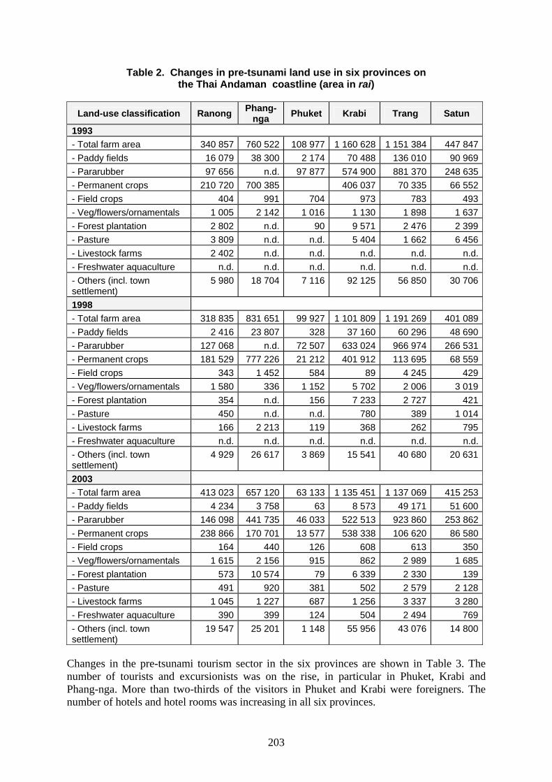
negatively on the daily lives of fisherfolk. Small-scale fisherfolk are the most affected by mangrove degradation and the concomitant decline in fishery resources, as they are dependent on mangrove forests. They are well aware of how the changes in these forests affect them and realize that mangrove reforestation/afforestation contributes to a better quality of life (Suwannodom et al., 2004). People who receive direct benefits from the mangrove forests, in particular fisherfolk, are more prepared than others to participate in rehabilitation programmes (Siriboon, 2000). Changes in mangrove productivity will be the major factor for sustaining fishing communities and their livelihoods. In turn, the prosperity of the fishing communities will provide a good indicator of coastal productivity. A number of stakeholders have made integrated efforts to help combat declining coastal resources and to sustain the fishing community. However, there is a need for cooperation in conservation and rehabilitation activities. Public awareness and participation in coastal resource conservation and rehabilitation are important internal driving forces to sustain coastal resources. In this regard, community-based management has been introduced for managing coastal resources in the context of fishery management and coastal rehabilitation. 1.2 The background of the tsunami-affected areas The 2004 tsunami generated death and destruction in six coastal provinces on the Andaman Sea coastline of Thailand, which have a total population of 1.9 million. The tsunami-affected 25 districts, 95 tambons (subdistricts) and 407 villages, of which 47 were almost completely destroyed. Phang-nga and Krabi provinces were the most severely affected areas with 4 225 and 721 deaths recorded respectively. Phuket, being a primary international tourist attraction recorded 279 deaths. Satun and Trang provinces had the lowest casualties. The most important occupation in these coastal provinces, except for Phuket, is agriculture — contributing 40 to 50 percent to the Gross Provincial Product (GPP) (Table 1). In Phang-nga Province, the agriculture sector contributes more than 50 percent to the GPP. The fishery sector contributed up to 26 percent to the GPP in 2000; this declined to 14 percent in 2004. Agriculture is also the major occupation in Ranong Province, the smallest province in southern Thailand. In Ranong, the fishery sector contributed more than 25 percent to the GPP. Phuket’s economy, on the other hand, is reliant on the tourism sector. Income from tourism in this province generates the highest GPP in southern Thailand. Tourism contributions to the GPP of other coastal provinces are also increasing. Table 2 shows the changes in pre-tsunami land use in the six provinces along the Andaman coastline. Pararubber and permanent crops are the two most important agricultural activities in the area. Rice and vegetables/flowers/ornamental plants are next in terms of importance. Phuket has the least area in terms of agricultural land. Phang-nga and Krabi provinces have extensive areas of forest plantation. Pasture, livestock farms and freshwater aquaculture (fish cages and ponds) increased in number towards 2003. Industry has a minimal role in these provincial economies.

202
Table 1. Pre-tsunami GPP (THB million) in six provinces on the Thai Andaman coastline
Year Province 2000 2001 2002 2003 2004 Ranong GPP 6 482 5 910 5 812 6 604 6 564Agriculture sector 2 991 2 447 2 418 3 027 2 828
- Agriculture/forestry 1 311 920 1 121 1 442 1 170- Fisheries 1 680 1 527 1 297 1 584 1 658
Industry sector 524 482 435 457 448Tourism sector 81 77 70 70 81Phang-nga GPP 15 161 14 557 16 273 19 253 20 281Agriculture sector 8 103 7 346 8 422 10 532 10 267
- Agriculture/forestry 4 183 3 850 5 524 7 705 7 385- Fisheries 3 920 3 495 2 898 2 827 2 883
Industry sector 684 606 705 926 1 031Tourism sector 235 357 563 679 804Phuket GPP 38 794 39 823 45 688 46 691 51 984Agriculture sector 5 006 4 860 4 360 4 770 4 594
- Agriculture/forestry 769 839 1 198 1 425 1 403- Fisheries 4 237 4 021 3 162 3 345 3 192
Industry sector 1 751 1 575 1 600 1 540 1 641Tourism sector 15 334 16 085 21 307 20 559 23 602Krabi GPP 17 310 20 317 24 066 30 481 33 178Agriculture sector 5 726 8 267 10 537 15 108 16 750
- Agriculture/forestry 4 148 7 011 9 553 14 074 15 636- Fisheries 1 578 1 256 984 1 034 1 114
Industry sector 814 931 1 473 2 098 2 264Tourism sector 2 197 2 426 2 968 3 136 3 281Trang GPP 18 597 28 652 32 557 39 138 40 174Agriculture sector 10 925 10 964 13 868 17 790 16 715- Agriculture/forestry 6 583 6 762 9 746 14 007 12 807- Fisheries 4 342 4 202 4 122 3 784 3 911Industry sector 4 344 4 088 4 237 5 568 6 199Tourism sector 261 235 215 250 293Satun GPP 17 987 16 621 17 759 18 030 20 260Agriculture sector 9 057 8 029 8 710 8 760 9 665- Agriculture/forestry 3 787 2 904 3 354 4 583 5 434- Fisheries 5 270 5 125 5 356 4 177 4 237Industry sector 2 797 2 557 2 407 2 471 2 650Tourism sector 102 99 93 98 110
203
Table 2. Changes in pre-tsunami land use in six provinces on the Thai Andaman coastline (area in rai)
Land-use classification Ranong Phang-
nga Phuket Krabi Trang Satun
1993 - Total farm area 340 857 760 522 108 977 1 160 628 1 151 384 447 847- Paddy fields 16 079 38 300 2 174 70 488 136 010 90 969- Pararubber 97 656 n.d. 97 877 574 900 881 370 248 635- Permanent crops 210 720 700 385 406 037 70 335 66 552- Field crops 404 991 704 973 783 493- Veg/flowers/ornamentals 1 005 2 142 1 016 1 130 1 898 1 637- Forest plantation 2 802 n.d. 90 9 571 2 476 2 399- Pasture 3 809 n.d. n.d. 5 404 1 662 6 456- Livestock farms 2 402 n.d. n.d. n.d. n.d. n.d.- Freshwater aquaculture n.d. n.d. n.d. n.d. n.d. n.d.- Others (incl. town settlement)
5 980 18 704 7 116 92 125 56 850 30 706
1998 - Total farm area 318 835 831 651 99 927 1 101 809 1 191 269 401 089- Paddy fields 2 416 23 807 328 37 160 60 296 48 690- Pararubber 127 068 n.d. 72 507 633 024 966 974 266 531- Permanent crops 181 529 777 226 21 212 401 912 113 695 68 559- Field crops 343 1 452 584 89 4 245 429- Veg/flowers/ornamentals 1 580 336 1 152 5 702 2 006 3 019- Forest plantation 354 n.d. 156 7 233 2 727 421- Pasture 450 n.d. n.d. 780 389 1 014- Livestock farms 166 2 213 119 368 262 795- Freshwater aquaculture n.d. n.d. n.d. n.d. n.d. n.d.- Others (incl. town settlement)
4 929 26 617 3 869 15 541 40 680 20 631
2003 - Total farm area 413 023 657 120 63 133 1 135 451 1 137 069 415 253- Paddy fields 4 234 3 758 63 8 573 49 171 51 600- Pararubber 146 098 441 735 46 033 522 513 923 860 253 862- Permanent crops 238 866 170 701 13 577 538 338 106 620 86 580- Field crops 164 440 126 608 613 350- Veg/flowers/ornamentals 1 615 2 156 915 862 2 989 1 685- Forest plantation 573 10 574 79 6 339 2 330 139- Pasture 491 920 381 502 2 579 2 128- Livestock farms 1 045 1 227 687 1 256 3 337 3 280- Freshwater aquaculture 390 399 124 504 2 494 769- Others (incl. town settlement)
19 547 25 201 1 148 55 956 43 076 14 800
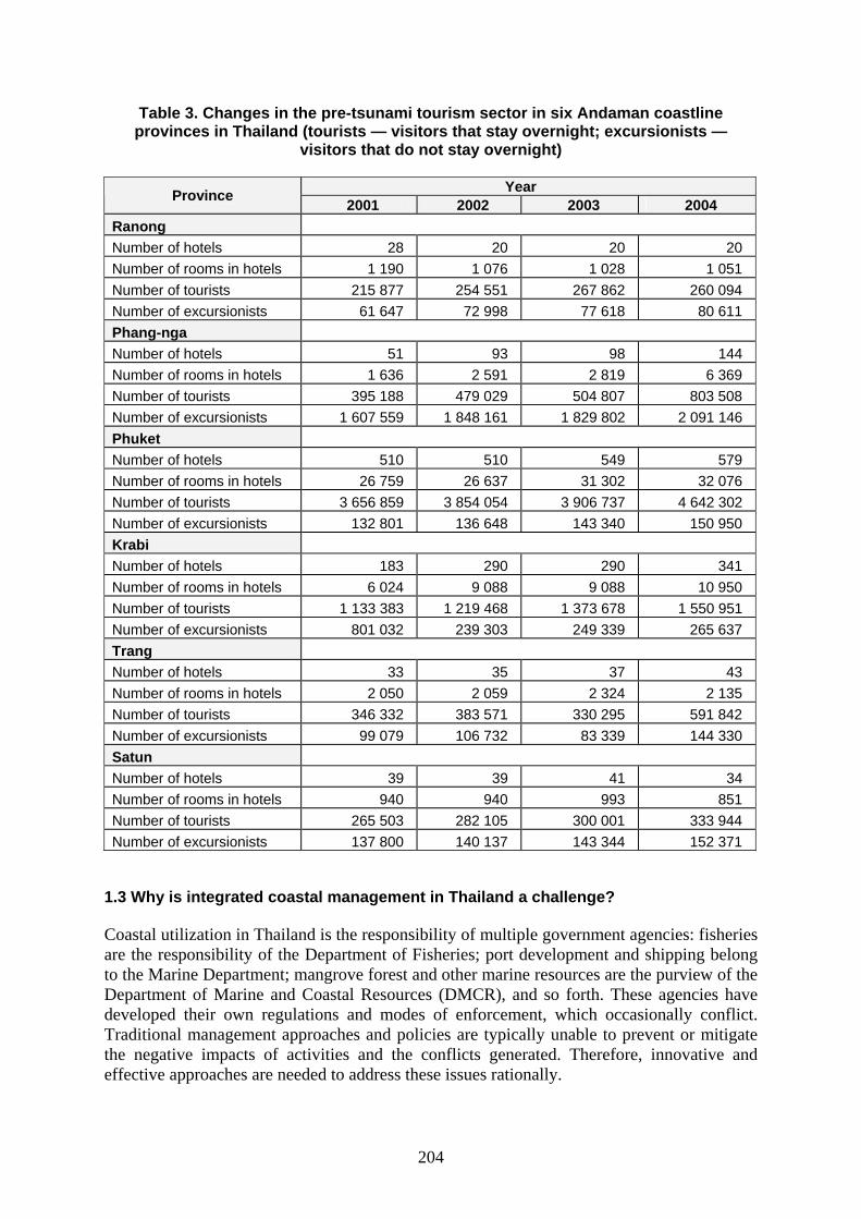
Changes in the pre-tsunami tourism sector in the six provinces are shown in Table 3. The number of tourists and excursionists was on the rise, in particular in Phuket, Krabi and Phang-nga. More than two-thirds of the visitors in Phuket and Krabi were foreigners. The number of hotels and hotel rooms was increasing in all six provinces.
204
Table 3. Changes in the pre-tsunami tourism sector in six Andaman coastline provinces in Thailand (tourists — visitors that stay overnight; excursionists —
visitors that do not stay overnight)
Year Province 2001 2002 2003 2004 Ranong Number of hotels 28 20 20 20 Number of rooms in hotels 1 190 1 076 1 028 1 051 Number of tourists 215 877 254 551 267 862 260 094 Number of excursionists 61 647 72 998 77 618 80 611 Phang-nga Number of hotels 51 93 98 144 Number of rooms in hotels 1 636 2 591 2 819 6 369 Number of tourists 395 188 479 029 504 807 803 508 Number of excursionists 1 607 559 1 848 161 1 829 802 2 091 146 Phuket Number of hotels 510 510 549 579 Number of rooms in hotels 26 759 26 637 31 302 32 076 Number of tourists 3 656 859 3 854 054 3 906 737 4 642 302 Number of excursionists 132 801 136 648 143 340 150 950 Krabi Number of hotels 183 290 290 341 Number of rooms in hotels 6 024 9 088 9 088 10 950 Number of tourists 1 133 383 1 219 468 1 373 678 1 550 951 Number of excursionists 801 032 239 303 249 339 265 637 Trang Number of hotels 33 35 37 43 Number of rooms in hotels 2 050 2 059 2 324 2 135 Number of tourists 346 332 383 571 330 295 591 842 Number of excursionists 99 079 106 732 83 339 144 330 Satun Number of hotels 39 39 41 34 Number of rooms in hotels 940 940 993 851 Number of tourists 265 503 282 105 300 001 333 944 Number of excursionists 137 800 140 137 143 344 152 371
1.3 Why is integrated coastal management in Thailand a challenge?
Coastal utilization in Thailand is the responsibility of multiple government agencies: fisheries are the responsibility of the Department of Fisheries; port development and shipping belong to the Marine Department; mangrove forest and other marine resources are the purview of the Department of Marine and Coastal Resources (DMCR), and so forth. These agencies have developed their own regulations and modes of enforcement, which occasionally conflict. Traditional management approaches and policies are typically unable to prevent or mitigate the negative impacts of activities and the conflicts generated. Therefore, innovative and effective approaches are needed to address these issues rationally.
205
Recently, Thailand unveiled the Ninth Economic and Social Development Plan concerning marine resource conservation, which focuses on demarcating protected areas to maintain biodiversity and the equilibrium of the ecosystem, and to restore the fertility of the Thai coastal and marine environment. To achieve the objective of the plan and the vision for the Thai maritime area, the Thai Marine Policy and Restoration Committee (TMPRC) was established in 1996 to manage the use of natural resources and to establish the framework for the use of Thai waters. The committee comprises ministers of the concerned agencies and representatives from many ministries and departments involved. The TMPRC set up the Office of the Thai Marine Policy and Restoration Committee (OTMPRC) to help the committee develop a draft agenda recommending effective policies, strategies and action plans, which should be ratified by all stakeholders through public consultation (also the responsibility of the OTMPRC). Regarding resolution of conflict among users of Thai waters, a National (the existing TMPRC), Provincial and Community Committee should be established, comprising members from public and private sectors. However, as the use of one resource affects others, conflict management mechanisms should be in place. The 1997 constitution, in particular the Normative Principle for Ocean Governance, makes specific reference to the management, preservation and balanced exploitation of natural resources and the environment in several sections. This was a major breakthrough to mainstream coastal zone management in Thailand. The constitution set out guidelines for the decentralization of resource administration and management to local communities by empowering them with the rights to preserve, rehabilitate and participate in management, maintenance and utilization for sustainable resource management. Government agencies were responsible for supporting and encouraging local communities so they could develop into “learning communities” and properly manage and utilize their own resources. As part of the reformation of the government bureaucratic system in 2002, the establishment of the new Ministry of Natural Resources and Environment (MoNRE) was another step toward mainstream coastal zone management. The agencies addressing natural resources and the environment were placed under the MoNRE. The main strategies underscore the role of public participation in the preservation, protection, conservation, utilization and rehabilitation of natural resources and the environment. Supervision, monitoring and rehabilitating the environment and mitigating pollution are other strategies. The ministry is also responsible for capacity building and equitable access to natural resources, and also proactive and integrated natural resource management. The DMCR was established with the major objectives of managing and conserving coastal and marine resources based on good governance, research, monitoring and assessment and rehabilitation and conservation. Thailand’s National Marine Policy was overhauled in 2003 to improve the efficiency of management mechanisms in order to avoid conflict and promote long-term direction for the future. The policy is now under review and will be submitted for approval by the TMPRC. It is designed to identify effective policies that promote the sustainable development of coastal and marine areas, which will follow an international framework for integrated and holistic management. It will establish a broad framework of planning and management principles for accelerated sustainable development, rational resource utilization, conservation of the marine environment and biodiversity and the preservation of community assets for the benefit and prosperity of present and future generations.

206
The DMCR’s main objectives and goals are conservation, rehabilitation and management of marine and coastal resources to achieve their sustainability and address social and economic needs. Action has been derived from national policies and guidelines, as well as regional initiatives and international agreements for the sustainability of the marine environment. During 2003–2004, the government launched many measures and allocated a large budget to support learning processes and disseminate knowledge to people, as well as to continuously enhance institutional capacity at all levels. A public awareness campaign for stakeholders, including the building of participatory networks, was also conducted. The mainstream for co-management is based on ecological principles that promote conservation and sustainable use in equitable ways. Marine Protected Areas (MPAs) constitute marine national parks and fishery sites reserved for specific purposes such as closed habitats and seasons. The DMCR expected to develop and use MPA incentive measures for improving and rehabilitating coastal resources and environmental quality with a target of maintaining 20 percent of the specified area along the coastline within five years. Government agencies and universities cooperate in many fields of studies, research and management programmes. Marine and coastal resources and environmental management are the responsibility of multi-sectoral government agencies, as found in the legislative administration of the coastal area. Boards and committees are set up in order to establish national agendas, guidelines and proactive integration of administrative management. Stakeholder representatives have been nominated as committee members. As pointed out by Phongsuwan et al. (2005), the DMCR has taken over responsibility for coordinating coral reef conservation and monitoring in Thailand; however, the DMCR, the Department of Fisheries and the Marine National Park authorities all have mandates under different laws to protect coral reefs. There is minimal coordination of activities by national agencies, provincial governments and the private sector in coral reef management. Enforcement is weak due to overlapping jurisdiction and misunderstandings over responsibilities. The major emphasis of marine park management is to support the tourism economy rather than focusing on conservation and regulation enforcement. All of these factors have led to ineffective control of widespread destructive fishing and other injurious practices in coral reef areas that result in the deterioration of Thailand’s coral reefs. Although the DMCR has the mandate to administer integrated coastal zone and marine area management, it lacks the express legal authority to do so. Coastal zone and marine area activities are exercised by other groups and provincial and local authorities have expanded powers under an ongoing process of government decentralization. In order to enable the sustainable management of coastal zone and marine area resources, regulatory mechanisms must be improved; it must be ensured that communities are involved in planning and decision-making processes for sustainable management and use.

207
Figure 1. Legislative administration of the coastal zone in Thailand

208
2. Issues 2.1 The impacts of the tsunami on coastal resources 2.1.1 Mangrove forests The 2004 Indian Ocean tsunami caused great loss of life and property. Mangrove forests were claimed to have mitigated losses by acting as barriers against wind, waves and erosion. Approximately 2 415 rai (386 hectares) of mangrove forests were reported to have been impacted by the tsunami. Only 89 hectares in Ranong Province were documented as being severely damaged. Mangrove forests in Phang-nga Province were slightly damaged. The impaired mangrove area was small in comparison with the areas of other coastal ecosystems, coral reefs and sandy beaches affected (691 hectares and 992 hectares respectively). However, these impact assessments are based only on physical alterations as shown Table 4. Assessments of ecological functions (i.e. permanent habitats, feeding and nursery grounds) and nutrient transports between mangrove forests and coastal waters have not been conducted.
Table 4. Tsunami impact on mangrove forests on the Thai Andaman coastline (Paphavasit et al., 2005)
Provinces Impacts on mangrove ecosystems Ranong Phang-
nga Phuket Krabi Trang Satun
1. Physical alterations 1.1 Water quality
- seawater intrusion in mangrove forest 0–1 0–2 0–2 0–1 0 0–1 - channel fill-up 0 0–1 0–2 0–1 0 0–1 - changes in waterways 0 0–3 0–2 0 0 0–1 - increased channel depth due to erosion 0 0–2 0–2 0 0–1 0–1 - increased turbidity 0–1 0–3 0–3 1 0–1 0–1 - changes in seawater colour 0 0–4 0–1 1 0 0–1 - increase in offensive odour 0–1 0 0–3 0 0 0–1
1.2 Sediment quality - increased sediment in mangrove area 0 0–4 0–3 0 0 0–1 - soil erosion 0–1 0–3 1–3 1 0–1 0–1 - changes in sediment colour 0–1 0–2 0–1 1 0 0–1 - increase in offensive odour 0–1 0–1 0–2 0 0 0–1
2. Biological alterations 2.1 Mangrove flora
- loss of mangrove area 0–1 0–3 0 0 0 0 - loss of seedling area 0 0–2 0 0 0 0 - mangrove regeneration 0 0–2 0–1 0 0 0 - increased damage to mangrove shrubs 0 0–2 0–3 0 0 0 2.2 Mangrove fauna - decline in fishery resources 0–1 0–3 1–2 0–1 0 0–1 - increase in fishery resources 0 0–2 0 0 0 0–1
3. Socio-economic aspects (fishing communities)
- decline in catches 0 0–3 0–1 0–1 0–1 0–1 - decline in fishing boats 0 0–4 0–2 0–2 0–1 0–1 - decline in fishing families 0 1–4 0–2 0–2 0 0 - occupational shifts 0–1 0–4 0–2 0–1 0 0–1
Note: 0 = not affected, 1 = 1–25% alteration from normal condition, 2 = 26–50% alteration from normal condition, 3 = 51–75% alteration from normal condition, 4 = 75% alteration from normal condition
209
Paphavasit et al. (2006) conducted an integrated research project on post-tsunami Monitoring on Impact Assessment on Mangrove Ecosystem on Andaman Coastline, which aimed to elucidate how mangrove forest structures withstood the impact of the tsunami. Comparative post-tsunami impact assessments were carried out at Ban Nam Khem village, Phang-nga Province and Bang Rong village, Phuket Province, during October and November 2005. Prior to the tsunami the two mangrove forests in these locations were considered to be degraded and had been under two rotation cycles as wood concessions from 1976 to 2000. After 2000, the two forests switched management direction. Rhizophora apiculata, R. mucronata, Ceriops tagal and Bruguiera cylindrica were the dominant species in the natural regenerated forest in Ban Nam Khem; Avicennia alba and Sonneratia ovata were also found. Dense Rhizophora forests characterized the intact Bang Rong mangrove forests; A. marina, A. alba as well as S. ovata were also present. The rich intact forest in Bang Rong was attributable to the mangrove reforestation programme launched by the Royal Forest Department, together with the Petroleum Authority of Thailand in 1996. Since then, the local community became immersed in mangrove conservation by managing the resource themselves. During the tsunami, the mangrove forests in Ban Nam Khem were impacted directly. The Bang Rong mangrove forest was impacted indirectly. The Rhizophora and Avicennia forests, which received differing degrees of impact, were compared. The history of the two villages revealed that in 1975 tin mining lured poor people in search of work to the unknown remote rural area of Ban Nam Khem village. Most of them were not the citizens of the village by birth. This resulted in low cooperation among people in the community. In contrast, Bang Rong village had a very long history of more than 200 years. Most of the villagers were born in the community, which was unified by religion. Mangroves played significant roles in enhancing community livelihoods. Biological productivity and maintenance processes determine the self-reliance of an ecosystem. It also demonstrates the resilience and response of the ecosystem to disturbance. From their ecological risk assessment, Paphavasit et al. (2006) indicated that mangrove forests at Ban Nam Khem and Bang Rong would be resilient to trauma such as tsunamis owing to the forests’ high stability. A high recovery rate was also predicted. Their findings reported the relationships and mechanisms of different vegetation on wave mitigation. The ability of mangrove forest structures to withstand the impacts of a tsunami based on the position of the forest — facing the tsunami directly or indirectly — as well as selected dominant mangrove species, and forest condition (width, tree density, root system and tree canopy characteristics) were studied. Severity of impact differed between Avicennia forest and Rhizophora forests. The assessment of the two mangrove forests reflected the self-reliance of the forests. Coastal and mangrove productivity, both in Ban Nam Khem and Bang Rong, were not affected negatively in the tsunami’s aftermath. The two mangrove forests continue to serve as habitats, nursery and feeding grounds for numerous mangrove inhabitants. The return of certain birds and long-tailed macaques to the affected areas is a positive sign. The DMCR conducted a rapid impact assessment of the tsunami on Andaman mangrove forests. Severe damage was reported in Ranong and Phang-nga provinces. The degree of impact varied. In heavily damaged areas, some trees had been uprooted by advancing waves. Debris and destroyed properties, including houses, vehicles and boats, littered the mangrove area. The environmental impact assessment conducted by Aiemsiri et al. (2005) contained similar findings to the impact assessment of mangrove forests conducted by Wanaprapoti et al. (2005). Ban Nam Khem village suffered major loss of property – mainly hotels, resorts, fishing villages and shrimp ponds – in the 1.5-kilometre beach vicinity. Certain beaches were totally eroded with a 30- to 50-metre clearance zone. Wanapropoti et al. (2005) also studied the dynamics of natural forests after
210
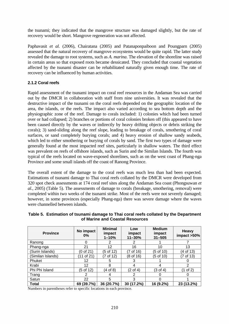
the tsunami; they indicated that the mangrove structure was damaged slightly, but the rate of recovery would be short. Mangrove regeneration was not affected. Paphavasit et al. (2006), Chairatana (2005) and Patanaponpaiboon and Poungparn (2005) assessed that the natural recovery of mangrove ecosystems would be quite rapid. The latter study revealed the damage to root systems, such as A. marina. The elevation of the shoreline was raised in certain areas so that exposed roots became dessicated. They concluded that coastal vegetation affected by the tsunami disaster can be rehabilitated naturally given enough time. The rate of recovery can be influenced by human activities. 2.1.2 Coral reefs Rapid assessment of the tsunami impact on coral reef resources in the Andaman Sea was carried out by the DMCR in collaboration with staff from nine universities. It was revealed that the destructive impact of the tsunami on the coral reefs depended on the geographic location of the area, the islands, or the reefs. The impact also varied according to sea bottom depth and the physiographic zone of the reef. Damage to corals included: 1) colonies which had been turned over or had collapsed; 2) branches or portions of coral colonies broken off (this appeared to have been caused directly by the waves or indirectly by heavy drifting objects or debris striking the corals); 3) sand-sliding along the reef slope, leading to breakage of corals, smothering of coral surfaces, or sand completely burying corals; and 4) heavy erosion of shallow sandy seabeds, which led to either smothering or burying of corals by sand. The first two types of damage were generally found at the most impacted reef sites, particularly in shallow waters. The third effect was prevalent on reefs of offshore islands, such as Surin and the Similan Islands. The fourth was typical of the reefs located on wave-exposed shorelines, such as on the west coast of Phang-nga Province and some small islands off the coast of Ranong Province. The overall extent of the damage to the coral reefs was much less than had been expected. Estimations of tsunami damage to Thai coral reefs collated by the DMCR were developed from 320 spot check assessments at 174 coral reef sites along the Andaman Sea coast (Phongsuwan et al., 2005) (Table 5). The assessments of damage to corals (breakage, smothering, removal) were completed within two weeks of the tsunami strike. Most of the reefs were not severely damaged; however, in some provinces (especially Phang-nga) there was severe damage where the waves were channelled between islands. Table 5. Estimation of tsunami damage to Thai coral reefs collated by the Department
of Marine and Coastal Resources
Province No impact 0%
Minimal impact 1–10%
Low impact 11–30%
Medium impact 31–505
Heavy impact >50%
Ranong 0 2 2 1 7 Phang-nga 21 12 16 10 13 (Surin Islands) (0 of 21) (5 of 12) (7 of 16) (5 of 10) (4 of 13) (Similan Islands) (11 of 21) (7 of 12) (8 of 16) (5 of 10) (7 of 13) Phuket 12 5 3 1 0 Krabi 12 8 4 4 2 Phi Phi Island (5 of 12) (4 of 8) (2 of 4) (3 of 4) (1 of 2) Trang 2 4 2 0 0 Satun 22 5 3 0 1 Total 69 (39.7%) 36 (20.7%) 30 (17.2%) 16 (9.2%) 23 (13.2%)
Numbers in parentheses refer to specific locations in each province.
211
It is anticipated that reef recovery in Phuket and the surrounding regions will be relatively rapid, with the most severely damage areas recovering within five to ten years, provided there are no other stresses (such as coral bleaching and death from abnormally high sea temperatures). This optimism is based on rapid rates of recovery following damaging storms, rapid coral growth rates and the present good condition of many nearby reefs. Satapoomin (2005) studied the responses of reef fish communities to tsunami impacts. A visual fish census was used to assess the abundance of fish species at some impacted sites. Pre-tsunami data on the abundance of fish and trophic structures of marine communities at specific sites were used in comparison. The results revealed no alteration of the fish community structure owing to the tsunami. 2.1.3 Seagrass beds Only 3.5 percent of the more than 7 900 hectares of seagrass beds along the Andaman coast was affected by the tsunami, with most damage induced by sedimentation. There was total destruction of only 1.5 percent of the seagrass beds. However, seagrass beds in Thailand are under greater threats from pollution and sedimentation from industry, housing and tourism developments, effluent from shrimp aquaculture, destructive fishing practices and tin mining activities. These beds serve as a major production base for fisheries, assist in coastline stabilization and are a food source for endangered species such as the green turtle and dugong. The most affected area was Yao Yai Island in Phang-nga Province, which lost ten percent of its seagrass habitat. Seagrass growing in the intertidal zone at Kuraburi, Phang-nga Province may have reduced the soil erosion of beaches during the tsunami. There was minimal damage or habitat loss in Talibong Island, Trang Province, which has extensive seagrass beds that serve as dugong feeding grounds. About ten percent of the area was affected by siltation and superficial erosion; these seagrasses should recover within one year, although those buried under heavier sands may take longer. Within three months, the seagrass beds showed signs of recovery from sand sedimentation (Poovachiranon, 2005). 2.2 Tsunami impacts on other coastal land use The total financial cost of the tsunami in Thailand was estimated to be US$2.09 billion, ranking the country second among countries affected in financial terms (UN Country Team, 2005). The impact of the tsunami reduced the overall Gross Domestic Product (GDP) growth by about 0.4 percent. Damage comprised losses in property, fisheries, livestock, agriculture and business sectors. Damage in the agriculture sector and to livestock were most severe in Phang-nga, Ranong, Krabi and Phuket, in that order (Phang-nga was estimated to have lost THB13 660 585 and 2 458 363 respectively) (Office of Natural Resources and Environmental Policy and Planning, 2006). One of the major impacts of the tsunami was the destruction of various types of land use. Soil for agriculture was seriously affected. Soil surfaces were eroded, became saline and thus unsuitable for agriculture. Oil palm, rubber and coconut plantations were destroyed. The total area of agricultural land affected by seawater intrusion was assessed to be 2 000 hectares. The tsunami caused loss of livestock valued at approximately US$0.4 million (UN Country Team, 2005). Shortage of feed for the surviving animals became a critical problem. Private entrepreneurs were devastated, in particular tourism-related business in Phang-nga, Phuket and Krabi provinces. Thirteen national parks that served as major tourist attractions were afflicted. Solid waste and debris were the major environmental problem, as well as declining water resources, in particular surface water and artesian wells; pollution by

212
wastewater was another problem. Apropos shorelines, several beaches were eroded, while others suffered from sand and sediment deposition which enlarged the beach area. Moreover, waterways and river mouths became shallow. 2.3 Impacts on demographic and socio-economic conditions According to the Office of Natural Resources and Environment Policy and Planning (2006), the tsunami caused colossal destruction including loss of lives and damage to property, natural resources and the environment, as well as severe damage to society and the economy. Casualty counts confirmed that 5 395 people from more than 37 countries, including Thailand, lost their lives, while some 8 457 people were injured. Another 2 817 people are still missing. Residential buildings, hotels, shops, schools and government buildings, including offices of national parks, roads, ports and piers were ravaged. Fishing communities were affected by the loss of life, boats as well as fishing gear, fish and shrimp ponds and fish cages. Village water supply systems and sources of freshwater, beach fronts and public gardens were severely impaired. An impact assessment on fisheries on the Andaman coastline is given in Table 6.
Table 6. Impact assessment on fisheries in six Andaman coastline provinces http://hazard.disaster.go.th/
Damage (recorded from field surveys)
Aquaculture (no.) Fishing boats (no. of boats) Fishing gear (no.) Province
Fish cages
Fish ponds
Hatch-eries Small Large Stake
traps Nets Traps
Total cost (THB)
Phang-nga 1 733 7 67 390 473 - 477 517 913 549 111Krabi 890 2 - 1 034 10 345 643 402 191 696 510Phuket 529 2 209 968 473 - 649 72 320 504 169Ranong 1 229 - - 420 356 56 522 267 170 737 983Trang 470 - - 815 1 8 600 483 14 980 000Satun 1 126 - 1 1 30 274 580 584 119 393 730Total 5 971 11 277 3 628 1 343 683 3 471 2 322 1 730 861 458
The environmental impact assessment by Aiemsiri et al. (2005) revealed low impact, with approximately 19 percent of the total number of villages being affected. Urban community areas of Phuket had the highest degree of impact. More than 70 percent of the affected areas was claimed to be unused land and coastal areas. Work places and premises mainly for tourism businesses were the most affected, accounting for 87.7 percent of the losses. Fisheries accounted for 12 percent and agricultural areas 1.2 percent. Fishery yields declined, but recovered in a short time. The decline in catches was mainly attributable to damaged fishing gear and equipment. Public health and safety facilities experienced moderate impact. In the first month, 3 823 patients needed care; 9 174 patients needed psychiatric services. Damage to utilities (water supply, electricity, telecommunications, sewage facilities) and roads, mostly in urban areas was repaired quickly. Phongsuwan et al. (2005) concluded that the tsunami resulted in massive losses to Thailand’s two main economic sectors; it was estimated that US$321 million was lost in the tourism sector and US$43 million in fisheries. More than 300 hotels/resorts were damaged, with 40 percent of the 53 000 rooms either being damaged or destroyed. In addition, 200 restaurants
213
and 4 300 shops that were tourist-dependent were totally or partially destroyed. The real and perceived damage to the supporting infrastructure meant that many of the surviving tourism facilities suffered (and continue to suffer) major reductions in tourist numbers. The downturn in tourism has meant that many who were employed in the industry or supplied products have lost their livelihoods. The total fisheries catch in 2000 was estimated at 3.7 million tonnes and valued at US$1.1 billion; however, as mentioned already, the tsunami caused huge losses to the fishing and aquaculture industry. Eight harbours were severely damaged and approximately 150 large tourist vessels and 776 small tourist craft were damaged or lost. Siriboon et al. (2006) indicated that the demographic and socio-economic impact was clear. Most villagers in Ban Nam Khem were affected both directly in terms of loss of household members and relatives as well as damage to property, and indirectly because of mental health trauma. One-third of the households in Ban Nam Khem had lost family members. Households experiencing mortality lost approximately two members in the disaster. Fear of the tsunami, stress and grieving, insecurity about the future and careers and also loss of faith were the main factors underlying mental health problems. Bang Rong did not experience this to the same degree as Ban Nam Khem because the village received only indirect impact and no casualties were recorded. Houses and dwellings remained intact and only fishing gear was damaged. Migration was the major factor contributing to the altered population structure and composition in Ban Nam Khem. A high percentage of people was reported to have moved from the village either permanently or temporarily and the community’s economic status suffered considerably. One-third of the respondents and one-fourth of their spouses were unemployed after the tsunami. More than half of the people had to change their occupations, in particular fisherfolk. Many fisherfolk had to work as unskilled labourers and needed to move to work away from home. This had a significant impact, not only on the economic structure, but also on lifestyles and relationships with family members. Income was reduced by 35 percent in comparison with the period prior to the disaster. The severity of economic difficulty was also reflected in increasing debts. People in Ban Nam Khem evaluated that they would face economic strain for a long time (not less than four years into the future). In Bang Rong, the tsunami-affected the economic status of small-scale fisherfolk, aquaculture businesses and ecotourism. Suthiphanwiharn et al. (2005) assessed resource bases and community rehabilitation in the affected area. The inappropriate settlement pattern of local communities within the highly resilient coastal ecosystem was evident. Damage and losses were remarkably high due to the expansion of towns in favor of tourist businesses without sound city planning. Restoration of the mangrove and coastal forests was highly recommended. 2.4 Land rights/land tenure Issues related to land ownership and rights have probably become the most important causes of social problems after the tsunami. The accumulated problems of unclear documentation and lack of an accountable property claiming system have been exacerbated by the tsunami making the settlement of land problems particularly difficult. Now there are many conflicts over land for conservation and private use. The tsunami impact has led to land disputes among local communities, private developers and local governments as reported by the United Nations Country Team (2005). This has become an obstacle to the recovery process. Of the 412 villages affected by the tsunami, 83 villages are facing problems related to insecure land tenure. Ethnic groups who live on “prime real estate” along the coast are especially affected.
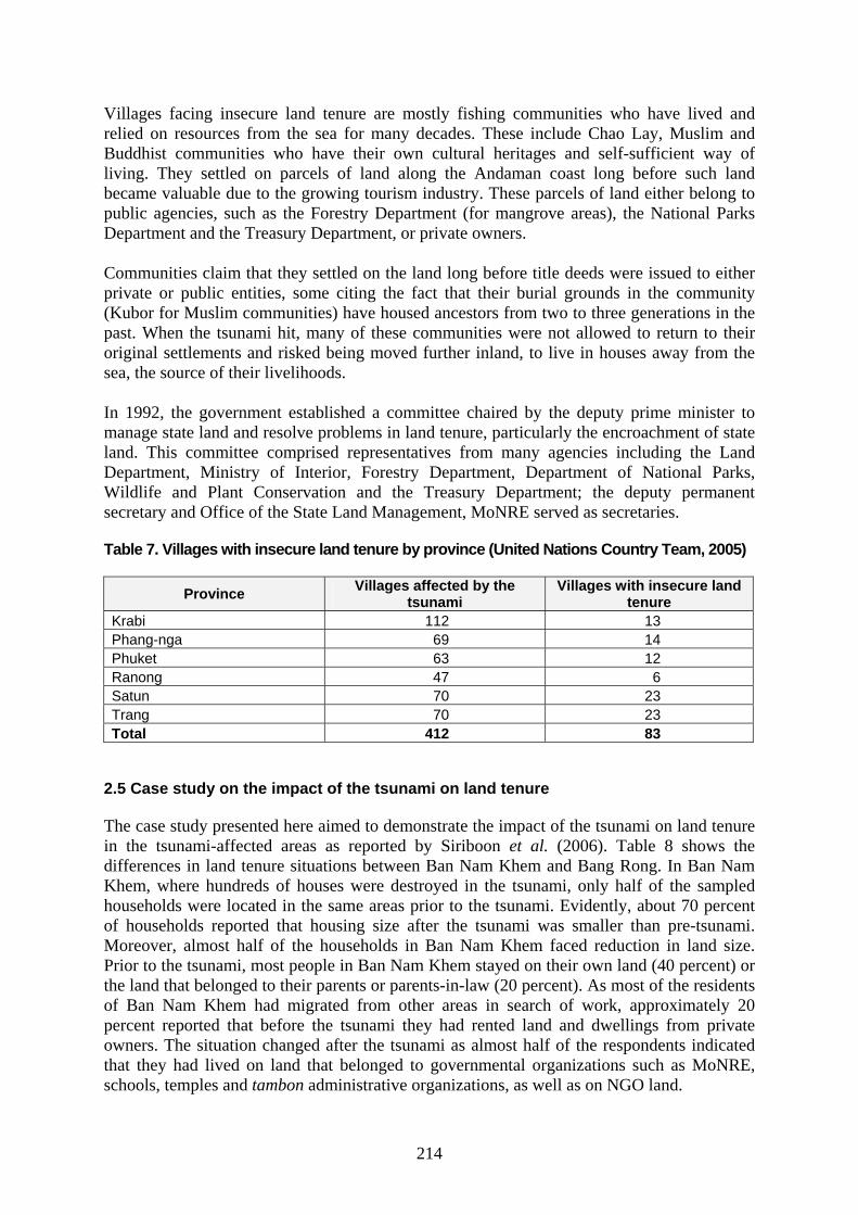
214
Villages facing insecure land tenure are mostly fishing communities who have lived and relied on resources from the sea for many decades. These include Chao Lay, Muslim and Buddhist communities who have their own cultural heritages and self-sufficient way of living. They settled on parcels of land along the Andaman coast long before such land became valuable due to the growing tourism industry. These parcels of land either belong to public agencies, such as the Forestry Department (for mangrove areas), the National Parks Department and the Treasury Department, or private owners. Communities claim that they settled on the land long before title deeds were issued to either private or public entities, some citing the fact that their burial grounds in the community (Kubor for Muslim communities) have housed ancestors from two to three generations in the past. When the tsunami hit, many of these communities were not allowed to return to their original settlements and risked being moved further inland, to live in houses away from the sea, the source of their livelihoods. In 1992, the government established a committee chaired by the deputy prime minister to manage state land and resolve problems in land tenure, particularly the encroachment of state land. This committee comprised representatives from many agencies including the Land Department, Ministry of Interior, Forestry Department, Department of National Parks, Wildlife and Plant Conservation and the Treasury Department; the deputy permanent secretary and Office of the State Land Management, MoNRE served as secretaries. Table 7. Villages with insecure land tenure by province (United Nations Country Team, 2005)
Province Villages affected by the tsunami
Villages with insecure land tenure
Krabi 112 13 Phang-nga 69 14 Phuket 63 12 Ranong 47 6 Satun 70 23 Trang 70 23 Total 412 83
2.5 Case study on the impact of the tsunami on land tenure The case study presented here aimed to demonstrate the impact of the tsunami on land tenure in the tsunami-affected areas as reported by Siriboon et al. (2006). Table 8 shows the differences in land tenure situations between Ban Nam Khem and Bang Rong. In Ban Nam Khem, where hundreds of houses were destroyed in the tsunami, only half of the sampled households were located in the same areas prior to the tsunami. Evidently, about 70 percent of households reported that housing size after the tsunami was smaller than pre-tsunami. Moreover, almost half of the households in Ban Nam Khem faced reduction in land size. Prior to the tsunami, most people in Ban Nam Khem stayed on their own land (40 percent) or the land that belonged to their parents or parents-in-law (20 percent). As most of the residents of Ban Nam Khem had migrated from other areas in search of work, approximately 20 percent reported that before the tsunami they had rented land and dwellings from private owners. The situation changed after the tsunami as almost half of the respondents indicated that they had lived on land that belonged to governmental organizations such as MoNRE, schools, temples and tambon administrative organizations, as well as on NGO land.
215
Land tenure in Bang Rong was rather different because Bang Rong did not experience the same losses as Ban Nam Khem. No lives were lost and no migration had occurred. The proportion and pattern of land- and house owners remained unaltered. Population structure and composition in Ban Nam Khem were affected because most people moved or wanted to move out of the village. Survey data as well as information from in-depth interviews on migration indicated that prior to the tsunami, less than five percent of the residents of Ban Nam Khem reported that they wanted to move out of the village. This minority wanted to leave mainly for economic reasons such as being unemployed (42 percent), not owning land or a house (32 percent) and having insufficient income (16 percent). In the tsunami’s aftermath, the desire to migrate out of the village increased drastically to 27 percent. As expected, the crucial reason for out-migration was fear of another tsunami (Siriboon and Paphavasit, 2006). For those who decided to remain, half reported having good jobs, the other half felt a sense of belonging and almost 40 percent owned land in the area..
The migration percentage in Bang Rong, pre- and post- tsunami, was much lower and did not reveal any significant changes (three percent compared to seven percent). Those who wanted to move cited fear of another tsunami (67 percent), economic difficulties (25 percent) and lower income (17 percent) as the main reasons for out-migration.
Table 8. Percent distribution of respondents according to land tenure and land use in
Ban Nam Khem (394 respondents) and Bang Rong (176 respondents)
Category Ban Nam Khem Phang-nga Province
Bang Rong, Phuket Province
Post-tsunami place of resident In the same place (land area) In a new place (land area)
51.0 49.0
98.3
1.7 Post-tsunami size of housing
Bigger than before Same as before Smaller than before Do not know/No answer
6.3
22.6 70.6
0.6
2.3
96.0 1.7 0.0
Post-tsunami size of land Bigger than before Same as before Smaller than before Do not know/No answer
4.1
47.7 47.7
0.5
1.7
97.7 0.6 0.0
Pre-tsunami land ownership Self/spouse Parents Rent from private sectors Supported by government Relatives Encroached land Temple ground Friend’s land Land of Sub-district Administration Organization
39.6 20.1 20.7
1.8 8.9 4.7 0.6 0.6 3.0
N/A N/A N/A N/A N/A N/A N/A N/A N/A
Post-tsunami land ownership Self/spouse Parents
33.8 12.9
53.4 22.2
216
Category Ban Nam Khem Phang-nga Province
Bang Rong, Phuket Province
Rent from private sectors Supported by government Relatives Encroached land Temple ground Friend’s land School ground Land of World vision organization Land of Sub-district Administration Organization Do not know/No answer
2.8 23.1
3.6 3.3 5.1 0.3
11.4 2.3 1.0
0.5
6.8 4.5 9.1 3.4 0.0 0.6 0.0 0.0 0.0
0.0
The desire to move out of the village, prior to tsunami
No desire Desire Not stay here prior to tsunami
94.9 4.8 0.3
96.6 2.8 0.6
The desire to move out of the village after tsunami
No Yes
72.8 27.2
93.2 6.8
2.6 Are post-tsunami policies, regulations and plans governing coastal land management and use working in reality? In the tsunami’s aftermath, several governmental organizations, together with NGOs, academic institutes, local administrative organizations as well as local communities collaborated to set up post-tsunami policies, regulations and plans governing coastal land management and use. The Office of National Resources and Environmental Policy and Planning (2005) concluded the land reform efforts. A serious problem for landowners who were victims of the tsunami was the loss of their land title documents. The Department of Lands provided assistance by resurveying and remeasuring the concerned parcels of land and re-issued documents to replace lost papers. The Land Development Department under the Ministry of Agriculture and Cooperatives surveyed the land, developed a map and studied and established guidelines on changes in land use in affected areas. In addition, the Office of Natural Resources and Environmental Policy and Planning implemented a project to establish guidelines in developing affected coastal areas in Ranong Province (Ban Tale Nok, Kum Puan subdistrict, Sook Samran District); Phang-nga Province (Khao Lak, Kuk Kak subdistricts, Takua Pa District); Phuket Province (Patong Beach and Kamala Beach, Katu District); and Krabi Province (Phi Phi Island, Ao Nang subdistrict, Muang District). The project’s output was a framework for land use, categorizing areas based on activities, their geographical features and potential and the level/nature of public participation. The framework is expected to lead to sustainable development and the formulation of measures to control development, guidelines for local communities on effective land development and guidelines to minimize the impact of construction and other activities that may create problems in the future. In addition, the Designated Area for Sustainable Tourism Administration (public organization) and the Department of Public Works and Town & Country Planning jointly developed a set of criteria on property use and formulated a town plan for Krabi Province,

217
which took effect on 31 May 2005. The criteria divided the beachfront of Phi Phi Island into three subareas from the shore and standardized the range of height of buildings in each subarea. However, these efforts to deliver quick relief and rehabilitation did not allow for extensive community participation and the anticipated results were not well-delivered; many of the affected people, mostly fishing communities, were not prepared to move to the inland sites. In some cases, the displaced communities decided to simply leave the relief camps, return to their old lands and start rebuilding. This led to bitter conflicts and protests as they obstructed proposed civic projects, zoning plans, commercial exploitation and vested interests (United Nations Country Team, 2005). The 2004 Land Readjustment Act was promulgated on 28 December 2004 and served as the basis for reviewing existing land use as well as planning for long-term post-tsunami reconstruction (Rochanakanan, 2005). The Ministry of the Interior, through the Department of Public Works and Town & Country Planning, established a centre to facilitate the construction of buildings for tsunami victims, in addition to taking immediate action to restore local communities and tourist spots. The department also developed a map of tsunami-affected areas for planning and developing a community town plan and infrastructure. Many pilot projects and feasibility studies were conducted in some affected areas to devise suitable plans for coastal land management and use. The comprehensive planning process was reviewed under three specific topics for planning and design vis-à-vis the tsunami hazards listed hereunder (Department of Urban and Regional Planning, Faculty of Architecture, Chulalongkorn University, 2005):
• Site planning: This underscored that new development should be avoided in areas vulnerable to tsunamis; new development located in hazardous areas should be designed to minimize future loss. Coastal area planning also included a transportation network, infrastructure and essential facilities as well as emergency services.
• Hazard warning system: Identifying areas for installing hazard warning instruments, as well as setting up a network for disseminating public information.
• Evacuation system: Specifying evacuation areas and evacuation routes, as well as risk preparation and evacuation maps.
It was suggested that the authorities should not rebuild on the same sites, but that affected villagers should be moved inland. The Department of Public Works and Town and Country Planning, Ministry of the Interior, developed a set-back policy in order to create a buffer zone to prevent loss of life along the shore and to protect property. However, information from both quantitative and qualitative research conducted by the College of Population Studies, Chulalongkorn University in Ban Nam Khem and Bang Rong indicated that this may not transpire.
Table 9. Respondents’ feedback on the appropriate distance for the set-back policy in Ban Nam Khem and Bang Rong (percent)
Appropriate distance of house from shore Ban Nam-Khem Bang Rong Total Less than 100 metres 100–500 metres More than 500 metres Do not know
32.5 24.9 26.9 15.7
31.3 19.9 40.9 8.0
32.1 23.3 31.2 13.3
218
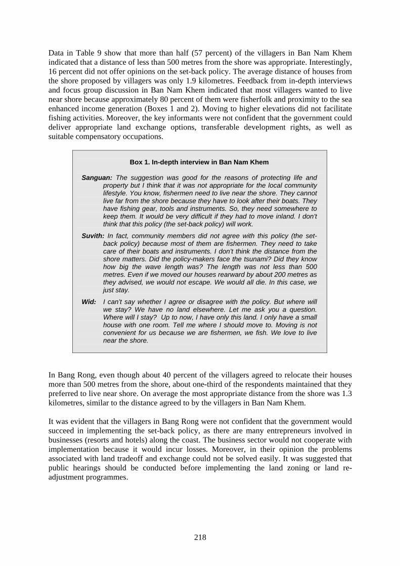
Data in Table 9 show that more than half (57 percent) of the villagers in Ban Nam Khem indicated that a distance of less than 500 metres from the shore was appropriate. Interestingly, 16 percent did not offer opinions on the set-back policy. The average distance of houses from the shore proposed by villagers was only 1.9 kilometres. Feedback from in-depth interviews and focus group discussion in Ban Nam Khem indicated that most villagers wanted to live near shore because approximately 80 percent of them were fisherfolk and proximity to the sea enhanced income generation (Boxes 1 and 2). Moving to higher elevations did not facilitate fishing activities. Moreover, the key informants were not confident that the government could deliver appropriate land exchange options, transferable development rights, as well as suitable compensatory occupations.
Box 1. In-depth interview in Ban Nam Khem
Sanguan: The suggestion was good for the reasons of protecting life and
property but I think that it was not appropriate for the local community lifestyle. You know, fishermen need to live near the shore. They cannot live far from the shore because they have to look after their boats. They have fishing gear, tools and instruments. So, they need somewhere to keep them. It would be very difficult if they had to move inland. I don’t think that this policy (the set-back policy) will work.
Suvith: In fact, community members did not agree with this policy (the set-back policy) because most of them are fishermen. They need to take care of their boats and instruments. I don’t think the distance from the shore matters. Did the policy-makers face the tsunami? Did they know how big the wave length was? The length was not less than 500 metres. Even if we moved our houses rearward by about 200 metres as they advised, we would not escape. We would all die. In this case, we just stay.
Wid: I can’t say whether I agree or disagree with the policy. But where will we stay? We have no land elsewhere. Let me ask you a question. Where will I stay? Up to now, I have only this land. I only have a small house with one room. Tell me where I should move to. Moving is not convenient for us because we are fishermen, we fish. We love to live near the shore.
In Bang Rong, even though about 40 percent of the villagers agreed to relocate their houses more than 500 metres from the shore, about one-third of the respondents maintained that they preferred to live near shore. On average the most appropriate distance from the shore was 1.3 kilometres, similar to the distance agreed to by the villagers in Ban Nam Khem. It was evident that the villagers in Bang Rong were not confident that the government would succeed in implementing the set-back policy, as there are many entrepreneurs involved in businesses (resorts and hotels) along the coast. The business sector would not cooperate with implementation because it would incur losses. Moreover, in their opinion the problems associated with land tradeoff and exchange could not be solved easily. It was suggested that public hearings should be conducted before implementing the land zoning or land re-adjustment programmes.
219
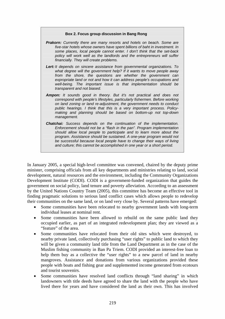
Box 2. Focus group discussion in Bang Rong
Prakorn: Currently there are many resorts and hotels on beach. Some are
five-star hotels whose owners have spent billions of baht in investment. In some places, local people cannot enter. I don’t think that the set-back policy will work well as the landlords and the entrepreneurs will suffer financially. They will create problems.
Lert: It depends on sincere assistance from governmental organizations. To what degree will the government help? If it wants to move people away from the shore, the questions are whether the government can expropriate land or not and how it can address people’s occupations and well-being. The important issue is that implementation should be transparent and not biased.
Ampon: It sounds good in theory. But it’s not practical and does not correspond with people’s lifestyles, particularly fishermen. Before working on land zoning or land re-adjustment, the government needs to conduct public hearings. I think that this is a very important process. Policy-making and planning should be based on bottom-up not top-down management.
Chatchai: Success depends on the continuation of the implementation. Enforcement should not be a “flash in the pan”. Program implementation should allow local people to participate and to learn more about the program. Assistance should be sustained. A one-year program would not be successful because local people have to change their ways of living and culture; this cannot be accomplished in one year or a short period.
In January 2005, a special high-level committee was convened, chaired by the deputy prime minister, comprising officials from all key departments and ministries relating to land, social development, natural resources and the environment, including the Community Organizations Development Institute (CODI). CODI is a government-funded organization that guides the government on social policy, land tenure and poverty alleviation. According to an assessment by the United Nations Country Team (2005), this committee has become an effective tool in finding pragmatic solutions to serious land conflict cases which allows people to redevelop their communities on the same land, or on land very close by. Several patterns have emerged:
• Some communities have been relocated to nearby government lands with long-term individual leases at nominal rent.
• Some communities have been allowed to rebuild on the same public land they occupied earlier, as part of an integrated redevelopment plan; they are viewed as a “feature” of the area.
• Some communities have relocated from their old sites which were destroyed, to nearby private land, collectively purchasing “user rights” to public land to which they will be given a community land title from the Land Department as in the case of the Muslim fishing community in Ban Pa Triem. CODI provided an interest-free loan to help them buy as a collective the “user rights” to a new parcel of land in nearby mangroves. Assistance and donations from various organizations provided these people with boats and fishing gear and supplemented income generated from ecotours and tourist souvenirs.
• Some communities have resolved land conflicts through “land sharing” in which landowners with title deeds have agreed to share the land with the people who have lived there for years and have considered the land as their own. This has involved
220
setting aside some portion of the land for people to rebuild their houses with secured legal rights, giving the rest back to the landowner to develop commercially; thus, the disputed land is shared by both parties, and both parties benefit. Ban Tung Wah, a village of indigenous Moken in Khao Lak, Phang-nga Province, has become an important model on how to resolve land-conflict cases through land sharing. As the original village occupied 4.16 hectares of land that had been totally washed away, through negotiations the village kept 2.56 hectares and gave 1.6 hectares to the province.
• Some communities have secure tenure planning in partnership with local district administration, as in the case of Ban Hualam village in Koh Lanta. This provided a test case for an unconventional kind of participatory, post-disaster coastal planning process. CODI, along with a special planning team and with support from UNDP, facilitated a process in which all the local groups (fishing communities, civic groups, district officials, local entrepreneurs and NGOs) convened and discussed what they would like to do. A collective master plan for the island was the outcome.
2.7 Can the tsunami “crisis” be turned into an “opportunity” for a sustainable coastal
rehabilitation plan? There is an opportunity to implement effective, integrated coastal management to make tourism, fisheries and community livelihoods sustainable, as well as to control human activities and to strengthen coastal habitats against natural trauma. Immediately after the tsunami hit coastal areas along the Andaman Sea, MoNRE initiated wide-ranging actions. Agencies under the ministry mobilized resources to assist the victims. In the ensuing period, the ministry cooperated with all relevant organizations in extending assistance by constructing necessary infrastructure, clearing up the land, creating employment, providing education and health care and establishing an early warning service. Efforts to restore and develop natural resources and the environment — thus providing people with food sources, fisheries, jobs and water supply — in addition to eliminating pollution generated by the tsunami, have been continuous. The ministry also contributed to the zoning of safe areas and coordinating with related international organizations in various projects. One of the most important activities was conducting a survey of the people’s needs and expectations, in order to assess the responsiveness of relief efforts undertaken by concerned agencies and to plan for appropriate forms of assistance over the long term. The DMCR, the Office of Natural Resources and Environment Policy and Planning and the Pollution Control Department are the three key agencies in the MoNRE apropos coastal rehabilitation efforts. The DMCR, in cooperation with UNEP, the coordination office of the Global Programme of Action for the Protection of the Marine Environment from Land-based Activities (GPA) and COBSEA, endorsed the Cairo 12 Guiding Principles to enable the government and other partners to implement environmentally sound reconstruction programmes in Thailand. A brainstorming meeting on the development of the national action plan on implementation of the Cairo Guiding Principles was held in Hua Hin, 6 to 8 October 2005. The guiding principles and measures in the integrated coastal rehabilitation plan were effected. 2.7.1 Coral reef rehabilitation efforts MoNRE, through the DMCR, has implemented many long-term measures and rehabilitation efforts, inter alia: repairing broken shipping buoys and establishing additional buoys to prevent anchoring in coral reef areas; establishing appropriate diving points to minimize the
221
impact of tourist activities on coral reefs; rehabilitating coral reefs by extending coral reef areas; and expanding areas for artificial reefs. Furthermore, the department also participated in developing zoning and suitable utilization measures, developing underwater barriers to mitigate the force of waves and preventing coastal erosion by using artificial reefs.
2.7.2 Mangrove rehabilitation efforts The DMCR also collected dead plants and addressed damaged mangrove forest areas, including the clearing of sedimented land, for reforestation at affected mangrove forests in Phang-nga Province (a total area of 1 900 rai). Local residents participated in planting mangrove trees in rehabilitated areas (approximately 1 400 rai) and nurtured growing seedlings. Rehabilitation efforts included the development and installation of signs to show forest boundaries, planting lines and the preparation of seedlings. The DMCR will take future action and coordinate with other relevant organizations to jointly rehabilitate mangrove forests in affected areas.
2.7.3 Beach forest rehabilitation efforts Up to 3 344 rai of beach forests were affected by the tsunami. The most severely damaged beach forests (2 162 rai) were in Laem Son National Park in Ranong Province and 532 rai in Khao Lumpee-Tai Muang Beach National Park in Phang-nga Province. As part of the rehabilitation plan, the DMCR, in association with local administrative authorities, students and local communities, planted some 3 000 mangrove plants and trees, such as Casuarina equisetifolia, Barringtonia asiatica, Pandanus adortissimus and coconuts, on 29 July 2005, at Pakarang Peninsular Beach in Kuk Kak subdistrict, Takua pa District, Phang-nga Province. 2.7.4 Establishment of environmentally protected areas Restoring and rehabilitating devastated areas requires time and effort. Therefore, MoNRE and the Office of Natural Resources and Environmental Policy and Planning envisaged the need to declare these sites as environmentally protected areas, as stipulated in the Enhancement and Conservation of National Environmental Quality Act (1992). This was one measure to support the restoration and conservation of natural resources and the environment, in addition to providing long-term security to local inhabitants. On 8 March 2005, the cabinet endorsed the principle of the draft Notification on Environmentally Protected Areas and Measures in tsunami-affected areas in Ranong, Phang-nga, Krabi, Phuket, Trang and Satun (2005). Prepared by MoNRE, the draft was approved by the Office of the Council of State and endorsed by related agencies. The draft is effective for a period of one year after its inclusion in the Royal Gazette. In brief, the details of the draft are:
1) Control the use of beachfronts by permitting only activities that promote marine safety and beach security, beach sports that do not create pollution or damage the beach and necessary zoning measures, including designating areas for boat mooring. Activities include those that regulate tidiness and promote safety.
2) Control the use of sand dunes by permitting only the planting of native or beach plants, establishing new sand dunes to replace lost or damaged ones and rehabilitating sand dunes that were damaged naturally.
3) Control actions that cause pollution and negative impact on natural resources and the
222
environment, on land and water, for the purpose of rapidly restoring natural resources and the environment to their original state.
4) Control construction of buildings and other infrastructure by setting appropriate criteria for construction away from the shore and stipulating the height of hotel and resort buildings, so as to prevent further deterioration and to plan land use and development.
5) Promote actions that enhance environmental quality, by assigning responsible governmental agencies to restore corals, seagrass beds and seawater quality, in addition to reforesting, restoring and conserving peat swamp.
6) Establishment of a committee to oversee the results of protective actions in environmentally protected areas.
2.7.5 Rehabilitation of the fishery sector The Thai Government recognized five key challenges to rehabilitation of the fishery sector. These included the provision of fishing boats and gear; the impact on natural resources and fishing grounds; damage mitigation plans; safety at sea; and sustainable fisheries development. It also enunciated three principles for rehabilitation: an integrated rehabilitation plan, management for sustainable development and human resource development. The Ministry of Agriculture and Cooperatives helped affected fisherfolk by assessing damage that they had incurred, including loss of fishing boats. Based on the assessment and on relevant regulations, compensation was paid to them. In addition, the department salvaged damaged boats and their engines and established a centre to coordinate assistance for victims in the fishery sector at the Andaman Sea Fisheries Research and Development Center. The department also assisted owners of aquaculture cages and ponds and paid compensation for their damaged equipment, boats and piers. The efforts of the Thai Government were supplemented by many national and international agencies and aid groups that provided collaborative assistance. A number of organizations united under the umbrella of the Save Andaman Network and provided funding to support fishing communities (building boatyards, building and repairing boats and providing engines and fishing gear to support livelihood recovery). International agencies such as the Food and Agriculture Organization of the United Nations worked with the Ministry of Agriculture and Cooperatives on an in-depth technical assessment for determining the level of fishing capacity and the promotion of community-based coastal natural resources management, in close collaboration with NGOs. 2.7.6 Rehabilitation of other coastal stakeholders Almost all parties allocated personnel, budget and equipment to provide assistance to restore property and livelihoods in the six tsunami-affected southern provinces. Assistance came in various forms, such as infrastructure construction for the community, improved public utilities, land reform, creation of occupations, provision of education, promotion of public health and the introduction of an early warning system. In order to restore agricultural production, the Land Development Department has implemented activities to restore soil health in affected areas. Major activities include land levelling, management of an appropriate system to conserve soil and water resources, restoring and improving soil fertility and suitability for growing cash crops as well as fruit trees, rubber trees and other permanent crops.
223
Transfer and disposal of solid waste and debris were carried out jointly by local agencies in tsunami-affected areas, including municipalities, Provincial Administrative Organizations and central government agencies. MoNRE and the DMCR joined local communities, NGOs and volunteers in cleaning up fishery habitats and collecting underwater solid waste and debris within and outside national parks. Rehabilitation of selected tourist attractions and tourists spot in Phuket, Phang-nga and Krabi Provinces was conducted. 2.7.7 Monitoring of public satisfaction and enhancement of public participation The Office of Natural Resources and Environmental Policy and Planning monitored the progress of restoration and development of natural resources and the environment and the response to community needs in tsunami-affected areas. The monitoring results were used in revising the most effective outputs of the policy, action guidelines and budget. One monitoring activity was a survey of and a visit to people in affected areas. Consultations and interviews with community leaders and local administrators were carried out, as well as focus group meetings among residents. This activity was aimed at listening to the people and understanding their needs and satisfaction levels. The Department of Environmental Quality Promotion concentrated on strengthening the capacity of local communities to be self-reliant in restoring natural resources and the environment to their original state and overseeing them. This approach also makes local communities better able to protect themselves from future disasters. The department organized 23 local community fora in six provinces during March to May 2005. The fora provided opportunities for all stakeholders to propose, exchange and gather ideas, especially concerning their needs and requirements. At the fora, local action plans were drafted on the restoration of natural resources and the environment, development of environmental management structures, capacity enhancement of community leaders and community members, organization and networking and campaigns and public relations’ exercises to raise awareness. Siriboon and Paphavasit (2006) concluded from their assessment on public awareness and participation in mangrove rehabilitation programmes, that the level of participation in any mangrove rehabilitation activity was highly correlated with the degree of mangrove-dependency. Many rehabilitation programmes or activities were arranged in an unsustainable fashion. Villagers joined the programme as a form of cooperation, not participation. In communities such as Bang Rong, where community-based mangrove management already existed, mangrove reforestation activities were arranged on a sustainable basis. Participation in any activity related to mangrove rehabilitation was always high. The Bang Rong community attempted to develop a “social capital” system. In their opinion, social capital constituted five components namely, natural resources, human resources, budget, social control and social wisdom. In order to carry out a successful mangrove rehabilitation programme, social capital is necessary. It can also be applied to the rehabilitation of other coastal ecosystems. 3. Lessons learned and solutions In order to fulfill our goals by turning the tsunami “crisis” into an “opportunity” to develop and implement integrated rehabilitation and management plans to sustain both natural resources and the livelihoods of coastal communities, scientific knowledge bases are needed. Most importantly, the sustainable development of coastal resources should not be the
224
government’s sole responsibility. Local communities should have the responsibility to conserve coastal resources as well as the right to utilize natural resources. As there are different goals and objectives for coastal restoration and rehabilitation, a basic blueprint cannot be drawn. There is a need to design integrated coastal zone management which is site-specific to suit the objectives of the coastal communities. In order to conserve and maintain long-term sustainable yields from coastal resources, full cooperation among government sectors (both national and local levels), NGOs and the public is required.
3.1 Integrating ecological processes into the coastal rehabilitation plan Scientific papers on coastal ecosystems in the post-tsunami period have documented the ecological changes. Monitoring of coastal ecosystems and loss of biodiversity in the tsunami’s aftermath should be systematically planned and carried out in the long term. Coastal productivity, in particular coastal fishery resources, should also be monitored. The capacity of ecosystems to recover naturally has been reported by scientists so coastal resource rehabilitation programmes should consider procedures that enhance natural recovery processes. It has been evidenced that impacts on coastal ecosystems by human activities are more serious and injurious in the longer term.
3.2 Proposed coastal rehabilitation programme Site-specific integrated coastal zone management should be designed to suit the needs of coastal communities. Natural bioshields can serve to mitigate tsunami impact and protect people and property. A coastal green belt was introduced in order to provide an open-ended framework to bring together key stakeholders to collaborate in supporting the protection and rehabilitation of the coastal area. Parish (2005) has concluded that poor design and management of coastal green belts in several countries reduced their effectiveness. He suggested that selected mangrove species, their complex root system and tree density, as well as spacing, should be considered in designing an effective green belt. In-depth data on the complex socio-economic and ecological relationships are useful in designing specific rehabilitation programmes. A coastal green belt was proposed for Ban Nam Khem on the basis that rapid recolonization of plant communities was expected in the short term. Planting in small patches with pioneer species was proposed instead of large plantations. Mangrove rehabilitation to enhance coastal fisheries was recommended for Bang Rong. In this case, re-introducing different species of mangrove was the key to re-establishing the forests as a viable ecosystem. Mangrove rehabilitation as landscaping for ecotourism was also proposed for Bang Rong.
3.3 Encouraging coastal community-based management As concluded in the panel discussion on “Impacts of Tsunami on Life Style of Local People and their Needs for Help,” and voiced by local community leaders and fisherfolk, the restoration/rehabilitation programmes outlined by the government and NGOs have been neither successful nor well-received by the local communities (Lewmanomont et al., 2005). A number of affected areas have been overlooked both by the government and NGOs. Many relief missions were merely business- and governmental goodwill-oriented. The goals of relief missions have not been achieved. Sadly, several relief missions have further divided local communities due to bias in the government and local authorities. Lack of cooperation among government authorities and NGOs (both Thai and international organizations) is
225
evident. This has stalled distribution of aid, while several affected areas have been crying for help. Relief and rehabilitation efforts have not been planned well and are not sustainable. People in affected areas still suffer and are not able to find new occupations. Local authorities were not interested in coastal resource rehabilitation programmes, mostly initiated by the ministry in top-down fashion, which ignored the needs of the locals and ecological processes. Community-based management in coastal rehabilitation programmes should be encouraged. The programmes should involve governmental agencies, local authorities and private organizations and address the needs of specific communities. Community strengths and unity should be emphasized through capacity building. The DMCR has the mandate to administer integrated coastal zone and marine area management. The department should put more effort into coordinating and collaborating with stakeholders instead of relying on legislative enforcement. The draft “Promotion of Marine and Coastal Resources Management Act” is now in the process of being submitted to the secretary-general of the cabinet and the National Assembly for debate and adoption. This law will contribute to the DMCR’s eventual legal mandate and enhance communities involved in sustainable resource management and use.
Bibliography Aiemsri, A., Suwanich, P., Tontrakulratanpa, U., Dumrongpol, P., Chairatana, R., Niumrtana,
W., Soontornchainaksang, P., Janejittikul, T., Samana, J., Nuchpongsri, P. & K. Tontakarnapa. 2005. Environmental impact assessment of the tsunami. W. Prasertphan, ed. Faculty of Environmental and Resources, Mahidol University. 156 pp. (In Thai.)
Chotiyaputta, C. 2005. Thailand marine and coastal resources management. Department of Marine and Coastal Resources. (Manuscript)
Chotiyaputta, C. 2005. From “crisis” – tsunami disaster to “opportunity” for coastal rehabilitation and management. Bangkok, Thailand, Department of Marine and Coastal Resources, Ministry of Natural Resources and Environment. 104 pp. (In Thai.)
Department of Marine and Coastal Resources (DMCR). 2005. Rapid assessment of the tsunami; impact on marine resources in the Andaman Sea. Bangkok, Thailand, Ministry of Natural Resources and Environment.
DMCR. 2006. Annotated guiding principles for post-tsunami rehabilitation and reconstruction. Bangkok, Thailand, Ministry of Natural Resources and Environment. 64 pp. (In Thai.)
DMCR. In press. Tsunami-related aid funds allocated to Southern Thailand. Department of Urban and Regional Planning. 2005. Post-tsunami rehabilitation and
reconstruction planning. Faculty of Architecture, Chulalongkorn University. (In Thai.)
Lewmanomont, K., Wongrat, L., Paphavasit, N. & S. Nimsnatichareon. 2005. Synopsis on the Fourth Asian Pacific Phycological Forum Special Session : Impacts of Tsunami on Marine Organisms and Coastal Environment. November 2005. 24 pp.
Office of Natural Resources and Environment Policy and Planning. 2004. The state of
environment report 2004. Bangkok, Thailand, Ministry of Natural Resources and Environment.
Office of Natural Resources and Environment Policy and Planning. 2005. 1 year after tsunami: restoration of Thailand’s natural resources and environment. Bangkok, Thailand, Ministry of Natural Resources and Environment. 128 pp.
226
Paphavasit, N., Piumsomboon, A., Sivaipram, I., Saramul, S. & S. Aksornkoae. 2005. Conceptual model on capacity building of fishing communities in post tsunami mangrove rehabilitation. In: Symposium on the importance of mangrove and other coastal ecosystems in mitigating tsunami disasters. 22–26 August 2005, Pan Pacific Hotel, Kuala Lumpur, Malaysia.
Paphavasit, N., Piumsomboon, A., Sivaipram, I., Saramul, S. & S. Aksornkoae. 2005. Ecological risk assessment in mangrove ecosystem in Thailand: tsunami 2004 aftermath. In: Regional symposium on the 2004 tsunami event. Bangkok, Faculty of Science, Chulalongkorn University.
Paphavasit, N. & Co-workers. 2006. Post- tsunami monitor on impact assessment on mangrove ecosystem on Andaman coastline. Thailand Environment Institute and UNOCAL. 240 pp.
Parish, F. 2005. 26 December tsunami: ecosystem impacts and coastal rehabilitation. In: Symposium on the importance of mangrove and other coastal ecosystems in mitigating tsunami disasters. 22–26 August 2005, Pan Pacific Hotel, Kuala Lumpur, Malaysia.
Patanaponpaiboon, P. & S. Poungparn. 2005. Impact of tsunami on coastal vegetations and mangroves. In: Regional symposium on the 2004 tsunami event. Bangkok, Faculty of Science, Chulalongkorn University.
Phongsuwan, N., Yeemin, T., Worachananant, S., Duangsawasdi, M., Chotiyaputta, C. & J. Comley. 2006. Post-tsunami status of coral reefs and other coastal ecosystems in the Andaman Sea coast of Thailand. In: C. Wilkinson, D. Souter & J. Goldberg, eds. Status of coral reefs in tsunami-affected countries: 2005. pp. 63–78.
Poungparn, S. & P. Patanaponpaiboon. 2005. Natural rehabilitation of coastal vegetations after tsunami. In: Regional symposium on the 2004 tsunami event. Bangkok, Faculty of Science, Chulalongkorn University.
Rochanakanan, T. 2005. Urban planning: reduction of vulnerability to national hazards: tsunami hazard. Journal of Department of Public Works and Town and Country Planning, 8: 35–41. (In Thai.)
Satapoomin, U. 2005. A preliminary study on the impact of the 2004 tsunami on reef fish communities of the Andaman Sea, Thailand. Paper presented at the Fourth Asian Pacific Phycological Forum: Impacts of Tsunami on Marine Organisms and Coastal Environment, November 2005.
Siriboon, S. 1998. Population, socio-economic characteristics and mangrove forest community’s environment: data from survey in Mahachai Mangrove Forest communities. Concept for rehabilitation, development and conservation. Bangkok, College of Population Studies, Chulalongkorn University. (In Thai.)
Siriboon, S. 2000. Community awareness on the values and used mangrove forest: case study of Nakhon Si Thammarat Province, Thailand. In: ICLARM-APN/PCE seminar. Hotel Equatorial, Penang, Malaysia, 10–11 April 2000.
Siriboon, S., Bangkaeo, C. Milintangkul, C. & N. Paphavasit. 2006. Post-tsunami: monitoring on impact assessment on demographic and socioeconomic status. In: Post-tsunami monitor on impact assessment on mangrove ecosystem on Andaman coastline, pp. 144–171. Thailand Environment Institute and UNOCAL. March 2006.
Siriboon, S., Bangkaeo, C., Milintangkul, C. & N. Paphavasit. 2006. Public awareness and
participation in mangrove rehabilitation programs. In: Post-tsunami monitor on impact assessment on mangrove ecosystem on Andaman coastline, pp. 172–213. Thailand Environment Institute and UNOCAL. March 2006.
Siriboon, S. & N. Paphavasit. 2006. Integrating ecological consideration into post-tsunami mangrove rehabilitation program in relation to public participation. Paper

227
presented at the International Conference on Population and Development in Asia: Critical Issues for a Sustainable Future, 20–22 March 2006, Phuket Province, Thailand. p. 34.
Suthiphanwiharn, S. & Co-workers. 2005. Tsunami: resources base and communities rehabilitation. In: Integrated project on rehabilitation of environment and communities in 6 southern provinces affected by the tsunami, Thailand. Mahidol University. (In Thai.)
Suwannodom, S. & Co-workers. 1999. Interrelationship between population and the mangrove ecosystem. Bangkok, College of Population Studies, Chulalongkorn University. (In Thai.)
Suwannodom, S., Siriboon, S., Paphavasit, N. & P. Thanasukarn. 2000. Inter relationship between coastal communities and the mangrove ecosystem. Lesson from the Green Carpet Project in Nakhon Si Thammarat. In: Annual report 1999 (second year: May 1999–March 2000) on Green Carpet Project in Nakhon Si Thammarat Province, Thailand, pp.94–114.
Suwannodom, S., Siriboon, S., Bangkaew, B., Militangul, C., Lertprasopsuk, N. & L. Kahcanuban. 2004. A comparative study on the desire for increasing mangrove forest areas of local people in coastal communities. In: S. Aksornkoae, et al. Integrated management of mangrove plantations for development of coastal resources and environment of Thailand, pp. 661–671. (In Thai.)
United Nations Country Team. 2005. Tsunami Thailand — one year later: national response and contribution of international partners. Joint publication by the Untied Nations Country Team with lead support from UNDP and the World Bank.

Related Documents