Practicing Practical INSPIRE INSPIRE Conference 2017

Welcome message from author
This document is posted to help you gain knowledge. Please leave a comment to let me know what you think about it! Share it to your friends and learn new things together.
Transcript

PracticingPracticalINSPIRE
INSPIRE Conference 2017

IntroductionArchitectural Overviewwith examples
Implementation Issueswhat went wrong - how we made it right
Discussion / Wrap-upwhat to do about it

ArchitecturalOverview
with examples

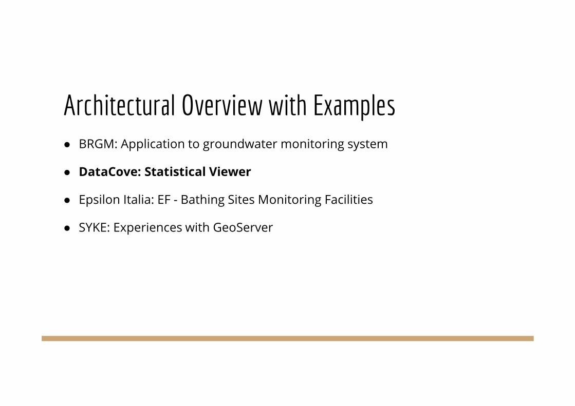
Architectural Overview with Examples● BRGM: Application to groundwater monitoring system
● DataCove: Statistical Viewer
● Epsilon Italia: EF - Bathing Sites Monitoring Facilities
● SYKE: Experiences with GeoServer

Architectural Overview with Examples● BRGM: Application to groundwater monitoring system
● DataCove: Statistical Viewer
● Epsilon Italia: EF - Bathing Sites Monitoring Facilities
● SYKE: Experiences with GeoServer

Application to groundwater information networkWhat was the plan?● Providing groundwater levels in their context
○ Observations/measurements (groundwater levels)
○ + associated features (Boreholes and facilities)
○ + links between them and other GeoScience things
I am#Piezometre/00634X0147/PZ1.2attached to#Borehole/00634X0147/PZ1.2
I am#EntiteHydroGeol/107AK01monitored by#Piezometre/00634X0147/PZ1.2
I have #GroundWater Levelsobservationsregarding#EntiteHydroGeol/107AK01
#GroundWater Levelsobservationsfrom#Piezometre/00634X0147/PZ1.2

Application to groundwater information networkWhat was the technology used?WFS AppSchema: GeoServer + Constellation + DeegreeSOS: 52°North
URIs as identifiers for features (boreholes, HydrogeologicUnits, facilities) andobservations (ground water levels)Apache resolver to manage redirections:http://ressource.brgm-rec.fr/obs/RawSeriePiezo/00463X0036/H1.2-622
à
http://192.168.6.208/52n-sos-rawdb-new/service?service=SOS&version=2.0.0&request=GetObservationById&observation=http://ressource.brgm-rec.fr/obs/RawSeriePiezo/00463X0036/H1.2-622

Application to groundwater information networkWhere were the problems?GetFeature / GetObservations with filters
○ WFS AppSchema works well with GetFeatureByID. Not so good with filters.
○ Better with SOS but still have limitations (eg: not yet possible to query from result value).
Data duplication○ WFS AppSchema: CONCAT & co. are very memory consumingà you need to have
database schema very close to the model to have direct mapping
○ SOS: It was not possible to have mapping on the fly from raw DB to SOSà we had tobuild materialized views compliant with 52nSOS expected schema and tables

Application to groundwater information networkHow did it come out? (1/2)
Borehole
Geology /HydroGeology
featureOfInterest
x
Env. MonitoringFacilityenvironmentalMonitoringFacility
attachedTo
Observations/ Geologicallogs
relatedObservation featureOfInterest
GroundWaterraw levels
hasObservation
relatedMonitoringFeature
GroundWatervalidated levels
Feature(s)
Observation(s)
Legend:
OGC/INSPIRE featureTypes

Application to groundwater information networkHow did it come out? (2/2)
Feature(s)
Observation(s)
Legend:
Architectural Overview with Examples● BRGM: Application to groundwater monitoring system
● DataCove: Statistical Viewer
● Epsilon Italia: EF - Bathing Sites Monitoring Facilities
● SYKE: Experiences with GeoServer

Statistical Viewer
What was the technology used:● Data Transformation: Java code● Data Provision: GeoServer AppSchema & PostGIS● Middleware: PHP Filter module● Web GUI: Open Layers, ajax, jquery
What was the plan:Create simple viewer for statistical data:• Statistical Units• Population DistributionNo INSPIRE compliant data servicesavailable• Implemented utilizing open data from
eurostat

Statistical ViewerWhere were the problems:● Stored Queries - syntax for complex features
not fully documented● Filtering of distinct values available for specific
fields not possible● Population Distribution features massive (not
geo!)● Various GeoServer bugs (i.e. quite crash after
requests for multiple complex features)How did it come out:● http://bolegweb.geof.unizg.hr:2017/danubeha
ck2/pd-viewer/
PostGIS
GeoServer PD_Filter
StatisticalViewer
WFS
WFS
JSON

Architectural Overview with Examples● BRGM: Application to groundwater monitoring system
● DataCove: Statistical Viewer
● Epsilon Italia: EF - Bathing Sites Monitoring Facilities
● SYKE: Experiences with GeoServer

EF - Bathing Sites Monitoring FacilitiesWhat was the plan:Transform bathing sites according to INSPIRE EF meeting requirements:● Conformity of the transformed GML dataset, served by means of WFS, to
INSPIRE data model and GML Specs.● Provide both deegree and GeoServer web services
What was the technology used:Data Transformation: hale studioData Provision:● GeoServer (using hale studio AppSchema feature)● deegree
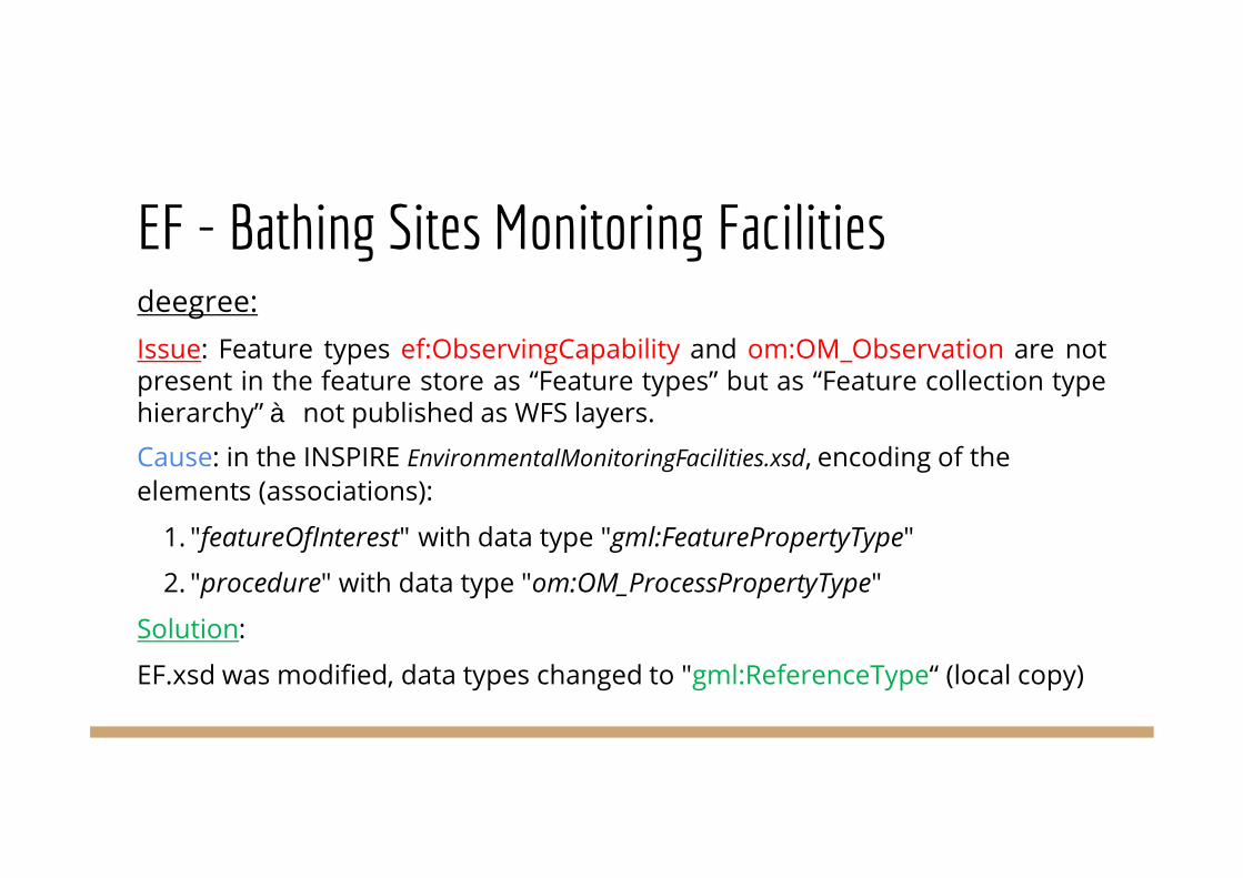
EF - Bathing Sites Monitoring Facilitiesdeegree:Issue: Feature types ef:ObservingCapability and om:OM_Observation are notpresent in the feature store as “Feature types” but as “Feature collection typehierarchy”à not published as WFS layers.
Cause: in the INSPIRE EnvironmentalMonitoringFacilities.xsd, encoding of theelements (associations):
1. "featureOfInterest" with data type "gml:FeaturePropertyType"
2. "procedure" with data type "om:OM_ProcessPropertyType"
Solution:
EF.xsd was modified, data types changed to "gml:ReferenceType“ (local copy)

EF - Bathing Sites Monitoring FacilitiesGeoServer & hale studio Appschema feature:Issues:
● <null> namespaces in WFS response (<null:OM_Observation> even whennot using virtual services)
● hale studio Appschema feature not able to correctly map multiplicity<ef:ObservingCapability>
Solution:
● No solution found for first issue
● Manually edit the appschema file

EF - Bathing Sites Monitoring Facilities
How did it come out?

Architectural Overview with Examples● BRGM: Application to groundwater monitoring system
● DataCove: Statistical Viewer
● Epsilon Italia: EF - Bathing Sites Monitoring Facilities
● SYKE: Experiences with GeoServer
SYKE’s experiences with GeoServerWhat was the plan?
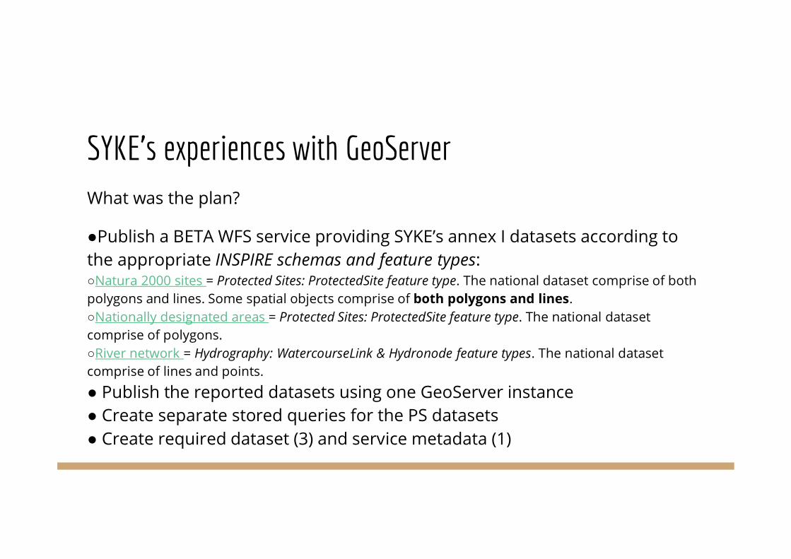
●Publish a BETA WFS service providing SYKE’s annex I datasets according tothe appropriate INSPIRE schemas and feature types:○Natura 2000 sites = Protected Sites: ProtectedSite feature type. The national dataset comprise of bothpolygons and lines. Some spatial objects comprise of both polygons and lines.○Nationally designated areas = Protected Sites: ProtectedSite feature type. The national datasetcomprise of polygons.○River network = Hydrography: WatercourseLink & Hydronode feature types. The national datasetcomprise of lines and points.
● Publish the reported datasets using one GeoServer instance● Create separate stored queries for the PS datasets● Create required dataset (3) and service metadata (1)

SYKE’s experiences with GeoServer

SYKE’s experiences with GeoServerHow did it come out?
● INSPIRE WFS service published (BETA)http://geoserver.ymparisto.fi/geoserver/wfs?service=wfs&version=2.0.0&request=GetCapabilities
● One Stored Query per PS datasethttp://geoserver.ymparisto.fi/geoserver/wfs?service=WFS&version=2.0.0&request=getfeature&storedqueryid=http://inspire.ec.europa.eu/operation/download/getspatialdataset/&DataSetIdCode=http://paikkatiedot.fi/so/1002201/ps/ProtectedSite/ (Natura 2000)
http://geoserver.ymparisto.fi/geoserver/wfs?service=WFS&version=2.0.0&request=getfeature&storedqueryid=http://inspire.ec.europa.eu/operation/download/getspatialdataset/&DataSetIdCode=http://paikkatiedot.fi/so/1002200/ps/ProtectedSite/ (Nationally Designated Areas)
●List of issues encountered, see later slides

ImplementationIssues
what went wrong –how we made it right

Implementation Issues● Data Provision
○ from the perspective of the data provider the problems faced in creation and provision ofthe data to the public
● Data Access○ from the perspective of the user the problems encountered in downloading the data
● Data Usage○ from the perspective of the user the problems encountered in using the data

Implementation Issues● Data Provision
○ Issues providing download services (GeoServer, DeeGree)
○ Simplification Options
● Data Access○ Identifier Management and Referencing
○ Stored queries
● Data Usage○ Available client libraries
○ Bits&Pieces

Implementation Issues● Data Provision
○ Issues providing download services (GeoServer, DeeGree)
○ Simplification Options
● Data Access○ Identifier Management and Referencing
○ Stored queries
● Data Usage○ Available client libraries
○ Bits&Pieces

Data Provision: Issues providing download services
● Various technologies being utilized for the provision of INSPIRE Services● Most have some deficiencies pertaining to INSPIRE● Knowing about these issues can save a great deal of effort and
frustration!
● Workarounds can help to mitigate some of these issues● Joint funding (crowd-funding among institutions) would be ideal (but
politically difficult)● Knowing who has contracted fixes would be valuable for coordination of
efforts

Main issues encountered by BRGM●GeoServer WFS AppSchema
○One namespace is linked to one xsd (e.g. gml is associated to GML3.1.1 or GML3.2.1 for all the appschemas based data)à If you have data based on both, then you must have several GeoServer.
○AppSchemaCache is not automatically updated when XSD changeà You have to do it manually(easy to forget!).
○AppSchema is mostly restricted to one to one mapping (CONCAT cannot be used for performancereasons).

Main issues encountered in SYKE implementation I● Hard to meet the „one endpoint per dataset“ Download Services TG
requirement 52 with GeoServer○ Strictly speaking, if you want to publish two INSPIRE datasets you need to set up two GeoServer
instances and publish them as separate endpoints
○ However, you can only publish the same feature types having the same namespace once.In order to provide our PS datasets (Natura, NDA) separately, we would need to set up and oneGeoServer instance for each
● When you publish WFS you automatically also generate WMS (workaround:have a separate GeoServer instance for publishing WFS services only.)
● Solution for these issues: workspace isolation (next page)

● Allow publishing the same (complex/simple) feature types (with the samenamespace) more than once using a different data source.
● Break the connection with namespaces and the workspaces:○Isolated workspace could have an arbitrary prefix.○Namespaces and feature types added to an isolated workspace would not conflict with or be visible inother workspaces or in the global services.
● Extend AppSchema to allow more than one complex feature mapping perfeature type:○Restriction: feature types used for feature chaining can only be mapped once or must be mapped againfor each using data store (OK).
●Contractor: GeoSolutions (funded by SYKE/Envibase project) -> benefit to all
Geoserver/AppSchema Improvement: Isolated Workspaces

Other issues encountered in SYKE implementation II● AppSchema restricted by HALE mapping (workaround: editing of mapping
documenting by hand, for example SWE/FI names)● We could not create optimal GMLs with the GeoServer solution, only with Atom for
PS using FME or HALE alone, as AppSchema cannot handle MultiGeometry objects(workaround: lines and polygons were split up into separate spatial objects)
● GDAL interpreted the CRS in incorrectly when providing them in an INSPIREcompliant way, that is in URI-form, not URN. This has been reported and fixed.
● Open search support in GeoNetwork is not fully working● ESRI Geoportal Server INSPIRE metadata templates are not fully according to
INSPIRE requirements● WMS Portrayal issue: according to IR code list values should be used in WMS layer
names, however if we use our national code list extensions, then we fail in thename validations… this needs to be fixed or guidelines changed

Data Provision: Issues providing download services - Excel Selfhelp
● Currently informally collecting known issues in excel table
● In addition to basic information describing the issue, table includesinformation on:
○ Known workarounds
○ Funding Status
■ Who is funding
■ Progress in remediation
○ OSGeo Issue Link

Data Provision: Issues providing download services - examples GeoServer
Problem Workaround Funding
Unique Endpoint per Dataset Utilize Apache's rewriting functionality SYKE
Stored Queries on Complex Features Documentation Issue, works, not properlydocumented
WMS doesn’t work on gml:MultiSurface Create simple feature
WFS-T doesn't work with complex features
Requests for multiple complex featurescrashes Geoserver
Request features individually
... ... ...

Data Provision: Issues providing download services
● Extend approach for other technologies:○ Deegree (in progress)
○ GeoNetwork
○ …
● Integrate content into existing INSPIRE platform?● Geoserver known issues:
https://docs.google.com/spreadsheets/d/1JTjwVJggxj3CHM40GL1B_b35IY8zV1_6i-E0HDaxJXc/
● Deegree known issues:https://docs.google.com/spreadsheets/d/1s1uh2t80d-J6KeHDjDCZSnWScLQ27z6SWQglGAGJsjg/

Data Provision: Simplification OptionsProblems:● Complexity of common INSPIRE types (i.e. Geographical Names, Addresses, Related Party…)
causes implementation and usage issues● Workarounds can be dangerous; lead to unstandardized standardization (i.e. putting the entire
geographical name into the GN delivery point element)(Currently also being discussed in MIG)
Options:● Software driven flattening vs. community driven schema simplifications (GeoSciML Lite,
EarthResourceML Lite,...).● Simple Feature Representations/Mapping
○ Potential of APIs exposing simplified features as an alternative solution● Simplification through alternative encodings (JSON, RDF)
○ Also as a way towards more INSPIRE based linked open data, ldproxy, Sensor Things

Implementation IssuesIntro to the following issues:● Data Provision
○ Issues providing download services (GeoServer, DeeGree)
○ Simplification Options
● Data Access○ Identifier Management and Referencing
○ Stored queries
● Data Usage○ Available client libraries
○ Bits&Pieces

Data Access: Identifier Management and ReferencingThere are no requirements/recommendations for the structure of INSPIRE identifiers. However:
● Identifiers are essential for referencing features; allow users to pin-point from very a very largedata-pool the exact feature they need
● We call a specific 8490 km-long road E40, INSPIRE calls it id:27C59F82-5208-4C70-AEAC-6A8E172D95CD
● The same approach of names/abbreviations is also used for addresses, admin. units, rivers,geographical places…
● Identifiers in INSPIRE should mirror this, since it makes working with data much easier/natural
In short, we need intelligent identifiers, since they make sure the data is not a mess, and make itavailable for everyone.

Data Access: Identifier Management and Referencing● Identifier management loosely specified in INSPIRE, various non-aligned
options available:○ base:inspireId (which provides the local identifier inside a namespace, and versioning )
○ gml:id (default for WFS, useful for getting just the exact feature needed, restrictions++)
■ doesn’t allow a number of characters, many SW generete IDs randomly
○ gml:identifier (alt. identifier in GML, freeer version of gml:id, not useful in feature filtering)
● Standard WFS GetFeatureById stored query (SQ) references gml:id○ filtering the data is based on an identifier element that has many restrictions
○ Currently no mechanisms defined for access via inspireId or gml:identifier

Data Access: Identifier Management and Referencing● What does INSPIRE TG mandatory GetSpatialDataSet SQ reference ???
○ unclear if this SQ is anything else than an alternative way of getting ALL the features froma WFS, or something more
● How to access a specific feature by the inspireId?○ Where is GetFeatureByInspireID Stored Query?
○ What about versioned data
○ Gets even more confusing with observational data, i.e. time series

Data Access: Identifier Management and Referencing● How to reference specific features? First try: WFS URI including query
Problems:○ URI changes with SW versions○ Long and ugly URI
● Rewriter approach - provider level:○ Configure Apache to rewrite simple URIs to current WFS (also possible with nginx)○ Simple URI used for referencing and in xlinks
● http://ressource.brgm-rec.fr/data/Piezometre/06512X0037/STREMY.2vs.
● https://wfspoc.brgm-rec.fr/geoserver/ows?service=wfs&version=2.0.0&request=GetFeature&StoredQuery_ID=GetEnvironmentalMonitoringFacilityById&ID=Piezometre.06512X0037.STREMY.2

Data Access: Stored queries● Syntax for stored queries on complex features slightly different from
simple features, not very well documented.
○ For simple features element name in the fes:ValueReference sufficient
○ For complex features relative XPath must be provided (currently not documented) :
■ gml:name doesn’t work
■ ./gml:name works
■ ./ps:DesignationType/ps:designationScheme/@xlink:href
■ /cdda:DesignatedArea/ps:siteDesignation/ps:DesignationType/ps:designationScheme/@xlink:href

Data Access: Stored queriesImplementations must keep track of the following RECs and REQs:● Req 49: Predefined SQ available for predefined datasets● Req 50: All combinations of CRS/DataSetIdCode/
DataSetIdNamespace/language available as Predefined SQ
● Req 51: Following parameter names must be used: CRS, DataSetIdCode,DataSetIdNamespace and Language
● Rec 13: Name of Predefined SQ for predefined datasets:http://inspire.ec.europa.eu/operation/download/GetSpatialDataSet
● These do not really apply for WFS-based GML features

Data Access: Stored queries● Standardized theme specific stored queries would be valuable for data
users○ Most systems will not allow users to specify their own stored queries, so dependent on
existing ones
○ A good complement to data specifications
○ Alignment across systems essential for cross-border applications
○ Discussion of potential stored query types/options for standardization
● Deficit of WFS Filters - no select distinct!○ Essential for GUI development, which features to select
○ Otherwise App must first access all features using GetPropertyValue, filter redundancies
● Security issue○ Blocking delete also blocks create
Implementation Issues (Overview)Intro to the following issues:● Data Provision
○ Issues providing download services (GeoServer, DeeGree)
○ Simplification Options
● Data Access○ Identifier Management and Referencing
○ Stored queries
● Data Usage○ Available client libraries
○ Bits&Pieces

Data Usage: Available client libraries● Various libraries are available for the implementation of client software. These will be discussed,together with their strengths and weaknesses
○ GDAL GMLAS driver (http://www.gdal.org/drv_gmlas.html )
○ QGIS GML application schema toolbox
○ QGIS V3 - will anything ever work again since V3 will make existing vital plugins unusable?
○ Resolving xlinks
In January 2017 the “application/gml+xml; version=3.2” MIME Type was registered at IANA, and WFSchanged text/xml into this new MIME type, making WFS response not readable in the the browseranymore.
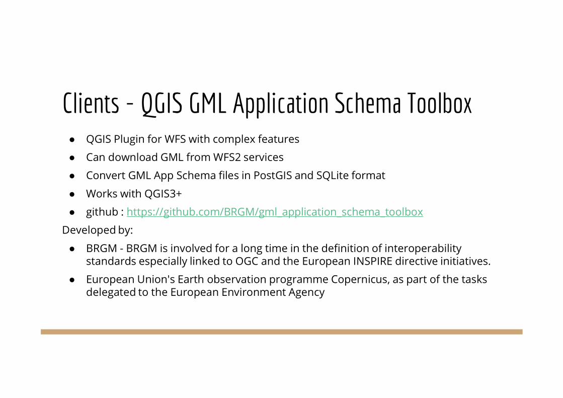
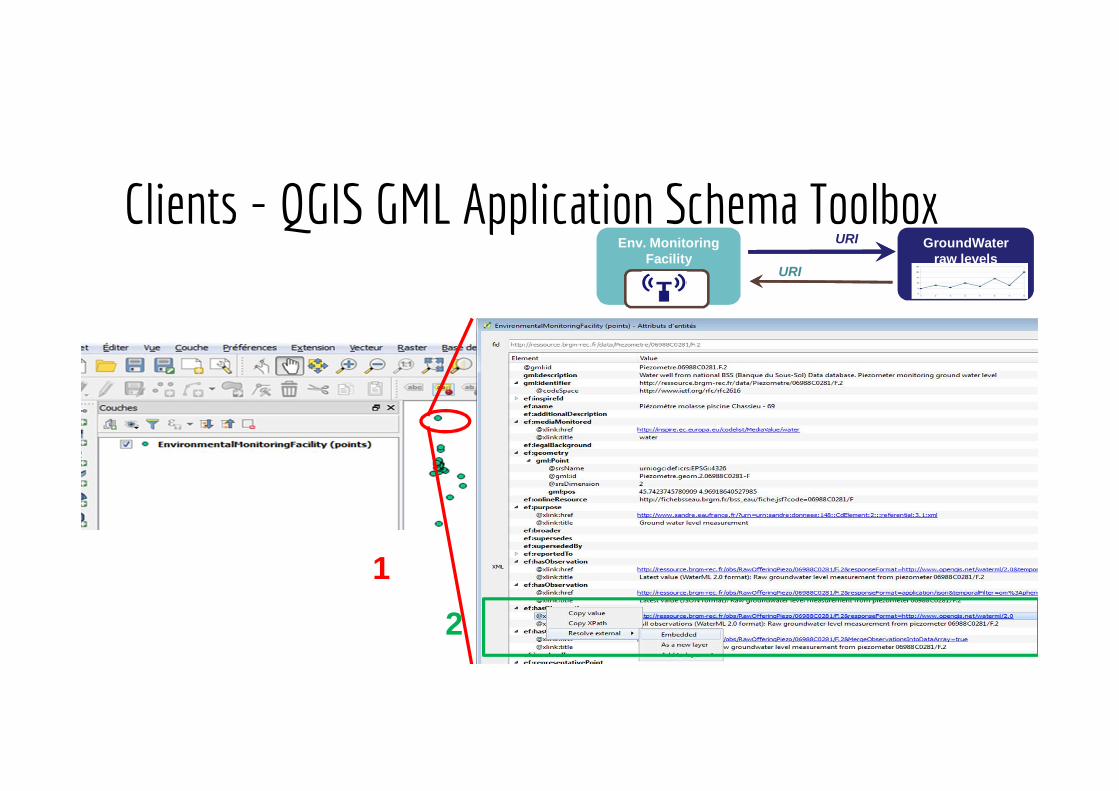
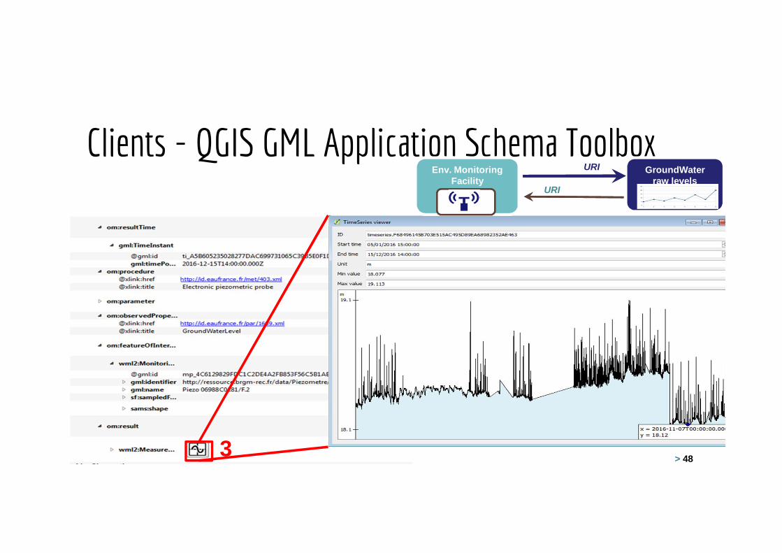
Clients - QGIS GML Application Schema Toolbox● QGIS Plugin for WFS with complex features
● Can download GML from WFS2 services
● Convert GML App Schema files in PostGIS and SQLite format
● Works with QGIS3+
● github : https://github.com/BRGM/gml_application_schema_toolbox
Developed by:
● BRGM - BRGM is involved for a long time in the definition of interoperabilitystandards especially linked to OGC and the European INSPIRE directive initiatives.
● European Union's Earth observation programme Copernicus, as part of the tasksdelegated to the European Environment Agency
> 47
12
Env. MonitoringFacility
GroundWaterraw levels
URI
URI
Clients - QGIS GML Application Schema Toolbox
Clients - QGIS GML Application Schema Toolbox
FOSS4G-E 2017 workshop – Paris – 2017-07-18 > 48OGC Hydro DWG Workshop 2017 – Tuscaloosa – 2017-06-203
Env. MonitoringFacility
GroundWaterraw levels
URI
URI

Data Usage: Codelist Registry & Content NegotiationBackground: codelist contents provided in various formats:● HTML (Human readable)● Re3gistry XML● ISO 19135 XML● RDF/XML● JSON● Atom
Within data, agnostic URI is provided, resolves to human readable HTML page. Example:http://inspire.ec.europa.eu/codelist/AdministrativeHierarchyLevel/1stOrderTwo options for retrieving specific formats & languages:● INSPIRE Specific URI extensions, Example:
http://inspire.ec.europa.eu/codelist/AdministrativeHierarchyLevel/1stOrder/1stOrder.en.iso19135xml
● Content Negotiation

Data Usage: Codelist Registry & Content NegotiationState of the Art in Informatics is Content Negotiation via Mime Types● Request URI is always the same (base URI)● Content Type in header Accept provides Mime Type to be returned● Language specified in header under Accept-Language
Browser specifies text/html and receives HTML for human consumptionApplications specify the mime type corresponding to their requirements
Format URI Suffix Mime Type Response
HTML text/html HTML Page
Re3gistry XML en.xml application/xml Re3gistry Encoding
ISO 19135 XML en.iso19135xml application/x-iso19135+xml
ISO 19135 XMLEncoding
RDF/XML en.rdf application/rdf+xml RDF Encoding
JSON en.json application/json JSON Encoding
Atom en.atom application/atom+xml Atom Encoding

Data Usage: Content Negotiation - New Gotcha!A further bit to Content Negotiation:A new Content Type has been defined for gml (2017-01-09):● application/gml+xml
Effect: Browsers no longer display the GML provided, instead make it availableas a downloaded file, eg: requesteddata.application file.
No problem if you’re aware of this, but good to know!

Data Usage: PortrayalPortrayal rules lead to ugly WMS data services, not really usable
● The least amount of effort went into designing the portrayals of layers
● Some portrayals are just not usable: AU is just a yellow patch
● Labels and scale-dependent styling?
WMS allows for so much more styling to be done, and have really nice maps
There are suggestions on thematic cluster, but not according to INSPIRE Reqs

Data Usage: Bits&PiecesMany tasks required in implementation of INSPIRE server and client solutions are beingduplicated across Europe. Examples:● Generic - Codelist Resolution: at the end of the day, the developer requires a
human readable label for the concept URI● Specific - Filtering Middleware: a PD feature provides many values for each spatial
object; only one can be displayed. For the creation of a viewer for this data, filteringdown to the relevant data via middleware can greatly improve viewer performance
● …? (brainstorming)

Data Usage: Bits&PiecesIdeas of what can be done:● “Map of the state of the INSPIRE implementation puzzle”
○ List existing projects: finished/on the run, technology inside.○ List people involved in the projects (thus contact points).○ List past/current issues, tips, workarounds faced and found in the projects.
■ To build a cross-project vision of common objectives, tools, issues■ To organize action to overcome them
How to make available:● GitHub: hard to see the forest for all the trees!● INSPIRE-in-Practice: currently only complete tools, not bits&pieces of helper code● Could we merge this?
Also see: "Designing a new functionality to help to fill the INSPIRE technical gaps"Wednesday 14:15h, Room: Amsterdam

Discussion /Wrap-upwhat to do about it

Discussion…

Providing INSPIRE measurement data
Thanks for your attention!
Kathi [email protected]
Full info at:https://themes.jrc.ec.europa.eu/news/view/148856/practicing-practical-inspire-ws-materials
Related Documents