Technical Report Phase II National Register Evaluation Site 36LU301 Bell Bend Nuclear Power Plant Luzerne County, Pennsylvania ER 81-0658-079 Prepared for: PPL BBNPP, LLC Prepared by: Barbara A. Munford, M.A. GAI Consultants Inc. 385 East Waterfront Drive Homestead, Pennsylvania GAI Project No. C110751.00 December 20, 2011 Redacted Photo Note 1: Items in brackets have been redacted per agency request

Welcome message from author
This document is posted to help you gain knowledge. Please leave a comment to let me know what you think about it! Share it to your friends and learn new things together.
Transcript
Technical Report Phase II National Register Evaluation
Site 36LU301
Bell Bend Nuclear Power Plant Luzerne County, Pennsylvania
ER 81-0658-079
Prepared for: PPL BBNPP, LLC
Prepared by:
Barbara A. Munford, M.A. GAI Consultants Inc.
385 East Waterfront Drive Homestead, Pennsylvania
GAI Project No. C110751.00
December 20, 2011
Redacted Photo
Note 1: Items in brackets have been redacted per agency
request
Technical Report
Phase II National Register Evaluation
Site 36LU301
Bell Bend Nuclear Power Plant Luzerne County, Pennsylvania
ER 81-0658-079
Prepared for:
PPL BBNPP, LLC
Prepared by:
_____________________________________ Barbara A. Munford, M.A., Principal Investigator
GAI Consultants Inc. 385 East Waterfront Drive Homestead, Pennsylvania
GAI Project No. C110751.00
December 20, 2011

Technical Report, Phase II National Register Evaluation, Site 36LU301
i
AbstractIn June and July, 2011, GAI Consultants, Inc. (GAI) conducted a Phase II National Register Evaluation of Site 36LU301, located within the proposed Bell Bend Nuclear Power Plant (BBNPP) project area, in Luzerne County, Pennsylvania, on behalf of PPL Bell Bend, LLC (PPL). Site 36LU301 represents a multicomponent prehistoric and historic site situated within a cultivated field, on an upland flat north of Walker Run. Proposed project impacts are anticipated to result from use of the northern portion of the site as a temporary construction laydown area. The site was identified during GAI’s Second Supplemental Phase I survey of the BBNPP project area in 2010. Based on Phase Ib results and consultation with the Pennsylvania Historic and Museum Commission/Bureau for Historic Preservation (PHMC/BHP) the site was recommended as potentially eligible for listing in the National Register of Historic Places (NRHP) and Phase II investigations were conducted to conclusively evaluate site eligibility.
GAI’s Phase II study included a background research review, field investigations, and laboratory analysis. Fieldwork consisted of controlled surface collection, excavation of 84 shovel test pits and ten test units, plowzone stripping, and feature investigations.
Phase II testing produced a very low density, dispersed scatter of 49 prehistoric lithic artifacts and 143 historic artifacts. In addition, 212 possible features (soil anomalies) were identified (all but one exposed on the surface of plowzone-stripped trenches). In accordance with a sampling strategy developed in consultation with PHMC/BHP, GAI investigated 25 percent (n=55) of these features. Feature sampling resulted in the identification of ten cultural features (five prehistoric thermal features, two prehistoric/historic postmolds, and three historic features—a refuse pit and two features of undetermined function) as well as 45 non-cultural soil anomalies (predominantly root/rodent disturbance).
The prehistoric lithic assemblage consisted of 2 bifaces, 24 debitage and 23 fire-cracked rocks, and included a single diagnostic Early Woodland Cresap-like projectile point. These artifacts were found overwhelmingly in plow-disturbed contexts, primarily in the western half of the site. Radiocarbon analysis of samples from four of the prehistoric thermal features indicated that two features (Features 150 and 171) date to the Middle Archaic period while two features (Features 153 and 154) date to the Early Woodland period. Excavation of these five prehistoric features yielded no evidence of subsistence remains and produced only three non-diagnostic artifacts. No artifact concentrations or diagnostic artifacts occurred in association with the thermal features. Based on the results of Phase II investigations, the site represents the remains of multiple, small, short term prehistoric occupations dating to the Middle Archaic and Early Woodland periods.
Phase II investigations also defined an historic component at the site, represented by the recovery of 143 historic artifacts and three sampled historic features (Feature 77—a refuse pit, and Features 83 and 85—features of undetermined function). Two thirds of the historic artifacts were found in the refuse pit, with the remainder widely dispersed across the southern portion of the sites. No structural remains or deep shaft features were identified. These materials represent a mid-to-late nineteenth century utilization of the locality (represented exclusively by Features 77) and a twentieth century field scatter associated with the adjacent ca 1880 Michaels Farmstead.
Based on the results of this Phase II study, GAI recommends that the prehistoric component and the historic component at Site 36LU301 are Not Eligible for listing in the National Register. GAI recommends no further investigation of this site.
Technical Report, Phase II National Register Evaluation, Site 36LU301
ii
Table of ContentsAbstract ...................................................................................................................................................... i Chapter 1. Introduction and Project Overview .......................................................................................... 1
Project Summary ................................................................................................................................ 1 Area of Potential Effect ....................................................................................................................... 4 Summary of Results ........................................................................................................................... 6
Previous Phase Ib Survey ............................................................................................................. 6 Phase II National Register Evaluation ........................................................................................... 6
Curation .............................................................................................................................................. 9 Regulatory Guidelines ........................................................................................................................ 9 Project Staff and Acknowledgements ................................................................................................. 9
Chapter 2. Site Setting ............................................................................................................................ 10
Physiography .................................................................................................................................... 10 Geology............................................................................................................................................. 10 Geomorphology and Drainage ......................................................................................................... 12 Soils .................................................................................................................................................. 13 Prehistoric Toolstone Resources ...................................................................................................... 13 Modern and Past Climates ............................................................................................................... 16 Paleoenvironment ............................................................................................................................. 17
Chapter 3. Culture History ....................................................................................................................... 18
Native American Prehistory .............................................................................................................. 18 Paleoindian (15,000 to 10,000 B.P.) ............................................................................................ 18 Early Archaic (10,000-8000 B.P.) ................................................................................................ 19 Middle Archaic (8000-5000 B.P.) ................................................................................................. 20 Late Archaic (5000-3000 B.P.) .................................................................................................... 21 Early Woodland (3000-2100 B.P.) ............................................................................................... 22 Middle Woodland (2100 B.P.-A.D. 900) ...................................................................................... 23 Late Woodland (A.D. 900-1600) .................................................................................................. 23 Protohistoric/Contact (A.D. 1600-1750) ....................................................................................... 24
Euroamerican History ....................................................................................................................... 25 Euroamerican Settlement (1750-1840) ....................................................................................... 25 Economic Development (1840-1900) .......................................................................................... 27 Economic Development in the Twentieth Century ....................................................................... 28
Chapter 4. Phase Ib Summary ................................................................................................................ 31
Phase Ib Methods and Results ......................................................................................................... 31 Phase Ib Artifact Analysis ................................................................................................................. 33
Chapter 5. Phase II Research Design .................................................................................................... 36 Chapter 6. Phase II Methods .................................................................................................................. 37
Field Methods ................................................................................................................................... 37 Surface Collection ........................................................................................................................ 37 Shovel Testing ............................................................................................................................. 37 Test Unit Excavation .................................................................................................................... 38 Plowzone Stripping ...................................................................................................................... 38 Feature Sampling ........................................................................................................................ 39
Analytical Methods ............................................................................................................................ 39
Technical Report, Phase II National Register Evaluation, Site 36LU301
iii
Laboratory Processing ................................................................................................................. 40 Methods of Prehistoric Lithic Analysis ......................................................................................... 40 Methods of Historic/Modern Artifact Analysis .............................................................................. 41 Methods of Flotation Processing ................................................................................................. 42
Chapter 7. Phase II Results ................................................................................................................... 43
Soils and Geomorphology ................................................................................................................ 44 Surface Collection ............................................................................................................................. 49 Shovel Testing .................................................................................................................................. 51 Test Units .......................................................................................................................................... 52 Plowzone Stripping ........................................................................................................................... 55 Feature Overview ............................................................................................................................. 75
Prehistoric Thermal Features ...................................................................................................... 88 Prehistoric/Historic Postmolds ................................................................................................... 109 Historic Features ........................................................................................................................ 113 Non Cultural Features/Anomalies .............................................................................................. 123
Chapter 8. Phase II Artifact Analysis..................................................................................................... 128
Prehistoric Artifact Analysis ............................................................................................................ 128 Lithic Raw Material Types .......................................................................................................... 128 Bifaces ....................................................................................................................................... 129 Debitage ..................................................................................................................................... 130
Historic Artifact Analysis ................................................................................................................. 131 Chapter 9. Site Synthesis ..................................................................................................................... 134
Summary of Phase Ib and II Results .............................................................................................. 134 Prehistoric Component .............................................................................................................. 134 Historic Component ................................................................................................................... 138
Prehistoric Settlement Pattern Analysis ......................................................................................... 138 Chapter 10. Summary and Recommendations ..................................................................................... 141 References ............................................................................................................................................ 143 Appendix A Project Correspondence Appendix B Phase II Workplan Appendix C BHP Report Summary Form Appendix D Updated PASS Form Appendix E Artifact Catalog Appendix F Qualifications of Key Personnel Appendix G Erosion and Sedimentation Control Plan Appendix H Methods of Prehistoric Lithic Analysis Appendix I Methods of Historic Analysis Appendix J Archaeobotanical Analysis Appendix K Radiocarbon Analysis
Technical Report, Phase II National Register Evaluation, Site 36LU301
iv
List of Figures Figure 1. Site 36LU301 Location ........................................................................................................ 2Figure 2. Second Supplemental Phase Ib Project Area showing Archaeological Potential,
Testing Locations and Identified Sites ................................................................................ 3Figure 3. Site 36LU301 Phase II Testing Locations ........................................................................... 5Figure 4. Site 36LU301 showing Phase Ib Testing Locations ............................................................ 7Figure 5. Project Area in Relation to Pennsylvania Physiographic Provinces ................................. 11Figure 6. Project Area Soils .............................................................................................................. 14Figure 7. Regional Lithic Raw Material Sources .............................................................................. 15Figure 8. Site 36LU301 Vicinity in 1873 ........................................................................................... 29Figure 9. Site 36LU301 Vicinity in 1939 ........................................................................................... 30Figure 10. Site 36LU301: Representative Phase Ib STP Profiles (STPs J-10 and A-2) .................... 32Figure 11. Site 36LU301: Test Unit 1, West Wall Profile ................................................................... 45Figure 12. Site 36LU301: Test Unit 10, South Wall Profile ................................................................ 46Figure 13. Site 36LU301: Test Unit 9, South Wall Profile .................................................................. 47Figure 14a. Site 36LU301: Trench 1 Plan View ................................................................................... 58Figure 14b. Site 36LU301: Trench 1 Plan View ................................................................................... 59Figure 15a. Site 36LU301: Trench 2 Plan View ................................................................................... 60Figure 15b. Site 36LU301: Trench 2 Plan View ................................................................................... 61Figure 16a. Site 36LU301: Trench 3 Plan View ................................................................................... 62Figure 16b. Site 36LU301: Trench 3 Plan View ................................................................................... 63Figure 16c. Site 36LU301: Trench 3 Plan View ................................................................................... 64Figure 17a. Site 36LU301: Trench 4 Plan View ................................................................................... 65Figure 17b. Site 36LU301: Trench 4 Plan View ................................................................................... 66Figure 17c. Site 36LU301: Trench 4 Plan View ................................................................................... 67Figure 18a. Site 36LU301: Trench 5 Plan View ................................................................................... 68Figure 18b. Site 36LU301: Trench 5 Plan View ................................................................................... 69Figure 18c. Site 36LU301: Trench 5 Plan View ................................................................................... 70Figure 19a. Site 36LU301: Trench 6 Plan View ................................................................................... 71Figure 19b. Site 36LU301: Trench 6 Plan View ................................................................................... 72Figure 20a. Site 36LU301: Trench 7 Plan View ................................................................................... 73Figure 20b. Site 36LU301: Trench 7 Plan View ................................................................................... 74Figure 21. Site 36LU301: Feature 150, Plan View ............................................................................. 90Figure 22. Site 36LU301: Feature 150, Northwest Profile ................................................................. 91Figure 23. Site 36LU301, Feature 153 Plan View .............................................................................. 94Figure 24. Site 36LU301, Southeast Profile ....................................................................................... 95Figure 25. Site 36LU301: Feature 154, Plan View ............................................................................. 98Figure 26. Site 36LU301: Feature 154, West Profile ......................................................................... 99Figure 27. Site 36LU301: Feature 161, Plan View ........................................................................... 102Figure 28. Site 36LU301: Feature 161, West Profile ....................................................................... 103Figure 29. Site 36LU301: Feature 171, Plan View ........................................................................... 106Figure 30. Site 36LU301: Feature 171, West Profile ....................................................................... 107Figure 31. Site 36LU301: Feature 37, Plan View and North Profile ................................................. 110Figure 32. Site 36LU301: Feature 38, Plan View and East Profile .................................................. 112Figure 33. Site 36LU301: Feature 77, Plan View and West Profile ................................................. 114Figure 34. Site 36LU301: Feature 83, Plan View and West Profile ................................................. 119
Technical Report, Phase II National Register Evaluation, Site 36LU301
v
Figure 35. Site 36LU301: Feature 85, Plan View ............................................................................. 121Figure 36. Site 36LU301: Feature 85, West Profile.......................................................................... 122Figure 37. Site 36LU301: Distribution of Phase Ib and II Lithic Tools and Cultural Features .......... 137
List of Photographs Photograph 1 . Site 36LU301 Overview showing Surface Collection Activities, Facing East ............... 1 Photograph 2. Site 36LU301 Overview from Northwest Portion of Field, showing Michael
Farmstead in Distance, Facing Southeast .................................................................... 4 Photograph 3. Site 36LU301: Pedestrian Ground Survey of Cultivated Field (Lot 41, Section
1), Facing South .......................................................................................................... 31 Photograph 4. Site 36LU301: Phase Ib Bifaces ................................................................................. 34 Photograph 5. Site 36LU301: Hammerstones (FS 6 and FS 7) ......................................................... 34 Photograph 6. Site 36LU301: TU 1 West Wall Profile, Facing West .................................................. 44 Photograph 7. Site 36LU301: TU 10 West Wall Profile showing Cobbles and Gravels, Facing
West ............................................................................................................................ 48 Photograph 8. Site 36LU301: TU 4 Plan View Top of B Horizon showing Cobbles and
Gravels, Facing North ................................................................................................. 48 Photograph 9. Site 36LU301: TU 9 South Profile, Facing South ....................................................... 49 Photograph 10. Site 36LU301: View of Controlled Surface Collection, Facing West .......................... 49 Photograph 11. Site 36LU301: View of Controlled Surface Collection, Facing East ........................... 50 Photograph 12. Site 36LU301: View of Controlled Surface Collection with Rock Outcrop
(Marked by Grass) in Foreground and Michaels Farmstead in Distance, Facing Southeast .................................................................................................................... 50
Photograph 13. Site 36LU301: Judgmental Shovel Testing in Cultivated Field, Facing Southwest ................................................................................................................... 51
Photograph 14. Site 36LU301: Judgmental Shovel Testing in Cultivated Field, Facing Northwest .................................................................................................................... 51
Photograph 15. Site 36LU301: Close Interval Shovel Testing in Farmyard, Facing South ................. 52 Photograph 16. Site 36LU301: View of TU 1 Excavation, Facing West ............................................... 52 Photograph 17. Site 36LU301: TU 10 South Wall Profile showing Cobbles and Gravels, Facing
South ........................................................................................................................... 54 Photograph 18. Site 36LU301: TU 3 North Wall Profile showing Cobbles and Gravels, Facing
North ........................................................................................................................... 54 Photograph 19. Site 36LU301: TU 5 South Wall Profile, Facing South ............................................... 54 Photograph 20. Site 36LU301: TU 6 East Wall Profile showing Excavated Feature 1 (Non
Cultural Tree Burn), Facing East ................................................................................ 55 Photograph 21. Site 36LU301: Overview of Plowzone Stripping, Trenches 3, 4, and 5, Facing
Northeast .................................................................................................................... 55 Photograph 22. Site 36LU301: Trench 3, B Horizon Surface, showing Possible Cultural
Features Marked by Pin Flags, Facing North ............................................................. 56 Photograph 23. Site 36LU301: Trench 2, B Horizon Surface, showing Possible Cultural
Features Marked by Pin Flags, Facing North ............................................................. 56 Photograph 24. Site 36LU301: Trench 4, B Horizon Surface, showing Possible Cultural
Features Marked by Pin Flags, Facing North ............................................................. 56 Photograph 25. Site 36LU301: Trench 1, B Horizon Surface, showing Possible Cultural
Features Marked with Pin Flags, Facing North. ......................................................... 57
Technical Report, Phase II National Register Evaluation, Site 36LU301
vi
Photograph 26. Site 36LU301: Trench 2, B Horizon Surface, showing Possible Cultural Features Marked with Pin Flags and Parallel Lines of Small Likely Agricultural-Related Stains, Facing North. ..................................................................................... 57
Photograph 27. Site 36LU301: Trench 2 showing Band of Cobbles and Gravels (Gravel Bar) on B Horizon Surface, Facing North ................................................................................ 57
Photograph 28. Site 36LU301: Feature 150, Plan View on B Horizon Surface (Trench 5), Facing West ................................................................................................................ 88
Photograph 29. Site 36LU301: Feature 150, Profile, Facing Northwest .............................................. 88 Photograph 30. Site 36LU301: Feature 150, Plan View of Excavated Feature, Facing
Northwest .................................................................................................................... 89 Photograph 31. Site 36LU301: Feature 153, Plan View on B Horizon Surface (Trench 5),
Facing North ............................................................................................................... 92 Photograph 32. Site 36LU301: Feature 153, Profile, Facing Southeast .............................................. 92 Photograph 33. Site 36LU301: Feature 153, Plan View of Excavated Feature, Facing
Southeast .................................................................................................................... 93 Photograph 34. Site 36LU301: Feature 154, Plan View on B Horizon Surface (Trench 5),
Facing West ................................................................................................................ 96 Photograph 35. Site 36LU301: Feature 154, Profile, Facing West ...................................................... 96 Photograph 36. Site 36LU301: Feature 154, Plan View of Excavated Feature, Facing North ............ 97 Photograph 37. Site 36LU301: Feature 161, Plan View on B Horizon Surface (Trench 5),
Facing North ............................................................................................................. 100 Photograph 38. Site 36LU301: Feature 161, Profile, Facing West .................................................... 100 Photograph 39. Site 36LU301: Feature 161, Plan View of Excavated Feature, Facing South .......... 101 Photograph 40. Site 36LU301: Feature 171, Plan View on B Horizon Surface (Trench 5),
Facing West .............................................................................................................. 104 Photograph 41. Site 36LU301: Feature 171, Profile, Facing West .................................................... 104 Photograph 42. Site 36LU301: Feature 171, Plan View of Excavated Feature, Facing West ........... 105 Photograph 43. Site 36LU301: Feature 37, Profile on B Horizon Surface (Trench 2), Facing
North ......................................................................................................................... 109 Photograph 44. ite 36LU301: Feature 38, Profile on B Horizon Surface (Trench 2), Facing East .... 111 Photograph 45. Site 36LU301: Overview of Trench 3 showing Features 76, 77, and 78 in
Foreground and Feature 82 (rock-filled stain) in Distance; Facing North. ................ 113 Photograph 46. Site 36LU301: Feature 77, Plan View on B Horizon Surface (Trench 3),
showing Feature 77 at East Edge (to right), Feature 76 to the South (near right) and Feature 78 to the West (left), Facing North ....................................................... 115
Photograph 47. Site 36LU301: Feature 77, Profile in East Wall of Trench 3, Facing East ................ 115 Photograph 48. Site 36LU301: Overview of Trench 3 showing Feature 82 (rock-filled stain) with
Features 83 and 85 in Distance (Feature 81 in left foreground), Facing North ........ 117 Photograph 49. Site 36LU301: Feature 83, Plan View on B Horizon Surface (Trench 3), Facing
North ......................................................................................................................... 117 Photograph 50. Site 36LU301: Feature 83, Profile, Facing West ...................................................... 118 Photograph 51. Site 36LU301: Feature 85, Plan View on B Horizon Surface (Trench 3), Facing
North ......................................................................................................................... 120 Photograph 52. Site 36LU301: Feature 85, Profile, Facing West ...................................................... 120 Photograph 53. Site 36LU301: Representative Non Cultural Feature—Type A, Profile of
Feature 2 (Root Disturbance) in Trench 1, showing Root Casts and Mixed Soils, Facing North .................................................................................................... 123

Technical Report, Phase II National Register Evaluation, Site 36LU301
vii
Photograph 54. Site 36LU301: Representative Non Cultural Feature—Type A, Profile of Feature 27 (Root Disturbance) in Trench 1, showing Root Casts and Mixed Soils, Facing North .................................................................................................... 124
Photograph 55. Site 36LU301: Representative Non Cultural Feature—Type A, Profile of Feature 29 (Root Disturbance) in Trench 1 showing Root Casts and Mixed Soils, Facing South ................................................................................................... 124
Photograph 56. Site 36LU301: Representative Non Cultural Feature—Type A, Profile of Feature 151 (Bioturbation) in Trench 5, showing Root Cast, Mixed Soils and Stain Angling to East, Facing West .......................................................................... 124
Photograph 57. Site 36LU301: Representative Non Cultural Feature—Type B, Profile of Feature 71 (Bioturbation) in Trench 2, showing Mixed Soils and Stain Angling to West, Facing Southeast ........................................................................................ 125
Photograph 58. Site 36LU301: Representative Non Cultural Feature—Type B, Profile of Feature 31 (Bioturbation) in Trench 1, showing Rodent Disturbance, Facing Northwest .................................................................................................................. 125
Photograph 59. Site 36LU301: Representative Non Cultural Feature—Type C, Profile of Feature 191 (Root Burn) in Trench 6, showing Gravelly Soils, Area of Dark Stain, and Irregular Shape, Facing North ................................................................. 125
Photograph 60. Site 36LU301: Representative Non Cultural Feature—Type D, Profile of Feature 72 (Bioturbation/Root) in Trench 2, showing Root Casts, Mixed Soils and Irregular Base, Facing Northeast ....................................................................... 126
Photograph 61. Site 36LU301: Representative Non Cultural Feature—Type I, Profile of Feature 146 (Tree/Root Burn) in Trench 5, showing Dark Irregular Stain with Root Casts, Mixed Soils and Burned Wood, Facing Southeast ........................................ 126
Photograph 62. Site 36LU301: Representative Non Cultural Feature—Type I, Plan View of Feature 172 (Root Burn) in Trench 5, showing Irregular Mottled Stain, Facing North ......................................................................................................................... 126
Photograph 63. Site 36LU301: Representative Non Cultural Feature—Type I, Profile of Feature 59 (Root Burn) in Trench 2, showing Burned Root Casts and Mixed Soils, Facing North ............................................................................................................. 127
Photograph 64. Site 36LU301: Early Woodland Cresap Projectile Point (FS 216) and Untyped Projectile Point (FS 217) ........................................................................................... 130
List of Tables Table 1. Site 36LU301: Phase Ib, Crosstabulation of Artifact Type by Lithic Raw Material ............... 33Table 2. Site 36LU301: Phase Ib, Summary of Lithic Tools ............................................................... 33Table 3 Site 36LU301: Phase Ib Historic Artifact Pattern Analysis ................................................... 35Table 4. Site 36LU301 Phase II: Stratigraphic Distribution of Prehistoric Artifacts by
Testing Method ..................................................................................................................... 43Table 5. Site 36LU301 Phase II: Stratigraphic Distribution of Historic Artifacts by
Testing Method ..................................................................................................................... 43Table 6. Site 36LU301 Phase II: Stratigraphic Distribution of Prehistoric Artifacts by
Artifact Class ......................................................................................................................... 44Table 7. Site 36LU301 Phase II: Test Unit Summary ......................................................................... 53Table 8. Site 36LU301 Phase II: Feature Types and Sampling Strategy ........................................... 75Table 9. Site 36LU301 Phase II: Summary of Identified Features by Trench .................................... 75Table 10. Site 36LU301 Phase II: Summary of Identified Features ..................................................... 77Table 11. Site 36LU301 Phase II: Summary of Sampled Features...................................................... 85Table 12. Site 36LU301: Feature 77 Pattern Analysis, Historic Artifacts ........................................... 116
Technical Report, Phase II National Register Evaluation, Site 36LU301
viii
Table 13. Site 36LU301: Summary of Count, Weight and Mean Weight by Artifact Class ....................................................................................................................... 128
Table 14. Site 36LU301 Phase II: Crosstabulation of Artifact Class by Lithic Raw Material .............. 128Table 15. Site 36LU301: Phase II Crosstabulation of Cortex Type by Lithic Raw Material ............... 129Table 16. Site 36LU301 Phase II Tool Summary ............................................................................... 129Table 17. Site 36LU301 Phase II: Crosstabulation of Flake Type by Soil Horizon ............................ 130Table 18. Site 36LU301 Phase II: Crosstabulation of Flake Type by Lithic Raw Material ................. 131Table 19. Site 36LU301 Phase II: Pattern Analysis, Historic Artifacts ............................................... 132Table 20. Site 36LU301: Phase Ib and II, Crosstabulation of Prehistoric Artifact Class by
Soil Horizon ........................................................................................................................ 134Table 21. Site 36LU301: Phase Ib and II, Crosstabulation of Artifact Class by
Lithic Raw Material Type .................................................................................................... 135Table 22. Site 36LU301: Phase Ib and II, Lithic Tool Summary ......................................................... 135Table 23. Previously Recorded Upland Sites in Vicinity of Site 36LU301 .......................................... 139
Technical Report, Phase II National Register Evaluation, Site 36LU301
1
Chapter 1. Introduction and Project OverviewProject Summary GAI Consultants, Inc. (GAI) conducted a Phase II National Register Evaluation of Site 36LU301, located within the proposed Bell Bend Nuclear Power Plant (BBNPP) project area in Luzerne County, Pennsylvania, on behalf of PPL Bell Bend, LLC (PPL) (Figure 1; Photograph 1). The overall BBNPP project area for cultural resources investigations consists of an approximately 1,104-acre (447-hectare) parcel situated west of the North Branch
Susquehanna River, adjacent to PPL’s existing Susquehanna Steam Electric Station (SSES). PPL proposes construction of a nuclear power generation unit in this locality. Proposed project impacts within Site 36LU301 will result from use of its northern portion for temporary construction laydown.
Photograph 1. Site 36LU301 Overview showing Surface Collection Activities, Facing East
Site 36LU301 was identified during GAI’s Second Supplemental Phase Ib investigation of the BBNPP project area, performed in 2010 (Figure 2) (Munford 2010). Based on results of the Phase Ib survey and consultation with the Pennsylvania Historic and Museum Commission/Bureau for Historic Preservation (PHMC/BHP), the site was recommended as potentially eligible for listing on the National Register of Historic Places (NRHP) due to its prehistoric information potential and site avoidance or Phase II investigations were recommended (Appendix A). As PPL concluded that site avoidance was not feasible, a Phase II study was conducted. Phase II fieldwork was performed between June 24 and July 27, 2011.
The purpose of GAI’s Phase II study was to investigate this potentially-eligible archaeological site in order to conclusively evaluate the site’s NRHP eligibility and to provide recommendations on the need for further archaeological investigations. Phase II investigations were conducted in accordance with GAI’s May 13, 2011 Scope of Work, as approved by the PHMC-BHP (May 26, 2011) (Appendix B). Based on interim field results, which documented over 200 possible features (soil anomalies) on the surface of plowzone stripped trenches, and subsequent consultation with Brad Wise (PPL) and Steve McDougal (PHMC-BHP), the work was expanded to include sampling of these possible features. The scope of Supplemental Phase II work was summarized in a July 15, 2011, e-mail to Mr. Wise.
Preliminary results of the Phase II Investigation were provided to PPL in a Phase II Management Summary (Munford 2011). The current report, incorporating and/or summarizing data presented in the previous Phase Ib document and the Phase II Management Summary, presents the methods and results of GAI’s Phase II National Register Site Evaluation of Site 36LU301, including recommendations on site eligibility and the need for additional investigations. A BHP Report Summary Form for the project is presented in Appendix C.
REDACTED Photograph 1

Technical Report, Phase II National Register Evaluation, Site 36LU301
2
REDACTED Figure 1
Site 36LU301 Location
Technical Report, Phase II National Register Evaluation, Site 36LU301
3
Figure 2. Second Supplemental Phase Ib Project Area showing Archaeological Potential, Testing Locations and Identified Sites
11x17
REDACTED Figure 2Second Supplemental Phase Ib
Project Area showing Archaeological Potential, Testing
Locations and Identified Sites
Technical Report, Phase II National Register Evaluation, Site 36LU301
4
Site 36LU301 is situated on a broad upland flat approximately 91 meters (300 feet) north of Walker Run, in the western portion of the BBNPP project area (see Figure 1, Photographs 1 and 2). Based on the results of Phase II investigations, the site measures 140x210 meters (459x689 feet) and occupies the southern portion of a large cultivated field, as well as a small section of an adjacent farmyard, northwest (inside) of a right-angle bend in North Market Street (Figure 3). Due to its irregular boundary the site encompasses approximately 20,175 square meters (217,162 square feet), or approximately 5.0 acres (2.0 hectares). It is bounded, in general, by North Market Street to the east and a fallow field to the west. To its south, a wooded wetland, a pond, and the Michaels Farm (including a house, two garages, and two sheds) separate the cultivated field from North Market Street. The circa 1880 Michaels Farm (155063/GAI-25) was documented during GAI’s previous architectural survey (Munford and Tuk 2008; Munford et al. 2010) and was determined by PHMC-BHP as Not Eligible for listing in the NRHP (March 17, 2010 review letter). Ground surface elevation within the site area rises slightly to the north, increasing from 200 meters (655 feet) above mean sea level (amsl) at the south edge to 203 meters (666 feet) amsl along the north edge. An outcrop of calcareous clay shale (claystone), measuring approximately 10x15 meters (33x49 feet), occurs at ground level in the north central portion of the site. The surface of the
cultivated field is characterized by a high percentage of cobbles, gravels, and rock fragments.
Photograph 2. Site 36LU301 Overview from Northwest Portion of Field, showingMichael Farmstead in Distance, Facing SoutheastAlso Note Area of Grass in Foreground Marking Location of Rock Outcrop
Area of Potential Effect The Area of Potential Effect (APE) for GAI’s Phase II National Register Site Evaluation included an approximately 140 x 225-meter (459 x 738-foot) area centered on the Phase Ib site boundary and encompassing the southern portion of the cultivated field (Lot 41, Section 1) and the western edge of the adjacent farmyard (Lot 41, Section 2) (see Figure 3). As noted above, based on Phase II testing, the site measured 140 x 210 meters (459 x 689 feet).
REDACTED Photograph 2
Technical Report, Phase II National Register Evaluation, Site 36LU301
5
Figure 3. Site 36LU301 Phase II Testing Locations
11x17
REDACTED Figure 3Site 36LU301 Phase II Testing
Locations
Technical Report, Phase II National Register Evaluation, Site 36LU301
6
Summary of ResultsPrevious Phase Ib SurveySite 36LU301 was identified during GAI’s Second Supplemental Phase Ib investigation of the BBNPP project area, conducted in 2010 (Munford 2010). The site consisted of a low-density, dispersed prehistoric lithic scatter measuring 80x200 meters (262x656 feet) (Figure 4). A sparse scatter of historic artifacts was also recovered within the site boundary.
Phase Ib investigations in the site vicinity included a pedestrian ground survey and judgmental shovel testing within the cultivated field, as well as systematic shovel testing of the farmyard south of the field. This work yielded a dispersed low-density surface scatter of 14 prehistoric lithics, as well as 21 historic specimens (see Figure 4). Shovel testing revealed an Ap-B soil horizon sequence throughout the site. [The Ap horizon represents a dark, organic-rich surface horizon that has been disturbed by cultivation. The underlying B horizon is a subsoil horizon that is typically lighter in color (e.g., yellowish-brown) and is characterized by a concentration of clays and iron. The Ap/B horizon interface is distinct and plowscars are often visible at the contact.] All prehistoric lithics were found in plow disturbed contexts, with 13 artifacts recovered from the surface of the cultivated field and one from the Ap horizon in a shovel test.
The sample of 14 prehistoric lithics included 5 bifaces, 7 debitage and 2 cobble tools (hammerstones/pecking stones). Shriver/Helderberg chert was used to manufacture six of the flaked stone artifacts, including three of the five bifaces, with the remainder made from argillite and Onondaga chert. Cobble tools were made exclusively from sandstone. The Phase Ib tool assemblage included one diagnostic specimen—a possible Early/Middle Archaic MacCorkle-like projectile point. Also recovered were one untyped projectile point fragment and three non-diagnostic biface fragments.
The scatter of 21 historic artifacts consisted predominantly of kitchen-related specimens, with a low frequency of architectural debris and activities-related artifacts. These artifacts were concluded to represent a field scatter of nineteenth and twentieth century debris associated with cultivation of this property; they were not considered to constitute an historic period archaeological site.
Based on the results of Phase Ib investigations, GAI concluded that Site 36LU301 had a potential to yield diagnostic artifacts and, possibly, cultural features that could contribute important information on the prehistoric use of the area. Accordingly, GAI recommended that the site was potentially eligible for listing in the NRHP under Criterion D. PHMC-BHP reviewed these results as presented in the Phase Ib Addendum Report (Munford 2010), and in a May 20, 2011 letter (see Appendix A) they concurred with the results and recommended site avoidance or Phase II National Register Evaluation to determine the site’s eligibility.
Phase II National Register EvaluationAt the request of PPL, GAI performed a Phase II National Register Evaluation of Site 36LU301 in June and July, 2011. Phase II fieldwork included controlled surface collection of the cultivated field, the excavation of 84 shovel test pits and ten test units, plowzone stripping within seven trenches, and feature sampling. This work produced 49 prehistoric artifacts and 143 historic artifacts and exposed 212 soil stains identified as possible cultural features (all but one located within plowzone stripped trenches). During the course of fieldwork GAI consulted with PHMC/BHP to develop an appropriate sampling strategy for the unexpectedly large number of stains (possible features) exposed during plowzone stripping.
Technical Report, Phase II National Register Evaluation, Site 36LU301
7
Figure 4. Site 36LU301 showing Phase Ib Testing Locations
11x17
REDACTED Figure 4Site 36LU301 showing Phase Ib
Testing Locations

Technical Report, Phase II National Register Evaluation, Site 36LU301
8
In accordance with the results of this consultation, GAI defined categories of features and investigated a 25 percent sample of features within each of the categories, resulting in a total of 55 tested features. Based on Phase II results, these 55 features included ten cultural features—five prehistoric thermal features (Features 150, 153, 154, 161, and 171), two prehistoric/historic postmolds (Features 37 and 38), and three historic features (Feature 77, 83 and 85)—as well as 45 non-cultural soil anomalies (primarily root/rodent disturbances).
The small Phase II lithic assemblage consisted of 2 bifaces, 24 debitage and 23 pieces of fire-cracked rock. The single recovered diagnostic artifact was an Early Woodland Cresap-like projectile point. The lithics were found overwhelmingly (84 percent) in plow-disturbed surface or plowzone contexts and occurred in a widely dispersed scatter, primarily in the western half of the site.
The five prehistoric thermal features were all identified on the plowzone stripped B horizon within a single trench (Trench 5). Radiocarbon analysis dated two features (Features 150 and 171) to the Middle Archaic period and two features (Features 153 and 154) to the Early Woodland period; Feature 161 was undated. These features yielded no evidence of prehistoric subsistence remains and produced scant prehistoric artifacts. No concentration of artifacts was observed in the vicinity of the thermal features. The two prehistoric/historic postmolds were located in the southwest portion of the site and as they produced no artifacts and were not associated with any postmold patterning or other prehistoric features, could not be attributed to a specific site occupation.
Based on the results of Phase II testing Site 36LU301 consists of the remains of multiple, small, short-term prehistoric occupations during the Middle Archaic and Early Woodland periods.
Phase II investigations also defined an historic component at the site, as represented by the recovery of 143 historic artifacts and the investigation of three historic features (Features 77, 83 and 85). (An additional five unsampled historic features were identified during plowzone stripping.) The three sampled features included one refuse pit (Feature 77) and two features of undetermined function (Features 83 and 85). All three historic features were situated in the southwest corner of the site and were truncated by plowing. The historic artifact assemblage was composed largely of kitchen-related ceramics and glass, as well as faunal remains (animal bone and teeth). Approximately two thirds of these artifacts were recovered from Feature 77 (refuse pit). The remaining historic artifacts occurred in a low density scatter across the southern portion of the site.
Phase II investigations indicate that the site includes the remains of mid-to-late nineteenth century activities (represented solely by Feature 77/refuse pit) as well as a twentieth century field scatter associated with the adjacent ca 1880 Michaels Farmstead.
Based on the results of Phase II testing GAI recommends that the prehistoric component and historic component of Site 36LU301 are Not Eligible for listing in the National Register. Pending PHMC-BHP review and comment, GAI recommends no further archaeological investigations of the site.
An updated Pennsylvania Archaeological Site Survey (PASS) Form is provided in Appendix D. Phase II prehistoric and historic artifact catalogs are presented in Appendix E.
Technical Report, Phase II National Register Evaluation, Site 36LU301
9
CurationMaterial remains and field records generated by this study will be donated by PPL to the Pennsylvania Historical and Museum Commission for long-term preservation at the State Museum of Pennsylvania.
Regulatory Guidelines GAI’s Phase II National Register Evaluation was conducted in accordance with Section 106 of the National Historic Preservation Act of 1966, as amended, guidelines developed by the Advisory Council on Historic Preservation, the amended Procedures for the Protection of Historic and Cultural Properties as set forth in 36 CFR 800, the Secretary of Interior’s Standards and Guidelines for Archaeology and Historic Preservation, and Cultural Resource Management in Pennsylvania: Guidelines for Archaeological Investigations (PHMC-BHP 1991).
Project Staff and AcknowledgementsBenjamin Resnick, M.A., R.P.A. (Group Manager, Cultural Resources) was project manager for GAI’s study. Barbara A. Munford, M.A., (Senior Staff Archaeologist) served as project Principal Investigator and authored this report. Lisa Dugas, M.A. (Senior Archaeologist) and Lori Fry M.A. (Senior Staff Archaeologist) contributed to report sections. Qualifications of key project staff are provided in Appendix F.
Terry J. Newell (Senior Archaeologist) supervised Phase II archaeological fieldwork with a crew that included Lisa Dugas, Mark Frank (Archaeologist), Greg Sutton (Archaeologist), Cory Laughlin (Archaeologist), Scott Gajewski (Archaeologist), Marina Davis (Archaeologist), Christine Lasser (Archaeologist), James Brenneman and Matt Wilson.
Colleen Dugan (Archaeologist) performed historic artifact analysis and Marina Davis conducted prehistoric artifact analysis. Lisa Dugas and Amanda Wasliewski (GIS Specialist) prepared figures for the report.
Mr. Brad Wise (PPL) served as PPL’s project manager for the Phase II study.
Technical Report, Phase II National Register Evaluation, Site 36LU301
10
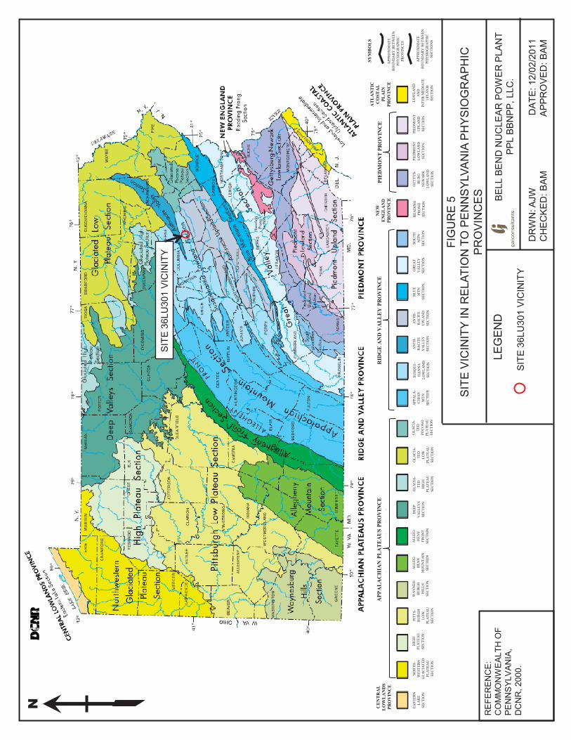
Chapter 2. Site SettingPhysiographySite 36LU301 is located in the Susquehanna Lowland Section of the Ridge and Valley physiographic province (Sevon 2000) (Figure 5). This section encompasses low to moderately-high linear ridges, linear valleys, and the Susquehanna River Valley. Relief is low to moderate, and the drainage pattern is trellis and angulated. A narrow prong of the Anthracite Valley Section of the Ridge and Valley lies approximately 6 kilometers (4 miles) north of the project area. The Glaciated High Plateau Section of the Appalachian Plateaus Province occurs in the northwestern portion of Luzerne County, approximately 25 kilometers (16 miles) north of the project area. All of Luzerne County has been glaciated. Uplands in the region are covered with the Wisconsin age Olean Till (Sevon and Braun 2000), while the Susquehanna River valley is mapped with stratified drift of Recent to Late Illinoian age.
The North Branch Susquehanna River originates in Otsego Lake near Cooperstown, New York (Kaktins and Delano 1999). From there the river flows in a southerly direction, crossing the Pennsylvania border where it makes a sharp turn to the northwest and flows back into New York. The river re-enters Pennsylvania further west near Sayre, Pennsylvania, and flows southeast to the Wilkes-Barre area. At Wilkes-Barre, the river flow direction is controlled by the intense structural geology folding of the Anthracite Valley Section of the Ridge and Valley Province, which causes the river to make an abrupt 90-degree turn to the southwest and flow through Luzerne County. It continues in a southwesterly direction until its junction with the West Branch Susquehanna River just north of Sunbury, Pennsylvania. From Sunbury, the main branch Susquehanna River generally flows south, eventually entering Maryland and emptying into the Chesapeake Bay. The river has a total length of 715 kilometers (444 miles) and it drains 71,225 square kilometers (27,502 square miles), covering nearly half of the land area of Pennsylvania and portions of New York and Maryland.
In the general site vicinity, the North Branch Susquehanna River flows south to the area of Wapwallopen, where it makes a curve to the southwest. This curve is referred to as Bell Bend. The river continues its southwesterly flow downstream, past Berwick and on to Sunbury. The width of the channel near the study area ranges from 200 to 300 meters (656 to 984 feet). Further downstream near Berwick the channel broadens to 500 meters (1640 feet). Several islands are present in the channel, the most notable being Gould Island near the northern boundary of the overall Bell Bend project area.
GeologyThe bedrock in the project vicinity consists of Middle to Upper Devonian shale, claystone, sandstone and limestone (Inners 1978). Site 36LU301 and the majority of the surrounding upland flats are mapped with the Middle Devonian Mahantango Formation of medium-dark to dark-gray silty to very silty claystone. The northernmost edge of this formation is differentiated into the Tully Member of the Mahantango Formation. The Tully Member consists of medium dark-gray, argillaceous, fine grained limestone and calcareous clay shale. North of the site, between Beach Grove Road and the northernmost SSES cooling tower, lies a band of the Middle Devonian Harrell Formation (Inners 1978). The Harrell Formation consists of dark-gray to grayish black clay shale and silty clay shale that forms splintery and platy fragments. The area north of Beach Grove Road is mapped with the Upper Devonian Trimmers Rock Formation. This formation consists of medium gray to medium dark-gray, fine-grained to very fine-grained sandstone, siltstone and shale. The uplands to the north of Beach Grove Road are steep with moderately broad summits and as much as 170 meters (558 feet) relief.
N
SITE
36L
U30
1 VI
CIN
ITY
LEG
EN
D
DR
WN
: AJW
DA
TE: 1
2/02
/201
1
CH
ECKE
D: B
AM
APPR
OVE
D: B
AM
BE
LL B
EN
D N
UC
LEA
R P
OW
ER P
LAN
T PP
L BB
NPP
, LLC
.
FIG
UR
E 5
S
ITE
VIC
INIT
Y IN
RE
LATI
ON
TO
PE
NN
SYL
VAN
IA P
HYS
IOG
RA
PH
IC
PR
OV
INC
ES
R
EFE
RE
NC
E:
CO
MM
ON
WEA
LTH
OF
PE
NN
SYL
VA
NIA
, D
CN
R, 2
000.
SITE
36L
U30
1 VI
CIN
ITY
NO
RTH
-W
ESTE
RN
GLA
CIA
TED
PLA
TEA
USE
CTI
ON
EAST
ERN
LAK
ESE
CTI
ON
PITT
S-B
UR
GH
LOW
PLA
TEA
USE
CTI
ON
HIG
HPL
ATE
AU
SEC
TIO
N
WA
YN
ES-
BU
RG
HH
ILLS
SEC
TIO
N
ALL
EG-
HEN
YM
OU
NTA
INSE
CTI
ON
ALL
EG-
HEN
YFR
ON
TSE
CTI
ON
DEE
PV
ALL
EYS
SEC
TIO
N
GLA
CIA
-TE
DH
IGH
PLA
TEA
USE
CTI
ON
GLA
CIA
-TE
DLO
WPL
ATE
AU
SEC
TIO
N
GLA
CIA
-TE
DPO
CO
NO
PLA
TEA
USE
CTI
ON
APP
ALA
-C
HIA
NM
TNSE
CTI
ON
SUSQ
UE-
HA
NN
ALO
WLA
ND
SEC
TIO
N
AN
TH-
RA
CIT
EV
ALL
EYSE
CTI
ON
AN
TH-
RA
CIT
EU
PLA
ND
SEC
TIO
N
GR
EAT
VA
LLEY
SEC
TIO
N
BLU
EM
TNSE
CTI
ON
SOU
THM
TNSE
CTI
ON
REA
DIN
GPR
ON
GSE
CTI
ON
GET
TYS-
BU
RG
NEW
AR
KLO
WLA
ND
SEC
TIO
N
PIED
MO
NT
LOW
LAN
DSE
CTI
ON
PIED
MO
NT
UPL
AN
DSE
CTI
ON
LOW
LAN
DA
ND
INTE
R M
EDIA
TEU
PLA
ND
SEC
TIO
N
APP
RO
XIM
ATE
B
OU
ND
AR
Y B
ETW
EEN
PH
YSI
OG
RA
PHIC
PR
OV
INC
ES
APP
RO
XIM
ATE
B
OU
ND
AR
Y B
ETW
EEN
PH
YSI
OG
RA
PHIC
SE
CTI
ON
S
APP
AL
AC
HIA
N P
LAT
EA
US
PRO
VIN
CE
CE
NT
RA
LL
OW
LA
ND
SPR
OV
INC
E
RID
GE
AN
D V
AL
LE
Y P
RO
VIN
CE
NE
WE
NG
LA
ND
PRO
VIN
CE
PIE
DM
ON
T P
RO
VIN
CE
AT
LA
NT
ICC
OST
AL
PLA
INPR
OV
INC
E
SYM
BO
LS
Technical Report, Phase II National Register Evaluation, Site 36LU301
12
Geomorphology and DrainageAs noted above, all of Luzerne County was glaciated during the Pleistocene. According to maps prepared by Inners (1978), the project area occurs at the boundary of the Woodfordian (Late Wisconsin, circa 12-25 ka) glaciation to the north and east, and older glacial deposits to the west and south. The edge of the Woodfordian End Moraine map unit extends from Beach Haven, along the Susquehanna River, northward to Lee Mountain, beyond the project area. The mapped unit is depicted as a broken boundary with various segments separated by outwash, ground moraine, or kame deposits (Inners 1978). The area of Site 36LU301, located in the westernmost portion of the Bell Bend project occurs in the vicinity of this end moraine map unit. Woodfordian Ground Moraine deposits are mapped on the majority of the uplands to the north of the study area, the uplands in the northern portion of the previously surveyed Bell Bend West Alternative, and the uplands west of the bend in Confers Lane (see Figure 2). Both the end moraine and the ground moraine consist of till--an unsorted mixture of clay, silt, sand, gravel, cobbles and boulders. The remainder of the uplands in the project vicinity west of Route 11 is mapped with the Woodfordian Kame Terrace, and Outwash, Undivided map unit (Inners, 1978). This unit is relatively flat to gently sloping land surfaces and consists of unconsolidated and stratified sand, gravel, and cobbles with some boulders.
Woodfordian outwash and kame deposits are also mapped along the Susquehanna River to the south and west of the end moraine (Inners, 1978). The town of Berwick, located west of the project area, is largely built on Woodfordian outwash deposits. The uplands to the south and west of the end moraine are mapped with discontinuous deposits of Altonian (circa 45-70 ka) and Illinoian (circa 500 ka) glacial deposits.
The Susquehanna River valley floor, east of Route 11, is mapped predominantly with the Holocene Alluvium map unit (Inners, 1978). This unit extends northward (upstream) beyond Gould Island and southward to Berwick. Within the Bell Bend project area, the width of the Holocene Alluvium unit (and the valley floor) ranges from about 400 to 670 meters (1312 to 2198 feet). Further downstream beyond Bell Bend, the unit is very narrow ranging from 60 to 140 meters (197 to 459 feet).
A review of the PHMC-BHP’s on-line Cultural Resources Geographical Information System (CRGIS) data base indicates that Site 36LU301 is located within Susquehanna River Basin, Subbasin Number 5 (The Central Susquehanna), Watershed D (Nescopeck Creek). The Central Susquehanna subbasin has a total drainage area of 1,761 square miles that includes the Susquehanna River from the Lackawanna River to the West Branch Susquehanna River, spanning Luzerne, Columbia, and Lackawanna Counties, and reaching portions of Schuylkill, Northumberland, Montour, Lycoming, Sullivan, Wayne, Wyoming and Susquehanna Counties. The Nescopeck Creek watershed has a total drainage area of 261 square miles, with Nescopeck Creek representing the only major stream (http://www.dep.state.pa.us, accessed February 1, 2010).
The area of Site 36LU301 is drained by Walker Run, located 91 meters (300 feet) to its south, which flows southward directly into the Susquehanna River. A large wetland is mapped at a confluence of Walker Run and unnamed tributaries, southeast of the site, opposite North Market Street. A man made pond borders the edge of Walker Run, immediately southwest of the site.
Upland localities east of the site are drained by an unnamed tributary which empties southward into the Susquehanna River. Further to the west, Salem Creek, Glen Brook, and their tributaries drain the uplands between the site area and Berwick. The east bank of the
Technical Report, Phase II National Register Evaluation, Site 36LU301
13
Susquehanna River, opposite the project area is drained primarily by Wapwallopen, Little Wapwallopen and Nescopeck Creeks, and their tributaries, which empty directly into the river.
SoilsThe site vicinity is mapped as the Chenango-Pope-Wyoming soil association (Bush 1981). This soil association is characterized by relatively level to sloping glacial outwash terraces, moderate to very steep hillsides, and relatively level floodplains. Uplands in the general site vicinity (north and west of U.S. Route 11) consist of glacial till and glacial outwash soils (Bush 1981). Glacial till soils, which weathered from sandstone, shale, siltstone and conglomerates, occur on the highest uplands to the north of the site, and on the highest elevation knobs and hillsides to its north and east. Site 36LU301and the majority of surrounding upland settings consist of glacial outwash soils, which formed in thick sediments derived from melting glacial ice. These broad, gently sloping areas represent the highest outwash terraces of the Susquehanna River and are Late Illinoian to Wisconsin in age. The wetlands that have developed on these terraces are also formed in glacial outwash. The site area itself is mapped predominantly as Chenango gravelly loam (ChA), with an area of Braceville gravelly loam (BrA) along its western edge (Figure 6). Soil types in the surrounding localities of glacial outwash include Chenango gravelly loam (ChA, ChB, ChC) and Braceville gravelly loam (BrA, BrB, BrC), as well as Atherton silt loam (At), Rexford loam (RdA, RdB) and Wyoming gravelly loam (WyD, WyF) (see Figure 6). Chenango gravely loam is found across large areas of cultivated fields, such as Site 36LU301; smaller areas of open fields are mapped with Braceville gravelly loam. In the surrounding area, Atherton silt loam and Rexford loam are associated with poorly drained localities while Wyoming gravelly loam occurs on steep hillsides.
Due to its upland setting Site 36LU301 has no potential for deeply buried cultural resources. Cultural resources in this locality are anticipated to be associated with the modern ground surface. Ground surface disturbances in the site area result from prior cultivation and an historic farmstead occupation (along the southern edge).
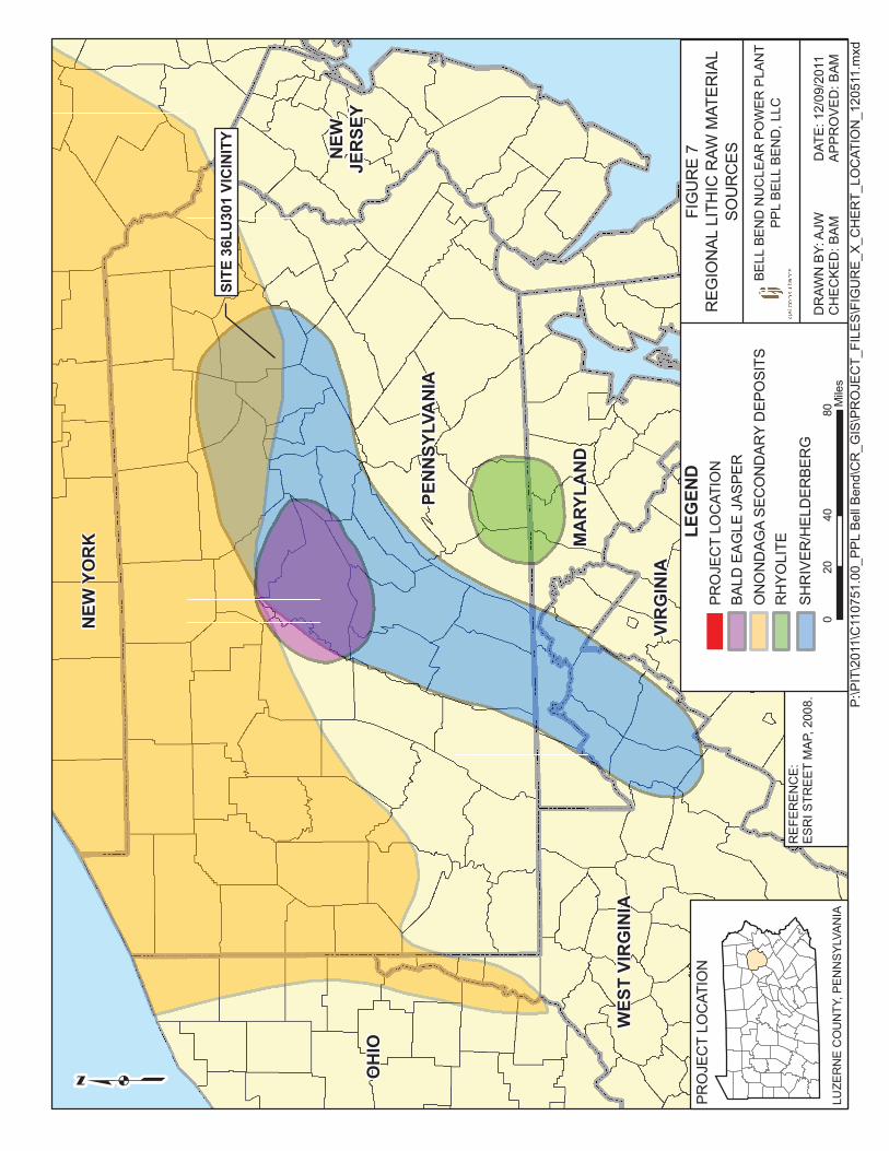
Prehistoric Toolstone Resources The geologic landscape of the Central West Branch subbasin provided Native Americans with not only livable terraces and highly productive soils, but also with a variety of lithic raw materials for stone tool production, including numerous cherts, jaspers, and quartzites. Among the most widely known lithic raw materials include Bald Eagle jasper, Shriver chert, Onondaga chert, oolitic chert, and Nittany chert (MacDonald 2006). Several other lithic raw materials, including rhyolite (from south-central Pennsylvania), steatite (from the Upper Potomac River), and Flint Ridge chert (from eastern Ohio), were transported into the region within the toolkits of Native Americans and mark the boundaries of trading systems and settlement patterns.
Two varieties of chert that could be attributed to specific geologic sources were deposited as artifacts at the Bell Bend sites (Figure 7). These include Shriver/Helderberg chert and Onondaga chert. Shriver/Helderberg chert is found in outcrops of the Helderberg formation, which extends in a northeast/southwest trending band following the ridgelines, from West Virginia and Virginia, into northeast Pennsylvania. This raw materially is locally available and was the most common material identified during GAI’s previous Phase Ib and Phase II investigations of prehistoric sites in the BBNPP project area. Onondaga chert outcrops in New York and also occurs as secondary deposits of cobbles that are transported throughout the river systems from New York and southward. Cobbles of Onondaga chert are available locally from stream beds.
Technical Report, Phase II National Register Evaluation, Site 36LU301
14
Figure 6. Project Area Soils
REDACTED Figure 6Project Area Soils
Technical Report, Phase II National Register Evaluation, Site 36LU301
16
In addition, calcareous clay shale (claystone) occurs on-site as a surface outcrop exposed in the cultivated field within the north-central portion of the site. The rock outcrop has undoubtedly been impacted by plowing and fractured pieces of claystone are ubiquitous across the ground surface in the vicinity of the outcrop. This raw material fractures naturally in a thin platy fashion, resulting in fragments with flake-like characteristics but with edges that are friable and easily broken. Over 200 specimens of claystone were initially collected during Phase II testing, however, following laboratory processing and analysis, all but six of these (exhibiting clear flake morphology) were concluded to be non-cultural and were discarded. As no tools made from claystone were recovered from the site, the use of this raw material as a prehistoric toolstone cannot be conclusively confirmed.
Several other cherts were used in toolstone production but they could not be identified with a specific sourced material type. These unsourced cherts were described primarily by color and include black and dark gray cherts.
In addition to the various cherts, other unsourced toolstone materials found in the prehistoric artifact assemblage include metamorphic rock and sandstone, typically used for cobble tools and/or fire-cracked rock (FCR). Phase II testing (plowzone stripping) exposed a gravel bar, representing a former stream channel, extending in a southwest/northeast band through the northwest quadrant of the site. A portion of a second gravel bar was also documented in the southern portion of the site. Sandstone cobbles found in these stream deposits may have been one source of this raw material; cobbles were also available in glacial till and outwash deposits in the surrounding uplands.
Within the Site 36LU301 Phase Ib and Phase II flaked stone assemblage, Shriver/Helderberg chert was the most common raw material type, followed by Onondaga chert. Sandstone and metamorphic rock were used predominantly for fire-cracked rock and cobble tools. The remaining raw material types occurred in lower frequencies.
Modern and Past ClimatesThe modern, local climate within the project area is classified as humid continental, with some modifications due to proximity to the Great Lakes and to the Atlantic Ocean (Rossi 1999, Trewartha 1967). An even greater influence is provided by the Ridge and Valley physiography, which has many of the characteristics of a mountain-type climate. These characteristics include localized uplift of moisture-laden air masses producing increased precipitation on the windward side of ridges, and drier conditions on the lee side.
In Luzerne County, Canadian air masses collide with warm airflow originating in the Gulf of Mexico, creating ample precipitation for the region. Summers are typically warm with average temperatures ranging between 80° and 85° Fahrenheit (26° to 29° Celsius). The cold and cloudy winters accumulate approximately 15 inches (38 centimeters) of snowfall in the lower elevations and up to 70 inches (177 centimeters) in higher elevation. In winter, the daytime temperature ranges from 30° to 35° Fahrenheit (1.1° to 1.6° Celsius). Spring and fall are characterized by swift weather pattern changes with fluctuating periods of freeze and thaw during both seasons. The area has a mean annual precipitation of 40.1 inches (102 centimeters). The growing season in Luzerne County averages 120-150 days (USDA, SCS 1981).
Pennsylvania has experienced three main climatic changes over the last 12,000 years (Carr 1998a, Guilday et al. 1964, Guilday et al. 1977, Stingelin 1965). First, at the late Pleistocene/early Holocene transition (circa 11,000 B.P.), a warmer and moister climate (although cooler than present) caused the northward movement of most plant communities

Technical Report, Phase II National Register Evaluation, Site 36LU301
17
and glacial retreat. Glacial deposits were present throughout the area, as glaciers reached as far south as Picture Rocks, in nearby Lycoming County (USDA, SCS 1986). Between 10,000 and 6000 B.P., climates became warmer and drier with the onset of the Hypsithermal/Altithermal. In the project vicinity, this change likely resulted in the establishment of the modern Mixed Mesophytic forest, including oak, hickory, and chestnut. Finally, after 3000 B.P., human modification of the landscape via fire and agriculture increasingly affected the ecological mosaic, leading to an increase in oak forests along with grasses and sedges (Joyce 1988, Watts 1979).
PaleoenvironmentThe project area falls within a basswood-beech-oak-hemlock Mixed Mesophytic forest region (Braun 1950) that became entrenched during the Holocene. Prehistoric faunal assemblages in the Appalachians revealed a rich and diverse fauna for forager exploitation. The white-tailed deer was the most commonly exploited mammal. Other species hunted by prehistoric populations were black bear, bobcat, river otter, raccoon, squirrel, beaver, woodchuck, fox, and rodents. Prehistoric Native Americans also exploited avian and aquatic resources. Except for the extinction of certain large animals (elk, wolf, and cougar) and increases in other species populations, such as white-tailed deer, turkey, and woodchuck, the faunal composition of the area is little changed from early historic times (Shelford 1963).
With easy access to resources in a variety of upland and riverine settings, prehistoric inhabitants extensively utilized this region, which generally has a high potential for prehistoric archaeological sites. However, the pattern of previously recorded sites in the vicinity suggests that there was a preference for the larger drainage valleys along Susquehanna River. Few sites have been recorded in uplands settings similar to that of Site 36LU301.

Technical Report, Phase II National Register Evaluation, Site 36LU301
18
Chapter 3. Culture HistoryThe purpose of this chapter is to provide a general context for the Phase II investigations of prehistoric Site 36LU301. Both the Native American and Euro-American culture history sections focus on Pennsylvania’s Susquehanna Valley region.
Native American PrehistoryPaleoindian (15,000 to 10,000 B.P.)Humans first entered North America during the Paleoindian period, which dates to before 10,000 B.P. Radiocarbon dates recorded at Meadowcroft Rockshelter in western Pennsylvania have conservatively placed the earliest date of site occupation to approximately14,500 B.P. (Adovasio et al. 1999); occupation of the Shawnee-Minisink Site in eastern Pennsylvania has been placed between 10,000 and 11,000 years ago (McNett 1985). Although the exact date of human entry into the New World remains obscure, it is generally agreed that the arrival was from Asia via Beringia (the area including modern day Northeastern Siberia, the Bering Straits, and Alaska), exposed during Pleistocene glaciations (Neusius and Gross 2007). The paleoclimate to which these populations were adapted was much wetter and cooler than the climate of today. Glaciers covered large portions of North America, terminating in northern Pennsylvania.
Paleoindian populations are viewed as having subsisted as relatively mobile bands of hunters and foragers. They have traditionally been viewed as primarily dependent on the hunting of Pleistocene megafauna such as mastodon, sloth, and giant beaver. Recent evaluations of the evidence for this type of subsistence base have suggested a more generalized hunting and foraging economy where Paleoindians exploited small game and wild plants (e.g., Meltzer 1988). Investigations of the Paleoindian levels at the Shawnee-Minisink Site, in eastern Pennsylvania, suggest that procurement and processing of seeds, berries, and fish reflect seasonally based procurement activities in this locality (McNett 1985; Dent 2002). In this light, more generalized subsistence strategies focusing on a variety of locally available species may have been the best available adaptation.
The majority of Paleoindian sites are interpreted as small, short-term campsites where activities included animal butchering and hide processing, as well as working of wood, bone and antler. Artifact scatters with fluted stone spear points and flake tools used for cutting and scraping mark these sites. The projectile points for this period include forms such as Clovis, Cumberland, and the unfluted Lanceolate Plano cluster (Justice 1987). Dalton cluster points are typical of the Late Paleoindian and some appear to be a technological transition into Early Archaic forms (Justice 1987). Paleoindian tool kits include polyhedral blade cores for producing expedient flake tools, as well as endscrapers, sidescrapers, and gravers. Bipolar reduction techniques may have been employed to allow for exploitation of a wider range of raw materials (Tankersley 1996: 31).
In the glaciated portions of northern Pennsylvania, Paleoindian points and sites typically occur on lowland terraces of small tributaries. Lantz (1984) observed that many Paleoindian sites also occur on glacial features such as glacial kames, terraces, and moraines near springs, wetlands, creeks, and rivers. These areas are considered to be game-attractive settings (Tankersley 1996: 28). In unglaciated regions, Paleoindians sites are located at “more diverse elevations with few areas of concentration” (Lantz 1984).
Researchers suggest that sources of cryptocrystalline raw material were important focus of these groups (Lantz 1984; Tankersley 1996). Studies conducted in the Blue Ridge area of

Technical Report, Phase II National Register Evaluation, Site 36LU301
19
Virginia (Gardner 1977) indicate that these lithic sources were a primary focus of Paleoindian groups. However, more recent examinations of sites across Virginia (Barber 2003) caution that this is only one of probably multiple factors weighing on the Paleoindian selection process for settlement location. Quarry-related sites in the Ridge and Valley province may occur in association with primary outcrops of these materials, or with cobble beds yielding chert, jasper, and other cryptocrystallines.
Many sites dating to the Paleoindian period have been recorded in the Susquehanna River Valley. However, in Pennsylvania, as in other areas, the majority of these sites are represented by isolated finds, limiting the evidence for subsistence activities of these populations. Prior to GAI’s investigations of the Bell Bend project area, only one previously recorded Paleoindian site, consisting of an isolated Paleoindian projectile point, had been documented in Luzerne County. GAI’s field investigations of the Bell Bend project area produced two Paleoindian points from prehistoric Site 36LU288, situated on a low terrace/floodplain west of the North Branch Susquehanna River (Munford et al. 2010). In addition, one Paleoindian point was recovered from a disturbed context within an historic period farmstead site (Site 36LU286), located approximately 259 meters (850 feet) east of Site 36LU301, in a similar upland setting above Walker Run. No Paleoindian diagnostic artifacts were recovered from Site 36LU301.
Early Archaic (10,000-8000 B.P.) The beginning of the Archaic period in eastern North America is generally associated with the onset of the Holocene, which directly followed the end of Pleistocene glaciation. The warmer, drier climate that resulted from the retreat of the Pleistocene glacial ice led to the replacement of a subarctic regime with more heterogeneous flora and fauna (Caldwell 1958). Gradual cultural change occurred as groups began to schedule their activities and specialize in methods of seasonal resource extraction in response to the existence of a more diversified resource base.
Although archaeological research on the Early Archaic period in the region has been limited, it is likely that patterns characterizing the Northeast in general were also typical of central and western Pennsylvania (George 1985). Many archaeologists believe the Early Archaic represents a continuation of the basic Paleoindian subsistence/settlement pattern. This notion is supported by a number of studies in the Mid-Atlantic region that indicate a continuity of lifeways at Paleoindian/Early Archaic sites in Delaware (Custer 1988), the Shenandoah Valley (Gardner 1980), and the Great Valley in Pennsylvania and Maryland (Stewart 1980). Groups remained highly mobile, and Carr (1998b:49, 60) and Stewart and Katzer (1989) suggest that the region sustained a significant population increase during the early Holocene. Territories became somewhat more limited as the spread of deciduous forests led to a greater dispersal of game species (Carbone 1974).
Technologically, the shift in projectile points from the earlier fluted forms to notched and serrated varieties may represent a change from a thrusting to a throwing technique that suggest changes in the hafting of these projectiles to dart or spear shafts. This shift in the design of hunting weaponry may reflect a change in prey species from Pleistocene to Holocene fauna. Projectile point forms typical of this period in the Susquehanna Valley include Palmer, Kessel, Charleston, and Kirk, corner-notched and stemmed points (Custer 1996; Justice 1987). Non-diagnostic tools on Early Archaic sites can include bifaces, and utilized and retouched flakes. Early Archaic sites also witness the first evidence of ground stone technology. Examples include flaked and ground celts and axes along with abraders. Early Archaic trends in lithic raw material use show a continued preference for high quality
Technical Report, Phase II National Register Evaluation, Site 36LU301
20
materials, such as jaspers and cherts, and the introduction of rhyolite to the tool assemblages (Carr 1998a). Often these materials are considered non-local to the sites and may indicate a wider range of settlement and/or procurement rounds (Carr 1998b).
Within the limits of the two watersheds in the site vicinity, only six sites with Early Archaic components have been identified. Three of these sites were located on low floodplain or terrace settings near the current study (PHMC/BHP 2010).
GAI’s 2008 Phase Ib survey of the Bell Bend project area documented two Early Archaic Isolated Finds (IF 2 and IF 15), consisting of individual diagnostic projectile points, in the upland flats east of Site 36LU301 (Munford et al., 2010). One Kirk corner notched point was recovered from a cultivated field approximately 0.9 kilometers (0.5 miles) to the east, while one Palmer point was found in a cultivated field along the east edge of North Market Street, immediately opposite the site.
Middle Archaic (8000-5000 B.P.)Like the Early Archaic period, the Middle Archaic is poorly understood in the Ridge and Valley (George 1985; Carr 1998a). Based on an understanding of this period in adjacent regions, however, researchers assume that population densities continued to increase because of the wider availability of food resources. Carr (1998a) notes a “significant increase in population” during the Middle Archaic in the Susquehanna region. A shift occurred toward more logistically organized subsistence/settlement patterns. In the American Midwest, there is evidence to suggest a decline in residential mobility for Middle Archaic populations, at least on a seasonal basis (Brown and Vierra 1983).
Bifurcate point production is the major technological change between the Early and Middle Archaic periods in the Ridge and Valley of Eastern Pennsylvania. Point forms indicative of the Middle Archaic period include Neville/Stanly and LeCroy, with fewer examples of MacCorkle, St. Albans, and Kanawha stemmed points in central Pennsylvania (Kuhn 1985). Rare examples of Morrow Mountain and Guilford type bifaces are found in the region (Cowin 1991:46). The processing of plant foods also grew in importance, and seems to be reflected in the tool assemblage by the introduction of various grinding and pitted stones (Graybill 1995:37). More local lithic resources were exploited and there seems to be an emphasis on more expedient tool production (e.g., bipolar reduction of cobbles) rather than curated tools such as bifaces of select high quality materials (Carr 1998a:88; Custer 1996:151; Graybill 1995:37).
Middle Archaic sites have been identified in a wider variety of settings than the previous Paleoindian and Early Archaic period sites. Cowin (1991:48) characterizes the Middle Archaic settlement system as consisting of base camps positioned on Holocene-age river terraces, smaller resource procurement stations for seasonal plant and animal exploitation in upland settings, and lithic reduction stations near bedrock outcrops of stone exploited for tool manufacture. Custer (1996:154-155) suggests that the base camps are located in areas where multiple resources are readily accessible, not just river terraces, and that procurement sites are positioned to focus exploitation on a single resource. He has revised his previous scenario, which included macro-band and micro-band base camps, and now sees evidence that the larger sites (previously termed “macro-band”) are simply a result of more frequent use rather than use by larger groups.
Previous research in Central Susquehanna Watersheds B and D has identified ten sites with Middle Archaic components. Of these sites, three are situated in the vicinity of Site 36LU301 in floodplain or terrace settings (PHMC/BHP 2010).
Technical Report, Phase II National Register Evaluation, Site 36LU301
21
One Early/Middle Archaic MacCorkle-like point was recovered from the surface of Site 36LU301 during GAI’s Second Supplemental Phase Ib survey.
GAI’s 2008 Phase Ib survey of the Bell Bend project area recovered two isolated diagnostic Early/Middle Archaic points (one MacCorkle-like point and one Kanawha point), recorded as IFs 3 and 5, from the surface of a cultivated field on an upland flat approximately 0.9 kilometers (0.5 miles) east of the current site (Munford et al., 2010).
In addition, Phase II investigations of Site 36LU301 identified two prehistoric thermal features (hearths) that have been radiocarbon dated to the Middle Archaic period. Radiocarbon analysis of samples from Feature 150 produced a date of 5120+/-40 B.P. (Beta-309435) while Feature 171 samples yielded a date of 7150+/-40 B.P. (Beta-309438).
Late Archaic (5000-3000 B.P.) The Late Archaic period witnessed major environmental changes, which seem to coincide with cultural changes, including continued population growth, a greater shift to logistically-oriented subsistence/settlement patterns, and the establishment of exchange networks. The appearance of more diverse artifact forms also marks this period. In other areas of eastern North America, the Late Archaic period yields the first evidence of fiber-tempered pottery (Reid 1984; Skibo et al. 1989), burial mounds (Charles and Buikstra 1983), and the use of domesticated plants (Ford 1985; Smith 1987).
Change toward a more logistical settlement pattern is paralleled by an increase in the number and types of sites, at least as seen in the region around Southeastern Pennsylvania (Custer 1983, 1988). Custer (1983) suggests that large base camp sites are found on well-drained land near large drainages or wetlands, while small procurement and extraction stations are found in upland areas.
Within central and eastern Pennsylvania, diagnostic artifacts of the Late Archaic period include Laurentian point types (Kinsey 1972:403-408; Ritchie 1965), such as Otter Creek, Vosburg, and Brewerton, as well as narrow-stemmed Piedmont point types (Kinsey 1972:418-417), including Poplar Island, Lackawaxen, Normanskill, and Lamoka. Subsequent Terminal Archaic projectiles include the Susquehanna and Perkiomen Broadspear, as well as Orient Fishtail points. Custer (1983) suggests that broad blade projectile points found in the neighboring regions may also represent knives. There is also an increase in the use of non-projectile point flaked stone technologies, including expedient flake tool and non-lithic tool types.
Non-diagnostic flaked stone artifacts at Late Archaic sites are dominated by unfinished bifaces and bifacial tools, expedient flake scrapers, drills, perforators, and utilized flakes. Additionally, the variety of groundstone implements in Late Archaic artifact assemblages increases, consisting of adzes, celts, gouges, and axes. The appearance of steatite vessels characterizes the latter part of the Late Archaic. As exchange networks increase in complexity during the Late Archaic, the importance of artifacts of rhyolite, argillite and steatite increased (Custer 1988; Dent 1995:202; Kent et al. 1971; Stewart 1987).
Within the nearby watersheds, Late Archaic components have been identified at 52 previously recorded sites. Of these 52, 13 sites occur near Site 36LU301, all in floodplain or terrace settings (PHMC/BHP 2010).
GAI’s 2008 Phase Ib survey of the Bell Bend project area recovered one diagnostic Middle to Late Archaic Piney Island point (IF 4), in a cultivated field on an upland flat 0.9 kilometers (0.5 miles) east of Site 36LU3U01 (Munford et al, 2010). In addition, one Late Archaic Brewerton
Technical Report, Phase II National Register Evaluation, Site 36LU301
22
eared-notched point (IF 11) was found in a cultivated field bordering the east edge of North Market Street, opposite (northeast of) the site.
Phase Ib and Phase II testing of Site 36LU301 yielded no diagnostic Late Archaic artifacts or features.
Early Woodland (3000-2100 B.P.)The Woodland period is better known in Pennsylvania than the preceding cultural periods. The major diagnostic traits traditionally cited for the Woodland period include burial ceremonialism, an increased reliance on horticulture, and extensive use of fired clay ceramics. Although the subsistence base was primarily composed of resources collected by the traditional patterns of hunting and gathering that persisted from the Archaic period, horticulture gradually assumed greater importance. This led to a subtle change in settlement patterns toward a more sedentary lifeway. Settlements focused on the most predictable resources and the areas with highest productivity. Semi-sedentary, very large base camps are situated in the floodplains of major drainages.
The emergence of the Adena cultural complex in the central Ohio Valley influenced groups as far east as New York and New Jersey and directly involved populations within the Susquehanna River watershed (Raber 1985). Beginning in the latter portion of the Early Woodland, Native Americans of the Adena and Meadowood cultures built burial mounds and other ceremonial facilities along the Ohio River and mid-Atlantic coast (Adena), as well as along the upper portion of the Susquehanna Valley in New York (Meadowood) (MacDonald 2006).
Early Woodland sites in the greater Susquehanna Valley, including the Memorial Park Site on the West Branch in Lock Haven, reveal evidence of early domestication of squash, chenopod, maygrass, sumpweed, and sunflower (Hart 1995a). Ethnobotanical remains from various Early Woodland sites suggest that, while domesticates were introduced, they were dominated by the use of widely available wild plant foods (Adovasio and Johnson 1981; Ballweber 1989; Ritchie 1980).
Ceramics generally function as cultural markers during the Woodland period. The general trend of Early Woodland pottery in central Pennsylvania and the greater Susquehanna River Valley was toward the production of coarse, crushed rock-tempered, and thick-walled conoidal vessels with cordmarked surface treatment. Marcey Creek, Juniata Thick, and Vinette I wares are characteristic of this region (Custer 1996). Stylistic changes are observable in these wares as Early Woodland potters replaced steatite temper with various forms of grit or crushed rock, including quartz, chert, and other minerals, and flat-bottomed vessels were replaced by conoidal-shaped ones (Custer 1996; MacDonald 2006).
Diagnostic lithic artifacts for the Early Woodland period in the greater Susquehanna Valley region include Cresap stemmed, Adena stemmed, Meadowood points (Ritchie 1980:181), and Robbins stemmed points (Justice 1987). Non-diagnostic stone tool assemblages include drills, perforators, scrapers, and utilized flakes. Additional artifacts associated with the Adena are tubular open-end and blocked-end pipes, copper beads and bracelets, cut mica, and groundstone gorgets and celts. Domestic (both Adena and non-Adena) sites typically yield groundstone tools, such as mortars, pestles, metates, manos, and pitted cobbles, while mortuary sites may contain ground slate objects, such as pendants, gorgets, and effigy pipes, as well as jewelry, projectile points, and blade/biface caches produced from exotic lithic raw materials (MacDonald 2006).
Technical Report, Phase II National Register Evaluation, Site 36LU301
23
Previous investigations have recorded 31 sites with Early Woodland components in the Central Susquehanna Watersheds B and D (PHMC/BHP 2010). However, only nine recorded sites containing Early Woodland components are located in the vicinity of Site 36LU301. As with the earlier time periods all of these sites were found in floodplain or low terrace settings.
The current study recovered one diagnostic Early Woodland specimen, a Cresap-like point, from Site 36LU301. In addition, based on the results of radiocarbon analysis two prehistoric thermal features (hearths) identified at the site were dated to the Early Woodland period. Feature 153 produced a radiocarbon date of 2780+/-40 B.P. (Beta-309436) and Feature 154 yielded a date of 2760+/-30 B.P. (Beta-309437).
Middle Woodland (2100 B.P. A.D. 900)The Middle Woodland period demonstrates a continuation of developments associated with the Late Archaic and Early Woodland periods. The Middle Woodland is characterized by further elaboration in burial ceremonialism, widespread interregional exchange, the increased importance of indigenous cultigens, and perhaps the first use of maize. After the end of Adena-related ceremonialism circa A.D. 250, the Hopewell complex flourished in Ohio and brought cultures in central and western Pennsylvania directly and/or indirectly into its exchange network (Kent et al. 1971). The seasonal hunting and gathering pattern continued, but with a greater emphasis on fishing. Settlement patterns are similar to those described for the Early Woodland. Settlements focused on the most predictable resources and the areas with highest productivity. Semi-sedentary, very large base camps are situated in the floodplains of major drainages.
The diagnostic ceramic types of this period are thick, but more finely grit-tempered wares that exhibit surface finishes of net-marking or cord-marking (e.g., Point Peninsula and Owasco). Associated projectile point forms are a mix of stemmed and notched varieties, including Fox Creek, and Jack's Reef types.
Twenty previously-recorded sites with Middle Woodland components occur in the Central Susquehanna Watersheds B and D. Only four of these previously identified sites are situated near the current study area (PHMC/BHP 2010), all in lowland settings.
Phase Ib and II investigations of Site 36LU301 produced no diagnostic Middle Woodland artifacts or features.
Late Woodland (A.D. 900 1600)The Late Woodland period in the Upper Susquehanna drainage is characterized by increasing cultural variability and an increase in the use of agriculture to supplement gathered wild food supplies. Although wild food resources remained a major part of the diet during the Late Woodland, data regarding subsistence indicates that maize, domesticated Chenopodium, as well as tobacco and sunflower used in the in the Susquehanna basin (Hart 1995b). Wild foods include hickory, chestnut, hazelnut, walnut, butternut, black walnut, acorn, wild rice, and a variety of mammals, fish, and birds. In consort with the change in subsistence pattern, village nucleation and increasing populations marked settlement patterns. There is evidence of large, circular, fortified multi-seasonal villages in floodplain settings. Social organization became more complex during the Late Woodland, and led to the emergence of tribal societies. The presence of palisaded villages suggests that intergroup relations were characterized by violence and competition, as well as intertribal alliances. Treatment of the dead changes, with ossuary burials identified during the Late Woodland.
The Late Woodland period seems to have experienced a more rapid population growth than the preceding periods. The population increase also corresponds with an increasing use of the
Technical Report, Phase II National Register Evaluation, Site 36LU301
24
Susquehanna drainage and vicinity. Sixty-five sites yielding Late Woodland components were identified within the Central Susquehanna Watersheds B and D. Of the previously identified sites, ten sites near the current study area yielded Late Woodland components (PHMC/BHP 2010).
The Late Woodland in this region can be divided into three sub-phases: Clemson Island (A.D. 750/900-1250), Stewart (A.D. 1250-1350), and McFate-Quiggle (A.D. 1350-1550/1600) (Graybill 1995). Clemson Island occupations show evidence that houses and large storage features were built, suggesting a fairly sedentary, agricultural community (Hart 1995b). Clemson Island pottery shows an increase in finely-made cordmarkings and punctations on vessel exteriors, an increase in decorated lips, and an increase in finely-crushed quartz, chert, or other grit temper. Some evidence of shell temper is observed in later Clemson Island pottery collections (MacDonald 2006). Ground stone tools increase in quantity due to the need for plant-processing equipment (Graybill 1995). Clemson Island stone tool assemblages consist of expedient tools for daily tasks and a decrease in biface production. Projectile points consist mainly of Levanna and Madison triangles and some Jack’s Reef corner-notched. Shenks Ferry sites typically yield only triangle points, which generally decrease in size over time (MacDonald 2006).
The Stewart Phase is believed to have developed locally out of the preceding Clemson Island complex. There is strong evidence for interaction with the down river Shenks Ferry populations and the Owasco-Iroquoian populations to the north (Graybill 1995). The Stewart Phase pottery is dominated low-collared forms of rock-tempered Shenks Ferry Incised and Shenks Ferry Cordmarked. Diagnostic projectiles points continue to be varieties of Levanna and Madison triangles.
The McFate-Quiggle Phase shows a continued focus on large fortified villages in the valleys of major drainages. Their ceramics are characterized by high-collared, shell-tempered varieties that exhibit distinctive incised line patterns (Graybill 1995). Again, diagnostic projectile points are primarily varieties of Madison triangular forms.
No Late Woodland diagnostic artifacts were recovered during Phase Ib and Phase II investigations of Site 36LU301.
Protohistoric/Contact (A.D. 1600 1750)In the Susquehanna River Valley south of the site vicinity, the Susquehanna River divides into its North and West Branches. The region is known for its rich soils, particularly near the mouths of principal tributaries, and former heavy timber coverage. Its mountains were originally a barrier to travel and settlement was initially slow; yet the timber and iron ore extracted from the mountains provided a source for industrial prosperity and growth.
The Andastes or Susquehannocks were known to have occupied the Susquehanna Valley as early as the year 1620. They are believed to have migrated southward from populations living in what is now New York State. Initial occupations appear to be represented by dispersed hamlets in the upper Susquehanna Valley, but later habitation established a series of fortified villages along the Lower Susquehanna River Valley (Custer 1996). Archaeological and ethnohistorical evidence indicates that this new group of people in the Susquehanna Valley brought with them a social organization that was different from the preceding populations. One sign of this is the introduction of Iroquois-style longhouses in the villages. The Susquehannocks became the dominate group in the central Mid-Atlantic region, and a vast array of trade goods has been found at sites during this period. The Susquehannocks occupied the Susquehanna Valley into the middle of the seventeenth century. By the

Technical Report, Phase II National Register Evaluation, Site 36LU301
25
beginning of the eighteenth century, they had already been removed as the dominate power in the region, and the native populations throughout the Mid-Atlantic were fragmented and dispersed due to increasing European settlement and control.
Initially, after the demise of the Susquehannocks, many different Indian groups migrated to Eastern Pennsylvania due to the more tolerant treatment by William Penn (Custer 1996). However, increasing pressure made those settlements unsustainable, and many groups began to form alliances with the Iroquois Nation, which seemed to have a strong influence on the region. During the last quarter of the seventeenth century and the first half of the eighteenth century, members of the Algonquin (Lenapi and Shawnee), Iroquois (Haudenosaunee), and Siouan (Tutelow and Catawa) tribes lived near the fork of the Susquehanna River. The Algonquins and Siouans, after being conquered by the Haudenosaunee, were absorbed into the Six Nations alliance of tribes. The Oneida Chief Shikellamy, a leader among the Six Nations, established his seat of power near what is now Milton. In 1741, he moved his headquarters to Shamokin, a Lenapi village in Northumberland County at the fork of the Susquehanna. From that location it was possible to travel up the North Branch to Lake Otsego, a short distance from Onondaga, New York, the center of government for the Six Nations. Additionally, the West Branch of the Susquehanna provided access to the upper Ohio Valley, and the Chesapeake Bay could be reached simply by traveling downstream along the main stem of the Susquehanna River. Nevertheless, most of the inhabitants of Shamokin moved westward to the Ohio lands following the death of Shikellamy in 1748 (Godcharles 1944:229-232).
Of the previously recorded archaeological sites in the general vicinity of the current study area just one site contained a Protohistoric/Contact era component (PHMC/BHP 2010). That site, located on the east side of the North Branch Susquehanna River, was identified as a cemetery.
Phase Ib and Phase II investigations of Site 36LU301 produced no diagnostic artifacts or cultural features dating to the Protohistoric/Contact period.
Euroamerican HistoryThe study area is located in Salem Township in western Luzerne County, east of the city of Berwick. The Susquehanna River flows east and south of the study area and forms the southern boundary of Salem Township. This region is predominately rural and agrarian in nature with Wapwallopen, and Beach Haven being the principal areas. While the study area was historically agricultural in nature, it was also impacted by mining of the large anthracite coal field in the Wyoming Valley to the north.
Euroamerican Settlement (1750 1840)Although William Penn was granted the Charter of Pennsylvania containing the present boundaries of Pennsylvania in 1681, the region remained largely unsettled by English colonists until the latter half of the eighteenth century (Archambault 1924:277). In the 1730s, Conrad Weiser, a noted Pennsylvanian German, travelled throughout the area that would become Luzerne County and noted the presence of Shawnee villages along the banks of the Susquehanna River (Pearce 1866:32). In approximately 1754, hostilities between Britain and France erupted into the Seven Years’ War or the French and Indian War. Most of the Shawnee and Lenape who were living in the Susquehanna River drainage allied themselves with the French during the conflict (Pearce 1866:40). After the Treaty of Paris in 1763, hostilities with the French ended. Delaware Chief Teedyuscung and other Native American leaders entered into council, and made peace with the English and settlement of the

Technical Report, Phase II National Register Evaluation, Site 36LU301
26
Pennsylvania frontier was open to American colonists (Pearce 1866:40-51). Shortly after the arrival of the settlers, Chief Teedyuscun perished in a suspicious fire, which triggered more hostilities of the Native American populations, and attacks were led against settlers throughout the western frontiers of Pennsylvania.
Settlement of the region progressed slowly during the 1770s. In 1774, the region that includes Luzerne, Wyoming, Susquehanna, Bradford, and a portion of Wayne Counties had a population of 1,922 (Pearce 1866:178). In a town meeting held in Wilkes-Barre on August 1, 1775, settlers resolved to join the American colonists in their fight against Britain. Hasty forts were constructed throughout the region (Pearce 1866:121).
In 1786, Luzerne County (encompassing present day Lackawanna, Wyoming, Susquehanna, and Bradford Counties) was created from part of Northumberland County. The county was named in honor Chevalier Caesar Anne de la Luzerne, who served as the French minister to the United States from 1779 to 1783.
In 1780, Sebastian Seybert settled at the mouth of Seybert’s Creek a mile west of Beach Haven and operated a gristmill and sawmill, as well as a distillery and clothiery (Bradsby 1893:643-644). In 1788, Mr. Walker constructed a gristmill on a small creek emptying into the Susquehanna a short distance upstream from Beach Haven. Prior to the construction of these mills, settlers in Salem Township shipped their grain via rafts up the Susquehanna to a mill located in Nanticoke.
The early settlers cleared their land, constructed houses, and raised a variety of crops and livestock for personal consumption. These farmers typically relied on storing less perishable items such as wheat, whisky, and salted pork (PHMC/BHP 2005b:15). Extra farm produce was traded locally for other needed goods and services. Their houses and barns were small, one-story, one or two room log structures. By 1840, new buildings (consisting of the two-story, “four-over-four” houses and banked barns) were built in the region (PHMC/BHP 2005b:159-165).
Agricultural development and settlement increased within the region, helped by improved transportation infrastructure, which made it easier to transport goods to more distant markets. The Lehigh-Nescopeck Highway was completed in 1790 to ease the burden of this travel, and allow a more efficient influx of goods in and out of the region. The decade between 1790 and 1800 witnessed a rapid increase in settlement largely due to transportation improvements. The population of Luzerne County rose from 2,000 to almost 13,000 during this decade.
After 1807, construction on the Susquehanna and Tioga Turnpike Road began in Berwick and proceeded north until it reached Elmira, New York in 1825. A ferry was opened to connect Nescopeck with Berwick and Beach Haven to the east. A bridge constructed across the Susquehanna River in 1816 connected Nescopeck to Berwick and also connected the Susquehanna and Lehigh Turnpike to the Tioga and Susquehanna Turnpike, providing easier access to other communities (Bradsby 1893: 612). A stage coach stop was established at Berwick to handle transportation needs of those passing through the area (Nescopeck Centennial Committee 1996: 34). These early roadways contributed to the economic growth and development of the area and, with a short connection from Lehigh to Philadelphia, the route provided the shortest distance from Philadelphia to Elmira, New York.
Construction of the North Branch Canal began in Berwick in 1828. The initial section of the canal extended 55 miles from Northumberland, at the fork of the North and West Branch of the Susquehanna River, to Nanticoke Falls, and was completed in 1831. The canal’s primary purpose was to transport the anthracite coal extracted in the Wyoming Valley to the main
Technical Report, Phase II National Register Evaluation, Site 36LU301
27
Pennsylvania canal system for transportation to other markets (Shank 1991:51). The canal spurred a general economic boom by providing an efficient means of transporting goods in and out of the region.
Economic Development (1840 1900)Farmers within the study area most likely relied on the North Branch Canal and the Susquehanna and Tioga Turnpike for the transportation of their goods to market until railroad lines were constructed in the area. In 1846 the completion of the Lehigh and Susquehanna Railroad, which connected the anthracite fields of the Wyoming Valley to the Lehigh River, proved to be a quicker and more efficient means of transportation. By 1856, the Lackawanna and Bloomsburg Railroad connected Scranton to Northumberland. Construction of this line began in 1854 and, by 1858, had reached Berwick. While the railroads became the preferred means of transportation for coal, agricultural products, and other supplies, the North Branch of the Pennsylvania Canal continued to be used in a limited capacity.
Following the Civil War, the Pennsylvania Railroad constructed a series of short routes in the region that connected to other anthracite-hauling routes to the northeast. The line that traversed through this area, also known as the North and West Branch Railroad, operated between Catawissa and the rich anthracite region of Wilkes-Barre. In 1873, the Delaware, Lackawanna, and Western Railroad took over the rails of the Lackawanna and Bloomsburg railroad, and added this spur to their larger system (Berwick Bicentennial Committee 1976:4). The Delaware, Lackawanna, and Western Railroad had earlier become the first anthracite region railroad that ran trains directly from the anthracite fields of the Wyoming Valley to New York Harbor. Many of the railroad corporations began purchasing coal land holdings after the Civil War, and by the turn of the nineteenth century railroads controlled 96 percent of the anthracite fields (Duncan and Sams 2002:18). By the 1880s, the more efficient railroad systems in the area had made the North Branch of the Pennsylvania Canal obsolete as a major transportation route.
The local region was located outside of the anthracite fields so farming continued in the rural areas within Luzerne County. The county witnessed a steady increase in the production of corn, sweet potatoes, and honey and beeswax in the latter half of the nineteenth century. Corn production rose from 290,122 bushels in 1849 to 478,648 bushels in 1879. Farmers of Luzerne County continued to grow oats, potatoes, wheat, rye, and buckwheat crops but not to the same extent as corn.
During the same period, the number of working oxen, other cattle, and sheep in Luzerne County steadily decreased. The number of working oxen in the county fell from 2,347 in 1850 to 358. The number of cattle and sheep also declined during the same period while dairy production and butter seemed to fluctuate.
The overall decline in agricultural production in Luzerne County was most likely due to the growing anthracite industry in the region attracting farmers from the fields to the mines or mining towns. In the late 1800s, many county residents became employed in the coal mines, as well as in other burgeoning industry related jobs. There were fewer families making a living farming; however, the project area was still largely rural and farmed in the late nineteenth to mid twentieth century. Local farmers continued to practice a diversified mix of production and sold their produce to markets in mining communities using transportation routes established earlier (PHMC/BHP 2005b:152).
As shown in Figure 8, in 1873 the general site vicinity consisted of scattered residences and farmsteads located in proximity to roads, railroads and waterways (Beers 1873). A residence

Technical Report, Phase II National Register Evaluation, Site 36LU301
28
identified as “S. Hill” is depicted inside the sharp bend in North Market Street in the location of the current Michaels farmstead and another residence is shown to the northeast, opposite North Market Street, in the location of Site 36LU286 (the Kisner Farmstead), investigated during GAI’s previous Phase II study of the Bell Bend project area. No structures are mapped in the field to the north of the current Michaels Farmstead.
The economic development and population within the study area continued to grow. By 1892, Beach Haven contained a post office, railroad station, two hotels, two general stores, two groceries, a brick yard, a blacksmith, and a shoemaker. The village boasted 300 residents (Bradsby 1893:647).
Economic Development in the Twentieth CenturyAt the end of the nineteenth century, labor unrest and union activity grew among Luzerne County’s miners. Tension over poor working conditions and pay escalated in the county, and eventually culminated in the Lattimer Massacre in September of 1897; during this tragedy, a Sheriff posse opened fire on miners killing 16 and wounding 38. Then, in 1902, 140,000 United Mine Workers went on strike that was finally settled with President Theodore Roosevelt’s assistance. After the strike, production of anthracite coal increased dramatically. By 1914, 181,000 people were employed in northeastern Pennsylvania’s anthracite mines.
Anthracite coal was commonly used in industrial production, such as steel mills, rather than home use. Two world wars created heavy demand for anthracite coal. The industrial demands created by World War I spurred a boom in anthracite production in 1917, with a national output of 99.7 million tons. After the war, production rapidly declined (Luzerne County 2006). The industrial needs of World War II created another demand for anthracite coal, and in 1944 63.7 million tons of anthracite coal was used. However, after the war, the use and mining of anthracite coal again sharply declined.
On January 22, 1959, tragedy struck the anthracite mining community. The Knox Mine Disaster occurred near the small town of Port Griffith, between Scranton and Wilkes-Barre. The company’s mines under the Susquehanna River collapsed, sending 10.37 billion gallons of water into mines. Other mines were shut down as mining companies feared that a similar accident might occur at their mines. This tragedy essentially ended the underground anthracite mining in the area, costing the county 7,500 jobs (Luzerne County 2006).
Hurricane Agnes struck the region in 1972. The storm dropped 18 inches of rain on an already saturated Luzerne County. The Susquehanna River rose 40.9 feet in some areas, and as the flood subsided 25,000 homes had been nearly destroyed and six people had lost their lives. The total cost of the estimated damage was set at $1 billion (Luzerne County 2006).
In 1975, Pennsylvania Power and Light Company purchased property for the Susquehanna electric steam plant. The construction of the nuclear power plant resulted in the relocation of families within the current APE. Most of these families relocated to nearby Berwick in Columbia County (Berwick Bicentennial Committee 1976:6).
The area in the immediate vicinity of Site 36LU301 remained largely agricultural through the twentieth century. Aerial photography of the area from 1939 (Figure 9) shows the Michaels Farmstead (residence and outbuildings) and indicates the presence of large cultivated fields to the north of the farmstead in the area of the Site 36LU301. No structures are depicted within the cultivated field. Aerial photographs dating to 1959 and 1969 show no changes in land use within the site area.

Technical Report, Phase II National Register Evaluation, Site 36LU301
29
Figure 8. Site 36LU301 Vicinity in 1873
REDACTED Figure 8Site 36LU301 Vicinity in 1873
Technical Report, Phase II National Register Evaluation, Site 36LU301
30
Figure 9. Site 36LU301 Vicinity in 1939
REDACTED Figure 9Site 36LU301 Vicinity in 1939
Technical Report, Phase II National Register Evaluation, Site 36LU301
31
Chapter 4. Phase Ib SummaryPhase Ib Methods and ResultsSite 36LU301 was identified in May 2010, during GAI’s Second Supplemental Phase Ib survey of the Bell Bend project area (Munford 2010). The site was encountered in the southern portion of a large cultivated field (Lot 41, Section 1) and the adjacent farmyard (Lot 41, Section 2) at the western edge of the study area (see Figure 4). Field investigations included pedestrian ground survey and judgmental shovel testing in the cultivated field and systematic shovel testing in the farmyard. Because cultural resources in this upland setting were anticipated to be near surface in nature, shovel tests were excavated to a maximum depth of 50 cm below ground surface. GAI conducted pedestrian survey of the field along transects spaced at 5-meter (16-foot) intervals (Photograph 3). Observed surface artifacts were marked with pin flags. Due to the dispersed nature of the artifact scatter, surface artifacts were plotted on a site map and recorded individually, rather than being collected within a surface collection block (as proposed in the scope of work). Twelve judgmental shovel tests were excavated in dispersed localities within the field to document stratigraphy and the depth of cultural deposits, with four of these (STPs 3, 10, 11, and 12) occurring within the site boundary (see Figure 4). All four of these shovel tests were negative. The farmyard south of the field was subject to
systematic shovel testing along transects spaced at 15-meter (49-foot) intervals (see Figure 4). Of the 21 systematic shovel tests excavated in the farmyard, only one STP (STP A2) produced a prehistoric artifact; one additional STP (STP E1) contained an historic specimen.
Photograph 3. Site 36LU301: Pedestrian Ground Survey of Cultivated Field (Lot 41, Section 1), Facing South
Phase Ib investigations yielded a dispersed low-density surface scatter of 14 prehistoric lithics, as well as a scatter of 21 historic specimens, across the southern end of the field. Systematic shovel testing within the farmyard yielded one additional prehistoric artifact from a single positive STP (STP A-2, A horizon), located at the northwestern edge of the yard (see Figure 4). Radial shovel tests excavated around this initial findspot produced no additional artifacts. Based on the results of Phase Ib survey, the site had dimensions of 80 x 200 meters (262x656 feet). Shovel testing revealed an Ap-B soil horizon sequence within the cultivated field (Lot 41, Section 1). As described for STP 10 the profile consisted of a 30-cm-thick dark yellowish-brown silt loam plowzone above a brownish-yellow silty clay B horizon (Figure 10). Shovel testing in the farmyard (Lot 41, Section 2) exposed an A-B soil horizon sequence. The profile of STP A-2 included a 30-cm-thick brown silt loam A horizon and a yellowish-brown clay loam B horizon (see Figure 10).
REDACTED Photograph 3
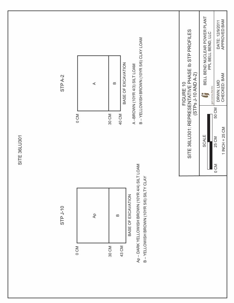
FIG
UR
E 1
0
SIT
E 3
6LU
301:
RE
PR
ES
EN
TATI
VE
PH
AS
E Ib
STP
PR
OFI
LES
(STP
s J-
10 A
ND
A-2
)
DR
WN
: LM
D
DA
TE: 1
2/9/
2011
C
HEC
KED
: BAM
A
PPR
OVE
D:B
AM
1 IN
CH
= 2
5 C
M
SCAL
E
0 C
M
25 C
M
50
CM
STP
J-1
0
Ap –
DAR
K YE
LLO
WIS
H B
RO
WN
(10Y
R 4
/4) S
ILT
LOAM
B –
YELL
OW
ISH
BR
OW
N (1
0YR
5/6
) SIL
TY C
LAY
30 C
M
0 C
M
Ap
B 43
CM
BASE
OF
EXC
AVAT
ION
STP
A-2
A –B
RO
WN
(10Y
R 4
/3) S
ILT
LOAM
B –
YELL
OW
ISH
BR
OW
N (1
0YR
5/6
) CLA
Y LO
AM
30 C
M
0 C
M
A
40 C
M
B
BASE
OF
EXC
AVAT
ION
BE
LL B
EN
D N
UC
LEA
R P
OW
ER P
LAN
T PP
L BE
LL B
END
, LLC
SIT
E 3
6LU
301
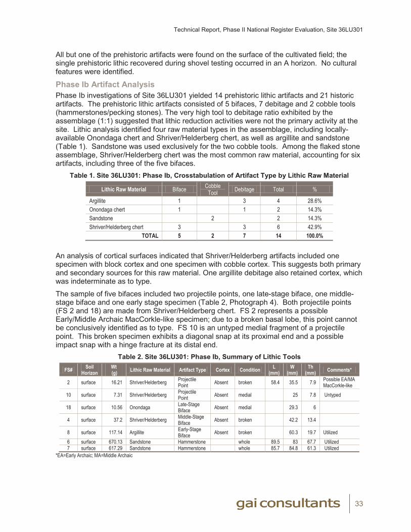
Technical Report, Phase II National Register Evaluation, Site 36LU301
33
All but one of the prehistoric artifacts were found on the surface of the cultivated field; the single prehistoric lithic recovered during shovel testing occurred in an A horizon. No cultural features were identified.
Phase Ib Artifact AnalysisPhase Ib investigations of Site 36LU301 yielded 14 prehistoric lithic artifacts and 21 historic artifacts. The prehistoric lithic artifacts consisted of 5 bifaces, 7 debitage and 2 cobble tools (hammerstones/pecking stones). The very high tool to debitage ratio exhibited by the assemblage (1:1) suggested that lithic reduction activities were not the primary activity at the site. Lithic analysis identified four raw material types in the assemblage, including locally-available Onondaga chert and Shriver/Helderberg chert, as well as argillite and sandstone (Table 1). Sandstone was used exclusively for the two cobble tools. Among the flaked stone assemblage, Shriver/Helderberg chert was the most common raw material, accounting for six artifacts, including three of the five bifaces.
Table 1. Site 36LU301: Phase Ib, Crosstabulation of Artifact Type by Lithic Raw Material
Lithic Raw Material Biface Cobble Tool Debitage Total %
Argillite 1 3 4 28.6%Onondaga chert 1 1 2 14.3%Sandstone 2 2 14.3%Shriver/Helderberg chert 3 3 6 42.9%
TOTAL 5 2 7 14 100.0% An analysis of cortical surfaces indicated that Shriver/Helderberg artifacts included one specimen with block cortex and one specimen with cobble cortex. This suggests both primary and secondary sources for this raw material. One argillite debitage also retained cortex, which was indeterminate as to type.
The sample of five bifaces included two projectile points, one late-stage biface, one middle-stage biface and one early stage specimen (Table 2, Photograph 4). Both projectile points (FS 2 and 18) are made from Shriver/Helderberg chert. FS 2 represents a possible Early/Middle Archaic MacCorkle-like specimen; due to a broken basal lobe, this point cannot be conclusively identified as to type. FS 10 is an untyped medial fragment of a projectile point. This broken specimen exhibits a diagonal snap at its proximal end and a possible impact snap with a hinge fracture at its distal end.
Table 2. Site 36LU301: Phase Ib, Summary of Lithic Tools
FS# Soil Horizon
Wt(g) Lithic Raw Material Artifact Type Cortex Condition L
(mm)W
(mm)Th
(mm) Comments*
2 surface 16.21 Shriver/Helderberg Projectile Point Absent broken 58.4 35.5 7.9 Possible EA/MA
MacCorkle-like
10 surface 7.31 Shriver/Helderberg Projectile Point Absent medial 25 7.8 Untyped
18 surface 10.56 Onondaga Late-Stage Biface Absent medial 29.3 6
4 surface 37.2 Shriver/Helderberg Middle-Stage Biface Absent broken 42.2 13.4
8 surface 117.14 Argillite Early-Stage Biface Absent broken 60.3 19.7 Utilized
6 surface 670.13 Sandstone Hammerstone whole 89.5 83 67.7 Utilized7 surface 617.29 Sandstone Hammerstone whole 85.7 84.8 61.3 Utilized
*EA=Early Archaic; MA=Middle Archaic
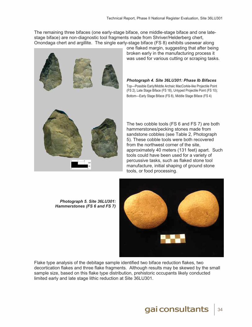
Technical Report, Phase II National Register Evaluation, Site 36LU301
34
The remaining three bifaces (one early-stage biface, one middle-stage biface and one late-stage biface) are non-diagnostic tool fragments made from Shriver/Helderberg chert, Onondaga chert and argillite. The single early-stage biface (FS 8) exhibits usewear along
one flaked margin, suggesting that after being broken early in the manufacturing process it was used for various cutting or scraping tasks. Photograph 4. Site 36LU301: Phase Ib BifacesTop—Possible Early/Middle Archaic MacCorkle-like Projectile Point (FS 2), Late Stage Biface (FS 18), Untyped Projectile Point (FS 10);Bottom—Early Stage Biface (FS 8), Middle Stage Biface (FS 4)
The two cobble tools (FS 6 and FS 7) are both hammerstones/pecking stones made from sandstone cobbles (see Table 2, Photograph 5). These cobble tools were both recovered from the northwest corner of the site, approximately 40 meters (131 feet) apart. Such tools could have been used for a variety of percussive tasks, such as flaked stone tool manufacture, initial shaping of ground stone tools, or food processing.
Photograph 5. Site 36LU301: Hammerstones (FS 6 and FS 7)
Flake type analysis of the debitage sample identified two biface reduction flakes, two decortication flakes and three flake fragments. Although results may be skewed by the small sample size, based on this flake type distribution, prehistoric occupants likely conducted limited early and late stage lithic reduction at Site 36LU301.
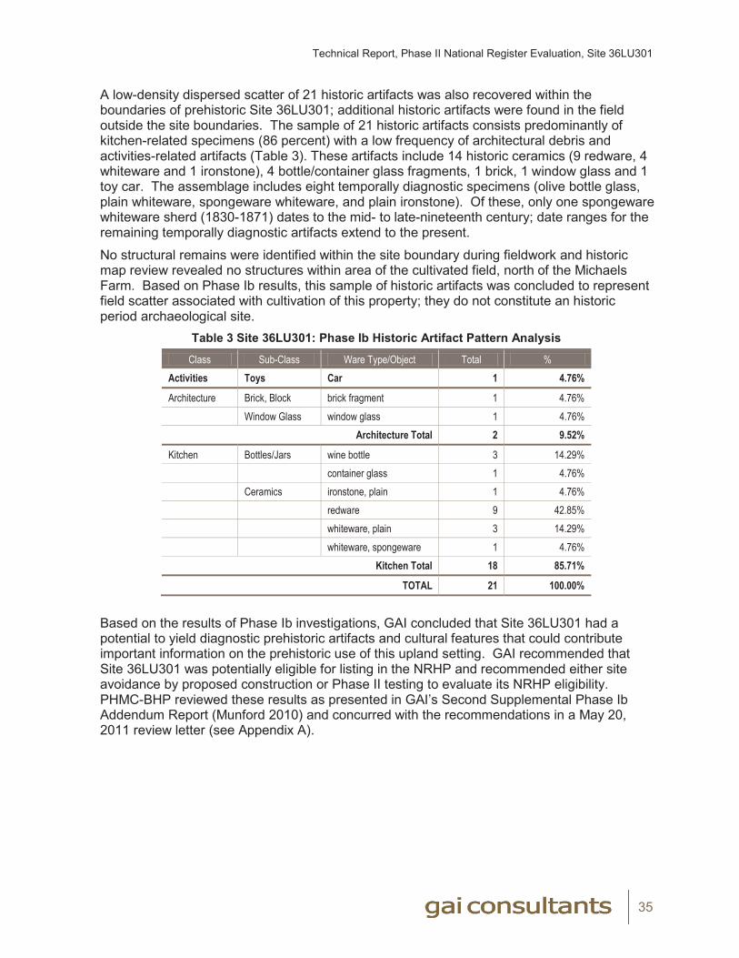
Technical Report, Phase II National Register Evaluation, Site 36LU301
35
A low-density dispersed scatter of 21 historic artifacts was also recovered within the boundaries of prehistoric Site 36LU301; additional historic artifacts were found in the field outside the site boundaries. The sample of 21 historic artifacts consists predominantly of kitchen-related specimens (86 percent) with a low frequency of architectural debris and activities-related artifacts (Table 3). These artifacts include 14 historic ceramics (9 redware, 4 whiteware and 1 ironstone), 4 bottle/container glass fragments, 1 brick, 1 window glass and 1 toy car. The assemblage includes eight temporally diagnostic specimens (olive bottle glass, plain whiteware, spongeware whiteware, and plain ironstone). Of these, only one spongeware whiteware sherd (1830-1871) dates to the mid- to late-nineteenth century; date ranges for the remaining temporally diagnostic artifacts extend to the present.
No structural remains were identified within the site boundary during fieldwork and historic map review revealed no structures within area of the cultivated field, north of the Michaels Farm. Based on Phase Ib results, this sample of historic artifacts was concluded to represent field scatter associated with cultivation of this property; they do not constitute an historic period archaeological site.
Table 3 Site 36LU301: Phase Ib Historic Artifact Pattern Analysis
Class Sub-Class Ware Type/Object Total %Activities Toys Car 1 4.76%
Architecture Brick, Block brick fragment 1 4.76%Window Glass window glass 1 4.76%
Architecture Total 2 9.52%
Kitchen Bottles/Jars wine bottle 3 14.29%container glass 1 4.76%
Ceramics ironstone, plain 1 4.76%redware 9 42.85%whiteware, plain 3 14.29%whiteware, spongeware 1 4.76%
Kitchen Total 18 85.71%
TOTAL 21 100.00%
Based on the results of Phase Ib investigations, GAI concluded that Site 36LU301 had a potential to yield diagnostic prehistoric artifacts and cultural features that could contribute important information on the prehistoric use of this upland setting. GAI recommended that Site 36LU301 was potentially eligible for listing in the NRHP and recommended either site avoidance by proposed construction or Phase II testing to evaluate its NRHP eligibility. PHMC-BHP reviewed these results as presented in GAI’s Second Supplemental Phase Ib Addendum Report (Munford 2010) and concurred with the recommendations in a May 20, 2011 review letter (see Appendix A).

Technical Report, Phase II National Register Evaluation, Site 36LU301
36
Chapter 5. Phase II Research Design Because site avoidance through project design was not feasible, PPL requested that GAI conduct a Phase II National Register Site Evaluation of Site 36LU301 to evaluate its eligibility for listing in the NRHP. Specific objectives of the study included the following:
(1) Determine the horizontal and vertical limits of the site in the APE;
(2) Interpret the site’s cultural affiliations, functions and significance;
(3) Evaluate site integrity;
(4) Conclusively determine the site’s eligibility for listing on the NRHP;
(5) Define the need for further archaeological work.
The National Register Bulletin No. 15-How to Apply the National Register of Criteria for Evaluation (NPS 1997) provides standards that a site must meet to be considered eligible to the NRHP. The researcher must first be able to establish an historic context for the site, relating it to a specific cultural group or particular time period, and secondly, document that the site retains integrity.
To establish the historic context of a site, archaeologists must determine the period of occupation or cultural affiliation, typically accomplished via analysis of diagnostic artifacts (e.g., projectile points, bottle glass manufacturing method, ceramic type and decoration method), or by the identification of features which may provide a means to date the site occupation (e.g., large sample of diagnostic historic period artifacts or radiocarbon dating of charcoal from prehistoric hearths). For historic sites, context can be established by means of historic map research and chain-of-title and deed research. If the age of a site cannot be established, the site cannot be placed within a broad historic context and likely will not be eligible to the NRHP.
If the site provides data regarding its period of occupation, it must also be shown to be significant under one of the four National Register Criteria: A) association with historic events; B) association with historic individuals; C) distinctive design/construction; or D) information potential. Archaeological sites generally cannot be linked to historic events (Criterion A) or historic individuals (Criterion B), nor can they be evaluated based on their distinctive design/construction (Criterion C). Thus, most historic and prehistoric sites are evaluated for NRHP eligibility under Criterion D, the potential to contribute important information on the prehistory or history of the region. Site 36LU301 was evaluated for its NRHP eligibility under Criterion D.
An archaeological site must also retain integrity to qualify as NRHP-eligible. For archaeological sites, integrity is a quality that typically reflects whether or not the site's physical components have been disturbed since their original deposition. If the disturbance has been substantial, resulting in a significant loss of integrity, the site is likely to be not eligible to the NRHP. However, if a site was not disturbed, or only minimally disturbed to the extent that the disturbance has not affected the qualities that render it NRHP eligible, then the site can still be considered eligible to the National Register.
Technical Report, Phase II National Register Evaluation, Site 36LU301
37
Chapter 6. Phase II MethodsField MethodsAt the request of PPL, GAI performed a Phase II National Register site evaluation of Site 36LU301. Phase II investigations were conducted in accordance with GAI’s Phase II Scope of Work (May 13, 2011) as approved by the PHMC-BHP (May 26, 2011) (see Appendix A). The study included field excavations and laboratory analysis. Phase II fieldwork was conducted between June 24 and July 27, 2011.
Prior to the start of Phase II investigations, the previously cultivated field within the site area was plowed and disked and was rain washed in order to provide good ground surface visibility. Following site preparation, GAI surveyors established a grid across the site using a total station [electric theodolite (transit) with integrated electronic distance meter]. The grid was referenced in space using GPS points (to sub meter accuracy). The survey grid covered an area measuring 140x220 meters (459x722 feet) (see Figure 3). A site datum was established and designated with arbitrary north and east coordinates. Stakes were placed at 20-meter (65.6-foot) intervals along north/south and east/west baselines at the edges of the site and throughout the portion of the site in the cultivated field. Ground surface elevations were recorded at these stakes. Subsequent excavations were designated by their coordinates within this grid system.
Phase II fieldwork included controlled surface collection (CSC) followed by judgmental and close-interval shovel testing, test unit excavation, plowzone stripping (mechanical trenches), and feature sampling. Due to the need for mechanical plowzone stripping, the Luzerne Conservation District required preparation and implementation of an Erosion and Sedimentation Control (E&S) Plan for the site (Appendix G). In accordance with this plan, GAI installed silt fencing along the southern and western edges of the cultivated field before the start of plowzone stripping and removed this fencing following the completion of fieldwork.
Surface CollectionPhase II fieldwork began with a controlled surface collection (CSC) of the plowed and disked field. The site was gridded into 5x5-meter (16.4x16.4 foot) surface collection blocks (see Figure 3). GAI archaeologists examined the ground surface within each block and observed artifacts were collected, bagged, and provenienced according to the southwest corner grid coordinates of the collection block. A total of 1,009 surface collection blocks were examined during the CSC, for a total of 25,225 square meters (271,520 square feet). Surface collection results were plotted on a site map, documented on standard GAI Surface Collection Forms, and used to guide the placement of subsequent shovel tests and test units.
Shovel TestingGAI excavated 84 shovel test pits (STPs) within the site area during the Phase II study. Based, in part, on the results of the surface collection, 64 judgmental shovel test pits (STPs) were excavated in select localities within the cultivated field to further investigate areas of surface artifact recovery, document soil stratigraphy, and assess the presence of subplowzone cultural deposits (see Figure 3). Radial shovel tests were excavated at 5-meter (16-foot) intervals around initial positive findspots in an area outside of the recent plowing and disking at the northern edge of the site, where surface visibility was poor.
Close-interval (5-meter/16-foot) shovel testing was conducted in a small portion of the farmyard south of the field from which prehistoric artifacts were recovered during Phase Ib shovel testing. Twenty STPs were excavated in this lawn area (also used as a field access
Technical Report, Phase II National Register Evaluation, Site 36LU301
38
road) bounded by North Market Street to the south, the field to the north and west, and a line of evergreen trees to the east (see Figure 3).
Shovel tests measured 50x50-cm (1.6x1.6-feet) and were hand-excavated by natural stratigraphy to a depth of approximately 40 to 50 cm (1.3 to 1.6 feet) below ground surface. Shovel test results were recorded on standard GAI Shovel Test Forms. STPs were backfilled upon completion.
Test Unit ExcavationGAI excavated ten 1x1-meter (3.3x3.3-foot) test units (TUs 1-10) in select areas of the site to sample areas of relatively higher artifact density or possible activity areas, to assess the presence of cultural features, and to evaluate the vertical extent of cultural deposits. Test units were hand-excavated in 10-cm (0.3-foot) levels within natural strata, to a depth of at least 10 cm (0.3 feet) into the subsoil and 10 cm (0.3 feet) below the deepest recovered artifact. Nine of the test units (TUs 1-8 and 10) were excavated in the northwest quadrant of the site and one (TU 9) was placed in the southwest quadrant (see Figure 3). Test units were backfilled upon completion.
TU 1 (N592 E418) and TU 5 (N585 E416) were excavated in the location of two contiguous positive surface collections blocks (yielding one flake and one FCR), in the western portion of the site’s northwest quadrant. TU 2 (N603 E426), TU 4 (N608 E426), and TU 7 (N598 E423) were located in the central portion of the northwest quadrant, in the vicinity of positive STP J29, which produced one flake. TU 6 (N602 E444) sampled two contiguous positive surface collection blocks (yielding one flake each), in the western portion of the northwest quadrant. TU 3 (N612 E445), TU 8 (N610 E443), and TU 10 (N617 E445) were located north of TU 6, between positive STPs J29 (n=1 flake) and J32 (n=2 flakes).
TU 9 (N540 E445) was positioned in the site’s lower density southwest quadrant, in the vicinity of a positive surface collection block which produced one FCR.
Plowzone StrippingFollowing the completion of hand excavations, GAI conducted mechanical stripping of the plowzone to investigate the presence of cultural features at the top of the subsoil. Seven trenches (Trenches 1-7) were excavated using a rubber-tired backhoe and/or a trackhoe, both with flat-bladed buckets. Due to the near absence of recovered artifacts from the site’s eastern portion, these parallel, north/south-oriented trenches were all located in the western half of the site. The trenches measured 2-meters (6.6-feet) wide and varied in length from 95 to 130 meters (312 to 427 feet). Under the guidance of a GAI archaeologist, within each trench the plowzone was removed in increments, to expose the top of the B horizon. Excavated soils were deposited in piles along one side of each trench. GAI archaeologists then hand shovel-scraped the floor of the trench to expose soil anomalies or artifact concentrations representing possible cultural features. Each trench was mapped and photographed. Identified features were documented and sampled (as described below).
Trenches were mechanically backfilled upon completion of investigations. GAI excavated 1,600 square meters (17,222 square feet) during plowzone stripping, representing approximately 7.9 percent of the total site (measuring 20,175 square meters/217,162 square feet).
The trenches extended northward from the south edge of the cultivated field through the site area. Six of the parallel trenches (Trenches 1-6) were placed at 10-meter (33-foot) intervals between E405 and E455; Trench 7 was positioned 25 meters further east at E480. Trenches 1 through 5 extended from between the N505 and N530 gridlines to approximately the
Technical Report, Phase II National Register Evaluation, Site 36LU301
39
northern edge of the site, ending at the N630 to N640 gridlines. Trenches 1 and 2 measured 110 meters (361 feet) in length while Trenches 3, 4 and 5 were 130 meters (427 feet) long. Trenches 6 and 7 (95 meters/312 feet in length) were both terminated at N600 in order to avoid the rock outcrop (claystone) located in the north-central portion of the site.
Feature SamplingGAI’s initial Phase II Scope of Work assumed investigation of up to five prehistoric features. Following the identification of a large number of possible cultural features during initial plowzone stripping, GAI notified Mr. Brad Wise (PPL) of these unanticipated discoveries. At the request of PPL, GAI consulted with Steve McDougal (PHMC-BHP) to develop an appropriate approach for investigation of these features. In a July 12, 2011 phone conference, Mr. McDougal recommended investigation of a 25 percent sample of various feature types exposed during plowzone stripping. In accordance with PHMC-BHP’s recommendations, and subsequent to PPL’s approval of supplemental Phase II work, feature sampling was conducted at Site 36LU301.
GAI identified 211 possible cultural features on the surface of the plowzone stripped trenches. [One additional feature (non-cultural Feature 1) was previously exposed and excavated in TU 6 and was not included in sampling process.] GAI grouped these 211 possible cultural features into categories based on initial plan view observations of feature size and morphology. Seven feature categories were defined: small circular/oval stains (Type A); medium circular/oval stains (Type B); large circular stains (Type C); large oval/elongate stains (Type D); oxidized stains (Type OX); irregular stains (Type I); and large, likely historic/modern stains (Type H). Clearly non-cultural anomalies (e.g., obvious root disturbances) and recent agricultural-related anomalies (e.g., multiple, overlapping lines of small circular to rectangular stains) were excluded from investigation. GAI investigated a 25 percent sample of features in each of the seven categories. During Phase II fieldwork, GAI investigated 54 possible cultural features exposed during plowzone stripping, plus one additional feature (Feature 1) identified during test unit excavation, for a total of 55 features.
All 212 possible cultural features were troweled clean, plotted on project maps, photographed, and recorded on a Feature Log. Each sampled feature was bisected along its long axis and the first half of the feature was removed in 10-cm (0.3-foot) arbitrary levels within natural stratigraphy, if present. The feature fill was screened through 0.6-cm (0.25-in) wire mesh and recovered artifacts were bagged according to their provenience. The feature profile was recorded with a measured drawing and photographs. If the results of the bisection confirmed that the feature was non-cultural, investigations were terminated at this stage. If the feature was concluded to be potentially cultural the second half of the feature was excavated as above and flotation samples were collected from the feature fill. The base of the excavated feature was photographed. Sampled features were documented with standardized GAI Feature forms.
Analytical MethodsThis section reviews the methods employed during analysis of prehistoric and historic artifacts recovered during GAI's investigations of Site 36LU301. Brief overviews of analytical methods are presented for prehistoric lithics, historic/modern artifacts, and flotation/ethnobotanical remains. Detailed descriptions of prehistoric lithic analysis and historic artifact analysis are provided in Appendices H and I.
Technical Report, Phase II National Register Evaluation, Site 36LU301
40
Laboratory ProcessingCultural materials collected during field investigations were transported to GAI's Archaeological Laboratory in Homestead, Pennsylvania, for processing and analysis. These materials were processed in accordance with the Curation Guidelines of the Pennsylvania Historical and Museum Commission (2005a). Following completion of this project and approval of technical reporting, project materials will be donated to the PHMC-BHP for permanent curation at the State Museum of Pennsylvania.
The initial processing stage consisted of checking artifact bags against the field-generated Field Specimen Log to confirm that all collected materials were present. Artifacts were temporarily placed in numerical order according to Field Specimen Number (FS#), providing a basis for processing, analysis, and curation. Artifacts were then cleaned, generally with water and a soft brush. Metal artifacts and perishable items were cleaned by dry-brushing. Non-cultural materials (i.e., pebbles) included in the artifact samples were recorded and discarded during this stage of processing or in later stages, as they were recognized. Cultural materials were placed on artifact-drying racks to air dry.
When dry, the artifacts within each provenience were sorted into basic artifact classes (i.e., lithics, glass, ceramic) and were re-bagged accordingly in clean, perforated, 4-mil polyethylene bags. Bags were labeled with provenience information using a permanent ink marker. An acid-free paper tag with complete provenience information was also placed inside each artifact bag.
Specimens large enough in size were then labeled with the site number and the appropriate field specimen number (FS#). Labels were written in permanent ink and coated with PVA. After washing and labeling, artifacts were subject to the appropriate laboratory analysis.
Methods of Prehistoric Lithic AnalysisThe analytical approach for stone tools and debris employed here can be described as techno-morphological; that is, lithic artifact classes and types were based on key morphological attributes, which are linked to or indicative of particular stone tool production (reduction) strategies (see Appendix H).
Following initial artifact processing, GAI's Lithic Analyst divided lithic artifacts from each provenience into general classes (i.e., debitage, bifaces, fire-cracked rock) and then subdivided them into specific artifact types (i.e., early-stage biface, late-stage biface, projectile point) for that particular class. Artifacts were then examined and appropriate attributes were recorded. The surfaces and edges of artifacts were examined with the unaided eye and with a 10x hand lens, where appropriate, to discern evidence of retouch and/or utilization.
Lithic raw material type was recorded for all artifacts. These lithic raw material types were defined on the basis of macroscopic characteristics, including color, texture, hardness, and inclusions (Luedtke 1992). Where possible using conservative standards and based on the above macroscopic criteria, lithic raw material types were attributed to known geological sources based on published sources (e.g., Stewart 1984) and by reference to GAI's lithic reference collection.
All lithic tools were examined at a detailed analysis level that recorded temporal/stylistic, functional, and technological variables as well as lithic raw material type. These variables included artifact class, artifact type, condition of specimen, presence/type of cortex, weight, and metric dimensions (when complete). Further artifact-specific observations (e.g., heat damage, refit, unique characteristics) were noted where appropriate. Diagnostic projectile points, important in assessing the age of prehistoric components represented at the sites,
Technical Report, Phase II National Register Evaluation, Site 36LU301
41
were identified though a comparison with standard typologies established for Pennsylvania and the eastern United States (Custer 2001; Fogelman 1988; Dent 1995; Justice 1987; Broyles 1971; Ritchie 1961). Additional variables of point type and temporal affiliation were recorded for diagnostic points.
Lithic debitage was classified using a typology designed to detect differences in lithic reduction practices and early vs. late-stage reduction (e.g., decortication flake, bipolar reduction flake, early reduction flake, biface thinning flake). Other attributes recorded for debitage included raw material, presence and type of cortex (as indicators of primary or secondary geologic source), weight and size grade.
Information recorded during lithic analysis was entered on analysis sheets as a series of codes, unique to each variable. The codes were then entered into Access, a relational database. For the purposes of data analysis and manipulation, this database was subsequently converted to the Excel computer program for data manipulation and table generation.
Methods of Historic/Modern Artifact AnalysisHistoric/modern artifacts recovered during Phase II investigations were subjected to identification and analysis using GAI’s Historic Coding scheme (see Appendix I). This multivariate classification system codes for significant attributes of various artifact classes. Artifact analysis was focused on the creation of an inventory of artifact classes and types to examine issues of chronology and function for each site containing historic/modern components. A variety of analytical techniques was employed to synthesize artifact data including standard classification typologies developed by South (1977).
Once washed, artifacts were sorted into major material classes including ceramics, glass, and metal. The materials were then subjected to a preliminary analysis, which included a basic description of artifacts by material class, functional group, and relevant attributes. Included among the recorded attributes, where applicable, are type, beginning and end dates of production, form, motif/decoration, color, manufacturing technique, functional group, base, finish, embossment, maker’s mark/manufacturer, material, bore diameter, and pattern class and subclass (South 1977:95-96). Artifact dating was based on the identification of maker’s marks, diagnostic-manufacturing methods, such as bottle mold seams, bottle pontil marks, ceramic bodies and glazes, and known dates of production.
Coded data, using unique codes for each artifact description, were entered into the Access database. This database was subsequently converted into the Excel computer program for purposes of data manipulation and table generation.
Historic ceramic analysis focused on identifying ware and type categories, decorative attributes, and maker’s marks, in order to interpret site chronology. Whenever possible, each provenience was assigned dates based on a Mean Ceramic Dates (MCD) and Terminus Post Quem (TPQ) date. Attributes recorded during the ceramic analysis include count, ware, type, form, motif, colors, percent complete, and functional group for each artifact or group of artifacts. Maker’s marks were described in detail and dated, when possible.
Glass artifacts, much like ceramics, were tabulated according to major groups (e.g., bottle glass, window glass, lamp glass, tableware, tumblers) and then separated into functional categories whenever possible. Dating information was based on the identification of diagnostic technological attributes (e.g., mold seams and evidence of snap-case manufacture) in addition to identifiable bottle embossments. Attributes recorded for glass artifacts include manufacturing technique, decoration, finish type, base type, color, and functional group. The

Technical Report, Phase II National Register Evaluation, Site 36LU301
42
beginning and end dates for datable attributes were determined. As with ceramics sample, maker’s marks and embossments were described and dated, when possible.
Other historic/modern artifact classes include architectural debris (e.g., bricks, nails, window glass, etc.), clothing (type and materials identified when possible) and miscellaneous small finds. Where appropriate, attributes such as character, wear, decoration, and material were recorded for these artifacts.
Methods of Flotation ProcessingSoil flotation samples were collected from feature fill during excavation in order to recover small specimens that would normally pass through 6-mm (0.25-inch) hardware cloth.
Select flotation samples of feature fill were processed at GAI's Archaeological Laboratory using an R. J. Dausman Flot-Tech flotation machine. The Dausman flotation machine is a self-contained, multi-modal system that uses a closed-loop water recirculation system. It allows the user to manually adjust water circulation and flow rates to assist in the separation of light and heavy fractions of flotation samples. This method produces clean, sediment-free, light and heavy fraction feature fill samples. Once processed, the materials were allowed to air dry before being re-bagged according to heavy or light fraction type into clean, 4-mil polyethylene bags. As with artifact processing, these bags were clearly labeled with provenience information using a permanent ink marker and an acid-free tag with complete provenience information placed inside each bag.
Following flotation processing, GAI technicians examined heavy fractions of each sample to collect cultural materials. To insure standardization during flotation sample "picking," each heavy fraction sample was examined for 20 minutes to separate out other cultural materials. Cultural materials identified in the samples were subjected to historic or prehistoric analysis as described above.
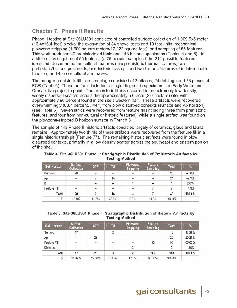
Technical Report, Phase II National Register Evaluation, Site 36LU301
43
Chapter 7. Phase II Results
Phase II testing at Site 36LU301 consisted of controlled surface collection of 1,009 5x5-meter (16.4x16.4-foot) blocks, the excavation of 84 shovel tests and 10 test units, mechanical plowzone stripping (1,600 square meters/17,222 square feet), and sampling of 55 features. This work produced 49 prehistoric artifacts and 143 historic specimens (Tables 4 and 5). In addition, investigation of 55 features (a 25 percent sample of the 212 possible features identified) documented ten cultural features (five prehistoric thermal features, two prehistoric/historic postmolds, one historic trash pit and two historic features of indeterminate function) and 45 non-cultural anomalies.
The meager prehistoric lithic assemblage consisted of 2 bifaces, 24 debitage and 23 pieces of FCR (Table 6). These artifacts included a single diagnostic specimen—an Early Woodland Cresap-like projectile point. The prehistoric lithics occurred in an extremely low density, widely dispersed scatter, across the approximately 5.0-acre (2.0-hectare) site, with approximately 90 percent found in the site’s western half. These artifacts were recovered overwhelmingly (83.7 percent, n=41) from plow disturbed contexts (surface and Ap horizon) (see Table 6). Seven lithics were recovered from feature fill (including three from prehistoric features, and four from non-cultural or historic features), while a single artifact was found on the plowzone-stripped B horizon surface in Trench 3.
The sample of 143 Phase II historic artifacts consisted largely of ceramics, glass and faunal remains. Approximately two thirds of these artifacts were recovered from the feature fill in a single historic trash pit (Feature 77). The remaining historic artifacts were found in plow disturbed contexts, primarily in a low density scatter across the southeast and eastern portion of the site.
Table 4. Site 36LU301 Phase II: Stratigraphic Distribution of Prehistoric Artifacts by Testing Method
Soil Horizon Surface Collection STP TU Plowzone
StrippingFeature
Sampling Total %
Surface 20 -- -- -- -- 20 40.8%Ap -- 7 14 -- -- 21 42.9%B -- -- 1 -- 1 2.0%Feature Fill -- -- -- -- 7 7 14.3%
Total 20 7 14 -- 7 49 100.0%% 40.8% 14.3% 28.6% 2.0% 14.3% 100.0%
Table 5. Site 36LU301 Phase II: Stratigraphic Distribution of Historic Artifacts by Testing Method
Soil Horizon Surface Collection STP TU Plowzone
StrippingFeature
Sampling Total %
Surface 17 -- 2 -- -- 19 13.29%Ap -- 28 1 -- -- 29 20.28%Feature Fill -- -- -- -- 93 93 65.03%Disturbed -- -- -- 2 -- 2 1.40%
Total 17 28 3 2 93 143 100.0%% 11.89% 19.58% 2.10% 1.40% 65.03% 100.0%
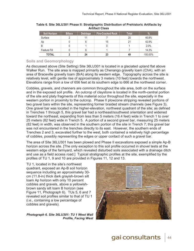
Technical Report, Phase II National Register Evaluation, Site 36LU301
44
Table 6. Site 36LU301 Phase II: Stratigraphic Distribution of Prehistoric Artifacts by Artifact Class
Soil Horizon Biface Debitage Fire-Cracked Rock Total %Surface 2 11 7 20 40.8%Ap 0 6 15 21 42.9%B 0 1 0 1 2.0%Feature Fill 0 6 1 7 14.3%
TOTAL 2 24 23 49 100.00%
Soils and GeomorphologyAs discussed above (Site Setting) Site 36LU301 is located in a glaciated upland flat above Walker Run. The site area is mapped primarily as Chenango gravelly loam (ChA), with an area of Braceville gravelly loam (BrA) along its western edge. Topography across the site is relatively level, with gentle rise of approximately 3 meters (10 feet) towards the northwest. Elevations range from a low of 656 feet at its southern edge to 666 at the northwest corner.
Cobbles, gravels, and channers are common throughout the site area, both on the surface and in the exposed soil profile. An outcrop of claystone is located in the north-central portion of the site and platy fragments of this material occur throughout the site, especially in the western portion in proximity to the outcrop. Phase II plowzone stripping revealed portions of two gravel bars within the site, representing former braided stream channels (see Figure 3). One gravel bar was located in the higher-elevation, northwest quadrant of the site; as defined in Trenches 1 through 5, this gravel bar had a northeast/southwest orientation and widened toward the northeast, expanding from less than 5 meters (16.4 feet) wide in Trench 1 to over 25 meters (82 feet) wide in Trench 5. A portion of a second gravel bar, measuring 25 meters (82 feet) in width, was observed in the southern portion of the site in Trench 7; this gravel bar was not encountered in the trenches directly to its east. However, the southern ends of Trenches 2 and 3, excavated further to the west, both contained a relatively high percentage of cobbles, possibly representing the edges or upper contact of such a gravel bar.
The area of Site 36LU301 has been plowed and Phase II excavations exposed a simple Ap-B horizon across the site. [The only exception to this soil profile occurred in shovel tests at the western edge of the farmyard, which revealed disturbed soils associated with a drainage ditch and use as a field access road.] Typical stratigraphic profiles at the site, exemplified by the profiles of TU 1, 9 and 10 are provided in Figures 11, 12 and 13.
TU 1, located in the site’s northwest quadrant, exposed an Ap-B soil horizon sequence including an approximately 30-cm (11.8-in) thick dark grayish-brown silt loam Ap horizon with only 10 percent cobbles and gravels, above a yellowish-brown sandy silt loam B horizon (see Figure 11, Photograph 6). TUs 5, 6 and 7 revealed soil profiles similar to that of TU 1 (i.e., containing a low percentage of cobbles and gravels).
Photograph 6. Site 36LU301: TU 1 West Wall Profile, Facing West
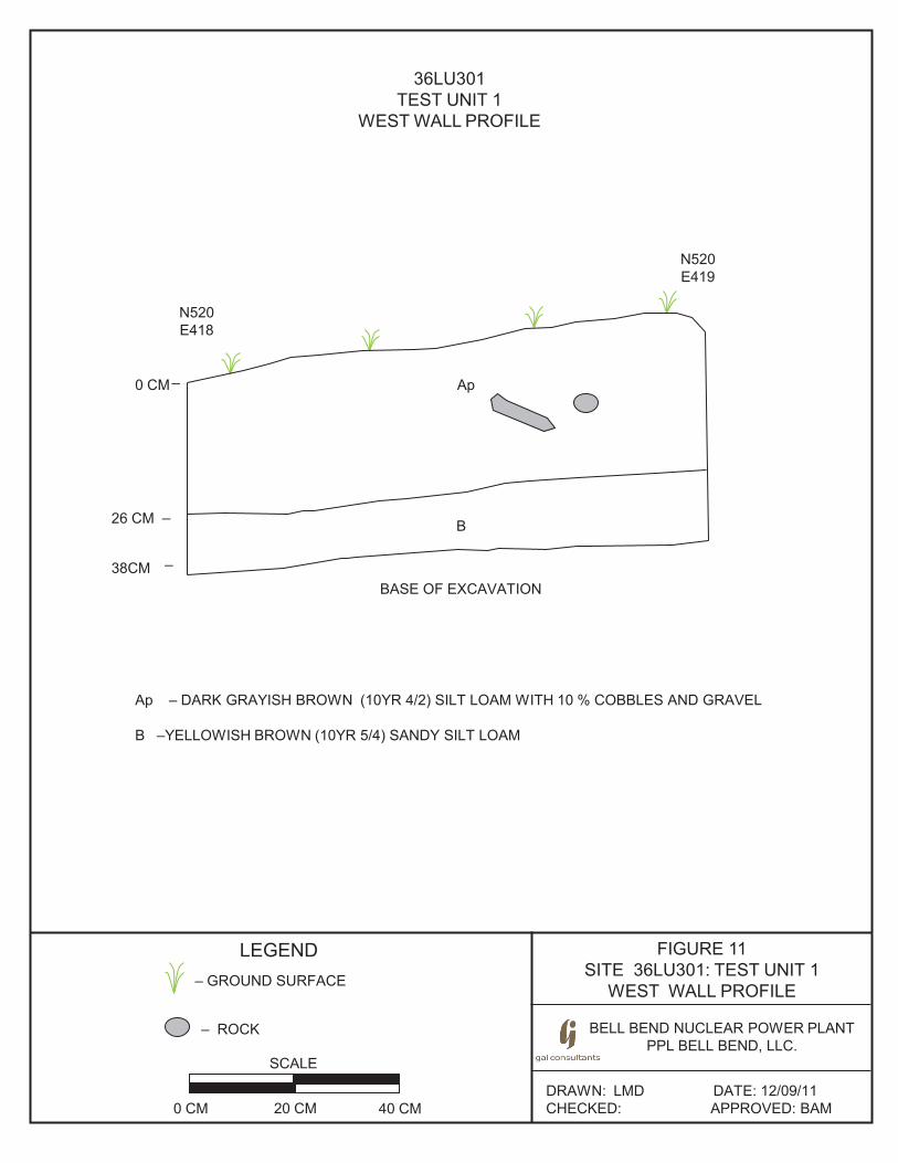
FIGURE 11SITE 36LU301: TEST UNIT 1
WEST WALL PROFILE
LEGEND
36LU301TEST UNIT 1
WEST WALL PROFILE
Ap – DARK GRAYISH BROWN (10YR 4/2) SILT LOAM WITH 10 % COBBLES AND GRAVEL
B –YELLOWISH BROWN (10YR 5/4) SANDY SILT LOAM
– GROUND SURFACE
BASE OF EXCAVATION
Ap
B
0 CM_
26 CM _
38CM_
N520E418
N520E419
DRAWN: LMD DATE: 12/09/11CHECKED: APPROVED: BAM
SCALE
0 CM 20 CM 40 CM
BELL BEND NUCLEAR POWER PLANTPPL BELL BEND, LLC.
– ROCK
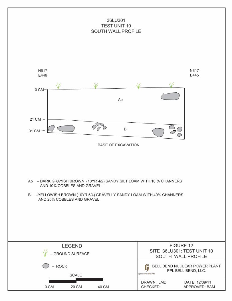
FIGURE 12 SITE 36LU301: TEST UNIT 10
SOUTH WALL PROFILE
LEGEND
36LU301 TEST UNIT 10
SOUTH WALL PROFILE
Ap – DARK GRAYISH BROWN (10YR 4/2) SANDY SILT LOAM WITH 10 % CHANNERS AND 10% COBBLES AND GRAVEL
B –YELLOWISH BROWN (10YR 5/4) GRAVELLY SANDY LOAM WITH 40% CHANNERS
AND 20% COBBLES AND GRAVEL
– GROUND SURFACE
BASE OF EXCAVATION
Ap
B
0 CM _
21 CM _
31 CM _
N617 E446
N617 E445
DRAWN: LMD DATE: 12/09/11 CHECKED: APPROVED: BAM
SCALE
0 CM 20 CM 40 CM
BELL BEND NUCLEAR POWER PLANT PPL BELL BEND, LLC.
– ROCK
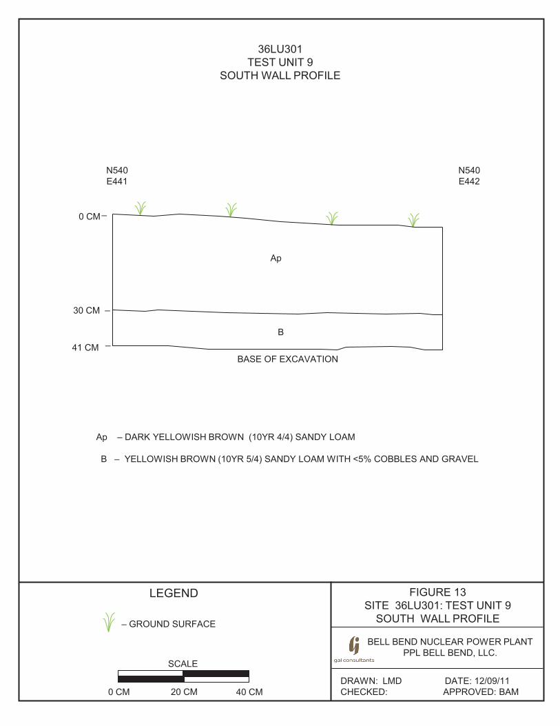
FIGURE 13 SITE 36LU301: TEST UNIT 9
SOUTH WALL PROFILE
LEGEND
36LU301 TEST UNIT 9
SOUTH WALL PROFILE
Ap – DARK YELLOWISH BROWN (10YR 4/4) SANDY LOAM B – YELLOWISH BROWN (10YR 5/4) SANDY LOAM WITH <5% COBBLES AND GRAVEL
– GROUND SURFACE
BASE OF EXCAVATION
Ap
B
0 CM _
30 CM _
41 CM _
N540 E442
DRAWN: LMD DATE: 12/09/11 CHECKED: APPROVED: BAM
SCALE
0 CM 20 CM 40 CM
BELL BEND NUCLEAR POWER PLANT PPL BELL BEND, LLC.
N540 E441
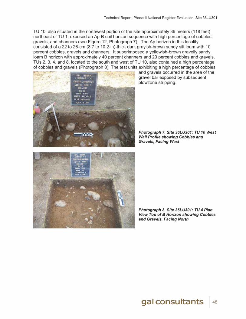
Technical Report, Phase II National Register Evaluation, Site 36LU301
48
TU 10, also situated in the northwest portion of the site approximately 36 meters (118 feet) northeast of TU 1, exposed an Ap-B soil horizon sequence with high percentage of cobbles, gravels, and channers (see Figure 12, Photograph 7). The Ap horizon in this locality consisted of a 22 to 26-cm (8.7 to 10.2-in)-thick dark grayish-brown sandy silt loam with 10 percent cobbles, gravels and channers. It superimposed a yellowish-brown gravelly sandy loam B horizon with approximately 40 percent channers and 20 percent cobbles and gravels. TUs 2, 3, 4, and 8, located to the south and west of TU 10, also contained a high percentage of cobbles and gravels (Photograph 8). The test units exhibiting a high percentage of cobbles
and gravels occurred in the area of the gravel bar exposed by subsequent plowzone stripping.
Photograph 7. Site 36LU301: TU 10 West Wall Profile showing Cobbles and Gravels, Facing West
Photograph 8. Site 36LU301: TU 4 Plan View Top of B Horizon showing Cobbles and Gravels, Facing North
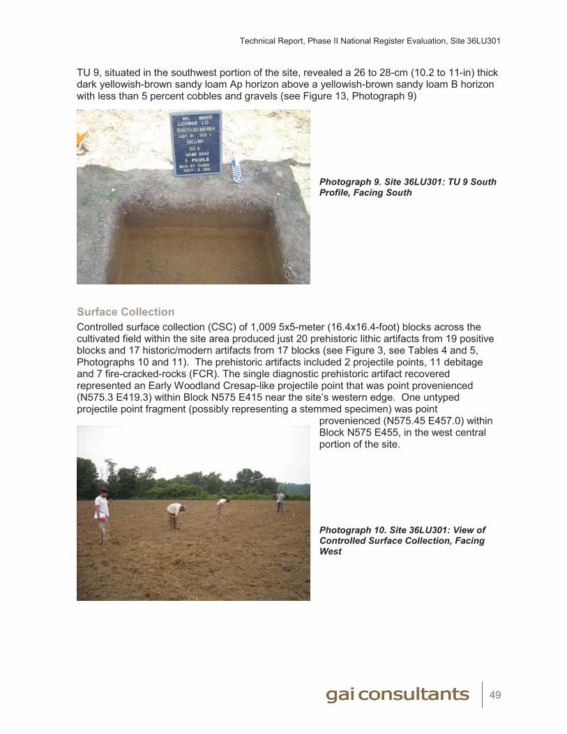
Technical Report, Phase II National Register Evaluation, Site 36LU301
49
TU 9, situated in the southwest portion of the site, revealed a 26 to 28-cm (10.2 to 11-in) thick dark yellowish-brown sandy loam Ap horizon above a yellowish-brown sandy loam B horizon with less than 5 percent cobbles and gravels (see Figure 13, Photograph 9)
Photograph 9. Site 36LU301: TU 9 South Profile, Facing South
Surface CollectionControlled surface collection (CSC) of 1,009 5x5-meter (16.4x16.4-foot) blocks across the cultivated field within the site area produced just 20 prehistoric lithic artifacts from 19 positive blocks and 17 historic/modern artifacts from 17 blocks (see Figure 3, see Tables 4 and 5, Photographs 10 and 11). The prehistoric artifacts included 2 projectile points, 11 debitage and 7 fire-cracked-rocks (FCR). The single diagnostic prehistoric artifact recovered represented an Early Woodland Cresap-like projectile point that was point provenienced (N575.3 E419.3) within Block N575 E415 near the site’s western edge. One untyped projectile point fragment (possibly representing a stemmed specimen) was point
provenienced (N575.45 E457.0) within Block N575 E455, in the west central portion of the site.
Photograph 10. Site 36LU301: View of Controlled Surface Collection, Facing West

Technical Report, Phase II National Register Evaluation, Site 36LU301
50
Photograph 11. Site 36LU301: View of Controlled Surface Collection, Facing East
Prehistoric artifact density was extremely low, with 18 of the blocks producing just one artifact each and one positive block yielding two artifacts. Half (n=10) of the artifacts recovered during controlled surface collection, including both projectile points, were found in the northwestern quadrant of the site (north of the N570 gridline and west of the E490 gridline). This is also the only area of the site containing contiguous positive surface collection blocks. Of the remaining artifacts, seven were found in the southern portion of the site while only two were recovered from its eastern portion. This surface artifact distribution differs from the results of Phase Ib survey of the site, which recovered artifacts in a scatter across the southeast and eastern portions of the field.
As noted previously, an outcrop of calcareous clay shale (claystone) was documented within the northern portion of the site and a high percentage of this rock, as well as sandstone cobbles and gravels, occurs naturally within the site area (Photograph 12). Based on surface collection observations, the percentage of claystone rock fragments was highest in the
northwest quadrant of the site, in proximity to the outcrop, and in the southwest quadrant.
Photograph 12. Site 36LU301: View of Controlled Surface Collection with Rock Outcrop (Marked by Grass) in Foreground and Michaels Farmstead in Distance, Facing Southeast
REDACTED Photograph 11
REDACTED Photograph 12
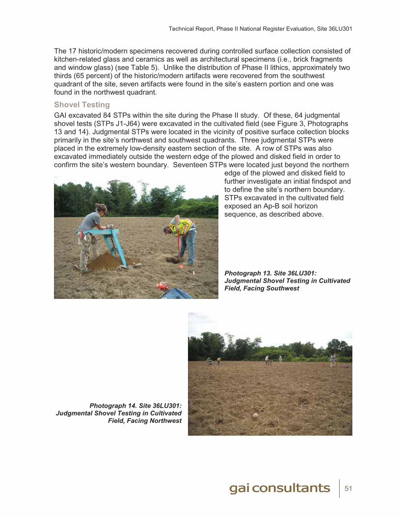
Technical Report, Phase II National Register Evaluation, Site 36LU301
51
The 17 historic/modern specimens recovered during controlled surface collection consisted of kitchen-related glass and ceramics as well as architectural specimens (i.e., brick fragments and window glass) (see Table 5). Unlike the distribution of Phase II lithics, approximately two thirds (65 percent) of the historic/modern artifacts were recovered from the southwest quadrant of the site, seven artifacts were found in the site’s eastern portion and one was found in the northwest quadrant.
Shovel TestingGAI excavated 84 STPs within the site during the Phase II study. Of these, 64 judgmental shovel tests (STPs J1-J64) were excavated in the cultivated field (see Figure 3, Photographs 13 and 14). Judgmental STPs were located in the vicinity of positive surface collection blocks primarily in the site’s northwest and southwest quadrants. Three judgmental STPs were placed in the extremely low-density eastern section of the site. A row of STPs was also excavated immediately outside the western edge of the plowed and disked field in order to confirm the site’s western boundary. Seventeen STPs were located just beyond the northern
edge of the plowed and disked field to further investigate an initial findspot and to define the site’s northern boundary. STPs excavated in the cultivated field exposed an Ap-B soil horizon sequence, as described above.
Photograph 13. Site 36LU301: Judgmental Shovel Testing in Cultivated Field, Facing Southwest
Photograph 14. Site 36LU301: Judgmental Shovel Testing in Cultivated
Field, Facing Northwest

Technical Report, Phase II National Register Evaluation, Site 36LU301
52
An additional 20 close-interval STPs were excavated in a small section of farmyard south of the field to further investigate an area of Phase Ib prehistoric artifact recovery (see Figure 3, Photograph 15). Shovel tests excavated at the western edge of the farmyard exposed
disturbed soils associated with a drainage ditch and use as a field access road. The remainder of STPs in the farmyard exposed an Ap-B soil horizon.
Photograph 15. Site 36LU301: Close Interval Shovel Testing in Farmyard, Facing South
Shovel testing yielded seven prehistoric artifacts and 28 historic specimens, all from plowzone contexts. The seven prehistoric lithics were recovered from six positive STPs, including four (STP J26, J29, J32 and J41) in the northwest portion of the site and two in the farmyard (STP X9 and X10) (see Figure 3). These lithics all consisted of debitage; no diagnostic artifacts were found.
The 28 historic artifacts occurred in ten positive shovel tests. The majority (n=16) of these artifacts were found STPs located in the farmyard, and all but one of the remaining artifacts were recovered from the southern edge of the field (see Figure 3). STP J43, located in the northwest corner of the site, yielded a single historic artifact.
Test Units Ten 1x1-meter (3.3x3.3-foot) test units (TUs 1-10) were excavated within the site during Phase II investigations (see Figure 3, Photograph 16).
Photograph 16. Site 36LU301: View of TU 1 Excavation, Facing West
Test unit excavation produced only 14 prehistoric lithic artifacts and three historic specimens (Table 7). The test unit prehistoric assemblage consisted entirely of fire-cracked rock (FCR); no flaked stone artifacts were recovered from the test units. These 14 FCR were recovered
Technical Report, Phase II National Register Evaluation, Site 36LU301
53
from two test units—TU 1 (n=10) and TU 7 (n=4). Both of these test units were situated in the northwest quadrant of the site, approximately 7 meters (23 feet) apart (see Figure 3). The three historic artifacts were found in surface/plowzone contexts in TU 4 (1 whiteware sherd and 1 window glass) and TU 10 (1 redware sherd), also located in the site’s northwest corner.
Table 7. Site 36LU301 Phase II: Test Unit Summary
TU Location Soil Stratigraphy(Depth=cm below ground surface)
Prehistoric Artifact Total
Historic Artifact Total Comments
1 N 592 E 418 Ap=0-30 cm; B=30-40 cm 10 0Few cobbles, No features, Plowscars at Ap/B interface
2 N 603 E 426 Ap=0-32 cm; B=32-42 cm 0 0 Cobbles, No features
3 N 612 E 445 Ap=0-29 cm; B=29-39 cm 0 0 Cobbles, No features
4 N 608 E 426 Ap=0-19 cm; B=19-29 cm 0 2 Cobbles, No features
5 N 585 E 416 Ap=0-34 cm; B=34-44 cm 0 0 Few Cobbles, No features
6 N 602 E 444 Ap=0-33 cm; B=33-43 cm 0 0Feature 1(Non cultural),Few cobbles, Plowscars at Ap/B interface
7 N 598 E 423 Ap=0-24 cm; B=24-34 cm 4 0 Few cobbles, No features
8 N 610 E 443 Ap=0-30 cm; B=30-40 cm 0 0 Cobbles, No features
9 N 540 E 442 Ap=0-35 cm; B=35-45 cm 0 0Few cobbles, No features, Plowscars at Ap/B interface
10 N 617 E 445 Ap=0-29 cm; B=29-39 cm 0 1 Cobbles, No features TOTAL 14* 3
*All FCR
As described above (Soils and Geomorphology), test units were excavated to a depth of between 29 and 45 cm (0.9 and 1.5 feet) below surface and exposed an Ap-B soil horizon sequence throughout the site (see Table 7). Representative profiles of this sequence as exposed in TUs 1, 9 and 10 are illustrated in Figures 11, 12 and 13 and Photographs 17 through 20. The dark brown to dark-grayish-brown sandy loam Ap horizon ranged from 19 to 35 cm (0.6 to 1.1 feet) in thickness and superimposed a yellowish-brown sandy loam to gravelly sandy loam B horizon. Five of the test units (TUs 2, 3, 4, 8 and 10) located in the northwest quadrant of the site contained a high percentage of channers (thin, flat rock fragments), gravels and cobbles, with the percentage of rock generally increasing from 5 to 10 percent at the top of the Ap horizon to as much as 40 to 50 percent in the subsoil (see Photographs 17 and 18). In the remaining units (e.g., TUs 1, 5, 6, and 7 in the northwest quadrant and TU 9 in the southeast quadrant) the percentage of channers, gravels and cobbles was significantly lower (see Photographs 9, 19 and 20). Prehistoric artifacts (FCR) were recovered exclusively from the plowzone (Ap horizon) (see Table 7).
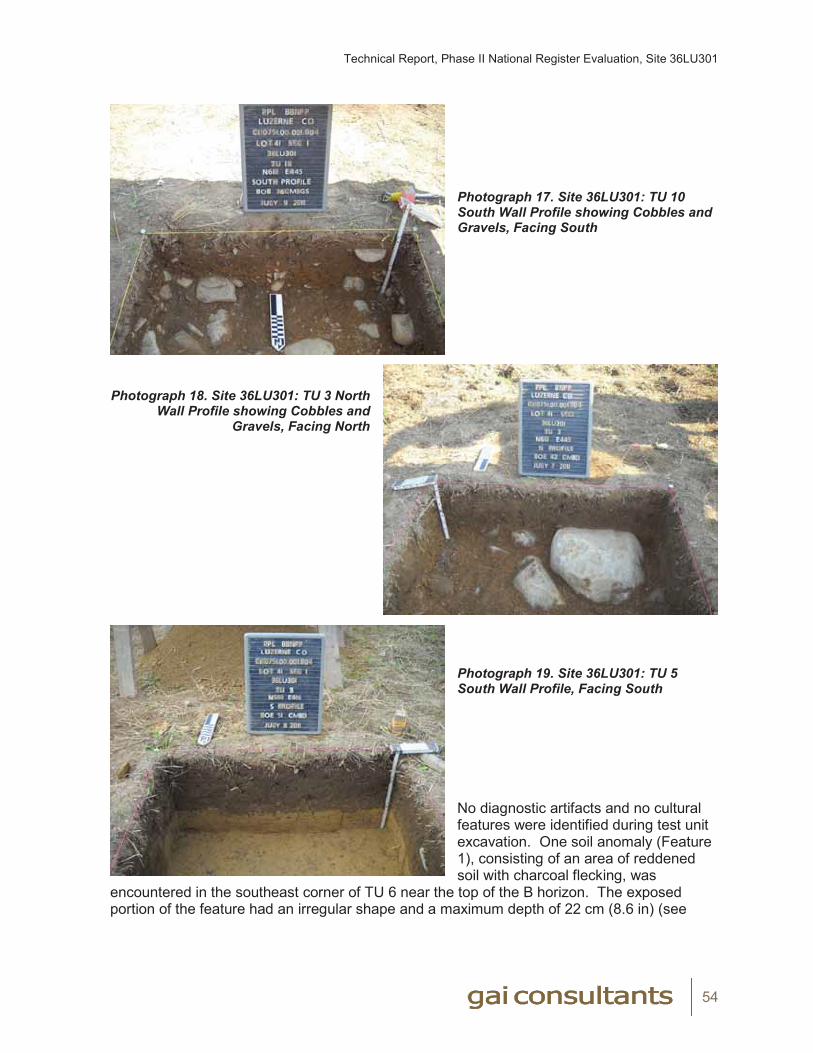
Technical Report, Phase II National Register Evaluation, Site 36LU301
54
Photograph 17. Site 36LU301: TU 10 South Wall Profile showing Cobbles and Gravels, Facing South
Photograph 18. Site 36LU301: TU 3 North
Wall Profile showing Cobbles and Gravels, Facing North
Photograph 19. Site 36LU301: TU 5 South Wall Profile, Facing South
No diagnostic artifacts and no cultural features were identified during test unit excavation. One soil anomaly (Feature 1), consisting of an area of reddened soil with charcoal flecking, was
encountered in the southeast corner of TU 6 near the top of the B horizon. The exposed portion of the feature had an irregular shape and a maximum depth of 22 cm (8.6 in) (see
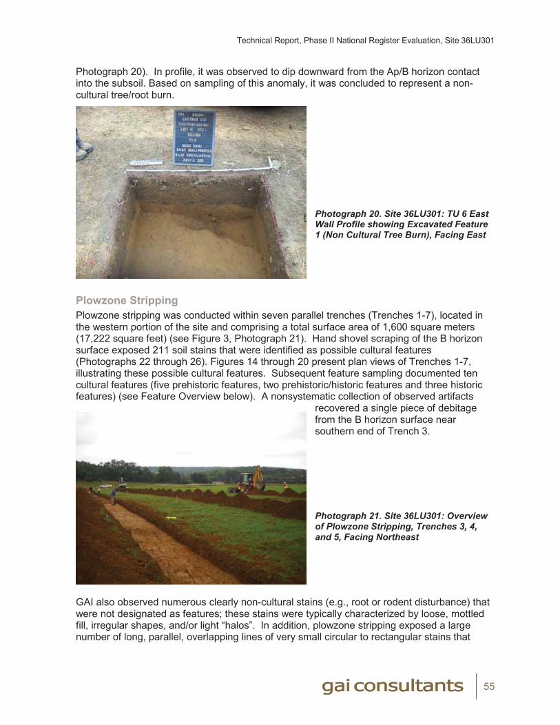
Technical Report, Phase II National Register Evaluation, Site 36LU301
55
Photograph 20). In profile, it was observed to dip downward from the Ap/B horizon contact into the subsoil. Based on sampling of this anomaly, it was concluded to represent a non-cultural tree/root burn.
Photograph 20. Site 36LU301: TU 6 East Wall Profile showing Excavated Feature 1 (Non Cultural Tree Burn), Facing East
Plowzone Stripping Plowzone stripping was conducted within seven parallel trenches (Trenches 1-7), located in the western portion of the site and comprising a total surface area of 1,600 square meters (17,222 square feet) (see Figure 3, Photograph 21). Hand shovel scraping of the B horizon surface exposed 211 soil stains that were identified as possible cultural features (Photographs 22 through 26). Figures 14 through 20 present plan views of Trenches 1-7, illustrating these possible cultural features. Subsequent feature sampling documented ten cultural features (five prehistoric features, two prehistoric/historic features and three historic features) (see Feature Overview below). A nonsystematic collection of observed artifacts
recovered a single piece of debitage from the B horizon surface near southern end of Trench 3.
Photograph 21. Site 36LU301: Overview of Plowzone Stripping, Trenches 3, 4, and 5, Facing Northeast
GAI also observed numerous clearly non-cultural stains (e.g., root or rodent disturbance) that were not designated as features; these stains were typically characterized by loose, mottled fill, irregular shapes, and/or light “halos”. In addition, plowzone stripping exposed a large number of long, parallel, overlapping lines of very small circular to rectangular stains that
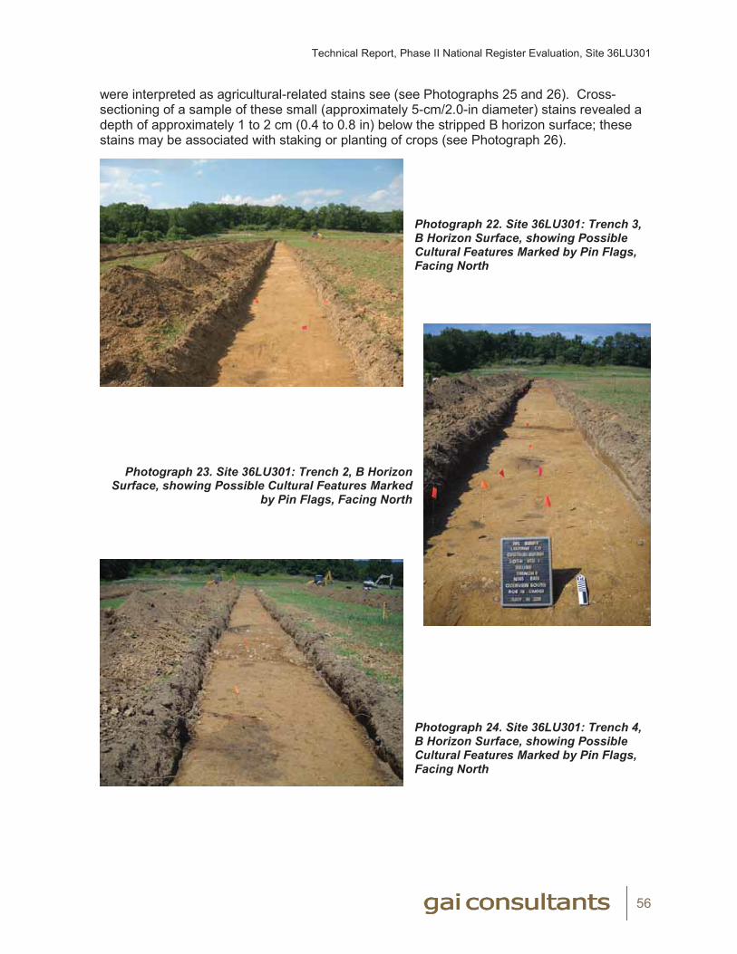
Technical Report, Phase II National Register Evaluation, Site 36LU301
56
were interpreted as agricultural-related stains see (see Photographs 25 and 26). Cross-sectioning of a sample of these small (approximately 5-cm/2.0-in diameter) stains revealed a depth of approximately 1 to 2 cm (0.4 to 0.8 in) below the stripped B horizon surface; these stains may be associated with staking or planting of crops (see Photograph 26).
Photograph 22. Site 36LU301: Trench 3,B Horizon Surface, showing Possible Cultural Features Marked by Pin Flags, Facing North
Photograph 23. Site 36LU301: Trench 2, B Horizon
Surface, showing Possible Cultural Features Marked by Pin Flags, Facing North
Photograph 24. Site 36LU301: Trench 4,B Horizon Surface, showing Possible Cultural Features Marked by Pin Flags, Facing North
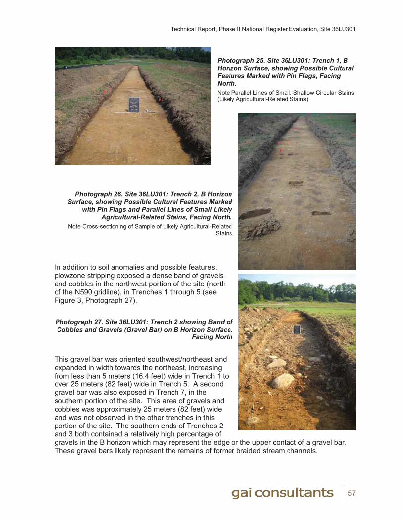
Technical Report, Phase II National Register Evaluation, Site 36LU301
57
Photograph 25. Site 36LU301: Trench 1, BHorizon Surface, showing Possible CulturalFeatures Marked with Pin Flags, Facing North.Note Parallel Lines of Small, Shallow Circular Stains (Likely Agricultural-Related Stains)
Photograph 26. Site 36LU301: Trench 2, B Horizon
Surface, showing Possible Cultural Features Marked with Pin Flags and Parallel Lines of Small Likely
Agricultural-Related Stains, Facing North.Note Cross-sectioning of Sample of Likely Agricultural-Related
Stains
In addition to soil anomalies and possible features, plowzone stripping exposed a dense band of gravels and cobbles in the northwest portion of the site (north of the N590 gridline), in Trenches 1 through 5 (see Figure 3, Photograph 27).
Photograph 27. Site 36LU301: Trench 2 showing Band of Cobbles and Gravels (Gravel Bar) on B Horizon Surface,
Facing North
This gravel bar was oriented southwest/northeast and expanded in width towards the northeast, increasing from less than 5 meters (16.4 feet) wide in Trench 1 to over 25 meters (82 feet) wide in Trench 5. A second gravel bar was also exposed in Trench 7, in the southern portion of the site. This area of gravels and cobbles was approximately 25 meters (82 feet) wide and was not observed in the other trenches in this portion of the site. The southern ends of Trenches 2 and 3 both contained a relatively high percentage of gravels in the B horizon which may represent the edge or the upper contact of a gravel bar. These gravel bars likely represent the remains of former braided stream channels.
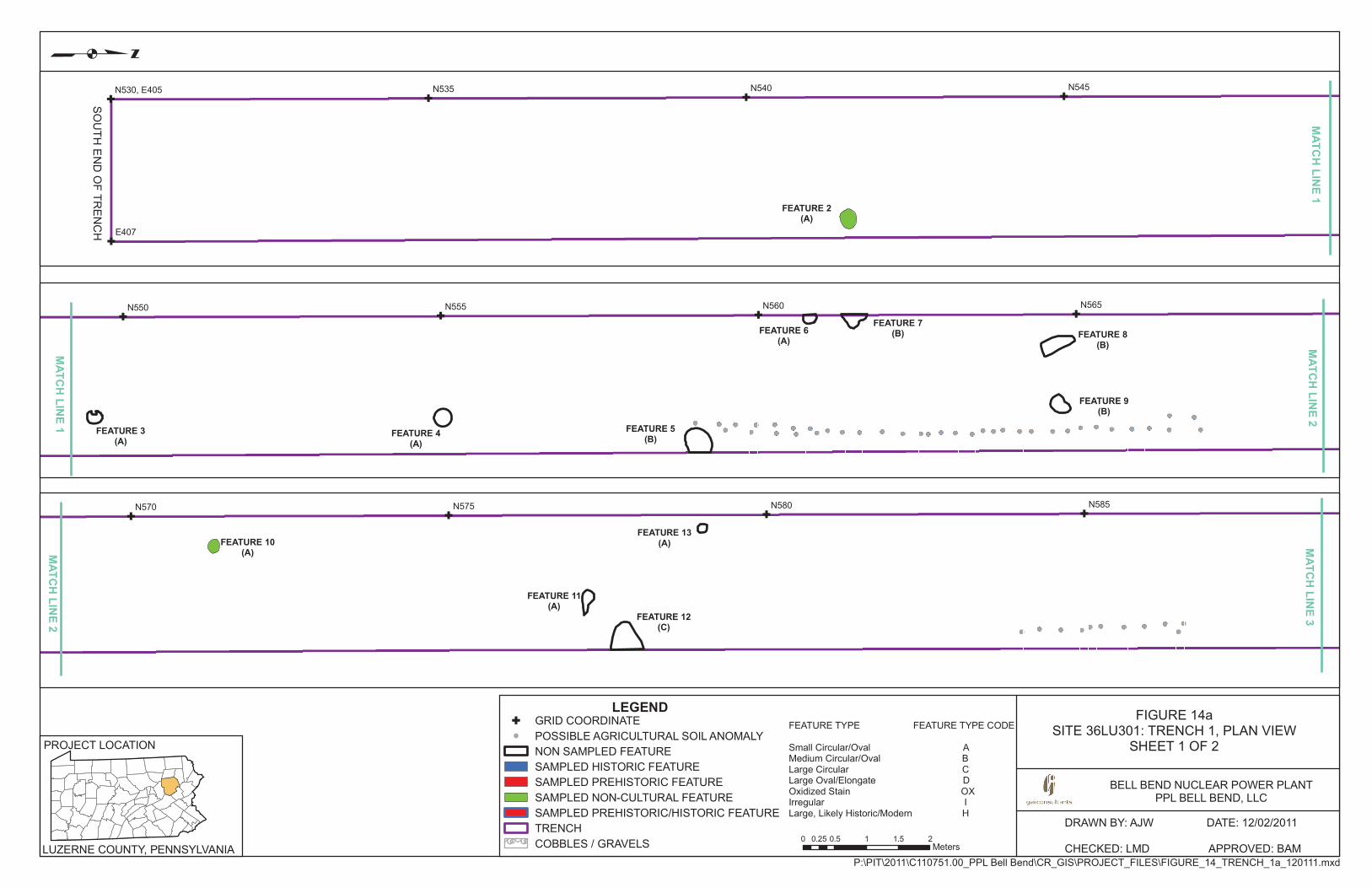
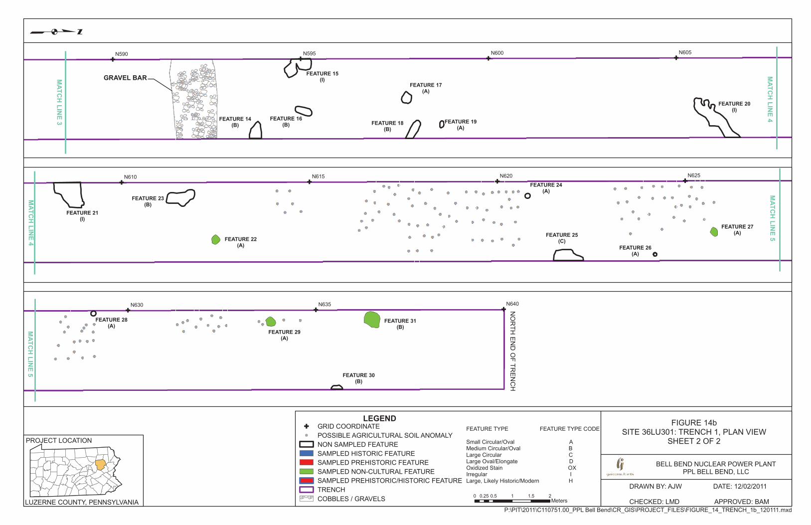
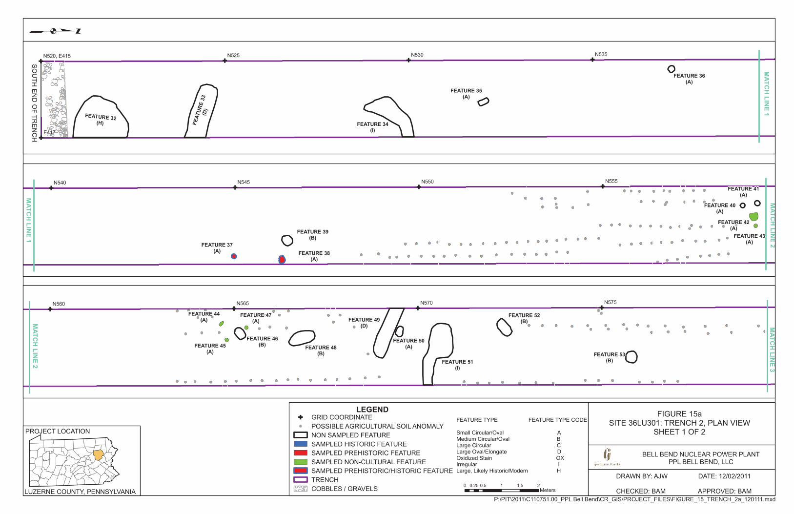
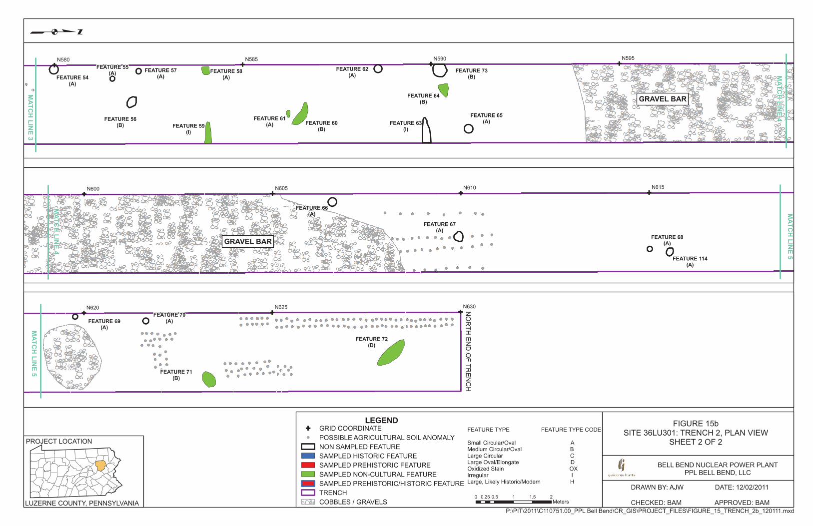
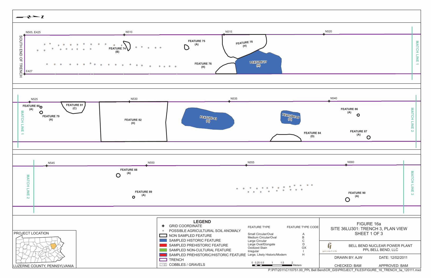

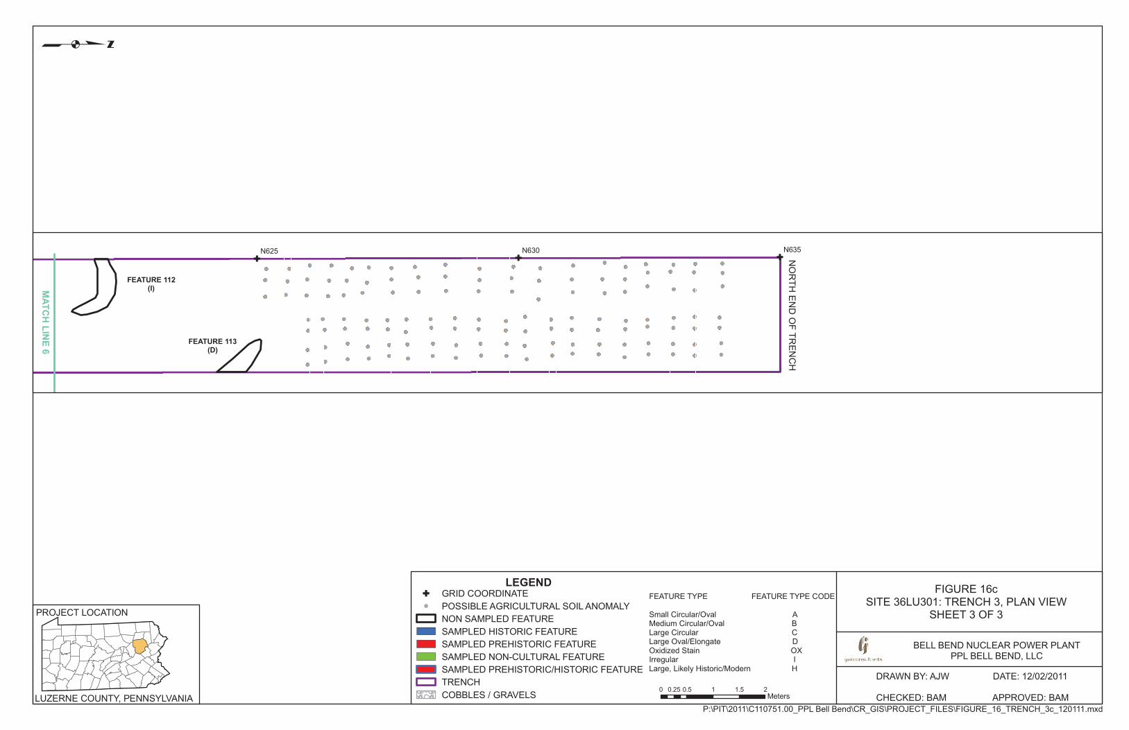
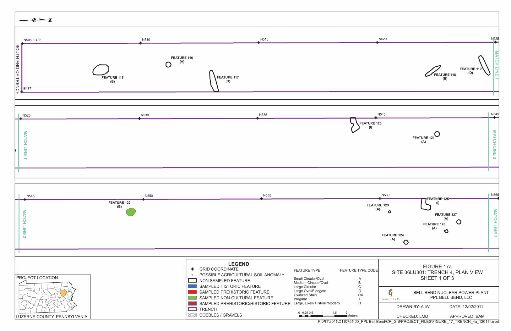

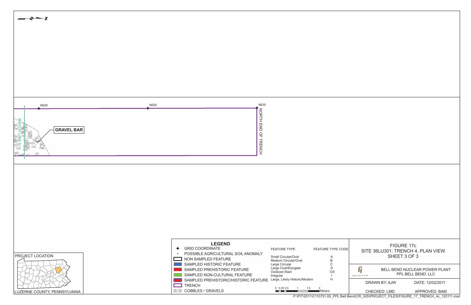
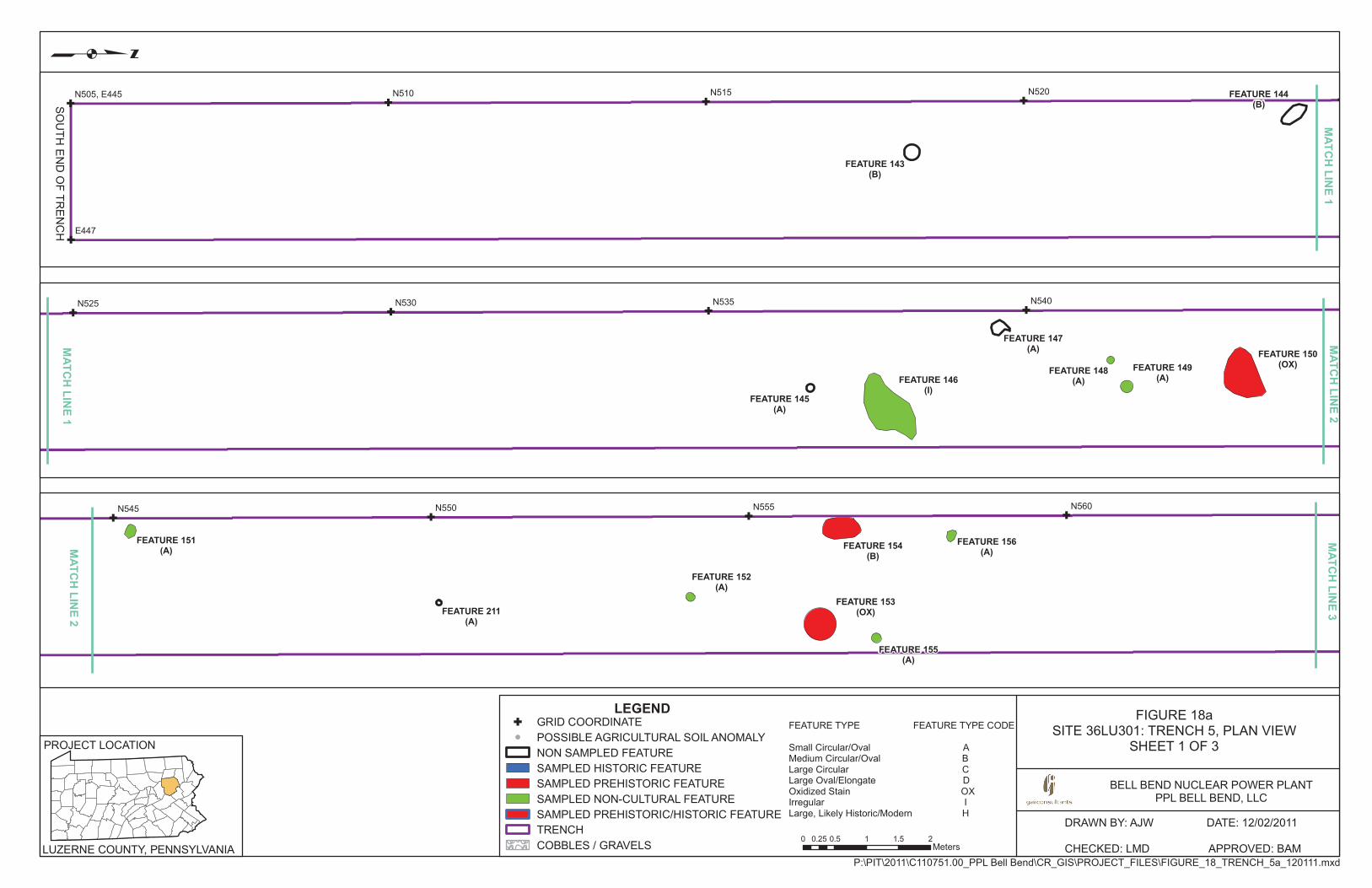
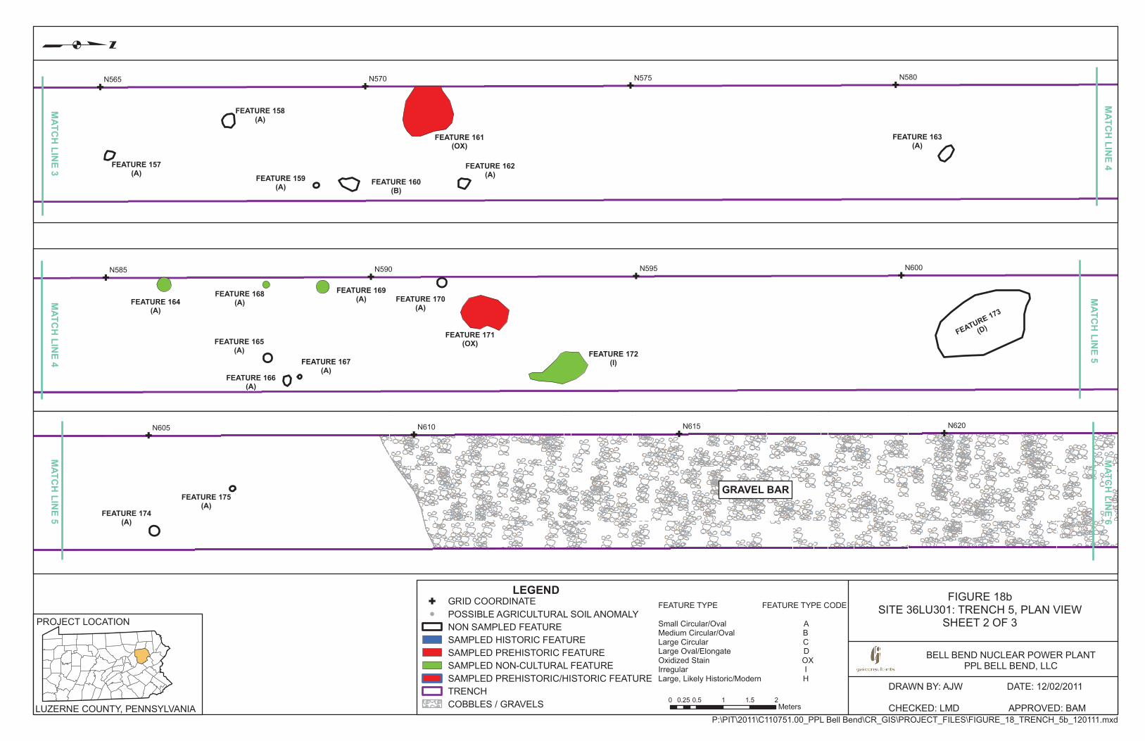
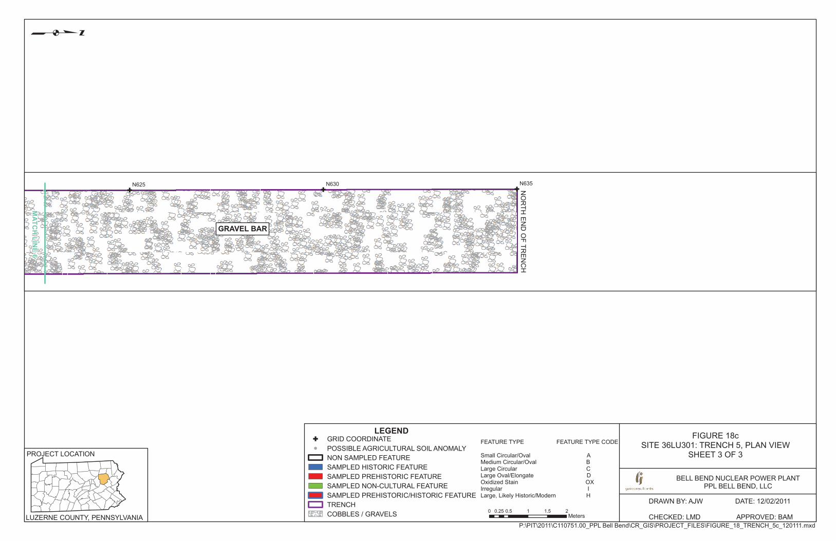
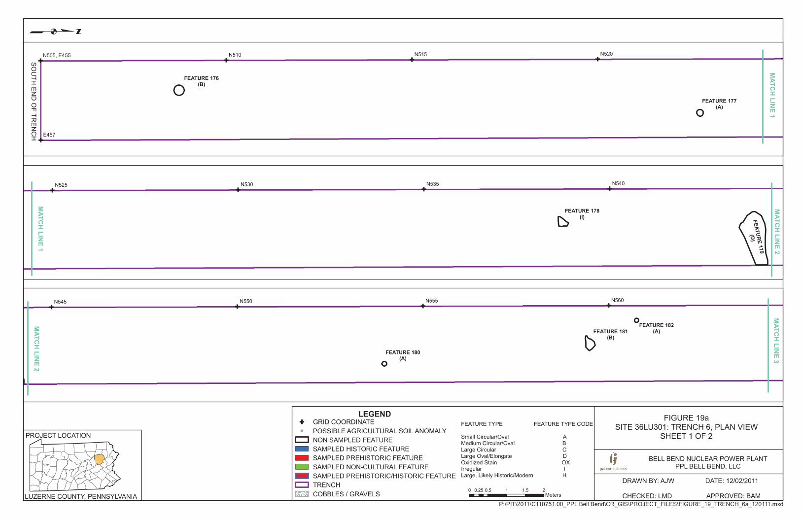
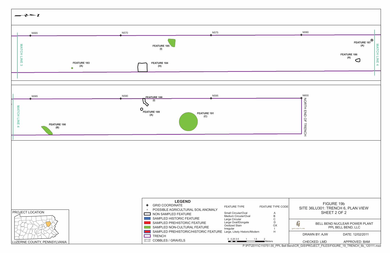
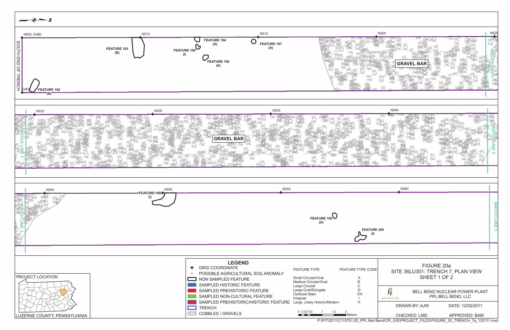
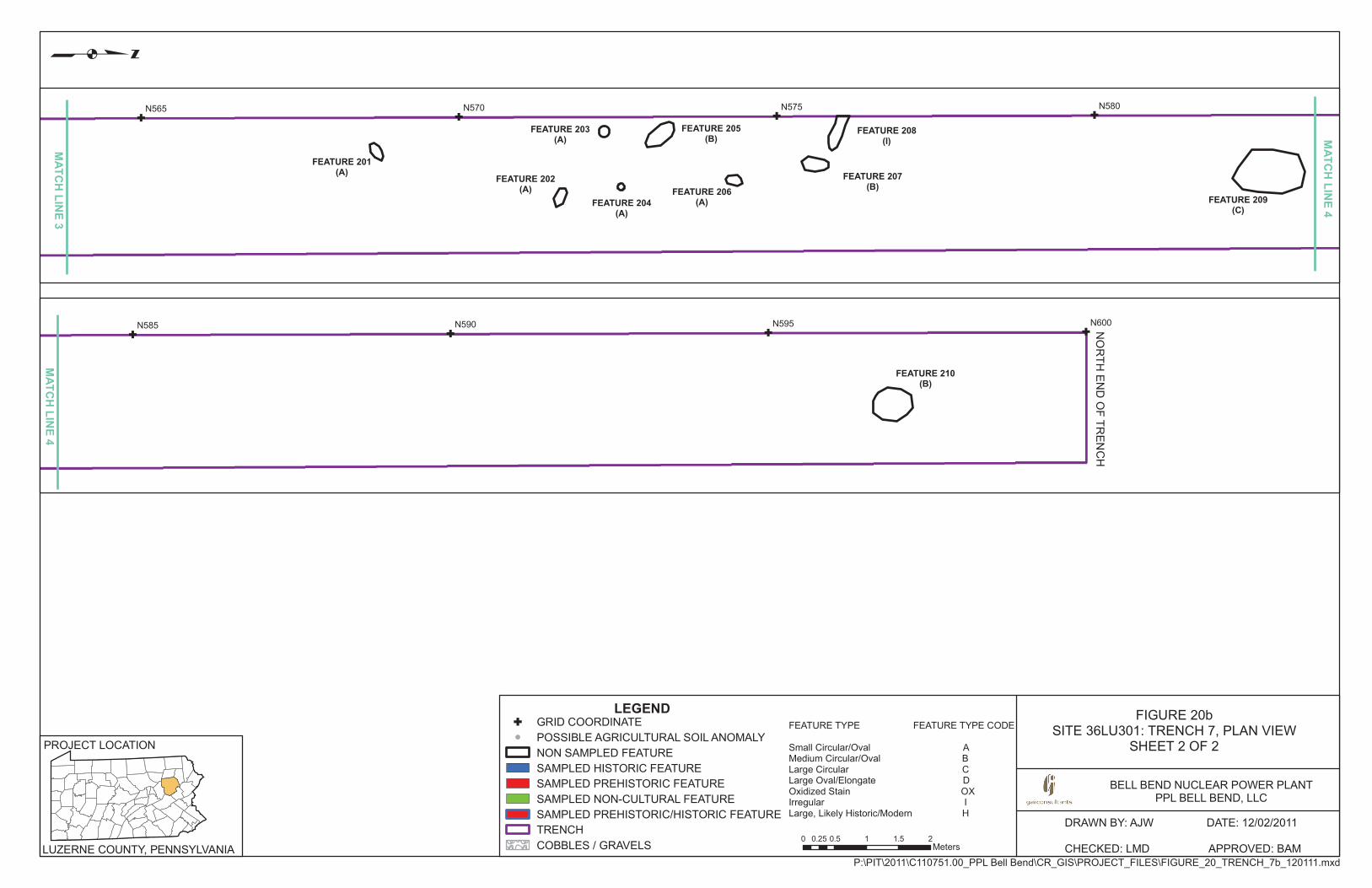
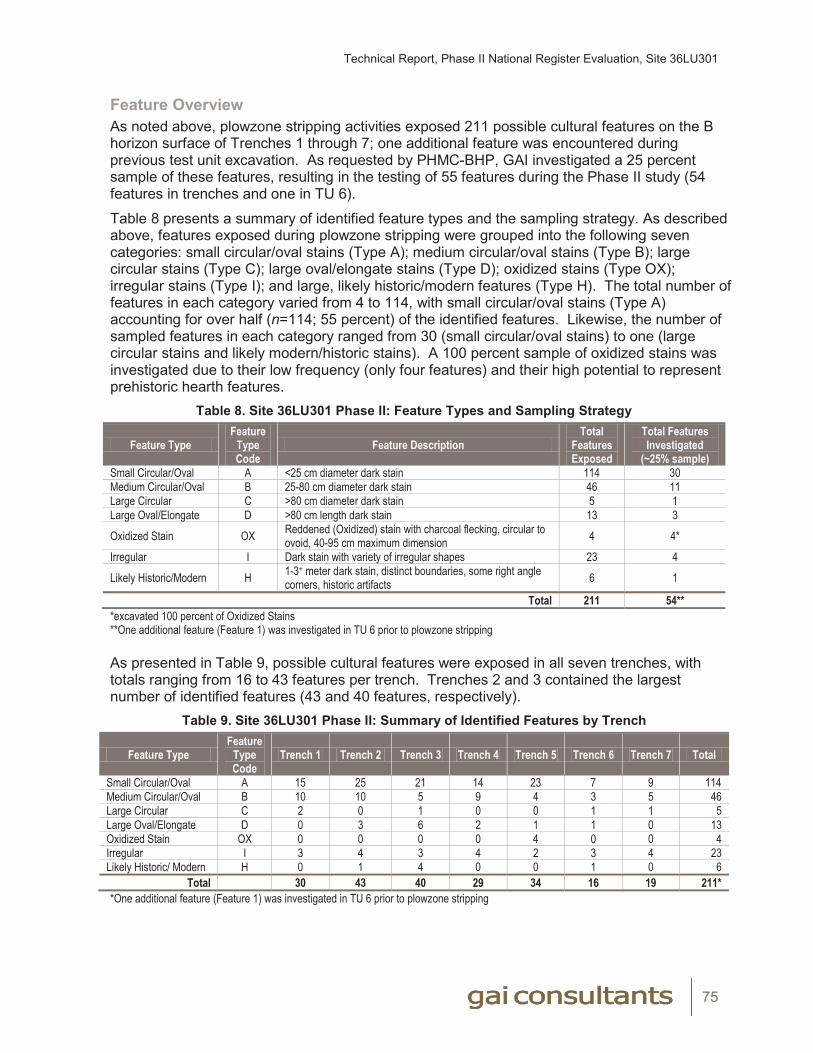
Technical Report, Phase II National Register Evaluation, Site 36LU301
75
Feature Overview As noted above, plowzone stripping activities exposed 211 possible cultural features on the B horizon surface of Trenches 1 through 7; one additional feature was encountered during previous test unit excavation. As requested by PHMC-BHP, GAI investigated a 25 percent sample of these features, resulting in the testing of 55 features during the Phase II study (54 features in trenches and one in TU 6).
Table 8 presents a summary of identified feature types and the sampling strategy. As described above, features exposed during plowzone stripping were grouped into the following seven categories: small circular/oval stains (Type A); medium circular/oval stains (Type B); large circular stains (Type C); large oval/elongate stains (Type D); oxidized stains (Type OX); irregular stains (Type I); and large, likely historic/modern features (Type H). The total number of features in each category varied from 4 to 114, with small circular/oval stains (Type A) accounting for over half (n=114; 55 percent) of the identified features. Likewise, the number of sampled features in each category ranged from 30 (small circular/oval stains) to one (large circular stains and likely modern/historic stains). A 100 percent sample of oxidized stains was investigated due to their low frequency (only four features) and their high potential to represent prehistoric hearth features.
Table 8. Site 36LU301 Phase II: Feature Types and Sampling Strategy
Feature TypeFeature
Type Code
Feature DescriptionTotal
Features Exposed
Total Features Investigated
(~25% sample)Small Circular/Oval A <25 cm diameter dark stain 114 30Medium Circular/Oval B 25-80 cm diameter dark stain 46 11Large Circular C >80 cm diameter dark stain 5 1Large Oval/Elongate D >80 cm length dark stain 13 3
Oxidized Stain OX Reddened (Oxidized) stain with charcoal flecking, circular to ovoid, 40-95 cm maximum dimension 4 4*
Irregular I Dark stain with variety of irregular shapes 23 4
Likely Historic/Modern H 1-3+ meter dark stain, distinct boundaries, some right angle corners, historic artifacts 6 1
Total 211 54***excavated 100 percent of Oxidized Stains**One additional feature (Feature 1) was investigated in TU 6 prior to plowzone stripping
As presented in Table 9, possible cultural features were exposed in all seven trenches, with totals ranging from 16 to 43 features per trench. Trenches 2 and 3 contained the largest number of identified features (43 and 40 features, respectively).
Table 9. Site 36LU301 Phase II: Summary of Identified Features by Trench
Feature TypeFeature
Type Code
Trench 1 Trench 2 Trench 3 Trench 4 Trench 5 Trench 6 Trench 7 Total
Small Circular/Oval A 15 25 21 14 23 7 9 114Medium Circular/Oval B 10 10 5 9 4 3 5 46Large Circular C 2 0 1 0 0 1 1 5Large Oval/Elongate D 0 3 6 2 1 1 0 13Oxidized Stain OX 0 0 0 0 4 0 0 4Irregular I 3 4 3 4 2 3 4 23Likely Historic/ Modern H 0 1 4 0 0 1 0 6
Total 30 43 40 29 34 16 19 211**One additional feature (Feature 1) was investigated in TU 6 prior to plowzone stripping

Technical Report, Phase II National Register Evaluation, Site 36LU301
76
Table 10 provides a summary of all 212 possible features identified at the site, including feature type code, location, and dimensions. These features are mapped on Figures 14 through 20.
Based on the results of the Phase II investigation, the 55 sampled features included ten cultural features. These consisted of five prehistoric thermal features (Features 150, 153, 154, 161 and 171) all identified in Trench 5, two prehistoric or historic postmolds (Features 37 and 38) located in Trench 2, and three historic features (Feature 77, an historic trash pit, and Features 83 and 85, historic features of indeterminate function ) all exposed in Trench 3. The remaining 45 features were concluded to represent non-cultural soil anomalies, primarily reflecting extensive bioturbation activity (e.g., root and/or rodent disturbances) within the cultivated field.
Table 11 presents a summary of the 55 features sampled during Phase II investigations. The ten possible cultural features noted above are illustrated on Figure 3 and on the appropriate trench plan views (see Figures 14 through 20) and are also documented with individual plan views and profiles (see feature descriptions below).
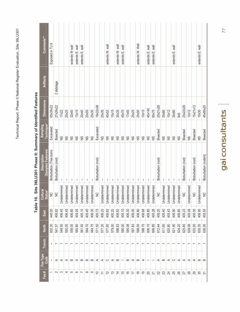
Tech
nica
l Rep
ort,
Phas
e II
Nat
iona
l Reg
iste
r Eva
luat
ion,
Site
36L
U30
1
77
Tabl
e 10
. Si
te 3
6LU
301
Phas
e II:
Sum
mar
y of
Iden
tifie
d Fe
atur
es
Fea #
FeaT
ype
Code
Tren
chNo
rthEa
stCu
ltura
lSt
atus
*De
scrip
tion
(S
ampl
ed F
eatu
res)
Sam
plin
gTe
chni
que+
Dim
ensio
nsAr
tifac
tsCo
mm
ents
**
1--
--60
2.30
445.0
0NC
Biotu
rbati
on (T
ree b
urn)
Ex
cava
ted65
x35x
22Ex
pose
d in T
U 6
2A
154
1.57
406.6
2NC
Biotu
rbati
on (r
oot)
Bise
cted
27x2
6x22
2 deb
itage
3A
154
9.55
406.4
5Un
deter
mine
d--
NS17
x22
4A
155
5.05
406.4
5Un
deter
mine
d--
NS25
x25
5B
155
9.05
406.8
5Un
deter
mine
d--
NS32
x40
exten
ds W
wall
6A
156
0.80
405.0
5Un
deter
mine
d--
NS13
x15
exten
ds E
. wall
7B
156
1.50
405.1
0Un
deter
mine
d--
NS20
x40
exten
ds E
. wall
8B
156
4.70
405.4
5Un
deter
mine
d--
NS20
x55
9B
156
4.75
406.3
5Un
deter
mine
d--
NS25
x35
10A
157
1.50
405.7
3NC
Biotu
rbati
on (r
oot)
Exca
vated
18x2
2x38
11A
157
7.20
406.2
3Un
deter
mine
d--
NS20
x35
12C
157
7.80
406.8
3Un
deter
mine
d--
NS40
x52
exten
ds W
. wall
13A
157
9.00
405.2
0Un
deter
mine
d--
NS10
x15
14B
159
8.83
406.8
3Un
deter
mine
d--
NS30
x35
exten
ds W
. wall
15I
159
5.00
405.1
0Un
deter
mine
d--
NS45
x70
exten
ds E
. wall
16B
159
5.08
406.3
0Un
deter
mine
d--
NS17
x45
17A
159
7.83
406.0
0Un
deter
mine
d--
NS25
x25
18B
159
8.00
406.8
0Un
deter
mine
d--
NS20
x50
exten
ds W
. Wall
19A
159
8.75
406.6
8Un
deter
mine
d--
NS10
x15
20I
160
6.15
406.8
5Un
deter
mine
d--
NS40
x140
exten
ds E
. wall
21I
160
6.85
405.2
8Un
deter
mine
d--
NS65
x70
exten
ds E
. wall
22A
161
2.44
406.2
0NC
Biotu
rbati
on (r
oot)
Bise
cted
20x2
1x26
23B
161
1.60
405.4
0Un
deter
mine
d--
NS35
x80
24A
162
0.80
405.4
3Un
deter
mine
d--
NS10
x12
25C
162
1.90
406.9
0Un
deter
mine
d--
NS30
x80
exten
ds E
. wall
26A
162
4.20
406.8
5Un
deter
mine
d--
NS9x
927
A1
625.6
540
5.23
NCBi
oturb
ation
(roo
t)Bi
secte
d20
x22x
2928
A1
629.0
840
5.08
Unde
termi
ned
--NS
12x1
229
A1
633.5
040
5.55
NCBi
oturb
ation
(roo
t)Bi
secte
d15
x21x
1230
B1
635.3
540
6.95
Unde
termi
ned
--NS
10x3
0ex
tends
E. w
all31
B1
636.0
540
5.55
NCBi
oturb
ation
(rod
ent)
Bise
cted
45x8
0x20
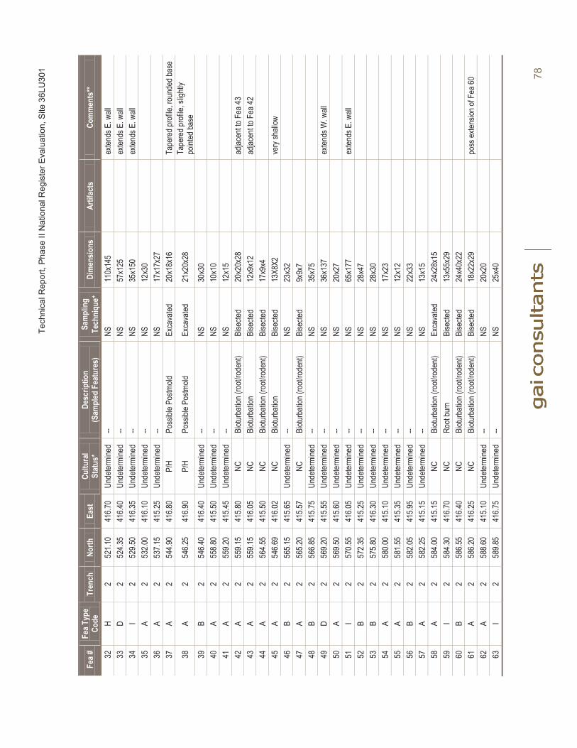
Tech
nica
l Rep
ort,
Phas
e II
Nat
iona
l Reg
iste
r Eva
luat
ion,
Site
36L
U30
1
78
Fea #
FeaT
ype
Code
Tren
chNo
rthEa
stCu
ltura
lSt
atus
*De
scrip
tion
(S
ampl
ed F
eatu
res)
Sam
plin
gTe
chni
que+
Dim
ensio
nsAr
tifac
tsCo
mm
ents
**
32H
252
1.10
416.7
0Un
deter
mine
d--
NS11
0x14
5ex
tends
E. w
all33
D2
524.3
541
6.40
Unde
termi
ned
--NS
57x1
25ex
tends
E. w
all34
I2
529.5
041
6.35
Unde
termi
ned
--NS
35x1
50ex
tends
E. w
all35
A2
532.0
041
6.10
Unde
termi
ned
--NS
12x3
036
A2
537.1
541
5.25
Unde
termi
ned
--NS
17x1
7x27
37A
254
4.90
416.8
0P/
HPo
ssibl
e Pos
tmold
Exca
vated
20x1
8x16
Tape
red p
rofile
, rou
nded
base
38A
254
6.25
416.9
0P/
HPo
ssibl
e Pos
tmold
Exca
vated
21x2
0x28
Tape
red p
rofile
, slig
htly
point
ed ba
se39
B2
546.4
041
6.40
Unde
termi
ned
--NS
30x3
040
A2
558.8
041
5.50
Unde
termi
ned
--NS
10x1
041
A2
559.2
041
5.45
Unde
termi
ned
--NS
12x1
542
A2
559.1
541
5.80
NCBi
oturb
ation
(roo
t/rod
ent)
Bise
cted
20x2
0x28
adjac
ent to
Fea
4343
A2
559.1
541
6.05
NCBi
oturb
ation
Bise
cted
12x9
x12
adjac
ent to
Fea
4244
A2
564.5
541
5.50
NCBi
oturb
ation
(roo
t/rod
ent)
Bise
cted
17x9
x445
A2
546.6
941
6.02
NCBi
oturb
ation
Bise
cted
13X8
X2ve
ry sh
allow
46
B2
565.1
541
5.65
Unde
termi
ned
--NS
23x3
247
A2
565.2
041
5.57
NCBi
oturb
ation
(roo
t/rod
ent)
Bise
cted
9x9x
748
B2
566.8
541
5.75
Unde
termi
ned
--NS
35x7
549
D2
569.2
041
5.55
Unde
termi
ned
--NS
36x1
37ex
tends
W. w
all50
A2
569.5
041
5.60
Unde
termi
ned
--NS
20x2
751
I2
570.5
541
6.05
Unde
termi
ned
--NS
65x1
77ex
tends
E. w
all52
B2
572.3
541
5.25
Unde
termi
ned
--NS
28x4
753
B2
575.8
041
6.30
Unde
termi
ned
--NS
28x3
054
A2
580.0
041
5.10
Unde
termi
ned
--NS
17x2
355
A2
581.5
541
5.35
Unde
termi
ned
--NS
12x1
256
B2
582.0
541
5.95
Unde
termi
ned
--NS
22x3
357
A2
582.2
541
5.15
Unde
termi
ned
--NS
13x1
558
A2
584.0
041
5.15
NCBi
oturb
ation
(roo
t/rod
ent)
Exca
vated
24x2
8x15
59I
258
4.30
416.7
0NC
Root
burn
Bi
secte
d13
x55x
2960
B2
586.5
541
6.40
NCBi
oturb
ation
(roo
t/rod
ent)
Bise
cted
24x4
0x22
61A
258
6.20
416.2
5NC
Biotu
rbati
on (r
oot/r
oden
t)Bi
secte
d18
x22x
29po
ss ex
tensio
n of F
ea 60
62A
258
8.60
415.1
0Un
deter
mine
d--
NS20
x20
63I
258
9.85
416.7
5Un
deter
mine
d--
NS25
x40

Tech
nica
l Rep
ort,
Phas
e II
Nat
iona
l Reg
iste
r Eva
luat
ion,
Site
36L
U30
1
79
Fea #
FeaT
ype
Code
Tren
chNo
rthEa
stCu
ltura
lSt
atus
*De
scrip
tion
(S
ampl
ed F
eatu
res)
Sam
plin
gTe
chni
que+
Dim
ensio
nsAr
tifac
tsCo
mm
ents
**
64B
259
0.35
415.6
5NC
Biotu
rbati
on (r
oden
t)Bi
secte
d35
x25x
5tria
ngula
r/circ
ular;
loose
re
cent
fill65
A2
591.0
041
6.65
Unde
termi
ned
--NS
18x2
0po
ss S
TP J2
666
A2
606.6
041
5.20
Unde
termi
ned
--NS
17x2
267
A2
609.9
041
6.10
Unde
termi
ned
--NS
25x2
568
A2
615.0
041
6.43
Unde
termi
ned
--NS
13x1
369
A2
619.8
041
5.10
Unde
termi
ned
--NS
13x1
370
A2
621.6
541
5.20
Unde
termi
ned
--NS
15x1
571
B2
623.3
041
6.70
NCBi
oturb
ation
Bise
cted
20x3
0x20
72D
262
8.15
416.1
0NC
Biotu
rbati
on (r
oot)
Bise
cted
25x7
0x9
oval
w/ C
14 an
d gra
y halo
73B
259
0.23
415.1
5Un
deter
mine
d--
NS30
x35
poss
STP
J19
74B
351
0.20
425.5
5Un
deter
mine
d--
NS20
x55
75A
351
3.10
425.6
7Un
deter
mine
d--
NS25
x25
76H
351
5.15
426.8
0Un
deter
mine
d/ H
--NS
50x1
00Da
rk sta
in wi
th ro
ck; a
djace
nt to
Fea 7
7; ex
tends
E. w
all
77H
351
7.05
426.5
0H
Shall
ow H
istor
ic Re
fuse P
itBi
secte
d95
x214
x26
92 H
istor
ic (fa
unal,
gla
ss, c
eram
ic,
metal
)Ne
ar F
ea 76
and 7
8
78H
351
6.00
425.5
0Un
deter
mine
d/ H
--NS
120x
220
Oval
to re
ctang
ular d
ark s
tain;
adjac
ent to
Fea
77; e
xtend
s W
. wall
79A
352
5.55
425.5
5Un
deter
mine
d--
NS10
x18
80A
352
5.55
425.3
0Un
deter
mine
d--
NS10
x10
81C
352
7.20
425.2
5Un
deter
mine
d--
NS60
x120
82H
353
0.00
426.0
0Un
deter
mine
d/ H
--NS
200x
330
Rock
filled
stain
with
shar
p pa
ralle
l edg
es; b
isects
tren
ch;
includ
es ch
anne
rs, br
oken
cobb
les an
d bur
ned w
ood
plank
83D
353
4.20
425.6
5H
Larg
e, sh
allow
basin
; un
deter
mine
d fun
ction
; his
toric
Exca
vated
220x
90x1
01 w
indow
glas
s; 2 d
ebita
ge1 g
lass f
rom
base
; sou
th of
Fea 8
5
84D
353
7.80
426.8
5Un
deter
mine
d--
NS35
x155
85D
353
8.00
425.6
5H
Shall
ow ba
sin;
unde
termi
ned f
uncti
on;
histor
icEx
cava
ted10
0x62
x13
North
of F
ea 83
86A
354
1.45
425.7
0Un
deter
mine
d--
NS10
x10
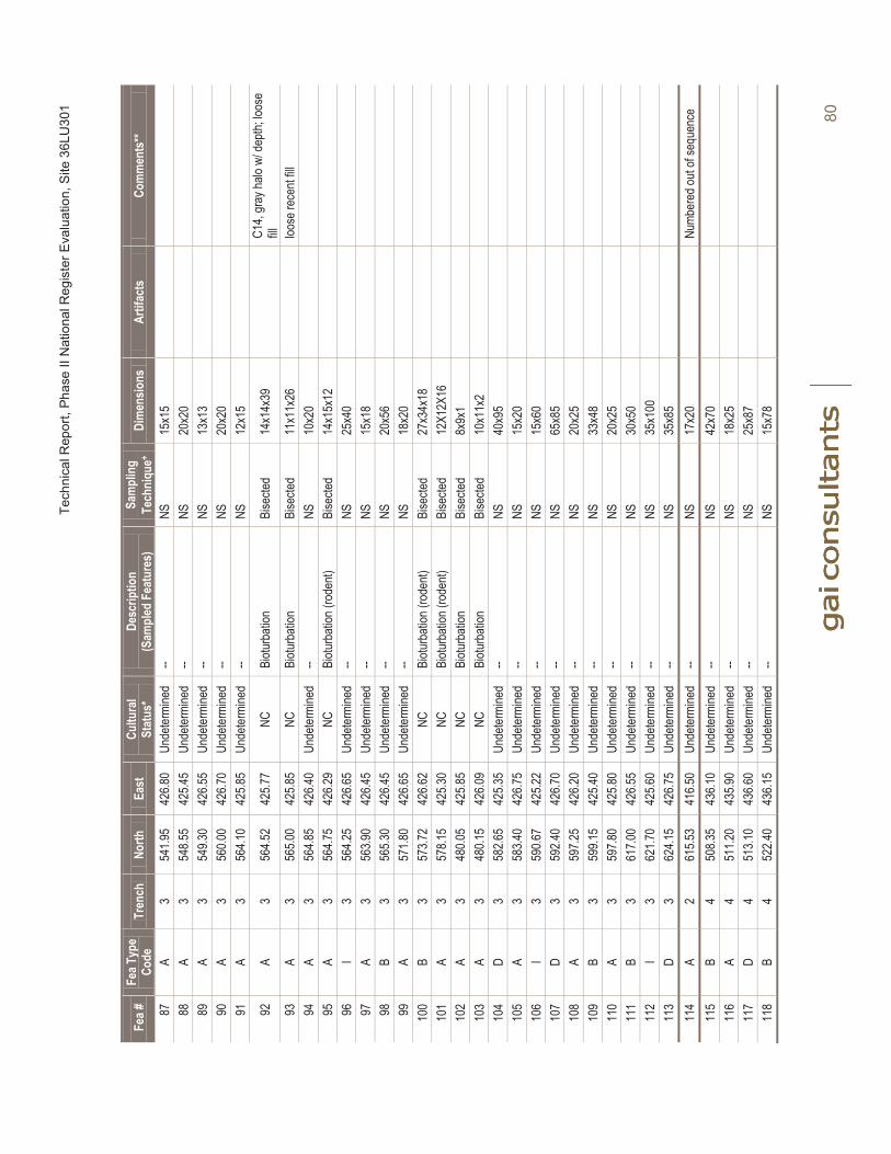
Tech
nica
l Rep
ort,
Phas
e II
Nat
iona
l Reg
iste
r Eva
luat
ion,
Site
36L
U30
1
80
Fea #
FeaT
ype
Code
Tren
chNo
rthEa
stCu
ltura
lSt
atus
*De
scrip
tion
(S
ampl
ed F
eatu
res)
Sam
plin
gTe
chni
que+
Dim
ensio
nsAr
tifac
tsCo
mm
ents
**
87A
354
1.95
426.8
0Un
deter
mine
d--
NS15
x15
88A
354
8.55
425.4
5Un
deter
mine
d--
NS20
x20
89A
354
9.30
426.5
5Un
deter
mine
d--
NS13
x13
90A
356
0.00
426.7
0Un
deter
mine
d--
NS20
x20
91A
356
4.10
425.8
5Un
deter
mine
d--
NS12
x15
92A
356
4.52
425.7
7NC
Biotu
rbati
onBi
secte
d14
x14x
39C1
4, gr
ay ha
lo w/
depth
; loos
e fill
93A
356
5.00
425.8
5NC
Biotu
rbati
onBi
secte
d11
x11x
26loo
se re
cent
fill94
A3
564.8
542
6.40
Unde
termi
ned
--NS
10x2
095
A3
564.7
542
6.29
NCBi
oturb
ation
(rod
ent)
Bise
cted
14x1
5x12
96I
356
4.25
426.6
5Un
deter
mine
d--
NS25
x40
97A
356
3.90
426.4
5Un
deter
mine
d--
NS15
x18
98B
356
5.30
426.4
5Un
deter
mine
d--
NS20
x56
99A
357
1.80
426.6
5Un
deter
mine
d--
NS18
x20
100
B3
573.7
242
6.62
NCBi
oturb
ation
(rod
ent)
Bise
cted
27x3
4x18
101
A3
578.1
542
5.30
NCBi
oturb
ation
(rod
ent)
Bise
cted
12X1
2X16
102
A3
480.0
542
5.85
NCBi
oturb
ation
Bise
cted
8x9x
110
3A
348
0.15
426.0
9NC
Biotu
rbati
onBi
secte
d10
x11x
210
4D
358
2.65
425.3
5Un
deter
mine
d--
NS40
x95
105
A3
583.4
042
6.75
Unde
termi
ned
--NS
15x2
010
6I
359
0.67
425.2
2Un
deter
mine
d--
NS15
x60
107
D3
592.4
042
6.70
Unde
termi
ned
--NS
65x8
510
8A
359
7.25
426.2
0Un
deter
mine
d--
NS20
x25
109
B3
599.1
542
5.40
Unde
termi
ned
--NS
33x4
811
0A
359
7.80
425.8
0Un
deter
mine
d--
NS20
x25
111
B3
617.0
042
6.55
Unde
termi
ned
--NS
30x5
011
2I
362
1.70
425.6
0Un
deter
mine
d--
NS35
x100
113
D3
624.1
542
6.75
Unde
termi
ned
--NS
35x8
511
4A
261
5.53
416.5
0Un
deter
mine
d--
NS17
x20
Numb
ered
out o
f seq
uenc
e11
5B
450
8.35
436.1
0Un
deter
mine
d--
NS42
x70
116
A4
511.2
043
5.90
Unde
termi
ned
--NS
18x2
511
7D
451
3.10
436.6
0Un
deter
mine
d--
NS25
x87
118
B4
522.4
043
6.15
Unde
termi
ned
--NS
15x7
8
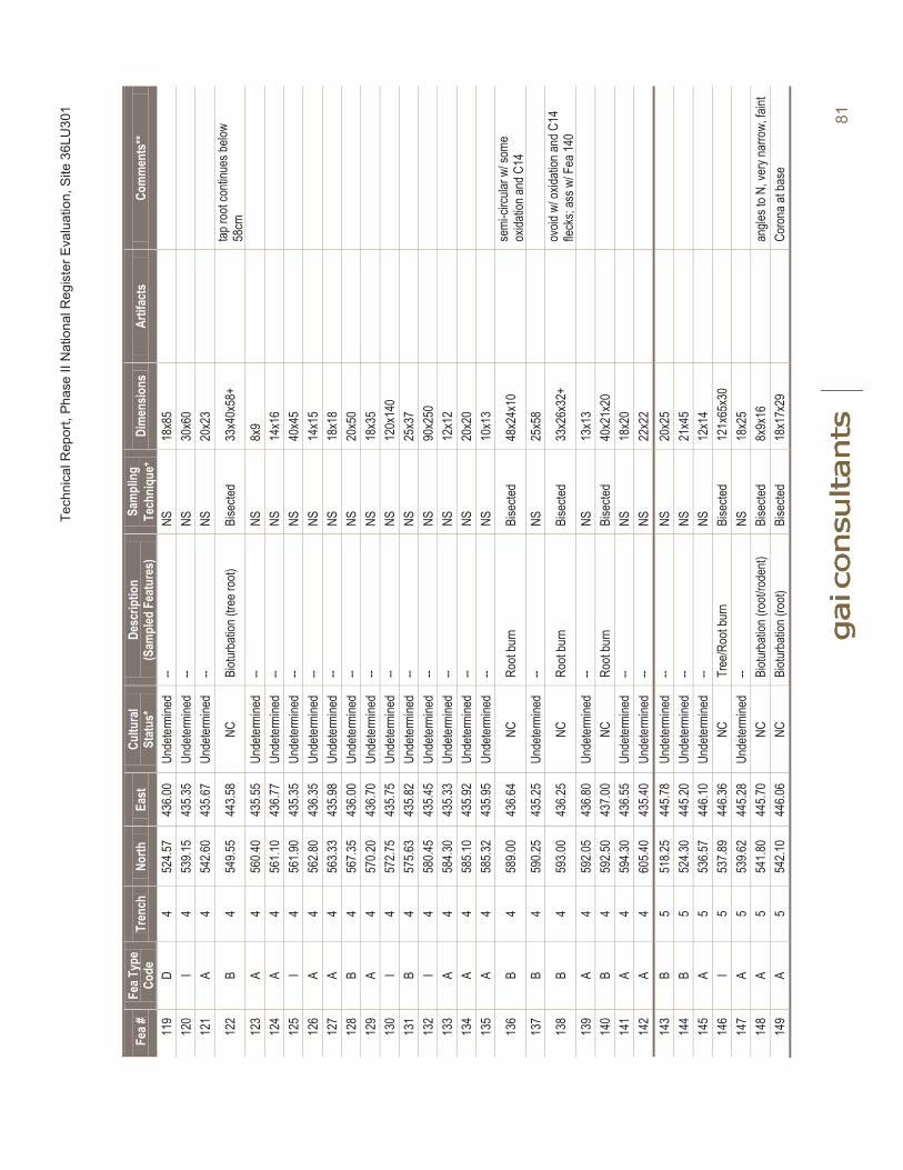
Tech
nica
l Rep
ort,
Phas
e II
Nat
iona
l Reg
iste
r Eva
luat
ion,
Site
36L
U30
1
81
Fea #
FeaT
ype
Code
Tren
chNo
rthEa
stCu
ltura
lSt
atus
*De
scrip
tion
(S
ampl
ed F
eatu
res)
Sam
plin
gTe
chni
que+
Dim
ensio
nsAr
tifac
tsCo
mm
ents
**
119
D4
524.5
743
6.00
Unde
termi
ned
--NS
18x8
512
0I
453
9.15
435.3
5Un
deter
mine
d--
NS30
x60
121
A4
542.6
043
5.67
Unde
termi
ned
--NS
20x2
3
122
B4
549.5
544
3.58
NCBi
oturb
ation
(tre
e roo
t)Bi
secte
d33
x40x
58+
tap ro
ot co
ntinu
es be
low
58cm
123
A4
560.4
043
5.55
Unde
termi
ned
--NS
8x9
124
A4
561.1
043
6.77
Unde
termi
ned
--NS
14x1
612
5I
456
1.90
435.3
5Un
deter
mine
d--
NS40
x45
126
A4
562.8
043
6.35
Unde
termi
ned
--NS
14x1
512
7A
456
3.33
435.9
8Un
deter
mine
d--
NS18
x18
128
B4
567.3
543
6.00
Unde
termi
ned
--NS
20x5
012
9A
457
0.20
436.7
0Un
deter
mine
d--
NS18
x35
130
I4
572.7
543
5.75
Unde
termi
ned
--NS
120x
140
131
B4
575.6
343
5.82
Unde
termi
ned
--NS
25x3
713
2I
458
0.45
435.4
5Un
deter
mine
d--
NS90
x250
133
A4
584.3
043
5.33
Unde
termi
ned
--NS
12x1
213
4A
458
5.10
435.9
2Un
deter
mine
d--
NS20
x20
135
A4
585.3
243
5.95
Unde
termi
ned
--NS
10x1
3
136
B4
589.0
043
6.64
NCRo
ot bu
rnBi
secte
d48
x24x
10se
mi-ci
rcular
w/ s
ome
oxida
tion a
nd C
1413
7B
459
0.25
435.2
5Un
deter
mine
d--
NS25
x58
138
B4
593.0
043
6.25
NCRo
ot bu
rnBi
secte
d33
x26x
32+
ovoid
w/ o
xidati
on an
d C14
fle
cks;
ass w
/ Fea
140
139
A4
592.0
543
6.80
Unde
termi
ned
--NS
13x1
314
0B
459
2.50
437.0
0NC
Root
burn
Bise
cted
40x2
1x20
141
A4
594.3
043
6.55
Unde
termi
ned
--NS
18x2
014
2A
460
5.40
435.4
0Un
deter
mine
d--
NS22
x22
143
B5
518.2
544
5.78
Unde
termi
ned
--NS
20x2
514
4B
552
4.30
445.2
0Un
deter
mine
d--
NS21
x45
145
A5
536.5
744
6.10
Unde
termi
ned
--NS
12x1
414
6I
553
7.89
446.3
6NC
Tree
/Roo
t bur
nBi
secte
d12
1x65
x30
147
A5
539.6
244
5.28
Unde
termi
ned
--NS
18x2
514
8A
554
1.80
445.7
0NC
Biotu
rbati
on (r
oot/r
oden
t)Bi
secte
d8x
9x16
angle
s to N
, ver
y nar
row,
faint
149
A5
542.1
044
6.06
NCBi
oturb
ation
(roo
t)Bi
secte
d18
x17x
29Co
rona
at ba
se
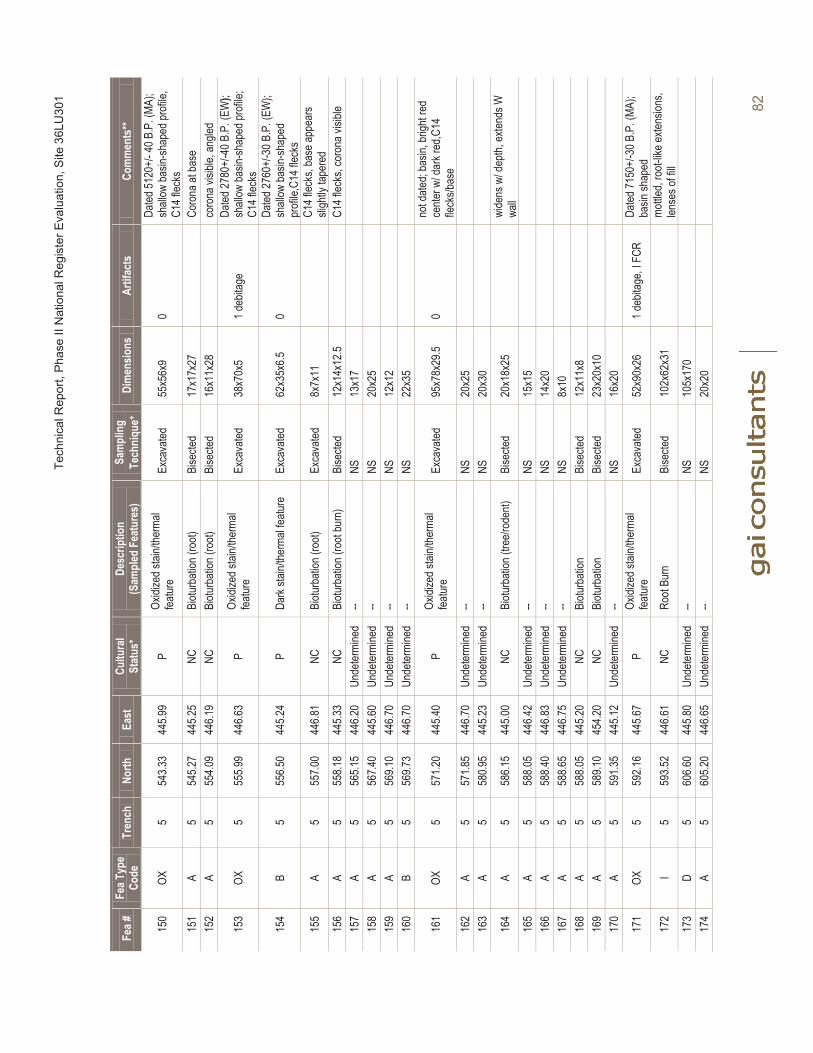
Tech
nica
l Rep
ort,
Phas
e II
Nat
iona
l Reg
iste
r Eva
luat
ion,
Site
36L
U30
1
82
Fea #
FeaT
ype
Code
Tren
chNo
rthEa
stCu
ltura
lSt
atus
*De
scrip
tion
(S
ampl
ed F
eatu
res)
Sam
plin
gTe
chni
que+
Dim
ensio
nsAr
tifac
tsCo
mm
ents
**
150
OX5
543.3
344
5.99
POx
idize
d stai
n/the
rmal
featur
eEx
cava
ted55
x56x
90
Dated
5120
+/-4
0B.P
.(MA
);sh
allow
basin
-shap
ed pr
ofile,
C1
4 flec
ks15
1A
554
5.27
445.2
5NC
Biotu
rbati
on (r
oot)
Bise
cted
17x1
7x27
Coro
na at
base
152
A5
554.0
944
6.19
NCBi
oturb
ation
(roo
t)Bi
secte
d16
x11x
28
coro
na vi
sible,
angle
d
153
OX5
555.9
944
6.63
POx
idize
d stai
n/the
rmal
featur
eEx
cava
ted38
x70x
51 d
ebita
geDa
ted 27
80+/
-40B
.P.(
EW);
shall
ow ba
sin-sh
aped
profi
le;
C14 f
lecks
154
B5
556.5
044
5.24
PDa
rk sta
in/the
rmal
featur
eEx
cava
ted62
x35x
6.50
Dated
2760
+/-3
0B.P
.(EW
);sh
allow
basin
-shap
ed
profi
le,C1
4 flec
ks
155
A5
557.0
044
6.81
NCBi
oturb
ation
(roo
t)Ex
cava
ted8x
7x11
C14 f
lecks
, bas
e app
ears
sligh
tly ta
pere
d15
6A
555
8.18
445.3
3NC
Biotu
rbati
on (r
oot b
urn)
Bise
cted
12x1
4x12
.5C1
4 flec
ks, c
oron
a visi
ble15
7A
556
5.15
446.2
0Un
deter
mine
d--
NS13
x17
158
A5
567.4
044
5.60
Unde
termi
ned
--NS
20x2
515
9A
556
9.10
446.7
0Un
deter
mine
d--
NS12
x12
160
B5
569.7
344
6.70
Unde
termi
ned
--NS
22x3
5
161
OX5
571.2
044
5.40
POx
idize
d stai
n/the
rmal
featur
eEx
cava
ted95
x78x
29.5
0no
t date
d; ba
sin, b
right
red
cente
r w/ d
ark r
ed,C
14
fleck
s/bas
e16
2A
557
1.85
446.7
0Un
deter
mine
d--
NS20
x25
163
A5
580.9
544
5.23
Unde
termi
ned
--NS
20x3
0
164
A5
586.1
544
5.00
NCBi
oturb
ation
(tre
e/rod
ent)
Bise
cted
20x1
8x25
wide
ns w
/ dep
th, ex
tends
W
wall
165
A5
588.0
544
6.42
Unde
termi
ned
--NS
15x1
516
6A
558
8.40
446.8
3Un
deter
mine
d--
NS14
x20
167
A5
588.6
544
6.75
Unde
termi
ned
--NS
8x10
168
A5
588.0
544
5.20
NCBi
oturb
ation
Bise
cted
12x1
1x8
169
A5
589.1
045
4.20
NCBi
oturb
ation
Bise
cted
23x2
0x10
170
A5
591.3
544
5.12
Unde
termi
ned
--NS
16x2
0
171
OX5
592.1
644
5.67
POx
idize
d stai
n/the
rmal
featur
eEx
cava
ted52
x90x
261 d
ebita
ge, I
FCR
Dated
7150
+/-3
0B.P
.(MA
);ba
sin sh
aped
172
I5
593.5
244
6.61
NCRo
ot Bu
rnBi
secte
d10
2x62
x31
mottle
d, ro
ot-lik
e exte
nsion
s, len
ses o
f fill
173
D5
606.6
044
5.80
Unde
termi
ned
--NS
105x
170
174
A5
605.2
044
6.65
Unde
termi
ned
--NS
20x2
0
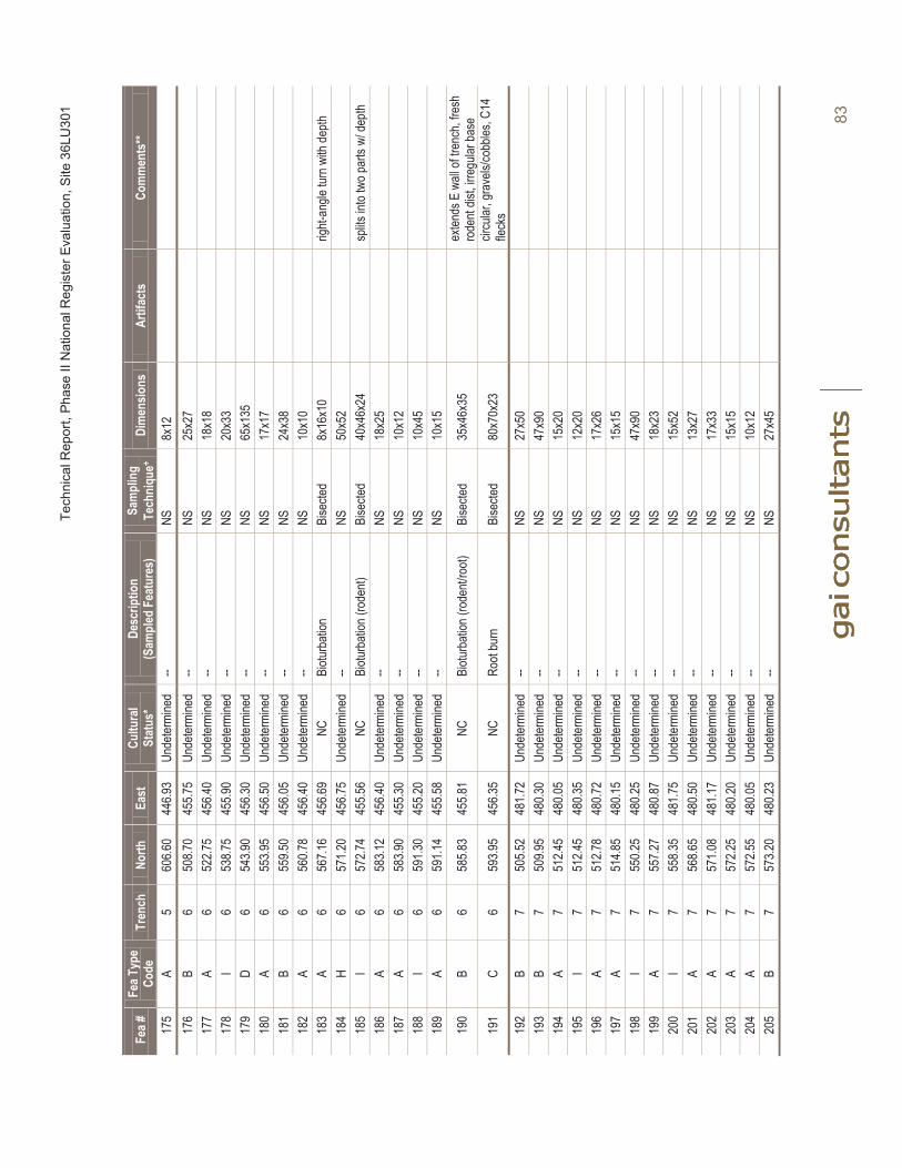
Tech
nica
l Rep
ort,
Phas
e II
Nat
iona
l Reg
iste
r Eva
luat
ion,
Site
36L
U30
1
83
Fea #
FeaT
ype
Code
Tren
chNo
rthEa
stCu
ltura
lSt
atus
*De
scrip
tion
(S
ampl
ed F
eatu
res)
Sam
plin
gTe
chni
que+
Dim
ensio
nsAr
tifac
tsCo
mm
ents
**
175
A5
606.6
044
6.93
Unde
termi
ned
--NS
8x12
176
B6
508.7
045
5.75
Unde
termi
ned
--NS
25x2
717
7A
652
2.75
456.4
0Un
deter
mine
d--
NS18
x18
178
I6
538.7
545
5.90
Unde
termi
ned
--NS
20x3
317
9D
654
3.90
456.3
0Un
deter
mine
d--
NS65
x135
180
A6
553.9
545
6.50
Unde
termi
ned
--NS
17x1
718
1B
655
9.50
456.0
5Un
deter
mine
d--
NS24
x38
182
A6
560.7
845
6.40
Unde
termi
ned
--NS
10x1
018
3A
656
7.16
456.6
9NC
Biotu
rbati
onBi
secte
d8x
16x1
0rig
ht-an
gle tu
rn w
ith de
pth18
4H
657
1.20
456.7
5Un
deter
mine
d--
NS50
x52
185
I6
572.7
445
5.56
NCBi
oturb
ation
(rod
ent)
Bise
cted
40x4
6x24
splits
into
two p
arts
w/ de
pth18
6A
658
3.12
456.4
0Un
deter
mine
d--
NS18
x25
187
A6
583.9
045
5.30
Unde
termi
ned
--NS
10x1
218
8I
659
1.30
455.2
0Un
deter
mine
d--
NS10
x45
189
A6
591.1
445
5.58
Unde
termi
ned
--NS
10x1
5
190
B6
585.8
345
5.81
NCBi
oturb
ation
(rod
ent/r
oot)
Bise
cted
35x4
6x35
exten
ds E
wall
of tr
ench
, fres
h ro
dent
dist, i
rregu
lar ba
se
191
C6
593.9
545
6.35
NCRo
ot bu
rnBi
secte
d80
x70x
23cir
cular
, gra
vels/
cobb
les, C
14
fleck
s19
2B
750
5.52
481.7
2Un
deter
mine
d--
NS27
x50
193
B7
509.9
548
0.30
Unde
termi
ned
--NS
47x9
019
4A
751
2.45
480.0
5Un
deter
mine
d--
NS15
x20
195
I7
512.4
548
0.35
Unde
termi
ned
--NS
12x2
019
6A
751
2.78
480.7
2Un
deter
mine
d--
NS17
x26
197
A7
514.8
548
0.15
Unde
termi
ned
--NS
15x1
519
8I
755
0.25
480.2
5Un
deter
mine
d--
NS47
x90
199
A7
557.2
748
0.87
Unde
termi
ned
--NS
18x2
320
0I
755
8.35
481.7
5Un
deter
mine
d--
NS15
x52
201
A7
568.6
548
0.50
Unde
termi
ned
--NS
13x2
720
2A
757
1.08
481.1
7Un
deter
mine
d--
NS17
x33
203
A7
572.2
548
0.20
Unde
termi
ned
--NS
15x1
520
4A
757
2.55
480.0
5Un
deter
mine
d--
NS10
x12
205
B7
573.2
048
0.23
Unde
termi
ned
--NS
27x4
5

Tech
nica
l Rep
ort,
Phas
e II
Nat
iona
l Reg
iste
r Eva
luat
ion,
Site
36L
U30
1
84
Fea #
FeaT
ype
Code
Tren
chNo
rthEa
stCu
ltura
lSt
atus
*De
scrip
tion
(S
ampl
ed F
eatu
res)
Sam
plin
gTe
chni
que+
Dim
ensio
nsAr
tifac
tsCo
mm
ents
**
206
A7
574.3
548
0.80
Unde
termi
ned
--NS
18x2
720
7B
757
5.10
480.7
3Un
deter
mine
d--
NS23
x40
208
I7
575.9
548
0.20
Unde
termi
ned
--NS
18x4
520
9C
758
2.85
480.8
5Un
deter
mine
d--
NS60
x110
210
B7
596.8
045
6.10
Unde
termi
ned
--NS
50x6
521
1A
555
0.144
6.25
Unde
termi
ned
--NS
8x8
Numb
ered
out o
f seq
uenc
e21
2A
457
5.95
435.7
7Un
deter
mine
d--
NS13
x17
Numb
ered
out o
f seq
uenc
eTo
tal
212
*H=H
istor
ic, P
=Pre
histor
ic, N
C=No
ncult
ural;
+ NS=
Not S
ample
d;** M
A=Mi
ddle
Arch
aic; E
W=E
arly
Woo
dland
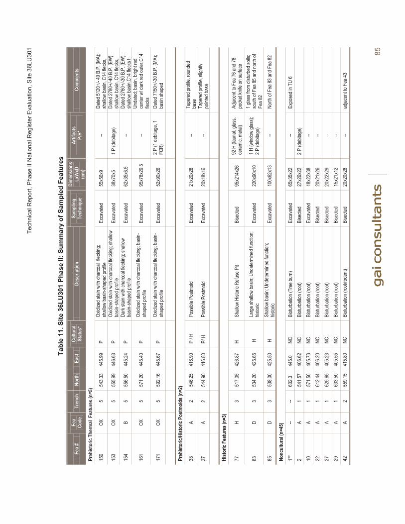
Tech
nica
l Rep
ort,
Phas
e II
Nat
iona
l Reg
iste
r Eva
luat
ion,
Site
36L
U30
1
85
Tabl
e 11
. Site
36L
U30
1 Ph
ase
II: S
umm
ary
of S
ampl
ed F
eatu
res
Fea #
Fea
Code
Tren
chNo
rthEa
stCu
ltura
lSt
atus
*De
scrip
tion
Sam
plin
g Te
chni
que
Dim
ensio
nsLx
WxD
(c
m)
Artif
acts
P/H*
Com
men
ts
Preh
istor
ic Th
erm
al F
eatu
res(
n=5)
150
OX5
543.3
344
5.99
POx
idize
d stai
n with
char
coal
fleck
ing;
shall
ow ba
sin-sh
aped
profi
leEx
cava
ted55
x56x
9--
Dated
5120
+/-4
0 B.P
.(MA
);sh
allow
basin
, C14
fleck
s,
153
OX5
555.9
944
6.63
POx
idize
d stai
n with
char
coal
fleck
ing; s
hallo
w ba
sin-sh
aped
profi
leEx
cava
ted38
x70x
51 P
(deb
itage
)Da
ted 27
80+/
-40B
.P.(
EW);
shall
ow ba
sin, C
14 fle
cks,
154
B5
556.5
044
5.24
PDa
rk sta
in wi
th ch
arco
al fle
cking
; sha
llow
basin
-shap
ed pr
ofile
Exca
vated
62x3
5x6.5
--Da
ted 27
60+/
-30B
.P.(
EW);
shall
ow ba
sin,C
14 fle
cks t
161
OX5
571.2
044
5.40
POx
idize
d stai
n with
char
coal
fleck
ing; b
asin-
shap
ed pr
ofile
Exca
vated
95x7
8x29
.5--
Unda
ted; b
asin,
brigh
t red
ce
nter w
/ dar
k red
outer
,C14
fleck
s
171
OX5
592.1
644
5.67
POx
idize
d stai
n with
char
coal
fleck
ing; b
asin-
shap
ed pr
ofile
Exca
vated
52x9
0x26
2 P (1
debit
age,
1 FC
R)Da
ted 71
50+/
-30B
.P.(
MA);
basin
shap
ed
Preh
istor
ic/Hi
stor
ic Po
stm
olds
(n=2
)
38A
254
6.25
416.9
0P
/ HPo
ssibl
e Pos
tmold
Exca
vated
21x2
0x28
--Ta
pere
d pro
file, r
ound
ed
base
37A
254
4.90
416.8
0P/
HPo
ssibl
e Pos
tmold
Exca
vated
20x1
8x16
--Ta
pere
d pro
file, s
lightl
y po
inted
base
Hist
oric
Feat
ures
(n=3
)
77H
351
7.05
426.8
7H
Shall
ow H
istor
ic Re
fuse P
itBi
secte
d95
x214
x26
92 H
(fau
nal, g
lass,
cera
mic,
metal
)Ad
jacen
t to F
ea 76
and 7
8,po
cket
knife
on su
rface
83D
353
4.20
425.6
5H
Larg
e sha
llow
basin
; Und
eterm
ined f
uncti
on;
histor
icEx
cava
ted22
0x90
x10
1 H (w
indow
glas
s);2 P
(deb
itage
)1 g
lass f
rom
distur
bed s
oils;
south
of F
ea 85
and n
orth
of
Fea 8
2
85D
353
8.00
425.5
0H
Shall
ow ba
sin; U
ndete
rmine
d fun
ction
; his
toric
Exca
vated
100x
62x1
3--
North
of F
ea 83
and F
ea 82
Nonc
ultu
ral (
n=45
)1*
*--
--60
2.344
5.0NC
Biotu
rbati
on (T
ree b
urn)
Ex
cava
ted65
x35x
22--
Expo
sed i
n TU
62
A1
541.5
740
6.62
NCBi
oturb
ation
(roo
t)Bi
secte
d27
x26x
222 P
(deb
itage
)10
A1
571.5
040
5.73
NCBi
oturb
ation
(roo
t)Ex
cava
ted18
x22x
38--
22A
161
2.44
406.2
0NC
Biotu
rbati
on (r
oot)
Bise
cted
20x2
1x26
--27
A1
625.6
540
5.23
NCBi
oturb
ation
(roo
t)Bi
secte
d20
x22x
29--
29A
163
3.50
405.5
5NC
Biotu
rbati
on(ro
ot)Bi
secte
d15
x21x
12--
42A
255
9.15
415.8
0NC
Biotu
rbati
on (r
oot/r
oden
t)Bi
secte
d20
x20x
28--
adjac
ent to
Fea
43
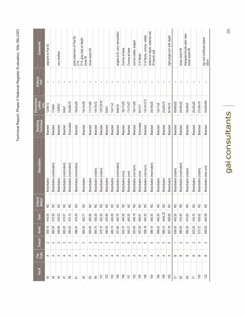
Tech
nica
l Rep
ort,
Phas
e II
Nat
iona
l Reg
iste
r Eva
luat
ion,
Site
36L
U30
1
86
Fea #
Fea
Code
Tren
chNo
rthEa
stCu
ltura
lSt
atus
*De
scrip
tion
Sam
plin
g Te
chni
que
Dim
ensio
nsLx
WxD
(c
m)
Artif
acts
P/H*
Com
men
ts
43A
255
9.15
416.0
5NC
Biotu
rbati
onBi
secte
d12
x9x1
2--
adjac
ent to
Fea
4244
A2
564.5
541
5.50
NCBi
oturb
ation
(roo
t/rod
ent)
Bise
cted
17x9
x4--
45A
254
6.69
416.0
2NC
Biotu
rbati
on
Bise
cted
13X8
X2--
very
shall
ow47
A2
565.2
041
5.57
NCBi
oturb
ation
(roo
t/rod
ent)
Bise
cted
9x9x
7--
58A
258
4.00
415.1
5NC
Biotu
rbati
on (r
oot/r
oden
t)Ex
cava
ted24
x28x
15--
61A
258
6.20
416.2
5NC
Biotu
rbati
on (r
oot/r
oden
t)Bi
secte
d18
x22x
29--
poss
exten
sion o
f Fea
60;
C14
92A
356
4.52
425.7
7NC
Biotu
rbati
onBi
secte
d14
x14x
39--
C14,
gray
halo
w/ de
pth;
loose
fill
93A
356
5.00
425.8
5NC
Biotu
rbati
onBi
secte
d11
x11x
26--
loose
rece
nt fill
95A
356
4.75
426.2
9NC
Biotu
rbati
on (r
oden
t)Bi
secte
d14
x15x
12--
101
A3
578.1
542
5.30
NCBi
oturb
ation
(rod
ent)
Bise
cted
12X1
2X16
--10
2A
348
0.05
425.8
5NC
Biotu
rbati
onBi
secte
d8x
9x1
--10
3A
348
0.15
426.0
9NC
Biotu
rbati
onBi
secte
d10
x11x
2--
148
A5
541.8
044
5.70
NCBi
oturb
ation
(roo
t/rod
ent)
Bise
cted
8x9x
16--
angle
s to N
, ver
y nar
row/
faint
149
A5
542.1
044
6.06
NCBi
oturb
ation
(roo
t)Bi
secte
d18
x17x
29--
Coro
na at
base
151
A5
545.2
744
5.25
NCBi
oturb
ation
(roo
t)Bi
secte
d17
x17x
27--
Coro
na at
base
152
A5
554.0
944
6.19
NCBi
oturb
ation
(roo
t bur
n)Bi
secte
d16
x11x
28
--co
rona
visib
le, an
gled
155
A5
557.0
044
6.81
NCBi
oturb
ation
(roo
t)Ex
cava
ted8x
7x11
--C1
4 flec
ks15
6A
555
8.18
445.3
3NC
Biotu
rbati
on (r
oot b
urn)
Bise
cted
12x1
4x12
.5--
C14 f
lecks
, cor
ona
visibl
e
164
A5
586.1
544
5.00
NCBi
oturb
ation
(tre
e/rod
ent)
Bise
cted
20x1
8x25
--wi
dens
w/ d
epth,
exten
ds in
to W
trenc
h wall
168
A5
588.0
544
5.20
NCBi
oturb
ation
Bise
cted
12x1
1x8
--16
9A
558
9.10
4454
.20NC
Biotu
rbati
onBi
secte
d23
x20x
10--
183
A6
567.1
645
6.69
NCBi
oturb
ation
Bise
cted
8x16
x10
--rig
ht-an
gle tu
rn w
ith de
pth
31B
163
6.05
405.5
5NC
Biotu
rbati
on (r
oden
t)Bi
secte
d45
x80x
20--
60B
258
6.55
416.4
0NC
Biotu
rbati
on (r
oot/r
oden
t)Bi
secte
d24
x40x
22--
loose
rece
nt fill
64B
259
0.35
415.6
5NC
Biotu
rbati
on (r
oden
t)Bi
secte
d35
x25x
5--
triang
ular/c
ircula
rplan
view
;loo
se re
cent
fill71
B2
623.3
041
6.70
NCBi
oturb
ation
Bise
cted
20x3
0x20
--10
0B
357
3.72
426.6
2NC
Biotu
rbati
on (r
oden
t)Bi
secte
d27
x34x
18--
122
B4
549.5
544
3.58
NCBi
oturb
ation
(tre
e roo
t)Bi
secte
d33
x40x
58+
--tap
root
conti
nues
below
58
cm
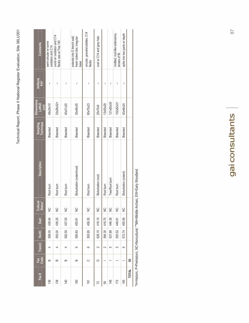
Tech
nica
l Rep
ort,
Phas
e II
Nat
iona
l Reg
iste
r Eva
luat
ion,
Site
36L
U30
1
87
Fea #
Fea
Code
Tren
chNo
rthEa
stCu
ltura
lSt
atus
*De
scrip
tion
Sam
plin
g Te
chni
que
Dim
ensio
nsLx
WxD
(c
m)
Artif
acts
P/H*
Com
men
ts
136
B4
589.0
043
6.64
NCRo
ot bu
rnBi
secte
d48
x24x
10--
semi
-circu
lar w
/ som
e ox
idatio
n and
C14
138
B4
593.0
043
6.25
NCRo
ot bu
rnBi
secte
d33
x26x
32+
--ov
oid w
/ oxid
ation
and C
14
fleck
s; as
s w/ F
ea 14
0
140
B4
592.5
043
7.00
NCRo
ot bu
rnBi
secte
d40
x21x
20--
190
B6
585.8
345
5.81
NCBi
oturb
ation
(rod
ent/r
oot)
Bise
cted
35x4
6x35
--ex
tends
into
E tre
nch w
all,
fresh
rode
nt dis
t, irre
gular
ba
se
191
C6
593.9
545
6.35
NCRo
ot bu
rnBi
secte
d80
x70x
23--
circu
lar, g
rave
ls/co
bbles
, C14
fleck
s
72D
262
8.15
416.1
0NC
Biotu
rbati
on (r
oot)
Bise
cted
25x7
0x9
--ov
al w/
C14
andg
ray h
alo
59I
258
4.30
416.7
0NC
Root
burn
Bise
cted
13x5
5x29
--14
6I
553
7.89
446.3
6NC
Tree
/Roo
tbur
nBi
secte
d12
1x65
x30
--
172
I5
593.5
244
6.61
NCRo
ot bu
rnBi
secte
d10
2x62
x31
--mo
ttled,
root-
like e
xtens
ions,
lense
s of fi
ll18
5I
657
2.74
455.5
6NC
Biotu
rbati
on(ro
dent)
Bise
cted
40x4
6x24
--sp
lits in
to tw
o par
ts w/
depth
TOTA
L55
*H=H
istor
ic, P
=Pre
histor
ic, N
C=No
ncult
ural;
**MA
=Midd
le Ar
chaic
, EW
=Ear
ly W
oodla
nd
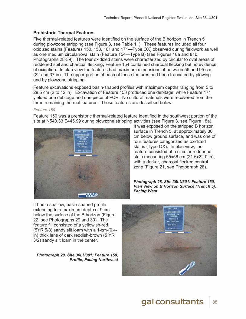
Technical Report, Phase II National Register Evaluation, Site 36LU301
88
Prehistoric Thermal FeaturesFive thermal-related features were identified on the surface of the B horizon in Trench 5 during plowzone stripping (see Figure 3, see Table 11). These features included all four oxidized stains (Features 150, 153, 161 and 171—Type OX) observed during fieldwork as well as one medium circular/oval stain (Feature 154—Type B) (see Figures 18a and 81b, Photographs 28-39). The four oxidized stains were characterized by circular to oval areas of reddened soil and charcoal flecking; Feature 154 contained charcoal flecking but no evidence of oxidation. In plan view the features had maximum dimensions of between 56 and 95 cm (22 and 37 in). The upper portion of each of these features had been truncated by plowing and by plowzone stripping.
Feature excavations exposed basin-shaped profiles with maximum depths ranging from 5 to 29.5 cm (2 to 12 in). Excavation of Feature 153 produced one debitage, while Feature 171 yielded one debitage and one piece of FCR. No cultural materials were recovered from the three remaining thermal features. These features are described below. Feature 150Feature 150 was a prehistoric thermal-related feature identified in the southwest portion of the site at N543.33 E445.99 during plowzone stripping activities (see Figure 3, see Figure 18a).
It was exposed on the stripped B horizon surface in Trench 5, at approximately 30 cm below ground surface, and was one of four features categorized as oxidized stains (Type OX). In plan view, the feature consisted of a circular reddened stain measuring 55x56 cm (21.6x22.0 in), with a darker, charcoal flecked central zone (Figure 21, see Photograph 28).
Photograph 28. Site 36LU301: Feature 150, Plan View on B Horizon Surface (Trench 5), Facing West
It had a shallow, basin shaped profile extending to a maximum depth of 9 cm below the surface of the B horizon (Figure 22, see Photographs 29 and 30). The feature fill consisted of a yellowish-red (5YR 5/8) sandy silt loam with a 1-cm-(0.4-in) thick lens of dark reddish-brown (5 YR 3/2) sandy silt loam in the center.
Photograph 29. Site 36LU301: Feature 150,
Profile, Facing Northwest
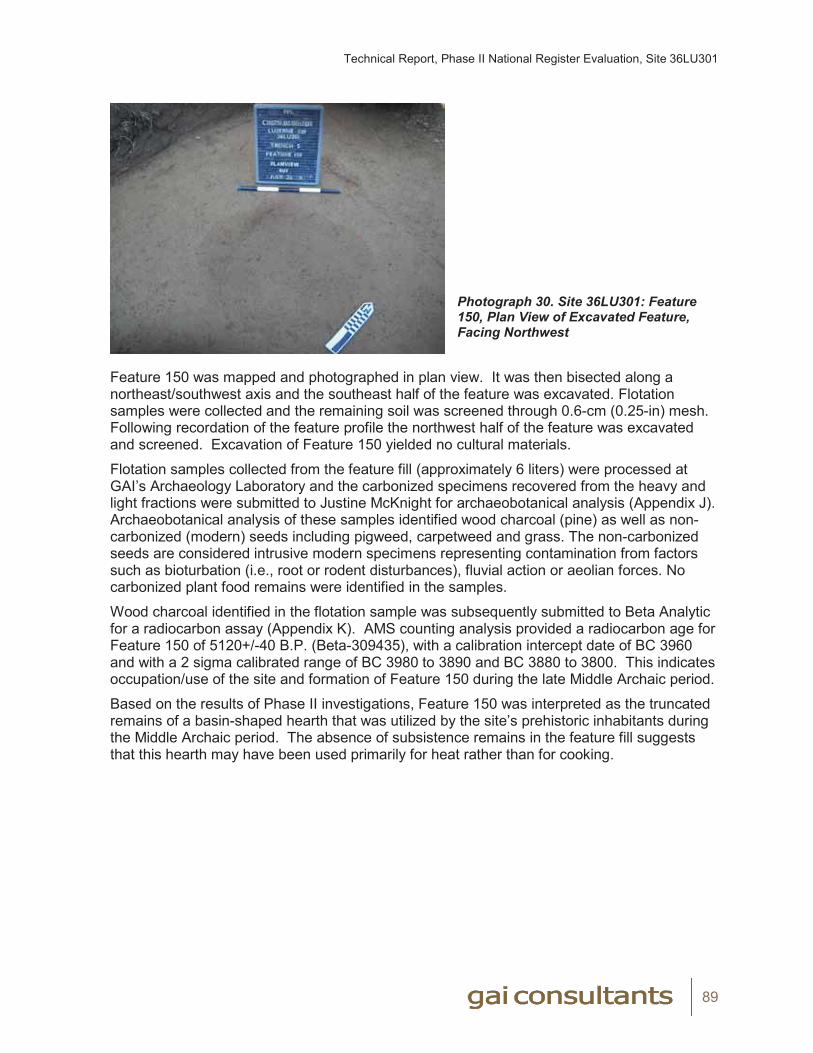
Technical Report, Phase II National Register Evaluation, Site 36LU301
89
Photograph 30. Site 36LU301: Feature 150, Plan View of Excavated Feature, Facing Northwest
Feature 150 was mapped and photographed in plan view. It was then bisected along a northeast/southwest axis and the southeast half of the feature was excavated. Flotation samples were collected and the remaining soil was screened through 0.6-cm (0.25-in) mesh. Following recordation of the feature profile the northwest half of the feature was excavated and screened. Excavation of Feature 150 yielded no cultural materials.
Flotation samples collected from the feature fill (approximately 6 liters) were processed at GAI’s Archaeology Laboratory and the carbonized specimens recovered from the heavy and light fractions were submitted to Justine McKnight for archaeobotanical analysis (Appendix J). Archaeobotanical analysis of these samples identified wood charcoal (pine) as well as non-carbonized (modern) seeds including pigweed, carpetweed and grass. The non-carbonized seeds are considered intrusive modern specimens representing contamination from factors such as bioturbation (i.e., root or rodent disturbances), fluvial action or aeolian forces. No carbonized plant food remains were identified in the samples.
Wood charcoal identified in the flotation sample was subsequently submitted to Beta Analytic for a radiocarbon assay (Appendix K). AMS counting analysis provided a radiocarbon age for Feature 150 of 5120+/-40 B.P. (Beta-309435), with a calibration intercept date of BC 3960 and with a 2 sigma calibrated range of BC 3980 to 3890 and BC 3880 to 3800. This indicates occupation/use of the site and formation of Feature 150 during the late Middle Archaic period.
Based on the results of Phase II investigations, Feature 150 was interpreted as the truncated remains of a basin-shaped hearth that was utilized by the site’s prehistoric inhabitants during the Middle Archaic period. The absence of subsistence remains in the feature fill suggests that this hearth may have been used primarily for heat rather than for cooking.
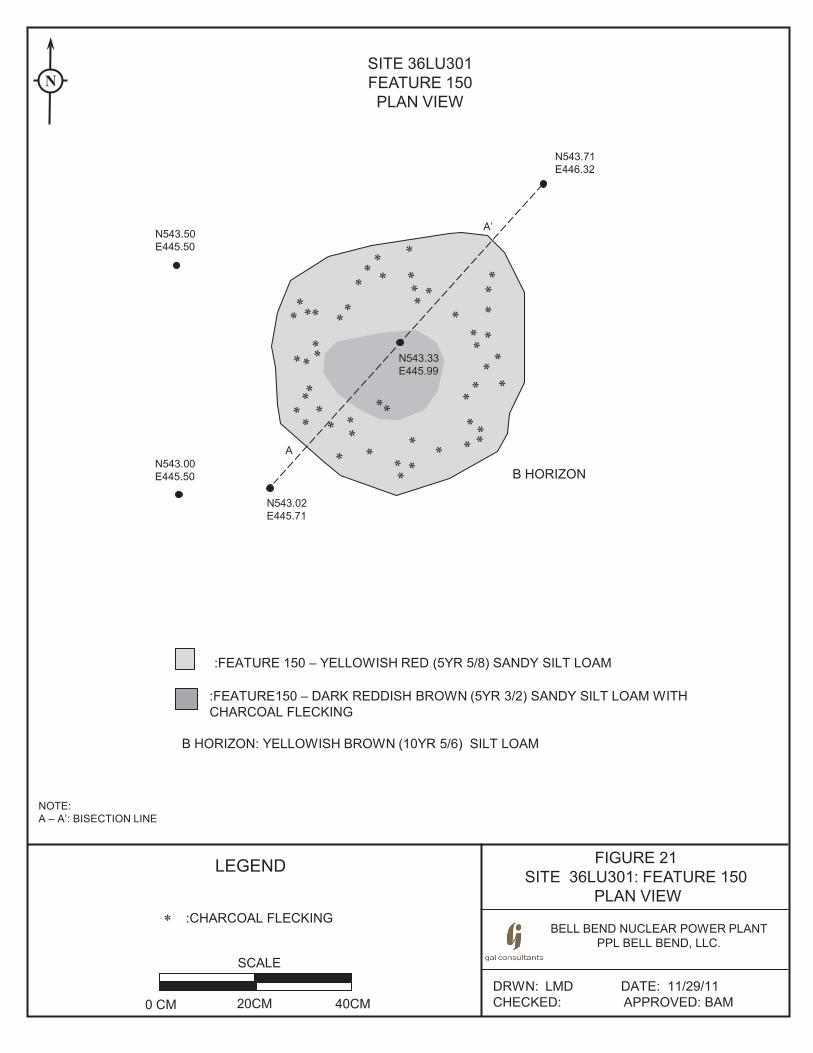
FIGURE 21 SITE 36LU301: FEATURE 150
PLAN VIEW
BELL BEND NUCLEAR POWER PLANT PPL BELL BEND, LLC.
DRWN: LMD DATE: 11/29/11 CHECKED: APPROVED: BAM
LEGEND
SITE 36LU301 FEATURE 150 PLAN VIEW
SCALE
0 CM 20CM 40CM
A’
A
NOTE: A – A’: BISECTION LINE
N
* :CHARCOAL FLECKING
N543.50 E445.50
N543.00 E445.50
N543.33 E445.99
N543.02 E445.71
N543.71 E446.32
B HORIZON
:FEATURE150 – DARK REDDISH BROWN (5YR 3/2) SANDY SILT LOAM WITH CHARCOAL FLECKING
:FEATURE 150 – YELLOWISH RED (5YR 5/8) SANDY SILT LOAM
B HORIZON: YELLOWISH BROWN (10YR 5/6) SILT LOAM
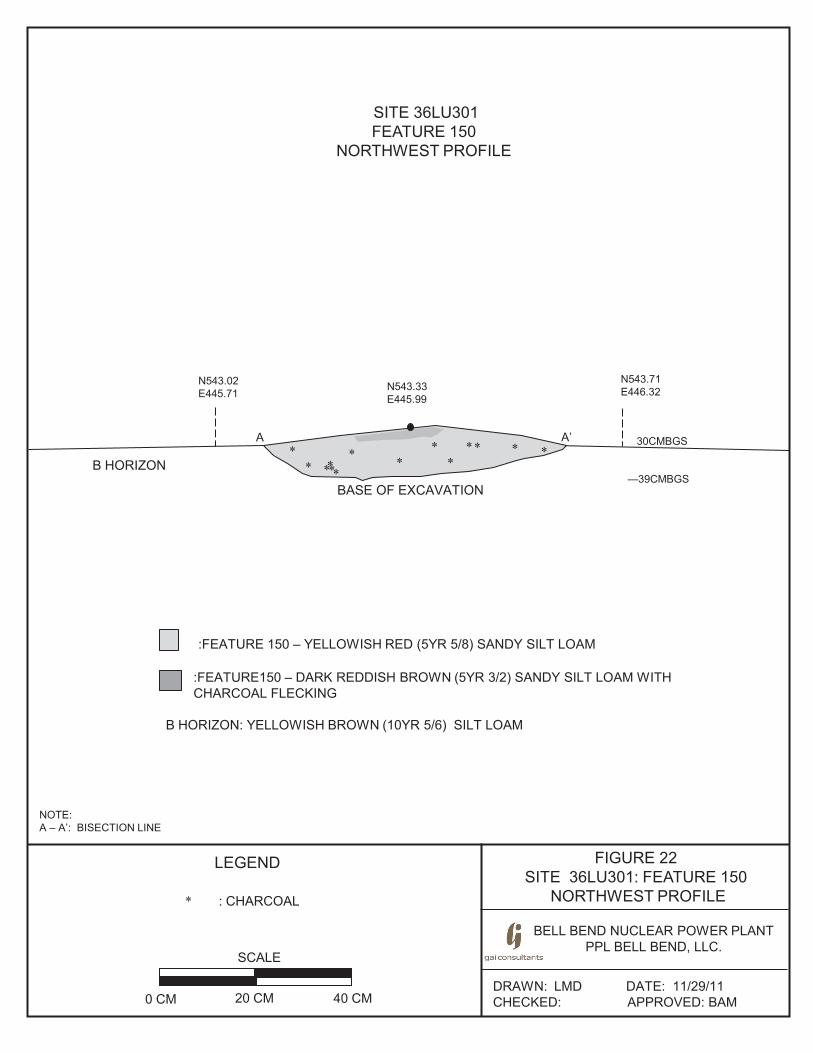
FIGURE 22 SITE 36LU301: FEATURE 150
NORTHWEST PROFILE
BELL BEND NUCLEAR POWER PLANT PPL BELL BEND, LLC.
BE
DRAWN: LMD DATE: 11/29/11 CHECKED: APPROVED: BAM
SITE 36LU301 FEATURE 150
NORTHWEST PROFILE
SCALE
0 CM 20 CM 40 CM
LEGEND
: CHARCOAL *
NOTE: A – A’: BISECTION LINE
N543.02 E445.71
N543.71 E446.32
**
A A’
B HORIZON
BASE OF EXCAVATION
**
*
**
** * ****
N543.33 E445.99
:FEATURE150 – DARK REDDISH BROWN (5YR 3/2) SANDY SILT LOAM WITH CHARCOAL FLECKING
:FEATURE 150 – YELLOWISH RED (5YR 5/8) SANDY SILT LOAM
B HORIZON: YELLOWISH BROWN (10YR 5/6) SILT LOAM
30CMBGS
—39CMBGS
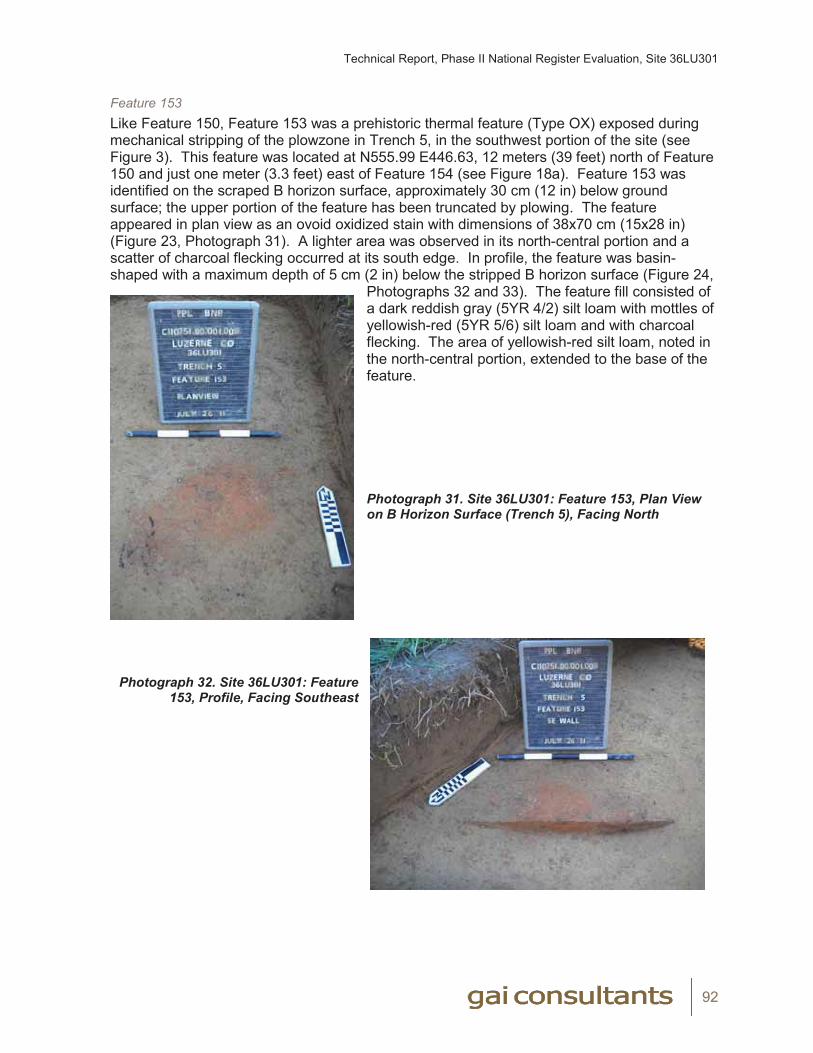
Technical Report, Phase II National Register Evaluation, Site 36LU301
92
Feature 153Like Feature 150, Feature 153 was a prehistoric thermal feature (Type OX) exposed during mechanical stripping of the plowzone in Trench 5, in the southwest portion of the site (see Figure 3). This feature was located at N555.99 E446.63, 12 meters (39 feet) north of Feature 150 and just one meter (3.3 feet) east of Feature 154 (see Figure 18a). Feature 153 was identified on the scraped B horizon surface, approximately 30 cm (12 in) below ground surface; the upper portion of the feature has been truncated by plowing. The feature appeared in plan view as an ovoid oxidized stain with dimensions of 38x70 cm (15x28 in) (Figure 23, Photograph 31). A lighter area was observed in its north-central portion and a scatter of charcoal flecking occurred at its south edge. In profile, the feature was basin-shaped with a maximum depth of 5 cm (2 in) below the stripped B horizon surface (Figure 24,
Photographs 32 and 33). The feature fill consisted of a dark reddish gray (5YR 4/2) silt loam with mottles of yellowish-red (5YR 5/6) silt loam and with charcoal flecking. The area of yellowish-red silt loam, noted in the north-central portion, extended to the base of the feature.
Photograph 31. Site 36LU301: Feature 153, Plan View on B Horizon Surface (Trench 5), Facing North
Photograph 32. Site 36LU301: Feature
153, Profile, Facing Southeast

Technical Report, Phase II National Register Evaluation, Site 36LU301
93
Photograph 33. Site 36LU301: Feature 153, Plan View of Excavated Feature, Facing Southeast
Feature 153 was bisected on a northeast/southwest axis and was excavated and documented as described above for Feature 150. One piece of lithic debitage (a biface reduction flake made from dark gray chert) was recovered from the feature fill.
Flotation samples (5 liters) collected from the feature fill were processed at GAI’s Archaeology Laboratory and the carbonized specimens recovered from the heavy and light fractions were submitted to Justine McKnight for archaeobotanical analysis (see Appendix J). Similar to Feature 150 results, archaeobotanical analysis of Feature 153 identified wood charcoal (pine) and noncarbonized (modern) seeds representing pigweed and carpetweed. Analysis identified no carbonized plant food remains in these samples.
A sample of charcoal from the flotation samples was submitted to Beta Analytic for a radiocarbon assay (see Appendix K). AMS counting analysis provided a radiocarbon age for Feature 153 of 2780+/-40 B.P. (Beta-309436), with a calibration intercept date of BC 920 and with a 2 sigma range of BC 1010 to 830. Based on these results Feature 153 dates to the Early Woodland period.
The results of Phase II investigations indicate that Feature 153 represents the truncated remains of a shallow, basin-shaped hearth, utilized by the site’s Early Woodland inhabitants for heat, and possibly for cooking. As noted above for Feature 150, the lack of subsistence remains suggests that food processing was not a primary function of Feature 153.
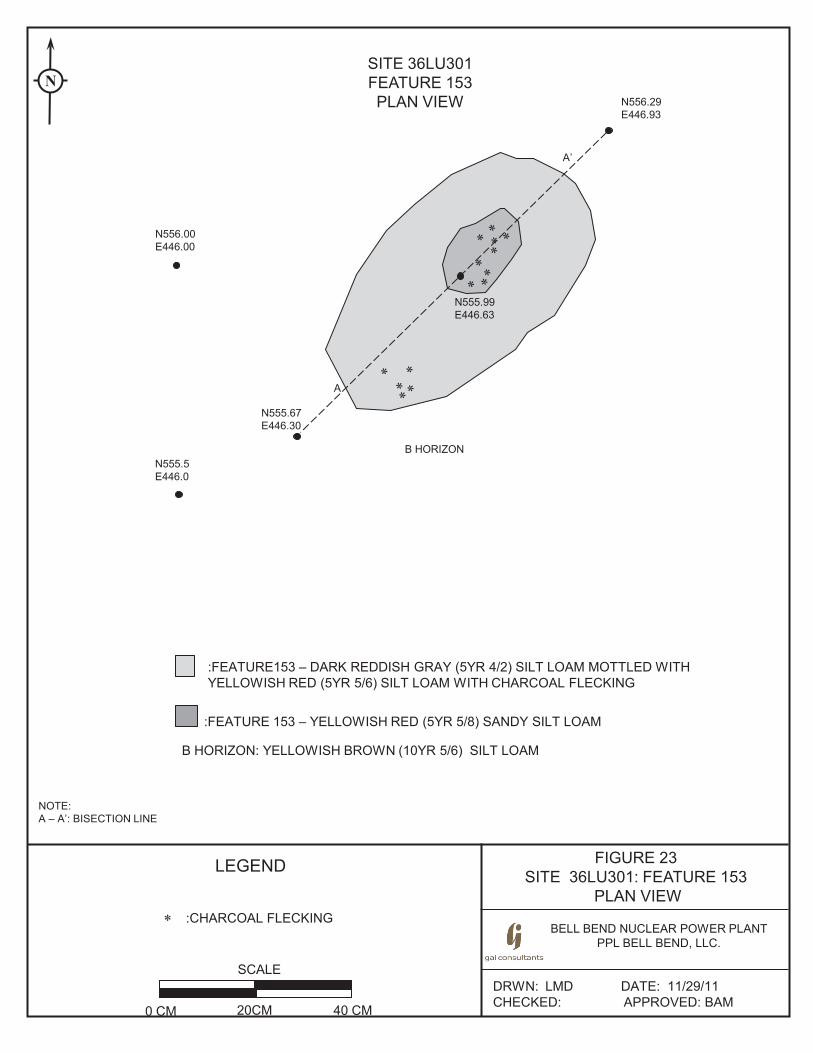
FIGURE 23 SITE 36LU301: FEATURE 153
PLAN VIEW
BELL BEND NUCLEAR POWER PLANT PPL BELL BEND, LLC.
DRWN: LMD DATE: 11/29/11 CHECKED: APPROVED: BAM
LEGEND
SITE 36LU301 FEATURE 153 PLAN VIEW
SCALE
0 CM 20CM 40 CM
NOTE: A – A’: BISECTION LINE
N
* :CHARCOAL FLECKING
:FEATURE153 – DARK REDDISH GRAY (5YR 4/2) SILT LOAM MOTTLED WITH YELLOWISH RED (5YR 5/6) SILT LOAM WITH CHARCOAL FLECKING
:FEATURE 153 – YELLOWISH RED (5YR 5/8) SANDY SILT LOAM
B HORIZON: YELLOWISH BROWN (10YR 5/6) SILT LOAM
N556.00 E446.00
N555.5 E446.0
N555.99 E446.63
A
A’
B HORIZON
N555.67 E446.30
N556.29 E446.93
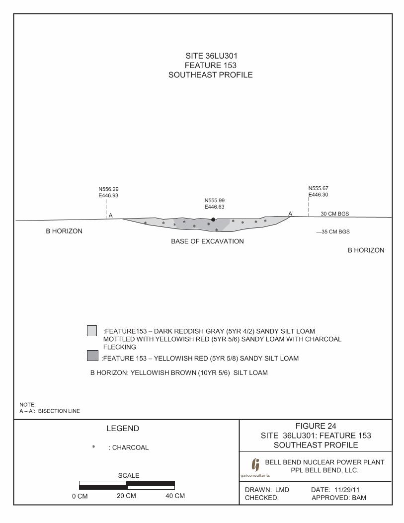
FIGURE 24 SITE 36LU301: FEATURE 153
SOUTHEAST PROFILE
BELL BEND NUCLEAR POWER PLANT PPL BELL BEND, LLC.
BE
DRAWN: LMD DATE: 11/29/11 CHECKED: APPROVED: BAM
SITE 36LU301 FEATURE 153
SOUTHEAST PROFILE
SCALE
0 CM 20 CM 40 CM
LEGEND
: CHARCOAL *
NOTE: A – A’: BISECTION LINE
N556.29 E446.93
N555.67 E446.30
B HORIZON
* *A A’
B HORIZON BASE OF EXCAVATION
* * * * ** * *** *
*
N555.99 E446.63
:FEATURE153 – DARK REDDISH GRAY (5YR 4/2) SANDY SILT LOAM MOTTLED WITH YELLOWISH RED (5YR 5/6) SANDY LOAM WITH CHARCOAL FLECKING
:FEATURE 153 – YELLOWISH RED (5YR 5/8) SANDY SILT LOAM
B HORIZON: YELLOWISH BROWN (10YR 5/6) SILT LOAM
30 CM BGS
—35 CM BGS
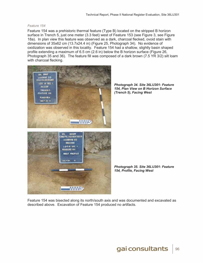
Technical Report, Phase II National Register Evaluation, Site 36LU301
96
Feature 154Feature 154 was a prehistoric thermal feature (Type B) located on the stripped B horizon surface in Trench 5, just one meter (3.3 feet) west of Feature 153 (see Figure 3, see Figure 18a). In plan view this feature was observed as a dark, charcoal flecked, ovoid stain with dimensions of 35x62 cm (13.7x24.4 in) (Figure 25, Photograph 34). No evidence of oxidization was observed in this locality. Feature 154 had a shallow, slightly basin shaped profile extending a maximum of 6.5 cm (2.6 in) below the B horizon surface (Figure 26, Photograph 35 and 36). The feature fill was composed of a dark brown (7.5 YR 3/2) silt loam with charcoal flecking.
Photograph 34. Site 36LU301: Feature 154, Plan View on B Horizon Surface (Trench 5), Facing West
Photograph 35. Site 36LU301: Feature 154, Profile, Facing West
Feature 154 was bisected along its north/south axis and was documented and excavated as described above. Excavation of Feature 154 produced no artifacts.
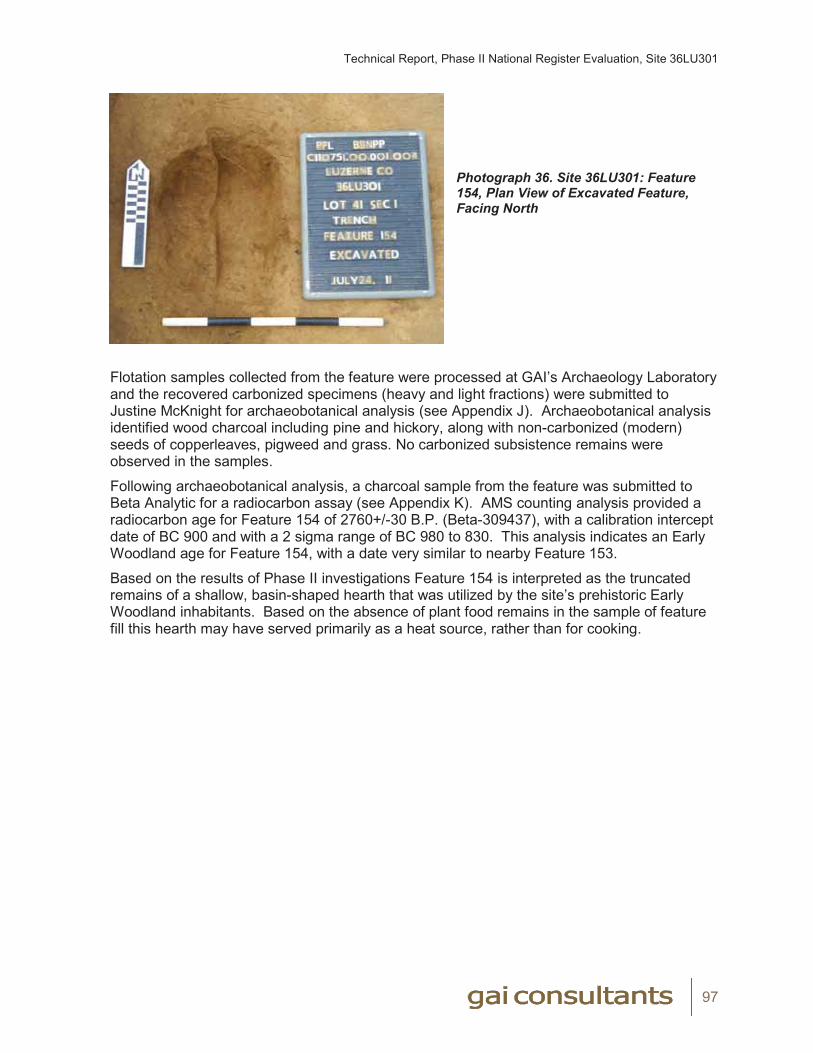
Technical Report, Phase II National Register Evaluation, Site 36LU301
97
Photograph 36. Site 36LU301: Feature 154, Plan View of Excavated Feature, Facing North
Flotation samples collected from the feature were processed at GAI’s Archaeology Laboratory and the recovered carbonized specimens (heavy and light fractions) were submitted to Justine McKnight for archaeobotanical analysis (see Appendix J). Archaeobotanical analysis identified wood charcoal including pine and hickory, along with non-carbonized (modern) seeds of copperleaves, pigweed and grass. No carbonized subsistence remains were observed in the samples.
Following archaeobotanical analysis, a charcoal sample from the feature was submitted to Beta Analytic for a radiocarbon assay (see Appendix K). AMS counting analysis provided a radiocarbon age for Feature 154 of 2760+/-30 B.P. (Beta-309437), with a calibration intercept date of BC 900 and with a 2 sigma range of BC 980 to 830. This analysis indicates an Early Woodland age for Feature 154, with a date very similar to nearby Feature 153.
Based on the results of Phase II investigations Feature 154 is interpreted as the truncated remains of a shallow, basin-shaped hearth that was utilized by the site’s prehistoric Early Woodland inhabitants. Based on the absence of plant food remains in the sample of feature fill this hearth may have served primarily as a heat source, rather than for cooking.
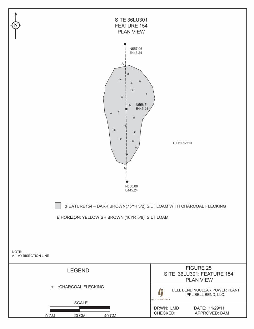
FIGURE 25 SITE 36LU301: FEATURE 154
PLAN VIEW
BELL BEND NUCLEAR POWER PLANT PPL BELL BEND, LLC.
DRWN: LMD DATE: 11/29/11 CHECKED: APPROVED: BAM
LEGEND
SITE 36LU301 FEATURE 154 PLAN VIEW
SCALE
0 CM 20 CM 40 CM
NOTE: A – A’: BISECTION LINE
N
* :CHARCOAL FLECKING
:FEATURE154 – DARK BROWN(75YR 3/2) SILT LOAM WITH CHARCOAL FLECKING
B HORIZON: YELLOWISH BROWN (10YR 5/6) SILT LOAM
N557.06 E445.24
N556.00 E445.24
N556.5 E445.24
A
A’
B HORIZON
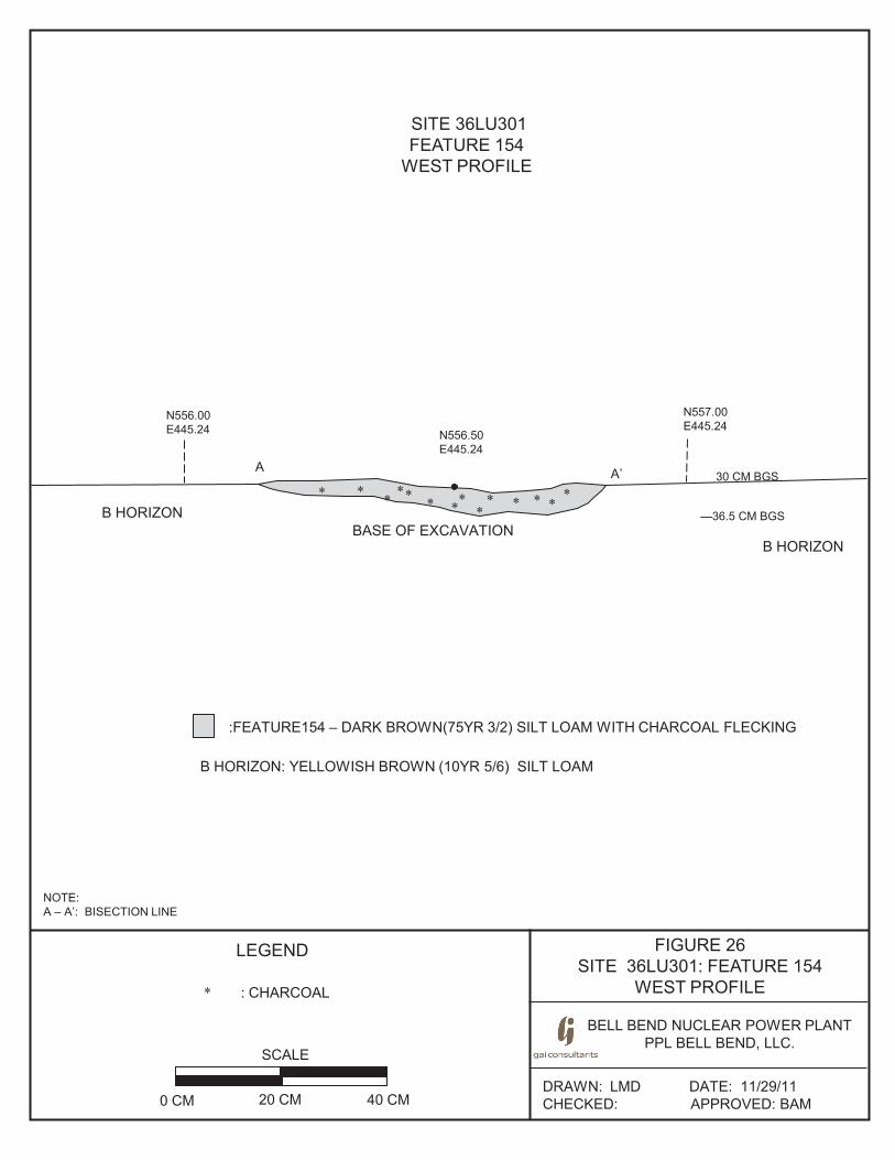
FIGURE 26 SITE 36LU301: FEATURE 154
WEST PROFILE
BELL BEND NUCLEAR POWER PLANT PPL BELL BEND, LLC.
BE
DRAWN: LMD DATE: 11/29/11 CHECKED: APPROVED: BAM
SITE 36LU301 FEATURE 154
WEST PROFILE
SCALE
0 CM 20 CM 40 CM
LEGEND
: CHARCOAL *
NOTE: A – A’: BISECTION LINE
N556.00 E445.24
N557.00 E445.24
B HORIZON
* *
A A’
B HORIZON BASE OF EXCAVATION
* * * * ** **
** *
*
:FEATURE154 – DARK BROWN(75YR 3/2) SILT LOAM WITH CHARCOAL FLECKING
B HORIZON: YELLOWISH BROWN (10YR 5/6) SILT LOAM
N556.50 E445.24
30 CM BGS
—36.5 CM BGS
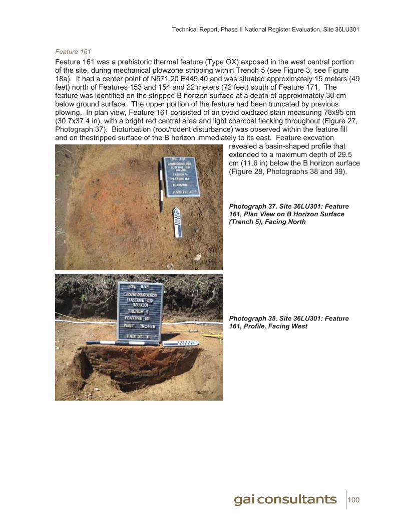
Technical Report, Phase II National Register Evaluation, Site 36LU301
100
Feature 161Feature 161 was a prehistoric thermal feature (Type OX) exposed in the west central portion of the site, during mechanical plowzone stripping within Trench 5 (see Figure 3, see Figure 18a). It had a center point of N571.20 E445.40 and was situated approximately 15 meters (49 feet) north of Features 153 and 154 and 22 meters (72 feet) south of Feature 171. The feature was identified on the stripped B horizon surface at a depth of approximately 30 cm below ground surface. The upper portion of the feature had been truncated by previous plowing. In plan view, Feature 161 consisted of an ovoid oxidized stain measuring 78x95 cm (30.7x37.4 in), with a bright red central area and light charcoal flecking throughout (Figure 27, Photograph 37). Bioturbation (root/rodent disturbance) was observed within the feature fill and on thestripped surface of the B horizon immediately to its east. Feature excvation
revealed a basin-shaped profile that extended to a maximum depth of 29.5 cm (11.6 in) below the B horizon surface (Figure 28, Photographs 38 and 39).
Photograph 37. Site 36LU301: Feature 161, Plan View on B Horizon Surface (Trench 5), Facing North
Photograph 38. Site 36LU301: Feature 161, Profile, Facing West
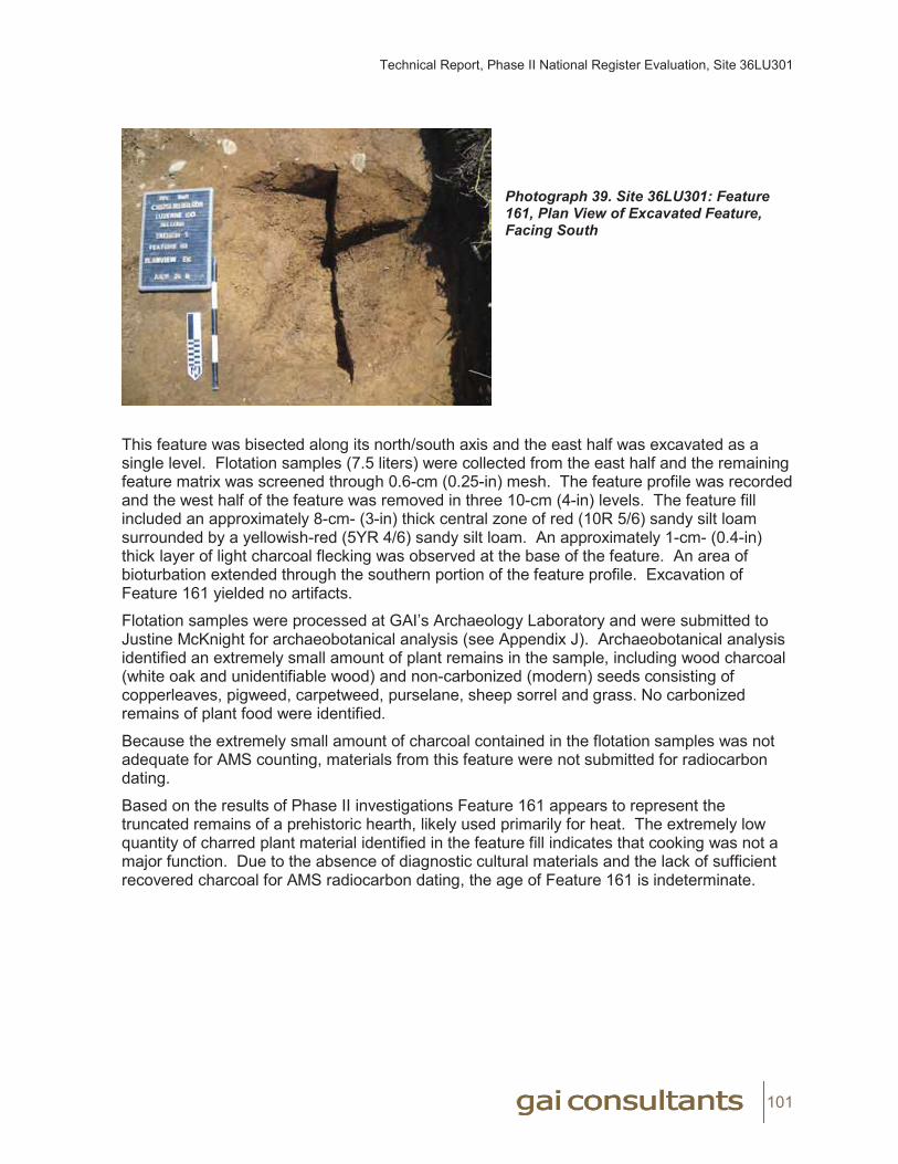
Technical Report, Phase II National Register Evaluation, Site 36LU301
101
Photograph 39. Site 36LU301: Feature 161, Plan View of Excavated Feature, Facing South
This feature was bisected along its north/south axis and the east half was excavated as a single level. Flotation samples (7.5 liters) were collected from the east half and the remaining feature matrix was screened through 0.6-cm (0.25-in) mesh. The feature profile was recorded and the west half of the feature was removed in three 10-cm (4-in) levels. The feature fill included an approximately 8-cm- (3-in) thick central zone of red (10R 5/6) sandy silt loam surrounded by a yellowish-red (5YR 4/6) sandy silt loam. An approximately 1-cm- (0.4-in) thick layer of light charcoal flecking was observed at the base of the feature. An area of bioturbation extended through the southern portion of the feature profile. Excavation of Feature 161 yielded no artifacts.
Flotation samples were processed at GAI’s Archaeology Laboratory and were submitted to Justine McKnight for archaeobotanical analysis (see Appendix J). Archaeobotanical analysis identified an extremely small amount of plant remains in the sample, including wood charcoal (white oak and unidentifiable wood) and non-carbonized (modern) seeds consisting of copperleaves, pigweed, carpetweed, purselane, sheep sorrel and grass. No carbonized remains of plant food were identified.
Because the extremely small amount of charcoal contained in the flotation samples was not adequate for AMS counting, materials from this feature were not submitted for radiocarbon dating.
Based on the results of Phase II investigations Feature 161 appears to represent the truncated remains of a prehistoric hearth, likely used primarily for heat. The extremely low quantity of charred plant material identified in the feature fill indicates that cooking was not a major function. Due to the absence of diagnostic cultural materials and the lack of sufficient recovered charcoal for AMS radiocarbon dating, the age of Feature 161 is indeterminate.
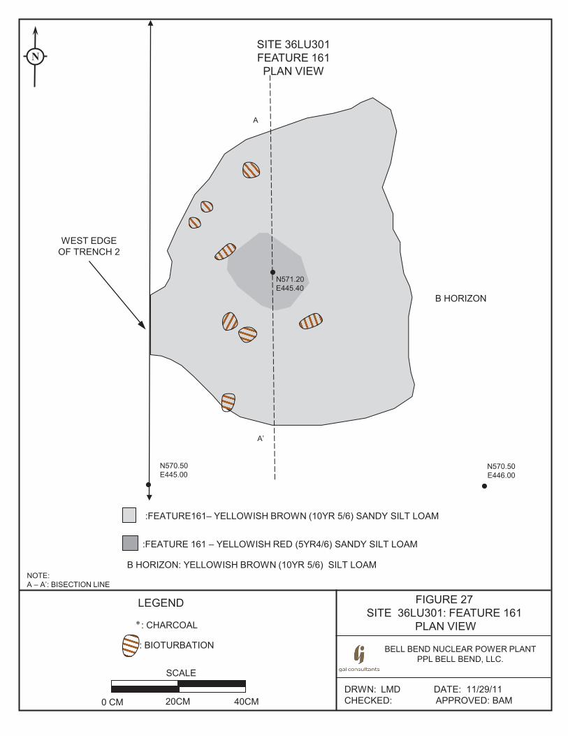
FIGURE 27 SITE 36LU301: FEATURE 161
PLAN VIEW
BELL BEND NUCLEAR POWER PLANT PPL BELL BEND, LLC.
DRWN: LMD DATE: 11/29/11 CHECKED: APPROVED: BAM
SITE 36LU301 FEATURE 161 PLAN VIEW
SCALE
0 CM 20CM 40CM
NOTE: A – A’: BISECTION LINE
N
:FEATURE161– YELLOWISH BROWN (10YR 5/6) SANDY SILT LOAM
:FEATURE 161 – YELLOWISH RED (5YR4/6) SANDY SILT LOAM
B HORIZON: YELLOWISH BROWN (10YR 5/6) SILT LOAM
N570.50 E446.00
N570.50 E445.00
WEST EDGE OF TRENCH 2
LEGEND
: BIOTURBATION
: CHARCOAL *
A
A’
N571.20 E445.40
B HORIZON
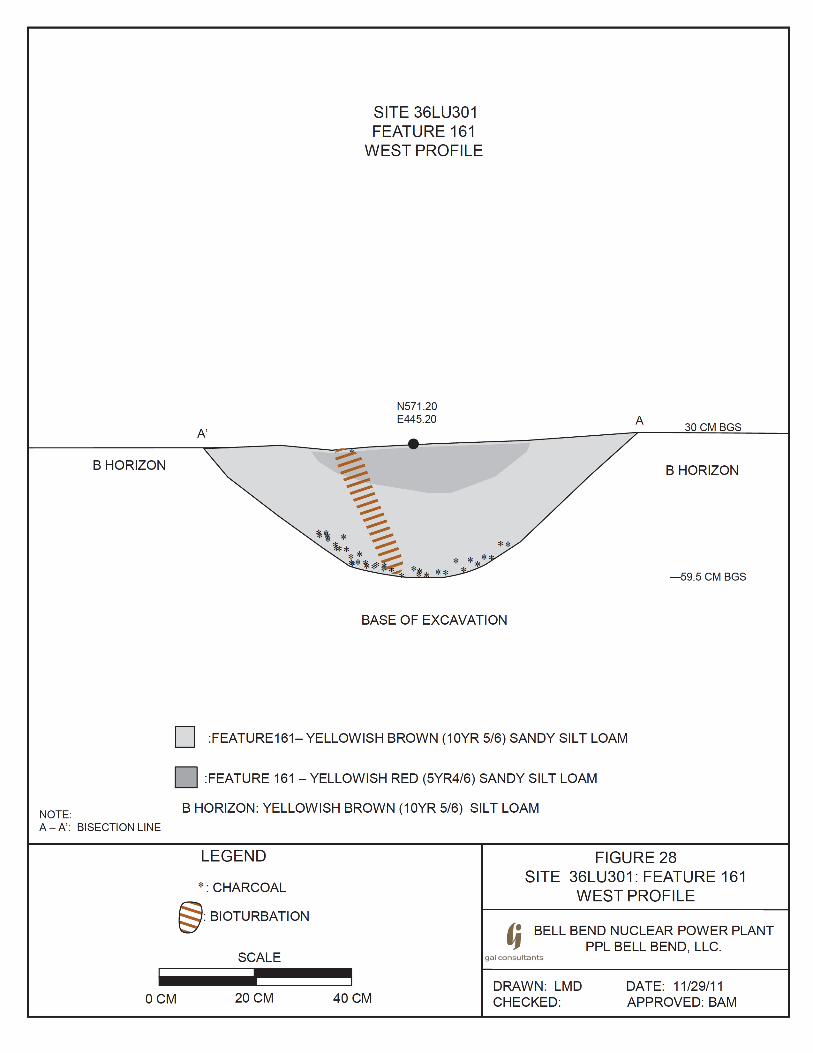
B HORIZON
NOTE: A- A': BISECTION LINE
I
A'
SITE 36LU301 FEATURE 161
WEST PROFILE
N571 .20 E445.20 -
**
BASE OF EXCAVATION
A 30 CM BGS
B HORIZON
-59.5 CM BGS
D :FEATURE161- YELLOWISH BROWN (10YR 5/6) SANDY SILT LOAM
D :FEATURE 161- YELLOWISH RED (5YR4/6) SANDY SILT LOAM
B HORIZON: YELLOWISH BROWN (10YR 5/6) SILT LOAM
LEGEND
* :CHARCOAL
@ :BIOTURBATION
SCALE
I I
FIGURE 28 SITE 36LU301: FEATURE 161
WEST PROFILE
/! BELL BEND NUCLEAR POWER PLANT IJ PPL BELL BEND, LLC.
gai consultants
OCM 20CM 40CM DRAWN: LMD CHECKED:
DATE: 11/29/11 APPROVED: BAM

Technical Report, Phase II National Register Evaluation, Site 36LU301
104
Feature 171Feature 171, a prehistoric thermal feature (Type OX), was identified in the northwest portion of the site during plowzone stripping of Trench 5 (see Figure 3, see Figure 18b). It was the northernmost of the five thermal features exposed in Trench 5 and was located at N592.16 E445.67, approximately 22 meters (72 feet) north of Feature 161. Feature 171 was identified on the stripped surface of the B horizon approximately 25 cm below ground surface; the upper portion of the feature had been truncated by plowing. As defined in plan view, Feature 171 was a generally ovoid oxidized stain with dimensions of 52x90cm (20.5x35.4 in) (Figure 29, Photograph 40). The feature had a basin shaped profile with a maximum depth of 26 cm (10.2 in) below the stripped B horizon surface (Figure 30, Photographs 41 and 42). The feature fill was a yellowish-red (5YR 5/8) sandy silt loam mottled with grayish-brown (10YR
5/2) and brownish-yellow (10YR 6/6) and with slight charcoal flecking.
Photograph 40. Site 36LU301: Feature 171, Plan View on B Horizon Surface (Trench 5), Facing West
Photograph 41. Site 36LU301: Feature 171, Profile, Facing West
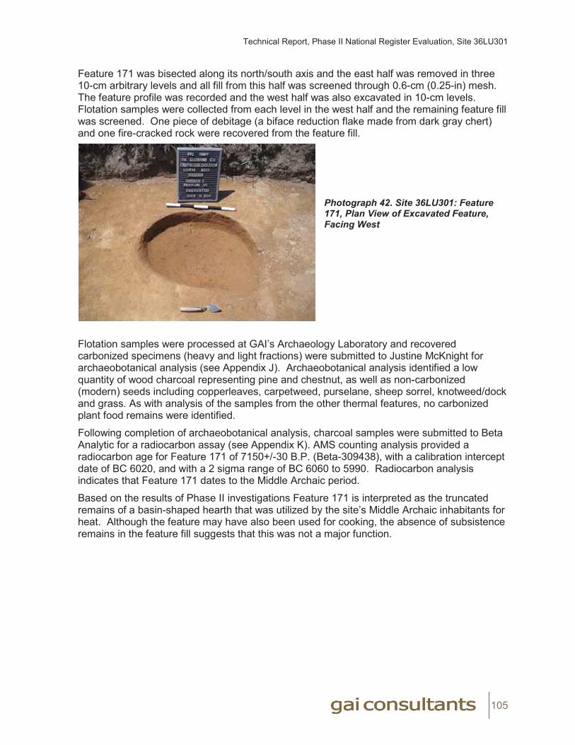
Technical Report, Phase II National Register Evaluation, Site 36LU301
105
Feature 171 was bisected along its north/south axis and the east half was removed in three 10-cm arbitrary levels and all fill from this half was screened through 0.6-cm (0.25-in) mesh. The feature profile was recorded and the west half was also excavated in 10-cm levels. Flotation samples were collected from each level in the west half and the remaining feature fill was screened. One piece of debitage (a biface reduction flake made from dark gray chert) and one fire-cracked rock were recovered from the feature fill.
Photograph 42. Site 36LU301: Feature 171, Plan View of Excavated Feature, Facing West
Flotation samples were processed at GAI’s Archaeology Laboratory and recovered carbonized specimens (heavy and light fractions) were submitted to Justine McKnight for archaeobotanical analysis (see Appendix J). Archaeobotanical analysis identified a low quantity of wood charcoal representing pine and chestnut, as well as non-carbonized (modern) seeds including copperleaves, carpetweed, purselane, sheep sorrel, knotweed/dock and grass. As with analysis of the samples from the other thermal features, no carbonized plant food remains were identified.
Following completion of archaeobotanical analysis, charcoal samples were submitted to Beta Analytic for a radiocarbon assay (see Appendix K). AMS counting analysis provided a radiocarbon age for Feature 171 of 7150+/-30 B.P. (Beta-309438), with a calibration intercept date of BC 6020, and with a 2 sigma range of BC 6060 to 5990. Radiocarbon analysis indicates that Feature 171 dates to the Middle Archaic period.
Based on the results of Phase II investigations Feature 171 is interpreted as the truncated remains of a basin-shaped hearth that was utilized by the site’s Middle Archaic inhabitants for heat. Although the feature may have also been used for cooking, the absence of subsistence remains in the feature fill suggests that this was not a major function.
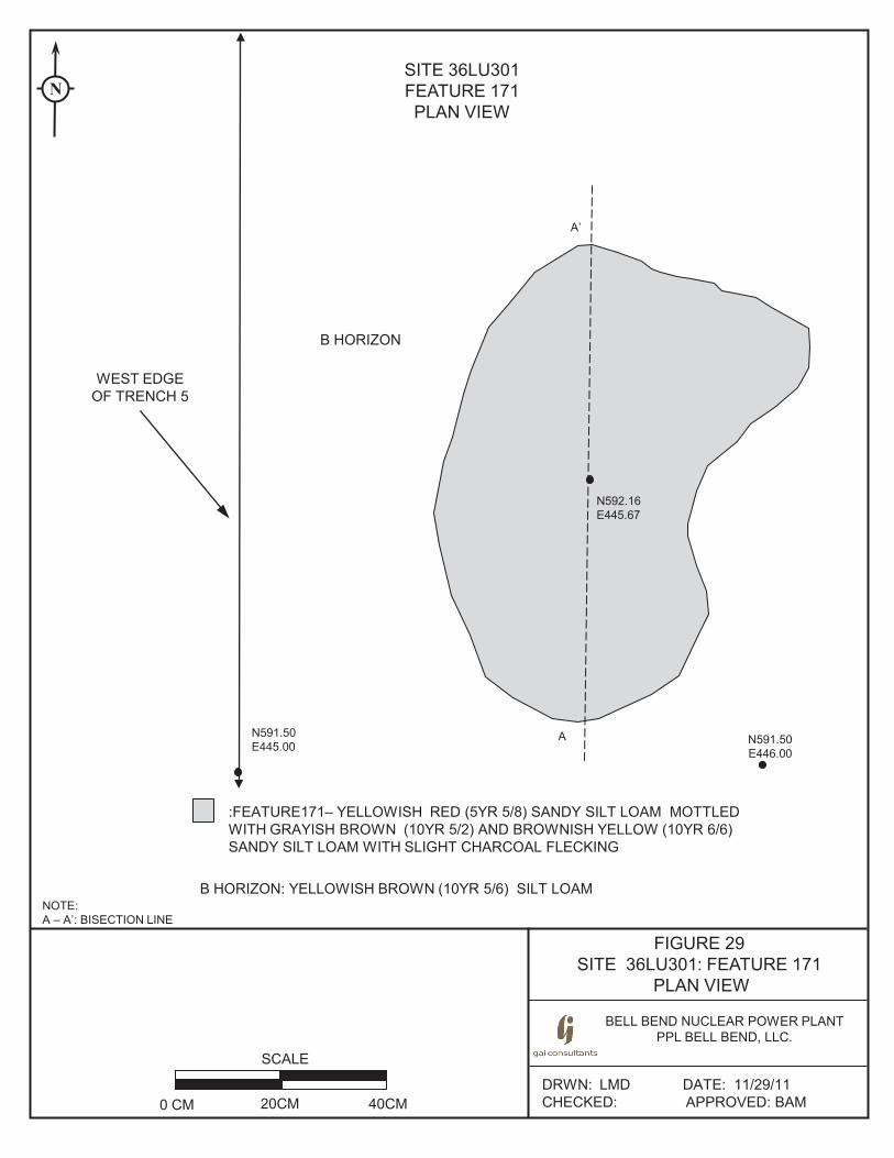
FIGURE 29 SITE 36LU301: FEATURE 171
PLAN VIEW
BELL BEND NUCLEAR POWER PLANT PPL BELL BEND, LLC.
DRWN: LMD DATE: 11/29/11 CHECKED: APPROVED: BAM
SITE 36LU301 FEATURE 171 PLAN VIEW
SCALE
0 CM 20CM 40CM
NOTE: A – A’: BISECTION LINE
N
:FEATURE171– YELLOWISH RED (5YR 5/8) SANDY SILT LOAM MOTTLED WITH GRAYISH BROWN (10YR 5/2) AND BROWNISH YELLOW (10YR 6/6) SANDY SILT LOAM WITH SLIGHT CHARCOAL FLECKING
B HORIZON: YELLOWISH BROWN (10YR 5/6) SILT LOAM
N591.50 E446.00
N591.50 E445.00
WEST EDGE OF TRENCH 5
A
A’
N592.16 E445.67
B HORIZON
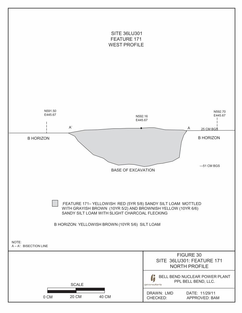
FIGURE 30 SITE 36LU301: FEATURE 171
NORTH PROFILE
BELL BEND NUCLEAR POWER PLANT PPL BELL BEND, LLC.
BE
DRAWN: LMD DATE: 11/29/11 CHECKED: APPROVED: BAM
SITE 36LU301 FEATURE 171
WEST PROFILE
SCALE
0 CM 20 CM 40 CM
NOTE: A – A’: BISECTION LINE
N592.16 E445.67
B HORIZON
A A’
B HORIZON
BASE OF EXCAVATION
N591.50 E445.67
N592.70 E445.67
:FEATURE 171– YELLOWISH RED (5YR 5/8) SANDY SILT LOAM MOTTLED WITH GRAYISH BROWN (10YR 5/2) AND BROWNISH YELLOW (10YR 6/6) SANDY SILT LOAM WITH SLIGHT CHARCOAL FLECKING
B HORIZON: YELLOWISH BROWN (10YR 5/6) SILT LOAM
25 CM BGS
—51 CM BGS

Technical Report, Phase II National Register Evaluation, Site 36LU301
108
Summary of Prehistoric Thermal FeaturesThe five thermal features identified within the site during Phase II feature sampling represent the remains of burning events which resulted in reddened (oxidized) soils and/or concentrations of charcoal flecking in these localities. These features are very similar in size, morphology, and in the near-absence of artifacts or cultural remains. In addition, all five features were identified in a single 2-meter (6.5-foot) wide trench, extending in a north/south orientation across the site’s upland landform in the western portion of the site (perpendicular to the location of Walker Run, situated south of the site). Their size and morphology suggest that they represent the remains of prehistoric hearth features, whose upper portion has been truncated by previous plowing. Three of the feature remnants (Features 150, 153 and 154) were just 5 to 9 cm (1.9 to 3.5 in) thick, while the other two (Features 161 and 171) had maximum depths of 26 to 29.5 cm (10.2 to 11.6 in). Excavation of these features revealed clear boundaries and a smooth, basin shaped profile. No evidence of an irregular base, as would be expected of a natural tree/root burn, was observed.
Based on radiocarbon analysis, two of the features (Features 150 and 171) date to the Middle Archaic period and two features (Features 153 and 154) date to the Early Woodland period; the remaining feature (Feature 161) yielded insufficient material for radiocarbon analysis and its date is unknown. Due to their close spatial proximity and their overlapping radiocarbon dates, it is possible that Features 153 and 154 represent a single prehistoric occupation.
Archaeobotanical analysis identified no evidence of charred subsistence remains in samples from any of the features; plant remains consisted of low quantities of wood charcoal (primarily pine) and numerous non-carbonized modern weed seeds. Two features (Features 153 and 171) yielded only one to two prehistoric artifacts each while the other three features produced no artifacts. No diagnostic lithic artifacts were recovered from the feature fill or surrounding vicinity. Additionally, no ceramics were found in association with the Early Woodland features (or from the site as a whole).
These features represent multiple prehistoric occupations of the site during the Middle Archaic and Early Woodland periods. However, due to the near dearth of artifacts or subsistence remains from the feature fill, as well as the overall the lack of associated artifacts in the surrounding portions of the site, these features provide little information on the nature of the site’s prehistoric occupations.
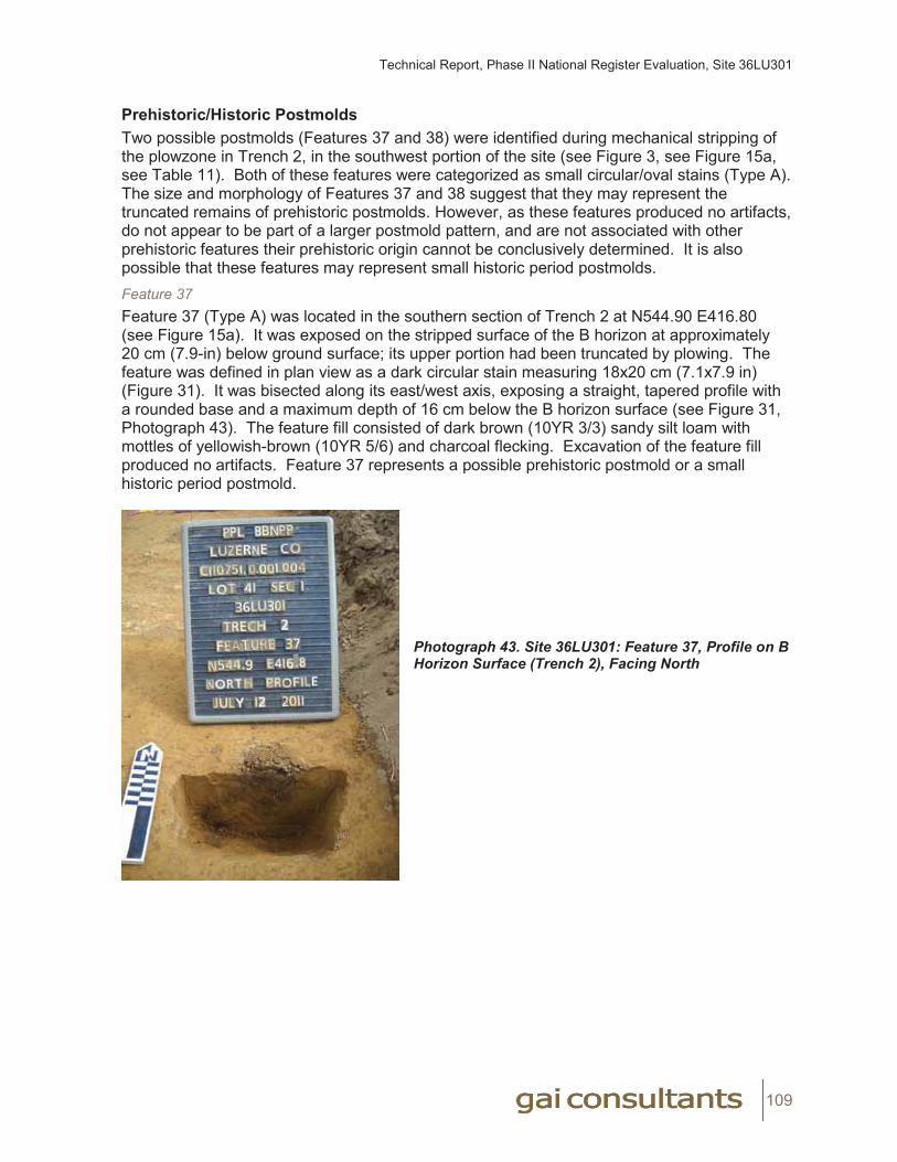
Technical Report, Phase II National Register Evaluation, Site 36LU301
109
Prehistoric/Historic Postmolds Two possible postmolds (Features 37 and 38) were identified during mechanical stripping of the plowzone in Trench 2, in the southwest portion of the site (see Figure 3, see Figure 15a, see Table 11). Both of these features were categorized as small circular/oval stains (Type A). The size and morphology of Features 37 and 38 suggest that they may represent the truncated remains of prehistoric postmolds. However, as these features produced no artifacts, do not appear to be part of a larger postmold pattern, and are not associated with other prehistoric features their prehistoric origin cannot be conclusively determined. It is also possible that these features may represent small historic period postmolds. Feature 37Feature 37 (Type A) was located in the southern section of Trench 2 at N544.90 E416.80 (see Figure 15a). It was exposed on the stripped surface of the B horizon at approximately 20 cm (7.9-in) below ground surface; its upper portion had been truncated by plowing. The feature was defined in plan view as a dark circular stain measuring 18x20 cm (7.1x7.9 in) (Figure 31). It was bisected along its east/west axis, exposing a straight, tapered profile with a rounded base and a maximum depth of 16 cm below the B horizon surface (see Figure 31, Photograph 43). The feature fill consisted of dark brown (10YR 3/3) sandy silt loam with mottles of yellowish-brown (10YR 5/6) and charcoal flecking. Excavation of the feature fill produced no artifacts. Feature 37 represents a possible prehistoric postmold or a small historic period postmold.
Photograph 43. Site 36LU301: Feature 37, Profile on BHorizon Surface (Trench 2), Facing North

FIGURE 31 SITE 36LU301: FEATURE 37
PLAN VIEW AND NORTH PROFILE
BELL BEND NUCLEAR POWER PLANT PPL BELL BEND, LLC.
BE
DRAWN: LMD DATE: 11/29/11 CHECKED: APPROVED: BAM
SITE 36LU301 FEATURE 37 PLAN VIEW AND
NORTH PROFILE
SCALE
0 CM 20CM 40CM
LEGEND
: BIOTURBATION
: CHARCOAL *
NOTE: A – A’: BISECTION LINE
:FEATURE 37- DARK BROWN (10YR 3/3) SANDY SILT LOAM WITH FEW MOTTLES OF YELLOWISH BROWN (10YR 5/6) SANDY SILT LOAM AND CHARCOAL FLECKING
B HORIZON: YELLOWISH BROWN (10YR 5/6) SANDY SILT LOAM
N544.90 E416.62
—20 CM BGS *
**
*
A A’
B HORIZON
BASE OF EXCAVATION
EAST WALL OF TRENCH 2
N544.90 E416.62
N544.90 E416.95
A A’
EAST WALL OF TRENCH 2
GROUND SURFACE N544.90 E417.00
—36 CM BGS
0 CM BGS
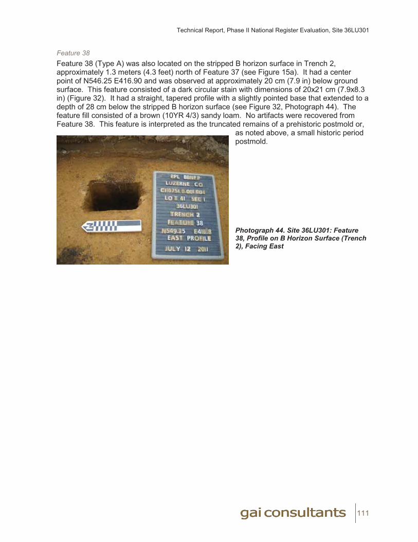
Technical Report, Phase II National Register Evaluation, Site 36LU301
111
Feature 38Feature 38 (Type A) was also located on the stripped B horizon surface in Trench 2, approximately 1.3 meters (4.3 feet) north of Feature 37 (see Figure 15a). It had a center point of N546.25 E416.90 and was observed at approximately 20 cm (7.9 in) below ground surface. This feature consisted of a dark circular stain with dimensions of 20x21 cm (7.9x8.3 in) (Figure 32). It had a straight, tapered profile with a slightly pointed base that extended to a depth of 28 cm below the stripped B horizon surface (see Figure 32, Photograph 44). The feature fill consisted of a brown (10YR 4/3) sandy loam. No artifacts were recovered from Feature 38. This feature is interpreted as the truncated remains of a prehistoric postmold or,
as noted above, a small historic period postmold.
Photograph 44. Site 36LU301: Feature 38, Profile on B Horizon Surface (Trench 2), Facing East

FIGURE 32 SITE 36LU301: FEATURE 38
PLAN VIEW AND EAST PROFILE
BELL BEND NUCLEAR POWER PLANT PPL BELL BEND, LLC.
BE
DRAWN: LMD DATE: 11/29/11 CHECKED: APPROVED: BAM
SITE 36LU301 FEATURE 38 PLAN VIEW AND
EAST PROFILE
SCALE
0 CM 20CM 40CM
LEGEND
: CHARCOAL *
NOTE: A – A’: BISECTION LINE
:FEATURE 37- DARK BROWN (10YR 3/3) SANDY SILT LOAM WITH CHARCOAL FLECKING
B HORIZON: YELLOWISH BROWN (10YR 5/6) SANDY SILT LOAM
N546.40 E416.90
A A’
B HORIZON
BASE OF EXCAVATION
EAST WALL OF TRENCH 2
N544.9 E416.62
A
A’
N546.00 E416.90 N546.25
E416.90 20 CM BGS
—48 CM BGS
B HORIZON
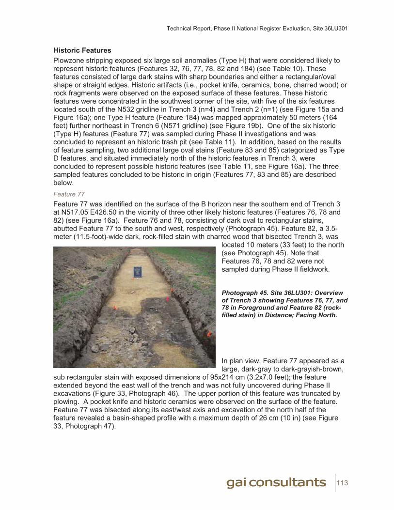
Technical Report, Phase II National Register Evaluation, Site 36LU301
113
Historic FeaturesPlowzone stripping exposed six large soil anomalies (Type H) that were considered likely to represent historic features (Features 32, 76, 77, 78, 82 and 184) (see Table 10). These features consisted of large dark stains with sharp boundaries and either a rectangular/oval shape or straight edges. Historic artifacts (i.e., pocket knife, ceramics, bone, charred wood) or rock fragments were observed on the exposed surface of these features. These historic features were concentrated in the southwest corner of the site, with five of the six features located south of the N532 gridline in Trench 3 (n=4) and Trench 2 (n=1) (see Figure 15a and Figure 16a); one Type H feature (Feature 184) was mapped approximately 50 meters (164 feet) further northeast in Trench 6 (N571 gridline) (see Figure 19b). One of the six historic (Type H) features (Feature 77) was sampled during Phase II investigations and was concluded to represent an historic trash pit (see Table 11). In addition, based on the results of feature sampling, two additional large oval stains (Feature 83 and 85) categorized as Type D features, and situated immediately north of the historic features in Trench 3, were concluded to represent possible historic features (see Table 11, see Figure 16a). The three sampled features concluded to be historic in origin (Features 77, 83 and 85) are described below. Feature 77Feature 77 was identified on the surface of the B horizon near the southern end of Trench 3 at N517.05 E426.50 in the vicinity of three other likely historic features (Features 76, 78 and 82) (see Figure 16a). Feature 76 and 78, consisting of dark oval to rectangular stains, abutted Feature 77 to the south and west, respectively (Photograph 45). Feature 82, a 3.5-meter (11.5-foot)-wide dark, rock-filled stain with charred wood that bisected Trench 3, was
located 10 meters (33 feet) to the north (see Photograph 45). Note that Features 76, 78 and 82 were not sampled during Phase II fieldwork.
Photograph 45. Site 36LU301: Overview of Trench 3 showing Features 76, 77, and 78 in Foreground and Feature 82 (rock-filled stain) in Distance; Facing North.
In plan view, Feature 77 appeared as a large, dark-gray to dark-grayish-brown,
sub rectangular stain with exposed dimensions of 95x214 cm (3.2x7.0 feet); the feature extended beyond the east wall of the trench and was not fully uncovered during Phase II excavations (Figure 33, Photograph 46). The upper portion of this feature was truncated by plowing. A pocket knife and historic ceramics were observed on the surface of the feature. Feature 77 was bisected along its east/west axis and excavation of the north half of the feature revealed a basin-shaped profile with a maximum depth of 26 cm (10 in) (see Figure 33, Photograph 47).
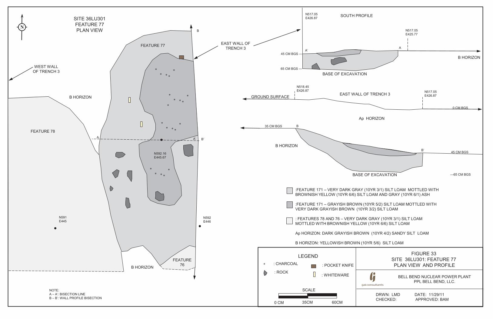
BELL BEND NUCLEAR POWER PLANTPPL BELL BEND, LLC.
FIGURE 33SITE 36LU301: FEATURE 77PLAN VIEW AND PROFILE
SCALE
0 CM 35CM 60CM
EAST WALL OF TRENCH 3
DRWN: LMD DATE: 11/29/11CHECKED: APPROVED: BAM
:FEATURE 171 – VERY DARK GRAY (10YR 3/1) SILT LOAM MOTTLED WITH BROWNISH YELLOW (10YR 6/6) SILT LOAM AND GRAY (10YR 6/1) ASH
:FEATURE 171 – GRAYISH BROWN (10YR 5/2) SILT LOAM MOTTLED WITH VERY DARK GRAYISH BROWN (10YR 3/2) SILT LOAM
: FEATURES 78 AND 76 – VERY DARK GRAY (10YR 3/1) SILT LOAM MOTTLED WITH BROWNISH YELLOW (10YR 6/6) SILT LOAM
Ap HORIZON: DARK GRAYISH BROWN (10YR 4/2) SANDY SILT LOAM
B HORIZON: YELLOWISH BROWN (10YR 5/6) SILT LOAM
SITE 36LU301FEATURE 77 PLAN VIEW
NOTE:A – A’: BISECTION LINEB – B’: WALL PROFILE BISECTION
N
N592E446
N591E445
A A’
N592.16E445.67
**
***
*
**
***
**
***
**
***
B HORIZON
B HORIZON
LEGEND: CHARCOAL* : POCKET KNIFE
: WHITEWARE: ROCK
B
B’
B HORIZON
N517.05E426.87
N517.05E425.77
A’A
B
N517.05E426.87
N518.45E426.87
B’B HORIZON
Ap HORIZON
GROUND SURFACE
SOUTH PROFILE
EAST WALL OF TRENCH 3
FEATURE 78
FEATURE 77
FEATURE 76
BASE OF EXCAVATION
BASE OF EXCAVATION
0 CM BGS
45 CM BGS
—65 CM BGS
65 CM BGS —
45 CM BGS —
WEST WALL OF TRENCH 3
35 CM BGS
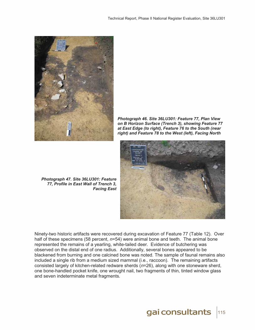
Technical Report, Phase II National Register Evaluation, Site 36LU301
115
Photograph 46. Site 36LU301: Feature 77, Plan View on B Horizon Surface (Trench 3), showing Feature 77 at East Edge (to right), Feature 76 to the South (near right) and Feature 78 to the West (left), Facing North
Photograph 47. Site 36LU301: Feature 77, Profile in East Wall of Trench 3,
Facing East
Ninety-two historic artifacts were recovered during excavation of Feature 77 (Table 12). Over half of these specimens (58 percent, n=54) were animal bone and teeth. The animal bone represented the remains of a yearling, white-tailed deer. Evidence of butchering was observed on the distal end of one radius. Additionally, several bones appeared to be blackened from burning and one calcined bone was noted. The sample of faunal remains also included a single rib from a medium sized mammal (i.e., raccoon). The remaining artifacts consisted largely of kitchen-related redware sherds (n=26), along with one stoneware sherd, one bone-handled pocket knife, one wrought nail, two fragments of thin, tinted window glass and seven indeterminate metal fragments.

Technical Report, Phase II National Register Evaluation, Site 36LU301
116
Table 12. Site 36LU301: Feature 77 Pattern Analysis, Historic Artifacts
Class SubClass Ware Type/Object Count %Architecture Nails, Spikes, Etc. nail, wrought 1 1.09%
Window Glass window glass 2 2.17%Architecture Total 3 3.26%
Faunal Bone bone 49 53.26%teeth 5 5.43%
Faunal Total 54 58.70%Kitchen Ceramics redware, brown glaze 18 19.57%
redware, clear lead glaze 8 8.70%whiteware, plain 1 1.09%
Kitchen Total 27 29.35%Personal Personal-Other pocket knife 1 1.09%Unidentifiable Indeterminate indeterminate metal 7 7.61%
TOTAL 92 100.00%
Based on Phase II analysis, Feature 77 represents the remains of a shallow refuse pit. The presence of redware sherds, a wrought nail, and thin window glass suggest an early to mid nineteenth century age for this feature. As the adjacent Michael’s residence dates to circa 1880, this feature may be associated with an earlier activity or use of the field that predates construction of this residence. The 1873 map of the area (see Figure 8) depicts no structures in this locality and no structural remains were identified within the site during Phase II investigations. This data suggests that Feature 77 and the earlier historic activities may have been limited in time and scale and/or that any associated structures, if present, were abandoned prior to 1873.
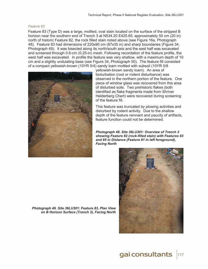
Technical Report, Phase II National Register Evaluation, Site 36LU301
117
Feature 83Feature 83 (Type D) was a large, mottled, oval stain located on the surface of the stripped B horizon near the southern end of Trench 3 at N534.20 E425.65, approximately 50 cm (20 in) north of historic Feature 82, the rock filled stain noted above (see Figure 16a, Photograph 48). Feature 83 had dimensions of 220x90 cm (87x35 in) and sharp boundaries (Figure 34, Photograph 49). It was bisected along its north/south axis and the east half was excavated and screened through 0.6-cm (0.25-in) mesh. Following recordation of the feature profile, the west half was excavated. In profile the feature was very shallow, with a maximum depth of 10 cm and a slightly undulating base (see Figure 34, Photograph 50). The feature fill consisted of a compact yellowish-brown (10YR 5/4) sandy loam mottled with subsoil (10YR 5/8
yellowish-brown sandy loam). An area of bioturbation (root or rodent disturbance) was observed in the northern portion of the feature. One piece of window glass was recovered from this area of disturbed soils. Two prehistoric flakes (both identified as flake fragments made from Shriver Helderberg Chert) were recovered during screening of the feature fill.
This feature was truncated by plowing activities and disturbed by rodent activity. Due to the shallow depth of the feature remnant and paucity of artifacts, feature function could not be determined.
Photograph 48. Site 36LU301: Overview of Trench 3 showing Feature 82 (rock-filled stain) with Features 83 and 85 in Distance (Feature 81 in left foreground), Facing North
Photograph 49. Site 36LU301: Feature 83, Plan Viewon B Horizon Surface (Trench 3), Facing North
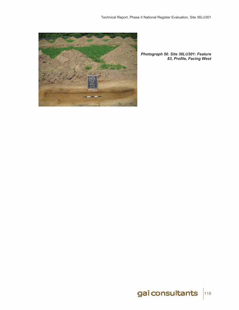
Technical Report, Phase II National Register Evaluation, Site 36LU301
118
Photograph 50. Site 36LU301: Feature 83, Profile, Facing West
gai consultants I
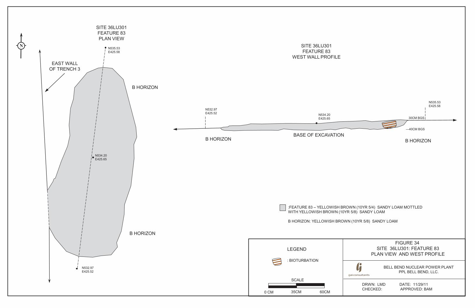
BELL BEND NUCLEAR POWER PLANT PPL BELL BEND, LLC.
FIGURE 34 SITE 36LU301: FEATURE 83
PLAN VIEW AND WEST PROFILE
SCALE
0 CM 35CM 60CM
DRWN: LMD DATE: 11/29/11 CHECKED: APPROVED: BAM
:FEATURE 83 – YELLOWISH BROWN (10YR 5/4) SANDY LOAM MOTTLED WITH YELLOWISH BROWN (10YR 5/8) SANDY LOAM B HORIZON: YELLOWISH BROWN (10YR 5/8) SANDY LOAM
LEGEND
: BIOTURBATION
N534.20 E425.65
B HORIZON
EAST WALL OF TRENCH 3
SITE 36LU301 FEATURE 83 PLAN VIEW
N
N532.97 E425.52
N535.53 E425.58
BASE OF EXCAVATION
B HORIZON
N535.53 E425.58
N532.97 E425.52
SITE 36LU301 FEATURE 83
WEST WALL PROFILE
B HORIZON
N534.20 E425.65 30CM BGS
—40CM BGS
B HORIZON
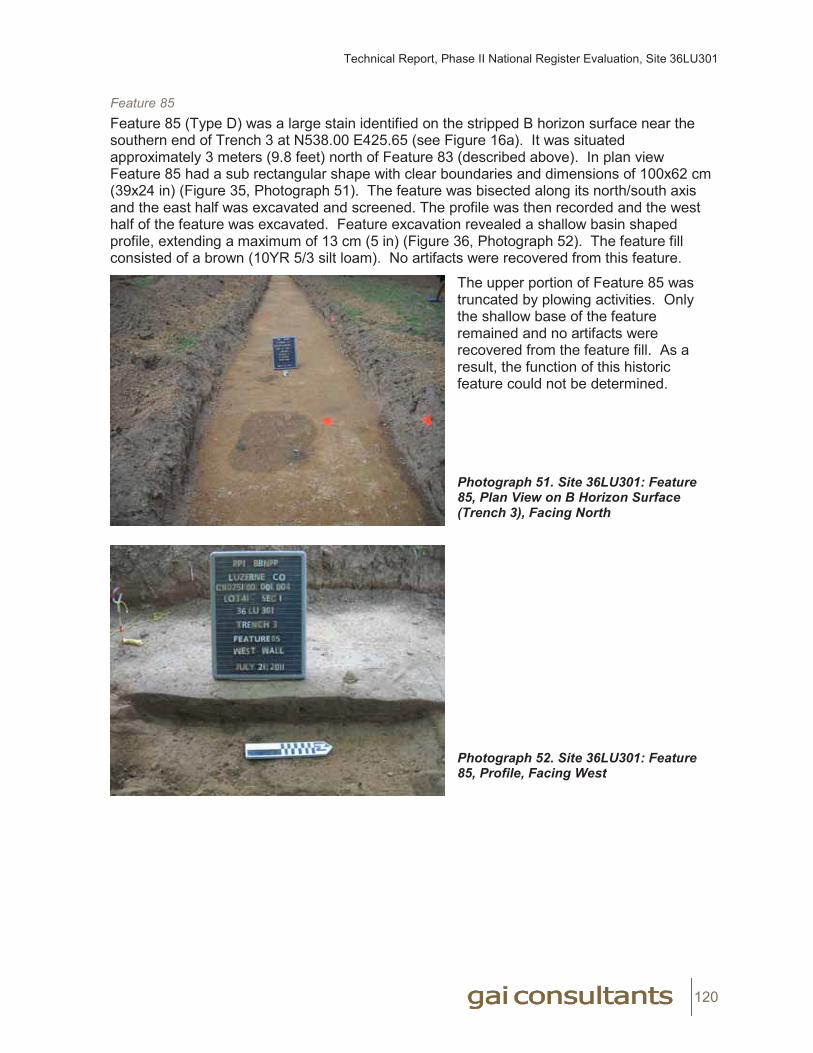
Technical Report, Phase II National Register Evaluation, Site 36LU301
120
Feature 85Feature 85 (Type D) was a large stain identified on the stripped B horizon surface near the southern end of Trench 3 at N538.00 E425.65 (see Figure 16a). It was situated approximately 3 meters (9.8 feet) north of Feature 83 (described above). In plan view Feature 85 had a sub rectangular shape with clear boundaries and dimensions of 100x62 cm (39x24 in) (Figure 35, Photograph 51). The feature was bisected along its north/south axis and the east half was excavated and screened. The profile was then recorded and the west half of the feature was excavated. Feature excavation revealed a shallow basin shaped profile, extending a maximum of 13 cm (5 in) (Figure 36, Photograph 52). The feature fill consisted of a brown (10YR 5/3 silt loam). No artifacts were recovered from this feature.
The upper portion of Feature 85 was truncated by plowing activities. Only the shallow base of the feature remained and no artifacts were recovered from the feature fill. As a result, the function of this historic feature could not be determined.
Photograph 51. Site 36LU301: Feature 85, Plan View on B Horizon Surface (Trench 3), Facing North
Photograph 52. Site 36LU301: Feature 85, Profile, Facing West
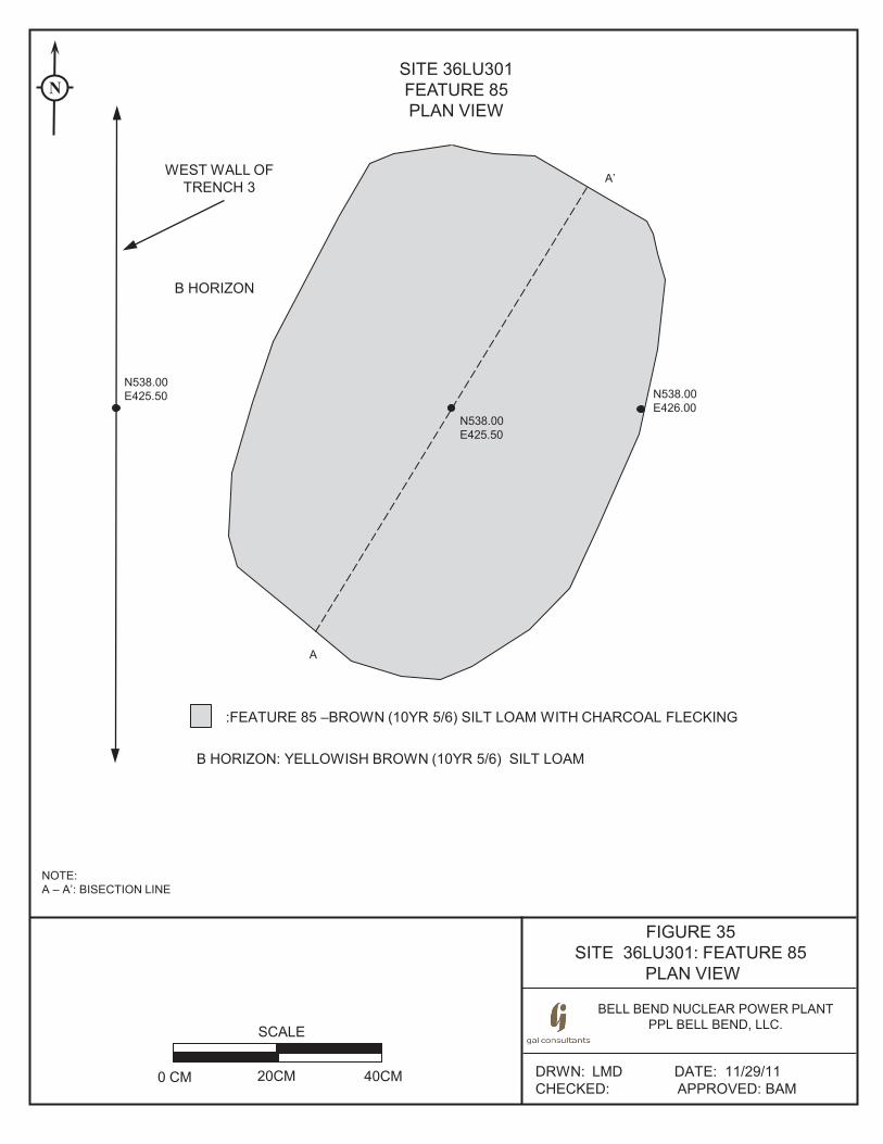
FIGURE 35 SITE 36LU301: FEATURE 85
PLAN VIEW
BELL BEND NUCLEAR POWER PLANT PPL BELL BEND, LLC.
DRWN: LMD DATE: 11/29/11 CHECKED: APPROVED: BAM
SITE 36LU301 FEATURE 85 PLAN VIEW
SCALE
0 CM 20CM 40CM
A’
A
B HORIZON
NOTE: A – A’: BISECTION LINE
N
:FEATURE 85 –BROWN (10YR 5/6) SILT LOAM WITH CHARCOAL FLECKING
B HORIZON: YELLOWISH BROWN (10YR 5/6) SILT LOAM
N538.00 E425.50
N538.00 E425.50 N538.00
E426.00
WEST WALL OF TRENCH 3
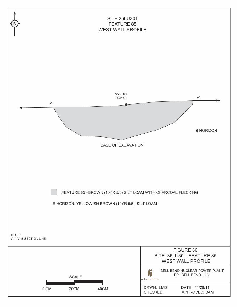
FIGURE 36 SITE 36LU301: FEATURE 85
WEST WALL PROFILE
BELL BEND NUCLEAR POWER PLANT PPL BELL BEND, LLC.
DRWN: LMD DATE: 11/29/11 CHECKED: APPROVED: BAM
SITE 36LU301 FEATURE 85
WEST WALL PROFILE
SCALE
0 CM 20CM 40CM
A’
A
B HORIZON
NOTE: A – A’: BISECTION LINE
N
:FEATURE 85 –BROWN (10YR 5/6) SILT LOAM WITH CHARCOAL FLECKING
B HORIZON: YELLOWISH BROWN (10YR 5/6) SILT LOAM
N538.00 E425.50
BASE OF EXCAVATION
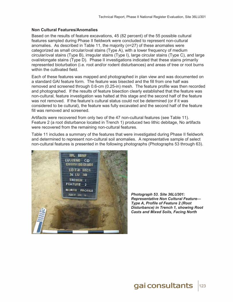
Technical Report, Phase II National Register Evaluation, Site 36LU301
123
Non Cultural Features/AnomaliesBased on the results of feature excavations, 45 (82 percent) of the 55 possible cultural features sampled during Phase II fieldwork were concluded to represent non-cultural anomalies. As described in Table 11, the majority (n=27) of these anomalies were categorized as small circular/oval stains (Type A), with a lower frequency of medium circular/oval stains (Type B), irregular stains (Type I), large circular stains (Type C), and large oval/elongate stains (Type D). Phase II investigations indicated that these stains primarily represented bioturbation (i.e. root and/or rodent disturbances) and areas of tree or root burns within the cultivated field.
Each of these features was mapped and photographed in plan view and was documented on a standard GAI feature form. The feature was bisected and the fill from one half was removed and screened through 0.6-cm (0.25-in) mesh. The feature profile was then recorded and photographed. If the results of feature bisection clearly established that the feature was non-cultural, feature investigation was halted at this stage and the second half of the feature was not removed. If the feature’s cultural status could not be determined (or if it was considered to be cultural), the feature was fully excavated and the second half of the feature fill was removed and screened.
Artifacts were recovered from only two of the 47 non-cultural features (see Table 11). Feature 2 (a root disturbance located in Trench 1) produced two lithic debitage, No artifacts were recovered from the remaining non-cultural features.
Table 11 includes a summary of the features that were investigated during Phase II fieldwork and determined to represent non-cultural soil anomalies. A representative sample of select non-cultural features is presented in the following photographs (Photographs 53 through 63).
Photograph 53. Site 36LU301: Representative Non Cultural Feature—Type A, Profile of Feature 2 (Root Disturbance) in Trench 1, showing Root Casts and Mixed Soils, Facing North
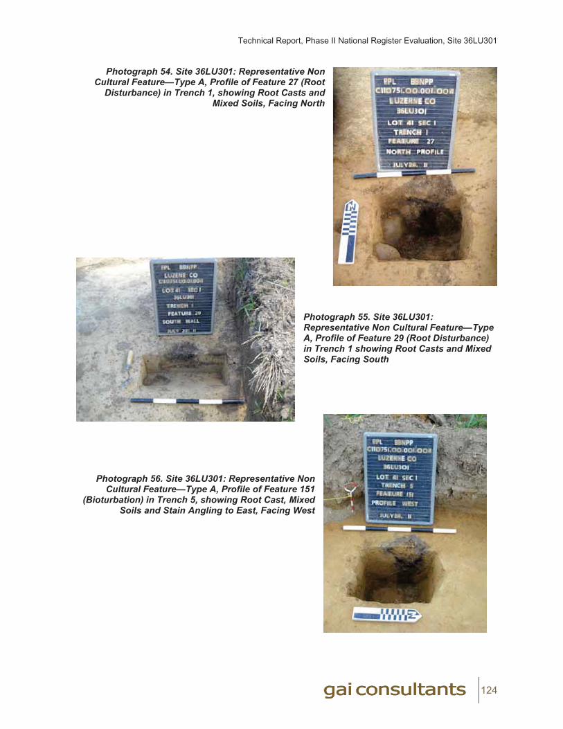
Technical Report, Phase II National Register Evaluation, Site 36LU301
124
Photograph 54. Site 36LU301: Representative Non Cultural Feature—Type A, Profile of Feature 27 (Root
Disturbance) in Trench 1, showing Root Casts and Mixed Soils, Facing North
Photograph 55. Site 36LU301: Representative Non Cultural Feature—Type A, Profile of Feature 29 (Root Disturbance) in Trench 1 showing Root Casts and Mixed Soils, Facing South
Photograph 56. Site 36LU301: Representative Non
Cultural Feature—Type A, Profile of Feature 151 (Bioturbation) in Trench 5, showing Root Cast, Mixed
Soils and Stain Angling to East, Facing West
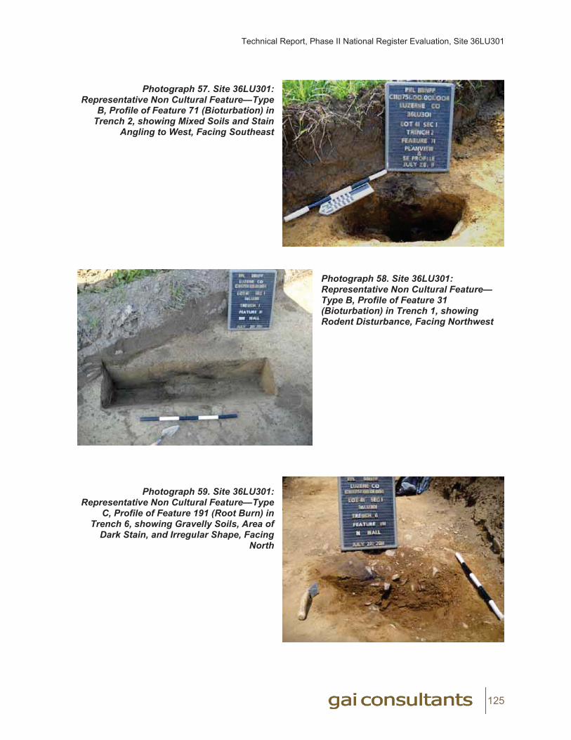
Technical Report, Phase II National Register Evaluation, Site 36LU301
125
Photograph 57. Site 36LU301: Representative Non Cultural Feature—Type
B, Profile of Feature 71 (Bioturbation) in Trench 2, showing Mixed Soils and Stain
Angling to West, Facing Southeast
Photograph 58. Site 36LU301: Representative Non Cultural Feature—Type B, Profile of Feature 31(Bioturbation) in Trench 1, showingRodent Disturbance, Facing Northwest
Photograph 59. Site 36LU301: Representative Non Cultural Feature—Type
C, Profile of Feature 191 (Root Burn) in Trench 6, showing Gravelly Soils, Area of
Dark Stain, and Irregular Shape, Facing North
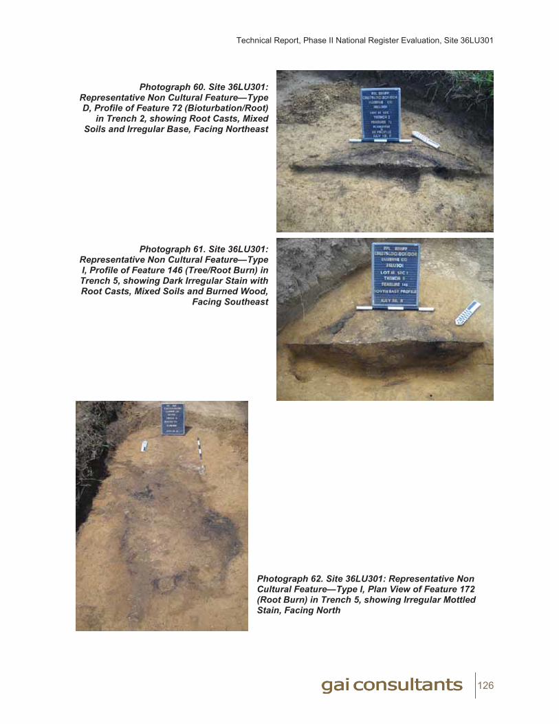
Technical Report, Phase II National Register Evaluation, Site 36LU301
126
Photograph 60. Site 36LU301: Representative Non Cultural Feature—Type D, Profile of Feature 72 (Bioturbation/Root)
in Trench 2, showing Root Casts, Mixed Soils and Irregular Base, Facing Northeast
Photograph 61. Site 36LU301: Representative Non Cultural Feature—Type I, Profile of Feature 146 (Tree/Root Burn) in Trench 5, showing Dark Irregular Stain with Root Casts, Mixed Soils and Burned Wood,
Facing Southeast
Photograph 62. Site 36LU301: Representative Non Cultural Feature—Type I, Plan View of Feature 172(Root Burn) in Trench 5, showing Irregular Mottled Stain, Facing North

Technical Report, Phase II National Register Evaluation, Site 36LU301
127
Photograph 63. Site 36LU301: Representative Non Cultural Feature—Type I, Profile of Feature 59 (Root Burn) in Trench 2, showing Burned Root Casts and Mixed Soils, Facing North
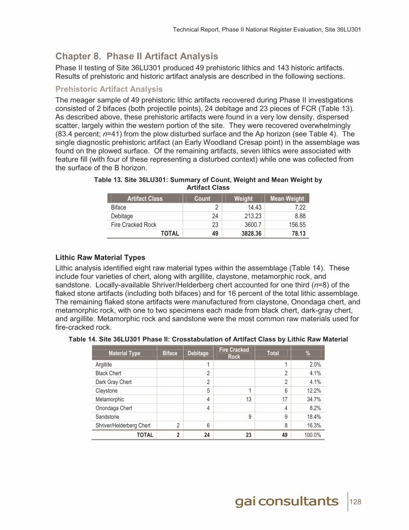
Technical Report, Phase II National Register Evaluation, Site 36LU301
128
Chapter 8. Phase II Artifact AnalysisPhase II testing of Site 36LU301 produced 49 prehistoric lithics and 143 historic artifacts. Results of prehistoric and historic artifact analysis are described in the following sections.
Prehistoric Artifact AnalysisThe meager sample of 49 prehistoric lithic artifacts recovered during Phase II investigations consisted of 2 bifaces (both projectile points), 24 debitage and 23 pieces of FCR (Table 13). As described above, these prehistoric artifacts were found in a very low density, dispersed scatter, largely within the western portion of the site. They were recovered overwhelmingly (83.4 percent; n=41) from the plow disturbed surface and the Ap horizon (see Table 4). The single diagnostic prehistoric artifact (an Early Woodland Cresap point) in the assemblage was found on the plowed surface. Of the remaining artifacts, seven lithics were associated with feature fill (with four of these representing a disturbed context) while one was collected from the surface of the B horizon.
Table 13. Site 36LU301: Summary of Count, Weight and Mean Weight by Artifact Class
Artifact Class Count Weight Mean WeightBiface 2 14.43 7.22Debitage 24 213.23 8.88Fire Cracked Rock 23 3600.7 156.55
TOTAL 49 3828.36 78.13
Lithic Raw Material TypesLithic analysis identified eight raw material types within the assemblage (Table 14). These include four varieties of chert, along with argillite, claystone, metamorphic rock, and sandstone. Locally-available Shriver/Helderberg chert accounted for one third (n=8) of the flaked stone artifacts (including both bifaces) and for 16 percent of the total lithic assemblage. The remaining flaked stone artifacts were manufactured from claystone, Onondaga chert, and metamorphic rock, with one to two specimens each made from black chert, dark-gray chert, and argillite. Metamorphic rock and sandstone were the most common raw materials used for fire-cracked rock.
Table 14. Site 36LU301 Phase II: Crosstabulation of Artifact Class by Lithic Raw Material
Material Type Biface Debitage Fire Cracked Rock Total %
Argillite 1 1 2.0%Black Chert 2 2 4.1%Dark Gray Chert 2 2 4.1%Claystone 5 1 6 12.2%Metamorphic 4 13 17 34.7%Onondaga Chert 4 4 8.2%Sandstone 9 9 18.4%Shriver/Helderberg Chert 2 6 8 16.3%
TOTAL 2 24 23 49 100.0%
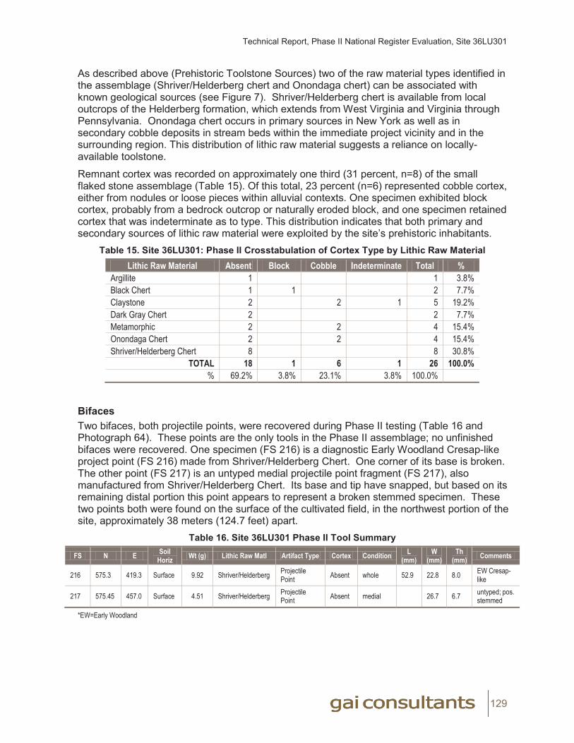
Technical Report, Phase II National Register Evaluation, Site 36LU301
129
As described above (Prehistoric Toolstone Sources) two of the raw material types identified in the assemblage (Shriver/Helderberg chert and Onondaga chert) can be associated with known geological sources (see Figure 7). Shriver/Helderberg chert is available from local outcrops of the Helderberg formation, which extends from West Virginia and Virginia through Pennsylvania. Onondaga chert occurs in primary sources in New York as well as in secondary cobble deposits in stream beds within the immediate project vicinity and in the surrounding region. This distribution of lithic raw material suggests a reliance on locally-available toolstone.
Remnant cortex was recorded on approximately one third (31 percent, n=8) of the small flaked stone assemblage (Table 15). Of this total, 23 percent (n=6) represented cobble cortex, either from nodules or loose pieces within alluvial contexts. One specimen exhibited block cortex, probably from a bedrock outcrop or naturally eroded block, and one specimen retained cortex that was indeterminate as to type. This distribution indicates that both primary and secondary sources of lithic raw material were exploited by the site’s prehistoric inhabitants.
Table 15. Site 36LU301: Phase II Crosstabulation of Cortex Type by Lithic Raw MaterialLithic Raw Material Absent Block Cobble Indeterminate Total %
Argillite 1 1 3.8%Black Chert 1 1 2 7.7%Claystone 2 2 1 5 19.2%Dark Gray Chert 2 2 7.7%Metamorphic 2 2 4 15.4%Onondaga Chert 2 2 4 15.4%Shriver/Helderberg Chert 8 8 30.8%
TOTAL 18 1 6 1 26 100.0%% 69.2% 3.8% 23.1% 3.8% 100.0%
BifacesTwo bifaces, both projectile points, were recovered during Phase II testing (Table 16 and Photograph 64). These points are the only tools in the Phase II assemblage; no unfinished bifaces were recovered. One specimen (FS 216) is a diagnostic Early Woodland Cresap-like project point (FS 216) made from Shriver/Helderberg Chert. One corner of its base is broken. The other point (FS 217) is an untyped medial projectile point fragment (FS 217), also manufactured from Shriver/Helderberg Chert. Its base and tip have snapped, but based on its remaining distal portion this point appears to represent a broken stemmed specimen. These two points both were found on the surface of the cultivated field, in the northwest portion of the site, approximately 38 meters (124.7 feet) apart.
Table 16. Site 36LU301 Phase II Tool Summary
FS N E Soil Horiz Wt (g) Lithic Raw Matl Artifact Type Cortex Condition L
(mm)W
(mm)Th
(mm) Comments
216 575.3 419.3 Surface 9.92 Shriver/Helderberg Projectile Point Absent whole 52.9 22.8 8.0 EW Cresap-
like
217 575.45 457.0 Surface 4.51 Shriver/Helderberg Projectile Point Absent medial 26.7 6.7 untyped; pos.
stemmed
*EW=Early Woodland
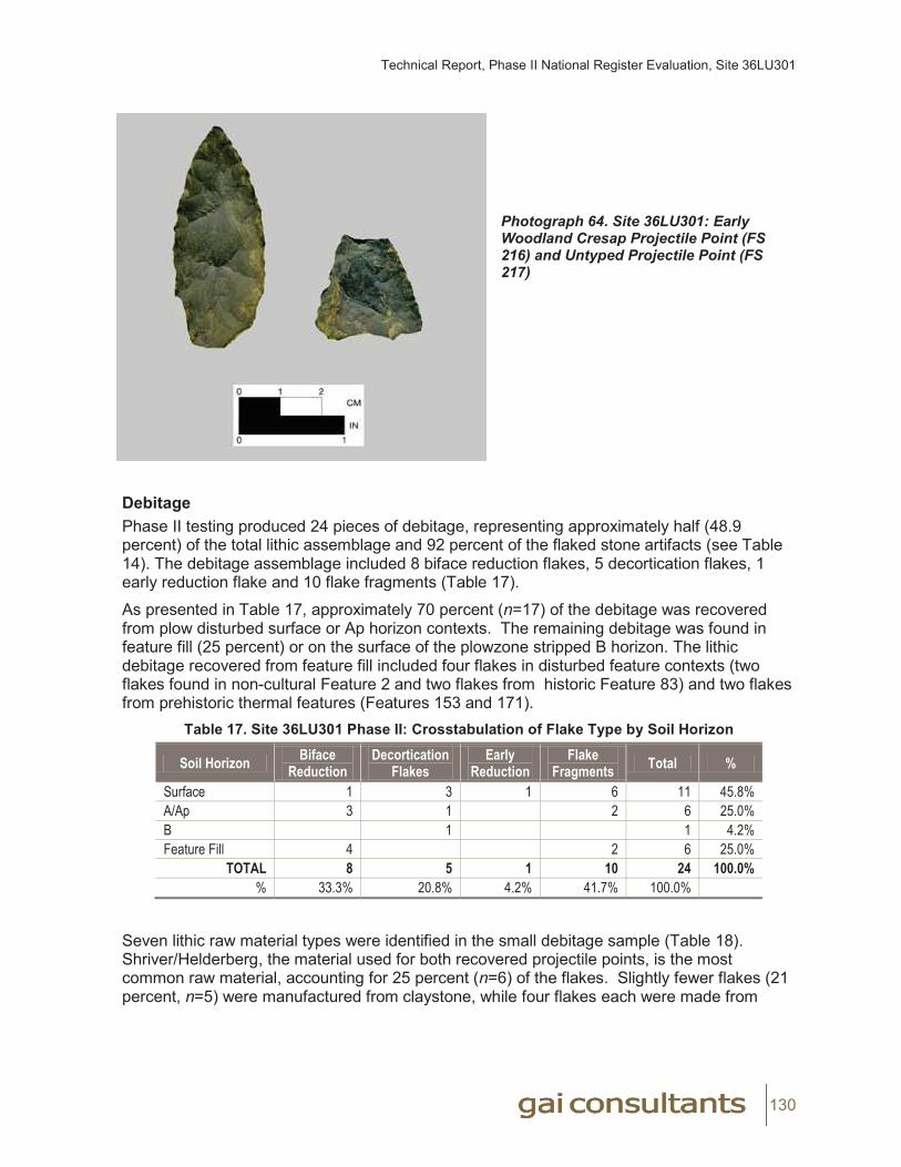
Technical Report, Phase II National Register Evaluation, Site 36LU301
130
Photograph 64. Site 36LU301: Early Woodland Cresap Projectile Point (FS 216) and Untyped Projectile Point (FS 217)
DebitagePhase II testing produced 24 pieces of debitage, representing approximately half (48.9 percent) of the total lithic assemblage and 92 percent of the flaked stone artifacts (see Table 14). The debitage assemblage included 8 biface reduction flakes, 5 decortication flakes, 1 early reduction flake and 10 flake fragments (Table 17).
As presented in Table 17, approximately 70 percent (n=17) of the debitage was recovered from plow disturbed surface or Ap horizon contexts. The remaining debitage was found in feature fill (25 percent) or on the surface of the plowzone stripped B horizon. The lithic debitage recovered from feature fill included four flakes in disturbed feature contexts (two flakes found in non-cultural Feature 2 and two flakes from historic Feature 83) and two flakes from prehistoric thermal features (Features 153 and 171).
Table 17. Site 36LU301 Phase II: Crosstabulation of Flake Type by Soil Horizon
Soil Horizon Biface Reduction
Decortication Flakes
Early Reduction
Flake Fragments Total %
Surface 1 3 1 6 11 45.8%A/Ap 3 1 2 6 25.0%B 1 1 4.2%Feature Fill 4 2 6 25.0%
TOTAL 8 5 1 10 24 100.0%% 33.3% 20.8% 4.2% 41.7% 100.0%
Seven lithic raw material types were identified in the small debitage sample (Table 18). Shriver/Helderberg, the material used for both recovered projectile points, is the most common raw material, accounting for 25 percent (n=6) of the flakes. Slightly fewer flakes (21 percent, n=5) were manufactured from claystone, while four flakes each were made from

Technical Report, Phase II National Register Evaluation, Site 36LU301
131
Onondaga Chert and metamorphic rock. The remaining raw materials represent one to two specimens each.
Table 18. Site 36LU301 Phase II: Crosstabulation of Flake Type by Lithic Raw Material
Lithic Raw Material Biface Reduction
Decortication Flakes
Early Reduction
FlakeFragments Total %
Argillite 1 1 4.2%Black Chert 1 1 2 8.3%Claystone 1 1 1 2 5 20.8%Dark gray chert 2 2 8.3%Metamorphic 1 2 1 4 16.7%Onondaga Chert 1 1 2 4 16.7%Shriver/Helderberg Chert 2 4 6 25.0%
TOTAL 8 5 1 10 24 100.0%% 33.3% 20.8% 4.2% 41.7% 100.0%
The analysis of debitage recorded flake type for each specimen. Decortication and early reduction flake types are characteristic of early stages of lithic reduction. Biface reduction flakes represent middle to late-stage reduction, usually associated with the manufacture of bifacial tools or the refurbishing of projectile points. Flake fragments are not diagnostic of specific stages of lithic reduction.
Of the 24 flakes in the debitage sample, one third (33.3 percent, n=8) are classified as biface reduction flakes. Flake types representative of early stage lithic reduction (decortication and early reduction flakes) constitute 25 percent (n=6) of the sample. The majority (42 percent, n=10) of the recovered debitage consists of non-diagnostic flake fragments. Although results may be skewed by the small sample size, this analysis suggests that later stage lithic reduction activities appear to have been more common at the site than initial lithic reduction activities.
As noted previously, along with the prehistoric lithic artifacts reported here, more than 200 additional specimens of claystone were collected during initial surface collection activities. Subsequent to laboratory processing and analysis it was concluded that these specimens were likely non-cultural. An outcrop of calcareous clay shale (claystone) occurs within the northern portion of the site and fractured pieces of this material were ubiquitous throughout the site. Although it is possible that this immediately-available claystone was used prehistorically for stone tool manufacture, no tools of this material were identified during Phase Ib or Phase II investigations. The breakage patterns observed in these specimens likely reflect plowing or other nondeliberate activity (e.g., vehicle impacts). While the few specimens of claystone (n=5) included in the prehistoric lithic assemblage exhibit good flake morphology, there is a possibility that these specimens may represent non-cultural breakage.
Historic Artifact AnalysisA total of 143 historic artifacts were collected within the boundary of Site 36LU301 during Phase II investigations. Approximately two-thirds (64 percent, n=92) of these artifacts were recovered from a single historic refuse pit (Feature 77), located in the cultivated field in the southwest corner of the site (see Figure 3; see Table 5). Nearly all of the remaining historic specimens (34 percent, n=48) occurred in plow disturbed contexts, in a low density scatter found largely in the southern portion of the site. One historic artifact was recovered from
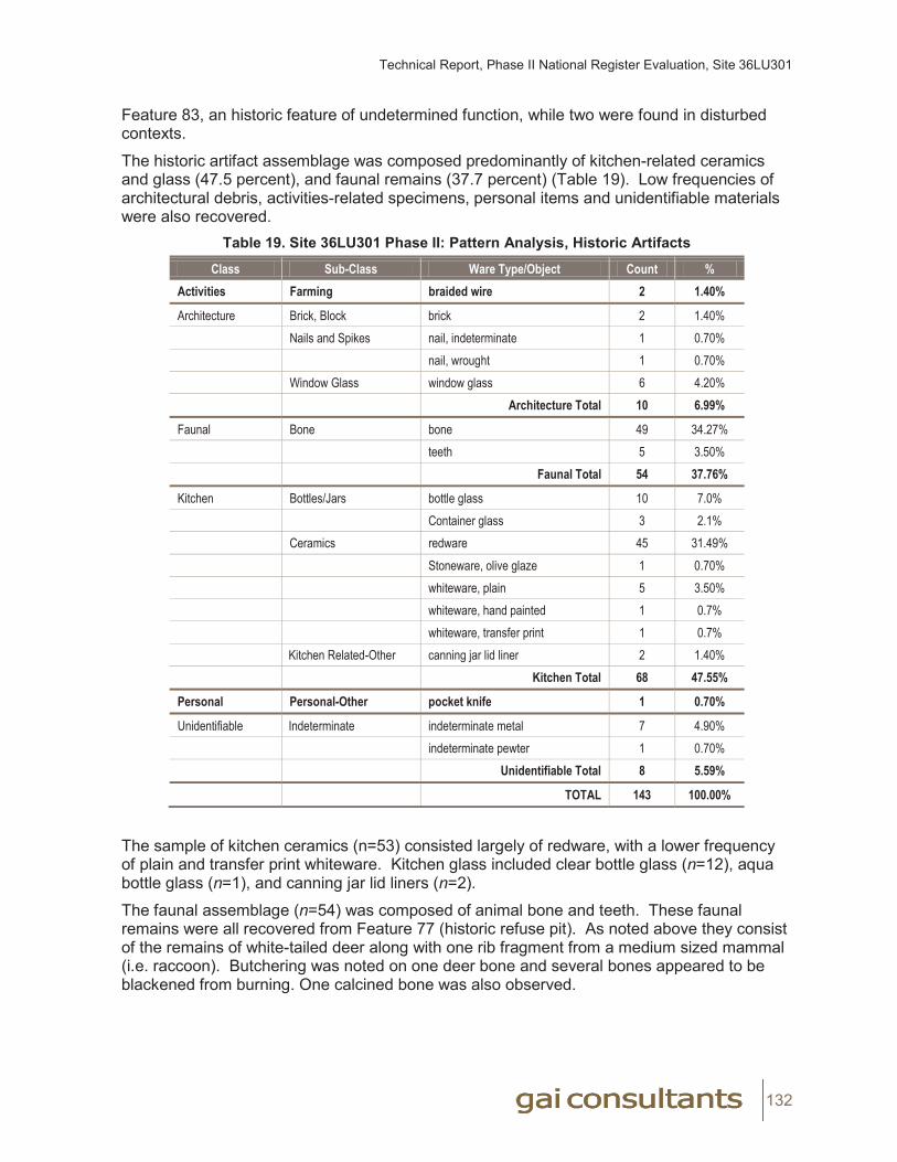
Technical Report, Phase II National Register Evaluation, Site 36LU301
132
Feature 83, an historic feature of undetermined function, while two were found in disturbed contexts.
The historic artifact assemblage was composed predominantly of kitchen-related ceramics and glass (47.5 percent), and faunal remains (37.7 percent) (Table 19). Low frequencies of architectural debris, activities-related specimens, personal items and unidentifiable materials were also recovered.
Table 19. Site 36LU301 Phase II: Pattern Analysis, Historic Artifacts
Class Sub-Class Ware Type/Object Count %Activities Farming braided wire 2 1.40%
Architecture Brick, Block brick 2 1.40%Nails and Spikes nail, indeterminate 1 0.70%
nail, wrought 1 0.70%Window Glass window glass 6 4.20%
Architecture Total 10 6.99%
Faunal Bone bone 49 34.27%teeth 5 3.50%
Faunal Total 54 37.76%
Kitchen Bottles/Jars bottle glass 10 7.0%Container glass 3 2.1%
Ceramics redware 45 31.49%Stoneware, olive glaze 1 0.70%whiteware, plain 5 3.50%whiteware, hand painted 1 0.7%whiteware, transfer print 1 0.7%
Kitchen Related-Other canning jar lid liner 2 1.40%Kitchen Total 68 47.55%
Personal Personal-Other pocket knife 1 0.70%
Unidentifiable Indeterminate indeterminate metal 7 4.90%indeterminate pewter 1 0.70%
Unidentifiable Total 8 5.59%
TOTAL 143 100.00%
The sample of kitchen ceramics (n=53) consisted largely of redware, with a lower frequency of plain and transfer print whiteware. Kitchen glass included clear bottle glass (n=12), aqua bottle glass (n=1), and canning jar lid liners (n=2).
The faunal assemblage (n=54) was composed of animal bone and teeth. These faunal remains were all recovered from Feature 77 (historic refuse pit). As noted above they consist of the remains of white-tailed deer along with one rib fragment from a medium sized mammal (i.e. raccoon). Butchering was noted on one deer bone and several bones appeared to be blackened from burning. One calcined bone was also observed.

Technical Report, Phase II National Register Evaluation, Site 36LU301
133
The low quantity of architectural debris (n=10) included window glass, brick fragments and nails (wrought and indeterminate). Activities-related items consisted of braided wire (n=2), while the single personal item was a bone-handled pocket knife.
The 92 historic artifacts recovered from Feature 77 included redware, a wrought nail, thin tinted window glass, and a relatively large quantity (n=54) of faunal remains (animal bone and teeth). Based on the presence of diagnostic specimens this feature appears to date to the early to mid nineteenth century.
The remaining low-density dispersed scatter of historic artifacts included clearly twentieth century materials and likely reflects field scatter associated with use of this property over approximately the last 175 years.
The Phase II historic artifact assemblage represents two historic era periods of use: one dating to the early-to-mid nineteenth century and one dating to ca 1880 to present. Wrought nails, redware and very thin window glass are associated with the early historic period use of the site. This period is represented by a refuse pit (Feature 77); no other feature was identified in association with this early to mid-nineteenth century use of the property. The later historic-era usage of the site area is likely associated with the adjacent residence (Michaels Farmstead) constructed in ca 1880. Artifacts associated with this component include machine-made bottle glass, canning jar lid liners, and braided wire. No features sampled during Phase II investigations could be attributed to this more recent component.
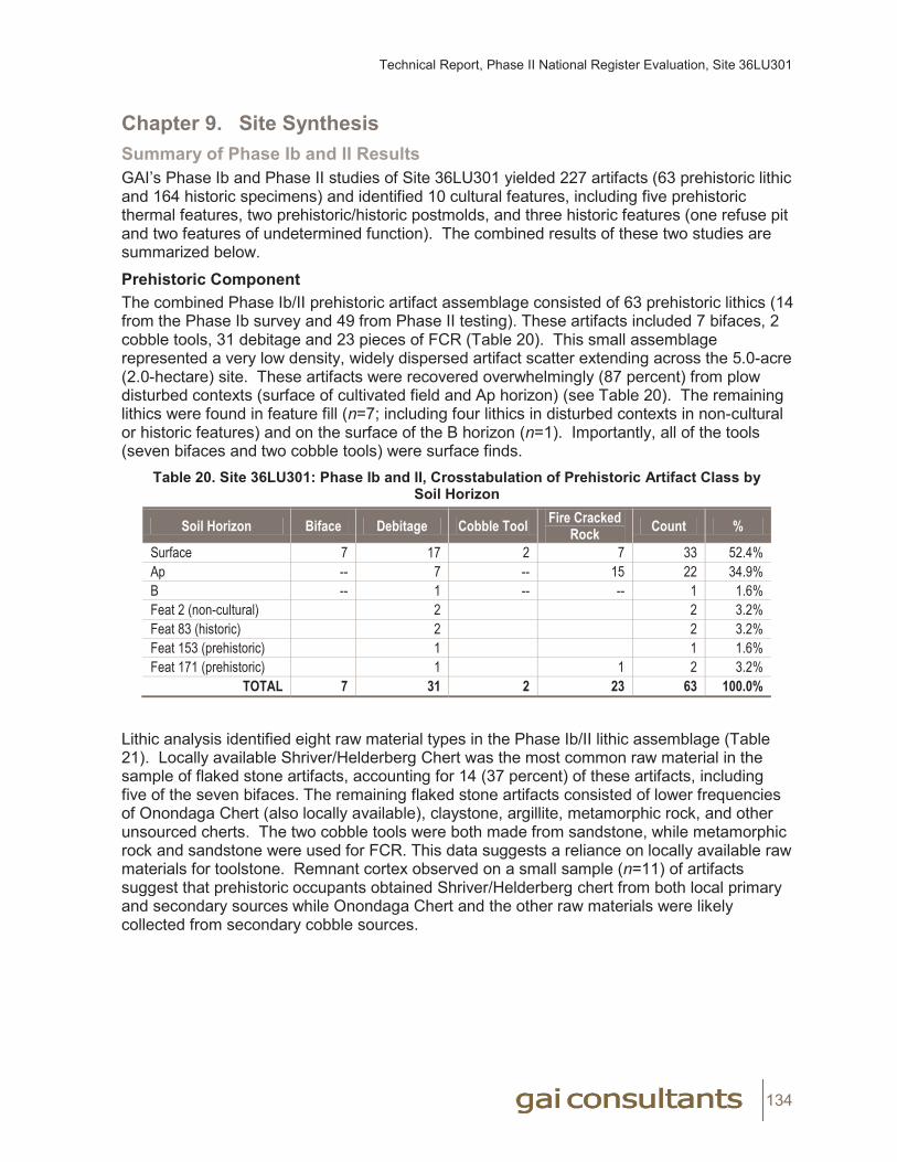
Technical Report, Phase II National Register Evaluation, Site 36LU301
134
Chapter 9. Site Synthesis Summary of Phase Ib and II ResultsGAI’s Phase Ib and Phase II studies of Site 36LU301 yielded 227 artifacts (63 prehistoric lithic and 164 historic specimens) and identified 10 cultural features, including five prehistoric thermal features, two prehistoric/historic postmolds, and three historic features (one refuse pit and two features of undetermined function). The combined results of these two studies are summarized below.
Prehistoric ComponentThe combined Phase Ib/II prehistoric artifact assemblage consisted of 63 prehistoric lithics (14 from the Phase Ib survey and 49 from Phase II testing). These artifacts included 7 bifaces, 2 cobble tools, 31 debitage and 23 pieces of FCR (Table 20). This small assemblage represented a very low density, widely dispersed artifact scatter extending across the 5.0-acre (2.0-hectare) site. These artifacts were recovered overwhelmingly (87 percent) from plow disturbed contexts (surface of cultivated field and Ap horizon) (see Table 20). The remaining lithics were found in feature fill (n=7; including four lithics in disturbed contexts in non-cultural or historic features) and on the surface of the B horizon (n=1). Importantly, all of the tools (seven bifaces and two cobble tools) were surface finds.
Table 20. Site 36LU301: Phase Ib and II, Crosstabulation of Prehistoric Artifact Class by Soil Horizon
Soil Horizon Biface Debitage Cobble Tool Fire Cracked Rock Count %
Surface 7 17 2 7 33 52.4%Ap -- 7 -- 15 22 34.9%B -- 1 -- -- 1 1.6%Feat 2 (non-cultural) 2 2 3.2%Feat 83 (historic) 2 2 3.2%Feat 153 (prehistoric) 1 1 1.6%Feat 171 (prehistoric) 1 1 2 3.2%
TOTAL 7 31 2 23 63 100.0%
Lithic analysis identified eight raw material types in the Phase Ib/II lithic assemblage (Table 21). Locally available Shriver/Helderberg Chert was the most common raw material in the sample of flaked stone artifacts, accounting for 14 (37 percent) of these artifacts, including five of the seven bifaces. The remaining flaked stone artifacts consisted of lower frequencies of Onondaga Chert (also locally available), claystone, argillite, metamorphic rock, and other unsourced cherts. The two cobble tools were both made from sandstone, while metamorphic rock and sandstone were used for FCR. This data suggests a reliance on locally available raw materials for toolstone. Remnant cortex observed on a small sample (n=11) of artifacts suggest that prehistoric occupants obtained Shriver/Helderberg chert from both local primary and secondary sources while Onondaga Chert and the other raw materials were likely collected from secondary cobble sources.
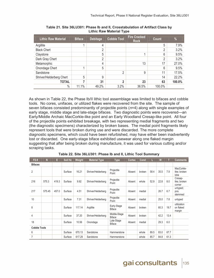
Technical Report, Phase II National Register Evaluation, Site 36LU301
135
Table 21. Site 36LU301: Phase Ib and II, Crosstabulation of Artifact Class by Lithic Raw Material Type
Lithic Raw Material Biface Debitage Cobble Tool Fire Cracked Rock Count %
Argillite 1 4 5 7.9%Black Chert 2 2 3.2%Claystone 5 1 6 9.5%Dark Gray Chert 2 2 3.2%Metamorphic 4 13 17 27.0%Onondaga Chert 1 5 6 9.5%Sandstone 2 9 11 17.5%Shriver/Helderberg Chert 5 9 14 22.2%
TOTAL 7 31 2 23 63 100.0%% 11.1% 49.2% 3.2% 36.5% 100.0%
As shown in Table 22, the Phase Ib/II lithic tool assemblage was limited to bifaces and cobble tools. No cores, unifaces, or utilized flakes were recovered from the site. The sample of seven bifaces consisted predominantly of projectile points (n=4) along with single examples of early stage, middle stage and late-stage bifaces. Two diagnostic points were recovered—an Early/Middle Archaic MacCorkle-like point and an Early Woodland Cresap-like point. All four of the projectile points exhibited breakage, with two representing medial fragments and two (the diagnostic specimens) characterized by broken bases. The medial point fragments likely represent tools that were broken during use and were discarded. The more complete diagnostic specimens, which could have been refurbished, may have either been inadvertently lost or discarded. One early-stage biface exhibited usewear along one flaked margin suggesting that after being broken during manufacture, it was used for various cutting and/or scraping tasks.
Table 22. Site 36LU301: Phase Ib and II, Lithic Tool SummaryFS # N E Soil Hz Weight Material Type Type Cortex Cond L W T Comments
Bifaces
2 Surface 16.21 Shriver/Helderberg Projectile Point Absent broken 58.4 35.5 7.9
MacCorkle-like; broken lobe
216 575.3 419.3 Surface 9.92 Shriver/Helderberg Projectile Point Absent whole 52.9 22.8 8.0
Cresap-like; broken corner
217 575.45 457.0 Surface 4.51 Shriver/Helderberg Projectile Point Absent medial 26.7 6.7
untyped; pos. stemmed
10 Surface 7.31 Shriver/Helderberg Projectile Point Absent medial 25.0 7.8 untyped
8 Surface 117.14 Argillite Early-Stage Biface Absent broken 60.3 19.7
utilization on flaked margin
4 Surface 37.20 Shriver/Helderberg Middle-Stage Biface Absent broken 42.2 13.4
18 Surface 10.56 Onondaga Late-Stage Biface Absent medial 29.3 6.0
Cobble Tools6 Surface 670.13 Sandstone Hammerstone whole 89.5 83.0 67.77 Surface 617.29 Sandstone Hammerstone whole 85.7 84.8 61.3
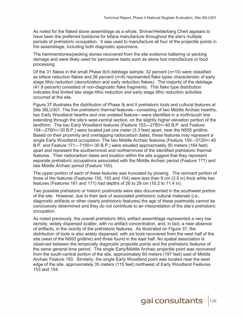
Technical Report, Phase II National Register Evaluation, Site 36LU301
136
As noted for the flaked stone assemblage as a whole, Shriver/Helderberg Chert appears to have been the preferred toolstone for biface manufacture throughout the site’s multiple periods of prehistoric occupation. It was used to manufacture all four of the projectile points in the assemblage, including both diagnostic specimens.
The hammerstones/pecking stones recovered from the site evidence battering or pecking damage and were likely used for percussive tasks such as stone tool manufacture or food processing.
Of the 31 flakes in the small Phase Ib/II debitage sample, 32 percent (n=10) were classified as biface reduction flakes and 26 percent (n=8) represented flake types characteristic of early stage lithic reduction (decortication and early reduction flakes). The majority of the debitage (41.9 percent) consisted of non-diagnostic flake fragments. This flake type distribution indicates that limited late stage lithic reduction and early stage lithic reduction activities occurred at the site.
Figure 37 illustrates the distribution of Phase Ib and II prehistoric tools and cultural features at Site 36LU301. The five prehistoric thermal features—consisting of two Middle Archaic hearths, two Early Woodland hearths and one undated feature—were identified in a north/south line extending through the site’s west-central section, on the slightly higher elevation portion of the landform. The two Early Woodland features (Feature 153—2780+/-40 B.P. and Feature 154—2760+/-30 B.P.) were located just one meter (3.3 feet) apart, near the N555 gridline. Based on their proximity and overlapping radiocarbon dates, these features may represent a single Early Woodland occupation. The two Middle Archaic features (Feature 150—5120+/-40 B.P. and Feature 171—7150+/-30 B.P.) were situated approximately 50 meters (164 feet) apart and represent the southernmost and northernmost of the identified prehistoric thermal features. Their radiocarbon dates and location within the site suggest that they represent separate prehistoric occupations associated with the Middle Archaic period (Feature 171) and late Middle Archaic period (Feature 150).
The upper portion of each of these features was truncated by plowing. The remnant portion of three of the features (Features 150, 153 and 154) were less than 9 cm (3.5 in) thick while two features (Features 161 and 171) had depths of 26 to 29 cm (10.2 to 11.4 in).
Two possible prehistoric or historic postmolds were also documented in the southwest portion of the site. However, due to their lack of associated prehistoric cultural materials (i.e., diagnostic artifacts or other clearly prehistoric features) the age of these postmolds cannot be conclusively determined and they do not contribute to an interpretation of the site’s prehistoric occupation.
As noted previously, the overall prehistoric lithic artifact assemblage represented a very low density, widely dispersed scatter, with no artifact concentration, and, in fact, a near absence of artifacts, in the vicinity of the prehistoric features. As illustrated on Figure 37, the distribution of tools is also widely dispersed, with six tools recovered from the west half of the site (west of the N500 gridline) and three found in the east half. No spatial association is observed between the temporally diagnostic projectile points and the prehistoric features of the same general time period. The single Early/Middle Archaic projectile point was recovered from the south-central portion of the site, approximately 60 meters (197 feet) east of Middle Archaic Feature 150. Similarly, the single Early Woodland point was located near the west edge of the site, approximately 35 meters (115 feet) northwest of Early Woodland Features 153 and 154.
Technical Report, Phase II National Register Evaluation, Site 36LU301
137
Figure 37. Site 36LU301: Distribution of Phase Ib and II Lithic Tools and Cultural Features
11x17
REDACTED Figure 37Site 36LU301: Distribution of Phase
Ib and II Lithic Tools and Cultural Features

Technical Report, Phase II National Register Evaluation, Site 36LU301
138
In all, prehistoric artifact recovery at the site is surprisingly dispersed and low density, given the presence of the identified prehistoric hearth features. The low quantity of lithic debitage and the absence of cores suggest that although limited early and late lithic reduction occurred, these activities were not a primary focus of the site’s prehistoric inhabitants. The absence of subsistence remains in the thermal features indicates that these features may have been used primarily for heat, rather than for cooking. The lack of prehistoric ceramics in association with the Early Woodland hearth features likewise suggests that food processing was not a major activity. The restricted range and quantity of recovered artifact types suggests that the site consists of the remains of multiple small, short term prehistoric occupations during the Middle Archaic, late Middle Archaic, and Early Woodland periods, perhaps representing small camps or procurement stations for the exploitation of upland plant or animal resources.
Historic ComponentPhase Ib and II investigations recovered 164 artifacts from Site 36LU301 (21 artifacts from Phase Ib survey and 143 from Phase II testing). These artifacts consisted largely of kitchen-related ceramics and glass, and faunal remains (animal bone and teeth); minimal architectural debris, activities-related items and personal items were also recovered. In addition, Phase II fieldwork sampled three historic features and identified and mapped five more likely historic features which were not investigated during this study. The three sampled features included one historic refuse pit (Feature 77) and two features of undetermined function (Features 83 and 85). All of these features were truncated by plowing. Historic features were concentrated in the southwest corner of the site. Two thirds (n=92) of the historic artifacts (including all 54 faunal specimens—almost exclusively deer) were recovered from Feature 77. The remaining artifacts occurred in plow-disturbed contexts in a dispersed, low density across the southern portion of the site.
Artifact analysis indicated that Feature 77 likely represents an early-to-mid nineteenth century use of the locality; no other features or artifacts associated with this time period were identified. The remaining low density, dispersed scatter of historic artifacts included clearly twentieth century materials and likely represents field scatter associated with the use of this property and the adjacent ca 1880 farmstead (Michaels Farmstead).
Prehistoric Settlement Pattern Analysis In order to assist in the evaluation of Site 36LU301, a comparison with nearby prehistoric sites was undertaken, using data available through the PHMC-BHP’s on-line Cultural Resources Geographic Information System (CRGIS). This on-line database lists 144 prehistoric sites within the surrounding Central Susquehanna River Watersheds B and D, with 107 having datable components. Using CRGIS, the number of recorded prehistoric sites and areas of professional archaeological survey was examined for a roughly 5-mile (8.0-kilometer) radius around Site 36LU301. This data was grouped into three categories based on basic landform regions—lowlands, uplands, and transitional. The lowlands include the Susquehanna floodplain and the first terrace. The uplands consist of elevated broad areas consisting of flat land and rolling hills. Finally, the transitional area includes the tributary valleys of the Susquehanna and rugged slopes and undulating hills positioned between the lowlands and the uplands.
Within the 5-mile (8.0-kilometer) radius research area, archaeological surveys have taken place in nearly equal portions of lowlands (approximately 532 ha [1,315 ac]) and uplands (566 ha [1,399 ac]), with the transitional areas being subjected to substantially more survey (1,275 ha [3,150 ac]). Within the professionally-surveyed portions of these three landform
Technical Report, Phase II National Register Evaluation, Site 36LU301
139
categories, an overwhelming majority of sites (n=20) are recorded in lowland settings, while only two prehistoric sites are recorded in uplands and one prehistoric site is recorded in the transitional area. Twelve additional prehistoric sites have been recorded in the lowlands by informant interview or avocational survey. Site 36LU301 is one of the two professionally recorded sites within the uplands within this study area. The other site is Site 36LU282, a small, undated prehistoric lithic scatter identified during GAI’s previous Phase Ib survey of the Bell Bend project area (Munford et al., 2010). This site is situated in a cultivated field on an upland flat east of North Market Street, just 152 meters (500 feet) northeast of Site 36LU301. Phase Ib survey recovered only two non-diagnostic lithics (one biface and one debitage) from this locality (Table 23).
Table 23. Previously Recorded Upland Sites in Vicinity of Site 36LU301
Site # Temporal Period Setting # Lithics Ceramics Features Distance from Site 36LU301
36LU178 Late Archaic / Late Woodland Mid to Upper Slope Unrecorded Owasco Series None 12 miles
36LU189 Middle Archaic /Late Woodland Mid to Upper Slope <25 Owasco Series None 12 miles
36LU282 Undated Upland Flat 2 None None 500 feet
Little is known about prehistoric land use in upland settings near the Bell Bend project area. The results of GAI’s previous studies of the Bell Bend project area (Munford et al. 2010, Munford 2010) supply the only information on prehistoric upland land use within the 5-mile (8.0-kilometer) radius of the current study area. Based on GAIs Phase Ib survey results, it appears that pre-European Native American groups minimally used these upland settings, as represented by occasional isolated finds and low-density lithic scatter sites (Site 36LU282 and Site 36LU301). Isolated finds of diagnostic projectile points represent use of these upland settings during the Early Archaic through Late Archaic periods; non-diagnostic prehistoric artifacts were also documented as Isolated Finds. A high number of prehistoric sites are recorded along the floodplain of the Susquehanna, including Site 36LU288, investigated during GAI’s previous Phase II investigations of the Bell Bend project area (Munford et al., 2010). With the exception of one cemetery and two longer-term camps (all three in the lowlands), the recorded prehistoric sites in the vicinity of Site 36LU301 are generally multi-component short-term camps representing locales that were repeatedly reused over hundreds or even thousands of years. However, no distinct settlement pattern is apparent based on chronology.
Due to the scarcity of previously recorded upland sites within a 5-mile (8.0-kilometer radius) of the study area, in order to gain additional information about prehistoric land use in upland settings, GAI expanded the radius of the background research search. CRGIS review identified two sites (36LU178 and 36LU189) in upland locales approximately 19 kilometers (12 miles) southeast of the study area, near Hazleton City (see Table 23). These two sites both occur in mid and upper slope settings. Site 36LU178 consists of a low-density Late Archaic and Late Woodland artifact scatter that yielded two Late Archaic projectile points, one Late Woodland projectile point and Owasco Series ceramics. The total artifact count from the site is unrecorded. Site 36LU189 is recorded as a low-density (less than 25 artifacts) site with Middle Archaic and Late Woodland diagnostic artifacts including a Middle Archaic projectile point and Owasco Series ceramics.
Based on the results of GAI’s Phase Ib and II studies, Site 36LU301 consists of a low-density lithic scatter (n=63 lithic artifacts) as well as five prehistoric thermal features and two possible

Technical Report, Phase II National Register Evaluation, Site 36LU301
140
prehistoric/historic post molds. Diagnostic artifacts recovered from Site 36LU301 consist of one Early/Middle Archaic MacCorkle-like point and one Early Woodland Cresap-like point. In addition four of the five thermal features produced radiocarbon dates—two dating to the Middle Archaic period and two to the Early Woodland period.
None of the other three previously recorded upland sites in the vicinity of Site 36LU301 indicated the presence of cultural features. The flaked stone artifact counts for these three sites ranged from two to 25 artifacts each. These sites produced diagnostic artifacts from multiple periods, including Middle Archaic, Late Archaic, Middle Woodland, and Late Woodland.
Site 36LU301, as a multi-component, low-density artifact scatter, is consistent with the few other previously recorded upland sites in the general project vicinity in terms of its low artifact density and multicomponent nature. It differs from these recorded upland sites in the identification of prehistoric hearth features. However, based on the results of Phase II testing, these features were truncated, lacked evidence of subsistence remains, and yielded scant prehistoric artifacts from the feature fill (two features contained one to two lithics and three features were sterile) or from the surrounding site area. Accordingly, while they represent an unusual find at upland prehistoric sites in the vicinity, these features do not provide significant data regarding the site’s prehistoric occupations or the activities, subsistence practices and life-ways of the prehistoric inhabitants.
Technical Report, Phase II National Register Evaluation, Site 36LU301
141
Chapter 10. Summary and RecommendationsGAI Consultants, Inc. (GAI) conducted Phase II National Register Evaluations of Site 36LU301 at the Bell Bend Nuclear Power Plant (BBNPP), Luzerne County, Pennsylvania on behalf of PPL Bell Bend, LLC (PPL). Phase II fieldwork was performed between June 24 and July 27, 2011, and included a controlled surface collection, shovel testing, test unit excavations, plowzone stripping, and feature sampling.
Based on the results of this work, Site 36LU301 consists of a very low density, multicomponent prehistoric and historic site representing the remains of small, short-term Middle Archaic and Early Woodland prehistoric occupations and early-to-mid nineteenth century through twentieth century historic utilization, on an upland flat north of Walker Run. The site measured 140x210 meters (459x689 feet) and occurred almost exclusively within a cultivated field. Phase II testing yielded a meager prehistoric assemblage of 49 prehistoric lithic artifacts (2 bifaces, 24 debitage and 23 pieces of fire-cracked rock) as well as 143 historic artifacts. The Phase II prehistoric assemblage included a single diagnostic specimen—an Early Woodland Cresap-like projectile point, found on the surface of the cultivated field. The prehistoric lithics were found in a sparse, widely dispersed scatter, primarily in the western half of the field and were recovered overwhelmingly (84 percent) from plow-disturbed contexts. Nearly half of the prehistoric assemblage consisted of fire-cracked rock, with the flaked stone artifacts limited to two bifaces (both projectile points) and debitage.
In addition to these artifacts, Phase II plowzone stripping exposed an unanticipated 211 possible features (soil anomalies) on the B horizon surface within seven trenches; one additional possible feature was encountered in a test unit, for a total of 212 features. In accordance with procedures developed in consultation with PHMC-BHP, GAI investigated a 25 percent sample (n=55) of these features; the remaining features were documented with photographs and maps. Based on the results of Phase II investigations, these 55 sampled features included ten cultural features consisting of five prehistoric thermal features, two prehistoric or historic postmolds, and three historic features (one refuse pit and two features of undetermined function). The remaining 45 sampled features were concluded to represent non-cultural anomalies, primarily reflecting extensive bioturbation (i.e., root and rodent disturbance) within the cultivated field.
The five prehistoric thermal features (Features 150, 153, 154, 161 and 171), all identified in Trench 5 and extending in a north/south band through the site, were found on the B horizon surface at a depth of approximately 30 cm below surface; these features were truncated by plowing. Based on the results of radiocarbon analysis, two features (Features 150 and 171) were dated to the Middle Archaic period and two (Features 153 and 154) were dated to the Early Woodland period. Feature 161 was undated. The five features contained no evidence of subsistence remains. Prehistoric artifacts were also nearly entirely lacking from these features—Feature 153 yielded a single piece of debitage and Feature 171 produced one debitage and one piece of fire-cracked rock, while the remaining three features yielded no prehistoric artifacts. Additionally, no artifact concentrations occurred in the vicinity of these features and the recovered diagnostic artifacts (one Early Woodland point from the Phase II study and one Early/Middle Archaic point from the Phase Ib survey) were not found in association with the features of similar age.
The two prehistoric/historic postmolds yielded no artifacts and were not associated with other prehistoric features or larger postmold patterns. Accordingly, they cannot be attributed to a specific site occupation.
Technical Report, Phase II National Register Evaluation, Site 36LU301
142
Based on the results of this Phase II study, Site 36LU301 is concluded to have poor integrity. This is demonstrated by the recovery of both Early/Middle Archaic and Early Woodland points, as well as the bulk of non-diagnostic prehistoric lithics, from plow-disturbed surface/plowzone contexts. Poor integrity is likewise indicated by the truncation of the prehistoric thermal features, leaving feature remnants that produced no evidence of subsistence remains and yielded scant (n=3) prehistoric artifacts.
Despite the identification of five prehistoric thermal features, based on the paucity of artifacts recovered from the site, the mixed multicomponent nature of these artifacts, and the lack of subsistence remains and near absence of cultural materials associated with the prehistoric features, GAI recommends that the site does not have a potential to contribute important information on the prehistoric occupation of this upland setting.
Based on the above evaluation, GAI recommends that the Site 36LU301 prehistoric component is Not Eligible for listing in the National Register under Criterion D. No further investigations of this site are recommended.
In addition to the prehistoric materials described above, Phase II investigations of Site 36LU301 recovered 143 historic artifacts (largely kitchen-related ceramics and glass and faunal remains) and investigated three historic features (Features 77, 83 and 85). Approximately two thirds of the historic artifacts were found in Feature 77, a shallow historic refuse pit located in the southwest corner of the cultivated field. The remaining historic artifacts were found largely in plow-disturbed contexts within the southern portion of the site. Features 83 and 85 represent the truncated remains of shallow historic features of undetermined function; Feature 83 yielded a single historic artifact and two prehistoric lithic debitage. All three sampled features, as well as five additional unsampled historic features identified on the plowzone-stripped B horizon surface, were located primarily in the site’s southwest quadrant and were truncated by plowing.
Artifact analysis indicated that Feature 77 likely represents an early-to-mid nineteenth century use of this locality; no other features or artifacts associated with this time period were identified. The remaining low density, dispersed scatter of historic artifacts included clearly twentieth century materials and likely represents field scatter associated with the use of this property and the adjacent ca 1880 farmstead (Michaels Farmstead), located southeast of the site. Cartographic research documented no structures in the vicinity of the identified historic features or within the surrounding property prior to the construction of the ca 1880 residence.
Due to the lack of observed deep shaft features or structural remains, the shallow, truncated nature of the identified features, and the dearth of artifacts from two of the three sampled features, the site has a low potential to address questions associated with intrasite patterning, architecture, or other broader research questions related to its early-to-mid nineteenth century through twentieth century utilization.
Accordingly, GAI recommends that the Site 36LU301 historic component is Not Eligible for listing in the National Register under Criterion D. No further investigations of this site are recommended.
Technical Report, Phase II National Register Evaluation, Site 36LU301
143
References Adovasio, J.M. and W.C. Johnson 1981 The Appearance of Cultigens in the Upper Ohio Valley: A View from Meadowcroft
Rockshelter. Pennsylvania Archaeologist 51(1-2):63-80. Adovasio, J.M., D.R. Pedlar, J. Donahue, and R.Stuckenrath. 1999 No Vestige of a Beginning nor Prospect for an End: Two Decades of Debate on
Meadowcroft Rockshelter. In Ice Age People of North America, edited by Robson Bonnichsen and Karen Turnmire, pp. 416–431.Corvallis: Oregon State University Press for the Center for the Study of the First Americans.
Archambault, A. Margaretta 1924 A Guide Book of Art and Architecture, and Historic Interests in Pennsylvania. The
John C. Winston Company, Philadelphia, Pennsylvania. Ballweber, H.L. 1989 A Study of Six Early/Middle Woodland Sites in Westmoreland County, Pennsylvania.
Pennsylvania Archaeologist 59(2):46-99. Barber, Michael B. 2003 A Review of Early Archaic Research in Virginia: A Re-Synthesis a Decade Later.
Quarterly Bulletin 58(3):121-134. Archaeological Society of Virginia. Baugher-Perlin, Sherene 1978 The Prall Site: A Case Study in Historical Archaeology. Unpublished Doctoral
Dissertation, Department of Anthropology. State University of New York at Stony Brook, New York.
Beers, D.G. 1873 Atlas of Luzerne County, Pennsylvania, Salem Township. A. Pomeroy & Co., Inc.
Philadelphia. Berwick Bicentennial Committee 1976 The Old History of Salem Township from Canal Days to Nuclear, 1776-1976. On file
at McBride Memorial Library, Berwick, Pennsylvania. Bradsby, H. C., ed. 1893 History of Luzerne County Pennsylvania. S. B. Nelson & Co., Publishers, Chicago,
Illinois Braun, E.L. 1950 Deciduous Forests of Eastern North America. The Blakiston Company, Philadelphia. Brown, J.A., and R.K. Vierra 1983 What Really Happened in the Middle Archaic. In Archaic Hunters and Gatherers of
the American Midwest, edited by J.A. Phillips and J.A. Brown, pp. 165-196. Academic Press, New York.
Technical Report, Phase II National Register Evaluation, Site 36LU301
144
Broyles, Bettye J. 1971 Second Preliminary Report: The St. Albans Site, Kanawha County, West Virginia,
1964-1968. West Virginia Geological and Economic Survey, Report of Archaeological Investigations, Morgantown.
Bush, R.D. 1981 Soil Survey of Luzerne County, Pennsylvania. USDA-Soil Conservation Service. In
cooperation with the Pennsylvania State University, College of Agriculture, and the Pennsylvania Department of Environmental Resources, State Conservation Commission. National Cooperative Soil Survey, Washington, D.C.
Butterfield 1898 History of Brule’s Discoveries and Explorations. The Helman-Taylor Company,
Cleveland Ohio. Caldwell, J.R 1958 Trend and Tradition in the Prehistory of the Eastern United States. American
Anthropological Association Memoir 88. Callender, C. 1978 Shawnee. In Handbook of North American Indians, Volume 15: Northeast, edited by
B.G. Trigger, pp. 622-635. Smithsonian Institution, Washington, D.C. Carbone, V.A 1974 The Paleo-Environment of the Shenandoah Valley. In the Flint Run Paleo-Indian
Complex: A Preliminary Report 1971-1973 Seasons, edited by W.M. Gardener, The Catholic University of America, Archeological Laboratory, Occasional Publication 1.
Carr, K.W. 1998a Archaeological Site Distribution and Patterns of Lithic Utilization during the Middle
Archaic in Pennsylvania. In The Archaic Period in Pennsylvania: Hunter-Gatherers of the Early and Middle Holocene Period, edited by P. Raber, P. Miller, and S. Neusius, pp. 77-90. Pennsylvania Historical and Museum Commission, Harrisburg.
1998b The Early Archaic Period in Pennsylvania. Pennsylvania Archaeologist 68(2):42-69. Charles, D.K., and J.E. Buikstra 1983 Archaic Mortuary Sites in the Central Mississippi Drainage: Distribution, Structure,
and Behavioral Implications. In Archaic Hunters and Gathers of the American Midwest, edited by J.A. Phillips and J.A. Brown, pp. 117-146. Academic Press, New York.
Cowin, Verna L. 1991 The Middle Archaic in the Upper Ohio Valley. In Journal of Middle Atlantic
Archaeology, Vol. 7, pp.43-53. Custer, J.F. 1983 Woodland Ceramic Sequences of the Upper Delmarva Peninsula and Southeastern
Pennsylvania. Maryland Archeology 19(2):21-30.
Technical Report, Phase II National Register Evaluation, Site 36LU301
145
1988 Late Archaic Cultural Dynamics in the Central Middle Atlantic Region. Journal of
Middle Atlantic Archaeology 4: 39-60. 1996 Prehistoric Cultures of Eastern Pennsylvania. Anthropological Series Number 7.
Commonwealth of Pennsylvania, Pennsylvania Historical and Museum Commission, Harrisburg.
2001 Classification Guide for Arrowheads and Spearpoints of Eastern Pennsylvania and
the Central Middle Atlantic. Pennsylvania Historical and Museum Commission, Harrisburg. Dent, R.J., Jr. 1995 Chesapeake Prehistory: Old Traditions, New Directions. Plenum Press, New York. 2002 Paleoindian Occupation of the Upper Delaware Valley: Revisiting Shawnee Minisink
and Nearby Sites. In Ice Age Peoples of Pennsylvania, edited by Kurt W. Carr and James M. Adovasio, pp. 51–78. Harrisburg, Pennsylvania Historical and Museum Commission.
Duncan, Richard B. and Margaret G. Sams 2002 Archaeological Resource Sensitivity Mapping and Field Reconnaissance
Investigations, Luzerne County, Pennsylvania, Luzerne County Community College Connector S.R. 3046, Section 301. Submitted by Skelly and Loy, Inc. Engineers and Consultations, for Pennsylvania Department of Transportation Engineering District 4-0.
Fogleman, Gary L. 1988 Projectile Point Typology for Pennsylvania and the Northeast. Fogelman Publishing
Company, Turbotville, Pennsylvania. Ford, R.I. 1985 Patterns of Prehistoric Food Production in North America. In Prehistoric Food
Production in North America, edited by R.I. Ford, pp. 341-364. Anthropological Papers, Museum of Anthropology, University of Michigan, No. 75, Ann Arbor.
Gardener, W. 1977 Flint Run Paleo-Indian Complex and its Implications for Eastern North America. In
Amerinds and their Paleo-Environments in Northeast North America, edited by W.S. Newman and B. Salwen. Annals of the New York Academy of Sciences 288:257-263.
1980 The Archaic. Paper presented at 10th Middle Atlantic Archaeological Conference,
Dover, Delaware. George, R.L. 1985 The Archaic Period. In A Comprehensive State Plan for the Conservation of
Archaeological Resources, edited by P. Raber, pp. 181-184. Pennsylvania Historical and Museum Commission, Harrisburg.
Godcharles, Frederic A. 1944 Chronicles of Central Pennsylvania. Lewis Historical Publishing Company, New York.
Technical Report, Phase II National Register Evaluation, Site 36LU301
146
Graybill, J.R. 1995 Cultural Background. In Final Report, Archaeological Investigations at the Memorial
Park Site (36Cn164), Clinton County, Pennsylvania, pp. 33-56. Final Report Submitted to the U.S. Army Corps of Engineers, Baltimore. GAI Consultants, Inc., Monroeville, PA.
Guilday, J.E., P.S. Martin, and A.D. McCrady 1964 New Paris No. 4: A Pleistocene Cave Deposit in Bedford County, Pennsylvania.
Bulletin of the National Speleological Society 26:121-194. Guilday, J.E., P.W. Parmalee, and H.W. Hamilton 1977 The Clark’s Cave Bone Deposit and the Late Pleistocene Paleoecology of the Central
Appalachian Mountains of Virginia. Bulletin #2 of the Carnegie Museum of Natural History, Pittsburgh.
Hart, J.P. 1995a Pottery Analysis. In Final Report, Archaeological Investigations at the Memorial
Park Site (36Cn164), Clinton County, Pennsylvania, pp. 203-248. Final Report Submitted to the U.S. Army Corps of Engineers, Baltimore. GAI Consultants, Inc., Monroeville, PA.
1995b Summary and Conclusions. In Final Report, Archaeological Investigations at the
Memorial Park Site (36Cn164), Clinton County, Pennsylvania, pp. 507-548. Final Report Submitted to the U.S. Army Corps.
Inners, J.D. 1978 Geology and Mineral Resources of the Berwick Quadrangle, Luzerne and Columbia
Counties, Pennsylvania. Pennsylvania Geological Survey, 4th ser., Atlas 174. Jennings, F.J. 1978 Susquehannock. In Handbook of North American Indians, Vol. 15, Northeast, edited
by B.G. Trigger, pp. 362-367. Smithsonian Institution Press, Washington, D.C. Norton, New York.
Joyce, A. A. 1988 Early/Middle Holocene Environments in the Middle Atlantic Region: A Revised
Reconstruction. In Holocene Human Ecology in Northeastern North America, edited by George P. Nicholas, pp. 185-214. Plenum Press, New York.
Justice, Noel D. 1987 Stone Age Spear and Arrow Points of the Midcontinental and Eastern United States.
Indiana University Press, Bloomington and Indianopolis. Kaktins, U and H.L. Delano 1999 Drainage Basins, In The Geology of Pennsylvania, C.H. Shultz (ed), pp. 378-390.
Harrisburg, Pennsylvania Geological Survey and Pittsburgh, Pittsburgh Geological Society.
Technical Report, Phase II National Register Evaluation, Site 36LU301
147
Kent, B.C., I.F. Smith, and C. McCann (eds.) 1971 Foundations of Pennsylvania Prehistory. Pennsylvania Historical and Museum
Commission Anthropology Series No. 1. Harrisburg, Pennsylvania. Kinsey, W.F., III 1972 Archaeology in the Upper Delaware Valley. Pennsylvania Historical and Museum
Commission, Harrisburg. Kuhn, R.D. 1985 A Morphological Analysis of Bifurcated-Base projectile Points in the Northeastern
United States. Man in the Northeast 29:55-69. Lantz, S.W. 1984 Distribution of Paleo-Indian Projectile Points and Tools from Western Pennsylvania:
Implications for Regional Differences. Archaeology of Eastern North America 12: 210-230. Luedtke, B. E. 1992 An Archaeologist's Guide to Chert And Flint. Institute of Archaeology, University of
California, Los Angeles, California. Luzerne County 2006 History of Luzerne County. Atlantic Communications Group, available online at
http://www.luzernecounty.org/living/history_of_luzerne_county. MacDonald, D.H. 2006 Pennsylvania Archaeological Data Synthesis, Subbasin 9: The Central West Branch
Susquehanna River, Watersheds A (Pine Creek), B (Kettle Creek) & C (Bald Eagle Creek), with a focus on Great Island, Clinton County, Pennsylvania. GAI Consultants, Inc. Pittsburgh, PA.
Meltzer, D.J. 1988 Late Pleistocene Human Adaptation in Eastern North America. Journal of World
Prehistory 2: 1-52. Munford, Barbara A. 2010 Addendum Report, Second Supplemental Phase Ib Cultural Resources Investigation,
Power Block Relocation, Bell Bend Nuclear Power Plant, Luzerne County, Pennsylvania,ER 81-0658-079. Prepared by GAI Consultants, Inc., Homestead, Pennsylvania, for AREVA NP Inc. and UniStar Nuclear Energy, LLC.
2011 Management Summary, Phase II National Register Evaluation Site 36LU301, Bell
Bend Nuclear Power Plant, Luzerne County, Pennsylvania, ER 81-0658-079. Prepared by GAI Consultants, Inc., Homestead, Pennsylvania, for PPL Bell Bend, LLC.
Munford, Barbara A, and Jared N. Tuk 2008 Technical Report, Phase IA Cultural Resources Reconnaissance, Berwick, PA NPP-
1, Areas 6, 7, 8 and Confers Lane Parcel, Luzerne County, Pennsylvania. Prepared by GAI Consultants, Inc., Homestead, Pennsylvania, for AREVA NP Inc. and UniStar Nuclear Development, LLC.
Technical Report, Phase II National Register Evaluation, Site 36LU301
148
Munford, Barbara A., Lori A. Frye, and Michael P. Kenneally 2010 Technical Report, Phase I Cultural Resources Investigations and Phase II National
Register Site Evaluations, Bell Bend Nuclear Power Plant, Luzerne County, Pennsylvania,ER 81-0658-079. Prepared by GAI Consultants, Inc., Homestead, Pennsylvania, for UniStar Nuclear Energy, LLC.
National Park Service 1997 National Register Bulletin 15 – How to Apply the National Register Criteria for
Evaluation. US Department of the Interior, Washington, DC. Nescopeck Centennial Committee 1996 The History of Nescopeck. The Great American Printer, Ohio. Neusius, Sarah W. and G. Timothy Gross 2007 Seeking Our Past: An Introduction to North American Archaeology. Oxford University
Press, Oxford and New York. Pennsylvania Historical and Museum Commission-Bureau for Historic Preservation (PHMC-
BHP) 2005a Curation Guidelines: Preparing Archaeological Collections for Submission to the
State Museum. 2005b Historic Agricultural Resources of Pennsylvania, c. 1700-1960: North and West
Branch Susquehanna River Valleys. Electronic document. http://www.portal.state.pa.us/portal/server.pt/gateway/PTARGS_0_2_20378_2584_306006_43/http%3B/pubcontent.state.pa.us/publishedcontent/publish/cop_environment/phmc/communities/extranet/preservationprograms/aghistproj/paagregionsucontent/iv__north_and_west_branch_susquehanna_river_valleys.pdf, accessed October 15, 2009.
2010 Cultural Resources Geographic Information System (CRGIS). Pennsylvania Historical
and Museum Commission, Harrisburg. Electronic document, https://www.dot7.state.pa.us/ce/login.asp, accessed February 8, 2010.
2011 Cultural Resources Geographic Information System (CRGIS). Pennsylvania Historical
and Museum Commission, Harrisburg. Electronic document, https://www.dot7.state.pa.us/ce/login.asp, accessed December 7, 2011.
Raber, Paul A., editor 1985 Archaeological Testing and Mitigation of the Proposed Comfort Station, Stewart
Warehouse and Altman Mill, America's Industrial Heritage Project, Saltsburg Canal Park--Phase I Development, Saltsburg Borough, Indiana County, Pennsylvania. Prepared for the National park Service by GAI Consultants, Inc.
Reid, K.C. 1984 Fire and Ice: New Evidence for the Production and Preservation of Late Archaic
Pottery in the Middle-Latitude Lowlands. American Antiquity 49: 55-76.

Technical Report, Phase II National Register Evaluation, Site 36LU301
149
Ritchie, W.A. 1961 A Typology and Nomenclature for New York Projectile Points. New York State
Museum and Science Service, Bulletin No. 384, Albany. 1965 The Archaeology of New York State. The Natural History Press, Garden City. 1980 The Archaeology of New York State (revised edition). Harbor Hill Books, Harrison,
New York. Sevon, W. D. 2000 Physiographic Provinces of Pennsylvania. Fourth Edition. Compiled for the
Commonwealth of Pennsylvania, Department of Conservation and Natural Resources, Bureau of Topographic and Geologic Survey.
Sevon, W.D. and D.D. Braun 2000 Glacial Deposits of Pennsylvania. Map 59. Commonwealth of Pennsylvania,
Department of Conservation and Natural Resources, Bureau of Topographic and Geologic Survey.
Shank, William H. 1991 The Amazing Pennsylvania Canals. American Canal and Transportation Center,
York, Pennsylvania. Shelford, V.E. 1963 The Ecology of North America. University of Illinois Press, Urbana. Skibo, J.M., M.B. Schiffer, and K.C. Reid 1989 Organic-Tempered Pottery: An Experimental Study. American Antiquity 54(1): 122-
146. Smith, B.D. 1987 The Independent Domestication of Indigenous Seed-Bearing Plants in Eastern North
America. In Emergent Horticultural Economies of the Eastern Woodlands, edited by W.F. Keegan, pp. 3-48. Center for Archaeological Investigations, Southern Illinois University at Carbondale, Occasional Paper No. 7.
South, Stanley 1977 Method and Theory in Historical Archaeology. Academic Press, New York. Stewart, M. 1980 Environment, Settlement Pattern, and the Prehistoric Use of Rhyolite in the Great
Valley of Maryland and Pennsylvania. Paper presented at the 10th Middle Atlantic Archeology Conference, Dover, Delaware.
1984 Archaeologically Significant Characteristics of Maryland and Pennsylvania Rhyolites.
In Prehistoric Lithic Exchange Systems in the Middle Atlantic Region, edited by Jay F. Custer. Center for Archaeological Studies, University of Delaware, Newark.
Technical Report, Phase II National Register Evaluation, Site 36LU301
150
1987 Rhyolite Quarry and Quarry-Related Sites in Maryland and Pennsylvania. Archaeology of Eastern North America 15: 47-58.
Stewart, M. and J. Katzer 1989 Prehistoric Site Locations on the Unglaciated Appalachian Plateau. Pennsylvania
Archaeologist 59(1):19-36. Stingelin, R.W. 1965 Late-Glacial and Post-Glacial Vegetational History in the North Central Appalachian
Region. Unpublished Doctoral Dissertation, Department of Geology and Geophysics. Pennsylvania State University, State College.
Tankersley, Kenneth B. 1996 Ice Age Hunters and Gatherers. In Kentucky Archaeology, ed. R. Barry Lewis, pp 21-
38. The University of Kentucky Press, Lexington, Kentucky. Trewartha, G.T. 1967 An Introduction to Climate. McGraw-Hill, New York. United States Department of Agriculture, Soil Conservation Service (USDA, SCS) 1981 Soil Survey of Luzerne County, Pennsylvania. In Cooperation with the Pennsylvania
State University, College of Agriculture, and the Pennsylvania Department of Environmental Resources, State Conservation Commission. National Cooperative Soil Survey, Washington, D.C.
United States Department of Agriculture, Soil Conservation Service (USDA, SCS) 1986 Soil Survey of Lycoming County, Pennsylvania. In Cooperation with the Pennsylvania
State University, College of Agriculture, and the Pennsylvania Department of Environmental Resources, State Conservation Commission. National Cooperative Soil Survey, Washington, D.C.
Watts, W.A. 1979 Late Quaternary Vegetation of Central Appalachia and the New Jersey Coastal Plain.
Ecological Monographs 49(4):427-469.

Appendix A
Project Correspondence
Rocco R. Sgarro PPL Bell Bend, LLC 38 Bomboy Lane, Suite 2 Berwick, PA 18603
Dear Mr. Sgarro:
Commonwealth of Pennsylvania Pennsylvania Historical and Museum Commission
Bureau for Historic Preservation Commonwealth Keystone Building, 2nd Floor
400 North Street Harrisburg, PA 17120-0093
www.phmc.state.pa. us
Re: ER# 81-0658-079-CC
20 May 2011
Addendum Report, Second Supplemental Phase Ib Cultural Resource Investigation, Power Block Relocation, Bell Bend Nuclear Power Plant, Salem Township, Luzerne County, Pennsylvania
The Bureau for Historic Preservation (the State Historic Preservation Office) has reviewed the above named project in accordance with Section 106 of the National Historic Preservation Act of 1966, as amended in 1980 and 1992, and the regulations (36 CFR Part 800) of the Advisory Council on Historic Preservation as revised in 1999 and 2004. These regulations require consideration of the project's potential effect upon both historic and archaeological resources.
This report meets our standards and specifications as outlined in Guidelines for Archaeological Investigations in Pennsylvania (BHP 2008) and the Secretary of the Interior's Guidelines for Archaeological Documentation. This report documents two previously unrecorded archaeological sites with the project area. These sites include GAl Site 12 (36Lu301) and GAl Site 13 (36Lu302).
We agree that 36Lu301 is potentially eligible for inclusion on the National Register of Historic Places. If this site cannot be avoided by project activities, then a Phase II investigation is necessary to formally determine site eligibility.
We agree that 36Lu302 is not eligible for inclusion on the National Register. In our opinion, no further archaeological work is necessary at this site.
Please send four additional copies of the final report (three bound and one unbound) for our files and distribution to the repositories.
Page 2 20 May 2011 ER# 81-065 8-079-CC
If you need further information in this matter please consult Steven McDougal at (717) 772-0923.
Sincerely,
~ Douglas C. McLearen, Chief -?r Division of Archaeology & Protection
cc: B. Munford, GAl Consultants, 385 E. Waterfront Dr., Homestead, PA S. Imboden, NRC, Mailstop T-6D38M J. Davis, NRC, Mailstop 0-11F1
DCM/srm

From: McDougal, Steven [mailto:[email protected]] Sent: Thursday, May 26, 2011 9:33 AM To: Barbara Munford Cc: Benjamin Resnick Subject: RE: Bell Bend Site 36LU301 ER# 81-0658-079 B arb, T he scope of work for 3 6 L u3 0 1 is consistent with the B H P Guidelines for Archaeological Investigations in Pennsylvania (2 0 0 8 ). L et me know if you would like a site meeting towards the end of field work and I ’ ll work it into my schedule. W e look forward to rev iewing the report for this proj ect when it is complete. S tev e S tev en M cD ougal P ennsylv ania H istorical and M useum C ommission B ureau for H istoric P reserv ation (7 1 7 ) 7 7 2 - 0 9 2 3
-----Original Message----- From: Barbara Munford [mailto:[email protected]] Sent: Wednesday, May 25, 2011 1:09 PM To: McDougal, Steven Cc: Benjamin Resnick Subject: Bell Bend Site 36LU301 ER# 81-0658-079 Steve- As discussed this morning, attached for your review is GAI’s scope of work for Phase II investigations of Site 36LU301 located in the Bell Bend project area, Luzerne County (ER# 81-0658-079). We currently anticipate beginning fieldwork at this site in June. Please let me know if you have any questions or comments regarding the proposed scope. Have a good Memorial Day weekend! Barb Barbara A. Munford, M.A. Senior Project Archaeologist
GAI Consultants, Inc. 385 East Waterfront Drive Homestead, PA 15120-5005 412.476.2000 ext. 1203 | F 412.476.2020 | gaiconsultants.com

CONFIDENTIALITY NOTICE: This communication contains confidential information belonging to the sender and may be legally privileged. This communication is solely for the use of its intended recipient. If you are not the intended recipient, inform the sender of the error and remove this email from your system. If this transmission includes any technical information, design data, and/or recommendations, they are provided only as a matter of convenience and may not be used for final design and/or construction.

Appendix B
Phase II Workplan
M ay 1 3 , 2 0 1 1
M r. B radley W ise E nv ironmental P ermitting S uperv isor P P L B ell B end 2 N orth 9 th S treet G enpl- 4 A llentown, P A 1 8 1 8 1 R e: S cope of W ork
P hase I I N ational R egister E v aluation of A rchaeological S ite 3 6 L U 3 0 1 B ell B end N uclear P ower P lant L uz erne C ounty, P ennsylv ania E R 8 1 - 0 6 5 8 - 0 7 9
D ear M r. W ise: G A I C onsultants, I nc. (G A I ) is pleased to submit this scope of work to P P L N uclear D ev elopment, L L C (P P L ) to conduct a P hase I I N ational R egister E v aluation of archaeological S ite 3 6 L U 3 0 1 at the B ell B end N uclear P ower P lant (B B N P P ), L uz erne C ounty, P ennsylv ania. S ite 3 6 L U 3 0 1 lies within the A rea of P otential E ffect (A P E ) of the proposed B B N P P proj ect area located adj acent to the ex isting P P L C orporation’ s S usq uehanna S team E lectric S tation (S S E S ), west of the N orth B ranch S usq uehanna R iv er and northeast of the town of B erwick. G A I identified this site during a S econd S upplemental P hase I b surv ey of the proposed proj ect area in 2 0 1 0 (M unford 2 0 1 0 ). T he goal of G A I ’ s P hase I I archaeological study is to ev aluate the eligibility of S ite 3 6 L U 3 0 1 for listing in the N ational R egister of H istoric P laces (N R H P ).
G A I ’ s P hase I I inv estigation will include background research, preparation and implementation of an E rosion and S edimentation C ontrol P lan, archaeological fieldwork, laboratory analysis, management summary and technical report preparation, and curation activ ities. T his work will be conducted in accordance with S ection 1 0 6 of the N ational H istoric P reserv ation A ct of 1 9 6 6 , as amended, guidelines dev eloped by the A dv isory C ouncil on H istoric P reserv ation, the amended Procedures for the Protection of Historic and Cultural Properties as set forth in 3 6 C F R 8 0 0 , the S ecretary of I nterior’ s Standards and Guidelines for Archaeology and Historic Preservation and the Guidelines for Archeological Investigations in Pennsylvania [ P ennsylv ania H istorical and M useum C ommission/ B ureau for H istoric P reserv ation (P H M C / B H P ) 2 0 0 8 ] . T hese proposed proj ect tasks are described below.
Workplan Task 1: Project Management/Section 106 Coordination/Meetings A t v arious points in the proposed proj ect, G A I will assist P P L in consulting and coordinating with the P H M C / B H P . T his is ex pected to include phone calls and preparation of memos inv olv ing discussions of proj ect methods and results, drafting letters, and attendance at up to one (1 ) meeting either on- site or in H arrisburg, P ennsylv ania. T his task also includes preparation of a site- specific H ealth and S afety P lan (H A S P ). Task 2: Background Research G A I will conduct background research to enhance the ex isting prehistoric contex t dev eloped for the B B N P P proj ect area in order to support the N R H P ev aluation of S ite 3 6 L U 3 0 1 . T his work will include a rev iew of cultural resource inv estigations and prev iously recorded archaeological sites in similar upland
S cope of W ork: B B N P P P hase I I N ational R egister E v aluation S ite 3 6 L U 3 0 1 M r. B radley W ise M ay 1 3 , 2 0 1 1
2
settings within the proj ect v icinity. D ata will be gathered from on- line sources (e. g. , P H M C / B H P ’ s on-line C ultural R esources G eographic I nformation S ystem (C R G I S ) database) as well as from local repositories.
Task 3: Erosion and Sedimentation Control Plan B ased on prev ious P hase I I inv estigations within the B B N P P proj ect area, it is anticipated that the L uz erne C ounty C onserv ation D istrict will req uire an E rosion and S edimentation C ontrol (E S C ) P lan to address the effects of plowz one stripping activ ities proposed as part of the P hase I I archaeological fieldwork at S ite 3 6 L U 3 0 1 . G A I will prepare this E S C P lan in consultation with the L uz erne C ounty C onserv ation D istrict and the S alem T ownship Z oning O ffice. I t is assumed that the E S C P lan will be an on- site plan only and that no conserv ation district submittal and rev iew will be necessary. T he E S C P lan will be submitted to P P L and a copy will be kept on- site during the course of P hase I I fieldwork.
A s req uired by prev ious E S C P lans for P hase I I inv estigations in the B B N P P proj ect area, it is ex pected that this plan will req uire the installation of silt fencing at S ite 3 6 L U 3 0 1 . T his task assumes the installation and remov al of up to 3 6 0 meters (approx imately 1 , 2 0 0 feet) of silt fencing. S ilt fencing will be installed prior to the start of plowz one stripping activ ities and will be remov ed at the completion of fieldwork. T his activ ity will be conducted by G A I archaeological field personnel.
Task 4: Archaeological Fieldwork S ite 3 6 L U 3 0 1 lies almost entirely within a prev iously cultiv ated field northeast of a bend in N orth M arket S treet and north of W alker R un; a small portion of the site’ s southern edge ex tends into a farmyard. P hase I I field inv estigations will include surface collection, shov el testing, test unit ex cav ation, plowz one stripping, and feature ex cav ation.
P rior to the start of P hase I I fieldwork P P L will conduct plowing and disking of the site area within the cultiv ated field to produce adeq uate v isibility for subseq uent surface collection.
F ollowing site preparation by plowing and disking, G A I surv eyors will establish a grid ov er the site using a total station. T he grid will be tied into a permanent datum. P hase I I ex cav ations will be designated by coordinates within this grid. W here possible, P hase I b shov el tests will be relocated and plotted according to the P hase I I grid system.
P hase I I fieldwork will begin with a controlled surface collection of the recently plowed and disked site area to refine site boundaries and delineate within- site artifact concentrations. T his task is performed in accordance with state guidelines (P H M C / B H P 2 0 0 8 ) that req uire at least two surface collections of potentially eligible sites (including the P hase I surface collection). T he site will be gridded into 5 - meter (1 6 - foot) collection blocks and artifacts observ ed on the surface will be collected and prov enienced by block. D iagnostic artifacts will be point prov enienced, as appropriate. B ased on the results of surface collection, j udgmental S T P s will be ex cav ated to sample artifact concentrations or locations of possible cultural features within the site area.
D ue to low ground surface v isibility within the portion of the site situated in the farmyard, close- interv al shov el testing of this locality will be req uired. G A I will ex cav ate close- interv al shov el test pits at 5 -meter (1 6 - foot) interv als within transects spaced 5 - meters (1 6 - feet) apart. S T P s will measure approx imately 5 0 x 5 0 cm (1 . 6 x 1 . 6 - feet) in diameter and will be hand- ex cav ated by natural strata into the subsoil.
B ased on the results of surface collection and shov el testing, G A I will ex cav ate test units in areas of higher artifact density, unusual stratigraphy or potential cultural features within the site. T est unit ex cav ations will serv e to define site stratigraphy, sample artifact concentrations and/ or activ ity areas, determine the potential for subsurface features, and assess the integrity of archaeological remains. T est units will measure 1 x 1 - meters (3 x 3 - feet). T hey will be hand- ex cav ated in 1 0 - cm (0 . 3 - foot) lev els according to natural stratigraphy and will ex tend into subsoil. A t the completion of each test unit, measured profiles will be drawn and photographs taken of at least one wall of each unit.
S cope of W ork: B B N P P P hase I I N ational R egister E v aluation S ite 3 6 L U 3 0 1 M r. B radley W ise M ay 1 3 , 2 0 1 1
3
D ue to the site’ s upland setting, cultural resources will be near- surface in nature and ex cav ations are anticipated to ex tend to a max imum depth of 5 0 cm (1 . 6 feet).
F or both S T P s and test units, ex cav ated soils will be screened through 6 - mm (0 . 2 5 - inch) hardware cloth for systematic artifact recov ery. R ecov ered artifacts will be bagged and labeled with appropriate prov enience information. G A I archaeologists will record results of indiv idual S T P s and test units on standardiz ed field forms, including depths of soil horiz ons, soil tex ture and M unsell color, and artifact recov ery. T esting locations will be plotted on proj ect maps and documented with photographs.
F ollowing test unit ex cav ations, mechanical remov al of plowz one strips will be conducted in portions of the site to ex pose cultural features at the plowz one/ subsoil interface. A backhoe with a flat blade will be used to remov e the plowz one in approx imately 2 - meter (6 . 5 - foot)- wide strips to the top of the B horiz on. T his activ ity will be monitored by G A I personnel. P lowz one strips will be plotted on proj ect maps and documented with photographs. H and shov el- scraping of these strips will be conducted to define and delineate features.
P otential cultural features identified during testing will be troweled clean, cross- sectioned, and documented in plan v iew and profile with measured drawings and photographs. A s appropriate, a portion of the feature fill will be collected as a flotation sample and the remaining feature fill will be screened through 6 - mm (0 . 2 5 - inch) hardware cloth. A rtifacts and samples collected from the feature fill will be bagged and labeled with appropriate prov enience information. T he feature will be recorded on a standardiz ed G A I F eature F orm and plotted on proj ect maps. F eatures are assumed to hav e a max imum dimension of 6 0 cm (2 feet) and a max imum depth of 5 0 cm (2 . 5 feet).
E x cav ations (e. g. S T P s, T U s, plowz one strips) will be backfilled upon completion, either by hand or mechanically. G A I will coordinate plans for plowing/ disking activ ities with P P L .
F or purposes of this proposal G A I estimates the following field effort at S ite 3 6 L U 3 0 1 :
controlled surface collection of approx imately 4 . 0 acres; ex cav ation of up to 7 0 S T P s (5 0 j udgmental S T P s and 2 0 close- interv al S T P S ); ex cav ation of ten (1 0 ) test units [ 1 x 1 - meter (3 x 3 - foot)] ; identification and sampling of up to fiv e (5 ) features, plowz one stripping/ hand shov el scraping of approx imately 1 , 6 0 0 m2 , installation and remov al of silt fencing (approx imately 3 6 0 linear meters/ 1 2 0 0 linear feet); mapping; backfilling.
Task 5: Laboratory Analysis S ubseq uent to P hase I I fieldwork, G A I will conduct laboratory analysis of recov ered artifacts to characteriz e age, type, and function of recov ered archaeological remains. A rtifacts recov ered during P hase I I testing will be transported to G A I ’ s archaeological laboratory in H omestead, P ennsylv ania, and will be processed according to the Revised Curation Guidelines (P H M C / B H P 2 0 0 6 ). T hese materials will be washed, sorted, and labeled with the site number. P rehistoric artifacts will be div ided into general classes (i. e. , debitage, bifaces, unifaces, cores) and then subdiv ided into specific artifact types (i. e. , early- stage biface, late- stage biface, proj ectile point). L ithic raw material type will be recorded for artifacts and appropriate attributes will be documented. H istoric artifacts will be separated into v arious material groups, including ceramics, glass, metal, faunal, etc. T hese artifacts will be cataloged according to established typologies using the class- type- v ariety method. I f possible, historic prov eniences will be assigned date ranges, based on the presence of diagnostic artifacts (e. g. , bottle technological attributes, ceramic types). S oil flotation samples collected from feature fill will be processed to recov er small specimens such as seeds, nuts or small bones. S elect samples will be analyz ed to identify archaeobotanical materials. T he final artifact repository for these materials will be determined in consultation with P P L and the P H M C / B H P .

S cope of W ork: B B N P P P hase I I N ational R egister E v aluation S ite 3 6 L U 3 0 1 M r. B radley W ise M ay 1 3 , 2 0 1 1
4
F or the purpose of this proposal, G A I assumes the recov ery of a total of up to 8 0 0 artifacts and the processing of up to 5 flotation samples.
Task 6: Phase II Report Preparation A s preparation of the P hase I I T echnical R eport is anticipated to be deferred until 2 0 1 2 , G A I will produce a brief M anagement S ummary in order to prov ide P P L with timely P hase I I ev aluations and recommendations. T his document will be prepared following the completion of fieldwork and laboratory analysis. I t will summariz e preliminary P hase I I results and will present an ev aluation of the N R H P eligibility of S ite 3 6 L U 3 0 1 and the need, if any, for further work.
G A I will prepare a P hase I I T echnical R eport on the N ational R egister E v aluation of S ite 3 6 L U 3 0 1 . T he report will include methods and results of background research, prehistoric contex t, archaeological fieldwork, and laboratory analysis. I t will prov ide recommendations regarding the N R H P eligibility of this site and, if necessary, the need for additional archaeological inv estigations (i. e. , P hase I I I D ata R ecov ery I nv estigations). R eport appendices will include an updated P ennsylv ania A rchaeological S ite F orm and catalogs of recov ered artifacts.
T he P hase I I field inv estigation, artifact analysis, and P hase I I report preparation will be conducted in accordance with N ational R egister criteria and guidelines contained in National Register Bulletin 15—How to Apply the National Register Criteria for Evaluation (N ational P ark S erv ice 1 9 9 8 ) and National Register Bulletin 21—Defining Boundaries for National Register Properties (N ational P ark S erv ice 1 9 9 2 ).
G A I assumes the completion of the following proj ect deliv erables:
F iv e (5 ) hardcopies and electronic copy of M anagement S ummary for client rev iew;
F iv e (5 ) hardcopies and electronic copy of D raft R eport for client rev iew;
F iv e (5 ) hardcopies of F inal R eport, as well as disc with P D F and M S W ord files, within two (2 ) weeks of receipt of comments on D raft R eport;
Task 7: Curation T his task assumes that a D eed of G ift form will be signed by P P L , allowing material remains and field records generated by this P hase I I inv estigation to be to be donated to the S tate M useum of P ennsylv ania for curation. A rtifacts, samples, and proj ect documentation (including original field forms, laboratory forms, photographs, and artifact catalogs) will be processed and box ed for storage in accordance with the Revised Curation Guidelines (P H M C / B H P 2 0 0 6 ).
Cost Proposal and Schedule G A I can conduct P hase I I N ational R egister E v aluations of S ite 3 6 L U 3 0 1 as delineated abov e, for a not- to- ex ceed cost of $ X X X X X X . B ased on the assumptions stated in the workplan, it is anticipated that fieldwork will ex tend for a period of approx imately four (4 ) calendar weeks. L aboratory work will take approx imately two (2 ) calendar weeks. G A I will submit a M anagement S ummary within four (4 ) weeks following the completion of fieldwork. P hase I I T echnical R eport preparation will take approx imately six (6 ) calendar weeks. B ased on information prov ided by P P L G A I anticipates submittal of a P reliminary D raft P hase I I T echnical R eport in the first q uarter of 2 0 1 2 .
C osts are based on the workplan described abov e as well as the following assumptions:
O ne mobiliz ation/ demobiliz ation for all fieldwork; F ield crew consisting of S enior A rchaeologist (field director), 1 S enior T echnician (crew chief), and
5 technicians; 8 - hour work day; 1 0 - day work sessions, as appropriate;

S cope of W ork: B B N P P P hase I I N ational R egister E v aluation S ite 3 6 L U 3 0 1 M r. B radley W ise M ay 1 3 , 2 0 1 1
5
F ieldwork includes mapping, surface collection, plowz one stripping/ hand shov el scraping, ex cav ation (S T P s, test units and features) and trav el;
E x cav ation of up to 7 0 S T P s and up to 1 0 test units; S T P and test unit ex cav ations will ex tend to a max imum depth of 5 0 cm (1 . 6 feet); I dentification of up to 5 features; features are assumed to hav e max imum dimensions of 6 0 cm (2
feet) and a max imum depth of 5 0 cm (1 . 6 feet); S ite area within the prev iously- cultiv ated field will be plowed and disked by P P L prior to start of
P hase I I fieldwork; C ost assumes no crop damages will be incurred and no crop remov al will be req uired; C osts for preparation and implementation of E rosion and S edimentation C ontrol (E S C ) P lan
associated with mechanical soil remov al are included in this cost; C uration rates of $ 3 5 0 per box (as per P H M C / B H P req uirements); N o ex treme weather conditions or winter fieldwork (e. g. , froz en ground or flooding); N o more than one (1 ) day of down time due to inclement weather; S ubmittal of a brief P hase I I M anagement S ummary; S ubmittal of a P hase I I T echnical R eport including one round of report rev isions;
I f you hav e any q uestions, please do not hesitate to contact me at (4 1 2 ) 4 7 6 - 2 0 0 0 x 1 2 0 0 (b. resnick@ gaiconsultants. com) or B arbara M unford at (4 1 2 ) 4 7 6 - 2 0 0 0 x 1 2 0 3 (b. munford@ gaiconsultants. com). W e look forward to working with you and continuing to prov ide P P L with cultural resources serv ices for the B ell B end proj ect.
S incerely, G A I C onsultants, I nc.
B en R esnick, M . A . , R P A B arbara A . M unford, M . A . G roup M anager S enior P roj ect A rchaeologist C ultural R esources G roup C ultural R esources G roup / bam
B b A M f d M A
S cope of W ork: B B N P P P hase I I N ational R egister E v aluation S ite 3 6 L U 3 0 1 M r. B radley W ise M ay 1 3 , 2 0 1 1
6
References M unford, B arbara 2 0 1 0 Addendum Report, Second Supplemental Phase Ib Cultural Resources Investigation Power Block
Relocation, Bell Bend Nuclear Power Plant, Luzerne County, Pennsylvania . P repared by G A I C onsultants, I nc. for A R E V A N P I nc. and U niS tar N uclear D ev elopment, L L C .
N ational P ark S erv ice 1 9 9 8 National Register Bulletin 15 – How to Apply the National Register Criteria for Evaluation .
D epartment of the I nterior, N ational P ark S erv ice, W ashington, D . C . 1 9 9 2 National Register Bulletin 21 – Defining Boundaries for National Register Properties. D epartment
of the I nterior, N ational P ark S erv ice, W ashington, D . C . P ennsylv ania H istorical and M useum C ommission/ B ureau for H istoric P reserv ation 2 0 0 6 Revised Curation Guidelines . H arrisburg, P ennsylv ania. 2 0 0 8 Guidelines for Archaeological Investigations in Pennsylvania . H arrisburg, P ennsylv ania.

Appendix C
BHP Report Summary Form
Page 1 of 5 BHP 2-01 11/08
12/20/2011
PROJECT CHECKLIST: Please fill out a copy of this checklist and include it with your initial report submission,(including with management summaries or draft reports). This form may be downloaded and expanded as needed, but please do not eliminate any fields.
1. Report Title Technical Report, Phase II Natio nal Register Evaluation, Site
36LU301, Bell Bend Nuclear Power Plant, Luzerne County, Pennsylvania, ER 81-
0658-079, Prepared for PPL BBNPP, LLC, by GAI Consultants, Inc. Homestead,
Pennsylvania.
2. PI Barbara A. Munford ( MA, PhD) /Firm or Institution GAI Consultants,
Inc.
3. Report Date (Month/Day/Year) December 12, 2011
4. Number of Pages ~180 + appendices
5. Agency Name NRC Federal State
6. Project Area County/Municipality (list all)
County MunicipalityLuzerne Salem Township
7. Project Area Drainage(s), (list all)
Sub-basin WatershedCentral Susquehanna (Number 5) Nescopeck Creek (D)
8. Project Area Physiographic Zone(s) (list All) (Use DCNR Map 13 compiled by W.D.
Sevon, Fourth Edition, 2000.)
Physiographic ZoneRidge and Valley Province, Susquehanna Lowlands Section

Page 2 of 5 BHP 2-01 11/08
12/20/2011
9. Report Type (some reports are combinations, check as many as apply to this report)
Phase IA/Sensitivity Study Phase IPhase II Phase III
Historic StructuresGeomorphologyDetermination of EffectsOther
10. Total Project Area 2.0 hectares
11. Low Probability/Disturbed Areas 0 hectares = 0 % of project area
12. Phase I Methods used for total project (check as many as apply)
shovel tests, controlled test units/deep tests, surface survey, informant interview, other: Feature Sampling
13. Total Number of Sites Encountered/Phase I
Total Sites Tested/Phase II one (1)
Total Sites Excavated/Phase III
14. Updated PASS Information: Please complete an updated PASS form for each site reported by this report. Updated forms need only include the new information and the site number and name.
15. PASS Site Specific Information: In addition, the following pagesmust also be completed for each site. Complete only the portions that pertain to the current report. If the report is a stand-alone Phase II, you do not need to fill in the Phase I methods, since they should have been included in the summary form for the previous report.

Page 3 of 5 BHP 2-01 11/08
12/20/2011
15. PASS Site Specific Information
Please complete the following for each site reported by this report.
PASS NUMBER 36LU301
A. Phase I Methods (how the site was located - check as many as apply)
shovel tests, controlled test units/deep tests, surface survey, informant interview, other:
B. Phase II Methods
controlled surface collectioncontrolled excavation w. screening of plowzone, > 5 unitsmechanical stripping of plowzone ( 7.9 %)deep excavation unitsremote sensingother Feature Sampling; Shovel Testing
square meters of site tested: surface collection of entire site (20,175 square meters ) and surrounding field (total of 25,225 square meters); subsurface testing of 1628 square meters% of site area tested: surface collection 100%, subsurface testing ~8%
C. Phase III Methods
controlled surface collectioncontrolled excavation w. screening of plowzone, > 5 unitsmechanical stripping of plowzone %deep excavationblock excavationsremote sensingenvironmental reconstruction (soils, floral, pollen)dietary reconstruction (floral, faunal)intensive lithic analysis (functional)intensive lithic analysis (technological)raw material sourcingceramic analysis (seriation)ceramic analysis (functional)blood residueother
square meters of site tested: sq. m% of site area tested: %

Page 4 of 5 BHP 2-01 11/08
12/20/2011
Recommendations (normally completed only after Phase II):
-- NR Eligibility recommendationeligible, ineligible, undetermined
-- reasons for determination (check as many as apply; expand as needed)
eligible: Criterion A. Explain eligible: Criterion B. Explain eligible: Criterion C. Explain eligible: Criterion D:
settlement patterning (intersite patterning)intrasite artifact patterningfeaturesradiocarbon datingorganic preservationevidence of culture change through time
stratified temporally discrete clusters burials/human remainstechnologicaleconomicsethnicitydietaryother(specify):
ineligibledisturbedephemeral occupationredundant informationundatableother (specify): Artifacts occur in a mixed, mulitcomponent, plow-
disturbed context; extremely low artifact density (63 lithics from combined Phase Ib/II investigations within a 5-acre (2-hectare) site area; five prehistoric thermal features were identified, including two radiocarbon dated to the Middle Archaic and two dated to the Early Woodland period (one feature was undated);however these thermal features were truncated by plowing, lacked evidence of subsistence remains, and produced almost no prehistoric artifacts (total of 3 nondiagnostic artifacts from five features)
E. Artifacts/Collectionswill be donated to the State Museum of Pennsylvania
gift agreement from private owner enclosed - or -
Page 5 of 5 BHP 2-01 11/08
12/20/2011
transfer of responsibility from State Agency enclosedelection of repository from Federal Agency enclosedartifacts washed/marked/cataloged following State
Museum guidelines -- collection will be submitted by (date)
will be donated to other approved repository ( this option mustbe negotiated with the BHP and State Museum or stated as stipulation in MOA)
curation agreement enclosedartifacts washed/marked/cataloged following host
guidelines-- collection will be submitted by (date)
will be retained by land owner ( whole or partial collection)expanded documentation enclosed for items retainedproof enclosed that owner was notified of the option to
donate the collection to the State Museum and chose to retain the collection:letter from owner indicating desire to retain collection
- or -agency or representative discussed donation option with
owner on (date)
- and -copy of letter and certified letter receipt indicating that
the owner was offered this option in writing.

Appendix D
Updated Pennsylvania Archaeological Site Survey (PASS) Form
REDACTED Appendix D in its entirety

Appendix E
Artifact Catalogs
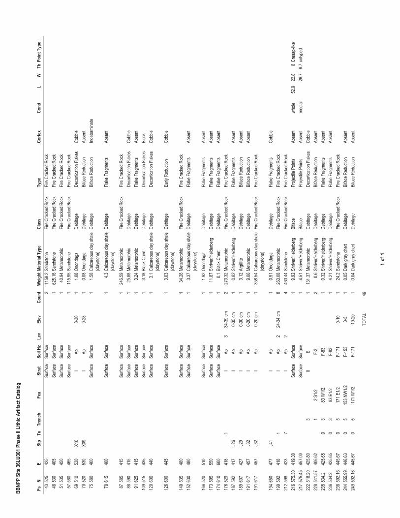
BBNP
P Si
te 36
LU30
1 Pha
se II
Lith
ic Ar
tifac
t Cat
alog
FsN
ESt
pTu
Tren
chFe
aSt
rat
Soil H
zLe
vEl
evCo
unt
Weig
htMa
teria
l Typ
eCl
ass
Type
Corte
xCo
ndL
WTh
Poin
t Typ
e43
525
425
Surfa
ceSu
rface
211
58.2
Sand
stone
Fire C
rack
ed R
ock
Fire C
rack
ed R
ock
4853
040
5Su
rface
Surfa
ce1
625.1
6Sa
ndsto
neFir
e Cra
cked
Roc
kFir
e Cra
cked
Roc
k51
535
450
Surfa
ceSu
rface
140
.94Me
tamor
phic
Fire C
rack
ed R
ock
Fire C
rack
ed R
ock
5756
046
5Su
rface
Surfa
ce1
115.9
5Sa
ndsto
neFir
e Cra
cked
Roc
kFir
e Cra
cked
Roc
k69
510
530
X10
IAp
0-30
11.0
8On
onda
gaDe
bitag
eDe
cortic
ation
Flak
esCo
bble
7052
053
0X0
9I
Ap0-
281
0.08
Onon
daga
Debit
age
Bifac
e Red
uctio
nAb
sent
7558
040
0Su
rface
Surfa
ce1
1.58
Calca
reou
s clay
shale
(cl
aysto
ne)
Debit
age
Bifac
e Red
uctio
nInd
eterm
inate
7861
540
0Su
rface
Surfa
ce1
4.3Ca
lcare
ous c
lay sh
ale
(clay
stone
)De
bitag
eFla
ke F
ragm
ents
Abse
nt
8758
541
5Su
rface
Surfa
ce1
246.5
9Me
tamor
phic
Fire
Cra
cked
Roc
kFir
e Cra
cked
Roc
k88
590
415
Surfa
ceSu
rface
125
.88Me
tamor
phic
Debit
age
Deco
rticati
on F
lakes
Cobb
le91
625
415
Surfa
ceSu
rface
13.2
4Me
tamor
phic
Debit
age
Flake
Fra
gmen
tsAb
sent
109
515
435
Surfa
ceSu
rface
13.1
8Bl
ack C
hert
Debit
age
Deco
rticati
on F
lakes
Bloc
k12
060
044
0Su
rface
Surfa
ce1
3.1Ca
lcare
ous c
lay sh
ale
(clay
stone
)De
bitag
eDe
cortic
ation
Flak
esCo
bble
126
600
445
Surfa
ceSu
rface
13.0
3Ca
lcare
ous c
lay sh
ale
(clay
stone
)De
bitag
eEa
rly R
educ
tion
Cobb
le
149
535
480
Surfa
ceSu
rface
134
.28Me
tamor
phic
Fire C
rack
ed R
ock
Fire C
rack
ed R
ock
152
630
480
Surfa
ceSu
rface
13.3
7Ca
lcare
ous c
lay sh
ale
(clay
stone
)De
bitag
eFla
ke F
ragm
ents
Abse
nt
166
520
510
Surfa
ceSu
rface
11.9
2On
onda
gaDe
bitag
eFla
ke F
ragm
ents
Abse
nt17
359
555
0Su
rface
Surfa
ce1
11.87
Shriv
er/H
elder
berg
Debit
age
Flake
Fra
gmen
tsAb
sent
174
610
600
Surfa
ceSu
rface
10.1
Blac
k Che
rtDe
bitag
eFla
ke F
ragm
ents
Abse
nt17
652
941
81
IAp
334
-39 c
m2
270.3
2Me
tamor
phic
Fire C
rack
ed R
ock
Fire C
rack
ed R
ock
187
592
417
J26
IAp
0-35
cm1
0.82
Shriv
er/H
elder
berg
Debit
age
Flake
Fra
gmen
tsAb
sent
189
607
427
J29
IAp
0-30
cm1
3.12
Argil
liteDe
bitag
eBi
face R
educ
tion
Abse
nt19
161
745
7J3
2I
Ap0-
20 cm
19.0
6Me
tamor
phic
Debit
age
Bifac
e Red
uctio
nAb
sent
191
617
457
J32
IAp
0-20
cm1
358.5
4Ca
lcare
ous c
lay sh
ale
(clay
stone
)Fir
e Cra
cked
Roc
kFir
e Cra
cked
Roc
k
194
650
477
J41
IAp
10.9
1On
onda
gaDe
bitag
eFla
ke F
ragm
ents
Cobb
le19
959
241
81
IAp
224
-34 c
m8
263.0
8Me
tamor
phic
Fire C
rack
ed R
ock
Fire C
rack
ed R
ock
212
598
423
7I
Ap2
446
3.44
Sand
stone
Fire C
rack
ed R
ock
Fire C
rack
ed R
ock
216
575.3
041
9.30
Surfa
ceSu
rface
19.9
2Sh
river
/Held
erbe
rgBi
face
Proje
ctile
Point
sAb
sent
whole
52.9
22.8
8Cr
esap
-like
217
575.4
545
7.00
Surfa
ceSu
rface
14.5
1Sh
river
/Held
erbe
rgBi
face
Proje
ctile
Point
sAb
sent
media
l26
.76.7
untyp
ed22
251
8.20
425.8
03
IIB
113
1.37
Metam
orph
icDe
bitag
eDe
cortic
ation
Flak
esCo
bble
228
541.5
740
6.62
12 S
1/2F-
22
0.6Sh
river
/Held
erbe
rgDe
bitag
eBi
face R
educ
tion
Abse
nt23
553
4.242
5.65
03
83 W
1/2F-
831
0.32
Shriv
er/H
elder
berg
Debit
age
Flake
Fra
gmen
tsAb
sent
236
534.2
425.6
50
383
E1/2
F-83
14.2
1Sh
river
/Held
erbe
rgDe
bitag
eFla
ke F
ragm
ents
Abse
nt23
859
2.16
445.6
70
517
1 E1/2
F-17
10-
101
24.2
Sand
stone
Fire C
rack
ed R
ock
Fire C
rack
ed R
ock
244
555.9
944
6.63
05
153 N
W1/2
F-15
30-
51
0.05
Dark
gray
cher
tDe
bitag
eBi
face R
educ
tion
Abse
nt24
959
2.16
445.6
70
517
1 W1/2
F-17
110
-20
10.0
4Da
rk gr
ay ch
ert
Debit
age
Bifac
e Red
uctio
nAb
sent
TOTA
L49
1 of
1
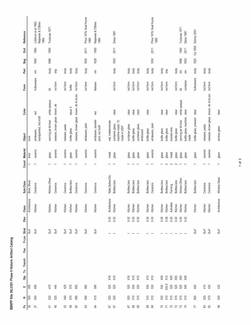
BBNP
P Si
te 36
LU30
1 Pha
se II
Hist
oric
Artif
act C
atalo
g
FsN
ESt
pTu
Tren
chFe
aF-
Lev
Stra
tEl
evCl
ass
Sub-
Clas
sCo
unt
Mate
rial
Objec
tCo
lor
Form
Part
Beg
End
Refe
renc
e36
500
485
Surf
Arch
itectu
reBr
ick, B
lock
1br
ickbr
ick
3750
049
5Su
rf Ki
tchen
Cera
mics
1ce
rami
cwh
itewa
re,
hand
paint
ed, in
d moti
fred
hollo
wwar
erim
1840
1860
Lofst
rum
et al
1982
; Ma
jewsk
i & O
'Brie
n 19
84
4152
047
5Su
rf Ki
tchen
Kitch
en-O
ther
1gla
ssca
nning
jar li
d line
rwh
ite op
aque
lidbo
dy18
9619
50To
ulous
e 197
1
4552
544
0Su
rf Ki
tchen
Cera
mics
1ce
rami
cre
dwar
e, br
own g
laze
brow
n, dk
ind fo
rmch
ip
5254
042
5Su
rf Ki
tchen
Cera
mics
1ce
rami
cre
dwar
e, pa
steind
form
body
5957
057
0Su
rf Ki
tchen
Bottle
s/Jar
s1
glass
bottle
glas
saq
ua, lt
bottle
body
6058
560
0Su
rf Ki
tchen
Cera
mics
1ce
rami
cre
dwar
e, br
own g
laze
brow
n, dk
int &
ext
ind fo
rmbo
dy
6359
058
5Su
rf Ki
tchen
Cera
mics
1ce
rami
cwh
itewa
re, p
lain
ind fo
rmbo
dy18
3020
11Pr
ice 19
79; N
oel H
ume
1980
6461
559
0Su
rf Ki
tchen
Cera
mics
1ce
rami
cwh
itewa
re, tr
ansfe
r pr
int, in
d moti
fre
dfla
twar
erim
1828
1850
Majew
ski &
O'B
rien
1984
6752
052
5X1
6I
0-32
Arch
itectu
reNa
ils,S
pikes
,Etc.
1me
talna
il, ind
eterm
inate
6752
052
5X1
6I
0-32
Kitch
enBo
ttles/J
ars
1gla
ssco
ntaine
r glas
s; ma
chine
mad
e; "O
ma
de in
USA
"
clear
ind fo
rmbo
dy19
0320
11Di
ess 1
981
6752
052
5X1
6I
0-32
Kitch
enBo
ttles/J
ars
1gla
ssco
ntaine
r glas
scle
arind
form
body
6851
553
0X1
5I
0-35
Kitch
enBo
ttles/J
ars
1gla
ssbo
ttle gl
ass
clear
ind fo
rmbo
dy69
510
530
X10
I0-
30Ki
tchen
Bottle
s/Jar
s1
glass
conta
iner g
lass,
embo
ssed
clear
ind fo
rmbo
dy
6951
053
0X1
0I
0-30
Kitch
enBo
ttles/J
ars
1gla
ssbo
ttle gl
ass
clear
ind fo
rmbo
dy69
510
530
X10
I0-
30Ki
tchen
Cera
mics
1ce
rami
cwh
itewa
re, p
lain
ind fo
rmbo
dy18
3020
11Pr
ice 19
79; N
oel H
ume
1980
7052
053
0X0
9I
0-28
Kitch
enBo
ttles/J
ars
1gla
ssbo
ttle gl
ass
clear
ind fo
rmbo
dy71
510
533.5
X12
I0-
38Ki
tchen
Bottle
s/Jar
s2
glass
bottle
glas
scle
arind
form
chip
7251
552
5X0
5I
0-30
Activ
ities
Farm
ing2
metal
braid
ed w
ire72
515
525
X05
I0-
30Ki
tchen
Bottle
s/Jar
s2
glass
bottle
glas
scle
arind
form
body
7251
552
5X0
5I
0-30
Kitch
enKi
tchen
-Othe
r1
glass
cann
ing ja
r lid l
iner
white
opaq
uelid
rim18
9619
50To
ulous
e 197
174
510
540
X06
I0-
32Ki
tchen
Bottle
s/Jar
s1
glass
bottle
glas
s, ma
chine
ma
decle
arco
ntaine
rrim
1903
2011
Dies
s 198
1
7760
040
0Su
rfKi
tchen
Bottle
s/Jar
s1
glass
bottle
glas
s, pr
esse
dcle
arho
lloww
are
body
1820
Ca 19
50Sc
hroy
2001
8352
041
0Su
rfKi
tchen
Cera
mics
1ce
rami
cre
dwar
e, pa
steind
form
body
9251
542
0Su
rfKi
tchen
Cera
mics
1ce
rami
cre
dwar
e, br
own g
laze
brow
n, dk
int &
ext
ind fo
rmbo
dy
9953
042
5Su
rfAr
chite
cture
Wind
ow G
lass
1gla
sswi
ndow
glas
scle
ar
1 of
3
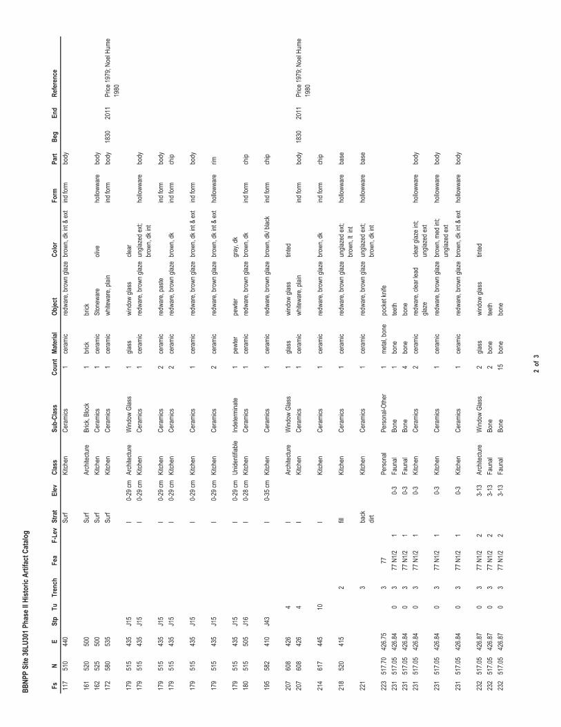
BBNP
P Si
te 36
LU30
1 Pha
se II
Hist
oric
Artif
act C
atalo
g
FsN
ESt
pTu
Tren
chFe
aF-
Lev
Stra
tEl
evCl
ass
Sub-
Clas
sCo
unt
Mate
rial
Objec
tCo
lor
Form
Part
Beg
End
Refe
renc
e11
751
044
0Su
rfKi
tchen
Cera
mics
1ce
rami
cre
dwar
e, br
own g
laze
brow
n, dk
int &
ext
ind fo
rmbo
dy
161
520
500
Surf
Arch
itectu
reBr
ick, B
lock
1br
ickbr
ick16
252
550
0Su
rfKi
tchen
Cera
mics
1ce
rami
cSt
onew
are
olive
hollo
wwar
ebo
dy17
258
053
5Su
rfKi
tchen
Cera
mics
1ce
rami
cwh
itewa
re, p
lain
ind fo
rmbo
dy18
3020
11Pr
ice 19
79; N
oel H
ume
1980
179
515
435
J15
I0-
29 cm
Arch
itectu
reW
indow
Glas
s1
glass
wind
ow gl
ass
clear
179
515
435
J15
I0-
29 cm
Kitch
enCe
rami
cs1
cera
mic
redw
are,
brow
n glaz
eun
glaze
d ext;
br
own,
dk in
tho
lloww
are
body
179
515
435
J15
I0-
29 cm
Kitch
enCe
rami
cs2
cera
mic
redw
are,
paste
ind fo
rmbo
dy17
951
543
5J1
5I
0-29
cmKi
tchen
Cera
mics
2ce
rami
cre
dwar
e, br
own g
laze
brow
n, dk
ind fo
rmch
ip
179
515
435
J15
I0-
29 cm
Kitch
enCe
rami
cs1
cera
mic
redw
are,
brow
n glaz
ebr
own,
dk in
t & ex
tind
form
body
179
515
435
J15
I0-
29 cm
Kitch
enCe
rami
cs2
cera
mic
redw
are,
brow
n glaz
ebr
own,
dk in
t & ex
tho
lloww
are
rim
179
515
435
J15
I0-
29 cm
Unide
ntifia
bleInd
eterm
inate
1pe
wter
pewt
ergr
ay, d
k18
051
550
5J1
6I
0-28
cmKi
tchen
Cera
mics
1ce
rami
cre
dwar
e, br
own g
laze
brow
n, dk
ind fo
rmch
ip
195
582
410
J43
I0-
35 cm
Kitch
enCe
rami
cs1
cera
mic
redw
are,
brow
n glaz
ebr
own,
dk/ b
lack
ind fo
rmch
ip
207
608
426
4I
Arch
itectu
reW
indow
Glas
s1
glass
wind
ow gl
ass
tinted
207
608
426
4I
Kitch
enCe
rami
cs1
cera
mic
white
ware
, plai
nind
form
body
1830
2011
Price
1979
; Noe
l Hum
e 19
80
214
617
445
10I
Kitch
enCe
rami
cs1
cera
mic
redw
are,
brow
n glaz
ebr
own,
dkind
form
chip
218
520
415
2fill
Kitch
enCe
rami
cs1
cera
mic
redw
are,
brow
n glaz
eun
glaze
d ext;
br
own,
lt int
hollo
wwar
eba
se
221
3ba
ck
dirt
Kitch
enCe
rami
cs1
cera
mic
redw
are,
brow
n glaz
eun
glaze
d ext;
br
own,
dk in
tho
lloww
are
base
223
517.7
042
6.75
377
Perso
nal
Perso
nal-O
ther
1me
tal, b
one
pock
et kn
ife23
151
7.05
426.8
40
377
N1/2
10-
3Fa
unal
Bone
1bo
netee
th23
151
7.05
426.8
40
377
N1/2
10-
3Fa
unal
Bone
4bo
nebo
ne23
151
7.05
426.8
40
377
N1/2
10-
3Ki
tchen
Cera
mics
2ce
rami
cre
dwar
e, cle
ar le
ad
glaze
clear
glaz
e int;
un
glaze
d ext
hollo
wwar
ebo
dy
231
517.0
542
6.84
03
77 N
1/21
0-3
Kitch
enCe
rami
cs1
cera
mic
redw
are,
brow
n glaz
ebr
own,
med i
nt;
ungla
zed e
xtho
lloww
are
body
231
517.0
542
6.84
03
77 N
1/21
0-3
Kitch
enCe
rami
cs1
cera
mic
redw
are,
brow
n glaz
ebr
own,
dk in
t & ex
tho
lloww
are
body
232
517.0
542
6.87
03
77 N
1/22
3-13
Arch
itectu
reW
indow
Glas
s2
glass
wind
ow gl
ass
tinted
232
517.0
542
6.87
03
77 N
1/22
3-13
Faun
alBo
ne2
bone
teeth
232
517.0
542
6.87
03
77 N
1/22
3-13
Faun
alBo
ne15
bone
bone
2 of
3
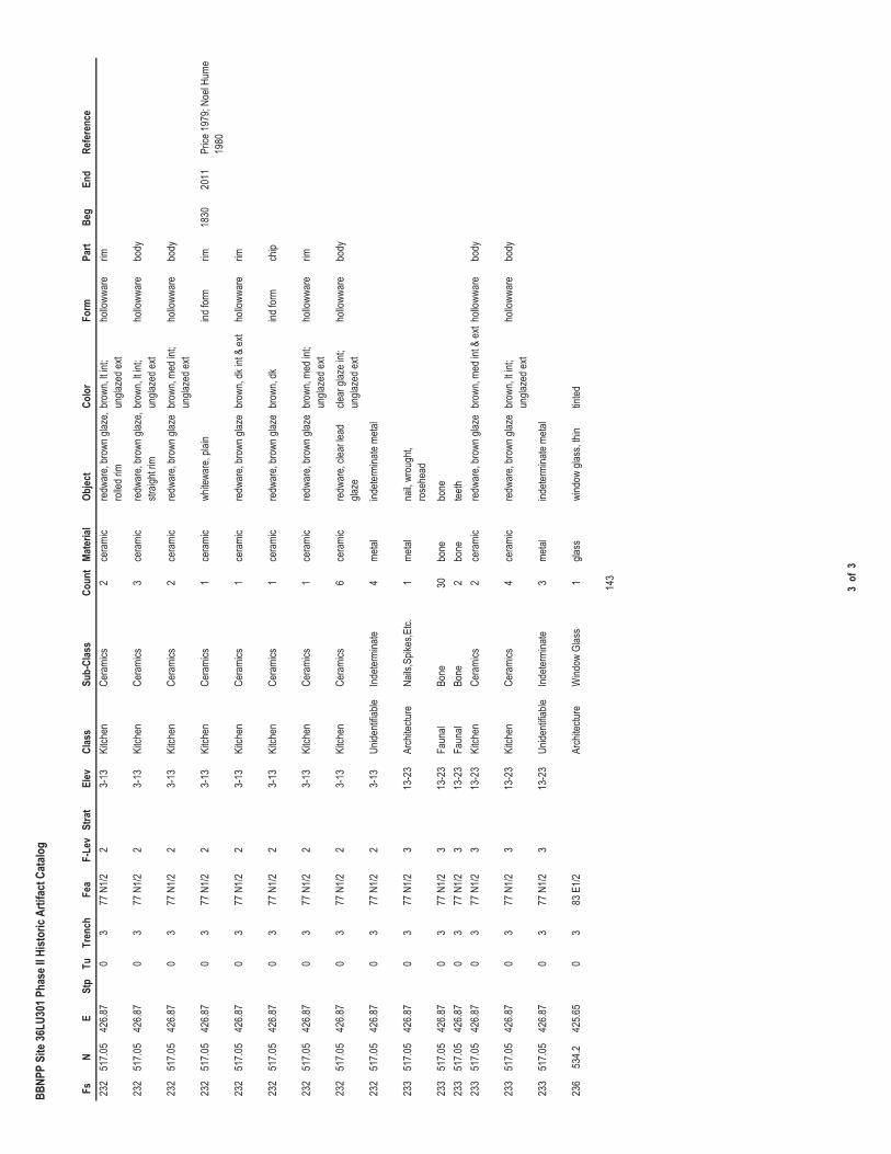
BBNP
P Si
te 36
LU30
1 Pha
se II
Hist
oric
Artif
act C
atalo
g
FsN
ESt
pTu
Tren
chFe
aF-
Lev
Stra
tEl
evCl
ass
Sub-
Clas
sCo
unt
Mate
rial
Objec
tCo
lor
Form
Part
Beg
End
Refe
renc
e23
251
7.05
426.8
70
377
N1/2
23-
13Ki
tchen
Cera
mics
2ce
rami
cre
dwar
e, br
own g
laze,
rolle
d rim
brow
n, lt i
nt;
ungla
zed e
xtho
lloww
are
rim
232
517.0
542
6.87
03
77 N
1/22
3-13
Kitch
enCe
rami
cs3
cera
mic
redw
are,
brow
n glaz
e, str
aight
rimbr
own,
lt int;
un
glaze
d ext
hollo
wwar
ebo
dy
232
517.0
542
6.87
03
77 N
1/22
3-13
Kitch
enCe
rami
cs2
cera
mic
redw
are,
brow
n glaz
ebr
own,
med i
nt;
ungla
zed e
xtho
lloww
are
body
232
517.0
542
6.87
03
77 N
1/22
3-13
Kitch
enCe
rami
cs1
cera
mic
white
ware
, plai
nind
form
rim18
3020
11Pr
ice 19
79; N
oel H
ume
1980
232
517.0
542
6.87
03
77 N
1/22
3-13
Kitch
enCe
rami
cs1
cera
mic
redw
are,
brow
n glaz
ebr
own,
dk in
t & ex
tho
lloww
are
rim
232
517.0
542
6.87
03
77 N
1/22
3-13
Kitch
enCe
rami
cs1
cera
mic
redw
are,
brow
n glaz
ebr
own,
dkind
form
chip
232
517.0
542
6.87
03
77 N
1/22
3-13
Kitch
enCe
rami
cs1
cera
mic
redw
are,
brow
n glaz
ebr
own,
med i
nt;
ungla
zed e
xtho
lloww
are
rim
232
517.0
542
6.87
03
77 N
1/22
3-13
Kitch
enCe
rami
cs6
cera
mic
redw
are,
clear
lead
gla
zecle
ar gl
aze i
nt;
ungla
zed e
xtho
lloww
are
body
232
517.0
542
6.87
03
77 N
1/22
3-13
Unide
ntifia
bleInd
eterm
inate
4me
talind
eterm
inate
metal
233
517.0
542
6.87
03
77 N
1/23
13-2
3Ar
chite
cture
Nails
,Spik
es,E
tc.1
metal
nail,
wrou
ght,
rose
head
233
517.0
542
6.87
03
77 N
1/23
13-2
3Fa
unal
Bone
30bo
nebo
ne23
351
7.05
426.8
70
377
N1/2
313
-23
Faun
alBo
ne2
bone
teeth
233
517.0
542
6.87
03
77 N
1/23
13-2
3Ki
tchen
Cera
mics
2ce
rami
cre
dwar
e, br
own g
laze
brow
n, me
d int
& ex
tholl
owwa
rebo
dy
233
517.0
542
6.87
03
77 N
1/23
13-2
3Ki
tchen
Cera
mics
4ce
rami
cre
dwar
e, br
own g
laze
brow
n, lt i
nt;
ungla
zed e
xtho
lloww
are
body
233
517.0
542
6.87
03
77 N
1/23
13-2
3Un
identi
fiable
Indete
rmina
te3
metal
indete
rmina
te me
tal
236
534.2
425.6
50
383
E1/2
Arch
itectu
reW
indow
Glas
s1
glass
wind
ow gl
ass,
thin
tinted
143
3 of
3

Appendix F
Qualifications of Key Personnel
Barbara A. Munford Principal Investigator
Education
M . A . , A nthropology, 1 9 8 2 , G eorge W ashington U niv ersity
B . A . , A nthropology, 1 9 7 7 , A merican U niv ersity
Affiliation W est V irginia A rchaeology S ociety E astern S tates A rchaeological F ederation
Relevant Training/Courses
2 0 1 0 P roj ect M anagement S hort C ourse 2 0 1 0 A dv anced P roj ect M anagement T raining P rogram
Areas of Specialization P rehistory of the eastern and southwestern U nited S tates; lithic analysis; collections management; field and laboratory methods.
Professional Experience Principal Investigator
2011 T hird S upplemental P hase I C ultural R esources I nv estigation, B ell B end N uclear P ower P lant,
L uz erne C ounty, P ennsylv ania, for A R E V A N P I nc. and U niS tar N uclear E nergy, L L C P hase I I N ational R egister E v aluation of S ite 3 6 L U 3 0 1 , B ell B end N uclear P ower P lant, L uz erne
C ounty, P ennsylv ania, for P P L B ell B end, L L C . R eport A uthor. P hase I C ultural R esources I nv estigation, T all T rees P roj ect, U pshur C ounty, W est
V irginia, for C hesapeake M idstream S erv ices, L L C . R eport C o- A uthor. P hase I C ultural R esources I nv estigation, T L - 5 7 1 R eplacement P roj ect, L ewis
C ounty, W est V irginia, for D ominion T ransmission, I nc.
2010 I ntensiv e P hase I C ultural R esources I nv estigation, S R 0 0 5 6 , S ection 4 5 3 , S outh B rush V alley B ridge
R eplacement, B rush V alley T ownship, I ndiana C ounty, P ennsylv ania, for P ennsylv ania D epartment of T ransportation, E ngineering D istrict 1 0 - 0 .
P hase I b C ultural R esources I nv estigation, R E M P G arden and F iber O ptic C ommunications, C able R elocation A rea, C alv ert C liffs N uclear P ower P lant, C alv ert C ounty, M aryland, for C onstellation G eneration G roup
B ell B end A lternativ e S ites R esearch, B ell B end N uclear P ower P lant, L uz erne C ounty, P ennsylv ania, for U niS tar N uclear E nergy, L L C .
P hase I C ultural R esource I nv estigations and P hase I I N ational R egister S ite E v aluations, B ell B end N uclear P ower P lant, L uz erne C ounty, P ennsylv ania, for U nistar N uclear E nergy, L L C .
S econd S upplemental P hase I b C ultural R esources I nv estigation and C O L A E nv ironmental R eport R ev isions, P ower B lock R elocation, B ell B end N uclear P ower P lant, L uz erne C ounty, P ennsylv ania, for A R E V A N P I nc.
2009

2
P hase I I N ational R egister S ite E v aluations (F iv e A rchaeological S ites), N ine M ile P oint N uclear S tation, P roposed U nit 3 (N M P U nit 3 ), O swego C ounty, N ew Y ork, for U niS tar N uclear E nergy, L L C .
C o- P rincipal I nv estigator. P hase I I N ational R egister S ites E v aluations (S ev en A rchaeological S ites), B ell B end N uclear P ower P lant, L uz erne C ounty, P ennsylv ania, for U niS tar N uclear E nergy, L L C .
P hase I C ultural R esources I nv estigations and P hase I I N ational R egister S ite E v aluations, C alv ert C liffs N uclear P ower P lant, C alv ert C ounty, M aryland, for U niS tar N uclear D ev elopment, L L C .
C o- P rincipal I nv estigator and R eport C o- A uthor. P hase I b A rchaeological S urv ey, R ural V alley P ipeline P roj ect, A rmstrong, W estmoreland, E lk, and M cK ean C ounties, P ennsylv ania, for D ominion T ransmission, I nc.
T hird S upplemental P hase I C ultural R esources S urv ey, F ranklin 2 0 - inch S torage P ipeline P roj ect, W ayne and S ummit C ounties, O hio, for D ominion E ast O hio G as.
S econd S upplemental P hase I C ultural R esources S urv ey, F ranklin 2 0 - inch S torage P ipeline P roj ect, W ayne and S ummit C ounties, O hio, for D ominion E ast O hio G as.
C o- P rincipal I nv estigator. D ata R ecov ery P lan: S ite 1 8 C v 4 7 4 , C alv ert C liffs N uclear P ower P lant, C alv ert C ounty, M aryland, for U niS tar N uclear D ev elopment, L L C .
P hase I I N ational R egister S ite E v aluations, T L - 5 8 5 / H - 1 6 2 P ipeline R eplacement P roj ect, K anawha and C lay C ounties, W est V irginia, for D ominion T ransmission, I nc.
2008 P hase I b C ultural R esources I nv estigations, T L - 5 8 5 / H - 1 6 2 P ipeline R eplacement P roj ect, K anawha
and C lay C ounties, W est V irginia, for D ominion T ransmission, I nc. P hase I a C ultural R esources I nv estigations, T L - 5 8 5 / H - 1 6 2 P ipeline R eplacement P roj ect, K anawha
and C lay C ounties, W est V irginia, for D ominion T ransmission, I nc. S upplemental P hase I b C ultural R esources I nv estigation, B ell B end N uclear P ower P lant, L uz erne
C ounty, P ennsylv ania, for A R E V A N P I nc. and U niS tar N uclear D ev elopment, L L C . P hase I b C ultural R esources I nv estigation, B ell B end N uclear P ower P lant, L uz erne C ounty,
P ennsylv ania, for A R E V A N P I nc. and U niS tar N uclear D ev elopment, L L C . P hase I C ultural R esources I nv estigations and P hase I I N ational R egister S ite E v aluations, C alv ert
C liffs N uclear P ower P lant, C alv ert C ounty, M aryland, for U niS tar N uclear D ev elopment, L L C . P hase I C ultural R esources S urv ey, L imestone C ompressor S tation and P ipeline P roj ect, C larion
C ounty, P ennsylv ania, for E q uitable G as. P hase I A C ultural R esources R econnaissance, S usq uehanna S team E lectric S tation, L uz erne
C ounty, P ennsylv ania, for C onstellation P ower G eneration. P hase I C ultural R esources S urv ey, F ranklin 2 0 - inch S torage P ipeline P roj ect, W ayne and S ummit
C ounties, O hio, for D ominion E ast O hio G as. P hase I A C ultural R esources R econnaissance, B erwick P A N P P - 1 , A reas 6 , 7 , and 8 , and C onfers
L ane P arcel, L uz erne C ounty, P ennsylv ania, for A rev a N P , I nc. and U niS tar N uclear D ev elopment, L L C .
2007 P hase I C ultural R esources S urv ey, D ominion E ast O hio S torage E x pansion P roj ect, W ayne and
S ummit C ounties, O hio, for D ominion R esources S erv ices, I nc.
P hase I b A rchaeological S urv ey, F alling W ater D ev elopment P roj ect, M onongalia C ounty, W est V irginia, for B ackwater P roperties, L L C .
P hase I C ultural R esources S urv ey, L imestone C ompressor S tation and P ipeline P roj ect, C larion C ounty, P ennsylv ania, for E q uitable G as C ompany.
P hase I C ultural R esources S urv ey, K eystone S tation W ater P ipeline P roj ect, A rmstrong C ounty, P ennsylv ania, for R eliant E nergy N ortheast M anagement.

3
P hase I a C ultural R esources R econnaissance, C arrie F urnaces R edev elopment P roj ect, A llegheny C ounty, P ennsylv ania, for R edev elopment A uthority of A llegheny C ounty.
P hase I C ultural R esources S urv ey, G lade R un L oop 1 3 8 kV L ine, A rmstrong C ounty, P ennsylv ania, for A llegheny P ower.
P hase I a C ultural R esources I nv estigation, M aj estic S tar C asino, P ittsburgh, A llegheny C ounty, P ennsylv ania, for C hester E ngineers.
P hase I C ultural R esources I nv estigation, C alv ert C liffs N uclear P ower P lant, C alv ert C ounty, M aryland, for T etra T ech N U S and U niS tar N uclear D ev elopment, L L C .
2006 P hase I S urv ey of the C ov e P oint L N G T erminal E x pansion, C alv ert C ounty, M D , for D ominion C ov e
P oint L N G L P .
P hase I C ultural R esources S urv ey, B ald E agle I I W etlands M itigation P roj ect, C ov e P oint E x pansion P L - 1 E X T - 2 , C entre C ounty, P ennsylv ania, for D ominion T ransmission, I nc.
P hase I C ultural R esources S urv ey, S wann W etland D ev elopment P roj ect, C ov e P oint E x pansion T L -5 3 2 P ipeline P roj ect, C alv ert C ounty, M aryland, for D ominion C ov e P oint L N G , L P .
P hase I A rchaeological S urv ey, W al- M art S upercenter # 4 5 0 1 - 0 0 , W est B rownsv ille B orough, W ashington C ounty, P ennsylv ania, for W al- mart S tores, I nc.
P hase I C ultural R esources S urv ey, S tate L ine P ipeyard P roj ect, C ov e P oint E x pansion T L - 4 5 3 and T L - 5 3 6 P ipeline, A llegany C ounty, N ew Y ork, for D ominion T ransmission, I nc. , C larksburg, W est V irginia.
P hase I / I I A rchaeological I nv estigations, M E M C O / A E P R iv erbank R estoration P roj ect, M ason C ounty, W est V irginia, for M adison C oal and S upply C ompany
2005 P hase I b S urv ey of the G raysv ille- W ind R idge A rea water system ex tension, G reene C ounty, P A for
S outhwestern P ennsylv ania W ater A uthority.
P hase I a C ultural R esources S urv ey of O akbrooke E states, C ecil T ownship, W ashington C ounty, P ennsylv ania, for O akbrooke M use P artners, L P .
2004 P hase I a A rchaeological R econnaissance and G eomorphology A ssessment of the K irwan H eights
I nterchange and C ollier C rossing D ev elopment, C ollier T ownship, A llegheny C ounty, P ennsylv ania, for the G oldenberg G roup, I nc.
A rchaeological M onitoring of P P L G as U tilities F irst Q uality P ipe I nstallation along S R 1 0 0 2 on G reat I sland, L ock H av en, C linton C ounty, P ennsylv ania, for P P L G as U tilities.
P hase I C ultural R esources S urv ey of the C ov e P oint L N G T erminal E x pansion, C alv ert C ounty, M aryland, for D ominion C ov e P oint L N G , L P .
P hase I A rchaeological S urv ey of A ccess R oads 1 0 B , 1 0 C , 1 0 D and 6 8 , T L - 2 6 3 1 2 ” N atural G as P ipeline R epair P roj ect, W yoming and B oone C ounties, W est V irginia, for D ominion T ransmission, I nc. (D T I ).
P hase I a A rchaeological R econnaissance of the M ockingbird C ompressor S tation A ccess R oad W idening, W etz el C ounty, W est V irginia, for D ominion T ransmission, I nc. (D T I ).
P hase I A rchaeological S urv ey of the S ophia S torage Y ard, T L - 2 6 3 1 2 ” N atural G as P ipeline R epair P roj ect, R aleigh C ounty, W est V irginia, for D ominion T ransmission, I nc. (D T I ).
P hase I b A rchaeological S urv ey of the G raysv ille- W ind R idge A rea W ater S ystem E x tension, G reene C ounty, P ennsylv ania, for B ankson E ngineers and the S outhwestern P ennsylv ania W ater A uthority.

4
P hase I I N ational R egister E v aluation of S ite 4 6 H m6 3 , R omney B ridge R eplacement, H ampshire C ounty, W est V irginia, for the W est V irginia D epartment of T ransportation, D iv ision of H ighways.
2003 P hase I b A rchaeological S urv ey of the R omney B ridge R eplacement, H ampshire C ounty, W est
V irginia, for the W est V irginia D epartment of T ransportation, D iv ision of H ighways.
P hase I , I I , and I I I I nv estigations of A ppalachian C orridor L (U . S . 1 9 ) and E I S for a 2 4 - mile, F our- lane H ighway, for the W V D O H .
P hase I S urv ey of T wo P roj ect A reas (W etlands M itigation A rea and S oil B orrow A rea) for the B runner I sland S team E lectric S tation, Y ork C ounty, P A , for the P ennsylv ania P ower and L ight C ompany.
P hase I b A rchaeological and G eomorphological S urv ey, R omney B ridge R eplacement, P referred A lternativ e 6 , H ampshire C ounty, W V for W V D O H .
P hase I b S urv ey of the U . S . R oute 1 9 / L ochgelly I nterchange and W V 1 6 R econnection, F ayette C ounty, W V for K imley- H orn and W V D O H .
P hase I C ultural R esources S urv ey of U . S . R oute 3 5 W etland M itigation S ites 3 , 5 A and 8 , M ason C ounty, W est V irginia, for K imley- H orn and A ssociates, I nc. and the W est V irginia D epartment of T ransportation, D iv ision of H ighways.
2002 P hase I a and I b S urv eys of the F ederal # 2 M ine, M onongalia C ounty, W V , for E astern A ssociated
C oal C ompany.
P hase I a S urv ey (A rchaeological and H istorical S erv ices) for the T olsia W etlands M itigation S ite M I I -3 , W ayne C ounty, W est V irginia, for K imley- H orn and A ssociates, I nc. and W V D O H .
P hase I S urv ey of the B urrell T ownship S ewer A uthority, S trangford A rea P roj ect, I ndiana C ounty, P A , for the U . S . C O E - P ittsburgh D istrict.
P hase I I I D ata R ecov ery I nv estigation of S ite 4 6 N i2 5 2 , an E arly A rchaic through M iddle/ L ate W oodland occupation, N icholas C ounty, W V , for the W V D O H .
1990-2001 P hase I I I D ata R ecov ery I nv estigations of S ite 4 6 N I 2 6 7 , a W oodland O ccupation, N icholas C ounty,
W V . W V D O H .
P hase I S urv ey of the Y ork H av en B ypass R oad, Y ork C ounty, P ennsylv ania, for the P ennsylv ania P ower and L ight C ompany.
A rchaeological T esting and D ata R ecov ery I nv estigations of the A ltoona R ailroaders M emorial M useum, B lair C ounty, P A for the N ational P ark S erv ice.
A rchaeological T esting and D ata R ecov ery I nv estigations of the F ort N ecessity N ational B attlefield, F ayette C ounty, P A for the N ational P ark S erv ice.
P hase I I / I I I testing of the L egion V ille site (3 6 B V 3 3 ), historic component, H armony T ownship, B eav er C ounty, P A for B . P . M ouradian.
P hase I S urv ey of the E ast T owanda to E ast S ayre T ransmission L ine, B radford C ounty, P A for the P ennsylv ania E lectric C ompany.
P hase I S urv ey of the Y ork H av en B ypass R oad, Y ork C ounty, P ennsylv ania, for the P ennsylv ania P ower and L ight C ompany
P hase I D eep T esting of the G as P ipeline between S tate R oute 6 6 and the L atrobe S teel P lant, W estmoreland C ounty, for C linton G as M arketing I nc.
F ield D irector: P hase I surv ey of the L eidy L oop, C entre C ounty, P ennsylv ania, for T ex as E astern G as P ipeline C ompany.
Terry J. Newell Archaeologist
Education S ection 1 0 6 E ssentials (O ct. 2 0 0 6 ) W aste S ite W orker P rotection (O S H A ) T raining – S kelly and L oy, I nc. (A ug. 1 9 9 6 ) 2 4 H our L ithic W orkshop, U niv ersity of P ittsburgh (N ov . 1 9 8 8 ) C onnellsv ille A rea H igh S chool (1 9 8 2 )
Previous Employment F ield D irector, G A I C onsultants, I nc. , 2 0 0 6 - P resent F ield D irector and L aboratory T echnician, S kelly and L oy, I nc. , 1 9 9 2 - 2 0 0 6 C rew C hief, F ield and L aboratory T echnician, C hristine D av is C onsultants, 1 9 9 2 C rew C hief, F ield and L aboratory T echnician, M ercyhurst U niv ersity, 1 9 9 1 - 1 9 9 2 C rew C hief and F ield T echnician, L ouis B erger, 1 9 9 1 F ield T echnician, G oodwin and A ssociates, 1 9 9 0 F ield T echnician, W . A . P . O . R . A . , 1 9 9 0 C rew C hief, F ield and L aboratory T echnician, U niv ersity of P ittsburgh (C ultural R esource M anagement P rogram) 1 9 8 6 - 1 9 9 0
Professional Experience
2011 F ield D irector. P hase I C ultural R esources I nv estigation, W yoming N atural G as P ipeline P roj ect,
L uz erne and W yoming C ounties, P ennsylv ania, for C hief G athering, L L C . S enior A rchaeologist. P hase I C ultural R esource I nv estigations and P hase I I N ational R egister
E v aluations, A ppalachian G ateway P roj ect, G reene, W ashington, A llegheny, W estmoreland C ounties, P ennsylv ania, for D ominion T ransmission, I nc.
S enior A rchaeologist. P hase I C ultural R esources I nv estigation, V E P C O , W arren C ounty P roj ect, W arren and L oudoun C ounties, V irginia, for N atural R esource G roup, L L C .
2010 F ield D irector. P hase I C ultural R esource I nv estigations and P hase I I N ational R egister E v aluations,
A ppalachian G ateway, B arbour, D oddridge, H arrison, K anawha, M arshall, and W etz el C ounties, W est V irginia, for D ominion T ransmission, I nc.
S enior A rchaeologist. R O D , M S I B ridge R eplacement P roj ect, V andergrift B orough, W estmoreland C ounty D epartment of P ublic W orks, P ennsylv ania
F ield D irector. P hase I A rchaeological I nv estigation, S M 1 1 6 L oop L ine P roj ect at H amlin C ompressor S tation, L incoln C ounty, W est V irginia, for C olumbia G as T ransmission, L L C .
2009 F ield D irector. P hase I I I A nalysis and R eport of the M cD aniel S ite (4 4 G n1 1 5 ), H ardy T ransmission
P roj ect, G reene C ounty, V irginia for C olumbia G as T ransmission. F ield D irector. P hase I I I D ata R ecov ery E x cav ations, S ites 4 6 T a2 3 and 4 6 T a2 4 , T aylor C ounty, W est
V irginia F ield D irector. P hase I I C ultural R esources inv estigations of six (6 ) historic sites plus one (1 )
prehistoric site for P P L and U nistar at B ell B end N uclear P ower P lant in L uz erne C ounty, P ennsylv ania. D irected a crew consisting of two (2 ) crew chiefs and fourteen (1 4 ) field technicians.

Terry Newell Archaeologist
2
F ield D irector. P hase I I I C ultural R esources I nv estigation for R E X - R ockies E x press G as P ipeline in O hio for C aprock.
F ield D irector. P hase I b A rchaeological S urv ey, N I J U S 0 0 1 (M D - 1 4 6 ) P ipeline P roj ect, A mwell T ownship, W ashington C ounty, P ennsylv ania, for E Q T P roduction C ompany.
F ield D irector. P hase I I I nv estigations of the D un G len H otel S ite for the F ire S uppression S ystem, F ayette C ounty, W est V irginia, for N ational P ark S erv ice- N E R I .
Field Director 2006 – 2008 F ield D irector. P hase I I I C ultural R esources inv estigation for R E X - R ockies E x press gas pipeline in
M onroe C ounty, O hio (3 3 M O 0 7 7 ). S uperv ised a crew consisting of fourteen (1 4 ) field technicians and one (1 ) crew chief. D uties included photography, q uality control, mapping with transit, and daily briefings with principal inv estigator.
P hase I C ultural R esources I nv estigation and P hase I I ex cav ations of 7 prehistoric sites and 2 historic sites, G reat B end, M eig’ s C ounty, O hio for A E P . S uperv ised 2 0 + field technicians and 2 crew chiefs for surv ey of more than 6 3 0 acres. S uperv ised multiple crews, maintained q uality control, presented daily briefings to P rincipal I nv estigators.
P hase I I I C ultural R esources I nv estigation, N uttalburg M ine C onv eyor, F ayette C ounty, W est V irginia for N ew R iv er G orge N ational R iv er (N P S / N E R I ). L imited ex cav ation at N ational R egister E ligible historic site.
P hase I I I C ultural R esources I nv estigation, H ardy T ransmission, G reene C ounty, V irginia for C olumbia G as T ransmission. S uperv ised 1 8 F ield T echnicians and 1 C rew C hief. B lock ex cav ations (2 1 3 m2 ) of multi- component prehistoric site (W oodland - P aleo I ndian). D uties included photography, maintaining digital F S log, preliminary proj ectile point identification, q uality control, mapping with transit, and daily briefings with P rincipal I nv estigator.
P hase I C ultural R esources I nv estigation, C alv ert C liff’ s N uclear P ower P lant, C alv ert C ounty, M aryland for T etra T ech, N U S , and U nistar N uclear D ev elopment, L L C . E ight (8 ) features and more than 4 3 , 0 0 0 lithics. S uperv ised 2 0 + field T echnicians and 1 C rew C hief for archaeological surv ey of 6 0 0 + acres, and maintained field mapping of testing, q uality control of field records.
P hase I C ultural R esources I nv estigation, C rawford S torage L ine, F airfield and H ocking C ounties, O hio for C olumbia G as T ransmission. S uperv ised 1 2 + F ield T echnicians and 1 C rew C hief on proposed natural gas storage line. M aintained q uality control, met with proj ect personnel from other firms, briefed proj ect archaeologist daily.
P hase I C ultural R esources I nv estigation, W eav er S torage L ine, A shland and H olmes C ounties, O hio for C olumbia G as T ransmission. S uperv ised 1 2 + F ield T echnicians and 1 C rew C hief for proposed natural gas storage line. M aintained q uality control of field records, met with proj ect personnel from other firms, briefed proj ect archaeologist daily.
P hase I C ultural R esources I nv estigation, H ardy T ransmission, E lkton S torage Y ard, R ockingham C ounty, V irginia for C olumbia G as T ransmission.
P hase I C ultural R esources I nv estigation, 2 ” P lastic R eplacement L ine, W ashington C ounty, P ennsylv ania for C olumbia G as T ransmission.
P hase I C ultural R esources I nv estigation, H - 1 5 6 line, v alv e replacement, A llegheny C ounty, P ennsylv ania for E q ui T rans.
P hase I C ultural R esources I nv estigation, H - 1 5 6 line replacement, A llegheny C ounty, P ennsylv ania for E q ui T rans.
P hase I C ultural R esources I nv estigation, 1 5 mile proposed pipeline alignment, A rmstrong C ounty, P ennsylv ania for K eystone P ower S tation.
P hase I C ultural R esources I nv estigation, proposed A v ella sewage line, W ashington C ounty, P ennsylv ania for B ankson E ngineers.

Terry Newell Archaeologist
3
P hase I C ultural R esources I nv estigation, U . S . R oute 1 5 relocation proj ect, S teuben C ounty, N ew Y ork for D ominion T ransmission, I nc.
P hase I C ultural R esources I nv estigation, M ares R un R oad pipe ev aluation assessment, L ewis C ounty, W est V irginia for D ominion T ransmission, I nc.
P hase I C ultural R esources I nv estigation, G reensboro S ewage C ollection and T reatment F acility, G reene C ounty, P ennsylv ania for F ayette E ngineering.
C ultural R esources P hase I / I I E x cav ation and M onitoring, N orth S hore C onnector, A llegheny C ounty, P ennsylv ania for P ort A uthority T ransit of A llegheny C ounty.
Field Director 1992-2005 P hase I / I I / I I I C ultural R esources I nv estigation, S tate R oute 1 5 preferred alignment, T ioga C ounty,
P ennsylv ania for P ennsylv ania D ept. of T ransportation. S uperv ised 2 0 + F ield T echnicians and 2 C rew C hiefs within multi- phase inv estigations of a L ate W oodland v illage site. D uties included field documentation, q uality control, and mapping with transit.
P hase I I I C ultural R esources I nv estigation, R onald M cD onald H ouse, W ilmington D elaware for B lue B all T ransportation. S uperv ised block ex cav ations at prehistoric camp site.
P hase I I I C ultural R esources I nv estigation, 9 9 C orridor, C entre C ounty, P ennsylv ania for P ennsylv ania D ept. of T ransportation. T ransitional A rchaic camp site (W iser S ite). S uperv ised 1 5 F ield T echnicians and 1 C rew C hief in block and feature ex cav ations.
Crew Chief Experience 1992-2006 P hase I I I C ultural R esources I nv estigation, I - 8 0 B ridge R eplacement, N orthumberland C ounty,
P ennsylv ania for P ennsylv ania D ept. of T ransportation. H elped superv ise fieldwork of deep, block ex cav ations and cultural features on floodplain of S usq uehanna R iv er.
P hase I I / I I I C ultural R esources I nv estigation, T unkhannock B ypass, W yoming C ounty, P ennsylv ania for P ennsylv ania D ept. of T ransportation. H elped superv ise ex cav ations of two prehistoric camp sites identified within right- of- way corridor.
P hase I I I C ultural R esources I nv estigation, natural gas line replacement, L ancaster, P ennsylv ania for T ex as E astern T ransmission. H elped superv ise prehistoric open camp site, (P ersal S ite)
P hase I C ultural R esources I nv estigation, C orridor O , C learfield C ounty, P ennsylv ania for P ennsylv ania D ept. of T ransportation.
P hase I C ultural R esources I nv estigation, M on- F ayette E x pressway, F ayette and W ashington C ounties, P ennsylv ania for P ennsylv ania D ept. of T ransportation.
P hase I / I I C ultural R esources I nv estigation, 2 1 8 mile gas pipeline surv ey, F ulton, A dams and F ranklin C ounties, P ennsylv ania for T ex as E astern T ransmission.
P hase I / I I C ultural R esources I nv estigation, I - 8 0 / B ellefonte I nterchange, C entre C ounty, P ennsylv ania for P ennsylv ania D ept. of T ransportation.
P hase I / I I C ultural R esources I nv estigation, G reensburg B ypass, W estmoreland C ounty, P ennsylv ania for P ennsylv ania T urnpike C ommission.
P hase I I I C ultural R esources I nv estigation, 1 1 . 5 acre M onongahela v illage site, W estmoreland C ounty, P ennsylv ania for S ony C orp.
Field Technician Experience 1986-1992 (representative samples) P hase I C ultural R esources I nv estigation, S uper C ollider P roj ect for the S tate of T ex as (1 9 9 1 - 1 9 9 2 ) P hase I C ultural R esources I nv estigation, F ort D rum military base ex pansion, F ort D rum, N ew Y ork
for U S D ept. of D efense (1 9 9 1 )
Appendix G
Erosion and Sedimentation Control Plan
REDACTED Appendix G in its entirety

Appendix H
Methods of Prehistoric Lithic Analysis

Appendix H: Methods for Analysis of Prehistoric Lithic Artifacts Introduction T his appendix prov ides an ov erv iew of the methods of lithic analysis used for this proj ect. A fter washing and labeling, prehistoric artifacts recov ered during the inv estigation were div ided into specific artifact types, with a number of v ariables recorded for each type. F iv e basic categories of information can be deriv ed from lithic artifacts: depositional, temporal/ stylistic, functional, technological, and raw material. E ach of these aspects of the lithic record are interrelated and cannot be completed div orced from one another. R aw material analysis identifies the lithic materials that were ex ploited; this information permits inferences to be made about procurement strategies and the related issues of ex change and settlement mobility. T echnological analysis ex amines tool design and methods of production, maintenance, and recycling; this information helps to document the organiz ation of technology and to address issues such as site function. F unctional analysis determines the tasks in which tools were employed; this information also helps to document the organiz ation of technology and site function. T emporal/ stylistic analysis prov ides chronological as well as other cultural information; typically, howev er, only the most formaliz ed stone tools are usually diagnostic (e. g. , proj ectile points), and ev en these items tend to be less sensitiv e to temporal change or regional styles than are ceramics. I nformation about depositional processes help to identify activ ity areas, tool kits, and larger- scale site formation processes; this information is deriv ed from crossmending and plotting artifact distributions.
T he methods and procedures used to generate data about these fiv e aspects of the lithic record are outlined below. A s lithic artifacts were analyz ed, information was recorded on analysis sheets as a series of codes; then, the codes were entered into a computer database program, M icrosoft A ccess. F or the purposes of data analysis and manipulation, this database was then conv erted to E x cel data manipulation and table generation. T hese computer programs facilitated a better understanding of site- use.
Artifact Classes and Types T he analytical approach to stone tool production and use used here can be described as techno- morphological; that is, artifacts were grouped into general classes and further div ided into specific types based upon key morphological attributes, which are linked to or indicativ e of particular stone tool production (reduction) strategies. F unction was inferred from morphology as well as from use- wear. S urfaces and edges were ex amined for traces of use polish and damage with the unaided eye and with a 1 0 x hand lens. A conserv ativ e approach to the identification of utiliz ed and edge- retouched flakes was taken because of a number of other factors can produce similar edge- damage, such as, trampling of materials on liv ing surfaces, spontaneous retouch during flake detachment, and trowel contact. D ata deriv ed from ex perimental and ethnoarchaeological research were relied upon in the identification and interpretation of artifact types. T he works of A dams (2 0 0 2 ), A ndrefsky (1 9 9 8 ), C allahan (1 9 7 9 ), C lark (1 9 8 6 ), C rabtree (1 9 7 2 ), F lenniken (1 9 8 1 ), G ould (1 9 8 0 ), P arry (1 9 8 7 ), W hittaker (1 9 9 4 ) were drawn upon most heav ily.
O rganiz ed by artifact classes, specific artifact types are listed below, followed by their code and a brief definition. A ll types were q uantified by both count and weight in grams. A lso discussed below are the specific v ariables or attributes that were recorded and how they were coded.
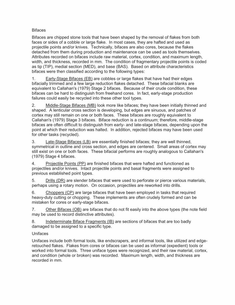
B ifaces
B ifaces are chipped stone tools that hav e been shaped by the remov al of flakes from both faces or sides of a cobble or large flake. I n most cases, they are hafted and used as proj ectile points and/ or kniv es. T echnically, bifaces are also cores, because the flakes detached from them during production and maintenance can be used as tools themselv es. A ttributes recorded on bifaces include raw material, cortex , condition, and max imum length, width, and thickness, recorded in mm. T he condition of fragmentary proj ectile points is coded as tip (T I P ), medial section (M E D ), and base (B A S ). B ased on attribute characteristics bifaces were then classified according to the following types:
1 . E arly- S tage B ifaces (E B ) are cobbles or large flakes that hav e had their edges bifacially trimmed and a few large reduction flakes detached. T hese bifacial blanks are eq uiv alent to C allahan' s (1 9 7 9 ) S tage 2 bifaces. B ecause of their crude condition, these bifaces can be hard to distinguish from freehand cores. I n fact, early- stage production failures could easily be recycled into these other tool types.
2 . M iddle- S tage B ifaces (M B ) look more like bifaces; they hav e been initially thinned and shaped. A lenticular cross section is dev eloping, but edges are sinuous, and patches of cortex may still remain on one or both faces. T hese bifaces are roughly eq uiv alent to C allahan' s (1 9 7 9 ) S tage 3 bifaces. B iface reduction is a continuum; therefore, middle- stage bifaces are often difficult to distinguish from early- and late- stage bifaces, depending upon the point at which their reduction was halted. I n addition, rej ected bifaces may hav e been used for other tasks (recycled).
3 . L ate- S tage B ifaces (L B ) are essentially finished bifaces; they are well thinned, symmetrical in outline and cross section, and edges are centered. S mall areas of cortex may still ex ist on one or both faces. T hese bifacial performs are roughly analogous to C allahan' s (1 9 7 9 ) S tage 4 bifaces.
4 . P roj ectile P oints (P P ) are finished bifaces that were hafted and functioned as proj ectiles and/ or kniv es. I ntact proj ectile points and basal fragments were assigned to prev ious established point types.
5 . D rills (D R ) are slender bifaces that were used to perforate or pierce v arious materials, perhaps using a rotary motion. O n occasion, proj ectiles are reworked into drills.
6 . C hoppers (C P ) are large bifaces that hav e been employed in tasks that req uired heav y- duty cutting or chopping. T hese implements are often crudely formed and can be mistaken for cores or early- stage bifaces.
7 . O ther B ifaces (O B ) are bifaces that do not fit easily into the abov e types (the note field may be used to record distinctiv e attributes).
8 . I ndeterminate B iface F ragments (I B ) are sections of bifaces that are too badly damaged to be assigned to a specific type.
U nifaces
U nifaces include both formal tools, like endscrapers, and informal tools, like utiliz ed and edge-retouched flakes. F lakes from cores or bifaces can be used as informal (ex pedient) tools or worked into formal tools. T hree uniface types were recogniz ed, and their raw material, cortex , and condition (whole or broken) was recorded. M ax imum length, width, and thickness are recorded in mm.
1 . E ndscrapers (E S ) are formaliz ed unifaces that hav e uniformly retouched edges, which creates a working edge and a standardiz ed shape. T he working edge is transv erse to the long ax is of the tool, and retouching often erases obv ious indications that the tool is made on a flake. I n some cases, endscrapers are bifacially worked, but they are still classified as unifaces.
2 . S idescrapers (S S ) are formaliz ed unifaces that hav e uniformly retouched edges, creating a working edge with a relativ ely standardiz ed shape. T he working edge or edges are parallel to the long ax is of the tool (or lateral margin of the original flake).
3 . R etouched F lakes (R F ) are ex pedient tools that hav e had one or more edges retouched, either to resharpen the working edge, to create a dulled edge for grasping, or to form a specific edge angle or shape. T he flake itself could hav e been detached from a core or biface. I t should be noted that sev ere edge- damage can be difficult to discern from intentional retouching. R etouch flake scars on edges typically ex ceed 2 mm in length.
4 . U tiliz ed F lakes (U F ) are ex pedient tools that ex hibit traces of use damage and/ or polish on one or more edges. T hese flakes could hav e been detached from cores or bifaces, and they were employed with no prior modification. B oth retouched flakes and utiliz ed flakes represent simple tools that were usually employed in cutting and scraping tasks, and after tasks were completed, they were discarded. A discriminating criterion v ersus retouched flakes includes flake scars less than 2 mm in length.
5 . N otched F lakes (N F ) or spokeshav es are a special type of retouched flakes. T he unifacial retouching of one of more flake edges resulted in a concav e working edge(s).
6 . G rav er F lakes (G F ) are a special type of retouched flake. U nifacial retouch of one or more edges resulting in acute proj ections distinguishes the morphology of this tool type.
7 . D enticulated F lakes (D T ) are a special type of retouched flake, with spaced unifacial flake remov als from one or more edges forming a toothed or serrated edge.
8 . O ther U niface T ypes (O U ) are unifaces that do not fit easily into ex isting types.
9 . I ndeterminate U niface F ragments (I U ) are unifaces that are too fragmentary to be assigned to a specific type.
C ores
C ores are cobbles or blocks of raw material that hav e had one or more flakes detached, but they hav e not been shaped into tools or used ex tensiv ely for tasks other than that of a nucleus from which flakes hav e been struck. C ores come in v arious shapes and siz es, depending upon their degree of reduction and the methods of reduction that were applied. T hree core types were identified and v ariables recorded include raw material and cortex .
1 . F reehand C ores (F C ) are blocks or cobbles that hav e had flakes detached in multiple directions by holding the core in one hand and striking it with a hammerstone held in the other (C rabtree 1 9 7 2 ). T his procedure generates flakes that can be used for ex pedient tools or can be reworked into formaliz ed tools. F reehand percussion cores come in v arious shapes and siz es, depending upon the raw material form and degree of reduction.
2 . B ipolar C ores (B C ) are usually cobbles that hav e had flakes detached by direct hard-hammer percussion on an anv il: the core is placed on the anv il and struck on the top with a hammerstone (C rabtree 1 9 7 2 ; H ayden 1 9 8 0 ). C ores typically assume a tabular shape, ex hibit heav y crushing and battering, and flake scars tend to run between areas of crushing and battering. B ipolar cores are normally smaller than freehand cores. M ost flakes that are

detached are only suitable for ex pedient flake tools. B ipolar reduction can also be used to recycle tools into usable flakes.
3 . T ested C obbles (T C ) are unmodified cobbles, blocks, or nodules that hav e had a few flakes detached to ex amine raw material q uality.
4 . O ther C ore T ypes (O C ) are cores that do not fit easily into ex isting types.
5 . B lade C ore (B C ) displays multiple parallel remov als of blades, often resulting in cone-like shape.
D ebitage
D ebitage includes all types of chipped- stone waste that bears no obv ious traces of hav ing been utiliz ed or intentionally modified. A ll flakes were sorted by raw material type, and weighed. D uring detailed analysis, flakes were also sorted into the following categories:
1 . D ecortication F lakes (D F ) are intact flakes with 5 0 percent or more cortex cov ering their dorsal surface. T hese are the first series of flakes detached during lithic reduction.
2 . E arly- R eduction F lakes (E R ) are intact or nearly intact flakes with less than 5 0 percent dorsal cortex , fewer than four dorsal flake scars, on av erage, and irregularly shaped striking platforms with minimal faceting and lipping. P latform grinding is not always present. T hese flakes could hav e been detached from early- stage bifaces or cores of the freehand and bipolar types.
3 . B iface- R eduction F lakes (B F ) are intact or nearly intact flakes with multiple ov erlapping dorsal flake scars and small elliptically shaped platforms with multiple facets. P latform grinding is usually present. P latforms are distinctiv e because they represent tiny sliv ers of what once was the edge of a biface. B iface- reduction flakes are generated during the middle- and late- stages of biface reduction and also during biface maintenance (resharpening).
4 . B ipolar- R eduction F lakes (B P ) are intact or nearly intact flakes that hav e been struck from a bipolar core. T hey typically ex hibit sheared cones or bulbs, closely spaced ripples, and crushed and splintered platforms. C rushing can also occur on the distal ends or terminations of these flakes, but it is a common misconception that platforms and bulbs are present on both ends of each flake. N ot all flakes that are generated during bipolar reduction are readily distinguishable as bipolar flakes, and large amounts of shatter are usually generated.
5 . B lock S hatter (B S ) are angular or blocky fragments that do not possess platforms or bulbs. G enerally the result of uncontrolled fracturing along inclusions or internal fracture planes, block shatter is most freq uently produced during the early reduction of cores and bifaces. B lock shatter is common in bipolar reduction, and it is eq uiv alent to " primary shatter" (B inford and Q uimby 1 9 6 3 ).
6 . F lake S hatter (F S ) consists of small, flat fragments or splinters that lack platforms, bulbs, and other obv ious flake attributes. F lake shatter is generated throughout a reduction seq uence but is most common in later stages. I t is a common by- product of bipolar reduction and is eq uiv alent to " secondary shatter" (B inford and Q uimby 1 9 6 3 ). T rampling of debitage on liv ing surfaces also generates flake shatter, while thermal fracturing produces both flake and block shatter.
7 . F lake F ragments (F F ) are sections of flakes that are too fragmentary to be assigned to a particular flake type.

8 . I ndeterminate F lakes (I F ) are flakes that could not be confidently assigned to any debitage category.
9 . B lades (B l) consist of flakes with dimensions of length measuring at least twice width, and displaying parallel lateral margins. W here recov ered in large numbers, may be associated with prepared core and blade reduction techniq ue (C rabtree 1 9 7 2 ).
D etailed analysis included collecting data on cortex (see below). I n addition, G A I recorded data on flake siz e using a template with concentric circles at 1 , 2 , 3 , 4 , 5 , 6 , 7 , and 8 cm diameters. A n artifact had to fit into the siz e grade by its max imum width. T hese siz e grades were labeled 1 , 2 , 3 , etc. . . . I f an artifact was siz e grade 1 , it means the artifact, in max imum width, fit within and did not ex ceed the 1 cm diameter template boundaries.
C obble T ools
A lluv ial and glacial cobbles were often used prehistorically for v arious tasks with little or no prior modification. C obbles of igneous and metamorphic rock were used as hammers, anv ils, grinding stones, or a combination of functions. B attered, crushed, pitted, and/ or smooth surfaces identify these cobbles as tools. W hen multiple functions are ev ident, the cobble is assigned to the artifact type that best represents its " dominant" or " primary" function; additional functions were recorded in the note field of the coding sheet. T wo types of cobble tools were identified and raw material and condition were recorded.
1 . H ammerstones (H S ) are cobbles that show ev idence of battering and crushing along their margins, indicating that they were intentionally used as percussors.
2 . M anos (M N ) or grinding stones are hand- siz ed cobbles with one or more flat surfaces that were used to crush and grind v arious materials, as is ev idenced by smoothed and polished surfaces.
3 . M etates (M T ) or grinding slabs are large cobbles or blocks of bedrock with one or two flat or concav e surfaces which ex hibit ev idence of grinding and crushing.
4 . P estles (P T ) are linear cobbles that ex hibit crushing and smoothing one or both ends or poles. P estles can also be formaliz ed tools that were shaped by pecking and grinding.
5 . M ortars (M R ) are large cobbles or blocks of bedrock with at least one deeply concav e surface, which was used to crush and grind v arious materials.
6 . A nv il S tones (A V ) are cobbles or blocks of bedrock that were used as a base on which to rest materials while they were struck with a hammer. S urfaces that are interpreted as anv ils tend to possess shallow, coarse- tex tured depressions with amorphous outlines.
7 . P itted C obbles (P C ) or “nutting stones” are cobbles or blocks of bedrock with at least one smooth depression no greater than about 4 cm in diameter. T hese depressions differ from anv il depressions in that they are smoother, often deeper, and tend to be circular or ov al. T hese depressions are believ ed to be the result of processing nuts, as compared to anv il depressions, which are attributed to bipolar reduction.
8 . N etsinkers (N S ) are either notched cobbles or crudely flaked slabs. I n the former, freehand or bipolar percussion was used to remov e one or two flakes from both ends or sides of a flat cobble to create notches. I n the latter, flakes or slabs of coarse- grained stone are shaped by the remov al of flakes. T hese items are believ ed to hav e been attached to nets, but some specimens could hav e functioned as bolas stones.

9 . A braders (A B ) are chunks of sandstone or related materials that were used to shape and sharpen tools made of v arious materials. S lotted abraders are believ ed to hav e been used in the manufacture and maintenance of bone and wood tools (e. g. , needles, awls, and arrow shafts), and flat abraders are believ ed to hav e been sued in the manufacture and maintenance of stone tools (e. g. , chipped stone platform preparation and polishing of groundstone tools) in addition to tools of bone and wood tools.
1 0 . O ther C obble T ools (O T ) are cobbles that do not fit into the abov e types. (K ey attributes are recorded in the note field. ) B roken cobble tools are assigned to one of the abov e types or are placed with the cracked rock if badly damaged.
G roundstone
1 . G roov ed A x es (A X ) are formal tools that were designed to be hafted, and their primary function was heav y- duty woodworking.
2 . C elts (C L ) are ungroov ed ax es; they were still hafted but by a different method.
3 . A dz es (G A ) or gouges manufactured by granitic materials by pecking and grinding were hafted and functioned as heav y- duty woodworking tools, much like their chipped- stone counterparts.
4 . S teatite B owls (S B ) are stone cooking v essels that were manufactured by carv ing, grinding, and polishing.
5 . O ther G roundstone T ools (O G ) are those tools and ornaments that are not cov ered by the abov e types, for ex ample, bannerstones, pipes and pendants.
6 . U nfinished G roundstone (U F ) consist of whole or fragmentary specimens that show some degree of modification (flaking, pecking, and/ or grinding) indicating a represent unfinished groundstone implements, discarded during manufacture.
7 . I ndeterminate G roundstone F ragments (I G ) are sections of groundstone tools or ornaments that are too badly damaged to be assigned to a specific type.
F ire- C racked R ock
F ire- C racked R ock (F C R ) includes all fragments of lithic debris that cannot be attributed to stone tool production. M ost specimens represent fire- cracked rock: cobbles and/ or chunks of local bedrock that were used in heating and cooking activ ities.
M inerals
(a “type” category that applies to unmodified or minimally modified minerals found at a site):
1 . H ematite (H M ) is a high- grade form of iron ore.
2 . L imonite (L M ) is a low- grade earthy form of iron ore; it is softer, lighter in weight, and lighter in color than hematite. L imonite is typically brown or yellow, while hematite is red or reddish brown.
3 . M ica (M C ) is a light- weight mineral that readily splits into thin elastic layers.
4 . S teatite (S T ) is an impure form of talc that is easily worked because of its softness and massiv e structure.
5 . Q uartz C rystals (Q C ) are transparent crystals of silica.
6 . G alena (G L ) is the principal ore of lead; its luster is metallic, and cleav age is cubic.
7 . O ther M inerals (O M ) are minerals that are not listed abov e.
Other Analytic Coding R aw M aterial A nalysis
1 . L ithic R aw M aterial T ype: lithic raw material identification was conducted on the entire lithic artifact assemblages. L ithic raw material types were identified on the basis of macroscopic characteristics: color, tex ture, hardness, and inclusions (L uedtke 1 9 9 2 ).
2 . C ortex was recorded for all chipped- stone artifacts with the following codes: A = absent, B = block cortex , C = cobble cortex , I = indeterminate cortex , and X = no observ ation. B lock cortex denotes lithic procurement from primary sources or outcrops, while cobble cortex denotes secondary sources (e. g. , grav el bars and glacial till). G enerally, block cortex is flat and may be coarse tex tured, while cobble cortex is rounded, smooth, and often polished. C hert cobbles can contain internal fracture planes, howev er, and when ex posed by knapping, can appear similar to block cortex . C ortex is coded as indeterminate when it was unclear whether the cortex ex hibited on an artifact was cobble or block. N o observ ation is coded when the presence or absence of cortex could not be determined; this is normally limited to argillite.
S tylistic A nalysis
O nly proj ectile points were stylistically analyz ed. I n this analysis, the effects or resharpening and recycling on proj ectile point morphology were considered. F inished bifaces were segregated into groups on the basis of morphology and technology. T he latter refers to those aspects of production, maintenance, recycling, and hafting that are " preserv ed" on the surfaces of each specimen through ev idence of percussion and pressure flaking, edge grinding, breakage, morphology etc. .
G eneral T ool A ttributes
1 . C ondition was recorded for tools as: whole (whl); base (bas); distal section (tip); medial section (med), and indeterminate (brk).
2 . S iz e was recorded on stone tools as: length, width, and thickness (recorded to 0 . 1 mm).
3 . W eight: recorded to 0 . 1 g.
References Cited A dams, J enny L . 2 0 0 2 Ground Stone Analysis: A Technological Approach. T he U niv ersity of U tah P ress,
S alt L ake C ity. A ndrefsky J r. , W illiam 1 9 9 8 Lithics: Macroscopic Approaches to Analysis. C ambridge U niv ersity P ress,
C ambridge. B inford, L ewis R . , and G eorge I . Q uimby 1 9 6 3 I ndian S ites and C hipped- S tone M aterials in the N orthern L ake M ichigan A rea.
Fieldiana Anthropology 3 6 :2 7 7 - 3 0 7 .
C allahan, E rrett 1 9 7 9 T he B asics of B iface K napping in the E astern P oint T radition: A M anual for
F lintknappers and L ithic A nalysts. Archeology of Eastern North America 7 :1 - 1 8 0 . C lark, J ohn E . 1 9 8 6 A nother L ook at S mall D ebitage and M icrodebitage. Lithic Technology 1 5 :2 3 - 2 3 . C rabtree, D onald E . 1 9 7 2 A n I ntroduction to F lintworking. The Idaho State Museum, Occasional Papers N o.
2 8 . P ocatello, I daho. F lenniken, J . J effery 1 9 8 1 R eplicativ e S ystems A nalysis: A M odel A pplied to the V ein Q uartz A rtifacts from
the H oko R iv er S ite. Laboratory of Anthropology, Reports of Investigation N o. 5 9 , W ashington S tate U niv ersity, P ullman.
G ould, R ichard A . 1 9 8 0 Living Archeology. C ambridge U niv ersity P ress, C ambridge. H ayden, B rian 1 9 8 0 C onfusion in the B ipolar W orld: B ashed C obbles and S plintered P ieces. Lithic
Technology 9 :2 - 7 . P arry, W illiam J . 1 9 8 7 C hipped S tone T ools in F ormativ e O ax aca, M ex ico: T heir P rocurement,
P roduction, and U se. Museum of Anthropology Memoir N o. 2 0 , U niv ersity of M ichigan, A nn A rbor.
W hitaker, J ohn C . 1 9 9 4 Flintknapping: Making and Understanding Stone Tools. U niv ersity of T ex as P ress,
A ustin.

Appendix I
Methods of Historic Analysis
Methods for Historic Artifact Analysis
P a g e | 1
Appendix I. Methods for Historic Artifact Analysis IntroductionHistoric artifacts recovered during investigations are subjected to identification and analysis using GAI’s Historic Coding scheme. Artifact analysis is focused on creating an inventory of artifact classes and sub-classes to examine issues of chronology and function for each site containing historic/modern components.
Whenever possible, proveniences were assigned dates based on Mean Dates (MOD) and Termini Post Quem (TPQ), or the earliest possible date for each specific context.
Once washed, artifacts are sorted into major artifact classes such as ceramics, glass, metal, small finds, and clothing. The materials are then subjected to a preliminary analysis, which includes a basic description of artifacts by material class, and relevant attributes. Included among the recorded attributes, as applicable, are:
type beginning and end dates of production form motif/decoration color manufacturing technique functional group base finish embossment maker’s mark/manufacturer material pattern class and subclass.
Artifact Class and Sub-Class CodesClass Codes
Class Code Class1 Kitchen2 Architecture4 Personal5 Clothing6 Arms7 Furnishings8 Tobacco Pipes9 Activities
11 Faunal12 Floral13 Prehistoric99 Unidentifiable
Sub-Class CodesSub-Class codes are used in association with the class codes, to further identify the basic typology of the artifacts. Sub-Classes may not give an exact determination of the artifacts, but it better refines the artifact type so that, in a database format, the artifact can be looked up more efficiently. One example of this is the toy sub-class that covers all toy types from marbles to dolls to baseballs. Another
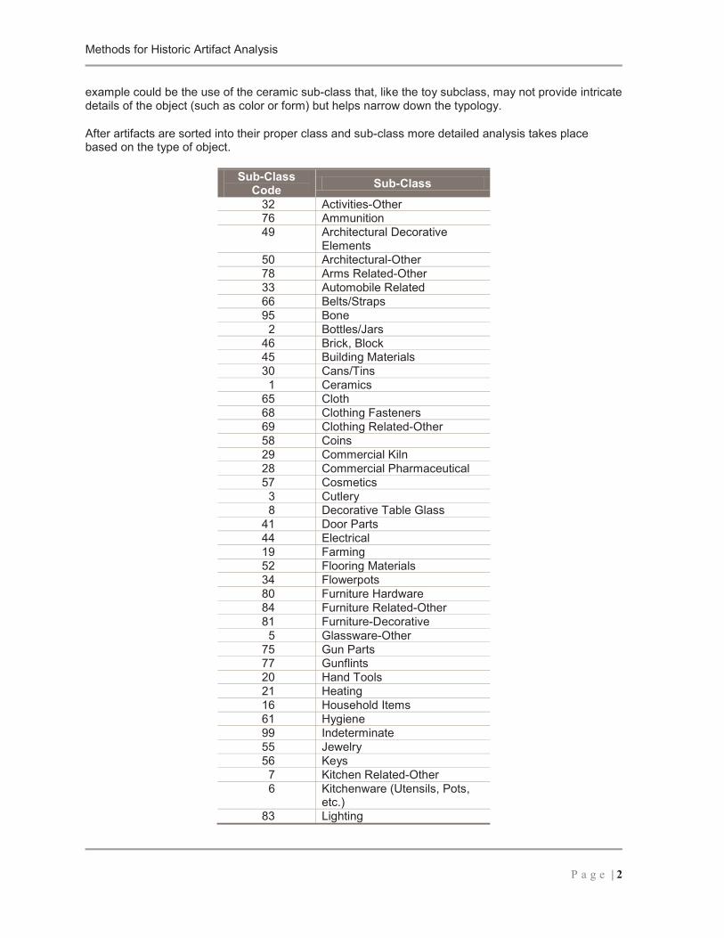
Methods for Historic Artifact Analysis
P a g e | 2
example could be the use of the ceramic sub-class that, like the toy subclass, may not provide intricate details of the object (such as color or form) but helps narrow down the typology.
After artifacts are sorted into their proper class and sub-class more detailed analysis takes place based on the type of object.
Sub-Class Code Sub-Class
32 Activities-Other76 Ammunition49 Architectural Decorative
Elements50 Architectural-Other78 Arms Related-Other33 Automobile Related66 Belts/Straps95 Bone
2 Bottles/Jars46 Brick, Block45 Building Materials30 Cans/Tins
1 Ceramics65 Cloth68 Clothing Fasteners69 Clothing Related-Other58 Coins29 Commercial Kiln28 Commercial Pharmaceutical57 Cosmetics
3 Cutlery8 Decorative Table Glass
41 Door Parts44 Electrical19 Farming52 Flooring Materials34 Flowerpots80 Furniture Hardware84 Furniture Related-Other81 Furniture-Decorative
5 Glassware-Other75 Gun Parts77 Gunflints20 Hand Tools21 Heating16 Household Items61 Hygiene99 Indeterminate55 Jewelry56 Keys
7 Kitchen Related-Other6 Kitchenware (Utensils, Pots,
etc.)83 Lighting
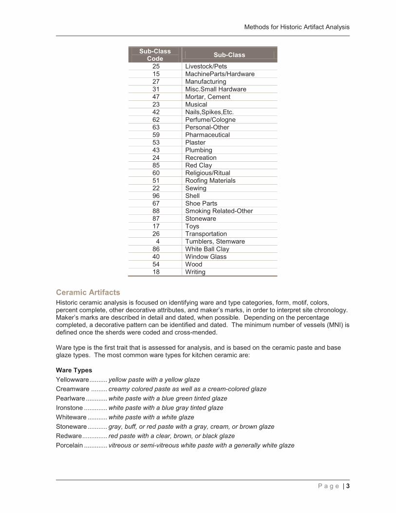
Methods for Historic Artifact Analysis
P a g e | 3
Sub-Class Code Sub-Class
25 Livestock/Pets15 MachineParts/Hardware27 Manufacturing31 Misc.Small Hardware47 Mortar, Cement23 Musical42 Nails,Spikes,Etc.62 Perfume/Cologne63 Personal-Other59 Pharmaceutical53 Plaster43 Plumbing24 Recreation85 Red Clay60 Religious/Ritual51 Roofing Materials22 Sewing96 Shell67 Shoe Parts88 Smoking Related-Other87 Stoneware17 Toys26 Transportation
4 Tumblers, Stemware86 White Ball Clay40 Window Glass54 Wood18 Writing
Ceramic ArtifactsHistoric ceramic analysis is focused on identifying ware and type categories, form, motif, colors, percent complete, other decorative attributes, and maker’s marks, in order to interpret site chronology. Maker’s marks are described in detail and dated, when possible. Depending on the percentage completed, a decorative pattern can be identified and dated. The minimum number of vessels (MNI) is defined once the sherds were coded and cross-mended.
Ware type is the first trait that is assessed for analysis, and is based on the ceramic paste and base glaze types. The most common ware types for kitchen ceramic are:
Ware TypesYellowware.......... yellow paste with a yellow glazeCreamware ......... creamy colored paste as well as a cream-colored glazePearlware ............ white paste with a blue green tinted glazeIronstone ............. white paste with a blue gray tinted glazeWhiteware ........... white paste with a white glazeStoneware ........... gray, buff, or red paste with a gray, cream, or brown glazeRedware.............. red paste with a clear, brown, or black glazePorcelain ............. vitreous or semi-vitreous white paste with a generally white glaze

Methods for Historic Artifact Analysis
P a g e | 4
Vessel PartPart is the portion of the vessel that has been recovered. The most common vessel parts are:Rim ...................... the top rim of a bowl, plate, or cupBody .................... the general pieces that do not connect to a rim or base. This is where most of the
decoration is placed on a pieceBase .................... the base or foundation of a piece. Most times this is where the maker’s mark is
placed
DecorationDecoration encompasses many different techniques, some of which are datable. The most common techniques used are:Hand painted.......simple designs used to decorate, usually
Sponge ware ....... technique that uses sponges dipped in paint used to decorate
Transfer print .......a technique where a general design is laid out and transferred in a small dotted pattern onto the surface of a vessel
Decal ...................an updated from of transfer printing where a pre-made design is adhered to the vessel
Shell edge ...........blue, green, or red color is used to decorate the outer edge of a plate
Glass ArtifactsGlass artifacts, much like ceramics, are tabulated according to major groups (e.g., bottle glass, window glass, lamp glass, tableware, tumblers), and then separated into functional categories whenever possible.
Dating information is based on the identification of diagnostic technological attributes (e.g., mold seams and evidence of snap-case manufacture), in addition to identifiable bottle embossments.
Attributes recorded for glass artifacts include: manufacturing technique decoration finish type base type color functional group/form
The beginning and end dates for every datable attribute is determined. Maker’s marks and embossments are identified, described and dated, when possible. A Maker’s Mark is the unique identifying mark of a specific company that is placed on the base of plate, bowls, cups, and bottles
Manufacturing TechniqueManufacturing Technique is the process by which the glass object is made. The most common types of manufacture are: Free Blown Blown in Mold Machine Made Molded with Applied or Improved Finish
Decoration

Methods for Historic Artifact Analysis
P a g e | 5
Decoration of glass can come in the form of a blown or etched design in the body of a piece or in the application of color labels.
Finish/Base TypeFinish type refers to the type of rim/lip on the bottle. The type of finish can,, in some cases, be used to provide a date range of bottle manufacture. The way that the finish was applied (by hand or by machine) can also be a determining factor in age. Some of the more common bottle finishes are: Crown Finish Blob Top Finish Oil Finish Bead Finish Sheared Finish String Rim Finish Patent Finish Prescription Finish
ColorColor is also an age-determining factor, since some unique colors were used for a limited time. The most common colors in historic glass are Sun Colored Amethyst Cobalt Olive Green Amber White Opaque Aqua Clear
FormForm is the part of the vessel that has been recovered. The most common vessel forms are:
Lip/Rim...... the top rim of a bottle or glassBody.......... the general pieces that do not connect to a rim or base. This is where most of the
decoration is placed on a pieceBase .......... the base or foundation of a piece. Most times this is where the maker’s mark is placed
Other ArtifactsOther historic/modern artifact classes include architectural debris (e.g., bricks, nails, window glass, etc.), clothing (type and materials identified when possible), and miscellaneous small finds. When necessary, attributes such as character, wear, decoration, and material are coded, as well.
Nails and screws can be assigned date ranges based upon their type of manufacture. The most datable types are:
Cut nails Wrought nails Wire nails Self-starting screws
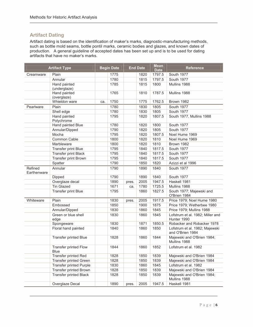
Methods for Historic Artifact Analysis
P a g e | 6
Artifact DatingArtifact dating is based on the identification of maker’s marks, diagnostic-manufacturing methods, such as bottle mold seams, bottle pontil marks, ceramic bodies and glazes, and known dates of production. A general guideline of accepted dates has been set up and is to be used for dating artifacts that have no maker’s marks.
Artifact Type Begin Date End Date Mean Date Reference
Creamware Plain 1775 1820 1797.5 South 1977Annular 1780 1815 1797.5 South 1977Hand painted (underglaze)
1785 1815 1800 Mullins 1988
Hand painted (overglaze)
1765 1810 1787.5 Mullins 1988
Whieldon ware ca. 1750 1775 1762.5 Brown 1982Pearlware Plain 1780 1830 1805 South 1977
Shell edge 1780 1830 1805 South 1977Hand painted Polychrome
1795 1820 1807.5 South 1977, Mullins 1988
Hand painted Blue 1780 1820 1800 South 1977Annular/Dipped 1790 1820 1805 South 1977Mocha 1795 1820 1807.5 Noel Hume 1969Common Cable 1800 1820 1810 Noel Hume 1969Marbleware 1800 1820 1810 Brown 1982Transfer print Blue 1795 1840 1817.5 South 1977Transfer print Black 1795 1840 1817.5 South 1977Transfer print Brown 1795 1840 1817.5 South 1977Spatter 1790 1850 1820 Azizzi et al 1996
Refined Earthenware
Annular 1790 1890 1840 South 1977
Dipped 1790 1890 1840 South 1977Overglaze decal 1890 pres. 2005 1947.5 Haskell 1981Tin Glazed 1671 ca. 1780 1725.5 Mullins 1988Transfer print Blue 1795 1860 1827.5 South 1977; Majewski and
O'Brien 1984Whiteware Plain 1830 pres. 2005 1917.5 Price 1979; Noel Hume 1980
Embossed 1850 1900 1875 Price 1979; Wetherbee 1980Annular/Dipped 1830 1860 1845 Price 1979; Mullins 1988Green or blue shell edge
1830 1860 1845 Lofstrum et al. 1982; Miller and Hunter 1990
Spongeware 1830 1871 1850.5 Robacker and Robacker 1978Floral hand painted 1840 1860 1850 Lofstrum et al. 1982; Majewski
and O'Brien 1984Transfer printed Blue 1828 1860 1844 Majewski and O'Brien 1984;
Mullins 1988Transfer printed Flow Blue
1844 1860 1852 Lofstrum et al. 1982
Transfer printed Red 1828 1850 1839 Majewski and O'Brien 1984 Transfer printed Green 1828 1850 1839 Majewski and O'Brien 1984Transfer printed Purple 1830 1860 1845 Lofstrum et al. 1982Transfer printed Brown 1828 1850 1839 Majewski and O'Brien 1984Transfer printed Black 1828 1850 1839 Majewski and O'Brien 1984;
Mullins 1988Overglaze Decal 1890 pres. 2005 1947.5 Haskell 1981
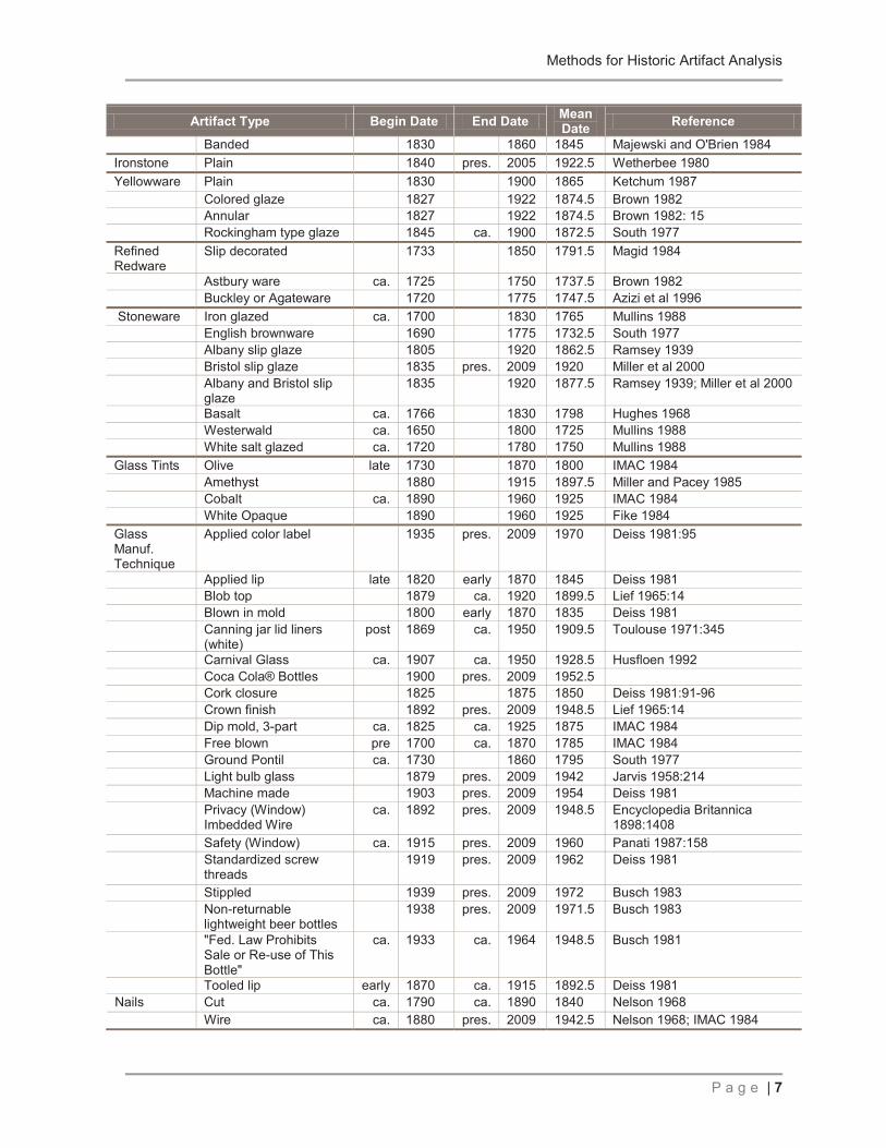
Methods for Historic Artifact Analysis
P a g e | 7
Artifact Type Begin Date End Date Mean Date Reference
Banded 1830 1860 1845 Majewski and O'Brien 1984Ironstone Plain 1840 pres. 2005 1922.5 Wetherbee 1980Yellowware Plain 1830 1900 1865 Ketchum 1987
Colored glaze 1827 1922 1874.5 Brown 1982Annular 1827 1922 1874.5 Brown 1982: 15Rockingham type glaze 1845 ca. 1900 1872.5 South 1977
Refined Redware
Slip decorated 1733 1850 1791.5 Magid 1984
Astbury ware ca. 1725 1750 1737.5 Brown 1982Buckley or Agateware 1720 1775 1747.5 Azizi et al 1996
Stoneware Iron glazed ca. 1700 1830 1765 Mullins 1988English brownware 1690 1775 1732.5 South 1977Albany slip glaze 1805 1920 1862.5 Ramsey 1939Bristol slip glaze 1835 pres. 2009 1920 Miller et al 2000Albany and Bristol slip glaze
1835 1920 1877.5 Ramsey 1939; Miller et al 2000
Basalt ca. 1766 1830 1798 Hughes 1968Westerwald ca. 1650 1800 1725 Mullins 1988White salt glazed ca. 1720 1780 1750 Mullins 1988
Glass Tints Olive late 1730 1870 1800 IMAC 1984Amethyst 1880 1915 1897.5 Miller and Pacey 1985Cobalt ca. 1890 1960 1925 IMAC 1984White Opaque 1890 1960 1925 Fike 1984
Glass Manuf. Technique
Applied color label 1935 pres. 2009 1970 Deiss 1981:95
Applied lip late 1820 early 1870 1845 Deiss 1981Blob top 1879 ca. 1920 1899.5 Lief 1965:14Blown in mold 1800 early 1870 1835 Deiss 1981Canning jar lid liners (white)
post 1869 ca. 1950 1909.5 Toulouse 1971:345
Carnival Glass ca. 1907 ca. 1950 1928.5 Husfloen 1992Coca Cola® Bottles 1900 pres. 2009 1952.5Cork closure 1825 1875 1850 Deiss 1981:91-96Crown finish 1892 pres. 2009 1948.5 Lief 1965:14Dip mold, 3-part ca. 1825 ca. 1925 1875 IMAC 1984Free blown pre 1700 ca. 1870 1785 IMAC 1984Ground Pontil ca. 1730 1860 1795 South 1977Light bulb glass 1879 pres. 2009 1942 Jarvis 1958:214Machine made 1903 pres. 2009 1954 Deiss 1981Privacy (Window) Imbedded Wire
ca. 1892 pres. 2009 1948.5 Encyclopedia Britannica 1898:1408
Safety (Window) ca. 1915 pres. 2009 1960 Panati 1987:158Standardized screw threads
1919 pres. 2009 1962 Deiss 1981
Stippled 1939 pres. 2009 1972 Busch 1983Non-returnable lightweight beer bottles
1938 pres. 2009 1971.5 Busch 1983
"Fed. Law Prohibits Sale or Re-use of This Bottle"
ca. 1933 ca. 1964 1948.5 Busch 1981
Tooled lip early 1870 ca. 1915 1892.5 Deiss 1981Nails Cut ca. 1790 ca. 1890 1840 Nelson 1968
Wire ca. 1880 pres. 2009 1942.5 Nelson 1968; IMAC 1984
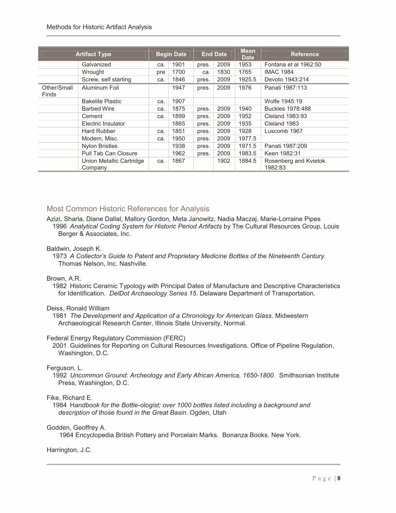
Methods for Historic Artifact Analysis
P a g e | 8
Artifact Type Begin Date End Date Mean Date Reference
Galvanized ca. 1901 pres. 2009 1953 Fontana et al 1962:50Wrought pre 1700 ca. 1830 1765 IMAC 1984Screw, self starting ca. 1846 pres. 2009 1925.5 Devoto 1943:214
Other/Small Finds
Aluminum Foil 1947 pres. 2009 1976 Panati 1987:113
Bakelite Plastic ca. 1907 Wolfe 1945:19Barbed Wire ca. 1875 pres. 2009 1940 Buckles 1978:488Cement ca. 1899 pres. 2009 1952 Cleland 1983:93Electric Insulator 1865 pres. 2009 1935 Cleland 1983Hard Rubber ca. 1851 pres. 2009 1928 Luscomb 1967Modern, Misc. ca. 1950 pres. 2009 1977.5Nylon Bristles 1938 pres. 2009 1971.5 Panati 1987:209Pull Tab Can Closure 1962 pres. 2009 1983.5 Keen 1982:31Union Metallic Cartridge Company
ca. 1867 1902 1884.5 Rosenberg and Kvietok 1982:83
Most Common Historic References for AnalysisAzizi, Sharla, Diane Dallal, Mallory Gordon, Meta Janowitz, Nadia Maczaj, Marie-Lorraine Pipes
1996 Analytical Coding System for Historic Period Artifacts by The Cultural Resources Group, Louis Berger & Associates, Inc.
Baldwin, Joseph K.1973 A Collector’s Guide to Patent and Proprietary Medicine Bottles of the Nineteenth Century.
Thomas Nelson, Inc. Nashville.
Brown, A.R.1982 Historic Ceramic Typology with Principal Dates of Manufacture and Descriptive Characteristics
for Identification. DelDot Archaeology Series 15. Delaware Department of Transportation.
Deiss, Ronald William1981 The Development and Application of a Chronology for American Glass. Midwestern
Archaeological Research Center, Illinois State University, Normal.
Federal Energy Regulatory Commission (FERC)2001 Guidelines for Reporting on Cultural Resources Investigations. Office of Pipeline Regulation,
Washington, D.C.
Ferguson, L.1992 Uncommon Ground: Archeology and Early African America, 1650-1800. Smithsonian Institute
Press, Washington, D.C.
Fike, Richard E.1984 Handbook for the Bottle-ologist; over 1000 bottles listed including a background and
description of those found in the Great Basin. Ogden, Utah
Godden, Geoffrey A.1964 Encyclopedia British Pottery and Porcelain Marks. Bonanza Books. New York.
Harrington, J.C.
Methods for Historic Artifact Analysis
P a g e | 9
1954 Dating Stem Fragments of Seventeenth and Eighteenth Century Clay Tobacco Pipes.Quarterly Bulletin of the Archaeological Society of Virginia 9 (1).
IMACS1984 IMACS Users Guide/April 1984
Jones, Olive R.1985 Cylindrical English Wine and Beer Bottles 1735-1850. Environment Canada-Parks, Ottawa,
Canada
Ketchum, William C. Jr.1987 American Country Pottery: Yellowware & Spongeware. Alfred A. Knopf Inc. Westminster,
Maryland
Lofstrum et.al.1982 “A Seriation of Historic Earthenwares in the Midwest, 1780-1870”. The Minnesota
Archaeologist 41 (1): 3-29
Majewski, Teresita, and Michael O'Brien 1984 An Analysis of Historical Ceramics from the Central Salt River Valley of Northeast Missouri.
Cannon Reservoir Human Ecology Project, Volume 1 Publications in Archaeology No.3, American Archaeology Division, Department of Anthropology, University of Missouri, Columbia.
Marks, Mariann, K.1989 Majolica Pottery. Collectors Books. Paducah, Kentucky.
Mullins, Paul R.1988 Typology. James Madison University Archaeological Research Center Ceramic April 1988
Nelson, Lee H.1968 Nail Chronology as an Aid to Dating Old Buildings. American Association for State and Local
History Technical Leaflet 48. History News 24(11)
Noel Hume, Ivor1969 A Guide to Artifacts of Colonial America. Alfred A. Knopf, New York
Price, Cynthia R.1979 “19th Century Ceramics in the Eastern Ozark Border Region,” Monograph Series No. 1, Center
for Archaeology Research, Southwest Missouri State University, Springfield, Missouri.
Robacker, Earl F. and Ada F. Robacker1978 Spatterware and Sponge: Hardy Perennials of Ceramics. A.S. Barnes and Co., South
Brunswick, New Jersey, and New York.
Rosenberg, Robert G. and D Peter Kvietok1982 A Guide to Historic Artifacts. High Plains Consultants, Laramie, Wyoming.
South, Stanley1977 Method and Theory in Historical Archaeology. Academic Press, New York

Methods for Historic Artifact Analysis
P a g e | 10
Toulouse, J.H.1969 Fruit Jars. Nelson Inc., NJ.
1971 Bottle Maker’s and Their Marks. Thomas Nelson Inc., New York; Camden
Wetherbee, Jean1980 A Look at White Ironstone. Wallace-Homestead Book Co., Des Moines, Iowa

Appendix J
Archaebotanical Analysis
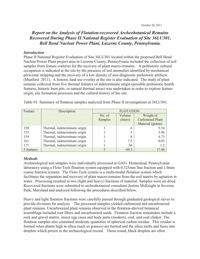
October 20, 2011
Report on the Analysis of Flotation-recovered Archeobotanical Remains Recovered During Phase II National Register Evaluation of Site 36LU301,
Bell Bend Nuclear Power Plant, Luzerne County, Pennsylvania.
Introduction Phase II National Register Evaluation of Site 36LU301 located within the proposed Bell Bend Nuclear Power Plant project area in Luzerne County, Pennsylvania included the collection of soil samples from feature contexts for the recovery of plant macro-remains. A prehistoric cultural occupation is indicated at the site by the presence of soil anomalies identified by mechanical plowzone stripping and the recovery of a low density of non-diagnostic prehistoric artifacts (Munford 2011). A historic land use overlay at the site is also indicated. The study of plant remains collected from five thermal features of indeterminate origin (possible prehistoric hearth features, historic burn pits, or natural thermal areas) was undertaken in order to explore feature origin, site formation processes and the cultural history of the site. Table 01: Summary of flotation samples analyzed from Phase II investigations at 36LU301. Feature Description FLOTATION No. of
Samples Volume (liters)
Weight of Carbonized Plant Material (grams)
150 Thermal, indeterminate origin 1 6 5.54 153 Thermal, indeterminate origin 1 5 5.96 154 Thermal, indeterminate origin 1 6 4.73 161 Thermal, indeterminate origin 1 7.5 0.05 171 Thermal, indeterminate origin 1 36 1.2 5 features 5 60.5 17.48 Methods Archaeological soil samples were individually processed at GAI's Homestead, Pennsylvania laboratory using a Flote-Tech flotation system equipped with 0.325mm fine fraction and 1.0mm coarse fraction screens. The Flote-Tech system is a multi-modal flotation system which facilitates the separation and recovery of plant macro-remains from the soil matrix by agitation in water. Processing resulted in two (light and heavy) fractions of material. Samples were air dried. Recovered fractions were submitted to archeobotanical consultant Justine McKnight in Severna Park, Maryland and analyzed following the procedures described below. Heavy and light flotation fractions were carefully passed through graduated geological sieves to provide divisions for analysis. The processed samples yielded carbonized and uncarbonized plant remains. Uncarbonized plant remains observed in the flotation-derived botanical assemblage included root fibers and uncarbonized seeds. Flotation fraction remainders include a rock and gravel matrix, insect egg cases and body parts (modern), coal, and coal clinker. The flotation samples also contained moderate quantities of spherical carbon residue. This residue is formed when plants high in silica (such as grasses) are burned and the silica melts and fuses into droplets which persist in the archaeological record. These round, black droplets are often
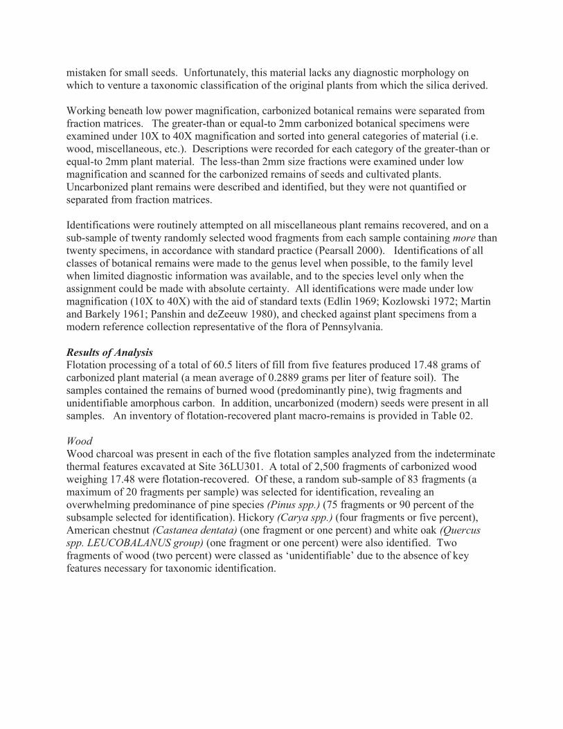
mistaken for small seeds. Unfortunately, this material lacks any diagnostic morphology on which to venture a taxonomic classification of the original plants from which the silica derived. Working beneath low power magnification, carbonized botanical remains were separated from fraction matrices. The greater-than or equal-to 2mm carbonized botanical specimens were examined under 10X to 40X magnification and sorted into general categories of material (i.e. wood, miscellaneous, etc.). Descriptions were recorded for each category of the greater-than or equal-to 2mm plant material. The less-than 2mm size fractions were examined under low magnification and scanned for the carbonized remains of seeds and cultivated plants. Uncarbonized plant remains were described and identified, but they were not quantified or separated from fraction matrices. Identifications were routinely attempted on all miscellaneous plant remains recovered, and on a sub-sample of twenty randomly selected wood fragments from each sample containing more than twenty specimens, in accordance with standard practice (Pearsall 2000). Identifications of all classes of botanical remains were made to the genus level when possible, to the family level when limited diagnostic information was available, and to the species level only when the assignment could be made with absolute certainty. All identifications were made under low magnification (10X to 40X) with the aid of standard texts (Edlin 1969; Kozlowski 1972; Martin and Barkely 1961; Panshin and deZeeuw 1980), and checked against plant specimens from a modern reference collection representative of the flora of Pennsylvania. Results of Analysis Flotation processing of a total of 60.5 liters of fill from five features produced 17.48 grams of carbonized plant material (a mean average of 0.2889 grams per liter of feature soil). The samples contained the remains of burned wood (predominantly pine), twig fragments and unidentifiable amorphous carbon. In addition, uncarbonized (modern) seeds were present in all samples. An inventory of flotation-recovered plant macro-remains is provided in Table 02. Wood Wood charcoal was present in each of the five flotation samples analyzed from the indeterminate thermal features excavated at Site 36LU301. A total of 2,500 fragments of carbonized wood weighing 17.48 were flotation-recovered. Of these, a random sub-sample of 83 fragments (a maximum of 20 fragments per sample) was selected for identification, revealing an overwhelming predominance of pine species (Pinus spp.) (75 fragments or 90 percent of the subsample selected for identification). Hickory (Carya spp.) (four fragments or five percent), American chestnut (Castanea dentata) (one fragment or one percent) and white oak (Quercus spp. LEUCOBALANUS group) (one fragment or one percent) were also identified. Two fragments of wood (two percent) were classed as ‘unidentifiable’ due to the absence of key features necessary for taxonomic identification.
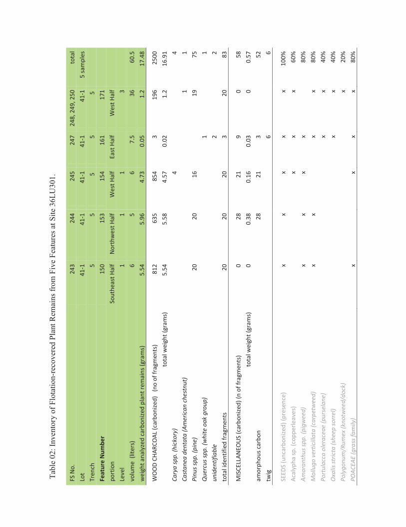
Tabl
e 02
: Inv
ento
ry o
f Flo
tatio
n-re
cove
red
Plan
t Rem
ains
from
Fiv
e Fe
atur
es a
t Site
36L
U30
1.
FS N
o.
243
244
245
247
248,
249
, 250
to
tal
Lot
41-1
41
-1
41-1
41
-1
41-1
5
sam
ples
Tr
ench
5
5 5
5
5
Fe
atur
e N
umbe
r 15
0 15
3 15
4 16
1 17
1
port
ion
Sout
heas
t Hal
f N
orth
wes
t Hal
f W
est H
alf
East
Hal
f W
est H
alf
Le
vel
1 1
1
3
volu
me
(lite
rs)
6 5
6 7.
5 36
60
.5
wei
ght a
naly
zed
carb
onize
d pl
ant r
emai
ns (g
ram
s)
5.54
5.
96
4.73
0.
05
1.2
17.4
8
WO
OD
CHAR
COAL
(car
boni
zed)
(n
o of
frag
men
ts)
812
635
854
3 19
6 25
00
tota
l wei
ght (
gram
s)
5.54
5.
58
4.57
0.
02
1.2
16.9
1 Ca
rya
spp.
(hic
kory
) 4
4 Ca
stan
ea d
enta
ta (A
mer
ican
che
stnu
t)
1 1
Pinu
s spp
. (pi
ne)
20
20
16
19
75
Que
rcus
spp.
(whi
te o
ak g
roup
) 1
1 un
iden
tifia
ble
2 2
tota
l ide
ntifi
ed fr
agm
ents
20
20
20
3
20
83
MIS
CELL
ANEO
US
(car
boni
zed)
(n o
f fra
gmen
ts)
0 28
21
9
0 58
to
tal w
eigh
t (gr
ams)
0
0.38
0.
16
0.03
0
0.57
am
orph
ous c
arbo
n 28
21
3
52
twig
6
6
SEED
S (u
ncar
boni
zed)
(pre
senc
e)
x x
x x
x 10
0%
Acal
ypha
sp. (
copp
erle
aves
) x
x x
60%
Am
aran
thus
spp.
(pig
wee
d)
x x
x x
80%
M
ollu
go v
ertic
illat
a (c
arpe
twee
d)
x x
x x
80%
Po
rtul
acca
ole
race
ae (p
urse
lane
) x
x 40
%
Oxa
lis st
ricta
(she
ep so
rrel
) x
x 40
%
Poly
gonu
m/R
umex
(kno
twee
d/do
ck)
x 20
%
POAC
EAE
(gra
ss fa
mily
) x
x
x x
80%
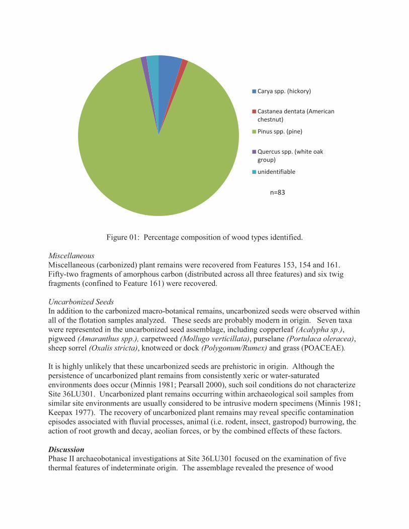
Figure 01: Percentage composition of wood types identified. Miscellaneous Miscellaneous (carbonized) plant remains were recovered from Features 153, 154 and 161. Fifty-two fragments of amorphous carbon (distributed across all three features) and six twig fragments (confined to Feature 161) were recovered. Uncarbonized Seeds In addition to the carbonized macro-botanical remains, uncarbonized seeds were observed within all of the flotation samples analyzed. These seeds are probably modern in origin. Seven taxa were represented in the uncarbonized seed assemblage, including copperleaf (Acalypha sp.), pigweed (Amaranthus spp.), carpetweed (Mollugo verticillata), purselane (Portulaca oleracea), sheep sorrel (Oxalis stricta), knotweed or dock (Polygonum/Rumex) and grass (POACEAE). It is highly unlikely that these uncarbonized seeds are prehistoric in origin. Although the persistence of uncarbonized plant remains from consistently xeric or water-saturated environments does occur (Minnis 1981; Pearsall 2000), such soil conditions do not characterize Site 36LU301. Uncarbonized plant remains occurring within archaeological soil samples from similar site environments are usually considered to be intrusive modern specimens (Minnis 1981; Keepax 1977). The recovery of uncarbonized plant remains may reveal specific contamination episodes associated with fluvial processes, animal (i.e. rodent, insect, gastropod) burrowing, the action of root growth and decay, aeolian forces, or by the combined effects of these factors. Discussion Phase II archaeobotanical investigations at Site 36LU301 focused on the examination of five thermal features of indeterminate origin. The assemblage revealed the presence of wood
Carya spp. (hickory)
Castanea dentata (American chestnut)
Pinus spp. (pine)
Quercus spp. (white oak group)
unidentifiable
n=83
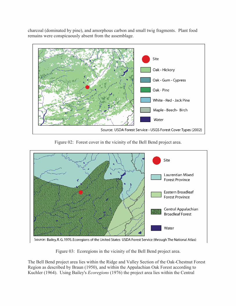
charcoal (dominated by pine), and amorphous carbon and small twig fragments. Plant food remains were conspicuously absent from the assemblage.
Figure 02: Forest cover in the vicinity of the Bell Bend project area.
Figure 03: Ecoregions in the vicinity of the Bell Bend project area. The Bell Bend project area lies within the Ridge and Valley Section of the Oak-Chestnut Forest Region as described by Braun (1950), and within the Appalachian Oak Forest according to Kuchler (1964). Using Bailey's Ecoregions (1976) the project area lies within the Central
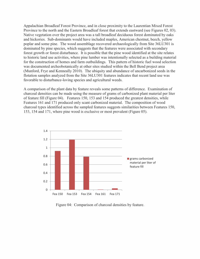
Appalachian Broadleaf Forest Province, and in close proximity to the Laurentian Mixed Forest Province to the north and the Eastern Broadleaf forest that extends eastward (see Figures 02, 03). Native vegetation over the project area was a tall broadleaf deciduous forest dominated by oaks and hickories. Sub-dominants would have included maples, American chestnut, beech, yellow poplar and some pine. The wood assemblage recovered archaeologically from Site 36LU301 is dominated by pine species, which suggests that the features were associated with secondary forest growth or forest disturbance. It is possible that the pine wood identified at the site relates to historic land use activities, where pine lumber was intentionally selected as a building material for the construction of homes and farm outbuildings. This pattern of historic fuel wood selection was documented archeobotanically at other sites studied within the Bell Bend project area (Munford, Frye and Kenneally 2010). The ubiquity and abundance of uncarbonized seeds in the flotation samples analyzed from the Site 36LU301 features indicates that recent land use was favorable to disturbance-loving species and agricultural weeds. A comparison of the plant data by feature reveals some patterns of difference. Examination of charcoal densities can be made using the measure of grams of carbonized plant material per liter of feature fill (Figure 04). Features 150, 153 and 154 produced the greatest densities, while Features 161 and 171 produced only scant carbonized material. The composition of wood charcoal types identified across the sampled features suggests similarities between Features 150, 153, 154 and 171, where pine wood is exclusive or most prevalent (Figure 05).
Figure 04: Comparison of charcoal densities by feature.
0
0.2
0.4
0.6
0.8
1
1.2
1.4
Fea 150 Fea 153 Fea 154 Fea 161 Fea 171
grams carbonized material per liter of feature fill
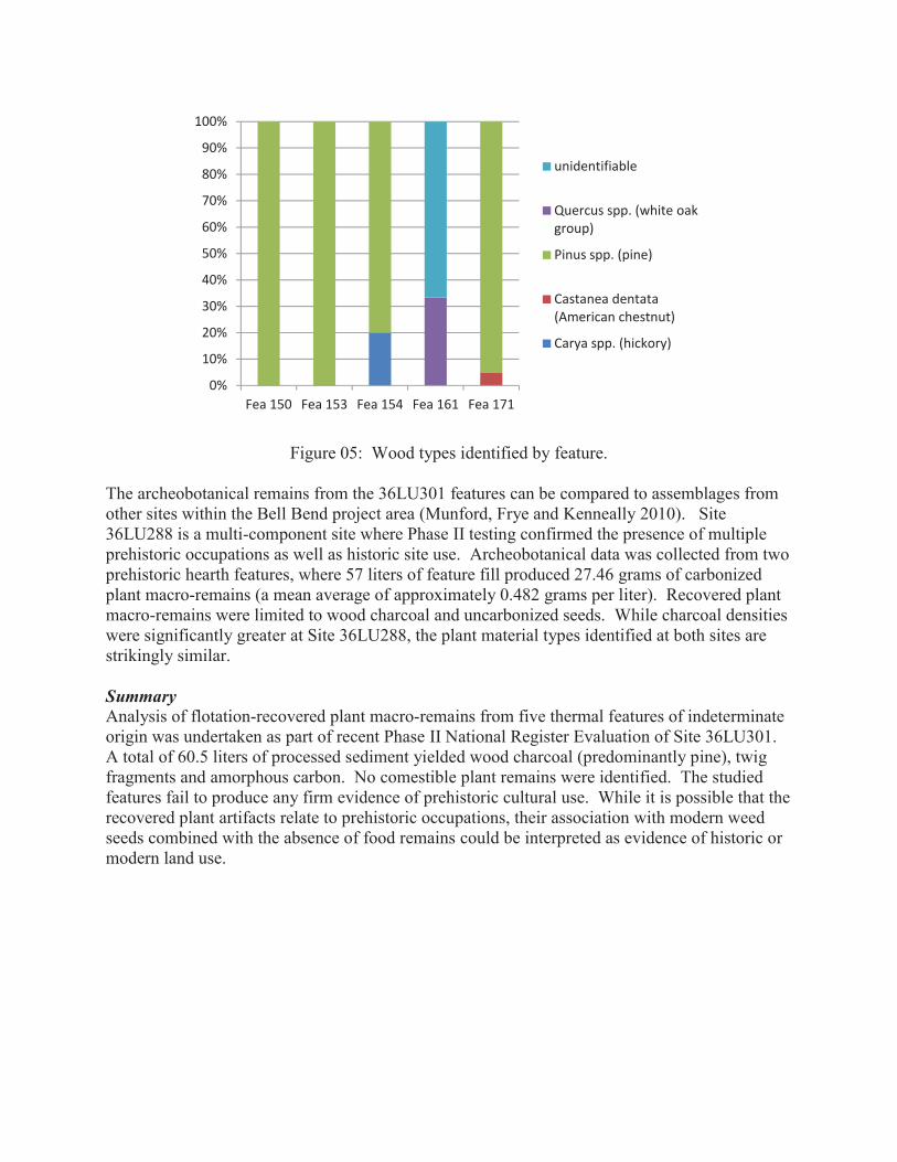
Figure 05: Wood types identified by feature. The archeobotanical remains from the 36LU301 features can be compared to assemblages from other sites within the Bell Bend project area (Munford, Frye and Kenneally 2010). Site 36LU288 is a multi-component site where Phase II testing confirmed the presence of multiple prehistoric occupations as well as historic site use. Archeobotanical data was collected from two prehistoric hearth features, where 57 liters of feature fill produced 27.46 grams of carbonized plant macro-remains (a mean average of approximately 0.482 grams per liter). Recovered plant macro-remains were limited to wood charcoal and uncarbonized seeds. While charcoal densities were significantly greater at Site 36LU288, the plant material types identified at both sites are strikingly similar. Summary Analysis of flotation-recovered plant macro-remains from five thermal features of indeterminate origin was undertaken as part of recent Phase II National Register Evaluation of Site 36LU301. A total of 60.5 liters of processed sediment yielded wood charcoal (predominantly pine), twig fragments and amorphous carbon. No comestible plant remains were identified. The studied features fail to produce any firm evidence of prehistoric cultural use. While it is possible that the recovered plant artifacts relate to prehistoric occupations, their association with modern weed seeds combined with the absence of food remains could be interpreted as evidence of historic or modern land use.
0%
10%
20%
30%
40%
50%
60%
70%
80%
90%
100%
Fea 150 Fea 153 Fea 154 Fea 161 Fea 171
unidentifiable
Quercus spp. (white oak group)
Pinus spp. (pine)
Castanea dentata (American chestnut)
Carya spp. (hickory)
References Cited Bailey, R.G. 1976 Ecoregions of the United States. United States Department of Agriculture Forest Service. Braun, E. Lucy 1950 Deciduous Forests of Eastern North America. The Blakiston Company, Philadelphia. Edlin, Herbert L. 1969 What Wood is That? A Manual of Wood Identification. The Viking Press, New York. Keepax, Carole 1977 Contamination of Archaeological Deposits by seeds of Modern Origin with Particular
Reference to the Use of Flotation Machines. Journal of Archaeological Science. 4:221-229.
Kozlowski, T.T., Ed. 1972 Seed Biology. Academic Press, New York. Kuchler, A.W. 1964 Manual to accompany the map of potential natural vegetation of the Coterminous United
States. American Geographical Society, Special Publication 36. Martin A. and W. Barkely 1961 Seed Identification Manual. University of California Press, Berkeley. Minnis, Paul E. 1981 Seeds in Archeological Sites: Sources and Some Interpretive Problems. American Antiquity 46:143-151. Munford, Barbara A. 2011 Management Summary, Phase II National Register Evaluation Site 36LU301, Bell Bend
Nuclear Power Plant, Luzerne County, Pennsylvania, ER 81-0658-079. Prepared by GAI Consultants, Inc., Homestead, Pennsylvania, for PPL Bell Bend, LLC.
Munford, Barbara A., Lori A. Frye, and Michael P. Kenneally 2010 Technical Report, Phase I Cultural Resources Investigations and Phase II National
Register Site Evaluations, Bell Bend Nuclear Power Plant, Luzerne County, Pennsylvania, ER 81-0658-079. Prepared by GAI Consultants, Inc., Homestead, Pennsylvania, for UniStar Nuclear Energy, LLC.
Panshin, Alexis and Carl deZeeuw 1980 Textbook of Wood Technology. Volume 1, 4th edition. McGraw Hill, New York.

Pearsall, D. 2000 Paleoethnobotany: A Handbook of Procedures. Second Edition Academic Press, San
Diego. Rhoads, A.F. and WM. Klein, Jr. 1993 The Vascular Flora of Pennsylvania. Annotated Checklist and Atlas. American
Philosophical Society, Philadelphia.

Appendix K
Radiocarbon Analysis

Digital signature on file
November 28, 2011
Ms. Barbara A. MunfordGAI Consultants, Incorporated385 East Waterfront DriveHomestead, PA 15120-5005USA
RE: Radiocarbon Dating Results For Samples 36LU301F150, 36LU301F153, 36LU301F154,36LU301F171
Dear Ms. Munford:
Enclosed are the radiocarbon dating results for four samples recently sent to us. They eachprovided plenty of carbon for accurate measurements and all the analyses proceeded normally. As usual,the method of analysis is listed on the report with the results and calibration data is provided whereapplicable.
As always, no students or intern researchers who would necessarily be distracted with otherobligations and priorities were used in the analyses. We analyzed them with the combined attention ofour entire professional staff.
If you have specific questions about the analyses, please contact us. We are always available toanswer your questions.
Thank you for prepaying the analyses. A receipt is enclosed with the mailed report copy. Asalways, if you have any questions or would like to discuss the results, don’t hesitate to contact me.
Sincerely,
P age 1 of 6
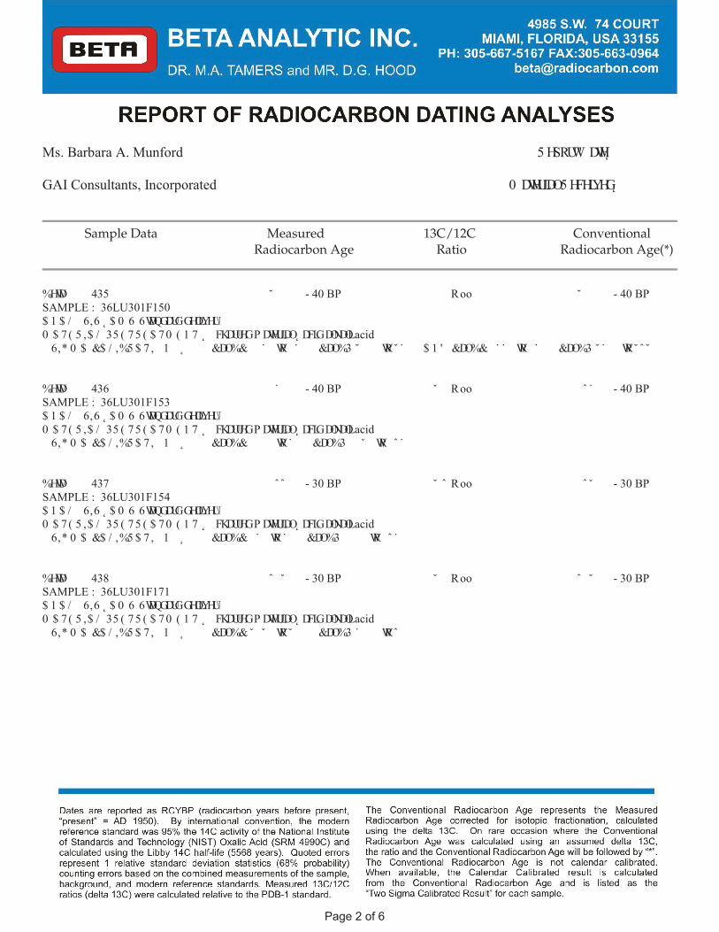
Ms. Barbara A. Munford 5 HSRUW' DWH � � � ��� ����
GAI Consultants, Incorporated 0 DWHULDO5 HFHLYHG � � � �� ����
Sample Data Measured 13C/12C ConventionalRadiocarbon Age Ratio Radiocarbon Age(*)
%HWD� � � � 435 ˘ � � � � � - 40 BP � � � � � R� oo ˘ � � � � � - 40 BPSAMPLE : 36LU301F150$ 1 $ / � 6,6 ˛ $ 0 6 � 6WDQGDUGGHOLYHU\0 $ 7 ( 5 ,$ / � 35 ( 7 5 ( $ 7 0 ( 1 7 ˛ � FKDUUHGP DWHULDO� ˛ DFLG� DONDOL� acid� 6,* 0 $ &$ / ,%5 $ 7 , � 1 ˛ &DO%& � � ˙ � WR � ˙ � � � &DO%3 ˘ � � � WR˘ ˙ � � � $ 1 ' &DO%& � ˙ ˙ � WR � ˙ � � � &DO%3 ˘ ˙ � � WR˘ ˆ ˘ � �� � � � � � � � � � � � � � � � � � � � � � � � � � � � � � � � � � � � � � � � � � � � � � � � � � � � � � � � � � � � � � � � � � � � � � � � � � � � � � � � � � � �
%HWD� � � � 436 � ˙ � � � � - 40 BP � � ˇ � � R� oo � ˆ ˙ � � � - 40 BPSAMPLE : 36LU301F153$ 1 $ / � 6,6 ˛ $ 0 6 � 6WDQGDUGGHOLYHU\0 $ 7 ( 5 ,$ / � 35 ( 7 5 ( $ 7 0 ( 1 7 ˛ � FKDUUHGP DWHULDO� ˛ DFLG� DONDOL� acid� 6,* 0 $ &$ / ,%5 $ 7 , � 1 ˛ &DO%& � � � � WR˙ � � � &DO%3 � � ˇ � WR � ˆ ˙ � �� � � � � � � � � � � � � � � � � � � � � � � � � � � � � � � � � � � � � � � � � � � � � � � � � � � � � � � � � � � � � � � � � � � � � � � � � � � � � � � � � � � �
%HWD� � � � 437 � ˆ ˆ � � � - 30 BP � � ˘ � ˆ R� oo � ˆ ˇ � � � - 30 BPSAMPLE : 36LU301F154$ 1 $ / � 6,6 ˛ $ 0 6 � 6WDQGDUGGHOLYHU\0 $ 7 ( 5 ,$ / � 35 ( 7 5 ( $ 7 0 ( 1 7 ˛ � FKDUUHGP DWHULDO� ˛ DFLG� DONDOL� acid� 6,* 0 $ &$ / ,%5 $ 7 , � 1 ˛ &DO%& � ˙ � WR˙ � � � &DO%3 � � � � WR � ˆ ˙ � �� � � � � � � � � � � � � � � � � � � � � � � � � � � � � � � � � � � � � � � � � � � � � � � � � � � � � � � � � � � � � � � � � � � � � � � � � � � � � � � � � � � �
%HWD� � � � 438 ˆ � ˇ � � � - 30 BP � � ˘ � � R� oo ˆ � ˘ � � � - 30 BPSAMPLE : 36LU301F171$ 1 $ / � 6,6 ˛ $ 0 6 � 6WDQGDUGGHOLYHU\0 $ 7 ( 5 ,$ / � 35 ( 7 5 ( $ 7 0 ( 1 7 ˛ � FKDUUHGP DWHULDO� ˛ DFLG� DONDOL� acid� 6,* 0 $ &$ / ,%5 $ 7 , � 1 ˛ &DO%& ˇ � ˇ � WR˘ � � � � &DO%3 ˙ � � � WRˆ � � � �� � � � � � � � � � � � � � � � � � � � � � � � � � � � � � � � � � � � � � � � � � � � � � � � � � � � � � � � � � � � � � � � � � � � � � � � � � � � � � � � � � � �
P age 2 of 6
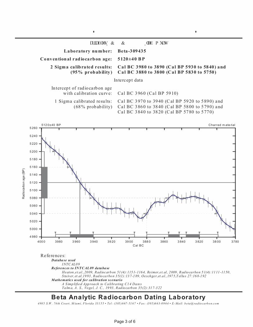
� � � � � � � � � � � � � � � ' � � � � � � � � � � � � � � � � � � ' � � � � � � �� � DULDEOHV &� � � &� � � � � � � � ˛ODE� P XOW� � �
Laboratory nu mber: Beta-309435
Conventional rad iocarbon age: 5120±40 B P
2 Sigma calibrated results:(95% probab ility )
Cal BC 3980 to 3890 (Cal BP 5930 to 5840) andCal BC 3880 to 3800 (Cal BP 5830 to 5750)
In tercep t data
In tercep t of rad iocarbon agewith calibration curve: Cal BC 3960 (Cal BP 5910)
1 Sigma calib rated resu lts:(68% probab ility)
Cal BC 3970 to 3940 (C al BP 5920 to 5890) andCal BC 3860 to 3840 (C al BP 5800 to 5790) andCal BC 3840 to 3820 (C al BP 5780 to 5770)
4985 S.W . 74 th Co u rt , M ia mi, F lo rida 331 5 5 • Tel : (3 05 )667 -51 6 7 • F a x: (30 5 )6 63 -0 9 64 • E -Ma il: b eta@ ra d io ca rb o n.com
Beta Analytic Radiocarbon Dating LaboratoryTa lm a, A. S., Vogel, J. C., 19 93 , Rad iocarbon 35 (2):317-322A S imp lified App roa ch to Ca libra ting C14 Dates
Mathematics used fo r ca libra tion scenarioS tu iver,et.al,19 93 , Rad io ca rbo n 35(1) :13 7-189 , Oeschger,et.a l.,1975,T ellu s 27 :168-192Heaton ,et.a l. ,2009, Rad iocarbon 51 (4):1151-1164, Reimer,et.al, 2009 , Rad iocarbon 51(4) :1111 -1150 ,
References to INTC AL09 da ta baseI NTC AL0 9
Databa se usedReferences:
Rad
ioca
rbon
age
(BP
)
4 980
5 000
5 020
5 040
5 060
5 080
5 100
5 120
5 140
5 160
5 180
5 200
5 220
5 240
Charred m ate rial5 260
Cal BC400 0 3980 3 960 3 940 39 20 39 00 388 0 3860 3 840 3 820 38 00 3780
512 0±40 BP
P age 3 of 6
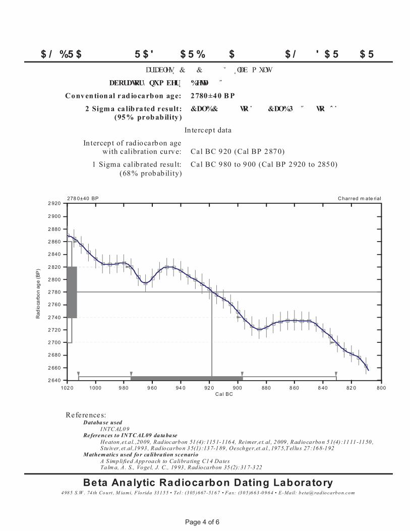
� $ / � %5 $ � � � � � � 5 $ ' � � � $ 5 %� � $ � � � � � $ / � � ' $ 5 � � $ 5 �� � DULDEOHV &� � � &� � � � � ˇ � � ˛ODE� P XOW� � �
� DERUDWRU\ QXP EHU %HWD� � � ˝ � � �
Conventional rad iocarbon age: 2780±40 B P
2 Sigma calibrated result:(95% probab ility )
&DO%& � � � � WR ˙ � � � &DO%3 � ˝ � � WR � ˆ ˙ � �
In tercep t data
In tercep t of rad iocarbon agewith calibration curve: Cal BC 920 (Cal BP 2870)
1 Sigma calib rated resu lt:(68% probab ility)
Cal BC 980 to 900 (Cal BP 2920 to 2850)
4985 S.W . 74 th Co u rt , M ia mi, F lo rida 331 5 5 • Tel : (3 05 )667 -51 6 7 • F a x: (30 5 )6 63 -0 9 64 • E -Ma il: b eta@ ra d io ca rb o n.com
Beta Analytic Radiocarbon Dating LaboratoryTa lm a, A. S., Vogel, J. C., 19 93 , Rad iocarbon 35 (2):317-322A S imp lified App roa ch to Ca libra ting C14 Dates
Mathematics used fo r ca libra tion scenarioS tu iver,et.al,19 93 , Rad io ca rbo n 35(1) :13 7-189 , Oeschger,et.a l.,1975,T ellu s 27 :168-192Heaton ,et.a l. ,2009, Rad iocarbon 51 (4):1151-1164, Reimer,et.al, 2009 , Rad iocarbon 51(4) :1111 -1150 ,
References to INTC AL09 da ta baseI NTC AL0 9
Databa se usedReferences:
Rad
ioca
rbon
age
(BP
)
2 640
2 660
2 680
2 700
2 720
2 740
2 760
2 780
2 800
2 820
2 840
2 860
2 880
2 900
Charred m ate rial2 920
Cal BC102 0 1000 9 80 9 60 94 0 92 0 900 880 8 60 8 40 82 0 800
278 0±40 BP
P age 4 of 6
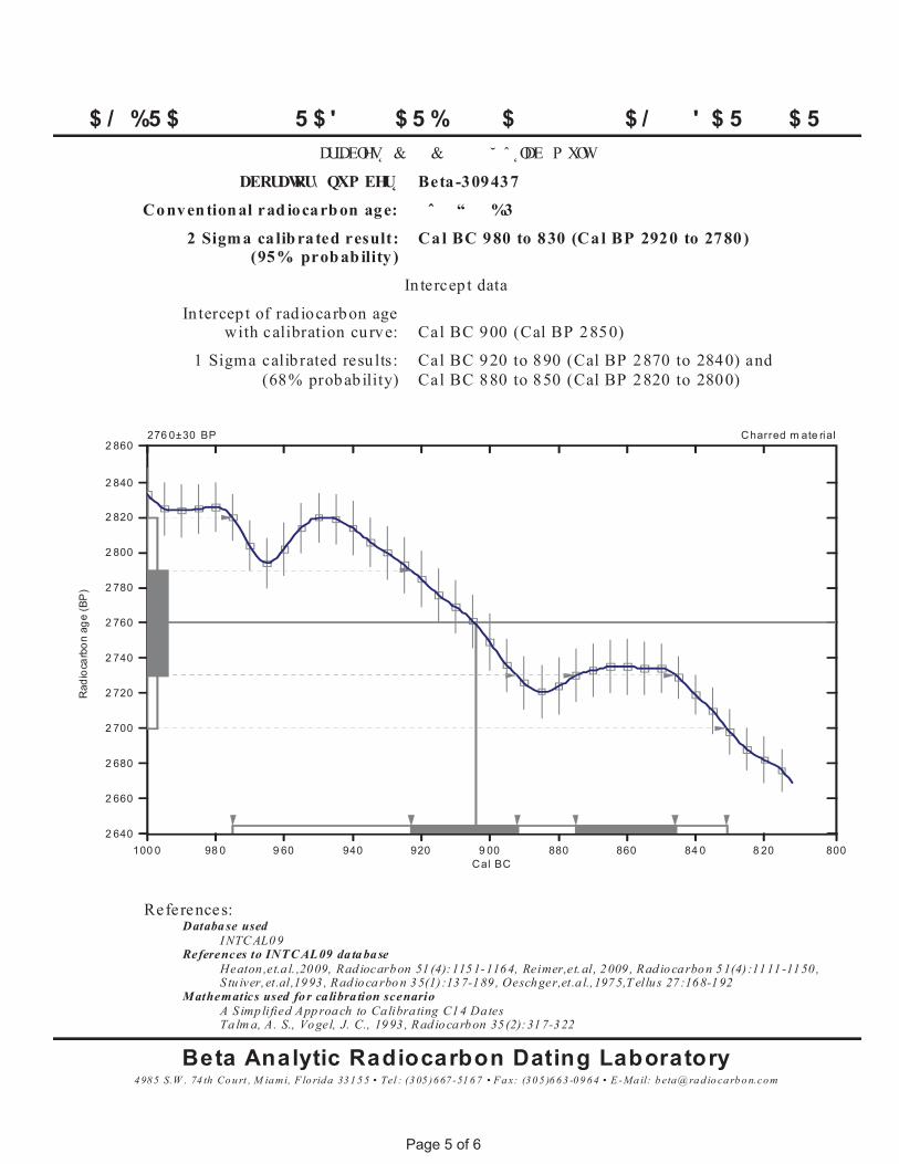
� $ / � %5 $ � � � � � � 5 $ ' � � � $ 5 %� � $ � � � � � $ / � � ' $ 5 � � $ 5 �� � DULDEOHV &� � � &� � � � � ˘ � ˆ ˛ODE� P XOW� � �
� DERUDWRU\ QXP EHU Beta-309437
Conventional rad iocarbon age: � ˆ � � “ � � %3
2 Sigma calibrated result:(95% probab ility )
Cal BC 980 to 830 (Cal BP 2920 to 2780)
In tercep t data
In tercep t of rad iocarbon agewith calibration curve: Cal BC 900 (Cal BP 2850)
1 Sigma calib rated resu lts:(68% probab ility)
Cal BC 920 to 890 (Cal BP 2870 to 2840) andCal BC 880 to 850 (Cal BP 2820 to 2800)
4985 S.W . 74 th Co u rt , M ia mi, F lo rida 331 5 5 • Tel : (3 05 )667 -51 6 7 • F a x: (30 5 )6 63 -0 9 64 • E -Ma il: b eta@ ra d io ca rb o n.com
Beta Analytic Radiocarbon Dating LaboratoryTa lm a, A. S., Vogel, J. C., 19 93 , Rad iocarbon 35 (2):317-322A S imp lified App roa ch to Ca libra ting C14 Dates
Mathematics used fo r ca libra tion scenarioS tu iver,et.al,19 93 , Rad io ca rbo n 35(1) :13 7-189 , Oeschger,et.a l.,1975,T ellu s 27 :168-192Heaton ,et.a l. ,2009, Rad iocarbon 51 (4):1151-1164, Reimer,et.al, 2009 , Rad iocarbon 51(4) :1111 -1150 ,
References to INTC AL09 da ta baseI NTC AL0 9
Databa se usedReferences:
Rad
ioca
rbon
age
(BP
)
2 640
2 660
2 680
2 700
2 720
2 740
2 760
2 780
2 800
2 820
2 840
Charred m ate rial2 860
Cal BC100 0 98 0 9 60 940 920 9 00 880 860 84 0 8 20 800
276 0±30 BP
P age 5 of 6
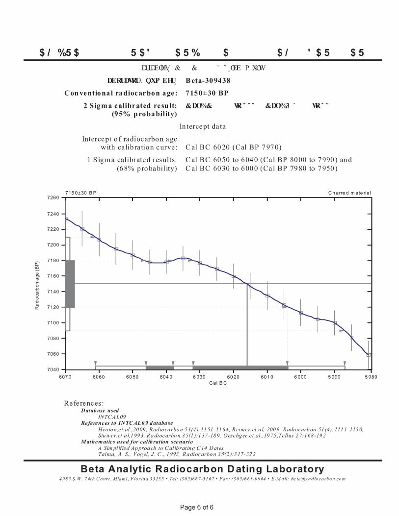
� $ / � %5 $ � � � � � � 5 $ ' � � � $ 5 %� � $ � � � � � $ / � � ' $ 5 � � $ 5 �� � DULDEOHV &� � � &� � � � � ˘ � ˝ ˛ODE � P XOW� � �
� DERUDWRU\ QXP EHU B eta-309438
Con ventiona l radiocarbon age: 7150± 30 BP
2 S igma calibrated resu lt:(95% p robability)
&DO%& � � � � WR ˘ ˝ ˝ � � &DO%3 ˙ � � � WRˆ ˝ � � �
In tercept data
Intercept o f radiocarbon agewith calib ration curve: C al BC 6020 (Cal BP 7970)
1 S igma calibrated results:(68% probability)
C al BC 6050 to 6040 (Cal BP 8000 to 7990) andC al BC 6030 to 6000 (Cal BP 7980 to 7950)
49 8 5 S .W. 7 4t h C our t, Mia mi , F lo r id a 3 3 15 5 • Tel: (3 0 5 )66 7 -5 16 7 • F ax: (3 05)6 6 3-09 64 • E -M a il: be ta@ ra d ioca rb on.co m
Beta Analytic Radiocarbon D ating LaboratoryTalma, A. S., Vog el, J . C ., 1993 , Radiocarbon 35(2 ):317-322A Sim plified Ap proa ch to C alib rating C 14 Dates
Mathematics used for calib ration scenarioStu iver,et.a l,1993, Radiocarbo n 35(1 ):137 -189, Oeschger,et.al.,1975 ,Tellus 27:168 -19 2Hea to n,et.al.,2009 , Rad io carbon 51(4 ):1151 -1164 , Reimer,et.a l, 2009, Radiocarbon 51 (4):1111-115 0,
References to INTC AL0 9 d atabaseINTC AL09
Datab ase usedReferences:
Rad
ioca
rbon
age
(BP)
7040
7060
7080
7100
7120
7140
7160
7180
7200
7220
7240
Ch arre d m ate rial7260
Cal B C607 0 6060 60 50 604 0 6 030 60 20 601 0 6 000 5 990 5 980
715 0±30 B P
P age 6 of 6
Related Documents


![Round results Notices issued by Ofcom under Wireless ... · Airspan [REDACTED] 34 34 EE [REDACTED] 16 16 H3G [REDACTED] 46 46 Telefonica [REDACTED] 37 37 Vodafone [REDACTED] 40 40](https://static.cupdf.com/doc/110x72/5ba4d8c509d3f257608be079/round-results-notices-issued-by-ofcom-under-wireless-airspan-redacted.jpg)