Lands Department The Government of the Hong Kong SAR 4D Mapping – Definitive, Diversified, Dynamic and Data Sharing for Smart City Development Thomas CHAN Director of Lands, Lands Department Hong Kong SAR Government

Welcome message from author
This document is posted to help you gain knowledge. Please leave a comment to let me know what you think about it! Share it to your friends and learn new things together.
Transcript

Lands Department
The Government of the Hong Kong SAR
4D Mapping – Definitive, Diversified, Dynamic and Data Sharing
for Smart City Development
Thomas CHAN Director of Lands, Lands Department
Hong Kong SAR Government

Source: Planning Department, HKSARG
Land Use in Hong Kong

About 20% of land is steep
slopes (ie > 30o in gradient)
Built-up
Areas 24%
Source: Planning Department, HKSARG
Land Area : 1,108 km2
Sea Area : 1,649 km2
Land Resources in Hong Kong
City Average Population Density (person/km2)
Hong Kong SAR 27,330
Singapore 11,400
Seoul 8,800
Los Angeles 2,300
New York 1,700
Source: Demographia World Urban Areas 14th Annual Edition: 201804
Country parks: 443 km2
Marine parks: 24 km2

About 90% of passenger
trips (12.6 million average
daily passenger trips) by
public transport
Rail share passenger trips
by public transport > 40%
Within 500m
from a rail
station
Transport in Hong Kong
Source: Planning Department, HKSARG
Source: Legislative Council Secretariat, HKSARG

Hong Kong’s Population is projected
to increase until 2046
Lands Department
The Government of the Hong Kong SAR
Source: Task Force on Land Supply

Source: Planning Department, HKSARG
Lands Department
The Government of the Hong Kong SAR
Estimation of Overall Land Supply
and Demand up to 2046 (hectares)
Total Area
1,108 km2
24% Built-up
Areas
Up to 2026 2026-2046 Total Shortfall Demand Supply Shortfall Demand Supply Shortfall
Residential Use
768 660 -108 902 780 -122 -230
Economic Use 196 61 -135 262 141 -121 -256
Infrastructure and Facilities
1,661 1,089 -572 931 783 -148 -720
Total 2,625 1,810 -815 2,095 1,704 -391 -1,206

v Strategic growth areas (the East Lantau Metropolis and
the New Territories North)
Spatial Development Framework
Source: Planning Department, HKSARG

Lands Department
The Government of the Hong Kong SAR

VISION
Lands Department
The Government of the Hong Kong SAR

Land Administration and
Management
Innovative Applications and
Technological Development
Land Use Policies and Best
Practices
Surveying, Mapping and
Positioning Infrastructure
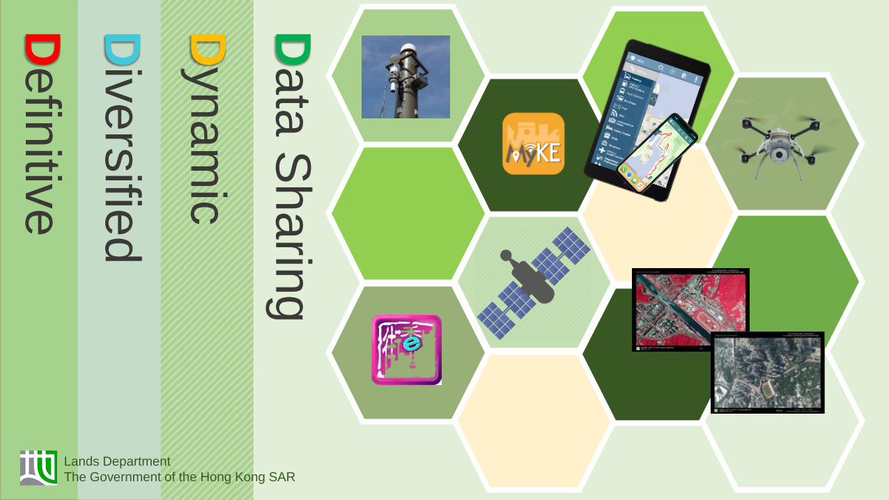
Lands Department
The Government of the Hong Kong SAR
Defin
itive
Div
ers
ified
D
ynam
ic
Da
ta S
ha
ring
Lands Department
The Government of the Hong Kong SAR

Defin
itive
Lands Department
The Government of the Hong Kong SAR
Topographic Map
Continuous updating Hong Kong Satellite Positioning
Reference Station Network
Aerial Photos
Acquire 13,000 numbers of aerial
photographs per year
Quality
Objectives
Performance
Pledge
All quality management system requirements with respect to ISO 9001 are applied

Defin
itive
Lands Department
The Government of the Hong Kong SAR
Smart Lamp Post Indoor Positioning
4MP 2µm Pixel Camera
Motion Tracking Camera Integrated
Depth Sensing Government Offices
LED light
Surveillance Camera
Sensors
Location Devices
Wi-Fi / 5G
Bluetooth Detector
Meteorological sensors
Air quality sensor

Div
ers
ified
D
efin
itive
Lands Department
The Government of the Hong Kong SAR

Div
ers
ified
D
efin
itive
Lands Department
The Government of the Hong Kong SAR
3D Pedestrian Network GIS & BIM Integration
MMS Application Drone Application

Div
ers
ified
D
efin
itive
Dynam
ic
Shadow Analysis
Flooding Analysis
Viewshed Analysis
Lands Department
The Government of the Hong Kong SAR

Div
ers
ified
D
efin
itive
Dynam
ic
Lands Department
The Government of the Hong Kong SAR
Start
End

Div
ers
ified
D
efin
itive
Dynam
ic
10 Jan 2015 17 Dec 2015 Height +1.4m ~ +2.2m
Change Detection
Lands Department
The Government of the Hong Kong SAR
Greening/
Government
Institution
Community
Vacant Government Sites

Defin
itive
Div
ers
ified
D
ynam
ic
Da
ta S
ha
ring
Lands Department
The Government of the Hong Kong SAR
Clinics
Restaurants
Badminton
Courts

Average Household Income Analysis Report
Demographic Report of HK
Defin
itive
Div
ers
ified
D
ynam
ic
Da
ta S
ha
ring
Lands Department
The Government of the Hong Kong SAR
Digital Transformation
Geo-tagging

Defin
itive
Div
ers
ified
D
ynam
ic
Da
ta S
ha
ring
Lands Department
The Government of the Hong Kong SAR
School Net Boundary

Defin
itive
Div
ers
ified
D
ynam
ic
Da
ta S
ha
ring
Lands Department
The Government of the Hong Kong SAR
Policy and
Institutions
Framework
Data
Technologies
& Applications
COMMON SPATIAL
DATA INFRASTRUCTURE
(CSDI)
Technical
Standards
Common Spatial
Data Infrastructure

23
Developing Hong Kong into a Spatially Enabled World City

101011011000001011001010
101011011000001011001
101011011000001011001
1110110110000010
101111101100000101
1110110110000010111
11101101100000
1110110110000010111
011011000000111
Related Documents