Potential Impacts of Brownfield Development: an Assessment. David McOmish Strategic Research & Partnerships May 2018 [email protected]

Welcome message from author
This document is posted to help you gain knowledge. Please leave a comment to let me know what you think about it! Share it to your friends and learn new things together.
Transcript

Potential Impacts of Brownfield Development: an Assessment.
David McOmish Strategic Research & Partnerships
May 2018 [email protected]

1 Potential Impacts of Brownfield Development
May 2018
Executive Summary
The government has made the case for developing brownfield land in order to help address the housing shortage in England.
Using Leeds city centre as a case study, this assessment evaluates the likely scale of brownfield development, and its potential impact on historic fabric and places. This revealed that (potentially) we currently underestimate the number of historic assets and places that might be impacted by brownfield development.
There is analysis of the opportunities for enhanced understanding of the significance and value of those places selected for potential brownfield development. The report also frames the scope of our potential response and engagement with the development proposed.
Consultees Victoria Thomson, Andrew Vines, John Cattell, Owain Lloyd-James, Jen Heathcote, Daniel Miles.
2 Potential Impacts of Brownfield Development
May 2018
Contents Executive Summary ................................................1
Consultees ...............................................................1
Contents ..................................................................2
Introduction ............................................................3
Context ....................................................................4
Issues .......................................................................8
Potential responses: the case for strategic research 9
Leeds City Council Brownfield Register – Site Allocations Pilot 11
Potential responses for Historic England ............ 16

3 Potential Impacts of Brownfield Development
May 2018
Introduction Government land use statistics collected from each local authority in 20101 identified that there were approximately 68,910 hectares of ‘brownfield land that is unused or may be available for redevelopment’. Much of this land is located in urban areas and approximately 35,000 hectares of this land is considered suitable for housing. The Housing White paper2 sets out the wider, strategic, case for brownfield development, principally, the need to make
‘…more land available for homes in the right places, by maximising the contribution from brownfield and surplus public land, regenerating estates, releasing more small and medium-sized sites, allowing rural communities to grow and making it easier to build new settlements.’
Underpinning this is a clear understanding that residential development opportunities on small sites should be treated positively3. Regulations governing the introduction of a Brownfield Land Register came into force on 16th April 20174 and guidance was published in July 20175. In addition to this, a national data standard for Brownfield Land Registers was also released6.
This assessment evaluates the likely scale of brownfield development, its potential impact on historic fabric and places, and the prospects this development offers for enhanced understanding of the significance and value of those places selected for potential development. There are opportunities here to engage with, and encourage, good design outcomes that can enhance places too. The report also frames the scope of our potential response and engagement with the development proposed.
1 https://www.gov.uk/government/statistics/national-land-use-database-of-previously-developed-land-2010-nlud-pdl 2https://www.gov.uk/government/uploads/system/uploads/attachment_data/file/590464/Fixing_our_broken_housing_market_-_print_ready_version.pdf 3 Note, though, that the relationship is much more complex than this. Previous discussions have also included small greenfield options too. 4 http://www.legislation.gov.uk/uksi/2017/403/pdfs/uksi_20170403_en.pdf 5 https://www.gov.uk/guidance/brownfield-land-registers 6 https://www.gov.uk/government/uploads/system/uploads/attachment_data/file/653657/BrownfieldLandRegisters_-_DataStandard.pdf

4 Potential Impacts of Brownfield Development
May 2018
Context
What is Brownfield Land? The National Planning Policy Framework7 defines brownfield as
“land which is or was occupied by a permanent structure, including the curtilage of the developed land (although it should not be assumed that the whole of the curtilage should be developed) and any associated fixed surface infrastructure. This excludes:
• Land that is, or has been, occupied by agricultural or forestry buildings
• Land that has been developed for minerals extraction or waste disposal by landfill purposes where provision for restoration has been made through development control procedures
• Land in built-up areas such as private residential gardens, parks, recreation grounds and allotments
• Land that was previously-developed but where the remains of the permanent structure or fixed surface structure have blended into the landscape in the process of time”.
Land ascribed as ‘brownfield’ is diverse and ranges from spaces such as redundant quarries, 1960s industrial estates or cleared, former industrial, locations, all the way up to large areas of historic cities with deeply stratified urban archaeological deposits.
The scale of the issue Government land use statistics from 20108 identified that there were close on to 69,000 hectares of ‘brownfield land that is unused or may be available for redevelopment’. Much of this land is located in urban areas and approximately 35,000 hectares of it is considered suitable for housing. It is, though, probable that the re-draft of the NPPF will see this figure revised upwards. The Housing White paper9 sets
7 https://www.gov.uk/government/uploads/system/uploads/attachment_data/file/6077/2116950.pdf 8 https://www.gov.uk/government/statistics/national-land-use-database-of-previously-developed-land-2010-nlud-pdl 9 https://www.gov.uk/government/publications/fixing-our-broken-housing-markethttps://www.gov.uk/government/uploads/system/uploads/attachment_data/file/590464/Fixing_our_broken_housing_market_-_print_ready_version.pdf

5 Potential Impacts of Brownfield Development
May 2018
out the case for brownfield development, principally, the need to make ‘…more land available for homes in the right places, by maximising the contribution from brownfield and surplus public land.’ Underpinning this is a clear understanding that residential development opportunities on small sites should be treated positively. Seventy-three local authorities were selected to participate in a pilot Brownfield Register project10 but an initial (independent) review stated that the process is failing to identify and record small brownfield locations that could provide space for an additional c. 200,000 homes across England11.
The CPRE reported that ‘brownfield land has the capacity to support over 1.8 million new homes. However, despite the identified high housing capacity (a substantial increase on previous estimates and certainly a greater number than that suggested by the government), the most recent Government figures have shown that the proportion of new dwellings delivered on brownfield land has fallen significantly from 81% in 2008 to just 68% in 2011. It is likely that this has decreased further to 2014.12 The CPRE also notes ‘that the study of the 53 pilot registers produced a figure – 273,000 – that is both higher than previous Government estimates of countrywide brownfield housing capacity, and almost enough for the participating councils to meet their five-year housing targets without releasing any countryside for development’.
Some initial scoping analysis was undertaken by Historic England, assessing the potential impacts of the Leeds city centre brownfield options, in order to develop an effective working method (see below). This was successful and illustrates the need to include as many related datasets as possible in the assessment – the more data, the better the analysis – but, crucially, it also reveals that (potentially) we currently underestimate the number of historic assets and places that might be impacted by brownfield development.
Government policy In the Housing White Paper, the Secretary of State outlined the strategic drivers underpinning the regeneration of previously developed land:
10 The data relating to the pilot study can be accessed at https://data.gov.uk/dataset/brownfield-land-register-cbc 11 https://www.cpre.org.uk/resources/housing-and-planning/housing/item/4726-unlocking-potential-best-practice-for-brownfield-land-registers 12 CPRE Report, 2014 – From wasted space to living spaces - http://www.cpre.org.uk/media-centre/news-release-archive/item/3784-england-has-space-for-at-least-1-million-homes-on-brownfield-land
6 Potential Impacts of Brownfield Development
May 2018
1.24 We must make as much use as possible of previously-developed (‘brownfield’) land for homes – so that this resource is put to productive use, to support the regeneration of our cities, towns and villages, to support economic growth and to limit the pressure on the countryside. The Government is already pursuing a number of reforms to make this happen.
1.25 Going further, the presumption should be that brownfield land is suitable for housing unless there are clear and specific reasons to the contrary (such as high flood risk). To make this clear, we will amend the National Planning Policy Framework to indicate that great weight should be attached to the value of using suitable brownfield land within settlements for homes, following the broad support for this proposal in our consultation in December 2015.
The development of brownfield sites, in the Green Belt, will be considered but only where it contributes to the target provision of starter homes, and where it does not impact on the character (openness) of the Green Belt.
The Housing White Paper largely confirms an existing emphasis on brownfield development which has already been set out in the NPPF, as well as the Housing and Planning Act – please see Historic England’s response to the proposed planning change13 and an earlier response to the 2015 NPPF consultation14.
In addition, the more recent Historic England response to the Housing White Paper15 cites a number of concerns about the impact of the emerging policy on brownfield development. And our response to ‘Right Homes in the Right Places’16 also underscores our strategic approach to the issues surrounding the provision of local housing.
As part of this drive to ensure open access to areas of potential brownfield development, the government now requires that all Local Authorities maintain a
13 https://content.historicengland.org.uk/content/docs/consultations/technical-consultation-planning-changes-response-apr16.pdf 14 https://content.historicengland.org.uk/content/docs/consultations/DCLG-consultation-response-on-national-planning-policy-feb16.pdf 15 https://content.historicengland.org.uk/content/docs/consultations/he-response-dclg-housing-white-paper-may17.pdf 16 https://content.historicengland.org.uk/content/docs/consultations/he-response-dclg-consultation-planning-right-homes-right-places-nov17.pdf
7 Potential Impacts of Brownfield Development
May 2018
‘Brownfield Register’17,18 and an application for development can also be made through the Permission in Principle (PiP) regime19. There is a formal requirement in the Housing and Planning Act 2016 for registers to be kept and the intention is that the Register will ensure that nationally consistent information on suitable brownfield sites is kept up-to-date and made publicly available for communities and developers. These registers provide a platform for granting permission in principle for housing on suitable sites, ‘giving early certainty to landowners, developers and communities’ (guidance is available20,21). In addition to this, there are a series of initiatives that have been launched to encourage the use of brownfield for development. These include:
• making £3 billion of loan funding for developers available through the Home Building Fund announced in October 2016, with an emphasis on supporting developments on brownfield land.
• designating 26 Housing Zones with the potential to deliver up to 44,000 new homes on brownfield land. The London programme, which is devolved to the Mayor, incorporates 31 Zones expected to deliver 77,000 new homes.
• continuing to use the £1.2 billion Starter Homes Land Fund to bring forward suitable brownfield land for starter homes and other types of affordable home ownership products. Thirty local authority partnerships, working with the Homes and Communities Agency, were announced in January 2017 to help identify suitable sites.
The first round of registers should have been in place by the end of December 2017, and to a tightly defined format22, but approximately 20% of local authorities missed this deadline23.
17 Town and Country Planning (Brownfield Land Register) Regulations 2017. The pilot Brownfield Registers exclude Greater London: the London Land Commission published its own Brownfield Register of publicly owned sites in January 2016. Note that the Register comprises two parts: Part 1 – brownfield land suitable for housing; Part 2 – sites that come with permission in principle to develop. 18 http://legislation.data.gov.uk/uksi/2017/402/made/data.pdf 19 https://www.gov.uk/guidance/permission-in-principle 20 https://www.gov.uk/guidance/brownfield-land-registers 21https://www.gov.uk/guidance/permission-in-principle 22 http://www.legislation.gov.uk/uksi/2017/403/contents/made 23 http://www.elexica.com/en/legal-topics/real-estate/280218-brownfield-land-registers-come-into-effect-but-councils-miss-deadline
8 Potential Impacts of Brownfield Development
May 2018
Profiling where the greatest weight of impacts might lie shows that there is an uneven distribution of available brownfield sites in England. Government analysis suggests that the North West region contains the most (20% or 7080 hectares) followed by the South East (18% of the total, or 6170 hectares). The East and West Midlands, for example, together contain just 5360 hectares or 15% of England’s brownfield land.
Issues
Why should we be interested? The CPRE neatly capture the wider, public, benefits of developing on brownfield land24 saying that
‘It makes social, environmental and economic sense for most new development to occur in built-up areas where infrastructure and services are already in place, or can be more easily provided, rather than in the countryside. Brownfield development is essential for urban regeneration. Done well, it brings homes, jobs and services closer together, reduces car dependence and enhances local environmental quality and local communities.’
The inclusion of sites on brownfield registers should not mean development being agreed without necessary safeguards and there are concerns about the efficacy of these, e.g. how do you apply the NPPF without sufficient information in support of PiP entries? Local planning authorities will still be expected to take account of the NPPF when identifying sites suitable for granting permission in principle for sites on brownfield registers. However, given their locations, such sites may have increased archaeological interest and development will have the potential to greatly impact on local character, i.e. brownfield developments may have a greater impact on the historic environment than other locations.
The proposals outlined in the Housing White Paper constitute change to the NPPF and do raise a number of concerns, specifically, about a potential shift in the overall balance of policy:
• The identified housing requirement is to be accommodated unless other NPPF policies (including heritage) provide strong reasons not to; this also
24 Campaign to Protect Rural England (2008) The Campaign to Protect Rural England’s Policy on Brownfield Land, Campaign to Protect Rural England
9 Potential Impacts of Brownfield Development
May 2018
presupposes that the new housing requirement assessment methodology will itself be acceptable.
• There is a proposed presumption that brownfield land is suitable unless there are ‘clear and specific reasons to the contrary’; ‘great weight’ is to be attached to the value of using brownfield land in settlements.
• Allowing development on brownfield land in the Green Belt, but only where it contributes to the delivery of starter homes and there is no substantial harm to the openness of the Green Belt.
The draft revision to the NPPF25 (published March 2018) re-affirms these principles but further change in the final version should be anticipated.
Potential responses: the case for strategic research Whilst the wider sector appreciates the generic impact on the historic environment from any proposed brownfield development, the route to clearly understanding the implications in specific places may be more challenging to identify. To do so, actions are needed to:
• be proactively engaged with the potential impact flowing from brownfield development (i.e. impact stemming from proposals and applications to develop sites on the register)
• ensure that there is a proper consideration of historic environment-related issues in any proposed development – in all environments, not just on urban sites
• provide mechanisms for the careful, and early, screening of those places earmarked for brownfield development
• early assessments of the resource requirement [to address emerging brownfield development] for an already stretched professional sector is essential. Local Planning Authorities are already facing significant resource and funding issues.
• be innovative in how we assess and address the likely impacts of development, and exploit the opportunities too.
25 https://www.gov.uk/government/uploads/system/uploads/attachment_data/file/685289/Draft_revised_National_Planning_Policy_Framework.pdf

10 Potential Impacts of Brownfield Development
May 2018
• this demands a more collegiate and connected way in which the wider sector, as well as relevant agencies (including Historic England), address brownfield issues and work towards outcomes that benefit the historic environment, people and places.
The pressing issue of brownfield development is specifically mentioned in Historic England’s Research Agenda26, as part of the Theme: #adapt:
Central government set the overall policy direction and framework for the planning system operated by local government, and set regulation for specific issues, such as the redevelopment of former industrial or ‘brownfield’ development, and levels of housing development. Research questions that will help our mission include:
How do we enable sustainable brownfield development while protecting archaeological interest and retaining local character?
A current project, Increasing Housing Density (HE Project No: 7631), is directly related to brownfield development and will improve our understanding of the different approaches taken to ensure that developers acknowledge and seek to preserve local character. It may well be that the results from this project – which is focusing on assessing the qualities of acceptable development schemes in historic contexts – can be layered into an agreed methodological protocol for assessing the impact of development on the historic environment.
The CPRE noted recently the, as yet unrealised, potential in ‘Plotting the location of every identified brownfield recorded on GIS maps covering local authority or strategic housing market areas can increase understanding about the nature of sites available. Assessing sites over a wide area can directly aid decisions on the most appropriate uses for sites and allow the prioritisation of individual sites for development’.27
Historic England concur with this statement. In response, there is clear value in:
26 https://content.historicengland.org.uk/images-books/publications/he-research-agenda/research-agenda.pdf/ 27 http://www.cpre.org.uk/resources/housing-and-planning/housing/item/3877-better-brownfield

11 Potential Impacts of Brownfield Development
May 2018
• Collating and assessing all sites (for historic/heritage value) on the Brownfield Register on a GIS platform (see Leeds City Council Brownfield Register case study).
• Using GIS analysis, work out which sites are themselves ‘historic’ in character, as well as those which intersect or abut known heritage assets, and those which overlie buried archaeological resources.
• Cross-reference the data with any other relevant mapped sources, such as Historic Landscape Characterisation or Extensive Urban Surveys, in order to provide a more detailed contextualised understanding of any heritage asset and its setting.
In summary, it is important to emphasise the potential role of early (i.e. desk- or GIS-based) screening and ‘strategic’ assessment of spaces and places earmarked as part of brownfield development. The data, and its analyses, can then be combined with a range of other spatial datasets and form a significant component in digital assessments of threats and risk to the historic environment, across England. In terms of the brownfield aspect, we could, for example, envisage a screening of a whole authority’s Brownfield Register (or even all the brownfield land in a larger area, such as a region?) in which we categorise sites according to their ‘heritage issues’ – no problems envisaged, minor issues, or major, ‘show stopping’, problems. This approach, and an investigative method built upon it, might help tease out which sites are potentially less onerous (from a heritage perspective) to deliver development on, and which ones are not (and, therefore, require a greater amount and range of resources, and time, to remediate) – bearing-in-mind that delivery is major governmental driver.
This work can be collated rapidly and easily, as long as the relevant datasets are available – and the brownfield registers are accessible. When the data is in place, analyses can be done very quickly indeed – a matter of hours, days at most – such as that outlined below in the pilot study for the Leeds city centre sites.
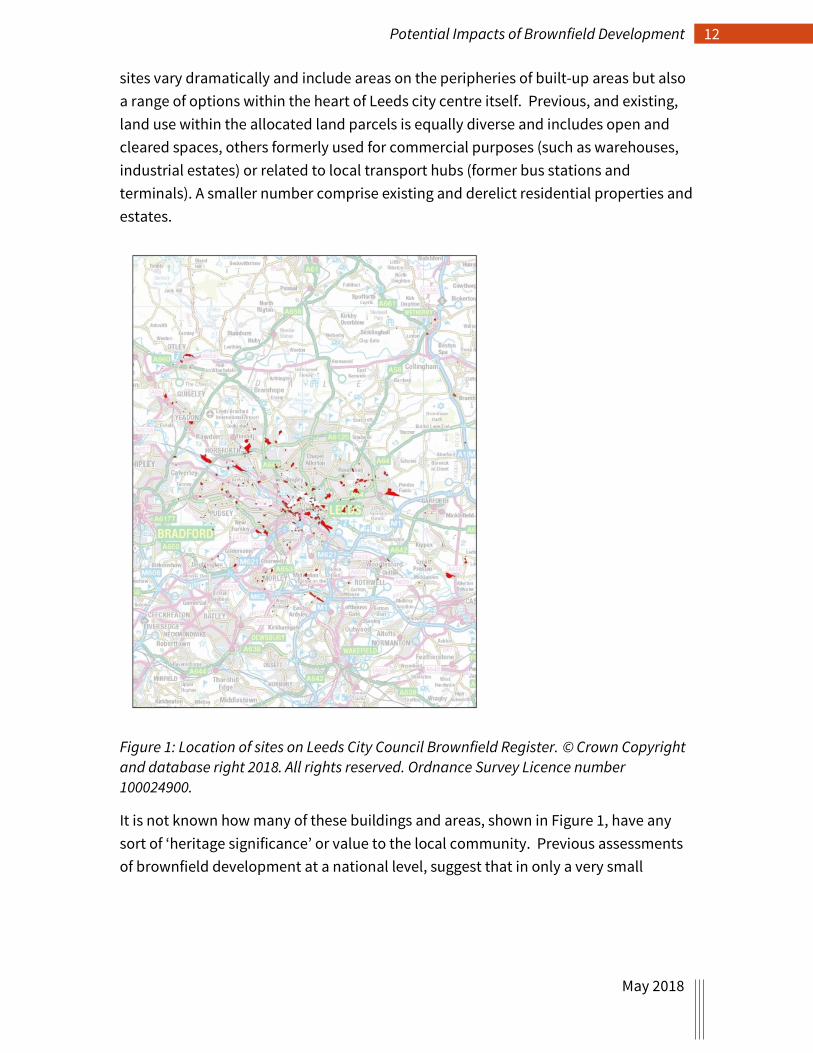
Leeds City Council Brownfield Register – Site Allocations Pilot Approximately 800 hectares of land are recorded on the Leeds City Council Brownfield Register (Fig. 1) and the following case study presents a basic analysis of the potential impact from development. More detailed, GIS-based, analyses could be undertaken, and other aspects factored in too (such as data from the Leeds City Centre Areas of Archaeological Sensitivity survey). In this case study a simple ‘headcount’ of known assets is presented, in mapped and tabular format. The locations of the brownfield
12 Potential Impacts of Brownfield Development
May 2018
sites vary dramatically and include areas on the peripheries of built-up areas but also a range of options within the heart of Leeds city centre itself. Previous, and existing, land use within the allocated land parcels is equally diverse and includes open and cleared spaces, others formerly used for commercial purposes (such as warehouses, industrial estates) or related to local transport hubs (former bus stations and terminals). A smaller number comprise existing and derelict residential properties and estates.
Figure 1: Location of sites on Leeds City Council Brownfield Register. © Crown Copyright and database right 2018. All rights reserved. Ordnance Survey Licence number 100024900.
It is not known how many of these buildings and areas, shown in Figure 1, have any sort of ‘heritage significance’ or value to the local community. Previous assessments of brownfield development at a national level, suggest that in only a very small

13 Potential Impacts of Brownfield Development
May 2018
number of cases (3%) there is impact on existing historic environment fabric28. Focusing on Leeds city centre (Fig. 2) a different picture emerges.
Figure 2: This map focusses on the core of Leeds city centre. The brownfield allocations are shown in red, designated assets in blue, undesignated in purple. © Crown Copyright and database right 2018. All rights reserved. Ordnance Survey Licence number 100024900.
28 Historic England’s Government Advice Team response to information request from DCLG on: the proportion of applications for planning permission that involve archaeology; the proportion of brownfield sites that will have archaeological interest.

14 Potential Impacts of Brownfield Development
May 2018
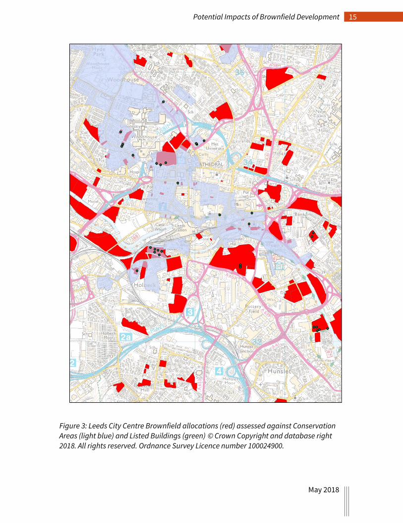
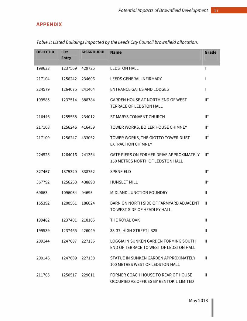
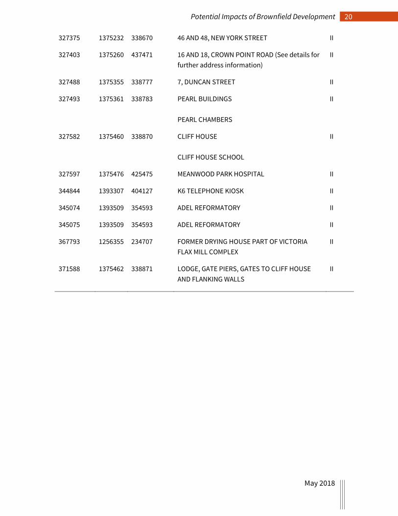
Figure 2 immediately reveals that there are strong overlaps between the location of land being made available for brownfield development, and the survival of historic assets (designated or not). Indeed, it is estimated that at least 40% of the allocated sites either intersect with, or are adjacent (within 100 metres) to known and suspected historic fabric. In total, 68 Listed Buildings, two Scheduled Monuments, and one Registered Park and Garden (see Appendix) are at direct risk (i.e. directly impacted by a proposed development site, or within 100m of it) when assessed against the Leeds City Centre Brownfield Register.
Conservation Area data then overlaid suggests how a further refining of sensitivity to change might be applied. The map excerpt (Figure 3) shows Leeds city centre brownfield development options, Conservation Areas, and the location of Listed Buildings that lie within both, i.e. Listed Buildings, within a Conservation Area, that are at threat from development. There are a further nine Listed Buildings that are threatened with development but which lie outwith any Conservation Area.
15 Potential Impacts of Brownfield Development
May 2018
Figure 3: Leeds City Centre Brownfield allocations (red) assessed against Conservation Areas (light blue) and Listed Buildings (green) © Crown Copyright and database right 2018. All rights reserved. Ordnance Survey Licence number 100024900.
16 Potential Impacts of Brownfield Development
May 2018
Conclusion Historic England are statutory consultees on both the Register and on PiP/TDC but a number of concerns remain:
• the lack of information available in support of permission in principle (PiP) decisions (i.e. not enough to properly apply NPPF and local policy).
• lack of clarity in the requirements for Technical Details Consents (TDC) as part of the process of granting permission for development.
• the potential cost of revocation if information emerges later that suggests permission in principle was an error.
• the potential pressure on LPAs to use this route when 'normal' planning routes are much more appropriate.
In order to address these issues, there is a clear advantage in developing options for ‘next steps’ that could provide significant operational gains for Historic England. These options may well aide our ability to:
• undertake work that alerts us (and the wider sector) to the potential impacts of brownfield development.
• get ‘ahead of the curve’ (in terms of managing our casework load) and assess and respond in a timely fashion to specific brownfield development proposals and their likely impact on historic fabric and setting.
• allows us to act proactively in terms of responding to the proposed development, contributing to TDC as part of the process of granting permission to develop.
• to engage with, and influence, decision-making with Local Authorities and those promoting or funding the brownfield development.
• sensitise developers, business owners, and the wider community to the importance of the historic environment (visible and hidden)
• assert the value of incorporating all historic fabric in any proposed development.
17 Potential Impacts of Brownfield Development
May 2018
APPENDIX
Table 1: Listed Buildings impacted by the Leeds City Council brownfield allocation.
OBJECTID List Entry
GISGROUPUI Name Grade
199633 1237569 429725 LEDSTON HALL I
217104 1256242 234606 LEEDS GENERAL INFIRMARY I
224579 1264075 241404 ENTRANCE GATES AND LODGES I
199585 1237514 388784 GARDEN HOUSE AT NORTH END OF WEST TERRACE OF LEDSTON HALL
II*
216446 1255558 234012 ST MARYS CONVENT CHURCH II*
217108 1256246 416459 TOWER WORKS, BOILER HOUSE CHIMNEY II*
217109 1256247 433052 TOWER WORKS, THE GIOTTO TOWER DUST EXTRACTION CHIMNEY
II*
224525 1264016 241354 GATE PIERS ON FORMER DRIVE APPROXIMATELY 150 METRES NORTH OF LEDSTON HALL
II*
327467 1375329 338752 SPENFIELD II*
367792 1256253 438898 HUNSLET MILL II*
69663 1096064 94695 MIDLAND JUNCTION FOUNDRY II
165392 1200561 186024 BARN ON NORTH SIDE OF FARMYARD ADJACENT TO WEST SIDE OF HEADLEY HALL
II
199482 1237401 218166 THE ROYAL OAK II
199539 1237465 426049 33-37, HIGH STREET LS25 II
209144 1247687 227136 LOGGIA IN SUNKEN GARDEN FORMING SOUTH END OF TERRACE TO WEST OF LEDSTON HALL
II
209146 1247689 227138 STATUE IN SUNKEN GARDEN APPROXIMATELY 100 METRES WEST OF LEDSTON HALL
II
211765 1250517 229611 FORMER COACH HOUSE TO REAR OF HOUSE OCCUPIED AS OFFICES BY RENTOKIL LIMITED
II

18 Potential Impacts of Brownfield Development
May 2018
216447 1255559 439519 PRESBYTERY AT ST MARYS CONVENT CHURCH II
216448 1255560 234014 1, CHURCH ROW II
216457 1255569 445265 37 AND 39, HUNSLET ROAD (See details for further address information)
II
216459 1255571 430175 NUMBER 41 AND ATTACHED WALL AND RAILINGS
II
216477 1255593 234041 IDA CONVALESCENT HOSPITAL II
216478 1255594 455142 LODGE AT COOKRIDGE HOSPITAL II
216479 1255595 444962 OLD BLOCK AT COOKRIDGE HOSPITAL II
216480 1255596 234043 POST BOX AT COOKRIDGE HOSPITAL SOUTH WEST OF LODGE
II
216504 1255621 234067 FORMER YORK ROAD LIBRARY AND BATHS II
216516 1255633 234076 BLENHEIM TERRACE NUMBER 22 II
216671 1255791 234215 UPPER WORTLEY PRIMARY SCHOOL II
216884 1256012 439504 ROSE COURT WITH TERRACE WALL AND STEPS (LEEDS HIGH SCHOOL FOR GIRLS)
II
216908 1256036 234430 RETAINING WALL TO LEEDS ZOOLOGICAL AND BOTANICAL GARDENS
II
216910 1256038 409218 19, SPRINGFIELD MOUNT II
216918 1256046 406526 GARDEN WALL TO NORTH AND WEST AND SUMMERHOUSE TO WEST OF ARNCLIFFE
II
216919 1256047 429539 CHAPEL ALLERTON HOSPITAL II
216920 1256048 234440 22D, SHIRE OAK ROAD II
216956 1256087 423373 ARNCLIFFE II
217052 1256186 438826 NUMBERS 17 AND 18 AND ATTACHED RAILINGS II
217055 1256189 234560 21, QUEEN SQUARE II
217056 1256190 234561 22, QUEEN SQUARE II
217058 1256192 234562 23, QUEEN SQUARE II

19 Potential Impacts of Brownfield Development
May 2018
217105 1256243 415220 BOUNDARY WALL AND RAILINGS TO LEEDS GENERAL INFIRMARY WITH GATE PIERS AND GATES
II
217106 1256244 234608 GLOBE IRON FOUNDRY FITTING UP SHOP II
217107 1256245 449353 TOWER WORKS ENGINE HOUSE II
217113 1256251 455250 VICTORIA WORKS RANGE II
217114 1256252 234616 MILL RANGE ATTACHED TO WEST SIDE OF NUMBER 21A
II
217150 1256289 423673 TOWER WORKS, ENTRANCE RANGE II
217200 1256342 434119 VICTORIA FLAX MILL ENTRANCE RANGE AND BOLLARDS
II
217502 1256648 421411 KIRKSTALL FORGE FORGE BUILDINGS WITH HELVE HAMMERS, SLITTING MILL MACHINERY
II
217503 1256649 430977 KIRKSTALL FORGE FORMER COTTAGES NOW OFFICES
II
217504 1256650 452111 KIRKSTALL FORGE FORMER STABLES NOW GARAGES
II
217505 1256651 442189 KIRKSTALL FORGE MILESTONE EAST OF EAST GATEWAY
II
224503 1263992 241333 STEPS IN CENTRE OF GRASSED TERRACES OF SUNKEN GARDEN TO WEST OF LEDSTON HALL
II
224580 1264076 392210 GATE AND STEPS AT SOUTH EAST CORNER OF SUNKEN GARDEN TO WEST OF LEDSTON HALL
II
270294 1313456 284549 HOUSE OCCUPIED AS OFFICES BY RENTOKIL LIMITED
II
306244 1352697 318941 BOILER HOUSE CHIMNEY II
327223 1375067 338527 BURLEY HOUSE II
327234 1375078 338538 CLARENDON HOUSE II
327235 1375079 338539 BOUNDARY WALL TO NUMBER 20 CLARENDON HOUSE
II
20 Potential Impacts of Brownfield Development
May 2018
327375 1375232 338670 46 AND 48, NEW YORK STREET II
327403 1375260 437471 16 AND 18, CROWN POINT ROAD (See details for further address information)
II
327488 1375355 338777 7, DUNCAN STREET II
327493 1375361 338783 PEARL BUILDINGS PEARL CHAMBERS
II
327582 1375460 338870 CLIFF HOUSE CLIFF HOUSE SCHOOL
II
327597 1375476 425475 MEANWOOD PARK HOSPITAL II
344844 1393307 404127 K6 TELEPHONE KIOSK II
345074 1393509 354593 ADEL REFORMATORY II
345075 1393509 354593 ADEL REFORMATORY II
367793 1256355 234707 FORMER DRYING HOUSE PART OF VICTORIA FLAX MILL COMPLEX
II
371588 1375462 338871 LODGE, GATE PIERS, GATES TO CLIFF HOUSE AND FLANKING WALLS
II

Table 2: Scheduled Monuments impacted by the Leeds City Council brownfield allocation.
OBJECTID ListEntry GISGROUPUI Name
28858 1018814 23550 Stone hut circle settlement in Clayton Wood on the south west side of Iveson Drive
28364 1018553 22617 Medieval farmstead in Ireland Wood, 150m north east of Cookridge Hospital
Table 3: Registered Parks and Gardens impacted by the Leeds City Council brownfield allocation.
GISGROUPUI Name HeritageCa Grade
1257 LEDSTON HALL AND PARK
Park and Garden II*
Related Documents