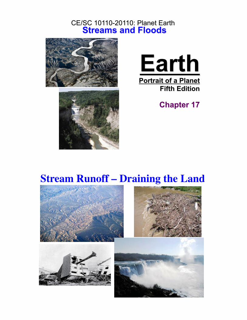
Earth Portrait of a Planet Fifth Edition Chapter 17 Streams and Floods CE/SC 10110-20110: Planet Earth Stream Runoff – Draining the Land 2

Welcome message from author
This document is posted to help you gain knowledge. Please leave a comment to let me know what you think about it! Share it to your friends and learn new things together.
Transcript
Earth Portrait of a Planet
Fifth Edition
Chapter 17
Streams and Floods CE/SC 10110-20110: Planet Earth
Stream Runoff – Draining the Land
2

Hydrologic Cycle3
Rivers & Streams: Basics
Sheetwash: unchanneled sheet of water, especially in deserts (no vegetation).
Channel flow – in a channel! This is where a river/stream is most of the time.Deepest part of the channel = Thalweg.
River = big stream!Reach = any segment along the length of the stream.Meander = curving reach.
4

Rivers & Streams: BasicsTypes of Runoff:Laminar: water moves slowly along a smooth channel, following straight, parallel lines, follows slope of containing boundary. More friction in wider, shallower streams
Depends on surface roughness and flow velocity.
In a curved channel, the fastest and deepest flow shifts towards the outer edge of the stream (over the THALWEG). The water follows a spiral path - surface water flows faster toward the outer bank, water deeper down must flow toward the inner bank to replace the surface water.
5
Velocity changes with:
Depth of channel.
River �bendiness� – fastest on outside of curves – further to travel.
Rivers & Streams: Basics
6

Rivers & Streams: BasicsTurbulent: water moves along an erratic path, deflected by the sides and bed of the channel (and obstructions) with the formation of eddies and swirls (shearing motion).
7
Flood Plain: flat area adjacent to the river channel that periodically floods. Fertile soil.Natural Levee: natural sediment build up that resists floods.Banks: sides of river channelChannel: where the water flows during non-flood stages.Stream Velocity: moderate ~5 km/h; flood >25 km/h.Velocity is a function of:
Stream gradient: vertical distance/ horizontal distance. Given as m/km or %.Frictional resistance: shape of channel, perimeter roughness.
Rivers & Streams: Basics
8

Water Table: Surface that is the contact between saturated and unsaturated zones.Humid Regions: cm to m below surface;Arid Regions: 10s of meters below surface.
Water table tends to parallel topography.Springs are where the water table and the ground surface intersect.
Rivers & Streams: Basics
The water table comes to the surface at springs, edges of streams, & lakes.
9
Streams & Drainage NetworksStreams begin as sheetwash. Heterogeneities in the surface promote channel formation through downcutting.Tributaries: smaller streams joining the main or trunk stream.Together, these form a drainage network.Stream migrates upstream through headward erosion - flow is more intense at the entry to the channel.
10

Streams & Drainage NetworksPatterns produced depend strongly on the nature of the bedrock (homogeneous vs. heterogeneous vs. faulted/ jointed).
Dendritic: homogeneous bedrock (igneous, metamorphic or sedimentary with horizontal bedding). Not heavily faulted or jointed.
Radial: volcanoes and domes.
Streams & Drainage Networks
Rectangular: Faulted/jointed bedrock. Square patterns. 90-degree turns are common and streams enter each other at right angles.

Streams & Drainage NetworksTrellis: Dipping beds of sedimentary rocks of alternating resistance to erosion (e.g., alternating limestone and sandstone).
Trunk stream
Tributaries
Streams & Drainage NetworksParallel: On a uniform, fairly steep slope, several streams with parallel courses develop simultaneously. Typically form on on the sides of steep escarpments of weak substrate. If the weak substrate has no sediment on top of it, it is called badlands topography.
Parallel

Streams & Drainage Networks
Antecedent Streams: stream maintains its flow pattern during tectonic activity.
Superposed Streams: erode through an unconformity but maintain the drainage pattern.
15
Streams & Drainage Networks
Drainage Basin: An area in which all runoff flows into a single stream (e.g., Mississippi River and on more local scale).
Divide: high area that separates drainage basins.
Headwater: beginning of the streams, high elevations in the drainage basin.
Mouth: where the river enters a larger body of water (ocean, lake, etc.).
16
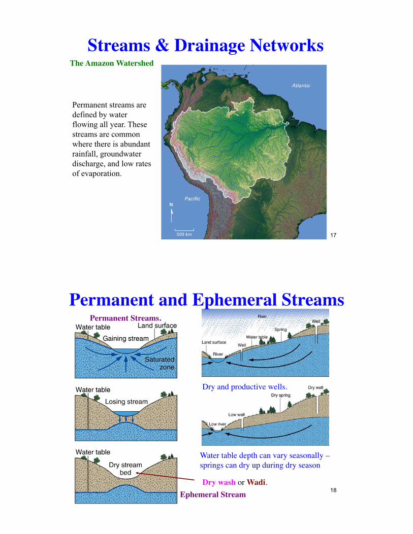
Streams & Drainage NetworksThe Amazon Watershed
17
Permanent streams are defined by water flowing all year. These streams are common where there is abundant rainfall, groundwater discharge, and low rates of evaporation.
Water table depth can vary seasonally – springs can dry up during dry season
Dry and productive wells.
Permanent Streams.
Permanent and Ephemeral Streams
Ephemeral StreamDry wash or Wadi.
18

Permanent and Ephemeral Streams
Hyporheic zone: surface/groundwater exchange
Discharge & TurbulenceDischarge: volume of water flowing through a given point in a stream in unit time.
Discharge = Ac x va
Discharge can increase downstream in temperate climate because of impact from tributaries and groundwater. In arid climates it may decrease due to infiltration and evaporation.
Ac = stream cross section.va = average velocity of water downstream.
Measured at a Stream-Gauging Station.
20
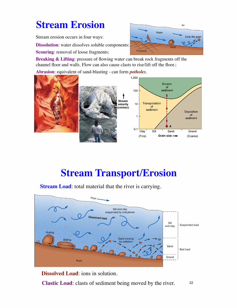
Stream ErosionStream erosion occurs in four ways:Dissolution: water dissolves soluble components;Scouring: removal of loose fragments;Breaking & Lifting: pressure of flowing water can break rock fragments off the channel floor and walls. Flow can also cause clasts to rise/lift off the floor.;Abrasion: equivalent of sand-blasting - can form potholes.
Stream Load: total material that the river is carrying.
Dissolved Load: ions in solution.
Clastic Load: clasts of sediment being moved by the river.
Stream Transport/Erosion
22

Clastic Load: Suspended & Bed Loads.
Suspended Load: typically clay and silt. Remain suspended because stream velocity exceeds the settling velocity of the particles.Bed Load: grains rolling along the stream bed because stream velocity is less than the settling velocity of these particles. Typically sand and gravel. 23
Stream Transport/Erosion
Traction: grains rolling/sliding along.Saltation: �hopping� grains because size is too large for continuous suspension. Typically falling grains dislodge more grains (transfer of kinetic energy).
Stream Capacity: Maximum load stream can carry. Streams are rarely loaded to capacity because weathering & erosion are slow processes.Stream Competence: maximum particle size that it can carry.
24
Stream Transport/Erosion

Fluvial DepositionFluvial deposits or alluvium form when stream velocity drops below settling velocity because:
A stream enters a standing body of water.The channel widens.The stream gradient decreases.Discharge decreases due to evaporation, infiltration, or removal for irrigation.Of obstructions.
Along the banks and in the middle of a stream due to channel widening.
25
Point Bars
Fluvial Deposition
26

Flood Plain: flat area outside of the channel. Velocity drops once water has spilled out of the channel and deposits fine sediments (muds/silts).
Channel �wanders� in the flood plain taking the �path of least resistance�.
Fluvial Deposition
Yazoo Streams: tributary streams that run in the floodplain parallel to the main river. They are blocked from joining the main river by natural levees.
27
Economic Aspects
Heavy minerals deposited in rivers where velocity is low.
Fluvial Deposition
28
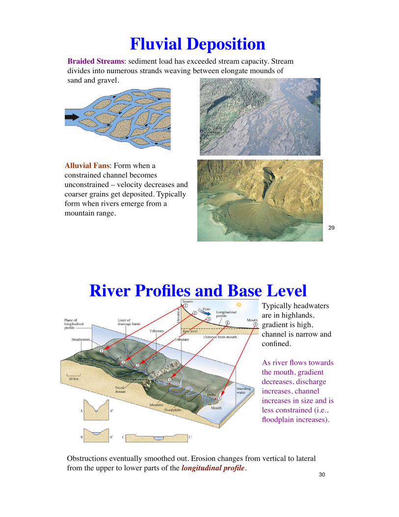
Fluvial DepositionBraided Streams: sediment load has exceeded stream capacity. Stream divides into numerous strands weaving between elongate mounds of sand and gravel.
Alluvial Fans: Form when a constrained channel becomes unconstrained – velocity decreases and coarser grains get deposited. Typically form when rivers emerge from a mountain range.
29
River Profiles and Base LevelTypically headwaters are in highlands, gradient is high, channel is narrow and confined.
As river flows towards the mouth, gradient decreases, discharge increases, channel increases in size and is less constrained (i.e., floodplain increases).
Obstructions eventually smoothed out. Erosion changes from vertical to lateral from the upper to lower parts of the longitudinal profile.
30
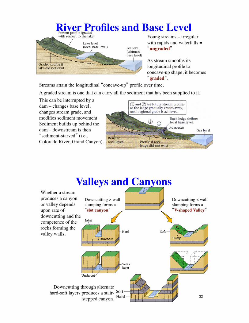
River Profiles and Base Level
Streams attain the longitudinal �concave-up� profile over time.A graded stream is one that can carry all the sediment that has been supplied to it.
Young streams – irregular with rapids and waterfalls = �ungraded�.
As stream smooths its longitudinal profile to concave-up shape, it becomes �graded�.
This can be interrupted by a dam – changes base level, changes stream grade, and modifies sediment movement. Sediment builds up behind the dam – downstream is then �sediment-starved� (i.e., Colorado River, Grand Canyon).
Valleys and CanyonsWhether a stream produces a canyon or valley depends upon rate of downcutting and the competence of the rocks forming the valley walls.
Downcutting > wall slumping forms a �slot canyon�
Downcutting < wall slumping forms a �V-shaped Valley�
Downcutting through alternate hard-soft layers produces a stair-
stepped canyon. 32

Valleys and CanyonsVertical erosion means the valley floor is generally free of alluvium.Alluvium is deposited when base-level is reached or it rises.
33
If base level drops and/or uplift occurs, streams cuts alluvium and forms �stream terraces�.Raised floodplains
Rapids and WaterfallsRapids: form where the stream flow is constricted - passing over large blacks, narrowing of the channel. This creates turbulence.
Waterfalls: escarpments (elevated sections), sometimes caused by a change in base level, faulting, variations in rock type, are removed by erosion and migrate upstream (e.g., Niagara Falls).
34

Rapids and WaterfallsNiagara Falls: water moves from Lake Erie to Lake Ontario. Drops over a 55 m ledge of hard Silurian dolostone, which is on top of weak shale.Undercutting by the water as it falls (forming a plunge pool) cause migration.
35
MeandersDevelop on the floodplain as river changes from vertical to lateral erosion - it �wanders� over the floodplain.Eventually meanders are cut off and ox-bow lakes form.
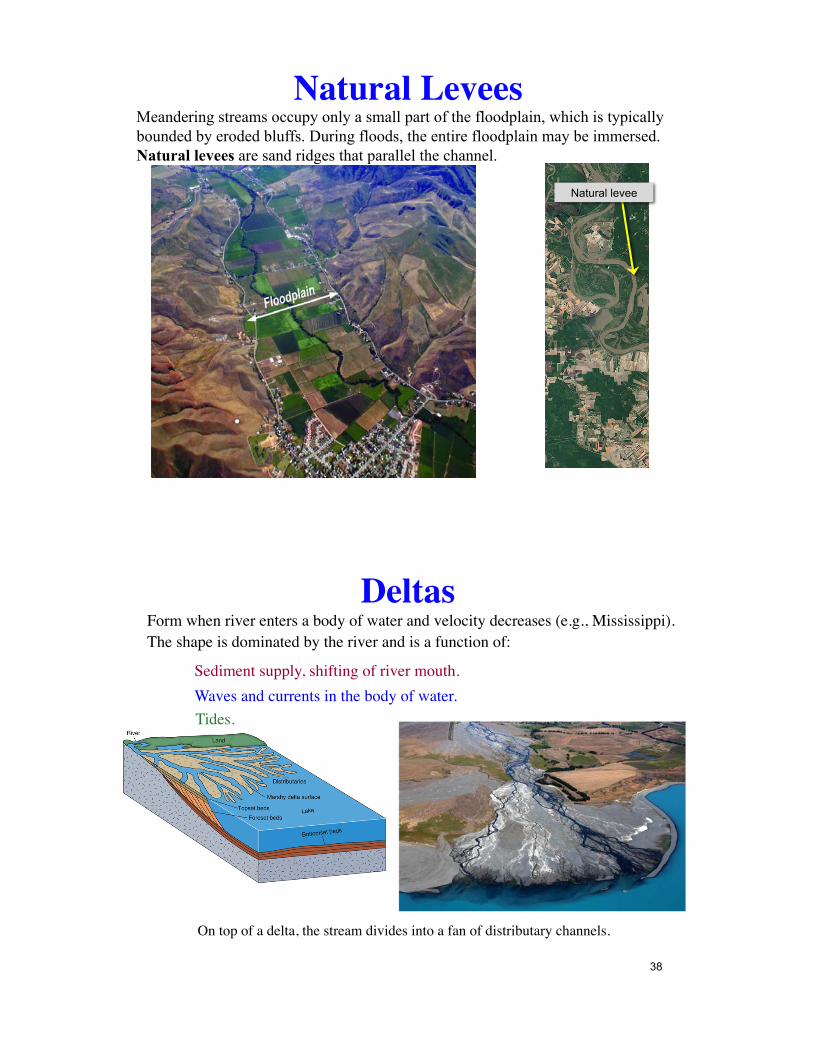
Natural LeveesMeandering streams occupy only a small part of the floodplain, which is typically bounded by eroded bluffs. During floods, the entire floodplain may be immersed. Natural levees are sand ridges that parallel the channel.
Natural levee
DeltasForm when river enters a body of water and velocity decreases (e.g., Mississippi). The shape is dominated by the river and is a function of:
Sediment supply, shifting of river mouth.Waves and currents in the body of water.Tides.
38
On top of a delta, the stream divides into a fan of distributary channels.

Sediment deposition builds out the toe of the delta and reduces the gradient. Eventually, the river cannot flow in this channel - the natural levee is topped upstream and the river makes a new path to the sea. This process = avulsion.
Deltas
39
Abandoned delta lobes, starved of sediment, slowly compact, dewater, and subside. Abandoned delta lobes are eventually submerged. Subsidence is a problem for cities built on deltas. Subsidence near (or below) sea level magnifies flooding risks. New Orleans is a prime example.
Deltas
40
Deltas
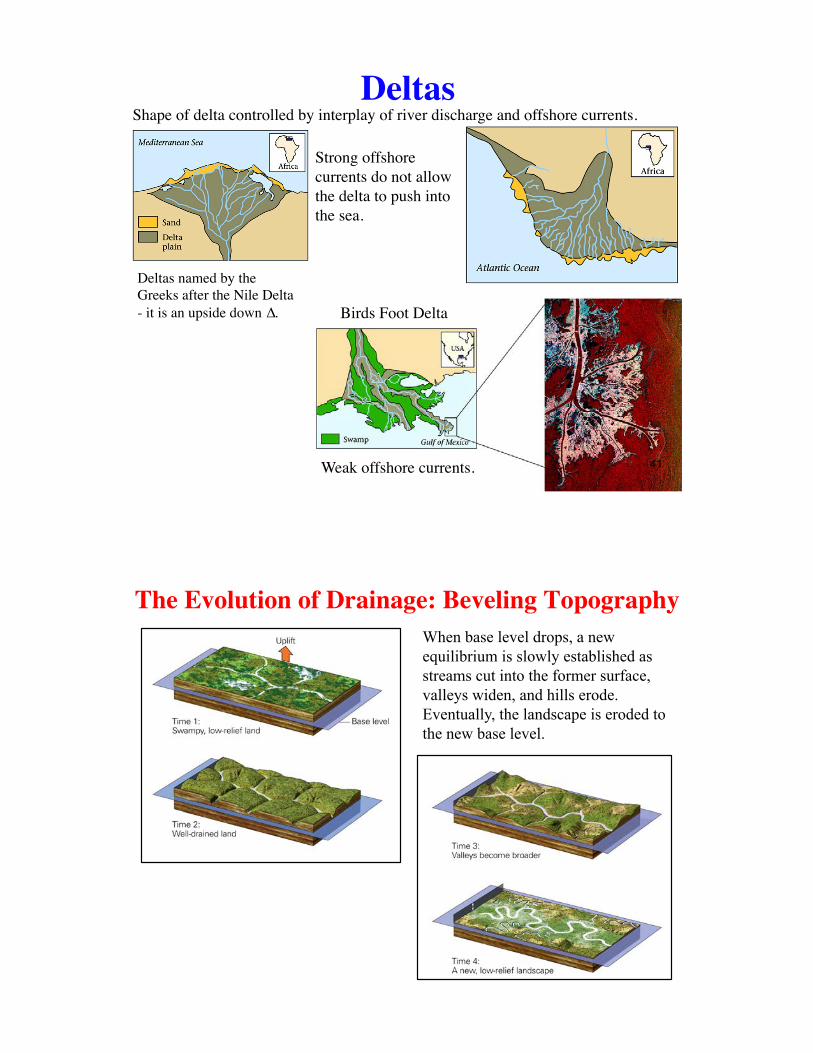
Birds Foot Delta
Weak offshore currents.
Shape of delta controlled by interplay of river discharge and offshore currents.
Strong offshore currents do not allow the delta to push into the sea.
Deltas named by the Greeks after the Nile Delta - it is an upside down ∆.
41
The Evolution of Drainage: Beveling TopographyWhen base level drops, a new equilibrium is slowly established as streams cut into the former surface, valleys widen, and hills erode. Eventually, the landscape is eroded to the new base level.
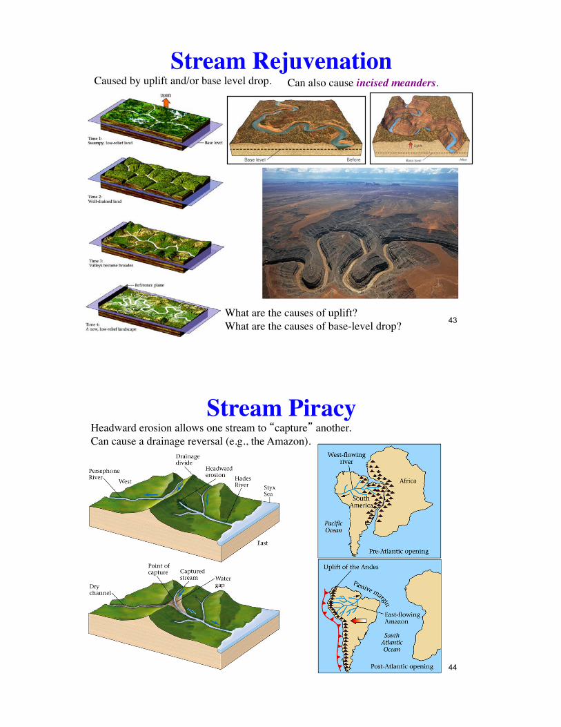
Stream RejuvenationCaused by uplift and/or base level drop. Can also cause incised meanders.
What are the causes of uplift?What are the causes of base-level drop? 43
Stream PiracyHeadward erosion allows one stream to �capture� another.Can cause a drainage reversal (e.g., the Amazon).
44
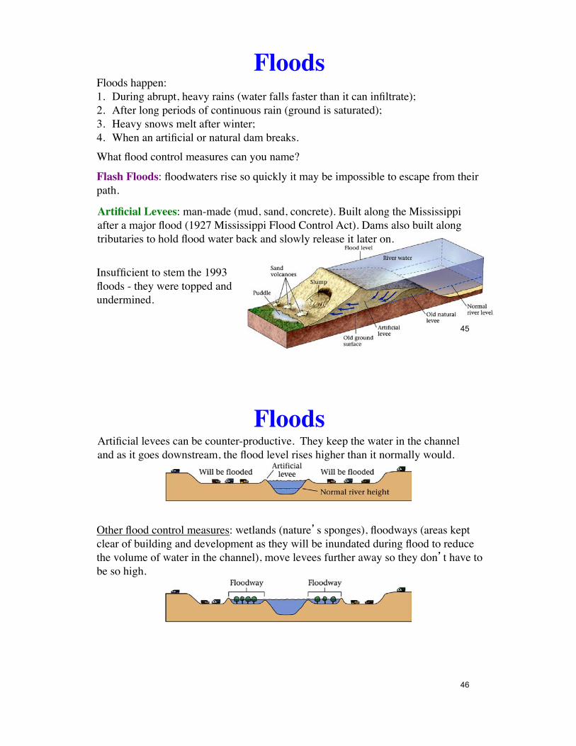
FloodsFloods happen:1. During abrupt, heavy rains (water falls faster than it can infiltrate);2. After long periods of continuous rain (ground is saturated);3. Heavy snows melt after winter;4. When an artificial or natural dam breaks.
Flash Floods: floodwaters rise so quickly it may be impossible to escape from their path.
Insufficient to stem the 1993 floods - they were topped and undermined.
Artificial Levees: man-made (mud, sand, concrete). Built along the Mississippi after a major flood (1927 Mississippi Flood Control Act). Dams also built along tributaries to hold flood water back and slowly release it later on.
What flood control measures can you name?
45
Artificial levees can be counter-productive. They keep the water in the channel and as it goes downstream, the flood level rises higher than it normally would.
Floods
Other flood control measures: wetlands (nature�s sponges), floodways (areas kept clear of building and development as they will be inundated during flood to reduce the volume of water in the channel), move levees further away so they don�t have to be so high.
46
Floods
€
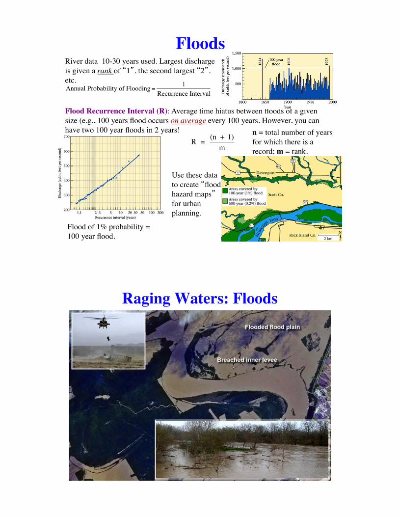
Annual Probability of Flooding =1
Recurrence Interval
Flood Recurrence Interval (R): Average time hiatus between floods of a given size (e.g., 100 years flood occurs on average every 100 years. However, you can have two 100 year floods in 2 years!
€
R = (n + 1)m
River data 10-30 years used. Largest discharge is given a rank of �1�, the second largest �2�, etc.
n = total number of years for which there is a record; m = rank.
Flood of 1% probability = 100 year flood.
Use these data to create �flood hazard maps� for urban planning.
47
Raging Waters: Floods

Case History of a Seasonal Flood: the Mississippi !and Missouri Rivers, 1993
In the spring of 1993, the jet stream moved over the midwestern United States. This trapped moist humid air from the Gulf of Mexico and rain fell in great abundance. In July of 1993, floodwaters invaded large areas. Flooding lasted 79 days, covering 40,000 square miles. The toll was enormous: 50 people died, 55,000 homes were destroyed, and the damage totaled $12 billion.
Rivers: A Vanishing Resource?Pollution: from raw sewage, storm drain water in urban areas, spilled oil, industrial waste, excess fertilizers, animal waste, general trash. Can destroy or radically alter ecosystems and make rivers off-limits.
Dam Construction: alters river ecosystems by decreasing water and sediment/nutrient flow downstream. Positive side - irrigation for agriculture, hydroelectric (clean) power.Urbanization: Increases run-off and peak discharge amounts due to concrete/tarmac (prevents infiltration).
50
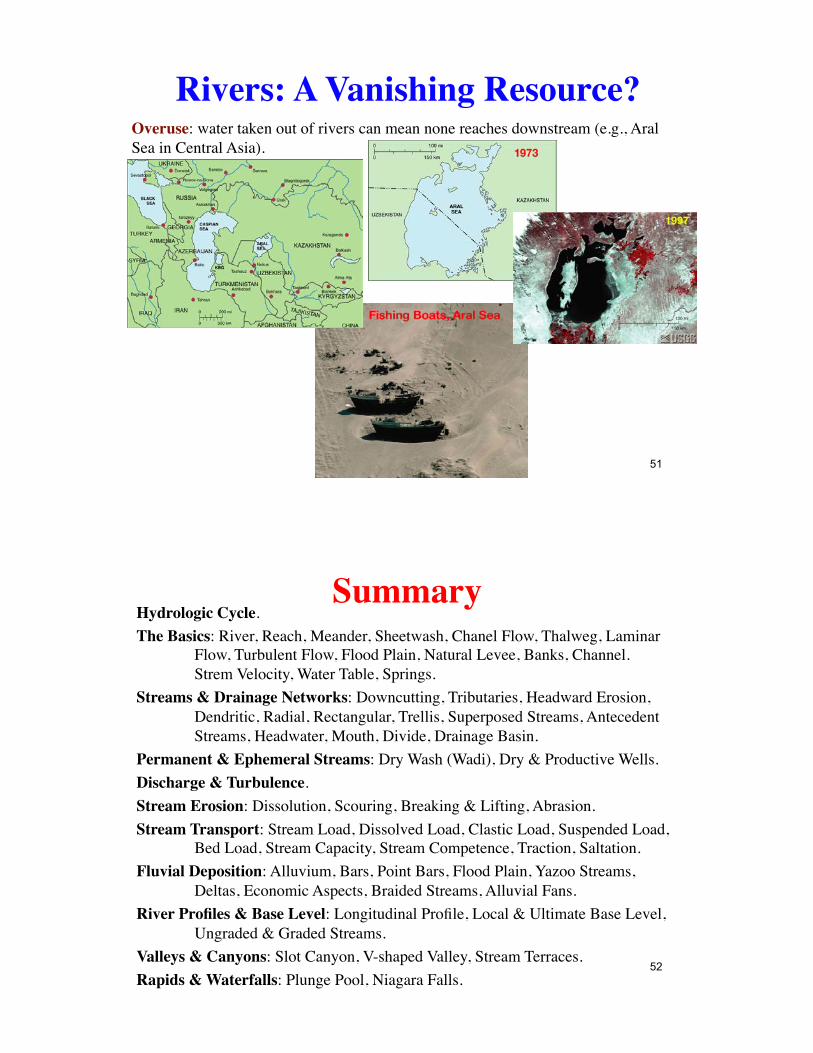
Rivers: A Vanishing Resource?Overuse: water taken out of rivers can mean none reaches downstream (e.g., Aral Sea in Central Asia).
51
SummaryHydrologic Cycle.The Basics: River, Reach, Meander, Sheetwash, Chanel Flow, Thalweg, Laminar
Flow, Turbulent Flow, Flood Plain, Natural Levee, Banks, Channel. Strem Velocity, Water Table, Springs.
Streams & Drainage Networks: Downcutting, Tributaries, Headward Erosion, Dendritic, Radial, Rectangular, Trellis, Superposed Streams, Antecedent Streams, Headwater, Mouth, Divide, Drainage Basin.
Permanent & Ephemeral Streams: Dry Wash (Wadi), Dry & Productive Wells.Discharge & Turbulence.Stream Erosion: Dissolution, Scouring, Breaking & Lifting, Abrasion.Stream Transport: Stream Load, Dissolved Load, Clastic Load, Suspended Load,
Bed Load, Stream Capacity, Stream Competence, Traction, Saltation.Fluvial Deposition: Alluvium, Bars, Point Bars, Flood Plain, Yazoo Streams,
Deltas, Economic Aspects, Braided Streams, Alluvial Fans.River Profiles & Base Level: Longitudinal Profile, Local & Ultimate Base Level,
Ungraded & Graded Streams.Valleys & Canyons: Slot Canyon, V-shaped Valley, Stream Terraces.Rapids & Waterfalls: Plunge Pool, Niagara Falls.
52

Summary (cont.)Meanders: Yazoo Streams, Ox-Bow Lakes.Deltas: Avulsion, Distributaries, Topset-Foreset-Bottomset Beds, Natural Levee,
Bird-Foot Delta.Stream Rejuvenation: Incised meanders.Stream Piracy: Headward Erosion, Stream Capture.Floods: Causes, Flash Floods, Artificial Levees, Undermining of Levees, Other
Flood Control Measures, Flood Recurrence Interval, Flood Hazard Maps.Vanishing Rivers: Pollution, Dam Construction, Urbanization, Overuse.
53
Related Documents