Go Your Own Least Cost Path Spatial technology and archaeological interpretation Proceedings of the GIS session at EAA 2009, Riva del Garda Edited by J. W. H. Verhagen A. G. Posluschny A. Danielisova BAR International Series 2284 2011

Welcome message from author
This document is posted to help you gain knowledge. Please leave a comment to let me know what you think about it! Share it to your friends and learn new things together.
Transcript
Go Your Own Least Cost Path
Spatial technology and archaeological interpretation
Proceedings of the GIS session at EAA 2009, Riva del Garda
Edited by
J. W. H. Verhagen A. G. Posluschny
A. Danielisova
BAR International Series 2284 2011
Published by Archaeopress Publishers of British Archaeological Reports Gordon House 276 Banbury Road Oxford OX2 7ED England [email protected] www.archaeopress.com BAR S2284 Go Your Own Least Cost Path: Spatial technology and archaeological interpretation. Proceedings of the GIS session at EAA 2009, Riva del Garda © Archaeopress and the individual authors 2011 ISBN 978 1 4073 0861 6 Printed in England by 4edge, Hockley All BAR titles are available from: Hadrian Books Ltd 122 Banbury Road Oxford OX2 7BP England www.hadrianbooks.co.uk The current BAR catalogue with details of all titles in print, prices and means of payment is available free from Hadrian Books or may be downloaded from www.archaeopress.com
- 33 -
P. Verhagen, A. G. Posluschny, A. Danielisová (eds.)Proceedings EAA 2009: Go Your Own Least Cost Path, Riva del Garda
Pollen and Archaeology in GIS.Theoretical Considerations and Modified Approach Testing
Alžběta Danielisová, Petr Pokorný
Abstract The research project of the Iron Age hillfort of Vladař (western Bohemia) is focusing on the reconstruction of past land cover and land use. Its primary aims are to chronolog-ically and spatially detect individual human activities, and to model their impact on the surrounding area. To achieve this, a multidisciplinary approach is undertaken combining both archaeological and environmental data. An absolutely dated onsite pollen profile offers detailed insight into the chronology of the site, covering not only archaeologically documented periods, but also those with little or no archae-ological record. This paper aims to a) discuss general is-sues connected with modelling the evolution of prehistoric cultural landscapes, and b) find a procedure that can com-bine both space- and time-related records of the past. GIS modelling of several probabilistic landscape scenarios can be an ideal tool for combining the space-related archaeo-logical and geographical data with the time-related pollen record. For each scenario the relative abundance of pollen indicative for the relevant land-cover units was calculated. Those units were then associated with the particular topo-graphical preferences and located within a site catchment. As a result, the chronological dynamics of the land use can be detected. The validate the results, scenarios with an extreme human impact and those with little or no human impact were compared to the historically documented situ-ation. The approach shows the potential of GIS modelling for past landscape reconstructions. We are convinced that this is a valuable new method for assessing the validity of current archaeological and pollen data and for modelling of past landscapes. It also allows us to gain insights into those aspects of human interaction with the landscape that are difficult to detect from the archaeological record itself.
Introduction
In this paper we discuss the development of spatial models of prehistoric cultural landscape evolution, based on the natural development of the environment and the activities of the communities living in it. We present a recently de-veloped approach that combines pollen-based representa-tions of past landscape dynamics and archaeological data. Our main goal is to show that qualitative and spatial di-mensions can be included in the quantitative approaches often used in recent environmental studies. The integra-tion of pollen analytical data in Geographical Information Systems (GIS) can be an important step towards a “visual landscape reconstruction” of the past (cf. caseLDine eT aL. 2008).
Palaeo-ecological data in itself can never give precise in-formation on the exact location of past vegetation or land
use units, but when combined with spatially oriented ap-proaches (“GIS”) and archaeological data, we can create a powerful tool to explore the dynamics of past landscapes. The modelling approach we used allowed us to create mul-tiple likely scenarios of past land use and landscape de-velopment which can be further tested to choose the most realistic solution. We also want to demonstrate that a mul-tiple scenario approach provides a suitable solution for the problem that these models are often based on subjective prerequisites and will therefore become “virtualisations” of the past (caseLDine eT aL. 2008), rather than realistic reconstructions. It also offers a solution to the problem that the fully automated procedures often used in model-ling allow for little flexibility in model creation (see e.g. Poska eT aL. 2008, 537) and usually depend on profound knowledge of subject matter and the input variables (see bunTinG – MiDDLeTon 2005, 1009). We want to show that by approaching each modelling step individually, using empirical settings, we can easily adjust the variables and criteria used before and during the modelling process. In this way we can achieve reliable and transparent results that can serve as a basis for the development of further automated processing.
Quantitative landscape interpretations and modelling in archaeology
With the boom of theoretic settlement archaeology in the 1970s and 1980s, various attempts were made to connect archaeological sites to the landscape: the location of the sites, the adaptation of individual cultural systems to their environments, resource economy, subsistence strategies etc. (eg. fLannery 1976; GranT 1986; hiGGs – ViTa-finZi 1972; finDLoW – ericson 1980; ucko – TrinGhaM – DiM-bLeby 1972; sTePonaiTis 1981). There are many ways to assess the complexity of the cultural landscape in the past. Many of them are based on the conceptions of econom-ic geography and Locational Geography (haGGeT eT aL. 1977), and have influenced archaeological spatial analy-sis especially during the heydays of processualism. These relatively straightforward concepts of spatial archaeology were challenged by post-processualist approaches. Struc-tural archaeology caught a new breath together with the development of the new conceptions leading eventually to the introduction and boom of Geographical Information Systems to archaeology.
Under the processual paradigm, studies dealing with human-landscape relationships try to integrate archaeo-logical and palaeo-environmental data, and interpret the results on the basis of theoretical models. Archaeological modelling is based upon the comparison and evaluation of the structures within the formal and spatial context with
- 34 -
Alžběta Danielisová, Petr PokornýPollen and Archaeology in GIS
the systems of mutually interactive categories of the liv-ing culture. The idea of the creation of “cultural land-scapes” and detecting the “behaviour” of particular site types (cf. kuna 2006, 2008) actually embodies the very theory of archaeological “predictive modelling”, where it is claimed that archaeological sites and aspects of the past cultural landscapes are spatially defined, and those vari-ables should be determined, quantified and classified (see e.g. DaLLa bonna 1994, VerhaGen 2007, kaMerMans eT aL. 2009, Mehrer – WescoTT 2006). Today’s routine of predictive modelling owes much to the expansion of GIS, which facilitated the rapid and effective manipulation and evaluation of large data volumes with the help of tools that were unavailable to archaeology before.
In addition to the original idea that predictive models serve to protect archaeological monuments by determining their (potential) location, they can also be used systematically to study the relationship between archaeology and landscape. (cf. VerhaGen 2007; stančič – kvaMMe 1999; Van Leusen 2002). These approaches can especially be applied to ad-dress general issues like the extent of settlement areas, the preference of individual site types with regard to relief (kuna 2006, 2008), the spatial continuity of the prehistoric settlement areas, or to other particular scientific questions (kuna 2006, 2008; DresLeroVá 2008; DanieLisoVá 2008, 2010).
One of its basic approaches to archaeological interpreta-tion is the creation of theoretical models (neusTuPný 2007, 176). By qualifying the variables characterising special-ised activities, these models can contribute to identify and understand the dynamics of landscape use in the past or to indicate its various strategies. By modelling we create simplified conceptions (abstractions) of real systems and on this level we analyse them. This enables us to explore the models of no longer existing or destroyed communi-ties, including prehistoric societies.
The understanding of systems theory is therefore impor-tant for the approaches of time-space modelling and the subsequent simulation of historic realities. With such mod-els we can then variously experiment, alter the initial vari-ables, inner structure, relationships etc. Digital modelling is based upon the principle that by using the digital equiva-lents of physical realities the virtual space is created within which the models are tested and analysed (hLásný 2007, 9). Modelling is not aiming to reconstruct past realities; instead, multiple qualified scenarios are created and after testing and evaluation the scenario most likely to approach reality can be chosen.
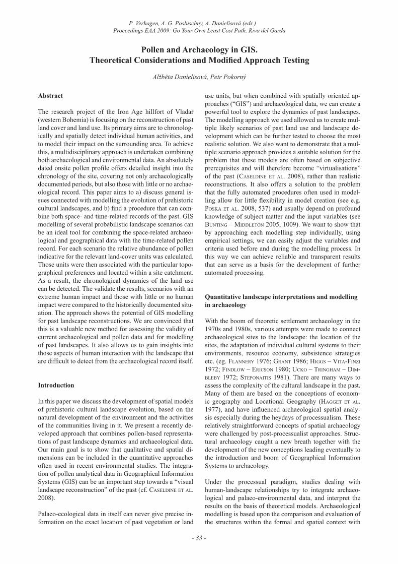
Figure 1. Vladař hillfort and the study area around in western Bohemia
- 35 -
P. Verhagen, A. G. Posluschny, A. Danielisová (eds.)Proceedings EAA 2009: Go Your Own Least Cost Path, Riva del Garda
Understanding pollen – landscape relationships
There is a whole spectrum of interactions between organ-ized settlements and their surrounding environments. The complexity of these interactions takes place on several lev-els: functional, spatial and temporal – which activity took place where and when (cf. Gaffney – Van Leusen 1996, 299). The composition of the individual components of the past cultural landscapes depends on the landscape char-acteristics and the cultural habits and subsistence strate-gies of the communities living in them. Reconstruction of these components in geographic space then departs from knowledge of the issue, the state of the art and the ability to integrate the acquired information into qualified mod-els. Stratified pollen data offer insight into the presence or absence of individual vegetation components. Subse-quent modelling, using settlement area theory and detailed analysis of the territory, can then achieve different levels of qualified spatial reconstructions (Pokorný eT aL. 2005, 88). For this, an intensive dialogue between archaeologists and palaeoecologists is necessary (cf. Gearey – chaPMan 2006, 172). Estimates of past vegetation composition are inferred from fossil pollen.
In recent years, research developments tend especially to the quantitative approaches with particle transfers de-veloped into the model-based reconstructions (caseLDine eT aL. 2008, 543) developed especially around the POL-LANDCAL research group (http://www.ecrc.ucl.ac.uk/minisite/pollandcal; see also suGiTa 2007a,b; suGiTa eT aL. 2008; bunTinG – MiDDLeTon 2005, 2009; bunTinG eT
aL. 2008; MiDDLeTon – bunTinG 2004; brosTröM eT aL. 2008; GaiLLarD eT aL. 2008; caseLDine eT aL. 2008; fyfe 2006; nieLsen – oDGaarD 2005). Past landscape model-ling can now follow two basic methodological approach-es: the Landscape Reconstruction Algorithm (LRA) (su-GiTa 2007a,b; 2008) and the Multiple Scenario Approach (MSA) (bunTinG eT aL. 2008, 78; 2009). LRA is based on a model which translates pollen counts into quantified es-timates of the past vegetation cover. The two components of the model – REVEALS and LOVE - are designed to calculate the vegetation cover on a regional and local ba-sis respectively, creating distance-based vegetation cover models within the Relevant Source Area of Pollen (RSAP; suGiTa 2007b). The MSA approach on the other hand is specifically designed to generate multiple ecologically distinct reconstructions of past vegetation from pollen sig-nals, forming multiple hypotheses for subsequent statisti-cal testing. The outcomes of the latter are GIS-based and can be presented in the form of possible vegetation maps. Specific software has been designed to simulate pollen dispersal and deposition, such as MOSAIC and HUMPOL (MiDDLeTon – bunTinG 2005; bunTinG – MiDDLeTon 2004).
Other approaches to landscape reconstruction are based on the combination of pollen analyses and other data in GIS and are much like the model-based solutions. Some of them are basically empirical (e.g. sTobbe 2008), some of them are GIS-based or use advanced GIS methodology (Poska 2008, GauDin eT aL. 2008, Garcia 2008, Gearey – chaPMan 2006, fyfe 2006). Some researchers have even used the combined methods of analytically treated envi-
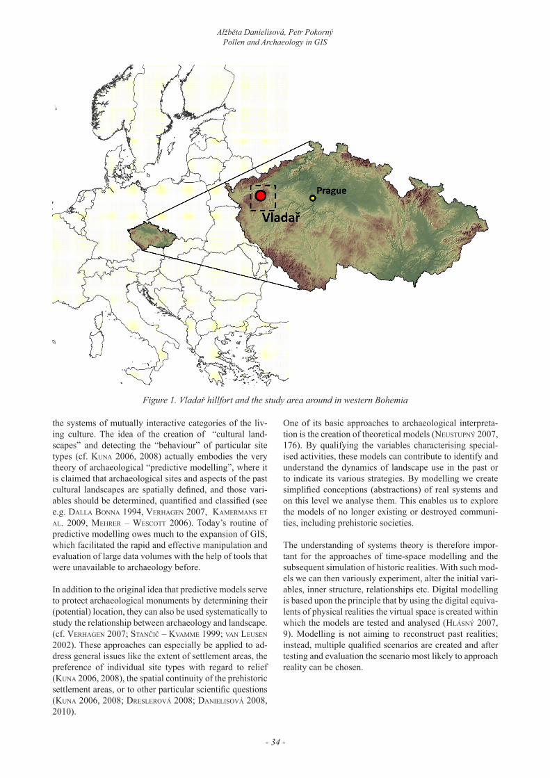
Figure. 2. Vladař hillfort and location of a water reservoir with core sampling.
- 36 -
Alžběta Danielisová, Petr PokornýPollen and Archaeology in GIS
ronmental and archaeological data in an attempt to explore the “sensual experience” of vegetation in a phenomeno-logical sense (cf. the “digital narrative” approach by Gear-ey – chaPMan 2006). Coupling of DEMs with vegetation cover reconstructions (caseLDine eT aL. 2008, 546–547; Gearey – chaPMan 2006) produces two-dimensional ar-rangements of vegetation or landscape units at the scale determined by the GIS. With additional data the “recreat-ed” landscapes can often be related to archaeological ques-tions (caseLDine eT aL. 2008, 544). However, experience shows that the empirical basis of these models needs to be more emphasized. Apart from that, spatial modelling of past cultural landscapes should also take into account the aspect of decision making (DaLLa bona 1994) which in-volves factors like movement efficiency, the interaction of environmental variables and cultural systems (e.g. the ef-fect of central places), particular settlement patterns (con-centrations versus dispersion of sites) and the continuity or discontinuity of economic systems.
Case Study – Vladař hillfort (western Bohemia)
The table mountain of Vladař (693 m asl) dominates the hilly area of the upper Střela stream in western Bohemia (figure 1). An extensive fortification system encloses an area of 115 ha and includes the extent of the adjacent foot-hills as well (figure 2). Recent excavations have shown that the fortification system has a long and complex his-tory with at least five construction phases, the oldest com-ing from the Bronze Age and the latest dating probably to the Late La Tène period (chytráček – ŠMejda 2005). The hillfort had an important position within the inter-regional contacts especially during the Late Hallstatt – Early La Tène periods, when the size and occupation density of the site reached its maximum. The importance of the hillfort and its location can probably be attributed to the rich gold-bearing areas existing in the vicinity (chytráček – ŠMejda 2005, 5–6). The site however does not appear to be a typi-cal representative of the contemporary Fürstensitze-sites (“Princely Sites”) known from the Western Hallstatt re-gions. Despite the evident Late La Tène occupation, the site probably did not function as a typical oppidum either. It seems that it was an independent central place in its
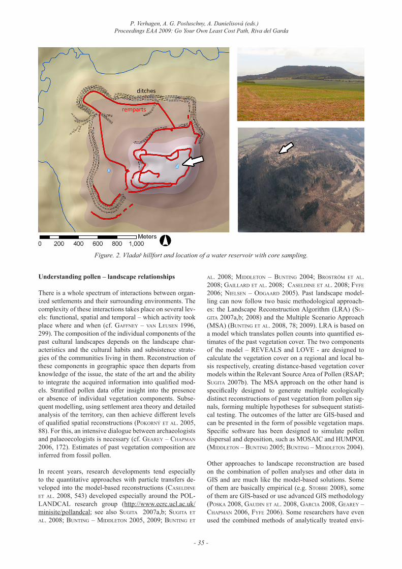
Figure 3. Archaeological sites around the Vladař hillfort (1), initial vegetation settings (“null scenario”) (2) and land-use according to the military mapping in 1845 (3).
- 37 -
P. Verhagen, A. G. Posluschny, A. Danielisová (eds.)Proceedings EAA 2009: Go Your Own Least Cost Path, Riva del Garda
region, outside the socio-political systems developing in central and southern Bohemia which led to the growth and subsequent fall of the oppida.
The Vladař hillfort settlement saw its peak during the beginning of the La Tène period. Occupation started to decline by the end of 3rd century BC, and the site was completely abandoned around the verge of a century after which it reverted back to natural woodland (Pokorný eT aL. 2006). It was again settled for a brief period during the Early Middle Ages, and from the Medieval period onward the area started to be used for agriculture. This situation continued until the mid 20th century, and now the site is again covered by shrubs and expanding woodland (figure 2). These conclusions are mainly drawn from palaeo-envi-ronmental research; the archaeological data remains most-ly fragmentary and discontinuous. The hillfort of Vladař offers ideal conditions for modern palaeo-environmental research because of a rather exceptional combination of archaeological and palaeo-ecological evidence (Pokorný eT aL. 2006). First of all, it offers a unique opportunity to study a continuous sedimentary record from the peat de-posits in the original cistern which was built right at the centre of the acropolis (figure 2) around 400 BC. In 2004 a continuous sedimentary record of a basin was sampled (Pokorný eT aL. 2005) and offered the first opportunity ever in the Czech Republic to examine the development of a prehistoric hillfort on the basis of direct and highly
detailed botanical indices with high chronological accu-racy. In this way, a detailed insight in the site’s chronology was obtained and human occupation could even be proved during periods with little or no archaeological evidence. It also documented the events connected to the site’s aban-donment and the following vegetational succession from settlement to natural forest (Pokorný eT aL. 2006, 420).
Modelling approach
The ongoing research project of the hillfort of Vladař and the surrounding region is, among others, concerned with the reconstruction of the development of the cultural land-scape, past vegetation and land-use around the site and within its fortifications. There can be no doubt that the settlement area of such an extensive hillfort contained all the essential elements of a prehistoric cultural landscape: a central settlement; associated villages in the vicinity (as proven by surface artefact studies); agricultural land (fields, fallow, pastures, and meadows); transitional zones of woodland managed for grazing, bedding and coppicing; probably forest of a more or less natural composition and structure; and areas for production, burial, ritual, and as-sembly. The changes in the pollen assemblages reflect the changes in human impact on the site and its surroundings with respect to secondary woodland composition, use of crops, intensity of pasture, and the vegetation composition
Figure 4. Schematic representation of the workflow.
- 38 -
Alžběta Danielisová, Petr PokornýPollen and Archaeology in GIS
Figure 5. Percentage pollen diagram made from sediments of the cistern located at Vladař hillfort acropolis.Only selected taxa are shown.
- 39 -
P. Verhagen, A. G. Posluschny, A. Danielisová (eds.)Proceedings EAA 2009: Go Your Own Least Cost Path, Riva del Garda
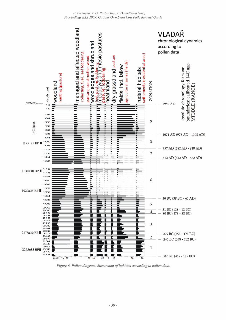
Figure 6. Pollen diagram. Succession of habitats according to pollen data.
- 40 -
Alžběta Danielisová, Petr PokornýPollen and Archaeology in GIS
of settlement areas (Pokorný eT aL. 2006, 420). The pri-mary aims of this project are to detect the particular human activities during the time of the site’s occupation, their ex-tent and localisation within a particular site catchment and to model their impact on vegetation cover diversity and successive processes in the surrounding landscape.
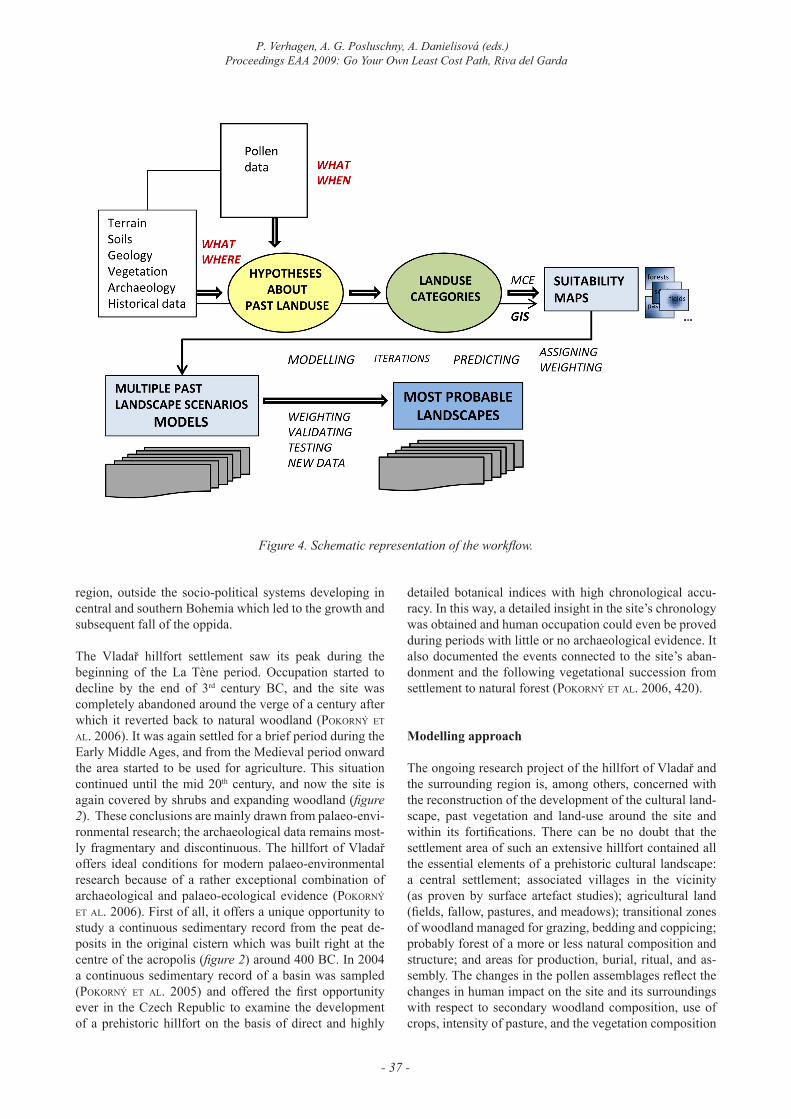
To achieve this, a multidisciplinary approach is under-taken integrating both archaeological and environmental data with GIS-based analytical tools, in order to create a set of chronologically distinctive landscape models based on the data from a single onsite pollen profile. The data concerning landscape morphology, geology, soil cover and climate were combined with data on past occupation (based on archaeological excavations and surface survey) and past vegetation (based on the results of pollen analy-ses). The greatest problem we faced for this analysis is the fact that pollen data is not spatially determined, unlike the rest. When we only dispose of a single pollen profile, the spatial interpretation of these data remains obscure. The best method to combine the spatially related data with the
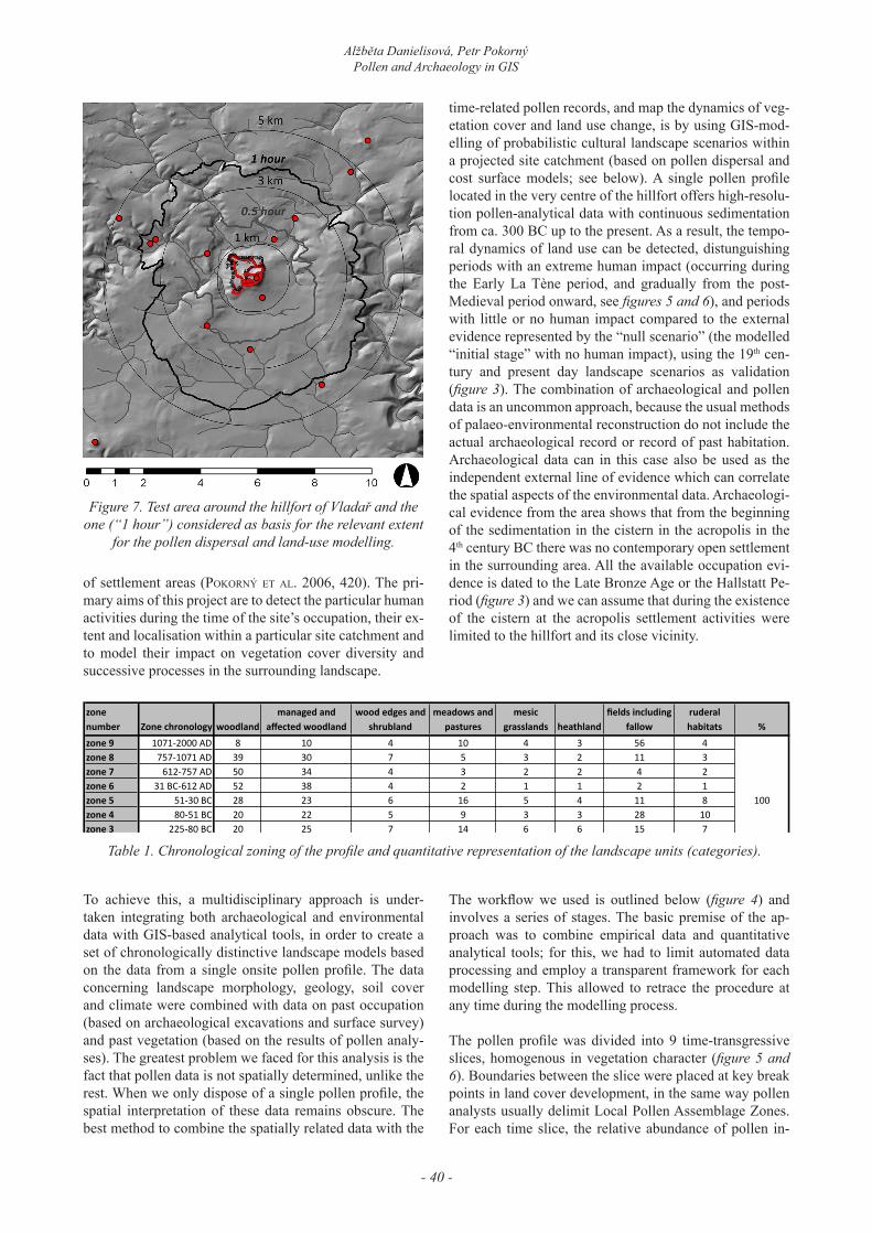
time-related pollen records, and map the dynamics of veg-etation cover and land use change, is by using GIS-mod-elling of probabilistic cultural landscape scenarios within a projected site catchment (based on pollen dispersal and cost surface models; see below). A single pollen profile located in the very centre of the hillfort offers high-resolu-tion pollen-analytical data with continuous sedimentation from ca. 300 BC up to the present. As a result, the tempo-ral dynamics of land use can be detected, distunguishing periods with an extreme human impact (occurring during the Early La Tène period, and gradually from the post-Medieval period onward, see figures 5 and 6), and periods with little or no human impact compared to the external evidence represented by the “null scenario” (the modelled “initial stage” with no human impact), using the 19th cen-tury and present day landscape scenarios as validation (figure 3). The combination of archaeological and pollen data is an uncommon approach, because the usual methods of palaeo-environmental reconstruction do not include the actual archaeological record or record of past habitation. Archaeological data can in this case also be used as the independent external line of evidence which can correlate the spatial aspects of the environmental data. Archaeologi-cal evidence from the area shows that from the beginning of the sedimentation in the cistern in the acropolis in the 4th century BC there was no contemporary open settlement in the surrounding area. All the available occupation evi-dence is dated to the Late Bronze Age or the Hallstatt Pe-riod (figure 3) and we can assume that during the existence of the cistern at the acropolis settlement activities were limited to the hillfort and its close vicinity.
The workflow we used is outlined below (figure 4) and involves a series of stages. The basic premise of the ap-proach was to combine empirical data and quantitative analytical tools; for this, we had to limit automated data processing and employ a transparent framework for each modelling step. This allowed to retrace the procedure at any time during the modelling process.
The pollen profile was divided into 9 time-transgressive slices, homogenous in vegetation character (figure 5 and 6). Boundaries between the slice were placed at key break points in land cover development, in the same way pollen analysts usually delimit Local Pollen Assemblage Zones. For each time slice, the relative abundance of pollen in-
Figure 7. Test area around the hillfort of Vladař and the one (“1 hour”) considered as basis for the relevant extent
for the pollen dispersal and land-use modelling.
zone number Zone chronology woodland
managed and affected woodland
wood edges and shrubland
meadows and pastures
mesic grasslands heathland
fields including fallow
ruderal habitats %
zone 9 1071-‐2000 AD 8 10 4 10 4 3 56 4zone 8 757-‐1071 AD 39 30 7 5 3 2 11 3zone 7 612-‐757 AD 50 34 4 3 2 2 4 2zone 6 31 BC-‐612 AD 52 38 4 2 1 1 2 1zone 5 51-‐30 BC 28 23 6 16 5 4 11 8zone 4 80-‐51 BC 20 22 5 9 3 3 28 10zone 3 225-‐80 BC 20 25 7 14 6 6 15 7zone 2 245-‐225 BC 15 18 6 9 5 5 32 10zone 1 307-‐245 BC 8 13 8 19 10 8 14 20
100
Table 1. Chronological zoning of the profile and quantitative representation of the landscape units (categories).
- 41 -
P. Verhagen, A. G. Posluschny, A. Danielisová (eds.)Proceedings EAA 2009: Go Your Own Least Cost Path, Riva del Garda
dicative for the relevant vegetation groupings of individual land cover units was calculated.
The following land cover categories were chosen:a) woodland,b) managed and affected woodland,c) wood edges and shrubland,d) meadows and mesice) pastures,f) heathland,g) dry grassland,h) fields (including fallow),i) ruderal habitats.
The recalculation of raw pollen percentages into quantita-tive estimates of land cover unit occurrence was based on empirical estimates of pollen productivity on a scale from 1 (least productive) to 5 (maximum productivity), and ecological indicator values of individual pollen types in respect to certain vegetation categories on a scale of 0 (no occurrence in respective type of vegetation) to 5 (strong affinity to respective type of vegetation). The calculated proportions of the land cover units (table 1) were then as-sociated with their particular topographical preferences and positioned within a site catchment according to pollen dispersion and the other criteria (see below).
Isolated time slices represent individual points in time – these are the “land use scenarios” which are meant to be stacked chronologically in order to visualize the cultural
landscape dynamics in space and time. The main problem with this approach is the (wrong) assumption that land use was constant in time.
The ultimate question to be solved is the detection of the relevant spatial extent for the model; many models rely on calculated RSAP (cf. suGiTa eT aL. 2007b; brosTröM et al. 2005; Bunting et al. 2008, 78; caseldine et al. 2008, 543, 545 etc.). The extent needs to be determined on the basis on number of criteria – especially pollen disper-sal estimates across a three-dimensional landscape (relief) and settlement area theory. The actual model area for this project was inferred from the current state of vegetation within the cistern (where the pollen profile was sampled) during the particular time slices and combined with the movement costs across the landscape up to a distance of 5 km: one walking hour for open pond, one half for partially weedy, 15 minutes (or one kilometre) for marsh (figure 7). This approach was accepted especially because we tend to model the cultural landscape with communities living and moving in it.
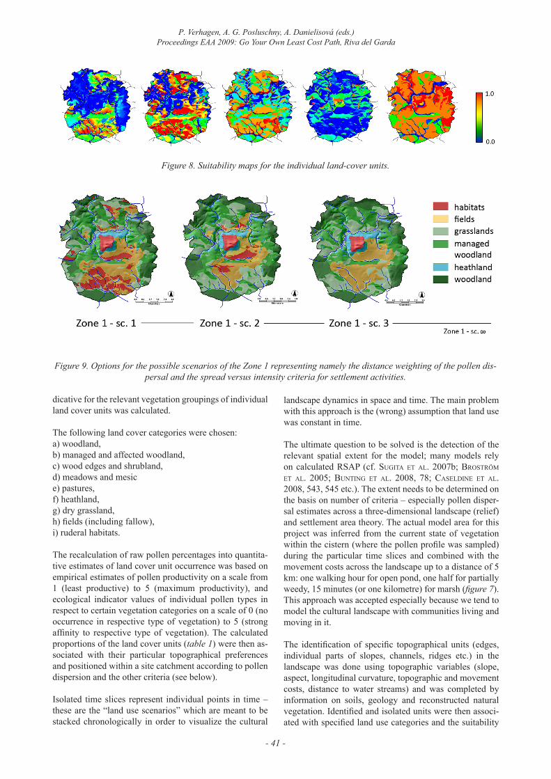
The identification of specific topographical units (edges, individual parts of slopes, channels, ridges etc.) in the landscape was done using topographic variables (slope, aspect, longitudinal curvature, topographic and movement costs, distance to water streams) and was completed by information on soils, geology and reconstructed natural vegetation. Identified and isolated units were then associ-ated with specified land use categories and the suitability
Figure 8. Suitability maps for the individual land-cover units.
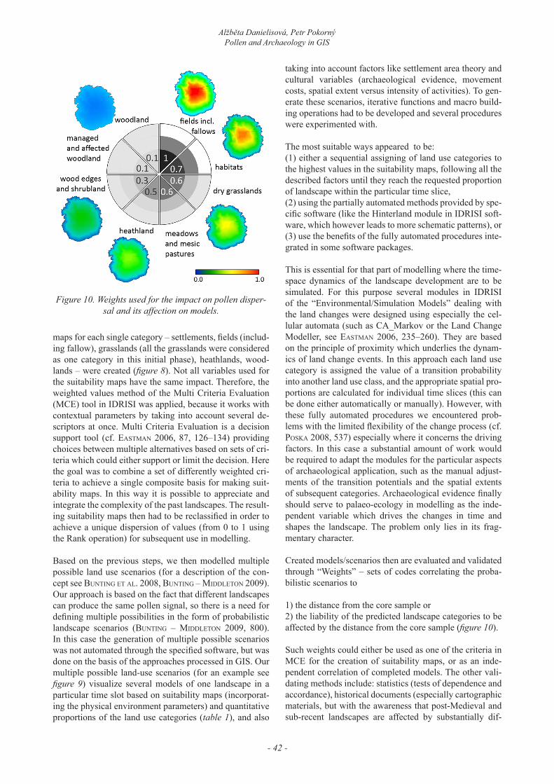
Figure 9. Options for the possible scenarios of the Zone 1 representing namely the distance weighting of the pollen dis-persal and the spread versus intensity criteria for settlement activities.
- 42 -
Alžběta Danielisová, Petr PokornýPollen and Archaeology in GIS
maps for each single category – settlements, fields (includ-ing fallow), grasslands (all the grasslands were considered as one category in this initial phase), heathlands, wood-lands – were created (figure 8). Not all variables used for the suitability maps have the same impact. Therefore, the weighted values method of the Multi Criteria Evaluation (MCE) tool in IDRISI was applied, because it works with contextual parameters by taking into account several de-scriptors at once. Multi Criteria Evaluation is a decision support tool (cf. easTMan 2006, 87, 126–134) providing choices between multiple alternatives based on sets of cri-teria which could either support or limit the decision. Here the goal was to combine a set of differently weighted cri-teria to achieve a single composite basis for making suit-ability maps. In this way it is possible to appreciate and integrate the complexity of the past landscapes. The result-ing suitability maps then had to be reclassified in order to achieve a unique dispersion of values (from 0 to 1 using the Rank operation) for subsequent use in modelling.
Based on the previous steps, we then modelled multiple possible land use scenarios (for a description of the con-cept see bunTinG eT aL. 2008, bunTinG – MiDDLeTon 2009). Our approach is based on the fact that different landscapes can produce the same pollen signal, so there is a need for defining multiple possibilities in the form of probabilistic landscape scenarios (bunTinG – MiDDLeTon 2009, 800). In this case the generation of multiple possible scenarios was not automated through the specified software, but was done on the basis of the approaches processed in GIS. Our multiple possible land-use scenarios (for an example see figure 9) visualize several models of one landscape in a particular time slot based on suitability maps (incorporat-ing the physical environment parameters) and quantitative proportions of the land use categories (table 1), and also
taking into account factors like settlement area theory and cultural variables (archaeological evidence, movement costs, spatial extent versus intensity of activities). To gen-erate these scenarios, iterative functions and macro build-ing operations had to be developed and several procedures were experimented with.
The most suitable ways appeared to be:(1) either a sequential assigning of land use categories to the highest values in the suitability maps, following all the described factors until they reach the requested proportion of landscape within the particular time slice,(2) using the partially automated methods provided by spe-cific software (like the Hinterland module in IDRISI soft-ware, which however leads to more schematic patterns), or(3) use the benefits of the fully automated procedures inte-grated in some software packages.
This is essential for that part of modelling where the time-space dynamics of the landscape development are to be simulated. For this purpose several modules in IDRISI of the “Environmental/Simulation Models” dealing with the land changes were designed using especially the cel-lular automata (such as CA_Markov or the Land Change Modeller, see easTMan 2006, 235–260). They are based on the principle of proximity which underlies the dynam-ics of land change events. In this approach each land use category is assigned the value of a transition probability into another land use class, and the appropriate spatial pro-portions are calculated for individual time slices (this can be done either automatically or manually). However, with these fully automated procedures we encountered prob-lems with the limited flexibility of the change process (cf. Poska 2008, 537) especially where it concerns the driving factors. In this case a substantial amount of work would be required to adapt the modules for the particular aspects of archaeological application, such as the manual adjust-ments of the transition potentials and the spatial extents of subsequent categories. Archaeological evidence finally should serve to palaeo-ecology in modelling as the inde-pendent variable which drives the changes in time and shapes the landscape. The problem only lies in its frag-mentary character.
Created models/scenarios then are evaluated and validated through “Weights” – sets of codes correlating the proba-bilistic scenarios to
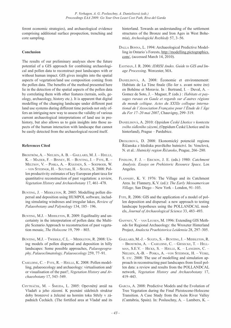
1) the distance from the core sample or2) the liability of the predicted landscape categories to be affected by the distance from the core sample (figure 10).
Such weights could either be used as one of the criteria in MCE for the creation of suitability maps, or as an inde-pendent correlation of completed models. The other vali-dating methods include: statistics (tests of dependence and accordance), historical documents (especially cartographic materials, but with the awareness that post-Medieval and sub-recent landscapes are affected by substantially dif-
Figure 10. Weights used for the impact on pollen disper-sal and its affection on models.
- 43 -
P. Verhagen, A. G. Posluschny, A. Danielisová (eds.)Proceedings EAA 2009: Go Your Own Least Cost Path, Riva del Garda
ferent economic strategies), and archaeological evidence comprising additional surface prospection, trenching and core sampling.
Conclusion
The results of our preliminary analyses show the future potential of a GIS approach for combining archaeologi-cal and pollen data to reconstruct past landscapes with or without human impact. GIS gives insights into the spatial aspects of vegetation/land use composition coming from the pollen data. The benefits of the method presented here lie in the detection of the spatial aspects of the pollen data by correlating them with other features (terrain, soils, ge-ology, archaeology, history etc.). It is apparent that digital modelling of the changing landscape under different past land use systems during different time periods not only of-fers an intriguing new way to assess the validity of various current archaeological interpretations of land use in pre-history, but also allows us to gain insights into those as-pects of the human interaction with landscape that cannot be easily detected from the archaeological record itself.
References Cited
brosTröM, a. – nieLsen, a. b. – GaiLLarD, M. J. – hJeLLe, k. – MaZier, f. – binney, h. – bunTinG, J. – fyfe, r. – MeLTsoV, V. – Poska, a. – räsänen, s. – soePboer, W. – Von sTeDinGk, h. – suuTari, h. – suGiTa, s. 2008: Pol-len productivity estimates of key European plant taxa for quantitative reconstruction of past vegetation: a review, Vegetation History and Archaeobotany 17, 461–478.
bunTinG, J. – MiDDLeTon, R. 2005: Modelling pollen dis-persal and deposition using HUMPOL software, includ-ing simulating windroses and irregular lakes, Review of Palaeobotany and Palynology 134, 185– 196.
bunTinG, M.J. – MiDDLeTon, r. 2009: Equifinality and un-certainty in the interpretation of pollen data: the Multi-ple Scenario Approach to reconstruction of past vegeta-tion mosaic, The Holocene 19, 799 – 803.
bunTinG, M.J. – TWiDDLe, c.L. – MiDDLeTon, r. 2008: Us-ing models of pollen dispersal and deposition in hilly landscapes: Some possible approaches, Palaeogeogra-phy, Palaeoclimatology, Palaeoecology 259, 77–91.
caseLDine, c. – fyfe, r. – hJeLLe, k. 2008: Pollen model-ling, palaeoecology and archaeology: virtualisation and/or visualisation of the past?, Vegetation History and Ar-chaeobotany 17, 543–549.
chytráček, M. – ŠMejda, L. 2005: Opevněný areál na Vladaři a jeho zázemí. K poznání sídelních struktur doby bronzové a železné na horním toku Střely v zá-padních Čechách. (The fortified area at Vladař and its
hinterland. Towards an understanding of the settlement structures of the Bronze and Iron Ages in West Bohe-mia), Archeologické Rozhledy 57, 3–56.
DaLLa bonna, L. 1994: Archaeological Predictive Model-ling in Ontario´s Forests, http://modelling.pictographics.com/, (accessed March 14, 2010).
easTMan, J. R. 2006: IDRISI Andes. Guide to GIS and Im-age Processing. Worcester, MA.
DanieLisoVá, A. 2008: Économie et environnement: Habitats de La Tène finale (IIe–Ier s. avant notre ère) en Bohême et Moravie. In : Bertrand, I. – Duval, A. – Gomez de Soto, J. – Maguer, P. (eds.) : Habitats et pay-sages ruraux en Gaule et regards sur d´autres régions du monde celtique. Actes du XXXIe colloque interna-tional de l´Association Française pour l´Étude de l´Âge du Fer 17–20 mai 2007, Chauvigny, 299–319.
DanieLisoVá, A. 2010: Oppidum České Lhotice v kontextu svého sídleního zázemí, (Oppidum České Lhotice and its hinterland), Prague – Pardubice.
DresLeroVá, D. 2008: Ekonomický potenciál regionu Říčanska z hlediska pravěkého hutnictví. In: Venclová, N. et al.: Hutnický region Říčansko, Prague, 266–280.
finDLoW, F. J. – ericson, J. E. (eds.) 1980: Catchment Analysis. Essays on Prehistoric Resource Space, Los Angeles.
fLannery, K. V. 1976: The Village and its Catchment Area. In: Flannery, K.V. (ed.): The Early Mesoamerican Village, San Diego – New York – London, 91–103.
fyfe, R. 2006: GIS and the application of a model of pol-len deposition and dispersal: a new approach to testing landscape hypotheses using the POLLANDCAL mod-els, Journal of Archaeological Science 33, 483–493.
Gaffney, V. – Van Leusen, M. 1996: Extending GIS Meth-ods for Regional Archaeology: the Wroxeter Hinterland Project, Analecta Praehistorica Leidensia 28, 297–305.
GaiLLarD, M.-J. – suGiTa, s. – bunTinG, J. – MiDDLeTon, r. – brosTröM, a. – caseLDine, c. – Giesecke, T. – heLL-Man, s.e.V. – hicks, s. – hJeLLe, k. – LanGDon, c. – nieLsen, a.-b. – Poska, a. –Von sTeDinGk, h. – Veski, s. eTc. 2008: The use of modelling and simulation ap-proach in reconstructing past landscapes from fossil pol-len data: a review and results from the POLLANDCAL network, Vegetation History and Archaeobotany 17, 419–443.
Garcia, A. 2008: Predictive Models and the Evolution of Tree Vegetation during the Final Pleistocene-Holocene Transition. A Case Study from the Asón River Valley (Cantabria, Spain). In: Posluschny, A. – Lambers, K. –
- 44 -
Alžběta Danielisová, Petr PokornýPollen and Archaeology in GIS
Herzog, I. (eds.): Layers of Perception, Proceedings of the 35th International Conference on Computer Applica-tions and Quantitative Methods in Archaeology (CAA), Berlin, Germany, April 2-6, 2007, Kolloquien zur Vor- und Frühgeschichte, Vol. 10, Bonn, 392–398.
GauDin, L. – Marquerie, D. – Lanos, P. 2008: Correlation between spatial distributions of pollen data, archaeologi-cal records and physical parameters from northwestern France: a GIS and numerical analysis approach, Vegeta-tion History and Archaeobotany 17, 585–595.
Gearey, B.R. – chaPMan, H.P. 2006: “Digital gardening”. An approach to simulating elements of palaeovegetation and some implications for the interpretation of prehistor-ic sites and landscapes. In: Evans, T. L. – Daly, P. (eds.): Digital Archaeology, bridging method and theory, Lon-don – New York.
GranT, E. (ed.) 1986: Central Places, Archaeology and History, Sheffield.
haGGeT, P. – cLiff, a.D. – frey, A. 1977: Locational Analysis in Human Geography I. II. Locational Models, London.
hiGGs, e. s. – ViTa-finZi, C. 1972: Prehistoric Economies: a Territorial Approach. In: Higgs, E. S. (ed.): Papers in Economic Prehistory. Studies by Members and Associ-ates of the British Academy Major Research Project in the Early History of Agriculture, Cambridge, 27–36.
hLásny, T. 2007: Geografické informačné systémy, priestorové analýzy, Banska Bystrica.
kaMerMans, h. – Van Leusen, M. – VerhaGen, P. (eds.) 2009: Archaeological Prediction and Risk Management. Alternatives to Current Practice, Archaeological studies Leiden University 17, Leiden.
kuna, M. 2006: Burial mounds in the landscape. In: Šmejda, L. (ed.): Archaeology of the burial mounds, Plzeň, 83–97.
kuna, M. 2008: Analýza polohy pravěkých mohylových pohřebišť pomocí geografických informačních systémů, (An analysis of prehistoric tumulus cemeteries by means of geographic information systems). In: Macháček, J. (ed.): Počítačová podpora v archeologii 2, Brno, 79–92.
Mehrer, M. W. – WesTcoTT, k. L. (eds.) 2006: GIS and Archaeological Site Location Modelling. Boca Raton – London – New York.
MiDDLeTon, r. – bunTinG, J. 2004: Mosaic v1.1: landscape scenario creation software for simulation of pollen dis-persal and deposition, Review of Palaeobotany and Pa-lynology 132, 61– 66.
neusTuPný, E. 2007: Metoda archeologie, Plzeň.nieLsen, A. B. 2004: Modelling pollen sedimentation in
Danish lakes at c. AD 1800: an attempt to validate the POLLSCAPE model, Journal of Biogeography 31, 1693–1709.
nieLsen, A.B. – oDGaarD, B.V. 2005: Reconstructing land cover from pollen assemblages from small lakes in Den-mark, Review of Palaeobotany and Palynology 133, 1–21.
Pokorný, P. – sádlo, j. – kaPlan, M. – MikoláŠková, k. – VeseLý, J. 2005: Paleoenvironmentální výzkum na Vladaři, (Palaeoenvironmental investigations at the hill-fort Vladař, Czech Republic), Archeologické Rozhledy 57, 57–99.
Pokorný, P. – Boenke, n. – chytráček, M. – nováková, k. – sádlo, j. – veselý, j. – kuneŠ, P. – jankovská, v. 2006: Insight into the environment of a pre-Roman Iron Age hillfort at Vladař, Czech Republic, using a multi-proxy approach, Vegetation History and Archaeobotany 15, 419–433.
Poska, a. – sePP, e. – Veski, s. – koPPeL, k. 2008: Using quantitative pollen-based land-cover estimations and a spatial CA_Markov model to reconstruct the develop-ment of cultural landscape at Roũge, South Estonia, Veg-etation History and Archaeobotany 17, 527–541.
stančič, z. – kvaMMe, k. l. 1999: Settlement Pattern Modelling through Boolean Overlays of Social and En-vironmental Variables. In: Barceló – Briz – Assumció (eds.): New Techniques for Old Times – CAA 98 – Com-puter Applications and Quantitative Methods in Archae-ology. Proceedings of the 26th Conference, Barcelona, March 1998, BAR International Series 757, Oxford, 231–237.
sTePonaiTis, V. P. 1981: Settlement Hierarchies and Politi-cal Complexity in Nonmarket Societies: The Formative Period of the Valley of Mexico, American Anthropolo-gist, New Series, Vol. 83, No 2, 320–363.
sTobbe, A. 2008: Palynological and Archaeological Data- a Comparative Approach. In: Posluschny, A. – Lambers, K. – Herzog, I. (eds.): Layers of Perception, Proceed-ings of the 35th International Conference on Computer Applications and Quantitative Methods in Archaeology (CAA), Berlin, Germany, April 2-6, 2007, Kolloquien zur Vor- und Frühgeschichte, Vol. 10, Bonn, (on CD).
suGiTa, S. 2007: POLLSCAPE model. In: Elias, S. A. (ed.): Encyclopedia of quaternary science. London.
suGiTa, S. 2007a: Theory of quantitative reconstruction of vegetation I: pollen from large sites REVEALS regional vegetation composition, The Holocene 17, 229–241.
- 45 -
P. Verhagen, A. G. Posluschny, A. Danielisovù (eds.)Proceedings EAA 2009: Go Your Own Least Cost Path, Riva del Garda
suGiTa, S. 2007b: Theory of quantitative reconstruction of vegetation II: all you need is LOVE, The Holocene 17, 243–257.
suGiTa, s. – GaiLLarD, M.-J. – heLLMan, s. – brosTröM, a. 2008: Model-Based Reconstruction of Vegetation and Landscape Using Fossil Pollen. In: Posluschny, A. – Lambers, K. – Herzog, I. (eds.): Layers of Percep-tion, Proceedings of the 35th International Conference on Computer Applications and Quantitative Methods in Archaeology (CAA), Berlin, Germany, April 2-6, 2007, Kolloquien zur Vor- und Frühgeschichte, Vol. 10, Bonn, 385–391.
ucko, P.J. – TrinGhaM, r. – DiMbLeby, G.W. (eds.) 1972: Man, Settlement and Urbanism. Gloucester.
Van Leusen, M. 2002: Pattern to Process. Methodological Investigations into the formation and interpretation of spatial patterns in archaeological landscapes, Gronin-gen.
VerhaGen, P. 2007: Case studies in archaeological predic-tive modelling, Archaeological studies Leiden Univer-sity 14.
Alžběta DanielisováInstitute of Archaeology CAS, Prague, v.v.i.
Letenská 4,118 01 – Prague 1
Czech Republic [email protected]
Petr PokornýInstitute of Archaeology CAS, Prague, v.v.i.
Letenská 4,118 01 – Prague 1
Czech Republic and
Center for Theoretical Study,Charles University in Prague and the CAS
110 00 – Prague 1Czech Republic
Related Documents