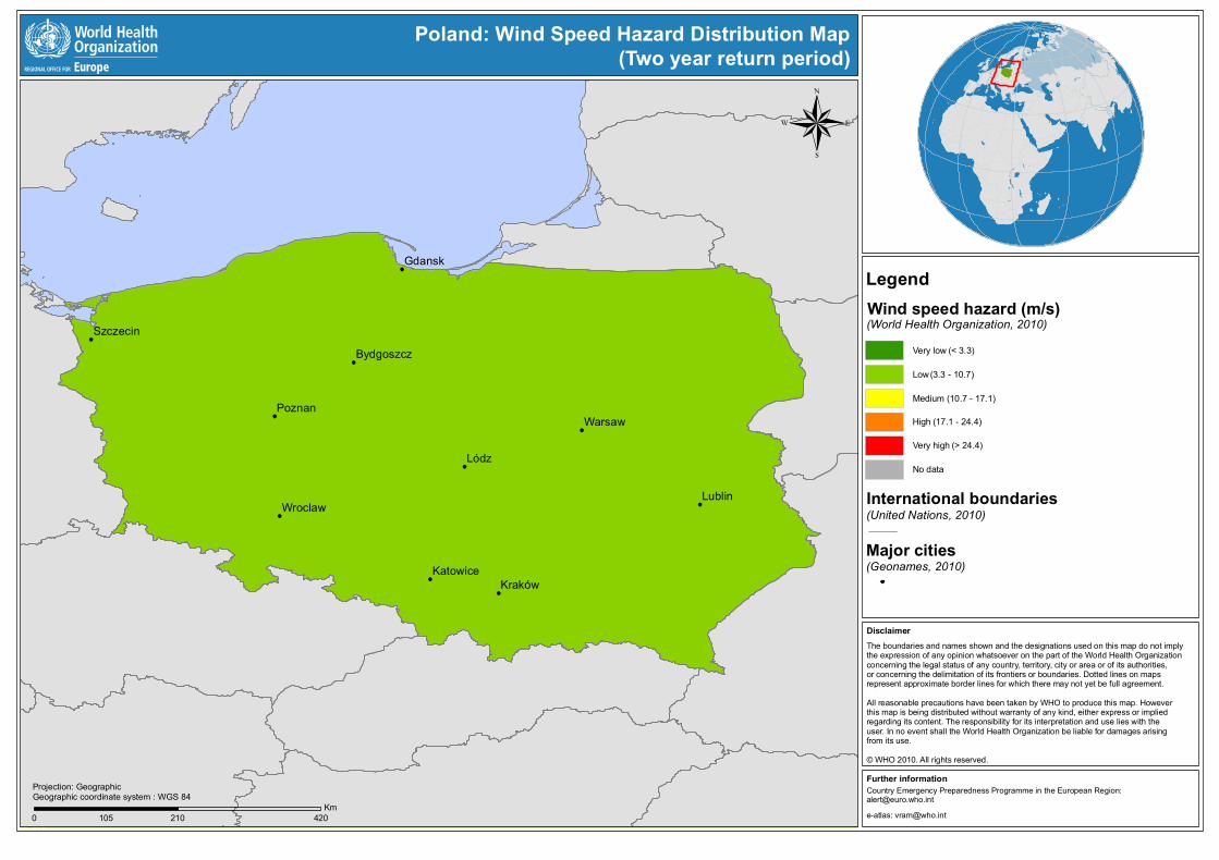
Country Emergency Preparedness Programme in the European Region: [email protected] Further information e-atlas: [email protected] Disclaimer The boundaries and names shown and the designations used on this map do not imply the expression of any opinion whatsoever on the part of the World Health Organization concerning the legal status of any country, territory, city or area or of its authorities, or concerning the delimitation of its frontiers or boundaries. Dotted lines on maps represent approximate border lines for which there may not yet be full agreement. All reasonable precautions have been taken by WHO to produce this map. However this map is being distributed without warranty of any kind, either express or implied regarding its content. The responsibility for its interpretation and use lies with the user. In no event shall the World Health Organization be liable for damages arising from its use. © WHO 2010. All rights reserved. 0 210 420 105 Km Projection: Geographic Geographic coordinate system : WGS 84 Legend Wind speed hazard (m/s) (World Health Organization, 2010) International boundaries (United Nations, 2010) Major cities (Geonames, 2010) Very low Low Medium High Very high No data (< 3.3) (3.3 - 10.7) (10.7 - 17.1) (17.1 - 24.4) (> 24.4) Poland: Wind Speed Hazard Distribution Map (Two year return period)

Welcome message from author
This document is posted to help you gain knowledge. Please leave a comment to let me know what you think about it! Share it to your friends and learn new things together.
Transcript
Country Emergency Preparedness Programme in the European Region:[email protected]
Further information
e-atlas: [email protected]
DisclaimerThe boundaries and names shown and the designations used on this map do not imply the expression of any opinion whatsoever on the part of the World Health Organization concerning the legal status of any country, territory, city or area or of its authorities, or concerning the delimitation of its frontiers or boundaries. Dotted lines on maps represent approximate border lines for which there may not yet be full agreement. All reasonable precautions have been taken by WHO to produce this map. However this map is being distributed without warranty of any kind, either express or implied regarding its content. The responsibility for its interpretation and use lies with the user. In no event shall the World Health Organization be liable for damages arising from its use.
© WHO 2010. All rights reserved.
0 210 420105Km
Projection: GeographicGeographic coordinate system : WGS 84
LegendWind speed hazard (m/s)(World Health Organization, 2010)
International boundaries(United Nations, 2010)
Major cities(Geonames, 2010)
Very low
Low
Medium
High
Very high
No data
(< 3.3)
(3.3 - 10.7)
(10.7 - 17.1)
(17.1 - 24.4)
(> 24.4)
Poland: Wind Speed Hazard Distribution Map(Two year return period)
Related Documents


![New RESEARCHARTICLE Evaluationofthe2013SoutheastAsianHaze … · 2017. 4. 13. · generation, suchas theeffect ofdust,duststorms, windspeed,angle, and shedding [9].In 1942,Hotteland](https://static.cupdf.com/doc/110x72/60106f03680181237e1a940d/new-researcharticle-evaluationofthe2013southeastasianhaze-2017-4-13-generation.jpg)