Point-to-GeoBlog: Gestures and Sensors to Support User Generated Content Creation Simon Robinson, Parisa Eslambolchilar, Matt Jones MobileHCI 2008

Point-to-GeoBlog: Gestures and Sensors to Support User Generated Content Creation Simon Robinson, Parisa Eslambolchilar, Matt Jones MobileHCI 2008.
Dec 28, 2015
Welcome message from author
This document is posted to help you gain knowledge. Please leave a comment to let me know what you think about it! Share it to your friends and learn new things together.
Transcript
Point-to-GeoBlog:Gestures and Sensors to Support UserGenerated Content Creation
Simon Robinson, Parisa Eslambolchilar, Matt Jones
MobileHCI 2008
Outline
Introduction Prototype : Gestures and Visual Feedback ─ Mobile Hardware
─ Marking points of Interest─ Making Maps
Evaluating the System ─ Method
─ Findings Discussion Conclusions and Future Work
Introduction (1)
Three trends in blogging motivate this work ─ Short, frequent low-cost posts
`status updates' .
─ Sparse and frequent acts are attractive to mobile users.
─ Blogs were text but now photos, videos .Use several web services for clear role.Facebook, Google MyMaps.
Likely to become extremely popular???

Introduction (2)
This map generating, journey reminiscing scenario is the one we focus on In the paper. An interaction performed at an earlier point in time is used to provide information later.
First combines pointing gesture with visual feedback to indicate areas of interest. Second, the mobile require minimal attention from the user.

Prototype : Gestures and Visual
FeedbackMobile Hardware
Marking points of Interest
Making Maps

Mobile Hardware (1)
SHAKE SK6 ─ small Bluetooth device
─ three-axis accelerometers, magnetometers and angular rate sensors, dual-channel capacitive input sensors and a navigation button ─ programmable vibrating motor
Dell Axim x51v PDA
Each SHAKE is attached to the back of a PDA.

Mobile Hardware (2)
The equipment in use. Inset: the SHAKE sensor pack.
Mobile Hardware (2)

Mobile Hardware (3)
Use a standard Bluetooth GPS receiver to determine a user’s location, PDA to record the data.
Any movements made by the user holding the device are recorded by the SHAKE.

Marking points of Interest (1)
Displays an aerial photo of the current location An arrow showing the direction they facing.
Tilt the device toward or away from bodies to refine the targeting.
Marker is positioned over their desired target , the user presses a button to mark.

Marking points of Interest (2)
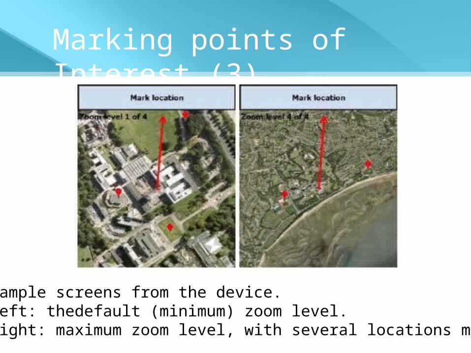
Default, the user is presented with a view that shows an area up to 175m from their current positions.
zoom out through three levels allow them to select targets up to 350m, 700m and 1400m.
Marking points of Interest (3)
Sample screens from the device. Left: thedefault (minimum) zoom level. Right: maximum zoom level, with several locations marked.

Marking points of Interest (4)
when horizontally (at 0 degrees relative to the horizontal plane), the distance is the maximum of the current zoom level ; when vertically (at 90 degrees relative to the horizontal plane) the distance is set to 0 metres.

Marking points of Interest (5)
Indicating distance (metres) by degree of tilt.
Left to right: points at a location and then tilts the SHAKE to indicate the target’s distance.

Making Maps (1)
Determine the user's route from logged GPS readings. Retrieve the latitude and longitude coordinates of the user's points of interest.
Finding content─ By postal codes and district names, to specify a
small area at street level, allowing for detailed location-specic results.
─ Text and image results are garnered from social networking sites.

Making Maps (2)
Sample webpage search result.

Making Maps (3)
Map visualisation
─ The map visualisation shows the route taken during each journey (as coloured lines, a dierent colour for each route ) and the areas-of-interest marked by the user .
─ Locations with no retrieved content are shown as grey markers.

Making Maps (4)
As user hovers over a marker, a line is drawn to show where the gesture originated and content statistics are displayed.

Making Maps (5)
Clicking on a marker displays content results.

Evaluating the System
Participants : fifteen participants ,18 to 45 Period: 4-day period
Place: covering approximately 14 square miles
Results: participant behaviors ,logged data

Method - start
Meet individually, short demonstration, basic training. the devices switched on at all times, and use the system to mark any places.
data logs were collected from each participant's PDA.

Method - mid
Questionnaire based on the NASA Task Load instrument.
Rate the mental, physical and temporal demand,about the marking task.
Dimensions was rated on a scale of 7.

Method - final
browse their map, exploring their routes and search results of each marked location.
thinking-aloud to explain their interaction with and impressions of the map.
Rated the content retrieved for each marked location on a scale of 1-7.

Findings
Journeys and marked points of interest.
Mobile Task Load and Usability Ratings.
Interview and think-aloud findings relating to the mobile system
Interview, think-aloud and content rating findings relating to the map visualisations

Journeys and marked points of interest
(1) 241 location be marked.(56%) public buildings(26%) landscape features(18%) particular historical interest.
view zooming functions were not often used.
The mean time taken to mark each location was 4½ seconds (std. dev:6.7 seconds).

Journeys and marked points of interest
(2)
All journeys (shown as lines) and marked locations (as pins) within the main common journey area.

Journeys and marked points of interest
(3)
Time taken to mark locations.

Mobile Task Load and Usability Ratings
Feature ratings.

Interview and think-aloud findings
Accurate marking of each location was time consuming.Have to match the map view with their actual view.
the distance in metres were marking on the map.
Trouble with on a moving bus.

Findings relating to the map visualisations
Skim over the textual information,preferring to skip directly to pictures
where they had been throughout the day, viewing this journey information would remind them about things.
For this content, all mean relevance rating for markers was 5.4 on a scale of 1 to 7.
Discussion
Found unexpected, interesting information.
Filtering mechanisms will be needed to ensure that the content is useful.
The use of visual feedback have both positive and negative impacts

Conclusions and Future Work (1)
Sensor data to mediate the combination of physical and digital experiences.
haptic feedback: related to the density of geo-tagged content in an area.
Dierent gestures to indicate the sorts of content.

Conclusions and Future Work (2)
From text update to gesture at a location and be provided with a list of interesting recommendations
`Google the real world '
Q&A
Related Documents