POHOIKI GEOTHERMAL TRANSMISSION LINE ROUTING STUDY Prepared (or: HAWAII ELECTRIC LIGHT COMPANY, INC. Prepared by: DHM inc. November 1987

Welcome message from author
This document is posted to help you gain knowledge. Please leave a comment to let me know what you think about it! Share it to your friends and learn new things together.
Transcript
POHOIKI GEOTHERMAL TRANSMISSION LINE
ROUTING STUDY
Prepared (or:
HAWAII ELECTRIC LIGHT COMPANY, INC.
Prepared by:
DHM inc.
November 1987
CONSULTANT TEAM
BISHOP MUSEUM
ArchaeologyBotany
EntomologyOrnithology
DAMES'" MOORE
Soils
DHM IDC.
Laad Use'" Enylronmental PlaDnlDiSta!! Members:
Duk Hee MurabayashiWendie McAllaster
Valerie LamRachel Sheffield
Lynn TaguchiEdie YamaguchiEugene Dashiell
SUMMARY
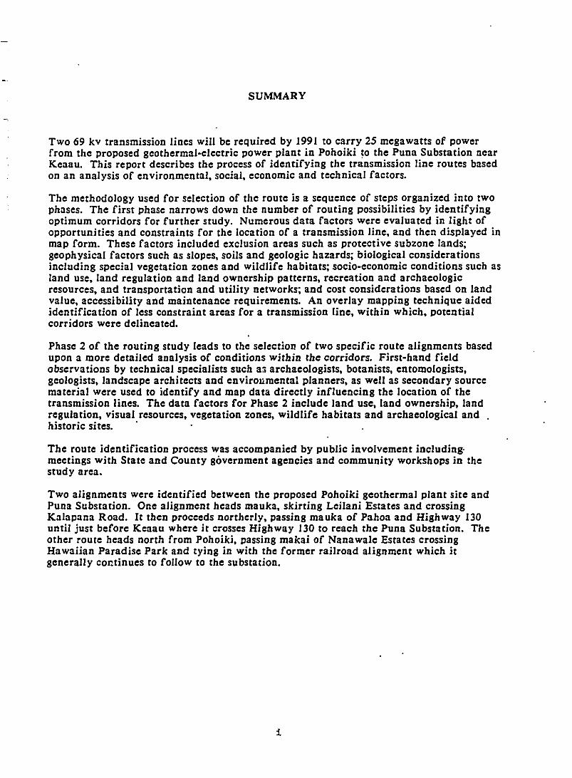
Two 69 kv transmission lines will be required by 1991 to carry 25 megawatts of powerfrom the proposed geothermal-electric power plant in Pohoiki to the Puna Substation nearKeaau. This report describes the process of identifying the transmission line routes basedon an analysis of environmental, social, economic and technical factors.
The methodology used for selection of the route is a sequence of steps organized into twophases. The first phase narrows down the number of routing possibilities by identifyingoptimum corridors for further study. Numerous data factors were evaluated in light ofopportunities and constraints for the location of a transmission line, and then displayed inmap form. These factors included exclusion areas such as protective subzone lands;geophysical factors such as slopes, soils and geologic hazards; biological considerationsincluding special vegetation zones and wildlife habitats; socio-economic conditions such asland use, land regulation and land ownership patterns, recreation and archaeologicresources, and transportation and utility networks; and cost considerations based on landvalue, accessibility and maintenance requirements. An overlay mapping technique aidedidentification of less constraint areas for a transmission line, within which, potentialcorridors were delineated.
Phase 2 of the routing study leads to the selection of two specific route alignments basedupon a more detailed analysis of conditions within the corridors. First-hand fieldobservations by technical specialists such a3 archaeologists, botanists, entomologists,geologists, landscape architects and envirollmental planners, as well as secondary sourcematerial were used to identify and map data directly influencing the location of thetransmission lines. The data factors for Phase 2 include land use, land ownership, landregulation, visual resources, vegetation zones, wildlife habitats and archaeological andhistoric sites. .
The route identification process was accompanied by public involvement including·meetings with State and County government agencies and community workshops in thestudy area.
Two alignments were identified between the proposed Pohoiki geothermal plant site andPuna Substation. One alignment heads mauka, skirting Leilani Estates and crossingKalapana Road. It then proceeds northerly, passing mauka of Pahoa and Highway 130until just before Keaau where it crosses Highway 130 to reach the Puna Substation. Theother route heads north from Pohoiki, passing makai of Nanawa1e Estates crossingHawaiian Paradise Park and tying in with the former railroad alignment which itgenerally continues to follow to the substation.
i
TABLE OF CONTENTS
GLOSSARY
CHAPTER I: SYSTEM REQUIREMENTS AND STUDY AREA
PAGE
A.
B.
C.
Proposed Geothermal Development and Required Transmission System.
Transmission Line Features .
Definition of Study Area .
I
3
3
CHAPTER II: TRANSMISSION LINE ROUTING METHODOLOGY
A.
B.
C.
Overview .
Step-by-Step Procedure .
Public Review .
7
10
II
CHAPTER III: TRANSMISSION LINE ALTERNATIVES
A.
B.
C.
D.
Types of Alternatives .
Underground Cable .
Submarine Cable .
Summary and Conclusions ' .
13
14
17
21
CHAPTER IV: BROADSCALE ANALYSIS
A.
B.
In troduction .
Exclusion Areas .
23
23
Geophysical Factors , .C.
I.
I.2.
Protective Subzone ; .
Slope and Soils .Geologic Hazards .
23
23
2528
D. Biological Factors . 30
I.2.
Vegeta tion .....................•........................Wildlife .
if
3033
E. Socio·Economic Factors .
PAGE
36
Cost Factors .F.
I.2.3.4.5.6.
I.2.3.
Recreation .Land Use .Transportation and Utilities .Land Ownership .History and Archaeology .Land Regulation .
Land Value .Maintenance .Access .
363942454851
53
535659
CHAPTER V: IDENTIFICATION OF CORRIDORS AND POTENTIAL ROUTES
A.
B.
C.
Composite Maps : .
Potential Corridors .
Corridor Evaluation .
61
61
62
CHAPTER VI: DETAILED ANALYSIS
A.
B.
C.
D.
Map Format and Data .
Physical Conditions .
Visual Resources ' .
Description of Alignments .
74
74
78
80
APPENDIX A:
APPENDIX B:
APPENDIX C:
APPENDIX D:
APPENDIX E:
APPENDIX F:
BIBLIOGRAPHY
Summaries of Community and Public Agency Workshops .
Archaeological Survey .
Botanical Survey , .
Ornithological Survey .
Terrestrial Anthropods .
Geologic Consultation .
iii
A-I
B-J
C-I
D·l
E-I
F-I
Exhibit
I-I
1-2
1-3
II-I
II-2
II-3
III-I
IV-I
IV-2
IV-3
IV-4
IV-5
IV-6
IV-7
IV-8
IV·9
'IV-IO
IV-II
IV-12
IV-13
IV-14
V-I
V-2
EXHIBITS
PAGE
Location Map 2
Typical 69 kV Line Spacing and Line Sag , . . . . . . . . . . . 5
Study Area , ,................... 6
Phase I Broadscale Analysis Data Categories and Factors. . . . . . . . . . . . . 7
Phase 2 Detailed Analysis Data Categories and Factors ,... 9
Transmission Line Routing Study Process : . . . . . . . . . . . . . . . . . . 12
Potential Marine Cable Routes ,. . . . . . . . . .. . . . 18
Exclusion Areas ,.............. 24
Slope and Soils ........•......................•...•..•......... 27
Geologic Hazards. . . . . . . . . . . . . . . . . . . . . . . . . . . . . . . . . . . . . • . . . . . . . . . 29\
Vegetation. . . . . . . . . . . . . . . . . . . . . . . . . . . . . . . . . . . . . . . • . . . . . . . . . . . . 32
Wildlife. . • . . . . . . . . ... . .• . . • . . . . . . . . . . . . . . . . . . . . . . . . . . . . . . . . . . . . 35
Recreation : : ' 38
Land Use , ................................•. , .. '" . . 41
Transportation and Utilities. . . . . . . . . . . . . . . . . . . . . . . . . . . . . . . . . . . . . 44
Land Ownership ........•........................ , . . . . . . . . . . . . . 47
History and Archaeology :. . . . . . . . . . . . . . 50
Land Regulation. . . . . . . . • . . . . . . . . . . . . . . . . . . . . . . . . . . . . . • . . . . . . . . 52
Land Value. . . . . . . . . . . . . . . . . . . . . . . . . . . . . . . . . . . . . . . . . . . . . . . . . . . 55
Maintenance. . . . . . . . . . . . . . . . . . . . . . . . . . . . . . . . . . . . . . . . . . . . . . . . . . . 5g
Access. . . . . . . . . . . . . . . . . . . . . . . . . . . . . . . . . . . . . . . . . . . . . . . . . . . . . . . . 60
Composi~e Constraints: Geophysical Factors 64
Compos}te Constraints: Biological Factors
iv
Exhibit
V-3
V-4
V-S
V-6
V-7
V-8
V-9
VI-I
VI-2
VI-3
VI-4
VI-S
VI-6
VI-7
VI-8
VI-9
VI-IO
Composite Constraints: Socio-Economic Factors .
Composite Constraints: Cost Factors .
Composite Constraints: All Data Categories .
Areas of Less Constraint .
Potential Corridors .
Test Routes .
Constraint Scores for Test Route Segments. by Data Factor .
Study Corridor Map Key .
Section I Physical Conditions .
Section I Visual Resources .
. Section 2 Physical Conditions ................•...................
Section 2 Visual Resources .
Section 3 Physical Conditions .
Section 3 Visual Resources '.' ' .
Section 4 'Physical Conditions .
Section 4 Visual Resources .
Alignments .
v
PAGE
66
67
68
69
70
71
72
75
82
83
85
86
88
89
92
93
94
'-
'-
GLOSSARY
TERM
~ (lava flow)
Alignment
Archaeological site
Areas of leastconstraint
BroadscaJe analysis
Composite mao
Conductor
Constraint
Corridor
Detailed analYsis
pistribution Line
Easement
GLOSSARY
DEFINITION
A rough-surfaced lava flow consisting of layers ofglass-like fragments of lava. Pahoehoe lava flows oftenchange to iUl. as they advance downhill.
The route of a proposed transmission line.
Locations of prehistoric or historic usc or habitation by .humans.
During the alignment identification process, theobjective is to locate potential routes where the leastenvironmental impacts arc thought to occur. SecChapter V for the application of this concept.
The process of mapping and analyzing availableinformation to identify potential corridors warrantingfurther study. Sec Chapter IV .for the factors andcriteria involved.
This map is a composite of several environmental datafa:tors. The purpose of the composite map is to presentan overall view of the constraints and opportunities forthe transmission line route. Sec Chapter V for adescription of the final composite maps.
The wire· or cable suitable for carrying electric current.
A condition which .discourages. but not necessarilyprecludes, a transmission line route.
A broad. linear area which provides ample space fordelineating and studying several alternative alignmentsfor a proposed transmission line.
During phase 2 of the routing study. following thebroadscale analysis, a detailed analysis of the areas ofleast constraint is conducted. This activity requires thecollection of detailed field data based on site surveys byenvironmental specialists. Sec Chapter VI for adescription of this phase.
A set of conductors which deliver electrical energyfrom the transmission system to the consumer.
An interest in land that entitles its holder to a specificland usc, such as a transmission line.
vi
TERM
Endemic species
Firm power
Geotherma I energy
Generation capacity
Indigenous species
Kilovolt IkV)
Main power grjd
Makai
Mauka
Megawatt (MW)
Native species
Opportunity
Pahoehoe(Java flow)
Peak load
DEFINITION
Plants and animals whose natural range is restricted tothe Hawaiian Islands and are found nowhere else.
Power which can be supplied on a 24·hour, 365 day-peryear basis.
The internal energy of the earth, available as heat fromheated rocks or water.
The nominal power output of a production facility,often measured in watts or megawatts..
Species of plants and animals which are native to theHawaiian Islands, but also with natural occurrenceselsewhere.
One thousand volts; a volt is a unit of electricalpotential difference and electromotive force.
The amount of electric power delivered or required atany specific point or points on a system. Load originatesprimarily at the power consuming equipment of theconsumers.
Hawaii Electric Light Company's main transmission line~ystem connecting generators to loads which providespower throughout the Island of Hawaii.
Hawaiian word for oceanward.
Hawaiian word for mountainward.
One miJIion watts; a watt is the absolute unit ofelectrical power equal to the rate of work representedby a current of one ampere under a pressure of one volt.
Plants and animals which are present in an environmentand were not introduced to that type of environment byhumans.
A favorable juncture of conditions for a transmissionline route.
A smooth-surfaced lava flow, often with wrinklesformed by the movement of liquid lava beneath a coolerbut stiJI-plastic crust. The liquid lava sometimes leavessubsurface hoJlow tubes with diameters of up to 50 feet.
The highest portion of demand, usually that occurringless than 10% of that time.
vii
TERM
Potentia! alignment
Potentia! corridors
Preferred alignment
Rare and endangeredspecies
Registered historicill;.
Right-of-Way (ROWl
Rift zone
Seismic
Study corridors
Substation
Switching station
Transmissjon line
DEFINITION
A potential alignment denotes a possible transmissionline route. See Chapter V for discussion.
Potential corridors are derived from the least constraintareas identified in the broad scale analysis. See ChapterIV and V for the identification of the corridors and adiscussion of the analytical process.
A preferred alignment appears to have the leastenvironmental impact, and to be the most desirablebased on the study criteria. See Chapter V fordiscussion.
Hawaiian term for a hill, peak, or mound.
Rare species or subspecies are animals or plants whichare in such limited numbers throughout their range thatthey may become endangered if their environmentworsens. Endangered species are threatened withextinction. Both terms have a legal definition and areused here in that sense.
The legal recognition of an historic property. TheNational and Hawaii Registers of Historic Places areplallning tools used to assess, but not necessarilyprevent, the potential impact of a publicly funded,licensed or permitted activity on the cultural resourcesor heritage of t~e State.
A legal right of passage over another person's land; theland used by a public utility.
A system of fractures and faults in the earth's crust.
Pertaining to an earthquake or earth vibration,inclUding those that are artificially induced.
Corridors selected for study in the detailed analysisphase. See Chapter VI.
A subsidiary station in which electric energy istransformcd. It is often combined with a switchingstation.
A subsidiary station in which electrical energy isswitched from one circuit to another. It is oftencombined with a station.
A set of conductors which transport electrical energybetween generators and loads.
viii
CHAPTER I
CHAPTER I: SYSTEM REQUIREMENTS AND STUDY AREA
A. PROPOSED GEOTHERMAL DEVELOPMENT AND REQUIRED TRANSMISSIONSYSTEM
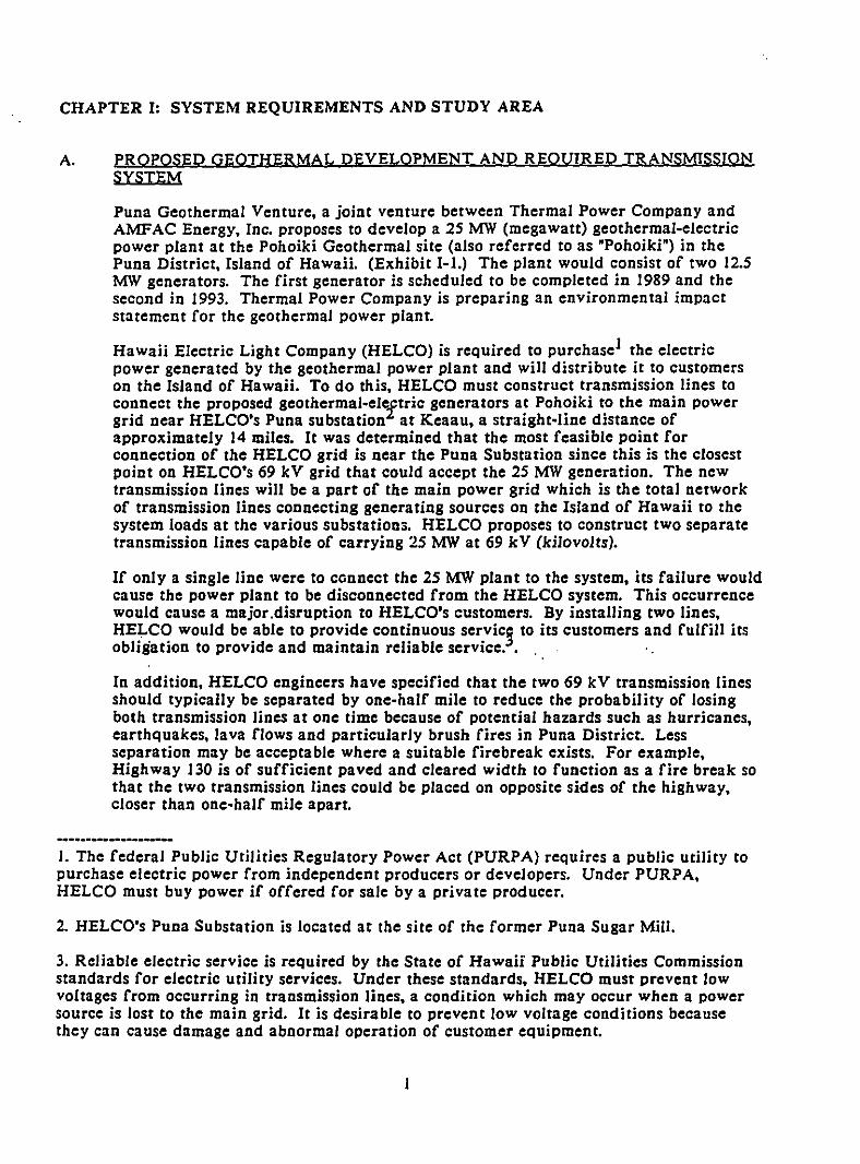
Puna Geothermal Venture, a joint venture between Thermal Power Company andAMFAC Energy, Inc. proposes to develop a 25 MW (megawatt) geothermal-electricpower plant at the Pohoiki Geothermal site (also referred to as 'Pohoiki') in thePuna District, Island of Hawaii. (Exhibit 1-1.) The plant would consist of two 12.5MW generators. The first generator is scheduled to be completed in 1989 and thesecond in 1993. Thermal Power Company is preparing an environmen tal impactstatement for the geothermal power plant.
Hawaii Electric Light Company (HELCO) is required to purchaseI the electricpower generated by the geothermal power plant and will distribute it to customerson the Island of Hawaii. To do this, HELCO must construct transmission lines toconnect the proposed geothermal-elCftric generators at Pohoiki to the main powergrid near HELCO's Puna substation at Keaau, a straight-line distance ofapproximately 14 miles. It was determined that the most feasible point forconnection of the HELCO grid is near the Puna Substation since this is the closestpoint on HELCO's 69 kV grid that could accept the 25 MW generation. The newtransmission lines will be a part of the main power grid which is the total networkof transmission lines connecting generating sources on the Island of HawaH to thesystem loads at the various substations. HELCO proposes to construct two separatetransmission lines capable of carrying 2S MW at 69 kV (kilovolts).
If only a single line were to connect the 2S MW plant to the system, its failure wouldcause the power plant to be disconnected from the HELCO system. This occurrencewould cause a major.disruption to HELCO's customers. By installing two lines,HELCO would be able to provide continuous servici to its customers and fulfill itsobligation to provide and maintain reliable service.. , '.
In addition, HELCO engineers have specified that the two 69 kV transmission linesshould typically be separated by one-half mile to reduce the probability of losingboth transmission lines at one time because of potential hazards such as hurricanes,earthquakes, lava flows and particularly brush fires in Puna District. Lessseparation may be acceptable where a suitable firebreak exists. For example,Highway 130 is of sufficient paved and cleared width to function as a fire break sothat the two transmission lines could be placed on opposite sides of the highway,closer than one-half mile apart.
I. The federal Public Utilities Regulatory Power Act (PURPA) requires a public utility topurchase electric power from independent producers or developers. Under PURPA,HELCO must buy power if offered for sale by a private producer.
2. HELCO's Puna Substation is located at the site of the former Puna Sugar Mill.
3. Reliable electric service is required by the State of Hawaii Public Utilities Commissionstandards for electric utility services. Under these standards, HELCO must prevent lowvoltages from occurring in transmission lines, a condition which may occur when a powersource is lost to the main grid. It is desirable to prevent low voltage conditions becausethey can cause damage and abnormal operation of customer equipment.
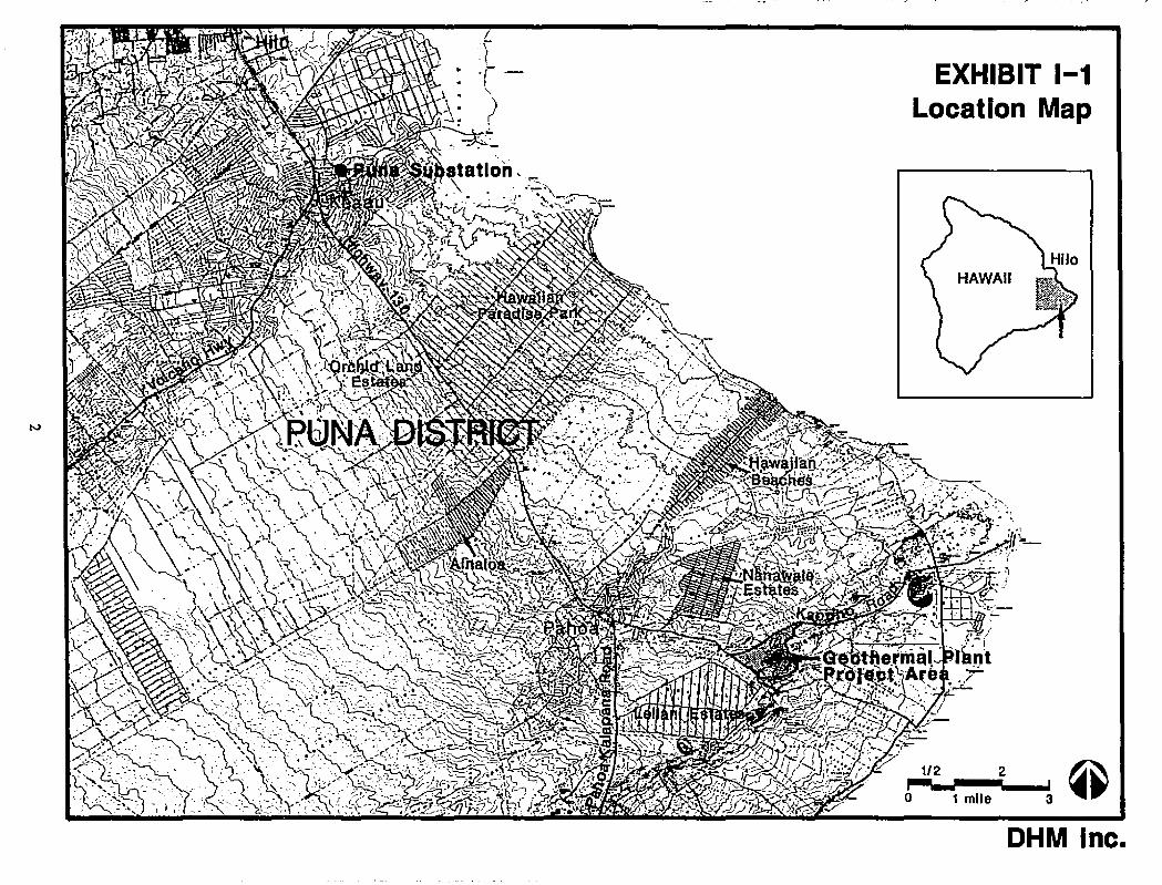
EXHIBIT 1-1Location Map
1/2 2
1 mile 3
OHM Inc.
B. TRANSMJSSION LINE FEATURES
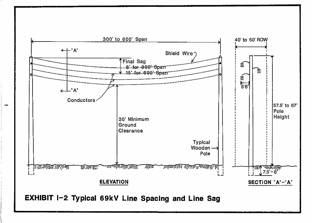
Each proposed 69 kV transmission line will consist of three aluminum conductors(0.856 inches in diameter) which will be supported by horizontal post insulators orstrings of suspension insulators attached to single wooden poles. The poles will bespaced approximately 300 to 600 feet apart and will carry a steel shield wire (0.375inch in diameter) at the pole top for protection against lightning. (Sec Exhibit 1-2.)The actual distance between poles will depend upon physical conditions in thevicinity of pole sites and various structural factors, such as tension or weight on theconductors caused by changes in the direction of the alignment or high windvelocities.
The wooden poles will range between 57.5 and 67 feet above ground with 7.5 to 8feet embedded in the ground. The poles will have diameters of about 1.5 feet attheir base, tapering to about 0.75 feet at the top. The wood will be fully treatedagainst termite damage and rot. To provide stability against high winds andchanges in direction of the alignment, guy wires and anchors may be installed onsome poles.
HELCO requires a typical right-of-way (ROW) between 40 and 50 feet wide foreach 69 kV transmission line. This will allow for conductor swing, usc of mUlti-polestructures where necessary and adjustments of pole sites in the field duringconstruction should the pole hole diggers encounter adverse geological conditions(such as lava tubes), archaeological and historic sites, or areas of ecologicalsensitivity. Additional land segments may be required in some cases toaccommodate guy wires and anchors falling outside the typical right-of-way.
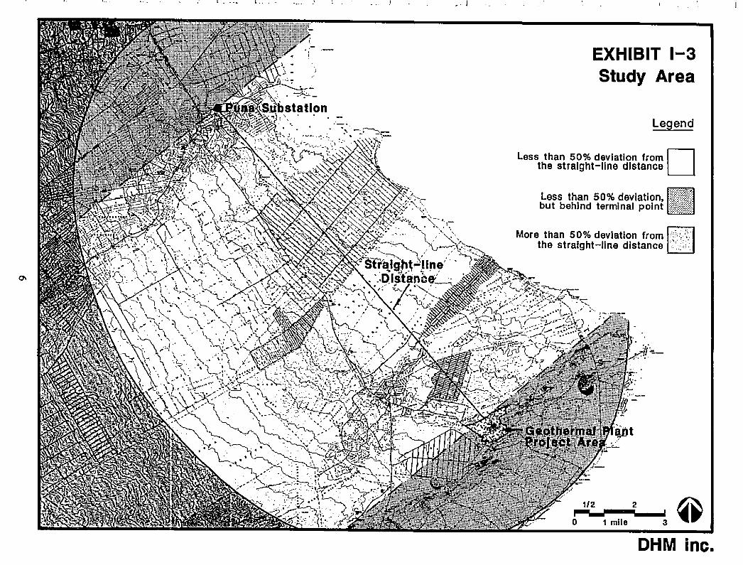
C. DEFINITION OF STUpy AREA
AI~hough the required tran's'mission lines will originate at the switching station nearthe geothermal plant, the origin of the lines for this study is considered to be theedge of the power plant project area (as shown on Exhibits I-I and 1-3). The reasonfor this is to avoid duplication between this routing report and Thermal PowerCompany's EIS which will cover the entire power plant area. The terminal point forthe proposed lines is the existing 69 kV line that leaves Puna Substation headingwest to Kaumana.
Theoretically, the shortest, most direct route between the proposed geothermalresource at Pohoiki and the Puna Substation is a straight line. However, there arcnumerous intervening factors which may make the idealized straight-line route fora transmission line impractical or undesirable.
The definition of a study region for the routing analysis balances these competingconsiderations. On one hand, the study region should be large enough to insure thatno feasible alternatives are arbitrarily excluded at the outset. On the other hand,route length is obviously a limiting factor. Longer routes require more time, energy,manpower and materials to construct the transmission line. A longer easement isrequired. Furthermore, the energy loss would be greater over a longer distance.
To define the study region, a broad oval-shaped a-rea was plotted which permits avariety of routing alternatives, including those which arc up to 50 percent longerthan the straight-line distance between the two terminal points of the proposedtransmission lines. (See Exhibit 1-3.) To determine this area, the ends of a string
3
50% longer than the straight-line distance was fixed at each terminal point. Thestring was then pulled taut at various points along its length, on either side of thestraight-lined route to define an elliptical area around the straight-line.
Note that the eIlipse includes areas behind the two terminal points, represented inExhibit 1-3 as the lighter-toned shaded areas. Portions of this lighter shaded areaare included in the study region, because it is conceivable that a feasible alternativemight double-back somewhat behind the terminal point to avoid major constrainingfactors or take advantage of certain routing opportunities. The study regionwindow also includes areas which extend weIl beyond the eIlipse.
4
57.5' to 67'PoleHeight
40' to 50' ROW
k J.Shield Wir:z
30' MinimumGroundClearance
300' to 600' Span
Conductors
TypicalWooden
Pole
ELEVATION SECTION" A"-" A"
EXHIBIT 1-2 Typical 69kV Line Spacing and Line Sag
I ..
. .
. l
EXHIBIT 1-3Study Area
Legend
Less than 50% deviation from Dthe straight-line distance
LII······~····,
ess than 50% deviation. (ff=i?but behind terminal point :~i:!¥1!tr
More than 50% deviation from "'::"':: Ithe straight-line distance .>':: .,:
:: .. 'qDt~.. .....' ~
,'f"'--. I
J':"""
1/2 2 @j~"_IIJ--.r.;--...I3'o 1 mile
DHM inc.
CHAPTER II
CHAPTER II: TRANSMISSION LINE ROUTING METHODOLOGY
A. OVERVIEW
There is a wide range of geographic alternatives for routing a transmission linebetween Pohoiki and the Puna Substation. a straight-line distance of approximately14 miles. HELCO's objective is to select the route which has the least environmentaland capital cost, and minimal impact on land usc along the route.
The methodology used for the selection of the route is a sequence of steps organizedin two phases. Phase 1 narrows down the large number of possibi!\ties byidentifying an optimum corridor for further study based upon a broadscale analysisof opportunities and constraints for a transmission line route. The width of thestudy corridor may vary. depending upon the type and number of constrainingfactors in any particular vicinity, but will be ample enough to permit severalalternative alignments. Phase 2 leads to the selection of a specific route alignment,based upon a detailed analysis of conditions within the study corridor and thedevelopment of measures to mitigate the potential adverse effects of the line.
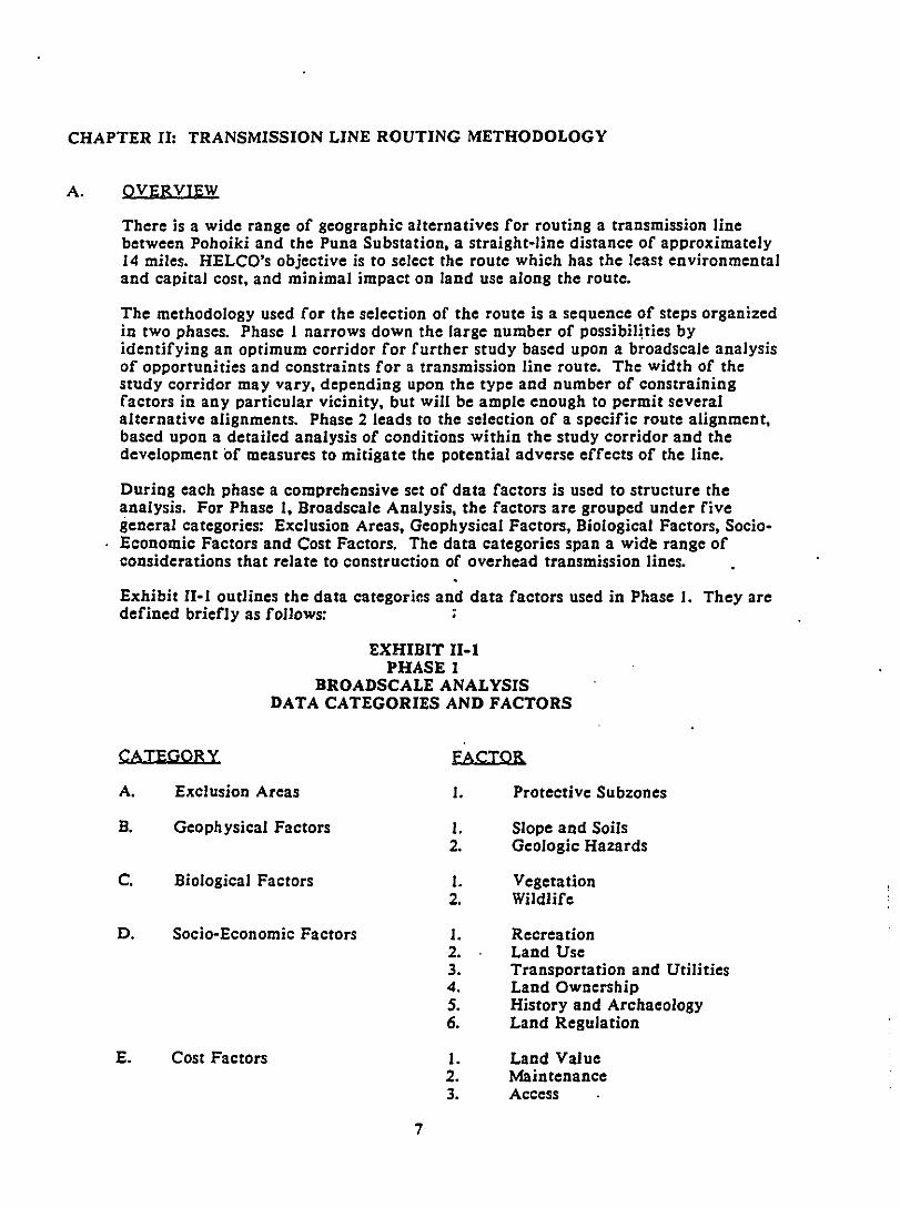
During each phase a comprehensive set of data factors is used to structure theanalysis. For Phase I, Broadscale Analysis, the factors arc grouped under fivegeneral categories: Exclusion Areas, Geophysical Factors, Biological Factors, SocioEconomic Factors and Cost Factors. The data categories span a wide range ofconsiderations that relate to construction of overhead transmission lines.
Exhibit II-I outlines the data categories and data factors used in Phase 1. They arcdefined briefly as follows: ;
EXHIBIT II-IPHASE 1
BROADSCALE ANALYSISDATA CATEGORIES AND FACTORS
CATEGORY FACTOR
A. Exclusion Areas
B. Geophysical Factors
C. Biological Factors
D. Socio-Economic Factors
E. Cost Factors
1. Protective Subzones
1. Slope and Soils2. Geologic Hazards
1. Vegetation2. Wildlife
1. Recreation2. Land Usc3. Transportation and Utilities4. Land Ownership5. History and Archaeology6. Land Regulation
1. Land Value2. Maintenance3. Access
7
Exclusion areas are those where regulatory controls are so restrictive that theyessentiaIly preclude a transmission line route.
Geophysical factors relate to the physical properties and processes of the earth. Thespecific factors which affect the location of transmission lines are:
Topographic f ea tures, particularly slopes and soils.
Geologic characteristics, including seismic, volcanic and other types offoundation hazard.
Biological factors include both plant life and animal life: The specific factors are:
Vegetation zones and their susceptibility to construction activity.
Wildlife habitats, particularly for species which are susceptible to potentialhazards from transmission lines.
Socio-economic factors relate to the human use of land and the effect which atransmission line might have upon the use or value of land. Specific factors are:
Recreational resources, such as parks, boat launching ramps, hiking andhunting areas.
Urban and non-urban land uses of various categories.
The transportation and utilities network.
Land ownership patterns.
Historic and archaeological resources.
Regulatory controls ·over land usc, other than Exclusion Areas, such asspecial management area, or subzones in State Conservation Land UseDistrict.
Cost factors are those which the utility company, and eventualIy the utilitycustomers, pay for the acquisition of an easement and the construction andmaintenance of a transmission line. These factors are:
Land value based on assessed valuations.
Physical conditions which affect the maintenance and operation of the line.
The relationship between site accessibility and construction and maintenancecosts.
The data factors arc further defined by criteria which have for the most part beendeveloped in previous scientific and planning studies sponsored by governmentagencies. The criteria deal with conditions on a general level, They are evaluatedin terms of constraints or opportunities for the location of a transmission line andthen displayed in map form shown in Chapter IV.
8
Phase 2, Detailed Analysis, involves a similar analytical framework. However, theanalysis is much more detailed, relying on first-hand field observations as well assecondary sources, and covers the corridor areas identified in the BroadscaleAnalysis which appeared to pose less constraint or provide greater opportunity fortransmission lines. Along with a more detailed scale of study, comes a reviseddescriPtion of data categories and factors (Exhibit 11-2). These are derived fromfactors which directly influence the location of a transmission line such as land use,land ownership, land regulation, and visual resources, and from the field surveyreports which provided detailed information on insects, birds, vegetation,archaeological sites, geology and soils.
EXHIBIT 11-2
PHASE 2DETAILED ANALYSIS
DATA CATEGORIES AND FACTORS
CATEGORY FACTOR
A. Physical Conditions I. Land UscExisting electric distribution and
transmission linesExisting telephone lines
.. Productive agriculture landsArchaeological and Historic sitesPahoa Bypass HighwayUrban District
2. BiologicalVegetationInsectsBirds
3. Land OwnershjpPrivately ownedPUblicly ownedHawaiian Home Lands
B. Visual Resources J. Visual Screens
2. Views
9
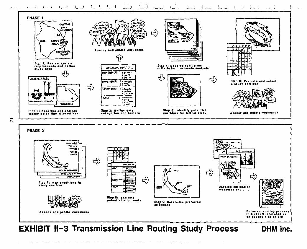
B. STEP-BY-STEP PROCEDURE
The following is a description of the sequence of steps leading to route selection.The procedure is illustrated in Exhibit Il-3. Detailed descriptions of the datasources and methods used can be found in the texts of Chapters IV through VI.
PHASE I: BROADSCALE ANALYSIS
Step I: Review System Requirements and Define Study Area
The system requirements and terminal points for the geothermal transmissionline were established by HELCO and arc described in Chapter 1. Definitionof the study area is also discussed in Chapter I.
Step 2: Describe and Analyze Transmission Line Alternatives
There are three transmission line alternatives for the project: overhead lines,underground cables and submarine cables. The design features of the lattertwo and their limitations and advantages relative to an overhead line arcdiscussed in Chapter Ill.
Step 3: Define Data Categories and Factors
This step provides a structure for analyzing and evaluating physical, socialand economic conditions which ·create constraints or opportunities forrouting an overhead 'transmission line. The data categories and factors arcdefined in the preceding pages and a more detailed discu3sion of them ismade in Chapter IV.
Step 4: Develop Evaluation Criteria for Broadscale AnalYsis
Criteria for evaluating the relative constraints. and opportunities for thetransmission line route within each data category arc described in ChapterIV. These evaluations rely almost entirely on secondary source material.particularly data and planning maps prepared by government agencies.
Step 5: Identify Areas of Less Constraint and Potential Corridors
Broadscale evaluation criteria arc displayed through an overlay mappingprocess which highlights the areas of less constraint or opportunity for atransmission line route. Potential corridors arc identified by linking theareas of less constraint to provide a continuous connection between thePohoiki geothermal site and the vicinity of the Puna Substation. The areasof less constraint arc more extensive in some areas than in others, so thecorridor width varies accordingly.
Step 6: Evaluate and Select Study Corridors
The potential corridors arc rated quantitatively by measuring the type andextent of constraint area crossed by a "test route" through each of thecorridor segments. This rating, combined with a narrative description, leadsto the selection of the study corridor. Steps 5 and 6 arc included inChapter V.
10
PHASE 2: PETAILEP ANALYSIS
Step 7: Map CQnditjQns in Study CQrridQrs
CQnditiQns in the study CQrridQrs which will influence the rQuting Qf thetransmissiQn line are defined and mapped. The types Qf cQnditiQnscQrrespQnd tQ the data factQrs fQr the brQadscale analysis but mQre detailedcriteria and infQrmatiQn SQurces are used fQr this phase. SecQndary SQurcesare used, when available. These are supplemented with visual analyses,aerial phQtQ interpretatiQn, field surveys, and cQnsultatiQn with technicalspecialists, reSQurce managers and land agents. In additiQn, the technical andengineering requirements Qf HELCO are cQnsidered at this time. ThesecQnsideratiQns include maintaining a minimum vertical separatiQn distanceQn the same pQle from a lower voltage line; a minimum horizQntal separatiQndistance of Qne transmission line pole length (approximately 80 feet) fromexisting telephone lines; a minimum separatiQn distance of three fourths thepole height Qf a transmission line (approximately 60 feet) from an existingpower line unless the pQwer line would be placed on the same poles beneaththe transmission line.
Step 8: Identify PQtential Alignments
Based on an analysis of constraints in the mapped data, preliminary PQtentialalignments are delineated. Along some sections of the corridor, particularlywhere there are trade-offs between the types of constraints which areencQuntered, more than one potential alignment may be shown. Thepotential alignments are used as a basis for consulting with variousgovernment regulatory agency representatives and landQwners who would beaffected by the proposed easement.
Step 9: Determjne Preferred Alignment
Adjustments to the potential alignm'ents are made as the result Qfconsultations in Step 8. A rationale for the selection of the preferredalignment is then elaborated based on the various selection criteria.
C. PUBLIC REVIEW
Workshops were held throughout the route selection process with governmentagencies and residents of the Big Island, particularly the Puna District, to informthem of the progress of this study and actively solicit their opiniQns and CQncerns.Three sets of public meetings were held. Each set of meetings cQnsisted Qf awQrkshQp for government agencies in HQnolulu and in HilQ, and a public meeting inthe evening at Pahoa. Government agencies were invited thrQugh written nQticesbased on the OEQC mailing list. The public was invited through nQtices innewspapers, and letters sent tQ the cQmmunity associations in Puna. These meetingswere held in November and December of 1986 and in September of 1987.
In addition, a special meeting was held in April, 1987 at the request Qf theHawaiian Paradise Park Community AssQciation for their membership. The meetingaddressed residents' concerns about the impacts of the prQPosed transmission lines ifrouted through their cQmmunity. Representatives from HELCO also met withrepresentatives Qf this grQUp Qn two earlier occasions.
Summaries of the workshQPs, and copies of the notices and mailing lists areincluded in Appendix A.
II
L __.J I~_\ I
Step 6: Evaluetl Ind aelectI atudy corridor
•~-'-... .-.r
~~~
CI::Js_
Step 5: Identl'y potentlllcOllldo,. for 'urther atudy
Step 4: Develop eYlluetloncrUetle 'or broadaclle InelyalaCO~SIfoU~P"".
titO~~1. ·..........•p".-·.......-l'I"L04fGAI. .~._-.......$o&lo·ef.4N ._,0,
• 00 ........~_ ...&D~r ..-..-·.,...,._-.-.
Step 3: DeUne det.eaUgorlaa and 'acton
Step 1: Re"lew ay.temrequirement. and daflna.tudy eree
Step 2: Deecrlbe and Inalyzehanaml.alon line alternatlvea
PHASE 1
PHASE 2
DI,elop mltlgltlonmee.urea end" ••
--Ill~o-.---~CJ
Step 7: "IP conditione InIludr cOllldor
~' II.. U II". A
~ , ."
I I. , .. 5
"1"1"'''''" "I~I~T 10./0/1!'oN._... &it..
"- .00.
~-
~
Step 8: EYlluatepotentlll IUgnmlnU
Step 9: Dltermlne preferredellgnment
Agener and pUblic worklhopa Document routing procea.In a uport, Included I.In IPPlndlll to In EIS
EXHIBIT 11-3 Transmission Line Routing Study Process OHM inc.
CHAPTER III
CHAPTER III: TRANSMISSION LINE ALTERNATIVES
A. TYPES OF ALTEENATIVES
Electrical transmission lines can be designed and constructed in three basicconfigurations: overhead lines, underground cables, and submarine cables. Atransmission line project may utilize anyone of the three forms, or combinations ofany two, or all three forms. The determining factors would be environmentalconsiderations, economics and system reliability. Experience has shown that themost economical method of transmitting bulk electrical power over a long distanceis via overhead transmission lines. Underground transmission cables are utilizedprimarily in densely populated areas and over short distances. Nationwide, thereare 323,000 mjles of transmission lines and only 3,000 miles of these areunderground. Submarine transmission cables are utilized primarily where there isno land connecting the two terminal points, such as between Oahu and the island ofHawaii, or if the submarine route is more viable than the overland route. For thetransmission of geothermal power from Pohoiki to the Puna Substation, overheadlines are proposed and have been described in Chapter I. Underground cables andsubmarine cables are presented as alternatives in this chapter.
There are two basic electrical modes to transmit bulk power: alternating current(ac) and direct current (dc). Electric power is usually generated, transmitted, anddistributed entirely using alternating current. However, when transmitting bulkpower over long distances on an ac system, the energy losses become considerableand use of a dc system, which has significantly lower energy losses, becomes moreattractive. As the ac and dc systems are incompatible and cannot be directlyconnected together, interfaces must be installed at some point (often at thegenerating plant) to convert the ac to de, and at anotQer point (often at the load orat a substation) to invert the dc to ae. These interfaces are expensive. The cost maybe justified when the value of electric power transmitted over this type of systemdoes not ~xceed the value of power generated locally and transmitted via ac circuits.This situation varies with the length of transmission lines and other factors. Forexample, the proposed Hawaii Deep Water Cable program justifies the use of dc forsubmarine cable r()utes when crossing c%annels between the major Hawaiian Islandsbecause of the great distances involved.
This is not the case for this transmission line routing study because the distancebetween Pohoiki and Puna via a submarine route is relatively short, about 23 miles,of which only II miles would be underwater. Therefore only an ac submarine cablewas considered.
The following sections will discuss generic issues related to the underground andsubmarine cable alternatives as compared to an overhead transmission line, and willconsider factors which would influence the routing of an underground or submarinecable.
4. HELCO, Speech to the Hawaiian Paradise Park Community Association, April 7, 1987.
5. The Hawaii Deep Water Cable (HDWC) Program, which is studying the technicalfeasibility of electrically linking the islands of Hawaii and Oahu (and possibly Maui andMolokai, as well), is considering a submarine, high voltage, direct current (HVdc) cablesystem. See various reports on the HDWC Program prepared for the Department ofPlanning and Economic Development, State of Hawaii.
13
B. UNDERGROUND CABLE
Components
The basic components of an underground transmission system include cables, itsencasement, and manholes.
I. Cables and Encasement
At the present time, the most commonly used underground system for 69 kVcircuits in the United States consists of insulated cables installed in buriedconduits. The cables have either copper or aluminum conductors and areinsulated with a synthetic dielectric material. These are installed in conduitsencased in concrete for mechanical protection.
2. Manholes
Most underground systems require manholes at intervals along the cableroutes. These manholes are used for installing, joining, splicing andmaintaining the cable system. The maximum spacing between manholes islimited by the amount of tension which can be used to pull the cable into thepipe. In some cases, the maximum length of cable that can be transported tothe job site may also have a bearing on the manhole spa~ing.
There are certain inherent technical disadvantages associated with undergroundsystems. A primary consideration in the design, manufacturing, installation andoperation of these systems is the insulation and cooling of conductors. Overheadconductors are cooled and insulated naturally by the air which surrounds them.Underground cables must be insulated artificially to prevent electric charge fromescaping into the surrounding environment. The-artificial insulating material,however tends to trap heat, thereby reducing power capacity. The resulting heatbuild-up impairs the electrical insulating properties of the insulating material itself.
Impacts
The potential impacts relating to the construction, operation and maintenance of anunderground cable between the Pohoiki and Puna terminal points have been placedin four categories and are discussed below.
I. Geophysical Impacts
In general, the construction of an underground transmission system wouldhave more extensive impacts on topography and soils than an overheadsystem because greater alteration to surface and subsurface conditions isinvolved. The construction of the underground system requires excavationand backfill along the entire length of the cable, whereas the overhead linerequires only the installation of poles spaced several hundred feet apart andthe area between poles remains relatively undisturbed.
Changes in physical characteristics of the soils affected by an undergroundline include compaction of surface soils from movement of equipment andpersonnel, changes in grain size and chemical make-up from accelerated soilweathering caused by earthwork and excavation and soil warming from cableoperations, and visible changes in soil color and texture at the groundsurface, especially in off-road barren areas.
14
A related impact is the rate of soil erosion, which would be increased due togreater rainfall runoff over the compacted soils. Also, after vegetationclearing during construction, a different type of vegetation, often lesseffective at retaining soil, may take root within the easement boundaries.Surface water runoff could be altered in a number of ways as well, including
changes in runoff rates due to changes in soil characteristics and vegetativecover, and changes in surface runoff patterns due to surface grading andexcavation.
Alterations to land forms from construction of the underground line mayoccur by grading within the easement, particularly on hillsides in steepterrain, grading for access roads, and excavating and filling trenches.
2. Biological Impacts
The construction of underground transmission lines tends to affect a varietyof vegetation types over the entire length of the corridor. The degree ofdisturbance may vary. For example, in open grasslands, vegetation wouldrecover rapidly. In mature forests, recovery would be much slower and thelikelihood of exotic species reforestation would be high. In the case ofoverhead lines where routes through tall trees have been avoided, the impactsmay not be significant because such an installation, which is greater inheight than the surrounding vegetation, does not require cutbacks duringconstruction.
During operation, maintenance of the underground line would tend to takeplnce at manholes. The majority of the surface above an underground line,after the initial recovering by vegetation, would tend to remain undisturbedby maintenance activities. These effects may not be significantly differentfrom those of an overhead line constructed through low forest or groundcover where maintenance pruning would not be required because the linewould be above the vegetation.
Wildlife i~ affected by underground transmission lines primarily because ofthe changes caused to vegetative habitats. For example, removing vegetationaffects wildlife by changing the cover and food supply. These impactswould be felt particularly among Hawaii's native birds. Direct impacts couldoccur to microorganisms or insect communities which are found at or nearthe surface.
3. Socio-Economic Impacts
In many respects, the generic socio-economic impacts of an undergroundcable and an overhead transmission line are similar. Considerations such asland use and land regulatiCJn, transportation and utility easements, landownership and recreation areas are dependent upon the route rather than thetype of system which is selected.
In areas where the transmission corridor is.exposed to public view, theunderground cable would be perceived as having less adverse impact onvisual quality than an overhead line would. However, the extent of theoverhead line's impact varies according to the closeness of view range, thecharacter of the visual background, the configuration of the overhead lineand its supporting structures and the subjective preferences of the viewer.
15
Overhead transmission line routes through densely developed urban settingshave a great deal of potential view exposure. This consideration, incombination with other socio-economic factors, such as high land values,fragmented ownership patterns, restrictive land regulation and potentialinterference with a wide variety of human activities, sometimes makesundergrounding the transmission cable beneath public streets, along withother utility lines, an attractive option.
However, if an underground line is not placed within an existing righ t-ofway, the limited usc of the land above the line is a disadvantage. Forinstance, a wall cannot be built over an underground line; crops, trees, bushescannot be planted over an underground line. Also, construction andmaintenance is more time consuming, thus more inconvenient to the public.
The poten tial impacts of an underground system on historic andarchaeological sites arc relatively greater than those of an overhead line dueto the greater degree of disturbance to surface and subsurface areas. Moreextensive surveys of an underground route would be necessary to determinethe location of archaeological remains.
4. Cost Impacts
Costs specific to the underground system, including the cable material,conduits, installation (trenching, b'ackfill, manholes, joint bays) andoperation (energy losses), arc very high compared to the capital costs of anoverhead line. An underground system between Pohoiki and Puna Substationis estimated to cost $18.6 million o~ nearly 5 times the estimated $3.8 millioncost of the proposed overhead line .
Normal operation and maintenance costs arc. higher for an underground line.Annually, HELCO estimates that an underground line for this project wouldcost more than the maintenance and repair costs of an overhead line. Also,when something docs go wrong with the underground cable, it is moreexpensive and time-consuming to repair than an overhead line because of thedifficulty in locating the cause of cable failure and getting access for repaircrews and equipment. lhe cost of service restorations arc three times greaterthan an overhead line.
6. HELCO, Speech to the Hawaiian Paradise Park Community Association, April 7, 1987.
7. Ibid.
16
I
•
C. SUBMARINE CABLE
Components
The components of a submarine cable system8 are as follows:
Submarine cables consist basically of a central conductor surrounded byinsulating material. enclosed in hard armoring. There are four types ofsubmarine cables depending upon the type of insulation: self contained oilfilled. pipe, solid paper and solid dielectric. The self contained oil-filled.cable has a history of 800d performance in the transmission of both 138 kVand 69 kV power. and would most likely be the type of cable used for thiskind of project. The pressurized oil, or dielectric fluid. is very light, similarto mineral oil.
2. Termjnal Stations
In addition .to the cable itself, a submarine cable system requires terminalstations where the cable is brought above ground and connected to overheadequipment or lines. These would be located close to the shoreline. For publicsafety. system security, and reliability. the cable is usually buried in a trenchfor a:pproximately 100 feet from the terminal station.
There are 26 submarine high-voltage electric transmission cables in operationthroughout the world. The first submarine cable was installed in 1942. .Submarine cables share with underground systems the technicaldisadvantages of insulation and cooling. In addition. there are otherdifficulties posed by the marine environment. These include extremely highpressures on the exterior surface of the cable when submerged at depths. thecorrosive nature of seawater. and problems with currents and rough oceanbottoms which constitute an abrasive climate to the exterior skin of thecable.
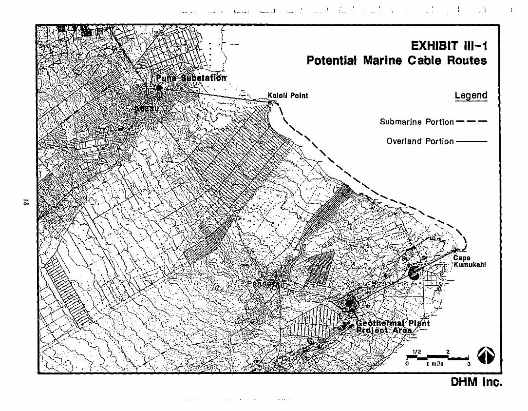
The potential marine route for this project runs parallel to the shorelinebetween Cape Kumukahi and Kaloli Point: (See Exhibit III-I.) The distanceof the route from the shorelinc would depend largely upon benthiccharacteristics. Sincc the ocean bottom drops sharply from this coastline andthe laying of submarine cable in deep waters presents added complications, itis likely that the route would be within a few hundred feet of the shore.
8. Discussion of cable components and history of usagc is based on H. H. Hwang and BryanYoung, A Study of the Ecasibjljty of Linking the Islands of MauL MolokaL and Lanaj withSubmarinc Elcctrical powcr Cablcs (Honolulu: University of Hawaii, Hawaii NaturalEnergy Institute. January 1979); and G. Krasnick and G. A. Chapman, for HawaiianElectric Company, Inc.• and the State of Hawaii Dcpartment of Planning and EconomicDcvclopment, Hawaii Dccp Water Cablc Program. Phasc TJ-A. Task I: EnvjronmcntalAnalyscs) (Honolulu: Parsons Hawaii) March 1984.
17
00
,- .J
EXHIBIT 111-1Potential Marine Cable Routes
Legend
Submarine Portion - - -
Overland Portion ---
0,.:'-';' 1Iij2~""3' IA\
1 mIle ~.
OHM Inc.
The main impacts related to submarine cables are described below:
I. Geophysical Impa cts
This stretch of coast is a series of low bluffs meeting the ocean with abruptdescents of 10 to 40 feet9. Much of the shoreline and sea bed consifos ofirregular, rocky surfaces due to prehistoric and historic lava flows
The typical ocean current flows northwest and generally parallels the coastfrom Cape Kumukahi to KaloIi Point. Because of the exposure to NorthPacific storm swells. surge action is also possible. This action couldpotentially cause chafing of the cable along the ocean bottom. Since thesurface of the ocean flow is rough in this vicinity. additional armoring ofthe cable may be necessary to prevent wear. The shoreline terminals for thecable would have to be suitably protected against potential inundation anddamage from a tsunami triggered elsewhere in the Pacific ring.
Damage from earthquake and volcanic activity is another potential hazard inthis area. The study region, including off-shore areas, has one of the highestincidences of historic seismic and volcanic activity in Hawaii. Seismicevents could produce underwater landslides which could bury or underminethe cable. The shoreside terminal or portions of the cable could also bedamaged or buried by a lava flow. Several lava flows have extendedseaward along this coast in historic times.
2. Biological Impacts
According to Chapman and Krasnick, the cable route would not cross anyparticularly viable coral communities. Therefore, the marine biolORcalimpacts would be localized, temporal and generally not significant .
Energy loss through the cable will be dissipated as heat and conducted tosurrounding marine 'waters. This discharged heat poses a' potential impact tobenthic organisms in the immediate area of the cable. The temperatureelevation would be confined primarily to the substrate because of thediluting effect and current flow of the surrounding waters.
9. U. S. Department of Commerce, National Ocean and Atmospheric Admin., United StatesCoast Pilot. Pacific Coast: California. Oregon. Washington and Hawaii. Sixteenth Edition(Washington D.C.: U.S. Government Printing Office) June 1980.
10. Discussion of geophysical conditions is drawn largely from Ralph Moberly Jr.,~. U.,Hawaii's Shoreline. Appendix I: Coastal Geology of Hawaii. (Honolulu: University ofHawaH, HawaH Institute of Geophysics) November 1963..
11. Discussion of biological factors is based primarily on G. Krasnick and G. A. Chapman,2ll.. ill. The substantial shield and armoring (see description in Chapter I) of the cable willprevent potential electromagnetic field effects on marine animals}.
19
Trenching of the nearshore areas will probably require blasting because ofthe hard substrate, resulting in a temporary shock wave impact to biota inthe vicinity, However, endangered marine species such as the humpback 12whale and green sea turtle are not known to frequent the area of the route ,In any event, it is possible to conduct blasting at a safe range and avoidpatential harm to these species.
A break of the cable could result in the discharge of insulating dielectric oilinto marine waters. It may be necessary, depending upon the repair strategy.to continue to pump oil through the cable to prevent the inflow of sea water.By the time the cable break is located and repaired, a considerable volume ofoil could have been discharged into the ocean. However, the dielectric oil isof very low viscosity, solubility and toxicity. The oil would rise to the oceansurface and evaporate rapidly. There are no heavy hydrocarbons orpolychlorinated biphenols (PCB) in the oil to ca~se ecological damage.Biodegradation would occur within thirty daysl .
3. Socio·Economic Impacts
Depending on the depth of the cable and its placement along the oceanbottom, commercial and sport fishing activities may constrain a submarinecable alternative. Eighty-one percent of reported damage to existingsubmarine cables 2uring a six year period (1975 to 1981) was attributed toexternal damage! . Of this percentage, 45 percent of the damage was causedby fishing and trawling gear, and 22 percent 'was caused by anchors.Trawling is not a factor along this' route, however, because of the roughocean bottom. The potential for damage from other fishing activities alsoappears to be remoSe, based on experience \\lith other undersea cables in theHawaiian islands1 .
4. Cost Impacts
A major cost consideration is related to route length. A submarine corridor'would be an indirect and lengthy route between the geothermal well site andthe Puna sUbstation. Installation proceeds much more quickly than with anoverhead line because the cable is laid directly on the ocean bottom by acable·laying barge. However, this savings in labor costs is more than off-setby the expense of the cable material and use of a cable·laying barge. Thecost of instaIling a submarine cable for about II miles, inclUding the
12. S. F. Payne and E. O. Hartwig. "The Ecology of Hawaiian Marine Animals Emphasizingthe Impact of Ocean Thermal Energy Converstion (OTEC) on Endangered Species"Lawrence Berkeley Laboratory, Marine Sciences Group MSG-82·017, LBL·13l92. 1982.
13. G. Krasnick and G. A. Chapman, sm. ill.
14. Sumitomo Electric Technical Revjew. Number 2I,1anuary 1982, "Studies on SubmarineCables with High Resistance to External Damage", Mitsuru Takada, Kusuo Sanjo andMinoru Kameda.
15. Letter from Mr. Henry M. Sakuda, Division of Aquatic Resources, State of HawaiiDepartment of Land and Natural Resources, to Mr. George Krasnick, Parsons Hawaii,dated November I, 1983.
20
terminal stations, is approximately $80.5 million.16 In addition, there stillremains the cost of the overland portion of the marine route which isapproximately 12 miles or three-fourths of the proposed overland route. Thetotal cost of the submarine route would exceed $83.5 million. The cost ofregular maintenance of a submarine cable is minimal. Emergency repair tothe cable, however, represents a significant cost. Adverse weather and seaconditions can seriously impede access to the cable. In 1977, for example, acrew from the Long Island Lighting Company had to abandon its repairbarges due to a storm.
5. Other Considerations
Installation of a submarine cable would come under the review of bothFederal and State agencies. The U. S. Army Corps of Engineers would baseits review of an application to do work in navigable waters on an evaluationof the probable impact of a submarine cable on the public interest, which theCorps defines with a wide range of physical, environmental and socioeconomic criteria.
The State government's review of a submarine cable proposal would becoordinated by the Department of Land and Natural Resources (DLNR),which administers the State Conservation District. The entire submarineroute is in the Resource (R) subzone of this District, so the cable wouldrequire a permit from DLNR's Board. The R subzone ~ less restrictive thantwo of the three other Conservation District subzones l . Nevertheless itwould be necessary to demonstrate that the cable would not adversely affectthe 'sustained use of the natural resources' of the subzone. Given theuncertainties about the long-term impacts of these cables, this would not beeasy to show conclusively.
The submarine route would still require a significant length overlandbetween the geothermal well site to the seashore and from the shore to thePuna Substation. The constraints for these land portions are analyzed inChapter IV.
D. SUMMARY AND CONCLUSIONS
Environmentally, the impacts of the submarine cable or underground line are, inmany respects, as great or greater than those of an overhead line. Although all threealternatives have their own unique set of impacts, none is significantly moreadverse than the others.
An overhead line is unique because of its exposure to the public and its potentialfor contact with plants and animals. In Puna, it may be possible (because of thenature of the relatively flat topography, the significant roadside vegetation and thegeneral lack of extensive view planes) to screen the proposed transmission linesfrom frequent public view. Careful routing and various design, construction andoperations measures, can avoid or minimize adverse impacts on physical and visualresources.
16. HECO, Letter of May 18, 1987 to DHM inc.
17. The Protective (P) and Limited (L) subzones are more restrictive than the R subzone asto use. The fourth subzone, the least restrictive, is the General (G) subzone.
21
The cost per mile and the total cost for construction of a submarine cable or anunderground transmission line would be substantially higher than for an overheadline. The submarine route. including the overland portions. would be over 23 mileslong ·or about 6-9 miles longer than a reasonably direct overland route. The highcost of these two alternatives makes them relatively infeasible when compared to anoverland line.
Chapter IV. which follows, describes criteria for routing an overhead transmissionline in a way which responds to sensitive environmental factors.
22
....,!iI
CHAPTER IV
CHAPTER IV: BROADSCALE ANALYSIS
A. INTRODUCTION
As described earlier, an initial step in the overhead line route selection process isthe identification and definition of criteria for broadscale analysis. These criteriaconsist of data factors that have a bearing on the location of a transmission line.The evaluation of criteria relies essentially upon information which is alreadyavailable in mapped form without having to do field surveys. This forms asufficient data base for the broadscale analytical objectives of Phase I.
The data factors for the routing evaluation are organized under five broad datacategories - "Exclusion Area", "Geophysical", "Biological", "Socio-economic" and"Cost". A narrative for each data category describes the issues considered in therouting of an overhead transmission line in the study region. Data factors aredescribed and quantified to provide a basis for comparison.
Under each data factor, with the exception of "Exclusion Areas", the conditions areevaluated in terms of degrees of constraint for the location of transmission lines.These constraints ranged in three degrees from "high" to "low" for each factor, witha description of the criteria used to rate the conditions. A constraint mapaccompanies the analysis of each data factor. The lower the constraints in a givenarea, the greater the opportunity for placing a transmission line corridor there.
Each data factor is evaluated separately and equally with no weighting given to anyfactor. No single factor is a determinant of the route. The routing opportunitiesare identified through a compo~jte view of the data factors provided by an overlaymapping process.
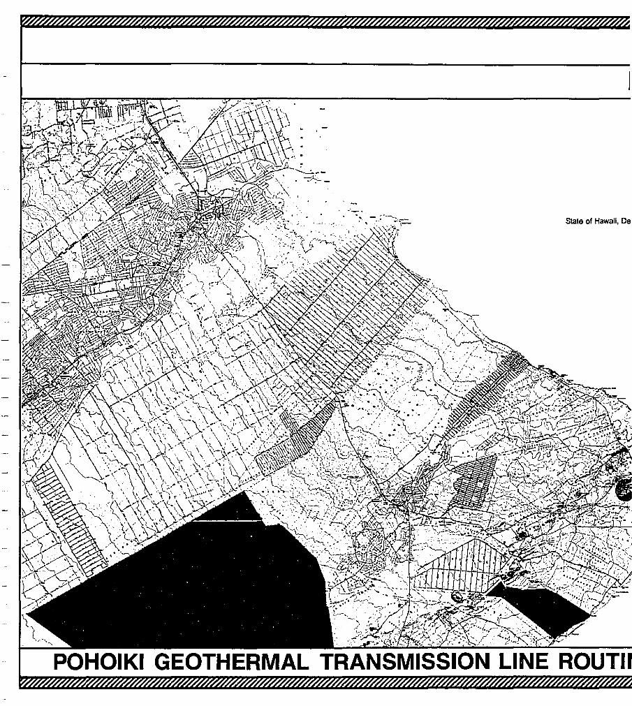
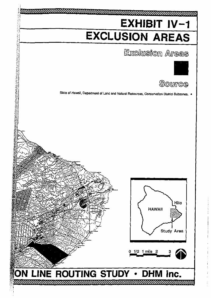
B. EXCLUSION AREAS
Regulatory restrictions on land use are generally considered potential constraints inthe evaluation of physical and socio-economicdata factors. In their most restrictiveform, regulatory measures may preclude rather than constrain the location oftransmission lines. Consequently, such areas are excluded at the outset from theanalysis of potential routes. The exclusion areas are as follows:
I. Protective Subzone - The Board of Land and Natural Resources hasestablished boundaries and regulations for four major subzones of the StateConservation District. The most restrictive of these subzones is theProtective Subzone, which includes "restricted watersheds, fish, plant andwildlife sanctuaries, significant historic, archaeological, geological ~~d
volcanological features and sites, and other designated unique areas .
C. GEOPHYSICAL FACTORS
The geophysical factors considered in the study region are slope and soils, andgeologic hazards, particularly seismic and volcanic activity. These factors influencethe stability of the transmission poles which support the line, and therefore thereliability of power.
18. State of Hawaii, Board of Land and Natural Resources, Regulation No.4, pursuant toChapter 183-41, Hawaii Revised Statutes, Honolulu, Hawaii, May, 1978.
23
Stale of Hawaii, De
· 't,
n EXHIBIT IV-1,"jc:.\"~ ~
.>; EXCLUSION AREAS~~,1,~-------------------------__t
@:~©DillJ@n@UD ~[(@@@
IISlale of Hawaii, Department of Land and Natural Resources, Conservation DIstrict Subzones••
o 1/2 1 mile 2 3 Qi~__--._..r ••
• OHM inc.
Hydrologic characteristics are not a significant factor in the study region becausethere are no major streams or inland water bodies. While average annual rainfalIranges from 75 to 200 inches, almost alI of the study region has a wet climate withthe seasonal variations causing distinctive dry periods.
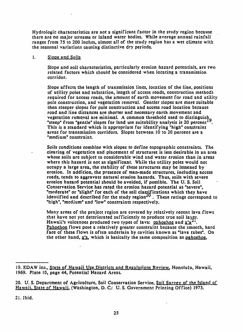
I. Slope and Soils
Slope and soil characteristics, particularly erosion hazard potentials, are tworelated factors which should be considered when locating a transmissioncorridor.
Slope affects the length of transmission lines, location of the line, positionsof utility poles and substation, length of access roads, construction methodsrequired for access roads, the amount of earth movement for road and utilitypole construction, and vegetation removal. Gentler slopes are more suitablethen steeper slopes for pole construction and access road location becauseroad and line distances are shorter and necessary earth movement andvegetation remoyal are minimal. A common threshold used to distinguisy"steep" from "gentle" slopes for land use suitability analysis is 20 percent 9.This is a standard which is appropriate for identifying "high" constraintareas for transmission corridors. Slopes between 10 to 20 percent are a"medium" constraint.
Soils conditions combine with slopes to define topographic constraints. Theclearing of vegetation tlnd placement of structures is less desirable in an areawhose soils are subject to considerable wind and water erosion than in areaswhere this hazard is not as significant. While the utility poles would notoccupy a large area, the stability of these structures may be lessened byerosion. In addition, the presence of man-made structures, including accessroads, tends to aggravate natural erosion hazards. Thus, soils with severeerosion hazard potential should be avoided, if possible. The U. S. SoilConservation Service has rated the erosion hazard potential as "severe","moderate" or "slight" for each of the soil clas2ifications which they haveidentified and described for the study region . These ratings correspond to"high", "medium" and "low" constraints respectively.
Many areas of the project region are covered by relatively recent lava flowsthat have not yet deteriorated sufficiently to produce true soillaY;zer.Hawaii's volcanoes produced two types of lava: pahoehoe and U I.Pahoehoe flows pose a relatively greater constraint because the smooth, hardface of these flows is often underlain by cavities known as "lava tubes". Onthe other hand, U. which is basicalIy the same composition as pahoehoe.
19. EDAW inc., State of Hawaii Use Districts and Regulatjons Review, Honolulu, Hawaii,1969. Plate 10, page 44, Potential Hazard Areas.
20. U. S. Department of Agriculture, Soil Conservation Service, Soil Survey of the Island ofHawaii. State of Hawaji. (Washington, D. C.: U. S. Government Printing Office) 1973.
21. Ibid.
25
flows to form a "...massive, relatively dense interior...22. Pahoehoe flows aretherefore considered a "medium" constraint because it can be difficult tolocate a suitable suite for transmission pole placement in this material.
SLOPE AND SOILS
DEGREE OF CONSTRAINT CRITERIA
High
Medium
Low
Soil erosion hazard potential rated "severe";slope greater than 20 percent.
Soil erosion hazard potential rated "moderate";pahoehoe lava flows; slope between 10 and 20percent.
Soil erosion hazard potential rated "slight".
22. Macdonald, Gordon A. and Agatin T. Abbott, Volcanoes in the Sea: The Geology ofHawaii. University of Hawaii Press, Honolulu, p. 26,1970.
26
CORRECTION
THE PRECEDING DOCUMENT{S) HASBr=EN REPHOTOGRAPHED TO ASSURE
LEGIBIUTYSEE FRAME(S)
·IMMEDIATELY FOLLOWING
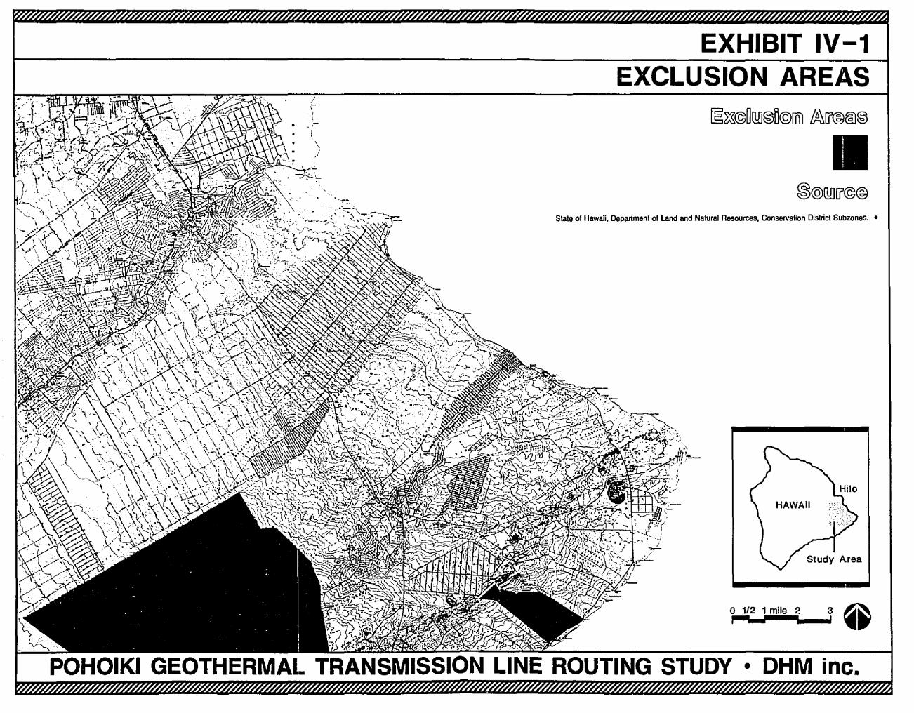
EXHIBIT IV-1EXCLUSION AREAS
\\
,; IIState of Hawaii, Department of Land and Natural Resources, ConselValion District Subzones. •
o 1/2 1 mile 2 3 ~,.:--,......_...' ..
• OHM inc.
Hydrologic characteristics are not a significant factor in the study region becausethere are no major streams or inland water bodies. While average annual rainfallranges from 75 to 200 inches, almost all of the study region has a wet climate withthe seasonal variations causing distinctive dry periods.
I. SloDe and Soils
Slope and soil characteristics, particularly erosion hazard potentials, are tworelated factors which should be considered when locating a transmissioncorridor.
Slope affects the length of transmission lines, location of the line, positionsof utility poles and substation, length of access roads, construction methodsrequired for access roads, the amount of earth movement for road and utilitypole construction, and vegetation removal. Gentler slopes are more suitablethen steeper slopes for pole construction and access road location becauseroad and line distances are shorter and necessary earth movement andvegetation remo.val are minimal. A common threshold used to distinguisy"steep" from "gentle" slopes for land use suitability analysis is 20 percent 9.This is a standard which is appropriate for identifying "high" constraintareas for transmission corridors. Slopes between 10 to 20 percent are a"medium" constraint.
Soils conditions combine with slopes to define topographic constraints. Theclearing of vegetation and placement of structures is less desirable in an areawhose soils are subj,ct to considerable wind and water erosion than in areaswhere this hazard is not as significant. While the utility poles would notoccupy a large area, the stability of these structures may be lessened byerosion. In addition, the presence of man-made structures, including accessroads, tends to aggravate natural erosion hazards. Thus, soils with severeerosion hazard potential should be avoided, if possible. The U. S. SoilConservation Service has rated the erosion hazard potential as "severe","moderate" or "slight" for each of the soil clas2ifications which they haveidentified and described for the study region . These ratings cotrespond to"high", "medium" and "low" constraints respectively.
Many areas of the project region are covered by relatively recent lava flowsthat have not yet deteriorated sufficiently to produce true soil laYir.Hawaii's volcanoes produced two types of lava: pahoehoe and U I.Pahoehoe flows pose a relatively greater constraint because the smooth, hardface of these flows is often underlain by cavities known as "lava tubes". Onthe other hand, n which is basically the same composition as pahoehoe,
19. EDAW inc., State of Hawaii Use Districts and Regulations Review, Honolulu, Hawaii,1969. Plate 10, page 44, Potential Hazard Areas.
20. U. S. Department of Agriculture, Soil Conservation Service, Soil Survey of the Island ofHawaii. State of Hawaii. (Washington, D. C.: U. S. Government Printing Office) 1973.
21. Ibid.
25
flows to form a •...massive. relatively dense interior...22. Pahoehoe flows aretherefore considcrcd a ·medium· constraint because it can be difficult tolocate a suitable suite for transmission pole placcmcnt in this material.
SLOPE AND SOILS
DEGREE OF CONSTRAINT CRITERIA
High
Medium
Low
Soil erosion hazard potcntial rated ·sevcrc·;slopc grcater than 20 pcrcent.
Soil erosion hazard potcntial rated ·moderate·;pahoehoe lava flows; slope between 10 and 20percent.
Soil erosion hazard potential rated ·slight·.
22. Macdonald, Gordon A. and Agatin T. Abbott, Volcanocs in the Sca: Thc Geology ofHawaii. Univcrsity of Hawaii Press, Honolulu, p.26. 1970.
26
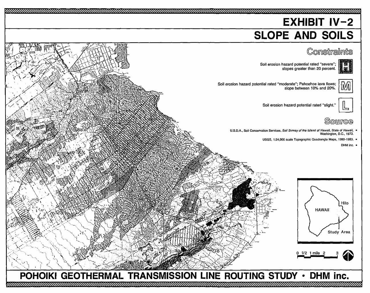
EXHIBIT IV-2SLOPE AND SOILS
3
CC@IJ1)~~U'callllJ1)fr~
m~
• OHM inc.
o 1/2 1 mile 2,
Soil erosion hazard potential rated "slight." [JbJ
Soil erosion hazard potential rated "severe";slopes greater than 20 percent.
U.S.D.A., Soil Conservation Services, Soil Survey of the Island of Hawaii, State of Hawaii, •Washington, D.C., 1973.
USGS, 1:24,000 scale Topographic Quadrangle Maps, 1980·1983. •
OHM inc.•
Soil erosion hazard potential rated "moderate"; Pahoehoe lava flows;slope between 10% and 20%.
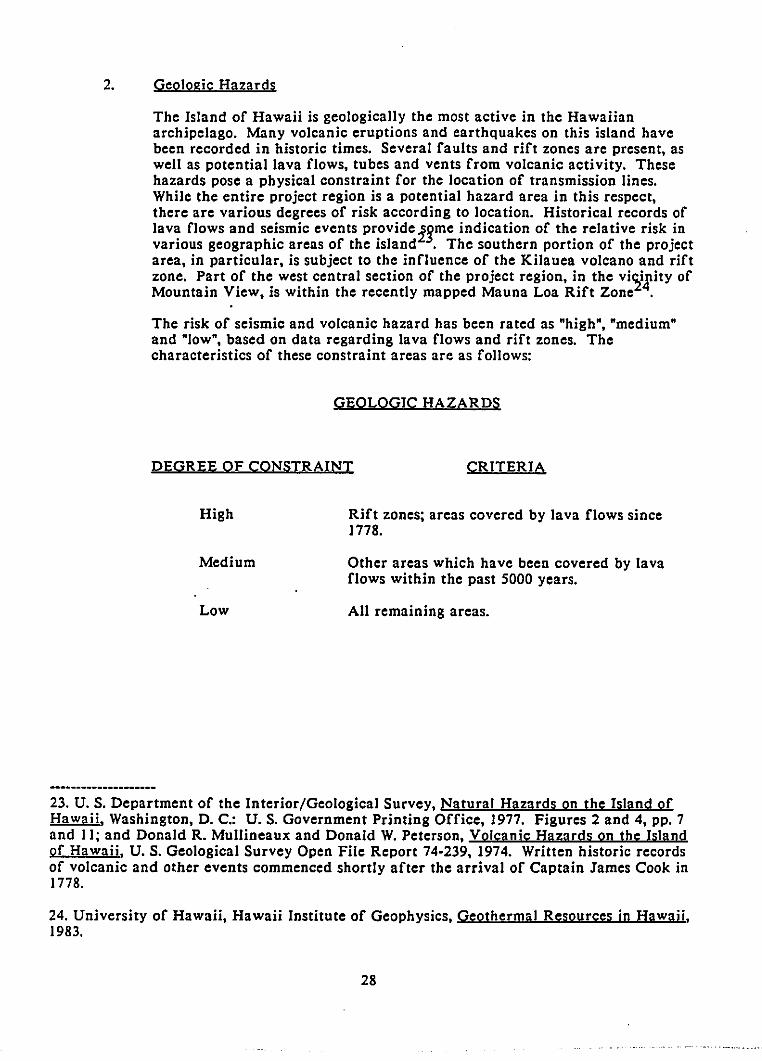
2. Geologic Hazards
The Island of Hawaii is geologically the most active in the Hawaiianarchipelago. Many volcanic eruptions and earthquakes on this island havebeen recorded in historic times. Several faults and rift zones are present, aswell as potential lava flows, tubes and vents from volcanic activity. Thesehazards pose a physical constraint for the location of transmission lines.While the entire project region is a potential hazard area in this respect,there are various degrees of risk according to location. Historical records oflava flows and seismic events provide zgme indication of the relative risk invarious geographic areas of the island . The southern portion of the projectarea, in particular, is subject to the influence of the Kilauea volcano and riftzone. Part of the west central section of the project region, in the vi~i.rity ofMountain View, is within the recently mapped Mauna Loa Rift Zone .
The risk of seismic and volcanic hazard has been rated as "high", "medium"and "low", based on data regarding lava flows and rift zones. Thecharacteristics of these constraint areas are as follows:
GEOLOGIC HAZARDS
DEGREE OF CONSTRAINT CRITERIA
High
Medium
Low
Rift zones; areas covered by lava flows since1778.
Other areas which have been covered by lavaflows within the past 5000 years.
All remaining areas.
23. U. S. Department of the Interior/Geological Survey, Natural Hazards on the Island ofHawaii. Washington, D. C.: U. S. Government Printing Office, 1977. Figures 2 and 4, pp. 7and II; and Donald R. Mullineaux and Donald W. Peterson, Volcanjc Hazards on the Islandof Hawaii, U. S. Geological Survey Open File Report 74-239, 1974. Written historic recordsof volcanic and other events commenced shortly after the arrival of Captain James Cook in1778.
24. University of Hawaii, Hawaii Institute of Geophysics, Geothermal Resources in Hawaii,1983.
28
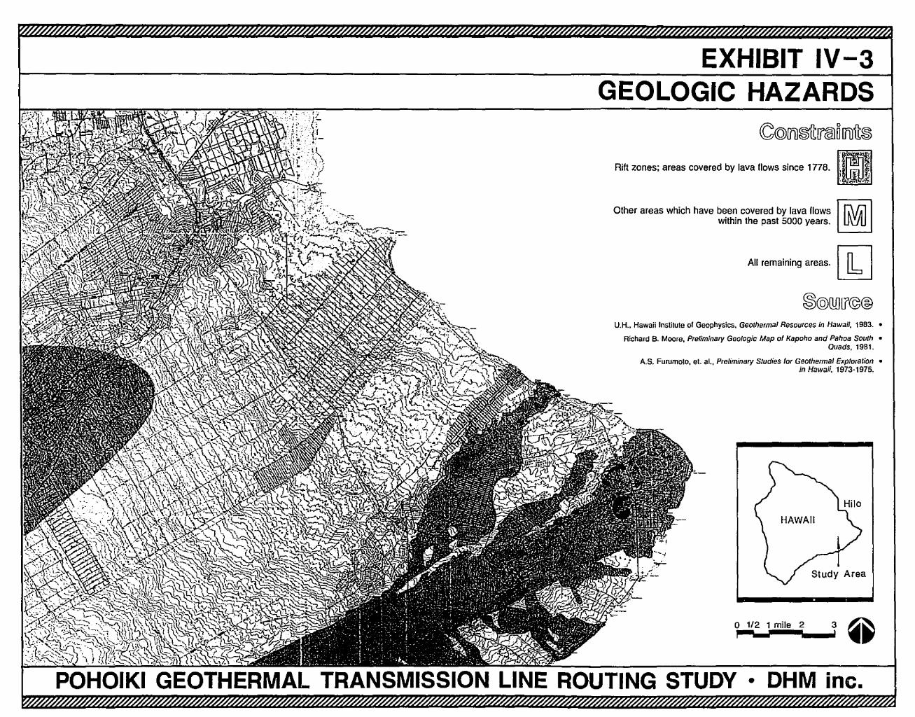
EXHIBIT IV-3GEOLOGIC HAZARDS
3o 1/2 1 mile 2I
All remaining areas. [1J
U.H., Hawaii Institute of Geophysics. Geothermal Resources in Hawaii, 1983.•
Richard B. Moore. Preliminary Geologic Map of Kapoho and Pahoa South •Quads, 1981.
A.S. Furumoto, et. aI., Preliminary Studies for Geothermal Exploration •in Hawaii. 1973·1975.
Rift zones; areas covered by lava flows since 1ns. [UJ~II I!f.' If,\ ~<<<:
Other areas which have bean covered by lava IIows Ir.\r.llwithin the past 5000 years. UVU
POHOIKI GEOTHERMAL TRANSMISSION LINE ROUTING STUDY • OHM inc.
D. BIOLOGICAL FACTORS
The potential biological effects of 69 kV ac transmission lines include disturbanceto' vegetation and disruption of habitat for wildlife due to the construction andmaintenance of the lines. These effects can be minimized by careful choice of atransmission line route and through construction and maintenance policies.
Based on available scientific data, potential health effects on humans or otherspecies associated with electromagnetic fields are not a major
230nsideration in the
routing of these lines because of their relatively low voltages . However, humanexposure to transmission lines is a consideration in the foIlowing section, SocioEconomic Factors.
I. Vegetation
The construction and maintenance of a transmission line inevitably entailssome disturbance to ground areas, including the removal of foliage. Thedegree of disturbance to plant communities can be reduced in various ways.For example, if no continuous access road is constructed along thetransmission line alignment, the potential for cumulative disturbance toadjoining plant communities is reduced. This is particularly important in thecase of native ecosystems, which are vulnerable to invasions by competingexotic species of plants and the disruptive activities of feral mammals andhumans. Impacts on forest areas may be reduced by "feathering back" thetaIler trees within the transmission line easement rather than uprooting themto provide adequate clellrance for the transmission conductors. Avoiding theuse of herbicides or other chemical substances within the transmission lineeasement would also mitigate potential impacts on surrounding plantingcommunities.
The kind and rigor of mitigating measures necessary to avoid adverseecological effects depends upon the characteristics of the plant communityand its degree of sensitivity to disturbance. In the study region, the plantcommunities most sensitive to disturbance from the construction andmaintenance of a transmission line are the relatively mature forests, asindicated by the typical height and coverage of the tree canopies. AIl forestswith a "closed" canopy (i.e.• those having greater than 80 percent tree cover)are considered a high constraint. With the exception of reforestationprojects, these are the areas which support the greatest diversity andabundance of plant species and where a greater number of indigenous speciesare found.
Also, more open-canopy forests (40 to 80 percent cover) with a typical canopyheight greater than 30 feet are a high constraint because a transmission linethrough such areas may require extensive clearance of vegetation.
25. B. Scott-Walton, K. M Clark. R. B. Holt, D. C. Jones, S. D. Kaplain, J. S. Crebs,P. Poulson. R. A. Shepherd. J. R. Young, Potential Environmental Effects of 765 kV Lines,prepared by SRI for the U. S. Department of Energy, Report No. DOE/EV-0056, November,1979; J. E. Bridges, "Environmental Considerations Concerning the Biological Effects ofPower Frequency (50 or 60 Hz) Electric Fields," IEEE Transactions on Power Apparatusand Systems, Vol. PAS-97. #1, Jan./Feb., 1978; New York Public Service Commission.Opinion No. 78-13. Case 26529 and 26559: Common Record Hearjngs on Health and Safetyof Extra-High Voltage Transmissio Lines. June 19, 1978.
30
Vegetation may be cleared initially in order to construct the transmissionline and vegetation is maintained in a cut back manner to clear transmissionlines. For this project, the minimum clearance between the lowest point ofthe transmission line and the ground has been specified to be 30 feet.
The following describes the relative constraints pertaining to vegetation fortransmission line routing at the regional scale.
VEGETATION
DEGREE OF CONSTRAINT CRITERIA
High
Medium
Low
All closed-canopy (greater than 80% coyer)forests; open-canopy (40-80% cover) forestswith tall stature trees (greater than 30 feet)26.
All forest areas with an open-canopy andmedium statute trees (6 to 30 feet tall).
All remaining areas, including agricultural andurban uses and barren lava flows.
26. Approximates classifications used in James D. Jacobi, Mapping the Natural Vegetationof the Hawaiian Islands, March 7, 1983. Only a portion of the study· region has beenmapped according to this classification system. For the remaining areas, maps wereproduced by OHM inc. based on aerial photo interpretation and field work by Lee Hannahand Linda CUddihy, using simplified version of the Jacobi system to classify vegetationzones according to tree species and forest type.
31
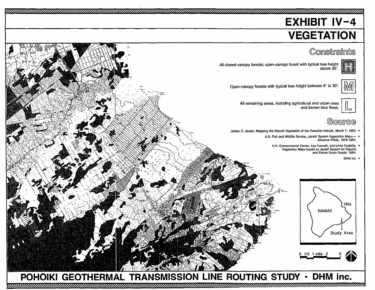
EXHIBIT IV-4VEGETATION
OHM inc. •
3
•Inc.
Study Area
DHM•
1/2 1 mile 2
'-
All remaining areas, including agricultural and urban uses rnland barren lava flows.~
James D. Jacobi, Mapping the Natural Vegetation of the Hawaiian Istands, March 7, 1983. •
U.S. Fish and Wildlife Service, Jacobi System Vegetation Maps- •Advance Prints, 1979-1984.
U.H. Environmental Center, Lee Hannah, and Unda Cuddihy, •Vegetation Maps based on Jacobi System for Kapt:>ho
and Pahoa South Quads, 1984.
Open-canopy forests with typical tree height between 6' to 30'.
All closed-canopy forests; open-canopy forest with typical tree heightabove 30'.
POHOIKI GEOTHERMAL TRANSMISSION LINE ROUTING STUDY
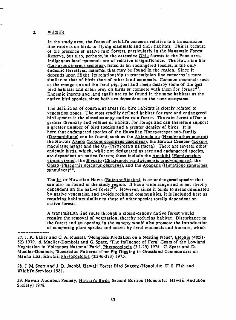
2. Wildlife
In the study area, the focus of wildlife concerns relative to a transmissionline route is on birds or flying mammals and their habitats. This is becauseof the presence of native rain forests, particularly in the Nanawale ForestReserve, but also, perhaps, in the extensive QhilI. forests in the Puna area.Indigenous land mammals arc of relative insignificance. The Hawaiian Bat(Lasiurus cinereus semotusl, listed as an endangered species, is the onlyendemic terrestrial mammal that may be found in the region. Since itdepends upon flight, its relationship to transmission line concerns is moresimilar to that of birds than of other land mammals. Common mammals suchas the mongoose and the feral pig, goat and sheep destroy some of the ~;st
bird habitats and often prey on birds or compete with them for forage .Endemic insects and land snails arc to be found in the same habitats as thenative bird species, since both arc dependent on the same ecosystem.
The definition of constraint areas for bird habitats is closely related tovegetation zones. The most readily defined habitat for rare and endangeredbird species is the closed-canopy native rain forest. The rain forest offers agreater diversity and volume of habitat for forage and can therefore supporta greater number of bird species and a greater density of birds. It ishere that endangered species of the Hawaiian Honeycreeper sub-family(Drepanidinae) can be found; such as the Akiapola au (Hemignathus munroi)the Hawaii Akepa (Lox ODS coccineus coccineusl, the Hawaii Creeper (Loxopsmaculatus mana) and the Q1!. (!?sittirostra psittacea). There arc several otherendemic birds, which, while not designated as rare and endangered species,arc dependent on native forests; these include the Amakihi (Hemignathusvjrens virens), the Elepuio (ChasiemDis sandwichensis sandwichensjs), the~.(Pha!Hrnis obscurus obscurus), and the Apapane (Hjmatione sanguineasangurneal .
The I2. or Hawaiian Hawk (Buteo solitariusl, is an'endangered species thatcan also be fDund in the study iggion. It has a wide range and is not striotlydependent on the native forest . However, since it tends to areas dominatedby native vegetation and avoids rockland communities, it is included here asrequiring habitats similar to those of other species totally dependent onnative forests.
A transmission line route through a closed-canopy native forest wouldrequire the removal of vegetation, thereby reducing habitat. Disturbance tothe forest and an opening in the canopy would also promote the introductionof competing plant species and access by feral mammals and humans, which
27. J. K. Baker and C. A. Russell, "Mongoose Predation on a Nesting Nene", Elepaio (40:5152) 1979. d. Mueller-Dombois and G. Spatz, "The Influence of Feral Goats of the LowlandVegetation in Volcanoes National Park", Phytocoelogia (3:1-29) 1975. G. Spatz and D.Mueller-Dombois, "Succession Patterns after Pig Digging in Grassland Communities onMauna Loa, Hawaii, Phytocoe!ogja (3:346-373) 1975.
28. J. M Scott and J. D. Jacobi, Hawaii Forest Bird Survey (Honolulu: U. S. Fish andWildlife Service) 1981.
29. Hawaii Audubon Society, Hawaii's Birds. Second Edition (Honolulu: Hawaii AudubonSociety) 1978.
33
would have a long-term adverse effect on the Quality of the habitat.Moreover, the presence of transmission lines in these forests creates apotential collision hazard.
The relative wildlife constraints can, therefore, be defined as follows:
WILDLIFE
DEGREE OF CONSTRAINT CRITERIA
High
Medium
Low
All closed-canopy forests (greater than80% cover).
All open-canopy forests (40-80% cover).
All remaining areas, including agriculturaland urban uses and barren Java flows.
34
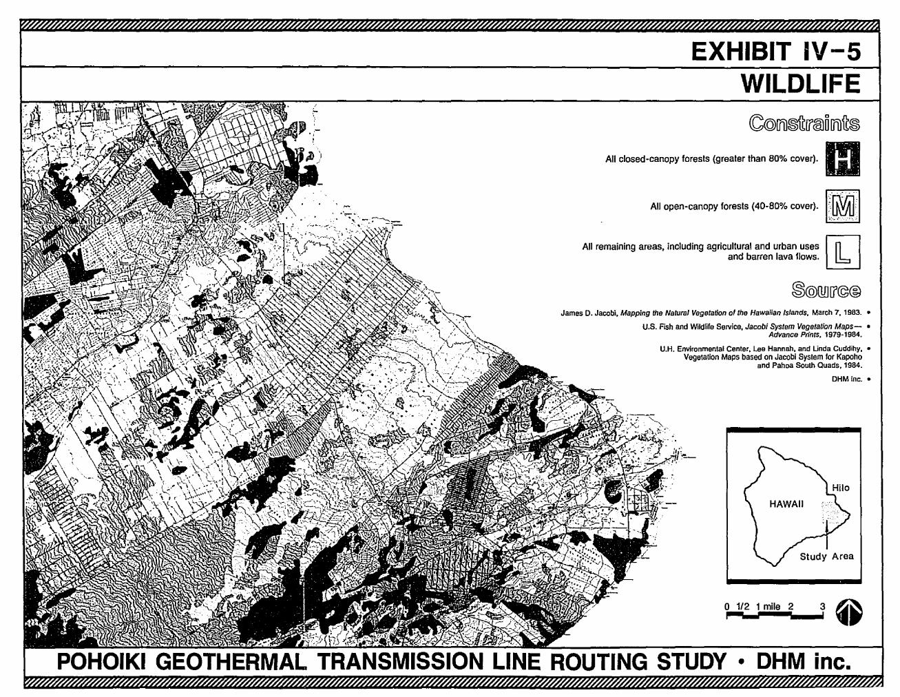
EXHIBIT IV-SWILDLIFE
All closed-canopy fcresls (grealer than BO% cover). mAll open-canopy loresls (40-BO% cover)·I;I~~ml
All remaining areas, including agricultural and urban uses~and barren lava flows.~
James D. Jacobi, Mapping the Natural Vegetation of the Hawaiian Islands, March 7.1983. •
U.S. Fish and Wildlife Service, Jacobi System Vegetation Maps- •Advance Prints, 1979-1984.
U.H. Environmental Center. Lee Hannah. and Unda Cuddihy. •Vegetation Maps based on Jacobi System for Kapoho
and Pahoa South Quads. 1984.
OHM fnc.•
o 1/2 1 mile 2 3 ~1,....-1-..... 1 ••
• OHM inc.
E. SOCIO-ECONOMIC FACTORS
Socio-economic considerations in the routing of the proposed transmission linesrelate to human uses of land in the study region. As previously noted, scientificevidence indicates that the electromagnetic fields of 69 kV ac transmission lines donot cause adverse biological effects on human beings. Nevertheless, the publicseems to have negative perceptions of transmission lines based on aesthetic valuesand uncertainty regarding potential health risks.
There are also certain nuisance factors associated with transmission lines. Forexample, a transmission line easement which bisects a property may be seen asdetracting from the property's future use potential. A more direct nuisance effect isthe potential interference with AM radio and television reception under certainconditions due to sparking and corona discharge from transmission lines. Thisproblem can be eliminated by proper design, installation and maintenance of thetransmission line.
It is characteristic of the following socio-economic factors that the constraints arebased at least as much on human ·perceptions of transmission lines and their effectsas they are on any inherent physical qualities. There are, however, someopportunities for routing the lines in the network of existing linear corridors fortransportation and utilities in the study region. These corridors identify areaswhere an additional transmission line Jllll.Y be perceived as less of an encumbrance.
Although the visual aspect of a transmission line is often a key feature in humanperceptions, visual constraints are discussed later, in Chapter VI, DetailedAlignment, because of the site-specific nature of their effects.
I. Recreation
While transmission lines often co-exist with recreational areas, they aresometimes perceived as an encumbrance. This ma y tend to constrain therecreational value of an area underneath and to either side of thetransmission line, but the degree of constraint varies according to the type ofrecreation area. Beach parks and playgrounds designed for active recreationuse, such as organized games and sporting events, are usually smaller in sizeand exposed to more frequent and intensive use than are wilderness parks.Therefore, a transmission line easement would tend to consume a greaterpercentage of these recreation areas and be perceived as a greaterencumbrance. In a large wilderness park, however, the easement would takea smaller percentage of the total recreation area and the opportunities forcamouflaging or locating the line itself to avoid or minimize exposure topark users are greater.
36
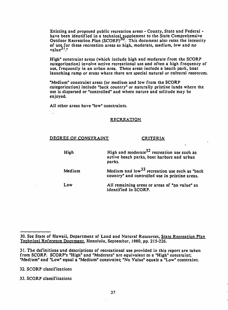
Existing and proposed pUblic recreation areas - County, State and Federal have been identified in a technica~8upplement to the State ComprehensiveOutdoor Recreation Plan (SCORP) . This document also rates the intensityof uSC)for these recreation areas as high, moderate, medium, low and novalue ."
High" constraint areas (which include high and moderate from the SCORPcategorization) involve active recreational use and often a high frequency ofuse, frequently in an urban area. These areas include a beach park, boatlaunching ramp or areas where there are special natural or cultural resources.
"Medium" constraint areas (or medium and low from the SCORPcategorization) include "back country" or naturally pristine lands where theuse is dispersed or "controlled" and where nature and solitude may beenjoyed.
All other areas have "low" constraints.
RECREATION
DEGREE OF CONSTRAINT CRITERIA"
High
Medium
Low
High and moderate32 recreation use such asactive beach parks, boat harbors and urbanparks.
Medium and low33 recreation use such as "backcountry" and controlled use in pristine areas.
All remaining areas or areas of "no value" asidentified in SCORP.
30. See State of Hawaii, Department of Land and Natural Resources, State Recreation PlanTechnical Reference Document, Honolulu, September, 1980, pp. 215-226.
31. The definitions and descriPtions of recreational use provided in this report are takenfrom SCORP. SCORP's "High" and "Moderate" are equivalent to a "High" constraint;"Medium" and "Low" equal a "Medium" constraint; "No Value" equals a "Low" constraint.
32. SCORP classifications
33. SCORP classifications
37
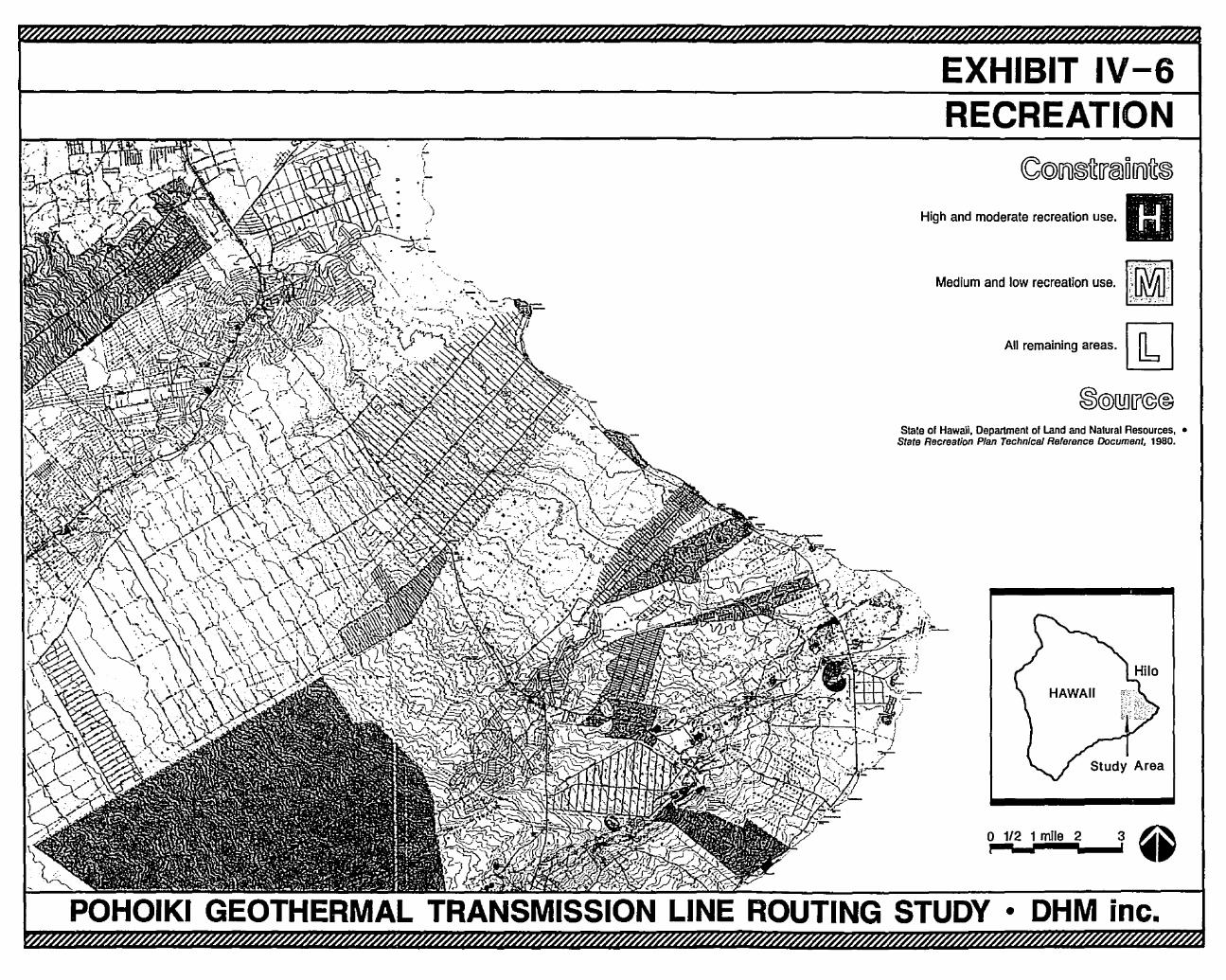
EXHIBIT IV-6RECREATION
I,)\
'it
')"
High and moderate recrealion use. mMedium and low reerealion use.lll~ml
Ali remaining areas.~
Stale of Hawaii, Department of Land and Natural Resources, •State Recreation Plan Technical Reference Document. 1980.
o 1/2 1 mile 2 3 ~p-;'-';''''IiIIIIII\_..i' ••
• OHM inc.
2. Land Use
Land uses described in thi~seport are based on the General Plan34 of theCounty of Hawaii, zoning applied by the County of Hawaii, Land UseDistricts36 administered through the State Land Use Commission and theDepartment of Land and Natural Resources, and cert}vn agricultural areasdelineated on the State's Agricultural Land Use Map .
Because the most intense use by the population occurs in urban or developingareas, all lands zoned by the County for urban use or designated by the Stateas Urban Districts are classified as a "high" constraint for the location of atransmission line. In some areas, one of the County's agricultural zoningclassifications [A - Agriculture (I a), which permits one-acre lots] is alsodesignated for urban use on the County General Plan or is in the State UrbanDistrict. Such areas are considered a "high" constraint.
Industrial areas are considered a "medium" constraint because the perceivedhazards and nuisances of industrial activities are often as great or greaterthan those of a transmission line. Agricultural subdivisions with a minimumlot sizes of one to three acres {A - Agricultural (1a), A - Agricultural (3a)] aszoned by the County also are considered to have a "medium" constraint,primarily because these areas tend to be residential in character.
In the study area there are a variety of other agricu'ltural uses, zoning andGeneral Plan allocations. Minimum lot sizes vary from one to 20 acres. Punahas the largest area of papaya orchards in the County of Hawaii and alsoextensive macadamia nut orchards. There are numerous small cut-flowernurseries and a variety of truck farming operations. There are also somegrazing and ranching operations on a small scale. These active andproductive uses are considered a "medium" constraint. The agricultural usesdescribed above do not include all lands in the State Agricultural Districtbecause not all agricultural lands are productive.
Former Puna Sugar Plantation lands are included as "medium" constraintsbecause the land is continuing in active agricultural production. Much of theformer sugar land is being placed in macadamia nuts or other orchard cropswhich may include cocoa.
All other areas have a "low" constraint.
34. County of Hawaii, The General Plan, (Adopted by Ordinance No. 439 on December IS,1971, revised 1986).
35. Department of Planning, County of Hawaii, Zoning Maps, 1986.
36. Land Use Commission, State of Hawaii, Land Use District Boundaries, Honolulu,Hawaii, 1987.
37. Department of Agriculture, State of Hawaii, Agricultural Land Use Maps, 1982.
39
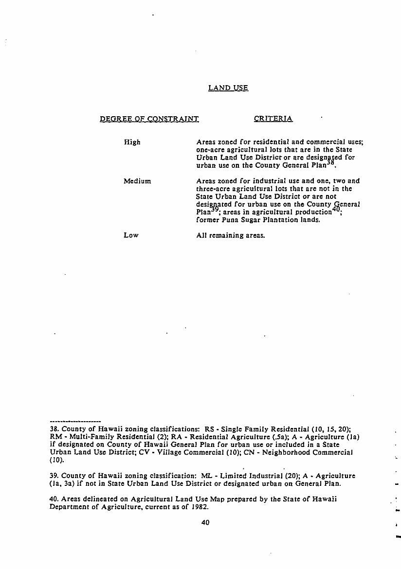
DEGREE OF CONSTRAINT
LAND USE
CRITERIA
High
Medium
Low
Areas zoned for residential and commercial uses;one-acre agricultural lots that are in the StateUrban Land Use District or are design!ged forurban use on the County General Plan .
Areas zoned for industrial use and one, two andthree-acre agriculturallots that are not in theState Urban Land Use District or are notdesi8j9ated for urban use on the County 4~eneral
Plan ; areas in agricultural production ;former Puna Sugar Plantation lands.
All remaining areas.
38. County of Hawaii zoning classifications: RS - Single Family Residential (10, 15,20);RM - MUlti-Family Residential (2); RA • Residential Agriculture (.5a); A - Agriculture (Ja)if designated on County of Hawaii General Plan for urban use or included in a StateUrban Land Use District; CV - Village Commercial (10); CN - Neighborhood Commercial(10).
39. County of Hawaii zoning classification: ML - Limited Industrial (20); A • Agriculture(la, 3a) if not in State Urban Land Use District or designated urban on General Plan.
40. Areas delineated on Agricultural Land Use Map prepared by the State of HawaiiDepartment of Agriculture, current as of 1982.
40
.,
..
-
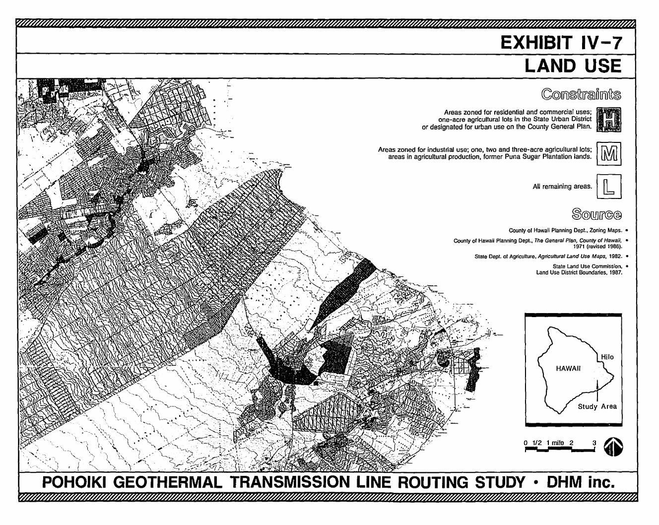
EXHIBIT IV-7LAND USE
Areas zoned for residential and commercial uses; GIl..one-acre agricultural lots in the State Urban District
or designated for urban use on the County General Plan.
Areas zoned for industnal use; one, two and three-acre agncuflural lots; I. r.\./Al Iareas in agricultural production, former Puna Sugar Plantation lands. U\JU
All remaining areas. [1J
County or Hawaii Planning Dept.. Zoning Maps. •
County of Hawaii Planning Dept., The General Plan, County of Hawaii, •1971 (revised 19B6).
Stale Dept. 01 Agriculture, Agricultural Land Use Maps, 19B2.•
State Land Use Commission, •Land Use District Boundaries. 19B7.
o 1/2 1 mile 2 3 ~.-:--"--'--' ..
POHOIKI GEOTHERMAL TRANSMISSION LINE ROUTING STUDY • OHM inc.
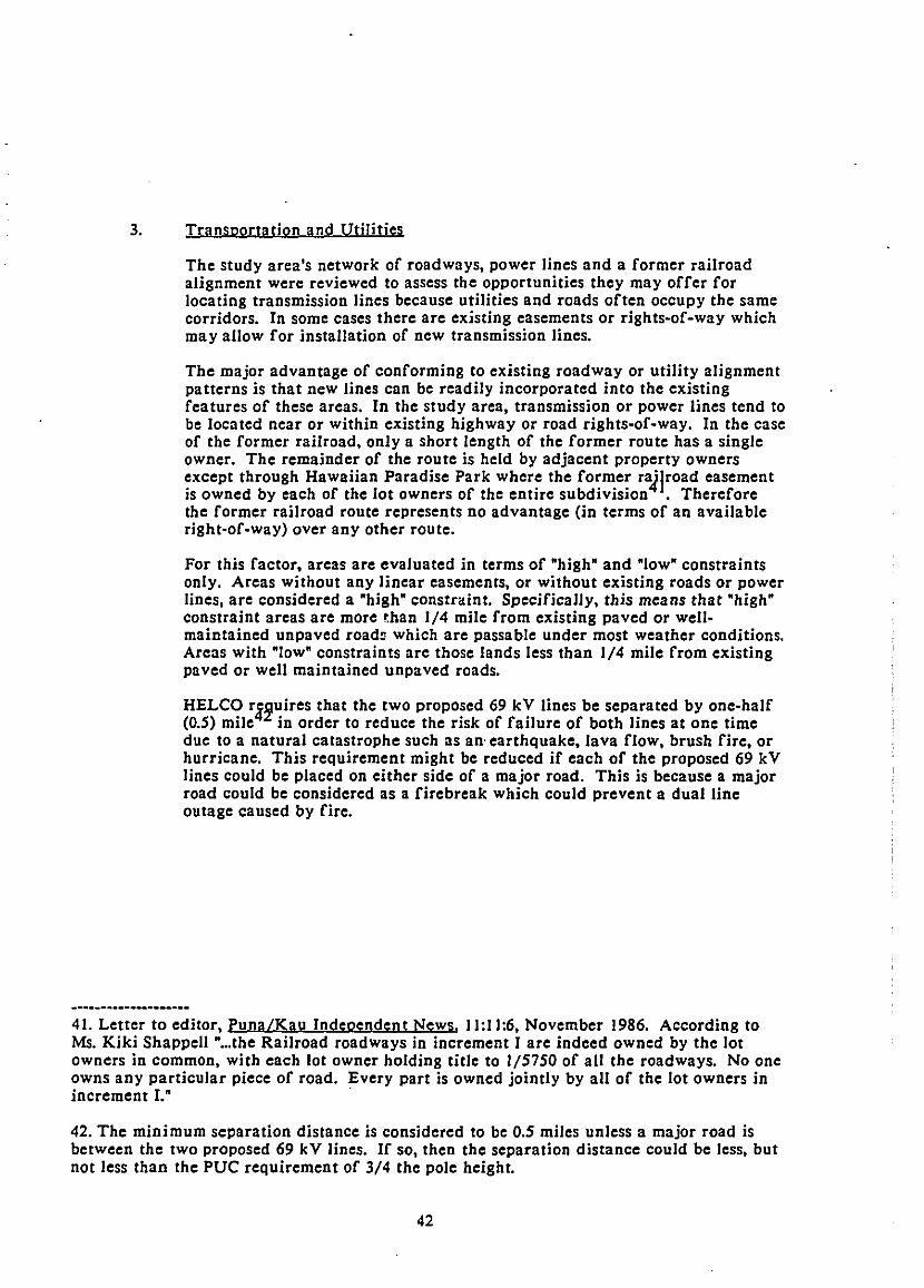
3. Transportation and Utilities
The study area's network of roadways, power lines and a former railroadalignment were reviewed to assess the opportunities they may offer forlocating transmission lines because utilities and roads often occupy the samecorridors. In some cases there are existing easements or rights-of-way whichmay allow for installation of new transmission lines.
The major advantage of conforming to existing roadway or utility alignmentpatterns is that new lines can be readily incorporated into the existingfeatures of these areas. In the study area, transmission or power lines tend tobe located near or within existing highway or road rights-of-way. In the caseof the former railroad, only a short length of the former route has a singleowner. The remainder of the route is held by adjacent property ownersexcept through Hawaiian Paradise Park where the former railroad easementis owned by each of the lot owners of the entire subdivision . Thereforethe former railroad route represents no advantage (in terms of an availableright-of-way) over any other route.
For this factor. areas are evaluated in terms of ·high· and ·Iow· constraintsonly. Areas without any linear easements, or without existing roads or powerlines, are considered a ·high· constraint. Specifically. this means that ·high·constraint areas are more t.han 1/4 mile from existing paved or wellmaintained unpaved road~ which are passable under most weather conditions.Areas with ·Iow· constraints are those lands less than 1/4 mile from existingpaved or well main tained unpaved roads.
HELCO r~~uires that the two proposed 69 kV lines be separated by one-half(0.5) mile in order to reduce the risk of failure of both lines at one timedue to a natural catastrophe such as an· earthquake. lava flow, brush fire. orhurricane. This requirement might be reduced if each of the proposed 69 kVlines could be placed on either side of a major road. This is because a majorroad could be considered as a firebreak which could prevent a dual lineoutage caused by fire.
41. Letter to editor. Puna/Kau Independent News, 11:11:6, November 1986. According toMs. Kiki Shappell •...the Railroad roadways in increment r are indeed owned by the lotowners in common, with each lot owner holding title to 1/5750 of all the roadways. No oneowns any particular piece of road. Every part is owned jointly by all of the lot owners inincrement I.· .
42. The minimum separation distance is considered to be 0.5 miles unless a major road isbetween the two proposed 69 kV lines. If so, then the separation distance could be less, butnot less than the PUC requirement of 3/4 the pole height.
42
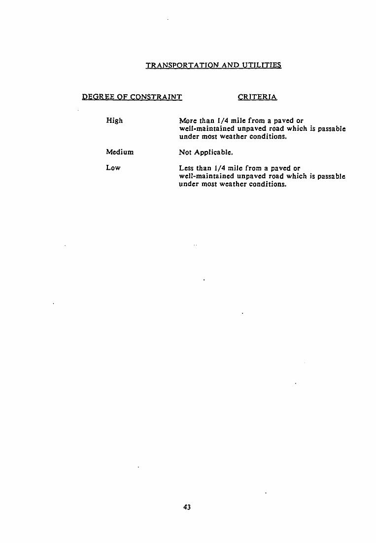
TRANSPORTATION AND UTIUTIES
DEGREE OF CONSTRAINT CRITERIA
High
Medium
Low
More than 1/4 mile from a paved orwell-maintained unpaved road which is passableunder most weather conditions.
Not Applicable.
Less than 1/4 mile from a paved orwell-maintained unpaved road which is passableunder most weather conditions.
43
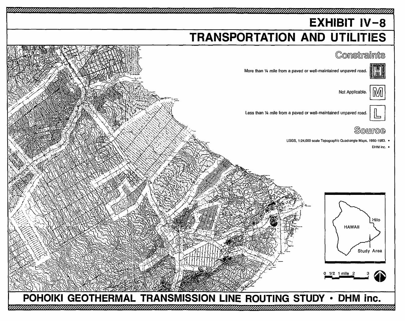
EXHIBIT IV-8TRANSPORTATION AND UTILITIES
~@ITI1~~[{,@}D!fi)~~
More than 1<0 mile from a paved or well-maintained unpaved road. IIINot APPiiCable·1 [RVt) I
less than 1<0 mile from a paved or well-maintained unpaved road. [k]
USGS, 1:24,000 scale Topographic Quadrangle Maps, 19BO·19B3. •
OHM inc.•
1/2 1 mile 2 3 ~~............, ••
POHOIKI GEOTHERMAL TRANSMISSION LINE ROUTING STUDY • OHM inc.
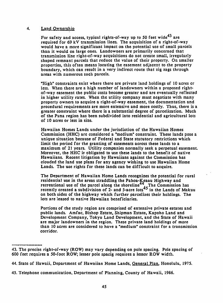
4. Land Ownership
For safety and access, typical rights-of-way up to 50 feet wide43 arerequired for 69 kV transmission lines. The acquisition of a right-of-waywould have a more significant impact on the potential use of smalI parcelsthan it would on large ones. Landowners are primarily concerned thattransmission line right-of-way acquisitions do not create smaIl, irregularlyshaped remnant parcels that reduce the value of their property. On smaIlerproperties, this often means locating the easement adjacent to the propertyboundary, which can result in a very indirect route that zig zags throughareas with numerous such parcels.
"High" constraints exist where there are private land holdings of 10 acres orless. When there are a high number of landowners within a proposed rightof-way easement the public costs become greater and are eventualIy reflectedin higher utility rates. When the utility company must negotiate with manyproperty owners to acquire a right-of-way easement, the documentation andprocedural requirements arc more extensive and more costly. Thus, there is agreater constraint where there is a substantial degree of parcelization. Muchof the Puna region has been subdivided into residential and agricultural lotsof 10 acres or less in size.
Hawaiian Homes Lands under the jurisdiction of the Hawaiian HomesCommission (HHC) are considered a "medium" constraint. These lands pose aunique situation because of Federal and State statutory restrictions whichlimit the period for the granting of easements across these lands to amaximum of 21 years. Utility companies normaIly seck a perpetual casement.Moreover, the HHC iE obligated to use these lands to the benefit of nativeHawaiians. Recent litigation by Hawaiians against the Commission hasclouded the land usc plans for any agency wishing to usc Hawaiian HomeLands. The use rights for these lands can be difficult to acquire.
The Department of Hawaiian Home Lands recognizes the potential for ruralresidential use in the areas straddling the Pahoa-f,eaau Highway andrecreational use of the parcel along the shoreline ~5The Commission hasrecently created a subdivision of 2- and 5-acre lots in the Lands of Makuuon both sides of the highway which further parcelizes their holdings. Thelots are leased to native Hawaiian beneficiaries.
Portions of the study region arc comprised of extensive private estates andpublic lands. Amfac, Bishop Estate, Shipman Estate, Kapoho Land andDevelopment Company, Tokyu Land Development, and the State of Hawaiiare major landowners in the region. These private land holdings of morethan 10 acres are considered to have a "medium" constraint for a transmissioncorridor.
43. The precise right-of-way (ROW) may vary depending on pole spacing. Pole spacing of600 feet requires a 50·foot ROW; lesser pole spacig requires a lessor ROW width.
44. State of Hawaii, Department of Hawaiian Home Lands, Genera! Plan, Honolulu, 1975.
45. Telephone communication, Department of Planning, County of Hawaii, 1986.
45
In the study area. large parcels of state land represent an opportunity for atransmission route because these lands are generaIly not intensively used andthere is no expectation of future profitable use, as in the case of privatelandowners. For this reason. State lands of more than 10 acres are classifiedas a "low" constraint.
LAND OWNERSHIP
DEGREE OF CONSTRAINT CRITERIA
High
Medium
Low
Private landholdings of 10 acres or less.
Public lands of 10 acres or less; Hawaiian HomeLands; private land holdings of more than10 acres.
Public lands of more than 10 acres.
46
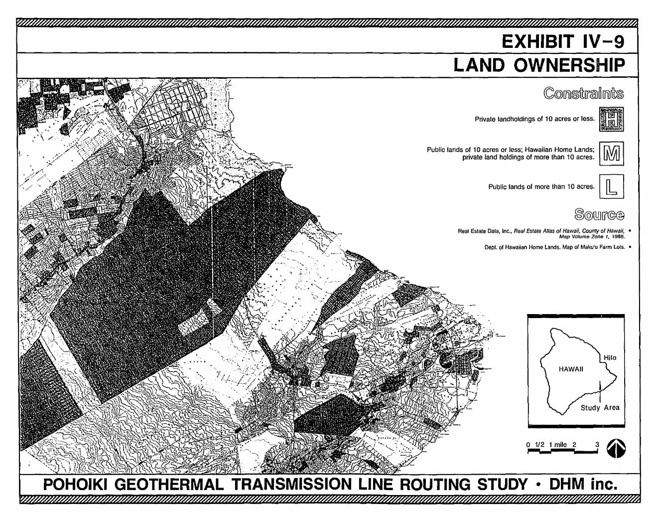
EXHIBIT IV-9LAND OWNERSHIP
,..1../2.,j1..m.il..e.2__..3 ~
Public lands 01 more than 10 acres. []:]
Dept. of Hawaiian Home Lands. Map of Maku'u Farm LoIs. •
Private landholdings of 10 acres or less.
Real Estate Dala, Inc.• Rea' Estate Atfas of Hawaii, County of Hawaii, •Map Volume Zone 7. 1986.
Public lands of 10 acres or less; Hawaiian Home Lands;private land holdings of more than 10 acres.
POHOIKI GEOTHERMAL TRANSMISSION LINE ROUTING STUDY • DHM inc.
S. History and Archaeology
The construction of a transmission line may detract from the research,cultural or sacred value of a historic property or archaeological site whichlies in or very near its path.
In Hawaii, a distinction is generally made between cultural properties whichpre-date (pre-historic) the arrival of Captain James Cook in Hawaii in 1778and those which are more recent (historic) in origin. The study region's threemajor areas of historic interest are the towns of Mountain View, K~gau andPahoa. Their location and historic characteristics are well-defined . Thepre-historic sites which have been identified in the study region consist ofthe archaeological remains of Haw/iian settlements, heiau. petroglyphs,burial grounds and ancient trails4 .
All of the sites from both periods which have been located, described andassigned a site number by the State Historic Preservation Office areconsidered "high" constraint areas. Some sites, however, are so small in sizethat their areal coverage must be exaggerated somewhat in order to bedistinguishable on a regional scale map. Such sites can be delineated moreprecisely in a more detailed analysis if they should appear in a potentialtransmission line corridor.
In addition to the known historic sites, there is a possibility of undiscoveredarchaeological remains in the region. The probability of a large number ofsuch si tes in this region is limi ted by several factors. Large areas of theregion have been covered by lava flows in the past SOO years, which has bothdiscouraged human settlement of the area and
4gestroyed much of what
evidence there might have been of human use . In addition to naturaldisturbances, urbanization and agriculture in the post-Cook period may havedestroyed archaeological remains in some areas.
Nevertheless, there are some relatively undisturbed areas which can be rateda "medium" constraint, in recognition of the relatively greater possibility ofundiscovered archaeological remains there.
The remainder of the study area is considered a "low" constraint in terms ofhistoric and archaeological resources. It should be noted that the designationof areas by degree of constraint does not eliminate the necessity ofconducting a more detailed analysis at later stages of route selection andproject planning. A field study of potential corridors and of areas that maybe disturbed in transmission line construction will mitigate against the
46. The entire towns have been described as historic areas and have been assigned sitenumbers by the State Historic Preservation Office, although none is on the official State orFederal registers of historic places.
47. State Historic Preservation Office, file of site descriptions.
48. Comments on lava flow coverage attributed to Richard B. Moore, former SurveyGeologist with the U. S. Geological Survey at Hawaiian Volcano Observatory.
48
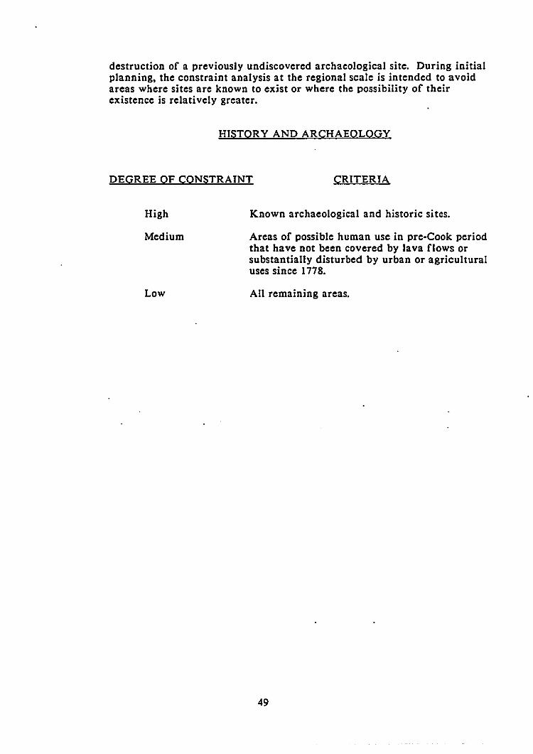
destruction of a previously undiscovered archaeological site. During initialplanning, the constraint analysis at the regional scale is intended to avoidareas where sites are known to exist or where the possibility of theirexistence is relatively greater.
HISTORY AND ARCHAEOLOGY
DEGREE OF CONSTRAINT CRITERIA
High
Medium
Low
Known archaeological and historic sites.
Areas of possible human use in pre-Cook periodthat have not been covered by lava flows orsubstantially disturbed by urban or agriculturaluses since 1778.
All remaining areas.
49
EXHIBIT IV-10HISTORY AND ARCHAEOLOGY
o 1/2 1 mile 2 3 ~
"I-';;''''''''_..i' ••
All remaining areas. [Jb]
Stale DLNR, Stale Parks, Historic Siles Section, Hisloric and Archaeological Sites Maps. •
Slale Dept. 01 AgriCUlture, Agricultural Land Use Maps, 1982. •
Richard B. Moore, Prefiminary Geologic Map of •Kapoho and Pahoa South Quads, 1981.
OHM inc. •
Known archaeological and historic sites. mAreas of possible human use in pre-Cook period Ir.\/ill
that have not been covered by lava flows or substantially disturbed OOUby urban or agricultural uses since 1nS.
POHOIKI GEOTHERMAL TRANSMISSION LINE ROUTING STUDY • OHM inc.
6. Land Regulation
There are some areas where the construction of a transmission line would bediscouraged by regulatory controls designed to protect special resourcevalues. The controls are not so restrictive that they eliminate these areasfrom further consideration, such as the Exclusion Areas which weredescribed earlier. Nevertheless, a permit application for a proposedtransmission line through these areas would be evaluated in terms of theline's possible conflicts with special resource values.
There is a ring of land area encircling the island which has been designatedthe Special Manageme.jV Area (SMA) as part of the State's Coastal ZoneManagement Program . The County reviews permit applications fordevelopment within the SMA in terms of a number of policies and guidelines.One of these policies is to "protect the shoreline of the County fohere neededfrom encroachment of man-made improvements and structures . The SMAis considered a "high" constraint area.
The State Conservation District contains several subzone3rnd specialdistricts representing a range in degree of restrictiveness . The mostrestrictive area is the Protective Subzone, which has previously beendescribed as Exclusion Areas. Next in the hierarchy of restrictiveness arethe Limited and Resource subzones. While regulations governing thesesubzones would not preclude a transmission line, their stated objectives andnarrow range of permitted uses for these areas suggest a "high" regulatoryconstraint. The General Subzone of the Conservation District is morepermissive, and can be considered a "medium" constraint. A transmission lineroute through any portion of the Conservation District would require thereview and approval of the State of Hawaii Board of Land and NaturalResources.
LAND REGULATION
DEGREE OF CONSTRAINT CRITERIA
High
Medium
Low
Limited and Resource Subzones of the StateConservation District. Special Management Areaof the coastal zone.
General Subzone of the State ConservationDistrict.
All remaining areas.
49. State of Hawaii, Department of Land and Natural Resources, Regulation No.4 pursuantto Chapter 183-41, Hawaii Revised Statutes, Honolulu, Hawaii, May, 1978.
50. County of Hawaii Planning Department, "Rules Relating to Administrative Procedures:Planning Commission: Hilo, Hawaii, October, 1975.
51. County of Hawaii Planning Department, "Rule Relating to Administrative Procedures:Planning Commission: Hilo, Hawaii, October, 1975.
51
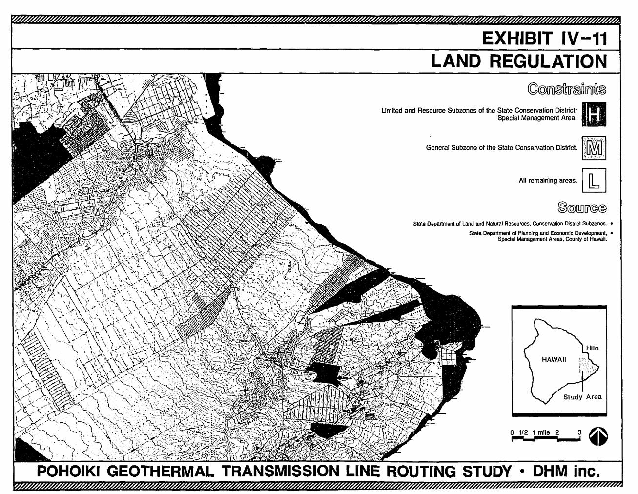
EXHIBIT IV-11LAND REGULATION
m
3,2
OHM inc.•
o 1/2 1 milei
All remalnlng areas. [k]
Slale Department of Land and Natural Resources, Conservation· District Subzones. •
Slale. Departmenl or Planning and Economic Development, •Special Management Areas, County of Hawaii.
General Subzone of the State Conservation District.
Umited and Resource Subzones of the State Conservation District;Special Management Area.
POHOIKI GEOTHERMAL TRANSMISSION LINE ROUTING STUDY
F. COST FACTORS
The cost of constructing and maintaining the proposed transmission lines is aconcern not only to the utility company but to all Island of Hawaii residents andbusinesses who arc supplied with electric power by the utility, since these costs areeventually borne by customers through the utility's rate base.
Route length is an obvious determinant of cost. This has been taken into account byrestricting the study region to the southeast portion of the island, which still permitsa very large number of routing alternatives, some of which could be Quite indirect.No additional route length criteria are considered in the broadscale analysis, but thelength of the route can be a factor in the identification of specific routingalternatives and the selection of a preferred route.
Transmission line costs at the regional scale of analysis are influenced primarily byrelative land values, various physical conditions which impinge on access to thetransmission lines, and certain land uses and physical clements that effect theamount of maintenance required by the line.
I. Land Value
Land value has a direct impact on the cost of acquiring an casement for atransmission line. Utility companies usually pay private property owners aconsideration based on an appraised value for transmission line easements.In recent years, the State government also has tended to demandcompensation for the use of public lands, although not necessarily at a ratecomparable to private lands.
Land values are usually negotiated. While the utility company has power ofeminent domain, this is used only as a last resort because the proceedings forthis form of acquisition add to costs in terms of legal fees and project delays.
The present and potential usc of a property is the mo~t significant influenceon its value. Potential use can be determined by the property's location,physical characteristics and zoning designation. The land use classificationsused for real property assessment purposes in Hawaii take potential use intoaccog~t; e.g.; there is a separate classification for "unimproved residential"land . Assessed valuation provides the most comprehensive availableindicator of land value according to present and potential use. It is possible,on the basis of public records, to determine the averaH valuation per acrefor different categories of existing and potential use .
Assessed valuations for these categories fall into three distinct groups,corresponding closely to the State Land Use District categories. The UrbanDistrict is the high-value category. The Rural and Agriculture District aremedium-value and the Conservation District is a low-value category.
---.---_._.._._._..-52. Hawaii uses the code system established by the "Pittsburgh Law" of differential taxrates for real property assessment and taxation. Cr., Chapter 246, Hawaii Revised Statutes.
53. City and County of Honolulu Department of Finance, Real Property AssessmentDivision, "Real Property Tax Valuations, Tax Rates and Exemptions, 1983-1984 Tax Year,State of hawaii," Honolulu, 1984. The City's Department of Finance compiles property taxdata for all of Hawaii's counties.
53
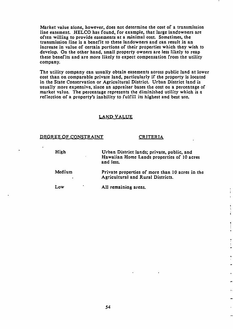
Market value alone, however, does not determine the cost of a transmissionline casement. HELCO has found, for example, that large landowners areoften willing to provide easements at a minimal cost. Sometimes, thetransmission line is a benefit to these landowners and can result in anincrease in value of certain portions of their properties which they wish todevelop. On the other hand, small property owners are less likely to reapthese benefits and are more likely to expect compensation from the utilitycompany.
The utility company can usually obtain easements across public land at lowercost than on comparable private land, particularly if the property is locatedin the State Conservation or Agricultural District. Urban District land isusually more expensive, since an appraiser bases the cost on a percentage ofmarket value. The percentage represents the diminished utility which is areflection of a property's inability to fulfill its highest and best use.
LAND VALUE
DEGR EE OF CONSTRAINT CRITERIA
High
Medium
Low
Urban District lands; private, public, andHawaiian Home Lands properties of 10 acresand less.
Private properties of more than 10 acres in theAgricultural and Rural Districts.
All remaining areas.
54
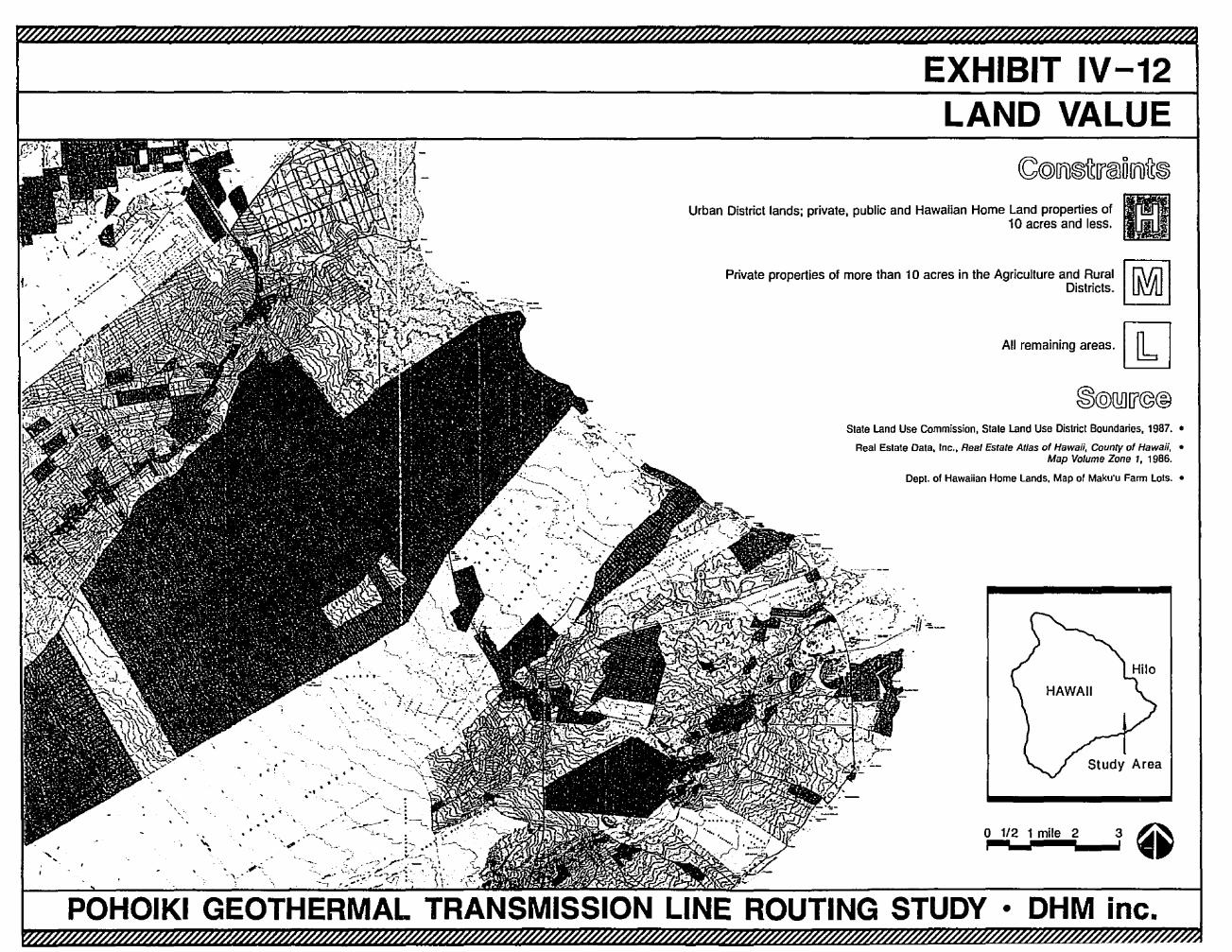
EXHIBIT IV-12LAND VALUE
3
All remaining areas. [kJ
o 1/2 1 mile 2i
Slale land Use Commission, Slale land Use Dislricl Boundaries, 1987. •
Real Estate Dala, Inc., Real Esrale Alias of Hawaii, County of Hawaii, •Map Volume Zone " 1986.
Dept. of Hawaiian Home Lands, Map 01 Maku'u Farm lois. •
Private properties of more than 10 acres in the Agriculture and RuralDistricts.
Urban District lands; private. public and Hawaiian Home Land properties of10 acres and less.
-:-->.. \.
, -', .... .........~\ ~."
'\ ", ..• " ·_:~...fp
-"--' -'.
-,
. '-'." .
<,. "
.."-,, "
"
POHOIKI GEOTHERMAL TRANSMISSION LINE ROUTING STUDY • DHM inc.
2. Maintenance
A major consideration in maintenance costs is the need for clearance betweenthe transmission conductors and nearby objects such as trees. HELCO'sengineering standards require that alI areas within 10 feet of thetransmission lines be kept free of vegetation. The specified minimum groundclearance (at the point of maximum line sag) of the proposed power line is 30feet. This means that vegetation would be maintained at a maximum heightof 20 feet (30 foot high power line - 10 foot clearance - 20 foot highvegetation) within the transmission line easement. Because of this standard,forest areas with canopy heights in excess of 30 feet pose a constraintbecause of the high cost of severe pruning. Both closed- and open- canopyforests with trees greater than 30 feet in height are considered as "high"constrain ts.
Salt spray, which occurs up to 1/2 mile54 from the shoreline inland, poses a"high" constraint. Salt spray can cause flashovers at insulators and isgenerally corrosive to electrical systems and to hardware. Therefore,transmission lines within this area incur high maintenance costs.
Considerations stemming from human activities can also affect themaintenance of a transmission line especialIy where vandalism by huntersmay occur. Hunter vandalism is associated with the discharge of firearmsand the use of the transmission line insulators and conductors for targetpractice. This generally occurs in or near areas where game hunting iscommon. Game hunting areas are considered a "high" constraint.
Open-canopy forests with medium stature trees (6 to 30 feet tall) are a"medium" constraint because of potential pruning costs to keep vegetationclear of transmission lines.
It should be noted that in general, Puna has a somewhat higher incidence offires, especially wing dry periods, than have less developed areas on theIsland of Hawaii . However, mapped data is unavailable. For the purposesof this study, it is assumed that the fire hazard is relatively equal throughoutthe district.
54. Based on information provided by HELCO.
55. Based on communications with staff, Department of Land and Natural Resources,Division of Forestry, September, 1986.
56
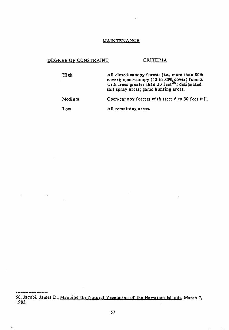
MAINTENANCE
DEGREE OF CONSTRAINT CRITERIA
High
Medium
Low
All closed-canopy forests (i.e., more than 80%cover); open-canopy (40 to 80% gover) forestswith trees greater than 30 feet5 ; designatedsalt spray areas; game hunting areas.
Open-canopy forests with trees 6 to 30 feet tall.
All remaining areas.
56. Jacobi, James D., MaDping the Natural Vegetation of the Hawaiian Islands, March 7,1985.
57
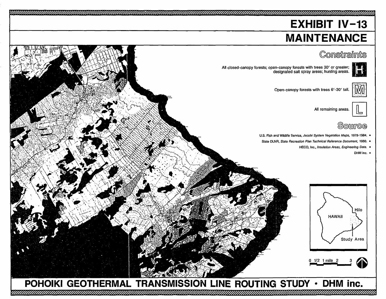
EXHIBIT IV-13MAINTENANCE
3o 1/2 1 mile 2i
All remaining areas.~
U.S. Fish and Wildlife SeNiee, Jacobi System Vegetation Maps. 1979-1984. •
Slale OLNR, State Recreation Plan Technical Reference Document, 1980. •
HEeO, Inc., Insulation Areas, Engineering Data. •
OHM inc.•
(C(Q)lrU®ftW@lOlrUft®
All closed-canopy forests; open·canopy forests with trees 3D' or greater; mdesignated salt spray areas; hunting areas.
Open-canopy foresls with trees 6'-30' tatl-I']:I~J'1
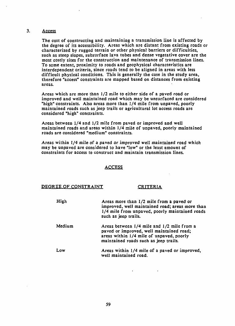
3. Access
The cost of constructing and maintaining a transmission line is affected bythe degree of its accessibility. Areas which are distant from existing roads orcharacterized by rugged terrain or other physical barriers or difficulties,such as steep slopes, subsurface lava tubes and dense vegetative cover are themost costly sites for the construction and maintenance of transmission lines.To some extent, proximity to roads and geophysical characteristics areinterdependent criteria, since roads tend to be aligned in areas with lessdifficult physical conditions. This is generally the case in the study area,therefore "access" constraints are mapped based on distances from existingareas.
Areas which are more than 1/2 mile to either side of a paved road orimproved and well maintained road which may be unsurfaced are considered"high" constraints. Also areas more than 1/4 mile from unpaved, poorlymaintained roads such as jeep trails or agricultural lot access roads areconsidered "high" constraints.
Areas between 1/4 and 1/2 mile from paved or improved and wellmaintained roads and areas within 1/4 mile of unpaved, poorly maintainedroads are considered "medium" constraints.
Areas within 1/4 mile of a paved or improved well maintained road whichmay be unpaved are considered to have "low" or the least amount ofconstraints for access to construct and maintain transmission lines.
ACCESS
DEGREE OF CONSTRAINT CRITERIA
High
Medium
Low
Areas more than 1/2 mile from a paved orimproved, well maintained road; areas more than1/4 mile from unpaved, poorly maintained roadssuch as jeep trails.
Areas between 1/4 mile and 1/2 mile from apaved or improved, well maintained road;areas within 1/4 mile of unpaved, poorlymaintained roads such as jeep trails.
Areas within 1/4 mile of a paved or improved,well maintained road.
59
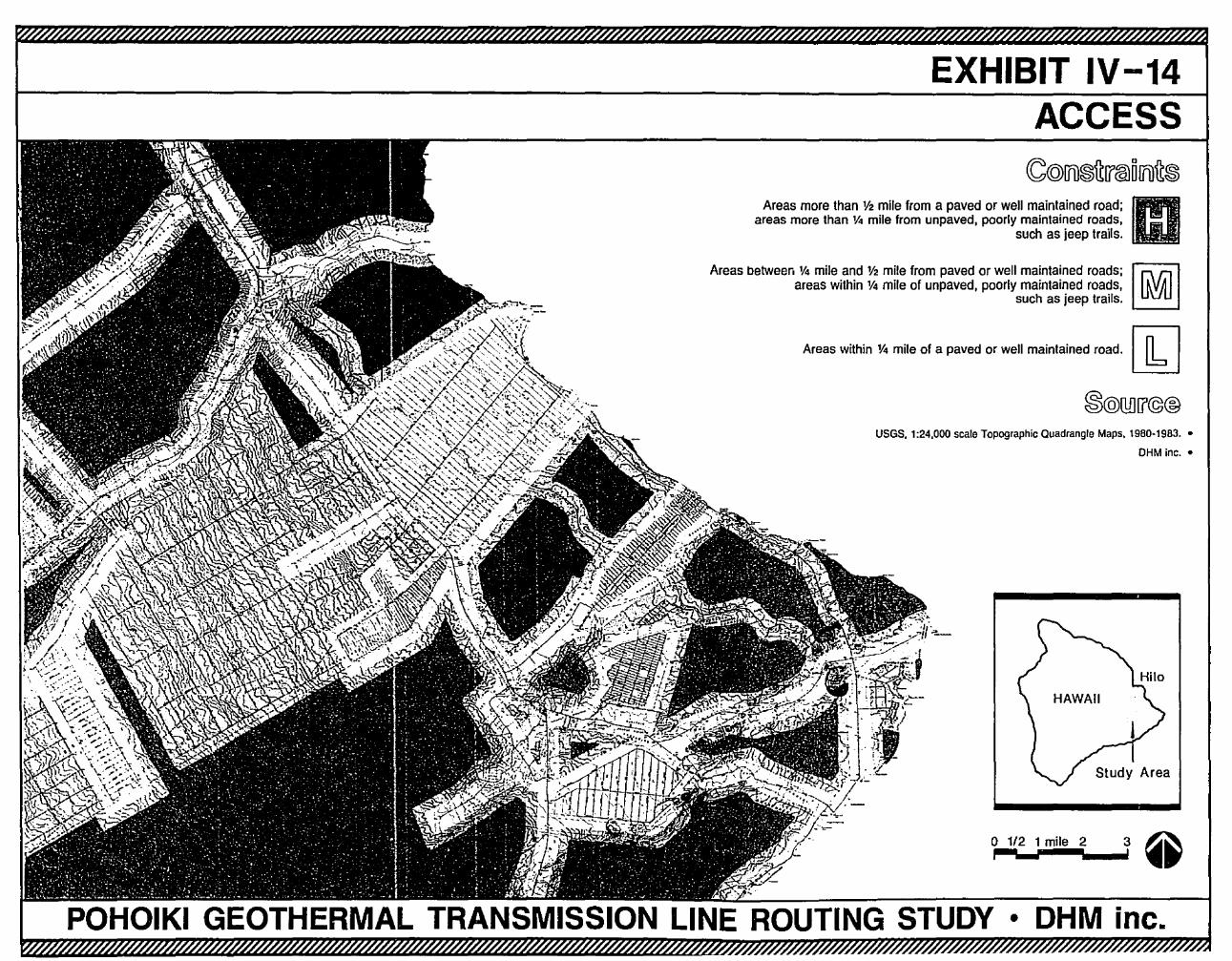
EXHIBIT IV-14ACCESS
Areas more than V2 mile from a paved or well maintained road; mareas more than 1f<I mile from unpaved, poorly maintained roads, .
such as jeep trails.
Areas betweer, Y. mile and lI2 mile from paved or well maintained roads; I.r.\r.llareas within 1M mile of unpaved, poorly maintained roads, UVU
such as jeep trails.
Areas wilhin Y. mile of a paved or well mainlained road. [k]
USGS, 1:24,000 scale Topographic Quadrangle Maps. 1980-1983. •
OHM inc. •
o 1/2 1 mile 2 3 ~.,.--,..-._....' ..POHOIKI GEOTHERMAL TRANSMISSION LINE ROUTING STUDY • DHM inc.
CHAPTER V
CHAPTER V: IDENTIFICATION OF CORRIDORS AND POTENTIAL ROUTES
A. COMPOSITE MAPS
In order to present an overall view of the constraints and opportunities for thetransmission line route, a composite overlay map was prepared for each datacategory (geophysical, biological, socio-economic, and cost factors). The compositemaps represent the combined constraints of all the data factors in each datacategory and identify the areas of less constraint for each category.
Composite maps for the data categories of geophysical, biological, socio-economicand cost factors are shown in Exhibits V-I, V-2, V-3 and Y-4. In Exhibit V-S, thefour composite maps and the Exclusion Areas map are laid over one another. Onecan see color tones ranging from black (Exclusion Areas), through dark grey (highconstraint) to light grey (Jow constraint). The "relatively" lighter areas are mappedas areas of less constraint, and are viewed as opportunities for transmission linecorridors. The areas of less constraint are mapped in Exhibit V-6.
Potential corridors are identified by linking the areas of less constraint to provide acontinuous connection between the geothermal power plant site and the PunaSubstation area at Keaau. This was done using the areas of less constraint as themain guide and linking them where they did not join. Linkages were normallymade across the shorter route and if possible along an existing road or jeep trail.Urban and Conservation District lands were avoided. Where necessary, thecorridors were widened to allow for alternative alignments if the widening did notaffect environmentally sensitive areas such as Urban or Conservation Districts.Through large areas of less constraint, such as agricultural subdivisions and themauka lands, the most direct route was chosen between the identified corridor oneither side. The potential corridors are shown on Exhibit Y-? The width of thecorridors is one-quarter to three-quarters of a mile to permit a choice of alignments.
B. POTENTIAL CORRIDORS
The corridors identified for further evaluation have been divided into fivesegments (as shown on Exhibit V-?) for review purposes. The segments may becombined to form three primary corridors from the Pohoiki geothermal plant to thePuna substation:
Corridor ABCorridor ACECorridor DE
Nanawale/Railroad CorridorNanawale/Highway CorridorLeilani/Highway Corridor
Below is a brief description of the five segments:
Segment A - This segment, referred to as the Nanawale segment, is commonto both the Nanawale/Railroad corridor and the Nanawale/Highwaycorridor. It originates at the geothermal plant site and proceeds north acrossNanawale Farm Ranch Lands, then west along the edge of Nanawale EstatesSubdivision. It terminates at the State-owned lands of Keonepoko Kiahupuaa, near the mauka corner of Hawaiian Beaches Subdivision.
61
Segment B - This segment originates along Kahakai Road near HawaiianBeaches Subdivision and proceeds along the northern boundary of thesubdivision to the former railroad alignment, which it then follows north tothe Puna SUbstation. Proceeding towards the substation, the first 4 1/2 milesof this segment cross vacant State-owned lands of tall grasses and scatteredQh.i.a. trees. The segment then passes through Hawaiian Paradise Park, a oneacre agriculture lot subdivision, for close to 4 miles. This portion of thesUbdivision is sparsely populated with between 25 and 50 developed parcels.The final 3 1/2 miles of the segment continue to follow the railroad routethrough scrub Q.!ilil. trees and the Puna Sugar lands to the substation.Segment C - This segment is a "connector" between the Nanawale segmentand the Highway segment. It primarily follows Kahakai Road betweenHawaiian Beaches and Pahoa town, and encompasses State-owned land,including the Pahoa Agricultural Park. It does not include the lands ofKeonepoko Homesteads along the highway. Segment C terminates near thePahoa landing strip.
Segment D - This segment is referred to as the Leilani segment because itoriginates at the Pohoiki geothermal plant site and heads west, along thenorthern edge of Leilani Estates Subdivision. It completely avoids the Stateconservation lands of Nanawale Forest Reserve on the right. The segmentheads north for a short distance spanning Kalapana Road, then veers off tothe northwest across former sugar lands and vacant State-owned lands on thewest side (mauka) of Pahoa. This segment terminates across Pahoa Highway(Highway 130) from the Pahoa landing strip and segment C.
Segment E - The highway segment is common to both the Nanawale/Highwaycorridor and the Leilani/Highway corridor. It extends along Pahoa Highwayfrom the Pahoa landing strip to just south of Keaau, at which point itcontinues northeast to the Puna Substation. Near its origin, segment E passesthro\lgh the Maku'u parcel of Hawaiian Home Lands, portions of which havebeen subdivided and leased to native Hawaiian beneficiaries. It then crosses·the eastern tip of Ainaloa Subdivision and 3-1/2 miles of Orchid LandEstates three-acre agriculture lot subdivision on the mauka side of thehighway. On the makai side, this corridor segment passes through 3-3/4miles of Hawaiian Paradise Park one-acre agriculture lot subdivision. North
of the subdivisions, the corridor segment includes vacant scrub Qhi;Llandsand former sugarcane fields, terminating at the substation near the PunaSugar Mill.
C. CORRTDOR EVALUATION
To generate a rating for each corridor to serve as a basis for comparing the corridoralternatives, "test routes" were identified by going through the lightest areas of thecomposite maps. The test results provide a point of reference to evaluate eachsegment against all the previously mapped data factors. These test routes wereoverlaid on each broadscale data factor constraint map. Each time the test routepassed through either a high or medium constraint area, the linear distance throughthe constraint area was measured in inches. The unit of measurement is a relativefigure, depending upon the scale of the map or, the actual conditions in the field.Therefore the measurement of constraint becomes the "score" for that data factor inthe particular segment where it was encountered. Exhibit V-8 shows a map of thetest routes and V-9 shows the scores for each data factor and each segment of thetest routes. The table shows a total score for each route.
62
In calculating the total score, each high constraint score was multiplied by three toreflect its relative importance while each medium score was recorded as it wasmeasured. The test route with the least constraints (the lowest total score) was "D" the one just mountainward of the State Highway. The next lowest score was "AC" the one just seaward of the State Highway. Potential route "AB" - the formerrailroad alignment - had the highest score but is still considered an acceptablealternative because its score is not significantly greater than the other two potentialroutes.
Note that the three total scores are quite close in value which reflects the overallsimilarity of the study area in general. Because of this, it was decided to study allthe corridors in the detailed analysis phase. The results of this study are describedin Chapter VI.
63
.. -..-'
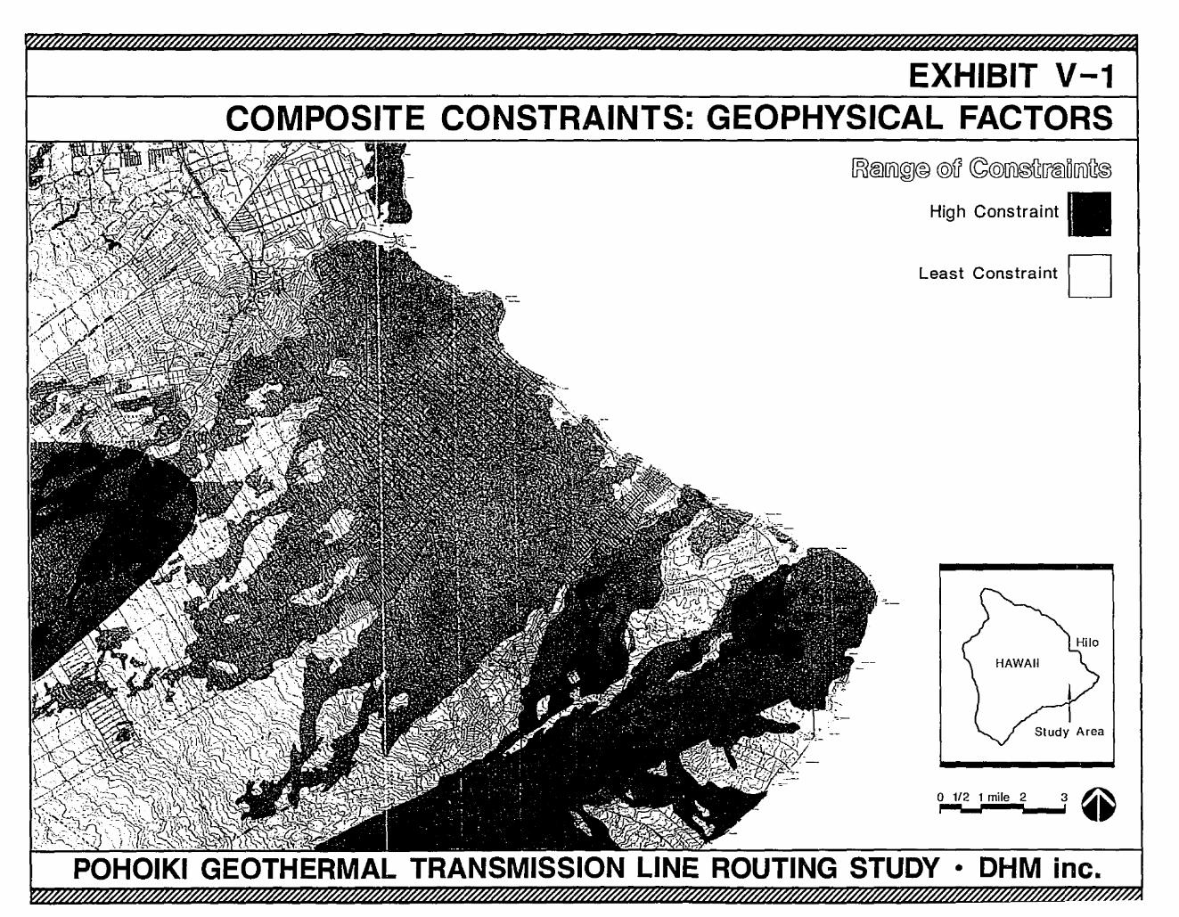
EXHIBIT V-1COMPOSITE CONSTRAINTS: GEOPHYSICAL FACTORS
[fJ(IDIJi]@@ @il ~@@®U[?@D[]uU®
High Constraint IIILeast Constraint D
Study Area
o 1/2 1 mile 2 3 ~P-:~,;,;;,--",,~, ••
• OHM inc.
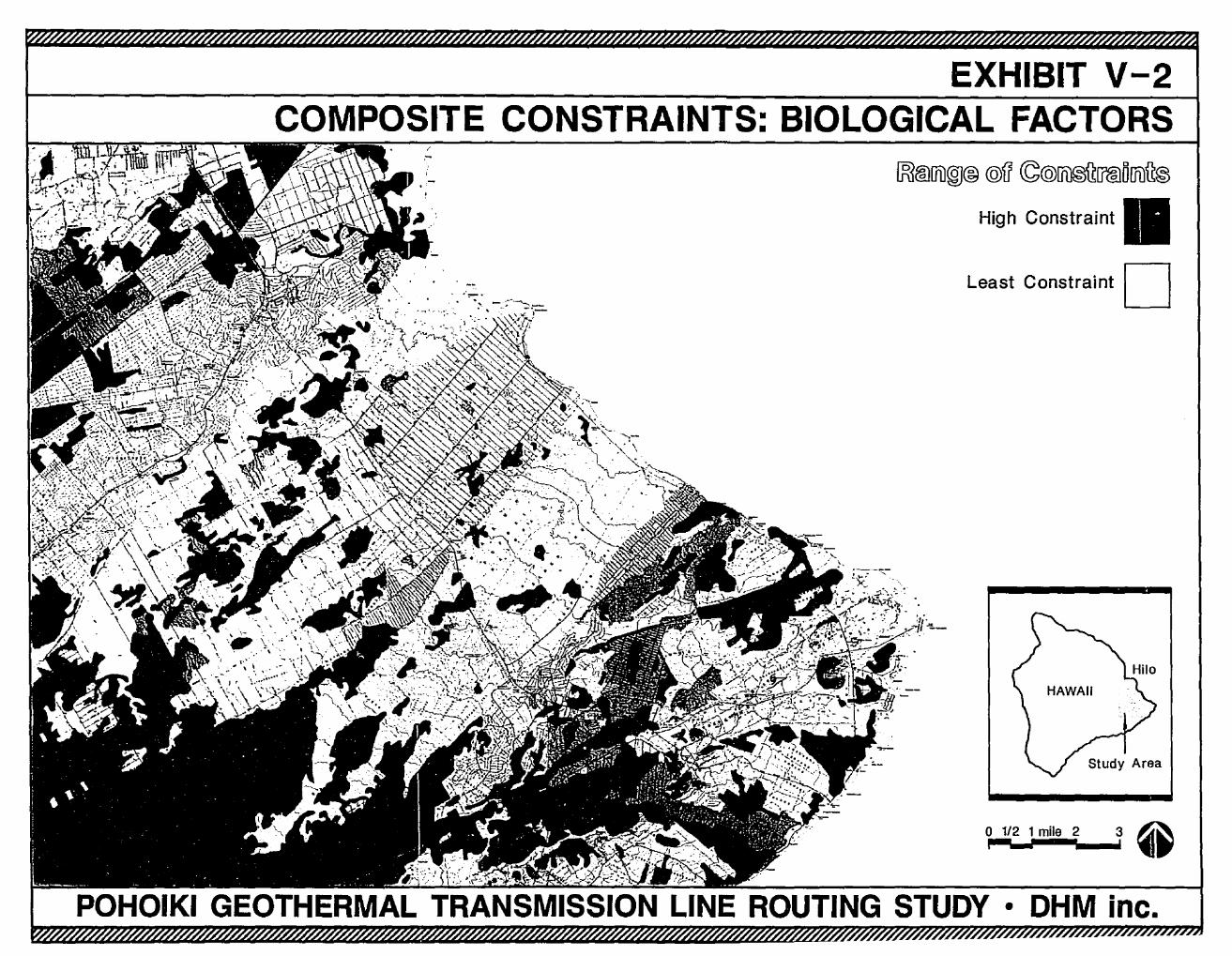
EXHIBIT V-2COMPOSITE CONSTRAINTS: BIOLOGICAL FACTORS
3o 1/2 1 mile 2I
1K1®1Ji)@@ @ll ~@~[f@O[fi)~@
High Constraint IILeast Constraint D..
,-
POHOIKI GEOTHERMAL TRANSMISSION LINE ROUTING STUDY • OHM inc.
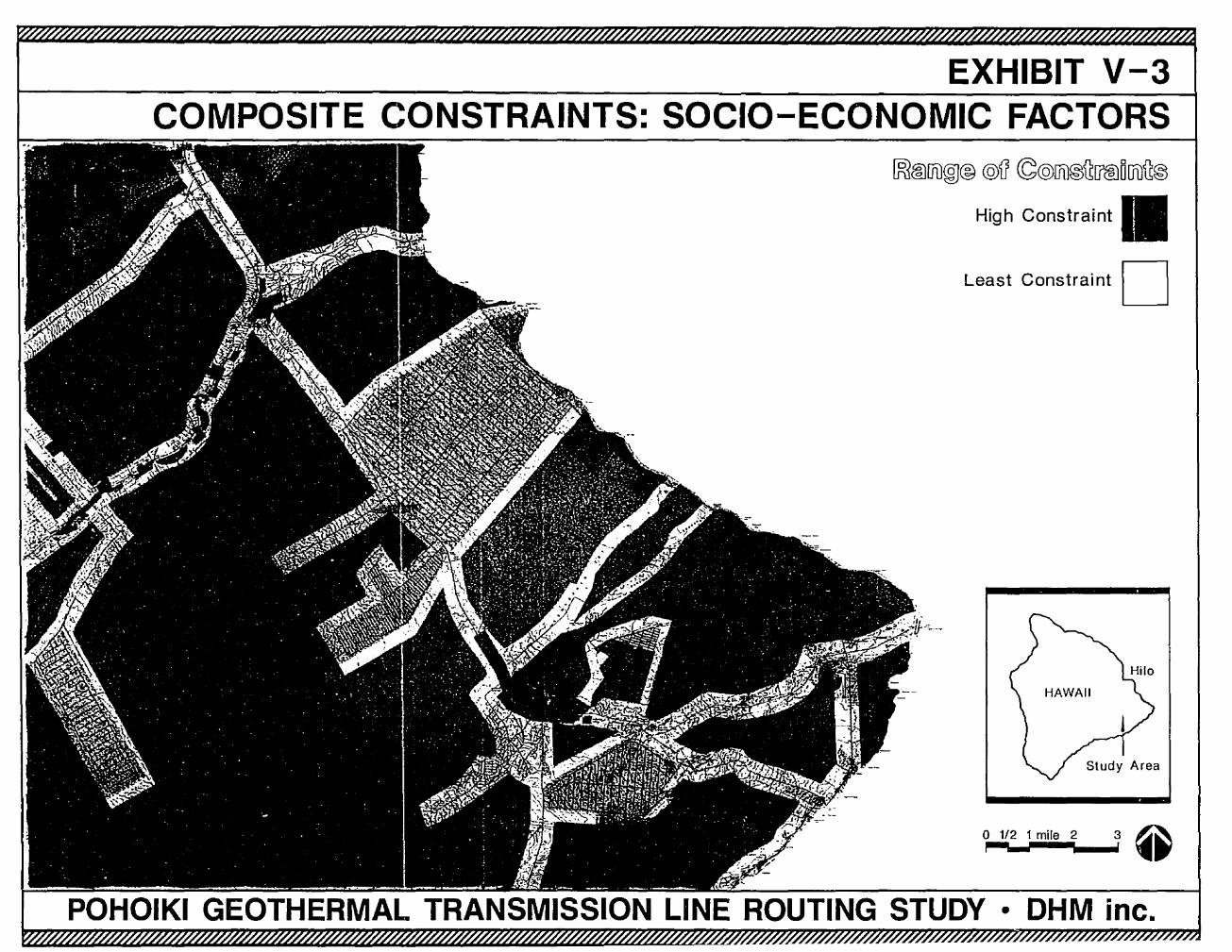
EXHIBIT V-3COMPOSITE CONSTRAINTS: SOCIO-ECONOMIC FACTORS
~@[]1)@® @g ©@ffi)®~[f@D01l~®
High Constraint IILeast Constraint D
1/2 1 mile 2 3 ~~__......Ir ••
POHOIKI GEOTHERMAL TRANSMISSION LINE ROUTING STUDY • DHM inc.
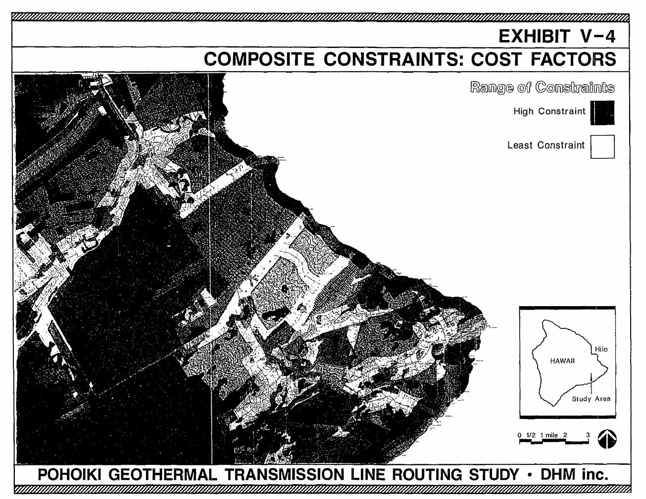
EXHIBIT V-4COMPOSITE CONSTRAINTS: COST FACTORS
~@[jl)®@ @il ©@[jl)@~[f@D [jl)~@
High Constraint IIILeast Constraint D
0,.;.1../2_1,.m_ile...2..__1 @
• OHM inc.
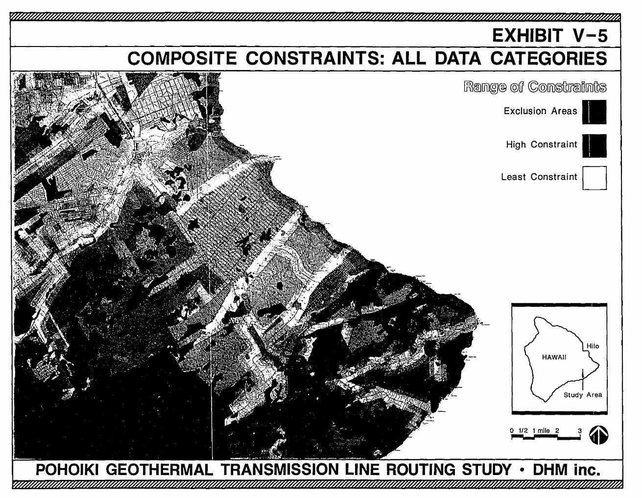
EXHIBIT V-SCOMPOSITE CONSTRAINTS: ALL DATA CATEGORIES
Study Area
o 1/2 1 mile 2 3 Q,.;__,--._...i' ,..,
~tID[ft)®@@il ~@rtD~(J®OUi)~®
Exclusion Areas IIHigh Constraint II
Least Constraint D
POHOIKI GEOTHERMAL TRANSMISSION LINE ROUTING STUDY • OHM inc.
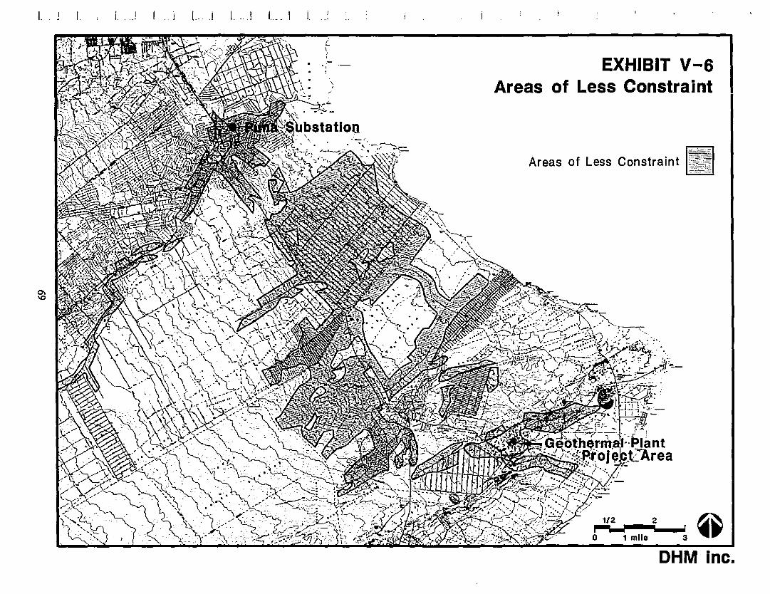
L L .i L ~. _.J '--_1 L I
1/2 2 0P:-".---"--.l3'o 1 mile
EXHIBIT V-6Areas of Less Constraint
•Inc.OHM
Areas of Less Constraint
a·_.~
,f
/
!..\I
.;.
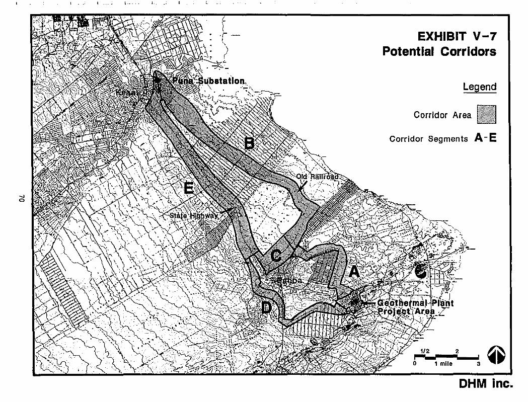
1- .• I.. __ .' l. _
Legend
Corridor Segments A-E
Corridor Area Ifl~J
•Inc.
3
OHM
1 mile
1/2 2
EXHIBIT V-7Potential Corridors
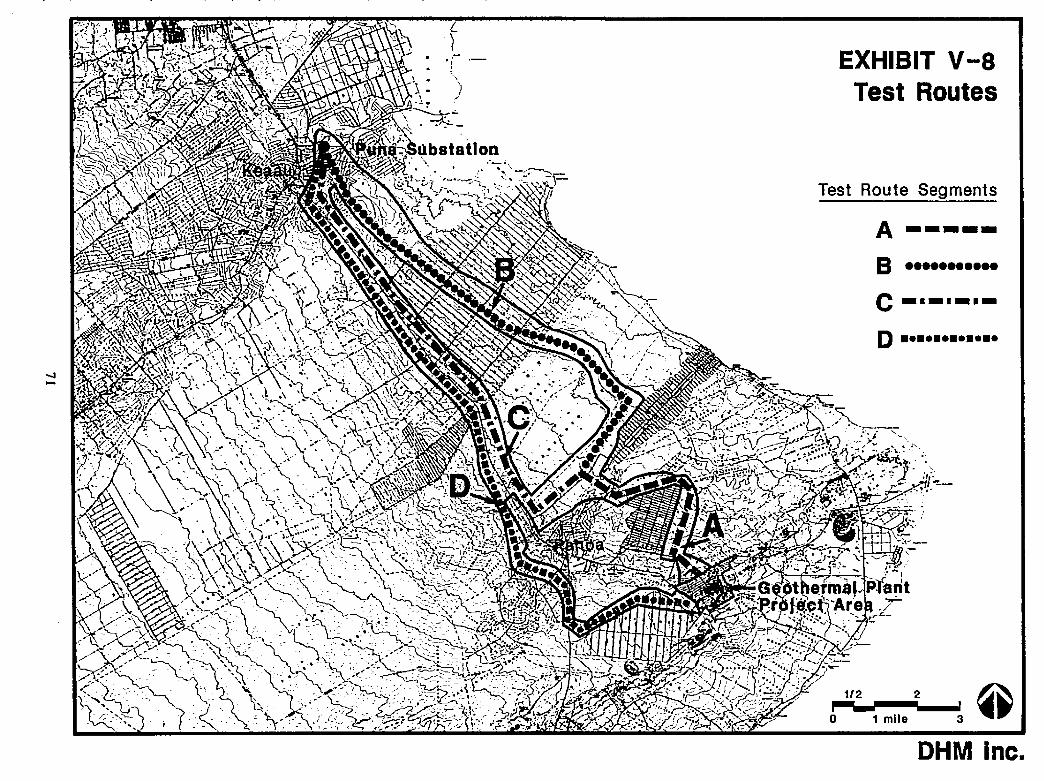
A -----B··.....••..
Test Route Segments
3
D············
OHM Inc.
C-I_._.-
1/2 2
EXHIBIT v-aTest Routes
o 1 mile
-..l-
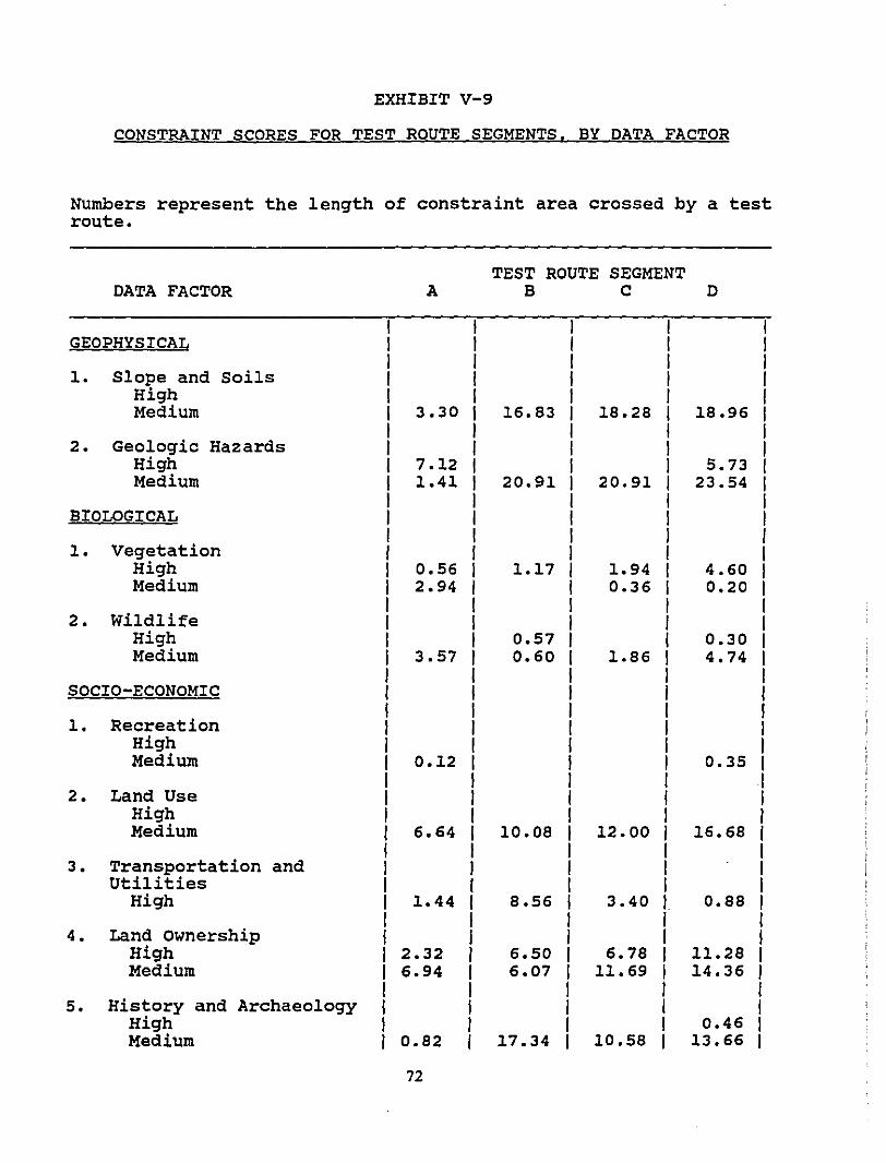
EXHIBIT V-9
CONSTRAINT SCORES FOR TEST ROUTE SEGMENTS, BY DATA FACTOR
Numbers represent the length of constraint area crossed by a testroute.
TEST ROUTE SEGMENTDATA FACTOR A B C D
I I I I IGEOPHYSICAL I I I I I
I I I I I1. Slope and Soils I I I I I
High I I I I IMedium I 3.30 I 16.83 I 18.28 I 18.96 I
I I I I I2. Geologic Hazards I I I I I
High I 7.12 I I I 5.73 IMedium I 1.41 I 20.91 I 20.91 I 23.54 I
I I I I IBIOLOGICAL I I I I I
I I I I I1. Vegetation I I I I I
High I 0.56 I 1.17 I 1.94 I 4.60 IMedium I 2.94 I I 0.36 I 0.20 I
I I I I I2. Wildlife I I I I I
High I I 0.57 I I 0.30 IMedium I 3.57 I 0.60 I 1.86 I 4.74 I
I I I I ISOCIO-ECONOMIC I I I I I
I I I I1. Recreation I I I I
High I I I IMedium I 0.12 I I 0.35 I
I I I I2. Land Use I I I I
High I I I IMedium I 6.64 10.08 I 12.00 I 16.68 f
I I I I3. Transportation and I I I I
Utilities I I I IHigh I 1.44 8.56 I 3.40 I 0.88 I
I I I I4. Land Ownership I , I I
High I 2.32 6.50 I 6.78 I 11.28 IMedium I 6.94 6.07 I 11.69 I 14.36 ,
I I I I5. History and Archaeology I I I I
High I I I 0.46 IMedium I 0.82 17.34 I 10.58 I 13.66 I
72
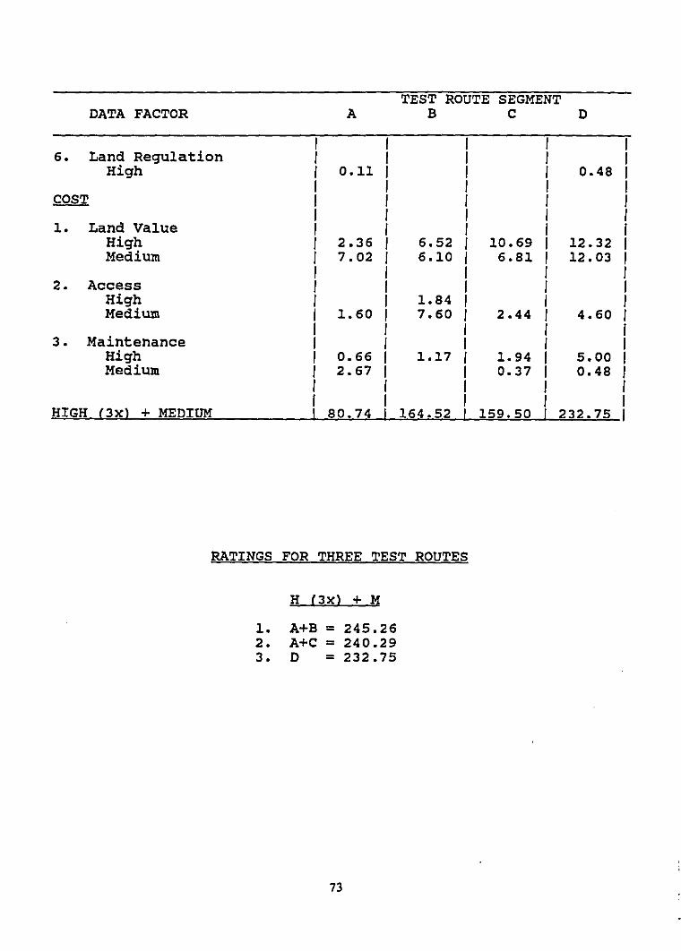
TEST ROUTE SEGMENTDATA FACTOR A B C D
I I I J J6. Land Regulation I J I J I
High I 0.11 I I I 0.48 II I J I I
COST I J I I II I I I I
1. Land Value I I J I ,High I 2.36 I 6.52 I 10.69 I 12.32 IMedium I 7.02 I 6.10 I 6.81 I 12.03 I
I I I I I2. Access I J I I I
High I I 1.84 I I IMedium I 1.60 I 7.60 I 2.44 J 4.60 I
J J I I ,3. Maintenance I I I I I
High I 0.66 I 1.17 I 1.94 J 5.00 IMedium I 2.67 I I 0.37 I 0.48 I
I I I , II I I I I
HIGH (3x) + MEDIUM I 80.74 I 164.52 I 159.50 I 232.75 I
RATINGS FOR THREE TEST ROUTES
H (3x) + M
1. A+B = 245.262. A+C = 240.293. D = 232.75
73
CHAPTER VI
CHAPTER VI: DETAILED ANALYSIS
A. MAP FORMAT AND DATA
The detailed analysis of conditions in the study corridors requires a larger mapscale. The Phase 2 mapping scale is 1:24,000 (I inch ~ 2,000 feet), whereas the PhaseI (Broadscale) analysis scale is 1:36,000 (I inch = 3,000 feet). Both phases use USGSquadrangle sheets for their base. The study corridors are divided into four sectionsfor suitable page-sized display in this report, beginning at the geothermal plantproject area in Section I and terminating near the Puna substation in Section 4. Thesegments are shown in Exhibit VI-I.
Air photos57 were used to provide additional information on land use, man-madeand natural features such as vegetation, roads, developed lands. Data from thesewere verified by field surveys. Consequently, much of the data shown on the largescale maps is new information collected during field surveys (see Appendices B-F)expressly for this project. Field surveys were performed by scientists andprofessional experts to identify the foHowing detailed information: archaeologyand histo,?g ornithology, entomology, botany, geology and soils, and visualresources. Other relevant data was also mapped, including existing telephonelines, existing electric transmission and distribution lines, a new Hawaiian HomeLands subdivision on both sides of Highway 130, lands in agriculture production,and land ownership.
Above data are shown in two data maps for each section: (1) Physical Conditionsand (2) Visual Resources. The following paragraphs describe the data factors placedon each map, and their relative constraints and opportunities for transmission linealignment.
B. PHYSICAL CONpiTIONS
I. Land Use
Land use factors mapped in the study corridors include urban lands,productive agriculture lands, residential agriculture lands, existing utilityline and road rights-of-way, the planned Pahoa By-pass Highway, andarchaeological and historic sites.
Productive agricultural lands are typically used for field crop cultivationwhich includes nurseries, orchards, or other diverse crops. While these landsare not a highly restrictive constraint to a transmission line route, they aremore constraining than vacant or pasture lands due to the level of humanactivity and land value. These lands are identified on the detailed analysismaps based on field checks of productive agricultural lands mapped by theState Department of Agriculture (as described in Phase I).
57. Air photos are dated 1977. Field checks were used to update the air photo informationand to verify changes in land uses.
58. Field surveys were conducted of the entire study corridors with the exception of theagricultural subdivisions of Orchid Land Estates, Ainaloa, and Hawaiian Paradise Park asthese areas have been physically disturbed.
74
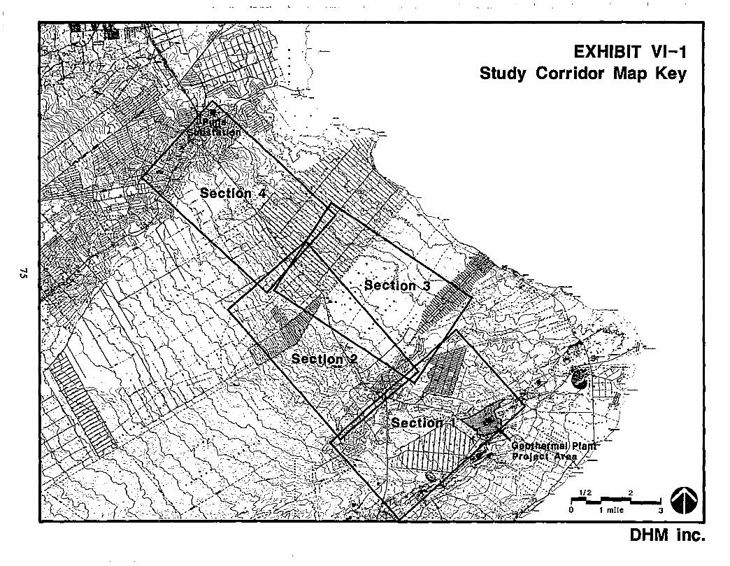
I'.i
EXHIBIT VI-1Study Corridor Map Key
1/2 2 @r--.-~3'
t mile
OHM inc.
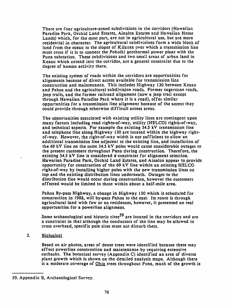
There are four agriculture-zoned subdivisions in the corridors (HawaiianParadise Park, Orchid Land Estates, Ainaloa Estates and Hawaiian HomeLands) which, for the most part, are not in agricultural use, but are moreresidential in character. The agricultural subdivisions form a wide block ofland from the ocean to the slopes of Kilauea over which a transmission linemust cross if it is to connect the Pohoiki geothermal power plant with thePuna substation. These subdivisions and two small areas of urban land inKeaau which extend into the corridor, are a general constraint due to thedegree of human activity there.
The existing system of roads within the corridors are opportunities foralignments because of direct access available for transmission lineconstruction and maintenance. This includes Highway 130 between Keaauand Pahoa and the agricultural subdivision roads. Former sugarcane roads,jeep trails, and the former railroad alignment (now a jeep trail exceptthrough Hawaiian Paradise Park where it is a road), offer similaropportunities for a transmission line alignment because of the access theycould provide through otherwise difficult access areas.
The opportunities associated with existing utility lines are contingent uponmany factors including road rights-of-way, utility (HELCO) rights-of-way,and technical aspects. For example the existing 34.5 kV transmission lineand telephone line along Highway 130 are located within the highway rightof-way. However, the right-of-way width is not sufficient to allow anadditional transmission line adjacent to the existing line, and installation ofthe 69 kV line on the same 34.5 kV poles would cause considerable outages tothe present customers throughout Puna during construction. Therefore, theexisting 34.5 kV line is considered a' constraint for alignment selection.Hawaiian Paradise Park, Orchid Land Estates, and Ainaloa appear to provideopportunity for construction of the 69 kV line within an existing HELCOright-of-way by installing higher poles with the new transmission lines ontop and the existing distribution lines underneath. Outages to thedistribution line would occur during construction, however the customersaffected would be limited to those within about a half-mile area.
Pahoa By-pass Highway, a change in Highway 130 which is scheduled forconstruction in 1999, will by-pass Pahoa to the east. Its route is throughagricultural land with few or no residences, however, it presented no realopportunities for a powerline alignment.
Some archaeological and historic sites59 are located in the corridors and area constraint in that although the conductors of the line may be allowed tocross overhead, specific pole sites must not disturb them.
2. Biological
Based on air photos, areas of dense trees were identified because these mayaffect powerline construction and maintenance by requiring extensivecutbacks. The botanical survey (Appendix C) identified an area of diverseplant growth which is shown on the detailed analysis maps. Although thereis a moderate coverage of Q!ilil. trees throughout Puna, much of the growth is
59. Appendix B, Archaeological Survey.
76
stunted. sparse and immature. Because of the relative youth of Qha in thestudy area, the plant communities have only a few of the potential numberof species which would develop in a mature forest. OveraIl. ·the floristicQuality was consistengd' poor and the same species composition wasrepeatedly expressed· in the study areas.
The ornithological survey identified the presence of three native birds andseveral common non-native species (see Appendix D). The native birds foundwere the ·EJeoaio. the:I2. (Hawaiian Hawk). and the Hawaiian Stilt. TheHawaiian Stilt were sighted on small ponds in the vicinity of the PunaSubstation. The 'Elepaio and the :I2. were seen in the makai corridor aboveNanawale Farm Ranch Lands. however specific locations for them are notmapped because these birds apparently use broad areas in Puna District andare not dependent on any specific locations. although they favor forests atthe higher elevations. The survey report notes that the environments in thestudy corridors are not particularly hospitable towards native species andthat although they •...may occash9naIly use these areas. it is not likely thatthey are dependent upon them·. I
The entomological survey (see Appendix E) found several native species ofinsects. Their habitats are all below ground in caves or lava tubes. Fromhighest to lowest significance, the areas are: ....1) Pahoa Cave, both upperand wwer caves. 2) The kjpuka area south of Pahoa.... 3) The Seaview Roadsite·. 2 GeneraIly, the presence of insects is determined by the surroundingvegetation. An important insect habitat in the caves are Qha roots whichenter the cave roof from the ground surface. The report notes that in orderto preserve the insects. the surrounding vegetation must be protected.especiaIly from herbicides which may be used to control vegetation as part ofpower line maintenance practices. Also there is a potential for theinfiltration of herbicides into the caves which could present a serious threatto the fragile ecosystems there.
3. Geophysjcal
The major finding of the field survey (see Appendix F) is that there is a highprobability of encountering lava tubes and caves which ultimately willaffect pole foundations and the precise alignment. The caves are ubiquitousto the area and are often obscured by vegetation. With the exception of thelarger underground formations described above in the biological section. thecaves or lava tubes will generaIly need to be identified during constructionand avoided.
60. Appendix C. Botanical Survey.
61. Appendix D. Ornithology Survey Report, p. 9.
62. Appendix E. Entomology Survey, p. 6.
77
4. Land Ownership
Land ownership was mapped from tax key maps which identify each parcelof land, it~:fwner, size and geographic location. Major land owners includethe public , Hawaiian Home Lands, and private entities. .State lands consist mostly of large parcels (greater than 10 acres) althoughthere are some small leased parcels.
Hawaiian Home Lands are on both sides of Highway 130, just south ofHawaiian Paradise Park and Ainaloa Estates. More than half of these landshave been divided into agricultural lots of S-acres (on the makai side ofHighway 130) and 2-acres (on the mauka side of Highway 130).
Privately owned lands consist of large vacant or agriculture parcels as wellas small residential parcels in urban areas or agricultural subdivisions.
C. VISUAL RESOURCES
A primary aesthetic consideration in the siting of a transmission line is the extent towhich the poles and conductors are screened from view at important vantage pointsby vegetation, natural landforms and buildings or structures. In the case of thestudy corridor, the area within visual range of the major roadways gets the mostfrequent view exposure since these roadways act as a continuous vantage point formotorists and passengers. These viewers include local residents, island-wideresidents, and visitors to the island.
I. Vjsual Screens
The physical features which screen views from major vantage points areindicated on the detailed analysis maps. Four types of screens are noted:I) solid vegetation, which consists of a thick growth of trees near. the. road,2) partial vegetation, which is thinner or lower vegetative growth that allowsoccasional or penetrated views, 3) urban, which is usually created by thebuildings and vegetation of an urban environment, and can be either partialor solid in effect, and 4) berms, which may be either man-made road cuts ornatural earth formations that limit all or part of the view from the road.
Partial vegetation screens and urban screens may allow occasional orpenetrated views to a transmission line. The effectiveness of a berm as ascreen depends upon berm height, distance from the road, vegetation cover,and the slope of the ground beyond it. The major constraint for all types ofscreens is if they are not tall enough to screen the entire pole, all or portionsof the poles may be silhouetted against the sky, resulting in a highly visiblecontrast of form and color.
Urban screens and residential areas can be a constraint if the line is highlyvisible from the urban or residential area itself.
63. Nearly all public land in the corridors belongs to the State of Hawaii, only a smallparcel along Highway 130 near Keaau belongs to the County of Hawaii. There is nofederally owned land. .
78
On the other hand, solid vegetation screens offer the best opportunity formasking the view of a transmission line. Solid screens virtually block one'sview at the edge of the road, creating an enclosure and directing the line ofsight away from the screen. A transmission line beyond the screen or wellwithin it would not be visible from the road. Partial vegetation screens areeffective if the line is set back far enough to appear no taller than the screenitself, and so views of the line are sufficiently diffused by the vegetation.
The urban screens of Pahoa and Keaau are wide enough that the corridorsbeyond are not visible from the main roads. The agriculture subdivisionsand lands in agriculture production serve as partial screens in some locationsalong the major roads.
The majority of the berms mapped are the result of man-made road cuts andare immediately adjacent to the road. They can serve as solid screens if theline is located far enough back so that it appears no taller than the bermitself. Berms are also effective screens if they are covered with trees or ifthe ground beyond slopes away. These conditions can vary considerably overshort distances however.
2. Views
Views of the corridor from major roads are indicated on the detailedanalysis maps along with a verbal description for each in term6'4of opennessand viewgrounds (ie. foreground, middleground, background).
All views ·are constraints to the extent that they allow a transmission line tobe fully visible from a major vantage point. Rights-of-way of major roadsare a visual constraint because lines adjacent to major roads are highlyvisible, often silhouetted, and visually exposed to large numbers of people.Existing utility lines (electric and/or telephone) in road rights-of-way are anadditional constraint because of the cluttered effect which may be createdby adding another line. Transmission lines would be very visible anddifficult to conceal when crossing major roads, so the number of roadcrossings should be minimized. If the line must cross a major road, it shoulddo so at a right angle, if possible, in order to shorten the visible length of theline.
Although much of the existing urban and residential land in the corridor isheavily vegetated, thereby providing screening opportunities for atransmission line, there is also potential for significant views of the line.Open views are predominant along existing roadways and in areas with littlevegetation or cleared of vegetation. Site-specific screening and viewconstraints are not mapped for these areas; all urban and residential landsare considered equally as a constraint in terms of visual resources.
Generally, views of the corridor from major roadways are infrequent andshort in duration, especially considering the speed of passing motorists andpassengers. Thus, the visual impact of views to the transmission line can beminimized by careful alignment within the viewplane. In the case of openviews where a vista of the foreground, middleground and background is
64. DHM Planners, inc. for Parsons Hawaii et. a!., Visual Impact Analysis of Proposed 300kVdc Line, Hawaii Deep Water Cable Program, January 1987.
79
present. it is preferable to locate the transmission line either directly in frontof a total backdrop to avoid having poles and conductors silhouetted againstthe sky, or at a distance far enough away that the line is visually absorbedby the landscape. Where only a foreground is visible, the line can be placedimmediately behind the screen which blocks the middleground andbackground. Alternately. it can be placed immediately in front of the screen,using it as a backdrop to minimize visual impact.
When there is more than one utility line along a major roadway. placement ofthe separate lines on a single pole minimizes the visual impact and clutteredappearance of several lines.
D. DESCRIPTION OF ALIGNMENTS
On the basis of these constraint analyses, a preferred alignment was delineated. Thepath of this alignment, in relation to the various data factors for all four (4) mapsections, is shown in Exhibits VI·2 through VI·9. Also shown are alternativealignment segments. A narrative accompanying each map section describes theconditions encountered by the preferred alignment travelling northwest, andexplains the reasons why it was selected over alternative alignments.
SECTION 1 (Exhibits VI·2 and VI·3)
Alignment "A": This alignment originates on the western edge of the geothermalplant project area at Pohoiki Road. The alignment crosses Pohoiki Road andfollows the western property lines of Pohoiki Bay Estates, a partially subdividedsubdivision. At the southwest corner of Pohoiki Bay Estates, the alignment headswest along the outside edge of Nana wale Forest Reserve. at no time entering therespective Conservation District. At Reference Marker IA, as shown on the map.the alignment turns southwest to follow a dirt road located on the northwest edge ofLeilani Estates SUbdivision, parilllel to Kahukai Street. This dirt road is alsomarked by the dense vegetation along it, consisting of early stage QIWI. forest andthick undergrowth of Ulube fern. The alignment is located on Puna Sugar Companyland to avoid crossing the numerous one·acre lots of Leilani Estates. BeforeReference Marker 3A;the alignment unavoidably passes through the dense trees(which continue beyond the corridor) and crosses Kalapana Road at a right angle tominimize visual impacts. This is the first point at which the line is openly visiblefrom a road since it originally crossed Pohoiki Road near the geothermal site. Onceacross Kalapana Road, the alignment parallels the road with a sufficient setback tobe screened by the vegetation along the road and, where visible, allow the solidvegetation screen in the middleground serve as a backdrop to the line. Atapproximately Reference Mar~er 4A, the alignment heads northwest across formersugarcane fields to the end of Section I.
An alternative alignment segment begins at Reference Marker 3A and parallelsKalapana Road on the east side. This alternative crosses the former sugarcanefields of Puna Sugar Company to the edge of the corridor where it turns to crossKalapana Road. Although the alternative is set back 500 feet from the road, it isstill within the open foreground view, thus visually less preferable.
Alignment "B": Preferred alignment "B" originates on the northern edge of thegeothermal plant project. area at Kapoho Road. Thermal Power intends to route thetransmission line along the existing dirt road from the proposed power plant sitenear Puu Honuaula to Kapoho Road. From this point, the preferred alignmentcrosses Kapoho Road and heads northwest across open herbac~ous weedland to the
80
edge of NanawaJe Farm Ranch Lands, avoiding an area of dense tree growth tominimize environmental disturbance and additional construction and maintenancecosts. Likewise, by following an existing dirt road along the east side of the RanchLands, considerable disturbance to the forest area is avoided. Views to thealignment are screened by a berm and dense vegetation along Kapoho Road. Thepreferred alignment continues outside the west and north boundaries of theNanawale Farm Ranch Lands to avoid the numerous subdivided parcels and areasof diverse forest and unique insect habitat identified during biological fieldsurveys. Near Reference Marker 2B, the alignment is on the edge of productiveorchard lands as identified by the State Department of Agriculture.
Between Reference Marker 2B and edge of Section I, the alignment runs adjacent tothe northern edge of Nanawale Estates Subdivision. Only at the northeast corner ofthe subdivision (about halfway between Reference Marker 2B and 3B) is thepreferred alignment located inside the subdivision property line, along an existingroad. This is necessary to avoid routing the line through the Conservation Districtlands of Nanawale Forest Reserve. Once past the Forest Reserve, the alignment islocated in State land which is leased to a large papaya growing company and isidentified as productive agricultural land. By keeping the alignment close to theproperty line, it will have minimal impact to agricultural use of the land and willnot be visible from the subdivision due to the dense vegetation screen along theroad.An alternative alignment segment also originates at Kapoho Road, a few hundredfeet west of the preferred alignment, in order to cross the road and follow aproperty line between two large (50 acre) flag lots. This alignment avoids bisectingindividual privately owned parcels, however it crosses through nearly a half mile ofdense vegetation. Since all the parcels affected by the preferred alignment have thesame owners and leasee, it was selected over this alternative. However, the finalalignment is dependent on negotiations with the landowners involved.
81
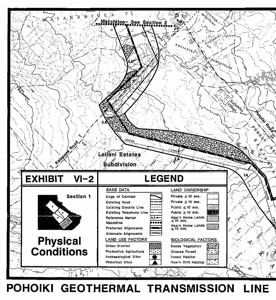
,,)
~'
LINE
.; ... Ir---- ;'//. ."
BIOLOGICAL FACTORS
Dense Vegetation ~t1'~Diverse Forest d l
,. ~.:a...,"'0 ,~
I nsect Habitat :::::::Haw'n Stilt Habitat
.. .... r ..
PrIvate S 10 8CS.
PrIvate ~ 10 8CS.
Public S 10 8CS. zik?~i
Public ~ 10 acs.
Haw'n Home Lands 1::::::::::::::1::; 10 8CS.
~a11>'na~?me Lands M:~:~;~:~:~:~:~J
LAND OWNERSHIP
-~EE
LEGENDBASE DATA
Urban District
Productive Agriculture
Archaeological SItes
Historical Sites
Edge of Corridor
Existing Road
Existing Electric LIne
Existing Telephone Line
Reference MarkerMatchllne
Preferred Alignments
Alternate Alignments
LAND USE FACTORS
U 1
\
VI-2
Section 1
GEOTHERMAL TRANSMISSION
"\
"'\.I
I
,I ,'" ",;..~
\
PhysicalConditions
EXHIBIT
" .
/./~.
0''-
~"-'''''\\,
" ", .....,~. \ (
'.' \ 'f''\' '.;-'\,'i '8-" I
. '. I '
........ - "
POHOIKI
',- ,I
inc.
II:fl' ~~ ~<~\,. ... -;. 'I;
~'(
/-~
'" '\ ----..C-J )
(
-.:..-(:\_,~ ))-..'('AtE"\~.
"
DHMo
~ .. ri :.----r--",~ U ,~~.
STUDYROUTINGLINE
VI-3BASE DATA
LEGENDVIEWS
'.
Solid Vegetation Screen 111111Partial Vegetation Screen 1lI1l11l111111
Berm Along Road 1-••••
Section 1
VisualResources
Edge of Corridor
Existing Road
Existing Electric Line
Existing Telephone Line
Reference MarkerMatchllne
Preferred Alignments
Alternate Alignments
VISUAL SCREENS-
Urban & Residential Areas ~~~Views
VIEW DESCRIPTION1. Open view across flat
grassland with trees atmiddleground horizon.
2. Open view across partiallycleared land and throughscattered Ohia trees.
3. Open view of former sugarcanefields in foreground to solidvegetation screen.
4. Open view of former sugarcanefields in loreground to solidvegetation screen.
5. Open view across formersugarcane fields.
POHOIKI GEOTHERMAL TRANSMISSION LINE
LINE ROUTING STUDY o OHM inc.
SECTION 2 (Exhibits VI-4 and VI-5)
Alignment "A": The preferred alignment "A" continues across the former sugarcanefields, skirting a small kipuka of native forest which is a significant insect habitat.Near Reference Marker SA, the alignment heads north along the existing Pahoa Bypass Road. The alignment is kept on the makai side of the road because of thePahoa solid waste station and a burial cave archaeological site on the mauka side.
The alternative alignment to the north meets the preferred alignment near the solidwaste sta tion.
From the waste station until nearly Reference Marker 7A, the preferred alignmentcrosses State-owned land which is basically vacant lava land, overgrown with weedsand scattered scrub Qhi.l!. trees. Unavoidably, the alignment crosses the upperportion of Pahoa Cave which was identified during the field surveys as a sensitiveinsect habitat. The cave is believed to extend far upland, therefore, even atransmission line route outside the study corridor may not avoid crossing it.Significant care must be taken during design and construction of the line to avoiddamaging the cave or exposing it to increased access.
Through the Hawaiian Home Lands of Maku'u (between Reference Marker 7A andAinaloa), the alignment is located near'the mauka edge of the study corridor toby-pass the newly subdivided 2-acre lots which are leased to native Hawaiianbeneficiaries.
The alignment route through Ainaloa Subdivision was based on the location of thepreferred alignment in Orchid Land Estates. In Orchid Land, the alignment follows35th Avenue -because it has the greatest length of existing distribution lines, thusexisting utility rights-of-way. Also, 35th Avenue is a continuous road through thesubdivision and has fewer existing homes along it than does 34th Avenue. InAinaloa Subdivision however, the extension of 35th Avenue is a densely populatedroad with an existing distribution line.
There is native Qhi.l!. forest of short, pole-like habit on both sides of the highway,through this section. Guava, mango and other alien trees are interspersed among theQhi.l!. and the understory consists of weeds. The presence of the numerous houselotsand agriculture lots disrupt the ~tegrity of the forest, and as a result there is nocontinuity to plant formations.6 This is the case throughout the subdivision areasin all corridor sections.
The alternative alignment through Ainaloa Subdivision follows a deadend, sparselypopulated road with no existing utility ROW, to meet with 34th Avenue in OrchidLand Estates. This alternative is so located because in Section 4 it joins Highway130.
65. Appendix C, Botanical Survey.
84
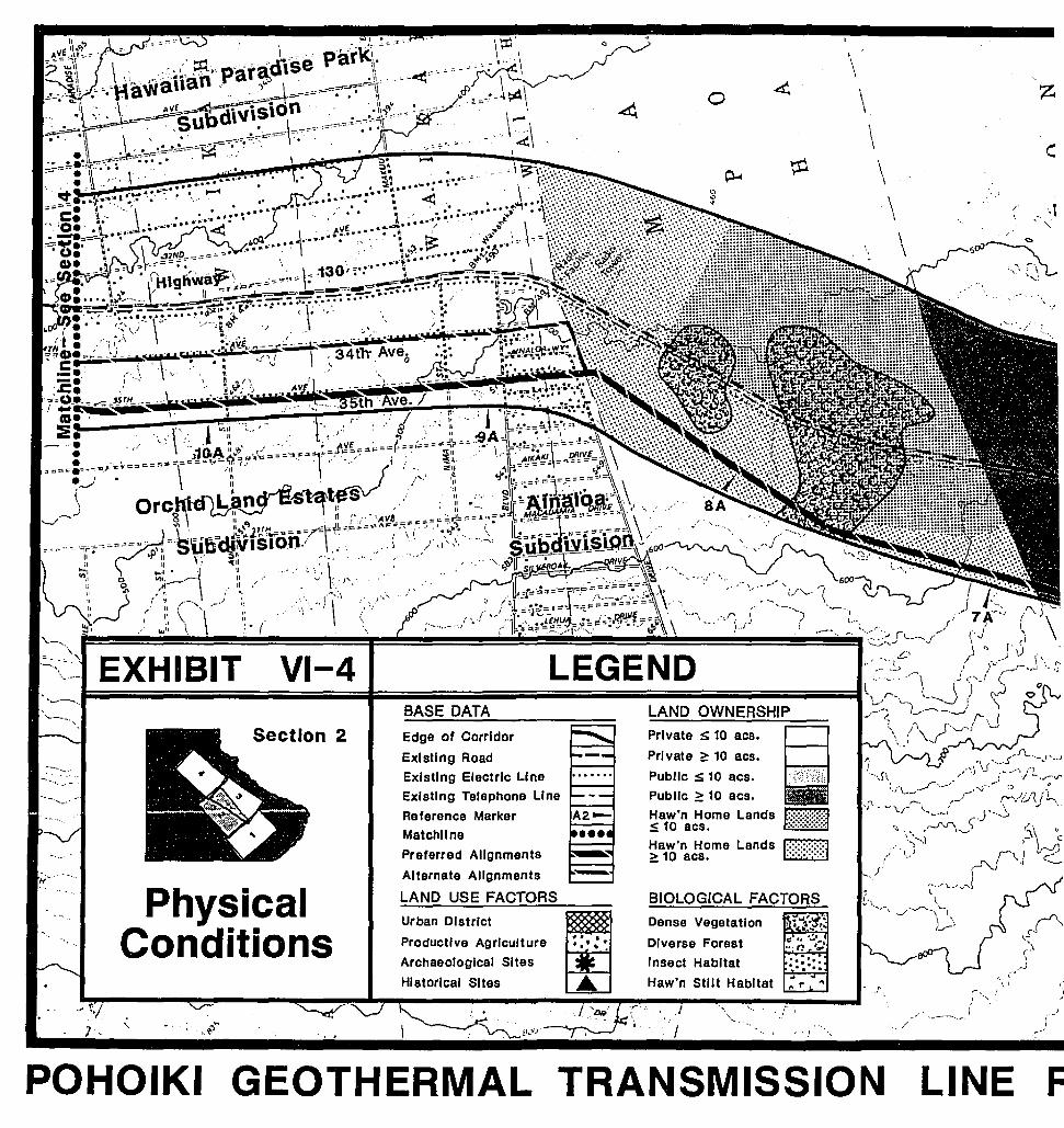
F
"-, ,I, ,I
I
LINE
/'
',,/
.I
Dense Vegetation ~~..."i1'~'DIverse Forest Jf1 ~, ~..t.
... ,., '.1Insect Habitat -.........' ...Haw'n Stilt HabItat
.. ..,. r
BIOLOGICAL FACTORS
Private ~ 10 acs.
Private ~ 10 acs.
Public S 10 aes.Public ~ 10 aes.Haw'n Home LandsS 10 acs.Haw'n Home Lands~ 10 acs.
•\
0 .d. \ z~
\ c:p.... ¢ \
\ _.,1'".
\/
soJ~~ ~.
',' I \"J
,
-.. .• • •....Productive Agriculture
Archaeological Sites
Historical Sites
Edge of Corridor
Existing Road
Existing Electric Line
Existing Telephone Line
Reference MarkerMatchllne
Preferred Alignments
Alternate Alignments
LAND USE FACTORS
Urban District
. -, ~
Section 2
GEOTHERMAL TRANSMISSION
PhysicalConditions
POHOIKI
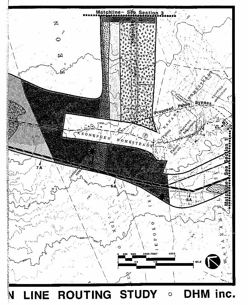
I .. :.
.., II.
'-I •.,
"\.
\ '",\
, ,I
\\
Matchllne- sh, Section ~ ", .,0 '. ~....... ..•...,.. .
~:' •• <. /',',.
,~~," .. " I,'.
, ~.'
" f":!
'.\ 0
.';\'"'I:1q .\j.J, \:.:
, .
"
, ."
, "/'
i .. ..-- ,.-..' (
(,,-i
!.. - ( ..
+ ..,.,0 , './ "'.
,... ......
-.(,,' 'oj
-0
800
'.:'0.\ ~. '.\
\- 0
). ,I:-
,.1 \- ..~
I ,,: ..4000
r
112
,",.~.
. _.' -!'-.:.
'./.
.~',-
., .t
....-.0'
LINE ROUTING STUDY o DHM inc.
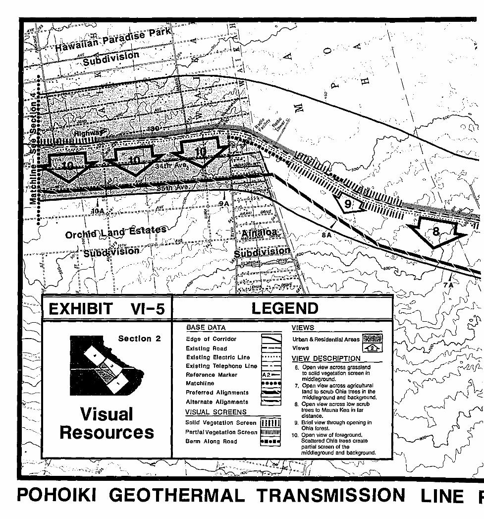
FLINE
.,/,\-.. :\
\\.:\.\
....
~.. ,
.'. ~. .0"
Urban & Aesldentlal Areas~VIews ~
VIEW DESCRIPTION
VIEWS
6. Open view across grasslandto solid vegetation screen inmiddJeground.
7. Open view across agriculturalland to scrub Ohla trees In themlddleground and background.
a. Open view across low scrubtrees to Mauna Kea In fardistance.
9. Brief view through opening InOhla forest.
10. Open view of foreground.SCattered Ohla trees createpartiar screen of themiddleground and background.
-
': ~. .. '..:-,
LEGENDBASE DATA
Edge of Corridor
Existing Aoad
Existing Electric Line
Existing Telephone LI ne
Reference MarkerMatchllne
Preferred Alignments
Alternate Alignments
VISUAL SCREENS
Solid Vegetation Screen 111111Partlal Vegetation Screen UJlIIUIIJIlI
Berm Along Aoad 1-••••
VI-S
I\.,..--. .
Section 2
GEOTHERMAL TRANSMISSION
.... ~
... ' ..•~-'-"~~.""'~"-..~'.' ' ....~.
. - .'.
VisualResources
EXHIBIT
....-- ........_-.~~ I'
"
- .._---
POHOIKI
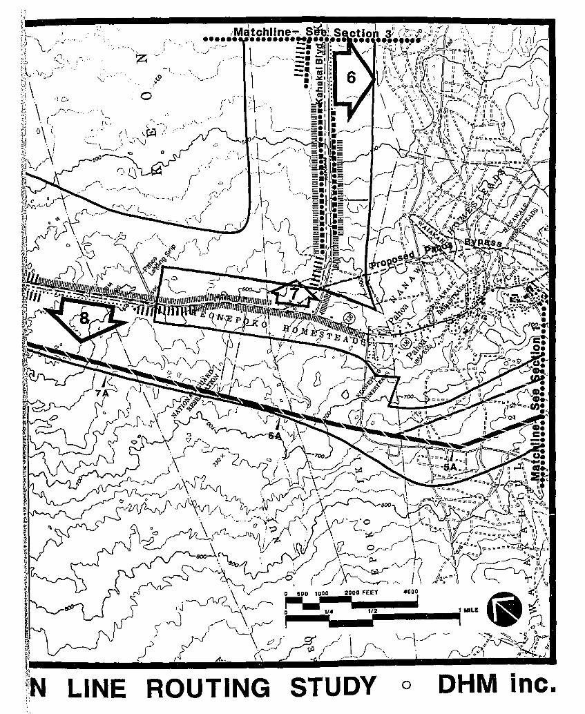
LINE
o
ROUTING STUDY o OHM inc.
SECTION 3 (Exhibits VI-6 and VI-7)
Alignment B: From the matchline with Section I, the preferred alignment turnsaway from the boundary of Nanawale Estates heading northwest across privateowned agricultural parcels and former sugar lands. At the western tip of HawaiianBeaches Subdivision, near Reference Marker SB, the alignment passes close to anexisting water tank, and between two archaeological sites identified in the fieldsurvey. There is sufficient distance between the line and the sites to avoid anydisturbance to them. The site closest to the subdivision is a cluster of petroglyphsand the site south of the alignment is a burial cave.
The alignment continues northwest across the State-owned grassland terrain inKeonepoko Iki land division. From Kahakai Boulevard, which the alignmentcrosses, there is an open view to the north, but a partial screen looking south. Thelower portion of Pahoa Cave, an important insect habitat, is unavoidably crossed bythe alignment, but is crossed at a right angle to minimize the distance. The finalalignment may be adjusted once the cave is accurately surveyed. Beyond the cave,the alignment hugs the Keonepoko boundary to the former railroad right-of-way,keeping the maximum distance between the line and Hawaiian Beaches Subdivision.
Along the former railroad right-of-way, the preferred alignment follows theexisting jeep trail closely to take advantage of the accessibility provided and tominimize unnecessary disruption to the surrounding environment. It also avoidsinterfering with two archaeological sites near the old railroad route.
Throughout this area (State-owned land) the landscape is very homogeneous,consisting of andropogon grassland with scattered Qhi.il snags, apparently previouslyburned.
Where the railroad meets Hawaiian Paradise Park Subdivision (Reference MarkerlOB), the preferred alignment turns and follows the subdivision boundary to 21stAvenue, where it turns and continues on 21st Avenue through tlie subdivision to thematchline with Section 4. 21st Avenue is the preferable route because it has anexisting distribution line and 40·foot wide HELCO easement along much of it.
An alternative alignment segment heads north toward the railroad ROW along thenorth side of Kahakai Boulevard (near Reference Marker SB). While this increasesthe ease of access, it also makes the line more visible from the boulevard andpossibly from Hawaiian Beaches Subdivision. When this alternative meets therailroad ROW however, it follows a straight-line route, minimizing line length andthe number of changes in direction, but diverging up to 700' from the jeep trail.
There are two alternatives through Hawaiian Paradise Park. The makai alternativefollows Railroad Avenue to 19th Aven ue, along which there are large sections withexisting distribution lines. The mauka alternative is along 23rd Avenue which alsohas distribution lines, but is entirely outside the corridor. The corridor boundariesthrough the subdivision define the most direct route between the areas of lessconstraint on either side. (Refer to Chapter IV and V).,
87
o,,
/I,J
,-'.-J
i.")
t,,'
...,....J
OJ" J ---- '",../., \.
r," (\ f..../ .v ~ '''\.~u· ".__ "/:
,.... ·~··.'.':'r·,S:·"· \.;~ ,.-" :.. '. -'. -~", '....,B.,<.;,,;,.V..;.'.:C'II
Iillill)
360 .'..,.;."
)
... "
I~ ..' 0
~ ....
o.!
Dense Vegetation ~{}'.~,
Diverse Forest f1 #••.;..... :
..·n I~. .Insect Habitat :::=:;Haw'n Stilt Habitat
.. ..r ..
".. ,.•./ .... .,i "
BIOLOGICAL FACTORS
LAND OWNERSHIP
Private ~ 10 8CS.
Private ~ 10 acs.
Public s: 10 aes.Public 2: 10 acs.Haw'n Home Lands~ 10 8CS.
Haw'n Home Lands f::::::::::::::::~~ 10 aC8. . .
)
'. '~
" ,JI
:. ~
-.. ..........
" /
(.,,-J r
.... ,~ ... /"
LEGENDBASE DATA
Productive Agriculture
Archaeological SItes
HIstorical Sites
Urban District
Edge of Corridor
Existing Road
Existing Electric LineExisting Telephone Line
Reference MarkerMatchllne
Preferred Alignments
Alternate Alignments
LAND USE FACTORS
x
.. ', ,. ,~ .
- .:,- ~. ::; ::". ~• .:. ~. 17 .... '..- .
/\1
VI-6
Section 3
PhysicalConditions
EXHIBIT
POHOIKI GEOTHERMAL TRANSMISSION LINE
I " ~\ 1~ //~~" "'" .t·~£~'!'J
\, '-. i
"" II r-'!I 1 .... ~'? I /' If ~~_, / I \I
,~ );-# _'I H '\\ I
" -'I;' ;1: I ".~1 ~~ /' ,~/;' ~'; ! ;", ", ),('/J~
I '.~
,/
I'I
500 II
", I
,",I "
o
o
~", ..". -'L·-
".. _) ,_J ',.,
) "'. d_.,· ..../~
0'
\. --~-
I'-
..../1 ~
,-,I '.I\,-----'
" .",,~
'v
.- .... ,
.'.,
",I c
:I~N LINE ROUTING STUDY o DHM inc.
LINE
.~
11. Foreground view of tallgrasses and flat terrain.
12. Open vrew to ocean acrossgently sloping grassland.
13. Open vrew of foreground andmiddleground through tallgrasses and scattered trees.-
Edge of Corridor
Existing Road
Existing Electric Line
Exlstlng Telephone Line
Reference MarkerMatchllne
Preferred Alignments
Alternate Alignments
VISUAL SCREENS
Solid Vegetation Screen 111111Partial Vegetation Screen IJIIIJIIIJlIJI
Berm Along Road •••••
If."r j
""
Section 3
VisualResources
POHOIKI GEOTHERMAL TRANSMISSION
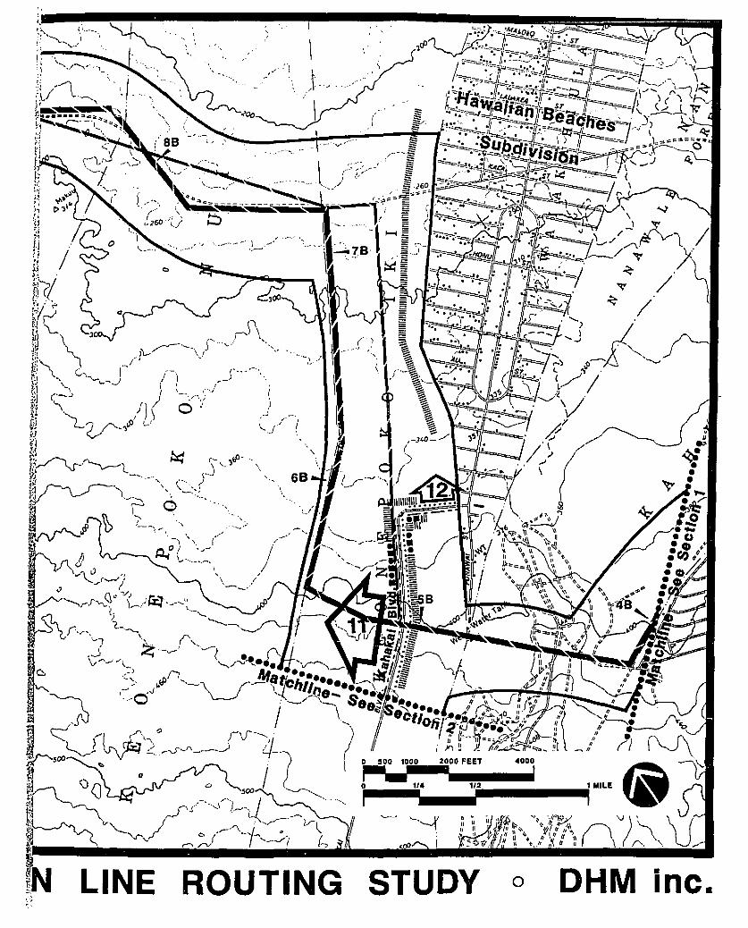
OHM inc.oSTUDY
~-_1~'i TiIIII --.i MILE
'-.--{
ROUTINGLINE.,'J .~
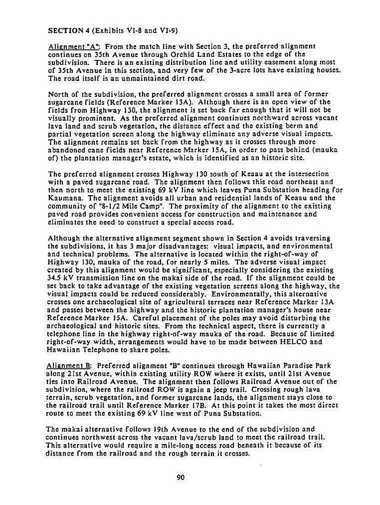
SECTION 4 (Exhibits VI-8 and VI-9)
Alignment "A": From the match line with Section 3, the preferred alignmentcontinues on 35th Avenue through Orchid Land Estates to the edge of thesubdivision. There is an existing distribution line and utility easement along mostof 35th Avenue in this section, and very few of the 3-acre lots have existing houses.The road itself is an unmaintained dirt road.
North of the subdivision, the preferred alignment crosses a small area of formersugarcane fields (Reference Marker 13A). Although there is an open view of thefields from Highway 130, the alignment is set back far enough that it will not bevisually prominent. As the preferred alignment continues northward across vacantlava land and scrub vegetation. the distance effect and the existing berm andpartial vegetation screen along the highway eliminate any adverse visual impacts.The alignment remains set back from the highway as it crosses through moreabandoned cane fields near Reference Marker 15A, in order to pass behind (maukaof) the plantation manager's estate, which is identified as an historic site.
The preferred alignment crosses Highway 130 south of Keaau at the intersectionwith a paved sugarcane road. The alignment then follows this road northeast andthen north to meet the existing 69 kV line which leaves Puna Substation heading forKaumana. The alignment avoids all urban and residential lands of Keaau and thecommunity of "8-1/2 Mile Camp". The proximity of the alignment to the existingpaved road provides convenient access for construction and maintenance andeliminates the need to construct a special access road.
Although the alternative alignment segment shown in Section 4 avoids traversingthe subdivisions, it has 3 major disadvantages: visual impacts, and environmentaland technical problems. The alternative is located within the right-of-way ofHighway 130, mauka of the road, for nearly 5 miles. The adverse visual impactcreated by this alignment would be significant, especially considering the existing34.5 kV transmission line on the makai side of the road. If the alignment could beset back to take advantage of the existing vegetation screens along the highway, thevisual impacts could be reduced considerably. Environmentally, this alternativecrosses one archaeological site of agricultural terraces near Reference Marker 13Aand passes between the highway and the historic plantation manager's house nearReference Marker 15A. Careful placement of the poles may avoid disturbing thearchaeological and historic sites. From the technical aspect, there is currently atelephone line in the highway right-of-way mauka of the road. Because of limitedright-of-way width, arrangements would have to be made between HELCO andHawaiian Telephone to share poles.
Alignment B: Preferred alignment "B" continues through Hawaiian Paradise Parkalong 21st Avenue, within existing utility ROW where it exists, until 21st Avenueties into Railroad Avenue. The alignment then follows Railroad Avenue out of thesubdivision, where the railroad ROW is again a jeep trail. Crossing rough lavaterrain, scrub vegetation, and former sugarcane lands, the alignment stays close tothe railroad trail until Reference Marker 17B. At this point it takes the most directroute to meet the existing 69 kV line west of Puna Substation.
The makai alternative follows 19th Avenue to the end of the subdivision andcontinues northwest across the vacant lava/scrub land to meet the railroad trail.This alternative would require a mile-long access road beneath it because of itsdistance from the railroad and the rough terrain it crosses.
90
The mauka alternative through the subdivision follows 23rd Avenue outside thecorridor, and meets the preferred alignment near Waipahoehoe, between ReferenceMarkers 14B and 15B.
The overall alignments of preferred and alternative "A" and "B" are shown inExhibit VI·IO.
91
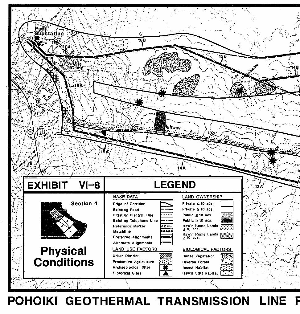
F
• I,
. .7
.... IJ. ----~,., .,;.. -...... --_._.;..-.:.",
'\'I, '.
'.
1.,\
,,
.r'
" \.5
LINE
.f. r--J...- /),< '), ._" \
~
. ,
\ C·"J '''','
.-,
\
.',
..,. r
.:.. ~........ ..
8II[~:~:~:~:i:~l. .
It1~~~~:1~i:i:~1
BIOLOGICAL FACTORS
Dense Vegetation
Diverse Forest
Insect Habitat
Haw'" Stilt Habitat
, 1
Private S; 10 aes.
Private ~ 10 aes.
Public S 10 aes.Public ~ 10 acs.
Haw'n Home Lands:s 10 aes.Haw'n Home Lands2: 10 acs.
LAND OWNERSHIP
LEGEND
""I:
"I, 1/{I (
-''- - .:\:. ,1 "
BASE DATA
Productive Agriculture
Archaeological Sites
Historical Sites
\\
Edge of Corridor
Existing Road
Existing Electric LineExisting Telephone Line
Reference MarkerMatchllne
Preferred Alignments
Alternate A.lIgnments
LAND USE FACTORS
Urban District
~...
VI-8
•
Section 4
GEOTHERMAL TRANSMISSION
", -'
PhysicalConditions
. ~ ;.7 "(~1
J:. \\1/ \ •
•~1 ~IIIIII
:: ~:1/ I{ I
fi ... /I
~~t-.: ~ .~~
II
". "'\a.. ~ .....~I '. ,'I
.'.... <;'II
POHOIKI
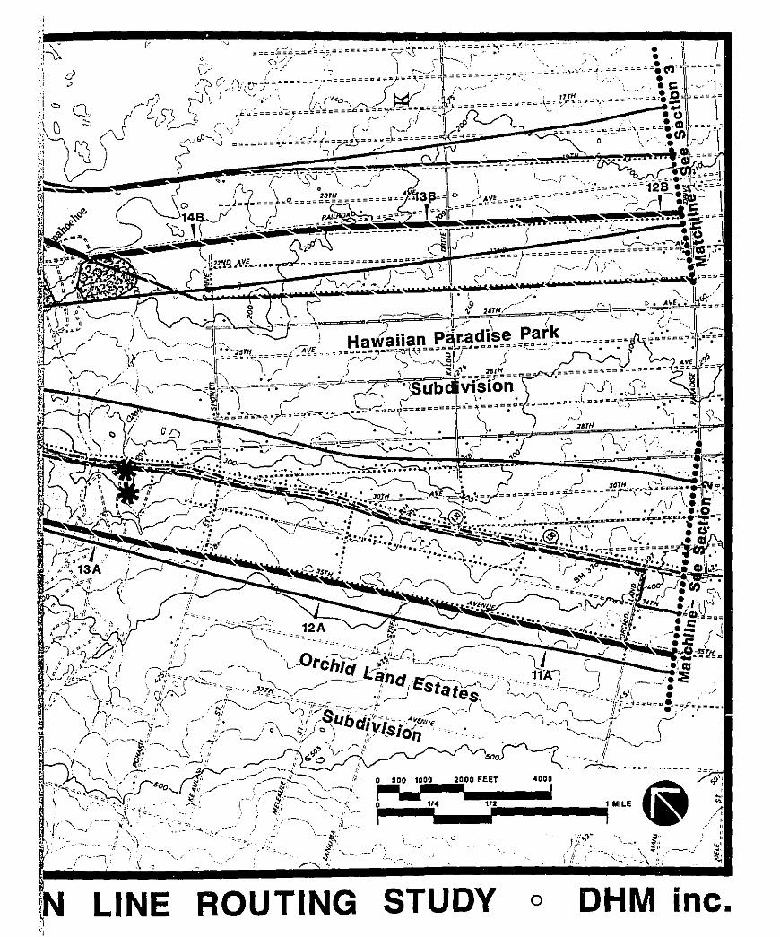
':
inc.
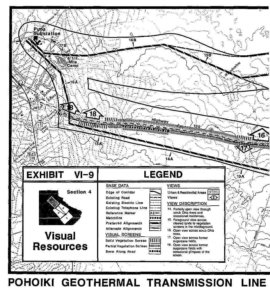
LINE
.::/.J
, .
fI
Urban & Res/dentla! Areas j.:.::.:;':;;:':;;:;;j
Views
VIEWS
~,.- -'-"'"
LEGEND
,t.' . "-'J
III,
BASE DATA
Section 4
GEOTHERMAL TRANSMISSION
Edge of Corridor
Existing Road
Existing Electric Line VIEW DESCRIPTIONExisting Telephone Line 14. Partially open view throughReference Marker scrub Ohla trees and
occasional residences.Matchllne 15. Foreground view acrossPreferred Alignments cleared lands to vegetation
_ screens in the middleground.Alternate Alignments 16. Open view across scrub Ohia
i., V-.sual VISUAL SCREENS trees.'.'. If" 17. Open view across former
. • I' sugarcane fields.
~;-;<t; ReSOurces 18. Open view across former'~r ' sugarcane fields wilh
• /I occasional glimpses of the \ \,.~~~~-- ocean.
a:·~zl:;:;'::~~~~~,..~~-~~~~~--~ ...._-.-oIiII!~-------------IIIIIlJl"-'"""'1-----"\I'."• ,..-.r... -,,- Ij J.;. 'I \.
.-, II II
;;.' Ir ",I' • J". \
POHOIKI
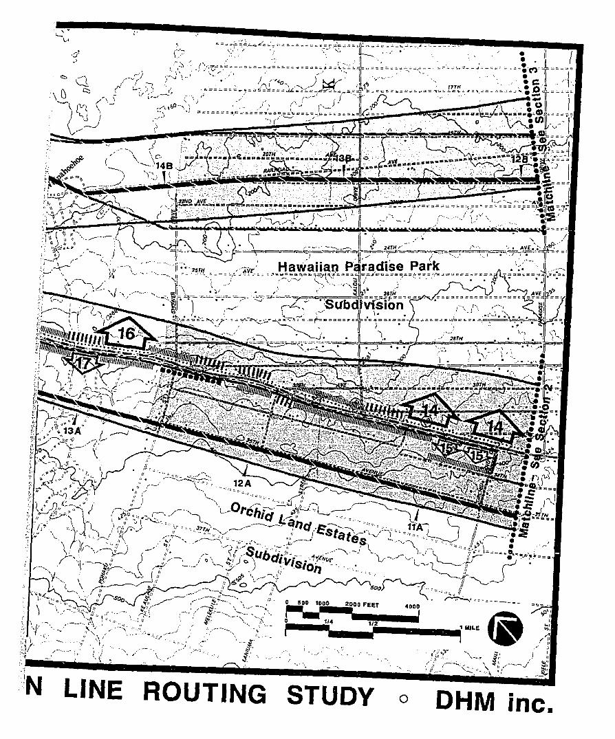
inc.OHMoSTUDYROUTINGLINE
::;,!r.~__....
III .~,.- .... __ ..;I
~,:' '~'-:-'~~;'::-:'" , ,1IIi[_Jii••i2.OOO FEET '''','"rll~ t ._~:I ~ '-- ....... ---,. 1I; or
\ \ ~\ .-: :' !.~- ~~--.,." •••••',4 ··"·/2······ 1 MILE ~,::I:r>"~.':~ .. J:.j ::.'~>~\~:il," •.. jil•••••••,./,1"1
1.-' ,\.~, '/1
-'I' ;~." j,', .1 p, _'. &;' ...."
.:,4.••••/••- ..1..•.-.....'••(11/•••.•'./•.••••••••••••, •••;r"'I:•••••••••••iI•••••••••••••I/..·•••~.~••••\••~i'l'.".·~.~.IiIJIi-iil~.::1~ '.- ". " ~ l . I "":":.' • '\ :: f ......." ~
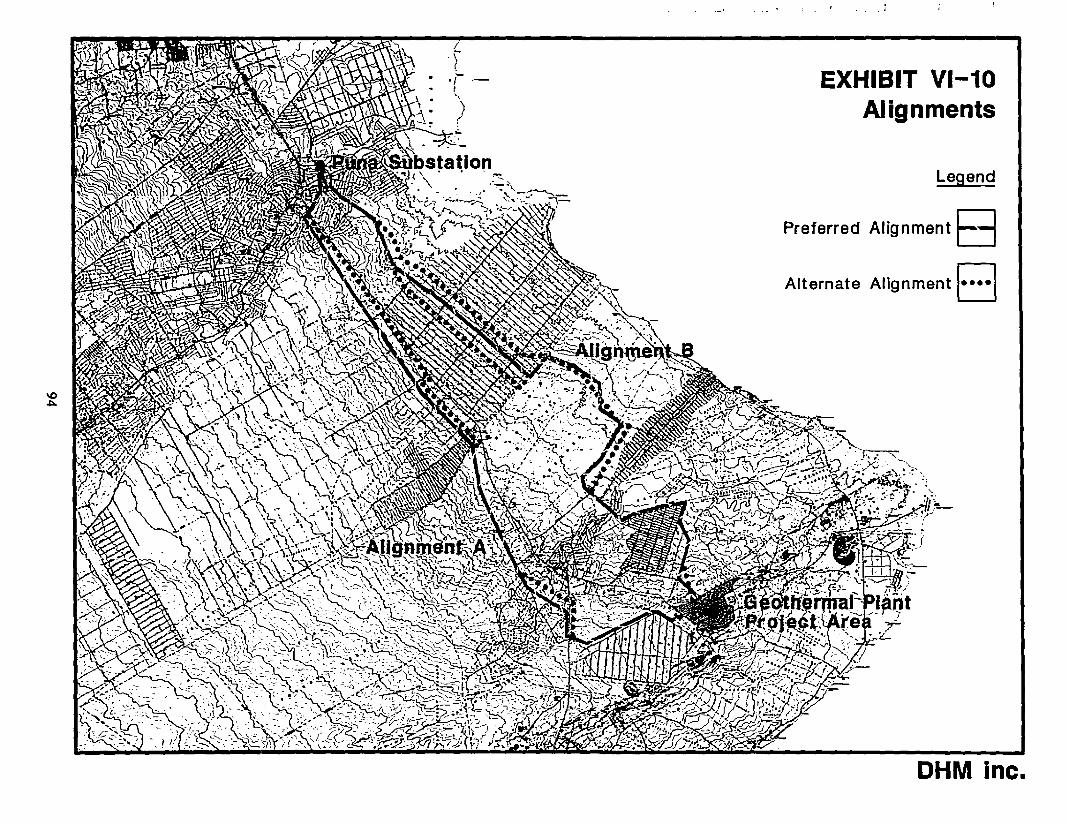
EXHIBIT VI-10
Preferred Alignment B
I
'f·i-
t
'>
Alternate
Alignments
Legend
t oAlignmen 0
DHM inc.
APPENDIX A
APPENDIX A
SUMMARY OF FIRST COMMUNITY WORKSHOP
Pahoa community CenterPahoa, Hawaii
Wed., November 12, 19867:00 p.m.
Twenty five residents attended the workshop in Hilo, as shown onthe'attached list. The workshop began with a presentation byHELCO on its system planning requirements and the need for theproposed transmission line. HELCO also explained why they areinvolved with the proposed geothermal plant, and indicated thatThermal Power Company will be holding separate workshops relatedto the general plant itself in the near future. This wasfollowed by a presentation by DHM inc. on transmission linerouting methodology and samples of broadscale data factor mapsfrom a previous transmission line routing stUdy.
After these presentations, workshop attendees were asked tocomment on or suggest revisions to the criteria or methodologyfor the routing stUdy. They were also invited to ,raise questionsand concerns related to the description and rationale for theproject.
Specific issues raised during the question and answer periodwere:
1. Project Need and Description
a. Will the new poles be shared with other utilities suchas telephone?
b. What "class" of pole will be used?
c. When making right-of-way acquisitions, will you becontacting individual landowners?
d. What kinds of projections does HELCO make for futureenergy demands?
e. How long will the proposed 2 transmission lines beadequate to meet the projected demands?
f. What is the capacity of the geothermal resource?
2. Routing/Environmental Considerations
a. Will the old railroad right-of-way be a possible route?
b. Does the proposed line have to go through Pahoa Town?
c. Where is State Conservation land?
d. Is it more difficult to go through Hawaiian Homes Land?
A-l
Most of these questions received immediate responses.participants were told that additional information and thepotential study corridors will be presented at the second roundworkshops to be held December 11th.
Twelve of the questionnaires distributed at the workshop werecompleted and returned. Attached is a summary sheet showing thevarious rankings that each routing factor received. If factorswere "x"'d instead of given numerical rankings, the "x"'s havebeen translated to number "1" rankings. It is interesting tonote that, based on this small sample, the highest priorities forrouting considerations inclUde residential areas, preservationlands, impacts on wildlife and native forest areas, using smallprivate priorities, and areas with archaeological sites.
A-2
PERSON
FIRST COMMUNITY WORKSHOP ATTENDEES
AFFILIATION
Daniel EliaRaymond K. EliaWilliam S. GardnerDavid T. Hess Sr.Patricia HessLorna WorswickVirginia SpencerGordon SouderS. P. GibbonsCarl DavidsonBetty DavidsonFrank J. MulecPeter K. HauanioWim (Pappy) WarrenMae E. MullRobert E. CooperWallace T. OkiGregory J. PlesciaSydney KeliipuleoleLee KentyM. Kenty ChamberlinMarguerite KentyW. H. KentyR. W. PulcareRussell Kokubun
Fred KarimotoAnna LauEugene YoshimiScott Shirai
Clyde NagataDennis Tanigawa
Duk Hee MurabayashiWendie McAllasterEugene Dashiell
Hawaii AUdUbon societyW. H. Shipman Ltd.
Kamehameha Schools/Bishop Estate
County Council Representative
HECO.HECOHECOHECO
HELCOHELCO
DHM inc.DHM inc.DHM inc.
A-3
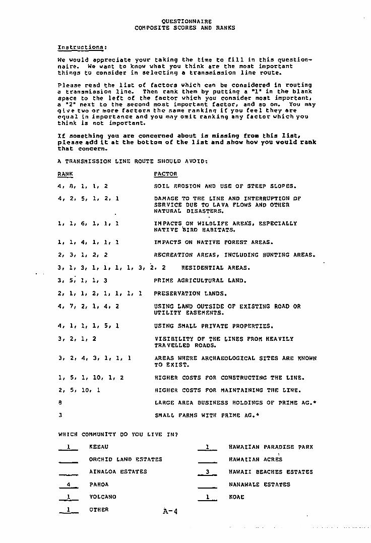
QUESTIONNAIRECOMPOSITE SCORES AND RANKS
Instructions:
We would appreciate your taking the time to fill in this questionnaire. We want to know what you think are the most importantthings to consider in selecting a transmission line route.
Please read the list of factors which can be considered in routinga transmission line. Then rank them by putting a -1- in the blankspace to the lett of the factor which you consider most important,a -2" next to the second most important factor, and so on. You m~y
qivt" two or more factot'li the name t'nnkin'l if you feel they areellul1l 1n importance and you may om I t ranking any factor \oIhich youthink is not Important.
If something you are concerned about is missing frOB this list,please add it at the bottolll of the list and show ho\ol you vould rankthat concern.
A TRANSMISSION LINE ROUTE SHOULD AVOID:
RANK
4, 13, 1, 1, 2
4, 2, 5, I, 2, 1
1, 1, 6, 1, 1, 1
1, 1, 4, 1, 1, 1
2, 3, 1, 2, 2
FACTOR
SOIL FoROStON AND USE OF STEEP SLOPES.
DAMAGE TO THE LINE AND INTERRUPTION OFSERVICE DUE TO LAVA FLOWS AND OTHERNATURAL DISASTERS.
IMPACTS ON WILDLIFE ARE~S, ESPECIALLYNATIVE aIRD HABITATS.
IMPACTS ON NATIVE FOREST AREAS.
RECREATION AREAS, INCLUDING HUNTING AREAS.
3, 1, 3, 1, 1, 1, 1, 3, 2. 2 RESIDENTIAL AREAS.
3, 5, 1, 1, 3
2, 1, 1, 2, 1, 1, 1, 1
4, 7, 2, 1, 4, 2
4, 1, 1, 1, 5, 1
3, 2, 1, 2
3, 2, 4, 3, 1, 1, 1
1, 5, 1, 10, 1, 2
2, 5, 10, 1
PRIME AGRICULTURAL LAND.
PRESERVATION LANDS.
USING LAND OUTSIDE OF EXISTING ROAD ORUTILITY EASEMENTS.
USING SMALL PRIVATE PROPERTIES.
VISIBILITY OF THE LINES FROM HEAVILYTRA VELLED ROADS.
AREAS WHERE ARCHAEOLOGICAL SITES ARE KNOWNTO EXIST.
HIGHER COSTS FOR CONSTRUCTING THE LINE.
HIGHER COSTS POR MAINTAINING THE LINE.
LARGE AR~A BUSINESS HOLDINGS OF PRIME AG.·
SMALL FARMS WITH PRIME AG.·
WHICH COMMUNITY DO YOU LIVE IN?
KEEAU ----L HAWAIIAN PARADIse PARK
ORCHID E.AND ESTATES H"WAnAN ACRES
AINAE.OA ESTATES --L HAWAII BEACHES ESTATES
PAHOA NANAWALE ESTATES
VOLCANO ----L !tOAI!:
OTHER A-4

SUMMARY OF FIRST PUBLIC AGENCY WORKSHOPS
AuditoriumHawaiian Electric Co. Inc.
HonolUlu, HawaiiWed., Nov. 12, 1986
10:00 a.m.
HONOLULU SESSION
AuditoriumHawaii Electric Light Co., Inc.
Hilo, HawaiiThurs., Nov. 13, 1986
9:30 a.m.
Five representatives from State agencies were present at theworkshop, as shown on the attached list. The workshop began witha presentation by HELCO on its system planning requirements andthe need for the proposed transmission line. HELCO alsoexplained why they are involved with the proposed geothermalplant, and indicated that Thermal Power Company will be holdingseparate workshops related to the geothermal plan itself in thenear future. This was followed by a presentation by OHM inc. ontransmission line routing methodology and samples of the broadscale data factor maps from a previous transmission line routingstudy.
After these presentations, workshop attendees were invited toraise questions regarding any of the material presented.
Issues raised during the question and answer period were:
1. Puna Natural Area Reserve is no longer designated as anatural area reserve.
2. Has the option to place part or all of the transmission lineunderground already been foreclosed?
Immediate responses were made to these comments. Participantswere told that the potential study corridors will be presented ata second workshop, scheduled for December 10, 1986. The workshopadjourned at 11:00.
HILa SESSION
Four agency representatives attended the workshop in Hilo. Thepresentation was identical to that in the Honolulu session theday before. No comments or questions were raised byparticipants.
A-5
CORRECTION
. THE PRECEDING DOCUMENT(S) HAS
BE;EN REPHOTOGRAPHED TO ASSURELEGIBILITY
SEE FRAME(S)·IMMEDIATELY FOLLOWING
..
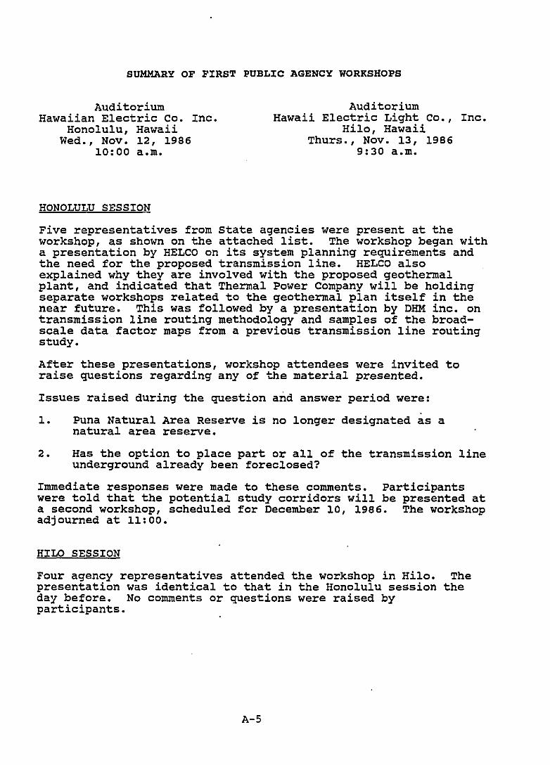
SUMMARY OF FIRST PUBLIC AGENCY WORKSHOPS
AUditoriumHawaiian Electric Co. Inc.
Honolulu, HawaiiWed., Nov. 12, 1986
10:00 a.m.
HONOLULU SESSION
AuditoriumHawaii Electric Light Co., Inc.
Hilo, HawaiiThurs., Nov. 13, 1986
9:30 a.m.
Five representatives from State agencies were present at theworkshop, as shown on the attached list. The workshop began witha presentation by HELCO on its system planning requirements andthe need for the proposed transmission line. HELCO alsoexplained why they are involved with the proposed geothermalplant, and indicated that Thermal Power Company will be holdingseparate workshops related to the geothermal plan itself in thenear future. This was followed by a presentation by OHM inc. ontransmission line routing methodology and samples of the broadscale data factor maps from a previous transmission line routingstudy.
After these presentations, workshop attendees were invited toraise questions regarding any of the material presented.
Issues raised during the question and answer period were:
1. Puna Natural Area Reserve is no longer designated as anatural area reserve.
2. Has the option to place part or all of the transmission lineunderground already been foreclosed?
Immediate responses were made to these comments. Participantswere told that the potential study corridors will be presented ata second workshop, scheduled for December 10, 1986. The workshopadjourned at 11:00.
HILa SESSION
Four agency representatives attended the workshop in Hilo. Thepresentation was identical to that in the HonolUlu session theday before. No comments or questions were raised byparticipants.
A-S
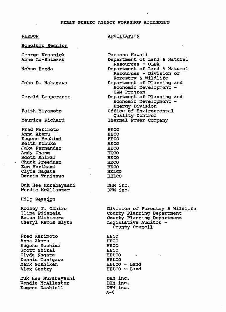
PERSON
FIRS~ PUBLIC AGENCY WORKSHOP A~TENDEES
AFFILIATION
Honolulu Session
George KrasnickAnne Lo-Shimazu
Nobuo Honda
John D. Nakagawa
Gerald Lesperance
Faith Miyamoto
Maurice Richard
Fred KarimotoAnna AkamuEugene YoshimiKeith KobukeJake FernandezAndy ChangScott ShiraiChuck FreedmanKen MorikamiClyde NagataDennis Tanigawa
Duk Hee MurabayashiWendie McAllaster
Hilo Session
Rodney T. OshiroIlima PiianaiaBrian NishimuraCheryl Ramos Blyth
Fred KarimotoAnna AkamuEugene YoshimiScott ShiraiClyde NagataDennis TanigawaMark GushikenAlex Gentry
Duk Hee MurabayashiWendie McAllasterEugene Dashiell
Parsons HawaiiDepartment of Land & Natural
Resources - OLEADepartment of Land & Natural
Resources - Division ofForestry & Wildlife
Department of Planning andEconomic Development CZM Program
Department of Planning andEconomic Development Energy Division
Office of EnvironmentalQuality Control
Thermal Power Company
HECOHECOHECOHECOHECOHECOHECOHECOHECOHELCOHELCO
DHM inc.DHM inc.
Division of Forestry & WildlifeCounty Planning DepartmentCounty Planning DepartmentLegislative Auditor -
County Council
HECOHECOHECOHECOHELCOHELCOHELCO - LandHELCO - Land
DHM inc.DHM inc.DHM inc.A-6
SUMMARY OF SECOND COMMUNITY WORKSHOP
Pahoa Community Centerpahoa, Hawaii
Wed., December 10, 19867:00 p.m.
Thirteen residents and landowners attended the workshop. (seethe attached list.) The content of the workshop was the same asfor the agencies. DHM described the corridor evaluations bybriefly discussing each factor and showing a map of the compositefactors, the corridors and the typical alignment being used forthe surveys.
The following questions and concerns were raised:
1. Can you put the transmission lines along the highway?
Response: Three lines along the highway would be difficultto construct.
2. Ownership of the former railroad alignment in HawaiianParadise Park is in dispute. The community association maynot own it. It appears to be owned by each of thelandowners in Hawaiian Paradise Park. Thus each person mayown 1/5750 of the former alignment through HPP.
3. Why is the voltage so low? Why not 138 kv?
Response: The Voltage is 69 kv ac because that is adequatefor the purpose and because the remaining HELCO grid is 69kv ac also.
4. Why are two lines needed?
Response: Two lines are required to provide a reliablesystem. Because this line would provide about 25 percent ofHawaii's power, an outage of the entire 25 MW couldadversely affect the entire system. If there are two lines,it is more likely that an outage would affect only one lineand power would be restored much more rapidly.
A-7
PERSON
SECOND COMMUNITY WORKSHOP ATTENDEES
AFFILIATION
Jenny AllenBetty VincentTsune MatsumotoSally WangMichael McMillanTadashi HigakiTed ShepherdWill SutherlandFrank HicksDavid FordRobert Cooper
Fred KarimotoAnna AkamuEugene YoshimiScott ShiraiClyde NagataDennis Tanigawa
Duk Hee MurabayashiEugene Dashiell
Amfac property
Paradise Anui Kanalike HPP
Hawaiian Acres C. C.
Paradise Park
W. H. Shipman Ltd.
HECOHECOHECOHECOHELCOHELCO
DHM inc.DHM inc.
A-B
SUMMARY OF SECOND PUBLIC AGENCY WORKSHOP
AUditoriumHawaiian Electric Company, Inc.
Honolulu, HawaiiWed., December 10, 1986
10:00 a.m.
HONOLULU SESSION
six representatives from State and County agencies attended theworkshop (see the attached list). Dennis Tanigawa, of HELCO,chaired the meeting. He noted that this was the second in aseries of three meetings, that the third would be held in Maywith the proposed transmission alignment as the subject. DHMinc. presented the corridor identification analysis and describedthe methodology and the findings. OHM showed maps of thecorridor and the possible routes which are being more fullyinvestigated during field work beginning this month. DHMdescribed the extent of the alignment investigations which arenow beginning.
Attendees asked the following questions:
1. Bruce Anderson of DOH expressed concern that the report andthe EIS include a discussion of the available informationwhich describes scientific findings regarding the effect onhuman health of simi:ar transmission lines. He offered toprovide a list of re:erence and copies of some of thecurrent articles. .
Response: OHM noted that the report and EIS will includediscussion of these materials, but that our presentunderstanding is that transmission line voltages of 69 kv acare relatively low and that most scientific stUdies areconcerned with lines of much higher voltage, perhaps 200 to400 kv. Anderson agreed. DHM will follow-up withAnderson's offer.
2. Nobuo Honda of the Division of Forestry expressed concernsover the height of vegetation when considering maintenanceor corridors. He felt that the analysis should reflect theactual species of the tree rather than just present heightsbecause even though they may be short now some species maygrow to be taller.
Response: OHM noted that we are using the Jacobi maps whichrecognize this concern and identify species.
A-9
HILO SESSION
Nine persons from State and county agencies attended theworkshop. The presentation was identical to that in Honolulu.
The following questions were asked:
1. How many transmission lines will eventually be built in thePuna region? What are the future plans regardingtransmission lines?
Response: HELCO is planning for 69 kv for the 25 MWgeothermal power plant development. Although a feasibilitystudy for a 300 kVdc transmission is a part of the Hawaii DeepWater Cable Program, HELCO is not planning for the project.
Hurricane Iwa caused transmission line planners to beconcerned about creating an energy corridor in which alltransmission lines are located. They are concerned aboutthe system reliability. As a result, HELCO set up a policyof 0.5 mile separation between the proposed 69 kv and othertransmission lines.
2. How many alignments will be selected and will you rank them?
Response: DHM will suggest two alignments to HELCO. Therewill be no ranking.
3. Can the 2 lines handle 50 MW if Thermal Power wants to buildmore generating units?
Response: No.
4. Will your EIS cover other than State lands?
Response: Yes. It will cover the full length of theselected alignments.
5. Are you seeking a Conservation District Use Application(CDUA) permit or a boundary amendment?
Response: No CDUA permit will be required if we can avoidcrossing the Conservation land. No boundary change isneeded. We will be preparing an EIS because of a potentialeasement request from the State due to the transmissionlines crossing the state-owned land areas.
6. When will additional lines be required?
Response: f~en more than 25 MW is required.
7. How many lines can you get in a corridor?
Response: It depends on how wide a corridor is. It willalso depend on the right-of-way width of 50 feet for a 69 kvline and a minimum separation of pole height length. Inaddition, a minimum of 0.5 mile separation between twotransmission lines is required by HELCO at this time.
A-IO
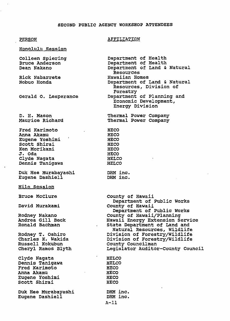
PERSON
SECOND PUBLIC AGENCY WORKSHOP ATTENDEES
AFFILIATION
Honolulu Session
Colleen spieringBruce AndersonDean Nakano
Rick NabarreteNobuo Honda
Gerald O. Lesperance
D. H. MasonMaurice Richard
Fred KarimotoAnna AkamuEugene YoshimiScott ShiraiKen MorikamiJ. OdaClyde NagataDennis Tanigawa
Duk Hee MurabayashiEugene Dashiell
Hilo Session
Bruce McClure
David Murakami
Rodney NakanoAndrea Gill BeckRonald Bachman
Rodney T. OshiroCharles K. WakidaRussell KokubunCheryl Ramos Blyth
Clyde NagataDennis TanigawaFred KarimotoAnna AkamuEugene YoshimiScott Shirai
Duk Hee MurabayashiEugene Dashiell
Department of HealthDepartment of HealthDepartment of Land & Natural
ResourcesHawaiian HomesDepartment of Land & Natural
Resources, Division ofForestry
Department of Planning andEconomic Development,Energy Division
Thermal Power CompanyThermal Power Company
HECOHECOHECOHECOHECOHECOHELCOHELCO
DHM inc.OHM inc.
County of HawaiiDepartment of Public Works
County of HawaiiDepartment of Public Works
County of Hawaii/PlanningHawaii Energy Extension ServiceState Department of Land and
Natural Resources, WildlifeDivision of Forestry/WildlifeDivision of Forestry/WildlifeCounty CouncilmanLegislator AUditor-county Council
HELCOHELCOHECOHECOHECOHECO
DHM inc.DHM inc.A-ll
SUMMARY OF THIRD COMMUNITY WORKSHOP
Pahoa community CenterPahoa, Hawaii
Thurs., september 3, 19877:00 p.m.
Approximately one hundred residents attended the workshop, asshown on the attached list. The Public utilities Commissionattended the workshop and served as a moderator.
The meeting was organized into three sections. First, HELCO andtheir planning consultant, DHM inc., presented the two selectedalignments for the proposed 69 kV transmission lines. DHM inc.described the types of factors which were mapped and evaluated inthe process of identifying the alignments. They also describedthe proposed route of each alignment across the Puna area.
The second portion of the meeting was an opportunity for theresidents to ask specific questions about the DHM inc. 'spresentation, the proposed alignments, and their selection.Questions were raised concerning such issues as:
late notice about the project to affected propertyowners
the density of Ainaloa subdivisionwhy the transmission lines were a separate issue fromthe geothermal power plant
will the subdivision(s) affected by the lines getelectricity from them
impacts on property values
consideration of undergrounding the lines
consideration of human beings and their homes
easement width and compensation to property owners
consideration of using large landowners' property
constraints given to the consultant by HELCO
The questions were responded to by HELCO or DHM inc.
During the final portion of the meeting,·the residents wereencouraged to voice their general concerns and opinions about theproposed project to the Public Utility Commission and HELCO.Several residents spoke, and their concerns are summarized below.Speakers were encouraged to submit their comments in written formto HELCO with a copy to the Commission.
A-12
Ainaloa is a densely populated subdivision with smalllots and private roads.
How much will the line cost and what would it cost togo underground?
Why can't the line(s) go along the highway?
What kind of improvements will be made to 35th Ave. ifthe line goes there?
Put the line in the mauka part of Ainaloa where it isless populated and the residents need power.
What would be the affect of the line on property value.
Alignment selection needs to consider fire hazards andsalt corrosion.
The former railroad is more of a hiking path than ajeep trail.
Safety.
There is no fire access to the railroad area andHawaiian Paradise Park.
The attendees were informed that HELCO will continue to work withthe sUbdivision associations in attempts to come to mutuallyagreeable locations for the alignments within the respectivesubdivisions.
A-l3
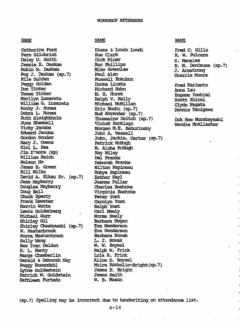
N1IME
catherine FordFem GilchristDaisy u. smithJessie E. DaskamRobin M. DaskamPeg J. Daskam CSP.?)Kile GoldenPeggy GOldenDon T.inkerTessa TinkerMarilyn II.IsaretaWilliam G. Illsareta~J. NunesDebra L. NunesRuth SleightholmJune ShamwellVicky JacobsEdward JacobsGOrdon SOUderMary J. owensK:iJ'Ii L. PeaJ:lJn E'more Csp)William ReichNelson HeJames H. GreenBill MilksDavid A. Kikau Sr. Csp.?)Jeam MaybenyDouglas MayberryDoug BellQn1ck Spen:yFrank DewaterMarvin wattsIewis GoldenbergMichael GurrShirley GilShirley O1aekowski. Csp.1)W. MastenbrookNo:rma MastenbrookSally wan;Rex Ivan DeldenH. L. KentyMarge C1aIN:lerlinGerald & Deborah HayPeggy FloserxiahlLynne GoldesteinPatrick W. GoldsteinKathleen P\lrtado
N1IME
Diana & I.orXIo Lorxllsue ClarkDick MinerRon B1i1lipsMike GreenlawPaul AlanRussell KokubunDonna LicataRichard HahnH. H. HuretRalph V. KellyMichael McMillanEric EUshu Csp.1)Bud Ahrerxier (sp.1)'Ihomasine Deitch (sp.?)Violet SantiagoMoz:gen M.E. BahurinskyJohn A. WassellJohn, Jackie, carter CSP.?)Patrick McHughB. Aloha Mc.'b3hKay WileyDel PranksDebdrah PranksMilton PapineauRubye PapineauEsther KaylJeanne FullerCharles BoehnkeVil:ginia BoehnkePeter yostcarolyn yostRalph yostcarl NeelyNo:rma NeelyBartlara HoganTom HendersonEve HendersonBartlara NovakL. J. NovakW. W. EoyselRalph W. FrinkLola R. FrinkAlice D. EoyselMoira Kokkolio-Bright(sp.1)James K. BrightJames smithw. B. Mason
NAME
Fred C. GillsR. w. PulcareS. MenelesB. M. DenCause (sp.1)J. AnnstrongSherrie Moore
Fred KariJnotoAnna IauE.\lgene Yosliliniscott ShiraiClyde NagataDennis Tanigawa
I)Jk Hee !m'abayashiWendie McAllaster
CSP.?) SPelling nay be incorrect due to handwriting on attendance list.
A-14
SUMMARY OF THIRD PUBLIC AGENCY WORKSHOPS
AuditoriumHawaiian Electric Co. Inc.
Honolulu, HawaiiThurs., Sept. 3, 1987
10:00 a.m.
HONOLULU SESSION
AuditoriumHawaii Electric Light Co., Inc.
Hilo, Hawaii .Fri., Sept. 4, 1987
10:00 a.m.
The fourteen individuals that attended the workshop included sixrepresentatives from State agencies as shown on the attachedlist.
DHM inc., HELCO's planning consultant, presented the two selectedalignments for the proposed 69 kV transmission lines. Theydescribed the types of factors which were mapped and evaluated inthe process of identifying the alignments, and also described theproposed route of each alignment across the Puna area.
HirLO SESSION
Four agency representatives attended the workshop in Hilo.presentation was identical to that in the Honolulu sessionday before.
A-lS
Thethe
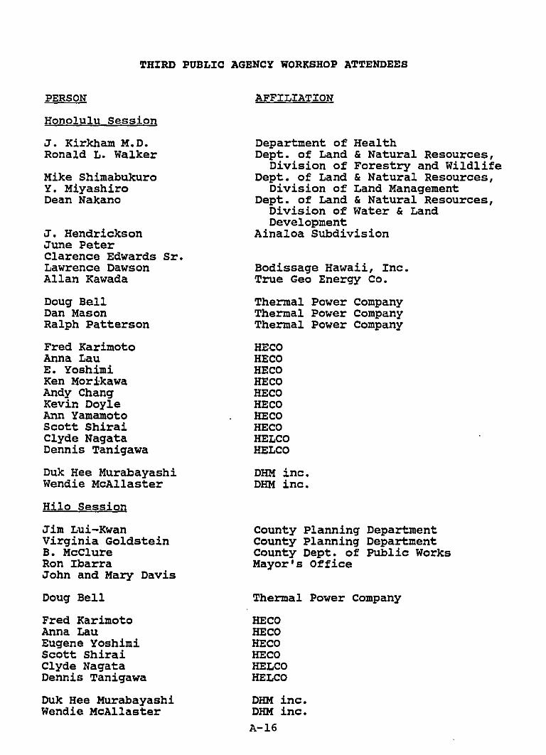
PERSON
THIRD PUBLIC AGENCY WORKSHOP ATTENDEES
AFFILIATION
Honolulu Session
J. Kirkham M.D.Ronald L. Walker
Mike ShimabukuroY. MiyashiroDean Nakano
J. HendricksonJune PeterClarence Edwards Sr.Lawrence DawsonAllan Kawada
Doug BellDan MasonRalph Patterson
Fred KarimotoAnna LauE. YoshimiKen MorikawaAndy ChangKevin DoyleAnn YamamotoScott ShiraiClyde NagataDennis Tanigawa
Duk Hee MurabayashiWendie McAllaster
Hilo Session
Jim Lui-KwanVirginia GoldsteinB. McClureRon IbarraJohn and Mary Davis
Doug Bell
Fred KarimotoAnna LauEugene YoshimiScott ShiraiClyde NagataDennis Tanigawa
Duk Hee MurabayashiWendie McAllaster
Department of HealthDept. of Land & Natural Resources,
Division of Forestry and WildlifeDept. of Land & Natural Resources,
Division of Land ManagementDept. of Land & Natural Resources,
Division of Water & LandDevelopment
Ainaloa Subdivision
Bodissage Hawaii, Inc.True Geo Energy Co.
Thermal Power companyThermal Power CompanyThermal Power Company
HECOHECOHECOHECOHECOHECOHECOHECOHELCOHELCO
OHM inc.OHM inc.
County Planning DepartmentCounty Planning DepartmentCounty Dept. of Public WorksMayor's Office
Thermal Power Company
HECOHECOHECOHECOHELCOHELCO
DHM inc.DHM inc.A-16
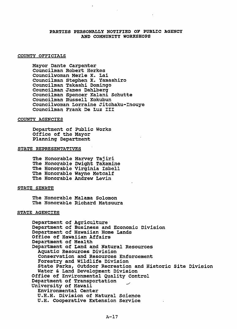
PARTIES PERSONALLY NOTIFIED OF PUBLIC AGENCYAND COMMUNITY WORKSHOPS
COUNTY OFFICIALS
Mayor Dante CarpenterCouncilman Robert Herkescouncilwoman Merle K. LaiCouncilman stephen K. YamashiroCouncilman Takashi DomingoCouncilman James DahlbergCouncilman Spencer Kalani SchutteCouncilman Russell KokubunCouncilwoman Lorraine Jitchaku-InouyeCouncilman Frank De Luz III
COUNTY AGENCIES
Department of Public WorksOffice of the MayorPlanning Department
STATE REPRESENTATIVES
The Honorable Harvey TajiriThe Honorable Dwight TakamineThe Honorable Virginia IsbellThe Honorable Wayne MetcalfThe Honorable Andrew Levin
STATE SENATE
The Honorable Malama SolomonThe Honorable Richard Matsuura
STATE AGENCIES
Department of AgricultureDepartment of Business and Economic DivisionDepartment of Hawaiian Home LandsOffice of Hawaiian AffairsDepartment of HealthDepartment of Land and Natural Resources
Aquatic Resources DivisionConservation and Resources EnforcementForestry and Wildlife DivisionState Parks, Outdoor Recreation and HistoricWater & Land Development Division
Office of Environmental Quality ControlDepartment of TransportationUniversity of Hawaii
Environmental CenterU.H.H. Division of Natural ScienceU.H. Cooperative Extension Service
A-l7
Site Division
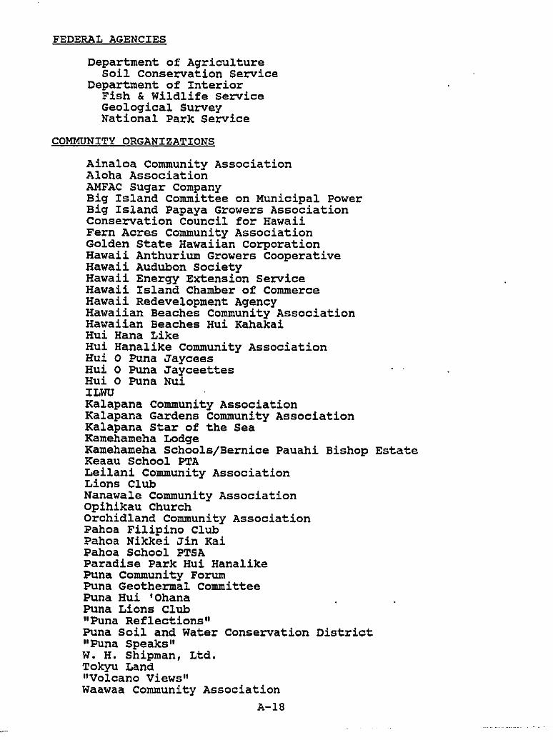
FEDERAL AGENCIES
Department of AgricultureSoil Conservation Service
Department of InteriorFish & Wildlife ServiceGeological SurveyNational Park Service
COMMUNITY ORGANIZATIONS
Ainaloa Community AssociationAloha AssociationAMFAC Sugar CompanyBig Island Committee on Municipal PowerBig Island Papaya Growers AssociationConservation Council for HawaiiFern Acres Community AssociationGolden State Hawaiian corporationHawaii Anthurium Growers CooperativeHawaii Audubon SocietyHawaii Energy Extension ServiceHawaii Island Chamber of CommerceHawaii Redevelopment AgencyHawaiian Beaches Community AssociationHawaiian Beaches Hui KahakaiHui Hana LikeHui Hanalike Community AssociationHui 0 Puna JayceesHui 0 Puna JayceettesHui 0 Puna NuiILWUKalapana Community AssociationKalapana Gardens Community AssociationKalapana Star of the SeaKamehameha LodgeKamehameha Schools/Bernice Pauahi Bishop EstateKeaau School PTALeilani Community AssociationLions ClubNanawale Community AssociationOpihikau ChurchOrchidland Community AssociationPahoa Filipino ClubPahoa Nikkei Jin KaiPahoa School PTSAParadise Park Hui HanalikePuna Community ForumPuna Geothermal CommitteePuna Hui 'OhanaPuna Lions Club"Puna Reflections"Puna Soil and Water Conservation District"Puna Speaks"W. H. Shipman, Ltd.Tokyu Land"Volcano Views"Waawaa Community Association
A-18
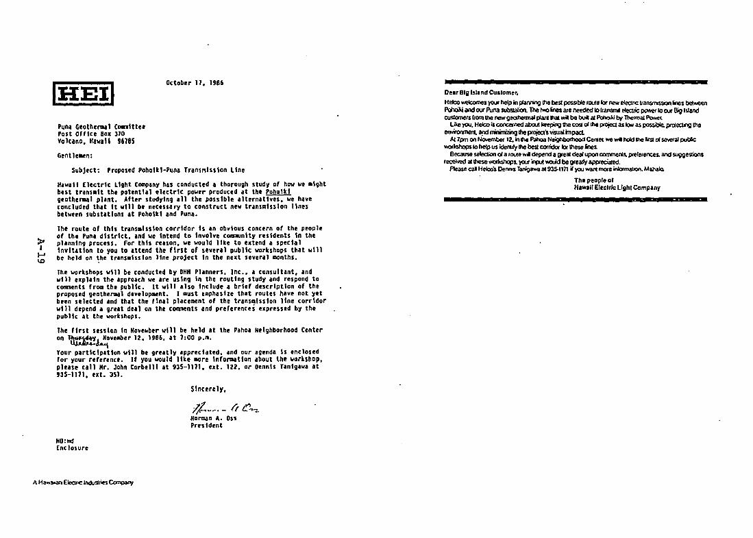
Ottober 11, 1986
punl Geothenaal CGalltte'Post Offlte 80x 310Volcano, Hawal' 96185
Gen t1 elltn:
SubJett: Proposed Poholtl·Puna Trans~lssion line
Hawaii [lectrtc Light C~any has tonducled • thorough study of haw we mightbest transmit the potential electric pover produted .t the Poholtlgeothen.al plant. After studying all the possible alternatives, we havetontluded that It will be netessary to construct new trans~lsslon linesbetween subst.tlons at Poholtl and Puna.
The route of this transmission corridor Is an Obvious concern of the peopleof the Pun. district. and we Intend to Involve c~nlty residents In theplanning process. for this reason, we would lite to extend a specialInvitation to you to attend the first of several public workshops that willbe held on the trans.lsslon line project In the next several months.
The workshops will be conducted by OHH Planners, Inc., a consultant, andwill explain the approath we are using In the routing study and respond totoroments fr~ the public. It will also Include a brief description of theproposed geothermal development. I must emphasize that routes have not yetbeen selected and th.t the flnat placement of the transmission line torrldorwill depend a gre.t de.l on the c~nts and preferences expressed by thepublic at the workshops.
The first session In Hove~ber will be held at the Pahoa Neighborhood Centeran ~~ve~er 12, 198&, at 1:00 p.g.
Your participation will be greatly apprecIated. and our agenda Is enclo$edfor your reference. If you would like more Info~tlon about the workshOP.please call Mr. John Corbelll at 935-11Jl, ezt. 122. or DennIs Tanlgawa at935-1111. ext. 351.
Sincerely,
/J. ..~. - If C,,-:.Horman A. assPruldent
HO:1nd[ntlosure
Our Big Island CUllomer.Helco~ )<k.W help in panring !he be:;t possollIe rClUlelor /Ie'1oIt eIeclnc llanSlMSlon~s betY<eenPdv:».i iIlId our Puna subsaalicn The l'*'O lnes aze needed 10 llansmol e1ecuic powet 10 cur Big IslandCUSlOrne1s 110m II1e rw:<t geahennill plazt thai wi: be buol al PoI1Q.ld by The<maI~
liI<c}'CU. HeIc;o is COI>Ceined abouI kl!epiI1g!he ttlSl oIlhe .,..ojeQ as low as possiOIe. prrAllCUlg !heerwitomIer«. ard~ the projea's visualrnpad.
A11pm CItI No.oembeI12. irllha PahoaN~Ce<1et"'" hold !he IirSl 01 sevetal publicYlOIIcshop$IO help us idel'llly!he besI corridcll" lor lhese ines.
Because seIecOOn 01 a lOUIe~ depend a gleal dealupon~ptelelenen and sugge$lion$received a11hese~ )OUl'~ ¥Old be lI'ealfy apprecialed.
Please cal HeIco's Oems tarigawa al9J5.ll71 if}'CU wan tnOIe inIotmaIJo<\.M~
The peopl. orHaMil E1eclrlc Ught Company -
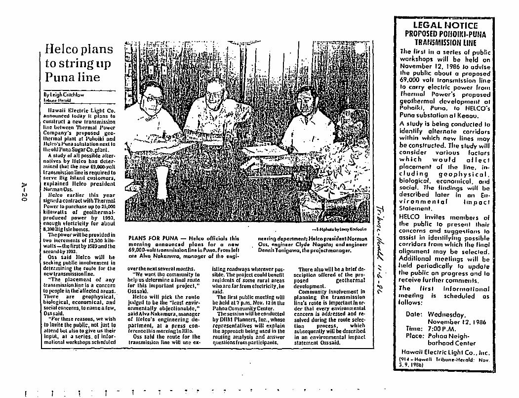
PLANS FOR PUNA - Heleo oUidals Ihismorning announced plans fOl 0 now69,OOO-volilronsmiuion line in Puna. From Jehore Alva, Nakamura, manager af Ihe engi.
-l.Hp/>olob,lonylCodoolo
neering depal1menl; Holea presidenl Normanau, engineer Clyde Nagala; and ongineerDennis Toni!Jawa,lhe projllcl ml:lOogol.
~I
l\Jo
I-Ielco plansto string upPuna line8y Le;9hCrilchlow, nbYn.·II••oI.l
lIawaii Eleclric Light Co.announced loday II plans tocOlIslrucl a new Iransmissiohline between n.ermal "owerCompany's pruposed geo·Ihennill plilnt at J>olJoiki amiJIt:kD'S Puna subsla IiDn nell I I0
Ihe old I'una Sugar Co, pl:ml.A Sludy 01 all possible OIlier·
nalivelo by flelco has deler·mined Ihal lhe new 69,OOO·yollIransmis~ion lim: is required toserve Dig Island customers,uiliained lIelcD presidentNurmanOss.
lIelCD earlier Ihis yearsigneda contrad wilh ThermnlPower to purchase up to 25.000kilo\Valls or geolhermal·produced power by 1993,enough tlectricily ror about8.300 II ig Isle homes.
The power will be provided inIwo incremenls DC 12.500 kilo·walls-thelirst by 1!l89 and lhesecond by J9'JJ.
Oss said lIelco will beseeking pUblic involvemenl indelermining the roule ror lhenew Iransmission line.
"The placement DC anylransmissionline is a concernto !,cople in Ihe'aCCeded areas.There are geophysical, .biological, economical, antisocial concerns,lo name a lew,Osssaitl.~For these reasons, we wish
(0 Invile Ihe public, nol just 10allcnd bUI also to give us theirinput, Oil a series, oC inCor·malional workshops scheduled
1
over the hexl severa Imonths."We wanl the community la
help us delcrmine alinal rouleCor this Imporlanl project,"Osssaid.
lIelcD will pick the routejudged to be the "Icast envir·onmentally objeclionable,"said Alva Nakamura, manager01 Jrelco's engineering de·parlmenL, at a press con·Ierenc:e 111 is morning in llil o.
Oss saltl the route ror theIransmission line will usc ex·
isUng roadways wherever possible. Tile projecl could benefitrcsidcnls oC some rural areaswho arclar Crom eleclricily, hesait!.
The lirst (Iublic meeting willbe heltl at 7 p.m. Nov, t2 in lhePahoa Com mURily Cenler.
The session will be conductedby DIIM Planners, Inc., whoserepresentatives will explainIhe approach being used In Iherouting analysis and anSWerCjuestions Irom participants.
There also will be a brier de·scriplion oUered 01 the pro·posed geolhermaldevelopmenl.
Community Involvement Inplanning the transmissionline's roule is lmportanlln or'der Ihat every environmentalconcern is addressed and reosolved during the raule selec·lion process, whichsubsequently will be describedin an environmental Impadstatement Osssaitl.
LEGAL NOTICEPROrOSED POIfOlKI·PUNA
TRAUSMISSfOfllltlEThe fir sl ill a series of publicworkshops will be held onNovember 12, 1986 10 adviseIhe public oboul a proposed69.000 volt Iransrnlssion lineto carry electric power fromrherJllol Power's proposedgeothermol dcvelopmenl 01Pohoiki. Puna, 10 HELCO'sPuna substation at Keaau.A sludy is being conclucled toidenlify ollernote corridorswilhin which new lines moybe conSlrude-d. The sludy wilfconsider vorious foclorswhich would affectplacement of Ihe line. including geophysical,biological. economical, ondsocial. The findings will bedescribed laler in an Ellvironmental JmpaciSiolemeni.HElCO inviles membef s ofIhe public 10 present Ihairconcerns and sU9gco;liolls 10assist in identifying possiblecorridors from which Ihe finalolignmenl may be selec led.Additional meelings will beheld periodically to updolethe public on progress and 10receive further comments.The lirst Informationalmeeling Is scheduled osfollows:
Date: Wednesday,November 12. 1986
Time: 7:00 P.M.Ploce: Pohoo Neigh.
borhood CenlerHawaii Elec/ric light CO .• IIlC,
(91~ -·Howail Tribunl!·Hl!rQld: Nov.:i.9.19661
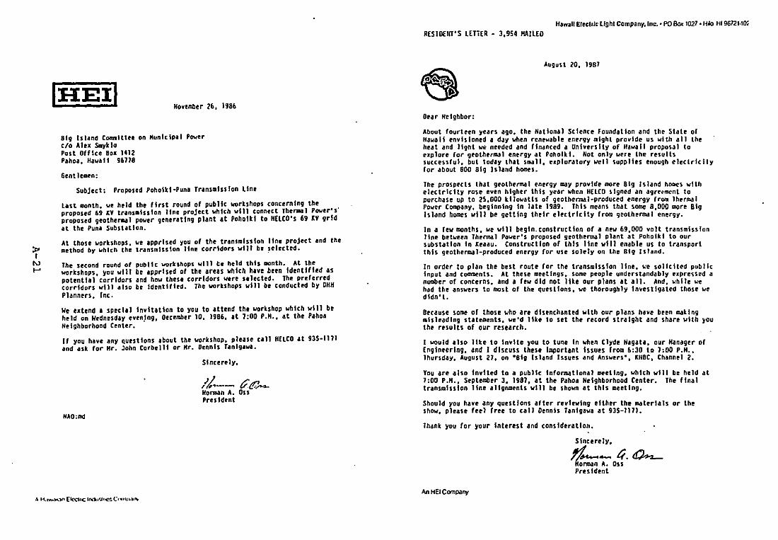
November 26, 1986
81g Island C~lttee on Hunlclpal Powerc/o Alu SalyldoPost Office 80_ 1412Pahoa. HawaiI 96118
Gent hmen:
Subject: Proposed Poholtl·Puna Trans_Isslon line
last month. ue held the first round of public ~rtshops concerning theproposed 69 U trans.lulon line project which will connect Thenalll Pwer's·proposed geothen-al power generatIng plant at Poholkl to H(LCO's 69 XV gridat the Puna Substation.
At those wrtshops. ue apprised you of the transmission line project and themethod by uhlch the transmission line corridors will be ~elected.
The second round of public workshops will h held this month. At theworkshops, you wilt be apprised of the arelS which have been Identified aspotential corridors and how these corridors uere selected. The preferredcorridors will also be Identified. The workShops will be conducted by OHHPlanners. Inc.
We e_tend a special Invitation to you to attend the wortshop uhlch will beheld on Wednesday even.tng. December 10. 1986. It 1:00 P.H•• at the PahoaNeighborhood Center.
If you have any Questions about the wrkshop. please call HflCO at 935·1111and ask for Hr. John corbel11 or Hr. Dennis Tanlgava.
Sincerely.
/1-- t/t:.'..-HOrJlldn A. OssPres Ident
NAO:md
HawaII Elecllic Ught Company, Inc.· PO Box 1027.H~ HI 96721·10;RESIDENT'S LETTER - 3,9S4 MAILED
August 20. 1981
Oear Netghbor:
About fourteen years ago. the Hatlonal Science Foundation and the State ofHawaii tnvlslond a dJY when renewable energy IIlght provide us with all theheat and light we needed and financed a University of Hawaii proposJI toe_plore for geother~1 energy at Poholkl. Not only were the resultssuccessful. but today that small. e_ploratory!Je1l suppltes enough electrfcflyfor about 800 Big Island homes.
The prospects that geothermal energy ~y provide more Big Island ho~cs withelectricity rose even higher this year when H£LCO signed an agreNllcnl topurchase up to 2S.000 kttowatts of geothenmal·produced energy frOll IhermalPower COIIIPany. beginning In late 1989. This means that some 8,000 more BigIsland homes will be getting their electricity frOlD geothenmal energy.
In a few months. ~e will begin. construction of a new 69.000 volt transmissionline bet~een Thenmal Power's proposed geothermal plant at Poholkl to oursubstation In ~eaau. Construction of this line will enable us to transportthis geothermal-produced energy for use solely on the Big Island.
In-order to plan the best route for the transmissIon line. ~e solicited publicInput and comments. At these meellngs. some people understandably expre~sed anUtlber of concerns. and a few did not Ute our plans at 0111. And ....hUe ~'e
had the answers to most of the questions. we thoroughly Investigated those wedidn't.
Because so~e of those who are disenchanted with our plans have been matingmisleading statements. ~'d lite to set the record straight and share with youthe results of our research.
I wuld also like to Invite you to tune In when Clyde Nagata. our Hanager ofEngineering. and I discuss these Important Issues from 6:30 to 1:00 P.H••Thursday. August 21. on -81g Island Issues and Ans~rs-. ~HBC. Channel 2.
You are .1so Invited to a public Informational meeting. which will be held at1:00 P.H •• September 3. 1981. at the Pahoa Neighborhood Center. The (fnaltransmission line allgnlllents will be shown at this meeting.
Should you hue any questions after reviewing either the materials or theshow. please feel free to call Dennis Tanlgaw. at 935-1111.
Thank you for your Interest and consideratIon.
Slncere1y.
~- ti.O>-.-, {~rman A. aSSPresident
An HEI COOlpany
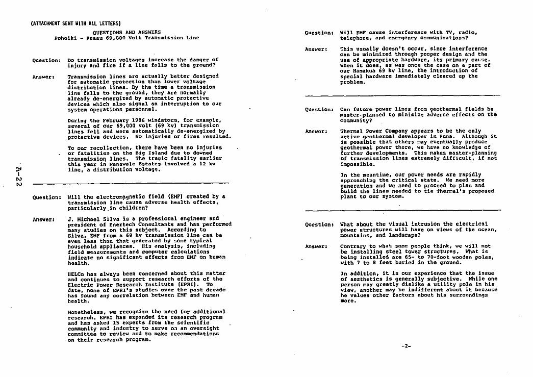
(ATTACHKENT SENT WITH ALL LETTERS)QUESTIONS AND ANSWERS
Pohoikl - Keaau 69,000 Volt Transmission Line
ouestion: Do transmission voltages increase the danger ofinjury and fire if a line falls to the ground?
Answer: Transmission lines are actually better desisnedfor automatic protection than lower voltagedistribution lines. By the time a transmissionline falls to the ground, they Are normallyalready de-energized by automatic protectivedevices which also sIgnal an interruption to oursystem operations personnel.
OUring the February 1986 windstorm. for example,several of our 69,000 volt (69 kv) transmissionlines fell and were automatically de-energized byprotective devices. No injuries or fires resulted.
To our recollection, there have been no injuriesor fatalities on the Big Island due to downedtransmission lines. The tragic fatality earlierthis year in Nanawale Estates involved a 12 kvline, a distribution voltagp..
Question: Ilill the electro~9netic field (EHF) created by atransmission line cause adverse health effects,particularly.in children?
Question: Will EMF cause interference with TV, radio,telephone, and emergency communications?
Answer: This usually doesn't occur, since interferencecan be minimized through proper design and theuse of appropriate hardware, its primary ca~~e.
When it does, as was once the case on a part ofour Hamakua 69 kv line, the introduction ofspecial hardware immediately cleared up theproblem.
Question: Can future power lines from geothermal fields bemaster-planned to minimize adverse effects on thecommunity?
Answer: Thermal power Company appears to be the onlyactive geothermal developer in Puna. Although itis possible that others may eventually producegeothermal power there, we have no knowledge offurther developments. This ~akes master-planningof transmission lines extremely difficult. if notimpossible.
In the meantime, our power needs are rapidlyapproaching the critical state. We need moregeneration and we need to proceed to plan andbuild the lines needed to tie The~alls proposedplant to our system.
Answer: J. Michael Silva is a professional engineer andpresident of Enertech Consultants and has performedmany studies on this SUbject. According tosilva, EMF from a 69 kv transmission line can beeven less than that generated by some typicalhousehold appliances. His analysis, includingfield measurements and computer calculationsindicate no significant effects from EMF on humanhealth.
HELCo has always been concerned about this matterand continues to support research efforts of theElectric power Research Institute (EPRI). Todate, none of EPRI's studies over the past decadehas found any correlation between &~F and humanhealth.
Nonetheless, we recognize the need for additionalresearch. EPRI has expanded its research programand has asked 15 experts from the scientificcommunity and industry to serve o~ an oversightcommittee to review and to make recommendationson their research program.
Ouestion: What about the visual intrusion the electricalpower structures will have on views of the ocean,mountains, and landscape?
Answer: Contrary to what some people think, we will notbe installing steel tower structures. What isbeing installed are 65- to 'O-foot wooden poles.with 7 to B feet buried in the ground.
In addition, it is our experience that the issueof aesthetics is generally SUbjective. While oneperson may greatly dislike a utility pole in hisview, another may be indifferent about it becausehe values other factors about his surroundingsmore.
-2-
OUestion: What effect would the presence of a transMissionline have on property values?
Answerz There are a number of 69 kv lines already aroundthe Big Island, inclUding through some residentialareas as Kawailani Street. Research by theCounty tax office established that there was noevidence of decrease in property values.
.There is also the argument that values may increasein many sections of SUbdivisions currently lacking'electricity, since distribution lines could beinstalled on the same 69 kv poles, making it moreeconomically affordable for residents to obtainline extensions, especially in conjunction withour new special subdivision Project ProvisionProgram (SSPP).
Question: What effect, if any, would a 69 kv transmissionline have on my home insurance premiums?
Question: How wide will the easement for the line be?
Answer: Although the ·corridors· we have been studyingare quite wide, we normally require a maximum ofonly 50 feet for the actual alignment for a69,000 volt line. However, if the line is locatedalong a roadway (~hich is a likely case), wewould be satisfied with an easement covering thewidth of the roadway. Then we would not have toask for easements within individual lots exceptfor anchors wherever the line changes direction.
Answer: The insurance companies we contacted unanimouslyagreed that there would be no effect. In fact,they reported that premiums are sometimes lowerin homes served by electric utility servicerather than by their own generators. Some companiesreported that they would not insure a house thatdidn't have electric service from a utility.
Question; Could the transmission line be placed undergroundinstead?
Answer: It could, but the cost would be apprOXimately 6times greater than an overhead line and wouldcreate an unfair and unnecessary financial burdenon all our Big Island customers. In this case, itwould cost $4 million for one overhead 69 kvline, compared to $22 million for one undergroundline.
There is pro and con to most situations and thisis no exception. Because underground lines areburied and not visible, maintenance and restorationof power due to cable failure takes considerablymore time. Depending on the severity, repairsmay take several days. Also. since there are nopoles on an underground line, they would have tobe installed later, anyway, whenever line extensionsare necessary to serve customers requestingelectric service to areas currently without it.
-3--4-
APPENDIX B
BISHOP MUSEUM
CULTU&AL AN~ Bl~LOGlCAL ~tsOU~CES SURVEY Of THEPOHOlll TO PUNA-SU8STATIO~ 69~V TRANSnlSSJOH CORRIDOR
kAP~HO TO kEA'AU, PUNA. HAVAI') JSLAND
tilI....
CUL111RAL AIlD BIOLOGICAL RESOURCES SURVEYOf 11IE PaIOUI TO I'IJJIA-SUBSTATIOH
69lV 11lAllSllISSIOH CORRIDOR(AI'OIIO TO lEA'AU, I'IlHA, DAVAI'! ISUHD
Final Report:Archaeololtcal SUfyey
Depart.ent of AnthropologyBernice Pauahl Bishop Huseua
ORIGINAL
Final Report:
Archaeol09ical Survey
AprU 30. 1981
Eric K. ko.ori
Llt.rature RaYleV ofFreviaus Archa.ologtcal Work,
~rOYI0u. H,.toric Land U••• andLegenda and Tradition.
Pupared tor:
lI}irt Inc.1168 bishop Stra.t
SUIU 2485Honolulu, Ha.al'l 96813
lI.p.rt.~nt of A~thr~tol09v
Bernlce ~. Eiahop Ku.«ua~~n~lulu. "&.11'1
TABLE or CONTENTS
Ab.tr.ct •••••••••••••••••••••••••••••••••••••••••••••••••••••••••••• iv
Introduction••••••••••••••••••••••••••••••••••••••••••••••••••••••••• 1
G.ovraphlC S.ttin9••••••••••••••••••••••••••••••••••••••••••••••••••• 1
Envlron••ntal S.ttlng•••••••••••••••••••••••••••••••••••••••••••••••• 2
GIol09y •••••••••••••••••••••••••••••••••••••••••••••••••••••••••••4
Flor•••••••••••••••••••••••••••••••••••••••••••••••••••••• , ••••••• 4
r.un•••••••••••••••••••••••••••••••••••••••••••••••••••••••••••••• S
Ttralnol09Y•••••••••••••••••••••••••••••••••••••••••••••••••••••••••• S
Prtviou. Arch.eoloqlc.l Vork •••••••••••••••••••••••••••••••••••••••••7
Re••arch £Ie.19n •••••••••••••••••••••••••••••••••••••••••••••••••••••• 8
Settle.tnt fattern Hodel •••••••••••••••••••••••••••••••••••••••••• 9
Re•••reh Goal••••••••••••••••••••••••••••••••••••••••••••••••••••• 9
S••pllnV 1I••19n•••••••••••••••••••••••••••••••••••••••••••••••••• 18
n.thodol09Y •••••••••••••••••••••••••••••••••••••••••••••••••••••• 11
£Ourvey lI••ult••••••••••••••••••••••••••••••••••••••••••••••••••••••• 13
Arch••oloV1c.l Slt.s ••••••••••••••••••••••••••••••••••••••••••••• 13
Hl.tOfic Site•••••••••••••••••••••••••••••••••••••••••••••••••••• 28
Dl.cu•• lon ••••••••••••••••••••••••••••••••••••••••••••••••••••••••••29
• eco•••nd.tlon•••••••••••••••••••••••••••••••••••••••••••••••••••••• 32
R.f.r.nc•••••••••••••••••••••••••••••••••••••••••••••••••••••••••••• J3
Appendix. Lit.r.tura Re"iew of fre'loue Arch.eolovical Vork
Hi.torie L.nd U.a. and Le9.nd••nd Or.l Tr.dltion"
tJJlT OF fIGU~ES
J. H.p of Project Ar•• with (orri~or Se911nt••nd LOC.tl0n••••••••••• ]
2a. Sit~ Loc.tl0n Hap with Tran.ect Loc.tion••••••••••••••••••tt.ch••nt
2b. Slt. Location r..p with Tran.ect Loc.tions ••••••••••••••••att.ch••nt
3. Atrial VltW or T~~f.phy nt.r Site Al·47 ••••••••••••••••••••• 161.9rlcultur~1 eQ_pl4xJ
S. SHe ""·67 lterncto1 rlltfor.'. 1n ··ohl·. di.~.ck· Aru ••••••••• U
6. Rcu?h ~~eteh ~i Sltt A4·68 «refuql c.v~•••••••••••••••••••••••••• 2B
7. ACfld VU1W of Topoqufhy ne.r Site M·U fufU7' eav.J •••••••••• 22
£.. Inte:fior of Slto A4-69 Iburj.l c.".I ••••••••••••••••••••••••••••• 23
9. SK.teh ~.p oC Site A<·18 'r.troqlyph.I ••••••••••••••••••••••••••• 2S
11. re~r011Yrh SltO A4·7~. Tri.n~ul.r Hu••n Fi~ur~ ••••••••••••••••••• 26•
:2. Vr9~t.tl0n.tSite A4S·18 .burl.l c."e) •••••••••••••••••••••••••• 27
ttlIw
t.8SIRAct
Thirty .1x .rch~.oI09tC.l tr.n.ect. of tnl~nd portion. or Pun. diatrict
on tb. the tsl.nd of H•••l'l were conducted to locate archleol091cal .Ite••nd
•••••• the potenti.l for addition. I r••ource. in the .re•• The purpoae of·the
.tudy i. to ~ro"td. data for an envlron.ental i.pact Itate••nt on •tr.n••ialion 11n,.
The nu_ber of .lte. 10Clted II very low III prehi.toric-type.and 3
ha.t~ric-type ait••). howewer, the finding. support I aettl•••nt plttern lod.l
for the .r•• that predict. the occurrence of •• ten.ave prehl.toric-ty~.
agricultural fl~ld•• an4 81t•• th.t rerlect adaptation to the phyaiographic
f ••ture. In the are.. Hi.torIC-type .1te. w~r. a••ociated with the IUOlr
indu.try.
Fr,vloua 0~0)09ic r••••rch provtd•••Iti•• t •• of the a9* of the
lubatr.te. an the .tudy 4r'. that al10. t.nt.tive generaliz.d tnterpratation.
of the arch••olOOlcal 11t... the hypoth••ta t~at .xpan'lon of Hav.ll.n••ttl••enta a.a, fro. ln1tl.1 fOCi .ft.r A.D. 1181 i••upported by esti&.ted
datu ot no oJdtor that A.D. 1458 fOr the ut••• the eau••ted .9. and type ofa ••all nuab4r of p,tr09Jyph. located .uppart. the finding. at previous
re••arch that Indicate•• chang. tn .tylt.tIC praterence.
Pr••ervation of .11 .it•• locat.d ia r.co•••nded and furth.r
.rch.aol09ic.l .ur~.y once. particular al19n••nt 1. cho.an 1••pectfled.
lteIRQDYqJOM
Thi. report pr••ent. the re.ulta of an arch.eolooieal .tudy of alt.rnlte
route. tor the propo.ed Pohoiti-rea'lu Tranl.illion Line Corridor located In the
di~trict of Punl on the isl,nd of Hlwat·i. The study .a. conduct.d undercontr.ct to DK". Inc. by th. D.part••nt of Anthropo109Y. 8.rnice. P blahop
"u.eu.. Th. archaeoloOic.l fieldwork .a. conducted between February 9-28. 1967
by the author. Will1a. fartlni. El.lne Rogera-Jourdane. and Jeffery I ••auchi.
All r.~ord. and data ar. depo.ited in the Dep.rtl.nt of Anthropol09Y, Bernic.
Paulhl Biahop Hunu.. I would Ute to .xpr....y .ppreciation to Hr. TiaothyLU1-Kw.n CH.W.l·1 County PI.nnino D.p.rt••ntl. Hr. Bruc. Butt. CH.wal·1 County
Civil Dtf.n.~), Hr. Sonny Kinney (Alu Lite, Inc.). and Hr. Cl.rk. Val lac. (Alf.c
Inc.1 for prOviding valuable .aai.t.nc. and intor••tion durino the cour•• of thefi.ldwork.
The prllary obJecttve of thia atud, 1a to provide d.ta for .n _nviron••ntal
i.p.ct et.t••ent on the trln••i••,on lin. corridorl. Th. t.lt. undert.ken .era1
1. Id.ntlfic~t1on .nd .vIlu.tion of .rch••ological ra.ourci.
found in tha ara. through fiald aur••y and liter.ture aearch.
2. A•••••••nt of ~~t.nti.l for the ••tatanc. or ~ddltlonal
.rch••ological r.aourc•• in the .r•••
3. Ev.luation of poa.lble kffactl of tha propo.ad tranl.l•• lon
lin. on .rch.eologic.l r.aourc•• In the .r.a.
A lit.ratur•••arch on tha 1ag.nd••nd tr.dition., praviou••rch.eologic.l
r••••rch. and historlc.l d.ta conc.rning the g,n.ra1 Puna .rea w•• al.oconduct.d .nd i. includ.d a. an app.ndix.
GEOGRAPHIC StTIINq
The atud, ar.a con.l.t. of thr•• dilcontlnuou. corridor. th.t b.Vin ne.r
the Pun. Sugar Hill 1••lt of the town of r ••·.u). cont1nu~1 to the P.hoa town.rea. and .nd ne.r the ••1atino o.other••l pl.nt .t Pu'u Honulul•• in POhOlkl
Cfig. 11. The corridor. g8n.ral1y follow .xi.tlng road•• ranV_ 1ro••SI to
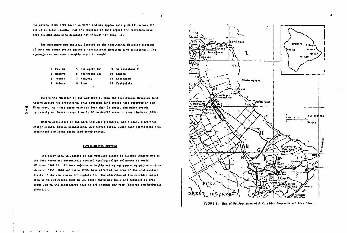
2
858 Beters 115ej·~eee flet) 1n w1dth and are apprO~laatel, 4Z klloaeter. 126
aile.) In t~tal lenQth. For the furr~ae_ of thl_ leport the corridor. have
been dlv1ded 1nto nIne .e~••nt. ·A· throu9h "J. (f19. 1).
The c~rrldor. ar. 8ntir.ly located In tha tr.dltl~nal Hawaiian dl'trlct
of f~na and erea' t.,l.e 'hypu,', Itredltlonll HI.lllan land dl.I,lon.). ThQ
at.upua·a cro~.ed arel IrouQhly ncrth to ,outhl
1 rt,.'au ~ he-nape-1I0 ,"UI 9 iialall"lhlnl 2
2 K,ku'u 6 hen.poko Ikl 18 kapoho
3 Popokl 7 I:ahu.al 11 r.,nuh11cu
4 Hl10nl 8 PUul 12 l:uhllllka
~urln9 the ·K,hlle· In the 'ld-1~80'" vhen the tradlt10nal Ha.alian land
tenure 8y't•••a, overthrown. only fourteen land a.ard, vera recorded In the
Punl area. Of the•• three ••r. for le'8 than 28 Icr ••• tha other avard.
tprl ••rtl, to chle(8) range fro' I.llt to 64.275 acre, In area (Indlce. (929).
"Dd~ln letlvltl•• In the ar •• Include: geother.al and bieaa.a electricil
ener~, planta, papa,. plantatlona. cut-flover far.a, .ugar can. plantatIon. (no.
ab,nde-ned) and lar91 .ca1. land cev.ll~••nta.
ENVIHO"KENTAL SETTING
the atudy ar.a 18 lecated on the wlnd••rd alopt. of Kilauta Yolcano ona of
the beat known Ind Intenalvely .tudl~d (VeoloQ1callyl volcanoa. In world
cHolcoab 1961121. Kilauta volclno 1. h19hly activa Ind reclnt eruption. luch a.
t~O~b In 1955, J&49 and circa 179~. havi affectld portion. of th. louthlaatern
11alt. of tha ltudr aria Ilbldlpl'tl 31. Thl Illvation ot the corridor ranQa.
fr~. 61 to 274 ~~ter. 12t~ to ~e8 tautl abovi aa. lev.l ~nd raInfall 1. 1roa
about 318 to 445 centl ••terl 1125 to 175 incl,eal plr y.ar (Ste.rn. and "'cDonald
194612'J~I.
\
-..:,
~~/"."~-
3
...... .. .-
4
~
The d,.per .0118 1ft tb' an. are repn.lnted by U.1ted Ire.. of uhdepollta and •••th.~.d ••••• Virtuall, all of th••• ar••• hava bean vied for
'Ug'l cIne f1,ldl or pl.ture l'nd and Ir' Ixtlnlivily dtaturbed. The•• depolltlIr. 'urroundtd by • 1.fgl nUlbtr of Ixtenll.I, lora racent llYI flo•• thlt h,vI
1tttla or no loll dlvelopslos ISoil Con,.fvltion Service 1972; Holcoab 1981).
The high frequency of dtvar••, r.cent l.va flo.1 in the .tu4y .r•• ha.
ra.ult.d in • topogr.phy th.t II hiVhly v.rS.bl••nd clo.aly 11nk,d to. flowaorpholo;y. A r.c.nt .tu4y th.t datatl. the chronoloqy of the lurftci.l l.va
'low. of Kilauea volcano Iho.1 that .uch of the atudy .r.a ia cov.r.d w1th
recant pahoehe. l.va. 1••• th.n one thoua.nd y.ar. old••1th pock.t. of ••••1••• th.t .r. v.ner.ll, old.r IHolcoab I98Ilpl.t. 31. Utill&lnv data .u~h ••
rad10t~rbon d.ta•• p.lao••onatic d.t., atratlgf.phic ral.tionlhlpl. or hl.torlc
.ccounta. Ho1ce-b .rr.noed tha l.v. f10wl into ninl 'VI Vroup.. Th' 'Ve
1nt.rv.l, lor the vroupa f.ng. frc. Ie. to see y.ar•• with the .Olt r.eant l.v••batng frol the t.lntiath c.ntur, .nd the '.rll•• t l.v•• baing old.r th'n 158atr "Uri B. P. I Ibid).
U1
Tvo ba'lc typal of 1.v. flo••••urf.c.·f.d and tUba·fed .re dlltingui.h.dfor Kll.u•• Volc.no. the ,urf.c. aorphology. howav.r. 1. lnfluenc.d by .any
t.ctor••uch •• It. phYlic.l propertte•• tha enwlron••nt lnto which 1t i.
Introduc.d. r.ta of flow. and d~r.tlon. Th. l.r9' nuaber of f.ctor' r ••ult 1n
• v.riety of ,urf'ca t.xtur•• tb.t r.ng. fro. r.l.tlvely ••ooth fl.t .urf'ca••to bro••n pl.t.·llk. atructur,•• to .xtr•••ly rough •••• l.v. Ilb1dI77-9S).
El.2arore.t.d ara•• that 'ra undS.turbid b, .od,rn .gr1culturll or urb.n
Ictiviti•• ar. dOlinat.d by .~ Cn.tro'ld,ro. ~) .ith 'n und.rltory
th.t includaa 'n •••ort••nt of f.rn••nd .hruba. nor. axpo••d .r.a. r.no' troa1••• d.naa .~ foraat. with I ground cov.r of thick I.U.d Wh!. (ern.
(Duranoot"1' .p.) to opan 9r"'y an.. cOllonly calbd .'S!.h.1.:.!. dteback-.V.riatlona In vep.t.tion In the•• un.ltarad .r••• 'ppear to b. clo.ely r,l.ted
to lub.trate type .nd '0"
s
Although poorly rlpr•••nted, pl.nt. found in the stud, Ir•• that are
co••only I ••oct.tad With prtht'toric-type H,.,11.n IctlY1tr include~
U,hUt1\!! .01uce,",J, h.t.l!. (P.ndln'" odoraUfftlu,J,'m CArt9Cuph
co"unl.) and kl (Cordyl!". teTlin,IJ') 5••11 nUlblra of rlClnt introduction.
tuch .. guava 1f.!.!.!U!!!. i!l!J.!!.!.J, air" ItJ.lU.I..lI.~I, k2l. h!..2b. cLaucun.
~I. and "ogo I.,nplfar! ~) Ir. frlqulntl, found. clu.t.r.d in
rel.tiv.ly un.lt.red .r.... eFor a cO'plete lilting. the r ••dlr i. retlrre4 to
concurr.nt r ••••rch by T.k.uchl .nd I••d. for DH". Inc.'
~
Indic.non. of the prestnce of flral P10I 11!!!,!££.91t.) ... noud throughout
the atudy .r••• how.v.r. only on. d.c••••d Juv.nil, ••• ' ••n. Co•••nd hor•••.r••1.0 pr•••nt. how.v.r. no lar.l .x••pl•• of 1.rva •••••1. otblr th'n plg.
v.r. ob••rv.d. Dova••nd .yn. btrda .r. co••on in tba .r•••nd .gr.ta ••reocca.lon.lly •••n. (For furth.r In(or••tion on tha ornithology of tha .r.' tha
ra.dar i. rafarrod to concurrant r••••rch by Fl.l.cher for DHn. Inc••.nt~,01091c'1 racourc•• ln the .ra••r. cover.d In Ni.hld. at .1. for ~H". Jnc.)
TERn)HOWI
Th. pr••ent r ••••reh i. pri.arlly int.nd.d to provld••n ••••••••nt of
.rch.eoloqic.l ra.ourc•• Sn the .tudy .r.a b••ad pravtou, docu••nt.tlon .nd
• ••pllng of lurf.c. r •••ln8. Th.r,for•• In order to avold ••bI9ultr lint. the
cultur.l and chronological •••octltlona ••crlbad to ••ch ait. 18 b••ed on
llaltad d.tl. t'r.' va.d for alta lnt.rpr.~tlon luat be ••11 defined. Of
prlnc1p.l COncarn .r. tha dlchoto.ta. of prahlatorie - hi.torie IN,.,it.n v••
non·H••ail.n)••nd .rch.eologic.l - hl.toric 1"l~lr concern.d with .•• thodologyl.
PrehS.toric - Hi.torie
Th. dl.covery of th. H,v'll'n l.l.nda by VI.tern.r. in A.D. 1778(technically en4ing the ·pr.-hl.torlc- parlodl ••• not acco.pani.d by an
i,••dl.t. and to pra-cont.ct H.v.l1.n cultur•• It·,u.t be racognl&ed.
th.r.for" that wall into the -hiatoric· pariod alt•• vera being for.ed wlthtn •
tr.41tl0n.l H'••lt.n cont.xt. Th. t.r•• hi.torlc .nd pr.hl.torlc 'r. not u.adher••• the, laply ••harp chronologie br.ak. Inat"d the alte
•
interpretationa us. the tet.. 1 prehiltoric-typ. to tlpl, •••octetlon with
ttedillona. H•••l1an culture. hiltoric-typl to tlpl, •••ociatlon with latlrculture., and pr,ht,tprlc/hl.torlc·t!p' _hen an interpretatIon cannot be ••dt.
In c•••• wherl lore thin ana type of interpretIt ion can be ••d. !uttlple ter••
are uled.
In the Ib.anca of .xclvlted dltl. the lIte attribut•• of prehistoric-type
and historic-type Ire baled on thr•• ChltlCleft,ticl thlt ara obaerv,bt. throu9h
••••1nltlon of lurface f.atur.al
1. Artifact and aldd.n typ•••
2. Conatructlon techniqu•• and _truetural configuration.
J. Sp.ttal a.aoctationa.
Of th•••• tb. interpretation of artifact. and aidden i. v.u.ll, the .oat
~ rall.bla Le.nl o[ lita ey,lvatlon.
0'1
The aatho4ol~y for anll,ai' of conatruction techniqu•• , Itructvral
configurationa and .p.tial a••ociationa, ba.ed on aurf.ce ch.r.cteriltic. i. not
ayate•• tleed for Ha••ii.n .itea. Ho••yer, although alte interpretation. b.ald
aolel, on theI' ch.rlcter.ltic' ar. Ie•• explictt, the, coapr••e , u••ful b.ai.
lor lub••quent iny,.iio.tlonl.
Arch.,ologicil~ - Hiltoric~
Another potenti.l .ource or conluaion .r. the t.r'I' .rch.eological ~'
.nd hlltorle~. For the purpo.e. of thi••tud, archalologic.l and hi.torie
lit.1 .r. diff.rentiated based on the potential for reli.bl. dacu.,nt.tion Ci.'.
oral hiltory or or coe•• l docu••nt.tionJ. Thi. criteria .il1 deteraine the
rrlaar, r ••••rch ,ethodolOVY, archaeoloqical for an Irchaeological~ or
hiltoricat for a hl.torlc.l !!!!.
Situ thllt .u pUlIflly ...oclat.d with preh1ttor1catnu of .cUYltln
are unlik.ly to h.va coeval doeu,entatlon and .r. ther.fore called
!U.h!!..2.\M!lli!1.1!.. Sltea thlt. an ...oc1ated WIth htatoric-typ.. of
.ctl.ltl•••r. c.lled hi.toric~ if the .it. ha. coeval docu.,ntation, or
• rchafoloqlc.l !!1l if luch docul,nt.tion I' Ilckinq.
1
PREVIOUS ARCHAEOLOGICAL VOR~
Thl1 ••ction 1. principally concernad with the study ete. proper•• lore
91hefaltted raport cov,tino prlvioul .rch••ologic.l.r••••rch 1n the Pun. ar•• 1s
included I. In append•••
Archaeological raae.rch raoarding thl Inland ar... at Puna h.. bean
'!ixUee.,ly lhltd. "o.t Itudy ne.. h..e btlln Ihit.d In lin and tnqu.nU,
cone.rhPd .ith onl, one 81ta. A not.bl. exception, although no fialdwork •••
conducted, i. a coaprehen.ive anal,.i. of archaeological and htltortcal
literatur. concerning the Puna .re. IncEldo.nl, 1979), that ta utille.d in the
develop••nt of the r••••rch d.aign for the pr•••nt atud, Ca•• belo.l.
Although the prea.nt atud, ara••, quit. Ixtan.l•• ani, on. project
tnvolving archa.ologlc.l fieldwork had b.en prl.lou.l, conducted In the .re.
lBordn.r 1917_. Thi. proJ.ct r.avlted In the location of on., poaaibl,
pr.hlatoricatype aite IStat. of H•••i·l Sit. 51-l8a46-6417a_ IIbld_. Thia aite
ta .n ili latone tound) locat.d .pproxhat.l, 91 an.ra lJeI f••U •••t of
Highw.y 138, .pproxl••tely 5.5 kiloaetera 13.4 .tle.' northweat of Pahoa town.
Thia aita .a. not r.locat.d durin; the pr•••nt .urv., .nd aa, h.ye b••n
d.atroyed by au~.eqvent eon.truction activitie••
Pahoa town, CStat. of Ha.ai'l Sit. 58-lea55a73BB' and the for.er riqhtaof
w., for the H••ai't Con.olidat,d Rlil.a" Ir. the onl, prl.loual, Identified
htstoric-type litel within the corridor••
Prehi.torie-type .it.. located in the qanlral vlcinit, of the propO.td
corridora conai.t of four la.a tub. lite. I Ship.an', C.y. ISI-HaaAl-IIJ, r.po
kohe Ltle C.ve, p.hoa C.ve, and a -,odifled 11•• tuba- C.ee appendixi. Vith thl
exception of the -'o4ifl,d lava tuba,- th,•• ,II contain hu••n ,kalatll r,••lnl.
p.ho. CaVa .nd Ship••n', C.v. ar. thought to be rafuge c.v•• a. well I,••
.ppendix_. The•• c.ve. CJ,vI tub••,g.ent.1 .r. p.rt of an extenli.e 'Jlte. of
lava tube. th.t occur In .any .ectlonl of the .tud, .re. and aay be connectad to
l.v. tub••1t•• loc.ted durin; the pre.ent fieldwork.
Hi,toric-typ' .tt., loc.ted near the corrIdor ar. for the aoat p.rt ra1atedto .ug~r plantation .ctiviti,. In the ar.a. Th. c10.,.t e.aapl. i •
8
r •• ·.u Diltrict IStat. of H•••l'l alt. 59-10-44-7389) which .nea.p••••• 10It of
r••·.u town.
RESEARCH DESteH
The atud, obJecti••• outlined in the introduction ar. prl••ril, ralatad to
the dl.llop••nt In Inviton_.ntal iapact Itata••nt conclrnlng the prape••d
activit, and not n.c••••rily ra1atad to 91hlral Irch••oloqlcal r.~••rch 90a1a.
Sine. the Itud, ar•• COVlrl • larVI ar•• that h•• not ~n pre.loual, ••••1n.d
through ••tlnl!VI fialdwork. It 1. n.c••••ry to r.llte the pr•••nt r••••rch
activiti•• to the conttxt of the gtnaral Punl atta.
S.ttl•••nt Fatt.rn "04.1Th. r ••••rch d•• ion Jor tha rr•••nt .tu~y focu••• on pr.hl.torlc·type
actlvity in the .tudy Ir•••nd utilia•• a ••tt1•••nt p.tt.rn .ode1 b••ad onanaly.la of .rch••olavlcal dlt. fro. pra.ioua .tudl•••nd literatute fro. the
~ ••rly hiatorlc period fftcEldovn.y 1979). Tha Inalyala v.a pti••rlly concarn.d
I with the ••at Pun. reglon b+twa.n the town ~f Hllo and Cap. ~u.ukahl to an~
.ltitude of 2988 .atar. 19.588 f ••tl ••nd includ.d the pr•••nt atudy ar.a.
"cEldovn.y id,ntifiad fiv8 ton~. of pr.hiatorlc·typ. H.vail.n a,ttle••nt .nd
l.nd u.~ roughly corra.ponding to ,ltv.tlonl
1. Co,It.1 ••ttla••nt ('·58 ft.1
II. Upl.nd .gricultur. 151-1.581 ft.1
lIS. Lower fort.t 11.588·2,5'8 ft.1IV. a.lnfore.t 12.581·5.5" ft.1
V. Sub·alpin. (5,588-9.588- ft.1
Sub.t.ntial prahlatoric-typl ,ettl•••nt•••r. found to have occurred on thl
co••t. with ••tlnal•• agricultural filld. locatld in .re•• of Zone 11. Th.
higher .l,vat10n .r••• of Zon•• III. IV. and V ••r. ha•• been utl11&ed for
.xploit.tion of • large vartaty of for.,t r ••ource••uch a. tr•••• fiber••
blrd•• etc••nd tral1a ("cEldownt, 1978115·331.
"cEldovnay noted that dlffering l.nd u'a patterna. although clo.'l, r,l.t,d
to Il.v.tion t1 ••• proai.tt, to co.'t.l .r••••nd pri••ry a.ttl",nt.1 are .1ao
rel.ttd to v,rl.b1Iity in ph,'iography (V.olO9ic lorphology••nd
•
VIVltltlon) withtn .ach &onl (lbid.3. 4, 141. Two ••tr•••• In V101oqlc
vlrl.btlttr ar. rlpe•••ntad by thick, oldar. volcanic ••h dapolltl froa Kluna
toa volcano Iralatt.,l, .111 dl.elopld 1011." and the raclnt la••• of killu••
yolcano 111tt1. or no loll dl.elop••ht).
"cEldovnay illultratad .paclfic Idlptltion. to the .nviron••nt of tha
r.gion utiliaing dlta fro•••rly hiatorie d.acriptiona .nd pr.viou.
Irch••oloqlell r ••••rchl
(on the .ah dapolit.J ••• the lInd u•• patt.rn. vert
unfor. (unlfora). con.latlng of acr. conc.ntrat.d
a.ttl••anta on oulch or val lay floor. n••r theco••t and of vidaly .plcad plantationa .nd hUta
.c.ttared acro•••n -unvood.d.· g'nt18 .lope up to
2.e88 ft .le.ltlon IElll•• 15631349) ".cr.e. 1922148·
49; "~ntie•• 19281511. Ion r.c.nt l •••• ) ••••d.pt.tlonp.ttern. center.d around ••xi.l&lng u•• of I
fr.quently ch.nging l.nd.clpt wIth I rough. une••n"
.nd hlghly .Iriablt aurf.ca ha.ing 11ttl, ,oil
d.v.lop.'n~. Practice. ~,plc.l of the .r••• luch ae
the .odlflcatlon of la.1 tub'l .nd outcrop. for
.halt~r. the u•• ~f lound••nd aulching for plantln;.••• typify thie adaptation IHcEldavn.,. 1979114. IS).
In t~r•• of over.11 ait, fr.qu.ncy ln Zona 11 "cEldownay .ugg••t. th.t fa.
prehi.totic·typa 'lte. art to be expactld in .rea. of rlc.nt lav••• and thatundlaturbed volc.nlc a.h depo.it••nd oldar lavl flov. havi a hlgh.r potantial
(lbtdt19J.
k~.,arcb Go.l,
Gtn,ral r ••••rch probl••••ddt••••d by the pre••n~ .tudy ar' r.l_ttd to the
prahlltorlc-type a.ttl••ant pattern .odel pr•••ntad by "cEldowne,. Although tht
.tudy ar.a la 1181ted by -.rtifici.1 canatraint.- (i ••• the atudy ar••
boundlrie. ate not congruent with archaeological r ••••rch conaidaratlon". the
.tudy IU,t b, conducted vithin thl conte.t of region.l con.14.t,tion••
I.
the follow1n9 r ••••rch probl••• or qUI.tlon. ate .ddr••aed by fieldwork Inthe pr.,ent .tud, .r••1
Pt••toua arch••oIGglea] vork ha. not re.u]ted in
the location of Igrlcultural f.aturl. In .r." of
Zon. II II predicted by the a,ttl'.ent aodtl. Ja
this the r ••ult of tnadequate •••pling or 'te
•••~n..... In the .od,1 the laurce of the
dl.crap.ncyl
2 Wh.t klnd' of prehiltorie·typ_ aetivltia' oth.r
th.n 'grleulture are indicat.d by archaeologicala1te. 1n thl ar'" 01 Zone JJ atudied, and what
ts their di.tribution.
3 The efleet. of volcanic activity ••pacl.lly during thaprehl.torie period.
~I Althou9h hl.toric-typ••lte' .re not e••lu.ted here in the cont•• t or
cor •••• tch go.l•• identlfic.tion and a.aluttion of thea. r ••ource. i. includad ••one of the obJectlv., of the .tudy.
S••pling D••19n
Du. to the den••••g.tation, rough tOPOQraphy, and larv••11. of the atudy
area ••urf.ce .ur.e, of lee percent of the .rea .a. eonaidar.d unfa••ibl••
Thu•• the .doption of a a••plin; .trate9, .aa neeee••ry. Although no larg.
.eale vround .urv.y. h.d been pr,vioualy conduct.d Within dir.etly eo.p.rabl.
• r•••• reat.reh in n••rby area. ,ugge.t the occurrence of .rch.aologic.l .it••
in •••oei.tion _ith certain phy.iographic f ••tur... Thar.fore ••tratifi.d
•••pllng .tr.tag, ••• cho"n l"cEldo.noy 19791.
Coap.tad to a lor. randol d••1gn. a .tratified •••pling Itr.t.gy incr•••••the probabllity of obt.lnlng a tepta.antative aa.pl. if ralev.nt di.trlbutlonal
factor' 'r. kno.n. Th. p.r••etar. .dopted for th_ atr.tifted •••pling .raunteated. that.fore. a aet interval atr.tegy i. incorp~r.t.d 1nto th_ o.er.ll
.tratified design.
II
For the pte.ent .tud, tht••••ne that within I.ch phYllogf.phlc are.
ld~ntlfl.d for •••pltn9. lora than one tran.lct WI' perlor.ed .nd that the
tr.n.ect. v.r•• in 9.ner.l. Ivenl, aplcld.
Hlthodoloqy
The I ••plt .r••• identified. utll1&inQ .arla1 photos. Vlo1091c .nd
topographiC "p', 'nd helicopter raConn_ll.lncl. can.tat of .AfioUI la•• flo•• ,
lab depo.ita and '"oclated vegetaticn. The•• larv_ phya1cvraphlc area. ar.
well defined although internilly, nU'.rou, •••11 .eal. vlriation' 1n the tarr.ln
and vegetation occur.
Arproxi••t. locationa for t~.n••ct••I~••at at central and lor peripharalportiona of ••ch ph,.iogr.phic ar.a. S'l,etion of the prlei" location of '.ch
tranleet, ho.evfr, wal oltan influenced by dagre, of .ece.libility and loc.lized
variatlon. in tlrr.ln. It ahould be not.d that the con.id.rabl. ph,.iographic
v.ri.biI1t, ~t the .tudy .re. re.ulted In • 'et interval r.ttern of tr.n.actpl~ce••nt for the whol, at•• eflg. I). Tran••cta ••r. v.narally ori'nted
~erpendieular or p.rallel to the lurve, corridor•• ho••vcr. other orientation.
.ere .elect~d •• nec•••~r, ea.v. It the bord.r of two phyaiogr.phic are"
tt.nsect wera oriented to ineluda bothl. Table I au•••riz•• infor••tion on e.ch
tt.naert.
Surveya .ete conducted u.1ng .,.t•••tie ••••p. ori.nt.d to co.p•••
b••ring.. Per.onn.l .'t' u.u.ll, .pac.d 2S 'et.rl .p.rt .nd tr.n••ct .idth..ete v~n.r'lly le8 .atar'•••cept in .r••• of ••tre••ly rough terrain or
unu.uIII, den.e veget.tion. When f.atur•• w.re found an inten.1••••arch of thevicinit, ••• conduct.d for oth.r fe.tur... Varb.l d••criptiona ••r. wrttt.n for
.ach ait•• and all .it. location. plotted on 1124,111 'c.l•••p. IU.S.O.S) •
Ti.a conatr.int. dld not .11~. for the ••pping of all th••It•• locat.d,
hovever••\.trh "p•••r. dr••n and photogr.ph. t.\an _han.y.r f ••• ibl••
Artifacta .nd I ••ple•••t. not coll.ct.d during the aur••y.
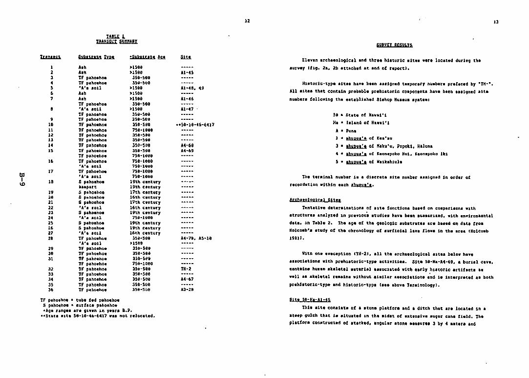
t!lI.E. 1I8ANSE~r~
Iunnct. S"b'tras.. fin oSub,u'$' ~
1 A.h >HGe2 A.b >15803 If p.hIMhoe JS8·S8a.. If p.ho.h_ 3S.~S\oB
5 'A'••0U >158116 A,h >15061 A.h >ISlili
If p.lIo.1I0. 3Se~SG8
a 'A" .011 >IS8aIf p.ho.lloe 3S11-59.
9 IF p.ha.ll0. 3se-SIIl'18 If p.hoeho. 35a-511811 If p.IIIMllo. 1Sa-leuJ2 IF p.hoello. 3se-see13 If p.hoello. 35e-511e14 IF p,"o.ho. 350-5aeIS IF p.hIMiio. 3se-5e8
If p.II0.ho. 758-10ee16 If p.ho.llo, 758-1eee
.A, ... SOlI 7S8-1"~1l
17 If p.ho.hoe 7S8-108eb:l 'A'••011 75e-letteI 18 S p.ho.hoe 19th c.ntury\D kllpart. 19th untury
19 Ii p.llo.hol 17th c.ntury~ll Ii p~h".ho. 16th c.ntury21 S p.ho.ho. 17th untury22 'A'. '011 16th untury23 S p.hoenoe lith c.ntury24 'A'••011 ne-18BBH s p.ho.IIoe 19th c.ntury4;6 S p.1I0.1Ie. 19th c'lItury27 'A', lOll 16tll c.nt.ury28 IF p.1I0.h(,. 15"-5\18
'A'I loll >158829 If p.hOlh". lSj-5l1l138 IF p.llo'ho. 358-56"31 IF Jo.II~ht•• 3S9-5~"
IF p.ho.ho. 758~IOell
32 IF p'"0,ho. 3SiI-5ee33 IF p.hoello. 35e~58e
34 IF p.1I0.IIC1e 3S"-50e35 IF p.hoeho. 358·5tltl36 IF p,"oeho. 3SII-Siill
If p.ho.hOlt • tub. fed pahoehoeS p.hoellOl • .urf.t. p.ho.ho.oA9' r.n9" .r. 9ly.n In y••r. a.p.
ooSt.t••1t. 5e-18·4b·6417 w•• not r.locat.d,
,\1-47
Hl/e-le-46-6417
At-6SU-69
U-78. A5-18
IH-2
U-67
u-n
12
SURVEr RESULTS
EI.v.n .rch••olO9ical and thr•• hl.torie .it•• w.r. locat.d during th•
• urv.y Iflg. 2•• 2b .t.t.ch.d .t .nd of r.port1,
Hl.torie-type .It•• h.v. bl.n •••19n.d t ••por.ry nu.blr. pr.fac.d by °TH-·,
All .it•• th.t cont.in prob.bl. prlhl.torie coaponlnt. h.v. bt.n •••19n.d .It.
nu.blr. following the ••tabll,h.d 81.lIop "u••v••y.tla.
58 • St.t. of H•••i'1
H. • I.l.nd of Hlw.l'l
A • PunaI • ,bupu,'. of K.a·lv
3 • ,bupv", of ",ku'u. Popeki, H.lon,4 ••hupu.', of K.on.poko Hul. K.on,poko lkl
~ ••hupu,', of V.tklhlul.
Th. tlr.ln.l nu.b.r 1•• dl.cr.t••It. nuab.r •••19n.d In ord'r of
r.cord.tlon within ••ch 'bupu.·••
A[~h.roloqlc.l Sltl'
T~nt.tlvl d.t.r.ln.tlon. of ,1t. function. bl••d on co.parl.on. 'lth.trvctur•••nalyt.d In pr.vlou••tudl•• h.v. be.n .u•••rl1.d. .1th .nvitona.nt.l
d.t•• ln T.bl. 2. lb. '9' of the 91010Qlc .ub.trat•• ar. b•••d on d.ta tro.HolcOlb'••tud, of tb. chronolO9Y of .urfic!.l I.v. flow. in the .r•• tHolcoab19811.
Vith on•••!C.ption lIH-2J, all the .rch••ologic.l .1t•• b.lo. hav.
al.ocl.tl0n. with pr.hl.torlc-tyPl actlYiti... Sit. 58-H.-A4-69, • burl11 C'Y',
cont.in. hu••n ,k.llt.l ••t.ri,1 , ••ocllt.d .ith .,rly h,.torle 'rtll.ct. ,.
v.l1 •••k.llt.l r•••in. without ,1.ll.r a,.ocl.tlon••nd I. int.rpr.t.d a. both
pr.hi.torie-type .nd hi.loric-typ. I••• abovi T.l.lnolO9y1,
Sit. 58-H.-Al-i5
Ihi••1te con.i.t. of , .tona pl.tfor••nd • ditch that .r. loc.t.d ln •
.tl,P 9ulch th.t. 1••1t.u.t.d In the .ld.t. of •• t.n.iv. ,uQar c.n. fl.ld. Ih.pl.tlor. con,truct.d of .t,ckld, .n9ul.r .ton•••••ur•• 3 by 4 ••t.r. and
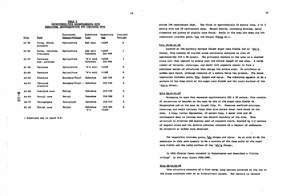
14
I!lli 1P~£H(STORJC·TYfE ARCHAtOLOGI(A~ ~
fUNctIONAL INTERPREIATIONS ANn SU@5TRATE DATA
FUllctional Sub.trlte -Sub.trate CorudorSltt IYa l!!!uM.ttu i on tIM !!I.!. Se-CU!t!l
41·4S Inl\1. ditch. A\lUclllture Aah sOlI >lS('I(I Aplattors
Al-46 Vall., terr.ce., A\lrlculture A.h soil >lS1'9cle.un9· hhoehoe JS"·seo
Al-47 Terrae.. , A9f1culture 'A'a .011 >HU.od. outcrop. Pahoeholt JSD-See
At-411 Terr.ce. A\luculture "A". aoll >lS\!D A
At-49 Terraces "\lriculture .A, •• aoU >lsee A
A3-28 Platfors &ouncluylTriJI Pahoehoe 3Se-S~e H
1.4-67 terraced 8oundary/TraU Pahoehoe 3se-~e" Hplatfe-r.
tl'A4-~8 1'!0diUed cave Refuge P.hoehoe 3!.1'-S~e II
I A4-69 ~urlai cave 8urlal hhoehoe ~Se-Sge C....0 A4-70 PetrQ9IYf/h. Petr09lyph hhothoe ~SlJ-S~e G
"S-ll~ Bur1&l c;ave 8urial PahoellOe Jse·seo G·A". >1500
• Sub.trate age ln years ~.P.
15
at.lld. leO cellti.etlrs li9". The dltc;h i. Ippro.i.atlly 23 ••tlr. 10n9, 2 to 3
seter. wlde and 38 centl.lters deep. Recent debri., Includino bottle., s.tll
frall.ent. and plece. of plaatic .ere found. 6011e in the area Ire deep alld the
velletation Include. Ilulv,,'~ Illd banyall I~ .1'.),
Sit, 5e-Ha-Al-46
Located at the boulldary bet.e.1l for.er .ullir Cilli fIeld. and an '2!1:lforest, this coepl.x of .tacked atone .tructure. occupie••n are. of
approxi.atily ISS ••8 .kler., The principal fe.ture in the area 1. a .tacked
.tona ••11 that ap~ar. to a.tend ow.r tha .nttre lellgth of the .rl., A la'll_
nu.ber of tarrace•• clear1l108. and a.all .all aao.ant. appea, to for' a
continou. a.ries of atructur•• that occupy the entire area. Ho arttf.ct. or
sIdden were found. althoullh re.nanta of a .edern fence .a. pre.ant. The den••
vellatatton includ.s 9uava.'~. banyan .nd a1rle. The .ub.trat••ppe.ra to be.
.i.ture of the deep .011. of the .uoe, cane field. and the rocky .urflc. of th.
'ohi'a foreat,
S1te 59-Ha-Al-4?
OCcllpylno .n are. tll.t ••••ur•• approxi••tel, 188 • 3e .ater., till. co.ple•
of .tructur•• ia bounded on the .e.t by one of the augar can. ftelda at
Vllp.h04hol and on the eaat by torl.t <11\1. 3). Hu.arou. sedifled outcrop.,
cla.r1nOa and ••all tarrace. <Ie•• then flv•••ter. long) .era found ln th.area, A Ion;, narro. dapre.lion, 15 leterl Ion;, 1 .eta, .id••nd 2e
centta.ter. deep i. located naar the e••tern boundar, of th. e,a.. Thtl
atructure i. oriented 248 dlore•••••t of .aon.tic Ilofth, boundld by 1-2 cour.e.
of .ngular .lone and it••1I_1low tnterior con.iltl of I dapoltt of .edt'lntl,
~o artifact. Dr .idden were ob.erved.
:ha veoetation illclude. Iluav••~ bln,.n and .tril. A. at aita Al-46 thl
sub.trat. in thl••rea Ip~a'. to be • aixtur. of the deep .011a of the aUllar
can. fiel~a and tha rock, .urflc. of lhe .~ fore.t.
In 1846 Che.ter LY.ln traveled to V.lpahoehol Ind dalcribad • "littl.
vlI1'0'" in the Ir •• ILy••n 18461188).
Site S8-Ha-Al-48
Tht••tructure conat.tl of a fivI .eter 10n9 tlrr.ee .ttu.ted at the top ot
tha at.ep .outh•••t bank of In lnteraittant .tf.... The t.rrae. 1. located
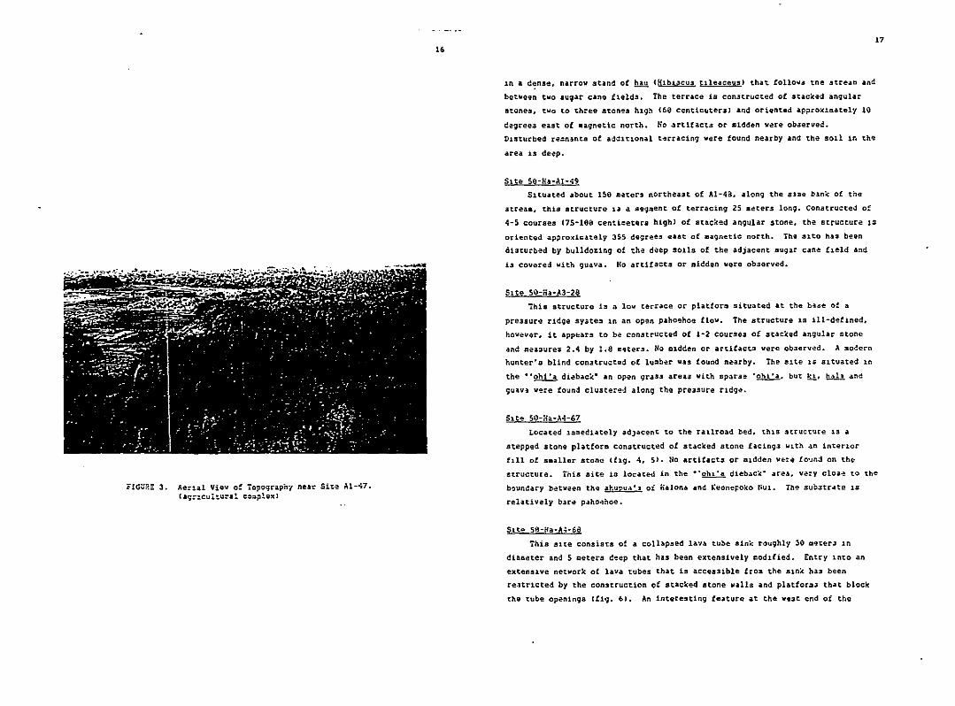
F!Gu~! 3. Ae:lal View of ropog~aph1 near Sl~~ Al-~7.
(a;:lculeural coo~le~J
,. 17
:In • c:nse. na~row stand of m Ohbi3CU!l t.11eaceusJ that. folloll3 tne streal:l and
betNeen tllO sugar cane flelds. The terrace is con3t~ucted of stacked angular
stones. two to three stones hlg~ (69 centic~tersl and oriented approxll:1ately 10
degree!! east of .agnetic north. No artifact~ or midden wece obAerved.
01sturbed re:n~nts of ad~ltl0nal t~rcacing were found nearby and the 5011 in the
area is deep.
Site 5e-Ha-Al-~9
Sltuated about ISO meters northeast of AI-4a. along the S~=~ bank of th~
3treaa. thiS structuro 13 a seql:lent of terracing 25 Deters long. Constructed of
4-5 courses (7S·100 centioeters highl of stacked angular stone, the structure 18
oriented approxlcately 355 degrees east of aagnetic north. The !llta has been
a1sturhed by bulldo%ing of the deep SOlIs of the adjacent Dugar cane f:leld and
i3 covered with guava. "0 artifacts or aidden were observed.
Site 50-Ha·A3-28
ihis structure is a lov terrace or platfor~ situated .t the ba~e of a
pre3sure ridqe syate~ ln an op~n p.ho~ho~ flov. The structure is 111-d~f1ned.
hovev~r. it app~ars to be constructed of 1-2 courses of stacked angular stone
and =ea3ures 2.4 by 1.0 m~ter5. Ho aldden or artif.cts vere ob~erved. A Dodern
hunter's b11nd con3tructed of lu~oer vas found nearby. The slte 10 sltuated in
the -'ohi'a diebac:.c- an open qraS3 areilJ With spar.il~ ·o"t'a. but ~, bA!.!. a:ld
9u~v~ were fOund clu3tered alonq th~ pre3sure rldqe.
Located i==edlately adJacent to the railroad bed, thlS structure lS a
stepped stone platfor= constructed of stacked stone facing3 v~th an inteclor
t~ll of saaller stono (f~g. 4. 5). Ho artifacts or Qldden we=e fo~nd on the
structure. This site is located in the ··ohl·a diebac~· area. very CI03~ to the
b~undary betveen the ahupu~'1 ot Halona and Keonepoko ~Ul. The sub3trate lS
relatively bare paho~hoe.
Site 50-!fa-A';·6tl
This site consists of a collapsed lava tube sin~ roughly 30 aeter3 1n
d1aaeter and 5 aeters deep that has begn extensively codlfied. Entry into an
extenSlve network of lava tubes that is acces31ble fro~ the ain~ has been
re3tr1cted by the constructiOn of stacked stone walls and platfora3 that block
the tube openings efig. 6). An interesting feature at the vest end of the
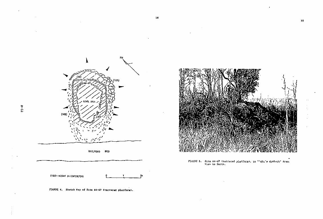
tII~
N
) ~ICHT IIj WHLW£TE?S(100- ...
RAIl~OAO B~O
2::01 ,9__-,-, _
1819
FIGURE 4. la~!or.)•(terraced pt Slte 114-67Sketch IlIP 0
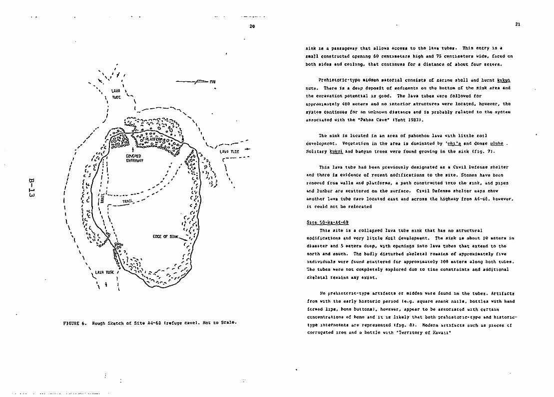
2. 21
FIG~GE 6. Rough Sketch of Site A4·6a (re!uge cave). Not to Scale.
,, -I
" '..'
SIte $O-~a-A~-69
This aite is a coll.p2ed l.va tube SInk that has no structural
~oCi[icationa and very little ioil cevelopkent. The sink 18 about 10 .etora In
diaaeter and S aeter~ d~~p, WIth openings into lava tub~s that extend to th~
north and south. 1he badly disturbed skeletal reaaina ot approxiaately fIve
Indlvlcuals were f~und ~Catt~red f~r approxi~.tcly Joe &btera alon9 both tu~~s.
~h~ tubes w~rQ not cocpletely oxplored duo to ti~e constraints and additional
s;'eletal teE. ins say Exist.
This hVII tube h.d been ~rev.io\lsjy de!l19nate~ .a a Clvi.l [.tetense ~lielter
and there is evidence of recent ~~lfications to the site. Stones h.vo been
r~ooved iroB walla h~d pl.tforas. a path conatructed lnto the SInk, and pipes
and lu~ber ar~ sCitterud on the surface. Civil Defense shelter ca~s ~how
anot~~r l~va tube cav~ }oeht~d e.ut and across the highway froa A~·~e. however,
it could not bo relocated
::0 pnt,u:tC'tlc<type .ru!locts (If aideen wHe found 1.n the tubel!. "rtlhct~
fro& WIth the early hlat~ric perIod (4.9. square enAn~ nd11s, bottlES With hand
!~r&ed lIPS, bone buttonsl. hO~Ev~r, ap~ar to be arl!oclat~d WIth ce=t.ln
ccncentr.tlons of bono an~ it 1£ likely th.t both ?rehlstorlc<ty~ ~nd hl:toric
type lnt~rn=Enls .re represented ([19. 8). Kocern A[llf.cts ~\lch .s pIecEs Gf
corru9ated 1.ron .nd ~ bott~~ wl~h ·i~rrltOry cf r..va~i-
1h~ sink is 1~3ted in in area of pahoeho~ lava v~th little £oi}
c:ieve}oilcent. Veljetoltion in the area is doainoted by .~ .. nd donse uluhe
SolItary Icuku[ .nd bilnyan trees vere found qrowinq in the sinlc ([1g'. 7).
sink 18 a passageway that allow# access to the lava tubes. This entry 15 a
£a.}1 construct~d openlnq 60 centl.et~r. high and 75 centl~~ters wide. faced en
both sides and celllng_ that continues COr a distance of about four &et~rs.
Preh1atoric·type _idoen Dat~rlal consists of £irlne shell and hurnt kukul
n~ta. Ther4 is a d.~p deposit o£ aedicents on the botto~ o£ the sink area and
the excavation potential 15 9~od. The lava tubes ~ere followed tor
~ppr~xi.4tely ~oo aotera and no interior .tructur~s were located. however. tho
~yst-:-11 c(ontinU(os fOf an unknc.v" disUlflce and 1s probably related to tho syetec
.s~oclated uith the -Pahoa Cave- IYent 19SJ}.
,,,
;e=-> "",UVA \nEt \,.-.
\( ----~,- '- ...,
\I
1
l ' ..... /--.-V.II" Tl=t:
\\
II
/
toI
I-'W
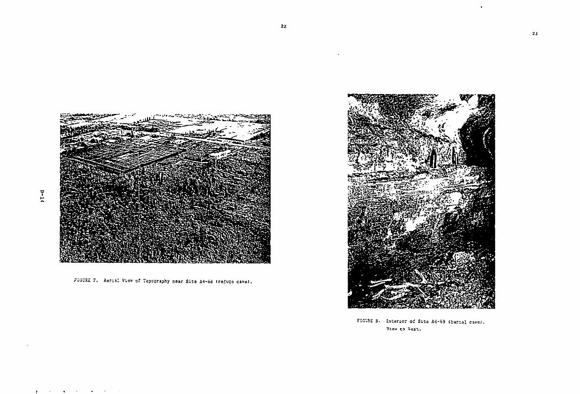
'"I....~
2Z
2J
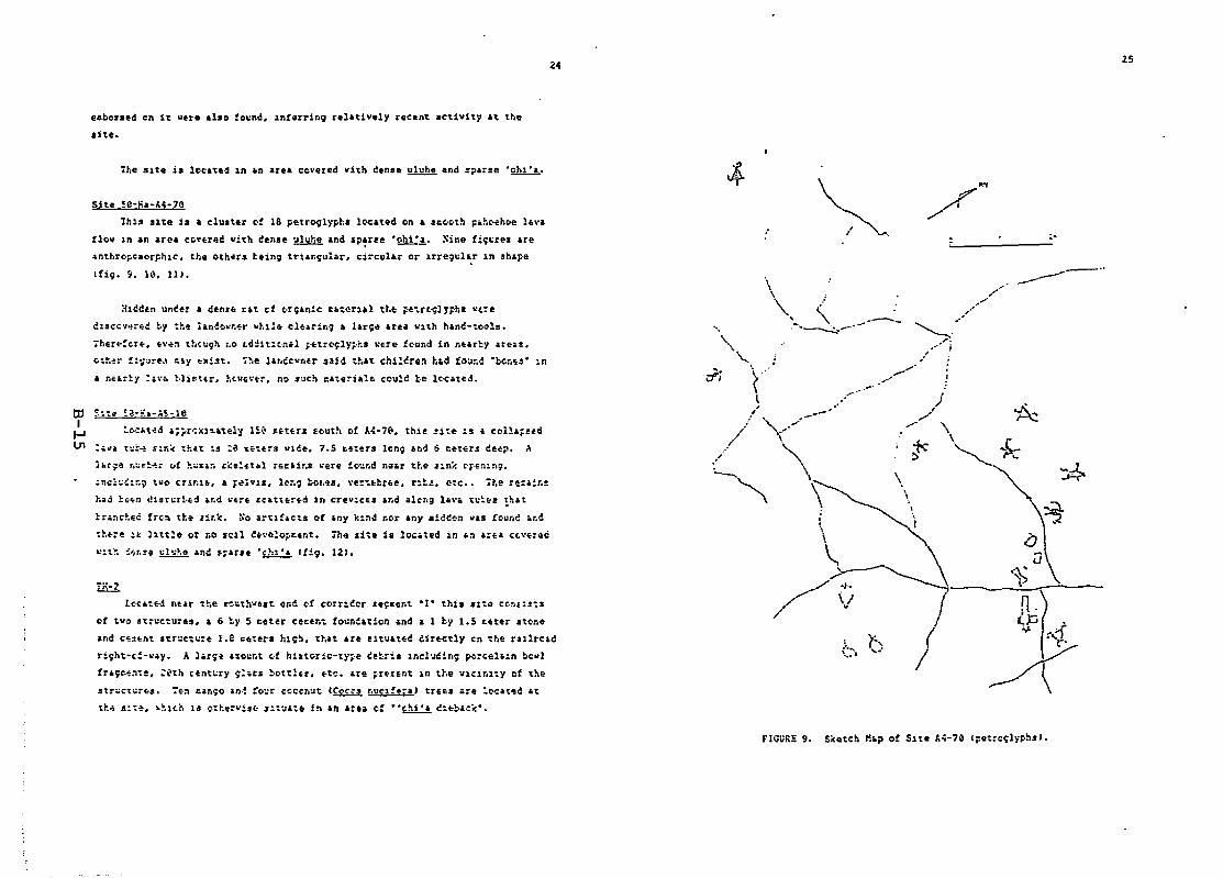
24 2S
e~be.sed en 1~ vere also :o~nd. in!errin9 rela~1v.ly rec.n~ aC~1vl~y a~ the
siu.
ille slte is leclte~ in an areI cevered vith den••~ and s?arse 'Ohl'I.
:-----_..
j
)./
./ \ok'~
\\
.......'-
,........"~ ... i
/(i
\\ .'\ ,--........~--.-
"'".-ji ~ .l
.//,/.'\......... ----
'\\\
,!leeen uneer a denu rH cf (orlian~c utend d.e ~·e ..rCt<;ly;,hl "t.:e
clsecv~:~~ ~y th~ i.n~~w~~r Whl1Q cl~Arin9 a Jar~~ 6rea with h.nt-~ools.
iher~!crE" fo\' ..:t tt'tt:9n :,e ~d:!it:tll.l p'fotrt'lily~i:s \lu'e fcund 1n nur~i' areH.
~~~~r :~~ured ~lY ~Xi3t. r~e l.~cc~ntr ~aid t~~t eh1~cre~ h&d io~~d ·bG~~34 In
• n~er~y :'Va ~·li~t'r. ~t~~~~t, n~ ~ac~ =atersal~ ccul~ be l~_ted+
had ~H" <!u~~tl'ed v.a "e~.. £(:~tH,r.d in crev:cu at,d a1cr,g 1"'·a 'l:~.s !nat
tran~~ec frc~ t~. ~i~k. ~o ar'1!.ct$ ~r any k1nd ~or any .iee~n ~.s Count a~~
o:~.:e 1~ )1,t1e or roo sell ~.~e1o~~er.t. ihe aite ia located in an ~rea c~~er~d
C1t~ !r,r.s. ~ll:~e and s~ar'e 'C~1'a l!i9' 121,
Located near t~e a~~th~est erod of corr:~t'r se~Eent ·1· this '10:& c~nr1Sta
of tvo Structures, a 6 ~y S c~t~r ce~er.t foundation and a 1 b~ 1.5 ~eter st~ne
and ceifont str~ctl::e I.e =eter. hi~~. that are situatee dir.c~li' en o:he rallrcad
ri~h~·c:-~.i'. A larS. ~:Ol:nt of h~.tor1c-ty~e letri. lncl~din~ p~rcel;:n bovl
fraye~llts. :~th CEnt~ry ~:.ts t,ottlet••t~. are ~rEtent in the vicinlty of the
.tr~~~~j~a. 7~~ ~~n~o In~ !o~r cc~cn~t CCCCk3 ~uel!f;a) trE&••:e :~At~d .t
t~~ s:~~. ~hl,h is ¢:~~=~:~~ ~~~~.t. i~ Aft .:&a G! ·~(hi~£ ~~~~.~~.~
Site ~e-HI·4i-10
1hlS Slte is I cluster ct 18 petroglyph- l~ated on a s~~~th p.h~lIoe lava
!lo~ 1n an area coyered vitll tense ulyhe and sparse '2h!:~, Sine fii~re. are
~nthropcmorpIl1c. the otllars hein9 trian~ul.r. circular er lrreg~l~r ln shape
tfi9. ~. 10. 111.
tu $~o:" ~;l·;:.-:.~-Ie
I~ t~~~t ..d a;;r~xi~atell 1~~ ~{,t{,r. louth of ~~·70. tllis site :s a col1a;s&d
In :.~a t~=~ Sl~~ t~at ~s :~ ~~~er~ vice. 7.5 ~.:er. 1~r.; 6nd 0 eetEr~ c&ep. A
1.:;6: r~~~~...:. "t ~:.utl:l l:;:.~~titl ril~.1r~* ,,4ere !o·..:.r.d n-a.r t~.• J'in~ e't"::l:.n9.
.r.C~~~:~9 t~o Cr1&1.~ a .~~V1S~ l~~~ ~O~~~I ~~~~~bfae. r~t~. ~te •. ~~e rE:air.~
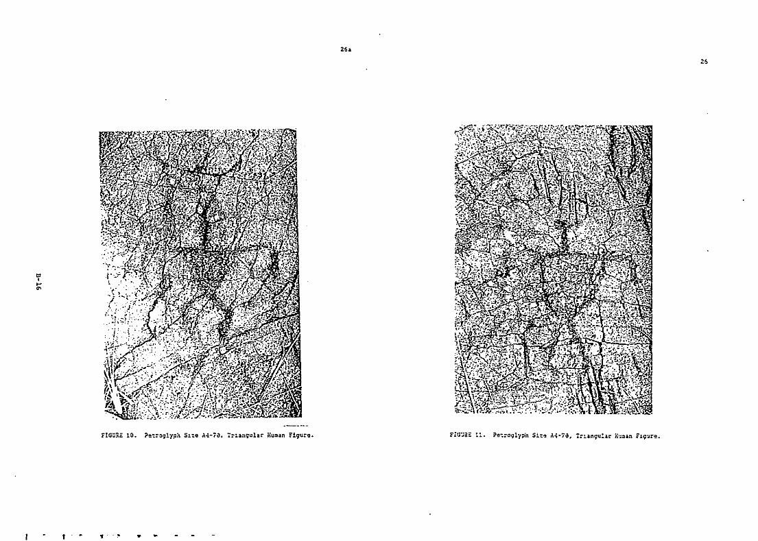
'",...'"
2••
FIG~5E 13.
, • , •

"I.......
if!!.,o:.'~~\.
J
27
Historic Sites
TH·l
This site 1s the right-of-vay of the Havaii Consolidated Rallway. that
extends fco. Hl10 b3y to the Kapoho area in south Puna. The tracks wece re~oved
in the early 1920's and aany portions, especially in the Hila area and the
subdivided areas in Puna have been utilized for aodern roads. however. the
rallroad bed itself 1s r~latively intact. lsee appendlx for (urther Inforcatl0n
on thb site)
!!i:.J.The 01aa Sugar Co~pany. plantation .anager's estate 1S located
ap?roxisately 1.2 kiloDeters (3/~ .L1e) south of Kea'au town along Hlghway 130.
This site 18 directly associated with Kea'au District (State of Havai'i slte 50
1~·~4·7J89J. which includes 3uch at the plantation town of Keaoau, and appeara
to be in relatively 90~ condltion.
DISCUSSION
The 11&ited scope of the present study a.kes interpretations very
tentatlV•• hove~er. the aettleaent pa~t~rn aodel presented in the reaearch
~esivn is venerally supported by the result4 of the Burvey, The predicted
occurrence of extensive a9ricultural fields and adaptation patterns closely
r~lated to Fhy~i09raphic feature. is 8upported by the current dlta,
It ahould t~ noted that the pr6sent study area covers only the central
portions of 20ne II ediscussed in the Research Desi9nJ, 'ihe underlying
queStl0n of ~her6 the ·Inland· areas begin, vith regard to prehistoric-type
site ~istribution is not addressed by the present .tu~y,
A~rlcuitural Sites
Five altes are related to pr~hi.toric-type19ricultu=al _ctivlti6s Ind
Ire locate~ near the northvest boundary of the StUey area, where deeper aoils
occur. iheae aOl1 deposits vere used tor ~odern a9r1culture .nd the terraln
has teEn eXttnsively altered. Th~refore, .1thou~h the sltes are l1cited in
ext~nt lt lS likely tha: th~ t~ature. are re_nants ct lat~e. PEr~anent
a~ricultural co=plexes cescribed by early historic visitors.
ivo of thec~ S1:68 .re a9ricultural coc~lexe. th~t are sltuated in areas
vhere the ceep aoils ceriv.d Cro~ volcanic ash. Qr veathered 'a'a are aixed
vith .,·re rectmt lava flco..... Althouo;h the ash is oldu than l5e& yeus, the
rela~1vely unweathered lava vas forced 350-500 years a.p•• therefore, a
te~:&tlV~ llDit ot S~O years is sU9q~sted for the age of these fea~ures. The
other aqricultural sltes 6re all loclted in nearby areas and Ire probably
cloaely related to the two co~plexe••
It !l'.culd be noted that althouqh a lar9a nu=.~er of a9r1c:ultural features
w~r. e.strcyed when the areas w1th deep soils vere plowed for auqar cane
"fleldr, .noth~r aourc:e of disturbance for features in the area cay havQ been
recent lavi Clov6. roany of the flovs in the Irea are less th.n l&~O years old
(w~ll wlthin the perIod ot hU~'n Occurltion tor nlvai'l), and ~ay cover
eariat sltes ln the area. the ."batr_tea on vhich the other types of slus
are locat6d were forced betw~en 35&-SeO years h.P. 1nd~catln9 that they toO
vere utl1i~ed wlthln the last see years.
r ---
>.Refug9 Cnes
The refuge cave locat~d durlng the present study 1. ptobl~ly pArt an
extensive ne~work of lava tube. lOcAted northve.t ~f P~hOA town that probably
~xtend to cOl~tal area.. It 1~ hl~hly likaly tblt Iddltional lava t~~e slte••
po••1bly conn@cted vlth thls refu9. cave. are present 1n areas vlth siellar
geologiC Dorphology since twO other refuge eaV6S have heen loc.ted ln the
9@neral area. Althou;h trad1ticn~1 hlstorle$ a.cribe a secondary politlcal
role tor Puna, the lands vere consl~e~ed valuable and the conflict l=pll~d ty
the pr~.ence of refu;e cave$ Kly be rela:ed to cuntrol of loeal re.o~rces.
Burtal Clive
Tte ~~eletal ~aterlal located at the two turlal eaves. ¥et~ ex~en'lvely
clsturb~d and only ~inieal inter?retations re;ardlng possible ';e of the
t~rlals is ~a1~. The re~ain' f~~nd in one ot burial caves appear to ~e fre=
both th~ hl.torlc and p:~h15turic period and cay ind1cate contln~al ~s~ of the
CioVe o\'er a ;"~rlod c·! t::'Qe ~parlnln9 the ~ransItl0n frCr:ll pret.istorl;:-t}·p~ to
h13~~rlC-type .ctlvitl~3. rh~ Other cave ~ay be relit~d to prehi.tOtlc-type
_ctIvltlea only. 1racltlCnal Hawailan burials are fr~qu~ntly ~ttoClatcd WIth
habltltlon aro••• hOVEv~r. no kn~vn prehistoric-type habltaticn $lte. are
alt~'t~d near tL~t~ 61:~s. One ~X?lion.tl0n lS that eo:e burIal Slt~S. u~ullly
for hi;h :ln~in~ per,ens ~~re secreted in re~ote areas. The other FO$Slbllity
18 thl~ ~any $it~. h.v~ heen c~.rroyed by Dod~:n actlVitl~S and features thlt
re:l~n ara dlffic~lt to locate.
;:}atfo:=s
Two of ti,e altn .:e ~1a.tfor~5 located .in op.n iltelS of 31:1ooth Fahof:hoe.
Since both of th~ srruCture3 aro located near boundarlEs betveen two ahuoua'a
a tentative interpr~tat10n 18 tha~ th~y ~ay be terrItorIal boun~aries or trail
.ci.rkerllo
Petrogl\'ph!l
The F~troglyphs found at CIte ~4-7e are tl~llar to t19ures found at ~tr.~r
.1tes 1n Havai'i. 7he laportlnce of the c~rv!nqs i_ that an aye l1cl~ of nO
old~r t~an see yea:s cth~ estlDated Ige of the l.vil: tlov ~n whIch th~y h"~e
bein InscrlbedJ c.n be placed on the:. To this author's knovle~q~. ~nIy one
othlr _ite. the Hl1ir.. fali fetr~91yph Cave (oi.ho~ Huseu= 81te ~~-r.v-~c~1 has
procuce~ ~lr.ct chronolc~ical a.SOCl.tlcn5 lor n.vaii~n petroglyph••
,.
Th. ce.e~cch at the Hil~na Palt ait. indic~t•• th.t thec. v••••tyltstic
ch.ng. in hu.an f1gurs petroglyrb. ~t about A.D. 1668. Hu.~n flguce. carved
whan tbe cava wa. flC.t occup1.d Icicc. A.D.1688) are do.ln~ted by 11n.~r
f19uce. cfel,. with f •• open-bodled C1811 .nd triangular figure. 110". ~aled
on lnf.centlal data • bypath••l. that th.ra wa. • .ub••quent chanyl ln
rcefennce (or tnangular fous til clJ'rased to l1nur figurea. vn f,roposed.
ho.a.er. further redl.cch wa. con.lder.d to be nec•••• ry cCleqnorn 19881.
At 'lte A4-70 all 01 the nln~ hu••n figures are e1ther trl,ngul~r or o~~n
boch.d. no hn.ar flquc•••ue found. Altbough the a••pl. 18 aaall tbe
co.~l.te absence of I1n.ar JlguC'. 1n a cluster of ~~tco9Iypb. produced afttr
C1cca A.~. 1588 l.n~••uppoct to Cl.ghorn·. hypoth••ia.
Su..uy
The ~rlod of tl" .uggl.t.d for occup.t1an of the 81t•• locatld ducln9
the pre••nt .t~dy i~ fro. cirel A.D. 1458 to the pr•••nt. In ter" of the
prehl.torie H••'li.n occupation of the ialandl thia .tAn. the lattlr ~~rt of
the Exp.n.lon Ferl0d CA.D. llee·1658J ~nd the entlre Proto·HIstoric Perlod
IA.O. J658·l79S. a. prapa'ld by Kirch for tbe eVolutlen of nA••ll.n culture
l~lreh 1?85J. Durl~g th••e period. the populatIon lncr••••d r~plaly •
••ttle••nt. ,xplndtd fro. v.ll.y fOCi. and .0Clal .).te•• und.rw~nt
• 19nlflc.nt ch~n9.a. r ••ultln7 in tb. ad.anc.d cultur••ncaunter.d by
Europ.~nl In the l.t••Ighteenth c.ntury CIbidl.
Th~ hypotho'il that .~ttle.ent. expanded Ira. pri••ry context. into oth.r
fpreau••bly le.' dealrabl••rel.' after A.D. 1108 i••upport.d by the re.ult.
of the pr.sent .tudy. Th•••tabll.h.tnt of .grlcultural cO'pltxel, far fro.
the plt..ry frua uud for ..ttlutnt on the eout Ccirca 5 h.) .0uU••
• ft.r A.D. 1458 1. con.i.tent vith Kitch'••od.l for the d••elop.ent of
Havaiian cultur••
F£COHHENDATIONS
Th18 .ecuon cantun. gen.c.l recouandationa r.garding a.hction of
the tr.n••l.Clon 11n. corrldor .nd apec1fic r.eo••andation. regardlng the
tcoat••nt of arch••oloqleal and hi.torie atte. locat.d durin; the lurvey. Th.
ceeo••~nd.tl0n. for corrldor ••I.ctlOn ara ba.ed on the pot.ntlal foc
.xiltenC' of addltionJl areh.loloqlell 11t•• in e.eh corridor ••ctian 1·.
through -.-, .nd ree~••tndAtlan. for areciflC .lte. are b'.ad on .lte
~.~luation. £nd pa••ibld iap_ct. the can.trUctlon of the tr.n••i •• lon 11n•••y
hAv* on the feature. loc.ted.
~en.ca. FecD.,endationl.h. result. of the surv6y lndlc~t. th.t the archa.ologlC.l .it•• located
ln th~ aurvey .r•••r. of ll'lt.d .r••l extent. Th.c' 1. a hlgh probabllity.
how.ver. that i.olated Ilte••r. pre.ent throughout the Itudy .r'••
Theretore. when ••peclf1c 1119n.ant for the corridor il I.lectld .dditlon.l
arch••olOilcal r~."reh .hould b. conduct.d In .r••• to b. eliiturbld. The
den•• vigetatlon and ruggeJ t.rrain of '.ny p.rt. of the .tudy .r••••k'
location of Ireh.eologlc.l 'lte••ueh II lav. tub. cav.a vary dlfflcult. If
the the .re. to be .tudled 1. w.ll-d.fined. concentrated effort. to loc.te
slteD c... n b•••ele •
Archa.aloqJc!1 ~ [v.luatton. ~ k.coe.endation.
Evaluati~n. of eondltl0n. rt••arch pot.ntlal and lnt.rpr.tlv, value of
e.ch archaeol091cal .1t. are lllt.d In r.bl, 3. Th. tar.a u••d ar.
h1erfrchlc.l and conli.t ofl .xcell.nt. good. f.ir. or poor.
Th. condition of the .1t, i3 ,valuated through • qualit.tive ••••••••nt
of the 'It'', .tructural lnt.gerity. ~e••arch potlntlal II r.latld to th'
po••lbl1Ity th.t the .It••ay contain dat, J.port.nt to the pcehiatory or
hlltory af the ar.'. reglon. or Hawal1an atCh,eology ln 9.n.ral. Jnt.rpretiv.
valu, i. b.ald on the pot.nti.l at a .1t, for public u•• or ell.play. Sit.
qualitl'. t.ken lnto con'ld~r.tion Includ.1 uniqulne,. in thl r.g)en • 'It.
condition••cc~a.lbility. and public interl.t.
The .rch.eoJoglcal ~lt•• ldentifJed during the pr•••nt .tuely ar. "I,,8.d•• h••lng eith.r gooi or .xcellent r ••••rch potentlal. Sine. the pr••ent
£tudy lndlcat~' th.t .ecy f*v pr.nlltorle-typ. alt•• r ••aln ln the .r.a. the
illI& ~ARCHAEOLOGICAL~ [VALUIATI9NS
lie••arch Jnt.erpr.tlv~
S1t. 1IuCI'lption Condition S1gnlf1clnce f21.e-'l!lll.
AI-45 Iruv· ditch, plattor. hlr Good Poor
"1-46 V.lla, t.rrac••• Good Excellent Goodclurin9'
AI-47 Tl=l'r.c:•• , 00<1. outc:ror;-I FUt Good Poor
.\1-48 TerrIe. Fur Good ·Poor
Al-49 t.rrlc, Poor Good Poor
"3-28 Plltfor. Fur Good Poor
,\1-67 T.ruc.d Platt or. Good Good rIll'
At-68 Refuv. elv, FlU' Good Poor
"4-69 ~Ut1al elY. rau' Good 1'001'
A4-78 fetro\llyph.s Fur Good f.JuIIII .\5-18 llurlal cav. Fair Good foot
N0 78-2 C'.tnt/aton. Poor Good hn
found_Hcn
Acc••• to tb••• 11t•••hould b. li_lt.d.therefor InterpretiVe value •••••••d II poor.
33
laportanc' of known , ••tur.. to future r••••rch 1. very h1qh 'Inc' th.irr ••••rch pot.nt,al 1, .nhlnc,d. Th. hietorie-type alt. TH-3 ia probably a
railroad depot. howlvlr. 1n the ab'.nci of ,plcific hiltorieal d.ta th11
lnterprlt.tlon 1. t.nt.tive an~ furth.r r ••••reh 1. n.c••••ry.
In 10.t c•••• the pl.celent ot foun~.tlon. for tran••ll.10n 11ne pole.
allow ~nou9h fllxibility to avoid all .it•••
It i. r.co••ended. therefore. th.t all of the located 81t•• be prel.rved,
H11totie~ Reeo••epdation.
"o~t of the prev10u.ly 1d.nt1fled hi.toric alte. ln the Puna .re••Ir.
evalu.ted during thl Statlwid. Inventory of Hiltortc Plae., conducted 1n the
~.rly 197&',. Th••aJorlty of the ,it•• ar. I.aociatld w1th 'ugar plantltl0na
and. baaed on lueh factorl ., arehit.ctural uniquln.aa. hiatOrlcal blekground
Ind repretlntative atyll. have been a,.ignld r ••lrv. Itatu. Ithe four tlra.
availabl••arl high va lUI. valu.bll. re.erve••nd ••rginal).
Although d~t.l1ed infor.atton on the plantatlon .Inlgar·, .atat•••ite
TN-3. 1S pr.sently unlvailable. lt .ay be elig1ble for no.inltlon for
reg11trltlon aa a hl,toric pI Ice. The .atate .rea I' well deflned and of
11elted are•• and Ihould b. avoided by thl propoald conatructlon act1Ylt1•••
The for.ul.t1on of s~cific reeo•••ndatlone regarding the railroad
ri9ht~of-Vly 1. probl••atic due to it•••trl•• length. Although pre',rv.tion
of portlons of the ra1lvay foundltion that r •••ln 1. d••lrabl•• the ,peclf1Cparte to bo pr•••rved 1. d1fficult to dltlrline. Howevlr, two .eetton. that
Ihould b. prlelrvld Ire the rortlon, nlar .itl. TN&2 Ind A3-28. both located
i ••edlatelr .d,aclnt to the ral1vlY bid•
• he propo.~d conltructlon aetlv1tl.a Ire unlikely to affect .ignlfleant
port lone of the rall.ay bed. howlver. apecifie conatructlon letivlte. Ihould
te rev1ew~d with r.gard to pC'11b11 e.t.n.i~. Ilt.rationl.
34
Corrldor Evalu.tl0nl
In ordlr to f,ctltt.tl dllcrlption the corrldorl h,v' b~~n divld.d lntO
nlnl ••ctlon•• -A- through -1- l(lV. 1).
S.q.ent. :c. !!I.S!. XPortion. of tb. nortb •••t .nd .outhl••t 11.1t. of the•••eQ.,nt••r •
• itu.ted ln .r••• util1C.d for lu9.r can. fl.ld••nd .adlrn hOUI. loti.
How.v.r. rlltrlct.d Ir.al luch a••••11 9ulch•••nd the ••r91nl o~ the ,u9,r
c.n. fi.ldl ••y contain addltion.l arch••ol99ical Itt.1 .uch a. the five
agrlcultural lIte. IAI·4~ through 49J locat.d. No ,it., vere locat.d 1n the
c.ntral plrt' of thi, ,.g"nt. hov'Yer. it i' lik.l, th.t l.v. tube 'y,t.,.
are pre.ent ln tbe pahu.hoe ,ub.tr.te of th••e .r", .nd cay. 'lte' lay ~xl't.
W!!D.l :cAn Ilxhn,1V' l.v. tube ,yet,. 1, knovn to be loc.ted ln the p.hoehoe
lub.tr.te ln thl1 are.. It 1. hlghl, 11k.ly th.t .ddltion.l 'It., .uch a. th_
~ burl.l CA4~69J and refuge c,v" (At-6aJ loc.t.d are pr.I'nt ln the area.I~ Th.,. 11t•••re v.ty dIffiCult to loc.te hut .re u.u.ll, of ll'lted extent •.....~=.c.
Thil leg'tnt cto•••• terr'ln that ha. be.n extenllvel, dl.turbed bylht.nllv. Modern agrlcultural 'ctlvitll.. Ho .1tel .ere lac. ted ln the••
ate•• and th_ potenti.l for ,It., l' v.ry lov.
~~
Thl .ubltr.t. ln tht, .rea l' l.trl.,ly roe«y .nd irrlgu1ar••nd 1•••
th.n te~ year. old wlth v.ry 11ttl. loil d.v.lop••nt. Th. "It,rn p.rt of the
aeg'ent ha, b~en e.tenaivelv diaturbed bV .cdern .gricultur.l Ictlvltle.. No
Iltes v.re loc.t.d in thi. area and the potentt.l for lites i. very low.
llil!.!ll~Port10ns of thls ••g.en~ .re covered by 16va tlowa that occurr~d ln the
19th eenturv. other ar"1 wlth older substrat., have been .xtenslvely dlstubed
by .od.rn agrICUltural actlvltl... No 11tel uer~ l~ated in thll art••nd t~e
potential for .1t.S 1. very low.
3S
~~
Th•••,t part of thl' "g'.nt h., he.n '.testv,ly dilturhld by aodern
agricultural activlti... No ,ite•••r. locatld in th,•• ar"1 bV th_ pr.slnt
.vrvlY and the potentlal for .1t.S 1••erv low. the north••'t end. hov••er.
.t the lnt.r.eetlon vlth "g_,nt 'F' 18 .ituat.d on an undi'turbed pahoehoe
flow wh.tt P~tt091yphl IA4-7el .nd a burl.l ca,e rAS-le) v•• loc.ted.
Although thea••It•••re of v.ry llllt,d 'xtlnt. there 1. a poaalbllity that
.dd1tlon~l. ~l'l).r 'lter. .ay be pr••ent.
~:£
It i. llkely th.t an ext,n'lv. la•• tub. ayst'M Ixiatl 1n the pahoehoe
.ubstr.t. of thi••re.. Thlr.for•••lthough the only lite locat.d .long thil
.eg.~nt 1. 'It. T8-2 tpo'Slbl. r.ilv.y depotl. thlr. 1•• po.libllity that
cav, 'ltO' .ay b. pr•••nt.
~~
The .ub~trate ln th11 'ra' I' '1811ar to that ln .'V"nt 'G- .nd th.re i.
II po:u1blhty th.. t cave ,au u. pre..nt. Two i.olat.d platfor.. tAl-2e.
At-67J w~r. loe,t.d along thi, ••g'.nt by thl pr"ent .urvey and add1tion.l.
3.
37
3.REfERENCES
l'ovacqua. R"1972
and 1. Dy.ArrhuolS!gu:f1 Rtt.2n.'!!.l.!!!nS.!. ~ propond ~~.l!'p'!!!!'!'
ti!9ll!.U&. h!.lllU. 21 bm.!L l!!~ ~ll!.!!!llJ.. (le-partloElntalRe~or~ Serle. 72·3. D.~t. An~hro~olo9Y. &. P. bl~hop Mus.
Hansen. Violet.19b? 'Lilt of HiltOflcal Sltel. I.land of Ha.'11.·
AnthropoIo9V. 8. P. Bllhop nUl.
Bonk, "111ua J.19&0. -An Arch.eoJo91c.l Survey 1n l.,hl.kala, Puna. Ha.11i.- "a.
prerared for Gaothecaat Exploration and Develop.ent Corp. "a,alto Ival)abl. at B. P. 8i.hop Hus. Llbrary.
~ordn.r. Richard n.1977 -Arch.eo)oQlcal R~conn.l•••nce of the ~ropo.~d FAA Atf Traffic
Control R.~.r Beacon Syat•• ,ATeRBS' FaCility at. Pahoa. Pun.,Havai'l 1.1and,- "s. preparod by Archaeological Rel.areh Canter~•••11. Jnc. for the Fedaral Aviation Adatnlatratlon. Paciftc·"sUin ke910n. Ks. aho nailabl. at &. 1'. &U1hop nul. LlbUf)'.
Kirch. Patrlct V.1985 ~th~rea 2~~ ~~ fl.hhOOk.. Honolulu: Unlv. HlVlli ~fe•••
nc~on.ld. Gordon A•• Abbott. A9atln T•••nd Peterlon. rran~ L.!!IS3 ~c..!!l!t~f. "11 the ill.... 1h!!.~ 2!. Ha"!il. Honolulu: Un1v.
HawUl I're".,
Unpubli.hed hate. in Dept. Anthropology. B. p. b11hop Hus.
JndlC't!. 2l. !!.~ tl!.!!.!. I!l. 1!l!. WI!!. 2I. Cosalllllone!.!.1.2. ~'U.t!. Land T.l!1n. !!!. 1fI_~ M.-..han hland.. HonolululCO"1'.10n~r of ~bllC Land•• Territory of Haval·).
·Kilaue. Volcano: Chronolo9Y and l'lorphol09Y of the SurficlalLava fIo••• - Phd. Dll.artation. Stanford Univeralty.
E.'ArchaeolooY of ra.t Hawill.' I'ls. 1n Dept. Anthropolo9V. b. P.Buhop l1us.
Lya'n. Cheater1924 6r.9.!:!n!l !.h!. Horn 12. lll!. Sllnchneh hlanda Ul!t Cahfornu. till:.
llli1. lli!lg ~ l:!ll2!l.!.!. hcold k!RS U Chutll. ~. New Haven:Yale Unlv.raltv ~r"1
Indlces •••15l~9
n.d.
Hudaon. Alfred1932
Holcoab. Ron15181
Chatter 6E. Htatorlc ~r'lervatlon ~evle.: Hawallan Ho.~land&
~roJect ("a(u·u). "e.orandu••val1abl~ at Plvl.10n of St~t.
Par•• and Hl.torlc Slte•• bert, of L~nd .nd ~~tural Re.~uc~••St.lote of Ha"ln.
'An Archa.ol091c.1 Survey 1n r'lh'akal. Ind PohOlkt. Punl.Havall.· nl. prepared for Geother.al Exploration andDeve:op.ent Corp. H•• avallable It 8. P. BiShop Hus. Librlry~
L.I!!.!. H.1.!l.!!.!.~ tt!.!:2i!xl!!!. Cav~, H!!.!.!....:.!. hiland: !. 5.!.0..2I1 !!nfrtl,.,n!r! ~J(ha.o~.l Inve.t19.tJ~n.. ~.~art.ental ~eport
Serle. 69-1. ~ert. Anthropol09V. B. P. et.hop Hu••
Corey. Ron1986.
C149hClrn. P.ul19£9
1~e6b Po"~r ~lant for Puna C.other.al Venture. ~~~~rt avallable atDIVision of St~te Parkl .nd Hlstoric Sites. Dept. of Land andN~tural ie.oucea. State of H''',ii.
HcEldo.nev.15119
Holly'ArchaeoloOlcal and Hl.toricil Lit.ratur. Se.rchOeaiqn. t.v. flo. Control Study. Hl10. H'.al·l.·
and R••••rehnl. 1n Dept.
Crolier. S. N. and D. B. ~.rr.re
1971 Arct,a~olooical and Hiltorieal~ 21 lh! Ahupua'_ 21 Pualaa.Pun. i!1!1.t1..c3.4 I.J.!.!mt 21 H1.!!1!.. Dep.n-ental hport Suna 71-1.~ept. Anthropol09Y. B. 1'. B~ahop Hua,
£Dorv. Kenn.th P.1945 'Expl~r.tlon or H~rbart C. Sh1raan Cave. Kea.u D!vislon or Puna.
H'.'!l.· Hs. ln D.pt. Anthropolo9Y. B. P. BishOp "UI.
In Card.nl eL tl!!!1l. Honolulu: B.P. Bllhop "UI. Spec. ~ub. S9.Honolulu~ bl.hop nUl, Pr••••
Roqarl-Jourdane. El_lne H.1984 -Part I: Archa.ol091cal Survey 11nl Archaaol091ea1
Reconnalllancl and Hlltorleal SurveVI of Landa .t Kapoho, Punl.Ha.a1'1 Iliand.· "a. ln Dept. Anthropol09Y. B. P. Btahop Hu••
H. LUlco.b-Archaaol091cal lI,conlln •••nca or f'rop"led hpoho-KeaukahaH19h••y. Puna. Ha.'ll.· Ha. ln Dept. Anthropol09Y. 8. P. Bi.hoPHu••
Warren Iked•• Robert Paeth. Richard S.ytha and ninoru T.kehlru Jr.~ Survey H!. 1h!. bhnd 21~ Sute 2!. t!!!!.U.. UnuedStates D.part.ent of AOrlculture. Soil Conaervation Servlce. andUnlV. Haval1. Agricultural £xp.rl••nt Station.
Evart. tt •• and1974
rederal Hlghway6a""1 ('Iept. of
1SI79
Ad'ln1atrat~on 'and Land Tran.portatlon racllitle.TranaportatlOn)'flnal Ehvlron.ental lapact Stat~.ent, teaau-I'ahoaBV·F•••• • fte. aV'llabla at ~ept. AnthropoJ09Y. 8."UI.
J(oad. P~hoa
P. &UhOp
Stoarn•• H. T.l!l46
Sato. Hury H••1SI72
and HcDonald. G. A.~ m Ground-UnarBulletin II. Hll•• i1 Dlv.
Rllourcn 2!. ill !..!.l!.n!l 21. l!!!!1.:.1.of Hvdro9uphy.
~INW
rent, "artha1~83
rent, Kartha,1~B2
3.
-Surv., of a Lava Tube, Pahoa, Puna, Havall.- "e. 1ft ~lv1aton
of State Parka and Hl.tOrle Sitea, Dept. of Lind Ind NaturalR••ourcea, Stlte at Ha.aii: "a. alao avallabl. It 8. P. Blahop"ua. Library.
and Ja.on Ota-ArchaeologIcal Reconnaiaaance Surv., of Nlnl.al. fer eat keterve,Halepua'a Section. Pun•• "••al1.- Ka. ln D1vla1on of State Parka andHl.toric Site., Dept. of Land and Natural ~elource., State of H.vaii;"a. al.o a.allabl_ at 8. P. 8iahop "ua. LIbrary.
'.';' t':
.-:'/ \".\,..\ ~ /""dZ) .' \\) : ~ / -' \/),
. \\.' <"': ~l''-'7, ), \\ '!'':--~·'T.. . . :' f
.... r • .J. ... ,.
~i y .. :~~i~ e. ~~fr'.!'".--••ut~.\ \ a- "l .'. . ·.1'''''' \1." I.) - :...... ~
I'. ......, I I ~·~·<I. ">: • ...... :.1.••••••• • .'~ ••0 . :'1 :••.• ~'(:~: ...I": .,.. ): ..•..• .,...... .:, : ..... " ~:-~\,\; ,:J../ : h.: /-!l~.... :'. . .."i........ . ".;..-' .. _..... .011. 1\ ·f"..· ,.. 1
••... .. .•.. . ../- ,.' ., -.::.•.~=.1'.1;, ,:\. : .:i'0 .... I". • ,1° 1..' KIll, '''''~ I •'" , ./ .'_1.. .••. o' \.1)1.··· .. ; :
• ..'.. 1 \. I.'" 'IIio..... " .,- -J'l·,. 0" "1 . --- .', ; .~ ,';"':~C"U o' ;.. ,- ..~;''-'H:'' . ," \20.~.•...•'" .,•.;:.._ .."'\ ·.~.:T. .,.,~, \ .r~~ .. 0' / ::: . '. ". ',.. ' • '. '.. -, 7.
.......t~·1 ."0", ":"""":... .. .... ,"';", , 1..',',':-: ..'-' '" .... - . .... ... ~•. ,. ,......-· . _0. 1 ••••11.' .,r l .... ~.." •••••• ,"', \ • 0 ".• ••• ~~....." ''lIo ~~,,·".l 'm,:\'~' 0'"\' • I.' ': : '0"' ,0'. : : ••• ""'...../. ..' .. ·.•·7.. [Ij.~.:"'.1.'... l .:,:~~~),,;.*~..'t -r-:~Z .,t:::" \:l~"'" !'. -~ ;"-/ r :.... ':~~ .'. ~. ..... : ., ....-•. /~-.: •• -:'···,.· .:.• : :.• e:::;' • "':o..Jr.... : : ,. ::; •../.• , .... U -'" .' -" .r-.....J1;;,.;:.;,:;r', ;~ ;':::...:, ..;....·..~~t\ '~~!".' .'/ ,fJI\,/ .....: ;..: ' ';-L" \':':.!~'; .....:)'~~J ::" ~.: ':.',.~".= !'.:.: ~C\.';'. r~. "'''l..~· .. ··"·•.i.·(.· · r ,f:\.· ". - ~':· : ;..;.... 1tS.... ..... . \'-. :.,. . " -=- ,.,,:• ~~ ' _ " \.-' ... Al-C5 ~ ".~....: =.~... '~.." .. ,,;,... ,..,. ..." .'" .' ..,.:.:~ ···::.J.·?:;:·:::::i~·:\ .:.,""t.' ~ ',~ '.X2~:~'· ..~.."~' ., :...: LI• •• "> .... • .. • ~:.' 6 • "• .. " •••••; •••M' ..~...... • .. _'. ." .' .' ,.:.7-.'_ .. _ ~
••••• ". _. _.-:: ..' .... .' TH·3.·,... ~--.. '_" ....,.,. '~' :. /:.;••••~••••' -,.' '.':'- -'~:"" AI·.C6 ."- .
.~ '..""::'" ": ;..... _....' .. ' .' ..,- /~'. " '-W r
J!r:'~:::~:'{:'.~:~:: . ~ ~.:;..... -.... '" ::.."~::f.{..,.>/:.::::~1:.;;{< '. ~\J<\. .:.' ~-~:'"..,~..." , ,-V••-" r • .~ ~ .. ~ ~':'"'.:. AI ..47 8 \..... I.. "rU.to"'n·.·· " • ... • " . - .';;:,~.~--:.:,,~ ... -. . . ..,,, ~ .::·r~-- '. 1: ~.: ' 01".1. :.""; _•.,: to " ;:., '" 4',\: i. : i. J..~.:. ..i \ /1'......,: •. ·w /1 . ..' -. •.... - " ~" .""."~''')' - :.'....";'" ····,t: ':~.' . \ .' '" \. .." .... :. '.' .. ........ -~.,:;.. '.:~.' / . ~,'.." ~,,, '. . "-. - , . 9 .':.~' f-./ r· . .;......::.r .... .1: 1'" ; '; ..... -.:., -' ....tl" ..... / .... ':." ~;! '. "".... ';/' C~I~I~'••::•••..•• / .....:... " ". '. "~:-.., '-'- -i'" ' ... ~ "'1"~ 'II. ". " :-.' \ ..... . . ... ..'.•:..... ••••• '." - '" " . :,..." I.," ••:,.' ", . '.\" -'.' J": Q.< : . ..,I. ~ '.Al.,., ,. _. . '" ., ..' ".. '" ....., ,-.' - . /.': '.. := .....; .-.,~~"~.' .,:.,~ ..~:::;~ ;: ;.... ~. ~ ~~:~ ·:····· ..k-~·~· ·..·t~> ~!:.:.:~· .;..: ~/_:::. .._.--':'" ''.._. '/ ;:-:::.:.: ·:::'.~",/'~1-4!\X~\::.. '~"'I::'.• ' ' :, .~.'..... ./ 1 " I ..· V. ..' :Ii:. .. . _",~ .~-·:,"7· .:\ r;..",,--. .;"'. .;J' ':'._ . ·f. ,,~~ '",' .. ' •••, .!. _.......;l' ._'.
o. ;t '\.,_..... ...~ .• - '. ..: .'~" : ,-'...... " ~<[~~ .\..0-'\:re<: . '\:.;\ '.:- -,<:·:··r~~:::?;~~·~··\ 1 '-\..';·l~\.\~., -. ...~.~)
~.....,::--. \. ~ J.\,... ' .••:.... ! ..I".i:::· .... . \ ~ <\\ . "~
""_. -.' .~. '" '.,'- '".,.~.,I] ... ~"':"" ". I t~~~.~~~.,.\ " '" ~:, ..': ; \, .' -'. ~··L::'!,<. --.":". I···~ -.t,.~ .... -~~\. '; -:..-:.~.., ]i' :.:., {I ,)..;:. ;.~,,:'-"'" <'~." "'1:~ ...Jr.'\.. .l' :.\:•••>;," ...<....: ~ :<':~<:~£;::?'~<~>:~;t{~~\\..... '"t~? .~;;O'~~~\{.... : ... :;t. . .... ". ..... J •• : •••••••• '... '.....,~ ::·.1 'I. ..~ . '1 .... \,. • ..:: (~.,. .., ..• ,.' Ji#- ...·.J Iif· ~ 1·.'- _.": " ~I'".... .. - .._.. '"'_ .. .... I".
;.
",L,.
o 4000lut
:='::=::;===;-'"it l000.~t.rs
CORRIDOR ~Ar~~
TRANSECT JI:::I[l
sit~.(
B-24
o
CORRIDOR ,,,,,
,..."', --1.•h~.(
B-25
j
ttlI
'"en
App.ndix
LITERATURE REVIEV
of
PREVIOUS AkCHAEOLOGICAL VORt.PR~VIOUS HISTORIC LAND USE AND
LEGEMUS AND TRAbiT10HS
by
Inor1d R. p.t.r,on
lA~LE Of CONTENTS
PREVIOUS ARCHAEOLOGICAL VOJi:t ••••••••••••••••••••••••••••••••••••••••• 1
PREVIOUS HISTOR1C LAND USE•••••••••••••••••••••••••••••••••••••••••••7
k.l1ro.d ••••••••••••••••••••••••••••••••••••••••••••••••••••••••••••7
Sug.r ••••••••••••••••••••••••••••••••••••••••••••••••••••••••••••••• 9
Coffe••••••••••••••••••••••••••••••••••••••••••••••••••••••••••••••le
Lu ..b.r••••••••••••••••••••••••••••••••••••••••••••••••••••••••••••• le
Rock ••••••••••••••••••••••••••••••••••••••••••••••••••••••••••••••• 11
R.nchlnq••••••••••••••••••••••••••••••••••••••••••••••••••••••••••• 12
LEGENltS AND (lRAL TRAhlT10NS ••••••••••••••••••••••••••••••••••••••••• 13
Lilqend of I.a. ••••••••••••••••••••••••••••••••••••••••••••••••••••• 1$
The Story of tal'tltlnl •••••••••••••••••••••••••••••••••••••••••••• 15
L.g.nd of H.1•••no•••••••••••••••••••••••••••••.•••••••••••••••••• 16
Xu.uk~hl froa K.hlkl •••••••••••••••••••••••••••••••••••••••••••••• 16
L.g.nd ")f Kuauk.h•• I Ch.ef ot Punl ••••••••••••••••••••••••••••••• l?
L~9'n1 ot K.hIV.ll •••••••••••••••••••••••••••••••••••••••••••••••• 1?
L.g.nd ot P.p.l.u.hl •••••••••••••••••••••••••••••••••••••••••••••• 18
L.gend at K.11lkuku••••••••••••••••••••••••••••••••••••••••••••••• 18
L.g'nd ot K.p.p.l ••••••••••••••••••••••••••••••••••••••••••••••••• 19
Legend of K••Ich.l.nl .nd Honolulu •••••••••••••••••••••••••••••••• 19
L.gend of Pun.·.lko.·••••••••••••••••••••••••••••••••••••••••••••• 19
L.q.nd of P.I••nd Hi·l.k••••••••••••••••••••••••••••••••••••••••• 28
TABLE 1••••••••••••••••••••••••••••••••••••••••••••••••••••••••••••• 21
REFERENC[S ••••••••••••••••••••••••••• , •••••••••••••••••••••••••••••• 4e
PREVIOYS ARCHAtoLPGICAL WORK
Arch••olOVic.l r ••••rch in the atud, are. v.a flrat conducted in the e.rly
1ge~.. Earl, r •••• rch focu••d on~. "are coapr.henaive aurv.y. of
arch.eoiovic' l alte. beg.n in the 193&.. Ho••v.r. the bulk of the r •••• rch h••
bttn conduct.d in co,. tal .r.... Studi •• at inl.nd .r". h'vt been conductad In
only v.r, litlted .r".' 1nw••tlvating eith,r lpeciflC .rch.eologic.l ait'. or
.p.Cific •••11 are•••l.tad for d••elopa.nt.
19b3
19ti6-
1~6&
L. J • Soehren
d.Utrlct.
Conducted Irch••oloVlc.l r.cannli••'nce
.urvev of X.hu.li Vill.V'. Pun'.
Conducted .rch.eologlc.l r.conn.ll.anet
aurvaya In the Puna are•• and recorded.
a.pped••nd loc.ted nu••roua alta. for the
d1Itr1C:t.
2
Th. pr.viou. arcb••olOVlcal
Itudy are. il au...r1c.d balov.
~f .rchl.ologlcal .nd h1.toric.1
DATE
19(16
1967
193e~
1932
1945
l!lS9
RESEARCHER
J. F. G.Stolt..
r. C. Thrua
A. E. Hud.on
K. P. £aory
vork for tht Puna diatr1et perlln.nl to the
Sa' rabl. 1 lat and of report) for an invantory
.ita. tn the atudv ar.a.
DESCRIPtION
A.urf_c••urv.y ot lh. proalnent r.llgioul
Itructur•• of HI.Il'1.
Da.cr1p~10n of ruk!1 Hal.u. in X.poho
and It. con.truction.
conducted arch.aolo9ic.l reconnalllance
.urvay on the ••• t co•• t ot H•••i1.
Hud.on· a ncord providea good g~neral
intora.tion on the Pun••rt' .nd ••• the
aO.t coaprahenltva turve, of ~una at
th.t tl.e.
Staff of the Siahop "u.eua conducted
r ••••rch on the n.tural and cultural
hiltorr of the rlllp.na .Xtan'lon ofHav.II Volclnca. "at1onal P.rk. The
raport provida. good Infor•• tlon on the
191ij, V. Loo and Anthropolovica1 R••earch Inurnauonal
'. Bonle coap11ed an lnventory of hiatoncal litea In
the northern portIon of the i.llnd of
HI.al'1, vith a 900d r.Vle. of the I'un.
dlltnet. in eonJunctlon .ith CI.pt. of
Plannlnv. County of HI.al'l.
1971 H. CroUer and St.tt of the Sllhop "vleua conducted
O. fl.rter. archl.olPglCII reconn'll ••nce aurve, and
hi.lorie•• r,learch of Pu·ala'a. Pun'. In
conJunc~lon vith Blthop Eatate.
1972 R. B~v.q"a and St.ff of the Bilhap "u.tua conducted
t. D,. .rch.eological reCORn'll.IRce turvay of the
propolad K.poho to r.l.pan. hlghwa,. In
conJuhct1Dft "1th S.a O. Hlrot. Inc. and hpt.
of Public 1I0rk•• County of H'.'li.
1973 H. [trUt .nd St.tt ot the Bl.hop "uatua conducted
•• Luacolb arChaeological reeonn'l.lanca lurva, of tho
propol.d k.pOhO to Xe'uk.h. highway. In
conJunction vlth Sat O. Hlrota Inc. and Dept.
of Publ1C Work•• County of H~W'11.
tIlI
I\)CD
1911
1919
1919
R. n. Bordnn
H. t:-:Eldovne~
Archaeological Re••arch C.n~er. Inc.
conduct.d arch••alo91cal reconna1"'nce
aurv.~ of • propo.ed radar beacon .~ate. in
naku·u. Puna, 1n conJunct10n with feder.l
AYla~10n Ad.1ni.~r.~1on.
Fed~r.l Hiv~wa~ Ad.lnlatr.~10n and ~he
Land Tr.nsport.tion D1V1Slon of St.te of
Havail D~pt. of Tran.portation dl.cover~d
tvo 81t•• in preparin9 an Environlental
lapacc r'ateaenC for propo.ed ~aho. B~·
Pa•• for K••au·Pahoa Road In Kanl.hlku.
Pun••
St.ff ot the Bl.hop nuaoU. conducted
.rchaeolc~lca1 survey. h1ctorlc~1 rerearch.
and coapiled .ite inventory of southern Hl10
Imd nortf,ern Puna IltstncU. ln con)unct:lon
wlth U.S. Aray Corps ot [n91neur••
3
19S3
1983
19S-I
K. Yant
D. Cox
E. Rogltto
JourdAn. and
b. N.ka.ur.
St.ff of Dlvi.l0n of Stata P.rks .nd HiatorlC
Sit••• ~ept. of Land and ~.tural R••ourc•••
Stat. of Hawaii conductad .rcha.oloqlcal
r.connai••ance .ury.y of a lav. tube in Halona.
Funa. in conJunction w1th D1vi810n of
For.atry.
Conducted archa.oloqical reconnai••anc.
.urvey of tha propo8ed Cap. Kuaukahl Sa.ll
Cr.ft Navigation laprov••entl PrOJect. in
conJunction with U.S. Aray Corps of
En9inll.r••
St.ff of the Blahop ftu••ua conductod
archaeological reconn'l.,anc. suryey and
hi.~orlc.l r •••• rch ln K.poho. ~una. In
conJunctlon vith Geother.al Deyelop.ent by
the Thera.l ~over Coapany.
•
15&2
V. PC'IIIk
E. J ....dd
n. flint and
J. OU
ronduct~d .rcha.o1ov1ca1 reconnalaaanc~
5urvey. Qf ..:4111 !.!!!.!!!. ana. in hahulak.
and POhOlkl. Puna. ln conJunctl0n wlth
Ceotharaal Explor.tion and ~evelo~aent Corp.
Conducted arch••oloV1c,l r.conn'la••nce
.ury.y of Cape luaukahi. 1n c~n)Unctlon w1th
u.s. Co•• t Guard.
Staff of Dlv1.10n of State Patk. and Hi.terie
SIt••• ~ept. of Land .nd Hatur.l He.ourc•••
Stat. of HaVali c~nducted .rch.eologic.l
reconnaUsance survey of • D.lku put of the
N.n.v,le ror~.t R.E.ry. in H.lepu.·•• Pun••
ln conJunctIon wlth Divl.10n ~f Fore.try.
the vaat .aJorlty of record.d .1t•• have ba.n found within I _11_ of the
eoa,tline. th~ only prahl.torlc alt.1 ln the .tudy area that are deflnltely
f.rther lnland are three lava tub. alt••• one th!. and aix .1t.a alon9 the ••,t
r1ft &On8. The ·Pahoa CaYe· lava tub. 'lte. located ln Halona .nd 11.ted in tha
lnventory. U .ctul11y .lightly uland of the .tudy area. Th. three lava tub.
.ites arel ·Shlp.an·, Cav•• - located in t ••·.u C'lt. 58-Ha·&I-l1I, the
unnuabered alte ln the K.nl.hlku ar.a of H.I.pu••·t.neklki-Puu. Ifed.ral Hlghw.y
Adalniatratlon 19191r and the unnuabered lite in Pohoikl IBonk 1988bJ. Th. ~
18 located 1n naku'u CS~ate of Hawal·1 alt. 58·18·46·6417.1.
Two of the e•• t rIft zone alt•• are ln Kul.: Kukl1 H.lau C.lte S&·Ha-A8-JI
and. vr.va tHud.on aite 1&71. Thr.e 11te, 'r. in rapoho: the Kapoho
~etr~lyph' C~&·Ha·A~-lJ. the holua .lld. 'It. K. Holu. g Kah.wal1 (5&-H.-&9
21. and the unnuab.red a1te of ••1. and fe••le aacred atone. lHudlon alt. IOSI.
In Pu·.la·a la the alte of • de.~roy.d ~ allda and p.r~1.11, d•• troyed
a9rlcultur.l patche. 15~-Ha·Ale-6J.
In .dd1~lon. 10•• of Ewart and Lu.coab", un••pped K•• ·.u altea that at. In
our atud, at•• and north of raloll Point ••, b. up to 2 Ill•• inland IEwart and
LUlcoab 1914.3). and 10" ot rent and Ota·. prehi.torte 11tea In Halapua"' ••,
ba up to t.7S .11~. Inlan4 (rant and Ota 1982111).
Fot an at•• lnclud1n9 the .tudy are'. "cEldo~n.y ••••rt. that the co_bln.d
r ••ult. at .rchaeolQ9ic.l Itudi•• alonl • •••do not providi .n .d.qu.te b.II. for
predicting .tt. dl.trtbutlon•••Covlr.VI of IVln thl ,o.t e.ten.ively e•••inld
~o••tal ar.a re••1n. lnc~.pl.t.· l"cEldovne, 19791&). Hovaver. b"ed on e.rly
hl.torlc .ccount.. "cEldo.ney d••crlbea land u.e &on.a .t the ti•• of Ve'tern
contact .nd po••lbl, earlier. and ,he ••k•• '0•• co•••ntl on lit. dlatrlbution.
~.r Co••t.) S.tt11••nt Zone. l.tendln9 1 .ill inland. .nd hlr adJ,cent Upland
Agricultural Zone incJude the rtudy ar•• Ilbld.:14,48,641.
Sho find. the hiVh••t nueb.r of p~opl. of the ••rly hi.toric
~rlod, and therefor. the hiVh••t 11te probabll1tie•• arl ln the Co••t.l
S.ttl.tent Zonl.
E.rly d••criptlon., •• v.ll a. the dl.tr1butlon
of known .ite•••UV91.t that .tructur.,
repr~'lntlng both per"n.nt and lor t ••por.ry ua.
occur .l~ng the .ntlrl CQ4.t••••Th. occuranci
of••• th. hatt.r dtveloped or9.nic .0111
ieportant to crop., ot pot.bl. fr••h .nd
braeki.h v.tar. ot loc.l coa.tlln. for••tion'
I.,n.bl. to .e. I.plott.tion, .nd of pond. or
.tr•••• for ~cquacultur••nd/or '.r.hland t.ro
cultlv.tlon ••••pp••r to be "jor factor.
,~,ocl.t.d With population concentratton'
(lbid.t1SJ.
Structure. occur .lngularly. elu.tered in •••11. Vld.ly·.p.ced group'. or
concentr.tld tn th. ,1x y111'9's ••ntlon.d in ••rly hi.torlc llter.ture Ite.·'u
~r H"n', ".ku·u, Vai·.kahlul•• Honolulu, X.huv.i, .nd Kula or Xo,'e)
Ilbld.rI5 e I61.
•
Agricultural are•• Weta nearby and lor alightly inland In th_ Upland
A9rlcultural ZOne. "eEldoun*r atat... 'Wlthin thtl zona. the po••ibl11tlea of
r"hant agricultural coapl.x,. could ba high on both alh and older liar
plh~hoe lub,trat•• that havI not be.n disrupted by hi.tor1c Igricultural
practtc.' (Ibid.alg). She alia not•• that land u•• In tht. zona ••y hIve
focuaed a1.0 on the lava tub•• underlying the pahoehoe flovl.
Cordy ,.k•• 10•• predlctl0n. on potlntlll .itl pattlrnl ba.ad on hl.torical
and archaeologlc.l rlcord. for tvo .rea. of Puna ln the .tudy 'r". In "aku·u·
P~~kl-H'lon•• h. luggl.t. a h19h concentration of Itte' In the co••t.l ar~' up
to 1.75 111e. inland, vhere per••nent .'ttle.,nt v•• 11klly to b. nl~r the
ahor•• vith agricultural are•• ne.rby .nd 'li9htly Inl.nd. F.rther lnl.nd he
rr~dlct•• 'par•• dl.tr1but1~n of 11t••• vlth burial. or tr.n'lt C'.p'lte
re••1n. 1ft 1.v. tube eaveM or trtn.tt c"p'lte re"lna In lurf.c' v.ll.d
8helt.ra ICordy 1986.J.
In dl'CU"l~g K.poho Ahupu.· •• Cordy note' th.t ln the .urround1ng 'r'" •
q,ner.l patttrn .ppear' to ••t.t of aOlt per••nent hou.lnq .nd a••oct. ted h!1I!ne.reAt the eo•• t le·l 'lle' tnl.ndl and .vricultural .r••• n•• rby the hou•••
.nd lu.t Inland fro. th... Farth.r lnl.nd h. pr.dlct••por.dlc l.nd u•• and fe.
.lte~. which .lght be .helter. in c.vea or .urt.e. enclo.ur•••111 or burl'I' In
~.v•• ~r ln platfor•• on clnder cone .lop•• ICordy 19S6bJ.
IIIIwo
7
PREVIOUS HISTORIC LAND USE
Rulroad
A railroad operatad 1n ~un. fro. 1&99 to 1946. the davelop••nt of tb.
augar, Juab_t, and rock ln~u.tfle. 1n and around the atud, Irea 18 tied 1n with
the bUilding of thi. railroad and the develop••nt of the co.panl" that ran It.
Hllo Railroad coapanr o~r.t.d the railroad fro. the tl•• of lta incorporation
1n 1899 until lta [80[qln1Zltlon 1n 1916. Fro. 1916 until 1946 H••al1
Con.olld,ted Ratl••y. Ltd. ran the railroad I~.lly at al. 142).
The .aJor pro8otara of Hila kai1road Coapany vere Honolulu buain.aa.en
BenJa.in F. Dill1ngha. and Lorrin A. Thur.ton. They vere al.o the aaJor·
pro.otera of 01aa Sugar COlpany, lncorporated In 1899. and tuna Sugar Co.pany,
Inc~rporated In 1gee 11bld.144. 131). Hllo Railroad coapany arranged a 4~-year
contra,t to tranaport all Olaa Sugar Coapany freloht Ilbld. 144). The 11rlt
product of 01aa Suoar COlpany va' .2h1."..!. vood. obtained in c:leanng foreats 1n
the 'Ola·, .re,.
In 19uO. Hll0 Ra11road Coapany bUilt about 8.3 81les o( rallroad line fro'
a teralnal .find harbor facalltie. at Valakea, Hilo to the 01aa Sugar Coapany aall
nelr ke.·au, Puna (lbld.J. k.v lugar .,. tranlportad fro. Oil. alII to HIla
Harbor on th,. 11ne: By the end of 1981, the llne .al extended farther aouth to
~.poho '11th a 5-aill branch to Pahoa, lor' total ~1 25.1 Ill... Another Ie
811ea were alia coapleted frol Olaa Kill to ~e.·au Ind up to Kountlln VleV.
Together th.l. 11nea .ada up the -Hila Uiv'llon- llbld. 147.. Sugar VII
cultiv.ted ,n are•• near the terainlll It Kapoho, Pahoa. and ~ountaln VleV
llbld. 132. 147 l6~; 164, 'ea allo ~~vall Survey l~eb).
By l~lO, the railroad alia lerved Pahoa Luebar Klll in Pahoa. The ald-19l0
annual r.,~rt for Hllo 'allr~.d COlpany d.acrlbe. the IIIxp~dl.ncy of changIng the
rilia on the Pahoa branch to 68 pound. and practically reconltructlng the 1ina
due to heavy trlfllc frol th_ luaber coapany freloht Ind augar cane 'kellY at
a1. l62). In 19t19. pahoa Lusber Kill -had about HI ail.. of rulread tncil:-
8
(Ibid. 1141. Th. arrange.'nt bet.een the luab., co.pany and the railroad
co.p~ny concerning tbe r.l1r~.d in th. Pahoa at•• v•• not deter.tned.
The railroad a1ao carried rock for the Hl10 br.ak.ater fro. quarti•• 1n
~.poho Croa 1998 to 1925 (Ibid. 1931.
In ald·1918. the annual report of Hila Railroad Coapany d,lcrlbed an
extenalon reachino 7 8il~1 aouthveat of ~apoho to Kaueleau and a luaber 8ill
there. Chuo1eau 1. outside tha atudy au.fl.) Thl cOlpany lecured tha rioht to
apI-ute over the portlon of th. ullroad gude and tuella OMned by Puna Sugar
Co.p~ny. The ~xten.lon alIa reached the rUbber plantation of PacIfic
D~v.lope.nt Ctoapany IIbld. 162, 164). twhther the rubbu plantaUon v..
located vlthln the study area va. not deter.ined.) A 1geb .ap ahowl lugar
cultlV~tlOn Juat ve~t of where the ext,nalon teralnated IHawall TerritOry survey
19t6). rerhapI the extenllon va••lao uaed to carry this lugar.
Hawall ConaDll~ated Rallvay va. controlled by the ownerl of the .ugar
phntation. 1t ..rved in Hila and adjOining diatnct. 11bld. 142, 165). In
1946. after a tidal vave cauaed • or.at d.al of daaaoe to Havall Con.olldated
Railway. the co,pany laquadated 'Ibid. 1751.
A .ap of louthern Puna .h~vI raIlroad track., includIng a branch to Paho.,
an extenll0n frol Klpoho to Kauel.au, and an addItional branch. apparently not
dc.cnbt-d above, In hpolio that teraln.ted nur lJu'u Honuaula IHa"lii lenitOry
SurvdY 19521. Thi. branch probably a.eved Puna Sugar Coapany flelda in Kapoho
and the ~apoho quarr1... ~nIy a very Ihor~ part of ltl appear. on I 1982 .ap
18a.ail Territory Survey 190,1.
In nDethern Puna. I 1917 Oh. Sugar Coapany (l.ld .ap ahow. t"o branch..
oft th~ aaln railroad lIne. ~n. branch extenda .aat fro. 011a through luglr In
1:1puh, 4. Tt,8 other bunchllli "tt the ,aln !lnll louth of the '111 at
~alpahc.hoe. pa.alnq thrOu~h luoar at klpuka 2 and tara'natlno at klpuka
'-field ,ap, 01a~ Suglr Co•• JUly 1917- in Conde and ~~.t 1~73:95. a.e alIa
Ha.allan Terrltcrial Survey 193~1.
IIII
IN....
9
-The incorporat10n 01 ~b. 01 •• SU9'f Pl.nt.l10n 1n 1899 •• rked the
beq1nninQ of aug.r CU1~lv.tlDn 1n the Pun. Ot.trict· eKelly at II. 1981:1441.
In the '01.', Ir_I, the coap.ny took ovar land for ••rly eultivlt~d wlth calfeeand eleare-d hnd cowned In~ foren. In 1988 the phnuUon covered about
19.588 Icr••, foralng one of the lafV•• t aU91r pl.ntationa 1n the TerritOry
Ckell, ,t .1. 19811144). By 1982. the plant.tion ,tretched 14 8tl••~ froa
the 1.11 CKelly at .1. 1981:141•••••1ao 6•••11 Survey 1986). extending far
outa.d, the atudy .r~.. By 1985. 01•• Sugar had 7.676•• Icre. u~d.r auV'r
cultivat10n ckelly at .1. 1311. In I 1917 01•• Sug.r Coapany field ••p, luglr
cultlvat10n 1n the .tUdy Ir •• can be •••n in the ar' around 01aa "111. ih a
•••11er area to the .alt a10n9 a rOld branch IK1puka 4J. and 1n tvo ••aller
ar.a' .outh of the .)11 on the V.ipah~ehoe rll1r.cd branch l~lpuka 1 and2)
I-Fuld ~ap. Olaa Sugar Co•• July 1917- 1n Conde Ind £..t 197JJ'J5. Ilea alao Land
Court r.ap 193il.
Puna Sugllr Cc.IJllny v..a ••taoluh.d 1n l~ee loy the tI:.... reel')e "ho c1ut!lCl~ed
Olaa Sugar (ollpany IhUy et ale 1!l8Ir13l). It ha" no 8111. 1.ut .ent lU cIne
to Olaa ~111 IKelly et al. )~el:l~.). -Ey 19~~. ~un. VI.ntatl~h ~a. tat~n Gver
by 01a. Sugar PlantatIon- tKell, et a1. liel:131). Howuver. lt Wi. not until
1936 that Qlaa SU9ar Co~pany offlelally Lou~ht out ~una SU9~r CODpany 1~~lly et
d. 198111311.
Puna SU9ar Co.pany cultlvat.d .ugar 1n Kapoho IKel1y .t al. 19811164. Conde
and alit J973199J and nllr P,hol IKelly et d. 19811162. 164J. A 1966 up .howa
the•• area. and another ~u;ar ~lantatl0n ar.a .hleh i. va.t of Kaue1.au land
out.lde t~a .tudy areal IHaw,ll Surv.y 1986). In 19~7. GI.al1.n ",hoV.ny Lu.b.r
CO.J"ny of lI.hoa. later knolln a. I'.hoa Lua"t·er (Clap.ny. ch·lu·d 'ehl'. fort=st. on
Puna Sugar Co.pany land. Thl. land ••• than to be planted )n cane (Conde and
B•• t 197J,1bIJ. hy .ld·1919. the Hl10 klllroad Co.~.ny annual report .pOk. c-f a
great tner•••• in the a.ount of cane p••• lnq over the Pahoa br,neh 11n& Cr.elJy
et ,I. 1~811162).
In 1955. I volcanic flov at Kapoho eli.inated 1.489 lerel of can. are I
b910n9ing to Olaa Sugar Coapany. Ltd. IKell,.t al. 1981:1321. B, 1956. the
coapan, had 9.489 acrea planted ln luglr can. crelly It II. 1981t1311. It. na••
va. offlciall, changed to Puna Sugar COlplny, Ltd. in 1966 ICondl and &elt
1913:941. In 1979. the co.pany harvelted 6.9(. aer'l of can. and had. total of
16.145 caneland Icre. IKelly ~t al. 1~8111191.
In the 1890., coffee plantation. were e'tabl1,hed in 'Oll'a diltrlct
Ibetveen the pr••ent Puna Ind South Hila dlltrictll ICord,1978:41. It .a, be
that all of th••• plantatlon. were far frol~ of the 1at.r Olaa "111 I,••
01.. Title ~IP 1geO) and therefore out of the atud, aua. In 1900. Olaa Sugar
COlpan, took ov~r land frol for.er 'Ola'l coffee hoaelteaders IK.lly et .1.1981:131. 1~41. -UnfortunateI' the coffee booe 1n Hav,ll ended .oon after It
began and by 1992. Hawallan eorfe~ grower. could no lon;ar eo.pate vlth forel~n
grc.weu- ICordy 197JhU.
-In the aor. reaot. dl.trlet of Pun•• the coftae lndustry vaa undeveloped
e~c~pt for _ coff•• plantat10n and a111 .stabli.hed at POhOlkl by Robert Rycroft
1ft (.or belore 1694 ICordy 1978t4J. kycroft had plantt:d 35 aer.. lCordy 1978:41
Hl. 8111 wa. nllr the COlst at Poho)ki and ther.ror. out of the study ar.a. but
hl1 coffe. fleld. v~re about 3 .1Ie••auka ICordy 1978:4•••• Loeb,nate1n 1895.
HaWai) T~rrltor, Surv~y 1952). -It 1. not known when Rob.rt Rycroft ah.ndon.d
hl. e~ffee plantation It POh01kl. but oth.r record••how h. hid .at.bll.hld a
.oda .or.' .anufletur1ng pllnt 1n the Sh.r1dan Tract of Kakaako. HonolulU 1n
1988- ICord, 1978J4J, 8y 1927. eoff•• W'I no 10nV.r beln; cultivat.d in Puna
dl.trlct ICordy 1918:4'.
In !!i87. Hawulan M.hoglny Luaber Coapany of Pahoa cleared~ {orute
on Puna Sugar CO_Fany land ICond, an 8e.t 1973:1811. 8y 1989. It had a contract
to provld. Sanll F. Ru)way Co.p,n, dth tUI lKdly et al. 1981:164'. In 1989.
Hlwailan r.~h09anv Lu.b.r Co.p.ny va. tak.n over by P.hoa Lu.ber Coapln,••1'0
known •• Pahoa Luaber "111. fh_ tl•• were to b. _hipped directly to California
froe Hila por~ ekelly at a1. 1981:1141.
II '2
Ranclnng
Fro. April to Dec.aber 1989, the _111 turned out 91,487 stand.rd t1.a.
about 622,662 it 01 •••11 tll., and 181.282 ft of luaber. The 1111 ~p.r.ted lta
own plant for building rallvl, Clrl and repairing ••chinery. It had about 18
all•• of railroad trick. four loco.otivel, fort,-five Clrl, and nine 10991n9
doniee,.. In addn10n to nUro&d U ... IIIbleb Vln in high d..and 1n the bland.
a. well •• on the ".inland, the coapany axpected tner••••d bu.ln~•• 1n Ihlngl••
and lu.ber for ear., .avonl. CIrri_g••, atc. (lbId.l.
In 1918. Pahoa Lu.ber "111 a.cured the -rlljJht to lueber the fore.t on a
tract of unle.aed 9u.etnaent foreat land in Puna, adJoinIn9 the raohe Hoa.ateads
at Pahoa, and hlvlng an ap~roxi'lte are. of 12.008 acr~a- IConde Ind telt
19'1311831.
1918 IConda and aeat 1973(181).
-Connruc110n of the nl10 I:.re.kwaur began In 191il!# with ttl' buIldIng of a
rock liU.... In the lirat .a".,al year. of br.akwater con.truchon, the
railroad hauled .11 of the rockl 10It va. fro. the kapoho quarry in Pun.
(r.Uy et a1. 19t11:1S1J. Ther. Wla .lao an 01.. quarry ••
Fro. 1988 to 1910. 148.2'8 ton. at rock tor the Hl10 bre.kwater were
quarried fro. the llpoho. Vai.kea. and 0)1' qUlrrle.. Fro. 1918 to 1912. 95.577
toni of rock for the proJect were quarried fro. the ~apoho and Vatake. qu.rr1~a.
Fro. 1924 to 1925. 68,657 ton. of rock for the br.akwater were qUlrritd fro. the
Kapoho quarri.. tkelly et al. 1981:193).
In Puna the -nltlve 19cicultural ayat•• bagan to decline .round 1848 .1 the
population declIned. At thia tl.e. thar••a. a ahift to ranchin9. coff••• and
augarcan,- U'ent and Ou 1972l12). Evidence ot ranching Via found ln Itanude
Fore.t Reaerv, near the COlat In the ahupua" of Hal,pua', Cr'nt ,nd Ota
1972115~16). Enclo.ur•• that .er' through to b. for.,r cattle pene vert found
in the ahupua' of Kea'au and 1n the ahupua'a of "aku'u-Popokl-Halona (Evart and
Lu.coeb 1974:16-19. 261. Th.te va•• Shipe.n Ranch 1n kea'au ([aorv 19451. An
1895 .ap aho•• -Lyean'a Ranch Paddock- in Kapoho betv••n rapoho Cratar and Pu'u
kuki'l (Loebenateln 18951. A 1923 Havall Con.olldated Rail.av eap aho.' cattl_
ranchinljJ In an undefined 1arljJa ar.a ,akat of the rat1road and between 01aa "111
and branch of the railroad 1a.ding to Pahoa IKel1, .t al. 1981,164).
IIIIww
13
LEGENDS AND ~RAL TRADITIONS
7[141$0".1 Ht.tpry of Politic. and Religion
'n recounting the tr.dition.l politiC.1 hiatolY of Puna. 8.rrere st.tes:
••• th.t ~un•••• a politiC.l unit. played an in.ignific.nt
part in ah.plnq the cour•• of the hl.tory of Ha.ali laland.
Unlit. thM other diattl't. ~f H•••ti, I~ gr.at f.811y .roae
~pon .h~•• aupport one or anoth.r of the chief. ..eking
pov.r h.d to d~pend for hi••ucc.... Puna l'nd••ere
d•• lrable, .n4 ~er•••ger)y .ought: but th.ir control did
not t •• t u~n the conqu.ring of Pun. it••lf. Lut r.th~r upon
control of th.. 'd),cent dhtrict., h'u .nd Hila. An
attt:.pt to follcl. in datul the eour•• of Pun,'s hi.tery u
•••ningl•••••ince h.r hl.tory i. bound up with the fortuneS
of the ruling ta.llis. on .lth.r .id. of her I&.fr.r.
1959:151.
8arrer' do.', hovlvlr, deacribs Ivent. th.t w.r. 'ivnl1ic.nt to Pun. It••lf.
Around 1415 A.D •• Pun•••• on. of .ix di.trict. of H.w.i'l I.l.nd who.e
chi,f. acknOWledged L110. a. their supr••• chief. Th. unlty of the dlatrict•
• ,. ta'porarlly d•• troyed vith the d••th of Lilo.. At thls ti•• Hu.'. v,. the
chief of Pun., 'U.i•• Ion of Lilo•• but not the .cknow1t:dg.d h.lr to hia
posltlo~ of .upr••• chlef. reunited the klngdol. The H.w.l1,n hiltorS.n S. ".
k•••••u d.,Cflbs. the d•• th of Hu.'. on the b.ttlefi.ld of luolo in t ••·.u
during the conqut.t of Puna by 'U.l t8arr.r. 1959115·16J. Oth.r polltic.l
.v~nt. r.latlnQ ,~clftcally t~ Puna {rol thl tla. of ·U'1 up until the ti•• of
la••h.a.h.·. conqu•• t of H•••l'S I.land Ir••1'0 de.crlbed by Barr.r. c1959; a.e
AppendiX AJ.
Th. kino.' Pill.r. t'58~Ha·A8·2J. the atone cairn. It the tiP of C,pa
~u,uk.hll ·.re ••id to havi b.an built by the yarioua lon'fch. of the Haw,lian
klngdoa upon .I.uling the thron.- eHudlon 1932r32SJ. 6th.r••ay th~ rock pil••
.r~ funeral cairna or that they are built to algnlfy that on.'. ll1n••• 1. belnq
left behind C"ary Kav,nl PUkUl 1n rlory at al. 19S9168J.
Pun. had taport.nc, .1 . center 1n the dlv,lop.,nt ot HI.allan [.11910n •
It v•• 1n Pun. that the plll.t PaID ftrlt ••t.bli_had hi. I1nl of prl••shaod.
lh. I1ne conttnued until .tter Kaa.h,.eh, I'. de.th 1n 1819 IBeckwith 1979:371
37SI. lhe Uut h.illu con-tructed by Puo v•• 1ft .. put of Pun. outaide the
study are' cThrua 19871:481. According to tr,d1tlon. Kut11 R.lau c,Sij-Ha-AS·ll
on tho IU••tt oC Kuk1! H111 1n kapoho v•• butlt by 'UI1, rullr of H,v.l'l
Ilhnd. who lin devoutly rehgloua.. Kukl1 Hdau vn one of the h,iau erected by
'Uai on hia tour .round the lsIand after h. caa. to paver. Each of th••e~
wad aatd to h.ve ~een di.tinguished by ita dre•••d- or h.vn·.ton~ con.truction
IFornandor 1969:1&1·1&21. It .~. aaid th.r. va. once .n i.port.nt~ in
POh~l~l c.lled 0010. but it .~. ~ntlr.ly d.attoyed by 1987 IThrua 1ge1bl.
n.ny of the It:g.nda of Pun. r.f.r to .n .,rly tlee When the .r.a .a. l ••ou.
for ita lono .tretch of ••nd, it. fertile pl.ina, and It. h.la tre... Nus.rou.
leg.nd. d••cfib. Pel.'. ang.r clullng lavi to cover either 1.rg8 ar••• of the
reVl0n or lors Itait.d .ection. of it. 't h•• btln pointld out thlt tr.ditlon.
i.ply th.t Puna •••• one. HI••il', richelt 'grlcultur.l r.Vion and thlt it J.
only In relatively recent tie, th.t volcanic .ruption h•• d•• troy,d aueh of It.
~e.t l'nd· (Handy .nd Handy 1912:542).
Pun•• Of ao•• 'ay the e'at.rn .1d, of the di,trict eGr••n 1928,18·11 in
-The Story of k.l.iklnl' •••, knovn ., k. p'i' -.1. i .a hal" .hich a••n. -the
toreat bow.r or ••11 ,cent.d by h.l.- cPutut Ind Elbert 191112181. H.l. Orev
abund,ntly in Pun. and p.opl. tucked h.l. bl0.loal in the wall. of their hou•••
and in th.lr .l."ping .,ta. Pun••al allo f.aou. for the fin. aat. p.opl •••d.
of the Ihort .hlte hUlk. or h.l. blo••o•• and for the .oft br"&' that In the
old d.V. va••c~nted by hala .nd l~hu. blo.,oll 621,
In thft l.gend of Puna"lkoa', tC"ary ra••n. Pukui in [lory .t .1. 19591371,
1'91. COVI'U .".t (.I{ the land of Pun•• includlng' .Olt of it. lono b.ach. With
blI
loJ...
1S
lava. In the 1eglnd of Kel11kuku eWe.terveIt 1916131·32), Pele covera house••
rertl1. plain., and (ore.ta, Including hala. with burnIng lava. S.veral other
Puna chlefa anger Pel•• cauling lava to cover parte of their land.
Lllt.d below ar••0.' of thl leglndl relerring to ~un. 91nera11y or lora.p~clflc.l1y to Puna landa WIthin the study ar... Given the aize ot the area
and tho clo•• connection betv••n ~.le and the Volcanically active land of Puna,
th.r, ar. lurely .ddltl~n.l reference. to thtl area oC Puna which. are not
• ~ntl0n.d here.
L'9Qnd of 'va CElb'rt 1919:l8-38J
In the legend of Iva. a.n naaad kea·au. who llves In that reglon. ovns tv~
~ shvlla Ccowries. eailld ralakuna. Se irea.uraa the ahella for their
a.ceptlonal pov.r a' b.lt f~r eqUid fiahin9. One ha. only to ~.pO.e thea and
aquids coae up and ent.r lh. canoe. ·Ual. ehl.! of Ha"ai'1 Island. "ho is then
liVing in kona, hear. of ~"·'U·I .h.lll .nd sends hi' aell~nger. to de. and that
thay be turn.d ow.r to hl_. K.a'a~ co~pli.a, but then yearns for hIs ahella,
H. brin91 the inf.aou. boy thl.f Iv. fr~. O'ahu to recov~r the ~hell. fro. ·U.i
for hia. thia Iw. do.s. but loon .fter he .teala the. b.ck froa fea'iu for
'U'l. Iva thlln J>fIrfor•• athttr feata of thl.very for 'Uai, .nd Kea·.u l' left
vithout hia Ihelll and 11~in9 in Leleivi. ethe point of land adJoining Kuauk.hi.
betv*en ~una and Hllo· (Elb.rt 1979122J.
The Story of YalaiUM IGreen 1928110·151
In thh .tory of Kalukinl. the traveling kupua or loreerer hoe tahiti. he
1. def.at.d in blttl. vith anoth'r aorc.r.r. Pohakuolekia. It Kapoho Crater.
P~hakuolekil II now I .aglc Illb-llke lock on the rIa of the crater. Hia vife.
the Icoreer'" Pohaleu 0 Hanal.l. i8 a .agic rock on the opPollte lido of the
crater. (Th••• rock, Ippe.r to b. Hudlon', lIte 118S.) In the 1*gend, they
"ere standing 1n th••• polltion. vhen Kalaikini eO••1 upon the.. ralalkin!
el~.t~1 • coluan of duat in alaolt digging up Pohlkuol~ki. froa hil firaly
pla~t.d atance, At hll w.f.·s t.ara .nd eri•• of love. Pohakuoleki. twi.tl and
Iqu.t•• until h. il so deeply rooted In the e.rth'. found.tl~n. that Kalalkini
.banJons his effortl to dialodge hi3 foe.
16
Legend ot Hale••no IElbert 1979125e-29QJ
In thll co,plle.ted roe.nce. handlo., Hlle••no of O',hu tall. d••ply in
love, through dra•••, With Ka.aJ_Ia.alu. the beautr of Puna. She i. the
dauvbter of the chiefs of £apoho. and ha. b••n brou;ht up wlth her favorite
brother Kuaukahi •• her only coap.nion .nd eight hundred doga to gu.rd .nd aery.
her. Hu.· •• the chie! of Puna. and Kulukulua. the chief of Hllo. court her
vithout aucc••• (Elb.rt 19791259J •
Wlth the help af his old~r slat.r. the aoreereas La.nlhl. Hale.ano traval.
to Puna and lures ka.alalavalu to hia canoe. H.la.ana and Laanlh1 arriV. off of
"aku'u and Popaki (Elbert 197912~61. vher. they u•• aplclally preparad
playthlnga to entlcI Kusukahl. vho in turn aua.ona hi. alat'r. 80th ar'
abduct.d to O·.hu by Hal~••no and Laenlhi. Hale.ano .nd Kaaal.la.alu .arry
thdr•••nd ah••end. Ku.ukahi back to Havai'l to live vlth thlir parenta IElbert
lSi7!1:26QJ.
Later ln the .t~ry vh.n H.1••ano and Ka.allla.alu are llvlng In Valak.a.
Hila••he lS t.ken to nu.· •• Chl.f of Pun.. She t.lls her broth.r to take good
e.re cf H.le.~no, ku.u~ahl ~nd 8.1••ano live together for eighty day. (Elb.rt
1911),aSJ,
LUer still. ill trying to Vln t.lck r ..alalavaIu. HIleuno chant. to her of
their ~.y. In Puna, a.ntl0nlng Cape Ku.ukahi and k. ahl a Laka (ethe fire. of
...h e ) IElbert 1979:216).
At the .nd of the 1~9.nd Ka.al.l,walu i. living on O·.hu '1 the vlfe of a
chief. Hu.· •• lh. chief of Punl. and the chief of Hilo ••11 to ~·.hu with ~n
ar.y, defe~t the O'ahu Chl.f •• and brln; ka••lalavalu back to H••al·t (Elbert
1979r2981.
KU8ukahl and h18 ~roth.r ~al.aoa ca.e fro. rahi.i to Hav'l'l 10n9 aVo in
th~ tl•• thd 90d••till valked on earth, Soa••ay he "a. a relative of Pel.
'beLIr.uh 1979:119J. OU....... aay he cue vlth his oldQr brother. the quat chief
nOlk.ha ,rorr.anJ.r 191d i:llil. With their alster ~ahl.1na••ala leth.
IIII
wVI
'7
.unCI"-). they took the fora of .or~.l. and aettled 1n Puna at the loat
•••terly point of land 1n the HI.a1tan Jaland' CCap. lv,uk.hi).
[v.ukahi had four _tv••• K,nono, PI'upo·vlu. H.·.h.·•• and Hlnaka'vlua.
«So•••ay H.',ha', ••• [v.uk.ht', younver brother (Fornlnder 1918 11111).J The
wlv••••nlpulated the ••••on. b, pU'hing the .un back and forth. Th.y v.r'
let,r .een II four larg••ton•••ple.d .venly .part at Cape [v.uk.ht. and v.r.u.Pd to calculate the 'ol.tlce. of the .un. Cap. [v.ukahi 1. known ther.for••_
tha ;L.dder of the Sun- and the ·Soule. 01 the Sun.' Th. lit.r.l tr.n.1Itlon of
'[v_uk.hi' t. 'Cir,t beginning' (Putu! .t a1. 197611241.
Sun worehiper. brought thei~ lick to be he.l.d at C.pe KUlukahi. Along
with the la~e .t kapoho Crater. it .'1 one ot the .top. on -the Journe, of
health- frequent1, .Id. b, thoe. who hid recovered fro. Illn••• IV••tarvalt
ISJ612e·.29J.
At loa. ~oint p.le d.,troy.d ~u.uk.hl and hi. f.llly •• aort.l b.Jn9"
How.v.r. th., were po••rful ·,u.aku.. kuauk'hi could t,k. the for. of • e'n or
a k2ltl bIrd Ithe 119r.nt plover). Pal.,oa could t.ke the Cora of a roolter.
There .re s.veral leoend••bout cbief, of Puna who .ng~r.d Pel.. kuauk.h1
i ••110 the n••• of on. of tb••• ch1etl. H. VI. a h.nd.oae eAn who loved the
ancient 9a.... No pl~••ed P.l., but vhen .1'1' c••, to hi' •• an old woa.n
d,.anding to Join the 9••••• h. ridicul.d her. She cha.ed I'll! to the ••a,
cov.ring 1'111 With l.v•• toralng the c'p. call.d ~U'Uklhl.
In thi. I.O.nd. ~ah•••ll. chllf of Pun', and Ahu. IV.at~rv.lt 1916141). on.
o[ hi. C.vorite co.panion•••r. racin9 With their~ c.leda) do.n thl .,d. of
• hill in lJpoho lr. Halula l.h.v.ll. '58·Ha-A9·2). At the bottoa of the rac.
course. f:,lh •••1i Itich MI bro..d srot-If into ttle 9round••nd then chabl the
hIll c.lled r.hal.ok.'.hin. (V,.tervelt 1916148) Cor Hal.k••,hina).
18
&ack at the top ot the .hd•• Pel•• J.n the tor. of • voun. chdhng••
Kahawall to a lace and 10.... She th.n aak. hi. for hi••led. Hot r ••liling
her id.ntlt,. ~.h.wall .bruptl, refua•• and .l.da otf do.n the hill. Enrag.d.
Pele Ita.p. her loot. causIng an .arthqu.~. and an opening in the hill. She
tranalor•• into her supernatural .tate and ch•••• ~ah••all with .tr•••• of lava.
At the botto. of the hill. ~.hIV.ll looka blck and ~.a. Pelo. He 9r1b' hi.
.pear and with Ahu. floea tor hi. life. The .p.et.tors and .nt.rl.inerl It the
race ioU ovnvh.lled by ..01 .. ·,3 1.vI a••ha pur-un rahivili. In hu fUvht. he
rau.e. at Pu'ukql. vhere he thro•• off htl ki le.f cloak. He then bids f.re ••ll
to his hvoUte pig Alo·lilU'. tW~.terv.lt 1916:431. to hn .other .t ~uki'i. to
hi. VIC. r..n.kl._hine. to his chlldr.n Poupoulu .nd kaoh•••nd finally••ft.r
(fClUing • ch·eop ,h.".. to h18 .htu lad in ~ula. ~uaukahi .nd Ahul esc.pe in
• cano•• de3p1te tho larg. rocks Fel. throvI .t th•• lrol the .hor••
Th' 'hl,f of fun•• ~.pal.u.hi, v., .1'0 ch.ll.nged to I~ rIc' b, Pell.
.ppearlng th11 llae 1n thl (ora of • be.utlful wOlan. H. won .nd P.l••tl.ped
on the ground, letting 100'. flood. of lava. P.pal.ulhl .nd 'an, of the
n.Jghborino chief••ttendlng the g•••• vlre de.troy.d •• the, fled. 'nd th.
apect.torl on the plalns b.lo_ .er. turned lnto pill.rs of lav••
Thl. l.g.nd telll of • chlet of Puna. k.llikuku. vho I. veor, proud of hJI
ho••land. ~h11. on O'ahu h, boa.t. to I prophet of P.le. keneak.l.v. -"ycountry J. chlralng. Abund.ne. Je found there. Rleh••andy pl.in. Ira th.ra.
wh.re ever,thlng oro•• wond.rful1y- IVelt.rvel~ 1916131). Th. prophet ridicul••
hil. .Iying tht Pel. h•• delolated Punl. -Th. tre•• h.ve de.c.ndld fro. the
l~unt.ln,3 to the •••• The 01'11'.- Ind puh.ll are on the .hor.. Th. houe'. of
your ~ople ar~ burned. Your lend il unproductlV.. You have no aore people-
IV••t.rv.lt 1916IJI-JlJ. r,lilkulu h••d. ho... He co••• 'round the ••,tern
.,d. of H•••S·l. l.nda hi. clona•••nd cllab. the hiO"eo.t pOInt for. vJ,v o[
Pun.. He ••~. 1'11. fertile pl.inl eoveor.d .ith bl.ck 1.vI ItJll pourino out
rloudn of aIIok... Till' Ulln.ntl of fonat. ne lull burnIng. Pel. hu hurd
keliSkuku bOI.tlnv and hI' de.onltrated thlt the lInd aro~nd her pit of fir. ia
no~ ,ecur. 1911nat her will. Kellikuku hlng, hil.elf.
Klplplla vaa a Puna chief who ••nt up ~o ~h. crater to ••e Pele. Th.y
anJoy.d each othar', COl pan, until K.papala dared to .urf her l.ke of firo.
Pele cau••d hi. to tall off hi. bo.rd into the fl •••••
In thia l'9,nd a Puna chief na••d K,.lohal.nl ang.r. ~.le by courtinG one
of h.r .i.t.r.. Pel. ch•••• ht. and, I' h. dive. 1nto th_ oc.an, hi, hal.et
falla orf on~o a .and hlll. Pala chang•••an and halaet lnto aton8.
K.alohalani can b. ' ••n belo~ th•••nd hill., the red .tone for.atlon of I .ay
lyinG 1n the water.
The ,and htll ble." known a. Honolulu, becau•• the chief Honolulu. on. oC
k.aloh.lani·, r.talnlra, cOlpo.ld tha chant of th!, Itory. Later h••8ttl.d on
O'ahu.
Th. hel•• t .tOnl, allo callad the Honolulu atone or the bell Itone for itl
,hape••a••ov.d f1r.t to Kalapana and then to 01aa.
Before Pele and her faaily c••• to H•••i·1, Ka'v and Puna w.r. b.autiful
land. with only earth froa one end to the other and no lava bed.. A very long
stretch of 'and, calltd raon.l,u'enaakant••tretched fro. V,i.k•• in H110 to
Panav 1n Puna.
In the 119.nd of Puna'alkoa·e. Pel_ .nd W.kakeaka~lav.1. ~h~ ~ ClizardJ
godd•••• have a gr.at battl_ OVer thtir hUlband Puna'likoa'e. He wa. a
.upcrnatural .an .Ith • kOI·' CtroplC blrdl. H. 11ved It Pu'ula, ~una. near I
pl.ca called KOI'. CPuku1 and Elbtrtl397J. Th. lighting b.tv,.n Pel. and Waka
••tend'd fro. Punalu'u 1n X.'u to Walak•• ln Hll0. cov.rinq aOlt of Punl ln
19 2&
lavi. On11 trace. of the long beach r ••aln. Pale da.tro,'d Waka and
~una·.1ko.'. 1n h.r fir... IS,. al,o Thrua 19231185-196.1
Leg,nd 01 P,l_ and Hi'ltka IEaer.on 1915)
In thl' long, co,pl~x l~gend th.r. ara .any '.nt10n, of Puna le.9 •• E.traon
19151208, 2~9, 211), Rtf.renc•• to .p.cific plac. n•••• ln Pun. 1nclud.
..nt1on. of Pu'vlena IE.~r.on 1915r193, 283, 2131, K••hialakl IEaerlon=189.
211), l •• ·.v IEaer.on 1915=223J and H,'.ha·. CE••rlon 1915=1891.
21 lltlE ccontd.) 22
JNVEHIQRY QEAJ!CHAEOL9t.iJCAL At!.Q. HISTORICAL~
l!! IHI; llill ill!
5e-H.-Al"~6 ~nclo.ur•• probablyhl.torlc cattl. pan
1 B.p.B.n. Site CardEv.rt and Lu,co.b 197.HcEldownay 1979
6.P.B.".·~ernlce P. ~l'bOP nu.tu•• Dept of AnthropoloqyS.H.P.G.-HAWAll State fr••ervAtlon Offle.Slte nU'~r. ar. 8.P.6.n••1te nu.ber. unla•• other wi•• noted.P'98 nU.ber. ar. 91Vtn anI, when referenct' to 'lte. 'r. nota••lly loc.t.~ ~1 .It. nu.bar••
58"H...11-27 coaple•• prob.blyhi.torlC cattl.enclo.ure.
~6 8.P.8.n. S1t. CardEvart and Luaco.b 1974ncEldovney 197i
B.p.b.n. Sl~. C.rdEvart and Lu.coeb 1974HcEldtlwnay 1!179
B.P.8.". Slt. CardEvart and Lu.coab 197.He£Idovney 1919
8.p.B.n. Site Card[v.rt and Luaco.~ 1974ncEldovney 1979
B.p.B.n. $lt. Card[v.rt and Luteoab 197.HeEldovnay 1979
B.p.B.n. Slte CardEwart.and Luacoab 1974nerIdovney 1979
B.P.8.H. Sit. C.rdEwart and Lusco.b 1974HcEldovney 1979
B.P.B.H. Site CardEv.rt and Lu.coab 1974ncEldownay 1979
8.p.8.n. $lte C.rdEwart and Luseoab 1974ncEldovn.y 1979
8.p.8.n. Site C.rdEvart an~ Lu.co.b 1974~cEldovney 1979
8.P.8.n. Slt. CardEvart .nd Luacoab 1974neEldovney 1979
HeEldowney 1979llkuehl 197~r~l. ~S
8.p.8.n. Site CardEwart and Lu.coab 197."cEldovney 1979
>7
1
>2
>2
3
1
1
>2
1
•
CO.pie.
coapl••
auU cOllpl...
poa.lbly hlstorlccattle *nelo.ur.
ehelo.ure
.hort v.ll
58"Ha-II-64H. •..na f'(>r.~
AHUPUA'A AI: EULA. OLAA
se"'H.-Al-II· .ecUon. of burul- >1 borf 1945Ship••n·, Cava rdu9_ l.v. tut-. HeElcownty Hl79
58"'H,-AI-]2 anelo.ur., hrbt:d 2 B.p.a.n. Site CardtUl] Ew'rt and Lu.eoab 197.
lJ:I Apple IP6~r31-39I neEIdovnay 1979
W~ 58-H."'I]-13 burial lava tub. B.p.B.n. Slta Card
Ev.rt and Lu.eoab 1974ncEldow~.y 1979
5EHi.·AI-17 hi.toric h'blt.tion- >S B.p.B.n. Sit. Card• aqricultunl co.pl•• Ev.rt .nd Lu.cc.b 197.
ftcEldovney 1979
58-H.-11-18 ~o"lbly hl.torlC >. B.p.B.n. Slt. C.rdhabitation'" Ew.rt an~ LU2coab 1~7•• qr1cu!tural co.pl•• ncEldovney li?9
~it-H.-AI-2I co.pla. 3 B.p.a.n. Slt. C.rdEv.rt .n~ Lu.co.b 1974ncEldovne, 1979
58-H.-11-22 enclo.ur., prob.bly B.p.B.n. Slt. Cardhl.torlc cattl. ~n [v.rt .nd Lu.co.b 197.
ncEldovn.y 1979
58-H.-A!·2. .ound B.p.B.n. S1t. C.rdEv.rt .nd Lu.coab 1~74
neEIdovney 1979
58-H.-11-25 hlUH1C L...h.p. 9.p.S.n. Slt. C.rd.truetur. Evart .nd Lu.co.b 1974
ncElcownay 1979
TAbU: tcontd. J 2' TAbL[ 1 IcoMd. J 24
B.p.B.n. Site CardEvart and Lu~eoab 1974HcEldown,y 1919
B.P.b.". Site CardEvart and Luacoab 1974"cEldowney 1~79
reatur,. ~,fer.ncea
hutonc wall
probably hat.ltatlon- ~9
agrlcultural coapl.x
Slt. Nu.b~r/Naae Site Tvp.
S.H.P.O. Slte FolderncEldoMne, 19;9
>1
partly hiatorlCcoaplex:
hiatOflC coaaerclal,do•••tlc, re11910ua,and plahtatlon·related atructure
58-8a·.\1·65Ha'ena Co.phx
State 18·44·7389Xea'au ~i.trlct
B.P.B.". Site CardEvart and Lu.co.b J974McEldowney 1979
B.P.8.H. Slte Car4Ewart and Luacoab 1974ncEldewn.y 1979
8.P.b.H. Site CardEvart and Lu.coab 1974McEldowney 1919
&.~.B.". 51te CardEvart and Luacosb 1974"eIldo_ney 1979
"cEldovney 1979Hud'Oh 1932. a~e
at leaat p.rtly 2hlstorlC burlalplatfona
po.albl. habltatl0n- ~3
agrlcultural co.plex
aepre.SJons In Java, 2poSSlbly for toodpreparatton
partly hJstorlC )9....blt.Uon·a9rlcuJturai cODpl~x
~C)-jia-Ai-19
I'-Ho-n-la
B.P.B.". Slte CardEvart and Lu!coab 1974ncEldovnay 1979
B.P.b.". Slte CardEvart and LUlco.b J974HcEldovney 1~19
B.P.B.". Site CardEvart and Lutcoab 1~74
HcEldovney 1~7~
&.P.B.H. Slt~ CardEvatt and Luecoab 1974ncEldoMney 197~
polclbly a9rlcultural ~3
coaplex
AHUPUA'A A2: VAJKAHEKAHE ~UJ, VAJXAHEKAHE Jll
S0-Ha·A2·2 probably habltatlon· ~9
a9flcultural co.plex
se·H.·AZ·J coaplex, includlnQ ~8
poullol. b.!!.!J!
b:lI
WCO
vIII B.P.B.H. Site CardEv.rt and Luaco.b 1974nc£ldovney 1~79
ahuDua'! boun~ary
vaUB.p.B.n. Site Card[wart and LU8coab 1974"cEldovney 1979
poaalbly a9rlcultural ~4
coaplex
eoaplsx, at le.st ~I
partly hutonccattle pen
probably agricultural ~4
valla and aounds,hutone MaUe
8.P.B.". S1te C.rdEvart and Luaeoab 1974HcEldowney 1919
B.P.8.H. Site CardEvart and Luacoab 1974HcEldovney 1919
8.p.a.". Site CardEvart and Lu.coab 1974HcEldovney 1979
probably prehlatorlCpetroQlyph fleld
at least paUlyhiatorlc petroglyphfi.ld
B.P.8.H. Slte CardEwart and Luacoab 1974ncEldownay 1979Hudaon 193213e8S.H.P.O. Folder 14222
B.P.B.H. Site CardE.art and Luaceab 1974ncEldowney 1979Hud.on 1932,3e8
hiatorle petroglyph_ 2 B.P.B.H. Site Card[v.rt and Luacoab 1974"cEldoMney lS79
probably buna!aou,.d
B.p.B.n. Site Card[.art and Luacoab 1974HcEldewney 1979
aoetly hiatorieally ~5
aodifl~d c~apl.x
B.p.8.n. 51te CardEvart and LUlcoab 1974HcEldovney 1979
.tone-l1neddepr~sal0n. po.alblyanl.al enclo.ure
B.p.8.n. 51te CardE.art and Lu.coab 1914McEldovney J979
plattor- ~c£ldovney 1979Hudaon 19;2. 162
TAUt letlntd.) 2S TABLE (eontd.) 2.
~.ber/N'•• SAt. TYp. , ..tur,. Rdtrenc,.Site Hu.ber/Na.. Sit. In, F..tun. flef.rtnct.aHudaon 181 Plattor.a. .,aUa. >S Hudlon 1932 5e-Ha-A4-12 problbly "lndbrcak 2 B.P.B.". Slt. Card.neloaur.a .all. aound E.lrt and LUlco.b 1914
"eEldo"n.y 1919Stnl 18-45- hiatorle p.troVlyphl 1 S.H.P.O. foldtr4222 Ev.rt Ind Lutccab 1914,29 5&-H.-A4-13 tr"11 1 B.p.B.n. Slte C..rdHaku·'" ~'tr091yph. HeEldo.n.y 191~ E".rt and LUlcolb 1974
"eEldovney 1979State le-4S- h11torle dOI.atle S.H.O.P. Folder Hudlon 1932. 0837476 .truetur' HeEldovney 197~
58-Ha-A4-14 C-.nap•• truetura B.P.B.H. Slte CardStat. 18-46- l.!lJL Bordner 19?7 E.art and Lu.coab 19746417.HeElde.ney 1979
....he. Cava burJal-r.fuVI lava lent 1983 SO-H.-A4-15 probably!h!pu.. •• B.P.B.". Sitl C.rdtu" t,cu'u,"al., !hY. E••rt and LUleoab 1974
HeEldowney 1979AHUPU",,, A4. KEOJtEPOl:O NUJ. tEONEPOKO II:JS\l-H.-U-16 prohbly hhto[1e 8.P.B.". 5atl Card5&-8.-At-1 lound B.P.B.H. Sit. Card "IU E.art and LUlcoab 1974
t.art Ind LUlcolb 1974 HeEldo"n.y 1919HeEldo.nay 1979
S8-Ha-A4-19 hl_torle ..IU 12 B.P.8.". Sa. Card58-Ha-"-2 at 1.I.t p.rtly >3 B.p.B.n. Slt, Card eoapl•• E••rt .nd Lu~coab 1974tll butane n.n ["'rt and LUIC05b 197. HeEldo"n.y 1979I coaplex HeEldo"n.y 1979W58-8.-"4-21 faced dlpr'lllon B.P.B.". Slt. Card\D 58-H.. -At-3 coaple. >S k.p.k.n. Sit. C.rd ["art .nd LUlcolb 1974
E.art .nd Lu,colb 1974 HcEldo"ne, 1979ftcEldo"n.y 1919
58-H.-,\4-22 dUturbed bunll B.P.B.". Slte Card5O-Ha-"-. plattor. I B.P.B.H. Sit. Card .ound Evart and LUlcolb 197.Evart .nd LUlc~.b 1974 HcEldo"n., 1979HeEldo"nay 1979
5O-Ha-U-23 pollibly burial B.P.B.". Site Card58-H'-"4-5 h1ator1e I ..n 2 B.P.B.". Site Card lound Ew..rt .nd Lu.coab 1974eoaphx E"lrt and LUleoab 1974 HeE1dovne, 1979HcEIdo.ne, 1979
58-H.-A4-24 PO..lbl, a9r1eu1tural >3 B.p.B.n. 61tl C.. rd5e-Ha-A4·6 reUih1h9 .IU B.p.B.n. Sit. Card coaphx £.art .nd LUleolb 1974EWlrt and LUleolb 1974 He[ldolln.y 1979HeEldovn.y 1979
58-H,-At-25 ••U B.P.B.H. Slte Card58-Ha-At·? pOlllb1y '9rlculturll • B.P.B.H. S1t. C.rd E"art and LUlco.b 1974caapi•• Ewart and LUlcoab 1974 HcEldo"ney 1979"cElde"nl' 1979
S"·8.-A4-26 plu,for. B.P.B.". Slte C.rd5e-HI-U-le co.ple.. p1atLora. >3 B.P.B.ft. SUe Card EVlrt .nd LUlcolb 1974.nd probably E"art and Luaeolb 1974 ftcElde.n.y 1979Ivricultural ".111 He£ldo"n,., 197958-"a-"-27 Iton. Out11ne B.P.B.". Slte C,rd!le-H.-A4-11 POIUbI, agricultural >3 B.P.B.H. S1te Card E"art and LVleoab 1974coaple. E"art and LUlcoab 1974 HeElde"n.y 1979
HeEldowney 1919
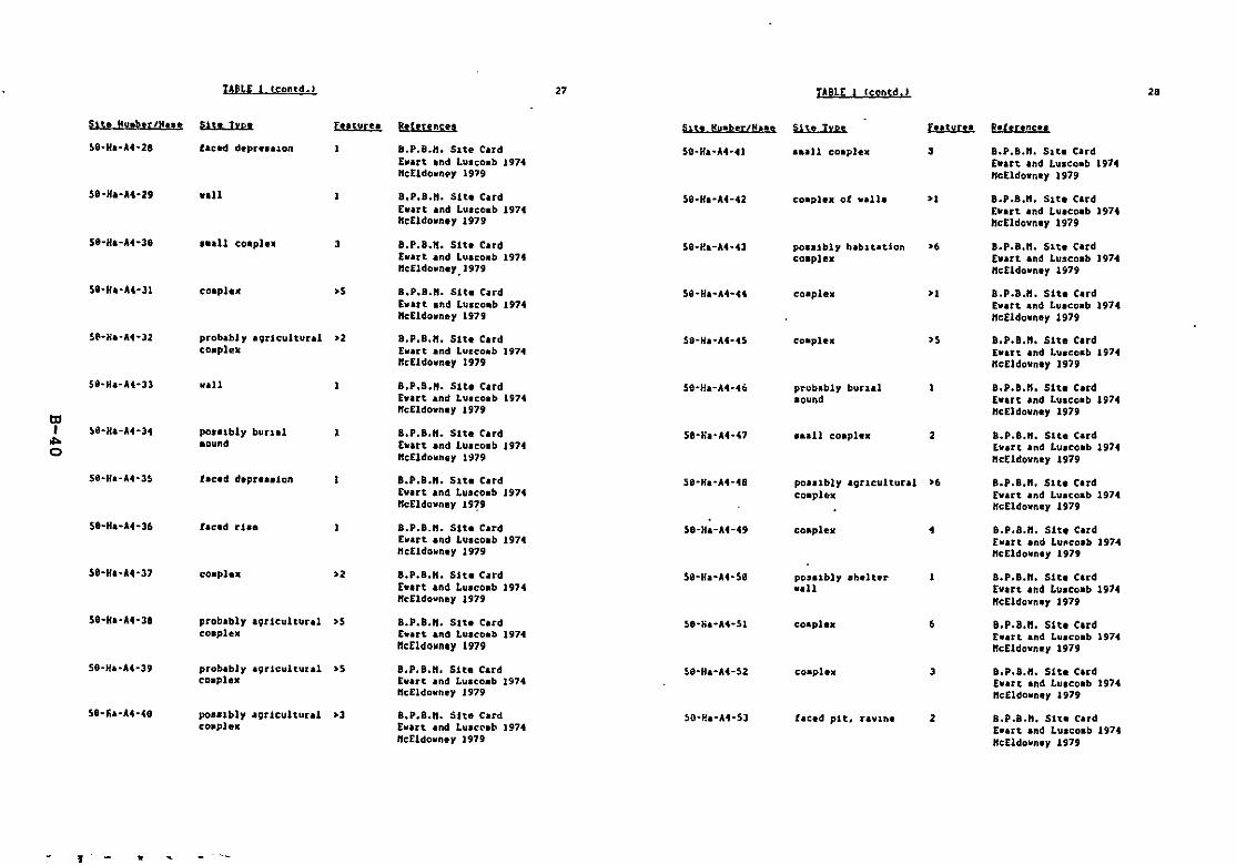
tABLE leontd.} 27 TABLE (eontd.) 2.
Site Muab,r/H••• Sit, typ. futuru Rehrencu Su, t!uabtr/Nue Site Typ, E..tyru hhrencu
~9-Ha-""-28 .hc~ dtpnauon 8.P.B.H. Slte Card 59-Ha-,H-41 ••all co.pl,. 3 B.P.B.H. 51t. CardEwart and Luaco.b 1974 EWlrt and Lu.co.b 1974"cEldovn.y 1979 "cEldovn.y 1979
58-HA-A4-29 will 8.P.B.H. Slt. Card 50-HI-""-42 co.pl•• of v.ll. >. 8.p.B.n. 51t. CardEvart and LUlco.b 1974 Evart and LUlco.b 1974"cEldown.y 1979 "cEldown.y 1979
59-H'-A4-39 ...11 cOllpln 3 B.p.8.n. Slt. Card 50-i:!a-M-43 po__tbl, hab1tatlon >. B.p.B.n. Sit. ClrdEvart and Luaco.b 1974 eO'pl .. Evart and Luseo.b 1974"cEldovn.y.1979 Hc£ldovn.y 1979
58-HI-A4-31 ce,plex >S B.P.B.". 51t. Card 58-Ha-M-tt co.plelC >. B.P.8.". Slt. CardEvart and Lu.co.b 1974 Evart and Lu.co.b 1974"dldowney 1979 "cEldovney 1979
Sl'-Ha-M-J2 probabl, aqrlcultural >2 8.P.B.". Slt, Card S8-Ha-A4-4S co.pltlC >S B.p.B.n. SIt. Cardco.ple. Evart and Lueco.b 1971 Evart and Luacoab 1914
"cEldevn.y 1979 "cEldownly 1919
S9-8a-A4-33 vall B.P.9.n. S1t. C.rd S8-Ha-A4-46 probabl, bunal 8.p.B.n. Slt. CardEvart and Luace.b 1974 aound EWlrt and Lusco.b 1974"cEldovn.y 1979 "cEldo"n.y 1979
ttlI Stl-HI-U-34 poulbly bunaJ , B.P.8."_ SIt. Card Se-na-A4-.(,7 ...11 co.pl•• 2 B.P.8.H. Sit. Card". .ound Evart and Luaco.b 1974 Evart and Luaco.b 19740 "c[ldo"n" 1~79 "s£ldovn" 1979
Stl-Ha-A4-J5 fac.d d.pr.aalon 8.p.8.n. Sit. Card 58-Ha-At-48 poulbly aguc:ultural >. 8.p.B.n. Slt. CardE"art and Luaco.b 1974 co.phrx Evart and Luacoab 1974"cEldovn.y 19?' HcEldowne, 1979
Se-Ha-A4-36 lac.d rtl. 8.P.8.H. 5tt. Card S8-Ha-A4-49 c:o.plex • B.p.8.n. Slt. CardEvart and Luac:oab 1974 Evart and Lu~c:oab 1974"c:Eldo"n., 1919 "c£ldovn., 1979
5e-Ha-A4-37 co.pl•• >2 B.p.8.n. Sit. Card S8-Ha-A4-S8 poulbh eh.lur 1 8.p.8.n. Sit. CardEwart and Luac:eab 1974 wall Evart and Luac:oab 197."cEldovney 1979 "cEldovn., 1979
S8"HI-A4-38 probably a9r1eultunl >S 8.P.8.H. Slt. Card 5e"fia-U-SI coapla. • B.p.8.n. Slt. Cardco.plelC E.art and Luacoab 1974 Ewatt and Luaco.b 1974
ncEldolln.y 1979 "cEldevney 1979
S8-Ha.-A4-39 probably a9r1cultural >S 8.P.8.n. Sit. Card ~e-Ha-A4-52 co.plex 3 8.p.8.n. SIt. Clrdc:oap1ex Evart and Luaco.b 1974 Evart and Lu.eoab 1974
Hc£ldo"ney 1979 HcE1dovn" 1979
Se-tia-At-te poaalbly agr1cultl.lral >3 8.P.B.H. Sit. Card SO-P.a-At-SJ hc:.d pit, raV1n. 2 8.P.8.H. Slte Cardcoaple. EVlrt and LuacC'ab 1974 E.lrt and Luaco.b 1974
"cEldovney 1979 "eEldavne, 1979
, •
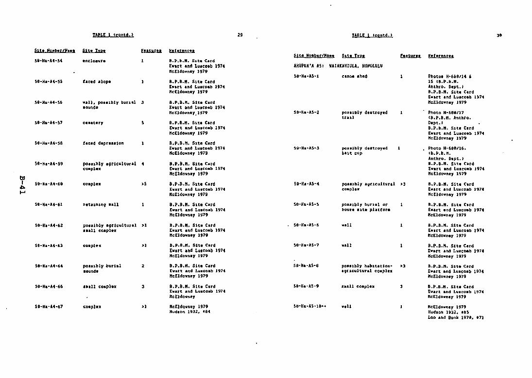
lAU£ 1 le!lntd.) 29 YApLE Ic:ontd.) 38
S1l, Muabtr/H'a' SUI Type [uturt! klll!!.n;.,~it8 HU'ber/H'a, ~.s. [ ••tur" I!.rer.n"..
S8-Ha-U-S4 .ncl~ur. 1 B.~.&.". S~t. C.rdEw.rt and Lu.co.b 197. AHUPUA'A ASI VAIAKAHIULA, HOHOLULU"cEldo..n.1' 1979
~8-Ha-'\5-1 cantil .h,d 1 Photo. H-668/14 ,S8-H.-U~S5 hc.d dope a.p.a.n. Slt. C.rd 15 IB.P.lI.".
Ewart and Lu."o.b 197. Anthro. D.pt.1nc£ldolln.1' 1979 B.p.a.". S~t. C.rd
E..art and Lua"o.b 197•58-b-At-S6 ..all. po•• lbly burl.l 3 B.P.B.". Sit. C,rd "cEldo..n.1' 1979
.ound. E".rt and Lu.coab 1974"cEldownllY.1979 58-fi.·AS~2 pOUlbl1' deattOI'.d Photo H-68e/17
trul (B.p.B.n. Anthro.58-Ha-U-S7 c•••t.r)' 5 B.p.B.n. Slt. Card D.pt.1
E".rt .nd Lu."o.b 1974 B.P.b.". S~t. C.rdncE1down.y 1979 E".rt .nd Lu.co.b 197.
"c£ldo"n.1' 197\158-H.-0\4-58 tac'd d'pr"'lon B.P.B.". Slt. C.rd
Ewart and Lu,co.b 197. 5;'-H.-'\5-3 po••'bly d.stroy.d Photo H-688/16."cEldo..n.y 1979 but cup Ib.P.b.l1.
Anthro. [l.pt.)S8-H.-U-59 po..~bly allrlcultural 4 B.P.B.". Site C.rd B.P.B.". Slt. C.rd
cotlpl•• E".rt .nd Lu.co.b 197. E"art and Luseo.b J974
tdne[1do"n.1' 1979 "cE1do..n.y 1979
I S{l-!ia-U-68 co.plt. )S 8.p.B.n. Sit. C.rd SO-!!.-AS-4 poulbly 'IItlCultural )3 B.P.B.". Sit. C,rd.c::a. [".rt .nd Lu.coab 197. co.p1•• E".rt .nd Lu,co.b 197.I-' "cEldo"n.y 1979 "cEldown.y 1979
58-H.-0\4-61 fttunln9 ...11 8.p.B.n. Sit. C.rd SO-H.-AS-S po.albll' burl.l or B.P.B.". S1t. C.rdI ..art .nd Lu.coab 1974 hou~. 'lte plattor. Ewart .n~ Lu.coab 1974"eElda..n.)' IS79 IlcEldo"n.1' 1979
59-H.-At-62 pa•• ib!y 'Il~Scultural >l B.'.8.". S1t. C.rd S8-H.-AS-6 ...U 8.P.B./l. Sit. C.rd..aU co.pl•• [llart and Luac..ab 1974 E".rt .nd Luaco.b 1974
"cEldo"ne, 1979 "cIldol/n.y 1979
Sll-Ha-U-63 co.plrll: H B.P.B.K. Sit. C.rd SO-H.-A5-7 l/all 8.P.B.H. Site C.rdEwa~t and Luacoab 1974 E".rt .nd Luacoeb 1974"cIldo"n.y 1979 IlcEldo"n.y 1979
58-H.-U-64 po.ubl)' burhl 2 8.P.8.". Site Card S8-H.-,\5-8 poa.lbl, h,bltation- ~3 B.P.B.". Slte Card.ound. £".rt and Lu.coab 197. a9[~cultural coaple. Ew.rt and Lu.coab 1974
"c[1dolln" 1979 ""Ildollnay 1979
58-H.-0\4-66 • 1111 co.phx 3 8.p.B.n. Sit. C.rd SO-Ka-A!-9 •••11 co.ple• 3 B.P.B.". S1t. C.rdEw.rt .nd Lu.co.b 197. [".rt .nd Lu.co.b 19741Ic:£ldo"n'l' "c£ld""",1' 1979
Se·H.-U-67 co.pl.. » "cEldo"n&1' 1979 Slt-H.-A5-10·. ..,U /lcEldo"n,1' 1979Hud.on 1932. 'fit Huel.on 19)2. 1&5
Loa .nd Bon~ 197i. 171

tABLE tconsd. ) 31 TULE fcontd. J J2
Sit. NubnJflu, Site lyp. Futur" Rdenncu 511. Nub.t/N... 51t.. Typ. F..tur" hfennc!a
State 18-45· probable hablt.atlon >7 S.H.P.O. Fold.r !I'1-Ha-A6·e canc>e ahed. 2 B.p.8.n. SHe Card4221 co.pl... probable v.ll Hudlon 1932. 185 Barrera 1974Honolulu Landlno Hanaen 1961 S.H.P.O. folder '4216
Hudlon 1932••92State lil-55· hi.toric co•••rcial. >2. S.H.P.O. foldu Orr 1963a73a8 do•••tic. r.liV1ou•• Orr 196JbPahoa D1strict cOI.unity, and school Ahu. 1963
.trueture. Barrero 1962rle4-18SncEldovney 1979
AHUPUA'. A61 5ANAWALE. VAAVAA. KAHUVAJSl)-Ha-A6-9 • nclo.ur., pO..lbl• B.p.B.n. Sit. Card
S8..Ha-A6-1 habltation co.pl•• >7 B.P.B.". Site Card heuu &arren 1914Barrer' 1914 S.H.p.a. Fo1d.r '4278S.H.P.o. Fold.r '4278 Hud.on 1932. 194Hudaon 1932. 193 "rr 1963aBarrer. 1962 Orr 1963hOrr 1963. Ahu. Hlflo3Orr U63h ncEldovney 1979"eEldown.y 197'1
:.e·!ia-A6-1lJ pos'lbly hahltation- >3 B.P.B.". Sit. Card58-6a-"6-2 pav.d t.raH B.P.B.". Slt. Card avrlcultura1 co.p1'•• barr.ra U74
Hudlon 1932. '86 dutroy.d 5.H.P.O. Fo1d.r '4278ncEldowney 1979 Hudaon 1932. 195
lJl Orr 196JaI 58·Ha-"6-3 habitation vIII•• >1 B.P.h.". Sit. Card Orr 196:tb.... "anawal. Vl1lav. p-rtly dutroyed Hudlon 1932. 166 So.hren 1963
N Wilke. 1845:189 ncEldovn.y 1979"eEldovn.y 1979
58-Ha-A6-11 habnat.l0n- >. B.p.B.n. Slt.. Card58-Ha-A6-4 cano••h.d B.P.8.". Slt.. Card 19nculturd Barrn. 1974
Hudlon 1932. '81 co.pIeJl:e. S.H.P.O. Folder .4278nc£1do~n.y 1979 Hudson 1932. '~6
Orr 1963,58-Ha-.\6-5 plaUora B.P.B.". Site C.rd Orr 1~63bHudlon 1932. 189 ncEldovney 1919ncEldolfn.y 1979
58-"a-A6-12 plaUor•• 3 B.P.B.". 51t. Card59~Ha-A6-6 po••ibly burlal 7 B.P.B.". Sit. Card Iltrnra lSI74
pl.ttor••• burials Barura 1914 Hudeon 1932. '.7S.H.P.O. Folder 14278 Orr 1963aHudlon 1932. '98 Orr 1963bOrr 1963a 501hun 1963Orr 1963b "e£ldownlY 1979Soehren 1963ncEldovney 1979 59-Ha·A6-13 platton. • B.P.B.". Slt.. Card
IlIrr.u 197459-Ha-A6-7 110Pflt paveeent. I B.p.B.n. Site Card S.H.P.O. Fold.r 14278po••ibly a ••ltln9 Barrera 1974 Hudlon 1932. '98plae. S.H.P.O. Folder 14278 Orr 1963.
Hudson 1932. 191 Orr l!l63bOrr 1963. Sothren 1963Orr 196~b neEldovney 1979"cEldowney 1979
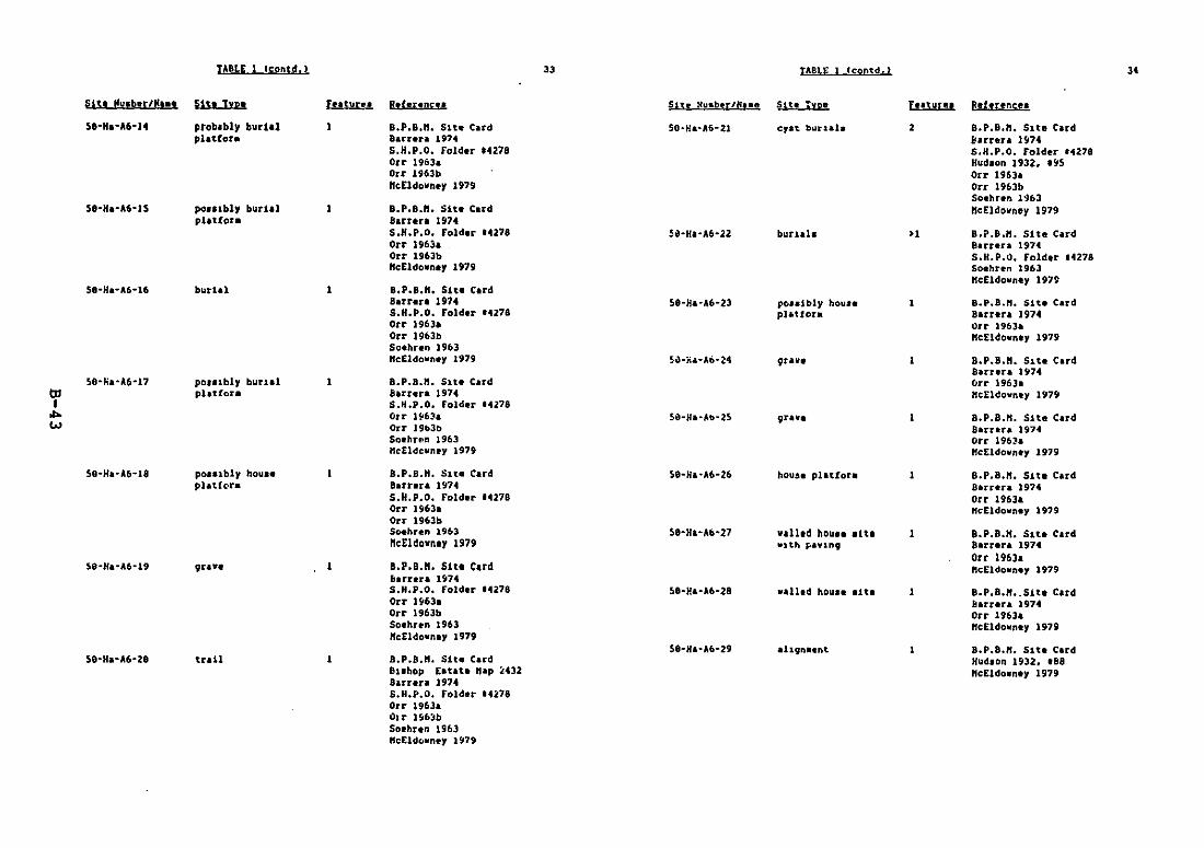
TABLE 1 leontd, ) 33 TABU: (coDtd. ) 3'
Sit! IIu,ber/M.., SU. lyp' Futuru Rtf·nne.. Site Nu_berIH,•• Sue'yp_ f.,tun. Ret!fencea
58-H,-A6-14 prob.bly burial B,p.B.n, 51t. Card SO·H.-A6-21 eyat burlal. 2 B.p.B.n. Site Cardplatfor. Ban".r.. 1974 !larrn. Hl7...
S.H.P,O. Fold.r t4278 5.H,P,0, Folder '4278Orr 1903a HUd,on 1932. 195Orr 1963b Orr 1963.KeEldown.y 1979 Orr 1963b
50ehun 1'J63Se-H.-A6-ts po"lbly burUl , B.P.8.". Sit. C.rd "cEldo~ney 1979
platfor. Burn. 1974S.H.P.O, Fold.r '4278 511'H"A6-22 buruls >' 8.p.B.n. Site CardOrr 1963. Barr.ra 1974Orr 196Jb S.H.P.O. Fold.r .4278"c£ldown., 1979 Soehun 1963
"c£ldovney un58-H.-A6-16 burial B.P.8.". Sit. C.rd
Barran 1974 58-8.. -,\6-23 pcoujbly hou•• B.p,B.n, S1t. C.rdS.H.P.O. Folder 14278 pH,Uora Barrer. 1974Orr 1963. Orr 1963.Orr 1963b "c£ldovn.y 1979So.hun 1963",£ldovn.y 1979 SiHi... -A6·24 9u .,. , B,p.8.n. 51t. C'rd
Barrara ISt7450-fi"A6-17 pOllibly buua1 B,P.8.". Sit. C,rd Clrr 1963'
lJl phtCor. Barrer. 1974 "c[ldovnl' 19751I S.H,P.O. raIder 14278... Orr l~Ua 511-H.-Ab-25 9uVI 8,p,8.n. 511. Card
W Orr 19b3b Barun 197450.hrf!" 1963 Orr 196~.
"eEldevney 1979 "'Eldovn.y 1979
50-Ha'A6-18 poulbl, hou.1 B.p.8.n. S1tl C.rd 50-Ha'A6-Z6 houSl platfou B,P.8.". S11. CardplatCH' Barrera H04 Barrer. 1974
S.H.p.O. Fold.r ....278 Orr 1963.Orr 1963. ",EldovnlY 1919Orr 1963bS~hren 1963 5e-Ha-A6'27 "a11.d houll .ne , a.p.8.". Sltl C,rd"cE1do"".y 1979 V) th F>aV1nv Barru. 1974
Orr 1963.5e·H.·A6-19 ljJUV. , B.P.B.". S1tl Card ",Eldo"nl' 1979
lIuren 19745.H,P.0. Folder '4278 Se-Ha-A6·28 v.l1.d hou,••1te B.P.8."•.Sit. CardOrr 1963. llarur. 1914Orr 1963b Orr 1963.So.hun 1963 neEldovn'y 1919",£ldo.nlp 1979
S8·H.·0\6-29 .hvn••nt 8.p.8.n. Site Card5e·H.·A6·28 tull B,p.B.n, Sltl Card Hudson 1932. IBe
Buhop E.t.tl nap ~432 ",Eldown.p 1979Sarr.ra 1974S,H,P.O, Folder tU18Orr 1963.ihr 1516;'bSotPirtn 1963"e£ldc.wnl'p 1979
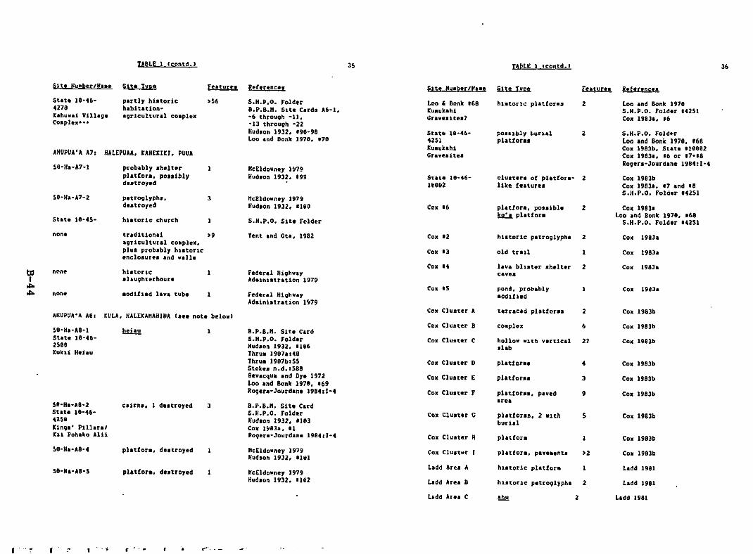
TAUE Cc:ontd.) 35 TAblE 1 tcontd.) 36
S.H.P.O. Fol~~r
Loo .nd Bonk 1978. '68Cox 1983b. Stlt, 'leee2Cox 1983.. '6 or ,7-18Roqers-Jourdane 19&4:1-4
Loo and Bonk 1978S.H.P.O. folder 14251Cox 1983&. 16
Cox 1983bCal( 1983., 11 and 18S.H.P.O. Folder '1251
Cox 1983.Loo .nd Bonk 1978. 168
S.H.P.O. Fold.r 14251
2
2
2
pl.ttora. pOSsiblek.2.:.!. plattors
cluster. of pl_tfors- 2like tenure.
po.ubl, Lurialphttora.
Cox 16
Loo , Bonk '68I:u.ukahl~raves1tea1
State 18-46Itl8e2
Stat. te-46·1251lu.ukahlGravesit.,s
HI;Eld~ney 1979Hud.on 1932. 'IGa
S.H.P.O. Sit. Felder
"eEldovney 1~79
Hud.on 1932. 199
S.H.P.O. Folder8.P.B.H. Slt, C.rda A6-1.-6 through -11,-13 through ·22Hud.on 1932. '98-98Loo and Bonk 1978. '78
>56
3
hhtoric I;hurC"h
p.uoglyphl,d..troyed
probably Ihdtnplatfor•• pO'liblydutroy.d
puUy hinorichabitation·agriCultural co.plex
AHUPUA'A A7r HALEPUAA. lAHElIKI. PUUA
Slt. Hueber/H... Sise lyp.
Stan 18-n·4278Kahuwai Villig.co.pl.x-··
non. tradition. I >9Igricultural co.plex.plua prob.bly hl.torle.nl;lo.ur" 'nd villa
Yent and Ot•• 1982 Cox '2
Cox 13 old trall 1
COli 1983a
COl( 1983.
hhtoricsllughterhoute
1 F.deral H19hvayAd'1n1ltration 1979
Cox 14 Iliva b11ster ahelter 2CIV,.
Cox 1983a
1 Fed'tll H19hva,Adaintatration 1~79
COli IS pond, proll.bl,.odlhed
Cox 19d31
AHUP~A'A A81 lVlA. HALEKAnAHINA rl•• not. below)
se-NI-AS-lStat, ]8-4625e9Kukli H.Jau
5a-Hs·A8-2St.t. le-n·42581::1n9" Plllaral1:11 Poh.l(o All1
1
3
B.P.B.". Sit. CardS.H.P.O. FolduHudlon 1932, 11e6Thrul 19871148Thru. 1ge7br55Stoke. n.d.IS88Bevacqua and ny. 1972Loo and Bonk 1978. '69Rog.r.·Jourdan. 198411·4
B.P.B.". Sit. CardS.H.P.O. FolderHud.on 1932. 'le3COl( IS1'S3., 11Rog.r.·Jourdan. 1984tl-4
Cox Cluster A
Cox Cl\:ster 9
Cox Cluster C
COl( Cluster D
Cal( Cluster E
COl( Cluster F
COli Cluster G
COll Cluater H
2
6
hollow Wlth v,rtle.l 21slab
platton. ..
platCou. J
pl.tfor•• , p.ved 9.rel
pl.tioras, 2 WIth Sburial
plattor-
Cox 1983b
Cox 1983b
Cox 1983b
COl( 1983b
COll 1983b
Cox 1983b
COl( 1983b
Cox 1983b
platfor., dutroyed Hc[ldowney 1979Hudson 1932. Ilvl
Cox Cluater >2 Cox 1983b
se-H.-AS-S 1 HeEldowne, 1979Hud'~n 1932. 1182
L.dd Aru A
Llldd Are. B
L.dd 1981
L.dd 1981
bdd Are. C 2 L.dd 1981
I I 1- - . :' ~-. --
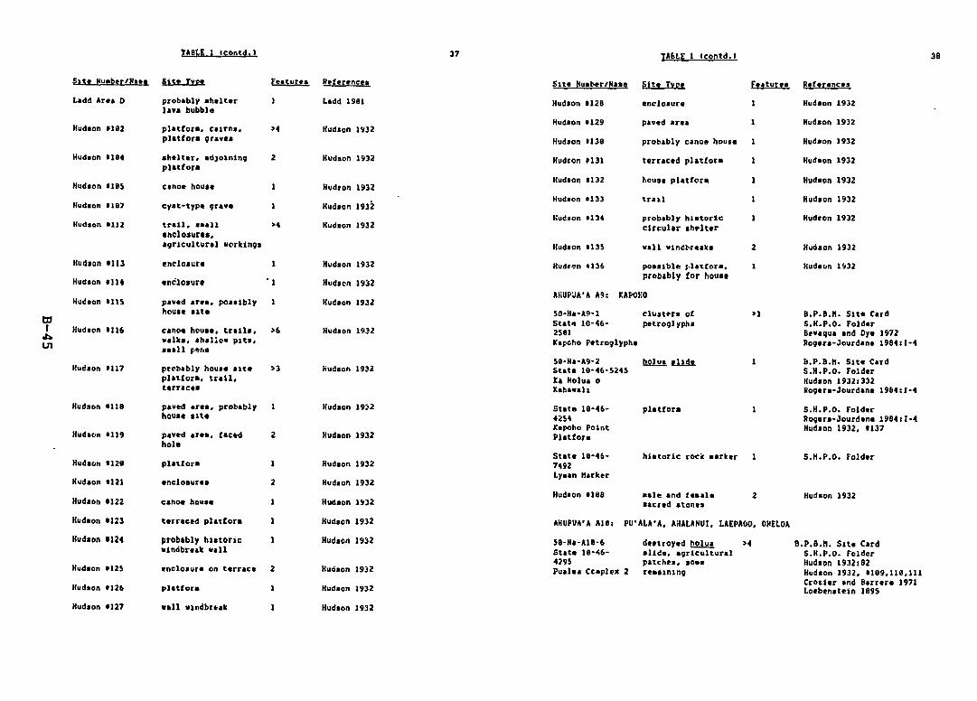
lS:ontd. ) 37 TA~lE 1 Ccontd.' 39
Hud,on 1932Hud.on H2BLadd 1961probably sllllt~r
Jan bubbleLadd Ar.. 0
Hud.on 1192 plltrOI" ellrna,plUfor. 9li1vel
lIudson 1'132Hudeon U29
Hudson IllO
paved IIrea Hudeon 1932
IlIlltlr. IdJ01n1ngplattor.
2 Hudlon 1932 Hudron fI31 terrlced pl.ttor. Hudaon 1932
Hlld.on I1l1S
Hudlon 1112 trIll, .sal1 ~4
encloSllu••agrIcultural worktngl
Hudron 1932
Hudson 1932
HUdlon 1932
Hud.on 1132
Hlldlon 8133
hall.. plettor.
\rnl
prob,bl, hlltorlCcircul.r Ih,lter
IIdl 1I1nc!t-ruk. 2
Hud.on 1932
Hudton 1932
Hlloeon 1932
Hud.on '113
Hud.On lB.
enclo.l:u
enclo.ure
1
• 1
Hudlon 1932
Hud,cn 1932
Hudt'.)n 1136 pOlllb}e ~latfor••prob.bly for hOUI •
Hudaton Hl32
B.P.B.". S1\. CardS.H.P.O. Folderaevaqua Ind Dya 1972Rogerl-Jourdane 1984:1-4
a.p.B.". Site Card5.H.P.O. Fold.,Hudlon 19321332Roger.-Jourdane 19&4:1-4
>1clUlt.r. ofpetrogl yphl
SO-HI-A!'-}StU.. 10-462581K.peho Petroglyph'
59-HI-A9-2Stlte Il1·46-5~45
h Holu. abll....ll
Hud.on 1932
hudlon 1932~3
~6
probably hou•• 11t.pllt(or" trel1.urrace.
pavld ar.a, poa.iblyhoun ute
canoe hOUI., tretll,WIlks, 'hallow Pltl,leell ~"rll
Hudllon 'U8 plved Ir.e, probeblyhaun ute
paved aree, racld 2hole
Hud.on 19~2
Hlld.on 1932
State 10-164254Klpoho PoIntPlattol'
phtfora S.H.P.O. FolderR0ger.-30urdene 19a411-4Hud,on 1932, '137
Hudson 1128
Hudlon '121 enclosuus 2
Hudlon 1932
Hudlon 1932
State 18-467492Lysen Harker
hiatoric roo:« .arker S.H.P.O. Folder
Hlldlon 1122 canoe hou••Hudson Ilea .ale and feaal.
aacred etones2 Hudeon 1932
Hudson 1123 1 Hudlon 1932 AHUPUA'A A18: PU'ALA'A. AHAlANU1. LAEpA~O, ONElOA
Hudson 1124
Hudlon '125
Hudson U26
problbly hletoricvtncibruk IIIU
enclolur. on terrlce 2
platfor.
Hudeon 1932
Hudlon 1932
S9-H.-AU·6State ltl'''64295Puale. Cc.plex 2
de.troy~d ~ ~4
111d•••~rtculturalpatche.~ 80••
re.unln;
B.P.B.". SIt. CardS.H.P.O. FolderHudlon 1932192Hudeon 1932, -189,119,]11Cro~ter and Barrere 1971Loebenatein 189S
Hud.on '127 HudlOIl 1932
TA~LE I l~ont4.1 39
AHUPUA'A Alii POijOlll. lEAHIALAKA
futuru l!EfE!!EHCES
Appie, Rus.ell A.1973 ~ ~SsepPlnQ.ton., 12 Ferbltooel. &. P.
8i.hop Mu•• S~ec. Publ. 53.
58·K.. ·AU-2·· ..0010 Kehll
none po,aibly buri,lrefuge la.a tube
1 B.P.B.", Site e.. rdThru. 1997a;39NI~I.ura 1904:11·2
Bonll 19Seb
Ahu., Joe196) A .ap of the~ .Iction of K.hu"al. Hap HA'A-24 In
Oapt. Anthropology. B. 1', hi.hop Hu••
THROUGH "ANY AHUPUA'AI
Ha...UCon,oIl datedR.n...y
HUo to Pun.Trul
partl.. lly d.etroye4tull
>1 Kelly It Ii. 1991:142-171H.".11 Sur.ey 1952USGS P.hoa Harth Qu..dUSGS Kapoho Ou.dHcEldowney 1979
Hud.on 19321246-249Loeben.teln 1995USGS [ •• •..11 Ou.4USGS Pahoa North QuadUSGS [ .. poho OUld"cEldollney 1979
B.rrer., Willi.' ".1974 ·Liat of H••atlan Site. on 81.hop tat.te Land•• "
n•• In D~pt. Anthropology. 8. P. Bl.hop nu••
Barrere, Dorothy 8.195~ ·~OlltlC.l HI.tOry of Pun•• ' in tlory et &1.,
'Natur&) and Cultural Ht.tory R.port on the~.la~.n. Exten.lon of the H."all N.tion.) Park.·ro•• 1n ~pt. ~nthropology. B. P. BI.hop Hu,.
1962 Il!!!ll. Abopgln.l Cu\tuU4 ~ ~!.&:. )771:1.II!.!. 1!i!!.U!!l!.l fuI.!.l'll 2!. II.! s t 0[1 c; ill..!.!. I..!!.!l!'~.!!.!!!!!i.~ ... lhu, lIll.a. IndIgenous~ !!!1~ultur... U. S. Dept. of the Intlrior, H.tionalP.rk £er"lCI.
BeckYlth, ".rthl1979 tia"al}~ tly,lholtgy, Nonolulu: Uni". Pre••
H."el1.4 8.1'.8.". Slte Card AI-II dllcrlb•• a dillferent l .. v.. tube elt. whichia out of the 'tudy .r•• , but .leo rtfers to E.ory·, ,.nurcr1pt onShlp••n·a C•••• "cE~~"heY liata Shlp,.n's ea.e la Slto Ai-II In hertnv"ntc,ry.
2ev-o\cqua. R.,1!172
and T. !JyeArch.eoloQlcal /l.connauu"ce of !'ropo."!!w~E:.!.\!.I!.!.!!.!.!Wl!l!!.~ t!UHict 9.t b!.!!.!.o..~2L ~L~ Report 72-3. lJept. Anthropology, B.P. &uhc.p "u•.
"An Arch••ologlcal Survey 1n ~Iahi.k.l. andPOhOlkl, Puna, H.".11.· Prepared for G.oth.r ••l[xplor.tton ..nd !J•••lop.lnt corp. "I ••vltl.bleat B. P. Bllhop Hu•• Libr.ry.
Thi~ tlte .... ~ro~..bly not In our atudy Irel. Ita for.er l~atton i.kno"n only a. betng In Poholkl.
Inote. Sal' site••ay be li.ted eore th.n once. There 1, luch uncertllnty a.to whether dIfferent .. rch.lologlet• .Ire de.cribing the •••• altea Inthe .re•• of e.pe lUluk.hi and the lueuk.hl Grav".lte.. So.e Hud.on.1te. {.182. i04, liS, li2·136) ,ay be de'troyed by i&v••
flonk. IIU11a.1999a
1991:1b
J.'An ArchaeologlcalHa.all." PreparedbevIloros.nt Corp.Hu•• Libruy.
Survey 1n Ke.hl.k.l., Puna,tor Geother.al Explor.t1on andH•• ••• llabl. at B. P. /:I1.hop
Bordnlr. klchard n.1977 'ATclouologlcal keconn.unnCI of the foropond
FAA A1r Tr.fflc Control Rad.r BI.con Sy.te.(ATC~~SI Fa~ility at Paho•• puna, Ha"al'l1.I.nd." Prep.r.d by ArchaeolOilcll R••••rchCenter Ma".ll. Inc. for th. Fed.ral A"lltlonAd.lnl.tratlon, Paclflc-A.ian Region. Ma ••1.0••II).ble at B. P. al.hop "UI. Llbr&ry.

CORRECTION
. THE PRECEDING DOCUMENT{S) HASBE:EN REPHOTOGRAPHED TO ASSURE
LEGIBILITYSEE FRAME{S)
·IMMEDIATELY FOLLOWING
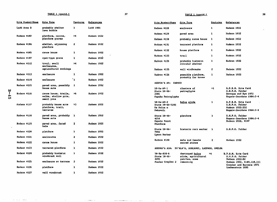
TABLE Icontd. ) 37 TAbLE 1 Icontd. ) 30
Slt. )Iuahr/N... S1S. I yp. Fe.turu Reohnnces 51t. Nuab!r/Naae Sit. Tn. Futuru Rd,nnc..
Ladd Ar.. D probably .h.lter Ladd 1981 Hudlon 1l2B enc:lo.ur. Hud.on 1932ta.. bubbl!
Hudlon 1129 pav.d area Hudlon 1932Hudlon .182 plattor.. calrn•• >. Hudlon 1932
pl.tfor. 9rav•• Hudlon IllB probably canoe house Hud.on 1932
Hudaon 1)'4 • h.lt.r••dJoinin9 2 Hudson 1932 Hudton U31 terraced rlatfor• Hudlon 1932platton
Hud.on 1132 hou•• platfor. Hudlon 1932Hudaon a)8S cano. hou•• Hudton 1932
HudJ'on 1133 trul Hudlon 1932Hudlon 1187 cy.t-type qrav. Hudlon 1932
liu~Jon 1134 probably hl.tor1e HudLon 1932Hud'on 1112 tull••a,ll >. Hudlon 1932 circular Ihelter
.nclo.ur•••'9ucultural vro-rk1nQ' Hudlon 113S w.ll vin~bre.k. 2 Huei.on 1932
Hud.on _113 enC'lo.",r. Hud.on 1932 Hudton 1136 pouible l,laUon. Hud.lIn 1932prObably for house
Hud.on 1)14 enclolur. • 1 Rudlcn 1932AIiUP~A'A A9: UPOf,O
Hudson 'llS pavld Irl., polilbly Hul!.on 1931hou•• 'ltl 50-Ha-A9-1 clu.un of >1 B.p.B.n. 51t. Card
III St.t.. 10-~6- p.troqlyph. S.H.P.O. FoldlrI Hudlc," '116 canoe hou••• tr,ll•• >. Hudlon 19n 2581 Bevaqua and Oy, 1972... walk., Ih.llo_ pit., r.pcho P.tro9lypha Rogera-Jourd.n. 1984rJ-4
U1 ••all J>fJ'I'l'58-H.-A9-2 Il.2!.J!!. I.ill..t. 1 B.P.B.". S1t. C.rd
Huebon '117 prro-b.bly hou•••1t. >3 nudlon 19;)2 St.t. 18·46-~24S S.H.P.O. folderplatfor., trail, ra Holua a Hudaon 19321332t.rrace. hh•.,h R09.r.~Jourd.n. 19&4:1-4
HudllDn '118 pand area. probably Hud.on 19:12 State 18·46~ platton S.H.P.O. Folderhou•• .1t. 4254 RQ9.ra-Jourdan. 198411-4
Kapoho Polnt Hud.on 1932, '137Hudltln '119 paved ar•• , fac:.d 2 Hudlon 1932 Plattor.
holeStat. 18-4ft· historic roeic ••rker 1 S.H.P.O. Fold.r
Hudac.n 1128 platfor. Hudlon 1932 7492Ly.an "uhr
Hudlon Uzl .ntlo.urel 2 Hudlon 1932Hudeon lle8 ••1e and t ••ale 2 Hudlon 1932
Hudlon 1122 canol haUl. Hudlon If132 a.cred atone'
Hud.on 11:3 t.rraced platfor. Hudlon 1932 AHUPUA'A A18: PU'ALA'A, AnALANU1. UEPAbO, ONELOA
Hudlon '124 problbly hi1tor1C Hudlon U32 58-HI-A18·6 destroyed I:!..2l.!!.!. >. B.P.B.". Sltl Clrddncibreak waU Stat. 18-U- slld., a9rlcultural S.H.P.O. Fold.r
4295 pltl:he., loa• Hudlon 1932:82Hudlon 1125 • nclo.ur. on t.rrac. 2 Hualon )932 Pula. CClpleX 2 rel'ln1n9 Hudlon 1932. '189,118,111
Cro~ier .nd Barrera 1971Hudlon 1126 platfor. Hudlon 1932 Loeben.t.in 1895
Hud.on '127 ••11 v1ncibu.k Hud.on 1932

tAE.<LE (contd. J 3.48
AHUPUA·A All: POnOlkl. kEAHIALAkA
REfERENCES
S9·Ha·All·Z····0010 Hehu
d.ttroytd~ B.p.B.n. Site CardThrua 1997.:39Na~aaur. 1964:11-2
Ahue. Joe1963 A tap of the ••hi lecUon of bhuw&l. nap hA-A-24 in
Uept. Anthropology, B. P. hiahop nUa.
nont pouibly burial·rtfugt lava tube
Bonk 198GbApple, Ruuell
1973A.~ ~Stepplngaton~a 12 Kerb.ton.a.Biahop nua. ~pec. Publ. S3.
B. P.
•• Thie well ••y b. the one ••ntioned .t State 10·4S-422l.
--- .hla aitp. includel eany Frevioully lilted ait•••
B.P.B.". Sitt C.rd AI-II delcrib•• a diffferent lava tube lite "hichi. out of the Itudy area, ~ut also refera to [tory·••anu£cript onShlp.an·. Cave. "cEl~~whey li.t. Sh1ps.n·. C.ve •• tlte AI-II in herinvlltntc.ry.
Thl~ titt ",s ~rolably not in our Itudy area. ItI fora~r l~catlon i.known only a. being in Pohoikl.
Survey 1n ~elhlakal •• Puna.tor Gaother.al Exploration .nd"a. a...allabl. at 8. P. Bllhop
and T. OfaArchuoloo)cd RpconnA1.Iur,ctl of ~!l~~E.!.t!n.!!.!.H1qhw•.L., lIutrict 91~ !.!l!.!!!!2! HLwlil. Report 72·3. (lept. Anthropology, e.P. Bubc.p "UI.
-An Arch••ologlcal Surv.y In Keah1akala andPOhOlkl, Puna. H''''11.- Prepared for Gaother.,lExploration and O!velopa.nt Corp. " •• availableat 8. P. Blahop "ua. Library.
BeckWIth. "artha1979 H.wall~ tlY3holbgy. Honolulu: Univ. Pre••
Ha"':I1.
Barrere, Dorothy B.1959 -~oI1tle.l Hlltory of Puna.- in Iaory et al ••
-Natural .nd eultural Hiatorf Raport on the.::.lapana ElCtenti.~ of the Hnall National Park.Ma. In ~pt. ~nfhropology, B. P. Blahop nua.
1962 Hlwall ALor)qln~l Culture. A.U. 7~e·A.D. 1778.It!.!. &tH~nl1 ~.1.!.tl. 2!. Hbtonc Sitea !!l!!!I.HI.!.~.l!lSI.!.... lhe., !Y.L. Indigenous hopl. ~!;.ulture!. U. S. Dept. of the Interior. Nat10nalPark !ervlce.
honk, Wi Ilia. J.1980, -An Archaeol09lcal
Ha.ll1.- Prepared[)evalol',ent Corp."U~. Library.
2ev4cqua. R.,1972
Barrera, Wlilla. n.1974 -Li.t at H••a1ian SIte. on Blahop Eatate Landa.
"a. in D.pt. Anthropoloqy. B. P. Biahop "u••ktlly tt al. 1991:142-177Ha"all Survey 1952USGS Pahoa Horth QuadUSGS Kapoho Quadnc[ldownty 1979
Hudlon 1932:246-249Loebenateln 1995USGS t:'•• ·au QuadUSGS P.hoa North QuadUSGS kapoho Quad"c[ldowney 1979
>'
>'deltroyed railroad
partlally d.ltroyedtull
So.e lites .ay be li.ted eore than once. There 1. auch uncertainty a.to whether dlfftrent archaeologista are deacrib1ng the aa.e Iltel 1nthe ar.aa of Cap. Kuaukahi and the Ku.u~ahl Grav.alt... So•• Hudlonaite. "182, 184, 165, 112-1361 .ay be destroytd by lava.
H."aUConsolidatedRan".y
Inotel
H110 to PunaTrul
THROUGH "ANY AHUPUA·A:
tilI
ot>
'"
Bordnar. kichard ".1977 -Archaeological Reconnal••anCt of the fropo.ed
fAA AIr Trafftc Control Radar eeacon Syat~e
(ATC~~SJ racillty at Pahoa, Puna, Haval·1I.land.- Prepared by Archaeoloqical ReaearchCenter Ha"al1. Ine. for the Federal AV1.t10nAdalnlatrat10n. Paclflc-A.ian R.glon. na. al.oavall.bl. at B. P. ~lahop nUl. LIbrary.
r.d.r.l H1ghvay Adtlntetratlon e.nd Land Tr.n.portatlonFacilitie. Dlv1lion. State of Hawaii Dept. of Tran.portatlonl
1979 -Flnal Environ.ent.l laplct Statealnt. K••au·P.hoaRo.d. ~aho. hy·P•••• • Ha. Iv.ll.bl. at Dept.Anthropolovy. B. P. 8ilhop Hua.
et at.-H.tur.l .nd Cultural Hiatory Report on theKal.p.na £xtenllon of the Hav.ii National P.rk.·na. 1n D.pt. Anthropolov,. k. P. biehop nus.
Cond., J ••••1973
Cordy, Ro••1978
1986~
19B6b
c., and Ger.ld K. ee.tb!UI. II.!ln!.!. I!!r.I..2!.~ H!!.l!. of l!!!!}.1.. I Feltc.n.C.ll(.11 010 Tree. ~re.a and ~,clflC &oc.kblndlng.
·Cultur.l keconnai.aanee R~port for POhOlkl BayMa.lv.tlon laproveaenta. ~OhOlkl B.y. Hav,ll.· U.S.Aray InVlneer blvlal0n. Paelfic Ocean. "s. avall.bl_at D1.1aion ~f St.t. Parka and Hiatorlc Sltes. ~pt.
of Land and ~.tural ke.oucee. St.t. of H,V.11.
·Chapter bE. Hietoric Pr.a.rv.tlon Revie": H.wali.nHoe_landa ProJect en.ku'ul.- ft.aorandua .vallable atD1vl.lon of Stat. P.rka an~ Hietoric Slte., Dept. ofLand and "atural ke.oucee, Stat. of H,W.l1.
-Power PI.nt for Puna Geoth.r.al Ventur•• - Reporta••llable .t ~iv1.1on of Stata ~arka .nd HlatorlCSite•• D.pt. of Land and ".tural Reaouc.a, State ofHa.ui.
41
£.ory. Kenneth1945
£al;ry. K, P••1959
Ev.rt. H•••nd1974
P.-Exploratlon of H.rbert C. Shlpa,n Cave, ~••auDiviaion of Puna, Haw,ll.- ne. ln Dlpt. Anthropology.B. P. b1.hop nu••
". LUlcu!b-Arch.eologlc.l k.eoRnlis••nce of Prc.poaedK.poho·r.auk.ha Hlgh_.,. Punt. H•••li.· " •• InDI~t. Anthropology. 8. P. hi.hop Hua.
42
ALreh.&!H.W'll.n Antigultil' !n! Fo1k·Lore. B, P. blahopHue. K~,olra. Vol. 4.
C•• and E. G. H.ndyl!n.lls. flhntln 1n ill~. Honolulu, h1ahop Hua.Pre...
CO)l, David v.1983a
b:lI
ol>o.....
1983b
Crou.r, S. N.1971
·Pr.lleln.ry Areh.eologlcal k.conn.l•••~c. ofCultural R.'ourc.e at the Propo.ad Sita of the~uauk.hi S.a11 Craft Navivatl0n.1 leproveaent.,·Appendlx B of ·A Draft Survay Report .ndEnvirona_nt.1 lap.ct St.t.a.nt for the ~u.uk.hl
Sa.l1 Cr.ft h.rbor.· U.S. Ar.y Engin.erDlatrict. Honolulu. " •• avai1.bl_ at 8. P.Blahop Kua. Library.
-Areha_olOVlcal Roconnale.ance ~f Addltion.lCultural Reeourc.e at the Proposed Location ofthe c.pe Kuauk.hi Sa.ll Craft N.Vlg.tlonlaproveaent ProJect. Pun., I.I.nd of Ha~.ii.·
U.S. Arey Engln..r Diatrict, Honolulu. He.av.llabl. at Div18ion of Stat. P.rke and Hi.toricSit••• D,pt. ~f L.nd .nd Natural R,sourc••• St.t.of H••ni.
and ~. h. ~.rrer.
Arcb.!91oqlc.l ~ Hlatoric.l~ 21 theAhupu .. ·t 21. £!!!l.!.!.&. eY.!!!. D1atnct,~ 2!.11!!'.!1L. hport. 71-1. Dept. Anthropol09Y, B.P. Bishop nUl.
l'orn.nl!~t.
1917
1919
1969
Gre~n, L.ur. S.192B
H.n••n. Vio"t1967
n.d.
Handy. E, S.1972
HIV.llan Antiquities !nt Folk-Lore. B. P. BlahopHue. Heaolre. Vol. 5.
An. Account 211h!. folyne.tan R!.£.s..L l!!. 2I..1!l!.n!. andHiurttlon.. Tokyol Charl.. E TulU. Co •• Inc.
Fo1kt.le.~ Hav'll. Honolulul Ha••li.n Bo.rd BookRooa••
·Li.t of Hi.torlcal Sitle. I.l.nd of H.w.ii.· Ha.ln Dept. AnthropoloVY. e. P. Bi.hop Kua.
Unpubl1.hed note. In D.pt. Anthropology. B. P.Biahop Hu••
E,erlon. "athanlel B.1915 E!l!. m H.1.!!.!!.!.L !. I!nh. Er.2!. H'''1I1 1 • Hcnolul u1
Honolulu Star·bull.tln Ltd.
Elbert, Saauel1979
H•••d.Sel.ctione tIJu! rornand't·. Ha~alian Antlqultle.!.mt l:9.1k·Lore, Honolulul Univ. Pre.. H"v&11.
H''''li Territory SurvlY1992 'Hap Shoving. Portion of Puna Dlltrlct, H.V'll.
Avallabl. at H••ali St.te SurvI, ~fflCI, RIV. 12191;copy ln Dlpt. Anthropology. 8. P. hlehop Hu••• H.p HA·aliI.
l~e6 -H'.ali, H'Va11n lal.nd., 19b1- .ith 1986 Legend.av.ilable fro. Don Perrjn. Aafac H••a1i. Inc.: copy ofportlon of .a~ In D~pt. AnthropCI1ovy. B, P. BlehopKue.
43 44
1952 -Kap Showln~ a Portion of Pun. District, ".w.ii.AV'll.ble .t H'W'll St.te Survey Offlce; copy lnDept. Anthropology, B. P. Bl.hop nUl., ".p HAA212.
Hawaii.n Terrltori.l Survey1938 -Ha••l1 CI.land .nd County of H••aii), Hilo
Ou.dr.n91e.- Avall.ble.t Dept. Anthropology. B. P.Bhhofl "us.
H.w.ii.n Terrltori.l Survey and U.S. Coaat .nd Geod~t1c Survey1924 -H'.'11 (Isl.nd .nd County of H.w.ii), "akuu
Ouadr.n91e.- Av.il.bl•• t Dept. Anthropology, B. P.Bishop "UI. •
Loo, Virglnia H•••nd Villil. J. Bon~
1978 ·A Historical Slt. Study .nd Evalu.tlon fo NorthH'W'li.· Prep. red by Anthropological Re.earchIntern.tl0nal for the Dept. of Planning, CountyHI".il. "$, availlble in Dept. Anthropolovy. B.P. lsahoJ.t nUl.
HcEldowney, Holly1919 ·Archaeologlcal and Hiltoricil Literature S.arch
.nd Rel.arch D'lign. L.va Flow Control Study.HUrt, Ha••i'l.· Prep.red t.y lIe~t. Anthropolo9Y, &.P. Bi.h~p Hu•• for U.S. Ar.y £nglneer Dlltr1ct.Honolulu.
Sketch .Ip of altel nelr br..ch at t:ahu"ll.l-a30~·. H.p HI-A-11 ln ~ept. Anthropolo9Y. B. P.B1Whop HUI.
Sketch .ap of Ilt., near b~&ch at ~.hu"al•1·~~0·. ~.p Ha-A-12 in Dept. Anthropology, 8. P.Buhop Hu••
·01•• Tltle n.p, 01••, H•••ll, Shovlng .11 Orlglna1TIU~. to the Oh. Plantauon Lota. Sept. nee.·Av.i).ble .t H.v.li St.te Surv.y Offlce.
·Part II: ! &rlef Hi.torlc,) Survey· in-Arch.~ol09ical 'econnlil••nCe and Hiltorlc.1Surv.·yll (·f Landa .t K.poho, ~un•• H.".l'llaland.· Prepared by Dept. Anthropology, B. P.Blah~p Hua. for Thera.1 Power C~~pany.
1963b
Ola. Title Hap1900
Urr, Jchn1963.
PukUl, Hary l ••en., and S••uel H. Elbert1971 H.val1an bictl0nlry. HonolulUl Unlv~r'lty Pr••••
Vukui. nary K.won., Saauel H. Elhert, and Elthar T. Hooklnl191ft fils!. t!l!.!.!. 2L H!.!.!U.r. Honolulul Unlv. Pre..
H.van.
Rog.ra-Jourdan•• Elalne H.19~4 ·Part I: Arch.~oloOlC.l Survey· 1n
-Arch.eologlcal Reconn_ll.lnce and Hlltorlc.lSurvey, of L.ndl at ~Ipoho, Punl. Haval'1J,l.nd.- Pr~plred by Dept. Anthropology. B. P.Bi.hop Hu•• for Ther.ll Power Coapany.
lIak.1aura, 8&rry• 1984
n.I!Y.l..lM Chah 2.l Hu.U. Honolulul buh..eh.5' hoola ~re...
H.wal1.n !au.cultur.l Syat... gl.,eftatlon,ub.ltted to D+pt. ot Anthr~pology. Unlver.ltyof Arhon••
·Arch.eologlcal Survey Report, C.~e ~u.uk.hi .ndK.walh•• Light, H.w.i1.- Prepared for the U.S.CO.'t Guard. Honolulu. "I. aVlil.ble at D1vll10nof St.t. Parkl and Hiltoric Site., Dept. of Landand ~Itural Resource•• State of Ha••ll.
E.-Archaeology of E'lt H'.'li.- "I. in Dept.Anthropology, 8. P. Bishop "UI.
B.rry "ika.ura, .nd Dorothy B. BarrereI!1.l.2 t!.!ll ~ 9lI.0nologtcal Hilttorv. l'rer'ilud bythe ai.hop "u••u. for the U.S. Ar.y EngineerD1ltrict, Honolulu.
[lkuchl. V. K.1!f73
Hudlon, Alfred1932
hUy, "arion,1981
Territory of H'.'li·n.p .nd Descnpuon with AppUc.t1on "0. Itt53 t2r,dA.end.ent), V. H. Ship••n, Li.ited -- Applicant, LandSituate at Pun.-H•••i1-T. H.· AVlllable at H.wailStlte Surv.y OffiCe) copy of portion of aap ln Dept.Anthropology. 8. P. BilhOp nUl.
K••ak.u. Sa.uel1!f61
L.dd. E. J.1981
tilI...
(Xl
Loebenst.in, A.1895
8.-H'.'llln Gov.rna.nt Survey ".p ot Portl~n ofPun.,HaM.il, Showing Sea (oa.t Sectl0n Lro.N.n."al. to tohoJki.- AVlllabl••t Hawal1 £t.teSurvey Off1ce, copy in Dept. Anthropol09Y, B. p.Bilhop Hu••• H.p H"-A617.
Soehren, Lloyd1963
Stokea, J. F.n.d.
Field ~ook No. I, in author's pt·.ae"lon.
~.
·Survey ot H~l&US of H,w'ii.- n•• in B. P.Bllhop Hu•• L1brary.
Thru8, Thoen1987,
1987b
G.'H,ttua and H.iau Sit•• Throu9hou~ the H••,11an"Janda.' ""Ii"n 4l.!.!n!£!..D& AnnUlI. pp.JU·41.
't.l•• fro. the r••pl••, Part 11.' H,.,11'n~ !M !.n.n!t!.l.. pp.4S·69.
45
1912 H,.,Uan E9ll. I!b!.1. A. CollecUon 21 r!!!.i.!.!. WtlJ!l!.oChicago I A. C. ncCluro , Co.
1923 !!!ttl H..diln f2lk. I!.l!.!.. Chiclgor A. C. ncClurg'Co.
Veat,rv,lt. V. D.1916 H,.,Uan~ 2l bl..f~l!l.2!.!.. BOltonl E1l11 Fr....
tIlI
ol>\D
Wilkes. Chulu1St!» Nuutlv, 21 th!. 1m1.U!t lli1!.!. {_plaring
~R!.!ti..\J.M~ 1h!. I!!I.!. 183a·) e12« undn 1h!.~21~~l!..:.§..J!.u..Vol. L.Phil.d~l~ht., Lea and Bl.nth.rd.
'Survey of • LtVI Tube. Pahoa. Puna. HI.ll1laland,' D1vl,10n DC State Park' and Htator1eS1t••• Dept. of Land and ",tural R.loure.a. Stat.of H•••11, "ao ,110 avail,bl, at B. P. Bf.hop"u. Librarr.
rent. ",rtha. and Jaton Ote1982 'Archa.ol091cal ~ecDnn.t•••nc. survey of Nln,•• te
Foreat R••erve~ Halepua'a Sectlon~ Puna~ Hawaii.Divialon or State Parka and Historic Sit.a~ DeFt.of L'n~ .nd ",tura. R••oure•• ~ Stlte of Haw.iiJHa. al~D available at B. P. Bl.hop "ua. Library.
APPENDIX C
nI
.....
CULroRAL }J.1l BIOLOGICAL RESOURCES SURVEY OF THEPOHOIKI-TO-PUSA SUBSTATION 69 KY TRANSHISSION CORRIDOR
tEA-AU TO }:APOHD. punA. HM,'AI·l ISLASD
Final Report:
Bot.nltal Survey
22 April 1987
~ayne N. TakeuchiClyde T. lmada
Depsrtaeot of BotanyBernice Pauahi Bishop Museuc
Prepared for:
DHH, Inc.1188 Bishop Street
Suite 2'05Honolulu, Hawai~i 96813
Depart~nt of BotanyBernice PauRhl Bishop Museum
Honolulu, Hawai~l
ThJRODUCfION
To s1epl!!, botanical description of the project terrain. the felleving
narrative Is keyed to the individual parcels into vhldn our fIeld survey VBS
divided. Sectors have been del1c~ted froa the total territory OD the basIs of
logleal con&1deratloos relatiog to spatial continuity aod approdcate
bocogeoelty of forest/cocmuolty condition. Geographic north 18 indicated for
each of the various d1agralllS. Ezcept for zone 6 (where: the cap reference 1&
self-evIdent). the loterrelatloo of the various subuoits Is depicted In figure
1.
Representative species lists 8re provided for ~O&t of th~ survey sections.
The follCl\ling s)'Cbols are ecployed in the enucerationt
E • endemic; a plant ~bose natural range is restricted to the Hawaiian
Islands.
I • indigenous; a plant native to the Hawalian Islands, but also with
natural occurrences els~here.
A • alieo; introduced by e4D, accidentally or by design.
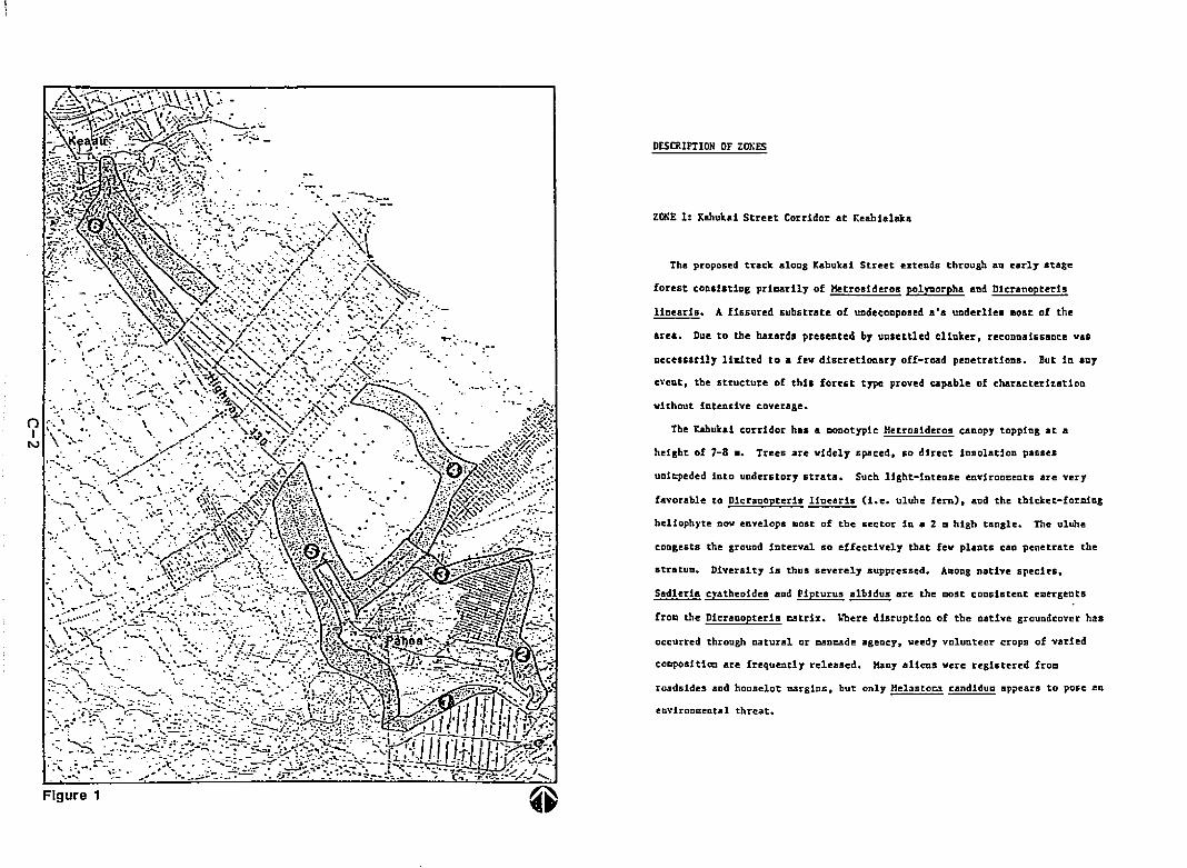
.....() .". \
IN
Figure 1
DESCRIPTION OF Zm:ES
ZQl;[ 1: Kahuka1 Street Corridor at r.eahilllllka
The proposed track aloDg Kahukai Street eIteDds through aD early atage
forest cODal.tiDg pricarily of Kl!trosideros pol~Drpha and Dicranopteris
lineari.. A fissured substrate of undecocposed a'a underliea eost of the
area. Due to the ha~ard. presented by unsettled clinker, reconnaissance vas
necessarily li&1ted to a fev discretionary off-road penetrations. But in any
eveDt, the structure of this forest type proved capable of characteri~atioQ
without intensive coverage•
The Kahukal corridor has a CODotypic Hetrosideros canopy topping at a
height of 7-8.. Trees are widely spaced, SO direct insolation passes
unicpeded into understory strata. Such light-intense eovironcents are very
favorable to Dicranopteria linearis (i.e. uluhe fern). and the thicket-forming
heliopbyte nov eovelops aost of tbe sector io a 2 • high tangle. The ulUhe
congests the ground interval so effectively that fev plants can penetrate the
stratuD. Diversity is thus severely suppressed. ADong native species.
Sadleria cyatheoides and Pipturus~ are the Dost cDnsistent eDergents
froc the Dicrannpteris catrix. \~ere disruption of the native groundcover has
occurred through natural or cancade agency. veedy volunteer crops of varied
co~sitiOD are frequently released. Many aliena vere registered fro.
roadsides and houselot carginl, but only Helasto~ candidua appears to pose an
environeeotal threat.
"
Toward. the HE I!Dd of the tract. the Hetro&1deros-DIcranopteri. forllation
paues rather sharply into 8 forest of greater aatur1ty. The abruptnen of
transItion indicates that the floristic deaarcatlon is probably a historical
flov boundary_ WIth pass.!!! acrosa tbis structural line, certain features of
successional process are displayed. In the forest: of contrasting condition.
the Hetrosideros canopy aSsuaea higher stature. and lateral elaboration of
Individual crowns ha. produced ao interlocking OVers tory. The resulting
reduction of subcaoOp111&ht ia auodated with the rt!p1ace~ot of uluhe fern
bl 8 shade-adapted alleChI8ge dominated by Cibotium ehamissoi and Ophioglossum
pendutn.
Wi thin the cature acruge there is also" noticeable increase in spedes
(A), Ageratull houstol:lianua CAl. Hltnc:arpua hlrtu8 CA), Spenoc:oee auur"en8
(A). Pol!saI_ panIculats (A). Llnderala erustac~ (A), Sacclo1ep18 indica (A',
Dls1tarla viol.scens CAl. Pasp.lull dl1atatuD (A), Paspalull &crohlculatua CAl,
Cannabis sat!va subsp.~ (A', CoprosQ4 mentlesti (I'. Machaerta_
angustifol1a (I). Hachllerlna carlacoldl!!8 (I).~ lachr1b!-jobl (A), Arundln&
haabuslfol1a (A). Spathollott1a pUcata (A). Nephrolepla lip., Cocculus
trl10hua (I), Chacaesvce hirts (A). AndropO!OD vlrslnlcue (A), Pltzrograc=a
calomel.noB (A). Lvcopodiull~ (I). Cha&lluyce prostnts (A). Sp!lenoDeda
chlnensll (I). reeded. ScandalS (A), PhJ!lltosorua 8colopendrfa (A'. Helaleuca
quioqueoervia (A). £lapho&1ossuD crassifoliua (E). Christella parasitica (A).
Adenophorus sp. (E). aDd Peperotl.1a sp. (E).
count. with Diospyros sandwicensis. HIT.Ine Ie.sertiaoa. aod Psychotria
The appearaoce of additiooal taxa results in a coredepauperate caoopy.
~ hawaiieosis var. havaiiensis achieviog significant frequencies in a oor&81ly
W
equItable occupation of the differeot height incremeots, so that a solId front
of plant growth confronts the observer. There Is no disjunction between
vegetation layer. as 1. obvious in the Hetrosideros-Dicranopteris association.
In addition to the species centioned 1n the tezt, the following plants were
recorded froa zone 11
Alb1z:da sp. (A), HelocbIa uClbellata (A). Ps1diull tatUeJanua (A). Psldiulll
aua'ava. (A), Aleuritu DOluccaDa (A).~ aaericaDa (A),~ sp. (A),
~ aculdData (A). Cecropia obtudfol1a (Al.~ svcphrUfoUa (A).
Buddlda asiatica (A).~ erJepa (A), Alyda ol1vilorms (E), Frelc1netla
~ (I), Cordrl1ne terminalis (A), Rubus ro51fol1us (A). Impatiens sultu!
(A), Coemellna~ (A), Psl10tuD nudum (I). Pleopdtis thunberr;1ana (£),
Begonh hirtella (A), Stachyurpheta dlchotolla (A),~ sp. (A). Cvperus
hatpAu (Al, Castille'. arvens1s (A). Youngia 'aponica (A), AgeratuQ conrzoides
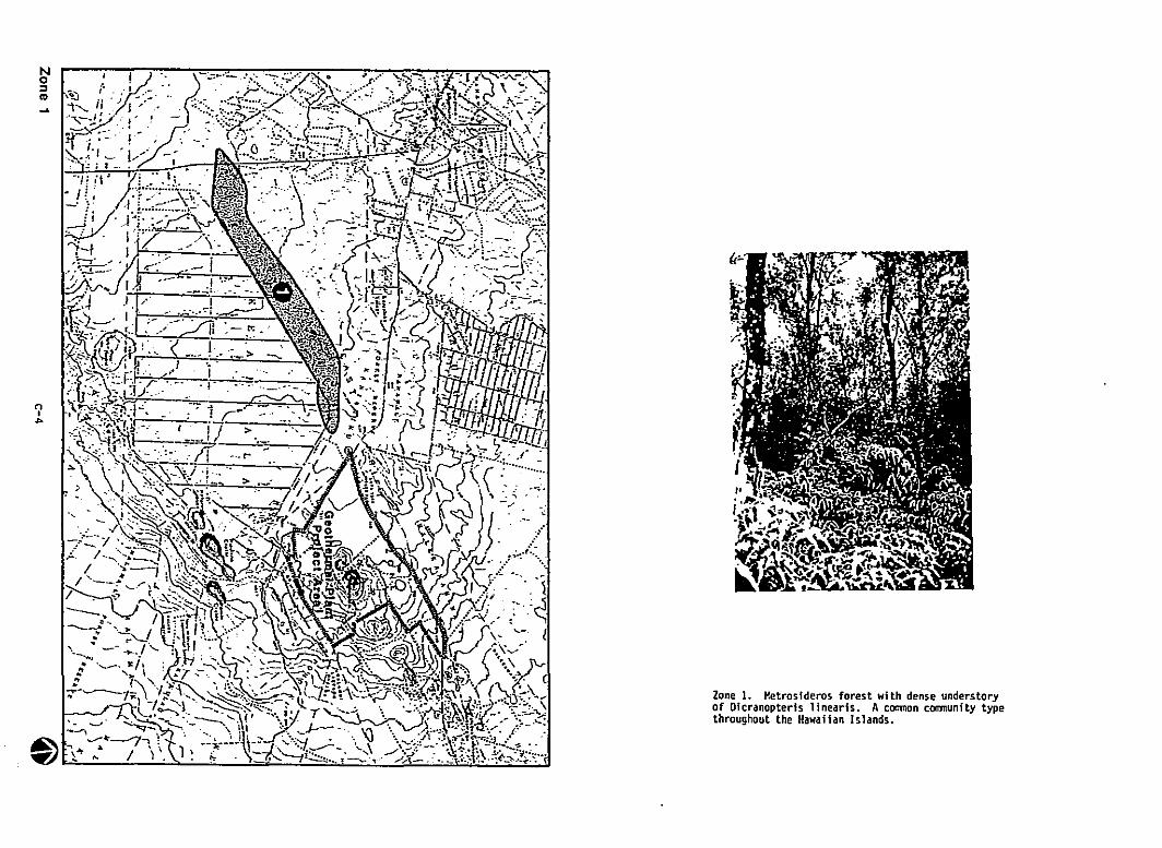
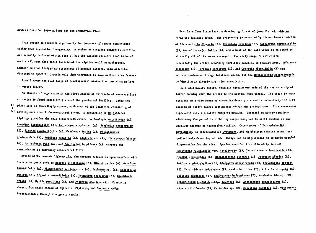
zeliE 2: Corridor !etveen Puua aDd the Ceothermal Plant
Thi. sector 1. recoGQized prlesrily for purposes of report convenience
rather than vegeUUon ho.o&eoelty. A nuaber of disUoct co=unlty entitles
are actually included vIthin zone 2. but the various ehlllents tend to be of
sucb scall area that their individual descriptiOD would be cUClbersolle.
COaQent 1s thus 111:rlted to statelClents of seneral patt:ern. ''It.h at.t.ent.lon
directed to specIfIc parcels only ~~en ~arr.nted by sace salieot Site feature.
Zone 2 spans the full range of develop&eDtal states froCl near-barren lava
to cature forest.
Au. eneple of ve&eutloo'in the first stase. af suecusional recavery froel
valcanUIl .18 found lcaediately around the geothermal faeUity. There the
~ plant life .Is exceedingly sparse, vjth eucb of the landscape eoosistJng of
un oothiog ~ore than lichen-encrusted rocks. A scattering af Hetosl~eras
sapUngs provides the only si&o.1f.1caot cover. ~ephrolep1s tNltlflorull CA).
AruQdioa bubuslfol1a CA). Andropogon vlrp:1nicuD (A). StlpheUa tllz:eiare!lIe
(1), Pluehea s}~phytifol1a CA), ~altheria iodica CI). Ph\~tosorus
scolopendria (A). Buddleia 8s.1atlc8 (A), Albi%%la sp. (A). Hltrllcarpus hirtus
(A), H,.p.arrhenia rufa (A). aod Spathoglottis pUcus (A), coq.ose the
reCl3Inder of ao extreaely abbreviated flora.
HovioA north tovards highway 132. the terraio becol:u an open veed1l!nd vith
herbaceous pests such as Helinia mlnutiflora (A),~ pudica (A). Arundina
ba=husifolia CAl, Phycatosorus scolopeDdria CA). Buchnera sp. (A). Sporobolus
~ CA). DissoUs rotundifolia CA). Desl::lodiull trlf10rull CA). Brachlari8
~ CA). HyptIs pectinata CA). aod Paederla scandens (A). Canopy is
absent, but scalI shrubs of Helochla, Pipturus. snd CecropJa spike
interClittently through the &rour.d taegh.
Near Lava Tree State Park, a devdopinS forest of juvenUe Hetros1deroa
forcs the docinant cover. The understory is occupied by discontinuous patchea
of Dler.noeteri. linearl. (E). Melaatoca candldulCl (A). Hachaerina anfuatlfolia
(1), DescodiuD ca1anifoliuD (A). and 8 host of the same weeds to be found in
virtually all o£ the zones surveyed. The early stage forest cove:s
essentially the entire reminIng te:rltory parallel to SeavIew Road. Hib1scus
tl1iaceus (I), Pandanus tectorius (I), and CecropIa obtuslfolJa (A) can
achieve doainaoce through localized areas. but the Hetrosideros-Dicr2oopteris
cOl:blnatiOQ 1s cleOlrly the cajor association.
10 8 prellc.lnsry report, specifIc aeotion vas cade of the narrow strip of
forest rucolog dovo the ceoter of the Seaview ROlld parcel. The strip Is very
distioct 00 a vide range of co==uolty descriptors aod is uodoubtedl1 the best
exacple of natIve forest encountered wIthin the project area. This assess~ent
represents only a relative jUdgCC!Dt however. Coepared to survey sectioos
elseWhere. the parcel is richer by cOl:parisoD, but is still cundaDe on any
absolute ceasure of vegetatIon qualIty. Occurrences of Tetraplasaodra
hawaiensis, an icdeterClio8ble C)7tandra. snd an ele\'ated species couot. are
collectively deserving of note--ehough not so significant as to ~erit specIal
dispensatIon for the site. Species recorded froll this strip ioclude:
Psychotria havaiiensis var. hawaiiensis (E). Teeraplasandra havaiensis (E).
Hvrsine lessertiana (E). Dicranopteris linearis (1). Pipturus~ (E).
Antldestlo1 plat)'phvlluCl (E). DiosP)TOS sandwicensis (E), Frevc1netia~
(I). Hetroslderos pol}~orpha (E), Asplenium nidus (I), Vittarla eleneata (E),
Cibot!ull chaCl.1ssoi (E). Thelypte:1s hudSO::llanuD CEll Vandenboscb1a sp. (E).
Ophio&1ossuD penduluCl subsp. f"lcatull CElt Adenophorus ta03rIscinus CE),
Ah':da olld!orc1s (E). C\o:tandra sp. (E). Helastoea candiduCl (A), 0pl1sl:enus
nI
0\
hirtellus (A). Cecropia obtusifoliua (A). Spatho!lottis plicata CA),~
cattlelanu. CAl. Blechnue occidentale CAl.~ pudica CAli Rubus rosifollus
(A). Ageratum houstonlanum (A). Psilotu.~ (I). Trema oriental Is CA).
Persea americana CAl.~ xparadislaca (A). Pluche. symphytifolia (A).
Paederia aeaDdeos CAl. IDpatiens valleraoa (A), Nephrolepis sp•• Cordlline
terminali. (A). Arundina baubusifolla (A), Christella SPOt Pleetranthus
scutellarioides CAl. Desmodium spo CAl. Setaria palmifol1a (A). Dlssotis
rotundifol1a (A). Cocculus trJlobus Cl). Ph~tosorus scolopendrJa (A).
Lycopodium phyllanthua (E). ~ikstroemJa snndviceosls CE). Pandanus tectorJus
(I). Hibiscus tilJaceua (1). and Peperomia spo (E)
(BLANK PAGE)
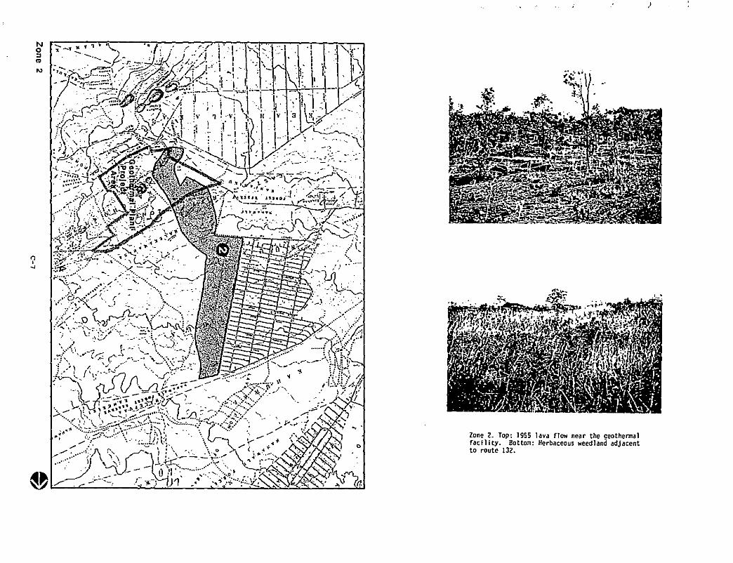
No:lIII
N
)
Zone 2. Top·facility. 80
1955lava flowto route 132 ttO:I1: Herbaceo near the geoth• us weedla d ennaln adj acent
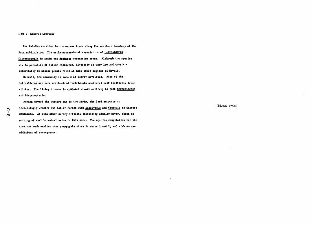
nI
'"
ZONE J: JC.ahuvd Corridor
The Kahuvai corridor ia the narrOW trace along the northern boundary of the
Puua aubdivisioo. The early 8ucce.siooa1 a••oclatloo of Hetros!dero. -
Dlcraoopteria ia agalo the do.toaot vegetation cover. Although the .pecles
aix 1. priDari1y of native character, dIversity 18 very lov aod cODsists
esseotially of COllmoa planta found in may other regiona of Havall.
OVerall, the coocunity io zone J 1. poorly developed. Host of the
Hetro.idero8 are ~ere Icrub-slted individuals scattered over relatively fresh
clinker. The liVing bio~sl is composed alDOst entirely by just Hetrosideros
aDd DicrBnopteria.
Hovio& toward the vestern end of the strip, the land supports an
increasingly veedier aod taller forest vith Eucalyptus and Cecropia as stature
dominant.. As with other survey lection~ eXhibiting slailar cover, there 18
nothing of real botanical value in this area. The species compilation for the
zone vas c;u.ch .uller than coaparable situ in units I and 2, and vith no new
additions of consequence.
(BLANK PAGE)
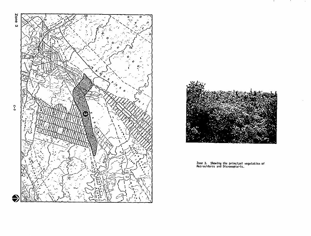
No::l..'"
n,~
Zone 3. Showl thHetrosideros annd9 Doe principal vegetation oflcranopteris.
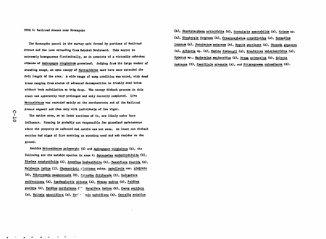
r
()II-'o
ZOl'lE 4: RallroacS Avenue aear leoaepoko
The keonepoko parcel ia the aurvey unIt fO~Cf!d by portioos of Railroad
Aveoue and the laDe uteudlDS froa J:ahukal Bnulevard. Thla aector is
extreaely bo~aeneoul 11orIltlcally. aa it consists of a virtually unbroken
expanse of ADcSropoaon virgin1eu. srasalaod. JuC:ginS fro. the larae nUlWer of
aeaudin! lDasa. an open canopy of Hetrosideros CUBt have once f!%tended the
ful1lf!DSth of the zone. A vide raoSe of S08S condition vas noted. vith dead
treea ranlinl fro. atates of advanced deco.position to freshly dead bolea
vithout bark ufoUaUon or tvil drop. The canopy d1eback process in thb
tract vas appareotly very prolonsed and only recently completed. Live
Hetrosideroa vas recorded cataly at the northvestern eod of the Railroad
Aveoue seSDf!ot aad then only vith individuals of low viSor.
The entire area, or at least sections of it. sre likely under burn
iofluence. Crazing is probably oot responsible for gra•• land maiotenance
.tace the property is unfenced and cattle vaS oot seeo. At least oDe dieback
sectioo had aigos of fire Icarriog on Btanding vood and ash residue on the
ground.
Besides Hetrosideros polyaorph~ (E) a~ Audroposoo vir,inituD CAl. the
followiog are the notable species in ~ODe 4: Dsteoaeles anthrllidifolla (E),
Plucbea sycphytlfolJa CA) I Arundloa ba:.buslfolJa CA). Paullion~ CA).
Waltheria indica (X). Chaaaecrist~ ?~:tit2ns subsp. patellaria val'. tlabrata
(A), Wikstroemia saadviceosls (E). ~~~srtha filiformis (I), Iadilofera
suffrutlcosa (A). Spathog!ottla pl1cata CA),~ pudica (A). PsidluD
suajava (A), PsldluD cattldaau:a. (" l'.s:l.slfera~ (A), Cocos ouclfera
(A), HelloIs aloutiflora CAl. ~::.... ~.pis culttflora (A), Centella asiatica
(A), Stachytarpbeu urtfclfoUa CA~, Crotalarh apectabllla CA),~ sp.
(A), Thunbergi. fragr.as (A), Crsssocephsiu. crepidioldes (A), Desaodiua
~ CA), Punisetu. aetaceua (A). ""tia pectlnsu CA), Thetleda Fipntea
(A). Alblzzla ap. CAl,~ fosberali (A). Erechtitea valerianifolia (A),
~ sp., Hachauiaa udacoidea (I), Treaa orJeataUa (A),~
teatacea (E). Castilleja srveaaia CAl, aad PJtrrograama calo.elanoa CAl.
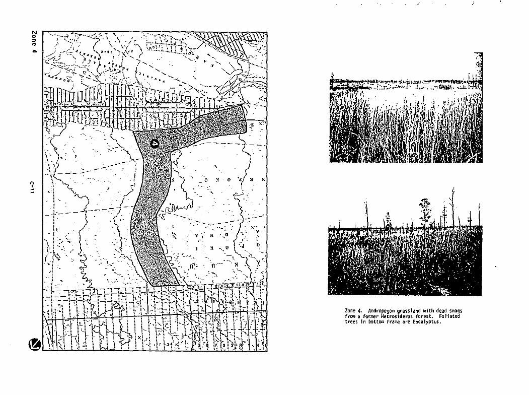
No::IIII
.c.
f')I.~....
,.
~one 4.f
Andropogon grassland with dead snagstram a ormer Hetrosideros forest. Foliatedrees in bottom fra~e are Eucalyptus.
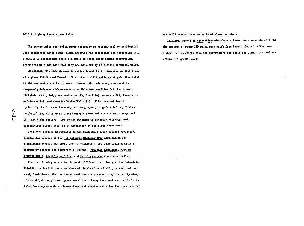
ZONE S: Hiahvay Parcels near Pahoa
the survey units near Pahoa occur pri~rily on aaricultural or residential
land brackettn& aajor toads. Huaan activity h3. fraaDented the vegetation into
a _osalc of contrasting types difficult to brina under coemon description,
other thaa vith the fact that they are universally of aIniaal botanical value.
In general, the largest area of aative forest ia the fractioo 00 both sides
of highway 130 (toward Xeaau). Short-atarured Hetroslderos of pole-like habit
Is the doalnaot COVer 1n the area. Hovever the understory cocponent is
frequently infested with weeds suth as "elaatoes candiduD (A), Andropogon
virigioicu. (A), PolygoouD capitatull (A), Castilleja arvenals (A), EraFrostis
unloloidea (A), aod Aruadiaa baabusifolla CAl. Alien coacunlties of
(prlaarlly) Psldlu:::l cattle1aaull,~~, HngUera indiea,~nI .,..phltlfoUa. Alblzzla sp•• and Cecropia obtusHolia are alao interspersed
I-'~ throughout the section. Due to tbe presence of numerous house Iota and
agricultural plots, there is DO continuity to the plant foreations.
this aaoe pattern i& repeated io the properties along Kahukai Boulevard.
Substantial patches of the Hetrosideros-Dlcranopteris association are
diStributed through the strip but the residential and cOc:lerclal farm lots
co~pletely disrupt the integrity of forest. Helochia umbellata,~
sygphytifolla. Buddle1a asiatica. and ~.1!!!1!!! are COUlon pests.
the lane foraing an arc to the west of Pahoa is slailarly of low botanical
quality. Huch of the area consists of abandoned C4nefle1ds. pasture1and, or
weedy borderland. ~~en Dative comcunlties are present, they are nearly alvays
of the ubiquitous pioneer type cocposition. Exceptions such as the kipuka by
pahoa Duap cay contain a rlcher-thao-usual species suite but the taxa recorded
are still coc=oa ite=s to be fouad alDost anywhere.
Relictual stands of Hetrosideros~Psychotriaforest vere encountered along
the portion of route 130 Which ruas south froa Pahoa. Certain sites have
hither species counts than the survey nora but sgaia the plants involved are
cocaon throughout Havail.
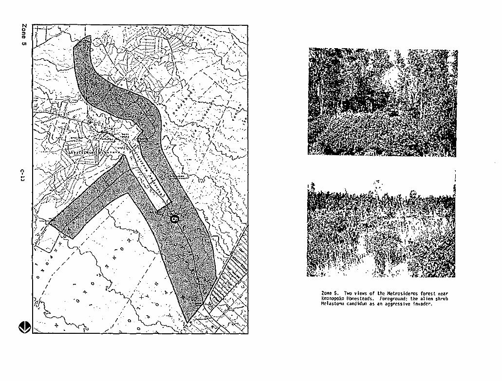
...... 0-
Zone S. Two views of the Hetrosideros forest nearKeonopoko Homesteads. foreground: the alien shrubHelastoma candid~ as an aggressive invader.
-~
,
Q
I
I/
/ ~
~
.I 0,.-~
Q
No:lIII
CJI
nI...
W
//
/.
~AI• .._.~W -";" . rJ
()II-'...
ZONE 6: Puna SubstaUon
The aurvey section near the Puna Bub.tation eztenda to the SE in a
double-lane configuration, vith one ar_ passing through ~aipahoeboe and the
second superimposed upnn the Ieaau-Pahoa highway. Host of this area has had a
1008 history of intenslYe aaricultural use. Native plaot cover h absent Eroa
a vide territory, especiall, In the region adjoining the substation.
Due to the failure of the sugar industr, arouod Ieaau, larDer plantation
aereages are nov in the proce.s of converting to veed, vastelota. Although
Saccharu. officinaruD (i.e. sugar cane) remains the dominant species 10
abandoned tracts, Cecropia obtuSifolla and Heloebla umbellata a:e invading.
Fro. present indications. the untended fields should eventually develop into
an alien lorest dODinated by~ cattleianum--lf the land 15 alloved to
continue 00 a free running sequence.
A large nu=her of site. 1a zone 6 are presently iavested in small scale
cultivatioa of alternative crops. Haay agricultural plant pests and
ineidental ephel:llt!rals are associated vith the fara plots. No atte~pt vas cade
to co~pile a botanical inventory of the occurrences since they represent
disturbance foreations Irrelevant to the proposed project.
Near Vaipahoehoe, a aecond grovth forest of~ oriental!s aod Cecropia
obtusifolla 13 distributed io discontinuous fashion aaong agricultural
clearings. Further to the southeast thla vegetation 8ives vay to an
Andropo$on virglnicuD-Arundlna bacbuslfoUa rangeland. ~ &lDphytlfoUa.
~ gua'.va. Desaodiull ca1an!fol!u:ll,~~. Handfera indica,
Cordyl1.ne teraInalIs. and~ ainutlflora are conspicuous weeds in the
rangeland community.
As a Benersl pattern. deep-soll habitats in zooe 6 are assodated vith the
kind of veedy plant asseDblages to be ezpected from past or present
agricultural use. PatcheS of native forest are present only over terrain
Vhich baa been renewed by relatively recent volcanic activity. In the latter
situation. an open Hetrosideros-Dicranopteris cocmunlty develops .s a
auccesstonal pIoneer on the unweathered lava. Ezaaples of the pioneer forest
are present along stretches of route 130 but the coc::unit1es are heavilY
infiltrated by aliens such as Aodroposoo, Aruadias, and the serious pest
~ eatUdanWl.

nI......
No::lIII
Ol '~.~..
I \
\
Zone 6. Top: Secondary forest near Waipahoehoe.abundantly vegetated by all manner of plantpests. (~nopy of Trema orientalis and Cecro~ia
obtuslfolla. Bott~n: Andropogon-Arundinarang~land to SE of Walpahoehoe.
S1JMKATION
Our ezac1aatioa of the roUtes under consideration iodicates that the
botacicaI l ..pact of the intended project vould be very Iliniul. Hany of the
areas subaitted for reviev are aanaged landscapea which bave already been
hi&hly altered by aan. EYen 10 cases vhere nstive foreat vas encountered. the
floristic quality vas consistently poor. and the same species co~sltioa vas
repeatedly ezpressed.
An ecological eO_eDt of general application can be Il4de of this study
terraio:
M a Yesetatioo a.sturea. It norll411y prosreaaes through a contlnuous serles
of chaoges known collectiVely as succession. In Puna envirooae:nts. the progt·aa
of chaose Is initiated When an e:x1sting plant cover is erased by lava flevs,nI the terrain subsequently recovering Its vegetation through stages ofI-'0'\ IncreDQtal repopulation. 'I'bough of vide spatial el:tentloo. the obie. stands
in the survey tract are consistently a: an early stale 10 the successIonal
process. Volcao1&. in the dtst::ict is so acUve thst the mturatlou ·sequence
is constantly belnl truncated, ~nd both the landscape and the plant
COI:llUnJ. ties are kept youthful by continual resetting to the starting point in
the development cycle. Due to theIr incipient status. the plant coccunities
conta!.n only a al:811 fractlon c;: the spee1es diversity Whic~ can be
pote.aUa11y ezhIblted by forest: of their type. 'fbe biolo&ical value. 1&
dialnished accordingly.
Rare and endangered tau of Ketrodderos forests are prltlarlly 4saoclated
vith the ~ture. dense-shade ec'Ironce~:s produced by old Gta~ds. Youthful
COUlUn1t1es like the ones co:-:o-_ OVe:: geologically active :..:.:-::a1l:!: ue not
likely to harbor plant rarities. It is physically iC?Qssible to inspect the
contents of ever, patch of native forest with occurrence inside the project
boundary. But just on general ecological principles. it is higbly icprobable
that SODe outstanding botanical fInd could ever be retrieved IroD the kind of
foreat. prevailing in the Puna district.
We recoe=end that botanical ccnceros be o=1tted froo the evaluation process
for final route selection. There ia DO coC?elliog basis for altering or
abandonIng aoy of the Intended tracks au th~ basis 0= vegetaUon
cODsideratioos.
APPENDIX D
CII-'
CULTURAL AND DIOlOGICAl RESOURCES SURVEY OF THEPOHOIKI TO PlNA-SUBSTATIlN 69KV T~Sl1ISSllN CORRIDOR
KEA' AU TO KAPOHO. PlNA. IWoIA I 'I JSLAND
Final R.port~
Ornltboloolsal 5urv.r
1:5 AprJ I 1987
Robl!'rt C. FltlsChtr, Ph.D.Hawaiian Evolutionary Biology ProQr&m
1993 East-W.st RoadUniv.r,lty of Hawai'i
Henolulu, HI 96822
Pr.par.d for I
Dlfl. Inc.1188 BiShop Str•• t
Sui h 2405Honolulu, Hawai'l 96813
O.partm.nt of V.rt.brat. ZoologyS.rnie. Pauahi Bishop Mus.um
Honolulu, Hawai'l
Introduction
69KV transmis~ion corridor b.tw••n Pohoiki and
Puna-Substation in th. Puna District. Hawaili Island. Th.
studY ar.a consists of corriders ef land roughly 26 mil.s in
I.ngth surrounding th. prepos.d tran~lssion aliignm.nts
(sn Fig. I). Th. primny goal of th. study was to documtnt
construction and continu.d pr''1.nc' of th. pow.,. lin•• In
pntlcular. I attempttd to docum.nt sp.ci.s 'that art
curr ..ntly ttll' ",ttn.d, .ndang.r.d or ar. in 10m' oth.r way of
.I.vatlon of th. studY ar•• « 300 m), and th. lack of ..
si9niflcant amount of w.tland habitat mad. it unlik.ly that
r''iults tabulat.d for various s.ctlons of th. study ar.a,
and .. dit.eusslon of th. pottntla' impact th. pow.r lin.
might haul on ~~ian sp.el.s in g.n.ral, and on thr.at.n.d or
Study Sit. and Habitats
Th. study ar.a was locat.d b.tw••n th. Puna Substation
and th. 9footh.rmal punt loc.tld.t Poholki Cu. Fig. 1>.
2
divid.d into 23 subs.ction' ~nd ~Ix m~Jor !.ctor~ (s.~ FIQ.
our 'CC.S5. (5., th, r.port from the B. P. Bishop Hu~.um'~
bl·hnfcd 5ur",.y for .. mar. d.hil.d d.scriptlon of th.
""9"tatlon tYP'5 .uallabl. for birds.)
I and Tabl.s
lubuetions as follows. Puna w.st. A, G, E, FI Puna Ea.st.
B. C. 0, E. Fl Old RRI H. Rr South.astl at T, ., 0, J, NI
t30 Easts L. HI, H2, Plr .30 W.stl L, PR, KI, K2. S. N. As
can bt st.n, som. subs.ctions .II" found In mort than on.I.ctor. This Is ~rimarlly b'caus. of ou.rlap of s.parat.
Substation and Poholkl plantr s •• Figur. I). 9ird sp.ci.s
numb.r. w,r. summariz,d for .ach ,ub~fction and th.n for
All fl,o·j.,,)rk was conducttd during tht pf'rlod 18-23
O,c,mb'r 1986. SU,."'fYS W'''t gfnfrally conduct.d from about
sunris. (about 6130 a.m.) to about 3100 or 4100 p.m. Our
m.thodology in"'olu.d making counts at I.ast '",.ry 0.2 mll.s
along .ach trans'ct. Counts w'r. conduct.d at stations from
which most or all of th. corridor ar.a. was ",Islbl. for at
I.ast 0.1 mil,s. This was a1so a dlstanc. within Which
station. Habitat tYP.5 at tach ,tatlon w.r. also not.d.
Th. numb.r of birds for .ach s.ctor was summ.d from th.
songs of most a",ian sp.cl,s could b. h.ard. Th.r.for.,
cou.rao. of th, corridor was fairly clos. to 100%. Th.
numb.rs of tach sp.cl.s of bird I ••n or h.ard during .I
fiut-mlnut. p.rlod was r.cerdld Into fl.ld not.books .It .ach
oI
r-l
.ach f.ctor. Th. six s.ctors can b. "'arJOUlly comblntd to
pro",ld' summarY dat. for ••ch of th. thr •• most llk.ly
tr.n~llslon lin. corridors.
Habitats w.r. "'ari'd in the ,tudy .11".1, and Includ.d
sugarcan. fl.lds (mostly in th, Puna .a,t .nd w",t s.ctor'l
Fig. 1)1 'ohia for,st (mostly In the -south.ast- and ~Old
stations within .ach s.ctor. and my fl.ld assistant
'a"'annas, and r.sld.ntial ar••s (mostly in th. -130 W.st-
s.ctor). Many of th. 'ohla tr ••• w.rl In bloom during thl
surv.y p.rlod, .0 nrctar r.sourc.s w.rl auallabl. fOr nat I",.
und.rlying substrate was fairly rough .nd rocky, and in som,
ar'as a thick und.rstory of gr.ss and thorny shrubs Ilmlt.d
3
athmphd to b. as rullstlc as poniblt In .stlmatlng th.
numb.r of birds s••n or h,ard. W. sp.nt th. first day of
th. stUdy (18 D.c.mb,r) visiting the .ntlr. studY .11".1, ~oth
to d.t.rmln. the b.st plan for conducting the suru.y and to
famillariz. or rlf&mlliarlzl ours.lu.s wIth th. typ.s of
birds pr,s.nt In th. study ar.a .nd th.lr songs.
4
oI~
R.sults And Discussion
Tablt 1. A total of 1254 Individuals of 16 sp.ei.s of birds
no mort than on. of th. 23 subs.ctions, and an additional
four sptelts wtr, found in f,w.r than half of th. 23
sp.cl.s found In mort than SOX of th. subs.ctions (Common
Nyna, Acrldoth.r., tristl!1 North.rn Cardinal, Cardinalis
mtx!canYSI and th. two dout sp.ci.s tSpotttd Dout,
StrlatoR.lia chintnsl,. and Z.bra Dov. G,op.li. ,triata]
combln.d into a ,'nOI. ·dov.s· cat.gory). Th.r' is also a
,.paratt cattgory with all of th. oth.r sp.ei.s combin.d.
All ••u.n of th. Iptcl.s found In mar. than SOX of th.
Th. r.latlu. abundanc. of th. common sptcits in taCh
maJor ,.etor is plotttd In Flgur. 2. As can b, s'tn, Nutmtg
Hannlkins and C~on Nyna, w.r. most common in th.
agrleulturallztd Pun. East and Puna W.st stctors, wh.r.as
North.rn Cardinals and Hous. Flnch.s w.r' mar. abundant in
th. wood.d hablt.t, of all s.ctors oth.r than Puna East and
5
.v.nly dlstribut.d ~ong all of th. s.ctors. Similar tr.nds
can also b. id.ntifi.d in Figurt 3. Tht ·oth.rs· that ar.
10 common In tht Puna stctors art primarily ducks (s.'
b,low).
Intraduc.d ••otic sp,ei.s (Eurasian Skylark,~
arv.nsi!1 H.ladlous LauQhing-Thru!h, Garru'a. canarusl and
<North,rn Pintail, Anas acut!1 l.sl.r Scaup,~ affinls;
and Goldtn Ploutr, Pluvi!li' domlnlca) and thr.' art natlv.!
of sptclal cone.rn (th, '10 or Hawaiian Hawk,~
folit!riu,; tht Hawaiian Black-n,ck.d Stilt or A,'o,
Himantopui m•• icanuf knuds.nll and th. 'EI.palo, Cha!i.mp~it
not a common bird at th.s•• I.vatlans on Hawaii <Pratt
19901.
Th. two duck sp.ei.s and th. ,tilts occurr,d onlY in
somt small ponds at tht tdgt of th. corridor in subs.ction F
(Fig. I>. Thts. ponds w.rt ch.ck.d & total of four tlm.s
during tht surv.y to d.ttrmln. how oft.n thty w.r. bting
ul.d by th. w.t.rfowl and stilts. Th. stilts wtrt s ••n on
only on' occasion, tht ducks on thr •• of th. four visits.
Th' ponds and th"r inhabitants ar, not Ilk.ly to b•
• fffet.d gr.atly by construction of th, powtr fin. b.eaus.
6
probabl. position of th. pow.r lin.>. How.v.r. If this
rout, Is chos,n, car. should b. tak.n to disturb this'
habitats as Iitti. as posslb1 ••
Th, .Ingl. '10 was s.,n .oarlng high abou, th,
abandon,d railway track In lubl.ctlon J. Thl ••ndang.r.d
(B.rg.r 1991, Griffin 1984). Th.y hunt mo,tly from
stationary p,rch.s but alwo whll. soaring (Griffin 1984).
pr.cautlons art tak,n to ,llminat' th. risk of"tl
I .I.ctrocutlon). In addition, th. d.struction of for.,t,d or..s.cond growth habitat associat.d with .,tabl'shm.nt of th.
pow,r lin. would incr.as. op.n ar.as, which th. hawk Is
known to us, to find food (Griffin 1984). All car' should
b. tak.n during construction and/Or malnt.nanc. of th. lin.
not to Int.rf.r. with br••dlng att.mpts bY th. hawk. '10
br"d b,tw,," March and S,pt.mb,r (Griffin 1984).
Th, ·El.paio was th. only oth'r .nd,mic form found
during th. surv,y, and Is th. only natlv. pass.rln. that
could normally b, ••p.ct.d at this low ,I.vatlon on Hawaii
(Scott ,t al. 1986). Although 'El.palo art not list.d as an
.ndang.rtd sp.cl.s by th. U.S. Fish & Wildllf. S.rvlc.,
7
th.lr numb.rw hav. app.ar.d to d.cr.a~. in r.c.nt y.ars
(Scott .t al. 1986). Th, birds w.r. slght,d In subs,ctlon 0
(Flgur. I, Tab1. I). Oth,r natlv. pass.rln.s w.r. car.fully
Ilst.n.d and ,.arch.d for (•• g. Apapan., Hlmatlon. ~anquln.a
and Common Amaklhl, H.mlgnathus ~), but non. w.r.
not.d. It Is po,slbl. that during oth.r tlm.s of th. y.ar
(p.rhaps wh.n mort 'ohla art In bloom> th.,. ,p,cl., do com.
down to low.r .I,vations. A Ilt'ratur. s.arch through ~
'EI.palo and oth.r sourc.s fall.d to find any .uld.nc. that
th.s, hon,ycr ••p,r, do or hav. In r,c.nt tlm.s occupl.d this
B
o,U1
Th. 'EI.palo, tht 'la, and th. Hawaiian Stilt Wt". all
found along thf sam. corridor <s.elors Puna East, Old RR and
ont of th. two alt.rnatt rout•• (1'.'1 tht two along tht
highway) would bt bt.t to minimlzt Impact to the •• natlv,
birds. Only non-natlv. (and mostly Pl'st> sptei •• w.r'.foun~
along the alt,rnat. corridors during the surufyS <Tabl, I,
Flgurt I). I b,lltv. that our coveragt of the sit •• was
.d.quatt to docum'nt wh.th,r natlu. spfci.s of birds occur
along th ••• corridors. Such natlv' birds may occasionally
aha do not f'l'l that popuLations of
th. Jntroduc.d l p.~t Ip'CitS would b••_trAordinar,ly
.ff.ct.d b~ th. con~tructlon and maint.nanc. of th. pow.t'
lin••
9
.-~
LI hratur' CI hd
e.rg.,., A. J. 1981. HAwall ..n Blrdllh, 2nd Edition.
Pyl •• R. L. 1983. Chlckl ist of the birds of Hawaii.
Scott, J. H., S. Hountain,prlng, F. L. Rams.~, and C. 9.
K.pltr. 1996. For.st bird cOIfrnunitl •• of th. HAw.ii.n
islandia th.lr d~n&mics. ,colog~ .nd cons.ry.tion.
Studl,. In Aui," Biology No.9, 431 pAgfS.
'0
J
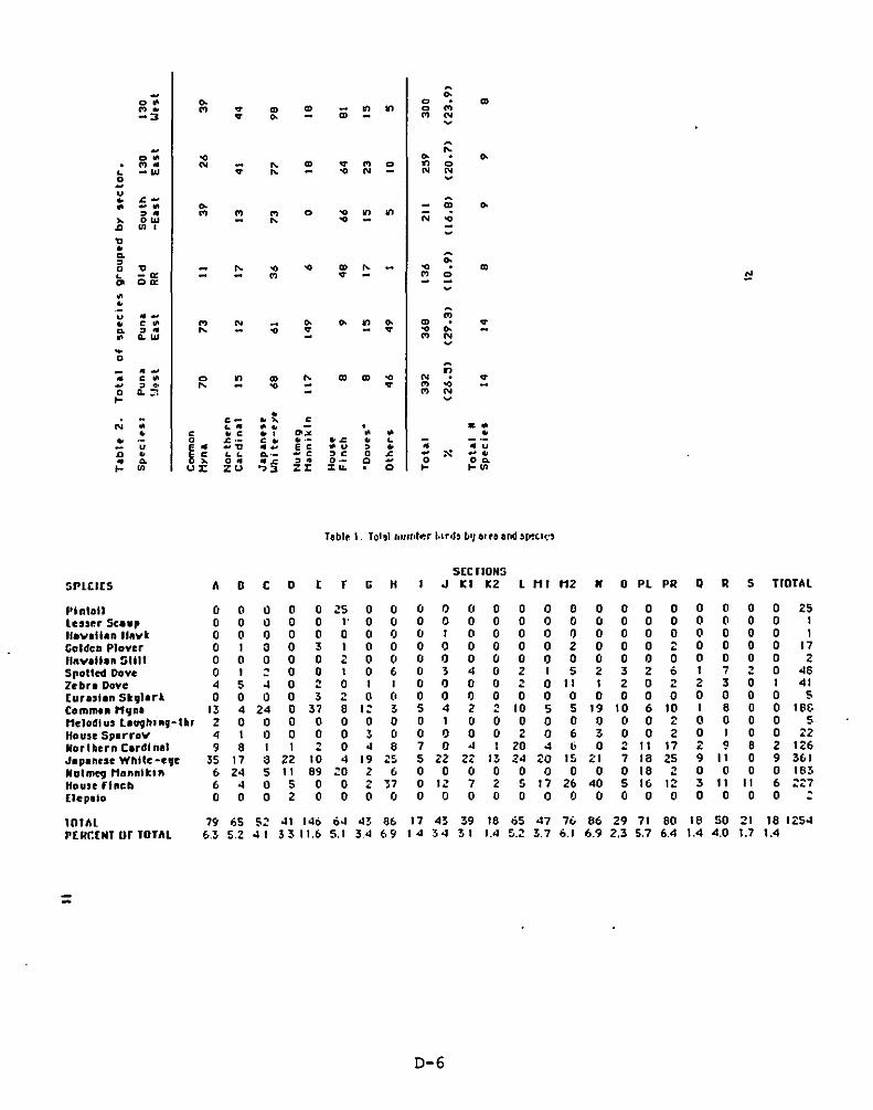
- ..00 .. 0 '".,. ., .,.
'" '" iii., ., 0 .,
-3 .,. .. ., N~
- r.:00 .. .. ..., .. N ;; "- '"
.,. ., 0., 0
• -w "- .. '" '" N
2 ~
u• .c-o -0 .. m .., .. ., ., ., 0 .. ., .,
N~ ow "- .. ..'" Ul , --"•0. 0:,0 " - "- .. .. '" "- .. '"L -0: - ., .,. ., 0 !:!'" 00: -~0
•u .. - Pi• < • ., N :0 .. .. ., .. m .,.0. , .. r-. .. .. .. ..• .. w ., N
~
~
0
'; -- In< 0 0 .,
'" "- '" '" .. '" .,.- , ,. r-. .. - .,. ., ..0 Q.:'l - ., NI- ~
•N ; c- .~ <
.0.- o • ·• < • c ., "'.. 0 0 •• 0 .c- c • ..- • .c • LU
~~ -" -- E c o u , • - _ u
" • L L 0.'_ _c , C 0 = - >< -.- 0. 0_ _.c , - 0- 0 0 00.I- Ul U:I: ZU "3 zr "' ... · 0 I- I-Ul
Teblt I. Tot,1 'illtl.tr.r 1.lnls [,'J 61 tb al'ld ~~~c.,~"
SEC nON:;
SPlCIC5 A 0 C D C r G H J Kl K2 1 HI H2 H 0 Pl PII Q II 5 TrOTAl
f·i ntaU 0 0 0 0 0 ~5 0 0 0 0 (0 0 0 0 0 0 0 0 0 0 0 0 0 25leucr se••, 0 0 0 0 0 l' 0 0 0 0 0 0 0 0 0 0 0 0 0 0 0 0 0 11I0",llIan IlIlvt 0 0 0 0 0 0 0 0 0 I 0 0 0 0 0 0 0 0 0 0 0 0 0 1Goldca Plover 0 1 3 0 3 I 0 0 0 0 0 0 0 0 2 0 0 0 ~ 0 0 0 0 17•IIftv.llen :iii" 0 0 0 0 0 2 0 0 0 0 0 0 0 0 0 0 0 0 0 0 0 0 0 2Sflotted Dove 0 I ~ 0 0 I 0 6 0 3 4 0 2 I 5 2 3 2 6 I 7 2 0 46Zebn Dove 4 5 4 0 2 0 I I 0 0 0 0 2 0 11 I 2 0 2 2 3 0 1 41[ur.,t.n St,.• rt 0 0 0 0 3 2 0 C' 0 0 0 0 0 0 0 0 0 0 0 0 0 0 0 5Commu t1lJna 13 4 24 0 37 8 I~ 3 5 4 2 2 10 S 5 19 10 6 10 I 8 0 0 18&Mclalll u, L'V9hug- thr 2 0 0 0 0 0 0 0 0 I 0 0 0 0 0 0 0 0 2 0 0 0 0 5House Splrrov 4 I 0 0 0 0 3 0 0 0 0 0 2 0 6 3 0 0 2 0 I 0 0 22Northern C.rdtnal 9 8 I I 2 0 4 6 7 0 4 1 20 4 6 0 2 11 17 2 9 8 2 126J.panese Whtle-e,e 35 17 3 22 10 4 19 Z~ 5 22 2Z 13 24 20 15 ;:1 7 18 25 9 11 0 9 361Natmeg Monntt." 6 24 5 11 89 ~o 2 6 0 0 0 0 0 0 0 0 0 18 2 0 0 0 0 16~
House filtch 6 4 0 5 0 0 2 37 0 I~ 7 <: 5 17 26 40 5 16 12 3 11 II 6 ::::7[tepaio 0 0 0 2 0 0 0 0 0 0 0 0 0 0 0 0 0 0 0 0 0 0 0 ~
11llAl 79 65 S~ 41 146 64 43 06 17 43 39 18 65 47 7. 66 29 71 60 16 SO 21 16 1Z54PC RCCHT IIr TOTAL 6.3 5.2 41 33 11.6 5.1 34 69 14 34 31 1.4 ~.:! 3.7 6.1 6.9 2.3 5.7 6.4 1.4 4.0 1.7 1.4
=
0-6
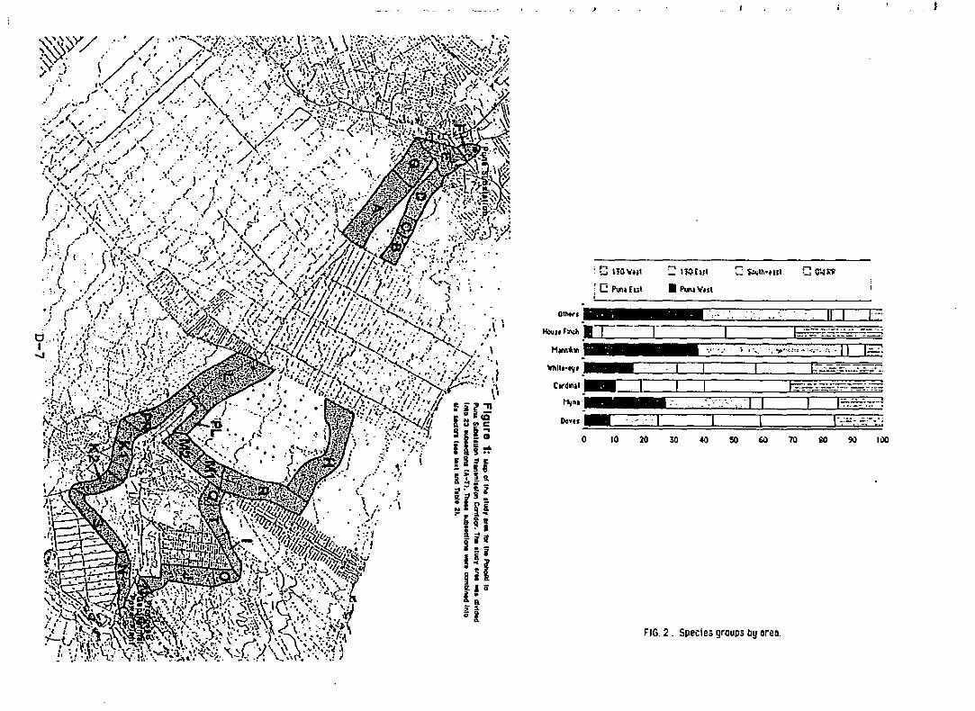
.f
~ IlQ£UI
• PI.N"'ul
FIG. 2. Species groups by lIrell.
·;····;.·1 II I
20 30 40 so 60
. C HIl ....ul
1c:: ~.h.l
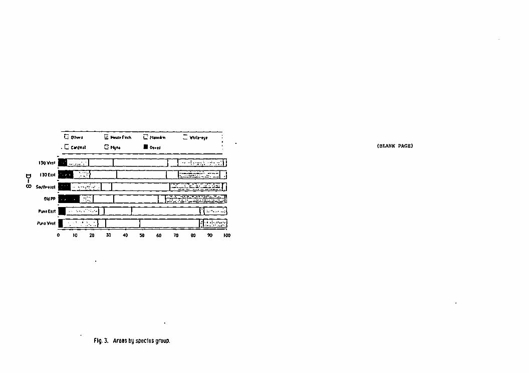
o
C 0'J>tr1
. [ C"4",~1
10
~ Ilo\lnr~
C~~ • Do-.,
70 100
(BLANK PAGE)
Fig. 3. Arells by species group.
APPENDIX E
Final Report of the Pohoiki to Puna Powerline EIS:
Terrestrial arthropods
by G.M. Nishida and W.C. Gagne
The Department of Entomology of Bishop Museum conducted
entomological field surveys of the Pohoiki to Funa proposed
powerlIne alignments, on 5-11 February, based on maps provided by
DHM, inc. Eighteen promising locations were sampled during this
period. Sampling methods included sweeping, beating, and hand
collecting during both day and night. Durin9 the evenings, a
mercury vapor lamp was used to attract insects. Lists of the
insects and other arthropods collected from the areas outlined by
DHM and identified are found in Appendix 1.t'lI Three areas of important concentrations of native species.... were found during the survey. one of critical importance. These
areas are outlined in AppendiX 2. A critical fourth area. though
not included in the survey. will be crossed by the powerline
using either of the alternate routes.
The follOWing narrative will begin from the Puna Substation
and work south and east toward the geothermal plant following the
two nearly parallel alternative routes marked on the DHM maps.
One route followed the old railroad track bed. The other
paralleled the Keeau to Pahoa Road. Divergences to these basic
routes occurred at and beyond Pahoa.
1
The survey areas just to the south and southeast of the Puna
Substation contained introduced species or common species of
native insects. The railroad bed route was surrounded by mostly
sugar cane and weeds and populated by non-native insect species.
The road route was mostly late flow lava vegetated with~
trees and~ fern and ~pulated by non-native or common native
insect species.
The survey map provided by DHM shows a coverage gap between
Shower Drive to slightly beyond Makuu Drive. Accordingly, this
area was not formally surveyed. However, the area was driven
through and visually surveyed. Superficially. there appears to
be not much entomologically that would be affected by a powerline
across this subdivision. However, we are concerned, as this
"non-survey" area crosses above Kazumura Cave, the restricted
habitat for a number of remarkable cave-adapted organisms (Gagne
and Howarth 1975. Gurney and Rentz 1978, Bellinger and
Christiansen 1974, Gertsch 1973). Kazumura Cave has been
previouslY studied and much Hawaiian lava tube research has taken
place there (Howarth 1973).
South of Hakuu Road. the Keeau to Pahoa Road route diverges
just before Pahoa town. One fork skirts Pahoa to the south. The
other fork makes a sharp bend at Kahakal Boulevard and joins with
the abandoned railroad route. which has made a similar bend lbut
in the opposite direction). At this location. the railroad route
crosses an area of scattered o'hia that appears to have been
previously burned. Nothing of entomological significance was
2
t'lI
N
found along the surface of this route. The route following the
road was, 8galn, populated by non-native or relatively common
native species.
Perpendicular to the outlined survey areas and paralleling
Kahakai Boulevard is the most significant habitat located within
the survey parameters lsee APpendix 2). This is the general
location of Pahoa Cave. Collected and observed in this cave were
unique cave-adapted creatures. Many have adapted so well to the
environment as to have become eyeless, using other means to
communicate with each other. These unique cave animals, found
only in this cave, included cixild bugs, crickets, crane flies,
moths, millipedes, sow bugs, silverfish and centipedes. A major
scientific study of the cixiid bugs from Pahoa Cave is currently
underway, with important disc~veries on the behavior of these
bugs (Hoch and Howarth, pers. communication). Pahoa Cave crosses
underneath both alternative routes inclUding both forks of the
alternate route on either sides of the Keeau to Pahoa Road.
Concern about this extremely important biological resource is not
focused only en possible physical damage to the cave during
construction or possible exposure of the cave to increased access
and thus pressure en the fragile habitat of these animalS, but
also extends to general maintenance of powerlines. A common
practice of powerline maintenance is to use herbicides to control
the vegetation beneath the lines. This practice of spraying
would be extremely dangerous to the cave animals, as the
herbicide would kill the host plants - the major energy sources
J
for the cave animals. The herbicide is also likely to percolate
down into the caves, directly affecting the animals.
Continuing first with the southernmost fork of the roadway
alternative. the proposed route skirts Pahoa to the south and
west. The fauna around the solid waste disposal site is very
similar to the previously mentioned roadway faunas, with nothing
unique. Traveling south and east. the area Is mostly sugar cane
and weeds without any entomological significance. However. a
small klpuka of native forest does appear at the edge of this
fork, on the map appearing beside and below the last "A" In
Waiakahiula (see Appendix 2 for location). This area produced a
significant number of native species, including several that are
probably new and undescribed. This kipuka is relativelY small
and located in the midst of sugar cane. It could be easily
skirted by the proposed powerline if the alignment was placed
directly in the middle of the alternative route or moved somewhat
closer to Pahoa.
Further along, this alternative goes south along State Route
130 for a short section, then proceeds east paralleling Kahukai
Street in the Keahialaka SubdiVision before it takes a turn
towards the geothermal facility. Some native insects were,
collected along Kahakai Street, but most species were of general
distribution.
Returning to the railway route, after the two forks combine
.along Kahakai BoUlevard, we find that the route parallels the
northern edge of Puna Subdivision, makes a sharp right-angle
4
turn, and parallels Seaview Road along an unnamed dirt road. The
route then skirts Nanawale Forest Reserve and Lava Tree Holds
State Park before heading towards the geothermal plant. Another
area of significance Was discovered along the east side of the
dirt road paralleling Seaview Road Isee Appendix 21. This site
is approximately outlined by the dirt road to the east, Seaview
The total for the endemic and indigenous species as compared
to the alien species is significant especially in light of the
occupation by the long-legged ant. The other surprising total
was the large number of species previously unknown from the Big
Island.
In summary. the areas of entomological significance, in
Road to the west, Plumeria Road extended to the north, and Hawaii
natives including 14 species of native moths (Hyposmocoma) alone,
Road extended to the south. The dominant native tree. !!m!
(Diospyros hawaiiensis), made up the canopy of a comparatively
diverse community of native plants.
despite the occupation by the long-legged ant. This area is one
of the lowest elevation patches of remaining lowland native
forest with surviving native species.
Based on Appendix 1, the species totals are as follows:
the least possible perturbation. We would suggest Dr. Fred Stone
of the Department of Geology at the University of Hawaii at Hila,
addition, the area crossed by Kazumura Cave not included in this
In general, the alignments could probably be adjusted to
skirt or skip the significant sites. Pahoa Cave and Kazumura
Cave are extremely important living biological laboratories and
different. This prOVided the first comparison of the impact of
this recently introduced ant on the island of Hawaii. In
arthropods in that one ~ipuka had ants and the other didn't. The
native arthropod composition of these two sites were dramatically
great care should be extended when passing over these caves. Our
recommendation is that someone with knowledge of the caves be
added as a consultant when the final alignment is decided, to
provide input as to the best possible way to cross the caves with
probable order of significance arc: 1J Pahoa Cave. both upper
and lower caves. possibly extending to the ocean. 2) The ~ipuka
area south of Pahoa near the last "A" in Waiakahiula. 3) The
survey is extremely signifiCant.
Seaview Road site. The latter two sites provided a living
laboratory insight as to the impact of long-legged ants on native
443
7012
Endemic speciesIndigenous speciesExotic or Alien speciesSpecies new to Big Island
In many of the other sites, Anoplolepis lonaiceps, the long
legged ant, was found in abundance. This introduced alien
species apparently heavily impacts resident insect populations,
thus areas foraged by this ant yield significantly fewer native
species than might be expected. This ant was also found in
abundance in the Seaview Road site, and indeed. day collecting
was not as productive as might have been expected. However,
collecting at night using a mercury vapor lamp attracted many
t'lI
W
5 6
and one knowledgeable about Hawaiian cave biotas. as a possible
conSUltant.
7
Acknowledgements:
Basic support was provided by the Department of Entomology
of the Bishop Museum. Identification support was provided by
G.A. samuelson. F.G. Howarth. H.L. Evenhuis. and J.C.E. Riotte of
the J.L. Gressitt Center for Research in EntomologyJ H. Asche of
Marburg University, West Germany. and C.W. Sabrosky of the u.s.
National Museum.
8
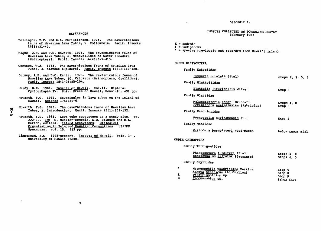
Appendix 1.
REFERENCESInSECTS COLLECTED ON POWERLINE SURVEY
February 1987
Gagne, W.C. and F.G. Howarth. 1975. The cavernicolous fauna ofHawaiian Lava Tubes, 6. Mesoveliidae or water treaders(Heteroptera). ?acif. Insects 16(41:399-413.
Gertsch, W.J. 1973. The cavernicolous fauna of Hawaiian LavaTubes, ). Araneae (Spidersl. pacif. Insects 15(11:16)-180.
Gurney, A.B. and D.C. Rentz. 1918. The cavernicolous fauna ofHawaiian Lava Tubes, 10. crickets (Orthroptera, Gryllidae).Pacit. Insects 1811-21:85-104.
Hardy, D.E. 1981. Insects of Hawaii. vol.14. Diptera:Cyclorrhapha IV. Univ. press of Hawaii, HonolUlu. 491 pp.
Howarth, F.G. 1912. Cavericoles in lava tubes on the island ofHawaii. Science 115:325-6.
Howarth. F.G. 1913. The cavernicolous fauna of Hawaiian LavaTubes, 1. Introduction. Paci!. Insects 15(1):139-152.
Howarth, F.G. 1981. Lava tube ecosystems as a study site. pp.222-30. IN: D. Hueller-Dombois. K.W. Bridges and H.L.Carson, editors. Island Ecosystems: BiologicalOrqanization in Selected Hawaiian Communities. US/IBPSynthesis, vol. 15. 58) pp.
Zimmerman. E.C. 1948-present. Insects of Hawaii. vols. 1University of Hawaii Press.
ORDER DICTYOPTERA
E = endemicI =indigenous• =species previously not recorded from Hawai'! island
Stops 2. 3, 5, 8
Stop 8
Stops 4, 8Stop 8
below sugar mill
Stop 8
Melanozosteria~ IBrunner)Periplaneta australasiac (Fabricius)
Crthodera burmeisteri Wood-Mason
~cnoscclis surinamensis IL.)
Lupparia notulata eStal)
Family Blattel1idae
Blattella lituricollis Walker
Family Blattidae
Family Panchloridae
Family Ectobiidae
FamUy Hantidae
ORDER ORTHOPTERA
cavernicolous.Pacif. Insects
Bellinger, P.F. and K.A. Christiansen. 1974. Thefauna of Hawaiian Lava Tubes, 5. Collembola.16111:31-40.
t>:lI
VI
Family Tettigoniidae
Phaneroptera furcifcra CStal)Conocephalus saltator ISaussure}
Family Gryllidae
Stops 4. 8Stops '4, 5
•EE
Hyrmecophila quadrispina Perkins~ oceanicum (Le GUillou)Paratriqonidium sp.Caconcmobius sp.
Stop 5Stop 8Stop 9Pahoa Cave
9
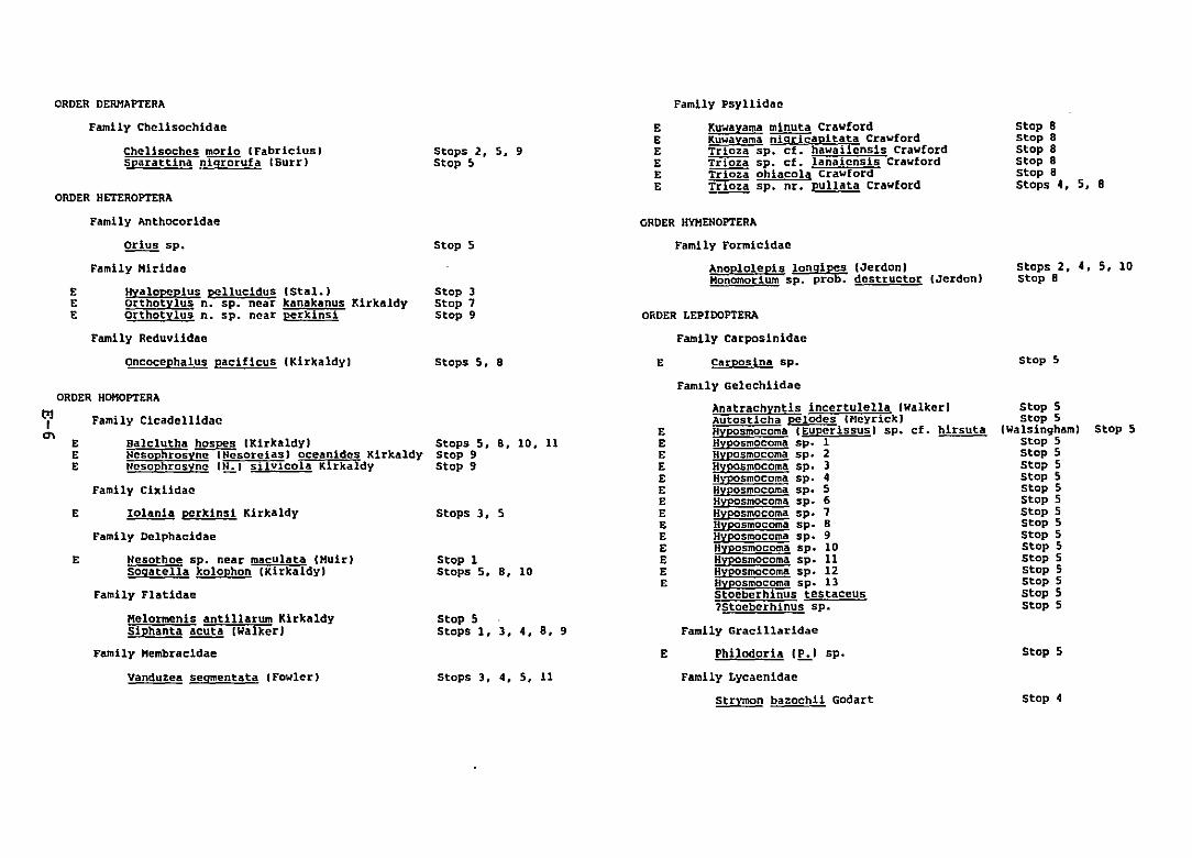
ORDER DERMAPTERA
Family Chelisochidae
chelisoches morio IFabricius)sparattina nigrorufa (Surr)
ORDER HETEROPTERA
Stops 2, S, 9Stop ~
EEEEEE
Family Psyllidae
K~Jayama minuta CrawfordKuwayama ni9ricapitata CrawfordTrioza sp~ ct. hawai1ensis CrawfordTrIOii sp. cf. lanaicns1s CrawfordTrIQia ohiacola CrawfordTrioza sp. nr. pullata Crawford
stop 8stop SStop 8stop 8stop 8stops 4, 5, 8
OnDER LEPIDOPTERA
Family carposinldae
oRDER HYHEHDPTERA
Family Formicidae
Anoplo1epis IOnq1~s (JerdenlHonomorium sp. pro • destructor (Jerdon)
EEE
Family Anthocoridae
orius sp.
Family Hiridae
Hyalopcplus pellucidus IStal.)orthotylus n. sp. near kanakanus KirkaldyOrthotylus n. sp. near perkins!
Family Reduviidae
Oncocephalus pacificus IKirkaldy)
Stop 5
Stop 3Stop 7Stop 9
Stops 5, 8 E Carposina sp.
steps 2, 4, 5, 10stop S
Stop 5
Vanduzea segmentata CFowlerl
Stop 5
stop 4
Stop 5
stop 5Stop 5
(Walsingham)Stop 5stop 5Stop 5stop 5stop 5Stop 5Stop 5Stop 5Stop 5stop 5Stop 5stop 5Stop 5stop 5Stop 5
Family Gelechiidae
Anatrachyntis incertulella (WalkeriAutosticha pelodes CHeyr!ck)HYposmocoma CEuperissus) sp. cf. hirsutaHyposmocoma sp. 1Hyposmocoma sp. 2Hyposmocoma sp. 3Hyposmocoma sp. 4Hyposmocoma sp. 5Hyposmocoma sp. 6Hyposmocoma sp. 7Hyposmocoma sp. 8Hyposmocoma sp. 9Hyposmocoma sp~ 10Hyposmocoma sp. 11Hyposmocoma sp. 12Hyposmocoma sp. 13Stoeberhinus testaceus1Stoebcrhinus sp.
Family Gracillaridae
Philodoria I~I sp.
Family Lycaenidae
Str\~n bazochli Godart
E
EEEEEEEEEEEEEE
Stops 3. 4, 5. 11
Stop 5Stops 1. 3. 4. 8. 9
Stop 1Stops 5, 8. 10
Stops 3, 5
Stops 5, S, 10. 11Stop 9Stop 9
Balclutha hospes IKlrkaldylNesophrosvne INcsorcias} oceanldes KlrkaldyNcsophrosync (N.I silvicola Klrkaldy
Family Cicadellidac
EEE
Family Cixl1dae
E Iolanla perkins1 Kirkaldy
Family Delphacidae
E Nesothoe sp~ near maculata IHuir)Soqatella kolophon (Klrkaldy)
Family Flatldae
Melormenis antillarum KlrkaldySiphanta~ (walker)
Family Hembracldae
ORDER HOHOPTERAt>lI
'"
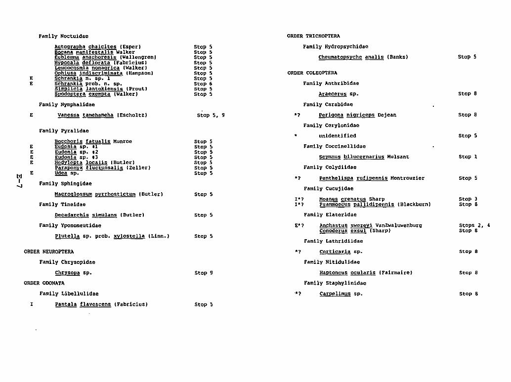
Decadarchls simulans (Butler)
Chrysopa sp.
ORDER ODONATA
Family Libellulidae
Macroglossum pyrrhostictum (Butler)
Family Tineidae
Stop 8
Stop a
Stop 5
Stop 1
Stop 5
Stop 3Stop 8
Stops 2, 4Stop 8
Stop 8
Stop 8
Stop 8
Stop 5
Moanus crenatus SharpPSammOccus pallidipennis (Blackburn)
Carpelimus sp.
Family Nltidulidae
Haptoncus ocularis IFairmaireJ
Family Staphylinida.
Araecerus sp.
scymnus biluccrnarius Hulsant
Family Colydlidae
Family Coccinellidae
Family Carabidae
Perlqona nigriceps Dejean
Family Cerylonidae
unidentified
Family Anthribidae
Family Hydropsychidae
Cheumatopsyche~ (Banks)
*1 corticaria sp.
*1 Penthel1spa rufipennis Hontrou~ier
Family Cucujidae
1'71'7
,
'7
'7
ORDER COLEOPTERA
Family Lathrldiidae
ORDER TRICHOPTERA
Stop 9
Stop 5Stop 5Stop 5Stop 5Stop 5Stop 5Stop 5Stop 6Stop 5Stop 5
Stop 5, 9
Stop 5
Stop 5
Stop 5 Family Elaterldae
E*? Anchastus swezeY! VanZwaluwenburgconoderus~ (Sharp)
Stop 5Stop 5Stop 5Stop 5Stop 5Stop 5Stop 5
Family Noctuidac
Autoqrapha chalcites (Esper)Socane manifestalis WalkerEublcmma anachoresls IWallengren)Hypocala deflorata (Fabricius)LeucocQsmia nonaqrica (Walker)ophiusa indiscriminata {Hampson)Schrankia n. sp. 1Schrankia probe n. sp.Simplicia lantokiensis {Prout)Spodoptera cxcmpta (walker)
Family Nymphalidae
Vanessa tamehameha IEscholtz)
Family Pyralidae
Family Yponomeutidae
Plutel1a sp. probe xylostella CLinn.1
Bocchoris fatualis HunroeE Eudonia sp. .1E Eudonia sp. ,2E . Eudonla sp. 13E Hcdylepta localls (Butler)
Paraponyx fluctuosalis {Zeller)E ~ sp.
Family Sphingldae
E
EE
ORDER NEUROPTERA
Family Chrysopidae
I Pantala flavcscens tFabricius) Stop 5
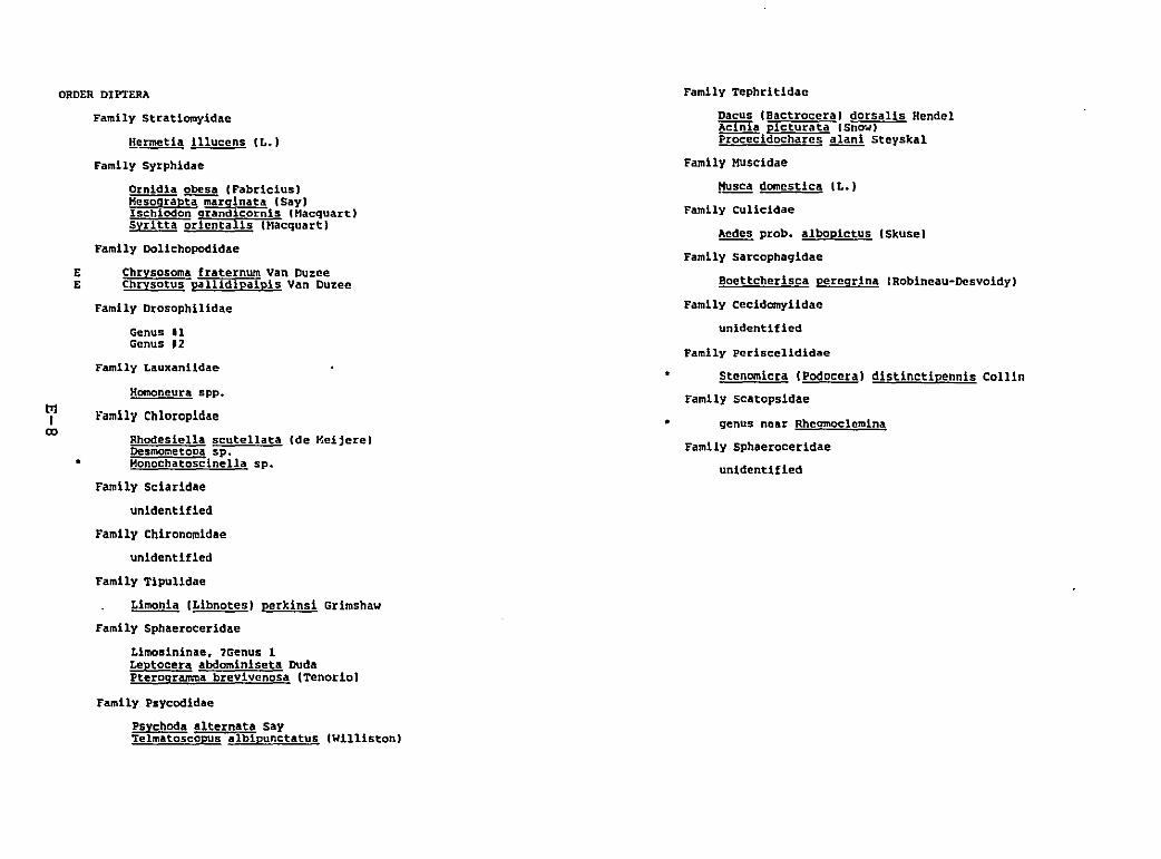
Family Drosophil1dae
Homoneura spp.
Genus .1Genus '2
Family Lauxanildae
genus near Rheomoclcmina
Family Sphaeroceridae
unidentified
Family Tephritldac
Dacus IBactrocera) dorsalis HendelAcinia picturata ISna~J
Procecidocharcs alani Steyskal
Family Muscidae
~~ domestica IL.)
Family CUlicidae
~ probe albopictus ISkuse)
Family Sarcophaqidae
Boettcherisca peregrina lRobineau-Desvoidy)
Family cecidomylidae
unidentified
Family Pcriscclididae
Stenomlcra IPodocera) dlstlnctlpennls Collin
Family scatopsidae
•
•Family Chloropidae
Rhodesiella scutellata (de MeljerelDesmometoca sp.Honochatoscinella sp •
Family Sciaridae
unidentified
Family Chironomidae
unidentified
Family Tipulidae
Limonia ILibnotesI perkins! Grimshaw
Family Sphaerocerldae
Limosininae. 1Genus 1Leptocera abdominlseta DudaPteroqramma brevivcnosa (Tenorio)
EE
•
ORDER DIPT£RA
Family Stratlomyidae
~ermetia lilucens IL.)
Family syrphidae
Ornldla obesa (Fabricius)Mesograpta marginata (SaylIschiodon grandicornls CHacquart)Syritta oricntalls IMacquart)
Family Dollchopodldae
Chrysosoma fraternum Van DuzeeChrysotus pallidlpalpls Van Duzec
~I
co
Family Psycodldae
Psychod. alternata sayTelmatoscopus alblpunctatus (Williston)
APPENDIX F
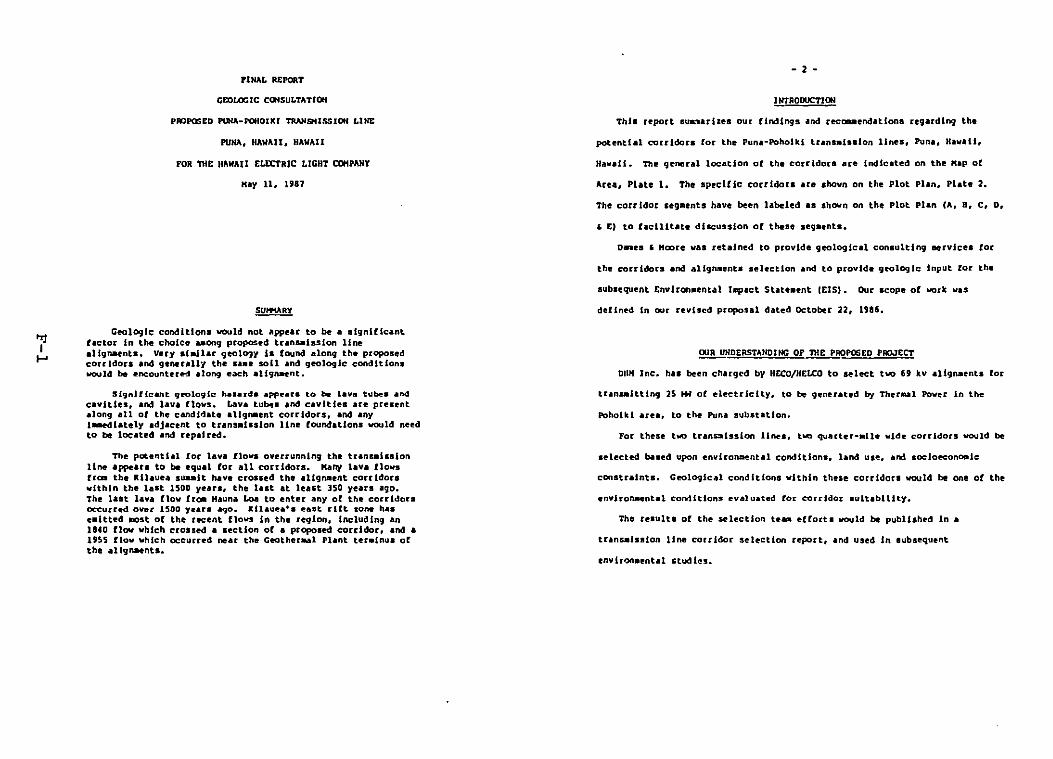
PINAL REPORT
CF.OLOCIC Ca.SULTATIOH
PIDPQSED I'l.lQ-POHOIKl 1'RAN9USSJON LINE
PUNA, HAWAII, HAWAII
FOR THe H"WAU ELECTRIC LICHT CClHPAHY
Kay 11, U81
Geologic conditions would not ~ppear to be a significantfactor In the choice ..ong proposed trans-iss ion lineaUgnaents. Vuy sl.Un ljIeolO1:t Is found along the proposedcarr idon and gennalll the salle soU and geologic conditionswould be encounter~ along each allgn-ent.
Significant qeologlc hazards appears to be lavoll tubes andcaVities. and lava flovs. Lava tu~. and cavities are presentalong all of the candl~ate allg~ent corridors. and anyIMmediately adjacent to trans.lsslon line fOUndations would needto be located and repaired.
The potential for lava flows overrunning the tranSllission11n4t appears to b. equal for all corridors. Mal'l'f Ina flowsfrCD the Kilauea sU&lllt have croased the aUgrull!nt corridorswithin the last 1500 years, the last at least 350 years .go.The l.at bv. flow fre- Hauna Loa to enter any of the corridorscccurred over 1500 y.ars ~o. Illauea'. east rift zone hasellitted .cst of the recent flows In the re910n, Including anIUD flov which crossed .. sectlon of .. propolled eorddor. and •1955 flow which occurred near the Ceotherul Phnt ter_lnus ofthe .llgnNnts.
- 2 -
lNTRODUCTJON
This report Buas.rlz~. our findings and recem.en4atlona regarding the
potential corridors for the Puna-Poholkl trans.I•• lon lines, Puna, Ha"all.
H.".U:. T111~ general location of the coU'idou are fncUc.ted on the "ap of
Aru, Plate 1. The specific corridon are shovn on the plot Plan. Plate 2.
The corridOr s.g_ents have been labeled .s shown on the plot Plan (A, B, C, D.
, E) to taclllto1lte discussion of these sega.nts.
D__eII , "CDre VAl rehlned to provide geologJcd consulting eenlce. fOC
the corridors and allgn-ents selection and to provide geologic input for the
subsequent Envlron.ental 11lpact State-ent IctS,. Our scope of work was
defln~ In our revl.~d proposal dated OCtober 22, .'86.
OUR UNDERSTANDING OF nlE PROPOSED PROJECT
DII" Inc. has been chargc:od b:t HECO/HELCO to sel~t two 6t kv aUgn.ents for
trana.ittlng 2S HW of electricity, to be generated by Ther~l Power in the
For these two tran~ission lines. two quarter·.II_ wide corridors would be
selected based upon envlro~nt.1 conditions. land us., and soclo~ona.lc
constraints. Geological conditions vithin these corridors would be one of the
envlroRllental co~ltlonS evaluated Cor corridor suitability.
The result. of the wlectlon h_ e(forts would b. published In a
trans.ls.lon line corridor selection report, ~nd used In aubsequent
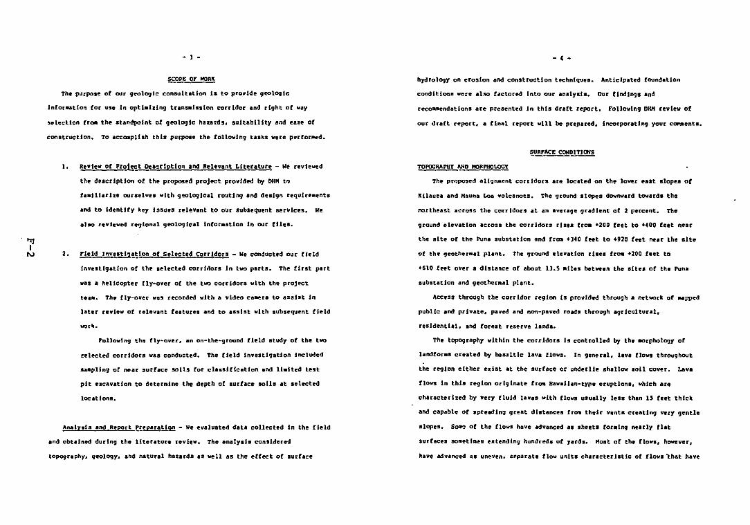
• l -
SCOPE OF WOAI{
The purpose of our CJ~logle consultaUon II to provide geologic
Infar_tie" (or use In optiMizing tnnplulon corridor and right of way
s!'lectlon ere:- the standpoint of 9to1og1c hunds, suitability and ease of
CDnlltr'uetion. To aecasplhh this purpose the following tasks wen perfor~d.
• c •
hydrology on erosion and conltrucUon t~hnlquu. Anticipated foundation
condltionll verII' aha factored Into our en_Iy.h. Our findings ,lind
reco~ndatlons are presented In thl. draft report. Following DKH review ot
our draft report, • final report will be prepared. Incorporating your cam-ent••
~URFACE ~Dnlai5
I.
2.
Revlev or Pro1!ct Dt&erlpllon and Relevant Literature - We reviewed
th description of the proposed proj~t provldN by DUK t"
and to IdentHy hey !ssuu rdevant to our subsequent Rrvlces. We
Field InveIt11!~lon of Sehcted: Corridors - We conducted our field
InvestigatIon of the selected corridors In two parts. The first part
vas a helicopter fly-over of the two corridors '11th the proj~t
te.a. The fly-over "n recorded '11th a video ca~ra to asslat In
later revlev of relevant features and to assist "1th subsequent field
Following the fly-over. an on-the-ground field study of the two
~~lected corrldora vas conducted. The field Investigation Included
saMpling of neat surface solts fat classification and lI.lted test
pit e_cavatlon to deternlne the depth of lurface soils at selected
locations.
TOPOGRAPHf ~D HORPHOLOGY
The proposed allgnaent con idOlS at. located on the lower east slapee of
KIlau~a and Hauna Loa volcano@s. The ground slopes downward towards the
northl!!!ast acros=I thl!!! corridors at an averagl!!! gUldlent of 2 percent. The
ground elevation across thl!!! corridors rlan frOll +200 feet to +400 feet near
the site of the Puna substation and [rom +J40 feet to .'20 f~t near the site
of the geother.al plant. The ground elevation rises frOll +200 feet to
+610 fett over a distance or about lJ.5 alles between the sItes of the Puna
substation and geother.al plant.
Access through the corridor regIon Is provided through a network of ...pped
public and private. paved and non-paved roads through agrIcultural.
residential. Ind forest reserve land••
the topography vlthln the corridors Is controlled by the .arpholO!JY of
landfor•• cuated by bli&:lltlc lava flows. In general. lava flows throughout
the teglon either exist at the surface or underlie shallow soil cover. Lava
flova In this region originate from Hawallan-t)'p. eruptions. which are
characterlzPd by Yet)' fluId lavas with flows usually less than IS feet thlc.
and capable of spreadln; gteat dIstances fr~ their ventR creating very gentle
Analysis and Report ~!.eparali~ - we evaluated data collected In the field
and obtained during the literature review. The analysis contidered
topography. geologr. and natural hazard. as well as the effect of surface
slopes. So~ of the Clows have advanced u sheets fO[llII"9 nurlr flat
surfaces solletlaes extendIng hundr~s of yards. Host of the lIo"s. ~ver,
have advanced as uneven. ceparate flow units characteristic of flows "that have
":lI
w
- 5 -
traveled ra, frc. their vents. In general, 3S these flows continue to spread
and cool, they qndergo dlvergence of len resulting In a distribution of
t.hlc\ened lobes pUed upon one: .nothel' or upon older flows en_ting an
te.nstor•• the flow fro. pahoehoe to .1 •. Landfor_. such as spatter cones,
collapled lava tubel, and fi.,ur.a contribute to the Irregular landscape.
Other ce.-on landforas include tuaull, pressure ridges, and prea.ure plateauI,
whleh au craekRd, deae-shaped hillocks occasionally greatu than 20 feet In
height. The lava fioWI In thll region have cr.ated • topography that, on a
large seale .easured over leveral square .11es. consists of a very gentle
slope nrel)' ~reater th~n 10 percent In avetage !)udient and. on a maller
leale, conslsta of an Irregular, undulating landscape with variations In
topD1raphlc relief up to about 20 feet.
5011 datA gathered durin!) this InvesU9aUon are sUllaadud on Plate ].
SoU Hap. Test Pit logs are presented In the AppendllC. as are laboratory test
data. Test pit locations an IMpped on Plate 2.
Host of the central portion of the corridor region has \Ittle or no sol\
cover above the lava flows vlth vegetation consisting of aeattered ohla treea.
.ass, 1rass, and ferns. In areas of soil cover, the soli I, typically less
than 1.5 feet thick. Soil cover ha. re.oved the a..ller irregularities fr~
the lava flow landscape. Larger lava flow landfora~ exist either as hillocks
and nobs covered by a:JJl or as roek outcrops.
Areas with .aU greater than 1.5 teet thlclt OVltf the lava are generally
Ualted to the two ends of the carr Ider aUgMents (See Soil Hap. Plate ]1.
At the Puna end. Olaa silty clay loa_, up to 25 Inches thlc\. Js prrdOllinant,
- 6 -
with 1131ted areas of Hila silty clay 10.. which I. over 5 reet thic_. There
are li.tled area. of 01•••Ilty clay 10.. at the Poholkl end of the allgn-entl.
Thirteen te.t pits vere ••cav.ted In soli area. along the _llgnaenta, to
a••ist In checking .apped soil cla••ificatlon lnfor..tlon. All encountered
basalt rock within 1.5 feet of the ground aurface, except for tnt. pits 9 and
11, which were located vlthln HUo IUty clay lad areill.
Organic soils overlylR1 older lava bedrock and Illty clay 10••s for-ed
frc. volcanic &IIh are the two bulc soil types found In the corridor region.
The orqanlc soU. are typically very rocky. le.. than , Inche. thick .nd
support a natural vegetation consistlnq of ohla. dense growths of uluhe fern,
!)uava. and grass. These lands are aalnly uled for \fOO:5land. pasture, and
haleal tel.
The silty clay 10... are often very stony and usually les. than I.S feet
thlclt. One type of 10.. occurctng near Keaau, cdled the Hilo Serlea 5Ut:/
Clay by the USDA 5011 Con~rv.tlon Service ISCSI can extend to depths qrt.ter
than 5 feet. Lands consisting of loaas support • n.tur.l vegetation of
Hl10 gran. California gr.... guava. ohla. and tree fern. Lou areas are lolled
[or suqueane, truck crop., and pasture.
Both the or9anlc lI011s and aUty clay lo.,.a have rapid per_abl \lty, slow
runoff. and aupport vegetation vlth roots that. unless the soil is vsry deep.
pass through to the bedrcck. The chance o[ .codon in these soUs 1a rated b'j
the SCS as allqht.
Laboratory te.tlnq lsee Appendix. Indicates that the solI, are generally
9rav~l1y "l1ty clay. or organic anl1s. The organic soil. are only lIultible
for poslllble U5e as top&oll. The qt4vdly silty clays are suitable ror ul. in
near surrace backfill for tran••lssJon tover or pole foundations. Along ..ast
or the allgMents. very little soil Js available for con5tructlon purposeS.
":II....
- 7 -
~l!.JI.FACE DRAINAGE
Only two atee.. channels pass throuqh the corridor r~lon. Doth streams
are dry and both are part of the Ndpahoehoe Strea_. The channels entel' the
corridor r~lon .1D~ an area of silty clay two _lIes south of Keaau and
cul_lnate, before leaVing the corridor region, on the surface of a pahoehoe
f~ov at about +180 ftet. Tbe absence of uell-ddlned stee.' Is· a
characteristic of areas of Hawaiian volcanic 9rowth where the ~ate of
aucceuive flows is often hll)h enough to COYer previously erooed surfaces and
where the reeks are so per-eable that runoff Js very slight.
GEllERM.. GOOLOGtC COHDtTIaiS
The geology of the corridor rle9ion to within 1.S .dlu of Xeaau Is ddlned
by lavas of the Xa'u Volcanic Series of Kauna LoA and the corridor re110n
south of this area Is defined by lavas of the Puna Volcanic Ser lea of
Xllau~a. In general, the type and thlcknee! of the overlying SQll cover and
vegetation can ~ used to deteralne the relative ages of the lava flows in the
re<)lon. T~ olde.t lavas are covered by volcanic ash which Is typically about
1.5 feet thick. Host of the ash areas have been cultivated for sugarcane.
Younger laval have organic clayey silt Iesa than 1 [oat In thlctn~ss and are
covered by dense vegetation. The .ost rt'C'ent lavas have no soil covel'. The
retativ'!ly high .Yeug~ rainfall of 150 Inches per yur In this region has
..de It possible for the growth of ohla. ferns, and grass on lavas that nowd
as recently aa the yea~ 1840.
- 8 -
VOLCANIC M1AJmS
The three regions of volcanic activity that could send lava flovs Into the
corridor r~lon are Mauna Loa, the Kilauea Bu..lt area, and the east rift tone
of Kilauea. Hany lava flovs f[~ the Kilauea .u~lt have crossed the
alignment corridors within the t.st 1500 y~.r. (Holcomb, 1980). Hovever, It
has been at least 350 years since 1•••• ftc. the Kilauea su.alt area entered
the corridor r~lon. The l ••t lava flow f~oa Kauna Loa to enter any of the
corridors occurred oYer 1500 yean ago.
A future lava flow entering the co~~I60r ~eglon viII .ast probably~
frON XllaueA"••ast rift zone, where ~ost of the recent flov. In the region
have been e.itt~. The -ast recent flow entering the corridor region vas the
flov of 1840 which erupted along. tvo·.ile long fls.ure within the corridor
area running parallel to the rift zone and crosses portions of corridor
segaent A. In 1955. a lava nov occurred near the Grother..l Plant teralnus
of the alJglUllents. The location of the 1840 aTd 1955 laVA flows are Indlcat~
On the Soils Hap, Plate ].
SEISHIC AA1ARD
Sela-Ie activity In the reqion Is prl..rlly ••soclated with the shifting
of rocts near areaS of volcanic activity as the ~ve~ent of .agaa Inflates .nd
deflates the volcanic structures. Several Itrl\e-alip faults created by the
.ave-ent of .agma and running parallel to the east rift zone are located
within the corridor region near the site of the geolher..l plant. Earthquake
epicenters In the region are concentrated along the east rHt lone.
"lI
U1
-.-
SLUMPS AND LAHDSLI DES
The general ablence of significant eol1 cOYer avec alaost the entire area
Indicate. that .lu~. and landslld.1 .r. not significant hazards. No .lu~ or
landslide are•• were observed during our field reconnaissance.
lAVA roBES
The general geology is conducive to the (orNUan of lava tubes. "ajor
lava tubes In the area were ••pped by HolcOMb (1980) basd on ngetatlon "hleh
tend. to clunu oyer tubu. The Geologic Hap (PUte 41 Indlcatea the NjOr
lava tube locaUon....~ by Holccab. Other ..aller tubes or cavities .ay be
encountered during conltructlon of the trans-II.lon line. and re~dJal work
••y be required to provide l.t~r.l support to trans.lsslon pole or tover
foundations where luch tube. or cavltle. are encountered.
SOIL EROSI~
Due to the hell of BOll coYer, the 11011 characteristics, and the
relatively gentle slopes, the SCS hal rated the entire corridor area as having
dlqht ecosJon potenUal.
Construction along the selected aliqnaent will consist of • series of
tranl.lsslon pol•• or tovers with ao.ent Uatenl1y loaded) fOUndations. Host
of the foundaUons will be e.bedded Into basaltic rock, which has a hll)h
lateral load bearing capacity. The prl.ary concern In these areas viII be to
seek out and r~pair any lava tubes or other cavities I..edlately adjacent to
the e.bedded foundatiOl'lI. It .ay be necesury to conduct pr'lblh') operatiol'ls
usln9 air-track drill or jackha..er type probes to check for such caYltles
.. 10 ..
l-.edlately adjacent to found.Uonl. Then would ba lIttl. or no lui table
eol1 for backfill in the•••real. and backfill .all to be plactd over the
In the few ueu with significant soU coYer IHllo IUt)' clay lou'. the
(oundatlonl would need to be dealgnrd for the lover lateral load bearing
capacity of theSe soils.
Existing wooden utility poles within the proposed corridor. appear to be
perfor.lng well vlth SODe tUtlrtg evIdent In two are... Soaa poles vlthln the
Hll0 Ility clay 10.. near Keaau art tilting, probably dut to the lover lateral
load bearing capacity of thele soil.. Several poles In the vicinity of
Xahakal Blvd (where seg.ent A splits into Band CI vere tilted. This tilting
corresponds to t~ tUtlng of tues In the near vicinity, Indicating that wind
loads In this vicinity are high.
Although selsalc loads are prob.1ble throughout the aliqlUlent corridors.
the later.l loads due to sels-Ic conditions would be expected to be leSS thin
that due to wind loads. and wind loads will probably be the criteria used for
deslqn.
The hlqh eleYatlon .n~ geol091c conditions Indicate that a 9roundvater
table would not be encountered within foundation excavatlonl.
- 11 - - 12 -
The following Plates and Appendix are att.ach~ and cCliplete this report.
":lI
'"
ALICNKEfI!' CHOICE
ceol091c condttlon~ WOUld not appear to be a significant factor In the
aUgMent ct~Jce. vuy ,t_Un geology Is found along the proposed corridors
and geMul1y the "lIIe soU and geologic condition. would be encounterl!d along
each al1gruaent.
The only atgnJftcant gtolQ1lc hazards appurs to be lav. tube. and lava
flows. Lava tube. are present along .11 of the candidate allgnnent corridors.
'nil! potenUal for hva flova aerosl the tun_lasIon aUgrment is present
for all of the corridors. The MOat probable source of luch lava flovi would
the East Rift Zone. which contains the Initial sections of both 5eg_ents ...
and D. ... longer section of I&gDent D Is located within the East Rift Zone
(appro_l.-tely 15,000 feetl than for seg-ent ~ fapproxlaately 5,00Q feetl.
However, .e-g.ent ~ VII Inhrcept~ by .. lav. nov hal t.he hat. R{(t lone .s
rfeently ... 1840. ~t. does not. .ppe.r that lither corridor I. significantly
le.1 II~ely to be overrun by a lav. flov.
"ITIGATION KEA5URES
"Itlg.tion MUSlins for lava tubes Is discuued In the lecUan on
canstructlan canslder.tlans.
"Itlg.tlon .easures far tava ftava daes not appear to be econealcally
fusible far this type of project.
- oDo -
Plate 1Plate 2Plate ]plate 4
AppendlJc
MRF/l.1C]~22B/16'811269-078-11
IThree copl~s lub.ltted)
Hap of Are.plot phnGener.llzed 50118 HapGeologic Hap
Field and Laboratory Data
- 000 -
Respectfully .u~ltted,
cw.£S S ttOOREA Professional LI.lt~ Partnership
-?r-L ,( . -';-"-_Hasanobu R. Fujioka, P.E.COflslJltant
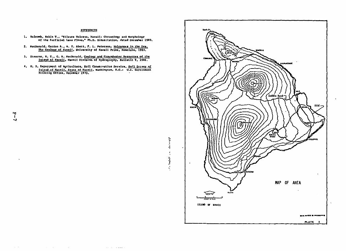
II£F£RDlCES anoS Morphology 1980.;alia Chronologyd4UoS Decnober1eano, H... ertAtion.T
-Kilauea VO - Ph.D. DI.. In the Sea.".1... • ".~. "'_'"I ,........ L <OM. Yo '_M•• 19 •
•f T ,.... ;, , ••••••f.... •..Go.... '.. •• ••I It, .~."LOL....
T. '''' of 'O!!!!. •C<~ ; , .~~ • C~'''''' ,., •C. A. HaeDonalDivlslon of HyoSrog 011 Survey of.......... ';''N.It ·.It Go",,, .l. •..... 0 SO" CO.... 'M. '.C.. :
of A9rlc~lture'H...all, W••hlngDepartaent State Of~__4. U. S. f H.... II. ber 1973.hland a Office. Dec••Printing
"~.",.j
1.
~. ....., .......-lSUIO Of .IUII
HAP OF AREA
Moo-.DA.....
I'LATE_....._ ...
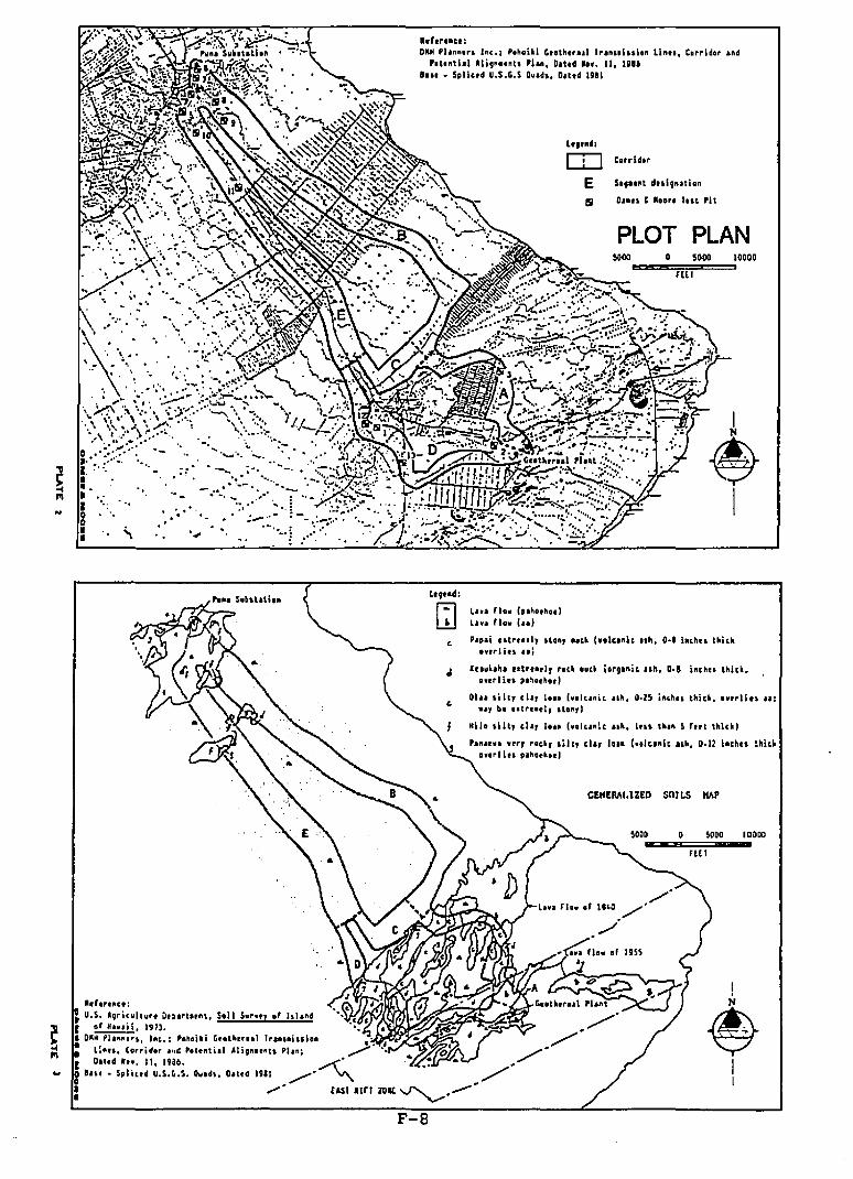
.~
.. , "
'.'-
.,
.. "....
-., ..""' ............
--..., ;... ..._~ ...........- ....~ ....-.,... ........ ......
'.."..'... f
hh••oc.:ORH 'h••••• I.c.; '.h.llI ' ..th....l l.a... I..Io. lIou, C.rrldo. a.d'.t••t'" Alig.ot.t. 'h., Olltd •••• 11, nnlau • Spllcrd U.S.'.S Du.d., Dattd lUI
Lt,.d:
IT] t.rrld..
E S.,...t dul,.ulo.
S Dn" t R••,. h.t 'i!
PLOT PLAN~OQ I!:Cl!!CI!!I
D=:::::::=5DzOQ==,IDoDorUI
I
~I
CElfEMl,lZEO SOILS lIAP
Lao. n•• h.hotho.ltha n•• h.}
Pap.i "1""1, .t.n, ••ek (..Iea.it uh, 0-' h.h.. thickDurliu, I.~
II
~II
SOOO
flO
o
lu.kaha .. t ....l, ••ch o.ch i ••g.nie uh, D-' i'chn thick,0 11.. PI~o.ho.1
01 ill, chI 10.. h.lco.it uh, 0·25 ift,h" llIick •••••11 .. II:.., b••tl .... l' .ton,l
Hilo .ill, .h, I... h.lco':, 10., lou th•• S rttt thick)
Pa ' ••e., .ih, cIa, 10.. (••Jea.ic uh, D-!Z inchn ~lIiek
.n. II u ,oh••, .. ,
~.g••d:
~
F-8
r O... d .... II, 19a6.eo" • Spl ie.d U.S.~.S. Ou.d., OIt.d lUI
•• '.rlllllel' ~
~ U.S. AQricultu•• O" •• t ...t, Soil 5••••, .r I.hndr ~,lm .• Glih. elIl."".,. ... , 'fit.: '."'aUd G,elhrnll 'r.n..~u.on
•I..
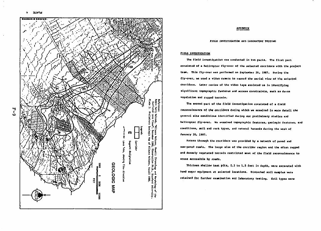
vegetation and rugged terrain.
APPJ!2lt)IJC
Thlrt••n ahallow telt pits, 0.] to 1.5 feet In depth. vere excavated With
PI EttI I NVESTICATIOff
rIELD INV'ESTICATIat AND U\BORATORf 'tESTUlG
teee. Thl. fly-ov.r va. perfor-.d on Septe.ber 26, 1987. During the
fly-ov.r, ~ used a video caBer. to record the aerial view of the .elected
Th. fl.ld lnv••tig.tion wa. condueted in two part.. The fir.t part
con.l.ted of • helicopter fly-over of the .elected corridor. vlth the project
Tha .econd part of the field inve.tlg.tlon conal.t.d of a fi.14
reconnel.aance of the corridor. during which ve ••••l~ In .are detail the
hellcopt.r fly-ov.r. w. '.&mined topogr.phlc f••turea, geologic f••tures, and
hand .uger .qulpaent at selected loc.tion.. Diaturbed soil a.apl.a vere
ret.i~4 for further ••eeinatlon .nd l.boratory t.ating. Soil typ•• vera
~anuary 26, 1'87.
condition., eoil and rock types, and natural hazarda during the we.k of
general .lte condition. Identifi.d during our preli.lnaty .tudie. and
Ace... through the corridotll vas provided by • network of paved and
non-paved road.. Th large .Iae of the corridor reglOtl and the Often rugged
.n4 d.nlely vlgetated t.rrain r.atrlct.d ~st of the flel4 rteennaialance to
.rea. acc•••lble by road••
:-3..~
D..
,It
:..~or.
--..~.......::i"
G>mara(j)(5
::»>"0
..
...g..
a-
."." .'.
:: ~}..~.
J' . f
.". .\
-~.-
.,t
•..!~
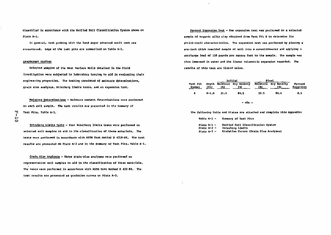
~laillfl~d fn .ccordanc~ vlth th~ Unlfl~ Sofl Clasllflcatfon Sy.t~a Ihown on
Phte 0\-1.
In gener.l, test probing vlth the han~ auger advanced until rock va.
encountered. LogI of the test pltl Ire su~rlzed on Table A-I.
Selected laaplel of the ~.r lurflce 10111 obtained In the field
Percent &!panslon T~st - One expansion telt VIS per(or-ed on • selected
sa~le of organic silty clay obtained fra. Test 'It 6 to deteralne Its
shrlnk-svell characteristic.. The expansion te.t va. per(or~ by placing •
one-Inch thick re-olded sample of soil Into. conaolldc.eter and applylnq •
surcharge load of 100 pounds per square foot to the laaple. The saaple val
resultl of thll test are listed belov.
Inve.tlgatlon ¥ere subjected to laboratory teltlng to lid In evaluating their
engineering properties. The testing consisted of -alsture deter.lnatlons,
grain size an.lyles, Atterberg llalts tests, and an e.panslon test.
:-:-,...,.-,I!.!;n~1tlalTe.t Pit Depth HoI.ture Dry Density
WLnber J.!ll.. 1') U)
PinalHollture Dry Density Percent
I\) ---1!1__ E!J?anslon
Hoisture Dtteraln~~~ - Hol.ture eon~nt deteralnatlona ~re perforaed
on each 1011 ""PIe. The test r~5l1Hs are presentl!c1 In the Su....ry of
, 0-1.0 31.5 16.5
- 000-
33.5 16.4 0.5
The follovlng Table and Platel are attached and co~lete this Append I.:~ Teat Pits. Table 0\-1.II-'o
Atterberq Ll.lta T@st~ - Four Atterberg 11.lta tests vere p@rfor-ed on
.el~ted aoll 'a~l@. to ,Id In the cl'.alfleatlon of these .sterl.ll. The
t ••tl vere perfo.-ed In accordance vlth ASTM Test H@thod D 4318~14. The test
results are pre.ented on Plate 0\-2 and In the S....ary of Teat Pits, Table 0\-1.
Gr.ln 51" Ana1ysl•• Three graln-Ilze analysel vere perforaed on
reprel.ntatlYe soil sa~les to aid In the elasalflcatlon of the••••terlals.
telt results are presented aa gradation eurY@1 on Plate 0\-3.
Table A-I -
Plate 0\-1 Plate "'-2 'late A-3 ~
S~ary of Te.t Pits
Unified Soil Clssllfleatlon Syste.Atterberg LIMitsGradation Curves IGr,ln Size Analy.esl

Note. G - De'lgnatee grain size analyale perfor..d, Refer to Plate A-l.
76
Att"rberg TestHoisture LI.lts (II ReportedContent ....!k.. ~...!L El ....llere
191 25& 65
112 171 59
Dark brown .andy clay.y 55sUt with baultic 9uveland soae roots• .alstGray banlt
SUIlKARf 01' TEST PITS
TABLE A-IPage :I
Dark brown ••~y chy.y nsilt with aoae graveland lOae rocts, aoistGUy baaelt
Dark bro..n .andy cl.yey 11slIt with so.e graveland lata of decoapostdvegetation, .alstGray bault
Brown clayey ailt withlIO&e land .nd guvl!land aoae roote. .alet
Reddish brown clayey 219Silt with soee roots,.olat
10 0-0.5 OH1
0.5
11 0-1.5 OK
12 0-1.0 KIf
1.0
13 0-1.0 KL
1.0
t 0-1.5 HL
Test Unifiedpit Depth Soil~ .illL £!!..!!.:...
TABLE A-I
SUIflAU 0 .. TEST 'ITS
Atterbug TeltMohture LI.IU !I! Reported
5011 Description Content ....!k.~ .l.L Elee..hu"
Dark brown .andy lD 81 139 52clayey alLt with aa."grav"l, root., an4 .~organic., .alatGut ba.alt
Dark brown allty ..nc!ly 13~rave1 With root. anddecoepOied v~etatlon,
IIOlatGut ba.alt
Dark brown to black 5 Gsilty aandy grav"l withtrece of organic.,_1stGray basalt
Dark brown .andy clayey 17silt ~Ith tODe basaltiCgUV1l1, loti of roots, andorganic., _1stCray bllult
Derk brown clayey silt 130with so.. sand and gravelanell _e roota, .alstCray Sault
DIrk brown to black n n 15 11 Eltp.orglnlc cllyey silt withlOme .and, gravel. roots,.n4 so. deco"l'Os.elIv~etatlon. _1stGuy basalt1.0
Test UnifiedPit Depth SOil~ l!!L 9.!.!!.:..-
1 0-0.1 CII
0.3
:I 0-0.1 CPoGH
0.3
1 0-0.5 G,
0.5I'1jI t 0-1.0 KL
'"""'"""1.0
5 0-1.5 HL
1.5
, 0-1.0 011
1 0-0.5 c;P~H
0.5
Dark brown silty ..ndy9ravel with ee-e roots •.alstGray basalt
11
8 0-1.5 HL
1.5
Dark brown cl~y.y siltwith eo_ aand andgravel, and ea.. roots._SstGray bualt
24
Continuation •••
(3522B/U98)
Cl522A/IUBIDA.........oo... DAM......oo••
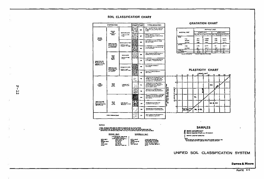
SOIL CLASSIFICATiON CHART
00 ...., 00
GRADATION CHART
PLASTICITY CHART
*"1·''- ,..,~ .. -:: ........... ........._t_ 4 • ....,·.·-: 'tit 1':'1 _ ...~--e.(•• ....t ...:1 •.....
\ "no•.~ ... ..,...- .., .... I" ..,.U.·" 'oo ... ... ...
..·..(4 ... ....... ... .C:O"'·U 4' I·· .. ... I'
e""..ls ... • - ..... ,..-..".. .... ..- ... M
• ~ ......J ••~ ·hl.' ...................
a 0 10 .. eo '" V)
113 V..9:
(l- Vl
V I
./UH ~OH
~ ....~ .... rO\.!'7•
..
a,.... u ...... ,....a.·...............
• ·It-_I ..... ~··..... ,'...,.,.~.- ..to
-..:-0,............................... • ....... '0( ..... _-..,.0-':\.·.·· .... 1..... _ ..... p
••.......1_·.. "......... ,.C'.••.. ,-c..""C·....,,.,_t~... ~~ ......u· ....,. ~'''U. I01:,··....._·'1:1.·.'1.··
1: •••, ..... -••• , ;-rr-c.._ .. '1 ......~.-c ~,
'" .....•......·•.,..,,......1·011:.·. ...III
~..":.h·I ..(·~.~e- i'... .....""..................................~ ...
I'.. --e,.."rC"C'o.t... eJoI ... '.... ~1l"':, ••• c•••••4C,.4"
!.... 'JI'"'J"""C" ..4,.:;l" ..,.. ... ·O
_-:.-~ •••<.4.ot- ••...: ......
., " •• ....-.., ...... tJio.\ ••••~~.... ".n......,.
..
..
-a~ Lin,.t._.... ,......,...
n t ••
.....,.~t...""'._t~."t...,."".............
--.._.
.. ,.,
.. t", ....~,..;J! •
i.:" : ::::~,=~1',,': cc ~l.·""."""
1----+---I~~---+-----1... --... ..~.. 1J6.u-t., I.W'll 40"' ••,,,-:~..:.;{ ,.. ,.11«,.,-" .... .,."""~......
_....--_.
_.......___ ~T-......
~r..... "4.IWt --on ---·~·-I·O't~ .. ·1II' *-r:'I.'
~.~ .'iI(lIy'oI........... Z •~~
j ~;' •
: It·~.- ':'~ L~L_'
_.t,j
_. ..... U1J ........ : .::.~
1 I i~,.;·,'I--' .i 1J'·'"N
II~.~... ," ....1.'0...,_'..._.t...... ·t ...
~.- .. ..... ~_.....• • n
p•-'-~
....-.....;.......".....-.c- .....
.~:=-
.oru
..................... -e W11 ~.It"'C."'"
...... 11 toooon "I'" LOt'l, " =-.,~ ' VUI ... Mk hf~l1tC.III Cl!IIIII h.~ ~....,..· U" u-c ".1OL1
SAMPLES• -uJ11I "\lIWf• ..--1.1IDC" t..-.c.~1o eoc.-n , ..
I~.."I fI ....
oa".··".., ,... ,· U ...' ..1'.. '••-C "'.. o..-p.r t ..
"'-".11,................,....".,hphl'
g.c .
I ..H t ............
":1:11::-h'-" .,.. ..II "'I.1"'.II" ••MM'_ .-- ...
"'.......,_..._.........,............UNIFIED SOIL CLASSIFICATION SYSTEM
Dames & Moore
PLATE 1\-1
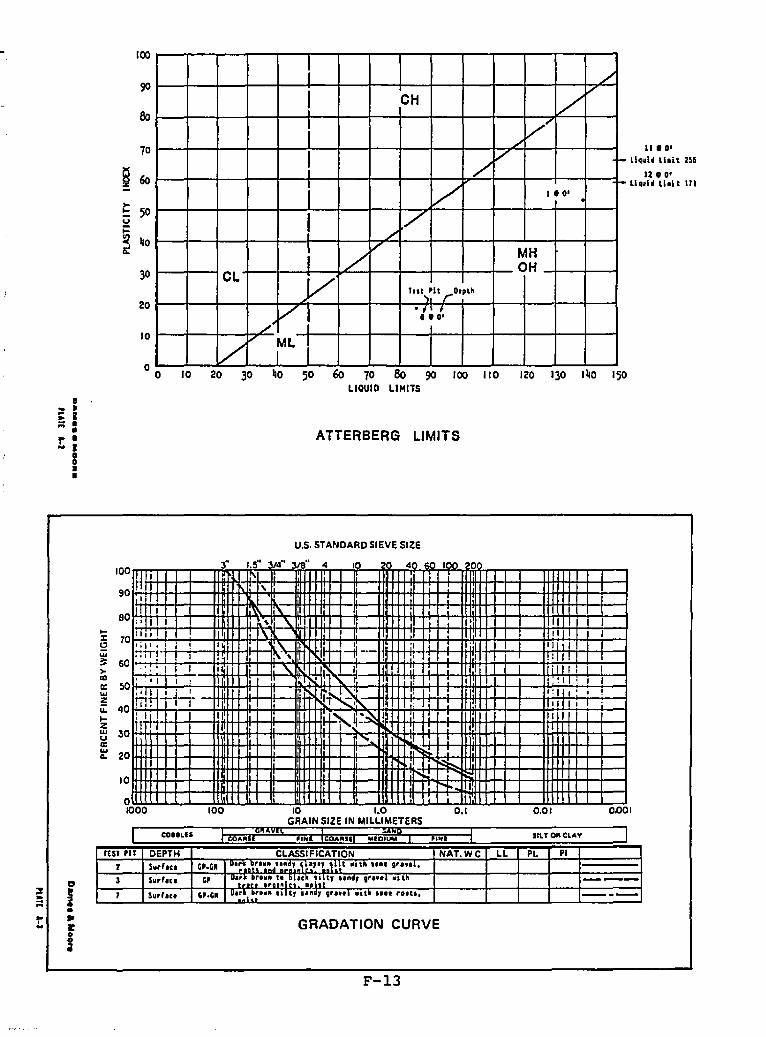
II'D'Llqulf U.lt 2~6
12. D'L1qul~ U.I t 111
120 130 140 150
ATTERBERG LIMITS
40 50 60 70 80 90 /00 110LIOUID LIMITS
10 20 30
I ./
I, VCH V
./
V ....
I /",/ f-
./r-
1.0'0
I ,/,/,
//' MH
OHCL /' ToI\~lt ,..O'Plh
~,.V .,.:.
V MLI
100
90
80
70
S60
l; 50u
$ 40li!
30
20
10
00
:: ~=I•r •... I
gI•
U.S. STANDARD SIEVE SIZE
J* 1.5 /4" 318 4 10 4 o I)() 0III IIf I I ,
I IIII I "-:' I , \.. , 1: III ! \ . I , I IIlli~H+ I "- -1l " I II I:-:nT I
",,' , . , I I I: I
. ~ .. : I I II "- H,
jil I I I, 'I , , , ,
: , . ! I I ~ I
'~!nJ...+-+ .l~_, I: ,
I
m: I IT~ It . I I
:1 !ff 'ij:~! I II
1 1 I, ......~
~
I'"
100
90
80...a 70w~ 60)-
a:la:: 50w~lI. 40...Z~ 30a:~ 20
10
o1000 100 10 1.0
GRAIN SIZE IN MILLIMETERS0.1 0.01 0.001
a
I•~
I:
!
I COIILlS ;'AIl ''''I CO;'ASI "'IOIUM ,.". IIUOACL..... J
rur 'If DEPTH CLASSIFICATION NAT.WC LL PL PI
2 Su.hn er·G~ u'~~'~~"~~d'~:~~.\~:r.t.,~~tOlt" .... ,......3 SU.rICI er OI::.::':~.::I~~IC:.;~~lr ludr ,,,ttl um ---7 Sill"'':. ".'1 O.~~l~: ..... It, lind, , ....1uitl I... nOli, ----
GRADATION CURVE
F-13
BIBLIOGRAPHY
BIBLIOGRAPHY
J. Baker, J.K., and Russell, C.A. "Mongoose Predation on a Nesting Nene." Elepaio 40(1979): 5 I-52.
2. Bechtel National, Inc. Puna Geothermal Venture Project Application for ThermalPower Company. San Francisco, California, 1986.
3. Board of Land and Natural Resources, State of Hawaii. Hawaii Natural AreaReserves System. Honolulu, Ha waii, current file.
4. Department of Agriculture, State of Hawaii. State Agriculture Plan and TechnicalReference Document. Honolulu, Hawaii, September, 1980.
5. Department of Hawaiian Home Lands, State of Hawaii. General Plan. Honolulu,Hawaii 1976.
6. Department of Land and Natural Resources, State of Hawaii. Conservation DistrictInventory: Island of Hawaii. Honolulu, Hawaii, 1977.
7. Dcpartment of Land and Natural Resources, State of Hawaii, Division of Forestryand Wildlife. Game Mammal Hunting Rules. Game Bird Hunting Rules. Hawaii, nodate.
8. Department of Land and Natural Resources, State of Hawaii, Division of StateParks, Outdoor Recreation, and Historic Sites. The Hawaii/National Registers ofHistoric Places. Honolulu, Hawaii, current.
9. Department of Land and Natural Resources, State of Hawaii. State Recreation Planand Technical Reference Document. Honolulu, Hawaii, 1985.
10. Department of Land and Natural Resources, State of Hawaii. Title 13. Subtitle 7.Water and Land Development. Chapter 184. Designation and Regulation ofGeothermal Resource Subzones, Honolulu, Hawaii, 1984.
I J. Department of Planning and Economic Development, State of Hawaii. Hawaii DeepWatcr Cable Program: Phase IA Preliminary Electrical Grid System Integration~. Honolulu, Hawaii, January, 1983.
12. Department of Planning and Economic Development, State of Hawaii. Hawaii DeepWater Cable Program: Phase JJ-A. Task J. Environmental Analyses. Honolulu,Hawaii, March 1984.
13. Department of Planning and Economic Development, State of Hawaii. State EnergyPlan and Technical Reference Document. Honolulu, Hawaii, September, 1980.
14. DHM Planners, inc. Visual Impact Analysjs of Proposed 300 kVdc Line. HawaiiDeep Water Cable Program for Parsons Hawaii et al. Honolulu, Hawaii, 1987.
15. EDAW inc. Transmjssion Line Routing Study: Kaumana to Keamuku. 138 KV Linefor Hawaii Electric Light Company, Inc., Honolulu, Hawaii, February, 1983.
16. Hawaii Audubon Society. Hawaii's Birds. 2nd ed. Honolulu: Hawaii AudubonSociety, 1978.
17. Hawaii Electric Light Company, Inc. Environmental Impact Statement: Kaumanato Keamuku 138 KV Transmission Line. Honolulu, Hawaii, August, 1983.
18. Hawaiian Electric Company, Inc. Insulation Areas. Engineering Data. Honolulu,Hawaii, Drawing 1-4050, Hawaii (August, 1976).
19. Horiguchi, Paul. Weather in Hawaiian Waters. Pacific Weather Inc., Honolulu,Hawaii.
20. Hwang, RH., and Young, Bryan. A Study of the Feasibility of Linking the Islandsof Maui. Molokai and Lanai with Submarine Electric Power Cables. Honolulu:University of Hawaii, Natural Energy Institute, 1979.
21. Jacobi, James D. Mapping the Natural Vegetation of the Hawaiian Islands.Honolulu, Hawaii, 1983.
22. Land Use Commission, State of Hawaii. Land Use District Boundaries, unpublished,current maps. Honolulu, Hawaii, 1987.
23. Macdonald, Gordon A., and Abbott, Agatin T. Volcanoes in the Sea: The Geologyof Hawaii. Honolulu: University of Hawaii Press, Honolulu, Hawaii, 1970.
24. Moberly, Ralph et al. Hawaii's Shoreline. Appendix I: Coastal Geology of Hawaii.Honolulu: Univcrsity of Hawaii, Hawaii Institutc of Geophysics, 1963.
25. Mullineaux, DonaM R, and Peterson, Donald W. Volcanic Hazards on the Island ofHawaii. U. S. Gcological Survey Opcn File Report 74-239, 1974.
26. Parsons Ha waii. Characterization of Potential Routes and Routc Option Selection.Honolulu, Hawaii, 1987.
27. Planning Department, County of Hawaii. The Gcneral Plan. County of Hawaii.Hilo, Hawaii, 1971 (Adopted by Ordinancc No. 439 on Dccember 15, 1971)/Revised1986.
28. Real Estatc Data, Inc. Real Estatc Atlas of the State of Hawaii. Map Volumes forthe 3rd Tax Division, 1996.
29. Scott, J.M., and Jacobi, J.D. Hawaii Forest Bird Survcy. Honolulu: U. S. Fish andWildlife Service, 1981.
30. Stone, Edward H., II, FASLA. Visual Resource Management. LandscapeArchitecture Tcchnical Information Series, Vol. I, No.2., American Socicty ofLandscape Architects, Washington, D.C., Junc, 1978, p. 15.
31. United States Department of Agriculture, Soil Conservation Scrvicc. Soil Survcy ofthe Island of Hawaii. Slate of Hawaii. Washington,D.C.: U. S. Govcrnment PrintingOfficc, 1973.
32. United States Department of the Interior, Fish and Wildlife Service. HawaiianHawk Recovery Plan. Honolulu, Hawaii, May, 1984.
33. United States Department of the Interior, Fish and Wildlife Service. Hawaii'sEndangered Forest Birds. Honolulu, no date.
34. United States Department of the Interior, Fish and Wildlife Service. Jacobi SystemVegetation Maos for Hawaii. 1979-1984.
35. United States Department of the Interior, Fish and Wildlife Service. Nene RecoveryflJ!l!.. Honolulu, Hawaii, February, 1983.
36. United States Department of the Interior, U. S. Geological Survey. Natural Hazardson the Island of Hawaii. Washington, D.C.: U. S. Government Printing Office, 1977.
37. United States Federal Emergency Management Agency. Flood Insurance Rate Map.Hawaii County (rev. May 3. 1982). Washington, D.C.
38. University of Hawaii, Department of Hawaii. Second Edition Atlas of Hawaii.University of Hawaii Press, Honolulu, Hawaii, 1983.
39. University of Hawaii, Hawaii Institute of Geophysics. Geothermal Resources inHawaii. Honolulu, Hawaii, 1983.
Related Documents