VOL. 83, NO. B7 JOURNAL OF GEOPHYSICAL RESEARCH JULY 10, 1978 PlateKinematicImplications, of' Atlantic Equatorial FractureZone Trends JEAN-CLAUDE SlBUET Centre Ocdanologique de Bretagne, B.P. 337, 29273 Brest Cedex, France JEAN MASCLE Station Gdodynamique Sous-Marine, La Darse,06230 Villefi'anche-sur-Mer, France We present a plate kinematic evolution of the South Atlantic whichis based largely on the determina- tion of the equatorial fracture zonetrends between the African and South American continental margins. Four main opening phases are datedby oceanic magnetic anomalies, notablyMO, A34, and A 13,and are correlated with volcanism and tectonic events on land around the South Atlantic Ocean. The Ceara and SierraLeonerises are probably of oceanic originand werecreated 80 m.y. agoor later in their present-day positions with respect to South America and Africa. INTRODUCTION Plate kinematics of anexpanding oceadic areh can beap- proximated by a small numberof successive finite rotations. These finite rotations can be obtained by successively fitting isochrons as given by the Vineand Matthews [1963] magnetic lineationsand/or by usingthe differentsegments of one or morefossil transformfaults[e.g.,Le Pichon et al., 1973].In the second approach, successive segments of fracturezonesare fitted to small circles about successive Eulerian polesof rota- tion. It isthus possible to approximate the progressive opening of an oceanic area by a succession of several phases. Le Pichon and Fox [1971], Le Pichon et al. [1971], Le Pichon and Hayes [1971], and Francheteau and Le Pichon [1972] used the trans- form fault method to discuss the early evolutionof the North and South Atlantic, whereasPitman and Talwani [1972] and Ladd [1974, 1976]used the isochron method.In thispaperwe use the kinematic implications of both the closely spaced equa- torial fracture zone trends [Heezenet al., 1964] and the mag- netic lineations [Ladd, 1974] to study the evolution of the whole South Atlantic. This follows essentiallythe method proposed by Morgan [1968]. Vine and Matthews'smagnetic lineations cannot be easily identifiedin the area of the equatorial fracturezones (between 10øN and 10øS), which hasbeen close to the magnetic equator since the Mesozoic[Philips and Forsyth, 1972],and they re- main relatively poorly mapped in the South Atlantic [Ladd et al., 1973; Larson and Ladd, 1973; Ladd, 1974; Emery et al., !975a]. However, the magnetic lineations give some strong constraints for working out the evolution of that oceansince anomaly 34 time [Ladd, 1974, 1976]. Our studymakesexten- sive use of the numerous geophysical data of good quality recently gathered inthe area of•he Gulf ofGuinea [see Fail et al., 1970;"Arens et al., 1971; Behrendt etal., 1974; Delteil et al., 1974; Emery et al., 1975b,' Mascle, 1975, 1976], in the Guiana basin offnorthern Brazil, and in •he areas of the Ceara and Sierra Leone rises [Hayes and Ewing, 1970; Cochran, 1973; Kumaret al., 1976; Gorini andBryan, 1976; KumarandEmbleoe, 1977]. CRITERIA FOR FRACTURE ZONE IDENTIFICATION In terms of plate tectonics, oceanic fracture zones are active or fossil plate boundaries which bring into contact two litho- spheric units of differentages[e.g., Le Pichon et al., 1973; Copyright ¸ 1978by the American Geophysical Union. Sibuet et al., 1974].The temperature and, consequently, the density and viscosity contrasts across theformer plate bound- ary decrease withtimeandareaffected by lateral conduction phenomena [Louden and Forsyth, 1976]. The basement topog- raphy isconsequently in great parttheexpression of differen- tial vertical readjustment with possible minorextensional or compressive components. Within the active plateboundary segment, strike slip motions arepredominant, and theresult- ingdeformations may explain in great partthecomplexity of the topography. A possible illustration of such a variation isschematized in Figure 1, which implies control of thedifferential subsidence of thebasement by cooling of thelithosphere andsedimentary loading (see legend)...Sibuet and Veyrat-Peiney (manuscript in preparation, 1978) hhve proposed that thisdifferential sub- sidence can explain the creation of the linear and parallel crest and trough system which is observed on fracture zone seg- ments corresponding to the early stage of formationof an ocean,before the breakup of marginal fracture ridges [Le Pichon and Hayes, 1971 ]. The complex morphology andrelatively large width (several tens of kilometers) of fracture zonesrender impossible their simulation by a flow line [e.g., Heezen et al., 1964; VanAndel et al., 1971].However, Sibuet and Veyrat-Peiney (manuscript in preparation, 1978) have shown that thereis a correlation between the variations in fracturezone gravity anomalies and the variations in density structure predicted by the thermal evolution of lithospheric plates. The main inflexion point of the gravity curve coincides approximately with the plate boundary, whether active or fossil (Figure 2). We have defined the'flow linealong a fracture zone according to thiscriterion. The subdued aspect of the roughly north-south Vine and Matthews [1963]magnetic patternin the equatorial Atlantic, as well as the well-developed magnetic anomalies across east- west trending fracture zones, is relatively wellexplained by the fact that the whole area lies, and seems to have lain sinceits creation, within low magnetic latitudes [seeSchouten, 1971; Philipps and Forsyth, 1972]. Magnetic anomalies across equa- torial fracturezoneshave been explained either by intruded andhighly magnetized bodies [e.g., Rea, 1972; Cochran, 1973] or by the juxtaposition of alternately positive and negative magnetic bodies along fracture zones, with a possible areaof nonmagnetization [Collette et al., 1974]. Emery et al. [1975b] have shown a goodcorrespondence between computed pro- files(using simple two-dimensional models) and most of the magnetic anomalies recorded across fracture zones in theGulf Paper number 8B0349. 0148-0227/78/078 B-0349501.00 3401

Welcome message from author
This document is posted to help you gain knowledge. Please leave a comment to let me know what you think about it! Share it to your friends and learn new things together.
Transcript

VOL. 83, NO. B7 JOURNAL OF GEOPHYSICAL RESEARCH JULY 10, 1978
Plate Kinematic Implications, of' Atlantic Equatorial Fracture Zone Trends
JEAN-CLAUDE SlBUET
Centre Ocdanologique de Bretagne, B.P. 337, 29273 Brest Cedex, France
JEAN MASCLE
Station Gdodynamique Sous-Marine, La Darse, 06230 Villefi'anche-sur-Mer, France
We present a plate kinematic evolution of the South Atlantic which is based largely on the determina- tion of the equatorial fracture zone trends between the African and South American continental margins. Four main opening phases are dated by oceanic magnetic anomalies, notably MO, A34, and A 13, and are correlated with volcanism and tectonic events on land around the South Atlantic Ocean. The Ceara and
Sierra Leone rises are probably of oceanic origin and were created 80 m.y. ago or later in their present-day positions with respect to South America and Africa.
INTRODUCTION
Plate kinematics of an expanding oceadic areh can be ap- proximated by a small number of successive finite rotations. These finite rotations can be obtained by successively fitting isochrons as given by the Vine and Matthews [1963] magnetic lineations and/or by using the different segments of one or more fossil transform faults [e.g., Le Pichon et al., 1973]. In the second approach, successive segments of fracture zones are fitted to small circles about successive Eulerian poles of rota- tion. It is thus possible to approximate the progressive opening of an oceanic area by a succession of several phases. Le Pichon and Fox [1971], Le Pichon et al. [1971], Le Pichon and Hayes [1971], and Francheteau and Le Pichon [1972] used the trans- form fault method to discuss the early evolution of the North and South Atlantic, whereas Pitman and Talwani [1972] and Ladd [1974, 1976] used the isochron method. In this paper we use the kinematic implications of both the closely spaced equa- torial fracture zone trends [Heezen et al., 1964] and the mag- netic lineations [Ladd, 1974] to study the evolution of the whole South Atlantic. This follows essentially the method proposed by Morgan [1968].
Vine and Matthews's magnetic lineations cannot be easily identified in the area of the equatorial fracture zones (between 10øN and 10øS), which has been close to the magnetic equator since the Mesozoic [Philips and Forsyth, 1972], and they re- main relatively poorly mapped in the South Atlantic [Ladd et al., 1973; Larson and Ladd, 1973; Ladd, 1974; Emery et al., !975a]. However, the magnetic lineations give some strong constraints for working out the evolution of that ocean since anomaly 34 time [Ladd, 1974, 1976]. Our study makes exten- sive use of the numerous geophysical data of good quality recently gathered in the area of •he Gulf of Guinea [see Fail et al., 1970;"Arens et al., 1971; Behrendt et al., 1974; Delteil et al., 1974; Emery et al., 1975b,' Mascle, 1975, 1976], in the Guiana basin off northern Brazil, and in •he areas of the Ceara and Sierra Leone rises [Hayes and Ewing, 1970; Cochran, 1973; Kumar et al., 1976; Gorini and Bryan, 1976; Kumar and Embleœ, 1977].
CRITERIA FOR FRACTURE ZONE IDENTIFICATION
In terms of plate tectonics, oceanic fracture zones are active or fossil plate boundaries which bring into contact two litho- spheric units of different ages [e.g., Le Pichon et al., 1973;
Copyright ̧ 1978 by the American Geophysical Union.
Sibuet et al., 1974]. The temperature and, consequently, the density and viscosity contrasts across the former plate bound- ary decrease with time and are affected by lateral conduction phenomena [Louden and Forsyth, 1976]. The basement topog- raphy is consequently in great part the expression of differen- tial vertical readjustment with possible minor extensional or compressive components. Within the active plate boundary segment, strike slip motions are predominant, and the result- ing deformations may explain in great part the complexity of the topography.
A possible illustration of such a variation is schematized in Figure 1, which implies control of the differential subsidence of the basement by cooling of the lithosphere and sedimentary loading (see legend)...Sibuet and Veyrat-Peiney (manuscript in preparation, 1978) hhve proposed that this differential sub- sidence can explain the creation of the linear and parallel crest and trough system which is observed on fracture zone seg- ments corresponding to the early stage of formation of an ocean, before the breakup of marginal fracture ridges [Le Pichon and Hayes, 1971 ].
The complex morphology and relatively large width (several tens of kilometers) of fracture zones render impossible their simulation by a flow line [e.g., Heezen et al., 1964; Van Andel et al., 1971]. However, Sibuet and Veyrat-Peiney (manuscript in preparation, 1978) have shown that there is a correlation between the variations in fracture zone gravity anomalies and the variations in density structure predicted by the thermal evolution of lithospheric plates. The main inflexion point of the gravity curve coincides approximately with the plate boundary, whether active or fossil (Figure 2). We have defined the 'flow line along a fracture zone according to this criterion.
The subdued aspect of the roughly north-south Vine and Matthews [1963] magnetic pattern in the equatorial Atlantic, as well as the well-developed magnetic anomalies across east- west trending fracture zones, is relatively well explained by the fact that the whole area lies, and seems to have lain since its creation, within low magnetic latitudes [see Schouten, 1971; Philipps and Forsyth, 1972]. Magnetic anomalies across equa- torial fracture zones have been explained either by intruded and highly magnetized bodies [e.g., Rea, 1972; Cochran, 1973] or by the juxtaposition of alternately positive and negative magnetic bodies along fracture zones, with a possible area of nonmagnetization [Collette et al., 1974]. Emery et al. [1975b] have shown a good correspondence between computed pro- files (using simple two-dimensional models) and most of the magnetic anomalies recorded across fracture zones in the Gulf
Paper number 8B0349. 0148-0227/78/078 B-0349501.00
3401

3402 SIBUET AND MASCLE: SOUTH ATLANTIC KINEMATICS
2 Km
A
6 __ 40 M Y 4Km I 60MY
60MY • I 80MY
c
D
Fig. 1. Diagram showing the possible morphological evolution of a fossil transform fault as a function of time. Hachures represent the oceanic basement. Dotted lines indicate the predicted basement depth as a function of the age in the absence of a sedimentary cover. In this model a constant sedimentation rate of 2.5 cm/1000 yr and a 20-m.y. difference in age of the lithosphere on each side of the fracture zone are assumed. The depth of the oceanic layer is computed by taking into account both the age of the crust and the isostatic readjustment. Linear features (troughs and crests) may be explained by the vertical constraints linked to the thermal and isostatic readjustments. Dashed lines represent the successive positions of the basement every 20 m.y.
of Guinea. Thus magnetic anomalies may help to locate frac- ture zones where the seismic or gravity data are inadequate.
FRACTURE ZONES IN THE GULF OF GUINEA
In the equatorial Atlantic, seismically active fracture zones (transform faults) may be characterized by the presence of approximately east-west trending, steep-walled depressions of great linear extent [Sykes, 1967]. Unfortunately, seismicity cannot be used to trace fossil segments of transform faults toward the continents; nor can topography always be used, particularly within an area such as the Gulf of Guinea, where the basement is buried beneath a thick sedimentary cover [Delteil et al., 1974; Emery et al., 1975b,' Mascle, 1975, 1976]. However, this difficulty has been largely overcome by the use of deep penetration seismic systems which have made it pos- sible to map the oceanic basement as far as the foot of the Niger delta and by identification of strong magnetic and free air gravity anomalies associated with the fracture zones [Coch- ran, 1973; Emery et al., 1975b,' Mascle, 1975, 1976]. We have used magnetic, gravity, and seismic data to locate and trace the fracture zones in the Gulf of Guinea and have identified the
flow lines according to the previously defined criterion (grav- ity) wherever possible.
Twenty-three seismic reflection profiles recorded in the Gulf
of Guinea (see locations on Figure 3) are shown on Figure 4. Eleven cut across the Romanche fracture zone, six across the Chain fracture zone [Heezen et al., 1964], and six across a newly desc•ribed structural trend named the Charcot fracture zone [Delteil et al., 1974].
The Romanche Fracture Zone
Between 10 ø and 7øW (profiles 1-3) the Romanche fracture zone, which is the major transform fault of the equatorial Atlantic Ocean, is clearly reflected in the topography of the sea floor. Within and near its active part it is expressed by two large topographic ridges [Heezen et al., 1964], and then further out by a single basement rise facing a wide, deep northern trough that is entirely buried. Between 6 ø and 3øW (profiles 4- 8) this feature appears on seismic reflection records as a large buried basement ridge with a sediment-filled trough to the north. The average difference in basement depth across the ridge is of the order of 1.5 s (double travel time), that is, about 1100 m.
From 3øW to 1 øE (profiles 9-11) the fracture zone trend is marked by a single and very wide basement ridge, the Ivory Coast Ghanean Ridge [Arens et al., 1971], the prolongation of which is the very steep Ghanean continental slope [Mascle and Stair, 1974]. Figures 5 and 6 show two examples of seismic profiles cutting across the Romanche fracture zone trend south of the Ivory Coast and Ghana, respectively. It is worth noting, in Figure 5, that the northern trough is filled by up to 3.5 s of sediments, while south of the ridge, only 2 s of acoustically well stratified sediments cover the, 6eeanic basement. The Ivory Coast Ridge, illustrated on Figure 6, bounds a 100-km- wide marginal basin and faces to the south a flat abyssal plain, where the sedimentary thickness also averages 2 s.
The Chain Fracture Zone
Two hundred kilometers south of the Romanche fracture
zone, the Chain fracture zone [Heezen et al., 1964] offsets the Mid-Atlantic Ridge by about 250 km. South of Liberia (profile 12) this structural feature appears as a basement ridge border- ing a depression partially filled by turbidites. Between 8øE and 2øW (south of Dahomey) it becomes less apparent, al- though it is marked by an offset in the basement depth, which averages 1 s (see profiles 13-17 in Figures 3 and 4). The increase in sedimentary thickness toward the Niger delta is considerable, and the Chain fracture zone basement is not seen in the seismic reflection records that we have examined
[Mascle, 1975, 1976].
The Charcot Fracture Zone
South of the equatorial fracture zone belt the exact position of the Mid-Atlantic Ridge axis as well as of the fracture zones (except for the Ascension fracture zone [Van Andel et al., 1973]) is poorly defined and is based mostly on earthquake epicenter locations and magnetic anomaly lineations. In the Gulf of Guinea, however, our data show the existence of an important basement trend, the Charcot fracture zone [Delteil et al., 1974], which is difficult to relate to any large Mid- Atlantic Ridge crest offset. Profiles 18-23 (Figure 4) illustrate six crossings of this feature, which becomes better expressed as the Niger delta margin is approached (Figure 7). Here the Charcot fracture zone is well marked by a steep ridge- and-trough basement complex which is entirely buried under a thick sedimentary cover made up of at least two distinct units [Mascle, 1975, 1976].

SIBUET AND M^SCLE: SOUVH AVL^NTXC KXNEM^V•CS 3403
N
DTT 0
Z 0
mga150_
o
-õ0
kmO
2O-
4O
60-
ROMANCHE FZ CHAIN FZ
I I
t04 MA
$.457•. 2.9 2.65
:5.4:5
3.40
3.37
3.34
3.31
3.28
3.25
3.23
63 MA
2.9 3.407
45 MA
.....
3.39
3.36
3.33
3.30
2.9 3.378
3.2,7
3.24
fi.223 •3.223
I I 200 400
3.36
3.33
3.30
3.27
3.24
3.23 3.223
_200
o •
_-200
I 600 km
Fig. 2. Lithospheric density model across the Chain and Romanche fracture zones according to the hypothesis of Sibuet et al. [1974]. Location is given by line A in Figure 3. The seismic profile is shown in Figure 5. The thickness of the lithosphere is 75 km. Note the good correspondence between observed (solid line) and computed (dotted line) gravity anomalies as well as the correspondence existing between magnetic and gravity anomalies and the oceanic basement topography.
The topographic map of the acoustic basement in the Gulf of Guinea (Figure 8) illustrates that the features identified by us as fracture zones are continuous. Note that the St. Paul's
fracture zone, which has been well studied by Behrend! el al. [1974], appears to be a complex system with at least three distinct lineaments (Figure 8). This map shows that the Ro- manche fracture zone has an easily identified topographic expression in the whole of the studied area, while the Charcot fracture zone (Figure 4, profiles 18, 19, and 20) and the Chain fracture zone are well expressed only in their eastern segments.
Nevertheless, the fracture zones are also marked by charac- teristic free air gravity anomalies (Figure 9). These are particu- larly well developed in the case of the Romanche fracture zone, which is characterized by a double belt of negative and positive anomalies up to 100 km wide (see also Figures 5 and 6). The Chain and Charcot fracture zone free air anomalies
intersect the large negative anomaly seaward of the Niger
delta. On the continent we recognize gravity anomaly trends which are similar to those of the oceanic fracture zones, al- though there is no obvious one-to-one correlation.
Figure 10 shows that magnetic anomalies can also be useful in identifying fracture zones. Even in this area of low magnetic latitude, large anomalies occur and mark east-west structural trends. For example, the model of Emery et al. [1975b], in which two-dimensional bodies of the same or opposite pola- rities are juxtaposed, shows that the amplitude and the wave- length of computed anomalies are quite compatible with the observed anomalies. Two additional fracture zones are distin-
guishable on the basis of magnetic anomalies (Figure 10); one may intersect the volcanic island trend of the Gulf of Guinea in the vicinity of Principe, and the second, which can be hypothetically related to the present Ascension fracture zone, may reach the African margin in Cameroon, just north of the town of Bata.

3404 SIBUET AND MASCLE: SOUTH ATLANTIC KINEMATICS
I I

SIBUET AND MASCLE: SOUTH ATLANTIC KINEMATICS 3405
FRACTURE ZONE PATTERN IN THE
EQUATORIAL ATLANTIC
The bathymetric map of Figure 11 is the result of a com- pilation of recent data: Kumar and Embley [ 1977] for the Ceara Rise, Gorini and Bryan [1976] for the northeastern Brazilian continental margin, Connary and Moody [1978] for the Brazil- ian continental margin, and Mascle [1975, 1976] and Gorini and Bryan [1976] for the Gulf of Guinea. The bathymetry of the area of the St. Paul's, Romanche, Chain, and Charcot transform faults comes from the Navoceano charts BC 201
and BC 301 (unpublished manuscript, 1976), while the bathymetry of the Ascension transform fault is from Van Andel et al. [1973]. The bathymetric chart of Uchupi[1971] was used as a general base map. We have also shown some conti- nental structural trends as they appear on the Mapa Geo16gica do Brasil [Alineida, 1971a] and on the Carte Geologique de I'Afrique [Lombard, 1963] and have included the fracture sys- tem described by Wright [1976].
As discussed above, the Gulf of Guinea fracture zone seg- ments are relatively well mapped. Similarly, gravity data [Cochran, 1973] combined with bathymetric data allowed us to map segments of fracture zones on the American side. Thus, the east-west continuity of the equatorial fracture zone belts now seems firmly established, even if jumps of the ridge axis have occurred, as, for example, for the Romanche fracture zone, where the present-day ridge offset is 900 km compared with corresponding offsets on the margins of Africa and Amer- ica of 400 km. However, the fracture zone prolongations south of the Chain fracture zone are quite hypothetical. This is particularly true of the poorly mapped Ascension fracture zone, which has a present-day right lateral offset of about 250 km [Van Andel et al., 1973], while the offset of the possible marginal counterpart is only 100 km. The tertiary Niger delta outbuilding and the Cameroon volcanic line hide any earlier marginal offsets or tectonic trends which may have existed there. The submarine ridge off Brazil, just east of the Per- nambuco shear zone, may correspond to the initial Charcot fracture zone. If this is the case, its Nigerian counterpart may then be in the Abakaliki zone [Mascle, 1975, 1976], where tectonic events occurred in Santonian times. Wright [1976] proposed a relationship between the Chain fracture zone and fault belts on land (the Ife fault zone and its possible north- eastern prolongation) which are probably old lines of weak- ness within the African craton; we suggest here that the west- ernmost part of the Rochas and Fernando de Noronha archipelagos constitute the Brazilian counterpart of the early Chain fracture zone trend on the African side, while the later Chain trend, well defined west of the Niger delta, could corre- spond to the Brazilian marginal offset mapped at 100 km south of the Atolls lineament.
The Romanche fracture zone is one of the best examples of a fracture zone which is continuous across the whole ocean. On
land, in Africa, its initial trend fits with the western rim of the Accra-Lagos sedimentary basin as proposed by Francheteau and Le Pichon [1972] and Mascle and Sibuet [1974]. Wright [1976] has noted the existence there of a northeast trending fault and of associated intrusive and extrusive bodies. The
Brazilian Romanche fracture zone initial segment is to be found along the east-west Brazilian margin just north of the Piaui and Barreinhas basins [Gorini and Bryan, 1976], while the east-west segment of the north Brazilian Ridge constitutes the probable counterpart of the Ivory Coast Ridge [Le Pichon and Hayes, 1971; Mascle, 1975, 1976; Gorini and Bryan, 1976].
ROMANCHE CHAIN
Sz ---'" N
Fig. 4. Twenty-three interpreted seismic reflection lines across the fracture zones in the Gulf of Guinea (see location on Figure 3). Black areas are acoustic basement, and white areas are sedimentary cover. The vertical scale is in seconds of two-way travel time, and the 6-s level is indicated by black arrows. The horizontal scale is not identical on all profiles because of the difference in ship speed and recording systems.
Eastward of Brazil the gravity data of Cochran [1973] agree very well with the bathymetric map of Figure 11, as well as with the previous data of Heezen et al. [1964] showing east- west trending topographic features corresponding to the Ro- manche fracture zone trace.
On the African side the St. Paul's fracture zone is made of
three distinct features [Behrendt et al., 1974] which can still be identified in the axial zone of the ocean. Its westward southern
extension reaches the Brazilian margin just along the northern border of the Brazilian Ridge (Figure 11); the two other seg- ments are to be found in the Amazon cone area, where slight marginal offsets can still be detected in spite of the thick sedimentary cover.
We agree with arguments by Kumar and Embley [1977] that the Sierra Leone Rise and the Ceara Rise are structurally related. Along the Sierra Leone continental margin, directions such as the Sierra Leone fracture zone direction may be linked to the flow lines of initial opening. The Guinea fracture zone appears to be the limit between the two systems constituted by the African and North American plates on one side and the South American and African plates on the other side, i.e, between the North and South Atlantic oceans.
GEOMETRY AND TIMING OF SOUTH
ATLANTIC EVOLUTION
The first attempt to describe the evolution of the South Atlantic opening in terms of plate kinematics was made by Le Pichon [1968], who distinguished two phases. An early phase was inferred by subtracting a Cenozoic phase (computed from the fit of anomaly 31) from the Bullard et al. [1965] total rotation (Table 1). Later, Le Pichon and Hayes [1971] in- troduced the concept of marginal fracture ridges in reinvesti- gating South Atlantic evolution prior to 80 m.y. (Table 1 ). The parameters of the subsequent opening were deduced by differ- ence from the total rotation of Bullard et al. [1965]. Fran- cheteau and Le Pichon [1972] showed that the early opening structural framework extended over the adjacent continents. Using only the Romanche fracture zone trend, between 5 ø and

3406 SIBUET AND MASCLE: SOUTH ATLANTIC KINEMATICS
s
•0 mgal
-20 _
CHAIN FZ
/• I / ',. /
\ / v
ROMANCHE FZ
IOO_ i \\./// • //• o
-100.2 Gammas (nT) "•:',. l If '"1 / /
0 100Km I I
Fig. 5. Section of a Flexotir seismic reflection line (Walda cruise) across the Romanche and Chain fracture zones south of the Ivory Coast (line A in Figure 3). Gravity and magnetic anomalies are correlatable with basement topography (see Figure 2).
2øW, Delteil et al. [1974] proposed an initial opening pole at 20øN, 13øW, which is close to the pole proposed by Le Pichon and Hayes [1971] (see Table 1). However, Delteil et al. [1974] did not believe that the pole obtained was located with suf- ficient accuracy to be applied to the equatorial fracture zones, notably the Chain and Charcot fracture zones. We also made an attempt at fitting small circles about a pole located at 32øN, 20øW [Mascle and Sibuet, 1974], using initial trends of several fractures in the Gulf of Guinea and also lineaments in other
South Atlantic areas. Ladd [1974, 1976] proposed a more accu- rate magnetic anomaly pattern for the South Atlantic between 10 ø and 50øS and obtained the relative positions of America and Africa at the times of anomalies 34, 31, 20, 13, and 5 (see Table 1). Ladd suggested that some of these times corre- spond to times of major structural readjustment in the evolu- tion of the South Atlantic. The initial opening phase before anomaly 34 is described by a rotation pole located at 22.9øN, 14.9øW with respect to Africa (Table 1 ) that is identical to the solution proposed by Le Pichon and Hayes [1971] within the accuracy of this type of determination.
A relatively large discrepancy exists between the early pole determinations of Ladd [1974, 1976] and of Mascle and Sibuet [1974] (see Table l), which is difficult to explain by errors inherent in each method. The solution to this problem can reside only in the existence of at least two different phases equivalent to the initial phase proposed by Ladd.
In this paper we accept the validity of the Bullard et al. [1965] fit and of the anomaly 34 fit of Ladd [1974, 1976]. Using fracture zone trends, we identify two distinct episodes within the initial opening time interval between 127 and 79 m.y. ago and only two distinct post-anomaly-34 phases, both in accord- ance with the geometry inferred by Ladd[1974, 1976] on the basis of magnetic anomalies.
Initial Reconstruction and Early Opening Phase(Phase I)
Figure 12 shows the initial positions of Africa and South America as given by the fit of Bullard et al. [1965] for the 1816.3-m (1000 fathom) isobaths, together with major linea- ments on the continents (Carte Gfiologique de l'Afrique
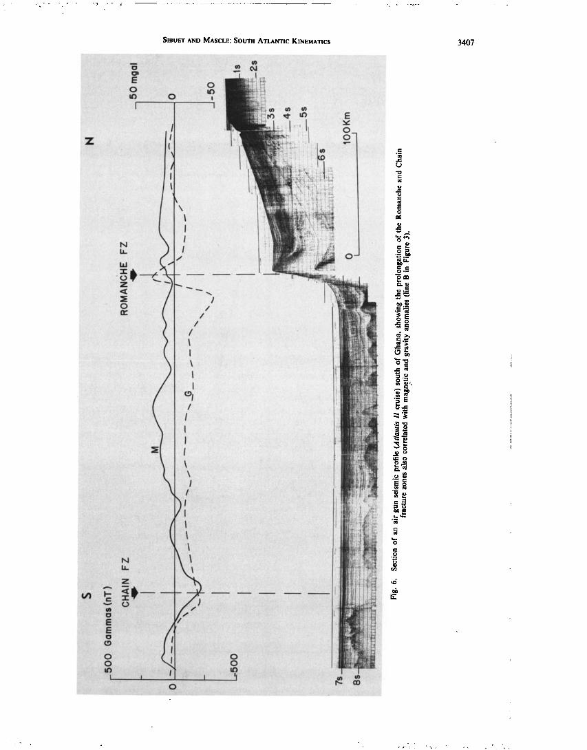
SIBUET AND MASCLE' SOUTH ATLANTIC KINEMATICS 3407
z
!
/
I \
I
I
/
I
I I
I /
I l),
o o

3408 SIBUET AND MASCLE: SOUTH ATLANTIC KINEMATICS
N
O_ mgal
-2O
-40 _
C HARCOT FZ
200
too
-too
Gammas (nT)
M
WALDA 15 Aout I9•'f
65
?$
0 1OOKm i I
Fig. 7. Section of a Flexotir seismic profile (Walda cruise) across the Charcot fracture zone (line C in Figure 3). Note again the correspondence between gravity, magnetic anomalies, and the basement topography.

SlBUET AND MASCLE: SOUTH ATLANTIC KINEMATICS 3409
///

3410 SIBUET AND MASCLE: SOUTH ATLANTIC KINEMATICS
! !
E
E-
!'-
._
¸
¸
¸

SIBUET AND MASCLE: SOUTH ATLANTIC KINEMATICS 3411

3412
I I I I
I • /
! / !
!
I I I I I
I \
\ \

SIBUET AND MASCLE: SOUTH ATLANTIC KINEMATICS 3413
[Lombard, 1963] and Mapa Tect6nico do Brasil [Almeida, 1971b]). Wright [1976] postulates a correspondence between two NE-SW trending fault belts existing in northern Nigeria and the initiation of the Romanche and Chain fracture zones
when Africa and South America separated. A comparable correspondence can also be inferred for the Naoundere fault system in Camcroon and the Pernambuco shear zone in Brazil, as suggested by Vincent [1968] and Mascle [1975, 1976]. Thus these structural lineaments outline a pattern of directions, which appears to be coherent with the directions of large marginal offsets known along both the South American and African continental margins.
To avoid discussion of the validity of parameters of the initial rotation based on poorly defined fracture zones, only the least ambiguous early African segments of transform direc- tions [Le Pichon et al., 1971; Freund, 1974] have been taken into account for the computation: the land prolongation of the Chain and Romanche fracture zones [Wright, 1976] and the easternmost submarine segments of the Romanche and St. Paul's fracture zones. Points used in the pole computation appear on Figure 13 and are listed in Table 2. The early pole is located at 17.9øN, 9.6øW with respect to Africa. The standard deviation of these points from concentric small circles is only about 4 km. Small circles about this pole (Figure 12) also fit relatively well with trends distributed over more than a quad- rant with respect to the pole position. Examples are the struc- tural directions on land of the Camcroon line and the Abaka-
liki zone in southern Nigeria (although the tectonic activity occurred later there [Reyment, 1969]), directions of offsets in the continental margins on the American side such as those of the Chain and Romanche fracture zones and on the African
side (e.g., the Sierra Leone fracture zone), or directions of the continental margin itself in the vicinity of the Amazon cone.
The age of the initial opening of the South Atlantic is still being debated. However, Larson and Ladd [1973] presented some geophysical evidence for an opening activity in early Cretaceous time (Valanginian). Rabinowitz [1976] recently substantiated their hypothesis by identifying magnetic anoma- lies of the M sequence, including Mll (127 m.y., Valanginian [after Van Hinte, 1976]), along the base of the South African continental margin. This age determination, which presum- ably marks the first creation of oceanic crust by sea floor spreading, corresponds to a minimum age. Alternatively, the compilation of chronological data on the different volcanic episodes in southern Africa proposed by Moore [1976] sug- gests that the rifting phase of the South Atlantic began around 130 m.y. Thus it is reasonable to believe that the initial breakup started around 130 m.y. and that the initiation of sea floor spreading started immediately afterward, at the time of anomaly M11 (127 m.y., during the Valanginian). Note that in the case of the South Atlantic evolution the initial rifting is not associated with the Triassic or Liassic distension, as is inferred for the North Atlantic ocean [e.g., Le Pichon et al., 1977; Dupeuble el al., 1976].
The age of the end of this initial episode is also difficult to appreciate. The episode was short-lived, as is shown by the relative shortness of the initial marginal segments, before the first change in trend. We best observe a change in the Ro- manche fracture zone trend along the north Brazilian Ridge segment and along the Ghanean margin (Figure 11); com- parable changes in direction can also be detected along the marginal prolongation of the Chain fracture zone and along the Falkland fracture zone, at 52.5øW (see the map of Lonardi and Ewing [1971]). In Figure 13 a rotation of 4.4 ø about the
TABLE 1. Finite Rotations Describing the Relative Motions of Africa and South America According to Previous Authors
Rotation
Phases Pole of Rotation Angle
Total rotation* 44.0øN, 30.6øW 57.0ø
Early pole [Le Pichon, 1968] Remaining average rotation
35.4øN, 21.0øW 32.5ø• ' 58.0øN, 37.0øW 25.0 ø
Early pole [Le Pichon and Hayes, 21.5øN, 14.0øW 26.3ø• ' 1971] 18.8øN, 39.9øW 26.3ø:!:
Remaining average rotation 67.3øN, 39.5øW 32.8 ø
Early pole [Delte# et al., 1974]
Early pole [Mascle and Sibuet, 1974]
20øN, 13øW• -
32.0øN, 20.0øW• -
Early pole [Ladd, 1976] (initial 22.9øN, 14.86øW 26.42ø• ' opening-anomaly 34)•
Anomalies 34-13 66.04øN, 39.20øW 20.38ø• ' Anomalies 13-5 53.40øN, 34.09øW 9.82ø't ' Anomalies 5-0 70øN, 35øW 3.8 ø
Present motion
Morgan [1968] 58.0øN, 36.0øW Minster et al. [1974] 57.4øN, 37.5øW Forsyth [1975] 58.6øN, 37.8øW
Conventions for rotations and compositions of finite rotations are as given by Le Pichon et al. [1973].
*Bullard et al. [1965] fit, 908.1 m (500 fathoms). •'With respect to Africa. $With respect to South America. {}Relative motions are computed from finite rotations determined
from anomaly fitting procedure. Parameters of the early phase are computed using the 1816.3-m (1000 fathom) Bullard et al. [1965] fit.
early pole of opening has been applied to bring the ends of the initial segments together. The amount of opening at the lati- tudes of south Africa, where the M sequence has been identi- fied [Rabinowitz, 1976] corresponds approximately to twice the distance between magnetic anomalies M ll and MO. If the south Atlantic sea floor spreading is symmetrical, the end of phase I can be estimated to be about the time of the M0 anomaly (i.e., late Aptian, 110 m.y., using the time scale of Van Hinte [1976]).
It is worth noting the coincidence between the end of the evaporitic episode known along parts of the South Atlantic margin between Gabon and Angola as well as off Brazil (which is presumed to be upper Aptian-lower Albian [Bolli et al., 1975]) and the end of the first initial opening phase. One may infer a relationship between the end of this episode and the change in the opening geometry which led to a complete reorganization of marginal fractures.
It is further likely that the establishment of limited oceanic circulation drastically changed the conditions of sedimenta- tion [e.g., Le Pichon et al., 1978]. At 110 m.y. ago the equa- torial and South Atlantic oceans were composed of a series of small and elongated basins individualized between the major fracture zones (Figure 13); a large amount of clastics was probably deposited in these basins. At the place of the present- day Niger delta a confined, small, and relatively deep basin (2000 m) existed, which does not necessarily preclude evapo- ritic sedimentation in the area. South of Cameroon and down
to the Rio G rande-Walvis Ridge line, a 2000-km-long evapo- ritic basin, somewhat comparable to the present-day Red Sea, existed between the two continents.

3414 SIBUET AND MASCLE: SOUTH ATLANTIC KINEMATICS
LEONE RISE
-40 ø
BULLARD FIT
AFR I C A
10 ø
S o u t h A M E R I C A •::Cor. o,oo.
0 o
Fig. 12. Predrift reconstruction of continents around the equatorial Atlantic Ocean according to Bullard et al. [1965]. Parameters of rotations used are in Table 4. Dashed lines indicate fracture zone directions of phase I. Bathymetric control is from Figure 11.
Phase II
Figure 14 shows the relative positions of South America and Africa at the end of phase II according to the fit of magnetic anomaly 34 [Ladd, 1974, 1976] (79 m.y., late Santonian [after Van Hinte, 1976]). The good correspondence between homolo- gous fracture zone segments confirms the validity of the anom- aly 34 fit proposed by Ladd. The rotation equivalent to the first two phases (Table 1) is the one which transfers the posi- tion of the initial fit of Bullard et al. [1965] (Table 1) to the position of the anomaly 34 fit [Ladd, 1974, 1976]. Knowing the parameters of phase I, parameters of phase II are deduced (Table 3). Note the good correspondence between small circles around the pole of rotation of phase II and bathymetric trends of the equatorial fracture zones (Figure 14). In particular, flow lines in the Gulf of Guinea run through points determined using the criterion previously defined. As the longitudes of the poles of rotations of phases I and II (Table 3) are the same (near 39øW), South America being fixed, small circles associ- ated with each of the two phases cannot be clearly differenti- ated except at the level of the 4øN and 8øN fracture zones (Figure 14). This is why these phases could not be identified uniquely by a change in fracture zone trends in the South Atlantic Ocean.
Magnetic lineations of the M sequence, at present known only on the South African side, will probably be identified in the future only south of 10øS. As the pole positions of phases I and II are close and on the same meridian with respect to South America (Table 3), it will probably be difficult to define
the existence of these two phases from identifications of mag- netic lineations. On the other hand, fracture zone trends used in the determination of the pole position of phase I are well distributed and define rather precisely the pole's position. As- suming symmetric sea floor spreading, the position of the Mid- Atlantic Ridge at the end of phase II (Figure 14), between the St. Paul's and the Romanche fracture zone, corresponds to a north-south line of seamounts, which is part of the north Brazilian Ridge as pointed out by Le Pichon and Hayes [ 1971 ]. As shown by these authors, this feature is a composite feature made of two east-west marginal fracture ridges and a con- necting north-south line which consists of seamounts related to a Mid-Atlantic Ridge jump or perhaps to the short-lived compressive episode known to have occurred at the same time in the Benue area [Burke et al., 1971]. Indeed, the geological history of the Benue trough consists of two main stages, a pre- Santonian opening (linked to a hypothetical triple junction in the area of the present-day Niger delta) and an upper Santo- nian compressive episode with associated volcanism. Such phases of minor extent (probably less than 100 km) could exist but cannot be detected by this type of study. Nevertheless, according to Burke and Dewey [1974] the closing of the Benue rift (if any) presumably occurred between Coniacian and San- tonian (86-79 m.y.) and is perhaps associated with the change in the opening geometry occurring at that time (79 m.y.). Some other tectonic readjustments such as those quoted by Miura and Barbosa [1972] in Ghana or along the Espirito Santo basin continental margin as well as a widespread volcanic episode in eastern Brazil [Almeida, 1968] and the Kimberlite emplace-

SlBUET AND MASCLE; SOUTH ATLANTIC KINEMATICS 3415
- 50* - 40* I I I I ] I I I I
tVORTH AMœRICA •
4 FR I C• \ S YS TœM
LEONE RISE
South
RECONSTRUCTION TO ANOMALY MO
-30*
AFR I C A
AMER I CA
.....
10*
0 o
-100
Fig. 13. Reconstruction of continents at the end of phase I (110 m.y., late Aptian). Points used in the computation of the pole of rotation of phase I are represented by solid circles. Small circles about the pole of rotation of phase I (Table 3) are dashed except for the parts corresponding to the active fracture zone segments (solid lines). The inferred position of the ß Mid-Atlantic Ridge crest is figured by a double dashed line.
ments in southern Africa [Allsopp and Barret, 1975; Moore, 1976] may also tentatively be related to a large-scale geometric reorganization of the plates.
During Coniacian-Santonian times, relatively large gaps (about 200 km) existed to the north, between homologous marginal fracture ridges (notably St. Paul's and Romanche fracture zones) (Figure 14), and to the south (Agulhas and Falklands fracture zones). However, Le Pichon et al. [1978] believe that the Walvis-Rio Grande barrier was at this time
still acting as a dam for the southern oceanic circulation and that the change in sedimentation known to have occurred in the Brazilian and Angolan basins [Perch-Nielsen et al., 1975; Bolli et al., 1975] reflected an opening to the north.
Phases III and I V
Using the fits of characteristic magnetic anomalies, Ladd [ 1974, 1976] proposed a scheme for the post-Cretaceous evolu- tion of the South Atlantic, with five distinct episodes. The relative motions of the two continents are consequently very well defined. However, we detect only one significant change in the fracture zone trends (Figure 11), and we suggest that the
post-79-m.y. kinematic history can be simply approximated by two main phases, even if the spreading rate varies during the two phases themselves.
Small circles about the present pole given by Minster et al. [1974], very close to the ones computed by Morgan [1968] and Forsyth [1975] (Table 1), fit transform fault directions and fracture zone trends after the last change apparent on Figure 11. Closing back the South Atlantic from its present position, it is found that this last change corresponds to anomaly 13 time. The parameters of rotation adopted (Table 3) are not
TABLE 2. Portions of Transform Directions Used in Computation of Early Pole (Figure 12)
Romanche
St. Paul's (Sea) Sea Land Chain (Land)
5.0øN, 5.0øW 4.0øN, 2.5øW 4.65øN, 6.0øW 4.8øN, 1.1øW 4.35øN, 7.0øW 5.5øN, 0.0øE
7.05øN, 2.37øE 6.7øN, 4.45øE 8.0øN, 3.35øE 10.37øN, 6.95øE
11.7øN, 5.70øE 11.5øN, 7.45øE
Pole position: 17.9øN, 9.6øW; standard deviation: 4 km.

3416 SIBUET AND MASCLE' SOUTH ATLANTIC KINEMATICS
-50 ø -40 ß
RECONSTRUCTION TO ANOMALY :54
AFR I C A
-20 ß
' I
South AMER I CA
II .10 ø
Fig. 14. Reconstruction of continents at the end of phase II (79 m.y., late Santonian). Open circles mark the position of fracture zones according to the criteria of location defined in the text. Small circles associated with phases I and II (Tables 3 and 4) correspond to fracture zone trends. Continuous lines represent we!l-defined active fracture zone segments during phase II. Note the complete reorganization of the fracture zone pattern at the end of phase I marked up by zigzags. The inferred position of the Mid-Atlantic Ridge is shown by a double dashed line and corresponds to a line of seamounts along the north Brazilian Ridge. The Ceara and Sierra Leone rises are connected to South America and Africa, respectively. Note the good correspondence of the African and South American segments of the St. Paul's and Romanche fracture zones.
significantly different from those given by Ladd [1974, 1976]. The parameters of phase III have been obtained by simple composition of the total rotation parameters for anomaly 34 and those of phase IV (Table 3). Figure 15 shows the equa- torial South Atlantic at the end of phase III (36 m.y.); a good agreement exists between theoretical flow lines and the frac-
ture zone trends. As in the case of the end of the previous
phases (I and ll), we note a possible relationship between the end of phase III and volcanic and geologic events on the South Atlantic continental blocks. Notable, for example, is the oc- currence of Oligocene volcanism in South Africa (between 35 and 38 m.y.) [Kroner, 1973; Moore, 1976] and in north Brazil [Ponte and/Ismus, 1976], as well as the Oligocene hiatus on the Brazilian and African continental margins [Mascle, 1975,
TABLE 3. Relative Motions of Africa and South America
Parameters of Rotation*
Africa With Respect to South America
South America With Respect to Africa
Rotation Rotation Magnetic Phase Pole of Rotati, on Angle Pole of Rotation Angle Anomalies Time,'{' m.y. Epoch•
I 13'5øN' 38'8øW 4.4ø 17.88øN, 9.61øW -4.4 ø MII-M0 II 21'86øN' 39'56øW 22-06ø 24.09øN, 15.67øW -22.06 ø M0-A34 III 66'30øN' 32'08øW 20'51ø 66.65øN, 37.4øW -20.51 ø A34-AI3
IV 57'4øN' 37'5øW 13.4ø 57.4øN, 37.5øW -13.4 ø AI3-0 Total opening 44'1øN, 30'3øW 56.10ø:]: 44.1 øN, 30.3øW -56.10ø:]: MII-0
127-110 110-79
79-36
36-0 127-0
Valanginian to late Aptian Late Aptian to late Santonian Late Santonian to early
O!igocene Early O!igocene to present Valanginian to present
Conventions for rotations and compositions of finite rotations as given by Le Pichon et al. [1973] *This paper, except where noted. ' '{'After Van Hinte [1976] and Berggren and Van Couvering [1974]. :[:1816.3-m (1000 fathom) Bullard et al. [1965] fit.

SlBUET AND MASCLE: SOUTH ATLANTIC KINEMATICS 3417
i I i I I
• / / / .! / /
i i i i I ß
ß
!
i !
t
i
i

3418
.70 ø
SIBUET AND MASCLE: SOUTH ATLANTIC KINEMATICS
_ 50 ø _ 30 ø _10 o 10 ø 30 ø i i
_50 ø
Fig. 16. Present-day configuration of' the South Atlantic: 1- and 4-kin isobaths are af.tcr &'½6K•/[1971]. The present Mid-Atlantic Ridge crest has been successively rotated to the positions corresponding to the phases described above using the parameters given in Tables 3 and 4. Synthetic fracture zones were thus obtained. The magnetic anomalies A I3 (triangles) and A 34 (circles) are after Ladd [1974, 1976], and the M anomalies off South Africa are after Rabinowitz [1976].
1976] which has been associated with a general continental margin flexuring [Spengler and Delteil, 1966; Reyre, 1966]. Figure 16 shows, in a synthetic fashion, the theoretical pattern of fracture zones (associated with the present-day Mid-Atlan- tic Ridge offsets) as well as the positions of the rotated ridge axis at the end of each phase (see Table 3). As previously discussed, the successive rotated position of the Mid-Atlantic Ridge at the end of phases II and III coincides with the positions given for magnetic anomalies 34 and 13. This clearly supports the assumption that south of the equatorial belt, no major jump affected the Mid-Atlantic Ridge as inferred by Sclater and McKenzie [1973]. Within the equatorial area the proposed reconstructions (Figures 11-15) imply that the posi- tion of Mid-Atlantic Ridge axis, probably initially subparallel to the continental borderland, was slowly readjusted and that subsequent ridge jumps or ridge reorientations may have oc- curred later, as in Oligocene time between St. Paul's and R omanche fracture zones.
Areas where the initial positions of the Mid-Atlantic Ridge do not fit well with the position of the continental margin are between Gabon and north Angola and the Brazilian counter- part and in the area of the Walvis Ridge and Rio Grande Rise (Figure 16). Concerning the first area it is difficult to decide if this ill fit is due to a relatively poor location of the Mid- Atlantic Ridge or to a reorganization of the directions of the
Mid-Atlantic Ridge axisß It is noteworthy that the margins on both sides show a different configuration (width and presence of an asymmetrical evaporitic basin). Concerning the second area we tend to favor the hypothesis of a ridge axis jump, and in this respect we note that such a mechanism has been in- ferred to explain both the presence of a large evaporitic basin beneath the Sao Paulo plateau [Kumar et al., 1976] and the complex structure of the westernmost Rio Grande rise [Fran- cheteau and Le Pichon, 1972].
POSSIBLE ORIGIN AND EVOLUTION OF CE^R^ AND SIERRA LEONE RISES
The Ceara and Sierra Leone rises, shallow and noticeably distinct from the surrounding oceanic sea floor, belong to the family of structures variously termed microcontinents, aseis- mic ridges or rises, volcanic features, uplifted oceanic crust, etc. Little is known about the structures of the two rises, considered by Kurnar and Ernbley [1977] as 'twin features.' Emery et al. [1975b] indicate an anomalous crust beneath the Sierra Leone Rise, report typical oceanic basement velocities (4.5 to 6.1 km/s), and correlate a strong reflector covering part of the rise with an Eocene chert layer drilled at Deep Sea Drilling Project site 13 [Maxwell et al., 1970]. They further believe that large-amplitude and postdeposition vertical move- ments, accompanied by volcanism, are responsible for the

SIBUET AND MASCLE: SOUTH ATLANTIC KINEMATICS 3419
TABLE 4. Finite Rotations of Plates With Respect to South America
Time,* Magnetic State m.y. Anomaly
Africa Sierra Leone Rise•'
Rotation Rotation
Epoch* Pole of Rotation Angle Pole of Rotation Angle
Ceara Riser
Rotation
Pole of Rotation Angle
Initial 127 M 11 reconstruction
End of phase I 110 M0 End of phase II 79 A34
End of phase III 36 A13
Valanginian 44.1øN, 30.3øW -56.10ø:]: 43.93øN, 32.39øW -46.35 ø
Late Aptian 46.64øN, 31.09øW -52.39ø• ' 43.93øN, 32.39øW -46.35 ø Late Santo- 63øN, 36øW -33.8ø{} 62.12øN, 36.30øW -27.32 ø
nian
Early Oli- 57.4øN, 37.5øW - 13.4ø• ' 57.4øN, 37.5øW - 13.4 ø gocene
66.3øN, 32.08øW -7.3 ø
66.3øN, 32.08øW -7.3 ø 66.3øN, 32.08øW -7.3 ø
Present-day position
Conventions for rotations and compositions of finite rotations as given by Le Pichon et al. [1973]. *After Van Hinte [1976] and Berggren and Van Couvering [1974]. tThis study. •:1816.3-m (1000 fathom) Bullard et al. [1965] fit. õLadd [ 1976].
present-day structure, which might also be linked to a phase change within the mantle or the presence of an underlying mantle hot spot. Embley et al. [1972] and Houtz et al. [1977] report data on the Ceara Rise that lead them to believe that the rise consists of a rather typical oceanic section capped by a pile of low-velocity volcanics. Their argument gains support from drilling in the Ceara Rise (site 354) which led to the recovery of basaltic rocks from presumed basement [Perch-Nielsen et al., 1975]. Kumar and Embley [1977] suggest that both structures were formed by normal faulting approximately 80 m.y. ago. At that time a major plate readjustment occurred in both North and South Atlantic (Pitman and Talwani [1972], Le Pichon and Hayes [1971], and this paper) and could have facilitated exten- sive volcanic extrusions. For Kumar and Embley [1977] the 2- km-thick volcanic pile thus created was later on split into two different segments: the Ceara Rise, now partially covered by the Amazon cone sediments, and the Sierra Leone Rise. We note, however, that in the Bullard et al. [1965] fit of the continents a gap exists between North America, South Amer- ica, and Africa, in a position similar to gaps in the reconstruc- tion between North America, Europe, and Africa. We surmise that this gap could be filled by the western part of the Bahamas platform (J. Klitgord and H. Schouten, personal communica- tion, 1977) and the presumed continental basement of Cuba presently hidden by folded ophiolite sequences. Assuming an oceanic origin of both Sierra Leone and Ceara rises, as advo- cated by Houtz et al. [ 1977] we propose that both features were created 80 m.y. ago [Kumar and Embley, 1977] or later in their present-day positions with respect to South America and Af-
,
rica.
Nevertheless, we suggest an alternative simple scheme for the evolution of major structural relationships (Table 4, Fig- ures 12-15). The eastern part of the Bahamas platform, under the assumption that it is built on oceanic.crust, and probably also the Ceara and Sierra Leone rises, both of oceanic origin, should be created in the Bullard gap during the period of initial opening of the North Atlantic, before the beginning of phase I (approximately 127-110 m.y.B.P.).
During phase ! (Table 4, Figure 13) the relative motion of Africa with respect to South America using the parameters of Table 3 would result in slightly less than 100 km of compres- sion in the area of the two rises. As the corresponding areas today show no major compressive deformation, it seems likely that an intense fracturing occurred, allowing the Sierra Leone Rise to be detached from Africa. Thus we may suppose (Fig- ure 13) that during phase I, there was a plate boundary be-
tween Africa and South America along the Sierra Leone frac- ture zone north of the Ceara and Sierra Leone rises. In our
reconstruction, both rises are fixed with respect to South America.
During phase II (Table 4, Figure 14) and after the early Cretaceous individualization of the Ceara Rise and Sierra
Leone Rise, they should both have remained connected with South America and Africa, respectively. However, following parameters close to those of the opening of the North Atlantic (Figure 14), oceanic crust may have been created west of the Sierra Leone rise. This hypothesis seems to be confirmed by the good correlation existing between the flow lines deduced from the parameters of the initial opening between Africa and North America [Le Pichon et al., 1977] and by the trends of the Guinea fracture zone and of the continental slope north of the Demerara plateau. Thus there may exist, just northwest of the Sierra Leone Rise, a portion of oceanic crust created during phase II between 110 and 79 m.y. Such a speculation appears compatible with the interpretation of J. G. Sclater (personal communication, 1976), who suspects, on the basis of magnetic anomalies, that Mesozoic oceanic crust may be present in this area, west of the present-day position of the Sierra Leone Rise.
During phase III (Table 4, Figure 15), between 79 and 36 m.y. the motions of the Ceara and Sierra Leone rises occurred seaward from South America and Africa, respectively, along phase III flow lines of the South Atlantic opening. During this phase the two rises should have reached their final positions with respect to Africa and South America (Table 4). The chronology implies two successive ridge axis jumps. Figure 15 shows the location of both structures at the end of this episode. This configuration suggests the possible existence of small portions of oceanic crust, generated during phase II, west of the Sierra Leone Rise, off Liberia and the Amazon cone and even between the Guinea and the 8øN fracture zone. This
interpretation does not support an Upper Jurassic-Lower Cre- taceous age for the formation of the Sierra Leone abyssal plain as was proposed by Jones and Mgbatogu [1977] on the basis of a questionable identification of the M1 1-M24 magnetic se- quence. Finally, since the Oligocene (during phase IV) the Mid-Atlantic Ridge axis stayed between the Ceara Rise and the Sierra Leone Rise (Figure 11).
CONCLUSION AND SUMMARY
We have used the initial fit of the African and South Ameri-
can continents, the powerful constraints provided by the equa- torial marginal fracture ridges and subsequent fracture zones,

3420 SIBUET AND MASCLE: SOUTH ATLANTIC KINEMATICS
and the fit of magnetic isochrons to obtain a kinematic evolu- tion of the South Atlantic Ocean with four main opening phases. The first one, between 127 and 110 m.y., corresponds to the evaporitic episode in the South Atlantic. The three others, between 110 and 84 m.y., 84 and 38 m.y., and 38 m.y. and the present, are tentatively correlated with significant vol- canic and tectonic episodes known around the South Atlantic Ocean. The validity of the principal evolutionary steps that we propose is supported by the good correlation between the successive positions of the rotated Mid-Atlantic Ridge and the location of characteristic magnetic anomalies, notably, anom- alies M0, A34, and A13 as given by Rabinowitz [1976] and Ladd [ 1974, 1976].
Finally, we speculate that in the Bullard et al. [1965] predrift configuration the large gap between Africa, North America, and South America was occupied by the western part of the Bahamas platform and part of Cuba. The Sierra Leone and Ceara rises of oceanic origin were probably created 80 m.y. ago or later in their present position with respect to Africa and South America.
Acknowledgments. We are especially grateful to X. Le Pichon, who gave us many helpful suggestions throughout this study, and to him, H. D. Needham, and R. W. Embley for their critical comments on the manuscript. We thank H. S. Fleming, S. Connary, and R. Moody for communicating, in advance of publication, detailed bath- ymetric maps of the equatorial Atlantic and the continental margin off Brazil and K. O. Emery for permission to use Atlantis H data ob- tained in the Gulf of Guinea by the Woods Hole Oceanographic Institution. We thank D. Carrfi and R. Thirion for drafting the figures and N. Guillo and Y. Potard for typing the manuscript. Contribution 574 of the Scientific Department of the Centre Oc•anologique de Bretagne.
REFERENCES
Almeida, F. F. M. de, Radiometric age determinations from north- eastern Brazil, Bol. Soc. Bras. Geol., 17, 3-14, 1968.
Alineida, F. F. M. de, Mapa geo16gico do Brasil, Min. das Minas e Enfirg., Dep. Nac. da Prod. Miner., Brasilia, Brazil, 1971a.
Almeida, F. F. M. de, Mapa tect6nico do Brasil, Min. das Minas e En&g., Dep. Nac. da Prod. Miner., Brasilia, Brazil, 1971b.
Allsopp, H. L., and D. R. Barret, Rb-Sr age determinations on South African kimberlite pipes, in Physics and Chemistry of the Earth, vol. 9, edited by L. H. Ahrens et al., Pergamon, New York, 1975.
Arens, G., J. R. Delteil, P. Valery, B. Damotte, L. Montadert, and L. Patfiat, The continental margin off Ivory Coast and Ghana, The Geology of the East Atlantic Continental Margin, 4, Africa, Rep. 70/16, edited by F. M. Delany, pp. 61-78, Inst. of Geol. Sci. of G. Br., London, England, 1971.
Behrendt, J. C., J. Schlee, and J. M. Robb, Geophysical evidence for the intersection of the St. Paul, Cape Palmas and Grand Cess fracture zones with the continental margin of Liberia, West Africa, Nature, 248, 324-326, 1974.
Berggren, W. A., and J. A. Van Couvering, The late Neogene bio- stratigraphy, geochronology, and paleoclimatology of the last 15 million years, in Marine and Continental Sequences, Developments in Paleontology and Stratigraphy, vol. 2, Elsevier, New York, 1974.
Bolli, H. M., W. B. F. Ryan, B. K. McKnight, H. Kagami, M. Melguen, W. G. Siesser, J. Natland, J. F. Longoria, F. Proto- Decima, J. B. Foresman, and W. E. Hoffman, Basins and margins of the eastern South Atlantic: Leg 40, DSDP, Geotimes, 6, 22-24, 1975.
Bullard, E., J. E. Everett, and A. G. Smith, The fit of the continents around the Atlantic, Symposium on Continental Drift, Phil. Trans. Roy. Soc. London, 258, 41-51, 1965.
Burke, K., and J. F. Dewey, Two plates in Africa during the Cretac- eous?, Nature, 249, 313-316, 1974.
Burke, K., T. F. J. Dessauvagie, and A. J. Whiteman, Opening of the Gulf of Guinea and geological history of the Benue depression and Niger delta, Nature Phys. Sci., 233, 51-55, 1971.
Cochran, J. R., Gravity and magnetic investigations in the Guiana basin, western equatorial Atlantic, Geol. Soc. Amer. Bull., 84, 3249- 3268, 1973.
Collette, B. J., H. Schouten, K. Rutten, and A. P. Slootweg, Structure of the Mid-Atlantic Ridge province between 12 ø and 18øN, Mar. Geophys. Res., 2, 143-179, 1974.
Connary, S., and R. Moody, Bathymetry of the continental margin of Brazil, submitted to Amer. Ass. Petrol. Geol. Bull., 1978.
Delteil, J. R., P. Valery, L. Montadert, C. Fondeur, P. Patfiat, and J. Mascle, The continental margin in the northern part of the Gulf of Guinea, in Geology of Continental Margins, edited by C. A. Burk and C. L. Drake, pp. 297-311, Springer, New York, 1974.
Dupeuble, P. A., and J.P. Rehault, J. L. AuXietre, J.P. Dunand, and L. Pastouret, R•sultats de dragages et essai de stratigraphie des bancs de Galice, et des montagnes de Porto et de Vigo (marge occidentale ib•rique), Mar. Geol., 22, M37-M49, 1976.
Embley, R., D. E. Hayes, and J. E. Damuth, The Ceara Rise: Western equatorial Atlantic (abstract), Eos Trans. AGU, .53, 408, 1972.
Emery, K. O., E. Uchupi, C. O. Bowin, J. Phillips, and E. S. W. Simpson, The continental margin of Western Africa: Cap St. Francis (South Africa) to Walvis Ridge (South West Africa), Amer. Ass. Petrol. Geol. Bull., 50, 3-59, 1975a.
Emery, K. O., E. Uchupi, C. O. Bowin, J. Phillips, and J. Mascle, The continental margin of Western Africa: Angola to Sierra Leone, Amer. Ass. Petrol. Geol. Bull., 59, 2209-2265, 1975b.
Fail, J.P., L. Montadert, J. R. Delteil, P. Valery, and R. Schlich, Prolongation des zones de fractures de l'ocfian A tlantique dans le golfe de Guinfie, Earth Planet. Sci. Lett., 7, 413-419, 1970.
Forsyth, D. W., Fault plane solutions and tectonics of the South Atlantic and Scotia Sea, d. Geophys. Res., 80, 1429-1443, 1975.
Francheteau, J., and X. Le Pichon, Marginal fracture zones as struc- tural framework of continental margins in the South Atlantic Ocean, Amer. Ass. Petrol. Geol. Bull., 56, 891-967, 1972.
Freund, R., Kinematics of transform and transcurrent faults, Tectono- physics, 21, 93-134, 1974.
Gorini, M. A., and G. M., Bryan, The tectonic fabric of the equatorial Atlantic and adjoining continental margins: Gulf of Guinea to northeastern Brazil, Symposium on Atlantic Type Continental Mar- gins, A. Acad. Bras. Cienc., 48, 101-120, 1976.
Hayes, D. E., and M. Ewing, North Brazilian Ridge and adjacent continental margin, Amer. Ass. Petrol. Geol. Bull., 54, 2120-2150, 1970.
Heezen, B.C., E. T. Bunce, J. B. Hersey, and M. Tharp, Chain and Romanche fracture zones, Deep Sea Res., 11, 11-33, 1964.
Houtz, R. E., W. J. Ludwig, J. D. Milliman, and J. A. Grow, Structure of the northern Brazilian continental margin, Geol. Soc. Amer. Bull., 88, 711-719, 1977.
Jones, E. J. W., and C. C. S. Mgbatogu, Jurassic sea-floor spreading in the eastern equatorial Atlantic, Nature, 267, 688-690, 1977.
Kroner, A., Comment on 'Is the African plate stationary?,' Nature, 243, 29, 1973.
Kumar, N., and R. W. Embley, Evolution and origin of Ceara Rise: An aseismic rise in the western equatorial Atlantic, Geol. Soc. Amer. Bull., 88, 683-694, 1977.
K umar, N., G. Bryan, M. Gorini, and J. Carvalho, Evolution of the continental margin off northern Brazil: Sedimentation and carbon potential, Symposium on Atlantic Type Continental Margins, A. Acad. Bras. Cienc., 48, 131-144, 1976.
Ladd, J. W., South Atlantic sea floor spreading and Caribbean tecton- ics, Ph.D. thesis, 251 pp., Columbia Univ., New York, 1974.
Ladd, J. W., Relative motion of South America with respect to North America and Caribbean tectonics, Geol. Soc. Amer. Bull., 87, 969- 976, 1976.
Ladd, J. W., G. O. Dickson, and W. C. Pitman Ill, The Age of the South Atlantic in the Ocean Basins and Margins, I, The South Atlantic, edited by A. E. M. Nairn and F. G. Stehli, pp. 555-573, Plenum, New York, 1973.
Larson, R. L., and J. W. Ladd, Evidence for the opening of the South Atlantic in the Early Cretaceous, Nature, 246, 209-212, 1973.
Le Pichon, X., Sea floor spreading and continental drift, d. Geophys. Res., 73, 3661-3697, 1968.
Ire Pichon, X., and J.P. Fox, Marginal offsets, fracture zones, and the early opening of the North Atlantic, d. Geophys. Res., 76, 6294- 6308, 1971.
Le Pichon, X., and D. E. Hayes, Marginal offsets, fracture zones, and the early opening of the South Atlantic, d. Geophys. Res., 76, 6283- 6293, 1971.
Le Pichon, X., J. Francheteau, and J.-C. Sibuet, Une hypoth•se d'•volution tectonique du golfe de Gascogne, in Histoire Structurale du GolJe de Gascogne, vols. 6, 11, pp. 1-44, Technip, Paris, 1971.

SlBUET AND MASCLE: SOUTH ATLANTIC KINEMATICS 3421
Le Pichon, X., J. Francheteau, and J. Bonnin, Plate Tectonics, vol. 6, Developments in Geotectonics, 300 pp., Elsevier, New York, 1973.
Le Pichon, X., J.-C. Sibuet, and J. Francheteau, The fit of the con- tinents around the North Atlantic Ocean, Tectonophysics, 38, 169- 209, 1977.
Le Pichon, X., M. Melguen, and J.-C. Sibuet, A schematic model of the evolution of the South Atlantic, in Proceedings of the Joint Oceanographic Assembly, Edinburgh, Plenum, New York, in press, 1978.
Lombard, J., Carte g•ologique de l'Afrique, sheets 4 and 5, Ass. des Serv. G•ol. Afr., Organ. des Nations Unies pour l'Educ., la Sci., et la Cult., UNESCO, Paris, 1963.
Lonardi, A. G., and M. Ewing, Sediment transport and distribution in the Argentine basin, 4, Bathymetry of the continental margin, Ar- gentine basin and the related provinces, canyons and sources of sediments, in Physics and Chemistry of the Earth, vol. 8, edited by R. H. Ahrens, F. Pi'ess, S. K. Runcorn, and H. C. Urey, pp. 79-121, Pergamon, New York, 1971.
Louden, K. E., and D. W. Forsyth, Thermal conduction across frac- ture zones and the gravitational edge effect, d. Geophys. Res., 81, 4869-4874, 1976.
Mascle, J., G•ologie sous-marine du golfe de Guin•e, Ph.D. thesis, 355 pp., Univ. P. and M. Curie, Paris, 1975.
Mascle, J., Le golfe de Guin•e: Exemple d'•volution d'une marge atlantique en cisaillement, Mem. Soc. Geol. Fr., nouvelle s•rie, 128, 1976.
Mascle, J., and J. C. Sibuet, New pole for the early opening of the South Atlantic, Nature, œ52, 464-465, 1974.
Mascle, J., and A. F. J. Smit, Nature de la pente continentale au sud du Cap des Trois Pointes (Ghana), C. R. Acad. Sci., 279, 121-124, 1974.
Maxwell, A. E., et al., Initial Reports of the Deep Sea Drilling Projec t, vol. 3, 806 pp., U.S. Government Printing Office, Washington,
Ponte, F. C., and H. E. Asmus, The Brazilian marginal basins: Current state of knowledge, Symposium on Atlantic type continen- tal margins, A. Acad. Bras. Cienc., 48, 215-240, 1976.
Rabinowitz, P. D., A geophysical study of the continental margin of Southern Africa, Geol. Soc. Amer. Bull, 27, 1643-1653, 1976.
Rea, D. K., Magnetic anomalies along fracthre zones, Nature Phys. Sci., 236, 58-59, 1972.
Reyment, R. A., Ammonite biostratigraphy, continental drift and oscillating transgressions, Nature, 224, 137-140, 1969.
Reyre, D., Particularit,s g•ologiques des bassins c6tiers de l'ouest africain, in Symposium des Bassins S•dimentaires du Littoral A fri- cain, 1964, edited by D. Reyre, Union lnternationale des Sciences G•ologiques et Association des Services G6ologiques Africains, Paris, 1966.
Schouten, J. A., A fundamental analysis of magnetic anomalies over oceanic ridges, Mar. Geophys. Res., 1, 111-144, 1971.
Sclater, J. G., and D. P. McKenzie, Paleobathymetry of the South Atlantic, Geol. Soc. Amer. Bull., 84, 3203-3216, 1973.
Sibuet, J. C., X. L½ Pichon, and J. Goslin, Thickness of lithosphere deduced from gravity edge effects across the Mendocino Fault, Nature, 252(5485), 676-679, 1974.
Spengler, A. de, and J. R. Delteil, Le bassin s&ondaire tertiaire de C6te d'lvoire, in Symposium des Bassins S•dimentaires du Littoral Africain, Delhi, 1964, part 1, Littoral Atlantique, edited by D. Reyre, pp. 99-113, Union lnternationale des Sciences G•ologiques et Association des Services G6ologiques Africains, Paris, 1966.
Sykes, L. R., Mechanism of earthquakes and nature of faulting on the mid-oceanic ridges, J. Geophys. Res., 72, 2132-2153, 1967.
Uchupi, E., Bathymetric atlas of the Atlantic, Caribbean and Gulf of Mexico, Rep. 71-72, Woods Hole Oceanogr. Inst., Woods Hole, Mass., 1971.
Van Andel, T. J. H., R. P. Von Herzen, and J. D. Phillips, The Vema fracture zone and the tectonics of transverse shear zones in oceanic
D.C., 1970. crustal plates, Mar. Geophys. Res., 1, 261-283, 1971. Minster, J. B., T. H. Jordan, P. Molnar, and E. Haines, Numerical Van Andel, T. J. H., D. K. Rea, R. O. Von Herzen, and H. Hoskins,
modeling of instantaneous plate tectonics, Geophys. d. Roy. Astron. Ascension fracture zone, Ascension Island, and the Mid-Atlantic Soc., 36, 541-576, 1974. Ridge, Geol. Soc. Amer. Bull., 84, 1527-1546, 1973.
Miura, K., and J. C. Barbosa, Geologia da plataforma continental do Van Hinte, J. E., A Cretaceous time scale, Amer. Ass. Petrol. Geol. Maranhao, Piani, Ceara e Rio Grande do Norte, Congr. Soc. Bras. Geol., 23, 57-66, 1972.
Moore, A. E., Controls of post-gondwanaland alkaline volcanism in Southern Africa, Earth Planet. Sci. Lett., 31, 291-296, 1976.
Morgan, W. J., Rises, trenches, great faults and crustal blocks, J. Geophys. Res., 73, 1959-1982, 1968.
Perch-Nielsen, K., et al., Leg 39 examines facies changes in the South Atlantic, Geotimes, 20(3), 26-28, 1975.
Philipps, J.P., and D. Forsyth, Plate tectonics, paleomagnetism, and the opening of the Atlantic, Geol. Soc. Amer. Bull., 83, 1579-1600, 1972.
Pitman, W. C., Ill, and M. Talwani, Sea-floor spreading in the North Atlantic, Geol. Soc. Amer. Bull., 83, 619-646, 1972.
Bull., 60, 498-516, 1976. Vincent, P.M., Attribution au Cr•tac• de conglom•rats m•tamor-
phiques de l'Adamaoua, Ann. Fac. Sci. Cameroun, 1, 69-76, 1968. Vine, F. J., and D. H. Matthews, Magnetic anomalies over oceanic
ridges, Nature, 199, 947-949, 1963. Wright, J. B., Fracture system in Nigeria and initiation of fracture
zones in the South Atlantic, Tectonophysics, 34, T43-T47, 1976.
(Received August 4, 1977; revised March 31, 1978; accepted April 3, 1978.)
Related Documents


![Clima equatorial[1]](https://static.cupdf.com/doc/110x72/5597a4931a28abd3218b48a9/clima-equatorial1.jpg)