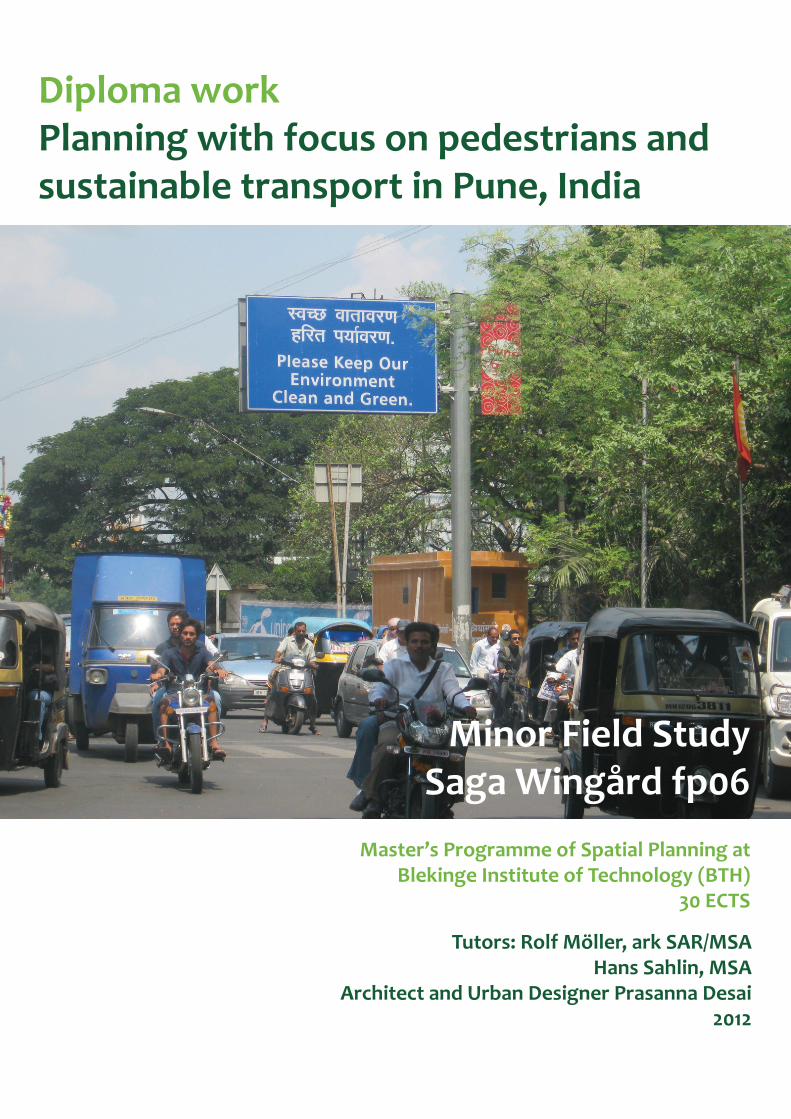
Tutors: Rolf Möller, ark SAR/MSA Hans Sahlin, MSA Architect and Urban Designer Prasanna Desai 2012 Diploma work Planning with focus on pedestrians and sustainable transport in Pune, India Minor Field Study Saga Wingård fp06 Master’s Programme of Spatial Planning at Blekinge Institute of Technology (BTH) 30 ECTS

Welcome message from author
This document is posted to help you gain knowledge. Please leave a comment to let me know what you think about it! Share it to your friends and learn new things together.
Transcript
Tutors: Rolf Möller, ark SAR/MSAHans Sahlin, MSA
Architect and Urban Designer Prasanna Desai2012
Diploma workPlanning with focus on pedestrians and sustainable transport in Pune, India
Minor Field StudySaga Wingård fp06
Master’s Programme of Spatial Planning at Blekinge Institute of Technology (BTH)
30 ECTS
2
Diploma Work/Master’s degree thesis, 30 ECTS, Autumn Semester 2011Programme for Spatial Planning at Blekinge Institute of Technology (BTH)Karlskrona, SwedenTutors: Rolf Möller, ark SAR/MSAHans Sahlin, MSAArchitect and Urban Designer Prasanna Desai
CopyrightSaga Wingård, fp06 ([email protected])
All photographs and illustrations are made by the author unless otherwise stated. The basemap used for most maps was supplied by Prof. Prasanna Desai and is the Pune Municipal Corporation (PMC) map for the 1987 Development Plan of Pune. For other maps, the source is stated in connection to the map.
3
AcknowledgementsWhen I told people I was going to do my thesis project on traffi c planning in India, the most common response was “Good luck!”. And I do consider myself lucky, hav-ing had the opportunity to work with a lot of knowledgeable and committed people, on a subject that really interests me.
First of all I would like to thank the people at Parisar, especially Sujit Patwardhan and Ranjit Gadgil for valuable input and letting me be a part of the offi ce for a while. I would also like to thank Professor Prasanna Desai and Professor Pratap Raval, for fi eld specifi c input in India, as well as supplying maps and getting their students to help me with some surveys. Th anks naturally also goes to these students.
My supervisors Rolf Möller and Hans Sahlin provided excellent input before and after my trip to India and both deserves a special thanks.
Others that have been important in making this project happen include: Graham Meadows, helping me get started, and suggesting India. Ranganath Nayak, supply-ing the contact with Sujit Patwardhan and Parisar. Phillippa Bricher, providing me somewhere to stay in Tasmania, as I wrote the scholarship application, as well as proofreading it. Th anks also to Bernard de la Coeur and Erin Siebers for taking the time to proof read the fi nal thesis.
I would like to thank the people that have supplied me with pictures of pedestrian streets around the world etc, as well as Gehl architects and Goudappel Coff eng for letting me use their maps.
Th anks also to my new found friends in India and my host family, as well as my other lovely friends and real family.
Saga Wingård - February 2012
PrefaceTh is thesis is my diploma work within the Master’s Programme of Spatial Plan-ning at Blekinge Institute of Technology (BTH), Karlskrona, Sweden. Th e thesis is based upon a fi eld study, which was performed in Pune, India, during a two and half month’s period, October-December 2011. It covers 30 ECTS credit points and is partly funded by SIDA (Swedish International Cooperation Agency) as a so called Minor Field Study (MFS), which is a scholarship that gives students a chance to base their thesis on their own fi eld studies in a developing country.
Th e project has been performed together with Parisar, a Non-Governmental Organisation (NGO) based in Pune, that lobbies for sustainable development in various fi elds including heritage preservation, protection of urban bio-diversity and sustainable agriculture (parisar.org, 2009a). Th eir work for the past decade has been mainly focused on sustainable urban transport.
My contact person at Parisar is Sujit Patwardhan, the founder of the NGO. To get input and supervision from academic professionals within my fi eld in India, Sujit contacted Architect and Urban Designer Prasanna Desai, Director at P.V.P. College of Architecture, who has been my supervisor in India.
4
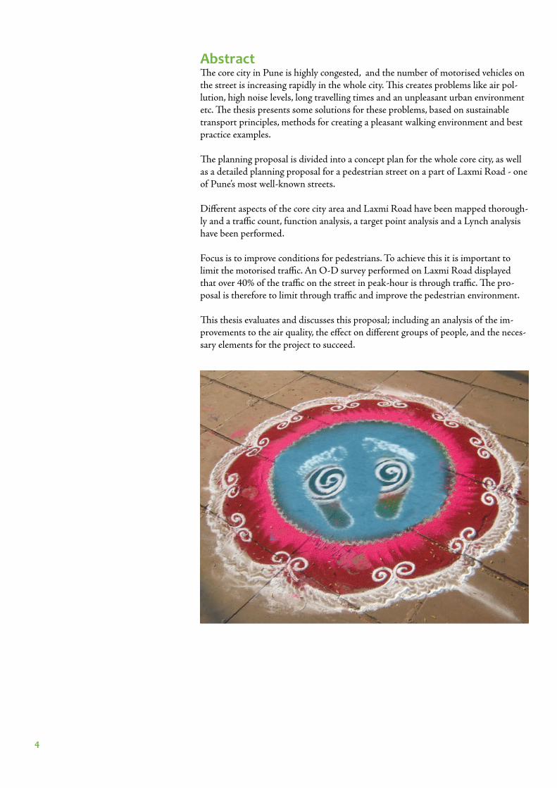
AbstractTh e core city in Pune is highly congested, and the number of motorised vehicles on the street is increasing rapidly in the whole city. Th is creates problems like air pol-lution, high noise levels, long travelling times and an unpleasant urban environment etc. Th e thesis presents some solutions for these problems, based on sustainable transport principles, methods for creating a pleasant walking environment and best practice examples.
Th e planning proposal is divided into a concept plan for the whole core city, as well as a detailed planning proposal for a pedestrian street on a part of Laxmi Road - one of Pune’s most well-known streets.
Diff erent aspects of the core city area and Laxmi Road have been mapped thorough-ly and a traffi c count, function analysis, a target point analysis and a Lynch analysis have been performed.
Focus is to improve conditions for pedestrians. To achieve this it is important to limit the motorised traffi c. An O-D survey performed on Laxmi Road displayed that over 40% of the traffi c on the street in peak-hour is through traffi c. Th e pro-posal is therefore to limit through traffi c and improve the pedestrian environment.
Th is thesis evaluates and discusses this proposal; including an analysis of the im-provements to the air quality, the eff ect on diff erent groups of people, and the neces-sary elements for the project to succeed.
5
CONTENT
Preface 3
Acknowledgements 3
Abstract 4
Content 5
INTRODUCTION 8
Background 9
Pune - Current traffi c situation 10
Problems 13
Possibilities 14
Aim 16 Delimitation 16
Main objectives 17
Method 17 Theoretical base 17 Planning conditions 17 Inventory methods 17 Analytical methods 18 Design principles 18
Choosing a case study area 19
INVENTORY 20
Use of public space 21 Temples and schools 24
Hawkers and vendors 25
Road network 26 Bus network 28
Parking 30
Speed 32
Places of tourist interest in and around Pune 33
6
ANALYSIS 35
Traffi c count 36
Method 36 Result 36 Analysis of traffi c count 38
Conclusion from traffi c count 38
Function analysis 39
Method 39 Analysis 39 Conclusions from function analysis 42
Target point analysis and O-D survey 43 Method 43 Result 43 Analysis of O-D survey 45
Conclusions from O-D survey 45
Lynch analysis 46 Method 46 Analysis 47 Conclusions from Lynch analysis 48
DESIGN PRINCIPLES 49
Sustainable transport principles for 50
reclaiming the street for pedestrians Gehl’s toolbox for a pleasant urban 51 environment Best practice 52
Copenhagen 53 Amsterdam 54
Pedestrian streets around the world 55
PLANNING PROPOSAL 57
Concept plan for the whole core city 58 Public transport 60 Semi-public transport 61 Non-motorised modes 61 Street design of ring road 62 Parking 63 Summarize 63
7
Detailed planning proposal for Laxmi Road 65 Overall map 66 Street design 67 Typical sections 68 Ends and intersections 69 Square 70 Entry from Tilak Chowk 71 Stormwater management 72 Deliveries 72 Parking 72 Getting people to stick to new traffi c rules 72 Road network 73 Buses 74 Levels of implementation 75
EVALUATION 76
Implementation of Gehl’s toolbox 77
Air pollution 78 Method 78 Result 78 Air pollutants 79 Analysis of air pollutant calculations 80 Conclusions from air pollutant calculations 80
How does this aff ect....? 81
With a Western perspective 82
Conclusion 83
REFERENCES 84
APPENDIX 87

8
INTRODUCTION
9
BackgroundTh is thesis discusses how to use sustainable transport principles to improve the traf-fi c situation in Pune, India, and stop or limit the current trend - a rapid increase of vehicles and congestion on the streets.
Th e fi eld of sustainable transport has grown from the concept of sustainable de-velopment. Transportation has infl uences in all of the commonly used categories of sustainable development; ecologic, social and economic sustainability (Schiller, Bruun & Kenworthy, 2010, p. 2). Many of the problems fi t under more than one of the categories, as these are highly linked to one another.
Th ere are several environmental problems with the increased motorised transport around the world. Petrol is a non-renewable source of energy and releases high car-bon dioxide emissions, leading to global warming. Other problems include air pol-lution, noise disturbance and greater storm water run-off problems, with big paved areas as roads and parking lots (Schiller, Bruun & Kenworthy, 2010, p. 2-13).
Th e way we build our cities has changed so they fi t driving. Th is increases the amount of car trips, inviting people to drive, as well as taking up a lot of urban space with roads and parking. It also creates a social problem of inequity, especially in developing countries where only a smaller part of the population actually can af-ford a car (Schiller, Bruun & Kenworthy, 2010, p. 16). Wider and bigger roads also often take away street life, and aff ect the safety and the sense of community in many neighbourhoods.
Economic problems include public health issues, with obesity as result of people exercising less etc., as well as the cost of traffi c accidents and already mentioned problems with noise and air pollution. Congestion and long travel times also have their costs.
Concerns about the counterproductivity of increasing roadspace and parking lots have been raised since the 1970s, and there has been several successful projects aiming for a sustainable transport system carried out in diff erent cities throughout the world (Schiller, Bruun & Kenworthy, 2010, p. 1). Scandinavia, Germany and Holland are pointed out as leading countries, whereas the USA is often used as a deterrent example (Schiller, Bruun & Kenworthy, p. 10 & 26). Th e situation in developing countries is partly diff erent, as the general income level only recently has increased enough for many middle class families to buy their own private vehicle.
In developing countries where the car often is seen as a status symbol and a sign of economic growth it is often easier to get politicians to fund road improvements, than build bicycle tracks and improve public transport and the walking environment (Th ynell, Mohan, and Tiwari, 2010, p. 7). A strong political leadership is important when aiming for sustainable transport solutions (Schiller, Bruun & Kenworthy, 2010, p. 299-300). With the increased climate change debate there is hope that poli-ticians can gain votes also for these kinds of projects (Th ynell, Mohan, and Tiwari, 2010, p. 7).
10
1000 km500 km
Mumbai
Delhi
Pune
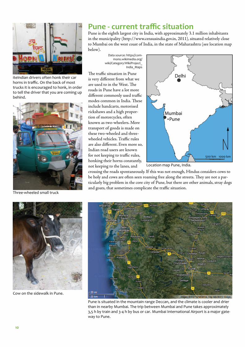
Pune - current traffi c situationPune is the eighth largest city in India, with approximately 3.1 million inhabitants in the municipality (http://www.censusindia.gov.in, 2011), situated relatively close to Mumbai on the west coast of India, in the state of Maharashtra (see location map below).
Data source: https//com-mons.wikimedia.org/
wiki/Category:WikiProject_India_Maps
Th e traffi c situation in Pune is very diff erent from what we are used to in the West. Th e roads in Pune have a lot more diff erent commonly used traffi c modes common in India. Th ese include handcarts, motorised rickshaws and a high propor-tion of motorcycles, often known as two-wheelers. More transport of goods is made on these two-wheeled and three-wheeled vehicles. Traffi c rules are also diff erent. Even more so, Indian road users are known for not keeping to traffi c rules, honking their horns constantly, not keeping to the lanes, and crossing the roads spontaneously. If this was not enough, Hindus considers cows to be holy and cows are often seen roaming free along the streets. Th ey are not a par-ticularly big problem in the core city of Pune, but there are other animals, stray dogs and goats, that sometimes complicate the traffi c situation.
iteIndian drivers often honk their car horns in traffi c. On the back of most trucks it is encouraged to honk, in order to tell the driver that you are coming up behind.
Cow on the sidewalk in Pune.
Three-wheeled small truck
Pune is situated in the mountain range Deccan, and the climate is cooler and drier than in nearby Mumbai. The trip between Mumbai and Pune takes approximately 3,5 h by train and 3-4 h by bus or car. Mumbai International Airport is a major gate-way to Pune.
Location map Pune, India.
11
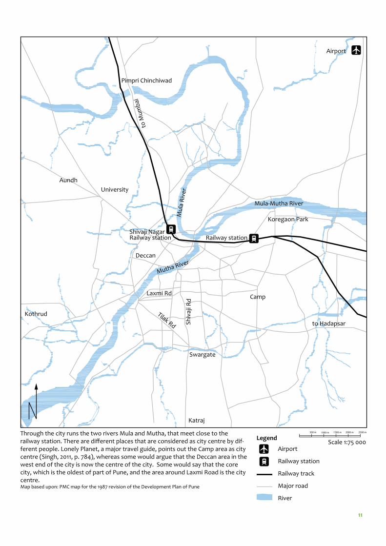
Through the city runs the two rivers Mula and Mutha, that meet close to the railway station. There are diff erent places that are considered as city centre by dif-ferent people. Lonely Planet, a major travel guide, points out the Camp area as city centre (Singh, 2011, p. 784), whereas some would argue that the Deccan area in the west end of the city is now the centre of the city. Some would say that the core city, which is the oldest of part of Pune, and the area around Laxmi Road is the city centre.Map based upon: PMC map for the 1987 revision of the Development Plan of Pune
Laxmi Rd
Sh
ivaj
i Rd
Koregaon Park
Camp
Railway station
Aundh
University
Tilak Rd
Swargate
Katraj
Deccan
Pimpri Chinchiwad
Shivaji Nagar Railway station
to Hadapsar
to M
um
bai
Airport
Mu
la R
ive
r
Mutha River
Mula-Mutha River
Kothrud
Scale 1:75 000Airport
Railway station
Railway track
Major road
River
Legend500 m 1000 m 1500 m 2000 m 2500 m
12
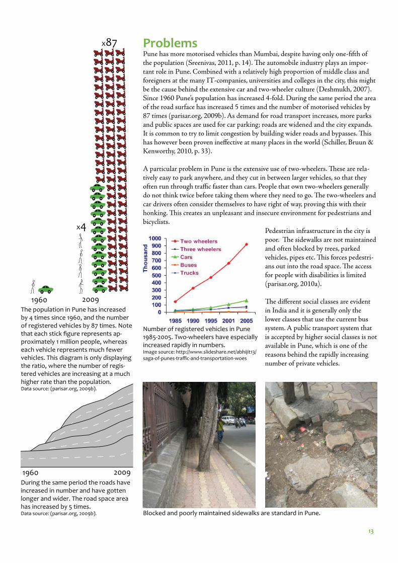
Pune was the fi rst Indian city to implement a so called Bus Rapid Transport system (BRT) in 2006 (Deshmukh, 2007). BRT is a cheaper alternative to Light Rail Tran-sit, LRT, and requires less new infrastructure to be built as it uses existing roads. Big buses are driven in dedicated bus lanes and are given right of way to improve punc-tuality and reduce travel time (Schiller, Bruun & Kenworthy, 2010, p. 315). Other important features of BRT are limited stop buses, a more frequent schedule running all day, tickets bought in advance from machines at the bus stop, lower boarding for improved accessibility, as well as improved design of bus stops. When BRT is implemented, safe pedestrian crossings, sidewalks and bicycle lanes should also be added (parisar.org, 2011). Successful examples often mentioned are the fi rst system implemented in 1974 in Curitiba, Brazil, and the more recent project in Bogotà, Colombia from 2000 (Schiller, Bruun & Kenworthy, 2010, p. 260).
Th e implementation of the BRT in Pune so far remains limited to the fi rst pilot project, between Hadapsar and Katraj, a stretch of approximately 17 km. A bad reputation in media has caused reluctance from the politicians to support and extend the project enough (parisar.org, 2011) and only about 20 BRT buses are run-ning (Depotwise statistical report, 2011). Th e project is often described as a failure, lacking many important features of a BRT system, as well as site specifi c detailed planning before implementation. For instance, instead of having low fl oored buses, the bus stops are made higher, so that boarding could be made from a platform-like construction. People however generally stand below the platform bus stop, which means the bus cannot get close enough. BRT has since been implemented in two other Indian cities; Delhi, with some major problems, and Ahmedabad where the project is described as a success (parisar.org, 2011).
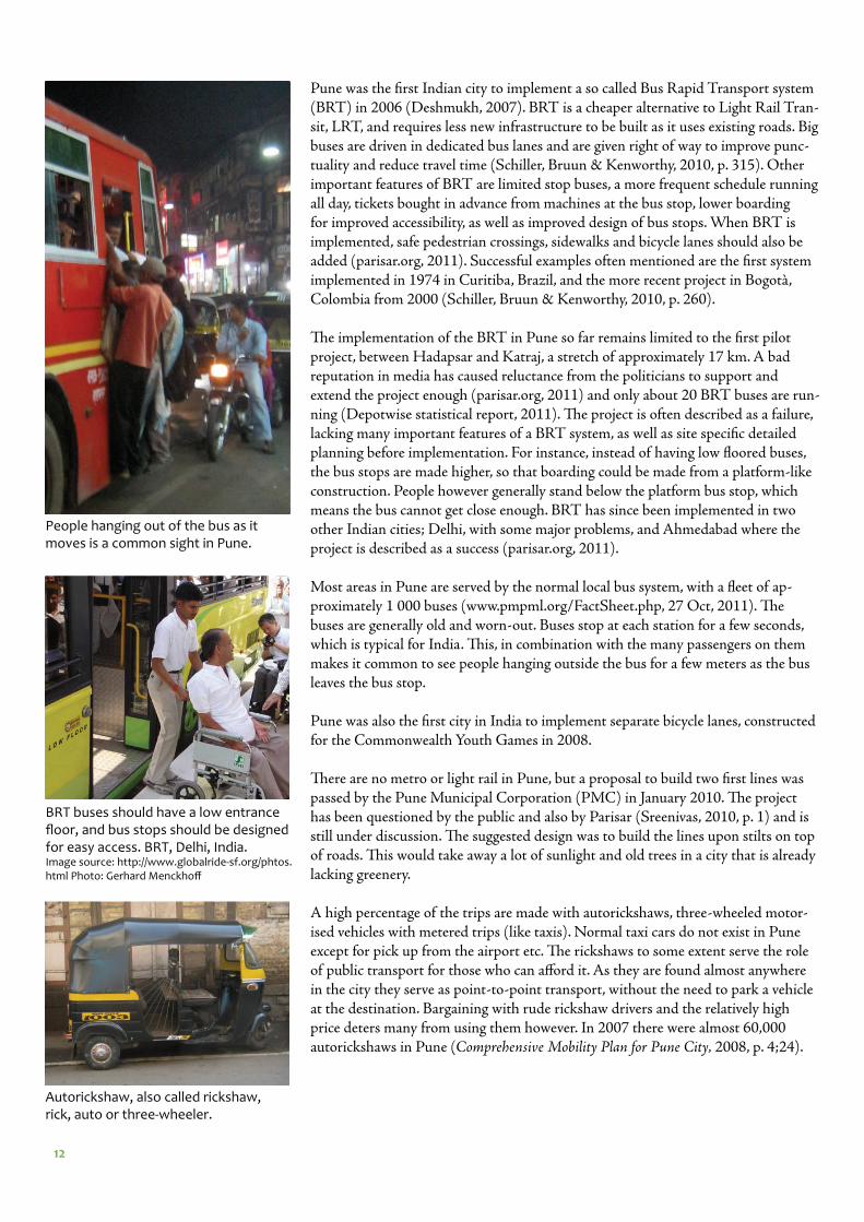
Most areas in Pune are served by the normal local bus system, with a fl eet of ap-proximately 1 000 buses (www.pmpml.org/FactSheet.php, 27 Oct, 2011). Th e buses are generally old and worn-out. Buses stop at each station for a few seconds, which is typical for India. Th is, in combination with the many passengers on them makes it common to see people hanging outside the bus for a few meters as the bus leaves the bus stop.
Pune was also the fi rst city in India to implement separate bicycle lanes, constructed for the Commonwealth Youth Games in 2008.
Th ere are no metro or light rail in Pune, but a proposal to build two fi rst lines was passed by the Pune Municipal Corporation (PMC) in January 2010. Th e project has been questioned by the public and also by Parisar (Sreenivas, 2010, p. 1) and is still under discussion. Th e suggested design was to build the lines upon stilts on top of roads. Th is would take away a lot of sunlight and old trees in a city that is already lacking greenery.
A high percentage of the trips are made with autorickshaws, three-wheeled motor-ised vehicles with metered trips (like taxis). Normal taxi cars do not exist in Pune except for pick up from the airport etc. Th e rickshaws to some extent serve the role of public transport for those who can aff ord it. As they are found almost anywhere in the city they serve as point-to-point transport, without the need to park a vehicle at the destination. Bargaining with rude rickshaw drivers and the relatively high price deters many from using them however. In 2007 there were almost 60,000 autorickshaws in Pune (Comprehensive Mobility Plan for Pune City, 2008, p. 4;24).
People hanging out of the bus as it moves is a common sight in Pune.
Autorickshaw, also called rickshaw, rick, auto or three-wheeler.
BRT buses should have a low entrance fl oor, and bus stops should be designed for easy access. BRT, Delhi, India. Image source: http://www.globalride-sf.org/phtos.html Photo: Gerhard Menckhoff
13
1960 2009
1960 2009During the same period the roads have increased in number and have gotten longer and wider. The road space area has increased by 5 times. Data source: (parisar.org, 2009b).
x87
Number of registered vehicles in Pune 1985-2005. Two-wheelers have especially increased rapidly in numbers. Image source: http://www.slideshare.net/abhijit13/saga-of-punes-traffi c-and-transportation-woes
x4
The population in Pune has increased by 4 times since 1960, and the number of registered vehicles by 87 times. Note that each stick fi gure represents ap-proximately 1 million people, whereas each vehicle represents much fewer vehicles. This diagram is only displaying the ratio, where the number of regis-tered vehicles are increasing at a much higher rate than the population. Data source: (parisar.org, 2009b).
ProblemsPune has more motorised vehicles than Mumbai, despite having only one-fi fth of the population (Sreenivas, 2011, p. 14). Th e automobile industry plays an impor-tant role in Pune. Combined with a relatively high proportion of middle class and foreigners at the many IT-companies, universities and colleges in the city, this might be the cause behind the extensive car and two-wheeler culture (Deshmukh, 2007). Since 1960 Pune’s population has increased 4-fold. During the same period the area of the road surface has increased 5 times and the number of motorised vehicles by 87 times (parisar.org, 2009b). As demand for road transport increases, more parks and public spaces are used for car parking; roads are widened and the city expands. It is common to try to limit congestion by building wider roads and bypasses. Th is has however been proven ineff ective at many places in the world (Schiller, Bruun & Kenworthy, 2010, p. 33).
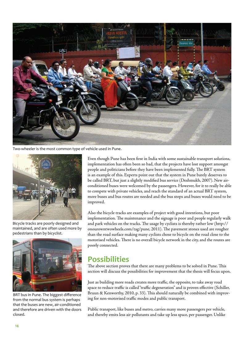
A particular problem in Pune is the extensive use of two-wheelers. Th ese are rela-tively easy to park anywhere, and they cut in between larger vehicles, so that they often run through traffi c faster than cars. People that own two-wheelers generally do not think twice before taking them where they need to go. Th e two-wheelers and car drivers often consider themselves to have right of way, proving this with their honking. Th is creates an unpleasant and insecure environment for pedestrians and bicyclists.
Pedestrian infrastructure in the city is poor. Th e sidewalks are not maintained and often blocked by trees, parked vehicles, pipes etc. Th is forces pedestri-ans out into the road space. Th e access for people with disabilities is limited (parisar.org, 2010a).
Th e diff erent social classes are evident in India and it is generally only the lower classes that use the current bus system. A public transport system that is accepted by higher social classes is not available in Pune, which is one of the reasons behind the rapidly increasing number of private vehicles.
Blocked and poorly maintained sidewalks are standard in Pune.
14
Bicycle tracks are poorly designed and maintained, and are often used more by pedestrians than by bicyclist.
Two-wheeler is the most common type of vehicle used in Pune.
BRT bus in Pune. The biggest diff erence from the normal bus system is perhaps that the buses are new, air-conditioned and therefore are driven with the doors closed.
Even though Pune has been fi rst in India with some sustainable transport solutions, implementation has often been so bad, that the projects have lost support amongst people and politicians before they have been implemented fully. Th e BRT system is an example of this. Experts point out that the system in Pune barely deserves to be called BRT, but just a slightly modifi ed bus service (Deshmukh, 2007). New air-conditioned buses were welcomed by the passengers. However, for it to really be able to compete with private vehicles, and reach the standard of an actual BRT system, more buses and bus routes are needed and the bus stops and buses would need to be improved.
Also the bicycle tracks are examples of project with good intentions, but poor implementation. Th e maintenance and the signage is poor and people regularly walk and park vehicles on the tracks. Th e usage by cyclists is thereby rather low (http://onourowntwowheels.com/tag/pune, 2011). Th e pavement stones used are rougher than the road surface making many cyclists chose to bicycle on the road close to the motorised vehicles. Th ere is no overall bicycle network in the city, and the routes are poorly connected.
Possibilities Th e above section proves that there are many problems to be solved in Pune. Th is section will discuss the possibilities for improvement that the thesis will focus upon.
Just as building more roads creates more traffi c, the opposite, to take away road space to reduce traffi c is called “traffi c degeneration” and is proven eff ective (Schiller, Bruun & Kenworthy, 2010, p. 33). Th is should naturally be combined with improv-ing for non-motorised traffi c modes and public transport.
Public transport, like buses and metro, carries many more passengers per vehicle, and thereby emits less air pollutants and take up less space, per passenger. Unlike
15
private vehicles, buses and trains do not have to be parked at the target points. Much of the urban space could then be used for city life instead of parking. To take away road space to give way to public transport is however often not welcomed by voters (Th ynell, Mohan, and Tiwari, 2010, p. 7). Politicians in many areas, afraid of losing votes, tend to focus on improvements for motorised vehicles. It is therefore impor-tant to point out, both to the people and the politicians, the many problems with motorised transport.
Most scientists in the fi eld of sustainable transport agree on that increasing the share of walking and non-motorised transport is the way to create a sustainable transport system (Lindelöw, 2009; Schiller, Bruun & Kenworthy, 2010; Th ynell, Mohan, Tiwari, 2010). Walking is important both as a mode of transport on its own, but also in combination with other modes. Most interaction and city life takes place while walking. Th e speed is relatively low, which gives the pedestrians a chance to see each other, stop, change direction, make small side trips, look around etc. (Gehl, 2010, p. 119). Small shops and cafes generally get their customers from people that walk by.
Th e poorly maintained sidewalks, the many pedestrians and the style of Indian traffi c forces pedestrians out in the roadspace. Th is creates a traffi c situation that is similar to shared space, which is a traffi c planning concept often used within sus-tainable transport and modern traffi c planning. Th e speed is kept relatively low as the roads are congested, but also because the drivers constantly need to look out for vehicles and people etc. in every direction. When planning for shared space however, it is important to make sure that a part of the street is dedicated to pedestrians, so that the street is accessible for everyone.
Compared to most Western countries, a higher percentage of the trips in India are made by walking (Th ynell, Mohan, and Tiwari, 2010, p. 3). Th ere is however, as displayed earlier, a rapid increase of the number of motorised vehicles on the streets of Pune. If the walking environment, as well as the public transport system could be improved enough, there is a possibility to get more people to choose to do most of their trips by foot or public transport, even after their private economy has im-proved. Th at, combined with getting people that already own a car or two-wheeler, to do more of their trips by non-motorised transport modes, could create a more sustainable urban transport situation.
Another important non-motorised mode of traffi c is the bicycle, especially for short trips. Pune used to be known as “the city of bicycles” (Diddee and Gupta, 2000, p. 207), but could now be called “the city of bikes” (bike in Pune and India is short for motorbike/two-wheeler rather than bicycle). Th e roadspace has now been taken over almost completely by motorised vehicles. Pune has however good potential to regain the old title, with the right bicycle friendly investments. Although situated in between mountains, the city is relatively fl at, which is an important quality for a human powered vehicle as the bicycle. Th e mountains also mean that the climate is slightly cooler than nearby Mumbai. Pune is a university city, which is an incentive for a bicycling city in many European cities, as it is a cheap form of transport. Th e bad bicycling infrastructure in the city has forced on a two-wheeler culture amongst students instead.
16
Aim Th e aim of the thesis project is to create a concept plan with help from sustainable transport principles for the whole core city area. A detailed planning proposal for the redesign of a street passage in central Pune into a pedestrian street, with quality urban spaces will also be conducted.
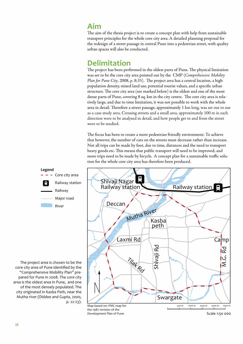
DelimitationTh e project has been performed in the oldest parts of Pune. Th e physical limitation was set to be the core city area pointed out by the CMP (Comprehensive Mobility Plan for Pune City, 2008, p. 8;35). Th e project area has a central location, a high population density, mixed land use, potential tourist values, and a specifi c urban structure. Th e core city area (see marked below) is the oldest and one of the most dense parts of Pune, covering 8 sq. km in the city centre. Th e core city area is rela-tively large, and due to time limitation, it was not possible to work with the whole area in detail. Th erefore a street passage, approximately 1 km long, was set out to use as a case study area. Crossing streets and a small area, approximately 100 m in each direction were to be analysed in detail, and how people get to and from the street were to be studied.
Th e focus has been to create a more pedestrian friendly environment. To achieve that however, the number of cars on the streets must decrease rather than increase. Not all trips can be made by foot, due to time, distances and the need to transport heavy goods etc. Th is means that public transport will need to be improved, and more trips need to be made by bicycle. A concept plan for a sustainable traffi c solu-tion for the whole core city area has therefore been produced.
Kasba peth
M.G
. Rd
Laxmi Rd
Sh
ivaj
i Rd
Camp
Railway station
Tilak Rd
Swargate
Deccan
Shivaji Nagar Railway station
Mutha River
The project area is chosen to be the core city area of Pune identifi ed by the
“Comprehensive Mobility Plan” pre-pared for Pune in 2008. The core city
area is the oldest area in Pune, and one of the most densely populated. The
city originated in Kasba Peth, near the Mutha river (Diddee and Gupta, 2000,
p. 22-23).
Scale 1:50 000
Core city area
Railway station
Railway
Major road
River
Legend
1000 m500 m 1500 m 2500 m2000 mMap based on: PMC map for the 1987 revision of the Development Plan of Pune
17
Main objectivesTh e main objectives are to:• to show how urban design can encourage people to walk more, by creating a pleas-ant walking environment• to show how sustainable transport principles can solve many traffi c problems in Pune and decrease motorised traffi c in the core city
Method Theoretical baseLiterature and scientifi c papers on traffi c and urban planning with focus on sustain-able transport and especially pedestrians have been used to provide a scientifi c back-ground for the analysis and planning proposal. Papers concerning traffi c planning in developing countries in general and India in specifi c have also been found, to give input on what issues are important to discuss and try to fi nd solutions for.
Th e relatively new book An Introduction to Sustainable Transportation: Policy, Plan-ning and Implementation by Preston Schiller, Eric Bruun and Jeff rey Kenworthy has provided a base knowledge about sustainable transport. Th e book gives an overview of the complex problems we are facing, and gives some key guidelines on how to act towards a sustainable transport system.
Much inspiration has also been taken from Jan Gehl, an architect and urban de-signer who is well known for planning public spaces, making them more pedestrian friendly. He has proved in many diff erent parts of the world that a street can become very lively “simply” by taking away all motorised traffi c and designing the outdoor space and building facades etc. with people in mind. His book Life Between Build-ings is a commonly used handbook, and in his newer book Cities for People a whole chapter is dedicated to planning in developing countries. Some of the projects he has been involved in have been studied as best practice examples.
To get an insight in the British planning ideals in India in the 19th and 20th Centu-ry a book called Patrick Geddes in India which is a collection of extracts from Patrick Geddes’ work in India between 1915-1919 (Tyrwhitt, 1947) was studied before ar-riving to Pune. None of the texts are specifi cally from Pune however. Th e book Pune - Queen of Deccan gave an overview of the urban planning history in Pune. A booklet called Pune Matters, created by Swedish students at Th e Royal Institute of Art, after a fi eld trip to Pune in 2009 was also studied, mainly to get an idea of what problems had been discussed already.
Planning conditionsA case study area has been chosen for a more detailed planning proposal within the core city area with help from representatives from Parisar and Prasanna Desai who have local knowledge. In the case study area, a detailed plan has been produced turn-ing the street segment into a pedestrian street. An overall concept plan for the whole core city area has also been developed.
Inventory methodsWhile at site, photos, sketches and notes of the observations were collected and used as a base for the planning proposal. Use of public space, road network, bus routes, parking, tourist attractions, schools and temples have been mapped.
18
Earlier plans, projects and analysis carried out in the city centre of Pune have also been studied to gain understanding of the project area. Some of the suggestions are based on things stated in the Comprehensive Mobility Plan prepared by Wilbur Smith Associates (Comprehensive Mobility Plan for Pune City, 2008) on behalf of Pune Municipal Corporation (PMC) in 2008, from which this thesis also gets its delimitation.
Key fi gures for diff erent air pollutants from diff erent types of vehicles have been col-lected and used for estimating improvements quantively. Th ere are many limitations in these kinds of measurements and confounding factors have been discussed.
Analytical methodsA traffi c count, a function analysis, a target point analysis with help from a origin-destination survey as well as a Lynch analysis have been carried out in the area. Th e analytical methods are described further in the analysis chapter starting on page 35.
Design principles Guidelines from the fi eld of sustainable transport have been used as design prin-ciples. Th is has been presented in a separate chapter called Design principles (page 49). Focus will be to plan in a human scale, with a varied and interesting environ-ment and open facades, as well as when possible, to give pedestrians right-of-way in front of motorised transport. A few examples, so called “best practice”, of pedestrian streets and limiting through traffi c in city centres have been used for inspiration and to convey an idea of how the proposal could function and look like.
19
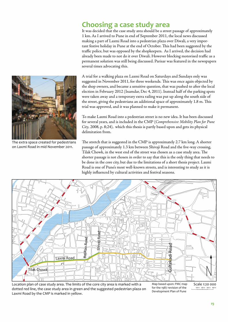
Choosing a case study areaIt was decided that the case study area should be a street passage of approximately 1 km. As I arrived to Pune in end of September 2011, the local news discussed making a part of Laxmi Road into a pedestrian plaza over Diwali, a very impor-tant festive holiday in Pune at the end of October. Th is had been suggested by the traffi c police, but was opposed by the shopkeepers. As I arrived, the decision had already been made to not do it over Diwali. However blocking motorised traffi c as a permanent solution was still being discussed. Parisar was featured in the newspapers several times advocating this.
A trial for a walking plaza on Laxmi Road on Saturdays and Sundays only was suggested in November 2011, for three weekends. Th is was once again objected by the shop owners, and became a sensitive question, that was pushed to after the local election in February 2012 (Inamdar, Dec 4, 2011). Instead half of the parking spots were taken away and a temporary extra railing was put up along the south side of the street, giving the pedestrians an additional space of approximately 1.8 m. Th is trial was approved, and it was planned to make it permanent.
To make Laxmi Road into a pedestrian street is no new idea. It has been discussed for several years, and is included in the CMP (Comprehensive Mobility Plan for Pune City, 2008, p. 8;24), which this thesis is partly based upon and gets its physical delimitation from.
Th e stretch that is suggested in the CMP is approximately 2.7 km long. A shorter passage of approximately 1.3 km between Shivaji Road and the fi ve-way crossing, Tilak Chowk, in the west end of the street was chosen as a case study area. Th e shorter passage is not chosen in order to say that this is the only thing that needs to be done in the core city, but due to the limitations of a short thesis project. Laxmi Road is one of Pune’s most well-known streets, and is interesting to study as it is highly infl uenced by cultural activities and festival seasons.
Scale 1:20 000
Laxmi Road
Sh
ivaj
i Ro
ad
Baj
iRao
Ro
ad
Gu
lte
kad
i Ro
ad
Location plan of case study area. The limits of the core city area is marked with a dotted red line, the case study area in green and the suggested pedestrian plaza on Laxmi Road by the CMP is marked in yellow.
100 m 200 m 300 m 400 m
The extra space created for pedestrians on Laxmi Road in mid November 2011.
Tilak Chowk
Map based upon: PMC map for the 1987 revision of the Development Plan of Pune
20
INVENTORY
21
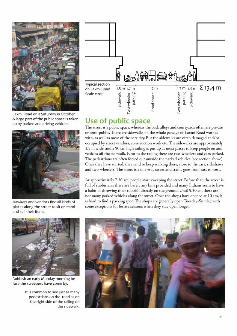
Use of public spaceTh e street is a public space, whereas the back alleys and courtyards often are private or semi-public. Th ere are sidewalks on the whole passage of Laxmi Road worked with, as well as most of the core city. But the sidewalks are often damaged and/or occupied by street vendors, construction work etc. Th e sidewalks are approximately 1,5 m wide, and a 90 cm high railing is put up at most places to keep people on and vehicles off the sidewalk. Next to the railing there are two-wheelers and cars parked. Th e pedestrians are often forced out outside the parked vehicles (see section above). Once they have started, they tend to keep walking there, close to the cars, rickshaws and two-wheelers. Th e street is a one-way street and traffi c goes from east to west.
At approximately 7.30 am, people start sweeping the street. Before that, the street is full of rubbish, as there are barely any bins provided and many Indians seem to have a habit of throwing their rubbish directly on the ground. Until 9.30 am there are not many parked vehicles along the street. Once the shops have opened at 10 am, it is hard to fi nd a parking spot. Th e shops are generally open Tuesday-Sunday with some exceptions for festive seasons when they stay open longer.
1.5 m 1.7 m 7 m 1.7 m 1.5 m
Sid
ew
alk
Two
-wh
ee
ler
par
kin
g
Ro
ad s
pac
e
Sid
ew
alk
Two
-wh
ee
ler
par
kin
g
Typical section on Laxmi RoadScale 1:200
Rubbish an early Monday morning be-fore the sweepers have come by.
Laxmi Road on a Saturday in October. A large part of the public space is taken up by parked and driving vehicles.
Hawkers and vendors fi nd all kinds of places along the street to sit or stand and sell their items.
It is common to see just as many pedestrians on the road as on the right side of the railing on
the sidewalk.
Σ 13.4 m
22
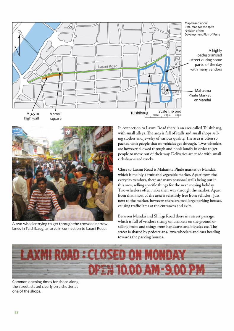
In connection to Laxmi Road there is an area called Tulshibaug, with small alleys. Th e area is full of stalls and small shops sell-ing clothes and jewelry of various quality. Th e area is often so packed with people that no vehicles get through. Two-wheelers are however allowed through and honk loudly in order to get people to move out of their way. Deliveries are made with small rickshaw-sized trucks.
Close to Laxmi Road is Mahatma Phule market or Mandai, which is mainly a fruit and vegetable market. Apart from the everyday vendors, there are many seasonal stalls being put in this area, selling specifi c things for the next coming holiday. Two-wheelers often make their way through the market. Apart from that, most of the area is relatively free from vehicles. Just next to the market, however, there are two large parking houses, causing traffi c jams at the entrances and exits. Between Mandai and Shivaji Road there is a street passage, which is full of vendors sitting on blankets on the ground or selling fruits and things from handcarts and bicycles etc. Th e street is shared by pedestrians, two-wheelers and cars heading towards the parking houses.
Scale 1:10 000Tulshibaug
Mahatma Phule Market
or Mandai
A highly pedestrianised
street during some parts of the day
with many vendors
A 3.5 m high wall
A small square
Laxmi Road
Sh
ivaj
i Ro
ad
A two-wheeler trying to get through the crowded narrow lanes in Tulshibaug, an area in connection to Laxmi Road.
Common opening times for shops along the street, stated clearly on a shutter at one of the shops.
Map based upon: PMC map for the 1987 revision of the Development Plan of Pune
100 m 200 m 300 m
23
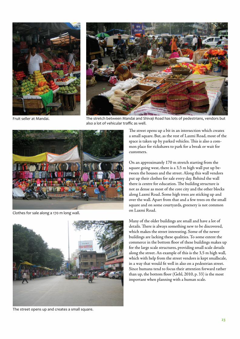
Th e street opens up a bit in an intersection which creates a small square. But, as the rest of Laxmi Road, most of the space is taken up by parked vehicles. Th is is also a com-mon place for rickshaws to park for a break or wait for customers.
On an approximately 170 m stretch starting from the square going west, there is a 3,5 m high wall put up be-tween the houses and the street. Along this wall vendors put up their clothes for sale every day. Behind the wall there is centre for education. Th e building structure is not as dense as most of the core city and the other blocks along Laxmi Road. Some high trees are sticking up and over the wall. Apart from that and a few trees on the small square and on some courtyards, greenery is not common on Laxmi Road.
Many of the older buildings are small and have a lot of details. Th ere is always something new to be discovered, which makes the street interesting. Some of the newer buildings are lacking these qualities. To some extent the commerce in the bottom fl oor of these buildings makes up for the large scale structures, providing small scale details along the street. An example of this is the 3,5 m high wall, which with help from the street vendors is kept smallscale, in a way that would fi t well in also on a pedestrian street. Since humans tend to focus their attention forward rather than up, the bottom fl oor (Gehl, 2010, p. 33) is the most important when planning with a human scale.
Fruit seller at Mandai. The stretch between Mandai and Shivaji Road has lots of pedestrians, vendors but also a lot of vehicular traffi c as well.
Clothes for sale along a 170 m long wall.
The street opens up and creates a small square.
24
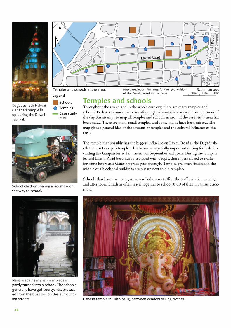
Temples and schoolsTh roughout the street, and in the whole core city, there are many temples and schools. Pedestrian movements are often high around these areas on certain times of the day. An attempt to map all temples and schools in around the case study area has been made. Th ere are many small temples, and some might have been missed. Th e map gives a general idea of the amount of temples and the cultural infl uence of the area.
Th e temple that possibly has the biggest infl uence on Laxmi Road is the Dagadush-eth Halwai Ganapati temple. Th is becomes especially important during festivals, in-cluding the Ganpati festival in the end of September each year. During the Ganpati festival Laxmi Road becomes so crowded with people, that it gets closed to traffi c for some hours as a Ganesh parade goes through. Temples are often situated in the middle of a block and buildings are put up next to old temples.
Schools that have the main gate towards the street aff ect the traffi c in the morning and afternoon. Children often travel together to school, 6-10 of them in an autorick-shaw.
Legend
Scale 1:10 000
Laxmi Road
Sh
ivaj
i Ro
ad
Dagadusheth Halwai Ganapati temple lit up during the Diwali festival.
School children sharing a rickshaw on the way to school.
Ganesh temple in Tulshibaug, between vendors selling clothes.
Schools
Temples
Case study area
Nana wada near Shaniwar wada is partly turned into a school. The schools generally have got courtyards, protect-ed from the buzz out on the surround-ing streets.
Map based upon: PMC map for the 1987 revision of the Development Plan of Pune.
Temples and schools in the area.100 m 200 m 300 m
25
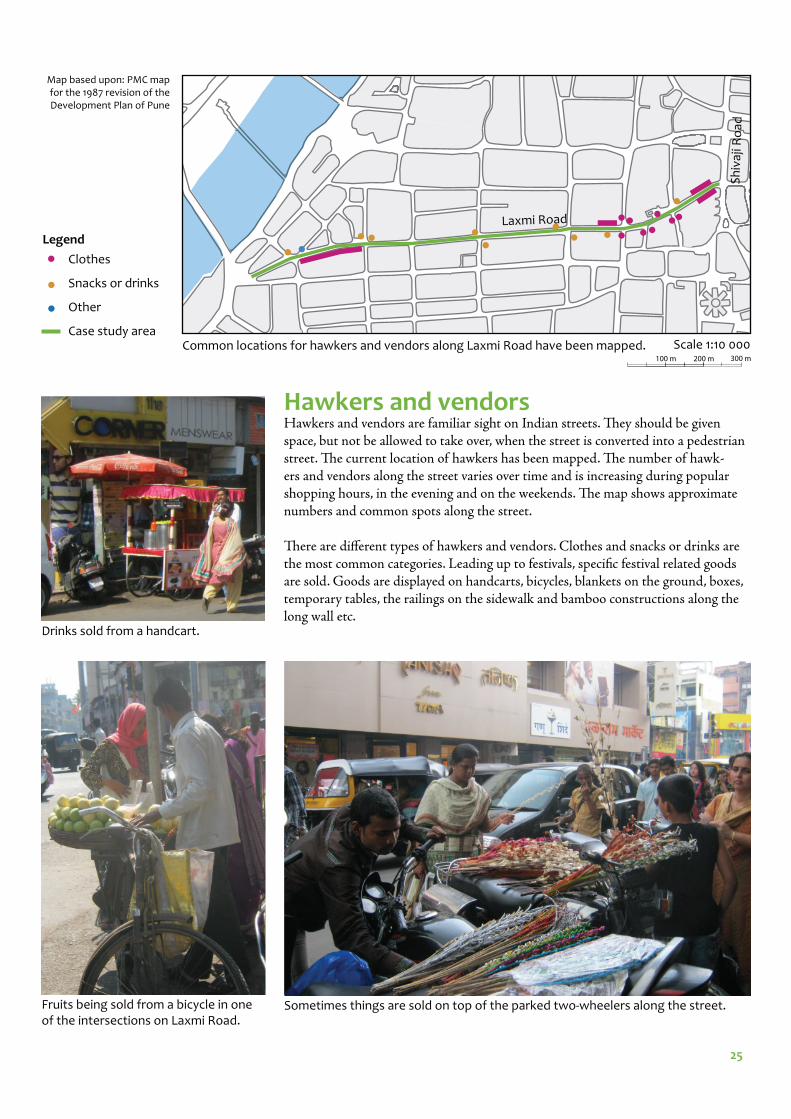
Hawkers and vendorsHawkers and vendors are familiar sight on Indian streets. Th ey should be given space, but not be allowed to take over, when the street is converted into a pedestrian street. Th e current location of hawkers has been mapped. Th e number of hawk-ers and vendors along the street varies over time and is increasing during popular shopping hours, in the evening and on the weekends. Th e map shows approximate numbers and common spots along the street.
Th ere are diff erent types of hawkers and vendors. Clothes and snacks or drinks are the most common categories. Leading up to festivals, specifi c festival related goods are sold. Goods are displayed on handcarts, bicycles, blankets on the ground, boxes, temporary tables, the railings on the sidewalk and bamboo constructions along the long wall etc.
Clothes
Snacks or drinks
Other
Case study area
Legend
Fruits being sold from a bicycle in one of the intersections on Laxmi Road.
Drinks sold from a handcart.
Sometimes things are sold on top of the parked two-wheelers along the street.
Scale 1:10 000
Map based upon: PMC map for the 1987 revision of the Development Plan of Pune
Laxmi Road
Sh
ivaj
i Ro
ad
Common locations for hawkers and vendors along Laxmi Road have been mapped.100 m 200 m 300 m
26
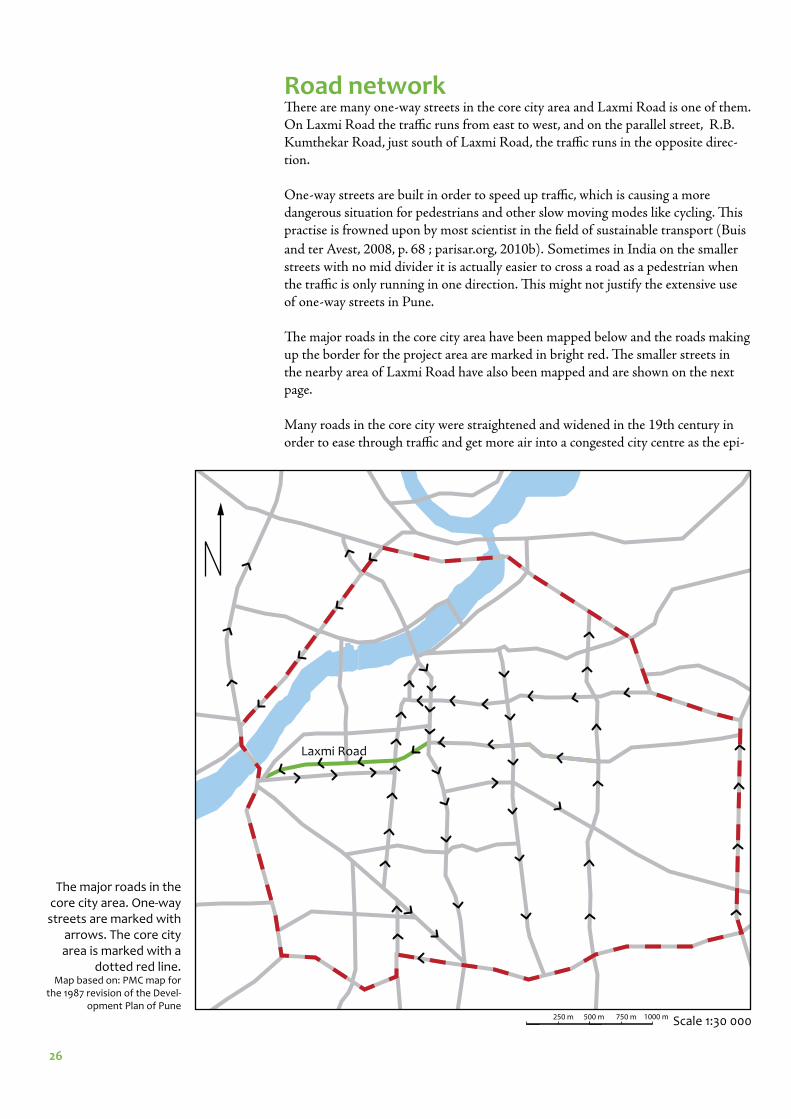
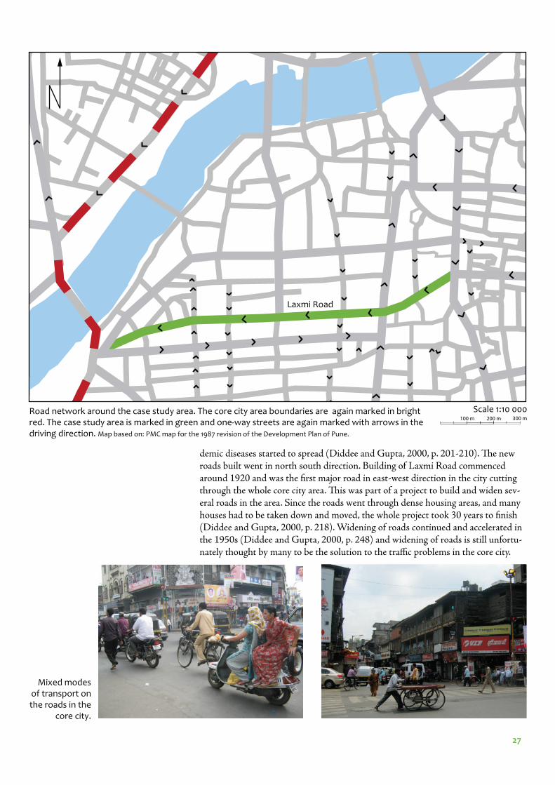
Road networkTh ere are many one-way streets in the core city area and Laxmi Road is one of them. On Laxmi Road the traffi c runs from east to west, and on the parallel street, R.B. Kumthekar Road, just south of Laxmi Road, the traffi c runs in the opposite direc-tion.
One-way streets are built in order to speed up traffi c, which is causing a more dangerous situation for pedestrians and other slow moving modes like cycling. Th is practise is frowned upon by most scientist in the fi eld of sustainable transport (Buis
and ter Avest, 2008, p. 68 ; parisar.org, 2010b). Sometimes in India on the smaller streets with no mid divider it is actually easier to cross a road as a pedestrian when the traffi c is only running in one direction. Th is might not justify the extensive use of one-way streets in Pune.
Th e major roads in the core city area have been mapped below and the roads making up the border for the project area are marked in bright red. Th e smaller streets in the nearby area of Laxmi Road have also been mapped and are shown on the next page.
Many roads in the core city were straightened and widened in the 19th century in order to ease through traffi c and get more air into a congested city centre as the epi-
Scale 1:30 000
The major roads in the core city area. One-way streets are marked with
arrows. The core city area is marked with a
dotted red line.Map based on: PMC map for
the 1987 revision of the Devel-opment Plan of Pune
Laxmi Road
250 m 500 m 750 m 1000 m
27
Scale 1:10 000
demic diseases started to spread (Diddee and Gupta, 2000, p. 201-210). Th e new roads built went in north south direction. Building of Laxmi Road commenced around 1920 and was the fi rst major road in east-west direction in the city cutting through the whole core city area. Th is was part of a project to build and widen sev-eral roads in the area. Since the roads went through dense housing areas, and many houses had to be taken down and moved, the whole project took 30 years to fi nish (Diddee and Gupta, 2000, p. 218). Widening of roads continued and accelerated in the 1950s (Diddee and Gupta, 2000, p. 248) and widening of roads is still unfortu-nately thought by many to be the solution to the traffi c problems in the core city.
Road network around the case study area. The core city area boundaries are again marked in bright red. The case study area is marked in green and one-way streets are again marked with arrows in the driving direction. Map based on: PMC map for the 1987 revision of the Development Plan of Pune.
Laxmi Road
Mixed modes of transport on the roads in the
core city.
100 m 200 m 300 m
28
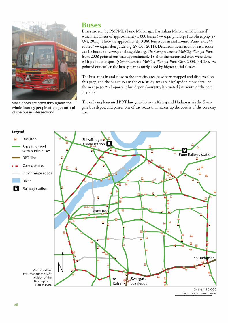
BusesBuses are run by PMPML (Pune Mahanagar Parivahan Mahamandal Limited) which has a fl eet of approximately 1 000 buses (www.pmpml.org/FactSheet.php, 27 Oct, 2011). Th ere are approximately 3 380 bus stops in and around Pune and 344 routes (www.punebusguide.org, 27 Oct, 2011). Detailed information of each route can be found on www.punebusguide.org. Th e Comprehensive Mobility Plan for Pune from 2008 pointed out that approximately 18 % of the motorised trips were done with public transport (Comprehensive Mobility Plan for Pune City, 2008, p. 4:28). As pointed out earlier, the bus system is rarely used by higher social classes.
Th e bus stops in and close to the core city area have been mapped and displayed on this page, and the bus routes in the case study area are displayed in more detail on the next page. An important bus depot, Swargate, is situated just south of the core city area.
Th e only implemented BRT line goes between Katraj and Hadapsar via the Swar-gate bus depot, and passes one of the roads that makes up the border of the core city area.
Swargate bus depot
Laxmi Road
Scale 1:30 000
Pune Railway station
Legend
Shivaji nagar Railway station
Bus stop
Streets served with public buses
BRT- line
Core city area
Other major roads
River
Railway station
Since doors are open throughout the whole journey people often get on and of the bus in intersections.
to Hadapsar
to Katraj
Map based on: PMC map for the 1987
revision of the Development
Plan of Pune
250 m 500 m 750 m 1000 m

29
Scale 1:10 000
Laxmi Road
R.B. Kumthekar Road
Sh
ivaj
i Ro
ad
Th ere are at least 13 bus routes that run on this section of Laxmi Road, which will need to be rerouted when the street is pedestrianised. A scheme of the bus routes that go around the case study area is displayed above.
Baj
iRao
Ro
ad
A local Pune bus on Shivaji Road.
Kelkar Road
Scheme of bus routes in the case study area, where each route is represented by a thin colored line. Because of the one-way streets, the buses that run on Laxmi Road, run on the parallel road, R.B.
Kumthekar Road, on the return journey. Some routes turn left on to Laxmi Road from BajiRao Road. There are also more than 10 bus routes that go north on BajiRao Road, which crosses Laxmi Road. These routes runs on Shivaji Road in the other direction.
Map based on: PMC map for the 1987 revision of the
Development Plan of Pune
100 m 200 m 300 m
30
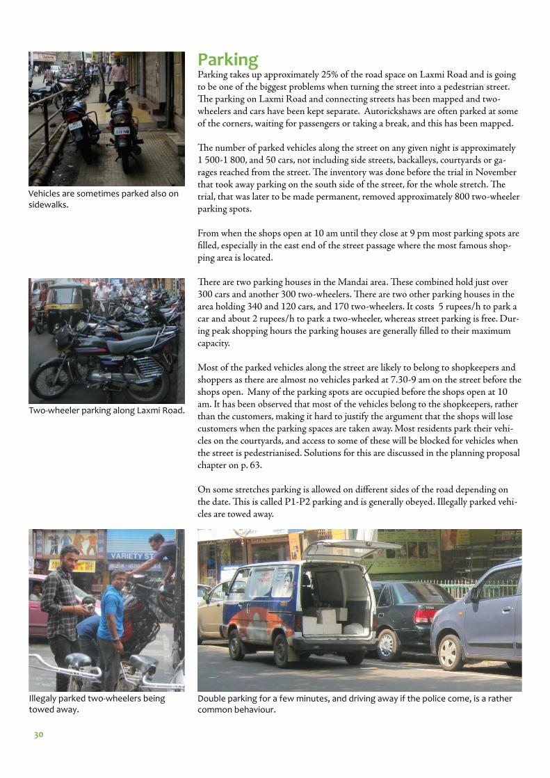
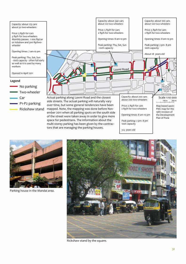
ParkingParking takes up approximately 25% of the road space on Laxmi Road and is going to be one of the biggest problems when turning the street into a pedestrian street. Th e parking on Laxmi Road and connecting streets has been mapped and two-wheelers and cars have been kept separate. Autorickshaws are often parked at some of the corners, waiting for passengers or taking a break, and this has been mapped.
Th e number of parked vehicles along the street on any given night is approximately 1 500-1 800, and 50 cars, not including side streets, backalleys, courtyards or ga-rages reached from the street. Th e inventory was done before the trial in November that took away parking on the south side of the street, for the whole stretch. Th e trial, that was later to be made permanent, removed approximately 800 two-wheeler parking spots.
From when the shops open at 10 am until they close at 9 pm most parking spots are fi lled, especially in the east end of the street passage where the most famous shop-ping area is located.
Th ere are two parking houses in the Mandai area. Th ese combined hold just over 300 cars and another 300 two-wheelers. Th ere are two other parking houses in the area holding 340 and 120 cars, and 170 two-wheelers. It costs 5 rupees/h to park a car and about 2 rupees/h to park a two-wheeler, whereas street parking is free. Dur-ing peak shopping hours the parking houses are generally fi lled to their maximum capacity.
Most of the parked vehicles along the street are likely to belong to shopkeepers and shoppers as there are almost no vehicles parked at 7.30-9 am on the street before the shops open. Many of the parking spots are occupied before the shops open at 10 am. It has been observed that most of the vehicles belong to the shopkeepers, rather than the customers, making it hard to justify the argument that the shops will lose customers when the parking spaces are taken away. Most residents park their vehi-cles on the courtyards, and access to some of these will be blocked for vehicles when the street is pedestrianised. Solutions for this are discussed in the planning proposal chapter on p. 63.
On some stretches parking is allowed on diff erent sides of the road depending on the date. Th is is called P1-P2 parking and is generally obeyed. Illegally parked vehi-cles are towed away.
Vehicles are sometimes parked also on sidewalks.
Two-wheeler parking along Laxmi Road.
Illegaly parked two-wheelers being towed away.
Double parking for a few minutes, and driving away if the police come, is a rather common behaviour.
31
Parking house in the Mandai area.
Actual parking along Laxmi Road and the closest side streets. The actual parking will naturally vary over time, but some general tendencies have been mapped. Note, the mapping was done before Nov-ember 2011 when all parking spots on the south side of the street were taken away in order to give more space for pedestrians. The information about the multi storey parking has been given by the contrac-tors that are managing the parking houses.
No parking
Two-wheeler
Car
P1-P2 parking
Rickshaw stand
Scale 1:10 000
Capacity: about 100 carsabout 100 two-wheelers
Price: 5 Rp/h for cars2 Rp/h for two-wheelers
Opening times: 8 am-10 pm
Peak parking: 2 pm- 8 pm 100% capacity
About 18 years old
Capacity: about 200 carsabout 200 two-wheelers
Price: 5 Rp/h for cars2 Rp/h for two-wheelers
Opening times: 8 am-10 pm
Peak parking: 2 pm- 8 pm 100% capacity
3-4 years old
Capacity: about 340 carsabout 120 two-wheelers
Price: 5 Rp/h for cars2 Rp/h for two-wheelers
Opening times: 8 am-10 pm
Peak parking: Thu, Sat, Sun - 100% capacity
Capacity: about 175 carsabout 50 two-wheelers
Price: 5 Rp/h for cars3 Rp/h for two-wheelersMonthly passes: 1 000 Rp/car or rickshaw and 300 Rp/two-wheeler
Opening times: 7 am-10 pm
Peak parking: Thu, Sat, Sun - 100% capacity - often full early as well as it is used by many workers
Opened in April 2011
Legend
Map based upon: PMC map for the 1987 revision of the Development Plan of Pune
Rickshaw stand by the square.
Laxmi Road
100 m 200 m
32
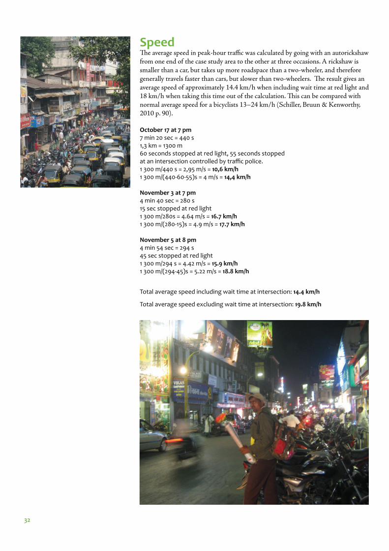
SpeedTh e average speed in peak-hour traffi c was calculated by going with an autorickshaw from one end of the case study area to the other at three occasions. A rickshaw is smaller than a car, but takes up more roadspace than a two-wheeler, and therefore generally travels faster than cars, but slower than two-wheelers. Th e result gives an average speed of approximately 14.4 km/h when including wait time at red light and 18 km/h when taking this time out of the calculation. Th is can be compared with normal average speed for a bicyclists 13–24 km/h (Schiller, Bruun & Kenworthy, 2010 p. 90).
October 17 at 7 pm 7 min 20 sec = 440 s 1,3 km = 1300 m60 seconds stopped at red light, 55 seconds stopped at an intersection controlled by traffi c police. 1 300 m/440 s = 2,95 m/s = 10,6 km/h1 300 m/(440-60-55)s = 4 m/s = 14,4 km/h
November 3 at 7 pm 4 min 40 sec = 280 s 15 sec stopped at red light1 300 m/280s = 4.64 m/s = 16.7 km/h1 300 m/(280-15)s = 4.9 m/s = 17.7 km/h
November 5 at 8 pm4 min 54 sec = 294 s45 sec stopped at red light1 300 m/294 s = 4.42 m/s = 15.9 km/h1 300 m/(294-45)s = 5.22 m/s = 18.8 km/h
Total average speed including wait time at intersection: 14.4 km/h
Total average speed excluding wait time at intersection: 19.8 km/h
33
Scale: 1:20 000
1. Shaniwar Wada2. Tulshibaug3. Mahatma Phule Market/Mandai4. Vishrambaug Wada5. Dagadusheth Halwai Ganapati Temple6. Laxmi Road7. Kelkar Museum8. Kesari Wada
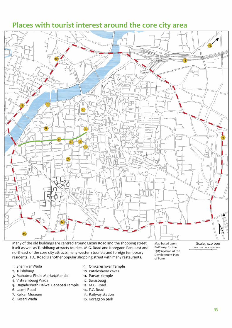
Places with tourist interest around the core city area
9. Omkareshwar Temple10. Pataleshwar caves11. Parvati temple12. Sarasbaug13. M.G. Road14. F.C. Road15. Railway station16. Koregaon park
Many of the old buildings are centred around Laxmi Road and the shopping street itself as well as Tulshibaug attracts tourists. M.G. Road and Koregaon Park east and northeast of the core city attracts many western tourists and foreign temporary residents. F.C. Road is another popular shopping street with many restaurants.
Map based upon: PMC map for the 1987 revision of the Development Plan of Pune
1.
2.4.
7.
14.
11.
12.
8.
9.
5.
3.
16.
13.
15.10.
6.
100 m 200 m 300 m 400 m 500 m
34
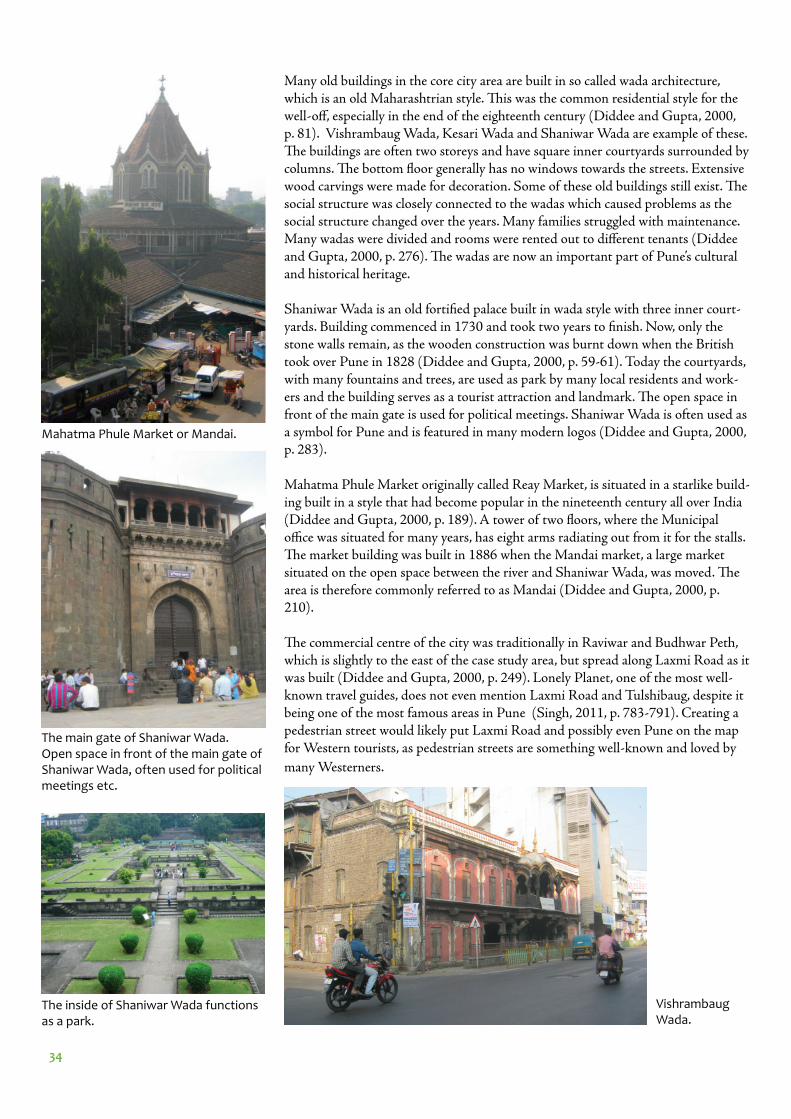
Many old buildings in the core city area are built in so called wada architecture, which is an old Maharashtrian style. Th is was the common residential style for the well-off , especially in the end of the eighteenth century (Diddee and Gupta, 2000, p. 81). Vishrambaug Wada, Kesari Wada and Shaniwar Wada are example of these. Th e buildings are often two storeys and have square inner courtyards surrounded by columns. Th e bottom fl oor generally has no windows towards the streets. Extensive wood carvings were made for decoration. Some of these old buildings still exist. Th e social structure was closely connected to the wadas which caused problems as the social structure changed over the years. Many families struggled with maintenance. Many wadas were divided and rooms were rented out to diff erent tenants (Diddee and Gupta, 2000, p. 276). Th e wadas are now an important part of Pune’s cultural and historical heritage.
Shaniwar Wada is an old fortifi ed palace built in wada style with three inner court-yards. Building commenced in 1730 and took two years to fi nish. Now, only the stone walls remain, as the wooden construction was burnt down when the British took over Pune in 1828 (Diddee and Gupta, 2000, p. 59-61). Today the courtyards, with many fountains and trees, are used as park by many local residents and work-ers and the building serves as a tourist attraction and landmark. Th e open space in front of the main gate is used for political meetings. Shaniwar Wada is often used as a symbol for Pune and is featured in many modern logos (Diddee and Gupta, 2000, p. 283).
Mahatma Phule Market originally called Reay Market, is situated in a starlike build-ing built in a style that had become popular in the nineteenth century all over India (Diddee and Gupta, 2000, p. 189). A tower of two fl oors, where the Municipal offi ce was situated for many years, has eight arms radiating out from it for the stalls. Th e market building was built in 1886 when the Mandai market, a large market situated on the open space between the river and Shaniwar Wada, was moved. Th e area is therefore commonly referred to as Mandai (Diddee and Gupta, 2000, p. 210).
Th e commercial centre of the city was traditionally in Raviwar and Budhwar Peth, which is slightly to the east of the case study area, but spread along Laxmi Road as it was built (Diddee and Gupta, 2000, p. 249). Lonely Planet, one of the most well-known travel guides, does not even mention Laxmi Road and Tulshibaug, despite it being one of the most famous areas in Pune (Singh, 2011, p. 783-791). Creating a pedestrian street would likely put Laxmi Road and possibly even Pune on the map for Western tourists, as pedestrian streets are something well-known and loved by
many Westerners.
Mahatma Phule Market or Mandai.
Vishrambaug Wada.
The main gate of Shaniwar Wada. Open space in front of the main gate of Shaniwar Wada, often used for political meetings etc.
The inside of Shaniwar Wada functions as a park.
35
ANALYSIS
36
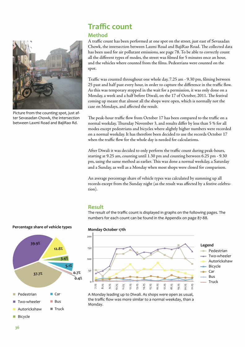
Traffi c count MethodA traffi c count has been performed at one spot on the street, just east of Sevasadan Chowk, the intersection between Laxmi Road and BajiRao Road. Th e collected data has been used for air pollutant emissions, see page 78. To be able to correctly count all the diff erent types of modes, the street was fi lmed for 5 minutes once an hour, and the vehicles where counted from the fi lms. Pedestrians were counted on the spot.
Traffi c was counted throughout one whole day, 7.25 am - 9.30 pm, fi lming between 25 past and half past every hour, in order to capture the diff erence in the traffi c fl ow. As this was temporary stopped in the wait for a permission, it was only done on a Monday, a week and a half before Diwali, on the 17 of October, 2011. Th e festival coming up meant that almost all the shops were open, which is normally not the case on Mondays, and aff ected the result.
Th e peak-hour traffi c fl ow from October 17 has been compared to the traffi c on a normal weekday, Th ursday November 3, and results diff er by less than 5 % for all modes except pedestrians and bicycles where slightly higher numbers were recorded on a normal weekday. It has therefore been decided to use the records October 17 when the traffi c fl ow for the whole day is needed for calculations.
After Diwali it was decided to only perform the traffi c count during peak-hours, starting at 9.25 am, counting until 1.30 pm and counting between 6.25 pm - 9.30 pm, using the same method as earlier. Th is was done a normal weekday, a Saturday
and a Sunday, as well as a Monday when most shops were closed for comparison.
An average percentage share of vehicle types was calculated by summing up all records except from the Sunday night (as the result was aff ected by a festive celebra-tion).
200
150
100
50
0
9.2
5
8.2
5
7.25
14.2
5
15.2
5
16.2
5
17.2
5
10.2
5
11.2
5
12.2
5
13.2
5
18.2
5
19.2
5
20.2
5
21.2
5
Monday October 17th
Picture from the counting spot, just af-ter Sevasadan Chowk, the intersection between Laxmi Road and BajiRao Rd.
ResultThe result of the traffi c count is displayed in graphs on the following pages. The
numbers for each count can be found in the Appendix on page 87-88.
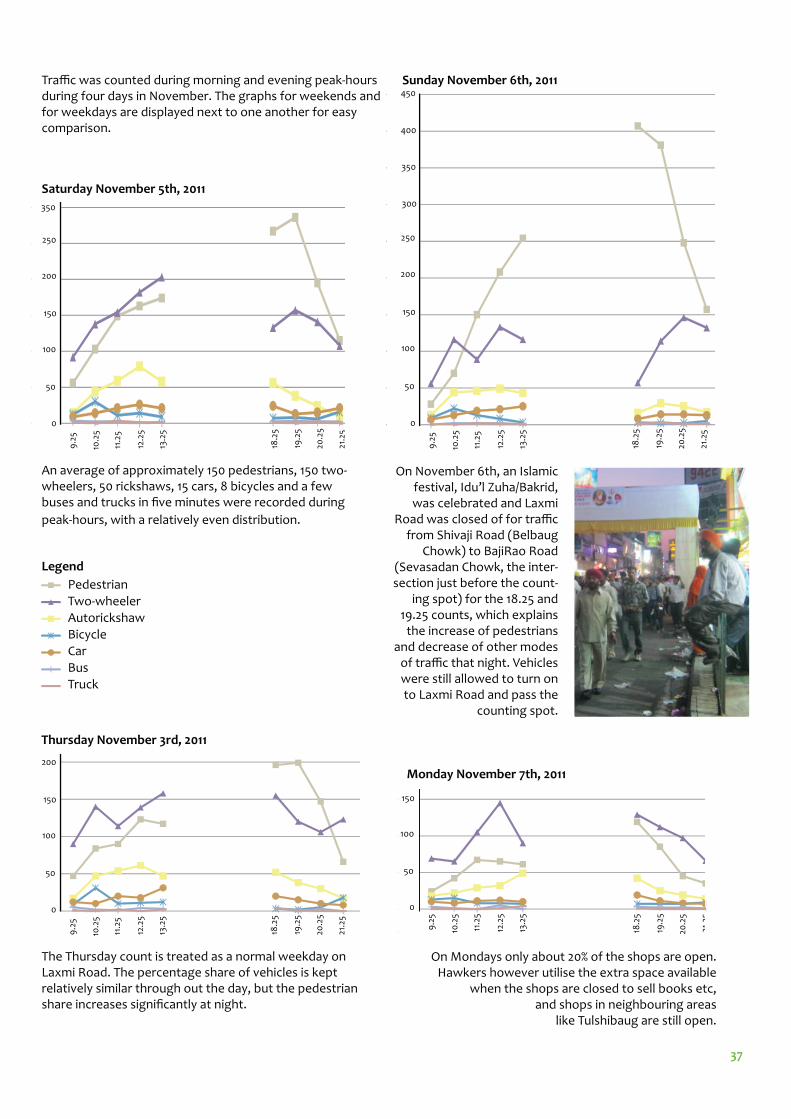
0.4%37.7%
39.9%
12.8%
3.4%
5.1%
0.7%
Pedestrian
Two-wheeler
Autorickshaw
Bicycle
Percentage share of vehicle types
Car
Bus
Truck
A Monday leading up to Diwali. As shops were open as usual, the traffi c fl ow was more similar to a normal weekday, than a Monday.
Pedestrian
Two-wheeler
Autorickshaw
Bicycle
Car
Bus
Truck
Legend
37
Pedestrian
Two-wheeler
Autorickshaw
Bicycle
Car
Bus
Truck
Legend
250
350
200
150
100
50
0
9.2
5
10.2
5
11.2
5
12.2
5
13.2
5
18.2
5
19.2
5
20.2
5
21.2
5
200
150
100
50
0
9.2
5
10.2
5
11.2
5
12.2
5
13.2
5
18.2
5
19.2
5
20.2
5
21.2
5
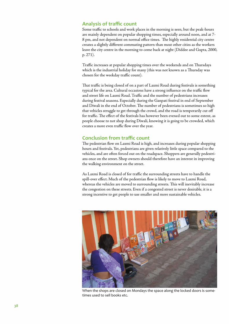
Thursday November 3rd, 2011
Saturday November 5th, 2011
250
200
150
100
50
09
.25
10.2
5
11.2
5
12.2
5
13.2
5
18.2
5
19.2
5
20.2
5
21.2
5
300
350
400
450
Sunday November 6th, 2011
150
100
50
0
9.2
5
10.2
5
11.2
5
12.2
5
13.2
5
18.2
5
19.2
5
20.2
5
2125
Monday November 7th, 2011
On Mondays only about 20% of the shops are open. Hawkers however utilise the extra space available
when the shops are closed to sell books etc, and shops in neighbouring areas
like Tulshibaug are still open.
On November 6th, an Islamic festival, Idu’l Zuha/Bakrid, was celebrated and Laxmi
Road was closed of for traffi c from Shivaji Road (Belbaug
Chowk) to BajiRao Road (Sevasadan Chowk, the inter-section just before the count-
ing spot) for the 18.25 and 19.25 counts, which explains
the increase of pedestrians and decrease of other modes
of traffi c that night. Vehicles were still allowed to turn on to Laxmi Road and pass the
counting spot.
Traffi c was counted during morning and evening peak-hours during four days in November. The graphs for weekends and for weekdays are displayed next to one another for easy comparison.
An average of approximately 150 pedestrians, 150 two-wheelers, 50 rickshaws, 15 cars, 8 bicycles and a few buses and trucks in fi ve minutes were recorded during
peak-hours, with a relatively even distribution.
The Thursday count is treated as a normal weekday on Laxmi Road. The percentage share of vehicles is kept relatively similar through out the day, but the pedestrian share increases signifi cantly at night.
38
Analysis of traffi c countSome traffi c to schools and work places in the morning is seen, but the peak-hours are mainly dependent on popular shopping times, especially around noon, and at 7-8 pm, and not dependent on normal offi ce times. Th e highly residential city centre creates a slightly diff erent commuting pattern than most other cities as the workers leave the city centre in the morning to come back at night (Diddee and Gupta, 2000, p. 271).
Traffi c increases at popular shopping times over the weekends and on Th ursdays which is the industrial holiday for many (this was not known as a Th ursday was chosen for the weekday traffi c count).
Th at traffi c is being closed of on a part of Laxmi Road during festivals is something typical for the area. Cultural occasions have a strong infl uence on the traffi c fl ow and street life on Laxmi Road. Traffi c and the number of pedestrians increases during festival seasons. Especially during the Ganpati festival in end of September and Diwali in the end of October. Th e number of pedestrians is sometimes so high that vehicles struggle to get through the crowd, and the road is temporarily cut off for traffi c. Th e eff ect of the festivals has however been evened out to some extent, as people choose to not shop during Diwali, knowing it is going to be crowded, which creates a more even traffi c fl ow over the year.
Conclusion from traffi c countTh e pedestrian fl ow on Laxmi Road is high, and increases during popular shopping hours and festivals. Yet, pedestrians are given relatively little space compared to the vehicles, and are often forced out on the roadspace. Shoppers are generally pedestri-ans once on the street. Shop owners should therefore have an interest in improving the walking environment on the street.
As Laxmi Road is closed of for traffi c the surrounding streets have to handle the spill-over eff ect. Much of the pedestrian fl ow is likely to move to Laxmi Road, whereas the vehicles are moved to surrounding streets. Th is will inevitably increase the congestion on these streets. Even if a congested street is never desirable, it is a strong incentive to get people to use smaller and more sustainable vehicles.
When the shops are closed on Mondays the space along the locked doors is some-times used to sell books etc.
39
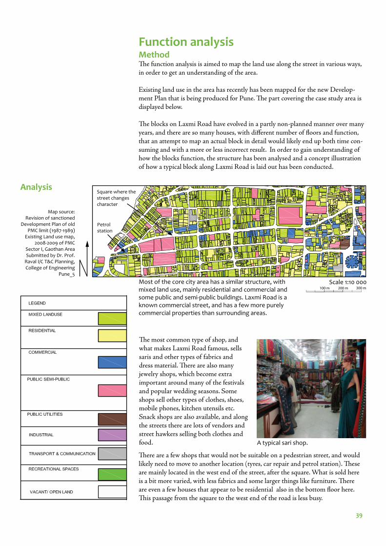
Function analysisMethod Th e function analysis is aimed to map the land use along the street in various ways, in order to get an understanding of the area.
Existing land use in the area has recently has been mapped for the new Develop-ment Plan that is being produced for Pune. Th e part covering the case study area is displayed below.
Th e blocks on Laxmi Road have evolved in a partly non-planned manner over many years, and there are so many houses, with diff erent number of fl oors and function, that an attempt to map an actual block in detail would likely end up both time con-suming and with a more or less incorrect result. In order to gain understanding of how the blocks function, the structure has been analysed and a concept illustration of how a typical block along Laxmi Road is laid out has been conducted.
Scale 1:10 000
Map source: Revision of sanctioned
Development Plan of old PMC limit (1987-1989)
Existing Land use map, 2008-2009 of PMC
Sector I, Gaothan AreaSubmitted by Dr. Prof.
Raval I/C T&C Planning, College of Engineering
Pune_5
Analysis
A typical sari shop.
Th e most common type of shop, and what makes Laxmi Road famous, sells saris and other types of fabrics and dress material. Th ere are also many jewelry shops, which become extra important around many of the festivals and popular wedding seasons. Some shops sell other types of clothes, shoes, mobile phones, kitchen utensils etc. Snack shops are also available, and along the streets there are lots of vendors and street hawkers selling both clothes and food.
Th ere are a few shops that would not be suitable on a pedestrian street, and would likely need to move to another location (tyres, car repair and petrol station). Th ese are mainly located in the west end of the street, after the square. What is sold here is a bit more varied, with less fabrics and some larger things like furniture. Th ere are even a few houses that appear to be residential also in the bottom fl oor here. Th is passage from the square to the west end of the road is less busy.
Most of the core city area has a similar structure, with mixed land use, mainly residential and commercial and some public and semi-public buildings. Laxmi Road is a known commercial street, and has a few more purely commercial properties than surrounding areas.
Petrol station
Square where the street changes character
100 m 200 m 300 m
40
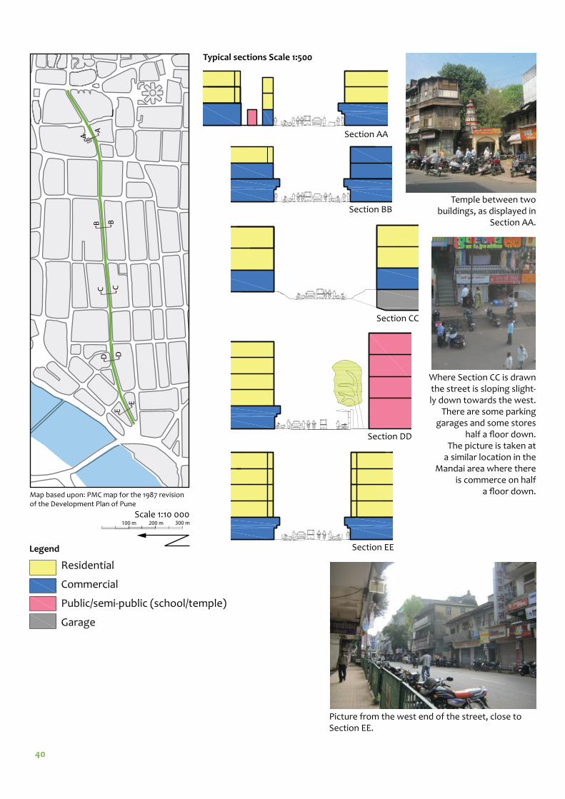
Section AA
Section BB
Section CC
Section DD
Section EELegend
Scale 1:10 000
Residential
Commercial
Public/semi-public (school/temple)
Garage
Temple between two buildings, as displayed in
Section AA.
Map based upon: PMC map for the 1987 revision of the Development Plan of Pune
Where Section CC is drawn the street is sloping slight-ly down towards the west.
There are some parking garages and some stores
half a fl oor down.The picture is taken at
a similar location in the Mandai area where there
is commerce on half a fl oor down.
Typical sections Scale 1:500
Picture from the west end of the street, close to Section EE.
E
E
D
CCB B
A
A
D
??
100 m 200 m 300 m
41
2nd fl oor
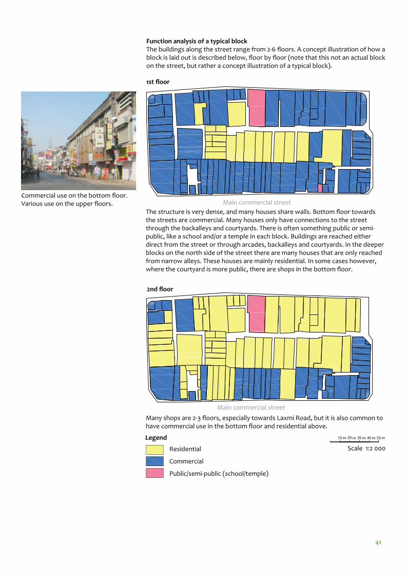
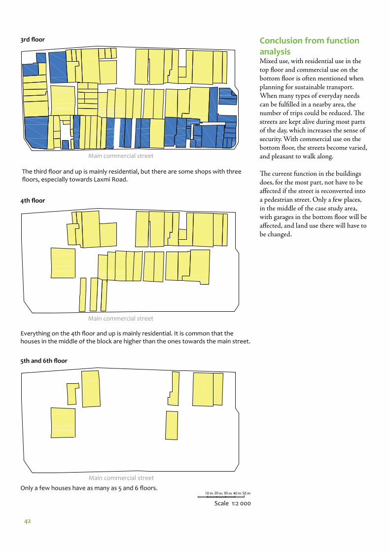
Function analysis of a typical blockThe buildings along the street range from 2-6 fl oors. A concept illustration of how a block is laid out is described below, fl oor by fl oor (note that this not an actual block on the street, but rather a concept illustration of a typical block).
Main commercial street
1st fl oor
Scale 1:2 000
Main commercial street
Legend
Residential
Commercial
Public/semi-public (school/temple)
The structure is very dense, and many houses share walls. Bottom fl oor towards the streets are commercial. Many houses only have connections to the street through the backalleys and courtyards. There is often something public or semi-public, like a school and/or a temple in each block. Buildings are reached either direct from the street or through arcades, backalleys and courtyards. In the deeper blocks on the north side of the street there are many houses that are only reached from narrow alleys. These houses are mainly residential. In some cases however, where the courtyard is more public, there are shops in the bottom fl oor.
Many shops are 2-3 fl oors, especially towards Laxmi Road, but it is also common to have commercial use in the bottom fl oor and residential above.
10 m 20 m 30 m 40 m 50 m
Commercial use on the bottom fl oor. Various use on the upper fl oors.
42
Main commercial street
3rd fl oor
4th fl oor
Main commercial street
Main commercial street
5th and 6th fl oor
The third fl oor and up is mainly residential, but there are some shops with three fl oors, especially towards Laxmi Road.
Everything on the 4th fl oor and up is mainly residential. It is common that the houses in the middle of the block are higher than the ones towards the main street.
Only a few houses have as many as 5 and 6 fl oors.
Conclusion from function analysisMixed use, with residential use in the top fl oor and commercial use on the bottom fl oor is often mentioned when planning for sustainable transport. When many types of everyday needs can be fulfi lled in a nearby area, the number of trips could be reduced. Th e streets are kept alive during most parts of the day, which increases the sense of security. With commercial use on the bottom fl oor, the streets become varied, and pleasant to walk along.
Th e current function in the buildings does, for the most part, not have to be aff ected if the street is reconverted into a pedestrian street. Only a few places, in the middle of the case study area, with garages in the bottom fl oor will be aff ected, and land use there will have to be changed.
Scale 1:2 000
10 m 20 m 30 m 40 m 50 m
43
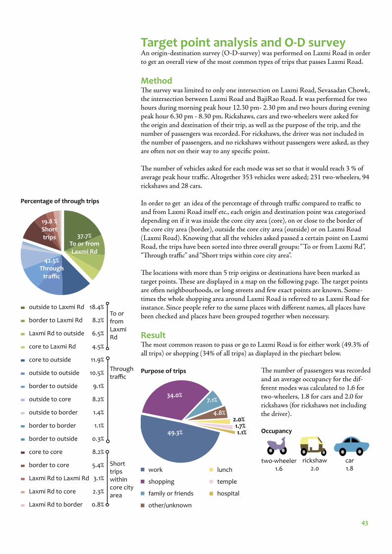
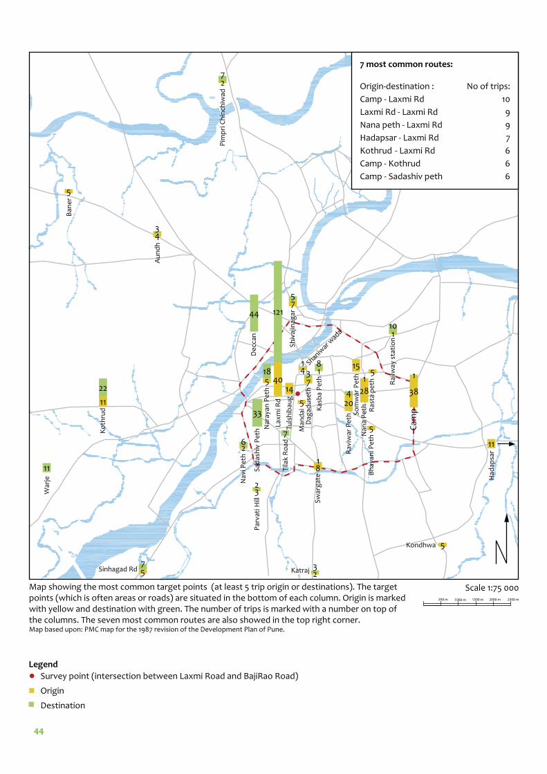
Target point analysis and O-D surveyAn origin-destination survey (O-D-survey) was performed on Laxmi Road in order to get an overall view of the most common types of trips that passes Laxmi Road.
MethodTh e survey was limited to only one intersection on Laxmi Road, Sevasadan Chowk, the intersection between Laxmi Road and BajiRao Road. It was performed for two hours during morning peak hour 12.30 pm- 2.30 pm and two hours during evening peak hour 6.30 pm - 8.30 pm. Rickshaws, cars and two-wheelers were asked for the origin and destination of their trip, as well as the purpose of the trip, and the number of passengers was recorded. For rickshaws, the driver was not included in the number of passengers, and no rickshaws without passengers were asked, as they are often not on their way to any specifi c point.
Th e number of vehicles asked for each mode was set so that it would reach 3 % of average peak hour traffi c. Altogether 353 vehicles were asked; 231 two-wheelers, 94 rickshaws and 28 cars.
In order to get an idea of the percentage of through traffi c compared to traffi c to and from Laxmi Road itself etc., each origin and destination point was categorised depending on if it was inside the core city area (core), on or close to the border of the core city area (border), outside the core city area (outside) or on Laxmi Road (Laxmi Road). Knowing that all the vehicles asked passed a certain point on Laxmi Road, the trips have been sorted into three overall groups: “To or from Laxmi Rd”, “Th rough traffi c” and “Short trips within core city area”.
Th e locations with more than 5 trip origins or destinations have been marked as target points. Th ese are displayed in a map on the following page. Th e target points are often neighbourhoods, or long streets and few exact points are known. Some-times the whole shopping area around Laxmi Road is referred to as Laxmi Road for instance. Since people refer to the same places with diff erent names, all places have been checked and places have been grouped together when necessary.
ResultTh e most common reason to pass or go to Laxmi Road is for either work (49.3% of all trips) or shopping (34% of all trips) as displayed in the piechart below.
Occupancy
rickshaw 2.0
car 1.8
two-wheeler 1.6
outside to Laxmi Rd
border to Laxmi Rd
Laxmi Rd to outside
core to Laxmi Rd
core to outside
outside to outside
border to outside
outside to core
outside to border
border to border
border to outside
core to core
border to core
Laxmi Rd to Laxmi Rd
Laxmi Rd to core
Laxmi Rd to border
To or from Laxmi Rd
Through traffi c
Short trips within core city area
19.8 %Short trips 37.7%
To or fromLaxmi Rd
42.5%Through
traffi c
18.4%
8.2%
6.5%
4.5%
11.9%
10.5%
9.1%
8.2%
1.4%
1.1%
0.3%
8.2%
5.4%
3.1%
2.3%
0.8%
Percentage of through trips
work
shopping
family or friends
other/unknown
lunch
temple
hospital
49.3%
34.0%7.1%
4.8%2.0%1.7%1.1%
Purpose of trips Th e number of passengers was recorded and an average occupancy for the dif-ferent modes was calculated to 1.6 for two-wheelers, 1.8 for cars and 2.0 for rickshaws (for rickshaws not including the driver).
44
40
121
Lax
mi R
d
44
De
ccan
38
1
Cam
p11
22
Ko
thru
d
73
Dag
adu
seth14
Tu
lsh
ibau
g
5
Man
dai
41 Shaniw
ar wada
33
Sad
ash
iv P
eth 7
Tila
k R
oad
18
Kas
ba
Pe
th
15S
om
war
Pe
th
5R
asta
pe
th
28
20
1
4
Nan
a P
eth
Rav
iwar
Pe
th
5
Bh
avan
i Pe
th
81
Sw
arg
ate
26
Nav
i Pe
th
518
Nar
ayan
Pe
th
11
1
2
4
5
10
7
3
Had
apsa
r
Rai
lway
sta
tio
n
Pim
pri
Ch
inch
iwad
Au
nd
h
Ban
er
5Kondhwa
11
War
je
75
Sh
ivaj
inag
ar
32
Par
vati
Hill
23Katraj5
7Sinhagad Rd
7 most common routes:
Origin-destination : No of trips:
Camp - Laxmi Rd 10
Laxmi Rd - Laxmi Rd 9
Nana peth - Laxmi Rd 9
Hadapsar - Laxmi Rd 7
Kothrud - Laxmi Rd 6
Camp - Kothrud 6
Camp - Sadashiv peth 6
Map showing the most common target points (at least 5 trip origin or destinations). The target points (which is often areas or roads) are situated in the bottom of each column. Origin is marked with yellow and destination with green. The number of trips is marked with a number on top of the columns. The seven most common routes are also showed in the top right corner. Map based upon: PMC map for the 1987 revision of the Development Plan of Pune.
Scale 1:75 000500 m 1000 m 1500 m 2000 m 2500 m
Survey point (intersection between Laxmi Road and BajiRao Road)
Origin
Destination
Legend
45
Analysis of O-D survey Th e occupancy is higher than the average occupancy calculated in most west-ern countries, but still signifi cantly lower than the average for cars and rickshaws recorded in the in the CMP in a survey performed in diff erent fringe areas of Pune. Th at survey resulted in an average occupancy of 1.6 for two-wheelers, 2.9 for cars and 3.8 for rickshaw, most likely including the driver (Comprehensive Mobility Plan for Pune City, 2008, p. 4;9).
Since Laxmi Road is a one-way street, most of the origin locations are east of the survey area, and most destination are to the west. Sometimes however, when the origin or destination is Laxmi Road, the origin was west of the destination.
Laxmi Road is a common shopping street, so that 34 % of the trips are for shopping is not surprising. However the biggest share of trips are for work. Th is is for both trips to and from Laxmi Road as well as through trips. Work trips are often trips that is made on the same route with the same mode of transport everyday, which makes fi nding alternative routes and modes relatively easy. Research has proven that the mode of transport we choose to use is highly aff ected by habits (Lindelöw, 2009, p. 12 + 26-27). If people are encouraged to change their mode of travelling for some of their trips, it can have an eff ect on all of their transport decisions.
Conclusion from O-D survey Th e target points should be considered in the overall concept plan, and when plan-ning for alternative ways to get to and from Laxmi Road.
Laxmi Road is also a common target point. As the survey was done on Laxmi Road itself, it is not surprising that almost 40 % of the trips are to or from Laxmi Road. Since many parking spots needs to be taken away when turning the street into a pedestrian street, many trips needs to be done with a diff erent mode of transport. When habits need to change and common routes to and from work are broken, it is important to give alternatives to not only change the route but also the mode, to a more sustainable mode.
Since 42,5 % of the trips passing Laxmi Road are through trips, there is a potential to decrease traffi c in the core city by stopping through traffi c. Th is is something considered in the concept plan.
For recording the purpose of the trip, it might have been useful to set up given categories in advance, as what was noted here clearly depended on the person asking, and had to be slightly adjusted when sorting the data. Th is, as well as some language barrier, explains the high percentage of “unknown/other.”
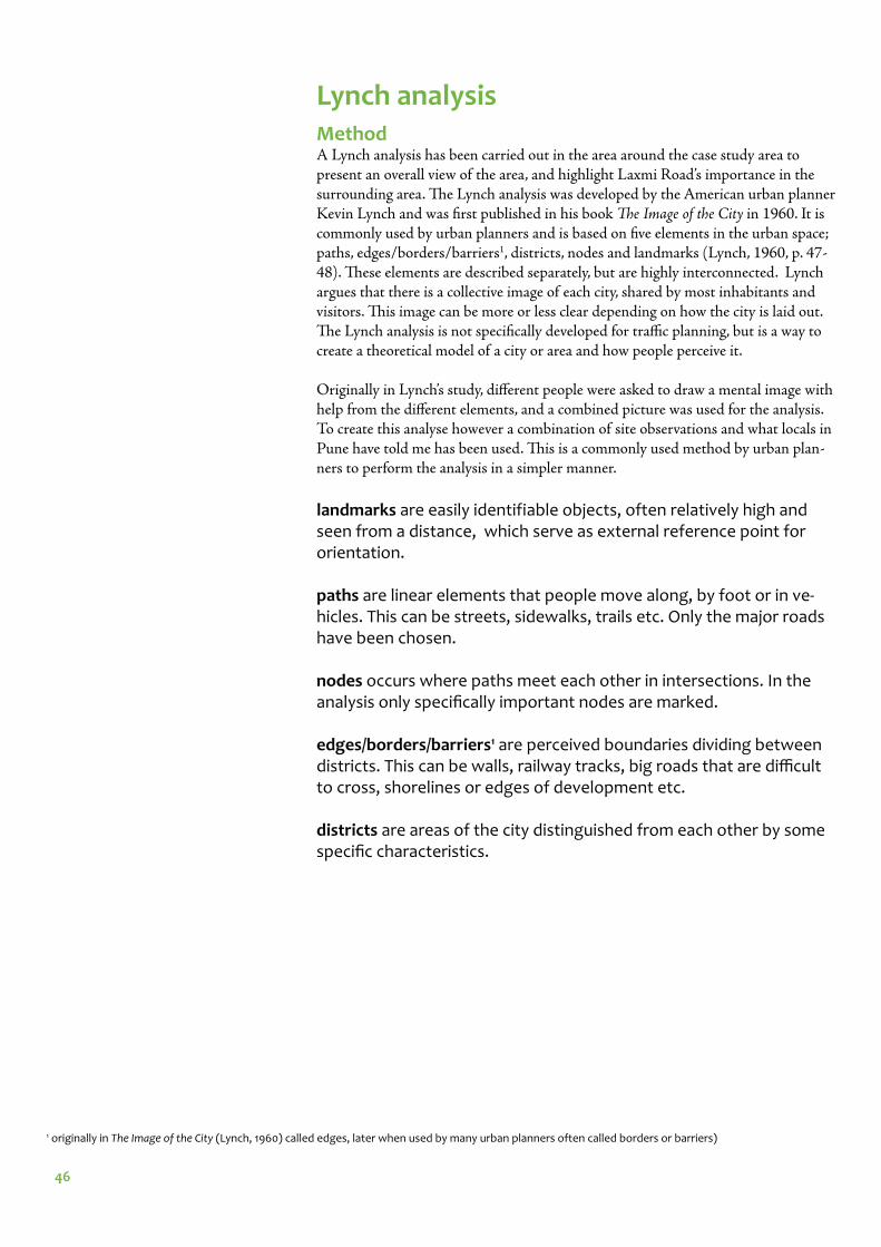
46
Lynch analysisMethodA Lynch analysis has been carried out in the area around the case study area to present an overall view of the area, and highlight Laxmi Road’s importance in the surrounding area. Th e Lynch analysis was developed by the American urban planner Kevin Lynch and was fi rst published in his book Th e Image of the City in 1960. It is commonly used by urban planners and is based on fi ve elements in the urban space; paths, edges/borders/barriers1, districts, nodes and landmarks (Lynch, 1960, p. 47-48). Th ese elements are described separately, but are highly interconnected. Lynch argues that there is a collective image of each city, shared by most inhabitants and visitors. Th is image can be more or less clear depending on how the city is laid out. Th e Lynch analysis is not specifi cally developed for traffi c planning, but is a way to create a theoretical model of a city or area and how people perceive it.
Originally in Lynch’s study, diff erent people were asked to draw a mental image with help from the diff erent elements, and a combined picture was used for the analysis. To create this analyse however a combination of site observations and what locals in Pune have told me has been used. Th is is a commonly used method by urban plan-ners to perform the analysis in a simpler manner.
landmarks are easily identifiable objects, often relatively high and seen from a distance, which serve as external reference point for orientation.
paths are linear elements that people move along, by foot or in ve-hicles. This can be streets, sidewalks, trails etc. Only the major roads have been chosen.
nodes occurs where paths meet each other in intersections. In the analysis only specifi cally important nodes are marked. edges/borders/barriers1 are perceived boundaries dividing between districts. This can be walls, railway tracks, big roads that are diffi cult to cross, shorelines or edges of development etc.
districts are areas of the city distinguished from each other by some specifi c characteristics.
1 originally in The Image of the City (Lynch, 1960) called edges, later when used by many urban planners often called borders or barriers)
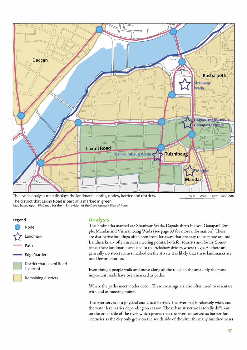
47
1:10 000
Node
Landmark
Path
Edge/barrier
District that Laxmi Road is part of
Remaining districts
Legend
Kasba peth
Laxmi Road
Deccan
Mandai
Tulshibaug
The Lynch analysis map displays the landmarks, paths, nodes, barrier and districts.
The district that Laxmi Road is part of is marked in green.Map based upon: PMC map for the 1987 revision of the Development Plan of Pune
Mandai
Shaniwar Wada
AnalysisTh e landmarks marked are Shaniwar Wada, Dagadusheth Halwai Ganapati Tem-ple, Mandai and Vishrambaug Wada (see page 33 for more information). Th ese are distinctive buildings often seen from far away, that are easy to orientate around. Landmarks are often used as meeting points, both for tourists and locals. Some-times these landmarks are used to tell rickshaw drivers where to go. As there are generally no street names marked on the streets it is likely that these landmarks are used for orientation.
Even though people walk and move along all the roads in the area only the most important roads have been marked as paths.
Where the paths meet, nodes occur. Th ese crossings are also often used to orientate with and as meeting points.
Th e river serves as a physical and visual barrier. Th e river bed is relatively wide, and the water level varies depending on season. Th e urban structure is totally diff erent on the other side of the river, which proves that the river has served as barrier for centuries as the city only grew on the south side of the river for many hundred years.
Dagadusheth Halwai Ganapati Temple
Vishraumbaug Wada
100 m 200 m 300 m
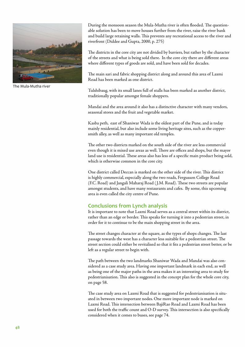
48
During the monsoon season the Mula-Mutha river is often fl ooded. Th e question-able solution has been to move houses further from the river, raise the river bank and build large retaining walls. Th is prevents any recreational access to the river and riverfront (Diddee and Gupta, 2000, p. 275)
Th e districts in the core city are not divided by barriers, but rather by the character of the streets and what is being sold there. In the core city there are diff erent areas where diff erent types of goods are sold, and have been sold for decades.
Th e main sari and fabric shopping district along and around this area of Laxmi Road has been marked as one district.
Tulshibaug, with its small lanes full of stalls has been marked as another district, traditionally popular amongst female shoppers.
Mandai and the area around it also has a distinctive character with many vendors, seasonal stores and the fruit and vegetable market.
Kasba peth, east of Shaniwar Wada is the oldest part of the Pune, and is today mainly residential, but also include some living heritage sites, such as the copper-smith alley, as well as many important old temples.
Th e other two districts marked on the south side of the river are less commercial even though it is mixed use areas as well. Th ere are offi ces and shops, but the mayor land use is residential. Th ese areas also has less of a specifi c main product being sold, which is otherwise common in the core city.
One district called Deccan is marked on the other side of the river. Th is district is highly commercial, especially along the two roads, Fergusson College Road (F.C. Road) and Jangali Maharaj Road ( J.M. Road). Th ese two streets are popular amongst students, and have many restaurants and cafes. By some, this upcoming area is even called the city centre of Pune.
Conclusions from Lynch analysisIt is important to note that Laxmi Road serves as a central street within its district, rather than an edge or border. Th is speaks for turning it into a pedestrian street, in order for it to continue to be the main shopping street in the area.
Th e street changes character at the square, as the types of shops changes. Th e last passage towards the west has a character less suitable for a pedestrian street. Th e street section could either be revitalised so that it fi ts a pedestrian street better, or be left as a regular street to begin with.
Th e path between the two landmarks Shaniwar Wada and Mandai was also con-sidered as a case study area. Having one important landmark in each end, as well as being one of the major paths in the area makes it an interesting area to study for pedestrianisation. Th is also is suggested in the concept plan for the whole core city, on page 58.
Th e case study area on Laxmi Road that is suggested for pedestrianisation is situ-ated in between two important nodes. One more important node is marked on Laxmi Road. Th is intersection between BajiRao Road and Laxmi Road has been used for both the traffi c count and O-D survey. Th is intersection is also specifi cally considered when it comes to buses, see page 74.
The Mula-Mutha river
49
DESIGN PRINCIPLES
50
Sustainable transport principles for reclaiming the street for pedestriansTo reclaim street space for pedestrians An Introduction to Sustainable Transporta-tion: Policy, Planning and Implementation by Preston Schiller, Eric Bruun and Jeff rey Kenworthy lists diff erent strategies:
• car-free zones • traffi c calming and street and highway reductions; • complete streets• freeway removal• restoration of environments destroyed or seriously damaged by auto-based
transportation
(Schiller, Bruun & Kenworthy, 2010 p. 237)
All of these strategies, except the more radical “freeway removal” was set out to be used in this project if proven possible. In Pune it is important to both reclaim the streets for people, but also stop the development in the other direction.
Car-free zones are pedestrian streets, and vehicle free squares etc.
Traffi c calming is a way to reduce the speed, and thereby the risk and severity of traffi c accidents, by redesign of the streets. Th is is done with street furniture, trees and by reclaiming space from vehicles for pedestrians (Schiller, Bruun & Kenworthy, 2010, p. 237-239).
Complete streets is an American concept, that is based on the idea that a street should provide safe travel for all types of users, not only private motor vehicles. On small streets, this is often done with shared space and traffi c calming, whereas on large roads, separate lanes are built for diff erent modes, including bicycle lanes, side-walks and separate bus lanes (Schiller, Bruun & Kenworthy, 2010, p. 239-240).
As big roads generates more traffi c, it has been proven that freeway removal has the opposite eff ect, and creates a more pleasant urban environment (Schiller, Bruun & Kenworthy, 2010, p. 240). Th ere are no freeways within the core city area however, which means no freeway removal will be discussed.
Streets and neighbourhoods can be destroyed by motorised transport in many ways, and there are diff erent ways to solve the problems. Some ways discussed in An Introduction to Sustainable Transportation: Policy, Planning and Implementation, are rehabilitation of the visual environment, by redesigning buildings and public spaces into small scale designs etc, to convert malls to more mixed use areas, converting parking lots and parking structures into parks and greening and shrinking the cities (Schiller, Bruun & Kenworthy, 2010 p. 241-244).
51
Gehl’s toolbox for a pleasant urban environmentIn the end of his book Cities for people Jan Gehl presents a toolbox for how to create an urban environment that makes people stay and walk. He presents 12 criteria for a good pedestrian environment. Th ese requirements will be used as guidelines as well as evaluation of the planning proposal and current environment.
• Protection against traffi c and accidents – feeling safe• Protection against crime and violence – feeling secure• Protection against unpleasant sensory experiences
• Opportunities to walk• Opportunities to stand/stay• Opportunities to sit
• Opportunities to see• Opportunities to talk and listen• Opportunities for play and exercise
• Scale• Opportunities to enjoy the positive aspects of climate• Positive sensory experience
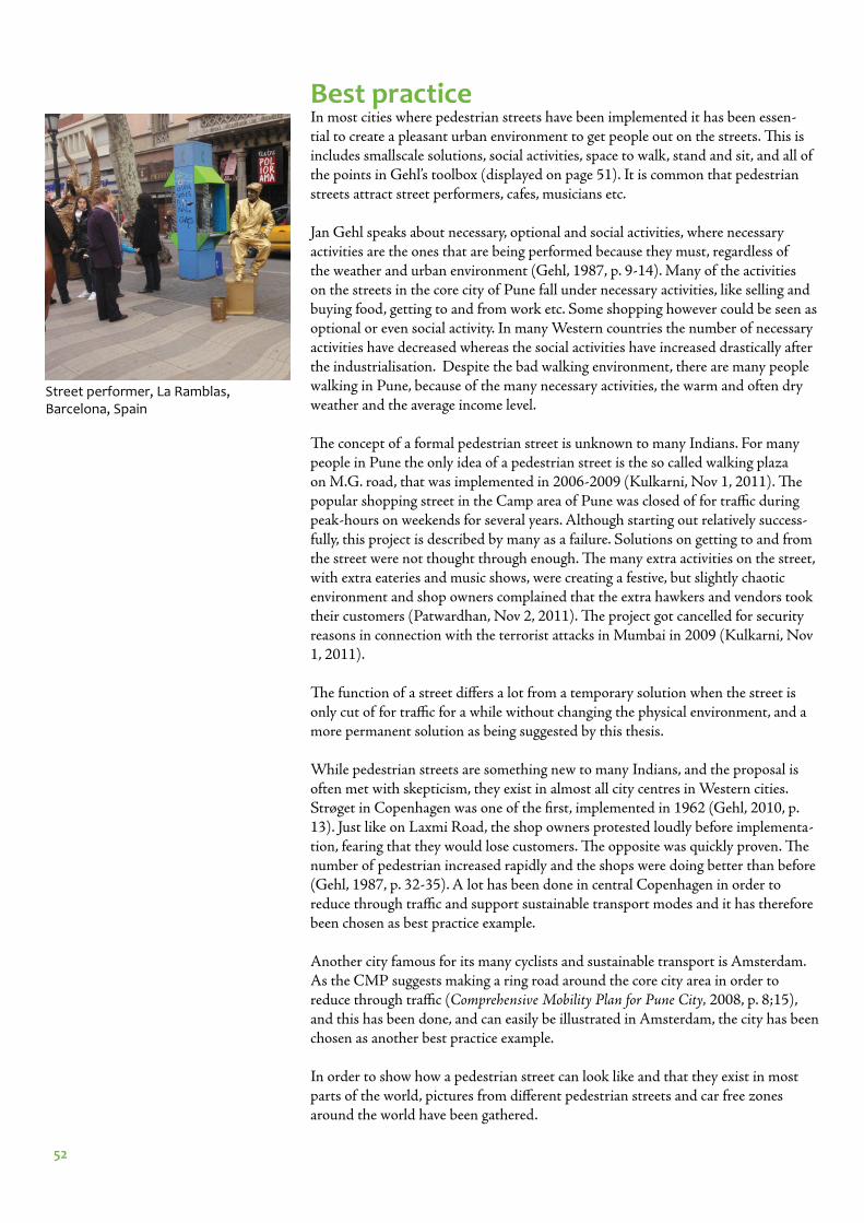
52
Best practiceIn most cities where pedestrian streets have been implemented it has been essen-tial to create a pleasant urban environment to get people out on the streets. Th is is includes smallscale solutions, social activities, space to walk, stand and sit, and all of the points in Gehl’s toolbox (displayed on page 51). It is common that pedestrian streets attract street performers, cafes, musicians etc.
Jan Gehl speaks about necessary, optional and social activities, where necessary activities are the ones that are being performed because they must, regardless of the weather and urban environment (Gehl, 1987, p. 9-14). Many of the activities on the streets in the core city of Pune fall under necessary activities, like selling and buying food, getting to and from work etc. Some shopping however could be seen as optional or even social activity. In many Western countries the number of necessary activities have decreased whereas the social activities have increased drastically after the industrialisation. Despite the bad walking environment, there are many people walking in Pune, because of the many necessary activities, the warm and often dry weather and the average income level.
Th e concept of a formal pedestrian street is unknown to many Indians. For many people in Pune the only idea of a pedestrian street is the so called walking plaza on M.G. road, that was implemented in 2006-2009 (Kulkarni, Nov 1, 2011). Th e popular shopping street in the Camp area of Pune was closed of for traffi c during peak-hours on weekends for several years. Although starting out relatively success-fully, this project is described by many as a failure. Solutions on getting to and from the street were not thought through enough. Th e many extra activities on the street, with extra eateries and music shows, were creating a festive, but slightly chaotic environment and shop owners complained that the extra hawkers and vendors took their customers (Patwardhan, Nov 2, 2011). Th e project got cancelled for security reasons in connection with the terrorist attacks in Mumbai in 2009 (Kulkarni, Nov 1, 2011).
Th e function of a street diff ers a lot from a temporary solution when the street is only cut of for traffi c for a while without changing the physical environment, and a more permanent solution as being suggested by this thesis.
While pedestrian streets are something new to many Indians, and the proposal is often met with skepticism, they exist in almost all city centres in Western cities. Strøget in Copenhagen was one of the fi rst, implemented in 1962 (Gehl, 2010, p. 13). Just like on Laxmi Road, the shop owners protested loudly before implementa-tion, fearing that they would lose customers. Th e opposite was quickly proven. Th e number of pedestrian increased rapidly and the shops were doing better than before (Gehl, 1987, p. 32-35). A lot has been done in central Copenhagen in order to reduce through traffi c and support sustainable transport modes and it has therefore been chosen as best practice example.
Another city famous for its many cyclists and sustainable transport is Amsterdam. As the CMP suggests making a ring road around the core city area in order to reduce through traffi c (Comprehensive Mobility Plan for Pune City, 2008, p. 8;15), and this has been done, and can easily be illustrated in Amsterdam, the city has been chosen as another best practice example.
In order to show how a pedestrian street can look like and that they exist in most parts of the world, pictures from diff erent pedestrian streets and car free zones around the world have been gathered.
Street performer, La Ramblas, Barcelona, Spain
53
CopenhagenSince 1967 a few percent of the parking spaces in the core city of Copenhagen, Den-mark have been taken away each year, which has reduced the motorised traffi c in the core city (Schiller, Bruun & Kenworthy, 2010, p. 26). Free parking is no longer available.
Th e fi rst street to be pedestrianised was Strøget, converted in 1962 after suggestion from Jan Gehl. Since then several other streets have been turned into pedestrian streets, creating a network of pleasant urban spaces (Gehl, 2010, p. 13). Th e streets are chosen so that traffi c is still allowed on some streets, in order to maintain acces-sibility to all parts of the core city, but to stop through traffi c. Th is is displayed in the map below. Similar solutions have been proven effi cient in several cities in the Netherlands and Germany etc (Pucher & Buehler, 2008, p. 514).
Bicycling has been promoted and has become so popular that bicycle lanes have had to be widened due to congestion on bicycle tracks. Th is is despite the often cold and snowy weather. Public transport is a combination of buses and a relatively new underground driverless metro, where the fi rst stretch opened in 2002.
250 m 500 m 750 m 1000 m
Central Copenhagen in 1995. Pedestrian streets marked in black. The pedestrian network is effi ciently stopping through traffi c. Map source: Gehl architects, with permission
1995
54
AmsterdamAmsterdam and Th e Netherlands are also well-known for their many cyclists. Th e road network structure in Amsterdam is designed with outer and inner ring roads, that encourage motorised vehicles to go around rather than through the city centre. Th e speed can be kept relatively high on these major roads, whereas the smaller roads in the city centre are traffi c calmed, so that no time is won by taking a short-cut.
Th e roads are classifi ed into “fl ow”, “distribution” and “access” roads (Buis and ter
Avest, 2008, p. 9-10). On the “fl ow” roads, which is an outer ring road as well as a highway leading to another city, the roads and intersections are designed so that the average speed can be kept relatively high. Th e distribution roads distributes the traffi c from the fl ow roads to the access roads, and the speed is still kept relatively high, but is slowed down in intersections. Th e access streets have relatively low speed.
Map source: Goudappel Coff eng, The Netherlands, with permission.
The city of Amsterdam
fl ow
distribution
central ring road
inner ring road
Legend
In the rather narrow street of the core city in Amsterdam access is allowed either for bicycles in both directions or cars in both directions, not both at the same streets (Pucher & Buehler, 2008, p. 514).
Bicycling has always been a popular mode in Amsterdam, but use was going down in the 1970s as the number of motorised vehicles increased. After protests from people and activists, decisions were made to not continue to change the city to fi t the car, but to promote and improve public transport and cycling options (Pucher, 2007, p. 2).
5 km 10 km 15 km 20 km 25 km
55
Pedestrian streets around the world
Amsterdam , The NetherlandsPhoto: Juliana Antia
Cologne, GermanyPhoto: Juliana Antia
Düsseldorf, GermanyPhoto: Juliana Antia
Freiburg, Germany
Old parts of Gdansk, Poland Copenhagen, Denmark
Nanchang, China Photo: Richard ter Avest
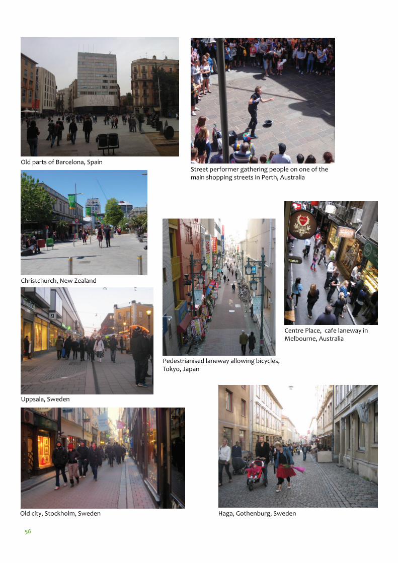
56
Centre Place, cafe laneway in Melbourne, Australia
Street performer gathering people on one of the main shopping streets in Perth, Australia
Haga, Gothenburg, Sweden
Pedestrianised laneway allowing bicycles, Tokyo, Japan
Old city, Stockholm, Sweden
Uppsala, Sweden
Christchurch, New Zealand
Old parts of Barcelona, Spain
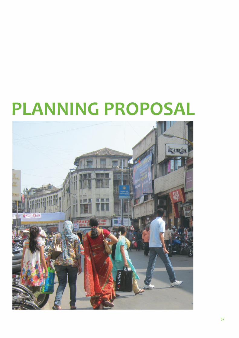
57
PLANNING PROPOSAL
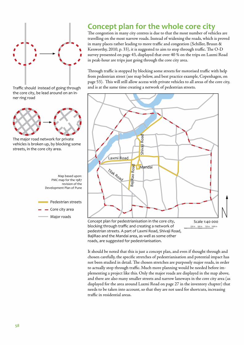
58
Concept plan for the whole core cityTh e congestion in many city centres is due to that the most number of vehicles are travelling on the most narrow roads. Instead of widening the roads, which is proved in many places rather leading to more traffi c and congestion (Schiller, Bruun & Kenworthy, 2010, p. 33), it is suggested to aim to stop through traffi c. Th e O-D survey presented on page 43, displayed that over 40 % on the trips on Laxmi Road in peak-hour are trips just going through the core city area.
Th rough traffi c is stopped by blocking some streets for motorised traffi c with help from pedestrian street (see map below, and best practice example, Copenhagen, on page 53). Th is will still allow access with private vehicles to all areas of the core city, and is at the same time creating a network of pedestrian streets. Traffi c should instead of going through
the core city, be lead around on an in-ner ring road
Scale 1:40 000Concept plan for pedestrianisation in the core city, blocking through traffi c and creating a network of pedestrian streets. A part of Laxmi Road, Shivaji Road, BajiRao and the Mandai area, as well as some other roads, are suggested for pedestrianisation.
The major road network for private vehicles is broken up, by blocking some streets, in the core city area.
It should be noted that this is just a concept plan, and even if thought through and chosen carefully, the specifi c stretches of pedestrianisation and potential impact has not been studied in detail. Th e chosen stretches are purposely major roads, in order to actually stop through traffi c. Much more planning would be needed before im-plementing a project like this. Only the major roads are displayed in the map above, and there are also many smaller streets and narrow laneways in the core city area (as displayed for the area around Laxmi Road on page 27 in the inventory chapter) that needs to be taken into account, so that they are not used for shortcuts, increasing traffi c in residential areas.
Pedestrian streets
Core city area
Major roads
Laxmi Road
Tilak Road
Sh
ivaj
i Ro
ad
Mandai
Baj
iRao
Ro
ad
Map based upon: PMC map for the 1987
revision of the Development Plan of Pune
250 m 500 m 750 m 1000 m
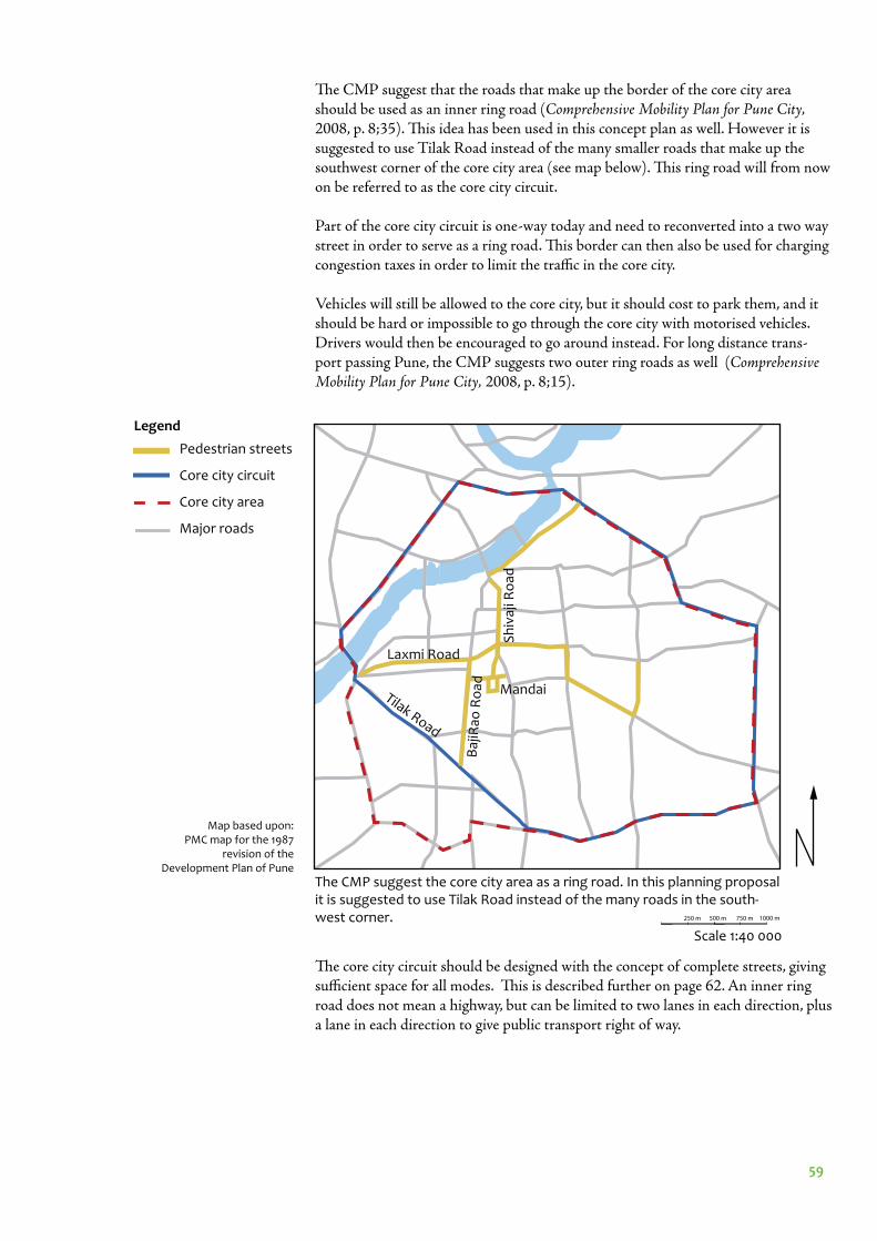
59
The CMP suggest the core city area as a ring road. In this planning proposal it is suggested to use Tilak Road instead of the many roads in the south-west corner.
Scale 1:40 000
Th e CMP suggest that the roads that make up the border of the core city area should be used as an inner ring road (Comprehensive Mobility Plan for Pune City, 2008, p. 8;35). Th is idea has been used in this concept plan as well. However it is suggested to use Tilak Road instead of the many smaller roads that make up the southwest corner of the core city area (see map below). Th is ring road will from now on be referred to as the core city circuit.
Part of the core city circuit is one-way today and need to reconverted into a two way street in order to serve as a ring road. Th is border can then also be used for charging congestion taxes in order to limit the traffi c in the core city.
Vehicles will still be allowed to the core city, but it should cost to park them, and it should be hard or impossible to go through the core city with motorised vehicles. Drivers would then be encouraged to go around instead. For long distance trans-port passing Pune, the CMP suggests two outer ring roads as well (Comprehensive Mobility Plan for Pune City, 2008, p. 8;15).
Th e core city circuit should be designed with the concept of complete streets, giving suffi cient space for all modes. Th is is described further on page 62. An inner ring road does not mean a highway, but can be limited to two lanes in each direction, plus a lane in each direction to give public transport right of way.
Map based upon: PMC map for the 1987
revision of the Development Plan of Pune
Pedestrian streets
Core city circuit
Core city area
Major roads
Laxmi Road
Tilak Road
Sh
ivaj
i Ro
ad
Mandai
Baj
iRao
Ro
ad
250 m 500 m 750 m 1000 m
Legend
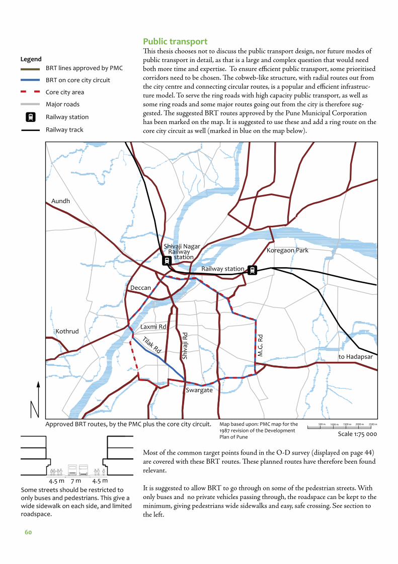
60
Public transportTh is thesis chooses not to discuss the public transport design, nor future modes of public transport in detail, as that is a large and complex question that would need both more time and expertise. To ensure effi cient public transport, some prioritised corridors need to be chosen. Th e cobweb-like structure, with radial routes out from the city centre and connecting circular routes, is a popular and effi cient infrastruc-ture model. To serve the ring roads with high capacity public transport, as well as some ring roads and some major routes going out from the city is therefore sug-gested. Th e suggested BRT routes approved by the Pune Municipal Corporation has been marked on the map. It is suggested to use these and add a ring route on the core city circuit as well (marked in blue on the map below).
Most of the common target points found in the O-D survey (displayed on page 44) are covered with these BRT routes. Th ese planned routes have therefore been found relevant.
It is suggested to allow BRT to go through on some of the pedestrian streets. With only buses and no private vehicles passing through, the roadspace can be kept to the minimum, giving pedestrians wide sidewalks and easy, safe crossing. See section to the left.
Approved BRT routes, by the PMC plus the core city circuit.
Some streets should be restricted to only buses and pedestrians. This give a wide sidewalk on each side, and limited roadspace.
BRT lines approved by PMC
BRT on core city circuit
Core city area
Major roads
Railway station
Railway track
4.5 m 7 m 4.5 m
Scale 1:75 000
Legend
500 m 1000 m 1500 m 2000 m 2500 mMap based upon: PMC map for the 1987 revision of the Development Plan of Pune
M.G
. Rd
Laxmi Rd
Sh
ivaj
i Rd
Koregaon Park
Railway station
Aundh
Tilak Rd
Swargate
Deccan
Shivaji Nagar Railway station
to Hadapsar
Kothrud
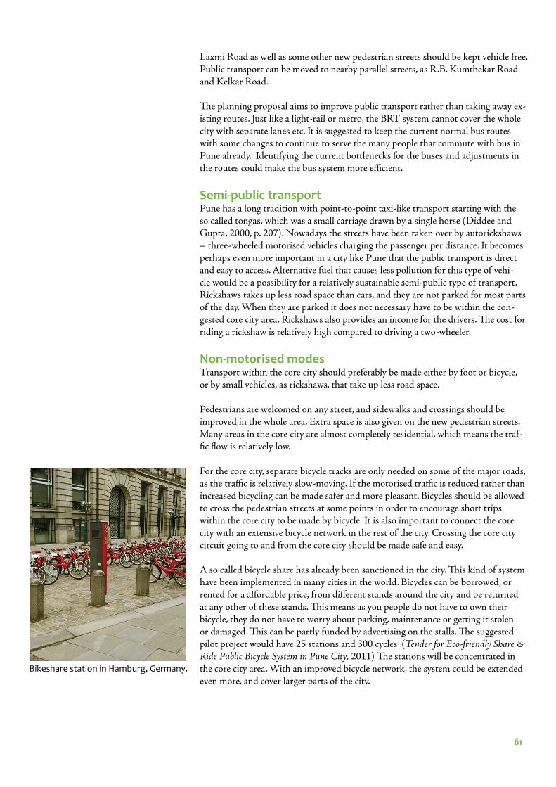
61
Laxmi Road as well as some other new pedestrian streets should be kept vehicle free. Public transport can be moved to nearby parallel streets, as R.B. Kumthekar Road and Kelkar Road.
Th e planning proposal aims to improve public transport rather than taking away ex-isting routes. Just like a light-rail or metro, the BRT system cannot cover the whole city with separate lanes etc. It is suggested to keep the current normal bus routes with some changes to continue to serve the many people that commute with bus in Pune already. Identifying the current bottlenecks for the buses and adjustments in the routes could make the bus system more effi cient.
Semi-public transportPune has a long tradition with point-to-point taxi-like transport starting with the so called tongas, which was a small carriage drawn by a single horse (Diddee and Gupta, 2000, p. 207). Nowadays the streets have been taken over by autorickshaws – three-wheeled motorised vehicles charging the passenger per distance. It becomes perhaps even more important in a city like Pune that the public transport is direct and easy to access. Alternative fuel that causes less pollution for this type of vehi-cle would be a possibility for a relatively sustainable semi-public type of transport. Rickshaws takes up less road space than cars, and they are not parked for most parts of the day. When they are parked it does not necessary have to be within the con-gested core city area. Rickshaws also provides an income for the drivers. Th e cost for riding a rickshaw is relatively high compared to driving a two-wheeler.
Non-motorised modesTransport within the core city should preferably be made either by foot or bicycle, or by small vehicles, as rickshaws, that take up less road space.
Pedestrians are welcomed on any street, and sidewalks and crossings should be improved in the whole area. Extra space is also given on the new pedestrian streets. Many areas in the core city are almost completely residential, which means the traf-fi c fl ow is relatively low.
For the core city, separate bicycle tracks are only needed on some of the major roads, as the traffi c is relatively slow-moving. If the motorised traffi c is reduced rather than increased bicycling can be made safer and more pleasant. Bicycles should be allowed to cross the pedestrian streets at some points in order to encourage short trips within the core city to be made by bicycle. It is also important to connect the core city with an extensive bicycle network in the rest of the city. Crossing the core city circuit going to and from the core city should be made safe and easy.
A so called bicycle share has already been sanctioned in the city. Th is kind of system have been implemented in many cities in the world. Bicycles can be borrowed, or rented for a aff ordable price, from diff erent stands around the city and be returned at any other of these stands. Th is means as you people do not have to own their bicycle, they do not have to worry about parking, maintenance or getting it stolen or damaged. Th is can be partly funded by advertising on the stalls. Th e suggested pilot project would have 25 stations and 300 cycles (Tender for Eco-friendly Share & Ride Public Bicycle System in Pune City, 2011) Th e stations will be concentrated in the core city area. With an improved bicycle network, the system could be extended even more, and cover larger parts of the city.
Bikeshare station in Hamburg, Germany.
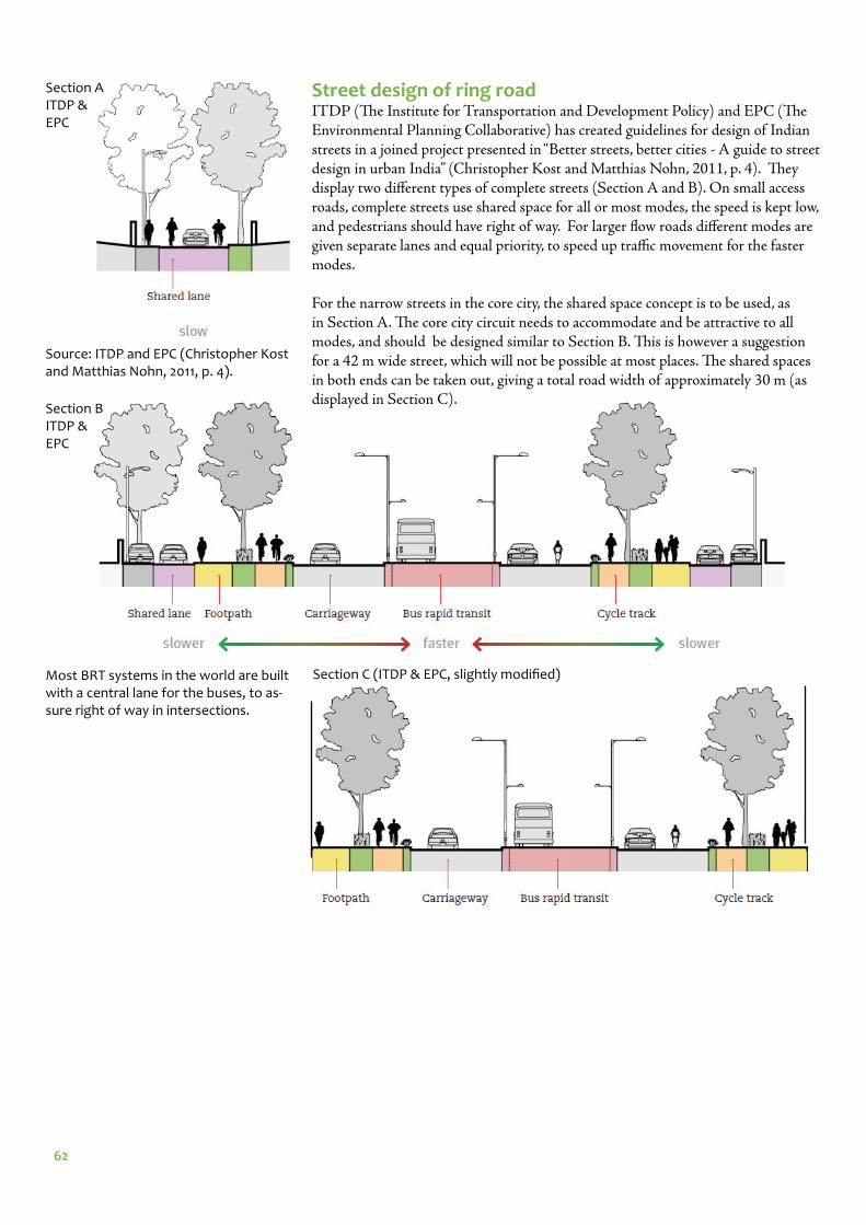
62
Street design of ring roadITDP (Th e Institute for Transportation and Development Policy) and EPC (Th e Environmental Planning Collaborative) has created guidelines for design of Indian streets in a joined project presented in “Better streets, better cities - A guide to street design in urban India” (Christopher Kost and Matthias Nohn, 2011, p. 4). Th ey display two diff erent types of complete streets (Section A and B). On small access roads, complete streets use shared space for all or most modes, the speed is kept low, and pedestrians should have right of way. For larger fl ow roads diff erent modes are given separate lanes and equal priority, to speed up traffi c movement for the faster modes.
For the narrow streets in the core city, the shared space concept is to be used, as in Section A. Th e core city circuit needs to accommodate and be attractive to all modes, and should be designed similar to Section B. Th is is however a suggestion for a 42 m wide street, which will not be possible at most places. Th e shared spaces in both ends can be taken out, giving a total road width of approximately 30 m (as displayed in Section C).
Section A ITDP & EPC
Section BITDP & EPC
Section C (ITDP & EPC, slightly modifi ed)Most BRT systems in the world are built with a central lane for the buses, to as-sure right of way in intersections.
Source: ITDP and EPC (Christopher Kost and Matthias Nohn, 2011, p. 4).
63
ParkingOne of the biggest problems in turning Laxmi Road into a pedestrian street is going to be parking. Sustainable transport suggests alternative solutions to the traditi-tional planning paradigm of estimating the number of new parking spaces needed and supplying them elsewhere. Th e main strategy when it comes to parking is to stop supplying free parking. Parking takes up a lot of space, and land is far from free, especially in the central parts of a city. It is thereby fair to set a cost for both street and off -street parking. Th is should be applied in the whole core city and could make people think one more time before going to the core city with their private vehicle (Schiller, Bruun & Kenworthy, 2010, p. 164). In Pune, it is important that this applies for both two-wheelers and cars. Since two-wheelers take up less space than cars, they should be slightly cheaper to park. Th is thesis is not suggesting any specifi c price, but it is clear that the current price of 5 rupees an hour for cars and 2 rupees an hour for two-wheelers is far from enough to reach the desired eff ect, as the parking houses are often full.
To come to terms with parking for local residents in the area, they should be given the chance to purchase a special sticker to put on their motor vehicle which they will need to be allowed to park within a small area around where they live, including the courtyards and backalleys. Th is should be limited to a few vehicles per household, as there is limited amount of space in the core city, and they would need to show proof of residency in order to purchase the sticker. Th is would mean that residents always would have a space to park close to their house, as the parking lots will not be taken up by visitors. On some streets visitors parking should also be allowed, but it should be made expensive. Th is generally makes it easier for the people that actually need a parking spot for some specifi c errand to fi nd one. Th e money from the stickers as well as the parking could be used to improve for public transport and pedestrians.
Some of the backalleys and courtyards with access from Laxmi Road will be closed of for traffi c as the street get pedestrianised. Th ese residents should get reserved parking permission, by purchasing a sticker, on the closest side street. With an improved walking environment approximately one hundred meters is not a long distance to walk to get to and from your private vehicle. Th e parking garages built in the bottom fl oor in a few of the bigger shopping complexes could, when not possible to reach from another street, be converted into more commercial space.
To make parking prices really high can seem unfair before improving public trans-port, but it should be noted that the area high is served by both public buses and autorickshaws.
Rather than adding new parking lots, parking spaces should be gradually taken away, as proven possible in central Copenhagen etc (see best practice example on p. 65). Pedestrianisation of Laxmi Road, and the removal of approximately 1800 two-wheeler parking spots at once, could be a fi rst step in this process.
Non-motorised vehicles, such as bicycles, should be parked for free, and should be given designated space close to popular target points.

64
Combined illustration of the concept plan.
Legend
Pedestrian streets
Core city circuit (with BRT on)
BRT (PMC)
Core city area
Major Road (most served with regu-lar PMPML buses)
Map based upon: PMC map for the 1987
revision of the Development Plan of Pune
SummarizeThe concept plan can be summarized into these bullet points: - block through traffi c with help from pedestrian streets- create a ring road around the core city with the concept of complete streets- make pedestrian streets network in the core city - use shared space in residential areas- improve the walking environment on all streets, improving sidewalks and accessibility - improve for bicyclists with cycle tracks and safe intersections on major roads, and shared space in residential areas- improve public transport- some streets where only pedestrians and public transport is allowed- no longer supply free parking
Laxmi Road
Tilak Road
Sh
ivaj
i Ro
ad
Mandai
Baj
iRao
Ro
ad
Scale 1:30 000250 m 500 m 750 m 1000 m
65
Detailed planning proposal for Laxmi RoadMaking Laxmi Road into a pedestrian street should be seen as a revitalisation of the street passage. Th e road surface should be evened out to one continuous surface to clearly point out that the whole street space is for pedestrians. Th e 90 cm high rail-ing will no longer be needed.
Th e hawkers and vendors are an important part of Indian street life and should still be allowed on Laxmi Road. To allow stalls everywhere however would likely create a rather chaotic and unpleasant environment with little space to walk. Established shop owners might argue that they are losing many customers to the street vendors. Designated spots should therefore be marked clearly, and hawkers and vendors should only be allowed within these areas with required permission.
It is suggested to clearly mark the Tulshibaug area as a pedestrian zone as well, only allowing deliveries, as Tulshibaug is almost completely pedestrianised already.
Crossing street are likely to be used by autorickshaws to drop off and pick up pas-sengers. Some intersections should be designated for this. Th is is pointed out in the map below.
Scale 1:10 000The suggested area of pedestrianisation. The Tulshibaug area, with the major alleys marked in orange is today almost completely pedestrianised, but it is poorly marked, and there are often two-wheelers passing through. This area should be included in the revitalisation and signage
and design of the entries should be improved. The area on the north side of the street opposite Tulshibaug, marked with a blue line, has a lot of temples and is sometimes closed of for traffi c today. Vehicles that belongs to residents in this area should be allowed in, unlike in Tulshibaug and on Laxmi Road.
Scale 1:10 000New designated rickshaw stands along the street.
Tulshibaug
Laxmi Road
Map based upon: PMC map for the
1987 revision of the Development Plan
of Pune
Map based upon: PMC map for the 1987 revision of the Devel-opment Plan of Pune
100 m 200 m 300 m
100 m 200 m 300 m
66
Overall mapThe full planning proposal on Laxmi Road, with specifi c points marked that will be zoomed in an explained better on the following pages.
Designing a new vehicle free square, see page 70
Intersections, see page 69
Street design, see page 67
Typical sections along the whole stretch, see page 68
Scale 1:500050 m 100 m 150 m 200 m 250 m
Bus network solutions, see page 74
Lax
mi R
oad
Map based upon: Revision of sanctioned Development Plan of old PMC limit (1987-1989) Existing Land use map, 2008-2009 of PMC Sector I, Gaothan AreaSubmitted by Dr. Prof. Raval I/C T&C Planning, College of Engineering Pune_5
Entry from Tilak Chowk, see page 71
67
1.8 m2.5 m 2.5 m1.8 m5.8 m
Street design
Most sidewalks in Pune has these types of tiles. They therefore signalise that the space is aimed for pedestrians, and are suitable to use on the pedestrian street.
Σ 13.4 mScale 1:200
Designated spots for hawk-ers between the trees
Trees to give shade and greenery on the street. Seats around the trees.
Grey tiles closest to the buildings, pink tiles in the middle walkway. Dark grey tiles to mark the desig-nated spots for hawkers
Rubbish bins to be provided
The street is purposely planned with limited amount of street furniture, to not take up too much of the space for pedestrians and be inexpensive to implement.
Stormwater management for the mon-soon season, see page 72.
Section and plan, typical street design.
68
Legend
Scale 1:10 000
Residential
Commercial
Public/semi-public (school/temple)
Garage
Map source: PMC map for the 1987 revision of the Develop-ment Plan of Pune
Current situation
E
E
D
CCB B
A
A
D
Planning proposal
Typical sectionsSome typical sections along the street have been drawn. They have been com-pared with the current situation as mapped for the function analysis (p. 40).
Location map
Scale 1:500
Section AA
Section BB
Section CC
Section DD
Section EE
Section AA
Section BB
Section CC
Section DD
Section EE
The parking garages by Section CC will not be reachable from Laxmi Road. There are however several examples of commerce half a fl oor down in the area, and this new land use should be possible also here.
100 m 200 m 300 m
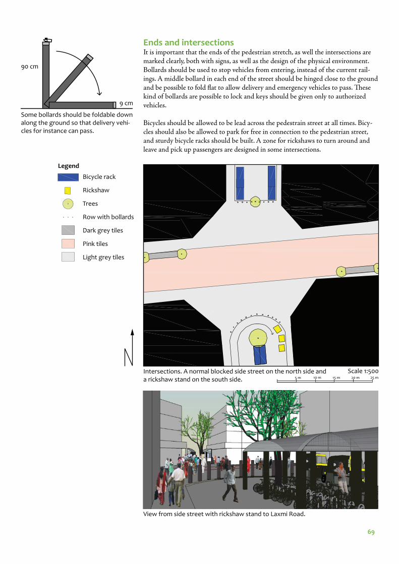
69
Intersections. A normal blocked side street on the north side and a rickshaw stand on the south side.
Scale 1:500
Ends and intersectionsIt is important that the ends of the pedestrian stretch, as well the intersections are marked clearly, both with signs, as well as the design of the physical environment. Bollards should be used to stop vehicles from entering, instead of the current rail-ings. A middle bollard in each end of the street should be hinged close to the ground and be possible to fold fl at to allow delivery and emergency vehicles to pass. Th ese kind of bollards are possible to lock and keys should be given only to authorized vehicles.
Bicycles should be allowed to be lead across the pedestrain street at all times. Bicy-cles should also be allowed to park for free in connection to the pedestrian street, and sturdy bicycle racks should be built. A zone for rickshaws to turn around and leave and pick up passengers are designed in some intersections.
Legend
Bicycle rack
Rickshaw
Trees
Row with bollards
Dark grey tiles
Pink tiles
Light grey tiles
10 m5 m 15 m 25 m20 m
90 cm
9 cm
Some bollards should be foldable down along the ground so that delivery vehi-cles for instance can pass.
View from side street with rickshaw stand to Laxmi Road.

70
SquareTh e square is redesigned in a simple manor with more greenery, and some seats. Th e rickshaw stand is moved to the side street so that vehicles on Laxmi Road can be avoided.
Scale 1:500
Legend
Bicycle rack
Rickshaws
Trees
Row with bollards
Dark grey tiles
Pink tiles
Light grey tiles
Entrance to shop
10 m5 m 15 m 25 m20 m
Square seen from the east.
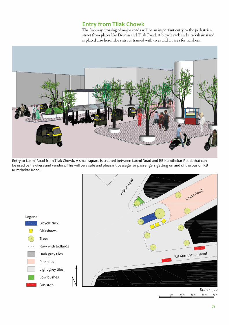
71
Entry from Tilak Chowk Th e fi ve-way crossing of major roads will be an important entry to the pedestrian street from places like Deccan and Tilak Road. A bicycle rack and a rickshaw stand is placed also here. Th e entry is framed with trees and an area for hawkers.
Scale 1:500
Legend
Bicycle rack
Rickshaws
Trees
Row with bollards
Dark grey tiles
Pink tiles
Light grey tiles
Low bushes
Bus stop
10 m5 m 15 m 25 m20 m
Laxmi Road
RB Kumthekar Road
Entry to Laxmi Road from Tilak Chowk. A small square is created between Laxmi Road and RB Kumthekar Road, that can be used by hawkers and vendors. This will be a safe and pleasant passage for passengers getting on and of the bus on RB Kumthekar Road.
Kelka
r Roa
d

72
Stormwater management Pune has an average annual rainfall of just over 700 mm. Out of this almost 90 % falls during the monsoon season from June to October (http://www.worldweather.org/066/c00535.htm). Th is concentrated period of rainfall calls for good stormwa-ter management. Tiles makes the ground slightly more permeable than asphalt. It is also suggested to build a drain on both sides of the street that would collect the water and lead it of the street. Th e water needs to be fi ltered before let out in the Mutha river.
DeliveriesDeliveries should still be allowed on to the pedestrian street, but limited to non-peak shopping hours and only for authorized vehicles. Th is should be marked clear-ly on signs, and all shop owners should be informed. Handcarts however should be allowed for deliveries during all parts of the day.
ParkingTo do something about the parking situation is essential when turning a part of Laxmi Road into a pedestrian street. To provide more parking somewhere, goes against the whole concept of sustainable transport and encourages use of private vehicles. Th e solution is therefore, just like for the concept plan, to no longer supply free parking.
Th e rising cost of parking may unforunately be seen as a negative eff ect of pedestria-nisation and provide a powerful argument against the proposal. It is therefore im-portant to highlight that charging for parking is something normal for most western city centres, as well as the positive eff ect this has had, both for vehicle owners and other citizens.
To help prevent the negative bias that connects parking fees with pedestrianisation and to make the system more effi cient, the parking fees should be implemented in the whole core city at once. Th e stickers, to ensure parking for residents, should be used, as described on page 63.
Getting people to stick to new traffi c rulesIt is often pointed out that Indians tend to break traffi c rules and concerns that peo-ple would illegally drive on the pedestrian street are raised. Bollards can stop larger vehicles like cars, but to physically stop two-wheelers, the street becomes inaccessi-ble for disabled people, as well as pedestrians during crowded hours.
If the rules are made clear, it is easier to get people to follow them. If signage,as well as the physical environment clearly marks that no vehicles are allowed, it becomes easier to fi ne people for driving where they are not suppose to, and disen-courage breaking the rules.
Traffi c police play an important role in getting people to stick to traffi c rules, by charging fi nes etc.
Handcarts can be allowed for deliveries at all parts of the day.
Drain for stormwater management should be placed along the street.
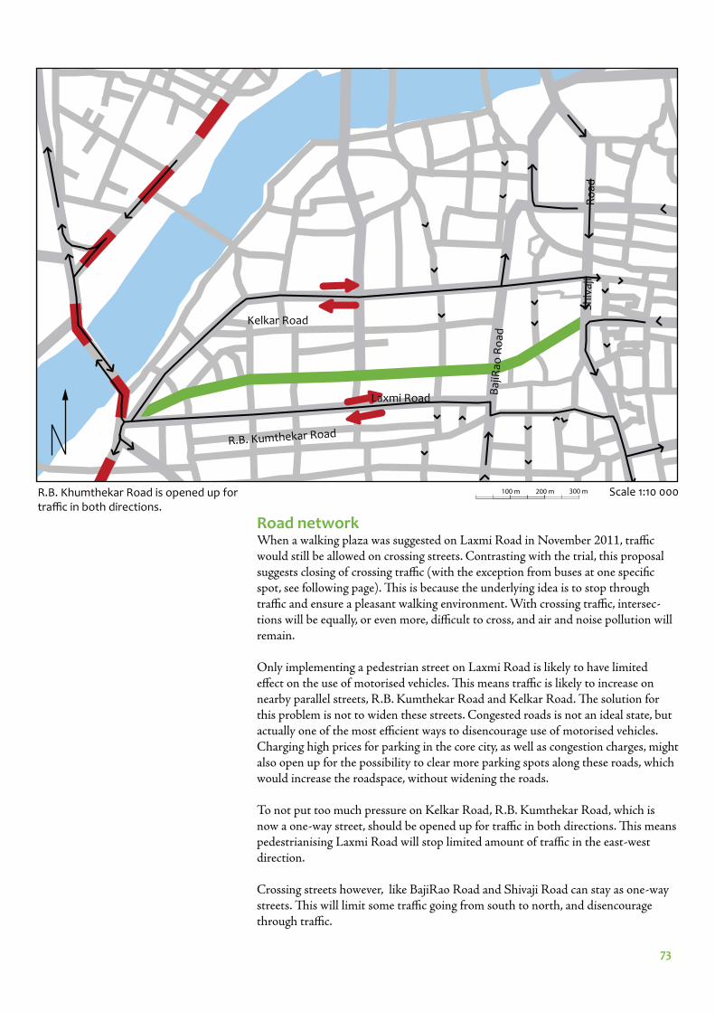
73
Road networkWhen a walking plaza was suggested on Laxmi Road in November 2011, traffi c would still be allowed on crossing streets. Contrasting with the trial, this proposal suggests closing of crossing traffi c (with the exception from buses at one specifi c spot, see following page). Th is is because the underlying idea is to stop through traffi c and ensure a pleasant walking environment. With crossing traffi c, intersec-tions will be equally, or even more, diffi cult to cross, and air and noise pollution will remain.
Only implementing a pedestrian street on Laxmi Road is likely to have limited eff ect on the use of motorised vehicles. Th is means traffi c is likely to increase on nearby parallel streets, R.B. Kumthekar Road and Kelkar Road. Th e solution for this problem is not to widen these streets. Congested roads is not an ideal state, but actually one of the most effi cient ways to disencourage use of motorised vehicles. Charging high prices for parking in the core city, as well as congestion charges, might also open up for the possibility to clear more parking spots along these roads, which would increase the roadspace, without widening the roads.
To not put too much pressure on Kelkar Road, R.B. Kumthekar Road, which is now a one-way street, should be opened up for traffi c in both directions. Th is means pedestrianising Laxmi Road will stop limited amount of traffi c in the east-west direction.
Crossing streets however, like BajiRao Road and Shivaji Road can stay as one-way streets. Th is will limit some traffi c going from south to north, and disencourage through traffi c.
Laxmi Road
R.B. Kumthekar Road
Sh
ivaj
i
Baj
iRao
Ro
ad
Kelkar Road
Ro
ad
Scale 1:10 000R.B. Khumthekar Road is opened up for traffi c in both directions.
100 m 200 m 300 m

74
Laxmi Road
R.B. Kumthekar Road
Sh
ivaj
i Ro
ad
Baj
iRao
Ro
ad
Kelkar Road
BusesTh e buses that run on Laxmi Road could be moved to R.B. Khumthekar Road as it is opened for traffi c in both directions. Th is would mean the bus routes goes on the same street in both directions. Th is is displayed in the map below. Th e road is considered wide enough for this. Th e blocks are about 70 m wide, so the distance to walk from a bus stop on R.B. Kumthekar road on to Laxmi Road is not longer than 100-200 m.
Bus routes that go north on BajiRao Road will continue to do so, and cross the pedestrian street in a single lane. It is important to clearly mark that this road is only meant for buses, and not to be used for private vehicles. A bus stop can then also be placed in connection to the intersection, which would give a bus stop very close to Laxmi Road. Another bus stop can be placed close to Tulshibaug, opposite Vishrambaug wada just south of Laxmi Road (see map to the left).
Baj
iRao
Ro
ad
Laxmi Road
Each bus route is represented with a thin colored line. The case study area is marked with a thick green line. Arrows mark if the routes are going in on only or both directions on the street.
Legend
Bus stop
Bicycle rack
Rickshaws
Trees
Row with bollards
Dark grey tiles
Pink tiles
Light grey tiles
5 m 10 m 15 m 20 m 25 m Scale 1:1 000
Tulshibaug
Vishram-baug Wada
Scale 1:10 000100 m 200 m 300 m
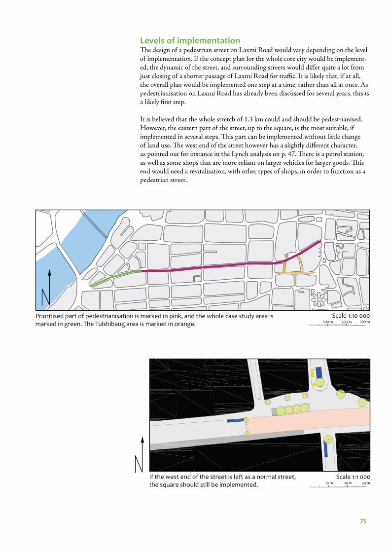
75
Levels of implementationTh e design of a pedestrian street on Laxmi Road would vary depending on the level of implementation. If the concept plan for the whole core city would be implement-ed, the dynamic of the street, and surrounding streets would diff er quite a lot from just closing of a shorter passage of Laxmi Road for traffi c. It is likely that, if at all, the overall plan would be implemented one step at a time, rather than all at once. As pedestrianisation on Laxmi Road has already been discussed for several years, this is a likely fi rst step.
It is believed that the whole stretch of 1.3 km could and should be pedestrianised. However, the eastern part of the street, up to the square, is the most suitable, if implemented in several steps. Th is part can be implemented without little change of land use. Th e west end of the street however has a slightly diff erent character, as pointed out for instance in the Lynch analysis on p. 47. Th ere is a petrol station, as well as some shops that are more reliant on larger vehicles for larger goods. Th is end would need a revitalisation, with other types of shops, in order to function as a pedestrian street.
Prioritised part of pedestrianisation is marked in pink, and the whole case study area is marked in green. The Tulshibaug area is marked in orange.
Scale 1:10 000100 m 200 m 300 m
Scale 1:1 00010 m 20 m 30 m
If the west end of the street is left as a normal street, the square should still be implemented.
76
EVALUATION
77
Implementation of Gehl’s toolbox Gehl’s toolbox for urban environment has been kept in mind while creating and evaluating the detailed planning proposal. How the 12 diff erent criteria are consid-ered is presented here.
• Protection against traffi c and accidents – feeling safe - This criteria is being fulfi lled by banning vehicles on the street
• Protection against crime and violence – feeling secure- This is not something being specifi cally considered in the planning proposal, but the mixed land use on Laxmi Road makes the street stay alive during all parts of the day. This is often pointed out to protect against crime and violence. As the pro-posal is aiming to keep this kind of land use, this criteria is also fulfi lled.
• Protection against unpleasant sensory experiences- Vehicles, which creates a rather stressful and unpleasant environment, with noise and air pollution etc are taken away from the street.
• Opportunities to walk - This is one of the main objectives of this thesis and both the detailed planning proposal and the overall concept plan aims to improve the walking environment.
• Opportunities to stand/stay- More space for pedestrians creates more space to stop and stand as well.
• Opportunities to sit- While visiting Laxmi Road it has been noted that places to sit are a scarce resource at present. People sometimes sit on other peoples parked two-wheelers while waiting for something, in lack of other of other places to sit. New seats with a good view of the street and in shade from the trees will be implemented.
• Opportunities to see- There are always something to see on Indian streets. The many sari fabric shops and the vendors makes Laxmi Road an extra colorful street.
• Opportunities to talk and listen- When traffi c is taken away, so are at least two sources of disturbing sounds on the street. The noise from the engines and wheels of the vehicles as well as the constant honking.
• Opportunities for play and exercise- As important as it is to have these kind of places in the city, a shopping street as Laxmi Road is not considered ideal for activities as play and exercise. It is likely pos-sible to fi nd better suited places for this within the core city area.
• Scale- To keep buildings and roads small scale is something that is something that per-meates the planning proposal. The land use and buildform is not changed with the planning proposal.
• Opportunities to enjoy the positive aspects of climate- Pune has a climate that for most parts of the year is pleasant for outdoor activi-ties. During winter it never rains, whereas the rainfall is sometimes heavy during the monsoon season. To create shade well needed on hot days the thesis suggests planting trees along the whole street.
• Positive sensory experience- There are already lots of positive sensory experiences on the street. By taking away negative sensory experiences, the positive can be reinforced.
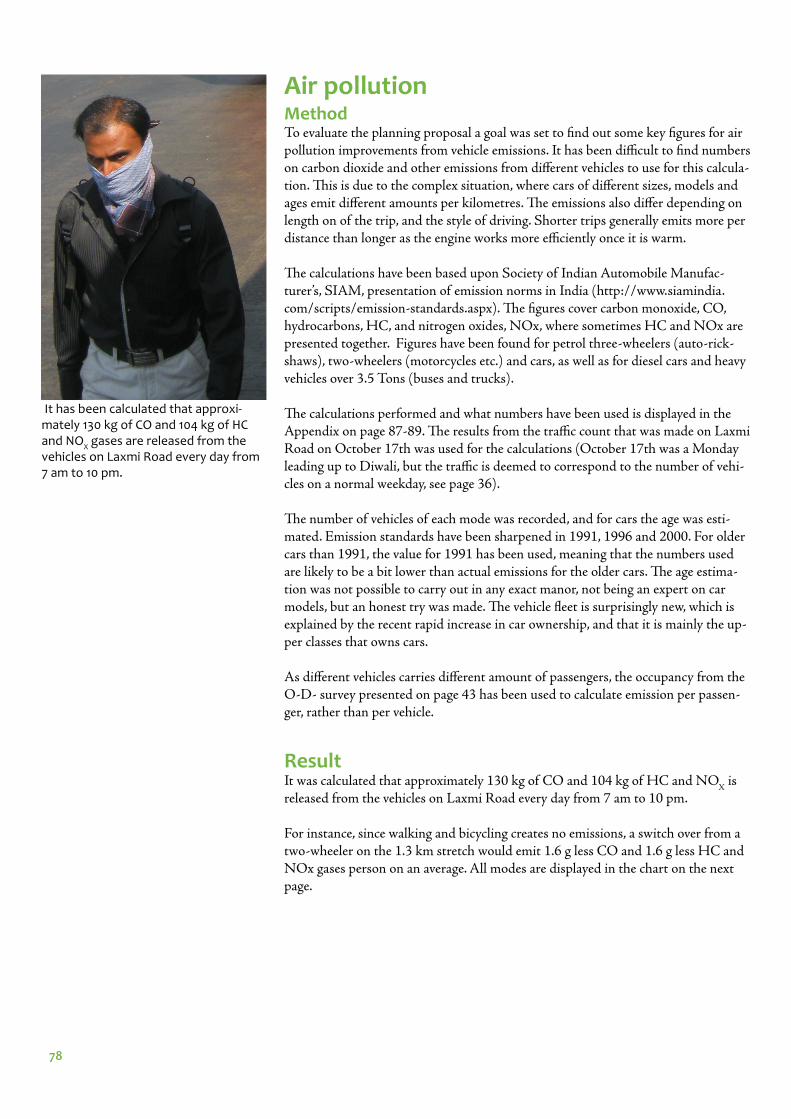
78
Air pollutionMethodTo evaluate the planning proposal a goal was set to fi nd out some key fi gures for air pollution improvements from vehicle emissions. It has been diffi cult to fi nd numbers on carbon dioxide and other emissions from diff erent vehicles to use for this calcula-tion. Th is is due to the complex situation, where cars of diff erent sizes, models and ages emit diff erent amounts per kilometres. Th e emissions also diff er depending on length on of the trip, and the style of driving. Shorter trips generally emits more per distance than longer as the engine works more effi ciently once it is warm.
Th e calculations have been based upon Society of Indian Automobile Manufac-turer’s, SIAM, presentation of emission norms in India (http://www.siamindia.com/scripts/emission-standards.aspx). Th e fi gures cover carbon monoxide, CO, hydrocarbons, HC, and nitrogen oxides, NOx, where sometimes HC and NOx are presented together. Figures have been found for petrol three-wheelers (auto-rick-shaws), two-wheelers (motorcycles etc.) and cars, as well as for diesel cars and heavy vehicles over 3.5 Tons (buses and trucks).
Th e calculations performed and what numbers have been used is displayed in the Appendix on page 87-89. Th e results from the traffi c count that was made on Laxmi Road on October 17th was used for the calculations (October 17th was a Monday leading up to Diwali, but the traffi c is deemed to correspond to the number of vehi-cles on a normal weekday, see page 36).
Th e number of vehicles of each mode was recorded, and for cars the age was esti-mated. Emission standards have been sharpened in 1991, 1996 and 2000. For older cars than 1991, the value for 1991 has been used, meaning that the numbers used are likely to be a bit lower than actual emissions for the older cars. Th e age estima-tion was not possible to carry out in any exact manor, not being an expert on car models, but an honest try was made. Th e vehicle fl eet is surprisingly new, which is explained by the recent rapid increase in car ownership, and that it is mainly the up-per classes that owns cars.
As diff erent vehicles carries diff erent amount of passengers, the occupancy from the O-D- survey presented on page 43 has been used to calculate emission per passen-ger, rather than per vehicle.
ResultIt was calculated that approximately 130 kg of CO and 104 kg of HC and NO
X is
released from the vehicles on Laxmi Road every day from 7 am to 10 pm.
For instance, since walking and bicycling creates no emissions, a switch over from a two-wheeler on the 1.3 km stretch would emit 1.6 g less CO and 1.6 g less HC and NOx gases person on an average. All modes are displayed in the chart on the next page.
It has been calculated that approxi-mately 130 kg of CO and 104 kg of HC and NO
X gases are released from the
vehicles on Laxmi Road every day from 7 am to 10 pm.
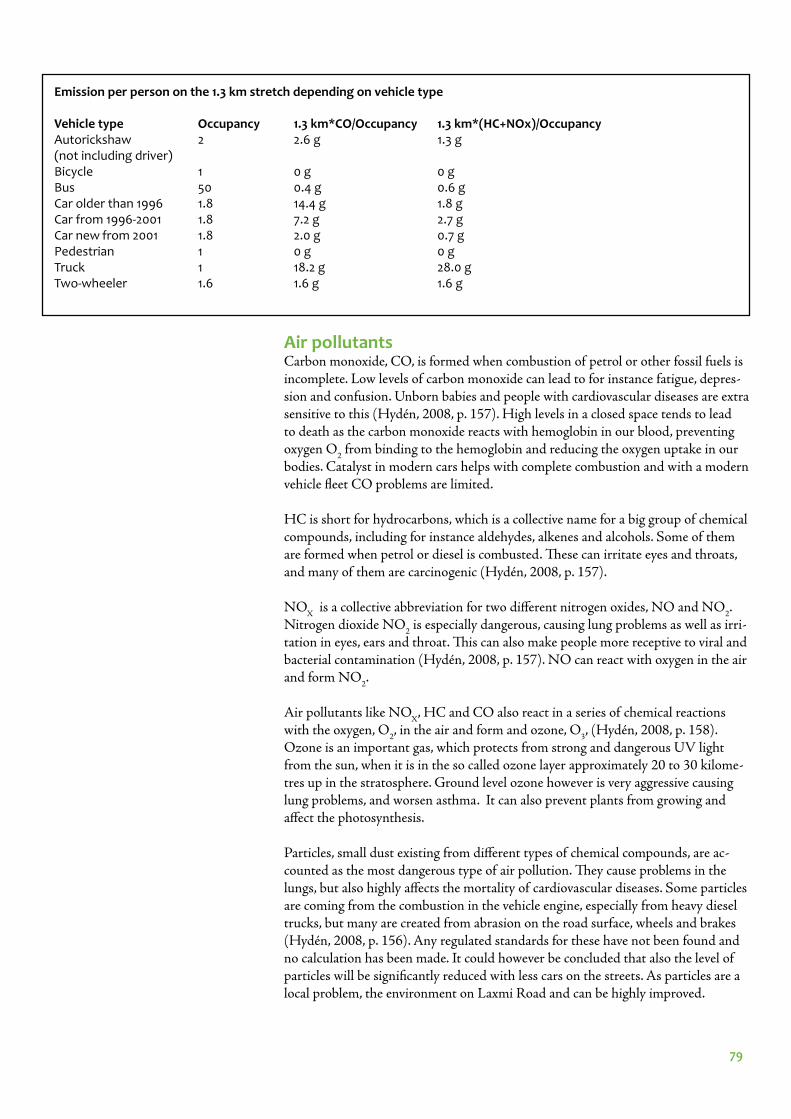
79
Air pollutantsCarbon monoxide, CO, is formed when combustion of petrol or other fossil fuels is incomplete. Low levels of carbon monoxide can lead to for instance fatigue, depres-sion and confusion. Unborn babies and people with cardiovascular diseases are extra sensitive to this (Hydén, 2008, p. 157). High levels in a closed space tends to lead to death as the carbon monoxide reacts with hemoglobin in our blood, preventing oxygen O
2 from binding to the hemoglobin and reducing the oxygen uptake in our
bodies. Catalyst in modern cars helps with complete combustion and with a modern vehicle fl eet CO problems are limited.
HC is short for hydrocarbons, which is a collective name for a big group of chemical compounds, including for instance aldehydes, alkenes and alcohols. Some of them are formed when petrol or diesel is combusted. Th ese can irritate eyes and throats, and many of them are carcinogenic (Hydén, 2008, p. 157).
NOX
is a collective abbreviation for two diff erent nitrogen oxides, NO and NO2.
Nitrogen dioxide NO2 is especially dangerous, causing lung problems as well as irri-
tation in eyes, ears and throat. Th is can also make people more receptive to viral and bacterial contamination (Hydén, 2008, p. 157). NO can react with oxygen in the air and form NO
2.
Air pollutants like NOX
, HC and CO also react in a series of chemical reactions with the oxygen, O
2, in the air and form and ozone, O
3, (Hydén, 2008, p. 158).
Ozone is an important gas, which protects from strong and dangerous UV light from the sun, when it is in the so called ozone layer approximately 20 to 30 kilome-tres up in the stratosphere. Ground level ozone however is very aggressive causing lung problems, and worsen asthma. It can also prevent plants from growing and aff ect the photosynthesis.
Particles, small dust existing from diff erent types of chemical compounds, are ac-counted as the most dangerous type of air pollution. Th ey cause problems in the lungs, but also highly aff ects the mortality of cardiovascular diseases. Some particles are coming from the combustion in the vehicle engine, especially from heavy diesel trucks, but many are created from abrasion on the road surface, wheels and brakes (Hydén, 2008, p. 156). Any regulated standards for these have not been found and no calculation has been made. It could however be concluded that also the level of particles will be signifi cantly reduced with less cars on the streets. As particles are a local problem, the environment on Laxmi Road and can be highly improved.
Emission per person on the 1.3 km stretch depending on vehicle type
Vehicle type Occupancy 1.3 km*CO/Occupancy 1.3 km*(HC+NOx)/OccupancyAutorickshaw 2 2.6 g 1.3 g(not including driver)Bicycle 1 0 g 0 gBus 50 0.4 g 0.6 gCar older than 1996 1.8 14.4 g 1.8 gCar from 1996-2001 1.8 7.2 g 2.7 gCar new from 2001 1.8 2.0 g 0.7 gPedestrian 1 0 g 0 gTruck 1 18.2 g 28.0 gTwo-wheeler 1.6 1.6 g 1.6 g
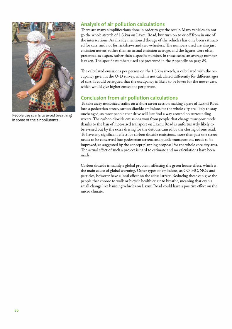
80
Analysis of air pollution calculationsTh ere are many simplifi cations done in order to get the result. Many vehicles do not go the whole stretch of 1.3 km on Laxmi Road, but turn on to or off from in one of the intersections. As already mentioned the age of the vehicles has only been estimat-ed for cars, and not for rickshaws and two-wheelers. Th e numbers used are also just emission norms, rather than an actual emission average, and the fi gures were often presented as a span, rather than a specifi c number. In these cases, an average number is taken. Th e specifi c numbers used are presented in the Appendix on page 89.
Th e calculated emissions per person on the 1.3 km stretch, is calculated with the oc-cupancy given in the O-D survey, which is not calculated diff erently for diff erent ages of cars. It could be argued that the occupancy is likely to be lower for the newer cars, which would give higher emissions per person.
Conclusion from air pollution calculationsTo take away motorised traffi c on a short street section making a part of Laxmi Road into a pedestrian street, carbon dioxide emissions for the whole city are likely to stay unchanged, as most people that drive will just fi nd a way around on surrounding streets. Th e carbon dioxide emissions won from people that change transport mode thanks to the ban of motorised transport on Laxmi Road is unfortunately likely to be evened out by the extra driving for the detours caused by the closing of one road. To have any signifi cant eff ect for carbon dioxide emissions, more than just one street needs to be converted into pedestrian streets, and public transport etc. needs to be improved, as suggested by the concept planning proposal for the whole core city area. Th e actual eff ect of such a project is hard to estimate and no calculations have been made.
Carbon dioxide is mainly a global problem, aff ecting the green house eff ect, which is the main cause of global warming. Other types of emissions, as CO, HC, NOx and particles, however have a local eff ect on the actual street. Reducing these can give the people that choose to walk or bicycle healthier air to breathe, meaning that even a small change like banning vehicles on Laxmi Road could have a positive eff ect on the micro climate.
People use scarfs to avoid breathing in some of the air pollutants.
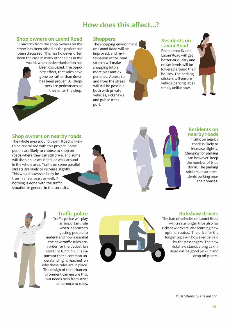
81
How does this aff ect...?
Shop owners on nearby roadsThe whole area around Laxmi Road is likely to be revitalised with this project. Some people are likely to choose to shop on roads where they can still drive, and some will shop on Laxmi Road, or walk around in the whole area. Traffi c on some parallel streets are likely to increase slightly. This would however likely be true in a few years as well, if nothing is done with the traffi c situation in general in the core city.
ShoppersThe shopping environment on Laxmi Road will be improved, and revi-talisation of the road stretch will make shopping into a more pleasant ex-perience. Access to and from the street will still be possible both with private vehicles, rickshaws and public trans-port.
Laxmi RoadPeople that live on Laxmi Road will get better air quality and noises levels will be lowered around their houses. The parking stickers will ensure vehicle parking at all times, unlike now.
nearby roadsTraffi c on nearby roads is likely to
increase slightly. Charging for parking
can however keep the number of trips down. The parking
stickers ensure resi-dents parking near
their houses.
Shop owners on Laxmi RoadConcerns from the shop owners on the
street has been raised as the project has been discussed. This has however often been the case in many other cities in the
world, when pedestrianisation has been discussed. The oppo-site eff ect, that sales have gone up rather than down has been proven. All shop-
pers are pedestrians as they enter the shop.
Traffi c policeTraffi c police will play
an important role when it comes to getting people to
understand how essential the new traffi c rules are.
In order for the pedestrian street to function, it is im-
portant that a common un-derstanding is reached on
why these rules are in place. The design of the urban en-vironment can ensure this, but needs help from strict
adherence to rules.
Rickshaw driversThe ban of vehicles on Laxmi Road
will create longer trips also for rickshaw drivers, and learning new
optimal routes. The price for the longer trips will however be paid
by the passengers. The new rickshaw stands along Laxmi
Road will be good pick up and drop off points.
Illustrations by the author.
Residents on
Residents on
82
With a Western perspectiveIndian traffi c often seems crazy to Westerners, and it is important to remember that what is chaotic to us follows some kind of pattern and is normal and accepted by most Indians. After a little while it is not very hard to cross an Indian road and feel relatively safe. To force a Western planning method on a diff erent cultural context might not always be ideal.
However, there is a drive in India to be classifi ed as a developed country, and in many ways the car is seen as a status symbol and a symbol of development. Th e peo-ple that can aff ord to have one tend to drive everywhere. Suffi cient alternatives are often lacking. Th e class society is very evident here. Just like in India, most western cities were initially developed as walking cities (Schiller, Bruun & Kenworthy, 2010, p. 25-26). Most Western cities have then gone through a period when they devel-oped almost only to support the needs of car drivers. First after a while the many problems that come with driving were realised. With scarce resource, it would be useful to skip the destructive step in the middle and learn from mistakes in the West as well as solutions to sort out our mistakes.
Th e same thing that happened in the West is now happening in India. Streets are widened, fl yovers are being built, and the number of vehicles is increasing rapidly. Th e two large scale parking houses by the old fruit market at Mandai is a sign that it is happening in the core city in Pune as well. In the West we have started to recon-struct our cities to also fi t pedestrians and a sustainable transport system, including good public transport as a goal. Th e National Urban Transport Policy as well as the CMP for Pune (Comprehensive Mobility Plan for Pune City, 2008, p. 1;1) aims for this as well, but so far implementation has not gone according to plan.
It is therefore important to show examples of the improvements that can be made with relatively simple methods. Jan Gehl points out in his book Cities for People that no matter where in the world, planning with focus on human scale is important (Gehl, 2010, p. 229). Global warming, which is one of the many problems with extensive automobile use is a global problem and something necessary to fi ght every-where in the world.

83
ConclusionTh e concept plan is a large scale project that would need time, money and lot of political will to implement. Much of the thesis is therefore focused on why these so-lutions are necessary. It is essential that the underlying ideas are understood, so that important parts of the proposal are still implemented even if all ideas are not used.
It is important that a project like this is well-implemented from the beginning. Otherwise there is a risk that a similar situation occurs as with the implementation of the BRT system trial in Pune, the cycle tracks, or the pedestrian plaza on M.G. Road. When some things are not working fully, the whole project gets criticised and lose support from people and politicians.
Some of the analysis are aimed mainly to investigate if pedestrianisation of a major road in the core city is possible, and if Laxmi Road is at an appropriate street to start with. It can be concluded from the Lynch analysis (see page 48), that there is no coincidence that Laxmi Road has been suggested for pedestrianisation for several years. Th e many places with tourist interest in the area, as well as the already highly pedestrianised area Tulshibaug, and the already high share of pedestrians makes this a suitable fi rst project.
Inventory and analysis have also been aimed to locate potential problems with blocking a stretch of Laxmi Road for traffi c, and then fi nd solutions for these prob-lems in the planning proposal.
Laxmi Road is a popular street for shopping for higher social classes in Pune. If an area like this is pedestrianised successfully, the status of these kind of projects could be raised, and the nice parts of traffi c-free areas could be realised by many Indians. Creation of a public transport system that would be accepted also by the higher classes should also be prioritised, and would be something that would benefi t all social classes.
Th e design of the pedestrian street is made relatively simple, which is keeping the costs down. With the dense structure of Indian cities and extensive street life it is important to not make the street over-crowded with street furniture etc. However, it is also important to keep the design smallscale. Th e diff erent colors and patterns of the pavement stones for instance, is a way to make the street feel narrow, without taking away any space.
It has been demonstrated that the air quality on the street can be greatly improved. Measurements should be made before and after implementing the project for further evaluation. Other parameters should also be evaluated, when the project is implemented. For instance traffi c safety, before and after implementation, should be analysed. Another important parameter is if the shop sales are going up or down if the street is pedestrianised. It would also be interesting to analyse if the project would lead to any trip reductions, or if it just changes the common routes slightly.
Th ese kinds of measurements are important in order to get tangible and comparable results. If the project is successful, Pune can be used as a best practice encouraging use of sustainable transport principles also outside the core city area, as well in other Indian and perhaps Asian cities.
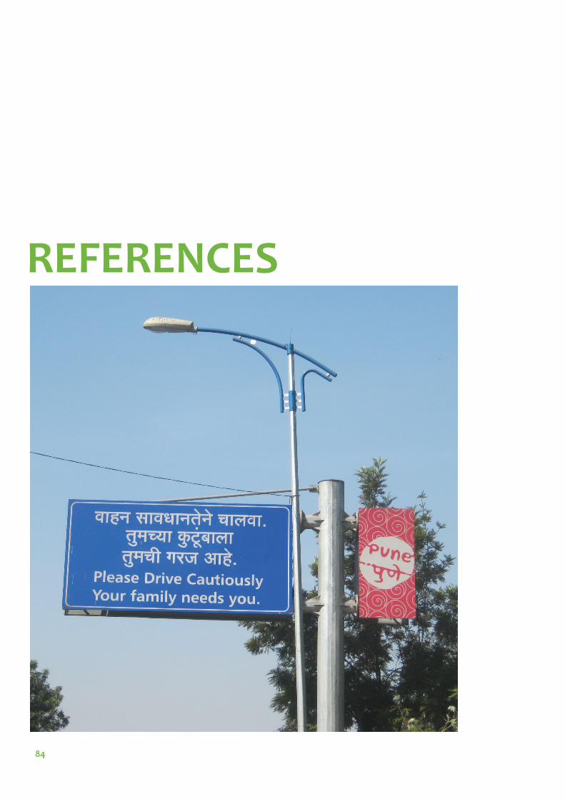
84
REFERENCES
85
References Buis, J. and ter Avest, R. November 2008, Sustainable Infrastructure, Powerpoint
Comprehensive Mobility Plan for Pune City, November 2008, Pune Municipal Cor-poration with Wilbur Smith Associates, Urban Infrastructure & Service Limited
Depotwise statistical report for the month of March 2011. Pune Mahanagar Parivahan Mahamandal LTD. Retrieved from Ranjit Gadgil January 27, 2012 [e-mail from <[email protected]> Saga Wingård <[email protected]>
Deshmukh, N. Nov 1, 2011. On weekends, Laxmi Road stretch as a walkway, Times of India, Times City, p. 20
Deshmukh, V., 4 Jan, 2007, Pune’s BRT stumbles at the start, retrieved July 20, 2011 from http://www.indiatogether.org/2007/jan/eco-brtpune.htm#continue
Diddee, J. & Gupta, S., 2000 Pune – Queen of Deccan, Elephant Design Pvt Ltd, Pune Printed at Tien Wah Press (Pte) Ltd, Singapore
Gadgil, R. 2011, Concept Note - Core Area Mobility Plan for Pune, retrieved from Sujit Patwardhan February 11, 2011 [e-mail from <[email protected]> Saga Wingård <[email protected]>
Gehl, J., 1987. Life Between Buildings: Using Public Space, Island Press
Gehl, J., 2010. Cities for People, Island Press
Hydén, C., 2008. Trafi ken i den hållbara staden, Studentlitteratur
Inamdar, P., meeting Dec 4, 2011
Kulkarni, P., Nov 1, 2011. MG Road to get back vehicle-free day, Times of India, Times City, p. 20
Kuvalekar, A., December, 2010, Th e Case for Metro Rail in Pune retrieved August 9, 2011 from http://www.parisar.org/images/publications/case-for-pune-metro.pdf
Kost, C., and Nohn, M., Sep 2011. Better streets, better cities - A guide to street design in urban India, ITDP (Th e Institute for Transportation and Development Policy) and EPC (Th e Environmental Planning Collaborative) Lindelöw, D., 2009, Strategier för ett ökat gående och cyklande - en litteraturstudie om olika faktorers betydelse, Bulletin 249, Institutionen för Teknik och samhälle, Trafi k och väg, Lunds universitet
Lynch, K., 1960, Th e Image of the City MIT Press
Patwardhan, S. meeting, Nov 2, 2011.
Pucher, J. Buehler, R, 2008, Making Cycling Irresistible: Lessons from Th e Netherlands, Denmark and Germany. Transport reviews 28 4;495-529, Routledge
Pucher, J., 2007. Case Studies of Cycling in Amsterdam: Th e Netherlands. New Bruns-wick, NJ: Rutgers University, Center for Urban and Economic Research

86
Schiller, P. L., Bruun, E.C. & Kenworthy, J.R., 2010. An Introduction to Sustainable Transportation: Policy, Planning and Implementation. London: Earthscan.
Singh, S. Sep 2011, India, 14th Edition, Lonely Planet publications Ltd.
Southworth, M., 2005, Designing the Walkable City, Journal of Urban Planning and Development 131 (4) pp. 246-257
Sreenivas, A. February 18, 2011, Presentation at “National Conference on Urban Policy and Planning: A Case Perspective of Pune” representing Parisar Urban transport in Pune, retrieved February 28, 2011 from http://www.parisar.org/im-ages/publications/ashok-symbiosis-ut-feb11.pdf
Sreenivas, A. December, 2010, Lessons in Urban Transport Planning and Governance: Based on the Proposed Metro Rail System in Pune Retrieved Jan 5, 2012 from http://www.parisar.org/images/publications/pune-metro-analysis-parisar.pdf
Tender for Eco-friendly Share & Ride Public Bicycle System in Pune City. Pune Municipal Corporation, [e-mail from <[email protected]> Saga Wingård <[email protected]>] March 2, 2012
Th ynell, M. Mohan, D. Tiwari, G., 2010 Sustainable Transport and the Moderni-sation of Urban Transport in Delhi and Stockholm, Cities, Volume 27, Issue 6, pp. 421-429
Webpages and online articleshttp://onourowntwowheels.com/tag/pune/ November 15, 2010 Do Segregated Cycle Tracks Make Sense in India? Retrieved August 8, 2011.
http://www.censusindia.gov.in/2011-prov-results/paper2/data_fi les/India2/Ta-ble_2_PR_Cities_1Lakh_and_Above.pdf Provisional Population Totals, Census of India 2011 retrieved March 3, 2012
http://www.parisar.org/about-us.html About Us, last updated 19 May, 2009a. Re-trieved February 22, 2011.
http://www.parisar.org/activities/public-outreach/130-brt-getting-people-on-board.pdf BRT - Getting People on Board, 25 April, 2011. Retrieved July 20, 2011.
http://www.parisar.org/images/publications/nowhere%20to%20walk.pdf Nowhere to walk, 2010a. Retrieved February 8, 2011.
http://www.parisar.org/activities/analysesreports/113-parisar-report-on-jm-fc-one-way-scheme.html 2010b. Critical Analysis of the Jangli Maharaj Road and Fergusson College Road One Way Scheme. Retrieved March 2, 2012
http://www.parisar.org/urban-transport.html Urban Transport, last updated May 22, 2009b. Retrieved February 22, 2011.
http://www.siamindia.com/scripts/emission-standards.aspx INTRODUCTION. Retrieved September 22, 2011.
http://www.worldweather.org/066/c00535.htm Climatological Information, retrieved January 26, 2012.
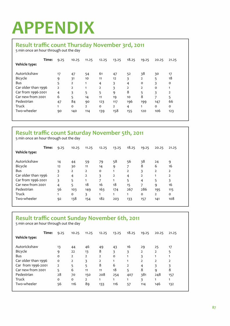
87
APPENDIXResult traffi c count Thursday November 3rd, 2011 5 min once an hour through out the day
Time: 9.25 10.25 11.25 12.25 13.25 18.25 19.25 20.25 21.25Vehicle type: Autorickshaw 17 47 54 61 47 52 38 30 17Bicycle 9 31 10 11 12 3 2 5 18Bus 5 2 1 4 3 4 0 3 0Car older than 1996 2 2 1 2 3 2 2 0 1Car from 1996-2001 4 3 5 5 9 8 5 3 2Car new from 2001 6 5 14 11 19 10 8 7 5Pedestrian 47 84 90 123 117 196 199 147 66Truck 1 0 2 0 2 4 1 0 0Two-wheeler 90 140 114 139 158 155 120 106 123
Result traffi c count Saturday November 5th, 2011 5 min once an hour through out the day
Time: 9.25 10.25 11.25 12.25 13.25 18.25 19.25 20.25 21.25Vehicle type: Autorickshaw 14 44 59 79 58 56 38 24 9Bicycle 12 30 11 14 9 7 8 6 16Bus 3 2 2 0 1 2 3 2 2Car older than 1996 2 4 2 3 2 4 2 1 2Car from 1996-2001 3 5 1 7 1 5 4 5 3Car new from 2001 4 5 18 16 18 15 7 9 16Pedestrian 56 103 149 163 174 267 286 195 115Truck 1 0 3 1 1 1 0 2 0Two-wheeler 92 138 154 182 203 133 157 141 108
Result traffi c count Sunday November 6th, 2011 5 min once an hour through out the day
Time: 9.25 10.25 11.25 12.25 13.25 18.25 19.25 20.25 21.25Vehicle type: Autorickshaw 13 44 46 49 43 16 29 25 17Bicycle 9 22 13 8 3 3 2 2 5Bus 0 2 2 2 0 1 3 1 1Car older than 1996 0 2 3 2 1 1 2 2 2Car from 1996-2001 2 5 5 8 6 2 4 3 3Car new from 2001 5 6 11 11 18 5 8 9 8Pedestrian 28 70 150 208 254 407 381 248 157Truck 0 0 2 1 1 1 3 1 1Two-wheeler 56 116 89 133 116 57 114 146 132
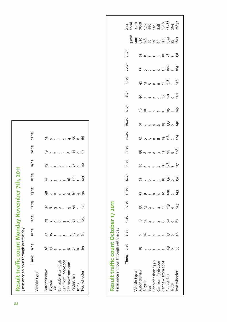
88
Re
sult
tra
ffi c
co
un
t O
cto
be
r 17
20
11
5
min
on
ce a
n h
ou
r th
rou
gh
ou
t th
e d
ay
T
ime
: 7.
25
8.2
5 9
.25
10.2
5 11
.25
12.2
5 13
.25
14.2
5 15
.25
16.2
5 17
.25
18.2
5 19
.25
20.2
5 21
.25
x
12
5
min
to
tal
Ve
hic
le t
ype
:
su
m
su
mA
uto
rick
shaw
15
9
18
33
51
75
40
55
52
8
1 4
8
50
42
35
25
629
75
48
B
icyc
le
7 14
12
13
9
7
2 8
5
2 10
7
14
5 11
12
6
1512
B
us
2 5
2 2
1 0
5
4
3 3
1 4
5
2 1
40
4
80
C
ar o
lde
r th
an 1
99
6
1 0
1
1 0
2
1 0
0
0
0
2
0
1 1
10
120
C
ar f
rom
19
96
-20
01
1 2
2 4
4
5
4
3 8
6
6
9
6
4
5
69
8
28
Car
ne
w f
rom
20
01
2 4
6
11
10
13
13
12
15
13
7
16
11
11
10
154
18
48
P
ed
est
rian
49
23
52
11
9
120
13
7 12
6
99
11
6
133
115
101
158
10
0
76
1524
18
288
Tr
uck
0
0
0
0
2
6
3 5
2 0
1
0
1 1
1 22
26
4
Two
-wh
ee
ler
35
4
6
67
143
143
152
117
128
12
4
140
14
5 14
0
146
16
4
131
1821
21
852
Re
sult
tra
ffi c
co
un
t M
on
day
No
vem
be
r 7t
h, 2
011
5
min
on
ce a
n h
ou
r th
rou
gh
ou
t th
e d
ay
Tim
e:
9.2
5 10
.25
11.2
5 12
.25
13.2
5 18
.25
19.2
5 20
.25
21.2
5V
eh
icle
typ
e:
Au
tori
cksh
aw
18
22
29
32
4
9
42
25
19
14B
icyc
le
13
15
8
8
7 7
7 7
9B
us
3 1
0
5 0
3
2 2
1C
ar o
lde
r th
an 1
99
6
1 2
0
2 1
2 0
1
1C
ar f
rom
19
96
-20
01
1 3
3 1
3 1
4
1 2
Car
ne
w f
rom
20
01
8
3 8
9
6
16
7
6
4P
ed
est
rian
24
42
67
65
61
119
8
5 4
5 35
Tru
ck
0
0
0
1 4
1
0
0
0Tw
o-w
he
ele
r
69
6
5 10
5 14
5 9
0
129
11
2 9
7 6
6

89
Air pollution calculations x 1.3 km Vehicle type Total sum Vehicle km CO HC + NOxAutorickshaw 7548 9812.4 39249.6 19624.8Bicycle 1512 1965.6 0 0 Bus 480 624 8736 13416 Car older than 1996 120 156 3120 390 Car from 1996-2001 828 1076.4 10764 4090.3 Car new from 2001 1848 2402.4 6678.7 2330.3 Pedestrian 18288 23774.4 0 0 Truck 264 343.2 4804.8 7378.8 Two-wheeler 21852 28407.6 56815.2 56815.2
= 130168.3 = 104045.5 = 130 kg/day = 104 kg/day
Used numbers for emissions from diff erent types of vehicles Based upon Society of Indian Automobile Manufacturer’s, SIAM presentation of emission norms in India (http://www.siamindia.com/scripts/emission-standards.aspx)
Vehicle type CO HC + NOxAutorickshaw 4 2Bicycle 0 0Bus 14 21.5Car older than 1996 20 2.5Car from 1996-2001 10 3.8Car new from 2001 2.78 0.97Pedestrian 0 0Truck 14 21.5
Two-wheeler 2 2
Related Documents