Planning Statement February 2013

Welcome message from author
This document is posted to help you gain knowledge. Please leave a comment to let me know what you think about it! Share it to your friends and learn new things together.
Transcript

Planning Statement
February 2013

Table of Contents
1.0 INTRODUCTION
2.0 LOCATION AND DESCRIPTION OF THE APPLICATION AREA
3.0 DEVELOPMENT PROPOSALS
4.0 LEGISLATION AND POLICY CONTEXT
5.0 CONCLUSIONS
FIGURES
Figure 1 Cable Route Zebrugge Belgium to Kent UK Figure 2 Site Location Plan Figure 3 Proposed Converter Station and Substation Site Layout Plan Figure 4 Proposed Converter Station and Substation Elevations Figure 5 Environmental Constraints Plan


1.0 INTRODUCTION
1.1 The Nemo Link (The Project) is a proposed high voltage direct current (HVDC) electrical
interconnector with an approximate capacity of 1,000 megawatts (MW) which will allow the transfer of electrical power via subsea cables between the UK and Belgium. The power would be bi-directional, able to flow in either direction at different times, depending on the
supply and demand in each country. The project will bring both short and long term local economic benefit, wider benefit to electricity consumers in the UK and Europe and enhanced opportunities for the integration of renewable energy to meet climate change targets. The UK onshore elements (the Proposed Development) for which planning permission is sought comprise a converter station, substation and cables installed below the ground between the converter station and mean low water. The onshore underground cables would connect above high water to subsea cables which would cross the inter-tidal area to low water and continue beneath the North Sea through English, French and Belgian waters to West Zeebruge. The subsea cables would then connect to onshore underground cables and a converter station in Belgium.
1.2 The proposed route of the subsea cables from Pegwell Bay at Richborough in Kent to
Zeebrugge in Belgium is shown at Figure 1. The Project is being developed by National National Grid Nemo Link Ltd (NGNLL) and Elia Asset S.A. (Elia) which is part of the national electricity transmission company in Belgium. The planning application includes a substation which will be part of the connection between the converter station and the high voltage alternating current (HVAC) national electricity transmission system. The substation will be owned and operated by NGET.
1.3 This Planning Statement has been prepared by TEP to accompany a hybrid planning
application under the Town and Country Planning Act 1990 submitted to Thanet District Council (TDC) and Dover District Council (DDC) for the onshore infrastructure required in the UK which will comprise:
A HVDC converter station on part of the site of the former Richborough Power Station which would convert the HVDC power used in the link to HVAC for use in the national transmission system and vice-versa;
A 400kV electricity substation on part of the site of the former Richborough Power Station;
Three 400kV high voltage AC underground electricity cables to connect the above substation to the HVDC converter station and up to two telecommunications cables for telemetry, control and protection purposes only;
Two HVDC onshore underground cables from the converter station to the landfall on the coast at Pegwell Bay where they will be joined to the subsea HVDC cables;
Two HVDC cables between the landfall and the mean low water mark; and
Fibre optic cables installed with the HVDC cables for the purposes of operational telemetry and communications.
1.4 The majority of the Proposed Development falls within the administrative boundary of Thanet
District Council (TDC). Approximately 720m of the onshore HVDC cable and a small area at the south east corner of the proposed converter station compound (outdoor hard landscaping and security perimeter fencing) is within the administrative boundary of Dover District Council. This Planning Statement accompanies a single hybrid application for planning permission (with some matters reserved) being sought under the Town and Country Planning Act 1990 as follows:

Outline Permission
Proposed HVDC converter station and 400kV substation – matters of landscaping and access are provided. Matters of appearance, layout and scale are reserved.
Full Permission
Proposed HVDC, HVAC and fibre optic cables - all matters are provided.
1.5 A full description of the Proposed Development is detailed at Chapter 2 of the Environmental
Statement. The hybrid planning application has been submitted to both Thanet District Council (TDC) and Dover District Council (DDC); through pre-application discussions with both Local Planning Authorities, it has been agreed that TDC is to adopt the lead with regards the coordination and determination of the hybrid planning application. Decision notices are however to be issued by both Local Planning Authorities (LPAs). Further details regarding the approach to and the provisions of the hybrid planning application are included in the planning application covering letters to TDC and DDC.
1.6 This Planning Statement provides the planning context and background. It also provides the
details of the Proposed Development and sets out how it fits with local, regional and national planning policy.
1.7 A separate Environmental Statement (ES) has also been submitted in support of the
applications. The Planning Statement and ES have been prepared to support the hybrid planning application made to Thanet District Council and Dover District Council and to meet the statutory obligations that apply to licence-holders under the Electricity Act 1989. Under Schedule 9 of the Electricity Act 1989, a licence holder must:
‘have regard to the desirability of preserving natural beauty, of conserving flora, fauna and geological or physiographical features of special interest and of protecting sites, buildings and objects of architectural, historic or archaeological interest; and
do what it reasonably can to mitigate any effect which the proposals would have on the natural beauty of the countryside or on such flora, fauna, features, sites, buildings or objects.’
1.8 The remainder of this Planning Statement is structured as follows:
Location and Description of the Application Area;
Development Proposals;
Legislation and Policy Context; and
Conclusions.

2.0 LOCATION AND DESCRIPTION OF THE APPLICATION AREA
General 2.1 The Proposed Development comprises approximately 2.1 kilometres (km) of underground
cables between the converter station and mean low water and a site of approximately 7.8 hectares (ha) of land at the former Richborough Power Station which will contain the proposed converter station and substation.
2.2 The main access to the former Richborough Power Station site is off Ramsgate Road (A256). Ramsgate Road is a dual carriageway at this point and connects to the East Kent Access Road. The A256 (Ramsgate Road), southeast of the power station, separates the proposed converter and substation site from the Kent coast and Pegwell Bay and Sandwich Bay. A road improvement scheme has been carried out to construct a new bypass which connects to the widened A256 at a new roundabout approximately 200m northeast of the Richborough Power Station site and passes north to connect to the A299.
2.3 The northern boundary of the proposed converter station and substation site is formed by a car park and electrical equipment south of the land allocated for the Channel Tunnel Rail Link; the eastern boundary is formed by Ramsgate Road; the southern boundary is the immediate southern extent of the steel frame of the former turbine hall which will be retained to form the frame for the converter station. Thanet Offshore Wind Farm substation and the UK Power Networks operated 132kV substation at Richborough provide local electricity supplies and connect the Thanet Offshore Wind Farm to the electricity distribution system. The substations are immediately south of the proposed converter and substation site.
2.4 The site of the proposed converter station and substation is derelict and the debris from demolition of the chimney stack and cooling towers which previously occupied part of the site has been cleared to an area outside of the application area within the former Richborough power station boundary. Former and present land uses in the vicinity are largely industrial with Weatherlees Hill Wastewater Treatment Works to the north west of the site and mixed use commercial development to the south and east. Brownfield land to the west of the proposed converter station and substation, comprising a further part of the former Richborough Power Station site, is proposed to be used for energy generation project(s) from a number of sources.
Need for the Proposed Development 2.5 The Project has set out a ‘Need Case’ separately1. It is European Union (EU) policy to
increase the transmission capacity between countries, with the stated wish to see each member state establish an interconnector capacity of around 10% of installed generation capacity. The reasons for this policy are to allow a more efficient energy market within the EU and facilitate the sustainable development of the electricity sector by increasing opportunities for clean and efficient generation and by making it easier to exploit intermittent renewable electricity resources in the UK and Continental Europe. The proposed interconnector is consistent with these policy objectives.
1 “Need Case for the development of an interconnector between the United Kingdom and Belgium” April 2012
http://www.nationalgrid.com/uk/Interconnectors/Belgium/Nemo+interconnector/

2.6 Interconnectors enable power to flow between member state transmission networks and are vital for ensuring a competitive and well-functioning integrated market for energy. Despite the existence of common rules for the internal market in electricity, the European Commission recognises that the internal market remains fragmented due to insufficient interconnections between national energy networks.
2.7 The Nemo Interconnector would be bi-directional allowing the import and export of energy between Belgium and the UK. Import and export of electricity will depend on the supply and demand conditions within the two countries’ respective transmission networks. It is anticipated that the interconnector would bring benefits to both countries given that the electricity generation and transmission patterns are different and complementary.
2.8 The interconnector will allow electricity exchange between Belgium and the UK which will support energy efficiency and low carbon generation from renewable sources such as wind generation which by its nature is intermittent and unpredictable. It is necessary to have plant and equipment that can respond to rapid changes in generating output. Interconnectors, such as this one, provide an effective way to manage these fluctuations in supply and demand.
2.9 The South East of England, in particular Kent, offers the shortest distance between mainland UK and Belgium. This is an important aspect in terms of minimising the amount of subsea cable required which, in turn, minimises the marine environmental impact and the investment cost whilst allowing the Project to be delivered by October 2018.
2.10 The alternatives that were considered for landfall sites, converter station sites and cables routes are set out in Chapter 3 of the ES.2
2 An Options Review has been written by National Grid which can be found on the project website.
http://www.nationalgrid.com/uk/Interconnectors/Belgium/Nemo+interconnector/

3.0 DEVELOPMENT PROPOSALS
3.1 The Proposed Development comprises a converter station, substation and onshore underground cables which are detailed below.
Converter Station and Substation Site
3.2 The converter station and substation will be constructed within part of the site of the former Richborough Power Station off Ramsgate Road, Sandwich (A256) (Figure 2). The site is approximately 4km to the southwest of Ramsgate, 3.5km north of Sandwich and 1.6km inland from the east Kent coastline.
3.3 The former power station site is on the reserve list for housing development in the Thanet Strategic Housing Land Availability Assessment (SHLAA) 2006 and allocated for waste separation and an energy from waste facility in the Kent Waste Local Plan 1998 ‘Saved Policies’. An application is currently being prepared for an Energy Park on the land immediately adjacent to the proposed converter station and substation development.
3.4 Access to the converter station and substation would be via the existing former power station entrance from the roundabout on Ramsgate Road (A256). This access has been improved to contemporary highway standards by work undertaken in 2011.
Converter Station 3.5 The proposed converter station will occupy a site of approximately 4.85 hectares (ha), will be
enclosed by a 2.4m high palisade fence with a 4m high electrified pulse security fence, installed on the internal side of the palisade fence. The majority of electrical equipment will be indoors to prevent exposure to saline pollution which can lead to damage and the need to replace equipment.
3.6 The converter station will comprise the following components:
Main Building: This will contain specialist HVDC electrical equipment including the power electronics equipment that converts electricity from AC to DC (and vice-versa). The main building will be constructed in part around the steel frame of the former Richborough Power Station’s turbine hall which was left in situ following demolition works. The main building will comprise three main parts. The tallest part to a maximum height of approximately 30.8m will be based around the former turbine hall frame and will be approximately 38.3m long and 93m wide. The remaining two parts will be approximately 25m high, 65.1m long and 93m wide (main extension) and 18m high, 45.7m long and 65.5m wide (transformer extension). The total length of the main building will be approximately 149m. Lightning conductors will be installed approximately 5m higher than the roof of the main building.
Service Building: There will be a service building attached to the eastern extent of the northern face of the main building which will house the control room, workshop, auxiliary power supply and cooling system. This building will be approximately 27.4m long, 13.6m wide and 14.5m high.
Storage Building: This will be attached to the western extent of the northern face of the main building and will be used for the storage of equipment spares and tools. The dimensions are the same as the Service Building.
Single Phase Converter Transformers: Each transformer is approximately 10.2m long, 8.2m wide and 9.8m high. These transform the voltage from the national transmission system voltage level to the DC converter station voltage level. The HVDC cables will
operate at this DC voltage level. The transformers will be outdoors north of the main buildings. There will be four transformers on site. Three will be in use at any one time and one will be a spare in case of a fault arising on one of the operational transformers. Each of the transformer bays will be separated from the adjoining one by concrete fire walls and acoustic enclosures. The transformer bays may have a system of rails constructed in the footings to allow quick removal and replacement of a transformer in the event of failure in service. The transformer bays will be provided with bunding, drainage and an underground oil containment system to prevent any transformer oil escaping into the environment.
Mechanically Switched Capacitor (MSC): This compound will be used to regulate and stabilise transmission voltages. This will be approximately 30.2m long by 25m wide with a height of approximately 11.8m.
Shunt reactor: This has similar dimensions to a Single Phase Transformer and will also be used to regulate voltages.
Outdoor High Voltage Electrical Equipment: This connects the transformers, MSC compound, shunt reactor to the electrical plant in the Main Building and also to the underground cables that connect the converter station to the substation. The equipment includes busbars, circuit breakers, switches, insulators and other connecting equipment. The tallest equipment will be overhead gantries at approximately 15m high.
Distribution Network Operator Substation: This will provide low voltage (11kV) supplies to the converter station from the local electricity network.
Diesel Generator: This will be approximately 8m long, 3m wide and 3.5m high and will be used to provide back-up electricity supply in the event of a failure of the low voltage electricity supply from the Distribution Network Operator.
3.7 Figures 3 and 4 provide a layout and elevations of the converter station.
3.8 The converter station building will be constructed of brick to a height of approximately 3m. The remaining sections of the buildings will be formed by a steel frame clad with metal panels and insulated. Panels will graduate from dark green to light green to the roofline. The final design of the finish will be subject to the approval of the planning authority.
3.9 The converter station will be designed for a 40 year lifespan with only control equipment expected to require replacement during that time.
3.10 Permanent lighting will be installed around the fenced compound containing the converter station. This will only operate when access to the site is required during maintenance activities or emergencies. Lighting will be controlled to avoid the unnecessary illumination of areas beyond the development.
3.11 The converter station will be manned by approximately six personnel split over three shifts within a 24 hour period.
Substation
3.12 A new 400kV substation is required to connect the converter station to the national grid electricity transmission system. The 400kV substation forms part of this planning application, however, the connection between the substation and the national grid is still in early development and does not form part of this planning application. The connection project is being promoted separately by National Grid Electricity Transmission (NGET).
3.13 A 400kV Gas Insulated Switchgear (GIS) substation will be built in a separately fenced compound immediately west of the proposed converter station. The substation will be connected to the converter station by underground high voltage alternating current (HVAC) cables. Figures 3 and 4 provide a layout and elevations of the substation.
3.14 The proposed substation will occupy a footprint of approximately 2.65 ha, and will contain indoor and outdoor electrical equipment. It includes a GIS Hall containing the switchgear, outdoor Gas Insulated Busbars (GIB), overhead line gantries, two Supergrid Transformers (SGTs), along the southern extent of the site, a Mechanically Switched Capacitor (MSC) and a Static Var Compensator (SVC) compound in the northern part of the subsation compound. The MSC and SVC are specific types of equipment used to regulate and stabilise transmission voltages and will be located on the north west corner of the substation site. The SVC compound will contain a transformer and outdoor electrical equipment with a small building for control and operation of the equipment.
3.15 The GIS Hall will be approximately 52.2m long, 21.5m wide and 15m high, central to the substation site and will take the form of a structural steelwork frame, clad with profiled metal panels, similar to the external appearance of the converter station.
3.16 The Supergrid transformers are approximately 22.5m long by 13.3m wide with a height of 10.6m. The MSC enclosure is approximately 30.2m long, 25m wide and approximately 11.8m for the tallest equipment. The SVC equipment would be approximately 52.6m long, 39m wide and 6.3m high for the tallest equipment. There are 3 buildings connected to the SVC equipment these would be approximately 12m long, 10.2m wide and 4.4m high.
3.17 The substation compound will also contain an amenity building 16m long, 12m wide and 4.2m high, a diesel generator building comprised of a single storey pre-fabricated modular unit 8m long, 3m wide and 3.5m high and a fire water tank, 6m high.
3.18 The layout of the substation includes two overhead line gantries in the south west corner of the site approximately 12.7m in height. NGET is currently assessing options for the connection between the substation and the national grid electricity transmission system. The connection would be the subject of a separate consenting process. The layout of the substation has included two overhead line gantries, on the basis that of the technology types that could be utilised for the connection, the use of overhead line gantries to provide the terminal connection to the substation, would be the tallest equipment that could be proposed within the substation to perform this function.
3.19 The maximum height of the remaining outdoor electrical equipment required to connect the above equipment together, will be approximately 8m.
3.20 All outdoor areas where plant is installed will be surfaced in stone chippings. The substation will be enclosed by a 2.4m high palisade fence with a 4m high electrified pulse security fence installed on the internal side of the palisade fence. Internal surfaced roads will be required to access the buildings, for maintenance and car parking.
3.21 External lighting will be installed within the fenced compound containing the substation. This will only operate when access to the site is required, during maintenance activities or emergencies outside daylight hours. Lighting will be controlled to avoid the unnecessary illumination of areas beyond the development.
3.22 Permanent access to the substation will be a continuation of the permanent access developed to the converter station. Direct access into the substation compound is to the north of the converter station site. Thirteen car parking spaces will be provided.
3.23 The substation would be an unmanned site subject to inspections and maintenance visits whilst in operation. The frequency and duration of maintenance visits will be dependent on the manufacturer’s recommendations related to the equipment installed on-site.
Subsea Cables Landfall and Installation
3.24 The route of the subsea cables to Pegwell Bay has been confirmed by geophysical and geotechnical survey. The two subsea cables will be installed in a single trench, from mean low water to the Transition Joint Pit (TJP). The subsea cables will be approximately 15cm in diameter, installed in a trench approximately 1-2m wide and buried to a target depth of circa 2-3m. The precise depth of burial depends on the nature of the material encountered, with the shallowest depth applying to the most difficult material to excavate.
3.25 The experience of Thanet Offshore Wind Farm installing its cables in this area suggests that the subsea cables can be buried by the offshore installation spread (the vessels used to install the cables in the North Sea) to a point approximately between 1.5km and 2km from the beach. Inshore from this point, including the intertidal area between mean low water and high water, other methods will be needed.
3.26 The proposed installation method is open cut trenching, possibly with the requirement for a cofferdam to keep water from entering the trench during excavation. This is a similar method to that used for the installation of the Thanet Offshore Wind Farm cables. A trench will be dug using a conventional excavator and rollers will be used in the base of the trench to pull the cable along it. Mechanical excavators will be used to bury the cable.
3.27 A temporary area of approximately 30m x 30m will be established as a works compound at a suitable point above high water.
HVDC Onshore Underground Cables 3.28 The two onshore underground cables (each approximately 15cm in diameter) will be
installed in a trench approximately 1m wide and 1m deep. A fibre optic cable will also be installed for control and communication along the link. An onshore underground cables route has been identified between the subsea cables’ landfall at Pegwell Bay and the converter station taking account of the following:
Designated sites of nature conservation;
Presence of protected species;
Quality of saltmarsh habitat;
Proximity to residential areas;
Archaeology;
Highways;
Planning proposals;
Watercourses;
Risk of encountering contamination;
Utilities and services; and
Land use.
3.29 The HVDC onshore underground cables will run from the TJP on the coastal side of the existing cycle track which runs parallel to the A256 Sandwich Road, through Pegwell Bay Country Park, then into Stonelees Nature Reserve and the BayPoint sports complex. From the sports complex, the cables will be routed by horizontal directional drilling (HDD) beneath the A256, Minster Stream, and a compartment of Hacklinge Marshes SSSI which is designated for the botanical interest of its ditches. The cables will terminate adjacent to the converter station. The overall length of the onshore HVDC cable route is approximately 2.1km.
3.30 The TJP site, close to Pegwell Bay Service Station, is within Sandwich Bay Special Area of Conservation (SAC), Sandwich Bay Special Protection Area (SPA) and Ramsar site, Sandwich Bay to Hacklinge Marshes Site of Special Scientific Interest (SSSI) and Sandwich and Pegwell Bay National Nature Reserve (NNR). These sites of nature conservation have predominantly been designated for their bird and habitat interest (Figure 5).
3.31 Within the majority of Pegwell Bay Country Park, the cables will be laid on the existing land surface and chalk will be used to cover them. The chalk will be spread to marry with existing levels gently and will be seeded with appropriate native grassland species which would improve the vegetation and biodiversity interest of the Country Park. This method of installation and protection avoids the risk of excavation disturbing contaminated ground of this former landfill site and opening potential contamination pathways during cable installation. Much of the land in Pegwell Bay Country Park has already been subject to this ‘capping’ treatment to further cover the landfill below and to allow native vegetation to establish. The proposed method of cables installation will effectively replicate this treatment which has been successfully implemented in other parts of the Country Park.
3.32 Open trenching similar to that used between the landfall and Country Park will also be used within Stonelees Nature Reserve and the BayPoint sports complex.
3.33 HDD from the BayPoint sports complex will avoid surface disturbance of a newly constructed roundabout on the A256, avoid disturbance to Minster Stream and also avoid disturbance to a compartment of Hacklinge Marshes Site of Special Scientific Interest (SSSI) which is designated for the botanical interest of its ditches.
3.34 The working width for cables installation will typically be 10-15m with a permanent easement of approximately 5m.
3.35 The cables would be delivered to site on drums which contain approximately 600m of cable. These would comprise the ‘working lengths’ of cable which will be installed in sections. Between each length of cable, a joint is required. Once the joint is made between each length of cable, the joint would be buried and the ground reinstated as for general cable installation.
3.36 Following installation, routine maintenance work to the cables is not anticipated. The cable and its installation will be designed to minimise any maintenance requirements.
Onshore Underground Cables and Subsea Cables Connection and Landfall 3.37 The land cables will be connected to the subsea cables in a Transition Joint Pit (TJP) buried
in the ground above the high water mark.
3.38 The site for the TJP is in an area immediately southwest of Pegwell Bay Service Station on the western side of the A256 Sandwich Road.
3.39 It will be necessary to agree temporary access routes to installation areas. On completion of works, there will not be any visible sign of the TJP on the surface.


4.0 LEGISLATION AND POLICY CONTEXT
Introduction
4.1 This section provides an assessment of the relevant national, regional and local planning policy framework in relation to the Proposed Development.
National Policy Framework Energy White Paper, May 2007
4.2 In 2007 the government published an Energy White Paper ‘Meeting the Energy Challenge’
which set out four key goals for energy policy3. The identified challenges are outlined below:
International recognition that there needs to be a concerted global effort to cut greenhouse gas emissions, especially carbon dioxide;
Rising fossil fuel prices and slower than expected liberalisation of EU markets at a time when the UK is increasingly relying on imported energy;
Heightened awareness of the risks arising from the concentration of the world’s remaining oil and gas reserves in fewer regions around the world; and
In the UK companies will need to make substantial new investment in power stations, the electricity grid and gas infrastructure.
4.3 The Project will support the use of renewable energy which is important in meeting these challenges. An inherent characteristic of the majority of renewable energy is its intermittency. In particular, wind power generation is effective only when the wind blows which is irrespective of demand characteristics in regions or countries. Interconnectivity between regions and countries increases the opportunities for intermittent renewable generation to supply energy at competitive rates to other markets. The development of the Project will support renewable energy generation in the UK, Belgium and also in other countries to which the UK and Belgium are connected.
4.4 Renewable power generation typically displaces the least efficient generation in the market.
The displaced less efficient generation is often the greatest contributor of greenhouse gases (such as coal-fired generation) meaning that the interconnector is likely to support the overall reduction in greenhouse gas emissions including carbon dioxide.
4.5 The Project will support renewable energy connected to the UK’s national electricity transmission system because the opportunity to export power when generation exceeds demand means that there is an additional potential market for renewables developers. This will support the development of renewable energy generation in the UK, assist in meeting the challenges related to security of supply and encourage investment in generation.
3 Energy policy goals are as follows:
To put the United Kingdom on a path to cut its carbon dioxide emissions (CO2) by some 60% by 2050 with real progress made by 2020;
To maintain the reliability of energy supplies;
To promote competitive markets in the UK and beyond, helping to raise the rate of sustainable economic growth and to improve our productivity; and
To ensure that every home is adequately and affordably heated.
Low Carbon Transition Plan: National Strategy for Climate and Energy, July 2009
4.6 The UK Low Carbon Transition Plan, published on 15 July 2009, sets out how the UK will meet the 34% cut in emissions on 1990 levels by 2020. By 2050 the UK may need to produce more electricity than currently but largely without emitting greenhouse gases. In order to achieve this, the system by which energy is generated will need to be transformed. To support such changes, an electricity grid with larger capacity and the ability to manage fluctuations in electricity demand and supply will be required. The Government supports innovation, speeding up grid connection and developing UK supply chain and will be working with industry to increase capacity and to support development of new technologies enabling the grid to work better in the future. National Planning Policy National Policy Statement for Energy (EN-1)
4.7 The National Policy Statements, approved by Parliament in July 2011, set out the most recent Government policy for the delivery of major energy infrastructure. These will be a material consideration in England and Wales, including those which fall under the Town and Country Planning Act 1990 (as amended).
4.8 The Overarching National Policy Statement for Energy (EN-1) notes that it is critical that the UK continues to have secure and reliable supplies of electricity as we make the transition to a low carbon economy. This means ensuring that:
There is sufficient capacity (including a greater proportion of low carbon generation) to meet demand at all times, including a safety margin of spare capacity to accommodate fluctuations in supply or demand;
This capacity is reliable enough to meet demands as it arises;
There is a diverse mix of technologies and fuels (including primary fuels imported from a wide range of countries); and
There are effective price signals, so that the market can react in a timely way to minimise imbalances between supply and demand.
4.9 The Government’s objectives for energy and climate change will require further diversification of the UK’s energy sources and much greater use of renewable and other low carbon forms of generation. It recognises the important role that interconnection can play in compensating for the intermittency of renewable generation. The NPS notes that ‘existing transmission and distribution networks will have to evolve and adapt in various ways to handle increases in demand’ and the fact that generation is now occurring in a greater diversity of locations.
National Policy Statement for Electricity Networks Infrastructure (EN-5)
4.10 The National Policy Statement for Electricity Networks Infrastructure (EN-5) highlights that the new electricity generating infrastructure that the UK needs to move to a low carbon economy, while maintaining security of supply, will be heavily dependent on the availability of a fit for purpose and robust electricity network. That network will need to be able to support a more complex system of supply and demand and cope with generation occurring in locations of greater diversity.
4.11 The NPS sets out the basis for assessing proposals. It advises for a variety of topic areas (including many of those normally covered in an Environmental Impact Assessment) that the applicant's own assessment should address. It also advises on the weight to be given

to certain issues and on the treatment of mitigation measures, particularly how these may be enforced through conditions or obligations. Any assessment will also need to cover those issues raised in the Overarching NPS for Energy (EN-1). The ES submitted with this hybrid planning application addresses the issues raised in the NPS.
National Planning Policy Framework
4.12 The Government published the National Planning Policy Framework (NPPF) in March 2012. The NPPF sets out the Government’s planning policies for England and replaces the majority of planning policy guidance notes including all Planning Policy Guidance (PPG) and most Planning Policy Statements (PPS). Some PPSs remain in place such as PPS10 which was recently published.
4.13 The NPPF is a material consideration in planning decisions and guides the development of
Local Plans and emphasises the importance of delivering and planning for sustainable developments. Policies from the NPPF relevant to the proposed works are outlined below.
4.14 The NPPF is based on 12 principles that should underpin plan making and decision taking.
The following four principles are particularly relevant to the Proposed Development:
‘Seek to secure high quality design and a good standard of amenity for all existing and future occupants of land and buildings.’
‘Support the transition to a low carbon future in a changing climate....and encourage the reuse of existing resources including conversations of existing buildings…’
‘Contribute to conserving and enhancing the natural environment…prefer[ing] land of lesser environmental value where consistent with other policies in this framework.’
‘Encourage the effective use of land by reusing land that has been previously developed (brownfield land), provided that it is not of high environmental value.’
4.15 The NPPF sets out 13 sub-topics beneath the goal of Delivering Sustainable Development. The most relevant of these are set out below.
Building a Strong, Competitive Economy
4.16 The Government is committed to ‘meeting the twin challenges of global competition and of
a low carbon future’ using the planning system to support economic growth. Delivery of the Project would support the move towards a low carbon future because the interconnector would support use of renewable power generation such as wind power. The ability to trade electricity over the link allows better use of renewable energy when resources are available.
4.17 The converter station and substation would be built on the site of the former Richborough
Power Station which is derelict brownfield land adjacent to the proposed Richborough Energy Park site. The construction work will create jobs and increase economic activity in the area. The agglomeration of energy industries on the former Power Station site will create a cluster of high technology energy industry.
Requiring Good Design
4.18 The NPPF establishes the importance of achieving high quality design that has a positive
effect on the environment. It states that permission should be refused for development of poor design that fails to take the opportunities available for improving the character and quality of an area and the way it functions. Local planning authorities should not refuse planning permission for building or infrastructure that promotes high levels of sustainability because of concerns about incompatibility with an existing townscape.

4.19 The Proposed Development demonstrates good design through the location of the converter station and substation on derelict brownfield land. As part of the design process, assessments of the impact of the Proposed Development on landscape and views and on archaeology and cultural heritage have been undertaken to ensure the effects of the development are as low as possible. The siting of the substation and convertor station seeks to use the existing turbine hall and has also been considered in accordance with National Grid’s guidelines for substation location, the Horlock Rules which are presented in Appendix 4.1. The external appearance of the buildings located with convertor station and substation will be similar in colour and style.
4.20 The converter station and substation will be adjacent to the proposed Richborough Energy
Park and will create a hub of energy infrastructure. The buildings at the converter station and substation will be similar to those already in the local area and those of the proposed Energy Park. The site will be subject to a landscaping scheme proposed for the Richborough Energy Park (pending planning application submitted by Richborough A Limited); a Section 106 agreement will ensure the delivery of a scheme separate from that development if required.
Meeting the Challenge of Climate Change, Flooding and Coastal Change
4.21 The NPPF sets out the importance the planning system has in securing reductions in
greenhouse gas emissions, minimising vulnerability and providing resilience to the impacts of climate change. Decision making can also support the delivery of renewable and low carbon energy, and associated infrastructure, which is central to the economic, social and environmental dimensions of sustainable development.
4.22 The Project helps to meet the challenge of climate change by supporting the use of
renewable energy as described above. 4.23 The proposed converter station and substation will be constructed on the former
Richborough Power Station site. The site is not in an area at risk of flooding. Sections of the cable route travel through Flood Zones 2 and 3. A Flood Risk Assessment has been carried out to ensure the risk of flooding in the local area or elsewhere would not increase as a result of the Proposed Development.
Conserving and Enhancing the Natural Environment
4.24 The planning system has a role to play in contributing to and enhancing the natural and local environment. Valued landscapes and ecosystems should be protected, with development prevented from adversely affecting soil, air, water, noise pollution and land instability. Effective use of land by re-using land that has been previously developed should be encouraged.
4.25 The potential effects on the natural environment as a result of the Proposed Development
have been assessed within the ES, particularly in Chapter 8 (Ecology), Chapter 10 (Landscape and Views) and ES Appendix 8.9 (Information for Habitats Regulations Assessment).
4.26 The subsea cables will fall to land and connect with the onshore underground cables in Pegwell Bay which is part of a larger designated site comprising:
Thanet Coast and Sandwich Bay Special Protection Area (SPA) and Ramsar Site;
Thanet Coast SAC;
Sandwich Bay Special Area of Conservation (SAC);
Sandwich Bay and Hacklinge Marshes Site of Special Scientific Interest (SSSI); and
Sandwich and Pegwell Bay National Nature Reserve (NNR). 4.27 In addition there is a Local Wildlife Site immediately southwest of the power station site,
and a Roadside Nature Reserve east of the A256 Sandwich Road, adjacent to Pegwell Bay Country Park, designated for its botanical interest.
4.28 Where any impacts have been identified during ecological assessments, appropriate
mitigation measures have been included to reduce the adverse effect of the Proposed Development; in Pegwell Bay Country Park, new chalk grassland will be provided to provide enhancement of existing conditions.
Localism Act 2011
4.29 The Localism Act contains provisions to alter the planning system and allow the Secretary
of State to make orders revoking Regional Spatial Strategies (RSS). Orders have not yet been made for the revocation. However, the Government is currently carrying out sustainability appraisals for the revocation of RSSs in due course.
Regional Planning Policy The South East Plan (2009)
4.30 At the time of writing, the South East Plan continues to be a material consideration in the
planning process, although relatively little weight should be given to the policies it contains.
CC1: Sustainable Development
4.31 Based on the guiding principles of the UK Sustainable Development Strategy 2005, this policy states that local development documents should ensure development meet obligations in relation to greenhouse gas emissions and take a precautionary approach to climate change. Development should relate to environmental limits and ensure that physical and natural environment is conserved. The Project supports renewable energy which is important in delivering sustainable development.
CC2: Climate Change
4.32 This policy states that measures to mitigate and adapt to current and forecasted effects of
climate change will be implemented through application of local planning policy and other mechanisms. The policy establishes levels for a reduction of the emission of carbon dioxide for the region to 2050. The Project supports renewable energy which is likely to displace less-efficient carbon-based generation.

CC4: Sustainable Design and Construction
4.33 The design and construction of all new development, and the redevelopment and refurbishment of existing building stock will be expected to adopt and incorporate sustainable construction standards and techniques. This will include high standards of sustainable development including aspects such as energy, water efficiency, biodiversity gain and securing increased recycling of construction and demolition waste.
4.34 The Proposed Development is on a brownfield site re-using an area previously used for
power generation. The steel frame of the former turbine hall of Richborough Power Station has been incorporated into the design, seeking re-use of the structure. There will be biodiversity gain along the cables route from new chalk grassland.
CC6: Sustainable Communities and Character of the Environment
4.35 Policy CC6 states that actions and decisions associated with the development and use of land will actively promote the creation of sustainable and distinctive communities. This will be achieved by developing and implementing a local shared vision which respects, and where appropriate enhances, the character and distinctiveness of settlements and landscapes throughout the region, and uses innovative design processes to create a high quality built environment which promotes a sense of place. This will include consideration of accessibility, social inclusion, the need for environmentally sensitive development and crime reduction.
C4: Landscape and Countryside Management
4.36 This policy places a responsibility on local authorities to recognise and protect and
enhance diversity and local distinctiveness of the countryside character. In exceptional circumstances where damage to the landscape character is unavoidable, mitigation should be included as part of development. The siting of the proposed converter station and substation would avoid damage to landscape character.
NRM1: Sustainable Water Resources and Groundwater Quality
4.37 Policy NRM1 ensures that water supply and groundwater will be maintained and enhanced
through avoiding adverse effects of development on the water environment. The ES demonstrates no adverse effects on water supply and groundwater.
NRM4: Sustainable Flood Risk Management
4.38 Coastal and river flooding is a significant risk in parts of the South East of England. The
priorities are to defend existing properties from flooding and locate new development where there is little or no risk of flooding. The assessment of flood risk presented in the ES demonstrates that the siting of the converter station and substation would not present a risk of flooding. The underground cables would not pose risks of flooding.
NRM5: Conservation and Improvement of Biodiversity
4.39 Local authorities should ensure that internationally and nationally designated sites are
given the strongest level of protection to avoid development that has adverse effects on the integrity of sites of European or international importance for nature conservation. The Project’s subsea cables fall to land in designated site. Careful design and assessment of potential effects has ensured that there would be no adverse effects on the integrity of the Pegwell Bay site which is of European and national importance.

NRM15: Location of Renewable Energy Development
4.40 Local development documents should encourage the development of renewable energy in order to achieve the regional and sub-regional targets. Renewable energy development, particularly wind and biomass, should be located and designed to minimise adverse impacts on landscape, wildlife, heritage assets and amenity. Priority should be given to development in less sensitive parts of countryside and coast, including on previously developed land and in major transport areas.
BE6: Management of the Historic Environment
4.41 Planning authorities should identify, protect, conserve, and where appropriate, enhance the
historic environment of the region and its historic assets which contribute to the local and regional distinctiveness of the South East of England. There would be views of the proposed converter station and substation from the Scheduled Monument of Richborough Fort although no significant adverse effects are forecast.
Local Planning Policy
4.42 The site of the proposed converter station and substation falls within the planning control of
Thanet District Council. Development control decisions in Thanet District are based on saved policies from the 2006 Thanet Local Plan. Thanet District Council is in the process of preparing a Core Strategy, which will establish policies for the future development of the Thanet District. The Thanet Core Strategy – Preferred Options Consultation Document although not yet adopted, is a material consideration in determining planning applications. Saved planning policies from the Thanet Local Plan and the Core Strategy Preferred Options Consultation Document have been assessed against the Proposed Development in Tables 4.1 and 4.2 respectively.

Table 4.1: Relevant Policies from the Thanet District Local Plan Adopted 2006
Thanet District Local Plan Adopted 2006 – Saved Policies
Policy Policy Summary Assessment of Policy
TR4: New Road and Highway Improvements
The Council will seek the implementation of improvements to dual carriageway standard to the A256 and A299 between Richborough, Lord of the Manor and Mount Pleasant known as Phases 1 and 2 of East Kent Access.
Phase 2 of the East Kent Access is complete and this route will be included in the Transport Plan for construction traffic. The use of a major road network will reduce the risk of adverse effects of construction traffic on the local road network. Access for the construction of the converter station and substation site will be from the site access off the A256. The cable route will cross beneath the A256 using HDD so that the new bypass and other land uses nearby are not disturbed.
TR8: Rail Link Safeguarding Direction
Safeguarding direction for development affecting the route corridor for the Channel Tunnel Rail Link (CTRL) and any additional land required for associated works.
Land at the former Richborough Power Station was safeguarded because it provides access to sidings which were needed for storage of ballast during the construction of the CTRL. The Directions have not yet been withdrawn although the CTRL is complete; the Proposed Development is not anticipated to cause any substantial harm to Policy TR8.
TR12: Cycling The Council wishes to promote the use of cycling through implementing a network of cycle routes.
The converter station and substation will require a maximum of 6 personnel on site per day. The site is adjacent to the Viking Coastal Trail (Sustrans Route 15) suitable for access on foot or by bicycle. Cycle parking is proposed on site.
TR16: Parking Provision Proposals for development will be required to make satisfactory provision for the parking of vehicles (including, where appropriate, service vehicles).
Car parking on site needs to consider occasional operational requirements which mean that there needs to be sufficient space for workers attending for refurbishment or emergency works to equipment. 18 parking spaces are proposed for the converter station (including 2 disabled spaces); 13 parking spaces are proposed for the substation (including 1 disabled space).
HE11: Archaeological Assessment
The Council may require the applicant to provide an assessment of archaeological or historic importance of the site in question and the likely impact of development.
An archaeological assessment has been provided at Chapter 9 of the ES. No significant adverse effects are anticipated.

Thanet District Local Plan Adopted 2006 – Saved Policies
Policy Policy Summary Assessment of Policy
HE12: Archaeological Sites and Preservation
Archaeological sites will be preserved and protected. On those sites where permanent preservation is not warranted, planning permission will only be granted if arrangements have been made by the Developer to ensure that time and resources are available to allow satisfactory archaeological investigation and recording by an approved archaeological body to take place in advance of and during development.
An archaeological assessment is provided at Chapter 9 of the ES. No significant adverse effects are anticipated.
NC6: RIG (Regionally Important Geological) Sites
Development which would result in the loss or obstruction of geological features of importance for study and research purposes will not be permitted.
The development is distant from and will not affect any RIGS. A geological assessment has been carried out and details are presented in Chapter 6 of the ES.
EP5: Local Air Quality Permission will not be granted for new development proposals that exceed the National Air Quality objectives.
Development proposals that might lead to such an exceedance resulting in unacceptable effects on human health, local amenity or the natural environment will require the submission of an Air Quality Assessment.
There will be no effects on air quality following the implementation of mitigation measures during the construction of the Proposed Development. No operational air quality effects are anticipated. An air quality assessment is provided at Chapter 13 of the ES.
EP9: Light Pollution Development that includes the provision of new outdoor lighting should be designed to minimise light glare, light trespass, spillage and sky glow so as to preserve residential amenity, the character of the surroundings and prevent disturbance to identified wildlife areas.
Outdoor lighting at the converter station and substation site will be used for security and emergency use only. Lighting will not impact on designated wildlife areas. Lighting will be designed and installed in accordance with the Institute or Lighting Engineers Guidance Reduction on Obtrusive Light.
Policy SR10: Public Open Space
Development will only be permitted on public open space in very exceptional circumstances and only if the proposed use is of a temporary or seasonal nature and cannot be accommodated elsewhere without conflict with areas of nature conservation or other development plan policies. The land shall be reinstated as public open spaces immediately after the temporary or seasonal use is ceased.
The onshore underground cable route includes areas of Public Open Space including Pegwell Bay Country Park. There will be a temporary diversion of the Thanet Coastal Path and the Viking Coastal Trail during installation of the cables and land will be reinstated to its former use.

Thanet District Local Plan Adopted 2006 – Saved Policies
Policy Policy Summary Assessment of Policy
SR20: Undeveloped Beaches
On or adjacent to beaches identified as undeveloped, priority will be given to the maintenance and enhancement of their natural and undeveloped character.
The intertidal underground cables will cross an undeveloped beach. During construction there will be a visual impact on the undeveloped beach however, following reinstatement and during operation there will be no visible impact of the cable affecting the character of the area. An assessment of Landscape and Views is presented in Chapter 10 of the ES.
D1: Design Principles All new development is required to provide high quality and inclusive design, sustainability, layout and materials. New development will only be permitted if it:
Respects or enhances the character or appearance of the surrounding area, particularly in scale, massing, rhythm and use of materials appropriate to the locality;
Is compatible with neighbouring buildings and spaces and does not lead to unacceptable loss of amenity though overlooking noise or vibration, light pollution, overshadowing, loss of natural light, or sense of enclosure;
Incorporates provision for disables access;
Incorporates new landscape as an integral part;
Incorporates measure to prevent crime and disorder, promotes the perception of public safety and security;
Provides safe and satisfactory means of pedestrian and, where provided, vehicle access; and
Incorporates sustainable drainage systems.
As part of the design process, assessments of the impact of the Proposed Development on landscape and views and on archaeology and cultural heritage have been undertaken to ensure the effects of the Proposed Development are as low as possible and avoid severe adverse effects.
Part of the proposed converter station will re-use the existing frame of the old turbine hall. The scale of the converter station buildings will be broken up by treatment to the cladding so that there is a gradual fading of colour from the bottom to the top. A recessive green colour is proposed, lightening gradually to off-white on the upper elevations which will be seen against the sky. This will reduce the apparent bulk of each converter station building in general views. The substation, lower in height than the converter station will be finished in a recessive green cladding to match the lower sections of the converter station.
The converter station and substation buildings will be similar to those already in the local area and those of the proposed Energy Park. The site will be subject to a landscaping scheme proposed for the Richborough Energy Park with provision for its implementation separate from the proposed Energy Park if necessary. Additional native landscaping is proposed at the south western elevation as part of this planning application.
Sustainable Drainage System (SUDS) has been designed for the converter station and substation site. A security fence will be installed surrounding the converter station and substation site to prevent unauthorised access to the converter station and substation. Appropriate access and parking provision (including provision for disabled access and parking) is included with the proposals.

Thanet District Local Plan Adopted 2006 – Saved Policies
Policy Policy Summary Assessment of Policy
D2: Landscaping The following elements will be required as part of landscaping proposals for any new development:
The enhancement of the development site in the setting;
The retention and protection of as many of the existing trees and hedges and other habitat features as possible on sites of one hectare of more the setting aside of 10% of the development site for the planting of native tree species either within or at the boundary of the development site; and
The maximising of nature conservation opportunities where development is proposed in proximity to existing open space or wildlife habitats and where both appropriate and possible the provision of landscaping in advance of new development to facilitate the assimilation of new development into the landscape.
The effects of the Proposed Development on landscape and views and ecology have been assessed and are presented at Chapters 10 and 8 of the ES respectively. The converter station and substation will benefit from a landscape scheme presented as part of the Richborough Energy Park proposal and will be implemented in the event that the Energy Park is not built. The Proposed Development includes landscape works with cables reinstatement to increase the area of calcareous grassland which is a priority habitat for the Kent region. Additional native landscaping is proposed at the south western elevation as part of this planning application.
CC1: Development in the Countryside
The Thanet countryside is defined as those areas of the district outside the identified urban and village confines.
Within the countryside new development will not be permitted unless there is a need for the development that overrides the need to protect the countryside.
Although outside the defined urban area, the converter station and substation will be built on derelict brownfield land located adjacent to the proposed Richborough Energy Park and will not impact on unspoilt countryside. There is a national need for investment in electricity infrastructure.
Thanet District Local Plan Adopted 2006 – Saved Policies
Policy Policy Summary Assessment of Policy
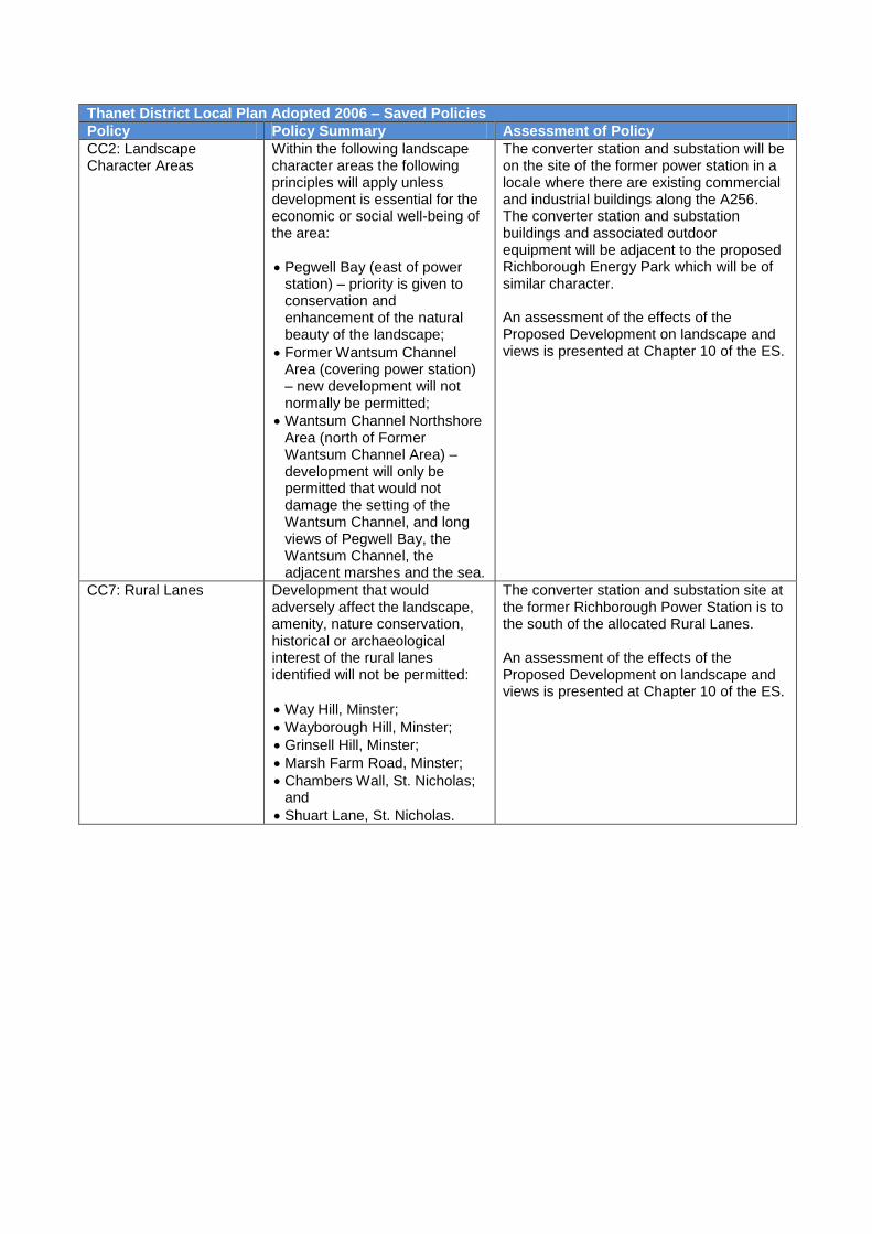
CC2: Landscape Character Areas
Within the following landscape character areas the following principles will apply unless development is essential for the economic or social well-being of the area:
Pegwell Bay (east of power station) – priority is given to conservation and enhancement of the natural beauty of the landscape;
Former Wantsum Channel Area (covering power station) – new development will not normally be permitted;
Wantsum Channel Northshore Area (north of Former Wantsum Channel Area) – development will only be permitted that would not damage the setting of the Wantsum Channel, and long views of Pegwell Bay, the Wantsum Channel, the adjacent marshes and the sea.
The converter station and substation will be on the site of the former power station in a locale where there are existing commercial and industrial buildings along the A256. The converter station and substation buildings and associated outdoor equipment will be adjacent to the proposed Richborough Energy Park which will be of similar character. An assessment of the effects of the Proposed Development on landscape and views is presented at Chapter 10 of the ES.
CC7: Rural Lanes Development that would adversely affect the landscape, amenity, nature conservation, historical or archaeological interest of the rural lanes identified will not be permitted:
Way Hill, Minster;
Wayborough Hill, Minster;
Grinsell Hill, Minster;
Marsh Farm Road, Minster;
Chambers Wall, St. Nicholas; and
Shuart Lane, St. Nicholas.
The converter station and substation site at the former Richborough Power Station is to the south of the allocated Rural Lanes. An assessment of the effects of the Proposed Development on landscape and views is presented at Chapter 10 of the ES.
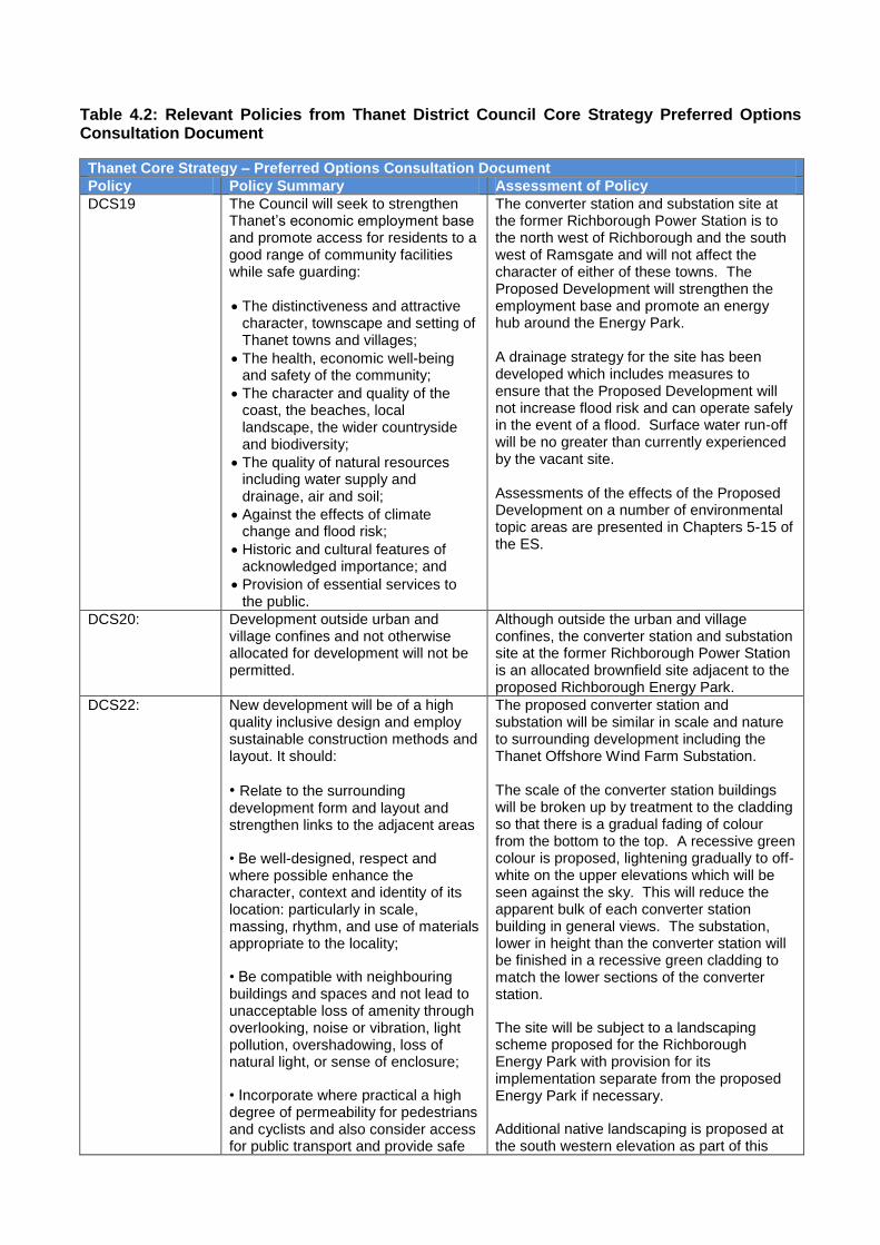
Table 4.2: Relevant Policies from Thanet District Council Core Strategy Preferred Options Consultation Document
Thanet Core Strategy – Preferred Options Consultation Document
Policy Policy Summary Assessment of Policy
DCS19 The Council will seek to strengthen Thanet’s economic employment base and promote access for residents to a good range of community facilities while safe guarding:
The distinctiveness and attractive character, townscape and setting of Thanet towns and villages;
The health, economic well-being and safety of the community;
The character and quality of the coast, the beaches, local landscape, the wider countryside and biodiversity;
The quality of natural resources including water supply and drainage, air and soil;
Against the effects of climate change and flood risk;
Historic and cultural features of acknowledged importance; and
Provision of essential services to the public.
The converter station and substation site at the former Richborough Power Station is to the north west of Richborough and the south west of Ramsgate and will not affect the character of either of these towns. The Proposed Development will strengthen the employment base and promote an energy hub around the Energy Park. A drainage strategy for the site has been developed which includes measures to ensure that the Proposed Development will not increase flood risk and can operate safely in the event of a flood. Surface water run-off will be no greater than currently experienced by the vacant site. Assessments of the effects of the Proposed Development on a number of environmental topic areas are presented in Chapters 5-15 of the ES.
DCS20: Development outside urban and village confines and not otherwise allocated for development will not be permitted.
Although outside the urban and village confines, the converter station and substation site at the former Richborough Power Station is an allocated brownfield site adjacent to the proposed Richborough Energy Park.
DCS22: New development will be of a high quality inclusive design and employ sustainable construction methods and layout. It should:
• Relate to the surrounding development form and layout and strengthen links to the adjacent areas
• Be well-designed, respect and where possible enhance the character, context and identity of its location: particularly in scale, massing, rhythm, and use of materials appropriate to the locality;
• Be compatible with neighbouring buildings and spaces and not lead to unacceptable loss of amenity through overlooking, noise or vibration, light pollution, overshadowing, loss of natural light, or sense of enclosure;
• Incorporate where practical a high degree of permeability for pedestrians and cyclists and also consider access for public transport and provide safe
The proposed converter station and substation will be similar in scale and nature to surrounding development including the Thanet Offshore Wind Farm Substation. The scale of the converter station buildings will be broken up by treatment to the cladding so that there is a gradual fading of colour from the bottom to the top. A recessive green colour is proposed, lightening gradually to off-white on the upper elevations which will be seen against the sky. This will reduce the apparent bulk of each converter station building in general views. The substation, lower in height than the converter station will be finished in a recessive green cladding to match the lower sections of the converter station.
The site will be subject to a landscaping scheme proposed for the Richborough Energy Park with provision for its implementation separate from the proposed Energy Park if necessary.
Additional native landscaping is proposed at the south western elevation as part of this
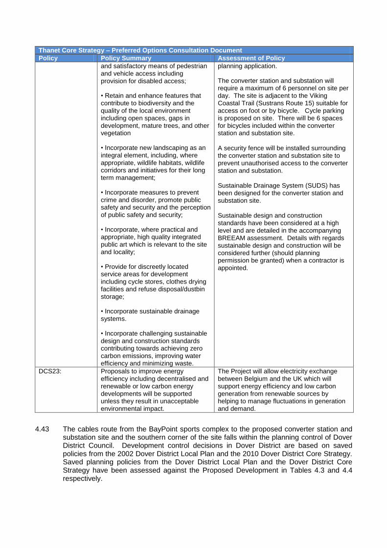
Thanet Core Strategy – Preferred Options Consultation Document
Policy Policy Summary Assessment of Policy
and satisfactory means of pedestrian and vehicle access including provision for disabled access;
• Retain and enhance features that contribute to biodiversity and the quality of the local environment including open spaces, gaps in development, mature trees, and other vegetation
• Incorporate new landscaping as an integral element, including, where appropriate, wildlife habitats, wildlife corridors and initiatives for their long term management;
• Incorporate measures to prevent crime and disorder, promote public safety and security and the perception of public safety and security;
• Incorporate, where practical and appropriate, high quality integrated public art which is relevant to the site and locality;
• Provide for discreetly located service areas for development including cycle stores, clothes drying facilities and refuse disposal/dustbin storage;
• Incorporate sustainable drainage systems.
• Incorporate challenging sustainable design and construction standards contributing towards achieving zero carbon emissions, improving water efficiency and minimizing waste.
planning application.
The converter station and substation will require a maximum of 6 personnel on site per day. The site is adjacent to the Viking Coastal Trail (Sustrans Route 15) suitable for access on foot or by bicycle. Cycle parking is proposed on site. There will be 6 spaces for bicycles included within the converter station and substation site. A security fence will be installed surrounding the converter station and substation site to prevent unauthorised access to the converter station and substation. Sustainable Drainage System (SUDS) has been designed for the converter station and substation site. Sustainable design and construction standards have been considered at a high level and are detailed in the accompanying BREEAM assessment. Details with regards sustainable design and construction will be considered further (should planning permission be granted) when a contractor is appointed.
DCS23: Proposals to improve energy efficiency including decentralised and renewable or low carbon energy developments will be supported unless they result in unacceptable environmental impact.
The Project will allow electricity exchange between Belgium and the UK which will support energy efficiency and low carbon generation from renewable sources by helping to manage fluctuations in generation and demand.
4.43 The cables route from the BayPoint sports complex to the proposed converter station and substation site and the southern corner of the site falls within the planning control of Dover District Council. Development control decisions in Dover District are based on saved policies from the 2002 Dover District Local Plan and the 2010 Dover District Core Strategy. Saved planning policies from the Dover District Local Plan and the Dover District Core Strategy have been assessed against the Proposed Development in Tables 4.3 and 4.4 respectively.

Table 4.3: Relevant Saved Policies from Dover District Local Plan
Dover District Local Plan Adopted 2002 - Saved Policies
Policy Policy Summary Assessment of Policy
AS14: Area Specific Policy
Within the Ramsgate Road area, shown on Sheet 2 and the Sandwich Inset of the Proposals Map, the Council will permit B1/B2/B8 employment uses on the proposals map:
All development provides for the visual upgrading of the A256/Ramsgate Road, including structural landscaping at the main site boundaries and a 10m landscape buffer zone fronting the A256/Ramsgate Road;
Any new buildings or extensions along the A256 are low rise;
A survey and evaluation is carried out to determine the extent of contamination and remedial measures proposed to ensure that the development of any site does note post a risk to human health or adjacent nature conservation interests;
Development does not increase the risk of flooding; and
Provision is made for an archaeological evaluation in advance of any planning decision and for the consequent appropriate level of archaeological mitigation in accordance with the Historic Environment policies of this plan.
This policy provides criteria to enable, in principle, the development of land for B1, B2 and B8 uses. The criteria do not apply to other proposed land uses, nor does the policy preclude other such land uses from being granted planning permission in principle. However, notwithstanding the above, the Proposed Development is in accordance with this policy for the following reasons: The proposed converter station and substation site is not immediately along the A256 or within the 10m landscape buffer zone. The proposed onshore underground cable will be installed using HDD which will not sterilise the 10m landscape buffer zone.
The site will be subject to a landscaping scheme proposed for the Richborough Energy Park with provision for its implementation separate from the proposed Energy Park if necessary.
Additional native landscaping is proposed at the south western elevation as part of this planning application
An assessment of ground conditions and hydrological, ecological and archaeological effects of the Proposed Development is detailed at Chapters 7, 8 and 9 of the ES respectively. No significant adverse effects are anticipated.
Policy TR12: Land safeguarded at Richborough Power Station for CTRL (Channel Tunnel Rail Link) development
Land at the former Richborough Power Station was safeguarded because it provides access to sidings which were needed for storage of ballast during the construction of the CTRL. The Directions have not yet been withdrawn although the CTRL is complete; the Proposed Development is not anticipated to cause any substantial harm to Policy TR12.

Table 4.4: Relevant Policies from Dover District Core Strategy
Dover District Core Strategy Adopted 2010
Policy Policy Summary Assessment of Policy
Policy CP 7: Green Infrastructure Network (relevant to part of the underground cable connection)
The integrity of the existing network of green infrastructure will be protected and enhanced through the lifetime of the Core Strategy. Planning permission for development that would harm the network will only be granted if it can incorporate measures that avoid the harm arising or sufficiently mitigate its effects. Proposals that would introduce additional pressure on the existing and proposed Green Infrastructure Network will only be permitted if they incorporate quantitative and qualitative measures, as appropriate, sufficient to address that pressure.
During construction, the Viking Trail Sustrans Route, the Thanet Coastal Path Long Distance Route (part of the Green Infrastructure Network) and some minor informal paths will need to be temporarily diverted. Following completion of the works all routes will be reinstated and reopened for use.
Policy DM 15: Countryside Protection
Development that would result in the loss of, or adversely affect the character or appearance of the countryside will only be permitted if it is:
In accordance with allocations made in Development Plan Documents, or
Justified by the needs of agriculture; or
Justified by a need to sustain the rural economy or a rural community;
It cannot be accommodated elsewhere; and
It does not result in the loss of ecological habitats.
Provided that measures are incorporated to reduce, as far as practicable, any harmful effects on countryside character.
Although outside the defined urban area, the converter station and substation will be built on derelict brownfield land located adjacent to the proposed Richborough Energy Park and will not impact on unspoilt countryside. The layout of electrical equipment is designed for optimum efficiency and requires a large site. As the converter station will allow the exchange of electricity between the UK and Belgium, the site is required to be located close to the coast. Potential effects on ecology and landscape character are discussed at Chapters 8 and 10 of the ES respectively. No significant adverse effects are anticipated.
Policy DM16: Landscape Character
Development that would harm the character of the landscape, as identified through the process of landscape character assessment will only be permitted if:
It is in accordance with allocations made in Development Plan Documents and incorporates any necessary avoidance and mitigation measures; or
It can be sited to avoid or reduce the harm and/or incorporate design measures to mitigate the impacts to an acceptable level.
The substation and converter station development will be consistent with the character of nearby development and with the proposed Richborough Energy Park and its landscape scheme. An assessment of the Proposed Development on landscape and views is presented at Chapter 10 of the ES.
Policy DM 25: Open Space
Proposals for development that would result in the loss of open space will not be permitted unless:
i. there is no identified qualitative or quantitative deficiency in public open space in terms of outdoor sports sites, children's play
The onshore underground cable route in Dover District crosses the BayPoint sports complex which is allocated in the 2002 Local Plan as Open Space. Effects would be temporary and

Dover District Core Strategy Adopted 2010
Policy Policy Summary Assessment of Policy
space or informal open space; or
ii. where there is such a deficiency the site is incapable of contributing to making it good; or
iii. where there is such a deficiency the site is capable of contributing to making it good, a replacement area with at least the same qualities and equivalent community benefit, including ease of access, can be made available; or
iv. in the case of a school site the development is for educational purposes; or
v. in the case of small-scale development it is ancillary to the enjoyment of the open space; and
vi. in all cases except point 2, the site has no overriding visual amenity interest, environmental role, cultural importance or nature conservation value.
the installation of the onshore underground cables will not result in the long term loss of open space. An assessment of the impacts of the Proposed Development on land use is detailed at Chapter 5 of the ES.
Kent Minerals and Waste Plan 1998 Saved Policies
4.44 Kent County Council produces Minerals and Waste Plans which set out policies for managing minerals and waste in the County. Policies from the Kent Minerals and Waste Plan that relate to the Proposed Development are set out in Table 4.5 below:
Table 4.5: Kent Waste Local Plan 1998 Saved Policies
Kent Waste Local Plan 1998 – Saved Policies
Policy Policy Summary Assessment of Policy
W7 – Reuse The following locations are considered to be suitable in principle for proposals to prepare Category A waste for re-use:
For permanent development - Richborough
The former Richborough Power Station site was identified as a site which could be used for the reuse of demolition waste, was one of a number of sites considered suitable in principle, but was not reserved exclusively for this type of development. Land is rarely allocated in development plans for electricity infrastructure. The Proposed Development is similar in type and scale to waste uses and is comfortably located on the site and in the context of its surroundings. The Proposed Development is not in full accordance with these policies, comprising a particularly bespoke sui generis form of development. However, it is not considered to cause substantial harm to Policies W7, W9 and W11.
W9 – Waste separation and transfer
The following locations are considered to be suitable in principle for proposals for waste separation and transfer:
xviii Richborough (N)
W11 – Waste to Energy
The following locations are considered to be suitable in principle for proposals for a waste to energy plant:
iv The Stour at Richborough.
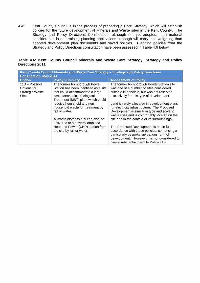
4.45 Kent County Council is in the process of preparing a Core Strategy, which will establish policies for the future development of Minerals and Waste sites in the Kent County. The Strategy and Policy Directions Consultation, although not yet adopted, is a material consideration in determining planning applications although will carry less weighting than adopted development plan documents and saved policies. Planning policies from the Strategy and Policy Directions consultation have been assessed in Table 4.6 below.
Table 4.6: Kent County Council Minerals and Waste Core Strategy: Strategy and Policy Directions 2011
Kent County Council Minerals and Waste Core Strategy – Strategy and Policy Directions Consultation, May 2011
Option Policy Summary Assessment of Policy
11B – Possible Options for Strategic Waste Sites
The former Richborough Power Station has been identified as a site that could accommodate a large scale Mechanical Biological Treatment (MBT) plant which could receive household and non-household waste for treatment by rail or water. A Waste biomass fuel can also be delivered to a power/Combined Heat and Power (CHP) station from the site by rail or water.
The former Richborough Power Station site was one of a number of sites considered suitable in principle, but was not reserved exclusively for this type of development. Land is rarely allocated in development plans for electricity infrastructure. The Proposed Development is similar in type and scale to waste uses and is comfortably located on the site and in the context of its surroundings. The Proposed Development is not in full accordance with these policies, comprising a particularly bespoke sui generis form of development. However, it is not considered to cause substantial harm to Policy 11B.

5.0 CONCLUSIONS
5.1 The Proposed Development will allow the transfer of electrical power between the high
voltage grid systems of Belgium and the United Kingdom. The power would be able to flow in either direction at different times, depending on the supply and demand in each country. The Project contributes to a low carbon future by allowing better use of renewable energy when resources are available and the ability to trade electricity over the link will contribute to a downward pressure on wholesale electrcity prices. The Project is consistent with EU and UK policy.
5.2 The site of the proposed converter station and substation is at the former Richborough Power Station adjacent to Thanet Offshore Wind Farm substation and the proposed Richborough Energy Park. The proposed converter station and substation site is located on derelict brownfield land part of which is currently occupied by the frame of the former turbine hall of the defunct Richborough Power Station. Development plans seldom make allocations for electricity infrastructure such as converter stations or substations and these infrastructure assets are classified as sui-generis development.
5.3 In considering where developments of this nature could be located, developers typically seek
locations where the existing character shows similarity with those of the development, such as where there are existing industrial uses which are unlikely to be adversely affected by such development. The location of the proposed converter station and substation in part of the former Richborough Power Station site is consistent with this approach and consistent with proposals for the development of the Richborough Energy Park.
5.4 The site is off the A256 which offers excellent access to the trunk road network and the M2
motorway for construction traffic and deliveries. The operational site can be accessed from sustainable transport routes such as the Viking Coastal Trail (Sustrans Route 15). The levels of traffic generated during the construction phase of the development are unlikely to have any significant adverse effects on the local highway network especially with the increased carrying capacity following the completion of the East Kent Access Phase 2.
5.5 The subsea and onshore underground cables can be installed without causing long term
disturbance or harm to land and would result in benefits to habitats from the creation of new chalk grassland. No significant adverse environmental effects are anticipated regarding contaminated land, the generation of noise or from electric and magnetic fields. The ES provides an assessment of likely environmental effects together with proposed mitigation measures to avoid or reduce potential effects.
5.6 The proposed substation and converter station on the former Richborough Power Station
site are within 1km of a number of internationally and nationally designated nature conservation areas. An ecological assessment of the Proposed Development has been completed and the findings are presented in Chapter 8 of the ES and ES Appendix 8.9. No significant adverse effects are predicted.
5.7 Although the development is not in full accordance with the development plan, comprising a
particularly bespoke sui generis form of development, it does not conflict with the policies and aims of the development plan.
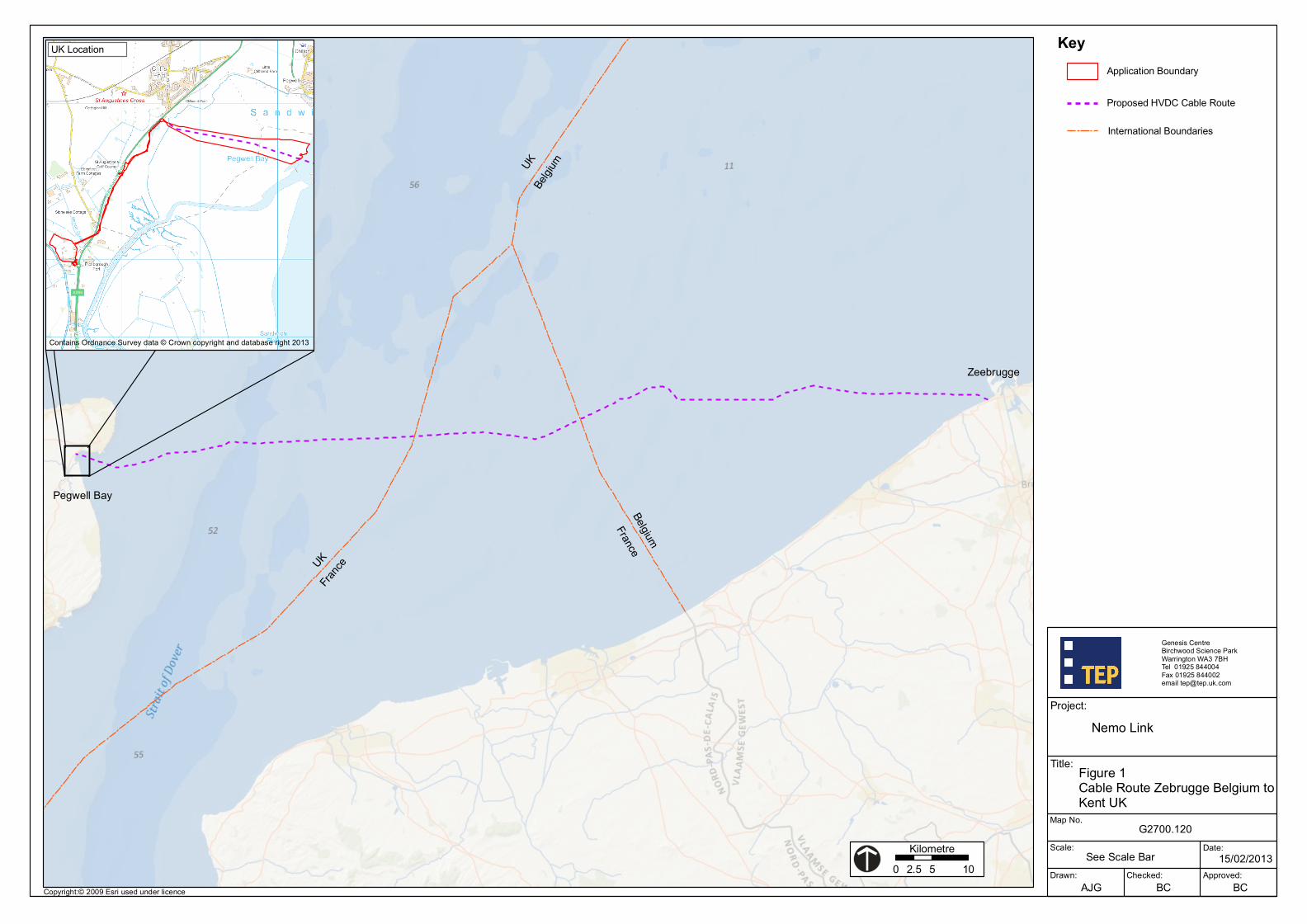
Drawn: Checked: Approved:
Date:Scale:
Map No.
Title:
Project:
Genesis CentreBirchwood Science Park Warrington WA3 7BHTel 01925 844004Fax 01925 844002email [email protected]
AJG BC BC
15/02/2013
G2700.120
Nemo Link
Key
Figure 1Cable Route Zebrugge Belgium to Kent UK
See Scale Bar
Proposed HVDC Cable Route
0 5 102.5Kilometre
Application Boundary
UK Fra
nce
Belgium
France
UK
Belgiu
m
Zeebrugge
Pegwell Bay
International Boundaries
UK Location
Copyright:© 2009 Esri used under licence
Contains Ordnance Survey data © Crown copyright and database right 2013
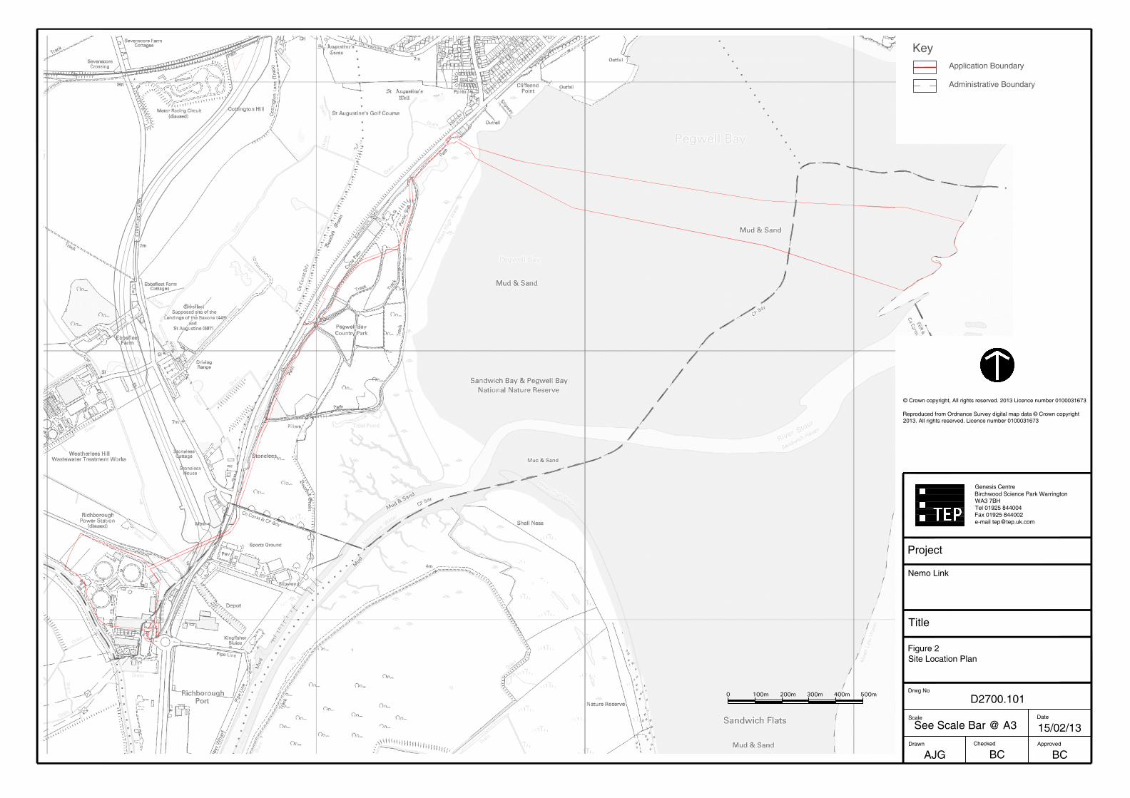
Title
AJGDrawn
Scale
See Scale Bar @ A3
Drwg No
D2700.101
Figure 2Site Location Plan
BCChecked
BC
15/02/13Approved
Date
Nemo Link
Project
Genesis CentreBirchwood Science Park WarringtonWA3 7BHTel 01925 844004Fax 01925 844002e-mail [email protected]
© Crown copyright, All rights reserved. 2013 Licence number 0100031673
Reproduced from Ordnance Survey digital map data © Crown copyright2013. All rights reserved. Licence number 0100031673

KeyKey
Application Boundary
HVDC Cables
Administrative
Boundary
Richborough A Limited Estate
Road (Subject to Separate
Pending Planning Application)
Landscaping
A
A'
B
D
I
I'
J
J'K
K'
L'
L
E'E
F
G'
H
B'
C
F'G
H'C'
D'
Title
AJGDrawn
Scale
1:2500 @ A3
Drwg No
D2700.102
Figure 3Proposed Converter Station and SubstationSite Layout Plan
BCChecked
BC
15/02/13Approved
Date
Nemo Link
Project
Genesis CentreBirchwood Science Park WarringtonWA3 7BHTel 01925 844004Fax 01925 844002e-mail [email protected]
© Crown copyright, All rights reserved. 2013 Licence number 100020245
Reproduced from Ordnance Survey digital map data © Crown copyright2013. All rights reserved. Licence number 100020245
Converter Station and Substation Design Parameters
Layout and position of converter station and substation buildings and equipmentto be confirmed at Reserved Matters stage.
Converter station main hall andmain hall extensions (see items 1-3 below)shown are equal to the maximum heightand floor space parameters detailedbelow.
1. Main HallMax. height 30.8mMax. floor space 3561.9m²
2. Main Hall ExtensionMax. height 25mMax. floor space 6054.3m²
3. Main Hall Transformer ExtensionMax. height 18mMax. floor space 3746.3m²
4. TransformersMax. height 9.8m
5. MSCMax. height 11.8m
6. Shunt ReactorMax. height 10m
7. Fan BanksMax. height 2m
8. Spares BuildingMax. height 4.2m
9. Distribution Network Operator BuildingMax. height 3m
10. Diesel GeneratorMax. height 3.5m
11. Fire TankMax. height 6m
12. Pump House
Max. height 3m
Substation GIS building (see item 13 below)shown is equal to the maximum height andfloor space parameters detailed below.
13. GIS BuildingMax. height 15mMax. floor space 1122.3m²
14. SVC BuildingsMax. height 4.4m
15. SVC EquipmentMax. height 6.3m
16. Super Grid TransformersMax. height 10.6m
17. MSCMax. height 11.8m
18. Compensator TransformerMax. height 11m
19. Amenity BuildingMax. height 4.2m
20. Storage UnitsMax. height 2.5m
21. Fire TankMax. height 6m
22. Diesel GeneratorMax. height 3.5m
23. Distribution Network Operator BuildingMax. height 3m
Converter Station Valve Hall(Using existing building frame)
Converter Station Valve Hall(New building extension)
Mechanically SwitchedCapacitor (MSC)
Gas Insulated Bus Bar (GIB)
Fan Banks
Car Parking
Shunt Reactor
Amenity Building
Static Var Compensator (SVC)
Gas InsulatedSubstation (GIS)Building
Gantries
Super Grid Transformers(SGT)
Storage Room
Distribution Network OperatorBuilding
Diesel Generator
Fire Water Tank
Air Handling Units
Thanet District C
ouncil
Dover D
istrict Council
Mechanically SwitchedCapacitor (MSC)
Distribution Network Operator (DNO)Building
Spares Building
Storage UnitsCar Parking
Car ParkingLaydown Area
Laydown Area
Proposed Landscape
Diesel Generator
1
2
3
4
5
6
7
8
9
11
1210
13
14
16
17
18
19
2021
22
23
15
Converter StationTransformers
Car Parking
Fire Water Pump House
Fire Water Tank
Control Room
Laydown Area

Title
AJGDrawn
Scale
1:1250 @ A3
Drwg No
D2700.103
Figure 4Proposed Converter Station and SubstationElevations
BCChecked
BC
15/02/13Approved
Date
Nemo Link
Project
Genesis CentreBirchwood Science Park WarringtonWA3 7BHTel 01925 844004Fax 01925 844002e-mail [email protected]
A:A'1:1250
Converter Station Valve Hall
Gas Insulated Substation(GIS) Building
Converter Station Valve Hall(New Extension)
Converter Station Store Room
Converter Station Valve Hall(Existing Building Frame)
Substation AmenityBuilding
Converter Station
Substation
Gas Insulated Substation (GIS) Building
Static Var Compensator (SVC)Converter Station Valve Hall(New Extension) Converter Station Control Room
Fire Water Tank
Transformers
Fan Banks
Substation AmenityBuilding
Gas Insulated Substation (GIS) Building
Converter Station Valve Hall(Existing Building Frame)
Gas Insulated Substation (GIS) Building
Lightning Conductor
Lightning Conductor
Mechanically SwitchedCapacitor (MSC)
Converter StationSpares Building
Converter Station Spares Building
B:B'1:1250
C:C'1:1250
D:D'1:1250
Note:Converter station and substation scale, layout and appearance to beconfirmed at Reserved Matters stage

Drawn: Checked: Approved:
Date:Scale:
Map No.
Title:
Project:
Genesis CentreBirchwood Science Park Warrington WA3 7BHTel 01925 844004Fax 01925 844002email [email protected]
AJG BC BC
15/03/2013
G2700.121
Nemo Link
Figure 5Environmental Constraints
See Scale Bar0 200 400100
Metres
Reproduced from Ordnance Survey digital map data © Crown copyright 2012. All rights reserved. Licence number 0100031673
Key
Pegwell Bay Country ParkListed Building
National Nature Reserve
Ramsar SiteSpecial Area of ConservationSpecial Protection AreaSite of Special Scientific Interest
Environmental Constraints
Historic Landfill
Cable RoutesA256 Bypass Road
Application Boundary
Marine HVDC Cable Route
Onshore HVDC Cable Route
Local Wildlife Site
Thanet Offshore WindfarmCable Route
!

Related Documents