Planning Proposal 55 Pitt Street Amendment to maximum height and FSR and concurrent DCP amendments Submitted to City of Sydney On behalf of Mirvac Projects 17 December 2019 | 13544

Welcome message from author
This document is posted to help you gain knowledge. Please leave a comment to let me know what you think about it! Share it to your friends and learn new things together.
Transcript

Planning Proposal
55 Pitt Street
Amendment to maximum height and FSR and
concurrent DCP amendments
Submitted to City of Sydney
On behalf of Mirvac Projects
17 December 2019 | 13544

CONTACT
Alexis Cella Director [email protected] 9956 6962
Reproduction of this document or any part thereof is not permitted without prior written permission of Ethos Urban Pty Ltd.
This document has been prepared by:
Alexis Cella 17 December 2019
Reproduction of this document or any part thereof is not permitted without written permission of Ethos Urban Pty Ltd. Ethos Urban operates under a Quality Management System. This report has been prepared and reviewed in accordance with that system. If the report is not signed, it is a preliminary draft.
VERSION NO. DATE OF ISSUE REVISION BY APPROVED BY
01 17 December 2019 AC AC
Ethos Urban Pty Ltd
ABN 13 615 087 931. www.ethosurban.com
173 Sussex Street, Sydney NSW 2000 t 61 2 9956 6952

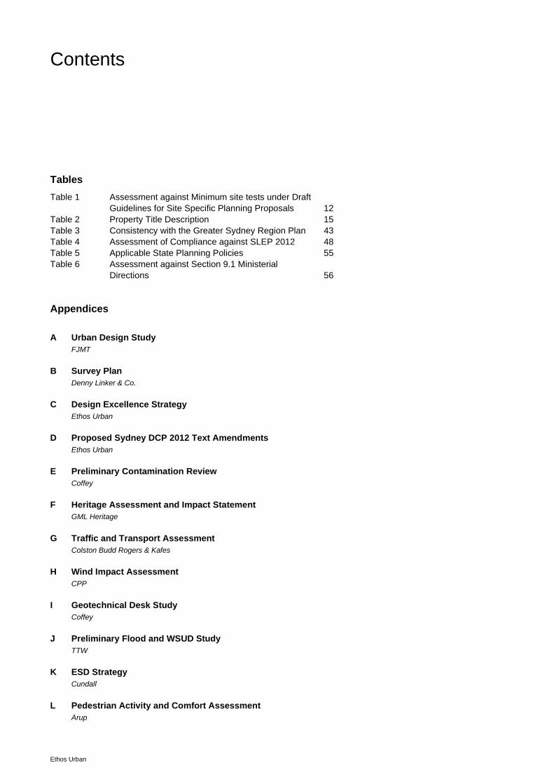
Contents
Ethos Urban
1.0 Introduction 4 1.1 Background 7 1.2 Consultation with Council 11 1.3 Minimum Site Tests 12
2.0 Site Context and Description 14 2.1 Location 14 2.2 Site Description 15 2.3 Surrounding Development 23
3.0 Key Current Planning Controls 26 3.1 Sydney Local Environmental Plan 2012 26 3.2 Sydney Development Control Plan 2012 28
4.0 Options Analysis 29 4.1 Different schemes explored 29 4.2 Indicative Concept / Development Outcome 35
5.0 Part 1 – Objectives and intended outcomes 37 5.1 Objectives and Intended Outcomes 37
6.0 Part 2 - Explanation of Provisions 38
7.0 Part 3 - Justification 42 7.1 Section A – Need for a Planning Proposal 42 7.2 Section B – Relationship to the Strategic Planning
Framework 43 7.3 Section C – Environmental, social and economic
impact 59 7.4 Section D – State and Commonwealth Interests 59
8.0 Environmental Assessment 61 8.1 Built Form and Urban Design 61 8.2 Design Excellence Strategy 65 8.3 Landscape / Public Domain Concept 65 8.4 Overshadowing 66 8.5 Daylight Analysis 67 8.6 View Analysis 67 8.7 Wind Assessment 69 8.8 Commercial Office Design Requirements 69 8.9 Transport and Traffic 70 8.10 Sustainability 71 8.11 Geotechnical Assessment 71 8.12 Heritage Assessment 72 8.13 Flooding and WSUD 73 8.14 Pedestrian Activity and Comfort Assessment 74 8.15 Social and Economic Effects 75 8.16 Airport Operations 76 8.17 Public Art 76

Contents
Ethos Urban
8.18 Voluntary Planning Agreement 76
9.0 Part 4 – Mapping 77
10.0 Part 5 – Community Consultation 78
11.0 Part 6 – Indicative Project Timeline 79
12.0 Conclusions and Recommendations 80
Figures
Figure 1: Photomontage of an indicative tower form 6 Figure 2: APDG Site - Development Blocks (55 Pitt Street site in
red) 7 Figure 3: 1 Alfred Street (as originally approved prior to
amendments / modifications) 8 Figure 4: 200 George Street 9 Figure 5: Lendlease Circular Quay Tower 10 Figure 6: APDG Site - Alternative Development Block outcome 11 Figure 7: Site Location 14 Figure 8: Aerial Image 16 Figure 9: Pitt Street elevation of existing buildings (view south) 17 Figure 10: Pitt Street elevation of existing buildings (view south) 18 Figure 11: Underwood Street elevation of existing buildings (view
east) 19 Figure 12: Dalley Street elevation of existing buildings (view west) 20 Figure 13: Dalley Street elevation of existing buildings (view east) 21 Figure 14: Queens Court elevation of existing buildings (looking
north) 22 Figure 15: View of adjacent Marriot Hotel fronting Pitt Street to the
east 24 Figure 16: ASX building to the south fronting Dalley and Pitt Streets 24 Figure 17: View of 200 George Street (centre) - 2017 25 Figure 18: Original APDG Block Vision 27 Figure 19: Complying LEP/DCP Scheme 30 Figure 20: APDG Scheme 31 Figure 21: CSPS Base Case Scheme 32 Figure 22: Proposed Additional Alternative Scheme 34 Figure 23: Photomontage of an indicative tower form 36 Figure 24 Features of the Eastern City 46 Figure 25: Central Sydney Planning Strategy context 51 Figure 26: Nominated Strategic Density Zones/Tower Clusters 53 Figure 27: Sydney Metro alignment 60 Figure 28: Skyline context 61 Figure 29: Pitt Street setback context 62 Figure 30: Tower separation 63 Figure 31: Illustration of proposed podium fronting Pitt Street 64 Figure 32: Ground plane view along Pitt Street 65 Figure 33: Landscape/Public Domain Concept 66 Figure 34: Upper level view opportunities available 68 Figure 35: Pedestrian comfort study area 75 Figure 36: Proposed Lanes Map – Sheet 14 Extract 77
Contents
Ethos Urban
Tables
Table 1 Assessment against Minimum site tests under Draft
Guidelines for Site Specific Planning Proposals 12 Table 2 Property Title Description 15 Table 3 Consistency with the Greater Sydney Region Plan 43 Table 4 Assessment of Compliance against SLEP 2012 48 Table 5 Applicable State Planning Policies 55 Table 6 Assessment against Section 9.1 Ministerial
Directions 56
Appendices
A Urban Design Study
FJMT
B Survey Plan
Denny Linker & Co.
C Design Excellence Strategy
Ethos Urban
D Proposed Sydney DCP 2012 Text Amendments
Ethos Urban
E Preliminary Contamination Review
Coffey
F Heritage Assessment and Impact Statement
GML Heritage
G Traffic and Transport Assessment
Colston Budd Rogers & Kafes
H Wind Impact Assessment
CPP
I Geotechnical Desk Study
Coffey
J Preliminary Flood and WSUD Study
TTW
K ESD Strategy
Cundall
L Pedestrian Activity and Comfort Assessment
Arup

55 Pitt Street | Planning Proposal | 17 December 2019
Ethos Urban | 13544 4
1.0 Introduction
This Planning Proposal is submitted to the Council of the City of Sydney (Council) to request an amendment to the
Sydney Local Environmental Plan 2012 (LEP) for land at 37 – 57 Pitt Street, 6 – 8 Underwood Street, 6 Dalley
Street, and 8 – 14 Dalley Street Sydney (otherwise known as 55 Pitt Street / the site).
Ethos Urban has prepared this Planning Proposal on behalf of Mirvac Projects Pty Ltd (Mirvac).
The purpose of this Planning Proposal is to principally introduce an additional alternative height and floor space
ration (FSR) control that applies to the site. This amendment, along with corresponding amendments to the Sydney
Development Control Plan 2012 (DCP), aim to support Council’s vision for the street block bound by Alfred, Pitt,
Dalley and George Streets, Sydney (the APDG Block) by facilitating the redevelopment of a key site within the
APDG Block that will achieve a high quality urban form and deliver public benefits.
This Planning Proposal more specifically seeks to provide for another alternative option/outcome for the site should
the existing APDG Block site specific LEP and DCP provisions not be realised. It is accordingly proposed to amend
the LEP and DCP in order to enable a tower of up to 232m to be delivered on the site/this corner of the APDG
Block. An image of the indicative tower form is provided in Figure 1.
Consistent with the existing APDG Block requirements for achieving additional height under the LEP, it would be
subject to delivering a high quality built form and publicly accessible open space, activated laneways and through-
site links (along with other public benefits). In addition to delivering additional height, the Planning Proposal
supports the Draft Central Sydney Planning Strategy through unlocking additional employment generating floor
space within a designated tower cluster.
Amendments to the DCP relating to the APDG Block are also proposed in order to reflect an alternative built form
proposed for the site and this part of the APDG Block.
As required by Section 3.33 of the Environmental Planning & Assessment Act 1979 (EP&A Act), this Planning
Proposal includes the following:
a statement of the objectives or intended outcomes of the proposed instrument;
an explanation of the provisions that are to be included in the proposed instrument;
the justification for those objectives, outcomes and provisions and the process for their implementation
(including whether the proposed instrument will comply with relevant directions under Section 9.1 of the EP&A
Act); and
details of community consultation.

55 Pitt Street | Planning Proposal | 17 December 2019
Ethos Urban | 13544 5
This Planning Proposal describes the site, the proposed LEP & DCP changes and provides an environmental
assessment of the new building envelope and indicative tower. The report should be read in conjunction with the
Urban Design Study prepared by FJMT (Appendix A) and specialist consultant reports appended to this proposal
(refer Table of Contents), together with the public benefit offer provided under separate cover. The Planning
Proposal has been prepared having regard to "A guide to preparing planning proposals” published by the
Department of Planning and Environment. In particular, this Planning Proposal addresses the following specific
matters in the guideline:
Part 1 – Objectives and intended outcomes
Part 2 – Explanation of provisions
Part 3 – Justification
− Need for the Planning Proposal
− Relationship to strategic planning framework
− Environmental, social and economic impact
− State and Commonwealth interests
Part 4 – Mapping
Part 5 – Community Consultation.
The Planning Proposal has also been prepared in accordance with Council’s Draft Central Sydney Planning
Strategy (CSPS), and more specifically the Draft Guideline for Site Specific Planning Proposals.

55 Pitt Street | Planning Proposal | 17 December 2019
Ethos Urban | 13544 6
Figure 1: Photomontage of an indicative tower form
Source: Virtual Ideas / FJMT

55 Pitt Street | Planning Proposal | 17 December 2019
Ethos Urban | 13544 7
1.1 Background
APDG Controls
In September 2008, the City of Sydney commissioned the NSW Government Architect’s Office to prepare an urban
design study (the UDS) for the block bound by Alfred, Pitt, Dalley and George Streets, Sydney (the APDG Block).
The key purpose of the UDS was to ensure that Council has a consistent set of planning controls that promote high
quality built form and urban design outcomes for both the public and private domain on this important street block.
The UDS recommended a preferred option for the APDG Block consisting of a large central open publicly
accessible square, a connected and activated laneway network, and three (3) tall tower buildings. The preferred
option was formalised through amendments to the Sydney LEP 2005 and Sydney DCP 1996 (both of which
commenced on 29 April 2011) and later adopted within Sydney LEP 2012 and Sydney DCP 2012. The specific
controls that apply to the APDG Block do not override the typical planning provisions that apply to the site as such,
but provide alternate planning provisions for the Block. In other words, an owner within the APDG Development
Blocks has the choice of two sets of planning provisions.
This Planning Proposal relates to part of the land in which one of those original three tall tower buildings (refer to
Development Block 1 within Figure 2) is planned for.
Figure 2: APDG Site - Development Blocks (55 Pitt Street site in red)
Source: Sydney Development Control Plan 2012 – City of Sydney Council

55 Pitt Street | Planning Proposal | 17 December 2019
Ethos Urban | 13544 8
The first of the three towers (being a building above 110m) within the APDG Block (Development Block 3, 1 Alfred
Street - D/2010/2029) was originally granted development consent by Council in May 2012 (refer to Figure 3). This
approval has since evolved with the landowner amending the approval along with securing approval to develop a
110m hotel on part of Block 3 and 19 – 31 Pitt Street (D/2016/1529). Work has now commenced on site.
The original intent though in terms of delivering a tower at the northern end of the APDG Block remains.
The second of the towers within the APDG block (Development Block 2, 200 George Street - D/2012/893) was
granted development consent by Council in December 2012 (refer to Figure 4). Work was completed in 2016, with
the building fully occupied.
Figure 3: 1 Alfred Street (as originally approved prior to amendments / modifications)
Source: Kerry Hill Architects

55 Pitt Street | Planning Proposal | 17 December 2019
Ethos Urban | 13544 9
Figure 4: 200 George Street
Source: Mirvac
It is acknowledged that considerable effort and work was invested by the City of Sydney Council in developing the
original APDG Block controls which are envisaged to deliver a significant positive urban outcome for the City.
Circumstances have evolved however since the original APDG Block controls were devised, most notably through
Lendlease’s reimagining of the public square from the centre of the block to George Street along with delivering a
new circa 263m commercial tower (refer to Figure 5) within the centre of the block (creating a new Block 4 – refer to
Figure 6). Following a similar Planning Proposal process as that now proposed for 55 Pitt Street, development
consent (D/2017/1620) was granted in October 2018 for the detailed design of the tower with works now underway.

55 Pitt Street | Planning Proposal | 17 December 2019
Ethos Urban | 13544 10
Figure 5: Lendlease Circular Quay Tower
Source: City of Sydney
With Lendlease embarking on its own Block 4 development it has effectively meant that the original 200m+ tower
expected in the south-east corner under the APDG Block was never going to be able to materialise.
Notwithstanding the realities of the original vision for Block 1 not being realised, this planning proposal seeks to
keep alive and not abandon these controls, but rather introduce a further and enhanced alternative outcome for the
site and broader APDG Block.

55 Pitt Street | Planning Proposal | 17 December 2019
Ethos Urban | 13544 11
Figure 6: APDG Site - Alternative Development Block outcome
Source: Sydney Development Control Plan 2012
1.2 Consultation with Council
Mirvac has worked closely with Council over a number of years to unlock the full employment generating
development potential of the site whilst balancing an appropriate urban form and height and ensured the continued
delivery of significant public benefits. Input has also been provided by Council’s Design Advisory Panel, providing
further rigour and support to the proposal.

55 Pitt Street | Planning Proposal | 17 December 2019
Ethos Urban | 13544 12
1.3 Minimum Site Tests
Table 1 details the compliance of the Planning Proposal against the minimum site tests under the Draft Guideline for Site Specific Planning Proposals. The assessment reveals that the Planning Proposal has merit and worthy of further consideration.
Table 1 Assessment against Minimum site tests under Draft Guidelines for Site Specific Planning Proposals
Control Test Compliance
Land use Proposed new buildings that rely on increased
maximum heights and/or FSR controls may be
any use permitted by Sydney 2012 except for
residential accommodation and serviced
apartments.
✓
Proposal only includes employment
generating land uses (i.e. it does not
contain any residential or serviced
apartments).
Erection of a tall
building
Site’s must have a minimum site area of 1,000sqm ✓
Planning proposal site has an area
more than 1,000sqm (i.e. 4,294sqm).
Height of
buildings
Proposed new buildings may exceed the maximum
height shown for the land on the Height of Buildings
Map but may not exceed any of Sun Access Planes,
No Additional Overshadowing controls
(Overshadowing of certain public places), Sydney
Airports Prescribed Airspace and the Tower Tide Line
as identified in Sydney LEP and the Strategy.
✓
The proposed maximum building
height does not cause additional
overshadowing of protected spaces
during the protected times.
Protection of
public views
Proposed new buildings may exceed the maximum
height shown for the land on the Height of Buildings
Map but may not exceed Public view protection
planes
✓
There are no public view protection
planes that affect the site
Floor space ratio Maximum FSRs will be set to match permitted
envelopes.
✓
The maximum FSR output from the
permitted envelope is 15.02:1
(excluding design excellence).
Ecologically
sustainable
development
Must exceed minimum requirements ✓
Development to achieve 5.5
NABERS Energy Rating and net-zero
carbon, zero waste and water
efficient outcomes across the site.
Heritage Floor
Space
Proposed new buildings must allocate an amount of
heritage floor space as required by Sydney LEP
✓
HFS to be secured for the project,
noting strategic floor space is
excluded.
Heritage
conservation
Development is subject to Sydney LEP’s heritage
controls.
N/A
Design
Excellence
Development as a result of a Request is subject to
Sydney LEP’s design excellence controls
✓
Development will be undertaken and

55 Pitt Street | Planning Proposal | 17 December 2019
Ethos Urban | 13544 13
Control Test Compliance
The type of competition must be an architectural
design competition.
meet design excellence
requirements, including undertaking
an invited architectural design
competition.
Car parking Car parking spaces (including existing car parking
spaces) are limited to the total number of existing car
parking spaces within existing developments on site,
or the maximum permitted under Sydney LEP for the
site, whichever is less.
✓
Car parking to be delivered on site
will comply with LEP requirements
and will be less than existing
numbers.
Affordable
housing
Subject to Council’s affordable housing program and
proposed LEP controls
✓
The public benefit offer includes the
provision of affordable housing
consistent with Council requirements
Section 61
contributions
Development contributions authorised by Section 61
of the City of Sydney Act 1988 apply in full
✓
Section 61 will be paid as part of the
detailed development of the site.

55 Pitt Street | Planning Proposal | 17 December 2019
Ethos Urban | 13544 14
2.0 Site Context and Description
2.1 Location
The site is located within the City of Sydney Local Government Area. The site is located within the northern part of
Sydney’s Central Business District in a block bordered by Underwood Street to the north, Dalley Street to the south,
and Pitt Street to the east. As noted, the site is located within the broader street block of Alfred Street, Pitt Street,
Dalley Street, and George Street (referred to as the APDG Block/Site). Circular Quay is located a short distance to
the north (some 200m away).
The location of the site in the northern part of the CBD ensures that it is accessible to a wide range of commercial,
retail, entertainment and cultural destinations, as well as excellent public transport facilities.
The site’s locational context is illustrated in Figure 7 below.
Figure 7: Site Location
Source: Google Maps

55 Pitt Street | Planning Proposal | 17 December 2019
Ethos Urban | 13544 15
2.2 Site Description
The site has an area of 4,294.6sqm and is irregular in shape with street frontages of approximately:
62m along Pitt Street;
57m to Underwood Street (north-south);
74m to Underwood Street (east-west)
47m to Dalley Street (excluding Queens Court); and
24m to Queens Court.
Table 2 below provides the address, legal description, and ownership of the parcels of land that comprise the site.
Table 2 Property Title Description
Property Title Description Owner Area (sqm)
37 Pitt Street Lots 2 – 3 DP 1092; Lot 6 DP 75338 Lot 7 DP 110046;
Lot 4 DP 524306; Lots 1 – 2 DP 1112308
Mirvac Capital Pty Ltd 1347.7
49 – 57 Pitt Street 1 DP 513109 Mirvac Capital Pty Ltd 629.8
6 – 8 Underwood Street Lot 501 DP 714847 Mirvac Capital Pty Ltd 462.2
6 Dalley Street Lot 1 DP 787946 Telstra 1003.7
8 – 14 Dalley Street Lot A and B DP 104160 Ausgrid 851.2
Total Area 4,294.6
A Survey Plan is located at Appendix B.
Currently the site under the control of Mirvac is occupied by three (3) commercial office buildings, with ground floor
active uses and basement level parking (including a public car park). The buildings range in height from 10 – 13
storeys. Primary access to the site is provided from Pitt Street and Underwood Street, with vehicle access to
basement parking provided from Underwood Street and Queens Court. There is some 110 car parking spaces
presently provided on site across the public and tenant basement car parks.
The Ausgrid building, which gains access from Dalley Street and Queens Court, is an essential electrical distribution
property for the CBD. While the Telstra Exchange building, with access from Underwood Street, also provides
essential telecommunications services for the CBD. Both buildings have been surveyed and confirmed as
containing all plant and equipment (i.e. there is no Gross Floor Area within either building).
An aerial photo of the site is provided at Figure 8. Photographs of the existing development are shown below in
Figures 9 - 14.

55 Pitt Street | Planning Proposal | 17 December 2019
Ethos Urban | 13544 16
Figure 8: Aerial Image
Nearmap and Ethos Urban

55 Pitt Street | Planning Proposal | 17 December 2019
Ethos Urban | 13544 17
Figure 9: Pitt Street elevation of existing buildings (view south)

55 Pitt Street | Planning Proposal | 17 December 2019
Ethos Urban | 13544 18
Figure 10: Pitt Street elevation of existing buildings (view south)

55 Pitt Street | Planning Proposal | 17 December 2019
Ethos Urban | 13544 19
Figure 11: Underwood Street elevation of existing buildings (view east)

55 Pitt Street | Planning Proposal | 17 December 2019
Ethos Urban | 13544 20
Figure 12: Dalley Street elevation of existing buildings (view west)

55 Pitt Street | Planning Proposal | 17 December 2019
Ethos Urban | 13544 21
Figure 13: Dalley Street elevation of existing buildings (view east)

55 Pitt Street | Planning Proposal | 17 December 2019
Ethos Urban | 13544 22
Figure 14: Queens Court elevation of existing buildings (looking north)

55 Pitt Street | Planning Proposal | 17 December 2019
Ethos Urban | 13544 23
2.3 Surrounding Development
The surrounding area more broadly is characterised by a mix of commercial office and hotel uses with some ground
level retail, restaurant, café and bar uses in buildings of varying heights, ages and styles.
The height of buildings in this part of the City of Sydney immediately surrounding the site is characterised by
predominately mid-rise buildings with taller high-rise tower buildings located further beyond and surrounding the
site.
The APDG Block is undergoing significant renewal in accordance with the established controls for the block, with
construction underway of Yuhu’s mixed use development at the north end of the block, Lendlease’s Circular Quay
commercial tower and new public square within the centre of the block, and Poly Group’s commercial tower on the
south-west corner.
North
More immediately to the north across Underwood Street is Lendlease’s Circular Quay Tower development under
construction, with an ultimate height at RL 265.
East
To the east of the site across Pitt Street is the Marriot Hotel (at RL 117.120), refer to Figure 15.
South
To the south is the Australian Stock Exchange (ASX), a mid-rise building of up to 13 storeys with frontages to Dalley
Street and Pitt Street (refer to Figure 16).
West
To the immediate west across Underwood Street comprises of a low scale functioning utility/infrastructure building
associated with the commercial tower at 200 George Street.
To the north-west is the Mirvac delivered 200 George Street commercial building (EY Centre) at RL 158.20 (refer to
Figure 17). Further due west as noted Poly Group are constructing a 110m commercial building at 210 – 220
George Street.

55 Pitt Street | Planning Proposal | 17 December 2019
Ethos Urban | 13544 24
Figure 15: View of adjacent Marriot Hotel fronting Pitt Street to the east
Figure 16: ASX building to the south fronting Dalley and Pitt Streets

55 Pitt Street | Planning Proposal | 17 December 2019
Ethos Urban | 13544 25
Figure 17: View of 200 George Street (centre) - 2017

55 Pitt Street | Planning Proposal | 17 December 2019
Ethos Urban | 13544 26
3.0 Key Current Planning Controls
3.1 Sydney Local Environmental Plan 2012
The Sydney LEP 2012 is the principal planning instrument applying to the site.
3.1.1 Zoning
The site is located on land zoned B8 Metropolitan Centre. Potential future uses of the site including commercial
premises are permissible with consent in this zone.
3.1.2 Development Standards
The principle development standards relevant to the site are height and floor space ratio.
Height of Buildings
The ‘base’ permissible height on the site is 110m. Additional site specific building height provisions (Clause 6.25)
also apply to the site and the broader APDG Block. In this regard, the subject site and other relevant land, forming
part of ‘Block 1’, is potentially capable of being developed up to a height of 200m, subject to meeting relevant
criteria. This includes:
Providing for publicly accessible open space, lanes and other links through the APDG Block;
Providing active ground floor uses to those public open spaces, lanes and roads; and
Providing appropriate distribution of built form and floor space.
In summary, the additional height provisions applying to the APDG Block essentially enables taller buildings to parts
of the street block in order to provide an integrated and activated lane network, a publicly accessible open space
and greater tower separation for better views and daylight access. Figure 18 illustrates graphically the originally
envisaged built form and heights established under the APDG LEP and DCP provisions. It is noted that this original
vision has since evolved and been reimagined, especially Lendlease’s Circular Quay Tower development.
The original basis/premise for achieving these additional heights/benefits is related to certain landholdings being
developed cooperatively.
Floor Space Ratio
The permissible floor space ratio on the site is 8:1. As the site is located within Area 1 on the FSR map within the
Sydney LEP, it is eligible for additional floor space of 4.5:1 for office, business or retail premises (among other
uses). Further to this, the proposal is eligible for a 10% bonus floor space provision if a competitive design process
is undertaken and design excellence is demonstrated.
In addition to accommodation floor space, the site is also potentially eligible for additional floor space under Clauses
6.5 – 6.9 of the Sydney LEP.

55 Pitt Street | Planning Proposal | 17 December 2019
Ethos Urban | 13544 27
Figure 18: Original APDG Block Vision
Source: Government Architect’s Office

55 Pitt Street | Planning Proposal | 17 December 2019
Ethos Urban | 13544 28
3.2 Sydney Development Control Plan 2012
The Sydney Development Control Plan 2012 (DCP) builds upon and provides more detailed provisions than the
Sydney LEP 2012.
The site and broader APDG Block is subject to site specific controls, which set out more detailed controls in order to
satisfy the additional building heights LEP Clause (6.25).
The objectives of the APDG Block specific controls seek to:
Facilitate the redevelopment of the site to achieve a high quality urban form;
Ensure that development on the APDG site results in major public benefits;
Ensure the publicly accessible open space is fronted with active uses and linked to surrounding streets with a
network of lanes and through-site links;
Maintain the legibility of the historical alignment of laneways and through-site links within the site;
Enable additional building height at certain sites where the development of the site provides for publicly
accessible open space, lanes and through-site links;
Encourage commercial uses at the southern end of the site;
Protect sunlight access to Australia Square; and
Create opportunities for views to and from Circular Quay.
The APDG Block specific controls include a range of provisions and plans relating to streets, lanes and through-site
links, publicly accessible open space, built form and design, and parking and vehicular access. With the gazettal of
the LLCQT planning proposal, there is a second set of ‘opt in’ DCP provisions that apply for this particular site. A
similar approach is proposed for 55 Pitt Street.

55 Pitt Street | Planning Proposal | 17 December 2019
Ethos Urban | 13544 29
4.0 Options Analysis
This section describes the background design work undertaken as part of the preparation of the Planning Proposal.
4.1 Different schemes explored
FJMT was engaged by Mirvac to review the development potential of the site and investigate additional alternative
options to redeveloping the site on the basis that the existing APDG Block provisions are not realistically achievable
and given Council’s policy intent under the Draft Central Sydney Planning Strategy.
Their scope was to develop a generally complying base commercial office scheme and then to look at whether the
scheme could be augmented to deliver a better outcome on the site and for the broader APDG Block (additional
alternative scheme). A copy of the analysis is contained in the architectural drawing package at Appendix A and is
summarised in the sections below.
4.1.1 Site Constraints/Criteria
In undertaking a review of the site’s development potential FJMT have considered the following site constraints,
planning controls and policy guidance:
Maximum base 110m height control contained in the LEP;
Additional height potentially achievable up to 200m, but requires acquisition of land outside the subject
development block;
Maximum FSR controls for commercial premises development in the LEP;
Setback controls as contained in the Sydney DCP;
No requirement in the base DCP provisions for any through-site links or laneways to be delivered;
Building over existing infrastructure/utility buildings is currently cost prohibitive/not feasible;
Achievement of a Global Office Tower and aspiration to achieve PCA Premium Grade floor plate (i.e. 1,500m2
+); and
Built form capacity modelling supporting the Draft CSPS identifying a maximum potential height limit of over
300m.

55 Pitt Street | Planning Proposal | 17 December 2019
Ethos Urban | 13544 30
4.1.2 Complying LEP/DCP Scheme
Figures 19 illustrates a complying (non-APDG Block) scheme for the redevelopment of the site. Whilst providing for
a large floor plate above podium that would meet the requirements for a Global Office Tower, the scheme is not
currently viable given it requires incorporating and building above both the existing Ausgrid and Telstra buildings.
Further, the excessive size and irregular plan form is not likely to be appealing to future prospective tenants. From
an urban design outcome, it would deliver a sub-optimal outcome (i.e. a short squat building with inappropriate
proportions between the podium and tower forms). Finally, from a public domain perspective, it would not deliver
any substantial improvements or benefits. It would also not lead or support the orderly and economic use and
development of the land.
Figure 19: Complying LEP/DCP Scheme
Source: FJMT

55 Pitt Street | Planning Proposal | 17 December 2019
Ethos Urban | 13544 31
4.1.3 APDG Scheme
Figure 20 illustrates an APDG Block scheme for the redevelopment of the site. This scheme option is highly unlikely
to be achievable given that to achieve this form it requires incorporating and building over infrastructure/utility
buildings as well as relying on land outside the development block area to the north and for which that adjacent
landowner has its own commercial objectives in terms of maximising the development potential of its landholding
(i.e. pursuing LLCQT). This option would deliver public benefits as envisaged under the APDG Block controls and
achieve a Global Office/PCA Premium Grade floor plate.
Figure 20: APDG Scheme
Source: FJMT

55 Pitt Street | Planning Proposal | 17 December 2019
Ethos Urban | 13544 32
4.1.4 CSPS Base Case
Consistent with the Draft CSPS, the site is located within a tower cluster and meets the minimum requirements
under the Draft Guideline for Site Specific Planning Proposals. A scheme on the site is therefore potentially
achievable up to PAN-Ops. Setbacks and tapering adopted comply with minimum requirements. As with previous
schemes, this form requires incorporating and building over infrastructure/utility buildings. The floorplate is also
compromised in the south-east corner.
Figure 21: CSPS Base Case Scheme
Source: FJMT

55 Pitt Street | Planning Proposal | 17 December 2019
Ethos Urban | 13544 33
4.1.5 Proposed Envelope Scheme (the subject of this Proposal)
The proposed alternative commercial scheme proposes an amendment to the APDG Block controls in relation to
additional height and FSR which will preserve the existing provisions whilst facilitating a further alternative pathway
that allows for the real and feasible construction of a tower up to a height of 232m on the site (Figure 22).
Acknowledging the many positive outcomes/benefits the existing APDG Block provisions achieve, this further
alternative scheme will also deliver the following for the site, the APDG Block and the CBD more broadly:
Delivery of a new Global Office Tower for the CBD, which may not realistically be achievable if the amendments
as proposed were not adopted;
Delivering public benefits, including through significant improvements to the public domain in the form of an
activated network of laneways and through-site links;
Preserving the memory of the historic pattern of development on the site;
Substantial increase in employment numbers on the site, which may not be achieved if the amendments as
proposed were not adopted;
Improved amenity outcomes for the site, opening up access within the building to north easterly views and
daylight – without resulting in any adverse impacts to the surrounding streetscape of public domain;
A building of appropriate proportions and form in light of the site’s existing and future context;
Providing for the inclusion of the Ausgrid and Telstra sites as part of a future commercial office building (with
‘significant’ development planned to occur to the buildings – generally consistent with the approach taken at 4
Dalley Street). Their inclusion allows for no substantial impact to operations and avoids the practical and
potentially cost-prohibitive issues associated with developing above this infrastructure/utility building. Their
inclusion also secures improvements to their “external building fabric” appearance and positive contribution to
the pedestrian experience within the APDG Block;
Maintaining adequate separation between towers; and
Enabling for a taller, slimmer and more refined tower than what is planned for in accordance with the existing
APDG Block controls/provisions.

55 Pitt Street | Planning Proposal | 17 December 2019
Ethos Urban | 13544 34
Figure 22: Proposed Additional Alternative Scheme
Source FJMT

55 Pitt Street | Planning Proposal | 17 December 2019
Ethos Urban | 13544 35
4.2 Indicative Concept / Development Outcome
In order to demonstrate that the proposed building envelope can deliver a feasible commercial office tower with
ground floor uses FJMT has developed an indicative scheme (refer to Appendix A). Further details regarding the
development outcome supported through the proposed amendments is provided within Appendix A (e.g. area
schedule).
This proposed amendment to the building height and corresponding DCP amendments will accommodate
indicatively a 50+ storey tower with a cost of works of some $400 million and more specifically comprising:
Approximately 70,000sqm of commercial office space/retail GFA;
Ground floor active uses;
Street address off Pitt Street;
Vehicular access off Dalley street;
Three basement levels, supporting approximately 84 parking spaces in accordance with Council requirements;
Public domain improvements, including north-south laneway/through site link connecting Dalley Street with
Underwood Street and widened pedestrian pathway along Underwood Street; and
Significant development to occur to the Ausgrid and Telstra buildings (e.g. façade improvements generally
consistent with 4 Dalley Street).
The scheme has been designed to be capable of accommodating public benefits including publicly accessible open
space, an activated through-site link and an activated laneway. The full package of public benefits is detailed within
the public benefit offer (provided under separate cover).
It should be noted that the scheme is indicative only and has been prepared for the sole purpose of demonstrating
that the proposed building envelope can deliver a viable scheme which complies with the amended planning
controls contained within the Sydney LEP and Sydney DCP. In undertaking the competitive design process and
then the detailed design of the building, changes to the indicative scheme will inevitably be required and desired
and it is imperative that the approved envelope provides flexibility and scope for a variety of design alternatives.
A photomontage of the indicative scheme is provided at Figure 23.
Design Excellence
The indicative scheme has been prepared assuming that a competitive design process will be undertaken and that
the development will exhibit `Design Excellence‟. In light of this the proposed envelope has been designed
assuming that a 10% bonus of additional floorspace will be awarded to the project and would be accommodated in
the development. Taking this approach will ensure that if the 10% is indeed awarded by Council, no further
amendments would be required to the maximum permissible envelope to accommodate that additional floorspace.
Refer to Section 8.2 and Appendix C for further details on the proposed Design Excellence Strategy.

55 Pitt Street | Planning Proposal | 17 December 2019
Ethos Urban | 13544 36
Figure 23: Photomontage of an indicative tower form
Source: Virtual Ideas / FJMT

55 Pitt Street | Planning Proposal | 17 December 2019
Ethos Urban | 13544 37
5.0 Part 1 – Objectives and intended outcomes
This chapter of the report describes the Planning Proposal and the urban design principles that set the foundation
for its structure. Further detail is provided throughout the environmental assessment in the following chapters.
5.1 Objectives and Intended Outcomes
The Planning Proposal is a site specific amendment to the Sydney LEP 2012 to provide for a further alternative
additional height and FSR control.
More specifically the key objectives of the planning proposal are to:
Acknowledge the significant work and positive outcomes the existing APDG Block provisions aim to achieve
and accordingly retain these existing LEP and DCP provisions;
Facilitate a further additional alternative to the existing APDG Block provisions that recognises current
landownership constraints across the APDG Block and therefore support a currently realistic and feasible
alternative scheme for the site/development block;
Enable an alternative commercial tower scheme on the site that is taller, slimmer and more refined than that
currently planned for in this part of the APDG Block;
Enable the re-development of the site for a “Global Office Tower” with a floor plate of over 1,500sqm;
Contribute towards Council’s vision for the site and broader APDG Block through providing for publicly
accessible open space and a network of accessible and activated laneways and through-site links; and
Further strengthen and protect the commercial core of Global Sydney;
Support the amalgamation of sites that will enable opportunities to increase employment floor space and
promote the efficient use of land within a nominated tower cluster area.
Through the proposed amendments, it will enable an alternative commercial office tower of an appropriate urban
form to be developed on the site with a maximum height of 232m and a maximum FSR of 15.02 (excluding design
excellence).

55 Pitt Street | Planning Proposal | 17 December 2019
Ethos Urban | 13544 38
6.0 Part 2 - Explanation of Provisions
The overarching purpose of the planning proposal is to facilitate the development of the site for a commercial office
tower that is of a high quality urban form, provides for public benefits in the form of publicly accessible open space,
activated laneways and through-site links, achieves a Global Office floor plate, that does not need to rely on
external landholdings to be realised/delivered, and delivers strategic floor space.
To achieve this desired outcome, a number of amendments to the Sydney LEP 2012 and Sydney DCP 2012 are
proposed:
Amendment to Clause 6.25 APDG Block of the Sydney LEP;
Amendment to Lanes Map - Sheet LNE_014 of Sydney LEP;
Amendments to Section 6.1.4 – Section 6.1.7 and associated relevant Figures of the Sydney DCP.
This section describes the proposed changes to the Sydney LEP 2012 and Sydney DCP 2012.
6.1.1 LEP Amendment
In order to effect the intended outcomes of this Planning Proposal it is proposed to amend clause 6.25 of the
Sydney LEP. The proposed amendments are identified below. Words proposed to be deleted are shown in bold
strike through and words to be inserted are shown in bold italics. As noted previously, it is proposed to preserve
the existing APDG Block provisions with an alternative development option being proposed.
The amendments to Clause 6.25 for the LLCQT Site along with Clause 6.44 in relation to 4-6 Bligh Street have
informed the proposed amendments (including applying lanes development floor space). There are consequential
amendments to the LEP Lanes Map (Sheet 14) required to facilitate this planning proposal – refer to Appendix A.
In drafting the amendments, it is noted that it is intended for additional floor space to be available where applicable,
e.g. Clause 6.6 End of Trip and Clause 6.8 Lanes development.
6.25 APDG block
(1) The objective of this clause is to provide for additional building height and floor space on parts of certain
sites (within the area bounded by Alfred Street, Pitt Street, Dalley Street and George Street (known as the
“APDG block”)) if the development of the site provides for publicly accessible open space, lanes and other links
through the site.
(2) This clause applies to land within Area 4 on the Height of Buildings Map.
(3) Despite clause 4.3, development consent may be granted to the erection of a building with a maximum
height of:
(a) 200 metres on up to 33% of the area of block 1, or
(b) 155 metres on up to 42% of the area of block 2, or
(c) 185 metres on up to 24% of the area of block 3, or
(d) 248 metres on up to 25% of the area of block 4 and 238 metres on up to 12% of the area of that block; or
(e) 232 metres on up to 44% of the area of block 5.
(3A) Despite any other provision of this Plan, a building on Block 5 may have a maximum floor space
ratio of —
(a) 15.02:1, or
(b) if a competitive design process has been held under clause 6.21 and the building demonstrates
design excellence within the meaning of that clause—16.52:1.
(4) Development consent must not be granted under this clause unless the consent authority is satisfied that
the development will:
(a) include recreation areas and lanes and roads through the site, and

55 Pitt Street | Planning Proposal | 17 December 2019
Ethos Urban | 13544 39
(b) include business premises and retail premises that have frontages at ground level (finished) to those
recreation areas, lanes and roads, and
(c) provide a satisfactory distribution of built form and floor space development.
(5) Development consent must not be granted under this clause in relation to development on land in block 1,
2, 3 or 4 or 5 unless the consent authority is satisfied that the development relates to the whole of the block
and, except as otherwise provided by this clause, no other land.
(6) Development on land in block 1 may also relate to the whole of any one or more of the following:
(a) Lot 1, DP 787946,
(b) Lot 180, DP 606866,
(c) Lot 1, DP 537286.
(7) Development on land in block 3 may also relate to the whole of any one or more of the following:
(a) Lot 180, DP 606866,
(b) Lot 1, DP 537286.
(7A) For the purposes of calculating a floor space ratio in respect of any building on block 4:
(a) the site area is taken to be the whole of block 4 (other than Lots 2 and 3, DP 1213767), and
(b) the gross floor area of all buildings on that site area is to be taken into account in that calculation other than:
(i) any floor area dedicated to the Council, and
(ii) up to 3,900 square metres of floor area leased to the Council for a period of not less than 20 years for the
purposes of office premises that are to be used to promote business innovation or economic development.
Note. Similar adjustments will also apply to calculations for additional floor space under Division 1 including in
respect of the utilisation of heritage floor space.
(7B) Despite any other provision of this Plan, a building erected on block 4 or block 5 must not be used for the
purpose of residential accommodation or serviced apartments.
(7C) Lanes development floor space may be utilised by a new building on block 4 or block 5 as if that building
were an existing building and for that purpose land (whether or not a public road) may be identified on the
Lanes Map as a lane to which clause 6.8 applies.
(7D) Development on land in block 5 may also relate to the whole of the road known as “Queens Court”.
(8) If a building, or part of a building, on block 5 is used for the purposes of office premises, business premises or retail premises, an amount of heritage floor space is to be allocated to the building using the following formula— A x 0.149:1 = B
where—
A is the total floor space ratio of the building, not being a ratio of more than 15.02:1, used for the purposes of office premises, business premises or retail premises.
B is the ratio of heritage floor space to be allocated to the building.
(9) If subclause (3)(A) applies, an amount of heritage floor space is allocated to the building that is equal to 50% of the difference between a floor space ratio of 15.02:1 and the proposed floor space ratio of the building.
(10) The consent authority may reduce the amount of heritage floor space that is required to be allocated to block 5 by up to 50% or 1,000 square metres, whichever is the lesser, if the proposed development is the winner of an architectural design competition carried out in accordance with the City of Sydney Competitive Design Policy.
(11) The consent authority may reduce the amount of heritage floor space that is required to be allocated to block 5 by up to 50% or 250 square metres, whichever is the lesser, if the proposed development includes any covered or partially covered pedestrian route through the site at street level and the consent authority is satisfied that the pedestrian route provides a vital and publicly accessible link between 2 streets.

55 Pitt Street | Planning Proposal | 17 December 2019
Ethos Urban | 13544 40
(12) In the case of development that is an alteration or addition to an existing building on block 5, the amount of heritage floor space required to be allocated to the site of the building under this clause is to be no more than the difference between— (a) the amount of heritage floor space that would be required to be allocated to the site if the building (as altered or added to) were to be constructed as a new building, and
(b) the amount of heritage floor space that would be required to be allocated to the site if the building (without the alteration or addition) were to be constructed as a new building.
(13) No heritage floor space is required to be allocated in the case of development on block 5 that is an alteration or addition to an existing building if the development does not increase the gross floor area of the building by more than 100 square metres.
(14) Clause 6.11A(2) – (4) apply to heritage floor space allocated to block 5 under this clause.
(8) (15) In this clause:
block 1 means:
(a) Lot 7, DP 629694, and
(b) Lot 501, DP 714847, and
(c) Lots 2 and 3, DP 1092, and
(d) Lots 1 and 2, DP 1112308, and
(e) Lots A and B, DP 104160, and
(f) Lot 7, DP110046, and
(g) Lot 6, DP 75338, and
(h) Lot 4, DP 524306, and
(i) Lot 1, DP 513109, and
(j) the whole of the road known as “Queens Court”.
block 2 means:
(a) Lot 4, DP 57434, and
(b) Lot 1, DP 69466, and
(c) Lot 1, DP 110607, and
(d) Lot 1, DP 188061, and
(e) Lots A–D, DP 435746, and
(f) Lot 20, DP 1063401, and
(g) Lot 1, DP 913005, and
(h) Lot 1, DP 107759.
block 3 means Lot 1, DP 220830 and Lot 1, DP 217877.
block 4 means:
(a) Lot 7, DP 629694, and
(b) Lots 181 and 182, DP 606865, and
(c) Lots 1 and 2, DP 880891, and
(d) Lots 2 and 3, DP 1213767.
block 5 means:
(a) Lot 501, DP 714847, and
(b) Lots 2 and 3, DP 1092, and
(c) Lots 1 and 2, DP 1112308, and
(d) Lot 7, DP110046, and
(e) Lot 6, DP 75338, and
(f) Lot 4, DP 524306, and
(g) Lot 1, DP 513109, and
(h) Lots A and B, DP 104160, and
(i) Lot 1, DP 787946.

55 Pitt Street | Planning Proposal | 17 December 2019
Ethos Urban | 13544 41
6.1.2 Concurrent Amendments to the DCP
In order to give certainty to the additional alternative new built form proposed for the site and this part of the APDG
Block, a range of amendments to the existing APDG Block site specific controls in Section 6 of the DCP are
proposed. The amendments will again preserve the existing APDG Block controls, whilst providing separate
controls in relation to the additional alternative scheme. The amendments support the objectives and intended
outcome of the amendment to the Sydney LEP 2012.
The proposed amended DCP text to apply to the alternative APDG Block development outcome is included at
Appendix D, with relevant alternative APDG Block DCP figures/maps included within Appendix A.

55 Pitt Street | Planning Proposal | 17 December 2019
Ethos Urban | 13544 42
7.0 Part 3 - Justification
7.1 Section A – Need for a Planning Proposal
7.1.1 Q1 – Is the planning proposal a result of any strategic study or report?
As noted in Section 1, the site and broader APDG Block has been the subject of an extensive urban design study
commissioned by Council and undertaken by the Government Architect’s Office. The recommendations from this
study were adopted by Council and formalised through the preparation and implementation of site specific LEP and
DCP amendments. The site specific APDG Block controls are ‘optional’ however, with land owners entitled/able to
develop their land holdings in accordance with the base LEP and DCP planning controls.
There is therefore no guarantee that the APDG Block vision and planned public benefits in the form of publicly
accessible open space and a network of activated lanes and through-site links will be fully delivered.
Since the study was completed in 2009, land ownership across the APDG Block has also changed dramatically.
This change has meant that the APDG Block vision has evolved.
Mirvac with its Pitt Street and Underwood Street landholdings could therefore develop a commercial office building
under the base LEP/DCP controls; however such an outcome would not achieve:
a positive urban form outcome;
public benefits in the form of publicly accessible open space and activated laneways/through-site links; or
a quality/premium commercial office tower commensurate with Sydney’s Global City status.
With a 200m tower in the south-east corner of the APDG Block not currently realistically achievable, especially
given the assumption of it being integrated with existing telecoms and electricity infrastructure, there is however an
additional alternative tower scheme that can be readily delivered, subject to the LEP/DCP amendments being
proposed. Such an alternative scheme would:
reach a height of 232m and reflect a slimmer and more refined built form outcome;
unlock additional employment generating floor space,
support growth opportunities as outlined within the Draft Central Sydney Planning Strategy;
promote the efficient use of the land in accordance with the objects of the EP&A Act;
continue to meet the requirements/criteria for a Global Office Tower floor plate; and
continue to deliver the type of public benefits planned for the APDG Block.
7.1.2 Q2 – Is the planning proposal the best means of achieving the objectives or intended
outcomes, or is there a better way?
The Planning Proposal responds to Council’s recommended pathway and framework (as reflected in its Draft
Guideline for Site Specific Planning Proposals) for unlocking additional height and floor space across Central
Sydney for employment generating land uses.
The Planning Proposal as set out in this document is considered to be the best means of achieving the objectives
and intended outcomes of the proposal, giving both the Council and the landowner certainty as to the development
outcomes expected on the site.

55 Pitt Street | Planning Proposal | 17 December 2019
Ethos Urban | 13544 43
7.2 Section B – Relationship to the Strategic Planning Framework
7.2.1 Q3 - Is the Planning Proposal consistent with the objectives and actions contained within the
applicable regional strategy?
Greater Sydney Region Plan – A Metropolis of Three Cities
The Greater Sydney Region Plan is the overarching strategy for growing and shaping the Greater Sydney Area. It
sets a 40-year vision (to 2056) and establishes a 20-year plan to manage growth and change for Greater Sydney in
the context of social, economic and environmental matters. The plan was adopted in March 2018, and seeks to
reposition Sydney as a metropolis of three cities – the western parkland city, central river city, and the eastern
harbour city. In the same vein as the former A Plan for Growing Sydney, the Plan provides 10 high level policy
directions supported by 40 objectives that inform the District Plans, Local Plans and Planning Proposals which
follow in the planning hierarchy.
The proposal is consistent with the policy directions and objectives under the Plan, which govern growth and
development in Sydney. This is demonstrated in Table 3 below, and an assessment of the proposal against the
specific vision for the Eastern District is provided further below.
Table 3 Consistency with the Greater Sydney Region Plan
A city supported by infrastructure
• The proposal supports the delivery of higher capacity development in-hand with the significant infrastructure investment being undertaken by local and state government (in particular light rail and
Sydney Metro).
• The proposal also includes a community infrastructure contribution, ensuring the additional demand generated by the proposal’s uplift in height and floor space is offset.
A city for people
• The proposal has been designed with consideration of intergenerational equity and promotes sustainability, universal design and accessibility, and community integration within the Precinct.
• The proposal prioritises opportunities for people to walk, cycle, and use public transport through improved pedestrian connections, reduction in on-site car parking, and new bicycle parking and end of trip facilities within the development.
Housing the city
• No housing is proposed.
• The development seeks to continue the existing use of the site as a destination for employment and retail.
• The proposal is in full alignment with Council’s key policy direction to deliver increased employment opportunities within Central Sydney, reinforcing the City’s role as Australia’s economic engine and
Australia’s only global city.
A city of great places
• The development seeks to offer ‘more than just new homes and jobs’. The site and block will be transformed into a lively, activated and connected precinct.
• The proposal will celebrate the cultural and heritage values of the site and broader context. The implementation of various heritage interpretation initiatives will ensure a long-lasting connection to the unique heritage of the Precinct.
• A well-connected city
• The proposal will seek to deliver additional commercial floor space and in doing so will connect new jobs to high-capacity transport. This will take advantage of substantial investment in public transport
infrastructure, and support the achievement of a ‘30-minute city’.

55 Pitt Street | Planning Proposal | 17 December 2019
Ethos Urban | 13544 44
Jobs and skills for the city
• The Plan recognises that Sydney’s greatest economic strength globally and nationally is the concentration of financial services sectors in the CBD, and that the implications of a strong financial sector is a high demand for premium-grade office space and high demand for associated knowledge-intensive industries such as legal, accounting, real estate and insurance. The proposal is consistent
with this objective in seeking to deliver new, premium-grade office space in the heart of Sydney’s CBD.
• In conjunction with commercial office floor space, associated retail and public domain spaces will also be delivered that support the diversity of functions in the CBD and encourage activity at the ground
plane.
A city in its landscape
• The proposal does not affect any protected biodiversity or remnant or significant vegetation. Opportunities for increased public domain planting will be explored.
An efficient city
• A key initiative of the proposal is to deliver a more sustainable development than is presently provided, and as such sustainability targets aligned with world’s best practice for ESD have been set.
A resilient city
• The proposal has sought to minimise exposure to natural hazards by ensuring that future development is not affected by flooding.
• The environmental initiatives implemented through the development will contribute to enhanced environmental outcomes and seek to mitigate impacts related to climate change.

55 Pitt Street | Planning Proposal | 17 December 2019
Ethos Urban | 13544 45
Eastern City District Plan
The Eastern City District Plan underpins the Greater Sydney Region Plan and sets the 20-year vision for the District
through ‘Planning Priorities’ that are linked to the Region Plan. Under this Plan, the site is strategically located within
the CBD of the Eastern City and the Eastern Economic Corridor (see Figure 24 below).
The proposed development will achieve the relevant planning priorities, as demonstrate in Table 3 above. A few of
the key priorities have also been explored further below in the context of the Eastern City District.
Planning Priority E1 – Planning for a city supported by infrastructure
Objective 4 – Infrastructure use is optimised
Aligning land use and infrastructure planning ensures that infrastructure is maximised, and that growth and
infrastructure provision are aligned. The development of over 70,000m2 of commercial floor space is aligned with
additional public transport capacity being delivered by local and state government. The proposal also provides a
community infrastructure contribution, supporting Council to deliver infrastructure in line with its Central Sydney
Infrastructure Plan, e.g. libraries, childcare centres, indoor recreation facilities, cultural/creative facilities.
Planning Priority E7 – Growing a stronger and more competitive Harbour CBD
Objective 18 – Harbour CBD is stronger and more competitive
The District Plan notes that the Harbour CBD is Australia’s financial and business capital, contains the largest
proportion of headquarters for multinational and national companies, and contains Australia’s most significant
finance industry cluster. The concentration of this large and specialised financial cluster attracts global talent and
investment, but is constrained by the limited capacity for the Sydney CBD to expand and deliver Prime Grade office
space. Accordingly, the District Plan recommends that commercial development is supported within the CBD to
assist in meeting the 45,000-80,000 future jobs that have been forecast for this region.
The proposed development will deliver additional premium office space within the heart of the Sydney CBD. This
proposed increase in commercial floor space also recognises the potential to increase economic activity, driven by
the catalytic effect of the enhanced rapid transit network being delivered. This is consistent with the Planning Priority
that seeks to safeguard the competitiveness of Sydney in both a domestic and international context.
Planning Priority E10 – Delivering an integrated land use and transport planning and a 30-minute city
Objective 14 – A Metropolis of Three Cities – integrated land use and transport creates walkable and 30-minute
cities
The ’30-minute city’ model is a long-term aspiration for Sydney whereby jobs and services and
strategic/metropolitan centres are accessible within 30 minutes by public transport. This development is uniquely
placed to benefit the ‘30-minute city’ model, by providing commercial floor space within a highly accessible location
and thereby improve access to jobs. The proposal will facilitate employment growth that is delivered following
commencement of the new Sydney Metro.

55 Pitt Street | Planning Proposal | 17 December 2019
Ethos Urban | 13544 46
The Site
Figure 24 Features of the Eastern City
Source: Sydney Region Plan
NSW State Infrastructure Strategy 2018
The NSW State Infrastructure Strategy 2018-2038 brings together the infrastructure investment and land use
planning of the Future Transport Strategy 2056 and the Greater Sydney Region Plan, and is underpinned by the
State Infrastructure Strategy 2018–2038: Building Momentum that established a pipeline of investment for
infrastructure that is underway or in advanced planning. The Strategy sets out the NSW Government’s vision for
infrastructure over the next 20 years, focussing on aligning investment with sustainable growth. For Metropolitan
NSW, the primary goal is to provide residents with access to jobs and services within 30 minutes, known as the ‘30-
minute city’ model.

55 Pitt Street | Planning Proposal | 17 December 2019
Ethos Urban | 13544 47
The Strategy sets out six directions for infrastructure in NSW, of which the following are relevant:
Better integrating land use and infrastructure – the proposal will deliver additional jobs in line with the delivery of
Sydney Metro, so that capital investment keeps pace with new jobs.
Making our infrastructure more resilient – the proposal will be designed with regard to flooding and other
environmental considerations, to ensure that the development is not vulnerable to hazards.
Future Transport Strategy 2056
The Future Transport Strategy 2056 is the 2017 update of the NSW Long Term Transport Master Plan, and
superseded the Master Plan. It is a 40 year vision for mobility in NSW, developed with the Greater Sydney
Commission, the Department, and Infrastructure NSW. It seeks to ensure that transport planning and land use
planning are fully integrated and is based upon the key themes of a Productive Economy, Liveable Communities
and a Sustainable Society.
The Planning Proposal will best serve the objectives of this Plan through:
supporting the expansion of the rail system, by providing significant employment opportunities in direct proximity
to existing heavy rail station and the future metro stations;
assisting in unclogging the Sydney CBD transport system by connecting more people to existing heavy rail and
future metro rail infrastructure and encouraging patronage of an existing network with spare capacity; and
encouraging public transport use by providing significant employment opportunities in close proximity to future
metro, light rail, rail, bus and ferry services.
7.2.2 Q3a - Does the proposal have strategic merit?
Q3b – Does the proposal have site specific merit?
In summary, the Planning Proposal is considered to have both strategic and site specific merit as:
It unlocks additional employment generating land uses in full accordance with Council’s Draft Central Sydney
Planning Strategy;
It will facilitate an increased permanent employment generating activity;
It relates to a site located in a Global City and supports state and local government strategic planning policies;
There is existing public infrastructure that is capable of servicing the proposed site, including significant
investment in public transport capacity – light rail and Sydney Metro;
The proposal offsets additional demand on local infrastructure through a community infrastructure contribution;
It will result in a form of development that is compatible with the site’s context within the centre of a Global City;
It will enable improvements to the public domain to be realised, as envisioned within the existing APDG Block
LEP and DCP provisions (e.g. upgraded and activated pedestrian priority lanes and through-site links);
It will enable the redevelopment of the site and further increase competition and choice for high quality Global
Office Towers within the City; and
It will deliver a tower form that is more slender than that originally planned under the APDG Block LEP/DCP
controls, improving overshadowing impacts etc.

55 Pitt Street | Planning Proposal | 17 December 2019
Ethos Urban | 13544 48
Without proceeding with the planning proposal, there are two likely scenarios. The first being a ‘no development’
scenario, which would mean that:
The existing commercial office buildings will continue to provide sub-optimal/‘C’ grade commercial office space;
The existing colonnade along Pitt Street would remain, thereby limiting the level of activation;
There would be no additional Global Office Commercial Tower delivered for Sydney City;
There would be no public benefits delivered, including in the form of new and upgraded lanes and through-site
links;
There would be no rejuvenation of the site, and consequently no generation of additional jobs (either temporarily
through construction or permanently through redevelopment); and
There would be no enhancement of the City skyline, including no building that achieved design excellence.
The second scenario would be to redevelop the site utilising the base LEP/DCP provisions. This scenario does
deliver benefits, but not to the same extent and degree as that able to be achieved under the APDG Block
provisions or through the subject planning proposal.
The scenario where the site would be developed in accordance with the site specific APDG Block LEP/DCP
provisions is not currently considered a feasible or realistic redevelopment option given the fragmented ownership
arrangements and reliance on cooperation between competing developer landowners.
The full package of public benefits is detailed within the public benefit offer (provided under separate cover).
7.2.3 Q4 – Is the Planning Proposal consistent with the Council’s local strategy or other local
strategic plans?
The following section provides a consistency analysis of the planning proposal against the relevant local strategic
and statutory framework.
Sydney Local Environmental Plan 2012
The proposal’s compliance with the relevant clauses of SLEP 2012 is summarised in Table 4.
Table 4 Assessment of Compliance against SLEP 2012
Clause No. Control Comment
2.3 – Zoning and Land Use Table
B8 Metropolitan Centre All of the proposed uses are permissible in the Zone.
4.3 Height of
Buildings
Maximum 110m Building
Height
No change proposed to this base height control. A new maximum site-
specific height limit of 232m is proposed under Clause 6.25.
4.4, 6.4 Floor Space Ratio
8:1 Base FSR + 4.5:1 Commercial FSR for accommodation floor space.
No change proposed to the base and additional floor space provisions. The proposal relies upon the full FSR generated by the development block along with additional strategic floor space.
A new maximum site-specific FSR of 15.02:1 (excluding design excellence) is proposed under Clause 6.25.
4.5 Calculation of floor space ratio and
site area
Only significant development to be included
The proposal seeks to undertake significant development to the Telstra and Ausgrid sites in order to utilise GFA from these sites within the
proposed tower. Details to be included as part of the future Stage 2 DA, with the approach taken at 4 Dalley Street for the 200 George Street project to be used as a guide.
5.10 Heritage Conservation
Heritage assessment required
A heritage assessment and impact statement is provided at Appendix F and discussed in Section 8.12.
6.6 End of journey
floor space
Allowance for bonus floor
space within a commercial building for end of trip facilities
The proposal seeks to utilise the end of trip facilities provisions, with the
future detailed DA to provide details.
6.8 Lanes
development floor space
Allowance for bonus floor
space where existing ground floor areas fronting a lane are used for active uses.
Lanes development floor space – notwithstanding that Cl. 6.8 applies to
alterations and additions to existing buildings, the proposal is seeking eligibility for lanes development floor space (consistent with that permitted for APDG Block 4 at Cl. 6.25 (7C)).

55 Pitt Street | Planning Proposal | 17 December 2019
Ethos Urban | 13544 49
Clause No. Control Comment
6.11 / 6.11A Heritage Floor Space
Allocation of Heritage Floor Space
The development of the site will require the allocation of heritage floor space.
Clause 6.25 is proposed to be amended in order to embed a site-specific formula for calculating the required allocation of HFS (consistent with the approach adopted for 4-6 Bligh Street, Clause
6.44).
6.16 Erection of tall buildings in
Central Sydney
Consideration and acceptance of a tall building (ranging in height from
110m to 200m) on the site has already occurred. This planning proposal in introducing an additional alternative height of 232m on the site is therefore considered to be acceptable and consistent with the
objects of this clause. The proposed additional alternative tower envelope will continue to
ensure the objectives of this clause are achieved, including for example:
• Through providing a PCA Premium office building in a desirable and
high amenity location;
• Improving the quality and amount of public places within the City;
• Not adversely affecting the amenity of public places;
• Enabling sunlight to reach the tower, in the context of the site’s CBD
location;
• Enables air movement around towers;
• Provides and encourages active ground floor uses; and
• The site also has an area greater than 800m2.
6.19 Overshadowing of certain public places
The proposal will not result in additional overshadowing to identified public places within the specified times, refer to Appendix A and
Section 8.4.
6.21 Design Excellence
A competitive design process will be held prior to the lodgement of a
detailed DA and undertaken in accordance with the Design Excellence Strategy provided at Appendix C. Pursuant to Clause 6.21(7), Council may grant an additional 10% of floor area if a competitive design
process has been undertaken. The new maximum FSR inclusive of design excellence bonus is 16.52:1.
6.25 APDG Block The proposal seeks to amend this clause, preserving the existing provisions/outcome whilst enabling a further additional development
alternative for the APDG Block to potentially be achieved. In short, the amendments support the original objectives of the clause through:
• continuing to provide incentives for certain sites within the APDG
Block to achieve additional building height (in addition to floor space in the case of the subject site - Block 5); and
• enabling increases in height to only be achievable subject to
delivering public benefits, including providing publicly accessible open space, lanes and through-site links.
7.6 Car parking Maximum car parking provisions
The proposal will comply with the maximum car parking rates as set out in the traffic report at Appendix G.
7.13 Affordable housing contribution
This clause does not technically apply to the proposal, however the proposal does include a monetary contribution towards the provision of
new affordable housing in accordance with Council’s Affordable Housing program it is planning to implement across the LGA.
7.16 Airspace provisions
Imposes a requirement for the Commonwealth to grant
approval for development above the OLS
The proposal will result in a building exceeding the OLS and therefore approval will be required by the Commonwealth prior to the issue of the
future Staged 2/detailed DA.
7.20 Development requiring preparation of a
Development Control Plan
A site specific DCP already applies to the site and broader APDG Block, with amendments proposed to facilitate the proposal.
Subsequently a waiver from a Stage 1 DA will be sought. It is noted that Council has previously issued a waiver for the redevelopment of 200 George Street (D/2012/893) and LLCQ (D/2017/1620).

55 Pitt Street | Planning Proposal | 17 December 2019
Ethos Urban | 13544 50
Sustainable Sydney 2030
Sustainable Sydney 2030 is the City of Sydney Council’s vision for the sustainable development of the City to 2030
and beyond. It includes ten specific targets to achieve a sustainable Sydney, as well as 10 strategic directions to
guide the future of the City. The achievement of a number of the targets and strategic directions are supported by
the planning proposal:
Target 1 - The city will reduce greenhouse gas emissions by 70 per cent by 2030 and achieve a net zero
emissions city by 2050.
Target 2 - The city will have 50% of electricity demand met by renewals, zero increase in potable water
use from 2006, and increased canopy cover of 50 per cent from 2008.
Strategic Direction 2 - A Leading Environmental Performer
− The planning proposal will support a more ecologically sustainable development on the site, with a target of
achieving a minimum NABERS Energy rating of 5.5 stars, a minimum 4 Star NABERS Water rating and a
minimum Greenstar rating of 6 stars.
Target 5 – 97,000 additional jobs in the City
Strategic Direction 1 - A Globally Competitive and Innovative City
− The planning proposal will provide for a significant boost in the employment capacity of the existing site,
directly contributing to the jobs target set;
− The proposal will support a future high quality urban design outcome that will provide new employment
opportunities. The investment into the site will help contribute to make Sydney attractive to global investors,
including through ensuring a Global Office Tower is delivered on the site.
Target 6 - Trips to work using public transport will increase to 80 per cent, for both residents of the city
and those travelling to the city from elsewhere.
Strategic Direction 3 - Integrated Transport for a Connected City
− The proposal will take advantage of the close proximity of existing heavy rail train stations, light rail, future
metro and a significant number of high frequency bus and ferry routes.
Target 7 - At least 10 per cent of city trips will be made by bicycle and 50 per cent by pedestrian
movement
Strategic Direction 4 - A City for Walking and Cycling
− The planning proposal supports the creation of a network of new activated laneways and through-site links
that support a more people oriented City.
− The future development will provide for increased cycle storage/ parking for employees and visitors thus
encouraging cycling within the City.
Strategic Direction 5 - A Lively and Engaging City Centre
− The mix of uses on the site will continue and significantly improve the levels of activation in this part of the
City.
Strategic Direction 7 - A Cultural and Creative City
− Public art is expected to be provided within the future development of the site thus supporting the local art
community and providing new creative and cultural experiences within the development and more broadly
within this part of the City. Art opportunities include potential to interpret and relate to the Tank Stream.
Strategic Direction 9 - Sustainable Development, Renewal and Design
− The proposal will support a future development that is expected to include a range of sustainable building
features.
− The proposal is also consistent with the principle of Transit Orientated Development (TOD) in that new
employment is provided in a highly accessible location thus reducing reliance on the private motor vehicle.

55 Pitt Street | Planning Proposal | 17 December 2019
Ethos Urban | 13544 51
Draft Central Sydney Planning Strategy
The City of Sydney Council released in 2016 its Draft Central Sydney Planning Strategy (CSPS) which is to be the
guiding strategic document for Central Sydney over the coming 20 years. Along with this Strategy is a Planning
Proposal to amend the Sydney Local Environmental Plan 2012 and amendments to the Sydney Development
Control Plan 2012.
Council predicts that under existing planning controls there is going to be a jobs gap of some 40,000 – 85,000,
equating to some 800,000sqm to 1.7million sqm of floor space (refer to Figure 25).
Figure 25: Central Sydney Planning Strategy context
Source: Ethos Urban
The Strategy responds accordingly with 10 key moves and an overall emphasis to position and strengthen Sydney
as Australia’s leading global city. The Planning Proposal responds directly to the CSPS and supports a number of
these key moves:
1. Prioritise employment growth and increase capacity
The Planning Proposal seeks to deliver over 70,000 sqm of employment commercial/retail floor space. No
residential or serviced apartment development is proposed, and appreciate restrictions are able to be imposed
accordingly.
4. Provide for employment growth in new tower clusters
The Strategy identifies three strategic zones for higher density (also referred to as tower cluster sites). These are
located within the Western Edge, City Core and Midtown precincts. The Strategy has identified that these areas
may be capable of achieving a greater height and floor space than the planning controls permit. The 55 Pitt Street
site is located within the City Core strategic density zone (refer to Figure 26). Modelling undertaken by Council
reveals that a tower of some 326m and accommodating nearly 100,000sqm of floor space could be developed on
the 55 Pitt Street site.
The Planning Proposal, supporting a tower of some 232m and over 70,000sqm, therefore enables increased growth
opportunities for employment floor space above the existing capacity of the site.
5. Ensure infrastructure keeps pace with growth
The investment being made by the NSW State Government with both the light rail and the Metro project will cut
travel times, reduce congestion and deliver substantial and long lasting economic and social benefits. These
projects respond to historic growth pressures across Sydney and seek to strengthen Sydney as a true Global city.
The Planning Proposal supports this investment. Further, the planning proposal supports the provision of new
affordable housing along with making a monetary contribution towards community infrastructure in order to offset
the additional demands being generating through the proposal.

55 Pitt Street | Planning Proposal | 17 December 2019
Ethos Urban | 13544 52
6. Move towards a more sustainable city
The future commercial buildings will be state of the art and highly sustainable. Mirvac has minimum targets of 6 Star
Green Star rating, 5.5 star NABERS Energy rating, and 4 Star NABERS Water rating.
8. Move people more easily
The Planning Proposal supports transit increased permeability within the CBD through the pedestrian connection
between Dalley Street and Underwood Street.
9. Reaffirm commitment to design excellence
Mirvac has a strong commitment to achieving design excellence as evidenced by its award winning 200 George
Street project. This will be achieved through a competitive design process (architectural design competition) as
detailed within the Design Excellence Strategy included at Appendix C.

55 Pitt Street | Planning Proposal | 17 December 2019
Ethos Urban | 13544 53
The Site
Figure 26: Nominated Strategic Density Zones/Tower Clusters
Source: Central Sydney Planning Strategy

55 Pitt Street | Planning Proposal | 17 December 2019
Ethos Urban | 13544 54
Draft Local Strategic Planning Statement
The City of Sydney Council released its draft Local Strategic Planning Statement (LSPS) in August 2019, representing Council’s 20-year vision and strategy for the LGA’s future direction on infrastructure, liveability, productivity and sustainability.
The LSPS implements the planning priorities and actions identified in the Greater Sydney Regional Plan and Eastern City District Plan at the local level. It is also informed by Council’s platform policy Sustainable Sydney 2030, Central Sydney Planning Strategy (CSPS) and Employment Lands Strategy. Importantly, it will underpin any future changes to Council’s Local Environmental Plan and Development Control Plan.
In terms of jobs Council has identified a growth target of 200,000, with Central Sydney planned to accommodate the lion’s share with 101,800 additional jobs, of which implementation of the CSPS is expected to deliver additional floor space for about half of this growth– 47,000 jobs.
The Planning Proposal is in alignment with the Draft LSPS and jobs target, delivering over 6,000 jobs, representing an increase of more than 4,500 people over and above the potential capacity of the existing commercial buildings.
Council has with its LSPS outlined its strategic and site-specific ‘principles for growth’ that it will use as a guide in considering planning proposals for additional development capacity.
The above assessment against the strategic policy context confirms consistency with the strategic principles for growth. In terms of the site-specific principles for growth, the planning proposal is also consistent given:
The site is located in close walking distance of existing and future public transport that has capacity and is
frequent and reliable.
The proposal will achieve high sustainability standards, including 6 Star Greenstar, 5.5 Star NABERS energy,
and 4 Star Water.
Any negative external impacts will be appropriately mitigated.
The proposal only includes non-residential floor space, which is a preferred land uses given the site’s strategic
location within Central Sydney;
The proposal will create and deliver significant public benefit, including monetary contributions towards
affordable housing and community infrastructure, provision of public art, new and activated through-site link,
improved pedestrian connections and accessibility (including dedication), and achievement of environmental
excellence.

55 Pitt Street | Planning Proposal | 17 December 2019
Ethos Urban | 13544 55
7.2.4 Q5 – Is the planning proposal consistent with applicable State Environmental Planning
Policies?
The proposal’s compliance with the relevant State and Regional Planning Policies is summarised in Table 5 below.
Table 5 Applicable State Planning Policies
State or Regional Policy Comment
State Environmental Planning Policy No 55 – Remediation of Land
SEPP 55 aims to promote the remediation of contaminated land for the purpose of reducing the risk of harm to human health or any other aspect of the environment. It specifically requires consideration when rezoning land and in determining development applications,
and requires that remediation work meets certain standards and notification requirements. Coffey has undertaken a preliminary review of the site from a contamination perspective
(refer to Appendix E) and has concluded that potentially contaminating activities have occurred on the site, with potential areas of environmental concern relating to:
• soil/groundwater impacts from former underground and above ground storage tanks;
• fill of unknown origin; and
• historical spills/leaks associated with equipment and/or tanks on the Ausgrid site.
Coffey accordingly recommend that further investigations of potential contamination be
undertaken. Notwithstanding, Coffey advise that the potential contamination issues identified are unlikely to significantly impact the planned future redevelopment of the site. Compliance with SEPP 55 in terms of site suitability will be demonstrated at the appropriate
time as part of any future detailed development application for the site’s redevelopment.
SEPP No 64 Advertising and Signage
Not relevant to proposed amendment. May be relevant to future DAs.
SEPP (Exempt and Complying Development Codes) 2008
May apply to future development of the site.
State Environmental Planning Policy (Infrastructure) 2007
State Environmental Planning Policy (Infrastructure) 2007 (SEPP Infrastructure) aims to facilitate the effective delivery of infrastructure across the State and identifies matters to be
considered in the assessment of development adjacent to particular types of infrastructure. The proposal will also be subject to the provisions in Division 17 of the SEPP as any future
redevelopment of the site will be considered `traffic generating development’ for the purposes of the SEPP as over 10,000sq.m of commercial floor space is proposed. In light of this any application for development will need to be referred to Roads and Maritime
Services. The site is also located above a Sydney Metro tunnel and accordingly the concurrence of
the Sydney Metro Authority will be required prior to determination of the future Stage 2/ detailed DA.
Sydney Regional Environmental Plan (Sydney Harbour Catchment)
2005
The subject site is located within the boundaries of the Sydney Harbour Catchment REP. The site is not ‘zoned’ under this plan nor is it located within the ‘Foreshores and Waterways
Area’, where the majority of the plans provisions apply. The key matter for consideration is therefore the visibility from Sydney Harbour. Given the position of the site and the larger towers planned to be developed to the north, views of the site from the harbour will be
limited. The planning proposal will therefore not result in any adverse impacts on views from Sydney Harbour (noting also that a 200m tower is able to be built on 55 Pitt Street site).

55 Pitt Street | Planning Proposal | 17 December 2019
Ethos Urban | 13544 56
7.2.5 Q6 – Is the Planning Proposal consistent with the applicable Section 9.1 Directions?
An assessment of the Planning Proposal against applicable Section 9.1 Directions is set out in Table 6 below.
Table 6 Assessment against Section 9.1 Ministerial Directions
Ministerial Directions Consistent Comment
Yes No N/A
1. Employment and Resources
1.1 Business and Industrial Zones ✓ Whilst not strictly applicable as the Site is
located within a mixed use zone, the amount of employment generated on the site will significantly increase as a result of the
planning proposal facilitating the redevelopment of the site for a new global office commercial tower. Preliminary
analysis reveals that the planning proposal has the potential to support a significant increase in employment numbers on the site
(from around 1,700 at present to some 6,000). This equates to a 352% increase.
1.2 Rural Zones ✓ Not applicable
1.3 Mining, Petroleum Production and Extractive Industries
✓ Not applicable
1.4 Oyster Aquaculture ✓ Not applicable
1.5 Rural Lands ✓ Not applicable
2. Environment and Heritage
2.1 Environment Protection Zones ✓ Not applicable
2.2 Coastal Protection ✓ Not applicable
2.3 Heritage Conservation ✓ The objective of section 9.1 direction 2.3 is to conserve items, areas, objects and places
of environmental heritage significance and indigenous heritage significance. With the exception of the Tank Stream, there are no
listed heritage items on the site of this planning proposal.
Refer to Section 8.12 for further discussion regarding Heritage. Overall, the proposal will not undermine the achievement of this
direction. Existing legislation will remain in place to ensure the conservation of heritage.
2.4 Recreation Vehicle Areas ✓ Not applicable
2.5 Application of E2 and E3 Zones and Environmental Overlays in Far North
Coast LEPs
✓ Not applicable
3. Housing, Infrastructure and Urban Development
3.1 Residential zones ✓ Whilst residential is a permissible use, the
site is located within the commercial core, and accordingly the highest and best land use of the site is commercial, consistent with
local and state planning strategies. The planning proposal includes a restriction on the use of the site for residential and
serviced apartments.
3.2 Caravan Parks and Manufactured Home Estates
✓ Not applicable
3.3 Home Occupations ✓ Not applicable

55 Pitt Street | Planning Proposal | 17 December 2019
Ethos Urban | 13544 57
Ministerial Directions Consistent Comment
3.4 Integrating Land Use and Transport ✓ The Planning Proposal will take advantage of the site’s strategic context within the Sydney CBD providing new employment in a
highly accessible transport location.
3.5 Development Near Licensed
Aerodromes ✓ ✓ The planning proposal supports the
development of a tower up to 232m. As this would encroach into the Obstacle Limitation Surface (OLS), direction 3.5 applies.
Clause 4(d) of this direction requires that Council must obtain permission from the relevant Department of the Commonwealth,
or their delegate, prior to undertaking community consultation. Whilst not technically consistent with this
direction, the planning proposal it is considered to be supportable/justified. This is on the basis that a tower of 200 metres is
already able to be developed on the site, and there are a significant number of towers surrounding the site that already or will
protrude into the OLS (most notably LLCQ).
3.6 Shooting Ranges ✓ Not applicable
4. Hazard and Risk
4.1 Acid Sulphate Soils ✓ In accordance with Sydney LEP 2012, the
site is classified as Class 2 Acid Sulfate Soils. The preliminary Contamination Assessment
undertaken by Coffey (at Appendix E) confirms that there is a very low probability for the presence of acid sulfate soils
beneath the site. At the time of any future development application, the need for an Acid Sulfate
Soils Management Plan will be addressed.
4.2 Mine Subsidence and Unstable Land ✓ Not applicable
4.3 Flood Prone Land ✓ See Section 8.13.
At the time of any future development application, the site levels and individual
buildings will be designed (where relevant) to ensure that the development will not be adversely impacted during a flood, the
development will not adversely impact the flood behaviour or result in any other adverse environmental impacts. Mitigation
measures to address flooding impacts will be investigated during the detailed design phase.
4.4 Planning for Bushfire Protection ✓ Not applicable
5. Regional Planning
5.1 Implementation of Regional Strategies ✓ Not applicable
5.2 Sydney Drinking Water Catchments ✓ Not applicable
5.3 Farmland of State and Regional Significance on the NSW Far North Coast
✓ Not applicable
5.4 Commercial and Retail Development along the Pacific Highway North Coast
✓ Not applicable
5.8 Second Sydney Airport: Badgerys
Creek
✓ Not applicable

55 Pitt Street | Planning Proposal | 17 December 2019
Ethos Urban | 13544 58
Ministerial Directions Consistent Comment
5.9 North West Rail Link Corridor Strategy ✓ Not applicable
5.10 Implementation of Regional Plans ✓ The Planning Proposal is consistent with the
Regional and District Plan.
5.11 Development of Aboriginal Land Council land
✓ Not applicable
6. Local Plan Making
6.1 Approval and Referral requirements ✓ No new concurrence provisions are required
6.2 Reserving Land for Public Purposes ✓ No new road reservation is proposed
6.3 Site Specific Provisions ✓ The Planning Proposal will not result in any
unnecessarily restrictive site-specific planning controls.
7. Metropolitan Planning
7.1 Implementation of A Plan for Growing Sydney
✓ The Planning Proposal will assist in the implementation of the Greater Sydney Region Plan and is consistent with the
objectives of the Plan. Refer to Section 7.2 for further details.
7.2 Implementation of Greater Macarthur Land Release Investigation
✓ Not applicable
7.3 Parramatta Road Corridor Urban
Transformation Strategy
✓ Not applicable
7.4 Implementation of North West Priority Growth Area Land Use and Infrastructure Implementation Plan
✓ Not applicable
7.5 Implementation of Greater Parramatta Priority Growth Area Interim Land Use
and Infrastructure Implementation Plan
✓ Not applicable
7.6 Implementation of Wilton Priority Growth Area Interim Land Use and Infrastructure Implementation Plan
✓ Not applicable
7.7 Implementation of Glenfield to
Macarthur Urban Renewal Corridor
✓ Not applicable
7.8 Implementation of Western Sydney Aerotropolis Interim Land Use and Infrastructure Implementation Plan
✓ Not applicable
7.9 Implementation of Bayside West
Precincts 2036 Plan
✓ Not applicable
7.10 Implementation of Planning
Principles for the Cooks Cove Precinct
✓ Not applicable

55 Pitt Street | Planning Proposal | 17 December 2019
Ethos Urban | 13544 59
7.3 Section C – Environmental, social and economic impact
7.3.1 Q7 – Is there any likelihood that critical habitat or threatened species, populations or
ecological communities, or their habitats, will be adversely affected as a result of the
proposal?
The Planning Proposal is unlikely to result in any impact on critical habitat or threatened species, populations or
ecological communities or their habitats, given the site’s CBD/urban location. The site is devoid of any vegetation.
7.3.2 Q8 – Are there any other likely environmental effects as a result of the planning proposal and
how are they proposed to be managed?
A detailed assessment of the environmental impacts of the Planning Proposal is provided in Section 8.0. No
unacceptable impacts are likely to result from the proposal and future development of the site.
7.3.3 Q9 – Has the planning proposal adequately addressed any social and economic effects?
The social and economic impacts of the proposal are addressed in Section 8.0. The Planning Proposal will have a
positive social and economic impact.
7.4 Section D – State and Commonwealth Interests
7.4.1 Q10 - Is there adequate public infrastructure for the Planning Proposal?
The proposed development will see the delivery of a Global Office Tower on the site. Given the site’s location, it is
expected that the site’s infrastructure is capable of accommodating, or can be augmented to accommodate, such
development. The proposal also includes delivery of public benefits that will offset the additional demands of the
development on local infrastructure.
The proposal will provide new publicly accessible open space together with an activated lane and through-site link.
It will also provide extra patronage for the existing public transport network, will take advantage of the new light rail
infrastructure recently delivered nearby the site on George Street and also leverage off the future Sydney Metro.
7.4.2 Q11 - What are the views of state and Commonwealth public authorities consulted in
accordance with the Gateway determination?
Given the nature of the Planning Proposal it is not expected that referral to any State or Commonwealth agency
would be required (except potentially to the federal Department of Infrastructure and Regional Development – refer
to Section 8.16 for details).
Input from Roads and Maritime Services (for traffic generating purposes - Infrastructure SEPP clause 104) will be
required as part of the determination of any future Development Application for the site.
Likewise, referral to Transport for NSW (Sydney Metro Authority) may also be required as part of the processing
and assessment of a future Stage 2 DA on the site given that the Sydney Metro City & Southwest - Chatswood to
Sydenham (the Metro) runs under the site (refer to Figure 27). Sydney Metro have already compulsory acquired the
area of land below the surface of the site (substratum) and completed the tunnelling works.
Where necessary, further consultation with relevant authorities will be undertaken as required in accordance with
the Gateway determination. State and Commonwealth authorities will have the opportunity to provide comment on
the Planning Proposal as part of its formal exhibition.

55 Pitt Street | Planning Proposal | 17 December 2019
Ethos Urban | 13544 60
Figure 27: Sydney Metro alignment
Source: TFNSW EIS Extract

55 Pitt Street | Planning Proposal | 17 December 2019
Ethos Urban | 13544 61
8.0 Environmental Assessment
The other environmental considerations associated with the Planning Proposal are addressed in subsequent
sections.
8.1 Built Form and Urban Design
The Planning Proposal seeks to amend the permissible height and FSR to allow an alternative development option
that will deliver a taller, slimmer and more refined tower on the site than under the existing and proposed to be
preserved APDG Block provisions.
8.1.1 Tower Form in Skyline/Context
The city skyline views (refer Figure 28) prepared by FJMT show that the proposed height and form of the tower
would sit comfortably within and responding to the evolving context of existing/proposed buildings. It is worth noting
that under the APDG Block controls a 200m tower has already been considered to be suitable and appropriate for
the site and broader development block. An alternative, taller and slimmer tower is considered to result in an
improved outcome, particularly given the tower’s proposed new role in providing an intermediate scale to other
surrounding taller buildings (namely LLCQ).
Figure 28: Skyline context
Source: FJMT

55 Pitt Street | Planning Proposal | 17 December 2019
Ethos Urban | 13544 62
8.1.2 Tower Setbacks
The proposal provides for tower setbacks generally envisaged as per the existing APDG Block controls. The key
proposed variation to Pitt Street (6m – 4m) responds to the existing and future pattern of development and
positioning/orientation of towers to the north and east (refer to Figure 29). As provided for under Council’s Draft
DCP, the proposed variations to tower setbacks have been assessed using the wind and daylight equivalence test.
The results from this test (as detailed in Section 8.5 and 8.7) confirm that the variations to setbacks and built form
are acceptable.
Figure 29: Pitt Street setback context
Source: FJMT

55 Pitt Street | Planning Proposal | 17 December 2019
Ethos Urban | 13544 63
8.1.3 Tower Separation
The relationship of the proposal to the adjacent future 263m LLCQ tower to the north is one which would provide a
minimum distance across Underwood Street of 8.1m. Such a circumstance is the direct result of accommodating
and facilitating a publicly accessible square within the APDG Block, which was one of the main objectives and
public benefits to be delivered through the site specific controls. In terms of the potential separation achieved, there
is considered to be sufficient space to facilitate appropriate air flow between the buildings, as well as enable
adequate outlook. Further any increased setback of the proposal from Underwood Street would not (given the site
has limited vantage points) deliver any real benefit as the towers would still be viewed as being read together
(foreground and background). Overall, there is not considered to be any material harm or impact resulting from the
position of these two towers, especially in the context of what significant public benefits will be delivered for the
APDG Block and the City more broadly. As evident from Figure 30, there is significant separation with other
surrounding towers within the precinct.
Figure 30: Tower separation
Source: FJMT

55 Pitt Street | Planning Proposal | 17 December 2019
Ethos Urban | 13544 64
8.1.4 Podium
The proposal adopts existing controls in relation to podium height (i.e. 45m), ensuring a consistency in street wall
language along the site’s main street frontages. As evident from the view analysis undertaken by FJMT, the
indicative design photomontage at Figure 31 and other accompanying reports, the proposal in adopting a tower
setback control to Pitt Street of 6m – 4m, will still ensure that the objectives of the DCP front setback controls are
achieved, i.e:
Providing for a strong street wall;
Ensuring unpleasant wind conditions are not created;
Preventing an undue sense of enclosure; and
Not affecting growing conditions of street trees.
Figure 31: Illustration of proposed podium fronting Pitt Street
Source: FJMT / VI

55 Pitt Street | Planning Proposal | 17 December 2019
Ethos Urban | 13544 65
8.2 Design Excellence Strategy
Included at Appendix C is a Design Excellence Strategy that details the process and approach Mirvac propose to
adopt in achieving the objectives and requirements of Clause 6.21 of Sydney LEP 2012.
8.3 Landscape / Public Domain Concept
A high quality landscape/public domain outcome is central to achieving the objectives for the APDG Block.
Mirvac and fjmt have started to develop an overall concept to assist in establishing the key principles to be adopted
and developed within the next detailed design phase.
Included in Appendix A is a concept plan prepared by fjmt for the ground plane (refer to Figure 32 and 33), with
key features identified including:
Queens Court Laneway - The proposed continuation of Queens Court laneway (part open to sky and part
enclosed) provides opportunity for fine grain lighting / paving design, and varied planting;
Decorative Wall Feature treatment - dressing 8-14 Dalley Street (Ausgrid) and 6 Dalley Street (Telstra);
Activated retail colonnade along the northern Underwood Street frontage;
Streetscape – street trees, paving and street furniture in accordance with Council policies and manuals; and
Forecourt - Potential for seamless paving design from public domain to the forecourt and commercial lobby.
Figure 32: Ground plane view along Pitt Street
Source: FJMT / VI

55 Pitt Street | Planning Proposal | 17 December 2019
Ethos Urban | 13544 66
Figure 33: Landscape/Public Domain Concept
Source: FJMT
8.4 Overshadowing
FJMT have analysed the overshadowing impacts of the proposal (with the results presented in Appendix A). The
analysis reveals that:
There is no additional shadowing of any nearby special areas (i.e. Australia Square and Macquarie Place)
within the specified LEP times;
The additional overshadowing caused by the proposal will have minimal to no additional impact on the public
domain, given the extent of existing shadow and where the shadow is cast (i.e. on roof tops); and
Much of the shadows cast by the proposal have minimal additional contribution to overshadowing when
reviewed in conjunction with the proposed tower envelope to the north of the subject site at 33- 35 Pitt Street
(LLCQ).

55 Pitt Street | Planning Proposal | 17 December 2019
Ethos Urban | 13544 67
8.5 Daylight Analysis
FJMT have undertaken an analysis of the daylight levels to the public domain (included at Appendix A). The
analysis identifies the potential impact of the proposed envelope on daylight levels over a 1m grid along surrounding
public places to a distance of at least 200m from the site boundaries. The analysis compares the impact of the
proposed envelope (232m) with the Base Case CSPS envelope (305m). The Base Case CSPS envelope is one that
complies with the CSPS built form controls (i.e. building height, tapering and setbacks).
FJMT use Sky View Factor (SVF) as the measure to determine daylight access and is based om the methodology
and approach outlined within Schedule 11 of Council’s Draft DCP associated with the Draft CSPS. In summary, the
analysis demonstrates that:
The differences in impact between the proposed envelope and the Base Case CSPS envelope have been
mapped with a variance between a 1.5% improvement and a 1.5% reduction. When averaged, this is an overall
0.001031% difference in SVF between the proposed envelope and a Base Case CSPS control envelope.
The results confirm that there is an improvement upon the Base Case CSPS envelope and therefore the proposed
envelope (notwithstanding variations to setbacks and tapering in particular) will maintain an acceptable and
appropriate level of daylight access to the surrounding public places.
8.6 View Analysis
Public Domain Views
The form of the proposal needs to be considered in the context of the site specific planning controls developed by
Council and the NSW Government Architect’s Office for the APDG Block.
Reference is made to the report prepared for the CSPC meeting of 10 May 2012 for the consideration of the 1
Alfred Street DA (Block 3 within the APDG site), where it effectively concluded that the extent of view loss
experienced by the alternative building envelopes for the APDG Block was acceptable given:
a) the CBD context of the sites and the reasonableness that new development would be characterised by tower forms,
which would only result in the loss of partial views;
b) the priority in retaining “outlook” and amenity over private “views” as stipulated at Section 6.1.11 and 6.1.12 of the
CSDCP 1996;
c) the public domain benefits of the alternative APDG scheme outweighing private interests; and
d) economic and employment benefits resulting from the redevelopment of the APDG block should take preference
above private interests.
FJMT have undertaken a preliminary view study of the proposed envelope from key view points (included at
Appendix A). The findings from FJMT’s study reveal that:
sitting predominantly in the shadow of the LLCQ tower envelope, the proposal will have minimal noticeable
contribution to the city skyline and therefore have little impact to sky views;
from the site’s best vantage point (cnr Pitt and Bridge Street looking north towards Circular Quay) the tower sits
comfortably in front of the adjacent LLCQ Tower envelope, providing an intermediate scale;
the proposed podium maintains the alignment and form of the street wall;
the proposed setback to Pitt Street ensures articulation between the podium and tower is maintained while also
providing variation to the tower plane on the western side of Pitt Street; and
the proposal will have no adverse impact on northern views down Pitt Street of the Harbour Bridge.

55 Pitt Street | Planning Proposal | 17 December 2019
Ethos Urban | 13544 68
Private Views
One of the key factors that has informed the proposed envelope is the views and daylight achievable and which
responds to a number of commercial objectives set by Mirvac for the redevelopment of the site. The key views
available for upper levels of the proposed envelope are illustrated within Figure 34.
Figure 34: Upper level view opportunities available
Source: FJMT

55 Pitt Street | Planning Proposal | 17 December 2019
Ethos Urban | 13544 69
8.7 Wind Assessment
The consideration of potential wind impacts at the pedestrian level associated with the proposal has been
undertaken by Cermak Peterka Petersen Pty Ltd (CPP). CPP’s investigations and analysis (included at Appendix
H) has been informed by Council’s Draft DCP associated with the Draft CSPS. Given the variation to proposed
tower setbacks, the focus of CPP’s assessment has been on comparing the difference in wind affects between two
scenarios: Base Case CSPS envelope (over 300m) and the proposed envelope (232m).
The development scenarios included modelling the current approved/under construction development in the APDG
block and surrounding area. The wind impact at 10 public locations was measured for 16 wind directions each.
CPP concluded that:
The wind comfort and safety levels around the site were generally equivalent across the two scenarios tested.
Where there were any differences in wind speeds at most measurement locations between the two scenarios,
they were typically small enough that there would be little perceivable difference in wind conditions.
Locations along Pitt Street were typically classified as suitable for pedestrian walking type activities. Most
locations along Pitt Street were found to exceed the once per annum gust distress criterion for both scenarios.
The wind conditions along Pitt Street are predominantly caused by the general massing along the northern
fringe of the Sydney CBD rather than the specific tower envelope present on the subject site.
Locations on Dalley and Underwood Streets were much calmer with the wind conditions typically being
classified as suitable for pedestrian standing type activities, and both scenarios passing the once per annum
gust distress criterion.
Therefore, the wind impacts of the planning proposal envelope are generally equivalent to wind impacts expected to
be generated by a CSPS Base Case envelope, providing support for the proposed variations to above podium
setbacks.
CPP have also analysed the planning proposal envelope and Base Case CSPS envelope against existing
conditions and have noted that the results are similar for most locations tests, indicating that wind conditions are
generally governed by the surrounding built environment rather than the specific tower form on the subject site.
The conclusions of the wind studies undertaken to date will be further confirmed and qualified through further
detailed environmental wind tunnel testing as part of the preparation of a detailed development application,
including identification and testing of any mitigation measures.
8.8 Commercial Office Design Requirements
Guiding the planning proposal envelope was an aspirational target to achieve a ‘Premium’ Grade floor plate in
accordance with the PCA’s A Guide to Office Building Quality. These floor plates are commensurate with other CBD
office buildings and acceptable to the knowledge, finance, IT and other professional services industries.
Large floor plates are also more likely to be occupied by large companies with global branding. Delivering an office
tower that is attractive to potentially global businesses (a “Global Office Tower”) is a critical commercial requirement
and objective of the planning proposal.

55 Pitt Street | Planning Proposal | 17 December 2019
Ethos Urban | 13544 70
8.9 Transport and Traffic
An assessment of the traffic and parking implications of the proposal (in particular the indicative design scheme)
has been undertaken by Colston Budd Hunt and Kafes Pty Ltd (refer to Appendix G). A further detailed traffic,
access and parking assessment will occur as part of any future detailed DA for the redevelopment of the site. The
assessment has had due regard to surrounding development in the planning and development stage.
Traffic Generation
Colston Budd Hunt and Kafes Pty Ltd note that the existing development have a combined traffic generation of
some 20 to 30 vehicles per hour two way (in plus out) at peak times.
With the proposed development anticipated to generate some 15 to 25 vehicles per hour two way, the assessment
concludes that the proposal will have a similar traffic generation to the existing development on the site.
Consideration of surrounding redevelopment proposals has also been undertaken, with Colston Budd Hunt and
Kafes Pty Ltd confirming these proposals will either have traffic effects similar to those experienced today or will be
of such low traffic generation that any impacts will be minimal.
Parking
The car parking requirements under Sydney LEP 2012 provide a maximum parking provision of one space per 50m2
of site area for commercial developments (with a maximum of 86 spaces on the site). Compliance with this
maximum amount of parking will be achieved, with 84 spaces currently provided for within the indicative design
scheme. It is noted that this number of spaces is well below the number of car parking spaces currently provided on
the site (110).
Access
Vehicular access to the proposal has been investigated via Queens Court and Dalley Street. The location of the
driveway has been investigated taking into consideration traffic arrangements along these roads, site constraints as
a result of the proposed development in terms of the provision of basement car parking and loading facilities, and
traffic and pedestrian implications in the vicinity of the site on Queens Court and Dalley Street. The preferred
location for the access driveway (to basement parking and loading facilities) is therefore via Dalley Street, which is
consistent with the APDG Block controls. A minor amendment to the positioning of the driveway is proposed, with it
being located to the east of Queens Court.
This location is appropriate given it:
provides the most efficient design for a two-way vehicular ramp for cars and service vehicles;
provides for improved pedestrian amenity along Queens Court;
allows for appropriate sight lines and passing opportunities for vehicles turning into and out of the site; and
continues to allow appropriate activation on the corner of Pitt Street and Dalley Street.
In terms of the potential relocation of the existing Telstra Exchange driveway, Colston Budd Hunt and Kafes Pty Ltd
confirm:
The location will be clear of the bend in Underwood Street;
It will provide for service vehicles, including small rigid vehicles to enter and exit in a forward direction, via the
use of a turntable; and
The driveway will be designed in accordance with Australian Standards and will provide appropriate sight lines
for traffic and pedestrian movements.
Shared basement
Mirvac have engaged with their neighbours to discuss the possibility of providing a shared basement arrangement
across neighbouring sites. Despite best endeavours to reach an agreement, it is currently not considered feasible
to the parties involved to consolidate basements.

55 Pitt Street | Planning Proposal | 17 December 2019
Ethos Urban | 13544 71
Pedestrian Safety
The proposed envelope includes a 3m setback to the Underwood Street site boundary, and splayed corners at the
intersections of Pitt Street and Underwood Street, Pitt Street and Dalley Street and Queens Court and Dalley Street.
These elements will increase pedestrian safety by providing greater space for pedestrians to traverse around the
site. Further discussion in terms of pedestrian capacity and comfort is provided below at Section 8.14.
8.10 Sustainability
The proponent is targeting to design the building to achieve:
a minimum 6 Star Office Green Star V1.3 Design rating;
a minimum 5.5 Star rating in operation under the NABERS Energy scheme; and
a minimum 4 Star NABERS Water rating.
In the context of the existing ‘C’ grade commercial office buildings on the site, the planning proposal will in unlocking
the site deliver significantly improved environmental performance and sustainability outcomes.
In accordance with Council’s Draft Guidelines for Site Specific Planning Proposals Mirvac is committed to achieving
net zero carbon, zero waste and water efficient outcomes across the site.
Further details regarding the proposed overall ESD Strategy to be pursued for the redevelopment of the site is
provided within Appendix K (prepared by Cundall).
8.11 Geotechnical Assessment
A Desktop Geotechnical Study was undertaken by Coffey and the report prepared is provided at Appendix I. The
study draws upon previous investigations and engineering works in the locality.
Coffey advise that the inferred subsurface conditions comprise:
Fill (up to 5m thick), overlying
Alluvium/marine deposits (up to 3m thick), overlying
Hawkesbury Sandstone.
Further, groundwater levels based on previous investigations are expected to vary between approximately 0.2 m
AHD and 1 m AHD in the fill/alluvium.
Tank Stream
In the vicinity of 37 – 57 Pitt Street, the Tank Stream heritage structure lies approximately nine metres outside of the
eastern property boundary, beneath Pitt Street.
The report confirms that the indicative development is considered feasible from a geotechnical perspective.
Excavation and construction activities associated with the proposed development, particularly those associated with
the additional area of basement excavation for 37 Pitt Street and 51 Pitt Street, have the potential to impact the
Tank Stream heritage structure through ground movements and vibration. However, given that the Tank Stream
heritage structure is assessed to lie some nine metres from the eastern property boundary, and potential ground
movements and vibrations during construction can be reduced by implementation of suitable retention systems and
excavation methods, the potential for ground movements and vibration to impact the Tank Stream heritage structure
is considered to be low risk.

55 Pitt Street | Planning Proposal | 17 December 2019
Ethos Urban | 13544 72
Sydney Metro
As noted, the Sydney Metro line traverses the site at subterranean levels.
Initial structural studies indicate that the depth of the tunnel is sufficient to allow structural flexibility in the design of
the tower and basement. Coffey acknowledge that allowance and consideration of the Sydney Metro tunnel during
the ongoing concept and detailed design phase will be critical.
In light of the above, Coffey confirm that the indicative development contained in this Planning Proposal is feasible
from a geotechnical perspective. Further detail of the assessment, recommendations and future site investigations
required during the detailed design phase is provided in the report at Appendix I.
8.12 Heritage Assessment
GML Heritage were engaged to prepare a Heritage Assessment and Impact Statement to accompany the planning
proposal (included at Appendix F).
The Report prepared by GML addresses built heritage and archaeological values, and has been prepared in
accordance with the principles outlined in the NSW Heritage Manual guidelines for the preparation of Statements of
Heritage Impact and is consistent with the relevant principles and guidelines of the Burra Charter: the Australia
ICOMOS Charter for Places of Cultural Significance 1999.
A summary of the conclusions reached by GML is provided below.
Built Heritage
The existing buildings which make up the subject site are not listed heritage items, nor are they located within a
conservation area. As the buildings on the site do not meet the threshold for listing as heritage items, the
preparation of Conservation Management Plan is not required.
There are numerous heritage items of both local and State significance located in the vicinity of the site. Many
of the heritage items in the vicinity however are located a fair distance from the site and/or are not visible in
conjunction with the subject site due to the presence of intermediary buildings.
There would be no impacts on the existing buildings of the site or the visual setting of heritage items in the
vicinity, subject to compliance with a small number of recommendations.
The proposed redevelopment will be a continuation of the history of commercial development in this part of the
CBD.
Tank Stream
The Tank Stream is located east of the site below Pitt Street.
There is potential for the proposal to impact upon this State significant heritage item, however the risk is
perceived to be low.
Aboriginal Archaeology
No aboriginal archaeological sites registered on the AHIMS data base are located within the site study area.
Aboriginal archaeological sites have been identified on natural foreshore environments similar to the subject site
within the Sydney CBD.
Historical Archaeology
Preliminary indications are that the site potentially contains archaeology (including associated with the earliest
phase of Sydney settlement and potential evidence of James Underwood’s shipwright’s yard) that is of local and
potential State significance.
The proposal by virtue of basement levels extending down into bedrock will result in the removal of these
potential archaeological remains.

55 Pitt Street | Planning Proposal | 17 December 2019
Ethos Urban | 13544 73
Mitigation Measures
GML identify a number of recommendations in regard to mitigating impacts associated with the proposal. These
recommendations, detailed within Appendix F, represent standard requirements for a development of this nature in
this location and therefore do not pose any significant obstacles or issues for the site’s redevelopment.
8.13 Flooding and WSUD
TTW have been engaged to provide flooding and WSUD advice and input to Mirvac and the project team moving
forward with the design (refer to Appendix J). The site is located in a flood prone area and a fundamental element
of the future detailed design will be flood protection to the site and the wider precinct.
TTW are well placed to advise given their involvement and experience with the sites to the north (LLCQT and 1
Alfred Street). The advice, whilst more targeted to the next phase of the planning and design (i.e. design excellence
process and stage 2 DA) is informative in terms of reaffirming the public domain strategy for the site.
The key conclusions reached by TTW include:
Site grading to minimise flood impacts. Regrading of Council’s Underwood Street is possible to reduce nuisance
flooding and overall flood risk but will affect the ground levels along the property boundaries at 55 Pitt Street
and the Lendlease site. Queens Court is proposed to be regraded.
Where existing flood conditions on Pitt Street, Dalley Street and Underwood Street dictate, alternate engineered
solutions or risk/merits based approaches including flood gates are proposed to mitigate flooding.
Achievement of WSUD requirements in accordance with Council’s DCP will be achievable and subject to
demonstration through the detailed design phase.
Basement Access Design
As mentioned above, Mirvac have been unable to reach an agreement with their neighbours to provide a
consolidated basement arrangement which may have removed the requirement for basement access to be
completely contained on the site. FJMT have undertaken an options analysis to understand how vehicular access
can be accommodated on the site while maintain the required flood protection to the basement. Six options were
considered. The options are outlined in the TTW report at Appendix J. The analysis demonstrates that ramping
the vehicular access, in accordance with relevant standards, to achieve the PMF level is not possible due to the size
and shape of the site. Other options sterilise the ground floor and prevent the retail activation of Pitt Street and
Queens Court.
The preferred option enables the retail activation of Queens Court and Pitt Street. The preferred option has a ramp
crest at RL 4.15m and flood gate which rises to RL 5.20m which is the PMF flooding level. The proposed approach
to prevent basement flooding is consistent with the approach accepted by the Central Sydney Planning Committee
for 1 Alfred Street (D/2016/1529). The City of Sydney’s report stated that:
“While flood gates are generally discouraged City staff recommended consideration be given to granting
development consent to the automated flood gates for the following reasons:
The site is situated in a natural flood basin, situated where the historical Tank Stream met Sydney Harbour,
resulting in particularly onerous flooding conditions along Pitt Street and adjacent to this site in particular.
To meet the FPL the design of the basement car park would be cumbersome and inefficient, requiring a
significant ramp at the entry which would have a significant knockon effect for the design of the tower and public
domain.
The Pitt Street hotel lobby entrance and Alfred Street entrance for Tower B are sufficiently high enough to
achieve flood resilience in all flood events up to and including the 100 year ARI flood event.
The Pitt Street basement car park entry is sufficiently high to achieve resilience in flood events up to and
including the 20 year ARI event.
While the use of flood gates is rightly unsupportable on the majority of sites, it is considered that the circumstances
outlined above are exceptional, and their use is warranted in this instance.”

55 Pitt Street | Planning Proposal | 17 December 2019
Ethos Urban | 13544 74
The proposal faces the same issues as 1 Alfred Street, and the consideration of an alternative solution to prevent
basement flooding is appropriate when considering the future detailed design of the development.
Telstra
Following feedback from Council to improve the pedestrian experience and level of activation along Underwood Street (east-west), Mirvac are investigating the potential relocation of the car park/loading dock entry to the Telstra Exchange at 6 Dalley Street to Underwood Street (north-south).
In accommodating this potential design change there are consequential impacts in terms of the flood immunity of the Telstra Exchange with a flood gate required to be implemented in order to meet Council’s Interim Floodplain Management Policy. The resolution of this design aspect will be resolved during the detailed design phase.
8.14 Pedestrian Activity and Comfort Assessment
In accordance with the requirements of Council’s Draft Guideline for Site Specific Planning Proposals, Mirvac
engaged Arup to prepare a pedestrian comfort assessment (included at Appendix L). The assessment was
undertaken having regard to Transport for London’s Pedestrian Comfort Levels (PCL) Assessment guideline/tool as
recommended by Council. All footpaths surrounding the site (refer to Figure 35) were assessed under three
scenarios, (1) 2019 Existing, (2) 2025 No Development, and (3) 2025 With Development.
Based on qualitative observations of pedestrian flows and behaviours and pedestrian count surveys Arup conclude:
all assessed footpaths are operating within the recommended PCL and Fruin limits under existing 2019
conditions;
all assessed footpaths are within acceptable PCL and Fruin limits under the 2025 No Development scenario;
all assessed footpaths are operating within generally acceptable PCL and Fruin limits under the 2025 With
Development scenario;
the proposal provides street level activation with the provision of a new attractive laneway through-site link; and
the proposal provides for wider footpaths on Underwood Street for an improved pedestrian experience.

55 Pitt Street | Planning Proposal | 17 December 2019
Ethos Urban | 13544 75
Figure 35: Pedestrian comfort study area
Source: FJMT
8.15 Social and Economic Effects
Economic role of the City of Sydney
The proposal will contribute towards strengthening Sydney’s role as a globally competitive City, by supporting
business activities and ensuring adequate capacity for new and upgraded office accommodation in the CBD.
The potential provision of some 70,000m2 of commercial and retail space in a future building that achieves design
excellence will contribute to the City of Sydney as a principal centre for business consistent with the objectives of
the Metropolitan Centre Zone.
Employment generation
The proposal will support a future development capable of providing office floor space to accommodate up to
approximately 6,000 people employed in the building. This represents an increase of more than 4,500 people over
and above the potential capacity of the existing commercial buildings.
The future construction of the proposal will also have the potential to generate over 700 construction jobs.

55 Pitt Street | Planning Proposal | 17 December 2019
Ethos Urban | 13544 76
Amenity, safety and security in the public domain
The proposal provides for active uses along all adjoining streets, lanes and through-site links. This activation
together with the creation of new publicly accessible open spaces will:
result in a significant improvement to the amenity and quality of the public domain;
generate increased pedestrian activity and interaction;
increase safety and security in the surrounding public domain; and
provide good opportunities for the integration of public art and site interpretation.
Improved accessibility and legibility of through site links
The proposal supports provision of active uses and the creation of new, open and accessible connections within
and through the site, linking up with the surrounding street/laneway network. These features will improve pedestrian
and disabled access and the legibility of the surrounding access network.
8.16 Airport Operations
Clause 7.16 of Sydney LEP requires that the consent authority must not grant development consent if the relevant
Commonwealth body advises that the development will penetrate the Limitation or Operations Surface and should
not be constructed. In effect, the consent authority will require the federal Department of Infrastructure and Regional
Development to authorise the penetration of the Obstacle Limitation Surface (OLS) prior to determination of the DA.
The applicable OLS applying across the Sydney CBD is 156m AHD.
The proposed amended building height control will therefore result in a tower that will penetrate the OLS (by some
76m) and therefore will require approval as a controlled activity under the Airports Act 1996. Given that the existing
LEP already enables a potential tower of some 200m on the site and in light of the approved LLCQ commercial
tower development adjacent to the north (at 263m) it is considered that the aviation approval required in the future
will be forthcoming.
8.17 Public Art
Fjmt have developed a public artwork strategy in support of the planning proposal (provided within Appendix A).
The strategy identifies that there are several unique opportunities to overlay heritage with public art.
Potential artwork opportunities identified (and subject to being developed as part of the detailed design phase)
include:
Commemorative plague;
Light artwork/installation;
Suspended light artwork;
Integrated heritage and artefact display; and
Major commissioned artwork (through-site link).
8.18 Voluntary Planning Agreement
In recognition of the change sought to the LEP by the Planning Proposal and in accordance with section 7.4 of the
EP&A Act, Mirvac has made an offer to enter into a voluntary planning agreement with Council. The VPA will secure
the agreed public benefit offer made by Mirvac. The offer accords with Council’s Guidelines for Site Specific
Planning Proposals and the Central Sydney Infrastructure Plan 2017.

55 Pitt Street | Planning Proposal | 17 December 2019
Ethos Urban | 13544 77
9.0 Part 4 – Mapping
The proposed amendment to the Sydney LEP 2012 Lanes Map is provided in Figure 36 and also at Appendix A.
Figure 36: Proposed Lanes Map – Sheet 14 Extract
Source: City of Sydney + FJMT
A range of figures/maps have been prepared in relation to Sydney DCP 2012. These maps/figures are included
within Appendix A, and are intended to be additional maps/figures and not replacement maps/figures.

55 Pitt Street | Planning Proposal | 17 December 2019
Ethos Urban | 13544 78
10.0 Part 5 – Community Consultation
The proponent has and continues to consult and keep a dialogue with key adjoining and adjacent landowners,
including:
Mirvac George Street Pty Ltd;
AMP Capital Pty Ltd;
Lend Lease;
Poly Australia; and
Yuhu.
Formal public consultation will take place in accordance with Sections 56 and 57 of the Environmental Planning and
Assessment Act. This is likely to involve notification of the proposal:
On Council’s website;
In newspapers that circulate widely in the City of Sydney Local Government Area; and
In writing to the adjoining and nearby landowners; relevant community groups; and the surrounding community
in the immediate vicinity of the Site.
It is noted that confirmation of the public exhibition period and requirements for the planning proposal will be given
by the Minister as part of the LEP Gateway determination.
Any future DA for the site would also be exhibited in accordance with Council requirements, at which point the
public and any authorities would have the opportunity to make further comment on the proposal.

55 Pitt Street | Planning Proposal | 17 December 2019
Ethos Urban | 13544 79
11.0 Part 6 – Indicative Project Timeline
Below is an indicative timeline for the planning proposal.
Submission of Planning Proposal: December 2019
Reporting of planning proposal to CSPC: March 2020
Referral to Minister for Gateway Determination: March 2020
Date of Gateway determination: April/May 2020
Commencement and completion dates for public exhibition period: May 2020
Timeframe for government agency consultation (pre-and post-exhibition as required by Gateway determination):
June – August 2020
Timeframe for consideration of submissions: July/August 2020
Reporting of exhibition of planning proposal to CSPC: August/September 2020
Date of submission to the Department to finalise the LEP: October 2020
Anticipated date RPA will make the plan (if delegated): November 2020
Anticipated date RPA will forward to the department for notification: November 2020

55 Pitt Street | Planning Proposal | 17 December 2019
Ethos Urban | 13544 80
12.0 Conclusions and Recommendations
This report has been prepared by Ethos Urban to support a Planning Proposal to the Council of the City of Sydney.
The Planning Proposal seeks to accommodate an alternative development option for the site to facilitate a Global
tower development of up to 232m and an FSR of up to 15.02:1 (excluding design excellence).
The Planning Proposal will support a future development that will achieve a number of positive outcomes for the
site, Sydney CBD and region more broadly, including:
unlocking the full development potential of the site in delivering premium grade floor space that will support and
strengthen Sydney’s role of Australia’s only global city;
delivering a future building form that is taller, more slender and more refined than provided for under the existing
controls;
providing new publicly accessible open space;
replacing existing buildings with poor ESD performance, with a new building that will achieve a minimum 6 Star
Green Star design rating, a minimum 5.5 Star NABERS Energy rating, and a minimum 4 Star NABERS Water
rating;
enhancing the physical appearance of the site by facilitating a new building which achieves design excellence,
in place of out dated 1970s/1980s buildings;
enhancing the site’s relationship with the ground plane and surrounding public domain;
fostering and contributing to the success and vitality of Sydney City’s historic network of laneways; and
providing a Global Office Tower and aspiration for a PCA Premium Grade floor plate, commensurate with the
prime CBD location.
The proposal is also consistent from a strategic merit perspective, achieving a number of the goals, targets and actions outlined within state, regional and local strategic plans. The proposal will also help to reinforce Sydney’s global competitiveness through the provision of high quality office space and increased employment opportunities.
Related Documents