Background Straddling the equator between Zaire and Kenya, Uganda is a comparatively small land- locked country of some 241,139 sq km, of which one-fifth is inland water. Despite its modest size, the country encompasses a great variety of habitats, including deciduous Acacia–Commiphora bush, lowland evergreen rain forest, montane forest, snow-clad moun- tain peaks, open water and swamps. This di- versity can be attributed to the country’s location in a zone of overlap between ecosys- tems typical of East African savannah and Central African rain forest (Howard, 1991), and altitudes ranging from below 600 m at the bottom of the Rift Valley to over 5000 m at the top of the Rwenzori Mountains. Uganda ranks second in Africa (and ninth in the world) for its mammalian diversity, has more than half of the birds and a third of the butterflies listed for the continent (Howard, 1991; Pomeroy, 1993; Davenport and Matthews, 1995), and a higher proportion of Africa’s plant phytochoria (plant ‘kingdoms’) than any other country in the continent (White, 1983). Much of this bio- diversity is concentrated in the nation’s forests, where it is at risk from encroachment, mismanagement and conflicting land-uses. Protected areas in Uganda Three principal categories of protected area are recognized in Uganda: National Parks, Game Reserves (recently renamed as Wildlife Reserves) and Forest Reserves. All support predominantly unmodified natural systems and are legally protected against any human settlement, cultivation or livestock grazing. Many have, nevertheless, suffered from un- controlled hunting and/or selective removal of important timber trees, particularly over the past two decades (Kayanja and Douglas- Hamilton, 1989; Howard, 1991). Most of the game and forest reserves were designated during the first half of this century, when Uganda was under British Protectorate ORYX VOL 31 NO 4 OCTOBER 1997 253 Planning conservation areas in Uganda’s natural forests Peter Howard, Tim Davenport and Fred Kigenyi In the late 1980s the Ugandan Government decided to dedicate a fifth (3000 sq km) of the country’s 15,000-sq-km forest estate to management as Strict Nature Reserves (SNRs) for the protection of biodiversity. The Forest Department subsequently undertook a 5-year programme of biological inventory and socio- economic evaluation to select appropriate areas for designation. Sixty-five of the country’s principal forests (including five now designated as National Parks) were systematically evaluated for biodiversity, focusing on five ‘indicator’ taxa (woody plants, birds, small mammals, butterflies and large moths). A scoring system was developed to compare and rank sites according to their suitability for nature reserve establishment and 11 key sites were identified, which, when combined with the country’s 10 national parks, account for more than 95 per cent of Uganda’s species. In order to satisfy multiple-use management objectives, the Man and the Biosphere model of reserve design is being applied at each forest, by designating a centrally located core area as SNR, with increasingly intensive resource use permitted towards the periphery of each reserve and adjacent rural communities. © 1997 FFI, Oryx, 31 (4), 253–264

Welcome message from author
This document is posted to help you gain knowledge. Please leave a comment to let me know what you think about it! Share it to your friends and learn new things together.
Transcript

Background
Straddling the equator between Zaire andKenya, Uganda is a comparatively small land-locked country of some 241,139 sq km, ofwhich one-fifth is inland water. Despite itsmodest size, the country encompasses a greatvariety of habitats, including deciduousAcacia–Commiphora bush, lowland evergreenrain forest, montane forest, snow-clad moun-tain peaks, open water and swamps. This di-versity can be attributed to the country’slocation in a zone of overlap between ecosys-tems typical of East African savannah andCentral African rain forest (Howard, 1991),and altitudes ranging from below 600 m at thebottom of the Rift Valley to over 5000 m at thetop of the Rwenzori Mountains. Uganda rankssecond in Africa (and ninth in the world) forits mammalian diversity, has more than half ofthe birds and a third of the butterflies listed forthe continent (Howard, 1991; Pomeroy, 1993;Davenport and Matthews, 1995), and a higherproportion of Africa’s plant phytochoria
(plant ‘kingdoms’) than any other country inthe continent (White, 1983). Much of this bio-diversity is concentrated in the nation’sforests, where it is at risk from encroachment,mismanagement and conflicting land-uses.
Protected areas in Uganda
Three principal categories of protected areaare recognized in Uganda: National Parks,Game Reserves (recently renamed as WildlifeReserves) and Forest Reserves. All supportpredominantly unmodified natural systemsand are legally protected against any humansettlement, cultivation or livestock grazing.Many have, nevertheless, suffered from un-controlled hunting and/or selective removalof important timber trees, particularly overthe past two decades (Kayanja and Douglas-Hamilton, 1989; Howard, 1991). Most of thegame and forest reserves were designatedduring the first half of this century, whenUganda was under British Protectorate
ORYX VOL 31 NO 4 OCTOBER 1997
253
Planning conservation areas in Uganda’snatural forests
Peter Howard, Tim Davenport and Fred Kigenyi
In the late 1980s the Ugandan Government decided to dedicate a fifth (3000 sqkm) of the country’s 15,000-sq-km forest estate to management as Strict NatureReserves (SNRs) for the protection of biodiversity. The Forest Departmentsubsequently undertook a 5-year programme of biological inventory and socio-economic evaluation to select appropriate areas for designation. Sixty-five of thecountry’s principal forests (including five now designated as National Parks) weresystematically evaluated for biodiversity, focusing on five ‘indicator’ taxa (woodyplants, birds, small mammals, butterflies and large moths). A scoring system wasdeveloped to compare and rank sites according to their suitability for naturereserve establishment and 11 key sites were identified, which, when combined withthe country’s 10 national parks, account for more than 95 per cent of Uganda’sspecies. In order to satisfy multiple-use management objectives, the Man and theBiosphere model of reserve design is being applied at each forest, by designating acentrally located core area as SNR, with increasingly intensive resource usepermitted towards the periphery of each reserve and adjacent rural communities.
© 1997 FFI, Oryx, 31 (4), 253–264

administration. The game reserves were estab-lished to protect large savannah mammals forhunting and cropping, while the forest re-serves were set up to protect fragile mountaincatchments, and to provide timber and otherforest products. The original designation ofmany of these areas was made possible byland clearance associated with sleeping sick-ness epidemics in the early part of the century(Hamilton, 1984; Rogers and Randolph, 1988;Wasawo and Bushara, 1989). The first nationalparks (Murchison Falls and Queen Elizabeth)followed in the 1950s, through redesignationand consolidation of former game reserves,where particular concentrations of ‘charis-matic mega-fauna’ and other attractions pro-vided a basis for tourism development.
The Forest Department’s jurisdiction coversabout 15,000 sq km of land in about 700 forestreserves scattered across the country (of whichabout 3000 sq km now have dual status asForest Reserve and National Park). More thantwo-thirds of Uganda’s vegetation types (asdescribed by Langdale-Brown et al., 1964) arerepresented in these reserves, including forest,woodland and open savannah communities.The reserves are managed to satisfy a varietyof purposes including: the protection of fragileenvironments such as mountain catchments;provision of environmental services; protec-tion of biodiversity; production of timber andother forest products; ecotourism; and meet-ing the subsistence needs of local human com-munities (Howard and Davenport, 1996). Afew forest nature reserves were established inthe larger forests during the 1950s, although itis now evident, with the development of con-servation science and the benefit of hindsight,that these were not fully representative andwere too small to remain viable in the long-term. Clearly, considerably larger areas werein need of preservation.
Rationale
Against this background, a decision was takenby the Ugandan Government towards the endof the 1980s to manage 50 per cent of the forestestate primarily for environmental protection,
with 20 per cent designated as Strict NatureReserves (SNRs) and 30 per cent as low-impact-use Buffer Zones. The remaining 50per cent of the estate is to be managed primar-ily for the sustained supply of quality tropicalhardwoods and other forest products. Thesebroad allocations are to be achieved by apply-ing the principles embodied in the Man andthe Biosphere concept of reserve design, inwhich management zones are defined arounda totally protected core (SNR), with zones ofincreasingly intensive use located towards theperiphery of each reserve (Batisse, 1985;Howard, 1991). The 20–30–50 per cent allo-cations are broad national objectives, whichcan be achieved by designating particular re-serves, or parts of reserves, to particular uses,according to each site’s characteristics.
It is important that decisions concerningland allocation are implemented on the basisof a comprehensive knowledge of the re-sources under consideration within each re-serve. However, prior to this programme veryfew data were available on the suitability ofdifferent areas for particular uses, and infor-mation on the biodiversity value of Uganda’sforests was extremely limited. Species lists ofselected plant and animal taxa have been com-piled for a number of sites, but these havegenerally arisen incidentally as a result ofother ecological investigations. Thus it wasconsidered important to collect new field dataon the biological values of the various reservesso that objective comparisons could be madeand priorities established for the selection ofthe new nature reserves.
Methods
An unparalleled programme of biological in-ventory work was undertaken by the ForestDepartment between 1991 and 1995. With somany reserves in Uganda and the usualfinancial and technical constraints, it wouldhave been impossible to investigate all sites,so a decision was taken to survey (1) thoseareas most likely to sustain viable populationsof most species in the long term (namely thelarger reserves exceeding 50 sq km), and (2)
P. HOWARD ET AL.
254 © 1997 FFI, Oryx, 31 (4), 253–264
PLANNING CONSERVATION AREAS IN UGANDA’S NATURAL FORESTS
255© 1997 FFI, Oryx, 31 (4), 253–264
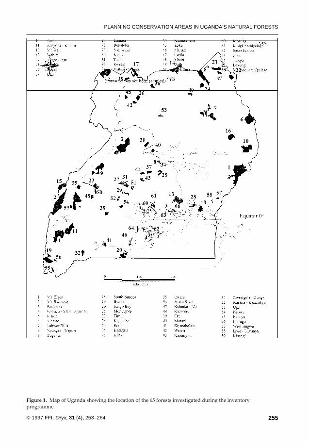
Figure 1. Map of Uganda showing the location of the 65 forests investigated during the inventoryprogramme.
any smaller reserve in which a particular veg-etation type was uniquely represented.Reserves qualifying under the second of thesecriteria were identified at the project planningstage, when a ‘gap analysis’ (Scott et al., 1993)was carried out to assess the extent to whichthe country’s vegetation types (Langdale-Brown et al., 1964) were already represented inthe country’s national parks, game reservesand larger forest reserves. An examination ofthe smaller reserves was then carried out toidentify localities where ‘missing’ vegetationtypes occur, so that these sites could be in-cluded in the inventory programme.
Clearly, it would be inefficient to designatemajor sites from the forest estate as SNRs ifthe same suite of species is already managedwithin other existing protected areas. The newSNRs should be part of an efficient nationalprotected-area system, which avoids un-necessary duplication. Ideally, therefore, thebiological inventory programme would havecovered all protected areas, but it was not poss-ible to include any of the game reserves orolder savannah national parks. Nevertheless,the programme provided a comprehensiveevaluation of the country’s principal forestedreserves, including five now designated asnational parks. Altogether, 65 forests distrib-uted throughout the country were selected fordetailed biological study (Figure 1), represent-ing all major vegetation types, and accountingfor more than 75 per cent of the area of the for-est estate.
Indicator taxa
A number of taxa were selected for investi-gation, based largely on their suitability asbiological ‘indicators’. While debate continuesover the value of indicators and their capacityto provide an accurate overall assessment ofbiodiversity, practical factors compel their use.Five taxa, as taxonomically different from oneanother as possible, were ultimately selectedfor study: woody plants; small mammals (fivefamilies: Cricetidae, Gerbillidae, Muridae,Myoxidae, Soricidae); birds; butterflies; andlarge moths (two families: Saturniidae,Sphingidae). By sampling these taxa the aim
was to compile as complete a species list aspossible for each site. Conservation prioritiescould then be established by comparing siteson the basis of species richness, diversity,rarity and complementarity, using directlycomparable datasets. Furthermore, the studyof specific taxa enabled the identification of lo-calities for species of particular conservationconcern.
Field sampling
Some ornithological and botanical work wasinitiated in 1991, but it was not until May 1992that the programme was fully implemented.Eighteen Forest Rangers were selected fromdifferent parts of Uganda and provided withover 3 months of intensive field training.These rangers were then divided between fourinventory teams, each comprising twobotanists, one ornithologist and one mammal-ogist/entomologist, supervised in the field byfull-time (graduate) biologists. In carrying outthe fieldwork, the broad approach of the in-ventory teams was to explore the full range ofhabitats, altitude and aspect within each for-est, from a number of strategically locatedbase camps. Sampling techniques for each ofthe five taxa were based on current recognizedmethods, described in detail elsewhere(Howard and Davenport, 1996).
In practice, it is seldom possible to compilecomplete lists of species for any given site,even for the most conspicuous groups ofplants and animals. It is therefore necessary toensure that data collected from different sitesare collected in a way that enables valid stat-istical comparison. Accordingly, field timewas allocated in proportion to the size of eachforest (thus standardizing as far as possible onsampling) and strict field recording pro-cedures were maintained so as to track therate of new species accumulation for eachtaxon with increased sampling effort. This fa-cilitated later comparison between sites usingspecies totals for given levels of sampling(Magurran, 1987; Krebs, 1989; Prendergast etal., 1993; Soberon and Llorente, 1993). Returnvisits were made to most forests during 1994and the early part of 1995 and where possible,
P. HOWARD ET AL.
256 © 1997 FFI, Oryx, 31 (4), 253–264

these took place at a different time of year andinvolved a different team of inventoryrangers, so as to control as much as possiblefor these variables.
The fieldwork was completed in March1995, and it took a further year to complete theidentification and verification of specimens,and enter the data into a computer. The firststage of the analysis was then aimed at identi-fying ‘biodiversity hotspots’ – areas with anunusually large number of species or concen-trations of rare species, which would be par-ticularly suitable for designation as naturereserves. Each site was scored for biologicalimportance based on a measure of species di-versity (relative species richness), and the‘rarity value’ of the species (based on fre-quency of occurrence in Uganda’s forests, andknown Africa-wide distributions; ForestDepartment, in prep.) represented within thefive indicator taxa at each site. As shown inTable 1, the most biologically diverse sites arenot necessarily those with the highest concen-trations of rare species, and the biological im-portance score gave equal weighting to eachof these two criteria. The next stage was torank all 65 forests in terms of their biologicalimportance.
Balancing biological conservation and socio-economic development objectives
This ranking process provided an unpre-cedented insight into the relative importance
of Uganda’s principal forests for biologicalconservation, but fell short of establishingclear site-selection priorities because it failedto take into account possible alternative de-mands on the same sites, for timber pro-duction, local community use, and so on.Clearly, conflicts of this nature should beavoided when possible.
The next stage of the site-selection processwas, therefore, to evaluate each site for vari-ous alternative land uses – such as timber pro-duction, local community use, recreational useand watershed protection – and derive scoresfor each of these criteria. In doing this, scoreswere derived as objectively as possible usingavailable data on standing timber volumes,population census statistics and so on, butmore subjective assessments (‘expert opinion’)were necessary in deriving scores for certaincriteria such as recreational potential (full de-tails are provided in Forest Department, inprep.). These scores were then combined in asingle statistic used as a measure of each for-est’s overall suitability for designation as StrictNature Reserve. Thus, the highest scoringforests are those of high biological value lo-cated in important watershed areas with eco-tourism development potential, where poortimber stocking combines with difficult accessand low human population densities in sur-rounding areas to minimize the potential forland-use conflicts.
PLANNING CONSERVATION AREAS IN UGANDA’S NATURAL FORESTS
257© 1997 FFI, Oryx, 31 (4), 253–264
Rank Species diversity Rarity value
1 Kasyoha-Kitomi† Echuya2 Bwindi Impenetrable*† Rwenzori*3 Budongo† Moroto4 Kalinzu-Maramagambo† Bwindi-Impenetrable*†5 Kibale* Mafuga6 Kadam Mt Elgon*7 Mpanga Budongo†8 West Bugwe Semliki*9 Mpigi Kasyoha-Kitomi†
10 Kabuika-Mujwal’ganda Kalinzu-Maramagambo†
* Existing national parks† Forests appearing in both lists
Table 1. Ranking of top 10forests for species diversity andrarity value as exhibited by thefive indicator taxa
Developing an efficient national protected-areasystem
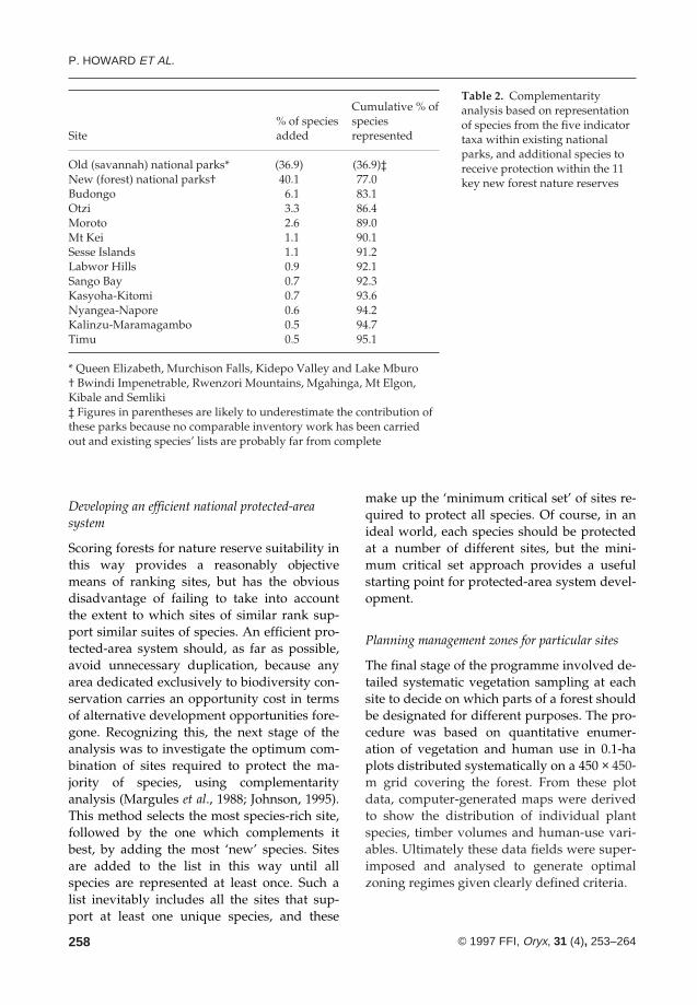
Scoring forests for nature reserve suitability inthis way provides a reasonably objectivemeans of ranking sites, but has the obviousdisadvantage of failing to take into accountthe extent to which sites of similar rank sup-port similar suites of species. An efficient pro-tected-area system should, as far as possible,avoid unnecessary duplication, because anyarea dedicated exclusively to biodiversity con-servation carries an opportunity cost in termsof alternative development opportunities fore-gone. Recognizing this, the next stage of theanalysis was to investigate the optimum com-bination of sites required to protect the ma-jority of species, using complementarityanalysis (Margules et al., 1988; Johnson, 1995).This method selects the most species-rich site,followed by the one which complements itbest, by adding the most ‘new’ species. Sitesare added to the list in this way until allspecies are represented at least once. Such alist inevitably includes all the sites that sup-port at least one unique species, and these
make up the ‘minimum critical set’ of sites re-quired to protect all species. Of course, in anideal world, each species should be protectedat a number of different sites, but the mini-mum critical set approach provides a usefulstarting point for protected-area system devel-opment.
Planning management zones for particular sites
The final stage of the programme involved de-tailed systematic vegetation sampling at eachsite to decide on which parts of a forest shouldbe designated for different purposes. The pro-cedure was based on quantitative enumer-ation of vegetation and human use in 0.1-haplots distributed systematically on a 450 × 450-m grid covering the forest. From these plotdata, computer-generated maps were derivedto show the distribution of individual plantspecies, timber volumes and human-use vari-ables. Ultimately these data fields were super-imposed and analysed to generate optimalzoning regimes given clearly defined criteria.
P. HOWARD ET AL.
258 © 1997 FFI, Oryx, 31 (4), 253–264
Cumulative % of% of species species
Site added represented
Old (savannah) national parks* (36.9) (36.9)‡New (forest) national parks† 40.1 77.0Budongo 6.1 83.1Otzi 3.3 86.4Moroto 2.6 89.0Mt Kei 1.1 90.1Sesse Islands 1.1 91.2Labwor Hills 0.9 92.1Sango Bay 0.7 92.3Kasyoha-Kitomi 0.7 93.6Nyangea-Napore 0.6 94.2Kalinzu-Maramagambo 0.5 94.7Timu 0.5 95.1
* Queen Elizabeth, Murchison Falls, Kidepo Valley and Lake Mburo† Bwindi Impenetrable, Rwenzori Mountains, Mgahinga, Mt Elgon,Kibale and Semliki‡ Figures in parentheses are likely to underestimate the contribution ofthese parks because no comparable inventory work has been carriedout and existing species’ lists are probably far from complete
Table 2. Complementarityanalysis based on representationof species from the five indicatortaxa within existing nationalparks, and additional species toreceive protection within the 11key new forest nature reserves
PLANNING CONSERVATION AREAS IN UGANDA’S NATURAL FORESTS
259© 1997 FFI, Oryx, 31 (4), 253–264
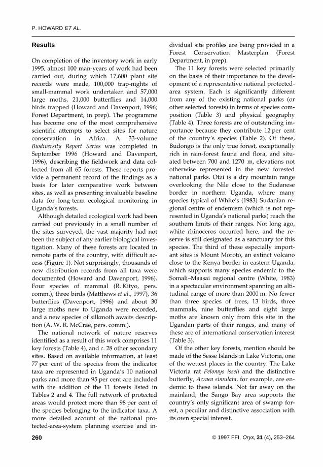
The steep-sided eastern slopes of Mt Moroto, viewed from the semi-arid savannah near the Kenyan border (T. Davenport).
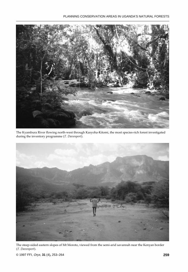
The Kyambura River flowing north-west through Kasyoha-Kitomi, the most species-rich forest investigatedduring the inventory programme (T. Davenport).
Results
On completion of the inventory work in early1995, almost 100 man-years of work had beencarried out, during which 17,600 plant siterecords were made, 100,000 trap-nights ofsmall-mammal work undertaken and 57,000large moths, 21,000 butterflies and 14,000birds trapped (Howard and Davenport, 1996;Forest Department, in prep). The programmehas become one of the most comprehensivescientific attempts to select sites for natureconservation in Africa. A 33-volumeBiodiversity Report Series was completed inSeptember 1996 (Howard and Davenport,1996), describing the fieldwork and data col-lected from all 65 forests. These reports pro-vide a permanent record of the findings as abasis for later comparative work betweensites, as well as presenting invaluable baselinedata for long-term ecological monitoring inUganda’s forests.
Although detailed ecological work had beencarried out previously in a small number ofthe sites surveyed, the vast majority had notbeen the subject of any earlier biological inves-tigation. Many of these forests are located inremote parts of the country, with difficult ac-cess (Figure 1). Not surprisingly, thousands ofnew distribution records from all taxa weredocumented (Howard and Davenport, 1996).Four species of mammal (R. Kityo, pers.comm.), three birds (Matthews et al., 1997), 36butterflies (Davenport, 1996) and about 30large moths new to Uganda were recorded,and a new species of silkmoth awaits descrip-tion (A. W. R. McCrae, pers. comm.).
The national network of nature reservesidentified as a result of this work comprises 11key forests (Table 4), and c. 28 other secondarysites. Based on available information, at least77 per cent of the species from the indicatortaxa are represented in Uganda’s 10 nationalparks and more than 95 per cent are includedwith the addition of the 11 forests listed inTables 2 and 4. The full network of protectedareas would protect more than 98 per cent ofthe species belonging to the indicator taxa. Amore detailed account of the national pro-tected-area-system planning exercise and in-
dividual site profiles are being provided in aForest Conservation Masterplan (ForestDepartment, in prep).
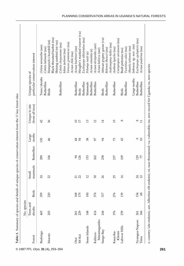
The 11 key forests were selected primarilyon the basis of their importance to the devel-opment of a representative national protected-area system. Each is significantly differentfrom any of the existing national parks (orother selected forests) in terms of species com-position (Table 3) and physical geography(Table 4). Three forests are of outstanding im-portance because they contribute 12 per centof the country’s species (Table 2). Of these,Budongo is the only true forest, exceptionallyrich in rain-forest fauna and flora, and situ-ated between 700 and 1270 m, elevations nototherwise represented in the new forestednational parks. Otzi is a dry mountain rangeoverlooking the Nile close to the Sudaneseborder in northern Uganda, where manyspecies typical of White’s (1983) Sudanian re-gional centre of endemism (which is not rep-resented in Uganda’s national parks) reach thesouthern limits of their ranges. Not long ago,white rhinoceros occurred here, and the re-serve is still designated as a sanctuary for thisspecies. The third of these especially import-ant sites is Mount Moroto, an extinct volcanoclose to the Kenya border in eastern Uganda,which supports many species endemic to theSomali–Maasai regional centre (White, 1983)in a spectacular environment spanning an alti-tudinal range of more than 2000 m. No fewerthan three species of trees, 13 birds, threemammals, nine butterflies and eight largemoths are known only from this site in theUgandan parts of their ranges, and many ofthese are of international conservation interest(Table 3).
Of the other key forests, mention should bemade of the Sesse Islands in Lake Victoria, oneof the wettest places in the country. The LakeVictoria rat Pelomys isseli and the distinctivebutterfly, Acraea simulata, for example, are en-demic to these islands. Not far away on themainland, the Sango Bay area supports thecountry’s only significant area of swamp for-est, a peculiar and distinctive association withits own special interest.
P. HOWARD ET AL.
260 © 1997 FFI, Oryx, 31 (4), 253–264
PLANNING CONSERVATION AREAS IN UGANDA’S NATURAL FORESTS
261© 1997 FFI, Oryx, 31 (4), 253–264
Tab
le 3
.Su
mm
ary
of s
peci
es a
nd d
etai
ls o
f uni
que
spec
ies
of c
onse
rvat
ion
inte
rest
from
the
11 k
ey fo
rest
sit
es
No.
spe
cies
Tre
es a
ndSm
all
Lar
geU
niqu
e to
sit
eU
niqu
e sp
ecie
s of
Fo
rest
shru
bsB
ird
sm
amm
als
But
terf
lies
mot
hs(f
rom
all
taxa
)pa
rtic
ular
con
serv
atio
n in
tere
st
Bud
ongo
465
359
2428
913
042
Tre
es/
shru
bsO
chna
mon
anth
a(a
re)
But
terf
lies
Col
otis
hal
imed
e(n
u)M
orot
o20
322
022
106
4636
Bir
ds
Hem
pric
h’s
horn
bill
(nt)
Bla
ck-t
hroa
ted
bar
bet (
nu)
Shin
ing
sunb
ird
(nt/
nu)
But
terf
lies
Col
otis
chr
yson
ome
(nu)
Iola
us ja
ckso
ni(n
u)T
aruc
us g
ram
mic
us (n
u)A
crae
a ch
ilo(n
u)O
tzi
261
168
2194
4410
But
terf
lies
Acr
aea
buet
tner
i(nu
)M
t Kei
229
175
2212
654
17B
ird
sH
eugl
in’s
mas
ked
wea
ver
(vu)
But
terf
lies
Euc
hrys
ops
albi
stri
atus
(nu)
Sess
e Is
land
s14
810
012
153
3813
Mam
mal
sP
elom
ys is
seli
(e)
But
terf
lies
Acr
aea
sim
ulat
a(e
)K
alin
zu-
414
374
3026
297
12B
utte
rflie
sA
crae
a al
ciop
oide
s(a
re)
Mar
amag
ambo
Acr
aea
kalin
zu(a
re)
Sang
o B
ay24
431
726
258
9414
Bir
ds
Afr
ican
pyg
my
goos
e (v
u)B
utte
rflie
sB
elen
ois
theu
szi(
nu)
And
rony
mus
hel
les
(nu)
Kas
yoha
-37
627
625
237
7315
But
terf
lies
Ant
hene
lysi
cles
(nu)
Kit
omi
Coe
nyro
psis
car
cass
oni(
nu)
Lab
wor
Hill
s23
913
916
109
438
Bir
ds
Bus
h pe
tron
ia (n
u)B
utte
rflie
sT
uxen
tius
cal
ice
(nu)
Aba
ntis
tett
ensi
s(n
u)L
arge
mot
hsIm
bras
ia s
p. n
ov. (
ns)
Nya
ngea
-Nap
ore
261
154
2412
99
8B
utte
rflie
sE
uchr
ysop
s cy
clop
teri
s(n
u)T
imu
166
6812
7710
11B
utte
rflie
sA
crae
a pu
dori
na(n
u)
e, c
ount
ry/
site
end
emic
; are
, Alb
erti
ne r
ift e
ndem
ic; n
t, ne
ar th
reat
ened
; vu,
vul
nera
ble;
nu,
new
rec
ord
for
Uga
nda;
ns,
new
spe
cies
P. HOWARD ET AL.
262 © 1997 FFI, Oryx, 31 (4), 253–264
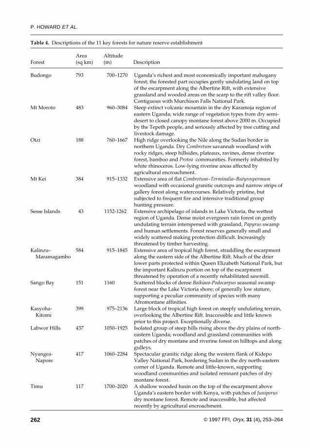
Table 4. Descriptions of the 11 key forests for nature reserve establishment
Area AltitudeForest (sq km) (m) Description
Budongo 793 700–1270 Uganda’s richest and most economically important mahogany forest; the forested part occupies gently undulating land on top of the escarpment along the Albertine Rift, with extensive grassland and wooded areas on the scarp to the rift valley floor. Contiguous with Murchison Falls National Park.
Mt Moroto 483 960–3084 Steep extinct volcanic mountain in the dry Karamoja region of eastern Uganda; wide range of vegetation types from dry semi-desert to closed canopy montane forest above 2000 m. Occupied by the Tepeth people, and seriously affected by tree cutting and livestock damage.
Otzi 188 760–1667 High ridge overlooking the Nile along the Sudan border in northern Uganda. Dry Combretum savannah woodland with rocky ridges, steep hillsides, plateaux, ravines, dense riverine forest, bamboo and Protea communities. Formerly inhabited by white rhinoceros. Low-lying riverine areas affected by agricultural encroachment.
Mt Kei 384 915–1332 Extensive area of flat Combretum–Terminalia–Butyrospermumwoodland with occasional granitic outcrops and narrow strips of gallery forest along watercourses. Relatively pristine, but subjected to frequent fire and intensive traditional group hunting pressure.
Sesse Islands 43 1152-1262 Extensive archipelago of islands in Lake Victoria, the wettest region of Uganda. Dense moist evergreen rain forest on gently undulating terrain interspersed with grassland, Papyrus swamp and human settlements. Forest reserves generally small and widely scattered making protection difficult. Increasingly threatened by timber harvesting.
Kalinzu– 584 915–1845 Extensive area of tropical high forest, straddling the escarpment Maramagambo along the eastern side of the Albertine Rift. Much of the drier
lower parts protected within Queen Elizabeth National Park, but the important Kalinzu portion on top of the escarpment threatened by operation of a recently rehabilitated sawmill.
Sango Bay 151 1160 Scattered blocks of dense Baikiaea-Podocarpus seasonal swamp forest near the Lake Victoria shore; of generally low stature, supporting a peculiar community of species with many Afromontane affinities.
Kasyoha- 399 975–2136 Large block of tropical high forest on steeply undulating terrain, Kitomi overlooking the Albertine Rift. Inaccessible and little known
prior to this project. Exceptionally diverse.Labwor Hills 437 1050–1925 Isolated group of steep hills rising above the dry plains of north-
eastern Uganda; woodland and grassland communities with patches of dry montane and riverine forest on hilltops and along gulleys.
Nyangea- 417 1060–2284 Spectacular granitic ridge along the western flank of Kidepo Napore Valley National Park, bordering Sudan in the dry north-eastern
corner of Uganda. Remote and little-known, supporting woodland communities and isolated remnant patches of dry montane forest.
Timu 117 1700–2020 A shallow wooded basin on the top of the escarpment above Uganda’s eastern border with Kenya, with patches of Juniperusdry montane forest. Remote and inaccessible, but affected recently by agricultural encroachment.
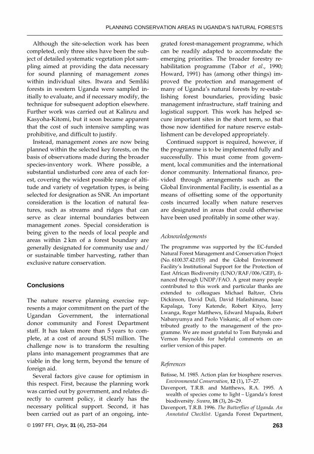
Although the site-selection work has beencompleted, only three sites have been the sub-ject of detailed systematic vegetation plot sam-pling aimed at providing the data necessaryfor sound planning of management zoneswithin individual sites. Itwara and Semlikiforests in western Uganda were sampled in-itially to evaluate, and if necessary modify, thetechnique for subsequent adoption elsewhere.Further work was carried out at Kalinzu andKasyoha-Kitomi, but it soon became apparentthat the cost of such intensive sampling wasprohibitive, and difficult to justify.
Instead, management zones are now beingplanned within the selected key forests, on thebasis of observations made during the broaderspecies-inventory work. Where possible, asubstantial undisturbed core area of each for-est, covering the widest possible range of alti-tude and variety of vegetation types, is beingselected for designation as SNR. An importantconsideration is the location of natural fea-tures, such as streams and ridges that canserve as clear internal boundaries betweenmanagement zones. Special consideration isbeing given to the needs of local people andareas within 2 km of a forest boundary aregenerally designated for community use and/or sustainable timber harvesting, rather thanexclusive nature conservation.
Conclusions
The nature reserve planning exercise rep-resents a major commitment on the part of theUgandan Government, the internationaldonor community and Forest Departmentstaff. It has taken more than 5 years to com-plete, at a cost of around $US1 million. Thechallenge now is to transform the resultingplans into management programmes that areviable in the long term, beyond the tenure offoreign aid.
Several factors give cause for optimism inthis respect. First, because the planning workwas carried out by government, and relates di-rectly to current policy, it clearly has thenecessary political support. Second, it hasbeen carried out as part of an ongoing, inte-
grated forest-management programme, whichcan be readily adapted to accommodate theemerging priorities. The broader forestry re-habilitation programme (Tabor et al., 1990;Howard, 1991) has (among other things) im-proved the protection and management ofmany of Uganda’s natural forests by re-estab-lishing forest boundaries, providing basicmanagement infrastructure, staff training andlogistical support. This work has helped se-cure important sites in the short term, so thatthose now identified for nature reserve estab-lishment can be developed appropriately.
Continued support is required, however, ifthe programme is to be implemented fully andsuccessfully. This must come from govern-ment, local communities and the internationaldonor community. International finance, pro-vided through arrangements such as theGlobal Environmental Facility, is essential as ameans of offsetting some of the opportunitycosts incurred locally when nature reservesare designated in areas that could otherwisehave been used profitably in some other way.
Acknowledgements
The programme was supported by the EC-fundedNatural Forest Management and Conservation Project(No. 6100.37.42.015) and the Global EnvironmentFacility’s Institutional Support for the Protection ofEast African Biodiversity (UNO/RAF/006/GEF), fi-nanced through UNDP/FAO. A great many peoplecontributed to this work and particular thanks areextended to colleagues Michael Baltzer, ChrisDickinson, David Duli, David Hafashimana, IsaacKapalaga, Tony Katende, Robert Kityo, JerryLwanga, Roger Matthews, Edward Mupada, RobertNabanyumya and Paolo Viskanic, all of whom con-tributed greatly to the management of the pro-gramme. We are most grateful to Tom Butynski andVernon Reynolds for helpful comments on anearlier version of this paper.
References
Batisse, M. 1985. Action plan for biosphere reserves.Environmental Conservation, 12 (1), 17–27.
Davenport, T.R.B. and Matthews, R.A. 1995. Awealth of species come to light – Uganda’s forestbiodiversity. Swara, 18 (3), 26–29.
Davenport, T.R.B. 1996. The Butterflies of Uganda. AnAnnotated Checklist. Uganda Forest Department,
PLANNING CONSERVATION AREAS IN UGANDA’S NATURAL FORESTS
263© 1997 FFI, Oryx, 31 (4), 253–264

Kampala, Uganda.Forest Department, in prep. Nature Conservation
Masterplan. Uganda Forest Department, Kampala,Uganda.
Hamilton, A.C. 1984. Deforestation in Uganda. OxfordUniversity Press, Nairobi, Kenya.
Howard, P.C. 1991. Nature Conservation in Uganda’sTropical Forest Reserves. IUCN, Gland, Switzerlandand Cambridge, UK.
Howard, P.C. and Davenport, T.R.B. (eds). 1996.Forest Biodiversity Reports. Vols. 1–33. UgandaForest Department, Kampala, Uganda.
Johnson, N. 1995. Biodiversity in the Balance:Approaches to Setting Geographic ConservationPriorities. Biodiversity Support Programme,Washington DC.
Kayanja, F.I.B. and Douglas-Hamilton, I. 1989. Theimpact of the unexpected on the Uganda NationalParks. In National Parks, Conservation andDevelopment (eds J. A. McNeely and K. R. Miller),pp. 87–93. Smithsonian Press, Washington DC.
Kingdon, J. 1971–74. East African Mammals: An Atlasof Evolution. Academic Press, London.
Krebs, C.J. 1989. Species Diversity Measures. EcologicalMethodology. Harper and Row, New York.
Langdale-Brown, I., Osmaston, H.A., and Wilson,J.G. 1964. The Vegetation of Uganda and its Bearingon Land-use. Government Printer, Entebbe.
Magurran, A.E. 1987. Ecological Diversity and itsMeasurement. Chapman and Hall, London.
Margules, C.R., Nicholls, A.O. and Pressey, R.L.1988. Selecting networks of reserves to maximisebiological diversity. Biological Conservation, 43,63–76.
Matthews, R.A., Baltzer, M.C. and Howard, P.C.1997. New bird records for Uganda, with an ad-dition to the East African avifauna. Scopus, 19,119–120.
Pomeroy, D. 1993. Centres of high biodiversity inAfrica. Conservation Biology, 7 (4), 901–907.
Prendergast, J.R., Wood, S.N., Lawton, J.H. andEversham, B.C. 1993. Correcting for variation inrecording effort in analyses of diversity hotspots.Biodiversity Letters, 1, 39–53.
Rogers, D.J. and Randolph, S.E. 1988. Tsetse flies inAfrica: bane or boon? Conservation Biology, 2 (1),57–65.
Scott, J.M.. Davis, M., Csuti, B., Noss, R., Butterfield,B., Groves, C., Anderson, H., Caicco, S., D’Erchia,F., Edwards, T.C., Ulliman, J. and Wright, R.G.1993. Gap analysis: a geographic approach to pro-tection of biological diversity. Wildlife Monographs,123, 1–41.
Soberon, J.M. and Llorente, J.B. 1993. The use ofspecies accumulation functions for the predictionof species richness. Conservation Biology, 7 (3),480–488.
Tabor, G., Johns, A. and Kasenene, J.M. 1990.Deciding the future of Uganda’s tropical forests.Oryx, 24 (4), 208–214.
Wasawo, D.P.S. and Bushara, J. 1989. Wildlife andProtected Areas. Strategic Resources Planning inUganda. Vol. III. United Nations EnvironmentProgramme, Nairobi.
White, F. 1983. The Vegetation of Africa. UNESCO,Paris.
Peter C. Howard, Ghana Wildlife Department, POBox M239, Ministry Post Office, Accra, Ghana.
Timothy R. B. Davenport, WWF-Cameroon, PO Box6776, Yaounde, Cameroon.
Frederick W. Kigenyi, Forest Department, PO Box1752, Kampala, Uganda.
P. HOWARD ET AL.
264 © 1997 FFI, Oryx, 31 (4), 253–264
Related Documents