Steve Rogers – Head of Planning & Building Standards Services Kirkbank, English Street, Dumfries, DG1 2HS Telephone (01387) 260199 - Direct Dial Fax (01387) 260188 Planning Applications Committee Report ERECTION OF 14 WIND TURBINES (MAXIMUM TIP HEIGHT 126.5 METRES) AND FORMATION OF ASSOCIATED ACCESS TRACKS AND HARDSTANDINGS, ERECTION OF 1 PERMANENT WIND MONITORING MAST (HEIGHT OF 80 METRES), 1 TEMPORARY WIND MONITORING MAST (HEIGHT OF 80 METRES), SUBSTATION AND CONTROL BUILDING, FORMATION OF TEMPORARY CONSTRUCTION COMPOUNDS AND OFFICES, BORROW PITS AND CONCRETE BATCHING PLANT AT AIRIES FARM, GLENLUCE Application Type: Full Planning Permission Applicant: Airies Windfarm Limited Ref. No.: 12/P/1/0271 Recommendation - Refuse Ward - Mid Galloway Hierarchy Type (if applicable) - Major Case Officer – Peter Barker 1 BACKGROUND Introduction 1.1 This application requires to be determined by the Planning Applications Committee because it is a Major Development as defined in the Town and Country Planning (Hierarchy of Developments (Scotland) Regulations 2009 and also as more than 6 objections were received. 1.2 Pre-application community consultation in accordance with statutory requirements was undertaken during July and August 2013 by means of local exhibitions, and meetings were also held with the three potentially interested Community Councils of New Luce, Old Luce, and Kirkcowan. 1.3 The planning application was submitted on 24 August 2012 after pre-application discussions with officers, and following a Scoping Opinion (11/E/1/0127) which was issued by the Council on 24 January 2012.

Welcome message from author
This document is posted to help you gain knowledge. Please leave a comment to let me know what you think about it! Share it to your friends and learn new things together.
Transcript

Steve Rogers – Head of Planning & Building Standards Services Kirkbank, English Street, Dumfries, DG1 2HS Telephone (01387) 260199 - Direct Dial Fax (01387) 260188
Planning Applications Committee Report ERECTION OF 14 WIND TURBINES (MAXIMUM TIP HEIGHT 126.5 METRES) AND FORMATION OF ASSOCIATED ACCESS TRACKS AND HARDSTANDINGS, ERECTION OF 1 PERMANENT WIND MONITORING MAST (HEIGHT OF 80 METRES), 1 TEMPORARY WIND MONITORING MAST (HEIGHT OF 80 METRES), SUBSTATION AND CONTROL BUILDING, FORMATION OF TEMPORARY CONSTRUCTION COMPOUNDS AND OFFICES, BORROW PITS AND CONCRETE BATCHING PLANT AT AIRIES FARM, GLENLUCE Application Type: Full Planning Permission Applicant: Airies Windfarm Limited Ref. No.: 12/P/1/0271 Recommendation - Refuse Ward - Mid Galloway Hierarchy Type (if applicable) - Major Case Officer – Peter Barker 1 BACKGROUND Introduction 1.1 This application requires to be determined by the Planning Applications Committee because it is a Major Development as defined in the Town and Country Planning (Hierarchy of Developments (Scotland) Regulations 2009 and also as more than 6 objections were received. 1.2 Pre-application community consultation in accordance with statutory requirements was undertaken during July and August 2013 by means of local exhibitions, and meetings were also held with the three potentially interested Community Councils of New Luce, Old Luce, and Kirkcowan. 1.3 The planning application was submitted on 24 August 2012 after pre-application discussions with officers, and following a Scoping Opinion (11/E/1/0127) which was issued by the Council on 24 January 2012.

Site Location and Description 1.4 The application site is located approximately 12km to the north-east of Glenluce and approximately 9km to the north of Kirkcowan. The site is set in a remote area of gently undulating land with a gradual rise in elevation from south to north. To the north is Eldrig Fell (227m above ordnance datum - AOD) with Eldrig Moss beyond further to the north; to the west is an area of afforestation leading up to the edge of the Artfield Fell Windfarm (approximately 2km away); to the east lie the coniferous plantations of the Kilquhockadale Flow; and to the south lies the ‘Three Lochs’ area (Lochs Ronald and Heron, and Black Loch) predominantly composed of lochans, forestry, peat moss, and rough pasture. Significant areas of plantation forestry throughout the application site have already been felled. 1.5 Around 1km to the south of the application site runs the C3w public road. The U165w public road bisects the application site on a north-west to south-east axis. Despite being a public road it has for all intents and purposes been abandoned. The Southern Upland Way (SUW) long distance walking route lies around 4 km to the north-west of the application site. 1.6 The site and immediately surrounding land, particularly to the south, south-west and north, is open moorland in character within a wider surrounding area heavily dominated by extensive areas of commercial coniferous forestry plantation. The land has few discernible features and is essentially undeveloped with the exception of a few scattered farmsteads and houses, and the Three Lochs Caravan Park. 1.7 Other than Low Airies Farmhouse itself, the closest residential properties (approximate measurements from the site boundary in each case) are located at: Torwood cluster (3km), Mark of Loch Ronald cluster (1.9km), Balminnoch cluster (1.1km), Three Lochs Holiday Park (1.2km), Old School House (1.3km), Dirnow School Houses (1.8km), Barsladie (1.8km), Kilquhockadale (1.5km), Urral (2.3km), Glenchamber (2.4km) and Artfield (2.4km). 1.8 The Dumfries and Galloway Landscape Assessment (DGLA-1998) categorises the Landscape Character Type (LCT) of the site and wider surrounding area as Plateau Moorland (LCT 17), and Plateau Moorland with Forest (LCT 17a). 1.9 The Dumfries and Galloway Windfarm Landscape Capacity Study (DGWLCS), which is a supporting document to the Council’s Interim Planning Policy – Wind Energy Development (IPP) and updates the landscape character assessments in the DGLA with specific reference to wind energy development, also places these areas in the corresponding character types. 1.10 Map 4 of the IPP (Potential Areas of Search for Large Scale Wind Energy Developments), designates the area within which the site is located as an “Area of Search”. Map 6 (Cumulative Sensitivity Zones) places the site outside an identified “Cumulative Sensitivity Zone”. 1.11 The area within which the site is located has no designation in the Structure Plan

“Dumfries and Galloway Wind Energy Diagram”, which plots an assessment of the suitability of various grid squares in areas where there are understood to be relatively high wind levels. 1.12 The site itself is not subject to any statutory landscape designations. The Galloway Hills Regional Scenic Area (RSA) lies some 9.5km to the east at its nearest point and extends for some distance eastwards, where it encompasses the Galloway Forest Park. The Mochrum Lochs RSA is located around 11km to the south of the application site. The Merrick Wild Land area (designated by SNH) lies around 18km to the east of the application site. 1.13 111 archaeological features have been identified within the application site. There are no Scheduled Ancient Monuments (SAMs) or other relevant designations. 3 of these features, within the site, can be regarded as of national or potentially national importance. Planning History / Other Windfarms and Windfarm Proposals Material to Consideration of the Application 1.14 The 15 x 76m high (base to tip) turbine operational windfarm at Artfield Fell (03/P/1/0195) with a completed 7-turbine extension at Balmurrie Fell (09/P/1/0224) lies some 2.5km to the west of the application site. 1.15 The 11 x 100m high (base to tip) turbine North Rhins windfarm, located some 35km to the south-west of the application site, has been fully operational since January 2009 (06/P/1/0403). 1.16 A planning application for an 11 x 125m high (base to tip) turbine windfarm at Glenchamber, Glenluce, located some 4km to the south-west of the application site, was refused by the Council in September 2011. Planning permission for this development was granted on appeal on 31 July 2012. 1.17 Planning permission for a 4 x 112m high (base to tip) turbine windfarm at Barlockhart Moor, Glenluce, located some 12km to the south-west of the application site, was granted on appeal in May 2010 (08/P/1/0202). A subsequent application to permit an increase in turbine height to 115m (base to tip) was granted permission by the Council on 25 November 2011 (11/P/1/0244). Construction commenced in September 2012. [NB - This site is currently the subject of a request for an EIA scoping opinion for a proposed 4-turbine extension.] 1.18 Planning permission for an 18 x 70m high (base to tip) turbine windfarm at Carscreugh Fell, Glenluce, located some 7km to the south-west of the application site, was granted on appeal on 21 March 2012 (06/P/1/0113). All pre-start planning conditions have now been discharged and it is understood that construction works are scheduled to commence in the near future. 1.19 A proposal for an 18 x 120m high (base to tip) turbine windfarm at Balunton Hill, Bargrennan, located some 13-14km to the north-east of the application site, was the
subject of a request for a Scoping Opinion in 2006 (06/E/5/0001). The applicant’s intentions for this site remain unknown. There is a current application for the siting of an additional anemometer mast on the site (12/P/1/0135), which has yet to be determined. 1.20 A proposal for a 9 turbine windfarm at Glenvernoch, some 7km to the north-east of the application site was the subject of intermittent informal discussions with planning officers (and others) in the period 2006-2009, culminating in a meeting with planning officers in October 2009. There has been no further contact since that date. Whether or not it is intended to progress this proposal towards a formal application is therefore currently unknown. 1.21 The recently constructed 60 x 127.5m high (base to tip) turbine windfarm at Arecleoch, located immediately to the north of the Dumfries and Galloway / South Ayrshire boundary, and some 12km to the north-west of the application site, is now fully operational. 1.22 The 28 x 127.5m high (base to tip) turbine windfarm at Mark Hill, Barrhill, is located some 15km to the north-west of the application site and is now also fully operational. 1.23 A proposal for a 94 x (up to) 146.5m high (base to tip) and 2 x (up to) 125m (base to tip) high turbine windfarm (reduced from an initial proposal for 132 turbines) at Kilgallioch, located some 5 to 10km to the north-east of New Luce (south-east of the Arecleoch windfarm – predominantly within Dumfries and Galloway but with a small part of the site extending into South Ayrshire) and some 3km to the north-west of the application site, has now been approved by the Scottish Ministers under Section 36 of the Electricity Act 1989. Having been duly consulted on this proposal (10/C/1/0003) and following consideration of a further report by the Planning Applications Committee on 28 November 2012, the Council raised no objection to the scheme as amended. 1.24 A Scoping Opinion for a proposed 12 x 125m high (base to tip) turbine windfarm at Arnsheen, some 4 - 5km to the north-east of the application site, was issued by the Council on 5 December 2011 (11/E/1/0091). 1.25 A proposal for a 60 x (up to) 150m high (base to tip) turbine windfarm at Chirmorrie (South Ayrshire), immediately adjacent to the south-east of the Arecleoch development and located some 10-11km to the north-west of the application site, was the subject of a scoping opinion in January 2010 (10/E/1/0015). This proposal would fall under Section 36 of the Electricity Act and so would be the subject of an application to the Scottish Government. Whether or not this site will be progressed is currently unknown. 1.26 A proposal for an 8 x (up to) 125m high (base to tip) wind turbine windfarm at Corwar (South Ayrshire), located some 8km to the north of the application site, was the subject of a scoping opinion in January 2012 (12/C/1/0003) and a formal consultation. The Council, under powers delegated to Officers, resolved on 18 January 2013 to recommend to South Ayrshire Council that it refuse the application (12/C/1/0019). 1.27 A proposed (up to) 28 x 126.5m high (base to tip) turbine windfarm (falling under Section 36 of the Electricity Act) at Stranoch, New Luce, located some 11km to the
north-west of the application site, was the subject of a scoping opinion in May 2012 (12/E/1/0022). A current formal consultation on the proposal was registered on 10 January 2013 (13/C/1/0001). A response has not yet been prepared. 1.28 A potential windfarm site at Fyntalloch, Knowe, approximately 3km to the north-east of the application site, was the subject of enquiry and an informal "pre-screening" meeting with planning officers in May 2012. 1.29 A potential windfarm site at Culvennan Fell / Ardachie Fell, Shennanton, located some 8km to the east of the application site has been the subject of informal enquiries. Temporary planning permission for the erection of a 70m high anemometer mast on this site was granted on 9 August 2012 (12/P/1/0156). 1.30 A proposal for a 19 x (up to) 126.5m high (base to tip) turbine windfarm at Annabaglish, located some 9km to the south of the application site, was the subject of a Scoping Opinion on 29 June 2010 (10/E/1/0035) when known as Derskelpin. Whether or not this site will be progressed is currently unknown. 1.31 A Scoping Opinion for a proposed 14 x 140m high (base to tip) turbine windfarm at Auchleand, Wigtown, located some 17 - 18km to the south-east of the application site was issued by the Council on 24 August 2012. Temporary planning permission for a 50m high meteorological monitoring mast on this site was granted on 27 April 2012 (12/P/1/0081). This proposal is currently the subject of pre-application public consultation. 1.32 A proposed 18 x 136.5m high (base to tip) turbine (Section 36) windfarm at Airriequhillart, Wigtown, located some 16-17km to the south of the application site is currently the subject of a request for a Scoping Opinion from Scottish Government Consents Unit. The Council has been duly consulted on this proposal (12/E/1/0056). Temporary planning permission for two 70m meteorological monitoring masts on this site was granted on 17 April 2012 (12/P/1/0078). 1.33 A potential site for a 24 x 125m high (base to tip) turbine windfarm at Barvennan Moss, Wigtown, located some 18-20km to the south-east of the application site and immediately adjoining to the west of the Auchleand site, has been the subject of an informal enquiry and a meeting with the planning officers in November 2011. Whether or not this site will be progressed is currently unknown. 1.34 A proposed 19 x 126.5m high (base to tip) turbine (Section 36) windfarm at Gass Farm, Glenluce, located directly adjacent to the west of the application site has been the subject of a request for a Scoping Opinion from the Scottish Government Consents Unit. The Council has been duly responded on this proposal (12/E/1/0062). 1.35 A planning application for a proposed 14-turbine windfarm at Glen App, South Ayrshire, located just to the north of the Dumfries and Galloway boundary and some 20km to the north-west of the application site, is currently the subject of a consultation request from South Ayrshire Council (12/C/1/0016).

1.36 A consultation on a Scoping Opinion request from South Ayrshire Council for a windfarm at Altercannoch, near Barrhill station (13/C/1/0006), some 3km to the north of the Dumfries and Galloway boundary has recently been received. 1.37 Summarising the above, turbine numbers in this part of Dumfries and Galloway and in the southern part of South Ayrshire close to the D&G boundary (including this application), equate to the following: Operational or Committed/Approved:
Artfield/Balmurrie 22
North Rhins 11
Barlockhart 4
Carscreugh 18
Arecleoch 60
Mark Hill 28
Glenchamber 11
Kilgallioch 96 250 Application Stage:
Airies 14
Glen App 14 28 Scoping Stage:
Balunton Hill 18
Arnsheen 12
Derskelpin 27
Auchleand 14
Chirmorrie 60
Corwar 8
Airriequhillart 18
Barlockhart 4
Gass 19
Stranoch 28 202 Enquiry/Pre-Screening:
Glenvernoch 9
Barvennan 24
Fyntalloch (no information at this stage)
Shennanton (no information at this stage) 33 1.38 These figures are, to some extent, indicative but provide a potential total of over 500 turbines within this part of Dumfries & Galloway and South Ayrshire, excluding those sites where numbers are currently indeterminate. Adding in an estimate for these two sites would increase this total to 550+ turbines. Breaking these figures down further for D&G alone shows potential for around 280 - 290 turbines in the area bounded by the A75(T) to the south and the South Ayrshire boundary in the north.

Brief Description of Proposal 1.39 The proposed development includes the following main components:-
14 x three-blade horizontal axis wind turbines of (up to) 126.5m high (base to tip) to blade tip – 80m high to hub with 90m rotor diameter - nominal output at 2.5 - 3 megawatts – with stand-alone kiosk to each turbine housing a transformer;
1 x permanent 80m latticed free-standing anemometer mast;
2 x temporary anemometer masts;
New (5.4km) and upgraded (2.6km) access tracks;
1 x on-site control building/sub-station (200 sq m approx);
Mass concrete or piled turbine foundations (subject to ground conditions);
Underground cabling;
Crane hardstandings and turning areas;
3 x borrow pits (within Penninghame Forest);
Temporary construction compound; and
Use of the U165w public road for principal access from Dirnow crossroads. This road will be temporarily stopped up for public use during construction works.
1.40 Access to the site for deliveries / construction is proposed via the A77(T) and / or A75(T) public roads; the C22w public road (Kirkcowan-Fell End-Dirnow Road); and the C165w public road into the site. 1.41 The submission indicates that the grid connection would be designed at a later stage. Any substantial overhead line would require to be the subject of a separate application for consent under Section 37 of the Electricity Act 1989. No specific details of the anticipated route nor whether underground / overhead cabling is intended has been provided at this stage. 1.42 The application is supported by an Environmental Statement (ES); a Non-Technical Summary; and a Planning Statement. The submission satisfies the requirements of the Town and Country Planning (Environmental Impact Assessment) (Scotland) Regulations 2011. 2 CONSULTATIONS 2.1 Scottish Natural Heritage:– No objections. Landscape overview 2.1.1 SNH has reviewed the landscape and visual section of the Environmental Statement and broadly agree with the judgments made in support of this application.
2.1.2 While SNH generally agrees with the findings of the assessment, it does have one area of concern that it would ask the applicant to look at: the visual impact upon receptors at Loch Heron. It is considered that, with further design work, there could be potential to lessen this significant impact, given the potential range and numbers of receptors affected.
2.1.3 There is also a more general concern around the cumulative visual effect of wind farms on the Southern Upland Way in this area, which relates to a more general capacity issue. Given the effect that Kilgallioch will have, even small effects such as that of the Airies scheme will add to the general wind farm influence upon this long distance route at this location.

Landscape Impacts
2.1.4 As noted within the capacity study, and as this area has been selected as a suitable ‘Area of Search’, the landscape in this area has a comparatively greater capacity to accommodate wind turbines. Although the capacity study set outs the principle of accepting development at this location, the scheme will still need to respond to localised and specific sensitivities; in this case, it is largely the visual impacts related to the proximity of the scheme to the Southern Upland Way (SUW) and tourist centres.
2.1.5 SNH is satisfied that there are no significant impacts upon designated landscapes and that there are likely to be localised significant impacts on the Plateau Moorland forestry landscape character type only.
2.1.6 The scheme will also give rise to a significant (but localised) effect upon the more distant Drumlin Pasture Moss and Moor LCT. Again SNH is satisfied with this conclusion.
Visual Amenity
2.1.7 With reference to the hub and tip height ZTV (Zone of Theoretical Visibility), most visibility occurs in the 10km band around the development, likely related to its location upon a plateau, with the Uplands limiting visibility to the north.
2.1.8 The assessment finds a number of significant visual impacts caused by the scheme, the majority of which occur within 5km of the scheme. These impacts occur to the south, north-east and north-west. SNH agrees with the assessment of significance, finding significant effects from: VP1 – south-east from Eldrig Fell, VP2 – north from Loch Heron, VP5 – SUW Standing Stones, VP7 – Bennan of Gravilland Hill fort, and VP9 – south-west from Hill of Ochiltree SUW.
2.1.9 SNH does have concerns with the impact upon the view from Loch Heron, given the proximity of holidaymakers, walkers and residents, and suggest that a further design iteration could lessen this impact. It is considered that the reduction in height or omission of turbines 1, 2 and 3 would go some way towards addressing these concerns.
2.1.10 SNH is pleased to note that there are no significant visual impacts from the Merrick, (Search Area for Wild Land) or from Bruce’s Stone (Glen Trool), and agree with these conclusions.
Cumulative Visual Impacts
2.1.11 Again SNH is in agreement with the assessment which finds significant cumulative effects from viewpoints 4, 5 and 9; as noted, two of these occur in views from the SUW and it is only viewpoint 4 that gains a significant impact that did not occur under visual impact alone. The majority of the cumulative impacts seem to occur in combination with Kilgallioch.
2.1.12 SNH is concerned as to the significant impact upon the Southern Upland Way, which the assessment finds for around 8km, and consider this impact in combination with Kilgallioch and other consented / operational schemes will cause an eventual limit to capacity in this area.
2.1.13 However, in this case, it agrees with the assessment that although the impacts are significant they are still fairly localised in extent. With reference to the combined ZTV with Kilgallioch, Fig. CLVIA 17, it does not appear to add additional visibility to this stretch of the SUW, though it will be visible successively with Kilgallioch for around 8km. Airies windfarm will be viewed at a greater distance from the path (at around 6km) as opposed to the SUW that will go through Kilgallioch wind farm.
Comments on the Assessment
2.1.14 In general, SNH has found the information supplied and judgments made in the assessment to provide a sound basis for decision-making.
Conclusion
2.1.15 SNH has to conclude that although there are significant impacts, the majority are either localised (not affecting an entire landscape character unit), or within around 5km or so. The area is also fairly sparsely settled, giving rise to fewer residential receptors. However, as discussed, SNH is concerned by the significant visual impact upon receptors at Loch Heron.
2.1.16 SNH is also aware that a limit is being reached regarding visual impact on walkers on the SUW and suggest that this is an issue that will need to be monitored in relation to other applications in the Broad Area of Search and outside but relating to it. Overall however SNH is content that the scheme has addressed the concerns raised at scoping.
River Bladnoch SAC
2.1.17 Although the proposal does not directly affect the River Bladnoch Special Area of Conservation (SAC), there are several tributaries that arise in and / or run through the proposed turbine site. Within the site, a number of access tracks are proposed. Some of these tracks cross the tributaries. SNH recommends that adequate provisions should be made both during construction and operation to ensure that silt, peat, fuel and any other materials are prevented from entering these watercourses. Suitably constructed bridge or pipe crossings should be provided both during construction and permanently. Similar precautions are necessary for cable trenches and during construction of turbine platforms. All work methodology for tracks and installations affecting watercourses should be agreed with SEPA.
Ornithology
2.1.18 Having considered the work carried out by Haworth Conservation Ltd, SNH considers that all breeding surveys have been undertaken appropriately. This is a low sensitivity site for birds. Although Vantage Point (VP) work was only carried out for part of the time for VP2, this is acceptable given the layout changes since work started. SNH is happy with the conclusions from the collision risk model. It agrees with the conclusions that that the low level of ornithological interest means that there should not be concerns about this site from an ornithological perspective. However, there may be cumulative impacts on species such as goshawk that cannot be assessed without further data. This is outwith the remit of the current ES, but it is requested that records are kept of collision risk for this species.
Ecology other than ornithology
Bats
2.1.19 The scoping report stated that the bat survey would conform to recommendations in Hundt L (2012) Bat Surveys: Good Practice Guidelines, 2nd edition, Bat Conservation Trust. From the information provided in the ES, the site appears to be low risk for bats. In this case, the recommendation is that ground level transect is carried out on 1 visit per season and automated surveys are carried out on 5 consecutive nights for each location. However, a ground level transect survey was only carried out on one evening and morning session in May; therefore, SNH cannot assess bat activity over the whole season and so it requests that further survey work is carried out.
Great Crested Newt
2.1.20 The report states that the development is distant a pond found to contain Great Crested Newt (GCN). However, the pond lies adjacent to the track up to Low Airies Farm. SNH seeks clarification that this track will not be used as an access track to the development, in particular during construction. It is not expected that a licence will be required from SNH for GCN but SNH will be better able to advise once access is clarified. It is recommended that the developer should submit a Species Protection Plan for GCN to identify contingencies should conflicting situations arise.
Otter
2.1.21 The report notes evidence of squirrel and otter on the site, but no breeding sites. It is not anticipated that a licence will be required, but this may be reviewed following survey immediately prior to work if delay greater than 6 months as recommended in the report. It is recommended that the developer also submits a Species Protection Plan for otter.
Red Squirrel
2.1.22 The report notes the presence of red squirrel from historical evidence but the field survey was not conclusive to identify if feeding signs were from red or the non-native invasive grey squirrel. SNH does not anticipate that a licence will be required for red squirrel. It is considered that appropriate recommendations have been made but recommend that the developer also submits a Species Protection Plan for red squirrel.
Conclusion
2.1.23 Although SNH has no objection to the proposal, it will be happy to provide further advice once the clarification and additional information recommended above is made available.
2.2 Council Landscape Architect:- Objection. 2.2.1 The proposals are not supportable as they stand, and are contrary to WEP 2.
However, it is recommended that the proposals could be approved subject to
modifications to the scheme (see below).
2.2.2 In terms of policy and the supporting guidance set out in the DGWLCS the principle
of a Large typology (>80m) windfarm is acceptable within the Airies site. Reviewing the LVIA and further to site work, it is confirmed that the principle of development in this general area would be acceptable. In landscape and visual terms the area to the north-east of the U165w public road and set back from Eldrig Fell and the Gall Moss of Dirneark is least problematic. Areas south-east of the road raise the following concerns: (a) There are scale issues with the 126.5m turbines in relation to sensitive local receptors: residential properties within 2.5km of the scheme; tourist and recreational interests at and around the Three Lochs Holiday Park, including waymarked forest trails and the network of minor road, including the U165w public road; Torwood House Non Inventory Designed Landscape and Hotel; the historic landscapes at High Aries and around the local landmark summit of Eldrig Fell.
(b) There are cumulative issues when Airies is seen in combination with other existing, consented, and proposed windfarms, in particular Artfield Fell, Glenchamber, and potentially Kilgallioch. (c) The proposed felling provides opportunity for positive change to the existing commercial forestry. As a minimum, any consented scheme should aim to improve the composition, age structure and design of existing forestry in accordance with current guidance. However, given the overall environmental impacts of the proposals, further environmental and amenity benefits should be sought through the forest plan by way of compensatory mitigation.
Recommended additional mitigation measures to be sought: 2.2.3 Preferred Landscape Scenarios: (a) Reduce turbine height to 100m (judged acceptable based most evidently on VP2 and various other visualisations), and relocate turbines 11 and 12; or (b) Omit turbines 10, 11, 12, 13, 14 to the south-west of the public road, and relocate turbine 7 to the north-east of the road; and (c) Restructure a substantial forest area to west and north of the scheme, around the historic landscapes of High Airies and Eldrig Fell, and in relation of the site boundary with Eldrig Moss, with conservation and amenity priority objectives. This should incorporate a high proportion of broadleaves and / or managed long retention coniferous plantings. (d) Permanent plantings should also be sought through a Landscape Plan in relation to local ‘screening’ along forest trails and the public road, as well as any permanent infrastructure (compounds, control buildings, substation, etc). 2.2.4 As A Minimum: (a) Omit turbines 10, 11, and 12, and relocate turbine 13 to the north-east of the U165w public road; (b) Develop a woodland planting plan that incorporates a greater proportion of broadleaf and / or managed long retention coniferous planting between Low and High Airies, and around the western and northern boundaries of the scheme; (c) Permanent plantings should also be sought through a Landscape Plan in relation to local ‘screening’ along forest trails and the public road, as well as any permanent infrastructure (compounds, control buildings, substation, etc).

Summary background to recommendation 2.2.5 The Airies scheme is considered to comply for the most part with IPP policy WEP 2 and with the DGWLCS. However, within and external to the site, there is scope for local landscape and visual impacts on sensitive receptors: (a) The site occupies an area of afforested, low lying ground, typical of the Plateau Moorland with Forest Landscape Character Type (LCT), and offering the opportunities for windfarm development as set out for the Glentrool Landscape Character Unit (LCU): simplicity of landform and land cover, relatively sparse population, and without designation; (b) There are notable types of sensitive receptors, for which the proposed layout and design would be problematic: the setting of lochs, more complex landform, archaeological features, views of the Galloway Hills, and cumulative issues, particularly in relation to windfarm design; and (c) Turbines to the south-west of the U165w public road may be problematic in principle, due to the immediate sensitivities of High Airies, and would also be problematic with regard to the local sensitivities of the settings of Lochs Ronald and Heron, Eldrig Fell, and in the context of Artfield Fell Windfarm. 2.2.6 Whilst within an Area of Search for Large (>80m) typologies, it is considered that the proposed turbines (126.5m) would create scale issues in relation to these local receptors. Based on visualisations, turbines in the region of 80-100m would be judged to be acceptable. 2.2.7 Consideration of the Airies ES Landscape and Visual Impact Assessment, and an independent site assessment, supports the principle of development within the Airies site, with the following concerns and limitations: 2.2.8 Landscape character (a) The LVIA identifies the high degree of influence of the Airies development on landscape character, and the scope for a tipping point to be reached locally in terms of the area being perceived as a ‘windfarm landscape’. It is judged that developing a ‘windfarm landscape’ within close range of a populated area is inappropriate and is unlikely to be compatible with the existing tourist and recreational interest. (b) The LVIA identifies significant visual effects associated with views from six dwellings, or groups of dwellings within 3km of Airies, in particular where dwellings are set back from mature forestry and residents experience more open views. The adverse impacts on the amenity of the wider setting and approaches of these properties are also of concern. (c) The immediate and wider setting of Torwood House (Hotel and Non-Inventory Designed Landscape) and approaches to it via both the Fell End minor road and from the west would be dominated by the Airies turbines, in themselves and in combination with the other baseline windfarm schemes. (d) The LVIA assesses the significant landscape impacts on the Drumlin Pastures with Moss LCT (13), at closer range, within 4km, [VP 4] where Airies Windfarm would represent a new feature within the view where vertical scale of the turbines would be notably greater than that of the whale-backed drumlins and scattered woodland found throughout the area, thus potentially partially eroding the existing landscape character.

(e) The proximity of the windfarm, particularly turbines 9 and 14, and the additional exposure of the development to views from Eldrig Fell and Moor through felling out of the forest edge, would impact of on the remoteness and relatively wild, historic character of the moorland. (f) Turbines would impinge on the landscape character and setting of High Airies historic farmstead. Turbines 11 and 12 would be most problematic, particularly on the fabric of historic fields, walls, boundary trees, and as seen in the approach from Low Aries. 2.2.9 Views and amenity (a) The LVIA identifies that views of Airies would result in significant visual effects for recreational users at Torwood House Hotel, Three Lochs Caravan and Holiday Park and at Loch Heron and Loch Ronald. (b) There would also be significant visual effects experienced by walkers using the local footpath network footpath users of the Southern Upland Way (distances 6-8km, at higher elevation)…because of potential for combined visibility of Artfield Fell, Balmurrie Fell and Glenchamber and the proportion of skyline occupied with windfarm development between Balmurrie and Glenvernoch Fell. (c) The overall turbine height would dominate the outlook and setting of the historic landscape around Eldrig Fell. Turbine rotor blades would extend across the view to the Galloway Hills. See VP 1. (d) Turbines, and in particular the rotating blades would be overbearing on the visual amenity and tranquility of residential, visitor, and recreational users around the Loch Heron area. Turbines 10 and 11 would be most exposed (see VP 2). 2.2.10 Cumulative impacts (a) In views from the south, and seen in combination with other baseline and proposed windfarms, the Airies turbines, would extend windfarm development considerably closer to settlement and farmland. Although seen set back beyond the forest edge the turbines will in read in relation to and dominate Dirnow Farm, see VP 4. This issue is less discernible in longer range contexts. (b) Seen in combination with Artfield Fell in views from the north and the south, the differences in turbine scale for Airies could be perceptible and potentially problematic cumulative visual impacts. See VPs 4 and 5. The issue remains but is less problematic in longer range contexts, such as Knock Fell. See VP 11. (c) Seen in combination with Artfield Fell, Carscreugh, Glenchamber, and Kilgallioch, Airies will be seen to coalesce individual developments, and bring the perceived scale and dominance of development in closer range of sensitive local receptors. 2.2.11 Mitigation measures (a) The mitigation measures identified of forest restructure and woodland planting will not address landscape and visual impacts significantly, nor adequately compensate for them. (b) Further details of mitigation measures through woodland and shrub planting, and any boundary treatments (mounding, tree and shrub belts, drystone walls) should be provided for ancillary aspects of the scheme. 2.3 Council Archaeologist:- Concerns regarding proposal as submitted. In summary, the proposal will have localised adverse effects in respect of the historic environment. The most significant being:

a) The setting of White Cairn, an undesignated burial cairn dating from around 3-4,000 years ago, assessed as being almost certainly of national importance by Dumfries and Galloway Council, would be dominated by turbine 13. This would have a significantly adverse effect as the whole 126 m turbine, which would be sited on the hill slope to the NW of the cairn, would be in visible at a distance of around 160 metres, when the cairn is approached and viewed from the south and west. At this distance, without and screening, the setting of the cairn would be dominated by a modern, industrial structure out of scale with all other man made, or managed structures in the vicinity. Turbine 14 would be set further back in this view. The outlook from the cairn over the falling ground to the south would be dominated by turbine 12 at about 230m distant with turbines 10 and 11 at about 800m and 620m distant. The site is not promoted as a visitor attraction but is readily accessible on a network of tracks and lies around 1.6 km SE of the similar, but designated Wood Cairn on Eldrig Fell, which is itself located in the vicinity of a range of archaeological remains. This effect would be reduced by the removal / relocation of turbine 13.
b) The setting of Wood Cairn, a designated burial cairn would be adversely affected by all of the turbines being highly visible in views to the east, see Viewpoint 1 from Eldrig Fell where the cairn is located. Although wireframes have not been supplied, it is advised that turbines from approved schemes, and Kilgallioch which is in process of approval, would span the skyline for approximately 160 degrees to the west (see CLVIA 05)
c) The historic environment as defined in Scottish Historic Environment Policy is a palimpsest of features that have been built and managed over time. Scale is an important characteristic of this environment. Photomontages from Viewpoint 2 from Loch Heron, and Cumulative Viewpoint 4 from the minor road at Fell End, illustrate the turbines relative to the farmed and managed landscape. The applicant has indicated in a letter of 19th December that Viewpoint 2 is the ‘worse case in this area in terms of turbine visibility due to its location in an open vantage point on the south side of the loch and set back from the rising topography that forms the horizon to the north of the holiday park. Visitors and users of the facilities and paths in this area would therefore generally experience more limited views of the windfarm’. From Fell End, the turbines would dwarf the long established Dirnow farm buildings and enclosed fields due to height and proximity. The turbines of Kilgallioch, Artfield, Balmurrie, Glenchamber and more distant windfarms would be set across the distant skyline, with Airies turbines being more prominent in the foreground, back-dropped by this line. The applicant has indicated in the letter of 19th December that Viewpoint 4 indicates the context of the windfarm within a landscape which has been heavily modified by land use change through commercial plantations. It is also stated that during consultation this viewpoint was not identified in relation to cultural heritage importance. In response, it is advised that Scottish Historic Environment Policy gives a very broad definition of the historic environment.
Taking the above into account, advises that there will be a localised adverse effect on the historic environment.
There would be additional cumulative effects that have not yet resulted from approved windfarms are Kilgallioch which is in process of consideration. Cumulative Viewpoint 5c from Laggangarn Standing Stones on the Southern Upland Way illustrates how Airies would introduce turbines blades into the easterly and south easterly outlook from this site, the only turbine-free aspects.
Cumulative Viewpoint 11 illustrates how the outlook to the north from the designated hill fort at Knock Fell that dominates the northern Machars will be further infilled with turbines as the arc of turbines extends east.
If the scheme is approved, a scheme must be put in place to protect the remains of High Airies Farm that lies immediately to the north of the existing track that is to be upgraded, see Fig 3.2 Access Track layout. This could be secured by a condition.
2.4 Council Roads Officer (following consideration of additional information requested):- No objections, subject to conditions. Pre-application advice was sought by the applicant and is accurately reflected in the Environmental Statement and the proposed mitigation measures, namely: (a) A Road Traffic Management Plan (RTMP) will be required prior to commencement of any works together with a detailed condition survey of any Council roads forming part of the access route. The plan should include proposals for maintenance of these routes during construction (including monitoring and proposals for agreeing additional maintenance costs and surveying and making good on completion of construction). Other issues such as signage and Community Consultation on the proposals should be covered in the RTMP. In particular the Community Council will require to be fully consulted. Forest owners and the impact on timber routes and haulage should be fully considered in the RTMP; and
(b) Improvements to C22w and U165w to Council standards and subject of application for Roads Construction consent.
The construction of the site and traffic movements would have to dovetail in with adjacent windfarm construction programmes so that no more than one windfarm is under way at any one time. 2.5 Council Environmental Standards Officer:- No objections, subject to conditions. 2.6 NATS:- No objections. Only scoping advice offered. 2.7 Dumfries and Galloway Constabulary:- No objections. Expect trial runs for abnormal loads to establish appropriate route. Constabulary happy to engage in discussions with other agencies to agree safe working plan for movement of construction materials and abnormal loads 2.8 Historic Scotland:- No formal objection, but raises significant concerns as follows: (a) ES has not adequately assessed potential direct and indirect impacts of the development on key historic environment features. (b) From information provided and in line with findings in ES, it appears that proposal would have significant impact on landscape setting of a small number of SAMs, although the impacts have been underscored in the EIA, and some of the methodology used is questionable. (c) Better visualisations regarding potential impacts on key archaeological features would have been of help.
(d) The impact of the development on the setting of Wood Cairn, in particular, would be significant. In order to mitigate the impact, large numbers of turbines would have to either be deleted or relocated elsewhere within the development site. However, as surrounding committed windfarms have already compromised the setting of Wood Cairn to some degree, the only mitigation possible appears disproportionate – hence the reason, on balance, to not formally object. 2.9 Transport Scotland Trunk Road Network Management:- No objections. Proposal unlikely to have significant impact on operation of trunk road network. Abnormal loads require authorisation from management organisation - prior consultation on feasibility is recommended. Due to frequency and number of these loads, UK policy is to restrict movements to nearest suitable ports. Proposed abnormal load routes, including any accommodation measures, must be approved by Transport Scotland in advance. 2.10 Scottish Environment Protection Agency (SEPA):- No objections subject to conditions being imposed covering development in peat areas, and habitat protection. 2.11 RSPB Scotland:- No significant impacts on ornithological interests foreseen. Stress great care needed in view of the hen harrier interest in the adjacent protect area (SPA). 2.12 Council Flood Risk Team:- No objections subject to flood risk measures being employed, especially during the construction period. 2.13 Scottish Water:- No objections. 2.14 Infratil (Glasgow Prestwick Airport):- No objections. Site outside Radar Consultation Zone. 2.15 Defence Estates (MoD):- No objections. All turbines must be fitted with 25 candela omni-directional red aviation lighting at highest practicable point. Information on dates of construction, height of construction equipment and latitude / longitude of each turbine must be provided for plotting on flying charts to ensure sure that military aircraft avoid this area.
2.16 Forestry Commission:- Objection. Forestry Commission Scotland (FCS) does not agree with the conclusions that have been reached in the respective section of the EIA with regard to compliance with the Scottish Governments Policy on Woodland Removal. The proposal, as drafted, does not comply with this policy. The developer has not engaged with FCS on the content of this section and the conclusion reached has been incorrectly drawn. 2.17 Old Luce Community Council:- Support the proposal. The location of the wind farm is set back some distance from the nearest villages of both Glenluce and Kirkcowan and is well screened. The area is covered in forestry presently and privately owned and is not considered a prime recreational area for visitors or hill walkers. The proposed wind farm is located within an “Area of Search” deemed appropriate by Dumfries and Galloway Council IPP for the establishment of large scale
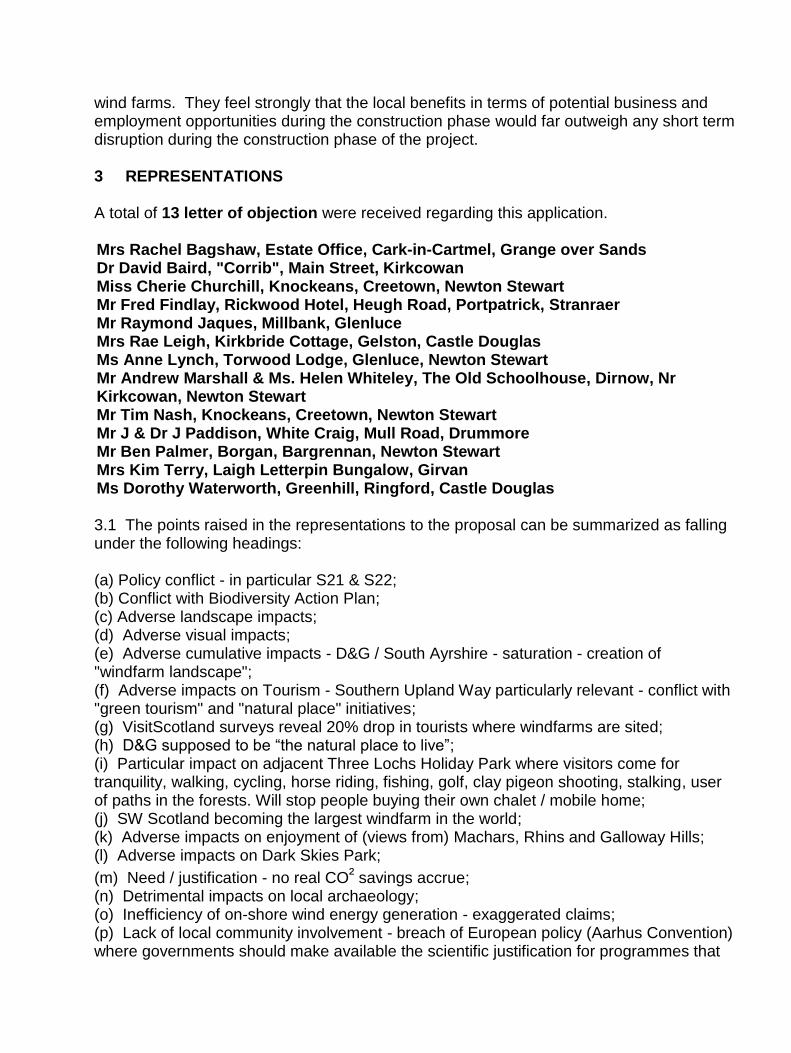
wind farms. They feel strongly that the local benefits in terms of potential business and employment opportunities during the construction phase would far outweigh any short term disruption during the construction phase of the project. 3 REPRESENTATIONS A total of 13 letter of objection were received regarding this application. Mrs Rachel Bagshaw, Estate Office, Cark-in-Cartmel, Grange over Sands Dr David Baird, "Corrib", Main Street, Kirkcowan Miss Cherie Churchill, Knockeans, Creetown, Newton Stewart Mr Fred Findlay, Rickwood Hotel, Heugh Road, Portpatrick, Stranraer Mr Raymond Jaques, Millbank, Glenluce Mrs Rae Leigh, Kirkbride Cottage, Gelston, Castle Douglas Ms Anne Lynch, Torwood Lodge, Glenluce, Newton Stewart Mr Andrew Marshall & Ms. Helen Whiteley, The Old Schoolhouse, Dirnow, Nr Kirkcowan, Newton Stewart Mr Tim Nash, Knockeans, Creetown, Newton Stewart Mr J & Dr J Paddison, White Craig, Mull Road, Drummore Mr Ben Palmer, Borgan, Bargrennan, Newton Stewart Mrs Kim Terry, Laigh Letterpin Bungalow, Girvan Ms Dorothy Waterworth, Greenhill, Ringford, Castle Douglas 3.1 The points raised in the representations to the proposal can be summarized as falling under the following headings: (a) Policy conflict - in particular S21 & S22; (b) Conflict with Biodiversity Action Plan; (c) Adverse landscape impacts; (d) Adverse visual impacts; (e) Adverse cumulative impacts - D&G / South Ayrshire - saturation - creation of "windfarm landscape"; (f) Adverse impacts on Tourism - Southern Upland Way particularly relevant - conflict with "green tourism" and "natural place" initiatives; (g) VisitScotland surveys reveal 20% drop in tourists where windfarms are sited; (h) D&G supposed to be “the natural place to live”; (i) Particular impact on adjacent Three Lochs Holiday Park where visitors come for tranquility, walking, cycling, horse riding, fishing, golf, clay pigeon shooting, stalking, user of paths in the forests. Will stop people buying their own chalet / mobile home; (j) SW Scotland becoming the largest windfarm in the world; (k) Adverse impacts on enjoyment of (views from) Machars, Rhins and Galloway Hills; (l) Adverse impacts on Dark Skies Park;
(m) Need / justification - no real CO² savings accrue; (n) Detrimental impacts on local archaeology; (o) Inefficiency of on-shore wind energy generation - exaggerated claims; (p) Lack of local community involvement - breach of European policy (Aarhus Convention) where governments should make available the scientific justification for programmes that

are said to affect the environment, and that there must be full and proper public participation in making such decisions; (q) Industrialisation of countryside; (r) No real local benefit - economic or otherwise; (s) Natural heritage / ecology - wildlife in general; (t) Loss of wilderness areas - scenic value - area of outstanding natural beauty - diminishing resource; (u) Progressive undermining of landscape quality. Where does the incremental encroachment of windfarms end?; (v) Noise; (w) Flicker; (x) Impacts on residential properties. The minority still deserve protection; (y) Impacts on infrastructure - roads and bridges; (z) Impacts on local (small) businesses; (aa) Increased electricity costs to consumer (to subsidise wind energy developments); (bb) Doubt over veracity of claimed climate change impacts; (cc) Level of community benefit irrelevant over 25-year lifespan, and is seen as a bribe; (dd) Net loss of 126ha of forest; (ee) Disruption by construction traffic (on top of windfarms already committed); and (ff) Neighbouring windfarms with potentially clashing turbine designs, would look discordant.
[NB - These reasons should be read in conjunction with the full text of written representations, which can be viewed on-line.] 4 REPORT Relevant development plan policies:- Dumfries & Galloway Structure Plan S21 - Renewable Energy S22 - Windfarm & Wind Turbines Development D36 - Design of Development D37 - Private Sector Contributions D38 - Environmental Assessment & Monitoring E2 - Regional Scenic Areas E3 - Landscape Character E6 - Conservation of Habitats & Species E12 - Development Affecting Archaeological Sites E13 - Archaeologically Sensitive Areas Wigtown Local Plan General Policy 1 - Development Principle General Policy 2 - Development Considerations General Policy 7 - Siting & Design General Policy 12 - Potentially Polluting Development General Policy 24 - Farm Diversification General Policy 42 - Regional Scenic Areas

General Policy 54 - Known Archaeological Sites – Including Scheduled Ancient Monuments General Policy 55 - Archaeologically Sensitive Areas General Policy 60 - Water Sewerage & Drainage Provision General Policy 65 - Traffic Management & Road Safety General Policy 66 - Local Road Network Other Material Considerations:- Structure Plan Strategy Statements 1 and 3 Technical Paper 5 with associated Wind Energy Diagram (WED) Dumfries and Galloway Landscape Assessment (Land Use Consultants for SNH - 1998) (DGLA) Council Interim Planning Policy: Wind Energy Development - February 2012 (IPP) - Policies WEP1 and WEP3 Dumfries and Galloway Windfarm Landscape Capacity Study (DGWLCS) Scottish Planning Policy (SPP) Scottish Government Renewables advice series: Onshore Wind Turbines 4.1 Consideration of the Application 4.1.1 Section 25 of the Town and Country Planning (Scotland) Act 1997, as amended by the Planning etc. (Scotland) Act 2006, requires that: “Where, in making any determination under the planning Acts, regard is to be had to the development plan, the determination shall be made in accordance with the plan unless material considerations indicate otherwise". 4.1.2 The application falls to be considered in terms of the development plan policies and other material considerations listed above. 4.2 Environmental Statement 4.2.1 The ES indicates that its preparation and production was conducted in accordance with the latest Government Regulations and advice on good practice. The ES has considered likely environmental effects including direct, indirect, secondary, cumulative, short, medium and long term, permanent and temporary, positive and negative.
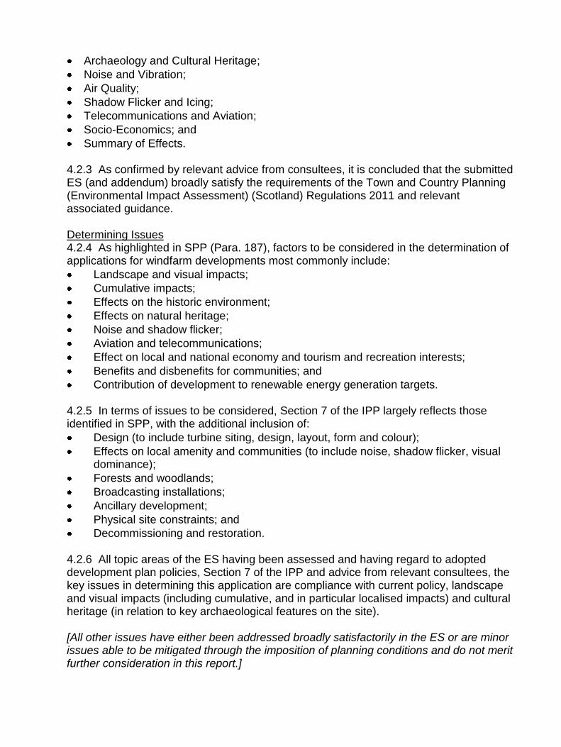
4.2.2 The ES comprises the following sections:
Introduction;
Need for the Project;
Project Description, Objectives and Alternatives;
Planning Policy;
Land Use, Property and Agriculture;
Forestry;
Geology, Soils and Contaminated Land;
Water Quality and Drainage;
Landscape and Visual Effects;
Ecology and Nature Conservation;
Traffic and Access;
Archaeology and Cultural Heritage;
Noise and Vibration;
Air Quality;
Shadow Flicker and Icing;
Telecommunications and Aviation;
Socio-Economics; and
Summary of Effects. 4.2.3 As confirmed by relevant advice from consultees, it is concluded that the submitted ES (and addendum) broadly satisfy the requirements of the Town and Country Planning (Environmental Impact Assessment) (Scotland) Regulations 2011 and relevant associated guidance. Determining Issues 4.2.4 As highlighted in SPP (Para. 187), factors to be considered in the determination of applications for windfarm developments most commonly include:
Landscape and visual impacts;
Cumulative impacts;
Effects on the historic environment;
Effects on natural heritage;
Noise and shadow flicker;
Aviation and telecommunications;
Effect on local and national economy and tourism and recreation interests;
Benefits and disbenefits for communities; and
Contribution of development to renewable energy generation targets. 4.2.5 In terms of issues to be considered, Section 7 of the IPP largely reflects those identified in SPP, with the additional inclusion of:
Design (to include turbine siting, design, layout, form and colour);
Effects on local amenity and communities (to include noise, shadow flicker, visual dominance);
Forests and woodlands;
Broadcasting installations;
Ancillary development;
Physical site constraints; and
Decommissioning and restoration. 4.2.6 All topic areas of the ES having been assessed and having regard to adopted development plan policies, Section 7 of the IPP and advice from relevant consultees, the key issues in determining this application are compliance with current policy, landscape and visual impacts (including cumulative, and in particular localised impacts) and cultural heritage (in relation to key archaeological features on the site). [All other issues have either been addressed broadly satisfactorily in the ES or are minor issues able to be mitigated through the imposition of planning conditions and do not merit further consideration in this report.]
4.3 Policy Considerations and Legislative Background 4.3.1 Government Policy 4.3.1.1 Government policy is primarily contained in Scottish Planning Policy (SPP) (February 2010). 4.3.1.2 Further advice and guidance particularly relevant to a windfarm proposals is contained in: PAN 42 (Archaeology); Onshore Wind Turbines (on-line guidance replacing relevant parts of PAN45, which is now superseded; PAN56 (Planning and Noise); PAN60 (Planning for Natural Heritage); and PAN73 (Rural Diversification). 4.3.1.3 SPP is the statement of Scottish Government policy on nationally important land use planning matters. In respect of windfarms, Government policy is set out in Paragraphs 187 to 191. Policy indicates that planning authorities should support development of windfarms where the technology can operate efficiently and environmental and cumulative impacts can be satisfactorily addressed. In terms of criteria to be considered relative to windfarm proposals, it is stated in Paragraph 187 that these are likely to include:
Landscape and visual impact;
Effects on the natural heritage and historic environment;
Contribution of the development to renewable energy generation targets;
Effects on the local and national economy and tourism and recreation interests;
Benefits and disbenefits for communities;
Aviation and telecommunications;
Noise and shadow flicker; and
Cumulative impact. 4.3.1.4 Policy also indicates that the design and location of any windfarm should reflect the scale and character of the landscape. 4.3.1.5 Landscape and natural heritage issues are covered in Paragraphs 125 to 148 of SPP. Much emphasis is placed on the importance and international renown of Scotland’s landscape and natural heritage and their contribution to the high environmental quality that makes Scotland an attractive place to live, do business and invest in. 4.3.1.6 Paragraph 127 states that; “Landscape in both the countryside and urban areas is constantly changing and the aim is to facilitate positive change whilst maintaining and enhancing distinctive character”; and that “Different landscapes will have a different capacity to accommodate new development and the siting and design of development should be informed by local landscape character”. 4.3.1.7 At Paragraph 131, SPP indicates that; “Landscapes and the natural heritage are sensitive to inappropriate development and planning authorities should ensure that potential effects, including the cumulative effect of incremental changes, are considered when preparing development plans and deciding planning applications”. While indicating that careful planning and design can minimise the potential for conflict with constraints imposed by the need to protect the landscape and natural heritage, recognition is also
given to the fact that there may be occasions where the sensitivity of the site or the scale of the proposed development is such that the development should not be permitted. 4.3.1.8 Policy on rural development is contained in Paragraphs 92 to 97 of the SPP. 4.3.1.9 SPP indicates that; “By taking a positive approach to new development, planning authorities can help to create the right conditions for rural businesses and communities to flourish. The aim should be to enable development in all rural areas that supports prosperous and sustainable communities whilst protecting and enhancing the environmental quality”. 4.3.1.10 The overarching aim should be to support diversification and growth of the rural economy by promoting economic activity and diversification in all rural areas, including development linked to farm diversification, whilst ensuring that the distinctiveness of rural areas, the service function of small towns and the natural and cultural heritage are protected and enhanced. 4.3.1.11 SPP explains how planning authorities are expected to respond to the issue of climate change, carbon emissions and sustainable development. Paragraph 37 indicates that decision making in the planning system should “Contribute to the reduction in greenhouse gas emissions in line with the commitment to reduce emissions by 42% by 2020 and 80% by 2050, contribute to reducing energy consumption and to the development of renewable energy generation opportunities”. 4.3.1.12 Paragraph 182 states that the Government’s commitment to increase the amount of electricity generated from renewable sources is a vital part of the response to climate change. Renewable energy generation will contribute to more secure and diverse energy supplies and support sustainable economic growth. Both SPP and National Planning Framework 2 (NPF2) set targets for the generation of electricity from renewable sources. The 2020 Route map for Renewable Energy in Scotland currently sets this target as 100% of electricity demand equivalent being generated from renewable sources (by 2020). During 2012 the Scottish Government announced an interim target of 50% by 2015. The current (January 2013) renewable proportion of generating capacity is 42%. 4.3.1.13 SPP indicates that planning authorities should set out a spatial framework for windfarms of over 20 megawatts in the development plan, although those below 20MW may also be included if deemed appropriate. Planning authorities must continue to determine planning applications while local policies are being updated. 4.3.1.14 Scottish Government policy on the historic environment and guidance on relevant legislation is set out in the 'Scottish Historic Environment Policy' (SHEP). SPP, the SHEP and the 'Managing Change in the Scottish Historic Environment' guidance note series (published by Historic Scotland), should be taken into account by planning authorities when determining applications for planning permission for developments that may affect the historic environment. 4.3.2 Key Council Development Plan Policies Structure Plan

4.3.2.1 The primary Structure Plan policy on windfarms is Policy S22. Technical Paper 5 and the Wind Energy Diagram flowing from that paper, relate directly to this policy. The Paper breaks the region into kilometre grid squares and the resultant diagram categorises areas of high wind speed as Potential, Intermediate and Sensitive. Policy S22 indicates that development proposals for sites outside identified search areas; " .. will be considered in terms of Policy S21 and Policy E3 until replaced by Local Plan guidance" 4.3.2.2 The application site is located outwith areas of high wind speed / areas of search considered in the Wind Energy Diagram. As such, the site and surrounding area has no designation. Key policy considerations are therefore those under S21 (Renewable Energy) and E3 (Landscape Character). 4.3.2.3 Policy S21 states that proposals for renewable energy sources will be considered positively provided that they do not have significant adverse impacts on:
The built and natural heritage;
Areas and routes important for tourism or recreational use in the countryside;
Water and fishing interests;
Air quality; and
The amenity of the surrounding area. 4.3.2.4 Structure Plan Policy E3 directs that guidance in the Landscape Assessment (DGLA) must be taken into account when assessing development proposals likely to have significant impact on the landscape. 4.3.2.5 Preparation of the Wind Energy Diagram also took account of the Landscape Character Type (LCT) designations contained in the Dumfries and Galloway Landscape Assessment (DGLA), which was published by SNH in 1994. The DGLA categorises the application site as Plateau Moorland (LCT17) and Plateau Moorland with Forest (LCT17a). 4.3.2.6 Descriptive text in Technical Paper 5 indicates that this landscape type is found in the west of the Region, to the north and west of Newton Stewart and in the western Machars. It is closely related to the Plateau Moorland landscape type, with similar gently undulating topography but is found where the plateau has become dominated by forestry. Extensive plantations, typically of uniform age, colour and texture, have been little modified by restructuring. The forests form dark horizons, limiting opportunities for open views. Their presence intrudes on the remaining open areas of moorland, reducing their wild land characteristics. Large scale open areas within the forest may be valued as a balance to the surrounding forest but may be suited to windfarm developments subject to the principals of good design set out in Appendix 3 depending on the inter-visibility and sensitivity of adjacent landscape types. The eastern fringes of the Plateau with Forest landscape are included within the Galloway Uplands RSA because they form part of the setting to these valued uplands and are thus considered sensitive. 4.3.2.7 Under the sub-heading “Strategies and Guidelines” (for each LCT), the DGLA advises as follows:

Plateau Moorland With Forest – "The smooth elevated relief of the plateau landscapes would be technically suited to windfarm development. Large scale open areas within forest dominated landscapes may be suited to wind power development. This would depend on the inter-visibility from adjacent landscape types which should be minimised. The road infrastructure of forests may be able to serve windfarm developments. This should be encouraged to prevent the disturbance of new access road construction.” Summary guideline – “Windfarms may be appropriate within open ground, ideally utilising existing roads.” 4.3.2.8 Landscape assessments and advice in the DGLA were based on turbine types prevalent at that time. Typically, these would have been in the 50-70m (base to tip) height range. In the sixteen years or so since publication of the DGLA, the technology, efficiency and size of typical wind turbines has increased to the extent that typical commercial scale turbines are now in the 100 - 150m (base to tip) height range. Notwithstanding the rapid increase in turbine heights, however, the characteristics of the landscape types and issues to be considered remain essentially unchanged. That being the case, and since the DGLA remains an integral element of the development plan under Structure Plan Policy E3, the advice contained therein remains relevant. 4.3.2.9 Assessment of the proposal under these five criteria in particular and other relevant development plan policies in general and the submitted Environmental Statement (ES) are considered below. 4.3.2.10 In terms of design, Structure Plan Policy D36 requires development proposals inter alia to take account of the relationship to landscape setting. Similarly, Wigtown Local Plan General Policy 7 requires developments to inter alia; have regard to the character of the adjacent area; retain important landscape features which contribute to the quality of the local environment; and have no material adverse effect on the local landscape character, avoiding prominent ridge lines or other visually sensitive sites. 4.3.3 Interim Planning Policy 4.3.3.1 Interim Planning Policy - Wind Energy Development (IPP) was approved by the Council’s Planning Housing and Environment Committee on 14 February 2012. In conjunction with the Dumfries and Galloway Windfarm Landscape Capacity Study (DGWLCS), which is a supporting technical document that updates and amends landscape character assessments and contains detailed guidance in relation to wind energy developments and landscape issues, the IPP is the latest statement of Council policy on wind energy development. As such, the IPP and DGWLCS are material considerations of significant weight in the assessment of all such developments. 4.3.3.2 The IPP replaces the Wind Energy Diagram and Technical Paper 5 contained within the Structure Plan and referenced at 4.3.2 above, but does not replace relevant development plan policies at this stage. However, the methodology employed in the preparation of Structure Plan Policy S22 in 1999 does not comply with the current SPP requirement for planning authorities to set out a spatial framework for wind energy development identifying areas of protection, areas of constraint, and areas of search. That being the case, and given that the methodology employed in formulation of the IPP does meet SPP requirements, it is considered that far greater weight should be given to the
policy and guidance contained within the IPP than to Structure Plan Policy S22. This has been the approach taken to recent turbine applications. 4.3.3.3 The principal stated aim of the IPP is to; “ .. accommodate renewable energy developments where the technology can operate efficiently and environmental impacts can be addressed satisfactorily”. The IPP contains the following three Interim Wind Energy Policies: WEP 1 - Areas Requiring Significant Protection; WEP 2 - Areas of Search for Large and Medium Scale Wind Energy Developments; & WEP 3 - All Other Areas 4.3.3.4 The spatial framework set out in the IPP is intended to guide large and medium typology turbine developments (i.e. those with a proposed base to tip height in excess of 50 metres) to appropriate locations. The Airies site is located within a designated ‘Area of Search’. Given the scale of proposed turbines, IPP Policy WEP 2 is relevant to this proposal. WEP 2 states that wind energy developments will only be acceptable where:
All relevant considerations contained in Section 7 of the IPP are adequately resolved;
Following appropriate assessment (where needed), the proposal has no adverse effects either alone or in combination on the integrity of any Natura site; and
Proposals have taken into account and responded to the sensitivity assessments and guidance contained in the DGWLCS.
4.3.3.5 Although the IPP is not part of the current Development Plan, it is now being actively used as policy guidance by the Council in the assessment of all wind energy developments, regardless of size. The DG Windfarm Landscape Capacity Study (DGWLCS) forms the baseline study document to the IPP.
4.3.3.6 The application site mainly falls within LCT17a (Plateau Moorland with Forest) but one turbine falls within LCT17 (Plateau Moorland). The DGWLCS identifies the following opportunities and limitations in terms windfarm development:
LCT17 Constraints: Due to other existing windfarms in the local area, cumulative effects must be considered;
LCT17 Opportunities: This LCT has a moderate sensitivity to windfarm development due to its scale. It is within an Area of Search in the IPP. The presence of extensive coniferous plantations within the landscape would screen views from many visual receptors;
LCT17a Constraints: Open moorland, pockets of settled farmland, loch basins increase diversity with the type as a whole; some edges of the LCT are close to settled farmland where very large turbines would dominate small scale valleys; strong sense of remoteness and naturalness in larger areas of open moorland; the settling of the Galloway Hills RSA to the east; views from The Merrick and Glen Trool; the Southern Upland Way extends through this LCT and cumulative effects experienced by those walking this route need to be considered; and potential cumulative effects with existing and consented windfarms nearby, including those in South Ayrshire; and
LCT17a Opportunities: The generally simple landform, expansive scale and uniform land cover of commercial coniferous forestry which could relate to large (windfarms of >10 turbines at heights of between 80-150m to blade tip) and medium scale typologies. The sparsely populated nature of this character type and the relatively limited visibility of the interior of this extensive plateau from adjacent settled character types (in terms of distance) and screening provided by forestry. An absence of landscape designations.
4.3.3.7 Acknowledging that LCT17a is the principal LCT in this case, summary guidance in the DGWLCS states that: There is scope to locate large typologies over 50 turbines within densely forested areas of this character type, avoiding open moorland and farmland which makes a strong contribution to landscape and visual diversity. Larger typologies should be located away from the edge of this character type where turbines may have an impact on small scale settled valleys. All development typologies should avoid impacting on the setting and views to lochs, on areas of more complex landform and on archaeological features as these enrich the overall landscape of this character type and often provide a focus in key views. Key views of the Galloway Hills and the landscape experience gained from walking the Southern Upland Way should be conserved. There may be capacity to accommodate multiple large scale developments within this character type, although the constraints identified above (and particularly the need to avoid impacting directly or indirectly on the character and experiential qualities associated with open moorland, settled farmland and open loch basins) are likely to limit scope for additional development should the Kilgallioch windfarm be consented.
4.3.3.8 Cumulative landscape and visual impacts between existing and new windfarm developments should be minimised by careful siting and design to avoid obvious contrasts in the scale and layout of turbines seen in key views. Any additional development should avoid significant visual impacts on the highly sensitive western Galloway Hills and on key viewpoints within Glentrool.
4.3.3.9 There is potential for windfarm development to accelerate positive change to existing commercial forestry within this character area. Any proposals for windfarm development should aim to improve the composition, age structure and design of existing forestry in accordance with current guidance.
4.4 Landscape and Visual Impacts, and Design 4.4.1 The ES considers the predicted constructional and operational effects of the proposed windfarm on landscape resources and visual amenity following field studies, computer visualisation work and a review of documentary and cartographic data.
4.4.2 The ES makes an assessment of the likely landscape and visual impacts or effects. Landscape and visual considerations are separate but closely interlinked and, to some extent, overlapping. Landscape considerations relate to changes to the physical landscape causing change to its character and how it is experienced and thus how it may be valued. On the other hand, visual considerations relate to overall effects on visual amenity in terms of changes in views and how changed views may be experienced and how people respond to such change.

4.4.3 Cumulative effects taken with other operational and approved windfarms, together with others currently in the planning system (i.e. proposals that are the subject of applications or at the 'scoping' stage) are also considered.
4.4.4 A summary of Significant Effects in the ES as they apply to Dumfries and
Galloway is as follows:
(a) The proposed development would result in a significant effect on the local landscape fabric. It would create a new (windfarm) landscape type. Judging the proposal against other landscape assessment criteria, it reaches the moderate, substantial, and moderate to major / moderate categories. (b) The proposed development would result in a significant effect on the Plateau Moorland with Forest LCT at a local level. There would be some apparent coalescence with other closest windfarms. It would create a new (windfarm) landscape type. Judging the proposal against other cumulative landscape assessment criteria, it reaches the slight / moderate, moderate / minor to moderate categories. (c) The proposed development would result in a significant effect on the Plateau Moorland LCT at a local level. There would be some apparent coalescence with other closest windfarms. It would create a new (windfarm) landscape type. Judging the proposal against other cumulative landscape assessment criteria, it reaches the slight / moderate, moderate / minor to moderate categories. (d) The revised layout would result in a reduced effect on the Area with Wildness Attributes (Kirkcowan Flow). The overall effect of the proposal on this landscape unit would be not significant. Judging the proposal against other cumulative landscape assessment criteria, it reaches the high, moderate, to none categories. (e) Low Airies (financially involved): the overall impact would be significant. Judging the proposal against other cumulative landscape assessment criteria, it reaches the high, substantial, and major categories. (f) Old School House: the overall impact would be significant. Judging the proposal against other cumulative landscape assessment criteria, it reaches the high, substantial, and major categories. (g) Balminnoch Cottages: the overall impact would be significant. Judging the proposal against other cumulative landscape assessment criteria, it reaches the high, substantial, and major categories. (h) Three Lochs Holiday Park house: the overall impact would be significant. Judging the proposal against other cumulative landscape assessment criteria, it reaches the high, substantial / moderate, and major to major / moderate categories. (i) Kilquhockadale: the overall impact would be significant. Judging the proposal against other cumulative landscape assessment criteria, it reaches the high, moderate, and

major / moderate categories. (j) Balminnoch Lodge: the overall impact would be significant. Judging the proposal against other cumulative landscape assessment criteria, it reaches the high, moderate, and major / moderate categories. (k) Drumabrennan: the overall impact would be significant. Judging the proposal against other cumulative landscape assessment criteria, it reaches the high, moderate, and major / moderate categories. (l) Barnsladie: the overall impact would be significant. Judging the proposal against other cumulative landscape assessment criteria, it reaches the high, moderate, and major / moderate categories. (m) Old Dirnow Schoolhouse (x2 dwellings): the overall impact would be significant. Judging the proposal against other cumulative landscape assessment criteria, it reaches the high, moderate, and major / moderate categories. (n) Urral: the overall impact would be significant. Judging the proposal against other cumulative landscape assessment criteria, it reaches the high, moderate, and major / moderate categories. (o) Dirnow: the overall impact would be significant. Judging the proposal against other cumulative landscape assessment criteria, it reaches the high, moderate, and major / moderate categories. (p) Fell of Loch Ronald & Fell of Loch Ronald (x4 dwellings): the overall impact would be significant. Judging the proposal against other cumulative landscape assessment criteria, it reaches the high, substantial / moderate, and major-major / moderate categories. (q) Ballochadee: the overall impact would be significant. Judging the proposal against other cumulative landscape assessment criteria, it reaches the high, moderate, and major / moderate categories. (r) Artfield: the overall impact would be significant. Judging the proposal against other cumulative landscape assessment criteria, it reaches the high, moderate, and major / moderate categories.
(all of the above properties are located within 3km of the boundary of the development site) (s) Three Lochs Holiday Park (as Three Lochs Holiday Park house above). (t) Loch Heron and Loch Ronald: the overall impact would be significant. Judging the proposal against other cumulative landscape assessment criteria, it reaches the high, moderate, and major / moderate categories.
(u) Torwood House Hotel: the overall impact would be significant. Judging the proposal against other cumulative landscape assessment criteria, it reaches the high, moderate / substantial, and major / moderate-moderate/minor categories.
(all of the above properties are within 4km of the boundary of the development site) (v) Whitecairn Caravan Park: the overall impact would be not significant. Judging the proposal against other cumulative landscape assessment criteria, it reaches the high, slight / negligible, and moderate-moderate / minor categories. (w) Galloway Forest Park: the overall impact would be not significant. Judging the proposal against other cumulative landscape assessment criteria, it reaches the high, slight / zero, and moderate-none categories. (x) Southern Upland Way. (y) National Cycle Routes locally. (z) Local Path/Core Paths: 4.4.5 In general terms, the landscape and visual assessments submitted by windfarm developers have become increasingly lengthy, complex and detailed. They analyse effects on landscape character and visual amenity over a wide area and consider increasingly complex scenarios in terms of cumulative impacts. This is a very specialised discipline so planning officers are ever more dependent on input from landscape professionals experienced in the field to give realistic and objective specialist guidance on the acceptability of any large windfarm proposal in landscape and visual impact terms.
4.4.6 The applicants claim to have taken on board the concerns and issues raised at the pre-application iterations to come up with what they consider to be a preferred scheme. However, whilst conflict or concern may have been minimised, it has not been avoided.
4.4.7 As set out in Section 4.3.4 (above), the Council’s Interim Planning Policy – Wind Energy development is a material consideration of significant weight. The applicable policy here is WEP2, which states that wind energy developments will only be acceptable where a number of criteria are met. The relevant criteria in respect of this proposal are that all factors identified in Section 7 of the IPP have been satisfactorily resolved and that proposals have taken account of and responded to, the sensitivity assessments and guidance in the DGWLCS. In terms of Section 7, the key issues to be considered in relation to this proposal are; Landscape and Visual Amenity; Cumulative impacts on Landscape and Visual Amenity, Design; Effects on Local Amenity and Communities, Historic Environment and Cultural Heritage, and Tourism and Recreation. 4.4.8 On the basis of the consultees’ responses and analysis in Sections 2.2 and 2.3 (above), it has already been concluded that the proposed windfarm would have significant adverse impacts on landscape and visual amenity, with particular regard to local key views, in particular, from Loch Heron, Tarff Bridge, Eldrig Fell and Fell End. Assessing the proposal against the DGWLCS in terms of the constraints and guidance set out above
shows that there is direct conflict in all of these same areas. That being the case, it is considered that the proposal does not satisfy the terms of Section 7 of the IPP relative to landscape and visual amenity, nor has it been shown that the proposal has taken account of and responded to, the sensitivity assessments and guidance in the DGWLCS. 4.4.9 The site falls within an Area of Search as identified in the IPP. However, this designation should not be interpreted as meaning that large scale wind farm development will automatically accord with policy. The Council’s position is that an Area of Search is an area where suitably designed windfarms (in terms of layout, turbine numbers, turbine heights) can be located to an agreed disposition, thus leaving appropriate gaps in between developments to enable the underlying landscape character type to prevail, rather than the landscape becoming unduly and adversely dominated by wind turbine development such that would change the character of that landscape. To be acceptable, it is clear that a windfarm proposal has to be assessed as appropriate to its local context. 4.4.10 Importantly, it should be noted that the IPP was adopted by the Council in February 2012. The Carscreugh windfarm was granted on appeal in March 2012, with the Glenchamber windfarm also being approved on appeal in July 2012. Both sites fall to the south of the Area of Search identified in the IPP, and are located within an area identified as a buffer zone in the IPP. The Glenchamber site virtually abuts the Area of Search. In spatial and visual terms, the Glenchamber windfarm (and to some extent the Carscreugh scheme) therefore have a bearing on the landscape and visual assessment of the Airies proposal. As such, it is considered that the capacity and ability of the respective portion of the Area of Search to accommodate turbine development has been reduced by these appeal decisions. The Council has to consider the Airies proposal in the light of prevailing circumstances, and the conclusion reached is that the scheme submitted is not acceptable principally by reason of its local impacts, as outlined below. 4.4.11 The Council’s Landscape Architect acknowledges the acceptability in principle of a windfarm at this location. The objection raised relates to the actual design and layout submitted. There are clear parallels with the SNH consultation response which also raises some concerns about local impacts, particularly from Loch Heron, and on users of the Southern Upland Way. 4.4.12 Similarly, and again having found the proposal to have significant adverse impacts, it is considered that the proposal fails to satisfy Section 7 in terms of Design (siting), with particular regard to: sensitivity of the locations from which the turbines are visible; locations that form significant focus of view from recreational routes and locations; and matters of recreational significance. The Council’s Landscape Architect highlights the parts of the scheme that are considered to be unacceptable, namely the overall height and size of the turbines proposed, and especially the position of turbines 10, 11, 12 and 13 (with additional concerns about turbines 7 and 14). It has also been noted from the submitted ES that the impact on all receptors within 3km of the site has been assessed as significant. 4.4.13 In terms of landscape fit, the proposed relatively open northern (former) forest edge of the development is of particular concern. In effect, the whole development site is potentially opened up to Eldrig Moss to the north, and the setting, context, appearance

and experience of remoteness, with wildland characteristics, would be significantly and adversely affected by this proposal. It is worth noting that the original Kilgallioch proposal was amended to maintain a solid tree edge to Eldrig Moss, as well as to provide a screen to the lower turbine towers, thus reducing their apparent height. This involved the deletion of 13 turbines from that proposal. 4.4.14 The applicant has declined to amend the proposal to fully address these matters, instead expressing a desire to have the application determined as originally submitted. 4.4.15 It should also be stressed that the significance of the local landscape and visual impacts predicted are additional to the impacts already received from the evolving windfarm development pattern locally (Artfield Fell, Balmurrie Fell, Glenchamber, Carscreugh, Barlockhart, and Kilgallioch) which have now all been granted permission. With regard to cumulative impact, it is considered that the proposal, in combination with other wind turbine developments, would be unacceptable in its present form. 4.4.16 The Forestry Commission has raised objections to the principles and design promoted in the application. These concerns are summarised in Section 2.16 of this Report. Should the proposal be amended following determination (if the applicant opts to re-submit) it is expected that an acceptable forest plan would be submitted. Alternatively, should the proposal obtain planning permission it is recommended that further information should be submitted to ensure a suitable forest redevelopment plan. This could be achieved by means of an appropriately worded condition. 4.5 Archaeology and Cultural Heritage 4.5.1 On the issue of Archaeology, Section 7 of the IPP states that proposals will require site-specific assessments to identify potential issues and effects, and that proposals should contain mitigation for identified effects. 4.5.2 In summary, the proposal would have localised adverse effects in respect of the historic environment, the most significant being upon the setting of White Cairn, an undesignated burial cairn dating from around 3-4,000 years ago, and assessed as being of significant (akin to national) importance by the Council Archaeologist. It is considered that this feature would be over-dominated and significantly and adversely affected by proposed Turbine 13.
4.5.3 Turbine 13, which would be sited on the hill slope to the north-west of the cairn, would be visible at a distance of around 160 metres when the cairn is approached and viewed from the south and west. At this distance, and in the absence of screening, the setting of the cairn would be over-dominated by this turbine. This effect would be reduced by the removal / relocation of proposed Turbine 13. Turbine 14 would be set further back in this view. It is also considered that the outlook from White Cairn over the falling ground to the south would also be dominated by proposed Turbine 12 at about 230m distant with Turbines 10 and 11 at about 800m and 620m distant.

4.5.4 Between 2000 and 2002, Historic Scotland provided funding to the Council to carry out an assessment of all recorded archaeological features which were recorded in the Council’s Historic Environment Record. This qualitative overview of data enabled an assessment of the importance of sites to be made (whether national, regional or local importance), against criteria established by Historic Scotland, as required by National Planning Policy Guidance 5: Archaeology and Planning which was of relevance at that time. The resulting ’Non-statutory Register’ of Council archaeological features was supplied to Historic Scotland as required following completion of this assessment.
4.5.5 Present Government policy is now set out in Scottish Historic Environment Policy (SHEP), SPP paras. 110-124, and Planning Advice Note 2/2011 Planning and Archaeology. The latter document indicates in para. 3 that ‘Not all nationally important sites have yet been designated’, and Annex 1 of SHEP sets out ‘Criteria for and guidance on the determination of National Importance for scheduling’.
4.5.6 The White Cairn feature is not promoted as a visitor attraction but is readily accessible on a network of tracks and lies around 1.6 km to the south-east of the similar, but designated, Wood Cairn on Eldrig Fell, which is itself located in the vicinity of a range of archaeological remains.
4.5.7 The setting of Wood Cairn, a designated burial cairn, would be adversely affected by all of the proposed turbines being highly visible in views to the east. Although wireframe diagrams specific to this particular issue have not been supplied, it is recognised that those turbines already granted planning permission, when taken in combination with the Kilgallioch proposal (presently awaiting determination by the Scottish Ministers), would be seen against the horizon over a sector spanning approximately 160 degrees to the west.
4.5.8 The historic environment as defined in Scottish Historic Environment Policy is a palimpsest of features that have been built and managed over time. Scale is recognised an important characteristic of this particular environment. Submitted photomontages from Loch Heron, and the minor road at Fell End, illustrate the proposed turbines relative to the farmed and managed landscape. The applicant has indicated in a letter dated 19 December 2012 that the Loch Heron viewpoint is the ‘worse case in this area in terms of turbine visibility due to its location in an open vantage point on the south side of the loch and set back from the rising topography that forms the horizon to the north of Three Lochs Holiday Park. Visitors and users of the facilities and paths in this area would therefore generally experience more limited views of the windfarm’.
4.5.9 From Fell End, the proposed turbines would dwarf the long established Dirnow Farm buildings and enclosed fields by reason of their height and proximity. The turbines of Kilgallioch (if granted), Artfield, Balmurrie, Glenchamber and more distant windfarms would be set across the distant skyline, with the proposed Airies turbines being more prominent in the foreground, back-dropped by distant skyline. The applicant has indicated that the Fell End Viewpoint indicates the context of the windfarm within a landscape which has been heavily modified by land use change through commercial forestry plantations. It is also stated in this letter that during consultation this viewpoint was not identified in relation to cultural heritage importance. In response, it is advised that Scottish Historic Environment Policy gives a very broad definition of the historic environment.
4.5.10 Taking the above into account it is concluded that there would be a localised and adverse effect on the historic environment.
4.5.11 There would also be additional cumulative effects that have not yet resulted from granted windfarms, and potentially from the Kilgallioch proposal.
4.5.12 Views from Laggangarn Standing Stones on the Southern Upland Way would be affected. Airies would introduce turbine blades into the easterly and south-easterly outlook from this site, currently the only turbine-free aspects from this location.
4.5.13 If this proposal is granted planning permission, it is recommended that a scheme be put in place to protect the remains of High Airies Farm that lies immediately to the north of the existing track that is proposed to be upgraded. This could be secured by an appropriately worded condition.
4.5.14 The Council’s Archaeologist has raised concerns in this regard, but has also suggested potential for mitigation measures to reduce these predicted impacts to an acceptable level. The suggested mitigation measures have not result in any change to the submitted proposal under determination.
4.5.15 The stance taken by Historic Scotland is one of not formally objecting, but several concerns are raised of major significance in their response.
4.5.16 Historic Scotland have raised concerns about the overall effect including cumulative impact on the setting of Wood Cairn, concluding that that the potential impact is likely to be significant and that in order to mitigate the potential impact it would be necessary to delete large numbers of the proposed turbines, or relocate similarly large numbers elsewhere in the development site. ‘These alterations to the scale of the development and the layout of the turbines appear to be disproportionately substantial , particularly given that other wind turbine developments have already altered the baseline setting of the Wood Cairn monument’.
4.5.17 For the reasons set out above, it is considered that the proposal neither adequately resolves all relevant factors in Section 7 of the IPP nor demonstrates that it takes account of and has responded to, the sensitivity assessments and guidance in the DGWLCS. That being the case, it is concluded that the proposal does not meet the terms of Interim Planning Policy WEP2.
4.6 Tourism and Recreational Interests 4.6.1 On the question of tourism and recreation, Section 7 of the IPP indicates that proposals will be assessed for their impact on the interests of tourism and recreation. In this case, it has been found that the proposal would impact adversely on key views from the Three Lochs Holiday Park, and the associated and adjacent Lochs Ronald and Heron. The proposal would also impact detrimentally on users of local walks, cycling routes, and the Southern Upland Way. The proposal would also adversely affect the setting and attractiveness to visitors of Torwood House Hotel and its ancillary elements. The impact on Three Lochs Holiday Park should not be understated. The submitted ES itself states that the impact would be significant, but no mitigation is proposed. It is felt that the impact of the development would overwhelm and intrude on the general amenity

Holiday Park. It would severely compromise the attractiveness of the establishment for users, and detract from their experience of it. 4.6.2 Torwood House Hotel has already been affected by the Artfield / Balmurrie Fell Windfarm, and Glenchamber and Carscreugh Windfarms to some degree. The Airies proposal would represent a further turbine development closer to this property. 4.6.3 The impact of the Airies proposal on users of the Southern Upland Way would be local, by virtue of the aforementioned open forest edge to Eldrig Moss, and the cumulative impact of another windfarm in relatively close proximity would further alter the appearance and character of the landscape through which it passes at present. 4.6.4 In summary, there is concern that the proposed development in its present form would adversely impact on local tourism and recreation interests, contrary to the terms of Section 7 of the IPP in this regard. 4.7 Socio Economics 4.7.1 In terms of benefits from the proposal, SPP identifies a commitment to increase the amount of energy generated from renewable resources as a vital part of the response to climate change. National Planning Framework 2 (NPF2) and SPP both set targets for the generation of electricity from renewable sources. They also confirm the Scottish Government’s strong support for renewable energy development as a means of reducing greenhouse gas emissions and combating climate change, contributing to more secure and diverse energy supplies and supporting sustainable economic growth, which is the Government’s overarching purpose. The 2020 Routemap for Renewable Energy in Scotland sets a target of 100% electricity demand equivalent from renewables. The proposed windfarm at Airies would contribute to meeting this target, which is not a cap, and to meeting current UK targets. 4.7.2 In terms of localised benefits, the ES indicates that construction would create direct employment for between 30-50 full time equivalents. After completion, it is stated that there would be one full time permanent operator on site, whilst ongoing servicing and maintenance will support a further 3-4 full time equivalent posts. No figures are given in the ES as to what the cost of the project may be and as to what proportion of the sums involved may be potentially directed at local suppliers. Judging by other windfarm projects, the sums involved are considerable and with local contractors and suppliers able to bid for some of the available work. 4.7.3 Despite the significant impact predicted on local tourist establishments (Three Lochs Holiday Park, Torwood House Hotel and lodges) the ES states that there is no evidence to indicate that onshore wind energy developments are affecting the decisions of holidaymakers to Dumfries and Galloway on whether to visit the area or not. It also predicts that by virtue of the proposed development site not being within a sensitive, designated or heavily visited landscape then the development is unlikely to affect the numbers of visitors coming to the region. It asserts that the Airies scheme would not add to or worsen views where other windfarms are currently visible, or are committed.

4.8 Public Representations 4.8.1 All letters of objection have been considered in the assessment of this proposal. As indicated in Paragraph 3.1 (above), concerns raised in objections relate to a large number of specific and more general issues. Appropriate weight has been attributed to all representations received. 4.9 Overall Conclusions 4.9.1 Landscape and Visual Amenity 4.9.1.1 Despite the application site falling within an Area of Search as outlined in the IPP, the Council’s Landscape Architect concludes that this location has particular landscape sensitivities that serve to constrain the design and potential extent for windfarm development. These principally relate to the potential impact on the landscape and visual amenity of the locality, particularly from key receptor points. It is recognised that previously committed windfarm developments in close proximity have taken up much of the available landscape capacity, and together with the proposed location of turbines relative to key local receptors, and the height of the proposed turbines, it is considered that the proposed development would have an unduly adverse impact. 4.9.1.2 It is acknowledged that the proposed windfarm would, from many vantage points be seen in conjunction with other windfarms. The proposal would represent a form of large scale wind turbine development close to the eastern edge of the relevant Area of Search identified in the IPP, and closer than previous proposals granted planning permission. It can also be seen that the proposal is located in close proximity to the relevant Area of Constraint identified in the IPP. The proposed opening up of the site to Eldrig Moss is of particular concern. It is considered that the present proposal is unacceptable in this regard. Having said that, it is considered that there is scope for the proposal to modifiied to address this concern and this has been put to the applicant. As advised previously, the applicant has expressed a desire for the application to be determined as submitted. 4.9.1.3 Also, having regard to the concerns from SNH and the Council’s Landscape Architect, it is concluded that the proposed windfarm would have significant adverse impacts on the visual amenity of the surrounding area, with particular regard to Three Lochs Holiday Park and Loch Heron and to a lesser extent on the experience of users of the Southern Upland Way walking route. It is considered that the proposal is contrary to the terms of Structure Plan Policies S21, S22 and E3. 4.9.2 Design 4.9.2.1 In terms of design, Structure Plan Policy D36 requires development proposals to take account of the relationship to landscape setting. Similarly, Wigtown Local Plan General Policy 7 requires developments to have regard to the character of the adjacent area; retain important landscape features which contribute to the quality of the local environment; and have no material adverse effect on the local landscape character, avoiding prominent ridge lines or other visually sensitive sites. The DGWLCS also advises
that windfarm development within the Plateau Moorland with Forestry LCT should not be sited close to the edges of this landscape character type. It is considered that the proposal fails to accord with these policies and guidance in this regard. 4.9.2.2 The proposed turbines would also appear as very large vertical mechanical structures in terms of design and materials. Following on from the conclusion that the proposal would have significant adverse landscape and visual impacts, it is considered that there is also a material conflict with Structure Policy D36 in terms of impact on landscape setting, and Local Plan General Policy 7 in terms of siting. 4.9.3 Archaeology and Cultural Heritage 4.9.3.1 The application site and its environs have identified archaeological interest which the proposals have to some extent respected. However, it is considered that in relation to the key local features (White Cairn and Wood Cairn), proposed Turbine 13 would severely compromise the setting of White Cairn, and that proposed Turbines 10, 11, 12 and 14 would also have some adverse impact on setting, but to a lesser degree than proposed Turbine 13. White Cairn is not a Scheduled Ancient Monument (SAM). Nevertheless, it is considered by the Council’s Archaeologist that it is of national importance, and of a quality worthy of a Scheduled Ancient Monument designation. In summary, it is considered that the proposal conflict with Structure Plan Policy E12, and Local Plan General Policies 54 and 55. 4.9.4 Development Plan Policy Summary 4.9.4.1 For the reasons set out above and having particular regard to objections from consultees including the Council’s Landscape Architect, it is considered that the proposal is contrary to the development plan in respect of significant adverse landscape and visual impacts (Structure Plan Policies S21, S22 and E3); potential harmful effects on natural heritage and design (Structure Plan Policy D36 and Wigtown Local Plan General Policy 7). By reason of adverse effect on the setting of White Cairn it is also considered that the proposal is contrary to the terms of Structure Plan Policy E12, and Wigtown Local Plan General Policies 54 and 55. 4.9.4.2 Referring back to Section 4.1.1 of this Report, Section 25 of the Act requires that “Where, in making any determination under the planning Acts, regard is to be had to the development plan, the determination shall be made in accordance with the plan unless material considerations indicate otherwise.” 4.9.4.3 In this case, it has been concluded that the proposal is contrary to the development plan for the reasons provided at 4.9.4.1. It has also been concluded that the proposal is in direct conflict with Interim Planning Policy WEP2 and constraints and guidance set out in the Dumfries and Galloway Windfarm Landscape Capacity Study, which are material considerations of significant weight in the determination of this application. 4.9.4.4 Government policy as set out in SPP, which is also an important material

consideration, supports a diverse range of wind energy developments at a national level but only where it can be shown that the proposal would not have significant adverse environmental impacts. The advantages of the proposal are recognised insofar as it would make a contribution towards the Scottish Government’s renewable energy targets and these weigh in favour of the proposal to a certain degree. However, these, and other positive aspects of the proposal, must be balanced against other material considerations (such as the IPP). The relevant policy documents and guidance (including SPP) recognise that serious impact on the landscape or on the amenity of the surrounding area should be taken into account. In this case, it is considered that the proposal would have significant adverse impacts locally and that these cannot be satisfactorily mitigated. 4.9.4.5 Drawing together all of the above, it is considered that the proposal would have significant adverse environmental effects in a number of areas and that, taken together, these disadvantages are not outweighed by other material considerations in terms of the advantages of the proposal in addressing climate change issues and general policy support at national level. The presumption in favour of the development plan should therefore take precedence. 4.9.5 Conclusion 4.9.5.1 For the reasons and rationale set out above, it is considered that the proposal neither adequately resolves all relevant factors in Section 7 of the IPP nor demonstrates that it takes account of and has responded to, the sensitivity assessments and guidance in the DGWLCS. That being the case, it is concluded that the proposal does not meet the terms of Interim Planning Policy WEP2, and other wider policy and guidance. 4.9.5.2 It is considered that the proposal does not accord with provisions of the development plan under the stated policies and that there are no other material considerations of sufficient cumulative weight to indicate otherwise in this case. Consequently, under Section 25 of the Town and Country Planning (Scotland) Act 1997 (as amended), it is recommended that this application should be refused. 5 RECOMMENDATION 5.1 Refuse on the following grounds:- 1. The proposal would have significant adverse environmental impacts on
the surrounding area in terms of landscape and visual amenity and tourism resources. As such, it would be contrary to Council development plan policy as stated in Structure Plan Policies S21, S22 and E3; to adopted guidance in the Dumfries and Galloway Landscape Character Assessment (1998); to Policy WEP2 of the Council’s Interim Planning Policy on Wind Energy development; and to associated guidance in the Dumfries and Galloway Windfarm Landscape Capacity Study (DGWLCS).
2. The proposed development, particularly by virtue of the siting and scale of proposed Turbine 13, would have a material and significant adverse impact on the setting of White Cairn, an important archaeological feature. As such, it would be contrary to Council development plan policy as stated in Structure Plan Policy E12 and Wigtown Local Plan General Policies 54.

Relevant Drawing Numbers: Environmental Statement – August 2012 - Volumes 1 and 2 Figure 1 - 1:50,000 Scale - Site Location Figure 2 - 1:25,000 - Scale Access to Site Figure 3- 1:10,000 - Scale Site Plan Figure 4 – Indicative Wind Turbine Design Figure 5 – Indicative Control Building / Substation Layout Figure 6 – 1:500 Scale- Typical Met Mast Design Figure 7 – 1:500 Scale - Indicative Temporary Construction Compound
Related Documents