Pioneer Neighborhood Development Plan City of Madison, Wisconsin Adopted: April 20, 2004 technology center urban mix neighbor hood

Welcome message from author
This document is posted to help you gain knowledge. Please leave a comment to let me know what you think about it! Share it to your friends and learn new things together.
Transcript

Pioneer Neighborhood
Development Plan
City of Madison, Wisconsin
Adopted: April 20, 2004
t e c h n o l o g y c e n t e r
u r b a n m i x
neighborhood

City of Madison Pioneer Neighborhood Development Plan
Adopted: April 20, 2004 1
City of Madison Pioneer Neighborhood Development Plan
Table of Contents
I. INTRODUCTION........................................................................................................ 5 A. PURPOSE................................................................................................................................................................. 5 B. PLANNING CONTEXT .......................................................................................................................................... 5 C. PLANNING PROCESS ............................................................................................................................................ 6
II. EXISTING CONDITIONS AND PLANNING CONTEXT ........................................... 7 A. PLANNING AREA .................................................................................................................................................. 7 B. MUNICIPAL JURISDICTION AND PROPERTY OWNERSHIP............................................................................. 8 C. EXISTING ZONING AND LAND USE ................................................................................................................. 8 D. EXISTING TRANSPORTATION SYSTEM ........................................................................................................... 13 E. TOPOGRAPHY AND NATURAL FEATURES ..................................................................................................... 14 F. STORMWATER DRAINAGE ................................................................................................................................ 14 G. EXISTING PUBLIC UTILITY SYSTEMS .............................................................................................................. 14
III. REGIONAL AND SITE ANALYSIS ......................................................................... 21 A. REGIONAL CONTEXT ........................................................................................................................................ 21 B. NEIGHBORHOOD SITE ANALYSIS ................................................................................................................... 23
IV. NEIGHBORHOOD GOALS .................................................................................. 29 A. OVERALL.............................................................................................................................................................. 29 B. LAND USE ............................................................................................................................................................ 29 C. URBAN DESIGN................................................................................................................................................... 29 D. HOUSING AND ECONOMIC DEVELOPMENT................................................................................................. 29 E. TRANSPORTATION.............................................................................................................................................. 29 F. OPEN SPACE ........................................................................................................................................................ 30
V. DETAILED DEVELOPMENT PLAN RECOMMENDATIONS..................................... 31 A. SUMMARY ............................................................................................................................................................. 31 B. DETAILED SITE AND BUILDING DESIGN STANDARDS ............................................................................... 31 C. LAND USE AND URBAN DESIGN RECOMMENDATIONS ............................................................................. 37 D. RECOMMENDED TRANSPORTATION FACILITIES ......................................................................................... 53 E. UTILITY SERVICE PLAN..................................................................................................................................... 61 F. DEVELOPMENT, UTILITY, AND TRANSPORTATION PHASING PLAN........................................................ 63
VI. PLAN IMPLEMENTATION..................................................................................... 69 A. MASTER PLAN AMENDMENT ........................................................................................................................... 69 B. CENTRAL URBAN SERVICE AREA AMENDMENT.......................................................................................... 69 C. ANNEXATIONS.................................................................................................................................................... 69 D. ZONING................................................................................................................................................................ 69 E. LAND SUBDIVISION REGULATIONS................................................................................................................ 71 F. CAPITAL IMPROVEMENT PROGRAMMING AND BUDGETING.................................................................... 72 G. INTERGOVERNMENTAL AND INTERAGENCY COOPERATION................................................................... 72 H. AREA-WIDE TRANSPORTATION STUDIES ...................................................................................................... 73
VII. APPENDICES ....................................................................................................... 75 A. SUBSTITUTE RESOLUTION ADOPTING THE PLAN ....................................................................................... 75 B. PIONEER NEIGHBORHOOD PLAN FOLLOW-UP STUDIES........................................................................... 77

City of Madison Pioneer Neighborhood Development Plan
Adopted: April 20, 2004 2
City of Madison
Pioneer Neighborhood Development Plan
Table of Figures and Maps
FIGURE 1: LOCATION MAP & PHOTO ............................................................................................................................ 7
FIGURE 2: PIONEER NEIGHBORHOOD PROPERTY OWNERSHIP SUMMARY (AS OF NOVEMBER 2003) ............ 8
FIGURE 3: PIONEER NEIGHBORHOOD EXISTING LAND USE EXCLUDING PUBLIC RIGHTS-OF-WAY............. 9
FIGURE 4: PROPOSED LAND USE FOR PIONEER NEIGHBORHOOD ...................................................................... 31
FIGURE 5: SITE AND BUILDING DESIGN STANDARDS BY PLANNED LAND USE DISTRICT .............................. 35
FIGURE 6: RESEARCH AND DEVELOPMENT CENTER DISTRICT IMAGE ............................................................... 39
FIGURE 7: URBAN MIX DISTRICT IMAGE .................................................................................................................... 43
FIGURE 8: POTENTIAL HOUSING UNITS AND POPULATION................................................................................... 49
FIGURE 9: PROPOSED CROSS SECTION OF “COUPLET” SEGMENT ........................................................................ 57
FIGURE 10: FIVE-YEAR DEVELOPMENT, UTILITY, AND TRANSPORTATION PHASING TIMELINE.................. 67
Map 1: Study Area Summary........................................................................................................................................... 11
Map 2: Natural Features Inventory................................................................................................................................ 17
Map 3: Additional Neighborhood Features.................................................................................................................. 19
Map 4: West Metro Regional Context ........................................................................................................................... 25
Map 5: Site Analysis.......................................................................................................................................................... 27
Map 6: Planned Land Use ............................................................................................................................................... 33
Map 7: Transportation Plan ............................................................................................................................................ 59
Map 8: Phasing and Utility Extension Plan .................................................................................................................. 65

City of Madison Pioneer Neighborhood Development Plan
Adopted: April 20, 2004 3
City of Madison
Pioneer Neighborhood Development Plan
Acknowledgements
Plan Prepared by:
Department of Planning and Development—Planning Unit
Mark A. Olinger, Planning and Development Director Bradley J. Murphy, AICP, Planning Unit Director
Technical Assistance Provided by:
VANDEWALLE & ASSOCIATES STRAND ASSOCIATES
Project Staff:
Michael Waidelich, Planner, City of Madison
Al Martin, Planner, City of Madison
Larry Nelson, City Engineer, City of Madison
Michael Dailey, City Engineering, City of Madison
David Dryer, Traffic Engineer, City of Madison
Dan McCormick, Traffic Engineering, City of Madison
Si Widstrand, Parks Division, City of Madison
Tim Sobota, Madison Metro Transit System
Robert McDonald, Madison Metro. Planning Org.
Robert Pike, Madison Metro. Planning Org.
Jeanne Hoffman, Mayor Cieslewicz’s Office
Dennis Cawley, Madison Water Utility
Ed Ruckreigel, Madison Fire Department
Scott Strassburg, Madison Fire Department
VANDEWALLE & ASSOCIATES
Mark Roffers, Project Manager
Rob Gottschalk, Urban Designer
Jeff Maloney, Urban Designer
Robin Wettstein, Associate Planner
Makela Mangrich, Assistant Planner
Aaron Brault, Cartographer
Andrew Curtiss, Cartographer
Ellen Hall, Communications Manager
Nicole Anderson, Assistant
STRAND ASSOCIATES
Mike Bridwell, Civil Engineer
Tom Lynch, PTOE, Transportation Engineer
Jeff Held, Traffic Modeling
Bryant Walker Smith, Traffic Modeling
Special thanks are owed to the University of Wisconsin Research Park
for its support of this planning process.

City of Madison Pioneer Neighborhood Development Plan
Adopted: April 20, 2004 4

City of Madison Pioneer Neighborhood Development Plan
Adopted: April 20, 2004 5
I. Introduction
A. Purpose In 1999, The City of Madison completed the Westside Neighborhood Development Plan to plan for the logical and orderly growth of Madison’s west side. Recently, the University of Wisconsin announced intentions to develop a new research center on their 260 acres of land within this neighborhood, just west of Junction Road/County Trunk Highway (CTH) M. The Westside Neighborhood Development Plan did not account for a large employment center in this location. Because a new research center would have significantly different effects on the area, the City decided to update the Westside Neighborhood Development Plan. This Pioneer Neighborhood Development Plan is the result of the Westside Neighborhood Development Plan update process.
The result is an innovative Plan that: Accommodates an urban research center along with appropriate adjustments to adjacent land use and
transportation recommendations in the eastern portion of the Pioneer Neighborhood; Re-evaluates the proposed CTH M realignment from the Westside Neighborhood Development Plan based
on the location of the existing telecommunication tower and appropriate transportation planning principles; and
Reconsiders the location and number of recommended neighborhood commercial centers in the Westside Neighborhood Development Plan.
The Mid-Town Road Amendment to the High Point-Raymond Neighborhood Development Plan was adopted in 1999 to accommodate the Hawk’s Landing Golf Course and residential development. While detailed land use recommendations were included for the Hawk’s Landing development, only conceptual land use recommendations were included near Valley View Road to the north. Detailed land use recommendations for this area were prepared as part of the Pioneer Neighborhood Development Plan process. While this Plan makes land use recommendations for the Mid-Town Road Neighborhood, most of the text in the Plan–including acreage calculations–are applicable only to the Pioneer Neighborhood (north of Valley View Road).
B. Planning Context Preparation of the Pioneer Neighborhood Development Plan is one phase of the City’s effort to plan for logical urban expansion on its periphery. The City of Madison adopted the Peripheral Area Development Plan in 1990 as a guide for land use and development in the peripheral area beyond what was then Madison's urban edge. That Plan recommended that lands in the peripheral area develop with public improvements and the full range of urban services. Thus, they must ultimately be added to the Central Urban Service Area. It mapped urban expansion areas in two phases—A and B. “A” Districts were mapped where the City could most efficiently provide urban services in the near term. “B” Districts were also mapped as suitable locations for future urban growth once development in the “A” Districts was at or near completion. The Pioneer Neighborhood is situated within a “B” District, to be served by utility and street extensions from development to the east, north, and south.
The Peripheral Area Development Plan recommended that detailed neighborhood development plans be prepared for all designated urban expansion areas prior to the initiation of any request for an amendment to the Central Urban Service Area. Most “A” Districts on Madison’s west side are either developed or ready for development in accordance with an adopted neighborhood plan, including:
Blackhawk Neighborhood Development Plan (1994) for lands west of Pleasant View Road and north of Old Sauk Road;
Junction Road Neighborhood Development Plan (1990) for lands east of Pleasant View Road between Old Sauk Road, Mineral Point Road, and the West Beltline;
City of Madison Pioneer Neighborhood Development Plan
Adopted: April 20, 2004 6
Elderberry Neighborhood Development Plan (2002) for lands west of Pleasant View Road between Old Sauk Road, Mineral Point Road, and Pioneer Road;
High-Point Raymond Neighborhood Development Plan (1997) for lands east of CTH M and north of CTH PD; and
Mid-Town Road Neighborhood Development Plan (1999) for lands between CTH M, Mid-Town Road, Meadow Road, and Valley View Road (although portions of that plan will be amended with this Pioneer Neighborhood Development Plan).
C. Planning Process The planning process began in January 2003. It included a number of public meetings and open houses, City and consultant staff meetings, property owner interviews, a review of existing plans and studies affecting the neighborhood, and an analysis of existing conditions and potential opportunities.
Meetings were held with several property owners within the Pioneer Neighborhood to gather information about the individual properties and the intentions of the owners. A public kick-off meeting for the project was held on January 22, 2003. About 60 area residents and stakeholders attended the meeting. At the meeting attendees were informed about the planning process and the reason for the plan update. They were then asked to participate in an exercise to identify their goals and values for the Pioneer Neighborhood, including land use mix and location, transportation, economic development, natural environment and parks, urban design, housing, and community facilities and utilities.
A neighborhood design session was conducted among consultants and staff in late January to review the previous plans for the area; review findings from the property owner interviews and the kick-off meeting; explore regional and site opportunities for the neighborhood; and explore land use and road layout options for the neighborhood. At the meeting, attendees also discussed the desired development form for the research center and potential alternative realignments for Highway M/Pleasant View Road. The group represented at the meeting met numerous subsequent times as the draft Plan evolved.
The Plan Commission met in early spring 2003 to discuss the process and to gather feedback on the alternative realignments for Highway M/Pleasant View Road and initial layout concepts for the Pioneer Neighborhood. Follow-up meetings were conducted to maintain contact with major property owners during this period. Various City committees reviewed preliminary draft plan maps throughout the summer and early fall.
Following completion of a draft development plan, a public open house was held on November 20, 2003 to obtain comments. The Plan Commission then held a formal public hearing on the Plan on January 26, 2004, and adopted the Plan on March 29, 2004. Various other City committees reviewed the draft Plan. The Common Council adopted the Plan on April 20, 2004. The adopting resolution can be found in Appendix A.
City of Madison Pioneer Neighborhood Development Plan
Adopted: April 20, 2004 7
II. Existing Conditions and Planning Context
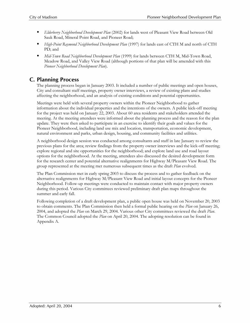
A. Planning Area The Pioneer Neighborhood is bounded by Junction Road on the east, Mineral Point on the north, Valley View Road on the south, and Pioneer Road on the west. The lands south of Valley View Road, shown on Figure 1, are located in the Mid-Town Neighborhood.
Figure 1: Location Map & Photo
City of Madison Pioneer Neighborhood Development Plan
Adopted: April 20, 2004 8
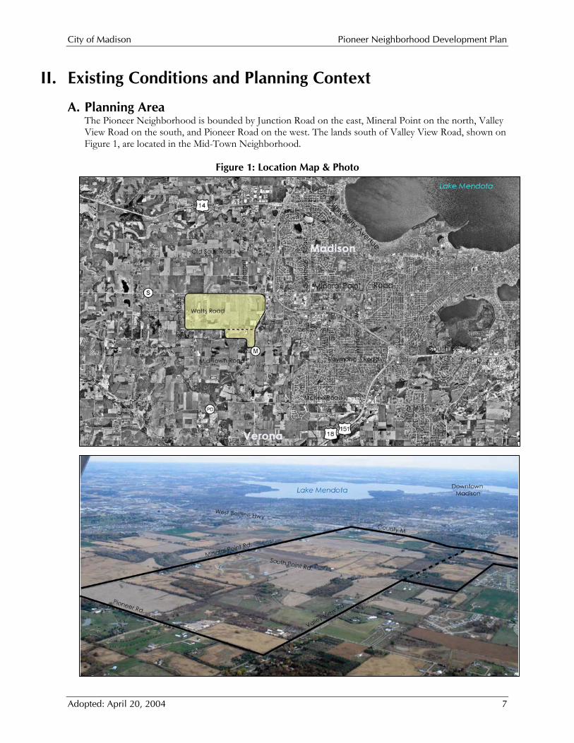
B. Municipal Jurisdiction and Property Ownership The Pioneer Neighborhood comprises approximately 1,403 acres. Existing roads account for approximately 43 acres; thus the net acreage is 1,360 acres. Of this net total, about 62%, or 841.5 acres, is located within the City of Madison, and the remaining 38%, or 518.5 acres, is within the Town of Middleton. A majority of the land acreage is held by relatively few property owners, including the University of Wisconsin and long-standing property owners. A small portion of the land is in parcels less than 10-acres in size, which are predominantly "large-lot" single-family residences.
Figure 2: Pioneer Neighborhood Property Ownership Summary (as of November 2003)
Property Owner Acres Regents of the University of Wisconsin 260.1 Theis, Karen, Laverne, & Randall 155.1 Dohm, Gerard & Charlene 134.6 Pellett, John & Joan 123.6 Welton Enterprises 107.9 Tormey, David & Kathryn 76.6 Garfoot, Charles & Catherine, and Living Trust 76.0 Chang, Chen-Kang 75.0 Malmquist, Douglas 65.6 Theis, Laverne 40.4 City of Madison 37.9 Theis, Laverne & Randall 30.2 Watts, James 25.0 Jovanovic, Dusan 23.3 Reynolds, Mark & Jeri 21.0 May, Ronald & Catherine 22.1 Keleny, John 19.5 Amble Landscaping, Inc. 11.2 Balance of Owned Property (owners with less than ten acres of property) 54.5
Rights-of-Way 43.4 Total 1,403
C. Existing Zoning and Land Use The existing uses in the planning area are primarily agricultural cropping and dairy farming, experimental agricultural research, a number of large-lot single-family residential uses along existing roads, and a few commercial and industrial uses located along Pioneer and Valley View Roads. The Silicon Prairie Business Park is presently under development southwest of the Mineral Point/South Point Roads intersection.
Most parcels located within the City of Madison are zoned A-Agriculture District. Farming and other agricultural uses are allowed as permitted uses in the zoning district. The City’s Agriculture District also functions as an interim zoning district pending the availability of urban services and assignment of permanent zoning consistent with the recommendations of an adopted neighborhood development plan.
The dominant built element in the planning area is UW’s communications tower (see Map 3). It has significant design implications with regard to road construction and land use within the radius of its guy
City of Madison Pioneer Neighborhood Development Plan
Adopted: April 20, 2004 9
wires, and within areas likely to receive icefall. The power transmission line that runs through the planning area from north to south at the west edge of the University of Wisconsin property also has implications for land use and roadway locations (e.g. lot depth, back/side-of-lot crossings, and road crossing between poles).
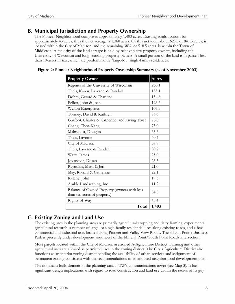
Figure 3: Pioneer Neighborhood Existing Land Use Excluding Public Rights-of-Way
Acres % of Total
City of Madison Agriculture 826.6 60.8% Single-Family Residential 14.9 1.1%
Total 841.5 61.9% Town of Middleton Agriculture 419.4 30.8% Commercial 36.3 2.7% Industrial 19.5 1.4% Single-Family Residential 43.4 3.2%
Total 518.5 38.1%
View of telecommunication tower from Mineral Point and Junction Road intersection

City of Madison Pioneer Neighborhood Development Plan
Adopted: April 20, 2004 10

Mineral Point Rd Mineral Point Rd
Pione
er Rd
Sout
h Poin
t Rd
Valley View Rd
Mea
dow
Rd
Suga
r Map
le Ln
Coun
ty Hig
hway
M
Junc
tion R
d
Pleas
ant V
iew Rd
CHANGA-1 Zoning36.8 Acres
TORMEYA-1 Zoning36.3 Acres
GARFOOTA Zoning
36.5 Acres
THEISA Zoning
38.1 Acres
THEISA Zoning
39.8 Acres
THEISA Zoning
37.2 Acres
THEISA Zoning
39.7 Acres
THEISA Zoning
39.8 Acres
UNIVERSITY OF WISCONSINA Zoning
39.7 Acres
HOOPESRH-3 Zoning8.3 Acres
THEISA Zoning
30.1 Acres
DOHMA-1 Zoning38.2 Acres
DOHMA-1 Zoning39.7 Acres
DOHMA-1 Zoning37.0 Acres
DOHMA-1 Zoning19.5 Acres
PELLETTA Zoning
37.1 Acres
PELLETTA Zoning
37.9 Acres
PELLETTA Zoning
24.6 Acres
PELLETTA Zoning
20.9 Acres
MALMQUISTA-1 Zoning22.2 Acres
MALMQUISTA-1 Zoning32.5 Acres
TORMEYA-1 Zoning40.2 Acres
CHANGA-1 Zoning37.9 Acres
JOVANOVICA-1 Zoning20.7 Acres
WATTSA-1 Zoning16.5 Acres
AMBLE LANDSCAPING INCA-1 Zoning7.0 Acres
WELTON ENTERPRISESSM Zoning33.1 Acres
WELTON ENTERPRISESSM Zoning39.4 Acres
WELTON ENTERPRISESSM Zoning35.4 Acres
CITY OF MADISONSM Zoning37.9 Acres
GARFOOTA Zoning
28.3 Acres
GARFOOTA Zoning
10.0 Acres
UNIVERSITY OF WISCONSINA Zoning
37.2 Acres
UNIVERSITY OF WISCONSINA Zoning
31.8 Acres
UNIVERSITY OF WISCONSINInstitutional39.7 Acres
UNIVERSITY OF WISCONSINA Zoning
29.0 Acres
UNIVERSITY OF WISCONSINA Zoning
37.8 Acres
UNIVERSITY OF WISCONSINA Zoning
28.0 Acres
MAYA-1 Zoning6.4 Acres
REYNOLDSA-1 Zoning8.9 Acres
REYNOLDSA-1 Zoning11.3 Acres
MAYA-1 Zoning9.2 Acres
HERRLINGA-1 Zoning15.2 Acres
HERRLINGA-1 Zoning13.9 Acres
HERRLINGA-1 Zoning13.5 Acres
HERRLINGA-1 Zoning14.2 Acres
WALZ, THOMAS PA Zoning
36.0 Acres
GARFOOTA-1 Zoning35.1 Acres
GARFOOTA-1 Zoning22.8 Acres
VETTERA-1 Zoning37.1 Acres
RIPPA-1 Zoning14.6 Acres
RIPPA-1 Zoning38.0 Acres
ROBERTSA-1 Zoning18.1 Acres
FRONCEKA-1 Zoning29.9 Acres
SMITHA-1 Zoning11.9 Acres
SMITHA-1 Zoning10.9 Acres
JENSEN, ERIC PA-1 Zoning17.0 Acres
CITY OF MADISONA Zoning
37.7 Acres
UNIVERSITY OF WISCONSINA Zoning
36.9 Acres
UNIVERSITY OF WISCONSINA Zoning
37.2 Acres
RIPPA-1 Zoning13.9 Acres
WATTSLC-1 Zoning
8.4 Acres
A-1SCHUMANN
7.2 AcresA-1
UNITED STATES OF AMERICA
7.1 Acres
Pione
er Rd
UNIVERSITY OF WISCONSINA-1 Zoning4.1 Acres
VETTERA-1 Zoning37.8 Acres
Mid-Town Neighborhood
Pioneer Neighborhood
City of MadisonPioneer Neighborhood
Development Plan
Map 1Study Area Summary
N
Sources:Municipal Boundaries - Dane County LIO 2001.Parcel Boundaries - Dane County LIO 2001.Other Information - V&A Site Inventory 2002.
April, 2004
1000 0 1000 Feet
ÊÚPlanning Area
Existing Land UseAgriculture & UndevelopedRecreationCommercialIndustrialInstitutionalLow Density ResidentialMedium Density Residential
Municipal Boundaries (2003)Urban Service Area Boundary (2003)Neighborhood Planning Area Boundaries

City of Madison Pioneer Neighborhood Development Plan
Adopted: April 20, 2004 12
City of Madison Pioneer Neighborhood Development Plan
Adopted: April 20, 2004 13
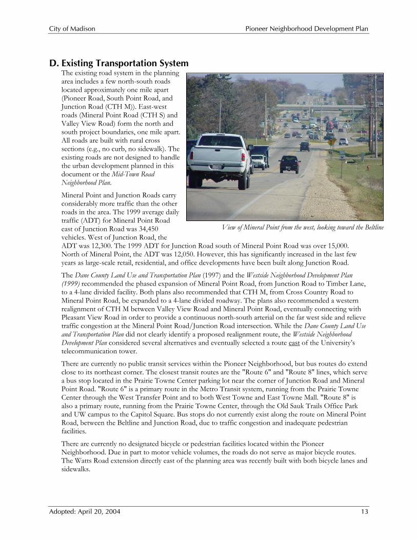
D. Existing Transportation System The existing road system in the planning area includes a few north-south roads located approximately one mile apart (Pioneer Road, South Point Road, and Junction Road (CTH M)). East-west roads (Mineral Point Road (CTH S) and Valley View Road) form the north and south project boundaries, one mile apart. All roads are built with rural cross sections (e.g., no curb, no sidewalk). The existing roads are not designed to handle the urban development planned in this document or the Mid-Town Road Neighborhood Plan.
Mineral Point and Junction Roads carry considerably more traffic than the other roads in the area. The 1999 average daily traffic (ADT) for Mineral Point Road east of Junction Road was 34,450 vehicles. West of Junction Road, the ADT was 12,300. The 1999 ADT for Junction Road south of Mineral Point Road was over 15,000. North of Mineral Point, the ADT was 12,050. However, this has significantly increased in the last few years as large-scale retail, residential, and office developments have been built along Junction Road.
The Dane County Land Use and Transportation Plan (1997) and the Westside Neighborhood Development Plan (1999) recommended the phased expansion of Mineral Point Road, from Junction Road to Timber Lane, to a 4-lane divided facility. Both plans also recommended that CTH M, from Cross Country Road to Mineral Point Road, be expanded to a 4-lane divided roadway. The plans also recommended a western realignment of CTH M between Valley View Road and Mineral Point Road, eventually connecting with Pleasant View Road in order to provide a continuous north-south arterial on the far west side and relieve traffic congestion at the Mineral Point Road/Junction Road intersection. While the Dane County Land Use and Transportation Plan did not clearly identify a proposed realignment route, the Westside Neighborhood Development Plan considered several alternatives and eventually selected a route east of the University’s telecommunication tower.
There are currently no public transit services within the Pioneer Neighborhood, but bus routes do extend close to its northeast corner. The closest transit routes are the "Route 6" and "Route 8" lines, which serve a bus stop located in the Prairie Towne Center parking lot near the corner of Junction Road and Mineral Point Road. "Route 6" is a primary route in the Metro Transit system, running from the Prairie Towne Center through the West Transfer Point and to both West Towne and East Towne Mall. "Route 8" is also a primary route, running from the Prairie Towne Center, through the Old Sauk Trails Office Park and UW campus to the Capitol Square. Bus stops do not currently exist along the route on Mineral Point Road, between the Beltline and Junction Road, due to traffic congestion and inadequate pedestrian facilities.
There are currently no designated bicycle or pedestrian facilities located within the Pioneer Neighborhood. Due in part to motor vehicle volumes, the roads do not serve as major bicycle routes. The Watts Road extension directly east of the planning area was recently built with both bicycle lanes and sidewalks.
View of Mineral Point from the west, looking toward the Beltline

City of Madison Pioneer Neighborhood Development Plan
Adopted: April 20, 2004 14
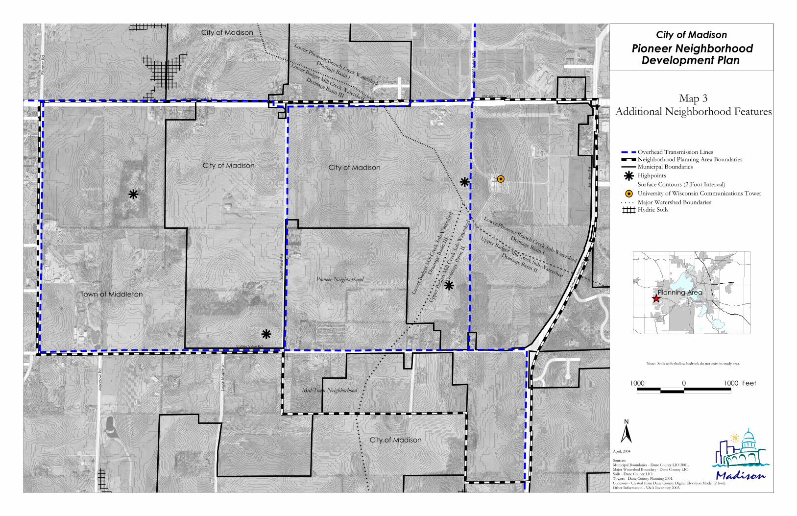
E. Topography and Natural Features Maps 2 and 3 depict the natural features and other development features within the Pioneer Neighborhood. The planning area is characterized by rolling hills, with limited areas of steep topography (slopes greater than 12%). A few high quality wooded groves exist in the southeast and west portions of the planning area. A ridgeline runs north-south in the eastern portion of the planning area, just south of the Pleasant View Road intersection with Mineral Point Road. Two of the high points of the neighborhood, offering a view of Lake Mendota and the State Capitol, are located along this ridgeline. Two other high points are located west of South Point Road—one near its intersection with Valley View Road and one roughly halfway between South Point Road and Pioneer Road. The planning area is well drained, being predominantly underlain with sand and gravel.
F. Stormwater Drainage The Pioneer Neighborhood is located within two different river basins—the Lower Rock River Basin and the Sugar River-Pecatonica River Basin. The major north-south ridgeline forms the divide between the two basins. The land within the Lower Rock River Basin, in the northeast corner of the planning area, is located within the Lower Pheasant Branch Sub-Watershed (See Map 3). The remaining three-quarters of the land lie within the Sugar-Pecatonica River Basin and within that, the Upper Sugar River Watershed. Within that watershed, there are the following two sub-watersheds:
Upper Badger Mill Creek Sub-Watershed: Lands around the intersection of CTH M and Valley View Road in the southeast corner of the planning area are part of the “West Branch” of the Upper Badger Mill Creek Sub-Watershed. According to the Upper Badger Mill Creek—Stormwater Management Analysis, the drainageway remains in its natural condition and is not clearly defined in many areas. This lack of definition slows and dissipates the flow of stormwater in the area. As development has occurred, the drainageway has been replaced with man-made greenways.
Lower Badger Mill Creek Sub-Watershed: The balance of the planning area, almost 1,000 acres, is located within the Lower Badger Mill Creek Sub-Watershed. Drainage predominantly flows toward the southwest and exits the area near Sugar Maple Road. A minor amount of surface water flows south toward the University Ridge Golf Course. The Lower Badger Mill Creek—Stormwater Management Plan proposed five new local drainage basins within the Pioneer Neighborhood. Four are located east of South Point Road and the fifth is located west of South Point Road. The Stormwater Management Plan also identifies proposed drainageways within the neighborhood.
G. Existing Public Utility Systems Existing public sewer and water systems within the planning area have been extended primarily to serve the Public Works Facility site and the adjacent Silicon Prairie Industrial Park. These areas are mainly along the Mineral Point and South Point Road corridors.
View of rolling topography within the Pioneer Neighborhood

City of Madison Pioneer Neighborhood Development Plan
Adopted: April 20, 2004 15
A small portion of the planning area is currently served by a City of Madison sanitary sewer pumping station, located near the Public Works Facility along South Point Road. This station discharges via a force main to the existing gravity sewer main along Mineral Point Road and east to existing developed parts of the City. Due to capacity limitations in the receiving downstream sewers, this pumping station is a temporary facility with a limited service area and service life. Other existing sanitary sewer mains extend to the southern edge of the planning area and west to the eastern edge.
The existing water system has been extended to certain areas in and adjacent to the planning area. A 16-inch main is in place along Mineral Point Road between Junction Road and South Point Road. A 12-inch main is in place a distance a half mile south of Mineral Point Road along South Point Road. In addition to these mains, 12-inch mains are in place up to Junction Road at Watts Road, and to the southerly planning limits at Red Tail Drive.

City of Madison Pioneer Neighborhood Development Plan
Adopted: April 20, 2004 16

Mineral Point Rd Mineral Point Rd
Pione
er Rd
Sout
h Poin
t Rd
Valley View Rd
Mea
dow
Rd
Suga
r Map
le Ln
Coun
ty Hig
hway
MJu
nctio
n Rd
Pleas
ant V
iew Rd
Pione
er Rd
City of Madison
Town of Middleton
City of Madison
City of Madison
City of Madison
Mid-Town Neighborhood
Pioneer Neighborhood
Map 2Natural Features Inventory
N
Sources:Municipal Boundaries - Dane County LIO 2001.Major Watershed Boundary - Dane County LIO 1995.Slopes - Dane County RPC 1995.Contours - Created from Dane County Digital Elevation Model (2 foot) 1995.Other Information - V&A Inventory 2003.
April, 2004
1000 0 1000 Feet
ÊÚPlanning Area
Environmental Corridors (2003)
Slopes between 12% - 20%Slopes greater than 20%Surface Contours (2 Foot Interval)
WoodlandsSurface Water
Municipal BoundariesNeighborhood Planning Area Boundaries
Note: FEMA has not mapped any floodplains in the study area.Also, DNR has not mapped any wetlands in the study area.
Pioneer NeighborhoodDevelopment Plan
City of Madison

City of Madison Pioneer Neighborhood Development Plan
Adopted: April 20, 2004 18
#Yr
r
r
r
Mineral Point Rd Mineral Point Rd
Pione
er Rd
Sout
h Poin
t Rd
Valley View Rd
Mea
dow
Rd
Suga
r Map
le Ln
Coun
ty Hig
hway
MJu
nctio
n Rd
Pleas
ant V
iew Rd
Pione
er Rd
Lower Pheasant Branch Creek Watershed
Drainage Basin I
Lower Badger Mill Creek Watershed
Drainage Basin III
City of Madison
City of Madison
City of Madison
Town of Middleton
City of Madison
Pioneer Neighborhood
Mid-Town Neighborhood
Lower Pheasant Branch Creek Sub-Watershed
Drainage Basin I
Upper Badger Mill Creek Sub-Watershed
Drainage Basin II
Lowe
r Badg
er Mi
ll Cree
k Sub
-Wate
rshed
Drain
age Ba
sin II
I
Upper
Badg
er Mi
ll Cree
k Sub
-Wate
rshed
Drain
age Ba
sin II
Map 3Additional Neighborhood Features
N
1000 0 1000 Feet
ÊÚPlanning Area
Note: Soils with shallow bedrock do not exist in study area.
April, 2004
Pioneer NeighborhoodDevelopment Plan
City of Madison
Sources:Municipal Boundaries - Dane County LIO 2001.Major Watershed Boundary - Dane County LIO.Soils - Dane County LIO.Towers - Dane County Planning 2001.Contours - Created from Dane County Digital Elevation Model (2 foot).Other Information - V&A Inventory 2003.
Hydric SoilsMajor Watershed Boundaries
#Y University of Wisconsin Communications TowerSurface Contours (2 Foot Interval)r HighpointsMunicipal BoundariesNeighborhood Planning Area BoundariesOverhead Transmission Lines

City of Madison Pioneer Neighborhood Development Plan
Adopted: April 20, 2004 20
City of Madison Pioneer Neighborhood Development Plan
Adopted: April 20, 2004 21
III. Regional and Site Analysis
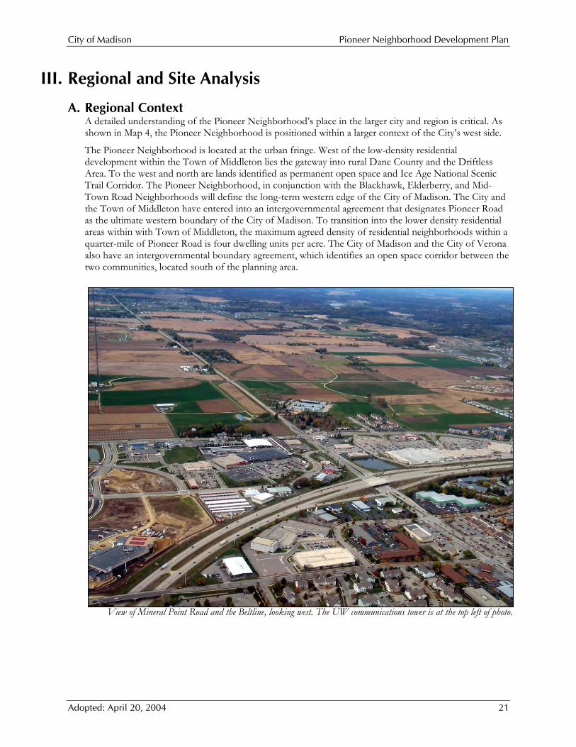
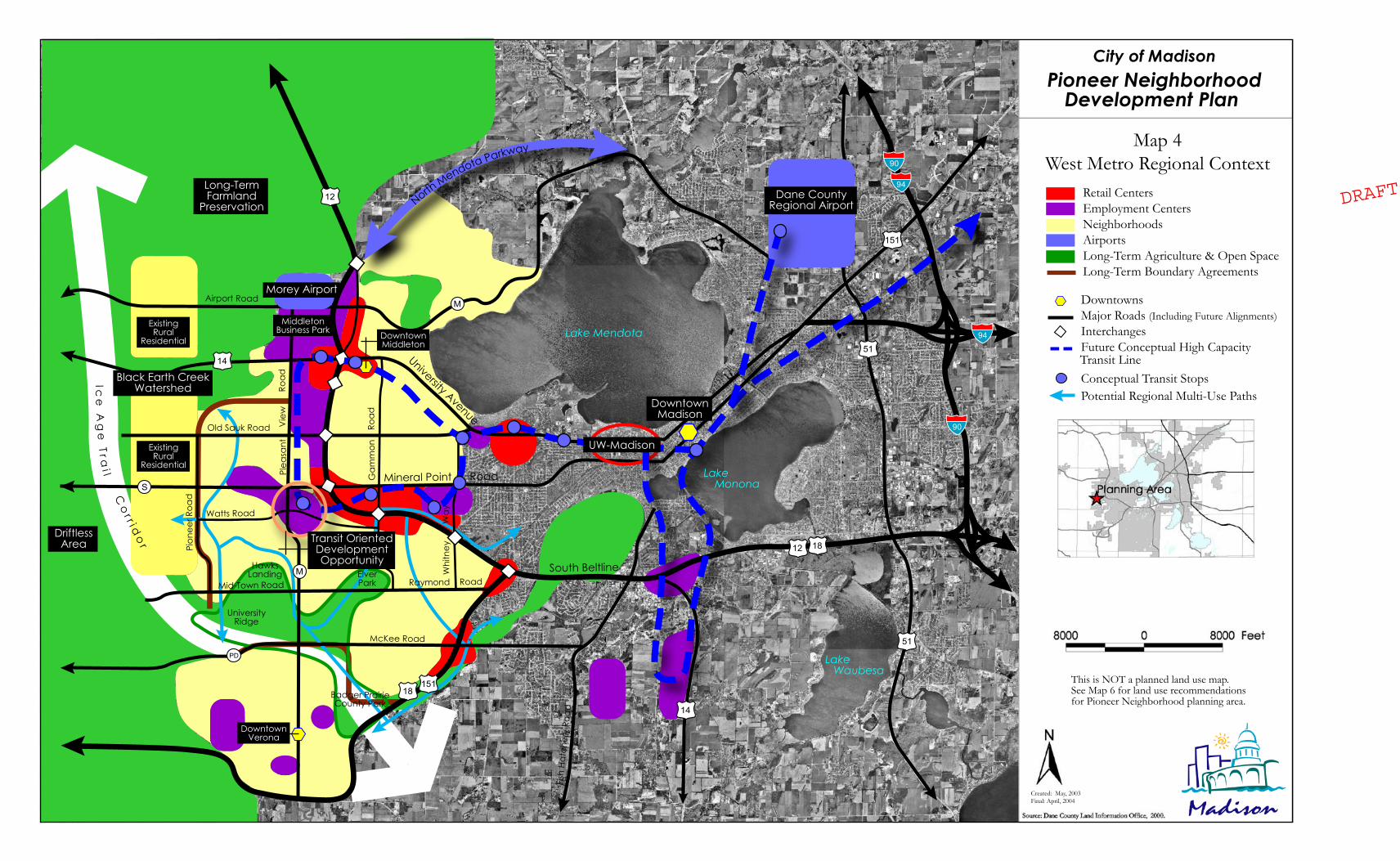
A. Regional Context A detailed understanding of the Pioneer Neighborhood’s place in the larger city and region is critical. As shown in Map 4, the Pioneer Neighborhood is positioned within a larger context of the City’s west side.
The Pioneer Neighborhood is located at the urban fringe. West of the low-density residential development within the Town of Middleton lies the gateway into rural Dane County and the Driftless Area. To the west and north are lands identified as permanent open space and Ice Age National Scenic Trail Corridor. The Pioneer Neighborhood, in conjunction with the Blackhawk, Elderberry, and Mid-Town Road Neighborhoods will define the long-term western edge of the City of Madison. The City and the Town of Middleton have entered into an intergovernmental agreement that designates Pioneer Road as the ultimate western boundary of the City of Madison. To transition into the lower density residential areas within with Town of Middleton, the maximum agreed density of residential neighborhoods within a quarter-mile of Pioneer Road is four dwelling units per acre. The City of Madison and the City of Verona also have an intergovernmental boundary agreement, which identifies an open space corridor between the two communities, located south of the planning area.
View of Mineral Point Road and the Beltline, looking west. The UW communications tower is at the top left of photo.
City of Madison Pioneer Neighborhood Development Plan
Adopted: April 20, 2004 22
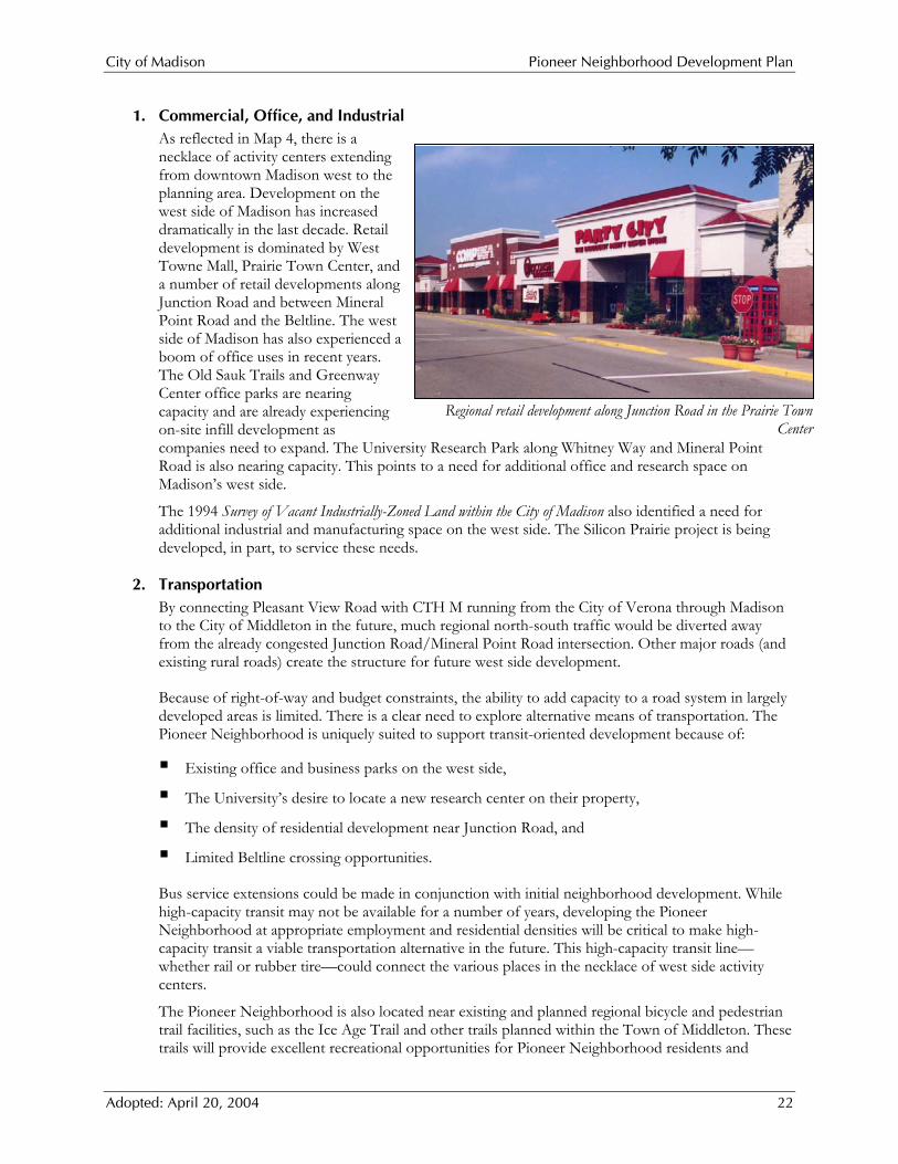
Regional retail development along Junction Road in the Prairie Town Center
1. Commercial, Office, and Industrial As reflected in Map 4, there is a necklace of activity centers extending from downtown Madison west to the planning area. Development on the west side of Madison has increased dramatically in the last decade. Retail development is dominated by West Towne Mall, Prairie Town Center, and a number of retail developments along Junction Road and between Mineral Point Road and the Beltline. The west side of Madison has also experienced a boom of office uses in recent years. The Old Sauk Trails and Greenway Center office parks are nearing capacity and are already experiencing on-site infill development as companies need to expand. The University Research Park along Whitney Way and Mineral Point Road is also nearing capacity. This points to a need for additional office and research space on Madison’s west side.
The 1994 Survey of Vacant Industrially-Zoned Land within the City of Madison also identified a need for additional industrial and manufacturing space on the west side. The Silicon Prairie project is being developed, in part, to service these needs.
2. Transportation By connecting Pleasant View Road with CTH M running from the City of Verona through Madison to the City of Middleton in the future, much regional north-south traffic would be diverted away from the already congested Junction Road/Mineral Point Road intersection. Other major roads (and existing rural roads) create the structure for future west side development.
Because of right-of-way and budget constraints, the ability to add capacity to a road system in largely developed areas is limited. There is a clear need to explore alternative means of transportation. The Pioneer Neighborhood is uniquely suited to support transit-oriented development because of:
Existing office and business parks on the west side,
The University’s desire to locate a new research center on their property,
The density of residential development near Junction Road, and
Limited Beltline crossing opportunities.
Bus service extensions could be made in conjunction with initial neighborhood development. While high-capacity transit may not be available for a number of years, developing the Pioneer Neighborhood at appropriate employment and residential densities will be critical to make high-capacity transit a viable transportation alternative in the future. This high-capacity transit line—whether rail or rubber tire—could connect the various places in the necklace of west side activity centers.
The Pioneer Neighborhood is also located near existing and planned regional bicycle and pedestrian trail facilities, such as the Ice Age Trail and other trails planned within the Town of Middleton. These trails will provide excellent recreational opportunities for Pioneer Neighborhood residents and

City of Madison Pioneer Neighborhood Development Plan
Adopted: April 20, 2004 23
employees. Internal neighborhood bicycle facilities can also be tied in to the City of Madison bicycle facilities along the Watts Road extension east of the planning area and in other directions. These bike lanes and routes will provide residents and employees of the new neighborhood with safe and convenient ways to get to and from central Madison.
3. Housing Housing diversity is crucial within the Pioneer Neighborhood. A range of housing types and sizes is essential to provide enough density on the east side of the neighborhood to support high-capacity transit, yet also meet the City of Madison-Town of Middleton intergovernmental agreement’s four dwelling units per acre requirement on the west side of the neighborhood. A well-crafted neighborhood design will be critical to seamlessly blend these differences in residential density. Particularly given high land values, density and quality will be the keys to providing a long-term supply of affordable housing on the far west side.
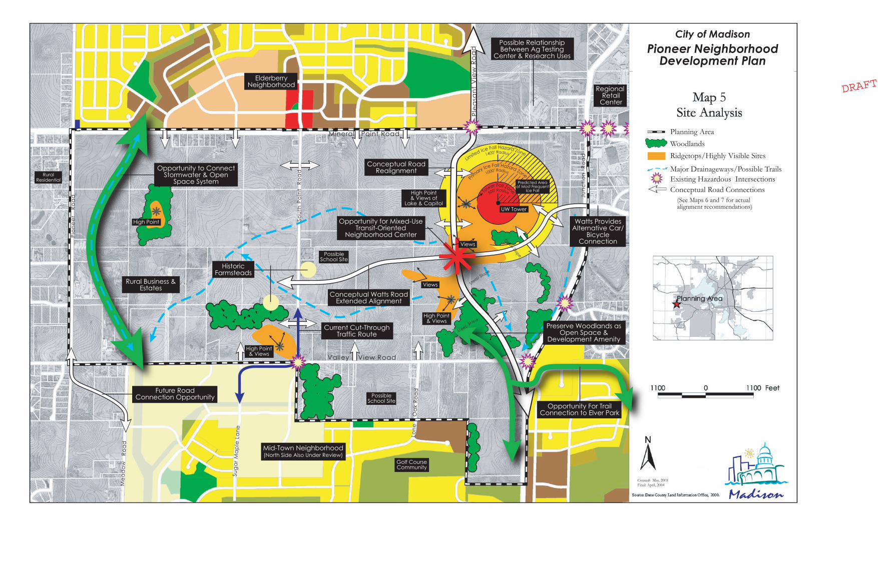
B. Neighborhood Site Analysis As depicted in Map 5, the Pioneer Neighborhood includes natural and built features that present both opportunities and challenges for future development.
The greatest challenge within the neighborhood is the existing 1,423 foot tall telecommunication tower on the University’s property. Due to a significant financial investment in the tower in the mid-1990s, a series of long-term leases, and difficulty in siting a new tower in a different location, this Plan anticipates that the tower will remain in place for at least ten more years. The tower affects surrounding road and lot layouts and development phasing. The tower is designed to collapse in on itself within a 500-foot radii circle around the base of the tower; therefore, development within this circle is prohibited. In addition, Kline Tower, the manufacturer, does not recommend any type of development within a circle around the outermost guy wire anchors, which are located 1,000 feet from the tower base. This is due primarily to ice fall potential. These areas are shown on Map 5.
During certain weather patterns, ice on the guy wires has the potential to melt slightly and fall to the ground. In 1996 the City Engineering Department commissioned a study using an engineering model to identify icefall hazard zones. The study identified three zones: extreme hazard zone (where building should not be allowed), a hazard zone (where buildings could be allowed with some restrictions), and a nuisance zone (where buildings could be allowed without restrictions, but some ice shower may occur). These are shown on Map 5. These hazard zones were identified as complete circles around the base of the tower. Because icefall is typically associated with warmer winter days and their southwesterly wind pattern, the area northeast of the tower is likely to experience the most incidents of icefall.
The challenges posed by the tower have a significant effect on the road layout of the neighborhood, especially the extension of Pleasant View Road to Highway M and the western extension of Watts Road. Map 5 suggests an alignment for this Pleasant Valley Road extension west of the tower.
The City and the consultant considered several alternative alignments for the Pleasant View Road extension during this planning process. The first alternative was an eastern alignment, located outside of the 1,000-foot “no-build” area. This alternative was eliminated because of the ice fall hazard northeast of the tower and the lack of sufficient room to safely bring the road back to the current Pleasant View Road/Mineral Point Road intersection with sufficient vehicle stacking room south of Mineral Point. Also, the issue of excessive cut-through traffic to the east could not be successfully addressed.
Two western alignments were also considered. The first, located on the UW’s west property line, was eliminated because it too was within the 1,000-foot “no-build” area and because it would bring road over the high point on the Theis property. The second alternative, which evolved into the recommended alternative after being split into one leg of the “couplet”, is located outside the 1,000-foot “no-build” area. This alignment places the road in more favorable topography and avoids most of a wood lot on the
City of Madison Pioneer Neighborhood Development Plan
Adopted: April 20, 2004 24
University’s property. The alignment was modified to locate the road as close to the Theis/UW property line while accomplishing three objectives: locating the road outside the 1,000 radius from the base of the tower, locating the road more favorably on the topography which avoids traversing the top of the hill on the Theis property, and maintaining the top of the hill as a developable parcel with potential long views back to the City. For similar reasons, the western extension of Watts Road must bend south in order to be located outside the 1,000-foot “no-build” area (See Map 5).
The future intersection of the Pleasant View and Watts Roads extensions is located near a high point, which provides long views back to the Capitol and Lake Mendota. This intersection provides a visible and strategic location for a mixed-use center within the neighborhood. As mentioned in the Regional Context section, this mixed-use center should provide sufficient densities to support high-capacity transit at a future date.
In addition to the UW communications tower, the major power transmission line that cuts through the planning area from north to south at the west edge of the UW property also has implications for land use and roadway locations (e.g., lot depth, back/side-of-lot crossings, and road crossing between poles). To limit the negative effect of the lines on the neighborhood, and in conjunction with development, there may be an opportunity to relocate or bury lines within certain portions of the neighborhood.
There are a number of existing buildings within the neighborhood that offer both challenges and opportunities. The historic farmstead and its outbuildings along South Point Road could be restored and integrated into the fabric of the neighborhood. The mix of large-lot, single-family homes and commercial operations in the southwest quadrant of the neighborhood (near Pioneer Road) will likely delay future development within this area.
While there are a number of wooded slopes and high points that create some challenges in road layout, these features also create significant site amenities, which should be incorporated into the neighborhood design, lot layout, and site design.
Existing drainageways provide opportunities for open space and trail connections. An existing drainageway on the west side of the neighborhood offers an opportunity to provide open space and stormwater connections between the Elderberry and Mid-Town Road Neighborhoods. This greenway should also be connected to existing woodlots and other drainageways within the neighborhood, providing a logical location for an off-street trail system. The Watts Road extension will also provide an alternative to Mineral Point Road for cyclists and pedestrians.
90
151
90
94
94
18151
12
14
S
M
M
PD
14
12 18
51
51
Mineral Point Road
University Avenue
Dane CountyRegional Airport
Morey Airport
Lake Mendota
Lake Monona
Lake Waubesa
UW-Madison
DowntownMadison
South Beltline
Plea
sant
V
iew
Road
Pion
eer R
oad
Old Sauk Road
Raymond Road
McKee Road
Airport Road
DowntownVerona
MiddletonBusiness Park Downtown
Middleton
Gam
mon
R
oad
NorthMendota Parkway
ElverPark
Badger PrairieCounty Park
HawksLanding
UniversityRidge
Watts Road
Ice
Ag
eT r a
i lC
or r i d
or
DriftlessArea
Fish
Hatc
hery
Roa
d
Whi
tney
Way
Mid-Town Road
Black Earth CreekWatershed
ExistingRural
Residential
ExistingRural
Residential
Long-TermFarmland
Preservation
Transit OrientedDevelopmentOpportunity
DowntownsMajor Roads (Including Future Alignments)InterchangesFuture Conceptual High Capacity
Conceptual Transit StopsPotential Regional Multi-Use Paths
Map 4West Metro Regional Context
Created: May, 2003Final: April, 2004
This is NOT a planned land use map.See Map 6 for land use recommendationsfor Pioneer Neighborhood planning area.
Retail CentersEmployment Centers NeighborhoodsAirportsLong-Term Agriculture & Open SpaceLong-Term Boundary Agreements
Transit Line
City of MadisonPioneer Neighborhood
Development Plan
DRAFT

City of Madison Pioneer Neighborhood Development Plan
Adopted: April 20, 2004 26
Predicted Areaof Most Frequent
Ice FallHigh Point& Views of
Lake & Capitol
High Point& Views
Views
Views
Conceptual RoadRealignment
Conceptual Watts RoadExtended Alignment
Opportunity for Mixed-UseTransit-Oriented
Neighborhood Center
Preserve Woodlands asOpen Space &
Development Amenity
HistoricFarmsteads
Opportunity to ConnectStormwater & Open
Space System
UW Tower
Tower Fall Zone
1000' Radius
500' Radius
ElderberryNeighborhood
Mid-Town Neighborhood(North Side Also Under Review)
Pio
ne
er
Ro
ad
Sout
h P
oin
t R
oa
d
Jun
cti
on
Ro
ad
Mineral Point Road
Valley View RoadHigh Point& Views
High Point
Primary Ice Fall Hazard Zone
1400' RadiusLim
ited Ice Fall Hazard Zone
Steep Slope
Steep Slope
SteepSlope
Regional Retail
Center
RuralResidential
PossibleSchool Site
Golf CourseCommunity
Current Cut-ThroughTraffic Route
Future RoadConnection Opportunity
Possible RelationshipBetween Ag Testing
Center & Research Uses
Rural Business &Estates
Me
ad
ow
Ro
ad
Sug
ar M
ap
le L
ane
Lone
O
ak
Roa
d
Watts ProvidesAlternative Car/
BicycleConnection
Opportunity For TrailConnection to Elver Park
PossibleSchool Site
Ple
asa
nt V
iew
Ro
ad
Ridgetops/Highly Visible SitesWoodlands
Existing Hazardous IntersectionsMajor Drainageways/Possible Trails
Conceptual Road Connections
Planning Area
5
(See Maps 6 and 7 for actualalignment recommendations)
Created: May, 2003Final: April, 2004
City of MadisonPioneer Neighborhood
Development Plan
DRAFT

City of Madison Pioneer Neighborhood Development Plan
Adopted: April 20, 2004 28
City of Madison Pioneer Neighborhood Development Plan
Adopted: April 20, 2004 29
IV. Neighborhood Goals
A. Overall Create a comprehensive Pioneer Neighborhood Development Plan that integrates an urban employment center, a mixed-use neighborhood center, light industrial uses, small-scale neighborhood commercial uses, institutional uses, and a mix of residential dwelling types, densities, and prices developed as a true neighborhood.
B. Land Use 1. Use natural features and open space to shape the Neighborhood Development Plan. 2. Integrate employment, retail, and residential uses to encourage pedestrian access and accommodate
the needs of daily living. 3. Develop public service facilities and utilities appropriate to the location and community needs. 4. Create strong relationships between the job centers and residential areas. 5. Coordinate with adjacent neighborhood plans to ensure planning continuity.
C. Urban Design 1. Incorporate pedestrian-oriented, higher-density design concepts that create attractive, quality, urban,
walkable pedestrian spaces. 2. Include design concepts that de-emphasize and reduce the use of large surface parking lots on
individual properties, and instead promote shared, structured, and on-street parking. 3. Lay out streets, buildings, and public open spaces to take advantage of long views created by
neighborhood topography.
D. Housing and Economic Development 1. Develop a more urban model for job centers as an alternative to the typical “park” model. 2. Integrate convenience retail and business service uses needed by employees and visitors within and
adjacent to the job centers. 3. Include a mix of housing types, lot sizes, and densities, including single-family detached and attached
housing, condominiums, apartments, and senior housing. 4. Provide for a wide range of housing targeted toward a broad range of income levels.
E. Transportation 1. Integrate Pioneer Neighborhood development planning with regional roadway, pathway, utility, and
land use planning initiatives. 2. Provide connections within and among the job centers, neighborhood commercial centers, and
residential neighborhoods, emphasizing the use of through streets and a modified grid street system. 3. Improve existing arterial and collector roads. Locate/relocate collector and local roads to respond to
topographic and drainage patterns, and to accommodate and minimize conflict between land uses. 4. Enhance opportunities to serve the area with alternative modes of transportation. Plan for future
extension of public transportation and bike facilities. 5. Incorporate pedestrian connections throughout the neighborhood, to adjacent neighborhoods, and
to regional facilities. Establish a network of sidewalks and trails that promotes pedestrian mobility.

City of Madison Pioneer Neighborhood Development Plan
Adopted: April 20, 2004 30
6. Balance the needs of traffic flow with the interest in creating a safe and attractive place to live, work, shop, and play.
F. Open Space 1. Use topographic relief and open space/drainage corridors for trail connections and as transition areas
between land uses. 2. Preserve environmentally-sensitive areas and unique natural features. 3. Connect open space/drainage corridors and trails to surrounding regional systems. 4. Locate area-wide storm water management systems in accordance with detailed stormwater plans and
in conjunction with open space amenities like wetlands, woodlands, and parklands. 5. Reduce stormwater runoff through the use of infiltration areas including within parking lots. 6. Incorporate village greens and squares, including consideration of non-public means to assure their
long-term maintenance. 7. Meet the City's standards for providing park and open spaces and the development of those spaces.

City of Madison Pioneer Neighborhood Development Plan
Adopted: April 20, 2004 31
V. Detailed Development Plan Recommendations
A. Summary The Pioneer Neighborhood Development Plan recommends a land use pattern that seeks to blend the interest of the University Research Park to develop a new research center on its lands on the east side of the neighborhood with land use concepts derived from the original Westside Neighborhood Development Plan for the west side of the neighborhood.
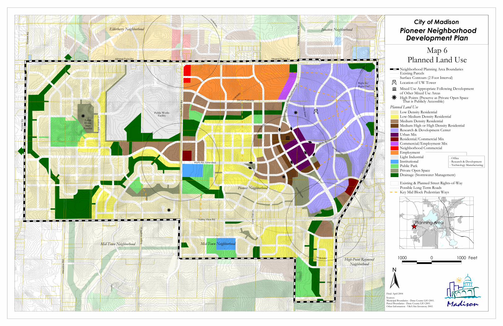
Map 6 depicts the recommended land use plan. This includes a research center on the University’s property; a mixed-use “urban mix” center at the unique intersection(s) of a Watts Road western extension and a Pleasant View Road southern extension; an employment center along Mineral Point Road; and a mix of residential uses, open spaces, and community facilities throughout the rest of the neighborhood. Map 6 also includes detailed land use recommendations for the northeast corner of the Mid-Town Road Neighborhood. Figure 4, at right, summarizes the acreage within the Pioneer Neighborhood area by proposed land use categories, as depicted on Map 6. It does not include acreages for the Mid-Town Neighborhood planning area.
B. Detailed Site and building Design Standards Figure 5 provides detailed site and building design standards for seven of the most complex land use districts. These standards are as critical as the locational land use recommendations in Map 6. Careful adherence to these detailed site and building design standards will assure that:
The desired character of the Pioneer Neighborhood can be achieved; Sufficient densities to maximize transit potential, and walkability will be achieved; and Locations for on-site expansion will be built into initial site plans.
These site and building design standards should be refined and used as components of new and/or revised zoning districts, planned unit development text, development agreements, urban design review guidelines, and/or private covenants to regulate development within the Pioneer Neighborhood.
Figure 4: Proposed Land Use for Pioneer Neighborhood
Planned Land Use District Acres % of Total
Residential Low Density Residential 284.4 20.3% Low-Medium Density Residential 101.3 7.2% Medium Density Residential 83.8 6.0% Medium-High or High Density 13.3 0.9% Mixed-Use
Urban Mix 15.3 1.1% Residential/Commercial Mix 5.9 0.4% Commercial/Employment Mix 5.9 0.4% Non-Residential Research and Development Center 195.2 13.9% Employment 78.2 5.6% Light Industrial 115.5 8.2% Neighborhood Commercial 2.9 0.2% Community Facilities & Open Space
Institutional 7.1 0.5% Public Park 42.7 3.0% Private Open Space 49.0 3.5% Other
Drainage (Stormwater Management) 115.0 8.2% Public Rights-of-Way 288.0 20.5%
Total 1,403 100%
City of Madison Pioneer Neighborhood Development Plan
Adopted: April 20, 2004 32
Ë
Mineral Point Rd Mineral Point Rd
Pione
er Rd
Sout
h Poin
t Rd
Valley View Rd
Mea
dow
Rd
Suga
r Map
le Ln
Coun
ty Hig
hway
M
Junc
tion R
d
Pleas
ant V
iew Rd
Pione
er Rd
Junc
tion R
d
Mid-Town Neighborhood
Elderberry Neighborhood Junction Neighborhood
Mid-Town Neighborhood
1/4 Mi
le Radi
us
1/2 Mile R
adius
1/4 Mile Radius
LargeHomeSites
Possible
1/4 Mi
le Radi
us
1/4 Mi
le Radi
usSuga
r Map
le Ln
Public WorksFacility
High-Point RaymondNeighborhood
Silicon Parkway
Pioneer Neighborhood
Watts Rd Extended
Watts Rd. Extended
1/4 Mile Radius
Steep Slope
Steep Slope
Steep Slope
#
Right In/Right Out
Lone
Oak
Ln.
Pleas
ant V
iew Ro
ad Ex
tende
d
r
r
r
r
ñ
City of MadisonPioneer Neighborhood
Development Plan Map 6
Planned Land Use
N
Sources:Municipal Boundaries - Dane County LIO 2001.Parcel Boundaries - Dane County LIO 2001.Other Information - V&A Site Inventory 2002.
Final: April 2004
1000 0 1000 Feet
ÊÚPlanning Area
- Office- Research & Development- Technology Manufacturing
;;
Planned Land UseLow Density ResidentialLow-Medium Density ResidentialMedium Density ResidentialMedium High or High Density ResidentialResearch & Development CenterUrban MixResidential/Commercial MixCommercial/Employment MixNeighborhood CommercialEmploymentLight IndustrialInstitutionalPublic Park
Drainage (Stormwater Management)Existing & Planned Street Rights-of-Way
Surface Contours (2 Foot Interval)Existing ParcelsNeighborhood Planning Area Boundaries
Possible Long-Term Roads
Private Open Space
Location of UW TowerË
Key Mid Block Pedestrian Ways
;
;
< <
<
< <
<
< <
rñ Mixed Use Appropriate Following Development
of Other Mixed Use AreasHigh Points (Preserve as Private Open Space That is Publicly Accessible)

City of Madison Pioneer Neighborhood Development Plan
Adopted: April 20, 2004 34

Note: See plan text for development & design standards for other planned land use districts & for further explanation of standards in above described districts. Adopted: April 20, 2004
Figure 5: Site and Building Design Standards by Planned Land Use District (see district locations on Map 6)
Residential/Commercial Mix District Medium Density Residential District Research and Development Center District Urban Mix District
Commercial/Employment Mix District Employment District
Medium High or High Density Residential Residential/Commercial • Ground: neighborhood retail, offices, services • Upper floors: residential, lodging, offices • Live-work unit potential • Neighborhood-scale grocery Allowable Use
Categories
• Research, development, and testing • Professional offices • Business incubators • Support uses similar to RPSM zoning district
(e.g., day care, health club, bank, clinic, deli, restaurant without drive-thru, convenience)
• Public uses (e.g., fire station, utilities) • Transit center • Structured parking
• Multi-story, mixed-use buildings • Ground floors: neighborhood retail, offices, and
services—create flexible spaces • Upper floors: housing, lodging, offices, research • Live-work unit potential • Underground structured parking, with first floor
retail if on street frontage • No auto-oriented commercial uses
Commercial/Employment • Neighborhood retail, offices, services, lodging • Auto-oriented uses as one component of a
mixed-use building with separated leasable spaces • No single use buildings with drive-through lane
• Professional offices • Research, development, and testing • Technology manufacturing and processing • Light industrial, similar to SM zoning district • Public and recreational uses
• Multi-family housing; including townhouses, rowhouses, and apartments, along with affordable owner & renter occupied options
• Ancillary recreational facilities, community space, and services serving residents of the plan district
Medium Density • 16 to 25 units per net acre Development
Intensity (FAR = Floor Area
Ratio)
• Minimum FAR of 0.20 in first building phase • Site plan build-out minimum FAR of 0.35 • Site plan build-out maximum FAR of 1.5 • Areas used for multi-site stormwater basins
not considered in FAR calculations • FAR or other bonus with shared parking
• Minimum FAR of 0.35 in first building phase • Site plan build-out minimum FAR of 1.0 • Site plan build-out maximum FAR of 4.0 • Use High Density Residential standards for
maximum housing density per site
• Minimum FAR of 0.15 in first building phase • Site plan build-out minimum FAR of 0.25 • Site plan build-out maximum FAR of 1.0 • Use Medium Density Residential standards for
maximum housing density in Residential/ Commercial District
• Minimum FAR of 0.15 in first building phase • Site plan build-out minimum FAR of 0.30 • Site plan build-out maximum FAR of 1.0
Medium-High, High Density • 26 to 60 units per net acre
Urban Design Features
• Urban, walkable job center • Buildings oriented & connected to street • Local business service uses along street
façade (i.e., cafeteria, fitness, coffee shop) • Focus on usable green space & trail system • Sidewalks on all streets; mid-block walkways • Preserved woods when sites developed • Preserved long views of Capitol, city, lake • Relationships/connections to nearby districts • 4-sided buildings on double frontage lots
• Urban “Transit Oriented Development” district form—focus on design, density, & access
• Attempt to concentrate retail activity in key areas • Buildings along streets and urban open spaces • Set back building facades above 3rd stories • Urban open spaces and street furniture • On-street parking on both sides of all streets • Sidewalks on both sides of all streets • Seamless transitions to nearby plan districts
• Building entries oriented and connected to street • Buildings cohesive with neighborhood fabric,
scale, setting, and design character • Building designs not specific to any tenant or use • Sidewalks on both sides of all streets • Seamless transitions to nearby plan districts
• Compact, walkable job center • Buildings & entries oriented to street • Special attention to building and site design
along Silicon Parkway extension • 4-sided buildings along Mineral Point • Sidewalks on both sides of all streets • Physical and programmatic links to Research
Center and Light Industrial Districts (e.g., day care, meeting centers)
• Urban neighborhood building arrangement • Avoid “super-blocks” of nearly identical building
sizes, placements, and designs • Buildings and entries oriented and connected to
street • Set back building facades above 3rd stories • On-site recreation spaces (e.g., rooftops, porches) • Connections to jobs, shopping, parks, and schools • Seamless transitions to adjacent plan districts
Medium Density • Min. of 50% of wall 20’ to 35’ from street ROW • Minimum 20’ spacing between buildings Principal
Building Setbacks
• Minimum of 50% of front building wall at 10’ to 30’ from street right-of-way
• Common wall buildings or 20’ spacing between buildings
• Setbacks for additional buildings on multi-building sites may vary
• Minimum of 75% of front building wall 0’ to 15’ from Watts & Pleasant View rights-of-way
• Minimum of 50% of building wall 10’ to 25’ from other street rights-of-way
• Use common walls or minimize spacing between buildings
• Minimum building and parking setback of 15’ • Promote green space between building and walk • Maximum of a single parking row plus driveway
in front of building • Common wall buildings or 20’ spacing between
buildings
• Minimum of 50% of front building wall 20’ to 35’ from street right-of-way
• Common wall buildings or 20’ spacing between buildings Medium-High, High Density
• Minimum of 50% of wall 10’ to 25’ from street • Common wall buildings or 10’ building separation
Medium Density • 2 to 4 stories Building
Height
• 1 to 4 stories near edge • 2 to 6 stories near Urban Mix District
• 2 to 6 stories • 2 to 3 stories • 1 to 4 stories • 2 to 4 stories fronting on Silicon Parkway
and Mineral Point Road Medium-High, High Density • 2 to 6 stories
Medium Density • Maximum of 0.75 per site Impervious
Surface Ratio
• Maximum of 0.85 per site • Maximum of 0.95 near Urban Mix District
• Maximum of 0.95 per site • Maximum of 0.85 per site • Maximum of 0.85 per site
Medium-High, High Density • Max of 0.85 (0.95 next to Urban Mix District)
Parking Standards
• Parking on all internal streets • Employee parking on interior side or rear
yard • Maximum 10 visitor parking spaces in front • Underbuilding, structured, shared parking • Break parking lots into pods of <50 spaces • Bike parking facilities • Mandatory Transportation Demand
Management
• Parking on all streets, including couplet • Surface parking to rear of buildings with limited
side yard parking • Encourage underground, structured, and shared
parking; bike parking facilities • No greater than 40’ of parking lot frontage on
street (except where frontage on 3+ streets) • Mandatory Transportation Demand Management
• Minimum 3/4 of parking spaces and all loading areas to side and/or rear of building
• Max. single parking row plus driveway in front • Minimize visibility of parking • Organize and manage all parking for shared use • Bike parking facilities
• Parking on all streets, except Mineral Point • Employee parking/loading to side or rear • Maximum 10 visitor parking spaces in front • Encourage underbuilding, structured, &
shared parking • Break up parking lots in pods of <50 spaces • Bike parking facilities • Mandatory Transportation Demand
Management
• Parking on all streets, except perhaps 2-way Pleasant View sections
• Parking on side or rear of building and/or underground
• Structured or underground parking required in High Density Residential plan district
• Bike parking facilities
Stormwater Principles
• Maximize on-site water quality & infiltration, including from parking lots and rooftops
• On-site and regional management approaches
• Urban stormwater management approaches • District served by regional basins • On-site water quality features
• Maximize on-site water quality and infiltration, including from parking lots and rooftops
• On-site and regional management approaches
• Maximize on-site water quality and infiltration, including from parking and roof
• On-site and regional mgmt. approaches
• Maximize on-site water quality and infiltration, including from parking lots and rooftops
• On-site and regional management approaches
Signs • Entry signs/features at main entrances • Monument and first floor business signs only
• On-building, first floor signs only • Themed, small-scale projecting signs encouraged
• Monument and first floor signs only • Monument and first floor signs only • Monument signs only

City of Madison Pioneer Neighborhood Development Plan
Adopted: April 20, 2004 36
City of Madison Pioneer Neighborhood Development Plan
Adopted: April 20, 2004 37
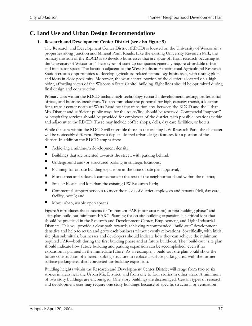
C. Land Use and Urban Design Recommendations 1. Research and Development Center District (see also Figure 5)
The Research and Development Center District (RDCD) is located on the University of Wisconsin’s properties along Junction and Mineral Point Roads. Like the existing University Research Park, the primary mission of the RDCD is to develop businesses that are spun-off from research occurring at the University of Wisconsin. These types of start-up companies generally require affordable office and incubator space. The location adjacent to the West Madison Experimental Agricultural Research Station creates opportunities to develop agriculture-related technology businesses, with testing plots and ideas in close proximity. Moreover, the west central portion of the district is located on a high point, affording views of the Wisconsin State Capitol building. Sight lines should be optimized during final design and construction.
Primary uses within the RDCD include high-technology research, development, testing, professional offices, and business incubators. To accommodate the potential for high-capacity transit, a location for a transit center north of Watts Road near the transition area between the RDCD and the Urban Mix District and sufficient public ways for the route/line should be reserved. Commercial “support” or hospitality services should be provided for employees of the district, with possible locations within and adjacent to the RDCD. These may include coffee shops, delis, day care facilities, or hotels.
While the uses within the RDCD will resemble those in the existing UW Research Park, the character will be noticeably different. Figure 6 depicts desired urban design features for a portion of the district. In addition the RDCD emphasizes:
Achieving a minimum development density; Buildings that are oriented towards the street, with parking behind; Underground and/or structured parking in strategic locations; Planning for on-site building expansion at the time of site plan approval; More street and sidewalk connections to the rest of the neighborhood and within the district; Smaller blocks and lots than the existing UW Research Park; Commercial support services to meet the needs of district employees and tenants (deli, day care
facility, hotel); and More urban, usable open spaces.
Figure 5 introduces the concepts of “minimum FAR (floor area ratio) in first building phase” and “site-plan build out minimum FAR.” Planning for on-site building expansion is a critical idea that should be practiced in the Research and Development Center, Employment, and Light Industrial Districts. This will provide a clear path towards achieving recommended “build-out” development densities and help to retain and grow each business without costly relocations. Specifically, with initial site plan submittals, businesses and developers should indicate how they can achieve the minimum required FAR—both during the first building phase and at future build-out. The “build-out” site plan should indicate how future building and parking expansion can be accomplished, even if no expansion is planned in the immediate future. As an example, a build-out site plan could show the future construction of a tiered parking structure to replace a surface parking area, with the former surface parking area then converted for building expansion.
Building heights within the Research and Development Center District will range from two to six stories in areas near the Urban Mix District, and from one to four stories in other areas. A minimum of two story buildings are encouraged. One story buildings are discouraged. Certain types of research and development uses may require one story buildings because of specific structural or ventilation

City of Madison Pioneer Neighborhood Development Plan
Adopted: April 20, 2004 38
needs. These one-story buildings would be most appropriately located near the eastern edges of the district.
To provide greater activity at the street level, a minimum of 50% of the front building façades will be located within ten to thirty feet from the street, with entrances oriented toward the street. Ancillary business services, such as cafeterias, fitness centers, and coffee shops, will be located on the ground floor fronting on the main street.
On-street parking within the Research and Development District will be available on most streets. Employee parking and loading areas will be located either behind or alongside buildings. The City and UW Research Park should work together to develop a consistent approach for lots with double street frontage. Small visitor parking areas will be allowed in front of the buildings. Underground, structured, and shared parking will be encouraged. The RDCD should include at least one shared parking structure during an early phase of development. Bike parking facilities will also be provided. All development in the RDCD will be expected to prepare a Transportation Demand Plan and to participate in a Transportation Management Association.
It will be important to incorporate existing woodlots within the site design of individual lots. Existing natural features provide an opportunity for an internal path system (see Map 7), and sidewalks will be required on both sides of all streets. Although topography in the district is hilly, the streets are still connected to each other and to others in the neighborhood. Long views of the Capitol, Lake Mendota, and the Cityscape should also be preserved.
The Research and Development Center District will be developed in two main phases. The portion of the district located south of the western extension of Watts Road is expected to develop over the next ten years. The portion located north of Watts Road is not expected to develop until the southern phase is approaching build-out. Most of this northern area will not be able to develop until the communications tower is removed. The proposed development plan for the northern section, as depicted in Map 6, is fairly conceptual and should be revisited during final site planning and platting.
Natural light fills interior corridor space
PIONEERNEIGHBORHOOD
MADISON
WISCONSIN
April 2004
View to
Northeast
To Junction Road
RESEARCH & DEVELOPMENTCENTER DISTRICT VISION
NO
RTH
To Pleasant View Rd.
F I G U R E 6

City of Madison Pioneer Neighborhood Development Plan
Adopted: April 20, 2004 40
City of Madison Pioneer Neighborhood Development Plan
Adopted: April 20, 2004 41
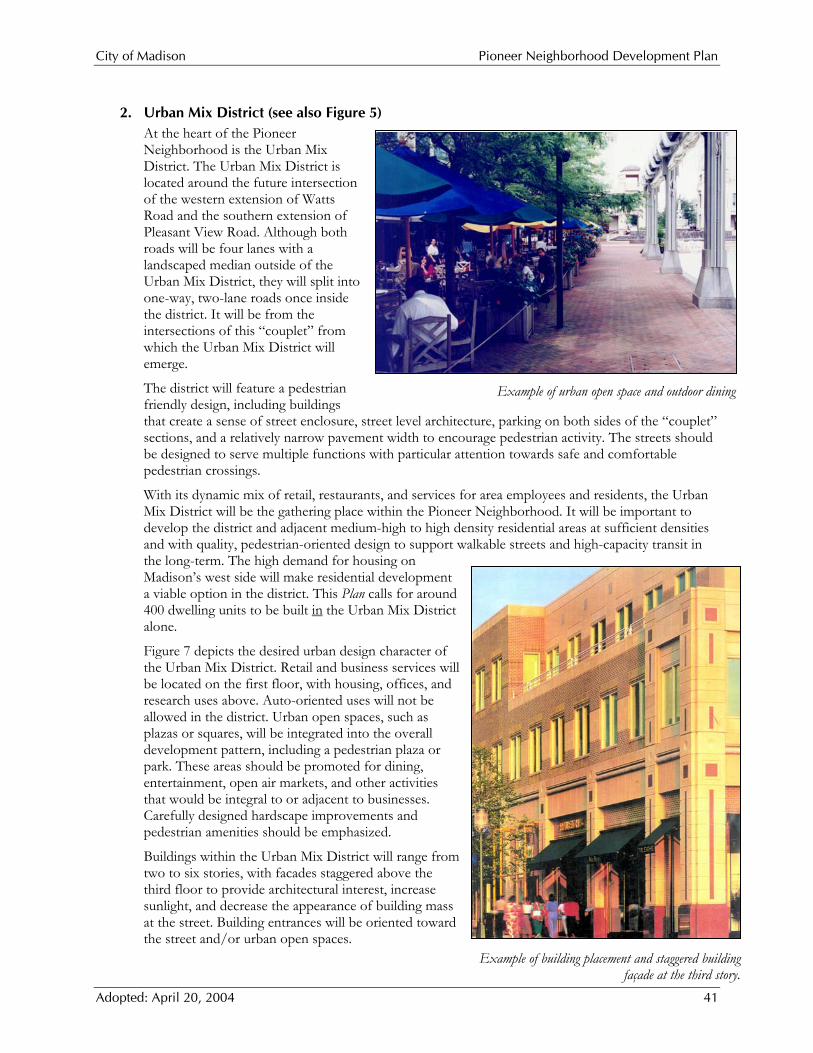
2. Urban Mix District (see also Figure 5) At the heart of the Pioneer Neighborhood is the Urban Mix District. The Urban Mix District is located around the future intersection of the western extension of Watts Road and the southern extension of Pleasant View Road. Although both roads will be four lanes with a landscaped median outside of the Urban Mix District, they will split into one-way, two-lane roads once inside the district. It will be from the intersections of this “couplet” from which the Urban Mix District will emerge.
The district will feature a pedestrian friendly design, including buildings that create a sense of street enclosure, street level architecture, parking on both sides of the “couplet” sections, and a relatively narrow pavement width to encourage pedestrian activity. The streets should be designed to serve multiple functions with particular attention towards safe and comfortable pedestrian crossings.
With its dynamic mix of retail, restaurants, and services for area employees and residents, the Urban Mix District will be the gathering place within the Pioneer Neighborhood. It will be important to develop the district and adjacent medium-high to high density residential areas at sufficient densities and with quality, pedestrian-oriented design to support walkable streets and high-capacity transit in the long-term. The high demand for housing on Madison’s west side will make residential development a viable option in the district. This Plan calls for around 400 dwelling units to be built in the Urban Mix District alone.
Figure 7 depicts the desired urban design character of the Urban Mix District. Retail and business services will be located on the first floor, with housing, offices, and research uses above. Auto-oriented uses will not be allowed in the district. Urban open spaces, such as plazas or squares, will be integrated into the overall development pattern, including a pedestrian plaza or park. These areas should be promoted for dining, entertainment, open air markets, and other activities that would be integral to or adjacent to businesses. Carefully designed hardscape improvements and pedestrian amenities should be emphasized.
Buildings within the Urban Mix District will range from two to six stories, with facades staggered above the third floor to provide architectural interest, increase sunlight, and decrease the appearance of building mass at the street. Building entrances will be oriented toward the street and/or urban open spaces.
Example of building placement and staggered building façade at the third story.
Example of urban open space and outdoor dining
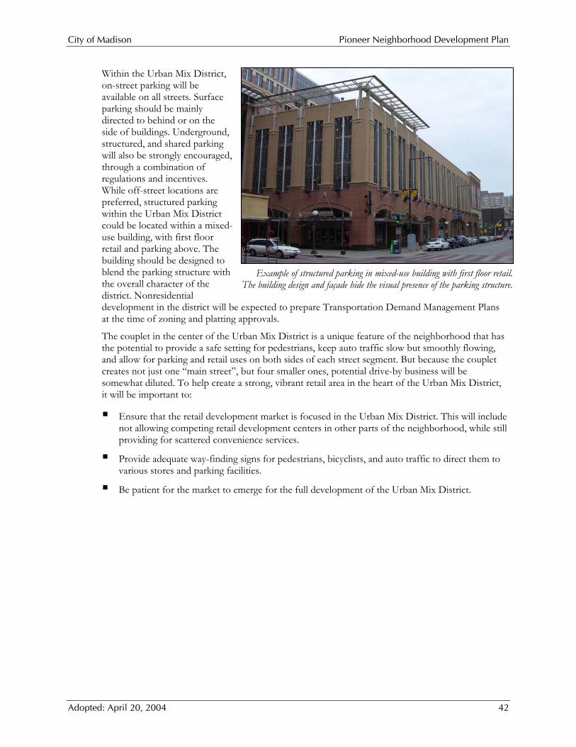
City of Madison Pioneer Neighborhood Development Plan
Adopted: April 20, 2004 42
Within the Urban Mix District, on-street parking will be available on all streets. Surface parking should be mainly directed to behind or on the side of buildings. Underground, structured, and shared parking will also be strongly encouraged, through a combination of regulations and incentives. While off-street locations are preferred, structured parking within the Urban Mix District could be located within a mixed-use building, with first floor retail and parking above. The building should be designed to blend the parking structure with the overall character of the district. Nonresidential development in the district will be expected to prepare Transportation Demand Management Plans at the time of zoning and platting approvals.
The couplet in the center of the Urban Mix District is a unique feature of the neighborhood that has the potential to provide a safe setting for pedestrians, keep auto traffic slow but smoothly flowing, and allow for parking and retail uses on both sides of each street segment. But because the couplet creates not just one “main street”, but four smaller ones, potential drive-by business will be somewhat diluted. To help create a strong, vibrant retail area in the heart of the Urban Mix District, it will be important to:
Ensure that the retail development market is focused in the Urban Mix District. This will include not allowing competing retail development centers in other parts of the neighborhood, while still providing for scattered convenience services.
Provide adequate way-finding signs for pedestrians, bicyclists, and auto traffic to direct them to various stores and parking facilities.
Be patient for the market to emerge for the full development of the Urban Mix District.
Example of structured parking in mixed-use building with first floor retail. The building design and façade hide the visual presence of the parking structure.

PIONEERNEIGHBORHOOD
MADISON
WISCONSIN
April 2004
URBAN MIX DISTRICT VISION
NO
RTH
To Res
earc
h & D
evel
opmen
t Cen
ter
Pleasan
t View
Road
(Extended
)
Watts Road (Extended)
One-Way
"Couplet"
Segments
F I G U R E 7

City of Madison Pioneer Neighborhood Development Plan
Adopted: April 20, 2004 44

City of Madison Pioneer Neighborhood Development Plan
Adopted: April 20, 2004 45
3. Employment District (see also Figure 5) The Employment District is located along Mineral Point Road, between the Pleasant View Road extension and South Point Road. Primary uses within the Employment District will be professional offices; research, development, and testing; technology manufacturing and processing; and/or light industrial uses.
This district will be closely linked to the Research and Development Center and Light Industrial Districts. Combined, there may be over 15,000 jobs in the neighborhood at build out. There will be the physical link of adjacency and the recommended Silicon Parkway extension connecting all three districts. Relationships between various businesses in the three districts should also be fostered. A business, for example, could have its main office within the Research and Development Center District, with satellite office and manufacturing spaces in the Employment District or Light Industrial District. These relationships may also include shared conferencing facilities, joint grounds maintenance contracts, shared redundant power systems, jointly funded communications infrastructure, a common business association, a job training center, interactions between design review boards and management entities, attempts to recruit complementary businesses, and a day care center.
An urban form will be emphasized in the Employment District. Buildings within the Employment District will range from one to four stories, with building entrances oriented toward the street. Buildings located along Mineral Point Road will be designed with similar architectural style and materials on all sides of the building. It will be important to pay special attention to building and site design for buildings along the eastern extension of Silicon Parkway in order to seamlessly transition into the Medium Density Residential uses on the south side of the road.
Within the Employment District, on-street parking will be available on all streets, except Mineral Point Road and the Pleasant View Road extensions. Employee parking and loading areas will be located either behind or alongside the buildings. Small visitor parking areas will be allowed in front of the building. Underground, structured, and shared parking will be encouraged. Bike parking facilities will also be provided. All development will be expected to prepare Transportation Demand Management Plans and to participate in a transportation management association.
This area had been considered for large-scale regional retail development as an alternative to the proposed Employment District. If instead developed with regional retail uses, the area would be capable of supporting at least two large anchor department stores, a number of strip center stores, and several outlets for fast food. In all, well over a half million square feet of retail could be built here. This type of use pattern may lead to challenges for other existing centers on the west side.
Local geography also provides clues to why this area would be better suited to the uses outlined in this Plan. The area would be nearly one mile west of the Beltline and travelers would need to pass the UW Research Center before reaching the retail district, increasing traffic along the way. This traffic would almost certainly be automobile traffic, because large scale regional development is generally not built to support transit use. Businesses would likely want large buildings and signs, in part due to the business format and in part because the area is so far away from the Beltline. Moreover, it is logical that if regional retail were allowed in this spot, other requests would follow west along Mineral
Example of professional office building appropriately suited for the Employment District.

City of Madison Pioneer Neighborhood Development Plan
Adopted: April 20, 2004 46
Point Road, blurring a potentially well-defined edge to Madison and increasing development pressure in the Driftless Area. This Plan instead suggests that the eastern edge of UW Research Center is a logical “break point” for regional retail.
In comparison to large-scale regional retail development, the planned Employment District will support businesses that:
Are more in keeping with the goal of creating a distinct neighborhood with a strong sense of place;
Promote more economic development opportunities and a more diverse, robust tax base; Provide potentially higher employee wages and benefits; Are typically locally owned and operated, resulting in a greater effect on the local economy; Occupy buildings that are more conducive to re-use and lots with more pervious cover; Generate comparatively lower auto traffic; and Could better support high capacity transit service.
4. Light Industrial District (Silicon Prairie) The Light Industrial District is located west of South Point Road at its intersection with Mineral Point Road. This location provides good physical access to the regional transportation network. As mentioned above, the Light Industrial District should be physically and programmatically linked to both the Research and Development Center District and the Employment District. However, it will likely be developed at somewhat lower densities.
Much of the Light Industrial District is already under development as the Silicon Prairie Business Park. As part of Phase One, Welton Enterprises Inc. is marketing eight lots ranging in size from 1.5 to 5.5 acres. Phase Two of the Silicon Prairie Business Park will have nine lots ranging in size from 2 to 13.5 acres. The lots are zoned SM-Specific Manufacturing District, established to accommodate “clean” light-industrial uses focused on production, assemblage, and light processing. All activities, except loading, must take place within enclosed buildings. The Silicon Prairie Business Park is also subject to protective covenants, which place use restrictions and building, landscaping, and other design requirements on the development.
The Light Industrial District also includes approximately 30 acres of land for a new Public Works facility. As the City of Madison continues to grow, its two existing public works facilities will not be able to efficiently provide services to the far west side of the City. In order to accommodate the City's westward growth, the City began to evaluate possible locations for an additional Public Works facility. In 1993, the City conducted an analysis of alternative sites for a west side location. After weighing advantages and disadvantages, the City decided to purchase land within the planning area for a new Public Works facility. A drainage corridor south of the Public Works facility will provide a buffer between the facility and the residential uses planned to the south.
Light industrial building with pedestrian-scale entrance and attractive landscaping

City of Madison Pioneer Neighborhood Development Plan
Adopted: April 20, 2004 47
5. Residential/Commercial District (see also Figure 5) To provide convenient neighborhood service opportunities, two small planned Residential/Commercial nodes are located within the Pioneer Neighborhood.
Developments within the Residential/Commercial Districts will include both mixed-use buildings and sites. Ideally, neighborhood retail, office, and business services will be located on the first floor, with residential units and offices above. Live-work units would also be appropriate within this district.
The first Residential/Commercial District is located at the intersection of South Point Road and the western extension of Watts Road. The historic farmhouse and outbuildings on this site could be adapted and reused for specialty retail shops, neighborhood services, or office uses. Because of the nature of this site and the existing buildings, the incorporation of residential uses within this node may not be required if developed for predominantly commercial purposes.
The second Residential/Commercial District is located on the west side of Junction Road, north of Valley View Road. This node will provide small-scale neighborhood retail, office and service opportunities to serve residents in the adjacent Medium Density Residential District and employees within the Research and Development Center District. Buildings within this node should be oriented toward internal streets, not Junction Road. The land use recommendations for the Hoopes property will require a land exchange between the University Research Park and Hoopes. If these land transfers do not occur then the research and development center recommendations for the Hoopes property are changed to an equivalent amount of medium density residential and residential-commercial mix. Because of the topography and woods on the properties, the exact boundaries will be based on a detailed plan for the property. Approximately 50% of the Hoopes property will be devoted exclusively to residential use and the remainder to residential-commercial mix.
Buildings within this district will range from two to three stories, with entrances oriented toward the adjacent street. Buildings should be designed to blend within the surrounding neighborhood and not be specific to a certain tenant (i.e., no franchise architecture).
Within the Residential/Commercial Districts, on-street parking will be available on all streets, except the Pleasant View extension and Junction Road. A minimum of 75% of the parking spaces should be located either behind or alongside of the buildings. A single row of off-street parking will be allowed in front of buildings, with heavy landscaping to screen the view of parking from the street. Shared parking areas will be encouraged.
6. Commercial/Employment District (see also Figure 5) Two Commercial/Employment nodes are planned within the Pioneer Neighborhood. Primary uses within these districts will be neighborhood retail, office, service, and lodging uses. Each node will serve as slightly different function, as described below.
The first Commercial/Employment District is located along the planned southerly extension of Pleasant View Road at its intersections with Mineral Point Road and the eastern extension of Silicon
Example design for the Residential/Commercial District.

City of Madison Pioneer Neighborhood Development Plan
Adopted: April 20, 2004 48
Parkway. This node is intended to accommodate auto-accessible service uses—such as banks, dry cleaners, or drug stores—to serve the neighborhood residents and area employees. These uses may not be appropriate in the Urban Mix District.
The second Commercial/Employment District is located at the south end of the Research and Development Center District. This node is also intended to accommodate auto-accessible service uses to serve the adjacent Medium-Density Residential and Research and Development Center Districts.
Buildings within the Commercial/Employment District will range from two to three stories, with entrances oriented toward the adjacent streets. Buildings should be designed to blend within the surrounding neighborhood and will not be specific to a certain tenant (i.e., no franchise architecture). Drive-through facilities will only be allowed as a component of a mixed-use building.
Within the Commercial/Employment Districts, on-street parking will be available on all streets, except on the Pleasant View Road extension. A minimum of 75% of the parking spaces should be located either behind or alongside the buildings. A single row of off-street parking will be allowed in front of the buildings, with heavy landscaping to screen the view of parking from the street. Shared parking areas will be encouraged.
7. Residential Districts The Pioneer Neighborhood will include a mix of housing types, lot sizes, and densities, including single-family detached and attached housing, condominiums, apartments, and senior housing. This diversity of housing options, densities, and related architectural styles further reinforces the mixed-use focus of the neighborhood. This diversity also offers the ability for residents to find housing in the neighborhood that fits both their price range and housing needs throughout their lifetime. As the neighborhood develops, it will be important to accommodate a wide range of housing types targeted toward a broad range of income levels, and to seamlessly integrate market rate with more affordable housing.
The modernization of home construction practices and the housing shortages after World War II coalesced into the creation of the modern single-family suburban neighborhoods. While this type of neighborhood met the housing needs of the American suburbanite, these neighborhoods typically lacked a “sense of place” and opportunities for residents to work, shop, and recreate within a short distance of their home. Until the early 1990s, most communities continued to develop in this manner, with single-use developments (e.g., a single-family neighborhood in one location, employment opportunities in another location) situated at the edge of a community. In the past decade, the desire to live, work, shop, and recreate within close proximity to each other has spurred a return to the pre-war “traditional neighborhoods” with twists to respond to modern needs and sensibilities.
The following principles of traditional neighborhood design should be incorporated into the Pioneer Neighborhood and should be used to guide the development of the City’s Traditional Neighborhood Design ordinance:
Example Design for the Commercial/Employment District.

City of Madison Pioneer Neighborhood Development Plan
Adopted: April 20, 2004 49
Mix of housing types, lot sizes, and densities, including single-family housing, town homes, condominiums, garden apartments, and senior housing.
Promotion of small-lot single-family development (e.g., lot areas of 3,000 to 8,000 square feet), with the smallest lots being served by alleys.
Neighborhood focal points, such as village greens, parks, squares, schools, and neighborhood retail and service centers within walking distance of homes.
An interconnected grid of streets sized to correspond with traffic volumes, and generally narrower than the more typical suburban streets.
Orientation to the pedestrian through sidewalks, paths, and other use interconnections.
Modest front yard setbacks, front porches, garages pulled back from front facades, and other design features that encourage neighborhood interaction and avoid “garage-scape” appearances.
Use of natural stormwater management techniques, and incorporation and restoration of degraded environmental features, which are particularly important with smaller lot sizes.
Approximately 5,100 dwelling units will be added in the neighborhood, the majority of which would be built in the neighborhoods immediately surrounding the Urban Mix District and the residential areas to the west. This would provide housing for approximately 11,500 people.
Figure 8: Potential Housing Units and Population
Plan District Net Acres
Average Net DU/Acre
Projected Dwelling Units (DU)
Projected Population
Low Density Residential1 284 5 1,420 3,763Low-Medium Density Residential 101 10 1,010 2,606Medium Density Residential 84 20 1,680 3,443Medium-High or High Density Residential 13 35 455 842Urban Mix2 15 1,500 Sq. Ft/DU 411 720Residential/Commercial2 6 1,500 Sq. Ft/DU 94 164
Totals 503 10 5,070 11,5381 Except within ¼ mile of Pioneer Road the maximum density is 4 units per acre. 2 Assumes 50% of the building space will be residential and 50% non-residential.
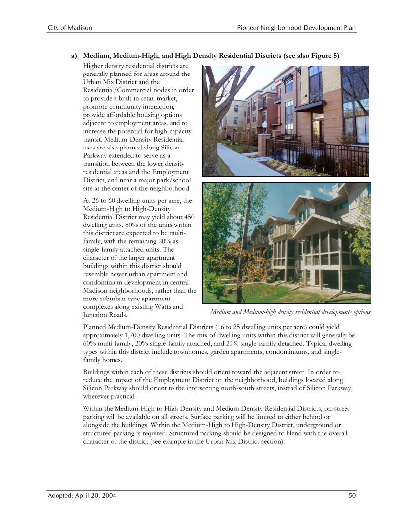
City of Madison Pioneer Neighborhood Development Plan
Adopted: April 20, 2004 50
a) Medium, Medium-High, and High Density Residential Districts (see also Figure 5)
Higher density residential districts are generally planned for areas around the Urban Mix District and the Residential/Commercial nodes in order to provide a built-in retail market, promote community interaction, provide affordable housing options adjacent to employment areas, and to increase the potential for high-capacity transit. Medium-Density Residential uses are also planned along Silicon Parkway extended to serve as a transition between the lower density residential areas and the Employment District, and near a major park/school site at the center of the neighborhood.
At 26 to 60 dwelling units per acre, the Medium-High to High-Density Residential District may yield about 450 dwelling units. 80% of the units within this district are expected to be multi-family, with the remaining 20% as single-family attached units. The character of the larger apartment buildings within this district should resemble newer urban apartment and condominium development in central Madison neighborhoods, rather than the more suburban-type apartment complexes along existing Watts and Junction Roads.
Planned Medium-Density Residential Districts (16 to 25 dwelling units per acre) could yield approximately 1,700 dwelling units. The mix of dwelling units within this district will generally be 60% multi-family, 20% single-family attached, and 20% single-family detached. Typical dwelling types within this district include townhomes, garden apartments, condominiums, and single-family homes.
Buildings within each of these districts should orient toward the adjacent street. In order to reduce the impact of the Employment District on the neighborhood, buildings located along Silicon Parkway should orient to the intersecting north-south streets, instead of Silicon Parkway, wherever practical.
Within the Medium-High to High Density and Medium Density Residential Districts, on-street parking will be available on all streets. Surface parking will be limited to either behind or alongside the buildings. Within the Medium-High to High-Density District, underground or structured parking is required. Structured parking should be designed to blend with the overall character of the district (see example in the Urban Mix District section).
Medium and Medium-high density residential developments options

City of Madison Pioneer Neighborhood Development Plan
Adopted: April 20, 2004 51
b) Low-Medium Density and Low Density Residential Districts
The rest of the residential portions of the Pioneer Neighborhood are planned for Low-Medium and Low-Density Residential development. The components of Traditional Neighborhood Design should be incorporated within these districts. Architectural styles and integrated site designs should address building scale, massing, relationships between the buildings and street, and the architectural character of the neighborhood. The proposed street and block patterns are designed to provide lots with front yard setbacks that are not excessive. Homes with porches are encouraged to promote community interaction at the street level. Homes served by alleys should be provided as part of the housing mix. There should be varying garage locations. In general, garages, and especially garage doors, should be directed away from primary streets wherever possible to improve the streetscape. Consideration should be given to having terrace areas extend into street intersections and at mid-blocks to reduce width of the pavement and improve the streetscape. On-street parking will be available on all streets. Surface parking for small scale multiple-family complexes will be limited to either behind or alongside buildings.
At eight to fifteen dwelling units per acre, the planned Low-Medium Density Residential development areas will yield around 1,000 dwelling units. Within this District, approximately 60% of the units will be single-family detached, 20% will be single-family attached, and the remaining 20% will be multi-family units.
In accordance with the City of Madison-Town of Middleton Intergovernmental Agreement, Low-Density Residential areas are generally located near the edge of the neighborhood west of South Point Road and along Valley View Road. At less than eight dwelling units per acre, these areas will yield about 1,400 dwelling units. Within this district, the mix of dwelling units will generally be 80% single-family detached and 20% single-family attached.
One example of low-medium density residential development
One example of urban low-density residential development
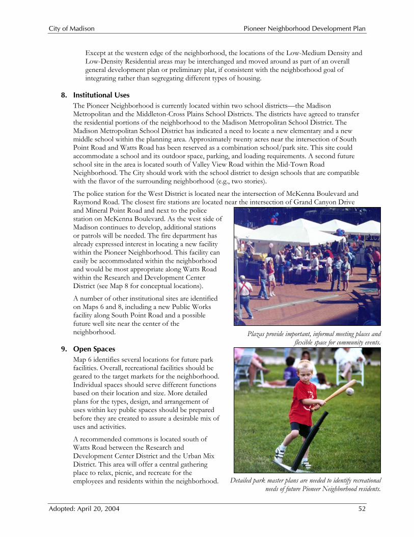
City of Madison Pioneer Neighborhood Development Plan
Adopted: April 20, 2004 52
Except at the western edge of the neighborhood, the locations of the Low-Medium Density and Low-Density Residential areas may be interchanged and moved around as part of an overall general development plan or preliminary plat, if consistent with the neighborhood goal of integrating rather than segregating different types of housing.
8. Institutional Uses The Pioneer Neighborhood is currently located within two school districts—the Madison Metropolitan and the Middleton-Cross Plains School Districts. The districts have agreed to transfer the residential portions of the neighborhood to the Madison Metropolitan School District. The Madison Metropolitan School District has indicated a need to locate a new elementary and a new middle school within the planning area. Approximately twenty acres near the intersection of South Point Road and Watts Road has been reserved as a combination school/park site. This site could accommodate a school and its outdoor space, parking, and loading requirements. A second future school site in the area is located south of Valley View Road within the Mid-Town Road Neighborhood. The City should work with the school district to design schools that are compatible with the flavor of the surrounding neighborhood (e.g., two stories).
The police station for the West District is located near the intersection of McKenna Boulevard and Raymond Road. The closest fire stations are located near the intersection of Grand Canyon Drive and Mineral Point Road and next to the police station on McKenna Boulevard. As the west side of Madison continues to develop, additional stations or patrols will be needed. The fire department has already expressed interest in locating a new facility within the Pioneer Neighborhood. This facility can easily be accommodated within the neighborhood and would be most appropriate along Watts Road within the Research and Development Center District (see Map 8 for conceptual locations).
A number of other institutional sites are identified on Maps 6 and 8, including a new Public Works facility along South Point Road and a possible future well site near the center of the neighborhood.
9. Open Spaces Map 6 identifies several locations for future park facilities. Overall, recreational facilities should be geared to the target markets for the neighborhood. Individual spaces should serve different functions based on their location and size. More detailed plans for the types, design, and arrangement of uses within key public spaces should be prepared before they are created to assure a desirable mix of uses and activities.
A recommended commons is located south of Watts Road between the Research and Development Center District and the Urban Mix District. This area will offer a central gathering place to relax, picnic, and recreate for the employees and residents within the neighborhood.
Plazas provide important, informal meeting places and flexible space for community events.
Detailed park master plans are needed to identify recreational needs of future Pioneer Neighborhood residents.

City of Madison Pioneer Neighborhood Development Plan
Adopted: April 20, 2004 53
The City of Madison Parks Department, the University, and adjacent businesses should evaluate potential ownership and maintenance arrangements for the commons.
Two area and three neighborhood parks are also included within the Pioneer Neighborhood. These parks should focus on active recreational facilities. The specific range of activities within these parks should be in accordance with the needs of its likely users and the City’s park development standards included in the Park and Open Space Plan. The City should prepare a detailed park master plan for each of these parks prior to park development.
Finally, the Plan includes an open space and trail network connecting public spaces and other destinations. The next section includes details on the bicycle and pedestrian facilities.
D. Recommended Transportation Facilities Transit, walking, and bicycling are the backbone of the transportation system in this neighborhood. The Plan calls for the neighborhood to be built at densities to support transit, and for facilities and patterns to facilitate bicycle and pedestrian traffic within the neighborhood and between the neighborhood and surrounding areas. It also outlines strategies for mixed use districts where people can live and work within a short distance, thereby reducing the vehicle miles traveled. There are also provisions to require Transportation Demand Management (TDM) programs to encourage alternative commuting patterns that reduce reliance on the single-occupancy vehicle.
Improvements to the roadway system will also be required. A system of arterial, collector, and local streets is recommended to provide external access and internal circulation within the Pioneer Neighborhood. The consultants have prepared a traffic impact analysis as part of this planning process American Association of State Highway and Transportation Officials (AASHTO) design standards or the Institute of Transportation Engineers’ Traditional Neighborhood Design Street Standards should be used in the geometric design of all new and expanded streets based on the speed limits anticipated for the various roads.
This neighborhood development plan was accompanied by a detailed traffic analysis to project the roadway expansion needs in and near the Pioneer Neighborhood. That study was divided into two parts. The first part considered expansion projects that are advised to accommodate the projected development of lands within phasing area A, as shown on Map 8. These expansions are proposed to be completed within the next five or six years. The second part of the traffic study considered the range of expansion projects on nearby streets that are advised to accommodate the full build-out of the Pioneer Neighborhood and other neighborhoods on Madison’s far west side. This second part suggested that more detailed studies of all possible transportation options should be completed to fully address long-range transportation demands. These more detailed studies and their timing are shown in Appendix B and Figure 10, and are discussed in more detail in section H later in this report. Within the next few years, the City intends to complete an area-wide, long-range regional study for the Beltline interchanges and west side arterial and collector roads, exploring all options, cross-sections, grade separated intersections, and Beltline crossings.
Map 7 summarizes recommended improvements to transportation facilities to serve the planning area based on the Phase A traffic analysis. These facility and service expansions are also described below and are included in Figure 10.
1. Transit Service In August, 2003, Madison Metro completed a review of transit services on the southwest side of the City and identified possible future routes through the neighborhood, which was then reviewed by City staff. The proposed routes would serve the UW Research Center, the Urban Mix District, other employment districts, and the residential developments on the west and south sides of the neighborhood. Transit stops should be located so that the majority of riders can walk a quarter mile

City of Madison Pioneer Neighborhood Development Plan
Adopted: April 20, 2004 54
or less to reach their destination. This analysis will continue with the Greater Westside Transit Service Study in 2004. The City, Madison Metro, and the UW Research Park should work to extend services when the first buildings open in the Urban Mix District and the Research and Development Center District. As the neighborhood grows and becomes denser, the bus transit route would likely be expanded to serve the Employment and Light Industrial Districts and residential areas. As more funding becomes available and ridership demands increase, the routing coverage on the neighborhood arterials and collectors can expand as necessary. Other collector streets in the neighborhood, as depicted in Map 7, should be designed to accommodate buses.
The City should work to advance the idea of, and place a priority on, identifying new funding sources for high-capacity transit service to and within this neighborhood, given the transit-supportive densities recommended and heavy vehicle traffic volumes anticipated on Mineral Point Road.
High-capacity transit service could be on rail or rubber tire. It would be distinguished from standard bus service by having its own dedicated lane, priority access to the Beltline if vehicular access is metered, and more frequent service. A high-capacity transit route might be designed as part of a regional loop, as suggested in Map 4. Within the neighborhood, a conceptual route for high-capacity transit service enters the Pioneer Neighborhood at Watts Road from the east, skirts the north side of the Urban Mix District, and leaves the neighborhood north along the Pleasant View Road extension (see Map 7).
When acquiring land for these road segments, the City should obtain sufficient right-of-way or easements to maximize flexibility for a high-capacity transit route. The ideal width of right-of-way or easements may depend on the type of transit technology used. At a minimum, an extra ten to fifteen feet of right-of-way or easement width is recommended for these road segments or off-street alignments. This may be kept as an extra-wide landscaped terrace area until high-capacity transit service is provided. Depending on the precise routes to the east and north of the Pioneer Neighborhood, using segments of Mineral Point Road and Junction Road may also be necessary.
The City should identify the likely alternative(s) to provide high capacity transit (e.g. busways, light rail), including design and right-of-way requirements as part of the ongoing Transport 2020 Study.
2. Bicycle and Pedestrian Facilities Planned bike and pedestrian facilities are shown on Map 7. The proposed system would have three major types of interconnected facilities:
On-street bike lanes;
Regional, multi-use paths; and
Local paths, trails, or corridors.
On-street bike lane facilities would utilize the modified grid system within the neighborhood to provide bikers and pedestrians multiple alternative parallel routes on the planned arterial and collector street system. Dedicated bicycle lanes of no less than four feet are recommended for arterial and collector streets. With the expected increases in traffic along Mineral Point Road, especially near the interchange, the bike lanes along Watts Road across Junction Road provides an important entrance and exit point of the neighborhood that cyclists might otherwise avoid due to safety concerns. This link provides a convenient and usable bike connection back toward central Madison from the Pioneer Neighborhood.
On-street bicycle lanes are recommended for arterial and collector streets.
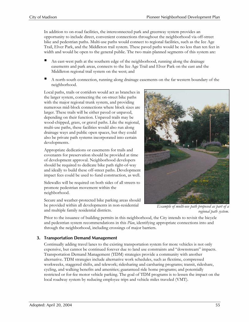
City of Madison Pioneer Neighborhood Development Plan
Adopted: April 20, 2004 55
In addition to on-road facilities, the interconnected park and greenway system provides an opportunity to include direct, convenient connections throughout the neighborhood via off-street bike and pedestrian paths. Multi-use paths would connect to regional facilities, such as the Ice Age Trail, Elver Park, and the Middleton trail system. These paved paths would be no less than ten feet in width and would be open to the general public. The two main planned segments of this system are:
An east-west path at the southern edge of the neighborhood, running along the drainage easements and park areas, connects to the Ice Age Trail and Elver Park on the east and the Middleton regional trail system on the west; and
A north-south connection, running along drainage easements on the far western boundary of the neighborhood.
Local paths, trails or corridors would act as branches in the larger system, connecting the on-street bike paths with the major regional trunk system, and providing numerous mid-block connections where block sizes are larger. These trails will be either paved or unpaved, depending on their function. Unpaved trails may be wood-chipped, grass, or gravel paths. Like the regional, multi-use paths, these facilities would also run along drainage ways and public open spaces, but they could also be private path systems incorporated into certain developments.
Appropriate dedications or easements for trails and covenants for preservation should be provided at time of development approval. Neighborhood developers should be required to dedicate bike path right-of-way and ideally to build these off-street paths. Development impact fees could be used to fund construction, as well.
Sidewalks will be required on both sides of all streets to promote pedestrian movement within the neighborhood.
Secure and weather-protected bike parking areas should be provided within all developments in non-residential and multiple family residential districts.
Prior to the issuance of building permits in this neighborhood, the City intends to revisit the bicycle and pedestrian system recommendations in this Plan, identifying appropriate connections into and through the neighborhood, including crossings of major barriers.
3. Transportation Demand Management Continually adding travel lanes to the existing transportation system for more vehicles is not only expensive, but cannot be continued forever due to land use constraints and “downstream” impacts. Transportation Demand Management (TDM) strategies provide a community with another alternative. TDM strategies include alternative work schedules, such as flextime, compressed workweeks, staggered shifts, and telework; ridesharing and carsharing programs; transit, rideshare, cycling, and walking benefits and amenities; guaranteed ride home programs; and potentially restricted or for-fee motor vehicle parking. The goal of TDM programs is to lessen the impact on the local roadway system by reducing employee trips and vehicle miles traveled (VMT).
Example of multi-use path proposed as part of a regional path system.
City of Madison Pioneer Neighborhood Development Plan
Adopted: April 20, 2004 56
The Research and Development Center and Employment Districts will generate a considerable number of vehicle trips per day. To reduce and rearrange the number of trips, especially at the peak morning and evening rush hours, the City will require management entities and individual businesses to prepare and implement TDM programs as part of development approvals and also require individual businesses to join a transportation management association to jointly implement TDM programs. The City could create an ongoing assessment district that would assess larger businesses (employing more than 50 people in one location, for example) to help fund these programs. The funds would be based on the number of employees expected at the proposed facility and could be used to pay for advertising and incentives to reduce VMT. A potential component of a TDM program is an alternative commute coordinator, employed by the district or larger businesses. These coordinators have proven to be an essential link in actually implementing the programs once established. The City may choose to link the ability to achieve the maximum permitted densities suggested in Figure 5 to more aggressive TDM strategies.
4. Arterial Streets
Arterial streets in the Pioneer Neighborhood include:
Mineral Point Road, Junction Road, Watts Extension (east of Urban Mix District), and Pleasant View Road extension.
The typical arterial street in the neighborhood will have a 130-foot wide right-of-way (140-foot at intersections), four travel lanes, a landscaped median, an urban cross section, no on-street parking and bike lanes on both sides. Access will be very limited on arterials. In order to accomplish this, the City will need to practice strong access control measures in the neighborhood.
Street design and access standards will vary where arterial streets become part of the “couplet” discussed in the Urban Mix District section of this Plan. The goal of the couplet is to provide an intimate, pedestrian feeling to the Urban Mix District, while allowing for smooth traffic flow. The key to accomplishing this will be to use the following design ideas, and those depicted in Figure 9, for the couplet and Urban Mix District:
Right-of-way width of 70-75 feet; On-street, parallel parking spaces; Travel lanes of modest width and speed limits of no more than 35 miles per hour; Pavement changes at crosswalks (concrete turns to pavers or colored concrete) to signal vehicles
are entering a pedestrian-centered area; Bulb-outs/narrowing of street width at intersections; Entrance signs or special treatments at the beginnings of the couplet segments to make drivers
aware they are entering a pedestrian-centered area; and Street trees and buildings designed to provide a sense of enclosure.
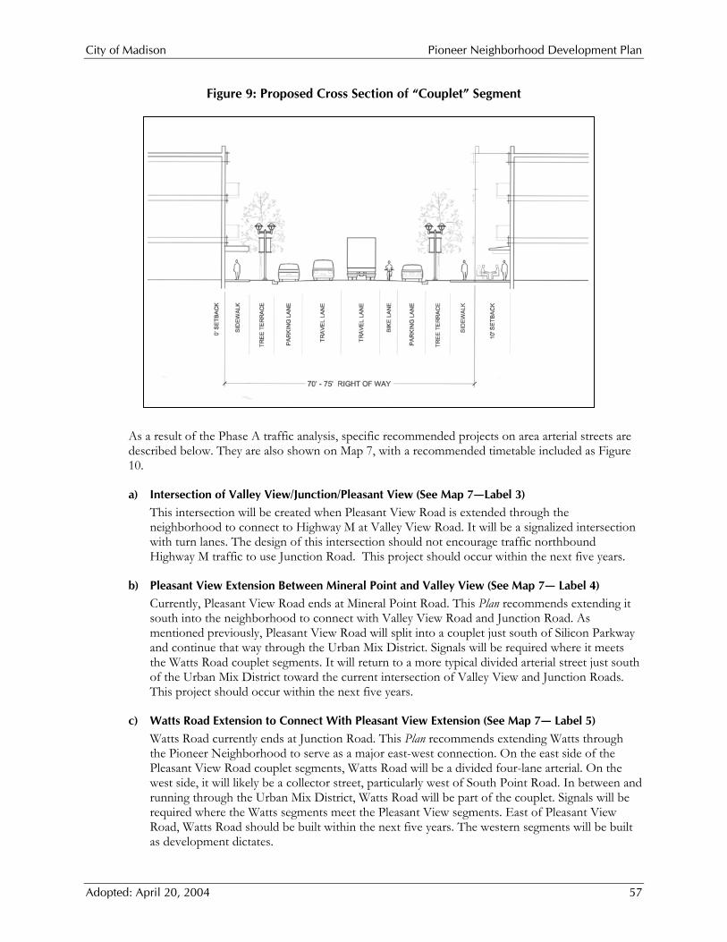
City of Madison Pioneer Neighborhood Development Plan
Adopted: April 20, 2004 57
Figure 9: Proposed Cross Section of “Couplet” Segment
As a result of the Phase A traffic analysis, specific recommended projects on area arterial streets are described below. They are also shown on Map 7, with a recommended timetable included as Figure 10.
a) Intersection of Valley View/Junction/Pleasant View (See Map 7—Label 3) This intersection will be created when Pleasant View Road is extended through the neighborhood to connect to Highway M at Valley View Road. It will be a signalized intersection with turn lanes. The design of this intersection should not encourage traffic northbound Highway M traffic to use Junction Road. This project should occur within the next five years.
b) Pleasant View Extension Between Mineral Point and Valley View (See Map 7— Label 4) Currently, Pleasant View Road ends at Mineral Point Road. This Plan recommends extending it south into the neighborhood to connect with Valley View Road and Junction Road. As mentioned previously, Pleasant View Road will split into a couplet just south of Silicon Parkway and continue that way through the Urban Mix District. Signals will be required where it meets the Watts Road couplet segments. It will return to a more typical divided arterial street just south of the Urban Mix District toward the current intersection of Valley View and Junction Roads. This project should occur within the next five years.
c) Watts Road Extension to Connect With Pleasant View Extension (See Map 7— Label 5) Watts Road currently ends at Junction Road. This Plan recommends extending Watts through the Pioneer Neighborhood to serve as a major east-west connection. On the east side of the Pleasant View Road couplet segments, Watts Road will be a divided four-lane arterial. On the west side, it will likely be a collector street, particularly west of South Point Road. In between and running through the Urban Mix District, Watts Road will be part of the couplet. Signals will be required where the Watts segments meet the Pleasant View segments. East of Pleasant View Road, Watts Road should be built within the next five years. The western segments will be built as development dictates.
City of Madison Pioneer Neighborhood Development Plan
Adopted: April 20, 2004 58
d) Junction Road (See Map 7— Label 6) Junction Road between Watts and Mineral Point Roads will be a four-lane divided road with a median, with this expansion suggested in the next five years. Junction Road will likely be expanded to four lanes south of Watts Road as traffic volumes warrant. The City should practice strong access control, particularly along the section north of Watts Road. At Applewood Drive, south of Watts Road, there should be access into both that neighborhood and the Research and Development Center District.
e) Mineral Point Between Pleasant View & Beltline (See Map 7— Label 7 and Label 8) Mineral Point Road will need substantial work between Pleasant View Road and the Beltline. Within the next five or six years period, the section of Mineral Point Road between Junction Road and the Beltline interchange will likely have to be expanded to a total of six through lanes. The section of Mineral Point Road between Pleasant View and Junction Roads will be developed as a four-lane road with a median. Signals are expected to be needed at Pleasant View Road. There should be a complete reconstruction of Mineral Point Road where it intersects with Junction Road, due to the high expected traffic volumes. Street and intersection reconstruction will require additional right-of-way. Generally, right-of-way would come equally from both sides of the street; however there is a cemetery on the north side of Mineral Point Road, west of Junction Road. More right-of-way may need to be acquired from the south side of Mineral Point Road in that section. These projects should occur within the next five or six years.
Later phases will see Mineral Point Road expanded as a four-lane divided road west of Pleasant View Road, as traffic volumes dictate. Finally, widening of Mineral Point Road between the Beltline and Junction Road will be required in the future.
5. Collector Streets There will be two types of collector streets in the neighborhood—major and minor collectors (see Map 7). Major collectors generally will have a 108 foot right-of-way, four travel lanes usually divided by a central landscaped median, and bike lanes and sidewalks on both sides of the road. Primary access to development sites will be from the rear or side of the site, not from the major collector roadway. Existing driveways are an exception to this guideline. In the next five years, there may be no need to widen existing major collector streets. As development progresses and traffic increases, there will be a need to first improve intersections and, when traffic volumes warrant, widen streets. Where not otherwise indicated on Map 7, major and minor collector streets should have an 80 foot wide right-of-way.
6. Local Streets All other planned streets depicted on Map 7 are expected to be classified as local or local connector streets. While this Plan shows the general planned location of the local streets in the Pioneer Neighborhood, the exact locations of local streets will be determined in conjunction with plats and engineering studies prepared in advance of private development.
Some local streets may require traffic-calming measures to help minimize the design speeds of many of the roadways in the neighborhood. These measures, when coupled with narrower street cross sections, also help minimize pedestrian/automobile conflicts and increase the sense of safety among pedestrians. Specific traffic-calming measures that may be appropriate in this neighborhood include intersection bump-outs, reduced curb radii, and traffic circles. These measures should be designed into the streets at the time of initial development.
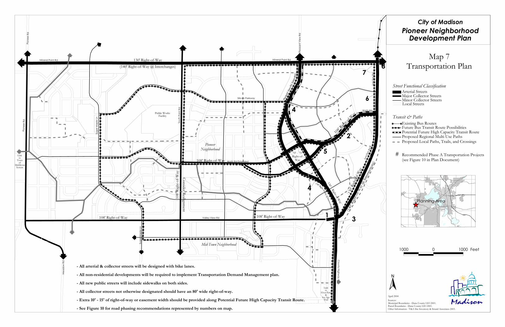
Mineral Point Rd Mineral Point Rd
Pione
er Rd
Sout
h Poin
t Rd
Valley View Rd
Mea
dow
Rd
Suga
r Map
le Ln
County Highway M
Junc
tion R
d
Pleas
ant V
iew Rd
Pione
er Rd
Junc
tion R
d
Watts Rd Extended
Suga
r Map
le Ln
Public WorksFacility
Silicon Parkway
108' Right-of-Way 108' Right-of-Way
108' Right-of-Way
130' Right-of-Way108
' Right-of-
Way
(140' Right-of-Way @ Interchanges)130' Right-of-Way
(140' R
ight-o
f-Way
@ Inter
sectio
ns)
130' R
ight-o
f-Way
PioneerNeighborhood
108'
Righ
t-of-W
ay
Linkto
Townof
MiddletonSystem
Linkto
Elver Park&
Ice AgeTrail
Consider Realignment
6
8
2
7
5
4
1 3
4
Mid-Town Neighborhood
70' - 75' Right-of-
Way
Watts Rd
Pleasa
nt Vie
w Rd.
Exten
ded
(140' Right-of-Way @ Intersections)
City of MadisonPioneer Neighborhood
Development Plan
Map 7Transportation Plan
N
Sources:Municipal Boundaries - Dane County LIO 2001.Parcel Boundaries - Dane County LIO 2001.Other Information - V&A Site Inventory & Strand Associates 2003.
1000 0 1000 Feet
ÊÚPlanning Area
April 2004
;;
;;
Local Streets
Street Functional ClassificationArterial StreetsMajor Collector StreetsMinor Collector Streets
; ; ;; ;;
; ;
Proposed Local Paths, Trails, and Crossings
Potential Future High Capacity Transit RouteExisting Bus Routes
Transit & Paths
;
;
;
;
;
;
;
Recommended Phase A Transportation Projects(see Figure 10 in Plan Document)
#
- All arterial & collector streets will be designed with bike lanes.- All non-residential developments will be required to implement Transportation Demand Management plan.- All new public streets will include sidewalks on both sides.- All collector streets not otherwise designated should have an 80' wide right-of-way.- Extra 10' - 15' of right-of-way or easement width should be provided along Potential Future High Capacity Transit Route.- See Figure 10 for road phasing recommendations represented by numbers on map.
Future Bus Transit Route PossibilitiesProposed Regional Multi Use Paths

City of Madison Pioneer Neighborhood Development Plan
Adopted: April 20, 2004 60
City of Madison Pioneer Neighborhood Development Plan
Adopted: April 20, 2004 61
E. Utility Service Plan 1. Sanitary Sewer
The planning area is divided topographically by two ridge lines. These topographic divides provide three separate drainage basins and service patterns for sanitary sewer service (see Map 8).
Basin I (part of the Lower Pheasant Branch Creek Sub-Watershed) consists of an approximately 240-acre triangular area in the northeast corner of the planning area that naturally drains to the northeast. This area could logically be served by gravity flow to existing City of Madison sanitary sewers located along Mineral Point Road.
Basin II (part of the Upper Badger Mill Creek Sub-Watershed) consists of approximately 275 acres just south of Basin I that naturally drains to the south. This area could logically be served by gravity sewer by extending the City of Madison’s Hawk’s Landing Interceptor that is located south of the planning area adjacent to the west side of CTH M (labeled as “Eastern Interceptor” on Map 8).
Basin III (part of the Lower Badger Mill Creek Sub-Watershed) consists of the remainder of the planning area, about 1000 acres to the west of Basins I & II. This area naturally drains to the west and south. A small portion of this basin is currently served by a City of Madison pumping station near the planned Public Works facility on South Point Road. This station discharges to the existing gravity sewer on Mineral Point Road. Due to capacity limitations in the receiving downstream sewers, this pumping station is considered a temporary facility with a limited service area and service life.
The development of Basin III will require the extension of an interceptor from the south (labeled as “Western Interceptor” on Map 8). Current plans envision this interceptor discharging to a future regional pumping station to be located on Mid-Town Road approximately 1,500 feet east of Meadow Road. This pumping station would then discharge to the head end of the Madison Municipal Sewerage District (MMSD) Mid-Town Interceptor. Capacity is available in the Mid-Town Interceptor to provide service to the entire Basin III area.
In addition to providing sewer service to the entire Basin III area, the development of this pumping station and interceptor system would allow for the eventual abandonment of the existing City of Madison wastewater pumping stations at Hawk’s Woods, Mid-Town Road, and South Point Road. This interceptor pumping station system would also have the capability of providing sewer service to areas north and west of this service area. Their current schedule calls for construction of these facilities in 2006. It is recommended that additional development in Basin III, beyond what the existing temporary pumping station can handle, be delayed until these facilities are installed.
The City should also identify where utility easements can be used for bike or pedestrian paths. Paths in these corridors allow for easier access if the lines need servicing and wise use of limited land resources.
2. Water Supply Water service for the planning area will be provided by the Madison Water Utility. In providing this service, the planning area will need to be divided into two independent pressure zones, Zone 10 and Zone 11.
The Zone 10 pressure zone is fed by Unit Well 26 and pressurized by the High Point elevated tank. This tank has an overflow elevation of 1320.60 USGS. With this height and a limiting pressure range of 100 pounds per square inch (psi) to 50 psi, Zone 10 can provide service to those areas with ground elevations between 1090 to 1205 USGS.
The Zone 11 pressure zone will initially be fed from Zone 10 through a pressure reducing valve or valves. Eventually this zone will be pressurized by a future elevated tank located north of the planning area. The overflow elevation of this future tank is expected to be approximately 1270
City of Madison Pioneer Neighborhood Development Plan
Adopted: April 20, 2004 62
USGS. With this height and a limiting pressure range of 100 psi to 50 psi, Zone 11 could then provide service to those areas with ground elevations between 1040 to 1155 USGS.
The elevation overlap of these two zones will provide substantial flexibility in the establishment of specific boundary locations between the zones. Suggested boundary locations are identified on Map 8.
The existing water system has been extended to a variety of areas that are adjacent to the planning area. A 16-inch main is in place along Mineral Point Road between Junction Road and South Point Road. A 12-inch main is in place along South Point Road from Mineral Point Road to 2600 feet south. In addition to these mains, 12-inch mains are in place up to Junction Road at Watts Road, and the south planning limits at Red Tail Drive.
As depicted on Map 8, the future layout of the water system for the planning area should include as a minimum, 16-inch mains on Mineral Point Road, and Pioneer Road, and 12-inch mains on Valley View Road, South Point Road, Watts Road, Pleasant View Road extended, and Junction Road. The remainder of the future water system should consist of minimum 8-inch mains for residential areas, and a combination of 8-inch and 10-inch mains for all other areas.
To further support the future water supply demand for this area, the Madison Water Utility has identified a need to develop a new unit well within the planning area. The proposed location for this well, shown on Map 8, is on the east side of South Point Road, approximately 4,200 feet south of Mineral Point Road, near a future drainageway in an area identified for a future park. The unit well site should be a minimum of one acre in size.
3. Stormwater Management Basins II and III of the planning area are located in the regional drainage basin known as the Badger Mill Creek Sub-Watershed. Stormwater management analyses for the Upper and Lower Badger Mill Creek basins were prepared for the City of Madison in February 2001. These analyses provided recommended locations and sizing of regional stormwater management facilities in Basins II and III of the planning area, including detention ponds, retention ponds, and overland conveyance routes. As development occurs within Basins II and III, these regional facilities should be provided in a coordinated approach with any local facilities that may be required to satisfy local and state stormwater management regulations.
Stormwater management facilities for Basin I (part of the Lower Pheasant Branch Creek Sub-Watershed) have not yet been identified. As a prelude to development in this basin, a stormwater management plan should be developed that establishes stormwater management goals and objectives consistent with plans and limitations for downstream facilities.
4. Service Utilities A major overhead electrical transmission line owned by American Transmission Company (ATC) traverses north-south through the planning area. This line follows an extension of Pleasant View Road south from Mineral Point Road to Valley View Road and connects the CTH PD substation with the Pleasant View Road substation.
The current location of this line may provide localized conflicts with development goals and objectives. Alternate overhead and/or underground routes for this facility are feasible but may be costly. As development occurs in accordance with this Plan, the City should participate in discussions concerning the feasibility and costs of relocating or burying these facilities. Burying or relocating power lines will be particularly important in the Urban Mix District.
Alliant Energy has also expressed interest in locating a local substation in close proximity to the transmission line. The planning and location of this facility should also be considered before or when

City of Madison Pioneer Neighborhood Development Plan
Adopted: April 20, 2004 63
private development proposals are offered for this area and in conjunction with the line relocation/burying discussion.
A more detailed discussion of the limitations and impacts associated with the UW communications tower is provided in other sections of this Plan.
F. Development, Utility, and Transportation Phasing Plan Development within the Pioneer Neighborhood will occur in phases. The three phases (A through C) shown in Map 8 are proposed as a reasonable sequence for staging urban development based on several factors. These include property owner interest in development, the availability and ease of delivery of public utilities, the proximity to existing Central Urban Service Area boundaries, logical drainage basins and transportation investment patterns, and an interest in providing a diversity of use areas in the neighborhood as soon as possible.
Roughly two-thirds of the phasing areas shown on Map 8 are currently outside the Central Urban Service Area. Phasing Area A through C with exception of the Phase C Area west of South Point Road, likely will form the basis for the City’s first request to expand the Central Urban Service Area because of its inclusion within the City limits, the availability of public services, and short-term private developer interest. The phasing of development is also tied to the follow-up studies related to traffic impacts as called for in Figure 10 and Appendix B.
1. Phasing Area A Area A includes the southern phase of the Research & Development Center District, much of the Urban Mix District near the proposed Watts/Pleasant View intersection, the developing Silicon Prairie Industrial Park, and planned residential development areas near that industrial park and south of Valley View Road in the Mid-Town Neighborhood (see Map 8). The City and affected property owners expect that development within Phasing Area A will begin within the next five years. Before any development occurs, the parts of Area A that are not presently in the Central Urban Service Area will have to be added and such lands will need to be rezoned and platted to permit the recommended development pattern.
A series of transportation and utility studies and investments should precede land development in Phasing Area A (see Figure 10). In brief, the present rural road network—particularly on and beyond the east side of the planning area—will require expansion and urbanization to accommodate development in Area A. Highlighted among the Phase A recommendations is the desired extension of Pleasant View Road between Mineral Point Road and Valley View Road. In addition, public sanitary sewer service and stormwater management facilities will have to be extended through parts of Phasing Area C to reach Area A. In particular, sanitary sewer interceptors currently located near CTH M and Meadow Road will need to be extended. It is the City’s policy to recover the costs of such projects from benefiting developments.
The Plan recommends the southern extension of Pleasant View Road as part of Phase A.
City of Madison Pioneer Neighborhood Development Plan
Adopted: April 20, 2004 64
2. Phasing Area B Phasing Area B generally consists of lands between the main Phase A areas—generally between South Point Road and the planned Pleasant View Road extension. These include lands proposed mainly for employment uses near Mineral Point Road, parts of the Urban Mix District, the predominantly residential neighborhoods to the south and east of these areas, and a small parcel near Junction Road proposed for a mix of uses. These lands have been placed in Phasing Area B because of their relative distance from existing and planned utilities and/or the lack of immediate property owner interest in developing in accordance with this Plan. Development in Phasing Area B is expected to start within the next five to fifteen years. Among other transportation projects, Watts Road would be extended west to South Point Road during this period.
3. Phasing Area C Area C includes the following three areas:
Lands owned by the University and presently developed with the communications tower, and adjacent lots;
Lands located between Valley View Road and the Hawk’s Landing development west of CTH M; and
Lands on the far western edge of the neighborhood.
Lands on the far west side of the neighborhood were placed in Area C due to their distance from existing City development and utilities, and the relative lack of property owner interest in further development in the near future. Lands in and near the UW communications tower were placed in Area C due to safety concerns associated with the tower and the need for land assembly and coordinated redevelopment along Junction Road. Further development and redevelopment in Phasing Area C is not expected to start for ten years.
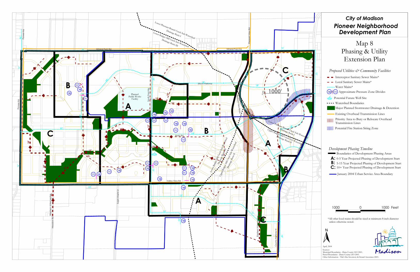
Ë
Mineral Point Rd Mineral Point Rd
Pione
er Rd
Sout
h Poin
t Rd
Valley View Rd
Mea
dow
Rd
Suga
r Map
le Ln
Coun
ty Hig
hway
M
Junc
tion R
d
Pleas
ant V
iew Rd
Pione
er Rd
Junc
tion R
d
Watts Rd
Suga
r Map
le Ln
PlannedPublic Works
Facility
Silicon Parkway
1000'
BC
A
C
A
A
C
BB
Pleasant View Road
Lower Pheasant Branch Creek Sub-Watershed
Drainage Basin I
Upper Badger Mill Creek Sub-Watershed
Drainage Basin II
Lowe
r Badg
er Mi
ll Cree
k Sub
-Wate
rshed
Drain
age Ba
sin II
I
Upper
Badg
er Mi
ll Cree
k Sub
-Wate
rshed
Drain
age Ba
sin II
Lower Pheasant Branch Creek Sub-Watershed
Drainage Basin ILower Badger Mill Creek Sub-Watershed
Drainage Basin III
12"
10"
16"
12"
12"
16"
12"12"
12"
12"
12"
12"
12"
10"
16"
10"
12"
12"
12"
12"
10"
12"
12"
16"
16"
18"
18"
30"
15"
18"
15"12"
6"
10"
15"
12"
10"
12"
10"
10"
12"10"
10"
B
Wes
tern
Inte
rcep
tor
Easte
rn In
terc
epto
r
City of MadisonPioneer Neighborhood
Development Plan Map 8
Phasing & UtilityExtension Plan
N
Sources:Municipal Boundaries - Dane County LIO 2001.Parcel Boundaries - Dane County LIO 2001.Other Information - V&A Site Inventory & Strand Associates 2003.
April, 2004
1000 0 1000 Feet
Proposed Utilities & Community Facilities
0-5 Year Projected Phasing of Development StartBoundaries of Development Phasing Areas
A:B:C:
5-15 Year Projected Phasing of Development Start10+ Year Projected Phasing of Development Start
Development Phasing Timeline
January 2004 Urban Service Area Boundary
Watershed Boundaries
Local Sanitary Sewer Mains*
Potential Future Well SiteB
Major Planned Stormwater Drainage & DetentionExisting Overhead Transmission Lines
*All other local mains should be sized at minimum 8-inch diameter unless otherwise noted.
Water Mains*
Interceptor Sanitary Sewer Mains*
10
1110 Approximate Pressure Zone Divides
10
1010
1010
1111
1111
101011
1011
11 11
10
1010
11
11
10 10
1110 10
1011
11
;
;
;
;
;
;
;
;
;
;
;
;
;
;
;;
;;;
;
;
;
;;
;
;
;
;
;
;
;
;
;
; ;
Priority Area to Bury or Relocate Overhead Transmission LinesPotential Fire Station Siting Zone

City of Madison Pioneer Neighborhood Development Plan
Adopted: April 20, 2004 66
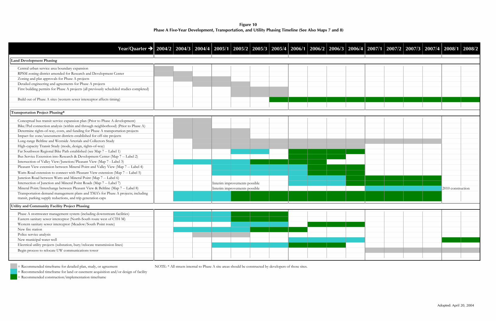
Figure 10 Phase A Five-Year Development, Transportation, and Utility Phasing Timeline (See Also Maps 7 and 8)
2004/2 2004/3 2004/4 2005/1 2005/2 2005/3 2005/4 2006/1 2006/2 2006/3 2006/4 2007/1 2007/2 2007/3 2007/4 2008/1 2008/2
Central urban service area boundary expansion RPSM zoning district amended for Research and Development CenterZoning and plat approvals for Phase A projectsDetailed engineering and agreements for Phase A projectsFirst building permits for Phase A projects (all previously scheduled studies completed)
Build out of Phase A sites (western sewer interceptor affects timing)
Conceptual bus transit service expansion plan (Prior to Phase A development)Bike/Ped connection analysis (within and through neighborhood) (Prior to Phase A)Determine rights-of-way, costs, and funding for Phase A transportation projectsImpact fee zone/assessment districts established for off-site projectsLong-range Beltline and Westside Arterials and Collectors StudyHigh-capacity Transit Study (mode, design, rights-of-way)Far Southwest Regional Bike Path established (see Map 7 -- Label 1)Bus Service Extension into Research & Development Center (Map 7 -- Label 2)Intersection of Valley View/Junction/Pleasant View (Map 7 - Label 3)Pleasant View extension between Mineral Point and Valley View (Map 7 -- Label 4)Watts Road extension to connect with Pleasant View extension (Map 7 -- Label 5)Junction Road between Watts and Mineral Point (Map 7 -- Label 6)Intersection of Junction and Mineral Point Roads (Map 7 -- Label 7) Interim improvements possibleMineral Point/Interchange between Pleasant View & Beltline (Map 7 -- Label 8) Interim improvements possible 2010 constructionTransportation demand management plans and TMA's for Phase A projects; including transit, parking supply reductions, and trip generation caps
Phase A stormwater management system (including downstream facilities)Eastern sanitary sewer interceptor (North-South route west of CTH M)Western sanitary sewer interceptor (Meadow/South Point route)New fire station Police service analysisNew municipal water wellElectrical utility projects (substation, bury/relocate transmission lines)Begin process to relocate UW communications tower
= Recommended timeframe for detailed plan, study, or agreement NOTE: * All streets internal to Phase A site areas should be constructed by developers of those sites.= Recommended timeframe for land or easement acquisition and/or design of facility= Recommended construction/implementation timeframe
Year/Quarter
Land Development Phasing
Transportation Project Phasing*
Utility and Community Facility Project Phasing
Adopted: April 20, 2004

City of Madison Pioneer Neighborhood Development Plan
Adopted: April 20, 2004 68
City of Madison Pioneer Neighborhood Development Plan
Adopted: April 20, 2004 69
VI. Plan Implementation Currently, the Pioneer Neighborhood consists primarily of large, undivided parcels within two municipal jurisdictions and served by a rural road network. This section recommends specific actions to prepare the neighborhood for development with the full range of urban services and to ensure that future development is consistent with the recommendations of this Plan.
A. Master Plan Amendment Lands within the Pioneer Neighborhood are included in the broad growth recommendations of the City’s adopted Peripheral Area Development Plan. The Pioneer Neighborhood Development Plan provides detailed land use and transportation recommendations to guide a portion of this area’s future growth and urban development.
The Pioneer Neighborhood Development Plan has been adopted as a detailed component of the City’s Master Plan, under §62.23, Wisconsin Statutes. In addition, the City incorporated the development recommendations for the area south of Valley View Road as a minor amendment to the Mid-Town Road Neighborhood Development Plan as a detailed component of the City’s Master Plan. The City should also incorporate the recommendations of this Plan in the City’s pending Comprehensive Plan.
B. Central Urban Service Area Amendment Much of the land in the Pioneer Neighborhood is not within the Central Urban Service Area. For the City to provide sanitary sewer and other urban services to future development, lands proposed for near-term development must first be included within the Central Urban Service Area.
Following City adoption of the Pioneer Neighborhood Development Plan, the City should prepare and submit to the Dane County Regional Planning Commission an application to amend the Dane County Land Use and Transportation Plan and the Dane County Water Quality Plan to include land included in Phasing Area A in the Central Urban Service Area (see Map 8). Some lands in other phases may also need to be included with the application to bring connectivity to lands added. Developers of lands within those areas may need to prepare and submit more detailed stormwater management plans along with the City’s application.
C. Annexations About 62 percent of the land within the Pioneer Neighborhood is currently within the City of Madison. The orderly development of lands within the neighborhood will require extension of public utilities and improvements and provision of urban services. The City’s policy is to provide such services only to lands within the City limits.
Urban development should not occur on lands currently outside the City until these lands are annexed. Further, the City should not approve any subdivision unless there is assurance that the full range of urban services will be provided at the time of such approval. This annexation and service policy is consistent with the 2002 intergovernmental agreement between the City of Madison and Town of Middleton that has been formalized through a cooperative boundary plan under Wisconsin Statutes.
D. Zoning Most land within the Pioneer Neighborhood is in an agricultural zoning district. In addition to allowing agricultural uses, the City’s A-Agriculture District is intended as interim zoning placed on future urban development lands. Permanent zoning will be required in advance of platting. Lands within the Pioneer
City of Madison Pioneer Neighborhood Development Plan
Adopted: April 20, 2004 70
Neighborhood should ultimately be rezoned to conform to the land use recommendations of this Plan. Lands currently zoned Agriculture District should be rezoned to another district only at such time as there is a specific subdivision and/or development proposal. This will help ensure that development will be consistent with this Plan.
This Plan calls for a diverse mix of land uses developed with special attention to urban design and urban form. The City’s existing menu of zoning districts and approaches may not be appropriate for all lands within the Pioneer Neighborhood. Further, the City’s typical approach for dealing with unique development proposals—the Planned Unit Development (PUD) district—has its shortcomings. Specific recommendations for amendments to the zoning ordinance to aid in implementing this Plan are as follows:
Revise the PUD district to require planned developments to comply with the recommendations of adopted neighborhood development plans. Using the PUD district for all or most of the Pioneer Neighborhoods is a viable option. This option is familiar to City staff, City officials, and most developers. It would not require Council approval of rules for an alternative zoning district, which could delay the implementation process. The main disadvantage to the PUD option is that this zoning district does not communicate detailed design expectations to ensure complete implementation of the Pioneer Neighborhood Development Plan. The City would therefore need to be vigilant and at times courageous when reviewing development proposals against Pioneer Neighborhood development standards. Because the PUD process relies heavily on City-developer negotiations, the Plan’s vision could be compromised over time. This chance could be reduced if the City adopted a zoning ordinance amendment to require that PUD zoning and associated development plans must comply with “detailed components of the City’s Master Plan,” like the Pioneer Neighborhood Development Plan. The ordinance amendment should ideally be adopted before or at the time of approval of Phase A development projects.
Revisit the RPSM Research Park—Specialized manufacturing district to allow its application to a more urban context. The RPSM zoning district is presently mapped over the existing UW Research Park along Whitney Way. The mix of uses allowed in this existing zoning district is generally appropriate to the proposed Research and Development Center District as shown on Map 6. However, the intent and dimensional standards of this zoning district are not a good fit for the urban job center form desired for the Pioneer Neighborhood. City and UW Research Park officials should develop either an “urban” option to the RPSM district or a separate research center district, with dimensional and design standards derived from Figure 5 of this Plan. This should be completed before the time of approval of Phase A projects.
Adopt a Traditional Neighborhood Development (TND) Zoning District. A TND zoning district could be used to facilitate City development objectives in the mainly residential sections of the Pioneer Neighborhood in particular. These include mixing uses, providing for a variety of residential types and densities, promoting pedestrian amenities and street activity, and including a connected open space system. The City is already required to adopt a TND ordinance under State law.
Consider adopting a Transit-Oriented Development (TOD) Zoning District. Nationally, many larger cities have adopted a TOD Transit Oriented Development district for mapping over existing and proposed transit station areas, where higher-density, mixed-use development is desired. These often cover community or regional employment, shopping, or entertainment centers. Within the Pioneer Neighborhood, a TOD district could be mapped over the Urban Mix and Medium High or High Density Residential Areas shown on Map 6. It is envisioned that this area will develop with transit-supportive densities and eventually be connected along a high-capacity transit route.

City of Madison Pioneer Neighborhood Development Plan
Adopted: April 20, 2004 71
Upgrade the City’s development design regulations. Successful implementation of the Pioneer Neighborhood Development Plan depends on careful attention to neighborhood, site, and building design quality. Without such attention, problems that people often attribute to “too much density” can result. This design quality may be achieved, in part, through careful adherence to the Plan recommendations and use of the right zoning districts. However, detailed regulations for high-quality landscaping, signage, lighting, exterior building materials, site layout, and other development qualities are also important to achieve consistently high development quality. We suggest that City consider revising its zoning ordinance to incorporate these types of modern design standards.
E. Land Subdivision Regulations Lands in the Pioneer Neighborhood will need to be subdivided into smaller parcels before they are developed with urban uses. Subdivisions form the spatial relationships between the proposed streets, parks, stomwater areas, and other land uses; the sizes and arrangement of individual development parcels; and the framework for housing types, sizes, and densities. As lands are proposed for development, City’s subdivision regulations may be used to implement the neighborhood plan recommendations. Specifically, the City should:
Assure that future subdivisions within the Pioneer Neighborhood conform to the recommendations of this Plan. This is particularly important with respect to the location of arterial and collector streets, area and neighborhood parks, environmental corridors, bike and pedestrian connections, stormwater facilities, and building lot dimensions to help facilitate the development of a variety of housing types and densities. Local streets should either generally conform to the pattern of local streets shown in this Plan, or otherwise reflect the Plan’s objectives regarding circulation and provision of multiple routes, access to parks, orientation of streets, and stormwater management. Where more detailed analysis leads to actual improvements to this Plan, these should be embraced.
Assure that the application of the subdivision regulations promotes a pedestrian-friendly, street-oriented neighborhood character. Street elevations should not be dominated by driveways, garage doors, and automobile parking areas. The City should adopt any modifications to the subdivision regulations necessary to facilitate Traditional Neighborhood Design or Transit-Oriented Design zoning district options. The City should also require information with subdivision review applications (e.g., covenants, design review standards) showing how the lots may be developed with building designs that maintain the desired street character.
Use subdivision regulations to acquire recommended public parks, greenways, and stormwater management areas through dedications. Other acquisition approaches for larger parks and stormwater management areas
Illustration of detailed landscaping standards that may be included in a zoning ordinance

City of Madison Pioneer Neighborhood Development Plan
Adopted: April 20, 2004 72
will also likely be required. The City should also require that developers fully fund all roads adjacent to planned parks within their development and assist with planned trail construction.
F. Capital Improvement Programming and Budgeting The Pioneer Neighborhood Development Plan proposes several types of public improvements and facilities. These improvements and facilities include proposed public parks and open spaces; relocations, expansions, extensions of arterial or collector streets; multi-use paths; transit improvements; stormwater management, sanitary sewer, and water distribution facilities; and fire stations. Particularly in this era of diminishing municipal resources, implementation of many of the public improvements recommended in this Plan will require participation from private developers and benefiting landowners. Development within the planning area will also create increasing demands on community services, such as police, fire, education, and community services.
Specific recommendations related to capital planning and budgeting to aid in implementing this Plan are as follows:
Include within future capital improvement programs and the capital budget those improvements and facilities for which public funding is required. The proposed Phase A project schedule included in Figure 10 provides a basis for items to include in the capital improvement program and capital budget over the next five years.
Seek state and federal cost sharing assistance on major public improvements. The City should actively work to secure state, federal, or county funding to support major transportation, open space, and recreational investments planned to cross and serve this neighborhood. The City should advocate that major transportation projects—such as the extension of Pleasant View Road—be added to the Metropolitan Planning Organization’s system plan and transportation improvement program. In addition, the City should work with the UW Research Park and other agencies to apply for grants. Specifically, several of the proposed transportation improvements could be strong candidates for transportation enhancements funding or economic development grants from the Wisconsin Department of Commerce, in addition to standard transportation funding sources. All parties should recognize, however, that the cost of such projects may exceed the availability of these state and federal resources.
Establish a transportation improvement impact fee zone and potential area-wide assessments for the neighborhood and other areas tributary to recommended transportation expansions. Most expansions to transportation systems necessary to serve future development in and near the neighborhood will have to be made or funded by private developers. This Plan advises establishment of impact fee zones and area-wide assessment district to fund a range of transportation improvements required to serve development in the planning area. The City can apply the results of the traffic impact analysis and the more detailed analysis requirements to develop a fee system. All analysis and procedural requirements of §66.0617, Wisconsin Statutes, should be followed. In part, this will involve identifying the range of future transportation projects serving more than just adjacent development; developing an estimated cost for those projects including federal, state, and other funding sources; and then developing a cost-sharing formula for all properties within the zone to share costs on a proportional, trip-generation basis. These impact fees would be applied at the time of land development.
G. Intergovernmental and Interagency Cooperation Full implementation of this Plan will require cooperation from and among a number of agencies in a number of units of government. Specific recommendations for the City related to intergovernmental cooperation to aid in implementing this Plan are as follows:

City of Madison Pioneer Neighborhood Development Plan
Adopted: April 20, 2004 73
Continue to work with the University of Wisconsin and UW Research Park on implementation of the Research and Development Center and the potential future relocation of the UW communications tower.
Work with the Dane County Highway Department on the rerouting of CTH M. The Plan advises a southerly extension of Pleasant View Road from Mineral Point Road to the current intersection of CTH M and Valley View Road. Also advocated is the eventual relocation of the designation for CTH M onto this new route to better facilitate north-south traffic flows from Verona to Middleton, which is in line with adopted regional plans. The City should work with Dane County to advance the jurisdictional transfers necessary to facilitate these recommendations.
Assist the two public school districts on school planning and district boundaries. When the 1999 Westside Neighborhood Development Plan was prepared, the Madison Metropolitan and Middleton-Cross Plains Area School Districts entered into an agreement on school district boundaries. In summary, the two districts agreed to transfer the residential portions of the Pioneer Neighborhood to the Madison Metropolitan School District at the time of annexation. Future school district boundaries were drawn based on the 1999 plan. This Pioneer Neighborhood Development Plan has modified the locations of residential development relative to non-residential uses within the neighborhood. Representatives from the two school districts, with assistance from City planning unit staff as necessary, should meet to discuss the implications of the Plan on future school district boundaries. The City should also work with the two school districts on siting future schools in and near the neighborhood.
Work with private developers and organizations and implement park and recreational improvements. The City should work with the development community and neighborhood groups on creative approaches to develop neighborhood parks in a timely manner, and help maintain those parks over time for open public use. This may include allowing developer-installed, City approved recreational facilities and sharing ongoing maintenance responsibilities with neighborhood organizations.
Work with the Dane County Parks Department and the City of Middleton on regional recreational connections. The Plan advocates trails within the neighborhood to connect with the Ice Age Trail, Elver Park, and a Town of Middleton bike system. The three units of governments should cooperate on the timing and location of proposed trails, and on seeking joint state and federal grants for path facilities.
Coordinate with the Upper Sugar Watershed Associates and other groups interested in promoting natural, open space, and recreational resources in the planning area.
H. Area-wide Transportation Studies The detailed traffic analysis that accompanied the completion of the Pioneer Neighborhood Development Plan has brought to the surface major west side transportation issues. The most significant issue is the limited future capacity of Mineral Point Road near the Beltline interchange, relative to the size of its service area and the lack of obvious alternative east-west arterial roads and other nearby Beltline interchanges. Projections suggest that over the next 20 to 50 years, either significant changes to the transportation system will be necessary or levels of congestion presently considered unacceptable will result. A portion of those trips will be generated from the future development of the Pioneer Neighborhood.
The following recommendations are intended to provide additional insight into a variety of transportation solutions for the Pioneer Neighborhood and the far west side of Madison.
Transit Service Study. Before any development approvals are offered in development phasing area A, as shown on Map 8, the City of Madison Metro should complete a review of west side services and a conceptual transit service extension plan for the area. This plan should include a program for the phasing of various transit services.
City of Madison Pioneer Neighborhood Development Plan
Adopted: April 20, 2004 74
Detailed Bicycle and Pedestrian System Study. Before any development approvals are offered in development phasing area A, as shown on Map 8, the City should complete a detailed plan for bicycle and pedestrian connections into this neighborhood. This plan should include inter-neighborhood connectivity and bicycle and pedestrian access across major transportation barriers.
Major West Side Transportation Study. The City, in cooperation with the MPO, Dane County, WisDOT, the University of Wisconsin Research Park, and others, should undertake a major transportation study of the west side of Madison. This study should take into consideration alternatives being considered to provide high capacity transit service to the area (a separate study), and consider the full range of alternative arterial and collector road, West Beltline crossings, transit, Transportation Demand Management (TDM), and bike and pedestrian mobility options to accommodate the long range build-out of Madison’s west side. The study should advise a package of strategies to be implemented as the demand for them requires. This study should be completed by 2007 or prior to development occurring in phasing area B, pending budget authorization and agreement with WisDOT.
High-capacity Transit Alternatives Study: The City should undertake a more detailed study to determine how high-capacity transit service could ultimately be brought into the neighborhood, including likely mode (e.g., busway, light rail), route(s), design standards, and right-of-way requirements. The results of this study should be incorporated into the ongoing Transport 2020 analysis, and used to inform land dedication and reservation requirements within the neighborhood and beyond.
City of Madison Pioneer Neighborhood Development Plan
Adopted: April 20, 2004 75
VII. Appendices
A. Substitute Resolution Adopting the Plan
AN AMENDED SUBSTITUTE RESOLUTION PRESENTED: December 2, 2003
REFERRED: Plan Commission, Long-Range Transportation Planning Commission, Pedestrian Bicycle Motor Vehicle Commission, Transit and Parking Commission, Park Commission, and Economic Development Commission
REREFERRED: Above & Citiarts Commission, Landmarks Commission (3-2-04)
REPORTED BACK: 3-2-04;4-20-04
Adopting amendments to the West Side Neighborhood Development Plan to now be known as the Pioneer Neighborhood Development Plan and amendments to the Mid-Town Road Neighborhood Development Plan as elements of the Master Plan for the City of Madison to be used as a guide for community planning and development and amending the City of Madison Land Use Plan to incorporate the recommendations and authorizing the City’s application to amend the Central Urban Service Area to include the lands within the plans.
ADOPTED: X POF: ______
Drafted By: Bradley J. Murphy, Planning Unit Director RULES SUSPENDED______________________
Date: April 6, 2004 PUBLIC HEARING ______________________
Fiscal Note: Local costs associated with development and the provision of urban services in this area will be included in future operating and Capital Budgets.
APPROVAL OF FISCAL NOTE IS NEEDED BY THE COMPTROLLER’S OFFICE
Approved By
_______________________________ Comptroller’s Office
Sponsors: Ald. Paul Skidmore AMENDED SUBSTITUTE RESOLUTION NUMBER 61448 ID NUMBER 35179
WHEREAS in 1999, the City of Madison adopted the West Side Neighborhood Development Plan and the Mid-Town Road Amendment to the High Point-Raymond Neighborhood Development Plan to serve as a guide for community planning and development and the extension of urban services for the area west of County Trunk Highway “M” between Mineral Point Road and Mid-Town Road; and
WHEREAS in 2001, the City was approached by the University Research Park who requested that the City support the development of a new research park located west of County Trunk Highway “M” between Valley View Road and Mid-Town Road; and
WHEREAS the City has also been approached by other property owners within this area expressing an interest in developing their properties; and
WHEREAS the University Research Park has expressed an interest in developing a more urban research center which will meet the economic needs of rapidly growing science and technology companies and which can be integrated with a broader mix of uses utilizing a design which promotes multi-level development

City of Madison Pioneer Neighborhood Development Plan
Adopted: April 20, 2004 76
oriented towards the public streets where shared parking is promoted and which provides a transit and pedestrian-friendly environment for employees and visitors; and
WHEREAS in order to fully address the changing conditions within these neighborhoods, the Department of Planning and Development contracted with the planning consulting firm of Vandewalle & Associates and Strand, Inc. to prepare amendments to these plans and to assess the transportation impacts of development within this area; and
WHEREAS during the preparation of the amendments to these plans, property owners, residents and others interested in the planning area were notified of the planning process and provided with opportunities to have input into the development of the plan recommendations and to review and comment on the draft plan including public meetings held in the neighborhood and a public hearing before the City’s Plan Commission.
NOW THEREFORE BE IT RESOLVED that the amendments to the West Side Neighborhood Development Plan and the Mid-Town Road Amendment to the High Point-Raymond Neighborhood Development Plan are hereby adopted as the Pioneer Neighborhood Development Plan and the Mid-Town Road Neighborhood Development Plan to be used as a guide for community planning and development.
BE IT FURTHER RESOLVED that Planning Unit staff are directed to modify the plan text to incorporate: the technical comments noted in the Planning Unit Director’s memoranda of March 10, 2004 and March 24, 2004, the revised plan map dated March 10, 2004, and Exhibit A which spells out the follow-up studies to be completed and the specific timeline.
BE IT FURTHER RESOLVED that development within the neighborhood development plan will follow the phasing recommendations included in the plan on Map 8 and the timeline for the follow-up studies in Exhibit A, and that the final design of the extension of Pleasant View Road considers the importance of agriculture as a viable economic enterprise in the greater Madison Community.
BE IT FURTHER RESOLVED that the City of Madison Land Use Plan is hereby amended to incorporate the recommendations of the plans.
BE IT FINALLY RESOLVED that the City of Madison Plan Commission and Common Council hereby authorize the City’s application to amend the Dane County Land Use and Transportation Plan and Dane County Water Quality Plan to include within the Central Urban Service Area all the land located within Phases A-C, with the exception of the Phase C area located west of South Point Road.
BE IT FINALLY RESOLVED that action Item 8 in Exhibit A calling for an area-wide long-range regional study for Beltline interchanges and future arterials and collectors to serve development, specifically include the identification and evaluation of all alternatives needed to address the projected build-out traffic volumes on Mineral Point Road including alternatives needed to expanding Mineral Point Road to eight lanes between the Beltline and Junction Road.

City of Madison Pioneer Neighborhood Development Plan
Adopted: April 20, 2004 77
B. Pioneer Neighborhood Plan Follow-up Studies
Com
men
t
To b
e co
mpl
eted
as
part
of a
lread
y sc
hedu
led
grea
ter
Wes
tsid
e St
udy.
Com
plet
e W
ests
ide
prio
r to
Eas
tsid
e as
ha
d be
en re
ques
ted
by P
C an
d PB
MV
C.
Est
ablis
h cr
iteria
to
be u
sed
by p
rope
rty
owne
rs/d
evel
oper
s.
Sugg
este
d Le
ad
Com
mitt
ee
Plan
Com
miss
ion
Tran
sit &
Par
king
Com
miss
ion
Pede
stria
n-Bi
cycle
-Mot
or
Veh
icle
Com
miss
ion
Pede
stria
n-Bi
cycle
-Mot
or
Veh
icle
Com
miss
ion
Long
-Ran
ge
Tran
spor
tatio
n
Plan
ning
Co
mm
issio
n
Sugg
este
d Le
ad S
taff
(and
team
mem
bers
)
Pla
nn
ing
Un
it
(City
Atto
rney
, In
spec
tion)
Met
ro
(Plan
ning
Uni
t/
MPO
, Tra
ffic
Eng
inee
ring)
Pla
nn
ing
Un
it/
M
PO
(Tra
ffic
Eng
inee
ring,
E
ngin
eerin
g)
Tra
ffic
E
ngi
nee
rin
g/C
ity
En
gin
eeri
ng
(Plan
ning
Uni
t)
Tra
ffic
E
ngi
nee
rin
g
(Met
ro, P
lanni
ng/
MPO
, Par
king
)
Tim
eline
Sum
mer
/Fall
200
4
(Prio
r to
Phas
e A
de
velo
pmen
t ap
prov
als)
Fall
2004
(Prio
r to
Phas
e A
de
velo
pmen
t ap
prov
als)
Sum
mer
/Fall
200
4
(Prio
r to
Phas
e A
de
velo
pmen
t ap
prov
als)
2004
-200
5
(As p
art o
f any
Ph
ase
A z
onin
g an
d su
bdiv
ision
plat
ap
prov
al)
2004
-200
5
(As p
art o
f any
Ph
ase
A z
onin
g an
d su
bdiv
ision
plat
ap
prov
al)
Act
ion
1. A
men
dmen
t of t
he R
PSM
Dist
rict.
(Dev
elop
men
t of D
esig
n G
uide
lines
for u
rban
mix
dist
rict)
2. C
ompl
ete
revi
ew o
f Wes
tsid
e Se
rvice
s. Co
mpl
ete
Conc
eptu
al Tr
ansit
Ser
vice
Ext
ensio
n Pl
an fo
r ne
ighb
orho
od.
3. E
stab
lish
gene
ral l
ocat
ions
and
ro
utes
for b
icyc
le an
d pe
dest
rian
conn
ectio
ns in
to a
nd th
roug
h th
e ne
ighb
orho
od in
cludi
ng c
ross
ings
of
majo
r bar
riers
.
4. F
urth
er re
view
of t
he d
esig
n an
d rig
ht-o
f-way
requ
irem
ents
for
area
s with
in th
e N
DP
and
off-s
ite
to h
andl
e Ph
ase
A d
evelo
pmen
t in
cludi
ng p
ed/b
ike
proj
ects
in
Phas
e A
.
5. T
DM
plan
s and
TM
A fo
r the
are
a in
cludi
ng tr
ansit
serv
ice, p
arki
ng
supp
ly re
duct
ions
and
trip
ge
nera
tion
caps
(inc
lude
cer
tain
m
anda
tory
feat
ures
).

City of Madison Pioneer Neighborhood Development Plan
Adopted: April 20, 2004 78
Co
mm
ent
Perm
its w
ill n
ot b
e iss
ued
until
Ste
ps 1
th
roug
h 6
are
com
plet
ed.
Nee
d bu
dget
au
thor
izat
ion
and
agre
emen
t with
W
DO
T.
Inco
rpor
ate
into
Tr
ansp
ort 2
020
follo
w-u
p.
Sugg
este
d Le
ad
Com
mitt
ee
Boar
d of
Pub
lic
Wor
ks
Boar
d of
Est
imat
es
Plan
Com
miss
ion
Long
Ran
ge T
rans
. Pl
anni
ng/P
lan
Com
miss
ion
Tran
sit &
Par
king
Co
mm
issio
n
Sugg
este
d Le
ad S
taff
(and
team
mem
bers
)
Tra
ffic
En
gin
eeri
ng
(Eng
inee
ring,
Plan
ning
U
nit,
City
Atto
rney
, M
etro
)
Cit
y E
ngi
nee
rin
g/T
raff
ic
En
gin
eeri
ng
Pla
nn
ing
Un
it/
MP
O
Pla
nn
ing
Un
it
(Eng
inee
ring,
Met
ro,
Traf
fic E
ngin
eerin
g)
Tim
eline
2004
-200
5
(Prio
r to
reco
rdin
g of
any
plat
as p
art
of P
hase
A)
Sprin
g/Su
mm
er
2005
2004
-200
7
2004
-200
6
Act
ion
6. D
evel
opm
ent o
f Im
pact
Fee
Zon
es
and
Ass
essm
ent D
istric
ts fo
r off
-site
tra
nspo
rtatio
n ca
pacit
y ex
pans
ions
/cap
ital p
roje
cts,
incl
udin
g pe
d, b
ike
and
trans
it se
rvic
e ne
eds a
sses
smen
t.
7. F
irst P
hase
A in
fras
truct
ure
impr
ovem
ents
and
bui
ldin
g pe
rmits
an
ticip
ated
.
8. A
rea-
wid
e lo
ng-ra
nge
regi
onal
stud
y fo
r the
Belt
line
inte
rcha
nges
and
fu
ture
arte
rials
and
colle
ctor
s to
serv
e de
velo
pmen
t, in
clud
ing
all
optio
ns, c
ross
-sec
tions
and
gra
de
sepa
rate
d in
ters
ectio
ns, i
nclu
ding
ad
ditio
nal B
eltli
ne c
ross
ings
.
9. Id
entif
y alt
erna
tives
to e
xten
d hi
gh
capa
city
tran
sit (b
us w
ays,
light
rail,
et
c.), i
nclu
ding
des
ign
and
right
-of-
way
requ
irem
ents
.
Related Documents


