Natural Heritage Program- Conserving Virginia’s biodiversity through inventory, protection, and stewardship Pinnacle Natural Area Preserve 776 acres – Russell County, Virginia The Site: Bordering Big Cedar Creek – a state scenic river – for two miles to its confluence with the Clinch River, Pinnacle Natural Area Preserve is characterized by fascinating geological formations and a diverse array of rare plants, animals and natural communities. The preserve is located within the Clinch River watershed, which contains the highest number of globally- imperiled freshwater species in the continental United States. The waters in and around the preserve support a rich diversity of aquatic life. The preserve’s habitats support at least nine rare plant species, five rare animal species, and four natural communi- ties. In 1989, Russell County donated the original 69-acre tract to The Nature Conservancy (TNC) with the understanding that the land would be transferred by 1992 to the Virginia Department of Conservation and Recreation (DCR) to be managed as a Natural Area Preserve. Additional tracts have been acquired with assistance from TNC, U.S. Fish and Wildlife Service, Virginia citizens’ contributions to the Open Space Conservation and Recreation Fund, and with funds from the 1992 and 2002 Virginia Parks and Natural Areas Bonds. As of 2013, Pinnacle Natural Area Preserve encompasses 776 acres. Statewide, DCR manages a system of 61 Natural Area Preserves, totaling over 50,000 acres. Natural History: Named for a towering rock outcrop known locally as The Pinnacle, this preserve has an assortment of geological features derived from the underlying bedrock. The Pinnacle is a sheer spire of dolomite nearly 400 feet tall that was created by the dissolving action of groundwater in combination with down-cutting of the gorge by Big Cedar Creek. Big Falls, an impressive waterfall in Big Cedar Creek, is formed where the creek passes over several layers of erosion-resistant sandstone. The geological diversity here has led to extraordinary biological diversity and created conditions suitable for several rare species. Growing in cracks and ledges along steep limestone cliffs are two globally-rare plant species, Canby’s mountain-lover (Paxistima canbyi) and Carolina saxifrage (Saxifraga caroliniana), and one state rarity, American harebell (Campanula rotundifolia). Another rare plant species, glade spurge (Euphorbia purpurea), is found along creek banks within the preserve. The Big Cedar Creek millipede (Brachoria falcifera) is only known to exist here and in a few other sites nearby. Resource Management: Resource managers continue to study the preserve’s flora, fauna and geological formations and develop and implement plans to best manage and protect them. DCR staff and volunteers work to maintain facilities and trails, control invasive species, and work with local landowners to help protect the area’s caves and waterways from nonpoint source pollution. Public Access: Picnic tables, a day-use shelter, pit toilets, a suspension footbridge over Big Cedar Creek, and four miles of hiking trails are currently available. Fishing is allowed within the preserve along Big Cedar Creek and the Clinch River. Compatible Uses: The preserve is especially suited for hiking, nature study, fishing, and photography. Extraordinary canoeing and kayaking opportunities are also available through the preserve on the Clinch River between Puckett’s Hole and Nash’s Ford where the Virginia Department of Game & Inland Fisheries manages public access boat ramps. Bicycles are only permitted between the entrance and Big Falls along the Big Cedar Creek trail. Visitors are urged to help keep the preserve free of litter and to stay on designated trails for safety and to protect fragile plant communities. Some uses are prohibited including horse- back riding, rock climbing, off-road vehicles, camping, and collecting plants, animals and minerals. Location: The preserve is in southwestern Virginia, about 25 miles north of Abingdon. From I-81 at Abingdon, take ALT 58 west through town to U.S. Route 19 north. Go about 20 miles to Business 19 into Lebanon. At the second light, turn left on Route 82 west. Go 1.1 mile to Route 640 (River Mountain Road) and turn right. Go 4.2 miles and turn left on Route 721 (a gravel road). Go 0.8 mile to the parking area on the left. Natural Heritage Resources Plants hairy rockcress (Arabis hirsuta) G5T4Q / S1S2 American harebell (Campanula rotundifolia) G5 / S1 beaked dodder (Cuscuta rostrata) G4 / S2 glade spurge (Euphorbia purpurea) G3 / S2 Canby’s mountain-lover (Paxistima canbyi) G2 / S2 Carolina saxifrage (Saxifraga caroliniana) G3 / S3 prostrate blue violet (Viola walteri) G4G5 / S2 Alabama grape-fern (Botrychium jenmanii) G3G4 / S1 Animals Big Cedar Creek millipede (Brachoria falcifera) G1 / S1 hellbender (Cryptobranchus alleganiensis) G3G4 / S2S3 spiny riversnail (Io fluvialus) G2 / S2 LT Tennessee clubshell (Pleurobema oviforme) G3 / S2S3 spiny softshell (Apolone spinifera) G5 / S2 Communities rich cove / slope forest montane dry calcareous forest / woodland low elevation boulderfield forest / woodland mountain / piedmont calcareous cliff For more information contact: Virginia Department of Conservation and Recreation Natural Heritage Program Southwest Region Office 276-676-5673 http://www.dcr.virginia.gov/natural_heritage/

Welcome message from author
This document is posted to help you gain knowledge. Please leave a comment to let me know what you think about it! Share it to your friends and learn new things together.
Transcript

Natural Heritage Program-
Conserving Virginia’s biodiversity
through
inventory, protection, and stewardship
Pinnacle Natural Area Preserve 776 acres – Russell County, Virginia
The Site: Bordering Big Cedar Creek – a state scenic river – for
two miles to its confluence with the Clinch River, Pinnacle
Natural Area Preserve is characterized by fascinating geological
formations and a diverse array of rare plants, animals and natural
communities. The preserve is located within the Clinch River
watershed, which contains the highest number of globally-
imperiled freshwater species in the continental United States.
The waters in and around the preserve support a rich diversity of
aquatic life. The preserve’s habitats support at least nine rare
plant species, five rare animal species, and four natural communi-
ties. In 1989, Russell County donated the original 69-acre tract
to The Nature Conservancy (TNC) with the understanding that
the land would be transferred by 1992 to the Virginia Department
of Conservation and Recreation (DCR) to be managed as a
Natural Area Preserve. Additional tracts have been acquired with
assistance from TNC, U.S. Fish and Wildlife Service, Virginia
citizens’ contributions to the Open Space Conservation and
Recreation Fund, and with funds from the 1992 and 2002
Virginia Parks and Natural Areas Bonds. As of 2013, Pinnacle
Natural Area Preserve encompasses 776 acres. Statewide, DCR
manages a system of 61 Natural Area Preserves, totaling over
50,000 acres.
Natural History: Named for a towering rock outcrop known
locally as The Pinnacle, this preserve has an assortment of
geological features derived from the underlying bedrock. The
Pinnacle is a sheer spire of dolomite nearly 400 feet tall that was
created by the dissolving action of groundwater in combination
with down-cutting of the gorge by Big Cedar Creek. Big Falls,
an impressive waterfall in Big Cedar Creek, is formed where the
creek passes over several layers of erosion-resistant sandstone.
The geological diversity here has led to extraordinary biological
diversity and created conditions suitable for several rare species.
Growing in cracks and ledges along steep limestone cliffs are two
globally-rare plant species, Canby’s mountain-lover (Paxistima
canbyi) and Carolina saxifrage (Saxifraga caroliniana), and one
state rarity, American harebell (Campanula rotundifolia).
Another rare plant species, glade spurge (Euphorbia purpurea), is
found along creek banks within the preserve. The Big Cedar
Creek millipede (Brachoria falcifera) is only known to exist here
and in a few other sites nearby.
Resource Management: Resource managers continue to
study the preserve’s flora, fauna and geological formations and
develop and implement plans to best manage and protect them.
DCR staff and volunteers work to maintain facilities and trails,
control invasive species, and work with local landowners to help
protect the area’s caves and waterways from nonpoint source
pollution.
Public Access: Picnic tables, a day-use shelter, pit toilets, a
suspension footbridge over Big Cedar Creek, and four miles of
hiking trails are currently available. Fishing is allowed within the
preserve along Big Cedar Creek and the Clinch River.
Compatible Uses: The preserve is especially suited for hiking,
nature study, fishing, and photography. Extraordinary canoeing
and kayaking opportunities are also available through the
preserve on the Clinch River between Puckett’s Hole and Nash’s
Ford where the Virginia Department of Game & Inland Fisheries
manages public access boat ramps. Bicycles are only permitted
between the entrance and Big Falls along the Big Cedar Creek
trail. Visitors are urged to help keep the preserve free of litter
and to stay on designated trails for safety and to protect fragile
plant communities. Some uses are prohibited including horse-
back riding, rock climbing, off-road vehicles, camping, and
collecting plants, animals and minerals.
Location: The preserve is in southwestern Virginia, about 25
miles north of Abingdon. From I-81 at Abingdon, take ALT 58
west through town to U.S. Route 19 north. Go about 20 miles to
Business 19 into Lebanon. At the second light, turn left on Route
82 west. Go 1.1 mile to Route 640 (River Mountain Road) and
turn right. Go 4.2 miles and turn left on Route 721 (a gravel
road). Go 0.8 mile to the parking area on the left.
Natural Heritage Resources Plants hairy rockcress (Arabis hirsuta) G5T4Q / S1S2
American harebell (Campanula rotundifolia) G5 / S1
beaked dodder (Cuscuta rostrata) G4 / S2
glade spurge (Euphorbia purpurea) G3 / S2
Canby’s mountain-lover (Paxistima canbyi) G2 / S2
Carolina saxifrage (Saxifraga caroliniana) G3 / S3
prostrate blue violet (Viola walteri) G4G5 / S2
Alabama grape-fern (Botrychium jenmanii) G3G4 / S1
Animals Big Cedar Creek millipede (Brachoria falcifera) G1 / S1
hellbender (Cryptobranchus alleganiensis) G3G4 / S2S3
spiny riversnail (Io fluvialus) G2 / S2 LT
Tennessee clubshell (Pleurobema oviforme) G3 / S2S3
spiny softshell (Apolone spinifera) G5 / S2
Communities rich cove / slope forest
montane dry calcareous forest / woodland
low elevation boulderfield forest / woodland
mountain / piedmont calcareous cliff
For more information contact:
Virginia Department of Conservation and Recreation
Natural Heritage Program
Southwest Region Office 276-676-5673
http://www.dcr.virginia.gov/natural_heritage/
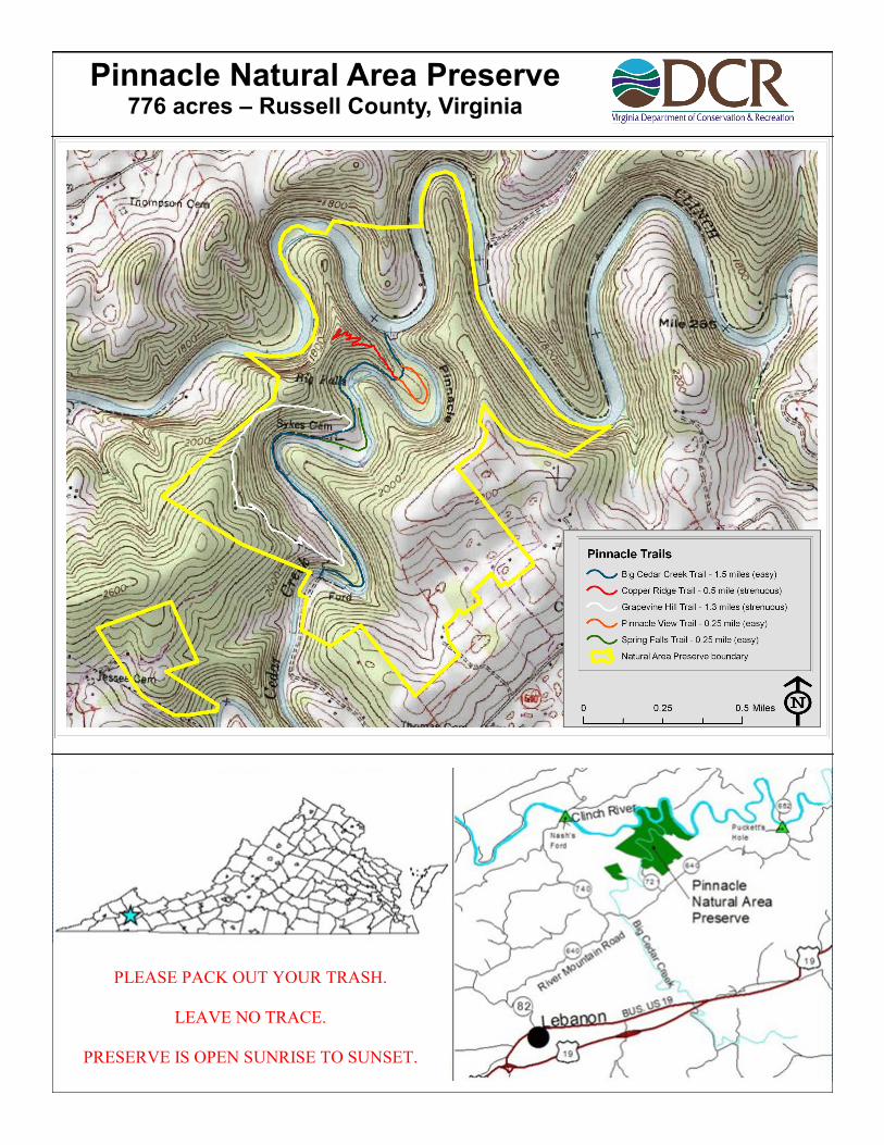
Pinnacle Natural Area Preserve 776 acres – Russell County, Virginia
PLEASE PACK OUT YOUR TRASH.
LEAVE NO TRACE.
PRESERVE IS OPEN SUNRISE TO SUNSET.
Related Documents