Pilot Project for Developing Model Flood Resilient Villages The “Pilot Project for developing model flood resilient village” was conceived after a detailed analysis of the reports on various studies conducted by ASDMA in the previous years and also the past flood experiences in various parts of Assam.After mapping of vulnerabilities on a macro scale, ASDMA decided to carry out implementable DRR activities at micro-level to increase the coping capacity of the communities in facing the different types of hazards.Based on the previous reports, five districts were selected in different parts of Assam viz. Lakhimpur, Dhemaji, Morigaon, Barpeta& S. Kamrup. One village in each of these 5 districts were selected for developing as a model flood resilient village. Hence a detailed concept was prepared for the project by incorporating both case studies of other countries facing similar kind of flooding conditions and also some best practices of CBDRR. The modalities of the project were however finalised in consultation with the different stakeholders at the district level. Village Mapping Exercises were carried out in Laomuri, Dhemaji and Bordubi Molual, Lakhimpur initially between 20-23 rd June, 2016 as a part of the pilot project, after its inception in May, 2016. A village baseline survey was carried out with the help of one student intern, and the reports revealed that 50-60% of the total population in both the villages are vulnerable. The index for measuring vulnerability was considered on the basis of total number of women (including the pregnant, lactating mother, widowed, bed ridden), children in the age group (6 months to 2 years), (2 to 8 years) and elderly people in the village. The survey also revealed the total number of livestock population, cattle sheds, water source (HP/TW/W) in both the villages. Apart from these, type of cook-stoves used, communication media in the villages were also mapped out. However it was surprising to find that only one radio existed in each of the villages, which serves to be an important mode of communication during disasters. Asset mapping of the village was also done viz. Schools, Anganwadi centres, PHC, PWSS, Common Drinking water Sources, Highlands. However the Schools, PHC, common drinking water sources, Community halls were found to be submerged in floods during the survey which are important utilities, during & post floods in a village. Schools, Community halls should be functional relief centres in a village. Special interventions would be required for these utilities and requires integration of departmental schemes with DRR planning. The survey carried out during the month of June could only be partially completed due to early onset of floods, therefore the proposed activity of Village Mapping Exercises in the project villages were postponed and conducted in the post monsoon period between 28 th September-5 th October, 2016. The team constituted two Project Officers from ASDMA, District Project Officer, DDMA Information Assistants and NGO (IGSSS) in both Dhemaji & Lakhimpur. The activity started in both the villages with a PRA followed by GPS survey for two consecutive days. During the PRA, a preliminary meeting was conducted together with the line departments working in those areas and the local community. The PRA in Dhemaji was chaired by District Development Commissioner, Dhemaji. There were discussions on the hindrances faced by the departments during implementation of departmental activities during floods and also the problems faced by the community during & post floods. The discussions were followed by Sketch Map preparation by the community which was facilitated by a local NGO (IGSSS) in both Dhemaji and Lakhimpur. The Sketch Map prepared on the ground was later copied on paper. The Map sketched on the paper was

Welcome message from author
This document is posted to help you gain knowledge. Please leave a comment to let me know what you think about it! Share it to your friends and learn new things together.
Transcript
Pilot Project for Developing Model Flood Resilient Villages
The “Pilot Project for developing model flood resilient village” was conceived after a detailed analysis of the reports on various studies conducted by ASDMA in the previous years and also the past flood experiences in various parts of Assam.After mapping of vulnerabilities on a macro scale, ASDMA decided to carry out implementable DRR activities at micro-level to increase the coping capacity of the communities in facing the different types of hazards.Based on the previous reports, five districts were selected in different parts of Assam viz. Lakhimpur, Dhemaji, Morigaon, Barpeta& S. Kamrup. One village in each of these 5 districts were selected for developing as a model flood resilient village. Hence a detailed concept was prepared for the project by incorporating both case studies of other countries facing similar kind of flooding conditions and also some best practices of CBDRR. The modalities of the project were however finalised in consultation with the different stakeholders at the district level.
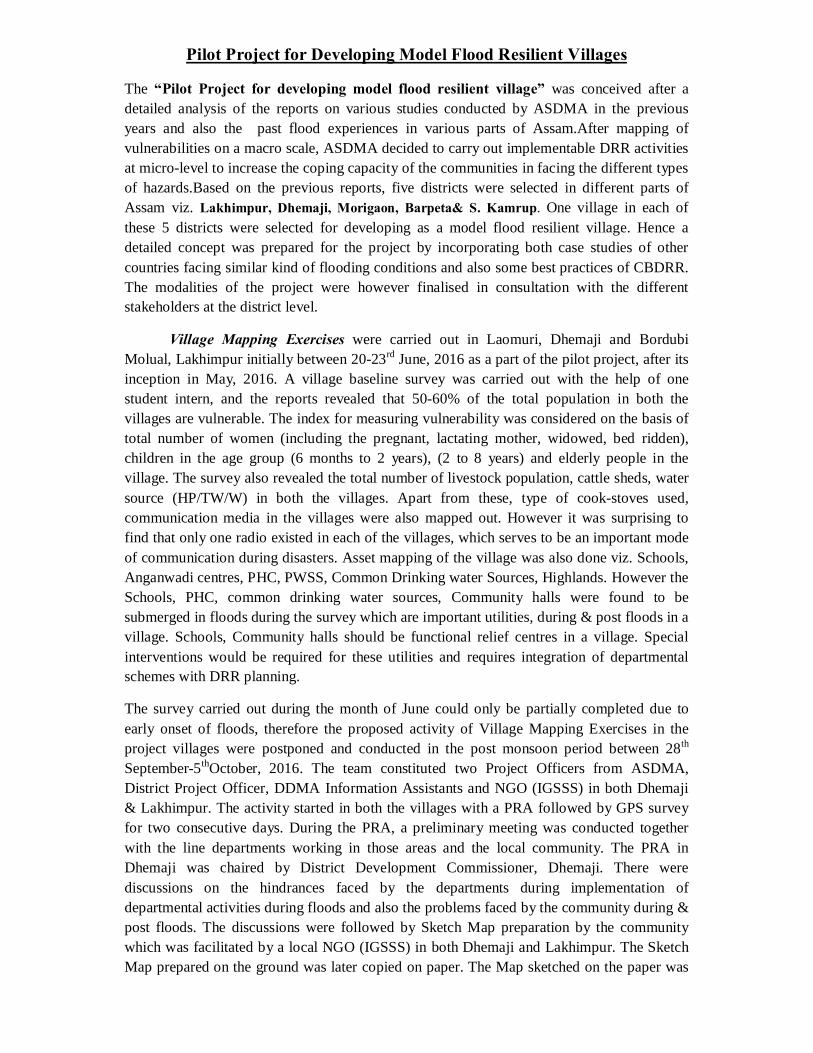
Village Mapping Exercises were carried out in Laomuri, Dhemaji and Bordubi Molual, Lakhimpur initially between 20-23rd June, 2016 as a part of the pilot project, after its inception in May, 2016. A village baseline survey was carried out with the help of one student intern, and the reports revealed that 50-60% of the total population in both the villages are vulnerable. The index for measuring vulnerability was considered on the basis of total number of women (including the pregnant, lactating mother, widowed, bed ridden), children in the age group (6 months to 2 years), (2 to 8 years) and elderly people in the village. The survey also revealed the total number of livestock population, cattle sheds, water source (HP/TW/W) in both the villages. Apart from these, type of cook-stoves used, communication media in the villages were also mapped out. However it was surprising to find that only one radio existed in each of the villages, which serves to be an important mode of communication during disasters. Asset mapping of the village was also done viz. Schools, Anganwadi centres, PHC, PWSS, Common Drinking water Sources, Highlands. However the Schools, PHC, common drinking water sources, Community halls were found to be submerged in floods during the survey which are important utilities, during & post floods in a village. Schools, Community halls should be functional relief centres in a village. Special interventions would be required for these utilities and requires integration of departmental schemes with DRR planning.
The survey carried out during the month of June could only be partially completed due to early onset of floods, therefore the proposed activity of Village Mapping Exercises in the project villages were postponed and conducted in the post monsoon period between 28th September-5thOctober, 2016. The team constituted two Project Officers from ASDMA, District Project Officer, DDMA Information Assistants and NGO (IGSSS) in both Dhemaji & Lakhimpur. The activity started in both the villages with a PRA followed by GPS survey for two consecutive days. During the PRA, a preliminary meeting was conducted together with the line departments working in those areas and the local community. The PRA in Dhemaji was chaired by District Development Commissioner, Dhemaji. There were discussions on the hindrances faced by the departments during implementation of departmental activities during floods and also the problems faced by the community during & post floods. The discussions were followed by Sketch Map preparation by the community which was facilitated by a local NGO (IGSSS) in both Dhemaji and Lakhimpur. The Sketch Map prepared on the ground was later copied on paper. The Map sketched on the paper was
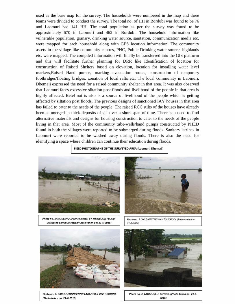
used as the base map for the survey. The households were numbered in the map and three teams were divided to conduct the survey. The total no. of HH in Bordubi was found to be 76 and Laomuri had 141 HH. The total population as per the survey was found to be approximately 670 in Laomuri and 462 in Bordubi. The household information like vulnerable population, granary, drinking water source, sanitation, communication media etc. were mapped for each household along with GPS location information. The community assets in the village like community centres, PHC, Public Drinking water source, highlands etc. were mapped. The compiled information will finally be transferred into the GIS platform and this will facilitate further planning for DRR like Identification of location for construction of Raised Shelters based on elevation, location for installing water level markers,Raised Hand pumps, marking evacuation routes, construction of temporary footbridges/floating bridges, zonation of local rafts etc. The local community in Laomuri, Dhemaji expressed the need for a raised community shelter in that area. It was also observed that Laomuri faces excessive siltation post floods and livelihood of the people in that area is highly affected. Betel nut is also is a source of livelihood of the people which is getting affected by siltation post floods. The previous designs of sanctioned IAY houses in that area has failed to cater to the needs of the people. The raised RCC stilts of the houses have already been submerged in thick deposits of silt over a short span of time. There is a need to find alternative materials and designs for housing construction to cater to the needs of the people living in that area. Most of the community tube-wells/hand pumps constructed by PHED found in both the villages were reported to be submerged during floods. Sanitary latrines in Laomuri were reported to be washed away during floods. There is also the need for identifying a space where children can continue their education during floods.
Photo no. 1: HOUSEHOLD MAROONED BY MONSOON FLOOD-Disrupted Communication(Photo taken on: 21-6-2016)
Photo no. 3: BRIDGE CONNECTING LAOMURI & KECHUKHONA (Photo taken on: 21-6-2016)
Photo no. 4: LAOMURI LP SCHOOL (Photo taken on: 21-6-2016)
FIELD PHOTOGRAPHS OF THE SURVEYED AREA (Laomuri, Dhemaji)
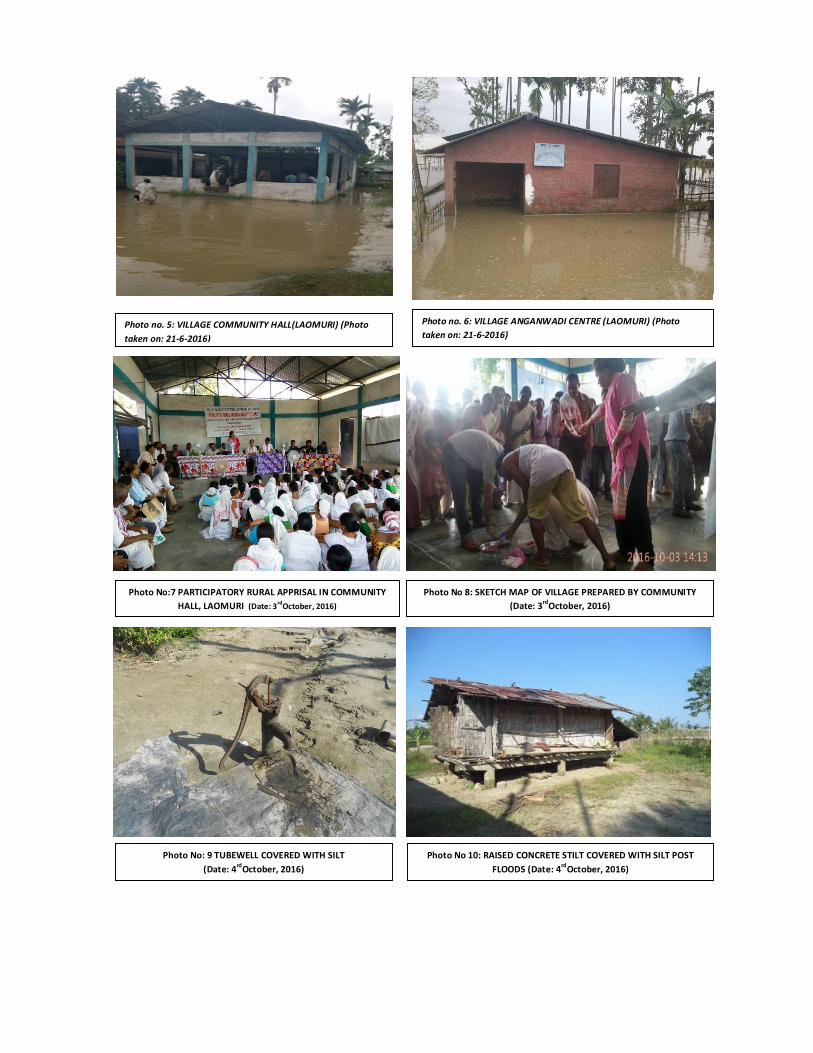
Photo no. 5: VILLAGE COMMUNITY HALL(LAOMURI) (Photo taken on: 21-6-2016)
Photo no. 6: VILLAGE ANGANWADI CENTRE (LAOMURI) (Photo taken on: 21-6-2016)
Photo No:7 PARTICIPATORY RURAL APPRISAL IN COMMUNITY HALL, LAOMURI (Date: 3rdOctober, 2016)
Photo No 8: SKETCH MAP OF VILLAGE PREPARED BY COMMUNITY (Date: 3rdOctober, 2016)
Photo No: 9 TUBEWELL COVERED WITH SILT (Date: 4rdOctober, 2016)
Photo No 10: RAISED CONCRETE STILT COVERED WITH SILT POST FLOODS (Date: 4rdOctober, 2016)
FIELD PHOTOGRAPHS OF BORDUBI MOLUAL, LAKHIMPUR
Photo No 13: HOUSEHOLD SURVEY BY DDMA, LAKHIMPUR TEAM (Date: 30th September, 2016)
Photo No 14: PHE COMMUNITY RING WELL (Date: 30th September, 2016)
Photo No 15: SUBMERGED TUBE WELL OF A HOUSEHOLD (Date: 31st September, 2016)
Photo No 11: PARTICIPATORY RURAL APPRISAL IN ANGANWADI CENTRE (Date: 29th September, 2016)
Photo No 12: SKETCH MAP OF VILLAGE PREPARED BY COMMUNITY (Date: 29th September, 2016)
Photo No 16: ANGANWADI CENTRE (Date: 31st September, 2016)
In the lower part of Assam three most flood affected districts were selected for implementation of the “Pilot Project for developing model flood resilient village”. The village mapping and PRA exercise was also carried out in the 3 vulnerable villages of the 3 districts of South Kamrup, Morigaon and Barpeta. The Village mapping and PRA Exercise was carried out by two Project Officers from ASDMA and Four student interns from Tata Institute of Social Science, Mumbai.
In South Kamrup, the PRA was conducted in Barakhat village under Goroimari Rev. Circle on 5th September 2016. The PRA was conducted with the community where DPO from DDMA Kamrup (Rural), sub divisional officers from Water Resource, Health & Family welfare, AH & Veterinary, Education, Representative from the Circle office of Goroimari and the Village Head man of Barkhata village were present.
Barakhat is a large village in South Kamrup district with total population of 2176 (Male=1119, Female=1057) and 394 houses as per 2011 census. There is a relief camp available in this village at a raised level which unfortunately gets flooded. An embankment is present in the village as a preventive measure but a majority part of the village resides outside the embankment protected area. The embankment is used by the villagers to seek shelter for themselves and their cattle during flood times. The farmers in the village mostly cultivate jute. Fishing is another major activity in which the villagers engage. At the time of flood, a few work as daily wage labourers to earn their livelihood, but most of the people use their savings.
A discussion was initiated with the representatives of the departments who participated in the PRA exercise. There was open discussion with the community and the department representatives, as what kind of services needs to be carried out during the time of flood in the village. The discussion was facilitated by the DPO, DDMA, Kamrup (Rural). The people expressed that they do not have access to services from Health department during the time of flood, which make the children and women more vulnerable at flood time. The villagers also informed that the LP School remains close during flood time; sometimes up to 20 days. During the discussion the villagers expressed that there is an urgent need of a raised shelter in the village to take shelter during the time of flood. There is an existing Relief camp which could not be used now as the height was low and submerged in the last flood. People express their view that the Relief camp can be used as a shelter if it can be raised in future.
A sketch map was prepared by the villagers during the PRA exercise which is later drawn in a chart paper to use as a base map for the further household survey. Members of a local NGO helped in organising the PRA and also in the Household Survey and collection of GPS Coordinates which is randomly taken for 32 HH in the village.
In Morigaon district the PRA was conducted in Hindujapori village with the community under Bhuragaon Revenue Circle on 9th September 2016. The Circle Officer of Bhuragon Revenue Circle was present along with Sub divisional officers from Water resource, Health & Family welfare, Education, PHED, Agriculture and AH & Veterinary Department. A discussion was initiated with the representatives from the present departments facilitated by the Project officer, ASDMA. The Circle officer of Bhuragaon Revenue Circle also actively participated in the discussion which mainly highlighted the initiatives taken by the departments during flood in the village and also the challenges faced by them in rendering
the services during flood. The discussion was also focused on the convergence that can be done for implementation of works for the pilot project on flood resilient model village.
Hindujapori is a medium size village with a total population of 683 (Male= 339, Female=344), and 136 houses as per 2011 census. At present the total households in the village are 89 houses.The villagers here are mostly dependent on daily wage labour and business. Very few of themare dependent on agriculture as most of the lands of village has been either washed or is coveredwith sand. Soil erosion is the main problem which the villagers are facing because of which their land is going under the river. The people here do not face much problem from flood. They have adapted to the floods. They build temporary structures using local resources to combat flood. The villagers use the PWD Road for shelter at the time of flood because that is the only highland in the village. There are three schools in the village of which one cannot be used as sheltercamp at the time of flood as it gets inundated. The other two are relatively away from the riverbank and hence do not get inundated and can be used as camps. Other resources available in the village are as follows: PHE Office of Water supply, SBI CSP, one Raised Hand pump installed by an INGO, Water treatment plant temporarily installed by Red Cross and Prayer Hall (Namghar). The communities that live are Hindu and Muslim in majority and other communities are few innumber. The people here cultivate sugarcane and jute mostly. Other crops are cultivated in smallquantities. Some people go to towns or other places for working at the time of flood. Muchland has been converted into sandy land which they cannot use for agriculture. This has forcedthese people to search for other avenues to survive. During the PRA exercise the villagers prioritised to construct a raised platform in the village which can be used for taking shelter during flood.
A sketch map was prepared by the villagers during the PRA exercise which is later drawn in a chart paper to use as a base map for the further household survey and collection of GPS Coordinates. Members of a local NGO helped in organising the PRA and also in the Household Survey. The household survey is conducted randomly of 24 houses on 10th September 2016. The GPS coordinate is also taken of the 24 houses and of the boundary of the village.
In Barpeta district the PRA was conducted in Kanara village with the community under Baghmara Revenue Circle on 11th September 2016. The BDO, Mandia Dev. Block was present along with Sub divisional officers from Health & Family welfare, Soil & Conservation, PHED, Social welfare, Water Resource, Fishery & ICDS.Kanara village is located at the Baghbor Tehsil of Barpeta District. It is situated 20 km away from its sub- district headquarters. The village is almost 30 km away and situated on the banks of river Brahmaputra. Satra Kanara is the Gram Panchayat of this village. There are 216 housesin the village. The population is 1281 people.
Apart of Kanara village is on the other bank of Brahmaputra.The people of Kanara village face lotsof problem during the monsoon season because most of the land of the village remains underthe water for many days. The people at that time use the embankment of the river to stay. They take their animals to the embankment. The two embankments in the village are the only raised platform in that village. There is a Junior College in that village. The Junior College is used as a shelter by the villagers at the time of flood.

A sketch map was prepared by the villagers during the PRA exercise which is later drawn in a chart paper to use as a base map for the further household survey and collection of GPS Coordinates. The household survey is conducted randomly of 40 houses on 12th and 13th September 2016. Members of a local NGO helped in organising the PRA and also in the Household Survey. The GPS coordinate is also taken of the 40 houses and of the boundary of the village.
Photo no.19: Sketch Map of Hindujapori village prepared by the community during the PRA Exercise (Photo taken on: 09-09-2016)
Photo no.17: Sketch Map of Barakhat village prepared by the community during the PRA Exercise (Photo taken on: 05-09-2016)
Photo no.18: Photograph of the No.3 Barakhat L.P. School which was flooded in the last flood in 2016 (Photo taken on: 05-09-2016)
Photo no.20: Water treatment plant installed by RE D CROSS in Hindujapori village for access to safe drinking water during flood (Photo taken on: 09-09-2016)
Photo no.21: One of the affected populationsaffected by the recent flood inKanara village (Photo taken on: 12-09-2016)
Photo no.22: Photograph of the No.127 Chachara L.P. School which was flooded in the last flood in 2016 (Photo taken on: 12-09-2016)
Related Documents