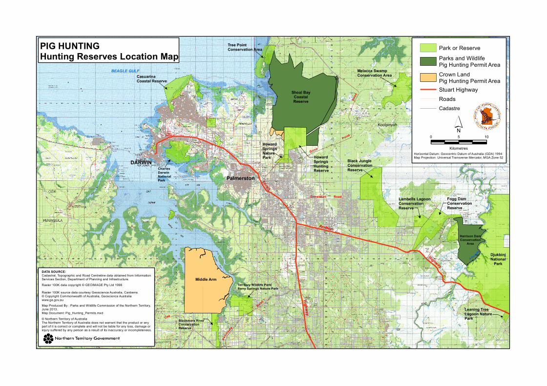
St u a rt Ar n he m Girraween Road BEAGLE GULF DARWIN Shoal Bay Coastal Reserve Melacca Swamp Conservation Area Howard Springs Hunting Reserve Black Jungle Conservation Reserve Tree Point Conservation Area Casuarina Coastal Reserve Charles Darwin National Park Palmerston Koolpinyah G unn Ro a d Po i n t Territory Wildlife Park/ Berry Springs Nature Park Blackmore River Conservation Reserve H i g h w a y Cox P e n ni su l a R oa d Howard Springs Nature Park Lambells Lagoon Conservation Reserve Fogg Dam Conservation Reserve Harrison Dam Conservation Area H i g hway Djukbinj National Park Leaning Tree Lagoon Nature Park A del a id e Ri v e r Middle Arm © Northern Territory of Australia The Northern Territory of Australia does not warrant that the product or any part of it is correct or complete and will not be liable for any loss, damage or injury suffered by any person as a result of its inaccuracy or incompleteness. Raster 100K data copyright © GEOIMAGE Pty Ltd 1998 Raster 100K source data courtesy Geoscience Australia, Canberra. © Copyright Commonwealth of Australia, Geoscience Australia www.ga.gov.au DATA SOURCE: Cadastral, Topographic and Road Centreline data obtained from Information Services Section, Department of Planning and Infrastructure. Map Produced By : Parks and Wildlife Commission of the Northern Territory, June 2013. Map Document: Pig_Hunting_Permits.mxd PIG HUNTING Hunting Reserves Location Map ´ 0 10 5 Kilometres Horizontal Datum: Geocentric Datum of Australia (GDA) 1994 Map Projection: Universal Transverse Mercator, MGA Zone 52 Park or Reserve Crown Land Pig Hunting Permit Area Parks and Wildlife Pig Hunting Permit Area Stuart Highway Cadastre Roads

Welcome message from author
This document is posted to help you gain knowledge. Please leave a comment to let me know what you think about it! Share it to your friends and learn new things together.
Transcript
Stuart
Arnhem
Girraween Road
BEAGLE GULF
DARWIN
Shoal BayCoastalReserve
Melacca SwampConservation Area
HowardSpringsHuntingReserve
Black JungleConservationReserve
Tree PointConservation Area
CasuarinaCoastal Reserve
CharlesDarwinNationalPark Palmerston
Koolpinyah
Gunn
Road
Point
Territory Wildlife Park/Berry Springs Nature Park
Blackmore RiverConservationReserve
Highway
Cox
Penn
isula
Road
HowardSpringsNaturePark
Lambells LagoonConservation Reserve
Fogg DamConservationReserve
Harrison DamConservation
Area
Highway
DjukbinjNational
Park
Leaning TreeLagoon NaturePark
Adelaide
Rive
r
Middle Arm
© Northern Territory of AustraliaThe Northern Territory of Australia does not warrant that the product or anypart of it is correct or complete and will not be liable for any loss, damage orinjury suffered by any person as a result of its inaccuracy or incompleteness.
Raster 100K data copyright © GEOIMAGE Pty Ltd 1998Raster 100K source data courtesy Geoscience Australia, Canberra. © Copyright Commonwealth of Australia, Geoscience Australiawww.ga.gov.au
DATA SOURCE:Cadastral, Topographic and Road Centreline data obtained from Information Services Section, Department of Planning and Infrastructure.
Map Produced By : Parks and Wildlife Commission of the Northern Territory,June 2013. Map Document: Pig_Hunting_Permits.mxd
PIG HUNTINGHunting Reserves Location Map
´0 105
KilometresHorizontal Datum: Geocentric Datum of Australia (GDA) 1994Map Projection: Universal Transverse Mercator, MGA Zone 52
Park or Reserve
Crown Land Pig Hunting Permit Area
Parks and Wildlife Pig Hunting Permit Area
Stuart Highway
CadastreRoads
Related Documents