Geoarchaeology in an urban context: the uses of space in a Phoenician monumental building at Tel Dor (Israel) Ruth Shahack-Gross a, * , Rosa-Maria Albert b , Ayelet Gilboa c , Orna Nagar-Hilman c , Ilan Sharon d , Steve Weiner a a Department of Structural Biology, Weizmann Institute of Science, Rehovot 76100, Israel b Catalan Institution for Research and Advanced Studies (ICREA)/Department of Prehistory, Ancient History and Archaeology, Universitat de Barcelona, c| Baldiri Reixach, s|n. 08028 Barcelona, Spain c Zinman Institute of Archaeology, University of Haifa, Mount Carmel, Haifa 31905, Israel d Institute of Archaeology, The Hebrew University of Jerusalem, Mount Scopus, Jerusalem 91905, Israel Received 28 January 2005; received in revised form 24 March 2005 Abstract Interpretation of past urban societies in the Near East, whose settlements are known mostly as tell sites, is largely based on macro-stratigraphy and on the association of architecture with macroscopic artifacts. Analyses of sediments, common in prehistoric sites, are rare in tell sites. Here we show the results of a detailed geoarchaeological study of the micro-stratigraphy of a sedimentary sequence associated with early Iron Age Phoenician monumental architecture. The study involves mineralogical, micromorpho- logical and phytolith analyses and provides new insights into the stratigraphic sequence and the use of architectural spaces. The sedimentary sequence examined comprises alternating layers of gray ‘fill’ deposits and white ‘floors’. We show that ‘floors’ made from local calcareous sandstone in the lower part of the sedimentary sequence were heated and are thus in effect ‘plaster floors’. A concentration of micro-laminated, trampled fish remains above the most elaborate of these plaster ‘floors’ indicates activities related to fish processing. Fine white layers in the upper part of the sedimentary sequence that were considered as plaster based on macroscopic examination are in fact composed almost entirely of opaline grass phytoliths. The phytoliths appear in an undulating micro-laminated structure and are associated with dung spherulites and phosphate nodules, thus probably reflecting livestock penning. The formation of ‘phytolith floors’ involves extensive volume reduction due to the degradation of the organic material and this may result in ‘floor’ subsidence, a phenomenon that is often observed in archaeological sites. Most ‘fill’ deposits include macroscopic and microscopic remains of wood ash, bones, phytoliths, charcoal, ceramics, plaster and mollusk shells, reflecting the debris produced from household activities. This study shows how a combination of macro-stratigraphy with microscopic and mineralogical analyses of the sediments within architectural spaces can provide information on the varying ways in which the space was used through time, and also contributes to solving macro-stratigraphic problems. Ó 2005 Elsevier Ltd. All rights reserved. Keywords: Mineralogy; Micromorphology; Phoenician architecture; Phytoliths; Tel Dor; Iron Age; Site formation processes 1. Introduction Urban centers in the Ancient Near East usually exhibit long occupational sequences, resulting in the formation of mounds or tell sites with complex stratigraphies. Interpretations of the habitation sequen- ces, the sociopolitical, economic and ideological aspects * Corresponding author. Tel.: C972 8 934 3254; fax: C972 8 934 4136. E-mail address: [email protected] (R. Shahack-Gross). 0305-4403/$ - see front matter Ó 2005 Elsevier Ltd. All rights reserved. doi:10.1016/j.jas.2005.04.001 Journal of Archaeological Science 32 (2005) 1417e1431 http://www.elsevier.com/locate/jas

Welcome message from author
This document is posted to help you gain knowledge. Please leave a comment to let me know what you think about it! Share it to your friends and learn new things together.
Transcript
Journal of Archaeological Science 32 (2005) 1417e1431
http://www.elsevier.com/locate/jas
Geoarchaeology in an urban context: the uses of space in aPhoenician monumental building at Tel Dor (Israel)
Ruth Shahack-Gross a,*, Rosa-Maria Albert b, Ayelet Gilboa c,Orna Nagar-Hilman c, Ilan Sharon d, Steve Weiner a
a Department of Structural Biology, Weizmann Institute of Science, Rehovot 76100, Israelb Catalan Institution for Research and Advanced Studies (ICREA)/Department of Prehistory, Ancient History and Archaeology,
Universitat de Barcelona, c| Baldiri Reixach, s|n. 08028 Barcelona, Spainc Zinman Institute of Archaeology, University of Haifa, Mount Carmel, Haifa 31905, Israel
d Institute of Archaeology, The Hebrew University of Jerusalem, Mount Scopus, Jerusalem 91905, Israel
Received 28 January 2005; received in revised form 24 March 2005
Abstract
Interpretation of past urban societies in the Near East, whose settlements are known mostly as tell sites, is largely based onmacro-stratigraphy and on the association of architecture with macroscopic artifacts. Analyses of sediments, common in prehistoric
sites, are rare in tell sites. Here we show the results of a detailed geoarchaeological study of the micro-stratigraphy of a sedimentarysequence associated with early Iron Age Phoenician monumental architecture. The study involves mineralogical, micromorpho-logical and phytolith analyses and provides new insights into the stratigraphic sequence and the use of architectural spaces. The
sedimentary sequence examined comprises alternating layers of gray ‘fill’ deposits and white ‘floors’. We show that ‘floors’ madefrom local calcareous sandstone in the lower part of the sedimentary sequence were heated and are thus in effect ‘plaster floors’. Aconcentration of micro-laminated, trampled fish remains above the most elaborate of these plaster ‘floors’ indicates activities related
to fish processing. Fine white layers in the upper part of the sedimentary sequence that were considered as plaster based onmacroscopic examination are in fact composed almost entirely of opaline grass phytoliths. The phytoliths appear in an undulatingmicro-laminated structure and are associated with dung spherulites and phosphate nodules, thus probably reflecting livestockpenning. The formation of ‘phytolith floors’ involves extensive volume reduction due to the degradation of the organic material and
this may result in ‘floor’ subsidence, a phenomenon that is often observed in archaeological sites. Most ‘fill’ deposits includemacroscopic and microscopic remains of wood ash, bones, phytoliths, charcoal, ceramics, plaster and mollusk shells, reflecting thedebris produced from household activities. This study shows how a combination of macro-stratigraphy with microscopic and
mineralogical analyses of the sediments within architectural spaces can provide information on the varying ways in which the spacewas used through time, and also contributes to solving macro-stratigraphic problems.� 2005 Elsevier Ltd. All rights reserved.
Keywords: Mineralogy; Micromorphology; Phoenician architecture; Phytoliths; Tel Dor; Iron Age; Site formation processes
* Corresponding author. Tel.: C972 8 934 3254; fax: C972 8 934
4136.
E-mail address: [email protected] (R. Shahack-Gross).
0305-4403/$ - see front matter � 2005 Elsevier Ltd. All rights reserved.
doi:10.1016/j.jas.2005.04.001
1. Introduction
Urban centers in the Ancient Near East usuallyexhibit long occupational sequences, resulting in theformation of mounds or tell sites with complexstratigraphies. Interpretations of the habitation sequen-ces, the sociopolitical, economic and ideological aspects
1418 R. Shahack-Gross et al. / Journal of Archaeological Science 32 (2005) 1417e1431
of these societies are largely based on architectural andartifactual data.
Formation processes in urban tell sites have rarelybeen addressed, though this subject attracted significantattention in the 1970s and 1980s (e.g., see [29] andreferences therein). Only a few studies focused on thesediments in Near Eastern archaeological urban sites,mostly on mud-brick composition (e.g., [19,29]). Sedi-mentological studies of activity areas in tell sites arescant and were based mainly on micromorphology andsieved micro-artifacts [24e26,29]. In prehistoric sites, onthe other hand, where permanent structures are rarelypreserved, many studies have highlighted the impor-tance of detailed analyses of microscopic finds, as well asthe mineral and elemental components of the sedimentsfor the reconstruction of activity areas. For example,Weiner et al. [42], Albert et al. [2] and Schiegl et al. [31]identified degraded hearths and the nature of the fuelused using mineralogical and phytoliths analyses.Shahack-Gross et al. [33] used micromorphology,mineralogy and phytoliths to identify degraded livestockenclosures in sites where no visible structures arepreserved. Eidt [14], Terry et al. [38] and Knudsonet al. [23] showed that activity areas could be determinedbased on the elemental composition of soils. It isparticularly helpful to perform some of these analyseson-site while the excavation is in progress [41].
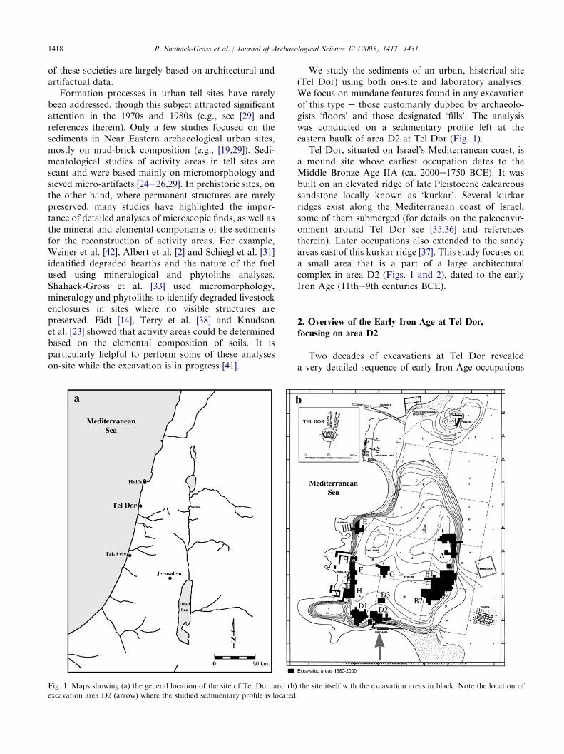
We study the sediments of an urban, historical site(Tel Dor) using both on-site and laboratory analyses.We focus on mundane features found in any excavationof this type e those customarily dubbed by archaeolo-gists ‘floors’ and those designated ‘fills’. The analysiswas conducted on a sedimentary profile left at theeastern baulk of area D2 at Tel Dor (Fig. 1).
Tel Dor, situated on Israel’s Mediterranean coast, isa mound site whose earliest occupation dates to theMiddle Bronze Age IIA (ca. 2000e1750 BCE). It wasbuilt on an elevated ridge of late Pleistocene calcareoussandstone locally known as ‘kurkar’. Several kurkarridges exist along the Mediterranean coast of Israel,some of them submerged (for details on the paleoenvir-onment around Tel Dor see [35,36] and referencestherein). Later occupations also extended to the sandyareas east of this kurkar ridge [37]. This study focuses ona small area that is a part of a large architecturalcomplex in area D2 (Figs. 1 and 2), dated to the earlyIron Age (11the9th centuries BCE).
2. Overview of the Early Iron Age at Tel Dor,
focusing on area D2
Two decades of excavations at Tel Dor revealeda very detailed sequence of early Iron Age occupations
Fig. 1. Maps showing (a) the general location of the site of Tel Dor, and (b) the site itself with the excavation areas in black. Note the location of
excavation area D2 (arrow) where the studied sedimentary profile is located.
1419R. Shahack-Gross et al. / Journal of Archaeological Science 32 (2005) 1417e1431
datable to the 12the9th centuries BCE (for overviews,see mainly [18,34,37]). Area D2 is one of the main areasin which this sequence was uncovered. It overlooks thesouthern lagoon of Dor, where the ancient harbor mayhave been situated (Fig. 1b). One important aspect ofthe Early Iron Age sequence in area D2 is its successionof monumental constructions, apparently of publicnature. Dor is one of the few sites in which publicedifices related to the early Phoenician Iron Age werethus far uncovered. These are of prime importance forstudying issues such as the nature of the Late Bronze/Iron Age transition in Phoenicia, modes of earlyPhoenician mercantilism, and so forth (see [17]). Thus,elucidating the functions of the spaces within andaround buildings in area D2 in Tel Dor is of importance.
The architectural elements in area D2 and theirstratigraphic relations are presented in Gilboa andSharon [18] and Sharon and Gilboa [34]. In general, thestratigraphy of the west and north quadrants of area D2is more detailed, and comprises three major construc-tional clusters. The first, an early Iron Age stone buildingon bedrock is earlier than the sequence discussedhere and will not be referred to (phases D2/13-12, [34]).The second (phase D2/11, [34]) is a badly-preserved and
Fig. 2. Schematic drawing showing Phases 10-9 of area D2 in plan
view. Note two construction methods: mud bricks (gray) and stone
(diagonal lines). The studied baulk is located on the eastern edge of the
excavation (arrow). The studied ‘floors’ and ‘fills’ were confined to the
area between the baulk in the east, wall W15088 in the north, wall
W5269 in the south that is an internal partitioning of the Monumental
Building, and a succession of walls in the west. The latter include an
earlier mud-brick wall W17188, and later two, probably contempora-
neous, stone walls W17058 and W17171.
ill-defined occupation post-dating the destruction of theprevious building. The third (phases D2/10-9, [34]) isa complex ofmassive constructions dating to the late IronAge I (11th century BCE by the ‘conventional’ or ‘high’Levantine Iron Age chronology or 10th century BCEby the ‘low’ chronology and by Tel Dor radiocarbondates e see [18] for discussion and further bibliography).The massive constructions during these phases includea very large mud-brick storage facility and a drainagechannel (Fig. 2). In the Iron Age I/II transition andearly Iron Age II (phase D2/8, e 9th century BCE basedon Tel Dor ‘low’ chronology [18,34]), these structures goout of use and are partly overlain by another stonebuilding (in the north) and partly by an open courtyard(in the south).
The Monumental Building which occupies thesoutheast quadrant of area D2 (Fig. 2) is an exception-ally large structure; one of the largest edifices of theearly Iron Age, not only in Phoenicia but in the entireeastern Mediterranean Basin. It is built mainly of largelimestone boulders, but its one preserved corner isconstructed of massive kurkar ashlars. The building mayhave two major systems of superimposed inner partitionwalls, the lower one constructed of mud bricks, and theupper one of un-hewn stones. The upper, stone systemabuts the external walls of the building, while therelation of the lower, mud-brick system is yet unclear. Iteither belongs to the building, or may have been cut by it(see below for details). This uncertainty in the macro-stratigraphy of the building raises two possibilities forthe date of its construction. It may have beenconstructed either during the middle Iron Age I (i.e.,phase D2/10; with a later renovation in phase D2/8 [34])or during the transition to Iron Age II (phase D2/8 andthe mud-brick wall system belongs to an earlierconstruction [34]). While the smaller structures westand north of the Monumental Building had artifactassemblages in primary deposition, the floors of theMonumental Building were practically bare of artifacts.
Overall, after excavation of several rooms of one ofthe largest monuments of the early Iron Age in theLevant, it was impossible to reach definitive conclusionsabout its function, precise stratigraphy, date of con-struction, and even architectural plan. It could only beconjectured that it was a public structure, possiblyfulfilling some administrative role associated with theactivities in the harbor it overlooks.
This study will concentrate on one space within thisbuilding, defined by wall W15088 on the north, wallW5269 on the south, and the sequence of wallsW17058RW17171OW17188 on the west (Fig. 2).The baulk forming the eastern boundary of thisexcavated space is the object of this study (Figs. 2 and3a). We studied a 70-cm thick section that contains 10depositional units, here termed layers, exposed in thelower part of the eastern baulk (Fig. 3). These layers
1420 R. Shahack-Gross et al. / Journal of Archaeological Science 32 (2005) 1417e1431
represent the transition from the late Iron Age I to theearly Iron Age II (phases D2/10-8b, [34]), based on theceramic assemblages [17]. Originally, these layers wereexcavated in several sections over two seasons and eachcomprises several different locus numbers. Table 1shows all locus numbers and highlights the main numberthat is routinely used. For brevity, the layers arenumbered sequentially from bottom to top by capitalletters, from A to J (see also Fig. 3b) and thesedesignations are used throughout the text. The strati-graphic relations between the inner and outer walls ofthe building and the excavated ‘floors’ inside it are alsosummarized in Table 1 (see also Fig. 3a). The upper partof this sequence, layers EeJ, relates to the upper systemof internal stone walls and thus certainly belongs to thebuilding. The lower part (layers AeD) relates to theproblematic mud-brick system and thus either alsorelates to the building, or alternatively, to a massivemud-brick building cut by it. In addition, note that allthe layers studied here end ca. 20 cm before the northern
wall of the Monumental Building (W15088), giving theimpression that these layers were cut by a foundationtrench for the building. On the other hand, all layersreach the wall in the south (W5269), indicating that thebuilding and the sedimentary profile within it are coeval.These relations emphasize the macro-stratigraphicproblems associated with the time of construction ofthe Monumental Building described above.
We first determined the material sources of each layerthrough mineralogical and phytolith analyses, and thenexamined the detailed structures and relations withinand between the various layers, mainly throughmicromorphological analyses.
3. Materials and methods
The sedimentary profile examined here was exposedduring the 1995e1996 excavation seasons. The profilewas cleaned and straightened several times in 2002
Table 1
Field descriptions and stratigraphic relations of the loci and ‘floors’, here termed layers (see Fig. 3b), in the studied sedimentary profile (from top to
bottom)
Layer Loci and ‘floor’ numbers Matrix and comments as recorded in the field Relations of ‘floors’ to walls
W15088 (N) W5269 (S) W17171 (W) W17188 (W)
Above J Fill 17138 (17112, 17141) Orange material with kurkar bits, possibly
constructional fill, over 40 cm thick, sloping
eastward.
C C ? �
J Fill 17088 (17113, 17119,
17142, 17149)
Soft gray material with ash, charcoal, burnt
mud-brick material and vitrified nodules,
sloping eastward. Bones, varied artifacts and
pottery, possibly in primary deposition.
I Floor 17088 White plaster floor, four more resurfacings
below it, sloping eastward.
� C ? �
H Fill 17158 (17156, 17159) Gray ashy fill with some mud-brick material,
tabun fragments, sloping eastward. Bone,
including fish bones, potsherds and various
artifacts.
G Floor 17158 White floor, sloping eastward. � C C �F Fill 17165 (17166) Gray fill, some sand, some mud-brick material,
bones, including fish bones, potsherds and
various artifacts.
E Floor 17165 Kurkar floor with mollusk shells in lower part. � C C �
Transition from inner mud-brick to inner stone system, from late Iron Age I to Iron Age I/II e Iron Age IIA
D Fill 17174 (17177, 17178) Brown-gray, composed of shells, mud-brick
material and contains tabun pieces, charcoal
bits, potsherds, some purple substance, bones,
including many fish bones.
C Floor 17174 Kurkar floor with shells. In northern part there
is plaster above the kurkar.
� C � Probably
B Fill 17179 (17189) Brown and gray fill.
A Floor 17179 Crushed kurkar and plaster floor, sloping
eastward. Pottery in primary deposition, bones
are present.
� C � Probably
The associations of ‘floors’ with surrounding walls are also indicated in order to relate the studied layers to the macro-stratigraphy in area D2. Wall
W15088 is the northern wall (N); wallW5269 is the southern wall (S); wallW17188 is the lower (mud-brick) wall on the west (W) andwallW17171 is the
upper (stone)wall on thewest (W): (�)means ‘floor’ does not reach thewall, (C) ‘floor’ abutswall, and (?) unclear relation towall.Note thatwe included
the relation to thewalls of the ‘fill’ above layer J in order to show that in contrast to all of the studied layers, this layer does abutwallW15088 on the north.
1421R. Shahack-Gross et al. / Journal of Archaeological Science 32 (2005) 1417e1431
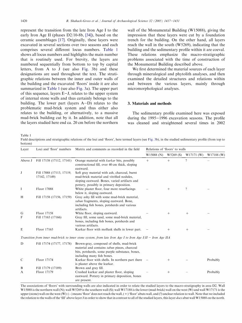
through 2004, and over 100 bulk (loose) sedimentsamples were collected based on texture and colordifferences. These samples were analyzed on-site by botha portable Fourier Transform Infrared (FTIR) Spec-trometer (MIDAC Corp., Costa Mesa, CA, USA) anda petrographic microscope (Nikon, Labophot2-pol).
The bulk sediment samples were collected and placedin plastic vials. These samples weighed on average a fewto tens of grams each. For FTIR measurements, eachsample was prepared by mixing about 0.1 mg ofpowdered sample with about 80 mg of KBr. FTIRspectra were collected at 4 cm�1 resolution. Forphytolith analyses, the bulk sediment samples weregently homogenized using a mortar and pestle. Quan-titative phytolith analyses were carried out based on themethods developed by Albert et al. [3]. Phytoliths weremorphologically identified using a polarizing lightmicroscope (Nikon Labophot2-pol) at 400! magnifi-cation. Morphological identification was based onstandard literature [7,27,28,39]. When possible, theterms describing phytolith morphologies follow ana-tomical terminology, and otherwise they describe thegeometrical characteristics of the phytoliths [4].
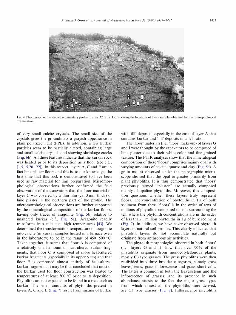
In addition to the bulk samples, 13 undisturbedsediment blocks were carved out of the profile formicromorphological analysis. The samples were takendiagonally along the profile with slight overlap betweenconsecutive samples in order to have a full, uninter-rupted sequence. This was repeated in two localitiesalong the profile, close to the northern wall (W15088)and about 2 m north of the southern wall (W5269) (Figs.3a and 4). Additional blocks were taken as well (Fig. 4).Due to the sandy nature of the sediments, the carvedblocks were coated with plaster of Paris prior to theirdetachment from the profile. The blocks were trans-ported to the laboratory where they were impregnatedwith a polystyrene mixture, cut using a rock saw andsent for thin section preparation to Spectrum Petro-graphics Inc. (Oregon, USA). Thin sections (standard30 mm thickness) were observed using a polarizing lightmicroscope (Nikon Labophot2-pol) and describedfollowing Bullock et al. [8] and Courty et al. [12]. Inaddition, one embedded block was polished, carboncoated and analyzed with a scanning electron micro-scope (Jeol 6400) with an EDS link (Oxford Instru-ments) operating system. Elemental analyses wereperformed in order to identify the various mineralsbased on stoichiometry (thus differentiating, for exam-ple, between phytoliths and calcite grains) and in orderto determine the relationships between the mineralgrains. Images were recorded in the back-scatteredelectron (BSE) mode.
An on-site burning experiment was conducted in the2004 season in order to quantify the change in thevolume of domestic livestock dung with degradation(i.e., from dry dung pellets to mineral, mostly phytolith,
powder). Dung pellets of free ranging cattle and sheep/goat were collected in locales in northern Israel. Analiquot of each dung type was weighed (g) and itsvolume recorded (ml). The aliquot was placed in a metalpot and burned. Burning temperature was recordedusing a portable digital thermometer (Yokogawa model2455, Singapore). The ash was weighed and its volumemeasured. The calcitic portion of the ash was thendissolved in 1 N HCl. The acid insoluble fraction wasweighed after washing in water and drying, and itsvolume measured, and compared to the volumes of thesame sample before burning and acid treatment. Themineralogical composition of these samples was de-termined using FTIR spectroscopy and grain mountswere prepared for microscopic examination.
4. Results
We first present the stratigraphic data obtainedduring the excavation of the Iron Age layers that arenow exposed on the eastern baulk of area D2. Theanalytical results are then reported based on deposi-tional categories, i.e., ‘floor’ and ‘fill’ deposits. For eachcategory, the results of bulk analyses obtained throughFTIR spectroscopy and phytolith analyses are shownfirst. These analyses provide information on the materialcomposition of the sediments, i.e., the material sources.Micromorphological observations are then presented,highlighting the structure of the sediments, i.e., themanner in which the sediments were deposited and therole of post-depositional changes.
4.1. Stratigraphy of the sedimentary profile
The sedimentary profile examined (Fig. 3a, lowerpart) is composed of alternating dark and light layers,conventionally interpreted as ‘fill’ deposits (the dark-colored layers) and ‘floors’ (the light-colored layers). Alllayers slope in a northeasterly direction. Note theconvexity of the layers in the southern part of theprofile (Fig. 3a). Table 1 summarizes the sequence ofdeposits exposed on the studied sedimentary profile.Table 1 also presents the relations between the ‘floors’and the surrounding walls (these can be partiallyobserved in Fig. 3a), and the macroscopic descriptionof the layers, as recorded during the excavation. Thesequence includes five ‘floors’ and five ‘fill’ deposits. Theexcavators determined that the three lower ‘floors’(layers A, C and E) are composed of crushed kurkar,while the two upper ones (layers G and I) are composedof lime plaster. Note that the composition of all ‘fill’deposits was not determined, and that the excavatorsnoted a large concentration of fish bones and relativelysmall amounts of pottery in the ‘fill’ deposit of layer D.In fact, several almost complete skeletons of small fish
1422 R. Shahack-Gross et al. / Journal of Archaeological Science 32 (2005) 1417e1431
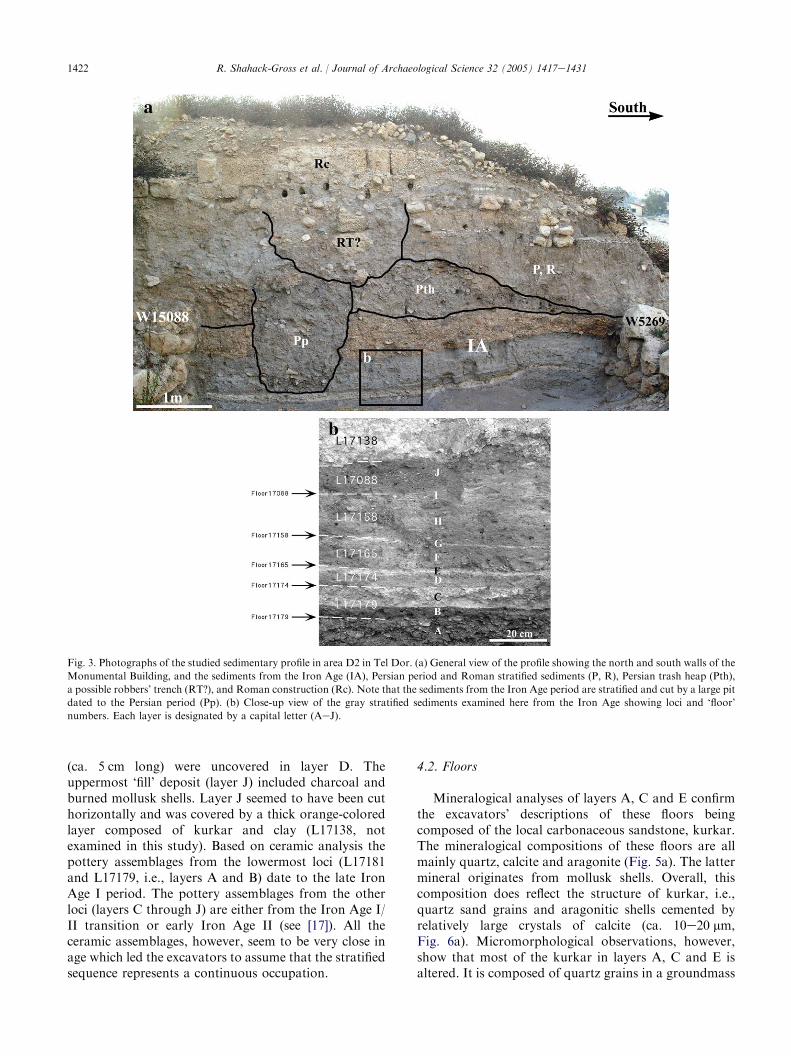
Fig. 3. Photographs of the studied sedimentary profile in area D2 in Tel Dor. (a) General view of the profile showing the north and south walls of the
Monumental Building, and the sediments from the Iron Age (IA), Persian period and Roman stratified sediments (P, R), Persian trash heap (Pth),
a possible robbers’ trench (RT?), and Roman construction (Rc). Note that the sediments from the Iron Age period are stratified and cut by a large pit
dated to the Persian period (Pp). (b) Close-up view of the gray stratified sediments examined here from the Iron Age showing loci and ‘floor’
numbers. Each layer is designated by a capital letter (AeJ).
(ca. 5 cm long) were uncovered in layer D. Theuppermost ‘fill’ deposit (layer J) included charcoal andburned mollusk shells. Layer J seemed to have been cuthorizontally and was covered by a thick orange-coloredlayer composed of kurkar and clay (L17138, notexamined in this study). Based on ceramic analysis thepottery assemblages from the lowermost loci (L17181and L17179, i.e., layers A and B) date to the late IronAge I period. The pottery assemblages from the otherloci (layers C through J) are either from the Iron Age I/II transition or early Iron Age II (see [17]). All theceramic assemblages, however, seem to be very close inage which led the excavators to assume that the stratifiedsequence represents a continuous occupation.
4.2. Floors
Mineralogical analyses of layers A, C and E confirmthe excavators’ descriptions of these floors beingcomposed of the local carbonaceous sandstone, kurkar.The mineralogical compositions of these floors are allmainly quartz, calcite and aragonite (Fig. 5a). The lattermineral originates from mollusk shells. Overall, thiscomposition does reflect the structure of kurkar, i.e.,quartz sand grains and aragonitic shells cemented byrelatively large crystals of calcite (ca. 10e20 mm,Fig. 6a). Micromorphological observations, however,show that most of the kurkar in layers A, C and E isaltered. It is composed of quartz grains in a groundmass
1423R. Shahack-Gross et al. / Journal of Archaeological Science 32 (2005) 1417e1431
Fig. 4. Photograph of the studied sedimentary profile in area D2 in Tel Dor showing the locations of block samples obtained for micromorphological
examination.
of very small calcite crystals. The small size of thecrystals gives the groundmass a grayish appearance inplain polarized light (PPL). In addition, a few kurkarparticles seem to be partially altered, containing largeand small calcite crystals and showing shrinkage cracks(Fig. 6b). All these features indicate that the kurkar rockwas heated prior to its deposition as a floor (see e.g.,[1,5,15,20e22]). In this respect, layers A, C and E are infact lime plaster floors and this is, to our knowledge, thefirst time that this rock is demonstrated to have beenused as raw material for lime preparation. Micromor-phological observations further confirmed the fieldobservation of the excavators that the floor material oflayer C was covered by a thin film (ca. 3 mm thick) oflime plaster in the northern part of the profile. Themicromorphological observations are further supportedby the mineralogical composition of the kurkar floors,having only traces of aragonite (Fig. 5b) relative tounaltered kurkar (c.f., Fig. 5a). Aragonite readilytransforms into calcite at high temperatures [43]. Wedetermined the transformation temperature of aragoniteinto calcite (in kurkar samples heated in a furnace ovenin the laboratory) to be in the range of 450e500 �C.Taken together, it seems that floor A is composed ofa relatively small amount of heat-altered kurkar frag-ments, that floor C is composed of more heat-alteredkurkar fragments (especially in its upper 5 cm) and thatfloor E is composed almost entirely of heat-alteredkurkar fragments. It may be thus concluded that most ofthe kurkar used for floor construction was heated totemperatures of at least 500 �C prior to its deposition.Phytoliths are not expected to be found in a rock such askurkar. The small amounts of phytoliths present inlayers A, C and E (Fig. 7) result from mixing of kurkar
with ‘fill’ deposits, especially in the case of layer A thatcontains kurkar and ‘fill’ deposits in a 1:1 ratio.
The ‘floor’ materials (i.e., ‘floor’ make-up) of layers Gand I were thought by the excavators to be composed oflime plaster due to their white color and fine-grainedtexture. The FTIR analyses show that the mineralogicalcomposition of these ‘floors’ comprises mainly opal withvarying amounts of calcite, quartz and clay (Fig. 5c). Agrain mount observed under the petrographic micro-scope showed that the opal originates primarily fromplant phytoliths. It is thus demonstrated that ‘floors’previously termed ‘‘plaster’’ are actually composedmainly of opaline phytoliths. Moreover, this composi-tion questions whether these layers truly representfloors. The concentration of phytoliths in 1 g of bulksediment from these ‘floors’ is in the order of tens ofmillions of phytoliths compared to soils surrounding thetell, where the phytolith concentrations are in the orderof less than 1 million phytoliths in 1 g of bulk sediment(Fig. 7). In addition, we have never observed phytolithlayers in natural soil profiles. This clearly indicates thatphytolith layers do not accumulate naturally butoriginate from anthropogenic activities.
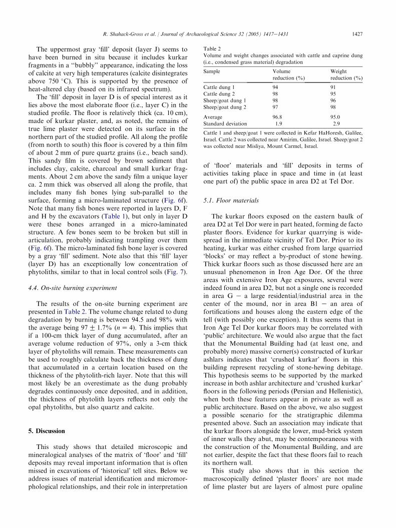
The phytolith morphologies observed in both ‘floors’(i.e., layers G and I) show that over 90% of thephytoliths originate from monocotyledonous plants,mostly C3 type grasses. The grass phytoliths were thenre-divided into three broader categories, namely grassleaves/stems, grass inflorescence and grass short cells.The latter is common in both the leaves/stems and theinflorescence of grasses, and its presence in suchabundance attests to the fact the major grass typesfrom which almost all the phytoliths were derived,are C3 type grasses (Fig. 8). Inflorescence phytoliths
1424 R. Shahack-Gross et al. / Journal of Archaeological Science 32 (2005) 1417e1431
Fig. 5. Fourier Transform Infrared (FTIR) spectra of representative materials identified in the studied sediments. (a) Spectrum of fresh (unmodified)
kurkar rock collected near the tell. The absorptions at 1435, 876 and 713 cm�1 are from calcite. The absorptions at 1085, the doublet around 780 and
464 cm�1 (and other weak absorptions in this spectrum) are from quartz. The absorption at 858 cm�1 together with absorptions at 1435 and
713 cm�1 are from aragonite. This mineralogical composition reflects the structure of kurkar rocks, composed of quartz sand grains and aragonitic
mollusk shells cemented by calcite. (b) Spectrum of kurkar from layer E. Note the similarity to the fresh kurkar except for the negligible absorption at
858 cm�1 relative to fresh kurkar. This spectrum reflects the transformation of aragonite to calcite. (c) Spectrum of bulk sediment sample from layer
G. The absorptions at 1097, weak doublet around 790 and at 473 cm�1 are from opal, the mineral component of siliceous plant phytoliths. The other
absorptions are from minor amounts of calcite, clay (main absorption at 1035 cm�1 but shifted to 1040e1050 cm�1 due to small amounts of the
phosphate mineral dahllite, almost not detected in the spectrum) and quartz. (d) Spectrum of bulk sediment sample from layer H. The main
absorptions are from quartz, clay and calcite. (e) Spectrum of bulk sediment sample from layer D. Note that this layer is richer in clay compared to
other ‘fill’ deposits (c.f., Fig. 5d).
dominate in both layers. Micromorphological observa-tions of these ‘floors’ show that the phytoliths arearranged as long arrays in an undulating micro-laminated structure (Fig. 6c). This was also clearlyobserved using the Scanning Electron Microscope(Fig. 6d). Layer I is composed of four depositionalsuites, each including a lower sub-unit of denselypacked, long phytolith arrays and an upper sub-unitcomposed of ‘fill’ deposits (see below). Dung spherulites(calcareous spheres measuring 5e15 mm in diameter thatform in the guts of animals and are excreted in theirdung [9e11]) are present in both ‘floor’ layers but aremore concentrated on top of layer G. In addition,microscopic masses of authigenic, i.e., in situ formed,phosphate mineral nodules were detected in thinsections. It may thus be concluded that layers G and Iwere produced from large amounts of grass thatincluded a high proportion of the flowering parts. Thepresence of authigenic phosphate minerals indicatesthat large amounts of organic matter degraded insitu, releasing phosphate into the soil solution.
The phosphate presumably reacted with calcium car-bonate present in the sediment to form the phosphatemineral dahllite (carbonated apatite). This, togetherwith the presence of dung spherulites, some of whichwere also phosphatized, indicates that these ‘floors’ werecomposed, at least in part, of livestock dung [6,9,13,33].
4.3. ‘Fill’ deposits
All gray-colored sediments and the topmost orange-colored sediment layer (locus 17138) were designated bythe excavators as ‘fill’ deposits. They were unable todetermine, however, whether these were ‘constructionalfills’, i.e., sediments brought to the area in order to serveas a substrate for the construction of a new floor, or‘accumulated fills’ i.e., deposits built up in situ as a resultof daily activities. The FTIR spectra of all gray-colored‘fill’ deposits show that their major mineral componentsare quartz, calcite and clay in varying amounts (Fig. 5d).They sometimes also include two weak absorptionsaround 567 and 603 cm�1 indicative of the phosphate
1425R. Shahack-Gross et al. / Journal of Archaeological Science 32 (2005) 1417e1431
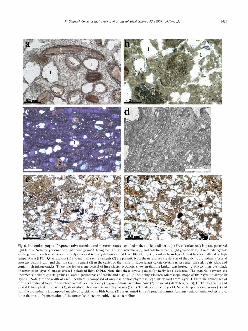
Fig. 6. Photomicrographs of representative materials and microstructures identified in the studied sediments. (a) Fresh kurkar rock in plane polarized
light (PPL). Note the presence of quartz sand grains (1), fragments of mollusk shells (2) and calcitic cement (light groundmass). The calcite crystals
are large and their boundaries are clearly observed (i.e., crystal sizes are at least 10e20 mm). (b) Kurkar from layer C that has been altered at high
temperatures (PPL). Quartz grains (1) and mollusk shell fragments (2) are present. Note the unresolved crystal size of the calcitic groundmass (crystal
sizes are below 1 mm) and that the shell fragment (2) in the center of the frame includes larger calcite crystals in its center than along its edge, and
contains shrinkage cracks. These two features are typical of lime plaster products, showing that the kurkar was heated. (c) Phytolith arrays (black
lineaments) in layer G under crossed polarized light (XPL). Note that these arrays persist for fairly long distances. The material between the
lineaments includes quartz grains (1) and a groundmass of calcite and clay (2). (d) Scanning Electron Microscope image of the phytolith arrays in
layer G. Note that the width of each lineament is composed of only one or two phytoliths. (e) ‘Fill’ deposit from layer H. Note the abundance of
remains attributed to daily household activities in the sandy (1) groundmass, including bone (2), charcoal (black fragments), kurkar fragments and
probable lime plaster fragment (3), short phytolith arrays (4) and clay masses (5). (f) ‘Fill’ deposit from layer D. Note the quartz sand grains (1) and
that the groundmass is composed mainly of calcitic clay. Fish bones (2) are arranged in a sub-parallel manner forming a micro-laminated structure.
Note the in situ fragmentation of the upper fish bone, probably due to trampling.
1426 R. Shahack-Gross et al. / Journal of Archaeological Science 32 (2005) 1417e1431
mineral dahllite. This mineral may be derived fromeither fragmented bones or authigenic phosphatenodules. After treatment of the ‘fill’ sediments with1 N HCl, the main absorption of clay was clearlyobserved with no interference due to the presence of themain peak of the dahllite. Based on the position of themain clay absorption around 1035 cm�1 and a relativelyprominent absorption at 535 cm�1 it can be concludedthat the clay minerals in most layers are not altered dueto exposure to high temperatures. The exception is layerJ, where a mixture of burned and un-burned clay wasdetected by infrared spectroscopy (unpublished results).
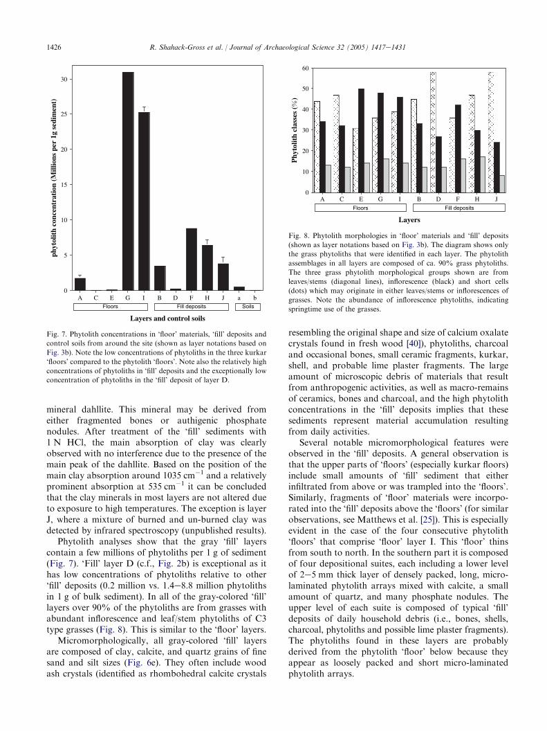
Phytolith analyses show that the gray ‘fill’ layerscontain a few millions of phytoliths per 1 g of sediment(Fig. 7). ‘Fill’ layer D (c.f., Fig. 2b) is exceptional as ithas low concentrations of phytoliths relative to other‘fill’ deposits (0.2 million vs. 1.4e8.8 million phytolithsin 1 g of bulk sediment). In all of the gray-colored ‘fill’layers over 90% of the phytoliths are from grasses withabundant inflorescence and leaf/stem phytoliths of C3type grasses (Fig. 8). This is similar to the ‘floor’ layers.
Micromorphologically, all gray-colored ‘fill’ layersare composed of clay, calcite, and quartz grains of finesand and silt sizes (Fig. 6e). They often include woodash crystals (identified as rhombohedral calcite crystals
0
5
10
15
20
25
30
phyt
olit
h co
ncen
trat
ion
(Mill
ions
per
1g
sedi
men
t)
A C E G I B D F H J a b
Layers and control soils
Floors Fill deposits Soils
Fig. 7. Phytolith concentrations in ‘floor’ materials, ‘fill’ deposits and
control soils from around the site (shown as layer notations based on
Fig. 3b). Note the low concentrations of phytoliths in the three kurkar
‘floors’ compared to the phytolith ‘floors’. Note also the relatively high
concentrations of phytoliths in ‘fill’ deposits and the exceptionally low
concentration of phytoliths in the ‘fill’ deposit of layer D.
resembling the original shape and size of calcium oxalatecrystals found in fresh wood [40]), phytoliths, charcoaland occasional bones, small ceramic fragments, kurkar,shell, and probable lime plaster fragments. The largeamount of microscopic debris of materials that resultfrom anthropogenic activities, as well as macro-remainsof ceramics, bones and charcoal, and the high phytolithconcentrations in the ‘fill’ deposits implies that thesesediments represent material accumulation resultingfrom daily activities.
Several notable micromorphological features wereobserved in the ‘fill’ deposits. A general observation isthat the upper parts of ‘floors’ (especially kurkar floors)include small amounts of ‘fill’ sediment that eitherinfiltrated from above or was trampled into the ‘floors’.Similarly, fragments of ‘floor’ materials were incorpo-rated into the ‘fill’ deposits above the ‘floors’ (for similarobservations, see Matthews et al. [25]). This is especiallyevident in the case of the four consecutive phytolith‘floors’ that comprise ‘floor’ layer I. This ‘floor’ thinsfrom south to north. In the southern part it is composedof four depositional suites, each including a lower levelof 2e5 mm thick layer of densely packed, long, micro-laminated phytolith arrays mixed with calcite, a smallamount of quartz, and many phosphate nodules. Theupper level of each suite is composed of typical ‘fill’deposits of daily household debris (i.e., bones, shells,charcoal, phytoliths and possible lime plaster fragments).The phytoliths found in these layers are probablyderived from the phytolith ‘floor’ below because theyappear as loosely packed and short micro-laminatedphytolith arrays.
0
10
20
30
40
50
60
Phy
tolit
h cl
asse
s (
)
Layers
FloorsA C E G I B D F H J
Fill deposits
Fig. 8. Phytolith morphologies in ‘floor’ materials and ‘fill’ deposits
(shown as layer notations based on Fig. 3b). The diagram shows only
the grass phytoliths that were identified in each layer. The phytolith
assemblages in all layers are composed of ca. 90% grass phytoliths.
The three grass phytolith morphological groups shown are from
leaves/stems (diagonal lines), inflorescence (black) and short cells
(dots) which may originate in either leaves/stems or inflorescences of
grasses. Note the abundance of inflorescence phytoliths, indicating
springtime use of the grasses.
1427R. Shahack-Gross et al. / Journal of Archaeological Science 32 (2005) 1417e1431
The uppermost gray ‘fill’ deposit (layer J) seems tohave been burned in situ because it includes kurkarfragments in a ‘‘bubbly’’ appearance, indicating the lossof calcite at very high temperatures (calcite disintegratesabove 750 �C). This is supported by the presence ofheat-altered clay (based on its infrared spectrum).
The ‘fill’ deposit in layer D is of special interest as itlies above the most elaborate floor (i.e., layer C) in thestudied profile. The floor is relatively thick (ca. 10 cm),made of kurkar plaster, and, as noted, the remains oftrue lime plaster were detected on its surface in thenorthern part of the studied profile. All along the profile(from north to south) this floor is covered by a thin filmof about 2 mm of pure quartz grains (i.e., beach sand).This sandy film is covered by brown sediment thatincludes clay, calcite, charcoal and small kurkar frag-ments. About 2 cm above the sandy film a unique layerca. 2 mm thick was observed all along the profile, thatincludes many fish bones lying sub-parallel to thesurface, forming a micro-laminated structure (Fig. 6f).Note that many fish bones were reported in layers D, Fand H by the excavators (Table 1), but only in layer Dwere these bones arranged in a micro-laminatedstructure. A few bones seem to be broken but still inarticulation, probably indicating trampling over them(Fig. 6f). The micro-laminated fish bone layer is coveredby a gray ‘fill’ sediment. Note also that this ‘fill’ layer(layer D) has an exceptionally low concentration ofphytoliths, similar to that in local control soils (Fig. 7).
4.4. On-site burning experiment
The results of the on-site burning experiment arepresented in Table 2. The volume change related to dungdegradation by burning is between 94.5 and 98% withthe average being 97G 1.7% (nZ 4). This implies thatif a 100-cm thick layer of dung accumulated, after anaverage volume reduction of 97%, only a 3-cm thicklayer of phytoliths will remain. These measurements canbe used to roughly calculate back the thickness of dungthat accumulated in a certain location based on thethickness of the phytolith-rich layer. Note that this willmost likely be an overestimate as the dung probablydegrades continuously once deposited, and in addition,the thickness of phytolith layers reflects not only theopal phytoliths, but also quartz and calcite.
5. Discussion
This study shows that detailed microscopic andmineralogical analyses of the matrix of ‘floor’ and ‘fill’deposits may reveal important information that is oftenmissed in excavations of ‘historical’ tell sites. Below weaddress issues of material identification and micromor-phological relationships, and their role in interpretation
of ‘floor’ materials and ‘fill’ deposits in terms ofactivities taking place in space and time in (at leastone part of) the public space in area D2 at Tel Dor.
5.1. Floor materials
The kurkar floors exposed on the eastern baulk ofarea D2 at Tel Dor were in part heated, forming de factoplaster floors. Evidence for kurkar quarrying is wide-spread in the immediate vicinity of Tel Dor. Prior to itsheating, kurkar was either crushed from large quarried‘blocks’ or may reflect a by-product of stone hewing.Thick kurkar floors such as those discussed here are anunusual phenomenon in Iron Age Dor. Of the threeareas with extensive Iron Age exposures, several wereindeed found in area D2, but not a single one is recordedin area G e a large residential/industrial area in thecenter of the mound, nor in area B1 e an area offortifications and houses along the eastern edge of thetell (with possibly one exception). It thus seems that inIron Age Tel Dor kurkar floors may be correlated with‘public’ architecture. We would also argue that the factthat the Monumental Building had (at least one, andprobably more) massive corner(s) constructed of kurkarashlars indicates that ‘crushed kurkar’ floors in thisbuilding represent recycling of stone-hewing debitage.This hypothesis seems to be supported by the markedincrease in both ashlar architecture and ‘crushed kurkar’floors in the following periods (Persian and Hellenistic),when both these features appear in private as well aspublic architecture. Based on the above, we also suggesta possible scenario for the stratigraphic dilemmapresented above. Such an association may indicate thatthe kurkar floors alongside the lower, mud-brick systemof inner walls they abut, may be contemporaneous withthe construction of the Monumental Building, and arenot earlier, despite the fact that these floors fail to reachits northern wall.
This study also shows that in this section themacroscopically defined ‘plaster floors’ are not madeof lime plaster but are layers of almost pure opaline
Table 2
Volume and weight changes associated with cattle and caprine dung
(i.e., condensed grass material) degradation
Sample Volume
reduction (%)
Weight
reduction (%)
Cattle dung 1 94 91
Cattle dung 2 98 95
Sheep/goat dung 1 98 96
Sheep/goat dung 2 97 98
Average 96.8 95.0
Standard deviation 1.9 2.9
Cattle 1 and sheep/goat 1 were collected in Kefar HaHoresh, Galilee,
Israel. Cattle 2 was collected near Amirim, Galilee, Israel. Sheep/goat 2
was collected near Misliya, Mount Carmel, Israel.
1428 R. Shahack-Gross et al. / Journal of Archaeological Science 32 (2005) 1417e1431
phytoliths. These ‘floors’ could be derived from theremains of matting, grain storage, thatch roofing,stabling and dung-plastered floors. Morphologicalanalysis of the phytoliths and other microscopicevidence enabled us to distinguish between theseoptions. The option of matting is excluded based onthe absence of palm and/or reed and/or sedge phytolithsand the presence of abundant inflorescence phytoliths. Italso rules out the option of grain storage because in thiscase mostly inflorescence phytoliths of wheat and/orbarley are expected to be present. The followingobservations are consistent with sediments that origi-nated from livestock dung. The phytoliths derive fromwild flowering grasses, appearing in an undulatingmicro-laminated structure, together with microscopicdung spherulites and authigenic phosphate nodules.Furthermore, the phytolith composition indicates thatthe animal fodder was composed of flowering grassesbased on the abundance of inflorescence phytoliths, thusreflecting springtime utilization of the grasses. Theoption of dung-plastered floors is ruled out based onmodern examples of dung plaster, from South Africaand India. These plasters indeed have a micro-laminatedstructure, however, the ratio of dung to soil is low.Therefore, after degradation these samples will probablyremain micro-laminated but will not form enrichedphytolith layers. On the other hand, dung plasterprepared by Maasai in southern Kenya, in which theratio of dung to wood ash is high (about 80% dung and20% ash by volume) and therefore will potentially formenriched phytolith layers, does not have a micro-laminated structure (probably because it is kneadedwhile being prepared) (R.S.-G. personal observations).The combination of a micro-laminated structure asso-ciated with high concentrations of phytoliths wasobserved in abandoned Maasai livestock enclosures insouthern Kenya [33]. We therefore conclude that thephytolith layers in the Monumental Building originatedfrom in situ primary livestock dung deposition. Theoption of roofing is unlikely, but cannot be ruled out.
Considering the thickness of the two phytolith layersidentified in the studied profile (layers G and I), it maybe calculated, using Table 2, that layer G, with anaverage thickness of ca. 1.5 cm, originated from abouthalf a meter thick accumulation of dung. Layer Gthickens to the north, becoming about 10 cm thick closeto wall W15088. Such a thick layer of phytoliths wouldtheoretically have originated from more than 3 m ofdung. As the phytolith layers also include sand grains,calcite and phosphate nodules, this is an overestimate.Furthermore, as dung breaks down fairly rapidly bymicrobial action, it is doubtful that such a thick dungaccumulation ever existed. Layer I is composed of 4phytolith-rich sub-layers. These sub-layers must eachhave originated from about 6e15 cm of dung. Thevolume of dung that formed layer I, as well as the layer’s
internal arrangement, may indicate four episodes ofrelatively short-term intermittent stabling.
The phenomenon of ‘phytolith floors’ is not unique tothe studied profile at Tel Dor, as other such ‘floors’ wereidentified in areas D1 and G in the 2004 season. We alsoknow of an occurrence of such surfaces in the Iron Agesediments in a domestic area (area K) at Tel Megiddo(R.S.-G., personal observation and examination).Patches of phytolith-rich layers have also been identifiedin the Neolithic settlement of Catalhoyuk (ArleneRosen, personal communication). It therefore seems tobe a potentially widespread phenomenon in tell sites,and should be investigated further.
5.2. ‘Fill’ deposits
The gray ‘fill’ deposits are rich in components thatprobably derive from daily human activities. Oneexceptional ‘fill’ deposit is layer D. It contains lessdebris derived from daily anthropogenic activities(especially less ceramics and phytoliths) than the other‘fill’ layers, and it contains more clay than the other ‘fill’deposits. It also contains large amounts of fish remains,arranged in a micro-laminated structure, some of themtrampled. The reason for finding a layer of fish remains,some of them in articulation (i.e., whole fish) is unclear.Possibilities are that as the studied area is located closeto the waterfront the fish remains represent the waste ofa fish processing area. This may also represent a fishstorage area because it is located in a public, possiblycommercial, area, or possibly a fish refuse disposal site.Systematic sieving in excavated tell sites would mostprobably produce large numbers of smaller bones andother microscopic remains. This would certainly con-tribute to a better functional understanding of featuressuch as layer D.
A question that often arises when discussing osten-sible ‘fill’ deposits is whether they are constructional(i.e., represent a single depositional episode) or accu-mulated through continuous in situ habitation (i.e., theyare in reality superimposed living horizons). This is oneof the most basic questions for the constructional/stratigraphic interpretation of any archaeological com-plex, and likewise for elucidating the chronological andfunctional association between the artifacts in those‘fills’ and surrounding architecture. A characteristicexample is Ussishkin [38], in which major issuesregarding Iron Age monumental architecture andchronology were based on the characterization of filldeposits, albeit with no analysis of the depositsthemselves. Although it has long been realized that thecomposition and micromorphology of ‘fill’ deposits isnot always similar, this study shows empirically howthe ‘fill’ deposit of layer D differs from all the other‘fill’ deposits studied here, and at least in part is theproduct of continuous activities. Thus sedimentological

1429R. Shahack-Gross et al. / Journal of Archaeological Science 32 (2005) 1417e1431
information, in addition to stratigraphic information,can help resolve this issue. Matthews et al. [25] noted,based on micromorphological considerations, that sedi-ments accumulated through continuous habitation arecharacterized by micro-laminated structures while dis-carded deposits, e.g., ‘constructional fills’, are charac-terized by random orientations of their components.Following their observations, layers F, H and J reflect‘constructional fills’ whereas layers G and I, consideredby the excavators as ‘floors’, are in fact ‘accumulatedfills’ formed through continuous, probably stabling,activities. This implies that the true constructed floorson which these deposits accumulated are the topmostsurface of the ‘constructional fill’ below them, i.e., ‘dirtfloors’. Moreover, layer D can now be divided into threeparts; the lowermost is ‘constructional fill’ overlain by‘accumulated fill’ composed of fish remains, that in turnis overlain by ‘constructional fill’. This implies that theinterface between the lower ‘constructional fill’ and the‘accumulated fill’ in layer D was in fact a ‘dirt floor’ thatwas not detected during the excavation.
5.3. Past human activities
Reconstruction of activity areas in urban sites fromhistorical periods is usually based on the form andmacroscopic contents of structures. We note that muchtime and resources were invested in order to constructthe layer C kurkar plaster floor (10-cm thick of heatedcrushed rock over an area of at least 16 m2 and coveredby true lime plaster). This layer therefore represents thefloor of an important structure and it is thus tempting torelate the layer above it, layer D, to the activities thattook place on this floor. Moreover, the fact that thematerials that were found in layer D differ from theother ‘fill’ deposits in the studied profile may beregarded as evidence in support of layer D representingthe primary activities that took place on the elaboratekurkar plaster floor. Ethnoarchaeological observations,however (e.g., [16,32,44]), point to the fact that thedeposits on floors often reflect activities that post-datethe primary use of structures. Therefore, it is more likelythat the activities related to fish processing (in layer D)reflect a later use of the space. This is consistent with thepresence of a thin layer of pure sand found in the sectiondirectly on the kurkar plaster floor and clayey sedimentwith low amounts of phytoliths and ceramics (this layerwas not noted during the excavation itself). In a pre-historic site or a domestic context in a historic site, thissand film would probably have been interpreted as dustaccumulation on the floor and the clayey sediment asdecayed mud bricks, thus leading to the conclusion thatthe fish processing activity post-dated a phase ofabandonment. However, in the context of publicarchitecture in such a strategic location, and in light ofthe detailed ceramic analysis which does not point to an
occupational gap, only a very short discontinuous use ofthis space can be considered. Alternatively, these thinlayers of pure sand and clay may represent thepreparation of the space for fish processing. Lateractivities taking place in the studied area includepossible livestock stabling. Layers G and I were notprepared as surfaces for stabling of animals but formedas a by-product of the stabling activities. These layersare in themselves direct evidence for this activity in thearea and should have been dubbed ‘accumulated fills’ or‘superimposed living horizons’.
Conventional interpretations of monumental archi-tecture such as the Monumental Building at Tel Dor arethat they are ‘fortresses’ or ‘palaces’, implying that theuse of space is for military, administrative, or ceremo-nial functions. This study indicates that a much widervariety of activities need be considered, especially if wetake into account the fact that the studied sedimentshave accumulated in one room of this building only, andthat other spaces in it must have housed a variety ofdifferent activities. This does not necessarily mean thatthe primary function of the building was not adminis-trative or ceremonial e especially if ‘administration’included gathering, stowing and redistributing food-stuffs and livestock or if ‘ceremony’ included large-scalepreparation and consumption of same. However,combining macro-stratigraphy and the results of thesedimentological study, it is clear that new interpreta-tions regarding the use of public space at early Iron AgeTel Dor are possible, which were not considered before.
Having noted above that evidence for the activitiesthat took place directly on the elaborate kurkar plasterfloor (layer C) were not found, we suggest that onlymaterials found within such floors or in the fewmillimeters below the very surface of plaster floors canbe indicative of the activities that took place on them.The reason is probably that plaster floors can beroutinely swept. Matthews et al. [24] reached a similarconclusion for Neolithic Catalhoyuk. It will probably bedifficult to routinely identify the primary activities onplaster floors. On the other hand, evidence for theactivities that took place on ‘dirt floors’ in this study isabundant (i.e., fish processing and livestock stabling),probably because these floors cannot be swept and thusremains of the activities are trampled into them and alsoaccumulate on them. Similarly, in an ethnoarchaeolog-ical study of a huntingefishing camp in northern Kenya,Gifford [16] observed that small bones were trampledinto the sandy sediments in her study area (i.e., ‘dirtfloor’) and thus had a better chance of being preservedfor long periods of time.
Layer J is a thick ‘fill’ deposit similar to the ‘fills’ oflayers F and H, except that it is burned. This layer wasleveled and covered by a thick ‘fill’ (locus L17138).Layer J may thus reflect a destruction event, eitherintentional or accidental.
1430 R. Shahack-Gross et al. / Journal of Archaeological Science 32 (2005) 1417e1431
5.4. Other implications to macro-stratigraphy
All of the studied layers slope (about 14 � below thehorizon) towards the northeast. It is improbable thatthis represents intentional construction, even in order tofacilitate drainage, because the slope is too steep fordaily use. A more likely scenario is that the slopedeveloped as a result of post-depositional subsidence.This is supported by the observation of the foldedsouthern part of the studied profile (see Fig. 3a). Post-depositional ‘floor’ subsidence is often observed inarchaeological sites, but the reasons for its occurrenceare not well understood. Schiegl et al. [30] notedsediment volume reduction in a prehistoric cave due toash diagenesis. We propose that another mechanism forsubsidence is due to the in situ degradation of the largeamounts of organic, vegetal material whose remains(i.e., phytoliths) are found in large quantities in ‘fill’deposits and in even larger quantities in animalenclosures (that are manifested as ‘phytolith floors’).In the case of the profile examined here, this wouldimply that there are more ‘phytolith floors’ below layerA, a viable possibility because the base of the studiedprofile is still well above bedrock.
The volume reduction associated with the formationof phytolith layers, from the accumulation of the dungto the complete degradation of its associated organicmaterial, calls for re-examination of stratigraphicrelationships between ‘floors’ and walls. The down-shifting of originally organic-rich sedimentary layersimplies that the original points of contact between floorsand walls may be difficult to determine. A maximumestimate could be made based on the volume changefrom pure dung to pure phytoliths. We also observedthat certain areas subside more than others (e.g., thestudied layers subside in a northeasterly direction). It istherefore possible that the lowermost area of subsidingfloors will separate horizontally from the walls theyoriginally reached, a possibility that cannot be ruled outas an explanation for the problematic macro-stratigra-phy within the Monumental Building (see Table 1).These are clearly important issues, as such siteformation processes may complicate the archaeologicalinterpretation of many such sedimentary sequences.
6. Conclusion
Careful field observations, together with micromor-phological, mineralogical and phytolith analyses can beused to elucidate the different ways in which spaceassociated with building construction was utilized. Suchan integrated approach to studying the sediments thataccumulate in and around structures at sites such as TelDor has the potential to contribute significantly to ourunderstanding of the ways tell sites were formed, and inturn to past human behavior.
This integrated approach not only means thatarchaeologists excavating large and complex sites willhave to devise systematic protocols in order tocharacterize the sediments they excavate, but that geo-archaeologists, usually accustomed to prehistoric sites,or other locales of relatively low complexity and modestarchitecture, will need to develop interpretative frame-works appropriate for urban contexts.
Acknowledgements
Between 1980 and 2000, Tel Dor was excavated byE. Stern of the Hebrew University, Jerusalem, heading aninternational consortium of universities. Section draw-ings and plans were produced by John Berg, SvetlanaMatskevich and Talia Goldman. We thank the peoplefrom the Kimmel Center for Archaeological Science atthe Weizmann Institute for their help in sampling andanalyzing bulk sediment samples using the on-siteinfrared spectrometer. Special thanks are due to EugeniaMintz and Meirav Yizhaq for helping R.S.-G. throughthe sediment sampling for micromorphological analysis.R.S.-G. is also indebted to Panagiotis Karkanas andFrancesco Berna for useful discussions of the data. Wealso thank two anonymous reviewers for their usefulcomments. This study was funded in part by generoussupport from Mr George Schwartzmann, Sarasota,Florida, and by the Kimmel Center for ArchaeologicalScience at the Weizmann Institute.
References
[1] M.T.C. Affonso, Identification of lime plasters, The Old Potter’s
Almanack 4 (1996) 1e6.
[2] R.M. Albert, O. Bar-Yosef, S. Weiner, Use of plant remains in
Kebara Cave: phytoliths and mineralogical analyses, in: O. Bar-
Yosef, L. Meignen (Eds.), The Upper and Middle Paleolithic
Archaeology of Kebara Cave, Mount Carmel, vol. 1, American
School of Prehistoric Research, Peabody Museum, Harvard
University, Cambridge MA, in press.
[3] R.M. Albert, A. Tsatskin, A. Ronen, O. Lavi, L. Estroff, S. Lev-
Yadun, S. Weiner, Mode of occupation of Tabun Cave, Mt
Carmel, Israel during the Mousterian Period: a study of the
sediments and phytoliths, Journal of Archaeological Science 26
(1999) 1249e1260.
[4] R.M. Albert, S. Weiner, Study of phytoliths in prehistoric ash
layers using a quantitative approach, in: J.D. Meunier, F. Colin
(Eds.), Phytoliths, Applications in Earth Science and Human
History, A.A. Balkema Publishers, 2001, pp. 251e266.
[5] W.K. Barnett, Optical petrography as a tool for examining
gypsum and lime plaster pyrotechnology, Journal of Field
Archaeology 18 (1991) 253e256.
[6] J.E. Brochier, P. Villa, M. Giacomara, Shepherds and sediments:
geo-ethnoarchaeology of pastoral sites, Journal of Anthropolog-
ical Archaeology 11 (1992) 47e102.
[7] D.A. Brown, Prospects and limits of a phytolith key for grasses in
the central United States, Journal of Archaeological Science 11
(1984) 345e368.
1431R. Shahack-Gross et al. / Journal of Archaeological Science 32 (2005) 1417e1431
[8] P. Bullock, N. Federoff, A. Jongerius, G. Stoops, T. Tursina,
U. Babel, Handbook for Soil Thin Section Description, Waine
Research, Wolverhampton, 1985.
[9] M.G. Canti, An investigation of microscopic calcareous spher-
ulites from herbivore dungs, Journal of Archaeological Science 24
(1997) 219e231.
[10] M.G. Canti, The micromorphological identification of faecal
spherulites from archaeological and modern materials, Journal of
Archaeological Science 25 (1998) 435e444.
[11] M.G. Canti, The production and preservation of faecal spher-
ulites: animals, environment and taphonomy, Journal of Archae-
ological Science 26 (1999) 251e258.[12] M.A. Courty, P. Goldberg, R. MacPhail, Soils and Micromor-
phology in Archaeology, Cambridge University Press, Cam-
bridge, 1989.
[13] M.A. Courty, R.I. Macphail, J. Wattez, Soil micromorphological
indicators of pastoralism; with special reference to Arene Candide,
Finale Ligure, Italy, Rivista di Studi Liguri LVII (1991) 127e150.
[14] R.C. Eidt, Detection and examination of anthrosols by phosphate
analysis, Science 197 (1977) 1327e1333.
[15] J. Elsen, P. Degryse, M. Waelkens, Mineralogical and petro-
graphical study of ancient mortars from Sagalassos in view of
their conservation, in: Proceedings of the Eighth Euroseminar on
Microscopy Applied to Building Materials, September 4e7, 2001,
Athens, Greece. Annales Geologiques Des Pays Helleniques,
Edition Speciale, 331e337.
[16] D.P. Gifford, Ethnoarchaeological observations of natural pro-
cesses affecting cultural materials, in: R.A. Gould (Ed.),
Explorations in Ethnoarchaeology, University of New Mexico
Press, Albuquerque, 1978, pp. 77e101.[17] A. Gilboa, Sea Peoples and Phoenicians along the southern
Phoenician Coast, a reconciliation: an interpretation of SKL
material culture, Bulletin of the American Schools of Oriental
Research 337 (2005).
[18] A. Gilboa, I. Sharon, An archaeological contribution to the Early
Iron Age chronological debate: alternative chronologies for
Phoenicia and their effects on the Levant, Cyprus, and Greece,
Bulletin of the American Schools of Oriental Research 332 (2003)
7e80.
[19] P. Goldberg, Geology of Late Bronze Age mudbrick from Tel
Lachish, Tel Aviv 6 (1979) 60e67.
[20] Y. Goren, P. Goldberg, Petrographic thin sections and the
development of Neolithic plaster production in northern Israel,
Journal of Field Archaeology 18 (1991) 131e138.
[21] W.H. Gourdin, W.D. Kingery, The beginnings of pyrotechnol-
ogy: Neolithic and Egyptian lime plaster, Journal of Field
Archaeology 2 (1975) 133e150.
[22] J.J. Hughes, A.B. Leslie, K. Callebaut, The petrography of lime
inclusions in historic lime based mortars, in: Proceedings of
the Eighth Euroseminar on Microscopy Applied to Building
Materials, 2001, Athens, Greece. Annales Geologiques Des Pays
Helleniques, Edition Speciale, 359e364.
[23] K.J. Knudson, L. Frink, B.W. Hoffman, T.D. Price, Chemical
characterization of Arctic soils: activity area analysis in contem-
porary Yup’ik fish camps using ICP-AES, Journal of Archaeo-
logical Science 31 (2004) 443e456.[24] W. Matthews, C. French, T. Lawrence, D. Cutler, Multiple
surfaces: the micromorphology, in: I. Hodder (Ed.), On the
Surface: Catalhoyuk 1993e95, The MacDonald Institute for
Research and British Institute of Archaeology of Ankara,
Cambridge, 1996, pp. 301e342.
[25] W. Matthews, C.A.I. French, T. Lawrence, D.F. Cutler,
M.K. Jones, Microstratigraphic traces of site formation processes
and human activities, World Archaeology 29 (1997) 281e308.
[26] W. Matthews, J.N. Postgate, The imprint of living in an early
Mesopotamian city: questions and answers, in: R. Luff,
P. Rowley-Conwy (Eds.), Whither Environmental Archaeology?,
The Short Run Press, Exeter, 1994, pp. 171e212.
[27] S.C. Mulholland, G. Rapp Jr., A morphological classification
of grass silica-bodies, in: G. Rapp Jr., S.C. Mulholland (Eds.),
Phytolith Systematics, Plenum Press, New York, 1992, pp.
65e89.[28] D.R. Piperno, Phytolith Analysis: An Archaeological and Geo-
logical Perspective, Academic Press, San Diego, 1988.
[29] A.M. Rosen, Cities of Clay: The Geoarchaeology of Tells, in:
K.W. Butzer, L.G. Freeman (Eds.), The University of Chicago
Press, Chicago, 1986.
[30] S. Schiegl, P. Goldberg, O. Bar-Yosef, S. Weiner, Ash deposits in
Hayonim and Kebara caves, Israel: macroscopic, microscopic and
mineralogical observations, and their archaeological implications,
Journal of Archaeological Science 23 (1996) 763e781.
[31] S. Schiegl, P. Stockhammer, C. Scott, L. Wadley, A mineralogical
and phytolith study of the Middle Stone Age in Sibudu Cave,
KwaZulu-Natal, South Africa, South African Journal of Science
100 (2004) 185e194.
[32] M.B. Schiffer, Formation Processes of the Archaeological Re-
cord, University of Utah Press, Albuquerque, New Mexico, 1987.
[33] R. Shahack-Gross, F. Marshall, S. Weiner, Geo-ethnoarchaeol-
ogy of pastoral sites: the identification of livestock enclosures in
abandoned Maasai settlements, Journal of Archaeological Science
30 (2003) 439e459.[34] I. Sharon, A. Gilboa, The SKL town: Dor in the Early Iron Age,
in: M. Artzy, A.E. Killebrew, G. Lehmann (Eds.), Philistines and
Other Sea Peoples, Brill, Leiden, in press.
[35] D. Sivan, D. Eliyahu, A. Raban, Late Pleistocene to Holocene
wetlands now covered by sand, along the Carmel coast, Israel,
and their relation to human settlement: an example from Dor,
Journal of Coastal Research 20 (2004) 1035e1048.
[36] Y. Sneh, M. Klein, Holocene sea level changes at the coast of
Dor, Southeast Mediterranean, Science 226 (1984) 831e832.
[37] E. Stern, Dor e Ruler of the Seas, Israel Exploration Society,
Jerusalem, 2000.
[38] R.E. Terry, F.G. Fernandez, J.J. Parnell, T. Inomata, The story in
the floors: chemical signatures of ancient and modern Maya
activities at Aguateca, Guatemala, Journal of Archaeological
Science 31 (2004) 1237e1250.[39] P.C. Twiss, E. Suess, R.M. Smith, Morphological classification
of grass phytoliths, Soil Science Society of America 33 (1969)
109e115.[40] J. Wattez, M.A. Courty, Morphology of ash of some plant
materials, in: N. Fedoroff, L.M. Bresson, M.A. Courty (Eds.),
Soil Micromorphology, AFES, Plaisir, 1987, pp. 677e683.
[41] S. Weiner, P. Goldberg, O. Bar-Yosef, Overview of ash studies in
two prehistoric caves in Israel: implications to field archaeology,
in: S. Pike, S. Gitin (Eds.), The Practical Impact of Science on
Near Eastern and Aegean Archaeology, Archetype Publications
Limited, Athens, 1999, pp. 85e90.
[42] S. Weiner, P. Goldberg, O. Bar-Yosef, Three dimensional
distribution of minerals in the sediments of Hayonim Cave,
Israel: diagenetic processes and archaeological implications,
Journal of Archaeological Science 29 (2002) 1289e1308.
[43] S. Yoshioka, Y. Kitano, Transformation of aragonite to calcite
through heating, Geochemical Journal 19 (1985) 245e249.
[44] R. Ziadeh-Seely, Abandonment and site formation processes: an
ethnographic and archaeological study, in: T. Kapitan (Ed.),
Archaeology, History and Culture in Palestine and the Near East:
Essays in Memory of Albert E. Glock, Scholars Press, Atlanta,
Georgia, 1999, pp. 127e150.
Related Documents