REVIEWS OF GEOPHYSICS AND SPACEPHYSICS, VOL. 21, NO. 5, PAGES1149-1181, JUNE 1983 U.S. NATIONAL REPORT TO INTERNATIONAL UNION OF GEODESY AND GEOPHYSICS1979-1982 PHYSICAL OCEANOGRAPHY OF CONTINENTAL SHELVES 1 2 3 J. S. Allen, Robert C. Beardsley, J. O. Blanton, William C. Boicourt, 4 Bradford Butman, 5 L. K. Coachman, 6 Adriana Huyer, 7 8 9 Thomas H. Kinder, Thomas C. Royer, James D. Schumacher, 1 10 11 Robert L. Smith, W. Sturges, Clinton D. Winant Introduction The following multi-authored report has been compiled as a result. Included are sections on Knowledge of the physical oceanography of the physical oceanography of continental shelves, continental shelves has increased tremendously in in or off of, the eastern Bering Sea, northern recent years, primarily as a result of new current Gulf of Alaska, Pacific Northwest, southern and hydrographic measurements made in locations where no comparable measurements existed previ- ously. In general, observations from geographic- ally distinct continental shelves have shown that the nature of the flow may vary considerably from region to region. Although some characteristics, such as the response of currents to wind forcing, are common to many shelves, the relative impor- tance of various physical processes in influencing the shelf flow field frequently is different. In the last several years, the scientific literature on shelf studies has expanded rapidly, with that for separate regions, to some extent, developing independently because of the variable role played by different physical effects. Consequently, it seems that a simultaneous review of progress in physical oceanographic research in different shelf regions would be especially useful at this time in order to help assess the overall progress in the field. This is appropriate also because the last quandrennial report did not include a review of continental shelf dynamics and much of our present understanding has been obtained in the last eight years. With the above objective, the assembler of this paper (J. S. Allen) felt that the most knowledgeable discussions would be given by those actively working in each area. California, west Florida, southeastern U.S., Middle Atlantic Bight, Georges Bank and Peru. These discussions clearly point to the diverse nature of the dominant physics in several of the regions, as well as to some of the dynamical features they share in common. Eastern Bering Sea (J. D. Schumacher, T. H. Kinder, L. K. Coachman) The largest continental shelf sea of the World Ocean, outside the Arctic, lies contiguous to the west coast of Alaska in the eastern Bering Sea (Figure 1). This shelf, which is bounded on the south by the Alaska Peninsula and on the north by Alaska and Siberia subtends 11 ø of latitude and exceeds 500 km in width at its narrowest point. The shelf deepens gradually from the shore to about 170 m at the shelf break which is indented by several huge canyons. The shelf connects with the Gulf of Alaska by Unimak Pass and with the Arctic Ocean through Bering Strait. Averaged 9ver a year, a significant volume (41 x 10 v m•/s; Coachman et al., 1975; Coachman and Aagaard, 1981) flows northward through Ber•ng•Strait, and a lesser volume (40.15 x 10 v m3/s; Schumacher et al., 1982)of Alaskan coastal water enters through Unimak Pass. Waters above the shelf receive an excess of 1. School of Oceanography, Oregon State University, precipitation over evaporation [Reed and Elliott, Corvallis, OR 97331 2. Woods Hole Oceanographic Institution, Woods Hole, MA 02543 3. Skidaway Institute of Oceanography, P.O. Box 13687, Savannah, GA 31416 4. Horn Point Environmental Laboratory, Univer- sity of Maryland, Cambridge, MD 21613 5. U.S. Geological Survey, Woods Hole, MA 02543 6. Department of Oceanography, University of Washington, Seattle, WA 98195 1979], and river discharge, principally from the Kvichak,aKu•kokwim , and Yukon Rivers, adds about 1.5 x 10⁷ m•/s [Roden, 1967; Favorite et al., 1976]. Apparently much of the remaining transport required to make up the Bering Strait outflow comes across the shelf south of Cape Navarin. Among this shelf's unique features are its vast size, its "leak" on the northern boundary, and the seasonal production of ice. 7. Naval Ocean Research and DevelopmentActivity, Hydrographic Feat.ures NSTL Station, MS 39529 8. Institute of Marine Science, University of Alaska, Fairbanks, AK 99701 9. Pacific Marine Environmental Laboratory, NOAA, Seattle, WA 98105 10. Department of Oceanography, Florida State University, Tallahassee, FL 32306 11. Scripps Institution of Oceanography, La Jolla, CA 92093 Copyright 1983 by the American Geophysical Union. Paper number 3R0292. 0034-6853/83/003R-029 2515.00 Prior to 1975, limited Japanese, Soviet, and American research had been carried out. Results from these studies, based primarily on broad (in both time and space) hydrographic surveys, have been summarized by Dodimead et al. [1963], Arsenev [1967], Ohtani [1973], Takenouti and Ohtani [1974], Favorite et al. [1976], and Ingraham [1981]. Since 1975 there has been a notable increase in the amount of research devoted to study of sub-regions of the shelf or specific oceanographic phenomena. This is a response to the possibility of petroleum development, the substantial harvests of pollock and crab, and the need to predict ice 1149

Welcome message from author
This document is posted to help you gain knowledge. Please leave a comment to let me know what you think about it! Share it to your friends and learn new things together.
Transcript
REVIEWS OF GEOPHYSICS AND SPACE PHYSICS, VOL. 21, NO. 5, PAGES 1149-1181, JUNE 1983 U.S. NATIONAL REPORT TO INTERNATIONAL UNION OF GEODESY AND GEOPHYSICS 1979-1982
PHYSICAL OCEANOGRAPHY OF CONTINENTAL SHELVES
1 2 3 J. S. Allen, Robert C. Beardsley, J. O. Blanton,
William C. Boicourt, 4 Bradford Butman, 5 L. K. Coachman, 6 Adriana Huyer, 7 8 9
Thomas H. Kinder, Thomas C. Royer, James D. Schumacher, 1 10 11
Robert L. Smith, W. Sturges, Clinton D. Winant
Introduction The following multi-authored report has been compiled as a result. Included are sections on
Knowledge of the physical oceanography of the physical oceanography of continental shelves, continental shelves has increased tremendously in in or off of, the eastern Bering Sea, northern recent years, primarily as a result of new current Gulf of Alaska, Pacific Northwest, southern and hydrographic measurements made in locations where no comparable measurements existed previ- ously. In general, observations from geographic- ally distinct continental shelves have shown that the nature of the flow may vary considerably from region to region. Although some characteristics, such as the response of currents to wind forcing, are common to many shelves, the relative impor- tance of various physical processes in influencing the shelf flow field frequently is different. In the last several years, the scientific literature on shelf studies has expanded rapidly, with that for separate regions, to some extent, developing independently because of the variable role played by different physical effects. Consequently, it seems that a simultaneous review of progress in physical oceanographic research in different shelf regions would be especially useful at this time in order to help assess the overall progress in the field. This is appropriate also because the last quandrennial report did not include a review of continental shelf dynamics and much of our present understanding has been obtained in the last eight years. With the above objective, the assembler of this paper (J. S. Allen) felt that the most knowledgeable discussions would be given by those actively working in each area.
California, west Florida, southeastern U.S., Middle Atlantic Bight, Georges Bank and Peru. These discussions clearly point to the diverse nature of the dominant physics in several of the regions, as well as to some of the dynamical features they share in common.
Eastern Bering Sea (J. D. Schumacher, T. H. Kinder, L. K. Coachman)
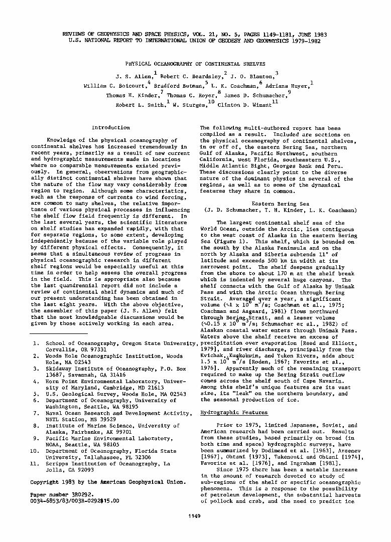
The largest continental shelf sea of the World Ocean, outside the Arctic, lies contiguous to the west coast of Alaska in the eastern Bering Sea (Figure 1). This shelf, which is bounded on the south by the Alaska Peninsula and on the north by Alaska and Siberia subtends 11 ø of latitude and exceeds 500 km in width at its
narrowest point. The shelf deepens gradually from the shore to about 170 m at the shelf break
which is indented by several huge canyons. The shelf connects with the Gulf of Alaska by Unimak Pass and with the Arctic Ocean through Bering Strait. Averaged 9ver a year, a significant volume (41 x 10 v m•/s; Coachman et al., 1975; Coachman and Aagaard, 1981) flows northward through Ber•ng•Strait, and a lesser volume (40.15 x 10 v m3/s; Schumacher et al., 1982) of Alaskan coastal water enters through Unimak Pass. Waters above the shelf receive an excess of
1. School of Oceanography, Oregon State University, precipitation over evaporation [Reed and Elliott, Corvallis, OR 97331
2. Woods Hole Oceanographic Institution, Woods Hole, MA 02543
3. Skidaway Institute of Oceanography, P.O. Box 13687, Savannah, GA 31416
4. Horn Point Environmental Laboratory, Univer- sity of Maryland, Cambridge, MD 21613
5. U.S. Geological Survey, Woods Hole, MA 02543 6. Department of Oceanography, University of
Washington, Seattle, WA 98195
1979], and river discharge, principally from the Kvichak,aKu•kokwim , and Yukon Rivers, adds about 1.5 x 10⁷ m•/s [Roden, 1967; Favorite et al., 1976]. Apparently much of the remaining transport required to make up the Bering Strait outflow comes across the shelf south of Cape Navarin. Among this shelf's unique features are its vast size, its "leak" on the northern boundary, and the seasonal production of ice.
7. Naval Ocean Research and Development Activity, Hydrographic Feat.ures NSTL Station, MS 39529
8. Institute of Marine Science, University of Alaska, Fairbanks, AK 99701
9. Pacific Marine Environmental Laboratory, NOAA, Seattle, WA 98105
10. Department of Oceanography, Florida State University, Tallahassee, FL 32306
11. Scripps Institution of Oceanography, La Jolla, CA 92093
Copyright 1983 by the American Geophysical Union.
Paper number 3R0292. 0034-6853/83/003R-029 2515.00
Prior to 1975, limited Japanese, Soviet, and American research had been carried out. Results
from these studies, based primarily on broad (in both time and space) hydrographic surveys, have been summarized by Dodimead et al. [1963], Arsenev [1967], Ohtani [1973], Takenouti and Ohtani [1974], Favorite et al. [1976], and Ingraham [1981].
Since 1975 there has been a notable increase
in the amount of research devoted to study of sub-regions of the shelf or specific oceanographic phenomena. This is a response to the possibility of petroleum development, the substantial harvests of pollock and crab, and the need to predict ice
1149
1150 Allen et al.: Physical Oceanography of Continental Shelves
NORTHERN GULF OF SUB-REGION /VOt•TO/V SOUND
.•yuKO N •'
ST MATTHEW
•N NUNIVAK D 50 >LAND
EASTERN REGION
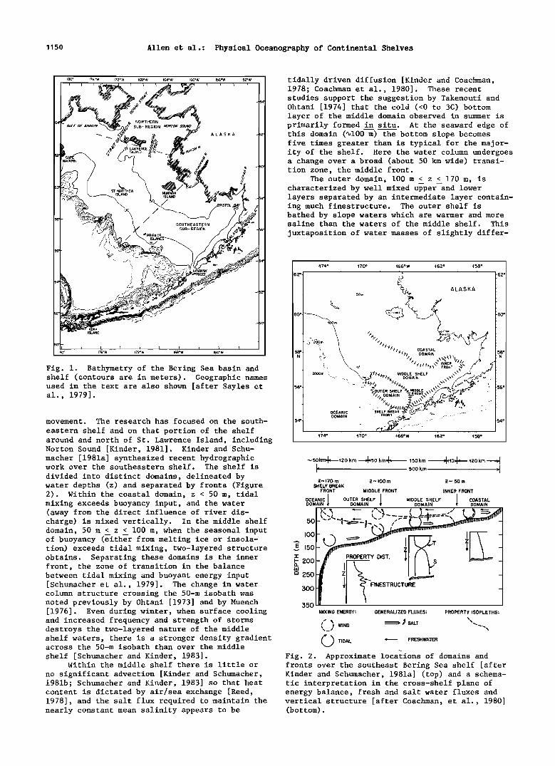
tidally driven diffusion [Kinder and Coachman, 1978; Coachman et al., 1980]. These recent studies support the suggestion by Takenouti and Ohtani [1974] that the cold (<0 to 3C) bottom layer of the middle domain observed in summer is primarily formed in situ. At the seaward edge of this domain (4100 m) the bottom slope becomes five times greater than is typical for the major- ity of the shelf. Here the water column undergoes a change over a broad (about 50 km wide) transi- tion zone, the middle front.
The outer domain, 100 m < z < 170 m, is characterized by well mixed upper and lower layers separated by an intermediate layer contain- ing much finestructure. The outer shelf is bathed by slope waters which are warmer and more saline than the waters of the middle shelf. This
juxtaposition of water masses of slightly differ-
ADAK ISLAND
Fig. 1. Bathymetry of the Bering Sea basin and shelf (contours are in meters). Geographic names used in the text are also shown [after Sayles et al., 1979].
movement. The research has focused on the south-
eastern shelf and on that portion of the shelf around and north of St. Lawrence Island, including Norton Sound [Kinder, 1981]. Kinder and Schu- macher [1981a] synthesized recent hydrographic work over the southeastern shelf. The shelf is
divided into distinct domains, delineated by water depths (z) and separated by fronts (Figure 2). Within the coastal domain, z < 50 m, tidal mixing exceeds buoyancy input, and the water (away from the direct influence of river dis- charge) is mixed vertically. In the middle shelf domain, 50 m < z < 100 m, when the seasonal input of buoyancy (either from melting ice or insola- tion) exceeds tidal mixing, two-layered structure obtains. Separating these domains is the inner front, the zone of transition in the balance between tidal mixing and buoyant energy input [Schumacher et al., 1979]. The change in water column structure crossing the 50-m isobath was noted previously by Ohtani [1973] and by Muench [1976]. Even during winter, when surface cooling and increased frequency and strength of storms destroys the two-layered nature of the middle shelf waters, there is a stronger density gradient across the 50-m isobath than over the middle
shelf [Schumacher and Kinder, 1983]. Within the middle shelf there is little or
no significant advection [Kinder and Schumacher, 1981b; Schumacher and Kinder, 1983] so that heat content is dictated by air/sea exchange [Reed,
50
474 ø 170 ø 166øW 462 ø • 58 ø
•___•j• 62ø 5o ALASKA
.....
OCEANIC DOMAIN FROm•
• 74 • • 70 • • 66 • W • 6 R• • 58 •
-•50km•--120 km ---•50 km •-1•- ,5okm m-lO•-- '120 km J k 500 km _1 -•,-, 170 m •. ',, I00 m •. ',, 50 m
SHELF BREAK FRONT MIDDLE FRONT INNER FRONT
DOMAIN DOMAIN DOMAIN DOMAIN
.... ..... - •E 150-
•- 200 , -
m 250
500 1 T ,• FINESTRUCTURE _ 550 MIXING ENERGY: GENERALIZED FLUXES: PROPERTY ISOPLF'THS:
I'"' • • ,.• SALT
• TIDAL : FRESHWATER Fig. 2. Approximate locations of domains and fronts over the southeast Bering Sea shelf [after Kinder and Schumacher, 1981a] (top) and a schema- tic interpretation in the cross-shelf plane of energy balance, fresh and salt water fluxes and
1978], and the salt flux required to maintain the vertical structure [after Coachman, et al., 1980] nearly constant mean salinity appears to be (bottom).
Allen et al.: Physical Oceanography of Continental Shelves 1151
ent densities results in lateral interactions
with interleaving of water masses occurring at vertical scales of 1 to 25 m within the mid-water
column [Coachman and Charnell, 1977, 1979]. Outer shelf waters intrude shoreward near the bottom while middle shelf waters extrude seaward
above them, and within the middle front vertical fluxes appear to be enhanced [Coachman et al., 1980; Coachman and Walsh, 1981].
Kinder and Coachman [1978] described the shelf break front, which separates the outer shelf from the oceanic domain, and recognized its essentially haline character; it is the zone of relatively steep upper-layer salinity gradients (about 0.5 g/kg in 50 km) dividing upper layer shelf water from the upper-layer water of the Bering Slope Current. Paralleling the shelf break from near Unimak Pass to •ea• Cape Navarin, this current transports 45 x 10 v m•/s northwest- ward [Kinder et al., 1975]. The oceanic region immediately seaward of the shelf break front is replete with mesoscale eddies [Kinder and Coach- man, 1977; Kinder et al., 1980].
The other sub-region of the eastern Bering Sea shelf which has been recently studied in detail is the northern shelf (north of about 62øN), including Norton Sound. Coachman et al. [1975] report three identifiable water masses. The most saline water mass (Anadyr) lies west of St. Lawrence Island and on the west side of
Bering Strait. The least saline waters (Alaskan Coastal) lie contiguous to the Alaskan Coast on
62*
60 ø
o_
174' 172' 170' 168 ø 166øW 164 ø 162 ø 160 ø 1.58 ø , , .... , , ,
s. M ..... • _• • • s• -- 50 ......
174' 172' 170' 168' 166 • 164 • 162 • 160' 158 •
'62* .
]61 o
-60 o
-.58*
-.56*
-.55*
:.54 ø
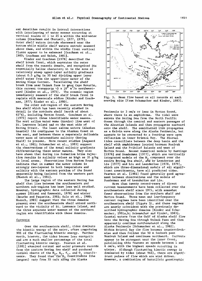
Fig. 3. Mean flow based on all records at each mooring site [from Schumacher and Kinder, 1983].
Peninsula to 3 cm/s or less in Norton Sound, where there is an amphidrome. The tidal wave enters the Bering Sea from the North Pacific Ocean through the central and eastern passages of the Aleutian Islands and then propagates eastward onto the shelf. The semidiurnal tide propagates as a Kelvin wave along the Alaska Peninsula, but
the east, and between these a separately definable appears to be converted to a Sverdrup wave upon water mass of intermediate salinity (Bering reflection in inner Bristol Bay. The diurnal Shelf) is present. More recent studies [Aagaard tides coosciliate between the deep basin and the et al., 1981; Schumacher et al., 1983] support shelf with amphidromes located between Nunivak the observations of the zonal salinity gradients Island and the Pribilof Islands and west of differentiating these water masses. They also Norton Sound. Recent numerical models by Hastings have shown that during ice formation brine rejec- [1976] and Sunderman [1977], which are vertically tion results in salinity values as high as 35 g/kg integrated models of the M• component over the z
in local areas. Observations from Norton Sound entire Bering Sea shelf, and by Leendertse and indicate that in summer the water column is
strongly two-layered in both temperature and salinity with the eastern portion of the Sound apparently being isolated from the western part [Muench et al., 1981].
The large region of the eastern Bering Sea shelf that lies between the southeastern and
northern sub-regions has been less well studied. However, hydrographic data collected during summer [Kitani and Kawasaki, 1978] and winter [Bourke and Paquette, 1981; Salo et al., 1980; Muench, 1983] suggest that the three domains present over the southeastern shelf extend north- ward to the vicinity of St. Lawrence Island, and the three separate water masses of the northern region are identifiable with these domains.
Currents
Over the southeastern shelf, tides dominate the kinetic energy of the water, often comprising 90% of the fluctuating kinetic energy. Farther north, however, the tides become less energetic and are a much smaller percentage of the total fluctuating kinetic energy. Pearson et al.
Liu [1977] and Liu and Leendertse [1978, 1979], which are three-dimensional models of all signif- icant constituents, have all predicted tides. Pearson et al. [1981] found generally good agree- ment between observations and the models of Sunderman and of Leendertse and Liu.
More than twenty record-years of direct current measurements have been collected over the
southeastern shelf since 1975, with somewhat fewer observations from the northern shelf and
Norton Sound. Three mean and low-frequency current regimes have been identified over the southeastern shelf (Figure 3), and these regimes are nearly coincident with the previously de- scribed hydrographic domains [Kinder and Schu- macher, 1981a,b; Schumacher and Kinder, 1983]. Coastal waters from the Gulf of Alaska shelf flow
into the Bering Sea through Unimak Pass and then apparently continue northeastward along the Alaska Peninsula [Schumacher et al., 1982]. Within Bristol Bay the flow becomes counterclock- wise and then follows the 50 m isobath past Nunivak Island and continues northward. Currents
appear to be strongest near the inner front, paralleling this feature at speeds between 1 and
[1981] examined current and water pressure records 6 cm/s, with the highest speeds occurring in from the eastern Bering Sea shelf and produced winter. Although fluctuating kinetic energy is cotidal charts of the M•, N•, K,, and O, constit- dominated by tides (about 96%) there are signif- z z I i ' uents. They found that the M? constituents (the icant pulses of flow which are wind driven. largest) vary from 35 cm/s alBng the Alaska However, a combination of baroclinic geostrophic
1152 Allen et al.: Physical Oceanography of Continental Shelves
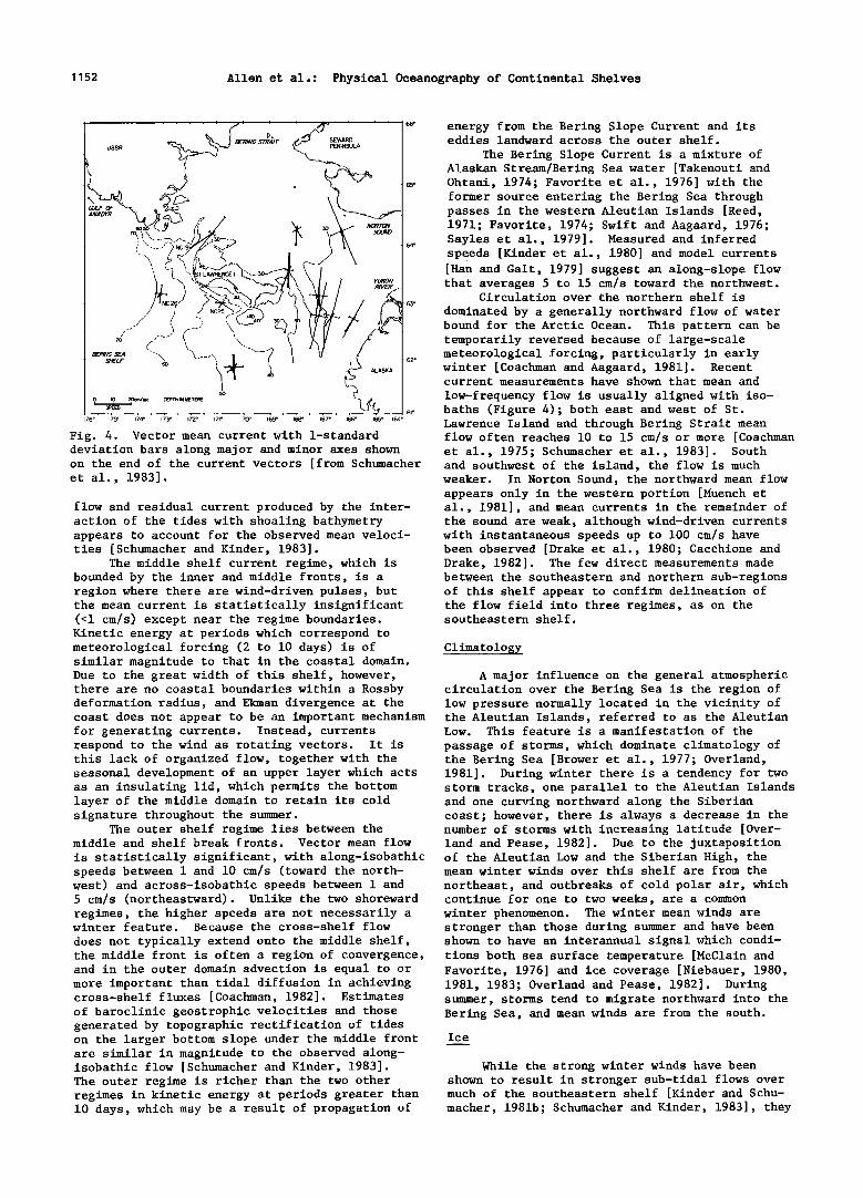
Fig. 4. Vector mean current with 1-standard deviation bars along major and minor axes shown on the end of the current vectors [from Schumacher and southwest of the island, the flow is much et al., 1983]. weaker. In Norton Sound, the northward mean flow
flow and residual current produced by the inter- action of the tides with shoaling bathymetry appears to account for the observed mean veloci- ties [Schumacher and Kinder, 1983].
The middle shelf current regime, which is bounded by the inner and middle fronts, is a region where there are wind-driven pulses, but the mean current is statistically insignificant (<1 cm/s) except near the regime boundaries. Kinetic energy at periods which correspond to meteorological forcing (2 to 10 days) is of similar magnitude to that in the coastal domain. Due to the great width of this shelf, however, there are no coastal boundaries within a Rossby deformation radius, and Ekman divergence at the
energy from the Bering Slope Current and its eddies landward across the outer shelf.
The Bering Slope Current is a mixture of Alaskan Stream/Bering Sea water [Takenouti and Ohtani, 1974; Favorite et al., 1976] with the former source entering the Bering Sea through passes in the western Aleutian Islands [Reed, 1971; Favorite, 1974; Swift and Aagaard, 1976; Sayles et al., 1979]. Measured and inferred speeds [Kinder et al., 1980] and model currents [Han and Galt, 1979] suggest an along-slope flow that averages 5 to 15 cm/s toward the northwest.
Circulation over the northern shelf is
dominated by a generally northward flow of water bound for the Arctic Ocean. This pattern can be temporarily reversed because of large-scale meteorological forcing, particularly in early winter [Coachman and Aagaard, 1981]. Recent current measurements have shown that mean and
low-frequency flow is usually aligned with iso- baths (Figure 4); both east and west of St. Lawrence Island and through Bering Strait mean flow often reaches 10 to 15 cm/s or more [Coachman et al., 1975; Schumacher et al., 1983]. South
Climatology.
A major influence on the general atmospheric circulation over the Bering Sea is the region of low pressure normally located in the vicinity of
coast does not appear to be an important mechanism the Aleutian Islands, referred to as the Aleutian for generating currents. Instead, currents Low. This feature is a manifestation of the respond to the wind as rotating vectors. It is passage of storms, which dominate climatology of this lack of organized flow, together with the the Bering Sea [Brower et al., 1977; Overland, seasonal development of an upper layer which acts 1981]. During winter there is a tendency for two as an insulating lid, which permits the bottom storm tracks, one parallel to the Aleutian Islands layer of the middle domain to retain its cold and one curving northward along the Siberian signature throughout the summer. coast; however, there is always a decrease in the
The outer shelf regime lies between the number of storms with increasing latitude [Over- middle and shelf break fronts. Vector mean flow land and Pease, 1982]. Due to the juxtaposition is statistically significant, with along-isobathic of the Aleutian Low and the Siberian High, the speeds between 1 and 10 cm/s (toward the north- mean winter winds over this shelf are from the west) and across-isobathic speeds between 1 and northeast, and outbreaks of cold polar air, which 5 cm/s (northeastward). Unlike the two shoreward continue for one to two weeks, are a common regimes, the higher speeds are not necessarily a winter phenomenon. The winter mean winds are winter feature. Because the cross-shelf flow stronger than those during summer and have been does not typically extend onto the middle shelf, shown to have an interannual signal which condi- the middle front is often a region of convergence, tions both sea surface temperature [McClain and and in the outer domain advection is equal to or more important than tidal diffusion in achieving cross-shelf fluxes [Coachman, 1982]. Estimates of baroclinic geostrophic velocities and those generated by topographic rectification of tides on the larger bottom slope under the middle front are similar in magnitude to the observed along- isobathic flow [Schumacher and Kinder, 1983]. The outer regime is richer than the two other regimes in kinetic energy at periods greater than 10 days, which may be a result of propagation of
Favorite, 1976] and ice coverage [Niebauer, 1980, 1981, 1983; Overland and Pease, 1982]. During summer, storms tend to migrate northward into the Bering Sea, and mean winds are from the south.
Ice
While the strong winter winds have been shown to result in stronger sub-tidal flows over much of the southeastern shelf [Kinder and Schu- macher, 1981b; Schumacher and Kinder, 1983], they
appears only in the western portion [Muench et al., 1981], and mean currents in the remainder of the sound are weak, although wind-driven currents with instantaneous speeds up to 100 cm/s have been observed [Drake et al., 1980; Cacchione and Drake, 1982]. The few direct measurements made between the southeastern and northern sub-regions of this shelf appear to confirm delineation of the flow field into three regimes, as on the southeastern shelf.
Allen et al.: Physical Oceanography of Continental Shelves 1153
also have a dramatic impact on water temperature and ice production. Ice cover is a seasonal feature of the eastern Bering Sea shelf, varying from none in summer to greater than 80% coverage of 0.5 to 2.0 m thick ice during its maximum extent in March [Niebauer, 1980; Pease, 1980]. Fay [1974], Muench and AhlnNs [1976] , Pease [1980], McNutt [1980, 1981], and Aagaard et al. [1981] have discussed the importance of the northern Bering Sea as an area where ice is preferentially produced along south-facing coasts because of wind-driven surface divergence. The ice produced in polynyas (areas of open water) is exported southward under the prevailing northerly winds, eventually melting at the southern marginal ice zone. Salinization during freezing has a measureable effect on both flow and water proper- ties in the vicinity of polynyas [Schumacher et al., 1983]. At the southern ice boundary, bands of ice which accelerate away from the pack have been identified in satellite photographs [Muench and Charnell, 1977; McNutt, 1980, 1981]. The melting ice causes a vertical stratification in the water column, which may produce a baroclinic geostrophic flow along the marginal ice zone [Niebauer, 1982; Muench, 1983]. Niebauer [1980, 1981] and Overland and Pease [1982] showed that the interannual variations in ice extent can be
hundreds of kilometers, and these variations are generally correlated with either the wind field or the location of storm tracks.
Physical-Biological Interactions
Studies of biological processes over the southeastern Bering Sea and in the vicinity of the ice edge have followed the progress in under- standing of the physical processes. Because of
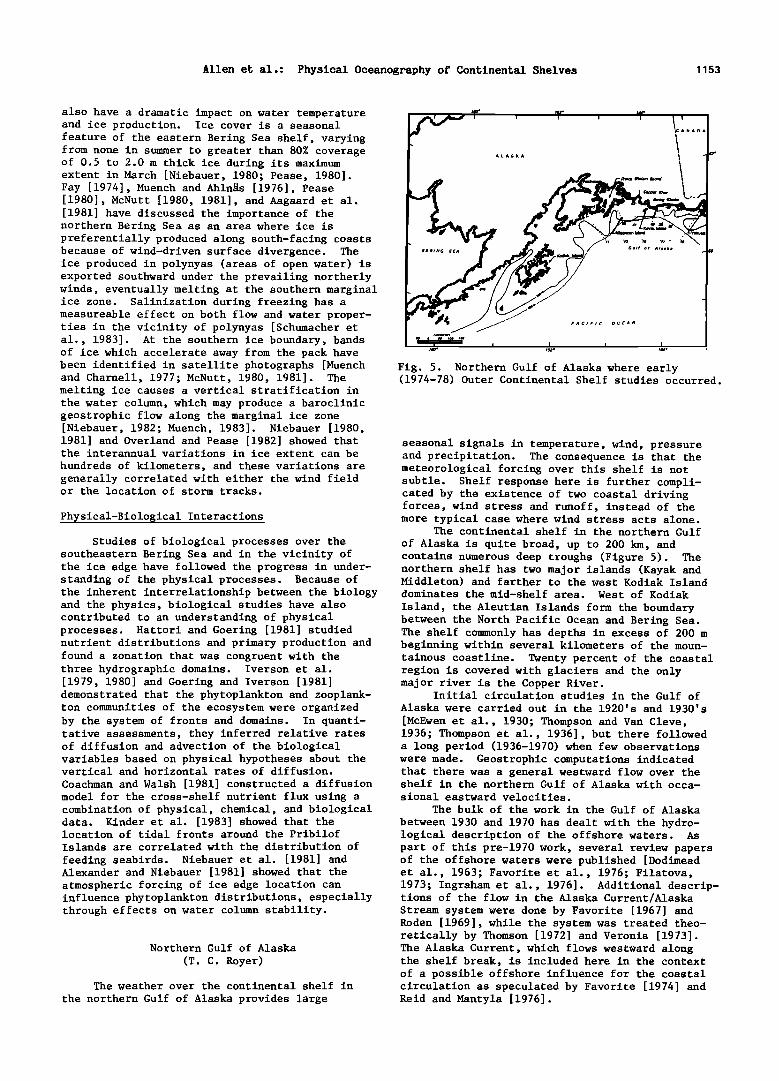
Fig. 5. Northern Gulf of Alaska where early (1974-78) Outer Continental Shelf studies occurred.
seasonal signals in temperature, wind, pressure and precipitation. The consequence is that the meteorological forcing over this shelf is not subtle. Shelf response here is further compli- cated by the existence of two coastal driving forces, wind stress and runoff, instead of the more typical case where wind stress acts alone.
The continental shelf in the northern Gulf
of Alaska is quite broad, up to 200 km, and contains numerous deep troughs (Figure 5). The northern shelf has two major islands (Kayak and Middleton) and farther to the west Kodiak Island
the inherent interrelationship between the biology dominates the mid-shelf area. West of Kodiak and the physics, biological studies have also contributed to an understanding of physical processes. Hattori and Goering [1981] studied nutrient distributions and primary production and found a zonation that was congruent with the three hydrographic domains. Iverson et al. [1979, 1980] and Goering and Iverson [1981] demonstrated that the phytoplankton and zooplank- ton communities of the ecosystem were organized by the system of fronts and domains. In quanti- tative assessments, they inferred relative rates of diffusion and advection of the biological variables based on physical hypotheses about the vertical and horizontal rates of diffusion.
Coachman and Walsh [1981] constructed a diffusion model for the cross-shelf nutrient flux using a combination of physical, chemical, and biological data. Kinder et al. [1983] showed that the location of tidal fronts around the Pribilof Islands are correlated with the distribution of
feeding seabirds. Niebauer et al. [1981] and Alexander and Niebauer [1981] showed that the atmospheric forcing of ice edge location can influence phytoplankton distributions, especially through effects on water column stability.
Northern Gulf of Alaska
(T. C. Royer)
The weather over the continental shelf in
the northern Gulf of Alaska provides large
Island, the Aleutian Islands form the boundary between the North Pacific Ocean and Bering Sea. The shelf commonly has depths in excess of 200 m beginning within several kilometers of the moun- tainous coastline. Twenty percent of the coastal region is covered with glaciers and the only major river is the Copper River.
Initial circulation studies in the Gulf of Alaska were carried out in the 1920's and 1930's
[McEwen et al., 1930; Thompson and Van Cleve, 1936; Thompson et al., 1936], but there followed a long period (1936-1970) when few observations were made. Geostrophic computations indicated that there was a general westward flow over the shelf in the northern Gulf of Alaska with occa- sional eastward velocities.
The bulk of the work in the Gulf of Alaska
between 1930 and 1970 has dealt with the hydro- logical description of the offshore waters. As part of this pre-1970 work, several review papers of the offshore waters were published [Dodimead et al., 1963; Favorite et al., 1976; Filatova, 1973; Ingraham et al., 1976]. Additional descrip- tions of the flow in the Alaska Current/Alaska Stream system were done by Favorite [1967] and Roden [1969], while the system was treated theo- retically by Thomson [1972] and Veronis [1973]. The Alaska Current, which flows westward along the shelf break, is included here in the context of a possible offshore influence for the coastal circulation as speculated by Favorite [1974] and Reid and Mantyla [1976].

1154 Allen et al.: Physical Oceanography of Continental Shelves
Meteorological Forcing
The measurement of meteorological parameters in the Gulf of Alaska has been limited by lack of suitable observing stations. Most studies requiring wind data use those determined by the Fleet Numerical Oceanographic Central and/or upwelling indices determined by Bakun [1973] using the same pressure data set. When compared with actual winds on Middleton Island [Livingstone and Royer, 1980], Bakun's winds were reasonably accurate in displaying the seasonal trends but missed the high frequency changes. From studies of the coastal meteorology near Yakutat, it was found that orographic effects are extremely important for nearshore meteorology, with winds increasing significantly nearshore [Reynolds et al., 1978].
The winds over the Gulf of Alaska are domi-
nated by strong cyclonic systems in the winter, leading to westward alongshore winds, and by a weak high in summer. These lows are enhanced by cyclogenesis [Winston, 1955] and tend to be trapped by the coastal mountains. Adiabatic ascent of the moist marine air over the coastal
mountains leads to extremely high precipitation rates in the coastal drainage areas [Royer, 1982]. Hydrologists have generally neglected these drainage areas because of the lack of large river networks, but average discharges for some of the major rivers have been presented by Roden [1967].
Circulation
The circulation of the deep water (>100 m) over this shelf responds to the seasonal wind stress with the renewal of bottom water in the
local fjords taking place in late summer [Muench and Heggie, 1978]. The absence of the strong wind field in summer allows a relaxation of
downwelling and the onshore intrusion of rela- tively warm, salty water from the central Gulf of Alaska [Royer, 1975]. This type of deep water
DEPLOYED IN THE GULF OF ALASKA IN JULY ].976
_
141 140 '49' 148' IJ7' I•' ' ,•' 14" ,•2' '' ' ' 145"
plays an important role in the coastal and off- shore flow as it deflects a portion of the rela- tively fresh coastal current southward into the Alaska Current. West of Kayak Island, the Alaska Current can be clearly identified by a low salin- ity surface layer [Ingraham, 1979], by anomalous sea surface temperatures [Royer and Muench, 1977] and occasionally by suspended particulate matter concentrations [Feely et al., 1979]. In the vicinity of Kodiak Island and Cook Inlet, Muench et al. [1981] have described the circulation of lower Cook Inlet as a continuous channel flow
connected with the Gulf of Alaska coastal region north of Kodiak Island. Mysak et al. [1981] have analyzed fluctuations in the current of Shelikof Strait and Lagerloef [1983] has investigated the topographic control of the flow off the southeast- ern tip of Kodiak Island.
Other current measurements have been made with drifters released in the central Gulf of
Alaska and recovered along the Alaska Peninsula [Favorite and Fisk, 1971]. More recently, satel- lite-tracked drifting buoys that were released south of 48N in the vicinity of 160W, entered the
renewal is supported by the seabed drifter studies Alaska Current, traversed an eddy near Sitka and near Kodiak Island where some drifters released near the shelf break were found within the local
bays [Ingraham and Hastings, 1974; Muench and Schumacher, 1980].
Prior to 1974, only one moored current observation had been reported for the Gulf of Alaska [Pearson, 1973]. That mooring deployed near Middleton Island indicated weak westward
flow along bathymetry with reversals. Recent current measurements in the northeastern Gulf of
Alaska indicate that the flow generally follows the local isobaths in the nearshore regions [Hayes and Schumacher, 1976]. However, away from the coast near Icy Bay (west of Yakutat Bay) the eddy kinetic energy increases offshore as one approaches the shelf break and Alaska Current [Hayes, 1979]. Toward the west, the mean energy of the current increases, but its relative eddy kinetic energy decreases [Niebauer et al., 1981]. Therefore with weaker flow in the northeast Gulf of Alaska, eddies play a more important role than in the northwestern part. While the eddies located along the shelf break seem to be transi- ent, a permanent eddy has been located to the west of Kayak Island [Gait, 1976]. This island
then entered the coastal current. They progressed northwestward along the coast [Kirwan et al., 1978]. The drifter that traveled farthest ran aground near Icy Bay.
Additional satellite-tracked drifting buoys were released near Yakutat and Icy Bay in 1976 to describe possible trajectories of pollutants from oil and gas development. In general, these buoys wandered over the outer and mid-shelf regions, slowly progressing shoreward until they became involved with the coastal current (Figure 6). At that point, they progressed westward following the coastline. They traveled around Kayak Island and entered the permanent eddy west of the Island. After leaving the eddy, the drifters entered Prince William Sound where they became stranded [Royer et al., 1979]. These trajectories describe the general coastal circulation in this area, except that the flow continues out of Prince William Sound to the west. Three drifters re-
leased in the Alaska Current in deep water near Kodiak Island in 1978 did not move shoreward, but instead made a circuit around the Alaskan gyre before one of them traversed the shelf and went ashore west of Kodiak Island [Reed, 1980].

Allen et al.: Physical Oceanography of Continental Shelves 1155
Overview
The wind plays a major role in determining the nearshore circulation. The low pressure system over the central Gulf of Alaska during the winter creates a coastal convergence and downwell- ing with westward alongshore flow [Royer, 1975].
However,6t•e maximum coastal current transport (>_1 x 10 m /s) precedes the maximum wind stress by several months. This may be caused by local runoff [Royer, 1981b]. Both of these effects can be seen in the annual signal in coastal sea level [Royer, 1979; Reed and Schumacher, 1981]. Apparently, the coastal flow is isolated from the effects of the Alaska Current which either has no
seasonal signal [Reed et al., 1980] or has a maximum transport in late spring or early summer [Royer, 1981a]. The relatively fresh water in the Alaska Coastal Current should mix offshore
across the shelf as it moves alongshore, its rate of cross-shelf movement being dependent on fric- tion [Kao, 1981]. However, even hundreds of kilometers from its sources the coastal flow
remains quite narrow, less than 25 km wide [Schu- macher and Reed, 1980; Royer, 1982]. This implies ,2,. .... ß that something is opposing this spreading tenden- cy. It is speculated here that the wind acts in a manner to maintain the coastal current as a
narrow flow adjacent to the coast. Thus, the wind and freshwater effects may combine, probably in a nonlinear fashion, to maintain the coastal flow.
Throughout the central Gulf of Alaska, the nutrient concentrations below the halocline are
among the highest in the world's ocean [Reid, 1961]. Downwelling and runoff keep these nutri- ents at depth and offshore so that a relaxation of downwelling or a decrease in the runoff will allow an upward displacement of this nutrient- rich water. Thus, the absence of winds or pre- cipitation might enhance coastal primary produc- tion, in contrast with upwelling regions where
1'2õ •' 124'
Fig. 7. Locations of current meter moorings (dots) maintained for a month or more and tide gages (triangles) along the Pacific Northwest coast. The star at 44ø45'N indicates the position of Poinsettia, a mooring maintained continuously for more than a year.
Flattery at 48N (Figure 7). There are only a few large estuaries and bays, and the continental shelf topography is quite uniform compared with other U.S. shelf regions. The shelf width varies from about 15 to 40 km with the shelf break
occurring at a depth of about 200 m. Currents over the shelf have been measured, primarily with subsurface-moored Aanderaa current meters, for varying periods in different years. The longest
Pacific Northwest
(A. Huyer, R. L. Smith)
The Pacific Northwest coast runs nearly north-south from Cape Blanco at 43N to Cape
et al., 1978], and are coherent over large along- shore separations; Hickey [1981] showed that simultaneous low-passed current measurements separated alongshore by 480 km had linear correla- tion coefficients greater than 0.7. This high correlation was observed in spite of the fact that the alongshore separation crossed some major canyons, including Astoria Canyon and Juan de Fuca Canyon.
Typical amplitudes of the alongshore current fluctuations vary from 10 cm/s in summer to
coastal current has not been investigated. The use of chemical and biological parameters as tracers for this current seem promising for future studies.
active wind forcing is necessary for high produc- records were obtained near 44ø45'N. Many of the tion. results of observations made before 1978 have
The temporal variability of the wind field been summarized in review papers by Huyer and in the Northeast Gulf of Alaska can create situa- Smith [1978], Allen [1980], and Huyer [1983]. tions where the coastal current locally disappears At low frequencies (f < 0.6 cpd) (i.e. altogether [Muench and Hachmeister, 1982]. periods longer than 40 hours), the currents are Schumacher et al. [1982] indicate that the coastal primarily alongshore, with the alongshore compo- current is an important source of low salinity nent typically exceeding the onshore component by water for the Bering Sea. Other implications of a factor of two or more. The fluctuations have this coastal current have yet to be investigated very high vertical coherence [Smith, R. L., such as the interaction of the Alaska Coastal and 1981], and the alongshore fluctuations are in Alaska Currents, the effects of the coastal phase at different depths. A quasi-barotropic current on the circulation of adjacent fjords and first empirical orthogonal function accounts for estuaries, and the exchange of water between the more than 80% of the fluctuation energy in each North Pacific and Bering Sea by the flow through season. These low frequency fluctuations are the Aleutian passes. While extensive sampling of coherent and nearly in phase with local wind and the physical parameters has taken place at a few sea level. They are also coherent and in phase selected sites, the alongshore variability of the across the width of the continental shelf [Huyer

1156 Allen et al.: Physical Oceanography of Continental Shelves
2o
-2o
-40 - 20
Poinsettia 197:5
i I I
.. / /----'25m
\•'•/• Sunflower 1975 I I I I I I I I I I I
20m .... 50m ......... 67m
2O
-2( m UWIN
1971 -1974 i i i i i i i i i i i
J F M A M J J A S 0 N D
Fig. 8. Monthly mean values of the alongshore component of the currents at Poinsettia in 1973 and at Sunflower in 1975. Also shown are the
record lengths and the value of the mean along- shore current for each record at b•qIN, from Smith, Hickey and Beck [1976]. The locations of Poinsettia, Sunflower(S) and UWIN are shown in Figure 7. Currents were rotated by -20 ø at Poin- settia, -13 ø at Sunflower, and +13 ø at UWIN.
30 cm/s in winter. These dominate over the tidal and inertial currents which both have amplitudes of 45 cm/s [Torgrimson and Hickey, 1979; Kundu, 1976]. However, the converse is true for the onshore component: low frequency fluctuations with typical amplitudes of <3 cm/s [Huyer et al., 1978; Smith, R. L., 1981] are obscured by the roughly isotropic tidal and inertial currents. Thus, observations of limited duration often suggest complex onshore/offshore circulation patterns [e.g., Johnson and Johnson, 1979], while averages from longer period observations usually suggest a simpler circulation pattern (e.g. Smith, R. L., 1981). The low frequency fluctua- tions in the onshore/offshore component are only partly due to variations in the alongshore wind stress [Allen and Smith, 1981]. The remainder
in June and July are southward at the surface (Figure 8). The amplitude of the seasonal cycle of the surface currents is comparable to the amplitude of the strongest low frequency fluctua- tions [Huyer et al., 1979]. Thus, the direction of the surface current is variable in winter when
the fluctuations are strongest, but nearly con- stant in summer when fluctuations are weaker.
The mean current is northward at all depths in winter, southward at all depths in spring, and southward at the surface but northward near the
bottom in summer [Huyer et al., 1978]. The low frequency current fluctuations are
much weaker in summer than in winter or spring, as would be expected from the weaker fluctuations in wind stress [Huyer et al., 1978]. In summer, the bottom stress is weak, and can be neglected in the vertically integrated momentum equations [Allen and Smith, 1981]. In winter and spring, however, the bottom stress is much larger, and Hickey and Hamilton [1980] have shown that the bottom stress is an important term in the momentum equations in those seasons.
The vertical gradient of the alongshore velocity, i.e., the shear, also varies seasonally. In winter, there is almost no mean vertical shear. In both spring and summer, the vertical shear is negative, i.e. currents are more strongly southward near the surface than near the bottom.
In winter the shear fluctuates, but in spring and summer the shear is almost constant [Huyer et al., 1979]. Associated with this change in the vertical shear is a change in the density dis- tribution. In winter, isopycnals are nearly level and have the greatest variability near 100 m over the mid-shelf. In spring, the mean isopycnals slope upward toward the coast and the greatest variability is at the surface near shore. In both the velocity field and the density field, the difference between the winter and spring mean values is greater than the standard deviation in either season [Huyer et al., 1979].
The onset of the typical spring-summer regime, with southward surface currents, sloped isopycnals and persistent shear, occurs very quickly, over a day or two, during a single upwelling event [Huyer et al., 1979]. Sea level falls quickly during the same event. This rapid spring transition seems to be due partly to the local wind stress [Huyer et al., 1979], partly to the large scale winds along the coast, and partly to the alongshore pressure gradient [Werner and Hickey, 1982] which is probably southward at this time of year [Hickey and Pola, 1982].
The fall transition (i.e. the disappearance of the southward surface current, the decay of the persistent shear, and the return to level isopycnals) seems to occur very gradually. A
might be due to changes in the alongshore pressure poleward undercurrent appears over the shelf gradient. These fluctuations result in a net onshore eddy heat flux in summer [Bryden et al., 1980].
Probably the most distinctive feature of currents over the shelf of the Pacific Northwest
is the strength and the repeatability of the seasonal cycle of the alongshore currents. In each year when measurements over mid-shelf are available, mean monthly currents for December, January and February are northward at all depths; mean monthly currents for April and May are
during the summer [Hickey, 1979; Halpern et al., 1978; Huyer et al., 1979]. This undercurrent increases in strength while the southward surface current weakens during August and September. The shear seems to decrease in almost a step-wise fashion, with a step at each northward wind event. The water column is gradually restrati- fied, as isopycnals lose their upward slope. This process appears to occur first at the sur- face, and only later at depth. Again, changes in the stratification appear to occur in association
southward at all depths; and mean monthly currents with northward wind events.
Allen et al.: Physical Oceanography of Continental Shelves 1157
One question that continues to intrigue investigators is the nature of the relationships among the seasonal cycles in the alongshore current, the wind and sea level. One school feels that the seasonal cycle in the currents is forced primarily by the local wind, while other schools argue that it is forced primarily by winds at distant locations, or by the alongshore pressure gradient. On seasonal time scales, alongshore currents and coastal sea level are strongly correlated. The spring zero crossing in sea level (referred to its long-term mean) occurs prior to the zero crossing in wind or wind stress. The converse is observed in autumn. These lags might imply that local wind stress is not suffi- cient to explain the seasonal cycle in sea level.
SPRING SUMMER
60 +©X
+© X
l= '1• X .
:• .itX o •0 •- '•X
o • i i i m 0 i
u j20 +© X
z # X
• 0 , '1• I( • I --
F ALL WlNT E R STATION
+ ß X +©X +©X
+o X +OxX +oX +o + oX
+o X X +oX ß • X +o +o x .IO X ++: X +.X x ++.Ox x , p% , , ,+.,x i i i i i i i
+ ß X ß
+. x •:• ++.x x
+o )• +©X +©X i . --I i i
0 I0 20 0 I0 20 0 I0 20 0 I0 20
TEMPERATURE (*C)
However, if wind and wind stress are also referred Fig. 9. Mean (.), maximum (x) and minimum (+) to their long-term means before the comparison with sea level, the three variables have nearly simultaneous mean-crossings in both spring and fall. This would imply that purely local wind stress forcing cannot be ruled out. Thus, the controversy over the dynamics of the forcing of these strong annual cycles is by no means re- solved.
Southern California
(C. D. Winant)
The continental shelf between the Mexican
border and Los Angeles is very narrow, ranging in
width between 3 and 10 kma2and very steep, with bottom slopes of order 10 . The Gulf of Santa Catalina, which separates the shelf from the deeper Pacific Ocean, is characterized by depths of order 1 km with some deeper basins as well as a number of islands. The coastline is markedly curved, running practically east to west just south of Los Angeles, and north to south in the vicinity of San Diego. Current and temperature observations have been made in this area more or
less continuously since 1977. Intensive observa- tions of the cross-shelf structure of shelf
circulation were made on a transect perpendicular to the coast off the city of Del Mar, California [Winant and Bratkovich, 1981] and the longshore structure of the flow was explored with an array of current meters deployed along the mid-shelf isobath (30 m) over a distance of 60 km, north from Del Mar [Winant, 1983]. Those observations are summarized in the following.
Thermal Structure
The temperature field over the southern California shelf undergoes a major seasonal change. Because density is mostly controlled by temperature here, these changes correspond to seasonal fluctuations in the density stratifica- tion which in turn affect the dynamics.
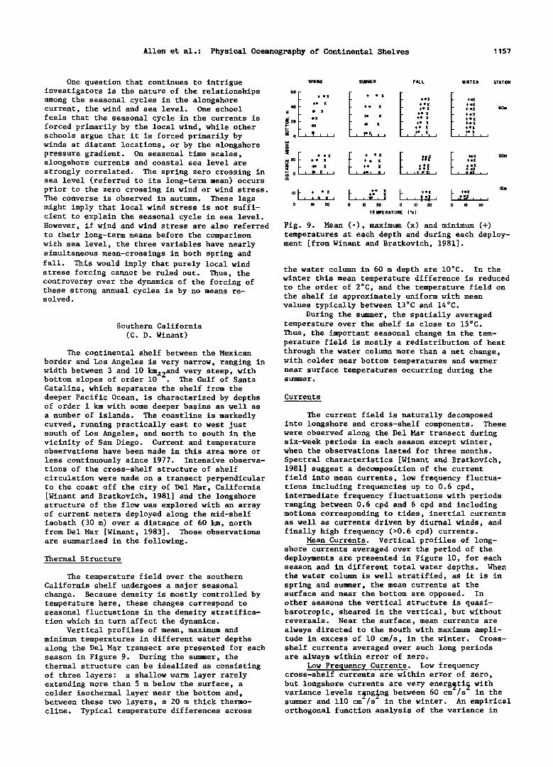
Vertical profiles of mean, maximum and minimum temperatures in different water depths along the Del Mar transect are presented for each season in Figure 9. During the summer, the thermal structure can be idealized as consisting of three layers: a shallow warm layer rarely extending more than 5 m below the surface, a colder isothermal layer near the bottom and, between these two layers, a 20 m thick thermo- cline. Typical temperature differences across
60m
ISm
temperatures at each depth and during each deploy- ment [from Winant and Bratkovich, 1981].
the water column in 60 m depth are 10øC. In the winter this mean temperature difference is reduced to the order of 2øC, and the temperature field on the shelf is approximately uniform with mean values typically between 13øC and 14øC.
During the summer, the spatially averaged temperature over the shelf is close to 15øC. Thus, the important seasonal change in the tem- perature field is mostly a redistribution of heat through the water column more than a net change, with colder near bottom temperatures and warmer near surface temperatures occurring during the summer.
Currents
The current field is naturally decomposed into longshore and cross-shelf components. These were observed along the Del Mar transect during six-week periods in each season except winter, when the observations lasted for three months.
Spectral characteristics [Winant and Bratkovich, 1981] suggest a decomposition of the current field into mean currents, low frequency fluctua- tions including frequencies up to 0.6 cpd, intermediate frequency fluctuations with periods ranging between 0.6 cpd and 6 cpd and including motions corresponding to tides, inertial currents as well as currents driven by diurnal winds, and finally high frequency (>0.6 cpd) currents.
Mean Currents. Vertical profiles of long- shore currents averaged over the period of the deployments are presented in Figure 10, for each season and in different total water depths. When the water column is well stratified, as it is in spring and summer, the mean currents at the surface and near the bottom are opposed. In other seasons the vertical structure is quasi- barotropic, sheared in the vertical, but without reversals. Near the surface, mean currents are always directed to the south with maximum ampli- tude in excess of 10 cm/s, in the winter. Cross- shelf currents averaged over such long periods are always within error of zero.
Low Frequency Currents. Low frequency cross-shelf currents are within error of zero,
but longshore currents are very energsti• with variance levels r•ng•ng between 60 cm-/s" in the summer and 110 cm-/s" in the winter. An empirical orthogonal function analysis of the variance in
1158 Allen et al.: Physical Oceanography of Continenta I Shelves
this band reveals that over 90% of the kinetic
energy is described by two eigenfunctions in all seasons.
The largest eigenfunction typically repre- sents 80% to 90% of the total variance in this
band, and its vertical structure is quasi-baro- tropic. The second largest function, which is baroclinic, represents typically 5% to 10% of the energy and reaches maximum amplitude relative to the total variance in the spring and summer, when the stratification is largest [Winant and Bratko- vich, 1981].
A low frequency synthetic bottom pressure was made by summing sea level observations and atmospheric pressure. There was a clear correla- tion between the largest current eigenfunction and synthetic bottom pressure, suggesting that in this band the cross-shelf momentum balance is
geostrophic. The correlation between wind stress and currents is not significantly different from zero, although large wind events induce an impor- tant response in shelf waters [Winant, 1980]. The lack of correlation between currents and
winds should mostly be ascribed to the relative absence of strong atmospheric forcing over the Southern California Bight, in comparison with other coastal areas along the U.S. seaboard.
During the summer, the alongshore coherent length scale of currents has been estimated from simultaneous current observations made along the 30 m isobath at various spacings ranging between 2.5 and 57.5 km [Winant, 1983] to be of order 30 km. This is relatively short compared to the scales in excess of 200 km observed on the
Washington-Oregon shelf [Hickey, 1981] or off Peru [Smith, R. L., 1978].
Intermediate Frequency Currents. Currents in this frequency band (0.6 to 6 cpd) account for nearly half the energy found in the low frequency
band,•wi•h variance levels rangin• b•tween z z 32 cm /s in the winter and 60 cm /s in the spring. The cross-shelf component of current is
length scales associated with currents in this band are mostly even shorter than the length scales associated with low frequency currents, on the order of 5 to l0 km. Near bottom longshore currents show evidence of a wave-like fluctuation
propagating poleward with phase speeds of 2 m/s. The short length scales associated with the other current components and their significant kinetic energy suggest that motions in this band make an important contribution to dispersion on the shelf.
High Frequency Currents. High frequency internal waves are commonly observed during spring and summer over the southern California shelf, filling the spectral gap between tidal currents and surface gravity waves. In the upper half of the water column there is a 180 ø phase difference between cross-shelf currents and
temperature. In addition these fluctuations are found to progress coherently from the edge of the shelf inshore at phase speeds characteristic of internal waves, but the longshore extent of these is found to be less than 2.5 km.
West Florida
(W. Sturges)
The continental shelf off the west coast of
Florida is long and broad. It is about two- thirds as long as the California coast, and is as long as the distance from the Strait of Juan de Fuca to Cape Mendocino, or from Cape Hatteras to Boston. This review will focus primarily on work which has appeared since 1978. Some relevant earlier work is the compilation by the SUSIO group (1975). Also, the report by New England Coastal Engineers [1982] includes a valuable summary of older observations using drift cards.
Initial studies involved comparisons between wind forcing and the response of sea level at coastal tide gauges [Cragg et al., 1983; Marmorino,
comparable in magnitude to the longshore component 1982, 1983a]. Because the shelf is so wide, the during the stratified seasons. In contrast to observations made on the eastern seaboard of the
United States, currents in this band are not well correlated with the sea surface elevation, which is to say that the tidal currents have a more baroclinic than barotropic nature.
The vertical structure of the most energetic longshore eigenvector in this frequency band is quasi-barotropic [Winant and Bratkovich, 1981]. Although there is a concentration of energy near the surface during spring and summer, the ampli- tude is practically depth independent in the other seasons. The largest eigenvector of the
observed response at the coast is larger by approximately a factor of four than off the coast of Oregon, for the same wind strength. The majority of the near shore response appears to be directly forced by wind. Little energy has yet been observed associated with free shelf waves.
Observed Currents
The "shelf dynamics program" of 1973-75 provided the earliest set of current meter obser- vations. These are predominantly on the outer shelf [Koblinsky and Niiler, 1980; Niiler, 1976].
cross-shelf current component is always baroclinic Most of the recent observations are on the north- with a reversal which occurs near the middle of
the water column.
The cross-shelf currents are coherent with
the most energetic longshore mode at the mid and outer shelf locations, with a 90 ø phase shift between longshore currents and near surface cross-shelf currents. Cross-shelf currents in
turn are coherent with the temperature, an index of isotherm displacement, with a phase lag of 270 ø in the upper half of the water column. These phase relations are consistent,with a baroclinic mode standing in the cross-shelf plane.
During the summer, the longshore coherent
ern half of the shelf. Mitchum and Sturges [1982] found that the wind-forced currents in depths of approximately 45 m or less are highly coherent with local wind. The dominant balance is between wind stress and bottom stress. A
model using a linear bottom-drag law [e.g., Scott and Csanady, 1976] fits the data well with a bottom friction parameter ("r") of 0.01-0.02 cm/s. However, because the tidal flow is small, the bottom stress is not quite linear in low frequency velocity. Mitchum and Sturges [1983] have shown that the response of sea level at the coast is to a power of wind stress less than one at St. Petersburg. They concluded that the cause was
Allen et al.: Physical Oceanography of Continental Shelves 1159
SPRING SUMMER FALL WINTER
60 ß ß
40
o 20
o
n• 0 i i i i i i i i i i i i i i ,,i
,., •0 ß $Om z
•- 0 I I I I I I I I I I I I L I I I
0 I I I I I I I I I I I I I I I I -20 0 •0 -20 0 20 -•0 0 •0 -•0 0 •0
LONGSHORE CURRENT (cms -I)
Fig. 10. Mean longshore currents. Positive values are poleward [from Winant and Bratkovich, 1981].
STATION break which are similar to those suggested by Niiler; the model used by Hsueh et al. [1982] contains no Loop Current forcing, but is forced
6o.• by wind. Cooper's model (see following section) suggests that many eddies on the shelf are strong- ly baroclinic. It is obvious that some large eddies may break off from the Loop Current and be observed partly on the shelf. Nevertheless, all such eddies on the shelf or shelf break need not
be caused by the Loop Current. The question of forcing of longshore flow on
the shelf by currents in deep water--here, the Loop Current--has been addressed by Sturges and Evans [1983]. They found that sea level at coastal stations, even inside a very wide shelf, is coherent with the northernmost position of the Loop Current at periods from 8 months to 30 months. They conclude that the Loop Current is forcing longshore flows on the shelf, but they have no supporting direct observations.
the result of a bottom stress law that departs from linearity in the case of small tidal flows. Numerical Models Marmorino [1983a,b] has reported on results from
recent current meter observgtions, finding that The model of Hsueh et al. [1982] is vertical- the response to a 0.5 dy/cm alongshore wind ly integrated, linear, and barotropic. It can stress--as measured at the coast--is approximately hindcast with reasonable accuracy the fluctuations 20 cm/s off Cedar Key but approximately 40 cm/s of sea level observed at the coast, and it also to the north where the shelf narrows. One finding makes shelf break eddies, as discussed above.
Marmarino [1982] describes a similar, steady by Marmorino seems particularly interesting. At a mooring offshore from a sharp bend in the model. A somewhat different one (also linear)
has been reported by Cooper et al. [New England coastline, the "longshore" currents followed the coastline direction remarkably well, in the Coastal Engineers, 1982]. They include stratifi-
cation, vertical variation of horizontal currents downstream direction. Direct pressure measure- ments show that the pressure field decays offshore and eddy viscosity. Their model reproduces with an e-folding scale of 4160 km, and allows coastal elevations fairly well, but it is diffi- calculations of geostrophic currents which are in good agreement with observed flow.
Another long record is the one obtained by Hopkins and Schroeder [1981]. They report on a pair of moorings at 430 m depth on the "Florida Middle Grounds" (425N), from Oct 78 through Nov 79, with most of the data 44 m above the bottom. One 4-month installation also had a current meter
10 m below the surface. They found typical speeds 420 cm/s in the near-bottom records associated with the passage of weather systems. The instruments also observed the effects of
Hurricane Frederic which passed 4225 km west of the mooring.
Loop Current Forcing
Observations from satellites have shown that
the Loop Current comes near the edge of the shelf break; some part of the surface expression of the Loop Current comes up on the shelf [Huh et al., 1981]. The satellite observations are clearly going to be our most prolific source of data [Maul et al., 1978; Vukovitch et al., 1979], although Sturges and Evans [1983] found that the position of the Loop Current as determined from hydrographic data may be 100 to 200 km farther to the south than when determined from satellite
data.
Niiler [1976] postulated a series of eddies along the shelf break--on the basis of current- meter mooring data. It seems likely that the Loop Current may force such a response at the shelf break. However, a model of Hsueh et al. [1982] is able to produce eddies at the shelf
cult to say whether these results differ signifi- cantly from those of Hsueh et al. [1982] at describing the observed currents, as the current data available for comparison were brief. Weatherly and Van Leer [1977] showed that strati- fication is important to include if the effects of the bottom boundary layer are to be modelled accurately. It is difficult for this reviewer to tell whether the limitations in the models are
necessarily caused by inadequately prescribed physics or whether they are due largely to our inability to describe the forcing to sufficient accuracy.
Tides
Several authors [Koblinsky, 1979, 1981; Mitchum and Sturges, 1982; Marmorino, 1983; Battisti and Clarke, 1982a] have studied tides on the West Florida Shelf. In the southern, narrower section of shelf from Naples to Tampa the tides are not strong, but north of Tampa to Apalachicola, where the shelf is much wider, semidiurnal tides and tidal currents increase significantly as a result of shelf tidal resonance [Battisti and Clarke, 1982b]. A substantial part of the energy in the observed records is from the tides, even along the narrower section of the shelf where they are weaker.
General Comments
It seems appropriate to point out that the Ocean Thermal Energy Program (OTEC) has provided
1160 Allen et al.: Physical Oceanography of Continental Shelves
82 81 80 79 78 77 ! I I ! ! !
Cope Fe•
Cape Lookouf•
76 75 !
Cope Halferos
'Savor
Canaveral
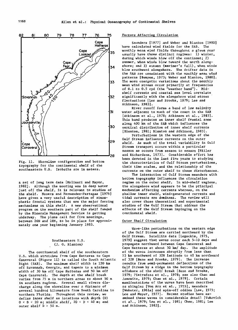
Fig. 11. Shoreline configuration and bottom topography for the continental shelf of the southeastern U.S. Isobaths are in meters.
a set of long term data [Molinari and Mayer, 1982]. Although the mooring was in deep water just off the shelf, it is relevant to studies of the shelf. Mooers and Fernandez-Partagas [1976] have given a very useful description of atmos- pheric frontal systems that are the major forcing mechanisms on this shelf. A new observational
program on the southern part of the shelf funded by the Minerals Management Service is getting underway. The plans call for five moorings, between 26N and 28N, to be in place for approxi- mately one year beginning January 1983.
Factors Affectin• Circulation
Saunders [1977] and Weber and Blanton [1980] have calculated wind fields for the SAB. The
monthly mean wind fields throughout a given year 35 usually have three distinct regimes: 1) winter,
during which winds blow off the continent; 2) summer, when winds blow toward the north along-
34 shore; and 3) autumn (mariner's fall), when winds blow southward alongshore. The drifter data in the SAB are consistent with the monthly mean wind patterns [Bumpus, 1973; Weber and Blanton, 1980].
33 The more energetic variations about the monthly mean wind stress occur primarily at frequencies of 0.1 to 0.5 cpd (the 'Weather band"). Mid- shelf currents and coastal sea level correlate
32 significantly with the alongshore wind stress fluctuations [Lee and Brooks, 1979; Lee and Atkinson, 1983].
River runoff forms a band of low salinity 3• water adjacent to much of the coast in the SAB
[Atkinson et al., 1978; Atkinson et al., 1983]. This band produces an inner shelf frontal zone along 400 km of the SAB which influences the
30 vertical distribution of inner shelf currents [Blanton, 1981; Blanton and Atkinson, 1983].
Perturbations in the western edge of the Gulf Stream influence currents on the outer
29 shelf. As much of the total variability in Gulf Stream transport occurs within a particular season as occurs from season to season [Niiler
28 and Richardson, 1973]. Considerable effort has been devoted in the last five years to studying the characteristics of Gulf Stream perturbations, their time scales, and the relationship of the currents on the outer shelf to these disturbances.
The interaction of Gulf Stream meanders with
bottom topography influences the circulation regime on the outer shelf. In mid-shelf regions, the alongshore wind appears to be the principal mechanism affecting currents whereas, on the shallow inner shelf, wind-generated currents and tidal currents are dominant. The review will
also cover those theoretical and experimental studies of the Gulf Stream that address the
effects of the Gulf Stream impinging on the continental shelf.
Outer Shelf Circulation
Wave-like perturbations on the western edge of the Gulf Stream are carried northward by the Gulf Stream. Satellite data [Legeckis, 1975,
Southeastern U.S. 1979] suggest that waves occur each 5-10 days and (J. O. Blanton) propagate northward between Cape Canaveral and
' Cape Hatteras at about 30 km/ day. The amplitude The continental shelf of the southeastern of the waves increases abruptly from less than
U.S. which stretches from Cape Hatteras to Cape 15 km southward of 32N latitude to 40 km northward Canaveral (Figure 11) is called the South Atlantic of 32N [Bane and Brooks, 1979]. The increase Bight (SAB). The maximum shelf width is 120 km off Savannah, Georgia, and tapers to a minimum width of 30 km off Cape Hatteras and 50 km off Cape Canaveral. The depth at the shelf break varies from 75 m in northern areas to about 50 m
in southern regions. Several small rivers dis- charge along the shoreline over a distance of several hundred kilometers from South Carolina to northern Florida. Throughout this review, we define inner shelf as locations with depth (D) 0 < D < 20 m; middle shelf, 20 < D < 40 m; and outer shelf D > 50 m.
results from semi-permanent deflections of the Gulf Stream by a ridge in the bottom topography offshore of the shelf break [Bane and Brooks, 1979; Pietrafesa et al., 1978; see also Chao and Janowitz, 1979; Chao et al., 1979]. Certain manifestations of the waves have been described
as shingles [Von Arx et al., 1955], meanders [Webster, 1961a] and spin-off eddies [Lee, 1975; Lee and Mayer, 1977]. Recent studies have ex- amined these waves in considerable detail [Vukovich et al., 1979; Lee et al., 1981; Chew, 1981; Lee and Atkinson, 1983].

Allen et al.: Physical Oceanography of Continental Shelves 1161
Recent studies have confirmed Webster's
[1961a] initial description of the skewed asymme- try of the meanders [Brooks and Bane, 1981; Bane et al., 1981] and have also confirmed earlier conclusions by Webster [1961b] and Oort [1964] that energy from the fluctuating meanders is transferred to the mean Gulf Stream. Moreover, an analysis of Webster's original data [Blanton, 1975] suggested that meanders contained enough available potential energy to drive upwelled water across the shelf break as well as provide energy for feedback into the mean flow. Under certain hydrographic conditions in summer, this upwelled water can intrude along the bottom and displace large amounts of shelf water [Blanton, 1971; Blanton and Pietrafesa, 1978; Atkinson and Pietrafesa, 1980; Smith, N. P., 1981; Hofmann et al., 1981; Atkinson et al., 1980]. It passes shoreward beneath a southward-flowing warm fila- ment on the surface [Lee et al., 1981; Bane et
al., 1981]. Cold cyclonic eddies often form on the
western edge of the Gulf Stream when it meanders offshore. These eddies entrain a warm streamer
of surface Gulf Stream water [Lee et al., 1981; Bane et al., 1981; Lee and Atkinson, 1983]. These streamers are only 20-30 km wide, but can extend along the shelf break 10-200 km and form the shingle structure originally observed by Von Arx et al. [1955]. The streamers elongate rapidly and dissipate over the outer shelf [Lee et al 1981]. They form an effective mechanism for mixing shelf and Gulf Stream waters.
Evidence exists that the streamers (or filaments) are larger north of latitude 32N and
8O
ß • s s
s s s
s
s
• •-G A UGUS T
' 1 •81
, BOTTO•
\ TEbfPER• TURE ß" (C)
7•
32
81 80 7•
-31
-30
-2•
can develop an anticyclonic circulation [Pietrafesa Fig. 12. Bottom temperature distribution showing and Janowitz, 1980; Chew, 1981]. The larger deformation of the front due to passage of a wave scale presumably results from larger meander of the cyclonic edge of the Gulf Stream. Cape amplitudes north of this latitude [Bane and Canaveral is located at 28.5N [figure courtesy of Brooks, 1979]. Detailed measurements of the flow L.P. Atkinson]. field within those frontal disturbances do not
exist and interpretation of Eulerian measurements can be difficult [Pietrafesa and Janowitz, 1979a]. diverges. Bottom temperature data that support
Variability of currents and temperature along the outer shelf at 0.1-0.5 cpd is primarily produced by these propagating meanders or frontal eddies. Lee and Atkinson [1983] and Lee et al. [1981] have described in detail the response of surface and bottom shelf currents to passage of frontal eddies. These disturbances are observed
to transport northward momentum and heat back to the Gulf Stream, in agreement with the studies cited above on transfer of eddy energy to the mean flow. Upwelling in the cold core of frontal eddies provides the major source of nutrients for primary production on the outer shelf [Lee et al., 1981; Lee and Atkinson, 1983].
Topography around Cape Canaveral and the Carolina capes plays an important role in inten- sifying intrusions of Gulf Stream water along the continental shelf [Blanton et al., 1981; Leming, 1979]. The temperature of bottom waters near the
this scheme are shown in Figure 12.
Middle Shelf Circulation
Inshore from the shelf break, the predominant forcing shifts from Gulf Stream to wind. Atkinson et al. [1983] caution that the mean of cumulative weekly averages of current meter observations only stabilize after 3 or more months. Therefore, monthly means should be interpreted with caution. Mean currents along isobaths at mid-shelf calcu- lated over the wind regimes of summer (July- August) and autumn (September-October) essentially follow the winds, i.e., northward in summer, southward in autumn [Atkinson et al., 1983].
Analysis of long term mean flows at mid- shelf suggests the alongshelf momentum balance is between an alongshelf pressure gradient forcing the flow northward and an opposing bottom stress
Capes is anomalously low in regions where isobaths [Lee and Brooks, 1979; Atkinson et al., 1983]. diverge [Janowitz and Pietrafesa, 1983]. A bottom temperature front separates the intruded oceanic water from ambient shelf water. The
intrusion results from waves that propagate poleward along the cyclonic edge of a boundary current. Oceanic water is pulled upward through the wave trough and spreads shoreward along the shelf bottom into regions where flow on the shelf
This pressure gradient may result from the north- ward slope downward of sea level in the Gulf Stream [Sturges, 1974] and plays a role similar to (although in the opposite direction from) that found for the open ocean along the Middle Atlantic Bight [Scott and Csanady, 1976; Csanady, 1978; Beardsley and Winant, 1979].
Low frequency variability in mid-shelf
1162 Allen et al.: Physical Oceanography of Continental Shelves
depends mainly on local wind forcing at periods between 2 days and 2 weeks [Lee and Brooks, 1979; Lee et al., 1981; Lee and Atkinson, 1983]. Alongshore currents are coherent over at least 400 km separation with small phase lag. The mid- shelf currents in this band are essentially barotropic [Lee et al., 1982]. The alongshore currents are geostrophically balanced by cross- shelf pressure gradients and are driven by local alongshore winds. The shallowness and great width of the shelf appear to isolate mid and inner shelf regions from propagating waves along the shelf break [Lee and Brooks, 1979; Pietrafesa and Janowitz, 1980] except where the shelf is narrow off Florida [Brooks and Mooers, 1977].
Inner Shelf Circulation
The entire SAB inner shelf is affected at
sometime during the year by an influx of low salinity water derived from river discharges. A band of low salinity resides essentially through- out the year off Georgia and South Carolina [Atkinson et al., 1978].
Runoff from rivers north of Cape Hatteras is occasionally advected southward around Cape Hatteras during peak discharge and episodes of southward wind stress in spring [Stefansson et al., 1971; Singer eta!., 1980]. In autumn, southward wind stress advects low salinity water found off Georgia toward Florida [Atkinson et al., 1983].
Baroclinic coastal currents are set up in the frontal zone that result when low salinity water overrides the ambient shelf water. Tidal
energy is insufficient to vertically mix the water column. During seasons when winds blow southward, the frontal zone is relatively narrow and steep, and the thermal wind equation suitably predicts vertical shear through the frontal zone [Blanton, 1981]. During spring off Georgia, northward wind stress seems to spread the zone farther offshore and low salinity water is lost frommthe inner shelf [Blanton and Atkinson, 1983]. The loss of low salinity water in spring can be explained as a response to upwelling favorable winds which decrease the horizontal
density gradient and cause an additional loss of freshwater due to upper layer Ekman flux [Pietra- fesa and Janowitz, 1979b].
Coastal currents measured over long time periods on the inner shelf are only now being studied [Schwing et al., 1983]. The many inlets off South Carolina and Georgia result in complex orientation of the principal axes of tidal cur- rents [Blanton, 1980]. Vertical shear in tidal currents has been studied by Kundu, Blanton and Janopaul [1981].
The multi-inlet shoreline in the central SAB
provides routes of exchange between estuaries and sound and the inner continental shelf [Kjerfve et
currents lag winds by about 3 hours. It is puzzling that coastal sea level significantly lags longshore currents by 15 hours at frequencies of about 0.2 cpd.
Middle Atlantic Bight (W. C. Boicourt, R, C. Beardsley)
The Middle Atlantic Bight is the curved section of the eastern U.S. continental shelf
stretching between Cape Hatteras at the south and Cape Cod and Nantucket Shoals at the northeast (Figure 13). The New York Bight is the subsection of the Mid-Atlantic Bight located between the New Jersey and Long Island coasts. The shelf topog- raphy within the Mid-Atlantic Bight is relatively simple and smooth, with a generally monotonic increase in depth from the shore out to the shelf break. The depth of the shelf break decreases from about 150 m south of Georges Bank to about 50 m off Cape Hatteras. This shelf region is about 800 km long and typically about 100 km wide between shore and shelf break except near Cape Hatteras where the width is about 50 km, and in the New York Bight where the shelf is about 150 km wide. While a few submarine canyons penetrate the outer shelf, the Hudson Shelf Valley off New York is the only pronounced drowned river channel to cross the shelf proper.
The first general description of the season- al mean circulation in the Mid-Atlantic Bight is provided by Bumpus [1973] in his summary of an extensive 10-year program of drift-bottle and sea-bed drifter releases and of historical data.
He concluded that a mean southwestward alongshelf flow of order 5 cm/s occurs between Cape Cod and Cape Hatteras, except nearshore during periods of strong northward winds and low runoff, and that the Nantucket Shoals and Cape Hatteras appear to be oceanographic barriers that in some sense limit the alongshelf flow. Near Cape Hatteras, the alongshelf flow turns seaward and becomes entrained in the Gulf Stream.
Since 1970, extensive current and hydro- graphic measurements have been made in the Mid- Atlantic Bight. These new direct current obser- vations have led to new kinematic and dynamical descriptions of the current field and its varia- bility. Preliminary results from some of these studies have been presented in reviews by Beardsley et al. [1976], Beardsley and Boicourt [1981], and Csanady [1982]. Partially because of the limited spatial and temporal sampling characterizing the early moored array experiments, these reviews focused on simplified quasi-two-dimensional descriptions of the seasonal mean circulation and low frequency current variability. More recent work shows that the flow field can exhibit more
spatial structure and alongshelf variability than was evident in the earlier moored array observa-
al., 1978; Wang and Elliott, 1978]. A significant tions. amount of sea level fluctuations in estuaries is We present here a brief overview of the due to sub-tidal oscillation in the open ocean regional hydrography and circulation within the off the SAB. Mid-Atlantic Bight, including recent work on
Inner shelf currents in summer off South spatial and temporal flow variability. The Carolina in 10 m of water are predominantly reader is referred to Williams and Godshall longshore northward in agreement with summer wind [1977] and Ingham [1982] for further summaries stress [Schwing et al., 1983]. Longshore currents and bibliographies of historical and recent and winds are highly coherent at 2-12 days and physical studies in the Mid-Atlantic Bight.

Allen et al.: Physical Oceanography of Continental Shelves 1163
•. •TO .' ............. " 'i:!•.•.':ii!111• ,•:: --"i!!?'" f'<l. ::•: ' ' ".:'•;•" .i:i:• ..... :'• •0•..'..! '" .:. ...... . .... .... ,:.... •, . ................... .• .:..•. •....: :: ..:...: '.•:. • ,...<. ....... • ....... • .•..•: ..:.. :.. .' ....... •:•:. •;.:'• "•.•. • '•7' ....•4':4:::•-:::•? ...... ..:' • ...•..
.. •f•:.. :"? ?' :': '..:• • .? 4: •':: ""'"'• .... 4:•'."':. ' "-:'.,•",'•:.:;' • ...:•';>' :?•.. •{•':.:.•:•::::.- :'?'.F:' •:: .':•? ", • •::...' ......................... •"', ........ • .. ;•:-•:' --":•. '•:':.:; :::• ." .•::.' .:.7L.d"• • • '.•::• ...: ... ? ....... ,?. • '.:.•.•{:•,:.:. ...:• :•:..:...:.'-'"'::::.:: '? ..:. .:::.v :'-.. •..:... •'•......:-' ..:: ;•: .':•:•.•:. ::?.." % , '• .... ...... ... :.:.?-: ......... :•.•. •. • ...... :..:.•:..:./...:.:.:• •.
ß >....•...• ' • ..:.:.:'.•:•. •......: ...... x..:x ...... •.• .... :.'"> ,L': "::.:. [ 8, P-•- •'• .... ..,.:.. ?::? ........ c •, ,, '"'.':,::::.,,':'..'•:•?•.•.: .,.j•: .... •?,, ) ' ', ß ."'? ...:" ..... . •'.':' CAPE ] • •-x ...?.:..':::::..:':... ?. /•. •o :.:'J.. "•.,:/•]' ..- ......... :•::•.:'• 'B:"• HENRY _.•. • •-•3 •_.•-.•-._ .• ........ -" /,
ß •' '•:•- YI ..... •'•-•%o •-•'• ....... -•'--•dd -'•-•-- •, ß f?': •_ •,. .::': :. ::... ,,-,• • .... • ",, , ............. - .... ,, ,,.. /
-- , ._.__<• c•rON • '• • ,,• •
• • -•_r-_ • • •3, -• U -..
-•.% • %,..._ •,•" '• •' '• '•. GEORGES BANK
'••,; '•.• .... .... •o • • / •2oom •
Fig. 13. A topographic map of the Mid-Atlantic Bight, Georges Bank, and a western section of the Gulf of Maine. The 60, 100, and 200 m isobaths are shown [from Beardsley and Boicourt, 1981].
H. ydrography
The Mid-Atlantic Bight undergoes a marked seasonal change in stratification [Bigelow, 1933; Bigelow and Sears, 1935; Han and Niedrauer, 1981]. In winter, the water column is often vertically homogeneous over much of the shelf, with the coldest temperatures and freshest water occurring nearshore in February and March (Figure 14). A sharp frontal zone, called the shelf slope front, separates the cooler, fresher shelf water from the warmer, more saline slope water [Wright, 1976]. Originating on the southern flank of Georges Bank, this front runs through the Mid-Atlantic Bight to near Cape Hatteras along the outer shelf and intersects the bottom near the 80 m isobath. In summer, the water column is strongly stratified over most of the shelf due to vernal warming and increased fresh- water runoff. The shelf slope front is less distinct in summer, but large horizontal temper- ature and salinity gradients still exist beneath the seasonal thermocline which has by then developed in both shelf and slope water. The summer stratification is subsequently destroyed in the fall by surface cooling and the seasonal increase in strong synoptic-scale weather distur- bances [Mooers et al., 1976].
The shelf slope front and increased mixing nearshore [Pettigrew, 1980] cause the formation in spring and summer of a band of cold, low salinity water called the "cold pool" located near the bottom on the mid and outer shelf
(Figure 14). This feature can be traced from the southern flank of Georges Bank to near Cape Hatteras. Houghton et al. [1982] and Ou and Houghton [1982] show that the New England shelf and perhaps Nantucket Shoals is the winter source region for the coldest cold pool water found in
the central Mid-Atlantic Bight in the late spring and summer.
Currents
Currents in the Mid-Atlantic Bight can be conceptually divided into tidal currents, sub- tidal low frequency currents with periods in the 2 to 10 day synoptic band, monthly mean currents, and annual mean currents. Tidal currents are
relatively weak in the Mid-Atlantic Bight except in and near some estuaries and sounds and over
Nantucket Shoals where tidal currents are suffi-
ciantly large to cause complete vertical mixing [Garrett et al., 1978; Bowman and Esaias, 1981; Limeburner and Beardsley, 1982; Ingham, 1982]. Most of the current variability observed in the Mid-Atlantic Bight is associated with winter storms. Storm-driven current fluctuations can be
of order 50 cm/s while the observed monthly mean currents over the mid and outer shelf are typi- cally of order 5 to 15 cm/s.
Tidal Currents. Recent tidal current and
pressure measurements made in the Gulf of Maine and adjacent shelf regions are summarized by Daifuku [1981], Mayer [1982], and Moody et al. [1983]. These results show that the tidal currents within the Mid-Atlantic Bight are dominated by the rotary semidiurnal components, especially the M• component which has a typical maximum amplitud• of 10 to 15 cm/s oriented primarily in the cross-shelf direction over much of the region. Redfield [1958] used channel theory to provide the first dynamical model of
the M 2 tide south of Long Island. Clarke and Battisti [1981] and Battisti and Clarke [1982a,b] recently showed that the M 2 component can be better modelled within the-Mid-Atlantic Bight by
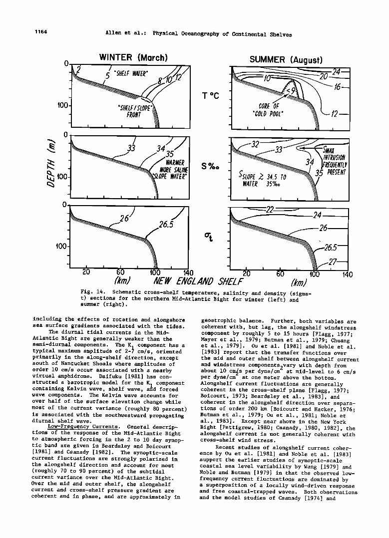
1164 Allen et al.: Physical Oceanography of Continental Shelves
SUMMER (August)
i i i
--------24
26
20 60 t00 140 20 60 t00 /km/ NE! ENGLNL SHELF
Fig. 14. Schematic cross-shelf temperature, salinity and density (sigma- t) sections for the northern Mid-Atlantic Bight for winter (left) and summer (right).
140
including the effects of rotation and alongshore sea surface gradients associated with the tides.
The diurnal tidal currents in the Mid- Atlantic Bight are generally weaker than the semi-diurnal components. The K• component has a typical maximum amplitude of 2-• cm/s, oriented primarily in the along-shelf direction, except south of Nantucket Shoals where amplitudes of order 10 cm/s occur associated with a nearby virtual amphidrome. Daifuku [1981] has con- structed a barotropic model for the K• component containing Kelvin wave, shelf wave, a•d forced wave components. The Kelvin wave accounts for over half of the surface elevation change while most of the current variance (roughly 80 percent) is associated with the southwestward propagating diurnal shelf wave.
Low-Frequency Currents. General descrip- tions of the response of the Mid-Atlantic Bight to atmospheric forcing in the 2 to 10 day synop- tic band are given in Beardsley and Boicourt [1981] and Csanady [1982]. The synoptic-scale current fluctuations are strongly polarized in the alongshelf direction and account for most (roughly 70 to 90 percent) of the subtidal current variance over the Mid-Atlantic Bight. Over the mid and outer shelf, the alongshelf current and cross-shelf pressure gradient are coherent and in phase, and are approximately in
geostrophic balance. Further, both variables are coherent with, but lag, the alongshelf windstress component by roughly 5 to 15 hours [Flagg, 1977; Mayer et al., 1979; Butman et al., 1979; Chuang et al., 1979]. Ou et al. [1981] and Noble et al. [1983] report that the transfer functions over the mid and outer shelf between alongshelf current and windstress components9vary with depth from about 10 cmos per dyne/cm - at mid-level to 6 cm/s per dyne/cm at one meter above the bottom. Alongshelf current fluctuations are generally coherent in the cross-shelf plane [Flagg, 1977; Boicourt, 1973; Beardsley et al., 1983], and coherent in the alongshelf direction over separa- tions of order 200 km [Boicourt and Hacker, 1976; Butman et al., 1979; Ou et al., 1981; Noble et al., 1983]. Except near shore in the New York Bight [Pettigrew, 1980; Csanady, 1980, 1982], the alongshelf current is not generally coherent with cross-shelf wind stress.
Recent studies of alongshelf current coher- ence by Ou et al. [1981] and Noble et al. [1983] support the earlier studies of synoptic-scale coastal sea level variability by Wang [1979] and Noble and Butman [1979] in that the observed low- frequency current fluctuations are dominated by a superposition of a locally wind-driven response and free coastal-trapped waves. Both observations and the model studies of Csanady [1974] and

Allen et al.: Physical Oceanography of Continental Shelves 1165
Beardsley and Haidvogel [1981] suggest that the frictional adjustment time scale for much of the Mid-Atlantic Bight is of order 10 hr, so that the directly wind-driven component should be similar to an arrested topographic wave [Csanady, 1978; Winant, 1979] moving slowly northeastward in phase with the dominant storms. The presence of free coastal-trapped waves in the Mid-Atlantic Bight was recently confirmed by Ou et al. [1981] and Noble et al. [1983] using current measure- ments. Ou et al. [1981] fitted a two-wave model to current data from two mid-shelf sites separated by 140 km along the 68 m isobath in the New York Bight and found that the forced and free wave components were roughly equal in energy content. The forced wave propagated northeastward while the free wave had a southwestward phase speed of about 525-820 km/day, roughly consistent with an estimate of 600 km/day from the sea level study of Wang [1979]. The presence in this region of equally energetic forced and free waves propagat- ing in opposite directions results in a coherence and rotary phase diagram between untreated velo- city records with little indication of alongshelf propagation. Removal of the forced wave component by subtracting that signal coherent with local wind, however, produces clear evidence of south- westward phase propagation [Ou et al., 1981].
While the alongshelf flow is coherent over alongshelf separations of at least 200 km, the low-frequency cross-shelf current fluctuations are incoherent over even the smallest alongshelf separation examined, 70 km [Boicourt and Hacker, 1976; Butman et al., 1979; Mayer, 1982]. Several processes can generate cross-shelf flows with short alongshelf scales. Allen [1976], Chao and Janowitz [1979], Brink [1980], and Wang [1980], for instance, examine the scattering of energy from free continental shelf waves by topographic features such as ridges, canyons, bumps, and regions of isobath convergence. Localized effects associated with bends or embayments in the coastline, or motions generated by small scale spatial wind stress variations can also contribute to the observed alongshelf variability in the cross-shelf flow structure.
A particularly dramatic example of topo- graphic control on the cross-shelf flow has been recently described by Mayer et al [1982]. They find that the Hudson Shelf Valley, which extends almost to the shelf break in the New York Bight (Figure 13) provides a channel for enhanced cross-shelf flow on both synoptic and monthly time scales. Mayer et al. [1982] report monthly mean upvalley flows of 10 to 25 cm/s in winter. In addition to the Hudson Shelf Valley, the series of submarine canyons in the outer shelf provide likely regions for flow disturbance and mixing [Hotchkiss, 1982; Hotchkiss and Wunsch, 1982]. Current fluctuations associated with the shelf slope front [Flagg, 1977; Halliwell and Mooers, 1979] and anticyclonic rings in the slope water [Mooers et al., 1979; Ramp et al., 1983] are additional sources for alongshelf variability in the cross-shelf flow over the outer shelf.
Monthly-Mean Currents. Monthly-mean cur- rents measured from long-term moorings on the outer shelf [Mayer et al., 1979; Beardsley and Boicourt, 1981] support the idea that summertime flow reversals from the generally southwestward mean alongshelf flow occur only in rare years of
Estuary
Shelf Break
' i
I I i
I
i
• / I I
i i • : Inner Shelf ,, Outer Shelf I
/ ,
/ : I I
Coastal I Jet
Fig. 15. Schematic alongshore surface velocity profile for summer in the southern Middle Atlantic Bight [from Boicourt, 1982].
strong and persistent northward winds. Bumpus [1969] reported reversals over the inner shelf ("nearshore"), ascribing them to the coincidence of strong northward winds and low runoff from rivers. Recent direct measurements of monthly- mean currents [Beardsley et al., 1976; Boicourt, 1981] suggest that summertime flow reversals over the inner shelf in the southern Mid-Atlantic
Bight may be the rule rather than the exception. Current measurements from lightships provide stronger evidence that, while the alongshelf flow over the outer shelf may undergo only occasional reversals, reversals occur annually over the inner shelf. Haight [1942] reports July mean currents (obtained by averaging hourly drift-pole measurements) that are, over a variety of years, consistently reversed with respect to the annual mean. The only exceptions are measurements from lightships at Nantucket Shoals and in estuarine outflow plumes. If near-surface flow over the inner shelf undergoes an annual reversal while the outer shelf reverses only occasionally, then the summertime upper-layer alongshelf flow should be banded into two or three counterflows (shown schematically in Figure 15). The low-salinity estuarine outflows form persistent southward- flowing coastal jets. Beyond this narrow band of width less than 20 km, the inner shelf flow is northward. The width of this band and the shape of the velocity profile offshore of this region are both uncertain. If the profile shown in Figure 15 does represent the July mean nearsurface flow pattern in th'e southern Mid-Atlantic Bight, then this banded flow structure may exist as a nearly two-dimensional feature from Long Island to Cape Hatteras or as one or a series of meso- scale gyres, with distinct geographical regions of enhanced cross-shelf flow.
In the New York Bight [Mayer et al., 1979] and off Chesapeake Bay [Beardsley and Boicourt, 1981], the measured near surface monthly mean currents are stronger during winter, but the records contain sufficient gaps at this level to preclude defining a seasonal signal. A more consistent seasonal variation is found in the
southern Mid-Atlantic Bight where near bottom
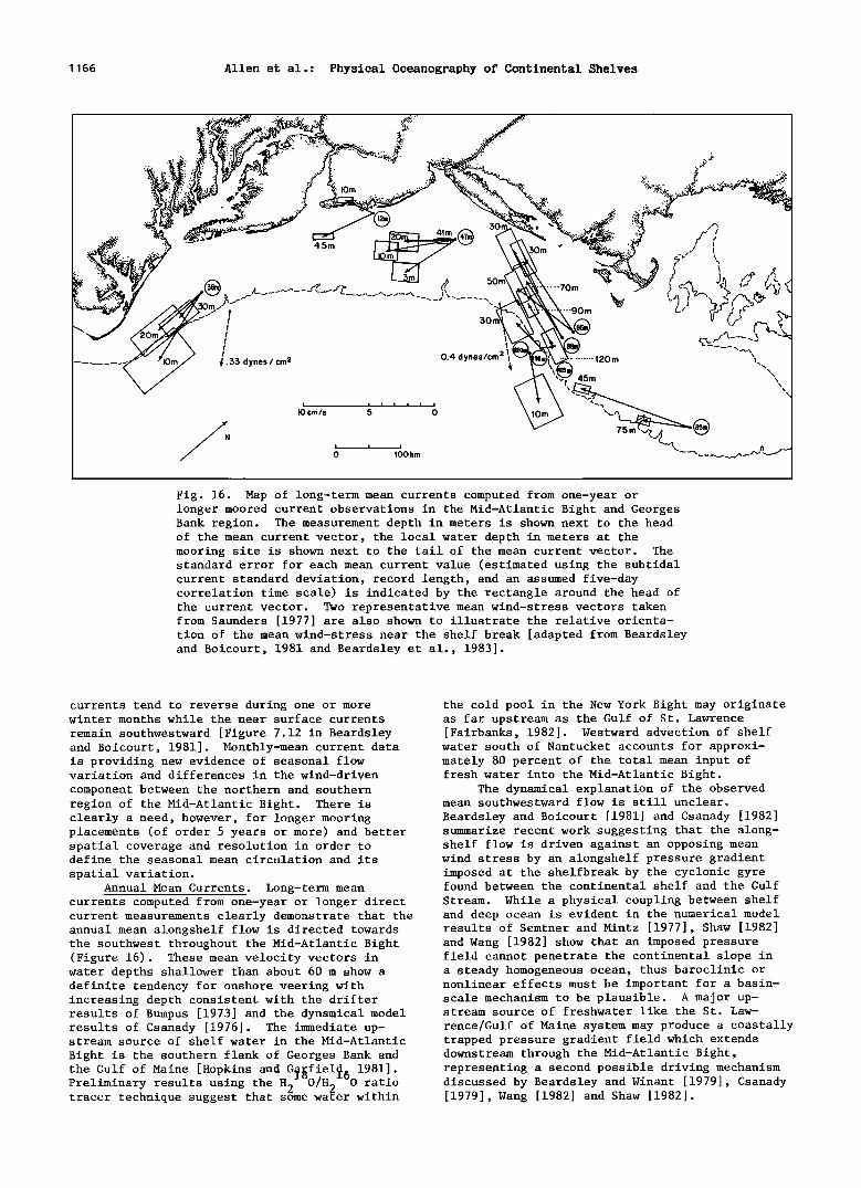
1166 Allen et al.: Physical Oceanography of Continental Shelves
:•:v.i!• >•'
lorn
4,5m )m •,•.,}. \
• 4 • _..,•_.._.,r• (? "70m ....
ß ' 'go m /...x 30
•2=.,- •'•--- --3 ....... • ..'.'5.'.'5 dynes / cm 0.4 dynes/cm 2• •-'-'"'"•
• • ....... 1:>0 m 45m
i i i i i i i
I0 cm/s 5 0 \"' L.__,
0 •00 km
Fig. 16. Map of long-term mean currents computed from one-year or longer moored current observations in the Mid-Atlantic Bight and Georges Bank region. The measurement depth in meters is shown next to the head of the mean current vector, the local water depth in meters at the mooring site is shown next to the tail of the mean current vector. The standard error for each mean current value (estimated using the subtidal current standard deviation, record length, and an assumed five-day correlation time scale) is indicated by the rectangle around the head of the current vector. Two representative mean wind-stress vectors taken from Saunders [1977] are also shown to illustrate the relative orienta- tion of the mean wind-stress near the shelf break [adapted from Beardsley and Boicourt, 1981 and Beardsley et al., 1983].
currents tend to reverse during one or more winter months while the near surface currents
remain southwestward [Figure 7.12 in Beardsley and Boicourt, 1981]. Monthly-mean current data is providing new evidence of seasonal flow variation and differences in the wind-driven
component between the northern and southern region of the Mid-Atlantic Bight. There is clearly a need, however, for longer mooring placements (of order 5 years or more) and better spatial coverage and resolution in order to define the seasonal mean circulation and its
spatial variation. Annual Mean Currents. Long-termmean
currents computed from one-year or longer direct current measurements clearly demonstrate that the annual mean alongshelf flow is directed towards the southwest throughout the Mid-Atlantic Bight (Figure 16). These mean velocity vectors in water depths shallower than about 60 m show a definite tendency for onshore veering with increasing depth consistent with the drifter results of Bumpus [1973] and the dynamical model results of Csanady [1976]. The immediate up- stream source of shelf water in the Mid-Atlantic
Bight is the southern flank of Georges Bank and
the Gulf of Maine [Hopkins and G fiel• 1981]. Preliminary results using the H2•O/H2 60 ratio tracer technique suggest that some water within
the cold pool in the New York Bight may originate as far upstream as the Gulf of St. Lawrence [Fairbanks, 1982]. Westward advection of shelf
water south of Nantucket accounts for approxi- mately 80 percent of the total mean input of fresh water into the Mid-Atlantic Bight.
The dynamical explanation of the observed mean southwestward flow is still unclear.
Beardsley and Boicourt [1981] and Csanady [1982] summarize recent work suggesting that the along- shelf flow is driven against an opposing mean wind stress by an alongshelf pressure gradient imposed at the shelfbreak by the cyclonic gyre found between the continental shelf and the Gulf
Stream. While a physical coupling between shelf and deep ocean is evident in the numerical model results of Semtner and Mintz [1977], Shaw [1982] and Wang [1982] show that an imposed pressure field cannot penetrate the continental slope in a steady homogeneous ocean, thus baroclinic or nonlinear effects must be important for a basin- scale mechanism to be plausible. A major up- stream source of freshwater like the St. Law-
rence/Gulf of Maine system may produce a coastally trapped pressure gradient field which extends downstream through the Mid-Atlantic Bight, representing a second possible driving mechanism discussed by Beardsley and Winant [1979], Csanady [1979], Wang [1982] and Shaw [1982].
Allen et al.: Physical Oceanography of Continental Shelves 1167
Cross Shelf Exchange Processes
Iselin's [1939, 1940] inference, from the salinity structure, of mean offshelf flow near- surface and onshelf flow nearbottom has been
documented by drifter and moored current measure- ments [Bumpus, 1973; Beardsley and Boicourt, 1981]. On a synoptic time scale, the cross-shelf current fluctuations reverse with depth during all seasons in a manner consistent with a wind-
driven surface Ekman layer [Boicourt and Hacker, 1976; Scott and Csanady, 1976; Flagg, 1977; Mayer et al., 1979; Chuang et al., 1979]. The low alongshelf coherence of cross-shelf flow and the possibility of regional circulation cells and of locally enhanced cross-shelf flows due to subtle topographic effects have generally frustrated attempts to measure and describe the cross-shelf transport of salt and heat [Bush, 1981; Fischer, 1980]. Two-dimensional simplifications are clearly inadequate for both observational schemes and analytic approaches attempting to construct accurate regional heat and salt budgets.
Most observations of exchange between shelf water and slope water have consisted of tempera- ture and salinity measurements from shipboard. For this reason, the resulting picture is primar- ily a catalog of processes on an event or synop- tic time scale, with temporal or spatial coverage that seldom allows a quantitative assessment of the associated transports. These processes include: "calving," the formation of discrete parcels of shelf water at the shelf slope front [Cresswell, 1967; Wright, 1976; Wright and Parker, 1976]; entrainment of shelf water in the trailing edge of anticylconic warm core rings [Saunders, 1971; Morgan and Bishop, 1977; Scarlet and Flagg, 1979; Smith, P. C., 1978]; cabelling [Garrett and Horne, 1978; Bowman and Okubo,
Georges Bank (B. Butman)
Georges Bank is a large shallow submarine bank located along the southeastern side of the Gulf of Maine (Figure 13). The bank is about 300 km long and 150 km wide. The water on the crest of the bank is 30-40 m deep although less than 5 m deep in some places. The bank is sepa- rated from the Scotian Shelf by the Northeast Channel (220 m deep) and from Nantucket Shoals by the Great South Channel (70 m deep).
Studies of the seasonal mean circulation in
the Georges Bank-Gulf of Maine region using surface and bottom drifters were conducted by Bigelow [1927] and Bumpus [1973, 1976]. These studies showed a residual surface counterclockwise
circulation in the Gulf of Maine and a clockwise
circulation around Georges Bank. The clockwise circulation around Georges Bank was strongest in spring and summer. In winter, the near-surface flow was primarily offshore, driven by the north- westerly winds.
Beginning in 1975, extensive current and hydrographic measurements were made on Georges Bank and the adjacent shelf and slope. Selected results from the recent field programs and a description of some of the modelling efforts are presented here. Results of recent studies con- ducted on the adjacent Scotian Shelf may be found in Smith [1983] and of observations made in the Northeast Channel in Ramp et al. [1983b].
H•drography
The water on the crest of Georges Bank (depths shallower than 60 m) is vertically well mixed throughout the year by the strong semidiur- nal tidal currents [Colton et al., 1968; Bumpus,
1978]; interleaving [Voorhis et al., 1976; Houghton 1976; Garrett et al., 1978]. The well-mixed and Marra, 1982]; and intrusions of high salinity slope water onto the Mid-Atlantic Bight which can occur in both stratified and unstratified seasons
(see Figure 14). Boicourt and Hacker [1976] report that large intrusions extending more than 50 km across the shelf in a layer 5 to 10 m thick during summer in the southern Mid-Atlantic Bight are correlated with strong northeastward winds. They interpret these intrusions to be the onshelf flow at mid-depth above the cold pool in compen- sation for a wind-driven off-shelf flow in the
upper Ekman layer. The regular occurrence of smaller intrusions over the outer shelf, even in the absence of strong winds, has led Posmentier
and Houghton [1980] , Gordon and Aikman [1981] , and Welch [1982] to offer other mechanisms for their generation.
Until observational coverage and resolution suffice to allow a reliable, direct estimate of the cross-frontal and cross-shelf fluxes associ-
ated with these processes, the alternate approach of estimating salt and heat fluxes from a model of the observed seasonal progression over the entire Middle Atlantic Bight may prove more accurate. Ou and Houghton's [1982] model incor- porating Houghton et al.'s [1982] observations of the cold pool temperature is a successful example of such an approach. A clear picture of the relative importance of the individual cross-shelf exchange processes contributing to the salt and heat budgets, however, has yet to be developed.
Georges Bank water is warmest, freshest, and lightest (14øC, 32.5%0 and 24.2 sigma-t) in summer, and coldest, saltiest, and heaviest (5øC, 33.3%0 and 26.4 sigma-t) in winter [Hopkins and Garfield, 1979; Flagg et al., 1982]. In winter, two fronts separate the well-mixed water from adjacent water masses (Figure 17a-c). On the southern flank of the bank, the shelf-water/slope- water front intersects the bottom at approximately 80 m and separates cooler, fresher shelf water from warmer, more saline slope water. The shelf- water/slope-water front is similar in structure and continuous with the front at the shelf break
in the Middle Atlantic Bight [see Beardsley and Flagg, 1976; Wright, 1976; Mooers et al., 1979]. On the northern flank, a second weaker and deeper front separates Georges Bank water from Gulf of Maine water. In summer (Figure 17d-f), a seasonal thermocline develops over the Gulf of Maine, the slope water, and the water deeper than 60 m on the southern flank. A tidally mixed front forms at approximately the 60-m isobath. A subsurface bank of cool water, referred to as the "cold pool," occurs along the southern flank of the bank between the 60-m and 100-m isobaths, bounded by the warmer slope water to the south, the warmer well-mixed Georges Bank water to the north, and the seasonal thermocline above. Houghton et al. [1982] have described in detail the structure and changes of the cold pool on the southern side of Georges Bank and in the Middle
1168 Allen et al.: Physical Oceanography of Continental Shelves
42ø15.0'N a 4øø17 O'N 42ø15'0'N b 40ø17.0 TM 42ø150'N 40ø17 O'N 6800 O'W 66020.0 ' W 6800 O'W 66020.0 ' W 6800 O'W C 66ø20 0 ' W
174 176 178 STATION NO 91 88 85 82 79 76 174 176 178 STATION NO 91 88 85 82 79 76 174 176 178 STATION NO 91 88 85 82 79 76
o o o. ß
. 'øø I
200 / • 200• ,•.•i '::] ) [ -[
SIGMA T t X 1
ß
o o © o ,oo ,oo DISTANCE (KILOMETERS)
42 ø ?.:5' N d 40 ø :51.6'N 42 ø ?.:5' N • 40 ø :51.6'N 42 ø ?.:5' N f 40ø 67 ø 54.5'W 6? ø 20.4' W 6?* 54.5'W 6? ø 20.4'W 6? ø 54.5'W 6? ø 20.4'W STA NO. 66 70 74 76 ?8 80 8: • 84 86 88 STA NO. 66 70 74 76 ?8 80 8: • 84 86 88 STA NO. 66 70 74 76 ?8 80 82 84 86 88
• I00 • \ •.• ..' '....
[, TEMPERATURE ('C) 200 •_ o[! SALiNiTY (%.) 200 [. SIGMA T
0 •0 ' ' 'S0 0 •0 .... ,• 0 •00 DISTANCE (KILOMETERS) DISTANCE (KILOMETERS) DISTANCE (KILOMETERS)
Fñg. 17. Typñcal hydrographñc sectñoas ruaañag roughly from aorthwest to southeast across the crest of Georges BaaS. (a)-(½): •ñater sectñoas showlag we11-mñxed water oa the crest aad oa the aorthera a•d southera flaa•s to water depths of 80-100 m. •hese sectñoas were ta•ea ña March 1979 at the wiater temperature mñañmum. (d)-(f): Su•et •ect•oas show•ag we11-a•xed water oa the crest, t•dal •toats at -40 m oa the aottheta •laak aad •60 m oa the southeta •laa• the cold ba•d oa the southet• •laa• aa• the she1•-watet/slope-watet •toat which •tetsects the shel• at •80 m. •ese sect•oas were ta•e• o• •ul• 8-9, 1977. •a•cates stat•oa• w•th teapetatute obsetvat•oas oal•, C •d•cates
•utmaa e• al., 1982].
Atlantic Bight during 1979. Within the well- mixed region, the concentrations of nutrients (nitrate, phosphate, and silicate) and of oxygen are highest in winter and lowest in mid-summer [Pastuszak et al., 1982]. Loder et al. [1982] used a simple axisymmetric model of the evolution of temperature in spring and summer to study horizontal exchange on central Georges Bank. The analysis suggests horizontal diffusion coeffi- cients of order 150-380 m'/s.
Currents
Conceptually, the currents can be divided into a seasonal mean circulation, subtidal low- frequency currents with periods of 50-600 hours,
and energetic tidal currents. Variance conserving kinetic energy spectra (Figure 18) of the currents at 45 m at station 11 on the southern flank of
Georges Bank (see Figure 19 for station location) clearly show that the semidiurnal and diurnal tidal currents dominate the currents on Georges Bank. At this station, the amplitudes of the
semidiurnal (M 2) and diurnal tidal currents (K1) were 38 and 5 cm/s, respectively. The amplitude of the subtidal currents were typically 5-15 cm/s, and were fairly evenly distributed over periods from 50 to 600 hours. Note that in the subtidal
band, the maximum in the wind-stress spectra occurred at higher frequencies than the current spectra maximum. This suggests that not all of the subtidal currents at this location were
Allen et al.: Physical Oceanography of Continental Shelves 1169
STATION A 'VARIANCE AT 45rn
Period (hours) IOOO IOO IO
I00 I ' , , , o
• L S. CURRENT 2g'?O(L.S.) ß
• _J ---C.S. CURRENT J ...... WIND STRESS
5o 80817- 780417
0 . .01 D' Frequency (cycles/hours)
Fig. 18. Variance conserving spectral plot of currents at 45 m at station 11 (water depth 85 m, see Figure 19 for station location) and wind stress at Nantucket Lightship for the period August 1976 to April 1978. The amplitudes of the energetic (and off-scale) along-bank and cross- bank semidiurnal tidal currents are indicated in
parentheses. Confidence limits are shown as open triangles for the region to the right of the solid triangles and as open circles for the region to the left [from Butman and Beardsley, •82].
directly wind driven. The mean current and current fluctuations with periods larger than
diverged south of Great South Channel where some flow turned northward into the Gulf of Maine and
some continued westward into the Middle Atlantic
Bight. Observations of drifters drogued at 10 m suggest that water particles which passed south of Great South Channel were most likely to turn northward into the channel in summer and least
likely in winter [Flagg et al., 1982]. Water from the southern flank of Georges Bank may reach the area south of Cape Cod in the Middle Atlantic Bight in about 30 days. The circulation pattern determined from these recent direct current
observations is similar to the summertime surface
circulation described by Bigelow [1927] and Bumpus [1973]. However, the recent observations show that the clockwise circulation exists through- out the year and extends to the subsurface cur- rents. Substantial seasonal and low-frequency variability in the along-bank flow was observed, however, and thus the flow pattern often varies from the simple clockwise circulation.
Nearly continuous current measurements at 45 and 75 m were made at station 11 on the southern
flank of Georges Bank from May 1975 to March 1979 [Butman and Beardsley, 1982]. These long-term current observations show that although the monthly averaged flow was southwestward throughout the year, the strength of the along-bank flow ranged from-2 to -17 cm/s and varied seasonally. On average, maximum along-bank flow at 15 and 45 m was in August-September, and minimum flow was in March (Figure 20). There was no signifi- cant seasonal variation in the along-bank flow at 75 m (10 m above bottom). Shorter term current observations at other stations around the periphery of Georges Bank suggest a similar seasonal pattern [Flagg et al., 1982; Butman and Beardsley, 1982].
Rectification of the strong semidiurnal tidal curents which flow across Georges Bank into the Gulf of Maine may partially drive the observed around-bank flow [Loder, 1980; Hopkins and Gar- field, 1981]. Along-bank currents predicted by Loder's depth-averaged analytical model occurred in relatively narrow regions over the steeply sloping topography on the sides of the bank. The predicted current amplitudes were about 10- 25 cm/s on the northern flank and 6 cm/s on the
about 140 days are not shown by the energy spectra. broader southern flank. These amplitudes are of However, the mean current was about 8 cm/s, and there was a seasonal variation of the monthly mean current of about 3 cm/s at this location. Thus, at station 11, the amplitude of the mean along-bank flow, the seasonal variation of the along-bank flow, and the subtidal currents were approximately the same amplitude. Note that the cross-bank currents were generally weak except at tidal periods.
Seasonal Mean Circulation. The recent
Eulerian subsurface current measurements made in
the Georges Bank region indicate that a residual subsurface clockwise circulation exists around
Georges Bank throughout the year [Butman et al., 1982]. The circulation (Figure 19) is defined by a broad southwestward flow along the southern flank, a northward flow on the eastern side of the Great South Channel into the Gulf of Maine, a strong northeastward flow along the northern flank, and a southerly flow on the northeast peak. Current speeds were typically 5-10 cm/s; thus water particles could circuit Georges Bank in about 2 months. The circulation apparently
the same order of magnitude as the observed mean flow. An analysis of the current observations for evidence of tidal rectification suggests that only a portion of the observed mean along-bank flow may be caused by tidal rectification, how- ever. Butman et al. [1983] used realistic topog- raphy for the southern flank of the bank and
extended Loder's model to include the weaker N 2 and S 2 tidal components. The analytic results show a weak jet of about 3 cm/s at the shelf break, a relative minimum (less than 1 cm/s) on the southern flank, and increased tidally recti- fied along-bank flow toward the crest of the bank. Butman et al. [1983] used the ratio of the modulation of the along-bank flow at fortnightly and monthly periods to the mean along-bank flow predicted from the analytical model, and the observed (weak) modulation to estimate the mean current caused by tidal rectification at station 11. The model and observations indicate that
less than about 40% of the mean along-bank flow at station 11 was caused by tidal rectification (about 2 cm/s). Magnell et al. [1980] computed
1170 Allen et al.: Physical Oceanography of Continental Shelves
43 ø
42 ø
N. H r_•.. ...
•OS•
"....... ß MASS.
'IDENCEe•
129
IVOt•TI-IL:AS'T
41 ø
NANTUCKET ISLAND
Z$(22) •8(64)
10(60,}
40 ø
Gt•EAT S'OUTH
•2000•• MEAN EULERIAN SUBSURFACE CURRENT
, I i i 72 ø 71 o 70 ø 69 ø 68 ø
EXPLANATION
INSTRUMENT LOCATION AND STATION NUMBER
• DIRECTION OF MEAN FLOW- ! LENGTH PROPORTIONAL TO / SPEED OF MEAN CURRENT
! AND TO WATER PARTICLE IF EXCURSION IN 6 0 DAYS
NUMBER AT ARROW TIP-DEPTH OF CURRENT MEASUREMENT (Meters)
WATER DEPTH AT STATION (Meters) ? ,? ,? cm/s Speed of Mean Current
0 25 50 I .... I .... I m•les
o, •,• ........ i kdometers
Bathymetry m meters
I
67 ø 66 ø 6b ø
Fig. 19. Mean Eulerian current measurements. The boldface number at origin of vector is the station identifier. The number in parentheses following identifier indicates water depth at that station. The number at the tip of the vector indicates the depth of measurement in meters. The length of vector is proportional to the mean current speed. The speed scale is such that the length of the current vector is equivalent to the mean displacement of a water particle during a 6-day period at map scale or a 30-day excurison at five times map scale. The current measurements were not synoptic nor of equal duration but are compiled from measurements of varying length (1 month minimum) made at different times during the 4-year period, 1975-79 [from Butman et al., 1982].
the coherence between the amplitude of the ob- Estimates of the cross-bank density field show served cross-bank tidal current and the along- lighter water on the crest of the bank in summer, bank current at one location on the steeply consistent with the stronger observed around-bank sloping northern flank where the amplitude of the flow. Cross-bank density gradients were strongest tidally rectified current should be large. The across the northern flank of the bank in the coherences were low. However, due to the expected region of the swift northeastward jet [Flagg et temporal and spatial variability of the narrow jet, Eulerian current measurements may be diffi- cult to interpret in this region. Although these preliminary analyses suggest that not all of the observed along-bank flow is caused by tidal rectification, they are single-point measurements and are not inconsistent with the existence of
al., 1982]. Butman and Beardsley [1982] found the observed seasonal shear between 45 and 75 m
at station 11 was explained entirely by the observed cross-bank density field, but the season- al shear between 15 and 45 m was not explained by the available density observations. It was also not clear if the increase in the southwestward
strong tidally rectified currents in other regions flow at station 11 in summer indicated an increase of the bank. Detailed numerical models may be in the around-bank flow. The shelf-water/slope- the best way to determine the importance of tidal water front was onshore at the same time as the rectification on Georges Bank [Greenburg, 1983]. maximum along-bank flow; thus the increased
Cross-bank and along-bank density gradients southwestward flow at station 11 could be inter- may also drive part of the around-bank flow. preted as a constant southwestward transport

Allen et al.: Physical Oceanography of Continental Shelves 1171
through a decreased cross-sectional area inside of the front. The increase in the gradient of the cross-bank density field at shallower stations near the top of the bank was consistent with an increased around-bank flow, however.
These data suggest that the seasonal mean circulation around Georges Bank is composed of a steady component which exists throughout the year, probably caused by tidal rectification, and a seasonally varying component partially caused by the cross-bank density field. This conceptual model will be refined with additional analyses and analytical and numerical models. The contri- bution of wind stress, an along-bank pressure gradient, and along-bank density gradients to the residual circulation remains to be determined, perhaps using simple diagnostic models [Csanady, 1974, 1976; Smith, 1983].
Low-Frequency Currents. The amplitude of the low-frequency currents in the Georges Bank region are typically 5-15 cm/s [Butman et al., 1982; Flagg et al., 1982]. The low-frequency currents were aligned parallel to the local isobaths and were stronger near the surface than near the bottom.
The major portion of the low-frequency along-bank current variance was concentrated in the wind-driven frequency band of 2-10 days (Figure 18). However, the coherence between wind stress and currents indicates that typically less than 50% of the low-frequency current variance
20-
STATION A ALONG-BANK (SOUTHWESTWARD)CURRENT
MEAN SEASONAL CYCLE
! _
MEAN
15m t45m
45m
-t 75m
I I I I I I I I I I
J F M A M J J A S 0 N D MONTH
LONGS'NœLF WIND AND CUœœœNT VAœ1AIVCœ
120 - - 5 ._.
'• I00 - - eu
E ind Stress .................. • 'Y'ø 80 - -2 co z LLI
•- 60- - •
• Z
40 - '• • o 20- • ee W•e c ...... -"•< • - •
'''--. Noise Current • • • z '
0 200 400 600
E C B LONGSHELF SEPARATION (km)
Fig. 21. Location of near-bottom current measure- ments and wind observations (top) and the parti- tion of near-bottom long-shelf low-frequency current variance between wind-driven, free-wave, and noise components as a function of long-shelf position for data obtained at stations B, C, and E from January 15-March 15, 1978 (bottom). •e variance has been averaged over the periods from 60 to 360 hours. Wind stress at station B is from Nantucket Lightship, wind stress at stations C and E was determined from JFK International
Airport, increased by the average winter ratio of winds observed at EB4• and JFK International
Airport in winter [from Noble et al., 1983].
was driven by the wind [Flagg et al., 1982; Noble et al., 1983]. This is in contrast to the shelf southwest of Georges Bank where the along-shelf currents were more correlated with wind stress.
Mayer [1982] found that greater than 60% of the low-frequency current variance was correlated with wind stress in the Middle Atlantic Bight.
In a comparison between low-frequency cur- rents observed on Georges Bank and in the Middle Atlantic Bight (MAB) in winter, Noble et al. [1983] separated currents measured i m above the
Fig. 20. Seasonal cycle of along-bank current at bottom at three locations along the 60-m isobath station ll determined by least squares fit to the into wind-driven currents and currents associated monthly averaged data. Error bars are the 95% with freely propagating waves; 70-90% of the confidence limits. Positive flow is toward the energy in the long-shelf currents in winter were southwest. attributed to these two components (Figure 21).
1172 Allen et al.: Physical Oceanography of Continental Shelves
The amplitude of the near-bottom subtidal long- shelf current was much larger in the MAB than on the southern flank of Georges Bank (about 10- 15 cm/s and 5 cm/s, respectively). The wind- driven currents accounted for the major portion of the increased current variance in the MAB; wind-driven currents were 8-12 cm/s in the MAB and only about 3 cm/s on the southern flank of Georges Bank. The wind stress was relatively uniform over the MAB-Georges Bank region and thus the larger wind-driven currents in the MAB were not caused by stronger winds. The free-wave currents also increased southwestward along the shelf from about 4 cm/s on Georges Bank to 6 cm/s in the MAB. Thus, the subtidal currents on the southern flank of Georges Bank were weaker than in the MAB, and free waves and wind-driven cur- rents were of approximately equal importance. Ou et al. [1982] also separated currents measured on Georges Bank and in the •iAB into southwestward propagating free waves and a wind-driven compo- nent.
sand and large mobile bed forms are found on the crest of the bank where the tidal currents con-
stantly rework the surficial sediments [Twichell et al., 1981; Twichell, 1983]. On the flanks of the bank where tidal currents are weaker, the sediments are finer and the sea floor is feature- less. The tidal currents are weakest in the
region of fine-grained sediments south of Cape Cod. Twichell et al. [1981] and Bothner et al. [1981] suggest that this modern deposit is com- posed of fine sediments winnowed from the crest of the bank by storms and tidal currents and carried westward in the mean flow. The sediments
are deposited south of Cape Cod where the tidal currents decrease and allow the fine sediments to
drop out of suspension.
Peru
(J. S. Allen)
The coastal region off Peru is well known as These observations show that the low-frequency a location of persistent coastal upwelling and of
current variability in the Georges Bank region is complex and only partially driven by wind stress, and that there is significant longshelf structure to the subtidal current variability. The absence of a simple coastal barrier across the top of the bank probably complicates the flow field [Brink, 1983]. Noble et al. [1983] have suggested that the along-shelf structure of the low-frequency currents may be partially related to the scale of the coastal wind systems [Csanady, 1978]. Gulf Stream eddies impinge along the outer edge of the
high biological productivity. The Coastal Upwell- ing Ecosystems Analysis (CUEA) program conducted a large joint physical and biological field experiment, called JOINT-II, off Peru near 15S from March 1976 to May 1977. Intensive experi- ments were conducted in March-July 1976 and March-May 1977 (MAM 77). During these time periods, currents and temperatures were measured from several moorings deployed on the continental shelf and upper slope near 15S (Figure 22) and also from single moorings spaced alongshore
shelf and also affect currents in the low-frequency equatorward to 10S. Wind observations were band [Flagg et al., 1982; Friedlander, 1982]. obtained from shore stations and, in 1977, from Further analysis is required to describe and buoys. Sea surface temperature and near surface understand the low-frequency current dynamics of wind fields were mapped by aircraft, and an the Georges Bank region. An understanding of the extensive hydrographic program was implemented. entire Georges Bank-Gulf of Maine-Middle Atlantic In MAM 77, the latitudinal extent of the current Bight-Scotian Shelf system may be required to measurements was effectively extended by observa- fully determine the low-frequency current dynamics. tions made at 5S in a joint German-Peruvian
Tidal Currents. The currents in the Georges Bank region are dominated by strong rotary semi- diurnal tidal currents. Bumpus [1976] summarized the available tidal current data, primarily reported by Haight [1942]. Greenberg [1979] developed a numerical model of the tide in the Georges Bank-Gulf of Maine region. Tidal obser- vations made as part of the recent field programs are summarized by Moody et al. [1983].
experiment [Brockmann et al., 1980]. Information on the seasonal variability of the currents at mid-shelf was obtained by maintaining the mooring M (Figure 22) for the entire 14 month experiment.
Geographically, the Peru coast provides an interesting contrast to the regions discussed in other sections. The shelf is on an eastern ocean
boundary, at low latitudes in close proximity to the equator. Unlike mid-latitude shelves, the
The tidal currents are strongest (50-100 cm/s) internal Rossby radius at 15S is greater than the on the shallow crest of the bank and on Nantucket
Shoals, weaker on the northern and southern flanks, and extremely weak (less than 5 cm/s) south of Cape Cod. The strong tidal currents determine several important characteristics of the region. As discussed previously, rectifica- tion of the semidiurnal tides may partially drive the along-bank flow. The tidal currents also partially determine the hydrography through vertical mixing. The tidal currents are strong enough to vertically well mix the water column throughout the year on the crest of the bank, in the Great South Channel, and on Nantucket Shoals [Garrett et al., 1978]. A seasonal thermocline forms in water depths deeper than about 60 m, where the tidal currents are too weak to keep the water column well mixed. The tidal currents
partially control the texture of the surface sediments and the surface topography. Coarse
shelf width. In addition, the equatorial wave- guide provides a theoretically possible additional source region for fluctuating disturbances. Both of these features appear to play a large role in determining the nature of the observed flow.
Winds
The large-scale, low frequency (periods >2 days) winds along the coast of Peru are asso- ciated with the southeast trades and are extremely persistent in both direction and magnitude [Enfield, 1981a,b]. The dominant direction is alongshore and equatorward and hence upwelling favorable. The magnitudes, for example, of the mean and standard deviation of the alongshore component of the wind stress z, measured from a
nearshore bu•y at 15S in MAM 77, were 0.8 and 0.4 dynes/cm , respectively [Allen and Smith,
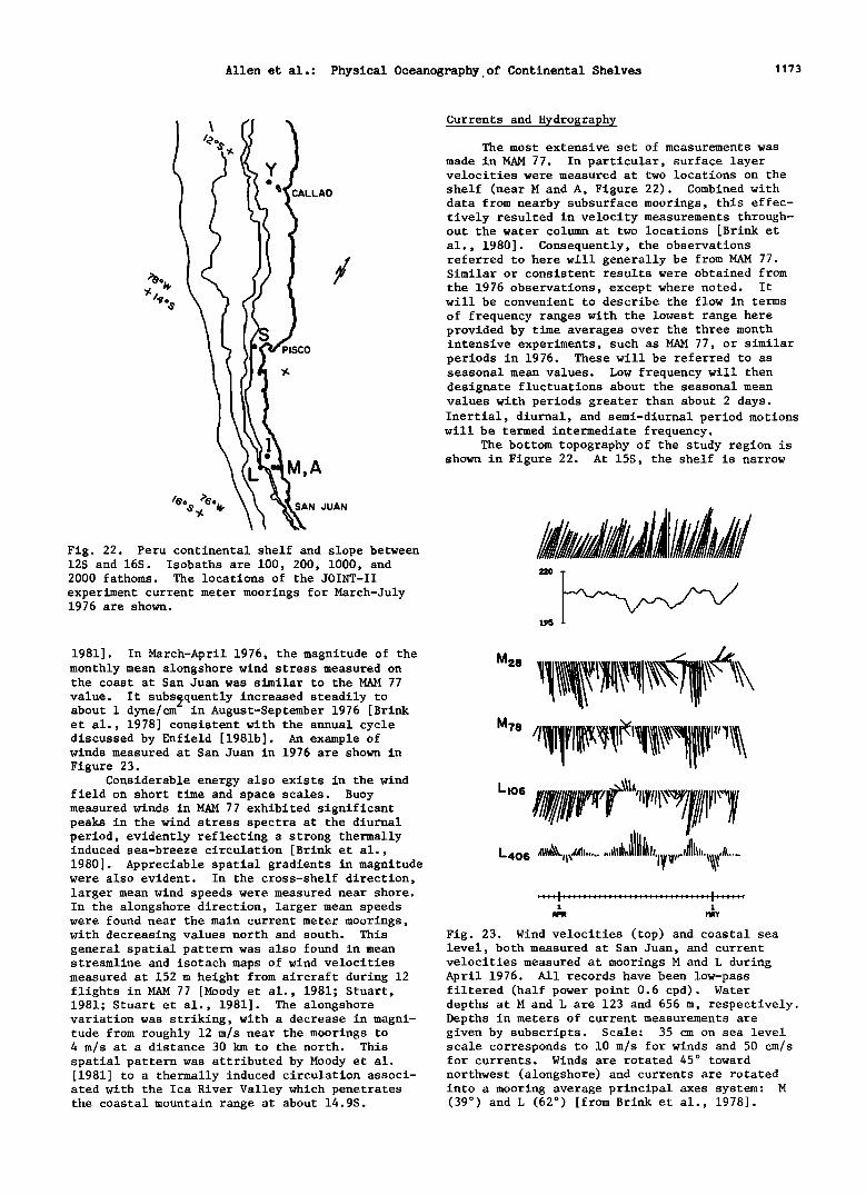
Allen et al.: Physical Oceanography,of Continental Shelves 1173
CALLAO
:•ISCO
¾.
M,A
SAN JUAN
Fig. 22. Peru continental shelf and slope between 12S and 16S. Isobaths are 100, 200, 1000, and 2000 fathoms. The locations of the JOINT-II
experiment current meter moorings for March-July 1976 are shown.
1981]. In March-April 1976, the magnitude of the monthly mean alongshore wind stress measured on the coast at San Juan was similar to the MAM 77
value. It subsequently increased steadily to about 1 dyne/cm- in August-September 1976 [Brink et al., 1978] consistent with the annual cycle discussed by Enfield [1981b]. An example of winds measured at San Juan in 1976 are shown in
Figure 23. Considerable energy also exists in the wind
field on short time and space scales. Buoy measured winds in MAM 77 exhibited significant peaks in the wind stress spectra at the diurnal period, evidently reflecting a strong thermally induced sea-breeze circulation [Brink et al., 1980]. Appreciable spatial gradients in magnitude were also evident. In the cross-shelf direction, larger mean wind speeds were measured near shore. In the alongshore direction, larger mean speeds were found near the main current meter moorings, with decreasing values north and south. This general spatial pattern was also found in mean streamline and isotach maps of wind velocities measured at 152 m height from aircraft during 12 flights in MAM 77 [Moody et al., 1981; Stuart, 1981; Stuart et al., 1981]. The alongshore variation was striking, with a decrease in magni- tude from roughly 12 m/s near the moorings to 4 m/s at a distance 30 km to the north. This spatial pattern was attributed by Moody et al. [1981] to a thermally induced circulation associ- ated with the Ica River Valley which penetrates the coastal mountain range at about 14.9S.
Currents and Hydrography
The most extensive set of measurements was
made in MAM 77. In particular, surface layer velocities were measured at two locations on the
shelf (near M and A, Figure 22). Combined with data from nearby subsurface moorings, this effec- tively resulted in velocity measurements through- out the water column at two locations [Brink et al., 1980]. Consequently, the observations referred to here will generally be from MAM 77. Similar or consistent results were obtained from
the 1976 observations, except where noted. It will be convenient to describe the flow in terms
of frequency ranges with the lowest range here provided by time averages over the three month intensive experiments, such as MAM 77, or similar periods in 1976. These will be referred to as seasonal mean values. Low frequency will then designate fluctuations about the seasonal mean values with periods greater than about 2 days. Inertial, diurnal, and semi-diurnal period motions will be termed intermediate frequency.
The bottom topography of the study region is shown in Figure 22. At 15S, the shelf is narrow
i 1 FIPR I'1•¾
Fig. 23. Wind velocities (top) and coastal sea level, both measured at San Juan, and current velocities measured at moorings M and L during April 1976. All records have been low-pass filtered (half power point 0.6 cpd). Water depths at M and L are 123 and 656 m, respectively. Depths in meters of current measurements are given by subscripts. Scale: 35 cm on sea level scale corresponds to 10 m/s for winds and 50 cm/s for currents. Winds are rotated 45 ø toward
northwest (alongshore) and currents are rotated into a mooring average principal axes system: M (39 ø ) and L (62 ø ) [from Brink et al., 1978].
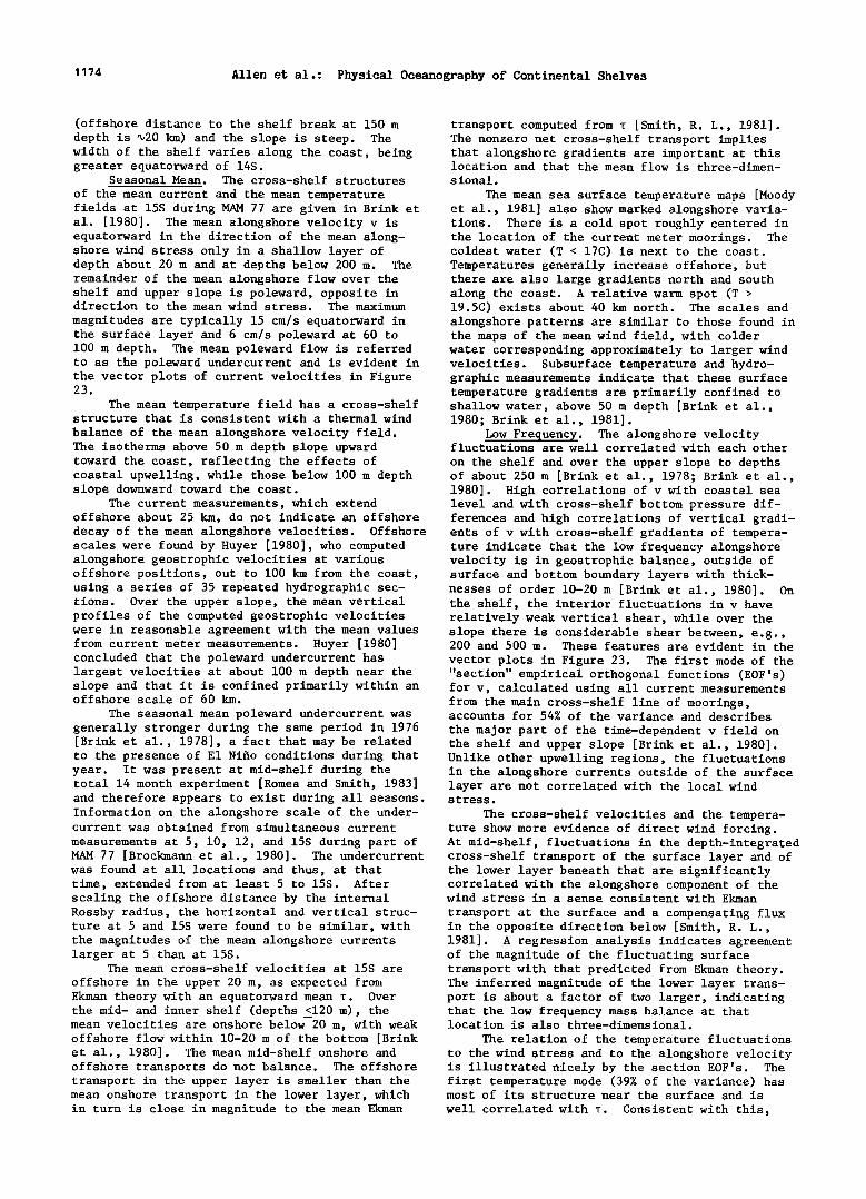
1174 Allen et al.: Physical Oceanography of Continental Shelves
(offshore distance to the shelf break at 150 m depth is 420 km) and the slope is steep. The width of the shelf varies along the coast, being greater equatorward of 14S.
Seasonal Mean. The cross-shelf structures
of the mean current and the mean temperature fields at 15S during MAM 77 are given in Brink et al. [1980]. The mean alongshore velocity v is equatorward in the direction of the mean along- shore wind stress only in a shallow layer of depth about 20 m and at depths below 200 m. The remainder of the mean alongshore flow over the shelf and upper slope is poleward, opposite in direction to the mean wind stress. The maximum
magnitudes are typically 15 cm/s equatorward in the surface layer and 6 cm/s poleward at 60 to 100 m depth. The mean poleward flow is referred to as the poleward undercurrent and is evident in the vector plots of current velocities in Figure 23.
The mean temperature field has a cross-shelf structure that is consistent with a thermal wind
balance of the mean alongshore velocity field. The isotherms above 50 m depth slope upward toward the coast, reflecting the effects of coastal upwelling, while those below 100 m depth slope downward toward the coast.
The current measurements, which extend offshore about 25 km, do not indicate an offshore
transport computed from T [Smith, R. L., 1981]. The nonzero net cross-shelf transport implies that alongshore gradients are important at this location and that the mean flow is three-dimen- sional.
The mean sea surface temperature maps [Moody et at., 1981] also show marked alongshore varia- tions. There is a cold spot roughly centered in the location of the current meter moorings. The coldest water (T < 17C) is next to the coast. Temperatures generally increase offshore, but there are also large gradients north and south along the coast. A relative warm spot (T > 19.5C) exists about 40 km north. The scales and alongshore patterns are similar to those found in the maps of the mean wind field, with colder water corresponding approximately to larger wind velocities. Subsurface temperature and hydro- graphic measurements indicate that these surface temperature gradients are primarily confined to shallow water, above 50 m depth [Brink et al., 1980; Brink et at., 1981].
Low Frequency. The alongshore velocity fluctuations are well correlated with each other
on the shelf and over the upper slope to depths of about 250 m [Brink et al., 1978; Brink et al., 1980]. High correlations of v with coastal sea level and with cross-shelf bottom pressure dif- ferences and high correlations of vertical gradi-
decay of the mean alongshore velocities. Offshore ents of v with cross-shelf gradients of tempera- scales were found by Huyer [1980], who computed alongshore geostrophic velocities at various offshore positions, out to 100 km from the coast, using a series of 35 repeated hydrographic sec- tions. Over the upper slope, the mean vertical profiles of the computed geostrophic velocities were in reasonable agreement with the mean values from current meter measurements. Huyer [1980] concluded that the poleward undercurrent has largest velocities at about 100 m depth near the slope and that it is confined primarily within an offshore scale of 60 km.
The seasonal mean poleward undercurrent was generally stronger during the same period in 1976 [Brink et al., 1978], a fact that may be related to the presence of E1 Nifo conditions during that year. It was present at mid-shelf during the total 14 month experiment [Romea and Smith, 1983]
ture indicate that the low frequency alongshore velocity is in geostrophic balance, outside of surface and bottom boundary layers with thick- nesses of order 10-20 m [Brink et al., 1980]. On the shelf, the interior fluctuations in v have relatively weak vertical shear, while over the slope there is considerable shear between, e.g., 200 and 500 m. These features are evident in the
vector plots in Figure 23. The first mode of the "section" empirical orthogonal functions (EOF's) for v, calculated using all current measurements from the main cross-shelf line of moorings, accounts for 54% of the variance and describes
the major part of the time-dependent v field on the shelf and upper slope [Brink et at., 1980]. Unlike other upwelling regions, the fluctuations in the alongshore currents outside of the surface layer are not correlated with the local wind
and therefore appears to exist during all seasons. stress.
Information on the alongshore scale of the under- The cross-shelf velocities and the tempera- current was obtained from simultaneous current ture show more evidence of direct wind forcing. measurements at 5, 10, 12, and 15S during part of At mid-shelf, fluctuations in the depth-integrated MAM 77 [Brockmann et al., 1980]. The undercurrent cross-shelf transport of the surface layer and of was found at all locations and thus, at that time, extended from at least 5 to 15S. After scaling the offshore distance by the internal Rossby radius, the horizontal and vertical struc- ture at 5 and 15S were found to be similar, with the magnitudes of the mean alongshore currents larger at 5 than at 15S.
The mean cross-shelf velocities at 15S are
offshore in the upper 20 m, as expected from Ekman theory with an equatorward mean T. Over the mid- and inner shelf (depths <120 m), the mean velocities are onshore below 20 m, with weak offshore flow within 10-20 m of the bottom [Brink et al., 1980]. The mean mid-shelf onshore and offshore transports do not balance. The offshore transport in the upper layer is smaller than the mean onshore transport in the lower layer, which in turn is close in magnitude to the mean Ekman
the lower layer beneath that are significantly correlated with the alongshore component of the wind stress in a sense consistent with Ekman
transport at the surface and a compensating flux in the opposite direction below [Smith, R. L., 1981]. A regression analysis indicates agreement of the magnitude of the fluctuating surface transport with that predicted from Ekman theory. The inferred magnitude of the lower layer trans- port is about a factor of two larger, indicating that the low frequency mass balance at that location is also three-dimensional.
The relation of the temperature fluctuations to the wind stress and to the alongshore velocity is illustrated nicely by the section EOF's. The first temperature mode (39% of the variance) has most of its structure near the surface and is
well correlated with T. Consistent with this,
Allen et al.: Physical Oceanography of Continental Shelves 1175
fluctuations in the temperature and the area of margin. An estimate of the internal Rossby the cold water in the sea surface temperature radius at 15S obtained from the observed wave maps are correlated with the wind stress [Stuart, speed divided by the Coriolis parameter is about 1981]. The area increases and the temperature 55 km, which is greater than the shelf width and decreases, as expected, for an increase in upwell- is consistent with the offshore scale found by ing favorable wind stress. On the other hand, the second temperature EOF (22% of the variance) is well correlated with the first mode of v and
reflects a fluctuating thermal wind balance. Most of the gradients in this T mode are concen- trated around 200 m depth near the shelf break, indicating that the fluctuations in v tend to be relatively barotropic over the shelf and baro- clinic over the slope [Brink et al., 1980].
This concentration of the temperature fluc- tuations associated with the fluctuations in the
v field at a depth of about 200 m is consistent with results from Huyer's [1980] dynamic height and geostrophic velocity calculations. Time variations of the dynamic height extrapolated to the coast were found to agree with those of coastal sea level. The time dependence is asso- ciated primarily with variations in the isotherm depths between 4300-500 m. Huyer's [1980] compu- tations are again extremely useful for the deter-
Huyer [1980]. The source of these free waves is not known
at present. Results from a forced wave model calculation by Brink [1982a], using observed winds and currents, suggest that the waves originate equatorward of 5S. It is theoretically possible that they are forced in the equatorial waveguide, propagate eastward along the equator and then southward along the South American coast, Romea and Smith [1983] have extended the data analysis concerning propagation to longer time and space scales using additional coastal sea level records. They find propagation between 2 and 17S and, with sea level data from the Galapagos Islands, "tenuous" evidence that the fluctuations come from the equatorial waveguide.
The question of what happens to free, first mode, coastal trapped internal Kelvin waves as they propagate poleward from low latitudes to mid-latitude regions where the internal Rossby
miation of an offshore decay scale and the result- radius is the order of, or smaller than, the ing estimate is 30-60 km. This scale agrees with shelf width, was investigated theoretically with estimates of the internal Rossby radius (discussed an idealized two-layer model by Allen and Romea below).
The time-dependent balance in the depth- integrated alongshore momentum equation at mid- shelf (near mooring M) was investigated by Allen and Smith [1981]. Estimates for five terms were obtained; depth-integrated v• and fu from current measurements (where subscrip• t denotes time derivative and f is the Coriolis parameter), pressure gradient p. from alongshore differences of coastal sea leve{, bottom stress from near bottom velocity measurements together with a quadratic drag law, and wind stress. To assess the relative importance of these five terms, the time series were expanded in empirical orthogonal functions. It was concluded that the motion is
dominated by an inviscid, unforced balance which, for the 0.1 to 0.2 cpd frequency band, is primar- ily between v. and p_.
While thg along•hore current v at 15S is not correlated with the wind stress, it is highly correlated with v measured at other locations
alongshore, i.e., at 10 and 12S. The time lags
[1980]. It was found that, provided the wave- length was small compared with a distance (41,100 km) dependent on model parameters (geometry, stratification, etc.), the cross-shelf modal structure of the wave would transform as it
propagated poleward so that at mid-latitudes it would be close to a barotropic shelf wave. The numerical calculations by Brink [1982a], of coastal trapped wave mode characteristics as a function of latitude in a more realistic continu-
ously stratified model, show essentially this same transformation for the first mode. For very low latitudes, on the other hand, e.g., near 5S, model results of Romea and Allen [1983] indicate that free or forced coastal trapped internal Kelvin waves may be characterized by vertical as well as poleward propagation.
Intermediate Frequency. Spectra of the current measurements at mid-shelf show peaks at diurnal and semi-diurnal periods, but no signifi- cant peak at the inertial frequency (0.52 cpd) [Brink et al., 1980]. Johnson [1981] found that,
for maximum correlation indicate poleward propaga- for the semi-diurnal motions, the alongshore tion [Smith, R. L., 1978]. Cross-spectral analy- sis shows that this propagation occurs strongly in the 0.1-0.2 cpd frequency band and is nondis- persive with an estimated speed in the range 200- 300 km/day. The propagating fluctuations in v are associated with the first section EOF of the
alongshore velocities. Consequently, the major share of the variance in the v field at 15S is
associated with free coastal trapped waves. Based on observations of wave speed, offshore decay scale, the structure of alongshore velocity and temperature fluctuations, the vL, p momentum balance, and on calculated theoretical •ode shapes and wave speeds [Smith, R. L., 1978; Brink eta!., 1978; Brink et al., 1980; Huyer, 1980; Allen and Smith, 1981; Brink, 1982a; Romea and Smith, 1983] these disturbances appear to have features much like a first mode free internal
Kelvin wave with some modification in properties due to the bottom topography of the continental
velocity component had an amplitude larger by a factor of three than the cross-shelf component,
typical kinetic energy levels of 6 erg/cm 3 and uniform phase over the shelf Th• diurnal motions had the largest energy (46 e•g/cm ) in the surface layer within 5 km of the coast, consistent with forcing by the diurnal sea breeze. Complex demodulation at the inertial frequency showed that the inertial motions were variable, but responded to wind forcing, with the largest amplitudes (410 cm/s) near the surface over the inner shelf. Johnson [1981] concluded that, although spectral peaks at the inertial frequency were generally absent in the current meter records, inertial motions were intermittantly energetic.
Future Work
Although recent observations have led to greatly improved descriptions of shelf flow

1176 Allen et al.: Physical Oceanography of Continental Shelves
fields, a large amount of work remains in trying to understand the physics of several important processes. Some of the unresolved questions for each shelf region were brought out in the previous sections. Here we summarize briefly a few of the major problems that need future work and that are common to several shelf regions. In general, the work required will involve various combinations of the continued analysis of existing data, development of improved theoretical models, laboratory experiments, and further field experi- ments.
The dynamics of the coupling between the flow on the outer shelf and the offshore current
and/or eddy regime over the slope certainly needs additional study. This is true not only in areas with strong offshore currents, such as the south- eastern U.S. and west Florida shelves, with the Gulf Stream and Loop Current, respectively, but also in regions such as the Pacific Northwest, Gulf of Alaska, and eastern Bering Sea, with the relatively weaker California, Alaska, and Bering Slope Currents. This interaction is one part of the more general subject of the cross-shelf transport of mass, momentum, energy, salt, nutri- ents, etc. That remains one of the most impor- tant, yet most poorly understood, aspects of shelf circulation. Included are questions on the effects of density fronts and of topographic irregularities on cross-shelf transport, as well as questions on the differences between cross- shelf exchange processes in the surface frictional layer and in the water column below. Combined Eulerian-Lagrangian experiments should be helpful in investigations of these processes.
The alongshore variations of low frequency, seasonal mean, and annual mean currents on large alongshore scales (>100 km) are not well under- stood. For example, the nature of the coupling of the circulation on these time scales in the
Middle Atlantic Bight, Georges Bank, Gulf of Maine, and ScotJan Shelf system, needs additional research. In fact, the driving mechanisms for the annual mean currents on several shelves have
not been unambiguously identified. The mean poleward current on the Peru shelf, which is opposite in direction to the persistent equator- ward wind stress, provides one obvious example. Likewise, the dynamics involved in the mean southward currents in the Middle Atlantic Bight have not been fully resolved. It is noteworthy that, although the geographical locations differ considerably, the direction of these mean currents
is the same as that of free, long, coastal trapped wave propagation. Although the significance of that fact is not known, it suggests that mechan- isms with common roots may be involved. Related to general questions on maintenance of the mean alongshore flow are specific questions on the role in the alongshore momentum balance of the alongshore pressure gradient and the bottom stress. Those two fundamental forces play ex- tremely important parts in even the simplest theoretical models. Establishing by measurements their contributions in actual shelf flow fields
is an important task. The dynamics of shelf currents driven by
density differences due to river runoff and the interaction of these density driven flows with wind driven currents is another subject that needs additional work. Results from laboratory experiments will likely prove useful in these studies.
New information provided by the large number of recent observations has, in several instances, outrun our ability to rationalize it with theo- retical models. The modelling aspect of shelf circulation will undoubtedly receive increased attention in the next few years. This should include the development of improved numerical models, with the incorporation of better repre- sentations of the surface frictional layer and of frictional and diffusive processes in general. In addition, the difficult, limited domain, open boundary condition problems inherent in construct- ing numerical models for shelf flow fields will have to be carefully dealt with. At the same time, there will be a need to further develop objective methods to test model predictions using available data sets.
Acknowledgements. The following people are thanked for their critical reviews of individual
sections: K. H. Brink (by JSA, RCB, WCB), D.C. Chapman and L. Rosenfeld (by RCB, WCB), L. P. Atkinson, T. N. Lee and L. S. Pietrafesa (by JOB), M. Noble (by BB), R. K. Reed (by JDS). We also thank P. Wegner for typing the manuscript. Preparation of this review was supported, for the coauthors in parentheses, by National Science Foundation Grants 0CE-8026131 (JSA, AH, RLS), 0CE-8017929 (JSA), 0CE-8014941 (RCB), 0CE-7826006 (WCB), 0CE-8208306 (TCR), 0CE-8217643 (WS), and by the Department of Energy Contract DE-AS09- 80EV10331 (JOB).
Aagaard, K., L. K. Coachman and E. Carmack, On the halocline of the Arctic Ocean, Deep-Sea Res., 28, 529-545, 1981.
Alexander, V. and H. J. Niebauer, Oceanography of the eastern Bering Sea ice edge zone in spring, Limnol. Oceanogr., 26, 1111-1125, 1982.
Allen, J. S., Continental shelf waves and along- shore variations in bottom topography and coastline, J. Phys. Oceanosr., •, 867-878, 1976.
Allen, J. S., Models of wind-driven currents on the continental shelf, Ann. Rev. Fluid Mech., 12, 389-433, 1980.
Allen, J. S. and R. D. Romea, On coastal trapped waves at low latitudes in a stratified ocean,
References
J. Fluid Mech., 98, 555-585, 1980. Allen, J. S. and R. L. Smith, On the dynamics of
wind-driven shelf currents, Phil. Trans. R. Soc. Lond., A302, 617-634, 1981.
Arsenev, V. S., Currents and water masses in the Bering Sea. (Transl. 1968, Nat. Mar. Fish. Serv., Northwest Fisheries Center, Seattle, WA), 1967.
Atkinson, L. P., J. O. Blanton and E. B. Haines, Shelf flushing rates based on the distribution of salinity and freshwater in the Georgia Bight, Est. Coast. Mar. Sci., •, 465-472, 1978.
Atkinson, L. P., T. N. Lee, J. O. Blanton and W. S. Chandler, Climatology of the southeastern United States continental shelf water, J.
_
Geophys. Res., in press, 1983. Atkinson, L. P. and L. J. Pietrafesa, A flushing
model of Onslow Bay, North Carolina based on intrusion volumes, J. Phys. Oceano•r., 10, 472- 474, 1980.
Atkinson, L. P., J. J. Singer and L. J. Pietrafesa, Volume of summer subsurface intrusions into
Onslow Bay, North Carolina, Deep-Sea Res., 27A, 421-434, 1980.
Bakun, A., Coastal upwelling indices, west coast of North America, 1946-71, NOAA Tech. Rept. NMFS SSRF-671 103 pp., 1973.
Bane, J. M., Jr., Coastal-trapped and frontal- trapped waves in a baroclinic western boundary current, J. Phys. Oceanosr., 10, 1652-1668,
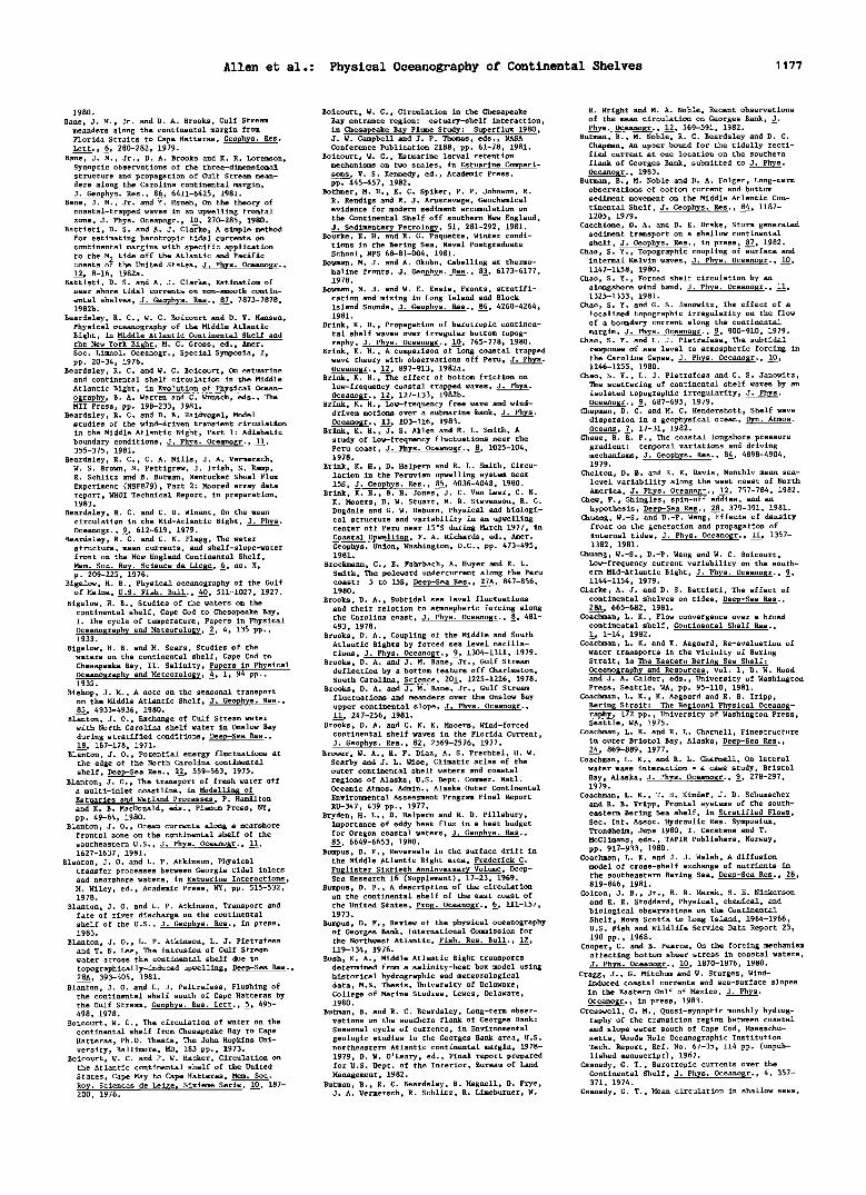
Allen et al.: Physical Oceanography of Continental Shelves 1177
1980.
Bane, J. M., Jr. and D. A. Brooks, Gulf Stream meanders along the continental margin from Florida Straits to Cape Hatteras, Geophys. Res. Lett., •, 280-282, 1979.
Bane, J. M., Jr., D. A. Brooks and K. R. Lorenson, Synoptic observations of the three-dimensional structure and propagation of Gulf Stream mean- ders along the Carolina continental margin, J. Geoph¾s. Res., 86, 6411-6425, 1981.
Bane, J. M., Jr. and Y. Hsueh, On the theory of coastal-trapped waves in an upwelling frontal zone, J. Phys. 0ceano•r., 10, 270-285, 1980.
Battisti, D. S. and A. J. Clarke, A simple method for estimating barotropic tidal currents on continental margins with specific application
to the • tide off the Atlantic and Pacific coasts the United States, J. Phys. Oceano•r., 12, 8-16, 1982a.
Battisti, D. S. and A. J. Clarke, Estimation of near shore tidal currents on non-smooth contin-
ental shelves, J. Geophys. Res., 87, 7873-7878, 1982b.
Beardsley, R. C., W. C. Boicourt and D. V. Hansen, Physical oceanography of the Middle Atlantic Bight, in Middle Atlantic Continental Shelf and the New York Bight, M. G. Gross, ed., Amer. Soc. Limnol. Oceanogr., Special Symposia, 2, pp. 20-34, 1976.
Beardsley, R. C. and W. C. Boicourt, On estuarine and continental shelf circulation in the Middle
Atlantic Bight, in Evolution of Physical Ocean- ography, B. A. Warren and C. Wunsch, eds., The MIT Press, pp. 198-233, 1981.
Beardsley, R. C. and D. B. Haidvogel, Model studies of the wind-driven transient circulation
in the Middle Atlantic Bight, Part 1: Adiabatic boundary conditions, J. Phys. Oceano•r., 11, 355-375, 1981.
Beardsley, R. C., C. A. Mills, J. A. Vermersch, W. S. Brown, N. Pettigrew, J. Irish, S. Ramp, R. Schlitz and B. Butman, Nantucket Shoal Flux Experiment (NSFE79), Part 2: Moored array data report, WHOI Technical Report, in preparation, 1983.
Beardsley, R. C. and C. D. Winant, On the mean circulation in the Mid-Atlantic Bight, J. Phys. 0ceano•r., •, 612-619, 1979.
Beardsley, R. C. and C. N. Flagg, The water structure, mean currents, and shelf-slope-water front on the New England Continental Shelf, Mem. Soc. Roy. Science de Liege, 6, no. X, p. 209-225, 1976.
Bigelow, H. B., Physical oceanography of the Gulf of Maine, U.S. Fish. Bull., 40, 511-1027, 1927.
Bigelow, H. B., Studies of the waters on the continental shelf, Cape Cod to Chesapeake Bay, I. The cycle of temperature, Papers in Physical Oceanography and Meteorology, •, 4, 135 pp., 1933.
Bigelow, H. B. and M. Sears, Studies of the waters on the continental shelf, Cape Cod to Chesapeake Bay, II. Salinity, Papers in Physical Oceanography and Meteorology, •, 1, 94 pp., 1935.
Bishop, J. M., A note on the seasonal transport on the Middle Atlantic Shelf, J. Geophys. Res., 85, 4933-4936, 1980.
Blanton, J. 0., Exchange of Gulf Stream water with North Carolina shelf water in Onslow Bay
during stratified conditions, Deep-Sea Res., 18, 167-178, 1971.
Blanton, J. 0., Potential energy fluctuations at the edge of the North Carolina continental shelf, Deep-Sea Res., 22, 559-563, 1975.
Blanton, J. 0., The transport of fresh water off a multi-inlet coastline, in Modellin• of Estuaries and Wetland Processes, P. Hamilton and K. B. MacDonald, eds., Plenum Press, NY, pp. 49-64, 1980.
Blanton, J. 0., Ocean currents along a nearshore frontal zone on the continental shelf of the
southeastern U.S., J. Phys. Oceanogr., 11, 1627-1637, 1981.
Blanton, J. 0. and L. P. Atkinson, Physical transfer processes between Georgia tidal inlets and nearshore waters, in Estuarine Interactions, M. Wiley, ed., Academic Press, NY, pp. 515-532, 1978.
Blanton, J. O. and L. P. Atkinson, Transport and fate of river discharge on the continental shelf of the U.S., J. Geophys. Res., in press, 1983.
Blanton, J. 0., L. P. Atkinson, L. J. Pietrafesa and T. N. Lee, The intrusion of Gulf Stream water across the continental shelf due to topographically-induced upwelling, Deep-Sea Res., 28A, 393-405, 1981.
Blanton, J. O. and L. J. Peitrafesa, Flushing of the continental shelf south of Cape Hatteras by the Gulf Stream, Geophys. Res. Lett., •, 495- 498, 1978.
Boicourt, W. C., The circulation of water on the continental shelf from Chesapeake Bay to Cape Hatteras, Ph.D. Thesis, The John Hopkins Uni- versity, Baltimore, MD, 183 pp., 1973.
Boicourt, W. C. and P. W. Hacker, Circulation on the Atlantic continental shelf of the United
States, Cape May to Cape Hatteras, Mem. Soc. Roy. Sciences de Lei•e, Sixieme Serie, 10, 187- 200, 1976.
Boicourt, W. C., Circulation in the Chesapeake Bay entrance region: estuary-shelf interaction, in Chesapeake Bay Plume Study: Superflux 1980, J. W. Campbell and J.P. Thomas, eds., NASA Conference Publication 2188, pp. 61-78, 1981.
Boicourt, W. C., Estuarine larval retention mechanisms on two scales, in Estuarine Compari- sons, V. S. Kennedy, ed., Academic Press, pp. 445-457, 1982.
Bothner, M. H., E. C. Spiker, P. P. Johnson, R. R. Rendigs and R. J. Aruscavage, Geochemical evidence for modern sediment accumulation on
the Continental Shelf off southern New England, J. Sedimentary Petrology, 51, 281-292, 1981.
Bourke, R. H. and R. G. Paquette, Winter condi- tions in the Bering Sea, Naval Postgraduate School, NPS 68-81-004, 1981.
Bowman, M. J. and A. 0kubo, Cabelling at thermo- haline fronts, J. Geophys. Res., 83, 6173-6177, 1978.
Bowman, M. J. and W. E. Esais, Fronts, stratifi- cation and mixing in Long Island and Block Islan• Sounds, J. Geophys. Res., 86, 4260-4264, 1981.
Brink, K. H., Propagation of barotropic continen- tal shelf waves over irregular bottom topog- raphy, J. Phys. Oceano•r., 10, 765-778, 1980.
Brink, K. H., A comparison of long coastal trapped wav• theory with observations off Peru, J. Phys. 0ceano•r., 12, 897-913, 1982a.
Brink, K. H., The effect of bottom friction on low-frequency coastal trapped waves, J. Phys. Oceano•r., 12, 127-133, 1982b.
Brink, K. H., Low-frequency free wave and wind- driven motions over a submarine bank, J. Phys. Oceano•r., 13, 103-116, 1983.
Brink, K. H., J. S. Allen and R. L. Smith, A study of low-frequency fluctuations near the Peru coast, J. Phys. Oceano•r., •, 1025-104, 1978.
Brink, K. H., D. Halpern and R. L. Smith, Circu- lation in the Peruvian upwelling system near 15S, J. Geophys. Res., 85, 4036-4048, 1980.
Brink, K. H., B. H. Jones, J. C. Van Leer, C. N. K. Mooers, D. W. Stuart, M. R. Stevenson, R. C. Dugdale and G. W. Heburn, Physical and biologi- cal structure and variability in an upwelling center off Peru near 15øS during March 1977, in Coastal Upwelling, F. A. Richards, ed., Amer. Geophys. Union, Washington, D.C., pp. 473-495, 1981.
Brockmann, C., E. Fahrbach, A. Huyer and R. L. Smith, The poleward undercurrent along the Peru coast: 5 to 15S, Deep-Sea Res., 27A, 847-856, 1980.
Brooks, D. A., Subtidal sea level fluctuations and their relation to atmospheric forcing along the Carolina coast, J. Phys. Oceano•r., •, 481- 493, 1978.
Brooks, D. A., Coupling of the Middle and South Atlantic Bights by forced sea level oscilla- tions, J. Phys. Oceanosr., •, 1304-1311, 1979.
Brooks, D. A. and J. M. Bane, Jr., Gulf Stream deflection by a bottom feature off Charleston, South Carolina, Science, 201, 1225-1226, 1978.
Brooks, D. A. and J. M. Bane, Jr., Gulf Stream fluctuations and meanders over the Onslow Bay upper continental slope, J. Phys. Oceano•r., 11, 247-256, 1981.
Brooks, D. A. and C. N. K. Mooers, Wind-forced continental shelf waves in the Florida Current, J. Geophys. Res., 82, 2569-2576, 1977.
Brower, W. A., H. F. Diaz, A. S. Prechtel, H. W. Searby and J. L. Wise, Climatic atlas of the outer continental shelf waters and coastal
regions of Alaska, U.S. Dept. Commer. Natl. Oceanic Atmos. Admin., Alaska Outer Continental Environmental Assessment Program Final Report RU-347, 439 pp., 1977.
Bryden, H. L., D. Halpern and R. D. Pillsbury, Importance of eddy heat flux in a heat budget for Oregon coastal waters, J. Geophys. Res., 85, 6649-6653, 1980.
Bumpus, D. F., Reversals in the surface drift in the Middle Atlantic Bight area, Frederick C. Fu•lister Sixtieth Anninversary Volume, Deep- Sea Research 16 (Supplement), 17-23, 1969.
Bumpus, D. F., A description of the circulation on the continental shelf of the east coast of the United States, Prog. Oceanogr., •, 111-157, 1973.
Bumpus, D. F., Review of the physical oceanography of Georges Bank, International Commission for the Northwest Atlantic, Fish. Res. Bull., 12, 119-134, 1976.
Bush, K. A., Middle Atlantic Bight transports determined from a salinity-heat box model using historical hydrographic and meteorological data, M.S. Thesis, University of Delaware, College of Marine Studies, Lewes, Delaware, 1980.
Butman, B. and R. C. Beardsley, Long-term obser- vations on the southern flank of Georges Bank: Seasonal cycle of currents, in Environmental geologic studies in the Georges Bank area, U.S. northeastern Atlantic continental margin, 1978- 1979, D. W. O'Leary, ed., Final report prepared for U.S. Dept. of the Interior, Bureau of Land Management, 1982.
Butman, B., R. C. Beardsley, B. Magnell, D. Frye, J. A. Vermersch, R. Schlitz, R. Limeburner, W.
R. Wright and M. A. Noble, Recent observations of the mean circulation on Georges Bank, J. Phys. Oceano•r., 12, 569-591, 1982.
Butman, B., M. Noble, R. C. Beardsley and D.C. Chapman, An upper bound for the tidally recti- fied current at one location on the southern
flank of Georges Bank, submitted to J. Phys. 0ceanogr., 1983.
Butman, B., M. Noble and D. A. Folger, Long-term observations of bottom current and bottom
sediment movement on the Middle Atlantic Con-
tinental Shelf, J. Geophys. Res., 84, 1187- 1205, 1979.
Cacchione, D. A. and D. E. Drake, Storm generated sediment transport on a shallow continental shelf, J. Geophys. Res., in press, 87, 1982.
Chao, S. Y., Topographic coupling of surface and internal Kelvin waves, J. Phys. 0ceanogr., 10, 1147-1158, 1980.
Chao, S. Y., Forced shelf circulation by an alongshore wind band, J. Phys. Oceanosr., 11, 1325-1333, 1981.
Chao, S. Y. and G. S. Janowitz, The effect of a localized topographic irregularity on the flow of a boundary current along the continental margin, J. Phys. Oceanogr., •, 900-910, 1979.
Chao, S. Y. and L. J. Pietrafesa, The subtidal response of sea level to atmospheric forcing in the Carolina Capes, J. Phys. Oceano•r., 10, 1246-1255, 1980.
Chao, S. Y., L. J. Pietrafesa and G. S. Janowitz, The scattering of continental shelf waves by an isolated topographic irregularity, J. Phys. Oceano•r., •, 687-695, 1979.
Chapman, D.C. and M. C. Hendershott, Shelf wave dispersion in a geophysical ocean, D•n. Atmos. Oceans, 7, 17-31, 1982.
Chase, R. R. P., The coastal longshore pressure gradient: temporal variations and driving mechanisms, J. Geophys. Res., 84, 4898-4904, 1979.
Chelton, D. B. and R. E. Davis, Monthly mean sea- level variability along the west coast of North America, J. Phys. Oceanogr., 12, 757-784, 1982.
Chew, F., Shingles, spin-off eddies, and an hypothesis, Deep-Sea Res., 28, 379-391, 1981.
Chuang, W.-S. and D.-P. Wang, Effects of density front on the generation and propagation of internal tides, J. Phys. Oceano•r., 11, 1357- 1382, 1981.
Chuang, W.-S., D.-P. Wang and W. C. Boicourt, Low-frequency current variability on the south- ern Mid-Atlantic Bight, J. Phys. 0ceanoõr., •, 1144-1154, 1979.
Clarke, A. J. and D. S. Battisti, The effect of continental shelves on tides, Deep-Sea Res., 28A, 665-682, 1981.
Coachman, L. K., Flow convergence over a broad continental shelf, Continental Shelf Res., •, 1-14, 1982.
Coachman, L. K. and K. Aagaard, Re-evaluation of water transports in the vicinity of Bering Strait, in The Eastern Berin• Sea Shelf: Oceanography and Resources, vol. 1, D. W. Hood and J. A. Calder, eds., University of Washington Press, Seattle, WA, pp. 95-110, 1981.
Coachman, L. K., K. Aagaard and R. B. Tripp, Berin• Strait: The Regional Physical Oceanog- raphy, 172 pp., University of Washington Press, Seattle, WA, 1975.
Coachman, L. K. and R. L. Charnell, Finestructure in outer Bristol Bay, Alaska, Deep-Sea Res., 24, 869-889, 1977.
Coachman, L. K., and R. L. Charnell, On lateral water mass interaction - a case study, Bristol Bay, Alaska, J. Phys. 0ceanosr., •, 278-297, 1979.
Coachman, L. K., T. H. Kinder, J. D. Schumacher and R. B. Tripp, Frontal systems of the south- eastern Bering Sea shelf, in Stratified Flows, Sec. Int. Assoc. Hydraulic Res. Symposium, Trondheim, June 1980, T. Carstens and T. McClimans, eds., TAPIR Publishers, Norway, pp. 917-933, 1980.
Coachman, L. K. and J. J. Walsh, A diffusion model of cross-shelf exchange of nutrients in the southeastern Bering Sea, Deep-Sea Res., 28, 819-846, 1981.
Colton, J. B., Jr., R. R. Harak, S. E. Nickerson and R. R. Stoddard, Physical, chemical, and biological observations on the Continental Shelf, Nova Scotia to Long Island, 1964-1966, U.S. Fish and Wildlife Service Data Report 23, 190 pp., 1968.
Cooper, C. and B. Pearce, On the forcing mechanism affecting bottom sheer stress in coastal waters, J. Phys. Oceanogr., 10, 1870-1876, 1980.
Cragg, J., G. Mitchum and W. Sturges, Wind- induced coastal currents and sea-surface slopes in the Eastern Gulf of Mexico, J. Phys. Oceanosr., in press, 1983.
Cresswell, G. M., Quasi-synoptic monthly hydrog- raphy of the transition region between coastal and slope water south of Cape Cod, Massachu- setts, Woods Hole Oceanographic Institution Tech. Report, Ref. No. 67-35, 114 pp. (unpub- lished manuscript), 1967.
Csanady, G. T., Barotropic currents over the Continental Shelf, J. Phys. Oceano•r., •, 357- 371, 1974.
Csanady, G. T., Mean circulation in shallow seas,
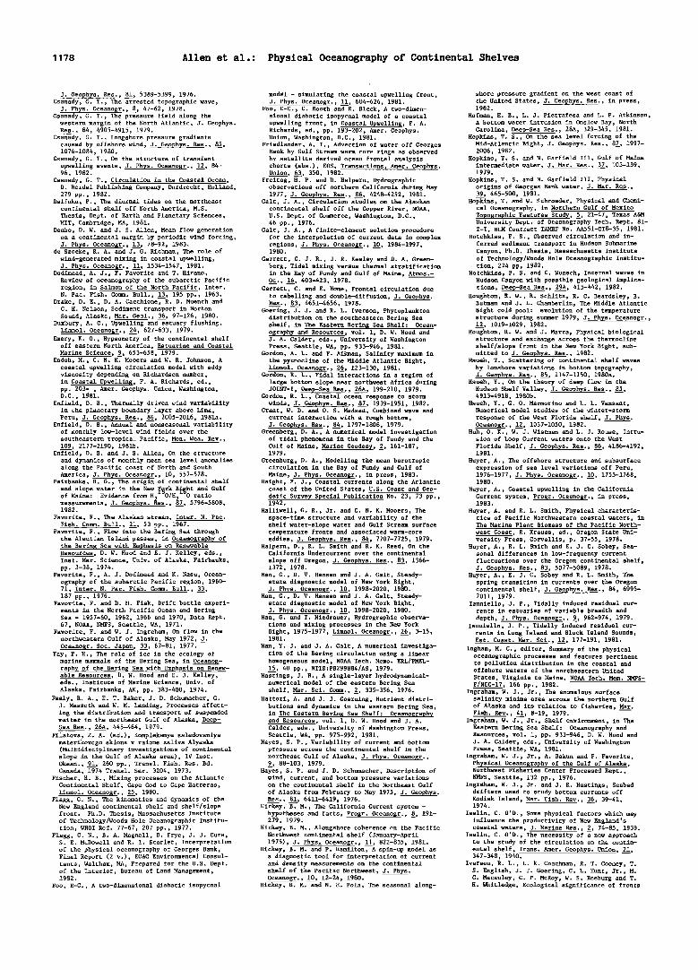
1178 Allen et al.: Physical Oceanography of Continental Shelves
J. Geophys. Res., 81, 5389-5399, 1976. Csanady, G. T., The arrested topographic wave,
J. Phys. Oceanogr., •, 47-62, 1978. Csanady, G. T., The pressure field along the
western margin of the North Atlantic, J. Geophys. Res., 84, 4905-4915, 1979.
Csanady, G. T., Longshore pressure gradients caused by offshore wind, J. Geophys. Res., 85, 1076-1084, 1980.
Csanady, G. T., On the structure of transient upwelling events, J. Phys. Oceanogr., 12, 84- 96, 1982.
Csanady, G. T., Circulation in the Coastal Ocean, D. Reidel Publishing Company, Dordrecht, Holland, 279 pp., 1982.
Daifuku, P., The diurnal tides on the northeast continental shelf off North America, M.S. Thesis, Dept. of Earth and Planetary Sciences, MIT, Cambridge, MA, 1981.
Denbo, D. W. and J. S. Allen, Mean flow generation on a continental margin by periodic wind forcing, J. Phys. Oceanogr., 13, 78-92, 1983.
de Szoeke, R. A. and J. G. Richman, The role of wind-generated mixing in coastal upwelling, J. Phys. Oceanogr., 11, 1534-1547, 1981.
Dodimead, A. J., F. Favorite and T. Hirano, Review of oceanography of the subarctic Pacific region, in Salmon of the North Pacific, Inter. N. Pac. Fish. Comm. Bull., 13, 195 pp., 1963.
Drake, D. E., D. A. Cacchione, R. D. Muench and C. H. Nelson, Sediment transport in Norton Sound, Alaska, Mar. Geol., 36, 97-126, 1980.
Duxbury, A. C., Upwelling and estuary flushing, Limnol. Oceanogr., 24, 627-633, 1979.
Emery, K. O., Hypsometry of the continental shelf off eastern North America, Estuarine and Coastal Marine Science, •, 653-658, 1979.
Endoh, M., C. N. K. Mooers and W. R. Johnson, A coastal upwelling circulation model with eddy viscosity depending on Richardson number, in Coastal Upwelling, F. A. Richards, ed., pp. 203- , Amer. Geophys. Union, Washington, D.C., 1981.
Enfield, D. B., Thermally driven wind variability in the planetary boundary layer above Lima, Peru, J. Geophys. Res., 86, 2005-2016, 1981a.
Enfield, D. B., Annual and nonseasonal variability of monthly low-level wind fields over the southeastern tropical Pacific, Mon. Wea. Rev., 109, 2177-2190, 1981b.
Enfield, D. B. and J. S. Allen, On the structure and dynamics of monthly mean sea level anomalies along the Pacific coast of North and South America, J. Phys. Oceanogr., 10, 557-578.
Fairbanks, R. G., The origin of continental shelf
and slope water in the New ¾•rk B•ht and Gulf of Maine: Evidence from H• - O/H2•VO ratio measurements, J. Geophys. Kes., 87, 5796-5808, 1982.
Favorite, F., The Alaskan stream, Inter. N. Pac. Fish. Comm. Bull., 21, 53 pp., 1967.
Favorite, F., Flow into the Bering Sea through the Aleutian Island passes, in Oceanography of the Bering Sea with Emphasis on Renewable Resources, D. W. Hood and E. J. Kelley, eds., Inst. Mar. Science, Univ. of Alaska, Fairbanks, pp. 3-38, 1974.
Favorite, F., A. J. Dodimead and K. Nasu, Ocean- ography of the subarctic Pacific region, 1960- 71, Inter. N. Pac. Fish. Comm. Bull., 33, 187 pp., 1976.
Favorite, F. and D. M. Fisk, Drift bottle experi- ments in the North Pacific Ocean and Bering Sea - 1957-60, 1962, 1966 and 1970, Data Rept. 67, NOAA, NMFS, Seattle, WA, 1971.
Favorite, F. and W. J. Ingraham, On flow in the northwestern Gulf of Alaska, May 1972, •. Oceanogr. Soc. Japan, 33, 67-81, 1977.
Fay, F. H., The role of ice in the ecology of marine mammals of the Bering Sea, in Oceanog- raphy of the Bering Sea with Emphasis on Renew- able Resources, D. W. Hood and E. J. Kelley, eds., Institute of Marine Science, Univ. of Alaska, Fairbanks, AK, pp. 383-400, 1974.
Feely, R. A., E. T. Baker, J. D. Schumacher, G. J. Massoth and W. M. Landing, Processes affect- ing the distribution and transport of suspended matter in the northeast Gulf of Alaska, Deep- Sea Res., 26A, 445-464, 1979.
Filatova, Z. A. (ed.), Kompleksmye ssledovaniya materikovogo sklona v raione zaliva Alyaska (Multidisciplinary investigations of continental slope in the Gulf of Alaska area), IV Inst. Okean., 91, 260 pp., Trans1. Fish. Res. Bd. Canada, 1974 Trans1. Ser. 3204, 1973.
Fischer, H. B., Mixing processes on the Atlantic Continental Shelf, Cape Cod to Cape Hatteras, Limno1. Oceanogr., 25, 1980.
Flagg, C. N., The kinematics and dynamics of the New England continental shelf and shelf/slope front. Ph.D. Thesis, Massachusetts Institute of Technology/Woods Hole Oceanographic Institu- tion, WHOI Ref. 77-67, 207 pp., 1977.
Flagg, C. N., B. A. Magne11, D. Frye, J. J. Cura, S. E. McDowell and R. I. Scarlet, Interpretation of the physical oceanography of Georges Bank, Final Report (2 v.), EG&G Environmental Consul- tants, Waltham, MA, Prepared for the U.S. Dept. of the Interior, Bureau of Land Management, 1982.
Foo, E-C., A two-dimensional diabatic isopycnal
model - simulating the coastal upwelling front, J. Phys. Oceanogr., 11, 604-626, 1981.
Fo0, E-C.• C. Rooth and R. Bleck, A two-dimen- sional diabatic isopycnal model of a coastal upwelling front, in Coastal Upwelling, F. A. Richards, ed., pp. 193-202, Amer. Geophys. Union, Washington, D.C., 1981.
Friedlander, A. I., Advection of water off Georges Bank by Gulf Stream warm core rings as observed by satellite derived ocean frontal analysis charts (abs.), EOS, Transactions, Amer. Geophys. Union, 63, 350, 1982.
Freitag, H. P. and D. Halpern, Hydrographic observations off northern California during May 1977, J. Geophys. Res., 86, 4248-4252, 1981.
Galt, J. A., Circulation studies on the Alaskan continental shelf off the Copper River, NOAA, U.S. Dept. of Commerce, Washington, D.C., 46 pp., 1976.
Galt, J. A., A finite-element solution procedure for the interPOlation of current data in complex regions, J. Phys. Oceanogr., 10, 1984-1997, 1980.
Garrett, C. J. R., J. R. Keeley and D. A. Green- berg, Tidal mixing versus thermal stratification in the Bay of Fundy and Gulf of Maine, Atmos.- O__C., 16, 403-423, 1978.
Garrett, C. and E. HOme, Frontal circulation due to cabelling and double-diffusion, J. Geophys. Res., 83, 4651-4656, 1978.
Goering, J. J. and R. L. Iverson, Phytoplankton distribution on the southeastern Bering Sea shelf, in The Eastern Bering Sea Shelf: Ocean- ography and Resources, vol. 1, D. W. Hood and J. A. Calder, eds., University of Washington Press, Seattle, WA, pp. 933-946, 1981.
Gordon, A. L. and F. Aikman, Salinity maximum in the pycnocline of the Middle Atlantic Bight, Limno1. Oceanogr., 26, 123-130, 1981.
Gordon, R. L., Tidal interactions in a region of large bottom slope near northwest Africa during JOINT-I, Deep-Sea Res., 26A, 199-210, 1979.
Gordon, R. L., Coastal ocean response to storm winds, J. Geophys. Res., 87, 1939'1951, 1982.
Grant, W. Do and O. S. Madsen, Combined wave and current interaction with a rough bottom, J. Geophys. Res., 84, 1797-1808, 1979.
Greenberg, D. A., A numerical model investigation of tidal phenomena in the Bay of Fundy and the Gulf of Maine, Marine Geodesy, •, 161-187, 1979.
Greenburg, D. A., Modelling the mean barotropic circulation in the Bay of Fundy and Gulf of Maine, J. Phys. Oceanogr., in press, 1983.
Haight, F. J., Coastal currents along the Atlantic coast of the United States, U.S. Coast and Geo- detic Survey Special Publication No. 23, 73 pp., 1942.
Halliwe11, G. R., Jr. and C. N. K. Mooers, The space-time structure and variability of the shelf water-slope water and Gulf Stream surface temperature fronts and associated warm-core eddies, J. Geophys. Res., 84, 7707-7725, 1979.
Halpern, D., R. L. Smith and R. K. Reed, On the California Undercurrent over the continental
slope off Oregon, J..Geophys. Res., 83, 1366- 1372, 1978.
Han, G., D. V. Hansen and J. A. Galt, Steady- state diagnostic model of New York Bight, J. Phys. Oceanogr., 10, 1998-2020, 1980.
Hah, G., D• V. Hansen and J. A. Galt, Steady- state diagnostic model of New York Bight, J. Phys. Oceanogr., 10, 1998-2020, 1980.
Han, G. and T. Niedrauer, Hydrographic observa- tions and mixing processes in the New York Bight, 1975-1977, Limnol. Oceano$r., 26, 3-15, 1981.
Han, Y. J. and J. A. Galt, A numerical investiga- tion of the Bering circulation using a linear homogeneous model, NOAA Tech. Memo. ERL/PMEL- 15, 40 pp., NTIS:PB299884/AS, 1979.
Hastings, J. R., A single-layer hydrodynamical- numerical model of the eastern Bering Sea shelf, Mar. Sci. Comm., •, 335-356, 1976.
Hattori, A. and J. J. Goerning, Nutrient distri- butions and dynamics in the eastern Bering Sea, in The Eastern Bering Sea Shelf: Oceanography and Resources, vol. 1, D. W. Hood and J. A. Calder, eds., University of Washington Press, Seattle, WA, pp. 975-992, 1981.
Hayes, S. P., Variability of current and bottom pressure across the continental shelf in the northeast Gulf of Alaska, J. Phys. Oceanogr., •, 88-103, 1979.
Hayes, S. P. and J. D. Schumacher, Description of wind, current, and bottom pressure variations on the continental shelf in the Northeast Gulf
of Alaska from February to May 1975, J. Geophys. Res., 81, 6411-6419, 1976.
Hickey, B. M., The California Current system - hypotheses and facts, Progr. Oceanogr., •, 191- 279, 1979.
Hickey, B. M., Alongshore coherence on the Pacific Northwest continental shelf (January-April 1975), J. Phys. Oceanogr., 11, 822-835, 1981.
Hickey, B. M. and ?. Hamilton, A spin-up model as a diagnostic tool for interpretation of current and density measurements on the continental shelf of the Pacific Northwest, J. Phys. Oceanogr., 10, 12-24, 1980.
Hickey, B. M. and N. E. Pola, The seasonal along-
shore pressure gradient on the west coast of the United States, J. Geophys. Res., in press, 1982.
Hofman, E.E., L. J. Pietrafesa and L. P. Atkœnson, A bottom water intrusion in Onslow Bay, North Carolina, Deep-Sea Res., 28A, 329-345, 1981.
Hopkins, T. S., On the sea level forcing of the Mid-Atlantic Bight, J. Geophys. Res., 87, 1997- 2006, 1982.
Hopkins, T. S. and N. Garfield III, Gulf of Maine intermediate water, J. Mar. Res., 37, 103-139, 1979.
Hopkins, T. S. and N. Garfield III, Physical origins of Georges Bank water, J. Mar. R•s., 39, 465-500, 1981.
Hopkins, T. and W. Schroeder, Physical and Chemi- cal Oceanography, in Northern Gulf of Mexico Topographic Features Study, •, 21-47, Texas A&M University Dept. of Oceanography Tech. Rept. 81- 2-T, BLM Contract TAMRF No. AA551-CT8-35, 1981.
Hotchkiss, F. S., Observed circulation and in- ferred sediment transport in Hudson Submarine Canyon, Ph.D. Thesis, Massachusetts Institute of Technology/Woods Hole Oceanographic Institu- tion, 224 pp, 1982.
Hotchkiss, F. S. and C. Wunsch, Internal waves in Hudson Canyon with possible geological implica- tions, Deep-Sea Res., 29A, 415-442, 1982.
Houghton, R. W., R. Schlitz, R. C. Beardsley, B. Butman and J. L. Chamberlin, The Middle Atlantic Bight cold pool: evolution of the temperature structure during summer 1979, J. Phys• Oceanogr., 12, 1019-1029, 1982.
Houghton, R. W. and J. Marra, Physical biological structure and exchange across the thermocline shelf/slope front in the New York Bight, sub- mitted to J. Geophys. Res., 1982.
Hsueh, T., Scattering of continental shelf waves by 1onshore variations in bottom topography, J. Geophys. Res., 85, 1147-1150, 1980a.
Hsueh, Y., On the theory of deep flow in the Hudson Shelf Valley, J. Geophys. Res., 85, 4913-4918, 1980b.
Hsueh, Y., G. O. Marmorino and L. L. Vansant, Numerical model studies of the winter-storm
response of the West Florida shelf, J. Phys. Oceanogr., 12, 1037-1050, 1982.
Huh, O.K., W. J. Wiseman and L. J. Rouse, Intru- sion of Loop Current waters onto the West Florida Shelf, J. Geophys. Res., 86, 4186-4192, 1981.
Huyer, A., The offshore structure and subsurface expression of sea level variations off Peru, 1976-1977, J. Phys. Oceanogr., 10, 1755-1768, 1980.
Huyer, A., Coastal upwelling in the California Current system, Progr. Oceanogr., in press, 1983.
Huyer, A. and R. L. Smith, Physical characteris- tics of Pacific Northwestern coastal waters, in The Marine Plant Biomass of the Pacific North-
west Coast, R. Krauss, ed., Oregon State Uni- versity Press, Corvallis, p. 37-55, 1978.
Huyer, A., R. L. Smith and E. J. C. Sobey, Sea- sonal differences in low-frequency current fluctuations over the Oregon continental shelf, J. Geophys. Res., 83, 5077-5089, 1978.
Huyer, A., E. J. C. Sobey and R. L. Smith, The spring transition in currents over the Oregon continental shelf, J. Geophys. Res., 84, 6995- 7011, 1979.
Ianniello, J.P., Tidally induced residual cur- rents in estuaries of variable breadth and
depth, J. Phys. oceanogr., •, 962-974, 1979. Ianniello, J.P., Tidally induced residual cur-
rents in Long Island and Block Island Sounds, Est. Coast. Mar. Sci., 12, 177-191, 1981.
Ingham, M. C., editor, Summary of the physical oceanographic processes and features pertinent to pollution distribution in the coastal and offshore waters of the northeastern United States, Virginia to Maine, NOAA Tech. Mem. NMFS- F/NEC-17, 166 pp., 1982.
Ingraham, W. J., Jr., The anomalous surface salinity minima area across the northern Gulf of Alaska and its relation to fisheries, Mar. Fish. Rev., 41, 8-19, 1979.
Ingraham, W. J., Jr., Shelf environment, in The Eastern Bering Sea Shelf: Oceanography and Resources, vol. 1, pp. 933-946, D. W. Hood and J. A. Calder, eds., University of Washington Press, Seattle, WA, 1981.
Ingraham, W. J., Jr., A. Bakun and F. Favorite, Physical Oceanography of the Gulf of Alaska. Northwest Fisheries Center Processed Rept., NMFS, Seattle, 132 pp., 1976.
Ingraham, W. J., Jr. and J. R. Hastings, Seabed drifters used to study bottom currents off Kodiak Island, Mar. Fish. Rev., 36, 39-41, 1974.
Iselin, C. O'D., Some physical factors which may influence the productivity of New England's coastal waters, J. Marine Res., •, 74-85, 1939.
Iselin, C. O'D., The necessity of a new approach to the study of the circulation on the contin- ental shelf, Trans. Amer. Geophys. Union, 21, 347-348, 1940.
Iverson, R. L., L. K. Coachman, R. T. Cooney, T. S. English, J. J. Goering, G. L. Hunt, Jr., M. C. Macauley, C. P. McRoy, W. S. Reeburg and T. H. Whitledge, Ecological significance of fronts

Allen et al.: Physical Oceanography of Continental Shelves 1179
in the southeastern Bering Sea. in Ecological Processes in Coastal and Marine Systems, Plenum Press, NY, 1980.
Iverson, R. L., T. E. Whitledge and J. J. Goering, Finestructure of chlorophyll and nitrate in the southeastern Bering Sea shelf break front, Nature, 281, 664-666, 1979.
Janowitz, G. S. and L. J. Pietrafesa, A model and observations of time-dependent upwelling over the mid-shelf and slope, J. Phys. Oceano•r., 10, 1574-1583, 1980.
3anowitz, G. S. and L. 3. Pietrafesa, The effects of alongshore variation in bottom topography on a boundary current (topographically induced upwelling), Continental Shelf Res., •, 123-141, 1982.
3anowitz, G. S. and L. 3. Pietrafesa, A model and observations of time-dependent upwelling over the mid-shelf and slope, 3. Phys. Oceanog•., 10, 1574-1583, 1980.
3ohnson, D. R. and W. R. 3ohnson, Vertical and cross-shelf flow in the coastal upwelling region off Oregon, Deep-Sea Res., 26A, 399-408, 1979.
3ohnson, W. R., The propagation of tidal and inertial waves in the upwelling region off Peru, in Coastal Upwelling, F. A. Richards, ed., Amer. Geophys. Union, Washington, D.C., pp. 79-86, 1981.
Kao, T. W., The dynamics of oceanic fronts, Part II: Shelf water structure due to freshwater
discharge, 3. Phys. Oceanogr., 11, 1215-1223, 1981.
Kinder, T. H., A perspective of oceanography in the Bering Sea, 1979, in The Eastern Bering Sea Shelf: 0ceano•raphy and Resources vol. 1, D. W. Hood and 3. A. Calder, eds., University of Washington Press, Seattle, WA, pp. 5-13, 1981.
Kinder, T. H. and L. K. Coachman, Observations of a bathymetrically trapped current ring, 3. Phys. Oceanogr., •, 946-952, 1977.
Kinder, T. H. and L. K. Coachman, The front overlaying the continental slope of the eastern Bering Sea, 3. Geophys. Res., 8•3, 4551-4559, 1978.
Kinder, T. H., L. K. Coachman and 3. A. Galt, The Bering slope current system, 3. Phys. Oceanogr., •, 231-244, 1975.
Kinder, T. H., G. L. Hunt, 3r., D. Schneider and 3. D. Schumacher, Correlations between seabirds and oceanic fronts around the Pribilof Islands, Alaska, Estuarine• Coastal and Shelf Sci., in press, 1983.
Kinder, T. H. and 3. D. Schumacher, Hydrography over the continental shelf of the southeastern
Bering Sea, in The Eastern Bering Sea Shelf: Oceanography and Resources, vol. 1, D. W. Hood and 3. A. Calder, eds., University of Washington Press, Seattle, WA, pp. 31-52, 1981a.
Kinder, T. H. and 3. D. Schumacher, Circulation over the continental shelf of the southeastern
Bering Sea, in The Eastern Bering Sea Shelf: Oceanography and Resources vol. 1, D. W. Hood and 3. A. Calder, eds., University of Washington Press, Seattle, WA, pp. 53-78, 1981b.
Kinder, T. H., 3. D. Schumacher and D. V. Hansen, Observation of a baroclinic eddy: an example of mesoscale variability in the Bering Sea, 3. Phys. Oceanogr., 10, 1228-1245, 1980.
Kirwan, A.D., G. 3. McNally, E. Reyna and W. 3. Merrell, 3r., The near surface circulation of the eastern North Pacific, 3. Phys. Oceanogf., •, 937-945, 1978.
Kitani, K. and S. Kawasaki, Oceanographic struc- ture on the shelf edge region of the Eastern Bering Sea, 1: The movement and physical char- acteristics of water in summer, 1978, Far Seas Fish. Res. Lab. Bull., 17, 1-12, 1979.
Kjerfve, B., 3. E. Greer and R. L. Crout, Low- fequency response of estuarine sea level to non-local forcing, in Estuarine Interactions M. L. Wiley, ed., Academic Press, NY, pp. 497- 513, 1978.
Klinck, 3. M., 3. 3. O'Brien and H. Svendsen, Simple model of fjord and coastal circulation interaction, 3. Phys. Oceanogr., 11, 1612-1626, 1981.
Klinck, 3. M., L. 3. Pietrafesa and G. S. 3anowitz, Continental shelf circulation induced by a moving, localized wind stress, 3. Phys. Oceanogr., 11, 836-848, 1981.
Koblinsky, C. 3., Tides on the West Florida Shelf, Ph.D. Thesis, Oregon State University, 110 pp., 1979.
Koblinsky, C. 3., The M. tide of the West Florida Shelf, Deep-Sea Res.,Z28__•A, 1517-1532, 1981.
Koblinsky, C. 3. and P. P. Nillet, Direct measure- ments of circulation on West Florida Continental
Shelf 3anuary 1973-May 1975, Data Report 76, Ref. 79-13, School of Oceanography, Oregon State University, 102 pp., 1980.
Kroll, 3., The kinetic energy on a continental shelf from topographic Rossby waves generated off the shelf, 3. Phys. Oceanogr., •, 712-723, 1979.
Kundu, P. K., An analysis of inertial oscillations observed near Oregon coast, J. Phys. Oceanogr., •, 879-893, 1976.
Kundu, P. K., 3. O. Blanton and M. M. 3anopaul, Analysis of current observations on the Georgia Shelf, 3. Phys. Oceanogr., 11, 1139-1149, 1981.
Lagerloef, G. S. E., Topographically controlled flow around a deep trough transecting the shelf off Kodiak Island, Alaska, J. Phys. Oceanogr., 1__•3, 139-146, 1983.
Lagerloef, G. S. E., R. D. Muench and 3. D. Schumacher, Low frequency variations in currents near the shelf break: northeast Gulf of Alaska,
J. Phys. Oceano•.., 11, 627-638, 1981. Leaman, K. D., Some observations of baroclinic
tides over a near-critical bottom slope, 3. Phys. Oceanogr., 10, 1540-1551, 1980.
Lee, T. N., Florida current spin-off eddies, Deep-Sea Res., 22, 753-756, 1975.
Lee, T. N. and L. P. Atkinson, Low-frequency current and temperature variability from Gulf Stream frontal eddies and atmospheric forcing along the southeast U.S. continental shelf, 3. Geophys. Res., in press, 1983.
Lee, T. N., L. P. Atkinson and R. Legeckis, Observations of a Gulf Stream frontal eddy on the Georgia continental shelf, April 1977, Dee•-Sea Res., 28, 347-378, 1981.
Lee, T. N. and D. A. Brooks, Initial observations of current, temperature, and coastal sea level response to atmospheric and Gulf Stream forcing, Geophys. Res. Lett., •, 321-324, 1979.
Lee, T. N., E. Daddio and G. C. Hah, Steady-state diagnostic model of summer mean circulation on the Georgia shelf, 3. Phys. 0ceanogr., 12, 820- 838, 1982.
Lee, T. N. and D. A. Mayer, Low-frequency current variability and spin-off eddies of southeast Florida, 3. Mar. Res., 35, 193-220, 1977.
Leendertse, 3. 3. and S. K. Liu, A three-dimen- sional model for estuaries and coastal seas:
IV, Turbulent energy computation, The Rand Corp. R-2187-OWRT, 1977.
Legeckis, R., Application of synchronous meteoro- logical satellite data to the study of time- dependent sea surface temperature changes along the boundary of the Gulf Stream, Geophys. Res. Lett., •, 435-438, 1975.
Legeckis, R., Satellite observations of the influence of bottom topography on the seaward deflection of the Gulf Stream off Charleston, South Carolina, 3. Phys. Oceanogr., •, 483-497, 1979.
Leming, T. D., Observations of temperature, current, and wind variations off the central eastern coast of Florida during 1970 and 1971, U.S. Dept. of Commerce, NOAA Tech. Memo. NMFS- SEFC-6, 172 p., 1979.
Limeburner, R. and R. C. Beardsley, The seasonal hydrography and circulation over Nantucket Shoal, 3. Marine Res., 40, supplement, 371-407, 1982.
Liu, S. K. and 3. 3. Leendertse, Three-dimensional subgridscale-energy model of eastern Bering Sea, Proc. XVI Coast. Eng. Conf., Amer. Soc. Civil Eng., 1978.
Liu, S. K. and 3. 3. Leendertse, A three-dimen- sional model for estuaries and coastal seas:
VI, Bristol Bay simulations, The Rand Corp. R- 2405-NOAA, 1979.
Livingstone, D. and T. C. Royer, Observed surface winds at Middleton Island, Gulf of Alaska and their influence on the ocean circulation, 3. Phys. Oceanogr., 10, 753-764, 1980.
Livingstone, D. and T. C. Royer, Eddy propagation determined from rotary spectra, Deep-Sea Res., 27, 832-835, 1980.
Loder, 3., Topographic rectification of tidal currents on the sides of Georges Bank, 3. Phys. Oceanogr., 10, 1399-1416, 1980.
Loder, 3. W., D. G. Wright, C. Garrett and B. A. 3uszko, Horizontal exchange on central Georges Bank, Can. 3. Fish. Aquatic Sci., 39, 1130- 1137, 1982.
Magnell, B. A., S. L. Spiegel, R. I. Scarlet and J. B. Andrews, The relationship of tidal and low-frequency currents on the north slope of Georges Bank, J. Phys. Oceanogr., 10, 1200- 1212, 1980.
Marmorino, G. O., Wind-forced sea level variabil- ity along the West Florida Shelf (winter, 1978), 3. Phys. Oceanogr., 12, 389-405, 1982.
Marmorino, G. O., Small-scale variations of the wind-driven coastal sea level response on the West Florida Bight, J. Phys. Oceanogr., 13, 93- 102, 1983a.
Marmorino, G. O., Summertime coastal currents in the Northeastern Gulf of Mexico, 3. Phys. Oceanogr., 13, 65-77, 1983b.
Marmorino, G. O., Variability of current, temper- ature, and bottom pressure across the West Florida continental shelf, submitted to 3.
_
Geophys. Res., 1983c. Martell, C. M. and 3. S. Allen, The generation of
continental shelf waves by alongshore variations in bottom topography, 3. Phys. Oceanogr., •, 712-723, 1979.
Maul, G. A. P. W. DeWitt, A. Yahaway and S. R. Baig, Geostationary satellite observations of Gulf Stream meanders: infrared measurements
and time series analysis, J. Geophys. Res., 83, 6123-6135, 1978.
Mayer, D. A., The structure of circulation: MESA physical oceanographic studies in New York Bight, 2, 3. Geophys. Res., 87, 9579-9588, 1982.
Mayer, D. A., G. C. Hah and D. V. Hansen, Circu-
lation in the Hudson Shelf Valley: MESA physi- cal oceanographic studies in New York Bight, 1, J. Geophys. Res., 87, 9563-9578, 1982.
Mayer, D. A., D. V. Hansen and D. A. Ortman, Long-term current and temperature observations on the Middle Atlantic shelf, J. Geophys. Res., 84, 1776-1792, 1979.
McClain, D. R. and F. Favorite, Anomalously cold winters in the southeastern Bering Sea, 1971- 1975, Mar. Sci. Comm., •, 299-324, 1976.
McCreary, J.P., Jr., A linear stratified ocean model of the coastal undercurrent, Phil. Trans. R. Soc. Lond., A302, 385-413, 1981.
McEwen, G. F., T. G. Thompson and R. Van Cleve, Hydrographic sections and calculated currents in the Gulf of Alaska, 1927-1928, Internatl. Fisheries Comm. Rept., • 36 pp., 1930.
McNutt, S. L., Ice conditions in the Eastern Bering Sea from NOAA and LANDSAT imagery: Winter conditions 1974, 1976, 1977, 1979, NOAA Tech. Memo. ERL PMEL-24, 179 pp. NTIS: PB81-220188, 1980.
McNutt, S. L., Remote sensing analysis of ice growth and distribution, in The Eastern Bering Sea Shelf: Oceanography and Resources, vol. 1, D. W. Hood and J. A. Calder, eds., University of Washington Press, Seattle, WA, pp. 141-166, 1981.
Mitchum, G. T. and W. Sturges, Wind-driven cur- rents on the West Florida Shelf, J. Phys. Oceanogr., 12, 1310-1317, 1982.
Mitchum, G. T. and W. Sturges, On the sea-level, wind stress power law, submitted to J. Phys. Oceanogr., 1983.
Mofjeld, H. O., Effects of vertical viscosity in Kelvin waves, J. Phys. Oceanogr., 10, 1039- 1050, 1980.
Molinari, R. L. and D. Mayer, Physical oceanog- raphic conditions at a potential OTEC site in the Gulf of Mexico: 27.5øN, 85.5øW, J. Phys. Oceanogr., 12, 1480-1492, 1982.
Moody, G. L., D. W. Stuart, A. I. Watson and M. M. Nanney, Sea-surface temperatures and winds during Joint II: Part 1, Mean conditions, in Coastal Upwelling, F. A. Richards, ed., Amer. Geophys. Union, Washington, D.C., pp. 21-31, 1981.
Moody, J. A., Butman, B. and others, Atlas of tides and tidal current observations on the
northeast Continental Shelf and slope of North America, U.S. Geological Survey Bulletin, in prep., 1983.
Mooers, C. N. K., R. W. Garvine and W. W. Martin, Summertime synoptic variability of the Middle Atlantic Shelf water/slope water front, J.
_
Geophys. Res., 84, 4837-4854, 1979. Mooers, C. N. K. and J. Fernandez-Partagas,
Winterime atmospheric cold fronts as oceanic forcing functions over the Gulf of Mexico and Florida Straits, unpublished manuscript, 1976.
Mooers, C. N. K., J. Fernandez-Partagas and J. F. Price, Meteorological forcing fields of the New York Bight, Technical Report, Rosensteil School of Marine and Atmospheric Science, University of Miami, TR 76-8, Miami, Florida, 151 pp, 1976.
Morgan, D. W. and J. W. Bishop, An example of Gulf Stream eddy-induced water exchange in the Mid-Atlantic Bight, J. Phys. Oceanogr., •, 472- 479, 1977.
Muench, R. D., A note on eastern Bering Sea hydrographic structure, August 1974, Deep- Sea Res., 23, 245-247, 1976.
Muench, R. D., Mesoscale oceanographic features associated with the central Bering Sea ice edge: February-March 1981, J. Geophys. Res., in press, 1983.
Muench, R. D. and K. Ahln•s, Ice movement and distribution in the Bering Sea from March to June 1974, J. Geophys. Res., 81, 4467-4476, 1976.
Muench, R. D. and R. L. Charnell, Observations of medium scale features along the seasonal ice edge in the Bering Sea, J. Phys. Oceanogr., 602-606, 1977.
Muench, R. D. and L. E. Hachmeister, Some effects of an event-dominated meteorological regime on early winter coastal circulation, First Intern. Conf. Meteoro. and Air/Sea Interaction, Preprint Volume, AMS, 260-264, 1982.
Muench, R. D. and D. T. Heggie, Deep water ex- change in Alaskan subarctic fjords, in Estuarine Transport Processes, B. Kjerfve, ed., •niv. South Carolina Press, Columbia, SC, 1978.
Muench, R. D., R. B. Tripp and J. D. Cline, Circulation and hydrography of Norton Sound, in The Eastern Bering Sea Shelf: Oceanography and Resources, vol. 1, D. W. Hood and 3. A. Calder, eds., University of Washington Press, Seattle, WA, pp. 77-93, 1981.
Muench, R. D., H. O. Mofjeld and R. L. Charnell, Oceanographic conditions in lower Cook Inlet; spring and summer 1973, 3. Geophys. Res., 83, 5090-5098, 1978.
Muench, R. D. and J. D. Schumacher, Physical oceanographic and meteorological conditions in the Northwest Gulf of Alaska, NOAA Tech. Memo. ERL PhiL-22, 147 pp., 1980.
Muench, R. D., 3. D. Schumacher and C. A. Pearson, Circulation in lower Cook Inlet, Alaska, NOAA Tech. Memo. ERL PMEL-28, 26 pp., 1981.

1180 Allen et al.: Physical Oceanography of Continental Shelves
Mysak, L. A., R. D. Muench and J. D. Schumacher, Baroclinic instability in a downstream channel: Shelikof Strait, Alaska, J. Phys.. Oceanogr., 11, 950-969, 1981.
New England Coastal Engineers, Southwest Florida shelf circulation model, Final Report, Prepared for U.S. Bureau of Land Management, Contract No. AA851-RPO-35, October, Bangor, ME, 2 vols., 1982.
Niebauer, H. J., Sea ice and temperature fluctua- tions in the eastern Bering Sea and the rela- tionship to meteorological fluctuations, J. Geophys. Res., 85, 7507-7515, 1980.
Niebauer, H. J., A numerical model of circulation in a continental shelf-silled fjord coupled system, Est. Coast. Mar. Sci., 10, 507-521, 1980.
Niebauer, H. J., Recent short period wintertime climatic fluctuations and their effect on sea
surface temperatures in the eastern Bering Sea, in The Eastern Berin$ Sea Shelf: Oceanosraphy and Resources vol. 1, D. W. Hood and 3. A. Calder, eds., University of Washington Press, Seattle, WA, pp. 23-30, 1981.
Niebauer, H. 3., Wind and melt driven circulation in a marginal sea ice edge frontal system: a numerical model, Continental Shelf Res., •, 49- 98, 1982.
Niebauer, H. 3., Multiyear sea ice variability in the eastern Bering Sea: an update, 3. Geophys. Res., in press, 1983.
Niebauer, H. 3., V. Alexander and R. T. Coohey, Primary production at the Eastern Bering Sea ice edge: The physical and biological regimes, in The Eastern Bering Sea Shelf: Oceanography and Resources vol. 1, D. W. Hood and 3. A. Calder, eds., University of Washington Press, Seattle, WA, pp. 763-772, 1981.
Niebauer, H. 3., 3. Roberts and T. C. Royer, Shelf break circulation in the northern Gulf of
Alaska, J. Geophys. Res., 86, 4231-4242, 1981. Nillet, P. P., Observations of low-frequency
currents on the West Florida Continental Shelf,
Mem. Soc. Roy. Sciences de Liege, 6, 331-358, 1976.
Niiler, P. P. and W. S. Richardson, Seasonal variability of the Florida Current, 3. Mar. Res., 31, 144-167, 1973.
Noble, M. and B. Burman, Low-frequency wind- induced sea level oscillations along the east coast of North America, J. Geophys. Res., 84, 3226-3236, 1979.
Noble, M., B. Burman and E. Williams, On the longshelf structure and dynamics of subtidal currents on the eastern United States Continen-
tal Shelf, submitted to 3. Phys. Oceanogr., 1983.
Ohtani, K., Oceanographic structure in the Bering Sea, Memoirs of the Faculty of Fisheries, Hokkaido Univ., 21, 65-106, 1973.
Oort, A. H., Computation of the eddy heat and density fluxes across the Gulf Stream, Tellus, 16, 55-63, 1964.
Ou, H. W., On the propagation of free topographic Rossby waves near continental margins, Part 1: Analytical model for a wedge, J. Phys. Oceanogr., 10, 1051-1060, 1980.
Ou, H. W. and R. C. Beardsley, On the propagation of free topographic Rossby waves near continen- tal margins, Part 2: Numerical model, J. •hys. Oceanogr., 10, 1323-1339, 1980.
Ou, H. W., R. C. Beardsley, D. Mayer, W. C. Boicourt and B. Burman, An analysis of subtidal current fluctuations in the Middle Atlantic
Bight, 3. Phys. Oceanogr., 11, 1383-1392, 1981. Ou, H. W. and R. Houghton, A model of the summer
progression of cold-pool temperature in the Middle Atlantic Bight, J. Phys. Oceanogr., 12, 1030-1036, 1982.
Overland, J. E., Marine climatology of the Bering Sea, in The Eastern Bering Sea Shelf: Oceanog- raphy and Resources, vol. 1, D. W. Hood and J. A. Calder, ed., University of Washington Press, Seattle, WA, pp. 15-22, 1981.
Overland, J. E. and C. H. Pease, Cyclone clima- tology of the Bering Sea and its relation to sea ice extent, Mon. Wea. Rev., 108, 2015-2023, 1980.
Pastuszak, M., R. W. Wright and D. Patanjo, One year of nutrient distribution in the Georges Bank region in relation to hydrography, 1975- 1976, J. Mar. Res., 40 (Supplement), 525-542, 1982.
Pearson, C. A., Deep sea tide and current obser- vations in the Gulf of Alaska, NOAATech. Memo. NOS 16, NOAA/NOS, Rockville, MD, 18 pp., 1973.
Pease, C. H., Eastern Bering Sea ice processes, Mon. Wea. Rev., 2015-2023, 1980.
Pease, C. H., S. A. Schoenberg and J. E. Overland, A climatology of the Bering Sea and its relation to sea ice extent, NOAA Tech. Report ERL 419- PMEL 36, 29 pp., 1982.
Pearson, C. A., H. Mofjeld and R. B. Tripp, Tides of the eastern Bering Sea shelf, in, The Eastern Bering Sea Shelf: Oceanography and Resources, vol. 1, D. W. Hood and J. A. Calder, eds., University of Washington Press, Seattle, WA, pp. 53-85, 1981.
Pettigrew, N. R., The dynamics and kinematics of the coastal boundary layer off Long Island, Ph.D. Thesis, Massachusetts Institute of Tech-
nology/Woods Hole Oceanographic Institution, 262 pp., 1980.
Philander, S. G. H., Upwelling in the Gulf of Guinea, J. Mar. Res., 37, 23-33, 1979.
Philander, S. G. H., Nonlinear coastal and equa- torial jets, J. Phys..Oceanosr., •, 739-747, 1979.
Philander, S. G. H. and J.-H. Yoon, Eastern boundary currents and coastal upwelling, J.
_
Phys. Oceanosr., 12, 862-879, 1982. Pietrafesa, L. J., J. O. Blanton and L. P. Atkin-
son, Evidence for deflection of the Gulf Stream by the Charleston Rise, Gulf Stream, •, 3-7, 1978.
Pietrafesa, L. J. and G. S. Janowitz, Lack of evidence of southerly propagating shelf waves in Onslow Bay, North Carolina, Geophys. Res. Lett., l, 113-116, 1977.
Pietrafesa, L. J. and G. S. Janowitz, A note on the identification of a Gulf Stream spin-off eddy from Eulerian data, Geophys. Res. Lett., •, 549-552, 1979a.
Pietrafesa, L. J. and G. S. Janowitz, On the effects of buoyanct flux on continental shelf circulation, J. Phys. Oceanogr., •, 911-918, 1979b.
Pietrafesa, L. J. and G. S. Janowitz, On the dynamics of the Gulf Stream front in the Carolina Capes, Proceedings of the 2nd International Symposium on Stratified Flows, Trondheim, Norway, 24-27 June 1980, TAPIR Publishing Company, 184-197, 1980.
Posmentier, E. S. and R. W. Houghton, Springtime evolution of the shelf break front, J. Geophys. Res., 86, 4253-4259, 1980.
Powell, M.D. and S. Sethuraman, Sea surface temperatures near a bay inlet zone, J. Geophys. Res., 84, 7012-7016, 1979.
Preller, R. and J. J. O'Brien, The influence of bottom topography on upwelling off Peru, j. Phys. Oceanogr., 10, 1377-1398, 1980.
Reeburgh, W. S., R. D. Muench and R. T. Coohey, Oceanographic conditions during 1973 in Russell Fjord, Alaska, Est. Coast. Mar. Sci., •, 129- 145, 1976.
Ramp, S. R., R. C. Beardsley and R. Legeckis, An observation of frontal wave development on a shelf-slope/warm core ring front near the shelf break south of New England, J. Phys. Oceanogr., in press, 1983a.
Ramp, S. R., R. Schlitz and W. R. Wright, On the deep transport of mass, heat and nutrients through Northeast Channel, Gulf of blaine, submitted to J. Phys. Oceanogr., 1983b.
Redfield, A. C., The influence of the continental shelf on the tides of the Atlantic coast of the
United States, J. Marine Res., 17, 437-448, 1958.
Reed, R. K., Nontidal flow in the Aleutian Island passes, Deep-Sea Res., 18, 379-380, 1971.
Reed, R. K., The heat budget of a region in the eastern Bering Sea, summer 1976, J. Geophys. Res., 83, 3636-3645, 1978.
Reed, R. K., Direct measurement of recirculation in the Alaskan Stream, J. Phys. Oceanogr., 10, 976-978, 1980.
Reed, R. K. and W0 P. Elliott, New precipitation maps for the North Atlantic and North Pacific Oceans, J.. Geophys. Res., 84, 7839-7846, 1979.
Reed, R. K., R. D. Muench and 3. D. Schumacher, On baroclinic transport of the Alaskan Stream near Kodiak Island, Deep-Sea Res., 27A, 509- 523, 1980.
Reed, R. K. and 3. D. Schumacher, Sea level variations in relation to coastal flow around
the Gulf of Alaska, 3. Geophys. Res., 86, 6543- 6546, 1981.
Reed, R. K., 3. D. Schumacher and C. Wright, On the coastal flow in the Northeast Gulf of
Alaska, Atmos. Ocean., 19, 46-53, 1981. Reid, 3. L., Intermediate Waters of the Pacific
Ocean, 3ohn Hopkins Press, Baltimore, 85 pp., 1965.
Reid, 3. L. and A. W. Mantyla, The effect of geostrophic flow upon coastal sea elevations in the northern North Pacific Ocean, J. Geophys. Re__s., 81, 3100-3110, 1976.
Reynolds, R. M., T. R. Hiester and S. A. Macklin, Coastal meteorology in the Gulf of Alaska, Icy Bay to Yakutat Bay, NOAA Tech. Memo. ERL-PMEL, 1978.
Richards, F. A., ed., Coastal Upwelling, Amer. Geophys. Union, Washington, D.C., 529 pp., 1981.
Roden, G., On river discharge into the northeast- ern Pacific Ocean and the Bering Sea, J.
_
Geophys. Res., 72, 5613-5629, 1967. Roden, G., Winter circulation in the Gulf of
Alaska, J. Geophys. Res., 74, 4523-4534, 1969. Romea, R. D. and J. S. Allen, On forced coastal
trapped waves at low latitudes in a stratified ocean, J. Mar. Res., 40, 369-401, 1982.
Romea, R. D. and J. S. Allen, On vertically propagating coastal Kelvin waves at low lati- tudes, J. Phys. qceanogr., in press, 1983.
Romea, R. D. and R. L. Smith, Further evidence for coastal trapped waves along the Peru coast, submitted to J. Phys. Oceanogr., 1983.
Royer, T. C., Seasonal variations of waters in the northern Gulf of Alaska, Deep-Sea Res., 22, 403-416, 1975.
Royer, T. C., On the effect of precipitation and runoff on coastal circulation in the Gulf of
Alaska, J. Phys. Oceano•r., •, 555-563, 1979. Royer, T. C., Baroclinic transport in the Gulf of
Alaska, Part I: Seasonal variations of the Alaska Current, J. Mar. Res., 39, 239-250, 1981a.
Royer, T. C., Baroclinic transport in the Gulf of Alaska Part II: A fresh water driven coastal
current, J. Mar. Res., 39, 251-266, 1981b. Royer, T. C., Coastal fresh water discharge in
the Northeast Pacific, J. Geophys. Res., 87, 2017-2021, 1982.
Royer, T. C. and R. D. Muench, On the ocean temperature distribution in the Gulf of Alaska, 1974-1975, J. Phys. Oceanogr., •, 92-99, 1977.
Royer, T. C., D. V. Hansen and D. J. Pashinski, Coastal flow in the northern Gulf of Alaska as
observed by dynamic topography and satellite- tracked drogued drift buoys, J. Phys. Oceanogr., •, 785-801, 1979.
Salo, S. A., C. H. Pease and R. W. Lindsay, Physical environment of the eastern Bering Sea, •rch 1979, NOAA Tech. Memo. ERL/PMEL-21, 127 pp., NTIS: PB81-148496, 1980.
Saunders, P.M., Anticyclonic eddies formed from shoreward meanders of the Gulf Stream, Deep- Sea Res., 18, 1207-1219, 1971.
Saunders, P. M., Wind stress on the ocean over the eastern continental shelf of North America, J. Phys. Oceanogr., •, 555-566, 1977.
Sayles, M. A., K. Aagaard and L. K. Coachman, Oceanographic Atlas of the Bering Sea Basin, University of Washington Press, Seattle, WA, 1979.
Scarlet, R. I. and C. N. Flagg, Interaction of a warm core eddy with the New England continental shelf (abstract only), EOS, Trans. Amer. Geophys. Union, 60, 279, 1979.
Schumacher, 3. D., K. Aagaard, C. H. Pease and R. B. Tripp, Effects of a shelf polynya on flow and water properties in the northern Bering Sea, 3. Geophys. Res., in press, 1983.
Schumacher, 3. D. and T. H. Kinder, Low frequency current regimes over the southeastern Bering Sea shelf, 3. Phys.. Oceanogr., in press, 1983.
Schumacher, 3. D., T. H. Kinder, D. 3. Pashinski and R. L. Charnell, A structure front over the continental shelf of the eastern Bering Sea, 3. Phys. Oceanogr., •, 79-87, 1979.
Schumacher, 3. D., C. A. Pearson and 3. E. Over- land, On exchange of water between the Gulf of Alaska and the Bering Sea through Unimak Pass, 3. Geophys. Res., 87, 5785-5795, 1982.
Schumacher, 3. D. and R. K. Reed, Coastal flow in the northwest Gulf of Alaska: the Kenai Cur-
rent, 3. Geophys. Res., 85, 6680-6688, 1980. Schwing, F. G., B. Kjerfve and 3. E. Sneed,
Nearshore coastal currents on the South Carolina
continental shelf, J. Geophys. Res., in press, 1983.
Scott, 3. T. and G. T. Csanady, Nearshore currents off Long Island, J. Geophys. Res., 81, 5401- 5409, 1976.
Semtner, A. 3. and Y. Mintz, Numerical simulation of the Gulf Stream and mid-ocean eddy, 3. Phys. 0ceanogr., l, 208-230, 1977.
Shaw, P. P., The dynamics of mean circulation on the continental shelf, Ph.D. Thesis, Massachu- setts Institute of Technology/Woods Hole Ocean- ographic Institution, WHOI Ref. 82-1, 226 pp., 1982.
Singer, 3. 3., L. P. Atkinson and L. 3. Pietrafesa, Summertime advection of low salinity surface waters into Ohslow Bay, Est. Coast. Mar. Sci., 1__•_1, 73-82, 1980.
Smith, J. D., E. Hickey and J. Beck, Observations from moored current meters on the Washington continental shelf from February 1981 to January 1974, Spec. Rept. 65, Univ. Washington, Dept. of Oceanogr., Seattle, 1976.
Smith, N. P., A comparison of tidal harmonic constants computed at and near an inlet, Est. Coast. Mar. Sci., 10, 383-391, 1980.
Smith, N. P., An investigation of seasonal upwell- ing along the Atlantic coast of Florida, in Ecohydrodynamics, J. C. J. Nihoul, ed., Elsevier, Amsterdam, p. 79-98, 1981.
Smith, P. C., Low-frequency fluxes of momentum, heat, salt, and nutrients at the edge of the Scotian Shelf, J. Geophys. Res., 83, 4079-4096, 1978.
Smith, P. C., The mean and seasonal circulation of southwest Nova Scotia, submitted to J. Phys. Oceanosr., 1983.
Smith, R. L., Poleward propagating perturbations in currents and sea level along the Peru coast, J. Geophys. Res., 83, 6083-6092, 1978.
Smith, R. L., A comparison of the structure and variability of the flow field in three coastal upwelling regions: Oregon, Northwest Africa and Peru, in Coastal Upwellinõ, F. A. Richards, ed., pp. 107-118, Amer. Geophys. Union, Washing- ton, D.C., 1981.
Snyder, R. L., M. Sidjabat and J. H. Filloux, A study of tides setup and bottom friction in a shallow semi-enclosed basin, Part II: Tidal model and comparison with data, J. Phys. Oceanogr., •, 170-188, 1979.
Stefansson, U., L. P. Atkinson and D. F. Bumpus, Hydrographic properties and circulation of the
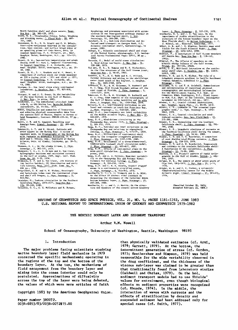
Allen et al.: Physical Oceanography of Continental Shelves 1181
North Carolina shelf and slope waters, Deep- Sea Res., 18, 383-420, 1971.
Stern, M. E., Geostrophic fronts, bores, breaking and blocking waves, J. Fluid Mech., 99, 687- 703, 1980.
Stevenson, M. R., D. W. Stuart and G. W. Heburn, Short-term variations observed in the circula-
tion, heat content, and surface mixed layer of an upwelling plume off Cabo Nazca, Peru, in Coastal Upwelling, F. A. Richards, ed., Amer. Geophys. Union, Washington, D.C., pp. 125-133, 1981.
Stuart, D. W., Sea-surface temperatures and winds during JOINT II: Part 2, Temporal fluctuations, in Coastal Upwelling, F. A. Richards, ed., Amer. Geophys. Union, Washington, D.C., pp. 32- 38, 1981.
Stuart, D. W., R. J. Goodwin and W. P. Duval, A comparison of surface winds and winds measured at 152 m during JOINT I 1974 and JOINT II 1977, in Coastal Upwelling, F. A. Richards, ed., Amer. Geophys. Union, Washington, D.C., pp. 39- 43, 1981.
Sturges, W., Sea level slope along continental boundaries, J. Geophys. Res., 79, 825-830, 1974.
Sturges, W. and J. C. Evans, On the variability of the Loop Current in the Gulf of Mexico, J. Mar. Res., in press, 1983.
Sunderman, J., The semidiurnal principal lunar
tide M 2 in the Bering Sea, Deutsche Hydrog. Zeitschrift, 30, 91-101, 1977.
SUSIO, Compilation and summation of historical and existing physical oceanographic data from the eastern Gulf of Mexico, Report to Bureau of Land Management, Contract #08550-CT4-16, 97 pp., 1975.
Swift, J. H. and K. Aagaard, Upwelling near Samalga Pass, Limnol. Oceanogr., 21, 399-408, 1976.
Takenouti, A. Y. and K. Ohtani, Currents and water masses in the Bering Sea: A review of Japanese work, in Oceanography of the Bering Sea with Emphasis on Renewable Resources, D. W. Hood and E. Kelley, eds., Institute of Marine Science, Univ. of Alaska, Fairbanks, pp. 39-75, 1974.
Thomson, R. E., On the Alaska Stream, J. Phys. Oceanogr., •, 363-371, 1972.
Thompson, T. G., G. F. McEwen and R. Van Cleve, Hydrographic sections and calculated currents in the Gulf of Alaska, 1929, Rept. Intl. Fish. Comm. No. 10, 5-32, 1936.
Thompson, W. F. and R. Van Cleve, Life history of the Pacific halibut, (2) Distribution and early life history, Rept. Intl. Fish. Comm. No. 9, 184 pp., 1936.
Torgrimson, G. M. and B. M. Hickey, Barotropic and baroclinic tides over the continental slope and shelf off Oregon, J. Phys. Oceanogr., •, 945-961.
Tsuchiya, M., Inshore circulation in the Southern California Bight, 1974-1977, Deep-Sea Res., 27A, 99-118, 1980.
Twichell, D.C., C. E. McClennen and B. Butman,
Morphology and processes associated with accum- ulation of the fine-grained sediment deposit on the southern New England shelf, J. Sed. Petrology, 51, 269-280, 1981.
Twichell, D.C., Bed-form distribution and in- ferred sand transport on Georges Bank, U.S. Atlantic continental shelf, Sedimentology, in press, 1983.
Uchupi, E., Atlantic continental shelf and slope of the United States, physiography, U.S. Geolog- ical Survey Professional Paper 529-C, 30 pp., 1968.
Veronis, G., Model of world ocean circulation: I. Wind driven two-layer, J. Mar. Res., 31, 228-288, 1973.
Von Arx, W. S., D. Bumpus and W. S. Richardson, On the fine structure of the Gulf Stream front, Deep-Sea Re•., •, 46-65, 1955.
Voorhis, A.D., D.C. Webb and R. C. Hillard, Current structure and mixing in the shelf/slope water front south of New England, J. Geophys. Res., 81, 3695-3708, 1976.
Vukovich, F. M., B. W. Crissman, M. Bushnell and W. J. King, Gulf Stream boundary eddies off the east coast of Florida, J. Phys. Oceanogr., •, 1214-1222, 1979.
Vukovich, F. M., B. W. Crissman, M. Bushnell and W. J. King, Some aspects of the oceanography of the Gulf of Mexico using satellite and in situ data, J. Geophys. Res., 84, 7749-7768, 1979.
Walters, R. A., Low-frequency variations in sea level and currents in south San Francisco Bay, J. Phys. Oceanogr., 12, 658-668, 1982.
Wang, D.-P., Low-frequency sea level variability on the Middle Atlantic Bight, J. Mar. Res., 37, 683-697, 1979.
Wang, D.-P., Wind-driven circulation in the Chesapeake Bay, winter 1975, J. Phys. Oceanogr., •, 564-572, 1979.
Wang, D.-P., Subtidal sea level variations in the Chesapeake Bay and relations to atmospheric forcing, J. Phys. Oceanogr., •, 413-421, 1979.
Wang, D.-P., Diffraction of continental shelf waves by the irregular alongshore geometry, J. Phys. Oceanogr., 10, 1187-1199, 1980.
Wang, D.-P., Development of a three-dimensional, limited-area (island) shelf circulation model, J. Phys. Oceanogr., 12, 605-617, 1982.
Wang, D.-P., Effects of continental slope on the mean shelf circulation, J. Phys Oceanogr., in press, 1982.
Wang, D.-P. and A. J. Elliott, Nontidal variabil- ity in the Chesapeake Bay and Potomac River: Evidence for nonlocal forcing, J. Phys. Oceano•r., •, 225-232, 1978.
Wang, D.-P. and C. N. K. Mooers, Coastal trapped waves in a continuously stratified ocean, J. Phys. Oceanogr., •, 853-863, 1976.
Weatherly, G. L., S. L. Blumsack and A. A. Bird, On the effect of diurnal tidal currents in
determinng the thickness of the turbulent Ekman bottom boundary layer, J. Phys. Oceanogr., 10, 297-300, 1980.
Weatherly, G. L. and P. J. Martin, On the struc- ture and dynamics of the oceanic bottom boundary
layer, J. Phys. Oceano$r., •, 557-570, 1978. Weatherly, G. L. and J. C. Van Leer, On the
importance of stable stratification to the structure of the bottom boundary layer on the West Florida shelf, in Bottom Turbulence, J. C. J. Nihoul, ed., Elsevier, Amsterdam, 1977.
Weber, A. H. and J. O. Blanton, Monthly mean wind fields for the South Atlantic Bight, J. Phys. Oceanogr., 10, 1256-1263, 1980.
Webster, F., A description of Gulf Stream meanders off Onslow Bay, Deep-Sea Res., •, 130-143, 1961a.
Webster, F., The effects of meanders on the kinetic energy balance of the Gulf Stream, Tellus, 13, 392-401, 1961b.
Welch, C. S., Mid-level intrusions at the contin- ental shelf edge, J. Geophys. Res., 86, 11013- 11019, 1981.
Werner, F. E. and B. M. Hickey, The role of a longshore pressure gradient in Pacific Northwest coastal dynamics, submitted to J. Phys. Oceanogr., 1982.
Williams, R. G. and F. A. Godshall, Summarization and interpretation of historical physical oceanographic and meteorological information for the Mid-Atlantic region, U.S. Dept. of Commerce, NOAA, Washington, D.C., Final report to BLM, U.S. Dept. of the Interior, Interagency Agreement AA 550-Ia6-12, 295 pp., 1977.
Winant, C. D., Coastal current observations, Rev. Geophys. Space Phys., 17, 89-98, 1979.
Winant, C. D., Comments on "The arrested topo- graphic wave," J. Phys. Oceanogr., •, 1042- 1043, 1979.
Winant, C. D., Coastal circulation and wind- induced currents, Ann. Rev. Fluid Mech., 12, 271-301, 1980.
Winant, C. D., Downwelling over the Southern California shelf, J. Phys. Oceanogr., 10, 791- 799, 1980.
Winant, C. D., Longshore coherence of currents on the Southern California shelf during the summer, J. Phys. Oceanogr., 13, 54-64, 1983.
Winant, C. D. and R. C. Beardsley, A comparison of some shallow wind-driven currents, J. Phys. Oceanogr., %, 218-220, 1979.
Winant, C. D. and A. W. Bratkovich, Temperature and currents on the southern California shelf:
A description of the variability, J. Phys. Oceanogr., 11, 71-86, 1981.
Winston, J. $., Physical aspects of rapid cyclo- genesis in the Gulf of Alaska, Tellus, 7, 481- 500, 1955.
Wright, W. R., The limits of shelf water south of Cape Cod, 1941-1972, J. Mar. Res., 34, 1-14, 1976.
Wright, W. R. and C. E. Packer, A volumetric temperature/salinity census for the Middle Atlantic Bight, Limnol. Oceano•r., 21, 563-571, 1976.
(Received October 29, 1982; accepted February 23, 1983.)
REVIEWS OF GEOPHYSICS AND SPACE PHYSICS, VOL. 21, NO. 5, PAGES 1181-1192, JUNE 1983 U.S. NATIONAL REPORT TO INTERNATIONAL UNION OF GEODESY AND GEOPHYSICS 1979-1982
THE BENTHIC BOUNDARY LAYER AND SEDIMENT TRANSPORT
Arthur R.M. Nowell
School of Oceanography, University of Washington, Seattle, Washington 98195
1. Introduction
The major problems facing scientists studying marine boundary layer fluid mechanics in 1979 concerned the specific mechanismic operating in the regions of the top and the bottom of the boundary layer. At the top, the mechanisms of fluid escapement from the boundary layer and mixing into the ocean interior could only be postulated. Approximations of diffusivity across the top of the layer were being debated, the values of which were more articles of faith
Copyright 1983 by the American Geophysical Union.
Paper number 3R0072. O034-6853/83/003R-007 2515.00
than physically validated estimates (cf. Armi, 1979; Garrett, 1979). At the bottom, the intermittent generation of stress (cf. Gordon, 1975; Heathershaw and Simpson, 1979) was held responsible for the wide variability observed in the drag coefficient, and the thickness of the viscous sub-layer was claimed to be greater than that traditionally found from laboratory studies (Caldwell and Chriss, 1979). On the bed, sediment transport models had to use Shields' values for entrainment, even though biological effects on sediment properties were recognized (cf. Rhoads, 1974). In the middle, the interaction of waves with currents and the
effects of stratification by density and suspended sediment had been addresed only for special cases (cf. Smith, 1977).
Related Documents