APRIL 2014 PHASE II ECOLOGICAL NETWORK REPORT TERMS OF REFERENCE

Welcome message from author
This document is posted to help you gain knowledge. Please leave a comment to let me know what you think about it! Share it to your friends and learn new things together.
Transcript
Phase II Ecological Network Report Terms of Reference
APRIL 2014
PhAse II ecoLogIcAL NetwoRk RePoRt
teRms of RefeReNce

April 2014
Phase II Ecological Network Report Terms of Reference
i
contents1.0 IntroductIon . . . . . . . . . . . . . . . . . . . . . . . . . . . . . . . . . . . . . . . . . . . . . . . . . . . . . . . . . . . . . . . . . 1
1.1 Objectives . . . . . . . . . . . . . . . . . . . . . . . . . . . . . . . . . . . . . . . . . . . . . . . . . . . . . . . . . . . . . . . . . . . . . . . . 21.2 POlicy cOntext . . . . . . . . . . . . . . . . . . . . . . . . . . . . . . . . . . . . . . . . . . . . . . . . . . . . . . . . . . . . . . . . . . . . . 21.3 timing and integratiOn with the Planning PrOcess. . . . . . . . . . . . . . . . . . . . . . . . . . . . . . . . . . . . . . . 3
2.0 GuIdelInes for developInG a phase II ecoloGIcal network report . . . . . . . . . . . . . . . . . . . . . . 52.1 Preliminary assessment and cOnsultatiOn . . . . . . . . . . . . . . . . . . . . . . . . . . . . . . . . . . . . . . . . . . . . . 5 2.1.1 review Of existing infOrmatiOn . . . . . . . . . . . . . . . . . . . . . . . . . . . . . . . . . . . . . . . . . . . . . . . . . . . 5 2.1.2 desktOP-based analysis . . . . . . . . . . . . . . . . . . . . . . . . . . . . . . . . . . . . . . . . . . . . . . . . . . . . . . . . . 6 2.1.3 cOnsultatiOn with ecOlOgy unit . . . . . . . . . . . . . . . . . . . . . . . . . . . . . . . . . . . . . . . . . . . . . . . . . . 6 2.1.4 Preliminary natural area rating . . . . . . . . . . . . . . . . . . . . . . . . . . . . . . . . . . . . . . . . . . . . . . . . . 72.2 biOPhysical inventOry . . . . . . . . . . . . . . . . . . . . . . . . . . . . . . . . . . . . . . . . . . . . . . . . . . . . . . . . . . . . . . . 8 2.2.1 vegetatiOn . . . . . . . . . . . . . . . . . . . . . . . . . . . . . . . . . . . . . . . . . . . . . . . . . . . . . . . . . . . . . . . . . . . . 9 2.2.2 wildlife . . . . . . . . . . . . . . . . . . . . . . . . . . . . . . . . . . . . . . . . . . . . . . . . . . . . . . . . . . . . . . . . . . . . . 10 2.2.3 hydrOlOgy, aquatic features, and landfOrms . . . . . . . . . . . . . . . . . . . . . . . . . . . . . . . . . . . . . 112.3 existing ecOlOgical netwOrk . . . . . . . . . . . . . . . . . . . . . . . . . . . . . . . . . . . . . . . . . . . . . . . . . . . . . . . . 122.4 assessment Of ecOlOgical integrity . . . . . . . . . . . . . . . . . . . . . . . . . . . . . . . . . . . . . . . . . . . . . . . . . . 132.5 recOmmended ecOlOgical netwOrk . . . . . . . . . . . . . . . . . . . . . . . . . . . . . . . . . . . . . . . . . . . . . . . . . . . 152.6 ecOlOgical imPacts Of develOPment . . . . . . . . . . . . . . . . . . . . . . . . . . . . . . . . . . . . . . . . . . . . . . . . . . 172.7 cOnstructiOn and OPeratiOnal mitigatiOn measures . . . . . . . . . . . . . . . . . . . . . . . . . . . . . . . . . . . . 18
3.0 updates to the phase II enr. . . . . . . . . . . . . . . . . . . . . . . . . . . . . . . . . . . . . . . . . . . . . . . . . . . . . . 19
4.0 submIssIon format . . . . . . . . . . . . . . . . . . . . . . . . . . . . . . . . . . . . . . . . . . . . . . . . . . . . . . . . . . . . 19
Glossary of terms. . . . . . . . . . . . . . . . . . . . . . . . . . . . . . . . . . . . . . . . . . . . . . . . . . . . . . . . . . . . . . . 20
references . . . . . . . . . . . . . . . . . . . . . . . . . . . . . . . . . . . . . . . . . . . . . . . . . . . . . . . . . . . . . . . . . . . . . 21
appendIces . . . . . . . . . . . . . . . . . . . . . . . . . . . . . . . . . . . . . . . . . . . . . . . . . . . . . . . . . . . . . . . . . . . . . 22aPPendix a: federal, PrOvincial and municiPal regulatiOns . . . . . . . . . . . . . . . . . . . . . . . . . . . . . . . . . 22aPPendix b: maPPing requirements crOss-reference . . . . . . . . . . . . . . . . . . . . . . . . . . . . . . . . . . . . . . . 26aPPendix c: samPle ecOlOgical netwOrk maPs . . . . . . . . . . . . . . . . . . . . . . . . . . . . . . . . . . . . . . . . . . . . . 28aPPendix d: natural area summary table . . . . . . . . . . . . . . . . . . . . . . . . . . . . . . . . . . . . . . . . . . . . . . . . . 31aPPendix e: ecOlOgical evaluatiOn tOOl . . . . . . . . . . . . . . . . . . . . . . . . . . . . . . . . . . . . . . . . . . . . . . . . . . 32aPPendix f: recOmmended references and infOrmatiOn sOurces . . . . . . . . . . . . . . . . . . . . . . . . . . . . . 36aPPendix g: design and management recOmmendatiOns fOr
stOrm-water influenced natural wetlands . . . . . . . . . . . . . . . . . . . . . . . . . . . . . . . . . . . . . . . . . . . 37

April 2014
ii
Phase II Ecological Network Report Terms of Reference
1
1.0 IntroductIonthe city of edmonton (“the city”) is committed to ensuring that new developments are designed to support and sustain the existing ecological function of natural areas, local and regional biodiversity, and edmonton’s ecological network. to meet these goals, the city’s ecological network approach has been incorporated into the area structure Plan (asP) and neighbourhood structure Plan (nsP) stages of the planning process.
at its core, the ecological network approach calls for the identification and conservation of connected ecological networks, rather than the consideration of natural sites in isolation. this network-based approach supports critical ecological processes like genetic flow, nutrient exchange and movement for resources, while contributing to the liveability and enjoyment of the city for edmontonians by enhancing recreational opportunities and the open space network.
the city’s ecological network approach is rooted in two guiding documents: the Natural Connections Strategic Plan (city of edmonton 2007c) and the city of edmonton natural area systems Policy, c-531 (city of edmonton 2007b). the Natural Connections Strategic Plan articulates the city’s ecological network vision and sets high-level principles, goals and strategies for natural areas conservation.
the city defines a natural area as “an area of land or water that is dominated by native vegetation in naturally occurring patterns” (city of edmonton 2007c); such areas could include grasslands, forests, wetlands, peatlands, or riparian areas. Policy c-531 (city of edmonton 2007b) states that all natural areas in edmonton should be considered part of an integrated ecological system, and outlines requirements for the provision of ecological information during the planning process.
Other high-level city plans such as The Way We Grow (city of edmonton 2010b), edmonton’s municipal development Plan, and The Way We Green (city of edmonton 2011), edmonton’s environmental strategic Plan, further embed the ecological network approach into the city’s development process. appendix a provides more details about these and other documents that inform the conservation of edmonton’s natural areas.
based on this foundation, the city has developed an updated approach to assessing the ecological features of proposed development sites, and integrating these features into development plans. this approach consists of two phases: the Phase i and Phase ii ecological network reports (enr). the components and requirements of the Phase i enr, which occurs during the asP stage, are described in the Phase I Ecological Network Report Terms of Reference (city of edmonton 2008).
this document describes the methodology to be followed when creating a Phase ii enr. the Phase II Ecological Network Report Terms of Reference is intended to be a “living” document, incorporating current ecological knowledge, urban design best practices, and management tools, and evolving as our understanding of natural area planning and management improves.
The Phase II ENR is guided by the following ecological principles:
ecological network: a coherent system of natural and/or semi-natural landscape elements that is configured and managed with the objective of maintaining or restoring ecological functions as a means to conserve biodiversity.
connectivity: linkages between natural areas support ecological processes such as resource collection, seasonal migration, species dispersal, and genetic exchange.
size: larger habitat patches can support whole populations of plants and animals and their associated ecological processes.
permeability: a high quality, permeable matrix (or developed area) has green and open spaces and few barriers to wildlife movement.
diversity: conservation of edmonton’s natural habitats and native plant and animal species enhances the city’s overall biodiversity.
buffers: ecological buffers allow conflicting land uses to coexist, and mitigate edge effects on conserved natural areas.

32
April 2014
1.1 objectIves the objectives of the Phase ii enr are to:
•build on the Phase i enr by further describing and assessing the structure, function and integrity of the ecological network existing within the plan area.
•collect site-specific information so that the ecological features and requirements of the plan area can be integrated into the planning process in a sustainable manner, and functionally maintained.
•describe the recommended configuration of the ecological network within the plan area, and clearly articulate which conservation tool(s) will be applied.
•identify anticipated ecological impacts of the proposed development and outline corresponding mitigation measures, including restoration, buffers, and site-specific ecological design criteria.
•examine the long-term (post-development) habitat connectivity of the area and optimize ecological linkages.
•describe the measures required to ensure the network remains sustainable into the future, within the context of the development concept approved at the asP stage.
1.2 PolIcy contexta range of federal, provincial and municipal regulations apply to the conservation and management of edmonton’s natural areas. the following list outline the regulations that may relate to the Phase ii enr, though it is not exhaustive. appendix a provides a summary of each regulation for further reference.
Federal Legislation:
•federal Policy on wetland conservation
•fisheries act
•migratory birds convention act, 1994
•species at risk act
Provincial Legislation:
•alberta land stewardship act
•alberta wetland Policy
•environmental Protection and enhancement act
•municipal government act
•Public lands act
•species at risk strategy
•water act
•weed control act
•wildlife act
Municipal Policies, Plans and Guidelines:
•guidelines for determining environmental reserve (er) dedication for wetlands and Other water bodies
•natural area systems Policy (c-531)
•natural connections strategic Plan
•north saskatchewan river valley area redevelopment Plan
•ribbon of green concept Plan and master Plan
•the way we green
•the way we grow
•the way we live
•top of bank Policy (c-542)
•urban Parks management Plan
•wetland strategy
•wildlife Passage engineering design guidelines

Phase II Ecological Network Report Terms of Reference
32
1.3 tImIng and IntegratIon wIth the PlannIng Processthe city of edmonton is committed to early, integrated planning for the protection of the ecological network so that development is tailored to the ecological network, and not the opposite.
the Phase ii enr is completed during the nsP stage (or at zoning for industrial developments), following the completion of the Phase i enr during the asP stage. the Phase ii enr replaces the stage 2 natural site assessment previously in use, and is a compulsory part of all nsPs that contain at least one natural area, or where connectivity between neighbouring natural areas is required.
the Phase ii enr is intended to inform the development of the nsP, and as such must be completed concurrently with the nsP. at its core, the Phase ii enr documents the interplay between the ecological features of the plan area and those of the built infrastructure, with the goal that the two can be designed together to respect both the ecological and infrastructure needs of the neighbourhood. This interplay is best supported by an interdisciplinary approach, instead of specialties working in isolation.
the Phase ii enr preparation process (figure 1) illustrates that following the completion of desktop-based analyses and field surveys, a recommended ecological network is proposed. the recommended ecological network is then used to help inform the development concept and the nsP as a whole. biologists (i.e., Phase ii enr authors) should collaborate with engineers, landscape architects, planners, and other members of the nsP project team when compiling the remainder of the report. this collaborative approach means that a Phase ii enr may go through several iterations before it is finalized, as the corresponding nsP evolves. likewise, as the NSP is developed, it should be influenced by the preliminary findings and Recommended Ecological Network developed during steps 1-8 of the Phase ii enr development process (figure 1).
The Phase II ENR should be initiated as early as possible in the planning process, well ahead of the planned NSP submission date. This will help ensure that all field work can be completed in a timely fashion and in the appropriate season. neighbourhoods that are large in size and/or exhibit a high degree of ecological complexity may require field surveys that span multiple seasons (e.g., wetland assessment in spring/summer, vegetation surveys in summer, wildlife tracking in winter). in these cases, it is suggested that proponents consult with the city, including with the ecology unit, one or more years in advance of the planned nsP submission date to identify technical report requirements and to plan the scope of the Phase ii enr. this will help minimize delays and unexpected costs during the preparation and review of the Phase ii enr and nsP documents.
the Phase ii enr methodology has been aligned with the nsP guidelines, with a requirement for some of the same information so that several Phase ii enr sections/figures can be easily transferred to the nsP [see Terms of Reference for the Preparation and Amendment of Residential Neighbourhood Structure Plans in Edmonton’s Urban Growth Areas (city of edmonton 2014c)]. the information collected during the preparation of the Phase ii enr should also be used during the creation of site-specific natural area management Plans [namPs; see City-Wide Natural Area Management Plan (city of edmonton 2014a) and Guidelines for Developing Site-Specific Natural Area Management Plans in the City of Edmonton (city of edmonton 2014b)]. appendix b lists biophysical survey and mapping requirements within the Phase ii enr that cross over with requirements of previous and other current planning documents.

54
April 2014
Figure 1: overview of Phase II enr preparation process
Preliminary Assessment and Consultation (Section 2.1)
Biophysical Inventory (Section 2.2)
ExistingEcologicalNetwork (Section 2.3)
Recommended EcologicalNetwork (Section 2.5)
Describe Ecological Impacts of the Land Use Concept on the Recommended
Ecological Network
EcologicalImpacts of Development (Section 2.6)
Construction and Operational Mitigation Measures (Section 2.7)
Assessment of EcologicalIntegrity (Section 2.4)
Consultation with project partners The design of the NSP Land-Use Concept should be informed by the analyses and surveys undertaken as part of the Phase II ENR preparation process and should reflect the Recommended Ecological Network. ENR report authors should work with other disciplines of the planning team (e.g. engineers, etc.) to ensure that the proposed land uses and locations of transportation, drainage, and utility networks are considered in the context of the Recommended Ecological Network and support any proposed “restored areas” in the network.
8) Describe Recommended Ecological Network Design, describe and map based on priority rankings
7) Prioritize natural areas for retentionDescribe and map based on scientifically derived priority
rankings
6) Describe Existing Ecological Network Describe and map (including regional and local connectivity)
5) Field verify Survey High/Medium/Undetermined rated natural areas
Map biophysical information
1) Review Existing Information
(Section 2.1.1)
2) Assess Desktop-based Analysis
(Section 2.1.2)
3) Consult with Ecology Unit
(Section 2.1.3)
4) Determine preliminary natural area ratings High/Medium/Low/Undetermined
(Section 2.1.4)
Iterative Process
STEP IN PHASE II ENR PHASE II ENRPROCESS NSP PROCESS1
NSP Authorizationby City Council
Collaborative PlanPreparation
Plan Review
Plan Completion
Pre-applicationConsultation
Applicant andstakeholders prepareNSP document and applicant conducts technicalstudies
Formal Submission toSustainable Development
Sustainable Developmentreviews application forcompleteness and assesses fees
1 Refer to the Terms of Reference for the Preparation and Amendment of Neighbourhood Structure Plansin Edmonton’s Urban Growth Areas (City of Edmonton 2014).
Phase II Ecological Network Report Terms of Reference
54
2.0 guIdelInes For develoPIng a Phase II ecologIcal network rePort
this section describes the components of a Phase ii enr. Please note while there are specific requirements for the content of this report, the structure of the final report is flexible. consultants are encouraged to organize the report and compile the associated maps in the format that they feel most clearly presents the information. for example, mapping requirements may be addressed using multiple map files in plan areas containing a high density and complexity of natural areas. all maps should be produced using high-resolution graphics and should employ colour schemes that allow for clear differentiation among map features. sample maps (appendix c) may provide guidance to ensure clarity and consistency of mapping products. in addition, the mapping conventions used in the Guidelines for Developing Site-Specific Natural Area Management Plans in the City of Edmonton (city of edmonton 2014b) may provide some consistency between the Phase ii enr and site-specific natural area management Plans.
2.1 PrelImInary assessment and consultatIonthe purpose of the preliminary assessment and consultation process is to 1) collect enough preliminary information to identify natural areas within the plan area for which field verification is required, and 2) identify natural areas within the plan area that may hold moderate or high ecological value and should be prioritized for retention through the development process. It is highly recommended that the preliminary assessment and consultation occur as early in the planning process as possible to ensure that planning goals and objectives are met to the satisfaction of both the proponent and the city.
2.1.1 revIew oF exIstIng InFormatIonat the outset of the process, existing legislation, plans and studies should be reviewed as a means of understanding the legislative restrictions, land-use history, and ecological landscape of the plan area. the results of the Phase i enr should provide the foundation for the more detailed, in-depth analysis of the Phase ii enr. recent and historic air photos for the plan area and its surrounding environment should be reviewed and included in the Phase ii enr.
description:
•document any previous plans and studies that have been conducted in the plan area that are relevant to the Phase ii enr, and summarize key findings. if any natural areas within the plan area have been identified as environmentally sensitive or significant (geowest 1993, spencer 2006), specify the natural area number and provide a brief summary of key findings specific to the natural area.
•list any natural areas that are adjacent to the plan area (at the asP level and broader, if applicable) or that are regionally significant and ecologically connected to the plan area. refer to Natural Connections (city of edmonton 2007c) for further information regarding regionally significant biodiversity core areas in the edmonton area.
•identify relevant The Way We Green and The Way We Grow policies and their application within the plan area.
•summarize the federal, provincial and municipal regulatory requirements that apply to the plan area, and describe their relevance to the proposed plan (see appendix a).
•describe the ecological history of the site, including factors such as disturbance, loss of natural areas, alteration of natural drainage courses and water bodies, etc. illustrate these changes using air photos. if historical air photo reviews were completed as part of previous plans and studies (e.g., Phase i enr), please provide a reference to the appropriate reports.
(next page)

76
April 2014
•referencing the Phase i environmental site assessment, or other applicable environmental assessment previously completed for the area, indicate if there are any environmental concerns (e.g., contamination) related to the natural areas in the plan area.
•describe the existing land use(s) at the site.
•Outline the nature and scale of the proposed development, including density and types of land uses.
•include all orthophotographs and digital imagery used for the preparation of the report. whenever possible, orthophotographs used should capture seasonal and historic variation in site conditions and wetland boundaries.
2.1.2 desktoP-based analysIs using existing information and analysis of the most recent available air photos and digital imagery, complete a spatial desktop-based analysis for each natural area in the plan area. this desktop assessment is meant to provide a preliminary rating of a natural area’s potential biodiversity and ecological connectivity. the spatial desktop-based analysis should be completed for all natural areas in the plan area and be based on the following known indicators of ecological integrity and function including area, shape, habitat diversity, and presence of nearby habitat. Please see Part a of appendix e for further details and rationale regarding the use of these indicators.
description:
•area (hectares)
•shape (e.g., simple round/square shape, linear, extent of edge)
•habitat diversity: identify the number of different habitat types (≥ 0.5 ha) present within a feature (e.g., open water, marsh wetland, shrub wetland, peatland, deciduous/coniferous/mixedwood upland, meadow/naturalized field, etc.). note: the size filter of ≥ 0.5 ha applies to the Phase ii enr only. mapping of features and habitat types < 0.5 ha may be required for site-specific natural area management Plans prepared for retained natural areas.
•Presence of other nearby upland and/or wetland habitat (within 100m)
•for each natural area in the plan area, provide a brief description of the natural area, and, if applicable, its natural area number and designation (i.e., environmentally sensitive area or significant natural area) as identified in geowest (1993) or spencer (2006)
a sample template for a natural area summary table is provided in appendix d.
mapping:
•Prepare a site location map of the plan area. include quarter sections labels from the alberta township survey (ats) system.
•confirm and refine the natural area boundaries described in the Phase i enr.
•Prepare a map outlining the habitat types (≥ 0.5 ha) of delineated natural areas in the nsP area. Please ensure the map identifies any changes to the natural area boundaries and classifications as described in the Phase i enr.
•Prepare a regional context map identifying any natural areas that are adjacent to the plan area (at the asP level and broader, if applicable) or that are regionally significant and ecologically connected to the plan area. refer to Natural Connections (2007c) for further information regarding regionally significant biodiversity core areas in the edmonton area.
sample maps provided in appendix c, may provide further guidance when preparing maps.
2.1.3 consultatIon wIth the ecology unItPrior to commencing the remainder of the Phase ii enr work, the proponent should consult with the ecology unit, Parks + biodiversity. this consultation allows the proponent and the ecology unit to clearly establish the expectations of the enr. additional benefits include, but are not limited to:
•clarification of any questions related to this document
•clear articulation of expectations related to the particular plan area and ensuring that the level of effort for the Phase ii enr is appropriate and understood by all parties
•reduction of duplication and maximizing effectiveness of field survey and reporting efforts by giving the ecology unit an opportunity to provide additional natural area information
Phase II Ecological Network Report Terms of Reference
76
2.1.4 PrelImInary natural area ratIngthe Preliminary natural area rating is meant to be a preliminary assessment of a natural area’s potential biodiversity and likely contribution to the ecological network in the plan area. it is specifically intended to help scope field survey efforts. The Preliminary Natural Area Rating must be completed for all natural areas in the plan area.
calculation of a Preliminary natural area rating must be based on sound principles of conservation biology and landscape ecology. further information regarding the ecological principles that form the basis for natural area and ecological network evaluation and conservation in the city of edmonton can be found in the Natural Connections Strategic Plan (city of edmonton 2007c). the following list, while not exhaustive, may provide guidance regarding the types of natural areas that are most likely to require field surveys:
•environmentally sensitive or significant natural areas (geowest 1993, spencer 2006)
•class iii, iv, and v wetlands (stewart and kantrud 1971)
•wetland-upland complexes (regardless of size or wetland class)
•Peatlands and forested wetlands
•upland tree stands > 0.5 ha in size
Please note that class i and ii wetlands and upland tree stands < 0.5 ha in size may hold high potential to strengthen connectivity within the ecological network (i.e., habitat patches and linkages), even if they do not hold high significance as biodiversity core areas. therefore, such natural areas should also be carefully reviewed and given due consideration when assigning a Preliminary natural area rating. the Preliminary natural area rating is not meant to dictate the final retention status of a natural area, and may change as further information is acquired either through field verification or ecological network analysis.
Please refer to Part a of appendix e (ecological evaluation tool) for a tool designed to obtain a Preliminary natural area rating for all natural areas within a plan area. this ecological evaluation tool is based on known indicators of ecological integrity and function and represents a consistent, scientifically-driven approach to evaluating
natural areas. for further information, the “rationale” portion of the ecological evaluation tool provides an explanation of the way in which each variable of the ecological evaluation tool is used to assess a natural area’s ecological function and integrity.
completion of Part a of the ecological evaluation tool as part of the Preliminary assessment and evaluation process allows proponents to assign a Preliminary natural area rating to each natural area. note that the indicators requested by the table have already been collected in section 2.1.2 (desktop-based analysis). Once all natural areas in the plan area have been evaluated against Part a of the ecological evaluation tool, each natural area receives a numeric score. the proponent can assign a ranking of low/moderate/high based on natural breaks in the numeric values or, the Preliminary natural area ratings may be influenced by supplementary information and analyses chosen by the proponent, which should be supported by professional expertise and judgement.
if any supplementary information or analyses are employed, provide a description of the methodology. in the report submission please describe the rationale for the Preliminary natural area rating assigned and include the Preliminary natural area rating for each natural area in the natural area summary table (appendix d).
in cases where existing information and desktop-based analysis are incomplete or uncertain, and a Preliminary natural area rating cannot be assigned, the natural area must be assigned an “undetermined” designation. this could happen, for example, in the case of wetlands for which differentiation between a class ii and iii classification (stewart and kantrud 1971) or classification as a bog or fen is uncertain or not possible due to limitations in air photo analysis.
Natural areas that receive a Preliminary Natural Area Rating of Moderate, High, or Undetermined, as well as those that receive a Low rating but that hold high potential to stregthen connectivity within the ecological network, must be field surveyed and meet all requirements of the biophysical inventory (section 2.2).

98
April 2014
2.2 bIoPhysIcal Inventorya detailed biophysical inventory is required in order to develop a complete picture of the plan area’s biodiversity and ecology so that conservation decisions can be made that strengthen the post-development ecological network. as described in this section, there are three main elements of the inventory: vegetation; wildlife; and hydrology, aquatic features, and landforms. all components of the biophysical inventory must be completed for natural areas assigned a Preliminary natural area rating of moderate, high, undetermined, or low but with high potential to strengthen connectivity within the ecological network.
the specific research methods used to conduct the inventory will depend on the natural areas of the development site. Field research protocols must meet or exceed industry standards and work must be carried out by trained professionals. The inventory should be conducted during the appropriate season or across multiple seasons in order to accurately describe the biophysical features of the site (e.g., vegetation surveys must be conducted during the main growing season). wildlife survey methodologies and survey intensity must reflect the character of the natural area and the wildlife species likely to occur. for example, winter track surveys, amphibian pitfall trapping, etc., may be required, in addition to incidental or indirect observations, to identify target species, wildlife movement pathways, and species abundance. refer to appendix e, Part b (under “implementation comment” and “rationale” headings) for further information regarding metrics and protocols to be used to complete the biophysical inventory.
the final report should include a description of all field methodologies, as well as the professional qualifications of those undertaking the studies. appendix f lists additional information sources that may be referenced to augment field research.
Please note that the level of survey effort should be commensurate with the features and total biodiversity present on the subject property, and should be informed by existing information from precedent surveys. when determining the detail and depth of the biophysical surveys, and survey methodologies, proponents should also review the goal statements that are provided throughout this section prior to each list of required information. at a minimum, proponents should aim to satisfy each goal through their chosen survey methods. also included in this section are policy statements that list the legal requirements and policies that provide the rationale for these information requests.
Proponents are encouraged to discuss with the ecology unit, as early in the planning process as possible (i.e., prior to completing field surveys), any unforeseen circumstances (e.g., limited access to subject lands) preventing completion of full biophysical inventories. should any of the information requirements listed below be deemed unwarranted or inapplicable, the reduction in scope of the biophysical inventory must be clearly outlined, and a clear scientific or planning rationale for the change must be provided.

Phase II Ecological Network Report Terms of Reference
98
2.2.1 vegetatIonGoal: To document key characteristics of each natural area’s vegetation, in order to assess habitat and biodiversity value, develop mitigation/management strategies, and strengthen the post-development ecological network.1 Policy Context: These information requirements are guided by the following regulations:
Federal Species at Risk Act
ProvincialSpecies at Risk Program Weed Control Act Wildlife Act
Municipal
Natural Area Systems Policy (C-531) Natural Connections Strategic Plan The Way We Grow The Way We Green
description:
•indicate vegetation community types present using classifications consistent with those in use by alberta environment and sustainable resource development (e.g., Primary land and vegetation inventory). if an alternative classification system is used to provide supplementary information, please reference and describe the system as required.
•describe native plant diversity (e.g., number of species, evenness, etc.).
•list rare or unique species or communities.2
•describe vegetation quality/condition (e.g., degraded, undisturbed, etc.).
•identify any human disturbance, such as tree removal, grazing activity, encroachment, etc. to the natural area, and describe the predicted ability to reverse the influence of existing disturbance.
•describe the presence and distribution of invasive, non-native species or noxious/prohibited noxious weed species.
•describe the successional stage. for forests, estimate the age of the oldest trees on site.
mapping:
•map and delineate all natural areas in the plan area. natural area boundaries mapped during the desktop-based analysis should be refined and confirmed during field surveys; boundaries should be based on natural vegetation patterns and the presence of hydric soils, where applicable (also see section 2.2.3, below).
•map dominant vegetation (e.g., balsam Poplar-aspen mixedwood).
•map concentrations of noxious weeds and observed occurrences of prohibited noxious weed species, as per the alberta Weed Control Act (government of alberta 2011).
•Provide a description of any changes to natural area boundaries, established during desktop-based analyses, which resulted from the completion of field surveys.
1 in spring 2013 the city initiated a city-wide ecosite inventory of all its natural and semi-natural areas following protocols of a modified alberta Primary land and vegetation inventory (Plvi). upon completion of the inventory, consultants will have access to the city’s ecosite classification guide to ensure consistency in ecosite classification from both aerial and field surveys. in addition, the city will make available its sampling Procedures manual and plot forms to those consultants who would find them useful. these items are being designed to integrate site-specific data into the ecosite inventory.
2 rare species are those that are listed as:• threatened or endangered under the provincial wildlife act• sensitive, may be at risk, or at risk under the general status of alberta wild species• s1, s2 or s3 by the alberta conservation information management system (acims)unique species are those that may not be listed as rare but are considered to be ecologically underrepresented in the edmonton area.rare or unique plant species should be reported to applicable provincial conservation databases (e.g., acims).

1110
April 2014
2.2.2 wIldlIFe Goal: To document a natural area’s wildlife diversity, key habitat features, and wildlife movement pathways, in order to make decisions that mitigate the impacts of development and optimize the ecological network. Policy Context: These information requirements are guided by the following regulations:
Federal Migratory Bird Convention Act Species at Risk Act
Provincial Species at Risk Program Wildlife Act
Municipal
Natural Area Systems Policy (C-531) Natural Connections Strategic Plan The Way We Grow The Way We Green
description:
•conduct a mammal survey, as required , listing species and counts of observations or signs of occurrence (e.g., direct sightings, tracks, scat, evidence of browse, etc.).
•conduct a bird survey, as required, and list species.
•conduct an amphibian (frogs, toads, and salamanders) survey, except where no amphibian habitat exists. Provide a list of all species detected and, for frogs and toads, the results of call surveys (e.g., maximum calling level).
•identify rare, unique wildlife species of concern (including provincially and federally recognized special status species) observed, either directly or indirectly, on-site3.
•Provide a table that lists all wildlife species with the potential to occur on-site (including rare/unique and common species), based on habitat requirements and availability, previous disturbances to the site, and landscape context.
3 rare species and species of concern should be reported to applicable provincial conservation databases (e.g., fisheries and wildlife management information system, fwmis).
mapping:
•identify and map significant wildlife habitat and habitat features, including observed seasonal habitats. examples include den sites, nests, and significant breeding, and colony sites. ensure that all natural areas in the plan area are delineated on this map.
•using observed wildlife movement, trails, and local knowledge, map pre-development wildlife movement pathways throughout the plan area and identify their probable usage by ecological design groups (edgs) in the plan area [see Wildlife Passage Engineering Design Guidelines (city of edmonton 2010c)]. the methodology used to conduct wildlife movement assessment and modelling is at the discretion of the proponent, but should be based on reliable scientific methods and clearly described as part of the Phase ii enr.

Phase II Ecological Network Report Terms of Reference
1110
2.2.3 hydrology, aquatIc Features, and landFormsGoal: To understand how the hydrology, water courses and landforms of the plan area influence, and are influenced by, local natural areas, in order to enhance the long term sustainability of retained natural areas. Policy Context: These information requirements are guided by the following regulations:
Federal Federal Policy on Wetland Conservation
Provincial
Municipal Government Act Public Lands Act Water Act Wetland Policy
Municipal The Way We Grow The Way We Green
description:
•referencing the neighbourhood design report (ndr) and existing imagery and geotechnical studies, provide a general description of the existing surface water drainage patterns and catchment areas across the entire plan area.
•referencing the ndr, existing imagery and geotechnical studies, and field survey observations, provide a general overview of groundwater hydrology patterns and seepage areas. consultation with other members of the project team, including hydrologists, engineers, etc. may be required.
•for each wetland (including peatlands and ephemeral wetlands), determine the class according to stewart and kantrud (1971), or the appropriate wetland classification system in use by the Province of alberta.
•identify and describe all watercourses and drainage channels. classify these using the alberta Water Act code of Practice stream classification criteria (alberta environment 2007).
•identify any human disturbance, such as draining, ditching, filling, encroachment, etc. to the natural area, and describe the predicted ability to reverse the influence of existing disturbance.
•submit, as an appendix, a copy of alberta Public Lands Act application or outcome documentation, whether complete or in progress, for all water bodies in the plan area. it is the proponent’s responsibility to work with alberta environment and sustainable resource development (aesrd) and supply all information required by aesrd to make Public Lands Act determinations. if crown claims were determined and confirmed by aesrd during the asP and/or Phase i enr stage, append this documentation and label maps accordingly. Please note that a copy of alberta Water Act applications may be requested at the subdivision/rezoning stage.
mapping:
•map the topography, existing drainage patterns, and catchment areas in the plan area.
•map all wetlands, peatlands, natural lakes, creeks, and streams, and their associated buffer and/or riparian areas. include ephemeral drainage courses and any groundwater springs. mapping and air photo analysis done at the asP level should be re-confirmed with desktop analysis and field surveys.
•delineate boundaries of all wetlands (class i-v and peatlands) using boundaries based on the extent of hydrophytic vegetation and, where possible, the extent of hydric soils. note: a description of wetland delineation methodology should be provided as part of the report, including references to any published field guides, guidebooks, and protocols used.
•identify crown-claimed bodies of water.
•for reference, please delineate uplands and identify dominant vegetation communities.
•map all culverts and bridges, specifying location, diameter, and current state (e.g., damaged, perched, etc.).
•identify any rare or unique landforms (e.g., sand dunes, karst formations, hoodoos, etc.).
1312
April 2014
2.3 exIstIng ecologIcal networkfollowing the ecological principles and terminology outlined in the Natural Connections Strategic Plan (city of edmonton 2007c), identify all existing elements of the ecological network, including natural, semi-natural, and connective features, in the plan area. all ecological features, regardless of their current level of disturbance or suitability for retention, should be included.refer to Natural Connections Strategic Plan (city of edmonton 2007c) for descriptions of each landscape element, listed below, and its role in the ecological network:
•biodiversity core area
•core area
•linkages: stepping stone, corridor
•matrix
•buffer
•barrier (natural or anthropogenic; land or water)
describe:
•describe the existing ecological network at the site and the ecological role that individual site features play in the context of the surrounding natural system (at the asP level and broader, if applicable). this may consist of a refinement of the information provided in the Phase i enr.
•based on the results of the biophysical inventory, classify and label landscape elements as core areas, habitat patches, stepping stones, corridors, barriers, and ecological connections (including wildlife movement patterns). Please note that each plan area will not necessarily include every landscape element (e.g., a core area). also note that in some cases, a landscape element could be classified in more than one way (e.g., a habitat patch could also serve as a stepping stone). choose the label that reflects the highest level of ecological function of each landscape element.
•discuss the degree of functional and structural connectivity within the plan area and in relation to the surrounding landscape. Please note that “ecological connectivity” refers not only to wildlife movement, but also to seed dispersal, genetic exchange, migration, drainage, nutrient flow, etc. (city of edmonton 2007c).
the methodology used to conduct connectivity analyses and modelling is at the discretion of the proponent, but should be based on reliable scientific methods and clearly described as part of the Phase ii enr.
•describe the ecological importance of each natural area at the regional/subwatershed scale, including connections to provincially (e.g., environmentally significant areas or aquatic environmentally significant areas), nationally, or internationally (e.g., ramsar wetlands) recognized natural areas in the region.
map:
based on the biophysical inventory and review of air photos, map the existing ecological network of the plan area and surrounding landscape and overlay the ecological network on a recent orthophotograph. components of the ecological network that should be mapped include:
•all natural areas, including ephemeral wetlands and drainage courses. label landscape elements as core areas, habitat patches, stepping stones, corridors, barriers, and ecological connections. for all natural areas, include their associated buffer and/or riparian areas. for wetlands, indicate their classification (class i-v, bog, fen, etc.) and whether they are crown-claimed. for uplands, indicate the dominant vegetation present (e.g., balsam Poplar-aspen mixedwood).
•drainage culverts and bridges.
•wildlife passage structures (if applicable).
•shelterbelts.
•semi-natural rights-of-way (rOws): pipelines, powerlines, railways, etc. Please include the widths of the rOws identified.
•location of legally-surveyed top of bank, if available.
•matrix elements and their predicted permeabilities [e.g. agricultural (moderate permeability); residential/industrial (low permeability)].
appendix c includes a sample existing ecological network map that can be used for reference and guidance.
Phase II Ecological Network Report Terms of Reference
1312
2.4 assessment oF ecologIcal IntegrItyecological integrity is defined as the ability of an ecological network to support ecosystem function, biodiversity, and abiotic systems over time in their natural state. an individual natural area’s contribution to ecological integrity is both a function of its:
1. natural area ecological value (e.g., size, biological diversity, uniqueness and condition) and
2. ecological network value (i.e., its location in the ecological network).
in this section, the ecological integrity of a natural area should be rated using a set of parameters that take both aspects of the natural area’s contribution to the ecological network into account. the goal of this assessment is to identify and rank priority natural areas and linkages for retention and restoration. the results of this ranking will inform the design of the recommended ecological network (section 2.5).
the assessment methodology chosen by the proponent to rank the plan area’s natural areas and linkages should be based on scientifically-derived parameters that are known to have a strong influence on ecological integrity. a suggested methodology that allows for the systematic evaluation of a natural area’s individual significance, as well as its contribution to the local and regional ecological networks, is described below and in appendix e.
should an alternate method be used, please provide a description of the methodology, describe the rationale for the rankings used, and describe how rankings were assigned. include the results of the assessment of ecological integrity in the natural area summary table (appendix d).
1. Natural Area Ecological Value (Appendix E: Ecological Evaluation Tool)
using information gathered through sections 2.1 (Preliminary assessment and consultation) and 2.2 (biophysical inventory), calculate the ecological evaluation tool score (appendix e) for each natural area in the plan area. apply both Parts a (desktop-based analysis) and b (field survey) of the table to calculate a total score for each natural area. for natural areas assigned a Preliminary natural area rating of low, only Part a of the ecological
evaluation tool will likely be available to calculate the natural area’s natural area ecological value.
the proponent should assign a ranking of low/moderate/high to each natural area based on a combination of: 1) natural breaks in the numeric ecological evaluation tool scores, and 2) supplementary information and analyses chosen by the proponent and supported by professional expertise and judgement.
2. Ecological Network Value
determine the ecological network value (low/moderate/high) of each natural area in the plan area. include natural areas that received a Preliminary natural area rating of low, as such sites may still have high conservation value because of their position with respect to the identified ecological network.
the following seven points describe potential landscape positions that range from having a high value to the ecological network to positions considered of low value. to determine the ecological network value rating of a natural area, choose one description of landscape position that best applies to the natural area from the list below:
High Ecological Network Value:
•forms an integral part of the ecological network; removal of a natural area from this location eliminates a functional connection within the network.
•directly connected to the north saskatchewan river valley or a tributary ravine system.
•forms a connection between a natural area with a moderate or high natural area ecological value and the rest of the ecological network.
•forms part of a peripheral network extension (i.e., extends from main network but ‘dead-ends’).
Moderate Ecological Network Value:
•forms a functional connection between multiple natural areas, but not to the main ecological network.
•is functionally connected to a natural area with a high moderate or high natural area ecological value, but not to the main ecological network.
Low Ecological Network Value:
•isolated; has no functional or structural connections to other natural areas.
1514
April 2014
natural areas that do not hold moderate or high ecological significance in their own right (i.e., received a low natural area ecological value rating) but that meet the criteria for high ecological network value may warrant conservation, and should be carefully reviewed and given due consideration when designing the recommended ecological network (section 2.5).
Phase II Ecological Network Report Terms of Reference
1514
2.5 recommended ecologIcal networkbased on the analysis of the existing ecological network and final natural area rankings, the proponent should recommend an ecological network that optimizes to the greatest extent possible the ecological integrity of the plan area and its surrounding landscape.
the recommended ecological network should be one that maintains core areas, incorporates semi-natural elements that enhance connectivity within and beyond the plan area, and identifies restoration and compensation opportunities.
the recommended ecological network must be sustainable over the long term. the following guiding principles should inform the design of the ecological network and the plan area as a whole:
•avoid habitat loss and fragmentation through intentional design of the proposed development (e.g., cluster buildings or place roads so as to avoid natural areas).
•Protect natural areas using tools like environmental reserve, municipal reserve, land purchase, voluntary conservation and crown ownership.
•compensate for wetland loss within the plan area.
•maintain adequate groundwater and surface water connections with natural areas and constructed wetlands to ensure their long-term sustainability.
•restore disturbed, degraded, or fragmented natural areas.
•maintain, create, and restore ecological linkages that connect both natural areas and semi-natural/constructed areas like playing fields, swmfs, pipeline rOws, etc.
•adopt ecologically-beneficial stormwater management, including constructed wetlands and low-impact development [lid; see Low Impact Development Best Management Practices Design Guide (city of edmonton 2011) and appendix g].
when assembling the recommended ecological network, it is essential that semi-natural portions of the landscape are considered in addition to natural areas. manicured parkland, greenways, schoolyards, cemeteries, golf courses, stormwater management facilities, landscaped boulevards and many rights-of-way can provide important connections, buffers and even habitat within a development, and should be viewed as key parts of the
ecological network. As such, the Recommended Ecological Network should integrate semi-natural portions of the plan area (which are flexible in their placement) into the existing ecological network. for example, focusing planning of semi-natural elements in the plan area to those areas identified by the recommended ecological network as priority areas for linkage restoration are perfect opportunities for integrated interdisciplinary planning (section 1.3 and figure 1, “consultation with project partners”).
use the natural area ecological value and the ecological network value to determine a natural area Priority ranking for each natural area. choose from the following natural area Priority rankings: retain, attempt to retain, and do not retain. natural areas that are recommended for retention, but for which limited conservation tools exist, should be ranked as attempt to retain. for these areas, assign a numerical retention priority score (e.g., 1 for highest priority for retention, 2 for next highest priority for retention, etc.). natural area Priority rankings and associated retention priority scores should be informed by the ecological evaluation tool score and the ecological network value of each natural area, but may be influenced by additional information and analyses chosen by the proponent, and should ultimately be based on professional expertise and judgement. for each natural area, briefly describe the rationale for the natural area Priority ranking and priority score assigned. if any supplementary information or analyses have been employed, provide a brief rationale and description of the methodology used.
for each natural area that is recommended for retention, list the tool(s) that should be used to secure the site (e.g., environmental reserve, municipal reserve, land purchase, voluntary conservation, crown land, etc). Please ensure that any securement tools that are identified reflect the reality of the planning and development process. as per city procedures, a minimum of 20% of land dedicated as municipal reserve (mr) can be allocated to natural area retention. should more than 20% of mr allocation in the plan area be required to retain ecologically-valuable natural areas, numerical retention priority scores (see above) should be used to prioritize the allocation of additional mr. also note that securement tools like land purchase and voluntary conservation are generally only available under certain circumstances, and the potential for their use for securement should not be overestimated.

1716
April 2014
the outcomes of the Phase i enr, as well as the analyses and field surveys undertaken as part of the Phase ii enr, should inform the prioritization of natural and semi-natural elements for retention and restoration, and should inform the design of the development land-use concept. the findings of the Phase i enr should be reviewed and if needed, refined, in order to ensure that they will lead to the most connected and resilient ecological network possible.
the proponent is encouraged to consult with the ecology unit as the recommended ecological network is designed.
description:
•indicate, for each natural area, whether or not the natural area is proposed to be retained, and list the tool(s) that should be used to secure the site. if only a portion of the natural areas in the plan area are able to be retained with the conservation tools available (e.g. mr is limited), indicate the numerical retention priority score for those natural areas identified as attempt to retain. these recommendations should also be included in the natural area summary table (appendix d).
•Provide a conceptual description of the ecology of the recommended ecological network. describe how the ecological features of the plan area will be integrated with existing constraints and semi-natural portions of the proposed development.
•Outline how semi-natural and constructed portions can be used to strengthen and enhance the ecological function and connectivity of the network.
•describe how the recommended ecological network will provide habitat and connectivity for the edgs identified in the plan area. describe how corridors and wildlife passages should be designed (e.g., size, type, landscaping, etc.) to facilitate usage by the edgs identified in the plan area. if an edg will not be supported by the network, provide rationale for its exclusion.
•identify any updates to the ecological network presented in previous planning documents (e.g., asP, Phase i enr, etc.). such updates may include, but are not limited to, natural area classification, size, retention priority, and condition.
•Provide rationale for the removal of any natural or semi-natural element of the existing ecological network, particularly for natural areas that received a retain or attempt to retain natural area Priority ranking.
•describe the local catchment area for all natural areas recommended for retention.
•based on the plant species present, indicate the preferred soil moisture regime and flood tolerances of the plant community of the retained natural areas.
•comparing the recommended and existing ecological networks, provide a statistical summary of natural areas protected, conserved, and lost, by land and water feature. statistics should provide information regarding the conservation tool(s) used, including er, mr, and other means of protection, such as conservation easements.
mapping:
a map of the recommended ecological network, overlaid on a recent aerial photograph should be produced, and should include the following components:
•natural areas to retain. for all natural areas, include their associated buffer and/or riparian areas. for wetlands, indicate their classification (class i-v, bog,
fen, etc.) and whether they are crown-claimed. for uplands, indicate the land class type and dominant vegetation present (e.g., aspen-white spruce mixed stand).
•natural areas to attempt to retain, including their priority score.
•any natural areas (or sections thereof) that have not been recommended for retention or integration within the nsP land-use concept. for clarity, these may simply be outlined, rather than shaded and labelled, on the map.
•natural areas to restore.
•Potential sites for wetland compensation.
•semi-natural areas (manicured parks, rOws, etc.) that are proposed to be integrated into the ecological network.
•linkages to retain/restore.
•suggested swmfs and their conceptual design (e.g., naturalized swmf).
•streams and ephemeral drainage courses.
•landscape element designations from the following list: core areas, habitat patches, stepping stones, corridors, barriers, and ecological connections.
•local catchment area of each retained natural area.
(next page)
Phase II Ecological Network Report Terms of Reference
1716
•wetland buffers [refer to Guidelines for Determining Environmental Reserve (ER) Dedication for Wetlands and Other Water Bodies (city of edmonton 2007a).
•location of legally-surveyed top of bank, if available. if the top of bank has not yet been surveyed, map the approximate location of the anticipated top of bank.
•wildlife passage structures and predicted wildlife movement pathways throughout the plan area [see Wildlife Passage Engineering Design Guidelines (city of edmonton 2010c)].
•any other relevant ecological features.
•matrix elements (see Natural Connections Strategic Plan for ways to improve matrix quality)
appendix c includes a sample recommended ecological network map that can be used for reference and guidance.
2.6 ecologIcal ImPacts oF develoPment the design of the nsP land-use concept must be informed by the analyses and surveys undertaken as part of the Phase ii enr preparation process and should, to the greatest extent possible, reflect the recommended ecological network. biologists should work with other disciplines and members of the planning team (e.g., engineers, hydrologists, planners, etc.) to ensure that the proposed land uses and locations of transportation, drainage, and utility networks are considered in the context of the recommended ecological network.
based on the design of the recommended ecological network and the nsP land-use concept, determine the likely ecological impacts on the recommended ecological network that will result from the proposed development. if the ecological network reflected in the land-use concept differs from the recommended ecological network, provide a rationale for any changes and describe how the existing ecological network is impacted. this analysis should consider losses resulting from the design, construction and operation of the development, as well as short- and long-term impacts that may affect the sustainability of any natural areas or ecological connectivity within the plan area and surrounding landscape. Please note that this is a descriptive analysis, and is not required to conform to municipal, provincial, or federal regulatory impact analysis
guidelines. examples of ecological impacts include, but are not limited to:
•fragmentation, reduction in size, or loss of existing natural areas.
•disruption or loss of ecological corridors and linkages.
•likely reduction in the population size, diversity, health or reproductive capacity of local species.
•alteration of the quantity, quality, timing or direction of flow of surface or groundwater within and surrounding the plan area.
•erosion and/or sedimentation concerns.
•increased potential for intrusion by humans or domestic animals into previously remote areas.
•increased potential for introduction of invasive species.
•impacts of occupancy (e.g., disturbance through increased access, lighting, noise, encroachment, garden escapes, etc).
•impacts to matrix quality.in addition to the descriptive analysis, include the following:
•referencing the ndr, clearly delineate catchment areas, prepare a water balance study, and confirm pre- and post-development hydrologic inputs (e.g., run-off rates) necessary to maintain the ecological function and integrity of all natural areas recommended for retention.
•comparing the post-development and existing ecological networks, provide a statistical summary of natural areas protected, conserved, and lost, by land and water feature. statistics should provide information regarding the conservation tool(s) used, including er, mr, and other means of protection, such as conservation easements.
mapping:
Produce a Post-development ecological network map showing a recent orthophotograph overlaid with the nsP land-use concept, as well as the following components:
•wetland and their associated buffers [refer to Guidelines for Determining Environmental Reserve (ER) Dedication for Wetlands and Other Water Bodies (city of edmonton 2007a)].
(next page)

1918
April 2014
•natural areas retained in their original state or restored, labelled and shaded according to the following categories: wetlands (combine all classifications), uplands (combine upland wetland buffers, tree stands, grasslands, etc.), and watercourses (combine all streams and rivers).
•natural areas integrated into development (e.g., naturalized swmf).
•any recommended natural areas (or sections thereof) that have not been retained or integrated in the nsP land-use concept. for clarity, these may simply be outlined, rather than shaded and labelled, on the map.
•stormwater facilities and outfalls.
•wildlife passage structures and predicted wildlife movement pathways throughout the plan area [see Wildlife Passage Engineering Design Guidelines (city of edmonton 2010c)].
•Other matrix elements and their predicted permeability.
appendix c includes a sample Post-development ecological network map that can be used for reference and guidance.
2.7 constructIon and oPeratIonal mItIgatIon measuresdescribe mitigation measures that should be incorporated into the construction and operation of the proposed development in order to avoid, minimize, or compensate for each ecological impact listed in section 2.6 that relates to construction and/or operation.
mitigation measures should be interdisciplinary in nature, and result in construction and operational solutions that ensure the ecological network is sustained over the long term. Recommendations must consider the sustainability of all retained natural areas throughout the development process and must address indirect, as well as direct, effects of development throughout the plan area. for example, hydrologic inputs must be maintained to a retained natural area for the duration of construction in the entire plan area, even if the natural area is part of a later development phase. whenever possible, recommended mitigation measures should be prepared in collaboration with other members of the project team (e.g., engineers, hydrologists, planners, etc.) to ensure that
recommendations are feasible and readily implemented, particularly during construction.
the mitigation measures must be described in sufficient detail so as to facilitate successful and effective implementation. mitigation measures identified as part of the Phase ii enr should be further refined and detailed in the site-specific namP prepared for each retained natural area. examples of concerns that should be addressed by the proposed mitigation measures may include (but are not limited to):
•maintenance of hydrologic inputs throughout the development process
•use of buffers and setbacks to protect habitat (include specific details about the buffers location, width and composition)
•design of roadways to accommodate wildlife passage, including details about location and size of crossings [see Wildlife Passage Engineering Design Guidelines (city of edmonton 2010c)]
•timing and staging of construction to minimize ecological impacts
•integration of biodiversity into the built environment (e.g., designing bird or bat habitat into built structures)
•erosion and sedimentation control measures [see Erosion and Sedimentation Control Guidelines (city of edmonton 2005)]
•elimination of perched/hanging culverts
•salvage of native plant materials
•Planting of native species
•removal of hazard trees
•increasing buffer zones around natural areas
•invasive species removal/control
•Protective hoarding and permanent fencing
•wildlife-friendly lighting
•Public education initiatives
•trail management
•ecological monitoring programs (to be refined in the site-specific namP)

Phase II Ecological Network Report Terms of Reference
1918
3.0 uPdates to the Phase II enrin order to optimize planning decisions, the submitted Phase ii enr must be updated as planning and development proceed. as other components of the development (e.g., drainage schemes, transportation infrastructure, etc.) are modified and refined, relevant/affected sections of the submitted Phase ii enr (e.g., land-use concept map, electronic ecological shadow Plan, etc.) must be updated accordingly.
following nsP approval, updates to the Phase ii enr may be required if changes to the original nsP affect the retention or long-term sustainability of natural areas recommended for retention in the approved Phase ii enr. the consultant must submit updated enr maps, figures, descriptions, etc. as early in the amendment process as possible to ensure timely review and response by the ecology unit. updates may be submitted as appendices, or, if the changes are substantial and extensive, as new copies of the entire enr.
4.0 submIssIon Formatthe Phase ii enr should be submitted in both one hardcopy and electronic format. Please provide one hardcopy and a Pdf version of the report on cd or dvd . in addition to the main body of the Phase ii enr, the final report should include:
•section 2.1: site location Plan, regional context map
•section 2.2: biophysical inventory maps (3): vegetation; wildlife; hydrology, aquatic features, and landforms
•section 2.3: existing ecological network map, regional context map (asP context)
•section 2.5: recommended ecological network map
•section 2.6: Post-development ecological network map, nsP land use concept map
•natural area summary table (appendix d)
•ecological evaluation tool (completed for each natural area)
all mapping files should also be submitted electronically in geomedia-compatible format (3tm, nad83). arcview shape files are accepted but require the projection file. spatial files requested include the following:
•biophysical inventory (vegetation; wildlife; and hydrology, aquatic features, and landforms)
•existing ecological network
•recommended ecological network
•Post-development ecological network
•ecological shadow Plan (includes: nsP land-use concept, transportation infrastructure, storm servicing scheme, water network, sanitary servicing scheme, and utility network)
Please submit a summary of field data collected for the biophysical inventory, organized by natural area unique identifier. for natural areas that will be retained through development and for which ssnamPs will be required, include raw data in the report. this supplementary raw data may be submitted at later stages of nsP preparation, once the post-development ecological network has been finalized.
following nsP approval, any required updates to the enr should be consistent with the format listed above and should be submitted in a timely fashion so as to expedite review by the ecology unit and co-ordination between various city departments.
the Phase ii enr is to be submitted and signed off by a certified Professional biologist (or equivalent professional certification in biology or ecology if obtained outside of alberta).
the applicant acknowledges that by submitting a Phase ii ecological network report to the city of edmonton, such documentation and any underlying data will be used by the city of edmonton in its review and analysis of the application and may be released, at the discretion of the city of edmonton, to subsequent applicants for the purpose of generating natural area management Plans for the area.
Contact Information:
Catherine Shier Principal Ecological Planner 780-442-4531

2120
April 2014
glossary oF termsAcronym Meaning
aesrd alberta environment and sustainable resource development
asP area structure Plan
edg ecological design group
er environmental reserve
lid low impact development
mr municipal reserve
namP natural area management Plan
ndr neighbourhood design report
nsP neighbourhood structure Plan
rOw right of way
swmf storm water management facility
Phase II Ecological Network Report Terms of Reference
2120
reFerencescity of edmonton. 2005. Erosion and Sedimentation Control
Guidelines. Prepared for the city of edmonton by stantec consulting ltd., edmonton, alberta.
city of edmonton. 2007a. Guidelines for Determining Environ-mental Reserve (ER) Dedication for Wetlands and Other Water Bodies. edmonton, alberta.
city of edmonton. 2007b. Natural Area Systems Policy C-531. edmonton, alberta.
city of edmonton. 2007c. Natural Connections Strategic Plan. edmonton, alberta.
city of edmonton. 2008. Phase I Ecological Network Report Terms of Reference. edmonton, alberta.
city of edmonton. 2010a. North Saskatchewan River Valley Area Redevelopment Plan. edmonton, alberta.
city of edmonton. 2010b. The Way We Grow. edmonton, alberta.
city of edmonton. 2010c. Wildlife Passage Engineering Design Guidelines. Prepared for the city of edmonton by stantec consulting ltd., edmonton, alberta.
city of edmonton. 2011. The Way We Green. edmonton, alberta.
city of edmonton. 2011. Low Impact Development Best Man-agement Practices Design Guide. edmonton, alberta.
city of edmonton. 2014a. City-Wide Natural Area Manage-ment Plan. edmonton, alberta.
city of edmonton. 2014b. Guidelines for Developing Site-Specific Natural Area Management Plans in the City of Edmonton. Prepared for the city of edmonton by fiera biological consulting, edmonton, alberta.
city of edmonton. 2014c. Terms of Reference for the Preparation and Amendment of Residential Neighbour-
hood Structure Plans in Edmonton’s Urban Growth Areas. edmonton, alberta.
geowest. 1993. Inventory of Environmentally Sensitive and Significant Natural Areas. Prepared for the city of edmonton by geowest environmental consultants ltd., edmonton, alberta.
government of alberta. 2011. Weed Control Act. statutes of alberta, 2008; chapter w-5.1. alberta queen’s Printer, edmonton, alberta.
government of alberta. 2013. Code of Practice for Water-course Crossings. made under the water act and water (ministerial) regulation. alberta queen’s Printer, edmon-ton, alberta.
spencer. 2006. Edmonton State of Natural Areas Project Report. Prepared for the city of edmonton by spencer environmental management services ltd., edmonton, alberta.
stewart, r. e. and kantrud, h. a. 1971. Classification of Natural Ponds and Lakes in the Glaciated Prairie Region. bureau of sport fisheries and wildlife, u.s. fish and wild-life service, washington, d.c., usa. resource Publication 92. 57 pp.
2322
April 2014
aPPendIx a: Federal, ProvIncIal and munIcIPal regulatIons
Please note that the following regulations may relate to the Phase ii enr, but it is not an exhaustive list.
Federal legislationFederal Policy on Wetland Conservationthis policy applies to wetland habitat on federal lands. it commits to no net loss of wetland function on these lands through the mitigation of impacts from development. the policy also commits to the rehabilitation of wetlands on federal lands in areas where wetland degradation has reached critical levels.
Fisheries Actthe Fisheries Act applies to all waterways in canada that support fish and prohibits the release of substances that are deleterious to fish or fish habitat, as well as any harmful alteration, disruption or destruction (hadd) of fish and fish habitat. authorization for works with potential to affect fish habitat is required and often involves mitigation and/or compensation.
Migratory Birds Convention Act, 1994this act aims to protect migratory birds through specific regulations controlling hunting, habitat disturbance, and other pressures. the act prohibits the disturbance to active nests and breeding birds of select species, including nearly all migratory species. this affects the acceptable timing of clearing, transplanting or disturbance of trees or other nesting habitats (including wetlands) when migratory birds are nesting or raising young. development can occur during the breeding season, in edmonton, typically 15 april to 31 july, only if an assessment, completed by a qualified professional, indicates that the area is free of active nests.
Species at Risk Actschedule 1 of the Species at Risk Act identifies canada’s extirpated, endangered, and threatened species, as well as species of special concern. the act makes it illegal to kill or harm any of the listed species, or to destroy their habitat on federal lands. Provincial/territorial governments are responsible for protecting listed species outside of federal lands. this act applies to mammals, birds, amphibians, reptiles, fish, insects and plants.
Provincial legislationAlberta Land Stewardship Actthe alberta land stewardship act sets a regional planning framework for alberta and ensures alignment of municipal plans, bylaws, and decisions with regional land-use plans. the act defines and regulates the use of conservation and stewardship tools, including conservation easements, for the purposes of protection, conservation, and enhancement of the environment and natural ecosystems.
Alberta Wetland Policy
Pursuant to the water act, aesrd administers the province’s wetland Policy, adopted in 2013. this policy seeks to minimize the loss and degradation of wetlands in alberta through avoidance, mitigation, and replacement. it also encourages scientific research, understanding, monitoring, and stewardship of wetlands in alberta.
Environmental Protection and Enhancement Actthe Environmental Protection and Enhancement Act (ePea) is a broad-reaching act that applies to many components of environmental protection, including pollution prevention, waste management, land reclamation, air quality, and storm and wastewater management.
Municipal Government Act the Municipal Government Act (mga) describes the authorities of alberta’s municipalities under the provincial government. during land development, the mga enables municipalities to claim up to 10% of the net developable land area as municipal reserve (mr) at subdivision, to be used as a public park, public recreation area, or to separate lands used for other purposes. for the purpose of natural areas conservation, mr can be used to secure tree stands or upland habitat adjacent to wetlands.
the mga also enables cities to claim the following as environmental reserve (er) at the time of subdivision: swamps, ravines, coulees or natural drainage courses; unstable lands or lands subject to flooding; or buffers for the purpose of pollution prevention or public access.

Phase II Ecological Network Report Terms of Reference
2322
Public Lands Actthe Public Lands Act gives the province ownership of the bed and shore of all permanent and naturally-occurring watercourses and bodies of water, unless title has been specifically granted to another party. any construction taking place on a crown body of water requires approval from alberta environment and sustainable resource development (aesrd) and may require compensation. avoidance may be requested. Proponents seeking to work in watercourses or wetlands should notify aesrd early in the development process so that a determination of ownership can be made and factored into plans.
Species at Risk Strategyalberta’s Species at Risk Strategy aims to prevent extinction as a consequence of human activity. species are classed into one of five categories: at risk, may be at risk, sensitive, undetermined, and secure. any species designated to be “at risk” or “may be at risk” undergoes an assessment and formal designation. species formally designated as “endangered” or “threatened” are legally protected under alberta’s wildlife act, while those designated as “special concern” are eligible for special management actions.
Water Actin alberta, the provincial crown owns all water in the province, including water in wetlands, whether they are permanent, temporary, or constructed. the crown also owns the right to make decisions about the diversion and disturbance of this water, under the Water Act. this act states that any activity that could impact water and the aquatic environment first requires approval from aesrd. these activities include taking water from, constructing within, and draining or filling any water body/wetland, regardless of class or features. aesrd expects that approval applicants:
1. avoid damage or destruction to the water body 2. minimize the impact and provide
applicable compensation3. compensate for unavoidable damage
or destruction
Weed Control Actthis act lists noxious and prohibited noxious weeds that must be controlled by property owners. noxious weeds must be prevented from seeding/spreading, while prohibited noxious weeds must be eradicated (all parts of the plant removed).
Wildlife Actalberta’s wildlife act regulates hunting, possession of wildlife, dealing with diseased or dangerous wildlife, closing areas to the public for wildlife protection, protects some species from disturbance, and regulates other wildlife-related activities. wildlife species designated as “endangered” or “threatened” are legally protected under this act. to promote compliance, the Province recommends avoiding vegetation clearing and working in wetlands in the edmonton area between 01 may and 31 july.
municipal Policies, Plans and guidelinesGuidelines for Determining Environmental Reserve (ER) Dedication for Wetlands and Other Water Bodiesthese guidelines outline how to determine the appropriate width of the buffer zone surrounding wetlands and other water bodies that have been dedicated as environmental reserve. they provide a methodology for determining the buffer zone width requirements for each of the four components of er (i.e. flooding, instability, pollution prevention and public access).
Natural Area Systems Policy (C-531)this city policy states that all natural areas in edmonton should be considered as part of an integrated ecological network, and ensures that equal consideration is given to ecological, economic, and social issues in decision-making. the associated procedure defines specific city responsibilities for policy implementation. attachments to the policy outline requirements for the provision of specific ecological information during the planning process, and guidelines for determining environmental reserve.
Natural Connections Strategic PlanNatural Connections is edmonton’s conservation Plan. it outlines the city’s ecological network approach and sets guiding principles, goals, system outcomes, strategic directions and strategies for natural area conservation.
2524
April 2014
North Saskatchewan River Valley Area Redevelopment Planthe River Valley ARP establishes policies and development approval procedures that must be followed for land falling within the north saskatchewan river valley and ravine system boundary. under the arP, an environmental impact screening and assessment is required for all proposed public development and development on public land within the north saskatchewan river valley and ravine system. the level of review depends on the scope of the project and the features of the development site.
Ribbon of Green Concept Plan and Master Planthe Ribbon of Green Concept Plan presents “a collective public vision for the river valley” and establishes the framework for the master Plan. the master Plan establishes policy guidelines for the “long-term development, use and care of the entire valley”. it provides guidance on themes including conservation, recreation, development, trails, and education within the river valley.
The Way We Greenthe Way We Green is edmonton’s environmental strategic Plan, which charts the way for edmonton’s transformation into a sustainable and resilient city. the plan designates ‘healthy ecosystems’ as an overarching environmental theme, and contains numerous objectives and strategies that relate directly to natural areas conservation in edmonton, such as the following sample of strategic actions (refer to The Way We Green for a complete list):
the city of edmonton:
3.3.16 ensures biodiversity corridors are appropriate for all scales of development (neighbourhood to regional) and that infrastructure developments provide appropriate wildlife passage.
3.5.2 will dedicate permanent, semi-permanent, and seasonal wetlands (i.e., class iii, iv, and v wetlands in the stewart and kantrud system) and all peatlands as environmental reserve upon subdivision of land.
3.3.14 establishes, implements, and maintains policies requiring biodiversity offsets to compensate for trees and wetlands that are lost as a result of the approval of land development applications.
3.5.3 requires compensation within the borders of the city for wetland drainage or alteration (in full or part) for all non-ephemeral wetlands (i.e., class ii, iii, iv, and v wetlands in the stewart and kantrud system) and all peatlands in the form of restoration or construction of a similarly functioning wetland.
The Way We Growedmonton’s municipal development Plan is the city’s 10-year strategic land use plan. through this plan, the city of edmonton will shape edmonton’s urban form and guide the development and implementation of more detailed plans. One of the main focus areas of the plan is to preserve the city’s natural environment, and the plan includes numerous corporate strategic directives and supporting policy statements that specifically address natural areas conservation, such as the following sample of policies (refer to The Way We Grow for a complete list):
the city of edmonton:
7.1.1.4 determines appropriate buffer areas around the periphery of natural areas identified for protection
7.1.1.7 ensures public projects, new neighbourhoods, and developments protect and integrate ecological networks, as identified in the natural connections strategic Plan, by adopting an ecological network approach to land use planning and design
7.1.1.11 requires new developments, adjacent to natural areas, to demonstrate that they have incorporated ecological design best-practices to mitigate negative consequences
7.2.1.1 works with land owners to see that compensation required by the Province as a result of the alteration or destruction of wetlands is carried out within city boundaries.
The Way We Liveedmonton’s People Plan aims to bring people together to create a civil, socially sustainable and caring society where people have opportunities to thrive and realize their potential in a safe, attractive city. the Plan recognizes the contribution that natural areas make to edmontonians’ quality of life and sets out several objectives and strategic directions that support natural areas conservation.

Phase II Ecological Network Report Terms of Reference
2524
Top of Bank Policy (C-542)the city’s Top of Bank Policy guides the development or redevelopment of areas abutting the north saskatchewan river valley and ravine system. the policy calls for separation between developable upland areas and non-developable environmental reserve, for purposes of ensuring slope stability, protecting the river valley from development, and maximizing public use and access.
Urban Parks Management Planedmonton’s Urban Parks Management Plan (uPmP) guides the acquisition, development, maintenance, preservation and use of parkland in the city, including natural areas.
Wetland Strategythe city of edmonton’s procedures and programs related to wetland conservation are integrated into numerous high-level plans and policies. the Wetland Strategy aggregates all of the city’s wetland-related strategic commitments and implementations tools into a single document.
Wildlife Passage Engineering Design Guidelinesthese guidelines describe how the needs of wildlife can be incorporated into transportation design and planning, with the goal of maintaining ecological connectivity and improving road safety.

26
April 2014
Section in Phase II ENR
Mapping requirement in Phase II ENR
Cross-reference to information requirements in other planning
documents
2.1.2 Desktop-Based Analysis
Description and mapping of natural area boundaries (area and shape), habitat diversity, presence of nearby habitat, and regional context
ASP, NAMP, NSA, NSP, Phase I ENR
2.2.1 Vegetation
Vegetation community classification NAMP, NSA
Rare or unique plant species or communities NAMP, NSA
Vegetation condition and successional stage NSA
Concentrations of prohibited and prohibited noxious weed species NAMP
2.2.2 Wildlife
Mammal, bird, and amphibian surveys NAMP, NSA
Rare or unique wildlife species NAMP, NSA
Significant wildlife habitat and habitat features, including seasonal habitats ASP, NAMP, NSA, NSP
Map pre-development wildlife movement pathways throughout the plan area and identify their probable usage by EDGs in the plan area
ASP, NAMP, NSP
2.2.3 Hydrology, Aquatic Features, and Landforms
Topography, existing drainage patterns, catchment area, groundwater hydrology patterns, and seepage areas
ASP, NDR, Phase I ENR
Wetland and watercourse delineation and classification, including buffer and riparian areas ASP, NAMP, NSP, Phase I ENR
Crown ownership determination ASP, NSP, Phase I ENR
Culverts and bridges NSP, Phase I ENR
Rare or unique landforms NSA
aPPendIx b: maPPIng and bIoPhysIcal Inventory requIrements cross-reFerence
ASP = Area Structure Plan NAMP = Natural Area Management Plan* NDR = Neighbourhood Design Report NSA = Natural Site Assessment** NSP = Neighbourhood Structure Plan Phase I ENR = Phase I Ecological Network Report
* the site-specific natural area management Plan (namP) follows the management framework set
out in the city-wide natural area management Plan. see City-Wide Natural Area Management Plan (city of edmonton 2014a) and Guidelines for Developing Site-Specific Natural Area Management Plans in the City of Edmonton (city of edmonton 2014b).
** this document is no longer in use or required by the city of edmonton.

27
Phase II Ecological Network Report Terms of Reference
Section in Phase II ENR
Mapping requirement in Phase II ENR
Cross-reference to information requirements in other planning
documents
2.3 Existing Ecological Network
Description and mapping of existing ecological network ASP, NSP, Phase I ENR
Ecological connectivity assessment ASP, NAMP, NSA, Phase I ENR
Description of ecological importance of each natural area at the regional/subwatershed scale NAMP, NSA, Phase I ENR
Identification and mapping of culverts, bridges, shelterbelts, semi-natural rights-of-way, agricultural land, and Top of Bank (if available)
NSP, Phase I ENR
2.5 Recommended Ecological Network
Description and mapping of recommended ecological network, including natural areas to retain, natural areas to restore, and natural and semi-natural linkages to retain or restore
ASP, NSP, Phase I ENR
Identification and mapping of retained wetlands, streams, ephemeral drainage courses, and buffers/riparian areas
ASP, NSP, Phase I ENR
Identification and mapping of potential wetland compensation sites New requirement
Identification of conservation tool(s) to be used for retention of natural areas, natural and semi-natural linkages, water bodies, and water body buffers
ASP, NSP, Phase I ENR
Location and conceptual design of SWMFs ASP, NDR, Phase I ENR
Local catchment area of retained natural areas New requirement
Wildlife passage structures and predicted wildlife movement pathways ASP, NSP, Phase I ENR
Preferred soil moisture regime and flood tolerances of plant communities in retained natural areas NAMP
Natural area protection and loss statistics ASP, NSP
2.6 Ecological Impacts of Development
Description and mapping of development impacts New requirement
Catchment areas, water balance study, and pre- and post-development hydrologic inputs NDR
Natural area protection and loss statistics ASP, NSP
aPPendIx b: maPPIng and bIoPhysIcal Inventory requIrements cross-reFerence (cont.)

292828
April 2014
aPPendIx c: samPle ecologIcal network maPs
# Street
# A
venu
e
Right-of-w
ay (20mwide)
NA
##
NA
##
NA
##
NA
##
NA
##
NA
##
Step
ping
Sto
ne
Step
ping
Sto
nes
Step
ping
Sto
ne
0.0
0.1
0.2
0.3
0.4
0.5
Kilo
met
ers
Orth
opho
togr
aph
Bas
e: S
epte
mbe
r 201
2D
ate
map
Cre
ated
: 01
Janu
ary
2013
Figu
re 1
. Exi
stin
g Ec
olog
ical
Net
wor
k
Lege
nd
NATU
RAL
FEAT
URES
ECO
LOG
ICAL
CO
NNEC
TIVI
TY
Bio
dive
rsity
Cor
e Ar
ea
Dra
inag
e C
ulve
rt
Corr
idor
BARRIER
Nor
thSa
skat
chew
anR
iver
Stre
am (L
inka
ge)
Eph
emer
al D
rain
age
(Lin
kage
)
Cla
ss I-
II W
etla
nds
Cla
ss II
I Wet
land
Cla
ss IV
Wet
land
Cla
ss V
Wet
land
Cro
wn-
Cla
imed
Wet
land
Nor
th S
aska
tche
wan
Riv
er V
alle
y
She
lterb
elt (
Bal
sam
Pop
lar)
Asp
en
Whi
te S
pruc
e-B
alsa
m P
opla
r Mix
edw
ood
Bal
sam
Pop
lar-
Asp
en M
ixed
woo
d
Sub
ject
Par
cel
Orth
opho
togr
aph
Res
iden
tial (
low
per
mea
bilit
y)
Agr
icul
tura
l Mat
rix (m
oder
ate
perm
eabi
lity)
Eco
logi
cal C
onne
ctio
n
Roa
d (P
oten
tial B
arrie
r)
Corr
idor
BAR
RIE
RU
tility
RO
W (P
oten
tial F
utur
e C
orrid
or)
Cor
e Ar
ea
Step
ping
Ston
e
exaMPLe
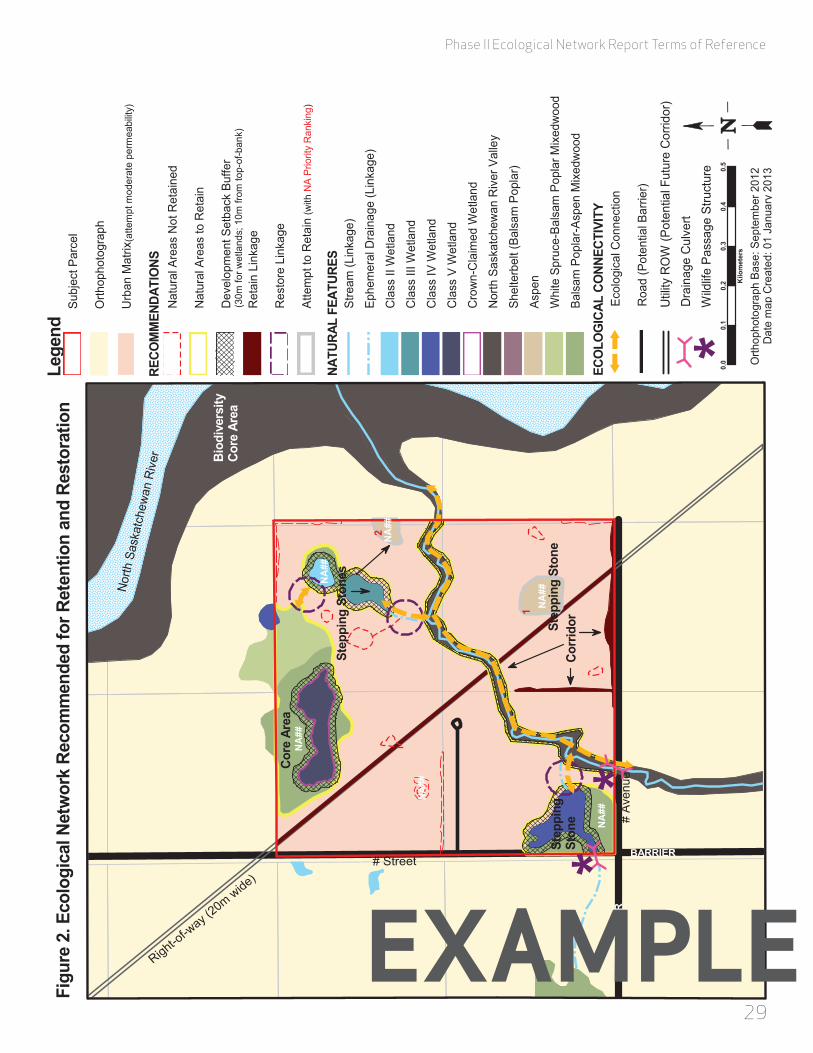
Phase II Ecological Network Report Terms of Reference
2928
# Street
# Av
enue
Right-of-w
ay (20mwide)
NA
##
NA
##
NA
##
NA
##
NA
##
NA
##
0.0
0.1
0.2
0.3
0.4
0.5
Kilo
met
ers
Orth
opho
togr
aph
Base
: Sep
tem
ber 2
012
Dat
e m
ap C
reat
ed: 0
1 Ja
nuar
y 20
13
Figu
re 2
. Eco
logi
cal N
etw
ork
Reco
mm
ende
d fo
r Ret
entio
n an
d Re
stor
atio
nLe
gend
NATU
RAL
FEAT
URES
ECO
LOG
ICAL
CO
NNEC
TIVI
TY
Subj
ect P
arce
l
Orth
opho
togr
aph
Urb
an M
atrix
Stre
am (L
inka
ge)
Ephe
mer
al D
rain
age
(Lin
kage
)
Cla
ss II
Wet
land
Cla
ss II
I Wet
land
Cla
ss IV
Wet
land
Cla
ss V
Wet
land
Cro
wn-
Cla
imed
Wet
land
Nor
th S
aska
tche
wan
Riv
er V
alle
y
Shel
terb
elt (
Bals
am P
opla
r)
Aspe
n
Whi
te S
pruc
e-Ba
lsam
Pop
lar M
ixed
woo
d
Bals
am P
opla
r-Asp
en M
ixed
woo
d
Ecol
ogic
al C
onne
ctio
n
Roa
d (P
oten
tial B
arrie
r)
Dra
inag
e C
ulve
rt
BARR
IER
BARRIER
Nor
thSa
skat
chew
anR
iver
RECO
MM
ENDA
TIO
NSN
atur
al A
reas
Not
Ret
aine
d
Nat
ural
Are
as to
Ret
ain
Dev
elop
men
t Set
back
Buf
fer
Ret
ain
Link
age
Res
tore
Lin
kage
Atte
mpt
to R
etai
n
(30m
for w
etla
nds;
10m
from
top-
of-b
ank)
Corr
idor
1
2
(with
NA
Prio
rity
Ran
king
)
Step
ping
Sto
ne
Step
ping
Sto
nes
**
*W
ildlif
e Pa
ssag
e St
ruct
ure
Util
ity R
OW
(Pot
entia
l Fut
ure
Cor
ridor
)
Biod
iver
sity
Core
Are
a
Core
Are
a
Step
ping
Ston
e
(atte
mpt
mod
erat
e pe
rmea
bilit
y)
exaMPLe exaMPLe
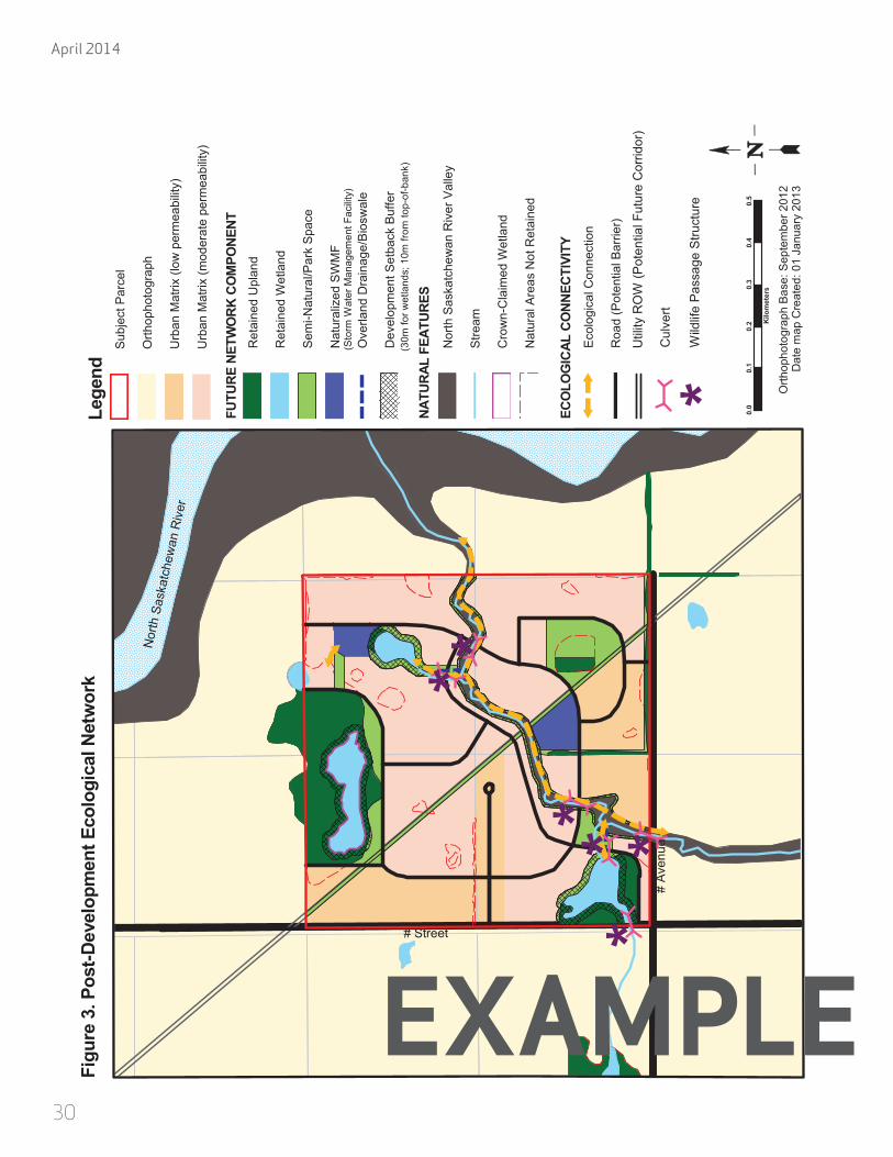
April 2014
30
# Street
# A
venu
e
Figu
re 3
. Pos
t-Dev
elop
men
t Eco
logi
cal N
etw
ork
Lege
nd
NATU
RAL
FEAT
URES
ECO
LOG
ICAL
CO
NNEC
TIVI
TYE
colo
gica
l Con
nect
ion
Roa
d (P
oten
tial B
arrie
r)
Cul
vert
Nor
thSa
skat
chew
anR
iver
FUTU
RE N
ETW
ORK
CO
MPO
NENT
0.0
0.1
0.2
0.3
0.4
0.5
Kilo
met
ers
Orth
opho
togr
aph
Bas
e: S
epte
mbe
r 201
2D
ate
map
Cre
ated
: 01
Janu
ary
2013
Ret
aine
d U
plan
d
Ret
aine
d W
etla
nd
Sem
i-Nat
ural
/Par
k S
pace
Nat
ural
ized
SW
MF
Ove
rland
Dra
inag
e/B
iosw
ale
Dev
elop
men
t Set
back
Buf
fer
Nor
th S
aska
tche
wan
Riv
er V
alle
y
Stre
am
Cro
wn-
Cla
imed
Wet
land
Nat
ural
Are
as N
ot R
etai
ned
(30m
for w
etla
nds;
10m
from
top-
of-b
ank)
**
*W
ildlif
e P
assa
ge S
truct
ure
(Sto
rm W
ater
Man
agem
ent F
acilit
y)
*
**
*
Util
ity R
OW
(Pot
entia
l Fut
ure
Cor
ridor
)
Sub
ject
Par
cel
Orth
opho
togr
aph
Urb
an M
atrix
(low
per
mea
bilit
y)
Urb
an M
atrix
(mod
erat
e pe
rmea
bilit
y)
ExaMPLE

Phase II Ecological Network Report Terms of Reference
31
aPPendIx d: natural area summary table
Natural Area
Phase II ENR ID
Other ID*Size
(area) (§2.1.2)
Shape (§2.1.2)
Habitat Diversity (§2.1.2)
Presence of Nearby
Upland Habitat (§2.1.2)
Presence of Nearby Wetland Habitat (§2.1.2)
Ecological Evaluation Tool – Part
A score (§2.1.2)
Preliminary Natural
Area Rating (§2.1.4)
Role in Ecological
Network (§2.3)
Ecological Evaluation Tool – Part B Score (if applicable)
(§2.4)
Natural Area
Ecological Value (§2.4)
Ecological Network
Value (§2.4)
Natural Area Priority Ranking
and Score(§2.4)
Retention Status (retained in original
state, restored, integrated,
not retained)(§2.5)
Retention Tool (§2.5)
W6 SW9999 15.2 ha Round
Class IV wetland-upland comlpex (open water, marsh wetland, deciduous upland, mixedwood upland)
5.7 ha 4.0 ha 41 High Core Area 49 High High Retain Retained in original state Crown-Claimed
WU9 SW9970 9.8 ha SquareClass III wetland-upland complex (marsh wetland, mixedwood upland)
3.9 ha 4.4 ha 29 Moderate Habitat Patch 36 High High Retain Retained in original
state ER
W2 --- 1.0 ha Round Class II wetland (meadow) 3.1 ha 5.3 ha 19 Moderate Stepping
Stone 29 Moderate High Attempt to Retain (1)
Integrated as naturalized SWMF
Integrated as PUL
U7 --- 0.6 ha Mix of linear and round
Deciduous tree stand (deciduous upland) none 1.5 ha 2 Low Stepping
Stone N/A Low Low Not Retained Not retained N/A
*for example geowest 1993, spencer 2006, etc.
note: Please sort table in descending order first by natural area ecological value, then by ecological network value.
ExaMPLE

April 2014
32
aPPendIx e: ecologIcal evaluatIon toolthe ecological evaluation tool is based on several factors contributing to the ecological value of a natural area. each factor, however, does not contribute equally to the final score. the following are the weightings of each factor: biodiversity Potential – 35%; ecological connectivity – 20%; Observed biodiversity – 35%; condition – 10%. the scores for each factor are added to obtain a maximum score of 100. a bonus score for representative value of up to 5 may also be added, however, the final score must be limited to a maximum of 100.
Score (TOTAL out of 100) = Biodiversity Potential + Ecological Connectivity + Observed Biodiversity + Condition + Representative Value [Bonus]
Part a of the ecological evaluation tool is comprised of two factors, biodiversity Potential and ecological connectivity, which are assessed using a desktop-based analysis. Part a must be completed for all natural areas in the plan area. Part b of the ecological evaluation tool is comprised of the Observed biodiversity and condition factors, and requires completion of field surveys. while it is recommended that Part b be completed for all natural areas, adequate field survey data may not be available for those natural areas that were assigned a Preliminary natural area rating of low. in this case, only the score from Part a will be available to calculate the natural area’s natural area ecological value.

33
Phase II ecological Network Report terms of Reference
Factor Variable Metric Criteria ScoringVariable
Score Calculation
Factor Score
CalculationImplementation Comment Rationale
biodiversity Potential
size area (ha)
<0.5 0
score out of 15
add variable scores = score out of 35
• calculate total area, in hectares, of the natural area with one decimal degree accuracy.
• best done using gis or similar analysis software.
habitat patch size is among the most commonly used surrogate measures of species richness/ biodiversity potential. it is generally understood that larger habitat patches are capable of supporting increased numbers of species and thus increased biodiversity. larger natural areas also tend to be more sustainable.
0.5 – 1 1
>1– 3 2
>3 – 6 5
>6 – 9 8
>9– 12 11
>12 15
shape shape
simple round/square shape 0
score down to -8
• review natural area delineation and choose the criteria category that best fits the shape of the subject feature.
Patch shape can affect the quality of habitat within a patch and, in doing so, can greatly influence the capacity of a natural area to support biodiversity. a natural area that is linear/narrow in shape will typically be more influenced by surrounding land use and will have less interior habitat compared to a natural area of similar size that is more round/square in shape.
a few linear/narrow areas -2
mix of linear/narrow areas and rounder/wider areas -4
linear/narrow throughout -8
habitat diversitynumber of different habitat types (> 0.5 ha) present within the natural area
Open water 3
add all that apply = score out of 20
• determine the number of different habitat types within the natural area using aerial photography and digital imagery.
• ground truthing may be required to confirm different habitat types.
Observed biodiversity values (Part b: field surveys) will likely be based on a single site visit for each of the taxa surveyed and thus represent a snapshot estimate of the biodiversity, and not necessarily the full biodiversity potential, of a natural area. however, the diversity of available habitat types can be used to complement biodiversity observed during plant and wildlife surveys. generally speaking, of two natural areas equal in size, the natural area having more habitat types is likely to support higher biodiversity.
marsh wetland 3
shrub wetland 2
Peatland (bog or fen) 4
deciduous upland 2
coniferous upland 2
mixedwood upland 3
meadow/naturalized field 1
ecological connectivity
Presence of nearby upland habitat
area (ha) of wooded, meadow, or naturalized field habitat within 100 m buffer
0 – 0.5 0
score out of 10 add variable
scores = score out of 20
• calculate area, in hectares, of natural upland habitat found within a 100 m buffer along the entire margin of the natural area.
• gis analysis approach is preferred.
ecological connectivity contributes greatly to long-term sustainability of observed biodiversity values. a natural area that is connected to other natural areas should be better able to support current biodiversity compared to a natural area lacking those same connections.
>0.5 – 1 1
>1 – 2 3
>2 – 3 5
>3 – 5 7
>5 10
Presence of nearby wetland habitat
area (ha) of wetland habitat within 100 m buffer
0-1 0
score out of 10
• determine the number of class iii, iv, or v wetlands found within a 100 m buffer along the entire margin of the natural area.
• gis analysis approach is preferred.
ecological connectivity contributes greatly to long-term sustainability of observed biodiversity values. a natural area that is connected to other natural areas should be better able to support current biodiversity compared to a natural area lacking those same connections.
>1-3 3
>3-5 5
>5 10
Part a: desktoP-based analysIs
part a total score:
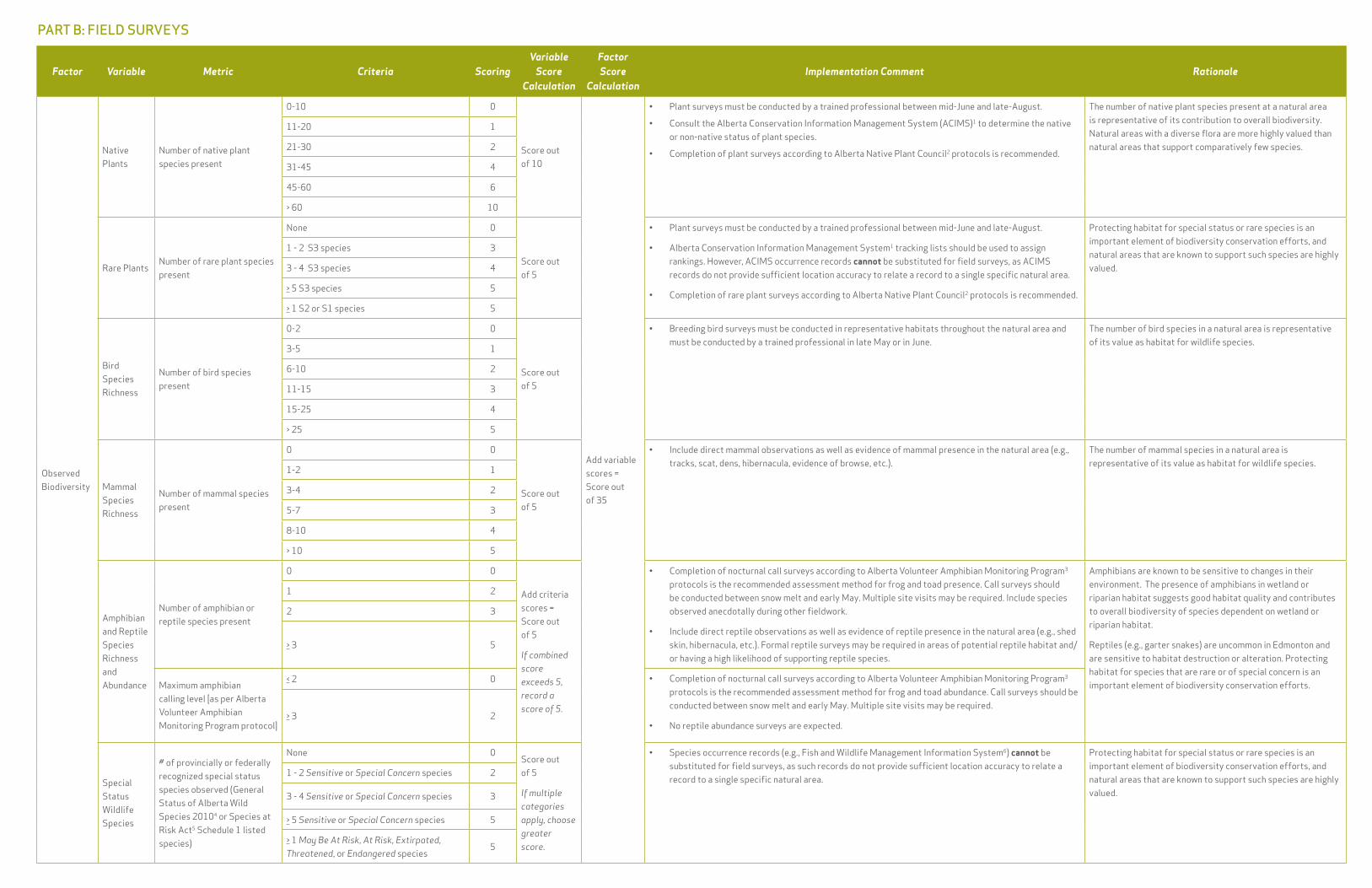
34
Factor Variable Metric Criteria ScoringVariable
Score Calculation
Factor Score
CalculationImplementation Comment Rationale
Observed biodiversity
native Plants
number of native plant species present
0-10 0
score out of 10
add variable scores = score out of 35
• Plant surveys must be conducted by a trained professional between mid-june and late-august.
• consult the alberta conservation information management system (acims)1 to determine the native or non-native status of plant species.
• completion of plant surveys according to alberta native Plant council2 protocols is recommended.
the number of native plant species present at a natural area is representative of its contribution to overall biodiversity. natural areas with a diverse flora are more highly valued than natural areas that support comparatively few species.
11-20 1
21-30 2
31-45 4
45-60 6
> 60 10
rare Plantsnumber of rare plant species present
none 0
score out of 5
• Plant surveys must be conducted by a trained professional between mid-june and late-august.
• alberta conservation information management system1 tracking lists should be used to assign rankings. however, acims occurrence records cannot be substituted for field surveys, as acims records do not provide sufficient location accuracy to relate a record to a single specific natural area.
• completion of rare plant surveys according to alberta native Plant council2 protocols is recommended.
Protecting habitat for special status or rare species is an important element of biodiversity conservation efforts, and natural areas that are known to support such species are highly valued.
1 - 2 s3 species 3
3 - 4 s3 species 4
> 5 s3 species 5
> 1 s2 or s1 species 5
bird species richness
number of bird species present
0-2 0
score out of 5
• breeding bird surveys must be conducted in representative habitats throughout the natural area and must be conducted by a trained professional in late may or in june.
the number of bird species in a natural area is representative of its value as habitat for wildlife species.
3-5 1
6-10 2
11-15 3
15-25 4
> 25 5
mammal species richness
number of mammal species present
0 0
score out of 5
• include direct mammal observations as well as evidence of mammal presence in the natural area (e.g., tracks, scat, dens, hibernacula, evidence of browse, etc.).
the number of mammal species in a natural area is representative of its value as habitat for wildlife species.
1-2 1
3-4 2
5-7 3
8-10 4
> 10 5
amphibian and reptile species richness and abundance
number of amphibian or reptile species present
0 0
add criteria scores = score out of 5
If combined score exceeds 5, record a score of 5.
• completion of nocturnal call surveys according to alberta volunteer amphibian monitoring Program3 protocols is the recommended assessment method for frog and toad presence. call surveys should be conducted between snow melt and early may. multiple site visits may be required. include species observed anecdotally during other fieldwork.
• include direct reptile observations as well as evidence of reptile presence in the natural area (e.g., shed skin, hibernacula, etc.). formal reptile surveys may be required in areas of potential reptile habitat and/or having a high likelihood of supporting reptile species.
amphibians are known to be sensitive to changes in their environment. the presence of amphibians in wetland or riparian habitat suggests good habitat quality and contributes to overall biodiversity of species dependent on wetland or riparian habitat.
reptiles (e.g., garter snakes) are uncommon in edmonton and are sensitive to habitat destruction or alteration. Protecting habitat for species that are rare or of special concern is an important element of biodiversity conservation efforts.
1 2
2 3
> 3 5
maximum amphibian calling level [as per alberta volunteer amphibian monitoring Program protocol]
< 2 0 • completion of nocturnal call surveys according to alberta volunteer amphibian monitoring Program3 protocols is the recommended assessment method for frog and toad abundance. call surveys should be conducted between snow melt and early may. multiple site visits may be required.
• no reptile abundance surveys are expected.> 3 2
special status wildlife species
# of provincially or federally recognized special status species observed (general status of alberta wild species 20104 or species at risk act5 schedule 1 listed species)
none 0score out of 5
If multiple categories apply, choose greater score.
• species occurrence records (e.g., fish and wildlife management information system6) cannot be substituted for field surveys, as such records do not provide sufficient location accuracy to relate a record to a single specific natural area.
Protecting habitat for special status or rare species is an important element of biodiversity conservation efforts, and natural areas that are known to support such species are highly valued.
1 - 2 Sensitive or Special Concern species 2
3 - 4 Sensitive or Special Concern species 3
> 5 Sensitive or Special Concern species 5
> 1 May Be At Risk, At Risk, Extirpated, Threatened, or Endangered species
5
Part b: FIeld surveys
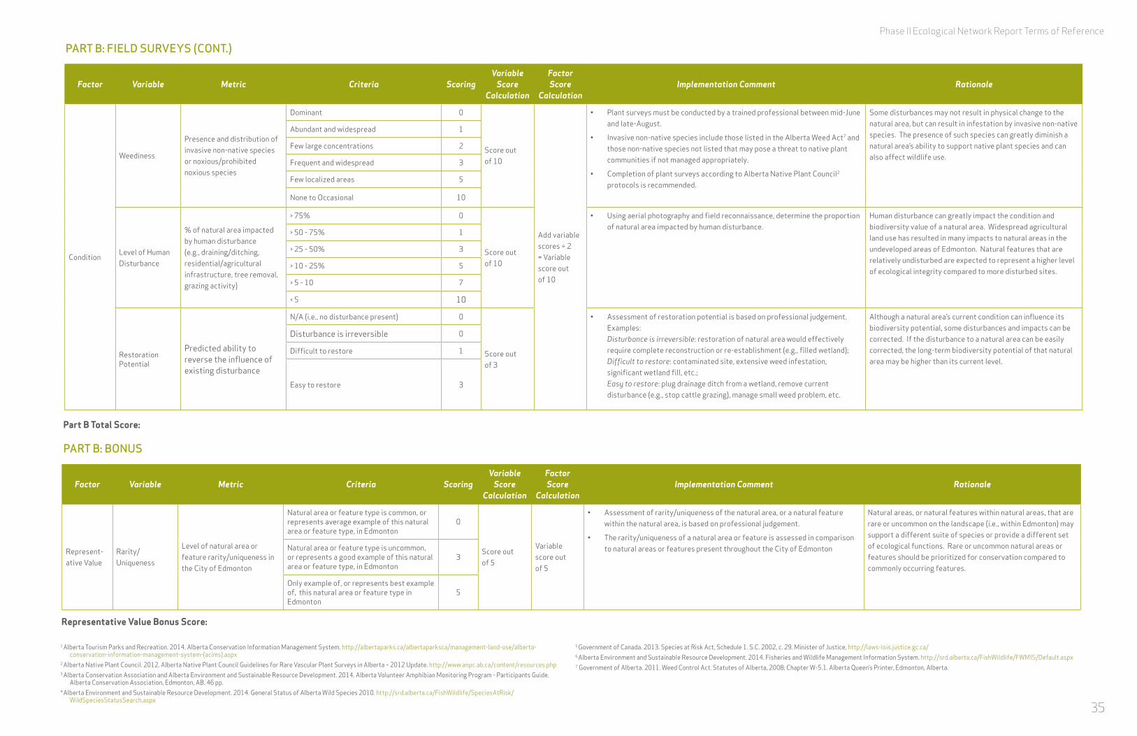
35
Phase II Ecological Network Report Terms of Reference
Factor Variable Metric Criteria ScoringVariable
Score Calculation
Factor Score
CalculationImplementation Comment Rationale
condition
weediness
Presence and distribution of invasive non-native species or noxious/prohibited noxious species
dominant 0
score out of 10
add variable scores ÷ 2 = variable score out of 10
• Plant surveys must be conducted by a trained professional between mid-june and late-august.
• invasive non-native species include those listed in the alberta weed act7 and those non-native species not listed that may pose a threat to native plant communities if not managed appropriately.
• completion of plant surveys according to alberta native Plant council2 protocols is recommended.
some disturbances may not result in physical change to the natural area, but can result in infestation by invasive non-native species. the presence of such species can greatly diminish a natural area’s ability to support native plant species and can also affect wildlife use.
abundant and widespread 1
few large concentrations 2
frequent and widespread 3
few localized areas 5
none to Occasional 10
level of human disturbance
% of natural area impacted by human disturbance (e.g., draining/ditching, residential/agricultural infrastructure, tree removal, grazing activity)
> 75% 0
score out of 10
• using aerial photography and field reconnaissance, determine the proportion of natural area impacted by human disturbance.
human disturbance can greatly impact the condition and biodiversity value of a natural area. widespread agricultural land use has resulted in many impacts to natural areas in the undeveloped areas of edmonton. natural features that are relatively undisturbed are expected to represent a higher level of ecological integrity compared to more disturbed sites.
> 50 - 75% 1
> 25 - 50% 3
> 10 - 25% 5
> 5 - 10 7
< 5 10
restoration Potential
Predicted ability to reverse the influence of existing disturbance
n/a (i.e., no disturbance present) 0
score out of 3
• assessment of restoration potential is based on professional judgement. examples: Disturbance is irreversible: restoration of natural area would effectively require complete reconstruction or re-establishment (e.g., filled wetland); Difficult to restore: contaminated site, extensive weed infestation, significant wetland fill, etc.; Easy to restore: plug drainage ditch from a wetland, remove current disturbance (e.g., stop cattle grazing), manage small weed problem, etc.
although a natural area’s current condition can influence its biodiversity potential, some disturbances and impacts can be corrected. if the disturbance to a natural area can be easily corrected, the long-term biodiversity potential of that natural area may be higher than its current level.
disturbance is irreversible 0
difficult to restore 1
easy to restore 3
Factor Variable Metric Criteria ScoringVariable
Score Calculation
Factor Score
CalculationImplementation Comment Rationale
represent-ative value
rarity/uniqueness
level of natural area or feature rarity/uniqueness in the city of edmonton
natural area or feature type is common, or represents average example of this natural area or feature type, in edmonton
0
score out of 5
variable score out of 5
• assessment of rarity/uniqueness of the natural area, or a natural feature within the natural area, is based on professional judgement.
• the rarity/uniqueness of a natural area or feature is assessed in comparison to natural areas or features present throughout the city of edmonton
natural areas, or natural features within natural areas, that are rare or uncommon on the landscape (i.e., within edmonton) may support a different suite of species or provide a different set of ecological functions. rare or uncommon natural areas or features should be prioritized for conservation compared to commonly occurring features.
natural area or feature type is uncommon, or represents a good example of this natural area or feature type, in edmonton
3
Only example of, or represents best example of, this natural area or feature type in edmonton
5
Part b: FIeld surveys (cont.)
Part b: bonus
part b total score:
representative value bonus score:
1 alberta tourism Parks and recreation. 2014. alberta conservation information management system. http://albertaparks.ca/albertaparksca/management-land-use/alberta-conservation-information-management-system-(acims).aspx
2 alberta native Plant council. 2012. alberta native Plant council guidelines for rare vascular Plant surveys in alberta – 2012 update. http://www.anpc.ab.ca/content/resources.php3 alberta conservation association and alberta environment and sustainable resource development. 2014. alberta volunteer amphibian monitoring Program - Participants guide.
alberta conservation association, edmonton, ab. 46 pp.4 alberta environment and sustainable resource development. 2014. general status of alberta wild species 2010. http://srd.alberta.ca/fishwildlife/speciesatrisk/
wildspeciesstatussearch.aspx
5 government of canada. 2013. species at risk act, schedule 1. s.c. 2002, c. 29. minister of justice, http://laws-lois.justice.gc.ca/6 alberta environment and sustainable resource development. 2014. fisheries and wildlife management information system. http://srd.alberta.ca/fishwildlife/fwmis/default.aspx7 government of alberta. 2011. weed control act. statutes of alberta, 2008; chapter w-5.1. alberta queen’s Printer, edmonton, alberta.
3736
April 2014
aPPendIx F: recommended reFerences and InFormatIon sources
alberta biodiversity monitoring institute (www.abmi.ca)
alberta bird atlas (www.naturealberta.ca)
alberta conservation information management system (acims) (http://www.albertaparks.ca/albertaparksca/management-land-use/alberta-conservation-information-management-system-(acims).aspx)
Alberta Invasive Plant Identification Guide, wheatland county, 2012
Alberta Vegetation Inventory Interpretation Standards, alberta sustainable resource development, 2005
committee on the status of endangered wildlife in canada, (www.cosewic.gc.ca)
Ecological Community Sampling Guidelines, alberta conser-vation information centre, 2011
fisheries and wildlife management information system fw-mis database (http://esrd.alberta.ca/fish-wildlife/fwmis/default.aspx)
flood hazard map application, alberta environment and sustainable resource development (http://www.envinfo.gov.ab.ca/floodhazard/)
Guidelines for Rare Vascular Plant Surveys in Alberta, alberta native Plant council, 2012
Native Plant Revegetation Guidelines for Alberta, alberta environment, 2001
Rangeland Health Assessment for Grassland, Forest & Tame Pasture, government of alberta, 2009
Sensitive Species Inventory Guidelines, alberta sustainable resource development, 2010

Phase II Ecological Network Report Terms of Reference
3736
aPPendIx g: desIgn and management recommendatIons For storm-water InFluenced natural wetlands
when integrating a natural wetland into the city’s drainage system, early planning should include development of explicit retention and management objectives. where the objective is conservation of the wetland and its current functions to the greatest degree possible, the city of edmonton recommends the following design/management practices:
Design/Retention
•Provide for stormwater treatment upstream of wetland inlet.
•dissipate inlet water velocity.
•establish a minimum 30 m buffer around the ecological boundary of the wetland and retain/reclaim to natural plant communities.
•where they extend beyond the buffer boundary, retain existing adjacent woody communities to greatest degree possible.
•Provide for ability to manipulate water levels, and in particular to provide for complete or near complete drawdown, as required.
•minimize the number and duration of high amplitude fluctuations per annum.
Management
•to mimic natural systems, periodically (every few years) draw water down to below nwl during the period august to October.
•assiduously manage noxious and prohibited noxious weeds, including in the buffer.
•monitor biological function at the integrated facility to allow for adaptive management.
•develop site-specific wetland and buffer management plans.
for additional design recommendations for constructed wetlands, consult Drainage Design and Construction Guidelines: Volume 3 (city of edmonton 2012).

April 2014
Related Documents