STATE OF WASHINGTON Department of Conservation and Development J. B. FINK, Acting Director DIVI SION OF GEOLOGY HAROLD E. CUL VER, Supervisor Report of Investigations No. 4 PRELIMINARY REPORT ON PETROLEUM AND NATURAL GAS IN WASHINGTON By SHELDON L. GLOVER OLYMPIA STATE. PRINTING PLANT 19Jf For sale by Department of Conservation and Development, Olympia, Washington Price, 25 cents.

Welcome message from author
This document is posted to help you gain knowledge. Please leave a comment to let me know what you think about it! Share it to your friends and learn new things together.
Transcript
STATE OF WASHINGTON Department of Conservation and Development
J . B. FINK, Acting Director
DIVI SION OF GEOLOGY HAROLD E. CUL VER, Supervisor
Report of Investigations No. 4
PRELIMINARY REPORT ON
PETROLEUM AND NATURAL GAS IN WASHINGTON
By
SHELDON L. GLOVER
OLYMPIA STATE. PRINTING PLANT
19Jf
For sale by Department of Conservation and Development,
Olympia, Washington
Price, 25 cents.
DEPARTMENT AL ORGANIZATION
DEPARTMENT OF CONSERVATION .AND DEVELOPMENT
J.B. FINK Acting Di,·ecto,·
Olympia
DIVISION OF RECLAMATION
FRANK R. SPINNING S11pe>'Uism· and Assi$tamt Dfrector
Olympia
DIVISION OF FORESTRY
T. S. GOODYEAR S111ienxso1·
Olympia
DIVISION OF HYDRAULICS
CHAS. J. BARTHOLET S11pe>'1>isor
Olympia
DIVISION OF GEOLOGY
HAROLD E. CULVER Supervfaot·
Pullman
DIVISION OF MINES AND MI NING
THOMAS B. HILL Supe,'Visor
Olympia
COLUMBIA BASIN COMMISSION
J.B. FINK Acting Chairman
Olympia
CONTENTS
Page Foreword . . . . . . . . . . . . . . . . . . . . . . . . . . . . . . . . . . . . . . . . . . . . . . . . . . . . 4 Introduction . . . . . . . . . . . . . . . . . . . . . . . . . . . . . . . . . . . . . . . . . . . . . . . . . . 5 Conditions of origin and occurrence of oil. . . . . . . . . . . . . . . . . . . . . . . . . 5 Conditions of origin and occurrence of gas. . . . . . . . . . . . . . . . . . . . . . . . . 6
Oil seeps and gas "shows". . . . . . . . . . . . . . . . . . . . . . . . . . . . . . . . . . . 7 Conditions unfavorable to the occurrence of oil and gas. . . . . . . . . . . . . 8 The State classified as to oil and gas possibilities by counties and districts 8
Areas and formations unfavorable for production . . . . . . . . . . . . . . . . 9 Areas and formations favorable for production. . . . . . . . . . . . . . . . . . 10
Eastern Washington . . . . . . . . . . . . . . . . . . . . . . . . . . . . . . . . . . . . . 10 Wenatchee region . . . . . . . . . . . . . . . . . . . . . . . . . . . . . . . . . . . . 10 Columbia basalt plateau. . . . . . . . . . . . . . . . . . . . . . . . . . . . . . . 10
Western Washington. . . . . . . . . . . . . . . . . . . . . . . . . . . . . . . . . . . . . 16 Whatcom County................... . ................. 16 Skagit County . . . . . . . . . . . . . . . . . . . . . . . . . . . . . . . . . . . . . . . 1 7 Snohomish County. . . . . . . . . . . . . . . . . . . . . . . . . . . . . . . . . . . . 17 King and Pierce counties... ... .. ........... ...... ..... 18 Island County . . . . . . . . . . . . . . . . . . . . . . . . . . . . . . . . . . . . . . . 18 Kitsap County . . . . . . . . . . . . . . . . . . . . . . . . . . . . . . . . . . . . . . . 18 Southwestern Washington . . . . . . . . . . . . . . . . . . . . . . . . . . . . . 19 Northeastern Jefferson County and northern Clallam County 19 West coast, Olympic Peninsula......................... 20
Selected bibliography . . . . . . . . . . . . . . . . . . . . . . . . . . . . . . . . . . . . . . . . . . 23

FOREWORD
Since 1911 ten separate reports applicable to the study of petroleum occurrence have been published by che Division of Geology. All but two present the results of investigations in separate counties, and none deals with the geologic conditions obtaining throughout the State. While more than half of these publications deal with coal, they all outline more or less completely local stratigraphic and structural conditions and so yield data of value in determining the possible occurrence of oil or gas.
The recent revival of active exploratory work has quickened the natural interest of the citizens of Washington in the possibility of commercial development. Discussions, both verbal and published, have included so much sheer speculation without adequate factual basis that it has seemed a plain duty for the Division of Geology to set forth in simple terms the essential facts of oil and gas occurrence as applied to the geologic conditions in Washington.
Detailed studies have been completed in but few areas. The present report must, therefore, be considered as strictly preliminary in character. Nevertheless, it is based upon several decades of work by a considerable number of competent geologists and constitutes an authoritative report.
HAROLD E. CUL VER, Supervisor of Geology .
..
PRELl1\1IN ARl' REPORT ON
PETROLEUM AND NATURAL GAS IN WASHINGTON
By SHELDON L. GLOVER
INTRODUCTION The search for oil and gas in Washington has held the interest of both
the public and of prospecting companies for over forty years. The .first well of which there is record was put down in Snohomish County in 1892; since then, drilling has been almost continuous in one pare of the State or another, with recurring cycles of more intense activity. Some 200 wells in all have been drilled to dace, but relatively few of these were located where formations and structural conditions were favorable for the occurrence of petroleum.
During the last few years, some of this prospecting has been successful. Natural gas has been developed and put to commercial use, and oil in amounts considerably greater than mere indications has been struck in three different wells. This has stimulated prospecting. It has also resulted in increasingly numerous inquiries directed to the Division of Geology for information on the general oil and gas situation in this State.
The present Report of Investigations has been prepared in response to these queries. It is intended to give general information on phases of the subject which are apparently of most interest and to deal briefly with the pretroleum possibilities of the State as a whole.
For detailed information now available on the geology of different areas, reference should be made to the selected bibliography at the end of this report. The list includes several accounts of general nature and many bulletins and reports on certain areas that are potentially productive of oil or gas.
CONDITIONS OF ORIGIN AND OCCURRENCE OF OIL
The commonly accepted theories accounting for the genesis and accumulation of oil have resulted from long study of world-wide occurrences. The subject is complex and evidence as to certain details is contradictory, but from the great mass of findings have come a few well-recognized working hypotheses: 1. Petroleum originates from the slow decomposition of organic material
entrapped in argillaceous sediments. Such source beds were laid down as muas or clays and later compacted; they are of marine or brackishwater origin, as shown by the plant and animal remains almost invariably contained in them.
2. From the source beds, the pecroliferous material migrates to adjacent porous rocks. This movement is caused by one or more of several forces and processes such as: capillarity, dehydration and induration of the clays, earth movement, and hydrostatic pressure.

6 Report of Investigations No. 4-Division of Geology
3. The porous beds, known as "reservoir rocks," mostly are sands or sandstones but may be limestones, conglomerates, fractured shales, -Qr creviced and cellular rocks of other types. To allow for commercial accumulation of oil, the reservoir rock must be permeable as well as porous and must be enclosed in impermeable strata, so the hydrocarbons have freedom of movement within the reservoir but no escape from it.
4. The attitude or shape of the reservoir rock must be such that the hydrocarbons tend to collect in some part under the influence of gas or hydrostatic pressure, differential gravitation, or other force. Favorable places for this concentration of gas or oil into a commercial supply may be at the top of a fold in the given stratum (a dome or anticline), in a lenticular sand body, or against a faulr plane; locations are varied and influenced by many factors. .
CONDITIONS OF ORIGIN AND OCCURRENCE OF GAS
Natural gas of the fuel variety is one of the produces of organic alteration and decomposition. If it is generated in swamps and lakes from decaying vegetal matter, it is called marsh gas. If it is given off in the formation of coal or is produced as coals are operated upon by processes tending to raise their rank, as from lignite to bituminous, it is known as ".fire damp" or coal gas. But gas available for fuel in the greatest quantities has been formed in past geologic time with or from petroleum and so is known as petroleum gas.
Basically, natural gas, of whatever origin, is methane (CH,). All such gases have admixtures of other gases such as carbon dioxide, nitrogen, or oxygen, and some have other gaseous hydrocarbons, depending on the original organic matter and upon the processes involved in its decomposition. If the gas contains ethane (GH.) or higher fractions, it may be assumed to be of petroleum origin; yet some for which that origin seems assured do not contain ethane. The safest basis for an assumption of petroleum origin is the actual occurrence of oil with the gas. If the gas contains readily condensible gasoline, it is termed a "wet" gas. That condition is indicated by a high ethane content or by the presence of propane (GH,) or butane (C.H,o). To be usable as a fuel, a petroleum origin for natural gas is not essential. It is only necessary that there be a sufficient amount of gas of acceptable quality. These features, it is true, are mostly associated with petroleum but may be developed with marsh or coal gas.
Gas and oil accumulate under similar circumstances, so a well drilled for one serves as a cest for both. However, the geology of a given area or structure may be favorable for the occurrence of gas withour satisfying all of the conditions considered necessary for the existence of oil in commercial quantities. For example, oil may have been present in a certain formation at one time, but, as a result of heat and pressure, it may be entirely altered to gas. This holds true for some sediments in early stages of metamorphism and is indicated by induration of the strata and by a rather high carbon ratio for coaly matter which may occur in them. Or, the formation may be of fresh-water origin and, while still favorable for the occurrem:e .of gas, may contain oil only in smaU amount if at all, or only because of unu~ual conditions. I• t,

Petroleum and Natwral Gas in Washington 7
The possibility of production from sediments of fresh-water ongin is of particular interest in Washington. Such fo rmations are widespread and occur in great thickness. Some contain source material for gas, but they lack the type of organic remains commonly associated with oil. P~troleum might occur from che distillation of vegetal matter such as resins, though it would not be expected in commercial quantity. Records of the oil fields of the world show production from marine or at least brackish-water beds, but only rraces of oil in fresh-water beds where its presence may not be explained as due to migration from other strata.
One possible exception is in the Hiawatha dome on the WyomingColorado boundary line. There, a wet gas is produced in great volume from Tertiary (Eocene, Wasatch) fresh-water san<;!s. Nightingale' mentions that the discovery well began to make 12 barrels of oil per day as the gas pressure declined, and he ascribes to this oil the same origin as the gas, i. e., from the Wasatch clay shales. It is to be noted, however, that a hypothesis of migration into the fresh-water beds from a lower series, marine, Cretaceous, and petroliferous, seems to fit known facts equaily well.
OIL SEEPS AND GAS "SHOWS"
Natural seepages of oil and emanations of gas are important, particularly · in a new region. They furnish data to the geologist which, correctly inter
preted, a.id in determining possibilities of production. Their importance is usually over-emphasized by the layman. Seepages are no assurance of commercial production; they merely show that source beds are present. When seeps and "shows" occur in formations that are favorable in other respects, they give added evidence thac under proper structural conditions the possibility of production is good.
Seepages are being reported continually. A few authentic ones are known to exist in this State or have appeared under conditions peculiar to a certain time. Some that have been investigated by the Division of Geology or upon which information has been received from reliable sources are mentioned later in this report. The great majority of reported occurrences, however, fall under one of the following headings:
a. Willful deception practiced by unscrupulous pseudo-geologists, promoters, and others.
b. Mistaking irridescent films of ferric hydroxide on the surface of stagnant water for films of oil.
Gray films, also oil-like in appearance, are produced by decaying vegetation. These cwo are most prolific sources of such erroneous reports.
c. Artificial and accidental occurrences of oil or oil-like products. In this class is the oil occasionally reported on the east shore
of Bainbridge Island and other places on Puget Sound, where s!udge discharged from oil tankers is held in the beach clays.
1 Nlghtlnga.Je, W. T., Geology of Vermllion Creek gas a .. ea in southwest Wyoming and northwest Colorado: Am. Assoc. of Pet. Geol. Bun., vol. 14, no. 8, pp. 1013-1040, Augui,t 1930.
, ···- ·--................... , .............. ..... :; Geology of Hiawatha. gas fields, southwest W.yomlng and nortJnvest Colorado:. A.In. Assoc. of Pet. Geol., Geology of natural gas, pp. 341-361, June 1935.
8 Report of Investigations No. 4-Division of Geology
An excitement in Moncesano, at one time, was caused by striking oil in a basement excavation. Such quantities oozed from the clays ten feet below the ground surface that bottles were filled and sold as souvenirs. It was finally traced co a leaky kerosene-storage tank that had been in use fifteen years before on a site several hundred feet from the excavation.
Considerable interest at Shelton was caused by oil films occurring on the surface of water which filled holes left by land-clearing operations. The film of rainbow colors, that practically required a chemical analysis to be distinguished from oil, owed its origin to the pitch in blasted and partially burned stumps.
The common occurrence of gas bubbles from swamp and tideland muck has no bearing on possible commercial gas in chat region; it may be taken as signifying that the gas escapes as fast as it is generated from the decaying vegetal matter, hence cannot accumulate co commercial amounts in those particular beds. A few gas "shows" from deep-rock sources are known in che State and are of value in estimating the possibilities of the areas in which they occur.
CONDITIONS UNFAVORABLE TO THE OCCURRENCE OF OIL AND GAS
Igneous rock, once molten material, cannot be a source of oil or gas. Under exceptional circumstances, however, oil could migrate from adjacent petroliferous shales to rock of igneous origin and there fill fractures and other voids; but known occurrences are rare and of no commercial importance.
A notable example of gas migration is that of Benton County. There, gas from some unknown source has migrated to porous basalt flows, where it has formed a commercial accumulation. This necessitates classifying ac least part of the Columbia basalt plateau as favorable to the occurrence of gas and possibly of oil, in spite of the presence of igneous rock.
Metamorphic rocks are unfavorable for the occurrence of either oil or gas. Those originating from igneous rock could never have contained hydrocarbons; those derived from sediments might once have contained such material, but it would have been dissipated or destroyed by the processes which altered the rocks to their present condition.
THE STATE CLASSIFIED AS TO OIL AND GAS POSSIBILITIES BY COUNTIES AND DISTRICTS .
Foregoing considerations may be applied to the rocks of the State and conclusions drawn as to the possibilities of the various formations and areas. The problem is restricted by making a general classification whereby the rocks which definitely cannot be expected to contain oil are distinguished from those chat cou ld carry oil or gas if other conditions were favorable.
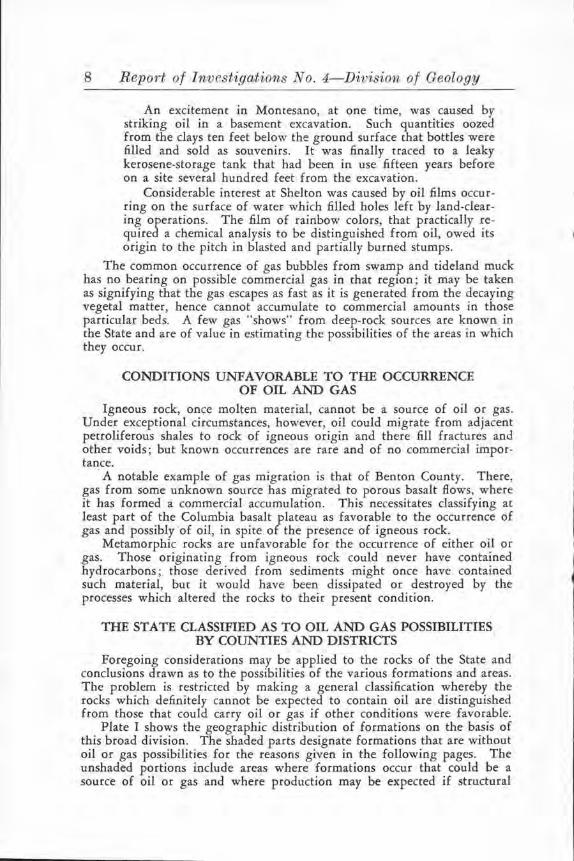
Plate I shows the geographic distribution of formations on the basis of this broad division. The shaded parts designate formations that are without oil or gas possibilities for the reasons given in the following pages. The unshaded portions include areas where formations occur that could be a source of oil or gas and where production may be expected if structural
DIVISION OF GEOLOGY
z
< w
.., 0
..,
...
.., < Q.
M A
" ' ~
~ ~
V
T A
0 E G O N
OUTLINE MAP OF WASHINGTON
REPORT OF INVESTIGATIONS NO. 4, PLATE I
G R A N T
AREAS THAT HAVE OIL OR" GAS POSSIBlLITIES IF STRUCTURAL
~~~f~TIO~ER°tREsciC~g:A:fifs J~$Li~\iAv'~~~ ~~V:~~ENT.
AREAS NOT FAVORABLE FOR THE OCCURRENCE OF' OIL OR GAS,
.. . u:awn.c
.. 10 ZO 30 40 N IL.&3
.. SHOWING AREAS F.A<VORABLE AND UNFAVORABLE FOR OIL AND GAS (See pp. 8 and 9).
Petroleum and Natitral Gas in Washington 9
and other conditions can be found to be favorable. The unshaded portions also include areas of basalt in eastern Washington and of Pleistocene and Recent sediments in western Washington where the concealment of the bedrock or underlying formation prevents definite classification. In some instances, favorable formations .c:nay be assumed to underlie this cover, as indicated by marginal outcrops or by the results of drilling; in others, the determinations are yet to be made.
The shaded and unshaded areas are separated by (1) solid lines, (2) dashed lines, and (3) no definite lines. A solid line indicates that a rather well-defined contact exists between the two divisions; dashed lines indicate an approximate or ill-defined contact; and the absence of any line indicates a boundary that is entirely suppositional.
AREAS AND FORi\iATIONS UNFAVORABLE FOR PRODUCTION
These include all known rocks older than Tertiary and all regions where such rocks form the surface exposures. An exception is the sedimentary series known as the Hoh formation, which may be pre-Tertiary in age, occurring in the area west of the Olympic Mountains. Elsewhere, preTertiary rocks exist either as isolated erosional remnants, such as the Cretaceous sediments of the San Juan Islands, or they consist of igneous types, or sediments too much metamorphosed to be productive.
Igneous and metamorphic rocks comprise all but a very small part of the Okanogan Highlands and the Cascade Mountains. Such unaltered sediments as occur are surficial deposits and relatively thin Tertiary lacustri!}e and fluviatile sediments without promise for oil or gas. In eastern Washington, this classes as definitely unfavorable Pend Oreille, Stevens, Ferry, and Okanogan counties, all of Chelan County except a few townships near Wenatchee, and the western part of Kittitas, Yakima, and Klickitat counties.
The Columbia basalt plateau might be considered unfavorable if it were not for the unique gas occurrence of Benton County. (See pp. 10-15.) Even so, the north and ease borders of the plateau hold no promise of ptoduction. There, nonproductive underlying rock is indicated by the large areas of igneous and metamorphic rock which appear beyond the area inundated by lava, by "islands" of the older formations projecting through che lava, and by ocher masses exposed where erosion has cut deeply into the basalt. So, without postulating definite boundaries, most of Douglas and Lincoln counties, all of Spokane and Whitman counties, and probably Garfield and Asotin counties should be classed as unfavorable for oil or gas.
In western Washington the areas definitely unfavorable by reason of the presence of igneous or metamorphic rock include the eastern threefourths of Whatcom County, all of Skagit County except a small area in the southwest part, all of San Juan County, the eastern four-fifths of Snohomish County, the eastern one-half to two-thirds of King County, the eastern half of Pierce and Lewis counties, all of Skamania County, the eastern two-thirds of Cowlitz County, and most of Clark County. In addition, predominance of Eocene basalt renders unfavorable for production the north and east portion of Thurston County, practically all of Mason County, and the southwest part of Kitsap County.
In the Olympic Peninsula, the central mountain mass is composed of sediments similar to the Hoh formation of the west coast. They are too
10 Report of Investigations No. 4-Division of Geology
much indurated as well as structurally unfavorable for the occurrence of oil or gas. Surrounding them and making up some of the mountainous area on the south, east, and north, are altered volcanic rocks that also are unfavorable. This eliminates from the field of possibilities the northeast part of Grays Harbor County, the central.area of Jefferson County, and all but the western part and northern fringe of Claliam County.
AREAS AND FORMATIONS FAVORABLE FOR PRODUCTION
In considering the following discussion of places classified as favorable for the production of gas and oil, it should be understood that there is no assurance of production in advance of actual drilling tests. In so far as the formations in the various areas fulfil the conditions deemed necessary and enumerated in the ~arlier pages of this report, so will the chances of production vary. There are always risks to be run in drilling for oil, even in structures that have been proved co be productive, but risk is minimized where geologic conditions are known co be favorable.
EASTERN ,v ASHINGTON
Wenatchee region. Eocene fresh-water strata of the Swauk formation cover a large area in the general vicinity of Wenatchee and extend to the northwest. They contain a few beds of subbicuminous coal and much carbonaceous shale which could be a source of gas and, possibly, oil. Gas might accumulate in structurally favorable places and be confined in porous sandstones by the interbedded shales.
A test well is being drilled just south of Wenatchee. It has reached a depth of over 2,500 feet and has had showings of oil and in several zones a considerable volume of gas. Io addition to these favorable indications for that area, reports, considered reliable, state that at certain stages of the water, petroleum seepages exist at the foot of Fifth Street in W enacchee and just south of town in the NW. ~ sec. 14, T. 22 N., R. 20 E.
Columbia basalt plateau. In 1913, a well was drilied for water on the northeast slope of the Rattlesnake Hills, about 18 miles northeast of Prosser, in Beaton County. After penetrating basalt and interbasalt sediments for 700 feet, it went through 71 feet of clay; below this, in a porous basalt, gas was encountered. The pressure was very low- about 5Y:z pounds per square inch-but the volume of flow was variously estimated between 70,000 and 500,000 cubic feet per day. A second well was drilled nearby in 1917-1918 to the gas zone, and an estimated flow of over 2,000,000 cubic feet per day at about the same pressure was obtained.
Other drilling followed as various organizations became interested in the field, but it was not until 1929 that a distribution system and centralized management allowed the various wells to be placed on production. At the present time fifteen wells, all producing from depths of 700 to 1,260 feet in basalt, are supplying gas to seven towns in the Yakima Valiey.

Pet-roleum c11ncl N atitral Gas in W a.shingf.on 11
Distribution Data
PIPE LINES
Connecting wells
Between wells and compressor ......... .... .. .
Compressor to Toppenish .................... .
Main branch lines to:
Sunnyside ....... . .................... .
Mabton ............................. · ·
Granger .................. . . . ...... .. .
Zillah .......... • ............ . ........
Grandview .................. .. ....... .
Prosser ........... . . ............. . ... .
Total main lines . . . . . . . . . . . . . . . . . . . . . . . . . . . .
Town systems ............. • ...............
Complete distributing plants in towns, 7. Main pressure and carry 125 pounds. Two pressures pounds and 4 to 1 O ounces.
Sizes MJJes (Inches)
2 6 2 4 1 3 3 2
1 10
40 6 4 4
3 4
4 3
2 2
'3 3
1 4
5 4
62 .. 70 2, 3, 4, and 6
lines built for 300 pounds in town systems. 5 to 20
Production from Rattlesnake G as Field
Year
1930
1931
1932
1933
1934
1935
Total ( 6 years) ...............•.... , ..
l\1. cubic feet
94,963
119 ,365
103,826
108,004
141 ,137
207,355
774,650
Value
$45,750
66,717
65,313
80,799
92,09?
116,248
$466,920
~ -

12 Report of Investigations No. 4-Division of Geology
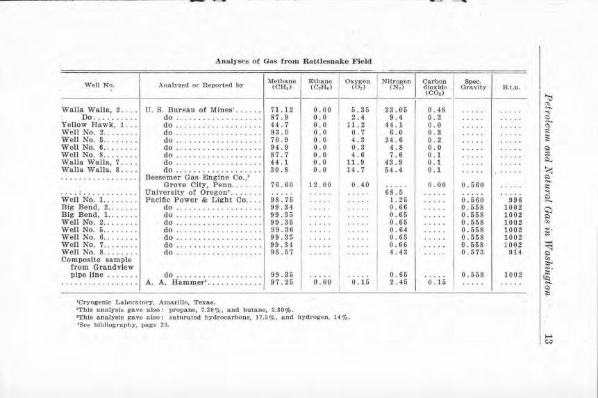
Analyses of this gas vary to a marked degree. Samples taken by methods that precluded air contamination above ground still showed an oxygen content, and surplus nitrogen was present that appears to be a component of the gas itself. A relatively high nitrogen content is common for many Washington gases, notably chose from the Chuckanut formation of Whatcom County, and is to be expected where the source of the gas is a freshwater accumulation of vegetal matter. Some commercial analyses show ethane and other hydrocarbons as constituents of Benton County gas; but Government analyses, using fractional distillation checked by combustion methods on samples from eight different wells during three years, showed an entire absence of ethane or heavier hydrocarbons.
The presence of gas in basalt is the outstanding peculiarity of this field, but the slight pressure and prolonged flow are almost equally out of the ordinary. The original pressure of 5¥2 pounds was recorded only during the early flow of the first wells; later, a pressure of between one and two pounds per square inch appeared normal and was maintained even after a large volume of gas had been withdrawn. At the present time, nearly a billion cubic feet of gas has been utilized commercially, over 270 million cubic feet has been expended in field tests, and a quantity probably over a billion cubic feec in amount was wasted in preliminary development of the .field. All producing wells now are being pumped, and the pressure is approximately zero; yet no diminution of volume is apparent.
Certain features of the basalt and of this gas occurrence in it are of particular importance for their bearing on other possible occurrences in the area. The basalt was formed in Miocene time, when flow after flow of lava, each from a few feet to 100 feet or more thick, spread over that region. The extrusion occupied a Jong period of time and resulted in a great series of superimposed layers. These are commonly flat lying, but in places they are folded and faulted.
The Rattlesnake field is on a well-defined anticline that is possibly complicated by longitudinal faulting. The gas accumulation is controlled by the structure and may owe its presence in relatively shallow beds to migration up a fault plane. Production is from porous basalt. Such rock, the vesicular and even scoriaceous top or bottom of individual flows, is permeable and can carry and store gas as efficiently as might sandstone. Similar beds commonly are important aquifers. The gas is held in the reservoir beds by overlying clays. These clays are interbasalt sediments which had their origin in wind- and water-deposited material with a very minor amount of residual day. They formed, during the occasional intervals between flows, in beds ranging from an inch or so to as much as 90 feet or more in thickness.
The sediments in some places contain the carbonized or silici.6.ed remains of trees and ocher vegetation that g rew ar chat time. A bed of woody lignite several feet thick in Asotin County, another in Lincoln County, and the opalized wood of Ginkgo National Monument and ocher places resulted from periods of growth between ftows. The general thinness of tbe days, the fact that sediments are apparently neither widespread nor particularly numerous, and their usual low content of carbonaceous matter makes ir very unlikely that these interbedded clays are source beds for the gas.
-........ -----
Ana.lyses of Gas from Rattlesnake Field
I Well No. l A na.lyzed or Reported by I Methane I Ethane I Oxygen
(CH4 ) (CoH,) (Oo) I I
Walla Walla, 2 .... U. S. Bureau of Mines' ...... 71.12 o.oo I 5.35 Do ...... .... do .......... . ..... . .. 87.9 0.0 2.4
Yellow Hawk, 1 ... do ...... .. ... . .. . ..... 44. 7 0.0 11. 2 Well No. 2 ........ do ............. • ..... 93.0 0.0 0.7 Well No. 5 ........ do ........•....... . .. 70.9 o.o 4.3 Well No. 6 .. . ..... do ................ . .. 94.9 0.0 0.3 Well No. 8 ........ do ............ . ... . .. 87.7 0.0 4. 6 Walla Walla, 7 .... do ................... 44.1 0.0 11. 9 Walla Walla, 8 .... do ................... 30.8 0.0 14. 7 ................. Bessemer Gas Engine Co.,'
Grove City, Penn ....... 76.60 12.00 0.40 ................. University of Oregon• ... ... . . .... . .... . ... . Well No. 1 .... .... Pacific Power & Light Co .... 98.75 . . . . .
I . . ...
Big Bend, 2 ... . ... do ................... 99.34 . .. ... . . . .. Big Bend, 1. ... ... do ... • ...... . .. . .. . .. 99.35 ..... . .... Well No. 2 ........ do ........... . ....... 99.35 . . . . .
I .. . ..
Well No. 5 ........ do ... . ............ . .. 99.36 . . . . . . . ... Well No. 6 ........ do ................... 99.35 . . . . . . . . .. Well No. 7 ........ do ...... . ... . ........ 99.34 ..... I . .. .. Well No. 8 ... . .... do .. . . ....... . ....... 95.57 .....
I . ....
Composite sample from Grandview pipe line ....... do ............. .. .... 99.35 . . . . . .....
. . . . . . . . . . . . . . . . . A. A. Hammer• ......... . .. 97.25 0.00 0.15 I
'Cryogenic Laboratory, Amarillo, Texas. 'This analy!;is gave also: propane, 7.20 % , and butane, 3.80%. 'This analysis gave a lso: saturated hydrocarbons, 17.5%, and hydrogen, 14%. 'See bibliography, page 23.
.. Nitro~en I Carbon (N~ dioxide .
(CO2)
23.05 0.48
I 9.4 0.3
44.1 0 .0 6.0 0.3
24.6 0.2 4.8 0.0 7.6 0. 1
43.9 0.1 54.4 0.1
..... 0.00 68.5 . ....
I 1. 25 . . ... 0.66 . .... 0.65 . ....
I 0.65 . .... 0.64 . .... 0.65 . .. .. 0.66 . .... 4.43 . ....
0.65 . .... I 2.45 0.15
-·
Spec. Gravity
.... .
. . . . .
. . . . .
.....
.... .
.....
.....
. ....
. ....
0.560 . .... 0.560 0.558 0.558 0.558 0.558 0.558 0.558 0. 573
0.558 . . . . .
B.l.u.
. ....
. . ...
. . ...
. . ...
. . ...
. .. ..
. . ...
. .... . .....
. ....
996 1002 1002 1002 1002 1002 1002
91'.4
1002 . ....
~ ~ .... ~ C) .,_ ~ ... ... ::l "" ~ ~
~
~ I.) ..... ~ ~ I.) .,._
~ I.) Cl)
""· ~
~ ~ ~ ~· ~ ..... C ~
1--' c,:,

14 Report of Investigations No. 4-Div-ision of Geology
What does constitute that source is entirely unknown. The most reasonable assumption is that ·the gas is derived from sediments of pre-basalt age presumably underlying the gas field at unknown depth. The gas may originate in a part of these beds under the basalt arch, or it may have migrated from some favorable structure at a distance from its present reservoir. There is no assurance that the structure of these sediments and that of the basalt is the same. The answer to such questions must await deep drilling and the recovery of rock samples which can be studied and identified.
The total thickness of the Columbia River basalt must vary greatly from place to place, since it covered a surface that had considerable relief. Calkins1 estimated its greatest thickness to be not Jess than 4,000 feet. It has been cut into for 2,000 feet by the Snake River in the canyon above Wawawai and has been drilled for over 3,000 feet in places without the bottom flow being reached; in fact, the only wells which are definitely known to have gone completely through are those near the margin of the plateau where the lava is thin.
The present commercial value of the Benton County production and the probability that future drilling in that field wiJJ greatly increase the available gas give reflected importance to much of the Columbia basalt plateau. It makes it necessary to admit the possibility of ocher occurrences in places of favorable structure in many counties. The basalt covers some 30,000 square miles of the State. Much of the area is de.finitely unfavorable owing co existent indications of nonproductive underlying rock. The rest of the plateau, then, may be classified as possibly favorable, not because source beds are known to underlie the basalt, but because non-source beds are not proved to be present- a Scottish verdict that muse be kept constantly in mind.
The more or less arbitrary determination of the favorable portion is obtained by eliminating the marginal part of the plateau except in the vicinity of Wenatchee. Granitic rock is intruded into the basalt in a few places in the southern Cascades, and similar rock may possibly underlie the flows in that area. Plutonic and metamorphic rocks are exposed below the basalt in northwestern Yakima County. The northern boundary of the basalt is rather closely marked by the Columbia and Spokane rivers; and along those streams, exposures of metamorphic and pre-basalt igneous rock are almost continuous. The eastern border of the basalt, also, is on either metamorphic or granitic rock. In some places, protruding through the basalt, like islands in the sea of lava, are the cops of mountains which were never covered. T hese are mostly gneiss or quartzite and show in northern Lincoln County and in many places in Spokane and Whitman counties. Metamorphic rocks are exposed deep under the basalt by the erosion of Snake River above Lewiston, and the top of a buried peak of granite five miles upstream from Wawawai has been exposed by the river cutting down through 2,000 feet of lava flows.
This leaves some 12,000 square miles which may be classified as possibly favorable for production if suitable structural conditions exist. It includes the eastern part of Kittitas, Yakima, -and Klickitat counties, all of Grant
1Calkins, F. C., Geology and water r esource s of a portion of east-central Wa.ablngton: U. S. Geol. Survey W a ter Supply Paper 118, p. 30, 1906.

Petroleum, (JJYl.d Natural Gas in W aslwngton 15
County except the more northern ,Part, Adams, Fra'?klin, Benton, and Walla Walla counties, the north half of Columbia County and the northwest part of Garfield County.
The only actual indication so far known of sediments underlying this great area is in the vicinity of Wenatchee and from there to the general vicinity of Cle Elum. The basalt in that region flowed over fresh-water beds of the Swauk and Roslyn formations with their coal and carbonaceous shales. Such strata, or others even more favorable, might underlie the lava plains. Whether they do or not, or what else may be present and at what depth, is unknown and will remain so until information is. obtained by drilling. It is hoped that a deep test on the Rattlesnake Hills structure, already carried to a depth of over 2,000 feet, may show what underlies the basalt, at least in that particular place.
le has been suggested that the John Day formation of eastern Oregon may underlie the basalt; :dso, that there is possibility of a Cretaceous formation there. Either condition may obtain. As to the John Day beds, the nearest known exposure is about 36 miles south of The Dalles, and as source material, that formation is not as promising as the Swauk formation which is present near Wenatchee. The eastern Oregon Cretaceous beds are excellent source material, being very fossiliferous marine sediments. but the nearest known exposure is some 80 miles co the south of the Washington line. Other Cretaceous sediments, the Pasayten formation , in part fossiliferous and marine, outcrop over an area of some 500 square miles in the northern Cascades of Whatcom and Okanogan counties. There, advanced induration and unfavorable structure preclude the occurrence of oil or gas, but with less diastrophism away from the mountain region such rocks might form source beds. However, the nearest Pasayten beds are separated from the Columbia basalt platau by about 30 miles of plutonic rock. An arm of the Cretaceous sea may have reached into central Washington from the south. If it did, it apparently remained unconnected with the sea occupying ~he northern Washington area, for lupher' reports a marked dissimilarity in the fauna of the two places.
Throughout most of the plateau, the basalt is flat lying, but in many places it has been folded into anticlines, as at Rattlesnake Hills. Such structures are excellent locations for any gas or oil that might be present to accumulate, thus forming favorable prospecting sites. One, just south of Yakima at Union Gap, is now being tested. In the progress of thac drilling, notable amounts of gas have been encountered in several zones. Certain water wells in eastern Yakima County have struck considerable gas, and similar conditions are reported from other places. Another test is under way on the Frenchman Hills anticline of Grant County. Still other wellmarked anticlines exist, as in the area between Yakima and El~ensburg, in the vicinity of Ephrata, and in the Horse Heaven Hills. Tests now under way and others contemplated will go far toward explaining the unique gas occurrences of the basalt plateau.
1Lupber, R L., .Oral communication .
16 Report of Investigations No. 4-D·ivision of Geology
WESTERN WASHlNGTOJS"
Throughout much of western Washington away from the mountainous parts, Tertiary sediments occur which answer the known requirements for strata in which production of oil or gas may be expected. Some are formacions of predominantly fresh-wacer origin with greater possibilities for gas than for oil. These include the Chuckanut formation and much of the Puget group, particularly the more easterly part. Both of these are of Eocene age and are coal bearing. Also, there are excensive formations which could be a source of oil as well as gas. These are of marine and brackishwacer origin. They include parts of the Puget group-that interbedded with the more westerly coal measures and that occurring in southwestern Washington- the Blakeley, Porter, Lincoln, Twin River, and, in part, Clallam formations of Oligocene age, and the Astoria and Montesano formacions of Miocene age.
In the Chuckanut and part of the Puget rocks, source material is present in the form of beds of coal and carbonaceous shale; in the various Oligocene and Miocene sediments and ocher parts of the Puget group, source beds may be expected in che shales which, in many zones, carry an abundant brackish-water or marine fauna. Permeable sandstones, impermeable shales, and abundant water are common to the various formations. The requirement of great importance, thac of favorable structural conditions, is met in many places, for the Tertiary beds have everywhere been folded to various attitudes, some of which favor oil and gas accumulation.
In the following brief listing of areas in which possible oil- or gasbearing beds occur, it should be understood that favorable formations are not everywhere present. In some places they are eroded away; in others they may be covered with such thicknesses of later sediments that their presence is only inferred and nothing is known of their structure. In these areas, in general, however, are rocks which might be expected to contain oil or gas where suitable structural conditions exist. The final possibilities of any given place can be determined only from a detailed study and correct interpretation of the stratigraphy and structure of that particular place. It is seldom, indeed, that drilling is warranted without such geologic information based on an adequate number of actual bedrock exposures.
Whatcom County. The Chuckanut formation is exposed over a large area in the western part of the county and underlies Pleistocene sediments in still more of that region. It has already been shown to contain considerable gas. Four promising structures are known, and one, the Goshen anticline, is now being tested by deep drilling. Several wells north of Bellingham were drilled where structural data were not available, owing to the bedrock being hidden by surficial deposits; yet gas issuing in large volume under heavy pressure was encountered with salt water at moderate depth.
Other indications of the possibilities of this area are: the pronounced seep of light paraffin-base oil in an excavation in Bellingham during the extremely dry season of 1929, and the presence of shallow gas in Pleistocene sands overlying the Chuckanut formation in many places.
The shallow gas has apparently migrated from underlying Chuckanut sources to sand lenses in the glacial sediments. Its presence cannot be predicted, since the position and extent of the lenses are not known. One occur-
P etroleurn and Natural Gas in Washington 17
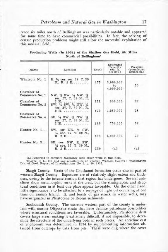
rence six miles north of Bellingham was particularly notable and appeared for some time to have commercial possibilities. In fact, the solving of certain production problems might still allow the successful exploitation of this unusual field.
Prodocm,g Wells (in 1934) of the SbaJlow Gas Field, Six Miles North of Bellingham'
Estimated Capacity Pressure
Name Location Depth (cu. ft. (pounds per per day) square in.)
Whatcom No. 1 E. 1.4 cor, sec. 28, T. 39 N., R. 2 E ......... 175 3,000,000
to 50 4,000,000
Chamber of Commerce No. 1 NW. 1.4 SW. 1.4 NW. 1.4
sec. 27, T. 39 N., R. Chamber of 2 E. ............. 171 900,000 27 Commerce No. 2 SW. 1.4 SW. 1.4 NW. 1.4
sec. 27, T. 39 N., R. 2 E . . . . . . . . . . . . . . 172 1,250,000 28
Chamber of Commerce No. 4 SE. 1.4 SW. 1.4 NW. 1.4
sec. 27, T. 39 N., R. 2 E. ............. 166 750,000 52 .
Hunter No. 1 .. SW. cor. NE. 1.4 SW. 1,4 sec. 27, T. 39 N., R. 2 E ............ 193 5,000,000 70
Hunter No. 3 .. SE. cor. NW. 1.4 SW. 14 sec. 27, T. 39 N., R. 2 E ............ 330 (a) (a)
(a) Reported to compare favorably with other wells in this field. 'Glover, S. L .. Oil and gas possibilities of western Watcom County: Washington
Div. of Geo). Report of Investigations No. 2, p. 40, 1935.
Skagit County. Strata of the Chuckanut formation occur also in part of western Skagit County. Exposures are of relatively slight extent and thickness, owing to the intense erosion that region has undergone. Several anticlines show metamorphic rocks at che crest, but the stratigraphic and structural conditions in at least one place appear favorable. On the other hand, little significance is to be attached to a seepage of light oil occurring at one time on Samish Island. It, and bursts of gas struck in water wells, may have originated in Pleistocene or Recent sediments.
Snohomish County. The extreme western part of the county is underlain with marine Oligocene strata chat have definite petroleum possibilities where structural conditions are favorable. Unfortunately, Pleistocene drift covers large areas, making ic extremely difficult, if not impossible, to determine the structure of the underlying beds in such places. An anticline east of Snohomish was determined in 1924 by supplementing information obtained from outcrops by data from pits. These were dug where the cover
18 Report of Investigations No. ~ Division of Geology
was thin and gave the needed fa~ts without too great expense. A well, based on these findings, was drilled there in 1925-6. It gave showings of gas and oil which have been thought sufficient by those interested to warrant further testing.
King and Pierce counties. The western part of these counties is so covered with Pleistocene drift and Recent alluvium that bedrock exposures are scarce. The probability is that Tertiary sediments underlie the deeP. mantle of sand, gravel, and day, but the nature and structure of the buried beds are unknown. However, in the central region and extending toward Seattle, rocks of the Eocene coal-bearing Puget group are exposed, and in a few places, as in Seattle and vicinity, are marine Oligocene beds. ·
The Eocene sediments are of fresh- and brackish-water origin. Beds of coal, "bone," and carbonaceous shale are abundant, and some zones contain invertebrate fossils. These beds could be a source of gas. The possibility of oil occurring with the gas would increase in the seaward phases of the formation.
Several instances of gas occurring in the Puget beds are known. One was that encountered with salt water in the 1,403-foot Lawson coal test. This was drilled in 1911 about 12 miles east of Auburn on Green River. (The site is now known as the "Flaming Geyser.") Mr. Eugene Lawson,' the driller, stated that the gas came in gradually, starting at about 900 to 1,000 feet. It increased as carbonaceous shales and coals were struck, particularly the dirty coal overlying the McKay bed, and rhe McKay bed itself. The final pressure was approxima'l:ely 600 pounds per square inch. The only use made of the gas was for fuel to maintain steam overnight during drilling. Later, the casing was pulled and the hole was allowed co become choked with boulders and cavings.
For years rhe pressure would build up to such a point that the gas would periodically raise the water out of the hole. When ignited, the flames burned 2 or 3 feet high over the 4-foot orifice to the old well, and occasionally more violent bursts would rise 15 feet or so. The gas still escapes from the hole, but in a less spectacular way. This diminution is probably, at least in part, due to the choked condition of the hole, for small natural gas-bearing springs a short distance away burn as freely as they did when early settlers first noticed them.
Island County. The only bedrock exposed in this county is at the north end of Whidby Island where metamorphosed sediments and basic intrusives crop out. Elsewhere, glacial drift of unknown depth prevents any determination of whether the underlying rock is favorable or not for the occurrence of oil or gas.
A seepage of paraffin-base light oil was reported from a water well at Coupeville several years ago. Rather persistent but unsubstantiated rumors of other seepages have come from that region, but they are aU meaningless in view of the unknown nature and structure of the bedrock.
Kitsap County. Oligocene rocks with a locally abundant marine fauna occur between the south end of Bainbridge Island and Port Orchard. They probabl! underlie the northern part of the county but are covered by glacial
•Lawson, Eugene, Oral communication.

Petroleum and Natural Gas in W ashvngton 19
drift, so no data are available. Exposures at Point Glover indicate the north end of an aoticlinal fold, though drift makes detailed determinations difficult.
Oil or gas may occur in these rocks where the structure is favorable. In fact, some gas is known ro exist by the showing in a shallow water well northeast of Port Orchard on the Worden place. -This well, drilled only 160 feet into Oligocene sediments, is steadily producing a small volume of gas at 5 pounds pressure.
Southwestern Washington. Formations in which oil or gas might occur make up the bedrock of most of this great area. Grays Harbor, Pacific, and Wahkiakum counties, western Cowlitz and Lewis counties, parts of southern Thurston County, and the southwest corner of Mason County, all contain favorable rocks. The marine Miocene and Oligocene beds cover large areas ; marine and brackish-water phases of the Eocene sediments underlie these strata and in other places form the surface exposures. Possible source beds, permeable sandstones, and impermeable shales are common in all the formations; and folding has produced a great variety of structural forms, some of which are suitable for concentrating oil or gas.
The; possibilities of this part of the State have long been recognized. A well was drilled in 1901-02 at Copalis Beach. Some drilling may have even preceded this. Certainly, since that time, at one place or another, a large number of tests have been made. Some of this work, particularly in later years, was located on favorable structures, bur roost .of it was without regard for that very necessary feature. Tests made where the structure was unknown or unfavorable may have satisfied those doing the work, but certainly neither prove nor disprove the oil possibilities of the area. This holds true for rwo deep wells drilled, it is said, by the Standard Oil Company near Moclips, for all but one well drilled in the vicinity of Tenino, an~ for wells drilled in many other places.
Favorable indications of production have been obtained in several wells. A considerable volume of gas was struck in the Salzer Valley well, southeast of Centralia,. under what were probably l\dverse structural conditions. Tests in the vicinity of Vesta, Pacific County, encountered gas in amounts reported to be almost commercial. A well now drilling in that area has had good showings of both oil and gas. The old Copalis well is said to have struck some gas, and similar reports, many no doubt authentic, came from the drilling of other .tests.
Cavities in Eocene basalts of southern Pacific County have been found containing inspissated oil, and some shales in that vicinity have reacted positively to qualitative tests for oil. Gas "shows" appear to be almost entirely from present-day decomposing vegetal matter in swamps and tidal areas, but one emanation doubtless originates in the underlying rock. This, at tht; Gar.field gas mound, is included with "shows" of the West Coast, Olympic Peninsula area. (See p. 20.)
Northeastern Jefferson County and nor thern Clallam County. A narrow strip-of marine Oligocene sediments borders the scrait of Juan de Fuca from the· ocean to Admiralty Inlet. The character of these shales and sandstones is such that they may be expected to contain oil or gas in places of favorabl~ stn1cture. 'l;"he known folds, however, are sharp and, because of overlying Pleistocene sediments, not well exposed.

20 Report of Investigations No. 4-Division of Geology
Possibilities of the region are indicated by a seepage 7 miles southwest of Port Angeles. There, on the DeKay place in the NW. ~ sec. 27, T. 30 N., R. 5 W., oil colors were first noticed in 1931 on water from a 114-foot well. The quantity increased until in 1934 yellowish-brown viscous oil could be skimmed from the tank to which the water was pumped.
West Coast, Olympic Peninsula. This area, which includes southwestern Clallam County, western Jefferson County, and northwestern Grays Harbor County, has decided promise for commercial production of oil and gas. Many features of the geology are not yet known despite the arduous and painstaking work done by various competent geologists at different times. Lack of topographic maps, almost entire absence of roads, a thick cover of vegetation, and scarcity of outcrops hindered investigations for a long time. Conditions are steadily improving, however; the Ocean Beach Highway and many branch roads make much of the area accessible, and recent and projected mapping by the U. S. Army and by the U. S. Geological Survey in cooperation with the State Department of Conservation and Development, Division of Geology, wiU aid detailed study.
A belt of basic igneous extrusive rocks, more or less altered throughout to greenstone, borders and forms a part of the central mountain mass of the Olympic Peninsula on the south, east, and north. To the west, in Clallam and Grays Harbor counties, this belt extends to the ocean. The inner part of the igneous belt, and the outer to a lesser extent, are made up of interbedded .flows and sediments which include beds of dense bluish-gray limestone. Within the belt are elastic sediments- sandstones and shaleswhich in the central and eastern part of the area are altered to quartzites and argillites. In general, where this metamorphism is most pronounced are the highest, most rugged portions of the Olympic Mountains.
Westerly, the mountains merge into high hills and finally into the rolling scream-incised plateau that continues to the ocean. Throughout this distance there is little change in the rocks except that they show to a much less extent the results of metamorphism. In the ocean cliffs, these rocks, known there as the Hoh formation,' are merely well-indurated sandstones and shales, which verge on argillites.
The age of the Hoh formation is in doubt; Weaver' placed it as preMiocene and suggested the possibility that it might be Jurassic. Other observers have found Miocene marine fossils in some places, have assumed these outcrops were of the Hoh formation, and so have ascribed a Miacene age to the entire formation. The confusion appears to be due to the occurrence of Miocene sediments not differentiated from the Hoh rocks in many places along the Coast. Some of the Miocene beds have been described in the literature and their boundaries mapped in a general way. Instances are those occurring in the vicinity of the Bogachiel-Soleduck confluence. Many others, as at the mouth of Hoh River, at Brown's Point (near Kalalock), near the Clearwater-Queets confluence, and on up the Clearwater River, have not been mapped and their extent is not known. The Miocene marine beds contain a sparse to moderately abundant fossil fauna; the exposures known co be of the Hoh formation have, so far, produced only foraminifera,
•Weaver, C. E., The T ertiary formations of western Washington: Washington Geol. Survey Bull. 13, pp. 67-77, 1916.
Petroleum a;n,d Natural Gas in Washington 21
worm-burrow casts, and a small amount of coal, none of which is of much value for age determination.
The petroleum possibility of the region is indicated by oil seepages, gas "shows," and the pronounced oil odor of many exposures, as well as by favorable stratigraphy and many favorable structures. Two well-known seeps are described by Lupton1-the Jefferson, in the SE. ;4 sec. 12, T. 26 N., R. 14 W., and the Lacy, in the NW. ;4 sec. 11, T. 26 N., R. 13 W .and others have been reported. The largest gas "shows" are known as the "Devil's mush pot" in the NE. ;4 sec. 35, T. 27 N., R. 11 W., and the Garfield gas mound in the NW. ;4 sec. 35, T. 22 N., R. 13 W. Others• of less prominence are located at:
NW. 1.4 sec. 27, (28-14 W.), on S. side Bogachiel River. S. part sec. 22, ( 26-13 W.), on old Hough place by Hoh River. Near center sec. 26, (27-12 W.), on N. side Hoh River. Sec. 8, (23-9 W.), at upper end Quinault Lake. Through water on Quinault River, a mile or two above Taholah. Various places on Quinault Indian Reservation.
Exposures giving the characteristic odor of petroleum are abundant; they are the "smell muds" of the Coast Indians. Some particularly noticeable ones are listed by Weaver•:
NE. 1.4 sec. 3, (28-13 W.), on Dunning place, S. side Calawah River. NE. 1.4 sec. 34, ( 28-13 W.), on W. side Calawah River. Sec. 13, (28-14 W.), on S. side Bogachiel River, 11.i mile above Calawah
River. NE. 111 NW. 1.4. sec. 24, (28-14 W.), on S. side Bogachiel River. SW. 1,4. sec. 27, (28-14 W.), on S. side Maxfield Creek. SE. 1,4. sec. 8, (28-15 W.), in cliff along ocean. NE. 1,4. sec. 8, (28-15 W.), in cliff along ocean. NW. 1.4 sec. 6, ( 29-15 W . ), in cliff along ocean. SW. 1,4. sec. 12, (30-16 W . ), in cliff along ocean. NW. 1.4 sec. 11, (31-16 W.), 1h mile below Cape Alava on coast. SW. 1,4. sec. 2, (31-16 W.), % mile below Cape Alava on coast. NE. 1.4. sec. 2 3, ( 31-16 W.), 11h miles above Cape Alava on coast. NE. 1,4. sec. 1, (31-16 W.), S. side Point of Arches. NE. 1/,, sec. 2, (27-16 W.), for 1,000 feet along beach. NW. 1,4. sec. l, (27-15 W.), in cliff along ocean. SE. 1,4. sec. 1, (27-15 W.), in cliff along ocean. NW. 1,4. sec. 7, (27-14 W.), in cliff along ocean. NW. 1,4. sec. 13, (28-14 W.), on trail S. of Hoh Head. SE. % sec. 18, (26-13 W.), 2 miles S. of Hoh Head.
Wells have been drilled in several places since the first test in 1901. Though the structural condition at some of the sites was not any too well known, encouraging results were reported from almost all tests. Three wells have been particularly notable. The old Washington Oil Company's well at Forks, Clallam County, struck oil which congealed almost to a vaseline-like consistency when cold. Samples were plentiful at one time, for it was reported that many barrels were bailed up before the hole was lost. This occurrence led to other drilling nearby. Work is continuing on one well there that already is credited with a production of gas, possibly commercial in amount.
'Lupton, C. T., Oil and gas In the western part of the Olympic Peninsula, Washington: U. S. Geo!. Survey Bull. 681-B, p. 31, 1914.
'Idem.., pp. 29-31. l'Weaver, C. E., Locality of oil and t·oclc exposures on the western slope of the
Olympic Peninsula: Northwest Oil and Gas World, vol. 2, no. 7, April 3, 1982. (Seattle.)

22 Report of Investigations No. 4-Division of Geology
Of equal interest are reports, considered reliable, of the results of a test made by the Leslie Oil Company in its Sims No. 1, near the mouth of Hoh River, Jefferson County, in the SE. cor. NW. ¥4 SE. Y4 sec. 12, T. 26 N., R. 14. W. The drill encountered an oil-saturated sand in November, 1931. This was cased off for deeper drilling after bailing tests were run. The tests showed the sand capable of producing 20 barrels per day of 39.5° Baume paraffin-base oil. Four other saturated sands were reported as the well was deepened to 2,200 feet. The well was never placed on production, and the test was discontinued.
To another test, the Kipling No. 1, goes the distinction of being the first oil well in the State co be placed on production. This well is located about 140 feet east of the Sims No. 1 and was drilled by the Washington Oil Co., Ltd. (not to be confused with the Washington Oil Company, which drilled at Forks). The test was spudded in April 5, 1936, struck oil at 287 feet, and was completed May 10, 1936, at a depth of 314 feet. In the 12 hours following completion, oil rose 114 feet in the six-inch casing. On May 11, 1936, the well was placed on the pump and the available storage, a 50-barrel tank, was partially filled by the small pump ac the rate of approximately 31/i barrels per hour.
As yet, the capacity of the well is not known. This, it is hoped, will be determined when production difficulties have been overcome and when an adequate pump and greater storage capacity are available. However, the considerable gas pressure, together with the fluidity of the oil and the tendency of the oil to rise in the hole, indicates that a recovery of 150 barrels per day may be possible.
The oil from the Kipling No. 1 is very similar to that of the Sims No. 1. Samples of the first day's pumping are amber colored by transmitted light and blue-green by reflected light. A preliminary distillation test shows the following:
Analysis of Oil from Kiplfog No. 1 'Well
(Analyst, R. C. Kirk, Department of Chemistry, State College of Washington)
Specific gravity of crude oil at 25 °C.. . . . . . . . . . . . . . . . . . . . 0.808 Specific gravity, in degrees Baume (B. of S.) . . . . . . . . . . . . . 41.1 Sulphur ... ............. . .................... ... . ... uegative Nitrogen ..... . .. . ............................... .... negative
Gravity Temperature of PRODUCT Specific (
0 Ba.ume Distillation Amount Gravity B. of S. ) ( •centigrade) (Per cent)
-Naphtha ............... 0.751 54.6 Below 150 50.0
(Gasoline)
Illuminating oil ........ 0.805 42.6 150 to 200 14.0 (Kerosene) 0.844 34.8 200 to 250 13.5
0.867 30.4 250 to 300 11.5
Lubricating oil .. .. ..... 0.886 26.9 Above 300 8.5
Residue ............... . .. . . . . ... .. . . . . .. . . . ............... . 2.5 (Dark brown low-melting solid)

Petroleum, and Natural Gas in Washington 23
SELECTED BIBLIOGRAPHY
The following bulletins, reports, and articles deal with the occurrence of oil and gas in Washington or wirh stratigraphic or structural conditions applicable to that occurrence:
Arnold, Ralph, Geological reconnaissance of the coast of the Olympic Peninsula, Washington: Geo!. Soc. of America, Bull. vol. 17, pp. 451-468, 1906.
Culver, Harold E., The coal fields of southwestern Washington: Washington Geol. Survey Bull. 19, 1919.
···········-········-··-·············-·· .. ··················-······-·· Abs tract of the report on the Pasco and Prosser quadrangles: Washington Div. of Geo!. Report of Investigations No. 1, 1926.
····················-········-···-·········-··-··- ········-·······• Oil and gas development in Washington: P etroleum W01·ld, Sept., 1932.
···········-·············- ·············-·-··········-······-·········• Present status of natural gas development in Washington: Pre-convention report, Northwest Regional Conference, Pac. Coast Gas Assoc., June, 1933.
Daniels, Joseph, The coal fields of Pierce County: Washington Geol. Survey Bull. 10, 1914.
Daly, M. R. The search for oil. as applied to Washington: Washington Oil World, vol. 1, no. 3 to no. 7, May 9 to June 6, 1 930. See also Northwest Oil and Gas World, vol. 4, no. 6 to no. 11, June 4 to Aug. 17, 1934 .
.......................... - ······- · .. ·-········-··················-··• Oil and gas possibilities of the Bellingham area: Northwest Oil and Gas World, vol. 4, no. 17 to no. 19, and vol. 5, no. 1, Nov. 16, 1934, to Jan. 4, 1935.
····-·····-······--···········-·····-·····-- ·····-···············• A geo logical report on the Rattlesnake Hills field, Washington: Northwes t Oil and Gas World, vol. 4, no. 3, Feb. 21, and succeeding issues, 1936.
Etherington, T . J., Stratigraphy and fauna of the Astoria Miocene of southwest Washington: California Univ., Dept. Geol. Sci. Bull., vol. 20, no. 5, pp. 31-142, 1931.
Evans, G. W., The coal fields of King County : Washington Geol. Survey Bull. 3, 1912.
Glover, Sheldon L., Oil and gas possibilities of western Whatcom County: Washington Div. of Geol. Report of Investigations No. 2, 1935.
-··-·-- ········-····-·········································, Oil and Gas possibilities of western Skagit County: Washington Div. of Geol. Report of Investigations. (In prepara-tion.)
Hager, Dorsey, Oil possibilities in western Washington: Oil and Gas Journal, August 21, 1924.
Hammer, A. A., Rattlesnake Hills gas field, Benton County, Washington, Am. Assoc. Petroleum Geologists Bull., vol. 18, no. 7, pp. 847-859, July, 1934.
Jenkins, O. P., Geologic investigation of the coal fields of western Whatcom County: Washington Div. of Geol. Bull. 28, 1923.
-··-········-··············-·-···-·····-····-···- ·················• Geological investigations of the coal fields of Skagit County: Washington Div. of Geol. Bull. 29, 1924.
Kerr, J. B., Report on the oil prospects o f southwest Washington: Washington Oil World, vol. 2, no. 26, July 10, 1931.
Lupton, C. T., Oil and gas in the weste rn part of the Olympic Peninsula, Washington: U. S . Geo!. Survey Bull. 581-B, 1915.
Moran, R . B., Geology of the Olympic coastal area: Washington Oil World, vol. 2, no. 22 to no. 25, June 5 to 26, 1931.
··-·-····-····--·-·················-··········-····--·-· ... , Hoh River oil structure indicates shallow field: Northwest Oil and Gas World, vol. 3, no. 7, Aug. 23, 1933.

24 Report of Investigations No. 4-Division of Geology
Ntghtingale, W. T., Petroleum geology and its application in southwest Washington: Northwest OU and Gas World, vol. 2, no. 3, Feb. 1, 1932.
Palmer, R. H., Geology and petroleum possibllities of the Olympic P eninsula, Washington: Am. Assoc. Petroleum Geologists Bull., vol. 11, no. 12, pp, 1321-1328, December, 1927.
······-····-·-······-··-······--·-··-·-·-• Geology of the Hoh formation of Washington: Washington Oil World, vol. 1, no. 26, Oct. 17, 19 30.
Saunders, E. J., The coal field s of Kittitas County: Washington Geol. Survey Bull. 9, 1914.
Smith, G. 0., U. S. Geol. Survey Geol. Atlas, Ellensburg folio (no. 86 ), 1903.
Stuart folio (no. 106), 1904. ' U. S. Geo!. Survey Geol. Atlas, Mount
··········-··- ··-·······-····-·-············-········-·······• and Calkins, F. C., U. S. Geol. Survey Geol. Atlas, Snoqualmie folio (no. 139), 1906.
Washburne, C. W., Reconnaissance of the geology and oil prospects of northwestern Oregon: U. S. Geo!. Survey Bull. 690, 1914.
W eaver, C. E., A preliminary r eport on the Tertiary paleontology of western Washington: Washington Geo!. Survey Bull. 15, 1912.
-··----·-, ....... - ............................................. _., The Tertiary formations of western Wash-ington: Washington Geol. Survey Bull. 13, 1916.
-·---··--··--··-····--··-··-·-·-··• Structural geology in the vicinity of the mouth of the Hoh River, J efferson County, Washington: Northwest Oil and Gas World, vol. 2, no. 3, Feb. 1, 1932.
Geological and structural r eport on the Queets River basin, Washington': Northwest Oil and Gas World, vol. 2, no. 4, Feb. 16, 1932.
-···-··----···-··········--·······--····--··--··• Geological and structural report on the r egion north of the Quinault River, Wash.: Northwest Oil and Gas World, vol. 2, no. 6, March 1, 1932 .
.......................... -............................................... , Structural geology of the region north of the Quinault River, Wash.: Northwest Oil and Gas World, vol. 2, no. 6, March 16, 19 32.
····-----·········-············-·······-···-··········-··-·• Locality of oil and rock exposures on western slope of the Olympic Peninsula: Northwest Oil and Gas World, vol. 2, no. 7, April 3, 1932.
__ .................... - .................... -···--··• Stratigraphy of northern border of Olympic Peninsula (abstract): Pan-Am. Geologist, vol. 61, no. 6, pp. 377-378, June, 1934.
Willis, Balley and Smith, G. 0., U. S. Geol. Survey Geol. Atlas, Tacoma follo (no. 54), 1899.
Related Documents


