Permanent Object Monitoring with GPS with 1 Millimeter Accuracy Gerhard Wübbena, Andreas Bagge, Gerald Boettcher, Martin Schmitz Geo++ ® Gesellschaft für satellitengestützte geodätische und navigatorische Technologien mbH D-30827 Garbsen, Germany Peter Andree AGC Ingenieurbüro für Spezialapplikationen in Hydrographie und Ingenieurgeodäsie D-21073 Hamburg, Germany BIOGRAPHY Dr. Gerhard Wübbena received his degrees in Geodesy from the Universität Hannover. He has worked in the field of GPS since 1983. In 1990 he founded the company Geo++ ® , which develops satellite navigation and positioning software and systems. Among these are the post-processing system GEONAP and real-time system GNSMART. Andreas Bagge got his Dipl.-Ing. in Geodesy from the Universität Hannover. Since 1986 he works in the field of GPS, first at the Universität Hannover, and now for several years at Geo++ ® . Gerald Boettcher received his degree in surveying from the Fachhochschule Oldenburg. Since 1998 he is involved in the application and evaluation of GPS projects. Dr. Martin Schmitz received his degrees in Geodesy from the Universität Hannover. He is working in the field of GPS for the industry and as a research fellow at the Universität Hannover since 1991. All four are currently employed at Geo++ ® . They are concerned in research and development in satellite positioning. One current project focus on real-time GPS deformation monitoring systems. Further projects among others are active reference networks for highly precise RTK phase positioning (GNSMART) and GPS station calibration project. Prof. Peter Andree received his Dipl.-Ing. in Geodesy from the Universität Hannover. He is professor at the Fachhochschule Hamburg and also head of his company AGC. ABSTRACT GPS is best suited to permanently monitor the deformations of buildings, dams etc. in real-time. However, there often exist some additional requirements, e.g. higher accuracy, multiple sensors, cheap equipment, which cannot be solved with standard RTK solutions. Geo++ ® has developed their system GNPOM (Geodetic Navstar - Permanent Object Monitoring) to overcome these restrictions. GNPOM is based on the multi-station real-time software GNNET, which is able to process the carrier phase observations of multiple receivers simultaneously. The result is not a set of single baselines, but a homogeneous set of coordinates with a realistic variance-covariance estimation for all stations. Cheap GPS sensors without any RTK or memory can be used, Presented at the International Technical Meeting, ION GPS-01, September 11.-14., 2001, Salt Lake City, Utah.

Welcome message from author
This document is posted to help you gain knowledge. Please leave a comment to let me know what you think about it! Share it to your friends and learn new things together.
Transcript
Permanent Object Monitor ing with GPS with 1 Millimeter Accuracy
Gerhard Wübbena, Andreas Bagge, Gerald Boettcher, Martin SchmitzGeo++® Gesellschaft für satellitengestützte geodätische und navigatorische Technologien mbH
D−30827 Garbsen, Germany
Peter AndreeAGC Ingenieurbüro für Spezialapplikationen in Hydrographie und Ingenieurgeodäsie
D−21073 Hamburg, Germany
BIOGRAPHY
Dr. Gerhard Wübbena received his degrees in Geodesyfrom the Universität Hannover. He has worked in thefield of GPS since 1983. In 1990 he founded thecompany Geo++®, which develops satellite navigationand positioning software and systems. Among these arethe post−processing system GEONAP and real−timesystem GNSMART.
Andreas Bagge got his Dipl.−Ing. in Geodesy from theUniversität Hannover. Since 1986 he works in the fieldof GPS, first at the Universität Hannover, and now forseveral years at Geo++®.
Gerald Boettcher received his degree in surveying fromthe Fachhochschule Oldenburg. Since 1998 he isinvolved in the application and evaluation of GPSprojects.
Dr. Martin Schmitz received his degrees in Geodesyfrom the Universität Hannover. He is working in thefield of GPS for the industry and as a research fellow atthe Universität Hannover since 1991.
All four are currently employed at Geo++®. They areconcerned in research and development in satellitepositioning. One current project focus on real−time GPS
deformation monitoring systems. Further projects amongothers are active reference networks for highly preciseRTK phase positioning (GNSMART) and GPS stationcalibration project.
Prof. Peter Andree received his Dipl.−Ing. in Geodesyfrom the Universität Hannover. He is professor at theFachhochschule Hamburg and also head of his companyAGC.
ABSTRACT
GPS is best suited to permanently monitor thedeformations of buildings, dams etc. in real−time.However, there often exist some additional requirements,e.g. higher accuracy, multiple sensors, cheap equipment,which cannot be solved with standard RTK solutions.
Geo++® has developed their system GNPOM (GeodeticNavstar − Permanent Object Monitoring) to overcomethese restrictions. GNPOM is based on the multi−stationreal−time software GNNET, which is able to process thecarrier phase observations of multiple receiverssimultaneously. The result is not a set of single baselines,but a homogeneous set of coordinates with a realisticvariance−covariance estimation for all stations. CheapGPS sensors without any RTK or memory can be used,
Presented at the International Technical Meeting, ION GPS−01, September 11.−14., 2001, Salt Lake City, Utah.
because all processing is done with separate software onstandard PC hardware.
Object monitoring is normally done within small areas.Over short distances the most limiting factors foraccuracy are antenna phase center variations (PCV) andthe influence of multipath propagation. GNPOM takesadvantage of absolute calibrated antennas, so antennaPCV induced errors can be reduced below the sub−millimeter level.
Multipath is very often present in construction and urbanenvironments, and can amount to an error of a fewcentimeters. For individual GPS satellites, multipathinfluence is significantly correlated between subsequentdays, because the satellite constellation repeats after asiderial day, and thus multipath geometry is very similarfor a given station environment. Using the data fromprevious days, GNPOM is able to separate multipathfrom the carrier phase observations. Other limiting errorsources like orbit, ionosphere or troposphere are eithernot significant, due to small distances, or can beeliminated by use of several base stations in the GNNETmulti−station adjustment. The remaining observationsare free from any systematic errors, with an accuracybetter than 1 millimeter.
Recent results allow to track the dynamic deformation ofa building with amplitudes of 25 millimeters andaccuracy of 1 millimeter.
INTRODUCTION
Multipath (MP) is the most limiting factor for veryprecise positioning applications with GNSS. Several MPmitigation techniques are known and implemented inmany receiver types (Van Dierendonck et al. 1992,Townsend et al. 1995, Garin, Rousseau 1997). However,these techniques normally only attack the code MPeffects. MP errors in carrier phase measurements aremuch more complicated to be mitigated through signaltracking techniques.
The multipath may also be mitigated through the use ofnew antenna designs like antenna arrays (Brown 2001)etc. Several groups are currently working and researchingin this field.
For static setups MP may even be calibrated (Böder et al.2001). Such calibration methods however are still notoperational and may cause additional efforts.
Siderial day differences of GPS carrier phases are muchless influenced by multipath errors than original phasemeasurements due to the daily repetition of satellitepositions. Intensive use of such observations has beenmade in the development of the absolute antennacalibration method (Wübbena et al. 1997, 2000).
The use of siderial day differences for deformationanalysis has been investigated in the early 1990’s. Some
experiments have been carried out in 1996 and reportedin 1997 (Seeber et al. 1997).
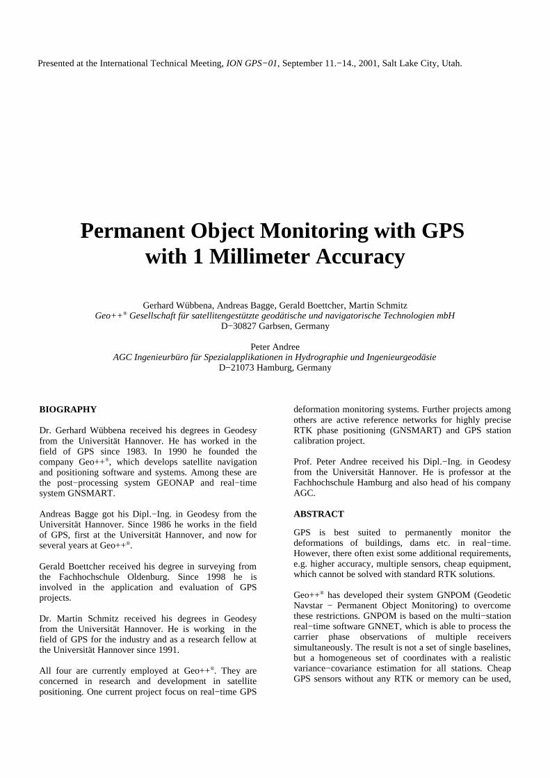
One antenna was put on a device allowing very small andprecise manually controlled movements, which waspositioned relative to an approximately 8 km apartreference station. The antenna was moved in steps of2 mm over a range of 2 cm. Fig. 1 shows the absolutetrajectory from a kinematic solution in post−processing.Fig. 2 shows the results from siderial differenceprocessing relative to a static observation on thepreceding day. From fig. 1 the overall trend of themovement can be seen, but the 2 mm steps are notobvious. From the siderial difference position however,one can clearly recognize the step movements. Theconclusion of these results was, that siderial differencesof carrier phase measurements are a very good andpromising method to very precisely determine smallmovements.
At the same time, Geo++® started to develop andintegrate this technique into their real−time software
Fig. 1: Absolute trajectory from standard post−processing
Fig. 2: Trajectory from siderial difference post−processing
systems. A product called GNPOM for permanent andprecise object monitoring has been developed. Thesystem has been used in a few projects and coulddemonstrate its excellent performance. Recentimprovements have been made to overcome the problemof relative movements between two consecutive days andto achieve millimeter accuracy for absolute kinematicpositioning.
The following chapters describe the basic principles toovercome the multipath problem using standard GPSreceivers, the software implementation and some resultsfrom recent projects.
GPS CARRIER PHASE MULTIPATH REDUCTIONMETHODS
AVERAGING OR LONG TERM FILTERING
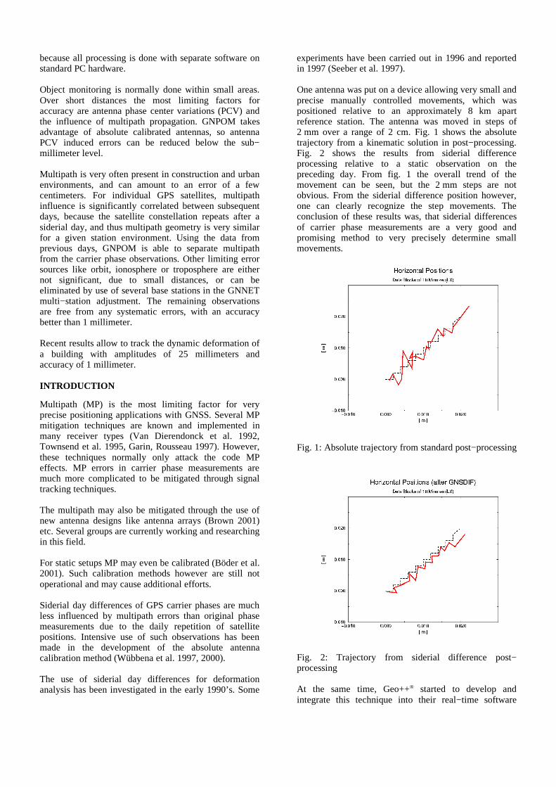
To show the effect of carrier phase multipath a smallexperiment has been carried out. A reference receiverwith antenna has been installed on the roof of theGeo++® building. A second receiver with antenna hasbeen operated in southern direction near the 2.5 storiedbuilding (Fig. 3). At this place one can expect strongmultipath effects, since the signals of satellites in thesouthern direction are reflected at the wall. The distancebetween the two receivers was approximately 10 m.
The static measurements were taken at two consecutivedays for a period of a few hours. The post−processingwas done with the Geo++® GEONAP package.
All measurements were corrected for absolute antennaphase center variations (PCV). Both antennas have beenindividually calibrated with the Geo++® absolute fieldcalibration procedure utilizing a robot for antennarotation and tilts (Menge et al. 1998, Wübbena et al.2000).
The relative positions of both antennas have beendetermined from all observations. The residuals (doubledifferences) of the observations will contain onlymultipath effects and random measurement errors. Due
to the short baseline there is no significant distancedependent effects. PCV is eliminated through theindividual elevation and azimuth dependent calibrationparameters.
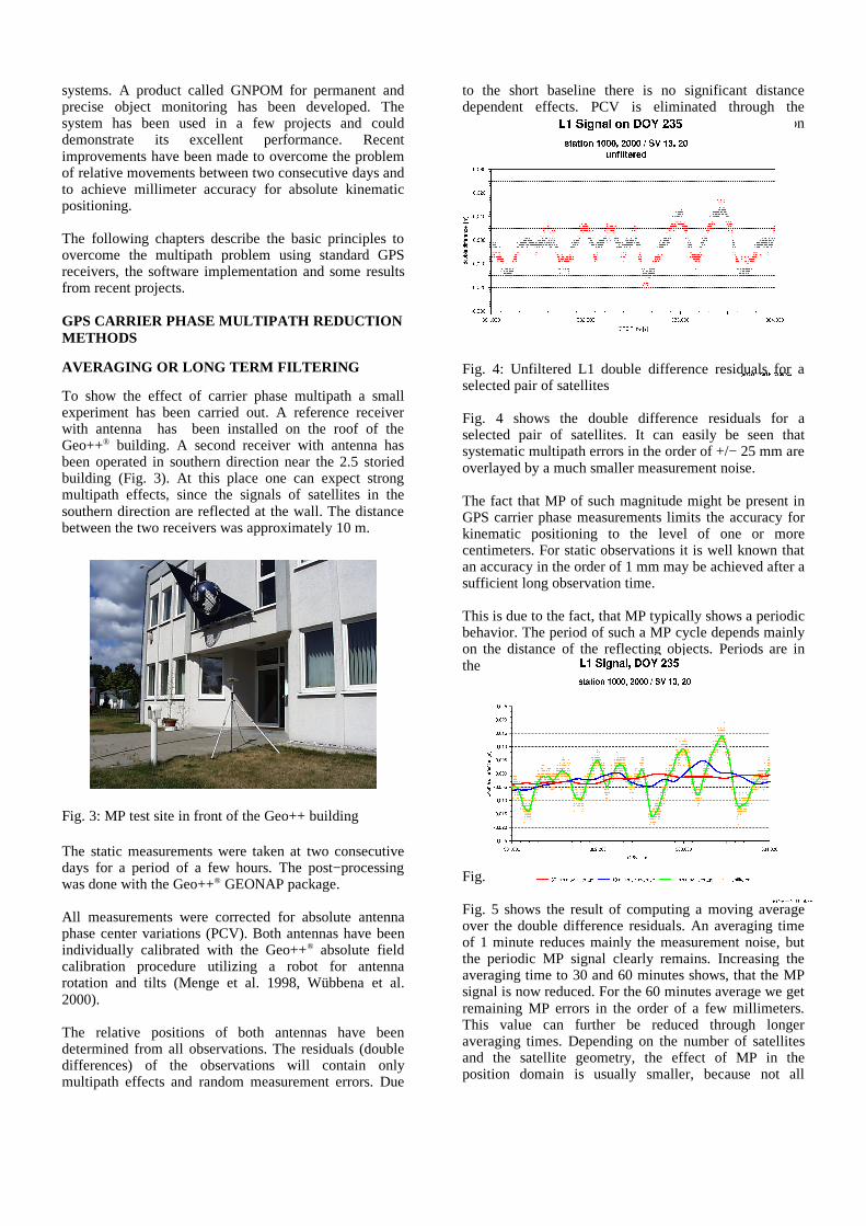
Fig. 4 shows the double difference residuals for aselected pair of satellites. It can easily be seen thatsystematic multipath errors in the order of +/− 25 mm areoverlayed by a much smaller measurement noise.
The fact that MP of such magnitude might be present inGPS carrier phase measurements limits the accuracy forkinematic positioning to the level of one or morecentimeters. For static observations it is well known thatan accuracy in the order of 1 mm may be achieved after asufficient long observation time.
This is due to the fact, that MP typically shows a periodicbehavior. The period of such a MP cycle depends mainlyon the distance of the reflecting objects. Periods are inthe order of minutes.
Fig. 5 shows the result of computing a moving averageover the double difference residuals. An averaging timeof 1 minute reduces mainly the measurement noise, butthe periodic MP signal clearly remains. Increasing theaveraging time to 30 and 60 minutes shows, that the MPsignal is now reduced. For the 60 minutes average we getremaining MP errors in the order of a few millimeters.This value can further be reduced through longeraveraging times. Depending on the number of satellitesand the satellite geometry, the effect of MP in theposition domain is usually smaller, because not all
Fig. 3: MP test site in front of the Geo++ building
Fig. 4: Unfiltered L1 double difference residuals for aselected pair of satellites
Fig. 5: Moving averages over double difference residuals
satellites are affected by the same magnitude and areduction is achieved through redundant satellites.
However, averaging can only be achieved if staticobservations are performed or if the dynamic model ofthe expected movements introduce enough constraintsinto the filter process to get something like an averagingeffect. This means, that kinematic observations withexpected movements in the order of millimeters overshort periods of time cannot take advantage of filteringor averaging and thus cannot eliminate or reduce MP.
SIDERIAL DAY DIFFERENCES
The orbit parameters of GPS satellites around the earthare designed to yield two revolutions within one siderialday (approximately 23 hours and 56 minutes). Due to thisfact, the satellite constellation, as visible from a certainposition on the earth, repeats every siderial day, i.e. thesame satellite is visible at the same elevation andazimuth angles.
MP errors are resulting from the interference of thedirectly received signal from the satellite with a signalreceived after reflection at objects in the vicinity of thereceiving antenna. The amount of the MP error dependson the delay path length of the reflected signal and therelative amplitude or signal to noise levels of direct anddelayed signal. If the local environment of the antenna isunchanged from one day to another, the geometry of thedirect and reflected signals and the relative signalstrength are the same. I.e. the MP error will also be thesame. The difference between two measurements at atime difference of one siderial day should therefore befree of MP errors.
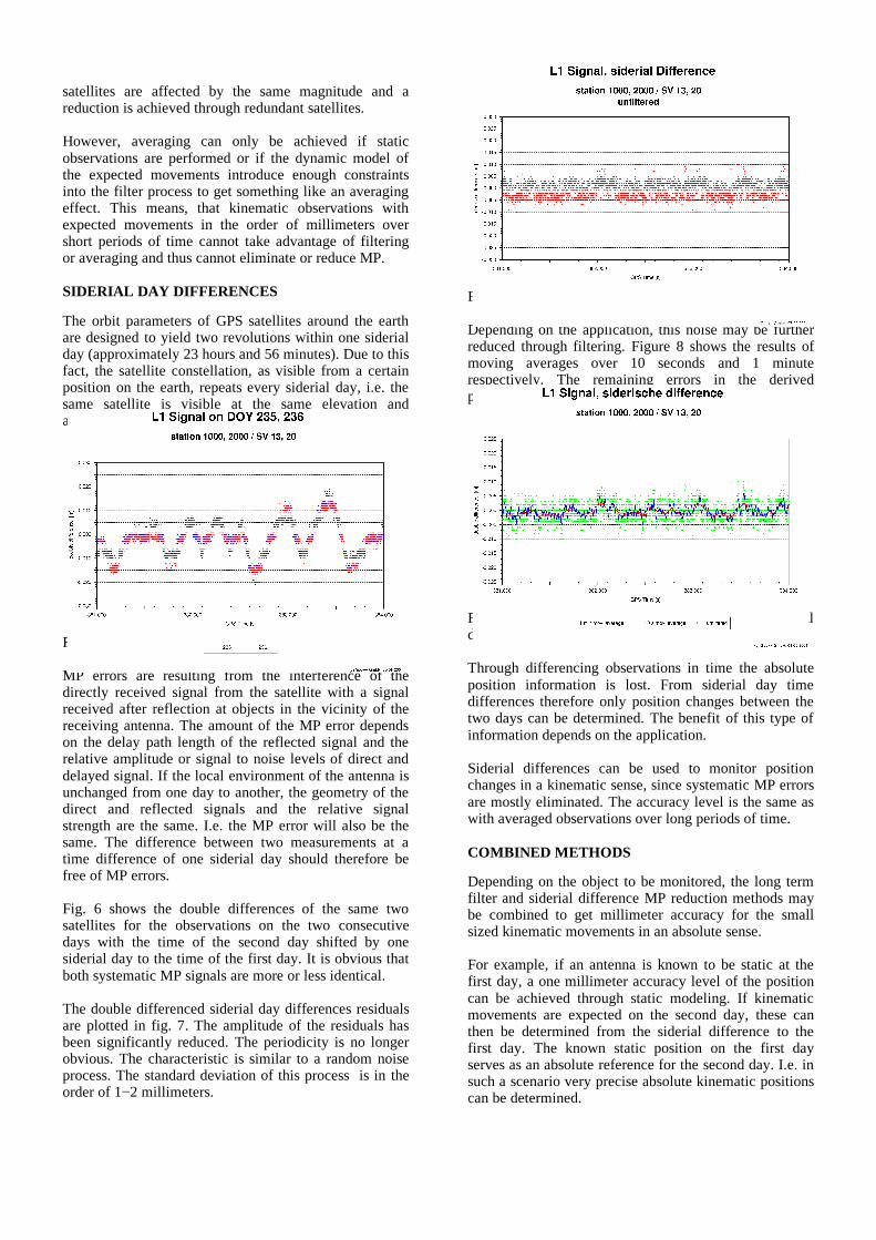
Fig. 6 shows the double differences of the same twosatellites for the observations on the two consecutivedays with the time of the second day shifted by onesiderial day to the time of the first day. It is obvious thatboth systematic MP signals are more or less identical.
The double differenced siderial day differences residualsare plotted in fig. 7. The amplitude of the residuals hasbeen significantly reduced. The periodicity is no longerobvious. The characteristic is similar to a random noiseprocess. The standard deviation of this process is in theorder of 1−2 millimeters.
Depending on the application, this noise may be furtherreduced through filtering. Figure 8 shows the results ofmoving averages over 10 seconds and 1 minuterespectively. The remaining errors in the derivedpositions can be reduced to the sub−millimeter level.
Through differencing observations in time the absoluteposition information is lost. From siderial day timedifferences therefore only position changes between thetwo days can be determined. The benefit of this type ofinformation depends on the application.
Siderial differences can be used to monitor positionchanges in a kinematic sense, since systematic MP errorsare mostly eliminated. The accuracy level is the same aswith averaged observations over long periods of time.
COMBINED METHODS
Depending on the object to be monitored, the long termfilter and siderial difference MP reduction methods maybe combined to get millimeter accuracy for the smallsized kinematic movements in an absolute sense.
For example, if an antenna is known to be static at thefirst day, a one millimeter accuracy level of the positioncan be achieved through static modeling. If kinematicmovements are expected on the second day, these canthen be determined from the siderial difference to thefirst day. The known static position on the first dayserves as an absolute reference for the second day. I.e. insuch a scenario very precise absolute kinematic positionscan be determined.
Fig. 6: L1 double differences of two consecutive days
Fig. 7: L1 double differences siderial day differences
Fig. 8: Moving averages over double differenced siderialday differences
If the characteristics of the movements of an object areknown as a function of acting forces, information aboutthese can be used to drive the parameters of the Kalmanfilter. For example, the movements of the wall of a lockare initiated by filling the lock with water or emptying it.After a certain period of time after such a process thevelocity of movement will decrease and stop. Theinformation about the filling or emptying process can beused to switch the filter parameters from static or veryslow movements to faster movements during the process.In such a situation the reduction of multipath throughfiltering and siderial differencing can be combined in anoptimum way for maximum accuracy of the absolutemovements of object points.
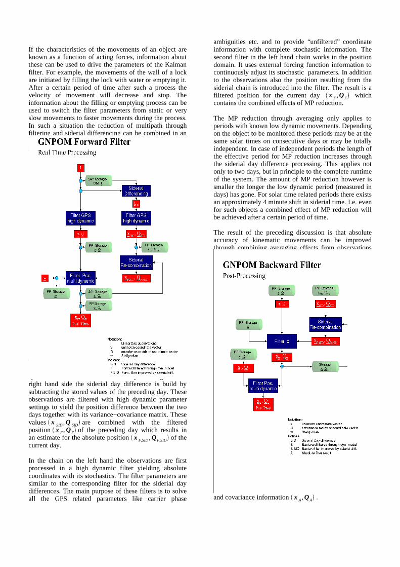
Figure 9 shows the principle of data flow in a systemusing both types of MP reduction simultaneously. Theoriginal or linearized observations are stored on disk andsplit in real−time into two chains of processing. On theright hand side the siderial day difference is build bysubtracting the stored values of the preceding day. Theseobservations are filtered with high dynamic parametersettings to yield the position difference between the twodays together with its variance−covariance matrix. Thesevalues x SID ,Q SID are combined with the filteredposition x F , QF of the preceding day which results inan estimate for the absolute position x F,SID , QF,SID of thecurrent day.
In the chain on the left hand the observations are firstprocessed in a high dynamic filter yielding absolutecoordinates with its stochastics. The filter parameters aresimilar to the corresponding filter for the siderial daydifferences. The main purpose of these filters is to solveall the GPS related parameters like carrier phase
ambiguities etc. and to provide “unfiltered” coordinateinformation with complete stochastic information. Thesecond filter in the left hand chain works in the positiondomain. It uses external forcing function information tocontinuously adjust its stochastic parameters. In additionto the observations also the position resulting from thesiderial chain is introduced into the filter. The result is afiltered position for the current day x F ,QF whichcontains the combined effects of MP reduction.
The MP reduction through averaging only applies toperiods with known low dynamic movements. Dependingon the object to be monitored these periods may be at thesame solar times on consecutive days or may be totallyindependent. In case of independent periods the length ofthe effective period for MP reduction increases throughthe siderial day difference processing. This applies notonly to two days, but in principle to the complete runtimeof the system. The amount of MP reduction however issmaller the longer the low dynamic period (measured indays) has gone. For solar time related periods there existsan approximately 4 minute shift in siderial time. I.e. evenfor such objects a combined effect of MP reduction willbe achieved after a certain period of time.
The result of the preceding discussion is that absoluteaccuracy of kinematic movements can be improvedthrough combining averaging effects from observationswhich are a multiple of siderial days apart in time. Thisalso applies to such periods in the future. This means thata backward filtering will improve results in the past.
Figure 10 shows the principle data flow for this backwardfiltering with GNPOM. The real−time coordinates fromthe GPS filters x ,Q and x SID ,Q SID as well as theinformation about the forcing function are used as aninput for the backward filter. This results in a secondestimate for the absolute coordinate for all past epochs
x B ,QB . In a final step these may be combined withthe forward filter results to the final absolute coordinatesand covariance information x A,QA .
Fig. 9: GNPOM real−time data flow
Fig. 10: GNPOM backward filtering
THE GEO++® − GNPOM SYSTEM
Geo++ has developed the software GNPOM forpermanent object monitoring with highest accuracy. Thesystem is designed for different applications rangingfrom static deformation monitoring with sub−millimeteraccuracy to high dynamic monitoring of even kinematicobjects.
One kernel part of the system is the main processingmodule GNNET. GNNET is a general purpose multi−station software for the adjustment or filtering ofundifferenced GNSS code and carrier phasemeasurements. The rigorous modeling of observationswithin GNNET allows it to be used for many differentapplications.
APPLICATION EXAMPLE: THE LOCK
Deformation monitoring tasks exist is many fields ofengineering. One special field is hydraulic engineeringwith its different types of objects.
A lock is an object where movements of the walls can beexpected as a function of the forces introduced by thewater through the filling or emptying periods.
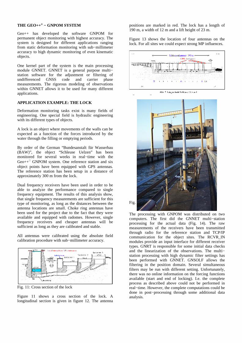
By order of the German “Bundesanstalt für Wasserbau(BAW)”, the object “Schleuse Uelzen” has beenmonitored for several weeks in real−time with theGeo++ GNPOM system. One reference station and sixobject points have been equipped with GPS antennas.The reference station has been setup in a distance ofapproximately 300 m from the lock.
Dual frequency receivers have been used in order to beable to analyze the performance compared to singlefrequency equipment. The results of this analysis show,that single frequency measurements are sufficient for thistype of monitoring, as long as the distances between theantenna locations are small. Choke ring antennas havebeen used for the project due to the fact that they wereavailable and equipped with radomes. However, singlefrequency receivers and cheaper antennas will besufficient as long as they are calibrated and stable.
All antennas were calibrated using the absolute fieldcalibration procedure with sub−millimeter accuracy.
Figure 11 shows a cross section of the lock. Alongitudinal section is given in figure 12. The antenna
positions are marked in red. The lock has a length of190 m, a width of 12 m and a lift height of 23 m.
Figure 13 shows the location of four antennas on thelock. For all sites we could expect strong MP influences.
Fig. 12: Longitudinal section of the lock
Fig. 13: The lock "Schleuse Uelzen"
The processing with GNPOM was distributed on twocomputers. The first did the GNNET multi−stationprocessing for the actual data (Fig. 14). The rawmeasurements of the receivers have been transmittedthrough radio for the reference station and TCP/IPcommunication for the object sites. The RCVR_INmodules provide an input interface for different receivertypes. GNRT is responsible for some initial data checksand the linearization of the observations. The multi−station processing with high dynamic filter settings hasbeen performed with GNNET. GNSOLF allows thefiltering in the position domain. Several simultaneousfilters may be run with different setting. Unfortunately,there was no online information on the forcing functionsavailable (start and end of locking). I.e. the completeprocess as described above could not be performed inreal−time. However, the complete computations could bedone in post−processing through some additional dataanalysis.
Fig. 11: Cross section of the lock
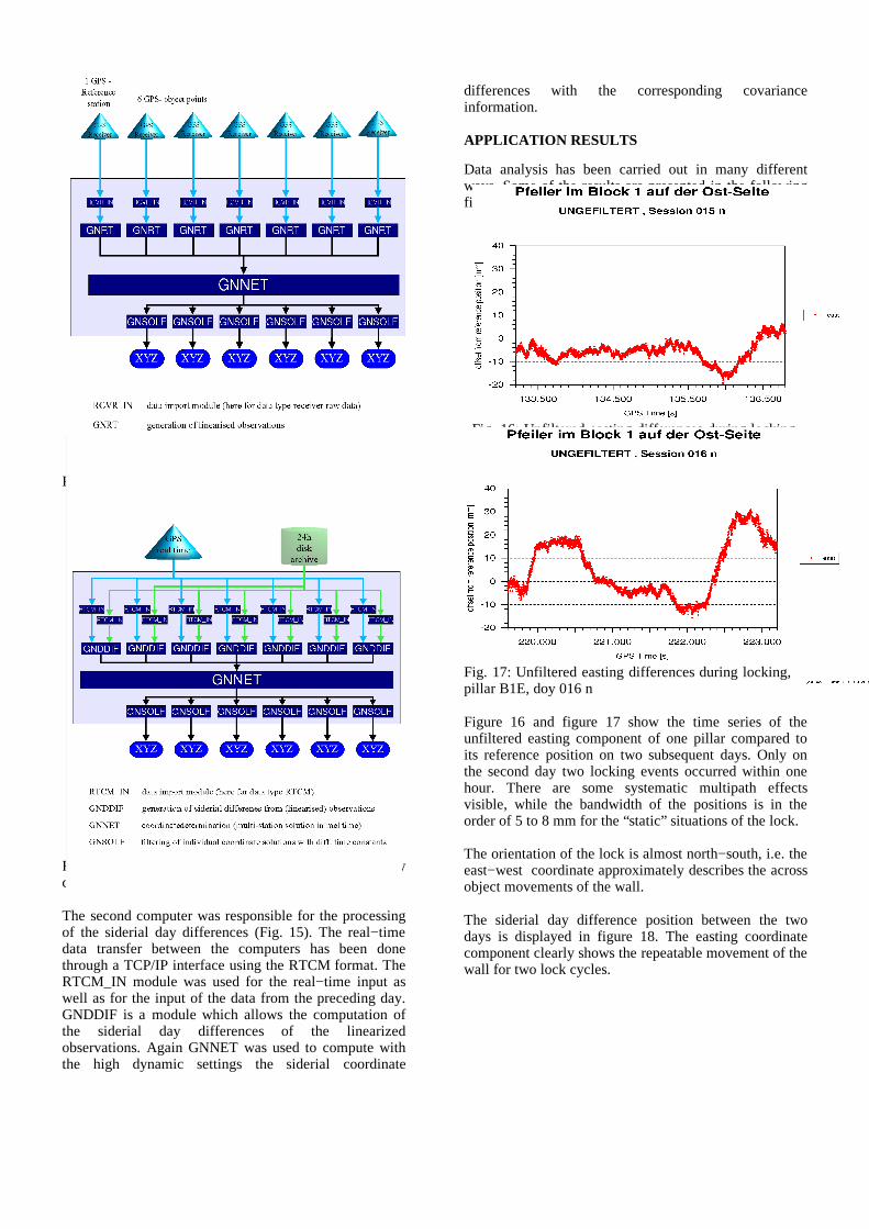
Fig. 15: GNNET multi−station processing of siderial daydifferences
The second computer was responsible for the processingof the siderial day differences (Fig. 15). The real−timedata transfer between the computers has been donethrough a TCP/IP interface using the RTCM format. TheRTCM_IN module was used for the real−time input aswell as for the input of the data from the preceding day.GNDDIF is a module which allows the computation ofthe siderial day differences of the linearizedobservations. Again GNNET was used to compute withthe high dynamic settings the siderial coordinate
differences with the corresponding covarianceinformation.
APPLICATION RESULTS
Data analysis has been carried out in many differentways. Some of the results are presented in the followingfigures.
Fig. 16: Unfiltered easting differences during locking,pillar B1E, doy 015 n
Fig. 17: Unfiltered easting differences during locking,pillar B1E, doy 016 n
Figure 16 and figure 17 show the time series of theunfiltered easting component of one pillar compared toits reference position on two subsequent days. Only onthe second day two locking events occurred within onehour. There are some systematic multipath effectsvisible, while the bandwidth of the positions is in theorder of 5 to 8 mm for the “static” situations of the lock.
The orientation of the lock is almost north−south, i.e. theeast−west coordinate approximately describes the acrossobject movements of the wall.
The siderial day difference position between the twodays is displayed in figure 18. The easting coordinatecomponent clearly shows the repeatable movement of thewall for two lock cycles.
Fig. 14: GNNET multi−station processing
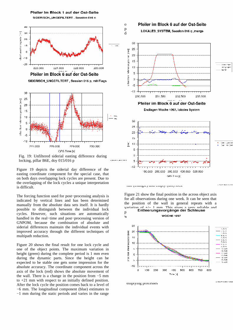
Fig. 18: Unfiltered easting differences during locking,pillar B1E, doy 016 n
Fig. 19: Unfiltered siderial easting difference duringlocking, pillar B6E, doy 015/016 p
Figure 19 depicts the siderial day difference of theeasting coordinate component for the special case, thaton both days overlapping lock cycles are present. Due tothe overlapping of the lock cycles a unique interpretationis difficult.
The forcing function used for post−processing analysis isindicated by vertical lines and has been determinedmanually from the absolute data sets itself. It is hardlypossible to distinguish between the individual lockcycles. However, such situations are automaticallyhandled in the real−time and post−processing version ofGNPOM, because the combination of absolute andsiderial differences maintain the individual events withimproved accuracy through the different techniques ofmultipath reduction.
Figure 20 shows the final result for one lock cycle andone of the object points. The maximum variation inheight (green) during the complete period is 1 mm evenduring the dynamic parts. Since the height can beexpected to be stable one gets some impression for theabsolute accuracy. The coordinate component across theaxis of the lock (red) shows the absolute movement ofthe wall. There is a change in the position from −5 mmto +21 mm with respect to an initially defined position.After the lock cycle the position comes back to a level of−6 mm. The longitudinal component (blue) estimates to−1 mm during the static periods and varies in the range
of −3 mm to +1 mm during the filling or emptyingperiods. This behavior is repeatable, i.e. it most probablydescribes a true movement.
Fig. 20: Final result for one lock cycle in longitudinal,cross axis of object and height
Fig. 21: Final positions in the across object axis, B6E,full (triangle) and empty (dot) lock
Figure 21 show the final position in the across object axisfor all observations during one week. It can be seen thatthe position of the wall in general repeats with avariation of +/− 1 mm. This gives a very reliable andprecise information about the true movements of thewall.
Fig. 22: Repeatability of the moving phases from 16emptying processes
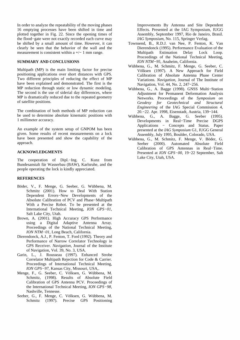
In order to analyze the repeatability of the moving phases16 emptying processes have been shifted in time andplotted together in Fig. 22. Since the opening times ofthe flood−gate were not exactly recorded each curve maybe shifted by a small amount of time. However, it canclearly be seen that the behavior of the wall and themeasurement is consistent within a +/− 1 mm range.
SUMMARY AND CONCLUSIONS
Multipath (MP) is the main limiting factor for precisepositioning applications over short distances with GPS.Two different principles of reducing the effect of MPhave been explained and demonstrated. The first is theMP reduction through static or low dynamic modeling.The second is the use of siderial day differences, whereMP is dramatically reduced due to the repeated geometryof satellite positions.
The combination of both methods of MP reduction canbe used to determine absolute kinematic positions with1 millimeter accuracy.
An example of the system setup of GNPOM has beengiven. Some results of recent measurements on a lockhave been presented and show the capability of theapproach.
ACKNOWLEDGMENTS
The cooperation of Dipl.−Ing. C. Kunz fromBundesanstalt für Wasserbau (BAW), Karlsruhe, and thepeople operating the lock is kindly appreciated.
REFERENCES
Böder, V., F. Menge, G. Seeber, G. Wübbena, M.Schmitz (2001). How to Deal With StationDependent Errors−New Developments of theAbsolute Calibration of PCV and Phase−MultipathWith a Precise Robot. To be presented at theInternational Technical Meeting, ION GPS−01,Salt Lake City, Utah.
Brown, A. (2001). High Accuracy GPS Performanceusing a Digital Adaptive Antenna Array.Proceedings of the National Technical Meeting,ION NTM−01, Long Beach, California.
Dierendonck, A.J., P. Fenton, T. Ford (1992). Theory andPerformance of Narrow Correlator Technology inGPS Receiver. Navigation, Journal of the Instituteof Navigation, Vol. 39, No. 3, USA.
Garin, L., J. Rousseau (1997). Enhanced StrobeCorrelator Multipath Rejection for Code & Carrier.Proceedings of International Technical Meeting,ION GPS−97, Kansas City, Missouri, USA,.
Menge, F., G. Seeber, C. Völksen, G. Wübbena, M.Schmitz, (1998). Results of Absolute FieldCalibration of GPS Antenna PCV. Proceedings ofthe International Technical Meeting, ION GPS−98,Nashville, Tennesse.
Seeber, G., F. Menge, C. Völksen, G. Wübbena, M.Schmitz (1997). Precise GPS Positioning
Improvements By Antenna and Site DependentEffects. Presented at the IAG Symposium, IUGGAssembly, September 1997, Rio de Janeiro, Brasil.IAG Symposium, No. 115, Springer Verlag.
Townsend, B., R.D.J. van Nee, P. Fenton, K. VanDierendonck (1995). Performance Evaluation of theMultipath Estimation Delay Lock Loop.Proceedings of the National Technical Meeting,ION NTM−95, Anaheim, California.
Wübbena, G., M. Schmitz, F. Menge, G. Seeber, C.Völksen (1997). A New Approach for FieldCalibration of Absolute Antenna Phase CenterVariations. Navigation, Journal of The Institute ofNavigation, Vol. 44, No. 2, 247−256.
Wübbena, G., A. Bagge (1998). GNSS Multi−StationAdjustment for Permanent Deformation AnalysisNetworks. Proceedings of the Symposium onGeodesy for Geotechnical and StructuralEngineering of the IAG Special Commission 4,20.−22. Apr. 1998, Eisenstadt, Austria, 139−144.
Wübbena, G., A. Bagge, G. Seeber (1995).Developments in Real−Time Precise DGPSApplications − Concepts and Status. Paperpresented at the IAG Symposium G1, IUGG GeneralAssembly, July 1995, Boulder, Colorado, USA.
Wübbena, G., M. Schmitz, F. Menge, V. Böder, G.Seeber (2000). Automated Absolute FieldCalibration of GPS Antennas in Real−Time.Presented at ION GPS−00, 19−22 September, SaltLake City, Utah, USA.
Related Documents