BioMap 2 CONSERVING THE BIODIVERSITY OF MASSACHUSETTS IN A CHANGING WORLD Pembroke Produced in 2012 This report and associated map provide information about important sites for biodiversity conservation in your area. This information is intended for conservation planning, and is not intended for use in state regulations.

Welcome message from author
This document is posted to help you gain knowledge. Please leave a comment to let me know what you think about it! Share it to your friends and learn new things together.
Transcript

BioMap2 CONSERVING THE BIODIVERSITY OF
MASSACHUSETTS IN A CHANGING WORLD
Pembroke Produced in 2012
This report and associated map provide information about
important sites for biodiversity conservation in your area.
This information is intended for conservation planning, and is
not intended for use in state regulations.

BioMap2
Conserving the Biodiversity of Massachusetts in a Changing World
Natural Heritage Massachusetts Division of Fisheries and Wildlife
1 Rabbit Hill Road, Westborough, MA 01581 & Endangered
phone: 508-389-6360 fax: 508-389-7890
Species Program
For more information on rare species and natural communities, please see our fact sheets online at www.mass.gov/nhesp.
Table of Contents
Introduction
What is BioMap2 Ȯ Purpose and applications
One plan, two components
Understanding Core Habitat and its components
Understanding Critical Natural Landscape and its components
Understanding Core Habitat and Critical Natural Landscape Summaries
Sources of Additional Information
Pembroke Overview
Core Habitat and Critical Natural Landscape Summaries
Elements of BioMap2 Cores
Core Habitat Summaries
Elements of BioMap2 Critical Natural Landscapes
Critical Natural Landscape Summaries
BioMap2
Conserving the Biodiversity of Massachusetts in a Changing World
Natural Heritage Massachusetts Division of Fisheries and Wildlife
1 Rabbit Hill Road, Westborough, MA 01581 & Endangered
phone: 508-389-6360 fax: 508-389-7890
Species Program
For more information on rare species and natural communities, please see our fact sheets online at www.mass.gov/nhesp.
Introduction
The Massachusetts Department of Fish & Game,
ɳɧɱɮɴɦɧ ɳɧɤ Dɨɵɨɲɨɮɭ ɮɥ Fɨɲɧɤɱɨɤɲ ɠɭɣ Wɨɫɣɫɨɥɤ˘ɲ
Natural Heritage & Endangered Species
Program (NHESP), and The Nature
Cɮɭɲɤɱɵɠɭɢɸ˘ɲ Mɠɲɲɠɢɧɴɲɤɳɳɲ Pɱɮɦɱɠɬ developed BioMap2 ɳɮ ɯɱɮɳɤɢɳ ɳɧɤ ɲɳɠɳɤ˘ɲ
biodiversity in the context of climate change.
BioMap2 ɢɮɬɡɨɭɤɲ NHESP˘ɲ ȯȬ ɸɤɠɱɲ ɮɥ rigorously documented rare species and natural
community data with spatial data identifying
wildlife species and habitats that were the focus
ɮɥ ɳɧɤ Dɨɵɨɲɨɮɭ ɮɥ Fɨɲɧɤɱɨɤɲ ɠɭɣ Wɨɫɣɫɨɥɤ˘ɲ ȮȬȬȱ State Wildlife Action Plan (SWAP). BioMap2 also
ɨɭɳɤɦɱɠɳɤɲ Tɧɤ Nɠɳɴɱɤ Cɮɭɲɤɱɵɠɭɢɸ˘ɲ ɠɲɲɤɲɲɬɤɭɳ
of large, well-connected, and intact ecosystems
and landscapes across the Commonwealth,
incorporating concepts of ecosystem resilience
to address anticipated climate change impacts.
Protection and stewardship of BioMap2 Core
Habitat and Critical Natural Landscape is
essential to safeguard the diversity of species
and their habitats, intact ecosystems, and
resilient natural landscapes across
Massachusetts.
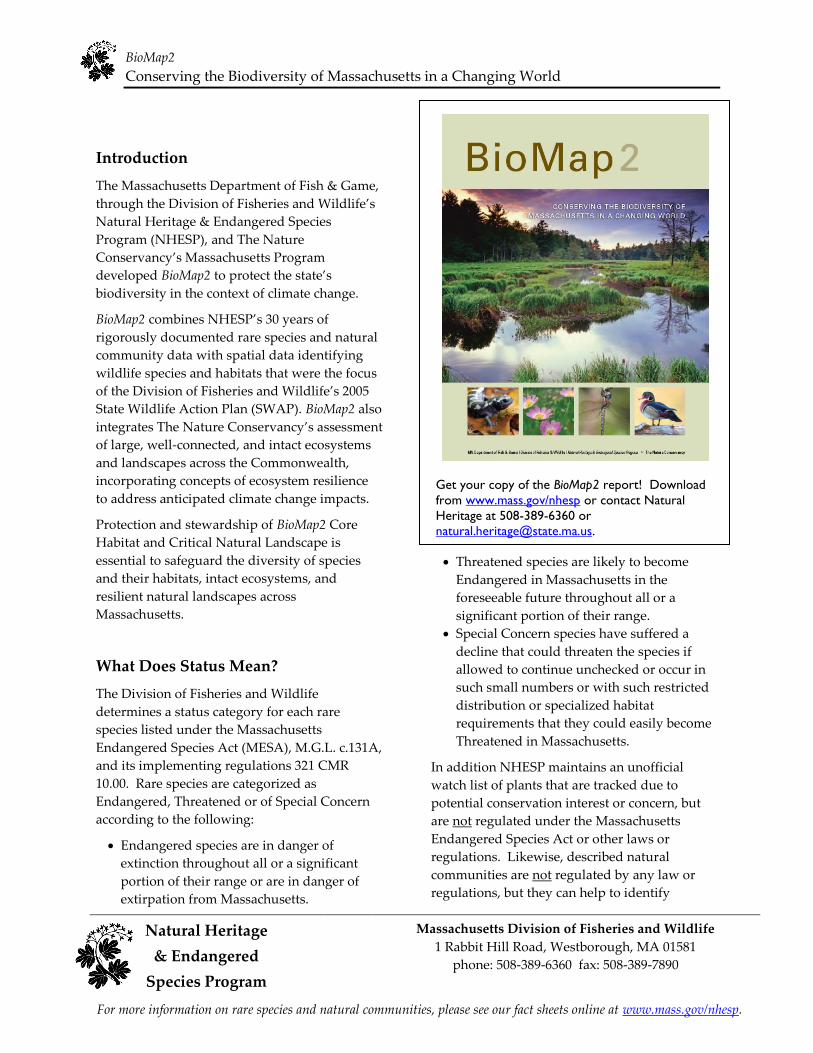
Get your copy of the BioMap2 report! Download
from www.mass.gov/nhesp or contact Natural
Heritage at 508-389-6360 or
What Does Status Mean?
The Division of Fisheries and Wildlife
determines a status category for each rare
species listed under the Massachusetts
Endangered Species Act (MESA), M.G.L. c.131A,
and its implementing regulations 321 CMR
10.00. Rare species are categorized as
Endangered, Threatened or of Special Concern
according to the following:
Endangered species are in danger of
extinction throughout all or a significant
portion of their range or are in danger of
extirpation from Massachusetts.
Threatened species are likely to become
Endangered in Massachusetts in the
foreseeable future throughout all or a
significant portion of their range.
Special Concern species have suffered a
decline that could threaten the species if
allowed to continue unchecked or occur in
such small numbers or with such restricted
distribution or specialized habitat
requirements that they could easily become
Threatened in Massachusetts.
In addition NHESP maintains an unofficial
watch list of plants that are tracked due to
potential conservation interest or concern, but
are not regulated under the Massachusetts
Endangered Species Act or other laws or
regulations. Likewise, described natural
communities are not regulated by any law or
regulations, but they can help to identify

BioMap2
Conserving the Biodiversity of Massachusetts in a Changing World
Natural Heritage Massachusetts Division of Fisheries and Wildlife
1 Rabbit Hill Road, Westborough, MA 01581 & Endangered
phone: 508-389-6360 fax: 508-389-7890
Species Program
For more information on rare species and natural communities, please see our fact sheets online at www.mass.gov/nhesp.
ecologically important areas that are worthy of
protection. The status of natural communities
reflects the documented number and acreages of
each community type in the state:
Critically Imperiled communities typically
have 5 or fewer documented good sites or
have very few remaining acres in the state.
Imperiled communities typically have 6-20
good sites or few remaining acres in the state.
Vulnerable communities typically have 21-
100 good sites or limited acreage across the
state.
Secure communities typically have over 100
sites or abundant acreage across the state;
however, excellent examples are identified as
Core Habit to ensure continued protection.
In 2005 the Massachusetts Division of Fisheries
and Wildlife completed a comprehensive State
Wildlife Action Plan (SWAP) documenting the
status of Massachusetts wildlife and providing
recommendations to help guide wildlife
conservation decision-making. SWAP includes
all the wildlife species listed under the
Massachusetts Endangered Species Act (MESA),
as well as more than 80 species that need
conservation attention but do not meet the
requirements for inclusion under MESA. The
SWAP document is organized around habitat
types in need of conservation within the
Commonwealth. While the original BioMap
focused primarily on rare species protected
under MESA, BioMap2 also addresses other
Species of Conservation Concern, their habitats,
and the ecosystems that support them to create a
spatial representation of most of the elements of
SWAP.
BioMap2: One Plan, Two Components
BioMap2 identifies two complementary spatial
layers, Core Habitat and Critical Natural
Landscape.
Core Habitat identifies key areas that are critical
for the long-term persistence of rare species and
other Species of Conservation Concern, as well
as a wide diversity of natural communities and
intact ecosystems across the Commonwealth.
Protection of Core Habitats will contribute to the
conservation of specific elements of biodiversity.
Critical Natural Landscape identifies large
natural Landscape Blocks that are minimally
impacted by development. If protected, these
areas will provide habitat for wide-ranging
native species, support intact ecological
processes, maintain connectivity among
habitats, and enhance ecological resilience to
natural and anthropogenic disturbances in a
rapidly changing world. Areas delineated as
Critical Natural Landscape also include
buffering upland around wetland, coastal, and
aquatic Core Habitats to help ensure their long-
term integrity.
The long-term persistence of Massachusetts
biological resources requires a determined
commitment to land and water conservation.
Protection and stewardship of both Critical
Natural Landscapes and Core Habitats are
needed to realize the biodiversity conservation
vision of BioMap2.
Components of Core Habitat
Core Habitat identifies specific areas necessary
to promote the long-term persistence of rare
species, other Species of Conservation Concern,
exemplary natural communities, and intact
ecosystems.
Rare Species
There are 432 native plant and animal species
listed as Endangered, Threatened or Special
Concern under the Massachusetts Endangered
Species Act (MESA) based on their rarity,
population trends, and threats to survival. For

BioMap2
Conserving the Biodiversity of Massachusetts in a Changing World
Natural Heritage Massachusetts Division of Fisheries and Wildlife
1 Rabbit Hill Road, Westborough, MA 01581 & Endangered
phone: 508-389-6360 fax: 508-389-7890
Species Program
For more information on rare species and natural communities, please see our fact sheets online at www.mass.gov/nhesp.
BioMap2, NHESP staff identified the highest
quality habitat sites for each non-marine species
based on size, condition, and landscape context.
Table 1. Species of Conservation Concern
described in the State Wildlife Action Plan
and/or included on the MESA List and for which
habitat was mapped in BioMap2. Note that
plants are not included in SWAP, and that
marine species such as whales and sea turtles
are not included in BioMap2.
Taxonomic MESA- Non-listed Species
Group listed of Conservation
Species Concern
Mammals 4 5
Birds 27 23
Reptiles 10 5
Amphibians 4 3
Fish 10 17
Invertebrates 102 9
Plants 256 0
Total 413 62
Other Species of Conservation Concern
In addition to species on the MESA List
described previously, the State Wildlife Action
Plan (SWAP) identifies 257 wildlife species and
22 natural habitats most in need of conservation
within the Commonwealth. BioMap2 includes
species-specific habitat areas for 45 of these
species and habitat for 17 additional species
which was mapped with other coarse-filter and
fine-filter approaches.
Priority Natural Communities
Natural communities are assemblages of plant
and animal species that share a common
environment and occur together repeatedly on
the landscape. BioMap2 gives conservation
priority to natural communities with limited
distribution and to the best examples of more
common types.
Vernal Pools
Vernal pools are small, seasonal wetlands that
provide important wildlife habitat, especially for
amphibians and invertebrate animals that use
them to breed. BioMap2 identifies the top 5
percent most interconnected clusters of Potential
Vernal Pools in the state.
Forest Cores
In BioMap2, Core Habitat includes the best
examples of large, intact forests that are least
impacted by roads and development, providing
critical habitat for numerous woodland species.
For example, the interior forest habitat defined
by Forest Cores supports many bird species
sensitive to the impacts of roads and
development, such as the Black-throated Green
Warbler, and helps maintain ecological
processes found only in unfragmented forest
patches.
Wetland Cores
BioMap2 used an assessment of Ecological
Integrity to identify the least disturbed wetlands
in the state within undeveloped landscapesȯ those with intact buffers and little fragmentation
or other stressors associated with development.
These wetlands are most likely to support
critical wetland functions (i.e., natural
hydrologic conditions, diverse plant and animal
habitats, etc.) and are most likely to maintain
these functions into the future.
Aquatic Cores
To delineate integrated and functional
ecosystems for fish species and other aquatic

BioMap2
Conserving the Biodiversity of Massachusetts in a Changing World
Massachusetts Division of Fisheries and Wildlife Natural Heritage 1 Rabbit Hill Road, Westborough, MA 01581
& Endangered phone: 508-389-6360 fax: 508-389-7890
Species Program
For more information on rare species and natural communities, please see our fact sheets online at www.mass.gov/nhesp.
Species of Conservation Concern, beyond the
species and exemplary habitats described above,
BioMap2 identifies intact river corridors within
which important physical and ecological
processes of the river or stream occur.
Components of Critical Natural Landscape
Critical Natural Landscape identifies intact
landscapes in Massachusetts that are better able
to support ecological processes and disturbance
regimes, and a wide array of species and
habitats over long time frames.
Landscape Blocks
BioMap2 identifies the most intact large areas of
predominately natural vegetation, consisting of
contiguous forests, wetlands, rivers, lakes, and
ponds, as well as coastal habitats such as barrier
beaches and salt marshes.
Upland Buffers of Wetland and Aquatic
Cores
A variety of analyses were used to identify
protective upland buffers around wetlands and
rivers.
Upland Habitat to Support Coastal
Adaptation
BioMap2 identifies undeveloped lands adjacent
to and up to one and a half meters above
existing salt marshes as Critical Natural
Landscapes with high potential to support
inland migration of salt marsh and other coastal
habitats over the coming century.
The conservation areas identified by BioMap2
are based on breadth and depth of data,
scientific expertise, and understanding of
Mɠɲɲɠɢɧɴɲɤɳɳɲ˘ ɡɨɮɣɨɵɤɱɲɨɳɸ˅ Tɧɤ ɭɴɬɤɱɮɴɲ
sources of information and analyses used to
Legal Protection of Biodiversity
BioMap2 presents a powerful vision of what
Massachusetts would look like with full
protection of the land most important for
ɲɴɯɯɮɱɳɨɭɦ ɳɧɤ Cɮɬɬɮɭɶɤɠɫɳɧ˘ɲ ɡɨɮɣɨɵɤɱɲɨɳɸ˅
While BioMap2 is a planning tool with no
regulatory function, all state-listed species enjoy
legal protection under the Massachusetts
Endangered Species Act (M.G.L. c.131A) and its
implementing regulations (321 CMR 10.00).
Wetland habitat of state-listed wildlife is also
protected under the Wetlands Protection Act
Regulations (310 CMR 10.00). The Natural
Heritage Atlas contains maps of Priority Habitats
and Estimated Habitats, which are used,
respectively, for regulation under the
Massachusetts Endangered Species Act and the
Wetlands Protection Act. For more information
on rare species regulations, and to view Priority
and Estimated Habitat maps, please see the
Regulatory Review page at
http://www.mass.gov/eea/agencies/dfg/dfw/natur
al-heritage/regulatory-review/.
BioMap2 is a conservation planning tool that
does not, in any way, supplant the Estimated
and Priority Habitat Maps which have
regulatory significance. Unless and until the
BioMap2 vision is fully realized, we must
continue to protect our most imperiled species
and their habitats.
create Core Habitat and Critical Natural
Landscape are complementary, and outline a
comprehensive conservation vision for
Massachusetts, from rare species to intact
landscapes. In total, these robust analyses
define a suite of priority lands and waters that, if
permanently protected, will support
Mɠɲɲɠɢɧɴɲɤɳɳɲ˘ ɭɠɳɴɱɠɫ ɲɸɲɳɤɬɲ ɥɮɱ ɦɤɭɤɱɠɳɨɮɭɲ
to come.

BioMap2
Conserving the Biodiversity of Massachusetts in a Changing World
Natural Heritage Massachusetts Division of Fisheries and Wildlife
1 Rabbit Hill Road, Westborough, MA 01581 & Endangered
phone: 508-389-6360 fax: 508-389-7890
Species Program
For more information on rare species and natural communities, please see our fact sheets online at www.mass.gov/nhesp.
Understanding Core Habitat Summaries
Following the Town Overview, there is a
descriptive summary of each Core Habitat and
Critical Natural Landscape that occurs in your
city or town. These summaries highlight some
of the outstanding characteristics of each Core
Habitat and Critical Natural Landscape, and
will help you learn more about your city or
ɳɮɶɭ˘ɲ ɡɨɮɣɨɵɤɱɲɨɳɸ˅ Yɮɴ ɢɠɭ ɥɨɭɣ ɮɴɳ ɬɮɱɤ information about many of these species and
natural communities by looking at specific fact
sheets at www.mass.gov/nhesp.
Additional Information
For copies of the full BioMap2 report, the
Technical Report, and an interactive mapping
tool, visit the BioMap2 website via the Land
Protection and Planning tab at
www.mass.gov/nhesp. If you have any
questions about this report, or if you need help
protecting land for biodiversity in your
community, the Natural Heritage & Endangered
Species Program staff looks forward to working
with you.
Contact the Natural Heritage & Endangered
Species Program
By phone 508-389-6360
By fax 508-389-7890
By email [email protected]
By Mail 100 Hartwell S treet, Suite 230
West Boylston, MA 01583
The GIS datalayers of BioMap2 are available for
download from MassGIS at
www.mass.gov/mgis.

BioMap2
Conserving the Biodiversity of Massachusetts in a Changing World
Natural Heritage Massachusetts Division of Fisheries and Wildlife
1 Rabbit Hill Road, Westborough, MA 01581 & Endangered
phone: 508-389-6360 fax: 508-389-7890
Species Program
For more information on rare species and natural communities, please see our fact sheets online at www.mass.gov/nhesp.
Town Overview
Pembroke lies on the border of the Bristol
Lowland/Narragansett Lowland and the Southern
New England Coastal Plains and Hills Ecoregions.
The Bristol Lowland/Narragansett Lowland
Ecoregion is an area of flat, gently rolling plains.
Forests are mostly central hardwoods and some
elm-ash-red maple and red and white pine. There
are numerous wetlands, some cropland/pasture,
and many cranberry bogs. Many rivers drain this
area. The Southern New England Coastal Plains
and Hills Ecoregion is comprised of plains with a
few low hills. Forests are mainly central
hardwoods with some transition hardwoods and
some elm-ash-red maple and red and white pine.
Many major rivers drain this area.
Pembroke at a Glance Total Area: 15,072 acres (23.5 square miles)
Human Population in 2010: 17,837
Open space protected in perpetuity: 1,993
acres, or 13.2% percent of total area*
BioMap2 Core Habitat: 3,249 acres
BioMap2 Core Habitat Protected: 1,131 acres
or 34.8%
BioMap2 Critical Natural Landscape: 3,647
acres
BioMap2 Critical Natural Landscape
Protected: 1,248 acres or 34.2%.
BioMap2 Components
Core Habitat
3 Exemplary or Priority Natural Community
Cores
6 Wetland Cores
3Aquatic Cores
9 Species of Conservation Concern Cores**
o 1 bird, 4 reptiles, 1 amphibian, 3 insects, 2
mussels, 4 plants
Critical Natural Landscape 2 Landscape Blocks 5 Wetland Core Buffers 3 Aquatic Core Buffers 5 Coastal Adaptation Areas
* Calculated uɲɨɭɦ MɠɲɲGIS ɣɠɳɠ ɫɠɸɤɱ ȃPɱɮɳɤɢɳɤɣ and Recreational Open SpaceȯMarch, ȮȬȭȮȄ.
** See next pages for complete list of species,
natural communities and other biodiversity
elements.

BioMap2
Conserving the Biodiversity of Massachusetts in a Changing World
Natural Heritage Massachusetts Division of Fisheries and Wildlife
1 Rabbit Hill Road, Westborough, MA 01581 & Endangered
phone: 508-389-6360 fax: 508-389-7890
Species Program
For more information on rare species and natural communities, please see our fact sheets online at www.mass.gov/nhesp.
BioMap2 Core Habitat and Critical Natural Landscape in Pembroke
BioMap2
Conserving the Biodiversity of Massachusetts in a Changing World
Natural Heritage Massachusetts Division of Fisheries and Wildlife
1 Rabbit Hill Road, Westborough, MA 01581 & Endangered
phone: 508-389-6360 fax: 508-389-7890
Species Program
For more information on rare species and natural communities, please see our fact sheets online at www.mass.gov/nhesp.
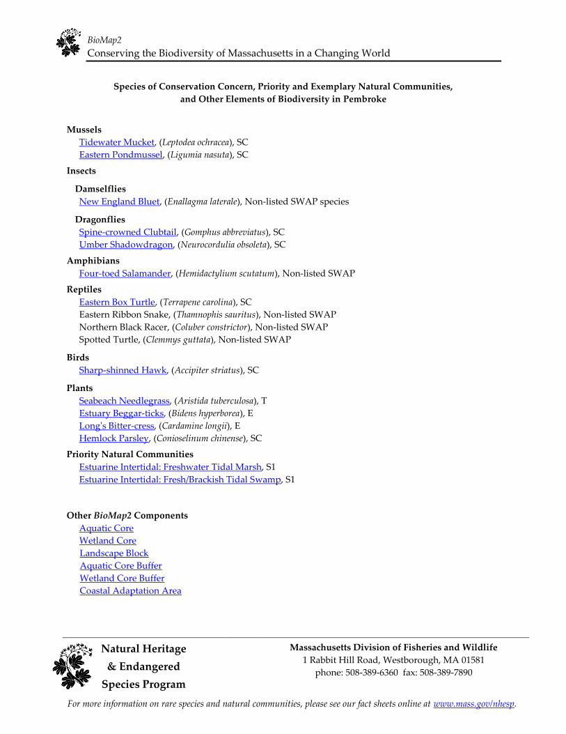
Species of Conservation Concern, Priority and Exemplary Natural Communities,
and Other Elements of Biodiversity in Pembroke
Mussels
Tidewater Mucket, (Leptodea ochracea), SC
Eastern Pondmussel, (Ligumia nasuta), SC
Insects
Damselflies
New England Bluet, (Enallagma laterale), Non-listed SWAP species
Dragonflies
Spine-crowned Clubtail, (Gomphus abbreviatus), SC Umber Shadowdragon, (Neurocordulia obsoleta), SC
Amphibians
Four-toed Salamander, (Hemidactylium scutatum), Non-listed SWAP
Reptiles
Eastern Box Turtle, (Terrapene carolina), SC
Eastern Ribbon Snake, (Thamnophis sauritus), Non-listed SWAP
Northern Black Racer, (Coluber constrictor), Non-listed SWAP
Spotted Turtle, (Clemmys guttata), Non-listed SWAP
Birds
Sharp-shinned Hawk, (Accipiter striatus), SC
Plants
Seabeach Needlegrass, (Aristida tuberculosa), T
Estuary Beggar-ticks, (Bidens hyperborea), E
Long's Bitter-cress, (Cardamine longii), E
Hemlock Parsley, (Conioselinum chinense), SC
Priority Natural Communities
Estuarine Intertidal: Freshwater Tidal Marsh, S1
Estuarine Intertidal: Fresh/Brackish Tidal Swamp, S1
Other BioMap2 Components
Aquatic Core
Wetland Core
Landscape Block
Aquatic Core Buffer
Wetland Core Buffer
Coastal Adaptation Area
BioMap2
Conserving the Biodiversity of Massachusetts in a Changing World
Natural Heritage Massachusetts Division of Fisheries and Wildlife
1 Rabbit Hill Road, Westborough, MA 01581 & Endangered
phone: 508-389-6360 fax: 508-389-7890
Species Program
For more information on rare species and natural communities, please see our fact sheets online at www.mass.gov/nhesp.
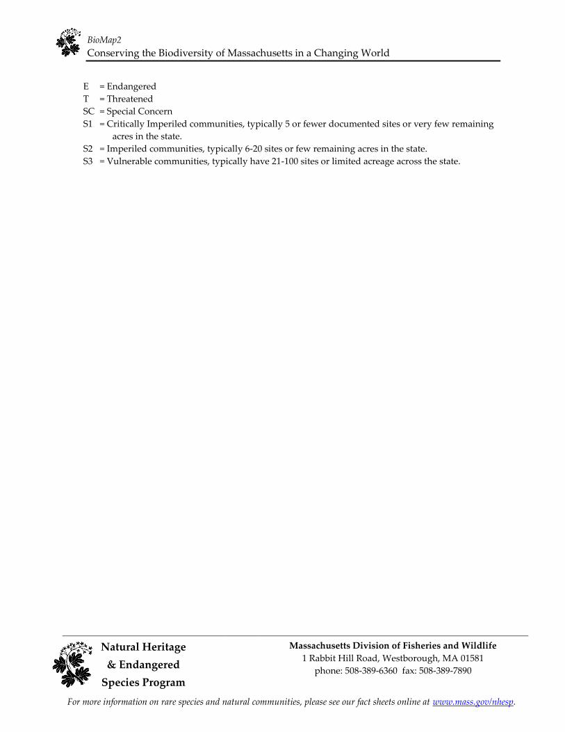
E = Endangered
T = Threatened
SC = Special Concern
S1 = Critically Imperiled communities, typically 5 or fewer documented sites or very few remaining
acres in the state.
S2 = Imperiled communities, typically 6-20 sites or few remaining acres in the state.
S3 = Vulnerable communities, typically have 21-100 sites or limited acreage across the state.
BioMap2
Conserving the Biodiversity of Massachusetts in a Changing World
Natural Heritage Massachusetts Division of Fisheries and Wildlife
1 Rabbit Hill Road, Westborough, MA 01581 & Endangered
phone: 508-389-6360 fax: 508-389-7890
Species Program
For more information on rare species and natural communities, please see our fact sheets online at www.mass.gov/nhesp.
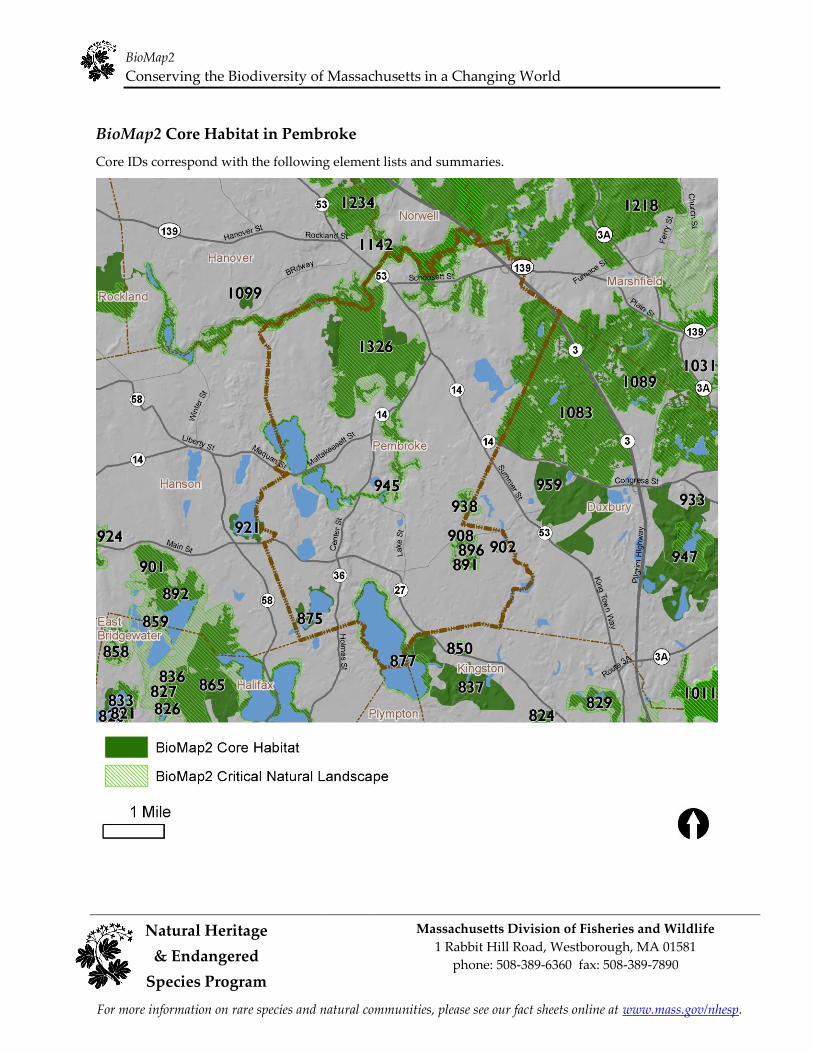
BioMap2 Core Habitat in Pembroke
Core IDs correspond with the following element lists and summaries.
BioMap2
Conserving the Biodiversity of Massachusetts in a Changing World
Natural Heritage Massachusetts Division of Fisheries and Wildlife
1 Rabbit Hill Road, Westborough, MA 01581 & Endangered
phone: 508-389-6360 fax: 508-389-7890
Species Program
For more information on rare species and natural communities, please see our fact sheets online at www.mass.gov/nhesp.
Elements of BioMap2 Cores
This section lists all elements of BioMap2 Cores that fall entirely or partially within Pembroke. The
elements listed here may not occur within the bounds of Pembroke.
Core 875
Species of Conservation Concern
New England Bluet Enallagma laterale Non-listed SWAP
Core 877
Aquatic Core
Species of Conservation Concern
Eastern Pondmussel
Tidewater Mucket
Spotted Turtle
Ligumia nasuta
Leptodea ochracea
Clemmys guttata
SC
SC
Non-listed SWAP
Core 891
Wetland Core
Core 896
Wetland Core
Core 902
Species of Conservation Concern
Seabeach Needlegrass Aristida tuberculosa T
Core 908
Wetland Core
Core 921
Species of Conservation Concern
New England Bluet Enallagma laterale Non-listed SWAP
Core 938
Wetland Core
Core 945
Aquatic Core
BioMap2
Conserving the Biodiversity of Massachusetts in a Changing World
Natural Heritage Massachusetts Division of Fisheries and Wildlife
1 Rabbit Hill Road, Westborough, MA 01581 & Endangered
phone: 508-389-6360 fax: 508-389-7890
Species Program
For more information on rare species and natural communities, please see our fact sheets online at www.mass.gov/nhesp.
Core 1083
Wetland Core
Aquatic Core
Species of Conservation Concern
Mocha Emerald Somatochlora linearis SC
Eastern Box Turtle Terrapene carolina SC
American Bittern Botaurus lentiginosus E
Core 1118
Priority & Exemplary Natural Communities
Estuarine Intertidal: Freshwater Tidal Marsh S1
Core 1326
Wetland Core
Aquatic Core
Priority & Exemplary Natural Communities
Estuarine Intertidal: Fresh/Brackish Tidal Swamp S1
Estuarine Intertidal: Freshwater Tidal Marsh S1
Species of Conservation Concern
American Sea-blite Suaeda calceoliformis SC
Estuary Beggar-ticks Bidens hyperborea E
Hemlock Parsley Conioselinum chinense SC
Long's Bitter-cress Cardamine longii E
Parker's Pipewort Eriocaulon parkeri E
Seabeach Needlegrass Aristida tuberculosa T
Eastern Pondmussel Ligumia nasuta SC
Tidewater Mucket Leptodea ochracea SC
Mocha Emerald Somatochlora linearis SC
Spine-crowned Clubtail Gomphus abbreviatus SC
Umber Shadowdragon Neurocordulia obsoleta SC
Four-toed Salamander Hemidactylium scutatum Non-listed SWAP
Eastern Box Turtle Terrapene carolina SC
Eastern Ribbon Snake Thamnophis sauritus Non-listed SWAP
Northern Black Racer Coluber constrictor Non-listed SWAP
Common Tern Sterna hirundo SC
Least Bittern Ixobrychus exilis E
Least Tern Sternula antillarum SC
Piping Plover Charadrius melodus T
Red Knot Calidris canutus Non-listed SWAP
Ruddy Turnstone Arenaria interpres Non-listed SWAP
Sanderling Calidris alba Non-listed SWAP
Sharp-shinned Hawk Accipiter striatus SC
BioMap2
Conserving the Biodiversity of Massachusetts in a Changing World
Natural Heritage Massachusetts Division of Fisheries and Wildlife
1 Rabbit Hill Road, Westborough, MA 01581 & Endangered
phone: 508-389-6360 fax: 508-389-7890
Species Program
For more information on rare species and natural communities, please see our fact sheets online at www.mass.gov/nhesp.
Core Habitat Summaries
Core 875
A 150-acre Core Habitat featuring a Species of Conservation Concern.
New England Bluets are damselflies whose habitat includes coastal plain ponds, open water in swamps,
and other ponds and lakes. It occurs only in the northeastern United States and is most common from
eastern Massachusetts into Connecticut.
Core 877
An 841-acre Core Habitat featuring Aquatic Core and Species of Conservation Concern.
Aquatic Cores are intact river corridors within which important physical and ecological processes of the
river or stream occur. They delineate integrated and functional ecosystems for fish species and other
aquatic Species of Conservation Concern.
Eastern Pondmussels, large freshwater mussels, are most abundant in southeastern Massachusetts. They
inhabit streams, rivers, and small to large lakes and ponds; they show no preference for substrate, depth,
or flow conditions. As sedentary filter feeders they are vulnerable to the alterations of water bodies.
In Massachusetts, the Tidewater Mucket, a freshwater mussel, prefers natural coastal freshwater ponds of
several acres in size with clear, clean water and sandy substrates. It almost always occurs near the
seacoast.
Strong populations of Spotted Turtles in good habitat - large, unfragmented, protected open space -
continue to be of interest for the conservation of this species. This small, dark-colored turtle with yellow
spots on its carapace inhabits a variety of wetlands year-round and nests in nearby uplands during
spring. Road and collection are the primary conservation concerns.
Core 891
A 29-acre Core Habitat featuring Wetland Core.
Wetland Cores are the least disturbed wetlands in the state within undeveloped landscapesȯthose with
intact buffers and little fragmentation or other stressors associated with development. These wetlands are
most likely to support critical wetland functions (i.e., natural hydrologic conditions, diverse plant and
animal habitats, etc.) and are most likely to maintain these functions into the future.

BioMap2
Conserving the Biodiversity of Massachusetts in a Changing World
Natural Heritage Massachusetts Division of Fisheries and Wildlife
1 Rabbit Hill Road, Westborough, MA 01581 & Endangered
phone: 508-389-6360 fax: 508-389-7890
Species Program
For more information on rare species and natural communities, please see our fact sheets online at www.mass.gov/nhesp.
Core 896
A <1-acre Core Habitat featuring Wetland Core.
Wetland Cores are the least disturbed wetlands in the state within undeveloped landscapesȯthose with
intact buffers and little fragmentation or other stressors associated with development. These wetlands are
most likely to support critical wetland functions (i.e., natural hydrologic conditions, diverse plant and
animal habitats, etc.) and are most likely to maintain these functions into the future.
Core 902
A 9-acre Core Habitat featuring a Species of Conservation Concern.
Seabeach Needlegrass is an annual grass of medium height, usually found on stable dunes growing in
association with beach heather.
Core 908
A 29-acre Core Habitat featuring Wetland Core.
Wetland Cores are the least disturbed wetlands in the state within undeveloped landscapesȯthose with
intact buffers and little fragmentation or other stressors associated with development. These wetlands are
most likely to support critical wetland functions (i.e., natural hydrologic conditions, diverse plant and
animal habitats, etc.) and are most likely to maintain these functions into the future.
Core 921
A 121-acre Core Habitat featuring a Species of Conservation Concern.
New England Bluets are damselflies whose habitat includes coastal plain ponds, open water in swamps,
and other ponds and lakes. It occurs only in the northeastern United States and is most common from
eastern Massachusetts into Connecticut.
Core 938
A 32-acre Core Habitat featuring Wetland Core.
Wetland Cores are the least disturbed wetlands in the state within undeveloped landscapesȯthose with
intact buffers and little fragmentation or other stressors associated with development. These wetlands are
most likely to support critical wetland functions (i.e., natural hydrologic conditions, diverse plant and
animal habitats, etc.) and are most likely to maintain these functions into the future.
BioMap2
Conserving the Biodiversity of Massachusetts in a Changing World
Natural Heritage Massachusetts Division of Fisheries and Wildlife
1 Rabbit Hill Road, Westborough, MA 01581 & Endangered
phone: 508-389-6360 fax: 508-389-7890
Species Program
For more information on rare species and natural communities, please see our fact sheets online at www.mass.gov/nhesp.
Core 945
A <1-acre Core Habitat featuring Aquatic Core.
Aquatic Cores are intact river corridors within which important physical and ecological processes of the
river or stream occur. They delineate integrated and functional ecosystems for fish species and other
aquatic Species of Conservation Concern.
Core 1083
A 2,103-acre Core Habitat featuring Wetland Core, Aquatic Core, and Species of Conservation Concern.
Wetland Cores are the least disturbed wetlands in the state within undeveloped landscapesȯthose with
intact buffers and little fragmentation or other stressors associated with development. These wetlands are
most likely to support critical wetland functions (i.e., natural hydrologic conditions, diverse plant and
animal habitats, etc.) and are most likely to maintain these functions into the future.
The 255-acre Wetland Core is among the largest 20% of Wetland Cores statewide and in this ecoregion.
Aquatic Cores are intact river corridors within which important physical and ecological processes of the
river or stream occur. They delineate integrated and functional ecosystems for fish species and other
aquatic Species of Conservation Concern.
The Mocha Emerald dragonfly breeds in small to medium-sized streams that flow through woods or
swamps. The young spend a year or more in the streams, and then emerge as adults that live in
surrounding upland forests.
The Eastern Box Turtle is a terrestrial turtle, inhabiting many dry and moist woodland and early
successional habitat. Development, roads, collection, and disease are the primary conservation concerns.
American Bitterns are heron-like birds that nest primarily in large cattail, tussock or shrub marshes and
are very sensitive to disturbance.
Core 1118
A <1-acre Core Habitat featuring a Priority Natural Community.
The Freshwater Tidal Marsh community occurs along coastal rivers, upstream of brackish tidal marsh.
Here the marshes are flooded by tidal action twice a day, but with fresh water. These structurally diverse
marshes are globally rare. This example of Freshwater Tidal Marsh is of part of a larger complex of
estuarine and riverine natural communities, and is unusually large for Massachusetts.
Core 1326
A 9,988-acre Core Habitat featuring Wetland Core, Aquatic Core, Priority Natural Communities, and
Species of Conservation Concern.

BioMap2
Conserving the Biodiversity of Massachusetts in a Changing World
Natural Heritage Massachusetts Division of Fisheries and Wildlife
1 Rabbit Hill Road, Westborough, MA 01581 & Endangered
phone: 508-389-6360 fax: 508-389-7890
Species Program
For more information on rare species and natural communities, please see our fact sheets online at www.mass.gov/nhesp.
A long and convoluted Core Habitat winds its way through the northern part of Plymouth County,
following the Drinkwater, Indian Head, North, and South Rivers, along with several of their tributaries.
This watery Core supports 17 rare and uncommon species. Along the ocean part of this Core, the
federally Threatened and globally rare Piping Plovers nest in small numbers, as well as Common and
Least Terns. Along the North River from about where Route 3 crosses, up to and along Herring Brook,
healthy examples of two very uncommon natural communities, Freshwater Tidal Marsh and
Fresh/Brackish Tidal Swamp, host two plants, Long's Bitter-cress and Estuary Beggar-ticks, that grow
only in these types of habitats.
Fresh / Brackish Tidal Swamps occur along free-flowing coastal rivers at the upper limit of tidal influence
and are flooded by daily tides. These low-stature forested wetlands often have a dense shrub understory.
The large, highly unusual tidal swamp includes 3 variants in a continuum from upland to streamside.
The wetlands are well buffered in a well developed landscape.
The Freshwater Tidal Marsh community occurs along coastal rivers, upstream of brackish tidal marsh.
Here the marshes are flooded by tidal action twice a day, but with fresh water. These structurally diverse
marshes are globally rare. Three examples of Freshwater Tidal Marsh including one that is of high-quality
because of its excellent species diversity, absence of invasive exotic species, and association with many
state-listed rare species, in spite of a somewhat urbanized landscape.
Wetlands Cores are the least disturbed wetlands in the state within undeveloped landscapesȯthose with
intact buffers and little fragmentation or other stressors associated with development. These wetlands are
most likely to support critical wetland functions (i.e., natural hydrologic conditions, diverse plant and
animal habitats, etc.) and are most likely to maintain these functions into the future.
Aquatic Cores are intact river corridors within which important physical and ecological processes of the
river or stream occur. They delineate integrated and functional ecosystems for fish species and other
aquatic Species of Conservation Concern.

BioMap2
Conserving the Biodiversity of Massachusetts in a Changing World
Natural Heritage Massachusetts Division of Fisheries and Wildlife
1 Rabbit Hill Road, Westborough, MA 01581 & Endangered
phone: 508-389-6360 fax: 508-389-7890
Species Program
For more information on rare species and natural communities, please see our fact sheets online at www.mass.gov/nhesp.
BioMap2 Critical Natural Landscape in Pembroke
Critical Natural Landscape IDs correspond with the following element lists and summaries.
BioMap2
Conserving the Biodiversity of Massachusetts in a Changing World
Natural Heritage Massachusetts Division of Fisheries and Wildlife
1 Rabbit Hill Road, Westborough, MA 01581 & Endangered
phone: 508-389-6360 fax: 508-389-7890
Species Program
For more information on rare species and natural communities, please see our fact sheets online at www.mass.gov/nhesp.
Elements of BioMap2 Critical Natural Landscapes
This section lists all elements of BioMap2 Critical Natural Landscapes that fall entirely or partially within
Pembroke. The elements listed here may not occur within the bounds of Pembroke.
CNL 494
Aquatic Core Buffer
CNL 501
Wetland Core Buffer
CNL 509
Wetland Core Buffer
CNL 511
Aquatic Core Buffer
CNL 565
Aquatic Core Buffer Landscape Block Wetland Core Buffer
CNL 571
Coastal Adaptation Area
CNL 700
Aquatic Core Buffer Coastal Adaptation Area Landscape Block Tern Foraging Area

BioMap2
Conserving the Biodiversity of Massachusetts in a Changing World
Natural Heritage Massachusetts Division of Fisheries and Wildlife
1 Rabbit Hill Road, Westborough, MA 01581 & Endangered
phone: 508-389-6360 fax: 508-389-7890
Species Program
For more information on rare species and natural communities, please see our fact sheets online at www.mass.gov/nhesp.
Critical Natural Landscape Summaries
CNL 494
An 814-acre Critical Natural Landscape featuring Aquatic Core Buffer.
A variety of analyses were used to identify protective upland buffers around wetlands and rivers. One,
the variable width buffers methodology, included the most intact areas around each wetland and river,
by extending deeper into surrounding unfragmented habitats than into developed areas adjacent to each
wetland. Other upland buffers were identified through the rare species habitat analysis. In this way, the
conservation of wetland buffers will support the habitats and functionality of each wetland, and also
include adjacent uplands that are important for many species that move between habitat types.
CNL 501
A 152-acre Critical Natural Landscape featuring Wetland Core Buffer.
A variety of analyses were used to identify protective upland buffers around wetlands and rivers. One,
the variable width buffers methodology, included the most intact areas around each wetland and river,
by extending deeper into surrounding unfragmented habitats than into developed areas adjacent to each
wetland. Other upland buffers were identified through the rare species habitat analysis. In this way, the
conservation of wetland buffers will support the habitats and functionality of each wetland, and also
include adjacent uplands that are important for many species that move between habitat types.
CNL 509
A 72-acre Critical Natural Landscape featuring Wetland Core Buffer.
A variety of analyses were used to identify protective upland buffers around wetlands and rivers. One,
the variable width buffers methodology, included the most intact areas around each wetland and river,
by extending deeper into surrounding unfragmented habitats than into developed areas adjacent to each
wetland. Other upland buffers were identified through the rare species habitat analysis. In this way, the
conservation of wetland buffers will support the habitats and functionality of each wetland, and also
include adjacent uplands that are important for many species that move between habitat types.
CNL 511
A <1-acre Critical Natural Landscape featuring Aquatic Core Buffer.
A variety of analyses were used to identify protective upland buffers around wetlands and rivers. One,
the variable width buffers methodology, included the most intact areas around each wetland and river,
by extending deeper into surrounding unfragmented habitats than into developed areas adjacent to each
wetland. Other upland buffers were identified through the rare species habitat analysis. In this way, the
conservation of wetland buffers will support the habitats and functionality of each wetland, and also
include adjacent uplands that are important for many species that move between habitat types.

BioMap2
Conserving the Biodiversity of Massachusetts in a Changing World
Natural Heritage Massachusetts Division of Fisheries and Wildlife
1 Rabbit Hill Road, Westborough, MA 01581 & Endangered
phone: 508-389-6360 fax: 508-389-7890
Species Program
For more information on rare species and natural communities, please see our fact sheets online at www.mass.gov/nhesp.
CNL 565
A 2,133-acre Critical Natural Landscape featuring Aquatic Core Buffer, Wetland Core Buffer and
Landscape Block.
A variety of analyses were used to identify protective upland buffers around wetlands and rivers. One,
the variable width buffers methodology, included the most intact areas around each wetland and river,
by extending deeper into surrounding unfragmented habitats than into developed areas adjacent to each
wetland. Other upland buffers were identified through the rare species habitat analysis. In this way, the
conservation of wetland buffers will support the habitats and functionality of each wetland, and also
include adjacent uplands that are important for many species that move between habitat types.
Landscape Blocks, the primary component of Critical Natural Landscapes, are large areas of intact
predominately natural vegetation, consisting of contiguous forests, wetlands, rivers, lakes, and ponds, as
well as coastal habitats such as barrier beaches and salt marshes. Pastures and power-line rights-of-way,
which are less intensively altered than most developed areas, were also included since they provide
habitat and connectivity for many species. Collectively, these natural cover types total 3.6 million acres
across the state. An Ecological Integrity assessment was used to identify the most intact and least
fragmented areas. These large Landscape Blocks are most likely to maintain dynamic ecological processes
such as buffering, connectivity, natural disturbance, and hydrological regimes, all of which help to
support wide-ranging wildlife species and many other elements of biodiversity.
In order to identify critical Landscape Blocks in each ecoregion, different Ecological Integrity thresholds
were used to select the largest intact landscape patches in each ecoregion while avoiding altered habitat
as much as possible. This ecoregional representation accomplishes a key goal of BioMap2 to protect the
ecological stages that support a broad suite of biodiversity in the context of climate change. Blocks were
defined by major roads, and minimum size thresholds differed among ecoregions to ensure that BioMap2
includes the best of the best in each ecoregion.
CNL 571
A <1-acre Critical Natural Landscape featuring Coastal Adaptation Area.
The coastal habitats of Massachusetts are particularly vulnerable to potential sea-level rise in the next
century, which many estimates suggest is likely to exceed one meter. Therefore, in addition to prioritizing
current coastal habitats, the creators of BioMap2 examined the landward side of salt marshes to determine
where these habitats might move to as sea levels rise. Undeveloped lands adjacent to and up to one and a
half meters above existing salt marshes were identified, and included as Critical Natural Landscapes with
high potential to support inland migration of salt marsh and other coastal habitats over the coming
century.
CNL 700
A 14,690-acre Critical Natural Landscape featuring Aquatic Core Buffer, Landscape Block, Coastal
Adaptation Area, and Tern Foraging Area.
A variety of analyses were used to identify protective upland buffers around wetlands and rivers. One,
the variable width buffers methodology, included the most intact areas around each wetland and river,
by extending deeper into surrounding unfragmented habitats than into developed areas adjacent to each

BioMap2
Conserving the Biodiversity of Massachusetts in a Changing World
Natural Heritage Massachusetts Division of Fisheries and Wildlife
1 Rabbit Hill Road, Westborough, MA 01581 & Endangered
phone: 508-389-6360 fax: 508-389-7890
Species Program
For more information on rare species and natural communities, please see our fact sheets online at www.mass.gov/nhesp.
wetland. Other upland buffers were identified through the rare species habitat analysis. In this way, the
conservation of wetland buffers will support the habitats and functionality of each wetland, and also
include adjacent uplands that are important for many species that move between habitat types.
Landscape Blocks, the primary component of Critical Natural Landscapes, are large areas of intact
predominately natural vegetation, consisting of contiguous forests, wetlands, rivers, lakes, and ponds, as
well as coastal habitats such as barrier beaches and salt marshes. Pastures and power-line rights-of-way,
which are less intensively altered than most developed areas, were also included since they provide
habitat and connectivity for many species. Collectively, these natural cover types total 3.6 million acres
across the state. An Ecological Integrity assessment was used to identify the most intact and least
fragmented areas. These large Landscape Blocks are most likely to maintain dynamic ecological processes
such as buffering, connectivity, natural disturbance, and hydrological regimes, all of which help to
support wide-ranging wildlife species and many other elements of biodiversity.
In order to identify critical Landscape Blocks in each ecoregion, different Ecological Integrity thresholds
were used to select the largest intact landscape patches in each ecoregion while avoiding altered habitat
as much as possible. This ecoregional representation accomplishes a key goal of BioMap2 to protect the
ecological stages that support a broad suite of biodiversity in the context of climate change. Blocks were
defined by major roads, and minimum size thresholds differed among ecoregions to ensure that BioMap2
includes the best of the best in each ecoregion.
The coastal habitats of Massachusetts are particularly vulnerable to potential sea-level rise in the next
century, which many estimates suggest is likely to exceed one meter. Therefore, in addition to prioritizing
current coastal habitats, the creators of BioMap2 examined the landward side of salt marshes to determine
where these habitats might move to as sea levels rise. Undeveloped lands adjacent to and up to one and a
half meters above existing salt marshes were identified, and included as Critical Natural Landscapes with
high potential to support inland migration of salt marsh and other coastal habitats over the coming
century.
Terns range widely from their breeding colonies to forage. While the breeding and staging areas for
Roseate, Arctic, Common, and Least Terns were included in the Species of Conservation Concern Core
Habitat for BioMap2, tern foraging areas were included in BioMap2 as part of Critical Natural Landscape.
The extent of foraging habitat for Arctic, Common, and Roseate Terns depends on the size of the breeding
colony. For Least Tern, all shallow marine and estuarine waters within 2 miles of recent colony sites and
up to 1 mile offshore were mapped as foraging habitat.

Help Save Endangered Wildlife!
Please contribute on your Massachusetts income tax form or directly to the
Natural Heritage &
Endangered Species Fund
To learn more about the Natural Heritage & Endangered Species Program ɠɭɣ ɳɧɤ Cɮɬɬɮɭɶɤɠɫɳɧ˘ɲ ɱɠɱɤ ɲɯɤɢɨɤɲˆ ɵɨɲɨɳ ɮɴɱ ɶɤɡ ɲɨɳɤ ɠɳ www.mass.gov/nhesp.
Related Documents


