patersongroup October 17, 2018 File: PE4384-LET.01 Colonnade Hotel Investment GP Inc. 16 Concourse Gate, Suite 200 Ottawa, Ontario K2E 7S8 Attention: Ms. Bonnie Chen Subject: Phase II Environmental Site Assessment Update 300 Moodie Drive - Ottawa Dear Ms.Chen, As per the requirements set out by the Ontario Ministry of the Environment, Conservation and Parks (MECP) for the approval of a Record of Site Condition application for the aforementioned site, the following Phase II-ESA update report summarizes the revised Conceptual Site Model for the subject site. Conceptual Site Model The following provides a narrative description of the Conceptual Site Model of the RSC property for the subject site addressed as 300 Moodie Drive, Ottawa, Ontario (“RSC Property”). This report is to be read in conjunction with the following attachments: Figure 1 - Key Plan Figure 2 - Topographical Map Drawing PE4384-1 - Site Plan Drawing PE4384-2 - Surrounding Land Use Plan Drawing PE4157-1 – Remedial Action Plan - VOC Impacts Tables A-1, A-2, and A-3 patersongroup Consulting Engineers 154 Colonnade Road South Ottawa, Ontario Canada, K2E 7J5 Tel: (613) 226-7381 Fax: (613) 226-6344 Geotechnical Engineering Environmental Engineering Hydrogeology Geological Engineering Materials Testing Building Science Archaeological Services www.patersongroup.ca

Welcome message from author
This document is posted to help you gain knowledge. Please leave a comment to let me know what you think about it! Share it to your friends and learn new things together.
Transcript
patersongroup
October 17, 2018
File: PE4384-LET.01 Colonnade Hotel Investment GP Inc. 16 Concourse Gate, Suite 200 Ottawa, Ontario K2E 7S8 Attention: Ms. Bonnie Chen Subject: Phase II Environmental Site Assessment Update
300 Moodie Drive - Ottawa Dear Ms.Chen, As per the requirements set out by the Ontario Ministry of the Environment, Conservation and Parks (MECP) for the approval of a Record of Site Condition application for the aforementioned site, the following Phase II-ESA update report summarizes the revised Conceptual Site Model for the subject site.
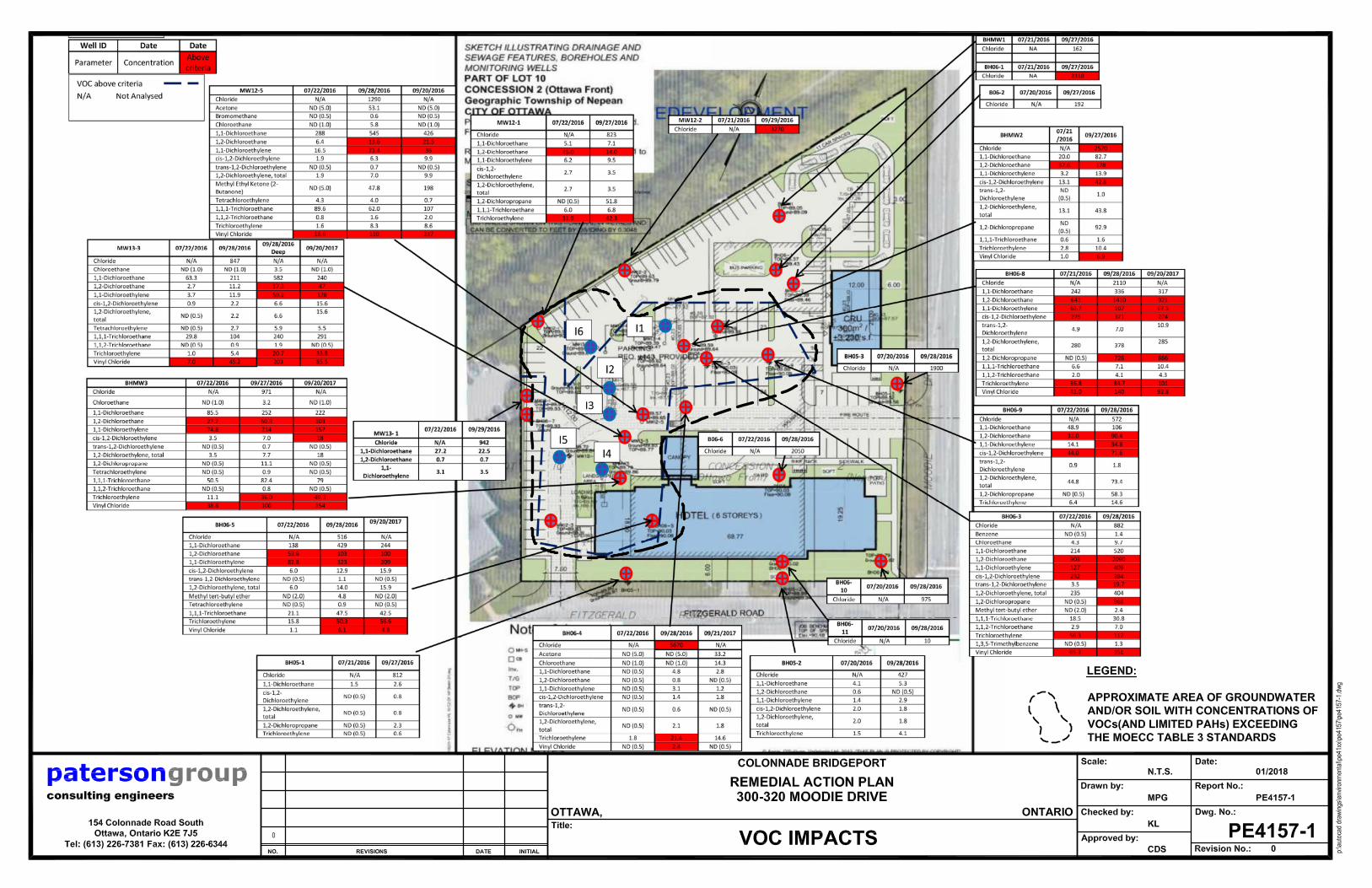
Conceptual Site Model The following provides a narrative description of the Conceptual Site Model of the RSC property for the subject site addressed as 300 Moodie Drive, Ottawa, Ontario (“RSC Property”). This report is to be read in conjunction with the following attachments: � Figure 1 - Key Plan � Figure 2 - Topographical Map � Drawing PE4384-1 - Site Plan � Drawing PE4384-2 - Surrounding Land Use Plan � Drawing PE4157-1 – Remedial Action Plan - VOC Impacts � Tables A-1, A-2, and A-3
patersongroup Consulting Engineers
154 Colonnade Road South Ottawa, Ontario
Canada, K2E 7J5 Tel: (613) 226-7381 Fax: (613) 226-6344 Geotechnical Engineering Environmental Engineering Hydrogeology Geological Engineering Materials Testing Building Science
Archaeological Services
www.patersongroup.ca

Ms. Bonnie Chen
Page 2
File: PE4384-LET.01
patersongroup
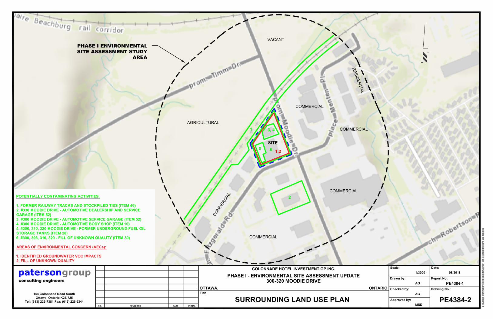
Site Description Potentially Contaminating Activities The presence of an automotive service garage and former underground fuel oil storage tanks were identified on the subject site by Golder Associates in 2000. The Phase I-ESA completed by Golder also identified a previous remediation program that had removed several areas of contaminated soil. The Golder Phase I-ESA recommended a Phase II-ESA to assess potential soil and groundwater impacts from the automotive service garage on the subject site. A supplemental Phase II-Environmental Site Assessment (following two previous Phase II-ESAs) was conducted by One Nation Engineering between 2013 and 2015, and further groundwater sampling was completed in 2017.
Physical Setting Monitoring Well construction and Site Stratigraphy The site stratigraphy was determined by the subsurface investigation conducted by One Nation Engineering. A total of 5 boreholes instrumented with groundwater monitoring wells were drilled on site on October 28 and 29, 2013. Other monitoring wells were installed on the site at various times during previous Phase II-ESA and remedial investigations. Continuous soil samples were obtained during the advancement of the boreholes, and samples exhibiting the highest vapour concentrations were submitted for laboratory analysis. Since there was no direct evidence of contamination at depth (highest vapour reading was detected at 4.5 mbgs), the boreholes were advanced to a maximum depth of 7.6 m. All monitoring wells were flush-mounted with steel casings. Stratigraphy consisted of: � A layer of fill, consisting predominantly of sand. The fill layer varied in thickness from
approximately 1.0 to 2.4 m below existing grade.
� A layer of silty clay with sand was encountered to at least the maximum drill depth of 7.6 m. The water table was determined to be located between 1.5 and 2.5 m below ground surface.
Bedrock was not encountered in any of the boreholes drilled by One Nation Engineering in 2013.

Ms. Bonnie Chen
Page 3
File: PE4384-LET.01
patersongroup
Hydrogeological Characteristics Groundwater levels were measured at the subject site in December 2013 and January 2014. All 21 monitoring wells on the site were measured and sampled. Groundwater was encountered at depths between 1.5 and 2.5 m below existing grade. Seasonal fluctuations of groundwater levels are expected to occur. Sections 41 and 43.1 of the Regulation Section 41 of the Regulation (Site Condition Standards, Environmentally Sensitive Areas) does not apply to the subject site. The RSC property does not include all or part of a water body and is not within 30 m of a water body. Buildings and Structures During the site inspection by Paterson in 2018, the subject site was occupied by two single-storey slab-on-grade buildings. Based on the air photo review and observed ages of the buildings during the site inspection, the southern building was constructed between 1950 and 1970 and the second building in the 1970s. The buildings were constructed with concrete block exterior walls.
The northern building, addressed 300 Moodie Drive, was occupied by Jim Licari Automotive service garage and X-clusive Auto body shop. The majority of the building was occupied by automotive service bays, including a waste oil AST. Two small reception areas were present at the front (east) side of the building.
The southern building was occupied by Hosie and Brown Auto Parts (addressed 306 and 320 Moodie Drive) and Salvation Army Thrift Store (310 Moodie Drive). Much of the building consisted of warehouse/storage space, with delivery bays at the rear of the building and a trash compactor used by the Salvation Army.
Heating was provided by natural gas boilers, space heaters, and electric baseboard heaters. One aboveground storage tank (AST) for waste oil was observed at 300 Moodie Drive. No underground storage tanks (USTs) were observed.
Water Bodies There are no water bodies on the RSC property. Stillwater Creek is located a minimum of 200 m to the east of the RSC property.
Ms. Bonnie Chen
Page 4
File: PE4384-LET.01
patersongroup
Areas of Natural Significance No areas of natural significance were identified on or in the immediate vicinity of the RSC property.
Environmental Condition Prior to Remediation
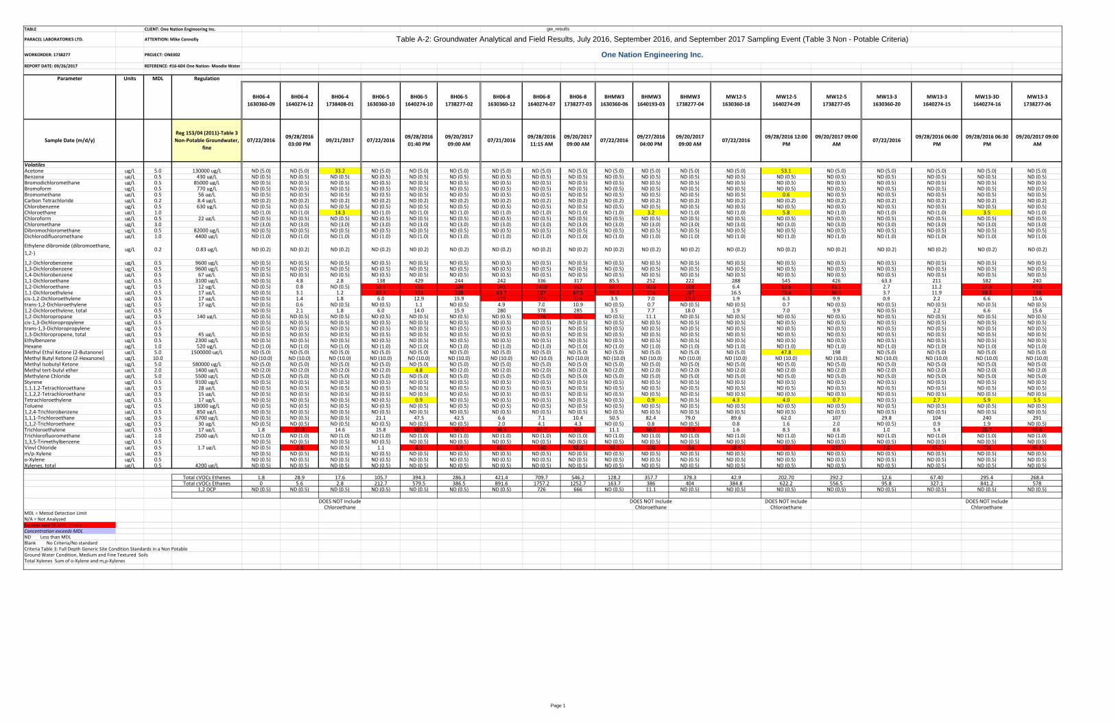
Areas Where Contaminants are Present All soil samples tested were in compliance with the selected MECP Table 3 standards. Metals, VOC, and PHC parameters were tested in selected soil samples. However, fill of unknown quality is considered to be present on the subject site, based on the scope of the soil testing program. PAH parameters were not tested. Based on the results of analytical testing at the subject site, contaminants were present in the site groundwater in concentrations greater than MECP Table 3 standards (medium/fine textured soil) at the locations shown on Drawing PE4157-1. Groundwater samples were submitted for laboratory analysis of metals, VOCs, and anions. Types of Contaminants Contaminants identified in the groundwater at the site in concentrations exceeding MECP standards include multiple VOC parameters. The following table shows the most recent laboratory VOC testing results of groundwater samples, compared to the MECP Table 3 standards for medium/fine textured soils. All soil samples were in compliance with MECP Table 3 standards for VOCs.

Ms. Bonnie Chen
Page 5
File: PE4384-LET.01
patersongroup
Table 1 - Analytical Test Results - Groundwater VOCs
Parameter MDL
(µg/L)
Groundwater Samples (µg/L) Table 3 Standards Residential Land Use
(µg/L)
September 2017
BH
06-4
BH
06-5
BH
06-8
BHMW3
MW
12-5
MW
13-3
Acetone 5.0 33.2 nd nd nd nd nd 130000
Benzene 0.5 nd nd nd nd nd nd 430
Bromodichloromethane 0.5 nd nd nd nd nd nd 85000
Bromoform 0.5 nd nd nd nd nd nd 770
Bromomethane 0.5 nd nd nd nd nd nd 56
Carbon tetrachloride 0.2 nd nd nd nd nd nd 8.4
Chlorobenzene 0.5 nd nd nd nd nd nd 630
Chloroethane 1.0 14.3 nd nd nd nd nd No standard
Chloroform 0.5 nd nd nd nd nd nd 22
Chloromethane 3.0 nd nd nd nd nd nd No standard
Dibromochloromethane 0.5 nd nd nd nd nd nd 82000
Dichlorodifluoromethane 1.0 nd nd nd nd nd nd 4400
Ethylene dibromide 0.2 nd nd nd nd nd nd 0.83
1,2-Dichlorobenzene 0.5 nd nd nd nd nd nd 9600
1,3-Dichlorobenzene 0.5 nd nd nd nd nd nd 9600
1,4-Dichlorobenzene 0.5 nd nd nd nd nd nd 67
1,1-Dichloroethane 0.5 2.8 244 317 222 426 240 3100
1,2-Dichloroethane 0.5 nd 100 921 103 21.5 47.0 12
1,1-Dichloroethylene 0.5 1.2 209 67.5 157 36.0 128 17
cis-1,2-Dichloroethylene 0.5 1.8 15.9 274 18.0 9.9 15.6 17
trans-1,2-Dichloroethylene 0.5 nd nd 10.9 nd nd nd 17
1,2-Dichloropropane 0.5 nd 666 nd nd nd nd 140
1,3-Dichloropropylene, total 0.5 nd nd nd nd nd nd 45
Ethylbenzene 0.5 nd nd nd nd nd nd 2300
Hexane 1.0 nd nd nd nd nd nd 520
Methyl ethyl ketone 5.0 nd nd nd nd 198 nd 1500000
Methyl butyl ketone 10.0 nd nd nd nd nd nd No standard
Methyl isobutyl ketone 5.0 nd nd nd nd nd nd 580000

Ms. Bonnie Chen
Page 6
File: PE4384-LET.01
patersongroup
Table 1 - Analytical Test Results - Groundwater VOCs
Parameter MDL
(µg/L)
Groundwater Samples (µg/L) Table 3 Standards Residential Land Use
(µg/L)
September 2017
BH
06-4
BH
06-5
BH
06-8
BHMW3
MW
12-5
MW
13-3
Methyl tert-butyl ether 2.0 nd nd nd nd nd nd 1400
Methylene chloride 5.0 nd nd nd nd nd nd 5500
Styrene 0.5 nd nd nd nd nd nd 9100
1,1,1,2-Tetrachloroethane 0.5 nd nd nd nd nd nd 28
1,1,2,2-Tetrachloroethane 0.5 nd nd nd nd nd nd 15
Tetrachloroethylene 0.5 nd nd nd nd 0.7 5.5 17
Toluene 0.5 nd nd nd nd nd nd 18000
1,2,4-Trichlorobenzene 0.5 nd nd nd nd nd nd 850
1,1,1-Trichloroethane 0.5 nd 42.5 10.4 79.0 107 291 6700
1,1,2-Trichloroethane 0.5 nd nd nd nd 2.0 nd 30
Trichloroethylene 0.5 14.6 56.6 101 49.3 8.6 33.8 17
Trichlorofluoromethane 1.0 nd nd nd nd nd nd 2500
1,3,5-Trimethylbenzene 0.5 nd nd nd nd nd nd No standard
Vinyl chloride 0.5 nd 4.8 92.8 154 237 85.5 1.7
Xylenes 0.5 nd nd nd nd nd nd 4200
Notes:
� MDL – Method Detection Limit � Nd – Not Detected (< MDL) � Bold and underlined results exceed the MECP Table 3 residential standards

Ms. Bonnie Chen
Page 7
File: PE4384-LET.01
patersongroup
Contaminated Media
Contaminants were identified at concentrations exceeding MECP standards in the site groundwater. Analytical test results indicated that samples tested were in compliance with MECP standards for metals, PHCs, and VOCs. What is Known About Area where Contaminants are Present Groundwater contamination was encountered in multiple locations on the property, shown on Drawing A-7d, in the supplemental Phase II ESA Annex A. Distribution of Contaminants The horizontal distribution of contaminants is shown in Annex C and Annex D of the Supplemental Phase II ESA by One Nation Engineering. Based on the distribution of the contaminants, the railway line to the north and the former use of the adjacent property to the west at 15 Fitzgerald Road for railway tie stockpiling are considered to be primary sources of contamination on the subject property. Discharge of Contaminants The exact mechanisms of discharge of contaminants at the subject site are not known. The discharge of contaminants is considered to be associated with the presence of the automotive service garage on the subject property and the off-site impacts from the rail line operations including the stockpiling of rail ties with creosote. Migration of Contaminants It is not suspected that the contaminants present on or under the RSC property have migrated significantly. Groundwater results indicated that contaminants did not migrate from the soil into the groundwater. Furthermore, off-site impacts have previously migrated from off-site onto the subject property. Climatic and Meteorological Conditions In general, climatic and meteorological conditions have the potential to affect contaminant distribution. Two ways by which climatic and meteorological conditions may affect contaminant distribution include the downward leaching of contaminants by means of the infiltration of precipitation, and the migration of contaminants via groundwater levels and/or flow, which may fluctuate seasonally. As contaminants were detected in the groundwater at concentrations in excess of MECP standards, climatic and meteorological conditions may have impacted contaminant distribution at the subject site.

Ms. Bonnie Chen
Page 8
File: PE4384-LET.01
patersongroup
Environmental Remediation Program
Based on identified gaps in the soil testing program, the results of the groundwater monitoring that has occurred on the subject property, and the results of the previous subsurface investigations which were largely completed prior to the introduction of the 2011 Ministry of Environment Soil, Groundwater and Sediment Standards for Use Under Part XV.1 of the Environmental Protection Act, an environmental remediation program is recommended for soil and groundwater at the subject site. We trust that this is to your satisfaction. Should you have any questions regarding this report, please contact the undersigned. Sincerely, Paterson Group Inc. Anna Graham, M.E.S. Carlos P. Da Silva, P.Eng., QPESA Report Distribution
❏ Colonnade Bridgeport (1 copy)
❏ Paterson Group (1 copy)

FIGURE 1
KEY PLAN
SITE

FIGURE 2
TOPOGRAPHIC MAP
SITE


gw_resultsTABLE CLIENT: One Nation Engineering Inc.
PARACEL LABORATORIES LTD. ATTENTION: Mike Connolly
WORKORDER: 1738277 PROJECT: ONE002
REPORT DATE: 09/26/2017 REFERENCE: #16-604 One Nation- Moodie Water
Parameter Units MDL Regulation
BH06-4
1738408-01
BH06-5
1738277-02
BH06-8
1738277-03
BHMW3
1738277-04
MW12-5
1738277-05
MW13-3
1738277-06
Tank Concentrations
Injected Back Into
Injection Wells
1738277-01
I1
1738277-07
I2
1738277-08
I3
1738277-09
I5
1738277-10
I6
1738277-11
Sample Date (m/d/y)
Reg 153/04 (2011)-Table 3
Non-Potable Groundwater,
fine
09/21/201709/20/2017 09:00
AM
09/20/2017 09:00
AM
09/20/2017 09:00
AM
09/20/2017 09:00
AM
09/20/2017 09:00
AM
09/20/2017 09:00
AM
09/20/2017 09:00
AM
09/20/2017 09:00
AM
09/20/2017 09:00
AM
09/20/2017 09:00
AM
09/20/2017 09:00
AM
Volatiles
Acetone ug/L 5.0 130000 ug/L 33.2 ND (5.0) ND (5.0) ND (5.0) ND (5.0) ND (5.0) ND (5.0) ND (5.0) ND (5.0) ND (5.0) ND (5.0) ND (5.0)Benzene ug/L 0.5 430 ug/L ND (0.5) ND (0.5) ND (0.5) ND (0.5) ND (0.5) ND (0.5) ND (0.5) ND (0.5) ND (0.5) ND (0.5) ND (0.5) ND (0.5)Bromodichloromethane ug/L 0.5 85000 ug/L ND (0.5) ND (0.5) ND (0.5) ND (0.5) ND (0.5) ND (0.5) ND (0.5) ND (0.5) ND (0.5) ND (0.5) ND (0.5) ND (0.5)Bromoform ug/L 0.5 770 ug/L ND (0.5) ND (0.5) ND (0.5) ND (0.5) ND (0.5) ND (0.5) ND (0.5) ND (0.5) ND (0.5) ND (0.5) ND (0.5) ND (0.5)Bromomethane ug/L 0.5 56 ug/L ND (0.5) ND (0.5) ND (0.5) ND (0.5) ND (0.5) ND (0.5) ND (0.5) ND (0.5) ND (0.5) ND (0.5) ND (0.5) ND (0.5)Carbon Tetrachloride ug/L 0.2 8.4 ug/L ND (0.2) ND (0.2) ND (0.2) ND (0.2) ND (0.2) ND (0.2) ND (0.2) ND (0.2) ND (0.2) ND (0.2) ND (0.2) ND (0.2)Chlorobenzene ug/L 0.5 630 ug/L ND (0.5) ND (0.5) ND (0.5) ND (0.5) ND (0.5) ND (0.5) ND (0.5) ND (0.5) ND (0.5) ND (0.5) ND (0.5) ND (0.5)Chloroethane ug/L 1.0 14.3 ND (1.0) ND (1.0) ND (1.0) ND (1.0) ND (1.0) ND (1.0) ND (1.0) ND (1.0) ND (1.0) ND (1.0) ND (1.0)Chloroform ug/L 0.5 22 ug/L ND (0.5) ND (0.5) ND (0.5) ND (0.5) ND (0.5) ND (0.5) ND (0.5) ND (0.5) ND (0.5) ND (0.5) ND (0.5) ND (0.5)Chloromethane ug/L 3.0 ND (3.0) ND (3.0) ND (3.0) ND (3.0) ND (3.0) ND (3.0) ND (3.0) ND (3.0) ND (3.0) ND (3.0) ND (3.0) ND (3.0)Dibromochloromethane ug/L 0.5 82000 ug/L ND (0.5) ND (0.5) ND (0.5) ND (0.5) ND (0.5) ND (0.5) ND (0.5) ND (0.5) ND (0.5) ND (0.5) ND (0.5) ND (0.5)Dichlorodifluoromethane ug/L 1.0 4400 ug/L ND (1.0) ND (1.0) ND (1.0) ND (1.0) ND (1.0) ND (1.0) ND (1.0) ND (1.0) ND (1.0) ND (1.0) ND (1.0) ND (1.0)Ethylene dibromide (dibromoethane,
1,2-)ug/L 0.2 0.83 ug/L ND (0.2) ND (0.2) ND (0.2) ND (0.2) ND (0.2) ND (0.2) ND (0.2) ND (0.2) ND (0.2) ND (0.2) ND (0.2) ND (0.2)
1,2-Dichlorobenzene ug/L 0.5 9600 ug/L ND (0.5) ND (0.5) ND (0.5) ND (0.5) ND (0.5) ND (0.5) ND (0.5) ND (0.5) ND (0.5) ND (0.5) ND (0.5) ND (0.5)1,3-Dichlorobenzene ug/L 0.5 9600 ug/L ND (0.5) ND (0.5) ND (0.5) ND (0.5) ND (0.5) ND (0.5) ND (0.5) ND (0.5) ND (0.5) ND (0.5) ND (0.5) ND (0.5)1,4-Dichlorobenzene ug/L 0.5 67 ug/L ND (0.5) ND (0.5) ND (0.5) ND (0.5) ND (0.5) ND (0.5) ND (0.5) ND (0.5) ND (0.5) ND (0.5) ND (0.5) ND (0.5)1,1-Dichloroethane ug/L 0.5 3100 ug/L 2.8 244 317 222 426 240 130 27.8 114 187 48.6 8.81,2-Dichloroethane ug/L 0.5 12 ug/L ND (0.5) 100 921 103 21.5 47.0 23.2 108 13.1 9.4 13.7 9.11,1-Dichloroethylene ug/L 0.5 17 ug/L 1.2 209 67.5 157 36.0 128 66.6 2.0 182 161 ND (0.5) ND (0.5)cis-1,2-Dichloroethylene ug/L 0.5 17 ug/L 1.8 15.9 274 18.0 9.9 15.6 8.9 11.9 9.7 3.0 ND (0.5) ND (0.5)trans-1,2-Dichloroethylene ug/L 0.5 17 ug/L ND (0.5) ND (0.5) 10.9 ND (0.5) ND (0.5) ND (0.5) ND (0.5) ND (0.5) ND (0.5) ND (0.5) ND (0.5) ND (0.5)1,2-Dichloroethylene, total ug/L 0.5 1.8 15.9 285 18.0 9.9 15.6 8.9 11.9 9.7 3.0 ND (0.5) ND (0.5)1,2-Dichloropropane ug/L 0.5 140 ug/L ND (0.5) ND (0.5) 666 ND (0.5) ND (0.5) ND (0.5) ND (0.5) 14.8 9.0 ND (0.5) ND (0.5) 13.4cis-1,3-Dichloropropylene ug/L 0.5 ND (0.5) ND (0.5) ND (0.5) ND (0.5) ND (0.5) ND (0.5) ND (0.5) ND (0.5) ND (0.5) ND (0.5) ND (0.5) ND (0.5)trans-1,3-Dichloropropylene ug/L 0.5 ND (0.5) ND (0.5) ND (0.5) ND (0.5) ND (0.5) ND (0.5) ND (0.5) ND (0.5) ND (0.5) ND (0.5) ND (0.5) ND (0.5)1,3-Dichloropropene, total ug/L 0.5 45 ug/L ND (0.5) ND (0.5) ND (0.5) ND (0.5) ND (0.5) ND (0.5) ND (0.5) ND (0.5) ND (0.5) ND (0.5) ND (0.5) ND (0.5)Ethylbenzene ug/L 0.5 2300 ug/L ND (0.5) ND (0.5) ND (0.5) ND (0.5) ND (0.5) ND (0.5) ND (0.5) ND (0.5) ND (0.5) ND (0.5) ND (0.5) ND (0.5)Hexane ug/L 1.0 520 ug/L ND (1.0) ND (1.0) ND (1.0) ND (1.0) ND (1.0) ND (1.0) ND (1.0) ND (1.0) ND (1.0) ND (1.0) ND (1.0) ND (1.0)Methyl Ethyl Ketone (2-Butanone) ug/L 5.0 1500000 ug/L ND (5.0) ND (5.0) ND (5.0) ND (5.0) 198 ND (5.0) ND (5.0) ND (5.0) ND (5.0) ND (5.0) ND (5.0) ND (5.0)Methyl Butyl Ketone (2-Hexanone) ug/L 10.0 ND (10.0) ND (10.0) ND (10.0) ND (10.0) ND (10.0) ND (10.0) ND (10.0) ND (10.0) ND (10.0) ND (10.0) ND (10.0) ND (10.0)Methyl Isobutyl Ketone ug/L 5.0 580000 ug/L ND (5.0) ND (5.0) ND (5.0) ND (5.0) ND (5.0) ND (5.0) ND (5.0) ND (5.0) ND (5.0) ND (5.0) ND (5.0) ND (5.0)Methyl tert-butyl ether ug/L 2.0 1400 ug/L ND (2.0) ND (2.0) ND (2.0) ND (2.0) ND (2.0) ND (2.0) ND (2.0) ND (2.0) ND (2.0) ND (2.0) ND (2.0) ND (2.0)Methylene Chloride ug/L 5.0 5500 ug/L ND (5.0) ND (5.0) ND (5.0) ND (5.0) ND (5.0) ND (5.0) ND (5.0) ND (5.0) ND (5.0) ND (5.0) ND (5.0) ND (5.0)Styrene ug/L 0.5 9100 ug/L ND (0.5) ND (0.5) ND (0.5) ND (0.5) ND (0.5) ND (0.5) ND (0.5) ND (0.5) ND (0.5) ND (0.5) ND (0.5) ND (0.5)1,1,1,2-Tetrachloroethane ug/L 0.5 28 ug/L ND (0.5) ND (0.5) ND (0.5) ND (0.5) ND (0.5) ND (0.5) ND (0.5) ND (0.5) ND (0.5) ND (0.5) ND (0.5) ND (0.5)1,1,2,2-Tetrachloroethane ug/L 0.5 15 ug/L ND (0.5) ND (0.5) ND (0.5) ND (0.5) ND (0.5) ND (0.5) ND (0.5) ND (0.5) ND (0.5) ND (0.5) ND (0.5) ND (0.5)Tetrachloroethylene ug/L 0.5 17 ug/L ND (0.5) ND (0.5) ND (0.5) ND (0.5) 0.7 5.5 ND (0.5) ND (0.5) ND (0.5) ND (0.5) ND (0.5) ND (0.5)Toluene ug/L 0.5 18000 ug/L ND (0.5) ND (0.5) ND (0.5) ND (0.5) ND (0.5) ND (0.5) ND (0.5) ND (0.5) ND (0.5) ND (0.5) 15.1 1.81,2,4-Trichlorobenzene ug/L 0.5 850 ug/L ND (0.5) ND (0.5) ND (0.5) ND (0.5) ND (0.5) ND (0.5) ND (0.5) ND (0.5) ND (0.5) ND (0.5) ND (0.5) ND (0.5)1,1,1-Trichloroethane ug/L 0.5 6700 ug/L ND (0.5) 42.5 10.4 79.0 107 291 18.5 ND (0.5) 41.7 28.2 5.9 ND (0.5)1,1,2-Trichloroethane ug/L 0.5 30 ug/L ND (0.5) ND (0.5) 4.3 ND (0.5) 2.0 ND (0.5) ND (0.5) ND (0.5) ND (0.5) ND (0.5) ND (0.5) ND (0.5)Trichloroethylene ug/L 0.5 17 ug/L 14.6 56.6 101 49.3 8.6 33.8 2.8 0.7 4.6 2.7 ND (0.5) ND (0.5)Trichlorofluoromethane ug/L 1.0 2500 ug/L ND (1.0) ND (1.0) ND (1.0) ND (1.0) ND (1.0) ND (1.0) ND (1.0) ND (1.0) ND (1.0) ND (1.0) ND (1.0) ND (1.0)1,3,5-Trimethylbenzene ug/L 0.5 ND (0.5) ND (0.5) ND (0.5) ND (0.5) ND (0.5) ND (0.5) ND (0.5) ND (0.5) ND (0.5) ND (0.5) ND (0.5) ND (0.5)Vinyl Chloride ug/L 0.5 1.7 ug/L ND (0.5) 4.8 92.8 154 237 85.5 27.9 5.0 42.1 5.1 1.5 ND (0.5)m/p-Xylene ug/L 0.5 ND (0.5) ND (0.5) ND (0.5) ND (0.5) ND (0.5) ND (0.5) ND (0.5) ND (0.5) ND (0.5) ND (0.5) ND (0.5) ND (0.5)o-Xylene ug/L 0.5 ND (0.5) ND (0.5) ND (0.5) ND (0.5) ND (0.5) ND (0.5) ND (0.5) ND (0.5) ND (0.5) ND (0.5) ND (0.5) ND (0.5)Xylenes, total ug/L 0.5 4200 ug/L ND (0.5) ND (0.5) ND (0.5) ND (0.5) ND (0.5) ND (0.5) ND (0.5) ND (0.5) ND (0.5) ND (0.5) ND (0.5) ND (0.5)
Total cVOCs Ethenes 17.6 286.3 546.2 378.3 292.2 268.4 106.2 19.6 238.4 171.8 1.5 0Total cVOCs Ethanes 2.8 386.5 1252.7 404 556.5 578 171.7 135.8 168.8 224.6 68.2 17.9
1,2 DCP ND (0.5) ND (0.5) 666 ND (0.5) ND (0.5) ND (0.5) ND (0.5) 14.8 9.0 ND (0.5) ND (0.5) 13.4
MDL = Metod Detection Limit
N/A = Not Analyzed
Exceeds April 15 2011 Criteria
Concentration exceeds MDL
ND Less than MDL
Blank No Criteria/No standard
Criteria Table 3: Full Depth Generic Site Condition Standards in a Non Potable
Ground Water Condition, Medium and Fine Textured Soils
Total Xylenes Sum of o-Xylene and m,p-Xylenes
Table A-1: Groundwater Analytical and Field Results, September 2017 Sampling Event (Table 3 Non - Potable Criteria)
One Nation Engineering Inc.
Page 1
gw_resultsTABLE CLIENT: One Nation Engineering Inc.
PARACEL LABORATORIES LTD. ATTENTION: Mike Connolly
WORKORDER: 1738277 PROJECT: ONE002
REPORT DATE: 09/26/2017 REFERENCE: #16-604 One Nation- Moodie Water
Parameter Units MDL Regulation
BH06-4
1630360-09
BH06-4
1640274-12
BH06-4
1738408-01
BH06-5
1630360-10
BH06-5
1640274-10
BH06-5
1738277-02
BH06-8
1630360-12
BH06-8
1640274-07
BH06-8
1738277-03
BHMW3
1630360-06
BHMW3
1640193-03
BHMW3
1738277-04
MW12-5
1630360-18
MW12-5
1640274-09
MW12-5
1738277-05
MW13-3
1630360-20
MW13-3
1640274-15
MW13-3D
1640274-16
MW13-3
1738277-06
Sample Date (m/d/y)
Reg 153/04 (2011)-Table 3
Non-Potable Groundwater,
fine
07/22/201609/28/2016
03:00 PM09/21/2017 07/22/2016
09/28/2016
01:40 PM
09/20/2017
09:00 AM07/21/2016
09/28/2016
11:15 AM
09/20/2017
09:00 AM07/22/2016
09/27/2016
04:00 PM
09/20/2017
09:00 AM07/22/2016
09/28/2016 12:00
PM
09/20/2017 09:00
AM07/22/2016
09/28/2016 06:00
PM
09/28/2016 06:30
PM
09/20/2017 09:00
AM
Volatiles
Acetone ug/L 5.0 130000 ug/L ND (5.0) ND (5.0) 33.2 ND (5.0) ND (5.0) ND (5.0) ND (5.0) ND (5.0) ND (5.0) ND (5.0) ND (5.0) ND (5.0) ND (5.0) 53.1 ND (5.0) ND (5.0) ND (5.0) ND (5.0) ND (5.0)Benzene ug/L 0.5 430 ug/L ND (0.5) ND (0.5) ND (0.5) ND (0.5) ND (0.5) ND (0.5) ND (0.5) ND (0.5) ND (0.5) ND (0.5) ND (0.5) ND (0.5) ND (0.5) ND (0.5) ND (0.5) ND (0.5) ND (0.5) ND (0.5) ND (0.5)Bromodichloromethane ug/L 0.5 85000 ug/L ND (0.5) ND (0.5) ND (0.5) ND (0.5) ND (0.5) ND (0.5) ND (0.5) ND (0.5) ND (0.5) ND (0.5) ND (0.5) ND (0.5) ND (0.5) ND (0.5) ND (0.5) ND (0.5) ND (0.5) ND (0.5) ND (0.5)Bromoform ug/L 0.5 770 ug/L ND (0.5) ND (0.5) ND (0.5) ND (0.5) ND (0.5) ND (0.5) ND (0.5) ND (0.5) ND (0.5) ND (0.5) ND (0.5) ND (0.5) ND (0.5) ND (0.5) ND (0.5) ND (0.5) ND (0.5) ND (0.5) ND (0.5)Bromomethane ug/L 0.5 56 ug/L ND (0.5) ND (0.5) ND (0.5) ND (0.5) ND (0.5) ND (0.5) ND (0.5) ND (0.5) ND (0.5) ND (0.5) ND (0.5) ND (0.5) ND (0.5) 0.6 ND (0.5) ND (0.5) ND (0.5) ND (0.5) ND (0.5)Carbon Tetrachloride ug/L 0.2 8.4 ug/L ND (0.2) ND (0.2) ND (0.2) ND (0.2) ND (0.2) ND (0.2) ND (0.2) ND (0.2) ND (0.2) ND (0.2) ND (0.2) ND (0.2) ND (0.2) ND (0.2) ND (0.2) ND (0.2) ND (0.2) ND (0.2) ND (0.2)Chlorobenzene ug/L 0.5 630 ug/L ND (0.5) ND (0.5) ND (0.5) ND (0.5) ND (0.5) ND (0.5) ND (0.5) ND (0.5) ND (0.5) ND (0.5) ND (0.5) ND (0.5) ND (0.5) ND (0.5) ND (0.5) ND (0.5) ND (0.5) ND (0.5) ND (0.5)Chloroethane ug/L 1.0 ND (1.0) ND (1.0) 14.3 ND (1.0) ND (1.0) ND (1.0) ND (1.0) ND (1.0) ND (1.0) ND (1.0) 3.2 ND (1.0) ND (1.0) 5.8 ND (1.0) ND (1.0) ND (1.0) 3.5 ND (1.0)Chloroform ug/L 0.5 22 ug/L ND (0.5) ND (0.5) ND (0.5) ND (0.5) ND (0.5) ND (0.5) ND (0.5) ND (0.5) ND (0.5) ND (0.5) ND (0.5) ND (0.5) ND (0.5) ND (0.5) ND (0.5) ND (0.5) ND (0.5) ND (0.5) ND (0.5)Chloromethane ug/L 3.0 ND (3.0) ND (3.0) ND (3.0) ND (3.0) ND (3.0) ND (3.0) ND (3.0) ND (3.0) ND (3.0) ND (3.0) ND (3.0) ND (3.0) ND (3.0) ND (3.0) ND (3.0) ND (3.0) ND (3.0) ND (3.0) ND (3.0)Dibromochloromethane ug/L 0.5 82000 ug/L ND (0.5) ND (0.5) ND (0.5) ND (0.5) ND (0.5) ND (0.5) ND (0.5) ND (0.5) ND (0.5) ND (0.5) ND (0.5) ND (0.5) ND (0.5) ND (0.5) ND (0.5) ND (0.5) ND (0.5) ND (0.5) ND (0.5)Dichlorodifluoromethane ug/L 1.0 4400 ug/L ND (1.0) ND (1.0) ND (1.0) ND (1.0) ND (1.0) ND (1.0) ND (1.0) ND (1.0) ND (1.0) ND (1.0) ND (1.0) ND (1.0) ND (1.0) ND (1.0) ND (1.0) ND (1.0) ND (1.0) ND (1.0) ND (1.0)
Ethylene dibromide (dibromoethane,
1,2-)ug/L 0.2 0.83 ug/L ND (0.2) ND (0.2) ND (0.2) ND (0.2) ND (0.2) ND (0.2) ND (0.2) ND (0.2) ND (0.2) ND (0.2) ND (0.2) ND (0.2) ND (0.2) ND (0.2) ND (0.2) ND (0.2) ND (0.2) ND (0.2) ND (0.2)
1,2-Dichlorobenzene ug/L 0.5 9600 ug/L ND (0.5) ND (0.5) ND (0.5) ND (0.5) ND (0.5) ND (0.5) ND (0.5) ND (0.5) ND (0.5) ND (0.5) ND (0.5) ND (0.5) ND (0.5) ND (0.5) ND (0.5) ND (0.5) ND (0.5) ND (0.5) ND (0.5)1,3-Dichlorobenzene ug/L 0.5 9600 ug/L ND (0.5) ND (0.5) ND (0.5) ND (0.5) ND (0.5) ND (0.5) ND (0.5) ND (0.5) ND (0.5) ND (0.5) ND (0.5) ND (0.5) ND (0.5) ND (0.5) ND (0.5) ND (0.5) ND (0.5) ND (0.5) ND (0.5)1,4-Dichlorobenzene ug/L 0.5 67 ug/L ND (0.5) ND (0.5) ND (0.5) ND (0.5) ND (0.5) ND (0.5) ND (0.5) ND (0.5) ND (0.5) ND (0.5) ND (0.5) ND (0.5) ND (0.5) ND (0.5) ND (0.5) ND (0.5) ND (0.5) ND (0.5) ND (0.5)1,1-Dichloroethane ug/L 0.5 3100 ug/L ND (0.5) 4.8 2.8 138 429 244 242 336 317 85.5 252 222 288 545 426 63.3 211 582 2401,2-Dichloroethane ug/L 0.5 12 ug/L ND (0.5) 0.8 ND (0.5) 53.6 103 100 641 1410 921 27.7 50.8 103 6.4 13.6 21.5 2.7 11.2 17.3 47.01,1-Dichloroethylene ug/L 0.5 17 ug/L ND (0.5) 3.1 1.2 82.8 323 209 63.7 107 67.5 74.8 214 157 16.5 73.4 36.0 3.7 11.9 59.2 128cis-1,2-Dichloroethylene ug/L 0.5 17 ug/L ND (0.5) 1.4 1.8 6.0 12.9 15.9 275 371 274 3.5 7.0 18.0 1.9 6.3 9.9 0.9 2.2 6.6 15.6trans-1,2-Dichloroethylene ug/L 0.5 17 ug/L ND (0.5) 0.6 ND (0.5) ND (0.5) 1.1 ND (0.5) 4.9 7.0 10.9 ND (0.5) 0.7 ND (0.5) ND (0.5) 0.7 ND (0.5) ND (0.5) ND (0.5) ND (0.5) ND (0.5)1,2-Dichloroethylene, total ug/L 0.5 ND (0.5) 2.1 1.8 6.0 14.0 15.9 280 378 285 3.5 7.7 18.0 1.9 7.0 9.9 ND (0.5) 2.2 6.6 15.61,2-Dichloropropane ug/L 0.5 140 ug/L ND (0.5) ND (0.5) ND (0.5) ND (0.5) ND (0.5) ND (0.5) ND (0.5) 726 666 ND (0.5) 11.1 ND (0.5) ND (0.5) ND (0.5) ND (0.5) ND (0.5) ND (0.5) ND (0.5) ND (0.5)cis-1,3-Dichloropropylene ug/L 0.5 ND (0.5) ND (0.5) ND (0.5) ND (0.5) ND (0.5) ND (0.5) ND (0.5) ND (0.5) ND (0.5) ND (0.5) ND (0.5) ND (0.5) ND (0.5) ND (0.5) ND (0.5) ND (0.5) ND (0.5) ND (0.5) ND (0.5)trans-1,3-Dichloropropylene ug/L 0.5 ND (0.5) ND (0.5) ND (0.5) ND (0.5) ND (0.5) ND (0.5) ND (0.5) ND (0.5) ND (0.5) ND (0.5) ND (0.5) ND (0.5) ND (0.5) ND (0.5) ND (0.5) ND (0.5) ND (0.5) ND (0.5) ND (0.5)1,3-Dichloropropene, total ug/L 0.5 45 ug/L ND (0.5) ND (0.5) ND (0.5) ND (0.5) ND (0.5) ND (0.5) ND (0.5) ND (0.5) ND (0.5) ND (0.5) ND (0.5) ND (0.5) ND (0.5) ND (0.5) ND (0.5) ND (0.5) ND (0.5) ND (0.5) ND (0.5)Ethylbenzene ug/L 0.5 2300 ug/L ND (0.5) ND (0.5) ND (0.5) ND (0.5) ND (0.5) ND (0.5) ND (0.5) ND (0.5) ND (0.5) ND (0.5) ND (0.5) ND (0.5) ND (0.5) ND (0.5) ND (0.5) ND (0.5) ND (0.5) ND (0.5) ND (0.5)Hexane ug/L 1.0 520 ug/L ND (1.0) ND (1.0) ND (1.0) ND (1.0) ND (1.0) ND (1.0) ND (1.0) ND (1.0) ND (1.0) ND (1.0) ND (1.0) ND (1.0) ND (1.0) ND (1.0) ND (1.0) ND (1.0) ND (1.0) ND (1.0) ND (1.0)Methyl Ethyl Ketone (2-Butanone) ug/L 5.0 1500000 ug/L ND (5.0) ND (5.0) ND (5.0) ND (5.0) ND (5.0) ND (5.0) ND (5.0) ND (5.0) ND (5.0) ND (5.0) ND (5.0) ND (5.0) ND (5.0) 47.8 198 ND (5.0) ND (5.0) ND (5.0) ND (5.0)Methyl Butyl Ketone (2-Hexanone) ug/L 10.0 ND (10.0) ND (10.0) ND (10.0) ND (10.0) ND (10.0) ND (10.0) ND (10.0) ND (10.0) ND (10.0) ND (10.0) ND (10.0) ND (10.0) ND (10.0) ND (10.0) ND (10.0) ND (10.0) ND (10.0) ND (10.0) ND (10.0)Methyl Isobutyl Ketone ug/L 5.0 580000 ug/L ND (5.0) ND (5.0) ND (5.0) ND (5.0) ND (5.0) ND (5.0) ND (5.0) ND (5.0) ND (5.0) ND (5.0) ND (5.0) ND (5.0) ND (5.0) ND (5.0) ND (5.0) ND (5.0) ND (5.0) ND (5.0) ND (5.0)Methyl tert-butyl ether ug/L 2.0 1400 ug/L ND (2.0) ND (2.0) ND (2.0) ND (2.0) 4.8 ND (2.0) ND (2.0) ND (2.0) ND (2.0) ND (2.0) ND (2.0) ND (2.0) ND (2.0) ND (2.0) ND (2.0) ND (2.0) ND (2.0) ND (2.0) ND (2.0)Methylene Chloride ug/L 5.0 5500 ug/L ND (5.0) ND (5.0) ND (5.0) ND (5.0) ND (5.0) ND (5.0) ND (5.0) ND (5.0) ND (5.0) ND (5.0) ND (5.0) ND (5.0) ND (5.0) ND (5.0) ND (5.0) ND (5.0) ND (5.0) ND (5.0) ND (5.0)Styrene ug/L 0.5 9100 ug/L ND (0.5) ND (0.5) ND (0.5) ND (0.5) ND (0.5) ND (0.5) ND (0.5) ND (0.5) ND (0.5) ND (0.5) ND (0.5) ND (0.5) ND (0.5) ND (0.5) ND (0.5) ND (0.5) ND (0.5) ND (0.5) ND (0.5)1,1,1,2-Tetrachloroethane ug/L 0.5 28 ug/L ND (0.5) ND (0.5) ND (0.5) ND (0.5) ND (0.5) ND (0.5) ND (0.5) ND (0.5) ND (0.5) ND (0.5) ND (0.5) ND (0.5) ND (0.5) ND (0.5) ND (0.5) ND (0.5) ND (0.5) ND (0.5) ND (0.5)1,1,2,2-Tetrachloroethane ug/L 0.5 15 ug/L ND (0.5) ND (0.5) ND (0.5) ND (0.5) ND (0.5) ND (0.5) ND (0.5) ND (0.5) ND (0.5) ND (0.5) ND (0.5) ND (0.5) ND (0.5) ND (0.5) ND (0.5) ND (0.5) ND (0.5) ND (0.5) ND (0.5)Tetrachloroethylene ug/L 0.5 17 ug/L ND (0.5) ND (0.5) ND (0.5) ND (0.5) 0.9 ND (0.5) ND (0.5) ND (0.5) ND (0.5) ND (0.5) 0.9 ND (0.5) 4.3 4.0 0.7 ND (0.5) 2.7 5.9 5.5Toluene ug/L 0.5 18000 ug/L ND (0.5) ND (0.5) ND (0.5) ND (0.5) ND (0.5) ND (0.5) ND (0.5) ND (0.5) ND (0.5) ND (0.5) ND (0.5) ND (0.5) ND (0.5) ND (0.5) ND (0.5) ND (0.5) ND (0.5) ND (0.5) ND (0.5)1,2,4-Trichlorobenzene ug/L 0.5 850 ug/L ND (0.5) ND (0.5) ND (0.5) ND (0.5) ND (0.5) ND (0.5) ND (0.5) ND (0.5) ND (0.5) ND (0.5) ND (0.5) ND (0.5) ND (0.5) ND (0.5) ND (0.5) ND (0.5) ND (0.5) ND (0.5) ND (0.5)1,1,1-Trichloroethane ug/L 0.5 6700 ug/L ND (0.5) ND (0.5) ND (0.5) 21.1 47.5 42.5 6.6 7.1 10.4 50.5 82.4 79.0 89.6 62.0 107 29.8 104 240 2911,1,2-Trichloroethane ug/L 0.5 30 ug/L ND (0.5) ND (0.5) ND (0.5) ND (0.5) ND (0.5) ND (0.5) 2.0 4.1 4.3 ND (0.5) 0.8 ND (0.5) 0.8 1.6 2.0 ND (0.5) 0.9 1.9 ND (0.5)Trichloroethylene ug/L 0.5 17 ug/L 1.8 21.4 14.6 15.8 50.3 56.6 36.8 84.7 101 11.1 36.0 49.3 1.6 8.3 8.6 1.0 5.4 20.7 33.8Trichlorofluoromethane ug/L 1.0 2500 ug/L ND (1.0) ND (1.0) ND (1.0) ND (1.0) ND (1.0) ND (1.0) ND (1.0) ND (1.0) ND (1.0) ND (1.0) ND (1.0) ND (1.0) ND (1.0) ND (1.0) ND (1.0) ND (1.0) ND (1.0) ND (1.0) ND (1.0)1,3,5-Trimethylbenzene ug/L 0.5 ND (0.5) ND (0.5) ND (0.5) ND (0.5) ND (0.5) ND (0.5) ND (0.5) ND (0.5) ND (0.5) ND (0.5) ND (0.5) ND (0.5) ND (0.5) ND (0.5) ND (0.5) ND (0.5) ND (0.5) ND (0.5) ND (0.5)Vinyl Chloride ug/L 0.5 1.7 ug/L ND (0.5) 2.4 ND (0.5) 1.1 6.1 4.8 41.0 140 92.8 38.8 100 154 18.6 110 237 7.0 45.2 203 85.5m/p-Xylene ug/L 0.5 ND (0.5) ND (0.5) ND (0.5) ND (0.5) ND (0.5) ND (0.5) ND (0.5) ND (0.5) ND (0.5) ND (0.5) ND (0.5) ND (0.5) ND (0.5) ND (0.5) ND (0.5) ND (0.5) ND (0.5) ND (0.5) ND (0.5)o-Xylene ug/L 0.5 ND (0.5) ND (0.5) ND (0.5) ND (0.5) ND (0.5) ND (0.5) ND (0.5) ND (0.5) ND (0.5) ND (0.5) ND (0.5) ND (0.5) ND (0.5) ND (0.5) ND (0.5) ND (0.5) ND (0.5) ND (0.5) ND (0.5)Xylenes, total ug/L 0.5 4200 ug/L ND (0.5) ND (0.5) ND (0.5) ND (0.5) ND (0.5) ND (0.5) ND (0.5) ND (0.5) ND (0.5) ND (0.5) ND (0.5) ND (0.5) ND (0.5) ND (0.5) ND (0.5) ND (0.5) ND (0.5) ND (0.5) ND (0.5)
Total cVOCs Ethenes 1.8 28.9 17.6 105.7 394.3 286.3 421.4 709.7 546.2 128.2 357.7 378.3 42.9 202.70 292.2 12.6 67.40 295.4 268.4Total cVOCs Ethanes 0 5.6 2.8 212.7 579.5 386.5 891.6 1757.2 1252.7 163.7 386 404 384.8 622.2 556.5 95.8 327.1 841.2 578
1,2 DCP ND (0.5) ND (0.5) ND (0.5) ND (0.5) ND (0.5) ND (0.5) ND (0.5) 726 666 ND (0.5) 11.1 ND (0.5) ND (0.5) ND (0.5) ND (0.5) ND (0.5) ND (0.5) ND (0.5) ND (0.5)
DOES NOT Include DOES NOT Include DOES NOT Include DOES NOT IncludeChloroethane Chloroethane Chloroethane Chloroethane
MDL = Metod Detection Limit
N/A = Not Analyzed
Exceeds April 15 2011 Criteria
Concentration exceeds MDL
ND Less than MDL
Blank No Criteria/No standard
Criteria Table 3: Full Depth Generic Site Condition Standards in a Non Potable
Ground Water Condition, Medium and Fine Textured Soils
Total Xylenes Sum of o-Xylene and m,p-Xylenes
Table A-2: Groundwater Analytical and Field Results, July 2016, September 2016, and September 2017 Sampling Event (Table 3 Non - Potable Criteria)
One Nation Engineering Inc.
Page 1

gw_results
TABLE CLIENT: One Nation Engineering Inc.
PARACEL LABORATORIES LTD. ATTENTION: Mike Connolly
WORKORDER: 1738277 PROJECT: ONE002
REPORT DATE: 09/26/2017 REFERENCE: #16-604 One Nation- Moodie Water
Parameter Units MDL Regulation
Tank Concentrations
Injected Back Into
Injection Wells
1738277-01
I1
1630360-21
I1
1640321-05
I1
1738277-07
I2
1630360-22
I2
1640321-06
I2
1738277-08
I3
1630360-23
I3
1640321-07
I3
1738277-09
I5
1640321-09
I5
1738277-10
I6
1640321-10
I6
1738277-11
Sample Date (m/d/y)Reg 153/04 (2011)-Table 3 Non-
Potable Groundwater, fine
09/20/2017 09:00
AM07/21/2016
09/29/2016 09:10
AM
09/20/2017 09:00
AM07/22/2016
09/29/2016 09:50
AM
09/20/2017 09:00
AM07/22/2016
09/29/2016 10:30
AM
09/20/2017 09:00
AM
09/29/2016 11:30
AM
09/20/2017 09:00
AM
09/29/2016 12:20
PM
09/20/2017 09:00
AM
Volatiles
Acetone ug/L 5.0 130000 ug/L ND (5.0) ND (5.0) ND (5.0) ND (5.0) ND (5.0) ND (5.0) ND (5.0) 22.7 ND (5.0) ND (5.0) ND (5.0) ND (5.0) ND (5.0) ND (5.0)Benzene ug/L 0.5 430 ug/L ND (0.5) ND (0.5) ND (0.5) ND (0.5) ND (0.5) ND (0.5) ND (0.5) ND (0.5) ND (0.5) ND (0.5) ND (0.5) ND (0.5) ND (0.5) ND (0.5)Bromodichloromethane ug/L 0.5 85000 ug/L ND (0.5) ND (0.5) ND (0.5) ND (0.5) ND (0.5) ND (0.5) ND (0.5) ND (0.5) ND (0.5) ND (0.5) ND (0.5) ND (0.5) ND (0.5) ND (0.5)Bromoform ug/L 0.5 770 ug/L ND (0.5) ND (0.5) ND (0.5) ND (0.5) ND (0.5) ND (0.5) ND (0.5) ND (0.5) ND (0.5) ND (0.5) ND (0.5) ND (0.5) ND (0.5) ND (0.5)Bromomethane ug/L 0.5 56 ug/L ND (0.5) ND (0.5) ND (0.5) ND (0.5) ND (0.5) ND (0.5) ND (0.5) ND (0.5) ND (0.5) ND (0.5) ND (0.5) ND (0.5) ND (0.5) ND (0.5)Carbon Tetrachloride ug/L 0.2 8.4 ug/L ND (0.2) ND (0.2) ND (0.2) ND (0.2) ND (0.2) ND (0.2) ND (0.2) ND (0.2) ND (0.2) ND (0.2) ND (0.2) ND (0.2) ND (0.2) ND (0.2)Chlorobenzene ug/L 0.5 630 ug/L ND (0.5) ND (0.5) ND (0.5) ND (0.5) ND (0.5) ND (0.5) ND (0.5) ND (0.5) ND (0.5) ND (0.5) ND (0.5) ND (0.5) ND (0.5) ND (0.5)Chloroethane ug/L 1.0 ND (1.0) ND (1.0) ND (1.0) ND (1.0) ND (1.0) ND (1.0) ND (1.0) ND (1.0) ND (1.0) ND (1.0) 5.4 ND (1.0) ND (1.0) ND (1.0)Chloroform ug/L 0.5 22 ug/L ND (0.5) ND (0.5) ND (0.5) ND (0.5) ND (0.5) ND (0.5) ND (0.5) ND (0.5) ND (0.5) ND (0.5) ND (0.5) ND (0.5) ND (0.5) ND (0.5)Chloromethane ug/L 3.0 ND (3.0) ND (3.0) ND (3.0) ND (3.0) ND (3.0) ND (3.0) ND (3.0) ND (3.0) ND (3.0) ND (3.0) ND (3.0) ND (3.0) ND (3.0) ND (3.0)Dibromochloromethane ug/L 0.5 82000 ug/L ND (0.5) ND (0.5) ND (0.5) ND (0.5) ND (0.5) ND (0.5) ND (0.5) ND (0.5) ND (0.5) ND (0.5) ND (0.5) ND (0.5) ND (0.5) ND (0.5)Dichlorodifluoromethane ug/L 1.0 4400 ug/L ND (1.0) ND (1.0) ND (1.0) ND (1.0) ND (1.0) ND (1.0) ND (1.0) ND (1.0) ND (1.0) ND (1.0) ND (1.0) ND (1.0) ND (1.0) ND (1.0)
Ethylene dibromide (dibromoethane, 1,2-) ug/L 0.2 0.83 ug/L ND (0.2) ND (0.2) ND (0.2) ND (0.2) ND (0.2) ND (0.2) ND (0.2) ND (0.2) ND (0.2) ND (0.2) ND (0.2) ND (0.2) ND (0.2) ND (0.2)
1,2-Dichlorobenzene ug/L 0.5 9600 ug/L ND (0.5) ND (0.5) ND (0.5) ND (0.5) ND (0.5) ND (0.5) ND (0.5) ND (0.5) ND (0.5) ND (0.5) ND (0.5) ND (0.5) ND (0.5) ND (0.5)1,3-Dichlorobenzene ug/L 0.5 9600 ug/L ND (0.5) ND (0.5) ND (0.5) ND (0.5) ND (0.5) ND (0.5) ND (0.5) ND (0.5) ND (0.5) ND (0.5) ND (0.5) ND (0.5) ND (0.5) ND (0.5)1,4-Dichlorobenzene ug/L 0.5 67 ug/L ND (0.5) ND (0.5) ND (0.5) ND (0.5) ND (0.5) ND (0.5) ND (0.5) ND (0.5) ND (0.5) ND (0.5) ND (0.5) ND (0.5) ND (0.5) ND (0.5)1,1-Dichloroethane ug/L 0.5 3100 ug/L 130 5.7 8.6 27.8 47.2 54.3 114 24.3 34.2 187 11.3 48.6 4.4 8.81,2-Dichloroethane ug/L 0.5 12 ug/L 23.2 32.2 28.1 108 6.2 14.4 13.1 0.9 1.0 9.4 3.0 13.7 3.8 9.11,1-Dichloroethylene ug/L 0.5 17 ug/L 66.6 0.9 0.6 2.0 45.5 38.3 182 27.4 27.5 161 ND (0.5) ND (0.5) ND (0.5) ND (0.5)cis-1,2-Dichloroethylene ug/L 0.5 17 ug/L 8.9 4.3 3.6 11.9 3.0 6.8 9.7 ND (0.5) ND (0.5) 3.0 ND (0.5) ND (0.5) 0.7 ND (0.5)trans-1,2-Dichloroethylene ug/L 0.5 17 ug/L ND (0.5) ND (0.5) ND (0.5) ND (0.5) ND (0.5) ND (0.5) ND (0.5) ND (0.5) ND (0.5) ND (0.5) ND (0.5) ND (0.5) ND (0.5) ND (0.5)1,2-Dichloroethylene, total ug/L 0.5 8.9 4.3 3.6 11.9 ND (0.5) 6.8 9.7 ND (0.5) ND (0.5) 3.0 ND (0.5) ND (0.5) 0.7 ND (0.5)1,2-Dichloropropane ug/L 0.5 140 ug/L ND (0.5) ND (0.5) 6.1 14.8 ND (0.5) 8.6 9.0 ND (0.5) ND (0.5) ND (0.5) ND (0.5) ND (0.5) 3.8 13.4cis-1,3-Dichloropropylene ug/L 0.5 ND (0.5) ND (0.5) ND (0.5) ND (0.5) ND (0.5) ND (0.5) ND (0.5) ND (0.5) ND (0.5) ND (0.5) ND (0.5) ND (0.5) ND (0.5) ND (0.5)trans-1,3-Dichloropropylene ug/L 0.5 ND (0.5) ND (0.5) ND (0.5) ND (0.5) ND (0.5) ND (0.5) ND (0.5) ND (0.5) ND (0.5) ND (0.5) ND (0.5) ND (0.5) ND (0.5) ND (0.5)1,3-Dichloropropene, total ug/L 0.5 45 ug/L ND (0.5) ND (0.5) ND (0.5) ND (0.5) ND (0.5) ND (0.5) ND (0.5) ND (0.5) ND (0.5) ND (0.5) ND (0.5) ND (0.5) ND (0.5) ND (0.5)Ethylbenzene ug/L 0.5 2300 ug/L ND (0.5) ND (0.5) ND (0.5) ND (0.5) ND (0.5) ND (0.5) ND (0.5) ND (0.5) ND (0.5) ND (0.5) ND (0.5) ND (0.5) ND (0.5) ND (0.5)Hexane ug/L 1.0 520 ug/L ND (1.0) ND (1.0) ND (1.0) ND (1.0) ND (1.0) ND (1.0) ND (1.0) ND (1.0) ND (1.0) ND (1.0) ND (1.0) ND (1.0) ND (1.0) ND (1.0)Methyl Ethyl Ketone (2-Butanone) ug/L 5.0 1500000 ug/L ND (5.0) ND (5.0) ND (5.0) ND (5.0) ND (5.0) ND (5.0) ND (5.0) ND (5.0) ND (5.0) ND (5.0) ND (5.0) ND (5.0) ND (5.0) ND (5.0)Methyl Butyl Ketone (2-Hexanone) ug/L 10.0 ND (10.0) ND (10.0) ND (10.0) ND (10.0) ND (10.0) ND (10.0) ND (10.0) ND (10.0) ND (10.0) ND (10.0) ND (10.0) ND (10.0) ND (10.0) ND (10.0)Methyl Isobutyl Ketone ug/L 5.0 580000 ug/L ND (5.0) ND (5.0) ND (5.0) ND (5.0) ND (5.0) ND (5.0) ND (5.0) ND (5.0) ND (5.0) ND (5.0) ND (5.0) ND (5.0) ND (5.0) ND (5.0)Methyl tert-butyl ether ug/L 2.0 1400 ug/L ND (2.0) ND (2.0) ND (2.0) ND (2.0) ND (2.0) ND (2.0) ND (2.0) ND (2.0) ND (2.0) ND (2.0) ND (2.0) ND (2.0) ND (2.0) ND (2.0)Methylene Chloride ug/L 5.0 5500 ug/L ND (5.0) ND (5.0) ND (5.0) ND (5.0) ND (5.0) ND (5.0) ND (5.0) ND (5.0) ND (5.0) ND (5.0) ND (5.0) ND (5.0) ND (5.0) ND (5.0)Styrene ug/L 0.5 9100 ug/L ND (0.5) ND (0.5) ND (0.5) ND (0.5) ND (0.5) ND (0.5) ND (0.5) ND (0.5) ND (0.5) ND (0.5) ND (0.5) ND (0.5) ND (0.5) ND (0.5)1,1,1,2-Tetrachloroethane ug/L 0.5 28 ug/L ND (0.5) ND (0.5) ND (0.5) ND (0.5) ND (0.5) ND (0.5) ND (0.5) ND (0.5) ND (0.5) ND (0.5) ND (0.5) ND (0.5) ND (0.5) ND (0.5)1,1,2,2-Tetrachloroethane ug/L 0.5 15 ug/L ND (0.5) ND (0.5) ND (0.5) ND (0.5) ND (0.5) ND (0.5) ND (0.5) ND (0.5) ND (0.5) ND (0.5) ND (0.5) ND (0.5) ND (0.5) ND (0.5)Tetrachloroethylene ug/L 0.5 17 ug/L ND (0.5) ND (0.5) ND (0.5) ND (0.5) ND (0.5) ND (0.5) ND (0.5) ND (0.5) ND (0.5) ND (0.5) ND (0.5) ND (0.5) ND (0.5) ND (0.5)Toluene ug/L 0.5 18000 ug/L ND (0.5) ND (0.5) ND (0.5) ND (0.5) 1.0 1.3 ND (0.5) ND (0.5) ND (0.5) ND (0.5) ND (0.5) 15.1 ND (0.5) 1.81,2,4-Trichlorobenzene ug/L 0.5 850 ug/L ND (0.5) ND (0.5) ND (0.5) ND (0.5) ND (0.5) ND (0.5) ND (0.5) ND (0.5) ND (0.5) ND (0.5) ND (0.5) ND (0.5) ND (0.5) ND (0.5)1,1,1-Trichloroethane ug/L 0.5 6700 ug/L 18.5 ND (0.5) ND (0.5) ND (0.5) 10.8 7.6 41.7 0.8 1.3 28.2 0.6 5.9 ND (0.5) ND (0.5)1,1,2-Trichloroethane ug/L 0.5 30 ug/L ND (0.5) ND (0.5) ND (0.5) ND (0.5) ND (0.5) ND (0.5) ND (0.5) ND (0.5) ND (0.5) ND (0.5) ND (0.5) ND (0.5) ND (0.5) ND (0.5)Trichloroethylene ug/L 0.5 17 ug/L 2.8 ND (0.5) ND (0.5) 0.7 1.3 2.4 4.6 ND (0.5) ND (0.5) 2.7 ND (0.5) ND (0.5) ND (0.5) ND (0.5)Trichlorofluoromethane ug/L 1.0 2500 ug/L ND (1.0) ND (1.0) ND (1.0) ND (1.0) ND (1.0) ND (1.0) ND (1.0) ND (1.0) ND (1.0) ND (1.0) ND (1.0) ND (1.0) ND (1.0) ND (1.0)1,3,5-Trimethylbenzene ug/L 0.5 ND (0.5) ND (0.5) ND (0.5) ND (0.5) ND (0.5) ND (0.5) ND (0.5) ND (0.5) ND (0.5) ND (0.5) ND (0.5) ND (0.5) ND (0.5) ND (0.5)Vinyl Chloride ug/L 0.5 1.7 ug/L 27.9 1.1 1.0 5.0 10.9 16.2 42.1 ND (0.5) 0.7 5.1 0.6 1.5 5.0 ND (0.5)m/p-Xylene ug/L 0.5 ND (0.5) ND (0.5) ND (0.5) ND (0.5) ND (0.5) ND (0.5) ND (0.5) ND (0.5) ND (0.5) ND (0.5) ND (0.5) ND (0.5) ND (0.5) ND (0.5)o-Xylene ug/L 0.5 ND (0.5) ND (0.5) ND (0.5) ND (0.5) ND (0.5) ND (0.5) ND (0.5) ND (0.5) ND (0.5) ND (0.5) ND (0.5) ND (0.5) ND (0.5) ND (0.5)Xylenes, total ug/L 0.5 4200 ug/L ND (0.5) ND (0.5) ND (0.5) ND (0.5) ND (0.5) ND (0.5) ND (0.5) ND (0.5) ND (0.5) ND (0.5) ND (0.5) ND (0.5) ND (0.5) ND (0.5)
Total cVOCs Ethenes 106.2 6.3 5.20 19.6 60.7 63.70 238.4 27.4 28.20 171.8 0.6 1.5 5.7 0Total cVOCs Ethanes 171.7 37.9 36.7 135.8 64.2 76.3 168.8 26 36.5 224.6 14.9 68.2 8.2 17.9
1,2 DCP ND (0.5) ND (0.5) 6.1 14.8 ND (0.5) 8.6 9.0 ND (0.5) ND (0.5) ND (0.5) ND (0.5) ND (0.5) 3.8 13.4
DOES NOT IncludeChloroethane
MDL = Metod Detection Limit
N/A = Not AnalyzedExceeds April 15 2011 Criteria
ND Less than MDL
Blank No Criteria/No standard
Criteria Table 3: Full Depth Generic Site Condition Standards in a Non Potable
Ground Water Condition, Medium and Fine Textured Soils
Total Xylenes Sum of o-Xylene and m,p-Xylenes
Table A-3: Groundwater Analytical and Field Results, July 2016, September 2016, and September 2017 Sampling Event (Table 3 Non - Potable Criteria)
One Nation Engineering Inc.
Page 1
Related Documents