LAND ACQUISITION AND RESETTLEMENT ACTION PLAN (LARAP) PATIMBAN PORT, SUBANG REGENCY December 2016 Directorate General of Sea Transportation, The Ministry of Transportation JICA Survey Team for the Preparatory Survey on New Port Development Project in Eastern Metropolitan Area in the Republic of Indonesia

Welcome message from author
This document is posted to help you gain knowledge. Please leave a comment to let me know what you think about it! Share it to your friends and learn new things together.
Transcript

LAND ACQUISITION AND RESETTLEMENT
ACTION PLAN
(LARAP)
PATIMBAN PORT, SUBANG REGENCY
December 2016
Directorate General of Sea Transportation,
The Ministry of Transportation
JICA Survey Team for the Preparatory Survey on
New Port Development Project in Eastern Metropolitan Area
in the Republic of Indonesia
LARAP
PATIMBAN PORT, SUBANG REGENCY
i
TABLE OF CONTENTS
CHAPTER 1. INTRODUCTION .................................................................................... 1
1.1. Background ................................................................................... 1
1.2. Purpose and Objectives of LARAP .................................................... 3
1.3. Target of the LARAP ....................................................................... 3
CHAPTER 2. PROJECT DESCRITION ........................................................................... 5
2.1. Project Description ......................................................................... 5
2.2. Project Location ............................................................................. 7
CHAPTER 3. INSTITUTIONAL AND LEGAL FRAMEWORK .............................................. 9
3.1. Institutional and Legal Framework of Indonesia ................................ 9
3.2. JICA Guidelines on Involuntary Resettlement................................... 21
3.3. Comparition Analysis of Government Law and Regulation with
JICA’s Policy ................................................................................. 23
CHAPTER 4. OVERVIEW OF THE PROJECTAFFECTED AREA ......................................... 27
4.1. Initial Survey Result Of Affected Area ............................................. 27
4.1.1. The Wide of Potentially Project Affected Area ....................... 27
4.1.2. Number of Parcels of Lands and Landowners ........................ 36
4.1.3. Status of Land Ownership ................................................... 37
4.1.4. The Land Use Condition ...................................................... 43
4.1.5. Potentially Project Affected Buildings ................................... 48
4.2. The Conditions of Potentially Affected Lands and Buildings in
the Back-Up Area (Every Block) ...................................................... 62
4.2.1. Block 15 ............................................................................ 62
4.2.2. Block 16 ........................................................................... 67
4.2.3. Block 17 ............................................................................ 71
4.2.4. Block 18 ............................................................................ 75
4.2.5. Block 19 ............................................................................ 78
4.2.6. Block 20 ............................................................................ 83
4.3. General condition of landowners and land tenants or
sharecroppers in back up area ....................................................... 89
LARAP
PATIMBAN PORT, SUBANG REGENCY
ii
4.3.1. The Number of Landowners and Land Tenants in
Patimban Coastal ............................................................... 90
4.3.2. The Land Ownership in Other Locations ............................... 92
4.3.3. Characteristics of Land Tenants Who Run the Brackish
Water Ponds ...................................................................... 92
4.3.4. Type of Commodities .......................................................... 93
4.4. PLANTS POTENTIALLY AFFECTED BY THE PROJECT IN BACK-
UP AREA ...................................................................................... 94
4.4.1. Trees and Plants Potentially Affected by the Project .............. 95
4.5. OTHER ASSETS POTENTIALLY AFFECTED BY THE PROJECT IN
BACK-UP AREA ........................................................................... 101
4.6. POTENTIALLY AFFECTED LAND BY THE EXPANSION OF
ACCESS ROAD IN EACH VILLAGE ................................................. 102
4.6.1. Gempol Village ................................................................. 102
4.6.2. Kaletambo Village............................................................. 107
4.6.3. Kota Sari Village ............................................................... 111
4.6.4. Pusaka Jaya Village .......................................................... 115
4.6.5. Pusaka Ratu Village .......................................................... 118
4.7. THE PLANTS POTENTIALLY AFFECTED BY THE EXPANSION
OF ACCESS ROAD TO THE PORT .................................................. 122
4.7.1. Trees and Plants Potentially Affected by the Project ............ 122
4.8. OTHER ASSETS POTENTIALLY AFFECTED BY THE PROJECT IN
ACCESS ROAD AREA ................................................................... 127
CHAPTER 5. COMPENSATION POLICIES .................................................................. 128
5.1. Entitled Partiesand Cut-off Date ................................................... 128
5.2. Criteria of Eligibility and Entitlement of Affected People .................. 131
5.3. Policy on Form of Compensation .................................................. 148
5.3.1 Determination of Compensation Value .................................. 148
5.3.2 Appraisal Approach ............................................................. 149
5.4. Mechanism of Deliberation for Consensus for the Form of
Compensation............................................................................. 152
LARAP
PATIMBAN PORT, SUBANG REGENCY
iii
5.5. Strategies for Addressing Gender Issues ....................................... 155
5.6. Strategies to Help Other Vulnerable Households ............................ 156
5.7. Unanticipated Impacts ................................................................. 156
CHAPTER 6. CENSUS AND SOCIO ECONOMIC CONDITION OF PAP’S ......................... 157
6.1. Study Approach .......................................................................... 157
6.2. Demographic Conditions of the Population in Pusakanagara
Sub-District ................................................................................ 157
6.3. Conditions of Potentially Affected Persons in the Back-Up Area
and Access Road ......................................................................... 158
6.3.1. Number of Project Affected Units (PAUs) and Affected
Persons (APs) .................................................................. 158
6.4. Socio Economic Conditionof Affected Person (PAP’s) in back up
area and access road area ........................................................... 162
6.4.1. General Information ......................................................... 162
6.4.2. Family Health Data ........................................................... 186
6.5. Retailing Businesses Along the Patimban BEACH ............................ 194
6.5.1. General History of Buildings (Restaurants) along the
PatimbanBeach ................................................................ 194
6.5.2. The Objectives of the People in Opening their Retailing
Businesses ....................................................................... 195
6.5.3. The Number of Landowners and Land Tenants ................... 195
6.5.4. Business Revenue ............................................................ 196
6.5.5. Operational Days of Food Stall, Restaurant or Café ............. 197
6.5.6. The Number of Customers per Day .................................... 197
6.5.7. The Land Ownership in Other Locations ............................. 198
6.6. Characteristics of Land Tenants Who Run the Brackish Water
Ponds ........................................................................................ 199
6.6.1. Type of Commodities ........................................................ 199
6.6.2. Operating Cost of the Business .......................................... 199
6.6.3. Production Value .............................................................. 200
6.7. Population Characteristics of Tenants ........................................... 202

LARAP
PATIMBAN PORT, SUBANG REGENCY
iv
6.7.1. The Age of Household Heads of the Land Tenants
Potentially Affected by the Project ..................................... 202
6.7.2. Status of Household Heads and Members by Gender ........... 203
6.7.3. Marital Status .................................................................. 203
6.7.4. The Length of Stay Old of the Household Heads ................. 204
6.7.5. The Ethnic Origin ............................................................. 205
6.7.6. Religion of the Household Heads ....................................... 206
6.7.7. Educational Level of Household Heads of the Land
Tenants ........................................................................... 206
6.7.8. Occupations of Household Heads of the Land Tenants ......... 208
6.7.9. Average Monthly Income of Household Heads of the
Land Tenants ................................................................... 208
6.8. People’s Perception about the Project and Their Willingness to
be Relocated .............................................................................. 210
6.9. Socio economic Conditions of Affected Marine Fishermen ............... 222
CHAPTER 7. LIVELIHOOD RESTORATION PROGRAM FOR AFFECTED
HOUSEHOLDS .................................................................................... 225
7.1. Background ................................................................................ 225
7.2. Program Objectives ..................................................................... 225
7.3. Main Attention of the Program ..................................................... 225
7.4. Target Group .............................................................................. 226
7.5. Analysis of Impact Identification for Affected Household ................ 226
7.6. The Type of Livelihood Restoration Program Needed by
Affected Households ................................................................... 227
7.7. Proposed Livelihood Restoration Program For Affected
Households ................................................................................ 229
7.8. Monitoring and Evaluation ........................................................... 234
CHAPTER 8. INSTITUTIONAL ARRANGEMENT FOR THE LARAP
IMPLEMENTATION .............................................................................. 236
8.1. Stakeholder Analysis ................................................................... 236
8.2. Project Institutions and Their Roles .............................................. 244
LARAP
PATIMBAN PORT, SUBANG REGENCY
v
8.3. Capacity Building ........................................................................ 251
8.4. Project Implementation Consultant ............................................... 252
CHAPTER 9. GRIEVANCE REDRESS MECHANISM ...................................................... 253
9.1. Grievance Redress Mechanism ..................................................... 253
9.2. General Stages of Complaint Handling .......................................... 253
9.3. Complaint Delivery Process in the Community ............................... 254
9.4. Special Complaints stipulated in laws ............................................ 255
CHAPTER 10. MONITORING PROGRAM ..................................................................... 259
10.1. Monitoring Arrangements ............................................................ 259
10.2. Monitoring Indicators .................................................................. 259
10.3. Reporting and Information Submission ......................................... 260
10.4. Assessment and Evaluation .......................................................... 260
CHAPTER 11. BUDGET OF LAND ACQUISTION AND LIFELIHOOD RESTORATION
PROGRAM .......................................................................................... ***
CHAPTER 12. PUBLIC CONSULTATION ACTIVITY ....................................................... 286
12.1. Public Consultation Process .......................................................... 286
12.1.1. Consultation During the Planning Stage Prior to the
Survey ............................................................................ 286
12.1.2. Consultation During the Planning Stage on
Compensation Policies ...................................................... 313
12.1.3. Consultation During the Preparation and
Implementation Stage ...................................................... 324
12.2. Information Disclosure ................................................................ 325
CHAPTER 13. IMPLEMENTATION SCHEDULE ............................................................. 327
13.1. Implementation Schedule of LARAP Activities ................................ 327
13.2. Implementation Schedule of Livelihood Restoration Program .......... 329
LARAP
PATIMBAN PORT, SUBANG REGENCY
vi
LIST OF TABLES
Table 3-1 Comparition Analysis on thr Gaps Between OP.4.12 and
RelevantIndonesian Regulation .............................................................. 23
Table 4-1. The Wide of Back-UpAreain Each Block (Other Than PT. *****) .............. 28
Table 4-2. The Total Wide Area of Land Owned by Local People and
Companies ........................................................................................... 30
Table 4-3. The Wide of Land Per Block Owned by the Government .......................... 30
Table 4-4. Wide of Land Per Village that Have Been Inventoried .............................. 33
Table 4-5. Wide of Public Land Per Village that Have Been Inventoried ................... 33
Table 4-6. Wide of Government Land Per Village that Have Been Inventoried .......... 33
Table 4-7. The Affected Wide of Land..................................................................... 35
Table 4-8. The Wide of Affected Public Land ........................................................... 35
Table 4-9. The Wide of Affected Government Land .................................................. 35
Table 4-10. The Land Ownner and Affected of Remaining Land Less Than 10
Percentage ........................................................................................... 36
Table 4-11. Number of Parcels of Lands and Landowners ......................................... 36
Table 4-12. Number of Parcels of Lands and Landowners per Village ........................ 37
Table 4-13. Ownership Status ................................................................................ 38
Table 4-14. Proof of Ownership Document of the Potentially Affected Land ................ 39
Table 4-15. Land Ownership Status (Tenant) ........................................................... 39
Table 4-16. Land Ownership in Other Places ............................................................ 39
Table 4-17. Location of Land Ownership in Other Places ........................................... 40
Table 4-18. The Origin of Land Ownership Status ...................................................... 40
Table 4-19. The Ownership Land Status .................................................................. 41
Table 4-20. The Proof of Letter/Tenure Project Affected ........................................... 41
Table 4-21. The Origin of Land Tenure/Land Owned ................................................ 42
Table 4-22. Land Ownership in Other Place ............................................................. 42
Table 4-23. The Location of Land Ownership in Other Place ...................................... 43
Table 4-24. The Wide of Land Use in Back-Up Area .................................................. 44

LARAP
PATIMBAN PORT, SUBANG REGENCY
vii
Table 4-25. The Wide of Land use in each Block of the Patimban Port
Development Project ............................................................................. 44
Table 4-26. The Wide of Land Use Owned by People and Government Inventoried ........... 47
Table 4-27. The Wide of Land Use in Each Village Inventoried ......................................... 48
Table 4-28. Number of Buildings in Each Block ............................................................... 49
Table 4-29. The Detail Number of Constrcted Land and BuildinginBack Up Area ................ 49
Table 4-30. Type/Use of Buildings ................................................................................. 52
Table 4-31. Building Specification .................................................................................. 52
Table 4-32. Construction Year of the Buildings ............................................................... 53
Table 4-33. Building Condition after the Construction ...................................................... 54
Table 4-34. Building Ownership Status .......................................................................... 54
Table 4-35. The Wide of Building .................................................................................. 55
Table 4-36. House Ownerhip in Other Locations ............................................................. 55
Table 4-37. Location of House Ownerhip in Other Places ................................................. 55
Table 4-38. Name of Owners and Tenants and the Wide of Buildings that have been
Inventoried .......................................................................................... 56
Table 4-39. Number and Wide Affected Building in Access Road ...................................... 57
Table 4-40. The Name of Land Owner/Tenant, Number of Wide of Building Partially
Affected ............................................................................................... 59
Table 4-41. Type/Building Used .................................................................................... 59
Table 4-42. Building Specification .................................................................................. 60
Table 4-43. The Year of Building Constructed ................................................................. 60
Table 4-44. The Buliding Condition Constructed ............................................................. 61
Table 4-45. The Building Ownership Status .................................................................... 61
Table 4-46. The Wide of Building .................................................................................. 61
Table 4-47. House/Building Ownership in Other Place ..................................................... 62
Table 4-48. Location of House/Building Ownership in Other Place .................................... 62
Table 4-49. The Wide of Land Use on Block 15 ............................................................... 63
Table 4-50. Owners and the Wide of Land on Block 15 ................................................... 64
Table 4-51. The Wide of Land Owned by Government on Block 15 ................................... 66

LARAP
PATIMBAN PORT, SUBANG REGENCY
viii
Table 4-52. Owner, Number and Wide of Buildings on Block 15 ....................................... 66
Table 4-53. The Wide of Land Use on Block 16 ............................................................... 67
Table 4-54. Owner and the Wide of Land on Block 16 ..................................................... 69
Table 4-55. The Wide of Land Owned by Government on Block 16 ................................... 70
Table 4-56. Owner, Number and the Wide of Building on Block 16 ................................... 70
Table 4-57. The Wide of Land use on Block 17 ............................................................... 71
Table 4-58. The Wide dan Owner of Land on Block 17 .................................................... 73
Table 4-59. The Wide of Land Owned by Government on Block17 .................................... 74
Table 4-60. Owner, Number and the Wide of Building on Block 17 ................................... 75
Table 4-61. The Wide of Land Use on Block 18 ............................................................... 75
Table 4-62. Owner and the Wide of Land on Block 18 ..................................................... 77
Table 4-63. The Wide of Land Owned by Government on Block 18 ................................... 77
Table 4-64. Owner, Number and the Wide of Building onBlock 18 .................................... 78
Table 4-65. The Wide and Land Use on Block 19 ............................................................ 80
Table 4-66. The Owner and Wide of Land Owned by the People on Block 19 .................... 80
Table 4-67. The Wide of Land Owned by Government on Block 19 ................................... 81
Table 4-68. Owner, Number and the Wide of Buildings on Block 19 ................................. 83
Table 4-69. The Wide of Land Use On Block 20 .............................................................. 87
Table 4-70. The Owner and Wide of Land Owned by People on Block 20 .......................... 87
Table 4-71. The Wide of Land Owned by Government on Block 20 ................................... 88
Table 4-72. Owner, Number and the Wide of Buildings on Block 20 ................................. 88
Table 4-73. The Number of Landowners and Land Tenants in the Patimban Port
Project Area ......................................................................................... 90
Table 4-74. The Wide of Buildings Along The Beach for Retailing Business........................ 90
Table 4-75. The Names of Land Tenants Who Run the Brackish Water Pond
Business and Landowners on Each Block ................................................. 93
Table 4-76. Type of Commodities of the Brackish Water Pond ......................................... 94
Table 4-77. The Number of Plants Potentially Affected by the Project ............................... 94
Table 4-78. The Number of Parcel of Annual Crops Potentially Affected by the
Project ................................................................................................. 95
LARAP
PATIMBAN PORT, SUBANG REGENCY
ix
Table 4-79. The Wide Area of Annual Crops Potentially Affected by the Project ................. 96
Table 4-80. The Frequency of Harvest in One Year ......................................................... 96
Table 4-81. The Production in Each Harvest ................................................................... 96
Table 4-82. Selling Price per Kg .................................................................................... 97
Table 4-83. The Number of Wood Plants Potentially Affected by the Project ..................... 97
Table 4-84. The Number of Woody Plants Potentially Affected by the Projectby Age .......... 98
Table 4-85. The Number of Fruit Plants Potentially Affected by the Project ....................... 98
Table 4-86. The Number of Fruit Plants Potentially Affected by the Project by Age ............ 98
Table 4-87. Production Per Plant in One Harvest by Plant Age ......................................... 99
Table 4-88. Harvest Frequency in One Year by Plant Age ................................................ 99
Table 4-89. Selling Price per Kg in One Harvest ............................................................ 100
Table 4-90. Assets Potentially Affected by the Project ................................................... 101
Table 4-91. The Dimension of Assets Potentially Affected by the Project ......................... 101
Table 4-92. The Wide of Land use that Have Been Inventoried in Gempol Village ............ 103
Table 4-93. The Wide of Land Use Owned by People that Potentially Affected in
Gempol Village .................................................................................... 103
Table 4-94. The Wide of Land Use Owned by Government that Potentially Affected
in Gempol Village ................................................................................ 103
Table 4-95. Owner and the Wide of Land Owned by People that have been
Inventoried in Gempol Village .............................................................. 104
Table 4-96. Owner and the Wide of Land Owned by Government Inventoried in
Gempol Village .................................................................................... 105
Table 4-97. Owner and the Wide of Land Owned by People Potentially Affected in
Gempol Village .................................................................................... 106
Table 4-98. The Wide of Land Owned by Government Potentially Affected in
Gempol Village .................................................................................... 107
Table 4-99. The Wide of Land Use that have been Inventoried in Kalentambo
Village ................................................................................................ 109
Table 4-100. The Wide of Land Use Potentially Affected in Kalentambo Village .......... 109
Table 4-101. Owner and the Wide of Land Owned by People Inventoried in
Kalentanbo Village .............................................................................. 109

LARAP
PATIMBAN PORT, SUBANG REGENCY
x
Table 4-102. Owner and the Wide of Land Owned by People Potentially Affected
in Kalentambo Village .......................................................................... 110
Table 4-103. The Wide of Land Use that have been Inventoried in Kota Sari
Village ................................................................................................ 112
Table 4-104. The Wide of Land Owned by People that Potentially Affected in
Kota Sari Village.................................................................................. 112
Table 4-105. The Wide of Land Owned by Government that Potentially Affected
in Kota Sari Village .............................................................................. 112
Table 4-106. Owner and the Wide of Land Owned by People that have been
Inventoried in Kota Sari Village ............................................................ 113
Table 4-107. Owner and the Wide of Land Owned by Government Inventoried .......... 114
Table 4-108. Owner and the Wide of Land Owned by People Potentially Affected
in Kota Sari Village .............................................................................. 114
Table 4-109. Owner and the Wide of Land Owned by Government Potentially
Affected in Kota Sari Village ................................................................. 115
Table 4-110. The Wide of Land Use that have been Inventoried in Pusaka Jaya
Village ................................................................................................ 116
Table 4-111. The Wide of Land Use Owned by People that Potentially Affected
in Pusaka Jaya Village ......................................................................... 116
Table 4-112. The Wide of Land Owned by Government that Potentially Affected
in Pusaka Jaya Village ......................................................................... 116
Table 4-113. Owner and the Wide of Land Owned by People Inventoried in
Pusaka Jaya Village ............................................................................. 117
Table 4-114. Owner and the Wide of Land Owned by Government Inventoried
in Pusaka Jaya Village ......................................................................... 117
Table 4-115. Owner and the Wide of Land Owned by People Potentially Affected
in Pusaka Jaya Village ......................................................................... 117
Table 4-116. Owner and the Wide of Land Owned by Governmnet Potentially
Affected ............................................................................................. 118
Table 4-117. The Wide of Land Use that have been Inventoried in Pusaka Ratu
Village ................................................................................................ 119
Table 4-118. The Wide of Land Use Owned by People that Potentially Affected
in Pusaka Ratu Village ......................................................................... 119

LARAP
PATIMBAN PORT, SUBANG REGENCY
xi
Table 4-119. The Wide of Land Use Owned by Government that Potentially
Affected ............................................................................................. 119
Table 4-120. Owner and the Wide of Land Owned by People that have been
Inventoried ........................................................................................ 120
Table 4-121. Owner and the Wide of Land Owned by Government Inventoried .......... 120
Table 4-122. Owner and the Wide of Land Owned by People Potentially Affected
in Pusaka Ratu Village ......................................................................... 121
Table 4-123. Owner and the Wide of Land Owned by Government Potentially
Affected in Pusaka Ratu Village ............................................................ 121
Table 4-124. The Number and Percentage of Potentially Affected Plants .................... 122
Table 4-125. The Number of Potentially Affected Annual Plants ................................. 122
Table 4-126. The Wide Area of Potentially Affected Annual Plants ............................. 123
Table 4-127. Harvest Frequency in One Year ........................................................... 123
Table 4-128. Production in One Harvest (Kg/m2) ..................................................... 124
Table 4-129. Selling Price per Kg ............................................................................ 124
Table 4-130. The Number of Potentially Affected Woody Plants ................................. 125
Table 4-131. The Number of Potentially Affected Woody Plants by Age ...................... 125
Table 4-132. The Number of Potentially Affected Fruit Plants .................................... 126
Table 4-133. Harvest Production in One Year by Age of Plant .................................... 126
Table 4-134. Selling Price per Kg ............................................................................ 127
Table 4-135. Other Assets Potentially Affected By The Project ................................... 127
Table 5-1. Entitlement Matrix for Land Acquisition and Land Clearing ............................. 131
Table 5-2. Assessment Approach Schemes ................................................................... 150
Table6-1. Total Population, Sex Ratio, and Population Density per Village in
Pusakanagara Sub-Distict .................................................................... 158
Table 6-2. Number of Project Affected Units (PAUs) and Affected Persons (Aps)
in Backup Area ................................................................................... 158
Table 6-3. Number of Project Affected Units (PAUs) and Affected Persons (Aps)
in Access Road ................................................................................... 160
Table 6-4. The Total of Affected Household and Affected Persons Need to be
Relocated in Backup Area and Access Road Area ................................. 161

LARAP
PATIMBAN PORT, SUBANG REGENCY
xii
Table 6-5. Number of Fishermen in Each Selected TPI ........................................... 162
Table 6-6. The Age of Potentially Affected Household Headsin Back-Up Area ........... 162
Table 6-7. The Age of Potentially Affected Household Headsin Access Road
Area .................................................................................................. 163
Table 6-8. Gender of Potentially Affected Household Heads in the Back-up Area ...... 163
Table 6-9. Gender of Potentially Affected Household Heads in Access Road
Area .................................................................................................. 164
Table 6-10. Marital Status of the Potentially Affected Household Headsin Back-
Up Area ............................................................................................. 164
Table 6-11. Marital Status of the Potentially Affected Household Headsin Access
RoadArea ........................................................................................... 165
Table 6-12. The Length of Stay of the Potentially Affected Households inBack-
Up Area ............................................................................................. 165
Table 6-13. The Length of Stay of the Potentially Affected Households inAccess
Road Area .......................................................................................... 166
Table 6-14. The Ethnic of Originof the Household HeadsinBack-Up Area ................... 167
Table 6-15. The Ethnic of Originof the Household HeadsinAccess Road Area ............. 167
Table 6-16. Religion of the Potentially Affected Household Headsin Back-Up
Area .................................................................................................. 168
Table6-17. Religion of the Potentially Affected Household Headsin Access Road
Area .................................................................................................. 168
Table6-18. Educational Level ofPotentially Affected Household Heads inBack-Up
Area .................................................................................................. 169
Table6-19. Educational Level ofPotentially Affected Household Heads inAccess
Road Area .......................................................................................... 169
Table 6-20. Physical Condition of the Potentially Affected Household Headsin
Back-Up Area ..................................................................................... 170
Table 6-21. Physical Condition of the Potentially Affected Household Headsin
Access Road Area ............................................................................... 170
Table 6-22. Assets’ Ownership Status of the Potentially Affected Household
Headsin Back-Up Area ......................................................................... 171

LARAP
PATIMBAN PORT, SUBANG REGENCY
xiii
Table 6-23. Ownership Status of the Potentially Affected Household Headsin
Access Road Area ............................................................................... 171
Table 6-24. Livelihoods of the Potentially Affected Household Headsin Back-Up
Area .................................................................................................. 172
Table6-25. Livelihoods of the Potentially Affected Household Headsin Access
Road Area .......................................................................................... 172
Table6-26. The Sidejobof the Potentially Affected Household Headsin Back-Up
Area .................................................................................................. 173
Table6-27. The Sidejobof the Potentially Affected Household Headsin Access
Road Area .......................................................................................... 173
Table6-28. Distance from the House to the Work Placein Back-Up Area ................... 174
Table 6-29. Distance from the House to the Work Placein Access Road Area ............. 174
Table 6-30. Monthly Income of Household Headsin Back-Up Area ............................. 175
Table 6-31. Monthly Income of Household Headsin Access Road Area ....................... 175
Table 6-32. Monthly Consumption of Potentially Affected Householdsin Back-Up
Area .................................................................................................. 176
Table 6-33. Monthly Consumption of Potentially Affected Householdsin Access
Road Area .......................................................................................... 176
Table 6-34. Source of Electricityin Back-Up Area ..................................................... 177
Table6-35. The Ownership of Electronic Devicesin Back-Up Area ............................. 178
Table6-36. The Ownership of Electronic Devicesin Access Road Area ....................... 178
Table6-37. The Ownership of Transportation Toolsin Back-Up Area ......................... 179
Table6-38. The Ownership of Transportation Toolsin Access Road Area ................... 179
Table6-39. The Number of Households Cultivating Paddy Field in Back-Up Area ........ 180
Table 6-40. The Number of Households Running Brackish Water Pond in Back-
Up Area ............................................................................................. 181
Table 6-41. The Ownership of Loanin Back-Up Area ................................................ 181
Table 6-42. The Ownership of Loanin Access Road Area .......................................... 182
Table 6-43. Money Lending Institutions in Back-Up Area .......................................... 182
Table 6-44. Tempat Pinjamandi WilayahAccess Road ............................................... 183
Table6-45. The Use of Loan in Back-Up Area ......................................................... 183

LARAP
PATIMBAN PORT, SUBANG REGENCY
xiv
Table6-46. The Use of Loan in Access Road Area ................................................... 184
Table6-47. Women Involvement in the Decision Making Process inBack-Up Area ...... 184
Table6-48. Women Involvement in the Decision Making Process inAccess Road
Area .................................................................................................. 185
Table6-49. Issues’ Decision Making Process that Involving Women in Back-Up
Area .................................................................................................. 185
Table 6-50. Source of Water for Cooking and Drinkingin Back-Up Area ...................... 186
Table 6-51. Source of Water for Cooking and Drinkingin Access Road Area ............... 187
Table 6-52. Source of Water for Bathing and Washingin Back-Up Area ...................... 187
Table 6-53. Source of Water for Bathing and Washingin Access Road Area ................ 188
Table 6-54. The Place for Defecatingin Back-Up Area .............................................. 188
Table6-55. The Place for Defecatingin Access Road Area ........................................ 189
Table6-56. The Place for Bathingin Back-Up Area ................................................... 189
Table6-57. The Place for Bathingin Access Road Area ............................................. 190
Table6-58. Place for Garbage Disposalin Back-Up Area ........................................... 190
Table 6-59. Place for Garbage Disposalin Access Road Area ..................................... 191
Table 6-60. Type of Diseases Commonly Suffered the Las One Month in Back-
Up Area ............................................................................................. 191
Table 6-61. Type of Diseases Commonly Suffered the Las One Month in Access
Road Area .......................................................................................... 192
Table 6-62. The Places of Medical Treatment Mostly Visited in Back-Up Area ............. 192
Table 6-63. The Places of Medical Treatment Mostly Visited in Access Road Area ....... 193
Table 6-64. People’s Perception on Health Assistance from the Local
Governmentin Back-Up Area ................................................................ 193
Table 6-65. People’s Perception on Health Assistance from the Local
Governmentin Access Road Area .......................................................... 194
Table 6-66. The Establishment Year of Food Stalls, Restaurants, or Cafés ................. 194
Table 6-67. The Objectives of the People in Opening Food Stalls, Restaurants or
Cafés ................................................................................................. 195
Table 6-68. Daily Revenue of Food Stall, Restaurant or Café ................................... 196
Table 6-69. The Number of Workers Employed by Food Stall, Restaurant or Café ...... 196
LARAP
PATIMBAN PORT, SUBANG REGENCY
xv
Table 6-70. Operational Days of Food Stall, Restaurant or Café in One Month ........... 197
Table 6-71. The Average Number of Customers of Food Stall, Restaurant or
Café per Day ...................................................................................... 197
Table 6-72. Type of Customers of Food Stall, Restaurant or Café .............................. 198
Table 6-73. Domicile of Customers of Food Stall, Restaurant or Café ........................ 198
Table 6-74. Type of Commodities of the Brackish Water Pond .................................. 199
Table 6-75. Daily Operating Cost ........................................................................... 200
Table 6-76. The Amount of Production per Harvest (kg) .......................................... 201
Table 6-77. Selling Price (Rp/kg) ............................................................................ 201
Table 6-78. Frequency of Harvest per Year ............................................................. 202
Table 6-79. The Age of Household Heads ............................................................... 202
Table 6-80. The Gender of Household Heads .......................................................... 203
Table 6-81. Marital Status of Household Heads ....................................................... 204
Table 6-82. The Length of Stay Old of the Household Heads .................................... 205
Table 6-83. The Ethnic Origin of the Household Heads ............................................ 205
Table 6-84. Religion of the Household Heads .......................................................... 206
Table 6-85. Educational Level of Household Heads .................................................. 207
Table 6-86. Occupations of Household Heads of the Land Tenants ........................... 208
Table 6-87. The Range of Average Monthly Income of Household Heads of the
Land Tenants ..................................................................................... 209
Table 6-88. Information on the Project Plan in Back-Up Area ................................... 210
Table 6-89. Information on the Project Plan in Access Road Area ............................. 210
Table 6-90. Source of Information on the Project Plan in Back-Up Area ..................... 211
Table 6-91. Source of Information on the Project Plan in Access Road Area ............... 211
Table 6-92. Alternative Land to Move Out in Back-Up Area ....................................... 212
Table 6-93. Alternative Land to Move Out in Access Road Area................................. 212
Table 6-94. Project Impact to Business of Potentially Affected People in Back-Up
Area .................................................................................................. 213
Table 6-95. Project Impact to Business of Potentially Affected People in Access
Road Area .......................................................................................... 213

LARAP
PATIMBAN PORT, SUBANG REGENCY
xvi
Table 6-96. People Opinion on Project Impact to Their Businesses in Back-Up
Area .................................................................................................. 213
Table 6-97. People Opinion on Project Impact to Their Businesses in Access
Road Area .......................................................................................... 216
Table 6-98. People Opinion that Project Has No Impact to Their Businesses in
Back-Up Area ..................................................................................... 216
Table 6-99. People Opinion that Project Has No Impact to Their Businesses in
Access Road Area ............................................................................... 217
Table 6-100. People Perception to the Project Plan in Back-Up Area ........................... 218
Table 6-101. People Perception on the Project Plan in Access Road Area..................... 218
Table 6-102. People Reasons to Agree with Project Plan in Back-up Area .................... 219
Table 6-103. People Reasons to Agree with Project Plan in Access Road Area .............. 221
Table 6-104. People Reasons to Disagree with Project Plan in Access Road Area ......... 222
Table 6-105. Number of Marine Fishermen around the Project Site ............................. 223
Table 6-106. Number of Fishing Boats by Type ......................................................... 223
Table 6-107. Number of Fishing Boats by Gear ......................................................... 223
Table 6-108. Average Yearly Fishing Costs and Income of Marine Fishermen
(Rp./year) .......................................................................................... 224
Table 7-1. Analysis of Impact Identification of Land Acquisition Activity for
Affected Household in Impacted Area ................................................... 226
Table 7-2. Lifelihood Restoration Program Needed by AHH’s in Back Up Area ......... 228
Table 8-1. Stakeholders Interest ................................................................................. 240
Table 8-2. Stakeholders Importance ............................................................................ 241
Table 8-3. Stakeholders Influence ............................................................................... 242
Table 8-4. Stages of Land Acquisition, Responsible Institutions and Timeframe
According to Law No. 2 of 2012 ........................................................... 247
Table 13-1. Description of Land Acquisition Implementation Schedule ...................... 327
Table 13-2. Schedule of Livelihood Restoration Program ......................................... 329
LARAP
PATIMBAN PORT, SUBANG REGENCY
xvii
LIST OF FIGURES
Figure 2-1. Layout Plan of Patimbun Port .................................................................. 6
Figure 2-2. Orientation Map of Patimban Village ........................................................ 8
Figure 4-1. Map of Block 15-20 .............................................................................. 29
Figure 4-2. Map of Parcels of Lands that Have Been Inventoried for Access
Road .................................................................................................... 32
Figure 4-3. Map of Parcels of Lands Potentially Affected by the Project ...................... 34
Figure 4-4. Map of the Land Use ............................................................................ 46
Figure 4-5. The Location of Buliding That Partially Affected in Access Road ....................... 58
Figure 4-6. Map of Land Use Area on Block 15 ............................................................... 63
Figure 4-7. Semi-Permanent Buildings on Block 15 ......................................................... 66
Figure 4-8. The Map of Back-Up Area on Block 16 .......................................................... 68
Figure 4-9. Buildings Taken from Aerial Photograph on Block 16 ...................................... 70
Figure 4-10. The Map of Back-Up Area on Block 17 ........................................................ 72
Figure 4-11. Chicken Farm Building Taken from Aerial Photograph on Block 17 ................. 74
Figure 4-12. The Map of Back-Up Area on Block 18 ........................................................ 76
Figure 4-13. General Conditions of Buildings on Block 18 ................................................ 77
Figure 4-14. The Map of Back-Up Area onBlock 19 ......................................................... 79
Figure 4-15. General Conditions of Semi-Permanent Building along the Patimban
Coastal Line .......................................................................................... 82
Figure 4-16. Permanent Building on Block 19 in the form of Small Mosque ....................... 82
Figure 4-17. The Map of Back-Up Area onBlock 20 ......................................................... 85
Figure 4-18. General Conditions of Buildings on Block 20 ................................................ 88
Figure 4-19. Map of Parcels of Lands in Gempol Village ................................................. 102
Figure 4-20. The Map of Parcels of Lands in Kalentambo Village ............................... 108
Figure 4-21. The Map of Parcels of Lands in Kota Sari Village ................................... 111
Figure 4-22. The Map of Parcels of Lands in Pusaka Jaya Village .............................. 115
Figure 4-23. The Map of Parcels of Lands in Pusaka Ratu Village .............................. 118
Figure 5-1. The Deliberation of Compensation ........................................................ 153
LARAP
PATIMBAN PORT, SUBANG REGENCY
xviii
Figure 5-2. Flow Chart of Compensation Process .................................................... 154
Figure6-1. Issues’ Decision Making Process that Involving Women inAccess
Road Area .......................................................................................... 186
Figure 7-1. Institutional Structure of Skill Training Program .................................... 232
Figure 7-2. Funding Mechanism of Skill Training Program ....................................... 233
Figure 8-1. Relationship between Project Area Development Activities and
Stakeholders’ Interest ......................................................................... 244
Figure 9-1 Flowchart of Procedures for Land Acquisition and Complaint Handling ............ 256

LARAP
PATIMBAN PORT, SUBANG REGENCY
1-1
CHAPTER 1. INTRODUCTION
1.1. BACKGROUND
International port development plan was initially planned in Cilamaya-Karawang located in
West Java North Coast Region as the realization of the mandate of Presidential Regulation
No. 32 Year 2011 on Master Plan for the Acceleration and Expansion of Indonesian
Economic Development (MP3EI) 2011-2025 and in accordance with the National Port Master
Plan Base on The Minister of Transportation Decree No. KP. 414 in 2013 and the West Java
Provincial Regulation No. 22 Year 2010 on Spatial Plan of West Java Province Year 2009-
2029. Urgency Cilamaya Port development plan are as follows:
1. Reduce the logistics cost to get closer to the center of production (manufacturing)
with an outlet port;
2. strengthen economic resilience by providing backup outlet ports that serve the area
that produces 70% of domestic cargo;
3. Reduce the level of congestion at the capital city by moving some heavy freight
traffic outside the capital region;
4. Suppress the use of subsidized fuel and increasing the utilization of container trucks
by shortening the distance from the manufacturing industry to the port;
5. Ensure the safety of shipping and oil and gas exploration in the area off the North
coast of West Java.
Following up on the discussion meeting Cilamaya Port dated 2 April 2015 in Karachi led by
the Vice President and attended by the Minister for Economic Affairs, the Coordinating
Minister for maritime, Minister of Transportation, Minister of Energy and Mineral Resources,
Ministry of Planning / Head of Bappenas, the Vice Governor of West Java, Karawang Regent
and Acting Director of PT. Pertamina (Persero), related to the area of oil and gas exploration
in the area of the port and the Cilamaya Port groove, the Vice President has given directives
to shift the location of the Cilamaya Port.
Shifting the location specified in the Cilamaya Port to Patimban based on the study Pre-FS
and FS New Port Development in West Java North Coast in the year 2015. The
determination of the new location in the region Patimban then set by the central
government policy through Indonesian Presidential Regulation No. 47 Year 2016 About the
determination of the Port Patimban in Subang district of West Java province As a National
Srtategis Project. As one of the National Strategic Projects, Patimban Port Development

LARAP
PATIMBAN PORT, SUBANG REGENCY
1-2
plans need to be accelerated so that the needs of the availability of marine transportation
modes to support accessibility of activities between Indonesia Western with Eastern
Indonesia may soon can be realized. For this purpose the government has issued policies
related to the acceleration of the implementation of the National Strategic Projects of the
Republic of Indonesia through Presidential Decree No. 3 of 2016 on the Acceleration of the
National Strategic Project Implementation.
Determination of the new location in the region Patimban based on the calculation of
financial and economic stated Worthy to be built. It was indicated by the rigidities yield
appropriate economic and financial criteria set by relevant regulations and statutes,
particularly the Minister of Transportation Decree number 83 of Year 2010, concerning
Implementation Guide to Private Partnerships for Infrastructure Ports.
Development of Patimban Port in Subang Regency includes three (3) areas of development,
which are listed below in relation to this Land Acquisition and Resettlement Action Plan
(LARAP) survey, namely:
1. Around the port to accommodate major activities and become a main facility area
landward side that includes, among others, container terminals, vehicle terminal and
terminal Roro with various utilities needed, to be able to accommodate ships Ultra-
Large Container Ships (ULCS) with a capacity of 13,000 TEU's with shipping channel
depth of at least -17 mLWS. This area will be built in a way reclaimed land area of
301 hectares. As the reclamation will affect the local marine fishing activities,
assistance for the fishermenis incorporated into this LARAP study by proposing the
Livelihood Restoration Program (LRP) for the fishermen.
2. Back up the area to support activities of the port, built on an area of 250 hectares by
freeing land allotment land currently in the form fields, fish ponds and a small
settlement. Considering the future expansion of the area, land acquisition of 356.23
hectares was studied in this LARAP study.
3. Access Road on the northern coast road to the Port Patimban along the 5 km. The
area for the width of 30m had already been acquired by Subang Regency for the
local port development before the international port is proposed. In order to secure
the smooth road alignment and possible future widening, another 30m width (15.79
ha) was studied to be acquired in this LARAP study.
Based on Law No. 2 of Year 2012 on Land Acquisition for Public Purpose Development and
Presidential Regulation No. 71 Year 2012 on the Implementation of Land Acquisition for
public purpose, land acquisition for public purposes includes four (4) phases, namely: (1)
planning; (2) Preparation; (3) Implementation; (4) The delivery of results.
As an initial step to begin the process,the project proponent, Directorate General of Sea
Transportation (DGST), Ministry of Transportation, has prepared a Land Aquisition Planning
LARAP
PATIMBAN PORT, SUBANG REGENCY
1-3
Document (LAPD) as the initial planning document based on the Law No. 2 of Year 2012
and submitted to West Java Province in November 2016. The LAPD contained the study
results of the inventoried assets (land, buildings, and plant growth) as well as the business
activities of society on the groundforthe land acquisition of 356.23 ha forthe backup area
and 15.79 ha for the access road.
1.2. PURPOSE AND OBJECTIVES OF LARAP
The purpose of the LARAP is to formulate a policy in decision making related to the land
acquisition plan and the implementation to be approved by DGST complying with the JICA
guidelines for environmental and social considereations issued in April, 2010, in addition to
the Indonesian regulations..This LARAPwas prepared based on the information of LAPD and
some supplemental survey reulsts collected by the JICA survey team.
The objectives of the LARAP for Patimban Port Development activities in Subang Regency
are as follows:
1. As an effort to mitigate the negative impact of land acquisition activity, so that
Project Affected People will not experience the decrease in their living standards.
2. Improve or at least restore to initial condition, the livelihood of all displaced persons
compared with their level of living standards before the project.
3. Improve the level of life of relocated poor people and other vulnerable groups.
4. Provide opportunities for PAP to participate in the development process.
5. Collect data on the ownership of land, buildings and plants as well as detailed
information required in the implementation of land acquisition and relocation of PAP
in the study area and the anticipation of problems that may arise.
6. Disseminate LARAP to the community related to the transfer of assets in order to
harmonize perception and obtain initial feedback from potentially affected people.
7. Develop general guidance/proposal for resettlement of affected people
1.3. TARGET OF THE LARAP
Target to be achieved in LARAP of Patimban Port in Subang Regency is to support the
harmony and conformity in the implementation of Patimban Port development, especially in
term of land acquisition.
The target group of the LARAP covers all people who will be affected physically and/or non-
phyhysically by the land aquisition; namely, landowners, tenants and workers in the affected
area. In addition, considering that the reclamation will disturb the local marine fishing

LARAP
PATIMBAN PORT, SUBANG REGENCY
1-4
ground and the fishing activities around the reclamation site, assistance for the affected
marine fishermen was also incorporated into the LARAP by proposing the Livelihood
Restoration Program (LRP) for the fishermen.

LARAP
PATIMBAN PORT, SUBANG REGENCY
2-5
CHAPTER 2. PROJECT DESCRITION
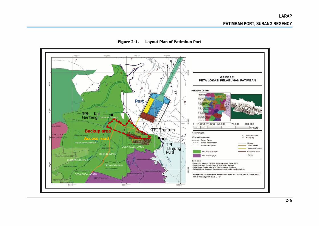
2.1. PROJECT DESCRIPTION
The development of the Patimban new port and its preparation is carried out by the
Government of Indonesia through the Ministry of Transportationc.q. Directorate General of
Sea Transport (DGST)/ DirektoratJenderalPerhubunganLaut in cooperation with the Japan
International Cooperation Agency (JICA). The project covers backup area of ± 356,23 ha,
access road of ± 15.79 Ha, and the port area (sea area) of 301 ha.
The construction of the Patimban port is located in Patimban, Subang, which is
administratively located in the northern part of West Java at 107°54'15.48"E and at
6°14'37.73"S. The allocation land plan for the backup area of the port (a facility support-
building) is estimated approximately 250 ha. The area is dominantly used for fishponds,
farmlands and recreation. Meanwhile, the port is located in the territorial waters, the Java
Sea. The area planned is approximately 301 ha, which is under the direct authority of the
local government, Subang.
The construction of the port and the port access road will have potential impacts on the
environment and the socio-economy. Social impacts include the loss of assets such as land,
buildings and crops as well as utilities. The development of the Patimban located in Subang
feared an impact on the fishing boat lines and Fishing Ground problem. The construction of
Patimban port is concerned to impact on the loss of fishing ground and the loss of access to
fishing grounds for local fishermen from three TPI (fish auction place), namely Kali Genteng,
Truntum and TanjungPura.
Project layout map is presented below.
LARAP
PATIMBAN PORT, SUBANG REGENCY
2-6
Figure 2-1. Layout Plan of Patimbun Port
TPI Kali Genteng
TPI Tanjung Pura
TPI Truntum
Access road
Port
Backup area

LARAP
PATIMBAN PORT, SUBANG REGENCY
2-7
2.2. PROJECT LOCATION
Determining the location of the new port Cilamaya replacement has been done through the
study of Pre-FS and FS New Port Development in West Java North Coast in 2015 through
the budget of the Ministry of Transportation. Based on the results of the study in the
document pre-feasibility study (Pre-FS) Port of West Java North Coast, has been produced
on the proposed location refers to the assessment aspects of the feasibility of developing a
new port based on the spatial aspects, regional transportation aspect, economic region
aspects, the social demography aspects, environmental aspects and technical aspects. Based
on the results of the scoring method, it was found PatimbanPort in Subang District as the
priority locations to replace Cilamayaarea.
Furthermore, the choice of location in the study of Pre-FS is done through screening method
to filter or specify the location of the port using the parameters of the feasibility of a
qualitative than four aspects, namely the legal and institutional aspects of transportation,
technical aspects, and safety aspects of shipping, especially to avoid the conflict with oil and
gas pipelines in the offshore (offshore) owned by PT. Pertamina. Referring to the results of
evaluation methods analysis, the result of the feasibility assessment of each location where
the port plans selected the most feasible locations and from four aspects no single element
that is not feasible is the location in the village Patimban in Subang.
Patimban village is one of eight villages in the district Pusakanagara which has an area of
2,065,311 Ha with administrative boundaries as follows:
North: the Java Sea and part of the district. LegonKulon.
South: with the RancadakaVillage andKalentambo Village.
East: Java Sea and part of the village Tanjongpura (Kab. Indramayu)
West: with the PangarenganVillage inLegonKulonDstrict
The access road which connects the port and the existing national road passes through
Kalentambo, Gempol, Kotasari, Pusakaratu and Pusakajaya village.

LARAP
PATIMBAN PORT, SUBANG REGENCY
2-8
Desa Patimban
Figure 2-2. Orientation Map of Patimban Village

LARAP
PATIMBAN PORT, SUBANG REGENCY
3-9
CHAPTER 3. INSTITUTIONAL AND LEGAL FRAMEWORK
3.1. INSTITUTIONAL AND LEGAL FRAMEWORK OF INDONESIA
Indonesia recently enacted a new land acquisition law for development in the public
interest1, Law No. 2/2012 and its implementing regulations i.e. (i) President of the Republic
of Indonesia Regulation No. 71/2012 and President of the Republic of Indonesia Regulation
No. 40/20142 on the Amendment to the President of the Republic of Indonesia Regulation
No. 71 of 2012 3;Presidential Regulation No. 99 of 2014 on the Second Amendment to
Presidential Regulation No. 71 of 2012; Presidential Regulation No. 30 of 2015 on the Third
Amendment to Presidential Regulation No. 71 of 2012 about the Implementation of Land
Acquisition for the Developmentin the Public Interest4 (ii) Head of National Land Agency No.
1 Public Interest means the interest of the people, state, and society that must be realized by the government
for best prosperity of the people. Please see Law No. 2/2012, General Elucidation.
2 President of the Republic of Indonesia Regulation No. 40/2014, changes the content of Article 121 of President of the Republic of Indonesia Regulation No. 71/2012 stipulates that, in the context of efficiency and effectiveness, land acquisition for public purposes of no more than 5 hectares can be implemented directly by the agency requiring land with the land rights holders, by way of sale or exchange or other means agreed upon by both parties.
3 It further regulates provisions under the land acquisition law that include i) land acquisition planning that include required information to be included in the land acquisition document; ii) land acquisition preparation that covers preparatory team and it tasks, stages and detailed activities for the project location determination; iii) land acquisition implementation by National Land Agency that include detailed provisions on land acquisition implementation team, preparation of land acquisition implementation, inventory of identification of losses, determination of independent appraiser, deliberations on the forms of compensation, delivery of compensation payment, delivery of compensation in the special circumstances, deposit compensation payment, release of the land acquisition objects, termination of rights between the entitled parties and land acquisition objects, recording and administrative data; iv) transfer of acquired land,; v) other provisions that include monitoring and evaluation, source of fund for land acquisition, negotiated land acquisition for small plot of land (less than 1 hectare; vii), tax incentive for entitled parties except who make claims on the decision on the location determination and decision on the amount of compensation.
4 There are some changes in the new regulation, as follows: 1) Change in the number 1 on Article 1, so that
the government agency requiring the land is so-called state institutions, ministries, non-ministry government agencies, provincial, district/city governments, and State-Owned Legal Entities/State-Owned Enterprises that received a special assignment from government or business entities that obtain power and authority to do so based on an agreement with state institutions, ministries, non-ministry government agencies, provincial, district/city governments, and State-Owned Legal Entities/State-Owned Enterprises which received a special assignment from government for providing infrastructure in the public interest; 2) one article is inserted between Article 117 and Article 118, namely Article 117A which mentions that Land Acquisition Funding for Public Interest can be taken in advance from the business entity as the institution that requires land which

LARAP
PATIMBAN PORT, SUBANG REGENCY
3-10
5/20125 which has been converted into Regulation of the Minister of Agrarian and Spatial
Planning/Head of National Land Agency No. 6 of 2015 on the Amendment to Regulation of
the National Land Agency No. 5 of 2012 about Technical Guidelines for the Implementation
of Land Acquisition(iii) Ministry of Finance Regulation No. 13/PKM.02/2013 6 ; and (iv)
Ministry of Home Affairs Regulation No. 72/2012). The law and regulations were issued to
ensure land acquisition for the implementation of development for the public interest, with
the emphasis on the principles of humanity, democratic, and equitable. These legal
provisions replaced previous land acquisition laws and its implementation regulations
(President of the Republic of Indonesia Regulation No. 65 of 2006; President of the Republic
of Indonesia Regulation No. 36/ 2005; BPN Head Regulation No. 3/2007).
Following are the directives in the implementation of development for public interest by Law
No. 2 Year 2012 and its implementing regulation under Presidential Regulation No. 71 of
2012 in Indonesia:
1. Law No. 2/2012 provides a clear procedure and timeframe for land acquisition involving
all stakeholders with a clear procedures and time frame. The implementation of land
acquisition considers balance between development interest and the interests of the
community and by way of giving appropriate and equitable compensation. The objective
of land acquisition is to make land available to improve the welfare and the prosperity
of the people, state, and society by ensuring the legal interest of the entitled parties.
The provision of the transitional law stipulates that the land acquisition started before
the enactment of the new law will be completed in accordance with the rules or
regulations applicable previously, while the land acquisition implemented after the
enactment of the new law will be conducted under the provisions of the law No 2/2012.
2. Based on Law No. 2/2012, the government should undertake land acquisition by
involving all entitled holders and concerned. The entitled parties shall be those who
acquires power and authority based on agreement, acts on behalf of state institutions, ministries, non- ministry government agencies, provincial, and/or district/city governments; 3) one article is inserted
between Section 123A and Section 124, namely Article 123B which specifies among others that the Land Acquisition Process that has not been completed under the provisions of Article 123 and Article 123A but has attained Construction Site’s Determination or Approval Letter for the Determination of Construction Site (SP2LP) or other name stipulated as a Construction Site’s Determination, the Land Acquisition process can be completed based on stages as provided for in this Presidential Regulation.
5 It provides technical guidelines on land acquisition implementation by Land National Agency.
6 It stipulates on operational and support costs for land acquisition implementation (planning, preparation, implementation, and land transfer phases) that come from the government budget. The regulation provides a detailed guidance on maximum cost for land acquisition preparation and implementation.
LARAP
PATIMBAN PORT, SUBANG REGENCY
3-11
control or own the object of the land acquisition, inter alia: (i) the holders of land rights;
(ii) the holders of land rights to manage; (iii) nadzir for the waqf land;7d. the owners of
former customary rights secured land; (v) indigenous people/customary
communities;(vi) the parties occupying the state land in good faith; (vii) land tenure
holders; and/or (viii) the owners of buildings, plants or other objects related to the land.
The object of land acquisition includes: (i) land; (ii) over ground and underground
space; (iii) plants; (iv) buildings; (v) objects related to land; and (vi) other appraisable
loss that include non-physical loss such as loss of business, loss of job, cost of change
of location, cost of change of profession, and loss of the remaining property (residual
property that is no longer viable)8.Land acquisition implementation is handled by the
National Land Agency, conducted by providing fair and adequate compensation. The
Law 2012 recognizes that a location determination will be required prior to land
acquisition.9 Acquisition of land for public interest less than 1 hectare can be conducted
by the institution needing the land through sale transaction, exchange, or other means
acceptable to both parties.10
3. Compensation for losses in terms of land acquisition and resettlement activities as
stipulated in the provisions of Law Number. 2/2012 now covers “Other appraisable
loss”. 11 Losses in terms of restriction/limitation or restriction of access 12 to natural
resources such as marine-fishery resources that can impact on the economic activities
of people are now categorized as losses by the new Law and may be valuated for
7 Waqf - an inalienable religious endowment in Islamic law, typically donating a building or plot of land or even cash for Muslim religious or charitable purposes. The donated assets are held by a charitable trust or waqf organizer
8 Elucidation of Article 33 of Law No. 2/ 2012.
9 Article 19 (5) specifies that "After the agreement referred to in paragraph (4), Agency requiring land must apply to the government for confirmation of the location ".
10 See Regulation of the Number 40/2014 an amendment to Article 121 of the President of the Republic of Indonesia Regulation No. 71/2012.
11 Pursuant to Article 33 of the Land Law 2012, it means non-physical loss equivalent to money value, for
example, loss due to loss of business or job, cost of change of location, cost of change of profession, and loss of value of the remaining property.
12 Study on the status of land affected to restriction of access is needed in order to formulate appropriate mitigation measures due to the determination or limitation or restriction of access to water resources or land on riparian area either temporariy or permanently. If the affected land or asset is owned by the people either individually or communally and the restriction is imposed either towards the access or the land function, measures related to land acquisition for the development in the public interest is required in this respect. If the affected land is owned by the state or has been the government asset, then the mitigation measures may refer to the special procedures as specified in Law No. 7/2004 on Water Resources Management and/or Presidential Regulation No. 38/2011 on River Management.
LARAP
PATIMBAN PORT, SUBANG REGENCY
3-12
compensation purposes and may be in any of the following forms (Article 36): (i)
money; (ii) substitute land; (iii) resettlements; (iv) shareholding; or (v) other forms as
agreed upon by both parties.
4. Law No. 2/2012 and its implementation regulations are applicable to the activities of
land acquisition for the construction for the public interest13 carried out by government
with appropriate and equitable compensation. Various discussions with institutions that
have the authority to provide an explanation of the provisions of the law, such as the
attorney and Ministry of Agriculture and National Land agency (BPN) asserted that Law
No. 2/2012 only applicable where the land acquisition objects to be acquired are the
property of other party and not owned by the institutions requiring land. Acquisition of
land belonging to the institution requiring land being used or occupied by people is not
considered as land acquisition, but rather ‘a land clearing’. “Land clearing”, therefore is
an effort to move illegal occupants from the piece of land/areas which have been
owned by entity needing the land for development /project proponent.
5. In this context (land clearing), the Government Regulation in lieu of Law Number 51 of
1960 on the prohibition of land use without the consent of the entitled party or his
proxy is still applicable. Article 2 of the Law Number 51 says that it is prohibited to use
land (to occupy, to utilize land and/or control piece of land, possessing plant or building
on the land – it does not matter whether the building is used by themselves or
somebody else) without consent/agreement from the entitled party (land right holder).
Article 4 asserts that the illegal occupants must move any objects on the occupied land
and leave the land with their owned resources. So the occupants must bear all cost
related to movement of their belonging, and therefore, no assistances for moving and
income restoration be provided. However, Article 5 (3) also mentions that during the
land clearing process, the entitled party must initially manage deliberation with the
parties concerned. With respect to any property right belong to the occupants, it needs
to consider Article 570 of the Indonesian Civil Code (KUH Perdata) stating that the
ownership rights is subject to the government’s right to expropriate land and property
for; for public use with suitable compensation as determined by laws and regulations.
Therefore, despite the occupied land is not belong to the occupants, the private
property other than land (buildings, plants or any other objects) must be well
13
Public interest is the interest of the nation, state, and society that must be realized by the government and used as much as possible for the prosperity of the people. Law No. 2/2012, General Elucidation.

LARAP
PATIMBAN PORT, SUBANG REGENCY
3-13
respected. The respect to the property right belong to the occupants is also clearly
stated in the Law Number 39 of 1999 on Human Rights. Article 29 of the law says that
every person is entitled of protection of their property right. Further, Article 36
stipulates that property right cannot be taken without due process and against the law.
Further, Article 37 of Law 39 of 1999 provides clear guidance that any property right
taken for public use must be compensated. That is why any affected property right
owned by the affected persons on land clearing is entitled for compensation.
6. In the past, although there are applicable legal frameworks on compensation for land
clearing, yet the level of knowedge on the legal framework and implementation of land
clearing operation vary. There are government agencies which provided compensation
for the affected assets and even provide relocation area to the APs, yet there are some
other government agencies evicted the people without any compensation. Some local
governments established Decrees to legalize the compensation of affected assets to
illegal occupants (squotters). The West Java Governor, for example, issued a Decree to
legalize compensation payment for the APs who are non- land rights holders living along
the canal to be rehabilitated. The Governor of DKI Jakarta relocated affected squotters
living along the Ciliwung River and Pluit Reservoar to ‘rumah susun’ with good facilities
and means for restoring economic income of the APs. For the Jati Gede Dam project,
the Directorate General of Water Resources provided compensation to the APs who are
mostly non-land rights holders/squotters as in 1970s, most of areas occupied by the APs
have been compensated.
7. Other relevant laws, regulations and provisions are:
(i) Related to IP/Customary/Adat
a) Law No. 5/1960 concerning Basic Agrarian Affairs – acknowledges customary
rights of Indigenous Peoples (IPs).
b) Law Number 23 of 2014 ConcerningLocal Government replaces Law No.
32/2004 concerning Local Government – decides on the establishment and
authority of the village, including traditional village. In the new legislation, the
village is including indigenous villages or called by other names, hereinafter
called the village, is a legal community unit which has borders with the
authority to regulate and manage Government Affairs, the interests of local
communities based on community initiatives, right origin, and/or traditional
rights are recognized and respected in the system of government of the
Republic of Indonesia.
c) Law No 38/2004 Concerning Streets/Roads. Article 58 of Law 38/2004 says
that land acquisition for road development for public use is carried out based

LARAP
PATIMBAN PORT, SUBANG REGENCY
3-14
on City/ district spatial management plan and the project must be informed to
the affected people. Further, land right holder or state land user or customary
law community whose land is needed for development are entitled for
compensation that will be carried out through consensus.
d) Law No 27/2007 Concerning Management of Coastal Areas and Small Islands.
Article 61 declares that government recognizes, respect, and protect customary
rights, traditional community and local wisdom over coastal areas and small
islands that have been utilized.
e) Law of the Republic of Indonesia No. 1/2014 on the Amendment to Law
Number 27/2007 on Management of Coastal Areas and Small Islands.
f) Constitutional Court Decision (MK) canceled the provisions of the Forestry Law
No. 41/1999 on indigenous forests, which establishes that indigenous forest is
state forest in the area of indigenous peoples. This Decision excluded
indigenous forest within the state forest.
g) Joint Regulation of the Minister of Home Affair, The Minister of Forestry,
Minister of public works and the Head of BPN No. 79 of 2014, No.
PB.3/Menhut-II/2014, No.17/PRT/M/2014, No.8/SKB/X/ 2014 on the
Procedures for Settlement of Land Tenure Inside Forest Zone. Coveredthe
procedures for the settlement of customary rights and land tenure within forest
area.
h) Regulation of the State Minister of Agrarian/Head of National Land Agency
Number 5 of 1999 on Guidelines Troubleshooting Land Rights of Indigenous
People.
i) Regulation of the Minister of Agrarian and Spatial Planning/Head of National
Land Agency No. 9 of 2015 on the Procedures for the Establishment of
Communal Rights on Customary Land and the People Living In A Specific Area
set forth that: a) the land entitlement can be granted to customary law
community who meet the requirements, b) the land entitlement can be granted
to community living in a specific area and meet the requirements.
(ii) Related to compensation and Improvement of living standards
a) Law no. 41/1999 Law on Forestry – regulates land acquisition in forests,
requiring compensation land to be acquired for afforestation in a ratio of 2:1.
b) Law No.11/2005 on the Ratification of the International Covenant on Economic,
Social and Cultural Rights. This Act protects people rights of economy, social,
and culture including right to live descent and protection of culture. As stated
in Article 11 of the Convention that the state recognizes the right of everyone
to an adequate standard of living for himself and his family, including adequate
food, clothing and housing, and to the continuous improvement of living

LARAP
PATIMBAN PORT, SUBANG REGENCY
3-15
conditions. The State will take appropriate steps to ensure the realization of
this right, recognizing the importance of international cooperation based on
free consent and proclaimed previously.
c) Law No.41/2009 on Protection on Agricultural Land for Sustainable Food –
stipulates special compensation if a project impacts sawah (wet rice) land,
which is important to food security.
d) Head of BPN Regulation No. 1/2010 – on Standard of Land Service and
Regulation regulates the time frame for certification of the remaining land after
compensation payment.
e) Presidential Decree No. 34/2003 on National Policy on Land- regulates
authorities of national and local governments on land. It stipulates that the
authorities of local government on land include; (i) undertake land acquisition
for development; and (ii) provide compensation and allowance (santunan) for
land acquisition.
f) The Indonesian Government Regulation No. 38/2007 about the distribution of
state activities between the Central Government, Provincial Government, and
district/ municipality government. Government regulations set the state
activities that must be conducted by the provincial government and district /
municipality government related to basic services 14 including among others
land issues15.
g) Indonesia Valuation Standards 306 (SPI 306) on the Assessment of Land
Acquisition for Development for the Public Interest. The Indonesia Professional
Appraisers Society (MAPPI) formulated the standards by adopting the
development of international standards (IVS 2011). Standard 306 provides
guidelines for assessment of land acquisition object for compensation in land
acquisition for development for the public interest. Assessment includes the
adequate replacement value of property and land. Assessment standards are
also associated with other standards, such as scope of assignment, land
property and structures valuation, farmland property valuation, valuation of
14
Article 7 Paragraph 1.
15 Compulsory activities reference to Article 7, Section 2 includes a. education; b. health; c. the environment; d. public works; e. spatial planning; f. development planning; g. housing; h. youth and sport; i. capital investment; j. cooperatives and small and medium enterprises k. demographic and civil registry; l. employment; m. food security; n. empowerment of women and protection of children; o. family planning and family welfare; p. transportation; q. communication and informatics; r. land; s. national unity and internal political; t. regional autonomy, public administration, regional financial administration , the regional equipment, personnel, and coding; u. empowering communities and villages; v. social; w. culture; x. statistics; y. archives; and z. library.

LARAP
PATIMBAN PORT, SUBANG REGENCY
3-16
property with particular business, business valuation, and inspection of cases
under consideration.
(iii) Related to Vulnerability and Severity Assistance
a) Law No. 11/2009 on Social Welfare and its implementing regulation Ministry of
Social Welfare Decree No. 39/2012 on Delivery of Welfare. Based on these
provisions, the vulnerable and severely affected people are eligible for
assistance.
b) Law No. 39/1999 On Human Rights (Article 5, elucidation), describes the
vulnerable groups include the elderly, children, the poor, pregnant women and
people with disabilities.
c) Vulnerable / severely affected people are identified as early as possible through
the Social Impact Assessment of AMDAL as referred to in the Environmental
Law no. 32/2009 on Environmental Protection and Management; Indonesia
Government Regulation on the Environmental Permit, Ministry of Environment
Regulation No. 17/2012 with regard to participation guidance of local
community in order to obtain AMDAL and Environmental Permit Issuance.
Decree of the Head of Environmental Impact Management Agency No.
299/1996 on Guidelines for the Technical Assessment on Social Aspects in
Preparation of the Environmental Impact Analysis.
(iv) Related to Tax Incentive
a) Income Tax Rate of Land and / or Building ownership transfer.
b) Basic Law: Government regulation (PP). 48/1994 jo; PP. 27/1996 jo; PP.
79/1999 jo; PP. 71/2008. On the Third Amendment to Government Regulation
No. 48/1994.
(vi) Related to Compensation for Buildings and Local Regulations on Buildings.
a) Law of the Republic of Indonesia No. 28 of 2002 on Buildings. This law
establishes the right of the building owner to get compensation in accordance
with applicable laws and regulations if the building is demolished by local
government or other parties that is not caused by the building owner’s fault
(Article 40 point f).
b) Governmental Regulation No. 36 of 2005 concerning the Implementation
Guidelines of Law No. 28 of 2002 on Buildings.
c) Decision of Director General of Human Settlements of the Ministry of Public
Works of 1994 on Building Compensation.

LARAP
PATIMBAN PORT, SUBANG REGENCY
3-17
(vi) Compensation For Residents Who Occupy State-Owned Landsin Project Affected
Urban and Rural Areas.
a) Regulations relating to the illegal use of state-owned lands may refer to
Governmental Regulation in Lieu of Law No. 51 of 1960, Basic Agrarian Law No.
5 of 1960, the Civil Penal Code, and Regulation of the Minister of Agrarian and
Spatial Planning/Head of National Land Agency No. 9 of 2015 on the
Procedures for Establishment of Communal Rights on Costumary Land and the
People Living In A Specific Region. This regulation stipulates that group of
people living in a specific segion (forests and plantations) and meet the
requirements may be granted the land entitlement16..
b) Governmental Regulation in Lieu of Law No. 51 of 1960 on Prohibition of the
Use of Land without any Permission from Entitled Parties or their authorized
proxy, stipulates that:
1) The rationale behind the establishment of Government Regulation No. 51
of 1960 is: "For the development of the country, the use of land should be
done in an orderly manner. The use of land that is carried out irregularly or
violated the norms of law and order, as happened in many places, is
completely inhibiting, and often make the implementation of development
plans in various fields is impossible. The construction of buildings in a city
for a living place, shop or any other purposes which is done overcrowdedly
with irregular layout and places, and made of flammable materials, is not
just increasing the magnitude of fire possibility, but also cannot be
accounted for in the perspective of health and security order. Not to
mention the losses burdened by the state and community, for example:
the action in form of the destruction of farm lands, which is one of
essential production branches for the state economy. The use of land in
this way, although it is understandable, cannot be justified and therefore
should be banned.
2) Referring to Article 2 and Article 6 paragraph 1 letter a of the
Governmental Regulation in Lieu of Law No. 51 of 1960, people is
prohibited to use land without any consent of the entitled party or
authorized proxy and the violation is punishable by criminal penalties. The
16
Following are the requirementsof communities group are in a specific area including: a) take a control physicallyat least ten (10) years or more in a row b) still hold the harvesting of the earth in certain regions and surrounding areas to meet the needs of daily living c) be The main source of life and livelihood of society; d) there are social and economic activities are integrated with community life.

LARAP
PATIMBAN PORT, SUBANG REGENCY
3-18
unauthorized use of land that is punishable by criminal penalties is not only
limited to the illegal use of land which began after the regulation is taken
into effect, but also for the illegal use of land before this regulation is
made and remains ongoing. However, in practice criminal prosecution is
not the only way to tackle the issue (Article 6), if the Minister of Agrarian
and Regional Authorities [Article 3 and Article 5 (4)] may enter into
another settlement, namely, through the deliberation with parties
concerned by taking into account the interest of the parties concerned and
the allotment plan and the use of respected land.
3) The clearing of land used without permission of entitled parties or their
proxies are not necessarily through the mediation of a court, and the
authority of the land clearing is on the hands of the Minister of Agrarian
and local authorities (Article 4 and Article 5, paragraph 3). Specifically for
the settlement of plantation and forest land, the authority belongs to the
Minister of Agragrian, Minister of Agriculture and Minister of Forestry.
c) Article 6 of Basic Agrarian Law No. 5/1960, explains that all land rights have
social function and Article 6 of Basic Agrarian Law No. 5/1960 explains about
the use of land or allotment of land for the development purpose, the
community must be willing to relinquish ownership over the land through either
grant or compensation process.
d) Pursuant to Article 1355 paragraph (3) of the Civil Penal Code, people who take
care of the interests of others (including taking care of the land or building)
voluntarily without being authorized, they won’t get any payment but entitled
to reimbursement of expenses incurred in connection with the maintaining of
such land or building just like a good father of a family (well behaved) in
accordance with Article 1356 and Article 1357 of the Civil Penal Code, and take
care appropriately the interest of the person represented.
e) The potential affected people with legal ownership rights over assets are
eligible for compensation according to applicable regulations and the potential
affected people have to show valid evidence of ownership documents from
local authorities or holders of rights to land such as the Certificate,
Land/Building Tax Receipt, sale and purchase deed or other documents, such
as payment receipt of public services, e.g. payment of water and electricity bill.
f) The potential affected people who occupy land illegally also need to be
compensated in accordance with the applicable provisions as discussed above
and the potential affected people concerned must show evidence documents of
taking care or using the land and or building given by the land owner (Forestry
Office, Agriculture/Plantation Office, Village), other information from neighbors

LARAP
PATIMBAN PORT, SUBANG REGENCY
3-19
and Village administration, and/or other documents, such as payment receipt
of public services, e.g. payment of water and electricity bill.
g) In the implementation of compensation to potential affected people of
ICWRMIP, the Ministry of Public Works and Housing/BBWS Citarum takes role
as the implementor of the decision made by authorities, namely the Minister of
Agrarian, Minister of Agriculture, Minister of Forestry and the local authorities
(Governors, Regents, Mayors, Heads of Sub-Districs and village Chiefs).
h) Regulation of the Minister of Finance No. 96 / PMK.06 / 2007 concerning the
Procedures for the Implementation of the Use, Utilization, Abolition and
Transfer of State Assets17
viii) In respect to The Use of Forestry Land Regulation
a) Law No. 5 of 1990 concerning Conservation of Natural Resources and
Ecosystems;
b) Law No. 41 of 1999 concerning Forestry, as amended by Law No. 1 of 2004
concerning Government Regulation in Lieu of Law No. 1 of 2004 on the
Amendment of Law No. 41 of 1999 on Forestry Becoming Law.
c) Government Regulation No. 44 of 2004 concerning Forestry Planning
d) Government Regulation No. 45 of 2004 on Forest Protection as amended by
Government Regulation No. 60 of 2009 concerning Amendment to Government
Regulation No. 45 of 2004 on the Protection of Forests;
e) Government Regulation Number 6 of 2007 concerning Forest Arrangement and
Preparation of Forest Management Plan and Forest Utilization, as amended by
Government Regulation No. 3 of 2008 concerning Amendment to the
Government Regulation Number 6 of 2007 regarding Forest Management and
Forest Management Planning, as well as Forest Utilization;
f) Government Regulation No. 24 of 2010 concerning Forest Area. Loading the
use of forest land for development outside forestry activities can only be
carried out for activities that have a strategic goal that can not be
circumvented. Interests of development outside forestry activities referred to in
Article 4 paragraph (1) including facilities and infrastructure of water resources,
water installation network construction, and water supply and/or wastewater;
Use permit for the provision of forest areas contained in Article 6 (paragraph 2)
17
Details of Procedures for Use of State-owned land can be found in Appendix 14

LARAP
PATIMBAN PORT, SUBANG REGENCY
3-20
As for the procedure and the requirement request for use of the forest area
can be found in Appendix 12.
g) Government Regulation No. 61 of 2012 concerning Amendment to Government
Regulation No. 24 of 2010 concerning Forest Area and in order to improve
governance and control of the use of forest areas, it is necessary to change
some provisions of the guidelines lend use of forest areas;
h) Governmental Regulation No. 72 of 2010 about the Public Corporation (Perum)
of State Forestry Article 7 (paragraph 6) stipulates that in implementing forest
management Perum Perhutani shall involve communities around the forest with
due regard to the principles of good corporate governance. Article 8
paragraphs (1 and 3) explains that if there are activities other than forestry
activities on the land within Perum Perhutani working area, then Perum
Perhutani is entitled to other benefits of forest management rights in
accordance with the guidelines set forth by Technical Minister. The
development activities other than forestry activities are among others those of
pre-defined in ICWRMIP project, such as the installation of water network,
clean water and/or wastewater drainage, irrigation, and water reservoir18
i) Regulation of the Minister of Forestry Number: P.18/Menhut-II/2011 on
Guidelines for Borrowing and Using the Forest Area;
j) Regulation of the Minister of Forestry Number: P.14/Menhut-II/2013 about the
Second Amendment to the Regulation of the Minister of Forestry Number:
P.18/Menhut-II/2013 on Guidelines for Borrowing and Using the Forest Area;
k) Regulation of the Minister of Forestry Number: P.18/Menhut-II/2012 on
Compensation Assessment Procedures for Forest Rehabilitation Crops due to
the Utilization of Forest Area and the Change of Forest Area Allotment;
l) Regulation of the Director General of Forestry Planning Number: P. 13/VII-
PKH/2012 on the Implementation Guidelines for the Use of Forests Area for the
Development other than Forestry Activities through Cooperation Mechanism
With Forest Management. The development activities other than forestry
operations as referred to in Article 2 paragraph (1) are activities for the
development purposes outside forestry activities that can support the
18 Activities other than forestry activities as referred to in Article 8 paragraph (1), include: a. religious affairs; b.
mining; c. electricity development and the installation of renewable energy technologies; d. the construction of telecommunication networks; e. the construction of water supply installation; f. special roads, toll roads; g. clean water and/or wastewater drainage network; h. irrigation; i. water reservoirs; j. public facilities; k. repeater telecommunications devices; l. radio stations; m. television relay station; and n. sea or air traffic safety devices.

LARAP
PATIMBAN PORT, SUBANG REGENCY
3-21
management of forest area within Perum Perhutani region and forest areas
beyond Perum Perhutani working area which have Forest Management Unit
(KPH) and can be done with the cooperation mechanism and become a part of
forest management activity.19
m) Joint Regulation of the Minister of Home Affair, Minister of Forestry, Minister of
public works and the Head of BPN No. 79 Year 2014, No. PB.3 / Menhut-II /
2014, No. 17 / PRT / M / 2014, No. 8 / SKB / X / 2014 on the Procedures for
Settlement of Land Tenure The Being In Forest Area.
3.2. JICA GUIDELINES ON INVOLUNTARY RESETTLEMENT
Regarding the involuntary ressettlement, the JICA guidelines for Environmental and Social
Consideration (April 2010) indicates the following principles.
1) Involuntary resettlement and loss of means of livelihood are to be avoided when feasible
by exploring all viable alternatives. When, after such an examination, avoidace is proved
unfeasible, effective measures to minimize impact an to compensate for losses must be
agreed upon with the people who will be affected.
2) People who must be resettled involuntary and people whose means of livelihood will be
hindered or lost must be sufficiently compensated and supported by project proponent
etc. in a timely manner. Prior compensation, at full replacement cost, must be provided
as much as possible. Host countries must make efforts to enable people affected by
project and to improve their standar of living, income opportunities, and production
levels, or at least to restore these to pre-project levels. Measures to achieve this may
include: providing land and monetary compensationfor losses ( to cover land and
property losses), supporting means for an alternative sustainable livelihood, and
providing the expenses necessary for the relocation and re-establishment of
communities at resettlement sites.
19 Activities other than forestry activities as referred to in Article 2 paragraph 1 include: a) Micro-Hydro
Electricity Power Plant (MHP) for non-commercial purpose; b) the installation of pipelines and cable on the area along the watershed; c) the installation of electricity lines into the village along the watershed (not SUTT); d) the construction of canals or drainages; e) landfill with the final product, among others compost; f) the construction of rest areas; g) an increase in the utilization of the watershed as the productions’ transportation way; h) natural disaster mitigation monitoring tool (PPMBG); i) the construction of dam for soil and water conservation; j) construction of water tanks or reservoirs; k) the construction of billboards; l) crops planting by parties outside the forestry party for forest reclamation and rehabilitation activities.

LARAP
PATIMBAN PORT, SUBANG REGENCY
3-22
3) Appropriate participation by affected people and their communities must be promoted in
the planning, implementation, and monitoring of resettlement action plans and measures
to prevent the loss of their means of livelihood. In addition, appropriate and accessible
grievance mechanisms must be established for the affected people and their
communities.
For project that will result in large-scale involuntary resettlement, resettlement actions
plans must be prepared and made available to the public. In preparing a resettlement
action plan, consultations must be held with the affected people and their communities
based on sufficient information made available to the in advance. When cosultations are
held, explanations must be given in a form, manner, and language that are
understandable to the PAPs. Note that the JICA requests that the borrowers follows the
OP.4.12 of World Bank for addressing individual issues on involuntary resettlement.
The World Bank experiance indicates that the involuntary resettlement under
development projects, if unmitigated, often gives rise to severe economic, social and
environmental risks. The policy includes safeguards to address and mitigate these
impoverisment risk.
Following are the key principles in the Bank’s policy on involuntary resettlement:
1) Involuntary resettlement should be avoided where feasible, or minimized,
exploring all viable alternatives project designs.
2) Displaced persons are to be provided prompt and effective compensation at full
replacement cost for losses of assets attributable directly to the project.
3) Resettlement activities should be conceived and executed as sustainable
depelopment programs.
4) Displaced persons should be meaningfully consulted and should have
opportunities to participate in planning and implementing resettlement program.
5) Displaced persons should be assisted in their effort to improve their livelihoods
and standars of living or at least to restore them, in real terms , to pre-
displacement levels or to levels prevailing prior to the beginning of project
implementation, whichever is higher.
6) The absenceof a formal legal title to land is not a bar to WB policy entitlements
7) Particular attention is paid to the needs of vulnerable group among those
displaced, especially those below the poverty line, the landless, the elderly,
women and children, indigenous people, ethnic minorities, or other displaced
persons who may not be protected through national land compensation
legislation.
8) The full cost of resettlement activities necessary to achieves the objectives of the
project are included in the total cost of the project.

LARAP
PATIMBAN PORT, SUBANG REGENCY
3-23
3.3. COMPARITION ANALYSIS OF GOVERNMENT LAW AND REGULATION WITH JICA’S POLICY
The Government enhanced its country system in order to address land acquisition issues for
public interest development project purposes. The new Land Acquisition Law No. 2/2012
and its implementing rules and regulations approximate harmonization with the JICA’s Policy.
The new law grants that persons with no legal title over the land they occupy or utilize are
entitled to compensation20 for improvements found thereon, including compensation for job
and business losses, moving cost,21 etc. A land acquisition plan also needs to be prepared by
the agency requiring land. People affected by land acquisition are consulted and their
complaints heard and resolved in the most expeditious way during the planning and
implementation of land acquisition.
Most of principles in Law No. 2/2012 have been in line with JICA’s. There are still some gaps
identified, but the gaps have been addressed by the provisions of other relevant laws,
regulations, and guidance. The gaps include compensation principle for affected
buildings/structures without depreciation, provision of livelihood recovery programs for
severely affected people and vulnerable groups to ensure that their lives will not be worse
due to the project, and relocation assistance for physically displaced residents as well as
transition allowance. The result of the comparition analyis on Involuntary Resettlement
between Indonesian laws and existing regulation and Operational policy (OP.412) of WB
based on the review of them are show in Table 3.1.
Table 3-1
Comparition Analysis on thr Gaps Between OP.4.12 and RelevantIndonesian Regulation
Issue WB OP.4.12/JICA Guideline
Indonesian Regulation on
Involuntary Resettlement
and gaps with WB OP 4.12
Counter measures to fill
gaps
1) Preparation of
Resettlement
Action Plan(RAP)
A resettlement plan or abbreviated
resettlement plan is required for all
operations that entail involuntary
resettlement unless otherwise
Although Indonesian law (No. 2
/2012) stipulates to establish
Land Acquisition Planning
Document (LAPD) by the
In addition to LAPD to be
submitted to the province,
Land Acquisition and
Resettlement Action Plan
20
See Elucidation of Article 40 of the Law No.2/2012.
21 Elucidation of Article 40 of Law No. 2/2012 with the the following provisions: For building rights or rights of
use that is above land not his own, Compensation granted to the holder of the right to build or use rights on buildings, plants, or other objects related to land owned by him, while Compensation on land granted to the holder of the ownership or management rights.

LARAP
PATIMBAN PORT, SUBANG REGENCY
3-24
Issue WB OP.4.12/JICA Guideline
Indonesian Regulation on
Involuntary Resettlement
and gaps with WB OP 4.12
Counter measures to fill
gaps
specified (OP.4.12 para 17(a)). proponent, stipulation on the
obligation for preparation of
Resettlement Action Plan (RAP)
is not found.
(LARAP) will be prepared to
be approved by DGST.
DGST shall take
responsibility on
implementation of the
LARAP.
2) Minimization
of Involuntary
Resettlement
Involuntary resettlement should be
avoided where feasible, or
minimized, exploring all viable
alternative project designs (OP.4.12
para 2)
No stipulation for minimization of
Involuntary resettlement is found
Involuntary resettlement is
minimized by avoiding land
acquisition at dense
residential areas as much as
possible.
3) Impacts
Covered
The compensation should cover not
only physical aspects such as
relocation or loss of shelter and loss
of assets or access to assets etc.
But also loss of income sources or
means of livelihood (OP.4.12 para
3).
Impacts to be compensated
based on the appraisal of the
amount are: a. land, b. over
ground and underground space,
c. buildings, d. plants, e. objects
related to land; and/or f. other
appraisable loss. “Other
appraisable loss” means
nonphysical loss equivalent to
money value, for example, loss
due to loss of business or job,
cost of change of location, cost
of change of profession, and loss
of value of the remaining
property.
Loss of income and means
of livelihood caused by
relocation is covered by the
compensation in addition to
physical loss such as land,
buildings and crops/plans.
4)
Compensation
for illegal
settlers
Those who do not have formal legal
rights to land but have a claim to
such land or assets --provided that
such claims are recognized under
the laws of the country are
provided compensation for the land
they lose, and other assistance.
And also those who have no
recognizable legal right or claim to
the land and occupy the project
area prior to a cut-off date are
provided resettlement assistance
(OP.4.12 para 15, 16).
No stipulation for compensation
for illegal settlers is found.
Loss of illegal settlers is
covered by the
compensation.
5) Estimation of
compensation
cost
To provide compensation at full
replacement cost for losses of
assets without depreciation of
structures or assets.
For agricultural land; based on the
market value of the pre-project
land or pre-displacement,
whichever is higher with the cost of
preparing the land, plus the cost of
any registration and transfer
taxes.
For land in urban areas ; based
onmarket value of the land with the
Compensation cost is appraised
based on the policy of
replacement cost. (Standar
Penilaian Indonesia :SPI)
Compensation cost is
estimated based on the
policy of replacement cost.
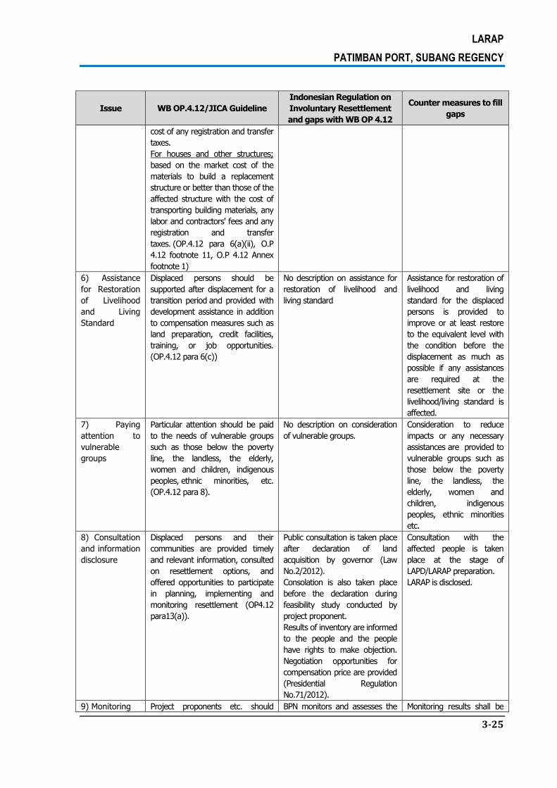
LARAP
PATIMBAN PORT, SUBANG REGENCY
3-25
Issue WB OP.4.12/JICA Guideline
Indonesian Regulation on
Involuntary Resettlement
and gaps with WB OP 4.12
Counter measures to fill
gaps
cost of any registration and transfer
taxes.
For houses and other structures;
based on the market cost of the
materials to build a replacement
structure or better than those of the
affected structure with the cost of
transporting building materials, any
labor and contractors' fees and any
registration and transfer
taxes. (OP.4.12 para 6(a)(ii), O.P
4.12 footnote 11, O.P 4.12 Annex
footnote 1)
6) Assistance
for Restoration
of Livelihood
and Living
Standard
Displaced persons should be
supported after displacement for a
transition period and provided with
development assistance in addition
to compensation measures such as
land preparation, credit facilities,
training, or job opportunities.
(OP.4.12 para 6(c))
No description on assistance for
restoration of livelihood and
living standard
Assistance for restoration of
livelihood and living
standard for the displaced
persons is provided to
improve or at least restore
to the equivalent level with
the condition before the
displacement as much as
possible if any assistances
are required at the
resettlement site or the
livelihood/living standard is
affected.
7) Paying
attention to
vulnerable
groups
Particular attention should be paid
to the needs of vulnerable groups
such as those below the poverty
line, the landless, the elderly,
women and children, indigenous
peoples, ethnic minorities, etc.
(OP.4.12 para 8).
No description on consideration
of vulnerable groups.
Consideration to reduce
impacts or any necessary
assistances are provided to
vulnerable groups such as
those below the poverty
line, the landless, the
elderly, women and
children, indigenous
peoples, ethnic minorities
etc.
8) Consultation
and information
disclosure
Displaced persons and their
communities are provided timely
and relevant information, consulted
on resettlement options, and
offered opportunities to participate
in planning, implementing and
monitoring resettlement (OP4.12
para13(a)).
Public consultation is taken place
after declaration of land
acquisition by governor (Law
No.2/2012).
Consolation is also taken place
before the declaration during
feasibility study conducted by
project proponent.
Results of inventory are informed
to the people and the people
have rights to make objection.
Negotiation opportunities for
compensation price are provided
(Presidential Regulation
No.71/2012).
Consultation with the
affected people is taken
place at the stage of
LAPD/LARAP preparation.
LARAP is disclosed.
9) Monitoring Project proponents etc. should BPN monitors and assesses the Monitoring results shall be

LARAP
PATIMBAN PORT, SUBANG REGENCY
3-26
Issue WB OP.4.12/JICA Guideline
Indonesian Regulation on
Involuntary Resettlement
and gaps with WB OP 4.12
Counter measures to fill
gaps
make efforts to make the results of
the monitoring process available to
local project stakeholders. (JICA
Guideline)
process and the results of land
acquisition (Law No.2/2012 and
Presidential Regulation
No.71/2012). No regulations for
disclosing monitoring results.
disclosed upon discussion
with DGST.
Source: The Survey Team
LARAP
PATIMBAN PORT, SUBANG REGENCY
4-27
CHAPTER 4. OVERVIEW OF THE PROJECTAFFECTED AREA
4.1. INITIAL SURVEY RESULT OF AFFECTED AREA
The land procurement for the development plan of Patimban Port in the back-up area and
access road location will be implemented through the acquisition of lands owned by the local
people. The data collection on assets has been done by way of two approaches, namely the
social and spatial analysis approaches, which are combined with field validation. The social
approach is carried out through interview with questionnaires, while spatial analysis
approach is undertaken by mapping the entire project plan area by using basic data of aerial
photographs taken by using unmanned aerial vehicle in order to see the overall biophysical
conditions of the area.
The land procurement plan for the development of Patimban Port in the back-up area and
access road location will be implemented through the acquisition of lands owned by the local
people. Those lands are currently being used as paddy fields, brackish water ponds, and
small part of them as constructed lands or residential areas. Based on the location of tax
payment area, it has been identified that back-up area is situated in Block 15, 16, 17, 18, 19
and 20. Administratively, the entire back-up area is situated in Patimban Village of
Pusakanagara Sub-District of Subang Regency. Meanwhile, for the location plan of access
road, the areas are located in Gempol Village, Kaletambo Village, Pusaka Ratu Village, and
Kota Sari Village, all of which are situated in Pusakanagara Sub-District and another one
location is in Pusaka Jaya Village of Pusaka Ratu Sub-District.
4.1.1. The Wide of Potentially Project Affected Area
4.1.1.1 Back-Up Area
Based on the quantified field survey result, the overall wide of back-up area is 356,13
hectares. It is planned that 250 hectares of it will be used for back-up area, wile the rest of
the land will be used for port development in the long term, green open space and buffer
zone. Based on the mapping and data collection results, the project location of Patimban
Port in PusakanagaraSub-District of Subang Regency is divided into 6 main blocks, namely
Block 15, 16, 17, 18, 19, and 20. The wide area of each block can be seen in Table 4.1, and
the blocks’ distribution map is presented in Figure 4.1.

LARAP
PATIMBAN PORT, SUBANG REGENCY
4-28
Table 4-1.
The Wide of Back-UpAreain Each Block (Other Than PT. *****)
Block Wide (M2) Wide (Ha)
15 757,335.48 75.73
16 222,105.85 22.21
17 729,667.51 72.97
18 377,854.42 37.79
19 1,090,140.59 109.01
20 385,194.15 38.52
Total 3,562,297.99 356.23
Source: Spatial Analysis Quantification, October 2016

LARAP
PATIMBAN PORT, SUBANG REGENCY
4-29
Figure 4-1.
Map of Block 15-20

LARAP
PATIMBAN PORT, SUBANG REGENCY
4-30
Figure 5-1 highlights the land conditions in Block 15-20, including the land owned by PT.
***** in Block 16 and Block 18 (shaded in black). The field survey result also shows that
there are road, river and irrigation canal in the area. The total wide of land owned by PT.
***** is 1,706,671.40 m2 (170.67 hectares) which is located on:
Block 16 with the wide of 1,312,506.30 m2 (131.25 hectares).
Block 18 with the wide of 394,165.09 m2 (39.42 hectares).
The total wide area of land owned by local people and companies or private sectors that will
be affected by the project plan of Patimban Port development is 322.07 hectares and the
wide of land owned by the government is 43.97 hectares. The total wide area of land owned
by the local people, companies, and government per block is highlighted in Table 4-2 and
Table 4-3.
Table 4-2. The Total Wide Area of Land Owned by Local People and Companies
Block Owner Wide (m2) Wide (ha)
15 Public Land 730,396.05 73.04
16 Public Land 200,646.45 20.06
17 Public Land 716,757.12 71.68
18 Public Land 353,162.52 35.32
19 Public Land 344,604.30 34.46
Private Land (PT.*****) 412,705.36 41.27
20 Public Land 365,518.37 36.55
Wide Total 3,123,790.18 312.38 Source: Spatial Analysis Quantification, 2016
Table 4-3.
The Wide of Land Per Block Owned by the Government
Block Owner Wide (m2) Wide (ha)
15 Village land 7,944.64 0.79
State land 18,994.76 1.90
16 Bengkok land 1,628.98 0.16
Village land 8,363.84 0.84
State land 11,466.58 1.15
17 Village land 2,253.24 0.23
State land 5,920.45 0.59
Public Works land 1,996.46 0.20
Waqf land 2,740.23 0.27
18 Village land 1,390.97 0.14
State land 23,300.93 2.33
19 Bengkok land 295,808.23 29.58
Village land 450.72 0.05
State land 13,110.93 1.31
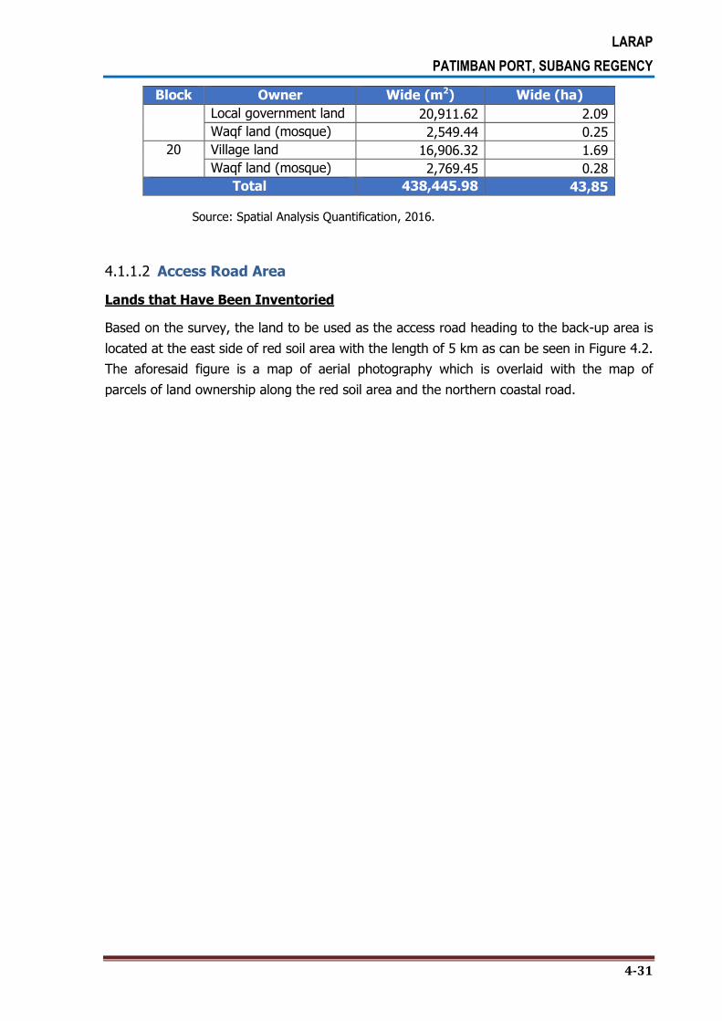
LARAP
PATIMBAN PORT, SUBANG REGENCY
4-31
Block Owner Wide (m2) Wide (ha)
Local government land 20,911.62 2.09
Waqf land (mosque) 2,549.44 0.25
20 Village land 16,906.32 1.69
Waqf land (mosque) 2,769.45 0.28
Total 438,445.98 43,85
Source: Spatial Analysis Quantification, 2016.
4.1.1.2 Access Road Area
Lands that Have Been Inventoried
Based on the survey, the land to be used as the access road heading to the back-up area is
located at the east side of red soil area with the length of 5 km as can be seen in Figure 4.2.
The aforesaid figure is a map of aerial photography which is overlaid with the map of
parcels of land ownership along the red soil area and the northern coastal road.

LARAP
PATIMBAN PORT, SUBANG REGENCY
4-32
Figure 4-2.
Map of Parcels of Lands that Have Been Inventoried for Access Road

LARAP
PATIMBAN PORT, SUBANG REGENCY
4-33
Based on the quantification and spatial analysis, the total wide of land in the five villages is
61.47 hectares, and the widest is located in Gempol Village, as can be seen in Table 4-4.
From the total wide of 61.47 hectares, some 43.16 hectares is owned by the local people
and 18.34 hectares is owned by the government. More detailed on the wide area per village,
and wide area owned by local people and government in each village is presented in Table
4-4 through Table 4-6.
Table 4-4. Wide of Land Per Village that Have Been Inventoried
Village Wide (m2) Wide (ha)
Gempol 268,579.28 26.86
Kalentambo 115,151.95 11.52
Kotasari 57,642.68 5.76
Pusakajaya 21,368.78 2.14
Pusakaratu 152,927.29 15.29
Total 615,669.98 61.57
Source: Spatial Analysis Quantification, 2016.
Table 4-5. Wide of Public Land Per Village that Have Been Inventoried
Village Wide (m2) Wide (ha)
Gempol 219,341.23 21.93
Kalentambo 115,151.95 11.52
Kotasari 53,802.90 5.38
Pusakajaya 20,908.51 2.09
Pusakaratu 23,092.76 2.31
Total 432,297.35 43.23
Source: Spatial Analysis Quantification, 2016.
Table 4-6.
Wide of Government Land Per Village that Have Been Inventoried
Village Wide (m2) Wide (ha)
Gempol 49,238.05 4.92
Kalentambo - -
Kotasari 3,839.78 0.38
Pusakajaya 460.27 0.05
Pusakaratu 129,834.53 12.98
Total 183,372.63 18.34
Source: Spatial Analysis Quantification, 2016.
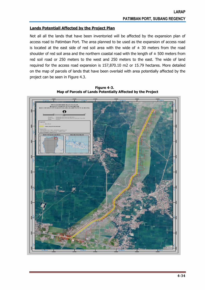
LARAP
PATIMBAN PORT, SUBANG REGENCY
4-34
Lands Potentiall Affected by the Project Plan
Not all all the lands that have been inventoried will be affected by the expansion plan of
access road to Patimban Port. The area planned to be used as the expansion of access road
is located at the east side of red soil area with the wide of ± 30 meters from the road
shoulder of red soil area and the northern coastal road with the length of ± 500 meters from
red soil road or 250 meters to the west and 250 meters to the east. The wide of land
required for the access road expansion is 157,870.10 m2 or 15.79 hectares. More detailed
on the map of parcels of lands that have been overlaid with area potentially affected by the
project can be seen in Figure 4.3.
Figure 4-3. Map of Parcels of Lands Potentially Affected by the Project

LARAP
PATIMBAN PORT, SUBANG REGENCY
4-35
Table 4-7. The Affected Wide of Land
Village Wide (m2) Wide (ha)
Gempol 81,790.30 8.18
Kalentambo 30,996.89 3.10
Kotasari 3,533.97 0.35
Pusakajaya 2,582.79 0.26
Pusakaratu 38,966.15 3.90
Luas Total 157,870.10 15.79
Source: Spatial Analysis Quantification, 2016.
Table 4-8. The Wide of Affected Public Land
Village Wide (m2) Wide (ha)
Gempol 74,164.71 7.42
Kalentambo 30,996.89 3.10
Kotasari 2,801.33 0.28
Pusakajaya 2,542.62 0.25
Pusakaratu 14,254.74 1.43
Luas Total 124,760.29 12.48
Source: Spatial Analysis Quantification, 2016.
Table 4-9. The Wide of Affected Government Land
Village Wide (m2) Wide (ha)
Gempol 7,625.59 0.76
Kalentambo - -
Kotasari 563.84 0.06
Pusakajaya 40.17 0.00
Pusakaratu 24,711.41 2.47
Luas Total 32,941.01 3.29
Source: Spatial Analysis Quantification, 2016.
Based on the policies and regulations in Indonesia, in quantifying the area affected, if the
remaining land area affected is less than 10%, then the whole a Plot inserted in the affected
areas. The following table is the land owners whose the remaining land affected less than
ten percent (10%).

LARAP
PATIMBAN PORT, SUBANG REGENCY
4-36
Table 4-10. The Land Ownner and Affected of Remaining Land Less Than 10 Percentage
CODE Land Owner Village
The wide
of Land (m2)
The Wide
of Affected Land (m2)
The Wide of
Remaining Land (m2)
Percentage
(%)
GP-19 *********** GEMPOL 1063.35 1056.32 7.03 0.66
GP-24 *********** GEMPOL 1299.80 1243.95 55.85 4.30
GP-25 *********** GEMPOL 1166.25 1145.02 21.23 1.82
GP-27 *********** GEMPOL 1498.64 1455.25 43.40 2.90
GP-30 *********** GEMPOL 1133.66 1103.94 29.72 2.62
GP-46 *********** GEMPOL 435.78 430.42 5.36 1.23
GP-54 *********** GEMPOL 1513.61 1502.47 11.14 0.74
KT-04 *********** KALENTAMBO 2071.56 1976.74 94.82 4.58
KT-06 *********** KALENTAMBO 2037.52 1959.97 77.55 3.81
KT-11 *********** KALENTAMBO 1238.80 1172.28 66.52 5.37
PR-03 *********** PUSAKARATU 633.88 623.15 10.73 1.69
PR-04 *********** PUSAKARATU 412.54 409.09 3.46 0.84
PR-07 *********** PUSAKARATU 969.75 966.66 3.09 0.32
PR-22 *********** PUSAKARATU 2015.68 1870.67 145.01 7.19
TOTAL 574.90
Source: Spatial Analysis Quantification, 2016.
4.1.2. Number of Parcels of Lands and Landowners
4.1.2.1 Back-Up Area
Based on the survey, there are 266 parcels of lands with 156 landowners in theback-up area
of each block. There are only a few of the landowners in the back-up area that have more
than one parcels of lands and are distributed in different blocks. For this reason, as seen in
Table 5-7, the total number of landowners in each block, i.e. 188 persons, does not
represent the actual number of landowners. More detailed of the number of parcels of lands
and landowners can be seen in Table 4-11.
Table 4-11.
Number of Parcels of Lands and Landowners
Block Parcel of Land Landowner
15 80 50
16 27 25
17 75 43
18 15 13
19 46 35
20 23 22
Total 266 *156
*Note: This is not the total parcels of lands per block, but simply based on the real landowners.

LARAP
PATIMBAN PORT, SUBANG REGENCY
4-37
4.1.2.2 Access Road
Based on the survey, there are 106 landowners in Gempol Village, Kalentambo Village, Kota
Sari Village, Pusaka Jaya Village, and Pusaka Ratu Village. Meanwhile, the number of parcels
of lands potentially affected by the expansion of access road for the project is 229 parcels of
land. The number of landowners and the parcels of lands per village are presented in Table
4-12.
Table 4-12. Number of Parcels of Lands and Landowners per Village
Village Parcel of Land Landowner
Gempol 56 47
Kalentembo 20 18
Kotasari 19 19
Pusakajaya 7 7
Pusakaratu 20 19
Total 122 106 Source: Spatial Analysis Quantification, 2016.
4.1.3. Status of Land Ownership
4.1.3.1 Back Up Area
Based on the identification of land ownership status in the project area of Patimban Port
development, in overall, the land ownership status is divided into two categories, namely
Private Property Land and State-Owned Land. Definition of respective land ownership status
can be described as follows:
1. Private Property Land, in this case is a land attributed with ownership document in
the form of Girik/Tax Payment Document, Deed of Sale and Purchase, or Certificate of
Ownership Right, Right to Cultivate, Right to Use, and Right to Manage Land. The lands
attributed with ownership right in Patimban Village are owned by individuals or
companies.
2. Government-Owned Land; among others are:
State-Owned Land which use, management and whatsoever has not been
mandated to local government. This type of land includes land along the riverbanks
or riparian zone and newly formed land due to the accumulation of marine
materials’ sedimentation process.
Village-Owned Land, which in this case is the land allocated for the village’s public
facilities.
Bengkok Land, which in this case is the village land that is not intended for public
use.

LARAP
PATIMBAN PORT, SUBANG REGENCY
4-38
Subang Regency Land, which in this case is in the form of parcels of land that are
intended as sample for backfill volume estimation for the Patimban Port
development project.
The above mentioned land ownership status is compiled through the asset survey by
distributing questionnaires to potentially affected people, whereby 25.97% status as the
owner, the owner and tenants 41.56%, and the remaining 32.47% status as tenants. A
complete overview of the status of land ownership can be seen in Table 4-13.
Table 4-13.
Ownership Status
No Block
Land Ownership Status
Total Owner
Owner and Tenant
Tenant
1 15 0 45 0 45
2 16 0 15 0 15
3 17 0 36 0 36
4 18 9 0 4 13
5 19 33 0 67 100
6 20 18 0 4 22
Total 60 96 75 231
Prosentase 25.97% 41.56% 32.47% 100.00%
Source: Questionnaire Data Processing Result, 2016
Of all the parcels of lands, most of them are attributed with legally ownership documents,
such as certificates, Girik, and deed of sale and purchase.Of the overall plot, most have
ownership documents or documents that explain the legal property, such as certificates,
girik, and deed of sale and purchase of land. The number of citizens who proof of ownership
such have certificate, girik, and the deed of sale and purchase as much as 96.1%, and that
no documents or can not show valid documents as much as 2.9%. In this case, the
aforesaid people either don’t have any land ownership document, do not understand the
issue, or they do show the document but it’s not the legal proof of ownership right of the
land. In the land acquisition or compensation process, in the relatively similar land
conditions, the proof of ownership document should also determine the amount of
compensation, as this document is a legal land ownership right for the people. The higher
statusof ownership, could be stronger to get higher compensation.

LARAP
PATIMBAN PORT, SUBANG REGENCY
4-39
Table 4-14.
Proof of Ownership Document of the Potentially Affected Land
Proof of Ownership
Document
Block Total %
15 16 17 18 19 20
Certificate 13 3 14 6 8 5 49 47.1%
Without Certificate 0 1 0 1 0 1 3 2.9%
Girik/Tax Payment 2 0 5 4 4 1 16 15.4%
Deed of Sale and Purchase 12 1 17 0 1 5 36 34.6%
Total 27 5 36 11 13 12 104 100.0%
Source: Questionnaire Data Processing Result, 2016
The tenants in the affected area majority were occupying land under permit without paying
(60%) and rent (40.0%).
Table 4-15. Land Ownership Status (Tenant)
Land Ownership Status Blok
Total % 15 16 17 18 19 20
Rent 0 0 0 0 18 0 18 40.0%
Occupying land under permit
without paying 0 0 0 0 23 4 27 60.0%
Total 0 0 0 0 41 4 45 100.0%
Source: Questionnaire Data Processing Result, 2016
Based on the survey, 50.7% of the landowners have land in the potentially project affected
area and in other locations, and the rest of 49.3% of the landowners do not have land
elsewhere.
Table 4-16.
Land Ownership in Other Places
Asset
Occupation Status
Land Ownership in
Other Places
Block
Total % 15 16 17 18 19 20
Owner Yes 8 1 13 2 9 4 37 50.7%
No 15 2 9 3 2 5 36 49.3%
Total 23 3 22 5 11 9 73 100.0%
Tenant Yes 9 9 64.3%
No 5 5 35.7%
Total 14 14 100.0%
Total Yes 8 1 13 2 18 4 46 52.9%
No 15 2 9 3 7 5 41 47.1%
Total 23 3 22 5 25 9 87 100.0%
Source: Questionnaire Data Processing Result, 2016

LARAP
PATIMBAN PORT, SUBANG REGENCY
4-40
Based on the survey, 35.7% of the landowners have land in other location, but still in the
same village that potentially affected by the project. Meanwhile, 50.0% of the landowners
have land in other villages but still in the same sub-district region.
Table 4-17. Location of Land Ownership in Other Places
Asset Occupation
Status
Location of Land in Other Places Block
Total % 15 17 19 20
Owner
The same village 0 1 1 1 3 42.9%
Different village, but in the same sub-district 0 1 0 1 2 28.6%
Different village and sub-district 1 0 1 0 2 28.6%
Total 1 2 2 2 7 100.0
%
Tenant The same village 2 2 28.6%
Different village, but in the same sub-district 5 5 71.4%
Total 7 7 100.0
%
Total
The same village 0 1 3 1 5 35.7%
Different village, but in the same sub-district 0 1 5 1 7 50.0%
Different village and sub-district 1 0 1 0 2 14.3%
Total 1 2 9 2 14 100.0
%
Source: Questionnaire Data Processing Result, 2016
With regard to the origin of land ownership, especially the property right, based on the
survey, 71.8% of the lands are attained through the land purchasing transaction, while
27.1% of the lands are attained through legacy or grant scheme.
Table 4-18. The Origin of Land Ownership Status
Asset Occupation Status
The Origin of Land Ownership Status
Block Total %
15 16 17 18 19 20
Owner Legacy, grant 11 0 9 0 1 2 23 28.4%
Purchase 15 6 14 5 9 8 57 70.4%
Other 0 0 0 0 1 0 1 1.2%
Total 26 6 23 5 11 10 81 100.0%
Tenant Purchase 4 4 100.0%
Total 4 4 100.0%
Total Legacy, grant 11 0 9 0 1 2 23 27.1%
Purchase 15 6 14 5 13 8 61 71.8%
Other 0 0 0 0 1 0 1 1.2%
Total 26 6 23 5 15 10 85 100.0%
Source: Questionnaire Data Processing Result, 2016

LARAP
PATIMBAN PORT, SUBANG REGENCY
4-41
4.1.3.2 Access Road Area
Land affected by the project are mostly owned by the PAP’s. As many as 60 percent
ownership of the land affected by the generally freehold ownership with the proof ownership
by certificate, deed of purchase, and girik/proof by tax(Table 4-19 and Table 4-20).
Table 4-19.
The Ownership Land Status
No Village
Ownership Land Status
Total Owner Rent
Occupying with permit without
Paying
Occuying with permit
No Answer
1 Gempol 33 0 3 0 12 48
2 Kalentambo 11 4 0 0 4 19
3 Kotasari 20 1 1 0 6 28
4 Pusakajaya 4 2 3 1 4 14
5 Pusakaratu 9 0 5 0 5 19
6 Rancadaka 1 0 0 0 1 2
Total 78 7 12 1 32 130
Prosentase 60,0% 5,4% 9,2% 0,8% 24,6% 100,0%
Source: Questionnaire Data Processing Result, 2016
Of the overall plot, most have ownership documents or documents that explain the legal
property, such as certificates, girik, and deed of sale and purchase of land. The number of
citizens who do not have documents or not be able to show a valid document as much as
1.3 percent. The reason citizens in such cases because they do not have documents, not
knowing, or they show the document but has no relevance to the status ownership land
assets. In the process of restitution or compensation, the land conditions are relatively the
same, proof of ownership should also determine the amount of compensation or indemnity,
as proof of ownership is legal proof of land rights. The higher the status of ownership, land
rights should be even stronger.
Table 4-20.
The Proof of Letter/Tenure Project Affected
Village
The Letter of Proof Ownership Status
Total Certificate %
Without Certificate
% Girik/Proof
of Tax Payment
% Deed of Sale and Purchase
%
Gempol 15 19,0% 0 0,0% 10 12,7% 4 5,1% 29
Kalentambo 9 11,4% 0 0,0% 3 3,8% 1 1,3% 13
Kotasari 2 2,5% 1 1,3% 15 19,0% 0 0,0% 18
Pusakajaya 2 2,5% 0 0,0% 2 2,5% 0 0,0% 4
Pusakaratu 1 1,3% 0 0,0% 11 13,9% 2 2,5% 14

LARAP
PATIMBAN PORT, SUBANG REGENCY
4-42
Village
The Letter of Proof Ownership Status
Total Certificate %
Without Certificate
% Girik/Proof
of Tax Payment
% Deed of Sale and Purchase
%
Rancadaka 0 0,0% 0 0,0% 0 0,0% 1 1,3% 1
Total 29 36,7% 1 1,3% 41 51,9% 8 10,1% 79
Source: Questionnaire Data Processing Result, 2016
As for the origin of land tenure, especially with the status of land owned, are generally
obtained from the purchase of 59.7 percent. While the legacy or the gift of 40.3 percent.
Table 4-21.
The Origin of Land Tenure/Land Owned
Village
The Origin of Land Tenue
Total Legacy, Gift % Purchase %
Gempol 12 15,6% 19 24,7% 31
Kalentambo 5 6,5% 3 3,9% 8
Kotasari 5 6,5% 11 14,3% 16
Pusakajaya 5 6,5% 3 3,9% 8
Pusakaratu 4 5,2% 9 11,7% 13
Rancadaka 0 0,0% 1 1,3% 1
Total 31 40,3% 46 59,7% 77
Source: Questionnaire Data Processing Result, 2016
In addition to owning land in the affected area, affected people also have the land in other
place as much as 52.1 percent, while 47.9 percent of the residents do not have the land in
other place.
Table 4-22. Land Ownership in Other Place
Village Land Ownership in other place
Total Yes % No %
Gempol 24 32,9% 7 9,6% 31
Kalentambo 3 4,1% 3 4,1% 6
Kotasari 5 6,8% 9 12,3% 14
Pusakajaya 1 1,4% 7 9,6% 8
Pusakaratu 4 5,5% 9 12,3% 13
Rancadaka 1 1,4% 0 0,0% 1
Total 38 52,1% 35 47,9% 73
Source: Questionnaire Data Processing Result, 2016
LARAP
PATIMBAN PORT, SUBANG REGENCY
4-43
The location of land ownership in other places there are located in the same village with the
location of the affected land (80.0%) and were in different villages in the same district
(17.1%).
Table 4-23. The Location of Land Ownership in Other Place
Village
The Location of Land Ownership in Other Place
Total In the same Village with the affected
land %
In different village with the same
district %
In different village with different
district %
Gempol 20 57,1% 3 8,6% 0 0,0% 23
Kalentambo 1 2,9% 2 5,7% 0 0,0% 3
Kotasari 3 8,6% 0 0,0% 1 2,9% 4
Pusakajaya 1 2,9% 0 0,0% 0 0,0% 1
Pusakaratu 2 5,7% 1 2,9% 0 0,0% 3
Rancadaka 1 2,9% 0 0,0% 0 0,0% 1
Total 28 80,0% 6 17,1% 1 2,9% 35
Source: Questionnaire Data Processing Result, 2016
4.1.4. The Land Use Condition
4.1.4.1 Back-Up Area
The land use refers to an area of land that is used for a specific purpose. Based on the
spatial analysis and field validation results, the use of land in the development plan of
Patimban Port in Patimban Village is classified into 9 categoris as can be seen in Table 5-10.
With reference to the spatial analysis quantification result, the widest land use in the back-
up area with the wide of 207.24 hectares is for paddy field, and then followed by the land
use for brackish water pond with the wide of 113.15 hectares. While the rest of the area are
used for farm field, cemetery, meadow, house yard, road, irrigation, and river. The wide of
land use in back-up area is highlighted in Table 4-24 and the land use in each block is
summarized in Table 4-25.

LARAP
PATIMBAN PORT, SUBANG REGENCY
4-44
Table 4-24.
The Wide of Land Use in Back-Up Area
No Land Use Wide (m2) Wide (ha)
1 Irrigation 9,975.27 1.0
2 Road 34,164.84 3.42
3 Cemetery 5,318.89 0.53
4 Farm field 186,171.02 18.62
5 Constructed land 87,733.07 8.77
6 Meadow 26,183.63 2.62
7 Paddy field 2,073,269.67 207.33
8 River 7,895.23 0.79
9 Brackish water pond 1,131,524.54 113.15
Total 3,562,297.99 356.23 Source: Spatial Analysis Quantification, 2016
Table 4-25. The Wide of Land use in each Block of the Patimban Port Development Project
BLOCK Land Use Wide (m2) Wide (Ha)
15 Irrigation 669.19 0.07
Road 22,387.91 2.24
Paddy field 734,216.54 73.42
Total Wide of Block 15 756,372.28 75.64
Paddy field 207,374.39 20.74
Brackish water pond 14,731.46 1.47
Total Wide of Block 16 222,105.85 22.21
17 Irrigation 5,920.45 0.59
Road 2,253.24 0.23
Constructed land 9,154.73 0.92
Paddy field 712,339.09 71.23
Total Wide of Block 17 729,667.51 72.97
18 Irrigation 2,919.44 0.29
Road 1,390.97 0.14
Paddy field 49,672.12 4.97
Brackish water pond 323,871.88 32.39
Total Wide of Block 18 377,854.42 37.79
19 Irrigation 466.18 0.05
Road 5,326.58 0.53
Cemetery 2,549.44 0.25
Farm field 90,617.21 9.06
Constructed land 64,983.19 6.50
Meadow 26,183.63 2.62
Paddy field 325,624.53 32.56
River 7,895.23 0.79
Brackish water pond 566,494.59 56.65
Total Wide of Block 19 1,090,140.59 109.01
20 Road 2,806.14 0.28

LARAP
PATIMBAN PORT, SUBANG REGENCY
4-45
BLOCK Land Use Wide (m2) Wide (Ha)
Cemetery 2,769.45 0.28
Farm field 95,553.81 9.56
Constructed land 13,595.14 1.36
Paddy field 44,043.00 4.40
Brackish water pond 226,426.61 22.64
Total Wide of Block 20 385,194.15 38.52
Total Wide of All Blocks 3,562,297.99 356.23 Source: Spatial Analysis Quantification, 2016
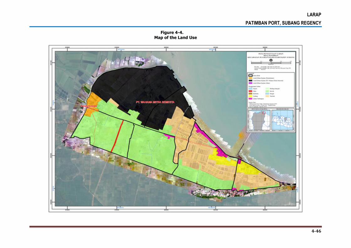
LARAP
PATIMBAN PORT, SUBANG REGENCY
4-46
Figure 4-4.
Map of the Land Use

LARAP
PATIMBAN PORT, SUBANG REGENCY
4-47
4.1.4.2 Access Road
Based on the quantification result, the total wide area of land owned by local community
and the government is 61.50 hectares. There are several land uses in the area. The widest
land use in the area is for paddy field with the wide of 28.64 hectares in the land owned by
local people, and 17.21 hectares in the land owned by government. The quantification result
on the wide of land use in the potentially project affected area is presented in Table 4-26
and Table4-27.
Table 4-26.
The Wide of Land Use Owned by People and Government Inventoried
No Land Use Wide (m2) Wide (ha)
Local People
1 Brackish water pond 875.38 0.09
2 Irrigation 952.25 0.10
3 Road 112.76 0.01
4 Constructed land 43,440.29 4.34
5 Meadow 10,519.23 1.05
6 Farmfield 89,984.27 9.00
7 Paddy field 286,413.16 28.64
Total 432,297.35 43.23
Government
1 Irrigation 981.80 0.10
2 Road 3,539.47 0.35
3 Cemetery 1,291.15 0.13
4 Constructed land 1,529.09 0.15
5 Farmfield 656.27 0.07
6 Paddy field 172,058.63 17.21
7 River 1,101.61 0.11
8 Riverbank 2,214.61 0.22
Total 183,372.63 18.34
Total 615,669.98 61.57
Source: Quantification of Spatial Analysis, 2016

LARAP
PATIMBAN PORT, SUBANG REGENCY
4-48
Table 4-27.
The Wide of Land Use in Each Village Inventoried
Village Land Use Wide (m2) Wide (ha)
Gempol Irrigation 324.69 0.03
Road 2,403.47 0.24
Constructed land 4,168.37 0.42
Farm field 61,529.60 6.15
Paddy field 199,791.58 19.98
River 361.58 0.04
Sub-Total 268,580.85 26.86
Kalentambo Irrigation 952.25 0.10
Paddy field 114,199.69 11.42
Sub-Total 114,501.70 11.52
Kota Sari Irrigation 657.11 0.07
Road 961.55 0.10
Constructed land 23,947.86 2.39
Meadow 10,519.23 1.05
Farm field 16,224.59 1.62
Paddy field 4,536.43 0.45
River 223.27 0.02
Riverbank 572.63 0.06
Sub-Total 57,642.68 5.76
Pusaka Jaya Brackish water pond 875.38 0.09
Road 208.58 0.02
Constructed land 16,853.14 1.69
Paddy field 3,171.10 0.32
River 260.58 0.03
Sub-Total 21,368.78 2.14
Pusaka Ratu Road 78.64 0.01
Cemetery 1,291.15 0.13
Farm field 12,884.78 1.29
Paddy field 136,772.99 13.68
River 256.18 0.03
Riverbank 1,641.98 0.16
Sub-Total 152,925.72 15.29
Total of All Villages 615,669.98 61.57
Source: Quantification of Spatial Analysis, 2016
4.1.5. Potentially Project Affected Buildings
4.1.5.1 Back-Up Area
Based on the field survey result, there are 216 buildings that potentially affected by the
project in all blocks. The buildings consist of permanent buildings in the residential area of
Patimban Village, wood cottages in the middle of paddy fields and brackish water ponds, as
well as semi-permanent buildings used as a place for retailing business along the Patimban
coastal line. The number of buildings on every block is presented in Table 4-28.

LARAP
PATIMBAN PORT, SUBANG REGENCY
4-49
Table 4-28.
Number of Buildings in Each Block
Block Number of Building (Unit)
15 4
16 4
17 6
18 19
19 143
20 40
Total 216
Source: Quantification of Spatial Analysis, 2016
Table 4-29. The Detail Number of Constrcted Land and BuildinginBack Up Area
BLOCK LAND OWNER LAND TENANTS
NUMBER
OF BUILDING
WIDE OF BUILDING m2
15 *********** - 1 59.25
*********** - 3 53.14
16 *********** - 3 136.37
*********** - 1 19.84
17 *********** - 1 10.20
*********** - 2 92.78
*********** - 1 13.32
*********** - 2 3,296.88
18 *********** - 1 68.40
*********** *********** 1 19.44
2 50.84
*********** - 2 71.01
*********** - 2 392.38
1 12.51
*********** - 2 397.53
*********** - 2 47.70
*********** - 1 22.48
*********** - 3 44.61
*********** - 1 42.33
*********** - 1 17.19
19 *********** - 1 17.33
*********** - 1 124.16
*********** - 3 360.22
*********** - 1 230.80
*********** *********** 1 66.60
- 2 136.77
*********** *********** 1 81.47

LARAP
PATIMBAN PORT, SUBANG REGENCY
4-50
BLOCK LAND OWNER LAND TENANTS
NUMBER
OF BUILDING
WIDE OF BUILDING m2
5 361.18
*********** - 1 34.26
*********** *********** 1 90.31
*********** 2 217.06
*********** - 1 139.31
*********** *********** 1 63.89
*********** 2 214.70
*********** *********** 2 390.34
*********** 2 378.91
*********** 2 244.00
*********** 1 214.66
*********** 1 202.01
*********** 1 117.14
*********** 2 159.87
*********** 1 183.73
*********** *********** 1 173.49
*********** 2 159.90
*********** 1 284.91
*********** *********** 4 237.45
*********** *********** 1 295.97
*********** 1 130.41
*********** 1 291.64
*********** 1 148.07
*********** *********** 1 245.72
5 552.36
*********** *********** 1 179.19
*********** 1 111.99
*********** 2 226.47
*********** 1 473.38
*********** 2 248.37
*********** 1 118.20
*********** 1 57.34
*********** 1 109.07
*********** 3 460.17
*********** 3 78.55
*********** 1 116.00
*********** 1 43.31
*********** 3 417.56
*********** 2 248.64
*********** 1 194.25
*********** 1 159.27
*********** 3 257.34
*********** 1 99.88
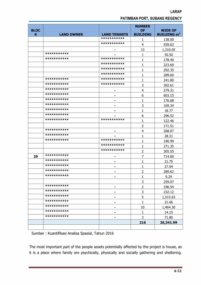
LARAP
PATIMBAN PORT, SUBANG REGENCY
4-51
BLOCK LAND OWNER LAND TENANTS
NUMBER
OF BUILDING
WIDE OF BUILDING m2
*********** 1 138.00
*********** 4 559.63
- 13 1,310.05
*********** - 1 50.50
*********** *********** 1 178.40
*********** 1 223.69
*********** 1 292.35
*********** 1 289.60
*********** *********** 1 241.80
*********** *********** 3 302.61
*********** - 4 279.31
*********** - 6 603.15
*********** - 1 176.68
*********** - 3 169.34
*********** - 1 18.77
*********** - 6 296.52
*********** *********** 1 122.46
2 171.51
*********** - 4 268.07
*********** - 1 28.31
*********** *********** 1 190.99
*********** 1 271.35
*********** 2 305.55
20 *********** - 7 714.60
*********** - 1 21.75
*********** - 1 27.04
*********** - 2 289.62
*********** - 1 9.29
3 259.07
*********** - 2 196.54
*********** - 3 232.12
*********** - 5 1,515.63
*********** - 1 21.66
*********** - 10 1,464.30
*********** - 1 14.15
*********** - 3 71.80
216 26,341.99
Sumber : Kuantifikasi Analisa Spasial, Tahun 2016
The most important part of the people assets potentially affected by the project is house, as
it is a place where family are psychically, physically and socially gathering and sheltering.

LARAP
PATIMBAN PORT, SUBANG REGENCY
4-52
Based on the field survey resultby taking a sample of 80 respondents the types or the uses
of buildings potentially affected by the project are 32 units (40.0%) of business houses, 17
units (21.3%) of living houses, and 11 units (13.8%) of warehouses. Other types of
buildings potentially affected by the project are animal cage, shop-house, office-house, and
others as can be seen in Table 4-30.
Table 4-30.
Type/Use of Buildings
Asset Occupation Status
Type/Use of Buildings Block
Total % 17 18 19 20
Owner
Living house 0 3 5 1 9 27.3%
Business house 0 0 4 0 4 12.1%
Shop-house 0 0 2 0 2 6.1%
Office-house 0 0 1 2 3 9.1%
Warehouse 1 3 4 2 10 30.3%
Cage 1 0 2 0 3 9.1%
Others 0 0 0 2 2 6.1%
Total 2 6 18 7 33 100.0%
Tenant
Living house 0 0 8 0 8 17.0%
Business house 0 0 28 0 28 59.6%
Shop-house 0 0 8 0 8 17.0%
Warehouse 0 0 1 0 1 2.1%
Cage 0 0 2 0 2 4.3%
Total 0 0 47 0 47 100.0%
Total
Living house 0 3 13 1 17 21.3%
Business house 0 0 32 0 32 40.0%
Shop-house 0 0 10 0 10 12.5%
Office-house 0 0 1 2 3 3.8%
Warehouse 1 3 5 2 11 13.8%
Cage 1 0 4 0 5 6.3%
Others 0 0 0 2 2 2.5%
Total 2 6 65 7 80 100.0%
Source: Questionnaire Data Processing Result, 2016
Based on the survey, there 33 units or 46.5% of single semi-permanent buildings in the
potentially affected area as can be seen in Table 4-31.
Table 4-31.
Building Specification
Asset Occupation
Status Building Specification
Block Total %
17 18 19 20
Owner
Single permanent 0 0 4 3 7 23.3%
Permanent building plot 0 0 0 3 3 10.0%
Single semi-permanent 1 4 4 0 9 30.0%
Semi-permanent building plot 0 0 1 0 1 3.3%
Single non-permanent 0 1 7 1 9 30.0%
Multy-storey non-permanent 1 0 0 0 1 3.3%
Sub-Total 2 5 16 7 30 100.0%

LARAP
PATIMBAN PORT, SUBANG REGENCY
4-53
Asset Occupation
Status Building Specification
Block Total %
17 18 19 20
Tenant
Single permanent 0 0 1 0 1 2.4%
Permanent building plot 0 0 1 0 1 2.4%
Single semi-permanent 0 0 24 0 24 58.5%
Multy-storey semi-permanent 0 0 2 0 2 4.9%
Single non-permanent 0 0 13 0 13 31.7%
Sub-Total 0 0 41 0 41 100.0%
Total
Single permanent 0 0 5 3 8 11.3%
Permanent building plot 0 0 1 3 4 5.6%
Single semi-permanent 1 4 28 0 33 46.5%
Semi-permanent building plot 0 0 1 0 1 1.4%
Multy-storey semi-permanent 0 0 2 0 2 2.8%
Single non-permanent 0 1 20 1 22 31.0%
Multy-storey non-permanent 1 0 0 0 1 1.4%
Total 2 5 57 7 71 100.0%
Source: Questionnaire Data Processing Result, 2016
Based on the survey, there are 31 units (48.4%) of buildings constructed in 2001-2010, 16
units (25%) of buildings constructed in 2011-2016, and the rest of the buildings are
constructed before 2000 as can be seen in Table 4-32.
Table 4-32.
Construction Year of the Buildings
Asset Occupation Status Construction Year Block
Total % 17 18 19 20
Owner
1980 – 1990 1 1 1 0 3 11.1%
1991 – 2000 0 0 1 3 4 14.8%
2001 – 2010 0 1 8 0 9 33.3%
2011 – 2016 1 4 3 3 11 40.7%
Sub-Total 2 6 13 6 27 100.0%
Tenant
1980 – 1990 0 0 0 0 1 2.7%
1991 – 2000 0 0 9 0 9 24.3%
2001 – 2010 0 0 22 0 22 59.5%
2011 – 2016 0 0 5 0 5 13.5%
Sub-Total 0 0 37 0 37 100.0%
Total
1980 – 1990 1 1 1 0 4 6.3%
1991 – 2000 0 0 10 3 13 20.3%
2001 – 2010 0 1 30 0 31 48.4%
2011 – 2016 1 4 8 3 16 25.0%
Total 2 6 50 6 64 100.0%
Source: Questionnaire Data Processing Result, 2016
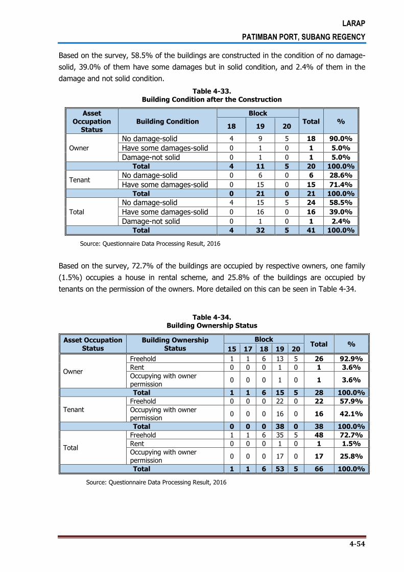
LARAP
PATIMBAN PORT, SUBANG REGENCY
4-54
Based on the survey, 58.5% of the buildings are constructed in the condition of no damage-
solid, 39.0% of them have some damages but in solid condition, and 2.4% of them in the
damage and not solid condition.
Table 4-33.
Building Condition after the Construction
Asset
Occupation Status
Building Condition
Block
Total % 18 19 20
Owner
No damage-solid 4 9 5 18 90.0%
Have some damages-solid 0 1 0 1 5.0%
Damage-not solid 0 1 0 1 5.0%
Total 4 11 5 20 100.0%
Tenant No damage-solid 0 6 0 6 28.6%
Have some damages-solid 0 15 0 15 71.4%
Total 0 21 0 21 100.0%
Total
No damage-solid 4 15 5 24 58.5%
Have some damages-solid 0 16 0 16 39.0%
Damage-not solid 0 1 0 1 2.4%
Total 4 32 5 41 100.0%
Source: Questionnaire Data Processing Result, 2016
Based on the survey, 72.7% of the buildings are occupied by respective owners, one family
(1.5%) occupies a house in rental scheme, and 25.8% of the buildings are occupied by
tenants on the permission of the owners. More detailed on this can be seen in Table 4-34.
Table 4-34. Building Ownership Status
Asset Occupation
Status
Building Ownership
Status
Block Total %
15 17 18 19 20
Owner
Freehold 1 1 6 13 5 26 92.9%
Rent 0 0 0 1 0 1 3.6%
Occupying with owner
permission 0 0 0 1 0 1 3.6%
Total 1 1 6 15 5 28 100.0%
Tenant
Freehold 0 0 0 22 0 22 57.9%
Occupying with owner permission
0 0 0 16 0 16 42.1%
Total 0 0 0 38 0 38 100.0%
Total
Freehold 1 1 6 35 5 48 72.7%
Rent 0 0 0 1 0 1 1.5%
Occupying with owner
permission 0 0 0 17 0 17 25.8%
Total 1 1 6 53 5 66 100.0%
Source: Questionnaire Data Processing Result, 2016
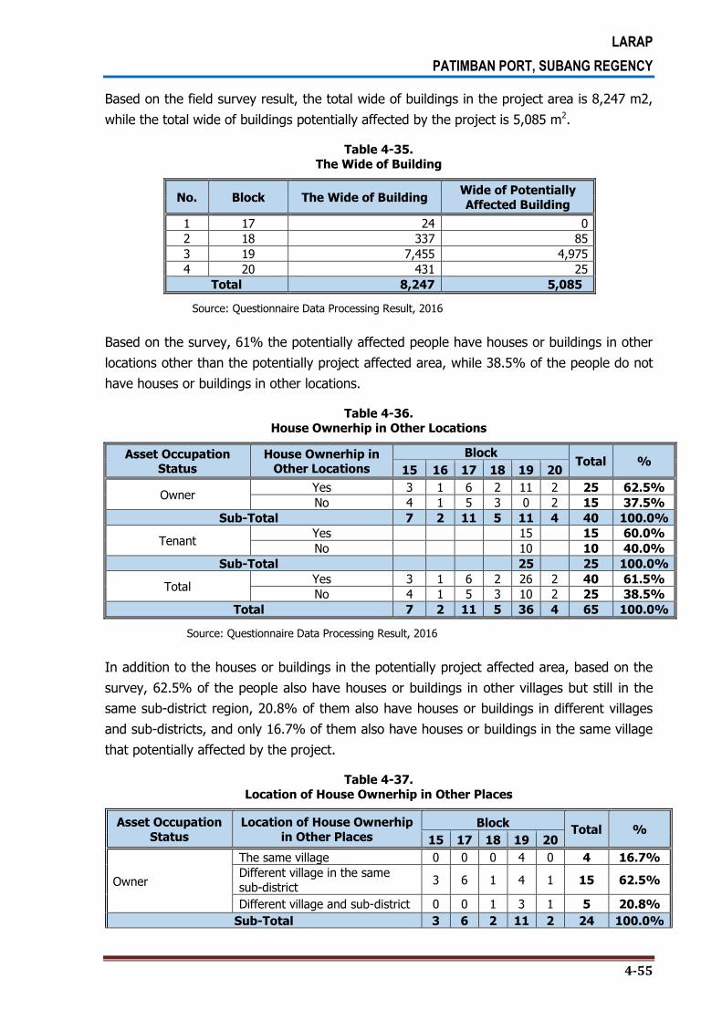
LARAP
PATIMBAN PORT, SUBANG REGENCY
4-55
Based on the field survey result, the total wide of buildings in the project area is 8,247 m2,
while the total wide of buildings potentially affected by the project is 5,085 m2.
Table 4-35.
The Wide of Building
No. Block The Wide of Building Wide of Potentially
Affected Building
1 17 24 0
2 18 337 85
3 19 7,455 4,975
4 20 431 25
Total 8,247 5,085
Source: Questionnaire Data Processing Result, 2016
Based on the survey, 61% the potentially affected people have houses or buildings in other
locations other than the potentially project affected area, while 38.5% of the people do not
have houses or buildings in other locations.
Table 4-36.
House Ownerhip in Other Locations
Asset Occupation Status
House Ownerhip in Other Locations
Block Total %
15 16 17 18 19 20
Owner Yes 3 1 6 2 11 2 25 62.5%
No 4 1 5 3 0 2 15 37.5%
Sub-Total 7 2 11 5 11 4 40 100.0%
Tenant Yes 15 15 60.0%
No 10 10 40.0%
Sub-Total 25 25 100.0%
Total Yes 3 1 6 2 26 2 40 61.5%
No 4 1 5 3 10 2 25 38.5%
Total 7 2 11 5 36 4 65 100.0%
Source: Questionnaire Data Processing Result, 2016
In addition to the houses or buildings in the potentially project affected area, based on the
survey, 62.5% of the people also have houses or buildings in other villages but still in the
same sub-district region, 20.8% of them also have houses or buildings in different villages
and sub-districts, and only 16.7% of them also have houses or buildings in the same village
that potentially affected by the project.
Table 4-37.
Location of House Ownerhip in Other Places
Asset Occupation
Status
Location of House Ownerhip
in Other Places Block
Total % 15 17 18 19 20
Owner
The same village 0 0 0 4 0 4 16.7%
Different village in the same
sub-district 3 6 1 4 1 15 62.5%
Different village and sub-district 0 0 1 3 1 5 20.8%
Sub-Total 3 6 2 11 2 24 100.0%

LARAP
PATIMBAN PORT, SUBANG REGENCY
4-56
Asset Occupation
Status
Location of House Ownerhip
in Other Places Block
Total % 15 17 18 19 20
Tenant
The same village dampak 9 9 69.2%
Different village in the same sub-district
3 3 23.1%
Different village and sub-district 1 1 7.7%
Sub-Total 13 13 100.0%
Total
The same village dampak 0 0 0 13 0 13 35.1%
Different village in the same
sub-district 3 6 1 7 1 18 48.6%
Different village and sub-district 0 0 1 4 1 6 16.2%
Total 3 6 2 24 2 37 100.0%
Source: Questionnaire Data Processing Result, 2016
4.1.5.2 Access Road
Inventoried Buildings
Based on the survey, the total wide of buildings in the planned access road area is
13,002.72 m2 with 42 owners and 17 tenants. The names of the owners and tenants and
the wide of buildings that have been inventoried can be seen in Table 4-38.
Table 4-38. Name of Owners and Tenants and the Wide of Buildings that have been Inventoried
Village No. Owner Tenant Wide (m2)
Gempol 1 *********** - 122.73
2 *********** *********** 139.94
3 *********** - 182.00
4 *********** *********** 115.14
5 *********** - 135.38
6 *********** - 140.68
7 *********** *********** 114.08
*********** 83.61
- 207.36
Kota Sari 1 *********** - 288.89
2 *********** *********** 155.49
3 *********** - 277.21
4 *********** *********** 251.67
5 *********** - 846.51
6 *********** - 42.85
7 *********** - 858.13
8 *********** *********** 94.12
9 *********** - 184.62
10 *********** - 62.63
11 *********** - 119.79
12 *********** *********** 108.31
13 *********** - 161.49
14 *********** - 461.56
15 *********** *********** 67.21
- 236.89
16 *********** - 107.74
17 *********** - 171.52
18 *********** *********** 221.92

LARAP
PATIMBAN PORT, SUBANG REGENCY
4-57
Village No. Owner Tenant Wide (m2)
19 *********** *********** 260.53
20 *********** - 80.74
21 *********** - 71.29
22 *********** - 730.96
23 *********** *********** 147.24
Pusakajaya 1 *********** *********** 119.79
- 425.85
2 *********** - 71.30
3 *********** - 574.31
4 *********** *********** 230.85
*********** 105.40
*********** 232.59
5 *********** *********** 299.30
6 *********** - 186.35
7 *********** - 199.45
8 *********** - 2,885.97
9 *********** - 57.66
10 *********** - 85.21
Pusakaratu 1 *********** - 103.66
2 *********** - 174.82
Total 42 17 13,002.72
Source: Quantification of Spatial Analysis, 2016
The building area affected quantifiable 2.336,39 m2, the buildings affected are in the four
villages of five villages inventoried. Is not identified buildings in the affected area in the
village of Kalentambo.
Table 4-39. Number and Wide Affected Building in Access Road
Village Name of the Land
Owner
Code Name of Tenant Wide (m2)
GEMPOL *********** GP-33 - 122.73
*********** GP-20 *********** 139.94
*********** GP-46 - 182.00
*********** GP-51 *********** 115.14
*********** GP-50 - 135.38
*********** GP-47 - 140.68
*********** GP-48 *********** 114.08
*********** 83.61
- 207.36
KOTASARI *********** KS-04 *********** 32.02
*********** KS-16 *********** 251.67
*********** KS-05 - 78.43
*********** KS-15 *********** 94.12
*********** KS-14 - 184.62
*********** KS-24 *********** 67.21
*********** KS-11 - 1.62
*********** KS-08 *********** 19.71
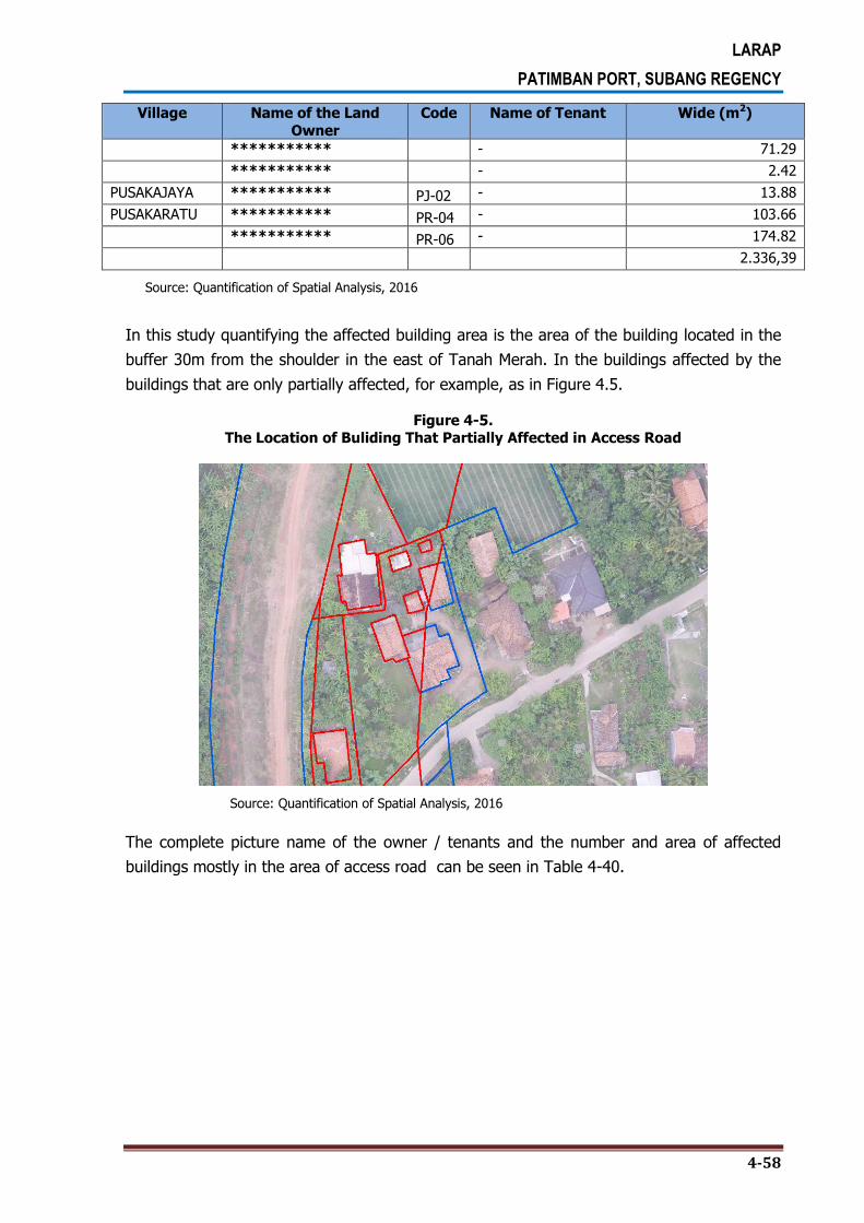
LARAP
PATIMBAN PORT, SUBANG REGENCY
4-58
Village Name of the Land
Owner
Code Name of Tenant Wide (m2)
*********** - 71.29
*********** - 2.42
PUSAKAJAYA *********** PJ-02 - 13.88
PUSAKARATU *********** PR-04 - 103.66
*********** PR-06 - 174.82
2.336,39
Source: Quantification of Spatial Analysis, 2016
In this study quantifying the affected building area is the area of the building located in the
buffer 30m from the shoulder in the east of Tanah Merah. In the buildings affected by the
buildings that are only partially affected, for example, as in Figure 4.5.
Figure 4-5. The Location of Buliding That Partially Affected in Access Road
Source: Quantification of Spatial Analysis, 2016
The complete picture name of the owner / tenants and the number and area of affected
buildings mostly in the area of access road can be seen in Table 4-40.

LARAP
PATIMBAN PORT, SUBANG REGENCY
4-59
Table 4-40.
The Name of Land Owner/Tenant, Number of Wide of Building Partially Affected
Village Land Owner Code Name of Tenant/
Renter Wide of
Building (m2)
Wide of Building
(m2)
Gempol *********** GP-20 *********** 139.94 87.72
*********** GP-51 *********** 115.14 17.35
*********** GP-48 *********** 114.08 60.42
- 207.36 83.33
Kotasari *********** KS-04 *********** 155.49 32.02
*********** KS-16 *********** 251.67 99.45
*********** KS-05 - 858.13 78.43
*********** KS-15 *********** 94.12 53.66
*********** KS-14 - 184.62 77
*********** KS-24 *********** 67.21 67.21
*********** KS-11 - 171.52 1.62
*********** KS-08 *********** 260.53 19.71
***********
- 71.29 25.63
***********
- 730.96 2.42
Pusakajaya *********** PJ-09 - 2,885.97 13.88
Total 6,308.03 719.85
Source: Quantification of Spatial Analysis, 2016
The type of building or use of affected buildings base on the sample are mostly Residential
29 fields (80.6%) and Home Shop 4 fields (11.1%). Other types of buildings affected are
Business House, Warehouse, and can be seen in Table 4-41.
Table 4-41.
Type/Building Used
Type of Building Used Village
Total %
Gempol Kotasari Pusakajaya
Residential 6 14 9 29 80,6% Home business 0 1 1 2 5,6% Home Shop 0 4 0 4 11,1% Warehouse 0 1 0 1 2,8% Total 6 20 10 36 100,0%
Percentage 16,7% 55,6% 27,8% 100,0%
Source: Questionnaire Results Data Processing, 2016

LARAP
PATIMBAN PORT, SUBANG REGENCY
4-60
In general specification of the buildings in the affected area is single permanent home with
the number 27, or 77.14 percent. The following specifications are presented in Table 4-42 of
buildings affected.
Table 4-42.
Building Specification
Building Specification Village
Total % Gempol Kotasari Pusakajaya
Single Permanent 4 16 7 27 77,14%
Permanent Terrace 1 3 0 4 11,43%
Sem-permanen single 1 0 2 3 8,57%
Non-permanentsingle 0 0 1 1 2,86%
Total 6 19 10 35 100,00%
Percentage 17,1% 54,3% 28,6% 100,0%
Source: Questionnaire Results Data Processing, 2016
The majority of buildings constructed between 1991 until 2000, the number of houses 12
units (44.4%). Buildings constructed between 2001 until 2010 as many as 5 units (18.5%).
Buildings constructed between 2011 until 2016 3 units (11.1%) and the remaining was built
under the year 1990. (See Table 4-43).
Table 4-43. The Year of Building Constructed
The Year of Building Constructed Village
Total % Gempol Kotasari Pusakajaya
1950 – 1960 0 0 1 1 3,7%
1961 – 1970 0 1 1 2 7,4%
1971 – 1980 0 0 0 0 0,0%
1981 – 1990 0 3 1 4 14,8%
1991 – 2000 1 8 3 12 44,4%
2001 – 2010 2 2 1 5 18,5%
2011 – 2016 0 1 2 3 11,1%
Total 3 15 9 27 100,0%
Percentage 11,1% 55,6% 33,3% 100,0%
Source: Questionnaire Results Data Processing, 2016
LARAP
PATIMBAN PORT, SUBANG REGENCY
4-61
The condition of the building when it was established on average in a condition no damage-
solid (73.9%), in the condition of no damage-solid (17.4%) and in conditions no damage
not solid (8.7%).
Table 4-44.
The Buliding Condition Constructed
Village
Kondisi Bangunan
Total No damaged – Soild % Damaged – Solid % Damaged – No Soild %
Gempol 2 8,7% 2 8,7% 0 0,0% 4
Kotasari 9 39,1% 2 8,7% 2 8,7% 13
Pusakajaya 6 26,1% 0 0,0% 0 0,0% 6
Total 17 73,9% 4 17,4% 2 8,7% 23
Source: Questionnaire Results Data Processing, 2016
Most of the buildings are occupied is a self-owned (80%), only one head of the family
(3.1%) who occupy with rental basis.
Table 4-45.
The Building Ownership Status
Village
Ownership Status
Total Self
Owned % Rental %
Occupy with permission
%
Gempol 4 13,3% 0 0,0% 1 3,3% 5
Kotasari 15 50,0% 0 0,0% 2 6,7% 17
Pusakajaya 5 16,7% 1 3,3% 2 6,7% 8
Total 24 80,0% 1 3,3% 5 16,7% 30
Source: Questionnaire Results Data Processing, 2016
Base on field survey result known that the wide of building in the project area is 6.397 m2.
Table 4-46. The Wide of Building
Village The Total of Wide Building (m2) %
Gempol 412 6,4%
Kotasari 5169 80,8%
Pusakajaya 816 12,8%
Total 6.397 100,0%
Source: Questionnaire Results Data Processing, 2016
LARAP
PATIMBAN PORT, SUBANG REGENCY
4-62
In addition to having house/building in the affected area, affected person also have house/
building in other place as much as 17.2 percent and 82.8 percent of other residents do not
own a house / building in other place.
Table 4-47.
House/Building Ownership in Other Place
Village House/Building Ownership in Other Place
Total Yes % No %
Gempol 1 3,4% 5 17,2% 6
Kotasari 3 10,3% 12 41,4% 15
Pusakajaya 1 3,4% 7 24,1% 8
Total 5 17,2% 24 82,8% 29
Source: Questionnaire Results Data Processing, 2016
Location of house/building ownership in other places there are located in different villages in
the same district (14.3%) and were in different villages in different districts (42.9%) and
14.3 per cent are located in the same village with the affected land.
Table 4-48. Location of House/Building Ownership in Other Place
Village
Location of House/Building Ownership in Other Place
Total In the same village with
affected land %
In different Village with the
same district %
In different village with
different district
%
Gempol 2 28,6% 0 0,0% 0 0,0% 2
Kotasari 1 14,3% 1 14,3% 2 28,6% 4
Pusakajaya 0 0,0% 0 0,0% 1 14,3% 1
Total 3 42,9% 1 14,3% 3 42,9% 7
Source: Questionnaire Results Data Processing, 2016
4.2. THE CONDITIONS OF POTENTIALLY AFFECTED LANDS AND
BUILDINGS IN THE BACK-UP AREA (EVERY BLOCK)
4.2.1. Block 15
4.2.1.1 Land Asset and the Use of Land
Block 15 is situated in Genteng Village and is bordered with river on the west side, village
road on the north side, and paddy field on the east and south sides. Most of the land on
Block 15 is used for paddy field with the wide of 73.42 hectares, and this wide area is still
added up with irrigation, road and constructed land in Genteng Village. Map and the wide of
land use area on Block 15 are presented in Table 4-49 and Figure 4.6.
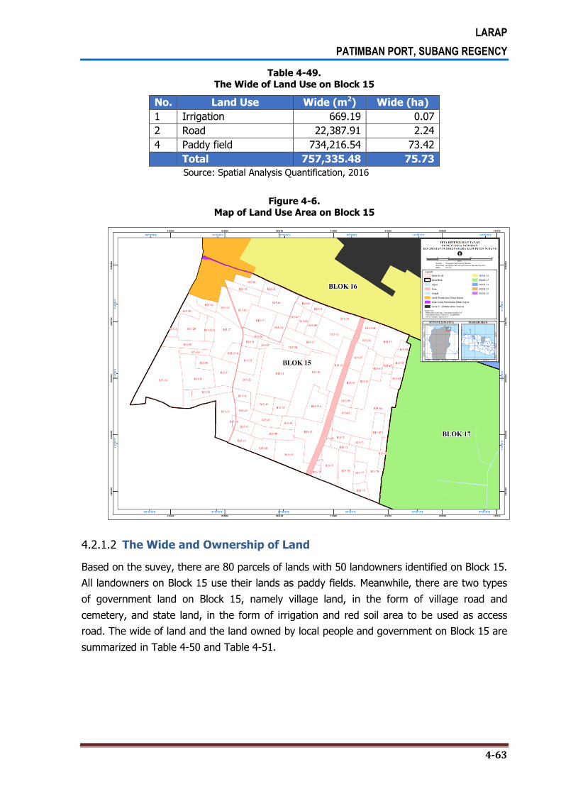
LARAP
PATIMBAN PORT, SUBANG REGENCY
4-63
Table 4-49.
The Wide of Land Use on Block 15
No. Land Use Wide (m2) Wide (ha)
1 Irrigation 669.19 0.07
2 Road 22,387.91 2.24
4 Paddy field 734,216.54 73.42
Total 757,335.48 75.73
Source: Spatial Analysis Quantification, 2016
Figure 4-6. Map of Land Use Area on Block 15
4.2.1.2 The Wide and Ownership of Land
Based on the suvey, there are 80 parcels of lands with 50 landowners identified on Block 15.
All landowners on Block 15 use their lands as paddy fields. Meanwhile, there are two types
of government land on Block 15, namely village land, in the form of village road and
cemetery, and state land, in the form of irrigation and red soil area to be used as access
road. The wide of land and the land owned by local people and government on Block 15 are
summarized in Table 4-50 and Table 4-51.

LARAP
PATIMBAN PORT, SUBANG REGENCY
4-64
Table 4-50.
Owners and the Wide of Land on Block 15
No Owner Code Wide (m2) Wide (ha)
1 *********** B15-67 8,234.11 0.82
B15-68 3,683.16 0.37
2 *********** B15-37 11,533.57 1.15
3 *********** B15-39 23,016.89 2.30
4 *********** B15-07 4,989.77 0.50
B15-17 11,942.13 1.19
5 *********** B15-78 4,000.33 0.40
6 *********** B15-46 5,158.28 0.52
7 *********** B15-18 10,351.15 1.04
8 *********** B15-03 5,137.04 0.51
B15-12 3,691.17 0.37
9 *********** B15-05 2,975.44 0.30
10 *********** B15-10 9,520.46 0.95
B15-51 17,757.45 1.78
B15-55 14,672.39 1.47
B15-66 38,629.82 3.86
B15-75 12,456.26 1.25
11 *********** B15-15 13,976.81 1.40
B15-28 B 5,231.04 0.52
B15-41 4,084.94 0.41
B15-44 7,043.70 0.70
12 *********** B15-06 2,866.82 0.29
B15-20 6,303.02 0.63
B15-50 8,533.06 0.85
B15-52 18,741.83 1.87
B15-69 2,160.39 0.22
13 *********** B15-13 9,243.00 0.92
B15-14 11,398.13 1.14
B15-16 6,999.05 0.70
B15-71 3,831.61 0.38
14 *********** B15-74 2,190.84 0.22
15 *********** B15-26 3,584.19 0.36
16 *********** B15-53 B 4,472.86 0.45
17 *********** B15-70 3,824.90 0.38
18 *********** B15-58 7,399.28 0.74
B15-63 2,954.32 0.30
19 *********** B15-32 8,813.42 0.88
B15-36 4,720.15 0.47
20 *********** B15-62 3,293.15 0.33
21 *********** B15-38 6,739.49 0.67
22 *********** B15-61 5,022.13 0.50
B15-72 3,834.65 0.38
B15-73 939.33 0.09

LARAP
PATIMBAN PORT, SUBANG REGENCY
4-65
No Owner Code Wide (m2) Wide (ha)
23 *********** B15-09 5,075.85 0.51
B15-19 33,344.72 3.33
24 *********** B15-11 14,447.90 1.44
B15-22 13,016.69 1.30
B15-76 12,456.55 1.25
25 *********** B15-28 A 4,301.32 0.43
26 *********** B15-60 13,429.52 1.34
27 *********** B15-25 3,450.09 0.35
28 *********** B15-64 4,787.61 0.48
29 *********** B15-57 7,235.96 0.72
30 *********** B15-04 14,147.79 1.41
31 *********** B15-21 37,555.82 3.76
32 *********** B15-53 A 11,586.96 1.16
33 *********** B15-79 17,382.54 1.74
34 *********** B15-48 3,808.35 0.38
35 *********** B15-34 41,758.30 4.18
36 *********** B15-45 6,563.49 0.66
37 *********** B15-24 3,432.87 0.34
38 *********** B15-49 9,940.75 0.99
39 *********** B15-08 4,606.52 0.46
40 *********** B15-27 23,391.34 2.34
B15-40 774.12 0.08
B15-43 4,983.20 0.50
41 *********** B15-31 3,089.82 0.31
B15-33 3,556.20 0.36
42 *********** B15-23 9,679.77 0.97
43 *********** B15-56 3,758.01 0.38
44 *********** B15-02 3,651.00 0.37
B15-47 7,784.37 0.78
45 *********** B15-54 4,039.41 0.40
46 *********** B15-29 13,994.04 1.40
47 *********** B15-42 5,451.24 0.55
B15-59 3,113.41 0.31
B15-65 5,587.76 0.56
48 *********** B15-01 6,498.40 0.65
49 *********** B15-35 17,395.66 1.74
50 *********** B15-77 5,367.15 0.54
Total Luas 730,396.05 73.04
Source: Spatial Analysis Quantification, 2016

LARAP
PATIMBAN PORT, SUBANG REGENCY
4-66
Table 4-51.
The Wide of Land Owned by Government on Block 15
No. Owner Wide (m2) Wide (ha)
1 Village land 7,994.64 0.79
2 State land 18,994.76 1.90
Total 26,939.43 2.69
Source: Spatial Analysis Quantification, 2016
4.2.1.3 Potentially Affected Buildings
Based on the survey, there are 4 buildings with the total wide of 112.39 m2 on Block 15. All
buildings are semi-permanent in the form of cottages on the cemetery and paddy field areas.
Table 4-52.
Owner, Number and Wide of Buildings on Block 15
No. Owner Number of Buildings Wide (m2)
1 *********** 1 59.25
2 VILLAGE LAND 3 53.14
Total 4 112.39
Figure 4-7.
Semi-Permanent Buildings on Block 15

LARAP
PATIMBAN PORT, SUBANG REGENCY
4-67
4.2.2. Block 16
4.2.2.1 Land Asset and the Use of Land
Block 16 is situated in Genteng Village and most of the land in this area is used for paddy
field with the total wide of 20.74 hectares. Actually, the lands on Block 16 include that of
owned by PT. *****. The block is bordered with residential area of Genteng Village on the
west side, brackish water pond of PT. ***** on the north and east sides, and the village
road and paddy fields of Block 15 on the south side. The use of land in Block 16 is supposed
to be dominated by brackish water pond of PT. *****, but since the land owned by
company is excluded from the land acquisition plan area, then the land use in this block is
dominated by paddy field which covers an area of 20.74 hectares. In the meantime, the
constructed land is located in Cemara Village and is all contained on Block 16. The wide of
land use on Block 16 can be seen in Table 4-53, while Figure 4.8 depicts the map of Block
16 area.
Table 4-53. The Wide of Land Use on Block 16
No. Land Use Wide (m2) Wide (ha)
1 Paddy field 207,374.39 20.74
2 Brackish water pond 14,731.46 1.47
Total 222,105.85 22.21
Source: Spatial Analysis Quantification, 201

LARAP
PATIMBAN PORT, SUBANG REGENCY
4-68
Figure 4-8.
The Map of Back-Up Area on Block 16
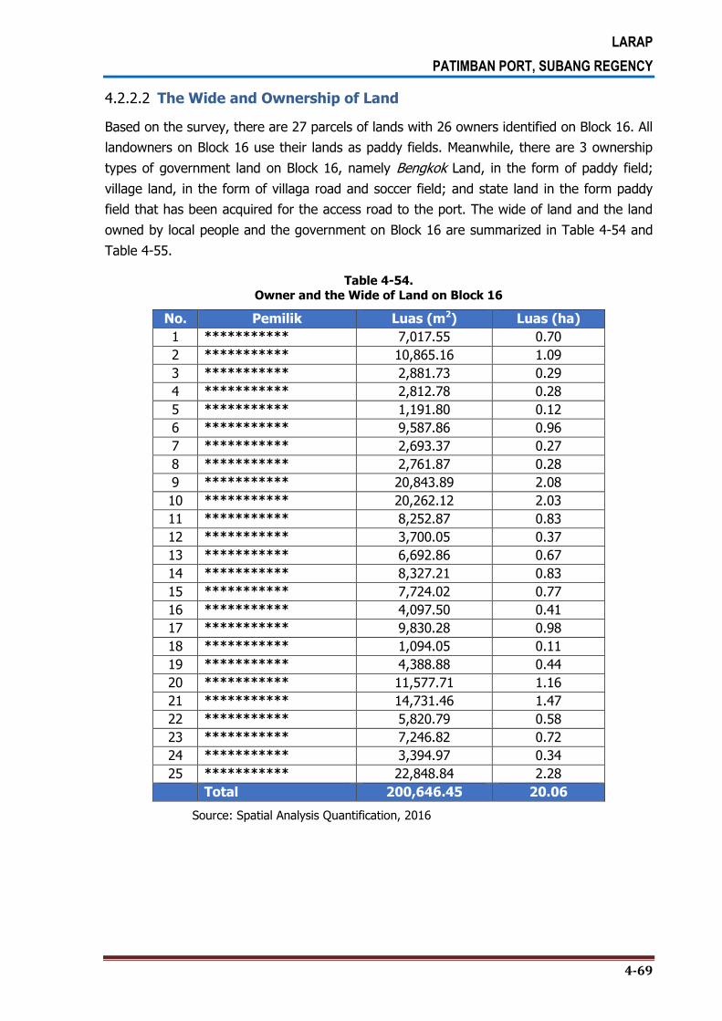
LARAP
PATIMBAN PORT, SUBANG REGENCY
4-69
4.2.2.2 The Wide and Ownership of Land
Based on the survey, there are 27 parcels of lands with 26 owners identified on Block 16. All
landowners on Block 16 use their lands as paddy fields. Meanwhile, there are 3 ownership
types of government land on Block 16, namely Bengkok Land, in the form of paddy field;
village land, in the form of villaga road and soccer field; and state land in the form paddy
field that has been acquired for the access road to the port. The wide of land and the land
owned by local people and the government on Block 16 are summarized in Table 4-54 and
Table 4-55.
Table 4-54.
Owner and the Wide of Land on Block 16
No. Pemilik Luas (m2) Luas (ha)
1 *********** 7,017.55 0.70
2 *********** 10,865.16 1.09
3 *********** 2,881.73 0.29
4 *********** 2,812.78 0.28
5 *********** 1,191.80 0.12
6 *********** 9,587.86 0.96
7 *********** 2,693.37 0.27
8 *********** 2,761.87 0.28
9 *********** 20,843.89 2.08
10 *********** 20,262.12 2.03
11 *********** 8,252.87 0.83
12 *********** 3,700.05 0.37
13 *********** 6,692.86 0.67
14 *********** 8,327.21 0.83
15 *********** 7,724.02 0.77
16 *********** 4,097.50 0.41
17 *********** 9,830.28 0.98
18 *********** 1,094.05 0.11
19 *********** 4,388.88 0.44
20 *********** 11,577.71 1.16
21 *********** 14,731.46 1.47
22 *********** 5,820.79 0.58
23 *********** 7,246.82 0.72
24 *********** 3,394.97 0.34
25 *********** 22,848.84 2.28
Total 200,646.45 20.06
Source: Spatial Analysis Quantification, 2016

LARAP
PATIMBAN PORT, SUBANG REGENCY
4-70
Table 4-55.
The Wide of Land Owned by Government on Block 16
No. Owner Wide (m2) Wide (ha)
1 Bengkok land 1,628.98 0.16
2 Village land 8,363.84 0.84
3 State land 11,466.58 1.15
Total 21,459.39 2.15
Source: Spatial Analysis Quantification, 2016
4.2.2.3 Potentially Affected Buildings
Based on the survey, there are 4 buildings with a total wide of 156.22 m2 on Block 16,
which consist of 1 unit permanent building and 3 units of semi-permanent buildings in the
form of farmer cottages in the middle of paddy fields.
Table 4-56.
Owner, Number and the Wide of Building on Block 16
No. Owner Number of Building Wide (m2)
1 *********** 3 136.37
2 *********** 1 19.84
Total 4 156.22
Source: Spatial Analysis Quantification, 2016
Figure 4-9.
Buildings Taken from Aerial Photograph on Block 16

LARAP
PATIMBAN PORT, SUBANG REGENCY
4-71
4.2.3. Block 17
4.2.3.1 Land Asset and the Use of Land
Block 17 is situated in Genteng Village and is bordered with paddy field area of Block 15 on
the west side, and the village road and paddy field area that has been acquired by the
government on the north side. Based on the survey, 71.23 hectares of the land is used for
paddy fields, and the remining land is used for irrigation, road, and constructed land in the
form of a chicken farm. The wide of land use on Block 17 is summarized in Table 4-57, while
Figure 5.9 highlights a map of land ownership on Block 17.
Table 4-57.
The Wide of Land use on Block 17
No. Land Use Wide (m2) Wide (ha)
1 Irrigation 5,920.45 0.59
2 Road 2,253.24 0.23
3 Constructed land 9,154.73 0.92
4 Paddy field 712,339.09 71.23
Total 729,667.51 72.97
Source: Spatial Analysis Quantification, 2016

LARAP
PATIMBAN PORT, SUBANG REGENCY
4-72
Figure 4-10.
The Map of Back-Up Area on Block 17

LARAP
PATIMBAN PORT, SUBANG REGENCY
4-73
4.2.3.2 The Wide and Ownership of Land
Based on the survey, there are 75 parcels of lands with 43 owners identified on Block 17.
Similarly with Block 15 and Block 16, all landowners on Block 17 use their lands for paddy
fields, and only one parcel or land that is used for chicken farming. There are 4 ownership
statuses of government land on Block 17, namely village land, in the form of village road;
state land, in the form of irrigation; the land owned by Ministry of Public Works, in the form
of paddy field; and Waqf land, in the form of paddy field. The wide of land and the land
owned by local people and the government on Block 17 are summarized in in Table 4-58
and Table 4-59.
Table 4-58.
The Wide dan Owner of Land on Block 17
No. Owner Wide (m2) Wide (ha)
1 *********** 4,226.63 0.42
2 *********** 6,371.92 0.64
3 *********** 15,092.25 1.51
4 *********** 4,157.30 0.42
5 *********** 7,362.66 0.74
6 *********** 4,889.78 0.49
7 *********** 4,257.89 0.43
8 *********** 892.56 0.09
9 *********** 9,285.18 0.93
10 *********** 80,191.29 8.02
11 *********** 38,608.75 3.86
12 *********** 10,105.52 1.01
13 *********** 39,954.67 4.00
14 *********** 43,019.44 4.30
15 *********** 53,218.95 5.32
16 *********** 9,254.84 0.93
17 *********** 43,851.71 4.39
18 *********** 9,572.01 0.96
19 *********** 44,330.50 4.43
20 *********** 7,453.73 0.75
21 *********** 9,703.48 0.97
22 *********** 23,770.31 2.38
23 *********** 4,574.60 0.46
24 *********** 9,692.97 0.97
25 *********** 40,335.18 4.03
26 *********** 10,084.24 1.01
27 *********** 5,005.33 0.50
28 *********** 4,083.19 0.41
29 *********** 4,907.12 0.49
30 *********** 21,921.55 2.19
31 *********** 7,920.05 0.79
32 *********** 7,030.56 0.70

LARAP
PATIMBAN PORT, SUBANG REGENCY
4-74
No. Owner Wide (m2) Wide (ha)
33 *********** 25,136.72 2.51
34 *********** 26,450.22 2.65
35 *********** 1,355.99 0.14
36 *********** 2,950.90 0.30
37 *********** 10,311.60 1.03
38 *********** 14,583.51 1.46
39 *********** 10,144.61 1.01
40 *********** 5,024.40 0.50
41 *********** 4,148.05 0.41
42 *********** 17,823.06 1.78
43 *********** 13,701.88 1.37
Total 716,757.12 71.68
Source: Spatial Analysis Quantification, 2016
Table 4-59. The Wide of Land Owned by Government on Block17
No. Owner Wide (m2) Wide (ha)
1 Village land 2,253.24 0.23
2 State land 5,920.45 0.59
3 Public Work land 1,996.46 0.20
4 Waqf land 2,740.23 0.27
Total 12,910.39 1.29
Source: Spatial Analysis Quantification, Oktober 2016
4.2.3.3 Potentially Affected Buildings
Based on the survey, there are 6 buildings on Block 17, one of which is semi-permanent
building in the form of a chicken farm and the other 5 are farmer cottages in the middle of
paddy fields.
Figure 4-11. Chicken Farm Building Taken from Aerial Photograph on Block 17

LARAP
PATIMBAN PORT, SUBANG REGENCY
4-75
Table 4-60.
Owner, Number and the Wide of Building on Block 17
No. Owner Number of Building (Unit)
Wide (m2)
1 *********** 1 10.20
2 *********** 2 92.78
3 *********** 1 13.32
4 *********** 2 3,296.88
Total 6 3,413.18
Source: Spatial Analysis Quantification, Oktober 2016
4.2.4. Block 18
4.2.4.1 Land Asset and the Use of Land
Block 18 is located in Patimban Village and is bordered with the land of PT. ***** on the
west and north sides, Luwung River and Block 19 on the east side, and paddy field of Block
17 on the south side. The use of land on Block 18 is dominated by the brackish water pond
with the wide of 32.39 hectares, and only small portion of it is used for paddy field with the
area of 4.97 hectares. The wide of land use on Block 18 can be seen in Table 4-61.
Table 4-61. The Wide of Land Use on Block 18
No. Land Use Wide (m2) Wide (ha)
1 Irrigation 2,919.44 0.29
2 Road 1,390.97 0.14
3 Paddy field 49,672.12 4.97
4 Brackish water pond 323,871.88 32.39
Total 377,854.42 37.79
Source: Spatial Analysis Quantification, Oktober 2016
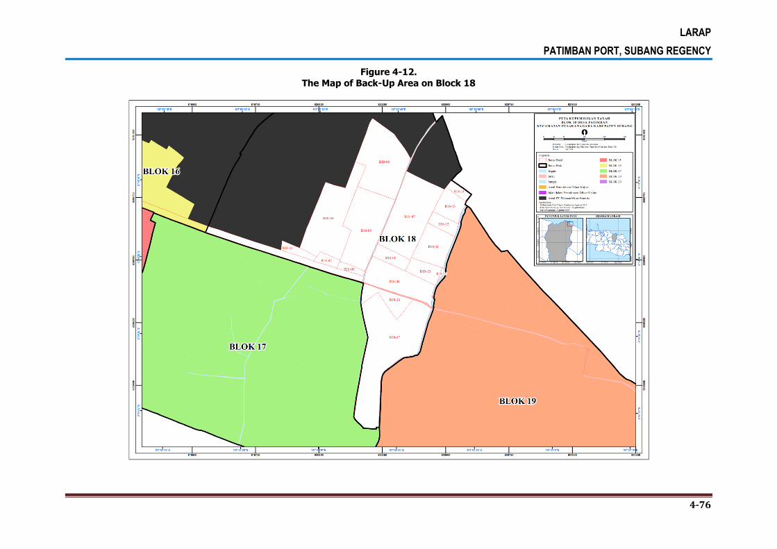
LARAP
PATIMBAN PORT, SUBANG REGENCY
4-76
Figure 4-12.
The Map of Back-Up Area on Block 18

LARAP
PATIMBAN PORT, SUBANG REGENCY
4-77
4.2.4.2 The Wide and Ownership of Land
Based on the survey, there are 15 parcels of lands with 13 owners identified on Block 18. Most of the lands on this block have been purchased and legally owned by PT. ***********. The wide and owners of land on Block 18 can be seen in Table 4-62.
Table 4-62.
Owner and the Wide of Land on Block 18
No. Owner Wide (m2) Wide (ha)
1 *********** 8,742.78 0.87
2 *********** 76,266.52 7.63
3 *********** 7,362.11 0.74
4 *********** 16,498.41 1.65
5 *********** 26,509.59 2.65
6 *********** 45,923.24 4.59
7 *********** 7,826.06 0.78
8 *********** 2,800.49 0.28
9 *********** 43,970.78 4.40
10 *********** 47,091.55 4.71
11 *********** 17,907.14 1.79
12 *********** 41,328.59 4.13
13 *********** 10,935.26 1.09
Total 353,162.52 35.32
Source: Spatial Analysis Quantification, 2016
There are two ownership types of government land on Block 18, namely village land, in the
form of village road; and state land, in the form of irrigation, paddy field that has been
acquired for access road to the port, brackish water pond on the newly formed land, and
riverbanks. The wide of government land on Block 18 can be seen in Table 4-63.
Table 4-63. The Wide of Land Owned by Government on Block 18
No. Owner Wide (m2) Wide (ha)
1 Village land 1,390.97 0.14
2 State land 23,300.93 2.33
Wide Total 24,691.90 2.47
Source: Spatial Analysis Quantification, Oktober 2016
4.2.4.3 Potentially Affected Buildings
Based on the survey, there are 19 buildings identified on Block 18, which are dominated by
semi-permanent buildings used for residential or cottages for shrimp farming activities in the
brackish water pond area.
Figure 4-13.
General Conditions of Buildings on Block 18

LARAP
PATIMBAN PORT, SUBANG REGENCY
4-78
Table 4-64. Owner, Number and the Wide of Building onBlock 18
No. Owner Number of Building (Unit)
Wide (m2)
1 *********** 1 68.40
2 *********** 3 70.28
3 *********** 2 71.01
4 *********** 3 404.89
5 *********** 2 397.53
6 *********** 2 47.70
7 *********** 1 22.48
8 *********** 3 44.61
9 *********** 1 42.33
10 *********** 1 17.19
Total 19 1,186.42
4.2.5. Block 19
4.2.5.1 Land Asset and the Use of Land
Block 19 is located in Patimban Village and is bordered with Block 17 and Block 18 on the west
side, Java Sea on the north side, Block 20 on the east side, and the residential area of
Patimban Village on the south side. The use of land on Block 19 is dominated by brackish water
pond with the total wide of 56.65 hectares and paddy field with the total wide of 32.56
hectares. In addition, there are also farm fields and constructed lands which are distributed
along the Patimban coastal line. The wide of land use on Block 19 can be seen in Table 4-65.

LARAP
PATIMBAN PORT, SUBANG REGENCY
4-79
Figure 4-14.
The Map of Back-Up Area onBlock 19

LARAP
PATIMBAN PORT, SUBANG REGENCY
4-80
Table 4-65.
The Wide and Land Use on Block 19
No. Land Use Wide (m2) Wide (ha)
1 Irrigation 466.18 0.05
2 Road 5,326.58 0.53
3 Cemetery 2,549.44 0.25
4 Farm field 90,617.21 9.06
5 Constructed land 64,983.19 6.50
6 Meadow 26,183.63 2.62
7 Paddy field 325,624.53 32.56
8 River 7,895.23 0.79
9 Brackish water pond 566,494.59 56.65
Total 1,090,140.59 109.01
Source: Spatial Analysis Quantification, 2016
4.2.5.2 The Wide and Ownership of Land
Based on the survey, there are 46 parcels of lands with 35 owners identified on Block 19. There
is a company that owns a land on this block, namely PT. *****. Historically, the land was
initially owned by local people and then purchased by the company in 1988 for running tiger
shrimp farming business. However, the business was stopped in 1995 as the company fell into
bankruptcy at that time.
The local people back to till the land in the period of 1995-2011. In 2012, the Ministry of
Maritime Affairs and Fisheries, through one of its programs, provided aid in the form of turbines,
engines, vanamei shrimp seed, and the feed until they are 40-day-old. The program lasted until
2014, and then continued with the establishment of BUMDES or village-owned enterprise and
the people were given a full right to till the land. The BUMDES, in this respect, is established as
an embodiment of the people’s aspiration to regulate the tilling right of the land. As of to date,
the number of land tillers on the company’s land is approximately 23 persons.
Table 4-66. The Owner and Wide of Land Owned by the People on Block 19
No. Owner Wide (m2) Wide (ha)
1 *********** 3,649.79 0.36
2 *********** 782.96 0.08
3 *********** 1,300.67 0.13
4 *********** 1,464.17 0.15
5 *********** 7,607.42 0.76
6 *********** 55,164.28 5.52
7 *********** 19,201.15 1.92
8 *********** 3,523.40 0.35
9 *********** 8,669.83 0.87
10 *********** 3,106.05 0.31

LARAP
PATIMBAN PORT, SUBANG REGENCY
4-81
No. Owner Wide (m2) Wide (ha)
11 *********** 1,263.03 0.13
12 *********** 8,191.15 0.82
13 *********** 8,669.59 0.87
14 *********** 970.51 0.10
15 *********** 10,489.65 1.05
16 *********** 2,420.33 0.24
17 *********** 5,112.63 0.51
18 *********** 412,705.36 41.27
19 *********** 4,587.68 0.46
20 *********** 5,138.61 0.51
21 *********** 62,624.66 6.26
22 *********** 3,634.81 0.36
23 *********** 9,526.73 0.95
24 *********** 779.69 0.08
25 *********** 5,847.95 0.58
26 *********** 19,380.67 1.94
27 *********** 2,786.46 0.28
28 *********** 354.17 0.04
29 *********** 686.03 0.07
30 *********** 8,432.65 0.84
31 *********** 45,352.84 4.54
32 *********** 3,669.18 0.37
33 *********** 739.46 0.07
34 *********** 24,744.44 2.47
35 *********** 4,731.63 0.47
Wide Total 757,309.66 75.73 Source: Spatial Analysis Quantification, Oktober 2016
In addition to community land, there is also land owned by the government on Blocked 19,
namely Bengkok land, village land,state land, Subang Regency land, and waqf land. Bengkok
land is in the form of paddy field, while village land and state land is in the form of riverbanks
area, which land use classification is included in the brackish water pond area. Meanwhile,
Suban Regency land is in the form of sample land to be used as the estimation of backfill
volume for the development plan of Patimban Port, while waqf land is in the form of cemetery.
Table 4-67.
The Wide of Land Owned by Government on Block 19
No. Owner Wide (m2) Wide (ha)
1 Bengkok land 295,808.23 29.58
2 Village land 450.72 0.05
3 State land 13,110.93 1.31
4 Local government land 20,911.62 2.09
5 Waqf land 2,549.44 0.25
Total 332,830.93 33.28
Source: Spatial Analysis Quantification, Oktober 2016

LARAP
PATIMBAN PORT, SUBANG REGENCY
4-82
4.2.5.3 Potentially Affected Buildings
Based on the survey, there are 143 permanent and semi-permanent buildings identified on
Block 19. The condition of buildings on Block 19 can be seen in Figure 4-15.
Figure 4-15.
General Conditions of Semi-Permanent
Building along the Patimban Coastal Line
Figure 4-16. Permanent Building on Block 19 in the form of Small Mosque

LARAP
PATIMBAN PORT, SUBANG REGENCY
4-83
Table 4-68.
Owner, Number and the Wide of Buildings on Block 19
No. Owner Number of Buildings Wide (m2)
1 *********** 1 17.33
2 *********** 1 124.16
3 *********** 3 360.22
4 *********** 1 230.80
5 *********** 3 203.37
6 *********** 6 442.66
7 *********** 1 34.26
8 *********** 3 307.36
9 *********** 1 139.31
10 *********** 3 278.58
11 *********** 12 1,890.65
12 *********** 4 618.30
13 *********** 4 237.45
14 *********** 4 866.08
15 *********** 6 798.08
16 *********** 48 5,890.24
17 *********** 1 50.50
18 *********** 4 984.05
19 *********** 1 241.80
20 *********** 3 302.61
21 *********** 4 279.31
22 *********** 6 603.15
23 *********** 1 176.68
24 *********** 3 169.34
25 *********** 1 18.77
26 *********** 6 296.52
27 *********** 3 293.98
28 *********** 4 268.07
29 *********** 1 28.31
30 *********** 4 767.89
Total 143 16,919.82
Source: Spatial Analysis Quantification, Oktober 2016
4.2.6. Block 20
4.2.6.1 Land Asset and the Use of Land
Block 20 is located in Patimban Village and is bordered with Block 19 on the west side, Java
Sea on the north and east sides, and residential area of Patimban Village on the south side.
Most of land in this block is used for brackish water pond with the total wide area of 22.64
hectares, farm field of 9.56 hectares and paddy field of 4.40 hectares. The farm field is

LARAP
PATIMBAN PORT, SUBANG REGENCY
4-84
generally planted with annual crops such as long bean, eggplant, watermelon, corn, cassava,
chili, etc. the wide of land use on Block 20 can be seen in Table 4-69.

LARAP
PATIMBAN PORT, SUBANG REGENCY
4-85
Figure 4-17.
The Map of Back-Up Area onBlock 20

LARAP
PATIMBAN PORT, SUBANG REGENCY
4-87
Table 4-69. The Wide of Land Use On Block 20
No. Land Use Wide (m2) Wide (ha)
1 Road 2,806.14 0.28
2 Cemetery 2,769.45 0.28
3 Farm field 95,553.81 9.56
4 Constructed land 13,595.14 1.36
5 Paddy field 44,043.00 4.40
6 Brackish water pond 226,426.61 22.64
Total 385,194.15 38.52 Source: Spatial Analysis Quantification, 2016
4.2.6.2 The Wide and Ownership of Land
Based on the survey, there are 23 parcels of lands with 22 owners identified on Block 20.
There is one person who owns the widest land on this block, namely Franky Pinalfian or who
is usually called as Koh Alfin. The wide and owners of land on Block 20 can be seen in Table
4-70.
Table 4-70. The Owner and Wide of Land Owned by People on Block 20
No. Owner Wide (m2) Wide (ha)
1 *********** 32,853.82 3.29
2 *********** 119,929.06 11.99
3 *********** 9,346.57 0.93
4 *********** 21,990.46 2.20
5 *********** 21,389.45 2.14
6 *********** 38,569.69 3.86
7 *********** 3,551.53 0.36
8 *********** 8,393.95 0.84
9 *********** 4,372.92 0.44
10 *********** 9,807.02 0.98
11 *********** 26,550.40 2.66
12 *********** 1,472.15 0.15
13 *********** 545.53 0.05
14 *********** 6,271.07 0.63
15 *********** 1,843.29 0.18
16 *********** 1,944.85 0.19
17 *********** 442.27 0.04
18 *********** 4,461.21 0.45
19 *********** 2,058.97 0.21
20 *********** 14,135.34 1.41
21 *********** 1,326.25 0.13
22 *********** 34,262.56 3.43
Total 365,518.37 36.55
Source: Spatial Analysis Quantification, 2016
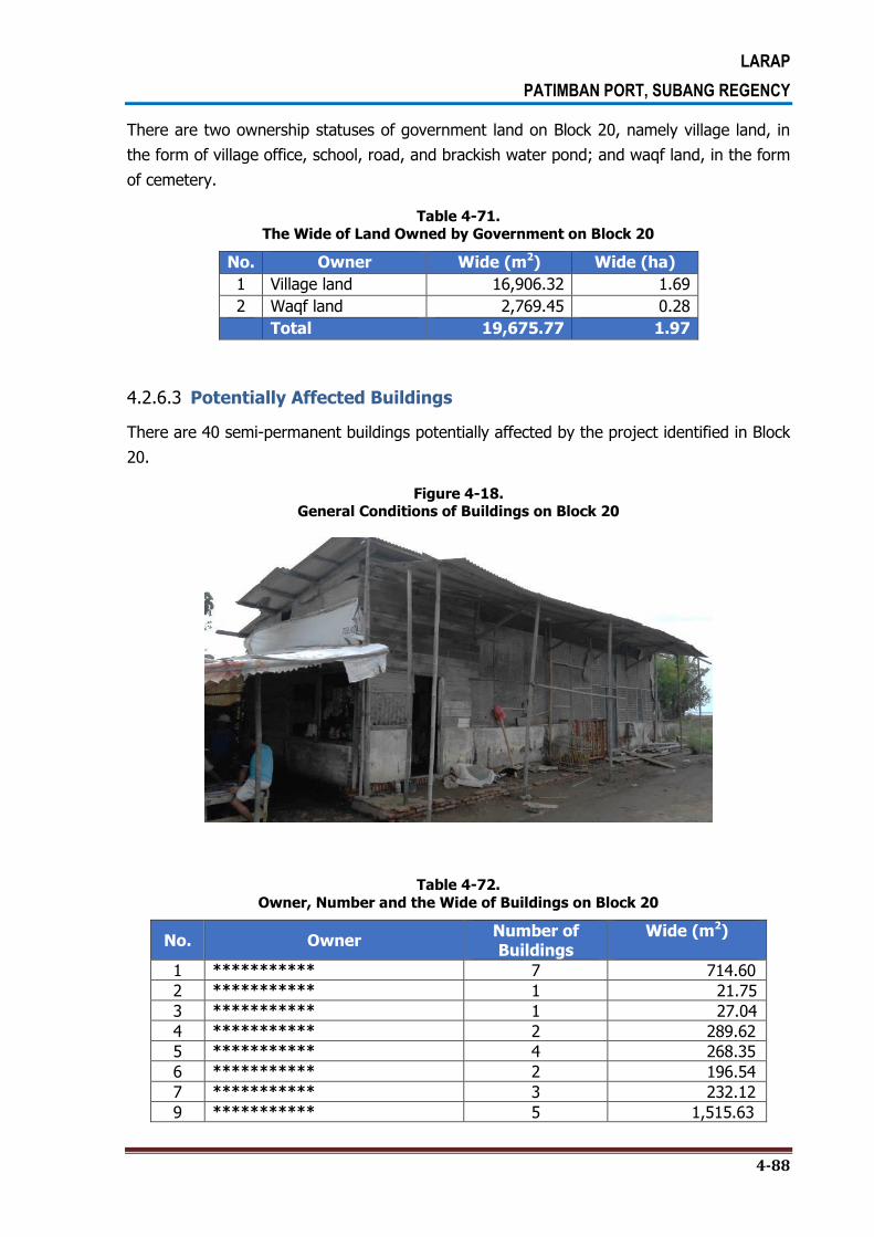
LARAP
PATIMBAN PORT, SUBANG REGENCY
4-88
There are two ownership statuses of government land on Block 20, namely village land, in
the form of village office, school, road, and brackish water pond; and waqf land, in the form
of cemetery.
Table 4-71. The Wide of Land Owned by Government on Block 20
No. Owner Wide (m2) Wide (ha)
1 Village land 16,906.32 1.69
2 Waqf land 2,769.45 0.28
Total 19,675.77 1.97
4.2.6.3 Potentially Affected Buildings
There are 40 semi-permanent buildings potentially affected by the project identified in Block
20.
Figure 4-18. General Conditions of Buildings on Block 20
Table 4-72.
Owner, Number and the Wide of Buildings on Block 20
No. Owner Number of Buildings
Wide (m2)
1 *********** 7 714.60
2 *********** 1 21.75
3 *********** 1 27.04
4 *********** 2 289.62
5 *********** 4 268.35
6 *********** 2 196.54
7 *********** 3 232.12
9 *********** 5 1,515.63

LARAP
PATIMBAN PORT, SUBANG REGENCY
4-89
No. Owner Number of Buildings
Wide (m2)
10 *********** 1 21.66
11 *********** 10 1,464.30
12 *********** 1 14.15
13 *********** 3 71.80
Total 40 4,837.54
4.3. GENERAL CONDITION OF LANDOWNERS AND LAND TENANTS OR SHARECROPPERS IN BACK UP AREA
Based on the map of land use, the land ownership in the back-up area is dominated by the ownership of paddy field and brackish water pond. The paddy fields are identified owned by individuals and the village in the form of Bengkok Land or the village land used as paddy field to fund salaries of village officials. Meanwhile, the ownership of brackish water pond is divided into individual ownership and company or private ownership. There are two companies running the brackish water pond business in the administrative area of Patimban Village, namely PT. *********** and PT. ***********. In addition, there is one company that is also located in back-up area, namely PT. ***********
The owners of lands in Patimban Village are mostly living outside Patimban Village, among others in Kalentambo Village, Rancadaka Village, Gempol Village, and a few of them are even living outside Subang Regency. Unlike the landowners, the land tenants are generally living in Patimban Village and they have been living in the village for a very long time. There are 156 landowners in the back-up area.
The dominant livelihoods of land tenants in the back-up area are identified in line with the
land use, among others:
1. The sharecropper of paddy field.
2. The land tenants for brackish water pond business.
3. The sharecropper of farm land.
4. The land tenants for retailing business purpose.
With respect to land management pattern, in general, landowners manage their own lands
by assigning some workers. However, there are also some landowners who hand over the
management of their lands to the land tenants or sharecroppers. In addition, there are also
landowners who manage their own land and also become the sharecroppers in other
people’s land. The following table highlights the quantification of the number of landowners
and land tenants or sharecroppers per block in the back-up area.

LARAP
PATIMBAN PORT, SUBANG REGENCY
4-90
Table 4-73. The Number of Landowners and Land Tenants in the Patimban Port Project Area
Block Number of Landowners Number of Land Tenants
15 50 -
16 25 -
17 43 -
18 13 6
19 35 72
20 22 2
Total 156 80
4.3.1. The Number of Landowners and Land Tenants in Patimban Coastal
The lands used for retailing businesses by tenants are mostly located in Patimban coastal
area. The tenants build food stalls or cafés along the coastal area on the permission of
landowners. Based on the collected data, there are 23 landowners in Patimban Coastal area
with 101 food stalls or cafes owned by 52 land tenants.
Table 4-74.
The Wide of Buildings Along The Beach for Retailing Business
No. Landowner Land Tenant Number of Building Wide of Building
(m2)
1 *********** - 1 124.16
2 *********** - 3 360.22
3 *********** 1 230.80
4 *********** *********** 1 66.60
5 *********** *********** 1 81.47
6 *********** *********** 1 90.31
*********** 2 217.06
7 *********** - 1 139.31
8 *********** *********** 1 63.89
*********** 2 214.70
9 *********** *********** 2 390.34
*********** 2 378.91
*********** 2 244.00
*********** 1 214.66

LARAP
PATIMBAN PORT, SUBANG REGENCY
4-91
No. Landowner Land Tenant Number of Building Wide of Building
(m2)
*********** 1 202.01
*********** 1 117.14
*********** 2 159.87
*********** 1 183.73
10 *********** *********** 1 173.49
*********** 2 159.90
*********** 1 284.91
11 *********** *********** 4 237.45
12 *********** *********** 1 295.97
*********** 1 130.41
*********** 1 291.64
*********** 1 148.07
13 *********** *********** 1 245.72
- 5 552.36
14 *********** *********** 1 179.19
*********** 1 111.99
*********** 2 226.47
*********** 1 473.38
*********** 2 248.37
*********** 1 118.20
*********** 1 57.34
*********** 1 109.07
*********** 3 460.17
*********** 1 116.00
*********** 1 43.31
*********** 3 417.56
*********** 2 248.64
*********** 1 194.25
*********** 1 159.27
*********** 3 257.34
*********** 1 99.88
*********** 1 138.00
*********** 4 559.63

LARAP
PATIMBAN PORT, SUBANG REGENCY
4-92
No. Landowner Land Tenant Number of Building Wide of Building
(m2)
15 *********** *********** 1 178.40
*********** 1 223.69
*********** 1 292.35
*********** 1 289.60
16 *********** *********** 1 241.80
17 *********** *********** 3 302.61
18 *********** - 3 556.16
19 *********** - 1 176.68
20 *********** - 3 169.34
21 *********** *********** 1 122.46
- 2 171.51
22 *********** - 4 268.07
23 *********** *********** 1 190.99
*********** 1 271.35
*********** 2 305.55
Total 101 13,977.70
Source: Spatial Analysis Quantification, 2016
4.3.2. The Land Ownership in Other Locations
Based on the field survey result, most of the land tenants who run the food stalls,
restaurants or cafés are staying in the villages in which their businesses are located, and
they don’t have any land elsewhere. In the land acquisition activity, the local government
should pay attention to this condition while figuring out the best solution for those land
tenants who do not have any land in any other location. In addition, the local government
should also seek the best solution program in term of livelihood recovery activity given the
fact that running food stalls, restaurants or cafés have been the main livelihoods for those
land tenants along the Patimban Coastal line.
4.3.3. Characteristics of Land Tenants Who Run the Brackish Water Ponds
There are 25 land tenants who run the brackish water ponds on the land area owned by 4
different landowners on Blocks 18, 19 and 20. The names of land tenants who run the
brackish water pond business and landowners on each block of potentially affected area can
be seen in the following table.
LARAP
PATIMBAN PORT, SUBANG REGENCY
4-93
Table 4-75. The Names of Land Tenants Who Run the
Brackish Water Pond Business and Landowners on Each Block
No. Landowner Land Tenant Block
Total 18 19 20
1 *********** *********** 1
4 *********** 1
*********** 1
*********** 1
2 *********** ***********
1 1
3 *********** ***********
1 1
4 *********** ***********
1
19
***********
1
***********
1
***********
1
***********
1
***********
1
***********
1
***********
1
***********
1
***********
1
***********
1
***********
1
***********
1
***********
1
***********
1
***********
1
***********
1
***********
1
***********
1
Total 4 17 4 25
4.3.4. Type of Commodities
Most of land tenants who run the brackish water ponds are doing the shrimp farming
(94.3%).

LARAP
PATIMBAN PORT, SUBANG REGENCY
4-94
Table 4-76. Type of Commodities of the Brackish Water Pond
No. Block
Type of Commodities of the Brackish Water Pond Total
Shrimp % Milkfish %
1 15 0 0.0% 1 2.9% 1
2 18 4 11.4% 1 2.9% 5
3 19 29 82.9% 4 11.4% 26
4 20 3 8.6% 0 0.0% 3
Total 33 94.3% 2 5.7% 35
Source: Questionnaire Data Processing Result, 2016
4.4. PLANTS POTENTIALLY AFFECTED BY THE PROJECT IN BACK-UP AREA
Based on the field survey, there are 36 types of plants potentially affected by the project in
the entire blocks. More detailed on the plants potentially affected by the project can be seen
in Table 4-78.
Table 4-77. The Number of Plants Potentially Affected by the Project
No. Types of Plants Block Total %
15 16 17 18 19 20
1 Akasia 3 0 0 9 43 16 71 2.62 2 Angsana 0 0 0 0 8 0 8 0.30 3 Asem 0 0 0 0 0 4 4 0.15 4 Bakau 0 15 0 16 160 0 191 7.06 5 Belimbing wuluh 0 1 0 0 0 0 1 0.04 6 Beringin 5 0 0 1 9 0 15 0.55 7 Bintaro 0 0 0 0 1 0 1 0.04 8 Gamal 45 80 0 0 12 15 152 5.62 9 Gempol 0 1 0 0 0 0 1 0.04 10 Glodokan 0 0 0 0 0 1 1 0.04 11 Jabon 25 2 0 0 0 0 27 1.00 12 Jambu air 30 5 0 0 0 0 35 1.29 13 Jambu biji 13 14 0 0 0 10 37 1.37 14 Jati 1 1 0 0 1 0 3 0.11 15 Kelapa 39 241 0 2 8 24 314 11.60 16 Kersen 29 43 2 6 47 0 127 4.69 17 Ketapang 0 0 0 1 49 8 58 2.14 18 Lamtoro 46 66 0 15 67 69 263 9.72 19 Mahoni 0 0 0 0 0 4 4 0.15 20 Mangga 41 171 0 0 0 73 285 10.53 21 Mengkudu 7 21 0 0 0 3 31 1.15 22 Nangka 0 8 0 0 0 1 9 0.33 23 Palem putri 0 0 0 0 0 13 13 0.48 24 Palem tiang 0 0 0 0 0 11 11 0.41 25 Palem tupai 0 0 0 0 0 5 5 0.18 26 Pepaya 8 33 0 0 0 6 47 1.74

LARAP
PATIMBAN PORT, SUBANG REGENCY
4-95
No. Types of Plants Block Total %
15 16 17 18 19 20
27 Pete 0 14 0 0 0 0 14 0.52 28 Pisang 70 121 1 58 189 268 707 26.12 29 Randu 9 17 0 0 0 1 27 1.00 30 Saga 0 4 0 0 0 0 4 0.15 31 Sawit 0 1 0 0 0 0 1 0.04 32 Sawo 0 10 0 0 0 2 12 0.44 33 Srikaya 0 0 0 0 0 1 1 0.04 34 Sukun 0 17 0 0 0 0 17 0.63 35 Trembesi 0 2 0 0 9 10 21 0.78 36 Waru 4 95 0 24 32 34 189 6.98 Total 375 983 3 132 635 579 2707 100
Source: Field Survey, October 2016
Based on the result of questionnaires distribution in each block, the plants potentially
affected by the project can be seen in the following description.
4.4.1. Trees and Plants Potentially Affected by the Project
A. Annual Plants
Based on the survey, 30.4% of annual crops potentially affected by the project are rice, and
then followed by banana (19.6%) with the wide area of between 1,000 m2 to 30,000 m2.
More detailed on this can be seen in the following Table 4-78 and Table 4-79.
Table 4-78.
The Number of Parcel of Annual Crops Potentially Affected by the Project
No Type of Annual Crops Block
Total % 15 16 17 18 19 20
1 Bawang 0 0 0 0 2 0 2 4.3%
2 Buntung 0 0 0 0 1 0 1 2.2%
3 Jagung 0 0 0 0 0 1 1 2.2%
4 Kacang 0 0 1 0 0 0 1 2.2%
5 Kacang Panjang 0 0 0 0 1 0 1 2.2%
6 Kelapa 0 0 0 0 1 0 1 2.2%
7 Kelapa 0 0 0 0 1 1 2 4.3%
8 Kormis 0 0 0 0 1 0 1 2.2%
9 Mangga 2 0 0 0 0 1 3 6.5%
10 Mangga 0 0 0 0 1 0 1 2.2%
11 Padi 5 1 4 0 2 2 14 30.4%
12 Pare 0 0 1 0 0 0 1 2.2%
13 Pepaya 0 0 0 0 0 1 1 2.2%
14 Pisang 2 0 0 1 4 2 9 19.6%
15 Sawi 0 0 0 0 1 0 1 2.2%
16 Semangka 0 0 0 0 2 0 2 4.3%
17 Terong 0 0 0 0 1 0 1 2.2%
18 Timun 0 0 0 0 2 0 2 4.3%
19 Ubi 0 0 0 0 1 0 1 2.2%
Total 9 1 6 1 21 8 46 100.0%
Source: Questionnaire Data Processing Result, 2016

LARAP
PATIMBAN PORT, SUBANG REGENCY
4-96
Table 4-79.
The Wide Area of Annual Crops Potentially Affected by the Project
No Wide of Area
(m2)
Block Total %
17 19 20
1 1,000 0 1 0 1 14.3%
2 1,750 0 1 0 1 14.3%
3 2,500 0 1 0 1 14.3%
4 3,000 0 1 0 1 14.3%
5 7,000 0 1 0 1 14.3%
6 7,212 1 0 0 1 14.3%
7 30,000 0 0 1 1 14.3%
Total 1 5 1 7 100.0%
Source: Questionnaire Data Processing Result, 2016
The frequency of harvest in one year is generally 1 to 3 times a year with the production of
between 10 to 10,000 kg/m2 with the selling price of between Rp 4,500 to Rp 4,000,000 in
one harvest.
Table 4-80.
The Frequency of Harvest in One Year
No. Harvest Frequency Block
Total % 15 16 17 18 19 20
1 1 time 2 1 0 0 2 0 5 27.8%
2 2 times 1 0 2 1 2 2 8 44.4%
3 3 times 0 0 0 0 4 0 4 22.2%
4 4 times 0 0 0 0 1 0 1 5.6%
Total 3 1 2 1 9 2 18 100.0%
Source: Questionnaire Data Processing Result, 2016
Table 4-81.
The Production in Each Harvest
No Harvest Production
(Kg/m2)
Block Total %
15 17 18 19 20
1 10 0 0 1 0 0 1 8.3%
2 50 0 0 0 1 0 1 8.3%
3 30 1 0 0 0 0 1 8.3%
4 100 0 0 0 1 0 1 8.3%
5 1,500 0 0 0 0 1 1 8.3%
6 2,000 0 1 0 1 0 2 16.7%
7 3,000 1 0 0 0 0 1 8.3%
8 4,000 1 0 0 0 1 2 16.7%
9 7,000 0 0 0 1 0 1 8.3%
10 10,000 0 0 0 1 0 1 8.3%
Total 3 1 1 5 2 12 100.0%
Source: Questionnaire Data Processing Result, 2016

LARAP
PATIMBAN PORT, SUBANG REGENCY
4-97
Table 4-82.
Selling Price per Kg
No Selling Price
(Rp)
Block Total %
15 19 20
1 4,000 0 2 0 2 25.0%
2 7,000 0 1 0 1 12.5%
3 100,000 2 0 0 2 25.0%
4 900,000 0 0 1 1 12.5%
5 4,000,000 0 2 0 2 25.0%
Total 2 5 1 8 100.0%
Source: Questionnaire Data Processing Result, 2016
B. Woody Plants
Table 4-83 describes the data on the types and number of woody plants potentially affected
by the land acquisition activity for the project. Based on the survey, there are 13 species of
woody plants potentially affected by the land acquisition, among others, earleaf acacia and
terminalia catappa (18.2%) and sonneratia (13.6%).
Table 4-83. The Number of Wood Plants Potentially Affected by the Project
No Type of Woody Plants Block
Total % 15 16 17 18 19 20
1 Beringin 2 0 0 0 0 0 2 9.1%
2 Cabe 0 0 0 0 0 1 1 4.5%
3 Jati 0 0 0 0 1 0 1 4.5%
4 Kapidada 2 0 0 1 0 0 3 13.6%
5 Ketapang 0 0 0 0 4 0 4 18.2%
6 Ki Hujan 0 0 0 0 1 0 1 4.5%
7 Kormis 0 0 0 0 4 0 4 18.2%
8 Labu 0 0 0 0 0 1 1 4.5%
9 Lantoro 0 0 0 1 0 0 1 4.5%
10 Pisang 0 0 0 0 0 1 1 4.5%
11 Rundu 0 0 0 0 1 0 1 4.5%
12 Sengan 0 0 0 0 1 0 1 4.5%
13 Waru 0 0 0 0 1 0 1 4.5%
Total 4 0 0 2 13 3 22 100.0%
Source: Questionnaire Data Processing Result, 2016
Based on the age, 69.7% of the potentially affected woody plants have the age of over 10
years, and then followed by the age of 6-10 years (21.2%).

LARAP
PATIMBAN PORT, SUBANG REGENCY
4-98
Table 4-84. The Number of Woody Plants Potentially Affected by the Projectby Age
No The Age of the Plants Block
Total % 15 16 17 18 19 20
1 1-3 years 0 0 0 0 1 1 2 6.1%
2 4-5 years, with butt wood diameter 4-6 cm 0 0 0 0 1 0 1 3.0%
3 6-10 years, with butt wood diameter 7-20 cm 0 0 0 0 7 0 7 21.2%
4 Above 10 years, with butt wood diameter more
than 20 cm 1 0 0 10 12 0 23 69.7%
Total 1 0 0 10 21 1 33 100.0%
Source: Questionnaire Data Processing Result, 2016
C. Fruit Plants
Based on Table 4-85, there are 8 types of fruit plants that potentially affected by the project,
among others, coconuts (26.7%), mangos (26.7%) and bananas (29.7%). More detailed on
this can be seen in the table below.
Table 4-85. The Number of Fruit Plants Potentially Affected by the Project
No Type of Fruit Plants Block
Total % 15 16 17 18 19 20
1 Chili 0 0 0 1 0 0 1 3.3%
2 Beans 0 0 1 0 0 0 1 3.3%
3 Coconut 0 2 0 0 4 2 8 26.7%
4 Pumpkin 0 0 0 1 0 0 1 3.3%
5 Mango 4 1 1 0 0 2 8 26.7%
6 Pepaya 0 1 0 0 1 0 2 6.7%
7 Banana 0 1 2 1 2 2 8 26.7%
8 Eggplant 0 0 0 1 0 0 1 3.3%
Total 4 5 4 4 7 6 30 100.0%
Source: Questionnaire Data Processing Result, 2016
Based on the age, 30.4% of the potentially affected fruit plants have the age of 1-3 years,
43.5% of them have the age of over 10 years, and 21.7% of them have the age of 6-10
years.
Table 4-86.
The Number of Fruit Plants Potentially Affected by the Project by Age
No Jenis Tanaman Buah Block
Total % 15 16 17 18 19 20
1 1-3 years 1 0 1 3 0 2 7 30.4%
2 4-5 years 0 0 0 0 0 1 1 4.3%
3 6-10 years 1 0 0 1 3 0 5 21.7%
4 Above 10 years 2 1 2 0 2 3 10 43.5%
Total 4 1 3 4 5 6 23 100.0%
Source: Questionnaire Data Processing Result, 2016

LARAP
PATIMBAN PORT, SUBANG REGENCY
4-99
The total production in one harvest by age category of plants can be seen in Table 4-87.
Table 4-87.
Production Per Plant in One Harvest by Plant Age
Age of Plant Production Per Plant
(kg)
Block Total %
15 16 17 18 19 20
1-3 years
20 0 0 1 0 0 0 1 8.3%
200 0 0 0 1 0 0 1 8.3%
3 0 0 0 1 0 0 1 8.3%
5 0 0 0 1 0 0 1 8.3%
4-5 years 1 0 0 0 0 1 0 1 8.3%
5 0 0 0 0 1 0 1 8.3%
6-10 years
100 1 0 0 0 0 0 1 8.3%
15 0 0 0 1 0 0 1 8.3%
40 0 0 0 0 1 0 1 8.3%
Above 10
years
100 1 0 0 0 0 0 1 8.3%
200 0 0 0 0 0 1 1 8.3%
40 0 0 0 0 1 0 1 8.3%
Total 2 0 1 4 4 1 12 100.0%
Source: Questionnaire Data Processing Result, 2016
Table 4-88. Harvest Frequency in One Year by Plant Age
Age of Plant Harvest Frequency Block
Total % 15 16 17 18 19 20
1-3 years
2 0 0 1 0 0 3 4 30.8%
15 0 0 0 1 0 0 1 7.7%
20 0 0 0 1 0 0 1 7.7%
100 0 0 0 1 0 0 1 7.7%
4-5 years 12 0 0 0 0 1 0 1 7.7%
6-10 years 1 1 0 0 0 0 0 1 7.7%
10 0 0 0 1 0 0 1 7.7%
Above 10 years 1 1 0 0 0 0 0 1 7.7%
12 0 0 0 0 1 1 2 15.4%
Total 2 0 1 4 2 4 13 100.0%
Source: Questionnaire Data Processing Result, 2016

LARAP
PATIMBAN PORT, SUBANG REGENCY
4-100
The selling price of the fruits is ranging between Rp 800-Rp 1,000,000 per kg in each
harvest.
Table 4-89.
Selling Price per Kg in One Harvest
No. Selling Price
(Rp)
Block Total %
15 16 17 18 19 20
1 800 0 0 0 0 0 1 1 5.9%
2 2,000 0 1 0 0 0 0 1 5.9%
3 2,500 0 0 0 1 0 0 1 5.9%
4 4,000 0 0 0 1 0 0 1 5.9%
5 5,000 0 0 1 0 0 0 1 5.9%
6 6,000 1 0 0 1 0 1 3 17.6%
7 7,000 0 0 0 0 1 0 1 5.9%
8 10,000 0 0 0 0 2 1 3 17.6%
9 12,000 0 0 0 0 0 1 1 5.9%
10 14,000 0 0 0 0 1 0 1 5.9%
11 15,000 1 0 0 0 0 0 1 5.9%
12 20,000 0 0 0 1 0 0 1 5.9%
13 1,000,000 1 0 0 0 0 0 1 5.9%
Total 3 1 1 4 4 4 17 100.0%
Source: Questionnaire Data Processing Result, 2016

LARAP
PATIMBAN PORT, SUBANG REGENCY
4-101
4.5. OTHER ASSETS POTENTIALLY AFFECTED BY THE PROJECT IN BACK-UP AREA
Based on the assets inventorying data, there are also other objects related to the land that
will be affected by the project, namely 15 drainages and 8 electrical poles. The length of the
drainages is 8-300 meters with the width of 4-24 meters, and the height of electrical poles is
4 meters and 8 meters. The drainages are privately owned by the people.
Table 4-90. Assets Potentially Affected by the Project
No Block Assets Potentially Affected by the Project
Total Drainage % Electrical Pole %
1 17 2 8.7% 0 0.0% 2
2 18 3 13.0% 1 4.3% 4
3 19 10 43.5% 7 30.4% 17
Total 15 65.2% 8 34.8% 23
Source: Questionnaire Data Processing Result, 2016
Table 4-91. The Dimension of Assets Potentially Affected by the Project
Asset Dimension Block
Total 17 18 19
Length (m)
3 0 0 1 1
8 0 1 0 1
10 1 0 0 1
20 0 0 3 3
50 0 0 1 1
56 0 0 1 1
64 0 0 1 1
76 0 0 2 2
90 0 0 1 1
100 0 0 1 1
240 1 0 0 1
300 0 1 0 1
Wide (m)
4 0 1 0 1
8 0 1 0 1
24 1 0 0 1
Height (m)
4 1 0 0 1
8 0 1 0 1
75 1 0 0 1
Source: Questionnaire Data Processing Result, 2016

LARAP
PATIMBAN PORT, SUBANG REGENCY
4-102
4.6. POTENTIALLY AFFECTED LAND BY THE EXPANSION OF ACCESS ROAD IN EACH VILLAGE
4.6.1. Gempol Village
Kalentambao Village is adjacent to Kalentambo Village and Pusaka Ratu Village. The map of
parcels of lands in Gempol Village is presented in Figure 4.19
Figure 4-19.
Map of Parcels of Lands in Gempol Village

LARAP
PATIMBAN PORT, SUBANG REGENCY
4-103
4.6.1.1 The Land Use
Based on the survey, the lands in this village are used for irrigation canal, road, constructed
land, farm land (generally mango commodity), paddy field, and river. The lands that
potentially affected by the expansion plan of access road to the port are used for paddy field
with the wide of 4.7 hectares and farm land with the wide of 2.30 hectares.
Table 4-92. The Wide of Land use that Have Been Inventoried in Gempol Village
No. Land Use Wide (m2) Wide (ha)
1 Irrigation 324.69 0.03
2 Road 2,403.47 0.24
3 Constructed land 4,168.37 0.42
4 Farm field 61,531.17 6.15
5 Paddy field 199,791.58 19.98
6 River 361.58 0.04
Wide Total 268,579.28 26.86 Source: Spatial Analysis Quantification, 2016
Table 4-93.
The Wide of Land Use Owned by People that Potentially Affected in Gempol Village
No. Land Use Wide (m2) Wide (ha)
1 Constructed land 4,168.37
0.42
2 Farm field 23,032.73
2.30
3 Paddy field 46,963.61
4.70
Total 74,164.71
7,41
Source: Spatial Analysis Quantification, 2016
Table 4-94. The Wide of Land Use Owned by Government
that Potentially Affected in Gempol Village
No. Land Use Wide (m2) Wide (ha)
1 Irrigation 99.85 0.01
2 Road 1,024.30 0.10
3 Farm field 584.93 0.06
4 Paddy field 5,577.73 0.56
5 River 338.77 0.03
Total 7,625.59 0.76 Source: Spatial Analysis Quantification, 2016

LARAP
PATIMBAN PORT, SUBANG REGENCY
4-104
4.6.1.2 Land Ownership
There are 47 landowners, whose lands are potentially affected by the project, identified in
Kalentambo Village. However, not all of the lands will be affected by the project. The wide
of lands owned by the people and the government that have been inventoried and
potentially affected by the project is presented in the table below.
Table 4-95. Owner and the Wide of Land Owned by People
that have been Inventoried in Gempol Village
No. The Land Owner Name’s Code Wide (m2) Wide (ha)
1 *********** GP-39 3,452.11 0.35
2 *********** GP-26 2,313.41 0.23
3 *********** GP-49 250.04 0.03
4 *********** GP-45 3,810.97 0.38
5 *********** GP-55 7,823.68 0.78
6 *********** GP-38 832.41 0.08
7 *********** GP-52 247.25 0.02
8 *********** GP-12 3,459.74 0.35
9 *********** GP-19 1,063.35 0.11
10 *********** GP-40 58.68 0.01
11 *********** GP-16 6,847.69 0.68
12 *********** GP-05 3,252.89 0.33
13 *********** GP-43 3,086.82 0.31
14 *********** GP-33 966.80 0.10
15 *********** GP-44 495.64 0.05
16 *********** GP-22 5,992.26 0.60
17 *********** GP-01 5,820.99 0.58
18 *********** GP-28 1,534.79 0.15
19 *********** GP-17 1,094.92 0.11
GP-20 2,477.22 0.25
20 *********** GP-46 617.79 0.06
21 *********** GP-15 5,021.03 0.50
22 *********** GP-10 10,449.62 1.04
23 *********** GP-25 1,166.25 0.12
GP-42 3,603.09 0.36
24 *********** GP-27 1,498.64 0.15
25 *********** GP-02 3,364.24 0.34
GP-04 13,768.07 1.38
GP-06 21,276.29 2.13
GP-08 10,665.14 1.07
GP-11 13,761.85 1.38
GP-21 3,878.95 0.39
26 *********** GP-41 1,811.29 0.18
27 *********** GP-14 5,931.56 0.59
28 *********** GP-03 7,079.78 0.71

LARAP
PATIMBAN PORT, SUBANG REGENCY
4-105
No. The Land Owner Name’s Code Wide (m2) Wide (ha)
29 *********** GP-18 343.80 0.03
30 *********** GP-09 10,128.25 1.01
31 *********** GP-36 729.26 0.07
32 *********** GP-51 635.05 0.06
33 *********** GP-24 1,299.80 0.13
GP-34 533.59 0.05
GP-54 1,513.61 0.15
34 *********** GP-30 1,133.66 0.11
35 *********** GP-35 3,067.79 0.31
36 *********** GP-07 7,008.39 0.70
37 *********** GP-23 2,375.04 0.24
38 *********** GP-13 3,359.39 0.34
39 *********** GP-31 1,082.57 0.11
40 *********** GP-50 385.04 0.04
41 *********** GP-29 249.10 0.02
42 *********** GP-53 7,017.19 0.70
43 *********** GP-37 4,425.99 0.44
44 *********** GP-47 803.97 0.08
45 *********** GP-48 1,726.52 0.17
46 *********** GP-32 1,510.89 0.15
47 *********** GP-56 11,237.06 1.12
Luas Total 219,341.23 21.93 Source: Spatial Analysis Quantification, 2016
Table 4-96.
Owner and the Wide of Land Owned by Government Inventoried in Gempol Village
No. Owner Wide (m2) Wide (ha)
1 BENGKOK LAND 45,492.05 4.55
2 VILLAGE LAND 2,728.16 0.27
3 STATE LAND 1,019.42 0.10
Total 49,239.63 32.91 Source: Spatial Analysis Quantification, 2016

LARAP
PATIMBAN PORT, SUBANG REGENCY
4-106
Table 4-97. Owner and the Wide of Land Owned by People Potentially Affected in Gempol Village
No. Land Owner Name’s Code Wide (m2) Wide (ha)
1 *********** GP-39 2,307.96 0.23
2 *********** GP-26 196.33 0.02
3 *********** GP-49 250.04 0.03
4 *********** GP-45 1,391.39 0.14
5 *********** GP-55 466.98 0.05
6 *********** GP-38 832.41 0.08
7 *********** GP-52 247.25 0.02
8 *********** GP-12 1,190.09 0.12
9 *********** GP-19 1,063.35 0.11
10 *********** GP-40 58.68 0.01
11 *********** GP-16 3,313.33 0.33
12 *********** GP-05 1,095.65 0.11
13 *********** GP-43 1,013.26 0.10
14 *********** GP-33 716.54 0.07
15 *********** GP-44 495.64 0.05
16 *********** GP-22 1,464.55 0.15
17 *********** GP-01 2,715.79 0.27
18 *********** GP-28 448.38 0.04
19 *********** GP-17 444.46 0.04
GP-20 2,477.22 0.25
20 *********** GP-46 617.79 0.06
21 *********** GP-15 158.45 0.02
22 *********** GP-10 2,269.96 0.23
23 *********** GP-25 1,166.25 0.12
GP-42 2,229.22 0.22
24 *********** GP-27 1,498.64 0.15
25 *********** GP-02 1,144.86 0.11
GP-04 4,615.22 0.46
GP-06 2,330.03 0.23
GP-08 1,174.81 0.12
GP-11 2,267.29 0.23
GP-21 2,442.95 0.24
26 *********** GP-41 40.14 0.00
27 *********** GP-14 1,673.77 0.17
28 *********** GP-03 2,327.95 0.23
29 *********** GP-18 343.80 0.03
30 *********** GP-09 3,357.89 0.34
31 *********** GP-36 252.82 0.03
32 *********** GP-51 635.05 0.06
33 *********** GP-24 1,299.80 0.13
GP-34 533.59 0.05
GP-54 1,513.61 0.15
34 *********** GP-30 1,133.66 0.11

LARAP
PATIMBAN PORT, SUBANG REGENCY
4-107
No. Land Owner Name’s Code Wide (m2) Wide (ha)
35 *********** GP-35 1,690.34 0.17
36 *********** GP-07 2,321.22 0.23
37 *********** GP-23 1,390.06 0.14
38 *********** GP-13 1,164.20 0.12
39 *********** GP-31 250.78 0.03
40 *********** GP-50 385.04 0.04
41 *********** GP-29 249.10 0.02
42 *********** GP-53 2,343.27 0.23
43 *********** GP-37 1,245.19 0.12
44 *********** GP-47 803.97 0.08
45 *********** GP-48 1,726.52 0.17
46 *********** GP-32 121.66 0.01
47 *********** GP-56 3,256.46 0.33
Luas Total 74,164.71 7.42 Source: Spatial Analysis Quantification, 2016
Table 4-98.
The Wide of Land Owned by Government Potentially Affected in Gempol Village
No. Owner Wide (m2) Wide (ha)
1 BENGKOK LAND 5,577.73 0.56
2 VILLAGE LAND 1,124.15 0.11
3 STATE LAND 923.71 0.09
Total 7,625,59 0.76 Source: Spatial Analysis Quantification, 2016
4.6.2. Kaletambo Village
Kalentambao Village is adjacent to Patimban Village and Gempol Village. There is no land
owned by the government in this village. However, based on the survey, there are 18
landowners in this village whose lands are potentially affected by the project. The map of
parcels of lands in Kalentambo Village is presented in Figure 4.20.

LARAP
PATIMBAN PORT, SUBANG REGENCY
4-108
Figure 4-20. The Map of Parcels of Lands in Kalentambo Village
4.6.2.1 The Land Use
Based on the survey, the land in this village that potentially affected by the expansion plan
of access road to the port is used for paddy fields and irrigation canals owned by the people.
The wide of land that have been inventoried and the wide of land potentially affected by the
project can be seen in Table 4-99 and Table 4-100.

LARAP
PATIMBAN PORT, SUBANG REGENCY
4-109
Table 4-99. The Wide of Land Use that have been
Inventoried in Kalentambo Village
No. Land use Wide (m2) Wide (ha)
1 Irrigation 952.25 0.10
2 Paddy field 114,199.69 11.42
Total 115,151.95 11.52 Source: Spatial Analysis Quantification, 2016
Table 4-100. The Wide of Land Use Potentially
Affected in Kalentambo Village
No. Land use Wide (m2) Wide (ha)
1 Irrigation 630.99 0.06
2 Paddy field 30,365.90 3.04
Total 30,996.89 3.10 Source: Spatial Analysis Quantification, 2016
4.6.2.2 Land Ownership
There are 18 landowners, whose lands are potentially affected by the project, identified in
Kalentambo Village. The total wide of lands that have been inventoried is 11.45 hectares
and the wide of potentially affected by the project is 3.03 hectares. The wide and owners of
land potentially affected by the project that have been inventoried in this village are
presented in Table 4-101 and Table 4-102.
Table 4-101. Owner and the Wide of Land Owned by People
Inventoried in Kalentanbo Village
No. The Land Owner Name Code Wide (m2) Wide (ha)
1 *********** KT-11 1,261.02 0.13
2 *********** KT-04 9,129.98 0.91
3 *********** KT-13 6,966.51 0.70
4 *********** KT-19 17,562.99 1.76
5 *********** KT-02 3,434.50 0.34
6 *********** KT-09 3,425.26 0.34
7 *********** KT-14 2,375.24 0.24
8 *********** KT-12 3,705.68 0.37
KT-16 3,787.07 0.38
9 *********** KT-06 2,149.43 0.21
10 *********** KT-05 10,605.44 1.06
11 *********** KT-01 2,639.87 0.26
12 *********** KT-10 3,469.71 0.35
13 *********** KT-18 6,944.91 0.69
14 *********** KT-17 14,139.52 1.41
15 *********** KT-15 6,159.78 0.62

LARAP
PATIMBAN PORT, SUBANG REGENCY
4-110
No. The Land Owner Name Code Wide (m2) Wide (ha)
16 *********** KT-20 5,657.63 0.57
17 *********** KT-08 1,078.38 0.11
18 *********** KT-03 3,586.00 0.36
Luas Total 115,151.94 11.52 Source: Spatial Analysis Quantification, 2016
Table 4-102.
Owner and the Wide of Land Owned by People Potentially Affected in Kalentambo Village
No. Land Owner Name Code Wide (m2) Wide (ha)
1 *********** KT-11 1,261.02 0.13
2 *********** KT-04 2,518.76 0.25
3 *********** KT-13 48.95 0.00
4 *********** KT-19 5,017.52 0.50
5 *********** KT-02 2,576.91 0.26
6 *********** KT-09 820.00 0.08
7 *********** KT-14 1,147.45 0.11
8 *********** KT-12 2,357.53 0.24
KT-16 1,217.94 0.12
9 *********** KT-06 2,149.43 0.21
10 *********** KT-05 2,438.15 0.24
11 *********** KT-01 1,418.85 0.14
KT-10 413.88 0.04
12 *********** KT-18 222.23 0.02
13 *********** KT-17 656.62 0.07
14 *********** KT-15 2,368.82 0.24
15 *********** KT-20 1,585.55 0.16
16 *********** KT-08 1,078.38 0.11
17 *********** KT-03 14.89 0.00
18 *********** KT-07 1,684.02 0.17
Luas Total 30,996.89 3.10
Source: Spatial Analysis Quantification, 2016

LARAP
PATIMBAN PORT, SUBANG REGENCY
4-111
4.6.3. Kota Sari Village
Kota Sari Village is located in the northern coastal road and is adjacent to Pusaka Ratu
Village and Pusaka Jaya Village. The map of parcels of lands in Kota Sari Village is presented
in Figure 4-21.
Figure 4-21.
The Map of Parcels of Lands in Kota Sari Village
4.6.3.1 The Land Use
Based on the survey, there are 8 types of land uses in Kota Sari Village, namely irrigation,
road, constructed land, plantation (generally mango commodity), paddy field, river and
LARAP
PATIMBAN PORT, SUBANG REGENCY
4-112
riverbank. The types of land use that potentially affected by this project are plantation and
constructed land.
Table 4-103. The Wide of Land Use that have been
Inventoried in Kota Sari Village
No. Land Use Wide (m2) Wide (ha)
1 Irrigation 657.11 0.07
2 Road 961.55 0.10
3 Constructed land 23,947.86 2.39
4 Meadow 10,519.23 1.05
5 Farm field 16,224.59 1.62
6 Paddy field 4,536.43 0.45
7 River 223.27 0.02
8 Riverbank 572.63 0.06
Total 57,642.68 5.76 Source: Spatial Analysis Quantification, 2016
Table 4-104.
The Wide of Land Owned by People that Potentially Affected in Kota Sari Village
No. Land Use Wide (m2) Wide (ha)
1 Constructed land 2,324.61 0.23
2 Farm field 476.72 0.05
Total 2,801.33 0.28 Source: Spatial Analysis Quantification, 2016
Table 4-105.
The Wide of Land Owned by Government that Potentially Affected in Kota Sari Village
No. Land Use Wide (m2) Wide (ha)
1. River Bank 150.75 0.02
2. Irrigation 125.64 0.01
3. Road 81.71 0.01
4. Constructed land 329.54 0.03
5. River 45.00 0.00
Total 732.64 0.07 Source: Spatial Analysis Quantification, 2016
4.6.3.2 The Land Ownership
Based on the survey, there are 26 landowners identified in this village, but only 19 of them
whose lands potentially affected by the project. The total wide of lands that have been
inventoried in this village is 11.45 hectares, while the total wide of lands potentially affected
by the project is 0.33 hectares. The wide and owners of land potentially affected by the
project that have been inventoried in this village are presented in Table 4-106 and Table 4-
107.

LARAP
PATIMBAN PORT, SUBANG REGENCY
4-113
Table 4-106. Owner and the Wide of Land Owned by People
that have been Inventoried in Kota Sari Village
No. Land Owner Nama Code Wide (m2) Wide (ha)
1 *********** KS-12 1,350.51 0.14
2 *********** KS-04 644.67 0.06
3 *********** KS-21 429.88 0.04
4 *********** KS-25 10,123.88 1.01
5 *********** KS-16 500.76 0.05
6 *********** KS-26 10,519.23 1.05
7 *********** KS-06 3,343.42 0.33
8 *********** KS-07 2,798.11 0.28
9 *********** KS-05 1,834.47 0.18
10 *********** KS-17 347.88 0.03
11 *********** KS-15 164.62 0.02
12 *********** KS-14 379.43 0.04
13 *********** KS-09 1,118.51 0.11
14 *********** KS-10 1,087.34 0.11
15 *********** KS-01 434.54 0.04
16 *********** KS-19 455.84 0.05
17 *********** KS-20 886.18 0.09
18 *********** KS-22 2,604.34 0.26
19 *********** KS-24 445.65 0.04
20 *********** KS-02 628.74 0.06
21 *********** KS-11 1,001.24 0.10
22 *********** KS-13 10,637.15 1.06
23 *********** KS-08 893.32 0.09
24 *********** KS-03 191.68 0.02
25 *********** KS-18 396.11 0.04
26 *********** KS-23 585.41 0.06
Luas Total 53,802.90 5.38
Source: Spatial Analysis Quantification, 2016
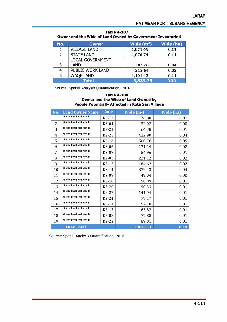
LARAP
PATIMBAN PORT, SUBANG REGENCY
4-114
Table 4-107. Owner and the Wide of Land Owned by Government Inventoried
No. Owner Wide (m2) Wide (ha)
1 VILLAGE LAND 1,071.69 0.11
2 STATE LAND 1,070.74 0.11
3 LOCAL GOVERNMENT LAND 382.28 0.04
4 PUBLIC WORK LAND 213.64 0.02
5 WAQF LAND 1,101.43 0.11
Total 3,839.78 0.38
Source: Spatial Analysis Quantification, 2016
Table 4-108. Owner and the Wide of Land Owned by
People Potentially Affected in Kota Sari Village
Source: Spatial Analysis Quantification, 2016
No. Land Owner Name Code Wide (m2) Wide (ha)
1 *********** KS-12 76.80 0.01
2 *********** KS-04 32.02 0.00
3 *********** KS-21 64.38 0.01
4 *********** KS-25 412.90 0.04
5 *********** KS-16 500.76 0.05
6 *********** KS-06 171.14 0.02
7 *********** KS-07 84.96 0.01
8 *********** KS-05 221.12 0.02
9 *********** KS-15 164.62 0.02
10 *********** KS-14 379.43 0.04
11 *********** KS-09 49.04 0.00
12 *********** KS-10 50.89 0.01
13 *********** KS-20 90.33 0.01
14 *********** KS-22 141.94 0.01
15 *********** KS-24 78.17 0.01
16 *********** KS-11 52.10 0.01
17 *********** KS-13 63.82 0.01
18 *********** KS-08 77.88 0.01
19 *********** KS-23 89.01 0.01
Luas Total 2,801.33 0.28

LARAP
PATIMBAN PORT, SUBANG REGENCY
4-115
Table 4-109. Owner and the Wide of Land Owned by
Government Potentially Affected in Kota Sari Village
No. Owner Wide (m2) Wide (ha)
1 VILLAGE LAND 100.09 0.01
2 STATE LAND 249.05 0.02
3 LOCAL GOVERNMENT LAND
72.34 0.01
4 TANAH PU 142.35 0.01
5 WAQF LAND 168.80 0.02
Total 732.64 0.07
Source: Spatial Analysis Quantification, 2016
4.6.4. Pusaka Jaya Village
Pusaka Jaya Village is situated in the northern coastal road and is adjacent to Pusaka Ratu
Village. The map of parcels of lands in this village is presented in Figure 4-22.
Figure 4-22.
The Map of Parcels of Lands in Pusaka Jaya Village

LARAP
PATIMBAN PORT, SUBANG REGENCY
4-116
4.6.4.1 The Land Use
Based on the survey, there are 5 types of land uses in Pusaka Jaya Village, namely brackish
water pond, road, constructed land, paddy field, river and riverbank. The wide of inventoried
land use in this village that potentially affected by this project is presented in the following
tables.
Table 4-110. The Wide of Land Use that have been Inventoried in Pusaka Jaya Village
No. Land use Wide (m2) Wide (ha)
1 Brackish water pond 875.38 0.09
2 Road 208.58 0.02
3 Constructed land 16,853.14 1.69
4 Paddy field 3,171.10 0.32
5 River 260.58 0.03
Total 21,368.78 2.14
Source: Spatial Analysis Quantification, 2016
Table 4-111.
The Wide of Land Use Owned by People that Potentially Affected in Pusaka Jaya Village
No. Land use Wide (m2) Wide (ha)
1 Brackish water pond 108.54 0.01
2 Road 18.42 0.00
3 Constructed land 2,076.04 0.21
4 Paddy field 339.62 0.03
Total 2,542.62 0.25
Source: Spatial Analysis Quantification, 2016
Table 4-112. The Wide of Land Owned by Government that
Potentially Affected in Pusaka Jaya Village
No. Land Use Wide (m2) Wide (ha)
1 River 40.17 0.004
Total 40.17 0.004
Source: Spatial Analysis Quantification, 2016
4.6.4.2 The Land Ownership
Based on the survey, there are 11 landowners identified in this village, but only 7 of them
whose lands potentially affected by the project. The total wide of lands that have been
inventoried in this village is 2.09 hectares, while the total wide of lands potentially affected
by the project is 0.25 hectares. The wide and owners of land potentially affected by the

LARAP
PATIMBAN PORT, SUBANG REGENCY
4-117
project that have been inventoried in this village are presented in Table 4-113 to Table 4-
114.
Table 4-113. Owner and the Wide of Land Owned by People Inventoried in Pusaka Jaya Village
No. Land Owner Name Code Wide (m2) Wide (ha)
1 *********** PJ-08 955.78 0.10
2 *********** PJ-09 98.79 0.01
3 *********** PJ-05 2,364.99 0.24
4 *********** PJ-01 3,998.09 0.40
5 *********** PJ-03 3,171.10 0.32
6 *********** PJ-06 1,978.51 0.20
7 *********** PJ-07 1,628.79 0.16
8 *********** PJ-11 638.60 0.06
9 *********** PJ-04 875.38 0.09
10 *********** PJ-02 5,073.94 0.51
11 *********** PJ-10 124.53 0.01
Luas Total 20,908.51 2.09
Source: Spatial Analysis Quantification, 2016
Table 4-114.
Owner and the Wide of Land Owned by
Government Inventoried in Pusaka Jaya Village
No. Owner Wide (m2) Wide (ha)
1 VILLAGE LAND 95.82 0.01
2 STATE LAND 260.58 0.03
3 WAQF LAND 103.88 0.01
Total 460.27 0.25
Source: Spatial Analysis Quantification, 2016
Table 4-115. Owner and the Wide of Land Owned by
People Potentially Affected in Pusaka Jaya Village
No. Land Owner Name Code Wide (m2) Wide (ha)
1 *********** PJ-05 335.14 0.03
2 *********** PJ-01 828.04 0.08
3 *********** PJ-03 339.62 0.03
4 *********** PJ-06 186.33 0.02
5 *********** PJ-07 78.00 0.01
6 *********** PJ-04 108.54 0.01
7 *********** PJ-02 666.94 0.07
Luas Total 2,542.62 0.25
Source: Spatial Analysis Quantification, 2016

LARAP
PATIMBAN PORT, SUBANG REGENCY
4-118
Table 4-116. Owner and the Wide of Land Owned by
Governmnet Potentially Affected
No. Owner Wide (m2) Wide (ha)
1 STATE LAND 40.17 0.004
Wide Total 40.17 0.004
Source: Spatial Analysis Quantification, 2016
4.6.5. Pusaka Ratu Village
Pusaka Ratu Village is situated in the northern coastal road and is adjacent to Gampol
Village, Kota Sari Village and Pusaka Jaya Village. The map of parcels of lands in this village
is presented in Figure 4-23.
Figure 4-23. The Map of Parcels of Lands in Pusaka Ratu Village
4.6.5.1 The Land Use
Based on the survey, there are 5 types of land uses in Pusaka Ratu Village, namely
riverbank, road, cemetery, paddy field and river. The land potentially affected by this project
is paddy field owned by the government (BPTP or Assessment Institute for Agricultural
Technology) with the wide of 2.35 hectares. The wide of inventoried land use in this village
that potentially affected by this project is presented in the following table.

LARAP
PATIMBAN PORT, SUBANG REGENCY
4-119
Table 4-117. The Wide of Land Use that have been
Inventoried in Pusaka Ratu Village
No. Land Use Wide (m2) Wide (ha)
1 Road 78.64 0.01
2 Cemetery 1,291.15 0.13
3 Farm field 12,884.78 1.29
4 Paddy field 136,772.99 13.68
5 River 256.18 0.03
6 Riverbank 1,641.98 0.16
Total 152,925.72 15.29 Source: Spatial Analysis Quantification, 2016
Table 4-118. The Wide of Land Use Owned by People that
Potentially Affected in Pusaka Ratu Village
No. Land Use Wide (m2) Wide (ha)
1 Farm field 9,047.48 0.90
2 Paddy field 5,207.26 0.52
Total 14,254.74 1.43 Source: Spatial Analysis Quantification, 2016
Table 4-119. The Wide of Land Use Owned by
Government that Potentially Affected
No. Land Use Wide (m2) Wide (ha)
1 Riverbank 247.37 0.02
2 Road 78.64 0.01
3 Cemetery 825.95 0.08
4 Paddy field 23,527.93 2.35
5 River 31.50 0.00
Total 24,711.41 2.47 Source: Spatial Analysis Quantification, 2016
4.6.5.2 The Land Ownership
Based on the survey, there are 21 landowners identified in this village, but only 197 of them
whose lands potentially affected by the project. The total wide of lands that have been
inventoried in this village is 15.29 hectares, while the total wide of lands potentially affected
by the project is 3.87 hectares. The wide and owners of land potentially affected by the
project that have been inventoried in this village are presented in Table 4-120 to Table 4-
121.

LARAP
PATIMBAN PORT, SUBANG REGENCY
4-120
Table 4-120. Owner and the Wide of Land Owned by People that have been Inventoried
No. Land Owner Name Code Wide (m2) Wide (ha)
1 *********** PR-19 2,284.67 0.23
2 *********** PR-10 1,508.29 0.15
3 *********** PR-12 1,168.06 0.12
4 *********** PR-18 2,425.46 0.24
5 *********** PR-21 3,478.20 0.35
6 *********** PR-22 2,015.68 0.20
7 *********** PR-04 516.20 0.05
8 *********** PR-20 72.47 0.01
9 *********** PR-14 1,043.76 0.10
10 *********** PR-07 969.75 0.10
PR-09 294.79 0.03
11 *********** PR-13 801.85 0.08
12 *********** PR-03 633.88 0.06
13 *********** PR-08 182.86 0.02
14 *********** PR-06 1,029.84 0.10
15 *********** PR-02 1,058.39 0.11
16 *********** PR-05 798.22 0.08
17 *********** PR-11 1,032.59 0.10
18 *********** PR-01 255.15 0.03
19 *********** PR-16 516.42 0.05
20 *********** PR-17 440.70 0.04
21 *********** PR-15 565.53 0.06
Luas Total 23,091.19 2.31 Source: Spatial Analysis Quantification, 2016
Table 4-121.
Owner and the Wide of Land Owned by Government Inventoried
No. Owner Wide (m2) Wide (ha)
1 VILLAGE LAND 3,178.20 0.32
2 STATE LAND 125,014.36 12.50
3
LOCAL GOVERNMENT LAND 1,641.98 0.16
Total 129,834.53 12.98 Source: Spatial Analysis Quantification, 2016

LARAP
PATIMBAN PORT, SUBANG REGENCY
4-121
Table 4-122. Owner and the Wide of Land Owned by People
Potentially Affected in Pusaka Ratu Village
No. Land Owner Name Code Wide (m2) Wide (ha)
1 *********** PR-19 1,038.84 0.10
2 *********** PR-10 866.13 0.09
3 *********** PR-12 986.87 0.10
4 *********** PR-18 757.65 0.08
5 *********** PR-21 2,185.22 0.22
6 *********** PR-22 2,015.68 0.20
7 *********** PR-04 516.20 0.05
8 *********** PR-20 72.47 0.01
9 *********** PR-14 647.27 0.06
10 *********** PR-07 969.75 0.10
PR-09 294.79 0.03
11 *********** PR-13 4.37 0.00
12 *********** PR-03 633.88 0.06
13 *********** PR-08 182.86 0.02
14 *********** PR-06 825.61 0.08
15 *********** PR-02 1,058.39 0.11
16 *********** PR-05 798.22 0.08
17 *********** PR-01 255.15 0.03
18 *********** PR-16 11.14 0.00
19 *********** PR-17 134.26 0.01
Luas Total 14,254.74 1.43 Source: Spatial Analysis Quantification, 2016
Table 4-123. Owner and the Wide of Land Owned by
Government Potentially Affected in Pusaka Ratu Village
No. Owner Wide (m2) Wide (ha)
1 VILLAGE LAND 904.59 0.09
2 STATE LAND 23,559.44 2.36
3 LOCAL GOVERNMENT LAND 247.37 0.02
Total 24,711.41 2.47 Source: Spatial Analysis Quantification, 2016

LARAP
PATIMBAN PORT, SUBANG REGENCY
4-122
4.7. THE PLANTS POTENTIALLY AFFECTED BY THE EXPANSION OF ACCESS ROAD TO THE PORT
The following described condition of the property affected trees and plants from field survey
conducted by census to every affected people (PAPs) in the region of the access road
(access road).
Table 4-124.
The Number and Percentage of Potentially Affected Plants
Type of Plant Village
Total % Gempol Pusakaratu
Akasia 4 1 5 0.30
Jabon 1 0 1 0.06
Jambu air 1 0 1 0.06
Kelapa 3 0 3 0.18
Kersen 8 0 8 0.49
Mangga 684 204 888 54.08
Nangka 28 0 28 1.71
Pepaya 7 0 7 0.43
Pete 10 0 10 0.61
Pisang 563 114 677 41.23
Rambutan 1 0 1 0.06
Randu 1 4 5 0.30
Sukun 8 0 8 0.49
Total 1,319 323 1,642 100
4.7.1. Trees and Plants Potentially Affected by the Project
A. Annual Plants
Based on the survey, most of annual crops potentially affected by the project is rice (95.7%),
and then followed by sweet leaf bush and pumpkin (2.2%) with the wide of area of 60 m2-
21,000 m2. More detailed on this can be seen in the following Table 4-125 and Table 4-126.
Table 4-125. The Number of Potentially Affected Annual Plants
Type of Annual Plant
Village Total %
Gempol Kalentambo Kotasari Pusakajaya Pusakaratu Rancadaka
Katuk 1 0 0 0 0 0 1 2,2% Padi 25 15 0 0 2 2 44 95,7% Labu 1 0 0 0 0 0 1 2,2% Total 27 15 0 0 2 2 46 100,0%
Source: Questionnaire Data Processing Result, 2016
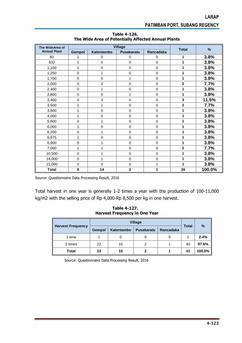
LARAP
PATIMBAN PORT, SUBANG REGENCY
4-123
Table 4-126. The Wide Area of Potentially Affected Annual Plants
The WideArea of Annual Plant
Village Total %
Gempol Kalentambo Pusakaratu Rancadaka
60 1 0 0 0 1 3.8% 832 1 0 0 0 1 3.8%
1,100 1 0 0 0 1 3.8% 1,250 0 1 0 0 1 3.8% 1,700 0 0 1 0 1 3.8% 2,000 0 2 0 0 2 7.7% 2,400 0 1 0 0 1 3.8% 2,800 0 0 1 0 1 3.8% 3,400 0 3 0 0 3 11.5% 3,500 1 1 0 0 2 7.7% 3,600 1 0 0 0 1 3.8% 4,000 1 0 0 0 1 3.8% 5,600 0 1 0 0 1 3.8% 6,000 1 0 0 0 1 3.8% 6,200 0 1 0 0 1 3.8% 6,875 1 0 0 0 1 3.8% 6,900 0 1 0 0 1 3.8% 7,000 1 1 0 0 2 7.7% 10,500 0 1 0 0 1 3.8% 14,000 0 1 0 0 1 3.8% 21,000 0 0 0 1 1 3.8% Total 9 14 2 1 26 100.0%
Source: Questionnaire Data Processing Result, 2016
Total harvest in one year is generally 1-2 times a year with the production of 100-11,000
kg/m2 with the selling price of Rp 4,000-Rp 8,500 per kg in one harvest.
Table 4-127. Harvest Frequency in One Year
Harvest Frequency Village
Total % Gempol Kalentambo Pusakaratu Rancadaka
1 time 1 0 0 0 1 2.4%
2 times 22 15 2 1 40 97.6%
Total 23 15 2 1 41 100.0%
Source: Questionnaire Data Processing Result, 2016
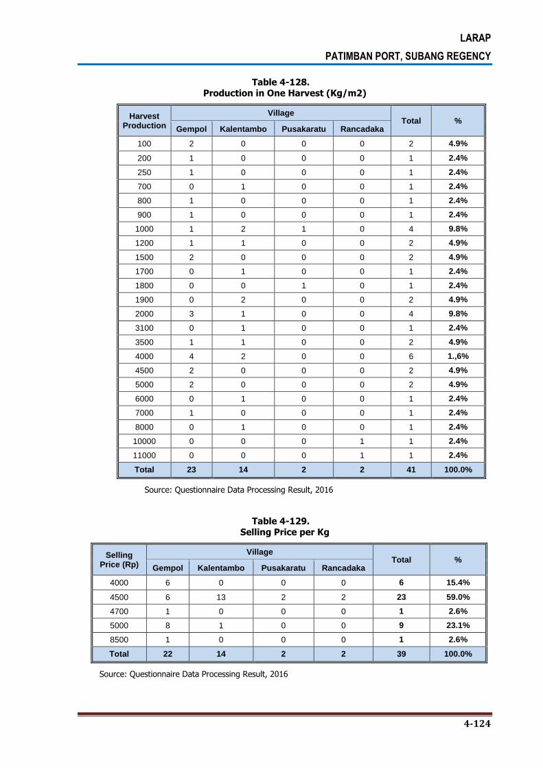
LARAP
PATIMBAN PORT, SUBANG REGENCY
4-124
Table 4-128. Production in One Harvest (Kg/m2)
Harvest Production
Village Total %
Gempol Kalentambo Pusakaratu Rancadaka
100 2 0 0 0 2 4.9%
200 1 0 0 0 1 2.4%
250 1 0 0 0 1 2.4%
700 0 1 0 0 1 2.4%
800 1 0 0 0 1 2.4%
900 1 0 0 0 1 2.4%
1000 1 2 1 0 4 9.8%
1200 1 1 0 0 2 4.9%
1500 2 0 0 0 2 4.9%
1700 0 1 0 0 1 2.4%
1800 0 0 1 0 1 2.4%
1900 0 2 0 0 2 4.9%
2000 3 1 0 0 4 9.8%
3100 0 1 0 0 1 2.4%
3500 1 1 0 0 2 4.9%
4000 4 2 0 0 6 1.,6%
4500 2 0 0 0 2 4.9%
5000 2 0 0 0 2 4.9%
6000 0 1 0 0 1 2.4%
7000 1 0 0 0 1 2.4%
8000 0 1 0 0 1 2.4%
10000 0 0 0 1 1 2.4%
11000 0 0 0 1 1 2.4%
Total 23 14 2 2 41 100.0%
Source: Questionnaire Data Processing Result, 2016
Table 4-129. Selling Price per Kg
Selling Price (Rp)
Village Total %
Gempol Kalentambo Pusakaratu Rancadaka
4000 6 0 0 0 6 15.4%
4500 6 13 2 2 23 59.0%
4700 1 0 0 0 1 2.6%
5000 8 1 0 0 9 23.1%
8500 1 0 0 0 1 2.6%
Total 22 14 2 2 39 100.0%
Source: Questionnaire Data Processing Result, 2016
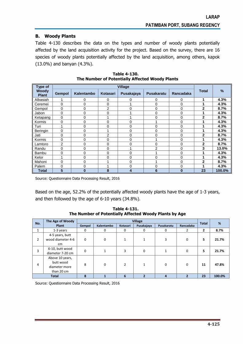
LARAP
PATIMBAN PORT, SUBANG REGENCY
4-125
B. Woody Plants
Table 4-130 describes the data on the types and number of woody plants potentially
affected by the land acquisition activity for the project. Based on the survey, there are 16
species of woody plants potentially affected by the land acquisition, among others, kapok
(13.0%) and banyan (4.3%).
Table 4-130. The Number of Potentially Affected Woody Plants
Type of Woody Plant
Village Total %
Gempol Kalentambo Kotasari Pusakajaya Pusakaratu Rancadaka
Albasiah 1 0 0 0 0 0 1 4.3%
Ceremei 0 0 0 1 0 0 1 4.3%
Gempol 0 0 2 0 0 0 2 8.7%
Jabon 0 0 0 1 0 0 1 4.3%
Ketapang 0 0 1 1 0 0 2 8.7%
Kormis 0 0 0 0 1 0 1 4.3%
Turi 1 0 0 0 0 0 1 4.3%
Beringin 0 0 1 0 0 0 1 4.3%
Jati 0 0 2 0 0 0 2 8.7%
Kormis 0 0 0 0 1 0 1 4.3%
Lamtoro 2 0 0 0 0 0 2 8.7%
Randu 0 0 0 1 2 0 3 13.0%
Bambu 0 0 0 0 1 0 1 4.3%
Kelor 1 0 0 0 0 0 1 4.3%
Mahoni 0 0 1 0 1 0 2 8.7%
Palem 0 0 1 0 0 0 1 4.3%
Total 5 0 8 4 6 0 23 100.0%
Source: Questionnaire Data Processing Result, 2016
Based on the age, 52.2% of the potentially affected woody plants have the age of 1-3 years,
and then followed by the age of 6-10 years (34.8%).
Table 4-131. The Number of Potentially Affected Woody Plants by Age
No. The Age of Woody
Plant Village
Total % Gempol Kalentambo Kotasari Pusakajaya Pusakaratu Rancadaka
1 1-3 years 0 0 0 0 0 2 2 8.7%
2 4-5 years, butt
wood diameter 4-6 cm
0 0 1 1 3 0 5 21.7%
3 6-10, butt wood
diameter 7-20 cm 0 1 3 0 1 0 5 21.7%
4
Above 10 years, butt wood
diameter more than 20 cm
8 0 2 1 0 0 11 47.8%
Total 8 1 6 2 4 2 23 100.0%
Source: Questionnaire Data Processing Result, 2016

LARAP
PATIMBAN PORT, SUBANG REGENCY
4-126
C. Fruit Plants
Based on Table 4-132, there are 18 types of fruit plants that potentially affected by the
project, among others, mangoes (42.7%) and bananas (16.7%). More detailed on this can
be seen in the following table.
Table 4-132.
The Number of Potentially Affected Fruit Plants
Type of Fruit Plant
Village Total %
Gempol Kalentambo Kotasari Pusakajaya Pusakaratu Rancadaka
Asem 0 0 2 0 1 0 3 2.0%
Belimbing 0 0 1 0 0 0 1 0.7%
buah naga 1 0 0 0 0 0 1 0.7%
jambu air 0 0 4 3 0 0 7 4.7%
jambu biji 0 0 3 0 0 0 3 2.0%
jambu klotok 0 0 1 0 0 0 1 0.7%
Jeruk 0 0 0 0 1 0 1 0.7%
kedongdong 0 0 0 0 1 0 1 0.7%
Kelapa 0 0 6 2 0 0 8 5.3%
kelengkeng 0 0 1 0 0 0 1 0.7%
Kersen 0 0 1 0 0 0 1 0.7%
Mangga 29 0 13 7 14 1 64 42.7%
Nangka 3 0 3 3 1 0 10 6.7%
Pepaya 2 0 3 3 0 0 8 5.3%
Pete 4 0 4 1 2 0 11 7.3%
Pisang 6 0 9 4 6 0 25 16.7%
Srikaya 0 0 0 1 0 0 1 0.7%
Sukun 0 0 2 0 1 0 3 2.0%
Total 45 0 53 24 27 1 150 100.0%
Source: Questionnaire Data Processing Result, 2016
Table 4-133.
Harvest Production in One Year by Age of Plant
Age of
Plant
Harvest Production
Village Total Total
Gempol Kalentambo Kotasari Pusakajaya Pusakaratu Rancadaka
1-3 years
100 1 0 2 0 1 0 4 2.7%
12 0 0 1 0 0 0 1 0.7%
20 2 0 1 0 0 0 3 2.0%
200 0 0 0 0 1 0 1 0.7%
30 2 0 0 0 0 0 2 1.3%
4-5 years
100 29 0 13 7 14 1 64 42.7%
55 2 0 1 0 0 0 3 2.0%
50 6 0 9 4 6 0 25 16.7%
40 2 0 3 3 0 0 8 5.3%
6-10 years
300 0 0 3 0 0 0 3 2.0%
40 3 0 0 0 1 0 4 2.7%
400 1 0 0 0 0 0 1 0.7%
50 8 0 2 0 6 0 16 10.7%
Above 10
years
60 0 0 1 0 0 0 1 0.7%
66 4 0 4 1 2 0 11 7.3%
80 0 2 0 0 1 0 3 2.0%
Total 60 2 40 15 32 1 150 100.0%
Source: Questionnaire Data Processing Result, 2016
The selling price of the fruits is ranging from Rp 3,000-Rp 20,000 per kg in each harvest.

LARAP
PATIMBAN PORT, SUBANG REGENCY
4-127
Table 4-134. Selling Price per Kg
Selling Price
Village Total %
Gempol Kotasari Pusakajaya Pusakaratu Rancadaka
3000 0 2 0 0 2 4 1.8%
4000 2 3 2 0 4 11 4.8%
5000 5 8 2 0 8 23 10.1%
6000 12 20 8 5 24 69 30.3%
7000 5 1 2 4 4 16 7.0%
8000 6 4 3 5 7 25 11.0%
10000 6 5 3 7 8 29 12.7%
12000 0 2 0 1 3 6 2.6%
13000 0 0 0 1 1 2 0.9%
15000 4 5 1 3 10 23 10.1%
20000 3 3 3 1 10 20 8.8%
Total 43 53 24 27 81 228 100.0%
Source: Questionnaire Data Processing Result, 2016
4.8. OTHER ASSETS POTENTIALLY AFFECTED BY THE PROJECT IN ACCESS ROAD AREA
Based on the assets inventorying data, there are also other objects related to the land that
will be affected by the project, namely 6 drainages and 3 electrical poles, and 1 other asset.
The length of the drainages is 8-300 meters with the width of 4-24 meters, and the height
of electrical poles is 4 meters and 8 meters. The drainages are privately owned by the
people.
Table 4-135. Other Assets Potentially Affected By The Project
No. Village
Jenis Aset
Total Drainage %
Electrical Pole
% Phone Line %
1 Kotasari 5 26.3% 5 26.3% 1 5.3% 11
2 Pusakajaya 4 21.1% 4 21.1% 0 0.0% 8
Total 9 47.4% 9 47.4% 1 5.3% 19
Source: Questionnaire Data Processing Result, 2016

LARAP
PATIMBAN PORT, SUBANG REGENCY
5-128
CHAPTER 5. COMPENSATION POLICIES
5.1. ENTITLED PARTIESAND CUT-OFF DATE
Entitled parties are all of people whose livelihood is affected by the project plan, not
only land owners but including wedge earners farmland, fishpond as well as marine
fishermen and those who control or have an object of land acquisition. The objects of
land acquisition include land, over ground and underground space, plants, buildings,
objects related to land, other appraisable losses22. Provisions regarding entitled parties
referred to in Article 16 of President Regulation No. 71 of 2012 as follows: individuals,
legal entities, social institutions, religious institutions, or government agencies that own
or control Land Acquisition Object in accordance with applicable rules and regulations.
The entitled parties shall be those who control or own the object of the land acquisition,
among others: (i) the holders of land rights; (ii) the holders of land rights to manage;
(iii) nadzir for the waqf land; d. the owners of former customary rights secured land;
(v) indigenous people/customary communities;(vi) the parties occupying the state land
in good faith; (vii) land tenure holders; and/or (viii) the owners of buildings, plants or
other objects related to the land.
Results of initial identification of the asset survey that will be affected by the project
activities include: houses, vacant land, agricultural land, fishpond, business premises
land, and social/public facilities. Most of those assets are owned personally, and the
rest of them are entreprise land and state land, and the people occupy the assets with
and without permission. Identification of non-material assets is also performed which
includes revenue/business opportunity, networking and social and cultural events that
will be permanent or temporary affected by the project.This also includes "Other
appraisable loss" in the form of non-physical loss equivalent to money value, for
example, loss due to loss of business or job, cost of change of location, cost of change
of profession, and loss of value of the remaining property23.
22
Law No. 2 of 2012.
23 Explanation of Law No. 2 of 2012, Article 33 letter f.

LARAP
PATIMBAN PORT, SUBANG REGENCY
5-129
Entitled parties identified in the project area are entitled to receive compensation in
accordance with the provisions of Law No. 2 of 2012. The alternative compensations
that can be discussed with affected households are in the form of: a) cash, b)
replacement land, c) resettlement, d) share ownership, and e) other forms agreed by
both parties.
In this project plan, party entitled to compensation can be described as follows: (i)
persons with formal legal rights to land they may lose in its entirety or in part, (ii) )
persons who may lose the land they occupy or utilize in its entirety or in part who have
no formal legal rights to such land or resources but have claims to such lands or
resources such as customary claims, that are recognized or recognizable under national
laws, i.e., nadzie for waqf land, former customary rights secured landowners,
indigenous people/customary communities, parties occupy the state land in good faith;
and (iii) persons who may lose the land they occupy or utilize in its entirety or in part
who have neither formal legal rights nor recognized or recognizable claims to such land
or resources such as owners of buildings, plants or other objects related to land.24
For the marine fishermen who earn their livlihood based on the fishing ground in the
sea area where the port will be constructed, there are no clear legal bases for
estimating compensation amount. However, considering the possible impacts on their
livelihood caused by the disturbance of the fishing ground and the navigation route,
marine fishermen is also entitled for the Livelihood Restoration Program (LRP).
The cut-off date to determine compliance with the requirements of project entitlement
is implemented in two stages. First, it is an initial process of determining the transfer of
right over land/other assets by referring to the date on which the determination of
location for development in the Public Interest is announced by the Governor of West
Java Province and Directorate General of Sea Transportaion (DGST). At this stage, the
entitled party can only do the transfer of right over their own land/other assets to the
agency requiring the land (DGST) through the National Land Agency of West Java
Province/Subang Regency. The transfer of right is carried out by providing the
compensation which value is assessed by independent assessor during the
announcement of location of Patimban Port Development. Second, the determination
24
In this case the proof of ownership or control of a plot of land belonging to indigenous and control over state-owned land in good faith does not exist, proof of ownership or control can be done with other evidence in the form of a written statement of the question and the information that can be trusted from at least two (2) witnesses from the local communities that do not have a family relationship with the relevant up to the second degree, both in kinship vertically or horizontally, stating that the person concerned is correct as the owner or the master plot of land (Presidential Decree No. 71 of 2012 Article 26).

LARAP
PATIMBAN PORT, SUBANG REGENCY
5-130
of Parties Entitled for the compensation is set out during the implementation phase of
land acquisition after the Inventory and Identification is announced by the Head of
Land Acquisition Implementation Team and there is no objection from the Entitled
Party on the results of verification of the inventory and identification signed by the
Head of Land Acquisition Implementation Team. The announcement of inventory and
identification result includes a list of entitled parties and losses and is performed in
public places (e.g. Village Hall/Office, sub-district office, and land acquisition
location).25
The cut-off-date for this project will be announced when the determination of location
is announced by the Governor. The cut-off-date will be applied to both physical and
non-physical loss including the right to participate in livelihood restoration program
(LRP).
The cut-off date set out in detail the deadline for determining the eligibility for people
who live or have assets or interests in the project area. If the people are severely
affected, they are entitled to compensation for affected assets, including rehabilitation
measures needed, appropriately to help the entitled people to increase or at least
maintain their standard of living, income and the level of production as they have
before the project. The cut-off date either in the preparation or in the implementation
stage will be well informed to entitled parties and other stakeholders.
The Land Acquisition and Resettlement Action Plan (LARAP) recognize certain social
groups (vulnerable groups) who are less able to restore their living standards,
livelihoods and income level. Therefore, these groups have a greater risk of
impoverishment when their land and other assets lost due to the project. The
vulnerable categorized people are: the landless, poor, households headed by women,
the elderly, and the disabled. This group will receive special assistance and
rehabilitation and will be determined during the process of screening and social impact
assessment. The program to restore living condition of vulnerable people and affected
people will be addressed through livelihood restoration program (LRP) to be
implemented by DGST and other appropriate programs to serve the poor and other
vulnerable groups.
25
Law No. 2 of 2012 Article 29.

LARAP
PATIMBAN PORT, SUBANG REGENCY
5-131
Based on the abovementioned description, the Entitled Party will be compensated
equivalent full replacement cost and other assistance as provided in Entitlement Matrix
(Table 5.1), as stipulated in Law No. 2 of 2012 and explanatory regulations.
5.2. CRITERIA OF ELIGIBILITY AND ENTITLEMENT OF AFFECTED PEOPLE
Based on the results of asset ownership census, all affected households will be given
appropriate compensation in accordance to their rights. Entitlement matrix below
(Table 5-1) discusses and describes the detriment of losing agricultural land, non-
agricultural land, business, residence land or building and other public facilities. The
temporary loss is also reflected in the ownership matrix.
Table 5-1. Entitlement Matrix for Land Acquisition and Land Clearing
No. Impact/ Loss
Category Entitled People Project Entitlement
LegalBasis / Implementation
Mechanism
Excecuting Agency/ Fund Resources Remark
A. LAND LOSS26
1 Loss of land, including agricultural, fishpond land and residential land
Those who have formal legal rights (certificate) or those whose claim over the land is recognized as a full title including persons occupying the state land in good faith (toward land use)27.
Cash compensation at replacement cost and reflective of fair market value at the time of payment of compensation28; or land replacement with at least similar attributes to the acquired land in term of value,
a) Law No 2/2012, Article 36
b) Presidential Regulation No 71/2012, Article : 65, 77
c) Indonesia Valuation Standards 306 (SPI 306)
LMANallocate land compensation
Land Acquisition ImplementingTeam deliver compensation
Applicable for Land Acquisition32.
The land acquisition is carried out based on the provisions of Law No. 2/2012 and its implementation regulations, including for the
26
Law No. 2 of 2012, Article 36 states that compensation can be given in the form of; (i) cash / money; ii) replacement land; iii) resettlement; iv) shares ownership , and v) other forms agreed by both parties. Assessment of compensation by appraisers in accordance with Article 32 of Law should be done per plot.
27 It is in line with the Law No. 2/2012, Article 40, and its elucidation and the PP No. 71/2012, Article 17-25.
28 See Law No. 2/2012, Article 36, PP No. 71/2012, Article 65. MAPPI’s standard on Valuation for land acquisition for the development in the public interest.
LARAP
PATIMBAN PORT, SUBANG REGENCY
5-132
No. Impact/ Loss
Category Entitled People Project Entitlement
LegalBasis / Implementation
Mechanism
Excecuting Agency/ Fund Resources Remark
productivity, location, and certification29.
Financial assistance for the renewal of the land ownership documents (certificate and land documents recognized as full title) for the residual area of the entitled persons' land30.
If the remaining affected land can’t be functioned for the specific use and utilization, the entitled party can ask for compensation for their entire land at replacement cost (UU No. 2 tahun 2012 Pasal 35).31
Independent Appraisal: conduct a valuation of the assets.
land in the river banks or riparian area/beach area with legal ownership. Valuation of compensation conducted by a licensed independent property appraiser, determined based on an assessment by an independent appraisal and negotiations have been carried out by the Land Acquisition Implementing Team
6 months advance notice is given to the entitled party before they have to destroy the overall house or
32
Land acquistition refers to land acquisition activities by way of giving equitable and fair compensation for losses to the entitled parties who controls or posess the land acquisition objects. Included within this scope is the land acquisition on the river banks or riparian area legally owned by another party. See Law No. 2/2012, Article 1.
29 Ibid
30 See MAPPI’s valuation standard.
31 Article 35 of Law No. 2 of 2012 and Article 67 of the PP 71/2012.

LARAP
PATIMBAN PORT, SUBANG REGENCY
5-133
No. Impact/ Loss
Category Entitled People Project Entitlement
LegalBasis / Implementation
Mechanism
Excecuting Agency/ Fund Resources Remark
store.
Tax incentives given to all entitled parties if they do not file a lawsuit against the decision of the location and the form and / or amount of compensation.
Law No. 2 /2012 Art. 44
Presidential Regulation No. 71/ 2012 Article122
Government: provide tax incentives (BPHTB) to entitled parties
Entitled parties bear the cost of the tax payable in the current year if they file a lawsuit. However, if there was an agreement / relinquishment of the land, then they are entitled to tax incentives33
2 Loss of customary land In the region patmban still a lot of land that has not been certified and only had evidence of a letter of the tax paid. Have been identified
Customary community34
Land replacement will be provided with similar value or higher (in terms of value, productivity, location, and titling)35
Compensation with cash reflects
Elucidation of Law No.2 / 2012 Article. 40
Land requiring agencies (DGST)/LMAN allocate land compensation
Land Acquisition Implementing Team deliver
The presence of indigenous peoples will be based on the results of the study, local government regulations, or the map on indigenous
33
Income taxes will be the responsibility of the entitled party and there is no tax deduction.
34 Customary or indigenous community is a community that is characterized by; i) the existence of group of people who are still bound by customary legal order as a whole community of an alliance with a particular customary law, who recognizes and implements the tradition in their daily life; ii) the existence of certain customary lands, which are the environment of the customary community and the area where they take their daily needs; and iii) the existence of common law regarding the maintenance of order, dominance, and applicable customary land use adhered by the members of the community. PP No. 71/2012, Article 22.
35 Elucidation of Article 40 of Law No. 2/2012

LARAP
PATIMBAN PORT, SUBANG REGENCY
5-134
No. Impact/ Loss
Category Entitled People Project Entitlement
LegalBasis / Implementation
Mechanism
Excecuting Agency/ Fund Resources Remark
as possible evidence girik letter, which can describe the genealogy of the land. Possibilities could be categorized as a land inherited from ancestors
the fair market value at the time of compensation payment. No deduction for transaction costs; or
Other forms of compensation agreed upon by indigenous people
compensation
Independent Appraisal: conduct a valuation of the assets.
peoples.
3 Government/ state enterprise land
Land owned / controlled by the government, state enterprises, village treasury
Cash Compensation at replacement cost; or
Land replacement with similar value or higher (in terms of value, productivity, location, and titling).
Presidential Regulation 71/2012 Article 82, 112
Regulation of the Head of BPN No. 5/2012 Article 29, 49
DGST/LMAN allocate land compensation
Land Acquisition Implementing Team deliver scompensation
Independent Appraisal: conducts a valuation of the assets.
Compensation will be provided for
i) Land owned/controlled by government with building used actively for governance; ii) land is owned/controlled by national and local state owned enterprises; iii) village land36
BPN transfers the acquired land owned by government / provincial government / SOE / regional government / village owned enterprise, to the
36
Article 82 of PP 71/2012.
LARAP
PATIMBAN PORT, SUBANG REGENCY
5-135
No. Impact/ Loss
Category Entitled People Project Entitlement
LegalBasis / Implementation
Mechanism
Excecuting Agency/ Fund Resources Remark
agency requiring land (DGST/LMAN) within 60 working days after the Governor of West Java Province/ Regent of Subangissued determinationlocation.
B. LOSS OF CROPS AND TREES
1. Loss of Crops and Trees:
Owners, regardless of land tenure status (with certificate or recognizable rights, informal dwellers, occupants).
Annual crops: cash compensation will be paid based on prevailing market rates.
Perennial crops: compensation at replacement cost taking into account their productivity and age37.
Timbers/trees: compensation at current market rate based on age, type of trees and diameter of trunk at breast height38.
Law No. 2 /2012 Pasal 33
Presidential Regulation No. 71/2012 Article 65
Presidential Regulation No. 30/2015 BPN Head Regulation No. 5/2012 Article 23, 24
Regulation of the Minister of Agrarian and Spatial
DGST/LMAN allocate budget for compensation
Land Acquisition Implementing Team delivers compensation
Independent Appraisal: conducts a valuation of the assets.
Applicable for Land Acquisition and Clearing39
Commercial crops: referring to income approach using Discarded Cash Flow (DCF) for 1 cycle
Non commercial crops: referring to market approach with a standard reference price issued by the local
37
For commercial plants, aside of considering market rate, appraiser will also consider DCF method for 1 cycle. While for non-commercial plants, the valuation is carried out in reference to the pricing standard issued by the concerned authorities. For plants, which are not productive yet, the valuation method uses cost approach.
38 Ibid.

LARAP
PATIMBAN PORT, SUBANG REGENCY
5-136
No. Impact/ Loss
Category Entitled People Project Entitlement
LegalBasis / Implementation
Mechanism
Excecuting Agency/ Fund Resources Remark
Planning/Head of National Land Agency No.6 of 2015 Presidential Regulation No. 38/2007
Indonesia Valuation Standards 306 (SPI 306) / 2013
government.
Non productive Plants: referring to cost approach;
30 to 60 days advance notice before harvesting / land clearing.
C. LOSS OF STRUCTURE
1
Loss of main structures (houses, offices, independent shops) and secondary structures (fences, driveways, extended eaves, sheds, etc.)
Owners of the affected structure, regardless of tenure40
Compensation at full replacement cost that reflect prevailing market prices of materials and cost of labor for dismantling, transferring and rebuilding at the time of compensation payment. No depreciation should be applied
Law No. 2 / 2012 Article 33
Elucidation of Law No. 2/2012 Article 35, 40
Presidential Regulation No. 71/2012 Article 65
Land requiring agencies (DGST/LMAN) allocate budget for compensation
Land Acquisition Implementing Team delivers compensation
Independent
Applicable for Land Acquisition and Clearing
Valuation is determined by an independent appraiser
Depreciation applies for the physical
39
Clearing land, refers to any activity for make a land that has been owned by the land requiring agency and has been occupied by the people, such as riparian area and flood plains to be used for development / projects, by giving the occupants 'compensation' over the affected assets and social programs. For land that has been owned by land requiring agency, the action of acquiring land is a land clearance, not a land acquisition. In this case Law No. 2 of 2012 does not apply.
40 Law No. 12/2012 Article 40 and the explanation, Indonesia Assessment Standards 2013 For commercial crops, in addition to considering market prices, assessors will also consider the DCF method for 1 cycle. Whereas for non-commercial crops, assessment is based on standards price issued by the competent authorities. For plants that are no longer productive, assessment uses the cost approach. See Indonesia Valuation Standards 306. MAPPI (Indonesian Society of Appraisers) 2013.

LARAP
PATIMBAN PORT, SUBANG REGENCY
5-137
No. Impact/ Loss
Category Entitled People Project Entitlement
LegalBasis / Implementation
Mechanism
Excecuting Agency/ Fund Resources Remark
or;
Option of Resettlement with comparable access to employment and production.
For partially affected structures, the cost of repairing the residual unaffected portion of the structure in addition to the compensation at replacement cost for the affected portion of the same41.
Compensation for affected electric, telephone, and other services based on prevailing cost of disconnection and re-installation42.
Presidential Regulation No. 30 of 2015. BPN Head Regulation No. 5/2012 Article 23, 24
Regulation of the Minister of Agrarian and Spatial Planning/Head of National Land Agency No.6 of 2015 Government Regulation No. 38/2007
Indonesia Valuation Standards 306 (SPI 306) / 2013
Appraisal: conducts a valuation of the assets.
condition of structures / buildings only. There is no depreciation for age of the building.
Depreciation for structures affected, will be given back to the rightful parties through the emotional compensation (solatium). See D. 3 below.
6 months advance notice is given to the entitled party prior to the date on which they must demolish their entirely affected houses or shops.
If more than 50%
41
Elucidation Article 33 of Law No 2/2012.
42 Article 33 of Law No. 2 of 2012 and Indonesia Valuation Standards (SPI 306) 2013.

LARAP
PATIMBAN PORT, SUBANG REGENCY
5-138
No. Impact/ Loss
Category Entitled People Project Entitlement
LegalBasis / Implementation
Mechanism
Excecuting Agency/ Fund Resources Remark
of the main structure is affected, the entire structure will be replaced at full replacement cost.
If less than 50% of the main structure is affected, but would endanger the stability of the residual area of the main structure, that is, structurally unstable, then the project will compensate at full replacement cost of equivalent structures.
If the resettlement / relocation is chosen, the relocation / resettlement sites should be discussed with the entitled parties, including teh provision of public services and facilities as well as access to employment and

LARAP
PATIMBAN PORT, SUBANG REGENCY
5-139
No. Impact/ Loss
Category Entitled People Project Entitlement
LegalBasis / Implementation
Mechanism
Excecuting Agency/ Fund Resources Remark
production
In case of delay in the construction of relocation sites, cash assistance equivalent to temporary house rental rates until the completion of resettlement in a new place.
Resettlement / Relocation Option will not be granted for land clearing
3 months - 1 year advance notice, before the date on which the affected tenants must move
Relocated entitled people regardless of land tenure
Cash allowance for moving if the project is not able to provide the use of a truck or a means of transportation to
Elucidation of Law No. 2/2012 Article 33 f
BPN Head Regulation No. 5 /2012 Article 30,
Land requiring agencies (DGST/LMAN) allocate budget for compensation
Land Acquisition
3 months - 1 year advance notice, before the date on which the affected tenants must move
In clearing the land, moving cost and

LARAP
PATIMBAN PORT, SUBANG REGENCY
5-140
No. Impact/ Loss
Category Entitled People Project Entitlement
LegalBasis / Implementation
Mechanism
Excecuting Agency/ Fund Resources Remark
carry goods to a new place.43
31; Regulation of the Minister of Agrarian and Spatial Planning/Head of National Land Agency No.6 of 2015 Indonesia Valuation Standards 306 (SPI 306) of 2013
Law No. 11/ 2009 on Social Welfare
Implementing Team delivers compensation
Independent Appraisal: conducts a valuation of the assets.
Regional Government : Social Program (land clearing)
transition allowance will be provided as required in the Land Acqusition Provisions to be included in social programs.
These requirements will be incorporated into the TOR for valuation of object loss/acquired land in determining the value of compensation
Tenant house / shop regardless of tenure
cash assistance equivalent of 12 months rental cost
Elucidation of Law No. 2 / 2012 Article 33 f
BPN Head Regulation No. 5/2012 Article 30, 31; Regulation of the Minister of Agrarian and Spatial Planning/Head of National Land Agency No.6
DGST/LMAN allocate budget for compensation
Land Acquisition Implementing Team delivers compensation
Independent Appraisal: conducts an valuation of the assets.
3 months prior notice before the date on which the affected tenants must move
43
Elucidation of Article 33 of Law No. 2 of 2012.
LARAP
PATIMBAN PORT, SUBANG REGENCY
5-141
No. Impact/ Loss
Category Entitled People Project Entitlement
LegalBasis / Implementation
Mechanism
Excecuting Agency/ Fund Resources Remark
of2015 Indonesia Standard Valuation 306 (SPI 306) of 2013
Law No. 11 Tahun 2009 on Social Welfare
Regional Government : Social program (Land Clearing)
2 Infrastructure and public facilities / objects attached to land
Government or State Enterprises/ communal property and assets (eg schools, mosques, village office power poles, etc.)
Rebuilding the facility or provide cash compensation based on the agreement with the affected parties44.
Law No. 2 Tahun 2012 Article 33
Presidential Regulation No. 71/2012 Article 82
DGST/LMAN allocate budget for compensation
Land Acquisition Implementing Team delivers compensation
Independent Appraisal: conducts an valuation of the assets.
Local Government: allocate budgets or rebuild facility
Valuation of affected assets will be performed by an independent appraiser
3 Tomb / grave Owner A replacement for public cemetery though prior consultation with village officials and residents.
Law No. 2/2012 Article 33
Presidential Regulation No. 71 / 2012 Article 82
DGST/LMAN allocate budget for compensation
Land Acquisition Implementing
Valuation of loss performed by an independent appraiser
44
Article 33 of Law No. 2 of 2012 and Article 82 of the Presidential Regulation Number 71 of 2012.

LARAP
PATIMBAN PORT, SUBANG REGENCY
5-142
No. Impact/ Loss
Category Entitled People Project Entitlement
LegalBasis / Implementation
Mechanism
Excecuting Agency/ Fund Resources Remark
Financial assistance to move the graves, including costs for the ceremony
Presidential Regulation No 30 of 2015
Team delivers compensation
Independent Appraisal: conducts an valuation of the assets.
Regional Government: allocate budget for land replacement, removal costs, including the cost of the ceremony
D. Temporary impact during construction
4 Temporary impact during construction to land
For those who have formal legal rights (certificate) or those whose claim on land is recognized as a full right
For lease payments of the affected land by the contractor based on the applicable rental fees and agreements with landowners.
For productive land, the cost of the rental will not be less than the net income that will be generated from productive affected land
compensation for non-land assets acquired (trees / plants, buildings) will be provided at replacement cost
Land will be
Contract documents / agreements with civil works contractors
contractors 30-60 days prior notice given to the owner of the land before it is used temporarily by contractors.
This provision is stated in the contract / agreement with the civil works contractors
Temporary impacts during construction include activities at the borrow pit area.

LARAP
PATIMBAN PORT, SUBANG REGENCY
5-143
No. Impact/ Loss
Category Entitled People Project Entitlement
LegalBasis / Implementation
Mechanism
Excecuting Agency/ Fund Resources Remark
restored to pre-project conditions or even better.
Those who do not have legal rights and entitlements that can be recognized as full ownership
There is no land rental costs during the period of impact
Land will be restored as it was before the project, or even better.
Contract documents /agreements with civil works contractors
Contractors
E. Other Appraisable Loss
1. Loss of income, venture and job
Business owner and employees regardless the tenure
The loss of a permanent business (restaurant, café, shop) or a termination due to closure of business premises: Replace the loss in cash based on the loss of business investment (capital, other production mode) is added to the total loss of revenue of at least 6 months and support the transition allowance in accordance with the time needed to stabilize the business.
Elucidation of Law No. 2 of 2012 Article 33 f
Presidential Regulation No. 71/2012 Article 33 f
Presidential
Regulation No 30 of 2015
Government Regulation No. 38 of 2007
Indonesia Valuation Standards (SPI 306), 2013,
DGST allocate land compensation
Land Acquisition Implementing Team delivers compensation
Independent Appraisal: conducts an valuation of the assets.
Regional Government: Social program
Applicable for Land Acquisition and Land Clearing:
For permanent loss, SPI 306 assess entire business losses include business interruption.
Waiting cost is needed so that affected operations business activities can resume
Temporary Lost:
Compensations in cash based on the loss of expected revenue is to be
Elucidation of Law No. 2 of 2012 Article 33 f
Government Regulation No. 38 of
Land requiring agencies allocate budget for compensation
For land clearing compensation can be covered from social programs

LARAP
PATIMBAN PORT, SUBANG REGENCY
5-144
No. Impact/ Loss
Category Entitled People Project Entitlement
LegalBasis / Implementation
Mechanism
Excecuting Agency/ Fund Resources Remark
obtained from use of the affected assets45.
2007
Indonesia Valuation Standards (SPI 306), 2013,
Land Acquisition Implementing Team delivers compensation
Independent Appraisal: conducts a valuation of the assets.
Regional government: Social program
Permanent job loss:
Damages in cash equivalent to the amount of lost job income multiplied at least by 6 months, or
Change profession: Cash compensation based on the costs required to change the profession on par with previous professions based on an assessment by a licensed appraiser
Elucidation of Law No. 2 of 2012 Article 33 f
Government Regulation No. 38 of 2007
Indonesia Valuation Standards (SPI 306), 2013
DGST allocate budget for compensation
Land Acquisition Implementing Team delivers compensation
Independent Appraisal: conducts an valuation of the assets.
Regional Government : Social Program
Payment slip, or if no payment slip, minimum wage will be used for the calculation of restitution.
For land clearance, compensation can be covered from social programs
Loss of temporary employees:
Compensation equivalent to the income lost during the disruption.
Elucidation of Law No. 2 of 2012 Article 33 f
Government Regulation No. 38 of
Land requiring agencies allocate budget for compensation
Payment slip, or if no payment slip, minimum wage will be used for the calculation of restitution.
45
See Standardized assessment of Indonesia (SPI 306), 2013, "Concepts and General Principles of Assessment", page 17.

LARAP
PATIMBAN PORT, SUBANG REGENCY
5-145
No. Impact/ Loss
Category Entitled People Project Entitlement
LegalBasis / Implementation
Mechanism
Excecuting Agency/ Fund Resources Remark
2007
Indonesia Valuation Standards (SPI 306), 2013
Land Acquisition Implementing Team delivers compensation
Independent Appraisal: conducts an valuation of the assets.
Regional Government : Social Program
For land clearance, compensation can be covered from social programs
2 Loss of emotional attachment to assets (solatium)
Entitled party who loss the emotional bond with the affected assets (land, structures, and plants)
Additional compensation of 10% - 30% of total compensation for physical assets affected. Compensation will include funding for:
• Transitional living allowance equivalent to 3 months of basic living expenses (at the provincial poverty line per household member which will be included in the solatium.
• Reduction of building depreciation.
Elucidation of Law No. 2 of 2012 Article 2 f
Indonesia Valuation Standards (SPI 306), 2013,
DGST allocate budget for compensation
Land Acquisition Implementing Team delivers compensation
Independent Appraisal: conducts an valuation of the assets.
Regional Government : Social Program
Applicable for land acquisition.
Percentage of emotional loss compensation will be based on an independent appraisal assessment
Details calculation and coverage of solatium is set forth in the LARP document
3 Transaction Cost
The entitled party who lost land and non-land assets
Allowance to cover of administration cost, renewal of land ownership (ownership name
Presidential Regulation No. 71/2012 Article 112
Presidential Regulation No 30 of
DGST allocate budget for compensation
Applicable for land Acquisition and clearing

LARAP
PATIMBAN PORT, SUBANG REGENCY
5-146
No. Impact/ Loss
Category Entitled People Project Entitlement
LegalBasis / Implementation
Mechanism
Excecuting Agency/ Fund Resources Remark
transfer) for residual land, land clearing46
2015. SPI 306, 2013
Land Acquisition Implementing Team delivers compensation
Independent Appraisal: conducts an valuation of the assets.
Calculations are based on IOL and SES
4 Compensation for the waiting period (interest)
The party entitled to receive compensation for late payment
Cash compensation based on the risk free interest, government bank interest
SPI 306, 2013
Land requiring agencies (DGST) allocate budget for compensation
Land Acquisition Implementing Team delivers compensation
Independent Appraisal: conducts a valuation of the assets.
Applicable for land Acquisition and clearing
6 Other physical loss
Owner, regardless of tenure
Compensation for repair costs
Elucidation of Law No. 2/2012 Article 33 f
Indonesia Valuation Standards (SPI 306), 2013,
Land requiring agencies (DGST)allocate budget for compensation
Land Acquisition Implementing
Applicable for land Acquisition and clearing
46
See Standardized assessment of Indonesia (SPI 306), 2013.

LARAP
PATIMBAN PORT, SUBANG REGENCY
5-147
No. Impact/ Loss
Category Entitled People Project Entitlement
LegalBasis / Implementation
Mechanism
Excecuting Agency/ Fund Resources Remark
Team delivers compensation
Independent Appraisal: conducts a valuation of the assets.
7 Loss of the resource base (high risk of impoverishment)
Entitled Party who lost of 10% or more of total assets or earning revenue sources which include land owners, tenants, wedge yearners and fishermen; Entitled Party , poor and vulnerable, regardless of the severity of the impact
Participate in livelihood restoration program (LRP)
Given the opportunity to get a work related with the project
Law No. 2 of 2012, article 33
Elucidation of Law No. 2 of 2012, Article 2b
Law No. 11 Year 2009 on Social Welfare 47 Government Regulation No. 38 of 2007
DGST :allocate budget for LRP
Regional Government: Social Program
IA / PIU: integrated in non-structural components of the program.
Contractor: work related project
Applicable for land
Acquisition and clearing
LRP includes agricultural support, provision of training, job placement, additional financial grants and micro loans for equipment and buildings, as well as organizational support / logistics to establish alternative income generating activities for affected populations
LRP will be integrated with local government social programs where the project is located
47
The social programs can use the Law No. 11 of 2009 on Social Welfare as a legal basis. Those prioritized for the program are; i) poor people; ii) refugees; iii) difable people; iv) isolated people; v) unsocial and irregularities victims; vi) disaster victims; vii) violence victims; and/or viii) exploited and discriminated people.

LARAP
PATIMBAN PORT, SUBANG REGENCY
5-148
5.3. POLICY ON FORM OF COMPENSATION
Pursuant to Presidential Regulation No. 71 of 2012, one of the tasks of the Land
Acquisition Implementation Team (LAIT) is to determine the form and value of
compensation48proposed by Independent Assessor Agency after the consultation with
landowners and the project. Generally, land acquisition and compensation activities will
be implemented through some activity stages.
The form of compensation will be discussed with AHH’s in the form of a) cash, b)
replacement land, c) resettlement, d) share ownership, and e) any other compensation
form as agreed by both parties, which is a combination of the two or more
compensation forms. Other form of compensation options that can be done are,
among others, the provision of replacement land with relatively similar wide and
productivity, simple housing, flats and other options. Based on the socialization result
with the people in affected villages forms of compensation proposed by the affected
people diverse, i.e. desire in the form of cash and resettlement. The compensation
proposal in the form of cash can be set in accordance with market price, the self-
manage relocation is an alternative that needs serious attention from affected
households, local governments and DGST.
The form of compensation for public and social facilities will be adapted to local
government policy and discussed with the public. The public and social facilities,
including those of owned privately or by BBWS Citarum, religious institutions, such as
the mosque, irrigation channel, cemetaryand other facilities.
5.3.1 Determination of Compensation Value
The determination of compensation value is performed by the Head of Land Acquisition
Implementation Team based on the assessment results of Appraisers or Public
Appraisers. The Appraiser is assessing the amount of compensation per plot of land,
which includes: (a) land; (b) over ground and underground space; (c) plants; (d)
buildings; (e) objects related to land; and (f) other appraisable loss.
Basic Value for Patimban Port Plan is Fair Compensation Value. According to the
Indonesia Assessment Standards (SPI) 306 (2013), Fair Compensation Value is the
value for owner benefit based on the equality with market value of a property by
48
SeeLawNo 2/2012, Presidential Regulation No.71/2012, and BPN Regulation 05/2012.

LARAP
PATIMBAN PORT, SUBANG REGENCY
5-149
taking into account the extraordinary elements, in the form of non-physical loss caused
by the transfer of rights over the respected property (SPI 102-3.10).
The legal basis for the assessment are the Code of Ethics of Indonesian Appraiser
(KEPI) and Indonesia Assessment Standard (SPI) 2013 and Law No. 2 of 2012,
Presidential Regulation No. 71 of 2012 as amended by Presidential Regulation No. 40
of 2014, Regulation of the Head of National Land Agency No. 5 of 2012, Regulation of
Minister of Home Affairs No. 72 of 2012, Regulation of Minister of Finance No.
13/PMK/2013 and its implementing regulations.
5.3.2 Appraisal Approach
The following are some methods of appraisal approaches that can be carried out by
independent appraiser:
- Market Data Approach
The land appraisal by using Market Data Approach can be described as follows:
The approach is taking into account the sale of similar or replacement property
and relevant market data, and producing the estimated value through the
comparison process. In general, the property being appraised (the assessment
object) is compared to a comparable property transaction, either the transaction
that has been done or the property that is being offered or still in the selling
process.
- Cost Approach
The building assessment by using the cost approach can be described as follows:
New Reproduction Cost is an estimated cost to reproduce a new similar/identical
property with the one being assessed, based on local market price on the
valuation date by taking into account as follows:
Costs incurred for the procurement of a property which includes the cost of
planning and supervision, the cost for the procurement of unit or material, the
cost of the foundation, the cost of construction or installation, including all the
standard expenses related to freight, insurance, customs duties, taxes and
interests during construction, but not including the cost incurred due to time
delay and overtime.
The amount of shrinkage as proven based on the observed condition and the
usefulness at the current time and future time compared with the similar new

LARAP
PATIMBAN PORT, SUBANG REGENCY
5-150
units. The shrinkage observed is in the form of physical deterioration, and
functional and economic setbacks.
Physical deterioration;
It’s worn out due to normal usage, mouldy, dry, cracked, structural damage
by taking into account the observed physical condition due to the age and
existing physical conditions.
Functional obsolescence;
Poor/inadequate planning, the lack or or over capability due to the size,
model, shape, age and so on.
Economic obsolescence;
It’s affecting outside factors such as social change, government regulations
and other regulations that impose limit, the allotment and others.
Extent, character and utility of the property.
- Income Approach
In addition to the abovementioned method, the calculation of non-physical and
plants losses is also performed by using the Income Approach method with
Discounted Cash Flow technique.
The detail of the abovementioned assessment approach schemes can be seen in Table
5.2.
Table 5-2. Assessment Approach Schemes
Appraisal Object Calculation Base Approach Remarks
Physique: Land or land and
building
Market and non-market
Market approach Income approach
Building and/or supporting facilities
New adjusted compensation
Cost approach Depreciation is not consider
Plant (including/not including land)
Market and fail agriculture calculation
Income approach With DCF method for one cycle
Market approach
For non-comercial plants with reference to relevant institution
Cost approach For non-productive plant
Non-Physique: Premium
compensation to be
Based on applicable rules and regulations

LARAP
PATIMBAN PORT, SUBANG REGENCY
5-151
Appraisal Object Calculation Base Approach Remarks
given to landowner: The loss of jon
and business, including profession change.
Emotional loss (solatium)
Market and non-market Additionl counted based on percentage of physical compensation
Income approach Cost approach
Loss due to the closure of business place, e.g. shrimp farm, restaurant and repairmen shop Example: 10% - 30% of the physical compensation will be used for house of the owner
Transaction cost Based on socio-economic study performed by consultant or applicable rules and regulations
Cost approach 1. Moving cost 2. Land clearing
cost 3. Related tax cost 4. The cost of
obtaining land by notaryor Head of Sub District
Compensation for waiting time (interest)
Based on free risk interest or deposit account interest from government-owned bank
Based on applicable rules and regulations
Remaining land loss Market Market approach
Based on applicable rules and regulations
Remaining land loss Market Market approach
Based on applicable rules and regulations
Other physical losses Repairmen cost Cost approach Based on applicable rules and regulations
In addition to the abovementioned assessment consideration, based on existing policy,
the remaining land and buildings affected by the project will be eligible to be acquired
by the project if as follows:
1. The remaining land is less than 72 m2 (based on the Decree of Ministry of Public
Works No. 403/KPTS/M/2002 on Technical Guidelines for the Development of
Simple and Healthy House), or

LARAP
PATIMBAN PORT, SUBANG REGENCY
5-152
2. The remaining building is less than 7.2 m2/person (based on the Decree of Ministry
of Public Works No. 403/KPTS/M/2002 on Technical Guidelines for the
Development of Simple and Healthy House); or
3. The remaining agricultural land affected by the project is less than 70% of the
previous wide (economically can be considered loss).
5.4. MECHANISM OF DELIBERATION FOR CONSENSUS FOR
THE FORM OF COMPENSATION
After the location of the development for public interest is announced by the
government to the public, the Entitled Parties can only transfer their land rights to the
agency requiring the land (DGST/LMAN) through the Land Agency. The assessment of
compensation by Land Agency cover as follows: land, over ground and underground
space, plants, buildings, objects related to land and other appraisable loss (Article 33
Law No. 2/2012). The compensation can be given in the form of: cash, replacement
land, resettlement, share ownership, or other forms agreed by the all parties (Article
36 Law No. 2/2012).
In case there is no agreement on the form and/or compensation value, the Entitled
Party can file an objection to the local district court within no less than 14 (fourteen)
working days after deliberation on compensation determination; the District Court
decides the form and/or value of compensation within a period of 30 (thirty) business
days since the receipt of the objection; the Party objected to the decision of the
District Court as referred to in paragraph (2) may file an appeal the Supreme Court of
the Republic of Indonesia within no less than 14 (fourteen) working days after the
issuance of such decision. The Supreme Court shall give a decision within a period of
30 (thirty) days after the appeal is received. The decision of verdict of District
Court/Supreme Court which has attributed with legal force shall be the basis for the
payment of compensation to the party who files the objection. The deliberation of
compensation can be seen in detailed in Figure 5.1.

LARAP
PATIMBAN PORT, SUBANG REGENCY
5-153
Figure 5-1. The Deliberation of Compensation
Source: Law No. 2 of 2012 Article 40 to Article 43 on Land Acquisition for
Development in Public Interest.
LAND AGENCY
ENTITLED PARTY
To determine the
compensation
Agreement reached as the basis for
compensation payment
Agreement not
reached,
Entitled party files
an objection
Village determines
the form and value of compensation
Appeal the
objection to
Supreme Court
Supreme Courtdecides the
compensation
District Court/
Supreme Court
Becomes the basis
for compensation payment
Compensation is given to
entitled party dengan
musyawarah
Article 37 (1)
Deadline
30 days
Deadline 14 days
Article 38 (1)
Deadline 30 days
Deadline 14 days
Article 38 (2)
Deadline 30 days
Article 38 (5)
Article 39

LARAP
PATIMBAN PORT, SUBANG REGENCY
5-154
Figure 5-2. Flow Chart of Compensation Process
Source: Law No. 2 of 2012 Article 40 to Article 43 on Land Acquisition for
Development in Public Interest.
LAND AGENCY
ENTITLED PARTY
Compensation based on
deliberation of Article
37 (2)
And/or verdict of District
Court/Supreme Court
Compensation is accepted
Compensation
is rejected
The objection is
decided with deliberation of verdict
of District
Court/Supreme Court
a. Handover the land rights
b. The submission of land
ownership document to
institution requiring the land
through Land Agency
Entrusted to the Court, the compensation entrustment is also carried in the case of:
a. The whereabout of entitled party is unknown.
b. The land acquisition object to be given the
compensation is under one of the following
conditions:
1. Become the object of dispute in a court;
2. The ownership status is in dispute;
3. Being confiscated by authorites; or
4. As a collateral object in a bank
If the compensation has been given, then the entitlement or land ownership rights become void and ownership document is no longer valid and the land directly becomes the state property. If the compensation and transfer of rights as referred to in Article 41 Paragraph (2) letter a has been completed or the compensation has been entrusted to a District Court as referrd to in Article 42 Paragraph (1), then the entitlement or land ownership rights become void and ownership document is no longer valid and the land directly becomes the state property.
Article 41 (1)
Article 43
Article 41 (2) a.b.
Article 41 (1)(2)
LARAP
PATIMBAN PORT, SUBANG REGENCY
5-155
From the two flow charts of compensation process mentioned above, as stipulated in
Law No. 2 of 2012, the most important principle is deliberation with the principles of
humanitarian, democratic and fairness. This will prevent the determination of
compensation value based on the base price which is far below the market price and
causing conflicts in the community.
5.5. STRATEGIES FOR ADDRESSING GENDER ISSUES
Especially for Land Acquisition and Resettlement Action Plan (LARAP), the following
specific actions are necessary to be taken in order to ensure women's participation:
(i) One of women of the heads of affected households will be elected as a member
of resettlement committee.
(ii) Women and men will participate in conducting in-depth survey of the census,
and consultation about resettlement and relocation options.
(iii) The gender issue will be included in the training to be provided during the
implementation of the livelihood/income recovery program.
(iv) Husbands and wives will be invited to receive compensation and other benefits
for the affected households’ assets.
(v) Women will be given the same opportunity to become a skilled work force and
receive equal pay for equal work with men.
(vi) It shall be ensured that women will be given the priority in livelihood/income
recovery program.
(vii) Special measures will be taken in assisting the relocated households headed by
elderly, disabled, and women or reconstruct their project affected shops and
homes.
(viii) Women to be given priority in the income/livelihood recovery program.
(ix) The monitoring indicators that disaggregated by gender will be developed to
monitor social benefits, economic opportunities, livelihoods and resettlement
activities.

LARAP
PATIMBAN PORT, SUBANG REGENCY
5-156
5.6. STRATEGIES TO HELP OTHER VULNERABLE HOUSEHOLDS
As discussed in the previous section, vulnerable households will receive compensation
and benefits as shown in the matrix of entitlement, vulnerable households are entitled
to participate in the income/livelihood recovery program to be designed with their
active participation and they will be prioritized to work in jobs related to the project
during Way Ruhu flood control project.
5.7. UNANTICIPATED IMPACTS
If unanticipated involuntary resettlement impacts are determined during project
implementation, the DGST will ensure the conduct of a social impact assessment and
update the LARAP or formulate a new LARAP covering all applicable requirements
specified in this LARAP depending on the extent of the impact changes. The social
impact assessment will be done in accordance with the procedures stipulated in this
LARAP.
Unanticipated impacts will be documented and mitigated based on the principles
provided in this LARAP. Directorate General of Sea and Transportation (DGST) shall
submit these documents (updated LARAP and Social Impact Analysis) to JICA for
disclosure on JICA’s website and convey relevant information in them to the affected
persons/community.

LARAP
PATIMBAN PORT, SUBANG REGENCY
6-157
CHAPTER 6. CENSUS AND SOCIO ECONOMIC CONDITION OF PAP’S
6.1. STUDY APPROACH
To determine the characteristic features of affected persons (landowners, tenants, wage
workers, fishermen) and how their perceptions to the project plan and land acquisition
activities have been conducted census to all of affected persons in backup area,access road
area, fishing ground activities in 3 TPI namely: TPI Kali Genteng, TPI Truntum and TPI
Tanjung Pura.The cencus has been conducted to 156 landowners in backup area, 130
landowners and tenants and tillers in access road, and 75 tenants in fishpond, farmland,
restaurants and shops in backup area. The fishermen in TPI Genteng are 146 persons, TPI
Truntum are119 persons, and TPI are Tanjung Pura 157 persons.
The backup area as the area study divided into severalblocks : 15, 16, 17, 18, 19 and 20, all
of blocks are administratively situated in Patimban Village, Pusakanagara Sub-District of
Subang Regency including the area of fishpond, farmland, restaurants and shops along the
beach in back up area.Meanwhile, the access road areaare administratively situated in
Gempol Village, Kalentambo Village, Pusaka Ratu Village, Kota Sari Village, all of which are
situated in Pusakanagara Sub-District, and Pusaka Jaya Village of Pusaka Jaya Sub-District.
Apart from the affected people by the land aquisition, socio economic conditions of the
marine fishermen are presneted in chapter 6.9.
6.2. DEMOGRAPHIC CONDITIONS OF THE POPULATION IN PUSAKANAGARA SUB-DISTRICT
The total population of Pusakanagara Sub-District in 2015 was 38,951 people that spread
out in 7 villages within an area of 52.60 km2 with the population density of 741 people per
km2. In addition, the sex ratio of population in Pusakanagara Sub-District is 107.61, which
means that there are 107 men for every 100 women in this sub-district.
Based on the recent survey, villages with the largest population in Pusakanagara Sub-District
are Ratu Village with 8,437 people and Patimban Village with 6,584 people. The most
populous village in this sub-district is Pusaka Ratu with the population density of 2,280
people per km2, while village with lowest population density is Patimban Village with only

LARAP
PATIMBAN PORT, SUBANG REGENCY
6-158
320 people per km2. More detailed on demographic conditions in Pusakanagara Sub-District
can be seen in Table 6.1.
Table6-1.
Total Population, Sex Ratio, and Population Density per Village in Pusakanagara Sub-Distict
No Village Wide (Km2)
Population Sex Ratio
Population Density per
Km2 Male Femle Total
1 Pusakaratu 3.70 4.343 4.094 8.437 106.09 2.280
2 Gempol 3.50 1.540 1.517 3.056 101.51 873
3 Kalentambo 6.90 2.742 2.512 5.236 108.44 759
4 Kotasari 3.50 2.312 2.154 4.466 107.32 1.276
5 Rancadaka 9.80 2.935 2.598 5.534 112.98 565
6 Patimban 20.60 3.408 3.177 6.584 107.28 320
7 Mundusari 4.60 2.927 2.711 5.638 108.00 1.226
Pusakanagara Sub-District
52,60 20.189 18.762 38.951 107.61 741
Source: Pusakanagara Sub-District in Figures, 2016
6.3. CONDITIONS OF POTENTIALLY AFFECTED PERSONS IN THE
BACK-UP AREA AND ACCESS ROAD
6.3.1. Number of Project Affected Units (PAUs) and Affected Persons (APs)
The total number of affected unit (PAUs) is 340 PAUs and affected persons (APs) is754APs
in Backup Area. For more detail can be seen in Table 6.2.
Table 6-2. Number of Project Affected Units (PAUs) and Affected Persons (Aps) in Backup Area
Affected assets Type of PAU/AP Unit No of PAUs No of APs
Legal Illegal Total Legal Illegal Total
1 Farmland Owner HH 105 105 244 244
CBEs
Tenant HH 1 1 1 1
CBEs
Wage earner HH 27 27 27 27
2 Fishpond Owner HH 24 24 55 55
CBEs 1 1 - -
Tenant HH 23 23 48 48
CBEs

LARAP
PATIMBAN PORT, SUBANG REGENCY
6-159
Affected assets Type of PAU/AP Unit No of PAUs No of APs
Legal Illegal Total Legal Illegal Total
Wage earner HH 18 18 18 18
3 Warehouse Owner on gov. land HH
CBEs
Owner on private land
HH
CBEs
Tenant HH
CBEs
Wage earner HH
4 Shop/ restaurant
Owner on gov. land HH
CBEs
Owner on private land
HH 21 21 45 45
CBEs
Tenant HH 43 43 242 242
CBEs
Wage earner HH 64 64 64 64
5 Office Owner on gov. land CBEs 1 1 - -
Owner on private land
CBEs
Tenant CBEs
Wage earner HH
6 House Owner on gov. land HH
Owner on private land
HH 5 5 5 5
Tenant HH 1 1 5 5
7 Grave Owner on gov. land HH 2 2
Owner on private land
HH
8 Mosque Owner Unit 1 1 - -
9 Other structure
Owner on gov. land HH 1 1 - -
Owner on private land
HH 2 2 2 2
Grand Total(1-9) 340 754
HH: House Hold, CBEs: Commercial and Business Enterprises
The total number of affected unit (PAUs) in access road area is 177PAUs and affected
persons (APs) in Access Road is 379 persons. The detail description can be seen in Table 6.3.

LARAP
PATIMBAN PORT, SUBANG REGENCY
6-160
Table 6-3. Number of Project Affected Units (PAUs) and Affected Persons (Aps) in
Access Road
Affected assets Type of PAU/AP Unit No of PAUs No of APs
Legal Illegal Total Legal Illegal Total
1 Farmland Owner HH 45 45 104 104
CBEs -
Tenant HH 14 14 20 20
CBEs -
Wage earner HH 14 14 14 14
2 Fishpond Owner HH 1 1 4 4
CBEs
Tenant HH
CBEs
Wage earner HH
3 Warehouse Owner on gov. land HH
CBEs
Owner on private land
HH
CBEs 1 1 - -
Tenant HH
CBEs
Wage earner HH
4 Plantation Owner on gov. land HH
CBEs
Owner on private land
HH 34 34 97 97
CBEs
Tenant HH 13 13 24 24
CBEs
Wage earner HH 14 14 14 14
5 Office Owner on gov. land CBEs
Owner on private land
CBEs
Tenant CBEs 1 1 - -
Wage earner HH 6 6 6 6
6 House Owner on gov. land HH
Owner on private land
HH 25 25 68 68
Tenant HH 8 8 27 27
7 Grave Owner on gov. land HH
Owner on private HH
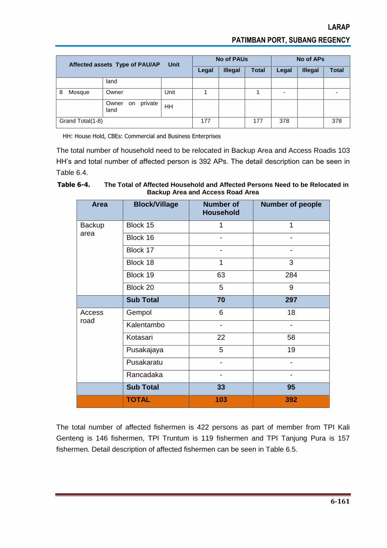
LARAP
PATIMBAN PORT, SUBANG REGENCY
6-161
Affected assets Type of PAU/AP Unit No of PAUs No of APs
Legal Illegal Total Legal Illegal Total
land
8 Mosque Owner Unit 1 1 - -
Owner on private land
HH
Grand Total(1-8) 177 177 378 378
HH: House Hold, CBEs: Commercial and Business Enterprises
The total number of household need to be relocated in Backup Area and Access Roadis 103
HH’s and total number of affected person is 392 APs. The detail description can be seen in
Table 6.4.
Table 6-4. The Total of Affected Household and Affected Persons Need to be Relocated in Backup Area and Access Road Area
Area Block/Village Number of Household
Number of people
Backup area
Block 15 1 1
Block 16 - -
Block 17 - -
Block 18 1 3
Block 19 63 284
Block 20 5 9
Sub Total 70 297
Access road
Gempol 6 18
Kalentambo - -
Kotasari 22 58
Pusakajaya 5 19
Pusakaratu - -
Rancadaka - -
Sub Total 33 95
TOTAL 103 392
The total number of affected fishermen is 422 persons as part of member from TPI Kali
Genteng is 146 fishermen, TPI Truntum is 119 fishermen and TPI Tanjung Pura is 157
fishermen. Detail description of affected fishermen can be seen in Table 6.5.
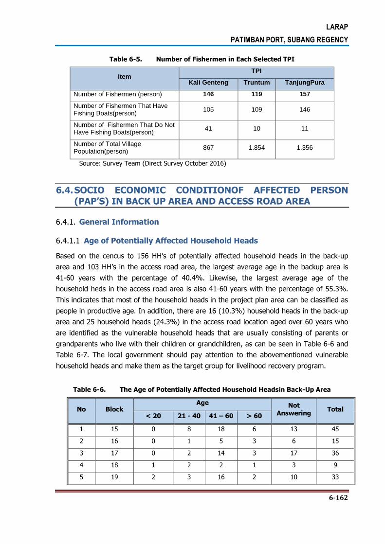
LARAP
PATIMBAN PORT, SUBANG REGENCY
6-162
Table 6-5. Number of Fishermen in Each Selected TPI
Item TPI
Kali Genteng Truntum TanjungPura
Number of Fishermen (person) 146 119 157
Number of Fishermen That Have Fishing Boats(person)
105 109 146
Number of Fishermen That Do Not Have Fishing Boats(person)
41 10 11
Number of Total Village Population(person)
867 1.854 1.356
Source: Survey Team (Direct Survey October 2016)
6.4. SOCIO ECONOMIC CONDITIONOF AFFECTED PERSON
(PAP’S) IN BACK UP AREA AND ACCESS ROAD AREA
6.4.1. General Information
6.4.1.1 Age of Potentially Affected Household Heads
Based on the cencus to 156 HH’s of potentially affected household heads in the back-up
area and 103 HH’s in the access road area, the largest average age in the backup area is
41-60 years with the percentage of 40.4%. Likewise, the largest average age of the
household heds in the access road area is also 41-60 years with the percentage of 55.3%.
This indicates that most of the household heads in the project plan area can be classified as
people in productive age. In addition, there are 16 (10.3%) household heads in the back-up
area and 25 household heads (24.3%) in the access road location aged over 60 years who
are identified as the vulnerable household heads that are usually consisting of parents or
grandparents who live with their children or grandchildren, as can be seen in Table 6-6 and
Table 6-7. The local government should pay attention to the abovementioned vulnerable
household heads and make them as the target group for livelihood recovery program.
Table 6-6. The Age of Potentially Affected Household Headsin Back-Up Area
No Block Age Not
Answering Total
< 20 21 - 40 41 – 60 > 60
1 15 0 8 18 6 13 45
2 16 0 1 5 3 6 15
3 17 0 2 14 3 17 36
4 18 1 2 2 1 3 9
5 19 2 3 16 2 10 33

LARAP
PATIMBAN PORT, SUBANG REGENCY
6-163
6 20 1 3 8 1 5 18
Total 4 19 63 16 54 156
Percentage 2.6% 12.2% 40.4% 10.3% 34.6% 100.0%
Sumber : Tabulasi data dan Hasil Survey 2016
Table 6-7. The Age of Potentially Affected Household Headsin Access Road Area
No. Village Age
Total 21-40 41 – 60 >60
1 Gempol 7 26 11 44
2 Kalentambo 3 7 2 12
3 Kotasari 4 10 7 21
4 Pusakajaya 2 4 1 7
5 Pusakaratu 4 9 4 17
6 Rancadaka 1 1 0 2
Total 21 57 25 103
Percentage 20.4% 55.3% 24.3% 100.0%
Sumber : Tabulasi data dan Hasil Survey 2016
6.4.1.2 Status of Household Heads and Members by Gender
Based on the gender category, 108 (69.2%) of potentially affected household heads in the
back-up area are male, and 47 (30.1%) of potentially affected household heads in the back-
up Area are female. Meanwhile, there are 111 (87.4%) male household heads and 16 (12.6)
female households heads in the access road area. Female household heads are identified as
vulnerable and local government should pay attention to the abovementioned vulnerable
household heads and make them as the target group for livelihood recovery program. More
detailed on this can be seen in Table 6-8 and Table 6-9.
Table 6-8. Gender of Potentially Affected Household Heads in the Back-up Area
No Block Gender
PT. **** Total Male Female
1 15 31 14 45
2 16 8 7 15
3 17 25 11 36
4 18 7 2 9
5 19 25 7 1 33
6 20 12 6 18
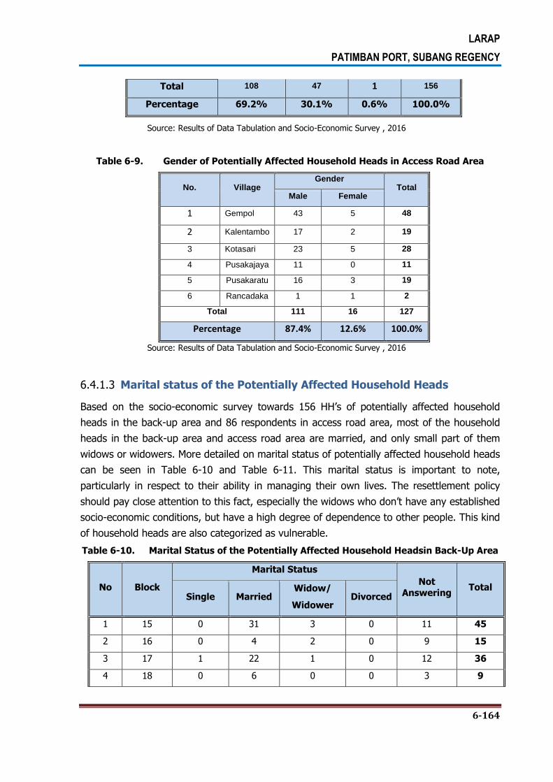
LARAP
PATIMBAN PORT, SUBANG REGENCY
6-164
Total 108 47 1 156
Percentage 69.2% 30.1% 0.6% 100.0%
Source: Results of Data Tabulation and Socio-Economic Survey , 2016
Table 6-9. Gender of Potentially Affected Household Heads in Access Road Area
No. Village Gender
Total Male Female
1 Gempol 43 5 48
2 Kalentambo 17 2 19
3 Kotasari 23 5 28
4 Pusakajaya 11 0 11
5 Pusakaratu 16 3 19
6 Rancadaka 1 1 2
Total 111 16 127
Percentage 87.4% 12.6% 100.0%
Source: Results of Data Tabulation and Socio-Economic Survey , 2016
6.4.1.3 Marital status of the Potentially Affected Household Heads
Based on the socio-economic survey towards 156 HH’s of potentially affected household
heads in the back-up area and 86 respondents in access road area, most of the household
heads in the back-up area and access road area are married, and only small part of them
widows or widowers. More detailed on marital status of potentially affected household heads
can be seen in Table 6-10 and Table 6-11. This marital status is important to note,
particularly in respect to their ability in managing their own lives. The resettlement policy
should pay close attention to this fact, especially the widows who don’t have any established
socio-economic conditions, but have a high degree of dependence to other people. This kind
of household heads are also categorized as vulnerable.
Table 6-10. Marital Status of the Potentially Affected Household Headsin Back-Up Area
No Block
Marital Status
Not Answering
Total Single Married
Widow/
Widower Divorced
1 15 0 31 3 0 11 45
2 16 0 4 2 0 9 15
3 17 1 22 1 0 12 36
4 18 0 6 0 0 3 9

LARAP
PATIMBAN PORT, SUBANG REGENCY
6-165
5 19 0 17 0 1 15 33
6 20 0 10 0 1 7 18
Total 1 90 6 2 57 156
Percentage 0.6% 57.7% 3.8% 1.3% 36.5% 100.0%
Source: Results of Data Tabulation and Socio-Economic Survey , 2016
Table 6-11. Marital Status of the Potentially Affected Household Headsin Access
RoadArea
No. Village
Marital Status
Single % Married % Widoe/
Widower % Divorced % total
1 Gempol 0 0.0% 33 38.4% 3 3.5% 0 0.0% 36
2 Kalentambo 0 0.0% 7 8.1% 0 0.0% 2 2.3% 9
3 Kotasari 2 2.3% 14 16.3% 1 1.2% 0 0.0% 17
4 Pusakajaya 0 0.0% 9 10.5% 1 1.2% 0 0.0% 10
5 Pusakaratu 0 0.0% 11 12.8% 1 1.2% 0 0.0% 12
6 Rancadaka 0 0.0% 2 2.3% 0 0.0% 0 0.0% 2
Total 2 2.3% 76 88.4% 6 7.0% 2 2.3% 86
Source: Results of Data Tabulation and Socio-Economic Survey , 2016
6.4.1.4 The Length of Stay of the Potentially Affected Households
With respect to the resettlement plan, it is very important to have in hand the information
on the length of stay of the potentially affected households as this is highly related to the
social capital they have in the society. Sociologically, if they have strong social bond, this will
indicate that they have been living in the area for such an extended period of time. Usually,
the length of stay will be correlated with the willingness to move out to another place,
whereby the longer they stay in an area, the more reluctant they are to move out to a new
place. The length of stay will also be used as the basis of calculations in determining the
solatium cost to be given to the potentially affected people, whereas the longer they stay in
an area, the more solatium cost will be given to them. Data on the length of stay of
households in the survey area can be seen in Table 6-12 and Table 6-13.
Table 6-12. The Length of Stay of the Potentially Affected Households inBack-Up Area
No Block Length of Stay Not
Answering Total
≤ 20 21 – 40 41 – 60 > 60
1 15 15 8 2 0 20 45
2 16 3 3 0 0 9 15
3 17 8 6 2 0 20 36
4 18 4 1 0 1 3 9
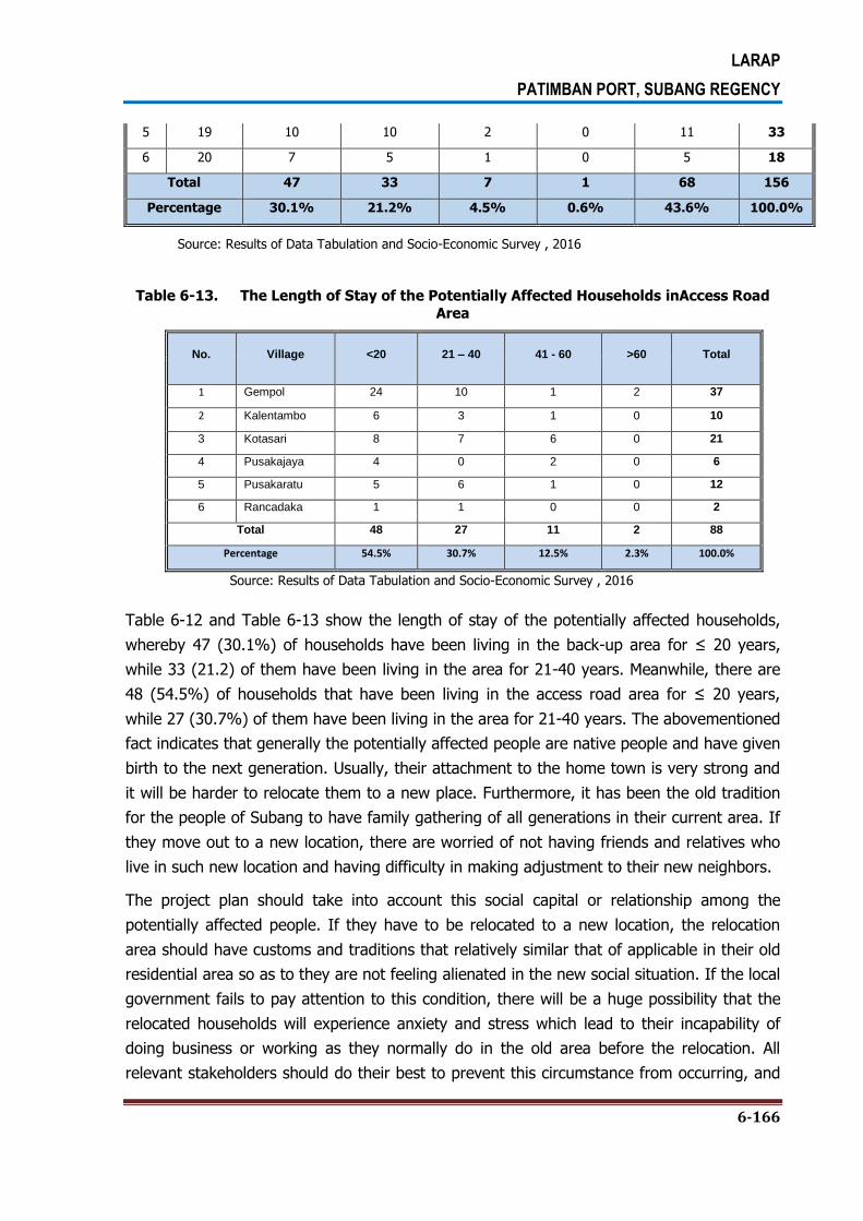
LARAP
PATIMBAN PORT, SUBANG REGENCY
6-166
5 19 10 10 2 0 11 33
6 20 7 5 1 0 5 18
Total 47 33 7 1 68 156
Percentage 30.1% 21.2% 4.5% 0.6% 43.6% 100.0%
Source: Results of Data Tabulation and Socio-Economic Survey , 2016
Table 6-13. The Length of Stay of the Potentially Affected Households inAccess Road
Area
No. Village <20 21 – 40 41 - 60 >60 Total
1 Gempol 24 10 1 2 37
2 Kalentambo 6 3 1 0 10
3 Kotasari 8 7 6 0 21
4 Pusakajaya 4 0 2 0 6
5 Pusakaratu 5 6 1 0 12
6 Rancadaka 1 1 0 0 2
Total 48 27 11 2 88
Percentage 54.5% 30.7% 12.5% 2.3% 100.0%
Source: Results of Data Tabulation and Socio-Economic Survey , 2016
Table 6-12 and Table 6-13 show the length of stay of the potentially affected households,
whereby 47 (30.1%) of households have been living in the back-up area for ≤ 20 years,
while 33 (21.2) of them have been living in the area for 21-40 years. Meanwhile, there are
48 (54.5%) of households that have been living in the access road area for ≤ 20 years,
while 27 (30.7%) of them have been living in the area for 21-40 years. The abovementioned
fact indicates that generally the potentially affected people are native people and have given
birth to the next generation. Usually, their attachment to the home town is very strong and
it will be harder to relocate them to a new place. Furthermore, it has been the old tradition
for the people of Subang to have family gathering of all generations in their current area. If
they move out to a new location, there are worried of not having friends and relatives who
live in such new location and having difficulty in making adjustment to their new neighbors.
The project plan should take into account this social capital or relationship among the
potentially affected people. If they have to be relocated to a new location, the relocation
area should have customs and traditions that relatively similar that of applicable in their old
residential area so as to they are not feeling alienated in the new social situation. If the local
government fails to pay attention to this condition, there will be a huge possibility that the
relocated households will experience anxiety and stress which lead to their incapability of
doing business or working as they normally do in the old area before the relocation. All
relevant stakeholders should do their best to prevent this circumstance from occurring, and

LARAP
PATIMBAN PORT, SUBANG REGENCY
6-167
to do this, it is deemed necessary to provide the household heads and their respective
family members with facilitation and other assistance program to ensure their comfort of
living in the new location.
6.4.1.5 The Ethnic of Origin
Based on the result of socio-economic survey, 59% of the household heads in the back-up
area are Javanese ethnic group. Meanwhile, 45.4% of the household heads in the access
road are Sundanese and 23.1% of them are Javanese. More details on this can be seen
inTable 6-14 and Table 6-15.
Table 6-14. The Ethnic of Originof the Household HeadsinBack-Up Area
No Block Ethnic of Origin Not
Answering Total
Betawi Javanese Sundanese
1 15 0 34 1 10 45
2 16 0 7 0 8 15
3 17 0 22 1 13 36
4 18 0 4 2 3 9
5 19 0 17 1 15 33
6 20 2 8 0 8 18
Total 2 92 5 57 156
Percentage 1.3% 59.0% 3.2% 36.5% 100.0%
Source: Results of Data Tabulation and Socio-Economic Survey , 2016
Table 6-15. The Ethnic of Originof the Household HeadsinAccess Road Area
No. Village Javanese Sundanese Not
Answering Total
1 Gempol 8 29 11 48
2 Kalentambo 4 6 9 19
3 Kotasari 8 10 10 28
4 Pusakajaya 6 4 4 14
5 Pusakaratu 2 10 7 19
6 Rancadaka 2 0 0 2
Total 30 59 41 130
Percentage 23.1% 45.4% 31.5% 100.0%
Source: Results of Data Tabulation and Socio-Economic Survey , 2016

LARAP
PATIMBAN PORT, SUBANG REGENCY
6-168
6.4.1.6 Religion of the Potentially Affected Household Heads
Based on the survey result, 64.7% of the potentially affected household heads and the
family members in the back-up area are Muslims, and Catholics and Buddhists with the
portion of 0.6% respectively. Meanwhile, all of the potentially affected household heads and
the family members in the access road area 91.5% are Muslims. More detailed on the
religion of the household heads is summarized in Table 6-16 and Table 6.17.
Table 6-16. Religion of the Potentially Affected Household Headsin Back-Up Area
No Block Religion Not
Answering Total
Islam Catholic Buddhism
1 15 36 0 0 9 45
2 16 6 0 0 9 15
3 17 24 0 0 12 36
4 18 6 0 0 3 9
5 19 20 0 0 13 33
6 20 9 1 1 7 18
Total 101 1 1 53 156
Percentage 64.7% 0.6% 0.6% 34.0% 100.0%
Source: Results of Data Tabulation and Socio-Economic Survey , 2016
Table6-17. Religion of the Potentially Affected Household Headsin Access Road Area
No. Village Religion Not
Answering Total
Islam Catholic
1 Gempol 46 2 0 48
2 Kalentambo 13 6 0 19
3 Kotasari 27 1 0 28
4 Pusakajaya 13 0 1 14
5 Pusakaratu 18 1 0 19
6 Rancadaka 2 0 0 2
Total 119 10 1 130
Percentage 91.5% 7.7% 0.8% 100.0%
Source: Results of Data Tabulation and Socio-Economic Survey , 2016
6.4.1.7 Educational Level of Potentially Affected Household Heads
With respect to the educational level, based on the survey result, most of household heads
in the back-up area have a fairly low education level, whereby 31.4% of them only

LARAP
PATIMBAN PORT, SUBANG REGENCY
6-169
graduated from elementary school, 9% of them graduated from senior high school and not
graduated from senior high school, 5.1% of them didn’t have any formal education in school,
and 1.9% of them graduated from university. Based on the interview, each household head
and the spouse have relatively the same education level. Likewise, most of household heads
in the access road area have a fairly low education level, whereby 20% of them only
graduated from elementary school, 14.6% of them graduated from senior high school, and
8.5% of them graduated from university. More details on this can be seen inTable 6-18 and
Table 6.19.
Table6-18. Educational Level ofPotentially Affected Household Heads inBack-Up Area
No Educational Level Block
Total % 15 16 17 18 19 20
1 Not school 4 1 0 1 0 2 8 5.1%
2 Not graduated elementary school
0 0 3 0 2 2 7 4.5%
3 Graduated elementary school
19 2 13 2 12 1 49 31.4%
4 Not graduated high school
6 0 2 2 3 1 14 9.0%
5 Graduated high school
4 2 3 1 1 3 14 9.0%
6 Graduated university
0 0 1 0 1 1 3 1.9%
7 Not Answering 12 10 14 3 14 8 61 39.1%
Total 45 15 36 9 33 18 156 100.0%
Source: Results of Data Tabulation and Socio-Economic Survey , 2016
Table6-19. Educational Level ofPotentially Affected Household Heads inAccess Road
Area
No Village
Pendidikan Terakhir
Not Answering
Total Not
School
Not Graduated Elementary
School
Graduated Elementary
School
Not Graduated High School
Graduated High School
Graduated University
1 Gempol 5 3 12 1 7 6 14 48
2 Kalentamb
o 1 0 2 0 4 1 11 19
3 Kotasari 2 2 5 2 4 2 11 28
4 Pusakajaya 0 3 4 0 0 2 5 14
5 Pusakaratu 5 0 1 1 4 0 8 19
6 Rancadaka 0 0 2 0 0 0 0 2
Total 13 8 26 4 19 11 49 130
Percentage 10.0% 6.2% 20.0% 3.1% 14.6% 8.5% 37.7% 100%
Source: Results of Data Tabulation and Socio-Economic Survey , 2016
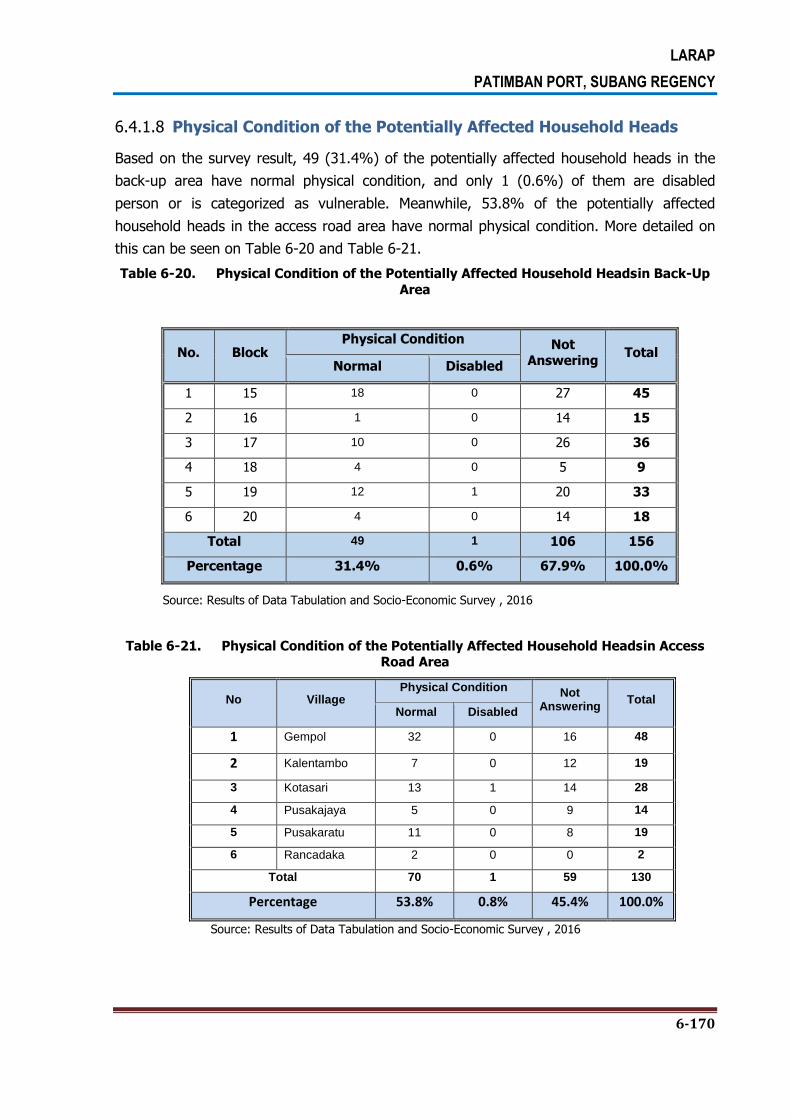
LARAP
PATIMBAN PORT, SUBANG REGENCY
6-170
6.4.1.8 Physical Condition of the Potentially Affected Household Heads
Based on the survey result, 49 (31.4%) of the potentially affected household heads in the
back-up area have normal physical condition, and only 1 (0.6%) of them are disabled
person or is categorized as vulnerable. Meanwhile, 53.8% of the potentially affected
household heads in the access road area have normal physical condition. More detailed on
this can be seen on Table 6-20 and Table 6-21.
Table 6-20. Physical Condition of the Potentially Affected Household Headsin Back-Up
Area
No. Block Physical Condition Not
Answering Total
Normal Disabled
1 15 18 0 27 45
2 16 1 0 14 15
3 17 10 0 26 36
4 18 4 0 5 9
5 19 12 1 20 33
6 20 4 0 14 18
Total 49 1 106 156
Percentage 31.4% 0.6% 67.9% 100.0%
Source: Results of Data Tabulation and Socio-Economic Survey , 2016
Table 6-21. Physical Condition of the Potentially Affected Household Headsin Access Road Area
No Village Physical Condition Not
Answering Total
Normal Disabled
1 Gempol 32 0 16 48
2 Kalentambo 7 0 12 19
3 Kotasari 13 1 14 28
4 Pusakajaya 5 0 9 14
5 Pusakaratu 11 0 8 19
6 Rancadaka 2 0 0 2
Total 70 1 59 130
Percentage 53.8% 0.8% 45.4% 100.0%
Source: Results of Data Tabulation and Socio-Economic Survey , 2016
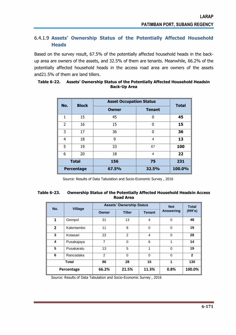
LARAP
PATIMBAN PORT, SUBANG REGENCY
6-171
6.4.1.9 Assets’ Ownership Status of the Potentially Affected Household
Heads
Based on the survey result, 67.5% of the potentially affected household heads in the back-
up area are owners of the assets, and 32.5% of them are tenants. Meanwhile, 66.2% of the
potentially affected household heads in the access road area are owners of the assets
and21.5% of them are land tillers.
Table 6-22. Assets’ Ownership Status of the Potentially Affected Household Headsin
Back-Up Area
No. Block Asset Occupation Status
Total Owner Tenant
1 15 45 0 45
2 16 15 0 15
3 17 36 0 36
4 18 9 4 13
5 19 33 67 100
6 20 18 4 22
Total 156 75 231
Percentage 67.5% 32.5% 100.0%
Source: Results of Data Tabulation and Socio-Economic Survey , 2016
Table 6-23. Ownership Status of the Potentially Affected Household Headsin Access
Road Area
No. Village Assets’ Ownership Status Not
Answering Total (HH’s) Owner Tiller Tenant
1 Gempol 31 13 4 0 48
2 Kalentambo 11 8 0 0 19
3 Kotasari 22 2 4 0 28
4 Pusakajaya 7 0 6 1 14
5 Pusakaratu 13 5 1 0 19
6 Rancadaka 2 0 0 0 2
Total 86 28 15 1 130
Percentage 66.2% 21.5% 11.3% 0.8% 100.0%
Source: Results of Data Tabulation and Socio-Economic Survey , 2016

LARAP
PATIMBAN PORT, SUBANG REGENCY
6-172
6.4.1.10 Livelihoods of the Potentially Affected Household Heads
The level of education of household heads is believed to affect their livelihoods. Based on
the socio-economic survey (SES) results, the livelihoods of household heads in the back-up
area are dominated by those who work in agriculture/animal husbandry sector (49.4%), and
then followed by business sector/retailer/shop owner (8.3%), and employees (2.6%).
Likewise, the livelihoods of household heads in the access road area are dominated by those
who work in agriculture/animal husbandry sector (29.2%) and the rest of them are working
in business sector/retailer/shop owner, driver/laborer, and employee. More detailed on this
can be seen in Table 6-24 and Table 6-25.
Table 6-24. Livelihoods of the Potentially Affected Household Headsin Back-Up Area
No. Main Job Block Total
(HH’s) %
15 16 17 18 19 20
1 Agriculture/animal husbandry 32 7 21 6 7 4 77 49.4%
2 business sector/retailer/shop owner 2 1 1 0 5 4 13 8.3%
3 Driver/labor 0 0 0 0 1 0 1 0.6%
4 Employee 0 0 0 0 2 2 4 2.6%
5 Others 0 1 1 0 0 0 2 1.3%
6 Not Answering 11 6 13 3 18 8 59 37.8%
Total 45 15 36 9 33 18 156 100.0%
Source: Results of Data Tabulation and Socio-Economic Survey , 2016
Table6-25. Livelihoods of the Potentially Affected Household Headsin Access Road Area
No Village
Main Job
Not Answering
Total (HH’s)
Agriculture/
animal husbandry
Business /retailer/
shop owner
Driver/ labor
Employee Retirement Other
1 Gempol 20 8 1 3 0 2 14 48
2 Kalentambo 4 2 0 2 0 0 11 19
3 Kotasari 5 7 2 1 1 1 11 28
4 Pusakajaya 3 4 1 1 0 1 4 14
5 Pusakaratu 4 1 1 2 1 0 10 19
6 Rancadaka 2 0 0 0 0 0 0 2
Total 38 22 5 9 2 4 50 130
Percentage 29.2% 16.9% 3.8% 6.9% 1.5% 3.1% 38.5% 100.0%
Source: Results of Data Tabulation and Socio-Economic Survey , 2016

LARAP
PATIMBAN PORT, SUBANG REGENCY
6-173
As for the sidejob, there are 11 household heads have the side job, among others, 3
persons in agriculture/animal husbandry sector, 6 persons in business sector/retailer/shop
owner, 1 person as driver/laborer, and 1 person in another type of sideline. Meanwhile,
there are 5 household heads that have the sideline in agriculture/animal husbandry and
business sector/retailer/shop owner. More detailed on this can be seen in Table 6-26 and
Table 6-27.
Table6-26. The Sidejobof the Potentially Affected Household Headsin Back-Up Area
No BLOCK
Sideline
Total Agriculture/
Animal husbandry
Business sector/retailer/
shop owner Driver/ laborer Other
1 15 1 0 0 0 1
2 17 0 3 1 0 4
3 18 1 3 0 0 4
4 20 1 0 0 1 2
Total 3 6 1 1 11
Percentage 27.3% 54.5% 9.1% 9.1% 100.0%
Source: Results of Data Tabulation and Socio-Economic Survey , 2016
Table6-27. The Sidejobof the Potentially Affected Household Headsin Access Road
Area
No Village
Sideline
Total Agriculture/
Animal husbandry
Business sector/retailer/
shop owner
Other
1 Gempol 0 1 0 1
2 Kalentambo 1 0 0 1
3 Kotasari 1 1 1 3
Total 2 2 1 5
Percentage 40.0% 40.0% 20.0% 100.0%
Source: Results of Data Tabulation and Socio-Economic Survey , 2016
6.4.1.11 Distance from the House to the Work Place
There are 26 (19.1%) of potentially affected household heads in the back-up area have the
distance from their houses to their work places of less than 1 km, so that the project plan
will bring direct impact to their working activities if they should be relocated to a new
location. In addition, 5 of potentially affected household heads (3.7%) do their works at
home. Meanwhile, there are 6 (20%) of potentially affected household heads in the access

LARAP
PATIMBAN PORT, SUBANG REGENCY
6-174
road area do their works at home. The latter will be effected by land acquisition activity as
they have to move out to a new location. Their businesses will be disrupted and they need
assistance before and after the relocation to a new place.
Table6-28. Distance from the House to the Work Placein Back-Up Area
No BLOCK
Distance of Work Place/School No
Answer
Total
(HH’s) At Home
<1 km 1-2 km 2-4 km >4 km
1 15 2 3 0 0 0 29 34
2 16 1 5 0 1 0 4 11
3 17 1 14 3 1 0 42 61
4 18 0 3 0 0 1 5 9
5 19 1 0 0 0 0 10 11
6 20 0 1 2 0 1 6 10
Total 5 26 5 2 2 96 136
Percentage 3.7% 19.1% 3.7% 1.5% 1.5% 70.6% 100.0%
Source: Results of Data Tabulation and Socio-Economic Survey , 2016
Table 6-29. Distance from the House to the Work Placein Access Road Area
No Village
Distance of Work Place/School
No Answer Total At Home < 1 km 1-2 km 2-4 km > 4 km
1 Gempol 4 1 2 1 1 2 11
2 Kotasari 1 0 0 0 0 2 3
3 Pusakaratu 1 0 1 0 0 5 7
4 Mekarjaya 0 0 0 0 0 1 1
5 Pusakajaya 0 0 0 0 0 1 1
6 Pusakaratu 0 0 0 0 0 6 6
7 Rancadaka 0 0 0 0 0 1 1
Total 6 1 3 1 1 18 30
Percentage 20.0% 3.3% 10.0% 3.3% 3.3% 60.0% 100.0%
Source: Results of Data Tabulation and Socio-Economic Survey , 2016
6.4.1.12 Monthly Average Income of Household Heads
Based on the field survey, standard error of meanthe income of household heads in the
back-up area is Rp 6,555,064 per month. Majority of them or 41 (30.1%) household heads
have the average monthly income of Rp 1,000,000-Rp 5,000,000. Meanwhile, average

LARAP
PATIMBAN PORT, SUBANG REGENCY
6-175
income of household heads in access road area is Rp 2,100,100 per month. Majority of them
or 10 (34.5%) household heads have the average monthly income of < Rp 2,000,000. More
detailed on this can be seen in Table 6-30 and Table 6-31.
Table 6-30. Monthly Income of Household Headsin Back-Up Area
No Monthly Income (IDR) Block
Total % 15 16 17 18 19 20
1 ≤ 1,000,000 0 0 0 0 2 0 2 1.3%
2 > 1,000,000 – 2,000,000 2 1 1 1 1 2 8 5.1%
3 > 2,000,000 – 4,000,000 3 2 6 0 2 1 14 9.0%
4 > 4,000,000 – 6,000,000 6 0 6 1 5 2 20 12.8%
5 > 6,000,000 – 8,000,000 5 0 0 0 0 0 5 3.2%
6 > 8,000,000 – 10,000,000 2 0 1 0 0 1 4 2.6%
7 > 10,000,000 6 1 2 0 3 1 13 8.3%
8 Not Answering 21 11 20 7 19 11 90 57.7%
Total 45 15 36 9 33 18 156 100.0%
Source: Results of Data Tabulation and Socio-Economic Survey , 2016
Table 6-31. Monthly Income of Household Headsin Access Road Area
No Village Monthly Income
Not Answering
Total 0 1 2 3 4 5 6
1 Gempol 2 9 13 2 2 1 2 17 48
2 Kalentambo 1 0 3 2 0 0 1 12 19
3 Kotasari 0 4 4 6 0 0 2 12 28
4 Pusakajaya 1 2 1 1 0 0 5 4 14
5 Pusakaratu 0 5 0 2 1 0 0 11 19
6 Rancadaka 0 0 0 0 1 1 0 0 2
Total 4 20 21 13 4 2 10 56 130
Percentage 3.1% 15.4% 16.2% 10.0% 3.1% 1.5% 7.7% 43.1% 100.0%
Source: Results of Data Tabulation and Socio-Economic Survey , 2016
Catatan : 0. ≤ IDR 1,000,000 4. >IDR 6,000,000 – IDR 8,000,000
1. >IDR 1,000,000 – IDR 2,000,000 5. >IDR 8,000,000 – IDR 10,000,000
2. >IDR 2,000,000 – IDR 4,000,000 6. >IDR 10,000,000
3. >IDR 4,000,000 – IDR 6,000,000

LARAP
PATIMBAN PORT, SUBANG REGENCY
6-176
6.4.1.13 Monthly Consumption of Potentially Affected Households
Income earned by every potentially affected household will be used for the household
monthly consumption. Based on the survey result, in every month, there are 9 ten types of
consumptions of the potentially affected households, namely: food, transportation, housing
payments, electricity bill, water bill, education, health, savings, and entertainment. The
average cost of overall consumption of the potentially affected households in the back-up
area is Rp 9,310,762. The cost for food is the biggest expense with the average of Rp
2,747,917 or 29.5% of the total cost. Meanwhile, the least expenditure is for electrical bill as
much as Rp 210,000 or 2.3% of the total cost. Meanwhile, the average cost of overall
consumption of the potentially affected households in the access road area is Rp 10,915,852.
The cost for food is the biggest expense with the average of Rp 2,515,000 or 23.0% of the
total cost. In the meantime, the least expenditure is for water bill from PDAM (Local-Owned
Water Supply Company) as much as Rp 157,692 or 1.4% of the total cost. Details on the
monthly consumption expenditures of households in the project area can be seen in Table
6-32 and Table 6-33.
Table 6-32. Monthly Consumption of Potentially Affected Householdsin Back-Up Area
No Expenses Average (Rp) %
1 Food 2,747,917 29.59%
2 Transportation 1,391,579 14.9%
3 Housing payments) 375,000 4.0%
4 Electricity bill 210,000 2.3%
5 Water bill 290,000 3.1%
6 Education 2,392,857 25.7%
7 Health 290,909 3.1%
8 Savings 1,312,500 14.1%
9 Entertainment 300,000 3.2%
Total 9,310,7622 100.0%
Source: Results of Data Tabulation and Socio-Economic Survey , 2016
Table 6-33. Monthly Consumption of Potentially Affected Householdsin Access Road
Area
No Type of Expenses Average (Rp) %
1 Food 2,515,000 23.0%
2 Transportation 726,200 6.7%
3 Housing payments) 0.0%

LARAP
PATIMBAN PORT, SUBANG REGENCY
6-177
No Type of Expenses Average (Rp) %
4 Electricity bill 178,276 1.6%
5 Water bill 157,692 1.4%
6 Education 780,588 7.2%
7 Health 654,762 6.0%
8 Savings 3,506,667 32.1%
9 Food 896,667 8.2%
10 Other 1,500,000 13.7%
Total 10,915,852 100.0%
Source: Results of Data Tabulation and Socio-Economic Survey , 2016
The amount of the average monthly expenditure obtained can be used as a basis for
determining the poverty line standard. Based on the standard poverty line set by the Central
Bureau of Statistics Indonesia which assign a category not poor are those whose
expenditure per person per month is more than IDR 350.610 or based on the international
poverty line category establishes the category of poor who have expenditure less than USD
1.25 per day, equivalent to IDR 16.875 per day (1 USD = IDR 13.500).
Based on the above poverty line category, according to both BPS and World Bank standards,
the aveerage level of the AHHs in back up area and access road area are not categorized
poor.
6.4.1.14 Source of Electricity
With respect to the source of electricity, 94.1% of potentially affected households in the
back-up area are using direct electricity supply from the PLN (State Electricity Company),
and only 4 of the households are obtaining the electricity supply from their neighbors, who
are actually also using electricity supply from the PLN. Meanwhile, all of potentially affected
households in the access road area are using electricity supply directly from the PLN.
Table 6-34. Source of Electricityin Back-Up Area
No BLOCK
Source of Electricity
No Answer Total Direct Supply from PLN From Neighbor
1 15 31 2 1 34
2 16 11 0 0 11
3 17 57 2 2 61
4 18 9 0 0 9
5 19 10 0 1 11

LARAP
PATIMBAN PORT, SUBANG REGENCY
6-178
6 20 10 0 0 10
Total 128 4 4 136
Percentage 94.1% 2.9% 2.9% 100.0%
Source: Results of Data Tabulation and Socio-Economic Survey , 2016
6.4.1.15 The Ownership of Electronic Devices
Most electronic devices owned by potentially affected households in the back-up area are TV
set (45%), fan (16%), and telephone/cell phone (10.7%). Meanwhile, most electronic
devices oned by potentially affected households in the access road area are TV set (96.7%)
and computer (3.3%). More detailed on this can be seen in Table 6-35. This indicates that in
addition to meet the everyday needs such as food, the people also have to spend their
income to meet household entertainment and other daily household needs.
Table6-35. The Ownership of Electronic Devicesin Back-Up Area
No Electronic Devices BLOCK
Total % 15 16 17 18 19 20
1 TV 12 6 18 9 4 10 59 45.0%
2 Radio 8 0 6 0 2 0 16 12.2%
3 Phone/Cell Phone 2 3 8 0 1 0 14 10.7%
4 Fan 4 0 14 0 3 0 21 16.0%
5 Microwave 0 1 2 0 0 0 3 2.3%
6 DVD/CD 3 1 5 0 0 0 9 6.9%
7 Computer 0 0 2 0 0 0 2 1.5%
8 AC 0 0 1 0 0 0 1 0.8%
9 Washing Machine 1 0 2 0 0 0 3 2.3%
10 Oven 2 0 1 0 0 0 3 2.3%
Total 32 11 59 9 10 10 131 100.0%
Source: Results of Data Tabulation and Socio-Economic Survey , 2016
Table6-36. The Ownership of Electronic Devicesin Access Road Area
No Village Electronic Devices
Total
TV Computer
1 Gempol 10 1 11
2 Kotasari 3 0 3
3 Pusakaratu 7 0 7

LARAP
PATIMBAN PORT, SUBANG REGENCY
6-179
No Village Electronic Devices
Total
TV Computer
4 Mekarjaya 1 0 1
5 Pusakajaya 1 0 1
6 Pusakaratu 6 0 6
7 Rancadaka 1 0 1
Total 29 1 30
6.4.1.16 The Ownership of Transportation Tools
The majority transportation tools owned by the potentially affected households in the back-
up area are motorcycle (52.3%), and then followed by bicycle (35.4%), car (10%), and
truck (1.5%). On the other hand, the majority transportation tools owned by the potentially
affected households in the access road area are motorcycle (62.1%), and then followed by
car (31%), and truck (3.4%). More detailed on this can be seen in Table 6-37 and Table 6-
38.
Table6-37. The Ownership of Transportation Toolsin Back-Up Area
No Transportation Tools BLOCK
Total % 15 16 17 18 19 20
1 Bicycle 14 1 16 7 2 6 46 35.4%
2 Motorcycle 13 9 34 2 6 4 68 52.3%
3 Car 4 1 7 0 1 0 13 10.0%
4 Truck 0 0 1 0 1 0 2 1.5%
5 Pedicab 0 0 1 0 0 0 1 0.8%
Total 31 11 59 9 10 10 130 100.0%
Source: Results of Data Tabulation and Socio-Economic Survey , 2016
Table6-38. The Ownership of Transportation Toolsin Access Road Area
No Village Transportation Tools
Total Bicycle Motorcycle Car Truck
1 Gempol 0 6 3 1 10
2 Kotasari 0 2 1 0 3
3 Pusakaratu 0 3 4 0 7
4 Mekarjaya 0 1 0 0 1
5 Pusakajaya 0 1 0 0 1
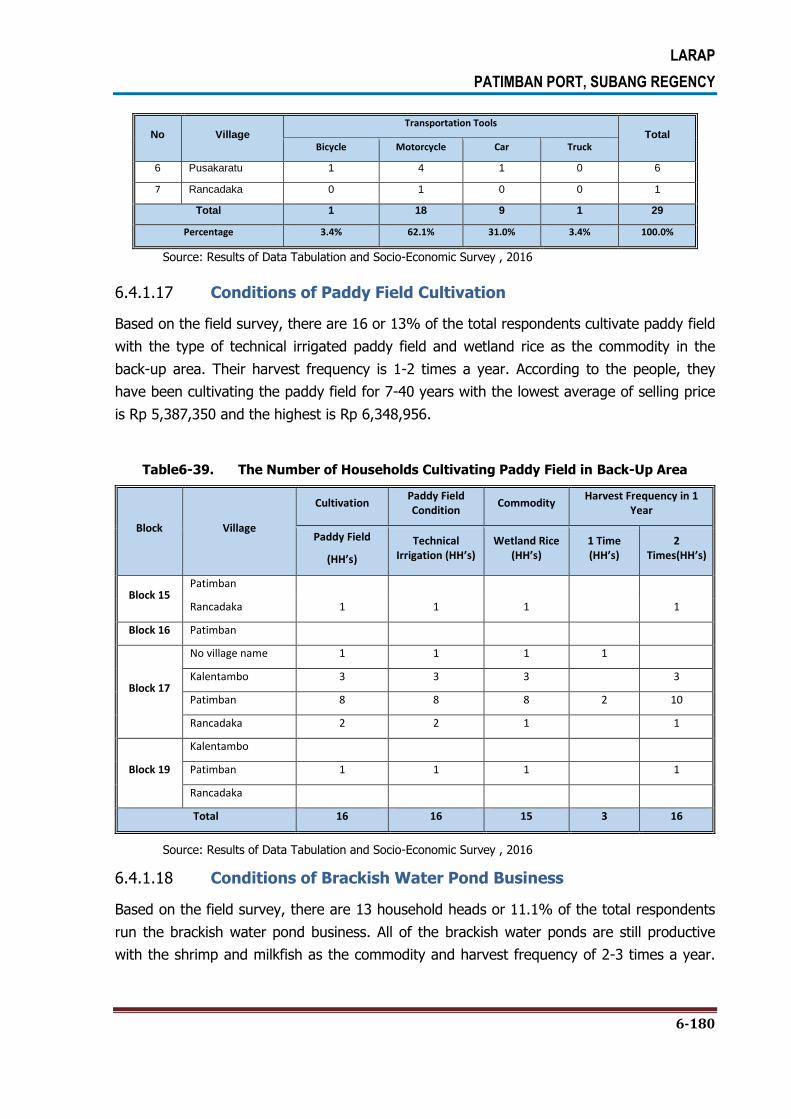
LARAP
PATIMBAN PORT, SUBANG REGENCY
6-180
No Village Transportation Tools
Total Bicycle Motorcycle Car Truck
6 Pusakaratu 1 4 1 0 6
7 Rancadaka 0 1 0 0 1
Total 1 18 9 1 29
Percentage 3.4% 62.1% 31.0% 3.4% 100.0%
Source: Results of Data Tabulation and Socio-Economic Survey , 2016
6.4.1.17 Conditions of Paddy Field Cultivation
Based on the field survey, there are 16 or 13% of the total respondents cultivate paddy field
with the type of technical irrigated paddy field and wetland rice as the commodity in the
back-up area. Their harvest frequency is 1-2 times a year. According to the people, they
have been cultivating the paddy field for 7-40 years with the lowest average of selling price
is Rp 5,387,350 and the highest is Rp 6,348,956.
Table6-39. The Number of Households Cultivating Paddy Field in Back-Up Area
Block Village
Cultivation Paddy Field Condition
Commodity Harvest Frequency in 1
Year
Paddy Field
(HH’s)
Technical Irrigation (HH’s)
Wetland Rice (HH’s)
1 Time (HH’s)
2 Times(HH’s)
Block 15 Patimban
Rancadaka 1 1 1 1
Block 16 Patimban
Block 17
No village name 1 1 1 1
Kalentambo 3 3 3 3
Patimban 8 8 8 2 10
Rancadaka 2 2 1 1
Block 19
Kalentambo
Patimban 1 1 1 1
Rancadaka
Total 16 16 15 3 16
Source: Results of Data Tabulation and Socio-Economic Survey , 2016
6.4.1.18 Conditions of Brackish Water Pond Business
Based on the field survey, there are 13 household heads or 11.1% of the total respondents
run the brackish water pond business. All of the brackish water ponds are still productive
with the shrimp and milkfish as the commodity and harvest frequency of 2-3 times a year.

LARAP
PATIMBAN PORT, SUBANG REGENCY
6-181
According to the people, they have been running the brackish water pond business for 2-20
years.
Table 6-40. The Number of Households Running Brackish Water Pond in Back-Up Area
Block Village Business Condition Commodity
Harvest Frequency in 1 Year
Pond Productive Shrimp Milkfish 2 Times 3 Times
Block 15 Patimban 1 1
1 1
Rancadaka
Block 16 Patimban 1
Block 17
No village name 3 3 3 3
Kalentambo 2 2 1 1 1
Patimban 3 3 2 1 2
Rancadaka
Block 19
Kalentambo
2
Patimban 3 1 2 1 2
Rancadaka 1 1 1
Total 13 12 9 3 9 3
Source: Results of Data Tabulation and Socio-Economic Survey , 2016
6.4.1.19 The Ownership of Loan
Based on the survey, 77.2% of respondents in the back-up area do not have any loan and
only 22.8% of the respondents have loan. Meanwhile, there are 15 (62.5%) respondents in
the access road area have loan. More detailed on this can be seen in Table 6-41 and Table
6-42.
Table 6-41. The Ownership of Loanin Back-Up Area
No BLOCK The Ownership of Loan
Total Yes No
1 15 11 17 28
2 16 2 9 11
3 17 7 40 47
4 18 1 3 4
5 19 2 8 10
6 20 0 1 1
Total 23 78 101

LARAP
PATIMBAN PORT, SUBANG REGENCY
6-182
Percentage 22.8% 77.2% 100.0%
Source: Results of Data Tabulation and Socio-Economic Survey , 2016
Table 6-42. The Ownership of Loanin Access Road Area
No Village The Ownership of Loan
Total Yes No
1 Gempol 5 3 8
2 Kotasari 2 1 3
3 Pusakaratu 3 3 6
4 Mekarjaya 0 1 1
5 Pusakajaya 0 1 1
6 Pusakaratu 4 0 4
7 Rancadaka 1 0 1
Total 15 9 24
Percentage 62.5% 37.5% 100.0%
Source: Results of Data Tabulation and Socio-Economic Survey , 2016
Majority of respondents in back-up area and access road area borrow money from bank,
either local or national bank. More detailed on this can be seen in Table 6-43 and Table 6-44.
Table 6-43. Money Lending Institutions in Back-Up Area
No Money Lending Institutions BLOCK
Total % 15 16 17 18 19 20
1 Adira 1 0 0 0 0 0 1 0.7%
2 Bank 8 0 8 0 2 0 18 13.2%
3 Cooperative 0 1 1 0 0 0 2 1.5%
4 Farmer Group 0 0 1 0 0 0 1 0.7%
5 Relatives 1 0 0 0 0 0 1 0.7%
6 Family 1 0 0 0 0 0 1 0.7%
7 No Answer 23 10 51 9 9 10 112 82.4%
Total (KK) 34 11 61 9 11 10 136 100.0%
Source: Results of Data Tabulation and Socio-Economic Survey , 2016
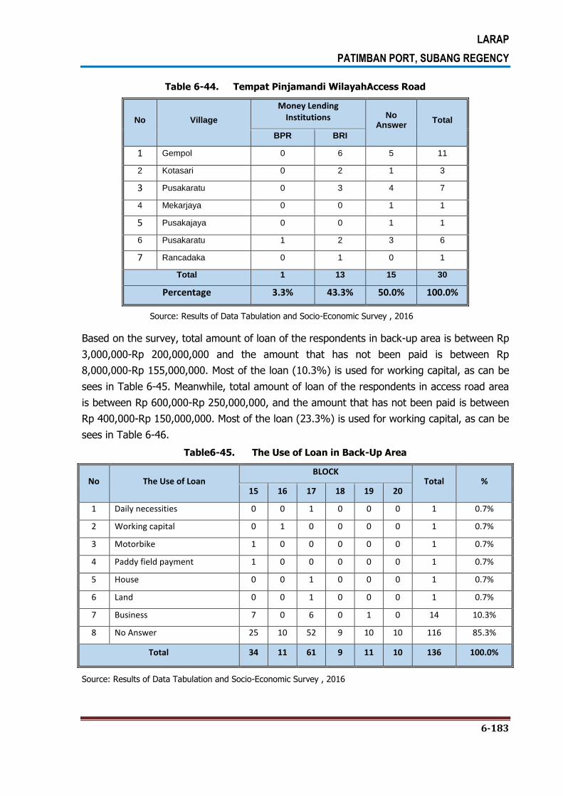
LARAP
PATIMBAN PORT, SUBANG REGENCY
6-183
Table 6-44. Tempat Pinjamandi WilayahAccess Road
No Village
Money Lending Institutions No
Answer Total
BPR BRI
1 Gempol 0 6 5 11
2 Kotasari 0 2 1 3
3 Pusakaratu 0 3 4 7
4 Mekarjaya 0 0 1 1
5 Pusakajaya 0 0 1 1
6 Pusakaratu 1 2 3 6
7 Rancadaka 0 1 0 1
Total 1 13 15 30
Percentage 3.3% 43.3% 50.0% 100.0%
Source: Results of Data Tabulation and Socio-Economic Survey , 2016
Based on the survey, total amount of loan of the respondents in back-up area is between Rp
3,000,000-Rp 200,000,000 and the amount that has not been paid is between Rp
8,000,000-Rp 155,000,000. Most of the loan (10.3%) is used for working capital, as can be
sees in Table 6-45. Meanwhile, total amount of loan of the respondents in access road area
is between Rp 600,000-Rp 250,000,000, and the amount that has not been paid is between
Rp 400,000-Rp 150,000,000. Most of the loan (23.3%) is used for working capital, as can be
sees in Table 6-46.
Table6-45. The Use of Loan in Back-Up Area
No The Use of Loan BLOCK
Total % 15 16 17 18 19 20
1 Daily necessities 0 0 1 0 0 0 1 0.7%
2 Working capital 0 1 0 0 0 0 1 0.7%
3 Motorbike 1 0 0 0 0 0 1 0.7%
4 Paddy field payment 1 0 0 0 0 0 1 0.7%
5 House 0 0 1 0 0 0 1 0.7%
6 Land 0 0 1 0 0 0 1 0.7%
7 Business 7 0 6 0 1 0 14 10.3%
8 No Answer 25 10 52 9 10 10 116 85.3%
Total 34 11 61 9 11 10 136 100.0%
Source: Results of Data Tabulation and Socio-Economic Survey , 2016

LARAP
PATIMBAN PORT, SUBANG REGENCY
6-184
Table6-46. The Use of Loan in Access Road Area
No Village
The Use of Loan
No Answer
Total Pay Land Debt
Buy Land
Paddy Field
Agriculture Business Surgery
1 Gempol 0 0 0 1 2 1 8 11
2 Kalentambo 0 1 0 0 1 0 1 3
3 Kotasari 1 0 0 0 2 0 4 7
4 Mekarjaya 0 0 0 0 0 0 1 1
5 Pusakajaya 0 0 0 0 0 0 1 1
6 Pusakaratu 0 0 0 1 2 0 2 6
7 Rancadaka 0 0 1 0 0 0 0 1
Total 1 1 1 2 7 1 17 30
Percentage 3.3% 3.3% 3.3% 6.7% 23.3% 3.3% 56.7% 100.0%
Source: Results of Data Tabulation and Socio-Economic Survey , 2016
6.4.1.20 Women Involvement in the Decision Making Process
Based on the survey result, women play important role in decision making process in back-
up area, as can be seen that 64.0% of respondents suggested that women have always
been involved in the decision making process in the family. Please refer to Table 6-47 for
more detail. Likewise, women also play important role in decision making process in access
road area, as can be seen that 96.6% of respondents suggested that women have always
been involved in the decision making process in the family. Please refer to Table 6-48 for
more detail.
Table6-47. Women Involvement in the Decision Making Process inBack-Up Area
No BLOCK
Women Involvement in the Decision Making Processin Family No Answer Total
Yes No
1 15 23 3 8 34
2 16 10 1 0 11
3 17 33 3 25 61
4 18 6 0 3 9
5 19 6 3 2 11
6 20 9 0 1 10
Total 87 10 39 136
Percentage 64.0% 7.4% 28.7% 100.0%
Source: Results of Data Tabulation and Socio-Economic Survey , 2016
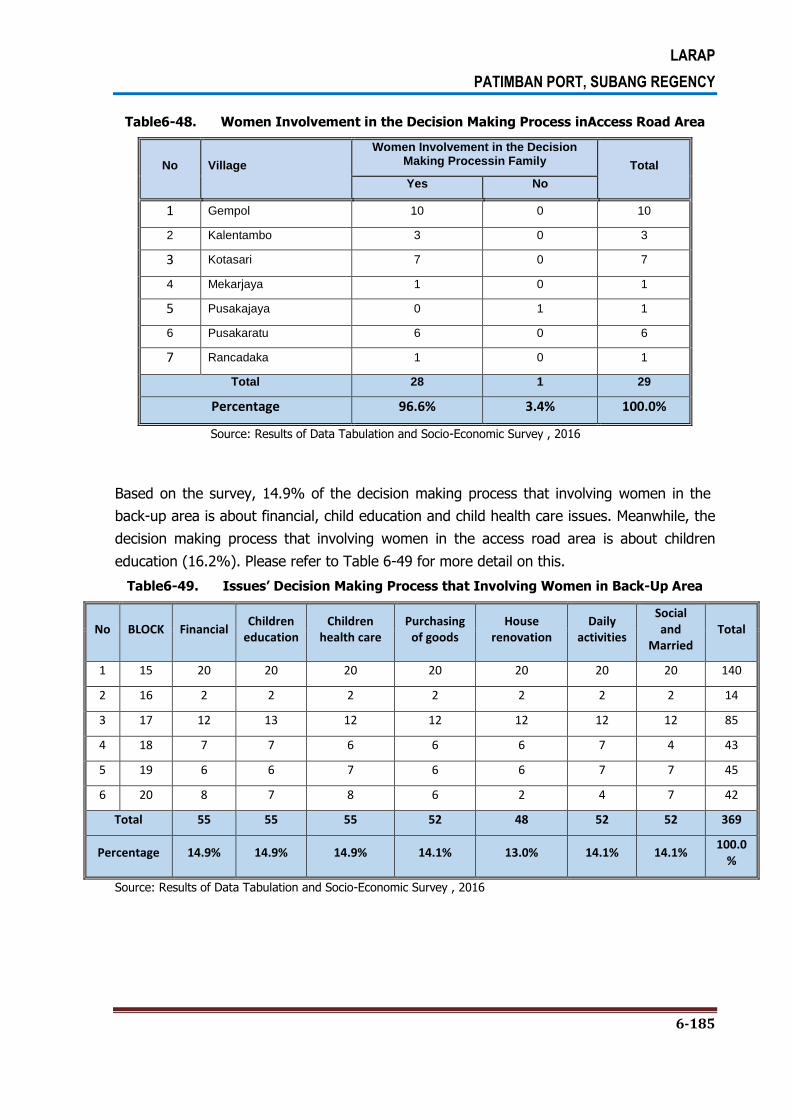
LARAP
PATIMBAN PORT, SUBANG REGENCY
6-185
Table6-48. Women Involvement in the Decision Making Process inAccess Road Area
No Village
Women Involvement in the Decision Making Processin Family Total
Yes No
1 Gempol 10 0 10
2 Kalentambo 3 0 3
3 Kotasari 7 0 7
4 Mekarjaya 1 0 1
5 Pusakajaya 0 1 1
6 Pusakaratu 6 0 6
7 Rancadaka 1 0 1
Total 28 1 29
Percentage 96.6% 3.4% 100.0%
Source: Results of Data Tabulation and Socio-Economic Survey , 2016
Based on the survey, 14.9% of the decision making process that involving women in the
back-up area is about financial, child education and child health care issues. Meanwhile, the
decision making process that involving women in the access road area is about children
education (16.2%). Please refer to Table 6-49 for more detail on this.
Table6-49. Issues’ Decision Making Process that Involving Women in Back-Up Area
No BLOCK Financial Children
education Children
health care Purchasing
of goods House
renovation Daily
activities
Social and
Married Total
1 15 20 20 20 20 20 20 20 140
2 16 2 2 2 2 2 2 2 14
3 17 12 13 12 12 12 12 12 85
4 18 7 7 6 6 6 7 4 43
5 19 6 6 7 6 6 7 7 45
6 20 8 7 8 6 2 4 7 42
Total 55 55 55 52 48 52 52 369
Percentage 14.9% 14.9% 14.9% 14.1% 13.0% 14.1% 14.1% 100.0
%
Source: Results of Data Tabulation and Socio-Economic Survey , 2016

LARAP
PATIMBAN PORT, SUBANG REGENCY
6-186
14.4%
16.2% 15.3%
13.0% 13.9%
13.0%
14.4%
0.0%
2.0%
4.0%
6.0%
8.0%
10.0%
12.0%
14.0%
16.0%
18.0%
Financial Childreneducation
Childrenhealth care
Purchasing ofgoods
Houserenovation
Daily activities Social andmarried
Figure6-1. Issues’ Decision Making Process that Involving Women inAccess Road Area
Source: Results of Data Tabulation and Socio-Economic Survey , 2016
6.4.2. Family Health Data
6.4.2.1 Source of Water for Cooking and Drinking
Based on the survey, for drinking and cooking, 50.7% of potentially affected households in
back-up area are using gallon packed water and 26.5% of them are using clean water from
their own wells, while the rest of them are using public water supply and water from Local-
Owned Water Company or PDAM. More detailed on this can be seen in Table 6-50.
Meanwhile, 70% of potentially affected households in access road area are using clean
water from their own wells and 20% of them are using gallon packed water. More detailed
on this can be seen in Table 6-51.
Table 6-50. Source of Water for Cooking and Drinkingin Back-Up Area
No BLOCK
Source of Water for Cooking and Drinking
No Answer Total Private well
Public water
supply PDAM
Gallon water
1 15 7 2 1 22 2 34
2 16 1 1 0 9 0 11
3 17 23 4 2 29 3 61
4 18 7 0 1 1 0 9
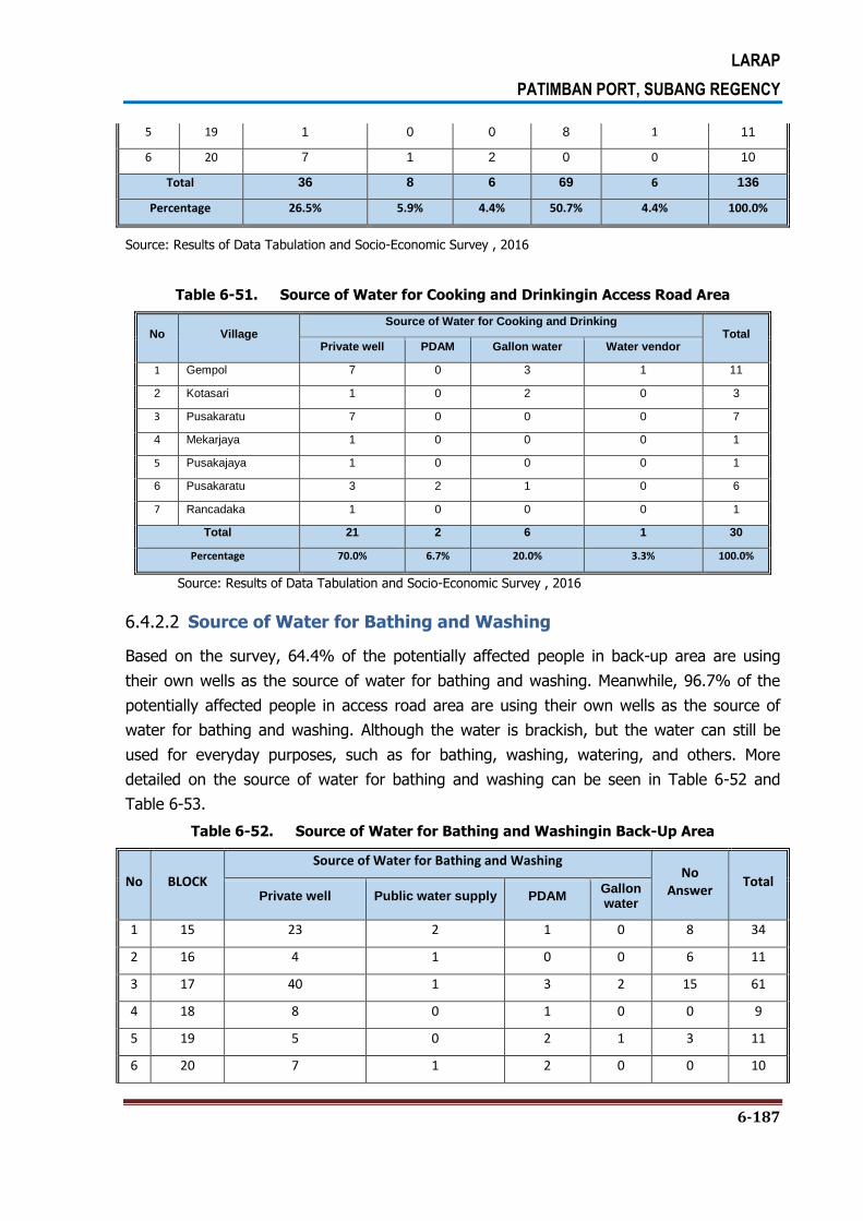
LARAP
PATIMBAN PORT, SUBANG REGENCY
6-187
5 19 1 0 0 8 1 11
6 20 7 1 2 0 0 10
Total 36 8 6 69 6 136
Percentage 26.5% 5.9% 4.4% 50.7% 4.4% 100.0%
Source: Results of Data Tabulation and Socio-Economic Survey , 2016
Table 6-51. Source of Water for Cooking and Drinkingin Access Road Area
No Village Source of Water for Cooking and Drinking
Total Private well PDAM Gallon water Water vendor
1 Gempol 7 0 3 1 11
2 Kotasari 1 0 2 0 3
3 Pusakaratu 7 0 0 0 7
4 Mekarjaya 1 0 0 0 1
5 Pusakajaya 1 0 0 0 1
6 Pusakaratu 3 2 1 0 6
7 Rancadaka 1 0 0 0 1
Total 21 2 6 1 30
Percentage 70.0% 6.7% 20.0% 3.3% 100.0%
Source: Results of Data Tabulation and Socio-Economic Survey , 2016
6.4.2.2 Source of Water for Bathing and Washing
Based on the survey, 64.4% of the potentially affected people in back-up area are using
their own wells as the source of water for bathing and washing. Meanwhile, 96.7% of the
potentially affected people in access road area are using their own wells as the source of
water for bathing and washing. Although the water is brackish, but the water can still be
used for everyday purposes, such as for bathing, washing, watering, and others. More
detailed on the source of water for bathing and washing can be seen in Table 6-52 and
Table 6-53.
Table 6-52. Source of Water for Bathing and Washingin Back-Up Area
No BLOCK
Source of Water for Bathing and Washing No
Answer Total
Private well Public water supply PDAM Gallon water
1 15 23 2 1 0 8 34
2 16 4 1 0 0 6 11
3 17 40 1 3 2 15 61
4 18 8 0 1 0 0 9
5 19 5 0 2 1 3 11
6 20 7 1 2 0 0 10

LARAP
PATIMBAN PORT, SUBANG REGENCY
6-188
Total 87 5 9 3 32 136
Percentage 64.0% 3.7% 6.6% 2.2% 23.5% 100.0%
Source: Results of Data Tabulation and Socio-Economic Survey , 2016
Table 6-53. Source of Water for Bathing and Washingin Access Road Area
No Village
Source of Water for Bathing and Washing
Total Private well PDAM
1 Gempol 11 0 11
2 Kotasari 3 0 3
3 Pusakaratu 7 0 7
4 Mekarjaya 1 0 1
5 Pusakajaya 1 0 1
6 Pusakaratu 5 1 6
7 Rancadaka 1 0 1
Total 29 1 30
Percentage 96.7% 3.3% 100.0%
Source: Results of Data Tabulation and Socio-Economic Survey , 2016
6.4.2.3 The Place for Defecating
Based on the survey, 80.93% of the potentially affected people in the back-up area are
using toilet with septic tank for defecating. Likewise, 96.7% of the potentially affected
people in the access road area are using toilet with septic tank for defecating. This indicates
that affected households pay enough attention to the environmental hygiene and sanitation.
The rest of affected people are using pit latrine toilet in the house, toilet with sewage flowed
into the river, and public toilet either with or without septic tanks. More detailed on this can
be seen in Table 6-54 and Table 6-55.
Table 6-54. The Place for Defecatingin Back-Up Area
No BLOCK
The Place for Defecating
No Answer
Total Toilet with septic tank
Pit latrine toilet
Toilet with sewage flowed into the river
Public toilet septic tanks
1 15 25 1 4 3 1 34
2 16 11 0 0 0 0 11
3 17 50 3 1 1 6 61
4 18 8 1 0 0 0 9
5 19 10 0 0 0 1 11
6 20 6 3 1 0 0 10

LARAP
PATIMBAN PORT, SUBANG REGENCY
6-189
No BLOCK
The Place for Defecating
No Answer
Total Toilet with septic tank
Pit latrine toilet
Toilet with sewage flowed into the river
Public toilet septic tanks
Total 110 8 6 4 8 136
Percentage 80.9% 5.9% 4.4% 2.9% 5.9% 100.0%
Source: Results of Data Tabulation and Socio-Economic Survey , 2016
Table6-55. The Place for Defecatingin Access Road Area
No Village
The Place for Defecating
Total Toilet with septic tank
Toilet with sewage flowed into the river
1 Gempol 11 0 11
2 Kotasari 3 0 3
3 Pusakaratu 7 0 7
4 Mekarjaya 1 0 1
5 Pusakajaya 1 0 1
6 Pusakaratu 5 1 6
7 Rancadaka 1 0 1
Total 29 1 30
Percentage 96.7% 3.3% 100.0%
Source: Results of Data Tabulation and Socio-Economic Survey , 2016
6.4.2.4 The Place for Bathing
Based on the survey, 86.8% of the potentially affected people in the back-up area are using
their own bathroom for bathing, and then followed by public bathroom (2.2%). Meanwhile,
all of the potentially affected people in the access road area are using their own bathroom
for bathing. The detail on this can be seen in Table 6-56 and Table 6-57.
Table6-56. The Place for Bathingin Back-Up Area
No BLOCK
The Place for Bathing
No Answer Total Private bathroom
Public bathroom
1 15 30 3 1 34
2 16 11 0 0 11
3 17 48 0 13 61
4 18 9 0 0 9
5 19 10 0 1 11
6 20 10 0 0 10

LARAP
PATIMBAN PORT, SUBANG REGENCY
6-190
Total 118 3 15 136
Percentage 86.8% 2.2% 11.0% 100.0%
Source: Results of Data Tabulation and Socio-Economic Survey , 2016
Table6-57. The Place for Bathingin Access Road Area
No Village Place for Bathing
Total
Private bathroom
1 Gempol 11 11
2 Kotasari 3 3
3 Pusakaratu 7 7
4 Mekarjaya 1 1
5 Pusakajaya 1 1
6 Pusakaratu 6 6
7 Rancadaka 1 1
Total 30 30
Percentage 100.0% 100.0%
Source: Results of Data Tabulation and Socio-Economic Survey , 2016
6.4.2.5 Place for Garbage Disposal
Based on the survey, 48.5% of the potentially affected households in the back-up area are
burning their garbage, 22.1% of them throwing their garbage into their garbage bins,
12.5% of them throwing their garbage into temporary waste disposal site, 7.4% of them
taken by garbage workers, and 1.5% of them are throwing the garbage into ground hole.
While 4.4% of them are still using a nearby river as a giant garbage bin, which indicates a
low awareness of the people on benefits and functions of a river.
Table6-58. Place for Garbage Disposalin Back-Up Area
No BLOCK
Place for Garbage Disposal
No Answer
Total Garbage bin
Temporary waste disposal
site
Garbage workers
River Burning Gound
hole
1 15 4 7 1 3 18 0 1 34
2 16 0 1 0 0 10 0 0 11
3 17 13 7 4 2 32 0 3 61
4 18 6 1 1 0 1 0 0 9
5 19 2 0 3 1 3 1 1 11
6 20 5 1 1 0 2 1 0 10
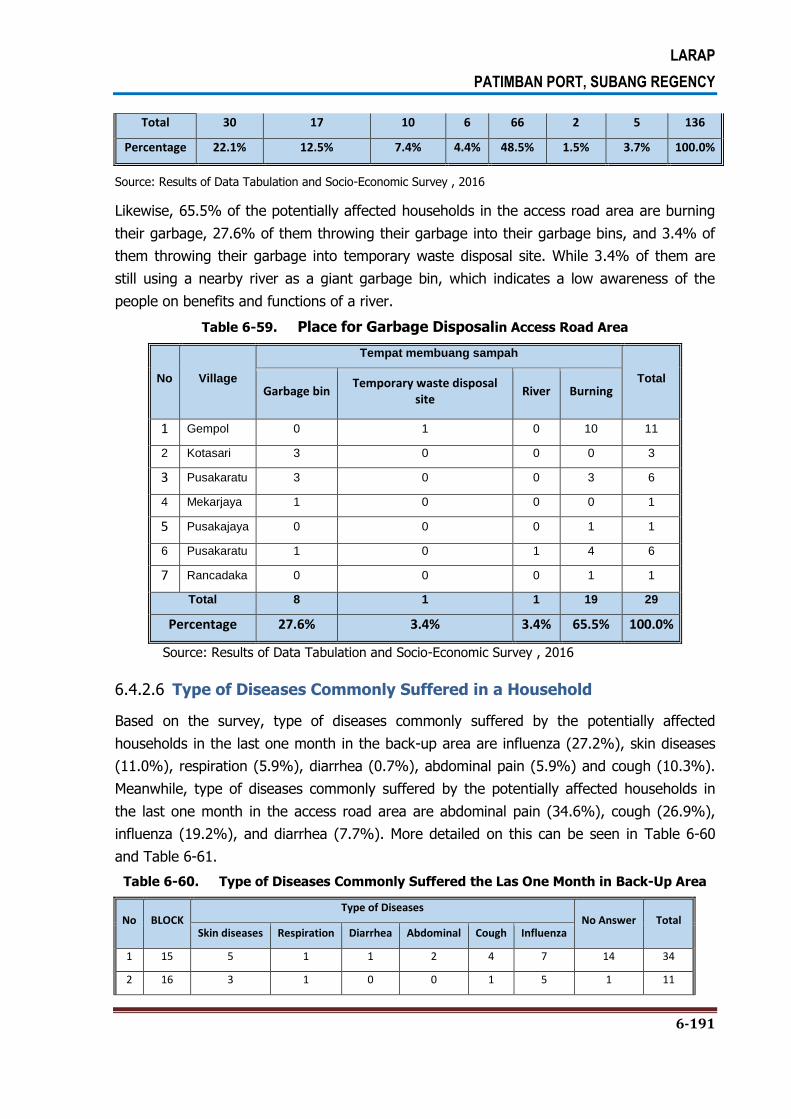
LARAP
PATIMBAN PORT, SUBANG REGENCY
6-191
Total 30 17 10 6 66 2 5 136
Percentage 22.1% 12.5% 7.4% 4.4% 48.5% 1.5% 3.7% 100.0%
Source: Results of Data Tabulation and Socio-Economic Survey , 2016
Likewise, 65.5% of the potentially affected households in the access road area are burning
their garbage, 27.6% of them throwing their garbage into their garbage bins, and 3.4% of
them throwing their garbage into temporary waste disposal site. While 3.4% of them are
still using a nearby river as a giant garbage bin, which indicates a low awareness of the
people on benefits and functions of a river.
Table 6-59. Place for Garbage Disposalin Access Road Area
No Village
Tempat membuang sampah
Total Garbage bin
Temporary waste disposal site
River Burning
1 Gempol 0 1 0 10 11
2 Kotasari 3 0 0 0 3
3 Pusakaratu 3 0 0 3 6
4 Mekarjaya 1 0 0 0 1
5 Pusakajaya 0 0 0 1 1
6 Pusakaratu 1 0 1 4 6
7 Rancadaka 0 0 0 1 1
Total 8 1 1 19 29
Percentage 27.6% 3.4% 3.4% 65.5% 100.0%
Source: Results of Data Tabulation and Socio-Economic Survey , 2016
6.4.2.6 Type of Diseases Commonly Suffered in a Household
Based on the survey, type of diseases commonly suffered by the potentially affected
households in the last one month in the back-up area are influenza (27.2%), skin diseases
(11.0%), respiration (5.9%), diarrhea (0.7%), abdominal pain (5.9%) and cough (10.3%).
Meanwhile, type of diseases commonly suffered by the potentially affected households in
the last one month in the access road area are abdominal pain (34.6%), cough (26.9%),
influenza (19.2%), and diarrhea (7.7%). More detailed on this can be seen in Table 6-60
and Table 6-61.
Table 6-60. Type of Diseases Commonly Suffered the Las One Month in Back-Up Area
No BLOCK Type of Diseases
No Answer Total Skin diseases Respiration Diarrhea Abdominal Cough Influenza
1 15 5 1 1 2 4 7 14 34
2 16 3 1 0 0 1 5 1 11

LARAP
PATIMBAN PORT, SUBANG REGENCY
6-192
3 17 5 2 0 4 7 20 23 61
4 18 2 2 0 1 0 1 3 9
5 19 0 1 0 0 1 3 6 11
6 20 0 1 0 2 3 1 3 10
Total 15 8 1 8 14 37 50 136
Percentage 11.0% 5.9% 0.7% 5.9% 10.3% 27.2% 36.8% 100.0%
Source: Results of Data Tabulation and Socio-Economic Survey , 2016
Table 6-61. Type of Diseases Commonly Suffered the Las One Month in Access Road
Area
No Village Type of Diseases
Total
Skin diseases Respiration Diarrhea Abdominal Cough Influenza
1 Gempol 0 0 0 2 1 5 8
2 Kalentambo 0 1 1 0 0 0 2
3 Kotasari 0 0 1 5 1 0 7
4 Mekarjaya 0 0 0 1 0 0 1
5 Pusakajaya 0 0 0 0 1 0 1
6 Pusakaratu 1 1 0 1 3 0 6
7 Rancadaka 0 0 0 0 1 0 1
Total 1 2 2 9 7 5 26
Percentage 3.8% 7.7% 7.7% 34.6% 26.9% 19.2% 100.0%
Source: Results of Data Tabulation and Socio-Economic Survey , 2016
In respect to the abovementioned diseases, the places of medical treatment mostly visited
by the sick people in the back-up area are public health center or 24 hours health clinic
(30.1%), hospital (20.6%), and paramedic (14%). Meanwhile, the places of medical
treatment mostly visited by the sick people in the access road are 24 hours health clinic
(43.3%), hospital and public health center (20.0%). More detailed on this can be seen in
Table 6-62 and Table 6-63.
Table 6-62. The Places of Medical Treatment Mostly Visited in Back-Up Area
No BLOCK The Place of Medical Treatment
No Answer Total Puskesmas Hospital 24 hours clinic Paramedic Alternative
1 15 16 3 8 6 0 1 34
2 16 6 2 0 3 0 0 11
3 17 13 12 24 8 0 4 61

LARAP
PATIMBAN PORT, SUBANG REGENCY
6-193
4 18 4 3 1 1 0 0 9
5 19 0 4 5 1 0 1 11
6 20 2 4 3 0 1 0 10
Total 41 28 41 19 1 6 136
Percentage 30.1% 20.6% 30.1% 14.0% 0.7% 4.4% 100.0%
Source: Results of Data Tabulation and Socio-Economic Survey , 2016
Table 6-63. The Places of Medical Treatment Mostly Visited in Access Road Area
No Village
The Place of Medical Treatment
Total Puskesmas Hospital
24 hours clinic
Paramedic
1 Gempol 1 3 6 1 11
2 Kalentambo 0 1 1 1 3
3 Kotasari 2 2 3 0 7
4 Mekarjaya 0 0 1 0 1
5 Pusakajaya 1 0 0 0 1
6 Pusakaratu 2 0 1 3 6
7 Rancadaka 0 0 1 0 1
Total 6 6 13 5 30
Percentage 20.0% 20.0% 43.3% 16.7% 100.0%
Source: Results of Data Tabulation and Socio-Economic Survey , 2016
6.4.2.7 People’s Perception Regarding Health Assistance From the Local
Government
With regard to health assistance from local government, 64.7% of the potentially affected
people in back-up area stated that they never received any health assistance from the local
government, while 24.3% of them said that there were some health assistances from the
local government. Likewise, 86.7% of the potentially affected people in access road area
claimed that they never received any health assistance from the local government, while
13.3% of them said that there were some health assistances from the local government.
More detailed on this can be seen in Table 6-64 and Table 6-65.
Table 6-64. People’s Perception on Health Assistance from the Local Governmentin
Back-Up Area
No BLOCK Government’s Health Aid
No Answer Total Yes No
1 15 13 20 1 34
2 16 8 3 0 11
3 17 6 43 12 61

LARAP
PATIMBAN PORT, SUBANG REGENCY
6-194
4 18 3 6 0 9
5 19 2 7 2 11
6 20 1 9 0 10
Total 33 88 15 136
Percentage 24.3% 64.7% 11.0% 100.0%
Source: Results of Data Tabulation and Socio-Economic Survey , 2016
Table 6-65. People’s Perception on Health Assistance from the Local Governmentin
Access Road Area
No Village Government’s Health Aid
Total
Yes No
1 Gempol 0 11 11
2 Kalentambo 2 1 3
3 Kotasari 0 7 7
4 Mekarjaya 0 1 1
5 Pusakajaya 0 1 1
6 Pusakaratu 2 4 6
7 Rancadaka 0 1 1
Total 4 26 30
Percentage 13.3% 86.7% 100.0%
Source: Results of Data Tabulation and Socio-Economic Survey , 2016
6.5. RETAILING BUSINESSES ALONG THE PATIMBAN BEACH
6.5.1. General History of Buildings (Restaurants) along the PatimbanBeach
The existence of food stalls or cafes along the Patimban Coastal line was begun in the 1990s
or 1996 to be exact. Since then, the number of land tenants who open food stalls,
restaurants, or cafés in the region continues to grow. The period of 2005-2010 is the period
in which most of the food stalls, restaurants, or cafés are established. Based on the survey,
38% of respondents confirmed that their business has been established since the period of
2005-2010.
Table 6-66. The Establishment Year of Food Stalls, Restaurants, or Cafés
No. Year of Establishment Number Percentage
1 ≤ 2000 9 18.0%

LARAP
PATIMBAN PORT, SUBANG REGENCY
6-195
2 > 2000 – 2005 10 20.0%
3 > 2005 – 2010 19 38.0%
4 > 2010 – 2016 6 12.0%
5 No answer 6 12.0%
Total 50 100.0%
Source: Questionnaire Data Processing Result, 2016
Based on the information obtained from the field, the first person who opens retailing
business in the area is Mr. ****. As time goes, there are many newly formed lands along
the Patimban Coastal area which add the wide land in the area. People began to see the
business opportunity in such newly formed land, or is perceived as no man’s land, and
started to build buildings for food stalls. These buildings are then sold by local people to the
people from outside the area to run their retailing businesses. Mr. ****, who is the first
person that opens business in the coastal area, has changed his business scale from a
vendor to become a distributor. As time goes by, people began to provide their own
merchandises. Then, with the development of such retailing activities in the area, they have
formed an association of retailers along the Patimban Coastal line.
6.5.2. The Objectives of the People in Opening their Retailing Businesses
Based on the survey, 78% of the people established food stalls, restaurants or cafés in the
Patimban Coastal area are for their main livelihoods, and only 2.0% of them established
such food stalls, restaurants or cafés as their sidelines.
Table 6-67. The Objectives of the People in Opening Food Stalls, Restaurants or Cafés
No. Objective of the Establishment
Number %
1 Main Livelihood 39 78.0%
2 Sidelines 1 2.0%
3 No answer 10 20.0%
Total 50 100.0%
Source: Questionnaire Data Processing Result, 2016
6.5.3. The Number of Landowners and Land Tenants
The lands used for retailing businesses by tenants are mostly located in Patimban coastal
area. The tenants build food stalls or cafés along the coastal area on the permission of
landowners. Based on the collected data, there are 23 landowners in Patimban Coastal area
with 101 food stalls or cafes owned by 50 land tenants.
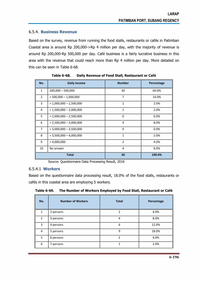
LARAP
PATIMBAN PORT, SUBANG REGENCY
6-196
6.5.4. Business Revenue
Based on the survey, revenue from running the food stalls, restaurants or cafés in Patimban
Coastal area is around Rp 200,000->Rp 4 million per day, with the majority of revenue is
around Rp 200,000-Rp 500,000 per day. Café business is a fairly lucrative business in this
area with the revenue that could reach more than Rp 4 million per day. More detailed on
this can be seen in Table 6-68.
Table 6-68. Daily Revenue of Food Stall, Restaurant or Café
No. Daily Income Number Percentage
1 200,000 – 500,000 30 60.0%
2 > 500,000 – 1,000,000 7 14.0%
3 > 1,000,000 – 1,500,000 1 2.0%
4 > 1,500,000 – 2,000,000 1 2.0%
5 > 2,000,000 – 2,500,000 0 0.0%
6 > 2,500,000 – 3,000,000 4 8.0%
7 > 3,000,000 – 3,500,000 0 0.0%
8 > 3,500,000 – 4,000,000 1 2.0%
9 > 4,000,000 2 4.0%
10 No answer 4 8.0%
Total 50 100.0%
Source: Questionnaire Data Processing Result, 2016
6.5.4.1 Workers
Based on the questionnaire data processing result, 18.0% of the food stalls, restaurants or
cafés in this coastal area are employing 5 workers.
Table 6-69. The Number of Workers Employed by Food Stall, Restaurant or Café
No. Number of Workers Total Percentage
1 2 persons 2 4.0%
2 3 persons 4 8.0%
3 4 persons 6 12.0%
4 5 persons 9 18.0%
5 6 persons 2 4.0%
6 7 persons 1 2.0%

LARAP
PATIMBAN PORT, SUBANG REGENCY
6-197
No. Number of Workers Total Percentage
7 No answer 28 56.0%
Total 50 100.0%
Source: Questionnaire Data Processing Result, 2016
6.5.5. Operational Days of Food Stall, Restaurant or Café
Most of the food stalls, restaurants or cafés open 30 days a month, or they are practically
open every day.
Table 6-70. Operational Days of Food Stall, Restaurant or Café in One Month
No. Operational Days in One
Month Total Percentage
1 20 days 1 2.0%
2 30 days 43 86.0%
3 No answer 6 12.0%
Total 50 100.0%
Source: Questionnaire Data Processing Result, 2016
6.5.6. The Number of Customers per Day
Based on the questionnaire data processing result, 62% of such food stalls, restaurants or
cafés are visited with average 10-20 customers per day, which is dominated by individual
(56%) and family customers (18%). The customers are mostly from outside Patimban
Village (86%), and only 10% of the customers come from villages in which such food stalls,
restaurants or cafés are located. A description of the above-mentioned condition can be
seen in Table 6-71, Table 6-72, Table 6-73.
Table 6-71. The Average Number of Customers of Food Stall, Restaurant or Café per
Day
No. The Average Number of
Customers per Day Total Percentage
1 < 10 persons 1 2.0%
2 10-20 persons 31 62.0%
3 21-30 persons 6 12.0%

LARAP
PATIMBAN PORT, SUBANG REGENCY
6-198
4 31-40 persons 5 10.0%
5 41-50 persons 3 6.0%
6 No answer 4 8.0%
Total 50 100.0%
Source: Questionnaire Data Processing Result, 2016
Table 6-72. Type of Customers of Food Stall, Restaurant or Café
No. Type of Customer Total Percentage
1 Individual 28 56.0%
2 Family 9 18.0%
3 Institution/Agency/Company 6 12.0%
4 No answer 7 14.0%
Total 50 100.0%
Source: Questionnaire Data Processing Result, 2016
Table 6-73. Domicile of Customers of Food Stall, Restaurant or Café
No. Domicile of Customers Total Percentage
1 Village in which the business is located 5 10.0%
2 Outside the village 43 86.0%
3 No answer 2 4.0%
Total 50 100.0%
Source: Questionnaire Data Processing Result, 2016
6.5.7. The Land Ownership in Other Locations
Based on the field survey result, most of the land tenants who run the food stalls,
restaurants or cafés are staying in the villages in which their businesses are located, and
they don’t have any land elsewhere. In the land acquisition activity, the local government
should pay attention to this condition while figuring out the best solution for those land
tenants who do not have any land in any other location. In addition, the local government
should also seek the best solution program in term of livelihood recovery activity given the

LARAP
PATIMBAN PORT, SUBANG REGENCY
6-199
fact that running food stalls, restaurants or cafés have been the main livelihoods for those
land tenants along the Patimban Coastal line.
6.6. CHARACTERISTICS OF LAND TENANTS WHO RUN THE BRACKISH WATER PONDS
There are 25 land tenants who run the brackish fishponds on the land area owned by 4
different landowners on Blocks 18, 19 and 20. The names of land tenants who run the
brackish water pond business and landowners on each block of potentially affected area can
be seen in the following table.
6.6.1. Type of Commodities
Most of land tenants who run the brackish water ponds are doing the shrimp farming (100%).
Table 6-74. Type of Commodities of the Brackish Water Pond
No Block
Type of Commodities of the Brackish
Water Pond
Shrimp %
1 18 4 13.8%
2 19 17 58.6%
3 20 4 13.8%
Total 25 100.0%
Source: Questionnaire Data Processing Result, 2016
6.6.2. Operating Cost of the Business
The biggest average of operating cost per day of the land tenants in running the shrimp
farming business is Rp 200,000 (36%). The biggest average of shrimp production in one
harvest is 300 kg (24%). The biggest average of shrimp harvest per year is 3 times (84.0%)
with the biggest average of selling price is Rp 70,000 per kg (60.0%).
A detailed field survey result on the characteristic of shrimp farming business can be seen in
the following tables.

LARAP
PATIMBAN PORT, SUBANG REGENCY
6-200
Table 6-75. Daily Operating Cost
No. Daily Operating
Cost
Block Total %
18 19 20
1 30,000 0 3 0 3 12.0%
2 40,000 0 1 0 1 4.0%
3 45,000 0 2 0 2 8.0%
4 50,000 0 1 0 1 4.0%
5 75,000 0 1 0 1 4.0%
6 100,000 0 2 0 2 8.0%
7 150,000 0 3 0 3 12.0%
8 155,000 0 0 1 1 4.0%
9 200,000 3 4 2 9 36.0%
10 250,000 1 0 0 1 4.0%
11 300,000 0 0 1 1 4.0%
Total 4 17 4 25 100.0%
Source: Questionnaire Data Processing Result, 2016
6.6.3. Production Value
The detail production value of shrimp in back up area minimum is 8 kg and maximum
150.000 kg. The averageof production value is 300 kg. For more detail the production value
of shrimp can be seen in Table 6-76.
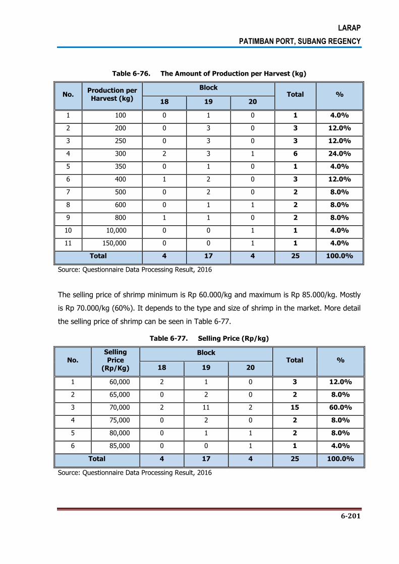
LARAP
PATIMBAN PORT, SUBANG REGENCY
6-201
Table 6-76. The Amount of Production per Harvest (kg)
No. Production per Harvest (kg)
Block Total %
18 19 20
1 100 0 1 0 1 4.0%
2 200 0 3 0 3 12.0%
3 250 0 3 0 3 12.0%
4 300 2 3 1 6 24.0%
5 350 0 1 0 1 4.0%
6 400 1 2 0 3 12.0%
7 500 0 2 0 2 8.0%
8 600 0 1 1 2 8.0%
9 800 1 1 0 2 8.0%
10 10,000 0 0 1 1 4.0%
11 150,000 0 0 1 1 4.0%
Total 4 17 4 25 100.0%
Source: Questionnaire Data Processing Result, 2016
The selling price of shrimp minimum is Rp 60.000/kg and maximum is Rp 85.000/kg. Mostly
is Rp 70.000/kg (60%). It depends to the type and size of shrimp in the market. More detail
the selling price of shrimp can be seen in Table 6-77.
Table 6-77. Selling Price (Rp/kg)
No.
Selling
Price (Rp/Kg)
Block Total %
18 19 20
1 60,000 2 1 0 3 12.0%
2 65,000 0 2 0 2 8.0%
3 70,000 2 11 2 15 60.0%
4 75,000 0 2 0 2 8.0%
5 80,000 0 1 1 2 8.0%
6 85,000 0 0 1 1 4.0%
Total 4 17 4 25 100.0%
Source: Questionnaire Data Processing Result, 2016

LARAP
PATIMBAN PORT, SUBANG REGENCY
6-202
Shrimps in the fishponds can be harvested in a year generally is 3 times per year (84%).
More detail the shrimp harvest in back up area can be seen in Table 6-78.
Table 6-78. Frequency of Harvest per Year
No Frequency of Harvest per Year ( ... times)
Block Total Percentage
18 19 20
1 2 0 2 2 4 16.0%
2 3 4 15 2 21 84.0%
Total 4 17 4 25 100.0%
Source: Questionnaire Data Processing Result, 2016
6.7. POPULATION CHARACTERISTICS OF TENANTS
6.7.1. The Age of Household Heads of the Land Tenants Potentially
Affected by the Project
Based on the census result, the biggest portion of average age of household heads of the
land tenants is 41-60 years (65.3%), while the least is 21-40 years (18.7%). This indicates
that most of the household heads of the land tenants in the project plan area can be
classified as people in productive age. Please refer to Table 6-79.
Table 6-79. The Age of Household Heads
Asset Occupation Status The Age of Household
Heads
Block Total %
18 19 20
Brackish Water Ponds
Tenants
< 20 0 0 0 0 0.0%
21 – 40 3 3 1 7 28.0%
41 – 60 1 14 2 17 68.0%
> 60 0 1 0 1 4.0%
Total 4 18 3 25 100.0%
Along The Beach Tenants
< 20 0 0 0 0 0.0%
21 – 40 0 7 0 7 14.0%
41 – 60 0 32 0 32 64.0%
> 60 0 11 0 11 22.0%
Total 0 50 0 50 100.0%
Total
< 20 0 0 0 0 0.0%
21 – 40 3 10 1 14 18.7%
41 – 60 1 46 2 49 65.3%
> 60 0 12 0 12 16.0%
Total 4 68 3 75 100.0%
Source: Questionnaire Data Processing Result, 2016

LARAP
PATIMBAN PORT, SUBANG REGENCY
6-203
6.7.2. Status of Household Heads and Members by Gender
Based on the gender category, most of household heads of the land tenants in the
potentially affected area is male (92.0%). There are six (8.0%) female household heads in
the area. For more details, it can be seen in Table 6-80.
Table 6-80. The Gender of Household Heads
Asset Occupation Status
Gender Block
Total % 18 19 20
Brackish Water Ponds Tenants
Male 4 16 4 24 96.0%
Female 0 1 0 1 4.0%
Total 4 17 4 25 100.0%
Along The Beach Tenants
Male 0 45 0 45 90.0%
Female 0 5 0 5 10.0%
Total 0 50 0 50 100.0%
Total Male 4 61 4 69 92.0%
Female 0 6 0 6 8.0%
Total 4 67 4 75 100.0%
Source: Questionnaire Data Processing Result, 2016
6.7.3. Marital Status
Based on the result of socio-economic survey towards 75 household heads of the land
tenants in the area, most of the household heads in the study area are married and only
small part of them widows or widowers. Table 6-81 shows the marital status of household
heads in the study area.

LARAP
PATIMBAN PORT, SUBANG REGENCY
6-204
Table 6-81. Marital Status of Household Heads
Asset
Occupation
Status
Marital Status
Blok
Total % 18 19 20
Brackish Water
Ponds Tenants
Married 4 16 4 24 96.0%
Widow/ Widower 0 0 0 0 0.0%
Divorced 0 1 0 1 4.0%
Total 4 17 4 25 100.0%
Along The Beach
Tenants
Married 0 45 0 45 90.0%
Widow/ Widower 0 2 0 2 4.0%
Divorced 0 3 0 3 6.0%
Total 0 50 0 50 100.0%
Total
Married 4 61 4 69 92.0%
Widow/ Widower 0 2 0 2 2.7%
Divorced 0 4 0 4 5.3%
Total 4 67 4 75 100.0%
Source: Questionnaire Data Processing Result, 2016
6.7.4. The Length of Stay Old of the Household Heads
Based on the survey result, 48% of the land tenants have been living in the area for ≤ 10
years, while 49.3% of the tenants have been living there for > 10-20 years. Data on the
length of stay of household heads in the study area can be seen in Table 6-82.

LARAP
PATIMBAN PORT, SUBANG REGENCY
6-205
Table 6-82. The Length of Stay Old of the Household Heads
Asset Occupation Status
Length of Stay (Years) Block
Total %
18 19 20
Brackish Water Ponds Tenants
≤ 10 1 4 4 9 36.0%
> 10 – 20 3 11 1 15 60.0%
> 20 0 1 0 1 4.0%
Total 4 16 5 25 100.0%
Along The Beach Tenants
≤ 10 0 27 0 27 54.0%
> 10 – 20 0 22 0 22 44.0%
> 20 0 1 0 1 2.0%
Total 0 50 0 50 100.0%
Total
≤ 10 1 31 4 36 48.0%
> 10 – 20 3 33 1 37 49.3%
> 20 0 2 0 2 2.7%
Total 4 66 5 75 100.0%
Source: Questionnaire Data Processing Result, 2016
6.7.5. The Ethnic Origin
Based on the result of socio-economic survey, 92% of the household heads are Javanese
ethnic group and only small part of them Sundanese and Bugis people. More details on this
can be seen in Table 6-83.
Table 6-83. The Ethnic Origin of the Household Heads
Asset Occupation Status
Ethnic Group Block
Total % 18 19 20
Brackish Water Ponds Tenants
Bugis 0 0 0 0 0.0%
Javanese 4 17 4 25 100.0%
Sundanese 0 0 0 0 0.0%
Total 4 17 4 25 100.0%
Along The Beach Tenants
Bugis 0 1 0 1 2.0%
Javanese 0 44 0 44 88.0%
Sundanese 0 5 0 5 10.0%
Total 0 50 0 50 100.0%
Total
Bugis 0 1 0 1 1.3%
Javanese 4 61 4 69 92.0%
Sundanese 0 5 0 5 6.7%
Total 4 67 4 75 100.0%
Source: Questionnaire Data Processing Result, 2016

LARAP
PATIMBAN PORT, SUBANG REGENCY
6-206
6.7.6. Religion of the Household Heads
Based on the survey result, most of the household heads of the land tenants in the study
area are Muslims (98.7%) and only 1.3% the household head of the land tenants is
Protestan.
Table 6-84. Religion of the Household Heads
Asset
Occupation Status
Religion
Block
Total % 18 19 20
Brackish Water Ponds Tenants
Islam 4 17 3 24 96.0%
Protestan 0 0 1 1 4.0%
Total 4 17 4 25 100.0%
Along The Beach
Tenants
Islam 0 50 0 50 100.0%
Protestan 0 0 0 0 0.0%
Total 0 50 0 50 100.0%
Total Islam 4 67 3 74 98.7%
Protestan 0 0 1 1 1.3%
Total 4 67 4 75 100.0%
Source: Questionnaire Data Processing Result, 2016
6.7.7. Educational Level of Household Heads of the Land Tenants
With respect to the educational level, based on the survey result, most of household heads
of the land tenants in the back-up area have a fairly low education level, whereby 72.0% of
them only graduated from the elementary school. Some 4% of the household heads
graduated from senior high school and even 9.3% of the household heads didn’t have any
formal education in school. Based on the interview, each household head and the spouse
have relatively the same education level. More details on this can be seen in Table 6-85.

LARAP
PATIMBAN PORT, SUBANG REGENCY
6-207
Table 6-85. Educational Level of Household Heads
Asset
Occupation
Status
Educational Level
Block
Total % 18 19 20
Brackish Water
Ponds Tenants
No Formal Education
0 1 0 1 4.0%
Not Graduated
from Elementary
School
0 0 0 0 0.0%
Graduated from
Elementary School 4 16 3 23 92.0%
Not Graduated
from High School 0 0 1 1 4.0%
Graduated from
High School 0 0 0 0 0.0%
Total 4 17 4 25 100.0%
Along The Beach
Tenants
No Formal Education
0 6 0 6 12.0%
Not Graduated
from Elementary
School
0 6 0 6 12.0%
Graduated from
Elementary School 0 31 0 31 62.0%
Not Graduated
from High School 0 4 0 4 8.0%
Graduated from
High School 0 3 0 3 6.0%
Total 0 50 0 50 100.0%
Total
No Formal Education
0 7 0 7 9.3%
Not Graduated
from Elementary
School
0 6 0 6 8.0%
Graduated from Elementary School
4 47 3 54 72.0%
Not Graduated
from High School 0 4 1 5 6.7%
Graduated from High School
0 3 0 3 4.0%
Total 4 67 4 75 100.0%
Source: Questionnaire Data Processing Result, 2016

LARAP
PATIMBAN PORT, SUBANG REGENCY
6-208
6.7.8. Occupations of Household Heads of the Land Tenants
Based on the survey result, 64% of the household heads of the land tenants potentially
affected by the project are working in business sector/retailers/shop owners/kiosks and
cafés and 33.3% of them are working as the sharecroppers in agriculture/animal
husbandry/brackish water pond sector. The occupation of household heads of the land
tenants based on the survey result can be seen in more detailed in Table 6-86.
Table 6-86. Occupations of Household Heads of the Land Tenants
Asset Occupation
Status Main Occupation
Block Total %
18 18 20
Brackish Water Ponds
Tenants
Sharecropper of
Agriculture/animal hubandry /brackish water pond
4 17 4 25 100.0%
Businee/retailer/shop owner/ food
stall & Café 0 0 0 0 0.0%
Driver/labour 0 0 0 0 0.0%
Total 4 17 4 25 100.0%
Along The Beach Tenants
Sharecropper of Agriculture/animal hubandry
/brackish water pond
0 0 0 0 0.0%
Businee/retailer/shop owner/ food
stall & Café 0 48 0 48 96.0%
Driver/labour 0 2 0 2 4.0%
Total 0 50 0 50 100.0%
Total
Sharecropper of Agriculture/animal hubandry
/brackish water pond
4 17 4 25 33.3%
Businee/retailer/shop owner/ food
stall & Café 0 48 0 48 64.0%
Driver/labour 0 2 0 2 2.7%
Total 4 67 4 75 100.0%
Source: Questionnaire Data Processing Result, 2016
6.7.9. Average Monthly Income of Household Heads of the Land Tenants
Based on the survey result, the average income of the household heads of the land tenants
potentially affected by the project Head is Rp 6,280,000 per month. From the household
heads participated in the survey, 28 (37.3%) of them have the average income of Rp
2,000,000-Rp 4,000,000 per month and another 15 (20.0%) household heads have the

LARAP
PATIMBAN PORT, SUBANG REGENCY
6-209
income of more than Rp 10.000.000 per month. Meanwhile, there are 11 (14.7%) household
heads have the income of Rp 4,000,000-Rp 6,000,000. The average monthly income of
household heads of the land tenants based on the survey result can be seen in more
detailed in Table 6-87.
Table 6-87. The Range of Average Monthly Income of Household Heads of the Land Tenants
Asset Occupation
Status
The Range of Average
Monthly Income
Block Total %
18 19 20
Brackish Water Ponds
Tenants
≤ 2,000,000 0 2 3 5 20.0%
> 2,000,000 – 4,000,000 4 9 1 14 56.0%
> 4,000,000 – 6,000,000 0 1 0 1 4.0%
> 6,000,000 – 8,000,000 0 1 0 1 4.0%
> 8,000,000 – 10,000,000 0 1 0 1 4.0%
> 10,000,000 0 3 0 3 12.0%
Total 4 17 4 25 100.0%
Along The Beach Tenants
≤ 2,000,000 0 8 0 8 16.0%
> 2,000,000 – 4,000,000 0 14 0 14 28.0%
> 4,000,000 – 6,000,000 0 10 0 10 20.0%
> 6,000,000 – 8,000,000 0 2 0 2 4.0%
> 8,000,000 – 10,000,000 0 4 0 4 8.0%
> 10,000,000 0 12 0 12 24.0%
Total 0 50 0 50 100.0%
Total
≤ 2,000,000 0 10 3 13 17.3%
> 2,000,000 – 4,000,000 4 23 1 28 37.3%
> 4,000,000 – 6,000,000 0 11 0 11 14.7%
> 6,000,000 – 8,000,000 0 3 0 3 4.0%
> 8,000,000 – 10,000,000 0 5 0 5 6.7%
> 10,000,000 0 15 0 15 20.0%
Total 4 67 4 75 100.0%
Source: Questionnaire Data Processing Result, 2016

LARAP
PATIMBAN PORT, SUBANG REGENCY
6-210
6.8. PEOPLE’S PERCEPTION ABOUT THE PROJECT AND THEIR WILLINGNESS TO BE RELOCATED
Based on the survey, 55.1% of the potentially affected households in the back-up area know
about the port development project and only 4.4% of them do not know about the project
plan. Meanwhile, all of the potentially affected households in the access road area know
about the project plan.
Table 6-88. Information on the Project Plan in Back-Up Area
No BLOCK
Informed on the Project Plan No Answer Total
Yes No
1 15 25 4 5 34
2 16 10 0 1 11
3 17 15 0 46 61
4 18 7 2 0 9
5 19 8 0 3 11
6 20 10 0 0 10
Total 75 6 55 136
Percentage 55.1% 4.4% 40.4% 100.0%
Source: Results of Data Tabulation and Socio-Economic Survey , 2016
Table 6-89. Information on the Project Plan in Access Road Area
No. Village
Informed on the Project Plan Total
Yes
1 Gempol 11 11
2 Kalentambo 3 3
3 Kotasari 7 7
4 Mekarjaya 1 1
5 Pusakajaya 1 1
6 Pusakaratu 6 6
7 Rancadaka 1 1
Total 30 30
Percentage 100.0% 100.0%
Source: Results of Data Tabulation and Socio-Economic Survey , 2016
In the meantime, 40.4% of the potentially affected households in the back-up area know
the information on the port development project from village officials. Meanwhile, 83.3% of
the potentially affected households in the access road area know the information on the port

LARAP
PATIMBAN PORT, SUBANG REGENCY
6-211
development project from village officials and 16,7% of them get the information on the
project plan from their neighbors.
Table 6-90. Source of Information on the Project Plan in Back-Up Area
No BLOCK
Source of Information
No Answer Total Village officials
Tetangga TV/Radio
1 15 18 9 0 7 34
2 16 9 1 0 1 11
3 17 10 5 0 46 61
4 18 6 2 0 1 9
5 19 7 0 1 3 11
6 20 5 5 0 0 10
Total 55 22 1 58 136
Percentage 40.4% 16.2% 0.7% 42.6% 100.0%
Source: Results of Data Tabulation and Socio-Economic Survey , 2016
Table 6-91. Source of Information on the Project Plan in Access Road Area
No Village Source of Information
Total Village officials Tetangga
1 Gempol 8 3 11
2 Kalentambo 3 0 3
3 Kotasari 7 0 7
4 Mekarjaya 1 0 1
5 Pusakajaya 1 0 1
6 Pusakaratu 4 2 6
7 Rancadaka 1 0 1
Total 25 5 30
Percentage 83.3% 16.7% 100.0%
Source: Results of Data Tabulation and Socio-Economic Survey , 2016
With respect to the relocation plan, 44.1% of the potentially affected households in the
back-up area do not have land in another place to move out and only 12.5% of them have
land in another place to move out. Likewise, 76.7% of the potentially affected households in
the access road area do not have land in another place to move out and only 23.3% of
them have land in another place to move out. More detailed on this can be seen in Table 6-
92 and Table 6-93.

LARAP
PATIMBAN PORT, SUBANG REGENCY
6-212
Table 6-92. Alternative Land to Move Out in Back-Up Area
No BLOCK
Alternative Land to Move Out No Answer Total
Have Don’t Have
1 15 6 22 6 34
2 16 3 7 1 11
3 17 0 15 46 61
4 18 1 7 1 9
5 19 4 3 4 11
6 20 3 6 1 10
Total 17 60 59 136
Percentage 12.5% 44.1% 43.4% 100.0%
Source: Results of Data Tabulation and Socio-Economic Survey , 2016
Table 6-93. Alternative Land to Move Out in Access Road Area
No Village
Alternative Land
Total Have Don’t Have
1 Gempol 5 6 11
2 Kalentambo 0 3 3
3 Kotasari 1 6 7
4 Mekarjaya 0 1 1
5 Pusakajaya 0 1 1
6 Pusakaratu 1 5 6
7 Rancadaka 0 1 1
Total 7 23 30
Percentage 23.3% 76.7% 100.0%
Source: Results of Data Tabulation and Socio-Economic Survey , 2016
Based on the survey result, 46.3% of the potentially affected people in back-up area argued
that the development plan of Patimban Port would affect the their business activities, but
8.8% of them said that the project plan would not affect their business activities. More
detailed on this can be seen in Table 6-94. Meanwhile, 82.1% of the potentially affected
people in access road area argued that the development plan of Patimban Port would affect
their business activities, but 17.9% of them said that the project plan would not affect their
business activities. More detailed ont his can be seen in Table 6-95.

LARAP
PATIMBAN PORT, SUBANG REGENCY
6-213
Table 6-94. Project Impact to Business of Potentially Affected People in Back-Up Area
No BLOCK
Project Impact to Business No Answer Total
Yes No
1 15 18 7 9 34
2 16 8 2 1 11
3 17 13 2 46 61
4 18 8 1 0 9
5 19 7 0 4 11
6 20 9 0 1 10
Total 63 12 61 136
Percentage 46.3% 8.8% 44.9% 100.0%
Source: Results of Data Tabulation and Socio-Economic Survey , 2016
Table 6-95. Project Impact to Business of Potentially Affected People in Access Road
Area
No Village Project Impact to Business
Total
Yes No
1 Gempol 7 2 9
2 Kalentambo 3 0 3
3 Kotasari 6 1 7
4 Mekarjaya 0 1 1
5 Pusakajaya 0 1 1
6 Pusakaratu 6 0 6
7 Rancadaka 1 0 1
Total 23 5 28
Percentage 82.1% 17.9% 100.0%
Source: Results of Data Tabulation and Socio-Economic Survey , 2016
The reasons put forwarded by the potentially affected people in back-up area and access
road area that the project plan will affect their business activities can be seen in Table 6-96
and Table 6-97.
Table 6-96. People Opinion on Project Impact to Their Businesses in Back-Up Area
BLOCK People Opinion
15 Close to the sea

LARAP
PATIMBAN PORT, SUBANG REGENCY
6-214
BLOCK People Opinion
Land, production, and income will be reduced
Reduce land, production, and work
Income will be reduced
16 Income will be reduced
Residential area will be disrupted
Relocation will make them to make adjustment to the new area
Income will be reduced
Residential area will be disrupted
Relocation will make them to make adjustment to the new area
17 Relocation will make them to make adjustment to the new area
18 Access will be harder and livelihood will be lost
Will lose the house
Livelihood will be lost
Will lose the houseand income
Will lose the houseand paddy field
Will lose the source of income
19 Relocation will make them to make adjustment to the new area
Income will be reduced and compensation should be as agreed
Reduce the livelihood
Different of land to be occupied
Income will be reduced
Paddy fields, ponds, and income will be reduced
20 Affect the livelihood
Will lose the business land
Will lose the job
Will lose the business place
Business place near to the house
Reduce the income
No other option
No other business
Total 1, income will be reduced

LARAP
PATIMBAN PORT, SUBANG REGENCY
6-215
BLOCK People Opinion
1, Relocation will make them to make adjustment to the new area
1, Residential area will be disrupted
1, Relocation will make them to make adjustment to the new area
1, Close to the sea
1, Land, production, and income will be reduced
1, Land, production, and income will be reduced
1, Land, production, and income will be reduced
1, Income will be reduced and compensation should be as agreed
1, Reduce the livelihood
1, Reduce the livelihood
1, Reduce the income
1, Residential area will be disrupted
1, Different of land to be occupied
1, Reduce the income
1, Reduce the income
1, Relocation will make them to make adjustment to the new area
Access will be harder and livelihood will be lost
Affect the livelihood
Will lose the house
Will lose the business place
Will lose the livelihood
Will lose the work, house, and land
Will lose income and house
Will lose paddy field and house
Will lose the business place
Business place near to the house
Reduce the income
Reduce the income
Reduce the income
No other option
No other business
Source: Results of Data Tabulation and Socio-Economic Survey , 2016

LARAP
PATIMBAN PORT, SUBANG REGENCY
6-216
Table 6-97. People Opinion on Project Impact to Their Businesses in Access Road Area
Village People Opinion
Gempol Current asset is still productive
Reduce income
Kalentambo Will lose tiling land
The land will be no effective
The current land is good, there’s no assurance the new land will be as good as the old one
Kotasari Rent the land for business
Shepperding land
The location is strategic for business
The location is strategic, by the road
Main livelihood and the location is good
It’s hard to find new customers
Pusakaratu Many people come
Farming land is taken
Farming in their own land
The land is taken
The business will be stopped and employee wil lose the job
Doing the farm land
Rancadaka Income will be reduced
Source: Results of Data Tabulation and Socio-Economic Survey , 2016
Meanwhile, the reasons put forwarded by the potentially affected people in back-up area
that the project plan will not affect their business activities can be seen in Table 6-98.
Table 6-98. People Opinion that Project Has No Impact to Their Businesses in Back-Up
Area
Block Reason
Block 15 2, relocation place shoule be better
2, able to bu new land from the compensation
Block 16 No
Block 17 No

LARAP
PATIMBAN PORT, SUBANG REGENCY
6-217
Block Reason
Block 19 No
2, the land is no longer productive
Source: Results of Data Tabulation and Socio-Economic Survey , 2016
The reasons put forwarded by the potentially affected people in access road area that the
project plan will not affect their business activities can be seen in Table 6-99.
Table 6-99. People Opinion that Project Has No Impact to Their Businesses in Access
Road Area
Village People opinion
Gempol
Asset still productive
Kalentambo
The current land is good
Have land in another place
Kotasari
Have no business
Mekarjaya
Have no business
Pusakajaya -
Pusakaratu
The land is not productive
Rancadaka -
Source: Results of Data Tabulation and Socio-Economic Survey , 2016
Based on the survey, 82.9% of the potentially affected people in back-up area have no
objection to the development plan of Patimban Port, and the remaining 17.1% did not give
answer.

LARAP
PATIMBAN PORT, SUBANG REGENCY
6-218
Table 6-100. People Perception to the Project Plan in Back-Up Area
Block Village People Perception
Total Agree No Answer
Block 15
No village name 4 2 6
Patimban 25 2 27
Rancadaka 1 0 1
Block 16 Patimban 7 4 11
Block 17
No village name 8 0 8
Kalentambo 5 1 6
Patimban 34 10 44
Rancadaka 3 0 3
Block 19
Kalentambo 1 0 1
Patimban 8 1 9
Rancadaka 1 0 1
Total 97 20 117
Percentage 82.9% 17.1% 100.0%
Source: Results of Data Tabulation and Socio-Economic Survey , 2016
Likewise, 93.3% of the potentially affected people in access road area have no objection to
the development plan of Patimban Port, and only 6.7% that do not agree with the project.
Table 6-101. People Perception on the Project Plan in Access Road Area
No Village
People Perception on the Project Plan
Total
Agree Disagree
1 Gempol 10 1 11
2 Kalentambo 3 0 3
3 Kotasari 6 1 7
4 Mekarjaya 1 0 1
5 Pusakajaya 1 0 1
6 Pusakaratu 6 0 6
7 Rancadaka 1 0 1
Total 28 2 30
Percentage 93,3% 6,7% 100,0%
Source: Results of Data Tabulation and Socio-Economic Survey , 2016
The reasons put forwarded by the potentially affected people in back-up area that they
agree with the project plan can be seen in Table 6-102. Meanwhile, the reasons put
forwarded by the potentially affected people in access road area that they agree with the
project plan can be seen in Table 6-103.

LARAP
PATIMBAN PORT, SUBANG REGENCY
6-219
Table 6-102. People Reasons to Agree with Project Plan in Back-up Area
Block Reason
Block 15
1, there’s new job opportunity
1, there’s new job opportunity
1, to attain a better place
1, the relocation area should not far
1, children still school and college
1, for public interest
1, the economy is improved
1, the economy is improved
1, compensation fair
1, central business
1, new job opportunity
1, new job opportunity
1, more new job opportunity
1, new job opportunityand compensation
1, reduce unemployment
1, improve local economy
1, improve people economy
1, open new job opportunity
1, improve people economy
1, open new job opportunity
1, improve people economyand open new job opportunity
1, improve people economy
1, don’t want to be relocated
Block 16
1, involve local people
1, relocated not far from Patimban
1, fair compensation
Block 17
1, relocated not far from Patimban
1, fair compensation
1, closer the paddy field to the house and fair compensation
1, for public interest, open new job opportunity

LARAP
PATIMBAN PORT, SUBANG REGENCY
6-220
Block Reason
1, fair compensation
1, fair compensation
1, relocated not far from Patimban
1, fair compensation
1, support government program
1, improve people economy, fair compensation
1, improve people economy, fair compensation
1, for public interest, open new job opportunity, fair compensation
1, for public interest
1, improve people economy, fair compensation.
1, fair compensation, open new job opportunity
1, will lose the job opportunity
1, improve people economyand open new job opportunity
1, improve people economyand reduce unemployment
1, improve people economyand near relocation
1, improve people economy
1, support government program
1, do not harm farmers
1, for public interest
1, fair compensation
1, do not harm farmers
1, do not harm local people
1, do not harm farmers
1, do not harm the people
1, improve people economyand open new job opportunity
Block 19
1, improve people economyand fair compensation
1, fair compensation to buy land in another place
1, improve people economyand open new job opportunity
1, open new job opportunityand tourism area
1, improve people economyand open new job opportunity

LARAP
PATIMBAN PORT, SUBANG REGENCY
6-221
Block Reason
1, improve people economyand and public interest
1, paddy field is less productive
1, fair compensation
Source: Results of Data Tabulation and Socio-Economic Survey , 2016
Table 6-103. People Reasons to Agree with Project Plan in Access Road Area
Village People Reasons to Agree with Project Plan
Gempol
Current asset is more productive
Asset will become productive, paddy field and farm land
Add income
Kalentambo
The land become effective
Current land is good
Kotasari
Rent the land for business
Shepperding land
The location is strategic for business for main livelihood
The location is strategic, by the road
Main livelihood and location is good for current business
Add customers
Mekarjaya
Improve economic value
Pusakajaya
Improve local economy
Pusakaratu Many people come
Add livelihood
LARAP
PATIMBAN PORT, SUBANG REGENCY
6-222
Village People Reasons to Agree with Project Plan
Farm land business
Rancadaka
Add family income
Table 6-104. People Reasons to Disagree with Project Plan in Access Road Area
Village People Reasons to Disagree with Project Plan
Gempol
The land will become not productive
Kalentambo Will lose the tilling land
Kotasari -
Mekarjaya
Will lose the business
Pusakajaya -
Pusakaratu The land is taken
Rancadaka -
Source: Results of Data Tabulation and Socio-Economic Survey , 2016
6.9. SOCIO ECONOMIC CONDITIONS OF AFFECTED MARINE FISHERMEN
Number of the fishermen, fishing boats and the fishing gear in three affected TPI (fish
auction places) around the project site; namely, Kali Genteng, Truntum and Tanjung Pura,
are presented in Table 6-105 to Table 6-107. They are operating the fishing activites with
their small boats which size is 2-5 GT. Their target fish are glass fish, mackerel, anchovy,
shrimp and so on. The average yearly costs for the fishing activities and the income
collected by interview are tabulated in Table 6-108.

LARAP
PATIMBAN PORT, SUBANG REGENCY
6-223
Table 6-105. Number of Marine Fishermen around the Project Site
Regency
TPI
Subang Indramayu
Total Kali Genteng
Truntum Tanjung
Pura
Number of fishermen who have fishing boats (person)
105 109 146 360
Number of fishermen whodo not have fishing boats (person)
41 10 11 62
Total (person) 146 119 157 422
Number of interviewed fishermen 16 11 16 44
Source: The Survey Team (Survey in October 2016)
Table 6-106. Number of Fishing Boats by Type
Regency
TPI
Subang Indramayu
Total Kali Genteng Truntum
Tanjung Pura
Registered
Type 2 GT 17 7 13 37
Type 3 GT 85 76 102 263
Type 4 GT 8 10 18
Type 5 GT 3 8 11 22
Subtotal 105 99 136 340
Non-registered
Type 2 GT 2 2 2 6
Type 3 GT 6 8 6 20
Type 4 GT 2 2 4
Type 5 GT 2 3 3 8
Subtotal 11 15 13 39
Ground total 116 114 149 379
Source: The Survey Team (Survey in October 2016)
Table 6-107. Number of Fishing Boats by Gear
Regency
TPI
Subang Indramayu
Total Kali Genteng
Truntum Tanjung
Pura
Trawl 65 71 155 291
Gill net 29 54 83
Trap 22 22
Hook Lines 19 19
Total 135 125 155 415
Source: The Survey Team (Survey in October 2016)

LARAP
PATIMBAN PORT, SUBANG REGENCY
6-224
Table 6-108. Average Yearly Fishing Costs and Income of Marine Fishermen (Rp./year)
Regency
TPI
Subang Indramayu
Kali
Genteng Truntum
Tanjung
Pura
Cost Operating cost of fuel (a boat) 27.216.000 24.240.000 24.864.000
Boat maintenance (a boat) 3.425.000 2.000.000 1.393.000
Machine/engine maintenance (a boat)
2.231.250 1.812.500 1.531.250
Fishing gear (a fisherman) 8.662.500 5.015.625 13.281.250
Income
(net)
Average income of fishermen
whohave fishing boats 34.800.000 31.540.000 46.800.000
Average income of fishermen whodo nothavefishing boats
25.200.000 22.460.000 18.000.000
Source: The Survey Team (Survey in October 2016)

LARAP
PATIMBAN PORT, SUBANG REGENCY
7-225
CHAPTER 7. LIVELIHOOD RESTORATION PROGRAM FOR AFFECTED HOUSEHOLDS
7.1. BACKGROUND
The Livelihood Restoration Program (LRP) is a program to reduce social risks in
implementation of the Patimban Port development project. Although compemsation will be
paied for the affected people, it is concerned that the people will face difficulties to maintain
their living standard as they will lose means of livelihood such as farmland and shops due to
the project and may be hard to find alternative means of livelihood or to addapt new job
oppotunites. In order to reduce the risk of the impacts to their livilihood, LRP will be
provided to the affected people to maintain or improve the pre-project living standard by
improving their income and productions.
7.2. PROGRAM OBJECTIVES
The objectives of livelihood restoration program are as follows:
1) Restore livelihood and incomes of affected households who live in Back Up area and
Access Road as well as affected marine fishermen.
2) Improve the quality of human resources of affected households through the
development of creative, innovative and entrepreneurial mindset.
3) Improve the community institutional capacity.
4) Provide awareness of healthy lifestyle to the affected people.
5) Improve the environment quality in the affected area.
7.3. MAIN ATTENTION OF THE PROGRAM
Things that need to be considered in deciding appropriate livelihood restoration program
activities are: (i) the nature of loss and/or asset situation of the affected people, (ii) the
needs, concerns, and preferences of the affected people, (iii) the level of preparedness of
affected people to participate in the livelihood restoration program, and (iv) the socio-
economic condition of affected people.

LARAP
PATIMBAN PORT, SUBANG REGENCY
7-226
7.4. TARGET GROUP
The target group of the LRP is the people whose livelihood will be affected by the project;
namely, owners, tenants and workers of the affected farmland, fishpond, shop and
restaurant as well as the affected marine fishermen. The entitlement of participating to the
LRP is defined as the people whose 10% or more of the toal assets of earning revenue
souces will be affected and the affected vulnerable people regardless the severity of the
impact.
The definition of vulnerable group is a certain group of people who might suffer
disproportionately or face the risk of becoming more marginalized as a result of the project,
and specifically covers: i) households headed by women, ii) households headed by disabled
people, iii) households under the poverty generally applicable indicators, and iv) households
headed by elderly people. This definition is in line with Law No. 39 of 1999 (Article 5 of
elucidation) on Human Rights, whereby the vulnerable group includes among others, the
elderly, children, the poor, pregnant women and disabled people.
One of the vulnerable groups to be used as the target of this program is the poor. For this,
the poverty measurement and standard should be acknowledged from various sources. The
poverty measuring concept according to the definition of Central Bureau of Statistics (BPS)
is the ability to meet basic needs. Hence, poverty is seen as an economic inability to meet
the basic needs of food and non-food which is measured from the expenditure side. So the
Poor People are those with an average monthly per capita expenditure below the poverty
line. The expenditure per capita (purchasing power) is the ability of people to spend their
money in the form of goods or services.
7.5. ANALYSIS OF IMPACT IDENTIFICATION FOR AFFECTED HOUSEHOLD
The development for the purposes of Patimban Port and Access Road will cause some
negative impacts to the affected households’ lives. Various negative impacts that will occur
and need livelihood restoration program for affected households can be seen in Table 7.1.
Table 7-1.
Analysis of Impact Identification of Land Acquisition Activity for Affected Household in Impacted Area
No. Type of Impact The Severity of Impact The Nature of Impact
1 The disruption/losing of livelihood
All of affected people whose
livelihood will be affected (landowners, tenants,
fishermen, wage earners) will
Temporary for theaffected people as far as they can
findalternative livelihood in another location.

LARAP
PATIMBAN PORT, SUBANG REGENCY
7-227
No. Type of Impact The Severity of Impact The Nature of Impact
experience loss of change of
livelihood as they have to move out to another location.
Vulnerable group:
1) Poor households/don’t have
land will experience loss of
change of livelihood as they have to move out to another
location 2) Female head of household
will experience loss of
change of livelihood as they have to move out to another
location
Permanent as they have to
find new job and place in other locations
Permanent as they have to
find new job and place in new place
2 The change/decline
of production/income
There will be a decline in
agriculture products, especially
for the landowner, shop owners, tenants, marine fishermen, wage
earners
Temporary for the affected
people as far as they can find alternative livelihoodin another
location.
Vulnerable Group
1) Poor households/don’t have
land will experience loss of change of livelihood as they
have to find a job in the new
place 2) Female head of household
will experience change or decline of income during the
transition period
Permanent
Permanent
7.6. THE TYPE OF LIVELIHOOD RESTORATION PROGRAM NEEDED BY AFFECTED HOUSEHOLDS
To restore livelihoods affected by land acquisition is certainly there should be a recovery
effort for the citizens. To determine the type of Livelihood Restoration program needed by
the AHH’s, has been distributing the questionnaires to the AHH’s both in back up area and
access road area. From the field survey known most people in back up area choose the
venture capital assistance program (26.5%) as the alternative to recovery their livelihood
followed by training programs (21.4%). More the program required can be seen in the Table
7-2.

LARAP
PATIMBAN PORT, SUBANG REGENCY
7-228
Table 7-2.
Lifelihood Restoration Program Needed by AHH’s in Back Up Area
No Blok
The type of Livelihood Restoration Program
Total Traning Program
Venture
Capital Assistance
Program
New
business activities
program
The
Marketing Assistance
Program
Equipment
Assistance
Program
1 15 5 4 5 3 4 21
2 16 1 1 1 1 1 5
3 17 2 2 2 2 2 10
4 18 4 4 1 2 3 14
5 19 9 15 8 7 8 47
6 20 0 0 1 0 0 1
Total 21 26 18 15 18 98
Prosentase 21.4% 26.5% 18.4% 15.3% 18.4% 100.0%
Sumber : Hasil Pengolahan Data Kuesioner, 2016
The same condition in the access road area, to restore livelihoods affected by land
acquisition activities, most people choose the venture capital assistance program (61.2%),
followed by new alternative business activities programs (15.7%). Other programs can be
seen in Table 7.3.
Table 7-3.
The Lifelihood Restoration Program Needed by the AHH’s in Access Road
No. Village
The type of Livelihood Restoration Program
Total Traning
Program
Venture Capital
Assistance
Program
New business
activities
program
The Marketing
Assistance
Program
Equipment
Assistance Program
1 Gempol 2 22 6 4 1 35
2 Kalentambo 4 10 4 6 2 26
3 Kotasari 1 16 3 1 1 22
4 Pusakajaya 3 8 6 2 1 20
5 Pusakaratu 0 16 0 0 0 16
6 Rancadaka 0 2 0 0 0 2
Total 10 74 19 13 5 121
Prosentase 8,3% 61,2% 15,7% 10,7% 4,1% 100,0%
Source : Field Survey, October 2016.

LARAP
PATIMBAN PORT, SUBANG REGENCY
7-229
Preference on the livelihood assistances were also asked to the affected marine fishermen
(Table 7.4). In addition to the financial support and request of job opportunities, they
expects support of fishing gear/vessels and fish apartment.
Table 7-4. The Lifelihood Restoration Program Needed by the Affected Marine Fishermen
TPI
Type of assistance
Kali Genteng
Truntum TanjungPura Total
Financial support 8 (20.0%) 8 (22.2%) 10 (15.6%) 26 (18.6%)
Job opportunity 9 (22.5%) 5 (13.9%) 4 (6.25%) 18 (12.9%)
Job opportunity at the port 13 (32.5%) 10 (27.8%) 8 (12.5%) 31 (22.1%)
Support of fishing gears/vessels 10 (25.0%) 13 (36.1%) 27 (42.2%) 50 (35.7%)
Make fish apartment - - 15 (23.4%) 15 (10.7%)
Total 40 36 64 140
Source : Field Survey, October 2016.
7.7. PROPOSED LIVELIHOOD RESTORATION PROGRAM FOR AFFECTED HOUSEHOLDS
The type of livelihood restoration program required by the AHH’s mostly is the venture
capital assistance program and followed by the training program and new alternative
business activities. Base on the results of the public consultation carried out in the region of
the back up area and the access road, the main needs of the community is like to get
employment and business opportunities. For that reason The LRP proposed program are:
employment services and skill training. Following are the general description of the proposed
LRP Program:
1. Employment for Construction Works
The Patimban Portactivities will provide many job opportunities for the affected people,
especially in the construction stage. Although the construction work opportunities are
temporary, it will be helpful for the people whose livelihood is affected temporary for the
period until when alternative land is obtained.
Type of Works:
It is estimated that there will be about 20 % of the employees do not require special skills
available in the construction stage. As recommended by Environmental Impact Analysis
(EIA), DGST will require the contractor to provide job opportunities for local people,

LARAP
PATIMBAN PORT, SUBANG REGENCY
7-230
especially for the affected people, who have a relevant background, skills and experience to
the project work. The following are identified types of work that can involve affected people:
a) The work of cleaning and preparation of the land (the cutting of trees/plants, soil
excavation, backfilling).
b) Security, flag man and handyman.
c) Structure work (foundation construction, casting, stones/bricks mounting, plastering).
d) Construction of temporary facilities and infrastructure (construction of borrow pit,
spillway).
e) Finalization and greening work.
Facilitation and Organization:
It is proposed that Manpower Office of Subang Regency together with DGST will form a
special committee in the labor recruitment process during the construction stage by issuing
policy that all contractors can involve affected people proportionately and in accordance with
the program objectives. This will be contained in the contract clause between DGST and the
contractor. Contractor can deliver the needs of the local labor force to every village by
placing the "Announcement of Manpower Requirement" as acknowledged by Manpower
Office of Subang Regency and DGST.
The Estimation of Manpower Requirement in the Construction Stage. Manpower requirement
for the construction of the port and the Access Roadis estimated to be about 1,000 people
and 200 of which (20%) will be supplied from the local workforce Based on a review of the
affected people livelihoods, employment opportunities in the construction phase can be
fulfilled by the affected people.
2. Skill Training
The skill training program is based on the review of socio-economic condition of affected
people and input from the community during the consultation activities. The training
modules will be prepared based on livelihood group of affected people working in the
agricultural and non-agricultural sectors, and also adjusted to their educational level. The
training activity will be performed separately for women.
Skill training program will be implemented in two stages: (i) the first stage is carried out
before the relocation, and (ii) the second stage is carried out during the project
implementation as a follow-up action of first stage activity and provide feedback on the
progress of affected people after the training.
Type of Skill Training Program:
LARAP
PATIMBAN PORT, SUBANG REGENCY
7-231
(1) Entrepreneurship training for affected people who change their livelihoods,
(2) Technical training on agricultural, livestock and fisheries sectors,
(3) Institutional capacity building of the community in increasing the production capacity of
a business, business management and market access.
(4) Training on improving the small and micro enterprises,
(5) Training of Skills: mechanics, sewing, and crafting, and
(6) Combined Training: Entrepreneurship, engineering, cultivation, improving micro and
small enterprises.
Training packages to be implemented will require some modifications and updated by the
trainer team who has been selected before the training and is adapted to the people’s socio-
economic conditions and the severity level of the project impact.
Facilitation and Organization. The main steps in the facilitation and organizational
processes are proposed as follows:
1) The initial meeting to form the LRP Implementation Team under the coordination of
BAPPEDA of Subang Regency,
2) The LRP Implementation Team prepares the a more detail program plan,
3) Program plan development,
4) Establishment of facilitators at the village level (required 2 persons),
5) The establishment of a training group for the affected households (related to the
distance and the area),
6) The Program Implementation Team to submit the plan implementation program in
each village.
7) The facilitator organizes meetings of community organization in every affected village
to improve the training needs based on further input from the affected households,
and
8) Prepare training group for the program implementation.

LARAP
PATIMBAN PORT, SUBANG REGENCY
7-232
Figure 7-1.
Institutional Structure of Skill Training Program
Funding Mechanism. The source of funding for the Skill Training program implementation
comes from APBN and APBD Budget allocated in 2017to 2022. The budget allocation is
proposed by every related office based on the type of program and implementation time to
BAPPEDA of Subang Regency. The BAPPEDA then proposes budget allocation of Skills
Training Program for affected people in Back Up Area and Access Road Area as outlined in
the Local Budget Plan (RAPBD). The RAPBD is then consulted to Local Parliament for
approval. While in the project implementation stage, funding mechanism is proposed by the
Program Implementation Team based on the identification and problems faced by affected
people and input from all facilitators and trainers.
BAPPEDA OF SUBANG REGENCY
LRP PROGRAM IMPLEMENTING TEAM
Formed from related office
and DGST elements
Prepare Program Plan Program Development Facilitator Establishment Establishment of Group in Every
Region
Implementation

LARAP
PATIMBAN PORT, SUBANG REGENCY
7-233
Figure 7-2.
Funding Mechanism of Skill Training Program
Logistics. Each facilitator will work with neighborhood/village where the training is
undertaken to organize place, transportation and other purposes. There will also be 10% of
the space provided to poor people in each village. The participation in the training will be
based on the selection/screening process after the invitation is informed on the bulletin
boards in every village containing the necessary requirements.
Program Implementation Schedule Plan. All training activities for the stage 1 will be
implemented within a period of 6 months. While the stage 2, as a follow-up program, will
also be implemented within the same period of 6 months. The program will be implemented
after the compensation payment has been completed.
The initial time of the project construction is not affected by the resettlement plan, so that
there will be time flexibility in the implementation of training. The activity in stage 1 will be
completed before the construction activity is carried out.
3. Program for Food Stalls
BAPPEDA OF SUBANG REGENCY
LRP Program Implementation Team
TRAINING PROPOSAL
FACILITATOR TRAINING GROUP
(PARTICIPANT)
TRAINER TEAM

LARAP
PATIMBAN PORT, SUBANG REGENCY
7-234
About 50 food stalls/cafes along the Patimban beach need to be relocated for the land
acquisition. If alternative place to replace the shops cannot be found, the impacts to the
livelihood of the affected people will become permanent. Considering the situation, DGST is
planning to prepare 5 ha of public area for developing a food court in the backup area to be
used by port related workers and local people. The area will be prepared in early stage of
the project (expected in 2018) so that the affected people could relocate in a timely manner.
The buildings and facilities will be built as a part of the port development and will be rent to
tenants. The right to make contract as the tenants will be prioritized for the owners and
tenants of the affected food stalls.
4. Assistance for Marine Fishermen
The Indonesian law does not provide clear base of compensation for the impacts on marine
fishing activities. However, considering the impacts of disturbance of their fishing ground,
the affected fishermen need to be entitled for the LRP for mitigating the possible income
loss.
Many of the affected marine fisehrmen are expecting any job opportunities. Those are able
to be hired for the construction works especially for transportation and monitoring works
using boats. Also, for assisting the fishing activities, technical program to improve
production or installing equipment shall be considered. Contents of the program shall be
discussed with experts of the Ministry of Marine Affairs and Fisheries and local fishery
department.
7.8. MONITORING AND EVALUATION
Internal Monitoring. The livelihood restoration program is designed and modified in
accordance with affected people’s conditions. The implementation process needs to be
monitored and evaluated internally by using measurable indicators.
External Monitoring. External Monitoring Agency (EMA) will analyze the following
indicators:
a) Effectiveness, impact and sustainability of the recovery program and the need for
further improvement and mitigation or measures if necessary,
b) The capacity of the affected households to restore/rebuild their livelihoods and living
standards. Special attention will be given to households categorized greatly affected
and vulnerable in order to achieve LRP objective of improving the socio-economic
status of vulnerable households,

LARAP
PATIMBAN PORT, SUBANG REGENCY
7-235
c) The condition of satisfaction with current economic activity and the types of problems
encountered, and
d) Recommendations for problem solving.
The monitoring method consists of the following activities:
1) A regular field visit to ensure that the affected people receive comprehensive
information related to the project objectives, impacts, compensation policies and rights
through an effective public information campaign. This activity will cover at least 30%
of the affected people.
2) A regular field visit to assess whether the complaint procedure has been adequately
explained to the affected people and can be implemented. This activity will cover at
least 30% of the affected people.
3) For evaluation study, the methodology will be based mainly on a comparison of the
socio-economic conditions of affected people before and after relocation. For this
purpose, a follow-up socio-economic survey will be performed by the EMA in order to
find out the living standards of the affected people.
4) Data and monitoring of results will be separated by gender.
The following are key indicators that need to be monitored for the LRP:
a) The number of affected people/households deemed eligible for LRP,
b) The number of affected people/households who receive the LRP training and the
number of affected people/households who participate in the project work (women,
men, vulnerable affected people/households),
c) The type of training to be carried out and the number of participants in each training
session,
d) The percentage of poor households living in villages in Back Up Area and Access Road
Area and participate in the LRP training,
e) The level of satisfaction of participants to the training and job opportunities of related
projects,
f) The percentage of affected people/households who have their income increased
(female, male, vulnerable affected people/households),
g) The percentage of affected people/households who have their living standards
increased whose (women, men, vulnerable affected people/households),
h) The number/percentage of affected people who change the use of their agricultural
land for production purpose.

LARAP
PATIMBAN PORT, SUBANG REGENCY
8-236
CHAPTER 8. INSTITUTIONAL ARRANGEMENT FOR THE LARAP IMPLEMENTATION
8.1. STAKEHOLDER ANALYSIS
The use of stakeholder analysis is to comprehend the complexity and compatibility of the
problems between objectives to be achieved and the position of each stakeholder. This
analysis is used by identifying the key actors or stakeholders and assessing the stakeholder’s
interest s in the Patimban Port and Access Road development plan and also understanding
the social relationship and linkage of each institution in the development plan.
The following are identification of the main problems in Patimban Port and Access Road
development plan that requires the involvement of all stakeholders in the anticipation of any
problem:
(a) Land acquisition is the most important issue in Patimban Port and Access Road
Development Plan Activities
(b) The main problems in land procurement are land acquisition, asset valuation,
determination of the form of compensation, the price of land and building, and
livelihood recovery.
(c) Some factors that potentially escalate the problems in land acquisition are unclear land
boundaries, the unavailability of land ownership documents, and unclear asset
ownership status. In project area there are many land don’t have ownership document
and unclear asset ownership. In this case need additional letter from village or sub
district to describe the ownership status.
(d) The protracted land acquisition process will have an impact to the project
implementation.
The following are objectives of stakeholder engagement:
(e) Identify each stakeholder who will be involved in Patimban Port and Access Road
development activity.
(f) Identify the important impact and the benefits of Patimban Port and Access Road
development activity for all stakeholders.
(g) Identify the level of interest, importance, and influence of each stakeholder in the
Patimban Port and Access Road development Plan activity.
LARAP
PATIMBAN PORT, SUBANG REGENCY
8-237
(h) Determine the stakeholder engagement method in order to obtain the most appropriate
approach in establishing good social relationship with all stakeholders.
STAKEHOLDERS ANALYSIS
The stakeholder analysis stage in Patimban Port and Access Road development plan are
implemented in the following stages:
Stage One: Identify stakeholders based on their strength, importance and influence in
Patimban Port and Access Road development plan. Stakeholders can be categorized into
some groups, i.e. the main stakeholders (primary), supporting stakeholders (secondary),
and key stakeholders.
a. Main Stakeholders (Primary)
The main stakeholders are those who have a direct link of interest to the policy, program,
and the development plan of Back Up Area and Access Road Area. In Back Up Area and
Access Road development plan, those who included in main stakeholders are: 1) internal
stakeholders of DGST along with supporting elements, including employees and business
partners; and 2) local community is external stakeholders of DGST, but they can influence
policy, program and development plans of Back UP Area and Access Road activities.
Therefore, they need to have special attention from DGST and become inseparable part of
DGST environment.
b. Supporting Stakeholders (Secondary)
Supporting stakeholders are those of not directly linked to policy, program, project or
activity, but they share the same care and concern. In Back Up Area and Access Road
development plan, supporting stakeholders are local, regional and international NGOs, mass
media, and others.
c. Key Stakeholders
Key stakeholders are those who have legal authority in the decision-making rights. Key
stakeholders in this respect are executive elements based on their respective level,
legislative and institution. Key stakeholders in Back Up Area and Access Road Area
development activity are the The Ministry of Transportation, DGST,West Java Provincial
Government, and Subang Regency Government. Central and local governments have roles
that are generally the same, but there are some different roles associated with the authority.
In general, the central government's role is to determine the policies and arrangement (laws
and regulations) of overall DGST activities. The central government in this respect is the
Ministry of Transportation.
LARAP
PATIMBAN PORT, SUBANG REGENCY
8-238
In Back Up area and Access Road development activity, West Java Provincial Government
has the authority to formulate legal framework and regulation at the provincial level, which
is an interpretation of the decision made by central government, but it still represents the
condition of Back Up area and Access Road activities. The provincial government will bridge
the interests of central government and Subang Regency in the project. In addition, DGST
should also have to coordinate with the provincial government in respect to permits of Back
Up area and Access Road activities at the provincial level.
Subang regency government is considered to better understand the natural potential and
conditions and also the existence of the community in Back Up area and Access Road area.
Therefore, in the implementation of Back Up area and Access Road activities, Subang
Regency government needs to cooperate and coordinate with Sub District of Pusakanagara
and the villages.
Stage Two: Analyze the interests and potential impact of the implementation of Back Up
area and Access Road development plan to the interests of each stakeholder. Of the three
stakeholders mentioned above, all parties have a great opportunity to get maximum benefit
from Back Up area and Access Road activities. The community can take advantage the
potential of their region with the help of experts introduced by DGST and get the
opportunity to work and do business. For the government itself, Back Up area and Access
Road activities can provide a multiplier effect in moving the local economic activity, local
government income and, improve the community welfare in general, especially from the
production outputs of Patimban Port activities. As for DGST, the action plan is part of a
strategic plan that has been prepared by the Ministry of Transportation.
In addition to providing benefits, Back Up Area and Access Road Area activities may also
provide negative impact to stakeholders. The negative effects can occur if Patimban Portand
access road activitiesare not managed properly. For example, over exploitation of natural
resources and the occurrence of various pollutions harm the environment. The negative
impact can also take place in the form of various potential of conflicts caused by poor
common understanding among stakeholders and with the presence of local community.
Potential conflicts may be in the form of land compensation value that does not meet the
expectations and needs of the community.
Stage Three: Analyzing the degree of influence and the level of interest of each
stakeholder. This analysis is used to determine the magnitude of the ability or capacity of
the resource control or certain power which may affect the implementation of the policy,
while the importance analysis is to find out the extent of achievement of Back Up Area and
Access Road activities implementation from the active involvement of respective
stakeholders.

LARAP
PATIMBAN PORT, SUBANG REGENCY
8-239
The analysis of interest, influence, and importance aspects of the abovementioned main
problems for each of the stakeholders are as follows:
A. Interest
Back up area and access road development plan attains a lot of attention from stakeholders,
especially related to procurement and land acquisition. As for the interest factor of every
stakeholder towards the project are as follows:
1. The local community supports the Patimban Port and access Road development plan to
be implemented by DGST in their area and being open to the existence of the project
plan. Although there are some of them who are less supportive and worried as their
homes have to be demolished or moved out of the Back Up area and access road area
People expect a discussion on the suitable compensation for the land and residential
buildings or business activities carried out in the Back up area and access road area.
People see the Patimban Port and access road activities are very important in order to
improve the economy of the community with their employment and business
opportunities, it can also boost the economy Subang District.
The people expect to be involved in Patimban Port and access Road plan both
technically and non-technically, particularly in job and business opportunities. According
to the people, DGST is having more coordination with the government and should
conduct more socialization related to the Patimban Port and activities. For that, people
expect to be involved in various activities and DGST able to communicate to the people
more intensively
Given the lack of knowledge and education of local people, community empowerment in
Patimban Port and access road activitiesare very important. DGST needs to conduct
assessments to determine what is the problem and what the needs and desires of
affected people. So that can know the type of program that fits the needs and problems
of the affected people.
Patimban Port and access road project should be able to improve job opportunity for
local people as there are many of them who are unemployed. Currently, job
opportunities are given more to immigrants due to low education level of the local
people. For that, community empowerment needs to be done, especially in improving
people’s education and skills so that they can take advantage of every job opportunity
available from the project.
Compensation pattern often leads to dissatisfaction in community side which could
trigger a conflict between the people and DGST. For this reason, people hope that
compensation pattern that can be beneficial to all parties (win-win) is applied in this
project. In order to properly address the problems related to compensation, the DGST
should coordinate and conduct consultations directly with customary councils,

LARAP
PATIMBAN PORT, SUBANG REGENCY
8-240
community leaders and landowners in order to get support from the community and
avoid the possible conflict.
2. For DGST existence can be supported in their interests to build the Patimban Port in
Patimban Village Subang District. The community and local government support and
participation are important things expected by DGST. Especially security guarantee for
all facilities and infrastructure that have been built by DGSTassociated with Patimban
Port development and includes support facilities and in the land acquisition process for
construction of the port will be built. In addition, better coordination between central
and local governments is very expected so as to DGST activities can work well while
providing important positive benefits to people's lives.
3. The local government has provided support to the DGST activities. The support
provided is in the form of assistance related to the security guarantee and ease
licensing procedures for various activities of DGST. A new law related to land acquisition
for public interest has been enacted, namely Law No. 2 of 2012 on Land Acquisition for
Public interest and this new law has provided guarantee for people and DGST in respect
to land acquisition process, so as to the process can be fair and beneficial for both
parties. The existence of an independent assessment team to perform assessment
towards people’s assets can give assurance to the people that they will get fair
compensation based on the market price.
However, local government is still deemed of less responsive, especially in respect to
lack of socialization on Patimban Port and access road project plan. This condition was
found out in public consultation meeting with local peoples during the discussion on the
Patimban Port development plan, access road, the compensation process and the
determination of land’s selling price.
Table 8-1. Stakeholders Interest
Stakeholders Interest
Affected people People support the Patimban Port and Access Road Development Plan
People requested to be involved in Patimban Port and Access Road Development Plan
People empowerment (livelihood restoration program) in Patimban Port and Access Road Project
The land selling price and compensation can be discussed and profitable to all parties
Coordination of DGST with Pusakanagara Sub District, villages and community leaders
The Minsitry of
Transportation/DGST
Security guarantee for all facilities and infrastructure that have been built by DGST, including the land acquisition process for Patimban Port and access road Project
Better coordination between central and local governments so

LARAP
PATIMBAN PORT, SUBANG REGENCY
8-241
as to Patimban Port and access road Project can be implemented well
Local government Support the Patimban Port and Access Road activities Provide security guarantee and ease licensing procedures for
Patimban Port and access road Project Dissemination of Patimban Port and access road Project plan
d. Importance
Importance is positive/negative impact received by stakeholders from Patimban Port
and access road activities. It can also identify potential conflict between stakeholders.
One of positive impacts that can be felt by the people is job opportunity for local
people provided by DGST. In addition, the livelihood recovery program will be further
discussed between DGST, BAPPENAS, relevant ministries, West Java Province and the
Government of Subang Regency.The Program will be one of the positive impacts of
Patimban Port and access road activity. However, not all affected people will get job
opportunity due to the limited number of workers who will be involved in this project.
Thus, this will have a negative impact of potential conflict between DGST and local
people. Furthermore, local government support for local people involvement in the
Patimban Port and access road activities are still lacking. This project has raised
concern in the community as the people who already live and running business
activities here should be moved to another place, and they don’t have new houses or
business places yet. For this reason, people need clarity on land relocation and
community empowerment program to prevent changes in livelihoods and the decline in
their income.
West Java Provincial government and Subang Regency support The Mistry of
Transportation/DGST activities in its territory as a national strategic program that is
expected to be the welfare of the community in particular in Subang and the general
availability of international marine transportation modes that can bridge the gap
between Western Indonesia and Eastern Indonesia. The challenge for the government
in the Patimban Port and access road project is empowering affected people in order
to avoid worse condition after land acquisition is conducted.
Table 8-2. Stakeholders Importance
Stakeholders Importance
Affected people Attain job opportunity from Patimban Port and access road project
Livelihood/income recovery program for affected people Clarity on land acquisition prcess, especially for the fishermen
and farmers who have business activities in original location
The Ministry of The integrated Patimban Port and access road program can be

LARAP
PATIMBAN PORT, SUBANG REGENCY
8-242
Transportation/DGST well implemented
Patimban Port and access road project can provide positive impacts not only for the welfare of Patimban people, but also to people in West Java Province
Conflict that may arise on the land acquisition process between between DGST and the community
Local government Patimban Port and access road project are carried out for the welfare of Subang Regency and the people in West Java Province
The empowerment of affected people so as to they are not experiencing income decline and the change in livelihoods
e. Influence
Influence focuses on the control ability/capacity of resource which can affect the
implementation of Patimban Port and access road.
1. People have a considerable influence on Patimban Port and access road activity
as they have lands to be used for the project.
2. Another influence is the use of land in Back up area and access road for
residential and business activities by the people, in addition to local potentials
recognized by the government, such as Badan Permusyawaratan Desa (BPD)
institution in the area that can help Patimban Port and access road
development plan process, although indirectly. The BPD institution can facilitate
community and if there is a conflict it help bridge people with DGST. Hence,
the institution can be very beneficial to local government.
3. DGST/The Ministry of Transportation has influence in the Patimban Port and
access road project plan, with the Patimban Port activities can cause a positive
impact for the provision of facilities and infrastructure for the Patimban Port
development plan both located in Subang as well as in West Java Province.
4. Local governments influence in Patimban Port and access road activities are
very large in the form of regulations and policies related to the Patimban Port
Development in Subang Regency and West Java Province.
Table 8-3. Stakeholders Influence
Stakeholder Influence
Affected people Considerable influence on Patimban Port and access road activities as they have lands to be used for the project and the use of land in Back up area and access road for residential and business activities.
BPD institution in the area that can help Patimban Port and access road process, although indirectly.
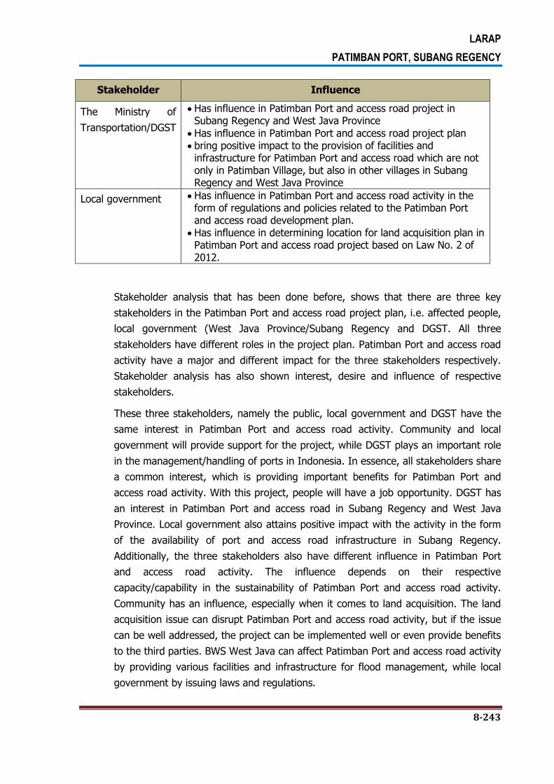
LARAP
PATIMBAN PORT, SUBANG REGENCY
8-243
Stakeholder Influence
The Ministry of
Transportation/DGST
Has influence in Patimban Port and access road project in Subang Regency and West Java Province
Has influence in Patimban Port and access road project plan bring positive impact to the provision of facilities and
infrastructure for Patimban Port and access road which are not only in Patimban Village, but also in other villages in Subang Regency and West Java Province
Local government Has influence in Patimban Port and access road activity in the form of regulations and policies related to the Patimban Port and access road development plan.
Has influence in determining location for land acquisition plan in Patimban Port and access road project based on Law No. 2 of 2012.
Stakeholder analysis that has been done before, shows that there are three key
stakeholders in the Patimban Port and access road project plan, i.e. affected people,
local government (West Java Province/Subang Regency and DGST. All three
stakeholders have different roles in the project plan. Patimban Port and access road
activity have a major and different impact for the three stakeholders respectively.
Stakeholder analysis has also shown interest, desire and influence of respective
stakeholders.
These three stakeholders, namely the public, local government and DGST have the
same interest in Patimban Port and access road activity. Community and local
government will provide support for the project, while DGST plays an important role
in the management/handling of ports in Indonesia. In essence, all stakeholders share
a common interest, which is providing important benefits for Patimban Port and
access road activity. With this project, people will have a job opportunity. DGST has
an interest in Patimban Port and access road in Subang Regency and West Java
Province. Local government also attains positive impact with the activity in the form
of the availability of port and access road infrastructure in Subang Regency.
Additionally, the three stakeholders also have different influence in Patimban Port
and access road activity. The influence depends on their respective
capacity/capability in the sustainability of Patimban Port and access road activity.
Community has an influence, especially when it comes to land acquisition. The land
acquisition issue can disrupt Patimban Port and access road activity, but if the issue
can be well addressed, the project can be implemented well or even provide benefits
to the third parties. BWS West Java can affect Patimban Port and access road activity
by providing various facilities and infrastructure for flood management, while local
government by issuing laws and regulations.
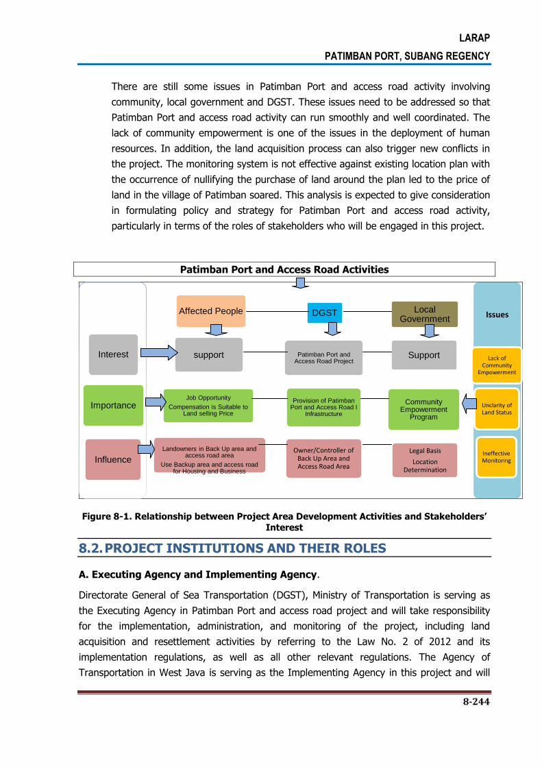
LARAP
PATIMBAN PORT, SUBANG REGENCY
8-244
There are still some issues in Patimban Port and access road activity involving
community, local government and DGST. These issues need to be addressed so that
Patimban Port and access road activity can run smoothly and well coordinated. The
lack of community empowerment is one of the issues in the deployment of human
resources. In addition, the land acquisition process can also trigger new conflicts in
the project. The monitoring system is not effective against existing location plan with
the occurrence of nullifying the purchase of land around the plan led to the price of
land in the village of Patimban soared. This analysis is expected to give consideration
in formulating policy and strategy for Patimban Port and access road activity,
particularly in terms of the roles of stakeholders who will be engaged in this project.
Patimban Port and Access Road Activities
Figure 8-1. Relationship between Project Area Development Activities and Stakeholders’
Interest
8.2. PROJECT INSTITUTIONS AND THEIR ROLES
A. Executing Agency and Implementing Agency.
Directorate General of Sea Transportation (DGST), Ministry of Transportation is serving as
the Executing Agency in Patimban Port and access road project and will take responsibility
for the implementation, administration, and monitoring of the project, including land
acquisition and resettlement activities by referring to the Law No. 2 of 2012 and its
implementation regulations, as well as all other relevant regulations. The Agency of
Transportation in West Java is serving as the Implementing Agency in this project and will
Interest
Importance
Influence
Affected People
support
Job Opportunity
Compensation is Suitable to Land selling Price
Landowners in Back Up area and access road area
Use Backup area and access road for Housing and Business
DGST
Patimban Port and Access Road Project
Provision of Patimban Port and Access Road l
Infrastructure
Owner/Controller of Back Up Area and Access Road Area
Local Government
Support
Community Empowerment
Program
Legal Basis
Location Determination
Issues
Lack of Community
Empowerment
Unclarity of Land Status
Ineffective Monitoring

LARAP
PATIMBAN PORT, SUBANG REGENCY
8-245
carry out Patimban Port and access road project activities, including preparation,
implementation, and supervision of land acquisition and resettlement framework and
planning. Directorate General of Sea Transportation and the Directorate of Program
Development as the Secretary will establish a Project Management Unit that will be
responsible for daily implementation of the project and social safeguard, including the
monitoring of land acquisition and resettlement.
The following are key agencies in Patimban Port and access road project which have roles
and responsibilities related to the implementation of land acquisition and resettlement
aspects:
1) Directorate of Transportation-Bappenas. Bappenas has an important role in
project planning, coordination, and policy on the implementation stage of Patimban
Port and access road Project, including the social safeguard and land
acquisition/resettlement. Bappenas will also review the progress of project activities,
including land acquisition and facilitate the settlement of issues during the project
implementation.
2) CPIU will play a key role in designing the annual budget and provide technical
guidance and supervision of the Department of Transportation in the area of West
Java Province in the implementation Patimban Port Development Project, including
land acquisition planning and implementation. Director General of Sea Transportation
with the assistance of consultants will be instrumental in implementing the project,
including setting up plans for land acquisition. Director General of Sea Transportation
will also be responsible for preparing the land acquisition plan and send it to the
Governor of West Java to get the project location determination. Director General of
Sea Transportation will also be involved in preparatory activities for land acquisition
and announced the establishment of the location as well as in cooperation with the
Regional Office of West Java Province Land and Subang District Land Office for the
procurement of land together with the National Asset Management Agency Ministry
of Transportation. Moreover, the Directorate General of Sea Transportation will also
cooperate with other relevant agencies, both at national and regional level to get a
variety of licensing requirements related to land acquisition.
3) National Asset Management Agency (LMAN) is an institution that is responsible for
the payment process in the implementation of land acquisition activities together
with the Directorate General of Sea Transportation as an institution requiring the
land. LMAN will also cooperate with the Regional Office of West Java Province Land
and Subang District Land Office for the implementation of land acquisition. The
process of payment of compensation to be granted to the holder of the rights will be
implemented after an assessment of the physical and non physical asset that will be
performed by a team of independent assessors.

LARAP
PATIMBAN PORT, SUBANG REGENCY
8-246
4) DGST is at the national level. DGST with the assistance of a consultant will take
some roles in the project implementation, including preparing the land acquisition
and resettlement plan to be submitted to the Ministry of Transportation for approval
before the implementation of civil work. The land acquisition plan should also be
submitted to the Governor of West Java Province for obtaining the determination of
project location. DGST will also be involved in the preparation of land acquisition and
the announcement of project location and is working with the National Land
Agency/BPN for the implementation of land acquisition. Further, DGST will also work
with other relevant agencies, at both national and local level for fulfilling various
requirements in respect to the land acquisition permits.
5) West Java Province and Subang Regency. West Java Province and Subang
Regency, especially Assistant to Regional Secretary (ASDA I) has an important role in
coordinating the preparation of land acquisition. In addition, Bappeda West Java
Province and Bappeda Subang Regency also play an important role in the
preparation and implementation of social safeguard/social action in order to ensure
the entitled party and vulnerable group receive benefit of livelihood recovery
program.
B. Institutions and Land Acquisition Processes
Pursuant to Law No. 2 of 2012 and its implementation regulations, there are some important
institutions which have authority in the land acquisition and resettlement processes, namely:
1) West Java Province and Subang Regency. DGST as the implementing agency of
the project and the institution requiring the land, in cooperation with West Java
Province Government, based on the land acquisition plan document, will carry out
the preparation of land acquisition activities which include: i) dissemination of the
project plan; ii) early identification of the location for project plan; and iii) public
consultation of the project plan; iv) Governor of West Java Province together with
DGST will announce the location of project implementation. Governor of West Java
Province may delegate authority on the implementation of land acquisition
preparation to Mayor of Subang Regency based on the consideration of efficiency,
effectiveness, geographical condition, human resources and other considerations.
Should there is any objection from entitled party in respect to the land acquisition,
Governor of West Java Province/ Mayor of Subang Regency will establish a special
team to examine the objection.
2) National Land Agency. Based on the determination of project location and the
proposal of land acquisition implementation by DGST as institution that requires land,
National Land Agency of West Java Province regional office will establish a land
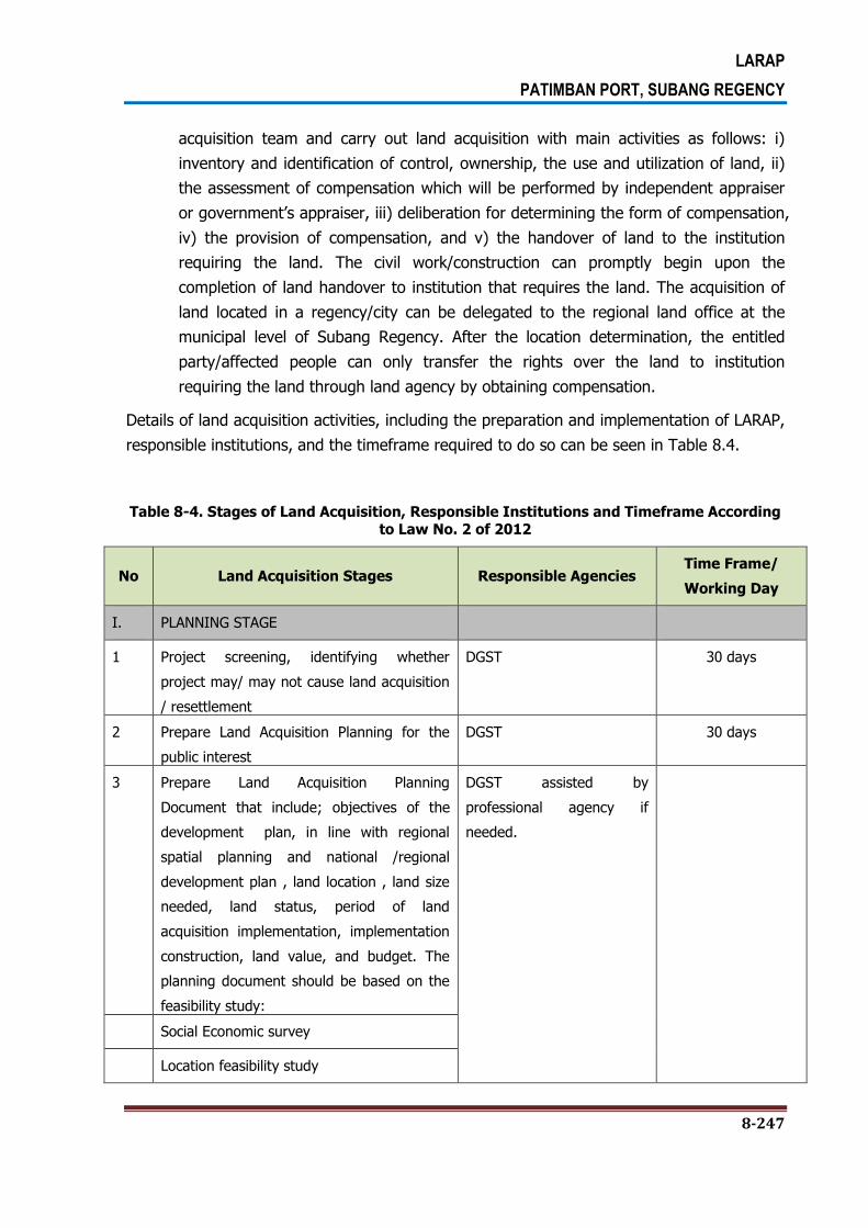
LARAP
PATIMBAN PORT, SUBANG REGENCY
8-247
acquisition team and carry out land acquisition with main activities as follows: i)
inventory and identification of control, ownership, the use and utilization of land, ii)
the assessment of compensation which will be performed by independent appraiser
or government’s appraiser, iii) deliberation for determining the form of compensation,
iv) the provision of compensation, and v) the handover of land to the institution
requiring the land. The civil work/construction can promptly begin upon the
completion of land handover to institution that requires the land. The acquisition of
land located in a regency/city can be delegated to the regional land office at the
municipal level of Subang Regency. After the location determination, the entitled
party/affected people can only transfer the rights over the land to institution
requiring the land through land agency by obtaining compensation.
Details of land acquisition activities, including the preparation and implementation of LARAP,
responsible institutions, and the timeframe required to do so can be seen in Table 8.4.
Table 8-4. Stages of Land Acquisition, Responsible Institutions and Timeframe According to Law No. 2 of 2012
No Land Acquisition Stages Responsible Agencies Time Frame/
Working Day
I. PLANNING STAGE
1 Project screening, identifying whether
project may/ may not cause land acquisition
/ resettlement
DGST 30 days
2 Prepare Land Acquisition Planning for the
public interest
DGST 30 days
3 Prepare Land Acquisition Planning
Document that include; objectives of the
development plan, in line with regional
spatial planning and national /regional
development plan , land location , land size
needed, land status, period of land
acquisition implementation, implementation
construction, land value, and budget. The
planning document should be based on the
feasibility study:
DGST assisted by
professional agency if
needed.
Social Economic survey
Location feasibility study

LARAP
PATIMBAN PORT, SUBANG REGENCY
8-248
No Land Acquisition Stages Responsible Agencies Time Frame/
Working Day
Analysis of cost and development benefit
Estimated land value
Environmental and social impacts
Other studies needed
4 Certify the Land Acquisition Planning
Document
DGST 60 days
5 Submitting Land Acquisition / Resettlement
Planning Draft documents to ADB for review
and approval
DGST 60 days
6 Submitting Land Acquisition/Resettlement
Planning Draft documents to West Java
Province
DGST 10 days
II PREPARATORY STAGE 130 – 207 days
1 Establishment of preparation team Governor of West Java
Province
10
2 Notice on development plan Provincial Preparatory Team
(PPT)/ District Preparatory
Team (DPT) of Subang
Regency
20
3 Preliminary identification PPT/DPT 30
4 Public consultation, if any rejection PPT/DPT 30
5 Public Consultation PPT/DPT 60
6 Issuance on project location determination
decree
Governor of West Java
Province
7 Announcement of project location
determination
Governor of West Java
Province and DGST
Grievance/Complaint raised by entitled
parties
8 Complaint lodging/rejection on project area
Complainant 14
9 Establishment of assessment team
Governor of West Java

LARAP
PATIMBAN PORT, SUBANG REGENCY
8-249
No Land Acquisition Stages Responsible Agencies Time Frame/
Working Day
Province/Mayor of Subang
Regency
10 Assessment on complaints Grievance Assessment
Team
11 Acceptance/rejection on the complain
Governor of West Java
Province
12 Complaint lodging to the Administrative Court (PTUN)
Complainant 30
13 Administrative Court decision Court 30
14 Complaint lodging to Supreme Court (MA) Complainant 14
15 Location determination, if complaint is rejected
(Location determination is valid for 2 years
and 1 year for extension)
Governor of West Java
Province
30
III IMPLEMENTATION STAGE 382 days max.
1 Preparation of land acquisition
implementation led by Head of West Java
Provincial BPN/ Head of land Office
Head of West Java
Provincial BPN/Subang
Regency
2 Inventory of losses (IOL) and legal
assessment of affected assets
LAIT of West Java
Province/Subang Regency – IOL Team
30
3 Announcement of the IOL LAIT of West Java
Province/Subang Regency
4 Data verification, if any complaint on IOL LAIT of West Java
Province/Subang Regency 14
5 Mobilization of appraiser /public appraiser LAIT of West Java
Province/Subang Regency 30
6 Appraisal/valuation of losses
Independent appraiser
7 Updating documents Land Acquisition /
Resettlement, if required DGST
9 Delivery to JICA for review and approval
DGST
10 Disclosure for updated land acquisition /
resettlement documents to the community / stakeholders, and website
LAIT of West Java
Province/Subang Regency 30
Grievances / complaints submitted by
the party entitled
11 Complaints lodging about compensation in
court Complainant 14
12 Court decision on complaint
Court 30
13 Complaint lodging in the Supreme Court
Complainant 14
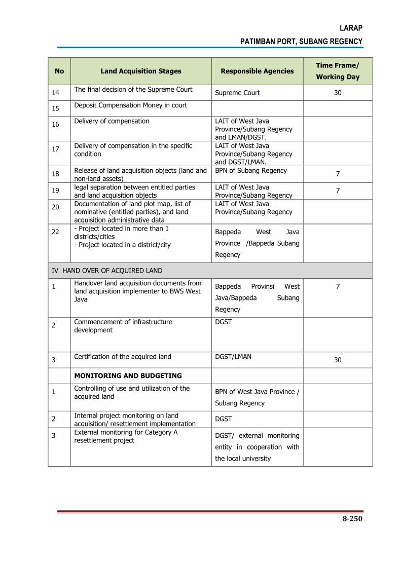
LARAP
PATIMBAN PORT, SUBANG REGENCY
8-250
No Land Acquisition Stages Responsible Agencies Time Frame/
Working Day
14 The final decision of the Supreme Court
Supreme Court 30
15 Deposit Compensation Money in court
16 Delivery of compensation LAIT of West Java
Province/Subang Regency
and LMAN/DGST.
17 Delivery of compensation in the specific
condition
LAIT of West Java
Province/Subang Regency and DGST/LMAN.
18 Release of land acquisition objects (land and
non-land assets)
BPN of Subang Regency 7
19 legal separation between entitled parties and land acquisition objects
LAIT of West Java Province/Subang Regency
7
20 Documentation of land plot map, list of nominative (entitled parties), and land
acquisition administrative data
LAIT of West Java Province/Subang Regency
22 - Project located in more than 1 districts/cities
- Project located in a district/city
Bappeda West Java
Province /Bappeda Subang
Regency
IV HAND OVER OF ACQUIRED LAND
1 Handover land acquisition documents from land acquisition implementer to BWS West
Java
Bappeda Provinsi West
Java/Bappeda Subang
Regency
7
2 Commencement of infrastructure
development
DGST
3 Certification of the acquired land DGST/LMAN
30
MONITORING AND BUDGETING
1 Controlling of use and utilization of the
acquired land BPN of West Java Province /
Subang Regency
2 Internal project monitoring on land
acquisition/ resettlement implementation DGST
3 External monitoring for Category A resettlement project
DGST/ external monitoring
entity in cooperation with
the local university

LARAP
PATIMBAN PORT, SUBANG REGENCY
8-251
8.3. CAPACITY BUILDING
Capacity development will be carried out to the staff who will prepare the land acquisition
plan document at the planning stage, the preparation team formed by Governor of West
Java Province to carry out land acquisition preparation and location determination, and land
acquisition implementation team formed by BPN. Since the preparation and implementation
team will follow the new procedures and regulations, special technical assistance and/or
workshop to review and to improve the skills of its members will be taken into account. The
forms of capacity building activities that can be carried out are as follows: i) workshop on
the process of land acquisition for public interest which refers to Law No. 2 of 2012 and its
implementing regulations for the staff of DGST, local governments (West Java
Province/Subang Regency), and BPN; ii) workshop on activity implementation process of
Land Acquisition Preparation Team; iii) workshop on activity implementation process of Land
Acquisition Implementation Team; iv) workshop on monitoring and evaluation of the land
acquisition implementation for the staff of DGST, local government (West Java
Province/Subang Regency), BPN, and NGOs/Universities.
DGST, as the main implementing agency, will have sufficient staff or alternatively may
appoint consultants, with relevant qualifications and experience, to design in more precisely
manner and produce the Land Acquisition and Resettlement Work Plan in Patimban Port and
access road Project. DGST will also be responsible for reviewing and, if necessary, updating
the work plan that has been prepared at each scheduled biannual report, particularly with
respect to the possibility of changes to project scope, location, time, rights or valuation that
may require additional resources.
In order to provide assistance to DGST, local government and some selected technical
agencies will have a well designed capacity building programs, specifically to enhance the
technical and institutional capacity in carry out social safeguard, land acquisition and
resettlement activities, including the income and livelihood recovery as well as other related
aspects.
The capacity assessment of project implementing agency and institutions dealing with land
acquisition and capacity building program have been incorporated into the land acquisition
and resettlement plan document. The capacity assessment as mentioned above covers as
follows: i) knowledge on the policies and procedures of land acquisition/resettlement and
social safeguard, ii) the capacity of project implementing agency in implementing social
safeguard and land acquisition/resettlement activities, iii) the existence and effectiveness of
institutions that deal with social safeguard/land acquisition, and iv) the need for capacity
building.
Study and implementation of capacity building are undertaken by social
safeguard/resettlement specialist under the consultant team dealing with the preparation or
LARAP
PATIMBAN PORT, SUBANG REGENCY
8-252
implementation of the project. The capacity building will also be performed to staff dealing
with the land acquisition and social safeguard. This component will also require the services
of a Social Development Specialist. The responsibility for budgeting and coordination of
capacity building activities will be in DGST as the implementing agency and is assisted by
Bappeda of West Java Province/Bappeda of Subang Regency.
8.4. PROJECT IMPLEMENTATION CONSULTANT
Project implementing consultant will be part of the Detailed Engineering Design and
Construction Supervision Consultant. The project implementing consultant will incorporate
social safeguard/resettlement team who will help the project implementation unit in
preparing planning document for land acquisition and resettlement and its amendment,
support the implementation and perform internal monitoring. The Social
Safeguard/Resettlement Consultant will also perform capacity assessment of the project
implementing institutions and other relevant institutions in dealing with land acquisition and
resettlement while providing capacity building as required.
LARAP
PATIMBAN PORT, SUBANG REGENCY
9-253
CHAPTER 9. GRIEVANCE REDRESS MECHANISM
9.1. GRIEVANCE REDRESS MECHANISM
Procedures for complaint/grievance handling on compensation will guide DGST to answer
various complaints of affected people, such as disputes on ownership and inheritance of the
assets, the compensation distribution to the heirs, loss of assets and list of names of the
census output, and so on.
In principle, all objections to any aspect of the project and the land acquisition will be
handled through consultation in order to achieve settlement agreement and best efforts
should be given in order to settle the disputes at sub-project level. Relevant institutions,
such as Project Implementation Unit (PIU) of DGST, the provincial/regencygovernment, and
sub-district and village governments will be involved in efforts to resolve objections. If
objection settlement is not reached, the settlement will be implemented through legal
mechanism based on procedures set forth in the applicable laws and regulations (Law No. 2
of 2012 and the Presidential Regulation No. 71 of 2012). No fees are charged to the affected
people who file the complaint. Mechanism for the objection acceptance and settlement will
consider cultural sensitivity and gender of the entitled party.
9.2. GENERAL STAGES OF COMPLAINT HANDLING
General mechanism for handling grieivance, objections or proposals on the implementation
of the LARAP is presented as follows. The mechanism covers all subjects related to the
LARAP including Livelihood Restoration Program (LRP) and is not limited to the process
referring to the Law No. 2 of 2012 and the Presidential Regulation No. 71 of 2012.
1. Based on the complaints, objections and proposals submitted by affected people,
through the local secretariat, Head of the PIU of DGST will perform research where
necessary collaborating with the local government to clarify the situation and the
problem;
2. The results of the research will be informed to the affected people at the latest within
15 working days;
3. The submitted grievance, objections or proposals will be logged and conveyed to
relevant agencies such as provintial government and BPN referring to the laws. If the
subject is not stipulated in the laws, PIU shall call a meeting involving district

LARAP
PATIMBAN PORT, SUBANG REGENCY
9-254
government and/or village leaders where necessary to decide the course of action to
resolve the complaint.
4. The solution of the problem or the handling of complaints, objections and the proposal
will be documented which can be accessed by the public;
5. In order to facilitate the general public, especially the affected people in accessing such
information, the complaint handling results will be disseminated through public space
such as announcement boards in project office and/or village office.
6. PIU of DGST shall takes responsibility of all activities of the mechanism listed above.
9.3. COMPLAINT DELIVERY PROCESS IN THE COMMUNITY
Affected people’s complaint at the village level can be delivered through a facilitator or
village representative, who will follow it up by bringing the complaint to the head of village
and traditional leader. Afterwards, the complaint will be forwarded by village representative
to PIU of DGST.
Specifically, the affected people can directly deliver any complaint to the head of village or
community leader with the following process: (i) affected people tell their dissatisfaction to
the community leaders/village heads, (ii) the village head prepares an official report for
documentation purposes and effort to address and resolve the complaint at the community
level, and (iii) if the affected people is satisfied, there is no need bring the complaint to the
higher level. If the complaint cannot be resolved at the village level, village head then
forwards the complaint to PIU of DGST.

LARAP
PATIMBAN PORT, SUBANG REGENCY
9-255
A SAMPLE OF COMPLAINT FILED BY AFFECTED PEOPLE
IN BACK UP AREA AND ACCESS ROAD PROJECT
TYPE OF COMPLAINT:
1) List of inventory of affected asset
2) The implementation of compensation and resettlement
3) Other complaints
Name of Complainee/Affected People: __________________________
Village : __________________________
Details of the complaint : __________________________
Date:___________________, 20..
Official Receiving the Complaint, Complainee,
_________________________ _____________________
Details of Response:_________________________________________________
Date: ___________________, 20..
Response Provider: ____________________________________________________
9.4. SPECIAL COMPLAINTS STIPULATED IN LAWS
Each type of complaint has its own mechanisms as stipulated in Law No. 2 of 2012: (i)
complaints about confirmation of project location and the results of asset inventory, and (ii)
complaints about compensation value. Land Acquisition Implementation Team (LAIT) will
keep all records of complaints and disputes handled.
According to the Law of the Republic of Indonesia No. 2 of 2012 on Land Acquisition for the
Development in Public Interest, complaint delivery mechanisms can be seen in Figure 9.1.
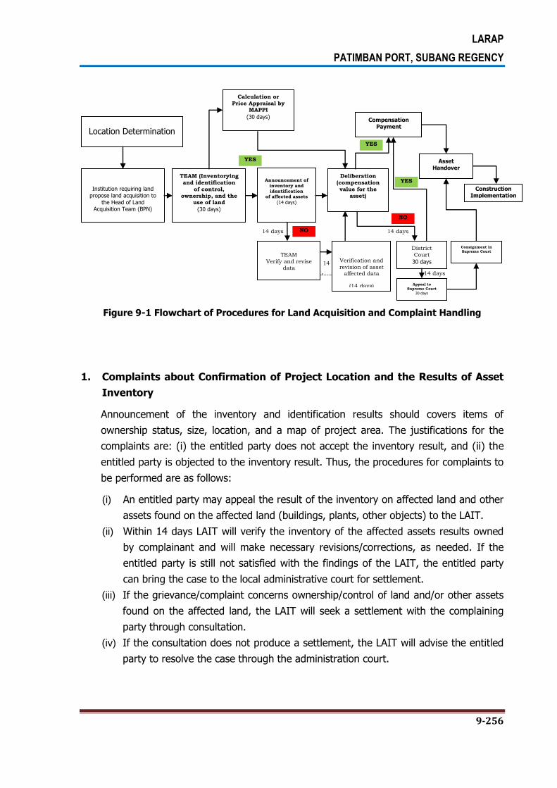
LARAP
PATIMBAN PORT, SUBANG REGENCY
9-256
Figure 9-1 Flowchart of Procedures for Land Acquisition and Complaint Handling
1. Complaints about Confirmation of Project Location and the Results of Asset
Inventory
Announcement of the inventory and identification results should covers items of
ownership status, size, location, and a map of project area. The justifications for the
complaints are: (i) the entitled party does not accept the inventory result, and (ii) the
entitled party is objected to the inventory result. Thus, the procedures for complaints to
be performed are as follows:
(i) An entitled party may appeal the result of the inventory on affected land and other
assets found on the affected land (buildings, plants, other objects) to the LAIT.
(ii) Within 14 days LAIT will verify the inventory of the affected assets results owned
by complainant and will make necessary revisions/corrections, as needed. If the
entitled party is still not satisfied with the findings of the LAIT, the entitled party
can bring the case to the local administrative court for settlement.
(iii) If the grievance/complaint concerns ownership/control of land and/or other assets
found on the affected land, the LAIT will seek a settlement with the complaining
party through consultation.
(iv) If the consultation does not produce a settlement, the LAIT will advise the entitled
party to resolve the case through the administration court.
Location Determination
Institution requiring land propose land acquisition to
the Head of Land Acquisition Team (BPN)
TEAM (Inventorying
and identification
of control,
ownership, and the use of land
(30 days)
Announcement of
inventory and identification
of affected assets
(14 days)
Deliberation
(compensation
value for the
asset)
Calculation or
Price Appraisal by MAPPI
(30 days)
TEAM
Verify and revise data
Verification and
revision of asset affected data
(14 days)
District
Court
30 days
Compensation Payment
Asset Handover
Appeal to
Supreme Court
30 days
Consignment in
Supreme Court
Construction Implementation
YES
YES
YES
NO
NO 14 days
14
days 14 days
14 days

LARAP
PATIMBAN PORT, SUBANG REGENCY
9-257
2. Complaints on Compensation Value
Based on the Law No.2/2012, an aggrieved entitled party may bring the
grievance/complaint on the compensation value directly to LAIT or land agency through
the community leader who will then forward it to the LAIT either in writing or verbally.
The LAIT together with the land agency and the community leader will attempt to seek
consensus to achieve an acceptable settlement with the aggrieved entitled party,
specifically:
(i) An entitled party that is not satisfied with the amount of compensation initially
offered by the LAIT has 30 days to come into agreement with the LAIT on the
compensation value for affected assets, including income loss for adversely
affected business or employment.
(ii) If negotiation on compensation with the LAIT fails, in no later than 14 days the
entitled party may file the complaint on the compensation value offered by LAIT to
a district court. The district court will process the case within 30 days.
(iii) If the entitled party is not satisfied with the verdict of the district court, within 14
days following the verdict issued by the district court the entitled party may bring
the case to Supreme Court and seeking for a reversal of the district court verdict.
The Supreme Court will process the case within 30 days.
3. Other Disputes
Objection related to project development and other resettlement issues which are not
covered by the complaint handling mechanisms in Law No.2/2012 and the Presidential
Regulation No. 71/2012, such as objections related to construction activities,
resettlement, and access restrictions, the complaint handling mechanisms are as
follows:
(i) The aggrieved entitled parties may bring the complaint to the project staff of PIU
of DGSTthrough local community leader. Project staff handling land acquisition and
social safeguard will record the complaint to the sub-project management.
(ii) Project manager will examine the complaint and within 15 working days and will
deliver the decision to the complainant. Project staff will facilitate communication
between the complainant and project management in addressing the complaint.
Project staff will document the complaint and resolution.
(iii) If the aggrieved entitled party is not satisfied with the decision or handling of the
complaint, they may bring the case, either in writing or verbally to regent/mayor
within a period of 14 days following the issuance of the decision.

LARAP
PATIMBAN PORT, SUBANG REGENCY
9-258
(iv) The regent/mayor will decide on the complaint within a period of 30 days by
requesting for opinions/wishes from (i) the aggrieved entitled party and (ii) other
relevant partied related to the complaint.
(v) If no decision to the complaint is made or if the aggrieved entitled party is not
satisfied with the decision taken by regent/mayor, the complainant may bring the
complaint/case to the court for adjudication.

LARAP
PATIMBAN PORT, SUBANG REGENCY
10-259
CHAPTER 10. MONITORING PROGRAM
10.1. MONITORING ARRANGEMENTS
DGST/LMAN with the assistance of project consultant will monitor all activities related to
land acquisition, payment of compensation to the entitled party and other aspects. The
scope of monitoring covers as follows:
(i) Payment of compensation to all entitled parties in various categories carried out in
accordance to the compensation policy set out in the LARAP.
(ii) The implementation of income recovery program and social benefit entitlement are
coordinated by Bappeda of West Java Province and Bappeda of Subang regency to the
relevant agencies.
(iii) The dissemination of public information and consultation processes.
(iv) Compliance with the complaint handling procedure and unresolved issues which
requires management attention.
(v) The entitled party preference on the options offered.
(vi) The benefits to be attained from the project.
The technical implementation unit will periodically collect information from various land
acquisition committees. The monthly report will be submitted to Directorate General of Sea
Transportation as the executing agency of Land Acquisition and Resettlement Action Plan.
The Patimban Port and Access Road Project is assessed as category A resettlement since
more than 200 people are seriously affected by the project; therefore, procurement of
consultant services will cover the procurement of external monitoring consultant to monitor:
(i) the payment of compensation and rehabilitation assistance are ready before the awarding
of civil work contract, (ii) the land donation and negotiated solution, and (iii) overall LARAP
implementation evaluation after the project is completed.
10.2. MONITORING INDICATORS
Monitoring indicators addressing specific contents of LARAP activity and entitlement matrix.
The key parameters are as follows:
(i) Compensation payment.
(ii) The land acquisition should be completed before the awarding of civil work contract.
(iii) Stipulation on income recovery assistance according to the project, if any.

LARAP
PATIMBAN PORT, SUBANG REGENCY
10-260
(iv) Eligibility on the project benefits.
(v) The number of entitled parties and areas included in voluntary land donations.
(vi) Public consultation and awareness on the compensation policy.
(vii) Entitled parties should be monitored in connection with their recovery of productive
activities.
(viii) The level of satisfaction of entitled party on various aspects of LARAP. The
implementation of complaint handling mechanism, and the speed of such complaint
handling will be monitored.
(ix) Throughout the implementation process, the tendency of living standards will be
observed and surveyed. Any potential problems that may arise in the living standard
recovery program will be reported.
10.3. REPORTING AND INFORMATION SUBMISSION
For the project with the land acquisition impact, DGST will prepare semester monitoring
report and external monitoring report (for project with category A) to be submitted to The
Ministry of Transportation. The report covers the progress of land acquisition activity. For
projects that are considered complex and sensitive, the monitoring report will be submitted
in quarterly basis.
Monitoring report includes the following indicators:
(i) The number of entitled parties based on the category of impact and the status of
compensation payment.
(ii) Income recovery program for each category.
(iii) The amount of funds allocated for operation or compensation and disbursed for each
category.
(iv) The final results of the complaint handling and unresolved issues which require action
from the executing agency of the project.
(v) Implementation problems and solutions.
Monitoring report will be reviewed by the The Ministry of Transportation and will be posted
on the project website. Director General of Sea Transportation will reveal the monitoring
results to entitled parties, especially on the LARAP status, information on various benefits
and corrective action plan, if any.
10.4. ASSESSMENT AND EVALUATION
Director General of Sea Transportation will evaluate the overall LARAP implementation after
the project is completed to examine whether the planned activities are actually achieve the

LARAP
PATIMBAN PORT, SUBANG REGENCY
10-261
expected objectives. At least, the assessment will produce gender disaggregated data which
covers indicators such as income level, access to social services, and the satisfaction level of
entitled parties.

LARAP
PATIMBAN PORT, SUBANG REGENCY
12-286
CHAPTER 12. PUBLIC CONSULTATION ACTIVITY
12.1. PUBLIC CONSULTATION PROCESS
Community involvement in governance is very important in order to make the governance
works effectively and development project to be successful. In this case, the involvement of
all stakeholders is equally important (Barry, 2002). Stakeholders include groups or
individuals who either benefit from or get impacted by the policy/project or those who can
affect the policy/project. In general, the poor and marginalized people (women, children,
the elderly, the disabled, orphans, landless workers) are often ignored, either because they
are not aware and not doing consultation or because they do not have any forum to express
their views. Identify and consult with all stakeholders, especially the poor and vulnerable
people, is essential to ensure that project meet the community needs. Furthermore,
consultation open lines of communication between various stakeholders and the authorities
implementing the project; thus helping the process of conflict resolution in the early stages
of a project rather than letting it rise to conflict resulting the project implementation to delay
and increasing costs. Participation of local community in decision-making process will assist
in prioritizing specific project and identify effective measures while reducing negative
impacts.
12.1.1. Consultation During the Planning Stage Prior to the Survey
A. Public Consultation with All Stakeholders
Public consultation with all relevant stakeholders was held at Regent’s Meeting Room II of
the Subang Regency Office on Tuesday, June 21, 2016. The public consultation meeting was
presided over by Local Secretary of Subang Regency and opened by Acting Regent of
Subang Regency. The following are directive recommendations given by Acting Regent of
Subang Regency.
1. The development Plan of Patimban Port should provide significant contribution to the
improvement of people economy and help reduce the high unemployment rate in
Subang Regency.
2. Subang Regency Administration fully support and welcome the development plan of
Patimban Port and, at the same time, expect that all related regency’s agencies can
synergize with the project plan by allocating funds for activities related to the project.
The regency will also allocate funds for the construction of access road.
LARAP
PATIMBAN PORT, SUBANG REGENCY
12-287
3. The development plan should pay attention to spatial condition of the region and not to
make any mistake in the program implementation. For this reason, drawings of the
construction plan should be disseminated in order to avoid adverse effects in the future.
The following are directive recommendations of Local Secretary of Subang Regency:
1. Subang Regency Administration will provide any necessary support for the development
plan of Patimban Port so as to the development can be implemented at once and in
accordance with all applicable laws and regulations.
2. There should be revisions in the spatial plan at the central, provincial, and regency
levels.
The public consultation came up with the following conclusions:
3. Subang Regency Administration fully support the development plan of Patimban Port
and place a hope that the development will provide significant contribution to the
improvement of people economy and help reduce the high unemployment rate in
Subang Regency.
4. Subang Regency Administration expect that all related regency’s agencies can synergize
with the project plan by allocating funds for activities related to port development plan.
The regency will also allocate funds for the construction of access road.
5. Drawings of the construction plan should be disseminated immediately in order to avoid
adverse effects in the future.
6. There should be revisions in the spatial plan at the central, provincial, and regency
levels.
7. The program should give consideration to the development of alternative distribution
access. There’s a strong option to build a railway to Pakbaden as the construction of
this railway will require far less land acquisition compared to the construction of new
road.
8. There has been a rumor that the land price in the project location is soaring very high.
Regent Subang needs to issue a decree in order to determine and control the land price.
The program should pay attention to the activities of land speculators in the project
location.
9. With regard to the possibility of opening new road, the project should pay attention to
the change of land use along the access road area to the port.
10. There’s a proposal for new city with the theme of port city or minapolitan.
11. In order to avoid land speculators and price soaring, construction permit for new
buildings will not be given at the planned project area.
12. It is deemed necessary to build a power plant and appropriate water supply system in
Subang Regency, especially in Patimban region.

LARAP
PATIMBAN PORT, SUBANG REGENCY
12-288
13. It is also deemed necessary to build office and marine industry supporting facilities with
the land requirement is estimated to be thousands of hectares.
14. It is necessary to build animal or livestock quarantine facility or veterinary hospital.

LARAP
PATIMBAN PORT, SUBANG REGENCY
12-289
Photo Documentations
Public Consultation with All Stakehoders
Venue: Regent Meeting Room II, Subang Regency Office
Tuesday, June 21, 2016

LARAP
PATIMBAN PORT, SUBANG REGENCY
12-290
B. Public Consultation with Related Local Government’s Agencies
Public consultation with related local government’s agencies was held at Broadband Meeting
Room 3 and 4 of Hotel Nexa Jl. Supratman No. 66-68 in Bandung on Wednesday, June 22,
2016. The public consultation was held in the form of coordination meeting and focus group
discussion, chaired by the Section Head of Marine Affairs (Transportation Office of West
Java Province), and opened by Head of Sub-Directorate I of the Directorate General of Sea
Transportation, Ministry of Transportation. In the public consultation, the Directorate
General of Sea Transportation delivered presentation on the Preparation of Patimban Port
Supporting Infrastructure, while PT InasaSakhaKirana delivered presentation on the
Preparation of the Land Acquisition and Resettlement Action Plan for Patimban Port. The
presentations, which were divided into three sessions, were then followed by hearing the
responses from various relevant local government agencies in West Java Province. The
public consultation came up with the following conclusions:
1. West Java Province and Subang Regency Administration support the development plan
of Patimban Port.
2. All related local government agencies should make a constructive coordination.
3. The next step is the process of project location determination by Directorate General of
Public Governance or PUM after holding a discussion with Local Spatial Planning
Coordinating Agency (BKPRD) regarding the conformity with existing spatial plan.
4. A tremendous coordination with the consultant should be made by providing accurate
and correct data.
5. The project should give attention to the protected forest area and its location carefully
and correctly.
6. It is deemed appropriate for the delineation to avoid residential, industrial and brackish
water pond areas that are seriously managed by local community.
7. The delineation covers the road network, backup area, and power plants. However, the
wide area and location are still tentative, which means that it can be increased or
decreased.
8. The development plan should be well disseminated to the public by providing them with
clear and comprehensive understanding.
9. The wide and length area of irrigation network should be identified clearly.
10. The owners and ownership status of Brackish water ponds and rice fields should be
appropriately identified.
11. The socio-economic survey should be carried out in an in-depth manner as this will
concern the lives of fishermen and farmers in the potentially affected area.
12. The document of land acquisition and resettlement action plan will be handed over to
State Assets Management Agency for an in-depth analysis with respect to the cost of
land acquisition, the implementation of negotiation and land acquisition process.

LARAP
PATIMBAN PORT, SUBANG REGENCY
12-291
Photo Documentations
Public Consultation with Related Local Government’s Agencies
Venue : Broadband Meeting Room 3 and 4 of Hotel Nexa– Bandung
Wednesday, June 22, 2016

LARAP
PATIMBAN PORT, SUBANG REGENCY
12-292
C. Public Cosultation With Sub-District Administration
Public consultation with the stakeholders in Pusakanagara Sub-District was held on June 28,
2016 to convey information related to the Development plan of Patimban Port and data
collection activity plan to be carried out by a consultant team.
The public consultation meeting was attended by representatives of Transportation Office of
Subang Regency, Sub-District Consultative Council (MUSPIKA) of Subang Regency, village
heads, Village Councils (LMD), village chiefs, and local youth organization or KarangTaruna.
The meeting was opened by the Head Pusakanagara Sub-District which then followed up by
presentation on the Dissemination Activity as well as Survey and Data Collection Plan by
Consultant. In this meeting, the Head of Transportation Office of Subang Regency also
conveyed some directive recommendations.
The Head of Pusakanagara Sub-District conveyed the following information related to the
dissemination and development plan of the port:
The dissemination activity was carried out by inviting all related local government
agencies in Subang Regency Administration, MUSPIKA of Subang Regency, Consultants
and village administrations, LMD, village chiefs and local youth organization. The
dissemination was aimed at providing information to the public in relation to
development plan of Patimban Port.
The dissemination was carried out by inviting villages potentially affected by the
development plan of Patimban Port, not only Patimban Village, but also other villages
locatedalong side the access road to Patimban Port and, in general, in Pusakanagara
Sub-District.
Consultant’s Presentation
The consultant will perform socio-economic survey and data collection on people
potentially affected by the project which shall be implemented through a census from
door to door.
It is deemed necessary to acquire data related to wide area, land owners, ownership
status and land ownership evidence based on the existing delineation estimation.
The survey and data collection implementation will be carried out through coordination
with Patimban Village Administration.
The activity is still in the planning stage and focused on land acquisition plan. The
calculation of land and building wide and everything else is just an estimation, which
actual figures may be increased or decreased.
The presentation mentioned about location potentially affected by the land acquisition
activity.
The consultant conveyed that this activity should not become a rumor among the local
people as, it is afraid that, this will affect the land price in the area.

LARAP
PATIMBAN PORT, SUBANG REGENCY
12-293
Other villages potentially passed through by the access road to Patimban Port will also
be the development area.
The public consultation with stakeholders in Pusakanagara Sub-District came up with the
following conclusions:
1. The people in Subang Regency enthusiastically welcome the development plan of
Patimban Port.
2. Subang Regency has acquired some lands for the access road.
3. It is expected that the port can improve the people economy in Subang Regency.
4. Actually, Patimban Port activities have been existed since 2010 with the status of
regional port. During the construction, there was no significant impediment from local
community at that time.
5. It is important to note that there should not be any party who takes action on behalf of
the local community for the benefit of a certain group of people as this will disrupt the
development activity, especially with the rumor related to the land price.
6. The local people are expected to have adequate education, so they can be involved in
the port activities.
7. Given the great scale of the port and for the security purpose, it is proposed to build a
police office building in the Patimban Port’s development plan area.
8. Many people in Patimban live as farmers, but their income is not suffice to cover their
daily necessities as they only harvest once in a year.
9. There are brackish water pond areas and other productive lands, so the compensation
value should be adjusted by the losses of business due to the land acquisition.
10. Consultant is expected to consistently coordinate with village officials and local Muspika.
11. This project should not be used by a certain group of people for their own advantages.
12. This meeting is the first meeting related to development plan of Patimban Port.
13. People have heard the development plan of Patimban Port for so many years.
14. There are many commercial brackish water fish ponds in Patimban area, but none of
local people involved in the business. Therefore, the development plan of Patimban port
is expected to absorb labor from the local community of Patimban. The people should
not just be the spectators, and the project should be able to provide benefit and
contribute to the improvement of local economy.
15. Almost 90% of lands in Patimban Village are owned by people from outside the
Patimban region or outside the Pusakanagara Sub-District.
16. The location and wide of areas potentially affected by the land acquisition activity
should be discussed and informed to the people.
17. There should be a study on relocation and resettlement for the people affected by the
land acquisition.
LARAP
PATIMBAN PORT, SUBANG REGENCY
12-294
The implementation of consulting activity in Pusakanagara Sub-District was then followed up
by a meeting on data collection plan through asset and socio-economic survey with officials
of Patimban Village which was held at the Patimban Village Office. The meeting also
discussed some important issues related to the data collection activity as follows:
1. The discussion on delineation area for determining temporary location blocks. Based on
the map of the village, it is known that the locations are in Block 16 to Block 25.
2. Based on the location of the blocks, a table on the names of landowners, wide of land,
ownership status, and location will be made available.
3. It is planned to hold coordination with all village heads in the delineation areas in no
later than July 17, 2016 which will be followed by dissemination to the landowners
before the data collection activity is held.
4. The survey or data collection will be implemented simultaneously in all villages.
5. List of names of the landowners is expected to be obtained in no later than July 10,
2016 and then followed by the determination of survey team in each village of
delineation area.

LARAP
PATIMBAN PORT, SUBANG REGENCY
12-295
Photo Documentations
Public Consultation withSub-District Administration
Venue: Auditorium of Pusakanagara Sub-District Office
Tuesday, June28, 2016

LARAP
PATIMBAN PORT, SUBANG REGENCY
12-296
D. Public Consultation In Back Up Area (Block 15 to Block 20)
Public consultation in the project plan area in Block 15 to Block 20 is a public consultation
activity carried out with the potentially affected people including landowners, land tillers,
community leaders, LMD and other related institutions. The public consultation was held in
July 28-29, 2016 at Patimban Village Office. The first public consultation was held on July 28,
2016 with the landowners in Block 15, Block 19 and Block 20. Meanwhile, the second public
consultation was held on July 29, 2016 with landowners in Block 16, 17 and 18.
1) Public Consultation in Block 15, Block 19 and Block 20
The public consultation in Block 15, 19 and 20 was held on July 28, 2016 at Patimban Village
Office.
a. The public consultation was attended by as follows:
1. Head of Pusakanagara Sub-District.
2. Head of Patimban Village.
3. BPD Patimban.
4. Pusakanagara Police Chief.
5. PT. InasaSakhaKirana.
6. Community Leaders.
7. Landowners in Block 15, 19, and 20.
b. The Implementation of Dissemination Activity
1. The dissemination activity on July 28, 2016 was held in two sessions; Session 1
was held at 8-11.30 with landowners in Block 15 and Session 2 was held at 14-
16:15 with landowners in Block 19 and 20.
2. Session 1 was opened by the Head of Patimban Village with the remarks from the
Head of BPD Patimban, police chief, and Head Pusakanagara Sub-District, which
then followed by explanation on asset and socio-economic surveys and discussion
with landowners in Block 15.
3. Session 2 was opened by Patimban Village Official with the remarks from the Head
of Pusakanagara Sub-District and Pusakanagara Police Chief, which then followed
by explanation on asset and socio-economic surveys and discussion with
landowners in Block 19 and 20.
4. The result of discussions in Session 1 and Session 2 is elaborated in conclusion
section, which is also the summary of the minutes of meeting prepared during the
dissemination activity.
c. Conclusions:
1. The Implementation of Data Collection Activity

LARAP
PATIMBAN PORT, SUBANG REGENCY
12-297
a) The land acquisition activity to be implemented is referring to Law No. 2 of
2012 on Land Acquisition for the Development in the Public Interest and
Presidential Regulation No. 71 of 2012 on Technical Guidelines on Land
Acquisition for the Development in the Public Interest.
b) The data collection activity to be performed by the Consultant Team is still in
the planning stage. There is possibility that data collection areas will be shifted
if the Master Plan and DED documents have been completed. The data
obtained during this initial data collection will be re-verified by the Land
Acquisition Preparation Team under the coordination of the Governor of West
Java Province and Land Acquisition Implementation Team under the
coordination of Regional Land Office of West Java Province.
c) The team will begin to perform the field survey on July 29, 2016 in Block 15
and July 30, 2016 in Block 19 and Block 20. The people concerned are
expected to come to the assets location at 8 am. Surveyors will come and
immediately collect the data on assets and socio-economic conditions of the
people.
d) During the data collection activity on assets, the people are expected to bring
their respective ownership evidence either in the form of a certificate or other
eligible form in order to find out that the asset is legally belong to them. The
Notification of Tax Due or SPPT cannot be used as the ownership evidence,
but simply the proof of tax payment.
e) There is a cemetery in Block 15, and this should also be recorded. All social
and public facilities such as local roads, drainages, public toilets, etc.
potentially affected by the project should also be recorded in the data
collection activity.
f) There is residential area in Block 15, and it is expected this residential area
should not be affected by the project plan. For this moment, the data
collection activity will cover everything, including this residential area. The
collected data will be submitted to the Ministry of Transportation to be
discussed together. The ministry has provided recommendation to exclude
residential areas from the development plan of Patimban Port.
g) Data collection activity covers various assets, including land, buildings, and
growing plants; and also socio-economic conditions of the local people, i.e.
employment, income, environmental condition, social condition, and
expectations or perceptions of the people towards the project plan. In this
case, objects to be input in the data collection include rice fields, gardens,
commercial brackish water fish ponds, residential areas, as well as social and
public facilities.

LARAP
PATIMBAN PORT, SUBANG REGENCY
12-298
h) There should be a solution if there is any difference in the data collection
during the planning and implementation stage. For this reason, the land
acquisition stages should be informed clearly in advance. Initial data collection
shall be implemented in the planning stage by institution requiring the land, in
this case the Ministry of Transportation. Result of such initial data collection
shall be incorporated into the Document of Land Acquisition and Resettlement
Action Plan. The document will be submitted to the Land Acquisition
Preparation Team for re-verification which result will be incorporated into Land
Acquisition Preparation Document. The aforesaid document will be submitted to
the Land Acquisition Implementation Team, who will also perform data
collection and re-measurement. The data compiled from this activity shall be
the final result and will be used as the basis data by an Independent Appraisal
Team for performing the price appraisal.
2. The Determination of the Land Price
a) It is expected that the determination of land price is not carried out based on
the price stipulated in the Sales Value of the Tax Object or NJOP. In addition,
there should not be any intimidation to the people by imposing the land price
based on the NJOP.
b) It is expected that the land price refers to the agreement price, so that all
party will not be harmed.
c) The determination of the land price will be carried out by an Independent
Appraisal Team during the land acquisition implementation stage. The
Appraisal Team will perform assessment to physical and non-physical assets.
The physical assets include land, buildings, the growing plants, and other
assets on the respective land. Non-physical assets include business activities,
length of stay, and others. The land price determination by the Independent
Appraisal Team shall refer to the Indonesian Appraisal Standard or SPI 306
whereby one of assessment approaches used for determining the land price is
referring to the market price. Therefore, the compensation to be received by
the people is not only to compensate the physical assets, but also non-physical
assets. Accordingly, the total of appraisal result shall be a fair value that can
be accepted by the people. It is expected that people can wisely use the
compensation money to buy more productive land for a better life.
3. People’s Hope or Expectation to the Project
d) The people of Patimban Village hope that they will not only be spectators, but
they can also be benefited from development plan of Patimban Port.

LARAP
PATIMBAN PORT, SUBANG REGENCY
12-299
e) First and foremost, the people have no objection to the development plan of
Patimban Port, and they even support and ready to make contribution to the
program.
f) The program should pay attention to the condition of paddy field farmers, fish
farmers and fishermen. The development plan of Patimban Port can make
them losing their livelihoods and income as they lost their paddy fields and
brackish water fish ponds and the fishing area will become more far-away. For
this reason, the program needs to figure out the best solution to this issue
potentially faced by farmers and fishermen.
g) The survey team will perform data collection on socio-economic conditions of
the people, which result shall be used as assessment material for the
preparation team in the planning stage as well as the assessment material for
the Independent Appraisal Team in the implementation stage. Based on the
data, the Appraisal Team will also perform assessment of non-physical
conditions.
h) Study on the socio-economic conditions of the people will also be performed
deeply in the EIA document. Aspect to be studied in the document is the
socio-economic aspect. The EIA Team will prepare environmental
management recommendation, especially in respect to the reduction in income
and change in livelihood. This recommendation should be implemented by the
project’s executing agency because the EIA document is a public document
attributed with legal force.
i) If there is a problem with the people during the land acquisition process, the
local government, in this case the sub-district and village administrations is
expected to take side and support the people instead of the investor.
j) The preparation of EIA document should be implemented in transparent
manner. For this, appropriated dissemination should be performed to the
public.
k) There is information to the public that the port to be built is a coal port. If this
information is true, the people will not agree it as they are afraid that this port
will cause damage to the environment.
l) The development of Patimban Port should be able to improve the people’s
welfare and open job opportunities to residents of Patimban Village in
particular.
m) The compensation with respect to land acquisition activity should be
implemented appropriately and fairly without harming the people’s rights.
n) The compensation should be given fairly and in such a way that landowners
can have a better life.

LARAP
PATIMBAN PORT, SUBANG REGENCY
12-300
o) The development of Patimban Port should not harm the people and
downgrade their social status.
p) The government is expected to provide information on Patimban Port’s
activities zone to the public in a clear and definite manner. Blocks in which
data collection is performed are expected to be the exact location of the port
development and so the compensation can be immediately implemented.

LARAP
PATIMBAN PORT, SUBANG REGENCY
12-301
Photo Documentations
Public Consultation with Landowners on Block 15, 19 and 20
Venue : Auditorium of Patimban Village Office
Thursday, July28, 2016

LARAP
PATIMBAN PORT, SUBANG REGENCY
12-302
2) Public Consultation on Block 16, 17 and 18
Public consultation on Block 16, 17 and 18 was held on July 29, 2016 at the Patimban
Village Office.
a. The public consultation was attended by as follows:
1. Regent of Subang Regency.
2. Head of Pusakanagara Sub-District.
3. Head of Patimban Village.
4. Pusakanagara Police Chief.
5. PT. InasaSakhaKirana.
6. Community Leaders.
7. Landowners on Block 16, 17, and 18.
b. The Implementation of Dissemination Activity
1. The dissemination activity on July 29, 2016 was held in one Session at 14-16:15
with landowners on Block 16, 17, and 18.
2. The session was opened by the Local Secretary of Patimban Village with the
remarks from the Regent of Subang and Head of Pusakanagara Sub-District, which
then followed by explanation on asset and socio-economic surveys and discussion
with landowners on Block 16, 17, and 18.
3. The discussion result is elaborated in conclusion section, which is also the summary
of the minutes of meeting prepared during the dissemination activity.

LARAP
PATIMBAN PORT, SUBANG REGENCY
12-303
c. Directive Recommendations from the Regent of Subang Regency
1. The development plan of Patimban Port should be supported as it can provide
great benefit to local people, especially in Patimban Village. However, the
implementation of this project should not deprive the people’s rights so they can
sincerely accept the project plan.
2. The compensation in the land acquisition process should be provided fairly and not
harming the people. The land price should be beneficial for the people. The
Independent Appraisal Team will calculate the fair compensation value for the land.
3. Subang Regency Administration will do the best to make the people obtain
beneficial compensation so they can use some of the money to buy more
productive land in other location and use the rest of it to run their businesses.
4. If the people have any grievance or displeasure in respect to this, they should
convey the grievance only to the Patimban Village Head and Pusakanagara Sub-
District Head, not to any third party.
5. Subang Regency Administration will not harm the people with this development
plan; as a matter of fact, the regency will even provide the following facilities to
the people:
Subang Regency Administration will allocate budget for the improvement of
the local economy in order to eliminate the unemployment in this region.
The regency will make available educational facility.
The regency will provide economic infrastructure for the improvement of
people’s businesses.
The regency will make available the health facility.
In essence, the development of Patimban Port in Patimban Village will improve
the people’s welfare.
6. All related stakeholders should take cautious actions necessary in order to evade
the cancellation of the port development due to any unnecessary misunderstanding
with the local people which can lead them to turn against the project.
7. Subang Regency Administration will do the best to make the project beneficial to
local people through the creation of job and business opportunities for them. For
this reason, the regency will provide various supporting facilities for the local
people.

LARAP
PATIMBAN PORT, SUBANG REGENCY
12-304
d. People’s Hope or Expectation to the Project
1. The people response the development plan of Patimban Port with mixed feelings.
They are happy with the project as it can improve the economy of people in
Subang Regency, in general, and Patimban Village, in particular. However, they
also feel unhappy because the project will make them losing their paddy fields and
brackish water fish ponds. For this reason, the regency should pay attention to the
direct and indirect impacts of the development plan of this port.
2. The port activities are usually exclusive and the labours are usually recruited from
outside the port area. Meanwhile, Patimban villagers with low educational level can
only be employed as construction workers. It is expected that local people will be
given more decent job opportunities.
3. Farmers should hand over their lands, including paddy fields and brackish water
fish ponds. Therefore, the compensation should be provided fairly and beneficial
for them as mandated by Article 33 of the 1945 Constitution.
4. The land price should not be determined based on the Sales Value of the Tax
Object because it will be very small, but it should be based on the mutually agreed
land price.
5. Principally, people have no objection with the development plan of Patimban Port
in the village. However, they ask the regency to provide them with fair and
beneficial compensation value.
6. In order to avoid the increasing unemployment rate due to this project, it is
expected that local young people who are only graduated from elementary school
or junior high school can be recruited as employee in the port.
7. The realization of the people economic improvement without any adverse impacts
after the construction of this port shall be analyzed and managed in the EIA
Document, which is attributed with the necessary legal force. Therefore, the
directive recommendations of the Environmental Management Plan or LKL and the
Environmental Monitoring Plan or RPL should be carried out by the project’s
executing agency, which in this respect is the Ministry of Transportation. If the
ministry fails to implement the directive recommendations, then the Environmental
Permit will be revoked.
e. The Implementation of Data Collection Activity
1. The land acquisition activity to be implemented is referring to Law No. 2 of 2012
on Land Acquisition for the Development in the Public Interest and Presidential
Regulation No. 71 of 2012 on Technical Guidelines on Land Acquisition for the
Development in the Public Interest.
2. The data collection activity to be performed by the consulting team is still in the
planning stage. There is possibility that data collection areas will be shifted if the
LARAP
PATIMBAN PORT, SUBANG REGENCY
12-305
Master Plan and DED documents have been completed. The data obtained during
this initial data collection will be re-verified by the Land Acquisition Preparation
Team under the coordination of the Governor of West Java Province and Land
Acquisition Implementation Team under the coordination of Regional Land Office of
West Java Province.
3. The wide area of land to be used for the port area is 300 hectares and Back Up
area is 250 hectares, and the wide area will be extended based on the
recommendation stipulated in the DED document. However, the extension area has
not been determined yet.
4. Data collection activity will be implemented in 10 days, and will be extended if it is
deemed necessary.
5. Currently, there is road that has been constructed by farmers with the wide of 6
meters and this will be recorded during data collection activity, including irrigation
channels and other social and public facilities.
6. The dissemination of data collection activity will be implemented gradually in a
series of sessions, because the number of potentially affected landowners invited
to the meeting is relatively big, i.e. 598 people. There is no intention from the
team to do some sort of scam in the data collection process. The invitation letters
have been distributed to landowners through the Patimban Village.
7. Data collection activity covers asset survey (land, buildings and growing plants)
and socio-economic survey (livelihood, income, household expense, etc.). Asset
survey will be carried out through a census method by recording all assets of
landowners on each block, while socio-economic survey will take 20 percent of the
landowners as samples.
8. Data collection in Block 16, 17 and 18 will be held on August 1-3, 2016. The data
collection period will be extended if it has not been completed in all blocks. For the
people who have not time to come for data collection, the survey team will visit
them first and then the team will continue the activity by collecting data at the
project location.
f. Recommendations
1. Data collection activity is implemented comprehensively and covers the
community’s assets (land, buildings, and growing plants), village land, and
company’s assets.
2. Appropriately identify the residential area, social and public facilities, as well as
infrastructure area (road, irrigation, electricity grid, and telecommunication
network).
3. Clearly identify the asset ownership status in order to avoid asset’s ownership
dispute in the future.

LARAP
PATIMBAN PORT, SUBANG REGENCY
12-306
4. The landowners who have not come during the dissemination activity should be
visited to their homes, because the data of all landowners should be recorded
properly.
5. Explain to the public that the activity undertaken is only at the planning stage, not
the implementation stage of determining the value of compensation as this activity
will be carried out by an Independent Appraisal Team.
The appropriate result of data collection on socio-economic condition of the people will be
used as the basis data for determining the value of non-physical compensation, and the
local government can also use it as the basis data in developing livelihood recovery program.

LARAP
PATIMBAN PORT, SUBANG REGENCY
12-307
Photo Documentations
Public Consultation withLandowners on Block 16, 17 and 18
Venue: Auditorium of Patimban Village Office
Friday, July 29, 2016

LARAP
PATIMBAN PORT, SUBANG REGENCY
12-308
3) Continuation of Public Consultation on Block 15, 16 and 17
The continuation of public consultation was carried out on Sunday, August 14, 2016 with
landowners on Block 15, 16 and 17, who are living in Kaletambo Village, Cemara Village,
Kalecabang Village, Gempol Village, and Rancadaka Village.
a. The public consultation was attended by as follows:
1. Muspika of Puskanegara Sub-District.
2. The Head of Patimban Village and Staff.
3. Residents of Kaletambo Village, Cemara Village, Kalecabang Village, Gempol Village,
and Rancadaka Village.
4. Landowners on Block 15, 16 and 17 of Patimban Village.
5. Consultant
b. Objectives of the Dissemination Activity:
1. Continue providing understanding to people who missed the socialization of stageI.
2. Provide understanding to the public on the objectives of this activity in order to
avoid misperception that can make the people refuse to be surveyed.
3. Assist and cooperate with the village facilitators in performing the following
activities:
Make approach to the landowners.
Search the addresses of the landowners.
Improve initiatives of the village officials.
Improve public’s understanding on the data collection program

LARAP
PATIMBAN PORT, SUBANG REGENCY
12-309
4. Update the baseline data that is still using the old data by conducting data
verification again before performing the field visit.
c. Conclusions and Dissemination Outputs:
1. There are not many agricultural areas in Patimban Village as the water resource in
this region is very limited, and therefore the villagers strongly support the
development of this port. It is also expected that the local people are involved in
the development of the port. Local Government has prepared a relocation area for
those potentially affected people.
2. The people are given information that Patimban Port is categorized as the national
strategic and priority project.
3. There are not many agricultural areas in Patimban Village, and therefore the
villagers strongly support the development of this port. It is also expected that the
local people are involved in the development of the port.
4. The people are also given information that their land entitlement documents should
be certified before the compensation is provided.
5. People are told to not worry about the amount of the compensation.
6. They are also informed that the wide area of land to be acquired has not been
determined yet, so that the land to be affected by the project cannot be
ascertained.
7. The data collection on the name of landowners and the wide of land they have is
performed simply as the initial preparation of the project.
8. The estimated compensation will include compensation for land, buildings and
growing plants.
9. Activity carried out by the Consultant so far is nothing more than data collection,
and has yet to reach the discussion on the amount of compensation. The next
stage will be undertaken by the land acquisition implementing team.
10. Simulation of data collection, survey of land and the filling out of survey form by
some landowners who bring documents is conducted during the dissemination
activity. Therefore, data collection for some landowners can be done at the
dissemination activity site.

LARAP
PATIMBAN PORT, SUBANG REGENCY
12-310
4) Public Consultation in Respect to the Development of Access Road
The public consultation in respect to the development of access road was held on Tuesday,
October 4, 2016 at Pusakanagara Sub-District Office from 10:00-finished. The people invited
to this meeting were landowners at the access road locations in Gempol Village, Kaletambo
Village, PusakaRatu Village, and Kota Sari Village all of which are situated in Pusakanagara
Sub-District and also landowners in another location in Pusaka Jaya Village of PusakaRatu
Sub-District. The meeting was chaired and opened by Head Pusakanagara Sub-District,
which was accompanied by the Head of PusakaRatu Sub-District and local Muspika.
a. The public consultation was attended by as follows:
1. Head of Public Governance Office of Subang Regency.
2. Head of Pusakanagara Sub-District.
3. Head of PusakaRatu Sub-District.
4. Police Chief of Pusakanagara Sub-District.
5. Transportation Office of Subang Regency.
6. Local Technical Implementation Unit of the Fishing Port of Subang Regency.
7. Sub-District Military Commander.
8. Potentially affected villages (Gempol Village, Kaletambo Village, PusakaRatu Village,
Kota Sari Village, and Pusaka Jaya Village).
9. The landowners and villagers of Gempol Village, Kaletambo Village, PusakaRatu
Village, Kota Sari Village, and Pusaka Jaya Village.
10. Consultant of PT. InasaSakhaKirana
b. Introductions during the Dissemination Activity
1. Explanation on the development plan of Patimban Port and the supporting facilities
that would require 300 hectares of land for the port area and 250 hectares of land
for supporting facilities in the back-up area.
2. Explanation on the plan with respect to the improvement and extension of access
road with the length of 5 km on the red soil location and the northern coastal road.
It is planned that the road will be widened to 30 meters.
3. Explanation related to the study being conducted by the Ministry of Transportation
and documents to be prepared (Development Master Plan (RIP), DED, EIA, and
LARAP).
4. Explanation on the Land Acquisition Activity in the Public Interest, which refers to
Law No. 2 of 2012 and Presidential Decree No. 71 of 2012.
5. Explanation related to the stages of land acquisition activity, and so far it is only in
the planning and initial data collection stage.

LARAP
PATIMBAN PORT, SUBANG REGENCY
12-311
6. Explanation on the initial data collection activity to be carried out which covers
asset and socio-economic surveys of the potentially affected people. The assets to
be surveyed include land, buildings and growing plants, while the socio-economic
conditions to be surveyed cover the livelihood, income, expense, social and cultural,
health as well as environmental conditions of the potentially affected people.
c. Conclusions and Dissemination Outputs
1. The people enthusiastically welcome and support the development plan of access
road to and from Patimban Port. The most important thing in this regard is that the
people should not be harmed and the project should be able to bring welfare and a
better life to them.
2. There is a plan to widen the existing road to 30 meters towards the right-hand side
and this road to be used as the access road to and from Patimban Port. The road is
situated in the red soil and the northern coastal road.
3. The development of such access road should pay attention to the existing drainage
in order to avoid flooding.
4. The people that all of their assets, including lands and houses, to be affected by
the land acquisition activity deserve a better attention in respect to relocation area
and livelihood condition.
5. The land acquisition should be implemented in clear and transparent manner, and
the compensation should be done fairly and appropriately.
6. The team should pay close attention to the size of the land area and building
between that of specified in the Notification of Tax Due or SPPT and the actual size
based on the current measurement. The policy to be taken will refer to the
measurement result performed by National Land Agency or BPN during the
implementation phase.
7. The village administration should pay attention to the land that has not been
attributed with any proof of ownership, and promptly address this issue in order to
evade unnecessary dispute in the future.

LARAP
PATIMBAN PORT, SUBANG REGENCY
12-312
Photo Documentations
Public Consultation withLandowners in the Access Road Location
Venue: Auditorium of Pusakanagara Sub-District Office
Tuesday, October4, 2016
LARAP
PATIMBAN PORT, SUBANG REGENCY
12-313
12.1.2. Consultation During the Planning Stage on Compensation Policies
After drafting the LARAP based on the survey results, another series of the consultation
meetings with the affected people were held on December 16, 2016 in order to explain the
compensation policies including entitlements. The meetings were held at six places at the
same time in the affected villages, namely, at Patimban beach, Patimban village office,
Kalentambo village office, Gempol village office, Pusakaratu village office and TPI Truntum
in Patimban village. The participants were the affected landowners, tenants and workers and
they were invited based on the survey results. In addition, the meetings at TPI Truntum was
arranged for the marine fishermen of three affected TPI.
Before the meetings were held, hard copies of draft summary of LARAP and entitlement
matrix in Indonesian language were disclosed at Pusakanagara sub-district office to be
accessed by the people. Also, the preliminary explanation was made to the village leaders
on 6 December.
The record of the meetings are presented below:
(1) Patimban beach
Date Friday, December 16, 2016
Time 13:30 – 16:30 Western Indonesia Time
Venue Pantai Kelapa, Patimban Village, Pusakanegara Sub-District
Participants Landowners, tenants and workers of the affected food stalls/cafes.
Number of participants (Number of women)
66 (4)
Contents/agenda of the presentation
1. Opening by Secretary of Patimban Village The development plan of Patimban Port will be implemented and the people need to support this project. In this opportunity, people can ask anything about land acquisition, such as what kind of property that eligible for compensation and how to handle the issue pertaining to food stalls and kiosks that have been established in Pantai Kelapa for so many years.
2. Messages from representative of the Ministry of Transportation. The development plan of Patimban Port is being prepared by the Ministry of Transportation and is currently entering the land acquisition phase. Issues related to project plan and land acquisition will be explained by the consultant. People need to fully support this development plan of Patimban Port.
3. Messages from JICA Consultant (Ides) Thank you for the attending of all participants in this project plan dissemination meeting. The participants’ attendance in this meeting is very important. The participants’ support to this development plan of Patimban Port is also paramount important.
4. Presentation from Consultant of PT Karya Mandiri: 1) Explanation on data collection result related to land acquisition in
backup area and access road. 2) Explanation on land acquisition mechanism for the development in
public interest as stipulated in Law No. 2 of 2012 and the implementation guidelines in Presidential Regulation No. 71 of 2012.
3) Explanation on Entitlement Matrix in the land acquisition process. 4) Activity schedule. 5) Complaint Handling.

LARAP
PATIMBAN PORT, SUBANG REGENCY
12-314
6) Follow-up action of the livelihood recovery program for potentially affected people, particularly those of categorized as vulnerable such as poor, widow, elderly, and disabled. This program is aimed at recovering the livelihood condition of potentially affected people or decreasing of income experienced by such potentially affected people due to the land acquisition, construction, and operational activities of the port.
5. Request and answer session.
Used documents/materials for the explanation
Presentation materials
Speaker Sex Comment/Question Answer / Reflection of the Comments into the Project
Villager of Patimban
Male He has been living in Patimban Village for 16 years at the seashore area. His land and house building have been recorded by the Team. He has emerging land but on the name of other people. The administration cost for this land is Rp 6 million for each name of owner.
Based on the law, the emerging land is owned by the government and should not be attributed with any ownership certificate. However, the data collection on buildings has been implemented and the National Land Agency (BPN) will precede it with measurement of land and building in the implementation phase. The independent appraisal team will calculate the building value and it will be discussed with respected building owner.
Villager of Patimban
Male He is happy with the development plan of Patimban Port, because he believes that this will improve people’s economy and welfare through the opening of new job and business opportunities for the people. He only asked of how the people should go if there’s any problem pertaining to this?
The complaint handling mechanism will be implemented since the land acquisition process until the port operation activities. In the land acquisition process, complaint handling can be implemented if during the announcement of definitive names, there are some people that put forward their objections against the data collection implemented by the land acquisition implementation team. The objection period is 14 days. The objection can be filed to village or sub-district administration which then forwards it to BPN as the coordinator of land acquisition implementation. The objection can also be filed to the Ministry of Transportation and UPP in Subang Regency.
Villager of Patimban
Male Residents on Pantai Kelapa Block have no objection to the development plant of Patimban Port as this port will improve the social, economic, and cultural aspects of the people. Patimban Village and native
The development of Patimban Port will be implemented promptly after the completion of land acquisition activity. The land acquisition timeframe are as follows: socialization phase is in May- November 2016; preparation phase in November 2016 – April 2017; and implementation phase in September –

LARAP
PATIMBAN PORT, SUBANG REGENCY
12-315
people will be known in the world as an international port is built in this area. He needs to know the realization of this port development plan, because the people will now be hesitating if they want to build a house in this area. He expects that from the compensation he can buy land in other area twice as wide as his land now. This project should not make the local people losing their livelihoods and pushed away by immigrants. The local people should be given opportunity to work during the construction and operational phase of the port. He needs to know the exact location of the port to be constructed.
November 2017. Therefore, the construction of Patimban Port can be implemented at least in December 2017 or in early 2018. The compensation is terminology specified in Law No. 2 of 2012. The compensation will be determined based on fair value comprising of market price by the independent appraisal team. It is hoped that people will have a better life instead of get harmed due to this land acquisition. This is also aligned with mandate given by JICA specified in the loan agreement. Local people’s livelihood should be given attention and they should not experience any income decline or whatsoever due to this project. For this reason, an assessment program will be implemented in order to find out in detail the people needs and issues. A livelihood recovery program will also be provided for them so as to the owners of brackish water ponds, paddy fields, food stalls or restaurants, including land tillers and workers are not losing their livelihoods and experiencing income decline. The program proposed is training to improve people’s skills and other programs suitable to the people’s issues and needs. This program is still being discussed by the Ministry of Transportation and JICA. Then it will be discussed again with local institutions and local governments for the implementation in the field. In the EIA document, a study and analysis will be implemented during the pre-construction phase towards the livelihood changes and income decline of potentially affected people due to the land acquisition process. Likewise, in the construction phase, it is expected that at least 60% of local people can be involved as manpower for the construction and operation of the port. Based on the abovementioned analysis, an environmental management and monitoring program will be prepared in

LARAP
PATIMBAN PORT, SUBANG REGENCY
12-316
the pre-construction, construction and operation phases. EIA document is a legal document, and therefore if any recommendation in the document cannot be implemented, then environment permission for the Patimban Port development can be revoked by the government.
(2) Patimban village office
Date Friday, December 16, 2016
Time 14:00 – 16:00 Western Indonesia Time
Venue Patimban village office
Participants Landowners, tenants and workers in the backup area.
Number of participants (Number of women)
26 (9)
Speaker Sex Comment/Question Answer / Reflection of the Comments into the Project
Villager Male What about the compensation for houses or paddy fields potentially affected by the project?
Based on the law on land acquisition, compensation in the form of cash money or any other form agreed by all parties should be provided for lands owned by local people that affected by any development project. The determination of compensation value in the land acquisition process shall be implemented by an independent party.
Villager Male People are worried about their lands that have not attributed with eligible certificates as this will affect the compensation value.
People should not be worried about their land status. The land ownership rights can be proven by any documents such as Girik certificate, tax payment bill, Sale and Purchase Deed and any other ownership certificates. Therefore, those who have not attributed their lands with such eligible certificates should complete it immediately.
The determination of compensation value in the land acquisition process shall be implemented by an independent party. The compensation value will not simply cover the land, but also any properties on it such as building, plant and other properties with economic value.
Villager Male When the compensation can be realized?
The land acquisition process shall be implemented in three phases, and so far it’s still in the planning phase. This phase is supposed to be completed in

LARAP
PATIMBAN PORT, SUBANG REGENCY
12-317
November 2016, but due to some problems it’s extended until December 2016. This planning phase shall be continued with preparation and implementation phases. All of the compensation series of activities, ranging from public consultation to the compensation payment will be carried out in the implementation phase which is planned to be started in April 2017.
Village Head Male Today’s meeting does not discuss about the compensation value, but this is simply a dissemination and to find out the potential impact of this land acquisition plan to local people.
There should be assistance program for fishermen in order to improve their socio-economic condition and becoming better and bigger fishermen by providing them bigger ships and bigger catching gears.
It is strongly suggested for the people whose paddy fields affected by the project to use the compensation money to buy paddy fields in other areas so they do not lose their livelihood or experience any income decline.
In the previous dissemination meeting, it was mentioned that kiosks would be built and these kiosk were supposed to be provided for Patimban Village residents only.
We want that 70% of manpower involved in the project is taken from local people, but according to JICA study, it should not be more than 20%. For this reason, it is necessary to immediately establish Technical Education and Training Centre or BLK
All inputs from meeting participants have been recorded and to be used as report materials and hopefully they can be put into realization.
Since this is still in the planning phase, there are so many rooms for changes and improvement in respect to this. We all do hope that the development of this Patimban Port will bring positive impact for Patimban Village and life improvement of the local people.

LARAP
PATIMBAN PORT, SUBANG REGENCY
12-318
(Balai Latihan Kerja) so as to when the construction begins, it can employ the local people as many as possible in the project.
Village Head Male A Technical Education and Training Centre or BLK should be made available in the Back-up Area to be managed by village administration.
All regencies, including Subang Regency, already have their respective Technical Education and Training Centre or BLK. However, we will propose an outsourcing institution that will cooperate with BLK in this Subang Regency.
(3) Kalentambo village office
Date Friday, December 16, 2016
Time 14:00-16:00 Western Indonesia Time
Venue Kalentambo village office
Participants Landowners, tenants and workers in the backup area and access road area.
Number of participants (Number of women)
43 (18)
Speaker Sex Comment/Question Answer / Reflection of the Comments into the Project
Land owner and land tiller
Male - Is there any compensation for banana trees? - Related to the land price will be influenced by any parties. Is there any regulation to maintain the condition ?
The compensation will be made in accordance with the laws: - Article 33 of Law No.2 of 2012 - Article 65 of Presidential Regulation No.71 of 2012 - Regulation of the Head of National Land Agency No.5 of 2012 - Government Regulation No.38 of 2007
Land owner on Block 17
Male - There is chicken cage and small hut in the paddy field on Block 17. - There is paddy field and brackish water pond on Block 18.
They have already surveyed. It will be compensated.
Land owner on Block 17, 18, 19 and 20
Male - The compensation should be made fairly and do not harm the people. - SPPT (Surat Penerimaan Pajak Tanah) should be recognized as legal land ownership document. - The land price between the certificate status should be different than with AJB (Akta Jual Beli) ownership certificate.
The compensation rate will be refered to the LAW No. 2/2012, Perpres 71/2012, and National Valuation Standard 306. Independent appraiser will valuate the all of assets base on regualation mentioned.
Land owner on Block 18
Male - The SKD (Surat Keterangan Desa) status of land ownership. - The land price negotiation should be made directly to the
The comments will be conveyed to the Ministry of Transportation, JICA, and other related institutions.

LARAP
PATIMBAN PORT, SUBANG REGENCY
12-319
people. - It is expected that at least 20% of the manpower in the project taken from the local people.
Farmer Male - Request for guarantee of livelihood recovery program. - The guarantee in the form of job opportunity.
The comments will be conveyed to the Ministry of Transportation, JICA, and other related institutions.
Land owner on Block 17, 18, 19, and 20
Male - There is farmer association in this area. - This farmer association should be involved in any meeting between local people and project developer.
The comments will be conveyed to the Ministry of Transportation, JICA, and other related institutions.
Head of Kalentambo Village
Male - This project should be immediately started. - The people are waiting for the livelihood recovery program. - The job opportunity should be opened from now on.
The comments will be conveyed to the Ministry of Transportation, JICA, and other related institutions.
Land owner on Block 16 and 18
Male - Unlike Tanjung Priok Port which is hard for local people to enter it for recreation purpose, the people need to have access to the new constructed of Patimban Port for such recreation purpose.
The comments will be conveyed to the Ministry of Transportation, JICA, and other related institutions.
(4) Gempol village office
Date Friday, December 16, 2016
Time 14:00 – 15:30 Western Indonesia Time
Venue Gempol village office
Participants Landowners, tenants and workers in the access road area.
Number of participants (Number of women)
33 (18)
Speaker Sex Comment/Question Answer / Reflection of the Comments into the Project
Head of BPD (Badan Permusyawaratan Desa)
Male 1. Is there any additional road for the public of the main access road?
2. What is the status of tanah merah which is the land that traditionally owned by Gempol Village?
1. Additioanl road for the public will be discussed with DGST. 2. This issue will be coordinated with any related parties in order to ensure the tanah merah status.
Head of Youth Association of Gempol Village
Male 1. The question has been put forwarded by the Head of BPD
2. Principally, we support the development plan of the port.
The question is the same with the previous one, will be discussed all of the public proposals with DGST

LARAP
PATIMBAN PORT, SUBANG REGENCY
12-320
Head of Gempol Village
Male 1. What about the manpower issue?
2. The village already has BLK (Balai Latihan Kerja, vocational training center)
We recommend that local manpower to be involved in this project based on their respective skills. We will also cooperate with BLK and Manpower Office of Subang Regency.
(5) Pusakaratu village office
Date Friday, December 16, 2016
Time 13:30 – 16:00 Western Indonesia Time
Venue Pusakaratu village office
Participants Landowners, tenants and workers in the access road area.
Number of participants (Number of women)
33 (8)
Contents/agenda of the presentation
1. The Opening by the Head of Pusakaratu Village. The development of this port in Pusakanagara Sub-District should be fully supported by the people. This has been a great opportunity for our region to be well developed. If a region has a port, the development in the region will be fast which in turn can improve the economy condition and welfare of the local people.
2. Explanation of the materials by the Consultant. 3. Messages from the Head of Sub-District.
There was a public consultation at sub-district level before this meeting. So far, the activity carried out by the project implementing agency is just dissemination of the project plan. Therefore, the people should not trust any information given by any parties outside such project implementing agency.
4. Messages from representative of the Ministry of Transportation In any development project, the government will always do the best to avoid the local people from any harm. As a matter of fact, the government will do the best to improve people’s welfare. It is the government that will do the project. Unlike the private sector who is always calculating the loss and profit, in implementing any development, the government is always aiming at the improvement of people welfare and open new job opportunities for them. This port development will be financed through loan from Japan Government.
5. Question and answer session.
Used documents/materials for the explanation
Presentation materials
Speaker Sex Comment/Question Answer / Reflection of the Comments into the Project
Resident of Pusakajaya Village
Male We need to know the compensation value and realization time.
So far we still do not know about the compensation value as it will be assessed by an Independent Appraisal Team. However, in doing their task, the team will not be interfered by the government in determining the compensation value. They will determine the value based on the feasibility and comparison with

LARAP
PATIMBAN PORT, SUBANG REGENCY
12-321
surrounding regions. Therefore, it is expected that the people should not sell their land to any land speculators, because there is no guarantee that their price will be better than that of offered by the government. It is expected that the compensation money received by the people is not used for unnecessary things, such as buying new vehicles, cell phone, etc., but they should use it to by other productive land in order to improve their income.
Resident of Kotasari Village
Male How much the price of land per square meter?
The question is the same as mentioned above.
Resident of Pusakaratu Village
Male He has no objection with the development plan of this Patimban Port. This project should also be supported by other villagers as the local government itself support this project. We should take into consideration the negative impact of this development, such as the increasing of criminality and drug abuse. How to tackle this negative impact?
In order to minimize such negative impact, we already have police and armed forces that will ensure the security of the people. In addition, the people is also expected to take an active role in preventing such negative impact and coordinate with village and sub-district administration in relation to such issue.
(6) TPI Truntum in Patimban village
Date Friday, December 16, 2016
Time 14:00 – 16:00 Western Indonesia Time
Venue Fish Auction Place (TPI) of Truntum
Participants Fishermen from three TPI: Kali Genteng, Truntum and Tanjung Pura.
Number of participants (Number of women)
50 (0)
Speaker Sex Comment/Question Answer / Reflection of the Comments into the Project
Fisherman of Tanjungpura, Ujung Gebang Village, Sukra Sub-District, Indramayu Regency
Male Having objection with the project plan because :
a. Fishermen catching area will be getting too far.
b. Fishermen fish net is frequently spoiled with the construction piles
c. I don’t want to be fooled again as they did to us with the PLTU Project in Indramayu. They said they
Tthe Ministry of Transportation: - In order to diminish the adverse
impacts, I hope to be provided with data of problems that potentially take place before and after the construction of the port.
- Director General of Port and Sea Transportation of the Ministry of Transportation hopes that all parties can find better solutions related to the catching area.

LARAP
PATIMBAN PORT, SUBANG REGENCY
12-322
would provide us with proper compensation and some assistance from the CSR fund, but there has been no realization so far since 2009.
d. There will be many negative impacts for local fishermen.
If the project really should be implemented, then:
a. Joint agreement should be made available between the project and fishermen.
b. A post or place for the fishermen to deliver complaints or grievances should also be made available.
c. The compensation should be made in clear and as per incident, especially for fishermen whose fish net is spoiled by the construction piles.
- We wish to have a definite and clear point area so we can consider and coordinate it with related ministries.
- There will be special unit to handle fishermen complaints or grievances as there will be port authority to cope with such issue.
- Fishermen complaints and grievances will be surely properly addressed so long as they are delivered based on the predetermined procedures.
Consultant:
- To address the sea traffic issue, a special lane with special marks will be made for big ships; hence fishermen and these big ships will have their own respective lanes.
- If there is any fisherman ship that goes through the big ship lane, they should be very careful in order to avoid collision.
- The government will surely pay attention to the fishermen grievances, as exemplified by this meeting in order to gather people’s opinions and responses related to the project plan. These opinions and responses will be taken into account in formulating the best solutions to the issues.
- Related to the assistance program for fishermen, there should be capacity building for fishermen institution beforehand.
- All issues can be discussed for a better solution by all related parties.
- All government assistance programs are delivered through official and legalized institutions, and only by this procedure the assistance is deemed eligible to be channelled to their members.
- The institutional capacity building should be implanted through various trainings.
Fisherman of Genteng, Patimban Village
Male - We highly support the development plan of Patimban Port.
- In order to avoid the collision with big ships, a special lane should be made for local fishermen for doing their daily activities.
Boat owner of Truntum, Patimban Village
Male - As the catching area will be getting far due to this project, he wishes to be provided with a program that facilitates them in obtaining a bigger ship.
- We hope to be provided with a special lane for the ships to enter and out the port as the sea siltation is frequently to take place and hamper the ships, particularly in May to October.
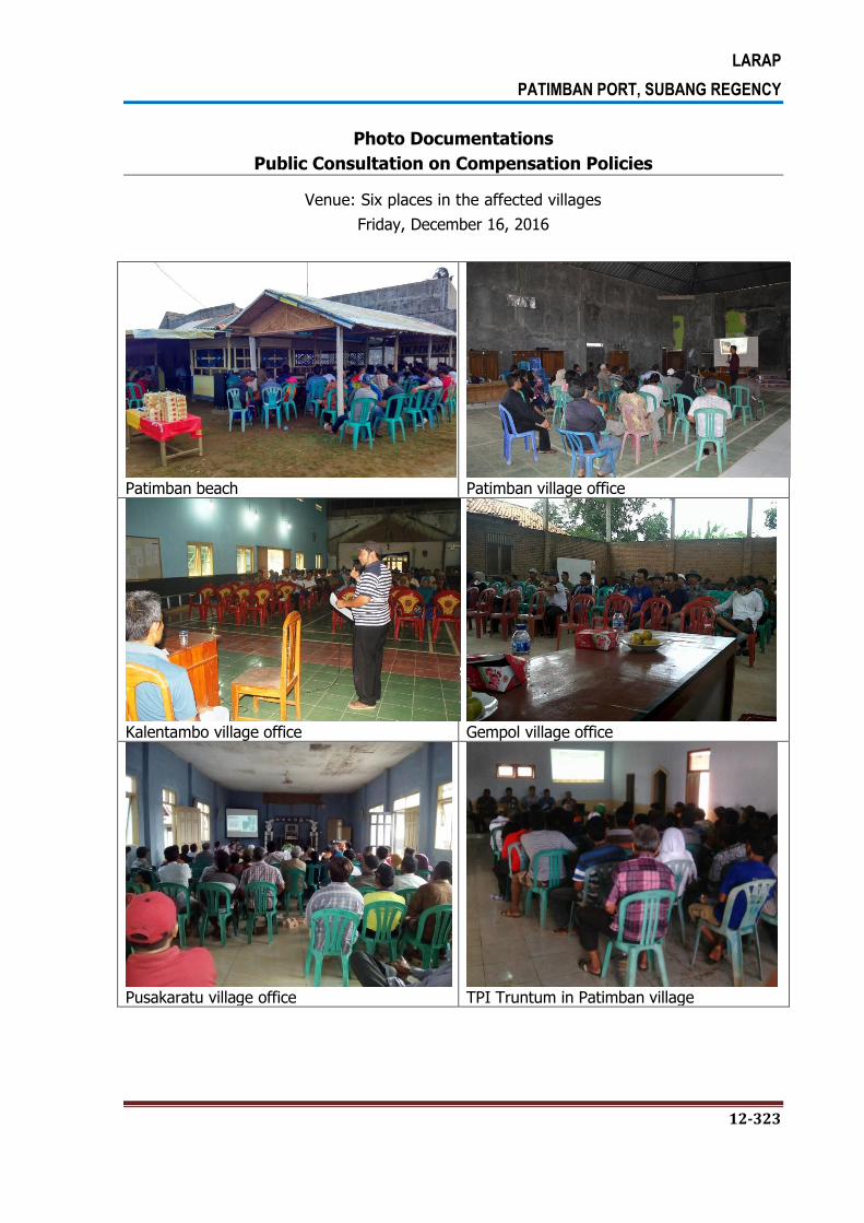
LARAP
PATIMBAN PORT, SUBANG REGENCY
12-323
Photo Documentations
Public Consultation on Compensation Policies
Venue: Six places in the affected villages
Friday, December 16, 2016
Patimban beach
Patimban village office
Kalentambo village office
Gempol village office
Pusakaratu village office
TPI Truntum in Patimban village

LARAP
PATIMBAN PORT, SUBANG REGENCY
12-324
12.1.3. Consultation During the Preparation and Implementation Stage
Preparation Stage. The preparation stage is a process aimed at determining the location
for land acquisition activity to be carried out by the Land Acquisition Preparation Team since
the Land Acquisition Document formally submitted by the DGST to the Governor of West
Java Province.
At this stage, socialization efforts that important to be done are as follows: (i) Dissemination
of Action Plan to the public by Land Acquisition Preparation Team, (ii) Introducing
Community Entitlement Matrix, and (iii) The distribution of PIB (Public Information Booklet)
to the affected people in the project area. It is highly important to disclose information on
project activities and the results of IOL/SES surveys so they can be comprehended by the
affected people. In addition to the affected people, the village heads and informal/religious
leaders should be included in the consultation process.
In the preparation process, activities to be carried out by Land Acquisition Preparation Team
are as follows:
a. Give information on the development plans;
b. Carry out initial data collection on the project location;
c. Carry out Public Consultation on the project plan;
d. Prepare the determination of the project location;
e. Announce the location of project for the public interest; and
f. Carry out other tasks related to the preparation of Land Acquisition for the
development in the Public Interest commissioned by the governor.
The information disclosure on project plan is given both directly and indirectly. The direct
information disclosure is carried out through socialization, face to face, or notification, while
the indirect information disclosure is carried out through print or electronic media. The
notification of project plan includes the following information:
a. Purpose and objective of the project plan;
b. Location and wide of land to be required for the project;
c. Land Acquisition planning stages;
d. The estimated time for Land Acquisition the implementation;
e. The estimated time for project implementation; and
f. Other information deemed necessary.
During Public consultation, the land acquisition preparation team will explain the plan of land
acquisition for Development of Patimban Port which covers as follows:
a. Purposes and objectives of Development of Patimban Port Project.
b. Stages and timeframe of Land Acquisition process for Development of Patimban
Port project;

LARAP
PATIMBAN PORT, SUBANG REGENCY
12-325
c. Appraisers role in determining the compensation value;
d. incentives to be given to the rights holder;
e. Objects assessed for compensation;
f. Form of compensation; and
g. Rights and obligations of entitled parties
Implementation Stage. Regarding the implementation stage, the socialization of
Entitlement Matrix is very needed so that the affected people can understand and agree to
the following issues:
Policies and regulations on land acquisition for public interests.
The land acquisition and resettlement stages.
Mechanisms and procedures for land acquisition and resettlement.
Mechanisms and procedures for compensation.
Mechanisms and procedures for relocation.
12.2. INFORMATION DISCLOSURE
Information disclosure on Development of Patimban Port project plan to the community is
very important in order to avoid misperceptions. For this purpose, LARAP document for
Development of Patimban Port approved by the Directorate General of See Transportation
(DGST) will be available in the relevant government offices in Subang Regency. In addition,
copies of Project Information Booklet (PIB) will be given to potentially affected
people/households and relevant stakeholders. LARAP will be posted onto DGST website.
DGST will distribute the PIB to all affected households in Back Up Area and Access Road
Area.
The PIB will include the following information: (i) a description of Development of Patimban
Port Project and social impacts that will occur due to the project implementation, (ii)
measures to avoid impacts, including the provision of entitlement to affected
people/households, (iii) procedures for consultation and complaint handling, (iv) the
schedule for compensation and assistance delivery, (v) the schedule for evacuation of assets
and impact of the project, and (vi) the name of officers who can be contacted for any
questions/clarifications in respect to the project plan.
After the implementation of the data collection and detailed measurements, the Land
Acquisition Implementation Team, which is coordinated by the Provincial National Land
Agency (BPN) and DGST, will discuss the results of such data collection and detailed
measurements, policy resettlement, the rights and the choice of relocation/reconstruction

LARAP
PATIMBAN PORT, SUBANG REGENCY
12-326
with the affected people/households. Copies of LARAP document will be available at the
relevant local government offices. Social monitoring report on the implementation LARAP will
also be made public and posted onto DGST website.
STRATEGY:
The strategy that will be implemented by DGST involving the following stakeholders:
(a) DGST will be supported by legal documents for land acquisition in its operation area
which covers: Policy/Decree of the Minister of Transportation, the determination of the
location by the Governor of West Java Provice, and others.
(b) DGST will form a special working unit for land acquisition to facilitate the settlement of
problems related to land acquisition in its operation area. DGST will also develop data
management systems and supporting tools.
(c) DGST will acquire land in the proper manner and harmonize the land price based on
acceptable market price and is equipped with complete legal documents and clear land
boundaries.
(d) Determining the required location through surveys and integrated studies by taking into
account the needs of future infrastructure.
(e) To prevent and address the land disputes quickly.
(f) Develop and update the land acquisition strategy in good manner and in line with
applicable laws and regulations.
(g) The land settlement will refer to the following strategic policy on land acquisition:
The Land Acquisition Implementation Team establishes forms of compensation
with the appropriate supporting documents, clear land boundaries, without any
dispute with other parties.
The Land Acquisition Implementation Team should set out resolution for land
disputes through coordination with all landowners, DGST, and local government.
The Land Acquisition Implementation Team will set the standard price based on
asset valuation performed by Independent Appraisal Team.

LARAP
PATIMBAN PORT, SUBANG REGENCY
13-327
CHAPTER 13. IMPLEMENTATION SCHEDULE
13.1. IMPLEMENTATION SCHEDULE OF LARAP ACTIVITIES
The implementation Schedule of LARAP Activities base on LARAP Document prepared by
DGST refers to GOI Regulation can be seen in Table 13-1.
Table 13-1.
Description of Land Acquisition Implementation Schedule
NO. ACTIVITIES SCHEDULLE
I PLANNING STAGE
1. Completion of Detailed Design Construction May 2016 – April 2017
2.
Public Consultation June 2016 – October 2016
3. Identification of affected assets and Socio-Economic
Survey to affected Person June – October 2016
4. Preparation of Livelihood Restoration Program October - November 2016
5. Preparation of LARAP Document June – November 2016
6. Endorsement of LARAP Document November 2016
7.
Revealing the land procurement planning documents
to the public (the party entitled and other stakeholders) and website
November 2016
8. Land Acquisition Planning Document Delivery to the
Governor of West Java Province November 2016
II PREPARATION STAGE
1. Land Acquisition Planning Documents Received By the Governor of West Java Province
November 2016
2. Formulated The Preparatory Land Acquisition Team January 2017
3. Notice Patimban Port Development Plan to the
Community January 2016
4. Early Identification and Data Collection Entitled Party and the object of the Land Acquisition
January - February 2017
5. Public Consultation Related to Development Plan February - 28 March 2017
6. Determination Location April 2017

LARAP
PATIMBAN PORT, SUBANG REGENCY
13-328
NO. ACTIVITIES SCHEDULLE
III IMPLEMENTATION STAGE
1. Preparation of Land Acquisition Implementation (14
days) 1 - 14 April 2017
2. Establishment of Land Acquisition Implementation Team
15 April 2017
3. Inventory and identification (30 Days) 16 April 2017 – 16 May 2017
4. Announcement of Definitive PAP’S and Complain
Period (14 Days) 17 – 30 May 2017
5. Re-inventory and Re-Identification If There Rebuttal (14 Days)
1 – 15 Juni 2016
6.
Selection Process and Independent Appraisal
Determination (30) and Assessment of Land Procurement Object (30 days)
15 June – 15 August 2017
7. Discussion of Compensation and Announced of
Compensation schedule (30 Days)
16 August – 16 September
2017
8. Objection and the completion of the Court (if there is 88 days)
9. Giving Compensation (if no filing objections) (30 days) 17 September - 17 October
2017
10. Submission Results (transfer of rights and certification)
18 October – 30 Des 2017
IV MONITORING AND DELIVERY OF RESULTS
1. Internal Monitoring Nov 2016 – December 2017
2. External Monitoring April – December 2017

LARAP
PATIMBAN PORT, SUBANG REGENCY
13-329
13.2. IMPLEMENTATION SCHEDULE OF LIVELIHOOD RESTORATION PROGRAM
The detailed implementation plan of the Livelihood Restoration Program (LRP) will be
developed in 2017 through close discussion with the affected communitis and the local
government. The implementation is expected to be started in 2017.
Table 13-2.
Schedule of Livelihood Restoration Program
NO. ACTIVITIES SCHEDULLE
1. Preparation of LivelihoodRestoration Program (LRP) January – June 2017
2. Implementation of LivelihoodRestoration Program (LRP) Dec 2017 – Dec 2021
Related Documents