MULTIPURPOSE QUADCOPTER SOLUTION FOR AGRICULTURE Powered by AUTONOMOUS FLIGHT NO NEED TO BE A SEASONED PILOT VIEW & DECIDE NDVI MAPS VIA CLOUD SERVICE PARROT SEQUOIA RGB & MULTISPECTRAL SENSOR COVERS UP TO 30HA AT 70M FLIGHT ALTITUDE PER BATTERY PHOTO & VIDEO FULL HD 1080P - 14MP 3-AXIS STABILIZATION ONE YEAR LICENCE ONE MONTH LICENCE INCLUDES NDVI & ZONING MAPS SERVICE

Welcome message from author
This document is posted to help you gain knowledge. Please leave a comment to let me know what you think about it! Share it to your friends and learn new things together.
Transcript

M U L T I P U R P O S E Q U A D C O P T E R S O L U T I O N F O R A G R I C U L T U R E
Powered by
A U T O N O M O U S F L I G H TN O N E E D T O B E
A S E A S O N E D P I L O T
V I E W & D E C I D EN D V I M A P S V I A C L O U D S E R V I C E
P A R R O T S E Q U O I AR G B & M U L T I S P E C T R A L S E N S O R
C O V E R S U P T O 3 0 H AA T 7 0 M F L I G H T A L T I T U D E
P E R B A T T E R Y
P H O T O & V I D E OF U L L H D 1 0 8 0 P - 1 4 M P 3 - A X I S S T A B I L I Z A T I O N
O N E Y E A R L I C E N C E
O N E M O N T H L I C E N C E
I N C L U D E SN D V I & Z O N I N G M A P S S E R V I C E
Powered by
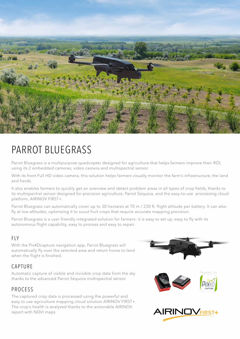
PARROT BLUEGRASSParrot Bluegrass is a multipurpose quadcopter designed for agriculture that helps farmers improve their ROI, using its 2 embedded cameras; video camera and multispectral sensor.
With its front Full HD video camera, this solution helps farmers visually monitor the farm’s infrastructure, the land and herds.
It also enables farmers to quickly get an overview and detect problem areas in all types of crop fields, thanks to its multispectral sensor designed for precision agriculture, Parrot Sequoia, and the easy-to-use processing cloud platform, AIRINOV FIRST+.
Parrot Bluegrass can automatically cover up to 30 hectares at 70 m / 230 ft. flight altitude per battery. It can also fly at low altitudes, optimizing it to scout fruit crops that require accurate mapping precision.
Parrot Bluegrass is a user friendly integrated solution for farmers: it is easy to set up, easy to fly with its autonomous flight capability, easy to process and easy to repair.
F LYWith the Pix4Dcapture navigation app, Parrot Bluegrass will automatically fly over the selected area and return home to land when the flight is finished.
C A P T U R EAutomatic capture of visible and invisible crop data from the sky thanks to the advanced Parrot Sequoia multispectral sensor
P R O C E S SThe captured crop data is processed using the powerful and easy to use agriculture mapping cloud solution AIRINOV FIRST+. The crop’s health is analyzed thanks to the actionable AIRINOV report with NDVI maps
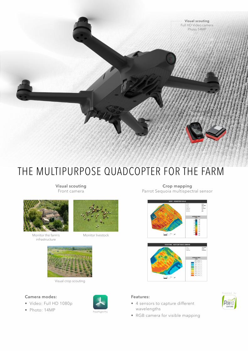
Visual scoutingFull HD Video camera
Photo 14MP
THE MULTIPURPOSE QUADCOPTER FOR THE FARMVisual scouting
Front cameraCrop mapping
Parrot Sequoia multispectral sensor
Camera modes:
• Video: Full HD 1080p
• Photo: 14MP
Features:
• 4 sensors to capture different wavelengths
• RGB camera for visible mapping
Crop mappingParrot Sequoia Multispectral sensor
Visual crop scouting
Monitor the farm’s infrastructure
Monitor livestock
FreeFlight Pro
Powered by
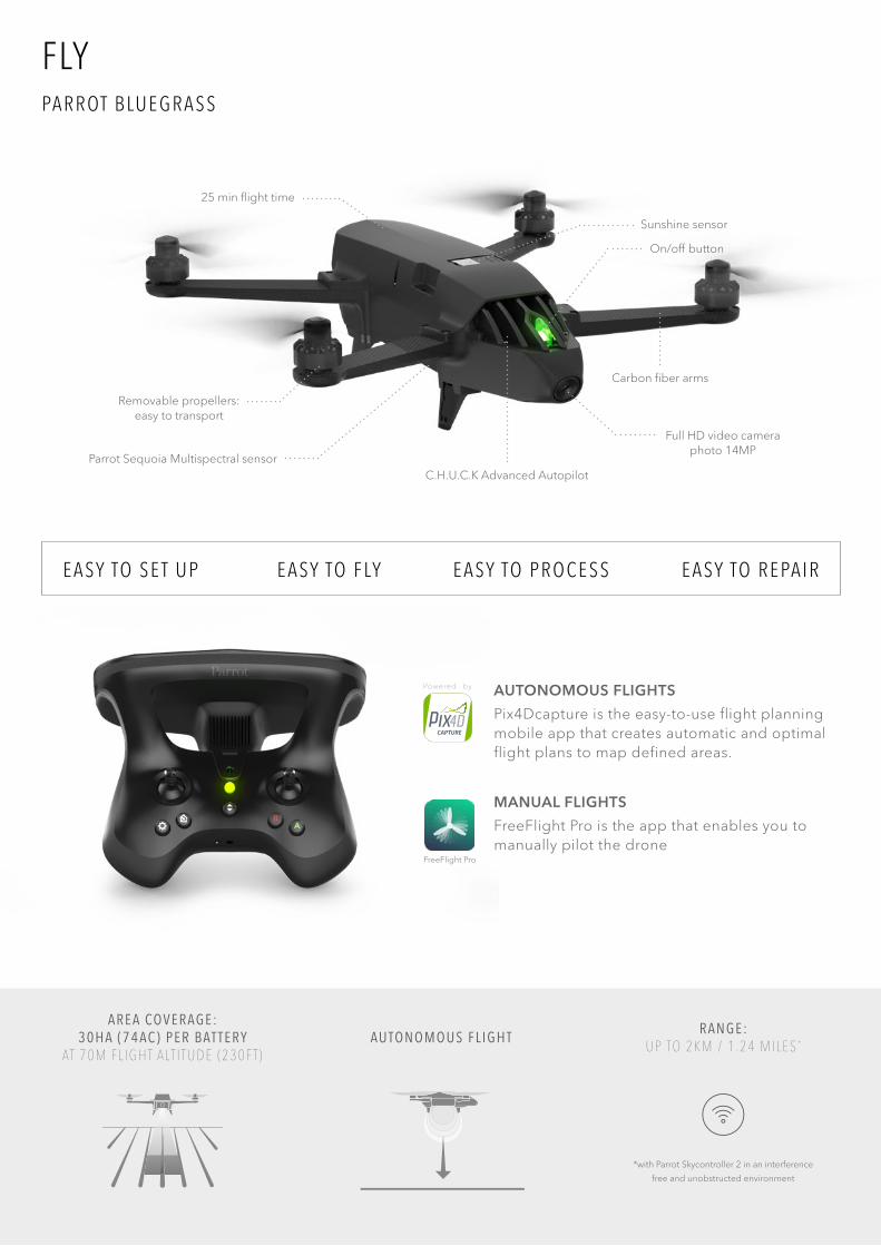
A R E A CO V E R A G E : 3 0 H A ( 7 4 A C ) P E R B AT T E R Y
AT 7 0 M F L I G H T A LT I T U D E ( 2 3 0 F T )AU TO N O M O U S F L I G H T R A N G E :
U P TO 2 K M / 1 . 2 4 M I L E S *
*with Parrot Skycontroller 2 in an interference
free and unobstructed environment
Parrot Sequoia Multispectral sensor
Removable propellers: easy to transport
Sunshine sensor
25 min flight time
Full HD video camera photo 14MP
Carbon fiber arms
On/off button
C.H.U.C.K Advanced Autopilot
FLYPA R R OT B LU E G R A S S
E A SY TO S E T U P E A SY TO F LY E A SY TO P R O C E S S E A SY TO R E PA I R
AUTONOMOUS FLIGHTS
Pix4Dcapture is the easy-to-use flight planning mobile app that creates automatic and optimal flight plans to map defined areas.
MANUAL FLIGHTS
FreeFlight Pro is the app that enables you to manually pilot the drone
FreeFlight Pro
Powered by
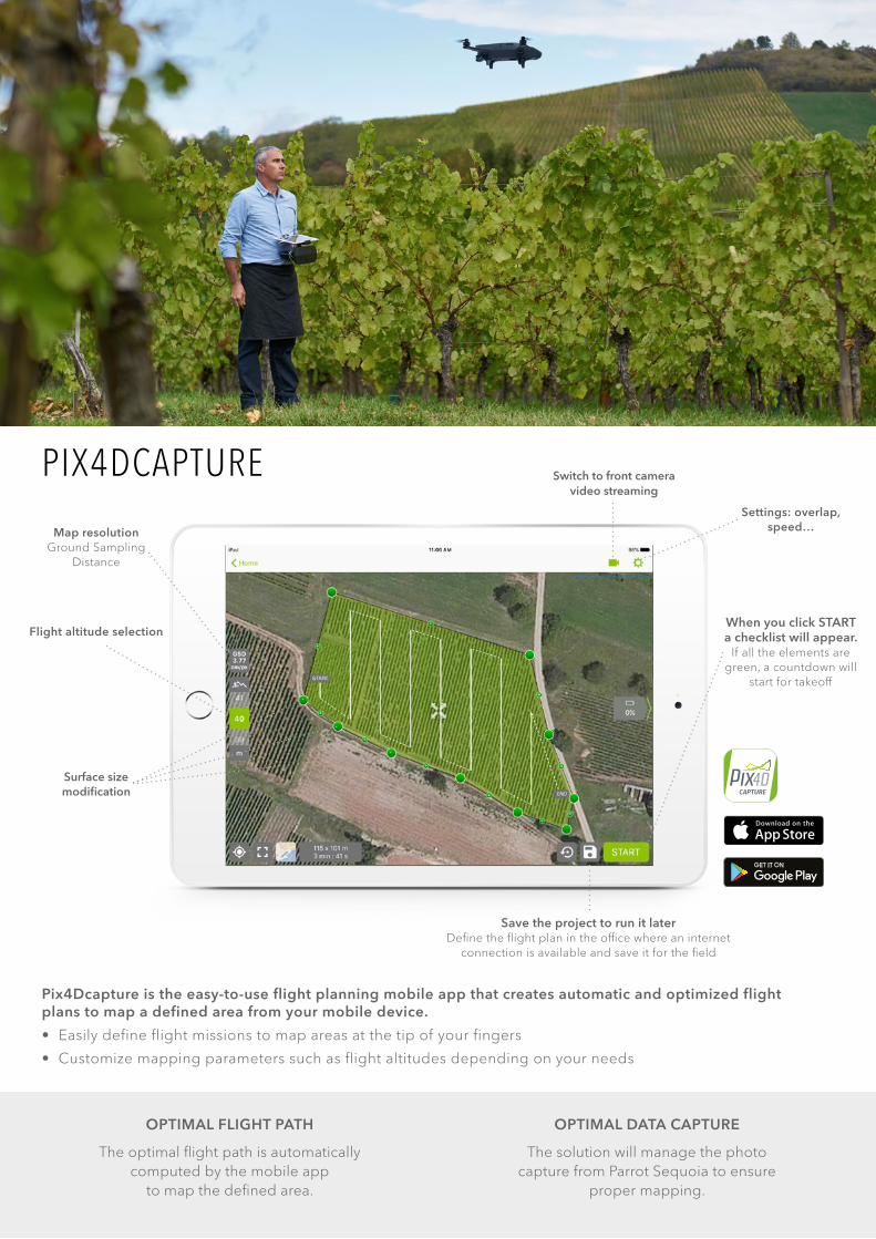
Pix4Dcapture is the easy-to-use flight planning mobile app that creates automatic and optimized flight plans to map a defined area from your mobile device.
• Easily define flight missions to map areas at the tip of your fingers
• Customize mapping parameters such as flight altitudes depending on your needs
OPTIMAL FLIGHT PATH
The optimal flight path is automatically computed by the mobile app
to map the defined area.
OPTIMAL DATA CAPTURE
The solution will manage the photo capture from Parrot Sequoia to ensure
proper mapping.
Map resolutionGround Sampling
Distance
Switch to front camera video streaming
Surface size modification
Flight altitude selection
Settings: overlap, speed…
When you click START a checklist will appear.
If all the elements are green, a countdown will
start for takeoff
Save the project to run it laterDefine the flight plan in the office where an internet
connection is available and save it for the field
PIX4DCAPTURE
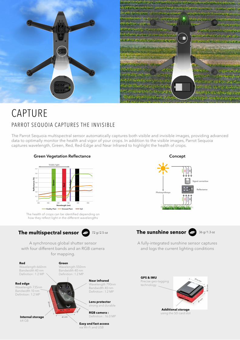
CAPTUREPA R R OT S E Q U O I A C A P T U R E S T H E I N V I S I B L E
The Parrot Sequoia multispectral sensor automatically captures both visible and invisible images, providing advanced data to optimally monitor the health and vigor of your crops. In addition to the visible images, Parrot Sequoia captures wavelength, Green, Red, Red-Edge and Near Infrared to highlight the health of crops.
A synchronous global shutter sensor with four different bands and an RGB camera
for mapping.
A fully-integrated sunshine sensor capturesand logs the current lighting conditions
41 mm
28 m
m
59 mm
Red Wavelength 660nmBandwidth 40 nmDefinition : 1.2 MP
Green Wavelength 550nmBandwidth 40 nmDefinition : 1.2 MP
Red edge Wavelength 735nmBandwidth 10 nmDefinition : 1.2 MP
Near infraredWavelength 790nmBandwidth 40 nmDefinition : 1.2 MP
Lens protectorstrong and durable
RGB camera :Definition : 16.0 MPInternal storage
64 GB Easy and fast access via Wi-Fi and USB
47 mm
18.5
mm
39.6 mm
GPS & IMUPrecise geo-tagging technology
Additional storage using the SD card slot
The multispectral sensor 72 g / 2.5 oz The sunshine sensor 36 g / 1.3 oz
The health of crops can be identified depending on how they reflect light in the different wavelengths
Green Vegetation Reflectance
Photosynthesys
Signal correction
Reflectance
GR
EEN
RED
RED
ED
GE
NIR
GR
EEN
RED
RED
EDG
E
NIR
Concept
Visible light
Refl
ecta
nce
(%)
Wavelength (nm)
Healthy Plant Stressed Plant Soil
0,7
0,6
0,5
0,4
0,3
0,2
0,1
0400 500 600 700 800 900
Gre
en
Red N
IR
Red
edg
e
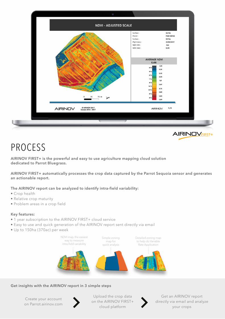
PROCESSAIRINOV FIRST+ is the powerful and easy to use agriculture mapping cloud solution dedicated to Parrot Bluegrass.
AIRINOV FIRST+ automatically processes the crop data captured by the Parrot Sequoia sensor and generates an actionable report.
The AIRINOV report can be analyzed to identify intra-field variability:• Crop health • Relative crop maturity• Problem areas in a crop field
Key features:• 1 year subscription to the AIRINOV FIRST+ cloud service• Easy to use and quick generation of the AIRINOV report sent directly via email• Up to 150ha (370ac) per week
Get insights with the AIRINOV report in 3 simple steps
Create your account on Parrot.airinov.com
Upload the crop data on the AIRINOV FIRST+
cloud platform
Get an AIRINOV report directly via email and analyze
your crops
NDVI map, the easiest way to measure
intra-field variability
Simple zoning map for
quick analysis
Detailed zoning map to help do Variable
Rate Application
PA R R OT B LU E G R A S S
PA R R OT S E Q U O I A
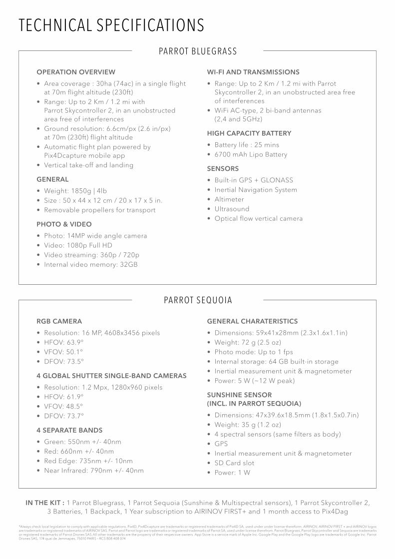
OPERATION OVERVIEW
• Area coverage : 30ha (74ac) in a single flight at 70m flight altitude (230ft)
• Range: Up to 2 Km / 1.2 mi with Parrot Skycontroller 2, in an unobstructed area free of interferences
• Ground resolution: 6.6cm/px (2.6 in/px) at 70m (230ft) flight altitude
• Automatic flight plan powered by Pix4Dcapture mobile app
• Vertical take-off and landing
GENERAL
• Weight: 1850g | 4lb• Size : 50 x 44 x 12 cm / 20 x 17 x 5 in.• Removable propellers for transport
PHOTO & VIDEO
• Photo: 14MP wide angle camera• Video: 1080p Full HD• Video streaming: 360p / 720p• Internal video memory: 32GB
RGB CAMERA
• Resolution: 16 MP, 4608x3456 pixels• HFOV: 63.9°• VFOV: 50.1°• DFOV: 73.5°
4 GLOBAL SHUTTER SINGLE-BAND CAMERAS
• Resolution: 1.2 Mpx, 1280x960 pixels• HFOV: 61.9°• VFOV: 48.5°• DFOV: 73.7°
4 SEPARATE BANDS
• Green: 550nm +/- 40nm • Red: 660nm +/- 40nm• Red Edge: 735nm +/- 10nm• Near Infrared: 790nm +/- 40nm
WI-FI AND TRANSMISSIONS
• Range: Up to 2 Km / 1.2 mi with Parrot Skycontroller 2, in an unobstructed area free of interferences
• WiFi AC-type, 2 bi-band antennas (2,4 and 5GHz)
HIGH CAPACITY BATTERY
• Battery life : 25 mins• 6700 mAh Lipo Battery
SENSORS
• Built-in GPS + GLONASS• Inertial Navigation System• Altimeter• Ultrasound• Optical flow vertical camera
GENERAL CHARATERISTICS
• Dimensions: 59x41x28mm (2.3x1.6x1.1in)• Weight: 72 g (2.5 oz)• Photo mode: Up to 1 fps• Internal storage: 64 GB built-in storage• Inertial measurement unit & magnetometer• Power: 5 W (~12 W peak)
SUNSHINE SENSOR (INCL. IN PARROT SEQUOIA)
• Dimensions: 47x39.6x18.5mm (1.8x1.5x0.7in)• Weight: 35 g (1.2 oz)• 4 spectral sensors (same filters as body)• GPS• Inertial measurement unit & magnetometer• SD Card slot• Power: 1 W
TECHNICAL SPECIFICATIONS
*Always check local legislation to comply with applicable regulations. Pix4D, Pix4Dcapture are trademarks or registrered trademarks of Pix4D SA, used under under license thereform. AIRINOV, AIRINOV FIRST + and AIRINOV logos are trademarks or registered trademarks of AIRINOV SAS. Parrot and Parrot logo are trademarks or registered trademarks of Parrot SA, used under license therefrom. Parrot Bluegrass, Parrot Skycontroller and Sequoia are trademarks or registered trademarks of Parrot Drones SAS.All other trademarks are the property of their respective owners. App Store is a service mark of Apple Inc. Google Play and the Google Play logo are trademarks of Google Inc. Parrot Drones SAS, 174 quai de Jemmapes, 75010 PARIS – RCS 808 408 074
IN THE KIT : 1 Parrot Bluegrass, 1 Parrot Sequoia (Sunshine & Multispectral sensors), 1 Parrot Skycontroller 2, 3 Batteries, 1 Backpack, 1 Year subscription to AIRINOV FIRST+ and 1 month access to Pix4Dag
Related Documents