1 PALL LIFE SCIENCES WESTERN AREA GROUNDWATER MONITORING PLAN ANN ARBOR, MICHIGAN April 2011 BACKGROUND The purpose of this monitoring plan is to collect data necessary to verify the effectiveness of the Western Area System in meeting the Western Area Non-Expansion Cleanup Objective set forth in Section V.B.1. of the Consent Judgment (CJ) (applicable portions summarized below). Western Area System Non-Expansion Cleanup Objective . The Defendant shall prevent the horizontal extent of the groundwater contamination in the Western Area from expanding. The horizontal extent shall be the maximum horizontal areal extent of groundwater contamination regardless of the depth of the groundwater contamination (as established under Section V.B.2.c. of this Consent Judgment). Continued migration of groundwater contamination into the Prohibition Zone or Expanded Prohibition Zone shall not be considered expansion and is allowed. A change in the horizontal extent of groundwater contamination resulting solely from the Court's application of a new cleanup criterion shall not constitute expansion. Nothing in this Section prohibits the Plaintiffs from seeking additional response activities pursuant to Section XVIII.E of this Consent Judgment. Compliance with the Non-Expansion Cleanup Objective shall be established and verified by the Compliance Well Network to be developed by the Parties as provided in Sections V.B.2.c and d., below ("Compliance Well Network"). There is no independent mass removal requirement or a requirement that the Defendant operate any particular extraction well(s) at any particular rate beyond what is necessary to prevent the prohibited expansion, provided that Defendant's ability to terminate all groundwater extraction in the Western Area is subject to Section V.D.1.c. and the establishment of property use restrictions as required by Section V.B.2.e. If prohibited expansion occurs, Defendant shall undertake additional response activities to return the groundwater contamination to the boundary established by the Compliance Well Network (such response activities may include recommencement of extraction at particular locations). * * * The monitoring program shall be continued until terminated pursuant to Section V.E.

Welcome message from author
This document is posted to help you gain knowledge. Please leave a comment to let me know what you think about it! Share it to your friends and learn new things together.
Transcript

1
PALL LIFE SCIENCES WESTERN AREA GROUNDWATER MONITORING PLAN
ANN ARBOR, MICHIGAN April 2011
BACKGROUND
The purpose of this monitoring plan is to collect data necessary to verify the effectiveness of the Western
Area System in meeting the Western Area Non-Expansion Cleanup Objective set forth in Section V.B.1.
of the Consent Judgment (CJ) (applicable portions summarized below).
Western Area System Non-Expansion Cleanup Objective. The Defendant shall prevent
the horizontal extent of the groundwater contamination in the Western Area from
expanding. The horizontal extent shall be the maximum horizontal areal extent of
groundwater contamination regardless of the depth of the groundwater contamination (as
established under Section V.B.2.c. of this Consent Judgment). Continued migration of
groundwater contamination into the Prohibition Zone or Expanded Prohibition Zone shall
not be considered expansion and is allowed. A change in the horizontal extent of
groundwater contamination resulting solely from the Court's application of a new cleanup
criterion shall not constitute expansion. Nothing in this Section prohibits the Plaintiffs from
seeking additional response activities pursuant to Section XVIII.E of this Consent
Judgment. Compliance with the Non-Expansion Cleanup Objective shall be established
and verified by the Compliance Well Network to be developed by the Parties as provided
in Sections V.B.2.c and d., below ("Compliance Well Network"). There is no independent
mass removal requirement or a requirement that the Defendant operate any particular
extraction well(s) at any particular rate beyond what is necessary to prevent the
prohibited expansion, provided that Defendant's ability to terminate all groundwater
extraction in the Western Area is subject to Section V.D.1.c. and the establishment of
property use restrictions as required by Section V.B.2.e. If prohibited expansion occurs,
Defendant shall undertake additional response activities to return the groundwater
contamination to the boundary established by the Compliance Well Network (such
response activities may include recommencement of extraction at particular locations).
* * *
The monitoring program shall be continued until terminated pursuant to Section V.E.

2
PROPOSED MONITORING LOCATIONS
PLS has been installing monitoring wells a collecting groundwater samples in the Western Area for
approximately 25 years. Wells have been installed from shallow depths to the bedrock surface allowing
for the monitoring of all key hydrostragraphic units. Numerous isoconcentration maps have been
prepared over the years depicting the extent of 1,4-dioxane in various hydrostratigraphc units.
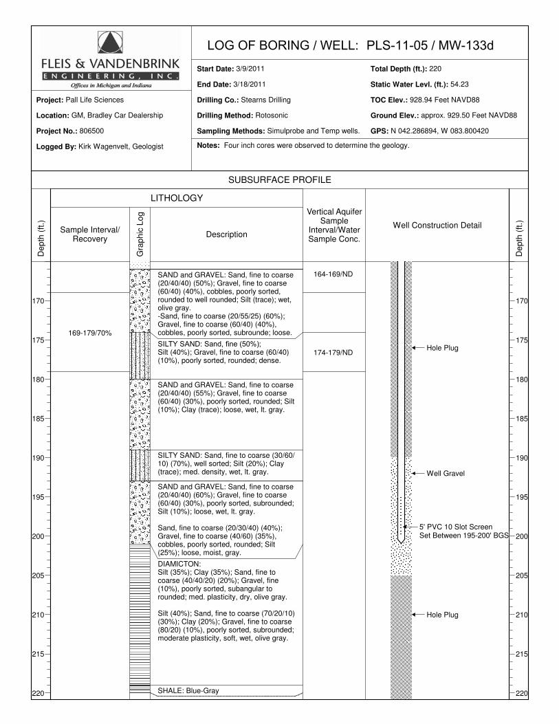
Recently, PLS has installed a series of borings/wells to further define the extent of 1,4-dioxane in the
Western Area. These wells include: MW-125, MW-126s, MW-126d, MW-127s, MW-127d, MW-128s,
MW-128d, MW-131s, MW-131d, MW-133s, MW-133i, MW-133d, MW-134s, MW-134i and MW-134d.
PLS also drilled another boring, PLS-11-04, near the University of Michigan - Saginaw Forest Caretaker’s
Cabin. The locations for these wells and boring were mutually agreed upon by PLS and the MDEQ.
Borings at all of these well locations reached the bedrock surface, and vertical groundwater samples were
collected at 10 foot intervals in water-bearing units. Boring logs, elevation/coordinate data and water level
data for the newest wells (MW-133/134 and PLS-11-04) are provided in Appendix 1. Data from these
borings/wells in concert with the extensive existing well network has sufficiently defined the extent of 1,4-
dioxane in the Western area in all hydrostratigraphic units from ground elevation to the bedrock surface.
Based on the data obtained from the agreed upon investigation, the extent of groundwater contamination
has been delineated within the compliance well network identified on Figure 1.
PLS has carefully selected approximately 125 locations to periodically collect groundwater samples for
1,4-dioxane analysis and water level measurements. The locations, along with other relevant information,
are listed on Table 1. Figure 1 identifies wells included in the monitoring well network, and highlights
wells in the Compliance Well Network (green).
Groundwater Quality Sampling
Purpose Designations
The monitoring locations have been assigned the following purpose designations:
Compliance Monitoring (CM) – With the exception of MW-134, these wells will be used to determine
compliance with the Non-Expansion Cleanup Objective in the CJ. Because of its proximity to the
boundaries of both the Prohibition Zone and the edge of the plume above 85 ppb and because
groundwater contamination above 85 ppb has historically been detected in this area , the detection of 1,4-
dioxane above 85 ppb in MW-134 in the future may indicate prohibited expansion or it may simply
indicate “continued migration of groundwater contamination into the Prohibition Zone or Expanded

3
Prohibition Zone”, which is specifically allowed under the CJ. PLS proposes to designate MW-134 as a
provisional compliance point. If 1,4-dioxane above 45 ppb is detected in any of the MW-134 wells, PLS
will undertake an investigation to determine whether groundwater contamination in this area is flowing
toward the Prohibition Zone or if flow is in a direction that constitutes prohibited expansion. PLS will
submit an investigation report to the MDEQ for review and approval. If this investigation demonstrates
that the 1,4-dioxane detected in MW-134 is migrating into the Prohibition Zone/Expanded Prohibition
Zone, this will mean that MW-134 is not an appropriate location for monitoring the Non-Expansion
Cleanup Objective. In this event, PLS will install an additional monitoring well nest north of MW-134,
roughly on a line between MW-133 and MW-66/35, which will then be the Compliance Monitoring point
that will be used to determine compliance with the Non-Expansion Cleanup Objective in this area. If, on
the other hand, PLS’ investigation demonstrates that groundwater in this area is not flowing toward the
Prohibition Zone/Expanded Prohibition Zone, MW-134 will be used as a Compliance Monitoring point to
determine compliance with the Non-Expansion Cleanup Objective.
General Monitoring (GM) – These wells will be monitored to track the general distribution of 1,4-dioxane
in the Western Area. Data from these wells will be used to evaluate the potential effects of changes in
the purge rates of PLS’ Western Area groundwater extraction wells.
Monitoring Locations
The locations of the monitoring wells that will be part of this plan are shown on Figure 1.
Monitoring Frequencies
PLS has reviewed the past water quality data and position of the wells relative to the boundaries of the
plumes and has assigned each well with a monitoring frequency. These frequencies are:
Quarterly (Q) – Quarterly sampling frequencies have been assigned to many wells since it is anticipated
that there will be significant extraction rate changes in the near future. It is anticipated that many wells
assigned a quarterly frequency will be changed to longer frequencies in the next revision of this plan.
Semi-annual (S) – Semi-annual sampling frequencies were generally assigned to locations where routine
data are important, but either due to historic trends or location, monitoring at slightly less frequent basis
than quarterly will be adequate to identify significant trends or changes.
Annual (A) – Annual sampling frequencies were generally assigned to locations where routine data are
important, but either due to historic trends or location, monitoring at slightly less frequent basis than semi-
annual will be adequate to identify significant trends or changes.
4
Biennial (B) – Biennial sampling frequencies were generally assigned to locations where historic
concentrations have shown that trends indicate subtle/negligible changes over time and frequent
monitoring is not warranted.
Omit (O) – PLS is proposing the elimination of selected wells from the monitoring program. Historic trends
at these locations have shown that 1,4-dioxane concentrations at these locations have consistently been
below 85 ppb, alternative nearby locations can and will be monitored, or the wells are no longer
functional.
Water Level Measurements
Objectives
The overall objectives of measuring water levels are:
1. Assessing groundwater flow patterns.
2. Evaluating potential changes in groundwater flow from changes in extraction rates and locations.
Locations
The wells to be monitored for water levels are shown on Figure 1.
Frequencies
Water level measurements in this plan will be made on a quarterly basis. This will allow for changes to be
observed tracked during periods where extraction rates in many wells will be changed. It is anticipated
that this frequency will be changed in many wells in the next version of this monitoring plan.
Sampling Methods and Analysis
Groundwater samples collected from monitoring wells will be collected by PLS in a manner consistent
with PLS sampling protocols and sample handling procedures that are currently being used for PLS’
routine monitoring. These sampling methods generally employ a 3 to 5 casing volume purge prior to
sample collection, strict equipment decontamination procedures, and standard sample handling and
documentation procedures.

5
Groundwater samples will be analyzed for 1,4-dioxane by the PLS laboratory using a U.S. Environmental
Protection Agency-approved modified GC/MS method capable of detection levels of 1 ppb.
REPORTING AND PLAN UPDATES
Data from the monitoring will be made digitally available to the Michigan Department of Environmental
Quality (MDEQ) via the PLS water quality database. The database can be used by the MDEQ and others
having access to prepare reports and trend graphs.
On a semi-annual basis, PLS will prepare and submit to the MDEQ isoconcentration and potentiometric
surface maps for the various aquifers, similar to those currently being provided to MDEQ.
On an annual basis, starting with the approval date of this plan, PLS may propose to adjust sampling and
submittal frequencies and submit revisions to the MDEQ for review and comment before implementation.

Table 1 - Western Area Groundwater Monitoring Program (to be revised annually)
Well Name Aquifer Site Area
Most Recent 1,4-Dioxane Result (ppb)
Date Sampled
Purpose for Sampling
Current Sampling Frequency
Revised Groundwater
Sampling Frequency
Water Level Measurement
Frequency
AMW-1 Marshy Western 342 8/11/10 GM A A QuarterlyAMW-2 Marshy Western 7 8/5/10 GM A A QuarterlyHZ-S D2 Western 958 3/7/11 GM-E M M* NMMOW-1 Marshy Western 565 8/5/10 GM A A QuarterlyMW-1 C3 Western 1,017 10/20/10 GM S Quarterly QuarterlyMW-2s Shallow Western 10 11/7/07 - R O NMMW-2d C3 Western 42 7/16/10 GM A Quarterly QuarterlyMW-3s Shallow Western 5 8/18/93 - R O NMMW-3d C3 Western ND 8/7/08 - A O QuarterlyMW-4s Sh Western 3 8/8/08 - A O QuarterlyMW-4d D2 Western 836 10/28/10 GM S Quarterly QuarterlyMW-5s Shallow Western 1 7/20/04 - A O NMMW-5d Sh Western 8,618 2/18/11 GM Quarterly Quarterly QuarterlyMW-8d C3 Western ND 8/13/08 - A O QuarterlyMW-9d D2 Western ND 8/7/08 - A O NMMW-10s Southwest Western ND 8/10/10 - A O QuarterlyMW-10d Southwest Western 1,505 10/19/10 GM S Quarterly QuarterlyMW-11s Shallow Western ND 8/10/10 - S O QuarterlyMW-11i C3 Western 1 10/19/10 - S O QuarterlyMW-11d D2 Western 194 10/19/10 GM S Quarterly QuarterlyMW-12d C3 Western ND 7/21/10 - A O QuarterlyMW-13 D2 Western ND 7/16/10 - A O QuarterlyMW-14d D2 Western ND 7/22/10 - A O QuarterlyMW-18s Shallow Western - R O NMMW-18d C3 Western 226 10/19/10 GM S Quarterly QuarterlyMW-20 C3 Western ND 7/29/08 CM A Quarterly QuarterlyMW-22 C3 Western 1,312 10/20/10 GM S Quarterly QuarterlyMW-23 C3 Western 184 8/5/10 GM A A QuarterlyMW-24 C3 Western 958 8/11/10 GM A A QuarterlyMW-25s Shallow Western 834 8/10/10 GM A Quarterly QuarterlyMW-25d C3 Western 423 1/16/03 - A O NMMW-26 Shallow Western 5 8/10/10 - A O QuarterlyMW-27 Shallow Western 16 8/5/10 - A O QuarterlyMW-28 C3 Western ND 8/4/10 GM A Quarterly QuarterlyMW-32 C3 Western 16 8/6/10 GM A Quarterly QuarterlyMW-34s C3 Western ND 7/15/08 CM A Quarterly QuarterlyMW-34d D2 Western ND 8/6/10 CM A Quarterly QuarterlyMW-35 C3 Western 8 8/6/10 CM A Quarterly QuarterlyMW-36 C3 Western ND 8/6/10 GM A A QuarterlyMW-37 C3 Western 249 10/19/10 GM S Quarterly QuarterlyMW-38s C3 Western ND 8/6/10 - A O QuarterlyMW-38d D2 Western 94 1/18/11 GM Quarterly Quarterly QuarterlyMW-39s C3 Western 22 1/5/11 GM Quarterly Quarterly QuarterlyMW-39d D2 Western 242 1/5/11 GM Quarterly Quarterly QuarterlyMW-44 D2 Western ND 8/4/10 - A O QuarterlyMW-45s Southwest Western 13 10/19/10 GM S S QuarterlyMW-45d Southwest Western 1,953 10/19/10 GM S S QuarterlyMW-46 Southwest Western 53 8/5/10 GM A S QuarterlyMW-48 Southwest Western 133 10/20/10 GM S S QuarterlyMW-49 Southwest Western ND 8/4/10 GM A S QuarterlyMW-50 Southwest Western 697 10/28/10 GM-E M M* QuarterlyMW-52s Southwest Western 1,305 8/10/10 GM S S QuarterlyMW-52i Southwest Western ND 8/10/10 - A A QuarterlyMW-52d Southwest Western ND 8/10/10 - A A QuarterlyMW-56s D2 Western 118 4/2/09 GM Quarterly Quarterly QuarterlyMW-56d E Western ND 8/4/10 GM A Quarterly QuarterlyMW-57 Southwest Western ND 8/13/08 CM A Quarterly QuarterlyMW-58s Southwest Western 182 10/15/08 CM S S QuarterlyMW-58d Southwest Western 9 8/12/08 CM A S QuarterlyMW-59s C3 Western ND 7/20/10 GM A A QuarterlyMW-59d D2 Western ND 7/20/10 GM A A QuarterlyMW-62s D2 Western ND 7/11/08 CM A S QuarterlyMW-62i D2 Western ND 7/17/08 CM A S QuarterlyMW-62d E Western ND 7/11/08 GM A S QuarterlyMW-63s D2 Western ND 8/4/10 CM A S QuarterlyMW-63i D2 Western ND 8/4/10 CM A S QuarterlyMW-63d E Western ND 8/4/10 GM A A Quarterly

Table 1 - Western Area Groundwater Monitoring Program (to be revised annually)
Well Name Aquifer Site Area
Most Recent 1,4-Dioxane Result (ppb)
Date Sampled
Purpose for Sampling
Current Sampling Frequency
Revised Groundwater
Sampling Frequency
Water Level Measurement
Frequency
MW-64 E Western 66 10/19/10 GM S Quarterly QuarterlyMW-65s E Western 25 7/30/10 GM A S QuarterlyMW-65i E Western 2 7/30/10 GM A S QuarterlyMW-65d E Western 31 11/8/10 GM S S QuarterlyMW-66 E Western 2 8/10/10 CM A Quarterly QuarterlyMW-68 E Western ND 7/21/10 CM A S QuarterlyMW-75 C3 Western 30 10/20/10 GM S S QuarterlyMW-78 C3 Western 22 10/18/10 GM S S QuarterlyMW-94s D2 Western 1,294 1/27/11 GM Quarterly Quarterly QuarterlyMW-94d E Western ND 1/27/11 GM Quarterly S QuarterlyMW-95 E Western 73 1/27/11 GM Quarterly S QuarterlyMW-96 E Western 79 1/27/11 GM Quarterly S QuarterlyMW-125 C3 Western 276 1/5/11 GM - Quarterly QuarterlyMW-126s D2 Western ND 1/5/11 CM - Quarterly QuarterlyMW-126d E Western ND 1/5/11 CM Quarterly Quarterly QuarterlyMW-127s C3 Western ND 1/5/11 CM - Quarterly QuarterlyMW-127d E Western ND 1/5/10 CM - Quarterly QuarterlyMW-128s C3 Western ND 2/14/11 CM - Quarterly QuarterlyMW-128d E Western ND 2/14/11 CM - Quarterly QuarterlyMW-131s D2 Western ND 3/21/11 CM - Quarterly QuarterlyMW-131d E Western ND 3/21/11 CM - Quarterly QuarterlyMW-133s ND Western ND 3/22/11 CM - Quarterly QuarterlyMW-133i ND Western ND 3/22/11 CM - Quarterly QuarterlyMW-133d ND Western ND 3/22/11 CM - Quarterly QuarterlyMW-134s ND Western 7 3/30/11 PCM - Quarterly QuarterlyMW-134i ND Western 5 3/30/11 PCM - Quarterly QuarterlyMW-134d ND Western 3 3/30/11 PCM - Quarterly QuarterlyNMW-1s Marshy Western 1,577 8/11/10 CM A Quarterly QuarterlyNMW-1d Marshy Western 639 8/11/10 GM A A QuarterlyNMW-2s Marshy Western 1,684 8/11/10 CM A Quarterly QuarterlyNMW-2d Marshy Western 597 8/11/10 GM A A QuarterlyNMW-3s Marshy Western 1,010 8/11/10 GM A A QuarterlyNMW-3d Marshy Western 918 8/11/10 GM A A QuarterlyPMW-1 Marshy Western 162 8/11/10 GM A A QuarterlyPMW-2 Marshy Western 5,708 8/5/10 GM A A QuarterlyPMW-3 Marshy Western 7,348 8/5/10 GM A A QuarterlyPMW-4 Marshy Western 930 8/5/10 GM A A QuarterlyPW-1 Marshy Western 1,112 3/7/11 GM-E M M* NMSurface Water-1M Marshy Western ND 7/30/08 GM A O NMSurface Water-2M Marshy Western ND 7/30/08 GM A O NMSurface Water-3M Marshy Western ND 7/30/08 GM A O NMSW-COMB Southwest Western 546 1/6/09 GM-E M M* NMTW-1 C3 Western 121 3/7/10 GM-E S M* NMTW-3 C3 Western 5 11/11/10 - S M* NMTW-4 Southwest Western 28 11/11/10 - S M* NMTW-5 D2 Western 872 11/11/10 GM-E M M* NMTW-6 C3 Western 66 5/21/10 GM-E M M* NMTW-8 Southwest Western 503 3/7/11 GM-E M M* NMTW-9 D2 Western 981 3/7/11 GM-E M M* NMTW-10 C3 Western 751 3/7/10 GM-E M M* NMTW-11 E Western 223 3/7/11 GM-E M M* NMTW-12 E Western 23 11/11/10 - S M* NMTW-13 Southwest Western 736 12/7/10 GM-E M M* NMTW-14 C3 Western 129 3/7/10 GM-E M M* NMTW-17 E Western 89 3/7/11 GM-E M M* NMTW-18 E Western 384 3/7/11 GM-E M M* NMTW-20 C3 Western 1,487 3/7/11 GM-E M M* NMTW-21 D2 Western 286 2/7/11 GM-E M M*TW-22 Southwest Western 760 3/7/11 GM-E M M* NM170 Aprill C3 Western 18 7/16/10 - A A NM175 Jackson Plaza D2 Western 706 11/8/10 GM S S Quarterly333 Jackson Plaza C3 Western 19 7/16/10 - A O NM371 Parkland Plaza #1 E Western ND 10/19/10 - R R NM371 Parkland Plaza #2 E Western ND 10/19/10 - R R NMSag. Forest Cabin #1 E Western 27 8/6/10 GM A S QuarterlySag. Forest Cabin #2 E Western 2 8/6/10 GM A S QuarterlySag. Forest Cabin #4 C3 Western ND 7/31/08 - A O NMFrequency Codes: O = No longer sample (statics if applicable)

Table 1 - Western Area Groundwater Monitoring Program (to be revised annually)
Well Name Aquifer Site Area
Most Recent 1,4-Dioxane Result (ppb)
Date Sampled
Purpose for Sampling
Current Sampling Frequency
Revised Groundwater
Sampling Frequency
Water Level Measurement
Frequency
M = Monthly Measured
S = Semi-Annually
A = Annually Sampling Purpose Codes:
B = Biannually
R = Randomly PCM = Provisional Compliance Monitoring
GM = General Monitoring
GM-E = General Monitoring - Extraction Well
M*=Monthly while operating, otherwise randomly sampled
CM = Compliance Monitoring
Analytical Codes:
ND = Non-Detect

LOG OF BORING / WELL:Start Date:
End Date:
Drilling Co.:
Drilling Method:
Sampling Methods:
Total Depth (ft.):
Static Water Levl. (ft.):
TOC Elev.:
Ground Elev.:
GPS:
Location:
Project No.:
Project:
Logged By:
SUBSURFACE PROFILE
LITHOLOGY
De
pth
(ft
.)
0
5
10
15
20
25
30
35
40
45
50
55
Sample Interval/Recovery
Gra
ph
ic L
og
Description
Vertical AquiferSample
Interval/WaterSample Conc.
Well Construction Detail
De
pth
(ft
.)
0
5
10
15
20
25
30
35
40
45
50
55
PLS-11-044/4/2011
4/8/2011
Boart Longyear
Rotosonic
Temp. Wells
220
approx. 3.5
N/A
approx. 910.0 Feet NAVD88
Approx. 15' W/NW of MW-125
Saginaw Forest, West of MW-125
806500
Pall Life Sciences
Kirk Wagenvelt, Geologist
0-5/100%
5-15/30%
15-25/100%
25-35/100%
35-45/100%
45-55/60%
Ground Surface
SILTY, CLAYEY, SAND: Sand, fine tocoarse (50/30/20) (30%), moderately sorted; Silt (40%); Clay (10%); moderate plasticity, organics, moist, green-gray.-Sand, fine to coarse (50/30/20) (60%), moderately sorted; Silt (30%); Clay (trace); wet, lt. gray.
SAND and GRAVEL: Gravel, fine tocoarse (40/60) (60%); Sand, fine to coarse (30/30/40) (40%), cobbles, poorly sorted, subrounded; wet, gray.
DIAMICTION: Clay (40%); Silt (30%);Sand, fine to coarse (30/20/50) (15%); Gravel (trace), poorly sorted, subangular to subrounded; high plasticity, very stiff, dry, olive gray.
SAND and GRAVEL: Sand, fine to coarse(30/50/20) (50%); Gravel, fine to coarse (60/40) (40%), poorly sorted, subrounded; Silt (trace); wet, gray.-Silt lensesSand, fine to coarse (60/30/10) (70%); Gravel, fine to coarse (60/40) (20%), poorly sorted, subrounded; Silty (10%); wet, gray.
SILTY, GRAVELY, SAND: Sand, fine to coarse (80/10/10) (70%); Silt (15%); Gravel, fine (trace), moderately sorted, angular to subrounded; dense, wet, gray.
GRAVELY, CLAYEY, SILTY, SAND
SILT
SAND: Sand, fine to med. (60/40) (90%), well sorted; Silt (trace), dense, wet, gray.
0-5/ND (did not add water)
10-15/ND (did not add water)
30-35/2 µg/L (did not add water)
40-45/57 µg/L (added 60 gal.)
50-55/225 µg/L (added 30 gal.)
Hole Plug
Approx. Water Level
Notes: All water samples analyzed by PLS for 1,4 Dioxane. ND = <1.0 µg/L

LOG OF BORING / WELL:Start Date:
End Date:
Drilling Co.:
Drilling Method:
Sampling Methods:
Total Depth (ft.):
Static Water Levl. (ft.):
TOC Elev.:
Ground Elev.:
GPS:
Location:
Project No.:
Project:
Logged By:
SUBSURFACE PROFILE
LITHOLOGY
De
pth
(ft
.)
60
65
70
75
80
85
90
95
100
105
110
Sample Interval/Recovery
Gra
ph
ic L
og
Description
Vertical AquiferSample
Interval/WaterSample Conc.
Well Construction Detail
De
pth
(ft
.)
60
65
70
75
80
85
90
95
100
105
110
PLS-11-044/4/2011
4/8/2011
Boart Longyear
Rotosonic
Temp. Wells
220
approx. 3.5
N/A
approx. 910.0 Feet NAVD88
Approx. 15' W/NW of MW-125
Saginaw Forest, West of MW-125
806500
Pall Life Sciences
Kirk Wagenvelt, Geologist
55-65/50%
65-75/100%
75-85/100%
85-95/100%
95-105/70%
105-115/100%
CLAYEY SAND: Sand, fine to coarse (60/20/20) (50%); Clay (30%); Silt (10%); Gravel (trace), poorly sorted, subangular to rounded; moderate plasticity, very stiff, dry.
DIAMICTON: Silt (60%); Clay (30%);Sand, fine to coarse (50/30/20) (trace); Gravel, fine (trace), poorly sorted, subangular to rounded; moderate plasticity, very stiff, dry.
Silt (70%); Sand, fine to coarse (50/40/10) (20%); Clay (10%); Gravel, fine (trace), poorly sorted, subangular to rounded; low plasticity, hard, dry, olive gray.
Silt (60%); Clay (30%); Sand fine to coarse (20/20/60) (trace); Gravel (trace), poorly sorted, angular-rounded; moderate plasticity, hard, dry, olive gray.
SILTY SAND: Sand, fine (70%); Silt(30%); low plasticity, dense, non cohesive, moist, olive gray.
Diamiction interbed
Sand, fine (80%); Silt (20%); low plasticity, dense, dry, olive gray
SANDY SILT: Silt (70%); Sand, fine tocoarse (80/10/10) (20%), well sorted; Clay (trace); low plasticity, very stiff, dry, gray.
DIAMICTON: Silt (80%); Sand, fine to coarse(70/10/20) (10%); Clay (trace); Gravel, fine (trace), poorly sorted; low plasticity, hard, dry, olive gray.
Silt (60%); Clay (20%); Sand, fine to coarse (60/20/20) (10%); Gravel, fine
60-65/910 µg/L (added 50 gal.)
Hole Plug
Notes: Six inch casing drilled to T.D. Four inch cores were observed to determine the geology.

LOG OF BORING / WELL:Start Date:
End Date:
Drilling Co.:
Drilling Method:
Sampling Methods:
Total Depth (ft.):
Static Water Levl. (ft.):
TOC Elev.:
Ground Elev.:
GPS:
Location:
Project No.:
Project:
Logged By:
SUBSURFACE PROFILE
LITHOLOGY
De
pth
(ft
.)
115
120
125
130
135
140
145
150
155
160
165
Sample Interval/Recovery
Gra
ph
ic L
og
Description
Vertical AquiferSample
Interval/WaterSample Conc.
Well Construction Detail
De
pth
(ft
.)
115
120
125
130
135
140
145
150
155
160
165
PLS-11-044/4/2011
4/8/2011
Boart Longyear
Rotosonic
Temp. Wells
220
approx. 3.5
N/A
approx. 910.0 Feet NAVD88
Approx. 15' W/NW of MW-125
Saginaw Forest, West of MW-125
806500
Pall Life Sciences
Kirk Wagenvelt, Geologist
105-115/100%
115-125/70%
125-135/100%
135-145/80%
145-155/30%
155-165/100%
(trace), poorly sorted, subangular to rounded; moderate plasticity, hard, dry, olive gray.
SANDY SILT
SAND and GRAVEL:Gravel, fine to coarse (60/40) (60%); Sand, fine to coarse (10/30/60) (40%), poorly sorted, subrounded to well rounded; loose, wet, brown.-Sand, fine to coarse (30/40/30) (60%); Gravel, fine to coarse (70/30) (20%), poorly sorted, subrounded to well rounded; Silt (15%); Clay (trace); loose, wet, gray-brown.-Sand, fine to med. (40/60) (90%), well sorted; Silt (trace); loose, wet, gray.-Sand, fine to coarse (20/30/50) (60%); Gravel, fine to coarse (80/20) (35%), moderately sorted, subrounded; Silt (trace); loose, wet, gray.-Gravel, fine to coarse (50/50) (60%); Sand, fine to coarse (30/30/40) (40%), cobbles, poorly sorted, subangular to rounded; Silt (40%); loose, wet, gray.
Sand, fine to coarse (20/40/20) (65%); Gravel, fine to coarse (70/30) (30%), poorly sorted, subangular to rounded; Silt (trace); loose, wet, gray.
Gravel, fine to coarse (40/60) (60%); Sand, fine to coarse (20/20/60) (20%), cobbles, poorly sorted, subangular to subrounded; Silt (20%); loose, wet, gray.
120-125/18 µg/L (added 60 gal.)
130-135/14 µg/L (added 100 gal.)
140-145/5 µg/L (added 40 gal.)
150-155/6 µg/L (added 60 gal.)
160-165/3 µg/L (added 60 gal.)
Hole Plug
Notes: Five foot vertical aquifer sampling intervals indicate the use of a temporary well.

LOG OF BORING / WELL:Start Date:
End Date:
Drilling Co.:
Drilling Method:
Sampling Methods:
Total Depth (ft.):
Static Water Levl. (ft.):
TOC Elev.:
Ground Elev.:
GPS:
Location:
Project No.:
Project:
Logged By:
SUBSURFACE PROFILE
LITHOLOGY
De
pth
(ft
.)
170
175
180
185
190
195
200
205
210
215
220
Sample Interval/Recovery
Gra
ph
ic L
og
Description
Vertical AquiferSample
Interval/WaterSample Conc.
Well Construction Detail
De
pth
(ft
.)
170
175
180
185
190
195
200
205
210
215
220
PLS-11-044/4/2011
4/8/2011
Boart Longyear
Rotosonic
Temp. Wells
220
approx. 3.5
N/A
approx. 910.0 Feet NAVD88
Approx. 15' W/NW of MW-125
Saginaw Forest, West of MW-125
806500
Pall Life Sciences
Kirk Wagenvelt, Geologist
165-175/30%
175-185/20%
185-195/100%
195-205/100%
205-220/70%
Sand, fine to coarse (10/50/40) (45%); Gravel, fine to coarse (60/40) (45%), cobbles, poorly sorted, subangular to well rounded; loose, brown-gray, wet.
Gravel, fine to coarse (50/50) (50%); Sand, fine to coarse (10/20/70) (40%), cobbles, poorly sorted, subangular to well rounded; Silt (10%); loose, wet, gray.
DIAMICTON: Silt (70%); Sand, fine tocoarse (40/20/40) (15%); Gravel, fine (10%), poorly sorted, subangular; Clay (trace); low plasticity, hard, dry, olive gray.
SAND and GRAVEL: Sand, fine to coarse(30/50/20) (35%); Silt (30%); Clay (20%); Gravel, fine to coarse (70/30) (15%), poorly sorted, subangular to rounded; very dense, moist, olive gray.-Diamicton interbed at 193'.
SHALE: Blue-Gray(30/60/10) (50%); Gravel, fine to coarse (70/30) (40%), cobbles, poorly sorted, subrounded; Silt (10%); med. density, moist, olive gray.
170-175/ND (added 40 gal.)
190-195/ND (added 50 gal.)
202-207/2 µg/L (added 60 gal.)
Hole Plug
Notes: Four inch cores were observed to determine the geology. Blue-gray shale was first observed on 3/27/11 at 212' BGS.

LOG OF BORING / WELL:Start Date:
End Date:
Drilling Co.:
Drilling Method:
Sampling Methods:
Total Depth (ft.):
Static Water Levl. (ft.):
TOC Elev.:
Ground Elev.:
GPS:
Location:
Project No.:
Project:
Logged By:
SUBSURFACE PROFILE
LITHOLOGY
De
pth
(ft
.)
0
5
10
15
20
25
30
35
40
45
50
55
Sample Interval/Recovery
Gra
ph
ic L
og
Description
Vertical AquiferSample
Interval/WaterSample Conc.
Well Construction Detail
De
pth
(ft
.)
0
5
10
15
20
25
30
35
40
45
50
55
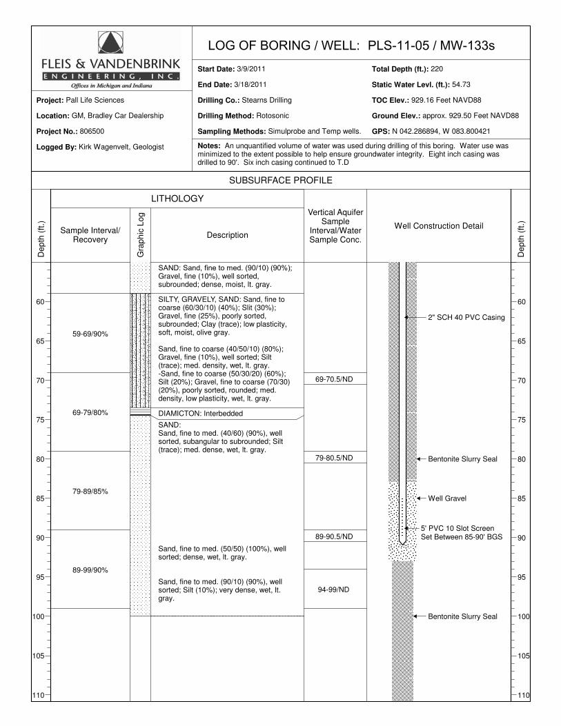
PLS-11-05 / MW-133d3/9/2011
3/18/2011
Stearns Drilling
Rotosonic
Simulprobe and Temp wells.
220
54.23
928.94 Feet NAVD88
approx. 929.50 Feet NAVD88
N 042.286894, W 083.800420
GM, Bradley Car Dealership
806500
Pall Life Sciences
Kirk Wagenvelt, Geologist
0-9/30%
9-19/75%
19-29/80%
29-39/100%
39-49/100%
49-59/100%
Ground Surface
4" Asphalt
DIAMICTON:Clay (40%); Silt (30%); Sand, fine to coarse (70/20/10) (20%); Gravel, fine to coarse (60/40) (10%), poorly sorted, subangular to subrounded; moderate plasticity, very soft, dry, green-gray, organic matter (roots/leaves).
Clay (50%); Silt (20%); Sand, fine to coarse (50/20/30) (20%); Gravel fine to coarse (60/40) (10%), poorly sorted, subrounded; low to moderate plasticity, med. stiff, lt. gray.
Same as above but soft.
Clay (50%); Silt (20%); Sand, fine to coarse (60/30/10) (20%); Gravel, fine to coarse (80/20) (10%), poorly sorted, subrounded; moderate plasticity, soft, lt. gray.
SILTY SAND: Sand, fine to coarse (50/35/15) (50%); Silt (30%); Gravel, fine to coarse (80/20) (10%), poorly sorted; Clay (trace); low plasticity, stiff, subangular, dry, lt. gray.
SILTY GRAVEL
DIAMICTON: Clay (40%); Silt (30%); Sand, fine to coarse (80/10/10) (20%): Gravel, fine (10%), poorly sorted, subrounded; low plasticity, very stiff, dry, olive gray.
SAND and GRAVEL: Sand, fine to coarse(20/60/10) (80%); Gravel, fine (10%) poorly sorted, angular to subangular; Silt (trace); loose, dry, lt. gray.
2" SCH 40 PVC Casing
Static Water Level
Notes: MW-133s,i & d were all set in the same boring. Geology, recovery information and vertical sampling results were taken from Log of Boring MW-133d. All water samples analyzed by PLS for 1,4 Dioxane. ND = <1.0 µg/L

LOG OF BORING / WELL:Start Date:
End Date:
Drilling Co.:
Drilling Method:
Sampling Methods:
Total Depth (ft.):
Static Water Levl. (ft.):
TOC Elev.:
Ground Elev.:
GPS:
Location:
Project No.:
Project:
Logged By:
SUBSURFACE PROFILE
LITHOLOGY
De
pth
(ft
.)
60
65
70
75
80
85
90
95
100
105
110
Sample Interval/Recovery
Gra
ph
ic L
og
Description
Vertical AquiferSample
Interval/WaterSample Conc.
Well Construction Detail
De
pth
(ft
.)
60
65
70
75
80
85
90
95
100
105
110
PLS-11-05 / MW-133d3/9/2011
3/18/2011
Stearns Drilling
Rotosonic
Simulprobe and Temp wells.
220
54.23
928.94 Feet NAVD88
approx. 929.50 Feet NAVD88
N 042.286894, W 083.800420
GM, Bradley Car Dealership
806500
Pall Life Sciences
Kirk Wagenvelt, Geologist
59-69/90%
69-79/80%
79-89/85%
89-99/90%
99-109/100%
SAND: Sand, fine to med. (90/10) (90%); Gravel, fine (10%), well sorted, subrounded; dense, moist, lt. gray.
SILTY, GRAVELY, SAND: Sand, fine tocoarse (60/30/10) (40%); Slit (30%); Gravel, fine (25%), poorly sorted, subrounded; Clay (trace); low plasticity, soft, moist, olive gray.
Sand, fine to coarse (40/50/10) (80%); Gravel, fine (10%), well sorted; Silt (trace); med. density, wet, lt. gray.-Sand, fine to coarse (50/30/20) (60%); Silt (20%); Gravel, fine to coarse (70/30) (20%), poorly sorted, rounded; med. density, low plasticity, wet, lt. gray.
DIAMICTON: Interbedded
SAND:Sand, fine to med. (40/60) (90%), well sorted, subangular to subrounded; Silt (trace); med. dense, wet, lt. gray.
Sand, fine to med. (50/50) (100%), well sorted; dense, wet, lt. gray.
Sand, fine to med. (90/10) (90%), well sorted; Silt (10%); very dense, wet, lt. gray.
69-70.5/ND
79-80.5/ND
89-90.5/ND
94-99/ND
104-109/ND
2" SCH 40 PVC Casing
Bentonite Slurry Seal
Notes: An unquantified volume of water was used during drilling of this boring. Water use was minimized to the extent possible to help ensure groundwater integrity. Eight inch casing was drilled to 90'. Six inch casing continued to T.D

LOG OF BORING / WELL:Start Date:
End Date:
Drilling Co.:
Drilling Method:
Sampling Methods:
Total Depth (ft.):
Static Water Levl. (ft.):
TOC Elev.:
Ground Elev.:
GPS:
Location:
Project No.:
Project:
Logged By:
SUBSURFACE PROFILE
LITHOLOGY
De
pth
(ft
.)
115
120
125
130
135
140
145
150
155
160
165
Sample Interval/Recovery
Gra
ph
ic L
og
Description
Vertical AquiferSample
Interval/WaterSample Conc.
Well Construction Detail
De
pth
(ft
.)
115
120
125
130
135
140
145
150
155
160
165
PLS-11-05 / MW-133d3/9/2011
3/18/2011
Stearns Drilling
Rotosonic
Simulprobe and Temp wells.
220
54.23
928.94 Feet NAVD88
approx. 929.50 Feet NAVD88
N 042.286894, W 083.800420
GM, Bradley Car Dealership
806500
Pall Life Sciences
Kirk Wagenvelt, Geologist
109-119/100%
119-129/100%
129-139/60%
139-149/100%
149-159/100%
159-169/70%
Sand, fine (95%), well sorted; Silt (trace); dense, wet, lt. gray.
Sand, fine to med. (40/60) (100%), well sorted, subangular; dense, wet, lt. gray.
Sand, fine to med. (90/10) (90%), well sorted; Silt (10%); med. density, wet, lt. gray.
Sand, fine (100%), well sorted; med. density, wet, lt. gray.
Sand, fine to med. (85/15) (90%), well
sorted; Silt (10%); med. density, wet, lt. gray.
Sand, fine to med. (75/25) (80%), well sorted; Silt (20%); med. density, low plasticity, olive gray.
114-119/ND
124-129/ND
134-139/ND
144-149/ND
154-159/ND
Bentonite Slurry Seal
Notes: Five foot vertical aquifer sampling intervals indicate the use of a temporary well.
LOG OF BORING / WELL:Start Date:
End Date:
Drilling Co.:
Drilling Method:
Sampling Methods:
Total Depth (ft.):
Static Water Levl. (ft.):
TOC Elev.:
Ground Elev.:
GPS:
Location:
Project No.:
Project:
Logged By:
SUBSURFACE PROFILE
LITHOLOGY
De
pth
(ft
.)
170
175
180
185
190
195
200
205
210
215
220
Sample Interval/Recovery
Gra
ph
ic L
og
Description
Vertical AquiferSample
Interval/WaterSample Conc.
Well Construction Detail
De
pth
(ft
.)
170
175
180
185
190
195
200
205
210
215
220
PLS-11-05 / MW-133d3/9/2011
3/18/2011
Stearns Drilling
Rotosonic
Simulprobe and Temp wells.
220
54.23
928.94 Feet NAVD88
approx. 929.50 Feet NAVD88
N 042.286894, W 083.800420
GM, Bradley Car Dealership
806500
Pall Life Sciences
Kirk Wagenvelt, Geologist
169-179/70%
SAND and GRAVEL: Sand, fine to coarse(20/40/40) (50%); Gravel, fine to coarse (60/40) (40%), cobbles, poorly sorted, rounded to well rounded; Silt (trace); wet, olive gray.-Sand, fine to coarse (20/55/25) (60%); Gravel, fine to coarse (60/40) (40%), cobbles, poorly sorted, subrounde; loose.
SILTY SAND: Sand, fine (50%);Silt (40%); Gravel, fine to coarse (60/40) (10%), poorly sorted, rounded; dense.
SAND and GRAVEL: Sand, fine to coarse(20/40/40) (55%); Gravel, fine to coarse (60/40) (30%), poorly sorted, rounded; Silt (10%); Clay (trace); loose, wet, lt. gray.
SILTY SAND: Sand, fine to coarse (30/60/10) (70%), well sorted; Silt (20%); Clay (trace); med. density, wet, lt. gray.
SAND and GRAVEL: Sand, fine to coarse(20/40/40) (60%); Gravel, fine to coarse (60/40) (30%), poorly sorted, subrounded; Silt (10%); loose, wet, lt. gray.
Sand, fine to coarse (20/30/40) (40%); Gravel, fine to coarse (40/60) (35%), cobbles, poorly sorted, rounded; Silt (25%); loose, moist, gray.
DIAMICTON:Silt (35%); Clay (35%); Sand, fine to coarse (40/40/20) (20%); Gravel, fine (10%), poorly sorted, subangular to rounded; med. plasticity, dry, olive gray.
Silt (40%); Sand, fine to coarse (70/20/10) (30%); Clay (20%); Gravel, fine to coarse (80/20) (10%), poorly sorted, subrounded; moderate plasticity, soft, wet, olive gray.
SHALE: Blue-Gray
164-169/ND
174-179/ND
5' PVC 10 Slot Screen Set Between 195-200' BGS
Well Gravel
Hole Plug
Hole Plug
Notes: Four inch cores were observed to determine the geology.

LOG OF BORING / WELL:Start Date:
End Date:
Drilling Co.:
Drilling Method:
Sampling Methods:
Total Depth (ft.):
Static Water Levl. (ft.):
TOC Elev.:
Ground Elev.:
GPS:
Location:
Project No.:
Project:
Logged By:
SUBSURFACE PROFILE
LITHOLOGY
De
pth
(ft
.)
0
5
10
15
20
25
30
35
40
45
50
55
Sample Interval/Recovery
Gra
ph
ic L
og
Description
Vertical AquiferSample
Interval/WaterSample Conc.
Well Construction Detail
De
pth
(ft
.)
0
5
10
15
20
25
30
35
40
45
50
55
PLS-11-05 / MW-133i3/9/2011
3/18/2011
Stearns Drilling
Rotosonic
Simulprobe and Temp wells.
220
54.58
929.03 Feet NAVD88
approx. 929.50 Feet NAVD88
N 042.286894, W 083,800421
GM, Bradley Car Dealership
806500
Pall Life Sciences
Kirk Wagenvelt, Geologist
0-9/30%
9-19/75%
19-29/80%
29-39/100%
39-49/100%
49-59/100%
Ground Surface
4" Asphalt
DIAMICTON:Clay (40%); Silt (30%); Sand, fine to coarse (70/20/10) (20%); Gravel, fine to coarse (60/40) (10%), poorly sorted, subangular to subrounded; moderate plasticity, very soft, dry, green-gray, organic matter (roots/leaves).
Clay (50%); Silt (20%); Sand, fine to coarse (50/20/30) (20%); Gravel fine to coarse (60/40) (10%), poorly sorted, subrounded; low to moderate plasticity, med. stiff, lt. gray.
Same as above but soft.
Clay (50%); Silt (20%); Sand, fine to coarse (60/30/10) (20%); Gravel, fine to coarse (80/20) (10%), poorly sorted, subrounded; moderate plasticity, soft, lt. gray.
SILTY SAND: Sand, fine to coarse (50/35/15) (50%); Silt (30%); Gravel, fine to coarse (80/20) (10%), poorly sorted; Clay (trace); low plasticity, stiff, subangular, dry, lt. gray.
SILTY GRAVEL
DIAMICTON: Clay (40%); Silt (30%); Sand, fine to coarse (80/10/10) (20%): Gravel, fine (10%), poorly sorted, subrounded; low plasticity, very stiff, dry, olive gray.
SAND and GRAVEL: Sand, fine to coarse(20/60/10) (80%); Gravel, fine (10%) poorly sorted, angular to subangular; Silt (trace); loose, dry, lt. gray.
2" SCH 40 PVC Casing
Static Water Level
Notes: MW-133s,i & d were all set in the same boring. Geology, recovery information and vertical sampling results were taken from Log of Boring MW-133d. All water samples analyzed by PLS for 1,4 Dioxane. ND = <1.0 µg/L

LOG OF BORING / WELL:Start Date:
End Date:
Drilling Co.:
Drilling Method:
Sampling Methods:
Total Depth (ft.):
Static Water Levl. (ft.):
TOC Elev.:
Ground Elev.:
GPS:
Location:
Project No.:
Project:
Logged By:
SUBSURFACE PROFILE
LITHOLOGY
De
pth
(ft
.)
60
65
70
75
80
85
90
95
100
105
110
Sample Interval/Recovery
Gra
ph
ic L
og
Description
Vertical AquiferSample
Interval/WaterSample Conc.
Well Construction Detail
De
pth
(ft
.)
60
65
70
75
80
85
90
95
100
105
110
PLS-11-05 / MW-133i3/9/2011
3/18/2011
Stearns Drilling
Rotosonic
Simulprobe and Temp wells.
220
54.58
929.03 Feet NAVD88
approx. 929.50 Feet NAVD88
N 042.286894, W 083,800421
GM, Bradley Car Dealership
806500
Pall Life Sciences
Kirk Wagenvelt, Geologist
59-69/90%
69-79/80%
79-89/85%
89-99/90%
99-109/100%
SAND: Sand, fine to med. (90/10) (90%); Gravel, fine (10%), well sorted, subrounded; dense, moist, lt. gray.
SILTY, GRAVELY, SAND: Sand, fine tocoarse (60/30/10) (40%); Slit (30%); Gravel, fine (25%), poorly sorted, subrounded; Clay (trace); low plasticity, soft, moist, olive gray.
Sand, fine to coarse (40/50/10) (80%); Gravel, fine (10%), well sorted; Silt (trace); med. density, wet, lt. gray.-Sand, fine to coarse (50/30/20) (60%); Silt (20%); Gravel, fine to coarse (70/30) (20%), poorly sorted, rounded; med. density, low plasticity, wet, lt. gray.
DIAMICTON: Interbedded
SAND:Sand, fine to med. (40/60) (90%), well sorted, subangular to subrounded; Silt (trace); med. dense, wet, lt. gray.
Sand, fine to med. (50/50) (100%), well sorted; dense, wet, lt. gray.
Sand, fine to med. (90/10) (90%), well sorted; Silt (10%); very dense, wet, lt. gray.
69-70.5/ND
79-80.5/ND
89-90.5/ND
94-99/ND
104-109/ND
2" SCH 40 PVC Casing
Bentonite Slurry Seal
Notes: An unquantified volume of water was used during drilling of this boring. Water use was minimized to the extent possible to help ensure groundwater integrity. Eight inch casing was drilled to 90'. Six inch casing continued to T.D

LOG OF BORING / WELL:Start Date:
End Date:
Drilling Co.:
Drilling Method:
Sampling Methods:
Total Depth (ft.):
Static Water Levl. (ft.):
TOC Elev.:
Ground Elev.:
GPS:
Location:
Project No.:
Project:
Logged By:
SUBSURFACE PROFILE
LITHOLOGY
De
pth
(ft
.)
115
120
125
130
135
140
145
150
155
160
165
Sample Interval/Recovery
Gra
ph
ic L
og
Description
Vertical AquiferSample
Interval/WaterSample Conc.
Well Construction Detail
De
pth
(ft
.)
115
120
125
130
135
140
145
150
155
160
165
PLS-11-05 / MW-133i3/9/2011
3/18/2011
Stearns Drilling
Rotosonic
Simulprobe and Temp wells.
220
54.58
929.03 Feet NAVD88
approx. 929.50 Feet NAVD88
N 042.286894, W 083,800421
GM, Bradley Car Dealership
806500
Pall Life Sciences
Kirk Wagenvelt, Geologist
109-119/100%
119-129/100%
129-139/60%
139-149/100%
149-159/100%
159-169/70%
Sand, fine (95%), well sorted; Silt (trace); dense, wet, lt. gray.
Sand, fine to med. (40/60) (100%), well sorted, subangular; dense, wet, lt. gray.
Sand, fine to med. (90/10) (90%), well sorted; Silt (10%); med. density, wet, lt. gray.
Sand, fine (100%), well sorted; med. density, wet, lt. gray.
Sand, fine to med. (85/15) (90%), well
sorted; Silt (10%); med. density, wet, lt. gray.
Sand, fine to med. (75/25) (80%), well sorted; Silt (20%); med. density, low plasticity, olive gray.
114-119/ND
124-129/ND
134-139/ND
144-149/ND
154-159/ND
Bentonite Slurry Seal
Well Gravel
Notes: Five foot vertical aquifer sampling intervals indicate the use of a temporary well.

LOG OF BORING / WELL:Start Date:
End Date:
Drilling Co.:
Drilling Method:
Sampling Methods:
Total Depth (ft.):
Static Water Levl. (ft.):
TOC Elev.:
Ground Elev.:
GPS:
Location:
Project No.:
Project:
Logged By:
SUBSURFACE PROFILE
LITHOLOGY
De
pth
(ft
.)
170
175
180
185
190
195
200
205
210
215
220
Sample Interval/Recovery
Gra
ph
ic L
og
Description
Vertical AquiferSample
Interval/WaterSample Conc.
Well Construction Detail
De
pth
(ft
.)
170
175
180
185
190
195
200
205
210
215
220
PLS-11-05 / MW-133i3/9/2011
3/18/2011
Stearns Drilling
Rotosonic
Simulprobe and Temp wells.
220
54.58
929.03 Feet NAVD88
approx. 929.50 Feet NAVD88
N 042.286894, W 083,800421
GM, Bradley Car Dealership
806500
Pall Life Sciences
Kirk Wagenvelt, Geologist
169-179/70%
SAND and GRAVEL: Sand, fine to coarse(20/40/40) (50%); Gravel, fine to coarse (60/40) (40%), cobbles, poorly sorted, rounded to well rounded; Silt (trace); wet, olive gray.-Sand, fine to coarse (20/55/25) (60%); Gravel, fine to coarse (60/40) (40%), cobbles, poorly sorted, subrounded; loose.
SILTY SAND:
164-169/ND
174-179/ND
5' PVC 10 Slot Screen Set Between 165-170' BGS
Hole plug
Notes: Four inch cores were observed to determine the geology.

LOG OF BORING / WELL:Start Date:
End Date:
Drilling Co.:
Drilling Method:
Sampling Methods:
Total Depth (ft.):
Static Water Levl. (ft.):
TOC Elev.:
Ground Elev.:
GPS:
Location:
Project No.:
Project:
Logged By:
SUBSURFACE PROFILE
LITHOLOGY
De
pth
(ft
.)
0
5
10
15
20
25
30
35
40
45
50
55
Sample Interval/Recovery
Gra
ph
ic L
og
Description
Vertical AquiferSample
Interval/WaterSample Conc.
Well Construction Detail
De
pth
(ft
.)
0
5
10
15
20
25
30
35
40
45
50
55
PLS-11-05 / MW-133s3/9/2011
3/18/2011
Stearns Drilling
Rotosonic
Simulprobe and Temp wells.
220
54.73
929.16 Feet NAVD88
approx. 929.50 Feet NAVD88
N 042.286894, W 083.800421
GM, Bradley Car Dealership
806500
Pall Life Sciences
Kirk Wagenvelt, Geologist
0-9/30%
9-19/75%
19-29/80%
29-39/100%
39-49/100%
49-59/100%
Ground Surface
4" Asphalt
DIAMICTON:Clay (40%); Silt (30%); Sand, fine to coarse (70/20/10) (20%); Gravel, fine to coarse (60/40) (10%), poorly sorted, subangular to subrounded; moderate plasticity, very soft, dry, green-gray, organic matter (roots/leaves).
Clay (50%); Silt (20%); Sand, fine to coarse (50/20/30) (20%); Gravel fine to coarse (60/40) (10%), poorly sorted, subrounded; low to moderate plasticity, med. stiff, lt. gray.
Same as above but soft.
Clay (50%); Silt (20%); Sand, fine to coarse (60/30/10) (20%); Gravel, fine to coarse (80/20) (10%), poorly sorted, subrounded; moderate plasticity, soft, lt. gray.
SILTY SAND: Sand, fine to coarse (50/35/15) (50%); Silt (30%); Gravel, fine to coarse (80/20) (10%), poorly sorted; Clay (trace); low plasticity, stiff, subangular, dry, lt. gray.
SILTY GRAVEL
DIAMICTON: Clay (40%); Silt (30%); Sand, fine to coarse (80/10/10) (20%): Gravel, fine (10%), poorly sorted, subrounded; low plasticity, very stiff, dry, olive gray.
SAND and GRAVEL: Sand, fine to coarse(20/60/10) (80%); Gravel, fine (10%) poorly sorted, angular to subangular; Silt (trace); loose, dry, lt. gray.
2" SCH 40 PVC Casing
Static Water Level
Notes: MW-133s,i & d were all set in the same boring. Geology, recovery information and vertical sampling results were taken from Log of Boring MW-133d. All water samples analyzed by PLS for 1,4 Dioxane. ND = <1.0 µg/L
LOG OF BORING / WELL:Start Date:
End Date:
Drilling Co.:
Drilling Method:
Sampling Methods:
Total Depth (ft.):
Static Water Levl. (ft.):
TOC Elev.:
Ground Elev.:
GPS:
Location:
Project No.:
Project:
Logged By:
SUBSURFACE PROFILE
LITHOLOGY
De
pth
(ft
.)
60
65
70
75
80
85
90
95
100
105
110
Sample Interval/Recovery
Gra
ph
ic L
og
Description
Vertical AquiferSample
Interval/WaterSample Conc.
Well Construction Detail
De
pth
(ft
.)
60
65
70
75
80
85
90
95
100
105
110
PLS-11-05 / MW-133s3/9/2011
3/18/2011
Stearns Drilling
Rotosonic
Simulprobe and Temp wells.
220
54.73
929.16 Feet NAVD88
approx. 929.50 Feet NAVD88
N 042.286894, W 083.800421
GM, Bradley Car Dealership
806500
Pall Life Sciences
Kirk Wagenvelt, Geologist
59-69/90%
69-79/80%
79-89/85%
89-99/90%
SAND: Sand, fine to med. (90/10) (90%); Gravel, fine (10%), well sorted, subrounded; dense, moist, lt. gray.
SILTY, GRAVELY, SAND: Sand, fine tocoarse (60/30/10) (40%); Slit (30%); Gravel, fine (25%), poorly sorted, subrounded; Clay (trace); low plasticity, soft, moist, olive gray.
Sand, fine to coarse (40/50/10) (80%); Gravel, fine (10%), well sorted; Silt (trace); med. density, wet, lt. gray.-Sand, fine to coarse (50/30/20) (60%); Silt (20%); Gravel, fine to coarse (70/30) (20%), poorly sorted, rounded; med. density, low plasticity, wet, lt. gray.
DIAMICTON: Interbedded
SAND:Sand, fine to med. (40/60) (90%), well sorted, subangular to subrounded; Silt (trace); med. dense, wet, lt. gray.
Sand, fine to med. (50/50) (100%), well sorted; dense, wet, lt. gray.
Sand, fine to med. (90/10) (90%), well sorted; Silt (10%); very dense, wet, lt. gray.
69-70.5/ND
79-80.5/ND
89-90.5/ND
94-99/ND
2" SCH 40 PVC Casing
Bentonite Slurry Seal
Bentonite Slurry Seal
5' PVC 10 Slot Screen Set Between 85-90' BGS
Well Gravel
Notes: An unquantified volume of water was used during drilling of this boring. Water use was minimized to the extent possible to help ensure groundwater integrity. Eight inch casing was drilled to 90'. Six inch casing continued to T.D

LOG OF BORING / WELL:Start Date:
End Date:
Drilling Co.:
Drilling Method:
Sampling Methods:
Total Depth (ft.):
Static Water Levl. (ft.):
TOC Elev.:
Ground Elev.:
GPS:
Location:
Project No.:
Project:
Logged By:
SUBSURFACE PROFILE
LITHOLOGY
De
pth
(ft
.)
0
5
10
15
20
25
30
35
40
45
50
55
Sample Interval/Recovery
Gra
ph
ic L
og
Description
Vertical AquiferSample
Interval/WaterSample Conc.
Well Construction Detail
De
pth
(ft
.)
0
5
10
15
20
25
30
35
40
45
50
55
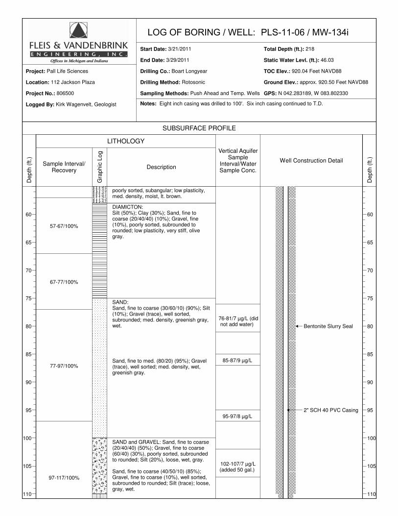
PLS-11-06 / MW-134d3/21/2011
3/29/2011
Boart Longyear
Rotosonic
Push Ahead and Temp. Wells
218
46.12
920.07 Feet NAVD88
approx. 920.50 Feet NAVD88
N 042.283190, W 083.802331
112 Jackson Plaza
806500
Pall Life Sciences
Kirk Wagenvelt, Geologist
0-7/90%
7-17/90%
17-27/90%
27-47/80%
47-57/90%
Ground Surface
SILTY SAND: Silt (60%); Sand, fine tocoarse (60/20/20) (30%); Clay (10%); low plasticity, loose, organic matter, brown.
SAND and GRAVEL: Gravel, fine (70%); Silt (20%); Sand, fine to med. (60/40) (10%), poorly sorted; loose, brown.
Sand, fine to coarse (20/50/30) (60%); Gravel (30%), poorly sorted, rounded; Silt (10%); loose, dry, lt. brown.-Sand, fine to coarse (20/50/30) (50%); Gravel, fine to coarse (90/10) (30%), poorly sorted, rounded; Silt (20%); low plasticity, loose, dry, lt. brown.
SILTY SAND: Sand, fine to coarse(30/50/20) (50%); Silt (40%); Gravel, fine (10%); poorly sorted, rounded; low plasticity, loose, wet, brown.
CLAY: high plasticity, gray-brown mottled.
SILT: moderate plasticity, brown.
SAND: Sand, fine to coarse (20/40/40)(70%); Silt (20%); Gravel, fine (10%), poorly sorted, subangular, med. dense, dry, brown.
CLAY: Clay (80%); Silt (10%); Gravel (trace), poorly sorted, subangular; moderate plasticity; soft, brown-gray, dry.
DIAMICTON: Silt (40%); Sand, fine to coarse (60/30/10) (25%); Clay (20%); Gravel, fine (trace), poorly sorted; stiff, gray.
SILTY SAND: Sand, fine to coarse (20/50/30) (60%); Silt, (20%); Gravel, fine (20%); poorly sorted, subrounded; loose, wet, gray.
DIAMICTON: Clay (50%); Sand, fine tocoarse (40/40/20) (25%); Silt (20%); Gravel, fine (trace), poorly sorted; moderate plasticity, med. stiff, dry, gray-brown.
SILTY SAND: Sand, fine to coarse (20/70/10) (65%); Silt (25%); Gravel, fine (10%),
17-22/ND (did not add water)
37-42/ND (did not add water)
2.5" SCH 80 PVC Casing
Static Water Level
Notes: MW-134s,i & d were all set in the same boring. Geology, recovery information and vertical sampling results were taken from Log of Boring MW-134d. All water samples analyzed by PLS for 1,4 Dioxane. ND = <1.0 µg/L

LOG OF BORING / WELL:Start Date:
End Date:
Drilling Co.:
Drilling Method:
Sampling Methods:
Total Depth (ft.):
Static Water Levl. (ft.):
TOC Elev.:
Ground Elev.:
GPS:
Location:
Project No.:
Project:
Logged By:
SUBSURFACE PROFILE
LITHOLOGY
De
pth
(ft
.)
60
65
70
75
80
85
90
95
100
105
110
Sample Interval/Recovery
Gra
ph
ic L
og
Description
Vertical AquiferSample
Interval/WaterSample Conc.
Well Construction Detail
De
pth
(ft
.)
60
65
70
75
80
85
90
95
100
105
110
PLS-11-06 / MW-134d3/21/2011
3/29/2011
Boart Longyear
Rotosonic
Push Ahead and Temp. Wells
218
46.12
920.07 Feet NAVD88
approx. 920.50 Feet NAVD88
N 042.283190, W 083.802331
112 Jackson Plaza
806500
Pall Life Sciences
Kirk Wagenvelt, Geologist
57-67/100%
67-77/100%
77-97/100%
97-117/100%
poorly sorted, subangular; low plasticity, med. density, moist, lt. brown.
DIAMICTON: Silt (50%); Clay (30%); Sand, fine to coarse (20/40/40) (10%); Gravel, fine (10%), poorly sorted, subrounded to rounded; low plasticity, very stiff, olive gray.
SAND:Sand, fine to coarse (30/60/10) (90%); Silt (10%); Gravel (trace), well sorted, subrounded; med. density, greenish gray, wet.
Sand, fine to med. (80/20) (95%); Gravel (trace), well sorted; med. density, wet, greenish gray.
SAND and GRAVEL: Sand, fine to coarse(20/40/40) (50%); Gravel, fine to coarse (60/40) (30%), poorly sorted, subrounded to rounded; Silt (20%), loose, wet, gray.
Sand, fine to coarse (40/50/10) (85%); Gravel, fine to coarse (10%), well sorted, subrounded to rounded; Silt (trace); loose, gray, wet.
76-81/7 µg/L (did not add water)
85-87/9 µg/L
95-97/8 µg/L
102-107/7 µg/L (added 50 gal.)
Bentonite Slurry Seal
Notes: Eight inch casing was drilled to 100'. Six inch casing continued to T.D.

LOG OF BORING / WELL:Start Date:
End Date:
Drilling Co.:
Drilling Method:
Sampling Methods:
Total Depth (ft.):
Static Water Levl. (ft.):
TOC Elev.:
Ground Elev.:
GPS:
Location:
Project No.:
Project:
Logged By:
SUBSURFACE PROFILE
LITHOLOGY
De
pth
(ft
.)
115
120
125
130
135
140
145
150
155
160
165
Sample Interval/Recovery
Gra
ph
ic L
og
Description
Vertical AquiferSample
Interval/WaterSample Conc.
Well Construction Detail
De
pth
(ft
.)
115
120
125
130
135
140
145
150
155
160
165
PLS-11-06 / MW-134d3/21/2011
3/29/2011
Boart Longyear
Rotosonic
Push Ahead and Temp. Wells
218
46.12
920.07 Feet NAVD88
approx. 920.50 Feet NAVD88
N 042.283190, W 083.802331
112 Jackson Plaza
806500
Pall Life Sciences
Kirk Wagenvelt, Geologist
117-127/100%
127-137/70%
137-147/100%
147-157/40%
157-167/30%
SANDY SILT:Silt (90%); Sand (trace); Gravel (trace), subrounded; low plasticity, stiff, dry, olive gray.
SILT: Silt (90%); Clay (10%); low plasticity, stiff, moist, olive gray.
Clay lenses.
Silt (40%); Sand, fine to coarse (50/30/20) (25%); Gravel, fine to coarse (40/60) (25%), cobbles, poorly sorted, rounded; Clay (10%); gray.
SAND and GRAVEL:Sand, fine to coarse (20/30/50) (50%); Gravel, fine to coarse (60/40) (35%); poorly sorted, subrounded to rounded; Silt (10%); Clay (trace), loose, wet, gray.
Color changes to brown.
Sand, fine to coarse (40/40/20) (65%); Gravel, fine to coarse (80/20) (25%), moderately sorted, subangular to rounded; Silt (10%); loose, wet, dk. brown.
Sand, fine to coarse (50/40/10) (60%); Silt (20%); Gravel, fine to coarse (80/20) (10%), poorly sorted, subrounded; Clay (10%); med. density, low plasticity, moist, lt. gray.
Sand, fine to coarse (40/40/20) (50%); Gravel, fine to coarse (60/40) (40%), poorly sorted, subrounded; Silt (10%); loose, moist, gray.
Gravel, fine to coarse (50/50) (50%), cobbles, poorly sorted, subrounded; Sand, fine to coarse (20/50/30) (40%); Silt (10%); loose, wet, gray.
132-137/2 µg/L (added 50 gal.)
142-147/4 µg/L (added 300 gal.)
152-157/9 µg/L (added 200 gal.)
162-167/3 µg/L
2.5" SCH 80 PVC Casing
Hole Plug
Notes: Five foot vertical aquifer sampling intervals indicate the use of a temporary well.

LOG OF BORING / WELL:Start Date:
End Date:
Drilling Co.:
Drilling Method:
Sampling Methods:
Total Depth (ft.):
Static Water Levl. (ft.):
TOC Elev.:
Ground Elev.:
GPS:
Location:
Project No.:
Project:
Logged By:
SUBSURFACE PROFILE
LITHOLOGY
De
pth
(ft
.)
170
175
180
185
190
195
200
205
210
215
220
Sample Interval/Recovery
Gra
ph
ic L
og
Description
Vertical AquiferSample
Interval/WaterSample Conc.
Well Construction Detail
De
pth
(ft
.)
170
175
180
185
190
195
200
205
210
215
220
PLS-11-06 / MW-134d3/21/2011
3/29/2011
Boart Longyear
Rotosonic
Push Ahead and Temp. Wells
218
46.12
920.07 Feet NAVD88
approx. 920.50 Feet NAVD88
N 042.283190, W 083.802331
112 Jackson Plaza
806500
Pall Life Sciences
Kirk Wagenvelt, Geologist
167-177/80%
177-187/100%
187-197/100%
197-207/80%
207-217/100%
Sand, fine to coarse (30/50/20) (50%); Gravel, fine to coarse (60/40) (30%), cobbles, poorly sorted, subrounded; Silt
(20%), loose, wet, gray.
SILTY CLAY: Clay (60%); Silt (20%); Sand, fine to coarse (70/20/10) (10%); Gravel fine (trace), poorly sorted, subangular; high plasticity, med. stiff, cohesive, dry, olive gray.
DIAMICTON: Silt (70%); Sand, fine tocoarse (40/20/40) (15%); Gravel, fine (10%), poorly sorted, subangular; Clay (trace); low plasticity, hard, dry, olive gray.
SILTY SAND: Sand, fine to coarse (30/50/20) (35%); Silt (30%); Clay (20%); Gravel, fine to coarse (70/30) (15%), poorly sorted, subangular to rounded; very dense, moist, olive gray.-Diamicton interbed at 193'.
SAND and GRAVEL: Sand, fine to coarse(30/60/10) (50%); Gravel, fine to coarse (70/30) (40%), cobbles, poorly sorted, subrounded; Silt (10%); med. density, moist, olive gray.
SILTY SAND: Sand, fine to med. (90/10) (80%); Silt (15%); Gravel (trace), well sorted; med. density, moist, olive gray.
SAND and GRAVEL: Sand, fine to coarse(30/60/10) (60%); Gravel, fine to coarse (70/30) (40%), cobbles, poorly sorted, subrounded; med. density, wet, olive gray.
SHALE TRANSITON: Weathered shale;Clay; Sand and Gravel (fine), poorly sorted, subrounded: high plasticity, hard.
SHALE: Blue-Gray
172-177/5 µg/L (added 300 gal.)
192-197/4 µg/L (added 200 gal.)
202-207/2 µg/L (added 400 gal.)
Hole Plug
Hole Plug
5' PVC 10 Slot Screen Set Between 197-202' BGS
Well Gravel
Notes: Four inch cores were observed to determine the geology. Blue-gray shale was first observed on 3/27/11 at 212' BGS.
(added 200 gal.)

LOG OF BORING / WELL:Start Date:
End Date:
Drilling Co.:
Drilling Method:
Sampling Methods:
Total Depth (ft.):
Static Water Levl. (ft.):
TOC Elev.:
Ground Elev.:
GPS:
Location:
Project No.:
Project:
Logged By:
SUBSURFACE PROFILE
LITHOLOGY
De
pth
(ft
.)
0
5
10
15
20
25
30
35
40
45
50
55
Sample Interval/Recovery
Gra
ph
ic L
og
Description
Vertical AquiferSample
Interval/WaterSample Conc.
Well Construction Detail
De
pth
(ft
.)
0
5
10
15
20
25
30
35
40
45
50
55
PLS-11-06 / MW-134i3/21/2011
3/29/2011
Boart Longyear
Rotosonic
Push Ahead and Temp. Wells
218
46.03
920.04 Feet NAVD88
approx. 920.50 Feet NAVD88
N 042.283189, W 083.802330
112 Jackson Plaza
806500
Pall Life Sciences
Kirk Wagenvelt, Geologist
0-7/90%
7-17/90%
17-27/90%
27-47/80%
47-57/90%
Ground Surface
SILTY SAND: Silt (60%); Sand, fine tocoarse (60/20/20) (30%); Clay (10%); low plasticity, loose, organic matter, brown.
SAND and GRAVEL: Gravel, fine (70%); Silt (20%); Sand, fine to med. (60/40) (10%), poorly sorted; loose, brown.
Sand, fine to coarse (20/50/30) (60%); Gravel (30%), poorly sorted, rounded; Silt (10%); loose, dry, lt. brown.-Sand, fine to coarse (20/50/30) (50%); Gravel, fine to coarse (90/10) (30%), poorly sorted, rounded; Silt (20%); low plasticity, loose, dry, lt. brown.
SILTY SAND: Sand, fine to coarse(30/50/20) (50%); Silt (40%); Gravel, fine (10%); poorly sorted, rounded; low plasticity, loose, wet, brown.
CLAY: high plasticity, gray-brown mottled.
SILT: moderate plasticity, brown.
SAND: Sand, fine to coarse (20/40/40)(70%); Silt (20%); Gravel, fine (10%), poorly sorted, subangular, med. dense, dry, brown.
CLAY: Clay (80%); Silt (10%); Gravel (trace), poorly sorted, subangular; moderate plasticity; soft, brown-gray, dry.
DIAMICTON: Silt (40%); Sand, fine to coarse (60/30/10) (25%); Clay (20%); Gravel, fine (trace), poorly sorted; stiff, gray.
SILTY SAND: Sand, fine to coarse (20/50/30) (60%); Silt, (20%); Gravel, fine (20%); poorly sorted, subrounded; loose, wet, gray.
DIAMICTON: Clay (50%); Sand, fine tocoarse (40/40/20) (25%); Silt (20%); Gravel, fine (trace), poorly sorted; moderate plasticity, med. stiff, dry, gray-brown.
SILTY SAND: Sand, fine to coarse (20/70/10) (65%); Silt (25%); Gravel, fine (10%),
17-22/ND (did not add water)
37-42/ND (did not add water)
2" SCH 40 PVC Casing
Static Water Level
Notes: MW-134s,i & d were all set in the same boring. Geology, recovery information and vertical sampling results were taken from Log of Boring MW-134d. All water samples analyzed by PLS for 1,4 Dioxane. ND = <1.0 µg/L
LOG OF BORING / WELL:Start Date:
End Date:
Drilling Co.:
Drilling Method:
Sampling Methods:
Total Depth (ft.):
Static Water Levl. (ft.):
TOC Elev.:
Ground Elev.:
GPS:
Location:
Project No.:
Project:
Logged By:
SUBSURFACE PROFILE
LITHOLOGY
De
pth
(ft
.)
60
65
70
75
80
85
90
95
100
105
110
Sample Interval/Recovery
Gra
ph
ic L
og
Description
Vertical AquiferSample
Interval/WaterSample Conc.
Well Construction Detail
De
pth
(ft
.)
60
65
70
75
80
85
90
95
100
105
110
PLS-11-06 / MW-134i3/21/2011
3/29/2011
Boart Longyear
Rotosonic
Push Ahead and Temp. Wells
218
46.03
920.04 Feet NAVD88
approx. 920.50 Feet NAVD88
N 042.283189, W 083.802330
112 Jackson Plaza
806500
Pall Life Sciences
Kirk Wagenvelt, Geologist
57-67/100%
67-77/100%
77-97/100%
97-117/100%
poorly sorted, subangular; low plasticity, med. density, moist, lt. brown.
DIAMICTON: Silt (50%); Clay (30%); Sand, fine to coarse (20/40/40) (10%); Gravel, fine (10%), poorly sorted, subrounded to rounded; low plasticity, very stiff, olive gray.
SAND:Sand, fine to coarse (30/60/10) (90%); Silt (10%); Gravel (trace), well sorted, subrounded; med. density, greenish gray, wet.
Sand, fine to med. (80/20) (95%); Gravel (trace), well sorted; med. density, wet, greenish gray.
SAND and GRAVEL: Sand, fine to coarse(20/40/40) (50%); Gravel, fine to coarse (60/40) (30%), poorly sorted, subrounded to rounded; Silt (20%), loose, wet, gray.
Sand, fine to coarse (40/50/10) (85%); Gravel, fine to coarse (10%), well sorted, subrounded to rounded; Silt (trace); loose, gray, wet.
76-81/7 µg/L (did not add water)
85-87/9 µg/L
95-97/8 µg/L
102-107/7 µg/L (added 50 gal.)
2" SCH 40 PVC Casing
Bentonite Slurry Seal
Notes: Eight inch casing was drilled to 100'. Six inch casing continued to T.D.

LOG OF BORING / WELL:Start Date:
End Date:
Drilling Co.:
Drilling Method:
Sampling Methods:
Total Depth (ft.):
Static Water Levl. (ft.):
TOC Elev.:
Ground Elev.:
GPS:
Location:
Project No.:
Project:
Logged By:
SUBSURFACE PROFILE
LITHOLOGY
De
pth
(ft
.)
115
120
125
130
135
140
145
150
155
160
165
Sample Interval/Recovery
Gra
ph
ic L
og
Description
Vertical AquiferSample
Interval/WaterSample Conc.
Well Construction Detail
De
pth
(ft
.)
115
120
125
130
135
140
145
150
155
160
165
PLS-11-06 / MW-134i3/21/2011
3/29/2011
Boart Longyear
Rotosonic
Push Ahead and Temp. Wells
218
46.03
920.04 Feet NAVD88
approx. 920.50 Feet NAVD88
N 042.283189, W 083.802330
112 Jackson Plaza
806500
Pall Life Sciences
Kirk Wagenvelt, Geologist
117-127/100%
127-137/70%
137-147/100%
147-157/40%
157-167/30%
SANDY SILT:Silt (90%); Sand (trace); Gravel (trace), subrounded; low plasticity, stiff, dry, olive gray.
SILT: Silt (90%); Clay (10%); low plasticity, stiff, moist, olive gray.
Clay lenses.
Silt (40%); Sand, fine to coarse (50/30/20) (25%); Gravel, fine to coarse (40/60) (25%), cobbles, poorly sorted, rounded; Clay (10%); gray.
SAND and GRAVEL:Sand, fine to coarse (20/30/50) (50%); Gravel, fine to coarse (60/40) (35%); poorly sorted, subrounded to rounded; Silt (10%); Clay (trace), loose, wet, gray.
Color changes to brown.
Sand, fine to coarse (40/40/20) (65%); Gravel, fine to coarse (80/20) (25%), moderately sorted, subangular to rounded; Silt (10%); loose, wet, dk. brown.
Sand, fine to coarse (50/40/10) (60%); Silt (20%); Gravel, fine to coarse (80/20) (10%), poorly sorted, subrounded; Clay (10%); med. density, low plasticity, moist, lt. gray.
Sand, fine to coarse (40/40/20) (50%); Gravel, fine to coarse (60/40) (40%), poorly sorted, subrounded; Silt (10%); loose, moist, gray.
Gravel, fine to coarse (50/50) (50%), cobbles, poorly sorted, subrounded; Sand, fine to coarse (20/50/30) (40%); Silt (10%); loose, wet, gray.
132-137/2 µg/L (added 50 gal.)
142-147/4 µg/L (added 300 gal.)
152-157/9 µg/L (added 200 gal.)
2" SCH 40 PVC Casing
Hole Plug
Hole Plug
5' PVC 10 Slot Screen Set Between 152-157' BGS
Well Gravel
Notes: Five foot vertical aquifer sampling intervals indicate the use of a temporary well.
162-167/3 µg/L (added 200 gal.)

LOG OF BORING / WELL:Start Date:
End Date:
Drilling Co.:
Drilling Method:
Sampling Methods:
Total Depth (ft.):
Static Water Levl. (ft.):
TOC Elev.:
Ground Elev.:
GPS:
Location:
Project No.:
Project:
Logged By:
SUBSURFACE PROFILE
LITHOLOGY
De
pth
(ft
.)
0
5
10
15
20
25
30
35
40
45
50
55
Sample Interval/Recovery
Gra
ph
ic L
og
Description
Vertical AquiferSample
Interval/WaterSample Conc.
Well Construction Detail
De
pth
(ft
.)
0
5
10
15
20
25
30
35
40
45
50
55
PLS-11-06 / MW-134s3/21/2011
3/29/2011
Boart Longyear
Rotosonic
Push Ahead and Temp. Wells
218
46.48
920.00 Feet NAVD88
approx. 920.50 Feet NAVD88
N 042.283190, W 083.802331
112 Jackson Plaza
806500
Pall Life Sciences
Kirk Wagenvelt, Geologist
0-7/90%
7-17/90%
17-27/90%
27-47/80%
47-57/90%
Ground Surface
SILTY SAND: Silt (60%); Sand, fine tocoarse (60/20/20) (30%); Clay (10%); low plasticity, loose, organic matter, brown.
SAND and GRAVEL: Gravel, fine (70%); Silt (20%); Sand, fine to med. (60/40) (10%), poorly sorted; loose, brown.
Sand, fine to coarse (20/50/30) (60%); Gravel (30%), poorly sorted, rounded; Silt (10%); loose, dry, lt. brown.-Sand, fine to coarse (20/50/30) (50%); Gravel, fine to coarse (90/10) (30%), poorly sorted, rounded; Silt (20%); low plasticity, loose, dry, lt. brown.
SILTY SAND: Sand, fine to coarse(30/50/20) (50%); Silt (40%); Gravel, fine (10%); poorly sorted, rounded; low plasticity, loose, wet, brown.
CLAY: high plasticity, gray-brown mottled.
SILT: moderate plasticity, brown.
SAND: Sand, fine to coarse (20/40/40)(70%); Silt (20%); Gravel, fine (10%), poorly sorted, subangular, med. dense, dry, brown.
CLAY: Clay (80%); Silt (10%); Gravel (trace), poorly sorted, subangular; moderate plasticity; soft, brown-gray, dry.
DIAMICTON: Silt (40%); Sand, fine to coarse (60/30/10) (25%); Clay (20%); Gravel, fine (trace), poorly sorted; stiff, gray.
SILTY SAND: Sand, fine to coarse (20/50/30) (60%); Silt, (20%); Gravel, fine (20%); poorly sorted, subrounded; loose, wet, gray.
DIAMICTON: Clay (50%); Sand, fine to coarse (40/40/20) (25%); Silt (20%); Gravel, fine (trace), poorly sorted; moderate plasticity, med. stiff, dry, gray-brown.
SILTY SAND: Sand, fine to coarse (20/70/10) (65%); Silt (25%); Gravel, fine (10%),
17-22/ND (did not add water)
37-42/ND (did not add water)
2" SCH 40 PVC Casing
Static Water Level
Notes: MW-134s,i & d were all set in the same boring. Geology, recovery information and vertical sampling results were taken from Log of Boring MW-134d. All water samples analyzed by PLS for 1,4 Dioxane. ND = <1.0 µg/L

LOG OF BORING / WELL:Start Date:
End Date:
Drilling Co.:
Drilling Method:
Sampling Methods:
Total Depth (ft.):
Static Water Levl. (ft.):
TOC Elev.:
Ground Elev.:
GPS:
Location:
Project No.:
Project:
Logged By:
SUBSURFACE PROFILE
LITHOLOGY
De
pth
(ft
.)
60
65
70
75
80
85
90
95
100
105
110
Sample Interval/Recovery
Gra
ph
ic L
og
Description
Vertical AquiferSample
Interval/WaterSample Conc.
Well Construction Detail
De
pth
(ft
.)
60
65
70
75
80
85
90
95
100
105
110
PLS-11-06 / MW-134s3/21/2011
3/29/2011
Boart Longyear
Rotosonic
Push Ahead and Temp. Wells
218
46.48
920.00 Feet NAVD88
approx. 920.50 Feet NAVD88
N 042.283190, W 083.802331
112 Jackson Plaza
806500
Pall Life Sciences
Kirk Wagenvelt, Geologist
57-67/100%
67-77/100%
77-97/100%
97-117/100%
poorly sorted, subangular; low plasticity, med. density, moist, lt. brown.
DIAMICTON: Silt (50%); Clay (30%); Sand, fine to coarse (20/40/40) (10%); Gravel, fine (10%), poorly sorted, subrounded to rounded; low plasticity, very stiff, olive gray.
SAND:Sand, fine to coarse (30/60/10) (90%); Silt (10%); Gravel (trace), well sorted, subrounded; med. density, greenish gray, wet.
Sand, fine to med. (80/20) (95%); Gravel (trace), well sorted; med. density, wet, greenish gray.
SAND and GRAVEL: Sand, fine to coarse(20/40/40) (50%); Gravel, fine to coarse (60/40) (30%), poorly sorted, subrounded to rounded; Silt (20%), loose, wet, gray.
Sand, fine to coarse (40/50/10) (85%); Gravel, fine to coarse (10%), well sorted, subrounded to rounded; Silt (trace); loose, gray, wet.
76-81/7 µg/L (did not add water)
85-87/9 µg/L
95-97/8 µg/L
102-107/7 µg/L (added 50 gal.)
2" SCH 40 PVC Casing
Hole Plug
Bentonite Slurry Seal
5' PVC 10 Slot Screen Set Between 92-97' BGS
Well Gravel
Notes: Eight inch casing was drilled to 100'. Six inch casing continued to T.D.

ARTESIAN WELL AREA
LITTLELAKE
POND IIFORMER
SISTERLAKE
SECOND
THIRDSISTERLAKE
FIRSTSISTERLAKE
I-94
REDPONDGREEN
POND
H O N E Y
C R E E K
T R I B U T A R Y
Pall Life Sciences
CARETAKER'SCABIN AREA
PALL LIFE SCIENCESWASHTENAW COUNTY, MI
NORTH
- COMPLIANCE MONITOR WELL
- PROVISIONAL COMPLIANCE MONITOR WELL
- MONITORING WELL
- EXTRACTION WELL
- TEST BORING
PROHIBITION ZONE BOUNDARY
- EXPANDED PROHIBITION ZONE BOUNDARY
- LITTLE LAKE AREA SYSTEM
LEGEND
APRIL 2011
WESTERN AREA SYSTEMMONITORING PLAN
Hard copy isintended tobe 11"x17"
when plotted.
© Copyright2011 All Rights
Reserved.
M:\Proj#
805010-810000\806500 Pall Corp - Project Pending\CAD
2009\Sheets\M
onitoring Plan\W
estern Area Com
pliance Plan-041211.dw
g, Layout, 4/12/2011 5:42:17 PM
,
DW
G To PD
F.pc3, 1:1

ARTESIAN WELL AREA
LITTLELAKE
POND IIFORMER
SISTERLAKE
SECOND
THIRDSISTERLAKE
FIRSTSISTERLAKE
I-94
REDPONDGREEN
POND
H O N E Y
C R E E K
T R I B U T A R Y
CARETAKER'SCABIN AREA
Pall Life Sciences
8585
85
85
PALL LIFE SCIENCESWASHTENAW COUNTY, MI
NORTH
- COMPLIANCE MONITOR WELL
- PROVISIONAL COMPLIANCE MONITOR WELL
- MONITORING WELL
- EXTRACTION WELL
- TEST BORING
- PROHIBITION ZONE BOUNDARY
- EXPANDED PROHIBITION ZONE BOUNDARY
- LITTLE LAKE AREA SYSTEM
- CURRENT INTERPRETATION OF 85 µg/L ISOCONCENTRATION LINE
LEGEND
APRIL 2011
WESTERN AREA SYSTEMMONITORING PLAN
Hard copy isintended tobe 11"x17"
when plotted.
© Copyright2011 All Rights
Reserved.
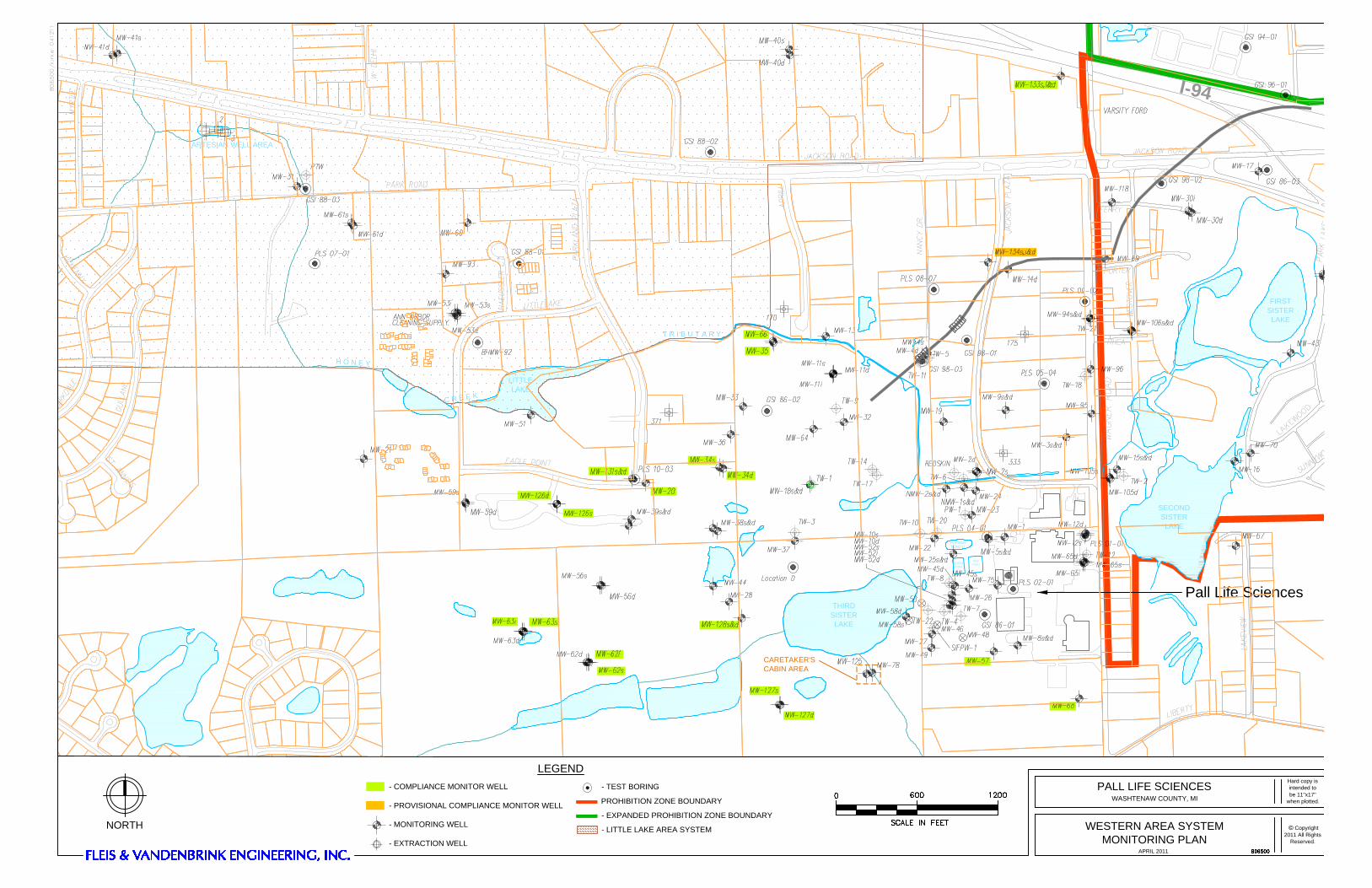
ARTESIAN WELL AREA
LITTLELAKE
POND IIFORMER
SISTERLAKE
SECOND
THIRDSISTERLAKE
FIRSTSISTERLAKE
I-94
REDPONDGREEN
POND
H O N E Y
C R E E K
T R I B U T A R Y
CARETAKER'SCABIN AREA
Pall Life Sciences
PALL LIFE SCIENCESWASHTENAW COUNTY, MI
NORTH
- COMPLIANCE MONITOR WELL
- PROVISIONAL COMPLIANCE MONITOR WELL
- MONITORING WELL
- EXTRACTION WELL
- TEST BORING
PROHIBITION ZONE BOUNDARY
- EXPANDED PROHIBITION ZONE BOUNDARY
- LITTLE LAKE AREA SYSTEM
LEGEND
APRIL 2011
WESTERN AREA SYSTEMMONITORING PLAN
Hard copy isintended tobe 11"x17"
when plotted.
© Copyright2011 All Rights
Reserved.
Related Documents