PALETTA INTERNATIONAL LIMITED FUNCTIONAL SERVICING and STORMWATER MANAGEMENT REPORT EAGLE HEIGHTS & TAYLOR PROPERTY CITY OF BURLINGTON Updated June 2010 Addendum Revised Section 7 to Address Region of Halton Comments March 2013 By: Metropolitan Consulting Inc. 1422 Ontario Street Burlington, ON L7S 1G4

Welcome message from author
This document is posted to help you gain knowledge. Please leave a comment to let me know what you think about it! Share it to your friends and learn new things together.
Transcript

PALETTA INTERNATIONAL LIMITED
FUNCTIONAL SERVICING and STORMWATER MANAGEMENT REPORT
EAGLE HEIGHTS & TAYLOR PROPERTY
CITY OF BURLINGTON
Updated June 2010
Addendum
Revised Section 7 to Address Region of Halton Comments March 2013
By:
Metropolitan Consulting Inc. 1422 Ontario Street
Burlington, ON L7S 1G4

Eagle Height s /Taylor P roper ty U p d a t e t o Fun c t io n a l Se rv i c in g & S to r mwat e r Man ag e men t Rep o r t
Ad d en d u m R evi sed S ec t io n 7
Metropol i tan Co nsul t ing Inc . i i March 2013
TABLE OF CONTENTS
Page INTRODUCTION 1 7.0 WATER DISTRIBUTION & WASTEWATER COLLECTION 2 7.1 Water & Wastewater Treatment 2 7.2 Existing Water Distribution System 2 7.3 Proposed Water Pressure Zones 3 7.4 Master Plan Proposed Water Distribution works 4 7.5 Zone B2 4 7.6 Zone B3A 5 7.7 Zones B4A & B5A 6 7.8 Watermain Modeling 7 7.9 Existing Wastewater Infrastructure 11 7.10 Proposed Wastewater Collection System 12 7.11 Development Phasing 15 7.12 Phase 1 Water & Wastewater Servicing 16 7.13 Phase 2 Water & Wastewater Servicing 17 7.14 Stormwater Management & Regional Services 17
APPENDICES A Watermain Modeling B Revised Sanitary Sewer Design Sheets C Extracts from Halton Region letter dated February 27, 2012

Eagle Height s /Taylor P roper ty U p d a t e t o Fun c t io n a l Se rv i c in g & S to r mwat e r Man ag e men t Rep o r t
Ad d en d u m R evi sed S ec t io n 7
Metropol i tan Co nsul t ing Inc . i i i March 2013
FIGURES
7-10 Existing Water Distribution System At Back of Report
7-11 Proposed Water Distribution System At Back of Report
7-12 WaterCAD Model Schematic At Back of Report
7-13 Zone B3A Reservoir Alternative Locations Following Page 5
7-14 North Aldershot Wastewater Drainage Area At Back of Report
7-15 Proposed Wastewater Collection System At Back of Report
7-16 Phasing Plan 2013 At Back of Report
The following f igures in the June 2010 Update Report remain valid:
7-4 Sanitary Sewer Profiles 1
7-5 Sanitary Sewer Profiles 2
7-6 Sanitary Sewer Profiles 3

Eagle Height s /Taylor P roper ty U p d a t e t o Fun c t io n a l Se rv i c in g & S to r mwat e r Man ag e men t Rep o r t
Ad d en d u m R evi sed S ec t io n 7
Metropol i tan Co nsul t ing Inc . 1 March 2013
INTRODUCTION
The Functional Servicing & Stormwater Management report for Eagle
Heights and the Taylor properties was originally prepared in March 2007
to support applications to amend the Draft Plans of Subdivision, Official
Plan and Zoning bylaws for the 93ha & 9ha parcels of land within the
Central Sector of the North Aldershot Area of the City of Burlington.
The proposed developments are owned by Paletta International
Corporation. The report showed how the proposed developments could be
graded, serviced internally and external ly and provided with storm water
management.
The report was updated in June 2010 to address comments by
Conservation Halton regarding stormwater management and by the
Region of Halton regarding water and waste water servicing.
This Addendum revises and replaces Section 7 of the Updated Report to
address further comments by the Region regarding water and waste water
servicing contained in a let ter to the Ci ty of Burlington dated February
27, 2012 (see Appendix C).

Eagle Height s /Taylor P roper ty U p d a t e t o Fun c t io n a l Se rv i c in g & S to r mwat e r Man ag e men t Rep o r t
Ad d en d u m R evi sed S ec t io n 7
Metropol i tan Co nsul t ing Inc . 2 March 2013
7.0 WATER AND WASTEWATER
7.1 Water and Wastewater Treatment
The South Halton Water & Wastewater Master Plan Update, June 2008
and the Sustainable Halton Water and Wastewater Master Plan (30 day
review period completed November 14, 2011) includes the water and
wastewater servicing for areas of North Aldershot that are approved for
urban servicing. The Implementation of the Master Plan Update
preferred servicing strategy will ensure that adequate water and
wastewater treatment capacity is available for development on the Eagle
Heights and Taylor properties .
7.2 Existing Water Distribution System
The exist ing water distribution system is shown on Figure 7-10
There is an exist ing water reservoir on the west side of Waterdown Road
between Flatt Road and Craven Avenue. This reservoir supplies Zone
B1A by gravity via a 600mm watermain on Waterdown Road south of the
reservoir.
There is a 250mm Zone 5 equivalent main on Waterdown Road that
connects to the City of Hamilton dist r ibution system (Pressure Dist rict
16). This main was originally constructed to supply water from the
reservoir to the former Village of Waterdown. The pumping s tat ion at the
reservoir is now out of service and the 250mm main is gravity fed from

Eagle Height s /Taylor P roper ty U p d a t e t o Fun c t io n a l Se rv i c in g & S to r mwat e r Man ag e men t Rep o r t
Ad d en d u m R evi sed S ec t io n 7
Metropol i tan Co nsul t ing Inc . 3 March 2013
the Waterdown Standpipe under a ten year agreement between the Halton
Region and the City of Hamilton.
A 150mm main on Flatt Road is connected to the zone 5 watermain
result ing in relat ively high stat ic pressures (160 psi ).
South of the reservoir there is a pressure reducing valve on the Zone 5
watermain to service the exist ing residences on Nevarc, Craven and on
Waterdown Road in that vicinity. The watermain on Waterdown Road is
350mm and on Craven and Nevarc 150mm.
With the completion of the Waterdown Road / Hwy 403 intersection
improvements in 2010, the exist ing 300mm/350mm watermains on the
North Service Rd (NSR) and Panin Road have been switched from Zone
1A to Zone 2. The 350mm main on Waterdown Road has been replaced
by a 300mm Zone 2 main from Panin Road to the realigned NSR. A
Zone valve at the NSR is closed to isolate the Halton system from the
Hamilton fed system.
7.3 Proposed Water Pressure Zones
The ground elevation in North Aldershot varies from approx 117m at the
North Service Road to 220m at the intersection of Mountain Brow Road
and Waterdown Road (Hamilton/Burlington boundary). To service the
area will therefore require a number of pressure zones.
Pressure zones are proposed as follows:
Zone B2 Ground Elevations 97.5-134m
Zone B3A Ground Elevations 130-170m

Eagle Height s /Taylor P roper ty U p d a t e t o Fun c t io n a l Se rv i c in g & S to r mwat e r Man ag e men t Rep o r t
Ad d en d u m R evi sed S ec t io n 7
Metropol i tan Co nsul t ing Inc . 4 March 2013
Zone B4A Ground Elevations 165-205m
Zone B5A Ground Elevations above 200m (above 165m for Waterdown
Road on an interim basis)
7.4 Master Plan Proposed Water Distribution Works
The 2008 Master Plan Update and the 2011 Halton Sustainable Water &
Wastewater Master Plan propose a Zone B3A reservoir and pumping from
the Waterdown Road reservoir for zones B2, B3A & B5A. Zone B4A
would be fed from Zone B5A via PRVs. The Hamilton supply
connection to Zone B5A would be retained for emergency purposes.
The following capi tal works projects; al l funded from Development
Charges, and are identified in the Halton Master Plan:
ID 6863 Waterdown Rd Pump Station Expansion (Zones B2,B3A&B5A)
$2.279M
ID 3699 North Aldershot Reservoir (Zone B3A) $5.072M
ID 3700 400mm w/m from Waterdown Rd Pumping Stat ion to North
Aldershot reservoir (Zone B3A) $2.279M
ID 5881 400mm w/m on NSR from King Road to Waterdown Rd (Zone
B2) $6.589M
ID 6602 7 .5ML expansion to Waterdown Rd Reservoir $7.767M
All projects are scheduled for 2012-2016 except ID 6602 which is 2017-
2021.
7.5 Zone B2
When the Zone B2 portion of the Waterdown Rd pumping stat ion and the
400mm main on the NSR are constructed full Zone B2 pressures will be

Eagle Height s /Taylor P roper ty U p d a t e t o Fun c t io n a l Se rv i c in g & S to r mwat e r Man ag e men t Rep o r t
Ad d en d u m R evi sed S ec t io n 7
Metropol i tan Co nsul t ing Inc . 5 March 2013
available for the North Aldershot area from the NSR / Panin Road to
ground elevation 134m as shown on Figure 7-11. The exist ing residences
on Craven, Nevarc and Waterdown Road south of the reservoir should
then be converted to Zone B2. Proposed development in Zone B2 will
include the southern portion of Eagle Heights Sub-area 10, the “Morgante
property” and the proposed Cumis development . Potential future
development properties would include the CAMA Woodlands and the
Panin Rd Church properties and the southern portion of the Aldershot
Landscaping property.
7.6 Zone B3A
Zone B3A will include proposed Eagle Heights Sub- Areas 2, 5, 6, 7, 8
and the northern portion of Sub-area 10. Potential development areas
include the northern portion of the Aldershot Landscaping property and
the property at the north end of Flatt Rd Extension. Exist ing residences
on Flatt Rd, the exist ing school and the exist ing Aldershot Landscaping
business will be converted to Zone B3A. It is proposed that the exist ing
residences on Waterdown Rd from the Reservoir to the proposed Street D
also be converted to Zone B3A. This would provide water pressures to
the exist ing residences within a more normal range while providing
looping with proposed Streets D & E and Flatt Road.
It is recommended that the Zone B3A reservoir have a top water level of
202m. The final location of the reservoir will be established by a Class
EA to be carried out by the Region. This report will provide some input
to the Class EA. Three locations, shown on Figure 7-13, have been
identified as being suitable for the reservoir:

Paletta International Corporation4480 Paletta Court
Burlington, Ontario L7L 5R2
ZONE B3A
MAR 2013
FIGURE 7-13
Ontario, Canada
1 : 2500
HORNING R
OAD
TAYLOR PROPERTY
WA
TE
RD
OW
N R
OA
D
EAGLE HEIGHTS/
WA
TE
RD
OW
N R
D
FL
AT
T R
OA
D E
XT
EN
SIO
N
FLATT ROAD
HIGHWAY NO. 403
NO
RT
H S
ER
VIC
E R
D
H
O
R
N
I
N
G
R
O
A
D
RESERVOIR
WA
TE
RD
OW
N R
OA
D
ALTERNATIVE LOCATIONS
P:\P
aletta\P
09006-E
agle H
eights\dw
g\2013 R
evisions to 2010 F
SR
\F
igure 7-13 Z
one B
3A
R
eservoir A
ltenative Location.dw
g
LOCATION 1
LEGEND:
Eagle Height s /Taylor P roper ty U p d a t e t o Fun c t io n a l Se rv i c in g & S to r mwat e r Man ag e men t Rep o r t
Ad d en d u m R evi sed S ec t io n 7
Metropol i tan Co nsul t ing Inc . 6 March 2013
• Location A, at the north l imit of Sub-Area 1, has a ground level of
approximately 184m. This location would require a moderately
elevated storage tank.
• Location B is on property owned by Paletta International adjacent
to Horning Road but not subject to the current application. It has a
ground elevation of 191m which could be suitable for standpipe
storage.
• Location C is also on the property owned by Paletta International
adjacent to Horning Road and has a ground elevation of 202m
which would allow the reservoir to be in-ground.
The 400mm Zone B3A feedermain is recommended to be routed from the
proposed pumping s tat ion at the Waterdown Road reservoir to the B3A
reservoir via Waterdown Road, Flatt Rd, Flatt Extension, Street C,
servicing easement and Horning Road as shown on Figure 7-12.
Although i t is normal Region practice not to al low local mains to be
connected to trunk mains, i t has been agreed that this could be allowed in
this case. Individual service connections to the trunk main will not be
permitted.
7.7 Zones B4A & B5A
As previously stated, the exist ing Zone B5A is supplied from the City of
Hamilton system under an agreement with the Region of Halton. Zone
B4A can be fed from Zone B5A via a pressure reducing valve (PRV).
The water in the Hamilton and Halton systems cannot be mixed because
of di fferent t reatment systems (Hamil ton uses Chlorine, Halton uses
Chloramine).

Eagle Height s /Taylor P roper ty U p d a t e t o Fun c t io n a l Se rv i c in g & S to r mwat e r Man ag e men t Rep o r t
Ad d en d u m R evi sed S ec t io n 7
Metropol i tan Co nsul t ing Inc . 7 March 2013
If a “Halton only” solution is preferred, there are two options:
Option 1 as per the Master Plan, the Zone B5A component of the
Waterdown Road reservoir pumping stat ion can be constructed.
Option 2 A Zone B5A pumping stat ion can be constructed at the
proposed Zone B3A reservoir.
7.8 Watermain Modeling
Watermain modeling has been carried out using the WaterCAD V8i program with the exist ing Region of Halton model imported from Infowater. City of Hamilton WaterCAD model information was added for zone 16. The exist ing model from Halton did not include any watermains north of the Waterdown B1A reservoir. The proposed North Aldershot zones B3A & B4A mains were added to the model and the model was run under the Max Day plus Fire Flow and Peak hour scenarios. Nodes were placed at the st reet intersections and connections . The elevation of each node was obtained from the proposed and exist ing centre l ine of road elevations. System Requirements The water system is generally considered adequate if i t can meet the following:
• Maximum Day demand plus Fire Flow with residual pressures of at least 20psi (139kPa);
• Peak Hour Demand with al l junctions maintaining at least 40psi
(278kPa)
Water Demands
The daily average consumption demands were determined based on the
MOE Drinking-Water Design Guidelines (2008), the South Halton Water
and Wastewater Master Plan Update (2008) and Region of Halton Design

Eagle Height s /Taylor P roper ty U p d a t e t o Fun c t io n a l Se rv i c in g & S to r mwat e r Man ag e men t Rep o r t
Ad d en d u m R evi sed S ec t io n 7
Metropol i tan Co nsul t ing Inc . 8 March 2013
Criteria (2001). The design cri teria uti l ized in the model are presented
in Table 7 .1.
Table 7.1 DESIGN CRITERIA
Residential Avg. Day Demand 330L/capita/day Cluster housing & Condo Avg. Occupancy 2.5 people/unit Single Family Dwell ing Avg. Occupancy 3.0 people/unit Max Day Factor 1.9 Peak Hour Factor 3 C-Factor 200mm and below 110 C-Factor 250mm to 400mm 120
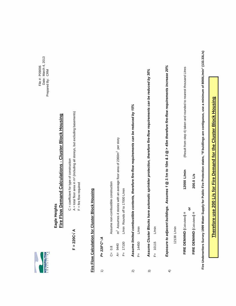
The result ing water demands are summarized in Appendix A-1. Fire Flow Requirements Fire Demands have been estimated using the calculations prescribed with
Water Supply for Public Fire Protection (1999) from the Fire
Underwriters Survey. Typically the largest building dictates the fire flow
demand requirements for a proposed development. In this case the larger
cluster housing bui ldings and the exist ing Flatt Road school building
were considered. The Fire Demands calculated varied depending on the
assumptions (construction type, sprinklers, etc. ) that were made and
ranged between 133.3L/s and 200L/s. Calculations and assumptions are
presented in Appendix A-2.
Fire Flow Analysis An analysis was performed to determine the adequacy of the proposed
system to provide the necessary fi re flow demands, while maintaining a
minimum pressure of 20psi within the zones B3A & B4A mains. The
highest calculated fi re flow demand of 200L/s was added to the Max Day
demand for the simulations. The Max Day scenario was modeled with the
fire flow demand automatically added to each node within the

Eagle Height s /Taylor P roper ty U p d a t e t o Fun c t io n a l Se rv i c in g & S to r mwat e r Man ag e men t Rep o r t
Ad d en d u m R evi sed S ec t io n 7
Metropol i tan Co nsul t ing Inc . 9 March 2013
development using the automated fi re flow analysis tools within
WaterCAD. All nodes within the dist rict were determined to meet the
minimum pressure requirement during the fi re flow analysis performed.
Tables of these resul ts are presented in Appendix A-3.
Zone B3A Pumping Station
The Zone B3A pumping stat ion will need to be designed with a fi rm
capacity based on the largest pump being out of service because of the
floating storage wil l be provided by the proposed Zone B3A reservoir.
The pumps will need to be capable of supplying the Max Day plus Fire
Flows, with the one pump off. Based on the init ial Fire Demand
estimates and total Max Day Demands for zone B3A (15.2L/s), the
minimum required f irm capacity of the pump stat ion could range from
150L/s to 220L/s. The potential impact of supplying Zones B4A & B5A
from a pumping stat ion at the Zone B3A reservoir should be considered
when determining what the firm capacity of the B3A pump stat ion should
ult imately be.
Zone B3A Storage
The storage requirements for zone B3A have been approximated based on
the MOE Design Guidelines for Drinking-Water Systems (2008).
Total Treated Water Storage = A + B + C
Where
A = Fire Storage;
B = Equalization Storage (25% of Max Day Demand);
C = Emergency Storage (25% of A + B)

Eagle Height s /Taylor P roper ty U p d a t e t o Fun c t io n a l Se rv i c in g & S to r mwat e r Man ag e men t Rep o r t
Ad d en d u m R evi sed S ec t io n 7
Metropol i tan Co nsul t ing Inc . 10 March 2013
Based on the projected population in zone B3A, the suggested fire flow
and duration from Table 8 .1 of the MOE Guidelines are 110L/s and 2
hours respectively. This results in a Total Storage volume requirement
for zone B3A of 1400m3. The total storage required and pump stat ion
firm capacity should be given further consideration during the Class EA
process and finalized at the detailed design stage.
Domestic Flows
To determine i f adequate water supply and pressure requirements can be
met, the peak hour scenario was modeled. The calculated peak hour
demands were added to each of the respective nodes and the resultant
pressures during the peak hour demand scenarios were determined.
Adequate pressures under the peak hour demands will be available to the
proposed development. Minimum and maximum pressures under the peak
hour scenarios are shown in Table 7.2 below. For further details and
calculations see Appendix A-4.
Table 7.2 Peak Hour Pressure Ranges
Zone Pressure Range
(psi) Junction
B3A Maximum 97.80 J-7 Minimum 56.20 J-3
B4A Maximum 152.10 J-28 Minimum 61.40 J-47
Sub-Area 10
The watermain on Street X, Sub-area 10, was modeled in zone B3A.
Predictably some pressures exceeded 100psi in areas as the boundary
between zone B3A and B2A falls approximately at midway point of

Eagle Height s /Taylor P roper ty U p d a t e t o Fun c t io n a l Se rv i c in g & S to r mwat e r Man ag e men t Rep o r t
Ad d en d u m R evi sed S ec t io n 7
Metropol i tan Co nsul t ing Inc . 11 March 2013
proposed Street X. Pressure reducing valves were added to two proposed
mains supplying this sub-area and pressures were successfully reduced
below 100psi . The southern portion of Street X will ul t imately be
serviced in zone B2A, however the modeling shows that servicing in
Zone B3A is feasible.
Waterdown Road – Horning Road to Street D
With Waterdown Road from Horning Road to proposed Street D in Zone
B5A, pressures in the exist ing 250mm watermain just north of Street D,
(junction J-28 on Figure 7-12) exceed 100psi . Although this is an
exist ing condit ion the option of including a pressure reducing valve
(PRV) south of Horning Road changing this area to Zone B4A was
modeled. Maximum pressures were reduced to below the 100psi
threshold. The available fi re flow with the PRV in place is 176 L/s
whereas 200 L/s is available without the PRV (Zone B5A). The
maximum fire flow demand from the exist ing dwellings in the immediate
area would l ikely fal l below 150L/s. Therefore this section of
Waterdown Road could be in ei ther Zone B4A or Zone B5A. See
Appendix A-4 for the analysis.
7.9 Existing Wastewater Infrastructure
As part of the improvements to the Waterdown Road / Hwy 403
interchange a 300mm sanitary sewer was constructed on the North
Service Road from the exist ing 450mm sewer crossing Hwy 403, to
Waterdown Road and then north on Waterdown Rd to Craven Ave. The
300mm sewer is Development Charges funded (with the cost being front
ended by Paletta International) and is proposed to serve the North
Aldershot area. The exist ing residencies and businesses on Waterdown

Eagle Height s /Taylor P roper ty U p d a t e t o Fun c t io n a l Se rv i c in g & S to r mwat e r Man ag e men t Rep o r t
Ad d en d u m R evi sed S ec t io n 7
Metropol i tan Co nsul t ing Inc . 12 March 2013
Road south of Craven Avenue and the proposed Cumis development were
provided with sanitary laterals when the sewer was constructed
The CAMA Woodlands facil i ty on Panin Road is serviced by a private
pumping stat ion and force main on Panin Road which now connects to
the 300mm NSR sewer at Waterdown Road.
Other residences, businesses and insti tutional properties have private
septic systems.
7.10 Proposed Wastewater Collection System
The overall North Aldershot wastewater collection system and drainage
areas are shown on Figure 7-14. The updated sanitary sewer design sheet
for the overall system is at tached in Appendix B. The design sheet has
been updated and revised to address Halton’s comments. It should be
noted that the design sheets include exist ing development and future
development on lands exterior to the subdivision. This explains the
difference in unit counts noted in the comments. It should also be noted
that unit counts are used for the proposed subdivision and for exist ing
development where applicable. The apparently “low” population
densit ies are in fact an accurate est imate of the anticipated development
densit ies .
Figure 7-15 shows the proposed sanitary sewers for the Eagle Heights
development . Preliminary profi les for major sewers, as shown on Figures
7-4, 7-5 & 7-6 in the June 2010 report , are st i l l valid.

Eagle Height s /Taylor P roper ty U p d a t e t o Fun c t io n a l Se rv i c in g & S to r mwat e r Man ag e men t Rep o r t
Ad d en d u m R evi sed S ec t io n 7
Metropol i tan Co nsul t ing Inc . 13 March 2013
Internal st reets will generally be serviced with 200 mm diameter sewers,
150mm sewers will be used on the first sections of each separate sub-
system to facil i tate self cleaning velocit ies.
Figure 7-5 shows the sewer profi le on Horning Road and the easement
through Sub-Area 6. Because of the need to maintain exist ing grades at
the hydro and gas pipeline crossings, the sewer will be deeper than usual
but can be instal led using conventional construction techniques. This
sewer will cross the open space block to Sub-Area 6 via a proposed
easement . There wil l also be a public trai l within the easement
At the south end of Sub-Area 6, i t is proposed that a gravi ty sewer be
instal led to connect to Flatt Road using trenchless technology. This will
preserve the valleyland and avoid the need for a pumping stat ion and
forcemain. The geotechnical investigation has indicated that the boring
will be within the shale bedrock and that conventional rock boring
techniques should be feasible.
The Flatt Road sewer is deep enough to service the portion of the
Aldershot Landscape property north of the uti l i ty corridor i f i t were to be
developed.
A sewer is proposed on Waterdown Road from Flatt Road to Street D.
This sewer will provide permanent servicing to the proposed Church on
Block PP and will also serve proposed lots 167 to 171 and the exist ing
residences fronting on Waterdown Road.
From Flatt Road, the DC funded 300mm trunk sewer will be constructed
south on Street X to avoid excessive depth at Flatt Rd & Waterdown Rd

Eagle Height s /Taylor P roper ty U p d a t e t o Fun c t io n a l Se rv i c in g & S to r mwat e r Man ag e men t Rep o r t
Ad d en d u m R evi sed S ec t io n 7
Metropol i tan Co nsul t ing Inc . 14 March 2013
(15m+). Alternate routes considered for the connection to the exist ing
sewer at Waterdown Road and Craven Ave include:
Alternate 1 The sewer would follow the Hydro One corridor from Street
X crossing Tributary 4 to Waterdown Road. The sewer would then go
south on Waterdown Road to the exist ing sewer at craven Ave.
Alternates 2A & 2B From Street X the sewer would cross under Tributary
4 (trenchless construction) to the Bethel Church property which Paletta
International has a condit ional agreement to acquire in exchange for
Block PP. The sewer will then either cross the Church property to
Waterdown Rd (Alt 2A) or follow Nevarc & Craven (Alt 2B) to the
exist ing sewer. A sewer on Nevarc & Craven could be a joint project
with the residents request for sewers under the Local Improvement Act.
The Tributary 4 crossing is proposed to be in a City owned block that
could also accommodate two watermains (Zone B3A and B2).
Alternates 2A and 2B are preferred over Alternate 1 because more of
SubArea 10 can be serviced. Alternate 2B is preferred to Alt 2A because
of the abil i ty to service exist ing homes on Craven and Nevarc; however
the depth of the sewer on Craven could result in the need for a shallow
local sewer to avoid excessive depth for laterals.
The “Morgante property” and the port ion of the Aldershot Landscape
property south of the uti l i ty corridor can be gravity drained to exist ing
manhole 9A on Waterdown Road at the NSR. As shown on Figure 7-14,
the sewer would cross the Hwy 403 on ramp and the Panin Rd / Nevarc
Dr l ink, under Tributary 4 to the Morgante property then via the south
end of Sub Area 10 (Taylor property) and under Tributary 5 to the
Aldershot Landscape property.

Eagle Height s /Taylor P roper ty U p d a t e t o Fun c t io n a l Se rv i c in g & S to r mwat e r Man ag e men t Rep o r t
Ad d en d u m R evi sed S ec t io n 7
Metropol i tan Co nsul t ing Inc . 15 March 2013
Future development on the CAMA Woodlands and Panin Rd Church
properties would require pumping to connect to the sewer at Waterdown
Road and the former Panin Road similar to the exist ing system.
7.11 Development Phasing
Exist ing services are available at the south end of the development and
will be extended northerly to service the various development Sub-Areas.
As shown on Figure 7-16, two phases are proposed:
Phase 1
Phase 1 will include a total of 138 single family freehold lots, 20 single
family condominium units and 325 cluster housing units in the following
Sub-Areas:
• Sub Area 1 (and the eight proposed lots on Horning Road)
• Sub-Area 2
• Lots on Flatt Road Extension in Sub-Area 5
• Sub-Area 6
• Sub-Areas 8
• Sub-Area 10
Phase 2
Phase 2 will include a total of 64 single family freehold lots and 323
cluster housing units in the following Sub-Areas:
• Sub Area 5 (excluding the Flatt Road Extension lots in Phase 1)
• Sub-Area 7

Eagle Height s /Taylor P roper ty U p d a t e t o Fun c t io n a l Se rv i c in g & S to r mwat e r Man ag e men t Rep o r t
Ad d en d u m R evi sed S ec t io n 7
Metropol i tan Co nsul t ing Inc . 16 March 2013
7.12 Phase 1 Water & Wastewater Servicing
Phase 1 will require the establishing of the proposed water Zone B3A
including construction of the B3A pumping stat ion at the Waterdown
Road reservoir, the North Aldershot Reservoir and the 400mm feedermain
from the pumping stat ion to the reservoir. All of these works are
Development Charge funded projects.
Sub-Area 1 and the eight Horning road lots that are in Phase 1 are in
Zone B4A. This zone can be supplied from the City of Hamilton Water
system (Zone B5A pressure) via a pressure reducing valve (PRV).
Ult imately, if the “Halton only” system is implemented and a Zone B5A
pumping stat ion is constructed at the North Aldershot Reservoir, then
Sub-Area 1 and the 8 Horning road lots could be supplied from it via a
PRV.
The southern portion of Sub-Area 10 is intended to be within Zone B2.
The proposed Zone B2 portion of the pumping stat ion at the Waterdown
Road Reservoir will be constructed with the Zone B3A portion and could
supply the south portion of Sub-Area 10. The Zone B2 system will
ul t imately be looped through the Morgante property when i t develops. As
previously stated the t iming of the Morgante property is uncertain and
therefore the southern portion of Sub-Area 10 could be fed from Zone
B3A with pressure reducing measures if necessary.
Phase 1 will require completion of the 300mm trunk outlet sanitary sewer
from Waterdown Road to Flatt Road. Local subdivision sewers will be
constructed on Flat t Road, Flatt Road extension, Streets C, D & E,
Horning Road and Waterdown Road from Flatt Rd to Street D. The

Eagle Height s /Taylor P roper ty U p d a t e t o Fun c t io n a l Se rv i c in g & S to r mwat e r Man ag e men t Rep o r t
Ad d en d u m R evi sed S ec t io n 7
Metropol i tan Co nsul t ing Inc . 17 March 2013
exist ing residences on Craven Ave, Nevarc Drive (including the rear of
lots fronting on Waterdown Road) will be able to connect di rectly to the
trunk sewer or have local sewers which will connect to the t runk.
The sanitary sewer design sheet for Phase 1 is at tached in Appendix B.
In addit ion to the proposed Eagle Heights development, al lowance has
been made for the Cumis property to be serviced as well as exist ing
properties on Waterdown Road, Craven Ave and Nevarc Dr. to be
connected. The total peak flow for Phase 1 is est imated to be 45 l /s (the
ult imate peak flow is 86 l /s).
7.13 Phase 2 Water & Wastewater Servicing
The Phase 2 Eagle Heights development areas are within water pressure
zone B3A for which the major infrastructure will be in place for Phase 1.
Extensions of local looped watermains for Sub-Areas 5 & 7 will be
required.
Similarly Phase 2 areas will only require extension of local sanitary
sewers.
With the completion of the Phase 2 servicing, the property at the north
end of Flatt Road and the portion of the Aldershot Landscape property
north of the Hydro One corridor could be developed.
7.14 Proposed Stormwater Management & Regional Services
Road Standards
In Section 3.1 of the report , i t s tates that a rural cross section is
proposed for internal roads where feasible. This is in keeping with the

Eagle Height s /Taylor P roper ty U p d a t e t o Fun c t io n a l Se rv i c in g & S to r mwat e r Man ag e men t Rep o r t
Ad d en d u m R evi sed S ec t io n 7
Metropol i tan Co nsul t ing Inc . 18 March 2013
intent of the proposed plan to uti l ize passive stormwater management
where feasible. This concept will be discussed with the City of
Burlington and refined during the detail design process .
Proposed Lot Level SWM Control Measures
The proposed lot level SWM control measures , including soakaway pits ,
infi l trat ion trenches, grassed swales and rainwater gardens, should have
no impact on Regional services . Any measures considered necessary to
prevent increased risk of infi l t rat ion to sanitary sewers or laterals can be
incorporated at the detail design.
Run-off from Waterdown Road RoW
As shown on Figure 5-1 in the June 2010 update, predevelopment storm
drainage area 401 includes a portion of the Waterdown Road RoW north
of Flatt Road which drains to Tributary 4. This exist ing run-off will be
accommodated in the proposed stormwater management facil i t ies
including extended detention wet SWM pond 4A.
The April 2012 Waterdown Road Corridor Class E A Environmental Study
Report recommends that 5year storm post reconstruction run-off from
this section of Waterdown Road be conveyed to an extended detention
dry pond adjacent to the Waterdown Road reservoir. However there is a
statement in Section 6.3.4 (pg 6-28) “Additional consideration should be
given in detail design to directing road flows to a future Eagle Heights
stormwater management facil i ty”.
It would be feasible to take post reconstruction minor system flows from
the section of Waterdown Road north of Street D to Pond 4A for

Eagle Height s /Taylor P roper ty U p d a t e t o Fun c t io n a l Serv i c in g & S to r mwat e r Man ag e men t Rep o r t
Ad d en d u m R evi sed S ec t io n 7
Metropol i tan Co nsul t ing Inc . 19 March 2013
treatment, subject to the appropri ate cost sharing. Considerat ion is being
given to the inclusion in the Master SWM Plan of another SWM facil i ty
on the east side of Tributary 4 north of Flatt Road. If such a facil i ty is
proposed then i t too could be designed to include the post reconstru ction
minor system flows from Waterdown Road between Street D and Flatt
Road, again subject to the appropriate cost sharing.
Prepared by:
Chris Povell P. Eng. Chuck McFarland, P. Eng.

Eagle Height s /Taylor P roper ty U p d a t e t o Fun c t io n a l Se rv i c in g & S to r mwat e r Man ag e men t Rep o r t
Ad d en d u m R evi sed S ec t io n 7
Metropol i tan Co nsul t ing Inc . February 2013
APPENDIX A
Watermain Modelling

Eagle Heights /Taylor Property Update to Functional Servicing & Stormwater Management Report
Addendum Revised Section 7
APPENDIX A-1
Max Day & Peak Hour
Demand Calculations

Dat
e:
Mar
ch 7
, 20
13
File
#:
P0
90
06
Pre
par
ed
By:
C
.McF
arla
nd
, P.E
ng
Eag
le H
eig
hts
Ap
pen
dix
A-1
Wate
r D
em
an
d C
alc
ula
tio
ns
No
.D
escr
ipti
on
L/d
ayL/
sC
oef
fice
nt (
3)
Dem
and
L/s
Co
effi
cen
t (3
)D
eman
d L
/s
J-1
16
12
00
3.0
2.5
48
.03
0.0
0.0
0.0
78
.03
30
25
74
00
.30
1.9
00
.57
3.0
00
.89
13
8.6
8
J-2
15
12
00
3.0
2.5
45
.03
0.0
0.0
0.0
75
.03
30
24
75
00
.29
1.9
00
.54
3.0
00
.86
12
3.9
9
J-3
60
00
3.0
18
.00
.00
.00
.01
8.0
33
05
94
00
.07
1.9
00
.13
3.0
00
.21
16
7.3
8
J-4
00
01
4In
stit
uti
on
(1)(
4)/
Ex. H
ou
sin
g (6
) 3
.00
.00
.00
.04
2.0
42
.03
30
15
46
00
.18
1.9
00
.34
2.0
00
.36
15
7.5
0
J-5
00
00
0.0
0.0
0.0
0.0
0.0
33
00
0.0
01
.90
0.0
03
.00
0.0
01
44
.82
J-6
00
00
0.0
0.0
0.0
0.0
0.0
33
00
0.0
01
.90
0.0
03
.00
0.0
01
41
.54
J-7
00
00
0.0
0.0
0.0
0.0
0.0
33
00
0.0
01
.90
0.0
03
.00
0.0
01
37
.72
J-8
04
20
5Ex
. Ho
usi
ng (
6)
2.5
3.0
0.0
10
5.0
0.0
15
.01
20
.03
30
39
60
00
.46
1.9
00
.87
3.0
01
.38
14
1.3
7
J-9
24
00
2Ex
Ho
usi
ng (
6)
3.0
3.0
72
.00
.00
.06
.07
8.0
33
02
57
40
0.3
01
.90
0.5
73
.00
0.8
91
40
.57
J-1
00
00
00
.00
.00
.00
.00
.03
30
00
.00
1.9
00
.00
3.0
00
.00
15
0.8
4
J-1
11
80
00
3.0
54
.00
.00
.00
.05
4.0
33
01
78
20
0.2
11
.90
0.3
93
.00
0.6
21
57
.25
J-1
20
12
20
02
.50
.03
05
.00
.00
.03
05
.03
30
10
06
50
1.1
61
.90
2.2
13
.00
3.4
91
51
.60
J-1
32
20
00
3.0
66
.00
.00
.00
.06
6.0
33
02
17
80
0.2
51
.90
0.4
83
.00
0.7
61
51
.20
J-1
40
00
00
.00
.00
.00
.00
.03
30
00
.00
1.9
00
.00
3.0
00
.00
15
8.0
7
J-1
50
00
00
.00
.00
.00
.00
.03
30
00
.00
1.9
00
.00
3.0
00
.00
15
4.7
5
J-1
60
37
00
2.5
0.0
92
.50
.00
.09
2.5
33
03
05
25
0.3
51
.90
0.6
73
.00
1.0
61
63
.99
J-1
72
40
00
3.0
72
.00
.00
.00
.07
2.0
33
02
37
60
0.2
81
.90
0.5
23
.00
0.8
31
65
.95
J-1
82
80
00
3.0
84
.00
.00
.00
.08
4.0
33
02
77
20
0.3
21
.90
0.6
13
.00
0.9
61
50
.17
J-1
90
00
00
.00
.00
.00
.00
.03
30
00
.00
1.9
00
.00
3.0
00
.00
14
3.0
0
J-2
00
85
00
2.5
0.0
21
2.5
0.0
0.0
21
2.5
33
07
01
25
0.8
11
.90
1.5
43
.00
2.4
31
51
.73
J-2
10
00
00
.00
.00
.00
.00
.03
30
00
.00
1.9
00
.00
3.0
00
.00
15
0.2
6
J-2
25
00
35
Futu
re D
evel
op
men
t (5)
3.0
3.0
15
.00
.00
.01
05
.01
20
.03
30
39
60
00
.46
1.9
00
.87
3.0
01
.38
16
2.5
3
J-2
30
00
00
.00
.00
.00
.00
.03
30
00
.00
1.9
00
.00
3.0
00
.00
16
2.8
4
J-2
40
64
00
2.5
0.0
16
0.0
0.0
0.0
16
0.0
33
05
28
00
0.6
11
.90
1.1
63
.00
1.8
31
48
.46
J-2
50
00
00
.00
.00
.00
.00
.03
30
00
.00
1.9
00
.00
3.0
00
.00
15
2.7
0
J-2
60
00
00
.00
.00
.00
.00
.03
30
00
.00
1.9
00
.00
3.0
00
.00
15
4.7
0
J-2
70
00
00
.00
.00
.00
.00
.03
30
00
.00
1.9
00
.00
3.0
00
.00
13
2.4
0
J-2
80
00
27
Ex. H
ou
sin
g (6)
3
.00
.00
.00
.08
1.0
81
.03
30
26
73
00
.31
1.9
00
.59
3.0
00
.93
16
9.5
0
J-2
90
00
20
Ex. H
ou
sin
g (6)
3.0
0.0
0.0
0.0
60
.06
0.0
33
01
98
00
0.2
31
.90
0.4
43
.00
0.6
92
07
.78
J-3
01
80
00
3.0
54
.00
.00
.00
.05
4.0
33
01
78
20
0.2
11
.90
0.3
93
.00
0.6
21
87
.57
J-3
10
94
00
2.5
0.0
23
5.0
0.0
0.0
23
5.0
33
07
75
50
0.9
01
.90
1.7
13
.00
2.6
91
85
.94
J-3
20
00
00
.00
.00
.00
.00
.03
30
00
.00
1.9
00
.00
3.0
00
.00
12
7.0
0
J-3
40
00
00
.00
.00
.00
.00
.03
30
00
.00
1.9
00
.00
3.0
00
.00
20
2.5
0
J-3
50
11
60
02
.50
.02
90
.00
.00
.02
90
.03
30
95
70
01
.11
1.9
02
.10
3.0
03
.32
15
0.0
4
J-3
60
00
00
.00
.00
.00
.00
.03
30
00
.00
1.9
00
.00
3.0
00
.00
14
0.5
7
J-3
80
00
00
.00
.00
.00
.00
.03
30
00
.00
1.9
00
.00
3.0
00
.00
13
7.7
2
J-3
90
00
6Sc
ho
ol (2
)(4)
/Ex.
Ho
usi
ng (
6)
3.0
0.0
0.0
0.0
18
.01
8.0
33
01
07
40
0.1
21
.90
0.2
42
.00
0.2
51
41
.54
J-4
01
40
02
Ex. H
ou
sin
g (6)
3
.03
.04
2.0
0.0
0.0
6.0
48
.03
30
15
84
00
.18
1.9
00
.35
3.0
00
.55
15
0.2
6
J-4
11
20
00
3.0
36
.00
.00
.00
.03
6.0
33
01
18
80
0.1
41
.90
0.2
63
.00
0.4
11
58
.07
J-4
40
00
25
Ex. H
ou
sin
g (6)
3
.00
.00
.00
.07
5.0
75
.03
30
24
75
00
.29
1.9
00
.54
3.0
00
.86
20
1.5
4
J-4
50
00
10
Ex. H
ou
sin
g (6)
3
.00
.00
.00
.03
0.0
30
.03
30
99
00
0.1
11
.90
0.2
23
.00
0.3
41
95
.90
J-4
60
00
00
.00
.00
.00
.00
.03
30
00
.00
1.9
00
.00
3.0
00
.00
21
4.0
0
CL
Ro
ad E
leva
tio
n a
t
Jun
ctio
n
Un
it C
ou
nts
Equ
ival
ent
Po
p. C
oef
fici
ents
Equ
ival
ent
Po
pu
lati
on
Tota
l
Equ
ival
ent
Po
pu
lati
on
Sin
gle
Fam
ily
ho
mes
Clu
ster
Ho
usi
ng
Condominuims
Oth
er
Sin
gle
Fam
ily
Dai
ly A
vera
ge u
sage
M
ax. D
ay
Pea
k H
ou
rD
aily
Ave
rage
usa
ge r
ate
L/p
erso
n/d
ay (3
)
Junction ID
Po
pu
lati
on
De
rive
d f
orm
Un
it C
ou
nts
Clu
ster
Ho
usi
ng
Condominuims
Oth
er
Clu
ster
Ho
usi
ng
Condominuims
Oth
er
Sin
gle
Fam
ily
Ap
pen
dix
A-1

Dat
e:
Mar
ch 7
, 20
13
File
#:
P0
90
06
Pre
par
ed
By:
C
.McF
arla
nd
, P.E
ng
Eag
le H
eig
hts
Ap
pen
dix
A-1
Wate
r D
em
an
d C
alc
ula
tio
ns
No
.D
escr
ipti
on
L/d
ayL/
sC
oef
fice
nt (
3)
Dem
and
L/s
Co
effi
cen
t (3
)D
eman
d L
/s
CL
Ro
ad E
leva
tio
n a
t
Jun
ctio
n
Un
it C
ou
nts
Equ
ival
ent
Po
p. C
oef
fici
ents
Equ
ival
ent
Po
pu
lati
on
Tota
l
Equ
ival
ent
Po
pu
lati
on
Sin
gle
Fam
ily
ho
mes
Clu
ster
Ho
usi
ng
Condominuims
Oth
er
Sin
gle
Fam
ily
Dai
ly A
vera
ge u
sage
M
ax. D
ay
Pea
k H
ou
rD
aily
Ave
rage
usa
ge r
ate
L/p
erso
n/d
ay (3
)
Junction ID
Po
pu
lati
on
De
rive
d f
orm
Un
it C
ou
nts
Clu
ster
Ho
usi
ng
Condominuims
Oth
er
Clu
ster
Ho
usi
ng
Condominuims
Oth
er
Sin
gle
Fam
ily
J-4
70
00
00
.00
.00
.00
.00
.03
30
00
.00
1.9
00
.00
3.0
00
.00
20
3.5
0
J-4
80
01
00
2.5
0.0
0.0
25
.00
.02
5.0
33
08
25
00
.10
1.9
00
.18
3.0
00
.29
16
2.8
4
J-4
90
64
10
02
.52
.50
.01
60
.02
5.0
0.0
18
5.0
33
06
10
50
0.7
11
.90
1.3
43
.00
2.1
21
54
.75
J-5
00
00
00
.00
.00
.00
.00
.03
30
00
.00
1.9
00
.00
3.0
00
.00
14
2.0
0
J-5
10
00
00
.00
.00
.00
.00
.03
30
00
.00
1.9
00
.00
3.0
00
.00
14
4.0
0
J-5
30
00
00
.00
.00
.00
.00
.03
30
00
.00
1.9
00
.00
3.0
00
.00
12
9.7
5
J-5
40
00
00
.00
.00
.00
.00
.03
30
00
.00
1.9
00
.00
3.0
00
.00
12
3.5
0
J-5
50
00
00
.00
.00
.00
.00
.03
30
00
.00
1.9
00
.00
3.0
00
.00
12
3.7
5
J-5
60
00
00
.00
.00
.00
.00
.03
30
00
.00
1.9
00
.00
3.0
00
.00
12
4.2
5
J-5
70
00
00
.00
.00
.00
.00
.03
30
00
.00
1.9
00
.00
3.0
00
.00
12
3.0
0
J-5
80
00
See
No
te 7
Cu
mis
(7)
0.0
0.0
0.0
40
5.0
40
5.0
33
01
33
65
01
.55
1.9
02
.94
3.0
04
.64
12
0.0
0
J-5
90
00
00
.00
.00
.00
.00
.03
30
00
.00
1.9
00
.00
3.0
00
.00
12
1.3
0
J-6
00
00
17
Futu
re D
evel
op
men
t (5)
3.0
0.0
0.0
0.0
51
.05
1.0
33
01
68
30
0.1
91
.90
0.3
73
.00
0.5
81
22
.50
NO
TES: 1
.D
em
and
fo
r In
stit
uti
on
al u
se (
Ch
urc
h)
was
bas
ed o
n a
rat
e o
f 8L
/per
son
/day
as
per
OB
C T
able
8.2
..1.3
.B (
2012
) an
d 2
00 s
eats
;
2.
De
man
d f
or
Ex. S
cho
ol w
as b
ased
on
30L
/per
son
/day
s p
er O
BC
Tab
le 8
.2..1
.3.B
(20
12)
& a
ssu
min
g 20
0 st
ud
ents
an
d s
taff
.
3.
Ave
rage
Dai
ly U
sage
Rat
e (L
/per
son
/day
), M
ax D
ay C
oef
fici
ent,
an
d P
eak
Ho
ur
Co
effi
cien
t w
ere
bas
ed o
n v
alu
es f
rom
th
e So
uth
Hal
ton
Wat
er a
nd
Was
tew
ater
Mas
ter
Pla
n U
pd
ate
(200
8);
4.
Pea
k H
ou
r C
oef
fici
ents
fo
r th
e Ex
. Sch
oo
l an
d t
he
Inst
itu
tio
nal
lan
ds
we
re b
ased
on
Tab
le A
.2.3
fro
m t
he
Reg
ion
of
Hal
ton
De
sign
Cri
teri
a (2
001)
;
5.
Un
it c
ou
nts
fo
r Fu
ture
De
vlo
pm
ent
we
re t
aken
fro
m F
igu
re 7
-2 o
f th
e 20
10 F
SR u
pd
ate
pre
par
ed b
y M
CI;
6.
Un
it c
ou
nts
fo
r Ex
isti
ng
dw
elli
ngs
we
re e
stim
ated
bas
ed o
n d
igit
al a
eria
l map
pin
g ;
7.
To
tal E
qu
ival
ent
Po
pu
lati
on
fo
r C
um
is p
rop
erty
cal
cula
ted
bas
ed o
ff a
nd
are
a o
f 4
.5h
a at
a p
op
ula
tio
n d
ensi
ty o
f 9
0p
ph
a
Ap
pen
dix
A-1
Eagle Heights /Taylor Property Update to Functional Servicing & Stormwater Management Report
Addendum Revised Section 7
APPENDIX A-2
Fire Flow Requirements
File
#:
P09006
Date
:M
arc
h 4
, 2013
Pre
pare
d B
y:
CR
M
Eag
le H
eig
hts
Fir
e F
low
De
ma
nd
Ca
lcu
lati
on
s -
Clu
ste
r B
loc
k H
ou
sin
g
C =
coeff
icie
nt
for
type o
f constr
uctio
n
F =
220C
A
A =
tota
l flo
or
are
a in
m²
(in
clu
din
g a
ll sto
reys,
but
exclu
din
g b
asem
ents
)
F
= f
ire f
low
required
Fir
e F
low
Calc
ula
tio
n f
or
Clu
ste
r B
lock H
ou
sin
g
1)
F= 2
20*C
*√A
C=
0.8
A=
9440
m2
Assum
es 4
sto
rie
s w
ith a
n a
vera
ge f
loor
are
a o
f 2360m
2
per
sto
ry
F=
17100
L/m
in
Rounds o
ff t
o 1
7000 L
/min
2)
Ass
ume
limite
d co
mbu
stib
le c
onte
nts,
ther
efor
e fir
e-flo
w re
quire
men
ts c
an b
e re
duce
d by
15%
F=
14450
L/m
in
3)
F=
10115
L/m
in
4)
12138
L/m
in
FIR
E D
EM
AN
D (
Calc
ula
ted)
=
12
00
0L
/min
(Result f
rom
ste
p 4
) ta
ken a
nd r
ounded t
o n
eare
st
thousand L
itre
s
or
FIR
E D
EM
AN
D (
Calc
ula
ted)
=
20
0.0
L/s
Fir
e U
nd
erw
rite
rs S
urv
ey 1
999 W
ate
r S
up
ply
fo
r P
ub
lic F
ire P
rote
cti
on
sta
tes,
"If
bu
idli
ng
s a
re c
on
tig
uo
us
, u
se a
min
imu
m o
f 8000L
/min
" (
133.3
3L
/s)
Assum
e n
on-c
om
bustib
le c
onstr
uctio
n
Ass
ume
Clu
ster
Blo
cks
have
aut
omat
ic s
prin
kler
pro
tect
ion,
ther
efor
e fir
e-flo
w re
quire
men
ts c
an b
e re
duce
d by
30%
Expo
sure
to a
djac
ent b
uild
ings
. A
ssum
es 1
@ 3
.1m
to 1
0m &
3 @
> 4
5m th
eref
ore
fire-
flow
requ
irem
ents
incr
ease
20%
Th
ere
fore
us
e 2
00
L/s
fo
r F
ire D
em
an
d f
or
the
Clu
ste
r B
loc
k H
ou
sin
g

File
#:
P0
90
06
Da
te:
Ma
rch
4,
201
3
Pre
pa
red
By:
CR
M
Eag
le H
eig
hts
Fir
e F
low
Dem
an
d C
alc
ula
tio
ns -
Clu
ste
r B
lock H
ou
sin
g (
Op
tio
n B
- F
ire R
esis
tive C
on
str
ucti
on
)
C =
co
eff
icie
nt
for
typ
e o
f co
nstr
uctio
n
F =
220C
A
A =
to
tal flo
or
are
a in
m²
(in
clu
din
g a
ll sto
reys,
but
exclu
din
g b
ase
me
nts
)
F
= f
ire
flo
w r
equ
ire
d
Fir
e F
low
Calc
ula
tio
n f
or
Clu
ste
r B
lock H
ou
sin
g
1)
F= 2
20*C
*√A
C=
0
.6
A=
7080
m2
Assu
me
s 1
00
% o
f firs
t 2
flo
ors
plu
s 5
0%
of
next
two
, w
ith
an a
vera
ge
flo
or
are
a o
f 2
36
0m
2
per
sto
ry
F=
11107
L/m
in
Ro
un
ds o
ff t
o 1
10
00
L/m
in
2)
Ass
ume
limite
d co
mbu
stib
le c
onte
nts,
ther
efor
e fir
e-flo
w re
quire
men
ts c
an b
e re
duce
d by
15%
F=
9350
L/m
in
3)
F=
5610
L/m
in
4)
F=
6732
L/m
in
FIR
E D
EM
AN
D (
Calc
ula
ted)
=
70
00
L/m
in(R
esult f
rom
ste
p 4
) ta
ke
n a
nd
ro
un
de
d t
o n
ea
rest
thou
san
d L
itre
s
or
FIR
E D
EM
AN
D (
Calc
ula
ted)
=
11
6.7
L/s
Assu
me
s F
ire
re
sis
tive
co
nstr
uctio
n,
i.e
. fu
lly p
rote
cte
d f
ram
e a
nd
flo
ors
, ro
of
Ass
ume
Clu
ster
Blo
cks
have
aut
omat
ic s
prin
kler
pro
tect
ion,
ther
efor
e fir
e-flo
w re
quire
men
ts c
an b
e re
duce
d by
30%
Expo
sure
to a
djac
ent b
uild
ings
. A
ssum
es 1
@ 3
.1m
to 1
0m &
3 @
> 4
5m th
eref
ore
fire-
flow
requ
irem
ents
incr
ease
20%

File
#:
P09006
Da
te:
Marc
h 4
, 2013
Pre
pare
d B
y:
CR
M
Eag
le H
eig
hts
Fir
e F
low
De
ma
nd
Calc
ula
tio
ns -
Sc
ho
ol B
loc
k
C =
co
eff
icie
nt
for
typ
e o
f co
nstr
uctio
n
F =
22
0C
A
A =
tota
l floor
are
a in m
² (inclu
din
g a
ll sto
reys, but exclu
din
g b
asem
ents
)
F
= f
ire f
low
required
Fir
e F
low
Calc
ula
tio
n f
or
Sch
oo
l B
lock
1)
F= 2
20*C
*√A
C=
1.0
A=
1200
m2 (
based o
n b
uild
ing f
ootp
rint are
a)
F=
7621
L/m
in R
ounds o
ff to 8
000 L
/min
2)
Low
occ
upan
cy h
azar
d w
ith li
mite
d co
mbu
stib
le c
onte
nts,
ther
efor
e fir
e-flo
w re
quire
men
ts c
an b
e re
duce
by
15%
F=
6800
L/m
in
3)
F=
4760
L/m
in
4)
One
Exp
osur
e fr
om s
truc
ture
with
in 4
5m. 1
@ 1
0.1m
to 2
0m, T
here
fore
fire
-flow
incr
ease
s by
15%
F=
5474
L/m
in
RE
QU
IRE
D F
LO
W =
5
00
0L
/min
Re
su
lt f
rom
ste
p 4
) ta
ke
nd a
nd
rou
nd
ed t
o n
ea
rest
tho
usa
nd L
itre
s
or
RE
QU
IRE
D F
LO
W =
8
3.4
L/s
Non-c
om
bustible
constr
uction (
based o
n e
from
Sveda K
oyanagi A
rchitects
, attached.)
Ass
ume
Aut
omat
ic s
prin
kler
and
ala
rm s
yste
m p
rese
nt, t
here
fore
fire
-flow
requ
irem
ents
can
be
redu
ce b
y 30
%

Eagle Heights /Taylor Property Update to Functional Servicing & Stormwater Management Report
Addendum Revised Section 7
APPENDIX A-3
Max Day Demands plus Fire Flow
Scenario Results

Dat
e: M
arch
7, 2
013
File
: P09
006
Pre
par
ed B
y: C
. McF
arla
nd
, P.E
ng.
Eagl
e H
eig
hts
Ap
pe
nd
ix A
-3:
Max
. D
ay D
em
and
s p
lus
Fire
Flo
w o
f 2
00
L/s
Fi
re F
low
An
alys
is:
Ex. W
ater
do
wn
Rd
. zo
ne
5 w
ater
mai
n f
ed f
rom
Ham
ilto
n (
Wat
erd
ow
n)
La
be
lZ
on
eF
ire
Flo
w
Ite
rati
on
s
Sa
tis
fie
s F
ire
Flo
w
Co
ns
tra
ints
?
Fir
e F
low
(Nee
de
d)
(L/s
)
Fir
e F
low
(Ava
ila
ble
)
(L/s
)
Flo
w
(T
ota
l
Nee
de
d)
(L/s
)
Flo
w
(To
tal
Ava
ila
ble
)
(L/s
)
Pre
ss
ure
(R
es
idu
al
Lo
we
r L
imit
) (p
si)
Pre
ss
ure
(Calc
ula
ted
Res
idu
al)
(p
si)
Pre
ss
ure
(Z
on
e
Lo
we
r L
imit
)
(ps
i)
Pre
ss
ure
(Calc
ula
ted
Zo
ne
Lo
we
r L
imit
) (p
si)
Ju
nc
tio
n w
/
Min
imu
m
Pre
ss
ure
(Z
on
e)
Is F
ire
Flo
w R
un
Bala
nc
ed
?
J-4
7Z
on
e -
B4
A2
TR
UE
20
02
20
.82
20
0.0
02
20
.82
20
75
.42
09
1J-4
4T
RU
E
J-4
6Z
on
e -
B5
A2
TR
UE
20
02
20
.82
20
0.0
02
20
.82
20
79
.82
08
8.6
J-2
9T
RU
E
J-4
4Z
on
e -
B4
A2
TR
UE
20
02
20
.82
20
0.5
52
21
.37
20
74
.12
08
1.4
J-4
7T
RU
E
J-2
9Z
on
e -
B5
A2
TR
UE
20
02
20
.82
20
0.4
42
21
.25
20
82
.12
07
9.8
J-4
6T
RU
E
J-4
5Z
on
e -
B4
A2
TR
UE
20
02
20
.82
20
0.2
12
21
.02
20
70
.82
07
4.1
J-4
4T
RU
E
J-2
8Z
on
e -
B4
A2
TR
UE
20
02
12
.21
20
0.5
92
12
.82
02
0.0
20
73
.9J-4
5T
RU
E
J-3
0Z
on
e -
B4
A2
TR
UE
20
02
20
.82
20
0.4
02
21
.21
20
70
.62
07
2.9
J-3
1T
RU
E
J-3
1Z
on
e -
B4
A2
TR
UE
20
02
20
.82
20
1.7
12
22
.53
20
60
.72
07
0.6
J-3
0T
RU
E
J-5
5Z
on
e -
B3
A2
TR
UE
20
02
20
.82
20
0.0
02
20
.82
20
77
.12
05
3.4
J-3
TR
UE
J-2
3Z
on
e -
B3
A2
TR
UE
20
02
20
.82
20
0.0
02
20
.82
20
54
.92
05
3.3
J-3
TR
UE
J-4
8Z
on
e -
B3
A2
TR
UE
20
02
20
.82
20
0.1
92
21
.01
20
54
.72
05
3.3
J-3
TR
UE
J-1
5Z
on
e -
B3
A2
TR
UE
20
02
20
.82
20
0.0
02
20
.82
20
66
.12
05
3J-3
TR
UE
J-4
9Z
on
e -
B3
A2
TR
UE
20
02
20
.82
20
1.3
52
22
.16
20
63
.62
05
2.7
J-3
TR
UE
J-1
4Z
on
e -
B3
A2
TR
UE
20
02
20
.82
20
0.0
02
20
.82
20
61
.32
05
2.7
J-3
TR
UE
J-4
1Z
on
e -
B3
A2
TR
UE
20
02
20
.82
20
0.2
72
21
.08
20
59
.52
05
2.6
J-3
TR
UE
J-2
2Z
on
e -
B3
A2
TR
UE
20
02
20
.82
20
0.8
72
21
.69
20
28
.12
05
2.6
J-3
TR
UE
J-2
6Z
on
e -
B3
A2
TR
UE
20
02
20
.82
20
0.0
02
20
.82
20
63
.22
05
2.5
J-3
TR
UE
J-2
0Z
on
e -
B3
A2
TR
UE
20
02
20
.82
20
1.5
42
22
.35
20
56
.42
05
2.5
J-3
TR
UE
J-4
0Z
on
e -
B3
A2
TR
UE
20
02
20
.82
20
0.3
42
21
.16
20
70
.02
05
2.4
J-3
TR
UE
J-2
1Z
on
e -
B3
A2
TR
UE
20
02
20
.82
20
0.0
02
20
.82
20
72
.42
05
2.4
J-3
TR
UE
J-2
5Z
on
e -
B3
A2
TR
UE
20
02
20
.82
20
0.0
02
20
.82
20
66
.02
05
2.4
J-3
TR
UE
J-2
4Z
on
e -
B3
A2
TR
UE
20
02
20
.82
20
1.1
62
21
.97
20
72
.42
05
2J-3
TR
UE
J-1
3Z
on
e -
B3
A2
TR
UE
20
02
20
.82
20
0.4
82
21
.29
20
61
.22
05
1.9
J-2
2T
RU
E
J-8
Zo
ne
- B
3A
2T
RU
E2
00
22
0.8
22
00
.87
22
1.6
92
08
5.5
20
51
.5J-3
TR
UE
J-5
0Z
on
e -
B3
A2
TR
UE
20
02
20
.82
20
0.0
02
20
.82
20
83
.02
05
1.2
J-3
TR
UE
J-7
Zo
ne
- B
3A
2T
RU
E2
00
22
0.8
22
00
.00
22
0.8
22
09
1.2
20
51
.1J-3
TR
UE
J-5
4Z
on
e -
B3
A2
TR
UE
20
02
20
.82
20
0.0
02
20
.82
20
73
.22
05
1J-3
TR
UE
J-9
Zo
ne
- B
3A
2T
RU
E2
00
22
0.8
22
00
.57
22
1.3
92
07
7.2
20
50
.9J-3
TR
UE
J-1
2Z
on
e -
B3
A2
TR
UE
20
02
20
.82
20
2.2
02
23
.02
20
53
.32
05
0.3
J-2
2T
RU
E
J-6
Zo
ne
- B
3A
2T
RU
E2
00
22
0.8
22
00
.00
22
0.8
22
08
6.1
20
50
.2J-3
TR
UE
J-1
9Z
on
e -
B3
A2
TR
UE
20
02
20
.82
20
0.0
02
20
.82
20
84
.42
04
9.8
J-3
TR
UE
J-5
3Z
on
e -
B3
A2
TR
UE
20
02
20
.82
20
0.0
02
20
.82
20
64
.52
04
8.9
J-3
TR
UE
J-2
Zo
ne
- B
3A
2T
RU
E2
00
22
0.8
22
00
.55
22
1.3
72
06
8.5
20
48
.8J-3
TR
UE
J-2
7Z
on
e -
B3
A2
TR
UE
20
02
20
.82
20
0.0
02
20
.82
20
61
.72
04
8J-3
TR
UE
Ap
pen
dix
A-3

Dat
e: M
arch
7, 2
013
File
: P09
006
Pre
par
ed B
y: C
. McF
arla
nd
, P.E
ng.
Eagl
e H
eig
hts
Ap
pe
nd
ix A
-3:
Max
. D
ay D
em
and
s p
lus
Fire
Flo
w o
f 2
00
L/s
Fi
re F
low
An
alys
is:
Ex. W
ater
do
wn
Rd
. zo
ne
5 w
ater
mai
n f
ed f
rom
Ham
ilto
n (
Wat
erd
ow
n)
La
be
lZ
on
eF
ire
Flo
w
Ite
rati
on
s
Sa
tis
fie
s F
ire
Flo
w
Co
ns
tra
ints
?
Fir
e F
low
(Nee
de
d)
(L/s
)
Fir
e F
low
(Ava
ila
ble
)
(L/s
)
Flo
w
(T
ota
l
Nee
de
d)
(L/s
)
Flo
w
(To
tal
Ava
ila
ble
)
(L/s
)
Pre
ss
ure
(R
es
idu
al
Lo
we
r L
imit
) (p
si)
Pre
ss
ure
(Calc
ula
ted
Res
idu
al)
(p
si)
Pre
ss
ure
(Z
on
e
Lo
we
r L
imit
)
(ps
i)
Pre
ss
ure
(Calc
ula
ted
Zo
ne
Lo
we
r L
imit
) (p
si)
Ju
nc
tio
n w
/
Min
imu
m
Pre
ss
ure
(Z
on
e)
Is F
ire
Flo
w R
un
Bala
nc
ed
?
J-1
Zo
ne
- B
3A
2T
RU
E2
00
22
0.8
22
00
.57
22
1.3
92
05
3.4
20
47
.6J-3
TR
UE
J-3
5Z
on
e -
B3
A2
TR
UE
20
02
20
.82
20
2.1
12
22
.92
20
53
.92
04
7.5
J-1
1T
RU
E
J-6
0Z
on
e -
B3
A2
TR
UE
20
02
20
.82
20
0.3
62
21
.18
20
43
.52
04
5.6
J-3
TR
UE
J-5
1Z
on
e -
B3
A2
TR
UE
20
02
20
.82
20
0.0
02
20
.82
20
57
.42
04
4.5
J-3
TR
UE
J-3
8Z
on
e -
B3
A2
TR
UE
20
02
20
.82
20
0.0
02
20
.82
20
63
.52
04
3.2
J-3
TR
UE
J-1
8Z
on
e -
B3
A2
TR
UE
20
02
20
.82
20
0.6
12
21
.42
20
65
.22
04
2J-3
TR
UE
J-3
9Z
on
e -
B3
A2
TR
UE
20
02
20
.82
20
0.2
32
21
.04
20
55
.52
04
1.5
J-3
TR
UE
J-5
Zo
ne
- B
3A
2T
RU
E2
00
22
0.8
22
00
.00
22
0.8
22
04
9.0
20
39
.5J-3
TR
UE
J-1
1Z
on
e -
B3
A3
TR
UE
20
02
00
.66
20
0.4
02
01
.06
20
20
.02
03
7.4
J-1
0T
RU
E
J-3
Zo
ne
- B
3A
2T
RU
E2
00
22
0.8
22
00
.13
22
0.9
52
02
6.8
20
35
.4J-1
7T
RU
E
J-4
Zo
ne
- B
3A
2T
RU
E2
00
22
0.8
22
00
.34
22
1.1
62
03
2.1
20
33
.7J-3
TR
UE
J-3
6Z
on
e -
B3
A2
TR
UE
20
02
20
.82
20
0.0
02
20
.82
20
25
.52
03
2.8
J-1
0T
RU
E
J-1
7Z
on
e -
B3
A2
TR
UE
20
02
20
.82
20
0.5
32
21
.35
20
33
.22
03
2.3
J-3
TR
UE
J-1
6Z
on
e -
B3
A2
TR
UE
20
02
20
.82
20
0.6
62
21
.48
20
25
.02
03
2.3
J-3
TR
UE
J-1
0Z
on
e -
B3
A3
TR
UE
20
02
01
.79
20
0.0
02
01
.79
20
20
.02
02
9.4
J-1
1T
RU
E
Ap
pen
dix
A-3

Dat
e: M
arch
7, 2
013
File
: P09
006
Pre
par
ed B
y: C
. McF
arla
nd
, P.E
ng.
Eagl
e H
eig
hts
Ap
pe
nd
ix A
-3:
Max
. D
ay D
em
and
s p
lus
Fire
Flo
w o
f 2
00
L/s
Fi
re F
low
An
alys
is:
Ex. W
ater
do
wn
Rd
. wat
erm
ain
wit
h p
rop
ose
d P
RV
so
uth
of
Ho
rnin
g R
d.
La
be
lZ
on
eF
ire
Flo
w
Ite
rati
on
s
Sa
tis
fie
s F
ire
Flo
w
Co
ns
tra
ints
?
Fir
e F
low
(Nee
de
d)
(L/s
)
Fir
e F
low
(Ava
ila
ble
)
(L/s
)
Flo
w
(T
ota
l
Nee
de
d)
(L/s
)
Flo
w
(To
tal
Ava
ila
ble
)
(L/s
)
Pre
ss
ure
(R
es
idu
al
Lo
we
r L
imit
) (p
si)
Pre
ss
ure
(Calc
ula
ted
Res
idu
al)
(p
si)
Pre
ss
ure
(Z
on
e
Lo
we
r L
imit
)
(ps
i)
Pre
ss
ure
(Calc
ula
ted
Zo
ne
Lo
we
r L
imit
) (p
si)
Ju
nc
tio
n w
/
Min
imu
m
Pre
ss
ure
(Z
on
e)
Is F
ire
Flo
w R
un
Bala
nc
ed
?
J-4
6Z
on
e -
B5
A2
TR
UE
20
02
20
.82
20
0.0
02
20
.82
20
79
.82
08
8.6
J-2
9T
RU
E
J-2
9Z
on
e -
B5
A2
TR
UE
20
02
20
.82
20
0.4
42
21
.25
20
82
.12
07
9.8
J-4
6T
RU
E
J-4
7Z
on
e -
B4
A2
TR
UE
20
02
20
.82
20
0.0
02
20
.82
20
65
.42
05
4.9
J-4
4T
RU
E
J-3
1Z
on
e -
B4
A2
TR
UE
20
02
20
.82
20
1.7
12
22
.53
20
50
.72
05
4.9
J-4
4T
RU
E
J-3
0Z
on
e -
B4
A2
TR
UE
20
02
20
.82
20
0.4
02
21
.21
20
60
.62
05
4.9
J-4
4T
RU
E
J-5
5Z
on
e -
B3
A2
TR
UE
20
02
20
.82
20
0.0
02
20
.82
20
77
.12
05
3.4
J-3
TR
UE
J-2
3Z
on
e -
B3
A2
TR
UE
20
02
20
.82
20
0.0
02
20
.82
20
54
.92
05
3.3
J-3
TR
UE
J-4
8Z
on
e -
B3
A2
TR
UE
20
02
20
.82
20
0.1
92
21
.01
20
54
.72
05
3.3
J-3
TR
UE
J-1
5Z
on
e -
B3
A2
TR
UE
20
02
20
.82
20
0.0
02
20
.82
20
66
.12
05
3J-3
TR
UE
J-4
9Z
on
e -
B3
A2
TR
UE
20
02
20
.82
20
1.3
52
22
.16
20
63
.62
05
2.7
J-3
TR
UE
J-1
4Z
on
e -
B3
A2
TR
UE
20
02
20
.82
20
0.0
02
20
.82
20
61
.32
05
2.7
J-3
TR
UE
J-4
1Z
on
e -
B3
A2
TR
UE
20
02
20
.82
20
0.2
72
21
.08
20
59
.52
05
2.6
J-3
TR
UE
J-2
2Z
on
e -
B3
A2
TR
UE
20
02
20
.82
20
0.8
72
21
.69
20
28
.12
05
2.6
J-3
TR
UE
J-2
6Z
on
e -
B3
A2
TR
UE
20
02
20
.82
20
0.0
02
20
.82
20
63
.22
05
2.5
J-3
TR
UE
J-2
0Z
on
e -
B3
A2
TR
UE
20
02
20
.82
20
1.5
42
22
.35
20
56
.42
05
2.5
J-3
TR
UE
J-4
0Z
on
e -
B3
A2
TR
UE
20
02
20
.82
20
0.3
42
21
.16
20
70
.02
05
2.4
J-3
TR
UE
J-2
1Z
on
e -
B3
A2
TR
UE
20
02
20
.82
20
0.0
02
20
.82
20
72
.42
05
2.4
J-3
TR
UE
J-2
5Z
on
e -
B3
A2
TR
UE
20
02
20
.82
20
0.0
02
20
.82
20
66
.02
05
2.4
J-3
TR
UE
J-2
4Z
on
e -
B3
A2
TR
UE
20
02
20
.82
20
1.1
62
21
.97
20
72
.42
05
2J-3
TR
UE
J-1
3Z
on
e -
B3
A2
TR
UE
20
02
20
.82
20
0.4
82
21
.29
20
61
.22
05
1.9
J-2
2T
RU
E
J-4
4Z
on
e -
B4
A2
TR
UE
20
02
20
.82
20
0.5
52
21
.37
20
43
.62
05
1.6
J-4
5T
RU
E
J-8
Zo
ne
- B
3A
2T
RU
E2
00
22
0.8
22
00
.87
22
1.6
92
08
5.5
20
51
.5J-3
TR
UE
J-5
0Z
on
e -
B3
A2
TR
UE
20
02
20
.82
20
0.0
02
20
.82
20
83
.02
05
1.2
J-3
TR
UE
J-7
Zo
ne
- B
3A
2T
RU
E2
00
22
0.8
22
00
.00
22
0.8
22
09
1.2
20
51
.1J-3
TR
UE
J-5
4Z
on
e -
B3
A2
TR
UE
20
02
20
.82
20
0.0
02
20
.82
20
73
.22
05
1J-3
TR
UE
J-9
Zo
ne
- B
3A
2T
RU
E2
00
22
0.8
22
00
.57
22
1.3
92
07
7.2
20
50
.9J-3
TR
UE
J-1
2Z
on
e -
B3
A2
TR
UE
20
02
20
.82
20
2.2
02
23
.02
20
53
.32
05
0.3
J-2
2T
RU
E
J-6
Zo
ne
- B
3A
2T
RU
E2
00
22
0.8
22
00
.00
22
0.8
22
08
6.1
20
50
.2J-3
TR
UE
J-1
9Z
on
e -
B3
A2
TR
UE
20
02
20
.82
20
0.0
02
20
.82
20
84
.42
04
9.8
J-3
TR
UE
J-5
3Z
on
e -
B3
A2
TR
UE
20
02
20
.82
20
0.0
02
20
.82
20
64
.52
04
8.9
J-3
TR
UE
J-2
Zo
ne
- B
3A
2T
RU
E2
00
22
0.8
22
00
.55
22
1.3
72
06
8.5
20
48
.8J-3
TR
UE
J-2
7Z
on
e -
B3
A2
TR
UE
20
02
20
.82
20
0.0
02
20
.82
20
61
.72
04
8J-3
TR
UE
J-1
Zo
ne
- B
3A
2T
RU
E2
00
22
0.8
22
00
.57
22
1.3
92
05
3.4
20
47
.6J-3
TR
UE
J-3
5Z
on
e -
B3
A2
TR
UE
20
02
20
.82
20
2.1
12
22
.92
20
53
.92
04
7.5
J-1
1T
RU
E
Ap
pen
dix
A-3

Dat
e: M
arch
7, 2
013
File
: P09
006
Pre
par
ed B
y: C
. McF
arla
nd
, P.E
ng.
Eagl
e H
eig
hts
Ap
pe
nd
ix A
-3:
Max
. D
ay D
em
and
s p
lus
Fire
Flo
w o
f 2
00
L/s
Fi
re F
low
An
alys
is:
Ex. W
ater
do
wn
Rd
. wat
erm
ain
wit
h p
rop
ose
d P
RV
so
uth
of
Ho
rnin
g R
d.
La
be
lZ
on
eF
ire
Flo
w
Ite
rati
on
s
Sa
tis
fie
s F
ire
Flo
w
Co
ns
tra
ints
?
Fir
e F
low
(Nee
de
d)
(L/s
)
Fir
e F
low
(Ava
ila
ble
)
(L/s
)
Flo
w
(T
ota
l
Nee
de
d)
(L/s
)
Flo
w
(To
tal
Ava
ila
ble
)
(L/s
)
Pre
ss
ure
(R
es
idu
al
Lo
we
r L
imit
) (p
si)
Pre
ss
ure
(Calc
ula
ted
Res
idu
al)
(p
si)
Pre
ss
ure
(Z
on
e
Lo
we
r L
imit
)
(ps
i)
Pre
ss
ure
(Calc
ula
ted
Zo
ne
Lo
we
r L
imit
) (p
si)
Ju
nc
tio
n w
/
Min
imu
m
Pre
ss
ure
(Z
on
e)
Is F
ire
Flo
w R
un
Bala
nc
ed
?
J-2
8Z
on
e -
B4
A1
9F
AL
SE
20
01
76
.66
20
0.5
91
77
.25
20
20
.02
04
7.4
J-4
4T
RU
E
J-6
0Z
on
e -
B3
A2
TR
UE
20
02
20
.82
20
0.3
62
21
.18
20
43
.52
04
5.6
J-3
TR
UE
J-5
1Z
on
e -
B3
A2
TR
UE
20
02
20
.82
20
0.0
02
20
.82
20
57
.42
04
4.5
J-3
TR
UE
J-4
5Z
on
e -
B4
A2
TR
UE
20
02
20
.82
20
0.2
12
21
.02
20
40
.22
04
3.6
J-4
4T
RU
E
J-3
8Z
on
e -
B3
A2
TR
UE
20
02
20
.82
20
0.0
02
20
.82
20
63
.52
04
3.2
J-3
TR
UE
J-1
8Z
on
e -
B3
A2
TR
UE
20
02
20
.82
20
0.6
12
21
.42
20
65
.22
04
2J-3
TR
UE
J-3
9Z
on
e -
B3
A2
TR
UE
20
02
20
.82
20
0.2
32
21
.04
20
55
.52
04
1.5
J-3
TR
UE
J-5
Zo
ne
- B
3A
2T
RU
E2
00
22
0.8
22
00
.00
22
0.8
22
04
9.0
20
39
.5J-3
TR
UE
J-1
1Z
on
e -
B3
A3
TR
UE
20
02
00
.66
20
0.4
02
01
.06
20
20
.02
03
7.4
J-1
0T
RU
E
J-3
Zo
ne
- B
3A
2T
RU
E2
00
22
0.8
22
00
.13
22
0.9
52
02
6.8
20
35
.4J-1
7T
RU
E
J-4
Zo
ne
- B
3A
2T
RU
E2
00
22
0.8
22
00
.34
22
1.1
62
03
2.1
20
33
.7J-3
TR
UE
J-3
6Z
on
e -
B3
A2
TR
UE
20
02
20
.82
20
0.0
02
20
.82
20
25
.52
03
2.8
J-1
0T
RU
E
J-1
7Z
on
e -
B3
A2
TR
UE
20
02
20
.82
20
0.5
32
21
.35
20
33
.22
03
2.3
J-3
TR
UE
J-1
6Z
on
e -
B3
A2
TR
UE
20
02
20
.82
20
0.6
62
21
.48
20
25
.02
03
2.3
J-3
TR
UE
J-1
0Z
on
e -
B3
A3
TR
UE
20
02
01
.79
20
0.0
02
01
.79
20
20
.02
02
9.4
J-1
1T
RU
E
Ap
pen
dix
A-3
Eagle Heights /Taylor Property Update to Functional Servicing & Stormwater Management Report
Addendum Revised Section 7
APPENDIX A-4
Peak Hour
Scenario Results
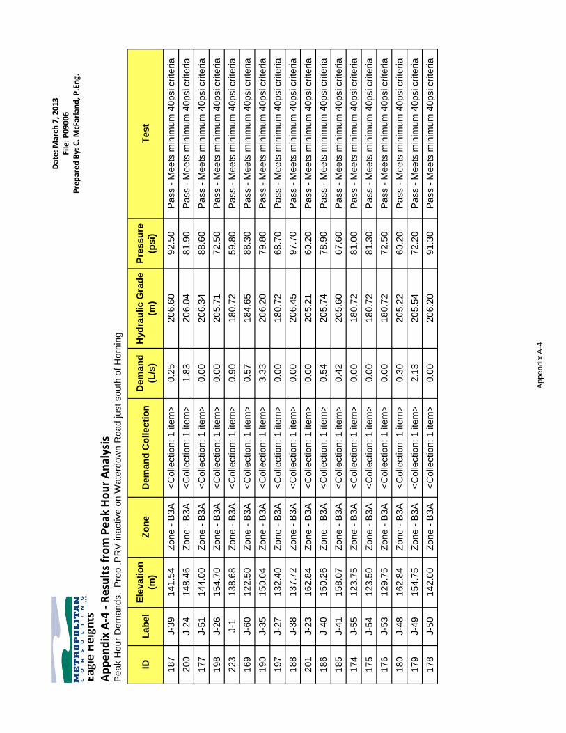
Dat
e: M
arch
7, 2
01
3Fi
le: P
09
00
6P
rep
are
d B
y: C
. McF
arla
nd
, P.E
ng.
Eagl
e H
eig
hts
Ap
pen
dix
A-4
- R
esu
lts
fro
m P
eak
Ho
ur
An
alys
isP
ea
k H
ou
r D
em
an
ds. P
rop
.P
RV
in
active
on
Wa
terd
ow
n R
oa
d ju
st so
uth
of
Ho
rnin
g
IDL
ab
el
Ele
va
tio
n
(m)
Zo
ne
De
ma
nd
Co
lle
cti
on
De
ma
nd
(L/s
)
Hyd
rau
lic
Gra
de
(m)
Pre
ss
ure
(ps
i)T
es
t
18
7J-3
91
41
.54
Zo
ne
- B
3A
<C
olle
ctio
n: 1
ite
m>
0.2
52
06
.60
92
.50
Pa
ss -
Me
ets
min
imu
m 4
0p
si cri
teri
a
20
0J-2
41
48
.46
Zo
ne
- B
3A
<C
olle
ctio
n: 1
ite
m>
1.8
32
06
.04
81
.90
Pa
ss -
Me
ets
min
imu
m 4
0p
si cri
teri
a
17
7J-5
11
44
.00
Zo
ne
- B
3A
<C
olle
ctio
n: 1
ite
m>
0.0
02
06
.34
88
.60
Pa
ss -
Me
ets
min
imu
m 4
0p
si cri
teri
a
19
8J-2
61
54
.70
Zo
ne
- B
3A
<C
olle
ctio
n: 1
ite
m>
0.0
02
05
.71
72
.50
Pa
ss -
Me
ets
min
imu
m 4
0p
si cri
teri
a
22
3J-1
13
8.6
8Z
on
e -
B3
A<
Co
llectio
n: 1
ite
m>
0.9
01
80
.72
59
.80
Pa
ss -
Me
ets
min
imu
m 4
0p
si cri
teri
a
16
9J-6
01
22
.50
Zo
ne
- B
3A
<C
olle
ctio
n: 1
ite
m>
0.5
71
84
.65
88
.30
Pa
ss -
Me
ets
min
imu
m 4
0p
si cri
teri
a
19
0J-3
51
50
.04
Zo
ne
- B
3A
<C
olle
ctio
n: 1
ite
m>
3.3
32
06
.20
79
.80
Pa
ss -
Me
ets
min
imu
m 4
0p
si cri
teri
a
19
7J-2
71
32
.40
Zo
ne
- B
3A
<C
olle
ctio
n: 1
ite
m>
0.0
01
80
.72
68
.70
Pa
ss -
Me
ets
min
imu
m 4
0p
si cri
teri
a
18
8J-3
81
37
.72
Zo
ne
- B
3A
<C
olle
ctio
n: 1
ite
m>
0.0
02
06
.45
97
.70
Pa
ss -
Me
ets
min
imu
m 4
0p
si cri
teri
a
20
1J-2
31
62
.84
Zo
ne
- B
3A
<C
olle
ctio
n: 1
ite
m>
0.0
02
05
.21
60
.20
Pa
ss -
Me
ets
min
imu
m 4
0p
si cri
teri
a
18
6J-4
01
50
.26
Zo
ne
- B
3A
<C
olle
ctio
n: 1
ite
m>
0.5
42
05
.74
78
.90
Pa
ss -
Me
ets
min
imu
m 4
0p
si cri
teri
a
18
5J-4
11
58
.07
Zo
ne
- B
3A
<C
olle
ctio
n: 1
ite
m>
0.4
22
05
.60
67
.60
Pa
ss -
Me
ets
min
imu
m 4
0p
si cri
teri
a
17
4J-5
51
23
.75
Zo
ne
- B
3A
<C
olle
ctio
n: 1
ite
m>
0.0
01
80
.72
81
.00
Pa
ss -
Me
ets
min
imu
m 4
0p
si cri
teri
a
17
5J-5
41
23
.50
Zo
ne
- B
3A
<C
olle
ctio
n: 1
ite
m>
0.0
01
80
.72
81
.30
Pa
ss -
Me
ets
min
imu
m 4
0p
si cri
teri
a
17
6J-5
31
29
.75
Zo
ne
- B
3A
<C
olle
ctio
n: 1
ite
m>
0.0
01
80
.72
72
.50
Pa
ss -
Me
ets
min
imu
m 4
0p
si cri
teri
a
18
0J-4
81
62
.84
Zo
ne
- B
3A
<C
olle
ctio
n: 1
ite
m>
0.3
02
05
.22
60
.20
Pa
ss -
Me
ets
min
imu
m 4
0p
si cri
teri
a
17
9J-4
91
54
.75
Zo
ne
- B
3A
<C
olle
ctio
n: 1
ite
m>
2.1
32
05
.54
72
.20
Pa
ss -
Me
ets
min
imu
m 4
0p
si cri
teri
a
17
8J-5
01
42
.00
Zo
ne
- B
3A
<C
olle
ctio
n: 1
ite
m>
0.0
02
06
.20
91
.30
Pa
ss -
Me
ets
min
imu
m 4
0p
si cri
teri
a
Ap
pe
nd
ix A
-4

Dat
e: M
arch
7, 2
01
3Fi
le: P
09
00
6P
rep
are
d B
y: C
. McF
arla
nd
, P.E
ng.
Eagl
e H
eig
hts
Ap
pen
dix
A-4
- R
esu
lts
fro
m P
eak
Ho
ur
An
alys
isP
ea
k H
ou
r D
em
an
ds. P
rop
.P
RV
in
active
on
Wa
terd
ow
n R
oa
d ju
st so
uth
of
Ho
rnin
g
IDL
ab
el
Ele
va
tio
n
(m)
Zo
ne
De
ma
nd
Co
lle
cti
on
De
ma
nd
(L/s
)
Hyd
rau
lic
Gra
de
(m)
Pre
ss
ure
(ps
i)T
es
t
18
9J-3
61
40
.57
Zo
ne
- B
3A
<C
olle
ctio
n: 1
ite
m>
0.0
02
06
.29
93
.40
Pa
ss -
Me
ets
min
imu
m 4
0p
si cri
teri
a
21
0J-1
41
58
.07
Zo
ne
- B
3A
<C
olle
ctio
n: 1
ite
m>
0.0
02
05
.59
67
.60
Pa
ss -
Me
ets
min
imu
m 4
0p
si cri
teri
a
22
2J-2
12
3.9
9Z
on
e -
B3
A<
Co
llectio
n: 1
ite
m>
0.8
71
80
.72
80
.60
Pa
ss -
Me
ets
min
imu
m 4
0p
si cri
teri
a
22
1J-3
16
7.3
8Z
on
e -
B3
A<
Co
llectio
n: 1
ite
m>
0.2
12
06
.95
56
.20
Pa
ss -
Me
ets
min
imu
m 4
0p
si cri
teri
a
22
0J-4
15
7.5
0Z
on
e -
B3
A<
Co
llectio
n: 1
ite
m>
0.3
62
06
.81
70
.10
Pa
ss -
Me
ets
min
imu
m 4
0p
si cri
teri
a
21
9J-5
14
4.8
2Z
on
e -
B3
A<
Co
llectio
n: 1
ite
m>
0.0
02
06
.66
87
.90
Pa
ss -
Me
ets
min
imu
m 4
0p
si cri
teri
a
21
8J-6
14
1.5
4Z
on
e -
B3
A<
Co
llectio
n: 1
ite
m>
0.0
02
06
.94
93
.00
Pa
ss -
Me
ets
min
imu
m 4
0p
si cri
teri
a
21
7J-7
13
7.7
2Z
on
e -
B3
A<
Co
llectio
n: 1
ite
m>
0.0
02
06
.51
97
.80
Pa
ss -
Me
ets
min
imu
m 4
0p
si cri
teri
a
21
6J-8
14
1.3
7Z
on
e -
B3
A<
Co
llectio
n: 1
ite
m>
1.3
82
06
.20
92
.20
Pa
ss -
Me
ets
min
imu
m 4
0p
si cri
teri
a
21
5J-9
14
0.5
7Z
on
e -
B3
A<
Co
llectio
n: 1
ite
m>
0.9
02
06
.20
93
.30
Pa
ss -
Me
ets
min
imu
m 4
0p
si cri
teri
a
21
4J-1
01
50
.84
Zo
ne
- B
3A
<C
olle
ctio
n: 1
ite
m>
0.0
02
06
.25
78
.80
Pa
ss -
Me
ets
min
imu
m 4
0p
si cri
teri
a
21
3J-1
11
57
.25
Zo
ne
- B
3A
<C
olle
ctio
n: 1
ite
m>
0.6
32
06
.22
69
.60
Pa
ss -
Me
ets
min
imu
m 4
0p
si cri
teri
a
19
9J-2
51
52
.70
Zo
ne
- B
3A
<C
olle
ctio
n: 1
ite
m>
0.0
02
05
.81
75
.50
Pa
ss -
Me
ets
min
imu
m 4
0p
si cri
teri
a
21
1J-1
31
51
.20
Zo
ne
- B
3A
<C
olle
ctio
n: 1
ite
m>
0.7
52
05
.60
77
.30
Pa
ss -
Me
ets
min
imu
m 4
0p
si cri
teri
a
20
2J-2
21
62
.53
Zo
ne
- B
3A
<C
olle
ctio
n: 1
ite
m>
1.3
82
05
.59
61
.20
Pa
ss -
Me
ets
min
imu
m 4
0p
si cri
teri
a
20
9J-1
51
54
.75
Zo
ne
- B
3A
<C
olle
ctio
n: 1
ite
m>
0.0
02
05
.41
72
.00
Pa
ss -
Me
ets
min
imu
m 4
0p
si cri
teri
a
20
8J-1
61
63
.99
Zo
ne
- B
3A
<C
olle
ctio
n: 1
ite
m>
1.0
52
06
.99
61
.10
Pa
ss -
Me
ets
min
imu
m 4
0p
si cri
teri
a
20
7J-1
71
65
.95
Zo
ne
- B
3A
<C
olle
ctio
n: 1
ite
m>
0.8
42
06
.99
58
.30
Pa
ss -
Me
ets
min
imu
m 4
0p
si cri
teri
a
20
6J-1
81
50
.17
Zo
ne
- B
3A
<C
olle
ctio
n: 1
ite
m>
0.9
62
07
.08
80
.90
Pa
ss -
Me
ets
min
imu
m 4
0p
si cri
teri
a
20
5J-1
91
43
.00
Zo
ne
- B
3A
<C
olle
ctio
n: 1
ite
m>
0.0
02
07
.14
91
.20
Pa
ss -
Me
ets
min
imu
m 4
0p
si cri
teri
a
20
4J-2
01
51
.73
Zo
ne
- B
3A
<C
olle
ctio
n: 1
ite
m>
2.4
32
05
.69
76
.70
Pa
ss -
Me
ets
min
imu
m 4
0p
si cri
teri
a
20
3J-2
11
50
.26
Zo
ne
- B
3A
<C
olle
ctio
n: 1
ite
m>
0.0
02
05
.78
78
.90
Pa
ss -
Me
ets
min
imu
m 4
0p
si cri
teri
a
Ap
pe
nd
ix A
-4

Dat
e: M
arch
7, 2
01
3Fi
le: P
09
00
6P
rep
are
d B
y: C
. McF
arla
nd
, P.E
ng.
Eagl
e H
eig
hts
Ap
pen
dix
A-4
- R
esu
lts
fro
m P
eak
Ho
ur
An
alys
isP
ea
k H
ou
r D
em
an
ds. P
rop
.P
RV
in
active
on
Wa
terd
ow
n R
oa
d ju
st so
uth
of
Ho
rnin
g
IDL
ab
el
Ele
va
tio
n
(m)
Zo
ne
De
ma
nd
Co
lle
cti
on
De
ma
nd
(L/s
)
Hyd
rau
lic
Gra
de
(m)
Pre
ss
ure
(ps
i)T
es
t
21
2J-1
21
51
.60
Zo
ne
- B
3A
<C
olle
ctio
n: 1
ite
m>
3.4
82
05
.60
76
.80
Pa
ss -
Me
ets
min
imu
m 4
0p
si cri
teri
a
19
6J-2
81
70
.00
Zo
ne
- B
4A
<C
olle
ctio
n: 1
ite
m>
0.9
32
76
.98
15
2.1
0P
ass -
Me
ets
min
imu
m 4
0p
si cri
teri
a
19
4J-3
01
87
.57
Zo
ne
- B
4A
<C
olle
ctio
n: 1
ite
m>
0.6
32
46
.67
84
.00
Pa
ss -
Me
ets
min
imu
m 4
0p
si cri
teri
a
19
3J-3
11
85
.94
Zo
ne
- B
4A
<C
olle
ctio
n: 1
ite
m>
2.7
02
46
.66
86
.30
Pa
ss -
Me
ets
min
imu
m 4
0p
si cri
teri
a
18
4J-4
42
01
.54
Zo
ne
- B
4A
<C
olle
ctio
n: 1
ite
m>
0.8
72
76
.98
10
7.2
0P
ass -
Me
ets
min
imu
m 4
0p
si cri
teri
a
18
3J-4
51
95
.90
Zo
ne
- B
4A
<C
olle
ctio
n: 1
ite
m>
0.3
32
76
.98
11
5.3
0P
ass -
Me
ets
min
imu
m 4
0p
si cri
teri
a
18
1J-4
72
03
.50
Zo
ne
- B
4A
<C
olle
ctio
n: 1
ite
m>
0.0
02
46
.69
61
.40
Pa
ss -
Me
ets
min
imu
m 4
0p
si cri
teri
a
18
2J-4
62
14
.00
Zo
ne
- B
5A
<C
olle
ctio
n: 1
ite
m>
0.0
02
76
.99
89
.50
Pa
ss -
Me
ets
min
imu
m 4
0p
si cri
teri
a
19
5J-2
92
07
.80
Zo
ne
- B
5A
<C
olle
ctio
n: 1
ite
m>
0.6
92
76
.99
98
.40
Pa
ss -
Me
ets
min
imu
m 4
0p
si cri
teri
a
Ap
pe
nd
ix A
-4

Dat
e: M
arch
7, 2
01
3Fi
le: P
09
00
6P
rep
are
d B
y: C
. McF
arla
nd
, P.E
ng.
Eagl
e H
eig
hts
Ap
pen
dix
A-4
- R
esu
lts
fro
m P
eak
Ho
ur
An
alys
isP
ea
k H
ou
r D
em
an
ds. P
rop
.P
RV
on
Wa
terd
ow
n R
oa
d ju
st so
uth
of
Ho
rnin
g
IDL
ab
el
Ele
va
tio
n
(m)
Zo
ne
De
ma
nd
Co
lle
cti
on
De
ma
nd
(L/s
)
Hyd
rau
lic
Gra
de
(m)
Pre
ss
ure
(ps
i)T
es
t
18
7J-3
91
41
.54
Zo
ne
- B
3A
<C
olle
ctio
n: 1
ite
m>
0.2
52
06
.60
92
.50
Pa
ss -
Me
ets
min
imu
m 4
0p
si cri
teri
a
20
0J-2
41
48
.46
Zo
ne
- B
3A
<C
olle
ctio
n: 1
ite
m>
1.8
32
06
.04
81
.90
Pa
ss -
Me
ets
min
imu
m 4
0p
si cri
teri
a
17
7J-5
11
44
.00
Zo
ne
- B
3A
<C
olle
ctio
n: 1
ite
m>
0.0
02
06
.34
88
.60
Pa
ss -
Me
ets
min
imu
m 4
0p
si cri
teri
a
19
8J-2
61
54
.70
Zo
ne
- B
3A
<C
olle
ctio
n: 1
ite
m>
0.0
02
05
.71
72
.50
Pa
ss -
Me
ets
min
imu
m 4
0p
si cri
teri
a
22
3J-1
13
8.6
8Z
on
e -
B3
A<
Co
llectio
n: 1
ite
m>
0.9
01
80
.72
59
.80
Pa
ss -
Me
ets
min
imu
m 4
0p
si cri
teri
a
16
9J-6
01
22
.50
Zo
ne
- B
3A
<C
olle
ctio
n: 1
ite
m>
0.5
71
84
.65
88
.30
Pa
ss -
Me
ets
min
imu
m 4
0p
si cri
teri
a
19
0J-3
51
50
.04
Zo
ne
- B
3A
<C
olle
ctio
n: 1
ite
m>
3.3
32
06
.20
79
.80
Pa
ss -
Me
ets
min
imu
m 4
0p
si cri
teri
a
19
7J-2
71
32
.40
Zo
ne
- B
3A
<C
olle
ctio
n: 1
ite
m>
0.0
01
80
.72
68
.70
Pa
ss -
Me
ets
min
imu
m 4
0p
si cri
teri
a
18
8J-3
81
37
.72
Zo
ne
- B
3A
<C
olle
ctio
n: 1
ite
m>
0.0
02
06
.45
97
.70
Pa
ss -
Me
ets
min
imu
m 4
0p
si cri
teri
a
20
1J-2
31
62
.84
Zo
ne
- B
3A
<C
olle
ctio
n: 1
ite
m>
0.0
02
05
.21
60
.20
Pa
ss -
Me
ets
min
imu
m 4
0p
si cri
teri
a
18
6J-4
01
50
.26
Zo
ne
- B
3A
<C
olle
ctio
n: 1
ite
m>
0.5
42
05
.74
78
.90
Pa
ss -
Me
ets
min
imu
m 4
0p
si cri
teri
a
18
5J-4
11
58
.07
Zo
ne
- B
3A
<C
olle
ctio
n: 1
ite
m>
0.4
22
05
.60
67
.60
Pa
ss -
Me
ets
min
imu
m 4
0p
si cri
teri
a
17
4J-5
51
23
.75
Zo
ne
- B
3A
<C
olle
ctio
n: 1
ite
m>
0.0
01
80
.72
81
.00
Pa
ss -
Me
ets
min
imu
m 4
0p
si cri
teri
a
17
5J-5
41
23
.50
Zo
ne
- B
3A
<C
olle
ctio
n: 1
ite
m>
0.0
01
80
.72
81
.30
Pa
ss -
Me
ets
min
imu
m 4
0p
si cri
teri
a
17
6J-5
31
29
.75
Zo
ne
- B
3A
<C
olle
ctio
n: 1
ite
m>
0.0
01
80
.72
72
.50
Pa
ss -
Me
ets
min
imu
m 4
0p
si cri
teri
a
18
0J-4
81
62
.84
Zo
ne
- B
3A
<C
olle
ctio
n: 1
ite
m>
0.3
02
05
.22
60
.20
Pa
ss -
Me
ets
min
imu
m 4
0p
si cri
teri
a
17
9J-4
91
54
.75
Zo
ne
- B
3A
<C
olle
ctio
n: 1
ite
m>
2.1
32
05
.54
72
.20
Pa
ss -
Me
ets
min
imu
m 4
0p
si cri
teri
a
17
8J-5
01
42
.00
Zo
ne
- B
3A
<C
olle
ctio
n: 1
ite
m>
0.0
02
06
.20
91
.30
Pa
ss -
Me
ets
min
imu
m 4
0p
si cri
teri
a
18
9J-3
61
40
.57
Zo
ne
- B
3A
<C
olle
ctio
n: 1
ite
m>
0.0
02
06
.29
93
.40
Pa
ss -
Me
ets
min
imu
m 4
0p
si cri
teri
a
21
0J-1
41
58
.07
Zo
ne
- B
3A
<C
olle
ctio
n: 1
ite
m>
0.0
02
05
.59
67
.60
Pa
ss -
Me
ets
min
imu
m 4
0p
si cri
teri
a
22
2J-2
12
3.9
9Z
on
e -
B3
A<
Co
llectio
n: 1
ite
m>
0.8
71
80
.72
80
.60
Pa
ss -
Me
ets
min
imu
m 4
0p
si cri
teri
a
22
1J-3
16
7.3
8Z
on
e -
B3
A<
Co
llectio
n: 1
ite
m>
0.2
12
06
.95
56
.20
Pa
ss -
Me
ets
min
imu
m 4
0p
si cri
teri
a
22
0J-4
15
7.5
0Z
on
e -
B3
A<
Co
llectio
n: 1
ite
m>
0.3
62
06
.81
70
.10
Pa
ss -
Me
ets
min
imu
m 4
0p
si cri
teri
a
Ap
pe
nd
ix A
-4

Dat
e: M
arch
7, 2
01
3Fi
le: P
09
00
6P
rep
are
d B
y: C
. McF
arla
nd
, P.E
ng.
Eagl
e H
eig
hts
Ap
pen
dix
A-4
- R
esu
lts
fro
m P
eak
Ho
ur
An
alys
isP
ea
k H
ou
r D
em
an
ds. P
rop
.P
RV
on
Wa
terd
ow
n R
oa
d ju
st so
uth
of
Ho
rnin
g
IDL
ab
el
Ele
va
tio
n
(m)
Zo
ne
De
ma
nd
Co
lle
cti
on
De
ma
nd
(L/s
)
Hyd
rau
lic
Gra
de
(m)
Pre
ss
ure
(ps
i)T
es
t
21
9J-5
14
4.8
2Z
on
e -
B3
A<
Co
llectio
n: 1
ite
m>
0.0
02
06
.66
87
.90
Pa
ss -
Me
ets
min
imu
m 4
0p
si cri
teri
a
21
8J-6
14
1.5
4Z
on
e -
B3
A<
Co
llectio
n: 1
ite
m>
0.0
02
06
.94
93
.00
Pa
ss -
Me
ets
min
imu
m 4
0p
si cri
teri
a
21
7J-7
13
7.7
2Z
on
e -
B3
A<
Co
llectio
n: 1
ite
m>
0.0
02
06
.51
97
.80
Pa
ss -
Me
ets
min
imu
m 4
0p
si cri
teri
a
21
6J-8
14
1.3
7Z
on
e -
B3
A<
Co
llectio
n: 1
ite
m>
1.3
82
06
.20
92
.20
Pa
ss -
Me
ets
min
imu
m 4
0p
si cri
teri
a
21
5J-9
14
0.5
7Z
on
e -
B3
A<
Co
llectio
n: 1
ite
m>
0.9
02
06
.20
93
.30
Pa
ss -
Me
ets
min
imu
m 4
0p
si cri
teri
a
21
4J-1
01
50
.84
Zo
ne
- B
3A
<C
olle
ctio
n: 1
ite
m>
0.0
02
06
.25
78
.80
Pa
ss -
Me
ets
min
imu
m 4
0p
si cri
teri
a
21
3J-1
11
57
.25
Zo
ne
- B
3A
<C
olle
ctio
n: 1
ite
m>
0.6
32
06
.22
69
.60
Pa
ss -
Me
ets
min
imu
m 4
0p
si cri
teri
a
19
9J-2
51
52
.70
Zo
ne
- B
3A
<C
olle
ctio
n: 1
ite
m>
0.0
02
05
.81
75
.50
Pa
ss -
Me
ets
min
imu
m 4
0p
si cri
teri
a
21
1J-1
31
51
.20
Zo
ne
- B
3A
<C
olle
ctio
n: 1
ite
m>
0.7
52
05
.60
77
.30
Pa
ss -
Me
ets
min
imu
m 4
0p
si cri
teri
a
20
2J-2
21
62
.53
Zo
ne
- B
3A
<C
olle
ctio
n: 1
ite
m>
1.3
82
05
.59
61
.20
Pa
ss -
Me
ets
min
imu
m 4
0p
si cri
teri
a
20
9J-1
51
54
.75
Zo
ne
- B
3A
<C
olle
ctio
n: 1
ite
m>
0.0
02
05
.41
72
.00
Pa
ss -
Me
ets
min
imu
m 4
0p
si cri
teri
a
20
8J-1
61
63
.99
Zo
ne
- B
3A
<C
olle
ctio
n: 1
ite
m>
1.0
52
06
.99
61
.10
Pa
ss -
Me
ets
min
imu
m 4
0p
si cri
teri
a
20
7J-1
71
65
.95
Zo
ne
- B
3A
<C
olle
ctio
n: 1
ite
m>
0.8
42
06
.99
58
.30
Pa
ss -
Me
ets
min
imu
m 4
0p
si cri
teri
a
20
6J-1
81
50
.17
Zo
ne
- B
3A
<C
olle
ctio
n: 1
ite
m>
0.9
62
07
.08
80
.90
Pa
ss -
Me
ets
min
imu
m 4
0p
si cri
teri
a
20
5J-1
91
43
.00
Zo
ne
- B
3A
<C
olle
ctio
n: 1
ite
m>
0.0
02
07
.14
91
.20
Pa
ss -
Me
ets
min
imu
m 4
0p
si cri
teri
a
20
4J-2
01
51
.73
Zo
ne
- B
3A
<C
olle
ctio
n: 1
ite
m>
2.4
32
05
.69
76
.70
Pa
ss -
Me
ets
min
imu
m 4
0p
si cri
teri
a
20
3J-2
11
50
.26
Zo
ne
- B
3A
<C
olle
ctio
n: 1
ite
m>
0.0
02
05
.78
78
.90
Pa
ss -
Me
ets
min
imu
m 4
0p
si cri
teri
a
21
2J-1
21
51
.60
Zo
ne
- B
3A
<C
olle
ctio
n: 1
ite
m>
3.4
82
05
.60
76
.80
Pa
ss -
Me
ets
min
imu
m 4
0p
si cri
teri
a
18
1J-4
72
03
.50
Zo
ne
- B
4A
<C
olle
ctio
n: 1
ite
m>
0.0
02
46
.69
61
.40
Pa
ss -
Me
ets
min
imu
m 4
0p
si cri
teri
a
18
3J-4
51
95
.90
Zo
ne
- B
4A
<C
olle
ctio
n: 1
ite
m>
0.3
32
36
.65
57
.90
Pa
ss -
Me
ets
min
imu
m 4
0p
si cri
teri
a
18
4J-4
42
01
.54
Zo
ne
- B
4A
<C
olle
ctio
n: 1
ite
m>
0.8
72
36
.65
49
.90
Pa
ss -
Me
ets
min
imu
m 4
0p
si cri
teri
a
19
3J-3
11
85
.94
Zo
ne
- B
4A
<C
olle
ctio
n: 1
ite
m>
2.7
02
46
.66
86
.30
Pa
ss -
Me
ets
min
imu
m 4
0p
si cri
teri
a
19
4J-3
01
87
.57
Zo
ne
- B
4A
<C
olle
ctio
n: 1
ite
m>
0.6
32
46
.67
84
.00
Pa
ss -
Me
ets
min
imu
m 4
0p
si cri
teri
a
Ap
pe
nd
ix A
-4

Dat
e: M
arch
7, 2
01
3Fi
le: P
09
00
6P
rep
are
d B
y: C
. McF
arla
nd
, P.E
ng.
Eagl
e H
eig
hts
Ap
pen
dix
A-4
- R
esu
lts
fro
m P
eak
Ho
ur
An
alys
isP
ea
k H
ou
r D
em
an
ds. P
rop
.P
RV
on
Wa
terd
ow
n R
oa
d ju
st so
uth
of
Ho
rnin
g
IDL
ab
el
Ele
va
tio
n
(m)
Zo
ne
De
ma
nd
Co
lle
cti
on
De
ma
nd
(L/s
)
Hyd
rau
lic
Gra
de
(m)
Pre
ss
ure
(ps
i)T
es
t
19
6J-2
81
70
.00
Zo
ne
- B
4A
<C
olle
ctio
n: 1
ite
m>
0.9
32
36
.65
94
.70
Pa
ss -
Me
ets
min
imu
m 4
0p
si cri
teri
a
18
2J-4
62
14
.00
Zo
ne
- B
5A
<C
olle
ctio
n: 1
ite
m>
0.0
02
76
.99
89
.50
Pa
ss -
Me
ets
min
imu
m 4
0p
si cri
teri
a
19
5J-2
92
07
.80
Zo
ne
- B
5A
<C
olle
ctio
n: 1
ite
m>
0.6
92
76
.99
98
.40
Pa
ss -
Me
ets
min
imu
m 4
0p
si cri
teri
a
Ap
pe
nd
ix A
-4

Eagle Height s /Taylor P roper ty U p d a t e t o Fun c t io n a l Se rv i c in g & S to r mwat e r Man ag e men t Rep o r t
Ad d en d u m R evi sed S ec t io n 7
Metropol i tan Co nsul t ing Inc . February 2013
APPENDIX B
Revised Sanitary Sewer Design Sheets

Date: rev 03/04/2013
Location: North Aldershot SANITARY SEWER DESIGN Calculated by: CCPChecked by:
Average Average Peak Infil- Max. Sewer % of Full Catch. Location Increment Total Total Flow Peaking Flow tration Flow Size Slope Capacity Velocity [m/s] Capacity Pipe Manning's
ID Street From ToEx. SF Res.
Pr SF Res.
Pr Cl Res
Non Res. Area
SF @ 3.4 ppu
Cl @ 2.5 ppu Pop. [l/s] Factor [l/s] [l/s] [l/s] [mm] [%] [l/s] Full Actual [%] Material n
30 Waterdown Rd A B 23.6 23.6 36 122 0 122 0.39 4.22 1.64 6.75 8.39 200 0.50% 23.2 0.74 0.64 36.2 PVC 0.01331 Waterdown Rd B AA 6.8 30.4 20 68 0 190 0.61 4.16 2.52 8.69 11.21 200 0.50% 23.2 0.74 0.69 48.3 PVC 0.013
6A,6B,18 Waterdown Rd AA AD 4.8 0.7 2.4 38.3 16 54 216 461 1.47 3.99 5.86 10.94 16.79 200 1.00% 32.8 1.04 1.04 51.2 PVC 0.013
16,17 Street D + ease C D 4.5 0.7 5.2 54 116 474 0 474 1.51 3.99 6.01 1.49 7.50 200 1.00% 32.8 1.04 0.81 22.9 PVC 0.013
19 Flatt Rd D E 1.7 45.2 0 153 1087 3.46 3.78 13.07 12.91 25.98 250 0.50% 42.1 0.86 0.89 61.8 PVC 0.013
1 Horning Rd F G 4.8 4.8 15 51 0 51 0.16 4.31 0.70 1.37 2.07 200 3.50% 61.4 1.95 0.83 3.4 PVC 0.0132 Horning Rd G H 1.5 6.3 18 61 0 112 0.36 4.23 1.51 1.80 3.31 200 2.90% 55.9 1.78 0.91 5.9 PVC 0.0133 Easement H I 0.9 7.2 94 235 0 347 1.11 4.05 4.48 2.06 6.54 200 1.00% 32.8 1.04 0.75 19.9 PVC 0.013
5A Condo Road I JJ 2.4 9.6 20 68 0 415 1.32 4.01 5.31 2.75 8.05 200 2.66% 53.5 1.70 1.23 15.0 PVC 0.013Street C JJ KK 9.6 415 1.32 4.01 5.31 2.75 8.05 200 0.50% 23.2 0.74 0.64 34.7 PVC 0.013
5B Street C+Ease L J 4.7 4.7 128 320 0 320 1.02 4.07 4.14 1.34 5.49 200 3.50% 61.4 1.95 1.16 8.9 PVC 0.013
10,11 Street B N O 2.1 1.1 3.2 26 124 398 0 398 1.27 4.02 5.10 0.92 6.02 200 0.60% 25.4 0.81 0.63 23.7 PVC 0.01312 Easement O L 0.5 3.7 83 208 0 606 1.93 3.93 7.58 1.06 8.64 200 0.50% 23.2 0.74 0.64 37.2 PVC 0.013
13,14 Flatt Rd Ext KK L 5.9 15.5 70 238 0 653 2.08 3.91 8.13 4.43 12.57 200 3.75% 63.5 2.02 1.46 19.8 PVC 0.01315 Flatt Rd Ext L M 2.6 21.8 42 105 0 1364 4.34 3.71 16.10 6.23 22.34 200 3.75% 63.5 2.02 1.76 35.2 PVC 0.013
7 Street A P Q 1.5 1.5 18 61 0 61 0.19 4.30 0.84 0.43 1.27 200 2.00% 46.4 1.48 0.59 2.7 PVC 0.0138 Street A Q R 2.5 4.0 37 93 0 154 0.49 4.19 2.05 1.14 3.19 200 1.00% 32.8 1.04 0.65 9.7 PVC 0.0139 Street A R S 1.8 5.8 24 82 0 235 0.75 4.12 3.09 1.66 4.75 200 1.00% 32.8 1.04 0.67 14.5 PVC 0.013
20A Flatt Rd S M 2.4 8.2 20 68 0 303 0.97 4.08 3.94 2.35 6.28 200 0.55% 24.3 0.77 0.60 25.8 PVC 0.01320B Flatt Rd M J 2.1 30.0 18 61 0 1729 5.50 3.63 20.00 8.58 28.58 300 0.50% 68.4 0.97 0.91 41.8 PVC 0.01320C Flatt Rd J E 0.6 35.3 3 10 0 2062 6.56 3.58 23.46 10.10 33.56 300 0.50% 68.4 0.97 0.91 49.1 PVC 0.01321 Street X E T 1.2 81.7 6 20 0 3176 10.11 3.42 34.58 23.35 57.93 300 0.50% 68.4 0.97 1.07 84.7 PVC 0.013
22,23 St X/Easement T U 2.1 2.1 85.9 31 24 165 0 3341 10.63 3.40 36.18 24.55 60.73 300 0.55% 71.7 1.01 1.13 84.7 PVC 0.01325 Nevarc/Craven U Ex 11A 7.9 93.8 30 102 0 3443 10.96 3.39 37.16 26.81 63.97 300 0.60% 74.9 1.06 1.18 85.4 PVC 0.01327 Waterdown Rd Ex 11A Ex 9A 4.5 98.3 0 405 3848 12.25 3.35 41.01 28.10 69.11 300 0.96% 94.8 1.34 1.45 72.9 PVC 0.013
28 Aldershot Landsc Z ZB 13.0 13.0 100 340 0 340 1.08 4.05 4.39 3.72 8.11 200 0.70% 27.4 0.87 0.68 29.5 PVC 0.01324 Morgante Propert ZB Ex 9A 3.4 16.4 35 119 0 459 1.46 3.99 5.83 4.69 10.52 200 0.50% 23.2 0.74 0.69 45.4 PVC 0.013
26 Waterdown Road Ex9A Ex5A 1.6 116.3 6 20 0 4327 300 0.86% 89.7 1.27 0.00 0.0 PVC 0.013
30 Panin Church ZC Pump St 5.9 5.9 50 170 0 170 0.54 4.17 2.26 1.69 3.95 200 1.00% 32.8 1.04 0.67 12.0 PVC 0.01329 Cama WoodlandsPump St 5A 4.0 9.9 0 360 530 1.69 3.96 6.68 2.83 9.51 Pump station & Forcemain
NSR Ex 5A Ex 1A 126.2 0 0 4857 15.46 3.26 50.35 36.08 86.43 300 0.90% 91.8 1.30 1.48 94.2 PVC 0.013
TOTAL 38.1 62.5 15.1 12.6 616 648
20.8 107.3As constructed
Tributary Area [ha]Residential Units
Population Total Res Pop.
Non Res @ 90

Date: 27/02/2013
Location: North Aldershot SANITARY SEWER DESIGN Calculated by: CCPPhase 1 Eagle Heights Checked by:
Average Average Peak Infil- Max. Sewer % of Full Catch. Location Increment Total Total Flow Peaking Flow tration Flow Size Slope Capacity Velocity [m/s] Capacity Pipe Manning's
ID Street From ToEx. SF Res.
Pr SF Res.
Pr Cl Res
Non Res. Area
SF @ 3.4 ppu
Cl @ 2.5 ppu Pop. [l/s] Factor [l/s] [l/s] [l/s] [mm] [%] [l/s] Full Actual [%] Material n
6A,6B,18 Waterdown Rd AA AD 4.8 0.7 2.4 7.9 16 54 216 270 0.86 4.10 3.53 2.25 5.77 200 1.00% 32.8 1.04 0.75 17.6 PVC 0.013
16,17 Street D + ease C D 4.5 0.7 5.2 54 116 474 0 474 1.51 3.99 6.01 1.49 7.50 200 1.00% 32.8 1.04 0.81 22.9 PVC 0.013
19 Flatt Rd D E 1.7 14.8 0 153 897 2.86 3.83 10.94 4.22 15.15 250 0.50% 42.1 0.86 0.75 36.0 PVC 0.013
1 Horning Rd F G 4.8 4.8 15 51 0 51 0.16 4.31 0.70 1.37 2.07 200 3.50% 61.4 1.95 0.83 3.4 PVC 0.0132 Horning Rd G H 1.5 6.3 18 61 0 112 0.36 4.23 1.51 1.80 3.31 200 2.90% 55.9 1.78 0.91 5.9 PVC 0.0133 Easement H I 0.9 7.2 94 235 0 347 1.11 4.05 4.48 2.06 6.54 200 1.00% 32.8 1.04 0.75 19.9 PVC 0.013
5A Condo Road I JJ 2.4 9.6 20 68 0 415 1.32 4.01 5.31 2.75 8.05 200 2.66% 53.5 1.70 1.23 15.0 PVC 0.013Street C JJ KK 9.6 415 1.32 4.01 5.31 2.75 8.05 200 0.50% 23.2 0.74 0.64 34.7 PVC 0.013
5B Street C+Ease L J 4.7 4.7 128 320 0 320 1.02 4.07 4.14 1.34 5.49 200 3.50% 61.4 1.95 1.16 8.9 PVC 0.013
14 Flatt Rd Ext KK L 2.3 11.9 35 119 0 534 1.70 3.96 6.73 3.40 10.14 200 3.75% 63.5 2.02 1.46 16.0 PVC 0.01315 Flatt Rd Ext L M 2.6 14.5 42 105 0 639 2.03 3.92 7.97 4.15 12.12 200 3.75% 63.5 2.02 1.46 19.1 PVC 0.013
20B Flatt Rd M J 2.1 14.5 18 61 0 700 2.23 3.89 8.68 4.15 12.83 300 0.50% 68.4 0.97 0.70 18.8 PVC 0.01320C Flatt Rd J E 0.6 19.8 3 10 0 1034 3.29 3.79 12.47 5.66 18.13 300 0.50% 68.4 0.97 0.75 26.5 PVC 0.01321 Street X E T 1.2 35.8 6 20 0 1957 6.23 3.59 22.38 10.22 32.61 300 0.50% 68.4 0.97 0.91 47.7 PVC 0.013
22,23 St X/Easement T U 2.1 2.1 40.0 31 24 165 0 2122 6.76 3.57 24.09 11.43 35.51 300 0.55% 71.7 1.01 0.95 49.5 PVC 0.01325 Nevarc/Craven U Ex 11A 7.9 47.9 30 102 0 2224 7.08 3.55 25.13 13.69 38.82 300 0.60% 74.9 1.06 1.06 51.8 PVC 0.01327 Waterdown Rd Ex 11A Ex 9A 4.5 52.4 0 405 2629 8.37 3.49 29.21 14.97 44.18 300 0.96% 94.8 1.34 1.26 46.6 PVC 0.013
26 Waterdown Road Ex9A Ex5A 1.6 54.0 6 20 0 2650 300 0.86% 89.7 1.27 0.00 0.0 PVC 0.013
NSR Ex 5A Ex 1A 54.0 0 0 2650 8.43 3.49 29.42 15.43 44.85 300 0.90% 91.8 1.30 1.22 48.9 PVC 0.013
TOTAL 14.5 22.0 11.0 8.6 252 404
23.5 91.8As constructed
Tributary Area [ha]Residential Units
Population Total Res Pop.
Non Res @
90

Eagle Height s /Taylor P roper ty U p d a t e t o Fun c t io n a l Se rv i c in g & S to r mwat e r Man ag e men t Rep o r t
Ad d en d u m R evi sed S ec t io n 7
Metropol i tan Co nsul t ing Inc . February 2013
APPENDIX C
Extracts from Halton Region letter to City of Burlington dated February 27, 2012


1:4000 Figure 7-10P09006MAR 2013
Paletta InternationalCorporation
4480 Paletta CourtBurlington, Ontario L7L 5R2
EAGLE HEIGHTS & TAYLORPROPERTY FSR ADDENDUM
LEGEND:
EXISTING ZONE 5 WATERMAIN
EXISTING ZONE 2 WATERMAIN
EXISTING ZONE 1A WATERMAIN
EXISTING WATERDISTRIBUTION SYSTEM

Paletta International Corporation4480 Paletta Court
Burlington, Ontario L7L 5R2
WATER DISTRIBUTION
MAR 2013
FIGURE 7-11
Ontario, Canada
1 : 3000
STREET AS
TR
EE
T B S
TR
EE
T C
ST
RE
ET
E
STREET D
WA
TE
RD
OW
N R
OA
D
FLATT ROAD
STR
EE
T X
STREET C
STREET B
HO
RN
ING
RO
AD
FLA
TT
RO
AD
EX
TE
NS
ION
FLATT ROAD
TAYLOR PROPERTY
STREE
T A
CRAVEN AVE.
NE
VA
RC
A
VE
.
WA
TE
RD
OW
N R
OA
D
EAGLE HEIGHTS/
MORGANTE
HWY 403
LEGEND:
SYSTEM
PROPERTY
CUMISPROPERTY

Paletta International Corporation4480 Paletta Court
Burlington, Ontario L7L 5R2
MAR 2013
FIGURE 7-12
Ontario, Canada
1 : 3000
STREET AS
TR
EE
T B
ST
RE
ET
C
ST
RE
ET
E
STREET D
WA
TE
RD
OW
N R
OA
D
FLATT ROAD
STR
EE
T X
STREET C
STREET B
HO
RN
ING
RO
AD
FLA
TT
RO
AD
EX
TE
NS
ION
FLATT ROAD
MODEL SCHEMATIC
STREE
T A
CRAVEN AVE.
NE
VA
RC
A
VE
.
WA
TE
RD
OW
N R
OA
D
NORTH ALDERSHOT
MORGANTE
HWY 403
LEGEND:
PROPERTY
CUMISPROPERTY

1:5000 Figure 7-14P09006MAR 2013
Paletta InternationalCorporation
4480 Paletta CourtBurlington, Ontario L7L 5R2
EAGLE HEIGHTS & TAYLORPROPERTY FSR ADDENDUM
NORTH ALDERSHOTWASTEWATER DRAINAGE AREA
1050 1.0CLU ha

SUB-AREA10
SUB-AREA 2
SU
B-A
RE
A 6
SUB-AREA8
SU
B-A
RE
A 7 S
UB
-AR
EA
5
SUB-AREA1
CRAVEN AVE.
MORGANTE PROPERTY
HWY 403
SANITARY LEGEND:
PROPERTY
Paletta International Corporation4480 Paletta Court
Burlington, Ontario L7L 5R2
PROPOSED WASTEWATER
MAR 2013
FIGURE 7-15
Ontario, Canada
1 : 3000
STREET A
ST
RE
ET
B
ST
RE
ET
C
ST
RE
ET
E
STREET D
WA
TE
RD
OW
N R
OA
D
FLATT ROAD
STR
EE
T X
STREET C
STREET B
HO
RN
ING
RO
AD
FLA
TT
RO
AD
EX
TE
NS
ION
FLATT ROAD
TAYLOR PROPERTY
STREE
T A
CRAVEN AVE.
NE
VA
RC
A
VE
.
WA
TE
RD
OW
N R
OA
D
EAGLE HEIGHTS/
HWY 403
COLLECTION SYSTEM
CUMIS

PHASE 1PHASING
TOTAL (All Phases)
MAR 2013 P09006
EAGLE HEIGHTS
24T-94012/B
FIGURE 7-16
PHASING PLAN 2013
SUB-AREA 2
SUB-AREA 5
SUB-AREA 6
SUB-AREA 8
SUB-AREA 10
TOTAL PHASE 1
PHASE 2
SUB-AREA 5
SUB-AREA 7
TOTAL PHASE 2
SUB-AREA 1
PHASE 1 DEVELOPMENT
LEGEND:
PHASE 2 DEVELOPMENT
PHASE 1 ROAD/SERVICING CORRIDOR
PHASE 2 ROAD/SERVICING CORRIDOR
SUB-AREA
UNITS
UNITS
1 : 2500
Related Documents