Paleo-environmental evolution of the Larnaca Salt Lakes (Cyprus) and the relationship to second millennium BC settlement Benoît Devillers a,b, ⁎, Michael Brown c , Christophe Morhange d a ASM — Archéologie des Sociétés Méditerranéennes, UMR5140, Univ Montpellier 3, CNRS, MCC, 34000 Montpellier, France b Labex ARCHIMEDE, IA-program ANR-11-LABX-0032-01, France c Department of Archaeology, Durham University, South Road, Durham DH1 3LE, UK d CEREGE, Université d'Aix-Marseille, Europôle Méditerranéen de l'Arbois, Avenue Louis Philibert, BP 67, 13545 Aix en Provence Cedex 04, France abstract article info Article history: Received 13 August 2014 Received in revised form 3 November 2014 Accepted 13 November 2014 Available online 28 November 2014 Keywords: Geoarchaeology Coastal geomorphology Late Bronze Age Harbour engineering Dromolaxia-Vyzakia Cyprus Mediterranean New coring data provides a complete 14 C dated sequence covering the paleo-environmental evolution of the Larnaca Salt Lakes from c. 9000 BP onwards. This suggests the formation of a relatively confined lagoon after 4000 cal. BP. On the western shore of the main Aliki basin, overseas imports from the Late Bronze Age site of Dromolaxia-Vyzakia (Hala Sultan Tekke) reflect use of the Salt Lakes as a harbour during the second millennium BC. Coring and geomorphological mapping were employed to determine routes of navigation between this port and the open sea, with two main natural channels identified. A third potential communication in the form of an artificial cut, previously dated by Gifford (1978) to the Venetian period, is discussed with reference to changes in relative sea level along the island's south-east coast. Abandonment of settlement at Dromolaxia-Vyzakia in the early 12th century BC relates to the gradual isolation of the Salt Lakes lagoon from the surrounding marine envi- ronment through sedimentation. The timing of this event correlates with other known instances of population displacement throughout the eastern Mediterranean c. 1200 BC. © 2014 Published by Elsevier Ltd. 1. Introduction The most prominent hydrological feature in Larnaca Bay is the Salt Lakes which cover an area of c. 57 km 2 (Fig. 1). Until recently the annual salt harvest provided Cyprus with one of its oldest and best known ex- ports (Yon, 1992). Prior to formation of the Salt Lakes this area of coast- line was connected to the sea, latterly in the form of a lagoon which gradually became isolated through sedimentation. In the second millen- nium BC this lagoon formed the largest sheltered anchorage on the island. The main focus of Late Bronze Age occupation on the shore of the Salt Lakes was at Dromolaxia-Vyzakia (otherwise known as Hala Sultan Tekke). Excavated remains at the site primarily date to its final major phase of occupation between c.1190–1175 BC in Late Cypriot IIIA. The late Paul Åström, who led the Swedish Cyprus Expedition between 1971 and 2008, characterised this settlement as, “an international har- bour town … (with) Mycenaean jars and krators from mainland Greece, early vases and stirrup jars of oatmeal fabric from Crete, Grey ware from Troy, Canaanite jars from Cicilia, Syria and Palestine, elephant tusks and fa- ience from the Near East and Egypt, and lapis lazuli from Badakstan in the north-east of Afghanistan” (Åström, 1986, 8). Dromolaxia-Vyzakia was also a likely point of departure for locally manufactured goods going overseas. Crushed murex shell heaps have been interpreted as evidence for purple cloth manufacture in the early 12th century BC (Åström, 1986, 11). Lead isotope analyses by Renson et al. (2007) on white slip and white painted wheelmade ceramics found at Dromolaxia-Vyzakia indicate that clay was sourced from the near vicinity, implying that the site was one of a number of manufactur- ing hubs for these major categories of Late Bronze Age Cypriot export (Artzy, 2001). In addition, the site appears to have been a regional cen- tre for outlying rural settlements including Dromolaxia-Trypes (Åström, 1977). A road running north from Dromolaxia-Vyzakia a short distance to the shore has been mapped using ground-penetrating radar survey (Fischer, 2011, 70; Fischer, 1980, 49). In common with other (proto-) harbours throughout the Bronze Age Mediterranean, shallow-draft ves- sels would presumably have been beached near to this location during loading, unloading and maintenance (for ancient depictions of this prac- tice see Marriner et al., 2008, 1287; also Carayon, 2008; Sauvage, 2012; Tartaron, 2013). Renewed excavations, ongoing as of 2010 under the directorship of Peter Fischer, have begun to investigate earlier occupation at Dromolaxia-Vyzakia in more detail. Preliminary results suggest two preceding architectural phases beginning c. 1600 BC in Middle Cypriot III–Late Cypriot I (see most recently Fischer and Bürge, 2013). The Journal of Archaeological Science: Reports 1 (2015) 73–80 ⁎ Corresponding author. E-mail address: [email protected] (B. Devillers). http://dx.doi.org/10.1016/j.jasrep.2014.11.004 2352-409X/© 2014 Published by Elsevier Ltd. Contents lists available at ScienceDirect Journal of Archaeological Science: Reports journal homepage: http://ees.elsevier.com/jasrep

Welcome message from author
This document is posted to help you gain knowledge. Please leave a comment to let me know what you think about it! Share it to your friends and learn new things together.
Transcript
Journal of Archaeological Science: Reports 1 (2015) 73–80
Contents lists available at ScienceDirect
Journal of Archaeological Science: Reports
j ourna l homepage: ht tp : / /ees .e lsev ie r .com/ jas rep
Paleo-environmental evolution of the Larnaca Salt Lakes (Cyprus) andthe relationship to second millennium BC settlement
Benoît Devillers a,b,⁎, Michael Brown c, Christophe Morhange d
a ASM — Archéologie des Sociétés Méditerranéennes, UMR5140, Univ Montpellier 3, CNRS, MCC, 34000 Montpellier, Franceb Labex ARCHIMEDE, IA-program ANR-11-LABX-0032-01, Francec Department of Archaeology, Durham University, South Road, Durham DH1 3LE, UKd CEREGE, Université d'Aix-Marseille, Europôle Méditerranéen de l'Arbois, Avenue Louis Philibert, BP 67, 13545 Aix en Provence Cedex 04, France
⁎ Corresponding author.E-mail address: [email protected] (B. Devillers).
http://dx.doi.org/10.1016/j.jasrep.2014.11.0042352-409X/© 2014 Published by Elsevier Ltd.
a b s t r a c t
a r t i c l e i n f oArticle history:Received 13 August 2014Received in revised form 3 November 2014Accepted 13 November 2014Available online 28 November 2014
Keywords:GeoarchaeologyCoastal geomorphologyLate Bronze AgeHarbour engineeringDromolaxia-VyzakiaCyprusMediterranean
New coring data provides a complete 14C dated sequence covering the paleo-environmental evolution of theLarnaca Salt Lakes from c. 9000 BP onwards. This suggests the formation of a relatively confined lagoon after4000 cal. BP. On the western shore of the main Aliki basin, overseas imports from the Late Bronze Age site ofDromolaxia-Vyzakia (Hala Sultan Tekke) reflect use of the Salt Lakes as a harbour during the secondmillenniumBC. Coring and geomorphological mapping were employed to determine routes of navigation between this portand the open sea, with two main natural channels identified. A third potential communication in the form of anartificial cut, previously dated by Gifford (1978) to the Venetian period, is discussedwith reference to changes inrelative sea level along the island's south-east coast. Abandonment of settlement at Dromolaxia-Vyzakia in theearly 12th century BC relates to the gradual isolation of the Salt Lakes lagoon from the surrounding marine envi-ronment through sedimentation. The timing of this event correlates with other known instances of populationdisplacement throughout the eastern Mediterranean c. 1200 BC.
© 2014 Published by Elsevier Ltd.
1. Introduction
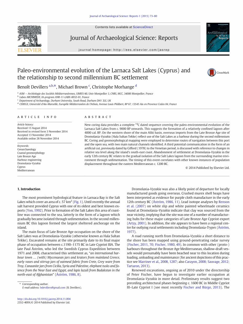
The most prominent hydrological feature in Larnaca Bay is the SaltLakeswhich cover an area of c. 57 km2 (Fig. 1). Until recently the annualsalt harvest provided Cyprus with one of its oldest and best known ex-ports (Yon, 1992). Prior to formation of the Salt Lakes this area of coast-line was connected to the sea, latterly in the form of a lagoon whichgradually became isolated through sedimentation. In the secondmillen-nium BC this lagoon formed the largest sheltered anchorage on theisland.
The main focus of Late Bronze Age occupation on the shore of theSalt Lakes was at Dromolaxia-Vyzakia (otherwise known as Hala SultanTekke). Excavated remains at the site primarily date to its final majorphase of occupation between c.1190–1175 BC in Late Cypriot IIIA. Thelate Paul Åström, who led the Swedish Cyprus Expedition between1971 and 2008, characterised this settlement as, “an international har-bour town … (with) Mycenaean jars and krators from mainland Greece,early vases and stirrup jars of oatmeal fabric from Crete, Grey ware fromTroy, Canaanite jars from Cicilia, Syria and Palestine, elephant tusks and fa-ience from the Near East and Egypt, and lapis lazuli from Badakstan in thenorth-east of Afghanistan” (Åström, 1986, 8).
Dromolaxia-Vyzakia was also a likely point of departure for locallymanufactured goods going overseas. Crushed murex shell heaps havebeen interpreted as evidence for purple cloth manufacture in the early12th century BC (Åström, 1986, 11). Lead isotope analyses by Rensonet al. (2007) on white slip and white painted wheelmade ceramicsfound at Dromolaxia-Vyzakia indicate that clay was sourced from thenear vicinity, implying that the sitewas one of a number of manufactur-ing hubs for these major categories of Late Bronze Age Cypriot export(Artzy, 2001). In addition, the site appears to have been a regional cen-tre for outlying rural settlements including Dromolaxia-Trypes (Åström,1977).
A road running north from Dromolaxia-Vyzakia a short distance tothe shore has been mapped using ground-penetrating radar survey(Fischer, 2011, 70; Fischer, 1980, 49). In common with other (proto-)harbours throughout the Bronze AgeMediterranean, shallow-draft ves-sels would presumably have been beached near to this location duringloading, unloading andmaintenance (for ancient depictions of this prac-tice see Marriner et al., 2008, 1287; also Carayon, 2008; Sauvage, 2012;Tartaron, 2013).
Renewed excavations, ongoing as of 2010 under the directorshipof Peter Fischer, have begun to investigate earlier occupation atDromolaxia-Vyzakia in more detail. Preliminary results suggest twopreceding architectural phases beginning c. 1600 BC in Middle CypriotIII–Late Cypriot I (see most recently Fischer and Bürge, 2013). The
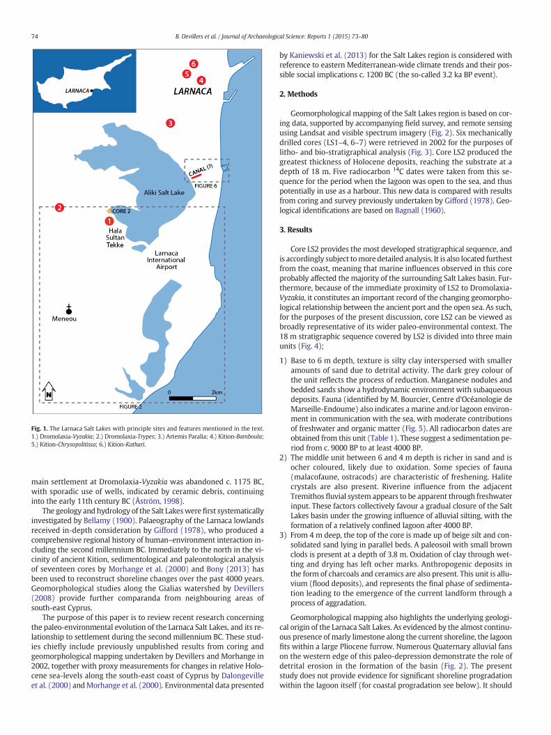
Fig. 1. The Larnaca Salt Lakes with principle sites and features mentioned in the text.1.) Dromolaxia-Vyzakia; 2.) Dromolaxia-Trypes; 3.) Artemis Paralia; 4.) Kition-Bamboula;5.) Kition-Chrysopolitissa; 6.) Kition-Kathari.
74 B. Devillers et al. / Journal of Archaeological Science: Reports 1 (2015) 73–80
main settlement at Dromolaxia-Vyzakia was abandoned c. 1175 BC,with sporadic use of wells, indicated by ceramic debris, continuinginto the early 11th century BC (Åström, 1998).
The geology and hydrology of the Salt Lakeswere first systematicallyinvestigated by Bellamy (1900). Palaeography of the Larnaca lowlandsreceived in-depth consideration by Gifford (1978), who produced acomprehensive regional history of human–environment interaction in-cluding the second millennium BC. Immediately to the north in the vi-cinity of ancient Kition, sedimentological and paleontological analysisof seventeen cores by Morhange et al. (2000) and Bony (2013) hasbeen used to reconstruct shoreline changes over the past 4000 years.Geomorphological studies along the Gialias watershed by Devillers(2008) provide further comparanda from neighbouring areas ofsouth-east Cyprus.
The purpose of this paper is to review recent research concerningthe paleo-environmental evolution of the Larnaca Salt Lakes, and its re-lationship to settlement during the second millennium BC. These stud-ies chiefly include previously unpublished results from coring andgeomorphological mapping undertaken by Devillers and Morhange in2002, together with proxy measurements for changes in relative Holo-cene sea-levels along the south-east coast of Cyprus by Dalongevilleet al. (2000) andMorhange et al. (2000). Environmental data presented
by Kaniewski et al. (2013) for the Salt Lakes region is considered withreference to eastern Mediterranean-wide climate trends and their pos-sible social implications c. 1200 BC (the so-called 3.2 ka BP event).
2. Methods
Geomorphological mapping of the Salt Lakes region is based on cor-ing data, supported by accompanying field survey, and remote sensingusing Landsat and visible spectrum imagery (Fig. 2). Six mechanicallydrilled cores (LS1–4, 6–7) were retrieved in 2002 for the purposes oflitho- and bio-stratigraphical analysis (Fig. 3). Core LS2 produced thegreatest thickness of Holocene deposits, reaching the substrate at adepth of 18 m. Five radiocarbon 14C dates were taken from this se-quence for the period when the lagoon was open to the sea, and thuspotentially in use as a harbour. This new data is compared with resultsfrom coring and survey previously undertaken by Gifford (1978). Geo-logical identifications are based on Bagnall (1960).
3. Results
Core LS2 provides the most developed stratigraphical sequence, andis accordingly subject tomore detailed analysis. It is also located furthestfrom the coast, meaning that marine influences observed in this coreprobably affected the majority of the surrounding Salt Lakes basin. Fur-thermore, because of the immediate proximity of LS2 to Dromolaxia-Vyzakia, it constitutes an important record of the changing geomorpho-logical relationship between the ancient port and the open sea. As such,for the purposes of the present discussion, core LS2 can be viewed asbroadly representative of its wider paleo-environmental context. The18 m stratigraphic sequence covered by LS2 is divided into three mainunits (Fig. 4);
1) Base to 6 m depth, texture is silty clay interspersed with smalleramounts of sand due to detrital activity. The dark grey colour ofthe unit reflects the process of reduction. Manganese nodules andbedded sands show a hydrodynamic environment with subaqueousdeposits. Fauna (identified by M. Bourcier, Centre d'Océanologie deMarseille-Endoume) also indicates a marine and/or lagoon environ-ment in communication with the sea, with moderate contributionsof freshwater and organic matter (Fig. 5). All radiocarbon dates areobtained from this unit (Table 1). These suggest a sedimentation pe-riod from c. 9000 BP to at least 4000 BP.
2) The middle unit between 6 and 4 m depth is richer in sand and isocher coloured, likely due to oxidation. Some species of fauna(malacofaune, ostracods) are characteristic of freshening. Halitecrystals are also present. Riverine influence from the adjacentTremithos fluvial system appears to be apparent through freshwaterinput. These factors collectively favour a gradual closure of the SaltLakes basin under the growing influence of alluvial silting, with theformation of a relatively confined lagoon after 4000 BP.
3) From 4 m deep, the top of the core is made up of beige silt and con-solidated sand lying in parallel beds. A paleosoil with small brownclods is present at a depth of 3.8 m. Oxidation of clay through wet-ting and drying has left ocher marks. Anthropogenic deposits inthe form of charcoals and ceramics are also present. This unit is allu-vium (flood deposits), and represents the final phase of sedimenta-tion leading to the emergence of the current landform through aprocess of aggradation.
Geomorphological mapping also highlights the underlying geologi-cal origin of the Larnaca Salt Lakes. As evidenced by the almost continu-ous presence of marly limestone along the current shoreline, the lagoonfits within a large Pliocene furrow. Numerous Quaternary alluvial fanson the western edge of this paleo-depression demonstrate the role ofdetrital erosion in the formation of the basin (Fig. 2). The presentstudy does not provide evidence for significant shoreline progradationwithin the lagoon itself (for coastal progradation see below). It should

Fig. 2. Geomorphological outline of the Larnaca Salt Lakes region.
75B. Devillers et al. / Journal of Archaeological Science: Reports 1 (2015) 73–80
be noted, however, that the possible significance of fluvial depositionduring antiquity is difficult to gauge, due to anthropogenic modificationof the watershed in the form of diverting channels, which carry awaymuch of the fresh water run-off (Fig. 6). These were constructed inthe Venetian period, if not before, to increase salt production bymakingthe lakes more saline (see Gifford, 1978, 49–54, 117–119, 168–169).
4. Discussion
4.1. Natural channels between the Salt Lakes lagoon and the open sea
A close relationship is apparent between the paleo-environmentalevolution of the Larnaca Salt Lakes during their marine stage and thecorresponding development of ancient settlement. Themost significantimplication of the new coring data is that siltation of the lagoon appearsto have been underwayduring the period itwas in use as a harbour. Thisimplies that the Bronze Age inhabitants of Dromolaxia-Vyzakia wouldhave been forced to contend with shifting channels suitable for naviga-tion. Geomorphological mapping presents two main possible routes tothe sea, between gaps in the marly limestone Pliocene outcrops alongthe eastern side of the lagoon (Fig. 2). A third potential anthropogenicchannel is discussed in Section 4.2.
The Swedish Cyprus Expedition to Hala Sultan Tekke has previouslyproposed that the entrance to the lagoon was most likely at the south-ern end of the Salt Lakes, based on the immediate proximity of themodern coastline. Borings intended to investigate this hypothesis,
undertaken in 1971 along the ridge at the presumed mouth of the em-bayment, proved to be inconclusive (Engvig and Åström, 1975, 6, 25).Coring for the present study (Figs. 2 & 3, core LS7) similarly showedthe presence of highly concentrated marine shells overlying substrateto a depth of more than 4 m. Artefacts including Canaanite jars recov-ered close offshore through underwater survey confirm the presenceof maritime traffic, and highlight the potential hazards of navigation inthis area during the Late Bronze Age (McCaslin, 1978; Engvig andÅström, 1975).
The other possible northern candidate for a natural passageconnecting themain Aliki basin with the sea is located immediately ad-jacent to and beneath the runway of Larnaca airport,meaning it was notpossible to obtain coring data from between the two main sections ofmarly limestone Pliocene ridge which form the eastern boundary ofthe Salt Lakes. In the absence of evidence for significant shorelineprogradation within the lagoon itself, it can be inferred that marine de-posits were also most likely responsible for infilling of this northernpaleo-channel.
Based on the assumption that sea-level was c. 3 m below its presentlevel, combined with the relative depth of the main Aliki basin, thenorthern passage was favoured by Gifford (1978, 166-68) as a naturalentrance for Late Bronze Age ships arriving and departing the lagoon.More recent 14C dating by Dalongeville et al. (2000) of stepped beachdeposits close to Cape Kiti, immediately southwest of the Salt Lakes,has conversely demonstrated that relative sea-levels (RSLs) were upto c. 1–1.5 m higher in the second millennium BC. While these RSL
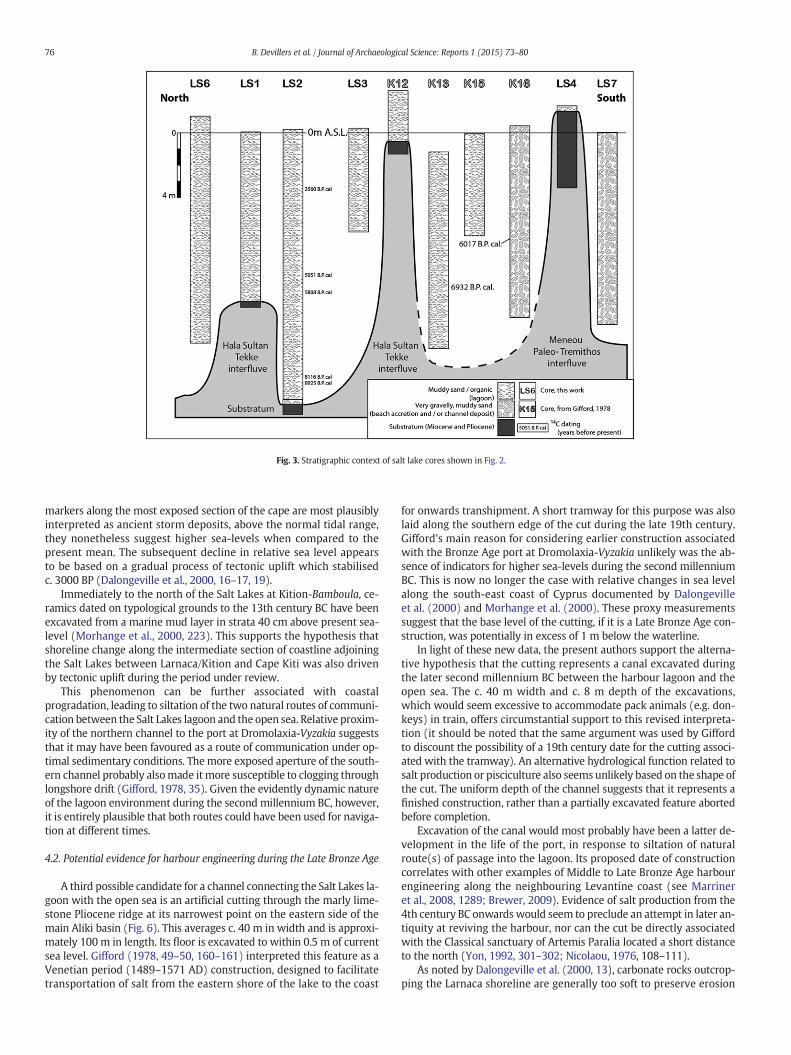
Fig. 3. Stratigraphic context of salt lake cores shown in Fig. 2.
76 B. Devillers et al. / Journal of Archaeological Science: Reports 1 (2015) 73–80
markers along the most exposed section of the cape are most plausiblyinterpreted as ancient storm deposits, above the normal tidal range,they nonetheless suggest higher sea-levels when compared to thepresent mean. The subsequent decline in relative sea level appearsto be based on a gradual process of tectonic uplift which stabilisedc. 3000 BP (Dalongeville et al., 2000, 16–17, 19).
Immediately to the north of the Salt Lakes at Kition-Bamboula, ce-ramics dated on typological grounds to the 13th century BC have beenexcavated from a marine mud layer in strata 40 cm above present sea-level (Morhange et al., 2000, 223). This supports the hypothesis thatshoreline change along the intermediate section of coastline adjoiningthe Salt Lakes between Larnaca/Kition and Cape Kiti was also drivenby tectonic uplift during the period under review.
This phenomenon can be further associated with coastalprogradation, leading to siltation of the two natural routes of communi-cation between the Salt Lakes lagoon and the open sea. Relative proxim-ity of the northern channel to the port at Dromolaxia-Vyzakia suggeststhat it may have been favoured as a route of communication under op-timal sedimentary conditions. Themore exposed aperture of the south-ern channel probably alsomade it more susceptible to clogging throughlongshore drift (Gifford, 1978, 35). Given the evidently dynamic natureof the lagoon environment during the second millennium BC, however,it is entirely plausible that both routes could have been used for naviga-tion at different times.
4.2. Potential evidence for harbour engineering during the Late Bronze Age
A third possible candidate for a channel connecting the Salt Lakes la-goon with the open sea is an artificial cutting through the marly lime-stone Pliocene ridge at its narrowest point on the eastern side of themain Aliki basin (Fig. 6). This averages c. 40 m in width and is approxi-mately 100 m in length. Its floor is excavated to within 0.5 m of currentsea level. Gifford (1978, 49–50, 160–161) interpreted this feature as aVenetian period (1489–1571 AD) construction, designed to facilitatetransportation of salt from the eastern shore of the lake to the coast
for onwards transhipment. A short tramway for this purpose was alsolaid along the southern edge of the cut during the late 19th century.Gifford's main reason for considering earlier construction associatedwith the Bronze Age port at Dromolaxia-Vyzakia unlikely was the ab-sence of indicators for higher sea-levels during the second millenniumBC. This is now no longer the case with relative changes in sea levelalong the south-east coast of Cyprus documented by Dalongevilleet al. (2000) and Morhange et al. (2000). These proxy measurementssuggest that the base level of the cutting, if it is a Late Bronze Age con-struction, was potentially in excess of 1 m below the waterline.
In light of these new data, the present authors support the alterna-tive hypothesis that the cutting represents a canal excavated duringthe later second millennium BC between the harbour lagoon and theopen sea. The c. 40 m width and c. 8 m depth of the excavations,which would seem excessive to accommodate pack animals (e.g. don-keys) in train, offers circumstantial support to this revised interpreta-tion (it should be noted that the same argument was used by Giffordto discount the possibility of a 19th century date for the cutting associ-ated with the tramway). An alternative hydrological function related tosalt production or pisciculture also seems unlikely based on the shape ofthe cut. The uniform depth of the channel suggests that it represents afinished construction, rather than a partially excavated feature abortedbefore completion.
Excavation of the canal would most probably have been a latter de-velopment in the life of the port, in response to siltation of naturalroute(s) of passage into the lagoon. Its proposed date of constructioncorrelates with other examples of Middle to Late Bronze Age harbourengineering along the neighbouring Levantine coast (see Marrineret al., 2008, 1289; Brewer, 2009). Evidence of salt production from the4th century BC onwards would seem to preclude an attempt in later an-tiquity at reviving the harbour, nor can the cut be directly associatedwith the Classical sanctuary of Artemis Paralia located a short distanceto the north (Yon, 1992, 301–302; Nicolaou, 1976, 108–111).
As noted by Dalongeville et al. (2000, 13), carbonate rocks outcrop-ping the Larnaca shoreline are generally too soft to preserve erosion
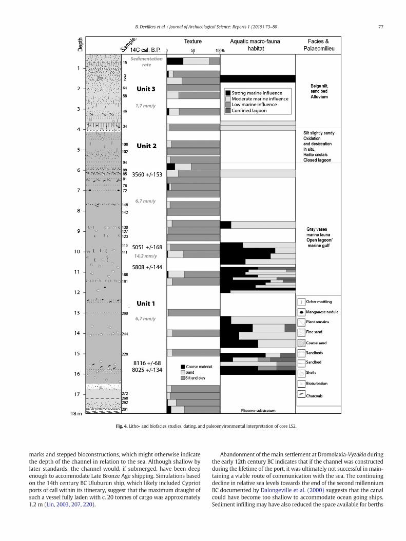
Fig. 4. Litho- and biofacies studies, dating, and paleoenvironmental interpretation of core LS2.
77B. Devillers et al. / Journal of Archaeological Science: Reports 1 (2015) 73–80
marks and stepped bioconstructions, which might otherwise indicatethe depth of the channel in relation to the sea. Although shallow bylater standards, the channel would, if submerged, have been deepenough to accommodate Late Bronze Age shipping. Simulations basedon the 14th century BC Uluburun ship, which likely included Cypriotports of call within its itinerary, suggest that the maximum draught ofsuch a vessel fully laden with c. 20 tonnes of cargo was approximately1.2 m (Lin, 2003, 207, 220).
Abandonment of themain settlement at Dromolaxia-Vyzakia duringthe early 12th century BC indicates that if the channel was constructedduring the lifetime of the port, it was ultimately not successful in main-taining a viable route of communication with the sea. The continuingdecline in relative sea levels towards the end of the second millenniumBC documented by Dalongeville et al. (2000) suggests that the canalcould have become too shallow to accommodate ocean going ships.Sediment infilling may have also reduced the space available for berths
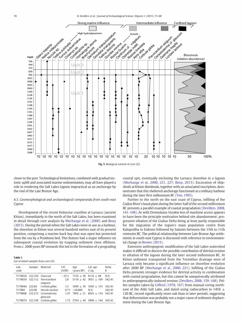
Fig. 5. Biological content of core LS2.
78 B. Devillers et al. / Journal of Archaeological Science: Reports 1 (2015) 73–80
closer to the port. Technological limitations, combinedwith gradual tec-tonic uplift and associated marine sedimentation, may all have played arole in rendering the Salt Lakes lagoon impractical as an anchorage bythe end of the Late Bronze Age.
4.3. Geomorphological and archaeological comparanda from south-eastCyprus
Development of the recent Holocene coastline at Larnaca (ancientKition), immediately to the north of the Salt Lakes, has been examinedin detail through core analysis by Morhange et al. (2000) and Bony(2013). During the period when the Salt Lakes were in use as a harbour,the shoreline at Kition was several hundred metres east of its presentposition, comprising a marine-back bay that was open but protectedfrom the sea by a Posidonia bed. This feature had a major influence onsubsequent coastal evolution by trapping sediment close offshore.From c. 2600 years BP onwards this led to the formation of a prograding
Table 1List of dated samples from core LS2.
Lab.code
Sample Material 13C(0/00)
Age(years BP)
Cal. age2 sig.
DeltaR
T17882A LS2.220 Charcoal −25.3 7335 ± 58 8116 ± 68 N/AT17883A LS2.112 Parvicardium
exiguum2.8 5118 ± 42 5051 ± 169 342/41
T17884A LS2.84 Corbula gibba 1.5 3999 ± 39 3569 ± 153 342/41T17885 LS2.68 Nucula nucleus 0.71 N24,800 N/A 342/41T17886B LS2.215 Cerastoderma
glaucum1.47 7895 ± 51 8025 ± 134 342/41
T17887A LS2.190 Corbula gibba 1.73 5794 ± 44 5808 ± 144 342/41
coastal spit, eventually enclosing the Larnaca shoreline in a lagoon(Morhange et al., 2000, 221, 227; Bony, 2013). Excavation of ship-sheds at Kition-Bamboula, together with an associated inscription, dem-onstrates that this sheltered anchorage functioned as amilitary harbourduring the later first millennium BC (Yon, 1995).
Further to the north on the east coast of Cyprus, infilling of theGialias River's basal plain during the latter half of the secondmillenniumBC presents a parallel example of coastal progradation (Devillers, 2008,141–168). As with Dromolaxia-Vyzakia loss of maritime access appearsto have been the principle motivation behind site abandonment; pro-gressive siltation of the Gialias Delta being at least partly responsiblefor the migration of the region's main population centre fromKalopsidha to Enkomi followed by Salamis between the 15th to 11thcenturies BC. The political relationship between Late Bronze Age settle-ments in south-east Cyprus is discussed with reference to environmen-tal change in Brown (2013).
Extensive anthropogenic modification of the Salt Lakes watershedmakes it difficult to discern the possible contribution of detrital erosionto siltation of the lagoon during the later second millennium BC. AtKition sediment transported from the Tremithos drainage west ofLarnaca only became a significant influence on shoreline evolutionafter 2600 BP (Morhange et al., 2000, 221). Infilling of the GialiasDelta presents stronger evidence for detrital activity in combinationwith coastal progradation, but this cannot be unequivocally attributedto anthropogenically-induced erosion (Devillers, 2008, 159–168). Pol-len samples taken by Gifford (1978, 167) from manual coring north-east of the Aliki Salt Lake, and dated using radiocarbon to 1456 ±120 BC, record significantly more oak than in later periods, suggestingthat deforestationwas probably not amajor cause of sediment displace-ment during the Late Bronze Age.
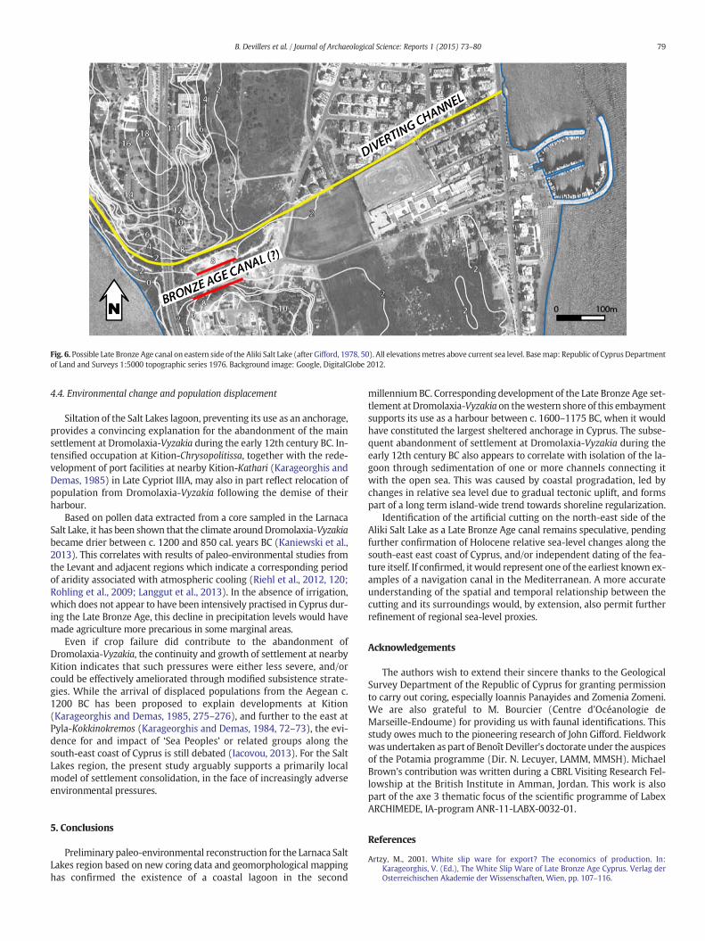
Fig. 6. Possible Late Bronze Age canal on eastern side of the Aliki Salt Lake (after Gifford, 1978, 50). All elevationsmetres above current sea level. Basemap: Republic of Cyprus Departmentof Land and Surveys 1:5000 topographic series 1976. Background image: Google, DigitalGlobe 2012.
79B. Devillers et al. / Journal of Archaeological Science: Reports 1 (2015) 73–80
4.4. Environmental change and population displacement
Siltation of the Salt Lakes lagoon, preventing its use as an anchorage,provides a convincing explanation for the abandonment of the mainsettlement at Dromolaxia-Vyzakia during the early 12th century BC. In-tensified occupation at Kition-Chrysopolitissa, together with the rede-velopment of port facilities at nearby Kition-Kathari (Karageorghis andDemas, 1985) in Late Cypriot IIIA, may also in part reflect relocation ofpopulation from Dromolaxia-Vyzakia following the demise of theirharbour.
Based on pollen data extracted from a core sampled in the LarnacaSalt Lake, it has been shown that the climate aroundDromolaxia-Vyzakiabecame drier between c. 1200 and 850 cal. years BC (Kaniewski et al.,2013). This correlates with results of paleo-environmental studies fromthe Levant and adjacent regions which indicate a corresponding periodof aridity associated with atmospheric cooling (Riehl et al., 2012, 120;Rohling et al., 2009; Langgut et al., 2013). In the absence of irrigation,which does not appear to have been intensively practised in Cyprus dur-ing the Late Bronze Age, this decline in precipitation levels would havemade agriculture more precarious in some marginal areas.
Even if crop failure did contribute to the abandonment ofDromolaxia-Vyzakia, the continuity and growth of settlement at nearbyKition indicates that such pressures were either less severe, and/orcould be effectively ameliorated through modified subsistence strate-gies. While the arrival of displaced populations from the Aegean c.1200 BC has been proposed to explain developments at Kition(Karageorghis and Demas, 1985, 275–276), and further to the east atPyla-Kokkinokremos (Karageorghis and Demas, 1984, 72–73), the evi-dence for and impact of ‘Sea Peoples’ or related groups along thesouth-east coast of Cyprus is still debated (Iacovou, 2013). For the SaltLakes region, the present study arguably supports a primarily localmodel of settlement consolidation, in the face of increasingly adverseenvironmental pressures.
5. Conclusions
Preliminary paleo-environmental reconstruction for the Larnaca SaltLakes region based on new coring data and geomorphological mappinghas confirmed the existence of a coastal lagoon in the second
millenniumBC. Corresponding development of the Late Bronze Age set-tlement at Dromolaxia-Vyzakia on thewestern shore of this embaymentsupports its use as a harbour between c. 1600–1175 BC, when it wouldhave constituted the largest sheltered anchorage in Cyprus. The subse-quent abandonment of settlement at Dromolaxia-Vyzakia during theearly 12th century BC also appears to correlate with isolation of the la-goon through sedimentation of one or more channels connecting itwith the open sea. This was caused by coastal progradation, led bychanges in relative sea level due to gradual tectonic uplift, and formspart of a long term island-wide trend towards shoreline regularization.
Identification of the artificial cutting on the north-east side of theAliki Salt Lake as a Late Bronze Age canal remains speculative, pendingfurther confirmation of Holocene relative sea-level changes along thesouth-east east coast of Cyprus, and/or independent dating of the fea-ture itself. If confirmed, it would represent one of the earliest known ex-amples of a navigation canal in the Mediterranean. A more accurateunderstanding of the spatial and temporal relationship between thecutting and its surroundings would, by extension, also permit furtherrefinement of regional sea-level proxies.
Acknowledgements
The authors wish to extend their sincere thanks to the GeologicalSurvey Department of the Republic of Cyprus for granting permissionto carry out coring, especially Ioannis Panayides and Zomenia Zomeni.We are also grateful to M. Bourcier (Centre d'Océanologie deMarseille-Endoume) for providing us with faunal identifications. Thisstudy owes much to the pioneering research of John Gifford. Fieldworkwas undertaken as part of Benoît Deviller's doctorate under the auspicesof the Potamia programme (Dir. N. Lecuyer, LAMM, MMSH). MichaelBrown's contribution was written during a CBRL Visiting Research Fel-lowship at the British Institute in Amman, Jordan. This work is alsopart of the axe 3 thematic focus of the scientific programme of LabexARCHIMEDE, IA-program ANR-11-LABX-0032-01.
References
Artzy, M., 2001. White slip ware for export? The economics of production. In:Karageorghis, V. (Ed.), The White Slip Ware of Late Bronze Age Cyprus. Verlag derOsterreichischen Akademie der Wissenschaften, Wien, pp. 107–116.
80 B. Devillers et al. / Journal of Archaeological Science: Reports 1 (2015) 73–80
Åström, P., 1977. Dromolaxia, locality “trypes”. Report of the Department of AntiquitiesCyprus, pp. 110–111.
Åström, P., 1986. Hala Sultan Tekke — an international harbour town of the Late CyprioteBronze Age. Opuscula Atheniensia 16 (1), 7–17.
Åström, P., 1998. Hala Sultan Tekke 10: The Wells. Åström Editions, Jonsered.Bagnall, P.S., 1960. The Geology and Mineral Resources of the Pano-Lefkara–Larnaca Area.
Geological Survey Department of Cyprus, Nicosia.Bellamy, C.Y., 1900. A description of the Salt Lake of Larnaca in the island of Cyprus. Q. J.
Geol. Soc. 56, 745–759.Bony, G. 2013. Natural constraints and potentials of some ancient harbours in the Medi-
terranean and Black Sea (Fréjus, Ampurias, Kition, Istanbul, Orgame). UnpublishedPhD thesis, Univ. Aix-Marseille I.
Brewer, M., 2009. The origins of the phoenician cothon: development of the inland har-bour in the Eastern and Central Mediterranean during the 2nd and 1st MillenniaBC. In: Aygün, Ç.Ö. (Ed.), SOMA 2007. Proceedings of the XI Symposium on Mediter-ranean ArchaeologyBAR International Series. 1900. Archaeopress, Oxford, pp. 25–32.
Brown, M., 2013. Waterways and the political geography of South-East Cyprus in the sec-ond Millennium BC. Annual of the British School of Athens 108, pp. 121–136.
Carayon, N., 2008. Les ports phéniciens et puniques. Géomorphologie et infrastructures.Unpublished PhD thesis, Université Marc-Bloch, Strasbourg.
Dalongeville, R., Bernier, P., Prieur, A., Le Campion, T., 2000. Les variations récentes de laligne de rivage du sud-est de Chypre/the early changes of southeastern Cyprus shore-lines. Géomorphol. 6 (1), 13–19.
Devillers, B., 2008. Holocenemorphogenesis and anthropisation of a semi-arid watershed,Gialias River, Cyprus. BAR International Series. 1775. Archaeopress, Oxford.
Engvig, O.T., Åström, P., 1975. Hala Sultan Tekke 2: The Cape Kiti Survey. Åström Editions,Göteborg.
Fischer, P.M., 1980. Applications of Technical Devices in Archaeology. Åström Editions,Göteborg.
Fischer, P.M., 2011. The new Swedish Cyprus expedition 2010: excavations at DromolaxiaVizatzia/Hala Sultan Tekke. Preliminary results. Opuscula 4, 69–98.
Fischer, P.M., Bürge, T., 2013. The new Swedish Cyprus expedition 2012: excavations atHala Sultan Tekke. Opuscula 6, 45–79.
Gifford, J.A., 1978. Paleography of archaeological sites of the Larnaca Lowlands, Southeast-ern Cyprus. Unpublished PhD thesis, University of Minnesota.
Iacovou, M., 2013. Aegean-style material culture in Late Cypriote III: minimal evidence,maximal interpretation. In: Killebrew, A.E., Lehmann, G. (Eds.), The Philistines andOther “Sea Peoples” in Text and Archaeology. Society of Biblical Literature, Atlanta,pp. 585–618.
Kaniewski, D., Van Campo, E., Guiot, J., Le Burel, S., Otto, T., Baeteman, C., 2013. Environ-mental roots of the Late Bronze Age crisis. PLoS ONE 8 (8), e71004. http://dx.doi.org/10.1371/journal.pone.0071004.
Karageorghis, V., Demas, M., 1984. Pyla-Kokkinokremos: A Late 13th-Century B.C.Fortified Settlement in Cyprus. Department of Antiquities, Cyprus, Nicosia.
Karageorghis, V., Demas, M., 1985. Excavations at Kition V: The Pre-Phoenician Levels.Areas I and II, 4 vols. Department of Antiquities, Cyprus, Nicosia.
Langgut, D., Finkelstein, I., Litt, T., 2013. Climate and the Late Bronze Collapse: New Evi-dence from the Southern Levant. Tel. Aviv. 40 (2), 149–175.
Lin, S-H., 2003. Lading of the Late Bronze Age Ship at Uluburun. Unpublished MA thesis.Texas A&M University.
Marriner, N., Morhange, C., Carayon, N., 2008. Ancient tyre and its harbours: 5000 years ofhuman–environment interactions. J. Archaeol. Sci. 35 (5), 1281–1310.
McCaslin, D., 1978. The 1977 underwater report. In: Åström, P. (Ed.), Hala Sultan Tekke.4. Åström Editions, Göteborg, pp. 97–172.
Morhange, C., Goiran, J.-P., Bourcier, M., Carbonel, P., Le Campion, J., Rouchy, J.-M., Yon, M.,2000. Recent Holocene paleo-environmental evolution and coastline changes ofKition, Larnaca, Cyprus, Mediterranean Sea. Mar. Geol. 170, 205–230.
Nicolaou, K., 1976. The Historical Topography of Kition. Åström Editions, Göteborg.Renson, V., Coenaerts, J., Matielli, N., Åström, P., Nys, K., Claeys, P., 2007. Provenance deter-
mination of pottery from Hala Sultan Tekke using lead isotopic analysis: preliminaryresults. In: Åström, P., Nys, K. (Eds.), Hala Sultan Tekke 12. Stone Anchors, FaunalRemains and Pottery Provenance. Studies in Mediterranean Archaeology 45. ÅströmEditions, pp. 53–62.
Riehl, S., Pustovoytov, K., Dornauer, A., Sallaberger, W., 2012. Mid-to-late holocene agri-cultural system transformations in the northern fertile crescent: a review of thearchaeobotanical, geoarchaeological, and philological evidence. In: Giosan, L., Fuller,D.Q., Nicoll, K., Flad, R., Clift, P.D. (Eds.), Climate Landscapes and Civilization.American Geophysical Union, Washington DC, pp. 115–136.
Rohling, E.J., Hayes, A., Mayewski, P.A., Kucera, M., 2009. Holocene climate variability inthe Eastern Mediterranean, and the end of the Bronze Age. In: Bachhuber, C.,Roberts, G. (Eds.), Forces of Transformation: The End of the Bronze Age in the Medi-terranean. Oxbow, Oxford, pp. 2–5.
Sauvage, C., 2012. Routes maritimes et systèmes d'échange internationaux au BronzeRécent en Méditerranée Orientale. Maison de l'Orient et de la Méditerranée, Lyon.
Tartaron, T.F., 2013. Maritime Networks in the Mycenaean World. Cambridge UniversityPress, Cambridge.
Yon, M., 1992. The goddess of the Salt-Lake. In: Ioannides, G.C. (Ed.), Studies in Honour ofVassos Karageorghis. Society of Cypriot Studies, Nicosia, pp. 301–306.
Yon, M., 1995. Kition et la mer à l'époque classique et hellénistique. In: Karageorghis, V.,Michaelides, D. (Eds.), Cyprus and the Sea. University of Cyprus, Nicosia, pp. 119–130.
Related Documents