PACIFIC RIM: AN ECOLOGICAL APPROACH TO A NEW CANADIAN NATIONAL PARK Edited by J.G.Nelson and L.D.Cordes STUDIES IN LAND USE HISTORY AND LANDSCAPE CHANGE NATIONAL PARK SERIES NO. 4

Welcome message from author
This document is posted to help you gain knowledge. Please leave a comment to let me know what you think about it! Share it to your friends and learn new things together.
Transcript

PACIFIC RIM:
AN ECOLOGICAL APPROACH TO
A NEW CANADIAN NATIONAL PARK
Edited by J.G.Nelson and L.D.Cordes
STUDIES IN LAND USE HISTORY AND LANDSCAPE CHANGE NATIONAL PARK SERIES NO. 4

Addendum
A number of typographical errors appear in this volume. The errors largely arise from the fact that the authors were scattered about doing field work in summer, 1972, when the final proofs were available and from a desire to publish the papers in time to influence apparently impending decisions on the Nitinat Triangle and other problems regarding Pacific Rim. The responsibility for the errors is the senior editor's. Not all can be corrected but a list of the more important ones is listed below.
Page Reads Should Read
90 fire density five densely
100 interior inferior
102 redcedar red alder
108 twinstones turnstones
113 nesting resting
114 M. yamaensis M. yumanensis saturatus saturatus
114 Tamiascurus hudsonicus Tamiasciurus hudsonicus lanuginosus lanuginosus
114 Rattus norvigicus Rattus norvegicus
115 Family Erethizontidae Erethizon dorsatum nigrescens (Should be omitted; strike out)
115 Mesoplodon srejnegeri Mesoplodon stejnegeri Srejneger Beaked Whale Stejneger Beaked Whale
115 Grampus grisens Grampus griseus
115 Rhacianectidae Rhachianectidae
115 B. Borealis B. borealis
115 Eubalaena Siebaldi Eubalaena sieboldi
115 Canis lupus crassadon Canis lupus crassodon
119 Limnodramus griseus Limnodromus griseus
119 Ruffer Grouse Ruffed Grouse
120 E. Minutilla E. minutilla

-2-
Page Reads Should Read
120 Larns glaucesceus Larus glaucescens
120 Bonaparte's Bonaparte's Gull
120 Hydropogne caspia Hydroprogne caspia
120 Vria aalge Uria aalgc
120 Phinoceros Auklet Rhinoceros Auklet
122 Iridoprocue biocolor Iridoprocne bicolor
122 Ixorens naevins Ixoreus naevius
122 Bombychillidae Bombycillidae
123 Geothlypis trichas Geothlyois trichas
Yellowthroat Yellowthroat*
12 3 D. Townsendi D. townsendi
123 1. africapilla Z. atricapilla ********************
Bibliographical Errors
Reference I Reads Should Read
1. Lone Lone Lone Cone
5. Annals Murrelet
12. Murrelet 4a Murrelet 4 9
21. Kenyan Kenyon
30. Brids Birds
35. , Can. And. Can. Aud.

PACIFIC RIM: AN ECOLOGICAL APPROACH TO
A NEW CANADIAN NATIONAL PARK
editors
J.G. Nelson, University of Western Ontario
L. D. Cordes, University of Calgary
This is No. 4 in STUDIES IN LAND USE HISTORY AND LANDSCAPE CHANGE, NATIONAL PARK SERIES, directed by J.G. Nelson. Copies of this publication can be obtained by writing to Dr. Nelson, the Department of Geography, University of Western Ontario, London, Ontario. This publication was printed and bound at the University of Calgary.
Q August, 1972
Note: Errata have been applied to this electronic edition, 2015.

- i -
Dedicated to Mrs. Peg Whittington, a long-time resident
and naturalist of Long Beach.

- 11 -
ACKNOWLEDGEMENTS
We gratefully acknowledge the assistance of the National Research
Council which financed most of the research contained in this volume. We
are also grateful to the many government officials, librarians and other
people who provided information and advice. Many persons helped with typing,
cartography and other work, notably Mrs. M.A. Burge and Mr. John Martin. Mr.
J. Masyk helped to guide the publication through the printing stages.
Without the help of these people the volume could not have been completed.
Thanks also are extended to M.G. Loutes for permission to use his drawing
of a cougar taken in Nootka Sound in 1932 as a cover logo.

- iii -
CONTENTS
Page
I. PREFACE: J. G. Nelson 1
II. THE ORIGINS OF PACIFIC RIM NATIONAL PARK: Melanie Miller 5
III. A RECONNAISSANCE STUDY OF THE GLACIAL GEOMORPHOLOGY OF THE UCLUELET-TOFINO AREA: J. G. Nelson and L.D. Cordes 26
IV. A VEGETATION CLASSIFICATION FOR PHASE I OF PACIFIC RIM NATIONAL PARK: L.D. Cordes and G.A. MacKenzie 37
V. LOGGING AND LANDSCAPE CHANGE IN PHASE I OF THE PACIFIC RIM NATIONAL PARK: G.A. MacKenzie 60
VI. MAN, BIRDS AND MAMMALS OF PACIFIC RIM NATIONAL PARK: PAST, PRESENT AND FUTURE: N. Roe and J.G. Nelson 84

- XV -
T A B L E S
Table T i t l e Page
(1) Vegeta t ion Layers Used in Both The Analysis and Synthesis of the Types 41
(2) The Species S ign i f icance Scale 41
(3) Desc r ip t ion of P lo t Condit ions 41a
(4) Synthes is of P lo t Data for the Vegetat ion Types 41b

- v -
M A P S
Figure Title Page
(1) Index Map: Pacific Rim and Southern 5a Vancouver Island
(2) Nitinat Triangle Arm 6a
(3) Reserves in Phase I Area, Pacific Rim 6b
(4) Surfacial Deposits of Pacific Rim Area 27a
(5) Topographic Features of Pacific Rim Area 32a
(6) Vegetation, Pacific Rim National Park 37a
(7) Land Tenure, Pacific Rim National Park 66a
(8) Logged Areas, Pacific Rim National Park 66b
(9) Wildlife Habitats, Pacific Rim National 106a Park

- vi -
* I L L U S T R A T I O N S
Plates Title Page
(1) (Front piece) View of Wickaninnish Bay, Long Beach vii
(2) Terrace Scarp in Florencia Bay 127
(3) Long Beach Looking East Toward Kennedy Lake 127
(4) A Rocky Headland Near Schooner Cove 128
(5) Dune Area at the South East End of Wickaninnish Bay 128
(6) Kennedy Lake 129
(7) Looking North from Radar Hill 129
(8) A View of the High Forest in the Park 130
(9) Sequence of Vegetation Types Wickaninnish Bay 131
(10) View of a Poorly Drained Interior Forest 132
(H) Slash from Logging Operations 132
* All the photographs were taken by L.D. Cordes.

- v n -
Plate. 1. View of Wichaninnish Bay (Long Beach) with the Vancouver Island Range in the background.
I
THE PACIFIC RIM: AN ECOLOGICAL APPROACH TO
A NEW CANADIAN NATIONAL PARK
PREFACE
Our interest in Pacific Rim National Park was aroused in several
ways. One member of our group, L. D. Cordes, had worked on the west coast
of Vancouver Island for several years doing research on Sitka spruce for
a Ph.D. dissertation. Another member, J. G. Nelson, has long been interested
in national park problems and was interested in studying Pacific Rim,
especially in view of news of difficulties among lumber companies, Indians
and governments in the establishment of the park boundaries and the develop
ment of a land use policy for the park area. Nelson also has a long standing
interest in the impact of human activity on the landscape or ecosystem and
was curious about changes in vegetation and wildlife as a result of the
coming of Caucasian man to the west coast.
Nicholas Roe and George A. MacKenzie are graduate students interested
in birds and plant geography respectively, not merely for their own sake, but
also from the standpoint of land use and environmental management. Miss
Melanie Miller has now completed her final year for the B.A. degree and is
interested in biogeography, national parks and resource management. She
prepared her article for this volume as a term paper for a graduate course
and was not involved in the field work conducted by other members of the
group in summer, 1971.
The field work consisted of library research by Roe and Mackenzie
in government offices and various libraries in Vancouver and Victoria.
Interviews also were conducted with government, university, park, lumber
company and other officials. Field studies in the Tofino-Ucluelet area
were carried out by Roe and MacKenzie during July, August and early September,
with Nelson and Cordes being involved for about five weeks in July and early
August. The reports contained in this volume were completed in the winter
and spring of 1971-1972.
The papers are considered to represent a broad ecological approach
to national park management and planning problems in general and for Pacific

- 2 -
Rim in particular. They are so considered because they present a mapped
inventory of some of the major natural resources of the park area: land-
forms, vegetation and wildlife. Many of the processes involved in explaining
the distribution and character of the resources or landscape elements are
also discussed, with some stress being placed on land use history, or man
as an ecological agent. This stress is particularly evident in the papers
by Mackenzie on Logging and Landscape Change in Phase I of Pacific Rim
National Park and by Roe and Nelson on Man, Birds and Mammals of Pacific
Rim National Park, Past, Present and Future. In the papers stressing man's
impact, a general approach or model is used which involves classifying and
organizing data in terms of perceptions and attitudes, institutional arrange
ments and technology.
The paper by Cordes and Mackenzie on A Vegetation Classification
for Phase I of Pacific Rim National Park is considered to be especially
important because it includes the first reasonably detailed map of vegetation
in the park area as well as the first general discussion of its plant ecology.
No doubt this map can be improved upon but the classification system used
for vegetation mapping should be a very useful basis for understanding the
physical geography of the park and managing its landscapes and ecosystems.
The same can be said for the map of wildlife zones in Roe and Nelson's paper,
this owing much to the vegetation map and being more tentative in the case
of some of the zones. The landform maps are quite preliminary in nature and
were prepared primarily as a guide to understanding some of the vegetation
patterns, although the map and associated field work also allows us to com
ment on some aspects of the glacial and recent geomorphic history of the
Pacific Rim area.
Throughout a number of the papers there is evidence of the many
changes brought about by the deliberate and often unwitting hand of man.
The maritime fur trade obviously had a profound effect on the area, intro
ducing a set of perceptions, attitudes, institutional arrangements and
technologies geared to exploitation, growth and profit and much broader in
its impact on vegetation and wildlife than the more respectful, symbiotic
and simple system of pre-Caucasian man. The papers by Mackenzie and Roe
and Nelson also show that the impact of man has strongly accelerated since

- 3 -
about 1945 and that the construction of roads, the coming of many tourists,
and the introduction of other facilities makes recreation and the national
park concept something less than a handmaiden for conservation of landscape.
A number of desirable management measures can be derived from the
papers. First, attempts to establish national parks require lengthy and
rather unwieldy negotiations and political arrangements which must be
improved upon else the quality of the proposed park suffers in the interim
and many compromises seemingly become necessary on boundaries and policies.
More money should be spent more quickly by both federal and provincial
governments in order to shorten the establishment period as much as possible.
In this regard Pacific Rim sets a precedent, for the B.C. government clearly
exerted pressure which caused modification of the former federal position
that the provinces should assemble the land for a national park and turn it
over "free of all encumbrances!" Pacific Rim also underlines the importance
of acquiring land well beyond settled areas to meet the needs of the future.
The West Coast National Park could have been established much more easily
in the 1930's and 1940's before lumbering and other interests became well
established in the area but did not go forward in part because it was
considered to be too far from population centres at that time. Institutional
arrangements in B.C. give the lumber companies a particularly strong hold
on public land, as Mackenzie's paper shows. These arrangements will have
to be reviewed in the light of late twentieth century social and landscape
conditions. There is now a strong need for recreational land and for the
protection of wildlife and vegetation much depleted and damaged since
earlier days of low population, extensive settlement and much wilderness.
Finally, there are a host of specific recommendations in the
papers in this volume regarding zoning of Phase I lands or possible changes
in boundaries to reduce the growing conflict between facilities-oriented
recreation, associated economic activities and the conservation of park
ecosystems and resources. A strong case can be made for the movement of
campsites and technology off the beach and into the inland logged-over and
forested areas in order to reduce impact on vegetation, birds and other
elements of the beach landscape. Pacific Rim National Park has been

- 4 -
perceived largely in terms of sun and sand but our studies show something
of the ecological and cultural complexity of the park and point to the
value of the interior for wildlife, camping, fishing, and swimming at
sites such as Kennedy Lake. Our studies also bring forward considerable
evidence in support of the addition of the controversial Nitinat Triangle
to Phase III of Pacific Rim. And, although we did not study their problems
very closely, we tend to be sympathetic to a strong role for the Indians in
the operation of Pacific Rim on the basis of our experience there and our
knowledge of the place of the Indian in its ecological history.
J. G. Nelson, June 13, 1972

II
THE ORIGINS OF PACIFIC RIM NATIONAL PARK
Melanie Miller
INTRODUCTION
Pacific Rim National Park, formally dedicated in 1971, is the result
of the efforts of many, over an extended period of time, (Figure 1). The
first phase of the chronology of events began about 1930, when land was
reserved pending federal government approval as a site for a west coast
national park. Later reserves were cancelled because the federal government
decided that they were not feasible locations. Toward the end of the second
period in the developmental history, 1948-1966, park establishment was again
discussed and land was acquired as a provincial park within the present
national park area. The third phase, 1966-1968, began with British Columbia's
(B.C.'s) offer to hand over provincial land in the Long Beach area as the
nucleus of a national park, and ended with a federal-provincial agreement
to share costs of further land acquisition. The fourth period, from 1968
to the present, has been marked by an as yet unresolved dispute between
federal and provincial authorities about the size of the park and multiple
use of potential park land.
In essence, the federal and provincial governments seem to have
been involved in two different policy-making situations; the first involving
the payment of the cost of land acquisition, and the second involving the
establishment of land use policy in the park area. I intend to describe
these two policy-making situations and to attempt to trace the changing
attitudes of the important individuals who greatly influenced the decisions
reached by their respective governments. I hope to be able to demonstrate
how decisions were reached, how they may have been affected by the activities
of particular interest groups and individuals, and so give a fairly accurate
account of the decision-making processes which have shaped Pacific Rim
National Park to the present time.
The individuals who apparently played the most important roles
in decision-making are:
Arthur Laing, former Federal Minister of the Department of Indian Affairs and Northern Development (1963-1968) and former leader of the Liberal Party in British Columbia.
- 5 -
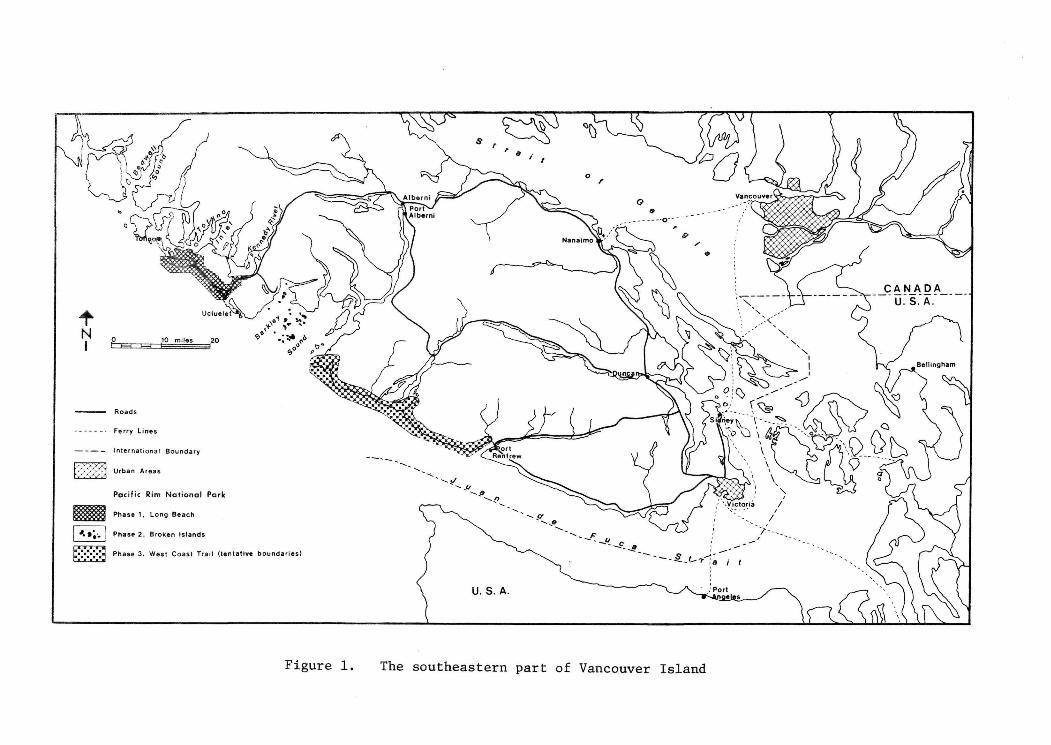
Figure 1. The southeastern part of Vancouver Island

Kenneth Kiernan, British Columbia Minister of the Department of Recreation and Conservation (1952 to the present).
Jean Chretien, Federal Minister of the Department of Indian Affairs and Northern Development (July, 1968 to the present).
Ray Williston, British Columbia Minister of the Department of Lands, Forests and Water Resources (1954 to the present).
EARLY HISTORY
The idea of establishing a national park in the area of Pacific
Rim apparently was first expressed about 1930 when a reserve was declared
by B.C. in the Nitinat area on the west coast of Vancouver Island (Bamfieldr
Nitinat Recreation Reserve, Figure 2). This was one of several map reserves
established in different parts of the province at the request of the federal
government pending their inspection as possible national park sites. 234
square miles were also reserved around Kennedy Lake as a result of the
activities of the Sutton Timber and Trading Company, which planned to build
a pulp mill on the shore of Grice (then called Mill) Bay, (Figure 3).
However the idea of a west coast park apparently was forgotten
during the depression and World War II. It was resurrected in 1944, when
the federal government expressed interest in a sea-level park on the west
coast as a health resort for people of the prairies. The Long Beach area
was examined but deemed unsuitable.
The Victoria Chamber of Commerce proposed a park in the Long Beach
area in June, 1947. The Chamber called for a "very large park, merging
Strathcona Park and the Forbidden Plateau ... as well as a strip of land
running from the centre of Clayoquot Arm of Kennedy Lake on the south down
to Wickaninnish Bay," a park that would "rival Banff and be a boon to the
island," (Victoria Times, June 13, 1947). The federal government indicated
willingness to develop such a park provided it had an outlet to the sea,
(Victoria Times, June 13, 1947). The Bamfield-Nitinat Reserve, which fronted
on the ocean apparently was not considered at this time.
Later that year, timber interests began to press for a decision
on the 4.5 billion board feet of timber in the Kennedy Lake reserve. The
- 6 -

•Figure 2. Boundary proposals for Phase Three of Pacific Rim National Perk

- 7 -
Deputy Minister of Forests for B.C., Dr. C. D. Orchard reported that the
timber was "mature and ripe for logging ... (and) should be used either
as timber or definitely for a park," (Vancouver Sun, December 2, 1947).
The federal government indicated that it was interested in a possible national
park but that the provincial government should take the initiative. This
federal position derived from a rather strict interpretation of the British
North America Act of 1867 which essentially gave the provincial governments
control of land and resources. It followed that, to establish a national
park, the province should assume responsibility for all aspects of land
acquisition and then turn the land over to the federal government "free of
all encumbrances."
Whether the province took the initiative or not is uncertain, but
a survey was undertaken about this time by the federal government with the
B.C. Forest Service. As a result, on December 17, 1947, Dr. Hugh Keenleyside,
federal Deputy Minister of Mines and Resources wrote to Dr. Orchard saying
that the west coast reserve areas would not be satisfactory national park
sites because much of the timber was under lease, the area was remote from
population and the water was too cold. B.C. then cancelled the Kennedy
and Nitinat reserves and the chance to establish a large national park in
the Pacific Rim area, with few of the land acquisition problems which later
plagued the park development process, was lost.
THE QUIET PERIOD
The idea of preserving areas on west Vancouver Island was forgotten
until 1959, when the provincial government acquired the first part of what
would become the 2,656 acre Wickaninnish Beach Provincial Park, in the
Long Beach area, (Figure 3). The park was expanded three times. At its
largest it contained approximately 2,317 acres, including a much publicized
254 acre plot along Schooner Cove acquired when the province gave up land
containing an equal amount of timber in Strathcona Provincial Park.
Interest in a federal park was again shown in 1964, when the Tofino
Chamber of Commerce sponsored a resolution calling for the establishment of
a 25,000 acre park between Schooner Cove and Cox Bay at the Tofino end of
Long Beach. Tom Gibson, a member of the Tofino Chamber, said that the federal
government had indicated willingness to establish a park at the site if the

Figure 3. Land reserves in the Phase One area of Pacific Rim National Park

- 8 -
provincial government would turn over the land. The Associated Chamber of
Commerce of Vancouver Island also passed a resolution in 1964, calling for
the establishment of a 5,000 acre park at Schooner Cover. After receiving
their petition, Recreation and Conservation Minister Ken Kiernan said that
the "park proposal sounds desirable." He also stated that "he would direct
the Provincial Parks Branch to determine whether the land involved is free
of mining and timber leases, then discuss the proposal with the cabinet,"
(Victoria Colonist, November 5, 1964). If his cabinet agreed in principle
with the proposal, he would submit it to Ottawa for consideration.
About one and one-half years later, Tom Gibson noted that "we
have never received one communication from the provincial government ...
except that a reserve upon Crown sales was declared ... we have only been
advised, indirectly, that the provincial cabinet did not favor turning over
the land for federal government development. I would hate to think that
this whole business is being delayed because of a personal animosity,"
(Vancouver Sun, February 23, 1966). This statement brings to the fore a
possible major reason for the slow progress toward park establishment,
despite some initial enthusiasm at both levels of government.
In power in B.C. was the Social Credit government of W.A.C. Bennett.
The federal Minister of Resources, Arthur Laing, through whom negotiations
had to be made, was the former leader of the Liberal party in B.C. It is
not difficult to imagine that hostility could have built up during the
years that Laing was involved in B.C. politics. An editorial in the Vancouver
Sun, (February 23, 1966), posed the probability that delay in park develop
ment was caused not so much by the B.C. government's unwillingness to
relinquish any of its sovereignty, as perhaps more by "Victoria's vendetta
with Ottawa (and) the more personal one nourished by members of Premier
Bennett's cabinet with former provincial Liberal leader, Mr. Laing.
THE TWO YEAR DISPUTE
The third period in the history of the west coast national park
began in the fall of 1966, at a time when it was being recognized that
"governments could be elected on the basis of their ability to provide
parkland and recreational facilities," (B.C. Outdoors, May-June, 1968).
- 9 -
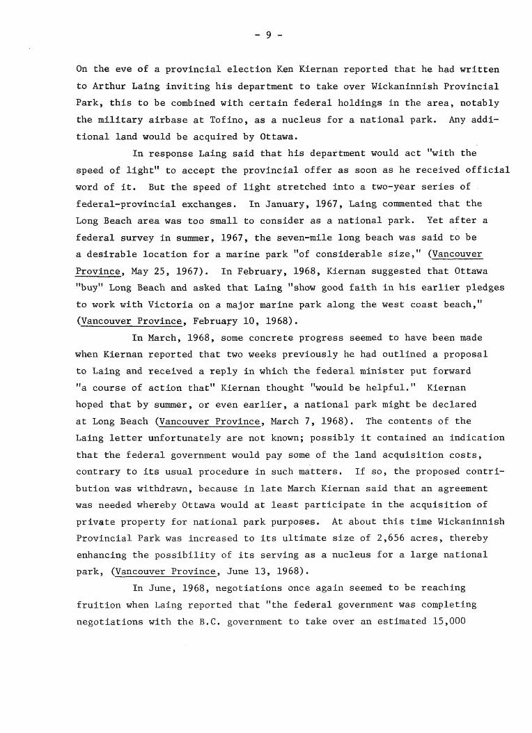
On the eve of a provincial election Ken Kiernan reported that he had written
to Arthur Laing inviting his department to take over Wickaninnish Provincial
Park, this to be combined with certain federal holdings in the area, notably
the military airbase at Tofino, as a nucleus for a national park. Any addi
tional land would be acquired by Ottawa.
In response Laing said that his department would act "with the
speed of light" to accept the provincial offer as soon as he received official
word of it. But the speed of light stretched into a two-year series of
federal-provincial exchanges. In January, 1967, Laing commented that the
Long Beach area was too small to consider as a national park. Yet after a
federal survey in summer, 1967, the seven-mile long beach was said to be
a desirable location for a marine park "of considerable size," (Vancouver
Province, May 25, 1967). In February, 1968, Kiernan suggested that Ottawa
"buy" Long Beach and asked that Laing "show good faith in his earlier pledges
to work with Victoria on a major marine park along the west coast beach,"
(Vancouver Province, February 10, 1968).
In March, 1968, some concrete progress seemed to have been made
when Kiernan reported that two weeks previously he had outlined a proposal
to Laing and received a reply in which the federal minister put forward
"a course of action that" Kiernan thought "would be helpful." Kiernan
hoped that by summer, or even earlier, a national park might be declared
at Long Beach (Vancouver Province, March 7, 1968). The contents of the
Laing letter unfortunately are not known; possibly it contained an indication
that the federal government would pay some of the land acquisition costs,
contrary to its usual procedure in such matters. If so, the proposed contri
bution was withdrawn, because in late March Kiernan said that an agreement
was needed whereby Ottawa would at least participate in the acquisition of
private property for national park purposes. At about this time Wickaninnish
Provincial Park was increased to its ultimate size of 2,656 acres, thereby
enhancing the possibility of its serving as a nucleus for a large national
park, (Vancouver Province, June 13, 1968).
In June, 1968, negotiations once again seemed to be reaching
fruition when Laing reported that "the federal government was completing
negotiations with the B.C. government to take over an estimated 15,000

- 34) -
acres at Long Beach between Tofino and Ucluelet on the west coast of Vancouver
Island," (Vancouver Sun, June 19, 1968). But the discussions soon stalled.
Kiernan felt that he would still be willing to turn over provincial land,
but that "Arthur Laing's last proposal that B.C. pay half of the cost of
further land acquisition to create the park is unacceptable," (Vancouver
Sun, September 19, 1968). The federal government had made a major concession
by offering to pay a large part of the land costs, but the province would
still not agree.
In the summer of 1968, the Trudeau government came to power. And
Kiernan, hoping for a policy change, approached Jean Chretien, the new federal
Minister of Indian Affairs and Northern Development in September, 1968, asking
for a complete review of all correspondence between the two governments regard
ing the park proposal. He asked Chretien if the federal land cost policy
was "a confirmed one or one set up for this specific instance," (Vancouver
Sun, September 19, 1968). Kiernan explained that his government could not
pay the cost of additional land acquisition for the park because the "province
was already heavily committed to running and extending its own park system,"
(Victoria Colonist, September 20, 1968).
In reply, Chretien suggested that Kiernan's department outline a
proposal for federal participation in the park planning procedure and "prepare
a survey showing the minimum amount of new land acquisition required without
endangering the park project," (Vancouver Sun, October 10, 1968). From this
point it would be "possible to estimate overall costs and arrive at a basis
for proposed cost-sharing," (Vancouver Sun, October 10, 1968). The B.C.
government was reluctant to share costs for even a small park and must have
been taken aback when in November of 1968, Chretien further stated that he
envisioned a much larger park, probably about 50 square miles. Kiernan,
having met with Chretien, described the meeting as being "useful and friendly"
though he would not discuss any details. "I'm obliged to be quite vague
because it involves a delicate matter," (Victoria Colonist, November 26, 1968).
Kiernan and Chretien "agreed to do further work in determining the magnitude
of the problems involved in creating a park of the optimum size" with the
realization that the larger the proposed project, the greater would be the
problems of assembling the land, (Victoria Times, November 26, 1968).
- 11 -
Chretien, more optimistic and enthusiastic than Kiernan, said that
if he had to make the decision, "work on a federal west coast marine park
could start tomorrow," and that "we should be men enough to spend a few
dollars now so this beautiful area can be preserved for the future," (Victoria
Colonist, November 26, 1968).
The first official recognition that some form of agreement had been
reached came in the B.C. Throne speech of January, 1969, when the legislature
was asked "to consider legislation to facilitate the development of a national
park on the west coast of Vancouver Island." The enabling legislation was
actually introduced by Kiernan on March 20, 1969. It proposed a marine
park along 65 miles of western Vancouver Island, including sections south
of the Long Beach area which had not been considered earlier. The bill was
a very general one, being "a statute to enable the provincial government ...
to tackle a very complex and touchy land assembly problem," (Victoria Colonist,
March 25, 1969). The bill did not guarantee the establishment of a national
park, but empowered the provincial government to begin negotiation to add
to the lands which it had been "quietly assembling" for the last several
years.
The park would be developed in three phases: The first involved
the Long Beach area, 1700 acres of federal land (the Tofino airstrip), 2700
acres of provincial land in Wickaninnish Park, and 12,000 to 15,000 acres
under forest management licenses held by B.C. Forest Products and MacMillan-
Bloedel. The latter would be gradually acquired "by purchase or offer of
other Crown lands to the companies in exchange." The total cost of acqui
sition of Phase I lands would be about $4 million, creating a unit of about
34,000 acres, of which about 12,000 would be offshore. Phase II would
consist of the Effingham Islands at the entrance to Barkley Sound. Phase III
would include the old west coast Lifesaving Trail, the length of coastline
between Port Renfrew and Bamfield, on Barkley Sound.
Conservation groups which had been showing a growing interest in
the proposed west coast national park were enthusiastic. Elton Anderson of
the Federation of B.C. Naturalists felt the proposal was a "major public
* Kiernan later opted for exclusion of certain areas because land wasn't available for exchange; he didn't mention his original suggestion of possible purchase, if necessary.

- 12 -
acquisition," though more of the west coast of the Island should be preserved.
Bruce Scott, a long-time advocate of the preservation of the West Coast Trail,
noted that the park would attract outdoorsmen from throughout Canada and the
U.S. as "long as it is kept in its wilderness state. The beauty of the coast
is in its wilderness aspects. Keep it that way. If people want to see it,
let them walk." And, M.L.A. Dr. Howard McDiarmid of Tofino-Ucluelet, who
had been campaigning since 1962 for a national park and had once described it
as being one of his main motivations for entering politics, called it the
"highpoint" of his political career.
The legislation finally ratified on September 21, 1969, did not
specify the park area but "set down the ground rules for the procedures
leading up to the establishment of the national park," (per. comm. Robert
Ahrens, October 12, 1971). The legislation:
1. authorized the provincial government to enter into an agreement with the federal government to establish a national park in the Renfrew, Barclay and Clayoquot districts.
2. empowered the provincial government to acquire title to those lands not owned by the federal or provincial governments and pay one-half of the cost of land acquisition.
3. established that title could be acquired by purchase, gift, exchange or appropriation, and lands could be exchanged for other Crown lands.
4. established that the lands, once acquired, could be transferred to the federal government.
5. stated that the Lieutenant-Governor-in-Council could make regulations and orders
a) designating lands to be "park lands" within the meaning of the act.
b) designate any portion of park lands, (lands in the Renfrew, Barclay, and Clayoquot districts) as the portion to which the act applies.
The most important sections of the Act, in view of later exclusion and
inclusion of land areas, are 5A and 5B. 5A can be interpreted to mean
that other lands, aside from those in the above-mentioned three districts,
can be set aside for national parks. 5B could be interpreted to mean that

- 13 -
any portion of the land in the district could be designated or excluded from
the park area.
THE FIRST BOUNDARY DISPUTE: THE WEST COAST LIFESAVING TRAIL
The first controversy regarding the Phase III boundaries centered
around the question of the inclusion of the Lifesaving Trail. The trail
stretches between Port Renfrew and Barkley Sound, having been constructed
around the turn of the century to aid shipwrecked sailors along the stormy
coast. Carved through the thick coastal rainforest and bridging many
ravines and raging streams, it enabled men to reach safety, passage along
the beach often being extremely hazardous.
The first public words of the controversy were spoken on December
1, 1969, when B.C.'s Deputy Minister of Recreation, H.G. McWilliams, announced
that the trail would definitely not be included in the national park, although
it could eventually become a provincial park. His government was not planning
to build any roads to the area which would spoil the wilderness aspects of
the coast.
Conservation groups now became concerned. Why had the decision
to include the Lifesaving Trail area suddenly been altered? Jim Hamilton,
a local resident who had been writing and working for the preservation of
the trail since 1930, expressed the thoughts of many when he suggested that
logging was planned and that the area should be protected immediately.
The provincial government's omission of the Lifesaving Trail almost
certainly won a major concession to the lumbering interests. They had already
given up some timber in the Long Beach area. And the establishment of a
national park between Renfrew and Barkley Sound could deny them access to
the ocean from logging sites on the inland side of the trail. A provincial
park would not necessarily do so, the provincial government already having
allowed logging in Strathcona Provincial Park, mining in Butte Lake Provincial
Park and the complete elimination of all but a small section of Hamber Pro
vincial Park to allow mineral exploration and development
On February 3, 1970, Kiernan said that he did not want the Phase II
or Phase III areas included in the federal-provincial agreement as this
would "be, in fact, freezing the three areas," (Victoria Times, Feb. 3, 1970).

- 14 -
The Effingham Islands probably were not in contention; they had little value
for forestry. Kiernan further stated that even the ironing out of the agree
ment for Phase I would be a much longer process than originally anticipated.
In support of this view, he cited several potential problems, for example,
lumber companies with holdings around the proposed park anticipated being
able to use logging roads in the park, (Victoria Times, February 3, 1970).
The influence of the lumber interests can be further illustrated
by referring to a series of letters by the Boy Scouts of Canada, Island
Region. The Boy Scouts had originally proposed, in January of 1967, to
re-open the Lifesaving Trail as their B.C. Centennial project. They later
submitted a petition to the provincial government, requesting the establish
ment of a minimum ten-chain reserve (66 feet per chain), for the length of
the trail. Kiernan and Ray Williston, Minister of Lands, Forests and Water
Resources, were highly receptive to the idea, but suggested that the Scouts
approach the logging companies through whose Tree Farm Licenses the portion
of the trail between Clo-oose (midpoint of the trail) and Port Renfrew passed.
The provincial government later indicated that no action would be taken toward
establishing a park along the trail until the Boy Scouts reached an agreement
with MacMillan-Bloedel and B.C. Forest Products, the two principal logging
companies, which had already expressed displeasure with the idea ... "in view
of the pressure that had been exerted on the logging companies to take over
various of their holdings for park purposes," (letter to Charles Nash from
H.S.C. Archbold, July 21, 1967).*
Another point raised in the Scout correspondence which indicates
that the provincial government was quite sympathetic to the lumber companies
was the matter of the width of the trail phase of the proposed national park.
Originally the forest industry favoured a one-half mile wide strip as this
would encompass the merchantable timber stands included in the two mile wide
zone proposed by the federal government. David Anderson, an M.P. from
Esquimalt-Saanich, said that the actual reason for the complete deletion of
the west coast trail was that the federal government would not accept the
province's suggestion for a narrower, 1/2 mile wide trail.
* In reply to a letter from the President of the Boy Scouts of Canada, which asked for federal government support for the project, Arthur Laing indicated that the federal government had been interested in the west coast trail section as a part of the proposed national park since the 1967 survey made by federal officials in the area. This was long before any official expression of interest was made.
- 15 -
The turning point in the Lifesaving Trail controversy was the
direct result of the action of two interest groups, the Victoria Fish and
Game Club and the Amalgamated Conservation Society. They invited Kiernan
and Chretien to Victoria to attend a meeting on February 28, 1970, which
was to be a confrontation over fears that the province would not include
the trail area in the national park agreement. The exclusion of the
Effingham Islands also was discussed, although this was not the major issue.
Kiernan did not attend the meeting. Chretien, in a surprise announcement
before the two groups, said that he had met with Kiernan that morning, at
which time the two agreed that the trail section would be included in the
initial agreement between the federal government and the government of B.C.
Kiernan's report of the meeting with Chretien was that they had agreed to
a "sight and sound boundary" of varying width from "a few hundred yards to
perhaps a mile or two miles," (Victoria Colonist, February 28, 1970).
There then followed a series of statements by Deputy Recreation
Minister McWilliams which seemed to be aimed at assuaging public opinion.
He said that there had been a "misunderstanding" concerning the provincial
government's intentions toward the trail. He also stated that there were
new B.C. cost estimates to cover the expense of obtaining the private hold
ings in the Long Beach area,* and that the Provincial Parks Branch would
soon begin land acquisition, (Victoria Colonist, February 28, 1970).
That it was in fact public opinion which forced the issues was
pointed out by Chretien, who said that "without your pressure on me and on
the provincial government . . . agreement might not have been achieved,"
(Victoria Times, February 28, 1970). Concerned interest groups and indi
viduals made Chretien aware of their support for the inclusion of the west
coast trail and may have helped convince him that he should try very hard
to have it included. And he apparently had that goal firmly in mind when
he came to Victoria, "My government has decided to be aggressive" (in
pushing for new parks), he said, "and I came out here to be very aggressive,"
(Victoria Times, February 28, 1970).
Did Chretien perhaps "aggressively" inform Kiernan that if the
* The same holdings which in 1968 were considered to be too expensive, more costly than the worth of their inclusion in the park.

- 16 -
west coast trail section and Effingham Islands were not included, there would
be no national park? Chretien certainly must have made his points very strongly
for Kiernan and his department to make a complete reversal of their decision
and suffer some degree of political embarrassment. The B.C. Department of
Recreation and Conservation and higher officials in the provincial government
apparently decided that a national park on Vancouver Island was too valuable
an asset to lose, that its worth was far greater than the opportunity cost
of non-harvested timber or a possible decline in provincial-forest industry
relations.
The west coast national park agreement between the governments of
Canada and B.C. was formally approved on April 21, 1970. The park would
consist of Phase I lands, approximately 36,000 acres in the vicinity of
Long Beach; Phase II lands, 2,814 acres of the Effingham Islands in Barclay
Sound; and Phase III lands, the Lifesaving Trail section between Port Renfrew
and Bamfield, totalling about 20,000 acres. Phase III lands might be "subject
to adjustment on the completion of a ground survey." The B.C. government
would acquire clear title to all Phase I and Phase II lands by October 1, 1972
and clear title to all Phase III lands by October 1, 1972, at which time all
lands would be transferred to the government of Canada. "As a further part
of the agreement, Canada and British Columbia will not ... in any way
temporarily or otherwise alter or impair the quality of the waters within or
flowing through the proposed national park, or the offshore waters."
THE NITINAT TRIANGLE CONTROVERSY
At a September 13, 1970 closed meeting in Ottawa, with representatives
of the B.C. government, the B.C. Forest Service, MacMillan-Bloedel, and B.C.
Forest Products, the federal government proposed that the Phase III boundaries
be enlarged to include the so-called Nitinat Triangle, (Figure 2). The proposed
addition was said to be necessary to protect the ecology of the land around
the Lifesaving Trail. The rationale was quite aptly summarized by John Nicol,
Director of the National and Historic Parks Branch:
The original intention for including the Lifesaving Trail as one of the three units of the National Park was to secure a wilderness hiking experience with its major aspect towards the sea. To satisfy this intention, a fairly narrow strip of land would suffice, provided that the lands adjacent to the strip are used as a buffer zone to logging and other inland uses.

- 17 -
As it was not easy to forecast the precise methods of use and management by which such a buffer zone could be provided, the boundary of this part of the park was not finally established by the agreement between Canada and British Columbia. Rather the agreement specifically referred to the need for a detailed ground survey of the area following which Canada or British Columbia could recommend some alteration in the boundary.
During the summer of 1970, officers of the National and Historic Parks Branch carried out such a study and certain boundary adjustments have been recommended. The Branch has placed an alternative boundary proposal before the province and is awaiting a response. A public announcement will, of course, be made when an agreement is reached.
The federal government proposal to add the Nitinat Triangle was
opposed at the Ottawa meeting by the B.C. Forest Service, MacMillan-Bloedel*
and B.C. Forest Products.* It was argued that the composition of the logging
firms for the loss of timber in the Nitinat Triangle area would be very diffi
cult because similarly forested areas for which the triangle could be traded
were not readily available. No mention was made of Ken Kiernan's March 20,
1966, offer to purchase any necessary lands.
The incorporation of the triangle into the west coast national
park was not a new idea. Groups of local residents had been campaigning for
its inclusion for a long time. In May of 1967, in a petition presented on
behalf of the Boy Scouts, a proposal was made to include "a greenbelt one
mile wide," and suggested that "the greenbelt be extended to include . . .
Nitchie, Hobiton, Squalicum, Touslet and Tauquadra Lakes . . . an area
approximately four miles wide along the northwest side of Nitinat Lake."
Nitinat Triangle inclusion could be legally justified by that
part of the federal-provincial agreement which stated that Canada and B.C.
"will not, . . . in any way, temporarily or otherwise alter or impair the
quality of the waters within or flowing through the proposed national park,
or the offshore waters." In other words logging might cause siltation or
pollution of the lakes and rivers of the Nitinat area, which drain through
the Lifesaving Trail area into offshore waters. This impairment of water
quality could be construed as a direct violation of the agreement. Even if
* The two companies holding Tree Farm Licences in the area in question.

- 18 -
"green belts" were left around the lakes and streams to prevent excessive
runoff, logging could still cause lowering of the lake levels. This could
cause appreciable damage to park features such as Tsusiat Falls, which flow
might be considerably altered by a change in the level of Tsusiat Lake.
Changes in water quality or quantity could also harm park wildlife through
alteration of the spawning grounds of salmon and disturbances of waterfowl
habitat.
A number of reasons were advanced for the preservation of the
Nitinat Triangle area by conservationists:
1. It is the only remaining, self-contained unit of Marine
West Coast Climax forest in the southern part of Vancouver
Island.
2. It is a geologically distinct trough, protected in the past
because of its topography and easily defensible from future
encroachments by man.
3. It contains a complete mountain top to stream bottom top
ographic sequence and would be the only such area in the
national park.
4. The area could provide a habitat for such species as the
Vancouver Island wolf and wolverine, whose habitat is being
ever more restricted by logging and other types of human
activity.
5. The lakes could provide an opportunity for canoeing similar
to the "chain" of lakes in Bewren Lakes Provincial Park.
6. The west coast trail itself is not large enough a land
area to accommodate the projected number of visitors seek
ing a wilderness recreation experience; the adjacent
Nitinat area would greatly ease the pressure on the trail
as well as enlarge the area available for wilderness use.
Throughout the entire history of park development, but most
particularly since 1966, the media had been used by both sides as a means
of expressing their views and countering the arguments of their opponents.
A very subtle but effective campaign was carried on by Jim Hamilton, who
had for many years been the only person maintaining the trail to any degree.

- 19 -
He authored a series of articles which appeared in the Victoria Daily Colonist
from January 24 to February 21, 1971. The articles were mainly descriptive
of various hikes and visits to areas in the Nitinat Triangle and along the
trail. The articles aimed to create a feeling among the public for some
of the values which Hamilton had so long recognized as worthy of preservation.
The first article (January 24), entitled "Nitinat Sacrificed" raised a storm
of controversy, the article implying that a valuable wilderness area was
being "sacrificed" to logging interests.
Both the Council of Forest Industries and the B.C. Forest Service
issued news releases, the latter directly attacking Hamilton's article, but
both mainly echoing thoughts presented by Gordon Draeseke, President of
the Council of Forest Industries in a January 27, 1971, news conference.
Draeseke stated that the addition of the Nitinat area would add 64,000 acres
to the park and result in the loss of 250 jobs directly related to the loss
of timber harvesting in the area, plus 500 other jobs indirectly related and
affecting 1500 dependents. It would also result in a "substantial annual
loss to the province in stumpage alone," (Vancouver Sun, January 28, 1971).
Draesek's press release was accompanied by a map which, he said, showed
"the tentative boundaries, as agreed to by the two governments, and the pro
posed addition of the Nitinat Triangle, as proposed by the Sierra Club,"
(Vancouver Sun, January 28, 1972). He based his estimates of acreage
involved and the jobs potentially lost upon this map.
The question was immediately raised as to the source of Draeseke's
map, as there had been no public release of such information and there were
only three official copies in B.C. at that time. One was filed with the
Provincial Parks Branch, the second with a warden at Pacific Rim National
Park, and the third with the B.C. Forest Service. Draeseke claimed to
have received the map from the Sierra Club, but its President, Ken Farquarson,
denied this, saying that he had no official copy of the federal proposal.
The only map in his possession was a small pencil sketch drawn for a news
letter to canoe groups.
Although the B.C. Forest Service's stated opposition to the inclusion
of the Nitinat Triangle might be seen as a possible lead to the source of
the map leakage, no evidence apparently is available to support this view.

- 20 -
It is also possible that Draeseke compiled the map on the basis of rumours
regarding the proposed federal boundaries. However, it was quickly pointed
out that his calculations were based upon a much larger area than was
probably proposed for inclusion. This left doubt as to the credibility of
other parts of his news release, severely harming the attempt to get public
sympathy for the forest industry's position.
In the winter of 1971 the B.C. Council of Forest Industries put
forward some of the arguments often used in making the case for multiple
use of areas proposed for national parks. It contended that the lakes,
streams, wildlife and forests of the Nitinat Triangle area were not unique
and that recreationalists could continue to use the area without having to
remove the forest from "the productive economy of the province," (Vancouver
Sun, January 28, 1971). A December, 1971 brief by B. C. Forest Products
maintained that other sections of the Marine West Coast Climax Forest had
been preserved in other parks, such as Strathcona, but without indicating
that logging had also been permitted there.
Another argument presented in this brief and a viewpoint generally
held by the forest industry is that "the decadent, over-mature forest" in
the Nitinat Triangle area is ecologically unsound, that logging "assists
nature in a meaningful way by harvesting the timber," creating a new forest
that is "vibrant, open and healthy." Ray Williston stated "that the area in
the triangle is dense rain forest" and questioned "its value as a purely
recreational reserve," (Vancouver Sun, April 23, 1971).
In April, Jean Chretien personally wrote Draeseke, "urging the
industry not to put immediate industrial gain ahead of the need to preserve
a prime wilderness area for future generations." Williston noted that
Chretien, "doesn't completely know what he is talking about," and that "it
is essential for the forest industry to have some access to the west coast
and it is possible for the land to be safeguarded even though it is not
part of the national park!" (Vancouver Sun, April 23, 1971). Williston also
made the rather extreme statement that, "Tying 'up' the area as a 'purely
recreational reserve' would render it of 'no use to anybody'," (Ibid.).
The arguments of interested conservation groups such as the
National and Provincial Parks Association were presented by the Sierra

- 21 -
Clubs of Vancouver and Victoria. The Vancouver group issued a booklet,
"A Plan for Canada's Life-Saving Trail," which proposed the inclusion of
the entire Nitinat Triangle. The Victoria chapter issued a compromise
proposal between this maximum extension and the minimum boundaries favoured
by the province. Their plan involved a variable width boundary, which
would extend up the major canoeable rivers to their navigable limits.
Other major arguments concerning the Nitinat Triangle are set
forth below.
Forest Industry Statements
1. B.C. Forest Products would lose 90% of T.F.L. 27, losing an annual cut of 4.2 million board feet
2. Under Tree Farm License Agreements, no more than 1% of licence area can be withdrawn without company's consent.
3. The company must be compensated with money or land of equal value; land is not available.
4. Logging roads would give access to recreationists.
5. Hiking and logging could co-exist in the Nitinat area.
6. The Nitinat area would be accessible only to the 1% of the people who are physically fit enough to walk the 55 mile trail.
Conservationists Replies
1. Timber is commercially of very low value because of cost of transportation.
2. Tree Farm Licenses in the Long Beach Area were reduced by more than 1%
3. B.C. could use some of its $10 million centennial gift for purchase.
4. Roads would only be open during forestry non-working periods or in low fire hazard periods.
5. Wilderness hiking experiences are not amenable with the noise of logging operations.
6. The addition of the Nitinat area "would bring in all sorts of people who wouldn't normally be able to get into the area; they could drive to the head of Nitinat Lake and take a boat ride back down the lake;" and more obviously, the Triangle is not 55 walking miles away from sources of users.
The argument also has been made that the jobs and income generated
by recreation and tourism would be greater than losses because of curtailment
of lumbering.

- 22 -
CURRENT SITUATION
There is no logging in the Tsusiat, Squalicum and Hobiton Lakes
area at present though this is proposed for 1973. A road is being constructed
to Hobiton Lake in accordance with this plan. B.C. Forest Products intends
to leave a "fringe" of trees around lakes and streams as the company believes
this will protect these water bodies and provide for their recreational use.
Another important current problem is the plight of the Indians
who have long made their homes in areas now included in the park, or who
reside in the Nitinat region. The National Parks Branch has suggested that
the Indians sell any lands within the proposed park boundaries or exchange
them for lands outside the park. But the Indians also may keep their lands
if they wish and will not be forced to leave. A Vancouver consulting firm
has been commissioned by the federal government to carry out a survey
"to determine, on behalf of the Indian bands, the value of the reserve lands
and optional uses," (Vancouver Sun, March 2, 1971). The Vancouver Sierra
Club has suggested that the Indians be allowed to remain on their lands
and be permitted to operate shelters and tourist services, for users of
the trail. The Indian bands are angry because they were not consulted in
the initial planning stages of the park, and oppose land exchange for
historical reasons.
CONCLUDING STATEMENT
What the future holds for the Pacific Rim National Park is difficult
to foresee. In recent years the interplay between the federal and provincial
governments has been increasingly influenced by organized citizen's conserva
tion groups whose views have to be balanced against the traditional interests
and influences of industry. The provincial government has tended to be quite
sympathetic to industrial viewpoints but in several instances during the
establishment of Pacific Rim National Park has also recognized the arguments
and pressures of the federal government and public groups. Out of the
resulting compromises a promising national park is evolving which will
continue to be fraught with policy and procedural problems for years to come.
In searching for solutions to issues such as the Nitinat Triangle and the
Indian problem, the federal and provincial governments can anticipate

-23-
increasing pressures from organized public groups and growing dissatisfaction
with planning procedures that involve reaction rather than public involvement
in planning from an early stage. Out of these pressures and dissatisfactions
new and improved institutional arrangements for the establishment and manage
ment of national parks and other public land undoubtedly will arise.
- 24 -
SOME REFERENCES
1. Newspaper articles, 1930 - 1971;
Vancouver Province
Vancouver Sun
Victoria Daily Times
Victoria Colonist
2. Legislative Acts: An Act to Authorize the Establishment of a National
Park on Vancouver Island, B.C. Legislative Assembly,
Chapter 41, assented to 2nd April, 1969.
An Agreement Between the Government of Canada and the
Government of British Columbia for the Establishment
of a National Park on the West Coast of Vancouver
Island, approved April 21, 1970 by representatives
of the federal and provincial governments.
3. British Columbia Forest Products, News Release, dated February 1, 1971.
4. British Columbia Forest Products, Statement on the Sierra Club Proposal,
issued December 17, 1971.
5. British Columbia Forest Service, News Release, dated January 29, 1971.
6. British Columbia Department of Lands and Forests, West Coast National
Park, Phase III, A Lifesaving Trail.
7. National Parks Act, Ottawa, 1956.
8. Scott, Bruce, "A Brief to Honourable W.K. Kiernan, Subject: West Coast
of Vancouver Island, Greenbelt-Proposed Park."
9. Sierra Club of British Columbia, Vancouver Section, A Plea for a Life-
saving Trail, April, 1971.
10. Sierra Club of British Columbia, Victoria Section, "A Brief on Phase III,
West Coast National Park."
11. Spriggs, William M., "West Coast Park Proposal, 1963," survey done for
the B.C. Provincial Parks Branch.
12. Letters: Boy Scouts of Canada, Island Region correspondence, January 18,
1967 to March 18, 1968.
Jean I. Nicol to Nicholas Roe, September 29, 1971.

- 25 -
Robert Ahrens to Melanie Miller, October 12, 1971.
Ray Williston to Melanie Miller, January 24, 1972,
and February 15, 1972.
13. Anonymous, "Pacific Rim - What Sort of a Park?" Park News, publication
of the National and Provincial Parks Association of Canada, December, 1971.
14. Anonymous, "Our West Coast National Park — Why the Delay?", B.C. Outdoors,
Volume 24, Number 3, May-June, 1968.

Ill
A RECONNAISSANCE STUDY OF THE GLACIAL GEOMORPHOLOGY OF THE UCLUELET - TOFINO AREA
J. G. Nelson and L. D. Cordes
INTRODUCTION
This study was undertaken to provide a base map of surface deposits
and landforms for use in a related vegetation study and also to attempt a
preliminary approximation of the glacial and Holocene history of the Ucluelet-
Tofino area, in the vicinity of the Pacific Rim National Park. The surficial
deposits were mapped in an attempt to ascertain the major events within this
time period, the emphasis being on process rather than chronology at this
stage of the research.
Only a few studies bearing on the area have been completed. These
are very general, the glacial and Holocene findings being ancillary to the
research purposes. The studies describe the Ucluelet-Tofino area as pre
dominantly a rather flat plain interrupted here and there particularly along
its seaboard rim by bedrock headlands and knolls of Mesozoic and Paleozoic
rocks, composed primarily of graywacke, andesite, diorite, granodiorite,
other intrusives and limestone. These bedrock hills generally rise a few
hundred feet above the surrounding deposits which have been mapped as alluvium
and till. A glacial delta and some high overflow channels also have been
identified at the southern edge of the approximately 250 square mile study
area, which is bordered on the southeast and north by mountains of the Outer
Coast Ranges. Three major glaciated valleys lead to the area, the Bedwell
on the northeast, the Kennedy on the east and Barkley Sound and the Alberni
Canal on the south, (Figure I).
Research on the southern end of Vancouver Island, near Victoria,
and on the coastal mainland of British Columbia and Washington has resulted
in some agreement on a chronology for the last Wisconsin glaciation, generally
termed the Fraser. Three major ice advances have been recognized, the Evans
Creek, largely confined to the mainland coastal region, and the more extensive
Vashon and Sumas. Many tongues and sheets of ice are envisioned as coalescing
during the Vashon, beginning some 18,000 years ago, forming the Georgia Strait
- 26 -

Glacier, which is concluded to have overrun much of southern Vancouver Island.
The Sumas advance of some 11,000 years ago is generally considered to have
been less extensive, with the mainland and associated ice being confined to
the Gulf region. As a result of these findings, the following questions
arise. How extensive was glaciation in the Ucluelet-Tofino area? From what
directions did the ice advance? Is there evidence for more than one advance
in the late Wisconsin and can such advances be related to the Vashon or Sumas?
And, finally, what were the deglacial processes in the Ucluelet-Tofino area,
notably in the form of possible high sea stands, glacial rebound and other
effects noted in studies by other workers in the Queen Charlotte Islands and
other parts of the west coast area?
THE MAPPING SYSTEM
The mapping system used in this paper is based largely on a series
of depositional categories, little work having been done so far on landforms
and topographic evidence. Some attempts were made to measure terraces with
an altimeter, but the usual difficulties were encountered and only fair
results were obtained. The field mapping and research was carried out in
the summer of 1971. Logging roads gave good access to many areas but the
thick unlumbered vegetation limited opportunity to visit others. During
field mapping, a number of stratigraphic sections were examined, some
glacial grooves and striae were located and their direction estimated, and
other evidence was compiled which is referred to in the following description
and interpretation.
The results of the field mapping are presented in Figure 4. The
depositional classes were established on the basis of the following
characteristics:
1. Ice-contact deposits
Generally blue-gray sands and gravels with some clay and silt:
striated very indurated, often cross-bedded; pebbles, cobbles and boulders
well rounded to occasionally angular, some bands of blue-brown clay; some
evidence of channel changes and collapse features; sometimes found with
poorly sorted heterogeneous till-like material.
- 27 -

Figure 4
SURFICIAL DEPOSITS
PACIFIC RIM NATIONAL PARK

- 28 -
2. Outwash
Stratified sands and gravels; these sometimes contain some silt
and clay and occasionally show cross-bedding but are characterized by
dominantly horizontal beds of often well-rounded gravels, whose size range
seems to fall largely between about 64 and 256 mm. These and the beach
outwash or windblown deposits are sometimes capped by inches to several
feet of loose rather loamy material, a result of weathering, subsequent
deposition or both.
3. Beach outwash or windblown deposits
Fine to coarse sands, usually horizontally well stratified, whose
texture can vary from place to place; these characteristics plus topography
and field relations lead to their being interpreted as beach, beach outwash
(fluvial) or windblown (dune) material.
4. Inlet or marine clay
Clay, massive, occasionally rather viscous but largely hard, brown
to mottled material, with few if any gravels and showing little weathering
or erosion; sometimes topped by a few inches to a few feet of rather loose
friable clay to clay loam. No shells were found. This material is exposed
to depths exceeding fifteen feet in a number of areas. It resembles deposits
forming in present tidal inlets and is interpreted as a lacustrine, inlet
or marine deposit.
5. Weathered clays
Clay, massive, generally hard brown to mottled, in fragments
usually from about 4 mm. to 64 mm. in median (b) diameter, in clay to clay
loam matrix; these deposits are weathered and/or eroded from the clay
described in 4.
6. Alluvium
Fine silts, sands and gravels whose field relations indicate
formation by post glacial streams.
7. Deltaic sands and gravels
These are fairly well sorted within members, usually ranging from
sands to 64 - 256 mm. gravels. They often exhibit strong cross-bedding.

- 29 -
8. Present and recent beach deposits
These are identified by their textural and structural characteristics,
their topography and field relations.
9. Till
Generally gray to brown, poorly sorted clayey deposits with rounded
to angular pebbles, cobbles and boulders, often erratic.
A deposit tentatively identified as a marine till also was found
in coastal sections in the study area. It is blue to gray clay with some
pebbles, cobbles and boulders, massive and often viscous, with occasional
concentrations of small gravels; cobbles and boulders can be very large,
exceeding 1024 mm. in (b) diameter. This deposit does not occur at the
surface but is topped in places by inlet or marine clay which may be an
oxidized or weathered form of the marine till, laid down in a changing
environment or as a subsequent deposit. The marine till is thought to
have been laid down in quiet water, relatively close to ice; the larger
cobbles and boulders being deposited during ice wastage or by ice rafting.
10. Deposits of complex origin
These deposits generally exhibit the characteristics of more than
one of the types described above and for various reasons could not be mapped
more precisely; for example the often poorly sorted sands, gravels and clays
located between Ucluelet and the junction of the coast road and Highway 1.
11. Deposits of uncertain origin
Sandy deposits with very large erratics, located in a rather
unaccessible position and difficult to examine closely. They may contain
finer material than sand. Erratics have been eroded from the deposit by
wave action and were observed along Florencia Beach. They are generally
dark andesitic-porphyritic rock exceeding 1,024 mm. in (b.) diameter and
seemingly were deposited by ice rafting.
12. Bedrock
Small knobs and hills of largely andesitic, dioritic and other
rock exposed in many locations throughout the study area.
13. Unmapped areas
Places where field work does not permit estimation of deposit
type with much confidence.

- 30 -
14. Tree-thrown deposits
These are not mapped as a distinct surface unit. They are variable
in texture, forming on a number of different parent materials as a result of
the blow-down or fall of large hemlock, cedar, spruce and other trees. They
are poorly sorted and marked by pebbles and other rock, disturbed during
fall. They often contain charcoal to depths of several feet, have an uneven
contact with parent material, and are usually yellow to red brown in colour
with some hardpan or Ae formation. The surface is often undulating to hummacky.
These deposits could be interpreted as till and are distinguished from it
by their relations to underlying material and the evidence for tree throw.
15. Directional indicators
Striae, glacial grooves and bedrock flutings.
16. Direction of Slope
17. Gorges or channels
Usually rather straight and steep walled, cut wholly or partly
through bedrock and perched above present grade.
18. Terrace scarps
These are cut in bedrock and sedimentary deposits and are not precise
as to height or extent.
SECTIONS AND STRATIGRAPHY
The Florencia Bay Section: At its northern end this wave-cut cliff is floored
near beach level by marine till which is exposed for hundreds of yards and
reaches a thickness of greater than 50 feet. The till grades upward into
outwash sands and gravels which override it to the south, eventually reaching
beach level. These gravels are 15 to 25 feet thick in the north but reach
more than 80 feet at the south end of the beach. Towards the south they
seem to divide into two members, a relatively well sorted, small suite of
gravels in the 64 mm. range and a larger set which seems to be in the 128 -
264 mm. range. In an unaccessible location atop these gravels, at the southern
end of the beach, are a few feet of what seems to be sand containing very
large rounded to angular boulders, sometimes exceeding 1024 mm. in(b)diameter
(deposits of uncertain origin). The rocks in the tills and gravels were not

- 31 -
studied in detail but seem to be largely local in origin, volcanics and
intrusives of the type observable in outcrops at the southern end of the
Kennedy Lake area, near Ucluelet and also reported in geologic literature
on the Alberni area. The Florencia Bay deposits have been eroded by Lost
Shoe Creek so that they grade rather evenly from a height of some 80-90 feet
at the southern end to about 30 feet near the entrance of Lost Shoe Creek
into Wreck Bay.
The Radar Hill Section: Some excellent outcrops of drift are apparent on
the side road leading from the coast highway to the summit of Radar Hill.
In a number of places the deposits are covered by slips of weathered rock
and drift, but seem to consist largely of a continuous deposit of indurated
sandy clay with many volcanic and intrusive pebbles, cobbles and boulders.
The deposit is about 80 feet thick overall and resembles another at the
McDairmid Quarry a few miles to the north, but may be closer to a till than
the ice-contact designation applied to the McDairmid materials.
The McDairmid Quarry Section: This quarry is next to the coast highway
and exposes about seventy feet of blue-gray indurated ice contact deposits.
Much of this material is composed of weakly stratified horizontal sands and
grits, with some clay and silt. Within this matrix are the usual assortment
of volcanic and intrusive pebbles, cobbles and boulders. Small channels
and collapse features are also apparent, as are bands of better stratified
and occasionally cross-bedded sands and gravels. The deposit is on bedrock
and is topped in two places by limited amounts of weathered brown to red
brown mass wasted deposits.
The Clayoquot Arm Section: East of Kennedy Lake, along a logging road up
a mountain side near Clayoquot Arm a variety of ice-contact deposits, with
large patches of till are found. It was not possible to determine if these
deposits reached the summit but they did attain an elevation of some 2300
feet.
The Sea Plane Station Section: A quarry located alongside the coast highway
just north of Ucluelet exposes about 30 to 40 feet of stratified sands and
gravels exhibiting the marked cross-bedding of deltaic deposits. The sedi
ments are on a bedrock knoll west of the highway and their dip and general

- 32 -
orientation suggests they were laid down by waters flowing from approximately
that direction. The sediments seem to have been deposited by waters flowing
from a nearby ice front for they show marked shifts in the size of particles
in various members, relatively coarse cross-bedded gravels being located not
far from sands of similar structure.
The Quarries at the Junction of the Coast Highway and Highway 1 to Alberni:
Several large quarries near this junction reveal 10 to 30 feet of well
sorted and stratified outwash sands and gravels. Imbrication in these
deposits suggests that they were laid down by waters flowing east and north
in the general direction of Kennedy Lake. However this outwash probably
is linked with that exposed in the Florencia Bay section which appears to
have been deposited at least in part by waters flowing north of the junction.
Indeed, as Figure 4 shows, a large area of such sands and gravels leads out
from the junction in all directions and underlies the southern part of the
extensive approximately 110 foot terrace found over much of the western side
of the study area and unevenly here and there elsewhere.
Terraces and Channels: The 110 foot terrace is only one of a number of
levels identified in the Tofino-Ucluelet area. It is underlain in part by
the outwash described above and in part by gray to brown, inlet or marine
clays (Figures 4 and 5).
Attempts were made to identify, map and estimate the heights of
these terraces and benches on or near bedrock. A number of terraces are
located on ice contact and deltaic deposits alongside old channels south
of the coast road - Highway 1 junction en route to Ucluelet. Other terraces
and benches can be seen around Kennedy Lake as well as a number of channels
cut through bedrock knolls and ridges. The channels appear to have carried
water northeast from the surface of the interior weathered and eroded brown
clays into Kennedy Lake and the Kennedy River area. Not all the terrace
and bench elevations could be ascertained because of access and altimeter
difficulties but an approximately 60 foot and 30 foot level appear to occur
at many sites in the Kennedy Lake region, along the coast highway, in the
interior, and north of the airport towards Tofino. A delta mapped by
Naismith in his study of the geology of the Kennedy Lake area also has its
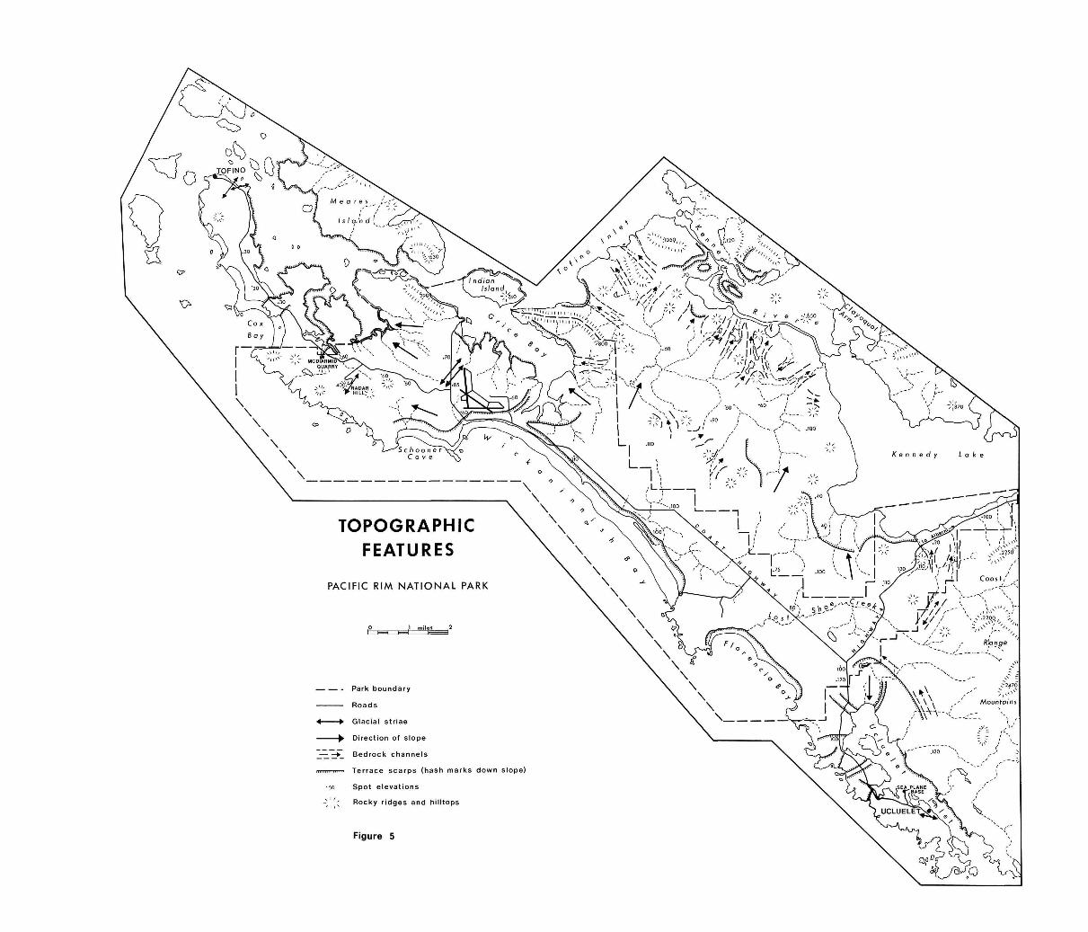
Park boundary
Roads
4 • Glacial striae
^ Direction of slope
_j3.--+_ Bedrock channels
iimn Terrace scarps (hash marks down slope)
•so Spot e leva t i ons
^ \ Rocky ridges and hilltops
Figure 5
TOPOGRAPHIC FEATURES
PACIFIC RIM NATIONAL PARK
- 33 -
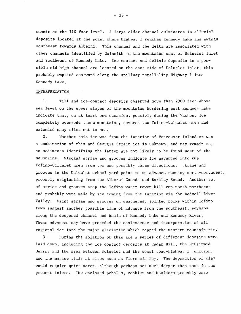
summit at the 110 foot level. A large older channel culminates in alluvial
deposits located at the point where Highway 1 reaches Kennedy Lake and swings
southeast towards Alberni. This channel and the delta are associated with
other channels identified by Naismith in the mountains east of Ucluelet Inlet
and southwest of Kennedy Lake. Ice contact and deltaic deposits in a pos
sible old high channel are located on the east side of Ucluelet Inlet; this
probably emptied eastward along the spillway paralleling Highway 1 into
Kennedy Lake.
INTERPRETATION
1. Till and ice-contact deposits observed more than 2300 feet above
sea level on the upper slopes of the mountains bordering east Kennedy Lake
indicate that, on at least one occasion, possibly during the Vashon, ice
completely overrode these mountains, covered the Tofino-Ucluelet area and
extended many miles out to sea.
2. Whether this ice was from the interior of Vancouver Island or was
a combination of this and Georgia Strait ice is unknown, and may remain so,
as sediments identifying the latter are not likely to be found west of the
mountains. Glacial striae and grooves indicate ice advanced into the
Tofino-Ucluelet area from two and possibly three directions. Striae and
grooves in the Ucluelet school yard point to an advance running north-northwest,
probably originating from the Alberni Canada and Barkley Sound. Another set
of striae and grooves atop the Tofino water tower hill run north-northeast
and probably were made by ice coming from the interior via the Bedwell River
Valley. Faint striae and grooves on weathered, jointed rocks within Tofino
town suggest another possible line of advance from the southeast, perhaps
along the deepened channel and basin of Kennedy Lake and Kennedy River.
These advances may have preceded the coalescence and incorporation of all
regional ice into the major glaciation which topped the western mountain rim.
3. During the ablation of this ice a series of different deposits were
laid down, including the ice contact deposits at Radar Hill, the McDairmid
Quarry and the area between Ucluelet and the coast road-Highway 1 junction,
and the marine tills at sites such as Florencia Bay. The deposition of clay
would require quiet water, although perhaps not much deeper than that in the
present inlets. The enclosed pebbles, cobbles and boulders probably were
- 34 -
dropped into the clay from blocks or rafts of ice. No weathering or other
evidence was found to indicate that the ice contact deposits and tills at
sites such as Radar Hill and McDairmid Quarry were deposited at different
times, although possibly the ice,contact materials to the south, in the
Ucluelet area, may have been. These Ucluelet area deposits are not as well
exposed as those at a number of other sites, being observed chiefly in road
cuts. They seem to be less indurated than other deposits and also are con
tiguous to the deltaic sands and gravels at the Sea Plane station quarry,
the deposits of uncertain origin at the east end of Florencia Bay, and the
outwash fanning out from the vicinity of the coast road-Highway 1 junction.
The outwash truncates other deposits such as the marine tills at the north
end of Florencia Bay and was deposited an unknown time later, although
perhaps as part of the same overall ablation phase.
There is other evidence which could be interpreted as indicating
a still stand or perhaps a re-advance of the ice at the time this outwash
was laid down. The deltaic deposits at the Sea Plane station exhibit
strong variation in size, sorting, dip and other characteristics, suggestive
of deposition near ice. The deposits of uncertain origin at the south end
of Florencia Bay also reflect ice proximous conditions. The often large,
rather angular boulders in these materials seemingly could only have been
laid down in their fine well sorted matrix from blocks of standing or
floating ice. How the fine matrix originated is uncertain. But the deposits
are continuous with the underlying sands and gravels exposed along Florencia
Bay. All this evidence suggests that the ice may have paused, fluctuated or
even retreated some distance to the south and re-advanced to a position
athwart the upper end of Ucluelet Penninsula and southern Florencia Bay.
Some may see the Sumas stage in this evidence.
4. Parts of the outwash sands and gravels, the ice contact deposits
near Ucluelet, and the brown tills located near Wickaninnish Bay as well as
at sites near southeast Kennedy Lake, are consistently located approximately
110 feet above present sea level and form the upper part of what has been
identified as the Tofino (Esteran) plain or terrace by previous workers.
As noted earlier, other surfaces also truncate these various materials at
other elevations, notably about 60 and 30 feet above present sea level.
- 35 -
Benches and high older drainage channels also are found at these two levels,
notably near Kennedy Lake. The weathered and eroded clays located predomi
nantly in the interior of the Tofino plain are found at these levels, perhaps
at several others, and also on gentle slopes leading from surrounding higher
ground such as the 110 foot rim on the west border of Tofino plain. The
approximately 60 foot and 30 foot surfaces also are located on beach sands
and gravels north of the airport toward Tofino.
All this evidence indicates that as ice finally ablated and retreated
from the Tofino area at least three water levels persisted at elevations
of approximately 110, 60 and 30 feet above present sea level for times suf
ficient for waves and streams to form terraces or benches. Other higher water
levels also may have occurred but their'location awaits more detailed research.
Nor is there any known evidence to indicate whether the water level changes
were due to ponding of water by ice located seaward of the present shoreline;
by a rise in sea level associated with ice retreat; by isostatic adjustment
with ice retreat; or by a combination of these processes.
5. While the water level was at about 30 feet, and since that time
to the present, ocean and inlet processes have deposited large quantities
of sand as well as some gravel and clay north of the airport toward Tofino,
linking former bedrock islands to the plain. These processes are still at
work and have been accelerated by the introduction of the lumbering industry
in the late 19th century. As a result of lumbering, many logs have been
deposited along beaches, leading to their growth and to the formation of
features such as log jam tombolos. Whether other changes have occurred as
a result of human interference is unknown at the present time.
6. No samples for C14 dating were obtained so that no estimate of
the actual timing of the previous processes and of the age of deposits is
possible now. Such dates would, of course, make it possible to link events
and processes in the Tofino area with those identified as of Vashon or
other age elsewhere.
- 36 -
SOME REFERENCES
1. Anonymous (1970), Geological History of the Long Beach Area, mimeo,
B.C. Dept. of Mines and Petroleum Resources, Victoria, November 25,
1970.
2. Dolmage, V. (1920), West Coast of Vancouver Island between Barkley and
Quatsino Sounds, Canada Dept. of Mines, Geol. Sur. Surom. Report,
Victoria, 12A - 22A.
3. Eastwood, G.E.P. (1968), Geology of the Kennedy Lake Area, Vancouver
Island, British Columbia, British Columbia Dept. of Mines and Petroleum
Resources, Bull. 55, Victoria.
4. Halstead, E.C., The Cowichan Ice Tongue, Vancouver Island, Canadian
Journal of Earth Sciences, 5, 6, 1968, 1409-1415.
5. Muller, J.E. and D.J.T. Carson (1969), Geology and Mineral Deposits of
Alberni Map - Area, British Columbia, Geological Survey of Canada, Ept.
of Energy, Mines and Resources, Paper, 68-50.
6. Naismith, H. (1970), Pleistocene Geology of the Queen Charlotte Islands
and Southern British Columbia, in Early Man and Environment in Northwest
North America, Proceedings, Second Annual Paleo-Environmental Workshop,
Editor, R.A. Smith and J.W. Smith, Archaeological Association, U. of
Calgary, 5-8.

IV
A VEGETATION CLASSIFICATION FOR PHASE I OF PACIFIC
RIM NATIONAL PARK
Lawrence D. Cordes and George A. MacKenzie
INTRODUCTION
The primary objectives of this study were to classify and map the
vegetation of Phase I of Pacific Rim National Park. The system is based on
vegetation form and dominant species as they relate to the physical envi
ronment; particularly land forms, topography, drainage patterns, and soils.
Although the vegetation map (Fig. 6) is only a first approximation, we hope
that it will prove to be both useful and flexible. It can be related to
geomorphic and other maps for comparison and study purposes. The system
additionally provides an overall framework which can be used for inventorying
other park natural resources such as wildlife and soils. It can also be
used in park planning and in interpretation programs.
DESCRIPTION OF THE AREA
Climate
The climate of the area is mild and humid due to the moderating
effect of the ocean. The mean annual temperature is 49 F and extremes in
temperature are rare. The mean temperature for the warmest month is 58 F
and for the coolest month, 41 F. The area averages 36 days of freezing
temperatures annually (Kuramoto, 1965). Precipitation is heavy with an
annual mean of 110-120 inches. The major portion of this occurs during
the late fall, winter and early spring. Fogs are frequent during the
summer and last from early morning to about noon. These fogs are usually
restricted to the immediate coast. Close proximity to the ocean along with
the onshore wind and cool temperatures result in high humidity throughout
the year. Winds are moderate with a mean speed of 7-10 mph but occasionally
reach gale force, especially during winter storms. The prevailing directions
are southeast during the winter and northwest and south during the summer.
- 37 -

VEGETATION
PACIFIC RIM NATIONAL PARK
C o a s t a l Z o n e
Rocky headlands and islands subzone
Al rocky outcrop
A2 shrub and herb
A3 spruce forest
H H m A4 red cedar-hemlock-spruce
"~" transitional forest
Beaches, dunes, and near coast terraces and plains subzone
! | B1 unvegetated
B2 herb and log
B3 shrub and herb
B4 scrub spruce forest
B6 spruce forest
I r I B7 hemlock-red cedar-spruce
^ ^ transitional forest
Figure 6

- 38 -
Geomorphology
The oldest land surfaces within the park area are outcrops of
andesite volcanics belonging to the Vancouver Group (Dolmage, 1923). These
rocks are exposed on headlands, islands and hills. Large exposures occur
on the headlands between Cox Bay and Portland Point and between Wickaninnish
and Florencia Bays. Several cone-shaped hills of this volcanic rock rising
to approximately 500 feet form the height of land within the park.
The remaining land surface of the park is part of the Estevan
Coastal Plain; a strip of land composed of Pleistocene and Recent deposits,
extending some 170 miles along the west coast of Vancouver Island. Between
Ucluelet and Tofino this plain forms an undulating surface made up of three
types of surficial deposits. These are: sand beach plains, glacial outwash
and marine clays.
The beach plain and associated dune deposits in the Wickaninnish
Bay and Schooner Cove area are the result of progradation of the coastline.
The development of these land forms coincides with a period when the amount
of sand deposited on the beach during the summer was greater than the amount
removed during winter storms. This is in marked contrast to the preceding
period when the entire length of the terrace behind the beach was being
undermined by winter storms as is presently taking place in Florencia Bay.
Behind the beach plains the coastal plain begins in the form of
a terrace rising to slightly over 100 feet above sea level. It extends
from the northwest end of Schooner Cover to Wya Point (Figure 5) at the
southeast end of Florencia Bay and inland to Kennedy Lake, a distance of
6 to 10 miles. This area is made up of low hills, broad shallow valleys
and extensive flat areas. There is a total absence of any sharp relief
with the exception of a few rocky outcrops.
Surface drainage of this terrace is very poor due to the limited
stream dissection and the presence of iron pans and impervious clay layers
within the soil. The most poorly drained sites are situated on interfluves
and along the major drainage divide of the coastal plain. Streams flowing
to the open ocean are separated from those flowing to the inlet and to
Kennedy Lake by this divide. The divide is located on to two miles inland
and runs approximately parallel to the coastline. The poor drainage results

- 39 -
in soils which are water-logged for much of the time with standing water
conditions being prevalent during the winter and spring. It must be noted
that drainage improves locally beside small streams and along the terrace
scarps.
Vegetation
The park area lies within the wet subzone of the Coastal Western
Hemlock Zone (Krajina, .1959, Orloci, 1961). The climatic climax forest
on mesic sites in this subzone is dominated by western hemlock (Tsuga
heterophylla) and Pacific silver fir (Abies amabilis). This forest is
typically multi-storied being made up of dense, uneven-aged stands. The
understory is lush and dense consisting of ericaceous shrubs and ferns.
Both the forest floor as well as the trees and other woody plants are
covered with a thick mat of mosses and liverworts.
Western redcedar (Thuja plicata) is the most common species on
extensive poorly drained areas. Shore pine (Pinus contorta), western
hemlock, and western yew (Taxus brevifolia) are also common on these
sites. Xeric to mesic sites support western hemlock, shore pine, and
Douglas-fir (Pseudotsuga menzeisii) either singularly or in combination.
Sitka spruce (Picea sitchensis) is typical of certain specialized habitats
such as flood plains, seepage sites and along the coast where it is
tolerant to ocean spray. Douglas-fir is a serai species, however, since
neither fires or logging were very prominent forces in the past, the area
supporting mature stands of this species is very small. In recent years
it has been planted extensively after logging, showing good growth on
well-drained sites.
METHODS
Prior to mapping, a considerable amount of time was spent in the
field to gain familiarity with both the vegetation and the physical
environment. The senior author had some knowledge of the vegetation of
the area prior to this study having carried out research on the Sitka
spruce forests of the region. Mapping was done by delimiting differences
in vegetation form and dominant species using air photos. Along with the
The air photo interpretation was carried out by J.G. Nelson and the senior author.

Table 3,
ENVIRONMENT
Mean slope gradient
Mean elevation (ft. M.S.L.)
Mean relief
Mean wind exposure
(A-B-C) layers
SOILS
Type
Humus type
Mean pH
Mean thickness-humus (in.)
Water table depth (in.)
Parent material
Drainage class
TREE MENSURATION
Age and height of oldest tree
(years - feet)
Sitka spruce
Western hemlock
Western redcedar
Shore pine
Pacific silver fir
Yellow cedar
Mean coverage by layer (%)
Tree - A
"3
Shrub -B
B 2
Herb -C
Moss & -D
Liver
wort
Epiphyte - E
Li
a 1 n
<
8° 20'
irregular
8-4
Regosol
Felty
mar
'..3
12.0
-Andesite
Submesic
:
_ 4
88
19
13
10
;•; 1 <
15°
25'
undulating
8-6-3
Lithic
Regosol
Felty
r.or
4.5
14.9
-Andesite
Hesic
184-84
24
22
15
58
39
8
10
26
no
0° 18'
flat-
concave
9-6
Regosol
Hull
7.1
1.0
-Sand
Subir.esic
:
_
-74
-
U
d
u
i-n
pa
4° 12'
undulating
9-6-3
Orthic
Regosol
Felty
nor
5.2
3.5
-Sand
Mesic
160-50
15
14
9
36
56
28
54
31
H
O k.
y p
m
4° 20'
undulating
8-5-2
Orthic
Regosol
Felty
5.1
5.0
39.0+
Sand
Hesic
294-126
4 2
25
18
33
50
25
27
14
Li
LL o
3 te
° S
CJ kJ ~i •-£ o M ~ [_) +-J
q JO
Si
3° 20'
undulating
7-4-1
Podzol
Greasy
nor
4.4
6.5
52.0
Sand
Sub-
Hygric
296-143
216-126
182-116
\
37
30
18
28
35
30
38
6
H
U
8° 40'
flat-
huo.oocky
4-3-1
Regosol,
Podzol
Mull-
Felty
nor
5.0
5.5
72.0-
84.0
Silt,
Sand
Sub-
Hygric
375-170
580-175
300-170
46
16
6
28
29
30
38
33
+-
3 p
Li o
1 q
O
U
4° 65'
flat-
hucrr.ocky
4-3-1
Podzol,
Gleysol
Felty
cor
4.7
9.0
36.0
Clay,
Sand
Hygric
230-115
320-125
34
16
11
33
35
34
28
21
p
2° 80'
hurrzio c ky
6-4-2
Gleyed
Podzol,
Gleysol
Greasy
cor
4.8
10.0
18.0
Clay,
Sand
Sub-
Hygric
260-35
230-45
215-85
38
18
6
26
45
31
27
19
H
O
CO
p
u
0° 95'
huco.ocky
5-4-2
Gleyed
Podzol,
Gleysol
Creasy
cor
4.1
12.5
12.0
Sand,
Gravel
Sub-
Uygric
188-30
250-50
285-70
136-40
26
46
36
58
12
15
67
55
e Id
o
u
M
C
o
15°
240'
irregular
6-A-2
Regosol,
Podzol,
Gleysol
Granular
mor
4.6
6.0
?2°0
7,ndesite,
boulder clay
Mesic
280-95
300-65
156-95
23
18
5
29
33
35
25
14
Estimated on a 10-point scale with 10 being the maximum.
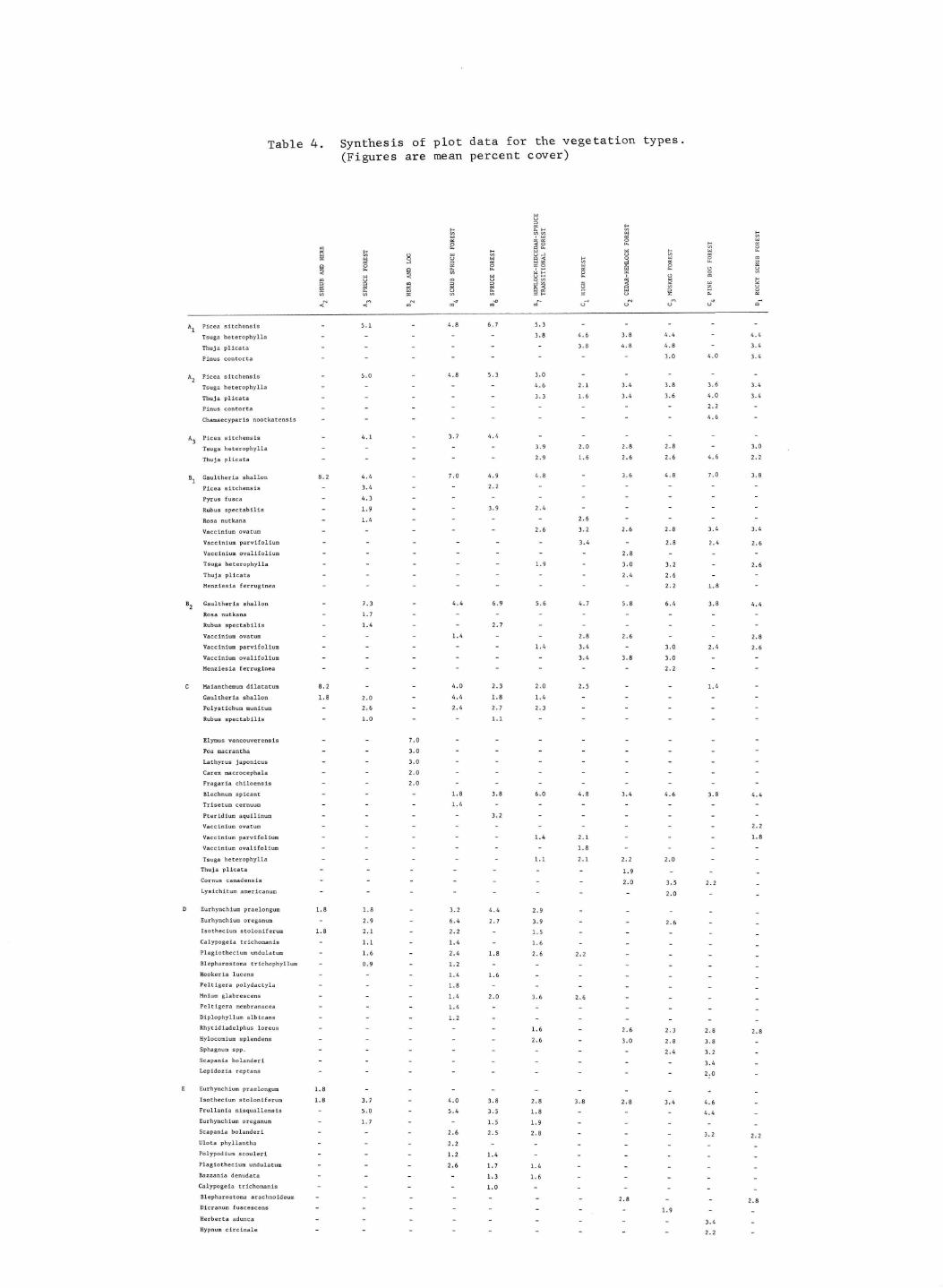
Table 4 . Synthes is of p l o t da ta for the v e g e t a t i o n types , (Figures are mean percen t cover)
u s
S fe W W H w i w M « O S o £ H ec
a b - . a u . w p « H H W _i H —' W W w U W w O -J C_> W < -X w O _> W d < H O W O —•
2 - i 3 od w z w a x w o Q O o i O M O W X O OS g W p O. W i w o i W U . O L) < few ^ H o _: g w
W < W O •-• In I C « m o m o o w S S •• £
v> fe X w w 2 H b- O £ W CS
< N < ; c Q t N o a c Q t a o o u o a
A, Picea sitchensis - 5.1 - 4.8 6.7 5.3
Tsuga heterophylla - - - - - 3.8 4- 6 3- 8 4- 4 " 4-4
Thuja plicata - - - 3.8 4.8 4.8 - 3.4
Pinus contorta - - - - - 3.0 4.0 3.4
A Picea sitchensis - 5.0 - 4.8 5.3 3.0
Tsuga heterophylla - - - - 4.6 2.1 3.4 3.8 3.6 3.4
Thuja plicata - 3.3 1.6 3.4 3.6 4.0 3.4
? 2 Pinus contorta _ _ - • • • •
Chamaecyparis nootkatensis - _ - 4.6
A, Picea sitchensis - 4.1 - 3.7 4.4 .. _ .. _
Tsuga heterophylla - - - - 3.9 2.0 2.8 2.8 - 3.0
Thuja plicata - 2.9 1.6 2.6 2.6 4.6 2.2
B Gaultheria shallon 8.2 4.4 - 7.0 4.9 4.8 - 3.6 4.8 7.0 3.8
Picea sitchensis - 3.4 - - 2.2
Pyrus fusca - 4.3 -
Rubus spectabilis - 1.9 - 3.9 2.4
Rosa nutkana - 1.4 _ - - 2.6
Vaccinium ovatum - - - - 2.6 3.2 2.6 2.8 3.4 3.4
Vaccinium parvifoltum - - 3.4 - 2.8 2.4 2.6
Vaccinium ovalifolium - - - 2.8 -
Tsuga heterophylla - - - 1.9 - 3.0 3.2 - 2.6
Thuja plicata - _ _ _ _ _ 2.4 2.6
Menziesia ferruginea - - _ _ _ _ _ _ 2.2 1.8
B_ Gaultheria shallon - 7.3 - 4.4 6.9 5.6 4.7 5.8 6.4 3.8 4.4
Rosa nutkana - 1 . 7 - _ _
Rubus spectabilis - 1.4 - - 2.7
Vaccinium ovatum - 1.4 - - 2.8 2.6 - - 2.8
Vaccinium parvifoltum - - 1.4 3.4 - 3.0 2.4 2.6
Vaccinium ovalifolium - - - 3.4 3.8 3.0
Menziesia ferruginea - - _ _ _ _ _ _ 2.2
C Maianthemum dilatatum 8.2 - - 4.0 2.3 2.0 2.5 - - 1.4 -
Gaultheria shallon 1.8 2.0 - 4.4 1.8 1.4
Polystichum munitura - 2.6 - 2.4 2.7 2.3 - - _ _ _
Rubus spectabilis - 1.0 - - 1.1 _ _ _ _ _ _
Elymus vancouverensis - - 7.0
Poa macrantha - - 3.0 _ _ _ _ _ _ _ _
Lathyrus Japonicus - - 3.0 _ _ _ _ _ _ _ -
Carex macrocephala - - 2.0 _ _ _ _ _ _ _ _
Fragaria chiloensis - - 2.0 _ _ _ _ _ _ _ _
Blechnum spicant - - - 1.8 3.8 6.0 4.8 3.4 4.6 3.8 4.4
Trisetum cernuum - - 1.4 _ _ _ _ _ _
Pteridium aquilinum - - _ - 3.2 _ _ _ _ _ _
Vaccinium ovatum - - - - - - - - - - 2 . 2
Vaccinium parvifoltum - - 1.4 2.1 1.8
Vaccinium ovalifolium - _ - - _ 1.8 -
Tsuga heterophylla - 1.1 2.1 2.2 2.0
Thuja plicata - - - - - - - j o _ _
Cornus canadensis - - - - - - - 2.0 3 5 2 2
Lysichitum americanum - - - _ _ _ _ - 2 0 -
D Eurhynchium praelongum 1.8 1.8 - 3.2 4.4 2.9 - _ _ _
Eurhynchium oreganum - 2.9 - 6.4 2.7 3.9 - - 2.6
Isothecium stoloniferum 1.8 2.1 - 2.2 - 1.5 - _ _ _
Calypogeia trichomanis - 1.1 - 1.4 - 1.6 - - _ _
Plagiotheeiurn undulatum - 1.6 - 2.4 1.8 2.6 2.2
Blepharostoma erichophyllum - 0.9 - 1.2 - - - -
Hookeria lucens - 1.4 1.6 - - - _ _
Peltigera polydactyla - - - 1.8 - - _ - _ _
Mnium glabrescens - 1.4 2.0 3.6 2.6 - - -
Peltigera membranacea - 1.4 - - - _ _ _
Diplophyllum albicans - - 1.2 - - _ - _ _
Rhytidiadelphus loreus - - _ _ _ i_0 _ 2.6 2.3 2 8 2 8
Hylocomium splendens - - 2.6 - 3.0 2 8 3 8
Sphagnum spp. - - _ - _ _ _ _ 2.4 3.2
Scapania bolanderi - - - - _ - _ _ - 3 4
Lepidozia reptans - - - - - _ _ _ - 2 0
E Eurhynchium praelongum 1.8 - - - - - - _ _ _
Isothecium stoloniferum 1.8 3.7 - 4.0 3.8 2.8 3.8 2.8 3.4 4.6
Frullania nisquallensis - 5.0 - 5.4 3.5 1.8 - - - 4 4
Eurhynchium oreganum - 1.7 - - 1,5 1.9 - _ _ _
Scapania bolanderi - - - 2.6 2.5 2.8 _ _ 3 - 2 2 2
Ulota phyllantha - 2.2 - - - _ _ _
Polypodium scouleri - - - 1.2 1.4 - - -
Plagiothecium undulatum - - 2.6 1.7 1,4 - -
Bazzania denudata - - - - 1.3 i.0
Calypogeia trichomanis - - - - 1 . 0
Blepharostoma arachnoideum - - _ - - _ _ 2 g
Dicranum fuscescens - - - - _ _ _ - 1 9 -
Herberta adunca - - - - _ _ - , - 3.4
Hypnum circinale - - _ - - _ _ _ - 2 2 -
- 40 -
air photo interpretation, field checks were conducted in order to test the
reliability of the mapping and to gather additional information.
Descriptions of most of the coastal vegetation types were available
from the senior author's previous research. Studies in the park area by
Kuramoto (1965) and Wade (1965) were of considerable value in preparing the
classification system and were used to provide descriptions of several of
the vegetation types. A study by Stanek and Krajina (1963) was also useful
in this respect. The interior vegetation types, for which there was no
previous information available, were sampled by the junior author. Several
of the vegetation types were not sampled, however a number of sites from
each type were visited and general descriptions were prepared.
The procedure for sampling the vegetation is as,follows: Plots
having dimensions of either one by one chain or one by two chains were
placed in locations which were judged to be typical of the vegetation type
in question. A minimum of five plots were analyzed for each type except
for several types that were not sampled. Visual estimates of cover as a
percentage of the total plot area were made on the tree, shrub, herb, moss
and epiphyte layers (Table 1). Species occurring in each layer were recorded
and rated according to a species significance scale (Table 2). Some tree
mensuration data as well as measurements on the parent material, topography,
water table, and soils were also recorded (Table 3).
Synthesis of the plot data for each vegetation type is presented
in Table 4 For most of the data only mean values are given. The vegetation
data has been limited to species which are present in 80% or more of the
plots of a given type (constant species). Soil classification and terminology
follows the system of soil classification for Canada (National Soil Survey
Committee of Canada 1970).
THE VEGETATION CLASSIFICATION
At the first level of generalization in the classification system,
two zones are identified: the Coastal Zone and the Interior Zone (Table 4).
The Coastal Zone is composed of vegetation types which are strongly influenced
by their close proximity to the sea. The Interior Zone consists of types
that are located inland from the Coastal Zone and have developed primarily
in response to edaphic influences such as differences in parent material
and drainage.

- 41 -
1 1 1 1 1 • TABLE 1
VEGETATION LAYERS USED IN BOTH THE ANALYSIS AND SYNTHESIS OF THE TYPES
Tree layer A.. - dominant trees
A„ - co-dominant trees
A„ - intermediate and suppressed trees over 30 feet in height
Shrub layer B.. - saplings and shrubs between 6 & 30 ft. in height
B„ - shrubs between 6 inches and 6 feet in height
Herb layer C - herbaceous plants Moss layer D - bryophytes and lichens on the ground surface
Epiphytes E - bryophytes and ferns on aerial parts of woody plants
-
Species Significance
seldom, cover negligible
very scattered, cover negligible
scattered, cover up to 5% of plot
common, cover 5-10% of plot
often, cover 10-20% of plot
very often, cover 20-35% of plot
abundant, cover 35-50% of plot
abundant, cover 50-75% of plot
abundant, cover 75-95% of plot
abundant, cover 100% of plot
Value
1
2
3
4
5
6
7
8
9
10
TABLE 2
THE SPECIES SIGNIFICANCE SCALE SHOWING THE COVER RANGE FOR EACH VALUE

- 42 -
The most obvious differences between the two Zones, vegetation
aside, are the more severe climate and better drainage of the Coastal
Zone. Ocean spray, high winds and associated storm waves are characteristic
of the coastal climate. The Coastal Zone is also differentiated by the
much more dynamic geomorphic processes, especially along the strand and
on beach plains and dune areas.
For purposes of this study, the tidal area of the park has been
placed in the Interior Zone in preference to establishing a third zone.
This seems reasonable since the tidal area is very restricted in size and
also because it was not studied in any detail. Further research might deem
it necessary to establish a tidal zone.
I. The Coastal Zone
The Coastal Zone is divided into two major subzones: the rocky
headlands and islands subzone, and the beaches, dunes, near-coast marine
terraces and plains subzone. The distinction between these two subzones
is based on differences in parent material: the first is found on andesite
bedrock while the second occurs on beach sand and other transported
surficial deposits.
A. The rocky headlands and islands subzone
This subzone consists of four vegetation types; their spatial
distribution being closely related to the degree of exposure to the ocean
and to the thickness of humus accumulation of the ever-present bedrock.
These are, in decreasing order of exposure: the rocky outcrop type, the
dense shrub and herb type, the spruce forest type and the redcedar-hemlock-
spruce transitional forest type.
A1 The rocky outcrop type
This is the most seaward of the types in this subzone and con
sequently has the most severe environment. It extends from the high tide
line inland to the dense herb and shrub type or to the spruce forest type.
Extensive areas of rock outcrop, either bare or supporting a thin layer of
lichens and mosses, are characteristic of this type. Herbaceous plants
tolerant to ocean spray succeed in becoming established on minute soil
deposits in cracks and depressions in the bedrock. The occasional shrub

- 43 -
or stunted Sitka spruce may be found in the wind-shade of rocks and boulders.
Soils are present only as minute amounts of accumulated organic matter, sand,
shells and rock fragments. No sample plot data is available for this type,
however, a generalized list taken from Stanek and Krajina (1963) is as
follows:
Herb layer
seaside plantain (Plantago maritima), leathery polypody (Polypodium scouleri), coast strawberry (Fragaria chiloensis), Indian paintbrush (Castilleja rhexifolia), cinquefoil (Potentilla villosa), wild-lily-of-the-valley (Maianthemum dilatatum), western yarrow (Achillea millefolium), nodding onion (Allium cernum)
Moss layer
Eurhynchium oreganum, Peltigera membranaceae
A The dense shrub and herb type
Inland from the unvegetated to sparsely vegetated rock outcrop
type one encounters a thick growth of shrubs. The dense shrub and herb
type forms a narrow band on the seaward side of the coastal forest, although
in places it forms isolated clumps of varying size. This type Is of minor
areal extent and in many places it is impossible to map at the present scale.
This type is found on sites with moderate to high exposure to the
ocean. However, probably of greater importance is the fact that some soil
development has taken place on top of the andesite bedrock. A more humus
layer ranging in thickness from 2 to 14 inches has accumulated from the
decomposition of past vegetation. In most locations this layer makes up
the total soil profile, although in certain places a thin mineral layer is
present.
The dense shrub layer of almost pure stands of salal (Gaultheria
shallon) varies in height from 2 to 8 feet. In exposed locations the upper
branches of these shrubs have been killed due to the effects of ocean spray.
The herb layer has a mean coverage of only 19% most of which can be attri
buted to a single species, wild lily-of-the-valley (Maianthemum dilatatum).
The most important mosses on the soil surface are Eurhynchium oreganum and
E. praelongum while Isothecium stoloniferum and Jh_ Oreganum are the
predominant epiphytes.

- 44 -
A The spruce forest type
The Sitka spruce forest is the dominant type on rocky headlands
and islands. It occupies a strip parallel to the coastline up to 200 feet
in width, although generally it is much thinner. This type is similar to
the two previous types in that it occupies sites which are exposed to the
open ocean. On sites which receive large amounts of ocean spray, the trees
are very stunted and take on a hedge-like or wind-formed appearance.
The soils in this type consist of a thick layer of very acid
felty mor humus over bedrock and have been classified as Lithic Regosols.
Mineral soil has accumulated in cracks and depressions forming a layer from
4 to 21 inches thick. These areas have a thick LFH, an eluviated or Ae
horizon and a Bf horizon in contact with the bedrock; they are classified
as Orthic Humic Podzols.
The Sitka spruce canopy varies in height from 30 to 50 feet with
a few individuals attaining heights of 70 feet. The canopy may be very open
or extremely dense depending on the age of the stand and the degree of
exposure. Many stands are very old with trees 300 years and older being
common. Salal is the dominant shrub and in stands with open canopies it
forms a dense understory that is as high as nine feet in places. Salmonberry
(Rubus spectabilis) and Nutka rose (Rosa nutkana) are also common in the shrub
layer. Oregon crabapple (Pyrus fusca) grows to a height of 25 feet in bedrock
depressions where soil moisture is more plentiful. Coverage in the herb layer
is limited due to shading from the dense shrub layer. Sword fern (Polystichum
munitum) and deer fern (Blechnum spicant) are the most common species in this
layer. Mosses such as Eurhynchium oreganum and Plagiothecium undulatum are
found on the humus and around the base of trees. The most prevalent epiphytes
are Frullania nisquallensis and the fern, Polypodium scoulerii.
A R.edcedar-hemlock-spruce transitional forest type
The redcedar-hemlock-spruce forest is a minor type which is found
on the inland side of the spruce forest type. It is considered a transitional
type between the rocky headlands and islands subzone and the rocky scrub
subzone of the Interior Zone. Within the park this type is limited to the
rocky headlands between Cox Bay and Portland Point (Figure 5).

- 45 -
This type is similar to the spruce forest type in that it occurs
on bedrock or on sites which have a thin layer of mineral soil over bedrock.
Soils consist of a thick layer of acid mor humus resting directly on bedrock
or on mineral soil. These soils have been classified as Lithic Regosols
and Orthic Humic Podzols.
Stands of this type are dominated by western redcedar and western
hemlock, with Sitka spruce occurring only in small numbers. The predominance
of redcedar and hemlock can be attributed to protection from the coastline
environment provided by the spruce forest type. The understory is once
again dominated by salal while red huckleberry (Vaccinium parvifolium) and
hemlock and redcedar transients are also common. Cover of the herb layer
varies considerably from site to site. Deer fern is the most common species
in this layer. Plagiothecium undulatum and Hylocimium splendens are common
mosses on humus while Isothecium stoloniferum is the most frequently epiphyte.
B. The beaches, dunes and near-coast terraces and plains subzone
This subzone has a greater areal extent and a more complex pattern
of plant communities than the rocky headlands and islands subzone. Although
there is a considerable diversity in land forms, a single surficial deposit,
sand, covers a great part of the area. A major exception is the scarp of
the marine terrace which is made up of clay and gravel. The active geomorphic
processes and time are important controlling factors in determining the
distribution of plant communities which occupy the subzone.
The vegetation types in this subzone generally form strips paralleling
the coastline. The sequence of types encountered in a transect running per
pendicular to the coastline and inland from the sea is as follows: unvegetated
beach type, herb and log type, shrub and herb type, scrub spruce forest type,
spruce forest type and hemlock-redcedar-spruce transitional forest type.
B The unvegetated beach type
This type consists of the intertidal area as well as a large part
of the strand which lies below the winter storm line. Sand, which is generally
free of logs and other debris, is present throughout the type. The invasion
of vegetation is restricted because of inundation by sea water during winter
storms and shifting sands and dessication during the summer.

- 46 -
B The herb and log type
Above the mean yearly high winter storm line is a highly variable
environment which has been classified as the herb and log type. This area
could have been broken down into a number of types; however it would have
been impossible to achieve the necessary detail using the present scale of
mapping. Many areas within this type are covered with logs and other debris
which have been placed there by the most severe of the winter storms. These
logs tend to catch and stabilize wind-blown sand during the summer and protect
this sand from erosion during storms. Sand tends to accumulate over the
years and eventually covers the logs. Although this system can be eroded
away by storms, a substantial amount of protection has been provided in
recent years by the continuous deposition of numerous logs on the seaward
side. This accumulation is undoubtedly related to activities of the coastal
logging industry.
The vegetation of this type is very diverse and for a complete
description one should consult the thesis by Kuramoto (1965). Much of the
area consists of barren sand and logs with scattered clumps of Cakile
edentula. In more stable areas a dense vegetation cover has developed which
is characterized by such species as wildrye (Elymus vancouverensis), seashore
bluegrass (Poa macrantha), peavine (Lathyrus japonicus), coast strawberry
(Fragaris chiloensis), beachgrass (Ammophila arenaria), and bighead sedge
(Carex macrocephala). The occasional stunted Sitka spruce is found in sites
which are well protected by logs.
B„ Shrub and herb type
The shrub and herb type occurs on logs and wind-blown sand which
have been stabilized for some time. It is therefore successional to the
herb and log type. This is the first type inland from the sea where soil
development has begun to take place. The best indication of this is a
thin surface layer of mor humus.
The vegetation of this type is heterogeneous and therefore no
plot sampling was carried out, although observations were made on a number
of sites. Vegetation is sparse and only about one foot tall on the seaward
side; it becomes much more dense and rises to a height of six to eight feet
on the inland side. Saial along with the occasional stunted Sitka spruce
- 47 -
dominate the shrub layer. Common herbs include bracken fern (Pteridium
aquilinum), giant vetch (Vicia gigantia) and wildrye.
B, Scrub spruce forest type
The first forest stands inland from the present beach belong to
the scrub spruce forest type. This type is commonly found on undulating
beach plains and on the tops and foreslopes of dunes and dune ridges. It
forms a 50 to 100 feet wide band above and parallel to the active beach.
It is best developed along the southeastern part of Wickaninnish Bay.
The soil consists of a layer of mor humus over a very thick
mineral layer which is fine sand in texture. The felty mor humus has a
mean thickness of 3 inches and contains a high proportion of sand grains
which have blown in from the beach. The underlying sand has been only
slightly modified by soil forming processes. These LFH-C profiles have
been classified as Orthic Regosols.
The tree layer is characterized by dense stands of stunted Sitka
spruce seldom exceeding a height of 40 feet. These trees form a unique
canopy which, when viewed from a distance, has the appearance of a giant
hedge. The top of the canopy forms a continuous straight line sloping
upwards in the direction away from the beach. Any branch reaching above
this line is killed by the intense ocean spray that is carried over the
top of the canopy by the wind.
A rather sparse cover of salal, in a stunted condition due to
shading by the tree canopy, forms the shrub layer. Wild lily-of-the-valley
is the only important species in the herb layer. Eurhynchium oreganum is
the dominant species in the moss layer while Frullania nisquallensis is
the leading epiphyte.
B The spruce forest type
By far the most extensive and variable type within the Coastal
Zone is the spruce forest type. It forms a band along all of the beaches
in the park and reaches a maximum width of approximately 500 feet on west-
facing bays where exposure to prevailing summer winds and waves is at a
maximum. This type commonly occurs on stabilized beach ridges, undulating
beach plains and on the slope of the marine terrace.

- 48 -
The soil consists of mor humus with a mean thickness of 5 inches
over a thick mineral layer varying from sand to clay in texture. Soil
profiles are weakly to moderately well-developed having either an LFH-Ah-C
or an LFH-Ae-Bf-C sequence. These two types have been classified as Orthic
Regosols and Minimal Podzols respectively.
Forest stands are fairly open and dominated by Sitka spruce with
the occasional western hemlock and western redcedar also being present.
The larger spruce are 120 to 155 feet tall and are commonly 200 to 500 years
old. Salal and Salmonberry (Rubus spectabilis) form a dense shrub layer
up to 9 feet in height. The herb layer consists mainly of ferns such as
deer fern, sword fern and bracken fern. Eurhynchium praelongum is the most
common species in the moss layer on humus.
B, The hemlock-redcedar-spruce transitional forest type
Of all the types in the Coastal Zone, the hemlock-redcedar-spruce
transitional forest occurs furthest from the coast and occupies sites which
have the greatest protection from the coastal climate. The inland boundary
of this type is considered to be synonymous with the inland boundary of the
Coastal Zone. In this way it is similar to the redcedar-hemlock transitional
forest type of the rocky headlands and islands subzone. It commonly forms
a band 50 to 250 feet or more in width on the inland side of the spruce
forest type. The most frequent occurrence of this type is on the upper slope
or on top of the marine terrace, although it is also found on the beach plain.
The deep sand or clay mineral soil is covered with a layer of mor
humus averaging 7 inches in thickness. The soil profiles are the most mature
of all the soils in the Coastal Zone. The profiles examined in this type
have well developed LFH, Ae, and B horizons and belong to the Podzolic Order.
In some places iron pans have begun to form, leading to a deterioration in
drainage on these sites.
In terms of numbers of individuals, western hemlock and western
redcedar are the leading species, although the largest and oldest trees are
Sitka spruce. Spruce over 170 feet tall and 500 years old or older are
occasionally found. Stands are generally quite dense and uneven-aged. The
presence of large numbers of hemlock and redcedar can probably be attributed
to protection from ocean spray and the mature nature of the soils. The dense

- 49 -
shrub layer is made up of salal, salmonberry, red huckleberry, and false
azalea (Menziesia ferruginea). The herb layer is similar to that of the
Spruce type except that deer fern is much more abundant. The moss layer
on humus is well developed; Mnium glabrescens and Plagiothecium undulatum
are important species.
II. The Interior Zone
The Interior Zone is divided into three subzones: the coastal
plain subzone, the rock outcrop subzone, and the tidal flats subzone. As
in the Coastal Zone, the primary distribution of the subzones is based on
differences in parent material which, either directly or indirectly, has
a major controlling influence on the distribution of the various vegetation
types.
C. The coastal plain subzone
This subzone is found on the various marine terraces in the park,
most of which are at an elevation of 60 to 110 feet. The marine terrace
area is not synonymous with the area occupied by this subzone since a small
part of the terraces are included in the Coastal Zone. In general, the
terraces are flat to slightly undulating and are made up of clay, sand,
and gravel deposits. Surface drainage which is controlled by both topography
and parent material is the single most important factor in determining the
pattern of vegetation types on the coastal plain. The types in the subzone,
listed in order of good to poor drainage, are: the high forest, the redcedar-
hemlock forest, the muskey forest, the pine bog forest and the treeless bog.
C, The high forest type
The hemlock high forest type occurs on sites which are in close
proximity to small streams or terrace scarps. Many of these sites have a
slope gradient steep enough to allow sufficient drainage so that the soil
does not remain water-logged for long periods during the winter and spring.
Seepage sites found on lower slope positions and on flood plains also support
stands of this type. On these sites the water table may be close to the
surface for longer periods; however, this water is moving so that stagnant
conditions with a lack of dissolved oxygen do not occur. This type once
covered large areas in the park, however, a large proportion of it has been
removed by logging.

- 50 -
Soils of this type are quite variable ranging from podzols on the
better drained sites to gleysols and regosols on the seepage sites. The
surface soil is either a fibrous or felty mor humus in podzolic and gleysolic
profiles or a mull humus in regosolic profiles. Humus layers are generally
quite thin compared to the other types in this subzone. Depth of rooting
is considerably better than the other types with depths of three feet or
more being common.
The major tree species are western hemlock, western redcedar, and
Pacific silver fir. Dense stands of hemlock and fir dominate the better
drained sites while more open stands of redcedar, hemlock and occasionally
Sitka spruce are found on the seepage sites. Most stands of this type are
160 to 200 feet in height and 200 to 600 years old. The shrub layer is
very sparse under closed stands while more open stands support a dense shrub
growth consisting mainly of salal and several species of huckleberry (Vaccinium
spp.). The herb layer is well developed being dominated by deer fern and
wild lily-of-the-valley as well as sword fern (Polystichum munitum) on seepage
sites. Common mosses on humus are Mnium glabrescens and Plagiothecium
undulatum while Isothecium stoloniferum is the dominant epiphyte.
C The redcedar-hemlock forest type
This type is less well-drained than the high forest being located
further away from streams and terrace scarps. The water table is close to
the surface during the rainy season and drops to approximately 5 feet or
more below the surface by late summer. Soils observed were either gleysols
or gleyed podzols. They consist of a 6 to 12 inch mor humus layer, a
leached Ae horizon and a gleyed B horizon. Clay is the most common parent
material although sand is present at some sites.
The dominant tree species are western redcedar and western hemlock.
Redcedar exhibits poor vigor and many individuals are stunted and have heart
rot. Although less numerous, hemlock shows better vigor and appears to be
reproducing more vigorously than the redcedar. Most stands are 100 to 150 ft.
tall and the older trees are 200 to 320 years old. The forest canopy is
open enough to allow the development of a dense shrub layer. Salal, tall
blue huckleberry (Vaccinium ovalifolium) and evergreen huckleberry (V. ovatum)
- 51 -
are the leading species in this layer. Species composition in the herb layer
is variable with deer fern and bunchberry (Cornus canadensis) being the only
constant species. Hylocomium spendens and Rhytidiadelphus loreus make up
the majority of the cover in the moss layer.
C„ The muskeg forest type
This type is found on sites similar to those of the redcedar-hemlock
forest type except that drainage is even more restricted. Standing water is
common during periods of heavy rainfall while late summer finds the water
table at depths of 2 to 3 feet. Soil profiles are very similar to the pre
vious type with the exception of the gleyed B horizon which is better developed.
Texture of the parent material ranges from clay to sand. In sandy areas an
iron pan at the bottom of the B horizon is sometimes present and acts as a
deterent to the downward movement of water.
Forest stands in this type consist of western redcedar, western
hemlock and shore pine. The muskey forest is distinguished from the previous
type by having trees with very poor growth form and by the presence of shore
pine (Pinus contorta). Stunted redcedar with candelabrum branching is the
leading tree species although hemlock shows better regeneration. Shore pine
is represented by a small number of individuals that overtop the much more
numerous redcedar and hemlock. The canopy is quite open and generally 35 to
50 feet high with the occasional shore pine reaching up to 85 feet. The
oldest trees measured ranged from 217 to 260 years and it is quite likely
that some are considerably older than these. The dense shrub layer is made
up of salal, several species of huckleberry and false azalea. The herb
layer, which is also quite dense, consists mainly of deer fern, bunchberry
and skunk cabbage (Lysichitum americanum). Hylocomium splendens, Sphagnum
spp. and Rhytidiadelphus loreus are the leading species in the well developed
moss layer on humus.
C, The pine bog forest type
The pine bog forest is the most poorly drained of all the forest
types in the park. This type occurs on the drainage divide of the Coastal
Plain where it occupies flat areas or shallow depressions, often in associ
ation with the bog type. Incising of local stream channels, a process which
- 52 -
tends to improve drainage, is lacking in these sites. It appears as if this
type is restricted to sand or sand and gravel surficial deposits. Poor
internal drainage of the soil is due to the presence of a very hard and
impervious iron hard pan, a result of intense podzolisation. This pan is
usually present within a foot of the top of the mineral soil. Soils are
typically gleyed podzols with greasy mor humus surface layers of variable
thickness.
The description of the vegetation is taken from Wade (1965) who
classified this type as the Pinus contorta - Chamaecyparis nootkatensis -
Sphagnum recurvum association.
Forest stands are composed primarily of several species of dwarfed
and peculiarly-shaped conifers of which the dominant species are shore pine,
yellow cedar (Chamaecyparis nootkatensis) and western redcedar. The largest
individuals are shore pine; they average 40 feet high and may occasionally
reach 70 feet. Branching trunks which support umbrella-like masses of foliage
at their tips give these trees a peculiar appearance. Other tree species
have dwarfed, bushy forms and do not exceed 40 feet in height. Both redcedar
and hemlock appear to be regenerating while no young specimens of either
shore pine or yellow cedar were observed.
The moderately dense shrub layer is dominated by salal with
Labrador-tea (Ledum groenlandicum) and mountain bilberry (Vaccinium vitis-idaea)
also common. The herbaceous layer is composed of both bog and forest elements
of which the forest species comprise most of the dominants. The moss layer
is extremely luxuriant and includes Sphagnum recurvum as a constant species.
CL The bog type
The bog type occupies depressions which are situated on interfluves
along the major drainage divide of the coastal plain. The water table remains
at or very close to the surface while standing water is common during the
winter and occurs in low places throughout the year. This type develops on
sandy parent material and, as in the pine bog forest, internal drainage is
impeded by the presence of an iron pan. Soils are characterized by a layer
of peat which ranges from very thin, up to 5 feet or more in thickness. The
soils fall into the Gleysols or Organic Orders.

- 53 -
The description of the vegetation follows Wade (1965) who has
broken the bog type into nine different classification units.
The bog type is predominantly composed of shrubs, herbs, and mosses;
although several tree species are present, particularly around the margin
of the bog and on hummocks. Shore pine is represented by stunted, dwarfed
specimens spaced at fairly regular intervals over the bog surface. These
trees, seldom over 15 feet tall and often over 100 years old, support plant
species on their basal hummocks that are typical of much drier habitats.
Yellow cedar is also present in the bog, however, it attains only the stature
of the prostrate shrub. The rather sparse shrub layer consists of such
species as Labrador-tea, bog laurel (Kalmia polifolia), crowberry (Empetrum
nigrum), bog cranberry (Oxycoccus quadripetalus), and bog blueberry (Vaccinium
uliginosum). The bulk of the bog surface is comprised of Sphagnum mosses
and herbaceous plants belonging to the following genera: Carex, Rhynchospora,
Juncus, and Scirpus. The predominant Shagnum species are S_̂ papillosum,
S. recurvum, and S^ mendocinum.
D. The rock outcrop subzone
The rock outcrop subzone consists of bedrock knolls as well as some
inland extensions of the rocky headlands which are out of the zone of strong
coastal influence. The largest area of rock knolls lies south of Cox Bay
and includes Vargas Cone and Radar Hill. This subzone consists of only one
type, the rocky scrub forest.
D The rocky scrub forest type
This type develops on the rocky to thinly drift-covered surfaces
which are found throughout the subzone. The topography is irregular con
sisting of cliffs, slopes of varying degrees of steepness, depressions, and
some relatively flat areas. In general, the higher parts have steep slopes
and consist largely of rock outcrops with small patches of till. Rock
outcrops also predominate on the lower less steep areas; however till patches
are somewhat more extensive here. Mineral soil, organic matter and ground
water accumulate in rocky depressions which support a forest very similar
to the muskeg type. The soil is quite variable due to the irregularities
in topography, drainage and soil depth. Lithic Regosols are common on
- 54 -
rocky outcrop areas where the entire profile consists of only a mor humus
layer of variable thickness. Depending on drainage conditions, either
podzols or gleysols develop on sites which possess some mineral soil. Soils
belonging to the Organic Order are sometimes present in depressions.
The composition of the forest varies considerably in response to
the same group of variables which affect soil genesis. Western hemlock,
western redcedar and shore pine are all present throughout the type; however
the proportion of the three species varies substantially from place to place.
In general the forest is of an open nature, has a canopy height of 35 to 70
feet, and is made up of individuals which are 150 to 300 years or more in
age. Poor vigor is exhibited by all tree species: slow growth rates, poor
form and dead tops are common throughout the forest. Hemlock and, to a
lesser extent, redcedar appear to be regenerating successfully. The shrub
layer varies from moderately to extremely dense and is dominated by salal
while red and evergreen huckleberry are also common. Deer fern is the
leading species in the herb layer with other species being important locally.
A thick moss layer covers the ground and, as in the other layers, varies
considerably from site to site.
A stand of Douglas-fir, the only natural one of this species in
the park, occurs on a rock knoll on Indian Island. It has been placed in
this type.
E. The tidal flats subzone
This subzone consists of that part of Tofino Inlet which lies
within the park boundary. Grice Bay makes up most of the area of this
subzone with the shorelines of several other bays contributing the remaining
part. Within these bays the tidal flats are defined, in general terms, as
that area which lies between the high and low tide lines. However, there
is some problem in establishing the exact upper limits of the tidal flats.
This is because the effects of tidal water, particularly restricted drainage
and salinity of the soil, go beyond the high tide line. Therefore, it seems
logical to define the upper limits of this subzone by the inland boundary of
herbaceous communities which are generally considered to be tidal flats
vegetation.

- 55 -
The tidal flats subzone has been divided into two types; the
unvegetated tidal flats, and the vegetated tidal flats. Since sampling was
not carried out in either of these types, it is possible to provide only
very general descriptions at this time. In fact, the units themselves
should be considered tentative; it is quite probable that further study
will lead to a classification of the tidal flats which includes more than
two types.
E The unvegetated tidal flats type
This type consists of unvegetated to very sparsely vegetated mud
flats which cover a high proportion of the total area of Grice Bay as well
as most of the other bays in the area.
E The vegetated tidal flats type
This type occupies a band parallel to the shoreline of bays as
well as extending into the lower reaches of stream channels which drain the
surrounding area. Along its inland boundary, this type meets several of
the forest types of the coastal plain subzone.
Vegetation is restricted to herbaceous plants which often form
communities made up of one or several dominant species. However, vegetation
varies considerably depending on local conditions and only a few of the
more common species will be mentioned here. On the higher mud flats which
are regularly inundated by high tide a dense growth of rushes and sedges
occurs. Such plants as Pacific coast bulrush (Scirpus pacificus) and
Lyngbye's sedge (Carex lyngbyei) are common dominants. Eelgrass (Zostera
marina var. stenophylla) forms almost pure stands on very similar habitats.
Further inland where tidal inundation is less frequent but where poor
drainage conditions are still prevalent, such species as tufted hairgrass
(Deschampsia caespitosa) and Baltic rush (Juncus balticus) are important
dominants.
F. Disturbed areas
The disturbed area category is interzonal in scope being applicable
to both the Coastal and Interior Zones. Of the two zones, by far the greatest
area as well as variety of disturbance is found in the Interior. Five classes

- 56 -
have been recognized: the built-up type, the major roads type, the minor
roads type, the logged type, and the alder type.
Although the preliminary definition of types is based on the mode
of disturbance; there is also considerable unity, at least in general terms,
in the secondary vegetation found within each type. Some degree of variation
in the vegetation can be expected due to differences in the length of time
since disturbance. It can also be assumed that succession on disturbed areas
with different physical site characteristics will lead to diverging trends
as time goes on and the vegetation gradually approaches a more or less
stable condition. Further studies should make it possible to establish the
potential successional trend and the climax type for any given disturbed
site. Obviously, this is true for only those sites which are allowed to
revert to nature.
F The built-up type
This type includes those sites which contain man-made features
with the exclusion of roads. The largest single area of this type in the
park is the Tofino Airport. Other built-up areas include resorts, houses,
gravel pits and Department of Transport radio transmitting stations.
F The major roads type
This type includes the road surface as well as the cleared right-
of-way along with its associated road cuts, fills and ditches. The most
important hard-top roads in the park are the Tofino-Ucluelet Highway and
part of Highway 4 which goes east to Port Alberni. Major gravel roads
provide access to the southeast end of Wickaninnish Bay and Radar Hill.
The wide variety of road-side vegetation is periodically cut making it
impossible for succession to proceed to a more mature type.
F The minor road type
Most of the roads in this type are gravel logging roads which
form an extensive network throughout the clearcut areas. These roads remain
unvegetated as long as they are used; however, if use stops, red alder
(Alnus rubra) invasion generally takes place.

- 57 -
F The logged type
The high forest and the redcedar-hemlock forest types and, to a
lesser extent, the muskeg forest type have been extensively logged leaving
large areas of the park in various stages of forest regeneration. On sites
which were logged prior to 1955 the original tree species have volunteered
and, on the basis of a number of observations it is thought that the original
plant communities will eventually re-establish themselves. Areas logged
after 1955 were being managed under Tree Farm Licences regulations which
required the company to restock these lands. A large percentage of this
land has been planted with Douglas-fir and to a lesser extent, Sitka
spruce. These two species were of little importance or completely lacking
on most of these sites before logging. Several areas which were logged
shortly before the establishment of the park were not planted and are major
eye-sores at the present time.
F The alder type
Red alder forms thick bands, swaths, and blocks along roads as
well as on other types of disturbed areas such as the fringe of clearcuts.
Generally speaking, it tends to seed in on moist gravel sites and highly
productive seepage sites. It is most common along roads becoming established
in the ditches and from there spreads up into the road surface. Red alder
is also very common around gravel pits. This type is considered important
because red alder is the only common deciduous tree species in the park.
DISCUSSION
It is well understood by plant ecologists that the vegetation of
any given site is an expression of the complex of environmental factors
acting on that site. It has often been stated that vegetation is the
single best integrator of the total environment. In developing the
present classification system we have attempted to follow these ideas by
considering the physical environment as being inseparable from, and strongly
integrated with the vegetation. Therefore, we have considered certain
aspects of the physical environment as being important criteria in setting
up the classification units and have used them in mapping and in describing
the vegetation types, subzones, and zones. Structural elements of the

- 58 -
environment that we have found particularly useful are topography, parent
material, soil drainage, soil morphology, and spatial position in reference
to the coastline. By following this procedure, we feel that the classifi
cation system along with the description of the units represents more than
simply a vegetation classification; it is a first approximation of a classi
fication and map of the park's terrestrial ecosystems.
This system is hierarchal having three levels, each being more
inclusive than the one below it. This has considerable value in that it
allows integration of information at different levels of generalization.
The system is also flexible and can be modified either by expanding or
contracting individual units or by the addition or subtraction of units
at any level. This is important in light of the fact that considerable
information has become "outdated" by being tied into a system which has
become obsolete because of its inflexibility or because a better system
has been developed.
The vegetation classification should be of considerable value in
providing an overall framework which can be used to inventory and classify
other kinds of the park's natural resources and was used to some extent
in the wildlife paper by Roe and Nelson in this publication. The system
undoubtedly has a number of uses in park planning and management, many of
which are self-evident. For example, it would be impossible to develop
a sound park zoning plan without the input of information made available
by a vegetation classification such as this one, as well as inventories
of a number of other natural resources.
The parks interpretation program is another area which can benefit
from this classification system. The descriptions of the vegetation types
provide information on plant species, structure of the vegetation and
characteristics of the environment. This type of information could be used
in a program which would emphasize an ecological interpretation of the
various ecosystems of the park. The idea of ecological series could also
be incorporated into interpretation programs. The strand series from
unvegetated beach sand to climax Sitka spruce forest and its relationship
to geomorphic processes and plant succession is a good example. Other
larger scale relationships such as those between vegetation types and
parent material or drainage could also be useful for interpretation purposes.

- 59 -
SOME REFERENCES
1. Cordes, L.D., 1968. Ecology of the Sitka Spruce Forests on the West Coast
of Vancouver Island. 1968 Progress Report, N.R.C. Grant A-92: 7-11.
2. Dolmage, V., 1920. West Coast of Vancouver Island Between Barkley and
Quatsino Sounds. Canada Dept. of Mines, Geol. Sur. Summ. Report,
Victoria, pp. 12A - 22A.
3. Franklin, J.F. and C.T. Dyrness, 1969. Vegetation of Washington and
Oregon. U.S.D.A. For. Ser. Research Paper PNW-80. 216 pp.
4. Krajina, V.J., 1969. Ecology of Forest Trees in British Columbia. Ecol.
of Western N.A. 2: 1-147.
5. , 1965. Biogeoclimatic Zones and Classification of British
Columbia. Ecol. of Western N.A. 1: 1-17.
6. , 1959. Bioclimatic Zones in British Columbia. U.B.C.,
Botanical series no. 1: 1-47.
7. Kuramoto, R.T., 1965. Plant associations and succession in the vegetation
of the sand dunes of Long Beach, Vancouver Island. M.Sc. thesis, Dept.
of Botany, U.B.C. 87 p.
8. National Soil Survey Committee of Canada, 1970. The System of Soil
Classification for Canada. Canada Dept. of Agriculture. 249 p.
9. Orloci, Laszlo, 1961. Forest Types of the Coastal Western Hemlock Zone.
M.Sc. thesis, Dept. of Biology and Botany, U.B.C. 206 p.
10. Peck, M.E. A Manual of the Higher Plants of Oregon. Blinfords and
Mort. 866 p.
11. Stanek, W. and V.J. Krajina, 1963. Preliminary Report on Some Ecosystems
of Western Coast on Vancouver Island. 1963 Progress Report, N.R.C.
Grant A-92: 57-66.
12. Wade, L.K., 1965. Vegetation and History of the Sphagnum Bogs of the
Tofino Area, Vancouver Island. M.Sc. thesis, Dept. of Botany,
U.B.C. 125 p.

V
LOGGING AND LANDSCAPE CHANGE IN PHASE I OF THE PACIFIC RIM NATIONAL PARK
George A. MacKenzie
OBJECTIVE
The objective of this paper is to analyze the landscape change
that has occurred from logging in the Phase I area of Pacific Rim National
Park. In order to achieve an understanding of this process it is necessary
to consider, first, the nature and quality of the original forest environment
and, second, the technology and institutional arrangements involved in the
exploitation of this environment. This, in turn, leads to study of the
implications of logging for park management and the establishment of the
park boundary.
LOGGING AS AN INSTRUMENT OF LANDSCAPE CHANGE
The Forest Environment
The National and Historic Parks Branch (National Parks Branch)
considers the cedar-hemlock forest of the park to be representative of the
Pacific Coast Forest. If this were the case the British Columbia lumber
industry would not be as profitable as it actually is. The fact is, that
the timber which existed in the park area prior to 1945 was generally of
poor quality.
In 1945, a forest inventory was undertaken in the Tofino-Ucluelet-
Kennedy Lake area. The following table shows the estimates of the area's
value in terms of timber resources, (Silburn, 1945).
Mature timber (accessible) 63,860 Mature timber (inaccessible) 3,690 Immature timber 130 Not satisfactorily stocked 1,070 Cultivated and urban 1,470 Non-productive 84,100
154,320 acres
Over half the area was forested by non-productive timber and by
1945 less than 1% of the total area had been logged. Throughout the survey
the forest sites were in most cases poor, or poor to fair. Out of a total
- 60 -

- 61 -
of 20 sub-compartments inventoried, only 4 were classified as having fair
forest sites. The western redcedar inventoried was invariably short and on
many sites it was suffering from butt-rot. The western hemlock and balsam
fir inventoried were either short or medium in height and in many cases they
were showing poor vigor. Throughout the inventory these two species were
described as having butt-rot and on many of the forest sites hemlock was
frequently subjected to witches' broom.
This inventory indicates that the original vegetation of the park
was not highly valuable for commercial purposes. The environmental factor
responsible for the high proportion of non-commercial timber is drainage.
On the best drained sites, hemlock is the dominant species and its associated
dominant is balsam fir. Redcedar is also found. The most poorly drained
sites support sphagnum bogs and the only tree species is dwarfed shore pine.
Between these two extremes of poor and good drainage are found two additional
forest types: the muskeg forest and bog forest. The bog forest is somewhat
better drained than the sphagnum bogs and supports a dwarf forest of pine,
western hemlock and redcedar. The muskeg has the next best drained sites,
and it supports redcedar, hemlock and pine with redcedar being the dominant
species; however, the trees are short and of poor vigor.
Large areas within the park are poorly drained and support only a
scrub forest. However, further inland from Long Beach, drainage conditions
improve and timber of commercial size could be found at one time. In the
Quisistis Point and Florencia Bay areas drainage is good a short distance
inland, and this area at one time supported a climax hemlock and balsam fir
forest. The area around Kennedy Lake is also reasonably well drained and
it too once supported timber suitable for commercial purposes.
The exploitation of the park's timber resources and those of the
surrounding area was delayed until the 1940's for a number of interrelated
reasons. Changes in technology, markets, and institutional arrangements
then interacted to open up the park area to logging.
Technology
Both past and present logging activity can be divided into the
following sub-systems: (Cottell, 1967)

- 62 -
1) Construction of access routes and log handling such as necessary to enable logging to continue;
2) Felling of the trees;
3) Topping, branching, and cutting the trees into suitable log lengths;
4) Skidding, yarding, or otherwise forwarding logs to a primary landing (primary transport);
5) Loading the logs, or otherwise embarking them upon the secondary transport phase;
6) Unloading at the final landing where the logs are processed.
Early logging activity in British Columbia was handicapped by
the rudimentary nature of the primary and secondary transportation technology.
Primary transport was either by oxen or by hand with wedges and jack screws.
Secondary transport of the logs to the mill was invariably by water. Hence,
logging had to be done in close proximity to the ocean, lakes or rivers.
In areas where the topography is characterized by little relief, oxen teams
could be used to skid logs to the water. Over time, these skid roads extended
further and further back from the water as the forest resources were pro
gressively used up. Eventually, these early skid roads were replaced by
logging railroads. This innovation allowed rapid and efficient logging,
(Hardwick, 1963). By 125, there were 1,000 miles of logging railway in
operation and the provincial forests were rapidly being liquidated.
Logging railways were expensive to build and the poor quality of
the Tofino-Ucluelet timber would never justify building a logging railroad
in order to exploit it.
The steam engine revolutionized logging because of the great
power it supplied. By 1890, the steam donkey engine was in general use
for primary log transport and assembly, (Carrothers, 1938). At first
steel cables were used to drag the logs along the ground; however, by 1915,
the high lead was used whereby the logs were transported partially or
completely off the ground.
The application of steam power to secondary water transport of
logs came early in the history of the province's forest industry. In
1878, the Burrard Inlet Mills acquired a steam tug for towing log booms.

- 63 -
Prior to this time logs had to be towed by row boat, and the logs usually
could be towed no further than 5 miles, (Hardwick, 1963). Within 20 years
all the timber in the sheltered water-ways of the province was accessible
to centralized saw-mills. This included the Alberni Canal between Ucluelet
and Port Alberni.
By 1900, the technology was available to log the park area but
this was not done until 1944. The delay can be attributed to the lack of
a market for timber of this quality. When the park area was eventually
logged, the logging techniques used were truck logging and high lead
yarding, (Silburn, 1945).
Technology as it relates to wood processing is also an important
consideration in this analysis. The faults of eastern hemlock such as
brittleness, a tendency to splinter, and a coarse texture gave the wood a
bad name, (Lawrence, 1956). Hemlock is in fact a difficult wood to process
because it has a tendency to warp. Millions of feet of it were left
unlogged throughout British Columbia because it could not be profitably
marketed. Two developments changed the lumberman's perception of the species.
In 1939, L. Koerner established the Alaska Pine Company on the
conviction that, when hemlock was properly kiln dried it was not structurally
inferior to Douglas fir. This process proved to be highly successful, and
so, by 1940 the hemlock of the park could be marketed for construction
purposes. The second development is more important, because it was to
result in large scale landscape changes in the park area. This was the
rapid development of the pulp and paper industry between 1945 and 1955.
During this period, the pulp and paper production of the province increased
from 534,000 tons to 962,000 tons. 88% of the material used for pulp and
paper production at this time was hemlock (Lawrence, 1956). This demand
meant that there now was a secure market for the park's hemlock.
Institutional Arrangements
The period of forest liquidation in the province occurred between
1930 and 1945. Logging railways had been expanded to capture a larger
hinterland and liquidation of the forest continued without regard for
conservation, (Hardwick, 1963). By 1940, mature stands of Douglas fir were
becoming scarce. This caused much concern on the part of the public and

- 64 -
politicians of British Columbia. They had gradually become aware of the
future implications of the policy of forest liquidation, and the need for
some conservation policies. In 1943, the provincial government established
a Royal Commission to enquire into the future of the forest industry.
After lengthy hearings, a report was completed and published in
1945. This report regarded the existing system of land tenure as jeopard
izing the future of British Columbia's forest industries. The original
system of temporary tenures, whereby timber lands reverted to the Crown
when logged, did not offer any inducement to the operators to do other
than cut off their mature timber (unless they could afford to hold it) and
then move on to other areas, without regard for productivity of the land
and its capacity to produce a continuous crop of timber (Sloan, 1956).
Disaster could only occur, because the practice of private forestry was
not encouraged by private tenure. Private forestry was defined as a planned
and regulated policy of forest management, leading eventually to a program
ensuring a sustained yield from all of the province's productive area.
The key recommendation of the report was the adoption of a
sustained-yield policy. This concept of sustained-yield, was defined as
a perpetual yield of wood of commercially usable quality from regional
areas in yearly or periodic quantities of equal or increasing volume. In
other words, the yearly cut would be either equal to or less than the
annual increment.
The report envisioned this sustained-yield policy as contributing
to social and economic welfare by guaranteeing a perpetual yield of forest
products from British Columbia's forests. The policy would also ensure a
continual forest-cover adequate to perform the invaluable functions of
water shed protection, stream flow and runoff control, the prevention of
soil erosion, the provision of recreational and scenic areas, and the
maintenance of habitats for wildlife. In effect, the sustained-yield
policy was perceived as providing a multiple use of the province's forest
resources. The recreational and wildlife resources of the province would
not be impaired but rather maintained by forest exploitation under a
sustained-yield policy. However, the Commission did not consider the
dislocation of wildlife and recreation that would occur under the rotational
- 65 -
system of cutting required by a sustained-yield policy. It could most
certainly be argued that, recreational and wildlife resources are not as
compatible with the sustained-yield policy as the Commission envisioned.
Any system of sustained-yield logging requires large areas of
land. This is because, with an average rotation period of 90 years, only
l/90th of the timber can be cut in any one year. The Commission devised
a form of contract which would supply the required areas of land. It was
at first called the Forest Management License and later became known as the
Tree Farm License, or T.F.L.
The Tree Farm License is a form of contract whereby, the holder
of private lands, in fee or on temporary tenures, would agree to manage
these lands in a sustained-yield basis and surrender his rights to liquidate
as he pleased, provided the Crown allocated to him sufficient contiguous
and suitable areas of unalienated Crown Timber so that the total combined
areas maintained production. The title of the whole area was to remain
with the Crown, except acreage held in fee, and the management of the total
area was subject to Crown control (Sloan, 1956).
The Tree Farm License is a device which encourages sustained-yield
private forestry on formerly private land. An additional benefit the
license affords is that the costly burden of the forest management of pre
viously unalienated Crown Land shifts to the forest industry, while the
Crown gains over-riding control of the whole license. This over-riding
control is of a rather tenuous nature; however, in theory the government
does have control of the license.
The actual contract between the license and the government is an
interesting document and warrants some discussion. Provisions are made in
the contract for withdrawal from Crown Lands included in a license of areas
required for parks or aesthetic purposes; but these cannot exceed 1% of the
total license area and no withdrawals can be made from areas being developed
under current cutting plans without the consent of the company involved.
If additional land is required, the government must first acquire the
consent of the licensee and this entails costly settlements and land trades.
The Tree Farm Licenses were generally awarded to firms already in
possession of processing plants. This led to the integration of the industry
wherein the logging camps, saw-mills, veneer and plywood mills, and pulp

- 66 -
and paper mills became complementary. Large operators were thus able to
achieve maximum efficiency by controlling every facet of the integrated
industry. This development resulted in the forest industry of the province
gradually passing into the hands of five large corporations. Two of these;
MacMillan and Bloedel, and British Columbia Forest Products are of primary
concern in this study.
In 1955, two Tree Farm Licenses were awarded in the Tofino-Ucluelet
area: MacMillan and Bloedel's T.F.L. 20; and British Columbia Forest
Product's T.F.L. 22. Figure 7 shows the extent of these T.F.L.'s in and
around the park. A large portion of the park's commercial timber was
liquidated while the land was managed under these two T.F.L.'s. Figure 8
shows the extent of this disturbance.
Up to this point, the forest environment, technology, and insti
tutional arrangements have been discussed separately in the interest of
clarity. The next section is on logging history and it will attempt to
integrate these factors.
Logging History
The Nootkan Indians were the original inhabitants of the park and
surrounding area. Primarily, they depended on the sea for their livelihood,
while the resources of the land were not exploited to any great extent.
The difficulty of travel through the dense forest undergrowth discouraged
the Indians from using the land. Basically, they were afraid of the forest
and perceived it as a dark, mysterious place best to be avoided. Their
religion reflected this fear. The evil spirits were thought to inhabit
the forest while the good spirits were all associated with the sea.
However, some use of the forest was made. During the summer
salal berries were gathered and made into dry cakes and redcedar was
utilized in the construction of canoes and lodges. The redcedar along the
water's edge could easily be felled; unfortunately, these carry branches
low on the trunk making them unsuitable for splitting into boards or
carving into canoes. Tall redcedars with clean, knotless trunks grow
back in the woods and it was these that the Indians used.
A single tree could not be felled, because it would become
entangled with its neighbours. There is no evidence that the Indians
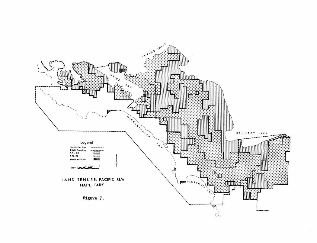
L A N D T E N U R E , PACIFIC RIM
NAT'L. PARK
Figure 7.

LOGGED AREAS
Figure 8. Logged areas in the Phase One area of Pacific Rim National Park

- 67 -
employed systematic logging to overcome this problem. Instead, they employed
an ingenious technique to utilize the wood of these trees, which was to split
a slab off a standing tree. This was done by making two cuts, one above
the other; the lower narrow, the upper one a high, open notch, while the
distance between the two notches was that desired for the length of the
boards or canoe (Drucker, 1951). Wedges were then driven into the notches
and a large pole was inserted length-wise into the upper notch. Over time,
wind would rock the tree and this action, coupled with the weight of the
pole, created a split between the two notches, and eventually the slab
fell off. This activity had very little impact on the forest because of
its highly selective nature. Examples of giant cedar with such slabs cut
out of them were seen by early European visitors to the western coast but
of course, most trees thus mutilated died or were blown over (Drucker, 1951).
The first incident of European logging on the west coast occurred
in Nootka Sound, some fifty miles north of the present day park area. In
1778, Captain Cook visited Nootka Sound, and while there, replaced a number
of spars and masts (Sloan, 1956). Easily accessible tall trees growing
along the shore line were cut for this purpose.
At this time the maritime fur trade was generating a great deal
of activity along the west coast. Robert Gray, a China trader was enjoying
a successful trade and found that he required an additional ship. During
the winter of 1791-1792, he built the ship Adventure at Fort Defiance. Today,
the site of this fort is protected under the Archaeological and Historic
Sites Protection Act (Mitchell, 1966). This site is located in Adventure
Cove, 16 miles from the village of Tofino on Lemmen's Inlet. This ship
was one of the first forest products of the west coast forests and the
logging that it involved was the first in the area around the park.
There are no other records of logging in the area adjacent to the
park until 1898. The occasional load of lumber was taken from the west
coast and shipped to China during the maritime fur trade, but precise dates
and locations are not available.
This early sporadic logging established a pattern which would
persist into the 20th century. Any timber logged on the west coast of
Vancouver Island had to be shipped to foreign markets, since the home market

- 68 -
was at first non-existent. Later, with settlement, a home market developed,
but it was more economically satisfied by logging operations on the mainland.
The mainland operations also depended on foreign markets, but to a lesser
extent. Nevertheless, fluctuations in the foreign markets made early logging
in British Columbia a high risk venture.
The first integrated logging and milling operation on the west
coast was established at Port Alberni in 1860. Port Alberni is of great
importance in this analysis, of landscape change, because a large percentage
of the timber eventually logged in the park and surrounding areas was pro
cessed at this centre.
In the spring of 1857, Captain Edward Stamp, an employee of
Anderson and Company, one of Great Britain's largest timber brokers, paid
a visit to the Alberni area, while his timber schooner was being loaded
with spars at a Puget Sound Lumber port (Lawrence, 1957). Impressed by
the spar timber available, he informed his company of his findings upon
return to England. At this time, the American Civil War blockade had cut
Britain off from its major source of lumber, the Mississippi pine forests.
Britain then turned to the west coast of the United States for its supply.
By 1860, the major suppliers, which were the Puget Sound Mills, could no
longer meet the demand. Thus, for the first time, lumbermen turned to the
untouched timber tracts of Burrard Inlet and the Alberni Canal.
Anderson and Company then acted on Captain Stamp's report and
established a mill at Port Alberni. For its time the mill had the most
up-to-date equipment available (Hardwick, 1963). This, plus the fact that
Anderson and Company had unlimited capital and a world wide network of
timber brokers, gave the mill excellent prospects for success. For a time
the mill flourished, but by 1864 the limited nature of early logging
technology forced it to close.
In five years, the Alberni mill had processed all the timber
in the area which was accessible via the techniques available. This
included damming Sproat Lake in order to raise the water level and open
up more timber to exploitation. Even if it had been possible to log
further back from the water, the mill's market would have most likely
vanished in 1885 with the end of the American Civil War and the reopening
of the Mississippi pine forests.

- 69 -
Liquidation of the Alberni area's Douglas fir forests was delayed
until logging equipment powerful enough to handle the area's large heavy
logs and rough terrain became available.
An important effect of institutional arrangements should be noted
at this point. Early mills, such as the Alberni Saw-Mill purchased timber
land outright, acquiring the rights to all natural resources, (Commission
of Conservation, 1918). After 1870, a more flexible system of land tenure
was introduced. Timber leases were issued to logging interests, and they
generally ran for a period of 30 years. They were transferable and thus
the lessee could engage in speculation.
The period between 1885 and 1912 saw a great deal of speculation
in the logging industry. This can for the most part, be attributed to
the highly variable nature of the market situation. Speculators such as
W.E. Simpson of Iowa Falls, Iowa, invested in small timber berths on
Vancouver Island and then sold them (Lawrence, 1956). By 1907, Simpson
had netted 500% on his original investment. Research of the Clayoquot
land registry indicates that Simpson was active within the area of the present
day park boundaries. By 1912, he had acquired timber leases in the park
area totalling 2,751 acres. Whom he sold them to could not be determined
since the registry only recorded the original alienation when and if it
reverts to the Crown. It is quite possible that Simpson's timber leases
were acquired by the Sutton Timber and Trading Company.
This company was active in the park area as early as 1890. By
1905, it acquired 7,682 acres of park land in timber leases. A total of
234 square miles of timber leases had been assembled within the Tofino-
Kennedy Lake-Ucluelet area by 1927. The first definite record of logging
in the Ucluelet area dates back to the activities of this company. In
1898, the old Sutton Mill, near Ucluelet, commenced operations, processing
logs that were floated by flume and canal from Mercantile Creek (T.F.L.
Working Plans, 1955-1971).
In 1907, the company erected a large mill at Mosquito Harbour on
Meares Island. This mill manufactured shingle bolts for the export trade,
but by 1913 market conditions deteriorated and the mill closed down. It
was reopened in 1925 and operated sporadically until 1943, when it was
dismantled. This is another example of how variable market conditions
plagued early west coast logging.

- 70 -
Although the Sutton Timber and Trading Company had extensive leases
in the future park area, there is no record of them having been logged prior
to 1944. It is possible that some logging occurred before this, but the B.C.
Forest Service inventories have no record of it. The doubt arises because
there was no Forest Service prior to 1912, and therefore, we cannot expect
the forest inventories dated earlier to be highly accurate.
The question now arises as to why the lumber company did not log
its leases. We have already referred to some possible reasons previously.
It may have been because of the poor quality of the timber, rudimentary
logging technology, or lack of a market. The period between 1890 and 1927
remains a mystery. However, by 1927, the Company was prepared to exploit
its timber leases. Plans were drawn up for a pulp mill which was to be
situated on Tofino Inlet at the mouth of the Kennedy River (Vancouver Sun,
December 2, 1947). Then in 1929, the stock market crashed, and the plans
had to be dropped. Meanwhile, the Dominion Government was considering the
possibility of establishing a national park in the Tofino-Kennedy Lake-
Ucluelet area. At the request of the federal government, the provincial
government put a reserve on the area encompassed by Sutton's former timber
leases, while the feasibility of a west coast national park was studied.
With the arrival of the depression and then the war, both governments
evidently forgot about the reserve. From time to time, interested parties
would try to purchase Crown Land in the area and were informed that a reserve
existed. Forestry inventory information indicates that there were isolated
incidences of logging around 1945 in the park area not included in the
reserve. The company responsible for this activity was the North Coast
Timber Company, which commenced operations in May of 1945, at the present
day location of the Port Alberni turnoff (McBean, 1972).
By 1947, the pressure to open up the reserve's 4% billion feet of
timber were becoming increasingly more insistent. The reserve was dropped
on January 6th, 1948 by an Order in Council (Willison, 1971). The reason
given for this action was that the National Parks Branch decided that the
area would make a poor park because the water was considered too cold for
See Figure 3, page 6b

- 71 -
bathing and the area too distant from large population centres. The pressure
to open up the reserve can be traced to the activities of the H.R. MacMillan
Export Company in the Alberni and Ucluelet areas.
After the Alberni Mill closed down in 1864, there was no more mill
ing activity until the turn of the century. One of the early mills established
was built by the Barkley Sound Timber Company in 1904. It is of some interest
that in this same year, the company acquired a timber lease in the park of
576 acres. In 1934, the H.R. MacMillan Export Company's future partner,
Bloedel, Stewart, and Welch Ltd., built a sawmill at Port Alberni and com
menced railroad logging in the Franklin River watershed in order to supply
it with logs. The Bloedel Company also acquired the Great Central Sawmills,
which were logging around the foot of the Great Central Lakes. In terms of
sawmills and timber leases, these future partners were literally acquiring
complete control of the Alberni area.
As was previously mentioned, logging within the park area commenced
in 1945 with the North Coast Timber Co. logging out of Ucluelet. The MacMillan
Company acquired North Coast in 1947 and at the time of acquisition, North
Coast was operating on a number of timber leases, licenses, and Crown Grants
formerly held by the Sutton interests (McBean, 1972). These were located to
the north of Ucluelet Inlet up to the south and west shores of Kennedy Lake,
which incidentally places North Coast's logging activities in the reserve
which was not officially dropped until January 1948.
In 1947, the MacMillan Company applied for a Tree Farm License in
the park and surrounding area, and in 1951, merged with the Bloedel Company.
This merger brought about corporate control of the Alberni Valley, Alberni
Canal, and Barkley Sound region as well as the diversified group of con
version plants at Port Alberni (Lawrence, 1956).
TFL 20 was granted to MacMillan and Bloedel in 1955. 49% of this
license was private land supplied by the Company. Prior to the granting of
the Tree Farm License they had already logged those areas which would
eventually become part of the park.
The other major company active in the area was British Columbia
Forest Products. They too applied for a T.F.L. in 1947, and were granted
T.F.L. 22 in 1955. However, they supplied only 21% of the land for the

- 72 -
T.F.L. and they did not have possession of future park land prior to 1955.
From the enclosed maps (Figures 7 and 8) it can be seen that B.C. Forest
Product's logging occurred after 1955.
By 1968, the establishment of a national park had become merely
a question of time. The areas in and around the park logged after this
date have been classified on Figure 8. MacMillan and Bloedel, except for
a few quite small areas, did not log in the park after 1967 since they had
already liquidated the areas of their T.F.L. which would become park land.
However, B.C. Forest Products did log an appreciable area of the park after
1967.
LANDSCAPE CHANGE
Approximately 6,500 acres of the park have been logged. The method
used was primarily high lead yarding and truck logging. From the logging
shows, the logs were hauled to the dumping grounds at Port Albion across
from Ucluelet. Both T.F.L. holders used Port Albion. There the logs were
assembled and then hauled to the processing plants. MacMillan and Bloedel
boomed the timber from the park area to their integrated milling complex
at Port Alberni. British Columbia Forest Products hauled their timber to
the east coast of Vancouver Island where their Crofton pulp mill is located.
Clear cutting has been practised throughout the logging history
of the park. This is especially true of the logging after 1955. There is
a sound silvicultural reason for this practice. Mature and over-mature
timber is simply not an efficient producer of wood because annual increment
in such timber tends to be negated by decay. The 1945 Commission on Forest
Conservation maintained that sustained-yield could not be achieved until
the mature timber on the coast had been cut. So far as increment is con
cerned, the old growth might just as well be in piles in a lumber yard as
in the forest (Sloan, 1956).
Although logging activity has been extensive in the park area, all
but the most recently disturbed sites have regenerated to an acceptable
standard. This standard is 31% regeneration, which means a density of
310 well-spaced trees per acre. Any regeneration levels below 31% are
classified N.S.R. (Not Sufficiently Restocked) by the Tree Farm License
holder.

- 73 -
After a specified period of time, a logged over area must be stocked
naturally to the standard of 31%. This time period varies with that producti
vity of the site, whereby the more productive a site is the sooner it must be
restocked. Site productivity is measured by the site index; i.e., the height
a tree will attain within 100 years. It is a license holder's responsibility
to restock insufficiently regenerating areas and if the company does not do
so, the government then does the planting and the company forfeits its T.F.L.
deposit (Sloan, 1956).
Natural regeneration has been allowed to occur only on the older
logged areas in the park. Since 1955, Douglas fir has been planted on a
majority of the logged over areas. This is because a Douglas fir forest is
more productive than the natural hemlock-redcedar-balsam fir forest. Occa
sionally hemlock has been planted, and on muck sites, redcedar and shore pine
have been stocked. Balsam fir is never planted because of the balsam wooly
aphid (T.F.L. 20 Working Plans, 1955-1971).
Two of the older areas in the park were studied in terms of
regeneration and an attempt was made to describe the original environment.
McClaren's Point
On the basis of the age samples taken from this site, it is esti
mated that the original timber was logged around 1945. This site has good
drainage and originally supported a redcedar-hemlock forest. Cedar stumps
were found having a 9 foot diameter and one of these was 540 years old when
logged. The original hemlock were much smaller, having a 2-3 foot diameter
and aged at 250 years when logged.
Access to the site is by an old skid road surfaced out of logs
and it now supports a thriving community of alder. A few alder have also
invaded the disturbed area and represent the oldest new growth on the site,
dated at 25 years.
Redcedar and hemlock have naturally regenerated. The redcedar
are much more numerous than the hemlock, with an average of 13 redcedar and
2 hemlock found in five 66 x 66' plots. The redcedar is also doing better
than the hemlock. This can be seen if we compare two of these individuals
dated at 17 years. The cedar is 20 feet with a diameter of 5.5 inches,

- 74 -
vhile the hemlock is 16 feet with a diameter of 4 inches. Presumably, the
redcedar will once again become dominant on the site with the hemlock
subordinate as was the case prior to the logging disturbance.
Port Alberni Turn Off
As was mentioned previously, this area was logged in 1945 by the
North Coast Timber Co. Excellent regeneration of hemlock has occurred and
the forest cover is predominantly hemlock with the occasional redcedar.
After 25 years, the hemlock have achieved an average height of 50 feet and
a mean diameter of 10 inches. The trees are densely stocked with the canopy
cover estimated at 80% and thinning of the stands has not yet started. The
denseness of the canopy has resulted in a meager shrub and herb layer,
although in places where there is a break in the canopy the salal grows
to heights of 12 to 16 feet.
Fifty percent of the forest floor is covered by slash and in many
places the western hemlock has rooted on top of it. There is no evidence
that the slash had been burnt and because of the advanced state of stump
decay, it was impossible to determine the composition of the original forest;
however it was most likely dominated by hemlock.
This site is a good example of how quickly vegetation can recover
after logging in the area, if the site is of reasonable quality. In this
case, the site index is 115 and for the west coast forest this is considered
a medium growth habitat.
The areas around the Tofino airport which are classified on Figure
8, as being logged prior to 1956, were cleared when the R.C.A.F. built the
airfield during the Second World War. The area around Radar Hill was also
cleared at this time.
As already noted, areas logged after 1955 were deliberately
managed in order to produce a more productive future forest. The procedure
as outlined in the Tree Farm Licenses has been to slash-burn as required
and artificially restock the sites. Douglas fir was selected because of
its higher productivity. Also, this species is more disease-resistant
than the natural forest types and therefore, it loses less annual increment
to decay and insect infestation. Sitka spruce has been planted by B.C.
Forest Products Company along with Douglas fir. This was an experiment they

- 75 -
were engaging in prior to the establishment of the park. The company is
quite anxious to continue this experiment on a monitoring basis (Glew, 1971).
Observations were made of the T.F.L. logging which was done in
the park. This area is primarily found inland from Quisitis Point and
Florencia Bay as can be seen from the map. As was expected, the predominant
tree species found was Douglas fir and in the experimental areas, large
numbers of Sitka spruce were observed. However, redcedar, hemlock and balsam
fir were volunteering in many of the areas. The data collected is of such
a limited nature that it would serve' little purpose to analyze it further.
However, the areas in the park which have been classified, 'Not Sufficiently
Restocked' are of considerable interest. The area logged after 1967 along
the road between the Port Alberni turn off and the park boundary and the
area between Quisitis Point and the highway have been classified 'Not Suf
ficiently Restocked' by B.C. Forest Products. This means that they were
not treated by the forest company before the establishment of the park.
This puts the National Parks Branch in a difficult situation in
terms of land management. Do they slash-burn these areas and restock, or
do they let natural succession take place? During the summer of 1971, part
of the insufficiently restocked area inland from Quisitis Point was slash-
burned by the federal Department of Lands and Forests. This activity was
described as forest rehabilitation, but it is not known if planting will
be done. The slash-burning by the federal government indicates that a
policy is being developed to deal with the logged over areas. The paper
will now turn to the management implications logging has for the park.
PARK MANAGEMENT
The logged over landscape of the park presents a definite management
problem for the National Parks Branch. The previous management program under
the Tree Farm Licenses was abruptly terminated, leaving a vacuum. At present
there are two distinct problems. Firstly, there are the disturbed areas
which have either been restocked artificially or naturally, and secondly,
there are those areas that have not been restocked by either process.
The National Parks Branch has described the Phase I area's redcedar-
hemlock forest as being representative of the west coast. We have seen that

- 76 -
most of the mature climax examples of this type have been logged and in many
cases the habitats have been restocked with Douglas fir and Sitka spruce.
On the west coast, Douglas fir is a serai or successional species which comes
in after disturbance of the cedar-hemlock forest, while Sitka spruce does
not naturally occur in the inland areas of the park. Since these two species
are now well established, there is little that can be done in regards to
re-establishment of the cedar-hemlock type.
The second problem is management of the unsatisfactorily restocked
habitats. If any planting is to be done, it should be of species which were
originally found in the habitat to be managed, since the cedar-hemlock type
has to a large extent been removed from the park area.
These unstocked areas and those which have regenerated naturally
represent a valuable resource in terms of park interpretation. Since the
park has been logged over a 25-year period, the disturbed areas could be
used to trace natural succession. Tours could be arranged whereby a park
naturalist would describe natural succession to interested park visitors.
It is difficult to identify uses for the disturbed areas which
would fit the objectives of the national park concept. Section 4 of the
National Parks Act of 1930 reads: "The Parks are hereby dedicated to the
people of Canada for their benefit, education and enjoyment, subject to the
provisions of the Act and the regulations, and such parks shall be maintained
and made use of so as to leave them unimpaired for future generations." As
already mentioned, the disturbed area could be used for educational purposes.
Another use the disturbed areas could be put to, is the provision of visitor
service facilities such as campgrounds. This is an ideal use since no further
disturbance of the existing mature vegetation would be required by the con
struction of camp sites. At present camp sites are located in the coastal
strip of Sitka spruce adjacent to the coast and their construction dates
back to Wickaninnish Park, the original provincial park in the area.
Obviously, it is considered desirable to have camp sites located as near as
possible to the park's major attraction, the ocean; and any recommendation
for building camp sites inland may seem impractical. Nevertheless, there
are other reasons for building camp sites on old logging sites in addition
to the strategy of avoiding further disturbance in the park.
- 77 -
On long weekends during the summer of 1971, campers, tent trailers,
and motor homes were parked side by side for virtually the entire length
of Long Beach. In order to protect the beach and associated wildlife resources,
this use of the beach will have to be curtailed. Further development of
camp sites within the coastal Sitka spruce belt to handle this volume of
visitation will result in wholesale disturbance of this vegetation type
and will not significantly relieve visitor pressure on the beaches. Con
struction of camp sites on the inland disturbed areas would allow the park
to handle peak volumes of visitors and additionally would relieve this
visitor pressure on the beach resources. Climatically, the interior disturbed
areas offer a further benefit because summer fogs are for the most part
confined to the narrow coastal area of the park, leaving the interior in
bright sunshine.
At present, the National Parks Branch is planning to construct a
camp site in behind Schooner Cove. This facility could be located in the
cleared area behind Schooner Cove which was disturbed prior to 1956. It is
still quite open and would make an excellent camp site.
Expense is the major problem associated with construction of camp
sites in disturbed areas. It would be aesthetically unpleasing to leave
the slash and stumps in the camp site areas. The slash would have to be
reduced to a minimum and stumps removed. Also, well thought out landscaping
would be necessary if the program were to be successful. It is definitely
less costly to simply establish camp sites in existing forest where all
that is required is removal of trees for the individual sites and the access
roads. At the present time there is no indication that the Parks Branch
intends to use the disturbed areas for camp sites. In fact, their only
policy seems to be forest rehabilitation via slash-burning.
The existence of the two Tree Farm Licenses inland from the park,
creates a conflict of interest between the National Parks Branch and the
forestry companies over access rights to the licenses. Park purposes will
not be served by the movement of heavily loaded logging trucks through the
park area to the dumping grounds at Port Albion. There are at present five
logging roads which originate in the park area giving the only access to
the inland Tree Farm Licenses. A solution to this problem is the closing of
- 78 -
the four roads which originate at the highway, inland from Long Beach and
Florencia Bay. This would require further development of the access road
which originates in the Kennedy Lake area. Thus, the disturbance would be
confined to the Kennedy Lake area. However, it would greatly increase the
use of this road and could very well destroy the tranquility of the park's
only fresh water swimming, which is found on the southern shore of Kennedy
Lake.
PARK BOUNDARIES
The land tenure and the logging maps (Figures 7 and 8) present
much information. The spatial relationships between the park boundary and
the T.F.L.'s, the logged areas, and the Public Yield Sustaining Unit boundary
can lead to endless speculation of the park boundary. However, the most
obvious relationship is that between the park boundary and the highway.
Inland from Grice Bay, the boundary follows two surveying lines used for
establishing the lots in the Clayoquot land district. The lots included
within the park along this middle section of the park boundary are the
minimum required so that the highway will be included in the park area. In
fact, most of the boundary, except for the Grice Bay area, was established
along the existing surveyor's grid.
The Public Sustained Yield Units were originally established on
the recommendation of the 1945 Royal Commission and were referred to as
Public Working Circles (Sloan, 1956). The P.S.Y.U.'s supply timber to the
small independent truck loggers who do not have a Tree Farm License and
they are held by the Crown. The P.S.Y.U. which was previously in the park
contained very little timber of commercial value. Because of the poor
quality of the timber, little logging has occurred in the P.S.Y.U.
As would be expected, the P.S.Y.U. and T.F.L. boundaries are
coterminous. The area between the P.S.Y.U. boundary and the park boundary
represents the area the two logging companies gave up for the park, while
the area between the P.S.Y.U. boundary and the ocean, excluding pre-emptions,
represents the area the provincial government supplied for the park. It
can be seen that the Crown supplied the major portion of the land for the
park. This conclusion is based on the fact that, of the two lumber companies,
B.C. Forest Products gave up the largest area for park purposes and as
- 79 -
mentioned previously, 79% of their T.F.L. was comprised of Crown Land. It
would be very interesting to see a tenure map of T.F.L. 22, showing Crown
Land and private land distribution within the T.F.L. It is quite possible
that the majority of the land supplied for the park from T.F.L. 22 was
Crown Land.
Earlier in the paper it was noted that only 1% of the Crown Land
comprising the T.F.L. could be withdrawn by the government for parks purposes
and this had to be taken from Crown Land. If private land is required, some
sort of settlement must be made between the Crown and the company involved.
There is no record of any settlement or land trade in regards to B.C. Forest
Products' T.F.L. The area they gave up from T.F.L. 22 was, however, over
1% of the total T.F.L. area. The total area of T.F.L. 22 is 392, 683 acres,
(T.F.L. 22 Working Plans, 1955-1971). Therefore, 1% of this is 3,927 acres.
B.C. Forest Products gave up a larger acreage than this and it is not known
what the arrangements were.
MacMillan and Bloedel gave up a much smaller area than B.C.
Forest Products. As stated previously they supplied 49% of the land for
their T.F.L. and we know that they privately acquired the land around
Kennedy Lake. From this information, it can be said that a settlement had
to have been made between the government and MacMillan and Bloedel.
The 1970 annual report for T.F.L. 20 states that MacMillan and
Bloedel gave up 1,729 acres of privately held land in their T.F.L. An
equivalent area of land in the Ash River district was traded by the government
for these 1,729 acres.
Under the existing legislation that relates to T.F.L.'s the
government could not acquire a larger area for the park without considerable
compensation for the lumber companies. It must be remembered that the T.F.L.
areas held by these companies are part of an integrated production system
which extends from the logging camps to the processing centres. Any with
drawal of T.F.L. land will result in dislocation of the entire system
unless suitable areas are given in exchange. This factor, the dislocation
of the forest industries, probably is the single most important factor
which determined the extent of the existing park boundaries.
Another factor which has had important consequences for the
- 80 -
establishment of Phase I area of the park is the relationship between the
accessibility of the area and the logging activities of MacMillan and
Bloedel. By 1959, this company had constructed a series of logging roads
which finally connected the future park area with the rest of Vancouver
Island. The public was only allowed to use these logging roads in the
evenings and on weekends. Pressure was applied by local business groups
to have the roads opened up on a 24-hour basis and in 1964, the provincial
government took over maintenance of the roads which gave the general public
unrestricted access to the future park area. Once the general public
became aware of the area's recreational resources, both levels of government
came under increasing pressure to establish a west-coast national park.
Thus, we have the paradoxical situation whereby the resource exploitation
on the part of the logging companies opened up the area to the general
public which was instrumental in the establishment of the park, while at
the same time, these companies devastated over 1/4 of the park's total
land area.
CONCLUSION
When the federal government allowed the reserve on the Tofino-
Ucluelet-Kennedy Lake area to lapse in 1948, the possibility of there ever
being a reasonably undisturbed 'natural' west coast park was reduced to
nil. The logging companies became entrenched in the area and only massive
government expenditure would have induced them to release their hold on
the forests.

- 81 -
INTERVIEWS AND LETTERS
G. Burch - Chief Forester, British Columbia Forest Products, Vancouver.
A.P. McBean - Chief Forester, MacMillan and Bloedel Limited, Vancouver.
D. Glew - Forester in Charge, Working Plans, B.C. Forest Service, Victoria
R. Mitchosky - Planning Coordinator, National Parks Service, Calgary
G. Trachuck - Superintendent, Pacific Rim National Park, Ucluelet
MAPS
The maps were compiled from B.C. Forest Service Inventory maps,
and from T.F.L. 20 and 22's working plan maps.

- 82 -
SOME REFERENCES
1. British Columbia Department of Lands and Forests, Forest Service,
1955-1971, "Tree Farm Licences #20, Tofino, and #22, Maquinna," Working
Plans and Annual Reports, 1955 to present, unpublished. Available
through Chief Forester, B.C. Forest Service, Department of Lands,
Victoria, B.C.
2. Carrothers, W.A. (1938), The North American Assault on the Canadian
Forests, Ryerson Press, Toronto.
3. Department of Lands, Victoria, B.C., Clayoquot Land Registry.
4. Cottell, P.L. (1967), The Influence of Changing Technology Upon the
Economic Accessibility of the Forest, unpublished Masters of Forestry
thesis, University of British Columbia, Vancouver, B.C.
5. Drucker, Philip (1951), "The Northern and Central Nootkan Tribes,"
Smithsonian Institution Bureau of American Ethnology Bulletin.
6. Hardwick, Walter G. (1963), Geography of the Forest Industry of Coastal
British Columbia, Occasional Papers in Geography, No. 5, Tantales
Research Limited, Vancouver, B.C.
7. Kettle, D.H. (1970), "The Planning Process in the National Parks of
Canada," Talk to Sir Sandform Fleming College.
8. Lawrence, J.C. (1956), Markets and Capital: A History of the Lumber
Industry of British Columbia, 1778 - 1952, unpublished M.A. thesis,
University of British Columbia, Vancouver, B.C.
9. McKelvie, B.A. (1947), "Paperwork Delays Development of Island West
Coast Ocean Park," Vancouver Sun.
10. Mitchell, D.M. (1970), "The Investigation of Fort Defiance: Verification
of the Site," B.C. Studies, 4: 3-19.
11. Paish, Howard, "Our West Coast National Park - Why the Delay?", B.C.
Outdoors, Vol. 24, May 1968.
12. Silburn, G, (1945), Reconnaissance No. 82, Clayoquot Region, 1945-46,
unpublished. Forester in Charge, Forest Inventory Division, B.C.
Forest Service, Victoria, B.C.
13. Sloan, G.M. (1956), The Forest Resources of British Columbia, 2 vols.,
Report of the Commissioner, Victoria, B.C.

14. Wade, L.K. (1965), Vegetation and History of the Sphagnum Bogs of the
Tofino Area, Vancouver Island, unpublished M.Sc. Thesis, University of
British Columbia, Vancouver, B.C.
15. Williston, R. (1971), West Coast Park Phase 3, A Life Saving Trail,
Provincial Government Brief, Dept. of Lands and Forests, Victoria, B.C.
16. Whiteford, H.N. (1918), Forests of British Columbia, Commission of
Conservation Canada, Ottawa, Ontario.
- 83 -

VI
MAN, BIRDS AND MAMMALS OF PACIFIC RIM NATIONAL PARK, B.C.: PAST, PRESENT AND FUTURE
N. Roe and J. G. Nelson
The basic theme of this paper is human disturbance of wildlife
in the Pacific Rim National Park area and its implications for the future.
The emphasis is on Phase I of the park between approximately Tofino and
Ucluelet (Figure 1). Overall the approach is historical (or temporal) and
ecological; fauna! changes in space and time are related to cultural, biotic,
hydrologic and other controls. Man is of special interest as an ecological
agent. His affects are considered within a three part framework: 1) perception
and attitudes; 2) institutional arrangements; 3) technology.
The physical characteristics of the park have been described in
earlier papers in this publication. Human settlement and land use have not
been extensive in the park. The fishing villages of Tofino and Ucluelet,
each with a population of approximately 300-400, are joined by a black-top
road that parallels the coast and eventually leads east to Port Alberni
(Figure I). Settlement in the park has been sporadic historically with
nodes developing around Tofino airport and at the Wickaninnish Inn, on the
north side of Quisitis headland between Long Beach and Florencia Bay. Other
wise, holiday cabins and a few commercial buildings are dotted along the
Tofino-Ucluelet road. Agriculture has never been practised extensively within
park boundaries, although a few small, cleared fields can be seen along the
main road. Logging activities have cleared a significant proportion of the
original forest and left behind a network of gravel roads.
Little settlement or land use seemingly has occurred in Phase
II, the Effingham Islands, although Indian activity may have been more
pronounced there in the past. In Phase III, along the Lifesaving Trail,
the villages of Bamfield and Port Renfrew, situated at either end of the
boundary, have little effect on the park. There are no roads; logging
activity has been minimal, and only one small settlement - at Clo-oose -
occurs within the park.
- 84 -

- 85 -
SOME ECOLOGICAL CONSIDERATIONS
Appendices 1 and 2 show the mammals and birds of the park
area. Not all the listed animals definitely have been observed within the
park boundaries but seem likely on the basis of historic or recent observa
tions in similar habitats or adjacent areas on Vancouver Island (Cowan and
Guignet, 1965). Examples are the Vancouver Island wolf, now rare throughout
the island, the wolverine and the porcupine. Others which are uncommon
but which have been seen or reported to the principal author are beaver and
marten. The muskrat, norway rat and house mouse are examples of exotic
animals introduced intentionally or unintentionally by white or Caucasian
settlers (Campbell, 1967).
Both the mammals and the birds show an emphasis on species
associated with acquatic habitat, either saline or fresh water. Seasonal
increases in the total avian population occur during the migration periods,
March - May and October - November, when thousands of anseriforms utilize
both near-shore and estuarine habitats and larger numbers of waders occupy
the beaches. Species composition therefore varies according to the season.
Resident birds include various gulls, and the bald eagle, although this
species tends to drift southward; individuals sighted in the winter months
possibly being vagrants from more northerly breeding grounds.
The majority of the passerine species are migratory. The
degree of human disturbance of the various habitats of Phase I of Pacific
Rim National Park may well have given rise to a more diverse species compo
sition of passerines than is present in the less varied habitat types found
in Phases II and III. The diversity may also be a function of natural pro
cesses associated with geomorphic, pedologic, hydrologic and vegetational
characteristics described in earlier papers in this publication. The
topic of habitat diversity and human disturbance will be discussed at
greater length later in this paper.
METHODS
As stated previously, the basic theme is to examine how man
has shaped the distribution and number of animals in the park area in the
past and his possible effects in future. The development of this theme
requires the use of government reports, travelogues, trader's accounts and
- 86 -
other primary source materials. These not only yield insights into animal
or ecological change but also into the variations in perceptions, attitudes,
institutional arrangements and technology associated with the changes.
Important secondary sources include Drucker's (1951) study of the ethnology
and history of the Nootka tribes resident in the general vicinity of Pacific
Rim National Park; Little's (1934) history of the maritime fur trade;
and Pearse's (1951) compendium of bird observations and descriptions by
early Caucasian explorers in the North Pacific.
In some instances in this study, observations or findings made
outside the park have been applied to it because of similarity in habitat,
economy, or other variables. Reconnaissance field work was conducted over
most of Phase I of Pacific Rim. Relatively detailed studies were made of
bird populations and possible human disturbance in certain physically similar
rocky headlands and beaches known to be subject to differing levels of human
use.
WILDLIFE AND THE INDIAN
Land Mammals and the Indian
Much of the following information is derived from the work of the
anthropologist, Drucker (1951) who conducted field investigations among the
Nootka in the late 1940's. It is difficult to single out any land mammal
as being more significant to the pre-historic Indian than any other. A few
certainly were important for nutritional, ritualistic, mythical or other
reasons. These mammals were the black bear, beaver, blacktail deer, wolf
and, in the interior, the Roosevelt elk. Fur bearers such as the marten,
minx and river otter apparently were of minor importance.
Black bears were caught with a deadfall trap. Vests were made
of the hide and the flesh was eaten. However the bear seems to have found
more importance in ritual than in economic use. "Bear ceremonialism" was
widespread. For example a bear was mythically supposed to have engaged in
a ritual bath to escape traps. In this bath the bear used leaves to scrub
its body and Indian trappers followed this practice closely in the expecta
tion of catching more animals. If a bear was trapped, the carcass was
carried to the village where it was offered salmon and mats to lie on and

- 87 -
eagle down was sprinkled on its head, after which the bear was skinned and
eaten. At Kyuquot, north of the park area, the usual mode of speaking to
a bear was to call it "Chufis wife" or "queen." Bears were respected more
than many other animals of greater economic importance, for example the
hair seal, sea otter, and blacktail deer. Drucker (p. 259) makes one reference
to grizzly bears, but there is little evidence of this animal's occurrence
on Vancouver Island in recent centuries.
According to Drucker (59) beaver were not hunted by most of the
Vancouver Island Nootka until "rather late days." However the animal may
have been used more by those Nootka who lived in the park area because the
flatness of the Tofino plain, the lower stream gradients, and easier damming
conditions all would have been favourable to the beaver. The deadfall trap
was used to catch beaver. They were also killed with harpoons. The flesh
was eaten.
Interior tribes such as the Muchalat and Hopachisat are noted by
Drucker (60) as hunting elk, whereas coastal groups are not. One reason
for this, he suggests, is that the dank tangles of Vancouver Island woods
are difficult to hunt in. But this did not stop interior groups from doing
so. Characteristic elk habitat is not the dense, virtually impenetrable
rain forest of the immediate coast; it is more open, either with evenly
spaced trees and little understory vegetation, or meadows interspersed with
groups of trees. It is more likely that the elk would find such habitat
at higher elevations where climatic phenomena were significantly different
from those of the coast, anc that this habitat would be conducive to Indian
hunting'drives." In comparison, blacktail deer are adapted to the much
denser forest near the coast, or will readily invade disturbed areas near
human habitation to feed on successional growth. The coast Indians are not
known to have cleared land on any substantial scale, for they were not
agriculturalists. But their daily activities and the use of forest products
would have changed vegetation around the villages which blacktail deer would
then exploit. Here they were hunted with the deadfall trap.
Wolves seem to have played a strong ritualistic and mythical role
among the Nootka. Unlike people such as the plains Indians, however, the
Nootka did not domesticate the wolf nor keep it as a pet. Indeed, according

- 88 -
to Drucker (152):
"Wolves were placed in a special category among all the animals,
as possessed of great supernatural powers whether in animal guise
or, without their skins, in human form. They were a 'tribe,' and
lived in a great house under a mountain. There was some peculiar
relationship existing between wolves and killer whales; some
people believed the latter emerged from the sea to turn into
wolves. Neither animal was considered dangerous to man. In
fact, they were more likely to be friendly than most spirits.
There was no prohibition on killing either species of the
real animals."
Definite taboos were placed on the eating of wolf flesh, although
in some instances it apparently was used as medicine. Wolf pelts do not
seem to have been important later on, during the maritime fur trade, although
some early traders and white visitors mention their presence among otter
and beaver skins (Little: 24).
The minx, marten and river otter were of minor importance to
the pre-historic Nootka, apparently not being eaten because of their rank
odour. Raccoons reportedly were considered good eating after soaking the
flesh overnight in fresh water, but were hunted only casually. Red squirrels
were subject to an eating taboo, but with mink were often "shamanized,"
being regarded as spirit powers which could endow a person fortunate enough
to encounter them with ritual songs and dances, perhaps with medical
powers. Thus squirrels and mink were sometimes seen in the woods singing
and shaking tiny rattles. They are purported to have shamanized over rotten
logs, making the logs writhe and groan through the power of their songs.
The final land mammal to be discussed is the cougar. Drucker
makes very few references to its role in early Nootkan life, stating that
it was not deliberately hunted, "but a fat one that wandered into a bear
deadfall was eaten" (61). Neither did the cougar apparently hold any
position in ritual or myth. It seems that it was neither dangerous nor
useful to the Nootkans, who consequently were rather indifferent to it.
The Nootka Indians have hunted the sea otter for an indefinite
period. Two methods apparently were in common use before the fur trade

- 89 -
era. Firstly, a hunter and canoe steersman went before daybreak to the kelp
beds where the animal sleeps, and would kill it before it awoke with either
bow and arrow or a spear or a harpoon. Secondly, a pup would be located
by its cries and caught easily as it was less wary than the adult. Tying
it to his canoe, the hunter allowed the pup to swim about whimpering, and
these sounds attracted the mother within harpooning distance, so that first
she then the pup were killed.
The skins were esteemed so highly that only persons of high rank
wore cloaks made of them. Until the time of the maritime fur trade, rigid
enforcement of game laws among the Nootka is said to have ensured that the
sea otters that could be taken were prized as tradable commodities. Even
then, when the pelts were given away in occasional potlatches, no particular
notice was paid, as far as can be learnt, to size or quality, although the
Indians were well aware during later times that the white trader would measure
the skin, feel the density of the fur, and so on, in setting a price on it.
In winter, or for ceremonial occasions, some Indians wore garments and hats
of woven cedar fibre, or robes made of three sea otter skins in which the
sides of the two were sewn together, and the side of the third sewn to the
ends of the others. The impressiveness of such a robe is referred to by
Little (321) who described the pelt as giving "the erroneous impression of
coming from an animal at least six feet in length."
Although other animals such as salmon, whales and bears were
considered worthy of ceremonies in their honour, the sea otter reportedly
was not so revered, despite the high esteem in which it was held. Sea otter
hunting was considered a noble vocation, and if a lesser man killed one he
would give the hide to his chief, receiving in exchange a small reward.
Chiefs would follow a ritual bathing routine before hunting sea otter. This
would always take place in salt water, being the habitat of the animal, and
the Indian would follow the shore line swimming, floating and diving "like
a sea otter" as long as he could stand the cold (Drucker: 169).
Attempts have been made to estimate sea otter populations in
pre-fur trade days. Kenyan (1969) identified 1741 as the year in which
Caucasian pressure was first exerted on the animal. He concluded that
islands contribute more usable habitat than unbroken coast and that the
population of sea otters in 1740 may have no more than five times the present

- 90 -
number, probably between 100,000 and 150,000 animals for the entire west
coast from lower California to the Aleutians.
According to Kenyan (136):
"it appears ... that a growing sea otter population in an
unexploited habitat may reach a temporary density of 40 or
more animals per square mile of habitat .... That a de
pleted feeding habitat may support about 10 to 15 otters
per square mile is indicated by the fact that the five
densely populated areas dropped to that level."
In the Pacific Rim area, Phase II, the Effingham Island, probably
is closest to the ideal habitat envisioned by Kenyan. Calculating that the
area of Phase II is about 45 square miles, the sea otter population probably
reached a maximum of about 1800 and a minimum of about 400. When the whole
park is considered, perhaps 2500 to 3000 sea otters may have lived in the
area at a favourable time during the pre-Caucasian era. Of course this
estimate is only a gross approximation but it is useful in the light of the
tendency to envision much higher otter populations prior to the coming of
the white man.
Indians and Sea Mammals
The natural orientation of the Nootka was toward the sea and many
animals of the coast and ocean were utilized which cannot be considered in
detail here, particularly fish and invertebrates. Plants also must be
neglected in this discussion.
The principal animals of interest are the various whales, the hair
seal, sea lion, fur seal and porpoise. The hunted whales included the gray
humpback, possibly Baird's beaked whale, and rarely the killer. The sperm
whale apparently was not hunted, nor the blue, which was too big to handle.
All hunted whales appear to have been caught in the same way and to have had
a similar place in myth and ritual.
The origin of whaling reportedly lies in the west coast villages
where there was little or no access to salmon streams. The art diffused to
other tribes and became a symbol of a chief's greatness rather than an
important source of subsistence. According to Drucker, "only great whalers

of ancient times killed 10 whales every season. Recent whalers, though they
hunted diligently and had improved equipment, obtained only a few in their
entire careers." Drucker relates the figures for whale killing among the
Ahousat tribe, given to him by an informant who was the last whaler among
that people. In one generation, only 8 members of the tribe were whalers,
and of these, only two were successful in killing a whale, and only 4 whales
were killed in all. In the preceding generation there had been three whalers,
one of whom killed 13 whales over a period of 12 years, and the other two
killing three each. Such figures indicate that the impact of the pre-
Caucasian Nootka on whale populations was probably slight.
The method of hunting was as follows: Canoes would scout the ocean
anywhere between one and two miles off the shore. On sighting a whale, the
canoe was brought alongside the animal and the harpoon thrust, not thrown,
into it. A line attached to the harpoon was payed out as the canoe took
avoiding action in order that the injured whale did not smash the boat to
pieces. The whale was rarely killed by the harpoon, and it took several
other thrusts to weaken the animal before a lance was used to cut the tendens
of the flukes and then driven under the flipper for the coup de grace. The
carcass was supported by floats and the mouth tied shut in order that water
did not fill the body and cause it to sink. Towing to shore was probably
the most arduous task of all. Eventually the animal was beached and butchered
with much ceremony.
Whale hunting ritual involved bathing in first running fresh water
and then in the sea. The rite took place over a period of six months, start
ing in November in time for the whaling season in April. Whales were con
sidered to "run" like salmon, and this may reflect an understanding of their
migratory habits along the eastern Pacific coastline. They were also believed
to have homes under the sea, as did hair seals, although the entrance to
the house of the latter was through a cave in a high island. This myth has
interesting parallels among the plains Indians who believed the bison
(Bison bison bison) came from beneath the ground, ensuring a never-ending
supply.
Killer whales were rarely hunted, except as a test of skill; the
meat and fat were eaten. None of Drucker's informants had ever heard of one
- 91 -

- 92 -
of these animals attaching a canoe, as they are reported to do by non-whaling
tribes of northern British Columbia and Alaska, as well as modern Caucasians.
In general, like the wolf, the Nootka considered the killer whale benign and
not dangerous.
The hair seal appears to have been of particular interest to the
Nootkans. They were hunted at almost any time of the year from canoes using
a harpoon and line. Having sighted one, the hunter paddled to where the
animal last dived, following the theory that an undisturbed hair seal will
resurface in the same place. If the animal reappeared, an attempt was made
to harpoon it, usually with some success if it was within 30 feet of the
canoe. Another hunting method was to harpoon seals that were stranded on
rocks exposed at low tide. There was also a hair seal rite involving bathing
in salt water and swimming with head held high out of the water, imitating
the desired behaviour of the seal for the easiest kill.
According to Drucker, sea-lions were hunted most in Kyuquot and
Clayoquot territory, where they congregated. A present-day colony exists
within park boundaries on Sea-Lion Rocks a few miles west of Long Beach.
This colony probably has been utilized for many years by the Clayoquot tribe,
which predominates in Phase II. However sea-lions were generally less
esteemed than hair seals.
The same is true for porpoise which were not hunted heavily. Some
times they were taken with hair seal harpoons, as were sea-lions. Another
interesting hunting method was to throw handfuls of sand or fine gravel into
the water in order to simulate the noise made by schools of fish, which
attracted the porpoise within harpooning range.
The fur seal apparently was not hunted in aboriginal times and only
became important as a trade item in the latter half of the nineteenth
century.
Indians and Birds
Thanks to the work of Pearse (1951) much valuable information on
the numbers and species of birds in the Nootka area in the late eighteenth
and early nineteenth centuries has been collected from the diaries and logs
of early eastern Pacific explorers. Extracts from Pearse's work can be cited

- 93 -
to familiarize the reader with the avifauna at the time of Caucasian discovery.
These citations were often made at different times of the year and some of the
difference in numbers among them undoubtedly is due to seasonal variations in
the occurrence of species.
On May 11, 1776, Broughton described wildfowl as present in vast
quantities in the Nootka area. Haswell, at Clayoquot on October 12, 1791,
said that:
"The natives were bringing a few wild geese and ducks for sale.
The fowl indeed were so plentiful that our sportsmen seldom returned
without twenty or thirty ducks and geese."
Haskins, also at Clayoquot between 1790 and 1793 gave a lengthy
description of bird-life, commencing with a statement at odds with Haswell's
impression:
"The feathered tribe are not very numerous nor do they form any
great variety—ravens, crows, brown eagles with a white head and
tail, herons, robbins, house and bank swallows are most numberous
[sic]—besides these there are three sorts of woodpeckers, the
Virginia red birds [presumably the cardinal—an impossible sight
ing] , yellow or bastard canary [probably the American goldfinch],
snow birds [?], long-tailed thrushes [?], ground birds [?], tomtits
[probably the chestnut-backed chickadee], sparrows, wrens, blue-
jaws [Steller's jay], partridges [probably a species of grouse],
quails [?], a small species of hawk, owls, pigeons [probably the
band-tailed pigeon] and doves [probably the morning dove], and
several sorts [unlikely] of humming birds.
"The waterfowl are plentiful from the last of August until the
beginning of March—there are two sorts of geese, the one resemb
ling the common wild goose found on our side of the continent
[probably the Canada goose] and the other brown and from its
tameness was denominated the foolish goose by our sailors [white-
fronted goose?]—there are also brants [black brant], two sorts
of ducks, shags [cormorants], shilldrakes [?] and teels [green-
winged and blue-winged], large loons, several sorts of divers
- 94 -
and gulls, seapies [black oystercatcher], plovers [killdeer?],
murres, marsh lark [?], peeps, the large crested American
kingfishers and a few flocks of swans were once or twice seen.
There was also a bird about the size of a hawk with a large
crest and of dark bottle green seen flying about the woods—
this bird was scarce and seldom to be seen—we were therefore
never able to procure and of course only had a distant sight
of them [possibly the pileated woodpecker]."
Boit, also at Clayoquot on September 20, 1791, said:
"We procured a constant supply of wild geese ducks and teal.
The ducks and teal resemble those at home [New England] but
the ducks were exactly of the same species with the tame of
our country [mallard]. We see none of any other kind. Now
and then we shot a wild turkey."
The latter species is identified by Pearse as the sandhill crane,
(Grus canadensis) which is not on the present park species list.
Although a number of species included in these descriptions are
terrestrial, very few of the references are to small passerines which
inhabit the forests. This may be because the forbidding nature of the
terrain dissuaded the early explorers from travelling inland.
The Indians used many of the birds for various purposes. According
to Drucker (59):
"Eagles were caught in a number of ways for their feathers and
the flesh was not disdained as food in the fall when the birds
were fat from eating salmon. In fact, older people say a good
fat eagle is quite as tasty as duck. Shooting and snaring
(with simple loop snares) were the usual modes of capture. A
Hesquiat told of catching eagles in a manner reminiscent of
the interior of the mainland: the hunter lay on the beach
concealed by branches and seaweed with a piece of salmon before
him. When an eagle alighted on the bait, the hunter seized him
by the legs."

- 95 -
Drucker (61) states that seagulls were not eaten until recent times,
and there was a vague avoidance of them by young adults because of an associ
ation of these birds with twinning, but elderly people ate the birds, and
children staged mock battles with the eggs. Ravens and crows were not eaten
owing to the taboo on their flesh. During the salom-spawning season traps
containing salmon eggs were set on shallow places for diving ducks and gulls.
Another method of capturing waterfowl was to use a net from a canoe.
Here two men would approach a flock of resting ducks or geese on a pitch black
night with a bright light attached to the prow of the boat. The birds were
disturbed into seeking the apparent safety of the shadow of the bow where
they were netted. At times of the year outside the migration season, this
method depended upon storms driving the birds to shelter in the many inlets
and bays along the coast, of which Grice Bay and Tofino Inlet bordering
Phase I of the park are important examples. When there were no storms and
birds remained on the sea, but near the shore, a blind was made of a canoe
by putting fir branches around it so as to screen the occupants. The
hunters circled well out, then drifted in toward a flock stern foremost.
The ducks would usually be swimming about just outside the line of breakers,
and, when within range, the hunters opened fire with bows and arrows (Drucker:
42).
The role of birds in ritual and mythology seems to have been
pronounced. Ceremonial use of feathers was widespread. Mozimo describes
this and also remarks on the taming of eagles to supply feathers (Pearse:
150). Gray, between 1787 and 1790, also witnessed the adornment of a
sacrificed slave's head with eagle feathers in honour of the killing of the
first whale of the season (Pearse: 253).
Mozimo tells of the imitation of birds during dancing (Pearse:150).
Indian Impact on Wildlife: A Summary
At this point some summarizing remarks can be made about the impact
of the Indian on wildlife in pre-Caucasian days. This impact would, of course,
be governed by the size of the native population, as well as Indian perception,
attitudes, institutional arrangements and technology. Various attempts have
been made to reconstruct early Indian populations but these have been handi
capped by the paucity and uneven quality of early Caucasian observations and

- 96 -
other factors. Although the estimate can serve only as an illustrative
approximation, at the end of the eighteenth century, when an unknown popu
lation decline had occurred after Caucasian arrival and the introduction
of virulent new diseases such as smallpox, Broughton's expedition recorded
that at Clayoquot there were five settlements each with a population of
1500 and one with as many as 2500. Such populations ranged over large areas
of sea and coast for subsistence and on these grounds alone are not likely
to have had a heavy impact on fauna. Indian technology although ingenious
also had limitations, as can be seen from previous descriptions of whale
and seal hunting; this also would limit the pressure that the Indians placed
on wildlife.
When resources became low in an area the hunters would move on,
leaving the region to recover for later use. Only hair seals were the
exclusive property of chiefs and, in general, game became the property of
the successful hunter. Otherwise no group or person owned game in the wild,
although tribal territories would be defended against undue pilfering by
neighbours. When captured, all game was honoured by ceremonies aimed at
pleasing the spirit of the trapped animal so that the spirit would again
let its body be captured. This custom was based on the belief in immortality
of animal spirits, and hoped to conciliate them for allowing themselves to
be taken. It has already been mentioned that killer whales and other animals
traditionally held in superstition and fear by Caucasians were regarded by
the Nootka as friendly, benign spirits who did not attack man. In consequence,
since the Nootka are not noted for undue waste or mass killing before the
arrival of the Caucasian, there appears to have been no overuse of wildlife.
Efficient techniques in trapping and hunting were evolved, but not
to the overall detriment of any species. In some cases, for example whaling
or hunting sea otters, prestige and social hierarchies were of considerable
importance in motivating a hazardous task and in limiting those who hunted
to a few. With these systems in operation, together with the role of myth
and ritual, it can be said that the Nootkan relationship to wildlife was
essentially one of respect, tolerance, and, hence, symbiosis.

- 97 -
THE CAUCASIAN AND WILDLIFE
The Maritime Fur Trade
Initially the British, French, Russians and Americans were principals
in this trade. The important animal species were primarily the sea otter and
fur seal with the beaver being taken where available. Intensive exploitation
began in 1741 with the voyage of Vitus Bering and continued unregulated for
170 years when it was halted as far as the sea otter was concerned through
an international treaty of 1911 among the United States, Great Britain, Russia
and Japan. Cowan and Guiguet (1956) describe the sea otter as at one time
inhabiting the entire length of British Columbia coast, but that the last
records of non-introduced individuals were made at Nootka Island in 1909 and
at Kyuquot, slightly farther north on Vancouver Island, in 1929. As an economic
resource the animal probably finished by the turn of the century.
Although Kenyan (1969) points to 1741 as the beginning of the trade,
Vancouver Island's west coast was not involved until Cook's voyage of 1778.
His reports led to a series of British and French expeditions which sought
to satisfy the demand for sea otter skins in China. Among the men who captained
these expeditions were Meaves, Strange and Barkley from Great Britain, and La
Perouse from France.
The number of skins that were taken is hard to determine as is the
place of origin. For example, La Perouse's expedition obtained 600 sea otter
skins, and Hanna's 100 (Little: 76,78). Barkley, while at Nootka in 1787,
"obtained a large number of sea otter skins" and sold 800, realizing $30,000
in Macao and Meaves 357 skins realizing $14,702 (Little: 80 and 91). Meaves
collected 140 skins while at Nootka Sound between May 13 and 28, 1788. He
also visited Wickaninnish and the Clayoquot securing 150 sea otter skins
(Little: 108). The success of these expeditions apparently depends upon the
luck of the ship in arriving at Nootka, or some other productive port, at
just the time when the sea otter population had been able to recover from a
previous visit. Success may have been further complicated by the tendency
of the sea otter to reproduce erratically, or possibly cyclically, giving
periodic highs and lows to the numbers caught. Consequently, considerable
rivalry developed between the ship's captains if it was known that more than
one expedition was scouting the coastline at the same time.

- 98 -
As the nineteenth century progressed, the trade intensified, and
the Nootka Indians became an integral part of the expanding Caucasian com
mercial economy; in fact, the economy's success depended upon them. Prior
to the incursion of the Caucasian, sea otter skins and hunting had been
considered fit only for the noblemen among the tribes, and all skins obtained
by non-noblemen were surrendered to the chief. The great value placed by
the white traders on the skins altered this and the individual hunter was
able to keep those he caught. It was expected that the proceeds would be
distributed among the people, but the net result was that there was far
more incentive for any man to kill a sea otter than formerly.
Another important affect on the Nootka was the development of
more intensive hunting techniques. These became highly systematized as
the animals became scarcer, and all hunters set out together. As many as
20 canoes took part in one hunt, forming a line from the edge of the breakers
seaward, and following the shoreline, sometimes 100 yards apart and therefore
over a mile out to sea. An otter sighting was signalled by a waved paddle
and transmitted to the end of the line. The canoes then assembled in a
circle about the place where the otter was seen, and when it surfaced, those
nearest shot at it with bow and arrow. Apparently, several volleys of
arrows were usually necessary before the animal was hit, the first man to
do so claiming the skin. Usually the animal was killed by a harpoon, for
it was rarely more than injured by the first or second shot. If it dived
under the ring of canoes, the circle was reformed about the area in which
it had appeared, and one can safely say that few escaped. The efficiency
was chiefly derived from the hunt's thorough coverage, sweeping in a wide
area to find the quarry and covering the areas through which it might escape.
Various estimates have been made of the numbers of sea otters
taken during the fur trade period. Fisher (1940) in an incomplete study,
lists records of 359,375 skins being taken between 1740 and 1916. Lensink
(1960) presents figures and broad estimates which place the take of sea
otters from Alaska at over 906,500 animals. Kenyan's (1969) study appears
the most reasonable:
"If the annual increment that could be cropped on a sustained
yield basis was about 2.5% per year (the approximate yield of

- 99 -
the Pribilof fur seal (Callorhinus urslnus) herd is 5% per
year and fur seals normally bear one pup each year, with two
years elapsing between births), then the take in 170 years
could have been between 425,000 and 637,500 if cropping had
been rational. The killing of sea otters, however, was un
regulated and for periods of many years the take was at the
expense of the population "capital." Probably certain popu
lations were wiped out during an early part of the exploitation
period. Thus the yield over the entire period was less than it
would have been if only the annual increment had been taken.
Reasoning on this basis, it appears that the probable take of
sea otters between 1740 and 1911 was less than a million and
more likely about a half a million animals."
The replacement of bow and arrow by the gun,probably about the
mid-nineteenth century, undoubtedly hastened the process of extermination;
however, as Pearse points out, guns would still have been rarities until
the time of settlement of Vancouver Island, when they could be relatively
easily acquired. It seems, therefore, that in general the intensive group
hunting was responsible for the decline of the sea otter.
Caucasian Settlement and Agriculture
A number of Indian reserves are dotted along the coastline within
and just outside the park at present, and these suggest a fairly evenly
distributed pre-Caucasian population of small groups whose effects upon
landscape apparently were quite localized. Before the turn of the century,
the Clayoquot village settlement was the most important for Caucasians and
natives, and since that time Tofino, Ucluelet and Bamfield have been the
centres of population. Initial land surveying for settlement was done in
the 1890's, and some of the reports submitted to the British Columbia
Department of Lands and Forests have interesting references to wildlife
contained in general descriptions of the region.
Gore (1896) reports deer as being "numerous everywhere" Leach
(1913) describes birds as:

- 100 -
"... very plentiful, especially ducks and geese. Kennedy Lake
is the chief resort of these species. There are also willow-
grouse and snipe in fair numbers. Deer are fairly numerous,
and bear and cougar are to be found on the mainland of Vancouver
Island. There are also a few small fur-bearing animals, such as
mink and marten."
Again in 1913, Leach comments:
"The waters along the coast abound in wildfowl, ducks, geese
and brant .... Black bear are numerous and are trapped or
shot along the streams when they are feeding on the salmon.
Deer are very scarce and difficult to approach on account of
the dense brush .... Fur-bearing animals are well represented
and consist of otter, marten, mink and raccoon. The pelts are
inferior to those obtained in the colder portions of the province
but bring fair prices."
Not all of the early reports indicate that wildlife was plentiful
however; for example in referring to the Barkley Sound area in 1928 Jackson
writes that:
"It is very poor game country. There were few signs of deer
and bear and no animals themselves were seen. We only saw oc
casional grouse and a few pigeons. Ducks and geese are said to
be fairly plentiful in some of the islets in winter. There is
some trapping, the animals taken are mink, coon, marten, and
beaver. The fur-seal herd passes the sound on its migration
north and south, and a few are captured by the Indians with
spears."
In 1941, in the Tofino-Ucluelet area, Jackson makes similar
remarks referring to game as "very scarce" with deer almost non-existent
and "only the odd bear and grouse" being seen. Fur-bearers were "not at
all plentiful." In 1942, around Tofino, deer are again referred to as
"scarce," bear as "being seen quite often along the inlets and rivers,"
and grouse as "very scarce."

- 101 -
During the time period covered by these reports, settlement did
not progress quickly. Abraham (1952) describes Tofino and Ucluelet as
"a little village of a few straggling houses, a life-boat station and a
road," and "a small fishing hamlet" respectively in 1919. Very little
land clearance was practised, but some of the original settlers of Tofino
"ran herds of cattle which grazed on the vitamin-deficient grass on the
river flats and the hay they raised on their slowly-cleared fields."
(Sharcott, nd., p. 188). Apparently there was little incentive to settle
the area, probably owing to the nature of the terrain and lack of regular
communications, which were all by ship to Victoria or Port Alberni.
Early agricultural land use does not seem to have been significant
enough to alter habitat and deplete wildlife. Even today, much of the Pacific
Rim area is undeveloped agriculturally. All large scale settlement has taken
place in Phase I. This is partly attributable to the natural harbours at
Tofino and Ucluelet, and partly to the flatness of the land which favoured
communications between them. It was the promise of a road link to Port
Alberni that brought many homesteaders to the area in 1911, but many of these
people did not remain long.
Two unpublished reports by Hillier and Matterson describe the
situation. Both refer to the influx of settlers following the promise of
a road to the east, and the hardship and eventual failure of attempts to
clear the forest and use the land. Removing the stumps of hundreds of
felled trees must have been back-breaking and unrewarding work, considering
the tools that were then available, and the rapid rate of regeneration of
vegetation in the moist climate. The effects upon wildlife habitat were
therefore probably minimal, actual clearance being achieved during a period
of not more than five years, and not over a particularly wide land area.
Some of this may have been beneficial in providing "edge" habitats which
deer and certain species of passerine birds would readily colonize.
One animal that was definitely depleted as a result of the acti
vities of the Caucasians during the 1920's, 1930's and 1940's was the
cougar. Sharcott indicates that early settlers rarely had the fear of the
cougar exhibited by later ones; the old-timer's "children walked for miles
through the wilderness but no harm came to them." In the late 1920's a

- 102 -
liver disease decimated the deer population and many cougar were seen around
settlements taking chickens, dogs and cats. This undoubtedly contributed to
the growing Caucasian fear of the cougar, but only one human fatality is
known to be due to the animal, this being a Kyuquot boy who disturbed a
cougar at a fresh kill some miles north of the Tofino area.
The official attitude toward the cougar in the 1940's probably is
reflected in a B.C. Travel Bureau document (1949?: 25) which described
the cougar as "vermin, an outlaw with a price on his head." Such attitudes
and the placing of a bounty on the animal undoubtedly led to a large reduction
in the population. One family is known to have killed 62 cougars between
1914 and the 1940's in the area north of Phase I.
What other changes in animal life occurred in the park area
through Caucasian interference during the 1930's, 1940's and later is
difficult to say on the basis of the evidence available at this time. Bears
may not have been much depleted; they do not seem to have bothered settlers
to any significant extent; Abraham (1952: 65) describes them as "few" in
winter and mostly found at Long Beach or away from communities such as
Tofino. The construction of the R.C.A.F. base south of Tofino involved
clearing about two square miles of forest and shrub. Today blacktail deer,
ruffed grouse and other wildlife frequently can be observed in the area.
The "edge" or "ecotone" created by construction and the production of what
is almost a "heathland" site probably has prompted increases in animal
numbers. Road construction and its encouraging effect on red alder and
other low vegetation also has provided habitat for certain birds, of which
Wilson's warbler is most notable and therefore may be more numerous in the
park area now than in the past.
Caucasian settlement throughout North America has encouraged the
growth of the salmon-fishing industry of Tofino and Ucluelet. With increas
ing demand for these fish, pressure on animals which prey on them has
built up. Many fishermen see the predators as undesirable competitors,
detrimental to their economic interests. They often hold the view that
the fur seal, harbour seal and sea lion capture a large amount of salmon.
However, Spaulding (1904) has estimated that sea lion and harbour seal
each year consume only about 2.5 percent of the animal commercial catch.

- 103 -
Nevertheless, the Sea-Lion Rocks, a few miles offshore from Long Beach and
Phase I of Pacific Rim, have been the scene of numerous shootings of sea-
lions by fishermen. Recently pressure has been placed on the fishermen
to abandon this practice (Campbell 1967, 1968).
Another modern development has been the growth in numbers of
"hippies" settling on or adjacent to the beaches, some permanently, but
most during the more benign summer months. Crude shacks are common features.
Some deserted cabins in the Sitka spruce band have been reoccupied and a
few are newly built. Recently park authorities have eliminated many of
the shacks and cabins as part of general policy, but this may not discourage
prolonged visitation of secluded beaches in the future. No studies have
been completed to determine actual or potential wildlife disturbance by
these people, but having taken the trouble to seek seclusion, their density
on the beaches is far less than on those accessible to cars, trailers and
tents. Dogs owned by the hippies were seen to harass wading birds and
gulls frequently and unremittingly, and use of rocky headland areas by
hippie fishermen may discourage some of the mammals usually found there,
such as mink, river otter and marten. However, it is the opinion of the
authors that awareness of disturbing behaviour is much greater among
these people than those of the camper/trailer type. Activities were also
less noisy and less widespread on the beaches. Swimming, fishing and
sun-bathing accounted for most of these.
Logging
The effects of logging are known to be extensive but are not
well understood so that only some of the more important effects observed
in the park area can be considered here. Approximately 20 percent of Phase I
has been cut over during the last 20 years, and little logging whatsoever
occurred before that time. Fire has been used to clear slash and debris
and encourage new growth. Such burning may have affected the soils of
some areas, perhaps by releasing nutrients that encourage a greater
variety of successional plant species. This in turn could encourage a
wider variety of bird species to invade logged areas. Other birds associ
ated with the original forest habitat probably would be displaced. Changes
in forage conditions by logging also probably have caused an increase in
the number of blacktail deer and other animals.

- 104 -
Restocking of logged areas with Douglas fir has been comprehensive,
except in certain experimental plantations of Sitka spruce. As a food source
the Douglas fir is known to be beneficial to the Oregon junco. On the other
hand logging will reduce the number of old dead trees in the forest and so
the habitat of woodpeckers and other birds. Logging also has caused clogging
of streams with slash and other debris, thereby creating small stagnant pools
along stream courses. This undoubtedly has an effect on fish populations
and perhaps on predators such as the black bear. During our field work
birds were observed in profusion around the pools while surrounding logged
areas appeared more sparsely populated.
Recreation and Tourism
Accurate records of visitor numbers are not available for any part
of Pacific Rim National Park. Campsites are few even in the Tofino-Ucluelet
area and only one exists within Phase I boundaries. This is situated in a
Sitka spruce forest overlooking Long Beach, within the confines of the former
Wickaninnish Provincial Park. Some visitor data, primarily for the summer,
is available for this area, indicating an increase from about 14,112 to
46,048 users between 1964 and 1970 respectively. However many more visitors
now camp on the beaches and their activities and effects are largely confined
to the near-shore zone. These include auto traffic on the beach, airplanes
on the beach, horses on the beach, motor rallies, unregulated collecting of
foreshore invertebrates, inadequate sanitation facilities, refuse, and,
simply, concentrations of hundreds of holidaymakers in areas that are too
small to sustain them comfortably and protect the beach from undue damage.
In terms of wildlife, the summer months have meant increasing noise
and disturbance by automobiles and motorcycles speeding along the beaches
and frightening or sometimes killing flocks of feeding or loafing wading
birds and gulls. In addition, refuse has attracted many Northwestern crows
and black bears to the one campsite. In areas of heavy disturbance, bald
eagles seem only occasionally to use the Sitka spruce fringe from which to
survey the surrounding country, although they are regularly seen flying
overhead. Many more species of birds are seen from the rocky headland areas
separating the two main beaches at Florencia Bay and Long Beach than are
seen in the heavy disturbance areas. These observations should be carried
- 105 -
further however and possible ecological controls stressed more closely.
Similarly, mink, river otter and marten can be seen near the rocky headlands
foraging. There undoubtedly is less disturbance in these promontories
because of their ruggedness and comparative inaccessibility to most park
visitors. A more precise account of this situation will be given later.
Caucasian Impact on Wildlife: A Summary
Not all of the early effects of the Caucasian on wildlife are
well understood, for the available evidence does not permit accurate re
construction of the numbers and distribution of animals such as the bear,
the wolf, the deer and the cougar. Nevertheless some species are known
to have been depleted by the Caucasian, although to an unknown degree, for
example the cougar. Other animals are known to have been eliminated,
notably the sea otter.
Very heavy pressures on fauna have arisen since 1945 with the
large-scale introduction of modern technology and a set of perceptions,
attitudes, and institutional arrangements favourable to the development of
logging, tourism and recreation. The respect, tolerance and symbiosis
of Indian and wildlife have been replaced by an orientation to growth and
development and a general lack of sympathy for animals and landscape even
when the emphasis is on land use for recreation. A multitude of changes
in vegetation, birds, mammals and other elements of the ecosystem are now
underway whose range and detail are simply not appreciated even by many
people in national park management. The Indians themselves are increasingly
drawn into the Caucasian value system. Technological change has given them
and the white men greater efficiency in fishing, hunting and other activities,
at least so far as short term yield is concerned. Almost everyone seems to
be in favour of more roads, more campsites, and more visitors, most of whom
show little appreciation of or respect for habitat or wildlife, apparently
having come chiefly for the sun and sand. This increasing use is coming
at a time when no zoning plans have been prepared for the park and inter
pretation programmes or other controls or education devices are not available.
Only the "hippies" stand aside from the technology, the value system and
the growth syndrome, although their bag and plastic huts probably will not
long endure.

- 106 -
PACIFIC RIM NATIONAL PARK AS A RECREATIONAL AND CONSERVATIONAL UNIT
The two basic purposes of a national park are recreation and
conservation of wildlife, vegetation and other elements of the landscape or
ecosystem. The previous discussion indicates that these two uses have come
into increasing conflict in Pacific Rim. The emphasis on increasing visitor
numbers and on automobiles, tents, campers and other elements of technology
is threatening to change the fauna and wild character of large parts of
Phase I. The National and Historic Parks Branch is working on a zoning and
management plan for Pacific Rim and is also considering various control
and management measures designed to make recreational and conservational
use more compatible. But the introduction of these measures may take a
considerable amount of time and much undesirable change could occur in the
interim. One thing that is required for the advancement of management
measures is a theoretical and organizational basis for managing the park,
an ecological classification or model which will bring some order to what
seems to be a maze of trees, shrubs, animals, rocks and water and provide
a foundation for zoning, possible changes in boundaries and other measures
designed to make recreation and conservation more amenable. The model can
also provide a basis for the development of interpretation, education and
research programmes and recreational enjoyment.
A tentative model can be suggested on the basis of the information
presented in this paper, others in this publication, and previous research
on the ecology of the west coast.
The model (Figure 9) involves dividing the park into eleven basic
habitats or zones and applies only to Phase I of Pacific Rim although
subsequent research may reveal its applicability in other sections of the
park. Research and use may also result in its modification for Phase I.
1. The pelagic zone
2. The near-shore unprotected zone
3. The protected zone between offshore islands and shore
4. Estuaries
5. Fresh water bodies such as lakes and streams

WILDLIFE HABITATS
PACIFIC RIM NATIONAL PARK
Figure 9.

- 107 -
6. Intertidal beaches
7. The beach - dune complex
8. Tidal mudflats
9. The Sitka spruce zone
10. The cedar-hemlock zone
11. The bog forest
Some comments will now be made on the characteristics of these
zones, their availability within the park area, any land use problems as
sociated with them, and any other matters significant for management.
1) The pelagic zone like the near-shore unprotected and protected zones
is exclusively marine. The pelagic zone differs from the other two zones,
however, in being located well out to sea and largely unaffected by and out
of sight of land. Among the important animals are transient or migratory
birds such as the two species of albatross, certain shearwaters and alcids.
Other significant fauna are sea mammals, notably the fur seal which rarely
is found within two miles of shore. The sea-lion, hair seal, harbour seal
and other animals are found within the zone but more frequently closer to
shore.
Pacific Rim National Park extends at a maximum just over a mile
from shore and thus provides for some observation and protection of pelagic
wildlife. But the zone's area within the park is too small. Serious
consideration should be given to the extension of the pelagic zone especially
as a buffer around areas falling within the unprotected offshore zone.
2) The near-shore unprotected zone includes stretches of open water and
occasional islands and rocks located within sight and relatively easy reach
of shore. Here one finds animals such as scoter ducks, as well as sea-
lions, harbour seals, cruising gray whales, and porpoises.
Relatively large areas of this zone are included in Phase I.
Human use and disturbance is not as great as in other parts of the park,
but can be significant from the standpoint of wildlife management and con
servation. For example the relatively rare sea-lions concentrate at Sea-
Lion Rocks in this zone and even though the animals are in the national
park, are still attacked by fishermen. Sea-Lion Rocks also is the only

- 108 -
known nesting site of Brandt's cormorant in Canada and the black oystercatcher
glaucous-winged gull and pelagic cormorant also are recorded as nesting
there. A marine patrol is necessary to enforce wildlife protection in this
zone and other offshore areas within the park. All offshore zones will be
used increasingly by commercial and recreational watercraft and oil, garbage,
and other pollution problems therefore will require monitoring and control
in future.
3) The protected zone includes the offshore islands and rocky headlands of
Phase I. The zone is important habitat for seals and other animals. Alcids
such as the murres and pelecaniforms, particularly cormorants, use the off
shore islands and the nearby quiet water close to shore.
The protective measures described for the unprotected offshore
zone also apply to the protected zone. Moreover, because the rocky headlands
can be approached on foot from land they could be subject to considerable
disturbance in future. The possible effects of increasing recreational use
on birds and other animals is not well understood; with this in mind a pre
liminary study of the two rocky headlands was undertaken in summer, 1971.
The study involved interviewing visitors to these areas, observation of
litter and other signs of disturbance, and bird counts. Some of the results
can be presented here in a general way.
A total of 34 species of birds were observed in the two headland
areas. In general more birds of all types were seen in the most remote
parts, although some environments were characterized by high population
even when subject to relatively heavy human use, for example intergraded
beach and rock areas. The nearby offshore islands were seen to be points
of much avian activity, particularly if variation in topography, water and
other conditions provided many niches for the birds: steep cliffs for the
cormorant, flat land and surf-washed areas for sleeping, loafing, feeding
gulls, turnstones, black oystercatchers and other shore birds. Mammals
such as river otter and minx were observed on a few occasions. Scat and
trails were seen in many places on the rocks.
The association of numerous birds with areas where least people
were encountered indicates a probable causal relationship but more investi
gation is required before more precise results and recommendations can be

- 109 -
presented. Caution in allowing or encouraging heavy use of the headlands
seems wise, however, until more knowledge of the effects of disturbance
are available. In the interim, observation and interpretation programmes
could be developed around certain high points connected by clearing some
trails through the forest behind the headlands, so that approaches could
be made without the disturbance and alarm which usually occur if the approach
is made along the rocks. In general the rocky headlands and offshore
islands are of great importance to wildlife and it is essential that research
and management measures be developed soon to make them available for recreation
and at the same time conserve them. One necessary measure is to zone certain
headland areas as wilderness and apply more rigid controls there. Serious
consideration also should be given to extending the boundary of Phase I
southward to include the entire headland area and associated wildlife at
the south end of Florencia Bay.
4) Estuaries are difficult of definition but are often described as embayments
characterized by the mixing of fresh and saltwater; they are often associated
with the tidal mudflats discussed separately in this park model. Estuaries
are important spawning and feeding areas for fish and provide valuable
nesting sites for migratory birds. Large estuaries are not well represented
in Phase I whose northern boundary is contiguous with Tofino Inlet and
Browning Passage which are not part of the park. The entrance to Nitinat
Lake in Phase III represents a possible additional estuary but is small and
narrow. Estuaries are important for the harbour seal.
5) Freshwater bodies are not well provided for in Phase I of the park so
that the possible inclusion of Nitinat Lake takes on added significance. No
complete drainage basin of any large river is included in the park. Lost
Shoe Creek follows through Phase I for only half its length. Kootorvis and
Sandhill Creeks originate in logged over areas and in places are heavily
clogged by slash and other debris. A small part of Kennedy Lake is included
in Phase I; serious consideration should be given to making additions here
as swimming and camping opportunities are good, with fog and wind less
common than near the sea. A rare nesting colony of Mew gulls also is located
on a small island in Kennedy Lake, outside the park.

- 110 -
6) Intertidal beaches are well represented in Phase I. In fact the splendour
of uninterrupted sand stretching for miles is the principal attraction for
most visitors, park officials and hippies, being best developed at Long
Beach and Florencia Bay. Pools sometimes several hundred yards in length
are found at low tide in depressions in the sand. They not uncommonly are
fed by small freshwater streams flowing out or to the beach. These have been
seen to attract numerous loafing and bathing glaucous-winged gull, Herman's
gull, California gull and Bonaparte's gull. Killdeer, semi-palmated plover
and various "peeps" can also be observed in or around them feeding on
thread worms.
The beaches themselves attract flocks of peeps and gulls regularly.
On three successive mornings in early August, 1971, in excess of 3,000 gulls
of all types were observed loafing in this habitat type on Schooner Cove.
It is on the beaches that the greatest and most obvious human
disturbance is present. On July 13, 1967, the Tofino-Ucluelet Press described
the scene thus:
"On the stretch of Long Beach between Green Point and Schooner Cove
there were hundreds of tents set up on the sand with a population
running into the thousands.
"A count taken last week showed 283 tents and campers on the
beach between Green Point and Schooner Cove. Averaging only
3 persons per camp this would give a total of 849 persons."
The impact of such concentrations is evident. Flocks of gulls
and sandpipers are continuously harrassed by automobiles, pedestrians and
domestic dogs, the latter being particularly prone to chasing and putting
to flight all flocks of birds within range. On several occasions, drivers
were seen to head straight for flocks of birds on the beach. On at least
one occasion, some were killed by this purposeful act. Serious considera
tion should immediately be given to excluding automobiles and similar
vehicles from the beach as well as camping which could be provided for
inland. Certain beaches should also be zoned as wilderness or special
ecological areas and use carefully controlled.
7) The beach-dune complex includes the area between the intertidal beach
and the beginning of the Sitka spruce zone. As such it incorporates a
number of possible wildlife habitats as indicated in the paper by Cordes

- Ill -
and Mackenzie in this publication. One detailed research project has been
carried out by Kuramoto (1965) on what apparently is the only large active
dune area in Phase I, at Long Beach. The emphasis in this study was on
vegetation and relatively little seems to be known about the faunal attri
butes of this and any similar areas. The rufus hummingbird and ruffed
grouse appear to be relatively numerous and the song sparrow is common.
Old relatively stable dunes are located at Cox Bay, Florencia Bay and other
sites in Phase I but little is known about their geomorphic origin, distri
bution, or biological character. Dunes are often perceived as fragile areas,
susceptible to human disturbance and accelerated erosion and require investi
gation in this regard both for scientific and park management purposes.
8) The tidal mudflats in the park are located on Grice Bay next to the Tofino
Waterfowl Management Reserve. The reserve, which is outside the park, was
established in 1956, and enlarged in 1958 and 1964. It is run for the
benefit of duck and goose hunters.
As a resting place for geese the Grice Bay mudflat area has been
important for centuries. However recent information suggests a downward
trend in the number of ducks and geese using the area. A report of the
regional wildlife biologist for Vancouver Island, I.D. Smith, includes
the following counts made in the general area of the reserve:
Nov. 16/'60
Dec. 21/'60
Nov. 11/'61
Nov. 16/'67
Geese
3,467
486
4,810
550
Dabbling Ducks
12,637
5,302
5,368
1,000
These figures are far from complete; moreover a number of variables
may be responsible for the suggested trend. However, local opinion seems
to confirm the indications of decline. The Tofino-Ucluelet Press of December
5, 1968, reports that counts have dwindled from 10,000 geese to 500 in about
the time period covered by Smith's report. If this is so, human disturbance
could be responsible as hunting pressure has increased.
The exclusion of the Waterfowl Reserve from the park undoubtedly
came about as a result of pressure from hunters and commercial interests.

- 112 -
Whether the exclusion is now justified on conservational and economic grounds
is, however, questionable. Financial returns from recreational use of Phase I
are increasing steadily and could override any loss in income resulting from
the exclusion of hunting from most of the Grice Bay area. Alternative hunt
ing opportunities also are available in Tofino Inlet and other areas outside
the park. The relationships between the Tofino Waterfowl Management Reserve
and Phase I of Pacific Rim deserve careful re-examination.
9) The Sitka spruce zone occurs in a 25 to 60 yard wide band in salt spray
areas adjacent to beaches and rocky headlands. The Sitka spruce in the
zone are often bent and deformed and consequently have been little disturbed
by logging. No studies appear to have been undertaken on the fauna of the
zone, although Cordes is completing a detailed study of the ecology of the
Sitka spruce in the Phase I area. The zone is recognized as providing
important nesting sites for bald eagles. The dense undergrowth, chiefly
salal, limits human use and also undoubtedly provides valuable habitat for
many birds and the raccoon, minx, river otter and other animals. Cutting
of the Sitka spruce can expose inland redcedar, hemlock and other less
tolerant trees to unsightly damage and death from salt spray. For all
these reasons and its attractive appearance the Sitka spruce zone deserves
careful management.
10) The cedar hemlock zone consists of the inland forests containing these
species plus Amabalis fir and other trees as described by Cordes and
Mackenzie in their paper in this publication (Vegetation types, C. , C„, C_).
This zone is the one which has been most affected by logging in Phase I with
the higher quality stands being cut out prior to the finalizing of the park
boundaries. Representative fauna are probably still found in the remaining
stands although the animal life of the zone is not well known and research
is needed. The cutting over of the Sitka spruce stands in Phase I also
makes a stronger case for the inclusion of the Nitinat triangle which is
said to still have areas of undisturbed redcedar-hemlock tall forest.
A major problem arises with respect to the revegetation of logged
over areas in the redcedar hemlock zone in Phase I. Should some of these
be kept in shrub and non-forest vegetation by cutting and fire in order to
maintain the diverse bird and animal life now found there? If the areas

are replanted should the Douglas fir be used, as is usually the case, with
consequent increase in the Oregon junco and other changes in wildlife?
Other faunal effects which might follow from such replanting deserve further
study, as do the possible changes arising from continued use of the logging
roads in the cedar-hemlock area by trucks communicating with lumber opera
tions around the park boundaries.
11) The bog forest consists principally of shore pine, Labrador tea and
other plants tolerant of poor drainage. It apparently is present only in
Phase I of the park but seems fairly safe from heavy disturbance or drainage
because of the bog conditions. Animals known to regularly occur in this
zone are black bear and orange-crowned warbler. The trees are well spaced
and shrubs common and the zone seems to be used relatively frequently by
transient or migratory birds and some animals which utilize other adjoining
zones, for example the blacktail deer. More research on the zone would be
useful; it seems interesting for interpretation purposes from both the
plant and animal standpoints.
Several other wildlife considerations should be kept in mind in
thinking about park boundaries and land use policy in Pacific Rim National
Park. One is the possibility offered by the Nitinat Triangle and the
Lifesaving Trail area for preservation of the Vancouver Island wolf and
wolverine. The wolf has been classified as a threatened species by the
International Union for the Conservation of Nature. Its numbers are esti
mated at no more than a few hundred in all of the Island by Donald Blood
of the British Columbia Fish and Widlife Department. Another threatened
species is the bald eagle. Although the park has a relatively large popu
lation compared with many other North American areas where it was formerly
common, studies suggest that its numbers are dwindling (Tofino-Ucluelet Press,
August 1, 1963). The bird is particularly numerous in the Broken Islands
(Phase II) which afford naturally favourable habitat and should be zoned
and managed for their protection. It is also conceivable that a sea otter
population might thrive in this group of islands. Introduction of these
typical west coast mammals would be a boon to conservation and recreation
in the area. Another fitting addition would be one or several of the
lakes north and west of Nitinat Lake that are resting grounds for Trumpeter
Swans.
- 113 -

- 114 -
APPENDIX I
MAMMAL SPECIES
The following is a list of mammals either known or believed to
range through the park area (Cowan and Guiguet, 1965). Those marked with
an asterisk have been recorded in a part of the northern section of the
park by the naturalists Buffam (1965) and Campbell (1967, 1968).
Order; Insectivora: Family; Soricidae
Sorex cinereus cinereus Cinereus Shrew*
S. vagrans isolatus Wandering Shrew
S. palustris brooksi Navigator Shrew
Order; Chiroptera: Family; Vespertilionidae
Myotis californicus caurinus California Myotis Bat
M. evotis pacificus Long-eared Myotis Bat
M. lucifugus alascensis Little Brown Myotis Bat
M. yumaensis saturatus Yuma Myotis Bat
Order; Rodenta: Family; Sciuridae
Tamiasciurus hudsonicus lanuginosus Red Squirrel*
Family; Castoridae
Castor canadensis leucodontus Beaver
Family; Cricetidae
Peromyscus maniculatus angustus White-footed Deermouse*
P. m. interdictus
Microtus townsendi laingi Townsend Vole
M. t. tetramerus
Ondatra zibethica osoyoosensis Muskrat
Family; Muridae
Rattus norvegicus Norway Rat
Mus musculus House Mouse

- 115 -
Order; Cetacea; Suborder; Odontocetl; Family; Ziphiidae
Berardius bairdi Baird Beaked Whale*
Mesoplodon stejnegeri Stejneger Beaked Whale
Ziphius cavirostris Cuvier Whale
Family; Physeteridae
Physeter catodon Sperm Whale*
Family; Delphinidae
Stenella euphrosne Long-beaked Dolphin
Delphinus bairdi Baird Dolphin
Lagenorhyncus obliquidens Pacific Striped Dolphin
Grampus rectipinna Pacific Killer Whale*
Globicephala scammoni Scammon Blackfish
Phocaena vomerina Harbour Porpoise*
Phocaenoides dalli Dall Porpoise
Grampus griseus Risso Dolphin
Suborder; Mysticeti: Family: Rhachianectidae
Eschrichtius glaucus Gray Whale*
Family; Balaenopteridae
Balaenoptera physalus Common Finback Whale
B. borealis Sei Whale*
B. acutorostrata Sharp-nosed Finner, Minke or Pike Whale
Sibbaldus musculus Blue Whale
Megaptera novaeangliae Humpback Whale
Eubalaena siebaldi Pacific Right Whale
Order; Carnivora: Family; Canidae
Canis lupus crassodon Vancouver Island Wolf
Family; Ursidae
Ursus americanus vancouveri American Black Bear*
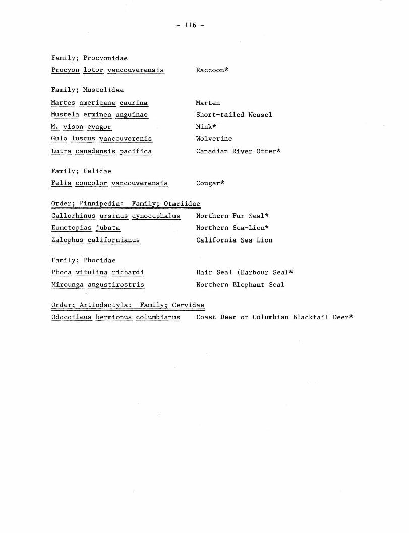
- 116 -
Family; Procyonidae
Procyon lotor vancouverens is Raccoon*
Family; Mustelidae
Martes americana caurina Marten
Mustela erminea anguinae Short-tailed Weasel
M. vison evagor Mink*
Gulo luscus Vancouverenis Wolverine
Lutra canadensis pacifica Canadian River Otter*
Family; Felidae
Felis concolor vancouverens is Cougar*
Order; Pinnipedia: Family; Otariidae
Callorhinus ursinus cynocephalus Northern Fur Seal*
Eumetopias jubata Northern Sea-Lion*
Zalophus californianus California Sea-Lion
Family; Phocidae
Phoca vitulina richardi Hair Seal (Harbour Seal*
Mirounga angustirostris Northern Elephant Seal
Order; Artiodactyla: Family; Cervidae
Odocoileus hermionus columbianus Coast Deer or Columbian Blacktail Deer*

- 117 -
APPENDIX II
BIRD SPECIES
This list is that given by Stirling (1968). It is probably incomplete,
and only a part of the northern section of the park is referred to. However,
the occurrence of the various species is not likely to vary substantially
between the three park sections. Two exceptions to this general rule might
be cited. The first concerns those species associated with the tidal mudflats
of Grice Bay, which is a habitat type available only sparingly in the other
sections. The second concerns the species associated with the more extensive
cedar/hemlock forest of the northern section, and the degree to which it has
been logged. Differences as a result of the latter factor may not be in
species composition but rather in numbers of individuals.
Those species marked with an asterisk are additions to Stirling's
list that have been observed by the author.
ORDER; Gaviiformes: FAMILY; Gaviidae
Gavia immer Common Loon
G. arctica Arctic Loon
G. stellata Red-throated Loon
ORDER; Podicipediformes: FAMILY; Podicipedidae
Aechmophorus occidentalis Western Grebe
Podiceps grisegena Red-necked Grebe
P. auritus Horned Grebe
ORDER; Procellariiformes: FAMILY; Diomedidae
Diomedea nigripes Black-footed Albatross
FAMILY; Hydrobatidae
Oceanodroma furcata Fork-tailed Petrel
0. leucorhoa Leach's Petrel
ORDER; Pelecaniformes: FAMILY; Phalacrocoracidae
Phalacrocorax auritus Double-crested Cormorant
P. pencillatus Brandt's Cormorant
P. pelagicus Pelagic Cormorant
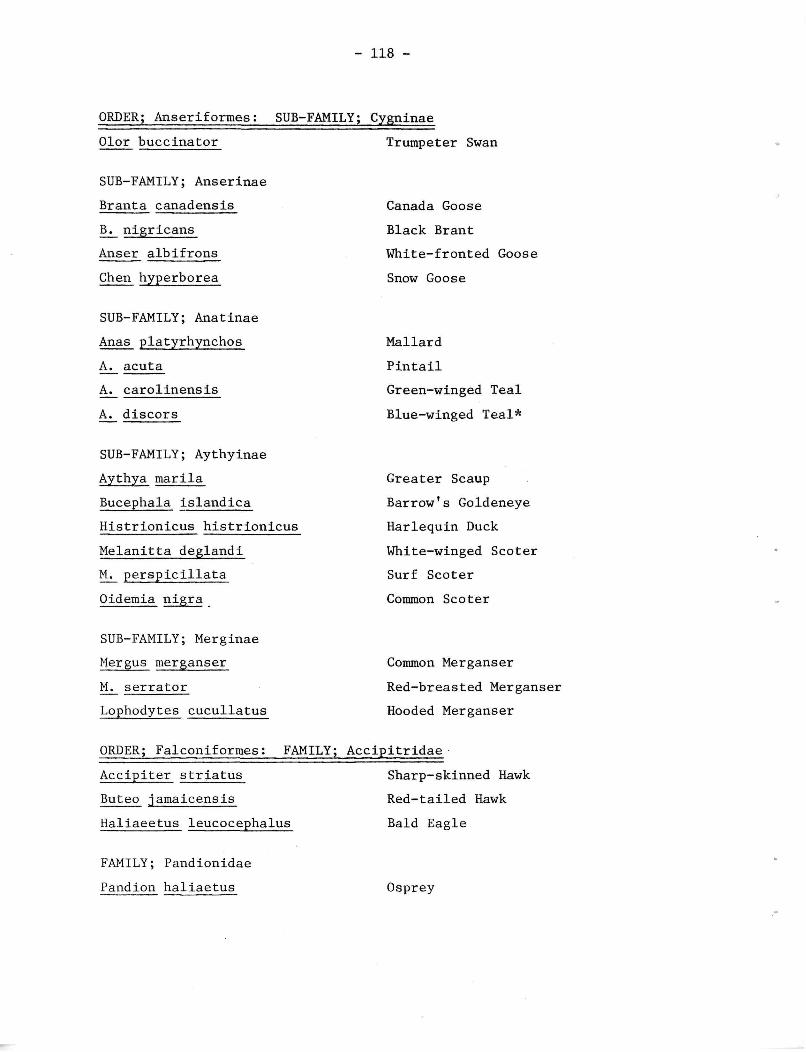
- 118 -
ORDER; Anseriformes: SUB-FAMILY; Cygninae
Olor buccinator Trumpeter Swan
SUB-FAMILY; Anserinae
Branta canadensis Canada Goose
B. nigricans Black Brant
Anser albifrons White-fronted Goose
Chen hyperborea Snow Goose
SUB-FAMILY; Anatinae
Anas platyrhynchos Mallard
A. acuta Pintail
A. carolinensis Green-winged Teal
A. discors Blue-winged Teal*
SUB-FAMILY; Aythyinae
Aythya marila Greater Scaup
Bucephala islandica Barrow's Goldeneye
Histrionicus histrionicus Harlequin Duck
Melanitta deglandi White-winged Scoter
M. perspicillata Surf Scoter
Oidemia nigra Common Scoter
SUB-FAMILY; Merginae
Mergus merganser Common Merganser
M. serrator Red-breasted Merganser
Lophodytes cucullatus Hooded Merganser
ORDER; Falconiformes: FAMILY; Accipitridae
Accipiter striatus Sharp-skinned Hawk
Buteo jamaicensis Red-tailed Hawk
Haliaeetus leucocephalus Bald Eagle
FAMILY; Pandionidae
Pandion haliaetus Osprey

- 119 -
FAMILY; Falconidae
Falco peregrinus Peregrine Falcon
F. columbarius Pigeon Hawk
F. sparverius Sparrow Hawk
ORDER; Galliformes: FAMILY; Tetraonidae
Dendragapus obscurus Blue Grouse
Bonasa umbellus Ruffed Grouse
ORDER; Ciconiiformes; FAMILY; Ardeidae
Ardea herodias Great Blue Heron
ORDER; Gruiformes: FAMILY; Rallidae
Rallus limicola Virginia Rail
ORDER; Charadriiformes: FAMILY; Haematopodidae
Haematopus bachmani Black Oystercatcher
FAMILY; Charadriidae
Pluvialis dominica American Golden Plover
Squatarola squatarola Black-bellied Plover
Charadrius semipalmatus Semi-palmated Plover
C. vociferus Killdeer
FAMILY; Scolopacidae
Numenius phaeopus Whimbrel
Actitis macularia Spotted Sandpiper
Heteroscelus incanum Wandering Tattler
Totanus melanoleucus Greater Yellowlegs
Limnodromus griseus Short-billed Dowitcher
Aphriza virgata Surfbird
Arenaria interpres Ruddy Turnstone
A. melanocephala Black Turnstone
Erolia ptilocnemis Rock Sandpiper
E. melanotos Pectoral Sandpiper
Calidris canutus Knot

- 120 -
Erolia acuminata Sharp-tailed Sandpiper
E. alpina Dunlin
Crocethia alba Sanderling
Erolia bairdii Baird's Sandpiper
E. minutilla Least Sandpiper
Ereunetes mauri Western Sandpiper
FAMILY; Phalaropodidae
Phalaropus fulicarius Red Phalarope
Lobipes lobatus Northern Phalarope
FAMILY; Stercorariidae
Stercorarius parasiticus Parasitic Jaeger
S. pomarinus Pomarine Jaeger
FAMILY; Laridae: SUB-FAMILY; Larinae
Larus glaucesceus Glaucous-winged Gull
L. hyperboreus Glaucous Gull* (Edwards,1968)
L. occidentalis Western Gull
L. argentatus Herring Gull
L. californicus California Gull
L. canus Mew Gull
L. heermanni Heerman's Gull
Rissa tridactyla Black-legged Kittiwake
Xema sabini Sabine's Gull
Larus Philadelphia Bonaparte's Gull
SUB-FAMILY; Sterninae
Hydroprogne caspia Caspian Tern (Schick, 1970)
FAMILY; Alcidae
Uria aalge Common Murre
Cepphus columba Pigeon Guillemot
Lundha cirrhata Tufted Puffin
Cerorhinca monocerata Rhinoceros Auklet
Ptychoramphus aleutica Cassin's Auklet

- 121 -
Brachyramphus marmoratum Marbled Murrelet
ORDER; Columbiformes: FAMILY; Columbidae
Columba fasciata Band-tailed Pigeon
Zenaidura macroura Mourning Dove
ORDER; Strigiformes; FAMILY; Strigidae
Bubo virginianus Great Horned Owl
Nyctea scandiaca Snowy Owl
ORDER; Caprimulgiformes: FAMILY; Caprimulgidae
Chordeiles minor Common Nighthawk
ORDER; Apodiformes: FAMILY; Apodidae
Cypseloides niger Black Swift
Chaetura vauxi Vaux Swift
FAMILY; Trochilidae
Selasphorus rufus Rufous Hummingbird
ORDER; Coraciiformes: FAMILY; Alcedinidae
Megaceryle alcyon Belted Kingfisher
ORDER; Piciformes: FAMILY; Picidae
Colaptes cafer Red-shafted Flicker
Dryocopus pileatus Pileated Woodpecker
Sphyrapicus varius "Red-breasted" Sapsucker
Dendrocopos villosus Hairy Woodpecker
D. pubescens Downy Woodpecker
ORDER; Passeriformes: FAMILY; Tyrannidae
Empidonax difficilis Western Flycatcher
FAMILY; Hirundinidae
Hirundo rustica Barn Swallow
Petrochelidon pyrrhonata Cliff Swallow Tachycineta thalassina Violet-green Swallow

- 122 -
Irldoprocue blcolor Tree Swallow
Stelgidopteryx ruficollls Rough-winged Swallow
FAMILY; Corvidae
Cyanocitta stelleri Steller's Jay
Corvus corax Common Raven
C. caurinus Northwestern Crow
FAMILY; Paridae
Parus rufescens Chestnut-backed Chickadee
FAMILY; Certhiidae
Certhia familiaris Brown Creeper
FAMILY; Troglodytidae
Troglodytes troglodytes Winter Wren
FAMILY; Turdidae
Turdus migratorius American Robin
Ixoreus naevius Varied Thrush
Hylocichla guttata Hermit Thrush
H. ustulata Swainson's Thrush
FAMILY; Sylviidae
Regulus satrapa Golden-crowned Kinglet
R. calendula Ruby-crowned Kinglet
FAMILY; Motacillidae
Anthus spinoletta Water Pipit
FAMILY; Bombycillidae
Bombycilla cedrorum Cedar Waxwing
FAMILY; Sturnidae
Sturnus vulgaris Starling
FAMILY; Parulidae
Vermivora celata Orange-crowned Warbler

- 123 -
Dendrolca petechia Yellow Warbler
D. auduboni Audubon's Warbler
D. townsendi Townsend's Warbler
Geothlypis trichas Yellowthroat*
Wilsonia pusilia Wilson's Warbler
FAMILY; Icteridae
Molothrus ater Brown-headed Cowbird
FAMILY; Fringillidae
Hesperiphona vespertina Evening Grosbeak
Spinus pinus Pine Siskin
S. tristis American Goldfinch
Loxia curvirostra Red Crossbill
Pipilo erythrophthalmus Rufous-sided Towhee
Passerculus sandwichensis Savannah Sparrow
Junco oreganus Oregon Junco
Zonotrichia leucophrys White-crowned Sparrow
Z. atricapilla Golden-crowned Sparrow
Passerella iliaca Fox Sparrow
Melospiza melodia Song Sparrow

- 124 -
SOME REFERENCES
1. Abraham, D.; 1952: "Lone Cone, A Journal of Life on the West Coast of
Vancouver Island." Diggen-Hibbon, Victoria. 103 p.
2. Buffam, F., 1965: "Wickaninnish - Summer, 1965." unpubl. B.C. Dept.
of Recreation and Conservation, Parks Branch, Victoria.
3. Campbell, R.W., 1967: "Wickaninnish Provincial Park - Summer, 1967."
unpubl. B.C. Dept. of Recreation and Conservation, Parks Branch,
Victoria.
4. , 1968: "Wickaninnish Provincial Park - Summer Report." unpubl.
B.C. Dept. of Recreation and Conservation, Parks Branch, Victoria.
5. Campbell, R.W., and D. Stirling; 1968: "Notes on the Vertebrate
Fauna Associated with a Brandt's Cormorant Colony in British Columbia."
Murrelet 49(1): 7-9.
6. Cowan, I. McT., and C.J. Guiguet; 1965: "The Mammals of British Columbia."
B.C. Provincial Museum Handbook No. 11., Victoria.
7. Drent, R.H., and C.J. Guiguet; 1961: "A Catalogue of British Columbia
Sea-bird Colonies." Occ. Paps. B.C. Prov. Mus. No. 12, Victoria.
8. Drucker, P.; 1951: "The Northern and Central Nootkan Tribes." Smithsonian
Institution Bureau of American Ethnology Bulletin No. 144.
9. Edwards, R.Y.; 1968: "Notes on the Gulls of Southwestern British Columbia."
Syesis 1: 199-202.
10. Fisher, E.M.; 1940: "The Sea Otter Past and Present." Proc. 6th Pacific
Sci. Congress No. 3, pp. 223-236. U. of Calif., Berkeley.
11. Gashwiler, J.S.; and A.L. Ward; 1966: "Western Red Cedar, a Food of
Pine Siskins." Murrelet 47(3): 73-75.
12. ; 1968: "Oregon Junco Foods in Coniferous Forests." Murrelet
49: 29-36.
13. Gore, T.S.; 1896: "Surveys Located, West Coast of Vancouver Island."
Crown Land Surveys, B.C. Sessional Papers, pp. 833-834.
14. Grant, W.C.; 1857: "Description of Vancouver Island." J. Royal Geog.
Soc. 27: 268-320.
15. Hagar, D.C.; 1960: "The Interrelationships of Logging, Birds, and
Timber Regeneration in the Douglas Fir Region of Northwestern California."
Ecology 41(1): 116-125.
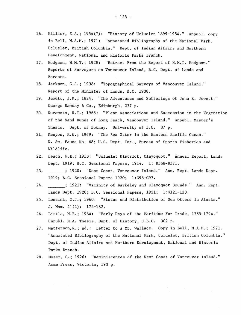
- 125 -
16. Hillier, E.A.; 1954(7): "History of Ucluelet 1899-1954." unpubl. copy
in Bell, M.A.M.; 1971: "Annotated Bibliography of the National Park,
Ucluelet, British Columbia." Dept. of Indian Affairs and Northern
Development, National and Historic Parks Branch.
17. Hodgson, H.M.T.; 1928: "Extract From the Report of H.M.T. Hodgson."
Reports of Surveyors on Vancouver Island, B.C. Dept. of Lands and
Forests.
18. Jackson, G.J.; 1938: "Topographical Surveys of Vancouver Island."
Report of the Minister of Lands, B.C. 1938.
19. Jewett, J.R.; 1824: "The Adventures and Sufferings of John R. Jewett."
George Ramsay & Co., Edinburgh, 237 p.
20. Kuramoto, R.T.; 1965: "Plant Associations and Succession in the Vegetation
of the Sand Dunes of Long Beach, Vancouver Island." unpubl. Master's
Thesis. Dept. of Botany. University of B.C. 87 p.
21. Kenyon, K.W.; 1969: "The Sea Otter in the Eastern Pacific Ocean."
N. Am. Fauna No. 68; U.S. Dept. Int., Bureau of Sports Fisheries and
Wildlife.
22. Leach, F.E.; 1913: "Ucluelet District, Clayoquot." Annual Report, Lands
Dept. 1919; B.C. Sessional Papers, 1914. 1: D368-D371.
23. ; 1920: "West Coast, Vancouver Island." Ann. Rept. Lands Dept.
1919; B.C. Sessional Papers 1920; 1:G96-G97.
24. ; 1921: "Vicinity of Barkeley and Clayoquot Sounds." Ann. Rept.
Lands Dept. 1920; B.C. Sessional Papers, 1921; 1:G121-123.
25. Lensink, G.J.; 1960: "Status and Distribution of Sea Otters in Alaska."
J. Mam. 41(2): 172-182.
26. Little, M.E.; 1934: "Early Days of the Maritime Fur Trade, 1785-1794."
Unpubl. M.A. Thesis, Dept. of History, U.B.C. 302 p.
27. Matterson,R.; nd.: Letter to a Mr. Wallace. Copy in Bell, M.A.M.; 1971.
"Annotated Bibliography of the National Park, Ucluelet, British Columbia."
Dept. of Indian Affairs and Northern Development, National and Historic
Parks Branch.
28. Moser, C.; 1926: "Reminiscences of the West Coast of Vancouver Island."
Acme Press, Victoria, 193 p.

- 126 -
29. Nicholson, G.; 1962: "Vancouver Island's West Coast." Morris Printing
Co., Victoria, 356 p.
30. Pearse, T.; 1951: "Birds of the Early Explorers of the Northern Pacific."
Published privately (?).
31. Ricker, W.E., and F. Neave; 1961: "Nesting Colony of Mew Gulls on Kennedy
Lake, Vancouver Island." B.C. Prov. Mus. Report for the Year 1961,
Victoria.
32. Schick, W.J.; 1970: "First British Columbia Specimen Record of Caspian
Tern." Syesis 3: 187.
33. Sharcott, M.; (nd.): "Troller's Holiday." publisher unknown.
34. Spalding, D.J.; 1964: "Comparative Feeding Habits of the Fur Seal,
Sea-Lion, and Harbour Seal." Fisheries Research Board of Canada,
Ottawa, Bulletin No. 146.
35. Stirling, 0.; 1968: "A Naturalist at Wickaninnish." Can. Aud. 30(5).
139-144.
36. Stirling, 0.; and F. Buffam; 1966: "First Breeding Record of Brandt's
Cormorant in Canada." Can. Field Nat. 80: 117-118.
37. Wade, L.K.; 1965: "Vegetation and History of the Sphagnum Bogs of the
Tofino Area, Vancouver Island." unpublished Master's Thesis, Dept. of
Botany, U.B.C. 124 p.

Plate. 2. Terrace scarp in Florencia Bay. These outwash deposits are typical for a large section of the Estevan Coastal Plain.
Plate. 3. Long Beach looking east towards Kennedy Lake,
- 127 -
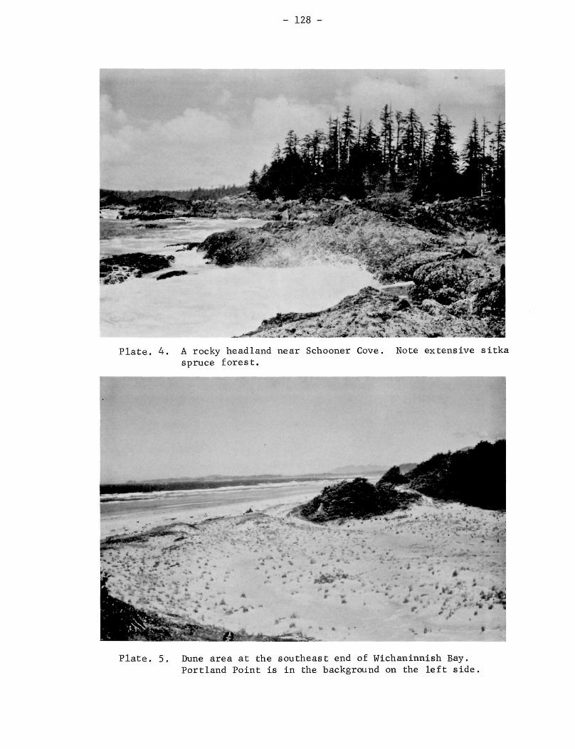
- 128 -
Plate. 4. A rocky headland near Schooner Cove. Note extensive sitka spruce forest.
Plate. 5. Dune area at the southeast end of Wichaninnish Bay. Portland Point is in the background on the left side.

- 129 -
Plate. 6. Kennedy Lake. This beach is part of the shoreline within the dark boundaries.
Plate. 7. Looking north from Radar Hill. The rocky scrub forest is in the foreground with Tofino Inlet and Vancouver Island in the background.

- 130 -
Plate. 8. A view of the high forest in the interior of the park. This stand consists of Western hemlock (left side of photo) and Pacific Silver fir (centre and right side of photo)

Plate. 9. Sequence of vegetation types on Wichaninnish Bay. From right to left; the herb and log type, the shrub and herb type, and the scrub spruce forest type and the spruce forest type.
- 131 -

- 132 -
Plate. 10. A view of the poorly drained interior forest showing a bog (centre) to pine bog forest to muskeg forest (background) sequence of vegetation types.
Plate. 11. Slash from logging operation carried out shortly before the establishment of the park.

Related Documents