This article appeared in a journal published by Elsevier. The attached copy is furnished to the author for internal non-commercial research and education use, including for instruction at the authors institution and sharing with colleagues. Other uses, including reproduction and distribution, or selling or licensing copies, or posting to personal, institutional or third party websites are prohibited. In most cases authors are permitted to post their version of the article (e.g. in Word or Tex form) to their personal website or institutional repository. Authors requiring further information regarding Elsevier’s archiving and manuscript policies are encouraged to visit: http://www.elsevier.com/copyright

Welcome message from author
This document is posted to help you gain knowledge. Please leave a comment to let me know what you think about it! Share it to your friends and learn new things together.
Transcript

This article appeared in a journal published by Elsevier. The attachedcopy is furnished to the author for internal non-commercial researchand education use, including for instruction at the authors institution
and sharing with colleagues.
Other uses, including reproduction and distribution, or selling orlicensing copies, or posting to personal, institutional or third party
websites are prohibited.
In most cases authors are permitted to post their version of thearticle (e.g. in Word or Tex form) to their personal website orinstitutional repository. Authors requiring further information
regarding Elsevier’s archiving and manuscript policies areencouraged to visit:
http://www.elsevier.com/copyright

Author's personal copy
Pacific Basin tsunami hazards associated with mass flows in the Aleutian arcof Alaska
Christopher F. Waythomas a,*, Philip Watts b, Fengyan Shi c, James T. Kirby c
a US Geological Survey, Alaska Science Center, Alaska Volcano Observatory, 4230 University Drive, Suite 201, Anchorage, AK 99508, USAb Applied Fluids Engineering, Inc., 6216 E. Pacific Coast Highway, PMB 237, Long Beach, CA 90803, USAc University of Delaware, Dept. of Civil and Environmental Engineering, Center for Applied Coastal Research, Newark, DE 19716, USA
a r t i c l e i n f o
Article history:Received 2 January 2008Received in revised form5 February 2009Accepted 25 February 2009
a b s t r a c t
We analyze mass-flow tsunami generation for selected areas within the Aleutian arc of Alaska usingresults from numerical simulation of hypothetical but plausible mass-flow sources such as submarinelandslides and volcanic debris avalanches. The Aleutian arc consists of a chain of volcanic mountains,volcanic islands, and submarine canyons, surrounded by a low-relief continental shelf above about 1000–2000 m water depth. Parts of the arc are fragmented into a series of fault-bounded blocks, tens tohundreds of kilometers in length, and separated from one another by distinctive fault-controlled canyonsthat are roughly normal to the arc axis. The canyons are natural regions for the accumulation andconveyance of sediment derived from glacial and volcanic processes. The volcanic islands in the regioninclude a number of historically active volcanoes and some possess geological evidence for large-scalesector collapse into the sea. Large scale mass-flow deposits have not been mapped on the seafloor southof the Aleutian Islands, in part because most of the area has never been examined at the resolutionrequired to identify such features, and in part because of the complex nature of erosional and deposi-tional processes. Extensive submarine landslide deposits and debris flows are known on the north side ofthe arc and are common in similar settings elsewhere and thus they likely exist on the trench slope southof the Aleutian Islands. Because the Aleutian arc is surrounded by deep, open ocean, mass flows ofunconsolidated debris that originate either as submarine landslides or as volcanic debris avalanchesentering the sea may be potential tsunami sources.To test this hypothesis we present a series of numerical simulations of submarine mass-flow initiatedtsunamis from eight different source areas. We consider four submarine mass flows originating insubmarine canyons and four flows that evolve from submarine landslides on the trench slope. The flowshave lengths that range from 40 to 80 km, maximum thicknesses of 400–800 m, and maximum widths of10–40 km. We also evaluate tsunami generation by volcanic debris avalanches associated with flankcollapse, at four locations (Makushin, Cleveland, Seguam and Yunaska SW volcanoes), which representlarge to moderate sized events in this region. We calculate tsunami sources using the numerical modelTOPICS and simulate wave propagation across the Pacific using a spherical Boussinesq model, which isa modified version of the public domain code FUNWAVE. Our numerical simulations indicate thatgeologically plausible mass flows originating in the North Pacific near the Aleutian Islands can indeedgenerate large local tsunamis as well as large transoceanic tsunamis. These waves may be several metersin elevation at distal locations, such as Japan, Hawaii, and along the North and South American coastlineswhere they would constitute significant hazards.
Published by Elsevier Ltd.
1. Introduction
Tsunami initiated by gravity driven mass flows of unconsoli-dated debris are increasingly recognized as important coastalhazards in many parts of the world (Keating and McGuire, 2000;Lee et al., 2003; Watts et al., 2005). Several recent tsunami disastershave been attributed to mass-flow tsunami sources (e.g., Tappin
* Corresponding author. Tel.: þ1 907 786 7122.E-mail address: [email protected] (C.F. Waythomas).
Contents lists available at ScienceDirect
Quaternary Science Reviews
journal homepage: www.elsevier .com/locate/quascirev
0277-3791/$ – see front matter Published by Elsevier Ltd.doi:10.1016/j.quascirev.2009.02.019
Quaternary Science Reviews 28 (2009) 1006–1019
Author's personal copy
et al., 2001, 2008), and many seismic events that produce tsunamismay also trigger tsunamigenic landslides (Lander and Lockridge,1989). Although the mechanism of tsunami generation by bothsubaerial and submarine mass flows has been studied for sometime, it is only recently that models capable of integrating thesource, propagation and inundation components of a tsunamievent have become available for application to hazard evaluation.
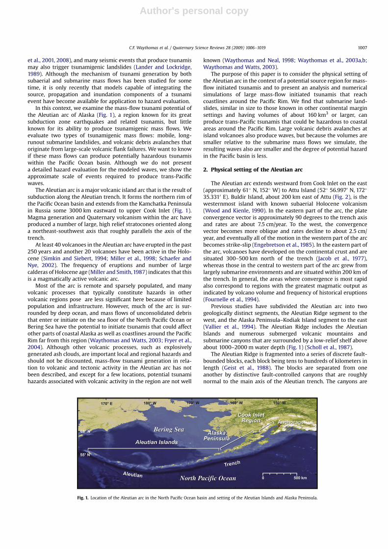
In this context, we examine the mass-flow tsunami potential ofthe Aleutian arc of Alaska (Fig. 1), a region known for its greatsubduction zone earthquakes and related tsunamis, but littleknown for its ability to produce tsunamigenic mass flows. Weevaluate two types of tsunamigenic mass flows: mobile, long-runout submarine landslides, and volcanic debris avalanches thatoriginate from large-scale volcanic flank failures. We want to knowif these mass flows can produce potentially hazardous tsunamiswithin the Pacific Ocean basin. Although we do not presenta detailed hazard evaluation for the modeled waves, we show theapproximate scale of events required to produce trans-Pacificwaves.
The Aleutian arc is a major volcanic island arc that is the result ofsubduction along the Aleutian trench. It forms the northern rim ofthe Pacific Ocean basin and extends from the Kamchatka Peninsulain Russia some 3000 km eastward to upper Cook Inlet (Fig. 1).Magma generation and Quaternary volcanism within the arc haveproduced a number of large, high relief stratocones oriented alonga northeast-southwest axis that roughly parallels the axis of thetrench.
At least 40 volcanoes in the Aleutian arc have erupted in the past250 years and another 20 volcanoes have been active in the Holo-cene (Simkin and Siebert, 1994; Miller et al., 1998; Schaefer andNye, 2002). The frequency of eruptions and number of largecalderas of Holocene age (Miller and Smith, 1987) indicates that thisis a magmatically active volcanic arc.
Most of the arc is remote and sparsely populated, and manyvolcanic processes that typically constitute hazards in othervolcanic regions pose are less significant here because of limitedpopulation and infrastructure. However, much of the arc is sur-rounded by deep ocean, and mass flows of unconsolidated debristhat enter or initiate on the sea floor of the North Pacific Ocean orBering Sea have the potential to initiate tsunamis that could affectother parts of coastal Alaska as well as coastlines around the PacificRim far from this region (Waythomas and Watts, 2003; Fryer et al.,2004). Although other volcanic processes, such as explosivelygenerated ash clouds, are important local and regional hazards andshould not be discounted, mass-flow tsunami generation in rela-tion to volcanic and tectonic activity in the Aleutian arc has notbeen described, and except for a few locations, potential tsunamihazards associated with volcanic activity in the region are not well
known (Waythomas and Neal, 1998; Waythomas et al., 2003a,b;Waythomas and Watts, 2003).
The purpose of this paper is to consider the physical setting ofthe Aleutian arc in the context of a potential source region for mass-flow initiated tsunamis and to present an analysis and numericalsimulations of large mass-flow initiated tsunamis that reachcoastlines around the Pacific Rim. We find that submarine land-slides, similar in size to those known in other continental marginsettings and having volumes of about 160 km3 or larger, canproduce trans-Pacific tsunamis that could be hazardous to coastalareas around the Pacific Rim. Large volcanic debris avalanches atisland volcanoes also produce waves, but because the volumes aresmaller relative to the submarine mass flows we simulate, theresulting waves also are smaller and the degree of potential hazardin the Pacific basin is less.
2. Physical setting of the Aleutian arc
The Aleutian arc extends westward from Cook Inlet on the east(approximately 61� N, 152� W) to Attu Island (52� 56.9970 N, 172�
35.3310 E). Buldir Island, about 200 km east of Attu (Fig. 2), is thewesternmost island with known subaerial Holocene volcanism(Wood and Kienle, 1990). In the eastern part of the arc, the plateconvergence vector is approximately 90 degrees to the trench axisand rates are about 7.5 cm/year. To the west, the convergencevector becomes more oblique and rates decline to about 2.5 cm/year, and eventually all of the motion in the western part of the arcbecomes strike-slip (Engebretson et al., 1985). In the eastern part ofthe arc, volcanoes have developed on the continental crust and aresituated 300–500 km north of the trench (Jacob et al., 1977),whereas those in the central to western part of the arc grew fromlargely submarine environments and are situated within 200 km ofthe trench. In general, the areas where convergence is most rapidalso correspond to regions with the greatest magmatic output asindicated by volcano volume and frequency of historical eruptions(Fournelle et al., 1994).
Previous studies have subdivided the Aleutian arc into twogeologically distinct segments, the Aleutian Ridge segment to thewest, and the Alaska Peninsula–Kodiak Island segment to the east(Vallier et al., 1994). The Aleutian Ridge includes the AleutianIslands and numerous submerged volcanic mountains andsubmarine canyons that are surrounded by a low-relief shelf aboveabout 1000–2000 m water depth (Fig. 1) (Scholl et al., 1987).
The Aleutian Ridge is fragmented into a series of discrete fault-bounded blocks, each block being tens to hundreds of kilometers inlength (Geist et al., 1988). The blocks are separated from oneanother by distinctive fault-controlled canyons that are roughlynormal to the main axis of the Aleutian trench. The canyons are
Fig. 1. Location of the Aleutian arc in the North Pacific Ocean basin and setting of the Aleutian Islands and Alaska Peninsula.
C.F. Waythomas et al. / Quaternary Science Reviews 28 (2009) 1006–1019 1007

Author's personal copy
important regions for the accumulation and conveyance of sedi-ment derived from glaciation and volcanic process at nearbyislands.
The bathymetry of the Aleutian arc is dominated by the Aleutiantrench, the deepest part of which is about 7600 m below sea level.Landward of the trench is a series of horst and graben-like features,called the Aleutian terrace, that extend from about 4500 m depth toabout 1000 m depth. Parts of the terrace are tilted gently north andthe area is generally an accumulation zone for volcaniclastic andglaciomarine deposits (Dobson et al., 1996). The water depth overthe Aleutian terrace and the submarine canyons that cross thetrench slope is >200 m (Fig. 2).
During the last glacial maximum, ca 20–18 ka, glacier iceextended southward across the Aleutian shelf and into Cook Inlet asthe sea level fell to about �125 m (Manley and Kaufman, 2002).Although little is known about the character of glacial deposits onthe shelf, bathymetric maps of the area indicate extensive zones ofice stagnation drift and moraine. Eruptions at Aleutian arc volca-noes throughout the late Pleistocene and Holocene have occurred inthe presence of ice and snow, and this has led to the generation ofvolcanic mudflows or lahars. These flows reached the sea andcontributed volcaniclastic debris to the shelf. Studies of sedimentprovenance and dispersal south of the Aleutian arc indicate thatsand layers of Holocene age recovered from piston cores taken fromthe trench slope (e.g. DSDP core 186 shown in Fig. 6) consistprimarily of volcaniclastic debris derived from volcanic sources(Underwood, 1986a,b). The sand layers, some of which are severalmeters thick, are interpreted as to have formed from gravity drivensediment flows that were funneled through submarine canyons.Sediment-gravity-flow deposits accumulated on the slope north ofthe trench or extended beyond the trench-slope break (Underwood,1986a,b; Underwood and Hathon, 1989) and clearly indicate thepotential for long-runout submarine mass flows in this area.Although we cannot be certain that all such sediment gravity flows
originated from large submarine landslides, it is reasonable toassume that some of them did.
Deposits of unconsolidated volcaniclastic and glacial debris onthe shelf and trench slope, and the submarine topography of theAleutian arc in general, make this region a suitable environment forthe generation of submarine mass flows as in other parts of Alaska(Hampton and Bouma, 1977; Schwab and Lee, 1983; Carlson et al.,1991; Karl and Carlson, 1996; Hampton et al., 1996) and in similarmarine environments elsewhere (Locat and Mienert, 2003). Thus,we hypothesize that the trench slope along the south flank ofthe Aleutian arc is a likely source region for tsunamigenic massflows.
A remaining physical characteristic of the region is its numeroussubduction zone earthquakes, some of which are among the largestever recorded (Taber et al., 1991; Haeussler and Plafker, 2003).Large earthquakes are a well-known mechanism for initiating massfailures of various types (Keefer, 1984, 2002), and subduction zoneearthquakes in the Aleutian arc have triggered submarine land-slides in several areas (Wilson and Torum, 1972; Fryer et al., 2004;Lee et al., 2006).
3. Submarine mass-flow tsunami sources
Submarine mass flows of unconsolidated sediment are anacknowledged generation mechanisms for tsunamis (Ward, 2001;Lee et al., 2003; Watts et al., 2003, 2005; Grilli and Watts, 2005;Harbitz et al., 2006; Tappin et al., 2008). As a result of these andother studies, the hazards posed by mass-flow initiated waves arewidely recognized as important local hazards, and should also beregarded as significant regional hazards. We suggest that theAleutian Islands region (Fig. 1) is an area capable of producingtsunamigenic mass flows, and here we present first-order evalua-tions of hypothetical, but plausible, mass-flow triggered tsunamis
Location ofmap area
ALASKA
Pacific OceanBering Sea
Bering Sea
Pacific Ocean 0 500 km50° N
55° N
170° E 175° E 180° E 175° W 170° W 165° W 160° W
Submarine canyon
Heck Canyon (360 km3)
Murray Canyon (300 km3)
Amchitka Pass (1440 km3)
Adak Canyon (160 km3)
Slope failure on shelf
Tanaga slope (720 km3)
Sitkin slope (160 km3)
Unimak slope (500 km3)
Shumagin slope (1600 km3)
A
B
C
D
AB
C D
Volcano or volcanic center
with historical or Holocene
activity
E
F
G
H
EF
G
H
ALE
UTIA
N TRENCH-2000m
-2000m
-2000m
-2000m
Kiska
Gareloi
Tanaga
Kanaga
Great Sitkin
KorovinAttu Island
2000 m isobath
Makushin
Seguam
Yunaska
Cleveland
Buldir
Volcanic landslide
Fig. 2. Bathymetric map of the central and western Aleutian arc showing location of mass flow tsunami sources and volumes. Bold arrows indicate direction of flow path and initialpropagation direction of tsunami.
C.F. Waythomas et al. / Quaternary Science Reviews 28 (2009) 1006–10191008

Author's personal copy
that originate in the Aleutian Islands and propagate across thePacific Ocean.
We evaluate submarine mass-flow initiated tsunamis in eightdistinct source areas within the central and western Aleutian arc(Fig. 2). The dimensions and characterization of the submarinemass flows are dictated by the geology and morphology of eachsource area (Table 1) and are typical of submarine mass flows thathave occurred in continental slope settings elsewhere, includingAlaska (Edgers and Karlsrud, 1982; Coleman and Prior, 1988;Hampton et al., 1996; Piper and McCall, 2003; Fryer et al., 2004;McMurtry et al., 2004; von Huene et al., 2004; McAdoo and Watts,2004; Solheim et al., 2005).
The tsunami sources we evaluate are generic submarine massflows with an assumed specific density of 1.85, initial lengths of40–80 km, maximum thicknesses of 400–800 m, and maximumwidths of 10–40 km (Table 1). The mass flows initiate in water2000–3000 m deep and flow generally southward along the seafloor toward the Aleutian trench (Fig. 2). The dimensions given inTable 1 vary with margin shape and slope, whereas the ratios ofdimensions stay the same. As described in Watts et al. (2003,
2005) submarine mass flows exhibit minimal basal friction andundergo translational acceleration over long distances (tens tohundreds of kilometers). Although we have not identified specificsubmarine mass-flow deposits or features south of the Aleutianarc having the geometry described in Table 1, documentedtsunamigenic submarine landslides in other parts of the world(Table 2) are of similar size. Submarine mass-flow deposits havebeen identified in GLORIA imagery of the seafloor of the southernBering Sea basin north of the Aleutian arc (Groome et al., 1997).Individual deposits in this area are >3 � 104 km2 although theirvolumes are unknown.
4. Subaerial mass-flow tsunami sources
We evaluate tsunami generation by subaerial mass flows in thecontext of large volcanic flank failures and associated debrisavalanches entering the North Pacific Ocean and Bering Sea. Ourapproach to this problem was described in a previous paper(Waythomas et al., 2006), and the reader is referred to this work for
Fig. 3. Near-field maximum water elevations above sea level for hypothetical submarine mass flow tsunami sources. (A)–(D) Tsunami sources originating in submarine canyons;(E)–(H) tsunami sources originating on the trench slope. A, Heck Canyon source; B, Murray Canyon source; C, Amchitka Pass source; D, Adak Canyon source; E, Tanaga slope source;F, Sitkin slope source; G, Unimak slope source; H, Shumagin slope source.
C.F. Waythomas et al. / Quaternary Science Reviews 28 (2009) 1006–1019 1009

Author's personal copy
more information about our treatment of tsunami generation bydebris avalanche.
Island volcanoes in the Aleutian arc and elsewhere are prone tolateral failures and this process is a well-known mechanism fortsunami generation (Keating and McGuire, 2000; McGuire, 2006).Although there have been no known historical flank failures atvolcanoes in Alaska that resulted in tsunamis, except for AugustineVolcano (Waythomas et al., 2006), large scale flank collapse anddebris avalanche runout into the sea has been documented atseveral Aleutian volcanoes (Waythomas et al., 2002, 2003a,b;Coombs et al., 2007). It is difficult to know beforehand how much ofa volcanic edifice will be involved in a flank collapse. Evaluations ofdebris-avalanche deposits resulting from flank collapse indicatethat most large-scale collapses involve about one-third or more ofthe total edifice volume (Siebert, 1996). Island volcanoes in theAleutian arc have subaerial edifice volumes that range from about0.5 km3 to about 200 km3 (Table 3). Assuming that the total edifice
volume is at least twice the subaerial volume, and one-third of thisamount is a plausible volume for a potential flank collapse, large-scale lateral flank collapses at island volcanoes in Alaska couldproduce between 0.3 and 140 km3 of material. A volcanic debrisavalanche with a volume in this range could be tsunamigenic, and,as we show later, far-field waves could be significant and localwaves near the source could produce large runup on nearby islandsand coastlines. We note that a tsunami may have been initiatedwhen about 0.09 km3 of avalanche debris from Augustine Volcanoentered Cook Inlet during an eruption in 1883 (Waythomas et al.,2006). This event indicates that large volumes of debris are notnecessarily required to produce potentially hazardous waves,although the impact and damage of smaller events is limited inareal extent. Maximum tsunami wave elevations and depressionsdepend on other factors including debris flux, water depth, land-slide Froude number, geometry, and no clear relation existsbetween landslide volume and maximum wave elevation (Murty,
Fig. 3. (continued).
C.F. Waythomas et al. / Quaternary Science Reviews 28 (2009) 1006–10191010

Author's personal copy
2003). As we have suggested elsewhere, tsunami generationdepends on the volume flux entering the water (Waythomaset al., 2006).
All of the known submarine debris-avalanche deposits associ-ated with flank collapse in the Aleutian Islands entered the BeringSea (Waythomas et al., 2002, 2003a,b; Coombs et al., 2007), butbecause the data needed to identify flank collapse debris-avalanchedeposits in North Pacific settings are not available, we do not knowhow common such deposits are in this area. Thus, our evaluation ofvolcanic avalanches that enter the North Pacific is hypothetical, andavailable evidence indicates that avalanche-initiated waves, if theydid form, have been directed primarily to the north.
5. Mass-flow motion
Mass-flow motion governs tsunami generation, and the accel-eration phase of the flow during the early stages of a tsunamigenicmass-flow event has the greatest influence on initial wave eleva-tion and tsunami generation (Watts, 1998, 2000; Watts et al., 2003,2005). Mass-flow motion can be described by evaluating thebalance of forces acting on the flow and applying standard equa-tions of motion for center of mass displacement along the sea floor(Slingerland and Voight, 1979; Heinrich, 1992; Pelinovsky and
Poplavsky, 1996; Watts, 1997; Watts and Grilli, 2003; Grilli andWatts, 2005). Deformation about the center of mass is addressedusing the center of mass motion. We consider a gravity-driven massflow moving down a finite, planar slope inclined at angle q to thehorizontal. The mass flow is treated as a deforming body, wheredeformation occurs relative to, and about, the center of massmotion s(t). We subdivide the slope over which the mass flowmoves into linear segments where each segment has a constantslope q. The instantaneous velocity u(t) of the mass flow for a givenplanar slope segment has the form:
dudt
zBA� C
Au2 (1)
where the first term B/A represents both gravitational accelerationand the effect of bed friction, and the second term (C/A)u2,represents drag by the ambient fluid (either air or water) at thecenter of mass location. The coefficients Ahðrb þ Cmr0Þ,Bhðrb � r0Þgðsinq� CncosqÞ, and Chr0Cd=2L are slowly varyingfunctions of time (Watts, 1997, 1998, 2000). In the expressions for A,B, and C above, rb is the instantaneous bulk density, r0 is theambient fluid density, Cm is the added mass coefficient, g is gravi-tational acceleration, Cn denotes the instantaneous Coulomb fric-tion coefficient, Cd is the total drag coefficient, and L is the
Fig. 4. Far-field maximum water elevation above sea level for hypothetical submarine mass- flow tsunami sources. A, Heck Canyon source; B, Murray Canyon source; C, AmchitkaPass source; D, Adak Canyon source; E, Tanaga slope source; F, Sitkin slope source, G, Unimak slope source; H, Shumagin slope source.
C.F. Waythomas et al. / Quaternary Science Reviews 28 (2009) 1006–1019 1011

Author's personal copy
instantaneous mass flow length (see Watts, 1998, 2000; Grilli andWatts, 1999; Watts et al., 2000; Grilli et al., 2002; Brodsky et al.,2003; Enet et al., 2003; Watts and Waythomas, 2003). We setCm ¼ 1:17, Cn ¼ 0:01, and Cd ¼ 1:44 to perform the computa-tions that utilize the coefficients A, B, and C. These are typical valuesfor mass-flow motion calculations (Waythomas et al., 2006). We donot consider entrainment for these landslides.
We assume that mass-flow motion occurs over discrete timesteps Dt, where Dt ¼ t � ti is the time difference between thebeginning and end of the time step, and with the initial conditionuðtiÞ ¼ ui. If the coefficient B > 0, the flow is accelerating and themass-flow velocity changes according to:
uðtÞyffiffiffiBC
rtanh
� ffiffiffiffiffiffiffiffiffiffiffiffiffiffiffiffiffiffiffiffiffiBCðt � tiÞ
p=A�þ ui
ffiffiffiffiffiffiffiffiffiC=B
p1þ ui
ffiffiffiffiffiffiffiffiffiC=B
ptanh
� ffiffiffiffiffiffiffiffiffiffiffiffiffiffiffiffiffiffiffiffiffiBCðt � tiÞ
p=A� (2)
We solve for position s(t) along the slope by integrating the velocityu(t) numerically over time, starting with ui ¼ 0 at ti ¼ 0. Fora planar slope, we integrate Eq. (2) to find an analytical solution forcenter of mass position as a function of time. Doing so yields thefamiliar law of motion:
uðtÞ ¼ s0ln�
coshtt0
�(3)
where s0 ¼ A=C and t0 ¼ A=ffiffiffiffiffiffiBCp
are the characteristic distanceand time of mass-flow motion, respectively (Watts, 1998; Wattset al., 2000; Grilli and Watts, 2001; Enet et al., 2003).
To account for deformation of the mass flow as it moves, internaldeformation about the center of mass is parameterized in terms ofthe center of mass motion. The center of mass position s(t) can beshifted down slope as internal deformation takes place, increasingthe acceleration of the center of mass (Watts and Grilli, 2003).Similarly, the nose position N(t) over time, and the mass-flowlength as a function of time L(t), increase in proportion to the centerof mass motion s(t). There are three dynamic deformation coeffi-cients with values based on experimental results (Watts, 1997;Fritz, 2002), numerical analysis (Watts and Grilli, 2003; Locat et al.,2004), and case studies of mass-flow tsunami generation (Greeneet al., 2006; Waythomas et al., 2006).
Mass-flow thickness with respect to time H(t) can be estimatedfrom conservation of mass, in simplified form:
HðtÞz 3Vi
2LðtÞW (4)
where Vi is initial volume, LðtÞ is instantaneous mass-flow length,and W is a typical mass-flow width, here assumed constant. Theratio 2/3 is a shape factor that relates the product of the length
Fig. 4. (continued).
C.F. Waythomas et al. / Quaternary Science Reviews 28 (2009) 1006–10191012

Author's personal copy
scales to the mass-flow volume. Mass-flow length with respect totime LðtÞ is calculated with the following equation:
LðtÞ ¼ Li þ CstðsðtÞ � siÞ (5)
where Li is the initial mass-flow length, Cst is a dynamic lengthcoefficient (set to a value Cst of 0.35), and si is the initial mass-flowposition. Center of mass motion sðtÞ is the only other length scaleavailable to modify mass-flow length in time. It could be said thatthe center of mass motion drives the deformation process. Mass-flow velocity with respect to time UðtÞ is calculated using
UðtÞ ¼ Ui þ CatðUðtÞ � UiÞ (6)
where Ui is the initial center of mass velocity and Cat is a dynamicacceleration coefficient (set to a value of Cat1.4). Eq. (6) amplifieschanges in velocity due to mass-flow deformation. Eqs. (1)–(6)provide a complete description of mass flow motion and defor-mation. Additional discussion of these concepts can be foundin Watts and Grilli (2003), Greene et al. (2006), and Waythomaset al. (2006).
6. Numerical simulation
The initial mass flow tsunami source is calculated using a soft-ware package called TOPICS (Tsunami Open and Progressive InitialConditions System). The output is linked to a public-domainBoussinesq wave propagation model called FUNWAVE (Wei andKirby, 1995; Wei et al., 1995) by way of a tsunami community modelGeowave (Watts et al., 2003, 2005). FUNWAVE handles frequencydispersion in a manner that simulates deep-water waves, modelsthe fluid mechanics of breaking waves, and simulates waveinundation.
Boussinesq equations are employed to describe the weaklydispersive propagation of nonlinear water waves (Kirby, 2003).Wave propagation simulations were carried out using FUNWAVE,which can perform simulations for a variety of model systemsincluding nonlinear shallow water equations, weakly nonlinearBoussinesq equations, and fully nonlinear Boussinesq equations,using a predictor-corrector scheme described by Wei and Kirby(1995). Further information on algorithms for wave breaking,shoreline inundation, runup, and bottom friction can be found inChen et al. (2000) and Kennedy et al. (2000). The near-field simu-lations use a uniform 2 � 2 km UTM grid. The far-field simulationswere performed on a regular, spherical, 10 � 10 min grid, usinga weakly nonlinear model equation based on depth-averagedhorizontal velocity.
The far-field model equations, implementations, and tests aredescribed by Kirby et al. (2004). In the derivation of the ocean scalespherical coordinate model, we introduce a parameter l to char-acterize the horizontal scale of the tsunami wave, with the ratio h/lrepresenting the dispersion parameter, where h is water depth.Taking l to characterize to the Earth’s radius (representing the casewhere motions scale with ocean basin dimensions) leads to theusual shallow-water equations, with Coriolis terms retained asleading-order accelerations, as well as contributions from undif-ferentiated velocity products to advective terms. Taking l to be onthe order of tens of kilometers leads to a dispersion parameter thatis small, but not vanishingly so. Retention of leading order terms inthe dispersion parameter then leads to the Boussinesq modelsystem. Coriolis terms are about the same order as weak dispersionterms, whereas the undifferentiated components of the advectiveacceleration are scaled out of the model system. The parameter l isa means of introducing Coriolis terms into a Boussinesq structure.
The numerical simulation capabilities of FUNWAVE have beenused to describe: (1) wave breaking during propagation andsometimes again during inundation; (2) dispersion during
0
50
100
150
200
-8000
-7000
-6000
-5000
-4000
-3000
-2000
300 350 400 450 500
Cen
ter o
f m
ass velo
city, in
m
eters p
er seco
nd
Dep
th
, in
m
eters
Center of mass position, in kilometers
velocitydepth
Fig. 5. Center-of-mass velocity versus position and bottom depth for the hypotheticalTanaga slope mass flow, which is typical of those evaluated in this paper. Location ofdepth profile shown in Fig. 6.
Bering Sea
0 500 km50° N
55° N
170° E 175° E 180° E 175° W 170° W 165° W 160° W
Volcano or volcanic center
with historical or Holocene
activity
ALE
UTIA
NTRENCH
-2000m
-2000m
-2000m
-2000m
2000 m isobath
Pacific Ocean
Location of velocity-depth
plot shown in Fig. 5
Approximate area of submarine
mass flow sediment accumulation
DSDP core 186
Fig. 6. Bathymetric map of the central and western Aleutian arc showing location of velocity-depth plot of Fig. 5, and approximate accumulation area for sediment deposited bysubmarine mass flows of the type we evaluate in this paper. Location of DSDP core 186, which contains submarine mass-flow deposits, is also indicated. Map location given in Fig. 2.
C.F. Waythomas et al. / Quaternary Science Reviews 28 (2009) 1006–1019 1013

Author's personal copy
propagation and the number of waves attacking the shoreline; (3)edge waves that interact with each other to produce the largestrunup; and (4) accurate reproductions of measured runup andobserved inundation (Watts et al., 2003; Waythomas and Watts,2003; Fryer et al., 2004; Day et al., 2005; Waythomas et al., 2006;Ioualalen et al., 2007; Mattioli et al., 2007; Rahiman et al., 2007;Tappin et al., 2008). Nonlinear shallow water wave models used tosimulate tsunami propagation and inundation have some difficultyin reproducing nearshore runup and inundation for most tsunamisources except long-wave earthquake tsunamis, and then mostmodels have problems reproducing edge wave interactions andassociated runup predictions. In our applications of FUNWAVE, wehave found that the model has consistently reproduced waveobservations and measurements for several case studies withoutneed for any model adjustments or bathymetric corrections (e.g.,Yeh et al., 1996; Watts et al., 2000; Tappin et al., 2008). FUNWAVEhas been used successfully to perform simulations of relativelyshort waves generated by submarine and subaerial mass flows(Watts et al., 2003; Waythomas and Watts, 2003; Fryer et al., 2004;Day et al., 2005; Waythomas et al., 2006; Rahiman et al., 2007;Mattioli et al., 2007; Tappin et al., 2008) and relatively long wavesresulting from co-seismic displacement (Day et al., 2005; Ioualalenet al., 2006, 2007; Grilli et al., 2007). We simulate plausible tsunamitriggered by submarine landslides on both local and Pacific Oceangrids; however, we do not attempt detailed analysis of far-fieldeffects because here we present only a preliminary examination oftsunami hazard.
7. Results
Near-field simulations of maximum water wave elevation forthe submarine mass-flow initiated tsunamis are shown in Fig. 3,and initial wave properties are given in Table 4. These resultsindicate potential hazard zones for local waves in the AleutianIslands and along the southern part of the Alaska Peninsula basedon maximum water elevation. Although we do not report specificwave elevations for locations in the near-field region, we note thatall of the mass flows originating in submarine canyons (Fig. 2)initiate tsunamis that could be hazardous to inhabited islands inthe western Aleutians where wave elevations of >5 m are common(Fig. 3a–d). The largest waves result from a massive, but notunprecedented worldwide, mass flow (1440 km3 in volume) thatwould produce wave elevations in excess of 20 m in the Adak-Amchitka sector of the Aleutian Islands (Fig. 3c). Several islands inthis region are nearly engulfed by the tsunami, and wave inunda-tion and coastal flooding are possible on northern shores of severalislands including Adak and Adak harbor. Smaller mass flows inHeck Canyon, Murray Canyon, and Adak Canyon also producesignificant local waves with maximum water elevations of >8 m(Fig. 3a,b,d).
Maximum near-field tsunami water elevations above sea levelfor mass flow tsunamis initiated by slope failures on the continentalshelf are shown in Fig. 3e–h. All of the mass flows originating asslope failures on the shelf (Fig. 2) initiate tsunamis that also couldbe hazardous to inhabited islands in Aleutians and areas along the
Table 1Tsunami source parameters used and input for TOPICS.
Quantities Heck Canyon Murray Canyon Amchitka Pass Adak Canyon Tanaga slope Sitkin slope Unimak slope Shumagin slope
UTM longitude, xo 552000 698000 488000 668000 426000 526000 360000 602000UTM latitude, yo 5781000 5744000 5676000 5704000 5674000 5686000 5950000 5998000Flow path orientation, 4, in degrees 224 235 245 263 180 170 170 170Mass flow specific density, g 1.85 1.85 1.85 1.85 1.85 1.85 1.85 1.85Initial mass flow length, b, in km 60 45 60 40 60 40 50 80Maximum initial mass flow
thickness, T , in m600 450 600 400 600 400 500 800
Maximum mass flow width, w, in km 10 15 40 10 20 10 20 25Mass flow volume, in km3 360 300 1440 160 720 160 500 1600Mean initial mass flow depth, d, in m 2200 2200 2600 2000 2400 3000 2000 2800Flow path slope, q, in degrees 2.3 5.1 4.6 5.7 4.6 5.7 4.6 4.0
Table 2Examples of known or suspected tsunamigenic submarine mass flows and associated wave amplitudes and run-up heights if known (values in italics are calculated).
Location or event nameand description
Volume, km3 Maximum tsunamiamplitude,a m
Maximum tsunamirun up, m
Reference
Papua New Guinea, 1998 6-17 �25 10–15 Watts et al., 2003; Tappin et al., 2008Grand Banks, 1929 200 Not known 4–8 Lander and Lockridge, 1989; McAdoo et al., 2003;
Fine et al., 2005Kitimat Inlet, BC, 1975 0.027 Not known 8.2 Murty, 1979; Skvortsov and Bornhold, 2007Storegga 1 3880 40 20 Bugge et al., 1987, 1988; Bondevik et al., 2003, 2005Alika 2 900 940 800 McMurtry et al., 2004Nicoya Slump 1650 >27 von Huene et al., 2004Fogo Island debris avalanche 250 Not known Not known Le Bas et al., 2007; Day et al., 1999Oregon continental slope 800-900 42 Not known Goldfinger et al., 2000; McAdoo and Watts, 2004Suva, Fiji, 1953 0.06 �41 3-15, 8–10 Rahiman et al., 2007Arecibo slide, Puerto Rico 22 15.7 ten Brink et al., 2006Kaikora Canyon, New Zealand 0.24 13 20 Walters et al., 2006Southern California continental slope 0.5 10–12 Lee et al., 2004; Locat et al., 2004; Greene et al., 2006Unimak Island, Alaska, continental slope 200 �61 108 Watts et al., 2003; Fryer et al., 2004Skagway, Alaska, 1994 0.001-0.003 �17 11 Watts et al., 2003Stromboli Island, Italy 0.02 w5 10 Tinti et al., 2006Oshima-Oshima, Japan 2.5 Not known Not known Satake, 2007
a Maximum tsunami amplitude ¼ vertical distance from trough to crest.
C.F. Waythomas et al. / Quaternary Science Reviews 28 (2009) 1006–10191014

Author's personal copy
North Pacific coast of the Alaska Peninsula. The Shumagin slopemass flow (1600 km3 in volume; Fig. 2) produces the greatest waterelevations (25 m), although the wave magnitude appears to dissi-pate as the leading wave evolves to a bore propagating in shallowwater, and zones of high water maxima are less widespread(Fig. 3h). The Tanaga slope mass flow also produces a significanttsunami with water elevations >15 m in the vicinity of Adak Island(Fig. 3e). The smaller Sitkin and Unimak slope submarine landslides(Fig. 2) also produce significant waves, but areas of high watermaxima are spatially limited (Fig. 3f,g).
Far-field simulations of maximum water elevation for the PacificOcean are shown in Fig. 4, and wave characteristics for three of themass-flow sources are given 20 km or so offshore from selectedlocations around the Pacific Rim in Table 5. All of the mass flowsproduce transoceanic waves that could pose significant hazards tocoastlines around the Pacific Ocean. Although we do not providea detailed analysis of the runup and inundation effects of thesewaves, we note that maximum water elevations of several metersor more are possible at a number of locations around the PacificRim (Fig. 4). These offshore wave elevations are as large as, or largerthan, those associated with the 2004 Sumatra tsunami approachinghighly impacted regions such as Thailand or Sri Lanka. In addition,local runup values can be expected to be 2–3 times the offshorewave elevations in Table 5.
We apply our mass-flow motion equations to the Tanaga slide.Fig. 5 shows the velocity results from Eqs. (2) and (6), from whichall other results are derived. The mass flow reaches a maximumvelocity of around 170 m/s in the trench before coming to rest onthe rise of the downgoing plate. The nose of the mass flow stopsaround 300 km farther south of the center of mass. These resultsare typical of all of the slides studied. We note that a turbidite shedfrom the top surface of the mass-flow would presumably traveleven further south beyond the nose position, leaving a thin recordof the event far out on the ocean floor. It is interesting that themass-flow center of mass comes to rest near the highest region ofthe downgoing plate, suggesting that this is a sediment accumu-lation zone (Fig. 6). It is plausible that the rise itself consists ofa thick pile of sediment eroded over geologic time. This hypothesiscould be tested with available high resolution seismic tools.
We estimate the return period of the types of submarine massflows we evaluate in this paper using the probabilistic model ofWatts (2004). We chose an arbitrary time interval of 63,000 yearsand found that 32 submarine mass-flow events with volumes�100 km3 produced tsunami elevations >10 m above sea level,with an average return period of about 2000 years over the entireAleutian arc. These events could be initiated by earthquakes withmoment magnitudes of 5.1–8.9 and can occur on slopes throughoutthe Aleutian arc margin. Given the low average sedimentation rate
Table 3Subaerial edifice and potential collapse volumes of island volcanoes in the Aleutian arc.
Volcano Area, km2 Summit altitude, km Subaerial edificevolume,a km3
Potential flank collapsevolume, km3
Likely tsunami source area
Kasatochi 5 0.314 0.5 0.3 Bering Sea or North Pacific OceanAdagdak 12 0.645 2.6 1.7 Bering SeaChagulak 8.5 1.142 3.2 2.2 Bering Sea or North Pacific OceanKagamil 18 0.893 5.4 3.6 Bering Sea or North Pacific OceanKanaga 23 1.307 10.0 6.7 Bering SeaSegula 34 1.153 13.1 8.7 Bering Sea or North Pacific OceanYunaska NE 81 0.55 14.8 9.9 Bering Sea or North Pacific OceanYunaska SW 49 0.915 14.9 10.0 Bering Sea or North Pacific OceanKiska 37 1.22 15.0 10.0 Bering SeaAmukta 48 1.066 17.1 11.4 Bering Sea or North Pacific OceanAugustine 50 1.26 21.0 14.0 Cook InletCarlisle 42 1.62 22.7 15.1 Bering Sea or North Pacific OceanHerbert 54 1.29 23.2 15.5 Bering Sea or North Pacific OceanKorovin 48 1.533 24.5 16.3 Bering SeaLittle Sitkin 63 1.188 24.9 16.6 Bering SeaCleveland 52 1.73 30.0 20.0 Bering Sea or North Pacific OceanMoffett 76 1.196 30.3 20.2 Bering SeaAkutan 72 1.303 31.3 20.8 Bering SeaGareloi 66 1.573 34.6 23.0 Bering Sea or North Pacific OceanTanaga (includes
Sajaka cone)68 1.806 40.9 27.3 Bering Sea
Seguam 201 1.054 70.6 47.0 Bering Sea or North Pacific OceanGreat Sitkin 136 1.74 78.9 52.5 Bering SeaVsevidof 118 2.149 84.5 56.3 Bering SeaMakushin 353 1.8 211.8 141.0 Bering Sea
a Volume estimates were made by digitizing the area of the edifice on 1:63,360 or 1:250,000 scale USGS topographic maps and then calculating volume using the standardformula for a cone. Total edifice volume is assumed twice that of the subaerial volume and the potential flank collapse volume is assumed to be one-third of the total volume.
Table 4Calculated initial tsunami properties.
Calculated values Heck Canyon Murray Canyon Amchitka Pass Adak Canyon Tanaga Slope Sitkin Slope Unimak Slope Shumagin Slope
Mass flow acceleration, ao, in m/s2 0.1178 0.2609 0.2354 0.2915 0.2354 0.2915 0.2354 0.2047Theoretical maximum mass flow velocity,
umax, in m/s178 229 252 229 252 229 230 271
Characteristic distance of mass flowmotion, so, in km
269 202 269 179 269 179 224 359
Characteristic time of mass flow motion,to, in s
1511 879 1069 784 1069 784 976 1324
Initial tsunami wavelength, lo, in km 222 129 171 110 164 135 137 219Initial tsunami amplitude, ho, in m �19.3 �67.8 �179.1 �52.7 �108.3 �25.8 �107.2 �135.4
C.F. Waythomas et al. / Quaternary Science Reviews 28 (2009) 1006–1019 1015

Author's personal copy
in the study region, the locations most likely to spawn large tsu-namigenic submarine mass flows are those with low seismic returnperiods, thick rapidly accumulated sediment, or both.
We did not compute initial tsunami properties for all potentialvolcanic debris avalanches and flank collapses at Aleutian Islandvolcanoes. To illustrate the magnitude of potential tsunamigenicevents associated with debris avalanches entering the sea, wechose four volcanoes involving large to intermediate avalanchevolumes (Table 3). These volcanoes are Makushin, Seguam, Cleve-land, and Yunaska (Fig. 2), and we simulate avalanches entering theNorth Pacific at Seguam, Cleveland, and Yunaska SW, and into theBering Sea at Makushin (Table 6). Volcanic debris avalanches at allof these locations could produce waves (Table 7), and thoseentering the North Pacific are large enough to produce waves thattravel across the Pacific Ocean. However, far-field waves fromvolcanic debris avalanche sources are not as large as those associ-ated with the submarine mass flows described above.
8. Discussion
Our numerical simulation results show that underwater massflows in the Aleutian arc of Alaska can initiate large transoceanictsunamis that could pose hazards to coastal regions around thePacific Rim. We suggest that the southern slope of the Aleutian arcis an area conducive to the formation of potentially catastrophiclandslide tsunamis, including those associated with large volcanicflank failures. Submarine mass flows large enough to producePacific-wide tsunamis could occur either on the continental slopeor within submarine canyons. Although the hypothetical subma-rine mass flows we simulate have volumes greater than 100 km3,this volume is not a lower limit for tsunami generation. Mass flowswith volumes as small as 0.09 km3 can initiate locally significantwaves, as they did at Augustine Volcano (Waythomas et al., 2006).Currently available data do not define specific source regions fortsunamigenic submarine landslides based on documented deposits,scarps, or historical observations. However, we note that largesubmarine debris flows have been mapped on the north side of theAleutian arc in GLORIA images of the sea floor (Groome et al., 1997).Thus, it seems reasonable to infer that similar mass flows do or candevelop on the south flank of the arc because both flanks share thesame source area. The events we simulate indicate the approximatesize of submarine mass flows required to initiate waves largeenough to be hazardous around the Pacific Rim. Our results couldbe useful for guiding future marine geophysical surveys in theregion aimed at acquiring and interpreting sea floor imagery, sub-bottom profiles, cores, or other observations and samples. Ourresults also indicate significant local landslide tsunami hazards forthe Aleutian Islands and parts of the southern Alaska Peninsula.
Although we do not specifically address volcanic flank failures atall Aleutian Island volcanoes as source mechanisms for tsunamis,our results indicate that volcanic flank failures involving >10 km3
of material can initiate trans-oceanic tsunamis that are similar to,but slightly smaller than the submarine mass-flow tsunamis. Thelargest volcanic edifice in the region is that of Makushin Volcano onUnalaska Island (Fig. 2). This volcano has a subaerial edifice volumeof about 200 km3 and could have a total volume of at least twicethis amount if the submarine roots of the volcano are included.Assuming that a typical large flank collapse may involve about one-third of the total edifice volume, a major flank collapse at Makushincould produce a debris avalanche with a volume of roughly130 km3, which is about the size of the smallest submarine massflow we used in our numerical simulations (Table 1). Although thetsunami magnitude of a volcanic debris avalanche resulting fromflank collapse is not strictly comparable to a similar-sized tsuna-migenic submarine mass flow, the Sitkin slope mass-flow tsunami(Table 4) provides an approximation of the tsunami magnitude thatcould occur should a large (ca 130 km3) volcanic flank collapseenter the North Pacific Ocean. The volume of such a collapse and
Table 5Far field wave characteristics off selected Pacific Rim locations.
Location Maximum amplitude,in meters
Wave period,min minutes
Arrival time,in hours
Heck Canyon mass flowPetropavlovsk, Russia 2.22 14 1.2Tokyo, Japan 1.23 11 3.7Hong Kong, China 0.31 14 7.2Manila, Philippines 0.38 8 7.0Nadi, Fiji 0.47 13 9.3Aitape, PNG 0.37 17 7.6Honolulu, USA 0.31 11 4.9Papeete, Tahiti 0.2 12 9.8Santiago, Chile 0.34 10 17.4Los Angles, USA 0.17 15 6.5Halmahera, Indonesia 1.48 15 6.3Gisborn, New Zealand 0.14 14 11.8Rio Gallegos, Argentina 0.05 65 20.3Lima, Peru 0.19 10 15.1Midway, USA 0.75 16 2.9
Unimak Slope mass flowPetropavlovsk, Russia 0.96 12 3.0Tokyo, Japan 0.64 16 5.4Hong Kong, China 0.14 12 8.8Manila, Philippines 0.11 9 8.7Nadi, Fiji 0.31 11 9.6Aitape, PNG 0.25 11 9.1Honolulu, USA 0.53 11 4.3Papeete, Tahiti 0.79 11 8.9Santiago, Chile 1.04 9 16.1Los Angles, USA 2.42 10 5.0Halmahera, Indonesia 0.64 11 6.8Gisborn, New Zealand 0.7 11 11.9Rio Gallegos, Argentina 0.11 62 19.0Lima, Peru 0.49 10 13.7Midway, USA 2.05 11 3.1
Shumagin Slope mass flowPetropavlovsk, Russia 0.59 22 3.3Tokyo, Japan 2.91 13 5.8Hong Kong, China 0.14 13 9.1Manila, Philippines 0.49 10 9.0Nadi, Fiji 1.19 10 10.0Aitape, PNG 0.81 11 9.2Honolulu, USA 1.06 17 4.2Papeete, Tahiti 1.26 11 8.8Santiago, Chile 2.06 11 15.9Los Angles, USA 2.65 16 4.6Halmahera, Indonesia 1.25 11 7.0Gisborn, New Zealand 1.25 28 11.9Rio Gallegos, Argentina 0.21 70 18.8Lima, Peru 1.15 24 13.4Midway, USA 2.89 18 3.2
Table 6Tsunami source parameters for volcanic landslides.
Quantities Makushin Yunaska Cleveland Seguam
Submerged mass flow specificdensity, g
1.95 1.95 1.95 1.95
Initial mass flow length, b, in km 36 13.2 10.2 15.9Maximum initial mass flow
thickness, T , in m490 535 444 857
Maximum mass flow width,w, in km
18 8.7 7.7 9.3
Mass flow volume, in km3 141 27.3 15.5 56.3Mean initial mass flow depth,
d, in m3600 1320 1020 1590
Flow path slope, q, in degrees 10.5 2.9 3.1 4.8
C.F. Waythomas et al. / Quaternary Science Reviews 28 (2009) 1006–10191016

Author's personal copy
the resulting debris avalanche would need to be at least compa-rable to a mass flow with characteristics like the Sitkin slope massflow, and would have to flow uninhibited along the sea floor intothe North Pacific Ocean to initiate a tsunami that could behazardous to coastlines around the Pacific Rim. With the exceptionof Makushin Volcano, all of the volcanoes in the Aleutian Islandshave approximate edifice volumes that are less than about 85 km3
and potential flank collapse volumes of about 55 km3 or less (Table3). Although flank failures involving volumes of this amount couldlead to tsunami generation, we note that a majority of these eventswould involve north-directed failures into the Bering Sea whosecoastlines are far less inhabited than those of the Pacific Ocean.
We reiterate that our analysis indicates that hazardous local, aswell as transoceanic tsunamis can result from large submarine massflows and volcanic landslides that originate on the south flank of theAleutian arc. These results are testable but require marine geologicstudies in the region to correctly identify and map submarine mass-flow deposits and features. Our results provide an indication of howlarge such deposits might be and thus could be used to develop anappropriate data collection strategy. The benefits of using a numer-ical model like Geowave are its ability to incorporate known orassumed geological phenomena as tsunami sources. Thus, bathy-metric and nearshore topographic data obtained by future marinestudies of the southern Aleutian arc could be easily incorporatedinto revised tsunami simulations. It is also possible to use the outputfrom FUNWAVE to calculate various wave effects in runup andinundation areas, such as transport of sediment, wave timing, andwave forces on structures, boats, buildings and people (Walder et al.,2006; Waythomas et al., 2006). Although we do not attempt suchcalculations here, this approach would yield much improvedtsunami hazard assessments in coastal areas at risk.
Finally we suggest that submarine and subaerial landslide-initiated tsunamis in the Aleutian Islands region could bea previously unrecognized hazard that requires further study anddocumentation. If future marine studies of the region indicate thepresence of submarine mass-flow deposits and related features,such as scarps, slump blocks, and turbidites, it may be importantto develop a warning system specifically designed to detectpotentially tsunamigenic mass flows on the sea floor. At present,there is no such warning system in place, and existing tsunamiwarning systems are unable to detect or interpret the tsunamihazard described here especially for submarine mass flows notinitiated by earthquakes or initiated by earthquakes with magni-tude M <7. The capability to correctly identify a landslide-initiatedtsunami is critical so that highly damaging surprise events do notstrike places like Hawaii or other vulnerable locations around thePacific Ocean. The Aleutian Islands region of Alaska supportsa large and economically significant international fishing fleet, andseveral of the ports in the region are among the largestcommercial seaports in the world (e.g., Dutch Harbor/Unalaska).Many of these ports and a number of communities in the Aleutian
Islands could face potentially catastrophic local tsunamis thatcould cause significant damage to port facilities and coastalstructures and installations. All of these areas could be effectivelyisolated from outside assistance in the event of an unheraldedmass-flow tsunami. Thus, we encourage a new approach totsunami warning, one that seeks to identify the source of tsunamigeneration, and one that includes the detection of landslidetsunamis.
9. Conclusions
We propose that the Aleutian arc poses previously unrecognizedlandslide tsunami hazards. Large underwater landslides haveoccurred along the northern slopes of the Aleutian arc margin andlikely exist south of the arc. Our analysis suggests that a sedimentaccumulation zone exists south of the Aleutian trench. We simulateeight plausible tsunami generated by submarine landslides and fourvolcanic landslide tsunamis on both local and Pacific Basin grids.Our results demonstrate a range of consequences, but with one clearoutcome: the Aleutian arc presents hazardous landslide tsunamislocally and around the Pacific Basin. We do not attempt to study theimpact of any specific event, in this preliminary examination oftsunami hazard. All of the events we simulated, however, yield localrunup along the nearest coastlines of 10–20 m above sea level,depending on the event. All of the events also produce transoceanictsunamis with significant far-field damage potential, some more sothan others. For some events, peak tsunami elevations in far-fieldlocations around the Pacific Ocean reach are 2–3 m above sea levelat distances up to 20 km from the shore. In some of these areas, localrunup could be two times or more than this value depending on thegeometry of the coastline and wave interactions. We suggest thatpotential hazards from mass-flow tsunamis in the Aleutian arcregion could be better mitigated if a local tsunami warning systemwere deployed, as existing tsunami warning systems are notdesigned to detect or interpret this type of tsunami hazard.
Acknowledgements
The authors would like to thank Peter Haeussler, Justin Ferris,John Clague, and Oliver Korup, and two anonymous reviewers fortheir thoughtful reviews and comments.
References
Bondevik, S., Mangerud, J., Dawson, S., Dawson, A., Lohne, Ø., 2003. Record-breakingheight for 8000-year-old tsunami in the North Atlantic. EOS 84, 293.
Bondevik, S., Løvholt, F., Harbitz, C., Mangerud, J., Dawson, A., Svendsen, J.I., 2005.The Storegga Slide tsunami – comparing field observations with numericalsimulations. Marine and Petroleum Geology 22 (1–2), 195–208 (special issue).
Brodsky, E.E., Gordeev, E., Kanamori, H., 2003. Landslide basal friction as measuredby seismic waves. Geophysical Research Letters 30 (24), doi:10.1029/2003GLO18485.
Table 7Calculated initial tsunami properties for selected volcanic landslides.
Calculated values Makushin Yunaska Cleveland Seguam
Mass flow acceleration, ao, in m/s2 0.91 0.18 0.24 0.39Theoretical maximum mass flow velocity, umax, in m/s 124 174 182 80Characteristic distance of mass flow motion, so, in km 163 184 219 49Characteristic time of mass flow motion, to, in s 2440 1802 2753 520Initial tsunami wavelength, submarine component, lo, in km 101 70 53 66Initial tsunami amplitude, submarine component, ho, in m �111 �18 �19 �62Initial tsunami wavelength, subaerial component, lo, in km 126 130 165 17Initial tsunami amplitude, subaerial component, ho, in m 61 37 19 156
For these landslides, each begins as a subaerial mass flow, enters the sea, and then becomes a submarine mass flow. So we compute the initial tsunami amplitude andwavelength for both the subaerial and submarine components.
C.F. Waythomas et al. / Quaternary Science Reviews 28 (2009) 1006–1019 1017

Author's personal copy
Bugge, T., Befring, S., Belderson, R.H., Eidvin, T., Jansen, E., Kenyon, N.H.,Holtedahl, H., Sejrup, H.-P., 1987. A giant three-stage submarine slide offNorway. Geo-Marine Letters 7, 191–198.
Bugge, T., Belderson, R.H., Kenyon, N.H., 1988. The Storegga slide. PhilosophicalTransactions of the Royal Society. Series A 325 (1586), 358–390.
Carlson, P.R., Karl, H.A., Edwards, B.D., 1991. Mass sediment failure and transportfeatures revealed by acoustic techniques, Beringian Margin, Bering Sea, Alaska.Marine Geotechnology 10 (1–2), 33–51.
Chen, Q., Kirby, J.T., Dalrymple, R.A., Kennedy, A.B., Chawla, A., 2000. Boussinesqmodeling of wave transformation, breaking and runup, II: 2D. Journal ofWaterway, Port, Coastal & Ocean Engineering ASCE 126, 48–56.
Coleman, J.M., Prior, D.B., 1988. Mass wasting on continental margins. AnnualReview of Earth and Planetary Sciences 16, 101–119.
Coombs, M.L., White, S.M., Scholl, D.W., 2007. Massive edifice failure at Aleutian arcvolcanoes. Earth and Planetary Science Letters 256 (3–4), 403–418.
Day, S.J., Heleno Da Silva, S.I.N., Fonseca, J.F.B.D., 1999. A past giant lateral collapseand present-day flank instability of Fogo, Cape Verde Islands. Journal ofVolcanology and Geothermal Research 94 (1-4), 191–218.
Day, S.J., Watts, P., Grilli, S.T., Kirby, J.T., 2005. Mechanical models of the 1975Kalapana, Hawaii earthquake and tsunami. Marine Geology 215 (1-2), 59–92.
Dobson, M.R., Karl, H.A., Vallier, T.L., 1996. Sedimentation along the fore-arc regionof the Aleutian arc, Alaska. In: Gardner, J.V., Twichell, D.C., Field, M.E. (Eds.),Geology of the United States Seafloor: The View from GLORIA. CambridgeUniversity Press, Cambridge, pp. 279–304.
Edgers, L., Karlsrud, K., 1982. Soil flows generated by submarine slides: case studiesand consequences. In: Chryssostomomidis, C., Connor, J.J. (Eds.), Proceedings ofthe Third International Conference on the Behavior of Offshore Structures, pp.425–437.
Enet, F., Grilli, S.T., Watts, P., 2003. Laboratory experiments for tsunamis generatedby underwater landslides: comparison with numerical modeling. Proceedingsof the 13th Offshore and Polar Engineering Conference 3, 372–379.
Engebretson, D.C., Cox, A., Gordon, R.G., 1985. Relative motions between oceanicand continental plates in the Pacific Basin. Geological Society of America SpecialPaper 206, 59.
Fine, I.V., Rabinovich, A.B., Bornhold, B.D., Thomson, R.E., Kulikov, E.A., 2005. TheGrand Banks landslide-generated tsunami of November 18, 1929: preliminaryanalysis and numerical modeling. Marine Geology 215, 45–57.
Fournelle, J.H., Marsh, B.D., Myers, J.D., 1994. Age character, and significance ofAleutian arc volcanism. In: Plafker, G., Berg, H.C. (Eds.), The Geology of Alaska.The Geology of North America G-1. Geological Society of America, Boulder, CO,pp. 723–757.
Fritz, H.M., 2002. Initial phase of landslide generated impulse waves. PhD thesis,Swiss Federal Institute of Technology. Switzerland, Zurich.
Fryer, G.J., Watts, P., Pratson, L.F., 2004. Source of the great tsunami of 1 April 1946:a landslide in the upper Aleutian forearc. Marine Geology 203 (3–4), 201–218.
Geist, E.L., Childs, J.R., Scholl, D.W., 1988. The origin of summit basins on theAleutian Ridge: implications for block rotation of an arc massif (Pacific).Tectonics 7 (2), 327–341.
Goldfinger, C., Kulm, L.D., McNeill, L.C., Watts, P., 2000. Super-scale failure of thesouthern Oregon Cascadia margin. Pure and Applied Geophysics 157,1189–1226.
Greene, H.G., Murai, L.Y., Watts, P., Maher, N.A., Fisher, M.A., Paull, C.E., Eichhubl, P.,2006. Submarine landslides in the Santa Barbara Channel as potential tsunamisources. Natural Hazards and Earth System Sciences 6, 63–88.
Grilli, S.T., Watts, P., 1999. Modeling of waves generated by a moving submergedbody. Applications to underwater landslides. Engineering Analysis withBoundary Elements 23, 645–656.
Grilli, S.T., Watts, P., 2001. Modeling of tsunami generation by an underwaterlandslide in a 3D numerical wave tank. Proceedings of the 11th Offshore andPolar Engineering Conference, 3, Stavanger, Norway, pp. 132-139.
Grilli, S.T., Watts, P., 2005. Tsunami generation by submarine mass failure. I:Modeling, experimental validation and sensitivity analyses. Journal of Water-ways, Port. Coastal and Ocean Engineering 131 (6), 283–297.
Grilli, S.T., Vogelmann, S., Watts, P., 2002. Development of a 3D numerical wave tankfor modeling tsunami generation by underwater landslides. EngineeringAnalysis with Boundary Elements 26 (4), 301–313.
Grilli, S.T., Ioualalen, M., Asavanant, J., Shi, F., Kirby, J., Watts, P., 2007. Sourceconstraints and model simulation of the December 26, 2004 Indian OceanTsunami. Journal of Waterways, Port. Coastal and Ocean Engineering 133 (6),414–428.
Groome, M.G., Gutmacher, C.E., Stevenson, A.J., 1997. Atlas of GLORIA sidescan-sonarimagery of the exclusive economic zone of the United States: EEZ-view. USGeological Survey Open File Report, 97–540.
Haeussler, P.J., Plafker, G., 2003. Earthquakes in Alaska. US Geological Survey Open-File Report, 95–624.
Hampton, M.A., Bouma, A.H., 1977. Slope instability near the shelf break, westernGulf of Alaska. Marine Geotechnology 2, 309–331.
Hampton, M.A., Lee, H.J., Locat, J., 1996. Submarine landslides. Reviews ofGeophysics 34 (1), 33–59.
Harbitz, C.B., Løvholt, F., Pedersen, G., Masson, D.G., 2006. Mechanisms of tsunamigeneration by submarine landslides: a short review. Norsk Geologisk Tidsskrift86 (3), 255–264.
Heinrich, P., 1992. Nonlinear water waves generated by submarine and aeriallandslides. Journal of Waterways, Port. Coastal and Ocean Engineering 118 (3),249–266.
Ioualalen, M., Pelletier, B., Watts, P., Regnier, M., 2006. Numerical modeling of the 26November 1999 Vanuatu tsunami. Journal of Geophyscal Research 111, C06030,doi:10.1029/2005JC003249.
Ioualalen, M., Asavanant, J., Kaewbanjak, N., Grilli, S.T., Kirby, J.T., Watts, P., 2007.Modeling the 26th December 2004 Indian Ocean tsunami: case study of impactin Thailand. Journal of Geophysical Research 112, C07024, doi:10.1029/2006JC003850.
Jacob, K.H., Nakamura, K., Davies, J.N., 1977. Trench-volcano gap along the Alaska-Aleutian arc; facts and speculations on the role of terrigeneous sediments. In:Talwani, M., Pitman III, W.C. (Eds.), Island Arcs, Deep Sea Trenches, and Back-ArcBasins. Maurice Ewing Series. American Geophysical Union, pp. 243–258.
Karl, H.A., Carlson, R., 1996. Alaskan EEZ. Geology of the United States’ Seafloor. TheView from GLORIA. Cambridge University Press, Cambridge, pp. 251–254.
Keating, B.H., McGuire, W.J., 2000. Island edifice failures and associated tsunamihazards. Pure and Applied Geophysics 157, 899–955.
Keefer, D.K., 1984. Landslides caused by earthquakes. Geological Society of AmericaBulletin 95 (4), 406–421.
Keefer, D.K., 2002. Investigating landslides caused by earthquakes – a historicalreview. Surveys in Geophysics 23 (6), 473–510.
Kennedy, A.B., Chen, Q., Kirby, J.T., Dalrymple, R.A., 2000. Boussinesq modeling ofwave transformation, breaking, and runup. I: 1D. Journal of Waterway, Port.Coastal and Ocean Engineering 126 (1), 39–47.
Kirby, J.T., 2003. Boussinesq models and applications to nearshore wave propaga-tion, surfzone processes and wave-induced currents. In: Lakhan, VC. (Ed.),Advances in Coastal Modeling. Elsevier, Amsterdam, pp. 1–41.
Kirby, J.T., Shi, F., Watts, P., Grilli, S.T., 2004. Propagation of short, dispersive tsunamiwaves in ocean basins. EOS Transactions of the AGU 85 (47) Abstract OS21E-02.
Lander, J.F., Lockridge, P.A., 1989. United States Tsunamis. US Department ofCommerce, Publication 41–42.
Le Bas, T.P., Masson, D.G., Holtom, R.T., 2007. Slope failures of the flanks of the southernCape Verde Islands. In: Lykousis, V., Sakellariou, D., Locat, J. (Eds.), SubmarineMass Movements and their Consequences. Springer, Berlin, pp. 337–345.
Lee, H.J., Kayen, R.E., Gardner, J.V., Locat, J., 2003. Characteristics of several tsuna-migenic submarine landslides. In: Locat, J., Mienert, J. (Eds.), Submarine MassMovements and their Consequences. Springer, Berlin, pp. 356–366.
Lee, H.J., Normark, W.R., Fisher, M.A., Greene, H.G., Edwards, B.D., Locat, J., 2004.Timing and extent of submarine landslides in Southern California, OTC Paper16744. Proceedings. Offshore Technology Conference, Houston, TX.
Lee, H., Ryan, H., Kayen, R.E., Haeussler, P.J., Dartnell, P., Hampton, M.A., 2006.Varieties of submarine failure morphologies of seismically-induced landslidesin Alaskan fjords. Norsk Geologisk Tidsskrift 86 (3), 221–230.
Locat, J., Mienert, J. (Eds.), 2003. Submarine Mass Movements and Their Conse-quences, 1st International Symposium. Kluwer Academic Publishers, pp. 509–519.
Locat, J., Lee, H.J., Locat, P., Imran, J., 2004. Numerical analysis of the mobility of thePalos Verdes debris avalanche, California, and its implication for the generationof tsunamis. Marine Geology 203 (3-4), 269–280.
Manley, W.F., Kaufman, D.S., 2002. Alaska paleoglacier atlas. Institute of Arctic andAlpine Research. University of Colorado. URL: http://instaar.colorado.edu/QGISL/ak_paleoglacier_atlas v.1.
Mattioli, G., Voight, B., Linde, A., Sacks, I.S., Watts, P., Widiwijayanti, C., Young, S.R.,Hidayat, D., Elsworth, D., Malin, P.E., Shalev, E., Van Boskirk, E., Johnston, W.,Sparks, R.S.J., Neuberg, J., Bass, V., Dunkley, P., Herd, R., Syers, T., Williams, P.,Williams, D., 2007. Unique and remarkable dilatometer measurements ofpyroclastic flow-generated tsunamis. Geology 35, 25–28.
McAdoo, B.G., Minder, J., Moore, A., Ruffman, A., 2003. Tsunami deposits from the1929 Grand Banks earthquake and submarine landslide, Taylor’s Bay,Newfoundland. Geological Society of America, Program and Abstracts, 32–4.
McAdoo, B.G., Watts, P., 2004. Tsunami hazard from submarine landslides on theOregon continental slope. Marine Geology 203 (3–4), 235–245.
McGuire, W.J., 2006. Lateral collapse and tsunamigenic potential of marinevolcanoes. In: Troise, C., DeNatale, G., Kilburn, C.R.J. (Eds.), Mechanisms ofActivity and Unrest at Large Calderas. Geological Society of London, SpecialPublication 269, 121–140.
McMurtry, G.M., Watts, P., Fryer, G.J., Smith, J.R., Imamura, F., 2004. Giant landslides,mega-tsunamis, and paleo-sea level in the Hawaiian Islands. Marine Geology203 (3–4), 219–233.
Miller, T.P., Smith, R.L., 1987. Late Quaternary caldera-forming eruptions in theeastern Aleutian arc, Alaska. Geology 15, 434–438.
Miller, T.P., McGimsey, R.G., Richter, D.H., Riehle, J.R., Nye, C.J., Yount, M.E.,Dumoulin, J.A., 1998. Catalog of the historically active volcanoes of Alaska. USGeological Survey Open-File Report OF 98-0582 104pp.
Murty, T.S., 1979. Submarine slide-generated water waves in Kitimat Inlet, BritishColumbia. Journal of Geophysical Research 84 (C12), 7777–7779.
Murty, T.S., 2003. Tsunami wave height dependence on landslide volume. Pure andApplied Geophysics 160, 2147–2153.
Pelinovsky, E., Poplavsky, A., 1996. Simplified model of tsunami generation bysubmarine landslide. Physics and Chemistry of the Earth 21 (12), 13–17.
Piper, D.W., McCall, C., 2003. A synthesis of the distribution of submarine massmovements on the eastern Canadian margin. In: Locat, J., Mienert, J. (Eds.),Submarine Mass Movements and Their Consequences. Kluwer Academic Press,Dordrecht, pp. 291–298.
Rahiman, T.I.H., Pettinga, J.R., Watts, P., 2007. The source mechanism and numericalmodeling of the 1953 Suva tsunami, Fiji. Marine Geology 237 (1–2), 55–70.
Satake, K., 2007. Volcanic origin of the 1741 Oshima-Oshima tsunami in the JapanSea. Earth. Planets and Space 59 (5), 381–390.
C.F. Waythomas et al. / Quaternary Science Reviews 28 (2009) 1006–10191018

Author's personal copy
Schaefer, J., Nye, C.J., 2002. Historically active volcanoes of the Aleutian Arc. AlaskaDivision of Geological and Geophysical Surveys Miscellaneous Publications, MP0123, 1 sheet, scale 1:3,000,000.
Scholl, D.W., Vallier, T.L., Stevenson, A.J., Scholl, D.W., Grantz, A., Vedder, J.G., 1987.Geologic evolution and petroleum geology of the Aleutian Ridge. In: Geologyand Resource Potential of the Continental Margin of Western North Americaand Adjacent Ocean Basins – Beaufort Sea to Baja California. Circum-PacificCouncil for Energy and Mineral Resources, vol. 6, pp. 123–155.
Schwab, W.C., Lee, H.J., 1983. Geotechnical analysis of submarine landslides inglacial sediment, northeast Gulf of Alaska. In: Molnia, B.F. (Ed.), Glacial–MarineSedimentation. Plenum, New York, p. 145.
Siebert, L., 1996. Hazards of very large volcanic debris avalanches and associatederuptive phenomena. In: Scarpa, R., Tilling, R.I. (Eds.), Monitoring and Mitiga-tion of Volcano Hazards. Springer-Verlag, Berlin, pp. 541–572.
Simkin, T., Siebert, L., 1994. Volcanoes of the World, second ed. Geoscience Press,Tucson, AZ, 349 pp.
Skvortsov, A., Bornhold, B., 2007. Numerical simulation of the landslide-generatedtsunami in Kitimat Arm, British Columbia, Canada, 27 April 1975. Journal ofGeophysical Research 112 (2), F02028, doi:10.1029/2006JF000499.
Slingerland, R.L., Voight, B., 1979. Occurrences, properties and predictive models oflandslide-generated impulse waves. In: Voight, B. (Ed.), Rockslides andAvalanches 2. Elsevier, Amsterdam, pp. 317–397.
Solheim, A., Berg, K., Forsberg, C.F., Bryn, P., 2005. The Storegga Slide complex:repetitive large scale sliding with similar cause and development. Marine andPetroleum Geology 22 (1–2), 97–107.
Taber, J.J., Billington, S., Engdahl, E.R., 1991. Seismicity of the Aleutian arc. In:Slemmons, D.B., Engdahl, E.R., Zoback, M.R., Blackwell, D.D. (Eds.), Neotectonicsof North America, Decade Map, vol. 1. Geological Society of America, Boulder,CO, pp. 29–46.
Tappin, D.R., Watts, P., McMurtry, G.M., Lafoy, Y., Matsumoto, T., 2001. The Sissano,Papua New Guinea tsunami of July 1998–offshore evidence on the sourcemechanism. Marine Geology 175 (1–4), 1–23.
Tappin, D.R., Watts, P., Grilli, S.T., 2008. The Papua New Guinea tsunami of 1998:anatomy of a catastrophic event. Natural Hazards and Earth System Sciences 8,243–266.
ten Brink, U.S., Geist, E.L., Andrews, B.D., 2006. Size distribution of submarinelandslides and its implication to tsunami hazard in Puerto Rico. GeophysicalResearch Letters 33, L11307.
Tinti, S., Pagnoni, G., Zaniboni, F., 2006. The landslides and tsunamis of the 30th ofDecember, 2002 in Stromboli analysed through numerical simulations. Bulletinof Volcanology 68, 462–479.
Underwood, M.B., 1986a. Sediment provenance within subduction complexesdanexample from the Aleutian forearc. Sedimentary Geology 51, 57–73.
Underwood, M.B., 1986b. Transverse infilling of the central Aleutian Trench byunconfined turbidity currents. Geo-Marine Letters 6, 7–13.
Underwood, M.B., Hathon, E.G., 1989. Provenance and dispersal of muds south ofthe Aleutian arc, north Pacific Ocean. Geo-Marine Letters 9 (2), 67–75.
Vallier, T.L., Scholl, D.W., Fisher, M.A., Bruns, T.R., Wilson, F.H., Von Huene, R.,Stevenson, A.J., 1994. The Geology of Alaska: Chapter 11, Geologic Framework ofthe Aleutian Arc. Geological Society of America, Boulder, CO, 1055 pp.
von Huene, R., Ranero, C.R., Watts, P., 2004. Tsunamigenic slope failure along theMiddle America Trench in two tectonic settings. Marine Geology 203, 303–317.
Walder, J.S., Watts, P., Waythomas, C.F., 2006. Case study: mapping tsunami hazardsassociated with debris flow into a reservoir. Journal of Hydraulic Engineering132 (1), 1–11.
Walters, R., Barnes, P., Lewis, K., Goff, J.R., Fleming, J., 2006. Locally generatedtsunami along the Kaikoura coastal margin: Part 2. Submarine landslides. NewZealand Journal of Marine and Freshwater Research 40, 17–28.
Ward, S.N., 2001. Landslide tsunami. Journal of Geophysical Research 106,11201–11215.Watts, P., 1997. Water waves generated by underwater landslides, PhD thesis,
California Institute of Technology, Pasadena, CA.Watts, P., 1998. Wavemaker curves for tsunamis generated by underwater landslides.
Journal of Waterway, Port, Coastal and Ocean Engineering 124 (3), 127–136.Watts, P., 2000. Tsunami features of solid block underwater landslides. Journal of
Waterway, Port, Coastal and Ocean Engineering 126 (3), 144–152.Watts, P., 2004. Probabilistic predictions of landslide tsunamis off Southern
California. Marine Geology 203, 281–301.Watts, P., Grilli, S.T., 2003. Tsunami generation by deformable underwater landslides, in:
Proceedings of the 13th Offshore and Polar Engineering Conference, pp. 364–371.Watts, P., Waythomas, C.F., 2003. Theoretical analysis of tsunami generation by
pyroclastic flows. Journal of Geophysical Research 108, 2563.Watts, P., Imamura, F., Grilli, S.T., 2000. Comparing model simulations of three
benchmark tsunami generation cases. Science of Tsunami Hazards 18 (2),107–123.Watts, P., Grilli, S.T., Kirby, J.T., Fryer, G.J., Tappin, D.R., 2003. Landslide tsunami case
studies using a Boussinesq model and a fully nonlinear tsunami generationmodel. Natural Hazards and Earth System Science 3 (5), 391–402.
Watts, P., Grilli, S.T., Tappin, D.R., Fryer, G.J., 2005. Tsunami generation by submarinemass failure. II: Predictive equations and case studies. Journal of Waterway,Port, Coastal and Ocean Engineering 131 (6), 298–310.
Waythomas, C.F., Neal, C.A., 1998. Tsunami generation by pyroclastic flow duringthe 3500-year B.P. caldera-forming eruption of Aniakchak volcano, Alaska.Bulletin of Volcanology 60 (2), 110–124.
Waythomas, C.F., Watts, P., 2003. Numerical simulation of tsunami generation bypryoclastic flow at Aniakchak Volcano, Alaska. Geophysical Research Letters 30(14) OCE 5-1-5-4.
Waythomas, C.F., Miller, T.P., Nye, C.J., 2002. Preliminary volcano-hazard assessmentfor Kanaga Volcano, Alaska. US Geological Survey Open-File Report OF 02-03971, sheet, 27 pp.
Waythomas, C.F., Miller, T.P., Nye, C.J., 2003a. Preliminary volcano-hazard assess-ment for Great Sitkin Volcano, Alaska. US Geological Survey Open-File ReportOF 03-0112 1, sheet, 25 pp.
Waythomas, C.F., Miller, T.P., Nye, C.J., 2003b. Geology and late quaternary eruptivehistory of Kanaga Volcano, a calc-alkaline stratovolcano in the western AleutianIslands, Alaska. US Geological Survey Professional Paper No. 1678, pp. 181–197.
Waythomas, C.F., Watts, P., Walder, J.S., 2006. Numerical simulation of tsunamigeneration by cold volcanic mass flows at Augustine Volcano, Alaska. NaturalHazards and Earth System Science 6 (5), 671–685.
Wei, G., Kirby, J.T., 1995. Time-dependent numerical code for extended Boussinesqequations. Journal of Waterway, Port, Coastal & Ocean Engineering ASCE 121(5), 251–261.
Wei, G., Kirby, J.T., Grilli, S.T., Subramanya, R., 1995. A fully nonlinear Boussinesqmodel for surface waves. Part 1. Highly nonlinear unsteady waves. Journal ofFluid Mechanics 294, 71–92.
Wilson, B.W., Torum, A., 1972. Effects of tsunamis: An engineering study. In, the GreatAlaska Earthquake of 1964. Oceanography and Coastal Engineering volume,361–523. pp.
Wood, C.A., Kienle, J. (Eds.), 1990. Volcanoes of North America. Cambridge Univer-sity Press, Cambridge, United States and Canada, 354 pp.
Yeh, H.H., Liu, P.L., Synolakis, C.E. (Eds.), 1996. Long-wave Runup Models. WorldScientific, Singapore, 403 pp.
C.F. Waythomas et al. / Quaternary Science Reviews 28 (2009) 1006–1019 1019
Related Documents