Field Trip Guide Book - P64 Florence - Italy August 20-28, 2004 Post-Congress P64 32 nd INTERNATIONAL GEOLOGICAL CONGRESS GEOLOGICAL SETTING, HAZARDS AND URBAN GROWTH IN SOME HISTORICAL TOWNS IN ITALY Leaders: E. Vittori, L. Piccardi Associate Leaders: E. Esposito, S. Porfido, C. Violante Volume n° 6 - from P55 to PW06

Welcome message from author
This document is posted to help you gain knowledge. Please leave a comment to let me know what you think about it! Share it to your friends and learn new things together.
Transcript
Fie
ld T
rip
Gu
ide B
oo
k -
P6
4
Florence - ItalyAugust 20-28, 2004 Post-Congress P64
32nd INTERNATIONAL GEOLOGICAL CONGRESS
GEOLOGICAL SETTING, HAZARDS AND URBAN GROWTH IN SOME HISTORICAL TOWNS IN ITALY
Leaders:E. Vittori, L. Piccardi
Associate Leaders: E. Esposito, S. Porfido, C. Violante
Volume n° 6 - from P55 to PW06
The scientific content of this guide is under the total responsibility of the Authors
Published by: APAT – Italian Agency for the Environmental Protection and Technical Services - Via Vitaliano Brancati, 48 - 00144 Roma - Italy
Series Editors:Luca Guerrieri, Irene Rischia and Leonello Serva (APAT, Roma)
English Desk-copy Editors:Paul Mazza (Università di Firenze), Jessica Ann Thonn (Università di Firenze), Nathalie Marléne Adams (Università di Firenze), Miriam Friedman (Università di Firenze), Kate Eadie (Freelance indipendent professional)
Field Trip Committee: Leonello Serva (APAT, Roma), Alessandro Michetti (Università dell’Insubria, Como), Giulio Pavia (Università di Torino), Raffaele Pignone (Servizio Geologico Regione Emilia-Romagna, Bologna) and Riccardo Polino (CNR, Torino)
Acknowledgments:The 32nd IGC Organizing Committee is grateful to Roberto Pompili and Elisa Brustia (APAT, Roma) for their collaboration in editing.
Graphic project:Full snc - Firenze
Layout and press:Lito Terrazzi srl - Firenze
Florence - ItalyAugust 20-28, 2004
P64
32nd INTERNATIONAL GEOLOGICAL CONGRESS
Volume n° 6 - from P55 to PW06
GEOLOGICAL SETTING, HAZARDS AND URBAN GROWTH IN SOME HISTORICAL TOWNS IN ITALY
AUTHORS:D. Berti¹, E. Esposito2, C. Giusti¹, G.M. Luberti¹, L. Piccardi3, S. Porfido2, C. Violante2, E. Vittori¹
1APAT, Roma - Italy2IAMC CNR, Napoli - Italy3CNR, IGG Firenze - Italy
Post-Congress

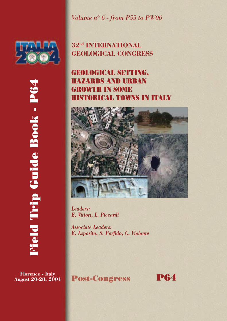
Front Cover:Rome and Naples, located in different geomorphological settings, share a multimillenary history marked by numerous natural catastrophes
GEOLOGICAL SETTING, HAZARDS AND URBAN GROWTH IN SOME HISTORICAL TOWNS IN ITALY P
64
3 - P64
Vo
lum
e n
° 6
- f
rom
P5
5 t
o P
W0
6
Leaders: E. Vittori, L. PiccardiAssociate Leaders: E. Esposito, S. Porfido, C. Violante
IntroductionThis multidisciplinary fi eld trip focuses on the infl uence (or lack of infl uence) of geology and geohazards on urban planning. Two of the most renowned towns and other less known but enchanting places in Italy are taken into consideration. Therefore, cultural interest is guaranteed. Italian towns display a great variety of geological-geomorphologic settings, and experience many extreme natural events such as earthquakes, volcanic eruptions, fl oods, or relatively slow phenomena such as subsidence or landsliding. Natural hazards have strongly affected the urban texture over time, occasionally determining the decay of towns and, more often, the kind of human intervention that takes place in search of appropriate technical solutions, as well as encouraging the fl ourishing of architectural and urban planning masterpieces, especially during the richest artistic periods. We believe this fi eld trip is a unique opportunity to discover how arts and nature have blended in world artistic heritage sites such as Roma and Naples.The fi eld trip area is situated in central-southern Italy, from Tuscany, through the volcanic coastal complexes of Latium, the “Campagna Romana” (Roman countryside), Roma itself, the Pontina Plain, to the Neapolitan coast, the volcanoes of the Campi Flegrei and Vesuvius, and fi nally Paestum. The complete itinerary is shown on the back cover.
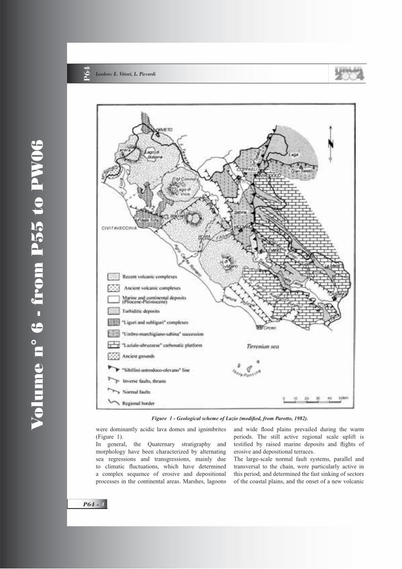
Regional Geological SettingThe present-day geological setting of the fi eld trip area is the result of a complex sequence of events, driven by the collision of the Euroasia and African plates, which has determined what is now peninsular Italy: an orogenic system mountain chain – foredeep – foreland, where the compressive wave has migrated in time and space from west to east. Extensional tectonic activity has followed the opening of the oceanic Tyrrhenian retro-arc basin. From Middle Lias to the end of the Mesozoic, an extensional tectonics has determined a segmentation of the Tethis Ocean sedimentary basin, leading to the individuation of vast deep-water sectors: pelagic basins, and large stable sectors: carbonate Bahamian-type platforms. During this phase, the main paleogeographic units of central and southern Italy were defi ned. In the area of this excursion, the bedrock is mainly
made of limestone from the Latium-Abruzzi and Campanian platforms. Pelagic sequences crop out in the Soratte Mt., the Circeo promontory, and on the island of Capri. Ligurian and Sub-Ligurian basin sequences crop out in the Tolfa Mts. and on Zannone Island (Back Cover).The convergence between the African and Eurasian plates has began in the Paleogene, thus structuring the Alpine-Himalayan mountain belt. Central Italy was affected by compressional phases from Late Oligocene-Early Miocene to Pleistocene. During this time interval, four main phases can be distinguished: the “sub-Ligurian phase”, represented by the Tolfa Mts. and part of Sabini and Aurunci Mts.; the “Tortonian” or “Tuscan” phase, which in the fi eld trip area is represented in the Sabini and Prenestini Mts. and the Circeo; the “Messinian” and “Pliocene” phases, which affect most of the central Apennines, such as the Gran Sasso and Maiella Mts. (Parotto and Praturlon, 1975) (Figure 1).From the Late Miocene (7-8 Myr), large-scale extensional movements dislocated and down threw localized sectors of the structures which originated during the compression, and a new oceanic basin began to form: the Tyrrhenian Sea (Malinverno and Ryan, 1986; Patacca et alii, 1992).On the western margin of the Apennine chain, a large network of parallel faults developed, northwest-southeast-striking, segmented by transverse structures, which defi ned a system of contiguous uplifted (horst), and downthrown (graben), sectors. They began to outline the main morphostructural units of the Tyrrhenian side of Central Italy (e.g., Bartole, 1984): the Tiber valley, Pontina, and Volturno-Neapolitan coastal plains, Ceriti, Soratte, Circeo and Zannone structural highs. Up to the Early Pleistocene, the structural lows remained submerged by the sea, receiving thick sequences of fi ne sediments from the rapidly emerging Apennines (Parotto and Praturlon, 1975). The progressive fi ll of the piedmont basins, testifi ed by regressive coarser (sandy) deposits, also connected to a glacial acme, brought about a progressive shift from marine to continental sedimentation moving away from the chain.Since the Late Pliocene, an intense volcanic activity began to affect Tuscany and northern Latium: Amiata, Monti Romani, Monti della Tolfa, Cimini, and the Pontine Islands (Tuscan and Latium Magmatic Provinces). In this phase, the volcanic products
Vo
lum
e n
° 6
- f
rom
P5
5 t
o P
W0
6
P64 -
Leaders: E. Vittori, L. Piccardi
P6
4
were dominantly acidic lava domes and ignimbrites (Figure 1).In general, the Quaternary stratigraphy and morphology have been characterized by alternating sea regressions and transgressions, mainly due to climatic fl uctuations, which have determined a complex sequence of erosive and depositional processes in the continental areas. Marshes, lagoons
and wide fl ood plains prevailed during the warm periods. The still active regional scale uplift is testifi ed by raised marine deposits and fl ights of erosive and depositional terraces.The large-scale normal fault systems, parallel and transversal to the chain, were particularly active in this period; and determined the fast sinking of sectors of the coastal plains, and the onset of a new volcanic
Figure 1 - Geological scheme of Lazio (modifi ed, from Parotto, 1982).

GEOLOGICAL SETTING, HAZARDS AND URBAN GROWTH IN SOME HISTORICAL TOWNS IN ITALY P
64
5 - P64
Vo
lum
e n
° 6
- f
rom
P5
5 t
o P
W0
6
phase during the Middle Pleistocene, with dominantly alkaline-potassic chemical composition. These volcanic manifestations, of crustal origin, had a highly explosive nature, originating huge volumes of pyroclastic deposits and hydro-magmatites. Their onset appears to propagate in time from northwest to southeast.In the Latium area, the volcanic districts from north to south are: Vulsini, Vicani (very near the older acidic Cimini), Sabatini, and the Alban Hills (detailed in the following chapters). Late hydrothermal activities, such as thermal, carbon dioxide and sulphur-rich springs, and travertine deposition, characterize the present day activity of these volcanic areas.The Roccamonfi na volcano, which emerged at the border between the Latium and the Campanian plain, was active from about 630 to 50 ka (De Rita and Giordano, 1996).
The activity of the Neapolitan Magmatic Province started more than 150 ka ago, with the building of the still active volcano of the island of Ischia. The activity of the Campi Flegrei and Somma-Vesuvius districts started in more recent times, at around 60 and 25 ka ago, respectively. (Figure 2)The growth of the Campi Flegrei has divided the Campanian plain into two morphological sub-units: the Volturno River plain to the northwest, the Sarno River basin to the southeast (Brancaccio et alii, 1995).The Holocene has been mainly characterized by large lacustrine-palustrine environments and over-fl ooded alluvial valleys, connected with the sea level rise after the Last Glacial (18 ka) regression. Along the coastline, such alluvial deposition has permitted the progradation of deltas since the sea level stabilization
which has taken place in the last few millennia. For example, the Tiber River delta has expanded by about 4 kilometers during the last two thousand years.
Field itinerary
DAY 1
Stops 1.1, 1.2, 1.3:Northern Latium volcanic districtsVolcanism in northern Latium originated a series of volcanic centers mainly characterized by sub-aerial explosive activity, with central and areal eruptions (Figure 1). The oldest ones are in the Tolfa and Cimino districts, Lower Pleistocene, which have a composition from intermediate to acid. The others, Middle-Upper Pleistocene, belong to an alkaline-potassic series. While the older and more acid volcanic districts produced mostly lava domes and ignimbrites, the younger ones were characterized by an explosive activity, ejecting mainly pyroclastic deposits and hydromagmatites.It is important to stress the role that the volcanic deposits have had on the growth of civilization. Etruscan and Latin people could benefi t from highly fertile soil, where forests and crops could equally well prosper; and from easy to quarry construction material, huge water reservoirs, and mineral and thermal springs.The Tolfa-Ceriti-Manziana district, together with the Cimini and Northern Ponziane islands, is characterized by chemism from acid to intermediate, and its activity is the oldest of the Latium Magmatic Province, comprised between 2,0 and 1,0 Ma. Its products are mainly ignimbrites and lava domes, whose composition range from rhyolitic to quartz-latitic (De Rita et alii, 1992).The Vulsino district is the northern-most volcano in Latium. An activity related to regional fault systems began about 0.8 Ma along its eastern sector through four main centers, shifting westwards about 0.6 Ma in the Paleovulsino centre, which has no more morphological evidence. The next important eruptive center, the so-called Bolsena-Orvieto center, produced thick pyroclastic deposits, among which is included the Orvieto ignimbrite. This eruptive event occurred about 370 ka ago, and caused the collapse of the caldera of Bolsena, on the northeastern border of the Bolsena lake. The Montefi ascone and the Latera volcanic centers, respectively southeast and west of the Bolsena lake, were active between 300 and 150 ka
Figure 2 - Geological scheme of the Campanian Plain (modifi ed from Cinque et alii, 1997).
Vo
lum
e n
° 6
- f
rom
P5
5 t
o P
W0
6
P64 -
Leaders: E. Vittori, L. Piccardi
P6
4
ago (Trigila, 1985). South-southeast of the Vulsino, is the Ciminovolcanic district. Its activity ranges between 1.35 and 0.8 Ma. Viscous and acid magmas penetrated into regional fractures, and originated several lava domes and violent ignimbritic eruptions, which determined the formation of the large Cimini volcanic plateau. More than 50 lava domes of rhyolitic to trachy-dacitic composition have been recognized, and many others probably lie below the ignimbritic cover. Activity of
this district ended with great emissions of latitic and olivine-latitic lavas (Sollevanti, 1983).The activity of the Vicano District started about 0.8 Ma ago with airfall pyroclastic deposits and lavas, building the Vico central stratovolcano. About 200 ka ago, the activity changed to explosive, producing pyroclastic fl ows, and eventually determining the collapse of the volcanic building, about 150 ka ago. A secondary volcano, the Venere Mt., was built in the center of the caldera, while its depression permitted the formation of a lacustrine environment. The activity ended 95 ka ago, after the last hydromagmatic phase (Sollevanti, 1983). The morphological evolution of the Sabatini
volcanic district was partially conditioned by the already present reliefs of the Tolfa Mts., Tolfa-Ceriti volcanic district, Soratte Mt. and Cornicolani Mt. Its activity began more than 600 ka ago, and took place in the eastern sector, near Soratte Mt., producing the Morlupo-Castelnuovo di Porto edifi ce. Its highly explosive nature was due to the interaction with the deep groundwater aquifers. At the same time, the Sacrofano volcano activity started, from 600 to 370 ka ago, which produced the largest amount of volcanic deposits. On the western side, the Bracciano center was activated. The main eruptive phase of this district was about 400 ka ago. The activity of the Sacrofano volcano ended with the collapse of the caldera;
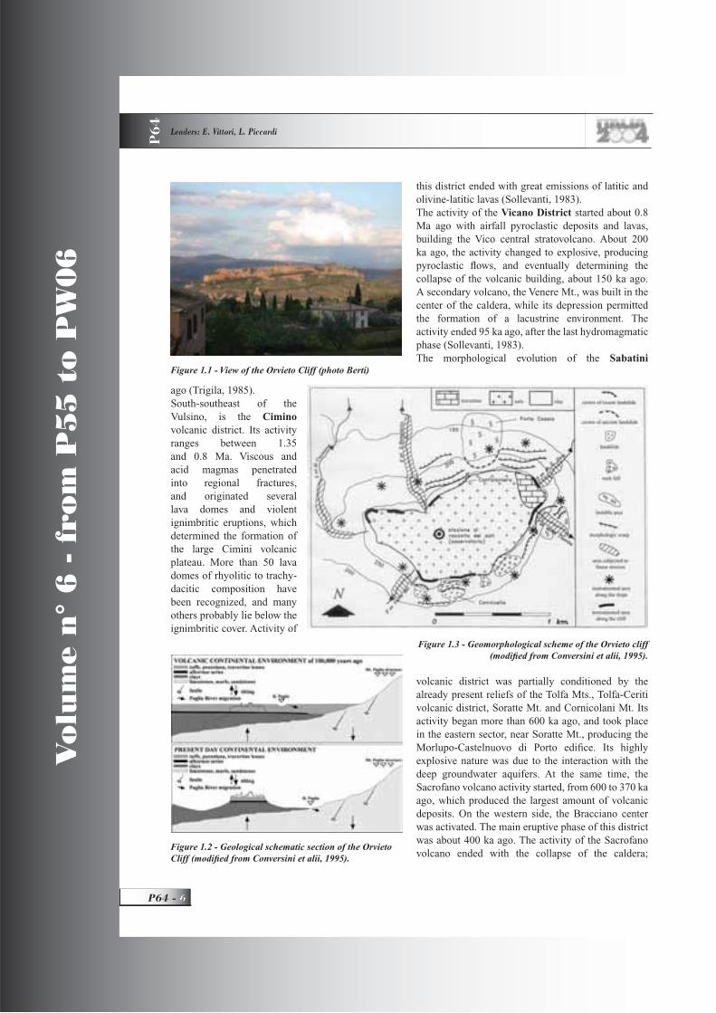
Figure 1.1 - View of the Orvieto Cliff (photo Berti)
Figure 1.2 - Geological schematic section of the Orvieto Cliff (modifi ed from Conversini et alii, 1995).
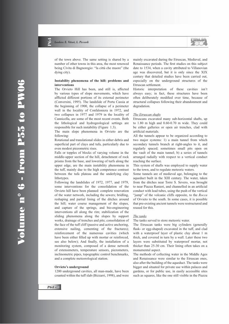
Figure 1.3 - Geomorphological scheme of the Orvieto cliff (modifi ed from Conversini et alii, 1995).

GEOLOGICAL SETTING, HAZARDS AND URBAN GROWTH IN SOME HISTORICAL TOWNS IN ITALY P
64
7 - P64
Vo
lum
e n
° 6
- f
rom
P5
5 t
o P
W0
6
hydromagmatic volcanic activity only remained in the Baccano centre, where activity ended about 40 ka ago (De Rita et alii, 1983).
Stop 1.1:Evolution of the Orvieto hill: historical urbanization andgeomorphic instability problemsThe hill of Orvieto (Fig 1.1) was inhabited already before Etruscan times, because of its favourable morphological position overlooking the Paglia River valley, the constant availability of water, and the existence of fertile soil nearby. The specifi c stratigraphic setting and the geomorphic features have infl uenced the land use, which over time has changed according to the needs of the moment. Thus, for centuries, in parallel with the development of the town on the top of the hill, various parts of the hill were excavated to form tunnels, wells, mines, and caves. From the Middle Ages onwards, some sectors of the volcanic slab have housed manufacturing and other economic activities, even spaces for bird breeding.The itinerary is organized with stops to examine the various geological and human aspects of the area, mainly through the many traces left by man in historical times.The top surface of the hill (Figure 1.3) has an irregular elliptical shape oriented ENE-WSW, with a maximum and minimum diameter of 1500-1600 and 700-800 m respectively, with fl anking cliffs 30 to 50 m high. The stratigraphic succession of the hill of Orvieto is shown in Figs. 1.2 and 1.3 (from Bizzarri, 1998; Conversini et alii, 1995).
At the base of the tuff hill, the contact between lithologies with different mechanic and
hydrogeological characteristics has produced an important aquifer, which is supported by Pliocene clays. This setting gives the whole cliff a tendency to instability phenomena, which several times in the past have created risks for buildings and some parts Figure 1.4 - Quarry (photo Berti).
Figure 1.5 - Columbaria (from Bizzarri, 1998).
Figure 1.6 - Millstones for olive pressing (photo Berti)
Figure 1.7 - S. Patrizio’s well (photo Berti)
Vo
lum
e n
° 6
- f
rom
P5
5 t
o P
W0
6
P64 -
Leaders: E. Vittori, L. Piccardi
P6
4
of the town above. The same setting is shared by a number of other towns in this area, the most renowed being Civita di Bagnoregio: “la città che muore” (the dying city).
Instability phenomena of the hill: problems and interventionsThe Orvieto Hill has been, and still is, affected by various types of slope movements, which have affl icted different portions of its external perimeter (Conversini, 1995). The landslide of Porta Cassia at the beginning of 1900, the collapse of a perimeter wall in the locality of Confaloniera in 1972, and two collapses in 1977 and 1979 in the locality of Cannicella, are some of the most recent events. Both the lithological and hydrogeological settings are responsible for such instability (Figure 1.3). The main slope phenomena in Orvieto are the following:Rotational and translational slides in either debris and superfi cial part of clays and tufa, particularly due to even modest piezometric rises.Falls or topples of blocks of varying volume in the middle-upper section of the hill, detachment of rock prisms from the base, and lowering of turfs along the upper edge, are the main instability phenomena in the tuff, mainly due to the high competence contrast between the tufa plateau and the underlying clay lithotypes.Following the landslides of 1972, 1977, and 1979, some interventions for the consolidation of the Orvieto hill have been planned: complete renovation of the water network, including the sewers; bridling, reshaping and partial lining of the ditches around the hill; water course management of the slopes, and capture of the springs, and bio-engineering interventions all along the rim; stabilization of the sliding phenomena along the slopes by support works, drainage of trenches and pits; consolidation of the face of the tuff cliff (passive and active anchoring, extensive nailing, cementing of the fractures); reinforcement of the numerous cavities (which have been either fi lled up with mortar or reinforced, see also below); And fi nally, the installation of a monitoring system, composed of a dense network of extensimeters, temperature sensors, piezometers, inclinometric pipes, topographic control benchmarks, and a complete meteorological station.
Orvieto’s underground 1200 underground cavities, all man-made, have been counted within the tuff slab (Bizzarri, 1998), and were
mainly excavated during the Etruscan, Medieval, and Renaissance periods. The fi rst studies on this subject date to 1534, when a cavity attributed to Villanovian age was discovered, but it is only since the XIX century that detailed studies have been carried out, especially on the underground structures of the Etruscan settlement. Historic interpretation of these cavities isn’t always easy; in fact, these structures have been often deliberately modifi ed over time, because of structural collapses following their abandonment and degradation.
The Etruscan shaftsEtruscans excavated many sub-horizontal shafts, up to 1.80 m high and 0.60-0.70 m wide. They could be either galleries or open air trenches, clad with artifi cial materials.All the tunnels appear to be organized according to two major systems: 1) a main tunnel from which secondary tunnels branch at right-angles to it, and regularly spaced; sometimes small pits open on the vault of the main tunnel; b) a series of tunnels arranged radially with respect to a vertical conduct reaching the surface.This system of shafts was employed to supply water to the town, and to regulate meteoric waters.Some tunnels are of medieval age, belonging to the aqueduct built in the XIII century. The water, taken from the ditches near Torre S. Severo, was brought to near Piazza Ranieri, and channelled in an artifi cial conduct with lead tubes, using the push of the vertical “jump” of the volcanic cliffs opposite, to the Roccaof Orvieto to the south. In some cases, it is possible that pre-existing ancient tunnels were restructured and reused for this.
The tanksThe tanks served to store meteoric water.The Etruscan tanks were big cylinders (generally fl ask- or egg-shaped) excavated in the tuff, and clad with a waterproof layer of plastic clay about 1 m thick, and covered in turn by a wall. Later these two layers were substituted by waterproof mortar, not thicker than 25-30 cm. Their lining often takes on a monumental aspect.The methods of collecting water in the Middle Ages and Renaissance were similar to the Etruscan ones, also after the building of the aqueduct. The tanks were bigger and situated for private use within palaces and gardens, or for public use, in easily accessible sites such as squares, like the one still visible in the Piazza

GEOLOGICAL SETTING, HAZARDS AND URBAN GROWTH IN SOME HISTORICAL TOWNS IN ITALY P
64
9 - P64
Vo
lum
e n
° 6
- f
rom
P5
5 t
o P
W0
6
del Popolo.
Pits and wellsThe Etruscan pits are vertical conduits, with many uses. They were used both to connect the surface with tanks and shafts, and as boreholes for the search of underground water. Most of the pits are not clad, and their section is usually squared (120 x 80 cm), although sometimes it can be round, and clad with rings of terracotta. They are usually provided with steps inside to go up and down.
Butti (dumps)The so-called “butti” (= thrown) of medieval and Renaissance age are generally small quarries for construction materials, which were successively used as garbage dumps, but they derived as well from ancient Etruscan cavities, abandoned tanks, etc. They are important reservoirs of medieval remains. Since the Middle Ages, people started to dig tuff and pozzolana from the underground of the Rocca,especially along the southern and eastern sectors of the plateau, areas that were less densely populated at the time. The quarries (Figure 1.4), which represent the most widespread group of artifi cial cavities, were mainly ruled individually with irregular developments, because during their excavation, people tended to follow the veins of incoherent material (tuffs and pozzolana). The quarries near the edge of the Rocca,of which even today many conduits still survive along the vertical cliff, were already recognized in the Middle Ages as a danger to the stability of the Roccaby the local administration. Much later, in 1897, a local decree forbade the quarrying activities, and ordered the walling up of all entrances to the caves.
Columbaria (dove-cotes)The columbaria (Figure 1.5), which were used to breed pigeons for food, are cavities characterized by many small niches of 30 x 30 cm, excavated in parallel lines along the walls, where doves made their nests. They are chiefl y present in the southern part of the Rocca, because of a more favorable exposure to the sun. Rooms had water reservoirs and openings to the outside to let the birds in and out. Since the Middle Ages, many underground cavities in direct communication with houses were also used for domestic activities, such as shelters for animals, deposits of farming tools, oil-presses, pottery shops with furnaces, wine and oil caves and so on. Some are still in use today.
Stop 1.1.1:St. Chiara Mill (cavity n. 536)The visit of the St. Chiara Mill shows, through a well-organized path, the archaeological evidence of different ages: the remains of an oil-press (Figure 1.6) with its millstones, the olive-press, an Etruscan pit and a quarry of pozzolana (Figure 1.4). Near it, cavity n. 6, called “of the dove-cote” (Figure 1.5) will allow us to visit one of the best preserved dove-cotes, and its water reservoirs, in the area.
Stop 1.1.2:The Well of St. Patrick The St. Patrick Well (Figure 1.7), is the most famous hydraulic work of Orvieto. It is situated on the eastern edge of the Rocca, and was conceived in 1537 by the architect Antonio da Sangallo il Giovane, on request of Pope Clemente VII. Clad with bricks to stabilize its walls, 54 m deep and 12 m wide, the well reaches the water table at the base of the tuffs. It consists of a double helicoidal ramp, which allowed people to descend with animals down one ramp and to climb up along the other. At the edge of the cliff nearby, there is a panoramic viewpoint, from where it is possible to observe the
Figure 1.8 - Orvieto cathedral

Vo
lum
e n
° 6
- f
rom
P5
5 t
o P
W0
6
P64 -
Leaders: E. Vittori, L. Piccardi
P6
4
recently stabilized S. Zeno creek, which was a major source of hazard in the past because of its rapid erosive action on the walls of the cliff, and some collapsed parts of the town walls.
Stop 1.1.3:The CathedralBetween 1263 and 1264, a Bohemian priest was on his way home from a pilgrimage to Roma. During a stop at the lakeside of Lake Bolsena (near the Umbrian town of Orvieto) to celebrate a holy mass, he was astonished to see a lot of blood dripping out of the communion wafers, which soaked the cloth of the altar and the rocks below. The three rocks stained with the blood of the miracle are kept and venerated within the altar of the Chapel of the Miracle in the Church of Santa Cristina at Bolsena. Pope Urban IV instead carried the cloth to Orvieto. At the time, the cathedral of Orvieto was an old ruined building, certainly unworthy of housing such important relics. It took the Popes sixty years to convince the townspeople to support the construction of a new building. The identity of the craftsman responsible is uncertain. The prevailing opinion ascribes the edifi ce to the monk Fra’ Bevignate da Perugia, whereas others suppose that he was merely executing plans drawn up much earlier by the great Florentine architect Arnolfo di Cambio. The construction of the Cathedral began in 1290, and lasted for about three centuries; therefore some parts of the building belong to quite different periods.Orvieto’s Cathedral is a masterpiece of late Italian Gothic architecture. The edifi ce is characterized by a typical bichromy, often used in central Italy, obtained by means of two different kinds of stones: travertine
and “basaltina”, a local name for a leucite-bearing rock of tephritic to phonolitic composition (Figure 1.8).In the monument, three different lithotypes of “basaltina” coexist: a grey “fi ne-grained” type, (FB), a darker “coarse-grained” one (CB), and a dark “very fi ne-grained” type (VFB), distinguished on the basis of the size of leucite phenocrysts (2 mm, 10 mm, and not visible, respectively). Three distinct lithotypes of travertine, stromatolitic, phytohermal, and detrital, were also distinguished on a textural basis. The external walls of the church ,and the circular windows in the apse, are made of alternating “basaltina” and travertine blocks, and the inner walls of the apse and chapels, of “basaltina” blocks only (Moroni and Poli, 2000).Comparisons between samples from the Cathedral, and similar samples from ancient quarries and zones of excavation, have revealed a provenance from a quite narrow area of the Vulsini volcanic District, between Orvieto and Bagnoregio, for all lithotypes. As well, comparisons among samples from different zones in the Cathedral, have proved that the source areas of “basaltina” and travertine did not change over time (Moroni and Poli, 2000).Not far from Orvieto’s Porta Maggiore, at the rise of the Tamburino (which still has a stretch of the original Roman paving), one can see the big rock of Sassotagliato, that according to the legend was miraculously split to let the Holy Altar Cloth from Bolsena pass.
Stop 1.2:Heading to ViterboLeaving Orvieto, the itinerary of the excursion reaches the top of the volcanic plateau, joining the ancient Via Francigena, the main road used by the pilgrims from the north to reach the Eternal City and the holy tomb of St. Peter in Roma.
Stop 1.2.1:“Pietre lanciate”On the road along the lake connecting Bolsena to Montefi ascone, there is an interesting outcrop of alkaline-potassic lava of the Vulsino district (Figure 1.9), displaying a beautiful pattern of prismatic columnar joints.
Stop 1.2.2:Montefi ascone: panorama on the Bolsena caldera lakeThe “Est! Est!! Est!!!” of Montefi ascone is one of the
Figure 1.9 - Prismatic columnar jointing in the Vulsino district.

GEOLOGICAL SETTING, HAZARDS AND URBAN GROWTH IN SOME HISTORICAL TOWNS IN ITALY P
64
11 - P64
Vo
lum
e n
° 6
- f
rom
P5
5 t
o P
W0
6
few wines of ancient origin whose date of creation is known. The wine produced from grapes grown along the slopes rising from the shores of Lake Bolsena to the town of Montefi ascone was locally appreciated and praised by travelers. But there was no real trade in wine. However, according to a legend, the Holy Roman Emperor Henry V marched on Roma at the head of a powerful army, to settle a controversy with Pope Pascal II. Bishop Johan Deuc (called Defuk by local people), took part in the expedition. He instructed his cupbearer Martin always to travel ahead of the expedition by one day, in order to select the inns where good wines were served, writing Est! (“Here it is!”) on the door as an indication for his master. When he reached Montefi ascone, Martin found that the usual notice “Est!” chalked next to the door of the selected inn was wholly inadequate, because the wine in the town was truly excellent.Since he had not arranged any other signal with his master, he decided to communicate his appreciation of that wine by writing three times “Est!” adding an additional exclamation mark each time.
The still enduring reputation of the wine was made on the day Bishop Defuk tasted the “Est! Est!! Est!!!” of Montefi ascone. Enraptured by the wine’s smoothness, the prelate remained in town for three days. After completing his imperial mission, he returned to Montefi ascone and legend states he stayed there for the rest of his life until he had drunk himself to death (1113). He was buried in the town’s church of San Flaviano. For several centuries the practice lasted to pour a barrel of wine over his tombstone every year.
Stop 1.3:The Thermal springs of Bullicame near ViterboThe Etruscan name of Viterbo, Surina, was connected with the presence of the nearby thermal springs of Bullicame (Figure 1.10), interpreted as a manifestation of the infernal god, Suri. Over the centuries, many Roman and medieval legends have been related to these peculiar springs, some of which emanate also poisonous gases. Many of these folk tales indicate the springs as dwellings of devils.One of these stories cites the springs in relation to the monster Volta, a horrible creature quoted since Roman times, believed to have inhabited inside the Bolsena volcano, and who threw up lavas and rocks, causing enormous destruction when he woke up. The story relates that one day the cone of the Bolsena volcano broke because of an earthquake and because
of the immense power of the monster. The cone walls fell into the fl aming chasm, which in time fi lled with water. The devils inhabiting the magma were thus forced to go away, and many of them reached Viterbo, taking refuge in the sulphurous springs of the Bullicame. Volta was also known in the Etruscan tradition. Pliny (2, 54) says that “it is ancient fame in Etruria that while the people were scared and
fl eeing because of the monster, that they called Volta, who was advancing toward the town of Volsinii after having devastated the country, he was sent away by a lightning evoked by their king Porsenna”. A parallel story tells that the people of Latera saw an enormous snake coming out from the mount near Mezzano. It ran downhill, spurting fi re and burning lava from its mouth and eyes, and killing whoever crossed the valley. At the end, a Lucumone (Etruscan priest) was able to send away the monster with spells and exorcisms (Nazareno Poscia, Il Castello di Latera, ed.
Figure 1.10 - Thermal springs of Bullicame. Aerial view of the area. (from TerraItaly 2000)
Figure 1.11 - Sutri. The Mithreum
Vo
lum
e n
° 6
- f
rom
P5
5 t
o P
W0
6
P64 -
Leaders: E. Vittori, L. Piccardi
P6
4
Ceccarelli, 1973).A different, more recent legend tells that on May 28, 1320, a terrible rumble and a sort of earthquake were felt in Viterbo; in the meanwhile at Bullicame the people saw an immense blaze, towering and blinding, rising up to the sky. Within the fl ames, people recognized the Madonna defeating some devils who spinned around her. After a while everything disappeared. This event was remembered with a yearly celebration at the Sanctuary known to be “of Holy Mary Liberator” or “of the Trinity”. Other ancient traditions set a connection between the springs of Bullicame and the nearby Lake Vico through the myth of Hercules. According to these legends, Heracles wanted to test the strength of the local people. Therefore, he stuck his club inside the ground, challenging the onlookers to extract it. Nobody succeeded, so that in the end, he had to do it. From the chasm thus opened spurted forth a water spring which formed Lake Vico. He then carried out the same test with his spear, thus creating the springs of Bullicame. The waters of Bullicame are also quoted by Dante as analogous to the infernal rivers (Inf., 14, 79).
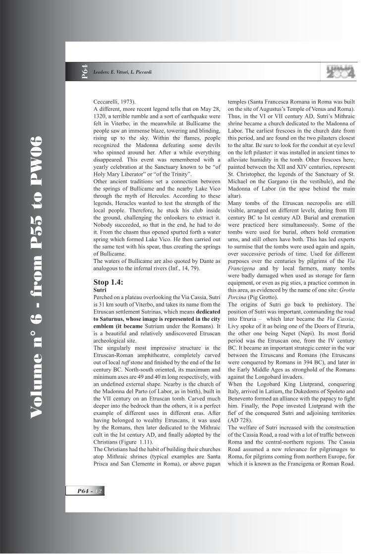
Stop 1.4:SutriPerched on a plateau overlooking the Via Cassia, Sutri is 31 km south of Viterbo, and takes its name from the Etruscan settlement Sutrinas, which means dedicated to Saturnus, whose image is represented in the city emblem (it became Sutrium under the Romans). It is a beautiful and relatively undiscovered Etruscan archeological site.The singularly most impressive structure is the Etruscan-Roman amphitheatre, completely carved out of local tuff stone and fi nished by the end of the Ist century BC. North-south oriented, its maximum and minimum axes are 49 and 40 m long respectively, with an undefi ned external shape. Nearby is the church of the Madonna del Parto (of Labor, as in birth), built in the VII century on an Etruscan tomb. Carved much deeper into the bedrock than the others, it is a perfect example of different uses in different eras. After having belonged to wealthy Etruscans, it was used by the Romans, then later dedicated to the Mithraic cult in the Ist century AD, and fi nally adopted by the Christians (Figure 1.11).The Christians had the habit of building their churches atop Mithraic shrines (typical examples are Santa Prisca and San Clemente in Roma), or above pagan
temples (Santa Francesca Romana in Roma was built on the site of Augustus’s Temple of Venus and Roma). Thus, in the VI or VII century AD, Sutri’s Mithraic shrine became a church dedicated to the Madonna of Labor. The earliest frescoes in the church date from this period, and are found on the two pilasters closest to the altar. Be sure to look for the conduit at eye level on the left pilaster: it was installed in ancient times to alleviate humidity in the tomb. Other frescoes here, painted between the XII and XIV centuries, represent St. Christopher, the legends of the Sanctuary of St. Michael on the Gargano (in the vestibule), and the Madonna of Labor (in the apse behind the main altar).Many tombs of the Etruscan necropolis are still visible, arranged on different levels, dating from III century BC to Ist century AD. Burial and cremation were practiced here simultaneously. Some of the tombs were used for burial, others hold cremation urns, and still others have both. This has led experts to surmise that the tombs were used again and again, over successive periods of time. Used for different purposes over the centuries by pilgrims of the Via Francigena and by local farmers, many tombs were badly damaged when used as storage for farm equipment, or even as pig sties, a practice common in this area, as evidenced by the name of one site: Grotta Porcina (Pig Grotto). The origins of Sutri go back to prehistory. The position of Sutri was important, commanding the road into Etruria – which later became the Via Cassia;Livy spoke of it as being one of the Doors of Etruria, the other one being Nepet (Nepi). Its most fl orid period was the Etruscan one, from the IV century BC. It became an important strategic center in the war between the Etruscans and Romans (the Etruscans were conquered by Romans in 394 BC), and later in the Early Middle Ages as stronghold of the Romans against the Longobard invaders.When the Logobard King Liutprand, conquering Italy, arrived in Latium, the Dukedoms of Spoleto and Benevento formed an alliance with the papacy to fi ght him. Finally, the Pope invested Liutprand with the fi ef of the conquered Sutri and adjoining territories (AD 728).The welfare of Sutri increased with the construction of the Cassia Road, a road with a lot of traffi c between Roma and the central-northern regions. The Cassia Road assumed a new relevance for pilgrimages to Roma, for pilgrims coming from northern Europe, for which it is known as the Francigena or Roman Road.

GEOLOGICAL SETTING, HAZARDS AND URBAN GROWTH IN SOME HISTORICAL TOWNS IN ITALY P
64
13 - P64
Vo
lum
e n
° 6
- f
rom
P5
5 t
o P
W0
6
Sutri lost its importance when, between the X and XI centuries, the variant of the Cassia called Via Cimina, which passed west of it, making a shorter way to Viterbo, became more important, absorbing most of the traffi c.Legends of the Middle Ages indicate here at Sutri the cave where Berta, abandoned by her brother Charlemagne, gave birth to the famous Paladin (knight errant), Roland.
Dinner in Trastevere with night walk in roma
DAY 2
Stops 2.1 - 2.6:Roma and its surroundingDuring this excursion in the Roman area, the fi rst day (August 30), will be spent visiting the archaeological and historical sites in the Tiber river delta (the Roman port) and observing coastal protection works. Later on, a brief stop will illustrate the combined effect of natural subsidence and the lack of geological attention on some recent buildings; a visit to a catacomb and a
short walk along the Appian Way (Regina viarum, as already ancient Romans called it) with a nice view of the Alban volcanic apparatus, will complete the day. The next day (August 31), will be devoted to a walking tour of Roma’s center, from S. Peter’s to the Colosseum (see ahead, Figure 3.1). Many rest places and fountains will provide refreshment to hikers. The most interesting monuments and archaeological sites will be touched, also pointing out their relationships with the local geology and natural hazards (fl oods, earthquakes, soil instabilities). Being too numerous for a complete explanation here, in this document only a few of them are described in some detail, many others will be illustrated directly in the “fi eld”.
Geological framework The Campagna Romana is a wide, nearly fl at landscape extending from the southwestern fl ank of the Central Apennine chain, to the Tyrrhenian Sea coast, which is bounded by volcanic apparatuses and structural highs (Figs. 2.1 and 2.2). Its origin is linked to the Neogenic extensional tectonic evolution of the Tyrrhenian Sea - Apennines boundary. The neo-autochthon marine
Figure 2.1 - Digital Terrain Model of the surroundings of Roma. The Sabatini volcanic fi eld is on the upper left. The Alban Hills are in the lower right. To the right, there is the western fl ank of Apennines. The box defi nes the area of
the city in Figure 2.3.
Vo
lum
e n
° 6
- f
rom
P5
5 t
o P
W0
6
P64 -
Leaders: E. Vittori, L. Piccardi
P6
4
sedimentation has fi lled this subsiding area since the Late Messinian, but during the Plio – Quaternary, the interplay between climatic changes, which have produced alternating depositional and erosive phases, and extensional tectonics and related volcanism, have caused a complex suite of geological features, in terms of marine to continental units, volcanic fi elds, tectonic structures, and erosive surfaces (Giordano etalii, 2002).The stratigraphic and structural background of this region, and its most recent climatically-driven paleogeographic evolution as shaped by the Tiber River and its tributaries, had a great infl uence on the ancient history of Roma.The deep structure of the Campagna Romana (Roman countryside) is made up of Meso – Cenozoic units, with basin-to-shelf carbonate facies of the Miocene northeast-verging Apenninic thrust and fold belt, later (Neogene) shaped by extensional tectonics following the opening of the Tyrrhenian Sea in a graben-like structure, whose roof is now from a few hundred (structural highs) to more than one thousand meters deep (Funiciello and Parotto, 2001). The age of the fi rst neo-autochthon marine units over the carbonate basement, shifts from southwest to northeast between Messinian (Tolfa – Ceriti basin) and Lower Pleistocene, apparently suggesting a spatial – temporal migration toward the northeast of the axis of the extensional tectonic activity (Patacca et alii, 1992; Faccenna et alii, 1995). The Pliocenic marine transgression during the same cycle has fi lled the basin, starting from Cerveteri and Pomezia (Globorotalia margaritae Biozone), rising to Roma, Monte Vaticano Unit (from G. puncticulata to G. infl ata), to the western fl ank of the Cornicolani Mts (G. aemiliana) (Marra and Rosa, 1995; Marra et alii, 1995), and the carbonate structural high of Mount Soratte, which were islands in the Pliocene and Early Pleistocene Tyrrhenian Sea.(Figure 2.1)
Pliocene marine clays (Argille Azzurre Fm.) crop out in Roma in the Monte Mario, Vaticano, and Gianicolo morphological highs, while their thickness reaches 900 m under the Circus Maximus (Marra and Rosa, 1995). The Pliocene marine cycle is interrupted by the Acqua Traversa erosive phase.The second and third marine transgression cycles, dating to the Lower Pleistocene, are mainly made up of sandy units, which indicate a much shallower marine environment, due to uplift of the basement and perhaps climatic changes. The second marine cycle
is represented by the Monte Mario Unit (Buliminaetnea and Hyalinea baltica) and is interrupted by the epi – continental Monte Ciocci Unit, which is the main (among many) events of eustatic sea level fl uctuations during the Early Pleistocene. The third and last transgression cycle is the Monte delle Piche Unit (H. baltica), which covered the upper part of Lower Pleistocene (Marra et alii, 1995; Marra and Rosa, 1995). These marine deposits crop out in Roma in the hills west of the River Tiber. At the beginning of the Middle Pleistocene, the paleogeographic features of the Campagna Romana deeply changed. Due to the general cooling and the concurrent basement uplift, the sea regression induced the erosion of the Plio-Pleistocene bedrock through the downcut of the drainage network, whose main stream is the Paleo-Tiber. The mainly continental deposits related to this activity are the Ponte Galeria (Paleotevere 1) Unit, outcropping southwest of the centre of Roma, and the Paleotevere 2 Unit, in
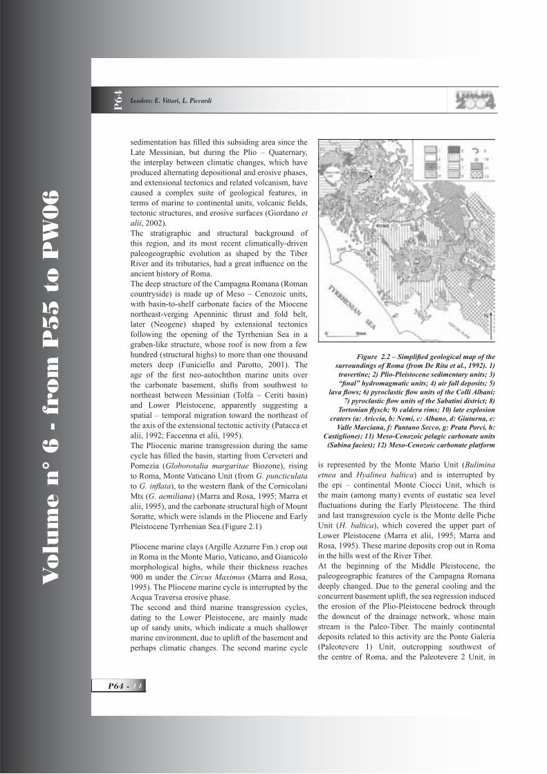
Figure 2.2 – Simplifi ed geological map of the surroundings of Roma (from De Rita et al., 1992). 1) travertine; 2) Plio-Pleistocene sedimentary units; 3) “fi nal” hydromagmatic units; 4) air fall deposits; 5)
lava fl ows; 6) pyroclastic fl ow units of the Colli Albani; 7) pyroclastic fl ow units of the Sabatini district; 8)
Tortonian fl ysch; 9) caldera rims; 10) late explosion craters (a: Ariccia, b: Nemi, c: Albano, d: Giuturna, e:
Valle Marciana, f: Pantano Secco, g: Prata Porci, h: Castiglione); 11) Meso-Cenozoic pelagic carbonate units
(Sabina facies); 12) Meso-Cenozoic carbonate platform

GEOLOGICAL SETTING, HAZARDS AND URBAN GROWTH IN SOME HISTORICAL TOWNS IN ITALY P
64
15 - P64
Vo
lum
e n
° 6
- f
rom
P5
5 t
o P
W0
6
the centre of Roma, connected to the migration of the stream axis, initially due to the tectonic strain propagating from the Plio-Pleistocene bedrock. The Ponte Galeria Unit deposits range from fl uvial to delta facies, and contains a beach layer with Arctica islandica. The Paleotevere 2 Unit is divided into 2 sub-units, a and b, with deposits ranging from fl uvial to palustrine-lacustrine environments, and frequent peat beds. Unit b contains in its upper layers some volcanic minerals, mixed together with fl uvial and palustrine deposits (Faccenna et alii, 1995; Marra and Rosa, 1995; Marra et alii, 1995).The activity of the Tosco-laziale Volcanic Province starts on the southwestern fl ank of the Apennine chain in the Late Pliocene, producing volcanic deposits ranging from acid (Tolfa-Ceriti-Manziana, Cimino, and Ponziane Islands Districts), to potassic (Vulsino, Sabatino, Vicano, and Albano Districts). After the Matuyama-Brunhes magnetic reversal, about 0.6 My, huge volumes of alkalin-potassic volcanic products have been emitted by two volcanic districts (Figure 2.2), located northwest (Sabatini Mts) and southeast (Alban Hills) of Roma, with a total volume ranging between 500 and 1,000 km3
(Funiciello and Parotto, 2001). The mainly explosive character of such activity has determined the type of eruptions, during several paroxysmal events, of pyroclastic fl ows, surges, and airfall deposits.The Sabatini Mts Volcanic District is made up of several independent volcanic centers (Morlupo, Sacrofano, Baccano, and Bracciano), which have determined the construction of caldera depressions and craters. The activity of this district is closely connected with such centers (Morlupo, Sacrofano, and Baccano Activities, and the First and Second Collapse of Bracciano basin) (Marra et alii, 1998).The activity of the Alban Hills Volcanic District can be divided into three different Eruption Phases: Tuscolano-Artemisio, Faete and Final Hydromagmatic (Marra et alii, 1998).With regards to the Alban District, the most ancient deposits are represented by the 1st Tuscolano-Artemisio pyroclastic fl ow (Tufi pisolitici – 561 ka, and Tufo del Palatino – 528 ka), which can be seen in several places from the northeast to the southeast of the city, being probably one of the main causes for the migration of the paleo-Tiber to its present-day position. The next unit is the Lave dell’Acquacetosa, some lava fl ows southeast of Roma, whose outcrops are only present now close to the Fosso dell’Acquacetosa. The 2nd Tuscolano-Artemisio pyroclastic fl ow (Pozzolane Rosse – 457
ka) and the Lave di Vallerano – 460 ka) is followed by the Lave di Vallerano, lava fl ows that reached the southern part of Roma (Via Laurentina). Later on, the 3rd Tuscolano-Artemisio pyroclastic fl ow (Pozzolane nere), related to a large eruption, is present in the Tre Fontane area (E.U.R. district) (Pozzolane nere – 407ka), and in the Rupe Tarpea - Capitol Hill and close to the Teatro di Marcello (Tufo lionato - 355 ka). The 4th Tuscolano-Artemisio pyroclastic fl ow ((Tufo di Villa Senni – about 365 ka) closes the Tuscolano Artemisio Phase with the collapse of the caldera. The Faete Phase originates from the construction of a little strato-vulcano inside the caldera. Its products are no more than 2 km3 (200 km3 in the T.A. Phase) and start with the leucitic Lava di Capo di Bove - 277 ka, 12 km long down to the Tomba di Cecilia Metella on the ancient Via Appia. The last Hydromagmatic Phase involves some eccentric craters in the northwest sector of the volcanic edifi ce, from Ariccia to Nemi and Albano: Lapis Albanus – 37 ka, close to the Carcere Mamertino in Roma (Marra and Rosa, 1995; Karner and Renne, 1998; Karner et alii, 2001).The most ancient Sabatini deposits in Roma are the pyroclastic fl ows Peperino della Via Flaminia and Tufo Giallo della Via Tiberina, 548 ka (Morlupo Activity and early Sacrofano Activity, respectively), which are present in the underground of the center of Roma (drilling of the Galleria Principe Amedeo). Resting above the Tufi stratifi cati varicolori di Sacrofano is the Tufo Rosso a scorie nere (449 ka), a pyroclastic fl ow, which represents the fi rst big explosive eruption of the Bracciano sector and the fi rst collapse of its caldera. In Roma it crops out close to the Via Olimpica and in the Prima Porta cemetery area. The next Sabatini units, poorly represented in Roma, are: “Complesso dei Tufi stratifi cati varicolori di La Storta”, “Tufo di Bracciano”, and “Tufo di Vigna di Valle” from the Bracciano Sector, ‘Tufo Giallo di Sacrofano”, 285 ka, which closes the activity of this sector with the collapse of the caldera, pyroclastic fl ows and hydromagmatic products from the Baccano center. The most recent known eruption of this district is about 250,000 years old (Marra and Rosa, 1995; Karner and Renne, 1998; Karner et alii, 2001).Some continental deposits are interlayered with the volcanic units, and testify to the activity of the Tiber and its tributaries and the formation of many short-lived lacustrine and palustrine environments, in a landscape continuously changing during the Middle-Late Pleistocene.The Unità di Valle Giulia overlaps the earliest Sabatini volcanics, with diatomitic and travertinous
Vo
lum
e n
° 6
- f
rom
P5
5 t
o P
W0
6
P64 -
Leaders: E. Vittori, L. Piccardi
P6
4
deposits. The San Paolo Unit contains reshaped levels of Pozzolane Rosse and “Tufi stratifi cati varicolori di Sacrofano” and “La Storta”. The Aurelia and the Vitinia Units are mainly made up of fl uvial and lacustrine deposits with volcanic elements. All these continental units are temporally separated by erosive phases, which are related to the glacial events. The last one, before the Holocene, is related to the Wurm III regression. In this phase, the Pliocene bedrock was eroded down to about 50 m below the sea level in Roma. The consequent uplifting of the sea level permits the sedimentation of the Holocene alluvial
deposits (Marra and Rosa, 1995).
Notes on the seismicity of RomaNumerous earthquakes have hit Roma during historical times, some originating from the Apennines, and others from more local sources (especially the Alban Hills) (Figure 2.4). The maximum macroseismic intensities are around the VIII degree MCS (Mercalli-Cancani-Sieberg scale), according to Molin et alii (1995), which represents the most recent and detailed account on the seismicity of Roma so far available. Other important sources of information are the various Italian seismic catalogues, and macroseismic databases (Boschi et alii, 1997; CPTI, 1999; Camassi and Stucchi, 1997; Monachesi and Stucchi, 2000), accessible through the following web site (www.ingrm.it/banchedati/banche.html) of the Italian Seismological and Volcanological Institute
(INGV). Table 2.1 is based on such summaries, with integrations from other sources which report events not taken into account there.It is noteworthy that various authors report different lists of events for the Roman to Medieval period, primarily because of lack of really dependable and detailed sources, so a fully reliable seismic history is still to come, (if ever possible), for Roma. Ancient sources quote many damaging seismic events in Roma, starting from 83 BC. However, generally there are no details about the damage pattern, and for most of them, there is no certainty about their epicentral location, or even if they had been truly felt in Roma. Being the capital city, many events were reported as having happened in Roma, even if they actually occurred elsewhere.The event that took place in 847 is cited in chronicles, and documented by archaeologists in several
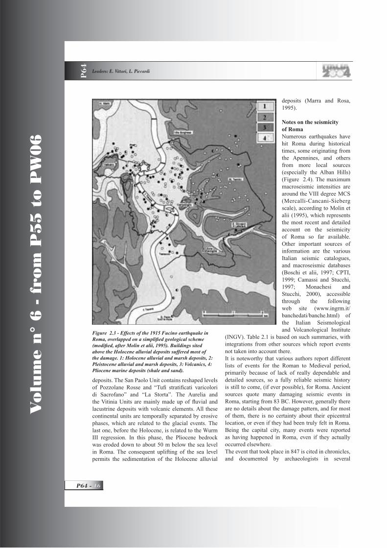
Figure 2.3 - Effects of the 1915 Fucino earthquake in Roma, overlapped on a simplifi ed geological scheme (modifi ed, after Molin et alii, 1995). Buildings sited above the Holocene alluvial deposits suffered most of the damage. 1: Holocene alluvial and marsh deposits, 2: Pleistocene alluvial and marsh deposits, 3: Volcanics, 4: Pliocene marine deposits (shale and sand).

GEOLOGICAL SETTING, HAZARDS AND URBAN GROWTH IN SOME HISTORICAL TOWNS IN ITALY P
64
17 - P64
Vo
lum
e n
° 6
- f
rom
P5
5 t
o P
W0
6
DateEarthquake
sourceEpicentralintensity
Known effects in RomaIntensityin RomaMin-max
Main sourcesAncient source
83 BCCentral
Apennines? Collapse of some temples VII - VIII
CFTIAppiano
72 BCCentral
Apennines? Damage and collapse of several houses VII - VIII
CFTIFlegonte
15Central
Apennines?
Collapse of parts of theServiane city walls
VII-VIIICFTI
Cassio Dione
51Central
Apennines? Collapse of houses VIII ?
CFTICassio Dione
442 or 443
Campania ?Collapse of parts of S. Paul’s fuori le mura, and
collapse of several houses VIIICPTI
Paolo Diacono
484 Campania ? Damage to Colosseum, partial collapseVII-VIII CPTI
29.4.801Central
Apennines(Umbria ?)
IX *“in some
places towns and mountains
fell down”
Collapse of S. Petronilla with parallel fallen columns, collapse of the roof of S. Paul’s fuori
le mura
VII-VIII
VIII *
CFTI
Eginardo
847 Roma ? ?
Damages in the Capitolium and Aventinus hills (collapse of S. Maria Antiqua), damage to
Colosseum ? and S. Maria in Trastevere (collapseof apse)
V-VI
VIII *
CFTI
Sovrintendenza Roma
1.6.1231 Cassino VIII Damage to Colosseum ? V CFTI
9.9.1349Venafro, Central
ApenninesX
Collapse of towers, damage to S. Paul’s, S. Peter’s and S. John’s in Laterano, collapse of part
(?) of ColosseumVII – VIII
DOM, CFTI
Villani, Petrarca,
14.1.1703Norcia,Central
ApenninesXI Ringing of bells, cracks in big buildings VI
INGV (Storia dei Papi, 1962)
DOM - CFTI
2.2.1703L’Aquila, Central
ApenninesX
Collapse of 3 arches of Colosseum, damage to S. Lorenzo, cracks in S. Peter’s in Vaticano and in the Quirinale building, no collapse of houses,
effects on underground waters (varying water table in wells, and muddy waters)
VII
INGVCFTI
Valesio
26.8.1806 Alban Hills VIII Modest damage to some churches V - VI DOM - CFTI
22.3.1812 Roma area VI - VIIModest damage and minor collapses in some
churches, walls and buildings in several areas of the city, particularly close to the Tiber
VI - VII DOM - CFTI
19.7.1899 Alban Hills VII Modest damage to buildings (cracks in walls) VI DOM - CFTI
13.1.1915Fucino basin,
CentralApennines
X - XINo collapses of buildings, collapse of 5 meters of the upper wall of the Claudio aqueduct, damage
to some churches and ancient ruinsVI - VII DOM - CFTI
* Intensity suggested here
Table 2.1 - Historic earthquakes with felt intensity in Roma above VI MCS or with reported damage (based on Molin et alii, 1995; Boschi et alii, 1997; Monachesi and Stucchi, 2000)
(principal modern and ancient sources specifi ed in last column)
Vo
lum
e n
° 6
- f
rom
P5
5 t
o P
W0
6
P64 -
Leaders: E. Vittori, L. Piccardi
P6
4
damaged monuments, including various churches and the Colosseum. The 1231 event (IX MCS according to Postpischl, 1985; VIII max in Boschi et alii, 1997), occurred in the Cassino area between Roma and Naples, and was certainly felt in Roma, but the information about damage needs to be better checked. After the Roman-Medieval period, it is broadly accepted that the most damaging events occurred in 1349 and 1703, when the local intensities reached the VII-VIII and VII degree MCS respectively.Also, the 1915 Fucino earthquake, in the Central Apennines, produced widespread damage in Roma, which was located about 80 km away from the epicenter, with local intensity close to VII MCS.So, several earthquakes produced effects inside Roma above degree VII, i.e. localized partial collapses, and damage of brick and stone masonry. Where documented, damage have affected primarily the lower areas (Molin et alii, 1995), where buildings were founded above Holocene or Upper Pleistocene alluvial deposits. Indirect evidence of seismic shaking and ground acceleration can be gathered from specifi c
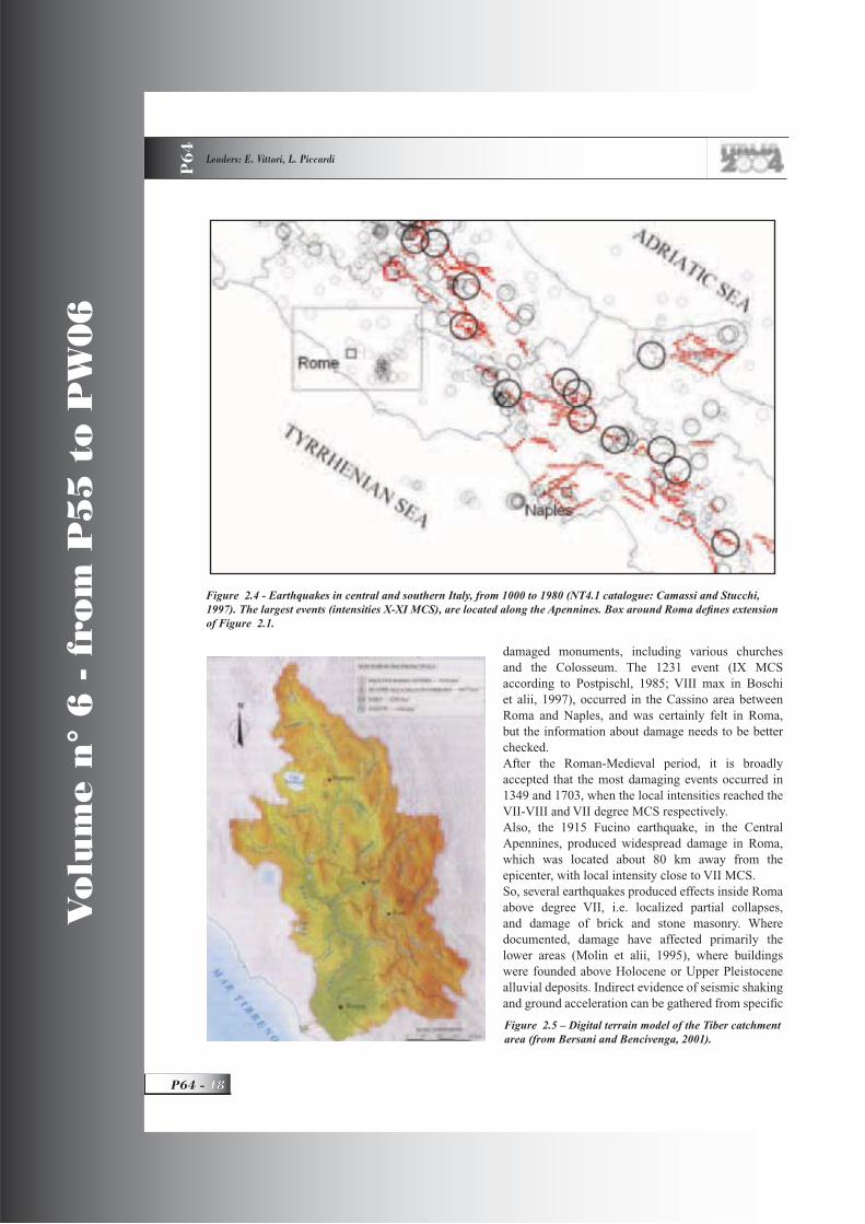
Figure 2.4 - Earthquakes in central and southern Italy, from 1000 to 1980 (NT4.1 catalogue: Camassi and Stucchi, 1997). The largest events (intensities X-XI MCS), are located along the Apennines. Box around Roma defi nes extension of Figure 2.1.
Figure 2.5 – Digital terrain model of the Tiber catchment area (from Bersani and Bencivenga, 2001).

GEOLOGICAL SETTING, HAZARDS AND URBAN GROWTH IN SOME HISTORICAL TOWNS IN ITALY P
64
19 - P64
Vo
lum
e n
° 6
- f
rom
P5
5 t
o P
W0
6
features displayed by ancient monuments, e.g. the Trajan’s and Marcus Aurelius’s columns (see ahead), and the collapse of temples with regularly-aligned, fallen columns (church of S. Petronilla in 801). Although poorly documented, the seismic event in 801 could have been the strongest earthquake felt in Roma during historic times.The earthquake of 1812 (VI – VII MCS) is of special interest, being probably the strongest, with an epicenter located very close to the city, which suffered modest damage, but evenly distributed over the urban area. In close agreement with the distribution of effects of the 1915 Fucino earthquake (see Figure 2.3), the most serious damage in 1812 were seen inside the Holocene alluvial plain near the Tiber.Due to the massive expansion of the city during the
last 130 years above the Holocene alluvial deposits of the Tiber and its tributaries, a major apprehension is now shared by most scientists about the actual seismic hazard in such areas, where poor soil properties, prone to seismic amplifi cation at low frequencies, are coupled with building structural designs lacking any kind of seismic reinforcement. As a matter of fact, examples from many recent earthquakes have shown the signifi cant destructive potential of even moderate seismic events in soft sediments and artifi cial fi ll, giving rise to some concern for the many hundreds of thousands of citizens living and working above them.
Tiber and its fl oods
IntroductionThe Tiber’s course runs for 403 km from its springs at the foot of Monte Fumaiolo, in the Apennines, to Roma and the Tyrrhenian Sea (Figure 2.5), across three Italian regions (Tuscany, Umbria, and Latium). There are two islands along the river: a natural one inside Roma (Tiberina islet), and an artifi cial one (Isola Sacra), at its mouth. It is third among the Italian rivers for length and fl ow rate, but certainly fi rst for notoriety: the blonde Tiber is intimately tied to the history of Roma. Its once rich sediment load, nourishing an ample delta bordered by wide beaches, was the cause of its blonde colour, (actually more akin to greenish). It still shows a yellowish colour, far from attractive, only when it is in full fl ood.
Figure 2.6 - Many marble plates on the façade of Santa Maria sopra Minerva, remembering the 1422, 1495, 1530, 1557, 1598, and 1870 fl oods (photo Vittori).
Figure 2.7 - Marble plate of the 1870 and 1495 fl oods, detail of Figure 2.6 (photo Vittori).
Figure 2.8 - Marble plate of the 1557 fl ood, detail of Figure 2.6 (photo Vittori).

Vo
lum
e n
° 6
- f
rom
P5
5 t
o P
W0
6
P64 -
Leaders: E. Vittori, L. Piccardi
P6
4
In the catchment area, the rain peak is in fall, and the minimum in July (Frosini, 1977). The mean fl ow rate is about 230 m3/s, with the maximum in February, and the minimum in August. Strong monthly, annual, and decadal variabilities affect the fl ow rate (Bencivenga et alii, 1995).As every important city is crossed by a river, the social and economic fl ourishing periods in the history of Roma correspond to the periods of best maintenance and exploitation of the river. In old Roman times, the river was a defensive barrier, and an essential source of water and fi sh for the poor. Downstream of the ancient town, it received the sewage water of the whole city through the Cloaca Maxima (main sewer), still working in recent times, although the city has expanded considerably downstream.
For many centuries, Roma has suffered the frequent and violent fl oods of its river, which have provoked huge damage, especially to economic activities, and the loss of lives, with longlasting negative effects on the life of the community.In the last two centuries, in particular soon after Roma had become the capital of the newly-formed Italian reign in 1870, extensive and expensive works were carried out to free the town from the severe threat of its river. The heavy fl ood of 1870, but even more, the ambitious plans of urban development in the low areas near the Tiber, prompted such works, which certainly
achieved their primary objective. However, they had enormous environmental and cultural costs: the sediment load, hence the natural beach nourishment, was nearly zeroed; many monuments and ancient buildings along the river were destroyed, together with the “river culture” of Roma. To the latter loss the heavy pollution of river waters, due to population and industrial growth, has given a signifi cant contribution. As a matter of fact, during the twentieth century, the river has become a sort of artifi cial channel crossing
the city, no longer a living creature intimately linked to Roma’s life.
Major fl oods of TiberAfter the great fl ood of December 29, 1870, the newly-established Ministry of Public Works started regular measurements of the water level at the hydRomater
Figure 2.9 - Marble plate of the 1598 fl ood, on the portico of the old hospital of S. Spirito (photo Vittori).
Figure 2.10 - Portuense Street during the fl ood of 1937 (from Bersani and Bencivenga, 2001).
Figure 2.11 - Retaining walls and quays along the Tiber. S. Peter’s dome is in the background (photo Berti).

GEOLOGICAL SETTING, HAZARDS AND URBAN GROWTH IN SOME HISTORICAL TOWNS IN ITALY P
64
21 - P64
Vo
lum
e n
° 6
- f
rom
P5
5 t
o P
W0
6
of Via Ripetta, already installed in 1782 (Bersani and Bencivenga, 2001). But it was only in 1921 that a dense network of daily rain and fl ow-rate m e a s u r e m e n t s allowed a characterization of the watershed.Nevertheless, many essential
data on the fl oods before 1870 are available, thanks to numerous chronicles and reports, and even marble plates indicating the peak level reached by water during some of the largest fl oods since 1277 (Bencivenga et al., 1995).Already before Christ, Titus Livius and Q. Oratius Flaccus cite fl oods. More fragmentary citations of ill-constrained events are available for the Roman imperial period and the Middle Ages, until the XII century (18 events from 476 to 1180). No events are reported from 860 to 1180, possibly because of a documentation gap or the climatic change that occurred in that period (mediaeval optimumclimaticum).Since the XIII century, marble plates, often placed on church façades (e.g., Santa Maria sopra Minerva, Figure 2.6), have marked the highest points reached by the fl ood. Only some of them have survived to this day: the oldest one, dated 1277, is on the façade of the church of the Saints Celso and Giuliano. Since the XV century, chronicles are more frequent, detailed, and reliable, also due to the diffusion of moveable-type printing.
Many fl oods occurred in the XVI century (1514, 1530, 1557, 1589, 1598; Figs. 2.8 and 2.9), most likely related to the beginning phase of the cold climate period known as the Little Ice Age (XVI-XIX centuries). On the Christmas night of 1598, Roma experienced its most terrible historical fl ood. The water nearly touched 19.56 m at the hydrometer of Ripetta (Frosini, 1977, Rimedia et alii, 1998), 370 cm above the ground level at Santa Maria sopra Minerva (Figure 2.6), and 5 meters at Piazza Navona. It is to be noted that the XVI century had been a period of large expansion for the city, with many new constructions narrowing that section of the river.During the next two centuries, most likely connected
Table 2.2 - Most important fl oods between 1180-1947 and water level at the hydrometer of Ripetta (in meters) (modifi ed, from http://www.meteotevere.it, 2003).
Figure 2.12 - Scheme of the Tiber delta Plain. The dotted area corresponds to the last 2,500 years coastline progradation.
Vo
lum
e n
° 6
- f
rom
P5
5 t
o P
W0
6
P64 -
Leaders: E. Vittori, L. Piccardi
P6
4
to the Little Ice Age, weaker fl oods occurred. Three large events took place in the XIX century (1805, 1846 and 1870) (Figs. 2.7).Since 1900, 28 extreme fl oods have occurred, the most relevant being those of 1900, 1915, and 1937 (Figure 2.10). The information is now very accurate, thanks to the meteorological network and the hydrometers, especially that of Ripetta, which in 1893 was moved near the new Cavour bridge on the just completed embankment. Table 2.2 summarizes the main fl oods event in Roma from 1180 to 1947.
Flood defence works and their effectsSince the end of XIX century, after extensive protective works, no events have occurred comparable to the past. In the last decades, only the 1986 event is worth remembering, at least to note that no signifi cant damages were reported. It should be added that also the generalized reduction of the mean seasonal rainfall, and consequently of the fl ow rate, has contributed to this success (Bersani and Bencivenga, 2001). Moreover, large quantities of water are diverted upstream for farming and industrial activities.The main hydraulic works carried out since the end of the XIX century to protect Roma from fl oods have been: “Muraglioni”, i.e. parallel retaining walls on both banks, 12 meters high, about 100 m apart, with large quays at their foot (Figure 2.11); two parallel outfall drains to collect and drive out of the city most of the sewage and rain waters; embankments, up and downstream; concrete beds to protect bridges from erosion; dams and artifi cial basins upstream, the main one of these being the Corvara reservoir near Orvieto, about 100 km from the city.
The artifi cial reservoirs capture a substantial portion of the river sediment load. This, and the climatically and artifi cially-driven reduction of mean fl ow rate, preclude the growth of the delta and the necessary sand beach nourishment. This is the most plausible cause of the erosion of the riverbed and of the beaches of Ostia and Fiumicino observed over the last 40 years.
Stops 2.1, 2.2, 2.3:The Tiber delta: geomorphological evolution, and historical to present-day settlements
IntroductionAfter leaving the southwestern side of Roma, the Tiber River runs for several more kilometers, with large meanders in a wide alluvial valley, still fl anked by Quaternary marine terraces gently sloping toward the sea, toppled by the volcanic products of the Alban and Sabatini Hills. At the exit of this valley, the Holocene alluvial deposits of the Tiber spread open with a large fan-delta, which characterizes the coast of Latium at least from Palo-Ladispoli in the north to Torre Paterno in the south (Figure 2.12).
The physical, environmental and cultural features of this area are quite peculiar, in a highly dynamic system of mutual interactions and changes between the natural environment and human activities. In this scheme, the human settlement can be seen as an ecosystem regulated by two driving forces (Bagnasco, 1998). One is the urban development, characterized in certain periods by an almost out-of-control virulence, vigorously attacking the composite natural environment. The natural environment is the second force, often able to “launch” dramatically expensive “counterattacks”. This determines a high fragility of the whole system, where every artifi cial change in the land cover is counterbalanced by signifi cant shifts in the natural, always highly dynamic, equilibria. During the last 25-27 ka, many times the often-confl icting interaction of historical and environmental processes, especially the land reclamation for farming
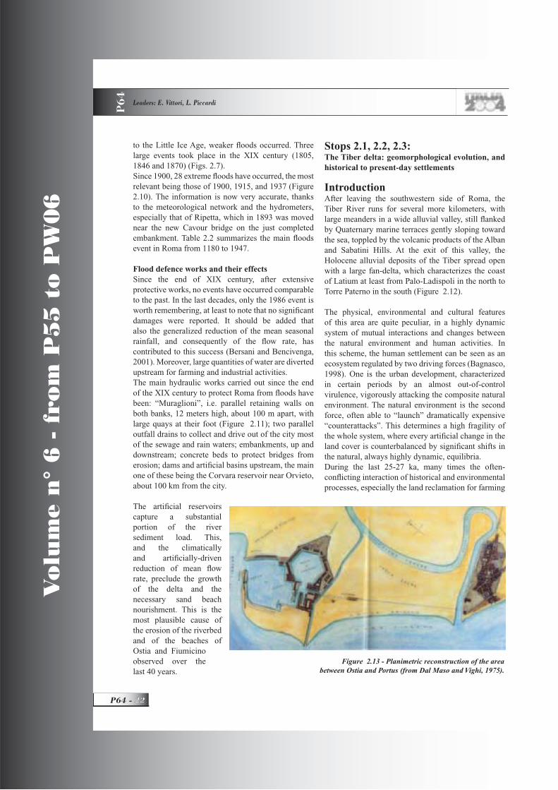
Figure 2.13 - Planimetric reconstruction of the area between Ostia and Portus (from Dal Maso and Vighi, 1975).
GEOLOGICAL SETTING, HAZARDS AND URBAN GROWTH IN SOME HISTORICAL TOWNS IN ITALY P
64
23 - P64
Vo
lum
e n
° 6
- f
rom
P5
5 t
o P
W0
6
and urban development, has caused deep changes in the whole ecosystem, repeatedly endangering human settlements themselves. As well, the natural evolution, rarely adequately foreseen, has often imposed drastic sacrifi ces, or costly protective interventions.For nearly a century, after the extensive land reclamation works carried out from 1883 to the Mussolinian age (Parisi Presicce and Villetti, 1998), all the coastal areas between Roma and the sea, including the fl ood plain of Tiber and its still active delta, have witnessed a continuous and unregulated growth of urban settlements. They have altered the already highly unstable equilibrium of the river
environment, endangered or even destroyed natural environments of particular appeal and archaeological-historical sites, and required expensive defensive interventions, either from fi nancial and/or environmental viewpoints, to lower the fl ood risk to a reasonable level. The recently-established Tiber Basin Authority and Regional Park have now inverted this trend, but the long-lasting substantial lack of control and planning has left hardly recoverable situations of risk and deep scars in the human and natural environment.
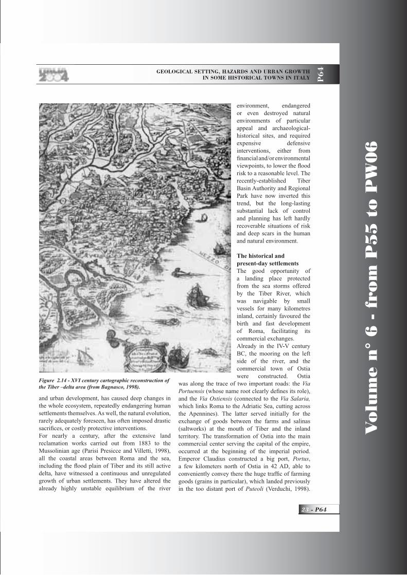
The historical and present-day settlementsThe good opportunity of a landing place protected from the sea storms offered by the Tiber River, which was navigable by small vessels for many kilometres inland, certainly favoured the birth and fast development of Roma, facilitating its commercial exchanges.Already in the IV-V century BC, the mooring on the left side of the river, and the commercial town of Ostia were constructed. Ostia
was along the trace of two important roads: the Via Portuensis (whose name root clearly defi nes its role), and the Via Ostiensis (connected to the Via Salaria, which links Roma to the Adriatic Sea, cutting across the Apennines). The latter served initially for the exchange of goods between the farms and salinas (saltworks) at the mouth of Tiber and the inland territory. The transformation of Ostia into the main commercial center serving the capital of the empire, occurred at the beginning of the imperial period. Emperor Claudius constructed a big port, Portus,a few kilometers north of Ostia in 42 AD, able to conveniently convey there the huge traffi c of farming goods (grains in particular), which landed previously in the too distant port of Puteoli (Verduchi, 1998).
Figure 2.14 - XVI century cartographic reconstruction of the Tiber –delta area (from Bagnasco, 1998).

Vo
lum
e n
° 6
- f
rom
P5
5 t
o P
W0
6
P64 -
Leaders: E. Vittori, L. Piccardi
P6
4
Augustus had established the latter only a few decades before, after his conquest of Egypt, which was the main producer of grains in the Mediterranean
region.A few years later, due to the loss of accessibility of this port determined by its rapid silting up, Emperor Trajan decided to realize a new port, near the other one, but inside an artifi cial basin connected to the sea through a channel (Trajan’s Port, Figure 2.13).
So, Portus and Ostia constituted a unique economic center fl ourishing up to the IV century, when the Emperor Constantinus decreed the separation of Ostia from Portus, which became Portus Urbis (Roma’s port). This decision rapidly led to the decline of Ostia (Dal Maso and Vighi, 1975).In the following centuries, with the decline of the Roman Empire, the raids of barbarians fi rst, and later, of Saracens, determined a progressive abandonment of the delta and of the port itself. The climatic changes, coupled with the removal of the wood cover in large parts of the river catchment area, and the lack of any maintenance work for many centuries led to a rapid progradation of the delta (more than 2 km in 1,000 years), with the obstruction of the old river mouth and of Trajan’s channel. In this way, also the port areas, now inaccessible from the sea, became
coastal lakes. The birth of wide coastal lakes and swamps behind the prograding coastline imposed the almost complete abandonment of this area, because of widespread malarian fevers and other diseases.To protect the few inhabitants left in the old town of Ostia, exposed to the frequent raids of the wild Saracen pirates, in the mid of IX century, Pope Gregorius IV decided to build a new fortifi ed village, Gregoriopoli (now identifi ed with
the Borgo of Ostia Antica), which was surrounded by walls and a ditch, where an old church had existed previously (www.romacivica.it/ cyberia/ riserva).At the end of the XV century, Pope Julius II transformed this fortifi ed “borgo” (village) into a
Figure 2.15 - Julius II’s castle, Borgo of Ostia Antica (photo Berti & Giusti).
Figure 2.16 - The fountain of the Borgo has recycled an ancient Roman sarcophagus (photo Berti and Giusti).

GEOLOGICAL SETTING, HAZARDS AND URBAN GROWTH IN SOME HISTORICAL TOWNS IN ITALY P
64
25 - P64
Vo
lum
e n
° 6
- f
rom
P5
5 t
o P
W0
6
robust castle, now located near the banks of the river, which made a large meander towards the east in that period (Figs. 2.14 and 2.15). In 1557, during one of the most remarkable fl oods of the Tiber, this meander (now called fi ume morto, “dead river”) was abandoned. So, the river shifted more than a kilometer away from the castle, generating new bogs. This fl ood imposed a new decline to the area which lasted up to the XIX century (Bellotti, 1998; Verduchi, 1998).
In the XVII century, during the reign of Pope Paulus V, the ancient artifi cial channel was cleared of its fi ll and made navigable once again. A new borgo, Fiumicino, was established near its mouth.But the true repopulation of the Tiber delta begun only at the end of the XIX century, after extensive reclamation works, which cleared the whole area of the coastal lakes and bogs, which had been the source of the deadly malaria fever.The out-of-control, unplanned development, cited above, started soon after World War II, with the growth of many borgate (e.g., Ostia lido, Acilia, Isola Sacra) only partially connected to the construction of Fiumicino’s port and Leonardo da Vinci Airport.
Stop 2.1:The archaeological site of Ostia Antica, its mediaeval borgo, and Julius II’s castleThe brief visit to the castle will include, on the fi rst fl oor, the Pope’s apartment, and a historical museum containing interesting items coming from the same monument, and late-Mediaeval-Renaissance ceramics found in the surrounding area.In the fi rst centuries of its long history, the ancient
Figure 2.17 - The decumanus maximus, near the entrance of the Roman city of Ostia Antica (photo Berti & Giusti).
Figure 2.18 - The Theatre of the Roman city of Ostia Antica (from Dal Maso and Vighi, 1975).

Vo
lum
e n
° 6
- f
rom
P5
5 t
o P
W0
6
P64 -
Leaders: E. Vittori, L. Piccardi
P6
4
borgo had grown in the outskirts of the port of Ostia. Just after the Christian religion had imposed itself with the accompanying religious peace decreed by Emperor Constantinus in 313, Ostia became a diocese. Since the IV century, its bishop has the privilege to be the fi rst to meet the newly-elected pope.The cathedral of Ostia Antica, consecrated to S. Aurea, a girl martyred in 258 under the Emperor Claudius the Gothic, is built above the basement of the paleo-Christian basilica. This church was inside the village which was transformed into a fortifi ed borgo by pope Gregorius IV in IX century, and which hosted all the people who managed to survive the raids of Saracens.In the XV century, with the aim of contributing to the defence of Roma, Martinus V raised the high tower, later incorporated into the castle, right on the river banks, and excavated the surrounding ditch, which was fed with the river water. Sixtus IV restored the borgo in the years 1472-1479, building many of the present-day houses (www.romacivica.it/ cyberia/ riserva).Among the notable curiosities inside the borgo, there is the tub of a fountain, which originally was part of a Roman age sarcophagus (Figure 2.16).The archaeological excavations at Ostia Antica have returned to light most of the Roman center, and represent a fundamental source of data on Roman life.
The city plan shows a rational distribution of spaces, with the typical network of orthogonal streets (decumani andcardines), defi ning blocks of tightly-spaced homes (insulae) (Dal Maso and Vighi, 1975; Verduchi, 1998).
Figure 2.19 - Aerial view of the present-day hexagonal Traianus basin (the ancient port of Traianus) (from Verduchi, 1998).
Figure 2.20 – Palaeogeographic reconstruction of the Tiber delta evolution in four principal steps:
a) the situation 14 ka ago; b) the situation 3 ka ago; c) the situation in the Roman imperial age;
d) the situation before the reclamation works of the XX century (from Bellotti, 1998).

GEOLOGICAL SETTING, HAZARDS AND URBAN GROWTH IN SOME HISTORICAL TOWNS IN ITALY P
64
27 - P64
Vo
lum
e n
° 6
- f
rom
P5
5 t
o P
W0
6
Many arcades, balconies, squares, gardens, and fountains adorned the city. Approaching the Tiber, hence the port facilities, commercial and offi cial buildings become dominant in the urban texture: the forum (square, the Greek “agora”) of the various corporations, horrea (warehouses), macella (food markets), tabernae (shops and wine bars), templa(temples), thermae (spas), stationes (police stations), and the basilica (temple). The entrance of the town is the Porta Romana, where the Via Ostiensis arrives from Roma. This road corresponds to the decumanusmaximus (the main street) (Figure 2.17), 10 meters wide and 1.5 kilometers long, which crosses the whole city from east to west, arriving eventually at the old sea shore. Along the decumanus maximus,
it is possible to admire Neptune’s thermae(thermal baths) (madeat the time of Adrianus and Antoninus Pius), thepolice station (between the thermae and the Tiber), the still used theatre, constructed by Augustus and enlarged by Septimius Severus (2,700 seats) (Figure 2.18), and the forum of the corporations, which was the commercial heart of the city. On the east side, there are the ruins of the forum’s thermae,where the impressive frigidarium (cold water
pool) is still visible; on the west side, the Antoninian age basilica exhibits a rectangular hall, surrounded by a portico which is supported by a colonnade.Ostia Antica offers a unique opportunity to analyze the evolution of Roman architectural and urban principles during the whole Roman imperial period (see for example Dal Maso and Vighi, 1975; Verduchi, 1998), also in the frame of the local evolving environment.
Stop 2.2:Port of TraianusThe construction of the port of Traianus started under the Emperor Traianus (Trajan) at the end of the Ist century AD., and was completed in 112 or 113. This facility, fl anked by the city of Portus, which was as big as Ostia, became necessary because of the continuous silting up of the portus along the Tiber. The port structure included a wide hexagonal basin
Figure 2.21 - Orto-photograph of the Tiber delta area (from TerraItaly 2000).
Figure 2.22 - The coastline erosion in 1980, near Piazza dei Canotti (Ostia Lido). The “lungomare” street (along the sea front) is affected by severe damage (photo Berti).
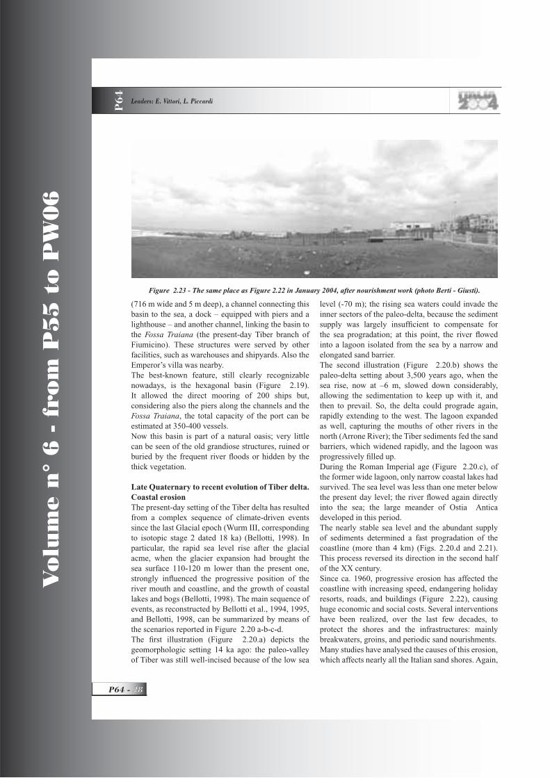
Vo
lum
e n
° 6
- f
rom
P5
5 t
o P
W0
6
P64 -
Leaders: E. Vittori, L. Piccardi
P6
4
(716 m wide and 5 m deep), a channel connecting this basin to the sea, a dock – equipped with piers and a lighthouse – and another channel, linking the basin to the Fossa Traiana (the present-day Tiber branch of Fiumicino). These structures were served by other facilities, such as warehouses and shipyards. Also the Emperor’s villa was nearby.The best-known feature, still clearly recognizable nowadays, is the hexagonal basin (Figure 2.19). It allowed the direct mooring of 200 ships but, considering also the piers along the channels and the Fossa Traiana, the total capacity of the port can be estimated at 350-400 vessels. Now this basin is part of a natural oasis; very little can be seen of the old grandiose structures, ruined or buried by the frequent river fl oods or hidden by the thick vegetation.
Late Quaternary to recent evolution of Tiber delta. Coastal erosionThe present-day setting of the Tiber delta has resulted from a complex sequence of climate-driven events since the last Glacial epoch (Wurm III, corresponding to isotopic stage 2 dated 18 ka) (Bellotti, 1998). In particular, the rapid sea level rise after the glacial acme, when the glacier expansion had brought the sea surface 110-120 m lower than the present one, strongly infl uenced the progressive position of the river mouth and coastline, and the growth of coastal lakes and bogs (Bellotti, 1998). The main sequence of events, as reconstructed by Bellotti et al., 1994, 1995, and Bellotti, 1998, can be summarized by means of the scenarios reported in Figure 2.20 a-b-c-d. The fi rst illustration (Figure 2.20.a) depicts the geomorphologic setting 14 ka ago: the paleo-valley of Tiber was still well-incised because of the low sea
level (-70 m); the rising sea waters could invade the inner sectors of the paleo-delta, because the sediment supply was largely insuffi cient to compensate for the sea progradation; at this point, the river fl owed into a lagoon isolated from the sea by a narrow and elongated sand barrier.The second illustration (Figure 2.20.b) shows the paleo-delta setting about 3,500 years ago, when the sea rise, now at –6 m, slowed down considerably, allowing the sedimentation to keep up with it, and then to prevail. So, the delta could prograde again, rapidly extending to the west. The lagoon expanded as well, capturing the mouths of other rivers in the north (Arrone River); the Tiber sediments fed the sand barriers, which widened rapidly, and the lagoon was progressively fi lled up.During the Roman Imperial age (Figure 2.20.c), of the former wide lagoon, only narrow coastal lakes had survived. The sea level was less than one meter below the present day level; the river fl owed again directly into the sea; the large meander of Ostia Antica developed in this period.The nearly stable sea level and the abundant supply of sediments determined a fast progradation of the coastline (more than 4 km) (Figs. 2.20.d and 2.21). This process reversed its direction in the second half of the XX century. Since ca. 1960, progressive erosion has affected the coastline with increasing speed, endangering holiday resorts, roads, and buildings (Figure 2.22), causing huge economic and social costs. Several interventions have been realized, over the last few decades, to protect the shores and the infrastructures: mainly breakwaters, groins, and periodic sand nourishments.Many studies have analysed the causes of this erosion, which affects nearly all the Italian sand shores. Again,
Figure 2.23 - The same place as Figure 2.22 in January 2004, after nourishment work (photo Berti - Giusti).

GEOLOGICAL SETTING, HAZARDS AND URBAN GROWTH IN SOME HISTORICAL TOWNS IN ITALY P
64
29 - P64
Vo
lum
e n
° 6
- f
rom
P5
5 t
o P
W0
6
Figure 2.24 - The S. Paul area: detachment of two originally adjoining buildings because of differential settling.
there is complex interaction of man-made and natural processes. Among the former, there are the changes in the catchment areas: fi rst of all, reduction of erosion surfaces by urban and industrial development and farming practices, sand borrowing from inside the river beds, sediment capture in artifi cial basins, and fi nally, reduction of river fl ow by collecting water for industrial and farming activities (Bellotti and De Luca, 1979). Natural phenomena are the reduction of mean yearly precipitation and higher evaporation, which reduce the river fl ow and its sediment load capacity.
Stop 2.3:Coastal erosion and defence worksOn our way to Roma, the strong erosion between the river mouth, where in the last few years, a new commercial-tourist port was built, and the Cristoforo Colombo highway, will be readily apparent. Defence works have slowed down this phenomenon, but are not able alone to solve the problem. The present situation can be compared to that before and after the nourishment and defence works (Figs. 2.22 and 2.23). Now the sand nourishment is repeated every 5 to 10 years, applying increasingly sophisticated techniques (e.g., groins and submarine breakwaters), to reconstruct and protect the sand beaches, as has been done to those visible near the pier, at the end of the Via Ostiensis (now “Via del Mare”). As a whole, the effect of such interventions on the natural system is satisfactory, but the economic and environmental cost is very high.
Stop 2.4:XX century urban expansionMany districts in Roma have been built on reclaimed soil, especially on former fl ood plains of Tiber and itstributaries. One such vall ey (Almone River plain)is that now hosting part of the San Paolo district, named after the church of S. Paul “out-of-the-walls”. As generally done in areas with near-surface water table, the original ground has been raised by ca. 5 m with an artifi cial fi ll, to stay far enough from humidity, and to obtain the necessary gradient for the drainage network.In the 1950s, many buildings were raised here, founded at a nearly standard depth of about 20 meters, without a detailed exploration of the subsoil.Unfortunately, but easily foreseeable by any geologist, the uneven stratigraphy of the alluvial to marsh environment (highly compressible soft fi ne-Figure 2.25 - Roman roads and distribution of main
underground sites. Squares = catacombs.
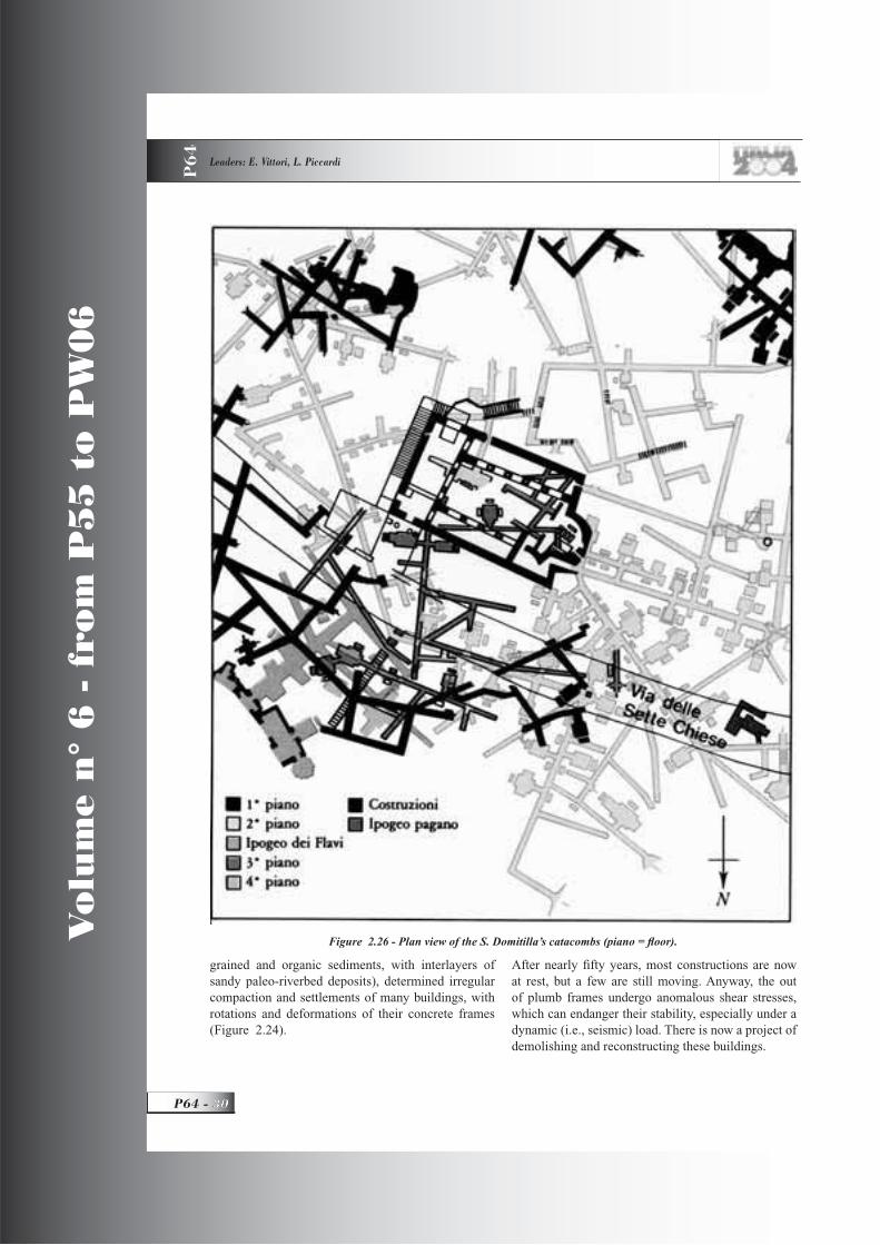
Vo
lum
e n
° 6
- f
rom
P5
5 t
o P
W0
6
P64 -
Leaders: E. Vittori, L. Piccardi
P6
4
grained and organic sediments, with interlayers of sandy paleo-riverbed deposits), determined irregular compaction and settlements of many buildings, with rotations and deformations of their concrete frames (Figure 2.24).
After nearly fi fty years, most constructions are now at rest, but a few are still moving. Anyway, the out of plumb frames undergo anomalous shear stresses, which can endanger their stability, especially under a dynamic (i.e., seismic) load. There is now a project of demolishing and reconstructing these buildings.
Figure 2.26 - Plan view of the S. Domitilla’s catacombs (piano = fl oor).
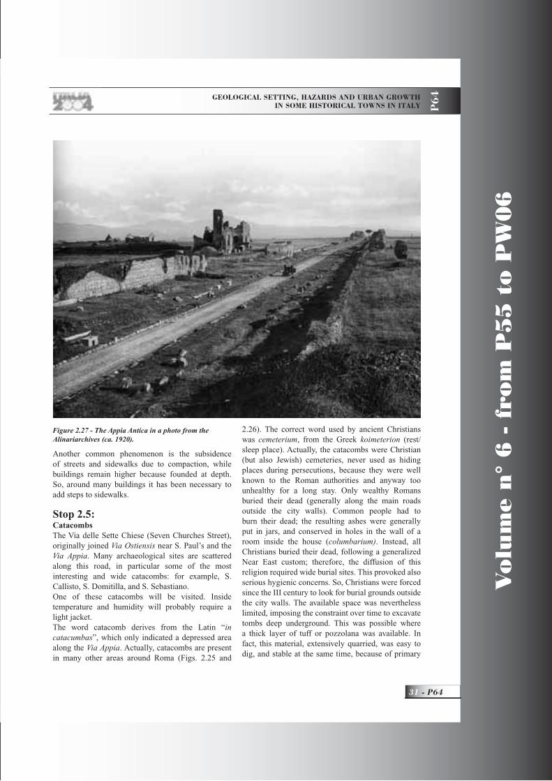
GEOLOGICAL SETTING, HAZARDS AND URBAN GROWTH IN SOME HISTORICAL TOWNS IN ITALY P
64
31 - P64
Vo
lum
e n
° 6
- f
rom
P5
5 t
o P
W0
6
Another common phenomenon is the subsidence of streets and sidewalks due to compaction, while buildings remain higher because founded at depth. So, around many buildings it has been necessary to add steps to sidewalks.
Stop 2.5:CatacombsThe Via delle Sette Chiese (Seven Churches Street), originally joined Via Ostiensis near S. Paul’s and the Via Appia. Many archaeological sites are scattered along this road, in particular some of the most interesting and wide catacombs: for example, S. Callisto, S. Domitilla, and S. Sebastiano.One of these catacombs will be visited. Inside temperature and humidity will probably require a light jacket.The word catacomb derives from the Latin “incatacumbas”, which only indicated a depressed area along the Via Appia. Actually, catacombs are present in many other areas around Roma (Figs. 2.25 and
2.26). The correct word used by ancient Christians was cemeterium, from the Greek koimeterion (rest/sleep place). Actually, the catacombs were Christian (but also Jewish) cemeteries, never used as hiding places during persecutions, because they were well known to the Roman authorities and anyway too unhealthy for a long stay. Only wealthy Romans buried their dead (generally along the main roads outside the city walls). Common people had to burn their dead; the resulting ashes were generally put in jars, and conserved in holes in the wall of a room inside the house (columbarium). Instead, all Christians buried their dead, following a generalized Near East custom; therefore, the diffusion of this religion required wide burial sites. This provoked also serious hygienic concerns. So, Christians were forced since the III century to look for burial grounds outside the city walls. The available space was nevertheless limited, imposing the constraint over time to excavate tombs deep underground. This was possible where a thick layer of tuff or pozzolana was available. In fact, this material, extensively quarried, was easy to dig, and stable at the same time, because of primary
Figure 2.27 - The Appia Antica in a photo from the Alinariarchives (ca. 1920).
Vo
lum
e n
° 6
- f
rom
P5
5 t
o P
W0
6
P64 -
Leaders: E. Vittori, L. Piccardi
P6
4
cementation or capillary water. Specialist diggers called fossores opened galleries, aerated by airshafts, and excavated holes in the vertical walls where the bodies, wrapped in sheets, were laid. Rock (marble, travertine) or terracotta slabs, with the names of the dead written on them, sealed the graves. The rich could afford even sarcophaguses, more commonly family chapels (cubicula), with vivid frescoes.The catacombs were gradually abandoned during the V century, when the Christian religion imposed its supremacy, and suffi cient burial ground was made available. As well, the many early popes, saints, and martyrs buried there were transferred to newly-built churches dedicated to them.
Stop 2.6:Via Appia AnticaFrom the gardens outside the catacomb, the volcanic Alban Hills are visible on the skyline. Just outside San Callisto and S. Sebastiano, there is the original track of the Via Appia, now called Appia Antica (old), because of the new Appia road nearby (Figure 2.27). This road connected, and still connects, Roma to Naples and the port of Brindisi (Brundisium), which was the principal port to Greece. A ten minute walk will allow us to admire the remains of the circus of Massentius, and the cylindrical Cecilia Metella’s mausoleum. In front, there are the ruins of a mediaeval gothic church (S. Nicola).
For more than one hundred meters, the Roman pavement of this road can be seen, made of lava slabs, called basoli. The lava was quarried nearby, in the phonolite-leucitite lava fl ow of Capo di Bove, ca. 270 ka old.Not far from here, there are springs of naturally sparkling mineral water, and the remains of the aqueduct of the “Aqua Claudia”.
Night in roma. Dinner and night walk downtown
DAY 3
“All roads lead to Roma.” Walk across 25 centuries of history in Roma (Figure 3.1.)Natural hazards: fl oods, earthquakes, and subsidence. Roma underground. Ancient topography and urban growth.
Stop 3.1:A walk downtown Roma Quandiu stabit Colyseus, stabit et Romaquando cadet Colyseus, cadet et Romaquando cadet Roma, cadet et mundus(Beda Venerabilis, 672-735)“As long as the Colosseum stands, Roma will stand; when the Colosseum falls, Roma will fall; when Roma falls, the whole world will fall.”
Roma was founded in 753 BC by Romulus after having killed in duel his twin brother, Remus: a bloody birth for the future capital of a wide and enduring empire. It started as a village, and grew to host more than two million citizens two thousand years ago, but then, reduced again to nearly a village after the loss of its empire, Roma rebuilt a new and even longer lasting kingdom, that of Christianity, founded on faith, but often defended with blood. So, for more than two millennia, Roma has exerted an undeniable infl uence over the Occidental world, both politically and culturally, during its long-lasting rule over the Mediterranean area and Europe; and then, in religious and cultural spheres, as the papal see, hence center of Christianity. It is interesting to note how signifi cantly the local stratigraphy and geomorphological setting have contributed to the good fortune of the founders of Roma.The Tiber River valley narrows considerably where it crosses the eastern outer slopes of the volcanic apparatus of the Alban Hills (Figure 1), more or less where their deposits had come in contact with the similar products of the Sabatini volcanic fi eld. The cap of relatively hard volcanic deposits (ignimbrites), has protected from erosion the softer uplifted marine and continental sediments underneath. As a result, the deep incision of the drainage network, following the Last Glacial sea level drop 18 ka ago, has shaped a system of tabular hills, bounded by cliffs and steep slopes. The subsequent sea rise has considerably reduced the gradients of the drainage system, determining the meandering of the Tiber, and the development of a broad fl ood plain with wide humid environments (marshes and swamps).The fi rst Romans chose to settle on the hilltops (the Palatine hosted the fi rst fortifi ed village), because of many good reasons. The septimontium (system of seven hills - Figure 3.2) offered ample nearly fl at surfaces, away from the periodic river fl oods. The city was protected from enemies by the steep slopes

GEOLOGICAL SETTING, HAZARDS AND URBAN GROWTH IN SOME HISTORICAL TOWNS IN ITALY P
64
33 - P64
Vo
lum
e n
° 6
- f
rom
P5
5 t
o P
W0
6
on several sides, and by the Tiber, which provided a barrier for enemies from the west. The only ford for many miles up and down stream was near the Palatine Hill across the Tiberina Islet, and could be easily patrolled by early Romans. Also the swampy areas fl anking the Tiber (e.g., the Velabrum) added further protection. The early Romans could benefi t from the abundant water of the river and of the many springs along the slopes. The volcanic rocks were a good construction material, easy to quarry and shape, and the outcrops of marine and lacustrine clays provided the furnaces with the source material for pottery and brick production. Also relevant was the very fertile volcanic soil, which added to the favourable climate and the water abundance. So, many gardens,
vineyards, and farms fl ourished in and around Roma up to the XIX century.From such a favourable site, Romans began their nearly continuous territorial expansion, which lasted for over a millennium. Over time, due to the urban expansion (more than two million people in Imperial times), Romans had to deal also with
natural drawbacks: pollution from organic waste was a major problem, dealt with by ancient Romans with a widespread distribution of water from an extraordinary system of aqueducts, and a pervasive sewer network. Many cavities are distributed inside the volcanic bedrock– C mainly quarries, aqueducts, cisternae(water tanks), and catacombs. Although not so relevant as in Naples (see ahead), the risk of collapses cannot be disregarded. The original morphology of the substratum has been deeply modifi ed over time by widespread man-made excavations and fi lls to level the ground, and reclamation works in the wet areas, already started in Roman times. The fi lls were realized mostly by dumping waste material from fi res,
earthquakes, and demolitions. Indeed, frequent were the devastating inundations of the Tiber; earthquakes often rocked the town, although widespread damage was rare. To all this, add fi res and periodic epidemics and, since the last days of the Empire, repeated looting from invaders.Nevertheless, the life of the city continued, although
Figure 3.1 - City plan of the center of Roma, from S.Peter’s to the Colosseum, where day 3 will take place.

Vo
lum
e n
° 6
- f
rom
P5
5 t
o P
W0
6
P64 -
Leaders: E. Vittori, L. Piccardi
P6
4
with many lows and only a few highs, until it became the capital of Italy, again a single country after fi fteen centuries. Since then, Roma’s population has increased from less than 100,000 to over three million. The rapid and chaotic modern expansion of the city has dramatically enhanced the risk level from geo hazards, imposing costly but so far effective interventions for the protection from fl oods (see “Tiber and its fl oods”), while the earthquake hazard has remained for too long underestimated, notwithstanding the vast historical evidence (see “Notes on the seismicity of Roma”).Due to the widespread diffusion of Holocene-uppermost Pleistocene alluvial sediments several tens of meters deep, and artifi cial fi lls even ten meters or
more thick, and, on top of that, a general lowering of the water table, subsidence and differential settling are common phenomena, often resulting as a signifi cant source of hazard for many recently developed urban areas.
Stop 3.1.1:The ColosseumBuilt during the reigns of Emperors Vespasianus and (his son) Titus, the Colosseum’s inauguration took place in the year 80 AD. Its correct name is Amphiteatrus Flavius (from the gens –family– Flavia,to which these emperors belonged), but already in the VIII century, it was popularly named Colosseum (Colyseus), probably due to the presence nearby of an enormous (30 meters high) bronze statue of Nero, the Colossus, transformed after his death into a statue of the god Helios (sun) and later probably melted down. The Colosseum, elliptical (188 x 156 meters) in shape and 48 m high, was made of > 100,000 cubic meters of travertine (lapis tiburtinus) which came from the
quarries near Tivoli, and 6,000 tons of concrete and other stone blocks. The travertine blocks were linked by means of 300 tons of iron clamps. Marble plates covered the outer face. It could host more than 50,000 spectators, who could attend various types of games
Figure 3.2 - Simplifi ed morphology of Roma, with the Seven Hills and the city walls (from Rodolfo Lanciani, Forma Urbis Romae, Edizioni Quasar, 1991).

GEOLOGICAL SETTING, HAZARDS AND URBAN GROWTH IN SOME HISTORICAL TOWNS IN ITALY P
64
35 - P64
Vo
lum
e n
° 6
- f
rom
P5
5 t
o P
W0
6
– mainly violent fi ghts between gladiators (munera),and the mock hunting of wild beasts (venationes).There were many independent accesses (vomitoria)to the seats, which allowed an easy exit at the end of the performance.
The “playground” (arena, from rena = sand) was made of wood, covered with sand (Upper Pliocene marine sand, quarried along the slopes of Monte Mario), to absorb the blood and soften the effects of falls. Gladiators and beasts entered the arena from the rooms underneath through underground passages. A sort of canopy (velarium) sheltered the spectators from the sun.Since its abandonment at the end of the empire, because of several reasons (fi res and earthquakes, the dislike of Christians for violent games, the impossibility of fi nding more wild beasts), this monument fell into ruins, and was disrupted by more earthquakes, as in the 801, 847, 1349, and 1703 events (See “Notes on the seismicity of Roma”). Its decadence was compounded by the weakening of its structure, due to the stealing of the iron clamps linking the travertine blocks. So, this magnifi cent monument ended up as a quarry, providing building stones for many Middle Age through to Baroque age palaces in Roma, or even for the production of quicklime (calcium oxide), sharing such an unfortunate destiny with many other Roman monuments. Only after the 1703 earthquake did the popes decide to protect it,
Figure 3.3 - Aerial view of the Colosseum (from Terra Italy 2000).
Figure 3.4 - Southern side of the Colosseum, where most of the seismically-induced damages have occurred. The fi rst two rings are missing and the third one, which collapsed after the 1703 earthquake, was reconstructed only in 1845.

Vo
lum
e n
° 6
- f
rom
P5
5 t
o P
W0
6
P64 -
Leaders: E. Vittori, L. Piccardi
P6
4
and they started restoration works, initially with the aim to transform it into a church.The Flavian Amphitheatre lies (Figs. 3.3 and 3.4) between the hills of Oppius and Caelius and the Velia (a ridge connecting the Palatine and Oppius Hills, removed in 1932 to realize the “Empire street”), inside the valley of a small stream (Labicanus),tributary of the Tiber through the lowlying humid area called Velabrum under the Palatine. This valley was partially dammed under the Emperor Nero, to realize an artifi cial pond (stagnum Neronis) encircled by a colonnade, part of his wide residence, DomusAurea (Golden House). The construction work started under the next Emperor Vespasianus. After draining the pond, without signifi cant excavations, an annular concrete platform was realized, over 13 meters thick, over which the travertine pillars were laid.The foundation ground is partly made up of Pleistocene alluvial sediments with good bearing capacity and partly, on the southwest side, of fi ne-grained soft Holocene deposits fi lling the talweg of the Labicanus creek (Bozzano et alii, 1995). The uneven
subsoil characteristics probably determined irregular settlements, and were the most likely cause of partial collapses, concentrated in the southern side (Figure 3.4), because of differential site responses during earthquakes (Figure 3.5) (Moczo et alii, 1995).
Stop 3.1.2: Fora and the CapitoliumFrom the Colosseum, an exciting walk across the Fora, with their triumphal arches and temples, will lead to the foot of the Capitolium, where volcanic deposits of the Sabatini and Alban Hills crop out along the incision between Capitolium and Palatinus hills. Climbing up the hill, there will be a great view of the archaeological area, including the Palatinus, and of baroque Roma, with the Apennines and the Alban Hills in the background. The Campidoglio is now the City Hall, and accomodates an important art museum. Michelangelo designed the square, with the statue of Emperor Marcus Aurelius in its center.
Stop 3.1.3:Trajan’s ColumnThe Traianus column (Trajan’s Column) in the
Figure 3.5. - Marble plate inside the Colosseum which records the restoration of the arena and podium in 508? after an earthquake (likely that of 443). The poor quality of this inscription testifi es to the decadence of Roma (text: Decivs Marivs Venantivs | Basilivs v(ir) c(larissimus) et inl(ustris) praef(ectus) | vrb(i) patricivs consvl | ordinarivs arenam et | podivm qvae abomi|nandi terrae mo|tvs rvina pros|travit svm‹p›tv pro|prio restitvit).
Figure 3.6 - Marcus Aurelius’s column.
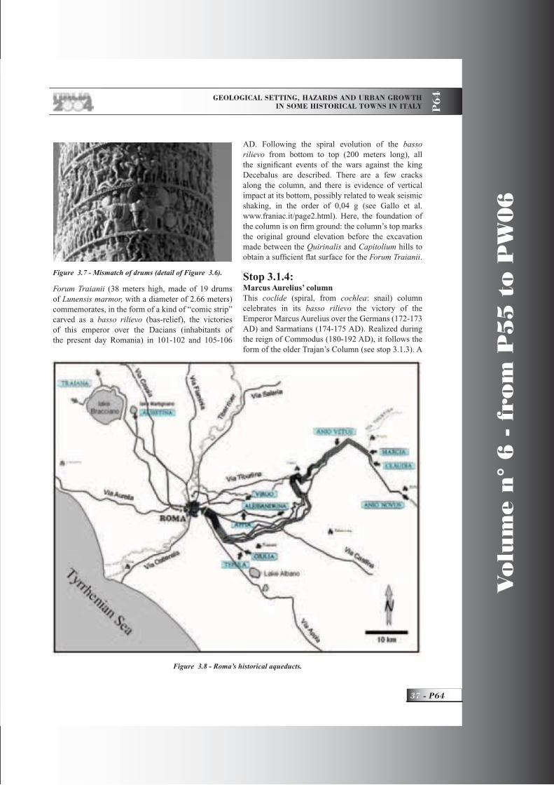
GEOLOGICAL SETTING, HAZARDS AND URBAN GROWTH IN SOME HISTORICAL TOWNS IN ITALY P
64
37 - P64
Vo
lum
e n
° 6
- f
rom
P5
5 t
o P
W0
6
Forum Traianii (38 meters high, made of 19 drums of Lunensis marmor, with a diameter of 2.66 meters) commemorates, in the form of a kind of “comic strip” carved as a basso rilievo (bas-relief), the victories of this emperor over the Dacians (inhabitants of the present day Romania) in 101-102 and 105-106
AD. Following the spiral evolution of the bassorilievo from bottom to top (200 meters long), all the signifi cant events of the wars against the king Decebalus are described. There are a few cracks along the column, and there is evidence of vertical impact at its bottom, possibly related to weak seismic shaking, in the order of 0,04 g (see Gallo et al. www.franiac.it/page2.html). Here, the foundation of the column is on fi rm ground: the column’s top marks the original ground elevation before the excavation made between the Quirinalis and Capitolium hills to obtain a suffi cient fl at surface for the Forum Traianii.
Stop 3.1.4:Marcus Aurelius’ columnThis coclide (spiral, from cochlea: snail) column celebrates in its basso rilievo the victory of the Emperor Marcus Aurelius over the Germans (172-173 AD) and Sarmatians (174-175 AD). Realized during the reign of Commodus (180-192 AD), it follows the form of the older Trajan’s Column (see stop 3.1.3). A
Figure 3.7 - Mismatch of drums (detail of Figure 3.6).
Figure 3.8 - Roma’s historical aqueducts.

Vo
lum
e n
° 6
- f
rom
P5
5 t
o P
W0
6
P64 -
Leaders: E. Vittori, L. Piccardi
P6
4
Christian symbol (the statue of the apostle S. Paul) was posed on top of the column after its restoration in 1589 under pope Sixtus V, to signify the supremacy of Christianity over pagan Roma. At that time, the original Roman basement (10.5 m high) was replaced by a lower one, and all the columns were placed at a level lower than about 4 meters, corresponding to the level ground elevation, which had been reclaimed from a former marsh. Close to the column runs the end section of the Via Flaminia, now Via del Corso, one of the main streets of modern day Roma.This extraordinary monument, “Marcus Aurelius”
Column, is made of Lunensis marmor, marble from the Apuan Alps (Tuscany), and is 29.5 meters high (42 m, including its base, but it was 46 m before restoration), and made up of 19 piled up drums, diameter ca. 240 cm. An inner helicoid staircase allows access to its top roof. One geological peculiarity is the few centimeters mismatch of drums nr. 9 and 10 (Figs. 3.6 and 3.7), which cannot certainly be due to an error during its construction. A possible explanation is the effect of seismic waves, maybe related to one of the late Imperial to mediaeval earthquakes (see for example www.geologia.com/english/fi 2004/2004_terremoti.html). However, the heavy restoration works at the end of the XVI century may just as well have produced this mismatch. Thus, the earthquakes felt in Roma were never strong enough to cause the collapse of the two columns, or even signifi cantly dislocate their slices, as observed for example in the columns of the Parthenon in Athens.
Figure 3.9 - Trevi Fountain.
Figure 3.10 - Northwest side of the Tiberina islet, during the 1937 fl ood (from Bersani and Bencivenga, 2001).
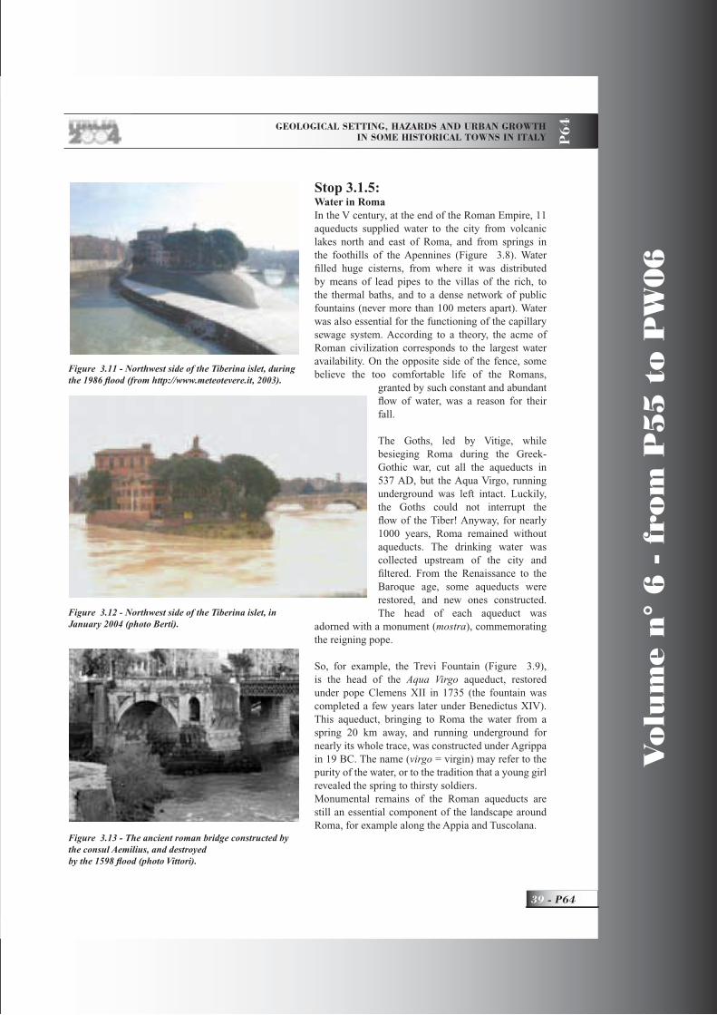
GEOLOGICAL SETTING, HAZARDS AND URBAN GROWTH IN SOME HISTORICAL TOWNS IN ITALY P
64
39 - P64
Vo
lum
e n
° 6
- f
rom
P5
5 t
o P
W0
6
Stop 3.1.5:Water in RomaIn the V century, at the end of the Roman Empire, 11 aqueducts supplied water to the city from volcanic lakes north and east of Roma, and from springs in the foothills of the Apennines (Figure 3.8). Water fi lled huge cisterns, from where it was distributed by means of lead pipes to the villas of the rich, to the thermal baths, and to a dense network of public fountains (never more than 100 meters apart). Water was also essential for the functioning of the capillary sewage system. According to a theory, the acme of Roman civilization corresponds to the largest water availability. On the opposite side of the fence, some believe the too comfortable life of the Romans,
granted by such constant and abundant fl ow of water, was a reason for their fall.
The Goths, led by Vitige, while besieging Roma during the Greek-Gothic war, cut all the aqueducts in 537 AD, but the Aqua Virgo, running underground was left intact. Luckily, the Goths could not interrupt the fl ow of the Tiber! Anyway, for nearly 1000 years, Roma remained without aqueducts. The drinking water was collected upstream of the city and fi ltered. From the Renaissance to the Baroque age, some aqueducts were restored, and new ones constructed. The head of each aqueduct was
adorned with a monument (mostra), commemorating the reigning pope.
So, for example, the Trevi Fountain (Figure 3.9), is the head of the Aqua Virgo aqueduct, restored under pope Clemens XII in 1735 (the fountain was completed a few years later under Benedictus XIV). This aqueduct, bringing to Roma the water from a spring 20 km away, and running underground for nearly its whole trace, was constructed under Agrippa in 19 BC. The name (virgo = virgin) may refer to the purity of the water, or to the tradition that a young girl revealed the spring to thirsty soldiers.Monumental remains of the Roman aqueducts are still an essential component of the landscape around Roma, for example along the Appia and Tuscolana.
Figure 3.11 - Northwest side of the Tiberina islet, during the 1986 fl ood (from http://www.meteotevere.it, 2003).
Figure 3.12 - Northwest side of the Tiberina islet, in January 2004 (photo Berti).
Figure 3.13 - The ancient roman bridge constructed by the consul Aemilius, and destroyed by the 1598 fl ood (photo Vittori).

Vo
lum
e n
° 6
- f
rom
P5
5 t
o P
W0
6
P64 -
Leaders: E. Vittori, L. Piccardi
P6
4
Stop 3.2:Floods and mitigation worksThe visit of several sites downtown near the Tiber will allow us to see the signs of past major fl oods, and to understand their disastrous effects on the every day lives of Romans over the centuries.
Stop 3.2.1:S. Maria sopra MinervaThe marble plates still fi xed on the façade of the beautiful church of Santa Maria sopra Minerva (one of the few churches in Roma still conserving its original structure in Gothic style) give evidence of the water level reached during six fl oods (1422, 1495, 1530, 1557, 1598, and 1870) (Figs. 2.6, 2.7, and 2.8). Other plates nearby recall the fl oods of 1530 (S. Eustachio), and of the Christmas night of 1598 (S. Spirito, near S. Peter’s; Figure 2.9).
Stop 3.2.2:Piazza NavonaThis is probably the most beautiful square in Roma, with its splendid baroque fountains, churches, and palaces. Its shape reproduces that of the Roman Domitianus’s circus buried underneath. During the 1598 fl ood, the water here reached a height of 5
meters.In the Baroque age, thanks to the abundant availability of water after the restoration of several aqueducts, this square was artifi cially fl ooded in August (then the fl oor had a concave shape) to refreshen the citizens, and for boat games (naumachiae), following an ancient Roman tradition.
Stop 3.2.3:Tiberina isletAccording to Livius (II, 5), the Tiberina islet originated just at the beginning of the Roman Republic due to the throw in the low-standing river of the emmer wheat straws coming from the destruction of the crop in the nearby fi eld owned by the family of the last Roman king (Tarquinius Superbus) exiled from town, but this is only a legend. The Ghetto and the synagogue are on the left, and Trastevere on the right bank. The retaining walls and quays realized since 1870 are clearly seen from here.The view from the bridge upstream allows a comparison of the present-day situation with the historical photographs of the fl oods of 1937 and 1986 (Figs. 3.10, 3.11, 3.12). From the islet we can see the ruins of the most ancient and large Roman stone bridge (Figure 3.13), constructed in 174 BC by the consul Aemilius and many times damaged and restored, until
its partial destruction and fi nal abandonment following the 1598 fl ood. Since then, Romans know this bridge as the ponte rotto (broken bridge) (Regione Lazio, 2003).Many fl oods have affected the church of San Bartolomeo all’Isola. Particularly severe were the 1557 and 1930 fl oods.Not far from here are the remains of the old fl uvial port and historical hydrometer of Ripetta. This port, still active in the last century,
was fi nally abandoned, because of the considerable drop of the mean fl ow-rate, as cited above. Along the river banks, Romans and their ancestors have fi shed, sunbathed, and swam for millennia until 40-50 years ago, when good train and road connections with the coast (with some contribution from river pollution), pushed Romans to move to the sea beaches, with the
Figure 4.1 - Geological scheme of the Pontina Plain: 1) Cenozoic-Mesozoic units of the Lazio-Abruzzo carbonatic platform; 2) Sicilids (Aquitanian, arenites of Mt. Circeo); 3) Pleistocene volcanic formations (Vulcano Laziale); 4) Pleistocene travertine formations; 5) Pleistocene - Holocene alluvial and slope deposits; 6) Pleistocene - Holocene dune sands; 7) Holocene fl uvial-marsh deposits; 8) Soils and recent covers; 9) normal fault: a) certain, b) presumed or buried; 10) thrust or reverse fault (from De Pippo, Donadio and Pannetta, 2002).
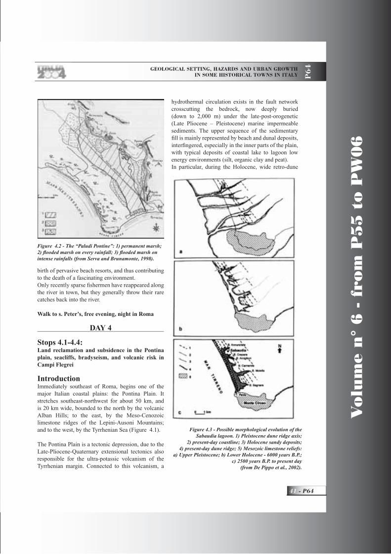
GEOLOGICAL SETTING, HAZARDS AND URBAN GROWTH IN SOME HISTORICAL TOWNS IN ITALY P
64
41 - P64
Vo
lum
e n
° 6
- f
rom
P5
5 t
o P
W0
6
birth of pervasive beach resorts, and thus contributing to the death of a fascinating environment. Only recently sparse fi shermen have reappeared along the river in town, but they generally throw their rare catches back into the river.
Walk to s. Peter’s, free evening, night in Roma
DAY 4
Stops 4.1-4.4: Land reclamation and subsidence in the Pontina plain, seacliffs, bradyseism, and volcanic risk in Campi Flegrei
IntroductionImmediately southeast of Roma, begins one of the major Italian coastal plains: the Pontina Plain. It stretches southeast-northwest for about 50 km, and is 20 km wide, bounded to the north by the volcanic Alban Hills; to the east, by the Meso-Cenozoic limestone ridges of the Lepini-Ausoni Mountains; and to the west, by the Tyrrhenian Sea (Figure 4.1).
The Pontina Plain is a tectonic depression, due to the Late-Pliocene-Quaternary extensional tectonics also responsible for the ultra-potassic volcanism of the Tyrrhenian margin. Connected to this volcanism, a
hydrothermal circulation exists in the fault network crosscutting the bedrock, now deeply buried (down to 2,000 m) under the late-post-orogenetic (Late Pliocene – Pleistocene) marine impermeable sediments. The upper sequence of the sedimentary fi ll is mainly represented by beach and dunal deposits, interfi ngered, especially in the inner parts of the plain, with typical deposits of coastal lake to lagoon low energy environments (silt, organic clay and peat).In particular, during the Holocene, wide retro-dune
Figure 4.2 - The “Paludi Pontine”: 1) permanent marsh; 2) fl ooded marsh on every rainfall; 3) fl ooded marsh on intense rainfalls (from Serva and Brunamonte, 1998).
Figure 4.3 - Possible morphological evolution of the Sabaudia lagoon. 1) Pleistocene dune ridge axis;
2) present-day coastline; 3) Holocene sandy deposits; 4) present-day dune ridge; 5) Mesozoic limestone reliefs:
a) Upper Pleistocene; b) Lower Holocene - 6000 years B.P.; c) 2500 years B.P. to present day
(from De Pippo et al., 2002).

Vo
lum
e n
° 6
- f
rom
P5
5 t
o P
W0
6
P64 -
Leaders: E. Vittori, L. Piccardi
P6
4
basins developed, as an effect of the Late Glacial – Early Holocene rapid sea level rise, collecting thick layers of highly organic and compressible sediments (Brunamonte and Serva, 1990).Moreover, there are important springs at the foot of the limestone ridge, fed by the large karst aquifer (Boni et alii, 1986). So, due to sediment compaction and sea level rise, possibly coupled with active faulting, wide sectors of the plain have presented a characterisitic, humid, swampy environment up to the beginning of the XX century, being commonly defi ned in historical to recent times as “Paludi Pontine” (Figure 4.2).
Stop 4.1:Recent evolution of coastal zoneSince the Middle Pleistocene (oldest outcropping sediments), the sea level fl uctuations related to the climate changes have determined alternating periods of entrenching of the drainage network (cold phases), and of over-fl ooding, with widespread submergence and sedimentation (warm phases). As in the Tiber delta, the present-day setting is the result of the fast sea level rise, which started at the end of the Last Glacial epoch, and was almost completed about 6,000 years ago (during the Optimum Climaticum). At this time, long ridges of sand dunes characterized the morphology of the area, and isolated wide coastal lakes and swamps from the sea.
Stop 4.1.1:The Lake of Sabaudia, and coastal dunesThe largest among the coastal lakes is the lake of Sabaudia (also called “di Paola”) (Bono, 1985; De Pippo et alii, 2000). The geomorphological and environmental evolution of the area is summarized in Figure 4.3 (De Pippo et al., 2000). The delicate equilibrium of the coastal dune system, and of the environment behind, is now endangered by human activities,
especially connected to the tourist exploitation of this unique natural reservation. In fact, this area is included
Figure 4.4 - Sabaudia Lake; in the background, Mt. Circeo (photo Berti and Giusti).
Figure 4.5 - Sabaudia Lake, from Mt. Circeo (photo Berti).
Figure 4.6 - Ground subsidence in the period 1927-1980 vs. the initial thickness of soils with high organic contents (modifi ed, from Serva and Brunamonte, 1998).

GEOLOGICAL SETTING, HAZARDS AND URBAN GROWTH IN SOME HISTORICAL TOWNS IN ITALY P
64
43 - P64
Vo
lum
e n
° 6
- f
rom
P5
5 t
o P
W0
6
in one of the fi rst Italian national parks (Parco del Circeo), aimed at preserving the few remains of the harsh but fascinating environment characterizing the Pontina Plain, up to the great land-reclamation works of the 1920s.
The core of the city of Sabaudia (named after the reigning dynasty in Italy before the republic) was built in just one year. This town, and many others in the plain, were realized as part of the reclamation work cited above, all sharing the same typical architectural style of the Fascist regime ruling at that time.From the bridge over the lake, it is possible to have a scenic view of the lake environment, with the Circeo mountain behind (looking east) (Figure 4.4). The profi le of Circeo seen from here is said to recall that of the Maga (witch) Circe, or even Mussolini. The mountain top is a privileged site to admire the land and seascape (Figure 4.5), the latter dominated by the Pontine Islands, and even the Gulf of Naples in particularly good weather. The typically thick Mediterranean vegetation covers the mountain and retro-dunal slopes. At the foot of Circeo, near the ancient watch tower named Torre Paola, there is the only outlet of the lake.
Reclamation works in the Pontine swampsThe fi rst drainage network was set up in Roman imperial times, aimed at land reclamation and at protecting the Appian Way, which connects Roma to Naples. From Terracina, at the southern end of the plain, the Flacca road departs from the Appian Way, following the scenic coast, where
many rich Romans had their villas (see Strabo, Geogr. V, 223), including the Emperor Tiberius (Svetonius, Annales IV, 59).The popes started the fi rst modern interventions in the XVIII century. Between 1776 and 1800, the road network was restored and uplifted, the drainage network was reorganized, and new channels were added.For more than a century, only minor maintenance works were carried out. The humid environment was home to wild animals and a few people (mainly fi shermen, hunters, and seasonal shepherds and cattlemen, all struggling with malaria) until 1920, when the “Grande bonifi ca integrale” (great integral land-reclamation) was initiated. After ca. 20 years of capillary hydraulic works, and a dense network of new roads and human settlements (mainly inhabited
Tab. 4.1 - Elevation variations of the topographic surface in the Mezzaluna area, inside the Quartaccio basin, along the fi rst trace of the old riverbed of the Ufente river (modifi ed, from Serva and Brunamonte, 1998).
Figure 4.7 - Location of drainage pumps in the Pontina Plain. The Ceccaccio plant will be visited (Ce in the
fi gure) (modifi ed from Serva and Brunamonte, 1998).

Vo
lum
e n
° 6
- f
rom
P5
5 t
o P
W0
6
P64 -
Leaders: E. Vittori, L. Piccardi
P6
4
by farmers emigrated from the plains of northern Italy), the territory reached its present shape, characterized by an extensive farming exploitation of the land freed from the water (De Vito, 1980). More recently, the proximity of Roma, and changes in the Italian economy, have favored an industrial development of the area. Most of the lowlands were reclaimed by fi lling them up with more than 10 million cubic meters of sediments. However, still nearly 200 km2 of land below sea level are kept dry by 25 drainage pumps (Serva and Brunamonte, 1998). Today, only a minor fraction of the old environment has survived land reclamation and its subsequent exploitation.
Land subsidence and organic deposits in the Pontina PlainDuring the XIX century, the inner zones of the plain experienced a subsidence rate a little above 2 cm/year. In the fi rst decades of 1900, during reclamation works, the rate increased to 4-5 cm/year. Since 1950, the rate decreased to 2-3 cm/year. The documented total subsidence exceeded 4 meters in the period 1811-1994 (Tab. 4.1) (Brunamonte and Serva, 1990, 1998; Brunamonte and Serangeli, 1996).
Already in the XIX century, the fi rst studies had recognized the nearly log-linear correlation between subsidence and the thickness of the organic matter-rich deposits (peat, organic soil, vegetation remains), i.e. total compaction = log
10 thickness (Figure 4.6).
Three main mechanisms, acting with different velocities, contribute to the overall loss of volume: primary compaction, due to a lowering of the water table, and consequent water expulsion; decomposition and mineralization of the organic matter; and fi nally, secondary compaction, due to the increasing weight of accumulating sediments.
The man-made modifi cations of the original environment have strongly infl uenced these
mechanisms, bringing initially an acceleration of the subsidence, followed by a signifi cant slowing down, largely due to the rapid exhaustion of the fi rst mechanism (water expulsion) cited above, without new sediment deposition.The costly major effects of subsidence on artefacts have been:continuous reduction of effi ciency of the drainage network (requiring frequent maintenance works, e.g. longitudinal reprofi ling of channels, more powerful pumps); recurrent fl ooding of roads; reduction of cultivable land; damage (mostly fi ssures) because of differential settling; maintenance of the approaches of bridges and buildings, founded on piles “fl oating” above the sinking ground (requiring new ramps or staircases).
Stop 4.1.2:The effects of subsidence on the drainage systemOne pumping installation near Terracina (Figs. 4.7 and 4.8) will be briefl y visited: Ceccaccio, along the Amaseno-Ufente river. It shows a good example of the denudation of walls and bases of pile-founded buildings, with measured subsidence during the last 60-70 years of 0.8 to 1.5 meters.
Stop 4.1.3:Tiberius’s villaAlong the road, just after Sperlonga, there are Romanremains, traditionally interpreted as Tiberius’s villa. It is noteworthy that the fi sh hatchery, originally
Figure 4.8 – Subsidence after the reclamation works in the Pontina plain near Ceccaccio.
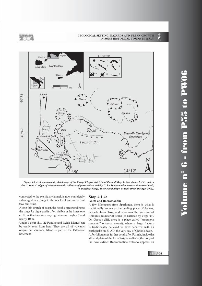
GEOLOGICAL SETTING, HAZARDS AND URBAN GROWTH IN SOME HISTORICAL TOWNS IN ITALY P
64
45 - P64
Vo
lum
e n
° 6
- f
rom
P5
5 t
o P
W0
6
connected to the sea via a channel, is now completely submerged, testifying to the sea level rise in the last two millennia.Along this stretch of coast, the notch corresponding to the stage 5.e highstand is often visible in the limestone cliffs, with elevations varying between roughly 7 and nearly 10 m.Under a clear sky, the Pontine and Ischia Islands can be easily seen from here. They are all of volcanic origin, but Zannone Island is part of the Paleozoic basement.
Stop 4.1.4:Gaeta and Roccamonfi naA few kilometres from Sperlonga, there is what is traditionally known as the landing place of Aeneas, in exile from Troy, and who was the ancestor of Romulus, founder of Roma (as narrated by Virgilius).On Gaeta’s cliff, there is a place called “montagna spaccata” (cleaved mount), where a large fracture is traditionally believed to have occurred with an earthquake on 33 AD, the very day of Christ’s death.A few kilometres further south after Formia, inside the alluvial plain of the Liri-Garigliano River, the body of the now extinct Roccamonfi na volcano appears on
Figure 4.9 - Volcano-tectonic sketch map of the Campi Flegrei district and Pozzuoli Bay. 1: lava dome, 2: CF caldera rim, 3: vent, 4: edges of volcano tectonic collapses of post-caldera activity, 5: La Starza marine terrace, 6: normal fault,
7: anticlinal hinge, 8: synclinal hinge, 9: fault (from Insinga, 2003).
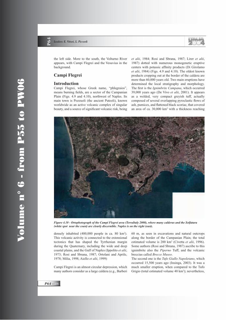
Vo
lum
e n
° 6
- f
rom
P5
5 t
o P
W0
6
P64 -
Leaders: E. Vittori, L. Piccardi
P6
4
the left side. More to the south, the Volturno River appears, with Campi Flegrei and the Vesuvius in the background.
Campi Flegrei
IntroductionCampi Flegrei, whose Greek name, “phlegraios”, means burning fi elds, are a sector of the Campanian Plain (Figs. 4.9 and 4.10), northwest of Naples. Its main town is Pozzuoli (the ancient Puteoli), known worldwide as an active volcanic complex of singular beauty, and a source of signifi cant volcanic risk, being
densely inhabited (400,000 people in ca. 80 km2).This volcanic activity is connected to the extensional tectonics that has shaped the Tyrrhenian margin during the Quaternary, including the wide and deep coastal plains, and the Gulf of Naples (Ippolito et alii,1973; Rosi and Sbrana, 1987; Ortolani and Aprile, 1978; Milia, 1998; Aiello et alii, 1999)
Campi Flegrei is an almost circular depression, which many authors consider as a large caldera (e.g., Barberi
et alii, 1984; Rosi and Sbrana, 1987; Lirer et alii,1987) dotted with numerous monogenetic eruptive centers with potassic affi nity products (Di Girolamo et alii, 1984) (Figs. 4.9 and 4.10). The oldest known products cropping out at the border of the caldera are more than 60,000 years old. Two main eruptions have determined the local stratigraphy and morphology. The fi rst is the Ignimbrite Campana, which occurred 39,000 years ago (De Vivo et alii, 2001). It appears as a welded, very compact greyish tuff, actually composed of several overlapping pyroclastic fl ows of ash, pumices, and fl attened black scoriae, that covered an area of ca. 30,000 km2 with a thickness reaching
60 m, as seen in excavations and natural outcrops along the border of the Campanian Plain; the total estimated volume is 200 km3 (Civetta et alii, 1996). Some authors (Rosi and Sbrana, 1987) ascribe to this ignimbrite also the Piperno Tuff, and the volcanic breccias called Brecce Museo.The second one is the Tufo Giallo Napoletano, which occurred 15,500 years ago (Insinga, 2003). It was a much smaller eruption, when compared to the Tufo Grigio (total estimated volume 40 km3); nevertheless,
Figure 4.10 - Ortophotograph of the Campi Flegrei area (TerraItaly 2000), where many calderas and the Solfatara (white spot near the coast) are clearly discernible. Naples is on the right (east).

GEOLOGICAL SETTING, HAZARDS AND URBAN GROWTH IN SOME HISTORICAL TOWNS IN ITALY P
64
47 - P64
Vo
lum
e n
° 6
- f
rom
P5
5 t
o P
W0
6
this pyroclastic fl ow, with a typical reddish-orange color, covered an area of more than 1000 km2, with a thickness locally exceeding 100 meters (Civetta etalii, 1996) According to the above-cited authors, these eruptions are related to two main sinking episodes, which have generated a complex caldera with a diameter of 12 km. Milia and Torrente (2003), based on the interpretation of 3,500 km of high resolution seismic refl ection profi les, believe instead that the complex volcanic and tectonic evolution of the Bay of Naples may be explained by the interaction and rotation of fault-bounded crustal blocks induced by an east-west left-lateral simple shear regime. The last period of volcanic activity, which started with the Tufo Giallo Napoletano eruption, has been, concentrated into three stages, separated by quiescent periods. In the fi rst stage (15.5-9.5 ka), about 34 eruptions occurred; in the second stage (8.6-8.2 ka), six explosive eruptions took place; whereas the third
stage (4.8-3.8 ka) was characterized by 16 explosive and 4 effusive eruptions, with an average frequency of 50 years (see www.ov.ingv.it). In this period ca. 40 meters of uplift of the central part of the Campi Flegrei took place, as testifi ed by the “Starza” marine terrace, which reached its elevation of 40 to 60 m a.s.l. 4.6-4 ka ago, anticipating the “Astroni” eruption (Cinque et alii, 1997). The last eruption, a modest tuff cone named Monte Nuovo (new mount), ca 150 mhigh, occurred in 1538 (Figure 4.11).
Vertical ground movement in the Bay of Naples During the last two millennia, the whole gulf area has undergone vertical soil movements, as shown by the many archaeological remains of Greek and Roman port facilities and towns (from VI BC to IV century AD) that are now submerged (Dvorak and Mastrolorenzo, 1991; Alessio et alii, 1994).Since the VIII century BC, many Greek colonies developed in the Campania region, the main of which were Pithecusa, on the Island of Ischia, and
Figure 4.11 - XVI century illustration of the 1538 eruption of Monte Nuovo.
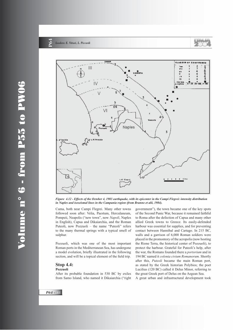
Vo
lum
e n
° 6
- f
rom
P5
5 t
o P
W0
6
P64 -
Leaders: E. Vittori, L. Piccardi
P6
4
Cuma, both near Campi Flegrei. Many other towns followed soon after: Velia, Paestum, Herculaneum, Pompeii, Neapolis (“new town”, now Napoli, Naples in English), Capua and Dikaiarchia, and the Roman Puteoli, now Pozzuoli – the name “Puteoli” refers to the many thermal springs with a typical smell of sulphur.
Pozzuoli, which was one of the most important Roman ports in the Mediterranean Sea, has undergone a model evolution, briefl y illustrated in the following section, and will be a topical element of the fi eld trip.
Stop 4.4:PozzuoliAfter its probable foundation in 530 BC by exiles from Samo Island, who named it Dikaiarchia (“right
government”), the town became one of the key spots of the Second Punic War, because it remained faithful to Roma after the defection of Capua and many other allied Greek towns to Greece. Its easily-defended harbour was essential for supplies, and for preventing contact between Hannibal and Cartago. In 215 BC, walls and a garrison of 6,000 Roman soldiers were placed in the promontory of the acropolis (now hosting the Rione Terra, the historical center of Pozzuoli), to protect the harbour. Grateful for Puteoli’s help, after the war, the Romans founded there a portorium and in 194 BC named it colonia civium Romanorum. Shortlyafter this, Puteoli became the main Roman port, as stated by the Greek historian Polybios; the poet Lucilius (120 BC) called it Delus Minor, referring to the great Greek port of Delus on the Aegean Sea. A great urban and infrastructural development took
Figure 4.12 - Effects of the October 4, 1983 earthquake, with its epicenter in the Campi Flegrei: intensity distribution in Naples and isoseismal lines in the Campania region (from Branno et alii, 1984).

GEOLOGICAL SETTING, HAZARDS AND URBAN GROWTH IN SOME HISTORICAL TOWNS IN ITALY P
64
49 - P64
Vo
lum
e n
° 6
- f
rom
P5
5 t
o P
W0
6
place under the Emperor Augustus, after the conquest of Egypt, when Egypt became the principal supplier of grain for Roma (Amalfi tano et alii, 1990). But soon after, the development of the port of Ostia (see Day 2, The Tiber delta), determined the slow decline of Puteoli, to which probably contributed the onset of the bradyseism in the area. Since the V century, the low areas were submerged by the sea or became malarial marshes, so the inhabitants moved back to the acropolis (which slowly developed as a typical, fortifi ed Medieval borgo, or fort) or even to Naples, also pushed by the barbarians fi rst, and then by Saracen raiders. At the end of the XIII century, the subsidence turned into uplift, prompting a phase of economic and urban development, with the reoccupation of the areas outside the city walls, fi rst by the common people, pushed out of the old town by the growth of clerical and noble buildings, and, since the XVIII century, by the clergy and the aristocracy who required wider spaces for their residences (Amalfi tano et al., 1990). Since then, the Rione Terra has been the home to humble people. Only now, is extensive restoration work in progress.In the years 1969-1972, and 1982-1984, the inhabitants of the area, Pozzuoli in particular, were the witnesses to, and victims of, intense events of positive bradyseism (from the Greek bradi = slow and seism = movement), of up to 0.5 mm/day, with a total uplift of 3.5 meters, such that a resumption
of volcanic activity was feared. As a result, many residents had to be displaced twice to safer areas, with severe economic and social consequences.
In 1969-1970, damages were observed in several buildings inside the Rione Terra, and uplift was noted in the port’s wharf. A small seismic swarm aggravated the fear of a new eruption, possibly similar to that of Monte Nuovo in 1538. So, 3,000 people were moved away from the Rione Terra, many of them forced to, with the help of the army, being reluctant to leave their homes. Ferocious political and scientifi c controversies arose at the time between supporters and opponents of the policy (including the volcanologist H. Tazieff, at that time Minister of Civil Protection in France), the latter being afraid of a manoeuver for a future tourist exploitation of the borgo, now conveniently freed of its humble residents. The uplift continued from mid 1969 to 1972, with a maximum of 170 cm in the wharf (Corrado et alii,1976). From 1972 to late 1974, the ground sunk by about 20 cm, leaving a permanent deformation of 150 cm (Barberi et alii, 1984).The second and much more serious crisis started in July 1982, becoming evident only in early 1983, and lasted until the end of 1984, with a maximum fi nal uplift of 180 cm, again near the port. Because of this new uplift, added to the previous one, a large area emerged from the sea, and new docks had to be built.
Figure 4.13 - Elevation changes measured at a leveling benchmark in Pozzuoli, located inside the area of maximum recent and historic bradyseism (source: www.ov.ingv.it).

Vo
lum
e n
° 6
- f
rom
P5
5 t
o P
W0
6
P64 -
Leaders: E. Vittori, L. Piccardi
P6
4
The uplifted area had a rounded, bulging shape, with a radius of about 6 km, and was centered in Pozzuoli (Berrino et alii, 1984). The seismic activity began in November 1982, with a swarm perceived in a small area. A major increase of seismic activity was recorded in the spring of the next year, with the occurrence of a M=3.5 earthquake beneath the Solfatara, and this was felt in a wide area, including the west side of Naples. On October 4, 1983, the Campi Flegrei were shaken by an earthquake of Ml=4.0, and an intensity of VII MSK, the largest shock during this crisis, and this caused some damage in the town of Pozzuoli and its surroundings, and was felt at a distance of 30 km from the epicenter (Figure 4.12, Branno et alii, 1984). This seismic sequence strongly distressed the population, because of the large number of daily shocks and the damage to the houses in the borgo.
On the days following the October 4 event, nearly 40,000 persons were evacuated from the center of
Pozzuoli, because of the high seismic risk (Barberi et alii, 1984; Luongo, 1986). Various factors were taken into consideration, among which were the poor structural characteristics of many buildings, some of which had already been damaged by the Irpinia 1980 earthquake (M= 6.9, I=IX-X MSK), and the growth trend of seismicity and uplift. Since 1985, the ground movement inverted its direction, with a subsidence of ca. 90 cm until 2001, interrupted by short episodes of uplift, again centered in Pozzuoli, in 1989 and 2000. The latter was characterized by a 3.5 cm rise, and a seismic swarm, with a sequence of ca. 60 events on August 22, the strongest ones felt by the population near the Solfatara (Mmax=2.2) (Figure 4.13).Recently (November 2003), a seismic event of M=1.2, located southeast of Pozzuoli, in the bay of Naples, was clearly felt in the area of Posillipo.(www.ov.ingv.it/ufmonitoraggio).
Stop 4.4.1:Serapeo or Temple of SerapisThe Serapeo, or rather, the macellum (the ancient Roman marketplace), located near the port of
Figure 4.14 - View of the Serapeo or “temple of Serapis” (macellum) in Pozzuoli. The darker bands on the columns are holes of lithodoms, marking the past sea level.

GEOLOGICAL SETTING, HAZARDS AND URBAN GROWTH IN SOME HISTORICAL TOWNS IN ITALY P
64
51 - P64
Vo
lum
e n
° 6
- f
rom
P5
5 t
o P
W0
6
Pozzuoli, is the monument which best testifi es to the Phlegrean bradyseism (Figure 4.14). This monument was rediscovered only in the XVIII century, when the king of Naples, Carlo di Borbone, prompted the archaeological excavation (from 1750 to 1756) of the site, which was locally called the “three-column vineyard”, because there were three old Cipollino marble columns partially sticking out of the ground.These archaeological excavations, completed between 1806 and 1818, brought to light the remains of a building that, due to the fi nding of a statue of the Egyptian god Serapis, was erroneously interpreted as a temple devoted to this god. Others interpreted it as a
thermal bath. Only in 1907, the French archaeologist, Charles Dubois recognized the true use as a macellumof this huge rectangular construction, 75 m long and 57 m wide, which recalls the shape of the macellummagnum built in Roma under Nero.
The building technique (opus lateritium) and the style of several decoration fragments date the macellum back to the end of the Ist and beginning of the II century. It was most probably divided into two levels; in addition to the many shops (a), there was an altar in the esedra, a fountain inside the tholos, an arcade, and public toilets (c). Access was guaranteed by a main entrance (vestibulum) on the seaward side (leading to
Figure 4.15 - Plan of the macellum (from Amalfi tano et al., 1990).

Vo
lum
e n
° 6
- f
rom
P5
5 t
o P
W0
6
P64 -
Leaders: E. Vittori, L. Piccardi
P6
4
the main arcade, supported by 30 columns) and lateral doors (b) (Figure 4.15, Amalfi tano et al., 1990). Four more columns bigger than the others (diameter 1.5 m) supported the monumental façade of the esedra. Only three of the latter columns are still up; the fourth lies on the fl oor, broken in four pieces.
These three Cipollino marble columns display, at 4 meters from their base, a 2.7 m high band thickly bored by molluscs (Lithodomus lithofagus), which precisely mark the mean sea level. This demonstrates that the Serapeo was once partially submerged, and then re-emerged from the sea.Over the course of time, the macellum suffered spoliations and modifi cations, which strongly modifi ed its original shape. In the XIX century, after its excavation, the building was partially used as a bath, because of its mineral springs, as proved by traces in the outer walls of some tabernae.Scientists in the XIX and early XX century proposed two main theories for explaining the lithodoms’ boreholes: global variation of the sea level, or vertical ground movements. Although a follower of the fi rst theory, Niccolini started a long period of measurements of the sea level, very useful for reconstructing the trend of this phenomenon during the fi rst half of the XIX century.
Breislak (1792) was the fi rst to suggest that the holes
Figure 4.16 - Vertical movements of the macellum’s fl oor, according to Parancandola (1947). The uplift peak corresponds to the 1538 “Monte Nuovo” eruption.
Figure 4.17 - Solfatara: view of the inner border of the crater ( photo by Porfi do).

GEOLOGICAL SETTING, HAZARDS AND URBAN GROWTH IN SOME HISTORICAL TOWNS IN ITALY P
64
53 - P64
Vo
lum
e n
° 6
- f
rom
P5
5 t
o P
W0
6
in the columns were related to sea level changes since the Roman age, laterproposing that two earthquakes could have successively changed the level of the structure, one lowering the area under the sea level and another raising it to its present elevation. Other scientists understood the true mechanism (e.g., Forbes, 1829; Babbage, 1847; Lyell, 1872). Much later, Parascandola (1947) detailed the vertical movements in the bay of Pozzuoli. He indicated a continuous subsidence since the III century, with a peak around the X century (Figure 4.16). A gradual uplift must have occurred from the X to the XV century, with 7 meters of elevation two days before the 1538 eruption, followed by a sinking of 5 meters over several decades. Recently, based on an accurate review of all available data, Dvorak and Mastrolorenzo (1991) have proposed a new scheme of the vertical movements at the Serapeo, from the Roman age to 1986. According to their calculations, the uplift before the 1538 eruption was even higher than already assessed: 11 meters, of which 5 to 7 occurred in the days immediately preceding the event, and about 4 m in the earlier decades immediately before the eruption. This is confi rmed by two royal decrees issued in 1503 and 1511: “Ferdinand, by grace of God, King of Aragona and King of the two Sicilies (Southern Italy), and Raymund, Viceroy of Cardona, donate to the city of Pozzuoli all of the city property dried up from the sea around Pozzuoli, which is located on the land within its boundary, 23 May 1511”.
Stop 4.4.2:Visit of underground PozzuoliThe excavations in the Rione Terra, which directly rests above the Roman colony, provide an exceptional
documentation of the ancient town plan, typically characterized by two central perpendicular axes: the east-west-trending decumanus maximus, 3 meters underground along the present-day Via Duomo, and the north-south-trending cardo maximus, today’s Via del Vescovado. Another cardo is recognizable in Piazza Liborio, probably related to another axis linking the acropolis to the Emporium, the dock area of Puteoli. Along the decumanus maximus, many ancient buildings have been found, mostly horrea(grain storehouses) and tabernae (shops), connected to the street via a large porch supported by brick pillars. The unveiled remains point out their various transformations in the imperial period. Next to Via Ripa, a wide taberna revealed much heavily damaged earthenware, possibly by an earthquake or a fi re. More excavations undertaken during the restoration of the Rione, are now discovering many extraordinary archaeological remains, including superb statues and signs of the Greek walls.
Stop 4.4.3:Solfatara (1.5-2 hours)Strabo (66 BC) defi ned the Solfatara Forum Vulcanii, i.e. the square, the forge of God Vulcanus, antechamber of Hades, the afterlife.It is the place (ad Sulphatariam) where, according to tradition, the decapitation of San Gennaro, bishop of Beneventum, took place in 305, during the Diocletian’s persecutions of Christians. The Solfatara was a thermal spring resort from Roman times until the end of 1800, supplying natural saunas, and hot water and mud baths.The Solfatara is today a quiescent volcano; the crater is elliptic (770 long and 580 m wide), the upper rim is 2.3 km long. The present-day crater is the result of a tephra phreatomagmatic eruption that occurred ca. 4,000 years ago. Inside the crater, there are typical manifestations of quiescent volcanoes: fumaroles, mofetes, mud cones, and sulphur crusts (Fig 4.17). The crater walls are chiefl y made up of cinder layers; at the bottom, there is a phreatomagmatic breccia, followed by a pyroclastic fl ow several meters thick, altered by fumarolic activity. These products cover the older lava dome of the Accademia, very near the Solfatara. Actually, inside the basal explosion breccia, there are frequent fragments of such a lava dome (Giacomelli and Scandone, 1992).Inside the Solfatara the most characteristic items are:La Bocca Grande (the big mouth), that is the largest fumarole, with a steam temperature of 160
Figure 4.18 - Solfatara: Le Stufe Antiche (photo by Vittori).
Vo
lum
e n
° 6
- f
rom
P5
5 t
o P
W0
6
P64 -
Leaders: E. Vittori, L. Piccardi
P6
4
°C. The reddish colour of the rocks nearby is due to the deposition of several salts contained in the steam: realgar (arsenic sulphide), cinnabar (mercury sulphide), and orpiment (arsenic trisulphide), with a high concentration of sulphydric acid. Le Stufe Antiche (the “old stoves”), two caves artifi cially excavated in the fl ank of the crater, named Purgatory and Hell, used in the past as natural saunas, and for inhaling sulphurous steam as a cure for the breathing apparatus. Crystals of alum and sulphur are common in this area (Figure 4.18).La Fangaia (the “mud place”), fed by numerous small fumaroles and thermal springs, to which rain water and superfi cial sediments add their contribution, is a very peculiar site, which provides a boiling mud (140 °C), considered to be excellent as a cure for rheumatism. It is also the habitat of a unique thermophilic microorganism: the Solfolobus solfataricus, useful for producing combustible organic acids and thermo-stable enzymes, used in the food industry for making syrups and sugars. There are also bacteria living at temperatures higher than 90°C, e.g. Bacillus acidocaldarius and Caldariella acidophila.On the inner walls of the Bocca Grande, unicellular algae have been found, Cyanidium caldarium, which can survive in very hot and acid environments.Il pozzo dell’acqua minerale (mineral water well), known since the mediaeval period, these waters were considered curative for manifold diseases, from skin affections to sterility.
Dinner at posillipo, night in Naples
DAY 5
Stops 5.1-5.2:
Stop 5.1Guided tour of the submerged Roman constructions in the Bay of Pozzuoli (ca. 70 min) by a special boat with a transparent keel
Due to its great strategic relevance, the Romans made 6 ports within the bay of Pozzuoli: Misenum, Baiae, Portus Julius (near the lake Lucrinus), Puteoli, Nisida (Nesis), and Posillipo (Pausilypon). Most of these harbour facilities are now submerged or lost.
Stop 5.1.1:BaiaThe ancient town of Baiae – named after a companion of Ulysses (Baios), who was buried here according
to legend – was a holiday resort in imperial times because of the amenity of its environment, and the thermal waters nearby. Many of the elegant Roman villas, with their spectacular fl oor mosaics, spread along the sinus Baianus, are now underwater between Epitaffi o point and the Castello promontory. One such house is the Villa dei Pisoni. Another one is the so-called Villa a protiro, because of the portico before its main door. Also a portion of the urban structure is preserved, with a street and the tabernae overlooking it and the remains of a thermal bath complex.The last pier of the Roman breakwater lies about 800 m from the shoreline. Dvorak and Mastrolorenzo (1991) have estimated a net subsidence of 8 meters since the Roman Age.
Stop 5.1.2:MisenoThe Roman Misenum (a name derived from the trumpeteer of Aeneas drowned in this sea after an unfortunate competition with Triton, god of the sea) was initially a holiday resort with patrician villas and later, under Augustus (Ist century AD), became the base of one of the two imperial fl eets (the other one was at Ravenna, in the Adriatic Sea). The port had two natural basins: the inner basin (now named “maremorto” or“dead sea”), was the shipyard, while the outer basin, the Misenum bay, was the true port. They connected through a channel, now fi lled up, which was crossed by a wood bridge. The port entrance was monumental and surrounded by lighthouses and watch towers. Inside rested the whole fl eet, the strongest in the world, with the giant admiral ship sporting six rows of oars. The naval base could accommodate 6,000 men. There were arsenals and dockyards. Of the many buildings and original infrastructure, very little has survived: some ruins and the beach name Miliscola (Militum schola) where the training center was located still remain.Remains of two mooring stones below the present-day sea level reveal a subsidence of about 9 meters since Roman times.
Stop 5.1.3:Portus JuliusAgrippa and Ottavianus built it in 37 BC during the civil war against Pompey. They utilized the coastal lake Lucrinus, which was linked to the sea, and the inner lake Avernus, by means of two channels. The combined effects of the bradyseism and the quick silting up of the basins, determined its abandonment in favour of Misenum, already before 12 BC. The
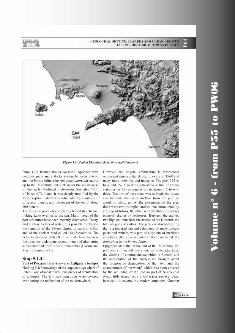
GEOLOGICAL SETTING, HAZARDS AND URBAN GROWTH IN SOME HISTORICAL TOWNS IN ITALY P
64
55 - P64
Vo
lum
e n
° 6
- f
rom
P5
5 t
o P
W0
6
famous (in Roman times) coastline. equipped with complex piers and a docks system between Puteoli and the Portus Julius (the ripa puteolana), was active up to the IV century, but sunk under the sea because of the early Medieval bradyseism (see also “Port of Pozzuoli”). Later, it was deeply modifi ed by the 1538 eruption, which was anticipated by a soil uplift of several meters, and the retreat of the sea of about 200 meters.The volcanic products completely buried the channel linking Lake Avernus to the sea. Many traces of the port structures have been recently discovered. Today, under a few meters of water, it is possible to observe the remains of the Portus Julius, of several villas, and of the ancient road called Via Herculanea. The net subsidence is diffi cult to estimate here, because this area has undergone several meters of alternating subsidence and uplift since Roman times (Dvorak and Mastrolorenzo, 1991).
Stop 5.1.4:Port of Pozzuoli (also known as Caligula’s bridge)Nothing is left nowadays of the Augustan age wharf of Puteoli, one of most marvellous pieces of architecture of antiquity. The few surviving ruins were covered over during the realization of the modern wharf.
However, the original architecture is represented on ancient mirrors, the Bellori drawing of 1768 and many more drawings and incisions. The pier, 372 m long and 15-16 m wide, ran above a line of arches standing on 15 rectangular pillars (pilae), 5 to 6 m thick. The aim of the arches was to break the waves and facilitate the water outfl ow from the port, to avoid its silting up. At the extremities of the pier, there were two triumphal arches, one surmounted by a group of tritons, the other with Neptune’s quadriga (chariot) drawn by seahorses. Between the arches, two high columns bore the statues of the Dioscuri, the tutelary gods of sailors. The pier, constructed during the fi rst imperial age and celebrated by many ancient poets and writers, was part of a system of maritime structures (the ripa puteolana) that connected the Emporium to the Portus Julius.Epigraphs state that at the end of the IV century, the port was still in full operation; some decades later, the decline of commercial activities in Puteoli, and the acceleration of the bradyseism, brought about the progressive degradation of the ripa, and the abandonment of the wharf, which was soon covered by the sea. Also, of the Roman port of Nisida (old Nesis, little island) only a few traces survive today, because it is covered by modern structures. Gunther
Figure 5.1 - Digital Elevation Model of coastal Campania.
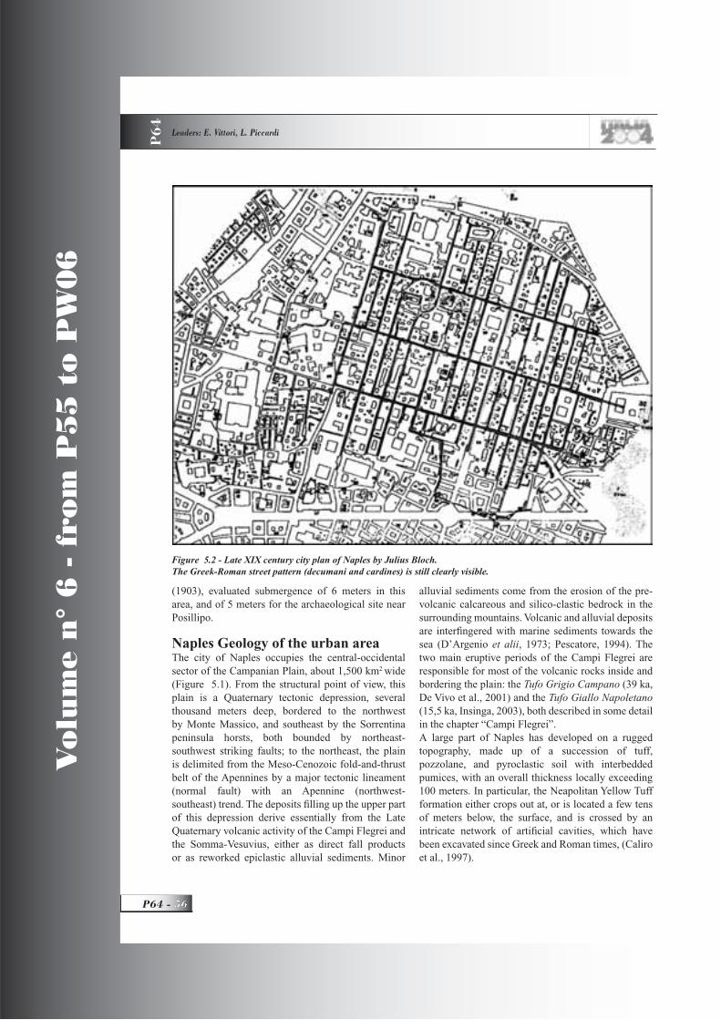
Vo
lum
e n
° 6
- f
rom
P5
5 t
o P
W0
6
P64 -
Leaders: E. Vittori, L. Piccardi
P6
4
(1903), evaluated submergence of 6 meters in this area, and of 5 meters for the archaeological site near Posillipo.
Naples Geology of the urban areaThe city of Naples occupies the central-occidental sector of the Campanian Plain, about 1,500 km2 wide(Figure 5.1). From the structural point of view, this plain is a Quaternary tectonic depression, several thousand meters deep, bordered to the northwest by Monte Massico, and southeast by the Sorrentina peninsula horsts, both bounded by northeast-southwest striking faults; to the northeast, the plain is delimited from the Meso-Cenozoic fold-and-thrust belt of the Apennines by a major tectonic lineament (normal fault) with an Apennine (northwest-southeast) trend. The deposits fi lling up the upper part of this depression derive essentially from the Late Quaternary volcanic activity of the Campi Flegrei and the Somma-Vesuvius, either as direct fall products or as reworked epiclastic alluvial sediments. Minor
alluvial sediments come from the erosion of the pre-volcanic calcareous and silico-clastic bedrock in the surrounding mountains. Volcanic and alluvial deposits are interfi ngered with marine sediments towards the sea (D’Argenio et alii, 1973; Pescatore, 1994). The two main eruptive periods of the Campi Flegrei are responsible for most of the volcanic rocks inside and bordering the plain: the Tufo Grigio Campano (39 ka, De Vivo et al., 2001) and the Tufo Giallo Napoletano(15,5 ka, Insinga, 2003), both described in some detail in the chapter “Campi Flegrei”.A large part of Naples has developed on a rugged topography, made up of a succession of tuff, pozzolane, and pyroclastic soil with interbedded pumices, with an overall thickness locally exceeding 100 meters. In particular, the Neapolitan Yellow Tuff formation either crops out at, or is located a few tens of meters below, the surface, and is crossed by an intricate network of artifi cial cavities, which have been excavated since Greek and Roman times, (Caliro et al., 1997).
Figure 5.2 - Late XIX century city plan of Naples by Julius Bloch. The Greek-Roman street pattern (decumani and cardines) is still clearly visible.

GEOLOGICAL SETTING, HAZARDS AND URBAN GROWTH IN SOME HISTORICAL TOWNS IN ITALY P
64
57 - P64
Vo
lum
e n
° 6
- f
rom
P5
5 t
o P
W0
6
A combination of geographic location and climatic conditions makes Naples more susceptible than other cities to the disasters caused by natural events. Major natural disasters have been caused by seismic and volcanic activity, as well as by fl ood inundation. The power of these events has even been able to signifi cantly reshape the ground morphology, bringing about serious damage to the community, and imposing many times the abandonment of areas only a posteriori recognized as dangerous and major reconsiderations of urban development plans.
Origin of the cityThe history of Naples begins with the Greek settlement of Partenope on the Pizzofalcone hill and the Megaris islet. A part of the historical tradition attributes its foundation to Rhodian sailors (VIII century BC), while others believe that it was due to the expansion of Cuma, the oldest and one of the largest Greek colonies in the Occident. So, the birth of Partenope was prompted by the will to counterbalance the Etruscan expansion in the area by creating seaports and controlling the farming inland. Around 470 BC, Cuman colons founded Neapolis (new town), not far from an older settlement called Palaeopolis.
Only in a later phase, the city expansion reached the area where today the old town is. The city came under Roman domination around 290 BC, after the Romans’
victory over the Samnites. The Romans preserved the structure of the Greek town, with only minor changes. The urban setting basically utilized the fl at areas encircled by canyons, which at that time were nearly fi lled by sediments. The typical regular network of cardines, decumani, and insulae is still recognizable in the present-day city plan (Figure 5.2). The Roman forum was built right above the Greek Agora, determining a fi rst vertical stratifi cation, (Giampaola and Longobardo, 2000).In Byzantine times, the city rapidly developed to the west, towards the sea. The expansion outside the old city walls, and the urban and architectural development of Naples continued during the Norman-Svevian domination and the Angioins that followed. Since then, Naples has been for many centuries the capital of a rich kingdom, comprising the whole of southern Italy, often ruled by foreign kings (Spanish and French chiefl y, in the XVI-XIX centuries of the Bourbon dynasty). An almost continuous economic, cultural, and social development has characterized Naples over the centuries, notwithstanding the many natural and man-made disasters, which have deeply affected it. This is evident in its innumerable monuments and art masterpieces, which add to a spectacular landscape, dominated by the Somma-Vesuvius.
Figure 5.3 - Vesuvius and the urbanized area around it (light grey). Naples is on the upper left (west) (from Terra Italy 2000).

Vo
lum
e n
° 6
- f
rom
P5
5 t
o P
W0
6
P64 -
Leaders: E. Vittori, L. Piccardi
P6
4
Effects of earthquakesTwo distinct seismic sources affect the Neapolitan area: one strictly tectonic, and the other originating from the volcanic activity. Their effects differ substantially in terms either of intensity and extension of the affected area.Based on the reconstruction of the macroseismic fi elds of the major Apenninic events from 1456 to 1980, obtained with a careful review of historical and archive data, the most relevant seismogenetic sources for Naples are located in the Matese mountains (at the border between the Campania and Molise regions), and in the Marzano-Ogna mountains (at the border between the Campania and Basilicata regions). The earthquakes originating from these seismic sources (> 100 km apart) are characterized by high energy (magnitudes around 7), which spreads over areas thousands of square kilometers wide, generating disastrous effects also tens of kilometers away from the epicenter. The strongest among the many Apennine earthquakes listed in Italian seismic catalogues (see www.ingv.it), have determined in Naples macroseismic intensities around the VIII degree MCS, i.e. signifi cant damage to constructions and even partial to complete collapses, as documented in numerous historical descriptions, and seen in recent events (Esposito et al., 1992).
In the Neapolitan volcanic centers, the seismicity level is much lower and, due to the shallow hypocentral depths (< 5 km), damage is generally confi ned to a narrow epicentral area. Anyway, also in this case, intensities around VIII can be attained.
Effects of fl oods and landslidesRecent studies inside the urban area of Naples have discovered huge accumulations of alluvial to debris-fl ow sediments, with ages starting from the IV-VI century BC, which have deeply modifi ed the local topography, (Caliro et al., 1997). Due to its rugged topography and the widespread, mostly artifi cially cut, cliffs and underground cavities, the metropolitan area of Naples is characterized by a widespread risk related to soil instabilities, which are rarely catastrophic but however never negligible, and which occur with a certain frequency in the whole district, thus proving the extreme fragility of this territory. Five main types of effect have been observed: rock falls, earth fl ows (landslides), collapses, fl oods, and lahars. Rock falls from the Neapolitan Yellow
Tuff cliffs were the most frequent and widespread phenomenon, characterized by the detachment of small-to-medium volumes of material (max 200 m3). Collapses were prevalently observed in
correspondence to the ancient cavities dug underneath the historical center of the city for water distribution and obtaining construction material (pozzolana and tuff bricks). They have occasionally caused severe damage to historical buildings and infrastructures. Flood events, induced by generally unforeseen heavy and abrupt rainstorms, occur about every ten years. They are largely diffused in the southern and eastern sectors of the city, but are less common in the historical center, where only four cases have been reported.In addition to this, the same rainstorms have induced numerous sliding phenomena causing, at times, severe damage to the economic, social and infrastructural setting of the metropolitan area (Pellegrino, 1994; Evangelista, 1994; Rossi, 1994; Esposito et alii,2002).Known lahars only occurred in the eastern side of the city (S. Giovanni), closely related to the 1906-1918 eruption cycles of the Somma-Vesuvius. In that period, eleven lahars invaded buildings, streets and railways, with layers of many thousand cubic meters of volcanic material 0.5 to 1.5 m thick.
Volcanic hazardThe Neapolitan region contains three highly hazardous volcanic areas: Somma-Vesuvius, Campi Flegrei, and Ischia Island, whose last eruptions occurred in 1944, 1538, and 1302 respectively. Their persistent living
Figure 5.4 - Gate to subterranean Naples, 40 m under the street level, corresponding to the decumanus superior,
near the church of San Gregorio Armeno (photo Esposito).

GEOLOGICAL SETTING, HAZARDS AND URBAN GROWTH IN SOME HISTORICAL TOWNS IN ITALY P
64
59 - P64
Vo
lum
e n
° 6
- f
rom
P5
5 t
o P
W0
6
state is testifi ed by fumarolic and seismic activity and ground deformation. The high hazard these volcanoes pose, and the extreme population density around them, determine levels of volcanic risk, ranking among the highest in the world (e.g., Scandone, 1983; Scandone et alii, 1993; Lirer, 1994).The Neapolitan volcanoes display a multiplicity of phenomena with varying hazard and environmental effects. The major direct menaces come from: fall of projecta of various size and temperature; lava, pyroclastic and mud fl ows; gas emissions; earthquakes and tsunamis. Other secondary effects of volcanism, such as fl oods and landslides, also occur.Notwithstanding the relative distance of the crater from the city, the local morphology, the mean wind direction, and the low probability of reactivation in the next decade, the risk posed by Vesuvius is considered extremely high in the eastern margin of Naples and fi ve other Vesuvian municipalities (Torre Annunziata, Torre del Greco, San Giorgio a Cremano, Portici, and Ercolano), because of the great number of people living within the exposed area (Scandone and D’Andrea, 1994).For the same reason, the Campi Flegrei represent a
source of extremely high risk for Pozzuoli and the western side of Naples (Scandone and D’Andrea, 1994).
For many years, scientists have been left alone to warn of the rapidly mounting volcanic risk, taking into consideration uncontrolled urban expansion (Figure 5.3). Only recently, decision-makers have recognized the no longer sustainable growth of such risk, and are planning a set of actions aimed at its mitigation.The Italian Civil Protection is continuously upgrading the complex emergency plan, to be applied when the monitoring system of any volcanic anomalies (one of the most effi cient in the world), would signal a renewal of the volcanic activity. In case a (likely) reactivation of Vesuvius takes place, the plan includes the exodus of at least 700,000 people to other Italian regions.
Figure 5.5 - Greek-Roman cisternae: water reservoirs entirely dug in the Neapolitan Yellow Tuff (photo Esposito).
Figure 5.6 - Staircases and passageways cut in the tuff, 40 m under S. Gregorio Armeno (photo Vittori).
Figure 5.7 - S. Lorenzo Maggiore: a Roman wall covered by a mud-debris deposit, possibly related to
a V century fl ood.

Vo
lum
e n
° 6
- f
rom
P5
5 t
o P
W0
6
P64 -
Leaders: E. Vittori, L. Piccardi
P6
4
This plan has been dimensioned taking as reference the 1631 Plinian eruption, which has been chosen as the most likely and hazardous to be expected, based on the present state of the volcano.
Stop 5.2:Underground of Naples An easy walk in the center of Naples will allow us to discover some surface and underground beauties of Naples. In particular, the subterranean exploration will include Greek and Roman water reservoirs, aqueducts, quarries, tunnels, and collapses. The street network still preserves the ancient Greek and Roman structure (decumani and cardines).
Stop 5.2.1:S. Gregorio Armeno (60 min)The tuffaceous subsoil of Naples has been exploited since its foundation. Already during the construction of Neapolis (V century BC), the Greek bored a deep system of water reservoirs, aimed at storing the precious rainwater, and excavated hypogeal graves. Moreover, they opened underground quarries to obtain tuff blocks to build temples and the city walls.
In the centuries that followed, the expansion of the city during the Augustan age imposed the realization of an impressive aqueduct, 100 km long. It carried to the city the water captured at the springs of Serino (Avellino), through a system of arches and tunnels. The drinking water, collected in wide underground reservoirs (cisternae), was distributed by means of a dense network of narrow tunnels. With the arrival of the Angioins in 1266, the town experienced a period of expansion, for which more subterranean quarries were necessary (Figs. 5.4 – 5.6).A powerful effect on the future of the underground excavations of Naples was brought about by several royal decrees issued between 1588 and 1615, and especially in 1781, which prohibited the quarrying of the subsoil inside the city limits, as a drastic measure to limit the quick and out-of-control rise of new homes (Evangelista, 1994). The old triangular shape of the vaults was abandoned in the XIX century, in favor of a more squared or elliptical profi le. This, coupled with shallower vaults in order to improve the exploitation of the quarry sites, increased the hazard with frequent collapses of the vaults. The last intervention in the subsoil took place during World War II, when the largest galleries were adapted to host the people seeking refuge from Allied air raids.
With time, the many changes to the primitive use of the excavations (chiefl y the shallowing, widening, and fl attening of vaults), the loss of knowledge about their existence, the disordered urban growth (without searching for potential cavities underneath), the natural deterioration of the relatively soft volcanic materials (helped by the uncontrolled water seepage from the surface), have led to diffuse instability. The high hazard is confi rmed by the many collapses that have occurred in the last half century, often following heavy rainstorms, mostly in the shape of sinkholes with signifi cant damage to the buildings and streets resting above.
Stop 5.2.2:Stratifi ed Greek and Roman settlements under S.Lorenzo Maggiore, and the fl ood of V (?) AD(60 min)The recent restoration and amplifi cation of the archaeological excavations under the basilica of San Lorenzo Maggiore have brought to light a clear stratifi cation of the main cultural epochs since Greek times.Inside the present-day basilica (XI century),, some features of the VI century palaeo-Christian basilica are still visible, although partially buried. Under the Sala Capitolare, there are elements of a Norman age building. All these constructions had been placed above a Roman complex of the second half of the Ist century AD, identifi ed as the macellum (city’s food market). Its typical structure (an arcade lined with shops), had its main entrance on the plateia of the present-day Via dei Tribunali (the Roman decumanus superior).In its turn, this edifi ce stretches onto a Greek structure of the IV century BC, very likely the main square of Neapolis, its “agora”, i.e. the primary meeting point of social and political life in all Greek towns.In a wall of the excavation, above the Roman pavement, a 2-3 meters high chaotic sediment crops out (mostly reworked volcanic material, with sparse pottery shards), very likely a mud-debris fl ow deposit from a big fl ood, supposedly occurring at the end of the V century (Figure 5.7).
DAY 6
Stop 6.1Vesuvius, Herculaneum
Lunch at herculaneum, dinner and night near paestum
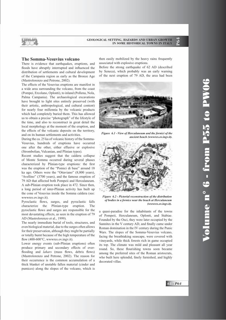
GEOLOGICAL SETTING, HAZARDS AND URBAN GROWTH IN SOME HISTORICAL TOWNS IN ITALY P
64
61 - P64
Vo
lum
e n
° 6
- f
rom
P5
5 t
o P
W0
6
The Somma-Vesuvius volcanoThere is evidence that earthquakes, eruptions, and fl oods have abruptly interrupted and infl uenced the distribution of settlements and cultural development of the Campania region as early as the Bronze Age (Mastrolorenzo and Petrone, 2002).The effects of the Vesuvius eruptions are manifest in a wide area surrounding the volcano, from the coast (Pompei, Ercolano, Oplonti), to inland (Pollena, Nola, Palma Campania). The archaeological excavations have brought to light sites entirely preserved (with their artistic, anthropological, and cultural content) for nearly four millennia by the volcanic products which had completely buried them. This has allowed us to obtain a precise “photograph” of the lifestyle of the time, and also to reconstruct in great detail the local morphology at the moment of the eruption, and the effects of the volcanic deposits on the territory, and on its human settlements and activities.During the ca. 25 ka of volcanic history of the Somma-Vesuvius, hundreds of eruptions have occurred one after the other, either effusive or explosive (Strombolian, Vulcanian, and Plinian types). Recent studies suggest that the caldera collapse of Monte Somma occurred during several phases characterized by Plinian-type eruptions: the fi rst was the eruption of the “Pomici di base” around 18 ka ago. Others were the “Ottaviano” (8,000 years), “Avellino” (3700 years), and the famous eruption of 79 AD that affected both Pompeii and Herculaneum. A sub-Plinian eruption took place in 472. Since then, a long period of inter-Plinian activity has built up the cone of Vesuvius inside the Somma caldera (see: wwwres.ov.ingv.it). Pyroclastic fl ows, surges, and pyroclastic falls characterize the Plinian-type eruption. The pyroclastic fl ows and surges are responsible for the most devastating effects, as seen in the eruption of 79 AD (Mastrolorenzo et al., 1999).The nearly immediate burial of tools, structures, and even biological material, due to the surges often allows for their preservation, although they might be partially or totally burnt because of the high temperature of the fl ow (400-600°C, wwwres.ov.ingv.it). Lower energy events (sub-Plinian eruptions) often produce primary and secondary effects of over-fl ooding and lahars (mass fl ows, debris fl ows) (Mastrolorenzo and Petrone, 2002). The reason for their occurrence is the common accumulation of a thick blanket of unstable fallen material (cinder and pumices) along the slopes of the volcano, which is
then easily mobilized by the heavy rains frequently associated with explosive eruptions.Before the strong earthquake of 62 AD (described by Seneca), which probably was an early warning of the next eruption of 79 AD, the area had been
a quasi-paradise for the inhabitants of the towns of Pompeii, Herculaneum, Oplonti, and Stabiae. Founded by the Osci, they were later occupied by the Sannites in the V century AD, and fi nally came under Roman domination in the IV century during the Punic Wars. The slopes of the Somma-Vesuvius volcano, facing the breathtaking seascape, were covered with vineyards, while thick forests rich in game occupied its top. The climate was mild and pleasant all year round. So, these fl ourishing towns soon became among the preferred sites of the Roman aristocrats, who built here splendid, fi nely furnished, and highly decorated villas.
Figure 6.1 - View of Herculaneum and the fornici of the ancient beach (wwwres.ov.ingv.it).
Figure 6.2 - Pictorial reconstruction of the distribution of bodies in a fornice near the beach at Herculaneum
(wwwres.ov.ingv.it).
Vo
lum
e n
° 6
- f
rom
P5
5 t
o P
W0
6
P64 -
Leaders: E. Vittori, L. Piccardi
P6
4
The 79 AD eruptionAll this came to an abrupt end on August 24, 79 AD, after days of continuous rumbles, tremors, and earthquakes. In two famous letters to the historian Cornelius Tacitus, Pliny the Younger has described the eruption and the death of his uncle Pliny the Elder. They were on the opposite side of the gulf (ca. 21 km away), when they saw the column of smoke. Scientifi c curiosity and the wish to bring help to his friends brought Pliny the Elder by boat to Stabiae, whence he could not escape his fate (Gigante, 1997).The eruption begun with a column of gas, ashes, and lapilli, white and black pumices, and lithic fragments, which reached an elevation of at least 15 km above the volcano, accompanied by numerous earthquakes.According to several authors (e.g., Sigurdsson et al., 1985; wwwres.ov.ingv.it): The column was about 26 km high during the phase called “of the white pumices”, and later climbed to 36 km, during the phase “of the grey pumices”.The collapse of the column, due to its increasing weight, because of cooling and loss of gases, and conclusion of the push from below, characterized the next phase of the eruption. Surges and pyroclastic fl ows moved downwards along the slopes of the volcano at high-speed, burning, and burying everything in their path (Mastrolorenzo et alii, 1999).A change of the eruptive style characterized the third phase, with huge increments of the pyroclastic fl ows, hotter and richer in ashes and pumices. Moving rapidly from the top of Vesuvius, they produced the largest area of devastation.
Stop 6.1:Herculaneum: effects of the eruption of 79 ADHerculaneum is sited on the western slope of Vesuvius, close to the sea, not far from the more renowned Pompeii, with which it shared the same tragic destiny.
The fi rst remains of Pompeii were found by chance in 1595, but systematic archaeological excavations in the area began in 1754. Not much later, the excavations at Herculaneum uncovered fascinating evidence of city life during the fi rst century of the Roman Empire, as crystallized and preserved intact for nearly eighteen centuries by the products of the surges and pyroclastic fl ows of the second and third phases of the eruption (Figure 6.1). This happened on August 25, 12 hours after an intense fall of pumice had already interrupted
the life of Pompeii forever. The lack of impact features suggests that the fi rst surge had limited transport capability, and moved as a nube ardente made of fi ne ash, coming directly from the lateral collapse of the eruptive cloud. This fl ow provoked the nearly immediate death of the inhabitants (Figure 6.2), but did not entirely destroy the buildings, which were merely unroofed and partially fi lled with ash. The style of fracturing, and the position of the bodies, suggest a high temperature (ca. 500 °C). On the contrary, the second surge moved at high speed, with a high transport capacity and with a major destructive impact on the walls. The successive fl ows and surges completely buried the buildings (Mastrolorenzo, 1998, 2001, 2002). For example, the circular basin of the calidarium of the suburban thermae was dragged against a wall; as well, the statue of the proconsul Narcus Nonius Baldus was dragged 15 meters away from its pedestal (De Simone, 1997).At the end of the eruption, Herculaneum was buried under a layer of volcanic products, 10 to over 23 meters thick, observable in the cliff overhanging the ancient beach.
DAY 7
Stops 7.1, 7.2:Paestum: fossilization of the ancient town by travertine depositing waters (2,500-1,000 yrs BP)
IntroductionThe ancient town of Paestum was founded by Sibari Greeks around VI-VII century B.C., at the southern end of the Sele Plain (Figs. 5.1 and 7.1). This settlement, close to a retreated coastline roughly corresponding to the Sterpina beach ridge, 100-150 m from the present coastline (Brancaccio et al., 1987), rests on organogenic calcareous encrustations (travertines), which originated from waters fl owing at a distance not exceeding a few hundred meters from their springs (D’Argenio et al., 1987; D’Argenio and Ferreri, 1992; Violante et al., 1994).In the Paestum area, the most recent travertines have an age spanning from more than 4000, to less than 1000 years, and may be divided into two levels (Violante et al., 1993): (a) the older (lower) travertines (about 4000 years old at their top) which form the deposits that underlie the town and which were used to erect temples, buildings, and perimeter walls; (b) the younger (upper) travertines, that cover Greek and

GEOLOGICAL SETTING, HAZARDS AND URBAN GROWTH IN SOME HISTORICAL TOWNS IN ITALY P
64
63 - P64
Vo
lum
e n
° 6
- f
rom
P5
5 t
o P
W0
6
Roman remains (walls, streets, and buildings).The depositional event which produced the upper travertines is a case of fossilization of a whole town, occurred in historical time, by encrusting waters fl owing from the inside to the outside of the city walls (Aiello et al, 1989; Violante et al., 1993; Violante and D’Argenio, 2000).
Lower travertinesTopographic analysis of the archaeological area suggests that the urban structure has been designed to fi t the travertine - controlled morphology. Lower travertines form two east-west oriented, downhill elongated mounds, separated by an intermediate depression. The middle axis of the town was developed along this depression, and was used as natural layout for the Decumanus Maximus and the public area (Agorà, Forum). The lateral mounds were the sites of sacred edifi cations (temples).Sedimentological analysis shows that textures and sedimentary structures of travertines outcropping in the trenches located just below the wall foundations, perfectly mirror those of many ashlars forming the
town walls. This suggests that the building material for the edifi cation of the town walls was extracted in situ and relocated just above. The artifi cial cuts visible along the western side of the perimeter walls, provided building material, and at the same time, further steepened the originally gently-dipping fl anks of the travertine mounds, thus increasing the defensive function of the walls.The lower travertine deposits show an abrupt morphological step (at present about 3 m high; Figure 7.2) on the western side of the town, close to Porta Marina. This morphology is due to a fossil waterfall structure, which developed perpendicularly to the original water fl ow direction, and now forms the western margin of the large travertine plate extending below the town perimeter.
Upper travertinesPaestum streets, buildings, and walls are also embedded in travertine deposits, due to fl owing waters which encrusted and then buried the town with their precipitates about 1000 years ago. Large parts of these deposits have been almost totally removed
Figure 7.1 - Travertines and beach ridges outcropping in the Sele River plain around Paestum.
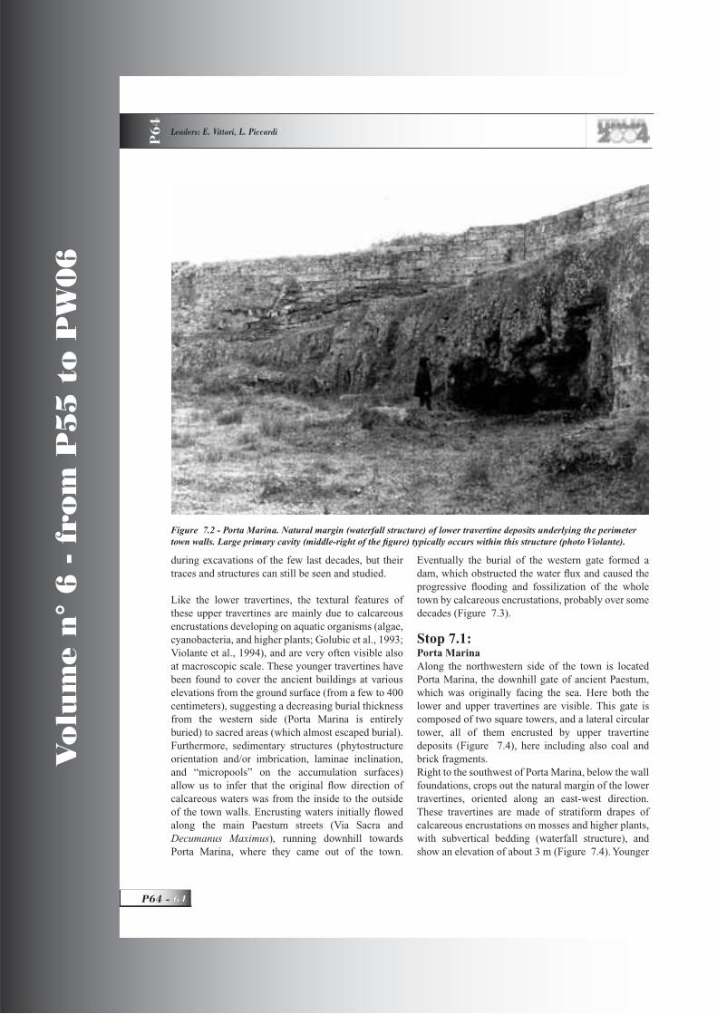
Vo
lum
e n
° 6
- f
rom
P5
5 t
o P
W0
6
P64 -
Leaders: E. Vittori, L. Piccardi
P6
4
during excavations of the few last decades, but their traces and structures can still be seen and studied.
Like the lower travertines, the textural features of these upper travertines are mainly due to calcareous encrustations developing on aquatic organisms (algae, cyanobacteria, and higher plants; Golubic et al., 1993; Violante et al., 1994), and are very often visible also at macroscopic scale. These younger travertines have been found to cover the ancient buildings at various elevations from the ground surface (from a few to 400 centimeters), suggesting a decreasing burial thickness from the western side (Porta Marina is entirely buried) to sacred areas (which almost escaped burial). Furthermore, sedimentary structures (phytostructure orientation and/or imbrication, laminae inclination, and “micropools” on the accumulation surfaces) allow us to infer that the original fl ow direction of calcareous waters was from the inside to the outside of the town walls. Encrusting waters initially fl owed along the main Paestum streets (Via Sacra and Decumanus Maximus), running downhill towards Porta Marina, where they came out of the town.
Eventually the burial of the western gate formed a dam, which obstructed the water fl ux and caused the progressive fl ooding and fossilization of the whole town by calcareous encrustations, probably over some decades (Figure 7.3).
Stop 7.1:Porta MarinaAlong the northwestern side of the town is located Porta Marina, the downhill gate of ancient Paestum, which was originally facing the sea. Here both the lower and upper travertines are visible. This gate is composed of two square towers, and a lateral circular tower, all of them encrusted by upper travertine deposits (Figure 7.4), here including also coal and brick fragments.Right to the southwest of Porta Marina, below the wall foundations, crops out the natural margin of the lower travertines, oriented along an east-west direction. These travertines are made of stratiform drapes of calcareous encrustations on mosses and higher plants, with subvertical bedding (waterfall structure), and show an elevation of about 3 m (Figure 7.4). Younger
Figure 7.2 - Porta Marina. Natural margin (waterfall structure) of lower travertine deposits underlying the perimeter town walls. Large primary cavity (middle-right of the fi gure) typically occurs within this structure (photo Violante).
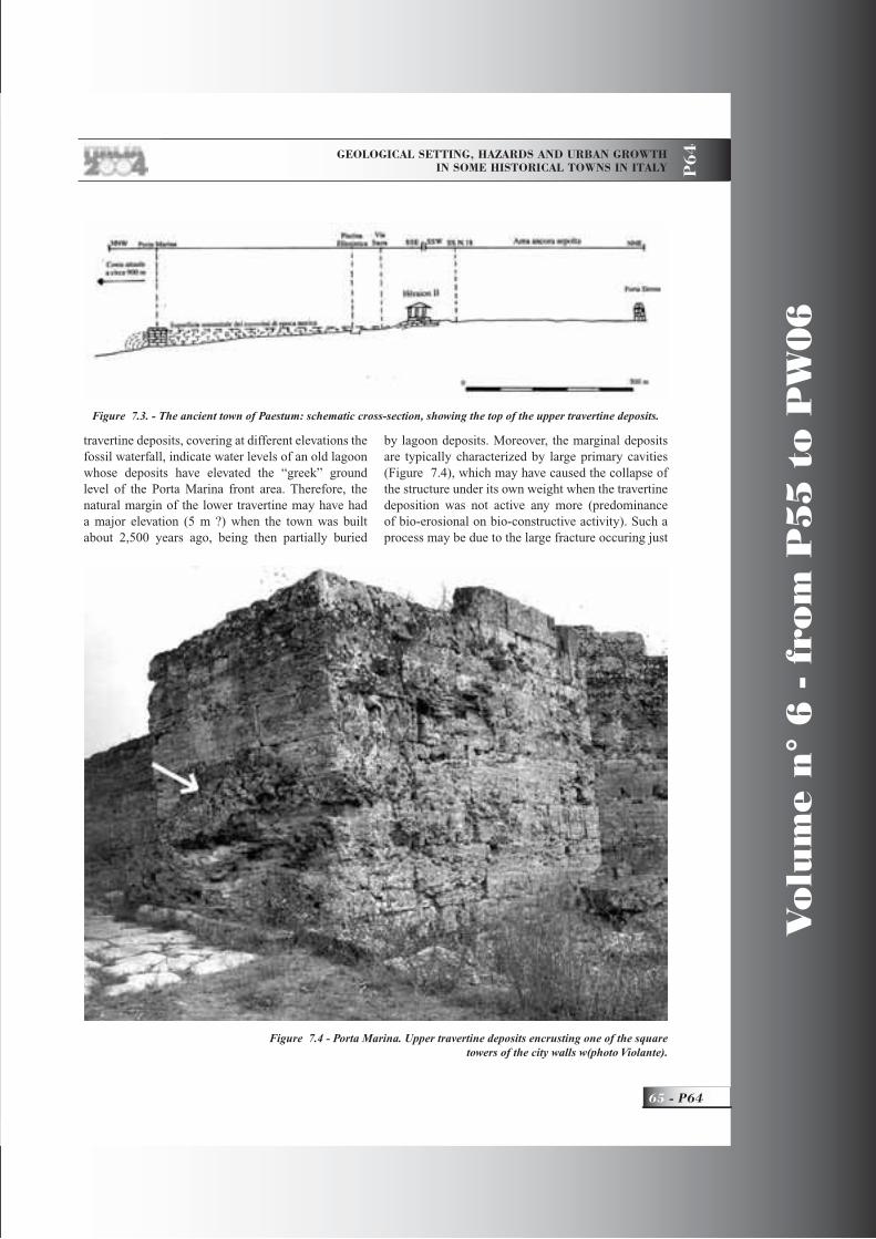
GEOLOGICAL SETTING, HAZARDS AND URBAN GROWTH IN SOME HISTORICAL TOWNS IN ITALY P
64
65 - P64
Vo
lum
e n
° 6
- f
rom
P5
5 t
o P
W0
6
travertine deposits, covering at different elevations the fossil waterfall, indicate water levels of an old lagoon whose deposits have elevated the “greek” ground level of the Porta Marina front area. Therefore, the natural margin of the lower travertine may have had a major elevation (5 m ?) when the town was built about 2,500 years ago, being then partially buried
by lagoon deposits. Moreover, the marginal deposits are typically characterized by large primary cavities (Figure 7.4), which may have caused the collapse of the structure under its own weight when the travertine deposition was not active any more (predominance of bio-erosional on bio-constructive activity). Such a process may be due to the large fracture occuring just
Figure 7.3. - The ancient town of Paestum: schematic cross-section, showing the top of the upper travertine deposits.
Figure 7.4 - Porta Marina. Upper travertine deposits encrusting one of the square towers of the city walls w(photo Violante).
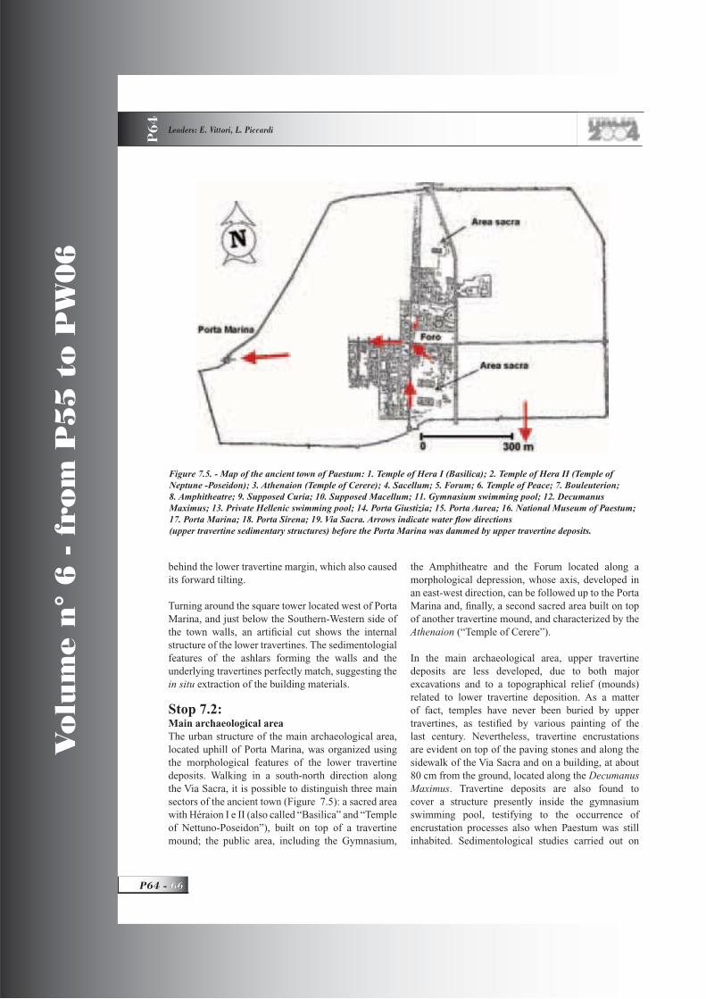
Vo
lum
e n
° 6
- f
rom
P5
5 t
o P
W0
6
P64 -
Leaders: E. Vittori, L. Piccardi
P6
4
behind the lower travertine margin, which also caused its forward tilting.
Turning around the square tower located west of Porta Marina, and just below the Southern-Western side of the town walls, an artifi cial cut shows the internal structure of the lower travertines. The sedimentologial features of the ashlars forming the walls and the underlying travertines perfectly match, suggesting the in situ extraction of the building materials.
Stop 7.2:Main archaeological areaThe urban structure of the main archaeological area, located uphill of Porta Marina, was organized using the morphological features of the lower travertine deposits. Walking in a south-north direction along the Via Sacra, it is possible to distinguish three main sectors of the ancient town (Figure 7.5): a sacred area with Héraion I e II (also called “Basilica” and “Temple of Nettuno-Poseidon”), built on top of a travertine mound; the public area, including the Gymnasium,
the Amphitheatre and the Forum located along a morphological depression, whose axis, developed in an east-west direction, can be followed up to the Porta Marina and, fi nally, a second sacred area built on top of another travertine mound, and characterized by the Athenaion (“Temple of Cerere”).
In the main archaeological area, upper travertine deposits are less developed, due to both major excavations and to a topographical relief (mounds) related to lower travertine deposition. As a matter of fact, temples have never been buried by upper travertines, as testifi ed by various painting of the last century. Nevertheless, travertine encrustations are evident on top of the paving stones and along the sidewalk of the Via Sacra and on a building, at about 80 cm from the ground, located along the DecumanusMaximus. Travertine deposits are also found to cover a structure presently inside the gymnasium swimming pool, testifying to the occurrence of encrustation processes also when Paestum was still inhabited. Sedimentological studies carried out on
Figure 7.5. - Map of the ancient town of Paestum: 1. Temple of Hera I (Basilica); 2. Temple of Hera II (Temple of Neptune -Poseidon); 3. Athenaion (Temple of Cerere); 4. Sacellum; 5. Forum; 6. Temple of Peace; 7. Bouleuterion; 8. Amphitheatre; 9. Supposed Curia; 10. Supposed Macellum; 11. Gymnasium swimming pool; 12. Decumanus Maximus; 13. Private Hellenic swimming pool; 14. Porta Giustizia; 15. Porta Aurea; 16. National Museum of Paestum; 17. Porta Marina; 18. Porta Sirena; 19. Via Sacra. Arrows indicate water fl ow directions (upper travertine sedimentary structures) before the Porta Marina was dammed by upper travertine deposits.

GEOLOGICAL SETTING, HAZARDS AND URBAN GROWTH IN SOME HISTORICAL TOWNS IN ITALY P
64
67 - P64
Vo
lum
e n
° 6
- f
rom
P5
5 t
o P
W0
6
these upper travertine deposits and their elevation from the ground, have allowed the reconstruction of the direction of the depositing water fl ows inside the ancient town (Figure 7.5).
Lunch in paestum. End of trip, departure for Roma and Firenze
References Aiello, G. and Violante, C. (1989). Studi sui travertini dell’Italia centro-meridionale. Tesi di Laurea, Dip. di Scienze della Terra, Univ. di Napoli.
Aiello G., Budillon F., Cristofalo G., D’Argenio B., De Alteriis G., De Lauro M., Ferraro L., Marsella E., Pelosi N., Sacchi M., Tonielli R. (1999). Marine geology and morphobathymetry in the Bay of Naples. CONISMA, Special Volume.
Alessio M., Allegri L., Antonioli F., Belluomini G., Improta S., Mandra L., Martinez M.P. (1994). La curva di risalita del Mar Tirreno negli ultimi 40 ka ottenuta mediante datazione di speleotemi sommersi e dati archeologici. Mem. Descr. Carta Geologica d’Italia, LII, 261-275.
Amalfi tano P., Camodeca G., Medri M. (1990). I Campi Flegrei un itinerario archeologico. Marsilio Editori.
Bagnasco C. (1998). Un laboratorio per l’innovazione della pianifi cazione urbana. In “Il delta del Tevere – un viaggio fra passato e futuro”, 9-15. Fratelli Palombi Editori. Roma.
Barberi F., Hill D., Innocenti F., Luongo G. (1984). Phlegraean Fields 1982-1984: Brief Chronicle of a Volcano emergency in a densely populated area. Bull. Volcanol. Vol. 47-2, 175-185.
Bartole, R. (1984). Tectonic structures of the Latian-campanian shelf (Tyrrhenian sea). Boll. Ocean. Teor. Appl., 2, 197-230.
Bellotti P., de Luca G. (1979). Erosione del litorale del Lido di Roma, cause ed effetti. In “L’Universo”, 6, 1169-1182.
Bellotti P., Chiocci F. L., Milli S., Tortora P., Valeri P. (1994). Sequence stratigraphy and depositional setting of the Tiber delta: integration of hy resolution
seismics well logs and archeological data. Journ. Sedimentary Research, B 64, 416-432.
Bellotti P., Milli S., Tortora P., Valeri P. (1995). Physical stratigraphy and sedimentology of the late Pleistocene-Holocene Tiber delta depositional sequence. Sedimentology, 42, 617-634.
Bellotti P. (1998). Il delta del Tevere. Geologia, morfologia, evoluzione. In “Il delta del Tevere – un viaggio fra passato e futuro”, 9-15. Fratelli Palombi Editori. Roma.
Bencivenga M., Di Loreto E. and Liperi L. (1995). Il regime idrologico del Tevere, con particolare riguardo alle piene nella città di Roma. In “La geologia di Roma. Il centro storico.” AA.VV. Memorie descrittive della Carta geologica d’Italia, Volume L, 125-172, Servizio Geologico Nazionale, Istituto Poligrafi ci e Zecca dello Stato, Roma,.
Berrino G., Corrado G. Luongo G., Toro B. (1984). Bull. Volcanol. Vol. 47-2 , 187-200.
Bersani P. and Bencivenga M. (2001). “Le piene del Tevere a Roma. Dal V secolo a.C. all’anno 2000”. Presidenza del Consiglio dei Ministri, Dipartimento per i Servizi Tecnici Nazionali, Servizio Idrografi co e Mareografi co Nazionale, pp. 100.
Bizzarri, C. (1998). Orvieto Underground., pp. 47. BetaGamma editrice, Viterbo.
Boni C., Bono P., Capelli G. (1980). Schema idrogeologico dell’Italia centrale. Memorie della Società Geologica Italiana, 35, 991-1012.
Boschi E., Guidoboni E., Ferrari G., Valensise G. and Gasperini P. (editors) (1997). Catalogo dei Forti Terremoti in Italia dal 461 a.C. al 1990. ING – SGA Bologna, pp. 644.
Bozzano F., Funiciello R., Marra M., Rovelli A., Valentini G. (1995). Il sottosuolo dell’area dell’anfi teatro Flavio in Roma. Geologia Applicata e Idrogeologia XXX, parte I, 405-422.
Brancaccio, L., Cinque, A., D’Angelo, B., Russo, F., Santagelo, N., Sgrosso, I. (1987). Evoluzione tettonica e geomorfologica della Piana del Sele (Campania, Appennino meridionale). Geogr. Fis.

Vo
lum
e n
° 6
- f
rom
P5
5 t
o P
W0
6
P64 -
Leaders: E. Vittori, L. Piccardi
P6
4
Dinam. Quat., 10, 47-55.Boni C., Bono P., Capelli G. (1980). Schema idrogeologico dell’Italia centrale. Memorie della Società Geologica Italiana, 35, 991-1012.Brancaccio L., Cinque A., Romano P., Rosskopf C., Russo F., Santangelo N. (1995). L’evoluzione delle pianure costiere della Campania: geomorfologia e neotettonica. Memorie della Società Geografi ca Italiana, 53, pp.313-336.
Branno A., Esposito E., Luongo G., Marturano A., Porfi do S., Rinaldis V. (1984). The October 4th, 1983 –Magnitude 4 earthquake in Phlegraean Fields: macroseismic survey. Bull. Volcanol. Vol. 47-2, 233-238.
Breislack S. (1792). Essais mineralogiques sur la Solfatare de Puzzole. Part. 3. Observations sur l’exterieur du Crater de la Solfatare. Naples, Giaccio, 170-177.
Brunamonte F. and Serva L. (1990). Subsidenza e distribuzione dei terreni ad elevata componente organica nella Pianura Pontina (Lazio Meridionale). Geologia Applicata e Idrogeologia, 25, 235-264.
Brunamonte F. and Serangeli S. (1996). Evoluzione naturale ed intervento antropico nello sviluppo dei fenomeni di subsidenza nella Pianura Pontina negli ultimi due secoli. Memorie della Società Geologica Italiana, 51, 823-836.
Caliro S., Francese G., Galateri C., Galateri G., Imperato M., Mila A., Monetti V., Ortolani F., Pagliuca S., Stanzione D., Toccaceli R. M. (1997). L’area urbana di Napoli: Principali caratteristiche geologiche, stratigrafi che ed ambientali. In “Geologia delle grandi aree urbane”, Vol. B, Bologna.
Camassi R. and Stucchi M. (1997). NT4.1.1 un catalogo parametrico di terremoti di area italiana al di sopra della soglia del danno. GNDT, Milano, pp. 95,http://emidius.itim.mi.cnr.it/NT/home.html
Cinque A., Aucelli P.P.C., Brancaccio L., Mele R., Milia A., Robustelli G., Romano P., Russo F., Russo M., Santangelo N., Sgambati D. (1997). Volcanism, tectonics and recent geomorphological change in the Bay of Naples. Supplementi di Geografi a e Dinamica Quaternaria, III-t 2, 123-141.
Civetta, L., Orsi, G., Pappalardo, L., Fisher, R. V., Heiken, G. H. and Ort. M. (1996). Geochemical zoning, mixing, eruptive dynamics and depositional processes - the Campanian Ignimbrite, Campi Flegrei, Italy, J. Volcanol. Geotherm. Res.
Conversini, P., Martini, E., Pane, V., Pialli, G., Tacconi., Tortoioli, L. and Ubertini, L. (1995). La Rupe di Orvieto e il Colle di Todi: due casi di città fragili. Atti Primo Convegno del Gruppo di Geologia Applicata, “La città fragile in Italia”, Giardini Naxos (ME), 11-15 giugno 1995, V. Cotecchia (ed.), V.XXX-1995, 211-224.
Corrado G., Guerra I., Lo Bascio A., Luongo G., Rampoldi R. (1976). Infl action and microearthquake activity of Phlegraean Fields. Italy. Bull. Volcanol., 40-3, 169-188.
CPTI (1999). Catalogo parametrico dei terremoti italiani. ING–GNDT–SGA-SSN, Bologna, pp. 92.
Dal Maso L.B., Vighi R. (1975). “Lazio archeologico”, pp. 286. Bonechi Editore, Firenze.
D’Argenio B., Pescatore T., Scandone P. (1973). Schema geologico dell’appennino meridionale (Campania, Lucania), Accademia Nazionale dei lincei, 183, 49-72.
D’Argenio, B., Ferreri, V. (1987). A brief outline of sedimentary models for Pleistocene travertine accumulation in Southern Italy. Rend. Soc. Geol. It., 9 (2), 167-170.
D’Argenio, B. and Ferreri, V. (1992). Ambienti di deposizione e litofacies dei travertini quaternari dell’Italia centro-meridionale. Mem. Soc. Geol. It., 41, 861-868.
De Pippo T., Donadio C., Pennetta M (2002). Evoluzione morfologica della laguna di Sabaudia (Mar Tirreno, Italia Centrale). Gelogica Romana, 36, 1-12.
De Rita D., Funiciello R., Rossi U., Sposato A. (1983). Structure and evolution of the Sacrofano Baccano caldera, Sabatini volcanic complex. Jour. Volc. Geoth. Res., 17, 219-236
De Rita D., Bertagnini A., Faccenna C., Landi

GEOLOGICAL SETTING, HAZARDS AND URBAN GROWTH IN SOME HISTORICAL TOWNS IN ITALY P
64
69 - P64
Vo
lum
e n
° 6
- f
rom
P5
5 t
o P
W0
6
P., Rosa C., Zarlenga F. (1992). Considerazioni sull’evoluzione geologico petrografi ca dell’area tolfetana e cerite. Studi Geologici Camerti, v. spec. 1991/2 CROP 11, 369-370.De Rita D. and Giordano G. (1996). Volcanological evolution of Roccamonfi na volcano (Italy): origin of the summit caldera, In “Volcano instability on the Earth and other planets”. Mc Guire et alii, Eds.
De Simone A. (1997). La terra del Vesuvio: I dati archeologici e la cultura dell’antico, in Mons Vesuvius Sfi de e Catastrofi tra paura e scienza, G. Luongo ed., Stagioni d’Italia, 27-42.
De Vito L. (1980). Studio idraulico delle utilizzazioni delle risorse idriche nel Comprensorio Pontino. Regione Lazio, pp 128. Roma.
De Vivo B., Rolandi G., Gans P.B., Calvert A., Bohrson W.A., Spera F.J., Belkin H.E. (2001). New constraints on pyroclastic eruptive history of Campanian volcanic Plain (Italy). Mineral. Petrol. Vol 73, 47-65.
Di Girolamo P., Ghiara M.R., Lirer L., Munno R., Rolandi G., Stanzione D. (1984). Vulcanologia e petrologia dei Campi Flegrei. Boll. Soc. Geol. Vol. 103, 349-413.
Dvorak J.J. and Mastrolorenzo G. (1991). The mechanisms of recent vertical crustal movements in Campi Flegrei Caldera, southern Italy. Special Paper 263, GSA, 1-47.
Esposito E., Porfi do S., Luongo G., Petrazzuoli S.M. (1992). Damage scenarios induced by the major seismic events from XV to XIX century in Naples city with particular reference to seismic response. Earthquacke Eng., ISBN: 9054100605.
Esposito E., Porfi do S., Tranfaglia G., Iaccarino G., Esposito G., Braca G. (2002). Correlation between pluviometric data and sliding phenomena in Naples, Southern Italy, Accademia Nazionale dei Lincei, 181, 379-386.
Evangelista A. (1994) Cavità e dissesti nel sottosuolo dell’area napoletana. CIRAM, Acta Neapolitana, 18, Guida ed., Napoli.
Faccenna C., Funiciello R., Marra F. (1995).
Inquadramento geologico strutturale dell’area romana. Servizio Geologico Nazionale, Memorie descrittive della Carta geologica d’Italia, volume L, La geologia di Roma – Il centro storico, 31-47.Frosini P. (1977). Il Tevere, le inondazioni di Roma e i provvedimenti presi dal governo italiano per evitarle.Accademia nazionale dei Lincei. Roma.
Funiciello R. and Parotto M. (2001). General geological features of the Campagna Romana. The World of Elephants – International Congress – RomaGiacomelli L. and Scandone R. (1992). Campi Flegrei, Campania Felix. Voll. II, Liguori editore, Napoli.
Gigante G. (1997). Plinio e il Vesuvio, in Mons Vesuvius Sfi de e Catastrofi tra paura e scienza, G. Luongo ed., Stagioni d’Italia, 43-57.
Giampaola D., Longobardo F. (2000). Napoli Greca e Romana tra museo archeologico nazionale e centro antico. Electa Napoli, pp 63.
Giordano G., Esposito A., De Rita D., Fabbri M., Mazzini I., Trigari A., Rosa C., Funiciello R.,. (2002). The sedimentation along the roman coast between middle and upper pleistocene: the interplay of eustatism, tectonics and volcanism – new data and review. Convegno AIQUA, Bari, Giugno 2002.
Golubic, S., Violante C., Ferreri V., D’Argenio B. (1993). Algal control and early diagenesis in Quaternary travertine formation. (Rocchetta a Volturno, Central Apennines). Spec. Vol. Boll. Soc. Paleont. It., 1, pp. 231-247.
Gunther R.T. (1903). Earth movements in the Bay of Naples. Geograph. Journ., 22, 121-149.
http://www.meteotevere.it (2003). Le alluvioni storiche del fi ume Tevere a Roma.
http://www.romacivica.net/ cyberia /riserva/ antica (2004). La rocca ed il borgo di Ostia Antica.
Karner, D.B. and Renne, P.R., (1998). 40Ar/39Ar geochronology of Roman volcanic province tephra in the Tiber River valley: Age calibration of middle Pleistocene sea-level changes. Geological Society of America, 110, 740-747.
Karner, D.B., Marra, F. and Renne, P.R. (2001).

Vo
lum
e n
° 6
- f
rom
P5
5 t
o P
W0
6
P64 -
Leaders: E. Vittori, L. Piccardi
P6
4
The history of the Monti Sabatini and Alban Hills volcanoes: Groundwork for assessing volcanic-tectonic hazards for Rome. Journal of Volcanology and Geothermal Research, 107(1-3), 185-215.Insinga D. (2003). Tefrostatigrafi a dei depositi fondo-Quaternari della fascia costiera campana. Università degli Studi di Napoli Federico II Dottorato di Ricerca in Scienze ed Ingegneria del Mare, XVI ciclo. PhD Thesis.
Ippolito F., Ortolani F., Russo M. (1973). Struttura marginale dell’Appennino Campano: reinterpretazione dei dati di antiche ricerche di idrocarburi. Mem. Soc. Geol. It., XX, 8-64.
Lirer L., Luongo G., Scandone R. (1987). On the volcanological evolution of Campi Flegrei. EOS, 68 - 16, 226-234.
Lirer L. (1994). La pericolosità vulcanica nell’area metropolitana napoletana. CIRAM, Acta Neapolitana, vol. 18, Guida ed., Napoli.
Luongo G. (1986). Il bradisismo fl egreo: storia di una esperienza di protezione civile. Osservatorio Vesuviano, 24.
Malinverno A. and Ryan W. (1986). Exstension in the Thyrrenian sea and shortening in the appennines as result of arc migration driven opening. Bollettino di Geofi sica Teorica ed Applicata, 28, 75-156.
Marra F., Carboni M.G., Di Bella L., Faccenna C., Funiciello R. and Rosa C. (1995). Il substrato Plio - Pleistocenico nell’area romana - Boll. Soc. Geol. It., 114, 195-214.
Marra F., Rosa C. (1995). Statigrafi a e assetto geologico dell’area romana. Servizio Geologico Nazionale, Memorie descrittive della Carta geologica d’Italia, L, La geologia di Roma – Il centro storico, 49-112.
Marra, F., Rosa, C., De Rita, D., Funiciello, R. (1998). Stratigraphic and tectonic features of the middle Pleistocene sedimentary and volcanic deposits in the area of Rome. Quaternary International, 47/48, 51-63.
Mastrolorenzo G., Petrone P.P., Pagano M., Incoronato A., Balasco A., Fattore L., Canzanella A.
(1998). Volcanology, archeology and anthropology: an interdisciplinary approach to the effects of the AD 79 eruption of Vesuvius (Italy), in Tephrochronology et coexistence Humans-Volcano, INQUA COT/UISPP 31, Brives-Charensac, F, 110-111.
Mastrolorenzo G., Petrone P.P., Pagano M., Incoronato A., Balasco A., Fattore L., Canzanella A. (1999). Eruption of Vesuvius (Italy): emplacement mechanisms of pyroclastic fl ows and related effects on structures and people, 24th General assembly Nonlinear Geophysics and Natural Hazards, EGS, The Hague, Netherland, 856.
Mastrolorenzo G., Petrone P.P., Pagano M., Incoronato A., Baxter P.J., Canzanella A., Fattore L. (2001). Herculaneum victims of Vesuvius in AD 79, in Nature, 410, 769-770.
Mastrolorenzo G., Petrone P.P. (2002). La ricerca bioarcheologica in Campania, in Vesuvio 79 AD Vita e morte ad Ercolano, Federiciana Editrice Universitaria, Napoli, I., 23-28.
Milia A. (1998). Stratigrafi a, strutture deformative e considerazioni sull’origine delle unità deposizionali oloceniche del Golfo di Pozzuoli ( Napoli). Boll. Soc. Geol. It. 117, 777-787.
Milia A., Torrente M.M. ( 2003). Late-Quaternary volcanism and transtensional tectonics in the Bay of Naples, Campanian continental margin, Italy. Mineral. Petrol., 79, 49-65.
Molin D., Castenetto S., Di Loreto E., Guidoboni E., Liberi L., Narcisi B., Paciello A., Riguzzi F., Rossi A., Tertulliani A., Traina G. (1995) - Sismicità. In: La Geologia di Roma, il centro storico, Memorie descrittive della Carta Geologica d’Italia, volume L, 323-408.
Monachesi G. and Stucchi M. (2000) – DOM: Un database di osservazioni macrosismiche di terremoti di area italiana al di sopra della soglia del danno, ver. 4.1. GNDT http://emidius.mi.ingv.it/DOM/
Moroni B., Poli G. (2000). Provenance of materials employed in the construction of Orvieto Cathedral (Umbria, Italy). Periodico di Mineralogia, 69, 143-163.

GEOLOGICAL SETTING, HAZARDS AND URBAN GROWTH IN SOME HISTORICAL TOWNS IN ITALY P
64
71 - P64
Vo
lum
e n
° 6
- f
rom
P5
5 t
o P
W0
6
Moczo P., Rovelli A., Labýk P. and Malagnini L. (1995). Seismic response of the geologic structure underlying Roman Colosseum and a 2-D resonance of a sediment valley. Annali di Geofi sica, XXXVIII, 5-6, 939-956.
Niccolini A. (1839). Tavola cronologic-metrica delle varie altezze tracciate dalla superfi cie del mare fra la costa di Amalfi ed il promontorio di Gaeta nel corso di diciannove secoli. Napoli, Flautina, pp. 52.
Ortolani F. and Aprile F. (1978). Nuovi dati sulla struttura profonda della Piana campana a SE del Fiume Volturno. Boll. Soc. Geol. Ital., 97, 591-608.
Parancandola A. (1947). I fenomeni bradisismici del Serapeo di Pozzuoli. Ristampa Guida ed. 1983, Napoli.
Parisi Presicce A., Villetti G. (1998). Le bonifi che, un ponte fra passato e futuro. In “Il delta del Tevere – un viaggio fra passato e futuro”, Fratelli Palombi Editori. Roma. 9-15.
Parotto, M. (1982). Storia geologia del Lazio. In “I minerali del Lazio” di Stoppani F. and Curti E.,. Editoriale Olimpia, Firenze. 15-27.
Parotto M. and Praturlon A. (1975). Geological summary of the Central Appennines. In “Structural model of Italy”. Quaderni de La Ricerca Scientifi ca, C.N.R., V 90, 257-300. Roma.
Patacca E., Sartori R. and Scandone P. (1992). Tyrrhenian basin and Apenninic arcs: kinematic relations since late Tortonian times. Mem. Soc. Geol. Italiana, 45, 425-451.
Pellegrino A. (1994) I fenomeni franosi nell’area metropolitana napoletana, CIRAM, Acta Neapolitana, 18, Guida ed., Napoli.
Pescatore T. (1994). Geologia dell’area metropolitana di Napoli, CIRAM, Acta Neapolitana, 18, Guida ed., Napoli.
Poscia N. (1973). Il Castello di Latera. Ed Ceccarelli.
Postpischl D. (editor) (1985). Catalogo dei terremoti italiani dall’anno 1000 al 1980. Quaderni della Ricerca Scientifi ca, 114, 2B, pp. 239.
Remedia G., Alessandrini M.G., Mangianti F. (1998). Le piene eccezionali del fi ume Tevere a Roma.Università Degli Studi dell’Aquila, Dip. di Ingegneria delle Strutture, delle Acque e del Terreno.
Regione Lazio, Assessorato Ambiente (2003). Il Tevere ieri, oggi e domani, pp 95. Nova Edinove Editore. Roma.
Rosi M., Sbrana A. (1987). Phlegraean Fields. CNR- Quaderni della ricerca scientifi ca, 9-114, pp. 175.
Rossi F. (1994) Alluvioni e dissesti delle reti di drenaggio, CIRAM, Acta Neapolitana, 18, Guida ed., Napoli.
Scandone R., (1983), Problems Related with the Evaluation of Volcanic Risk. In H.Tazieff, J.C.Sabroux editors: “Forecasting Volcanic Events”, 57-67, Elsevier, Amsterdam.
Scandone R., Arganese G, Galdi F. (1993) The Evaluation of Volcanic Risk in the Vesuvian Area, J. Volcanol. geoth. Res. 58, 261-273
Scandone R., D’Andrea M. (1994) Il rischio vulcanico, in V. Di Donna, A.Vallario (editori) “L’ambiente: Risorse e rischi”, Liguori editore, Napoli, 130-150.
Serva L. and Brunamonte F. (1998). L’abbassamento del suolo nella Pianura Pontina: un caso eccezionale di interferenza tra evoluzione naturale ed effetti della bonifi ca idraulica. In “Prima monografi a sulla difesa del suolo”, 149-189. CNR - GNDCI - Comitato Nazionale Difesa del Suolo.
Sigurdsson H., Carey S., Cornell W., Pescatore T. (1985) The eruption of Vesuvius in 79 AD, National Geographic Research, 1, 332-387.
Sollevanti F. (1983). Geology, volcanology and tectonic setting of the Vico-Cimini area, Italy. Jour. Volc. Geol. Res., 17, 203-217.
Sovrintendenza Archeologica di Roma (2004). http://www.archeorm.arti.beniculturali.it/sma/
Trigila R. (1985). Vulsini volcanoes. In Excursion guide book IAVCEI 1985, Sc. Ass.Verduchi P. (1998). L’insediamento storico Ostiense.

Vo
lum
e n
° 6
- f
rom
P5
5 t
o P
W0
6
P64 -
Leaders: E. Vittori, L. Piccardi
P6
4
In “Il delta del Tevere – un viaggio fra passato e futuro”, 9-15. Fratelli Palombi Editori. Roma.
Violante C., D’Argenio B., Ferreri V. (1993). Paestum: fossilization of the ancient town by travertines. In: From the lost Lagonegro basin to the present Tyrrhenian (Ed. B. D’Argenio et al.). 4th Workshop I.L.P. Task Force: “Origin of Sed. basins”, Benevento, Field Trip Guide Book, 135-138.
Violante, C., D’Argenio, B., Ferreri, V., Golubic, S. (1994). Quaternary travertines at Rocchetta a Volturno (Isernia, Central Italy). Facies analysis and sedimentary model of an organogenic carbonate
system. I.A.S. 15th Reg. Meet., 13-15 April 1994, Ischia, Guide Book to the Field Trips, 3-23.
Violante, C., D’Argenio, B. (2000). I Travertini alle origini e nel declino della antica città di Paestum (2500-1000 a. B.P.). Atti del Convegno GeoBen 2000 su “Condizionamenti Geologici e Geotecnici nella Conservazione del Patrimonio Storico e Culturale” Eng. Geology. Torino, Castello Moncalieri, 8-9 giugno 2000, 814-848.www.franiac.itwww.ov.ingv.itwwwres.ov.ingv.it/FV/schede/copertina.htm

Back Cover:fi eld trip itinerary

Edited by APAT
FIELD TRIP MAP
32nd
IN
TE
RN
AT
ION
AL
GE
OLO
GIC
AL
CO
NG
RE
SS
Related Documents