! P ! P ! P ! P ! P ! P ! P ! P ! P ! P Roberts County Grant County Grant County Codington County 7TH ST 159 ST 481 AVE 474 AVE U S HWY 1 2 S D H W Y 1 5 165 ST 163 ST 482 AVE 143 ST 472 AVE S D HWY 2 0 161 ST 480 AVE 151 ST M A R VI N ST 148 ST 4 6 4 A V E 150 ST 484 AVE 466 AVE 485 AVE 2 ST 477 AVE 144 ST S D H W Y 1 2 3 147 ST 153 ST 465 AVE 1 6 4 ST 145 ST 162 ST 468 AVE 483 AVE 158 ST 156 ST 155 ST 154 ST 4 7 3 A V E 149 ST 470 AVE 152 ST 479 AVE 469 AVE 160 ST CENTER RD 476 AVE 146 ST 4 6 7 A V E 142 ST 471 AVE 475 AVE S D HWY 1 5 8 Albee LaBolt Marvin Milbank Revillo South Shore Stockholm Strandburg Troy Twin Brooks T. 120N, R. 47W T. 122N, R. 50W T. 122N, R. 47W T. 118N, R. 50W T. 121N, R. 47W T. 120N, R. 50W T. 118N, R. 47W T. 121N, R. 50W T. 119N, R. 49W T. 118N, R. 48W T. 118N, R. 51W T. 120N, R. 48W T. 122N, R. 48W T. 121N, R. 48W T. 120N, R. 51W T. 119N, R. 47W T. 121N, R. 49W T. 119N, R. 50W T. 118N, R. 49W T. 121N, R. 46W T. 120N, R. 49W T. 119N, R. 51W T. 122N, R. 49W T. 119N, R. 48W T. 122N, R. 46W 1 3 2 4 5 8 7 6 10 9 11 13 12 16 15 14 17 21 20 19 18 24 23 22 25 Projection: NAD 1983 UTM Zone 14N Base Map: 2017 Aerial Imagery Source: USDA/FSA - APFO Codington and Grant Counties, South Dakota 0 5 2.5 Miles 0 5 2.5 Kilometers μ ! P City Proposed Transmission Line Page Index Township/Range Boundary County Boundary Site Plan ! \ Aberdeen Pierre Rapid City Sioux Falls Watertown MT ND WY MN IA NE § ¨ ¦ 29 § ¨ ¦ 94 § ¨ ¦ 90 Crowned Ridge I Transmission Line Date: 3/25/2019

Welcome message from author
This document is posted to help you gain knowledge. Please leave a comment to let me know what you think about it! Share it to your friends and learn new things together.
Transcript

!P
!P
!P
!P
!P
!P
!P!P
!P
!P
!P
Roberts CountyGrant County
Gran
t Cou
nty
Codin
gton
Cou
nty
7TH
ST
159 ST
481 AVE
474 A
VE
US HWY 12SD
HWY
15
165 ST
163 ST
482 A
VE
143 ST
472 A
VE
SD HWY 20
161 ST
480 A
VE
151 ST
M
ARVINST
148 ST
464A
VE
150 ST
484 AVE
466 A
VE
485 A
VE
2 ST
477 AVE
144 ST
SDHW
Y12
3
147 ST
153 ST
465 A
VE
164 ST
145 ST
162 ST
468 AVE
483 A
VE
158 ST
156 ST
155 ST
154 ST
473 AVE
149 ST
470 A
VE
152 ST
479 AVE
469 A
VE
160 ST
CENTER RD
476 AVE
146 ST
467A
VE
142 ST
471 A
VE
475 AVE
SD HWY 158
AlbeeLaBolt
Marvin
Milbank
Revillo
SouthShore
Stockholm
Strandburg
Troy
Twin BrooksT. 120N,R. 47W
T. 122N,R. 50W
T. 122N, R. 47W
T. 118N,R. 50W
T. 121N,R. 47W
T. 120N,R. 50W
T. 118N,R. 47W
T. 121N,R. 50W
T. 119N,R. 49W
T. 118N,R. 48WT. 118N,
R. 51W
T. 120N,R. 48W
T. 122N,R. 48W
T. 121N,R. 48W
T. 120N,R. 51W
T. 119N,R. 47W
T. 121N,R. 49W
T. 119N,R. 50W
T. 118N,R. 49W
T. 121N,R. 46W
T. 120N,R. 49W
T. 119N,R. 51W
T. 122N, R. 49W
T. 119N,R. 48W
T. 122N,R. 46W
1
32
4
5
87
6
10
9
11
13
12
1615 14
17
2120
1918
24 23 22
25
Projection: NAD 1983 UTM Zone 14N
Base Map: 2017 Aerial ImagerySource: USDA/FSA - APFOCodington and Grant Counties, South Dakota
0 52.5Miles
0 52.5Kilometers
µ!P City
ProposedTransmission LinePage IndexTownship/RangeBoundaryCounty Boundary
Site Plan
!\
Aberdeen
PierreRapid City
Sioux Falls
Watertown
MTND
WY
MN
IANE
§̈¦29
§̈¦94
§̈¦90
Crowned Ridge I Transmission Line
Date: 3/25/2019

146 ST
485 A
VE
484 A
VE
145 ST
US HWY 12
2
3
4
5
8
1
13
25
18
23
26
19
30
24
14
T. 121N,R. 47W
T. 121N,R. 46W
6
7
1828+81.60
1815+95.61
1805+57.31
1795+71.63
1784+84.83
1774+66.56
1770+35.37
1763+43.22
Projection: NAD 1983 UTM Zone 14N
Base Map: 2017 Aerial ImagerySource: USDA/FSA - APFOQuadrangle: Big Stone Lake SE (1971)Township/Range: T121N, R47W Grant County, South Dakota
0 500250Meters
0 1,000500Feet
µStructure Type3-Pole Deadend3-Pole Self-SupportMedium Angle3-Pole StrainH-Frame LightTangentHeavy TangentLight TangentSelf-Support DeadendSelf-Support LightAngle
Self-Support MediumAngleSelf-Support DeadendSubstation DeadendProposedTransmission LineHaul RoadExisting RoadSectionBoundaryTownship/RangeBoundaryCounty Boundary
Site Plan
Watertown
MinnesotaSouth Dakota
Roberts
Day
Grant
Codington
Deuel
§̈¦29
Crowned Ridge I Transmission Line
Page 1 of 25Date: 3/25/2019

146 ST
484 A
VE
147 ST
US HWY 12
10
9
111213141516
8
36
25
23
26
35
24
T. 121N,R. 47W
6
7
1774+66.56
1770+35.37
1763+43.22
1753+71.24
1745+63.25
1737+49.58
1729+34.04
1720+66.38
1713+63.01
1705+97.47
1697+91.87
Projection: NAD 1983 UTM Zone 14N
Base Map: 2017 Aerial ImagerySource: USDA/FSA - APFOQuadrangle: Big Stone Lake SE (1971)Township/Range: T121N, R47W Grant County, South Dakota
0 500250Meters
0 1,000500Feet
µStructure Type3-Pole Deadend3-Pole Self-SupportMedium Angle3-Pole StrainH-Frame LightTangentHeavy TangentLight TangentSelf-Support DeadendSelf-Support LightAngle
Self-Support MediumAngleSelf-Support DeadendSubstation DeadendProposedTransmission LineHaul RoadExisting RoadSectionBoundaryTownship/RangeBoundaryCounty Boundary
Site Plan
Watertown
MinnesotaSouth Dakota
Roberts
Day
Grant
Codington
Deuel
§̈¦29
Crowned Ridge I Transmission Line
Page 2 of 25Date: 3/25/2019

483 A
VE
147 ST
US HWY 12
18
20
151617
19
21
22
23
24
25
26
26
35
34
27
T. 121N,R. 47W
1705+97.47
1697+91.87
1690+46.38
1683+21.081675+09.82
1667+07.52
1658+60.64
1650+13.76
1642+71.20
1635+70.05
1628+04.19
1619+06.33
Projection: NAD 1983 UTM Zone 14N
Base Map: 2017 Aerial ImagerySource: USDA/FSA - APFOQuadrangle: Milbank East (1973),Big Stone Lake SE (1971)Township/Range: T121N, R47W Grant County, South Dakota
0 500250Meters
0 1,000500Feet
µStructure Type3-Pole Deadend3-Pole Self-SupportMedium Angle3-Pole StrainH-Frame LightTangentHeavy TangentLight TangentSelf-Support DeadendSelf-Support LightAngle
Self-Support MediumAngleSelf-Support DeadendSubstation DeadendProposedTransmission LineHaul RoadExisting RoadSectionBoundaryTownship/RangeBoundaryCounty Boundary
Site Plan
Watertown
MinnesotaSouth Dakota
Roberts
Day
Grant
Codington
Deuel
§̈¦29
Crowned Ridge I Transmission Line
Page 3 of 25Date: 3/25/2019

148 ST
483 A
VE
36
29
31
26
27
28
32
30
33
34
35
2 1
3534
T. 121N,R. 47W
T. 120N,R. 48W
1589+56.77
1619+06.33
1611+97.51
1603+19.90
1595+41.02
1586+06.26
1577+43.02
1568+54.28
1561+31.07
1555+06.03
1548+80.02
Projection: NAD 1983 UTM Zone 14N
Base Map: 2017 Aerial ImagerySource: USDA/FSA - APFOQuadrangle: Milbank East (1973)Township/Range: T121N, R47W & T120N, R48WGrant County, South Dakota
0 500250Meters
0 1,000500Feet
µStructure Type3-Pole Deadend3-Pole Self-SupportMedium Angle3-Pole StrainH-Frame LightTangentHeavy TangentLight TangentSelf-Support DeadendSelf-Support LightAngle
Self-Support MediumAngleSelf-Support DeadendSubstation DeadendProposedTransmission LineHaul RoadExisting RoadSectionBoundaryTownship/RangeBoundaryCounty Boundary
Site Plan
Watertown
MinnesotaSouth Dakota
Roberts
Day
Grant
Codington
Deuel
§̈¦29
Crowned Ridge I Transmission Line
Page 4 of 25Date: 3/25/2019

483 A
VE
150 ST
149 ST
43
40
36
41
44
46
47
37
38
39
42
45
13
2 1
14
11
12
T. 120N,R. 48W
1548+80.02
1538+99.33
1532+68.34
1525+20.31
1517+27.32
1507+90.70
1498+68.34
1488+69.261481+56.991474+55.73
Projection: NAD 1983 UTM Zone 14N
Base Map: 2017 Aerial ImagerySource: USDA/FSA - APFOQuadrangle: Milbank East (1973)Township/Range: T120N, R48W Grant County, South Dakota
0 500250Meters
0 1,000500Feet
µStructure Type3-Pole Deadend3-Pole Self-SupportMedium Angle3-Pole StrainH-Frame LightTangentHeavy TangentLight TangentSelf-Support DeadendSelf-Support LightAngle
Self-Support MediumAngleSelf-Support DeadendSubstation DeadendProposedTransmission LineHaul RoadExisting RoadSectionBoundaryTownship/RangeBoundaryCounty Boundary
Site Plan
Watertown
MinnesotaSouth Dakota
Roberts
Day
Grant
Codington
Deuel
§̈¦29
Crowned Ridge I Transmission Line
Page 5 of 25Date: 3/25/2019

150 ST
482 A
VE
49
46
47
48
50515253
10
1415
11
T. 120N,R. 48W
1467+00.69
1459+45.55
1451+88.281443+86.57
1437+16.11
1428+41.56
1419+80.90
1411+20.15
Projection: NAD 1983 UTM Zone 14N
Base Map: 2017 Aerial ImagerySource: USDA/FSA - APFOQuadrangle: Milbank East (1973)Township/Range: T120N, R48W Grant County, South Dakota
0 500250Meters
0 1,000500Feet
µStructure Type3-Pole Deadend3-Pole Self-SupportMedium Angle3-Pole StrainH-Frame LightTangentHeavy TangentLight TangentSelf-Support DeadendSelf-Support LightAngle
Self-Support MediumAngleSelf-Support DeadendSubstation DeadendProposedTransmission LineHaul RoadExisting RoadSectionBoundaryTownship/RangeBoundaryCounty Boundary
Site Plan
Watertown
MinnesotaSouth Dakota
Roberts
Day
Grant
Codington
Deuel
§̈¦29
Crowned Ridge I Transmission Line
Page 6 of 25Date: 3/25/2019

481 A
VE
151 ST
150 ST
55
63
56
62
53
54
57
58
59
60
61
6465666768
9
16
10
21 22
15
T. 120N,R. 48W
1402+59.40
1394+25.29
1385+20.97
1378+42.23
1371+33.50
1364+84.77
1357+84.04
1349+77.03
1342+39.73
1338+43.29
1329+98.38
1321+86.56
1313+98.50
1306+20.83
1298+25.99
Projection: NAD 1983 UTM Zone 14N
Base Map: 2017 Aerial ImagerySource: USDA/FSA - APFOQuadrangle: Milbank East (1973)Township/Range: T120N, R48W Grant County, South Dakota
0 500250Meters
0 1,000500Feet
µStructure Type3-Pole Deadend3-Pole Self-SupportMedium Angle3-Pole StrainH-Frame LightTangentHeavy TangentLight TangentSelf-Support DeadendSelf-Support LightAngle
Self-Support MediumAngleSelf-Support DeadendSubstation DeadendProposedTransmission LineHaul RoadExisting RoadSectionBoundaryTownship/RangeBoundaryCounty Boundary
Site Plan
Watertown
MinnesotaSouth Dakota
Roberts
Day
Grant
Codington
Deuel
§̈¦29
Crowned Ridge I Transmission Line
Page 7 of 25Date: 3/25/2019

151 ST
480 A
VE
6768697071727374
16
20
21
17
T. 120N,R. 48W
1306+20.83
1298+25.99
1290+18.75
1282+19.56
1274+12.36
1265+82.91
1258+08.39
1249+97.66
Projection: NAD 1983 UTM Zone 14N
Base Map: 2017 Aerial ImagerySource: USDA/FSA - APFOQuadrangle: Milbank East (1973)Township/Range: T120N, R48W Grant County, South Dakota
0 500250Meters
0 1,000500Feet
µStructure Type3-Pole Deadend3-Pole Self-SupportMedium Angle3-Pole StrainH-Frame LightTangentHeavy TangentLight TangentSelf-Support DeadendSelf-Support LightAngle
Self-Support MediumAngleSelf-Support DeadendSubstation DeadendProposedTransmission LineHaul RoadExisting RoadSectionBoundaryTownship/RangeBoundaryCounty Boundary
Site Plan
Watertown
MinnesotaSouth Dakota
Roberts
Day
Grant
Codington
Deuel
§̈¦29
Crowned Ridge I Transmission Line
Page 8 of 25Date: 3/25/2019

479 A
VE
152 ST
151 ST 76
82
72737475
77
78
79
80
81
838486 85
18
20
29
19
17
30
T. 120N,R. 48W
1258+08.39
1249+97.66
1241+81.93
1224+66.70
1215+87.19
1207+73.55
1199+16.22
1190+58.88
1181+93.22
1174+56.41
1167+22.54
1159+88.65
1152+53.51
Projection: NAD 1983 UTM Zone 14N
Base Map: 2017 Aerial ImagerySource: USDA/FSA - APFOQuadrangle: Milbank West (1973),Milbank East (1973)Township/Range: T120N, R48W Grant County, South Dakota
0 500250Meters
0 1,000500Feet
µStructure Type3-Pole Deadend3-Pole Self-SupportMedium Angle3-Pole StrainH-Frame LightTangentHeavy TangentLight TangentSelf-Support DeadendSelf-Support LightAngle
Self-Support MediumAngleSelf-Support DeadendSubstation DeadendProposedTransmission LineHaul RoadExisting RoadSectionBoundaryTownship/RangeBoundaryCounty Boundary
Site Plan
Watertown
MinnesotaSouth Dakota
Roberts
Day
Grant
Codington
Deuel
§̈¦29
Crowned Ridge I Transmission Line
Page 9 of 25Date: 3/25/2019

152 ST
153 ST
SDHW
Y15
88
91
92
8486
93
95
8587
89
90
94
2419
36
30
25
31
T. 120N,R. 48W
T. 120N,R. 49W
1159+88.65
1152+53.51
1142+41.17
1134+20.74
1126+60.99
1118+65.06
1109+36.13
1104+01.04
1095+38.28
1086+45.44
1076+74.91
Projection: NAD 1983 UTM Zone 14N
Base Map: 2017 Aerial ImagerySource: USDA/FSA - APFOQuadrangle: Milbank West (1973)Township/Range: T120N, R48W Grant County, South Dakota
0 500250Meters
0 1,000500Feet
µStructure Type3-Pole Deadend3-Pole Self-SupportMedium Angle3-Pole StrainH-Frame LightTangentHeavy TangentLight TangentSelf-Support DeadendSelf-Support LightAngle
Self-Support MediumAngleSelf-Support DeadendSubstation DeadendProposedTransmission LineHaul RoadExisting RoadSectionBoundaryTownship/RangeBoundaryCounty Boundary
Site Plan
Watertown
MinnesotaSouth Dakota
Roberts
Day
Grant
Codington
Deuel
§̈¦29
Crowned Ridge I Transmission Line
Page 10 of 25Date: 3/25/2019

154 ST
153 ST
SDHW
Y1 5
100
95
96
97
98
99
101
102
103
104
1 6
36
3025
31
T. 119N,R. 49W
T. 120N,R. 48W
T. 120N,R. 49W
T. 119N,R. 48W
1076+74.91
1068+78.09
1059+70.44
1051+11.62
1043+94.47
1036+86.79
1028+31.95
1020+54.90
1010+59.01
999+72.55
Projection: NAD 1983 UTM Zone 14N
Base Map: 2017 Aerial ImagerySource: USDA/FSA - APFOQuadrangle: Milbank West (1973)Township/Range: T120N, R48W & T120N, R49WGrant County, South Dakota
0 500250Meters
0 1,000500Feet
µStructure Type3-Pole Deadend3-Pole Self-SupportMedium Angle3-Pole StrainH-Frame LightTangentHeavy TangentLight TangentSelf-Support DeadendSelf-Support LightAngle
Self-Support MediumAngleSelf-Support DeadendSubstation DeadendProposedTransmission LineHaul RoadExisting RoadSectionBoundaryTownship/RangeBoundaryCounty Boundary
Site Plan
Watertown
MinnesotaSouth Dakota
Roberts
Day
Grant
Codington
Deuel
§̈¦29
Crowned Ridge I Transmission Line
Page 11 of 25Date: 3/25/2019
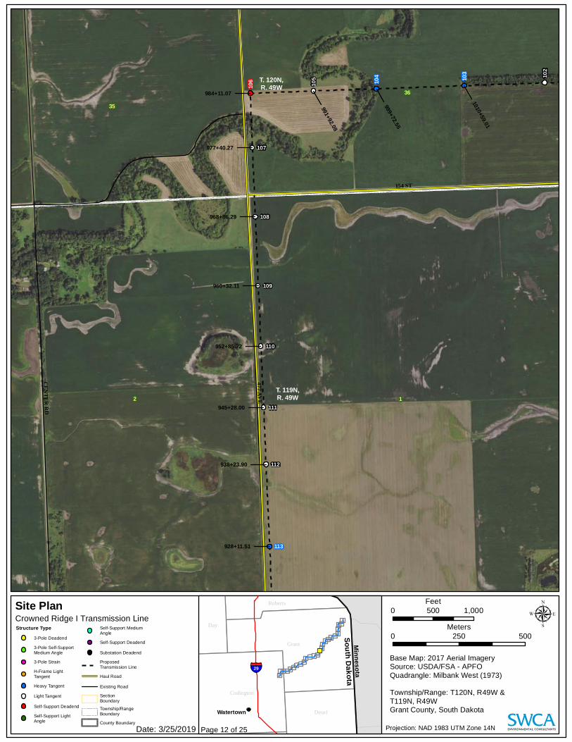
477 AVE
CENTER RD
154 ST
106 10
2
105
107
108
109
110
111
11210
3
104
113
35
12
36
T. 119N,R. 49W
T. 120N,R. 49W
1010+59.01
999+72.55
991+92.08
984+11.07
977+40.27
968+86.29
960+32.11
952+85.72
945+28.00
938+23.90
928+11.51
Projection: NAD 1983 UTM Zone 14N
Base Map: 2017 Aerial ImagerySource: USDA/FSA - APFOQuadrangle: Milbank West (1973)Township/Range: T120N, R49W & T119N, R49WGrant County, South Dakota
0 500250Meters
0 1,000500Feet
µStructure Type3-Pole Deadend3-Pole Self-SupportMedium Angle3-Pole StrainH-Frame LightTangentHeavy TangentLight TangentSelf-Support DeadendSelf-Support LightAngle
Self-Support MediumAngleSelf-Support DeadendSubstation DeadendProposedTransmission LineHaul RoadExisting RoadSectionBoundaryTownship/RangeBoundaryCounty Boundary
Site Plan
Watertown
MinnesotaSouth Dakota
Roberts
Day
Grant
Codington
Deuel
§̈¦29
Crowned Ridge I Transmission Line
Page 12 of 25Date: 3/25/2019

155 ST
156 ST476 AVE
477 AVE
CENTER RD
123
124
117
114
115
116
118
119
120
121
122
125
113
3
10
12
1
1415
11
13
2
T. 119N,R. 49W
928+11.51
917+99.57
910+25.10
901+98.32
893+30.74
885+59.06
878+15.39
870+57.71
863+00.04
855+53.80
847+55.40
843+24.93
835+92.54
Projection: NAD 1983 UTM Zone 14N
Base Map: 2017 Aerial ImagerySource: USDA/FSA - APFOQuadrangle: Milbank West (1973)Township/Range: T119N, R49W Grant County, South Dakota
0 500250Meters
0 1,000500Feet
µStructure Type3-Pole Deadend3-Pole Self-SupportMedium Angle3-Pole StrainH-Frame LightTangentHeavy TangentLight TangentSelf-Support DeadendSelf-Support LightAngle
Self-Support MediumAngleSelf-Support DeadendSubstation DeadendProposedTransmission LineHaul RoadExisting RoadSectionBoundaryTownship/RangeBoundaryCounty Boundary
Site Plan
Watertown
MinnesotaSouth Dakota
Roberts
Day
Grant
Codington
Deuel
§̈¦29
Crowned Ridge I Transmission Line
Page 13 of 25Date: 3/25/2019

476 AVE
156 ST
475 AVE
134
135
131
125
126
129
132
133
127
130
910
15
11
16
T. 119N,R. 49W
128
828+80.14
821+77.74
813+65.34
804+24.30
794+12.70
784+25.96
776+21.85
768+81.00
761+17.34
753+47.91
Projection: NAD 1983 UTM Zone 14N
Base Map: 2017 Aerial ImagerySource: USDA/FSA - APFOQuadrangle: La Bolt (1973),Milbank West (1973)Township/Range: T119N, R49W Grant County, South Dakota
0 500250Meters
0 1,000500Feet
µStructure Type3-Pole Deadend3-Pole Self-SupportMedium Angle3-Pole StrainH-Frame LightTangentHeavy TangentLight TangentSelf-Support DeadendSelf-Support LightAngle
Self-Support MediumAngleSelf-Support DeadendSubstation DeadendProposedTransmission LineHaul RoadExisting RoadSectionBoundaryTownship/RangeBoundaryCounty Boundary
Site Plan
Watertown
MinnesotaSouth Dakota
Roberts
Day
Grant
Codington
Deuel
§̈¦29
Crowned Ridge I Transmission Line
Page 14 of 25Date: 3/25/2019

156 ST
474 AVE
137
138
139
140
141
142
143
136
98
1716
T. 119N,R. 49W
743+16.72
732+65.42
725+17.18
717+68.19
708+68.37
699+68.78
690+95.24
682+64.91
Projection: NAD 1983 UTM Zone 14N
Base Map: 2017 Aerial ImagerySource: USDA/FSA - APFOQuadrangle: La Bolt (1973)Township/Range: T119N, R49W Grant County, South Dakota
0 500250Meters
0 1,000500Feet
µStructure Type3-Pole Deadend3-Pole Self-SupportMedium Angle3-Pole StrainH-Frame LightTangentHeavy TangentLight TangentSelf-Support DeadendSelf-Support LightAngle
Self-Support MediumAngleSelf-Support DeadendSubstation DeadendProposedTransmission LineHaul RoadExisting RoadSectionBoundaryTownship/RangeBoundaryCounty Boundary
Site Plan
Watertown
MinnesotaSouth Dakota
Roberts
Day
Grant
Codington
Deuel
§̈¦29
Crowned Ridge I Transmission Line
Page 15 of 25Date: 3/25/2019

473 AVE
156 ST
SD HWY 20
148
143
144
145
146
147
149
150
151
152
153
154
155
2019
8
17
18
7
T. 119N,R. 49W
674+29.77
666+48.02
659+83.92
650+75.64
644+10.41
636+87.36
629+86.36
623+49.08
617+01.81
610+00.55
602+52.29
595+20.04
Projection: NAD 1983 UTM Zone 14N
Base Map: 2017 Aerial ImagerySource: USDA/FSA - APFOQuadrangle: La Bolt (1973)Township/Range: T119N, R49W Grant County, South Dakota
0 500250Meters
0 1,000500Feet
µStructure Type3-Pole Deadend3-Pole Self-SupportMedium Angle3-Pole StrainH-Frame LightTangentHeavy TangentLight TangentSelf-Support DeadendSelf-Support LightAngle
Self-Support MediumAngleSelf-Support DeadendSubstation DeadendProposedTransmission LineHaul RoadExisting RoadSectionBoundaryTownship/RangeBoundaryCounty Boundary
Site Plan
Watertown
MinnesotaSouth Dakota
Roberts
Day
Grant
Codington
Deuel
§̈¦29
Crowned Ridge I Transmission Line
Page 16 of 25Date: 3/25/2019

472 AVE
JOHNSON AVE158 ST
SD HWY 20
158
159164
155
156
157
160
161
162
165
166
163
30
19
18
25
13
24
T. 119N,R. 49W
T. 119N,R. 50W
595+20.04
587+07.78
578+92.79
569+96.80
561+84.74
552+79.32
545+41.40
537+08.80
529+45.12
521+81.83
516+47.56
Projection: NAD 1983 UTM Zone 14N
Base Map: 2017 Aerial ImagerySource: USDA/FSA - APFOQuadrangle: Stockholm (1973),La Bolt (1973)Township/Range: T119N, R49W & T119N, R50WGrant County, South Dakota
0 500250Meters
0 1,000500Feet
µStructure Type3-Pole Deadend3-Pole Self-SupportMedium Angle3-Pole StrainH-Frame LightTangentHeavy TangentLight TangentSelf-Support DeadendSelf-Support LightAngle
Self-Support MediumAngleSelf-Support DeadendSubstation DeadendProposedTransmission LineHaul RoadExisting RoadSectionBoundaryTownship/RangeBoundaryCounty Boundary
Site Plan
Watertown
MinnesotaSouth Dakota
Roberts
Day
Grant
Codington
Deuel
§̈¦29
Crowned Ridge I Transmission Line
Page 17 of 25Date: 3/25/2019

E JOHNSON AVE
471 AVE
CEMETERY RD
JOH NS O NAV E
171
17217
5
169
165
166
167
174
168
170
173
26 25
23 24
T. 119N,R. 50W
469+24.66
516+47.56
509+25.09
501+02.07
490+17.83
482+23.29
474+85.06
465+84.04
456+97.13
449+46.43
Projection: NAD 1983 UTM Zone 14N
Base Map: 2017 Aerial ImagerySource: USDA/FSA - APFOQuadrangle: Stockholm (1973)Township/Range: T119N, R50W Grant County, South Dakota
0 500250Meters
0 1,000500Feet
µStructure Type3-Pole Deadend3-Pole Self-SupportMedium Angle3-Pole StrainH-Frame LightTangentHeavy TangentLight TangentSelf-Support DeadendSelf-Support LightAngle
Self-Support MediumAngleSelf-Support DeadendSubstation DeadendProposedTransmission LineHaul RoadExisting RoadSectionBoundaryTownship/RangeBoundaryCounty Boundary
Site Plan
Watertown
MinnesotaSouth Dakota
Roberts
Day
Grant
Codington
Deuel
§̈¦29
Crowned Ridge I Transmission Line
Page 18 of 25Date: 3/25/2019

470 AVE
159 ST
CEMETERY RD
158 ST
175
183
179
177
178
180
181
182
184
185
186
176
34
26
27
22
35
23
T. 119N,R. 50W
441+64.55
435+44.34
429+89.20
423+96.55
415+00.43
406+44.83
400+00.52
393+00.43
385+99.63
378+27.10
370+46.14
362+43.72
Projection: NAD 1983 UTM Zone 14N
Base Map: 2017 Aerial ImagerySource: USDA/FSA - APFOQuadrangle: Stockholm (1973)Township/Range: T119N, R50W Grant County, South Dakota
0 500250Meters
0 1,000500Feet
µStructure Type3-Pole Deadend3-Pole Self-SupportMedium Angle3-Pole StrainH-Frame LightTangentHeavy TangentLight TangentSelf-Support DeadendSelf-Support LightAngle
Self-Support MediumAngleSelf-Support DeadendSubstation DeadendProposedTransmission LineHaul RoadExisting RoadSectionBoundaryTownship/RangeBoundaryCounty Boundary
Site Plan
Watertown
MinnesotaSouth Dakota
Roberts
Day
Grant
Codington
Deuel
§̈¦29
Crowned Ridge I Transmission Line
Page 19 of 25Date: 3/25/2019

159 ST
469 AVE
185
186
187
188
189
190
192
191
193
34
2728
33
T. 119N,R. 50W
362+43.72
353+94.80
347+75.36
341+40.92
332+44.35
325+35.71317+90.74310+38.78
Projection: NAD 1983 UTM Zone 14N
Base Map: 2017 Aerial ImagerySource: USDA/FSA - APFOQuadrangle: Stockholm (1973)Township/Range: T119N, R50W Grant County, South Dakota
0 500250Meters
0 1,000500Feet
µStructure Type3-Pole Deadend3-Pole Self-SupportMedium Angle3-Pole StrainH-Frame LightTangentHeavy TangentLight TangentSelf-Support DeadendSelf-Support LightAngle
Self-Support MediumAngleSelf-Support DeadendSubstation DeadendProposedTransmission LineHaul RoadExisting RoadSectionBoundaryTownship/RangeBoundaryCounty Boundary
Site Plan
Watertown
MinnesotaSouth Dakota
Roberts
Day
Grant
Codington
Deuel
§̈¦29
Crowned Ridge I Transmission Line
Page 20 of 25Date: 3/25/2019

468 AVE
160 ST
159 ST
194
198
192
195
191
193
196
197
200
201
28
45
33
29
32
T. 118N,R. 50W
T. 119N,R. 50W
199
317+90.74310+38.78302+26.63
292+83.59
283+74.36
275+04.30
265+29.43
257+59.35
250+95.12
230+90.72
Projection: NAD 1983 UTM Zone 14N
Base Map: 2017 Aerial ImagerySource: USDA/FSA - APFOQuadrangle: Stockholm (1973)Township/Range: T119N, R50W & T118N, R50WGrant County, South Dakota
0 500250Meters
0 1,000500Feet
µStructure Type3-Pole Deadend3-Pole Self-SupportMedium Angle3-Pole StrainH-Frame LightTangentHeavy TangentLight TangentSelf-Support DeadendSelf-Support LightAngle
Self-Support MediumAngleSelf-Support DeadendSubstation DeadendProposedTransmission LineHaul RoadExisting RoadSectionBoundaryTownship/RangeBoundaryCounty Boundary
Site Plan
Watertown
MinnesotaSouth Dakota
Roberts
Day
Grant
Codington
Deuel
§̈¦29
Crowned Ridge I Transmission Line
Page 21 of 25Date: 3/25/2019

467 A
VE
160 ST
203
205
206
207
208 20
4
201
31
6 5
32
T. 118N,R. 50W
T. 119N,R. 50W
202
230+90.72
228+27.77
220+14
.57
210+91.05
204+36.69
197+73.51
188+50.73
180+55.22
Projection: NAD 1983 UTM Zone 14N
Base Map: 2017 Aerial ImagerySource: USDA/FSA - APFOQuadrangle: South Shore (1973),Stockholm (1973)Township/Range: T118N, R50W Grant County, South Dakota
0 500250Meters
0 1,000500Feet
µStructure Type3-Pole Deadend3-Pole Self-SupportMedium Angle3-Pole StrainH-Frame LightTangentHeavy TangentLight TangentSelf-Support DeadendSelf-Support LightAngle
Self-Support MediumAngleSelf-Support DeadendSubstation DeadendProposedTransmission LineHaul RoadExisting RoadSectionBoundaryTownship/RangeBoundaryCounty Boundary
Site Plan
Watertown
MinnesotaSouth Dakota
Roberts
Day
Grant
Codington
Deuel
§̈¦29
Crowned Ridge I Transmission Line
Page 22 of 25Date: 3/25/2019

Gran
t Cou
nty
Codin
gton
Cou
nty
160 ST
466 A
VE
210
211 20
8
20921
2
213
214
215
216
31
6
1
36
T. 118N,R. 50WT. 118N,
R. 51W
T. 119N,R. 50WT. 119N,
R. 51W
172+94.92
165+36.00
161+98
.20
153+79.16
145+44.81
135+99.40
128+23.99
120+48.57
Projection: NAD 1983 UTM Zone 14N
Base Map: 2017 Aerial ImagerySource: USDA/FSA - APFOQuadrangle: South Shore (1973)Township/Range: T118N, R50W & T119N, R51WCodington and Grant Counties, South Dakota
0 500250Meters
0 1,000500Feet
µStructure Type3-Pole Deadend3-Pole Self-SupportMedium Angle3-Pole StrainH-Frame LightTangentHeavy TangentLight TangentSelf-Support DeadendSelf-Support LightAngle
Self-Support MediumAngleSelf-Support DeadendSubstation DeadendProposedTransmission LineHaul RoadExisting RoadSectionBoundaryTownship/RangeBoundaryCounty Boundary
Site Plan
Watertown
MinnesotaSouth Dakota
Roberts
Day
Grant
Codington
Deuel
§̈¦29
Crowned Ridge I Transmission Line
Page 23 of 25Date: 3/25/2019

465 AVE
160 ST
219 21
5
216
217
218
221
222
220
223
2
35
1
36
T. 118N,R. 51W
T. 119N,R. 51W
120+48.57
112+73.16
104+97.74
97+71.92
89+20.04
81+37.23
72+88.92
63+64.30
Projection: NAD 1983 UTM Zone 14N
Base Map: 2017 Aerial ImagerySource: USDA/FSA - APFOQuadrangle: South Shore (1973)Township/Range: T119N, R51W & T118N, R51WCodington County, South Dakota
0 500250Meters
0 1,000500Feet
µStructure Type3-Pole Deadend3-Pole Self-SupportMedium Angle3-Pole StrainH-Frame LightTangentHeavy TangentLight TangentSelf-Support DeadendSelf-Support LightAngle
Self-Support MediumAngleSelf-Support DeadendSubstation DeadendProposedTransmission LineHaul RoadExisting RoadSectionBoundaryTownship/RangeBoundaryCounty Boundary
Site Plan
Watertown
MinnesotaSouth Dakota
Roberts
Day
Grant
Codington
Deuel
§̈¦29
Crowned Ridge I Transmission Line
Page 24 of 25Date: 3/25/2019
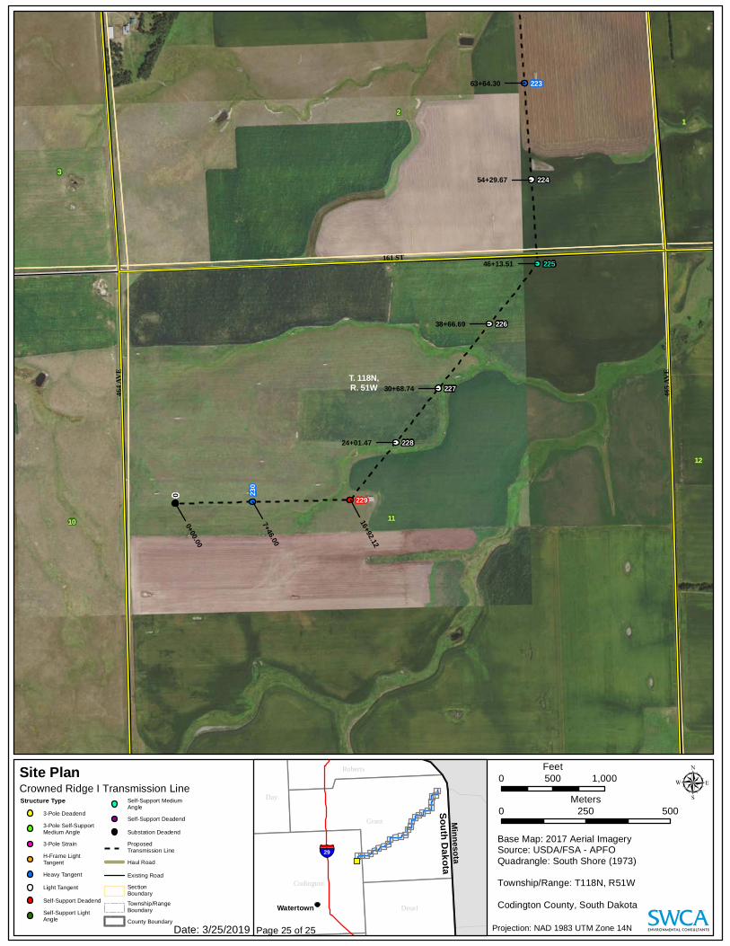
161 ST
465 A
VE
464 A
VE
0
225
229
224
226
227
228
223
230
12
2
3
11
1
10
T. 118N,R. 51W
63+64.30
54+29.67
46+13.51
38+66.69
30+68.74
24+01.47
16+92.12
7+46.00
0+00.00
Projection: NAD 1983 UTM Zone 14N
Base Map: 2017 Aerial ImagerySource: USDA/FSA - APFOQuadrangle: South Shore (1973)Township/Range: T118N, R51W Codington County, South Dakota
0 500250Meters
0 1,000500Feet
µStructure Type3-Pole Deadend3-Pole Self-SupportMedium Angle3-Pole StrainH-Frame LightTangentHeavy TangentLight TangentSelf-Support DeadendSelf-Support LightAngle
Self-Support MediumAngleSelf-Support DeadendSubstation DeadendProposedTransmission LineHaul RoadExisting RoadSectionBoundaryTownship/RangeBoundaryCounty Boundary
Site Plan
Watertown
MinnesotaSouth Dakota
Roberts
Day
Grant
Codington
Deuel
§̈¦29
Crowned Ridge I Transmission Line
Page 25 of 25Date: 3/25/2019
Related Documents