IM Instituto de Meteorologia 15-17 Nov 2010 4 th LSA SAF User Workshop, Toulouse, France Overview of the Land Overview of the Land Overview of the Land Overview of the Land Surface Surface Surface Surface Analysis Analysis Analysis Analysis SAF (LSA SAF (LSA SAF (LSA SAF (LSA SAF) SAF) SAF) SAF) Pedro Viterbo Pedro Viterbo Pedro Viterbo Pedro Viterbo Instituto de Meteorologia, Lisboa, Portugal Acknowledgments: Acknowledgments: Acknowledgments: Acknowledgments: Isabel Isabel Isabel Isabel Trigo, Lu Trigo, Lu Trigo, Lu Trigo, Luí í ís s s s Pessanha, & the Pessanha, & the Pessanha, & the Pessanha, & the LSA SAF consortium LSA SAF consortium LSA SAF consortium LSA SAF consortium

Welcome message from author
This document is posted to help you gain knowledge. Please leave a comment to let me know what you think about it! Share it to your friends and learn new things together.
Transcript

IM
Instituto de Meteorologia
15-17 Nov 2010 4th LSA SAF User Workshop, Toulouse, France
Overview of the Land Overview of the Land Overview of the Land Overview of the Land Surface Surface Surface Surface Analysis Analysis Analysis Analysis SAF (LSA SAF (LSA SAF (LSA SAF (LSA SAF)SAF)SAF)SAF)
Pedro ViterboPedro ViterboPedro ViterboPedro Viterbo
Instituto de Meteorologia, Lisboa, Portugal
Acknowledgments: Acknowledgments: Acknowledgments: Acknowledgments: Isabel Isabel Isabel Isabel Trigo, LuTrigo, LuTrigo, LuTrigo, Luíííís s s s Pessanha, & the Pessanha, & the Pessanha, & the Pessanha, & the
LSA SAF consortiumLSA SAF consortiumLSA SAF consortiumLSA SAF consortium

IM
Instituto de Meteorologia
LayoutLayoutLayoutLayout
• Introduction• Land Surface Analysis SAF and its services• Cooperation and training activities: Serving the users• Preview on CDOP-2• Conclusions
15-17 Nov 2010 4th LSA SAF User Workshop, Toulouse, France

IM
Instituto de Meteorologia
LayoutLayoutLayoutLayout
• Introduction• Land Surface Analysis SAF and its services• Cooperation and training activities: Serving the users• Preview on CDOP-2• Conclusions
15-17 Nov 2010 4th LSA SAF User Workshop, Toulouse, France

IM
Instituto de Meteorologia
LSA SAF in a nutshellLSA SAF in a nutshellLSA SAF in a nutshellLSA SAF in a nutshell• EUMETSAT Satellite Applications Facility on Land Surface Analysis:
Dedicated to algorithm development, validation and operational production of land surface related products (primarily) based on European meteorological satellites (MSG and METOP)
• Real time operations (i.e., some products are available every 15 min, ~1 hour after observed)
• Effective use of MSG and EPS data related to:– LAND
– LAND-ATMOSPHERE Interactions
– BIOSPHERIC Applications
• Timely provide:– Products
– User support
• Reviewed (~annually) by technical and scientific review panels
15-17 Nov 2010 4th LSA SAF User Workshop, Toulouse, France

IM
Instituto de Meteorologia
The Land SAF ConsortiumThe Land SAF ConsortiumThe Land SAF ConsortiumThe Land SAF Consortium
• Instituto de Meteorologia (IM), Portugal• Meteo-France (MF), France• Royal Meteorological Institute (RMI), Belgium• Finnish Meteorological Institute (FMI), Finland• Karlsruhe Institute of Technology• IDL, University of Lisbon• UV, University of Valencia
• Organisation principles– Algorithms developed and validated by one of the patners– Algorithms handed over to IM for integration and production– Operational chain in Lisbon
15-17 Nov 2010 4th LSA SAF User Workshop, Toulouse, France
A consortium of 7 Institutions in 6 countries

IM
Instituto de Meteorologia
02 03 04 05 06 07 08 10 11 12 13 14 15 16 17 18 19 20010099
Meteosat-8 (MSG-1)
Meteosat-9 (MSG-2)
MetOp-A
Meteosat-10 (MSG-3)
MetOp-BMeteosat-11 (MSG-4) MTG-1
MetOp-C
Development Phase:Sep 1999
Initial Operations Phase:Feb 2005
Continuous Development & Operations Phase:Mar 2007
Land SAF ChronogramLand SAF ChronogramLand SAF ChronogramLand SAF Chronogram
Continuous Development & Operations Phase 2:Mar 2012
15-17 Nov 2010 4th LSA SAF User Workshop, Toulouse, France
IM
Instituto de Meteorologia
LayoutLayoutLayoutLayout
• Introduction• Land Surface Analysis SAF and its services• Cooperation and training activities: Serving the users• Preview on CDOP-2• Conclusions
15-17 Nov 2010 4th LSA SAF User Workshop, Toulouse, France

IM
Instituto de Meteorologia
LST ↓LongWave Flux
Albedo ↓ShortWave Flux
LSA SAF MSG productsLSA SAF MSG productsLSA SAF MSG productsLSA SAF MSG products
Surface Radiation
Snow Cover
Evapotranspiration
Surface Water Balance
Fraction Veg Cover
LAI
fAPAR
Vegetation
Fire Detection
Fire Radiative Power
Fire Risk (Europe)
Wild fires
Increased level of maturity
15-17 Nov 2010 4th LSA SAF User Workshop, Toulouse, France
IM
Instituto de Meteorologia
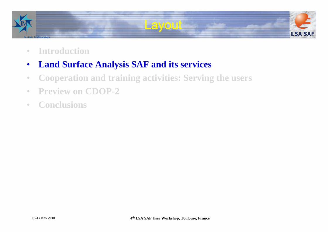
• All products have a quality flag(a-priori error bar for LST) field associated
• All products have a User Manual and a comprehensive Validation Report
• 4 production areas for MSG--Europe- N. Africa- S. Africa- S. America
• Variable time resolution--15 min to 10 days
• SEVIRI resolution
• EPS products generation for a subset of variables
Product characteristicsProduct characteristicsProduct characteristicsProduct characteristics
15-17 Nov 2010 4th LSA SAF User Workshop, Toulouse, France

IM
Instituto de Meteorologia
ALBEDODaily, 10-daily composites
Downwelling SW FluxEvery 30 min
Surface Radiation Budget: ShortwaveSurface Radiation Budget: ShortwaveSurface Radiation Budget: ShortwaveSurface Radiation Budget: Shortwave
15 Jul 2006 (12 UTC) – 16 Jul 2006 (12 UTC)
15-17 Nov 2010 4th LSA SAF User Workshop, Toulouse, France

IM
Instituto de Meteorologia
Surface TemperatureEvery 15 min
Downwelling LW FluxEvery 30 min
Surface Radiation Budget: LongwaveSurface Radiation Budget: LongwaveSurface Radiation Budget: LongwaveSurface Radiation Budget: Longwave
Emissivity
15 Jul 2006 (12 UTC) – 16 Jul 2006 (12 UTC)
15-17 Nov 2010 4th LSA SAF User Workshop, Toulouse, France

IM
Instituto de Meteorologia
Daily evapotranspiration (mm)
September 2009 November 2009 December 2009
15-17 Nov 2010 4th LSA SAF User Workshop, Toulouse, France

IM
Instituto de Meteorologia
EUMETSAT User Forum in Africa, Sep
Fraction of vegetation cover (Sep 05- Sep 07)
Tha
nks
to J
. Gar
cia-
Har
o, U
. Val
enci
a

IM
Instituto de Meteorologia
METOP/AVHRR productsMETOP/AVHRR productsMETOP/AVHRR productsMETOP/AVHRR products
16 Dec 2007 09 UTCSurface Temperature
15 Dec 2007 09 UTCDownwelling LW Flux
•Generation Frequency – 12 h• Based on METOP/AVHRR, over land ...•Available for Europe since Jan 2008•Globally early 2011

IM
Instituto de Meteorologia
Additional information & service components
• VITO computes and distributes time composites, re-gridded• LSA SAF/IM participates in GMES land (geoland-2)• Users (> 500 registered users)
– Numerical Weather Prediction • Update parameters, Assimilation & Forecast Verification (ECMWF, MF, INM, IM, …)
– Agriculture & Forestry (JRC)– Research (e.g. AMMA, U. Leicester)– Environmental Monitoring – Hydrology– (...)
• Help desk• Regular workshops (biennally since 2002; Toulouse) for user feedback and
evolution of user requirements
15-17 Nov 2010 4th LSA SAF User Workshop, Toulouse, France

IM
Instituto de Meteorologia
AVHRRASCATSEVIRI
EUMETCast
ECMWF
RMDCN
Retrieval System
&
Pre-Processing
Product Generation
• native formats→→→→ HDF5• radiances, TBs• temporal/spatial interpolation• cloud masking• ...
Post-Processing
NRT
EUMETCast
ARCHIVE
Off-Line
Operational systemOperational systemOperational systemOperational system
UMARF
15-17 Nov 2010 4th LSA SAF User Workshop, Toulouse, France

IM
Instituto de Meteorologia
LayoutLayoutLayoutLayout
• Introduction• Land Surface Analysis SAF and its services• Cooperation and training activities: Serving the users• Preview on CDOP-2• Conclusions
15-17 Nov 2010 4th LSA SAF User Workshop, Toulouse, France

IM
Instituto de Meteorologia
Cooperation Cooperation Cooperation Cooperation and training activitiesand training activitiesand training activitiesand training activities
• Cooperation with other SAFs– Shared validation of fluxes with CM and OSI SAF– Use of other SAF’s parameters to improve LSA SAF products (e.g., H-SAF soil
moisture to improve LSA SAF ET)
• Cooperation with MPEF– Production of Fire Radative Power, developped at EUMETSAT HQ
• Demonstrated flexibility of overall software architecture
• Geoland-2 (FP7 project, 2008-2012): LSA SAF partners are consortium members; Constellation of geostationary satellites (see poster)
• Work closely with key users– JRC (agrimetereological applications, VEGA intercomparison)– ECMWF for Fire Radiative Power
• Training– One training event in Mozambique– Modules developed for EUMETRAIN– Regular participation in remote sensing courses in Brazil
– ...
15-17 Nov 2010 4th LSA SAF User Workshop, Toulouse, France
IM
Instituto de Meteorologia
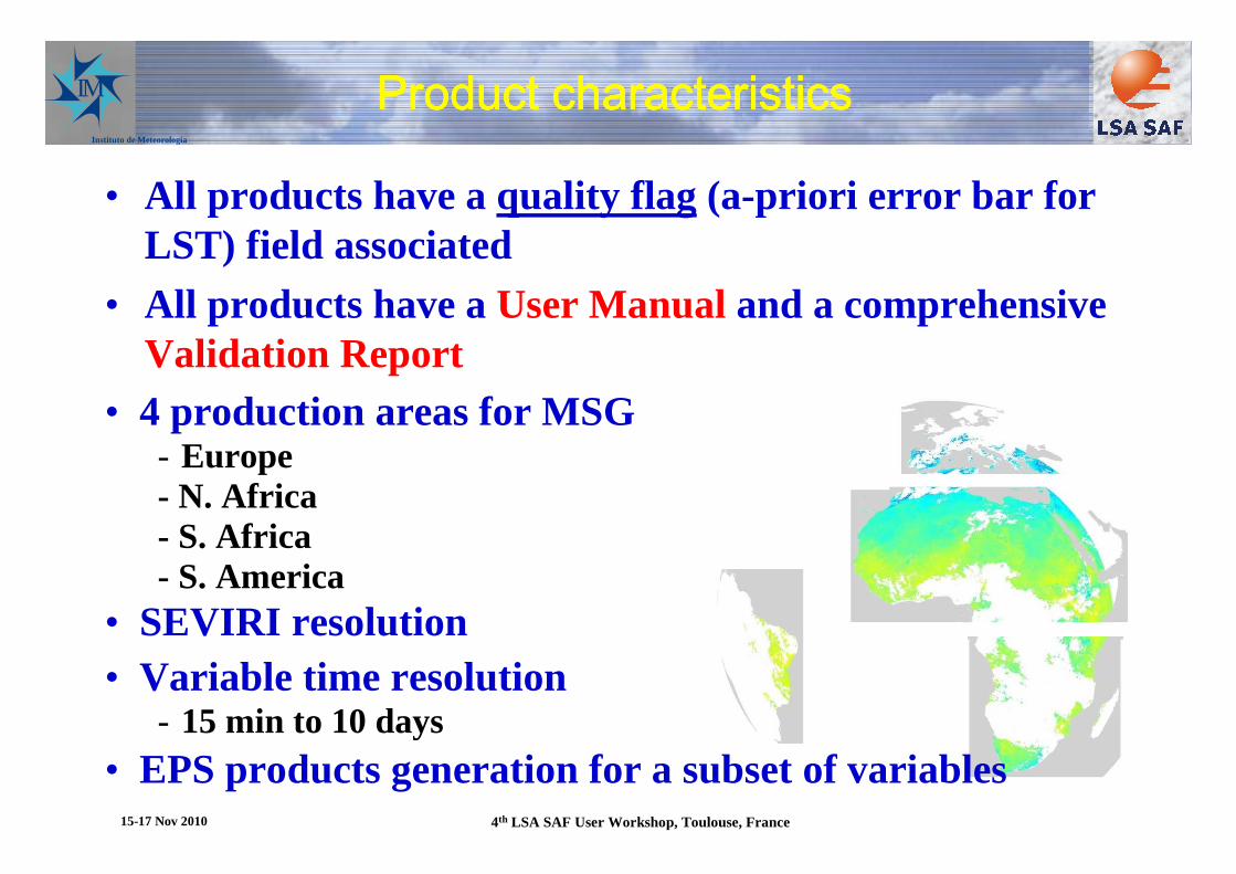
User questionnaire 2008 (1/3)User questionnaire 2008 (1/3)User questionnaire 2008 (1/3)User questionnaire 2008 (1/3)
0% 10% 20% 30% 40% 50% 60% 70% 80% 90%
Timeliness
Geographical Area covered
Accuracy
Availability of alternative data sources
Spatial resolution
Data accessibility
Long-term continuity
Availability of reprocessed data*
Data format
Data geographical projection
Quality control
Documentation and user support
Not Relevant
Low
High
Critical elements to use LSA SAF data
15-17 Nov 2010 4th LSA SAF User Workshop, Toulouse, France
IM
Instituto de Meteorologia
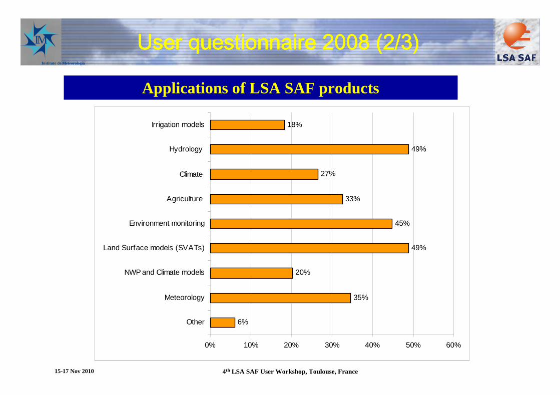
User questionnaire 2008 (2/3)User questionnaire 2008 (2/3)User questionnaire 2008 (2/3)User questionnaire 2008 (2/3)
6%
35%
20%
49%
45%
33%
27%
49%
18%
0% 10% 20% 30% 40% 50% 60%
Other
Meteorology
NWP and Climate models
Land Surface models (SVATs)
Environment monitoring
Agriculture
Climate
Hydrology
Irrigation models
Applications of LSA SAF products
15-17 Nov 2010 4th LSA SAF User Workshop, Toulouse, France

IM
Instituto de Meteorologia
User questionnaire 2008 (3/3)User questionnaire 2008 (3/3)User questionnaire 2008 (3/3)User questionnaire 2008 (3/3)
6%
8%
59%
22%
16%
4%
6%
0% 10% 20% 30% 40% 50% 60% 70%
Other
All Globe
Europe
North Africa
South Africa
North America
South America
35%
27%
20%
0%
49%
14%
14%
10%
0% 10% 20% 30% 40% 50% 60%
15 min
30 min
Hourly
Tw ice a day
Daily
10-day (composite of 30 days)
Monthly
Other
Geographical area
Time scales of interest
15-17 Nov 2010 4th LSA SAF User Workshop, Toulouse, France
IM
Instituto de Meteorologia
LayoutLayoutLayoutLayout
• Introduction• Land Surface Analysis SAF and its services• Cooperation and training activities: Serving the users• Preview on CDOP-2• Conclusions
15-17 Nov 2010 4th LSA SAF User Workshop, Toulouse, France

IM
Instituto de Meteorologia
• Instituto de Meteorologia (IM), Portugal
• Meteo-France (MF), France
• Royal Meteorological Institute (RMI), Belgium
• Finnish Meteorological Institute (FMI), Finland
• IMK, University of Karlsruhe
• IDL, University of Lisbon
• UV, University of Valencia
LSA SAF Current Consortium
CDOP-2 new members:
KCL (UK)
VITO (Belgium)
CDOP-2
15-17 Nov 2010 4th LSA SAF User Workshop, Toulouse, France

IM
Instituto de Meteorologia
LST ↓↓↓↓LongWave Flux
Albedo ↓↓↓↓ShortWave Flux
SEVIRI/Meteosat
Surface Radiation
Snow Cover
Evapotranspiration
Surface Water Balance
Fraction Veg Cover
LAI
fAPAR
Vegetation
Fire Detection
Fire Radiative Power
Fire Risk (Europe)
Wild fires
Increased level of maturity
Family of Products: Current status
MSG
Metop15-17 Nov 2010 4th LSA SAF User Workshop, Toulouse, France

IM
Instituto de Meteorologia
LST ↓↓↓↓LongWave Flux
SEVIRI/Meteosat
Surface Radiation
Vegetation
Fire Detection
Fire Radiative Power
Fire Risk (Europe)
Wild fires
Increased level of maturity
Family of Products: CDOP-2
MSG
Metop
Evapotranspiration
Reference Evap
Water stres
Fraction Veg Cover
LAI
fAPAR
State
NDVI
↓↓↓↓ShortWave Flux Albedo
15-17 Nov 2010 4th LSA SAF User Workshop, Toulouse, France

IM
Instituto de Meteorologia
LSA SAF Strategy for CDOP-2
• Maintenance, quality monitoring & validation of MSG & EPS inherited products
• Upgrade of existing algorithms for MTG data
Product & Service Continuation
• Overcome known deficiencies of current products• Address requests from user community
New Algorithms / Products aim to:
- Land surface modelling (carbon fluxes, hydrology)
- Agriculture and forest applications
- NWP
- Climate studies
- Environmental monitoring
- Food security15-17 Nov 2010 4th LSA SAF User Workshop, Toulouse, France
IM
Instituto de Meteorologia
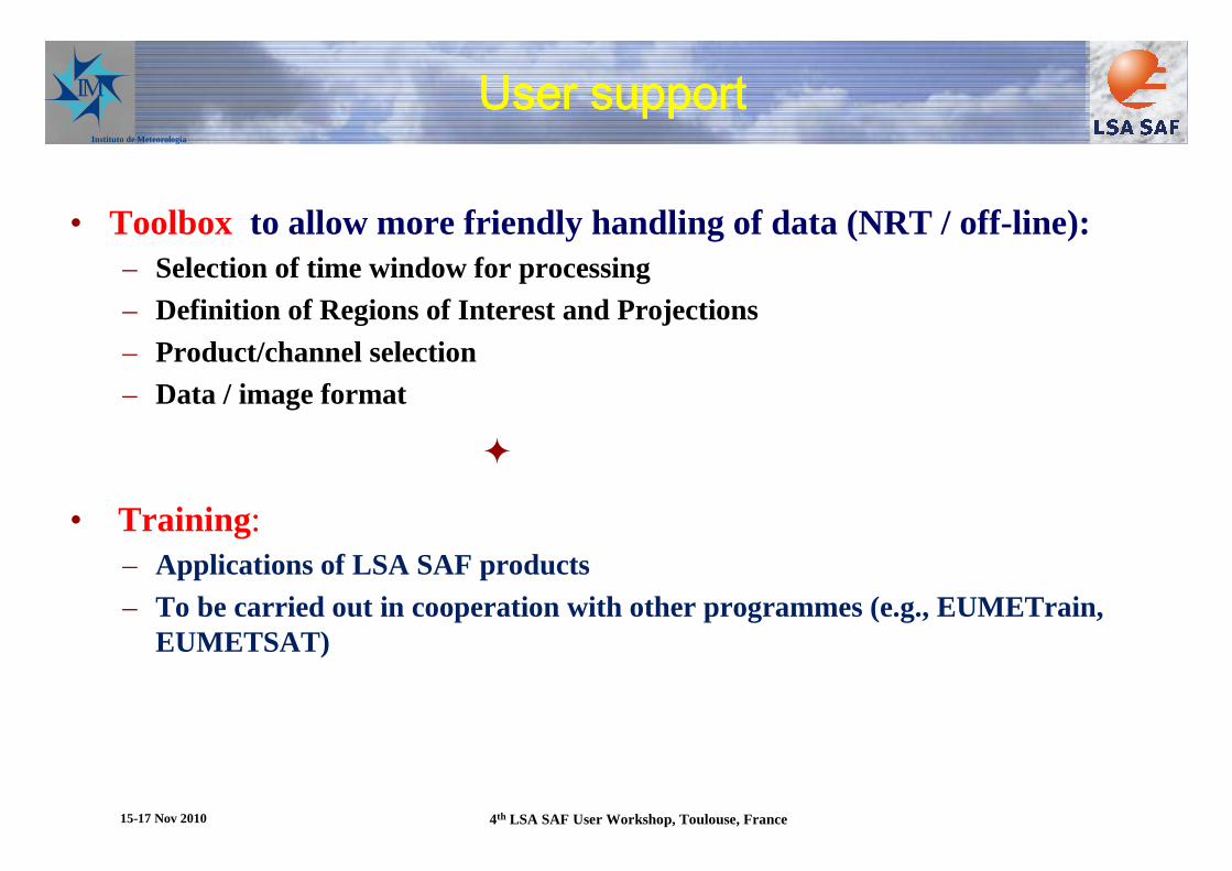
• Toolbox to allow more friendly handling of data (NRT / off-line):– Selection of time window for processing– Definition of Regions of Interest and Projections– Product/channel selection– Data / image format
�
• Training : – Applications of LSA SAF products – To be carried out in cooperation with other programmes (e.g., EUMETrain,
EUMETSAT)
User supportUser supportUser supportUser support
15-17 Nov 2010 4th LSA SAF User Workshop, Toulouse, France

IM
Instituto de Meteorologia
LSA SAF products and MTGLSA SAF products and MTGLSA SAF products and MTGLSA SAF products and MTG
• LSA SAF will use radiances from the (Full Disk) Imagery Mission,(SEVIRI follow-up)
• Better spatial resolution will be of benefit to all LSA SAF products• Enhanced spectral characteristics vs. SEVIRI
– FD-VIS 0.4 Better aerosol, should improve AL, SW flux, but also LW flux and LST
– FD-IR 3.8/8.5 Extended dynamical range for fire applications– FD-IR 1.3 et al Improved cloud mask and cloud type specification
• Impact on products– All products, given better clouds– Fire products– AL, radiative fluxes and LST, cascading into other products (VEGA, ET)– More competitive VEGA products with enhanced spatial resolution
15-17 Nov 2010 4th LSA SAF User Workshop, Toulouse, France

IM
Instituto de Meteorologia
LayoutLayoutLayoutLayout
• Introduction• Land Surface Analysis SAF and its services• Cooperation and training activities: Serving the users• Preview on CDOP-2• Conclusions
15-17 Nov 2010 4th LSA SAF User Workshop, Toulouse, France

IM
Instituto de Meteorologia
Summary, conclusions and perspectives
• Aalgorithm development, validationand operational production of land surface related products from remote sensing data, with a particular emphasis on EUMETSAT satellites:
– LAND– LAND-ATMOSPHERE Interactions– Land Biosphere Applications
• Outlook– Strenghten our links with users, emphasis on collaborative efforts with key users,
including targeted training efforts– CDOP-2 and plans for the upcoming MTG products– LSA SAF partners will participate in GMES land (geoland2)
• Product dissemination– Daily from our web site (http://landsaf.meteo.pt)
– EUMETCAST• Further information
– http://landsaf.meteo.pt– Trigo et al. 2010, Int. J. Rem. Sens., in press– LSA SAF poster
The users (you !) a
re on the dr iving sea
t
15-17 Nov 2010 4th LSA SAF User Workshop, Toulouse, France
Related Documents