OVERSIZE/OVERWEIGHT VEHICLE UNIFIED PERMITTING PROCESS (UPP) PHASE l AUGUST 2017 REPORT NUMBER: MN/RC 2017-26 Minnesota Department of Transportaon | Research Services & Library 395 John Ireland Boulevard, MS 330 | St. Paul, Minnesota 55155-1899 Authors: Renae Kuehl, SRF Consulng Group Samantha Markman, SRF Consulng Group Annee Theroux, Pro-West and Associates

Welcome message from author
This document is posted to help you gain knowledge. Please leave a comment to let me know what you think about it! Share it to your friends and learn new things together.
Transcript

OVERSIZE/OVERWEIGHT VEHICLE UNIFIED PERMITTING PROCESS (UPP) PHASE lAUGUST 2017REPORT NUMBER: MN/RC 2017-26
Minnesota Department of Transportation | Research Services & Library395 John Ireland Boulevard, MS 330 | St. Paul, Minnesota 55155-1899
Authors:Renae Kuehl, SRF Consulting Group
Samantha Markman, SRF Consulting Group
Annette Theroux, Pro-West and Associates

To request this document in an alternative format, such as braille or large print, call 651-366-4718 or 1-800-657-3774 (Greater Minnesota) or email your request to [email protected]. Please request at least one week in advance.

Technical Report Documentation Page 1. Report No. 2. 3. Recipients Accession No.
MN/RC 2017-26
4. Title and Subtitle 5. Report Date
Oversize/Overweight Vehicle Unified permitting process (UPP)
Phase I
August 2017 6.
7. Author(s) 8. Performing Organization Report No.
Renae Kuehl, SRF Consulting Group
Samantha Markman, SRF Consulting Group
Annette Theroux, Pro-West and Associates
9. Performing Organization Name and Address 10. Project/Task/Work Unit No.
SRF Consulting Group, Inc. One Carlson Parkway North, Suite 150 Minneapolis, MN 55447-4443 Pro-West and Associates 8239 State Hwy 371 Walker, MN 56484
11. Contract (C) or Grant (G) No.
(C) 1026145
12. Sponsoring Organization Name and Address 13. Type of Report and Period Covered
Minnesota Department of Transportation Research Services & Library 395 John Ireland Boulevard, MS 330 St. Paul, Minnesota 55155-1899
Final Report 14. Sponsoring Agency Code
15. Supplementary Notes
http:// mndot.gov/research/reports/2017/201726.pdf 16. Abstract (Limit: 250 words)
Multiple jurisdictions within Minnesota process oversize/overweight (OSOW) permits for the movement of freight
on state roadways, county roads, and municipal and township streets. Movement of freight has increased in
recent years to help support economic trends and construction needs. These moves often require haulers to off-
load from state roadways onto the county or municipal and township roadways for final delivery, causing pinch
points (i.e., construction, vertical clearance issues, etc.) which may negatively impact the forecast life cycles of
both roads and bridges. With haulers moving across roadway authorities, there is a desire to develop a unified
process to support OSOW permits. This report outlines the feasibility of implementing an OSOW unified
permitting process (UPP), to be used by multiple roadway authorities, allowing a “one-stop-shop” for haulers and
permitting agencies.
17. Document Analysis/Descriptors 18. Availability Statement
Overweight loads, permits, trucks by weight, freight
transportation, freight service, commodity density, size and
weight regulations
No restrictions. Document available from:
National Technical Information Services,
Alexandria, Virginia 22312
19. Security Class (this report) 20. Security Class (this page) 21. No. of Pages 22. Price
Unclassified Unclassified 39 $123,004.00
Oversize/Overweight Vehicle Unified Permitting Process
(UPP) Phase l
FINAL REPORT
Prepared by:
Renae Kuehl, SRF Consulting Group
Samantha Markman, SRF Consulting Group
Annette Theroux, Pro-West and Associates
August 2017
Published by:
Minnesota Department of Transportation
Research Services & Library
395 John Ireland Boulevard, MS 330
St. Paul, Minnesota 55155-1899
This report represents the results of research conducted by the authors and does not necessarily represent the views or policies
of the Minnesota Department of Transportation or SRF Consulting Group, In., or Pro-West and Associates. This report does not
contain a standard or specified technique.
The authors, the Minnesota Department of Transportation, and SRF Consulting Group, In., and Pro-West and Associates do not
endorse products or manufacturers. Trade or manufacturers’ names appear herein solely because they are considered essential
to this report because they are considered essential to this report.
TABLE OF CONTENTS Oversize/Overweight Vehicle Unified Permitting Process (UPP) ..........................................................1
What is the need? ......................................................................................................................................... 1
What is the goal? .......................................................................................................................................... 1
Stakeholders ................................................................................................................................................. 1
Project history ...................................................................................................................................4
OSOW Permitting history .............................................................................................................................. 4
Project methodology ..........................................................................................................................4
Listening Sessions ......................................................................................................................................... 4
Investigations .................................................................................................................................. 10
Categories of Permits .................................................................................................................................. 10
Permit Requirements between Agencies ................................................................................................... 10
Geospatial Data Requirements for Routing ................................................................................................ 10
Permitting Software .................................................................................................................................... 11
Other Processes and Data Sources ............................................................................................................. 12
Unified Permitting Process Needs and Recommendations ................................................................. 13
Policy ........................................................................................................................................................... 13
Process ........................................................................................................................................................ 14
Technology .................................................................................................................................................. 15
UPP Next Steps: Phase II .................................................................................................................. 17
Task 1: Define Policy Requirements ........................................................................................................... 17
Task 2: Define Permitting Processes .......................................................................................................... 17
Task 3: Define and Develop Core Prototype Functional Capabilities (Technology backend) .................... 18
Task 4: Execute a Pilot with the Working Group........................................................................................ 19
Task 5: Education and Research ................................................................................................................. 19
LIST OF TABLES Table 1. Policy Group .........................................................................................................................2
Table 2. Technical Advisory Panel (TAP) ..............................................................................................2
Table 3. Listening Session: Local Government .....................................................................................3
Table 4. Listening Session: MnDOT .....................................................................................................3
Table 5. Listening Session: Haulers .....................................................................................................3
Table 6. Listening Session: Law Enforcement.......................................................................................3
LIST OF APPENDICIES A. Detailed Interview Questions
B. List of Requirements to Issue Permits by Jurisdiction
C. Roadway Attributes Needed to Perform UPP
D. Structure of the UPP System
E. Self-Service Unified Permitting Workflow

EXECUTIVE SUMMARY
Today, in order to apply for an oversize/overweight permit, members of the hauling industry need to
apply for these types of permits for large loads through each individual roadway authority they will be
traveling through. MnDOT, counties and cities all administer permits for their own roadways. This
requires several different permit applications and processes from each roadway authority for an
individual hauler. The general purpose of this project is to explore the feasibility of a unified permitting
process for oversize/overweight vehicle permit applications across all roadway authorities. MnDOT is
looking to advance unified permitting endeavors in the future to help support the all roads network
concept.
This research study examined the feasibility of implementing a one-stop-shop permitting software
program to better support a unified permitting process. Project methodologies included reviewing the
current practices and developing a plan for creating a process and policies and technologies to assist
both local government and hauler needs. This report discusses the potential policy, process, and
technology recommendations that can be tested for further implementation in future phases of the
unified permitting process.
This document is organized to create a foundation for future unified permitting process phases. The
appendices referenced throughout the report offer additional information and insight into the findings
and investigation phases. These investigation phases explored the completed listening sessions,
technology discoveries, and potential technology mock-ups for how the unified permitting process
would function. Based on the early benefits already realized by the policy group and technical advisory
panel members, it is anticipated this report can have a substantial positive impact on the future for the
unified permitting process.
1
OVERSIZE/OVERWEIGHT VEHICLE UNIFIED PERMITTING
PROCESS (UPP)
Multiple roadway authorities within Minnesota process oversize/overweight (OSOW) permits for the
movement of freight on state roadways, county roads, and municipal and township streets. Movement
of freight has increased in recent years to help support a growing economy. These moves often require
haulers to off-load from state roadways onto the county or municipal and township roadways for final
delivery, causing pinch points (i.e. construction, vertical clearance issues, etc.) which may negatively
impact the forecasted life cycles of both roads and bridges. With haulers moving across roadway
authorities, there is a desire to develop a unified system to process OSOW permits.
WHAT IS THE NEED?
MnDOT, counties, cities, and townships all administer permits for their own roadways. Currently, in
order to apply for an OSOW permit, members of the hauling industry submit separate applications to
each roadway authority in which they will be traveling. This requires several different permit
applications and processes for an individual hauler crossing roadway authority lines. It is important for
each jurisdiction to remain in control of permitting their own roadways, however there is a need to
simplify the process for haulers to obtain the necessary permits from each road authority.
WHAT IS THE GOAL?
The focus of this project is to explore the feasibility of a unified permitting process (UPP) for OSOW
vehicle permit applications across all jurisdictions. The State of Minnesota has been discussing a unified
permitting process since the early 1990s. MnDOT and local roadway authorities are looking to advance
unified permitting endeavors in the future to support movement considering an all roads network
concept.
The goal of phase I for this project focuses on reviewing the current needs and practices to develop a
plan for creating process, policies, and technologies to address both government and industry needs for
creating an accessible and automated system for unified permitting within and across roadway
authorities.
STAKEHOLDERS
A series of stakeholder groups were involved throughout the project. Stakeholder groups included a
Policy Group and Technical Advisory Panel (TAP), in addition to individuals who were interviewed as part
of the project. Members of the Policy Group also make up some of the members of the TAP, as well as,
many of the TAP members were interviewed as part of this process. These interviews consisted of local
government, state agencies, haulers, and law enforcement. Below is a list of involved stakeholders by
associated group.

2
Table 1. Policy Group
Name Title Agency Industry
Rich Sanders County Engineer Polk County Government
Ted Coulianos Trans. Program Supervisor MnDOT Government
Ted Schoenecker Deputy State Aid Engineer MnDOT Government
Clark Moe Sr. Engineering Specialist MnDOT Government
Abbey Bryduck Director – Gov. Relations AGC Trucking
Annette Theroux Project Manager – Consultant Pro-West and Associates Consultant
Brandon Crissinger Data Development Manager Pro-West and Associates Consultant
Kyle Wikstrom GIS Solutions Specialist Pro-West and Associates Consultant
Mike Marti Principal – Engineer SRF Consulting Group Consultant
Renae Kuehl Project Manager – Engineer SRF Consulting Group Consultant
Samantha Markman Planner SRF Consulting Group Consultant
Table 2. Technical Advisory Panel (TAP)
Name Title Agency Industry
Mike Tardy County Engineer Carlton County Local Government
Cari Pedersen Chief Engineer City of Duluth Local Government
Butch McConnell ROW Permits Manager Dakota County Local Government
Steven Groen ROW Use Manager Hennepin County Local Government
John Ekola Bridge Engineer Hennepin County Local Government
Tim Stahl County Engineer Jackson County Local Government
Victor Lund Traffic Engineer St. Louis County Local Government
Dale Klossner MN.IT at MnDOT MnDOT State Government
Cory Johnson Engineer Admin MnDOT State Government
Dan Flatgard State Prog. Admin MnDOT State Government
Dave Conkel Engineer – Bridge MnDOT State Government
Moises Dimaculangan Engineer – Bridge MnDOT State Government
Paul Weinberger IT Division Manager MnDOT State Government
Peter Morey Trans. Program Supervisor MnDOT State Government
Steve Lund Engineer – Maintenance MnDOT State Government
Tim Andersen Pavement Design Engineer MnDOT State Government
Todd Bergland System Analysis Supervisor MnDOT State Government
Dan Ross IT Division MnGEO State Government
Tim Worke Director – Hwy/Trans. AGC Trucking
Jerry Anderson Heavy Haul Manager Midstate Reclamation Trucking
Rick Johnson Fleet Manager Tiller Corp Trucking
3
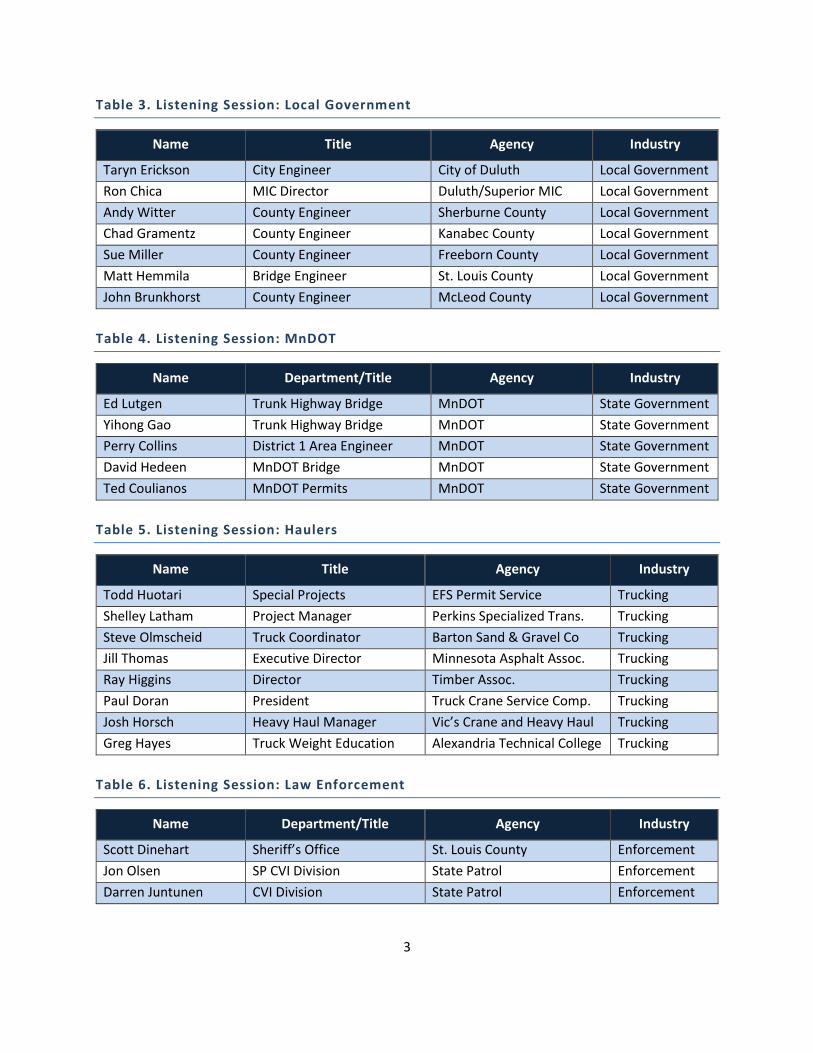
Table 3. Listening Session: Local Government
Name Title Agency Industry
Taryn Erickson City Engineer City of Duluth Local Government
Ron Chica MIC Director Duluth/Superior MIC Local Government
Andy Witter County Engineer Sherburne County Local Government
Chad Gramentz County Engineer Kanabec County Local Government
Sue Miller County Engineer Freeborn County Local Government
Matt Hemmila Bridge Engineer St. Louis County Local Government
John Brunkhorst County Engineer McLeod County Local Government
Table 4. Listening Session: MnDOT
Name Department/Title Agency Industry
Ed Lutgen Trunk Highway Bridge MnDOT State Government
Yihong Gao Trunk Highway Bridge MnDOT State Government
Perry Collins District 1 Area Engineer MnDOT State Government
David Hedeen MnDOT Bridge MnDOT State Government
Ted Coulianos MnDOT Permits MnDOT State Government
Table 5. Listening Session: Haulers
Name Title Agency Industry
Todd Huotari Special Projects EFS Permit Service Trucking
Shelley Latham Project Manager Perkins Specialized Trans. Trucking
Steve Olmscheid Truck Coordinator Barton Sand & Gravel Co Trucking
Jill Thomas Executive Director Minnesota Asphalt Assoc. Trucking
Ray Higgins Director Timber Assoc. Trucking
Paul Doran President Truck Crane Service Comp. Trucking
Josh Horsch Heavy Haul Manager Vic’s Crane and Heavy Haul Trucking
Greg Hayes Truck Weight Education Alexandria Technical College Trucking
Table 6. Listening Session: Law Enforcement
Name Department/Title Agency Industry
Scott Dinehart Sheriff’s Office St. Louis County Enforcement
Jon Olsen SP CVI Division State Patrol Enforcement
Darren Juntunen CVI Division State Patrol Enforcement
4
PROJECT HISTORY
Permitting for an all roads network has been discussed by industry and governmental agencies for many
years. Over the past 30 years, these multi-jurisdictional agencies have come together to pave the way
for UPP. These agencies are helping to find ways to create an effective and efficient movement of
Minnesota freight that supports economy, safety, and preservation.
OSOW PERMITTING HISTORY
1990s: In the 1990s, MnDOT implemented the country’s first automated permitting software/system for
the MnDOT roadway network.
2000s: In the 2000s, the Associated General Contractors (AGC) and Minnesota County Engineers
Association (MCEA) OSOW Committee set out to develop a permitting process for the local roadway
network.
2010s: In the 2010s, the Minnesota Local Road Research Board (LRRB) initiated attempts to determine
the feasibility of an “All Roads Network” in support of processing OSOW permitting.
In 2014, Cambridge Systematics conducted the Local Permit Coordination Project which looked at the
various permitting procedures across Minnesota’s state, county, municipal, and township agencies. The
2014 Study then led to the current unified permitting process (UPP) project led by local agencies and
included MnDOT to achieve an all roads network approach to OSOW permitting.
PROJECT METHODOLOGY
Project methodologies for the UPP project included Listening Sessions and software investigations to
help determine a chosen course of action to accomplish a unified software approach for an all roads
network to oversize/overweight permitting. These methodologies helped to inform the general need of
a unified system, as well as to identify the potential outcomes, based on existing software, policy and
process.
Listening Sessions
As part of the project methodology phase, the UPP project interviewed a series of stakeholders at
various levels of government and industries. The listening sessions included all the members of the
policy group and TAP members as well as members from city and county governments, state
government, hauling industry, and law enforcement, listed previously in this report. These stakeholders
were interviewed to get a preliminary idea of the strengths, weaknesses, and opportunities for the
current OSOW permitting system.

5
The stakeholder interviews were held from December 2016 through March 2017. Interviews were set up
as Listening Sessions where individuals across jurisdictions were invited to regional sessions to inform
UPP. See below for a summary and key themes. See Appendix A for detailed interview questions.
Listening Sessions Key Themes
District 1 Regional Listening Session
DECEMBER 1, 2016 – CARLTON COUNTY TRANSPORTATION DEPARTMENT
Attendees:
MnDOT District 1
Duluth/Superior MIC
City of Duluth
Carlton County
Polk County
Saint Louis County
Saint Louis County Sheriff Office
State Patrol Commercial Vehicle
Key Themes:
RT Vision is a common permitting software for local jurisdictions (County).
Limited enforcement available at the local level – mostly conducted at the state level (i.e., State
Patrol).
Most permitting standards (i.e., turnaround time for approval, fee structure, and hauling
specifications) are in place due to longstanding history. No real reason behind some of these
numbers/information – “how it has always been done.”
Bridge crossing (ratings) are often the choke point for permit applications. Some bridge
crossings require additional analysis – local jurisdictions have limited resources to complete a
detail analysis – rely on MnDOT Bridge Office.
90 to 98 percent of permit applications could potentially be approved automatically with a
software system with data built into the permit application.
Typically do not deny a permit – will suggest a new route for the hauler, but not a complete
denial.
Metro Regional Listening Session
DECEMBER 14, 2016 – SRF CONSULTING GROUP, INC.
Attendees:
Hennepin County Dakota County
Key Themes:
Dakota County has developed their own unified permitting system in-house which incorporates
data for an automated approval process for loads under 220,000 pounds.
Dakota County has created 10-ton routes that requires a 10-ton permit application separate to
the standard OSOW permit.

6
Dakota County has built MnDOT bridge approval into their automated permitting software.
Permit application goes to MnDOT for bridge approval prior to Butch/Dakota County seeing or
approving the permit.
Hennepin County sees mostly construction equipment using their roadways for various projects
throughout Hennepin County and beyond.
Hennepin County does not post bridges – they have their own internal process for approving the
crossings of Hennepin County bridges (dedicated staff and resources).
Hennepin County, Dakota County, and MnDOT do not permit vehicles over 20,000 pounds per
axle.
Limited enforcement available at the local level – mostly conducted at the state level (i.e., state
patrol) – Dakota County does have a dedicated Commercial Vehicle Inspector, they are so busy
the County is looking into certification of another deputy.
Counties typically attempt to reroute the load prior to denying a permit – however, both
Hennepin and Dakota County will deny a permit.
MnDOT Engineers Listening Session
DECEMBER 19, 2016 – MNDOT CENTRAL OFFICE
Attendees:
MnDOT Bridge
MnDOT State Aid Bridge
MnDOT OMRR
MnDOT OFCVO
Key Themes:
MnDOT Bridge Office provides primary support to local jurisdictions and MnDOT for permit
approval process – when crossing a MnDOT owned bridge.
MnDOT State Aid Bridge provides a support role to the local jurisdictions.
Route Builder – MnDOT permitting software is out of date and does not collaborate with bridge
and roadway data regular updates. Will be looking for new software programs moving forward.
MnDOT Bridge have built standard permit trucks (A, B, and C) which allows an automated
approval process for bridge applications. These truck configurations have been load certified for
the bridge ratings. Anything above a Truck C configuration requires individual computer analysis.
Thirty-two percent of MnDOT OSOW permit applications are completely auto-issued.
Limited coordination between MnDOT Permit Office and Pavement Office – more coordination
with MnDOT Bridge. However, Pavement Office will be contacted for rare occurrences (one to
five requests per year).
Limited coordination between the MnDOT Permit Office and local jurisdictions. MnDOT does not
know if local agency permittees are getting permits for MnDOT bridges (on local roadways
crossing MnDOT roadways). Local jurisdiction permits require the hauler to contact MnDOT – no
follow up to ensure they contacted MnDOT. Local jurisdictions are beginning to develop a
process with the MnDOT Permit Office to notify MnDOT of a permit application across the state-
owned bridges. More jurisdictions are beginning to develop this process with the MNDOT
Permit Office.

7
MnDOT IT Listening Session
DECEMBER 19, 2016 – MNDOT CENTRAL OFFICE
Attendees:
MnDOT Maintenance
MnDOT OFCVO
Mn.IT at MnDOT
MnGEO
Key Themes:
MnGeo and Mn.IT could help to facilitate a unified permitting software. They have the
capabilities to store the data and support an application software. MnGeo currently hosts five
agencies with data and applications.
MnGeo working to build a statewide roadway centerline file from County data – not complete
yet. This roadway file could have additional attributes and be used for permitting applications or
require a related table.
Mn.IT spoke about the actual permitting software – it would need to be decided whether or not
the goal would be to build a unified permitting application software or buy a relevant software
and expect all agencies to conform to a single system.
A hybrid approach may be ideal for initial implementation. Allow each software program to
communicate to each other – making it easier for the hauler. However, create a timeline for a
single system approach, may require a subscription service.
Mn.IT can work to set up a way to share bridge data with the roadway data and incorporate all
applicable data for permitting use.
There will be trainings held at the district level to get the CAD data to GIS – in order to build a
unified roadway file that could be used for routing and approval processes.

8
Haulers Listening Session
DECEMBER 20, 2016 – SRF CONSULTING GROUP, INC.
Attendees:
Truck Crane Service Company
EFS Permit Service
Minnesota Asphalt Pavement Association
Tiller Corp
Vic’s Crane and Heavy Haul
Midstate Trucking
Perkins Specialized Transportation
MnDOT OFCVO
Barton Sand and Gravel Co
Key Themes:
The most difficult hurdle for the haulers is the inconsistency between weights, time of travel,
flagging provisions, etc. The hauling industry sees this as an opportunity for “quick fixes” to
provide a standardization between these inconsistencies.
An example was provided that Iowa DOT has standardized their provisions from state to county
level – this is very convenient for the hauler.
Education needs to be better incorporated into the permitting system. Haulers fear the local
staff is not well educated on OSOW hauling and therefore denies a permit without taking into
consideration the safety measures that have been put in place for the loads.
Feel as though Dakota County’s automated permit service works well – but as with any permit,
the haulers worry what good it does. The hauling industry would like to see the counties and
state taking an interest in the routes being chosen to ensure when they hit the road – they will
not meet any obstacles. Difficult to turn around once on the road.
Turnaround time needs to be quick – the haulers will plan to move with or without a permit.
However, it would be nice if the permit process could be expedited to accommodate load
requests that come in at 3 p.m. and need to move at 3:30 p.m.
Typically maximize the weights allowed on the permit – to a certain extent – to allow a cushion
for weights and heights. Plus, the hauler is often times applying for a permit ahead of time and
does not always know the official weights of the load configuration.
Over-height hauling is difficult because most jurisdictions do not know what vertical clearance is
on the current roadways. For smaller loads, it is not worth it to the hauler to complete a route
survey – need to consider time and money.
Limited corridors equipped to handle OSOW loads from the river ports – therefore, it makes it
difficult to get goods in and out of Minnesota. Haulers will tell manufacturers “don’t build it in
Minnesota, you can’t get it out of here.”
Illinois permitting software works well – homebuilt system – which attempts eight routes before
a permit is denied. Closest current software program to a unified system; however, can take up
to 10 days to receive a permit.
Haulers feel the local jurisdictions (i.e., counties) need to be more standardized with the state. If
the State allows it – so should the county.
9
Outstate Minnesota Regional Listening Session
MARCH 8, 2017 – SRF CONSULTING GROUP, INC. / TELECONFERENCE
Attendees:
Freeborn County
McLeod County
Sherburne County
Polk County
Minnesota State Patrol
Key Themes:
Both paper permit and software based permitting applications are accepted by outstate
counties for oversize/overweight permitting.
Very little enforcement at the local (county or city/township) level, local jurisdictions are relying
on the Minnesota State Patrol to support the enforcement of OSOW permits – similar to what
has been at local jurisdictions across the state.
Largest hurdle to overcome with oversize/overweight permitting for local jurisdictions are
weight restricted bridges. Typically, counties will help to work out a different route for the
hauler in lieu of denying the permit application.
Local jurisdictions are worried what overweight loads will do to pavement quality overtime.
Freeborn County is suggesting to limit OSOW loads on the local county roadway network to only
loads with an origin or destination in Freeborn County.
In order to try and recoup some of the damage costs caused by repetitive oversize/overweight
loads, some outstate counties (i.e., Freeborn and Jackson counties) are charging permit fees by
axle weight for superloads.
Individual Interviews
JANUARY 25, 2017 – TELECONFERENCE
Attendees:
Greg Hayes, Alexandria Technical and Community College
FEBRUARY 24, 2017 – TELECONFERENCE
Attendees:
Captain Jon Olsen, Minnesota State Patrol

10
INVESTIGATIONS
Categories of Permits
Existing permitting software was discussed during the Listening Sessions and researched following the
sessions to discover unifying characteristics for software and permitting processes. Permits were
categorized by level of effort to determine if processes could be streamlined or automated by a unified
permitting process approach.
There are two levels of permitting that were discussed:
Repetitive trips over the same roads, oftentimes from the same hauler using the same
equipment. Also, loads that routinely fall within acceptable standards for the road and are
reviewed and issued quickly occur on a regular basis.
OSOW permits being issued by both local government and the State.
Permit Requirements between Agencies
Local government agencies and MnDOT each use different software or paper/FAX systems to issue
permits. The process of setting requirements to issue a permit is a common element between the
various systems whether digital or paper. Each agency has set information requirements for issuing
permits, some include vehicle registration details, weight, axle details, dimensions (width, height,
length, overhang), trailer details, route description, other permits, and hauling dates.
Following the Listening Sessions, a spreadsheet was created with the data as collected from various
types of permitting systems including custom built, vendor supplied, and MnDOT permit application
requirements. The spreadsheet was reviewed by local government and state permitting agencies to
determine if there are common permit requirements that could be set for issuing a permit across
roadway authorities. Collected data, as well as those requirements that are common and could be used
for issuing unified permits are listed in Appendix B.
Geospatial Data Requirements for Routing
Permit routing on a digital map using geospatial data is not being done in Minnesota, at this time. The
process for acquiring, attributing, and maintaining a routable statewide dataset was investigated during
the project. A list of roadway attributes needed to perform unified permitting was created based on the
listening session discussion and geospatial data being used currently. The list of attributes is included in
Appendix C.
Three significant geospatial data efforts are being executed or planned in the State that will be useful to
develop a routable center reference line for executing a unified permitting process across jurisdictions.
MnDOT is requesting local government agencies receiving State Aid to supply updated roadway
maps annually to update MnDOT’s geodatabase containing County State Aid Highways and
other local government roads. In the first quarter of 2017, the Office of Transportation System
11
Management added a request for additional roadway attributes beneficial for unified
permitting. In the future, the annual request process could be utilized to attribute a state-wide
roadway dataset for use in the unified permitting process and other roadway related processes.
The Minnesota Geospatial Office (MnGEO) is currently acquiring Next Generation 9-1-1
(NG9-1-1) road reference line data for the entire State of Minnesota. The data will be routable in
the near future and a plan has been developed to house, maintain, and update the data.
MnDOT has discussed a process with MnGEO for acquiring road centerline reference data from
local government agencies, attributing data with required attributes, and running scripts to
transform the data for use in MnDOT’s Linear Referencing System. Future options include using
Esri’s Roadway Characteristics Editor to allow local government staff to update the data
periodically.
Of note, a tool developed by the Upper Great Plains Transportation Institute of the North Dakota State
University named Geographic Roadway Inventory Tool (GRIT) was researched to determine if the tool
would be useful for attributing routable geospatial data with the attributes required for moving loads on
local and state government roads.
Permitting Software
Three types of permitting software used by UPP project participants were investigated: local agency
web-based vendor provided software, custom developed software (by individual agency), and the
State’s enterprise permitting software.
The various software was researched to determine key factors: how widespread the software was being
utilized in the state, whether the software was being shared between jurisdictions, the existence of a
routing capability and routable map, if the software met unified permitting input requirements, and
ease of use from the permit issuer and permit requester’s point of view.
Cross jurisdictional permitting software use: None of the permitting software being used in the State
(discovered during Listening Sessions and through second hand knowledge) issues permits across
jurisdictions. MnDOT does not have statutory authority to issue permits for another jurisdiction. At the
local government level, in some instances, counties issue permits that use municipal and township
roadways within their county. For cities that issue permits, the county and municipality do not share the
same permitting software. The State is using a permitting software that they are planning to replace in
the near future. A replacement software has not yet been decided.
Digital routable map: None of the software used by UPP project participants included a map that could
provide a routing tool.
Permit requirements for unified permitting: Each software required similar information for issuing a
permit. The difference in the software was the depth of the information being requested. Some counties
accepted the requirements of the software, while counties that developed a custom permitting software
set the exact information they needed. One particular vendor provided software included a visual

12
graphic tool for indicating the number of axles, weight per axle, and placement of axles instead of the
hauler typing in the information.
Ease of use: The ease of use for permitting software varied depending on whether the information was
provided from the hauler’s perspective or the permitting issuing agency’s perspective.
During the hauler’s listening session, haulers remarked on the difficulty in using the State’s
permitting system, although a newer version of the software (same vendor) used in another
state was reportedly user friendly. The same system from various states had mixed reviews
depending on the state. Local government permitting systems were favored by haulers because
the systems saved the organizations fleet vehicles and the truck’s configuration, however,
MnDOT’s permitting software also offers this feature. One request echoed by all industry
participants was that permit requirements and provisions be standardized across jurisdictions.
During the local government and law enforcement listening sessions, local government agencies
reported that they chose to develop their own custom software or use vendor provided
software based on their preferred process. Most local government agencies were comfortable
with the requirements of the vendor system, both for ease of use and information provided to
the permitting agency, and for the overall cost. A minority of local government agencies chose
to develop their own permitting system to have more control over the process, requirements,
and cost. For agencies using a paper process, the reason was cost/low demand for
permits/sufficient staff to respond.
Other Processes and Data Sources
Other processes and geospatial data sources were investigated as possible permitting processes or
routable data processes. These sources were reviewed to determine how they relate to and potentially
impact UPP.
BDC, MnDOT’s Business Data Catalog: The BDC maintains metadata and information about services
that could impact MnDOT’s business. In the future, the UPP application and data sources could become
useful for other initiatives being performed within MnDOT.
LRS, MnDOT’s Linear Referencing System: In operation for several years and contains a statewide
center reference line that has an accuracy of +/- 40 feet. The data being acquired for the UPP project
can, in the future, be registered as an outside event and plans are being discussed with MnGeo.
MnDOT’s Road Weather Technology Group: MnDOT’s Maintenance Decisions Support System (MDSS)
takes into consideration snow plow and maintenance routes. The system has a pavement history that
connects to meteorological information. Although, haulers are concerned about meteorological events
when transporting loads across the state, the information needed and the information being output by
the MDSS did not meet the needs for data or processes on the permitting level.
District CAD to GIS data transformation: MnDOT Districts are in the process of transforming
MicroStation CAD .dgn files to GIS geodatabase format for use in a GIS. The data is for MnDOT highways
and does not include local government highways.
13
LiDAR: Several counties have acquired LiDAR generated center reference line data. MnDOT is in the
process of acquiring center reference line data through a LiDAR initiative. This source of data could be
used to make edits to existing statewide data within the state, although there is no coverage for the
entire state and acquiring LiDAR data is costly for local governments, at this time.
County map services: Many counties have map services with geospatial highway and road data that is
updated regularly for their own mapping needs. The data is not routable from one county to the next
and is not available for all counties.
HPMA: (Federal Highway Administration’s Highway Pavement Management Application), HPMS
(MnDOT’s Highway Performance Monitoring System), and ARNOLD (All Roads Network of Linear
Referenced Data): As the UPP effort moves forward, it is important to ensure that the process and data
developed are compatible with efforts on the national level.
The HPMA was reviewed for attributes that make up Pavement Condition Indexes that could
contribute to UPP’s need for routable geospatial data. It was discovered that HPMA does an
extraction of lanes and updates the condition indexes that are available in the linear referencing
system. The HPMA/LRS data was not directly useful for the UPP effort but should be kept in
mind as a process operating in parallel.
The HPMS has similarities for attributes to the HPMA. As with the HPMA, the HPMS information
is not directly applicable to the UPP effort but should be kept in mind as a process operating in
parallel.
ARNOLD references 68 attributes that includes lane widths, pavements conditions, etc. It will be
important for the UPP effort to ensure the unique ID for road segments is compatible with the
ARNOLD database. MnGEO is acquiring and validating Minnesota NG9-1-1 data to ensure
compatibility with the ARNOLD database.
UNIFIED PERMITTING PROCESS NEEDS AND RECOMMENDATIONS
There are several needs that have been identified throughout the course of this project. These needs
can be lumped into three categories: Policy, Process, and Technology. Based on listening sessions and
various investigations, these three categories serve as the basis for continuing to move UPP forward.
The following section outlines the needs that have been identified, as well as potential
recommendations for how these needs can be met moving into the next phase(s) of UPP. These
recommendations are meant to continue to move UPP towards standardization and unification across
all jurisdictions.
Policy
Common themes throughout the listening session and investigation phases of UPP indicated that
through minor policy adjustments, and implementation of technology OSOW permits can move towards
being more unified. These policy adjustments include unifying general provisions across all jurisdictions,
and the standards or items required by the applicant to issue a permit. It was identified in project
listening sessions that many of the general provisions were adopted in years prior and never updated.

14
There was no reason to why a certain provision exists differently across jurisdictions (i.e., State to
County) for the sole fact that a jurisdiction (County) did not update with others (State).
General Provisions
Travel Hours: Travel hours vary based upon jurisdiction. With the varying hours of travel acceptable by
jurisdiction, this can complicate a move dramatically. Some local jurisdictions allow travel on holidays;
however, Minnesota permit applications do not allow travel during major holidays. Additionally, some
loads are restricted to certain times of day. A single jurisdiction could be withholding an entire move.
Unification of travel hours would help allocate acceptable travel hours statewide, limiting choke points
based upon jurisdictions.
Warning Devices: These devices include flagging requirements. Throughout the interview phase of the
project, haulers identified jurisdictions vary on the color and size of the flagging requirements.
Realistically haulers are not going to change the size nor color of their load’s flags in the middle of travel;
therefore, forcing them into a violation. If jurisdictions set a standard flag and warning device
requirement statewide, this would help to reduce the number of inconsistencies.
Insurance Requirements: Some jurisdictions require insurance policies with higher cost coverages. The
inconsistency in required insurance policies may cause haulers to avoid a specific jurisdiction because
they are one of few that do not follow the majority with a typical insurance coverage plan.
Requirements to Issue Permits
Haulers would like to ensure that all the information required to obtain a permit is being used to
determine the eligibility for approval or denial of an OSOW permit. Requiring information that does not
reflect the need of a permit could be adding steps to a permit application that are not necessary for
either the applicant or reviewer. A standardization of these requirements would help to provide clarity
between jurisdictions for the various applicants. Appendix B has a comprehensive list of requirements to
issue permits by jurisdiction, also showing commonalities across each jurisdiction.
Process
Throughout the listening session and investigation phase, process recommendations were identified as
potential items to reach successful implementation of UPP. These recommendations include what we
learned from other agencies, how to unify OSOW application forms, steps to build a dataset that allows
approximately 80 to 90 percent of permit applications to be automatically approved, and potential
technology options available for a unified permit application process.
Other Agencies
Across Minnesota jurisdictions a number of different approaches are being utilized for OSOW
permitting. Some counties still use paper permits by fax, some have homegrown technologies, and
others use software available through permitting companies. Based on this feedback, it was determined
that many of the jurisdictions (those using technologies) would like to remain in control of the software
being used for permitting, as there has already been a great deal of investment in the software.
15
However, those using paper permitting services would need to look to upgrade to a software-based
system, of some sort, to accomplish a unified permitting process.
Unified OSOW Application Form
The OSOW permit application form also varies by jurisdiction. Each county, city or state requires a
different application form requiring different information from the hauler. An identified need through
the investigations phase determined a unified application form would be helpful for haulers and
multi-jurisdiction approval. This application would require the same information but would be approved
by the jurisdiction responsible for ownership of the route’s roadway.
Technology Options
Throughout the UPP project, three potential software solutions were investigated to determine the best
fit for a unified system. These three software solutions include: single system, hybrid system, and portal
system. Each system requires a varied level in involvement from State and local jurisdictions. During the
Listening Sessions phase, it was determined many jurisdictions do not want to move away from the
investments that have been made under existing permitting software. Therefore, a technology solution
that allows the ability to maintain an existing software program would be desired.
Single System: All agencies managing permits on all roadways. This single system approach would
require all agencies to migrate to a single permitting software which would be used across all
jurisdictions, but still allow for individual approval by agency.
Hybrid System: MnDOT’s system integrates information from individual county and local systems. This
approach would marry the two ideas of a single system and portal system – allowing the permitting
software to “speak” to one another. This would also allow for individual approval by agency.
Portal System: Integrates all permitting systems. A one-stop shop for the user to request permits from
multiple jurisdictions. The portal system would function as a dashboard in which a hauler would log-in to
a portal system and complete one application, but in the background that one application would be
forwarded on to multiple jurisdictions for individual approval, based on the route identified. This
dashboard would also integrate a way for the hauler to see which jurisdiction is pending approval,
approved, or denied.
Technology
Technology in support of the Unified Permitting system falls into two types:
Software
Geospatial and attribute data
Software technology to support the UPP doesn’t exist currently in customized applications or vendor
provided software to meet all the functionality required. As the UPP project moves into the next phase,
the needs of the software will revolve around interoperability with other systems, self-service ability,

16
cross-jurisdictional collaboration to issue permits, routing and alternate routing via a map, and
accessibility to haulers, permitting agencies, and law enforcement.
Interoperability with other systems: A unified permitting process will interact with other systems, such
as credentialing or vehicle registration systems to provide auto-population of information to the hauler
and vehicle and load information for regulation to law enforcement.
The unified system requires geospatial data from multiple sources; such as, a statewide center reference
line from a repository, bridge rating attributes and geospatial location from a separate data repository,
attributes for determining road capacity from another system, and real time road updates (e.g., road
construction delineation, road closures, and weather related information from disparate systems).
Appendix D diagrams the structure of the UPP system and the interoperability specifications that govern
process and information exchange within the system.
Cross-jurisdictional collaboration: Developing standardized requirements for issuing a permit and
provisions that are accepted by all agencies will provide a base for collaboration across jurisdictions
when issuing a permit. Standardized requirements also become the base for interoperability
specifications that govern how current systems in multiple jurisdictions interact. The UPP system would
become the “One-Stop Shop” requested in every Listening Session. A One-Stop Shop facilitates
connecting agency’s individual systems, ensuring agency control over the permitting process, and
requiring systems to function with interoperability.
Routing and alternate routing: Throughout the Listening Session process, haulers, government
agencies, and law enforcement echoed each other in requesting a routing process for permits that did
not require typing in the route or selecting a route manually. The UPP software requirement for haulers
would be to click the beginning of a route and click the end of the route. The software would take into
account roadway characteristics, bridge ratings, road restrictions, and closures in automatically
generating a map route and route alternatives.
Self-service ability: Haulers may be requesting a permit hours, days, or weeks in advance of
transporting on a roadway. A self-service permit is one that allows the entire business transaction to be
completed without the assistance of a human. Listening Session attendees requested a status dashboard
that will allow the haulers, permitting agencies, and law enforcement to view the status of a permit and
what is required to complete the process.
The software technology must have the ability to accept a permit request from any location,
whether it be a desktop computer, hand-held tablet, or mobile phone. The request is entered
into an interface, passes specifications to other systems, and returns the permit in a digital pdf,
text, or email format to the hauler. Ease of accessibility to law enforcement will provide a handy
tool for law enforcement in their effort to patrol with a force that is stretched thin.
Appendix E illustrates the self-service unified permitting workflow.
Automation: It was determined that 80 percent or more of local government permits fall within the
category of repetitive or within acceptable permitting standards, while approximately 39 percent of
State-issued permits fall within the same category. During local government Listening Sessions, local

17
government and State staff welcomed automation of permitting when applicable, which would open up
their time to respond to OSOW permits, and provide updates for road restrictions and roadway changes.
Geospatial and Attribute Data is needed to support UPP with data that is complete, as accurate as
possible, accessible on a statewide level, maintained and updated on a nightly basis. This is not an easy
requirement to fulfill, however, data acquisition and sharing processes are already in place through the
Minnesota Geospatial Information Office. MnGEO is the State’s repository for geospatial data and
imagery relied on by government agencies of all levels, private business, non-profits and education
institutions throughout Minnesota. UPP software will require a stable data source with the ability to
acquire and share data across jurisdictions.
Currently, there is no statewide center reference line data that contains all the attributes required for a
unified permitting system. MnGEO can acquire the attributes needed through use of their tools, the
GRIT process, or the future the RCE (Roadway Characteristics Editor) process.
UPP NEXT STEPS: PHASE II
Phase II of UPP will begin immediately following Phase I. The goals of Phase II will be to develop a proof
of concept for the processes and policies required to deliver a prototype of a Unified Permitting
application. Phase II is focused on setting expectations, and ensuring success of Phase III full
implementation of a statewide OSOW Unified Permitting System. This next phase will begin to look at
how some of the needs and recommendations from Phase I can be tested and implemented across
jurisdictions. The tasks outlined to occur in Phase II include five Tasks:
Task 1: Define Policy Requirements
Standardized General Provisions: This sub-task will look at how the general provisions across
jurisdictions can be standardized. A subcommittee of local jurisdictions will work to test the feasibility of
adopting MnDOT’s current general provisions, and discuss the need to adjust any of these provisions for
local jurisdictions.
Standardized Permit Request Input Items: This sub-task will work to determine a standardization of
requested input items for each permit application. This will help to streamline the process for haulers
and agencies working towards a unified process. Consideration will be given to existing requested input
items, as well as ways to standardize the required fields across all jurisdictions.
Permit Issuing Criteria Items: This sub-task will focus on the issuing criteria for each permit. It is critical
to ensure jurisdictions across Minnesota are using the same type of criteria items when issuing permits.
Task 2: Define Permitting Processes
Define Business Cases: A working group will be created during Task 2 to define business cases to guide
the OSOW UPP development and testing to ensure the application meets the needs of all jurisdictions
and agencies involved in permitting. Business cases will include general repeatable and OSOW permits,
18
any permits that are exceptions to the process, or current issues in permitting that could cause the
workflow to fail.
Reference Platform Knowledge Capture: This sub-task requires the review of all collected information
in Task 1 and Task 2 business cases to develop interoperability specifications and quality assurance for
the application. Definitions will be documented for the interoperability specifications, routing process
and fees.
Working Group Testing: Testing of the application will be conducted by the working group. To
facilitate testing, the group will determine the business case testing process and success criteria.
Permitting Process to Policy Group: UPP functionality and business case success criteria will be
presented to the Policy Group for confirmation prior to application development in Task 3.
Task 3: Define and Develop Core Prototype Functional Capabilities (Technology
backend)
Define Interoperability Specifications: Items will be included in the specification that are most valuable
for delivery of a permit. The list below could change following knowledge capture with project
stakeholders.
Develop schema based on permit issuance criterion and general provisions
Define the process to pass information to agency permitting system and back
Define the workflow to accept fees and permit issue notification from agency permitting
system
Define the aggregations of permitting issue notifications across a route
Design the digital format permit

19
Develop prototype Reference Platform (a software library of code for implementation) to implement
the Interoperability Specifications (the tests against the software library): The Reference platform
may contain the following capabilities. The list could change following refined definition of the
interoperability specifications.
Capability for displaying routes to haulers
Capability for sending permit request to various agencies
Capability for receiving permit issuance verification from various agencies
Capability for accessing statewide routable data for the roadways and bridges
Permit generation via pdf files (mobile viewing or printing)
Prototype Introduction and Testing with project Working Group: Following development of the
prototype Reference Platform, the consultant team will present the prototype to the Policy Group for
input and testing.
Prototype Documentation: In addition to the written interoperability specification documentation, a record of the history of development of the specifications will be logged.
Task 4: Execute a Pilot with the Working Group
Select Working Group participants: Participants will include State, county, city and township agencies,
haulers and law enforcement.
Build a Front-end User Interface utilizing the Reference Platform developed in Task 3: The reference
platform interface will include a simple log-in, simple functional interfaces and connection with
statewide data for demonstration purposes.
Training and monitoring iterative testing: The Working Group will be trained to test the interface to
ensure satisfying UPP requirements. Iterative testing will be conducted in a bi-weekly cycle.
Task 5: Education and Research
Education for UPP stakeholders: Stakeholders will review the UPP and functioning policies, processes
and technology to provide input on the success of the prototype, and plan for full implementation in
Phase III.
Local Government and State Permit Systems Use in Minnesota: A survey will be conducted of counties
within Minnesota to determine the types of permitting systems currently in use. Understanding the
permitting systems in use will allow calculation for level of effort when conducting Phase III for
statewide unified permitting.
All tasks within Phase II will build policies, processes and the technology for implementing unified
permitting statewide across jurisdictions. Discovery during Phase II will also inform the estimated cost
for a statewide permitting system.

APPENDIX A
DETAILED INTERVIEW QUESTIONS

OSOW Unified Permitting Process - Interview Questions* = Question was included in the Cambridge study interviews
Local Government 1. What is your Name, Title, Organization, Email and Phone?
2. What is your role within your agency for OSOW permitting?
3. What is your current system for processing OSOW permit applications?*
• Who issues permit or approval? (County Engineer, Utilities Permitting, Sheriff, etc.)*
• What information do you require from the carrier for your permit?*
• Do you communicate with different agencies when an OSOW permit is required between
your agency and another jurisdiction (i.e., State, Township) for a truck route? *
o If so, how?
• Do you require information from MnDOT? *
o If so, what information?
• Do you communicate with enforcement agencies?
o If so, how?
o Who is primarily responsible for OSOW enforcement on local roads? (State Patrol,
Local Officers, other)
• What may cause an application to be denied? Are there any red flags that you look for?
• For “Mega Loads”, do you require a route survey and what are your minimum
requirements?
• Do you allow permits over 80,000lbs?
• Does your agency use any permitting programs or software? Are they useful/effective? *
• How do you handle repetitive/blanket permits?
• Do you charge an OSOW permit fee? What are your current fees for OSOW permits? How
do you determine your OSOW permit fee?
• What are your permitting fees used for?
4. What are your organizations’ operational requirements placed on OSOW permits for:
• Flagging
• Escorts
• Time of day
• Time of year
• Does a low volume and high volume roadway have the same operation requirements?
5. What criteria triggers an OSOW vehicle route on your agency’s roadways?
• Lane widths
• Shoulder widths
• Cross-sections (two-lane, four-lane,
divided, un-divided)
• Bridges
• Surface type
• Roadway geometry
• Construction projects
• Pavement condition/quality
• Traffic signals
A-1
OSOW Unified Permitting Process Page 2 Interview Questions
• Clearance (vertical and horizontal)
• Roundabouts
• Curves/turning radius
6. How many OSOW permit requests to do you receive each year?
• Has generation of OSOW permits increased?
• Approximately what % of freight is OSOW? (if known)
• Over what period of time?
• Is it due to a specific OSOW hauling need?
• Have you assigned specific routes for OSOW?
• Are there specific truck configurations responsible for OSOW permits?
• Is there a particular manufacturer or carrier in your county or community that regularly
permits OSOW loads? (example: wind turbines, oil pipes. Etc)
7. Does your organization have OSOW Corridors for specific truck configurations for a select
industry? (Example: Wind turbine transport)
8. Do trucks crossing your jurisdiction carry loads across State owned bridges that cross a trunk
highway? If so, how to you coordinate permits with MnDOT for bridges?
9. Have you experienced an Interstate/Trunk Highway detour across your roadways in the past
that required an OSOW permit?
• Who issued the OSOW permit?
• Did you restrict the OSOW use on your roadways during the detour?
10. Does bridge and roadway data exist for your organization? *
• Who can we talk to understand your road and bridge data?
• What format is this data in?
o Database
o Geospatial data
o Other
• How often is it updated?
• What attributes are contained in the data? (optional if known)
o Speed limit
o Road construction
o Road restrictions
o Functional road classification
o Spring load restrictions
11. Are you interested in using a Unified Permitting System? If not, why? If so, which type would
you prefer?
• Single system for all agencies managing permits on all roadways
• Hybrid system in which MnDOT’s system integrates information from individual county
systems
A-2
OSOW Unified Permitting Process Page 3 Interview Questions
• Portal system that integrates all permitting system. A one-stop-shop for the user to request
permits from multiple individual systems
12. Are you willing to accept a standardized application and provision?
13. What legislative solutions can be considered to mandate OSOW unified permitting process?
14. Are there areas for improvement in terms of your permitting process?
• Would you like to share any feedback that you’ve received from carriers, MnDOT permitting
officials, or other Minnesota counties? *
• What challenges do you encounter with the current permitting process?
• Do you have other feedback you’d like to give regarding the current permitting process? *
MnDOT 1. What is your Name, Title, Organization, Email and Phone?
2. What is your role (the State’s role) in OSOW permitting?
3. What is your current process for processing OSOW permit applications?
• Who issues permit or approval? (County Engineer, Utilities Permitting, Sheriff, etc.)
• What information do you require from the carrier within the application?
• How do you communicate with different agencies when an OSOW permit is required
between your agency and another jurisdiction (i.e., State, Township) for a truck route?
• What information do you require from MnDOT, if any?
• What may cause an application to be denied? Are there any red flags that you look for?
• Does your agency use any permitting programs or software? Are they useful/effective?
• How do you handle repetitive/blanket permits?
• What are your current fees for OSOW permits?
• What are your permitting fees used for?
• How do OSOW permits effect your Department?
4. Does MnDOT approve permits from other jurisdictions when a route crosses a MnDOT owned
facility? (Example: Trunk Highways or Bridges)
5. How do counties notify MnDOT of approved OSOW permits?
6. Who do you work with at MnDOT to acquire data?
7. Are you interested in using a Unified Permitting System? If so, which type would you prefer?
• Single system for all agencies managing permits on all roadways
• Hybrid system in which MnDOT’s system integrates information from individual county
systems
A-3
OSOW Unified Permitting Process Page 4 Interview Questions
• Portal system that integrates all permitting system. A one-stop-shop for the user to request
permits from multiple individual systems
8. Are there areas for improvement in terms of your permitting process?
• Would you like to share any feedback that you’ve received from carriers or other Minnesota
counties?
• What challenges do you encounter with the current permitting process?
• Do you have any other feedback you’d like to give regarding your current permitting
process? Are there areas for improvement?
Hauling Industry 1. What is your Name, Title, Organization, Email and Phone?
2. Approximately how many OSOW loads do you have annually which require permits?
3. Is there an industry you serve that could use an established corridor? Would designated
corridors make the hauling process more unified and streamlined?
4. What challenges do you encounter with the current permitting processes:
• For MnDOT roadways?
• For local agency roadways?
5. What are you challenges for hauling in Duluth/District 1?
6. When applying for a permit do you put the maximum axel weights or the axel weights at the
time of the move?
7. What is the turnaround time needed for permits? Are there constraints with the current
process?
8. What would an ideal permitting process look like for you? Is there a need for a mobile app, or
a need to edit the permit?
9. What other states or agencies have a unified permitting process that works well?
10. How can state and local agencies work together to work better for you? (Example: faster
response time, route across jurisdictions, similar fees, etc.)
Law Enforcement 1. What are the barriers to enforcing OSOW?
2. What do you need so you can successfully make permit checks?
A-4
APPENDIX B
LIST OF REQUIREMENTS TO ISSUE PERMITS BY JURISDICTION

PERMIT APPLICATION INPUTDakota County Polk County Carlton County MnDOT
Applicant Name x x x xApplication Date x xCompany Name x x x xCompany Address x x x xEmail x x x xPhone Number x x x xFax Number x x x xCell Number xInsurance Provider x x xInsurance Policy Number x x xInsured Amount x xVehicle Year xVehicle Make x x xVehicle Model x xVehicle Type x xVehicle License Number x x xVehicle State x x xVehicle (Truck) Serial Number xUSDOT Number x xVehicle Total Gross Weight x x x xWeight per Axle x x x xDimension Summary xHeight x x x xWidth x x x xLength x x x xFront Overhang x x xRear Overhang x x xLeft Overhang x x xRight Overhang x x xAxle Description Summary x xAxle Count x x xGroup Count x xAxle Length (axle spacing) x x xMax Axle Width x x xMax Axle Weight x xAxle Total Weight x xTruck Diagram x xAxle Group Summary x xAxle Group Tire Type x x xAxle Group Width x xAxle Group Weight x x xAxle Group Max Width x xAxle Group Total Weight x x xTrailer Description x x xTrailer Make x x x
Info
rmat
ion
Requ
este
d
B-1

Trailer Model x xTrailer Type x xTrailer Serial Number xTrailer License Number x xTrailer State x xTrailer Empty Weight x xTrailer Regulation Weight xEmpty Weight Amount x xRegulation Weight Amount xHauling Dates (Start/End) x x xLoad Description x x xRoute Description x x xRoute Description Detail x x x xRoute Length x xState Highway/Permit Number x x xFinal Location/Permit Number x x
Permit Number x x xApproving Signature xApprove Date x x xTotal Payment Due x x xPayment Amount Received xPayment Reference Number xIndividual Receiving Payment xPermit Expiration Date x x xStatus x xValid Dates x xQuantity xApproving Digital Signature x xMap Graphic x
Perm
it In
voic
e
B-2

APPENDIX C
ROADWAY ATTRIBUTES NEEDED TO PERFORM UPP
Oversize Overweight Unified Permitting Process
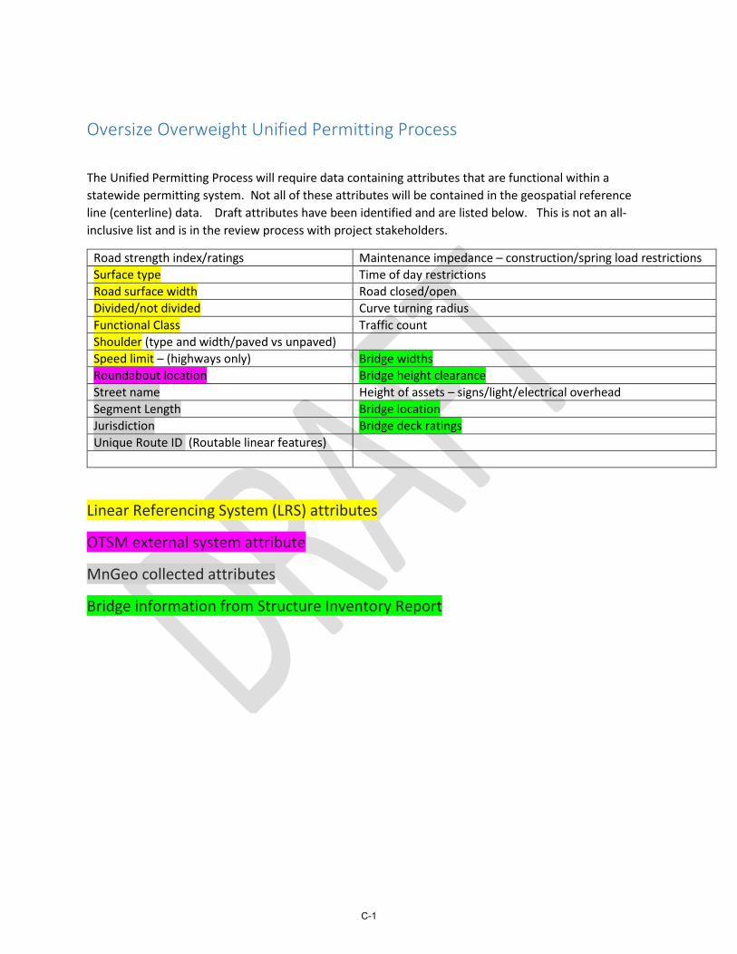
The Unified Permitting Process will require data containing attributes that are functional within a statewide permitting system. Not all of these attributes will be contained in the geospatial reference line (centerline) data. Draft attributes have been identified and are listed below. This is not an all-inclusive list and is in the review process with project stakeholders.
Road strength index/ratings Maintenance impedance – construction/spring load restrictions Surface type Time of day restrictions Road surface width Road closed/open Divided/not divided Curve turning radius Functional Class Traffic count Shoulder (type and width/paved vs unpaved) Speed limit – (highways only) Bridge widths Roundabout location Bridge height clearance Street name Height of assets – signs/light/electrical overhead Segment Length Bridge location Jurisdiction Bridge deck ratings Unique Route ID (Routable linear features)
Linear Referencing System (LRS) attributes
OTSM external system attribute
MnGeo collected attributes
Bridge information from Structure Inventory Report
C-1

APPENDIX D
STRUCTURE OF THE UPP SYSTEM

LOCAL GOVERNMENT
VENDOR PERMITTING SOFTWARE
ROADWAY ATTRIBUTES
Key Field Type
Key Field Type
Key Field Type
SELECT ROUTE START AND END
POINTS
SYSTEM LOGIN USER
INTERFACE
STANDARDIZED INFORMATION
INPUT
UPLOAD REQUIREMENTS
REFERENCE PLATFORM
MnDOT VENDOR PERMITTING SOFTWARE
CUSTOM PERMITTING SOFTWARE
LITE PERMITTING SOFTWARE
ALL ROADS NETWORK ROUTING
INFORMATION PROCESSING
UNIFIED PERMITTING
NTEROPERABILITY SPECIFICATIONS
PDF Permit
Mobile Client
NG9-1-1 DATA
UNIFIED PERMITTING INTEROPERABILITY SPECIFICATIONS
- Domain Data Types- Transactional Workflows Definitions- Operational Profiles- API Capabilities- Validation and Compliance Tests
Technical Support
AGENCY PERMIT REQUIREMENTS
- Permit Fees- Load Restrictions- Alternative Routes- Permit Timeline- Provisions- Contact Information- Invoicing
Law Enforcement
CREDENTIALING INFORMATION
SYSTEM
BRIDGE FEATURE ATTRIBUTES
INTEROPERABILITY IMPLEMENTATION
SYSTEM LOGIN USER
INTERFACE
TBD
D-1

APPENDIX E
SELF-SERVICE UNIFIED PERMITTING WORKFLOW

HA
ULE
RLA
W E
NF
OR
CE
ME
NT
RE
FE
RE
NC
E P
LAT
FO
RM
LG VENDOR PERMITTING SOFTWARE
ROADWAY ATTRIBUTES
Key Field Type
Key Field Type
Key Field Type
MnDOT VENDOR PERMITTING SOFTWARE
CUSTOM PERMITTING SOFTWARE
LITE PERMITTING SOFTWARE
LOC
AL
GO
V'T
& S
TAT
E S
YS
TE
MS
GE
OS
PA
TIA
L D
ATA
PR
OC
ES
S
NG9-1-1 DATA
UNIFIED PERMITTING INTEROPERABILITY SPECIFICATIONS
- Domain Data Types- Transactional Workflows Definitions- Operational Profiles- API Capabilities- Validation and Compliance Tests
Technical Support
AGENCY PERMIT REQUIREMENTS
- Permit Fees- Load Restrictions- Alternative Routes- Permit timeline- Provisions- Contact Information- Invoicing
CREDENTIALING INFORMATION
SYSTEM
BRIDGE FEATURE
ATTRIBUTES
CR
ED
EN
TIA
LS IN
TE
GR
AT
ION
INTEROPERABILITY IMPLEMENTATION
Open App
CHECK IDENTITY
SYSTEM LOGIN USER INTERFACE
IDENTITYVALID?
Failure
No
Yes AQUIRE ROUTE INFORMATION
SYSTEM LOGIN USER INTERFACE
CHECK IDENTITY
LOCAL USERS
CREATE QUERIES
Geospatial Services
ENRICH ROUTE DATA
UNIFIED PERMITTING
INTEROPERABILITY SPECIFICATIONS
PASS DATA TO EXTERNAL
AUTHORITIES
APPROVED?
Failure
No
SHOW RESULTS
ELECTRONIC PERMIT
Yes
E-1
Related Documents