U.S. DEPARTMENT OF THE INTERIOR U.S. GEOLOGICAL SURVEY PRELIMINARY DIGITAL GEOLOGIC MAP OF THE APPALACHIAN PIEDMONT AND BLUE RIDGE, SOUTH CAROLINA SEGMENT by J. Wright Horton, Jr., and Connie L. Dicken Open-File Report 01-298 This report is preliminary and has not been reviewed for conformity with U.S. Geological Survey editorial standards. Any use of trade, product, or firm names is for descriptive purposes only and does not imply endorsement by the U.S. Government. The USGS provides these data as is and makes no guarantee or warranty concerning the accuracy of information contained in the data. The USGS further makes no warranties, either expressed or implied as to any other matter whatsoever, including, without limitation, the condition of the product, or its fitness for any particular purpose. 2001 1

Welcome message from author
This document is posted to help you gain knowledge. Please leave a comment to let me know what you think about it! Share it to your friends and learn new things together.
Transcript
U.S. DEPARTMENT OF THE INTERIOR
U.S. GEOLOGICAL SURVEY
PRELIMINARY DIGITAL GEOLOGIC MAP OF THE
APPALACHIAN PIEDMONT AND BLUE RIDGE,
SOUTH CAROLINA SEGMENT
by
J. Wright Horton, Jr., and Connie L. Dicken
Open-File Report 01-298
This report is preliminary and has not been reviewed for conformity with U.S. Geological Survey editorial standards. Any use of trade, product, or firm names is for descriptive purposes only and does not imply endorsement by the U.S. Government. The USGS provides these data as is and makes no guarantee or warranty concerning the accuracy of information contained in the data. The USGS further makes no warranties, either expressed or implied as to any other matter whatsoever, including, without limitation, the condition of the product, or its fitness for any particular purpose.
2001
1

ABSTRACT This preliminary digital geologic map of the South Carolina segment of the
Appalachian Piedmont and Blue Ridge was compiled at 1:500,000 scale as part of a suite of regional and national spatial data sets. All of these coverages are intended for use in the analysis and interpretation of regional geochemical patterns that may have environmental or resource applications. The geology was compiled by integrating data and interpretations from a variety of pre-existing sources, as referenced, without field verification. Map units in the database are categorized by rock type, geologic province, and age to facilitate queries and searches. Customized maps for special applications can be generated by combining the geologic coverage with other types of spatial data.
2

INTRODUCTION
This preliminary geologic map of the Piedmont and Blue Ridge in South Carolina contributes to a suite of spatial data sets being assembled for the analysis of regional and national geochemical patterns that may have environmental and resource applications. It was motivated and designed to meet internal needs of the USGS Mineral Resources Program. The map was produced by integrating data and interpretations from a variety of pre-existing sources without the benefit of additional field work. Geologic map units are classified in the database according to rock type (lithology), geologic province (Atlantic Coastal Plain, Piedmont Mesozoic basin, Eastern Piedmont, Central Piedmont, Western Piedmont, and Blue Ridge), and age (where known). These criteria can be used to search the database for units having particular characteristics. They can also be used to generate customized maps for special applications by integrating selected geologic features with other digital data sets.
The suite of regional data sets, for which this map is a contribution, will include digitized geologic maps of North Carolina and Georgia originally produced at 1:500,000 scale (Georgia Geologic Survey, 1976; North Carolina Geological Survey, 1985), and this coverage is designed for compatibility. It is more current than Overstreet and Bell’s (1965a,b) map, more detailed than Maybin and others’ (2000) general state-wide map, and less detailed than Nelson and others’ (1998) partial coverage.
The geologic maps of North Carolina and Georgia were produced by multi-year efforts involving many collaborators, far exceeding the very limited scope and magnitude of this preliminary compilation for South Carolina. This coverage was assembled mainly from other regional compilations listed under “Principal Sources of Geologic Map Data.” Those sources already incorporate numerous, more detailed geologic maps as well as reconnaissance mapping. Local modifications are based on additional sources listed under “References Cited and Sources of Geologic Data.” Although including all of the latest geologic mapping is far beyond the intended scope of this compilation, this coverage for South Carolina is still generally more up-to-date than the comparable coverages for North Carolina and Georgia (Georgia Geologic Survey, 1976; North Carolina Geological Survey, 1985). Dikes of early Jurassic diabase, as compiled separately by Bell (1988), are omitted here. The inner margin of the Atlantic Coastal Plain is adapted from Offield and Sutphin (2000) with local modifications, and it differs slightly from that of Prowell and others (2000). Surficial geologic units are not shown in the Piedmont and Blue Ridge on this coverage or others nearby (Georgia Geologic Survey, 1976; North Carolina Geological Survey, 1985, Virginia Division of Mineral Resources, 1993), although deposits such as floodplain alluvium can be important for understanding regional geochemical patterns. Map-unit symbols use letters, such as “C” for Cambrian and TR for Triassic, rather than special characters, due to software limitations.
Multiple rock types may be lumped into a single unit, because of the compilation scale (1:500,000) and because the geology of many areas has not been mapped and studied in detail. No field verification was conducted, so errors in the source maps will be perpetuated. This compilation and others of similar scale in this region (e.g., Georgia Geologic Survey, 1976; North Carolina Geological Survey, 1985) should be considered progress reports to be superseded as knowledge of the geology improves. This map
3
product is intended to meet short-term needs until more accurate coverage of the regional geology is available. It may also draw attention to regional geologic issues and areas where new studies could be especially beneficial.
This general compilation is not intended for use at scales larger (more detailed) than 1:500,000, and it should not be applied in the investigation of local and site-specific issues, which require more detailed geologic information. However, it can provide a regional context for understanding geologic aspects of the local environment.
SOURCES OF GEOLOGIC MAP DATA
Numerous sources of geologic data were combined and integrated into this digital compilation, and they are listed individually under “References Cited and Sources of Geologic Data.” An index map shows where the “Principal Sources of Geologic Map Data” were used. These major sources include Barker and others (1998), Boland (1996), Butler (1977, 1988), Curl (1998), Daniels (1974), Dennis (1995), Goldsmith and others (1988), Hadley and Nelson (1971), Lawrence (1999), Maher and others (1991), Maybin and Niewendorp (1993), Nelson and others (1998), Offield and Sutphin (2000), Pray (1997), Robinson and others (1992), Schaeffer (1981), Secor and others (1986), West (1997). Local modifications are based on references cited in the Description of Map Units as well as the following additional sources: western Piedmont (Curl and Hatcher, 1997; Griffin, 1974; Hatcher, 1997; and Ranson and others, 1999), central Piedmont (Anonymous, 1972; Boland, 1998; Butler, 1966; Butler and Secor, 1991; Dennis and Wright, 1995; and Offield, 1995); plutonic rocks (Dennis and Wright, 1995; Nystrom and Niewendorp, 1998; Privett, 1995; Speer, 1987; and Speer and others, 1986), shear zones and faults (Boland, 1998; Dennis, 1991; Doar, 1996; Garihan and others, 1991, 1993; Lawrence and others, 1995; Maybin and Clendenin, 1998; and Sieling and others, 1997). Choices between inconsistent source maps were influenced by levels of detail, recency, and comparison with aeromagnetic data (Zietz and Daniels, 1982).
ACKNOWLEDGMENTS
This map was compiled for use by the USGS Mineral Resources Program’s “Surveys and Analyses, Eastern U.S.” project, as a step toward assembling a consistent set of digital geologic coverages for the eastern United States. The Spatial Data Delivery project under the USGS Mineral Resources Program aims to make general geologic and lithologic coverages for much of the United States available from an internet site such as http://mrdata.usgs.gov or links to sites of other agencies. We thank South Carolina State Geologist C.W. Clendenin, Jr. for providing a copy of the generalized geologic map by Maybin and others (2000) as well as other references and insights. We also thank Arthur E. Nelson, Suzanne A. Nicholson, David C. Prowell, and David J. Weary for constructive technical reviews.
4
DESCRIPTION OF MAP UNITS
ATLANTIC COASTAL PLAIN TK Coastal Plain sediments (Tertiary and Cretaceous)—Undivided
EARLY MESOZOIC RIFT BASINS TRc Chatham Group (Triassic)—Undivided conglomerate, sandstone, and
mudstone of Wadesboro basin and smaller Crowburg basin
LATE PALEOZOIC SHEAR ZONES
bz Mylonitic rocks of Brevard fault zone (Late Paleozoic)—Mylonitic and phyllonitic equivalents of Chauga River Formation and other adjacent rock units
myg mylonitic gneiss (Late Paleozoic)—Includes mylonitic gneiss in shear zone
east of Winnsboro granite (Barker and others, 1998); mylonitic gneiss, button schist and phyllonite of Cross Hill and Chappells shear zones (West, 1997, Lawrence, 1999); and Beaver Creek gneiss (West, 1997)
ph Phyllonite and phyllonitic schist (Late Paleozoic)—In shear zones such as
Gold Hill, Waxhaw, Lowndesville, and Buzzard’s Roost shear zones mym Mylonitic rocks of Modoc fault zone (Late Paleozoic)—Mylonitic paragneiss
and schist (Pray, 1997)
PLUTONIC AND ASSOCIATED IGNEOUS ROCKS LATE PALEOZOIC PLUTONIC ROCKS Cg Granite (Carboniferous and Permian)—Including named plutons: br, Bald
Rock; b, Batesburg (gneissic); cr, Catawba-Roddey; ch, Cherryville; cc, Clouds Creek; cv, Clover; cp, Cold Point; cl, Columbia; co, Coronaca; ct, Cuffytown Creek; e, Edgefield; ep, unnamed granites of eastern Piedmont; gv, Graniteville-Vaucluse; h, Harbison; j, Johnston (gneissic sheets) ; lx, Lexington; lh, Liberty Hill; p, Pageland; w, Winnsboro; y, York. Geochronology summarized in McSween and others, 1991, Table 7-1).
5
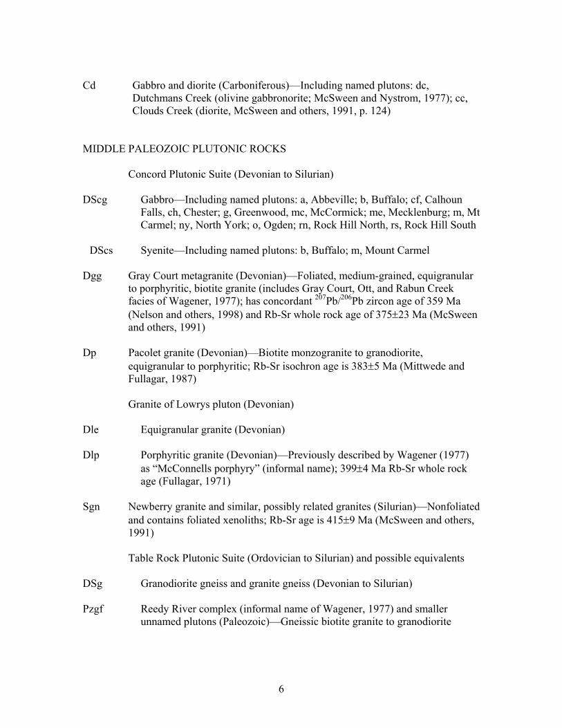
Cd Gabbro and diorite (Carboniferous)—Including named plutons: dc,
Dutchmans Creek (olivine gabbronorite; McSween and Nystrom, 1977); cc, Clouds Creek (diorite, McSween and others, 1991, p. 124)
MIDDLE PALEOZOIC PLUTONIC ROCKS
Concord Plutonic Suite (Devonian to Silurian) DScg Gabbro—Including named plutons: a, Abbeville; b, Buffalo; cf, Calhoun
Falls, ch, Chester; g, Greenwood, mc, McCormick; me, Mecklenburg; m, Mt Carmel; ny, North York; o, Ogden; rn, Rock Hill North, rs, Rock Hill South
DScs Syenite—Including named plutons: b, Buffalo; m, Mount Carmel
Dgg Gray Court metagranite (Devonian)—Foliated, medium-grained, equigranular
to porphyritic, biotite granite (includes Gray Court, Ott, and Rabun Creek facies of Wagener, 1977); has concordant 207Pb/206Pb zircon age of 359 Ma (Nelson and others, 1998) and Rb-Sr whole rock age of 375±23 Ma (McSween and others, 1991)
Dp Pacolet granite (Devonian)—Biotite monzogranite to granodiorite,
equigranular to porphyritic; Rb-Sr isochron age is 383±5 Ma (Mittwede and Fullagar, 1987)
Granite of Lowrys pluton (Devonian)
Dle Equigranular granite (Devonian) Dlp Porphyritic granite (Devonian)—Previously described by Wagener (1977)
as “McConnells porphyry” (informal name); 399±4 Ma Rb-Sr whole rock age (Fullagar, 1971)
Sgn Newberry granite and similar, possibly related granites (Silurian)—Nonfoliated
and contains foliated xenoliths; Rb-Sr age is 415±9 Ma (McSween and others, 1991)
Table Rock Plutonic Suite (Ordovician to Silurian) and possible equivalents
DSg Granodiorite gneiss and granite gneiss (Devonian to Silurian)
Pzgf Reedy River complex (informal name of Wagener, 1977) and smaller unnamed plutons (Paleozoic)—Gneissic biotite granite to granodiorite
6
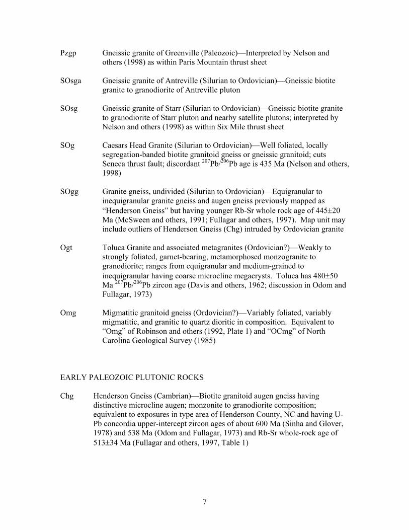
Pzgp Gneissic granite of Greenville (Paleozoic)—Interpreted by Nelson and others (1998) as within Paris Mountain thrust sheet
SOsga Gneissic granite of Antreville (Silurian to Ordovician)—Gneissic biotite
granite to granodiorite of Antreville pluton SOsg Gneissic granite of Starr (Silurian to Ordovician)—Gneissic biotite granite
to granodiorite of Starr pluton and nearby satellite plutons; interpreted by Nelson and others (1998) as within Six Mile thrust sheet
SOg Caesars Head Granite (Silurian to Ordovician)—Well foliated, locally
segregation-banded biotite granitoid gneiss or gneissic granitoid; cuts Seneca thrust fault; discordant 207Pb/206Pb age is 435 Ma (Nelson and others, 1998)
SOgg Granite gneiss, undivided (Silurian to Ordovician)—Equigranular to
inequigranular granite gneiss and augen gneiss previously mapped as “Henderson Gneiss” but having younger Rb-Sr whole rock age of 445±20 Ma (McSween and others, 1991; Fullagar and others, 1997). Map unit may include outliers of Henderson Gneiss (Chg) intruded by Ordovician granite
Ogt Toluca Granite and associated metagranites (Ordovician?)—Weakly to
strongly foliated, garnet-bearing, metamorphosed monzogranite to granodiorite; ranges from equigranular and medium-grained to inequigranular having coarse microcline megacrysts. Toluca has 480±50 Ma 207Pb/206Pb zircon age (Davis and others, 1962; discussion in Odom and Fullagar, 1973)
Omg Migmatitic granitoid gneiss (Ordovician?)—Variably foliated, variably
migmatitic, and granitic to quartz dioritic in composition. Equivalent to “Omg” of Robinson and others (1992, Plate 1) and “OCmg” of North Carolina Geological Survey (1985)
EARLY PALEOZOIC PLUTONIC ROCKS Chg Henderson Gneiss (Cambrian)—Biotite granitoid augen gneiss having
distinctive microcline augen; monzonite to granodiorite composition; equivalent to exposures in type area of Henderson County, NC and having U-Pb concordia upper-intercept zircon ages of about 600 Ma (Sinha and Glover, 1978) and 538 Ma (Odom and Fullagar, 1973) and Rb-Sr whole-rock age of 513±34 Ma (Fullagar and others, 1997, Table 1)
7
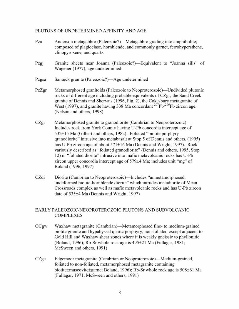
PLUTONS OF UNDETERMINED AFFINITY AND AGE Pza Anderson metagabbro (Paleozoic?)—Metagabbro grading into amphibolite;
composed of plagioclase, hornblende, and commonly garnet, ferrohypersthene, clinopyroxene, and quartz
Pzgj Granite sheets near Joanna (Paleozoic?)—Equivalent to “Joanna sills” of
Wagener (1977); age undetermined Pzgsa Santuck granite (Paleozoic?)—Age undetermined PzZgr Metamorphosed granitoids (Paleozoic to Neoproterozoic)—Undivided plutonic
rocks of different age including probable equivalents of CZgr, the Sand Creek granite of Dennis and Shervais (1996, Fig. 2), the Cokesbury metagranite of West (1997), and granite having 338 Ma concordant 207Pb/206Pb zircon age. (Nelson and others, 1998)
CZgr Metamorphosed granite to granodiorite (Cambrian to Neoproterozoic)—
Includes rock from York County having U-Pb concordia intercept age of 532±15 Ma (Gilbert and others, 1982). Foliated “biotite porphyry qranodiorite” intrusive into metabasalt at Stop 5 of Dennis and others, (1995) has U-Pb zircon age of about 571±16 Ma (Dennis and Wright, 1997). Rock variously described as “foliated granodiorite” (Dennis and others, 1995, Stop 12) or “foliated diorite” intrusive into mafic metavolcanic rocks has U-Pb zircon upper concordia intercept age of 579±4 Ma; includes unit “mg” of Boland (1996, 1997)
CZdi Diorite (Cambrian to Neoproterozoic)—Includes “unmetamorphosed,
undeformed biotite-hornblende diorite” which intrudes metadiorite of Mean Crossroads complex as well as mafic metavolcanic rocks and has U-Pb zircon date of 535±4 Ma (Dennis and Wright, 1997)
EARLY PALEOZOIC-NEOPROTEROZOIC PLUTONS AND SUBVOLCANIC
COMPLEXES OCgw Waxhaw metagranite (Cambrian)—Metamorphosed fine- to medium-grained
biotite granite and hypabyssal quartz porphyry, non-foliated except adjacent to Gold Hill and Waxhaw shear zones where it is weakly gneissic to phyllonitic (Boland, 1996); Rb-Sr whole rock age is 495±21 Ma (Fullagar, 1981; McSween and others, 1991)
CZge Edgemoor metagranite (Cambrian or Neoproterozoic)—Medium-grained,
foliated to non-foliated, metamorphosed metagranite containing biotite±muscovite±garnet Boland, 1996); Rb-Sr whole rock age is 508±61 Ma (Fullagar, 1971; McSween and others, 1991)
8
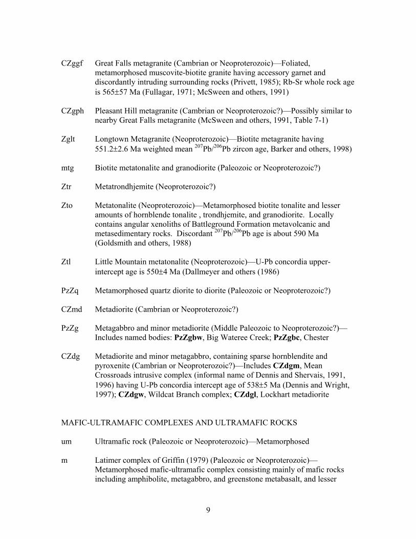
CZggf Great Falls metagranite (Cambrian or Neoproterozoic)—Foliated,
metamorphosed muscovite-biotite granite having accessory garnet and discordantly intruding surrounding rocks (Privett, 1985); Rb-Sr whole rock age is 565±57 Ma (Fullagar, 1971; McSween and others, 1991)
CZgph Pleasant Hill metagranite (Cambrian or Neoproterozoic?)—Possibly similar to
nearby Great Falls metagranite (McSween and others, 1991, Table 7-1) Zglt Longtown Metagranite (Neoproterozoic)—Biotite metagranite having
551.2±2.6 Ma weighted mean 207Pb/206Pb zircon age, Barker and others, 1998) mtg Biotite metatonalite and granodiorite (Paleozoic or Neoproterozoic?) Ztr Metatrondhjemite (Neoproterozoic?) Zto Metatonalite (Neoproterozoic)—Metamorphosed biotite tonalite and lesser
amounts of hornblende tonalite , trondhjemite, and granodiorite. Locally contains angular xenoliths of Battleground Formation metavolcanic and metasedimentary rocks. Discordant 207Pb/206Pb age is about 590 Ma (Goldsmith and others, 1988)
Ztl Little Mountain metatonalite (Neoproterozoic)—U-Pb concordia upper-
intercept age is 550±4 Ma (Dallmeyer and others (1986) PzZq Metamorphosed quartz diorite to diorite (Paleozoic or Neoproterozoic?) CZmd Metadiorite (Cambrian or Neoproterozoic?) PzZg Metagabbro and minor metadiorite (Middle Paleozoic to Neoproterozoic?)—
Includes named bodies: PzZgbw, Big Wateree Creek; PzZgbc, Chester CZdg Metadiorite and minor metagabbro, containing sparse hornblendite and
pyroxenite (Cambrian or Neoproterozoic?)—Includes CZdgm, Mean Crossroads intrusive complex (informal name of Dennis and Shervais, 1991, 1996) having U-Pb concordia intercept age of 538±5 Ma (Dennis and Wright, 1997); CZdgw, Wildcat Branch complex; CZdgl, Lockhart metadiorite
MAFIC-ULTRAMAFIC COMPLEXES AND ULTRAMAFIC ROCKS um Ultramafic rock (Paleozoic or Neoproterozoic)—Metamorphosed m Latimer complex of Griffin (1979) (Paleozoic or Neoproterozoic)—
Metamorphosed mafic-ultramafic complex consisting mainly of mafic rocks including amphibolite, metagabbro, and greenstone metabasalt, and lesser
9
amounts of ultramafic rock composed of talc, chlorite, serpentine, and minor cummingtonite(?) (Griffin, 1979); interpreted by Higgins and others (1988, 1989) as part of the “Juliette slice” of the “Macon mélange” and by Butler (1989) as mafic igneous rocks of calc-alkaline magmatic arc
Hammett Grove Meta-igneous Suite of Mittwede (1989) (Paleozoic or
Neoproterozoic)
hgg Metagabbro hgu Metamorphosed ultramafic rocks—Hornblendite, pyroxenite, serpentinite,
and talc schist
Burks Mountain complex of Sacks and others (1989) (Cambrian or Neoproterozoic)
CZbu Ultramafic rocks of Burks Mountain complex (Cambrian or Neoproterozoic) CZba Amphibolite of Burks Mountain complex (Cambrian or Neoproterozoic)
LAYERED AND STRATIFIED METAMORPHIC ROCKS BELAIR BELT CZvs Metavolcanic and metasedimentary rocks of Belair belt (Ordovician to
Neoproterozoic?)—Lower greenschist facies rocks in Belair belt of Crickmay (1952), may include rocks equivalent to Persimmon Fork Formation (Daniels, 1974; Offield and Sutphin, 2000)
KIOKEE BELT CZk Migmatitic paragneiss and schist of Kiokee belt (Cambrian or
Neoproterozoic?)—Migmatitic hornblende-biotite paragneiss having interlayered sillimanite schist and amphibolite; principal unit of Kiokee belt as defined by Crickmay’s (1952) and extended by Daniels (1974); interpreted by Maher and others (1991) as part of Savannah River terrane
CAROLINA SLATE BELT AND CHARLOTTE BELT OCc Cid Formation (Ordovician to Late Cambrian?)—Cid Formation as proposed
by Offield and Sutphin (2000), equivalent to Cid Formation Mudstone Member of previous usage. Mainly laminated metamudstone; contains euconodonts no
10

older than Late Cambrian in North Carolina (Koeppen and others, 1995; Offield and Sutphin, 2000)
OCr Richtex Formation (Ordovician to Middle Cambrian)—Laminated
metamudstone; contains Middle Cambrian or younger sponge spicules (Bourland and Rigby, 1982); Ordovician age proposed by Offield and Sutphin (2000) based on similarity and possible correlation with Tillery Formation in North Carolina, which contains bryozoans and other fossils no older than Middle Ordovician (Koeppen and others, 1995)
Cap Asbill Pond Formation (Middle Cambrian)—Siltstones and sandstones having
interbedded felsic to mafic metavolcanic rocks; age based on Middle Cambrian trilobite fauna (Secor and others, 1983; Samson and others, 1990)
OZfs Flat Swamp Formation (Ordovician to Neoproterozoic?)—Flat Swamp
Formation as proposed by Offield and Sutphin (2000), equivalent to Flat Swamp Member of Cid Formation of previous usage. Crystal and lithic metatuff of rhyolite to rhyodacite composition (Goldsmith and others, 1988); not reliably dated; age and stratigraphic relations uncertain since Koeppen and others’ (1995) discovery of fossils in Tillery Formation nearby in North Carolina (Offield and Sutphin, 2000)
OZvi Layered metavolcanic rocks (Ordovician to Neoproterozoic?)—Interlayered
mafic to felsic metavolcanic rocks, undivided OZvf Felsic metavolcanic rocks and layered felsic gneiss interpreted to be
metavolcanic (Ordovician to Neoproterozoic?)--Stratigraphic relations undetermined
OZvm Mafic to intermediate metavolcanic rocks including layered hornblende gneiss
and amphibolite (Ordovician to Neoproterozoic?)—Stratigraphic relations undetermined
CZpf Persimmon Fork Formation (Cambrian to Neoproterozoic)—Predominantly
metatuff; age based on 550.5±5.9 Ma weighted mean of 207Pb/206Pb ages (Barker and others, 1998)
CZph Quartz-sericite phyllite and schist (Cambrian to Neoproterozoic?)—Includes
exposures in Nanny Mountain area Zlm Lincolnton Metadacite (Neoproterozoic)—566±15 Ma U-Pb zircon upper
intercept concordia age (Carpenter and others, 1982) is similar to age of Persimmon Fork Formation as well as Uwharrie Formation in North Carolina
gn Biotite-quartz-plagioclase gneiss (Paleozoic to Neoproterozoic)—Undivided
biotite gneisses containing interlayered amphibole gneiss, amphibolite, and
11
mica schist; includes unit “g” of Nelson and others (1998). Gneiss in Newberry County contains isolated blocks of amphibolitized eclogite (Libby and Carpenter, 1969; Shervais and others, 1997)
am Amphibolite and amphibole gneiss (Paleozoic to Neoproterozoic) ms Tuffaceous metasiltstone (Paleozoic to Neoproterozoic) LITTLE RIVER SEQUENCE CZlr Metasedimentary rocks of Little River Sequence (Cambrian or
Neoproterozoic?)—White-mica schist and phyllite, metatuff, quartz-muscovite schist, and minor quartzite; equivalent to metasedimentary part of “Little River Series” as described by Crickmay (1952, p. 31-33), also known as “Little River Group” (Austin, 1969) and renamed Little River Sequence by Chowns (1976)
BATTLEGROUND AND BLACKSBURG FORMATIONS CZbl Blacksburg Formation, undivided (Neoproterozoic?)—Metamorphosed
sedimentary sequence of interlayered sericite schist and phyllite, sericitic quartzite, marble, amphibolite, and calc-silicate rock; stratigraphic relation to Battleground Formation undetermined because of intervening faults and plutons (Horton, 1983; Goldsmith and others, 1988)
Battleground Formation (Neoproterozoic)—Metavolcanic facies (Zbm, Zbf, Zbp) are most abundant in the lower part of the Formation and metasedimentary facies (Zba) are most abundant in the upper part; intruded by metatonalite (Horton, 1983)
Zba Metasedimentary rocks (undivided)—Quartz-sericite schist and phyllite and
interlayered quartzite, quartz-pebble conglomerate, high-alumina quartzite, and manganiferous schist
Zbp Schistose to phyllitic volcaniclastic rocks Zbf Felsic metavolcanic rocks Zbm Mafic to intermediate metavolcanic rocks CENTRAL PIEDMONT ALLOCHTHON OF MAYBIN AND NIEWENDORP (1993) eca Enoree mélange (informal name of Mittwede and Maybin, 1989), Cedar Shoals
gneiss (informal name of Horkowitz, 1984) and Cross Anchor mafic complex
12

(informal name as used by Maybin and Niewendorp, 1993) collectively interpreted by Maybin and Niewendorp (1993) as part of Central Piedmont allochthon. Cedar Shoals gneiss is biotite-quartz-feldspar gneiss interpreted as metagraywacke and interlayered felsic gneiss interpreted as metavolcanic rock (Dennis and others, 1995, Stop 10)
pcc Philson Crossroads complex (informal name of Maybin and Niewendorp,
1993)—Biotite-quartz-feldspar gneiss having interlayers of amphibolite and metagranite; interpreted by Dennis and Shervais (1996, Fig. 2) as mafic metavolcanic rock. Possibly equivalent to metavolcanic rocks in lower Battleground Formation (Zbf and Zbm)
CZgi Biotite gneiss having interlayered marble, calc-silicate gneiss, sillimanite-
muscovite schist, and garnet-quartz rock (Cambrian to Neoproterozoic?)—Stratigraphic significance undetermined; variously interpreted as west of “Central Piedmont suture” by Horkowitz (1984) and Dennis and Shervais (1996), and east of “Central Piedmont suture” by Dennis (1995)
WESTERN PIEDMONT (stratigraphic order undetermined) CZcp Chauga River Formation and Poor Mountain Formation (Cambrian or
Neoproterozoic?)—Undivided CZwa Wallhalla metamorphic suite (informal name of Horton and McConnell, 1991)
(Cambrian or Neoproterozoic?)—Predominantly hornblende-plagioclase gneiss and amphibolite, locally having interlayers of biotite-quartz-feldspar gneiss, undivided
CZgl Biotite-quartz-plagioclase gneiss and interlayers locally containing hornblende,
sillimanite, microcline, and muscovite (Cambrian or Neoproterozoic?)—Locally contains feldspar porphyroblasts, schist interlayers rich in biotite and/or sillimanite, and granitic gneiss interlayers. Includes gneiss assigned to Laurens thrust sheet by Nelson and others (1998)
CZwr Biotite-quartz-feldspar gneiss of Whitmire reentrant (Cambrian or
Neoproterozoic?)—Mapped and interpreted by West (1997, Fig. 3-3) as Inner Piedmont gneiss separated by thrust fault from structurally-higher allochthonous rocks of the Carolina terrane.
CZga Amphibolite having interlayered biotite gneiss, hornblende gneiss, and minor
mica schist (Cambrian or Neoproterozoic?) CZsp Sillimanite schist and sillimanite-mica schist (Cambrian or Neoproterozoic?)—
Sillimanite-rich aluminous schist composed mainly of sillimanite, biotite,
13

muscovite, and minor quartz; sillimanite abundant as needles matted in foliation and locally as larger prismatic crystals
CZsg Biotite-plagioclase-quartz gneiss and biotite-muscovite schist (Cambrian or
Neoproterozoic?)—Variably interlayered, containing subordinate layers of amphibolite and sillimanite-mica schist. Includes rocks assigned by Nelson and others (1998) to Six Mile thrust sheet
CZpg Megacrystic biotite gneiss (Cambrian or Neoproterozoic?)—Variably layered
biotite-quartz-feldspar gneiss having porphyroclasts and/or porphyroblasts of plagioclase and locally of quartz and potassium feldspar
CZms Sillimanite-mica schist and muscovite-biotite schist (Cambrian or
Neoproterozoic?)—Thin to thick layered sillimanite-mica schist and sillimanite-bearing muscovite-biotite schist, locally garnetiferous, having subordinate interlayers of muscovite-biotite-quartz-feldspar gneiss; sillimanite commonly altered to sericite
CZbg Biotite gneiss and muscovite-biotite gneiss (Cambrian or Neoproterozoic?)—
Layered biotite-quartz-feldspar gneiss, locally garnetiferous, locally inequigranular and having microcline porphyroblasts, having interlayers of sillimanite-mica schist, calc-silicate rock, and amphibolite. Locally contains small masses of granite
CZgs Garnetiferous mica schist (Cambrian or Neoproterozoic?)—Aluminous
muscovite-biotite schist, locally having subordinate amphibolite layers BLUE RIDGE
Tallulah Falls Formation (Neoproterozoic?) Zatb Gneissic metagraywacke and schist—Biotite-quartz-plagioclase gneiss
interpreted to be metagraywacke, and interlayered biotite-muscovite schist, garnet-mica schist, and amphibolite
Zata Amphibolite Yt Toxaway Gneiss (Mesoproterozoic)—Banded granite gneiss consisting of very
light gray layers rich in quartz, plagioclase, and microcline alternating with dark gray biotite-rich layers; Rb-Sr whole-rock age is 1197±56 Ma (Fullagar and others, 1979)
14

REFERENCES CITED AND SOURCES OF GEOLOGIC DATA Anonymous, 1972, Geologic reconnaissance map of Union County: Columbia, South Carolina Geological Survey, Open File Report SCGS OF-7, scale ~1:140,000. Austin, R.S., 1969, A stratigraphic section in the metamorphic Little River Group in east central Georgia: Bulletin of the Georgia Academy of Science, v. 27, no. 2, p.88. Barker, C.A., Secor, D.T., Jr., Pray, J.R., and Wright, J.E., 1998, Age and deformation of the Longtown metagranite, South Carolina Piedmont: A possible constraint on the
origin of the Carolina terrane: Journal of Geology, v. 106, p. 713-725. Bell, Henry III, 1988, Map showing Mesozoic diabase dikes in South Carolina described
since 1960: U.S. Geological Survey Miscellaneous Field Studies Map MF-2030, scale 1:250,000, 1 sheet.
Boland, I.B., 1996, The geologic, geophysical, and geochemical nature of the Carolina terrane in north central South Carolina: Columbia, University of South Carolina, unpublished Ph.D. thesis, 121 p.
Boland, I.B., 1997 (for 1996), Structural and petrogenetic implications of geophysical and geochemical maps of the Spartanburg 30x60 minute quadrangle, South Carolina: South Carolina Geology, v. 39, p. 1-21.
Boland, I.B., 1998, The nature of the Carolina terrane Charlotte Belt-Carolina slate belt boundary in north Central South Carolina [abs.]: Geological Society of America Abstracts with Programs, v. 30, no. 7, p. 126.
Bourland, W.C., and Rigby, J.K., 1982, Sponge spicules from early Paleozoic rocks of the Carolina slate belt, in Bearce, D.N., Black, W.W., Kish, S.A., and Tull, J.F., eds., Tectonic studies in the Talladega and Carolina slate belts, southern Appalachian orogen: Geological Society of America Special Paper 191, p. 125-132.
Butler, J.R., 1966, Geology and mineral resources of York County, South Carolina: South Carolina State Development Board, Division of Geology, Bulletin 33, 65 p.
Butler, J.R., 1977, Generalized geologic map of the Spartanburg quadrangle, South Carolina and North Carolina, in Heffner, J.D., and Ferguson, R.B., Savannah River Laboratory Hydrogeochemical and stream sediment reconnaissance, Preliminary raw data release, Spartanburg 1o x 2o NTMS area, North Carolina and South Carolina, National Uranium Resource Evaluation Program: U.S. Department of Energy, DPST-77-146-2, GJBX-9, scale 1:250,000.
Butler, J.R., 1988, Geologic map of Chester County, South Carolina: Columbia, South Carolina Geological Survey, Open File Report 63, scale ~1:130,000.
Butler, J.R., 1989, Review and classification of ultramafic bodies in the Piedmont of the Carolinas, in Mittwede and Stoddard, E.F., eds., Ultramafic rocks of the Appalachian Piedmont: Geological Society of America Special Paper 231, p. 19-31.
Butler, J.R., and Secor, D.T., Jr., 1991, The central Piedmont, in Horton, J.W., Jr., and Zullo, V.A., The Geology of the Carolinas, Carolina Geological Society Fiftieth Anniversary Volume: Knoxville, University of Tennessee Press, p. 59-78, Figs 4-2 and 4-3.
Carpenter, R.H., Odom, A.L., and Hartley, M.E., III, 1982, Geochronological investigation of the Lincolnton metadacite, Georgia and South Carolina, in Bearce, D.N., Black, W.W., Kish, S.A., and Tull, J.F., eds., Tectonic studies in the Talladega
15

and Carolina slate belts, southern Appalachian orogen: Geological Society of America Special Paper 191, p. 145-152.
Chowns, T.M., 1976, Introduction, in Chowns, T.M., compiler, Stratigraphy, structure, and seismicity in slate belt rocks along the Savannah River: Atlanta, Georgia Geological Survey Guidebook 16, printed for the Georgia Geological Society 11th annual meeting and field trip, p. 2-8.
Crickmay, G.W., 1952, Geology of the crystalline rocks of Georgia: Georgia Department of Mines, Mining, and Geology, Bulletin 58, p. 1-54.
Curl, D.C., 1998, Stratigraphy and structure of Wellford and Reidville quadrangles in part of the eastern Inner Piedmont, near Spartanburg South Carolina [unpublished M.S. thesis]: Knoxville, University of Tennessee, 129 p.
Curl, D.C., and Hatcher, R.D., Jr., 1997, Central-eastern Inner Piedmont geology in the Wellford and Reidville quadrangles, South Carolina [abs.]: Geological Society of America Abstracts with Programs, v. 29, no. 3, p. 11.
Dallmeyer, R.D., Wright, J.E., Secor, D.T., Jr., and Snoke, A.W., 1986, Character of the Alleghanian orogeny in the southern Appalachians: Part II. Geochronological constraints on the tectonothermal evolution of the eastern Piedmont in South Carolina: Geological Society of America Bulletin, v. 97, p. 1329-1344.
Daniels, D.L., 1974, Geologic interpretation of geophysical maps, central Savannah River area, South Carolina and Georgia: U.S. Geological Survey Geophysical Investigations map GP-893, scale 1:250,000, 10 p. text.
Davis, G.L., Tilton, G.R., and Wetherill, G.W., 1962, Mineral ages from the Appalachian province in North Carolina and Tennessee: Journal of Geophysical Research, v. 67, no. 5, p. 1987-1996.
Dennis, A.J., 1991, Is the central Piedmont suture a low-angle normal fault?: Geology, v. 19, p. 1081-1084.
Dennis, A.J., 1995, Rocks of the Carolina terrane in the Spartanburg 30o x 60o quadrangle prepared for 1995 Carolina Geological Society annual meeting: Aiken, South Carolina, University of South Carolina at Aiken, scale 1:100,000, available online at http://www.geo.duke.edu/cgs/cgsguide.htm
Dennis, A.J., and Shervais, J.W., 1991, Evidence for arc rifting along the Carolina terrane boundary in northwestern South Carolina: Geology, v. 19, p. 226-229.
Dennis, A.J., and Shervais, J.W., 1996, The Carolina terrane in northwestern South Carolina: Insights into the development of an evolving island arc, in Nance, R.D., and Thompson, M.D., eds., Avalonian and related peri-Gondwanan terranes of the circum-North Atlantic: Geological Society of America Special Paper 304, p. 237-256, Fig. 2.
Dennis, A.J., and Wright, J.E., 1995, Mississippian (ca. 326-323 Ma) U-Pb crystallization ages for two granitoids in Spartanburg and Union Counties, South Carolina: South Carolina Geology, v. 38, p. 23-28.
Dennis, A.J., and Wright, J.E., 1997, The Carolina terrane in northwestern South Carolina, USA: Late Precambrian-Cambrian deformation and metamorphism in a peri-Gondwanan oceanic arc: Tectonics, v. 16, p. 460-473.
Dennis, A.J., Butler, J.R., Garihan, J.M., Ranson, W.A., and Sargent, K.A., 1995, Geology of the western part of the Carolina terrane in northwestern South Carolina,
16
1995 Carolina Geological Society Field Trip: South Carolina Geology, v. 37, p. 1-29, Fig. 8.
Doar, W.R., III, 1996, A new east-west shear zone in the Chappells 7.5’ Quadrangle, S.C. [abs.]: Geological Society of America Abstracts with Programs, v. 28, no. 2, p. 10.
Fullagar, P.D., 1971, Age and origin of plutonic intrusions in the Piedmont of the southeastern Appalachians: Geological Society of America Bulletin, v. 82, p. 2845-2862.
Fullagar, P.D., 1981, Summary of Rb-Sr whole-rock ages for South Carolina: South Carolina Geology, v. 25, p. 29-32.
Fullagar, P.D, Goldberg, S.A, and Butler, J.R., 1997, Nd and Sr isotopic characterization of crystalline rocks from the Southern Appalachian Piedmont and Blue Ridge, North and South Carolina, in Sinha, A.K., Whalen, J.B., and Hogan, J.P., eds., The nature of magmatism in the Appalachian orogen: Boulder, Colorado, Geological Society of America Memoir 191, p. 165- 179.
Fullagar, P.D., Hatcher, R.D., Jr., and Merschat, C.E., 1979, 1200 m.y. old gneisses in the Blue Ridge province of North and South Carolina: Southeastern Geology, v. 20, p. 69-77.
Garihan, J.M., Ranson, W.A., Orlando, K.A., and Preddy, M.S., 1990, Kinematic history of Mesozoic faults in northwestern South Carolina: Columbia, South Carolina Geological Survey, South Carolina Geology, v. 33, no. 1, p. 18-31.
Garihan, J.M., Preddy, M.S., and Ranson, W.A., 1993, Summary of Mid-Mesozoic brittle faulting in the Inner Piedmont and nearby Charlotte belt of the Carolinas, in Hatcher, R.D., Jr., and Davis, T.L., Studies of Inner Piedmont Geology with a focus on the Columbus Promontory: Carolina Geological Society Annual Field Trip, November 6-7, 1993, p. 55-65, Fig. 2.
Georgia Geologic Survey, 1976, Geologic map of Georgia: Atlanta, Georgia Department of Natural Resources, Geologic Survey, scale 1:500,000.
Gilbert, N.H., Brown, H.S., and Schaeffer, M.F., 1982, Structure and geologic history of a part of the Charlotte belt, South Carolina Piedmont: Southeastern Geology, v. 23, p. 129-145.
Goldsmith Richard, Milton, D.J., and Horton, J.W., Jr., 1988, Geologic map of the Charlotte 1o X 2o quadrangle, North Carolina and South Carolina: U.S. Geological Survey Miscellaneous Investigations Series Map I-1251-E, scale 1:250,000.
Griffin, V.S., Jr., 1974, Analysis of the Piedmont in northwest South Carolina: Geological Society of America Bulletin, v. 85, p. 1123-1138.
Griffin, V.S., 1979, Geology of the Abbeville East, Abbeville West, Latimer, and Lowndesville quadrangles: South Carolina Geological Survey, Map Series MS-24, 58 p.
Hadley, J.B., and Nelson, A.E., 1971, Geologic map of the Knoxville quadrangle, North Carolina, Tennessee, and South Carolina: U.S. Geological Survey Miscellaneous Investigations Series Map I-654, scale 1:250,000.
Hatcher, R.D., Jr., compiler, 1997, Geologic map of the northern part of the Appalachian Inner Piedmont: Knoxville, University of Tennessee Department of Geological Sciences, Studies in Geology, Special Map Publication Series, no. 5, scale ~1:316,000.
17
Higgins, M.W., Atkins, R.L., Crawford, T.J., Crawford, R.F., III, Brooks, R., and Cook, R.B., 1988, The structure, stratigraphy, tectonostratigraphy, and evolution of the southernmost part of the Appalachian orogen, Georgia and Alabama: U.S. Geological Survey Professional Paper 1475, 172 p.
Higgins, M.W., Crawford, R.F., III, Atkins, R.L., and Crawford, T.J., 1989, The Macon complex: An ancient accretionary complex in the southern Appalachians, in Horton, J.W., Jr., and Rast, N., eds., Melanges and olistostromes of the U.S. Appalachians: Geological Society of America Special Paper 228, p. 229-246.
Horkowitz, J.P., 1984, Geology of the Philson Crossroads 7.5’ quadrangle, South Carolina – Nature of the boundary separating the Inner Piedmont from the Carolina-Avalon terrane in central northwestern South Carolina [M.S. thesis]: Columbia, University of South Carolina, 100 p.
Horton, J.W., Jr., 1984, Stratigraphic nomenclature in the Kings Mountain belt, North Carolina and South Carolina, in Stratigraphic Notes, 1983: U.S. Geological Survey Bulletin 1537-A, p. 59-67.
Horton, J.W., Jr., and McConnell, K.I., 1991, The western Piedmont, in Horton, J.W., Jr., and Zullo, V.A., The Geology of the Carolinas, Carolina Geological Society Fiftieth Anniversary Volume: Knoxville, University of Tennessee Press, p. 36-58, Fig. 3-6.
Koeppen, R.P. Repetski, J.E., and Weary, D.J., 1995, Microfossil assemblages indicate Ordovician or Late Cambrian age for Tiller Formation and mudstone member of Cid Formation, Carolina slate belt, North Carolina [abs.]: Geological Society of America Abstracts with Programs, v. 27, no. 6, p. 397.
Lawrence, D.P., 1999, Tectonic setting of the northwest-trending Buzzard’s Roost shear zone, central South Carolina: South Carolina Geology, v. 41, p. 1-9 and Figure 3, scale ~1:222,000.
Lawrence, D.P., Niewendorp, C.A., and Maybin, A.H., III, 1995, New trends for old faults; en echelon east-trending extension of the Lowndesville shear zone, central SC [abs.]: Geological Society of America Abstracts with Programs, v. 27, no. 2, p. 69.
Libby, W.G., and Carpenter, J.R., 1969, Petrography and geochemistry of a mafic granofels in Newberry County, South Carolina: Southeastern Geology, v. 10, no. 2, p. 55-62.
Maher, H.D., Jr., Sacks, P.E., and Secor, D.T., Jr., 1991, The eastern Piedmont in South Carolina, in Horton, J.W., Jr., and Zullo, V.A., The Geology of the Carolinas, Carolina Geological Society Fiftieth Anniversary Volume: Knoxville, University of Tennessee Press, p. 93-108, Figs. 6-1, 6-2, 6-3, 6-4, and 6-5.
Maybin, A.H., III (compiler) and Clendenin, C.W. (geophysical interpretation), 1998, Structural Features Map of South Carolina: South Carolina Geological Survey, GGMS-4, scale 1:500,000.
Maybin, A.H., III, and Niewendorp, C.A., 1993, The central Piedmont allochthon: An Alleghanian terrane in the central Piedmont of South Carolina: South Carolina Geology, v. 36, p. 47-57.
Maybin, A.H., III, Nystrom, P.G., Niewendorp, C.A., and Fields, M.D., 2000, Generalized Geologic Map of South Carolina: South Carolina Geological Survey, Hydrology/Geology Map 1, scale 1:1,000,000. (compiled 1995 by Maybin, A.H., III, and Nystrom, Paul G., 1995; revised 1997 by C.A. Niewendorp; cartography 2000 by M.D. Fields).
18
McCauley, J.F., 1976, Generalized geologic map, Newberry County: South Carolina
Geological Survey Open File Report 11, scale ~1:150,000. McSween, H.Y., Jr., and Nystrom, P.G., 1977, Mineralogy and petrology of the
Dutchmans Creek gabbroic intrusion, South Carolina: American Mineralogist, v. 64, p. 531-545.
McSween, H.Y., Jr., Speer, J.A., and Fullagar, P.D., 1991, Plutonic rocks, in Horton, J.W., Jr., and Zullo, V.A., The Geology of the Carolinas, Carolina Geological Society Fiftieth Anniversary Volume: Knoxville, University of Tennessee Press, p. 109-126, Fig. 7-1 and Table 7-1.
Mittwede, S.K., 1989, The Hammett Grove Meta-igneous Suite; A possible ophiolite in the northwestern South Carolina Piedmont, in Mittwede, S.K., and Stoddard, E.F., eds., Ultramafic rocks of the Appalachian Piedmont: Geological Society of America Special Paper 231, p. 45-62.
Mittwede, S.K., and Fullagar, P.D., 1987, Petrology and geochemistry of the Pacolet monzogranite, northeastern South Carolina: Petrogenetic implications [abs.]: Geological Society of America Abstracts with Programs, v. 19, p. 118.
Mittwede, S.K., and Maybin, A.H., III, 1989, Metamorphosed mélange in the central Piedmont of South Carolina: Journal of Geology, v. 97, p. 632-639.
Nelson, A.E., Horton, J.W., Jr., and Clarke, J.W., 1998, Geologic map of the Greenville 1o X 2o quadrangle, Georgia, South Carolina, and North Carolina: U.S. Geological Survey Miscellaneous Investigations Series Map I-2175, scale 1:250,000, 2 sheets, 12 p. text.
North Carolina Geological Survey, 1985, Geologic map of North Carolina: North Carolina Department of Natural Resources and Community Development, Geological Survey Section, scale 1:500,000.
Nystrom, P.G., Jr., and Niewendorp, C.A, 1998, Bush River Gabbro; relative age constraints on regional metamorphism, granitic plutonism, and shearing in the Charlotte Belt of South Carolina [abs.]: Geological Society of America Abstracts with Programs, v. 30, no. 4, p. 53.
Odom, A.L., and Fullagar, P.D., 1973, Geochronologic and tectonic relationships between the Inner Piedmont, Brevard zone, and Blue Ridge belts, North Carolina: American Journal of Science, v. 273-A (Cooper volume), p. 133-149.
Offield, T.W., 1995, Structural contrasts of the Carolina slate belt and Charlotte belt in South Carolina, in Dennis, A.J., ed., Papers related to the theme of the 1995 Carolina Geological Society annual meeting: Geology of the western part of the Carolina terrane: South Carolina Geology, v. 38, p. 61-70, Fig. 1.
Offield, T.W., and Sutphin, David, ed., 2000, Revised stratigraphic and tectonic framework of the Carolina slate belt from southern Virginia to the South Carolina-Georgia border (with observations bearing on the origin of slate-belt gold deposits): U.S. Geological Survey Open File Report 99-2, CD-ROM containing text and digital maps, scales 1:100,000 and 1:500,000.
Overstreet, W.C., and Bell, H., III, 1965a, Geologic map of the crystalline rocks of South Carolina: U.S. Geological Survey Miscellaneous Geologic Investigations Map I-403, scale 1:250,000.
19

Overstreet, W.C., and Bell, H., III, 1965b, The crystalline rocks of South Carolina: U.S. Geological Survey Bulletin 1183, 126 p.
Pray, J.R., 1997, Geology of the Modoc fault zone and adjacent terranes in the Southern Appalachian Piedmont; geochronological and kinematic investigations [unpublished dissertation]: Columbia, University of South Carolina, 97 p. and map figures 1-2, 1-3, and 1-4, all scale ~1:476,000.
Privett, D.R., 1995, The Great Falls metagranite, north central South Carolina: South Carolina Geology, v. 28, no. 2, p. 1-5.
Prowell, D.C., Bybell, L.M., Edwards, L.E., Frederiksen, N.O., Gohn, G.S., Self-Trail, J.M., Christopher, R.A., Waters, K.E., and Gellici, J.A., 2000, Geologic map of the Cretaceous and Tertiary formations of the South Carolina Coastal Plain [abs.]: Geological Society of America Abstracts with Programs, v. 32, no. 2, p. 67.
Ranson, W.A., Williams, I.S., and Garihan, J.M., 1999, SHRIMP zircon U-Pb ages of granitoids from the Inner Piedmont of South Carolina; evidence for Ordovician magmatism involving mid to late Proterozoic crust [abs.]: Geological Society of America Abstracts with Programs, v. 31, no. 7, p. 167.
Robinson, G.R., Jr., Lesure, F.G., Marlowe, J.I., II, Foley, N.K., and Clark, S.H., 1992, Bedrock Geology and Mineral Resources of the Knoxville 1o x 2o Quadrangle, Tennessee, North Carolina, and South Carolina: U.S. Geological Survey Bulletin 1979, 73 p., and Plate 1. Preliminary bedrock geologic map of the Knoxville 1o x 2o quadrangle, Tennessee, North Carolina, and South Carolina, scale 1:250,000.
Sacks, P.E., Maher, H.D., Jr., Secor, D.T., Jr., and Shervais, J.W., 1989, The Burks Mountain complex, Kiokee belt, Southern Appalachian Piedmont of South Carolina and Georgia: Geological Society of America Special Paper 231, p. 75-86.
Samson, S., Palmer, A.R., Robison, R.A., and Secor, D.T., Jr., 1990, Biogeographical significance of Cambrian trilobites from the Carolina slate belt: Geological Society of America Bulletin, v. 102, p. 1459-1470.
Schaeffer, M.F., 1981, Preliminary geologic map of north central South Carolina: South Carolina Geology, v. 25, p. 1-8 with map, scale 1:250,000.
Secor, D.T., Jr., Samson, S.L., Snoke, A.W., and Palmer, A.R., 1983, Confirmation of the Carolina slate belt as an exotic terrane: Science, v. 221, p. 649-651.
Secor, D.T., Jr., Snoke, A.W., Bramlett, K.W., Costello, O.P., and Kimbrell, O.P., 1986, Character of the Alleghanian orogeny in the southern Appalachians: Part I. Alleghanian deformation in the eastern Piedmont of South Carolina: Geological Society of America Bulletin, v. 97, p. 1319-1328, Fig. 1, scale ~1:857,000 and Fig. 3, scale ~1:294,000.
Shervais, John, McGee, J.J., Dennis, A.J., and Secor, D.T., 1997, Amphibolitized group B eclogite from Newberry, SC: High P/medium T metamorphism in the Carolina arc [abs.]: Geological Society of America Abstracts with Programs, v. 29, no. 3, p. 69.
Sieling, David R; Lawrence, David P; Maybin, Arthur H, III, 1997, Location of a north-south trending shear zone and the timing and transport direction on a thrust at the Saluda River [abs.]: Geological Society of America Abstracts with Programs, v. 29, no.3, p.69.
Sinha, A.K., and Glover, L., III, 1978, U/Pb systematics of zircons during dynamic metamorphism: Contributions to Mineralogy and Petrology, v. 66, p. 305-310.
20

Speer, J.A., 1987, Evolution of magmatic AFM mineral assemblages in granitoid rocks: The hornblende + melt = biotite reaction in the Liberty Hill pluton, South Carolina: American Mineralogist, v. 72, p. 863-878.
Speer, J.A., Brauer, S.V.G., and McSween, H.Y., Jr., 1986, The Bald Rock granite pluton, South Carolina: Petrography and internal fabric: South Carolina Geology, v. 30, p. 1-17.
Virginia Division of Mineral Resources, 1993, Geologic map of Virginia: Charlottesville, Virginia Division of Mineral Resources, scale 1:500,000.
Wagener, H.D., 1977, The granitic stone resources of South Carolina: South Carolina Geological Survey, Mineral Resources Series 5, 65 p.
West, Thomas E., Jr., 1997, Structural studies along the Carolina-Inner Piedmont terrane boundary in South Carolina and Georgia: Implications for the tectonics of the southern Appalachians [unpublished Ph.D. dissertation]: Columbia, University of South Carolina, 72 p. with maps, Fig. 3-3 (Whitmire reentrant), ~1:1,316,000, Fig. 3-4 (Shoals Junction, Cokesbury, and Waterloo 7.5’ quadrangles), scale ~1:178,570, Plates 1-3, 1:24,000 (same quadrangles).
Zietz, Isidore, Riggle, F.E., and Daniels, D.E., 1982, Aeromagnetic map of South Carolina: U.S. Geological Survey Geophysical Investigations Map GP-950, scale 1:250,000.
21
Related Documents