ORDINARY COUNCIL MEETING – 22 JUNE 2021 ATTACHMENTS Agenda Report Page No 4.1 Attachment A – Application Documents 1 Attachment B – Representations 157 4.2 Attachment A – Application Documents 159 Attachment B – Representations 172 5.1 Attachment 1 - Profit & Loss for the period ending 31 May 2021 185 Attachment 2 - Balance Sheet as at 31 May 2021 187 Attachment 3 - Statement of Cash Flows for the period ending 31 May 2021 188 Attachment 4 - Capital Works as at 31 May 2021 189 7.1 Attachment 1 - AusSpan Flooding Report 2021 192 8.2 Attachment 1 – East Coast Community Arts Initiative Application Form 195 8.3 Attachment 1 – Budget 2021/22 196 8.4 Attachment 1 – Draft Rates and Charges Policy 204 8.5 Attachment 1 – Rates Resolution 213 Attachment 2 – Fees and Charges Register 2021/22 216 Attachment 3 – Rating changes by location 222 8.6 Attachment 1 – Draft Rate Relief for Community Groups Policy 224

Welcome message from author
This document is posted to help you gain knowledge. Please leave a comment to let me know what you think about it! Share it to your friends and learn new things together.
Transcript
ORDINARY COUNCIL MEETING – 22 JUNE 2021
ATTACHMENTS
Agenda Report Page No
4.1 Attachment A – Application Documents 1
Attachment B – Representations 157
4.2 Attachment A – Application Documents 159
Attachment B – Representations 172
5.1 Attachment 1 - Profit & Loss for the period ending 31 May 2021 185
Attachment 2 - Balance Sheet as at 31 May 2021 187
Attachment 3 - Statement of Cash Flows for the period ending 31 May 2021 188
Attachment 4 - Capital Works as at 31 May 2021 189
7.1 Attachment 1 - AusSpan Flooding Report 2021 192
8.2 Attachment 1 – East Coast Community Arts Initiative Application Form 195
8.3 Attachment 1 – Budget 2021/22 196
8.4 Attachment 1 – Draft Rates and Charges Policy 204
8.5 Attachment 1 – Rates Resolution 213
Attachment 2 – Fees and Charges Register 2021/22 216
Attachment 3 – Rating changes by location 222
8.6 Attachment 1 – Draft Rate Relief for Community Groups Policy 224
Page 1 of 228
Agenda Item 4.1 - Attachment A

Page 2 of 228

Page 3 of 228
Page 4 of 228

Page 5 of 228

Page 6 of 228
STAGE 5 QUANTITIESSTAGE 5C
-
TOTAL121866
99802
23064
1173
STAGE 5BSTAGE 5A
483
LOT AREAROAD RESERVE AREALINEAL METRES OF ROAD
--
---
32464 36880 29943
GROSS AREA m²
371 319
5301962m²
5292426m²
5141761m² 513
1793m²
5282043m²
5271885m²526
1862m²5251840m²524
1818m²5231810m²522
1828m²5211837m²520
1876m²5191885m²518
2037m²508
2287m²
5072063m²
5062063m²
5052055m²
5042067m²
5031954m²
5021841m²
5011974m²
5121874m² 511
1753m² 5101883m²
5091814m²
5351937m²
5343654m²
5332262m²
5321959m²
5311959m²
5471926m²
5461770m²
5451834m²
5446536m²543
2607m²542
2315m²
5401777m²
5411759m²539
2376m²
5382301m²
5372354m²
5362163m²
5171740m²
5161669m²
5151613m²
35.809
54.78
6
35.809
54.78
6
28.02
3
38.696
54.78
6
44.519
7.537
22.02
3
56.35122.57
48.5
78
51.321 34.13
0
23.767
29.26
9
34.13
0
17.42614.498
63.77
4
9.33719.315
65.24
9
26.471 11.142
59.04
3
29.066
64.47
6
29.094
65.24
9
29.066
63.70
4
29.094
64.47
6
29.066
62.93
2
29.094
63.70
4
29.066
62.16
0
29.094
62.93
2
29.066
62.58
4
24.395 4.669
62.16
0
29.066
63.23
7
29.059
62.58
4
28.912
63.88
7
28.905
63.23
7
29.221
64.54
4
29.21463
.887
29.06665
.197
29.059
64.54
4
19.0065.894
64.23
6
18.742 19.108
65.19
75.894
22.691
65.74
0
21.00420.585
64.23
6
31.375
65.74
0
31.375
65.74
0
31.375
65.74
0
31.375
65.74
0
31.253
65.74
0
31.253
65.74
0
28.691
65.96
8
34.181
65.74
0
26.168
66.26
1
33.315
65.96
8
28.003
66.26
1
28.003
66.26
1
22.167
8.381
46.76
6
18.07
4
22.608
66.26
1
13.95712.796
63.77
4
32.844
62.58
1
5.02421.729
62.58
1
29.598
61.88
830.610
61.88
8
30.602
61.17
0
22.608
61.17
0
37.025
62.33
1
26.042
62.33
1
11.789 23.296
63.45
4
28.93728.937
63.45
4
51.873
8.485
57.45
4
41.611
48.78
6
8.485 35.611
54.78
6
10.16125.592
54.78
6
35.752
54.78
6
35.752
54.78
6
35.752
54.78
6
63.975
29.36
2
41.61125.592
29.53
9
60.780
27.36
2
63.975
29.53
9
58.243
25.36
2
60.780
7.975
28.81
0
7.943
15.559
15.559
12.900
16.77814.831
18.676
2.7339.220
77.32
7
23.225 8.485
58.243
28.60
9
20.013
19.995
62.66
7
37.225
77.32
7
7.040
25.475
15.889
5.682
19.51
4
55.914
11.643
62.66
7
8.48522.93728.937
61.41
7
28.93728.937
55.41
7
61.41
7
5.454
19.1162.271
65.73
9
22.608 26.042
61.41
7
2.271
30.799
70.82
75.024
30.610
65.73
9
9.94021.475
69.37
8
13.95721.729
70.82
7
29.473
32.00
5
32.02
7
23.76712.796
69.37
8
53.080
9.38114
.552
8.023
56.030
32.00
556.030
9.450
19.12
4
55.452 32.02
7
55.452
28.57
4
56.351 29.26
9
0 8040
SCALE IN METRES - 1:2000
6020 20
L O U I S V I L L E R O A D
N E W
R O
A D
B E R N A C C H I D R I V E
GD1917-P7 2-
-BAYPORT PTY LTDSPRING BAY
LAND DEVELOPMENTSUBDIVISION STAGE 5
LOT PLAN
R. GIBSON R. GIBSON R. GIBSON 11/5/2019
21-6-19 AHD 1 VEGETATION ADDED2 LOTS ADDED
REFERENCE FILES ATTACHED: GD1917-X3; GD1917-X1; GD1917-X2; GD1917-X4
DATE SIGNEDJun. 21, 19 - 19:45:26 Name: GD1917-P7.dwg Updated By: Ross gibson
DRAWING REVISION HISTORY
DATUMS:
REVISION DESCRIPTION
STATUS
REVIEWED DATEDRAWN DESIGNED
SIGNEDDRAWING No.
TITLE
CLIENT
PROJECT
CLIENT No.
REVISION
VERSIONSHEET No.ANDY HAMILTON & ASSOCIATES PTY LTDCONSULTING LAND SURVEYORS
PO Box 223 Bicheno 7215P: 0418 593 300 E: [email protected]
STAGE 5B
STAGE 5C
STAGE 5A LEGENDBIODIVERSITY PROTECTIONAREA OVERLAY PERPLANNING SCHEME
Page 7 of 228

Page | 1
JMG Ref: J192191 Client Ref: SA2019/0017
15th January 2020 The Manager Planning Glamorgan Spring Bay Council Dear Sir/Madam RE: SA 2019/00017 SPRING BAY SUBDIVISION TRAFFIC IMPACT ASSESSMENT I refer to an email to Council dated 5th August from Paul Blackwell - Traffic Engineering Liaison – Network Management Branch, State Roads - Department of State Growth. JMG have provided a response to that EMAIl dated 10/12/2019, however following further discussions with the department this response will become the formal response. The differences relate to advice from the department regarding the DSG roadworks programme and a review of some JMG conclusions. Within that DSG email it was stated that the JMG services report was very brief in relation to the junction with Louisville Road and the Tasman Highway and that they would require a full Traffic Impact Statement. JMG accept that criticism that the concept services report was brief with regard to traffic and the intersection of Louisville Road and the Tasman Highway. This brevity was based on a known decision since the first planning approval for subdivision that the State Growth Road Department had already designed and allocated funds towards an intersection safety improvement project. This should have been referred to in the services report but had been omitted when it should not have been. This level of comfort that the Intersection improvement was already a DSG project was informed by:
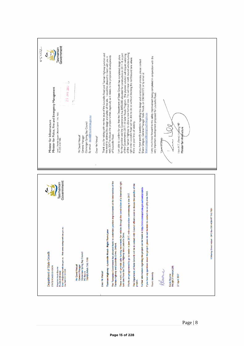
1. A letter from the Minister for Infrastructure, The Hon M.T. (Rene) Hidding MP To Glamorgan Spring Bay Council in January 2017 stating that he could confirm that “… the Government has $450,000 allocated for construction in 2017-18 as part of the Government’s 2017-18 safer roads Program….”
2. A letter from the DSG project Manager Kevin Bourne and dated 27th April 2017 Also addressed to Glamorgan Spring Bay Council re-confirming the completion of design and the complete funding allocation. The project was to be released for tender in June 2017, with construction commencing late 2017.
The Council had forwarded these documents to the developer. Copies are appended to this response for clarity. Whilst it is obvious that the June 2017 construction has been delayed, we were unaware that the project had been cancelled, and intersections will remain in its current state.
Page 8 of 228
Page | 2
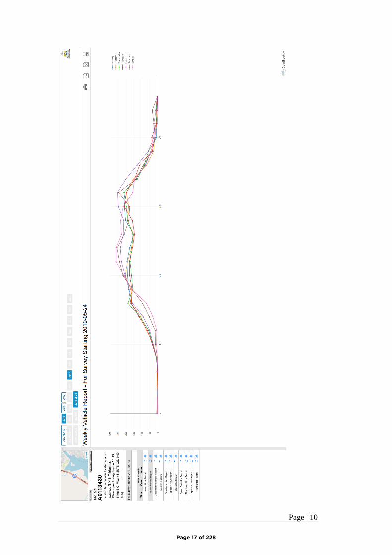
Since receiving the emailed response described above we have now taken Kevin Bourne’s advice and inspected the web site www.transport.tas.gov.au/road/projects. We were unable to detect any reference to Louisville Road, although The Tasman Highway – Great Eastern Drive from Orford to St Helens is clearly a listed project, but there are no Louisville road sub projects that we could identify. This is a major concern as much planning has been undertaken in reliance of the advice of the Minister and the Project Manager. We understand that the developer will discus this further with department officers. (JMG have since been advised that the project has been reinstated and is scheduled for construction in the next financial year). We shall however expand upon our traffic assessment of the existing intersection of Louisville Road and the Tasman Highway. TRAFFIC GENERATION BY THE DEVELOPMENT As outlined in the services report the proposed development is a residential subdivision with 47 allotments. In considering the traffic activity that the dwellings on the subdivisional lots will generate when occupied, guidance is normally sought from the New South Wales, Road Traffic Authority (RTA) document – Guide to Traffic Generating Developments. The RTA guide is a nationally well accepted document that provides advice on trips generation rates and vehicle parking requirements for new developments. The updated ‘Technical Direction’ to the guide dated August 2013 advises that the trip generation for residential dwellings in regional areas of New South Wales is 7.4 vehicles/dwelling/day. The developers have researched surveys in built up areas of Tasmania over a number of years and has found that typically the traffic generation in non-metropolitan areas that the numbers of vehicle trips for each dwelling is much lower, in the order of 5-6 vehicles/dwelling/day in country towns and even as low as 4 vehicles/dwelling/day in smaller communities and more remote areas. Surveys in similar areas have determined the traffic generation rates to be around 6.8 vehicles/dwelling/day in Snug, 6 vehicles/dwelling/day in Huonville, 5 vehicles/dwelling/day in Opossum Bay and around 4.5 vehicles/dwelling/day in Kooya. The above data would suggest that the traffic generation in a place such as Orford would be no more than 5/6 vehicles/dwelling/day during the summer months and 3 vehicles/dwelling/day during the winter period. Orford is mostly a holiday and retirement town, therefore the traffic distribution along the roads in the town would have peaks during mid-morning and mid-afternoon periods. There would not be a commuter peak hour period. Allowing for the 47 allotments and assuming a traffic generation of 6.0 vehicles/dwelling/day during the summer period, the expected traffic generation by the proposed 47 lot subdivision is up to 280 vehicles/day when fully developed and all dwellings are occupied.
Page 9 of 228
Page | 3
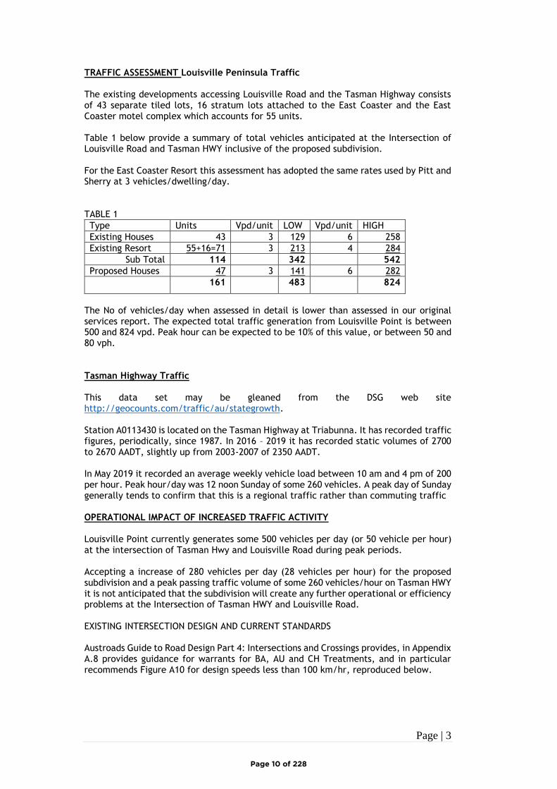
TRAFFIC ASSESSMENT Louisville Peninsula Traffic The existing developments accessing Louisville Road and the Tasman Highway consists of 43 separate tiled lots, 16 stratum lots attached to the East Coaster and the East Coaster motel complex which accounts for 55 units. Table 1 below provide a summary of total vehicles anticipated at the Intersection of Louisville Road and Tasman HWY inclusive of the proposed subdivision. For the East Coaster Resort this assessment has adopted the same rates used by Pitt and Sherry at 3 vehicles/dwelling/day. TABLE 1
Type Units Vpd/unit LOW Vpd/unit HIGH
Existing Houses 43 3 129 6 258
Existing Resort 55+16=71 3 213 4 284
Sub Total 114 342 542
Proposed Houses 47 3 141 6 282
161 483 824
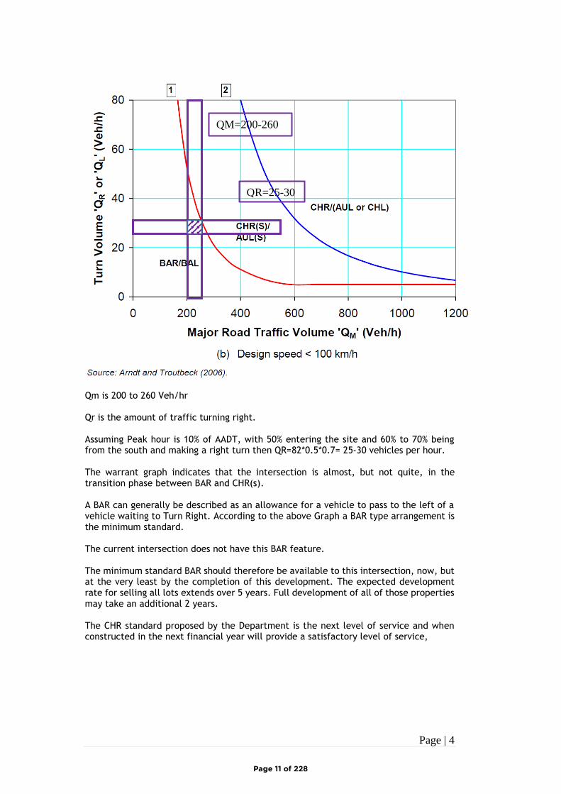
The No of vehicles/day when assessed in detail is lower than assessed in our original services report. The expected total traffic generation from Louisville Point is between 500 and 824 vpd. Peak hour can be expected to be 10% of this value, or between 50 and 80 vph. Tasman Highway Traffic This data set may be gleaned from the DSG web site http://geocounts.com/traffic/au/stategrowth. Station A0113430 is located on the Tasman Highway at Triabunna. It has recorded traffic figures, periodically, since 1987. In 2016 – 2019 it has recorded static volumes of 2700 to 2670 AADT, slightly up from 2003-2007 of 2350 AADT. In May 2019 it recorded an average weekly vehicle load between 10 am and 4 pm of 200 per hour. Peak hour/day was 12 noon Sunday of some 260 vehicles. A peak day of Sunday generally tends to confirm that this is a regional traffic rather than commuting traffic OPERATIONAL IMPACT OF INCREASED TRAFFIC ACTIVITY Louisville Point currently generates some 500 vehicles per day (or 50 vehicle per hour) at the intersection of Tasman Hwy and Louisville Road during peak periods. Accepting a increase of 280 vehicles per day (28 vehicles per hour) for the proposed subdivision and a peak passing traffic volume of some 260 vehicles/hour on Tasman HWY it is not anticipated that the subdivision will create any further operational or efficiency problems at the Intersection of Tasman HWY and Louisville Road. EXISTING INTERSECTION DESIGN AND CURRENT STANDARDS Austroads Guide to Road Design Part 4: Intersections and Crossings provides, in Appendix A.8 provides guidance for warrants for BA, AU and CH Treatments, and in particular recommends Figure A10 for design speeds less than 100 km/hr, reproduced below.
Page 10 of 228
Page | 4
Qm is 200 to 260 Veh/hr Qr is the amount of traffic turning right. Assuming Peak hour is 10% of AADT, with 50% entering the site and 60% to 70% being from the south and making a right turn then QR=82*0.5*0.7= 25-30 vehicles per hour. The warrant graph indicates that the intersection is almost, but not quite, in the transition phase between BAR and CHR(s). A BAR can generally be described as an allowance for a vehicle to pass to the left of a vehicle waiting to Turn Right. According to the above Graph a BAR type arrangement is the minimum standard. The current intersection does not have this BAR feature. The minimum standard BAR should therefore be available to this intersection, now, but at the very least by the completion of this development. The expected development rate for selling all lots extends over 5 years. Full development of all of those properties may take an additional 2 years. The CHR standard proposed by the Department is the next level of service and when constructed in the next financial year will provide a satisfactory level of service,
QR=25-30
QM=200-260
Page 11 of 228
Page | 5
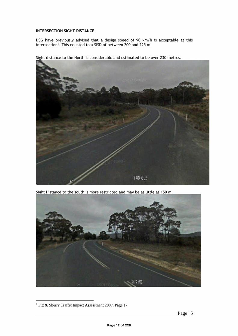
INTERSECTION SIGHT DISTANCE DSG have previously advised that a design speed of 90 km/h is acceptable at this intersection1. This equated to a SISD of between 200 and 225 m.
Sight distance to the North is considerable and estimated to be over 230 metres.
Sight Distance to the south is more restricted and may be as little as 150 m.
1 Pitt & Sherry Traffic Impact Assessment 2007. Page 17
Page 12 of 228
Page | 6
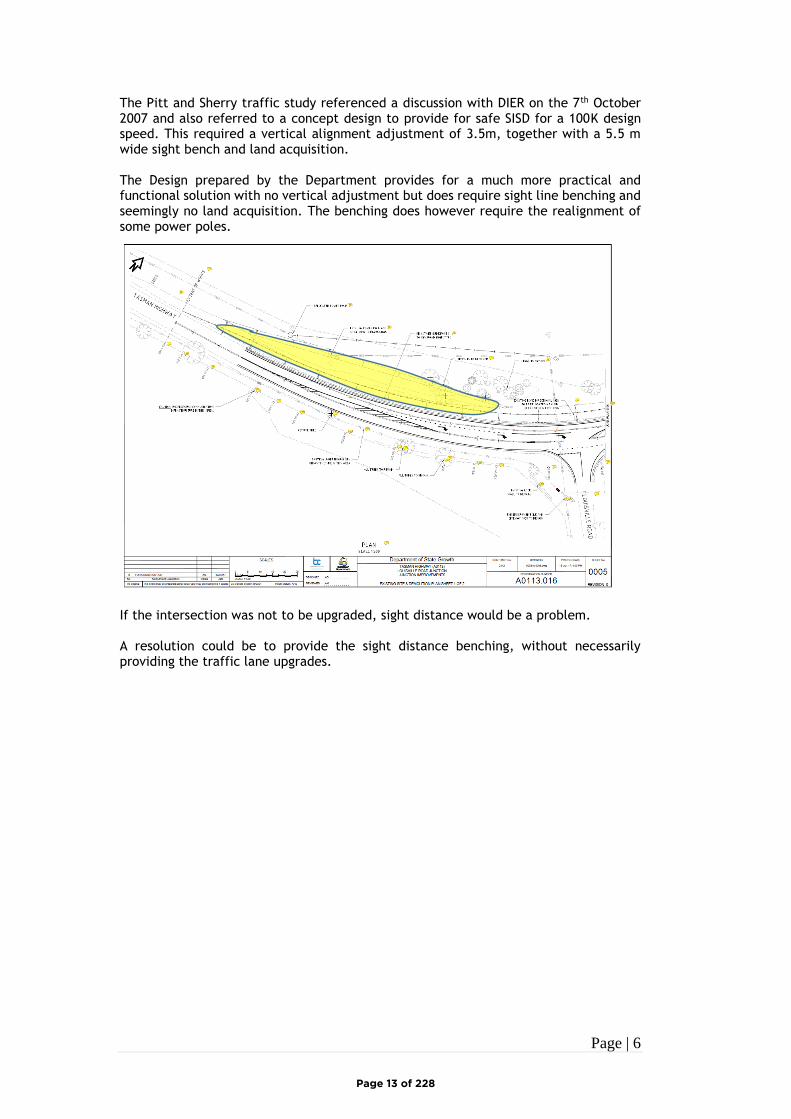
The Pitt and Sherry traffic study referenced a discussion with DIER on the 7th October 2007 and also referred to a concept design to provide for safe SISD for a 100K design speed. This required a vertical alignment adjustment of 3.5m, together with a 5.5 m wide sight bench and land acquisition. The Design prepared by the Department provides for a much more practical and functional solution with no vertical adjustment but does require sight line benching and seemingly no land acquisition. The benching does however require the realignment of some power poles.
If the intersection was not to be upgraded, sight distance would be a problem. A resolution could be to provide the sight distance benching, without necessarily providing the traffic lane upgrades.
Page 13 of 228

Page | 7
CONCLUSION The proposed subdivision will have an impact, but a relatively small one, on the existing operation of the Tasman HWY and Louisville Intersection. The Austroads standard is that every intersection should have a BAR feature, but this intersection is already deficient in that aspect. The intersection ought to be upgraded to at least a BAR, even without this subdivision proposal, but at the very least should be available at the conclusion of this subdivision construction. Sight distance is also a problem to the south that will need to be addressed, now, to provide for a safe intersection. Each of these issues would be resolved once the DSG has upgraded the intersection as currently programmed. Accordingly the Intersection is not a constraint to the approval of the subdivision application. Regards JOHNSTONE McGEE & GANDY PTY LTD Geoff BRAYFORD SENIOR CIVIL ENGINEER
Page 14 of 228
Page | 8
Page 15 of 228

Page | 9
Page 16 of 228
Page | 10
Page 17 of 228

STAGE 5 QUANTITIESSTAGE 5C
-
TOTAL121866
99802
23064
1173
STAGE 5BSTAGE 5A
483
LOT AREAROAD RESERVE AREALINEAL METRES OF ROAD
--
---
32464 36880 29943
GROSS AREA m²
371 319
5301962m²
5292426m²
5141761m² 513
1793m²
5282043m²
5271885m²526
1862m²5251840m²524
1818m²5231810m²522
1828m²5211837m²520
1876m²5191885m²518
2037m²508
2287m²
5072063m²
5062063m²
5052055m²
5042067m²
5031954m²
5021841m²
5011974m²
5121874m² 511
1753m² 5101883m²
5091814m²
5351937m²
5343654m²
5332262m²
5321959m²
5311959m²
5471926m²
5461770m²
5451834m²
5446536m²543
2607m²542
2315m²
5401777m²
5411759m²539
2376m²
5382301m²
5372354m²
5362163m²
5171740m²
5161669m²
5151613m²
35.809
54.78
6
35.809
54.78
6
28.02
3
38.696
54.78
6
44.519
7.537
22.02
3
56.35122.57
48.5
78
51.321 34.13
0
23.767
29.26
9
34.13
0
17.42614.498
63.77
4
9.33719.315
65.24
9
26.471 11.142
59.04
3
29.066
64.47
6
29.094
65.24
9
29.066
63.70
4
29.094
64.47
6
29.066
62.93
2
29.094
63.70
4
29.066
62.16
0
29.094
62.93
2
29.066
62.58
4
24.395 4.669
62.16
0
29.066
63.23
7
29.059
62.58
4
28.912
63.88
7
28.905
63.23
7
29.221
64.54
4
29.21463
.887
29.06665
.197
29.059
64.54
4
19.0065.894
64.23
6
18.742 19.108
65.19
75.894
22.691
65.74
0
21.00420.585
64.23
6
31.375
65.74
0
31.375
65.74
0
31.375
65.74
0
31.375
65.74
0
31.253
65.74
0
31.253
65.74
0
28.691
65.96
8
34.181
65.74
0
26.168
66.26
1
33.315
65.96
8
28.003
66.26
1
28.003
66.26
1
22.167
8.381
46.76
6
18.07
4
22.608
66.26
1
13.95712.796
63.77
4
32.844
62.58
1
5.02421.729
62.58
1
29.598
61.88
830.610
61.88
8
30.602
61.17
0
22.608
61.17
0
37.025
62.33
1
26.042
62.33
1
11.789 23.296
63.45
4
28.93728.937
63.45
4
51.873
8.485
57.45
4
41.611
48.78
6
8.485 35.611
54.78
6
10.16125.592
54.78
6
35.752
54.78
6
35.752
54.78
6
35.752
54.78
6
63.975
29.36
2
41.61125.592
29.53
9
60.780
27.36
2
63.975
29.53
9
58.243
25.36
2
60.780
7.975
28.81
0
7.943
15.559
15.559
12.900
16.77814.831
18.676
2.7339.220
77.32
7
23.225 8.485
58.243
28.60
9
20.013
19.995
62.66
7
37.225
77.32
7
7.040
25.475
15.889
5.682
19.51
4
55.914
11.643
62.66
7
8.48522.93728.937
61.41
7
28.93728.937
55.41
7
61.41
7
5.454
19.1162.271
65.73
9
22.608 26.042
61.41
7
2.271
30.799
70.82
75.024
30.610
65.73
9
9.94021.475
69.37
8
13.95721.729
70.82
7
29.473
32.00
5
32.02
7
23.76712.796
69.37
8
53.080
9.38114
.552
8.023
56.030
32.00
556.030
9.450
19.12
4
55.452 32.02
7
55.452
28.57
4
56.351 29.26
9
0 8040
SCALE IN METRES - 1:2000
6020 20
L O U I S V I L L E R O A D
N E W
R O
A D
B E R N A C C H I D R I V E
GD1917-P7 2-
-BAYPORT PTY LTDSPRING BAY
LAND DEVELOPMENTSUBDIVISION STAGE 5
LOT PLAN
R. GIBSON R. GIBSON R. GIBSON 11/5/2019
21-6-19 AHD 1 VEGETATION ADDED2 LOTS ADDED
REFERENCE FILES ATTACHED: GD1917-X3; GD1917-X1; GD1917-X2; GD1917-X4
DATE SIGNEDJun. 21, 19 - 19:45:26 Name: GD1917-P7.dwg Updated By: Ross gibson
DRAWING REVISION HISTORY
DATUMS:
REVISION DESCRIPTION
STATUS
REVIEWED DATEDRAWN DESIGNED
SIGNEDDRAWING No.
TITLE
CLIENT
PROJECT
CLIENT No.
REVISION
VERSIONSHEET No.ANDY HAMILTON & ASSOCIATES PTY LTDCONSULTING LAND SURVEYORS
PO Box 223 Bicheno 7215P: 0418 593 300 E: [email protected]
STAGE 5B
STAGE 5C
STAGE 5A LEGENDBIODIVERSITY PROTECTIONAREA OVERLAY PERPLANNING SCHEME
Page 18 of 228
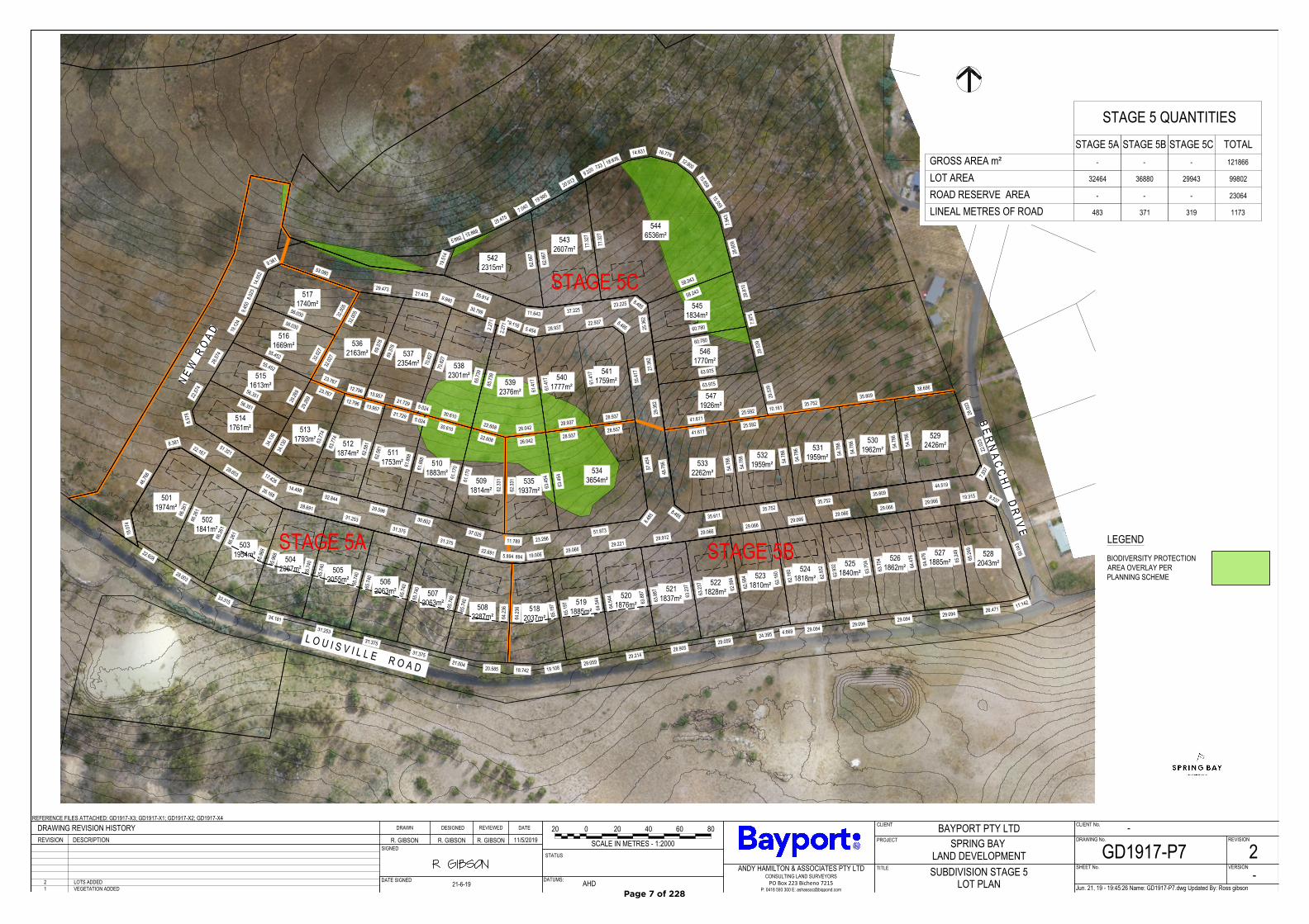
SPRING BAY PROPOSED SUBDIVISION STAGE 5 doc
ABSTRACT Proposed Subdivision 47 lots in 3 stages – Louisville Road Residential Precinct
User 1 [Course title]
Page 19 of 228
Spring Bay Stage 5
1
Summary.
This application seeks approval for Stage 5, Spring Bay Estate, in 3 Stages. The application is lodged under the Glamorgan Spring Bay Planning Scheme,
Louisville Road Specific Area Plan. The site is subject in part to a biodiversity protection overlay (BPA)
The south facing site fronts Louisville Road with proposed Road junction from there linking to a junction at Bernacchi Drive to the east. The lots are designed
at a low density with an average lot size around 2000m2. Site development guidelines are proposed to assist with future built form outcomes for the lots and
amenity of the area.
Addendums joining this application include:
Concept Services Plan (JMG)
Site analysis and effluent disposal report (Geosolutions)
Bushfire Report (Geosolutions)
Spring Bay Residential Design Guidelines
The proposed subdivision is consistent with the principles in the approved stage 2 subdivision (planning permit SU07002)
Wording below in italics (black) = planning scheme text. Wording in blue by the author.
F3.0 Louisville Road Specific Area Plan
F3.1 Purpose of Specific Area Plan F3.1.1 The purpose of the Louisville Road Specific Area Plan is to: (a) provide for a sustainable, high quality tourism, recreational and residential estate that is developed consistent with the Desired Future
Character Statements for the five precincts and nine sub-areas that comprise the Specific Area Plan; (b) provide for public access to open space areas and to the foreshore, and formed shared trails for public access and recreational use; (c) create a major visitor attraction that will encourage visitors to stay longer in the area;
Page 20 of 228

Spring Bay Stage 5
2
(d) ensure connections between the site and Orford are established and maintained; (e) minimise visual impact and protect the sites rural landscape, vistas from the Tasman Highway, the scenic values of Meredith Point and
existing ridgelines; (f) provide for re-vegetation of the site with native vegetation in order to increase habitat and screen development; (g) minimise the environmental footprint of development through energy efficiency, water sensitive urban design and reuse of waste and
construction materials; (h) protect and enhance natural and cultural values; (i) encourage best practice sustainable design for the built environment.
Desired Future Character Statements Implementation Strategy
Page 21 of 228

Spring Bay Stage 5
3
Residential Precinct Future development of the Residential Precinct is to: (a) provide a residential coastal community comprised of a variety of dwelling types and sizes designed to respond to the needs
and lifestyle of local people, visitors and residents; (b) develop dwellings, roads and infrastructure within a vegetated setting, with retention of bushland and vegetation; (c) include substantial areas of vegetation planting of local provenance with a mixture of permaculture/edible landscape elements; (d) provide pedestrian links to be formed between various areas to encourage walking and assist with the building of a
neighbourhood community; (e) maximise energy efficiency in the design and construction of buildings; (f) provide for a retirement village. (g) minimise visual impact upon surrounding locations particularly in terms of impacts upon the skyline or tree canopy when viewed
from surrounding land; and (h) provide buildings that lend with the surrounding natural environment.
Use and Development standards
F3.7.1 Lot Design
Page 22 of 228

Spring Bay Stage 5
4
Objective:
To provide for new lots that have appropriate area and dimensions to accommodate development consistent with the Purpose and Desired Future Character
Statements for this Specific Area Plan.
Acceptable Solutions Performance Criteria
A1
Each lot must have an area no less than:
(a) 450m², if in the Residential Precinct; met
(b) 250m², if in the Hub Precinct;n/a
(c) 100ha, if in the Golf Precinct or Eco Cabin Precinct or Open
Space and Reserves Precinct except for a lot for the purposes of
creating precinct boundaries.n/a
P1
No Performance Criteria.
Page 23 of 228

Spring Bay Stage 5
5
A2
The frontage of each lot must be no less than, except if for public open
space, a riparian or littoral reserve or utilities and except if an internal lot:
(a) 12m, if located in the Residential Precinct;
(b) 3.6m, if located in any precinct other than the Residential
Precinct.
P2
The frontage of each lot must satisfy all of the following:
(a) provides opportunity for practical and safe vehicular access;
(b) provides opportunity for passive surveillance between residential
development on the lot and the road;
(c) is not less than 6 metres.
Page 24 of 228
Spring Bay Stage 5
6
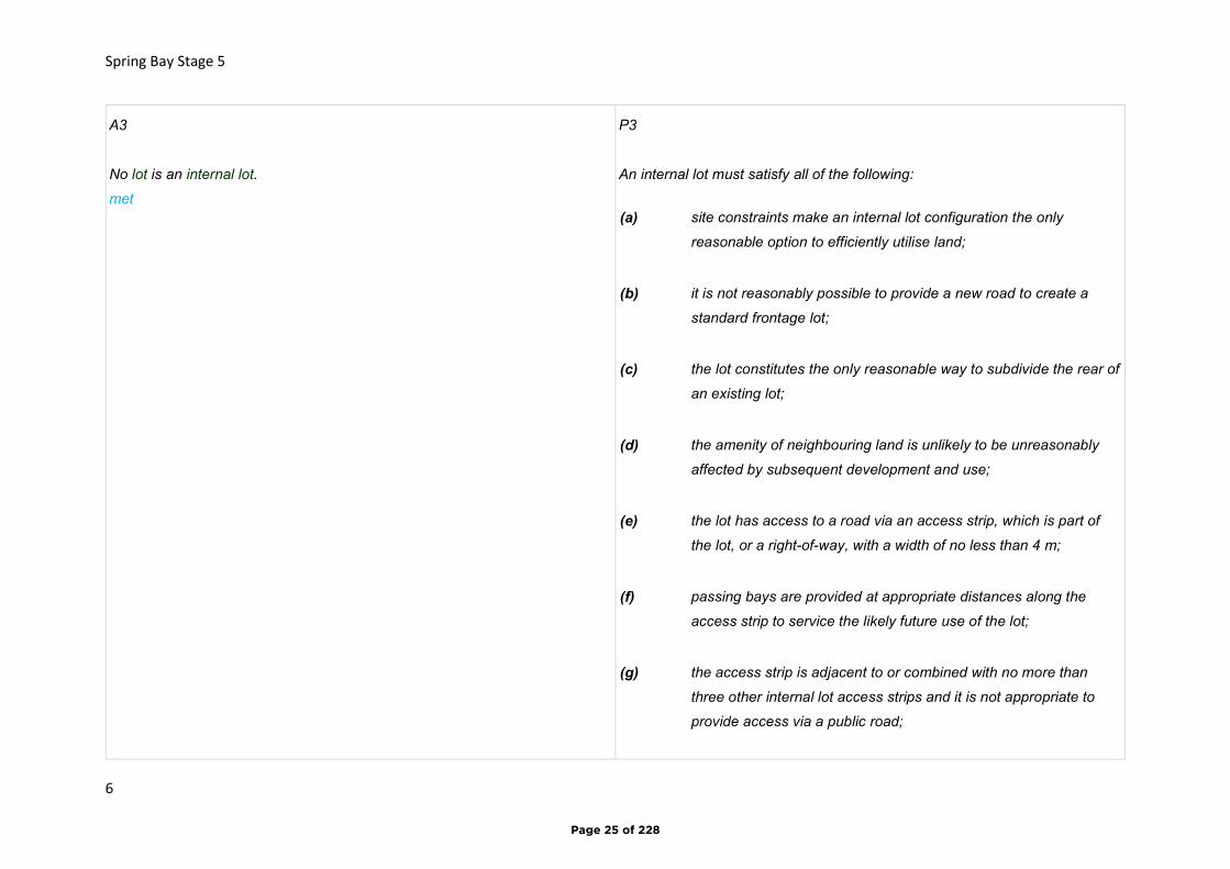
A3
No lot is an internal lot.
met
P3
An internal lot must satisfy all of the following:
(a) site constraints make an internal lot configuration the only
reasonable option to efficiently utilise land;
(b) it is not reasonably possible to provide a new road to create a
standard frontage lot;
(c) the lot constitutes the only reasonable way to subdivide the rear of
an existing lot;
(d) the amenity of neighbouring land is unlikely to be unreasonably
affected by subsequent development and use;
(e) the lot has access to a road via an access strip, which is part of
the lot, or a right-of-way, with a width of no less than 4 m;
(f) passing bays are provided at appropriate distances along the
access strip to service the likely future use of the lot;
(g) the access strip is adjacent to or combined with no more than
three other internal lot access strips and it is not appropriate to
provide access via a public road;
Page 25 of 228
Spring Bay Stage 5
7
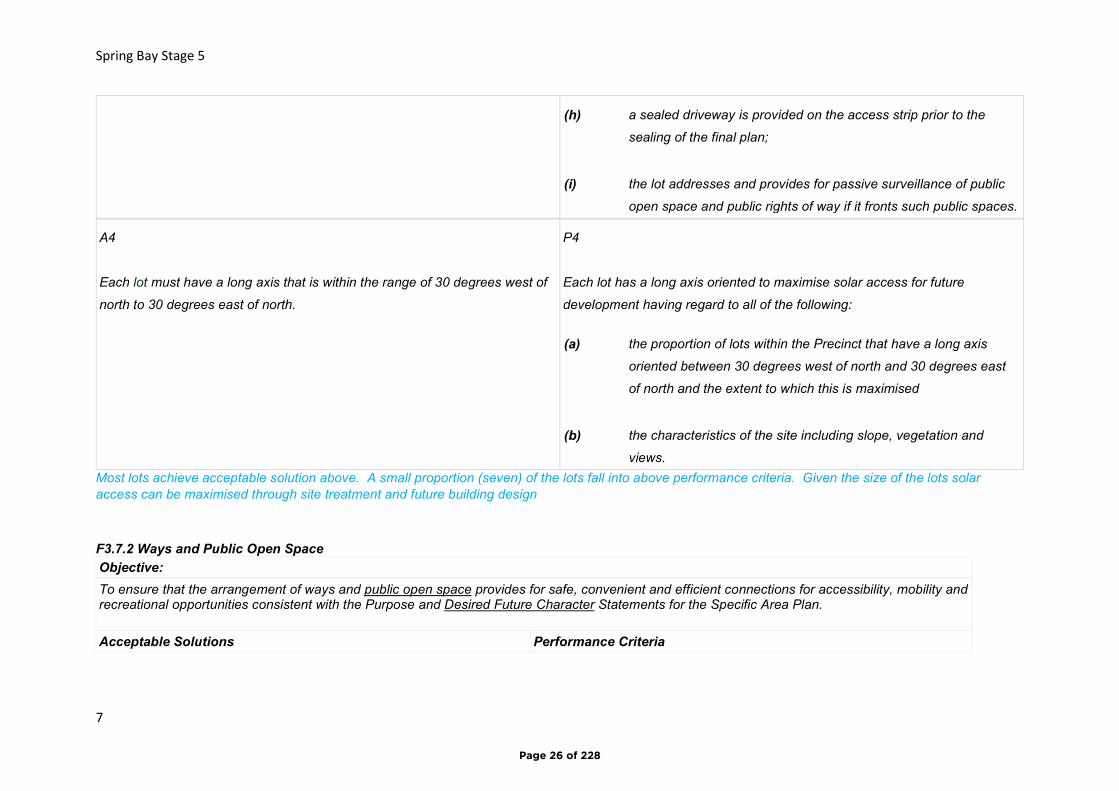
(h) a sealed driveway is provided on the access strip prior to the
sealing of the final plan;
(i) the lot addresses and provides for passive surveillance of public
open space and public rights of way if it fronts such public spaces.
A4
Each lot must have a long axis that is within the range of 30 degrees west of
north to 30 degrees east of north.
P4
Each lot has a long axis oriented to maximise solar access for future
development having regard to all of the following:
(a) the proportion of lots within the Precinct that have a long axis
oriented between 30 degrees west of north and 30 degrees east
of north and the extent to which this is maximised
(b) the characteristics of the site including slope, vegetation and
views.
Most lots achieve acceptable solution above. A small proportion (seven) of the lots fall into above performance criteria. Given the size of the lots solar access can be maximised through site treatment and future building design
F3.7.2 Ways and Public Open Space
Objective:
To ensure that the arrangement of ways and public open space provides for safe, convenient and efficient connections for accessibility, mobility and recreational opportunities consistent with the Purpose and Desired Future Character Statements for the Specific Area Plan.
Acceptable Solutions Performance Criteria
Page 26 of 228
Spring Bay Stage 5
8
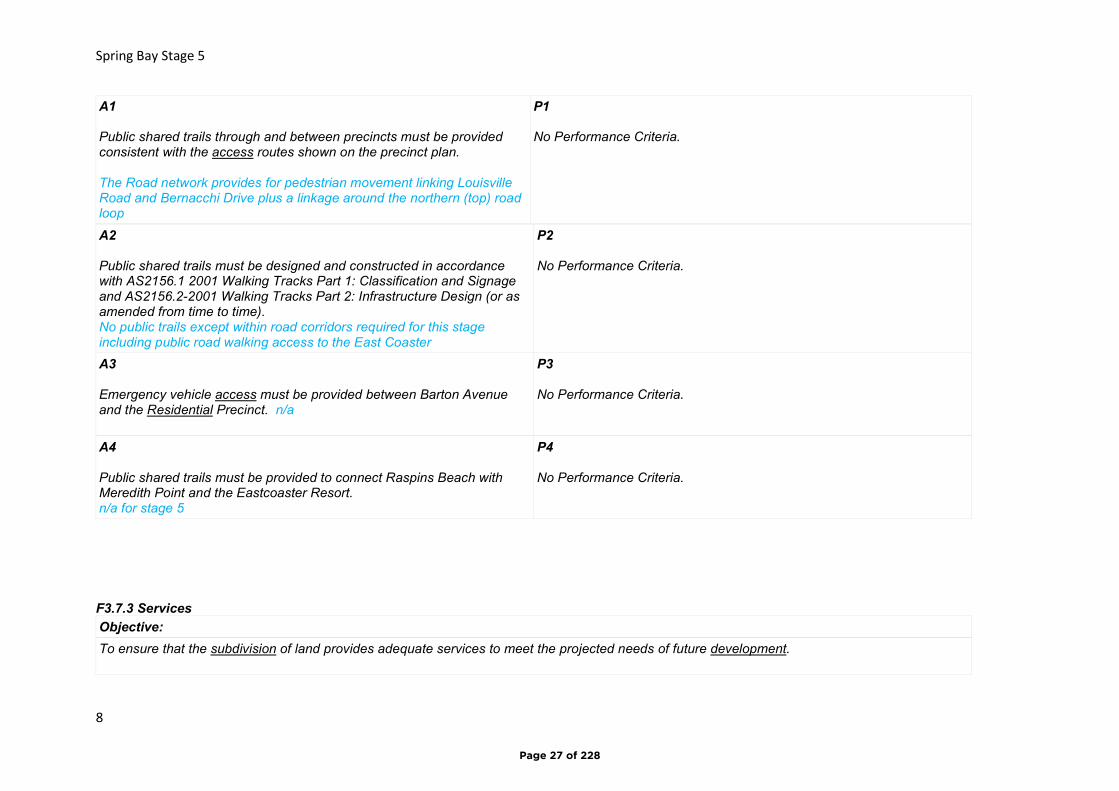
A1 Public shared trails through and between precincts must be provided consistent with the access routes shown on the precinct plan. The Road network provides for pedestrian movement linking Louisville Road and Bernacchi Drive plus a linkage around the northern (top) road loop
P1 No Performance Criteria.
A2 Public shared trails must be designed and constructed in accordance with AS2156.1 2001 Walking Tracks Part 1: Classification and Signage and AS2156.2-2001 Walking Tracks Part 2: Infrastructure Design (or as amended from time to time). No public trails except within road corridors required for this stage including public road walking access to the East Coaster
P2 No Performance Criteria.
A3 Emergency vehicle access must be provided between Barton Avenue and the Residential Precinct. n/a
P3 No Performance Criteria.
A4 Public shared trails must be provided to connect Raspins Beach with Meredith Point and the Eastcoaster Resort. n/a for stage 5
P4 No Performance Criteria.
F3.7.3 Services
Objective:
To ensure that the subdivision of land provides adequate services to meet the projected needs of future development.
Page 27 of 228
Spring Bay Stage 5
9
Acceptable Solutions Performance Criteria
A1 Each lot must be connected to a reticulated potable water supply. To be achieved. Refer engineering concept plan
P1 No Performance Criteria.
A2 Each lot must be connected to a reticulated sewerage system where available. Future system to be provided for (refer eng concept plan) ‘sleeper’ reticutalted system to be installed pending future sewer connection to stage 5.
P2 Where a reticulated sewerage system is not available, each lot must be capable of accommodating an on-site wastewater treatment system adequate for the future use and development of the land. On site wastewater treatment is proposed – see attached report. Proposed the lots be connected to a reticulated system when it becomes available.
A3 Each lot must be connected to a stormwater system able to service the building area by gravity. Achieved – see engineering concept design
P3 Each lot must be capable of accommodating an on-site stormwater management system adequate for the likely future use and development of the land.
A4 Stormwater drainage from development must comply with all of the following: (a) be reused on the golf course and returned to natural watercourses
entering the Prosser River or Spring Bay; refer engineering concept design and report
(b) exit the Specific Area Plan at a equivalent concentration, condition,
volume and velocity as would have occurred in the absence of any development assuming a continuous cover of natural vegetation as would have occurred prior to the clearing of land for agricultural use refer engineering concept design and report..
P4 No Performance Criteria.
Page 28 of 228
Spring Bay Stage 5
10
F3.7.4 Landscaping and lighting
Objective:
To ensure that a safe and attractive landscaping treatment enhances the appearance of the site, minimises visual impact of development and enhances natural values and night glare associated with landscape lighting is minimised.
Acceptable Solutions Performance Criteria
A1 Roads, ways and public open space and associated works must be landscaped. Landscaping plans to be submitted with future civil design build plans for approval.
P1 No Performance Criteria.
A2 No Acceptable Solution.
P2 Street lighting, flood lighting and landscape lighting must minimise the impact of 'night light' and must satisfy all of the following: (a) be baffled to prevent upward projection; (b) minimise light spillage; (c) minimise reflections from paved surfaces; (d) be installed in ground whereever possible.
Agreed. Lighting design plans taking a-d into account to accompany future civil design for approval
Page 29 of 228

Spring Bay Stage 5
11
Code Biodiversity Protection Area
E10.8.1 Subdivision Objective:
To ensure that:
(a) works associated with subdivision resulting in clearance and conversion or disturbance will not have an unnecessary or unacceptable impact on priority biodiversity values; (b) future development likely to be facilitated by subdivision is unlikely to lead to an unnecessary or unacceptable impact on priority biodiversity values.
Acceptable Solutions
A1 Subdivision of a lot, all or part of which is within a Biodiversity Protection Area, must comply with one or more of the following:
(a) be for the purposes of separating existing dwellings; (b) be for the creation of a lot for public open space, public reserve or utility; (c) no works, other than boundary fencing works, are within the Biodiversity Protection Area; (d) the building area, bushfire hazard management area, services and vehicular access driveway are outside the Biodiversity Protection Area. Met
Page 30 of 228
Spring Bay Stage 5
12
Re growth has commenced in recent years over portion of the site – lots fronting Louisville road have been designed to enable retention of this Vegetation on their downhill portions. Other areas of re growth will be subject to removal as required.
A2 Subdivision is not prohibited by the relevant zone standards. met
P2 No performance criteria.
Page 31 of 228

Spring Bay Stage 5
13
Page 32 of 228
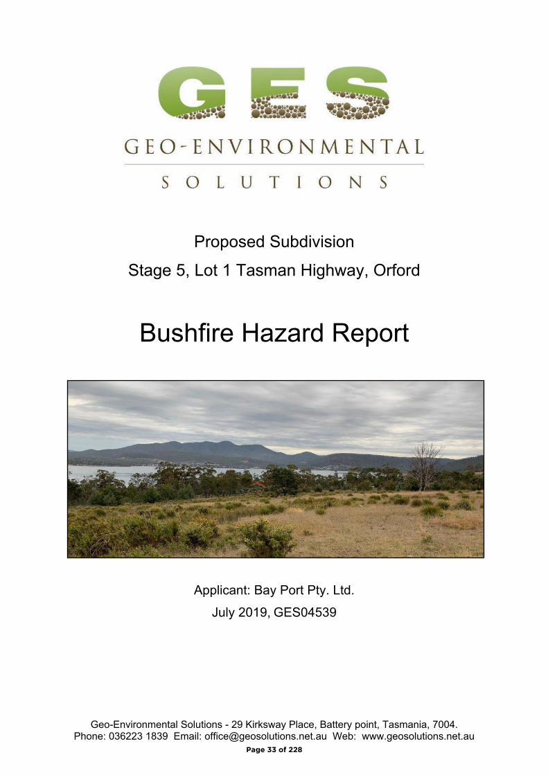
Geo-Environmental Solutions - 29 Kirksway Place, Battery point, Tasmania, 7004.Phone: 036223 1839 Email: [email protected] Web: www.geosolutions.net.au
Proposed Subdivision
Stage 5, Lot 1 Tasman Highway, Orford
Bushfire Hazard Report
Applicant: Bay Port Pty. Ltd.
July 2019, GES04539
Page 33 of 228
Bushfire Hazard Report - Stage 5, Lot 1 Tasman Highway, Orford, July 2019, GES04539.
Page 2 o f 1 2
Contents1.0 Introduction ........................................................................................................................3
2.0 Proposal.............................................................................................................................3
3.0 Site Description..................................................................................................................3
4.0 Bushfire Hazard Assessment.............................................................................................5
4.1 Vegetation ......................................................................................................................5
4.2 slopes .............................................................................................................................5
4.3 Bushfire Attack Level......................................................................................................7
5.0 Bushfire Prone Areas Code ...............................................................................................7
5.1 Hazard Management Areas ...........................................................................................7
5.1.1 Building areas ..........................................................................................................7
5.2 Public and firefighting Access ........................................................................................8
5.3 Water supplies for fire fighting........................................................................................9
6.0 Compliance ........................................................................................................................9
6.1 Planning Compliance .....................................................................................................9
6.2 Building Compliance (for future development) .............................................................10
7.0 Summary..........................................................................................................................11
Limitations Statement ............................................................................................................11
8.0 References.......................................................................................................................12
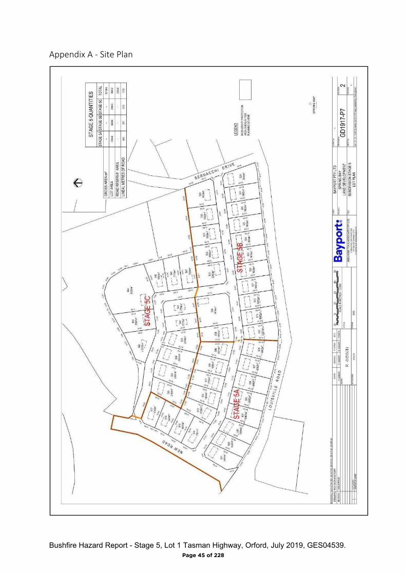
Appendix A - Plan of Subdivision
Appendix B - BAL assessment tables
Appendix C - Bushfire Hazard Management Plan
Appendix D - Planning Certificate
Appendix E - Certificate of Others (form 55)
Page 34 of 228
Bushfire Hazard Report - Stage 5, Lot 1 Tasman Highway, Orford, July 2019, GES04539.
Page 3 o f 1 2
1.0 Introduction
This Bushfire Hazard Report has been completed to form part of supporting documentation
for a planning permit application for a proposed subdivision. The proposed subdivision
occurs in a Bushfire-prone Area defined by the Glamorgan-Spring Bay Interim Planning
Scheme 2015 (the Scheme). This report has been prepared by Mark Van den Berg a
qualified person under Part 4a of the Fire Service Act 1979 of Geo Environmental Solutions
Pty Ltd for Bay Port Pty. Ltd.
The report considers all the relevant standards of Code E1 of the planning scheme,
specifically;
The requirements for appropriate Hazard Management Areas (HMA’s) in relation to
building areas;
The requirements for Public and Private access;
The provision of water supplies for fire fighting purposes;
Compliance with the planning scheme, and
Provides a Bushfire Hazard Management Plan to facilitate appropriate compliant
future development.
2.0 Proposal
It is proposed that a forty-seven lot subdivision be developed on the site described as per
the proposed plan of subdivision in appendix A. The proposed development occurs within
the Rural Resource zone and is adjacent to other areas with the same zoning and an area to
the east zoned as Low density Residential on Bernacchi Drive. Public access will be
provided to all lots with new cross overs from new public roadways. Water supplies for
firefighting will be provided by a new reticulated system managed by TasWater, hydrants will
be installed compliant with Code E1. of the scheme. The development is proposed to be
occur over three stages.
3.0 Site Description
The subject site comprises private land on one title at Lot 1 Tasman Highway, Orford, title
number 139972/1 (figure 1). The site occurs in the municipality of Glamorgan-Spring Bay,
this application is administered through the Glamorgan-Spring Bay Interim planning scheme
2015 and the Louisville Road Specific Area Plan which makes provision for subdivision.
The site is located north-east of the Orford township, approximately 0.8 km north-west of
Louisville Point, (figure 1) is dominated by grasslands with native vegetation remnants. It
Page 35 of 228

Bushfire Hazard Report - Stage 5, Lot 1 Tasman Highway, Orford, July 2019, GES04539.
Page 4 o f 1 2
has gentle to moderate slopes with multiple aspects and is currently un-developed (figure 2).
The site has areas which are within the Biodiversity Protection and Landslide Hazard
Overlays.
Figure 1. The site in a topographical context, pink line denotes the property boundary blue line denotes the Stage 5 subdivision area (approximate).
Page 36 of 228

Bushfire Hazard Report - Stage 5, Lot 1 Tasman Highway, Orford, July 2019, GES04539.
Page 5 o f 1 2
Figure 2. Aerial photo of the site, pink line denotes the property boundary blue line denotes the Stage 5 subdivision area (approximate).
4.0 Bushfire Hazard Assessment
4.1 Vegetation
The site and adjacent lands within 100 metres of the proposed building areas carry a mosaic
pattern of grassland and woodland vegetation (figures 3 to 5). A bushfire impacting the
subdivision area from the north will burn through woodland vegetation while bushfire attack
from the south and west will approach the subdivision area through grassland vegetation.
4.2 slopes
The effective slopes in relation to the proposed new lots are gentle to moderate
(approximately 0 to10 degrees) and are likely to have some influence on fire behaviour. The
aspects for each lot range from southerly to easterly (figures 3 to 5).
Page 37 of 228

Bushfire Hazard Report - Stage 5, Lot 1 Tasman Highway, Orford, July 2019, GES04539.
Page 6 o f 1 2
Figure 3. Centre of subdivision area in the vicinity of lot 510.
Figure 4. Western extent of subdivision area in the vicinity of lot 516.
Figure 5. Eastern extent of subdivision area in the vicinity of lot 525.
Page 38 of 228

Bushfire Hazard Report - Stage 5, Lot 1 Tasman Highway, Orford, July 2019, GES04539.
Page 7 o f 1 2
4.3 Bushfire Attack Level
An assessment of the bushfire attack level as per AS3959-2009 was undertaken for each
proposed lot to determine the required width of hazard management areas to yield building
areas of not greater than BAL-19. The vegetation present is assessed as ‘Grassland and
woodland or was excluded from the assessment as low threat vegetation. The bushfire
attack level assessment tables are found in appendix B. The assessment has been
completed measuring distances from the proposed building areas. The following lots have
been assessed and are within 100 metres of bushfire-prone vegetation (lots 509 to 517
inclusive, and lots 533 to 541 inclusive). The distance between the building areas for these
lots and the bushfire-prone vegetation exceeds the minimum distance required to achieve
BAL-12.5 and are not represented in appendix B.
5.0 Bushfire Prone Areas Code
Code E1 of the Scheme articulates requirements for the provision of hazard management
areas, standards for access and firefighting water supplies and requirements for hazard
management for staged subdivisions.
5.1 Hazard Management Areas
Hazard management areas (HMA) are required to be established for each lot, they provide
an area around the building within which fuels are managed to reduce or eliminate the
impacts of direct flame contact, radiant heat loads and embers on the site. The Bushfire
hazard Management Plan (BHMP) shows building areas (for habitable buildings) and the
associated HMA for each lot and provides guidance for establishment and maintenance.
Not all vegetation has to be removed from a hazard management area to be effective, trees
and shrubs can provide protection from wind and embers if other fuels are appropriately
managed. Temporary hazard management areas are also required for each stage of this
development. This is to ensure that vegetation within the balance of the subdivision not
have the potential to elevate the bushfire attack on developed lots. The location of the
temporary hazard management areas is shown on the BHMP.
5.1.1 Building areas
Building areas for habitable buildings on each lot are shown on the BHMP. Each lot has
been assessed and a Bushfire Attack Level (BAL) assigned to it. If future buildings are
located within the building area and comply with the minimum setbacks for the lot the
buildings may be constructed to the bushfire attack level assigned to that lot. If associated
structures like sheds or other non-habitable buildings are proposed, they do not need to
conform to the BAL for the lot unless they are within 6 metres of the habitable building.
Page 39 of 228
Bushfire Hazard Report - Stage 5, Lot 1 Tasman Highway, Orford, July 2019, GES04539.
Page 8 o f 1 2
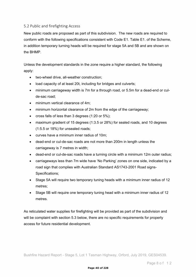
5.2 Public and firefighting Access
New public roads are proposed as part of this subdivision. The new roads are required to
conform with the following specifications consistent with Code E1. Table E1. of the Scheme,
in addition temporary turning heads will be required for stage 5A and 5B and are shown on
the BHMP.
Unless the development standards in the zone require a higher standard, the following
apply:
two-wheel drive, all-weather construction;
load capacity of at least 20t, including for bridges and culverts;
minimum carriageway width is 7m for a through road, or 5.5m for a dead-end or cul-
de-sac road;
minimum vertical clearance of 4m;
minimum horizontal clearance of 2m from the edge of the carriageway;
cross falls of less than 3 degrees (1:20 or 5%);
maximum gradient of 15 degrees (1:3.5 or 28%) for sealed roads, and 10 degrees
(1:5.5 or 18%) for unsealed roads;
curves have a minimum inner radius of 10m;
dead-end or cul-de-sac roads are not more than 200m in length unless the
carriageway is 7 metres in width;
dead-end or cul-de-sac roads have a turning circle with a minimum 12m outer radius;
carriageways less than 7m wide have ‘No Parking’ zones on one side, indicated by a
road sign that complies with Australian Standard AS1743-2001 Road signs-
Specifications;
Stage 5A will require two temporary tuning heads with a minimum inner radius of 12
metres;
Stage 5B will require one temporary tuning head with a minimum inner radius of 12
metres.
As reticulated water supplies for firefighting will be provided as part of the subdivision and
will be complaint with section 5.3 below, there are no specific requirements for property
access for future residential development.
Page 40 of 228
Bushfire Hazard Report - Stage 5, Lot 1 Tasman Highway, Orford, July 2019, GES04539.
Page 9 o f 1 2
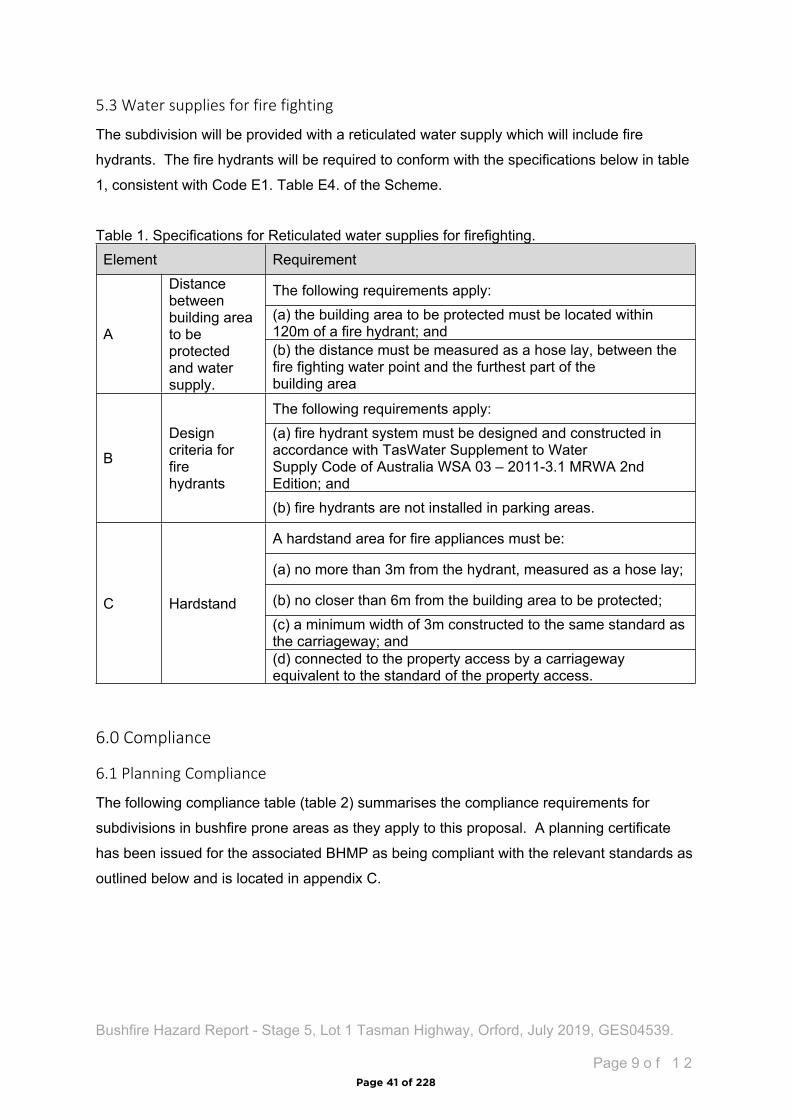
5.3 Water supplies for fire fighting
The subdivision will be provided with a reticulated water supply which will include fire
hydrants. The fire hydrants will be required to conform with the specifications below in table
1, consistent with Code E1. Table E4. of the Scheme.
Table 1. Specifications for Reticulated water supplies for firefighting.Element Requirement
The following requirements apply: (a) the building area to be protected must be located within 120m of a fire hydrant; andA
Distance between building area to be protected and water supply.
(b) the distance must be measured as a hose lay, between the fire fighting water point and the furthest part of the building area
The following requirements apply:(a) fire hydrant system must be designed and constructed in accordance with TasWater Supplement to Water Supply Code of Australia WSA 03 – 2011-3.1 MRWA 2nd Edition; and
B
Design criteria for fire hydrants
(b) fire hydrants are not installed in parking areas.
A hardstand area for fire appliances must be:
(a) no more than 3m from the hydrant, measured as a hose lay;
(b) no closer than 6m from the building area to be protected;(c) a minimum width of 3m constructed to the same standard as the carriageway; and
C Hardstand
(d) connected to the property access by a carriageway equivalent to the standard of the property access.
6.0 Compliance
6.1 Planning Compliance
The following compliance table (table 2) summarises the compliance requirements for
subdivisions in bushfire prone areas as they apply to this proposal. A planning certificate
has been issued for the associated BHMP as being compliant with the relevant standards as
outlined below and is located in appendix C.
Page 41 of 228
Bushfire Hazard Report - Stage 5, Lot 1 Tasman Highway, Orford, July 2019, GES04539.
Page 1 0 o f 1 2
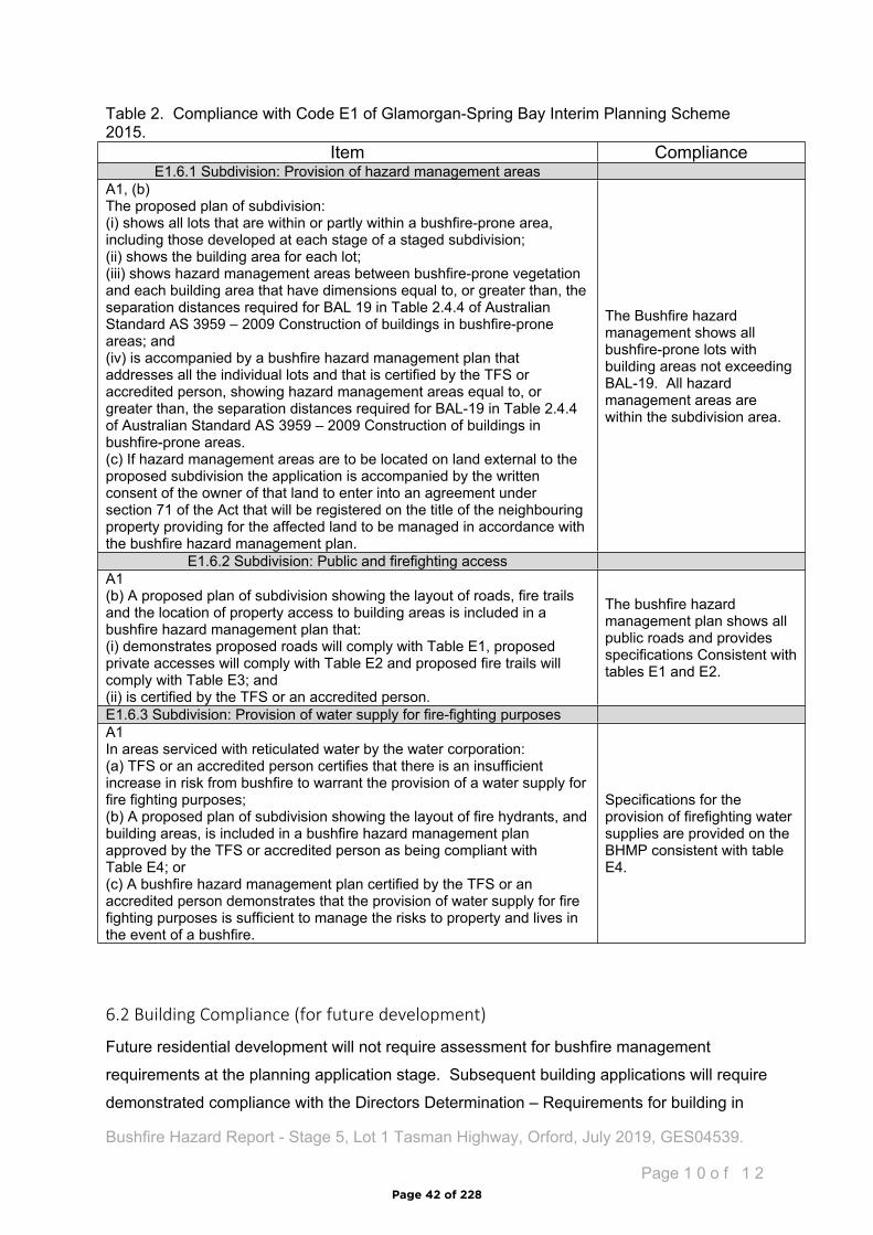
Table 2. Compliance with Code E1 of Glamorgan-Spring Bay Interim Planning Scheme 2015.
6.2 Building Compliance (for future development)
Future residential development will not require assessment for bushfire management
requirements at the planning application stage. Subsequent building applications will require
demonstrated compliance with the Directors Determination – Requirements for building in
Item ComplianceE1.6.1 Subdivision: Provision of hazard management areas
A1, (b)The proposed plan of subdivision: (i) shows all lots that are within or partly within a bushfire-prone area, including those developed at each stage of a staged subdivision; (ii) shows the building area for each lot; (iii) shows hazard management areas between bushfire-prone vegetation and each building area that have dimensions equal to, or greater than, the separation distances required for BAL 19 in Table 2.4.4 of Australian Standard AS 3959 – 2009 Construction of buildings in bushfire-prone areas; and (iv) is accompanied by a bushfire hazard management plan that addresses all the individual lots and that is certified by the TFS or accredited person, showing hazard management areas equal to, or greater than, the separation distances required for BAL-19 in Table 2.4.4 of Australian Standard AS 3959 – 2009 Construction of buildings in bushfire-prone areas.(c) If hazard management areas are to be located on land external to the proposed subdivision the application is accompanied by the written consent of the owner of that land to enter into an agreement under section 71 of the Act that will be registered on the title of the neighbouring property providing for the affected land to be managed in accordance with the bushfire hazard management plan.
The Bushfire hazard management shows all bushfire-prone lots with building areas not exceeding BAL-19. All hazard management areas are within the subdivision area.
E1.6.2 Subdivision: Public and firefighting accessA1 (b) A proposed plan of subdivision showing the layout of roads, fire trails and the location of property access to building areas is included in a bushfire hazard management plan that:(i) demonstrates proposed roads will comply with Table E1, proposed private accesses will comply with Table E2 and proposed fire trails will comply with Table E3; and (ii) is certified by the TFS or an accredited person.
The bushfire hazard management plan shows all public roads and provides specifications Consistent with tables E1 and E2.
E1.6.3 Subdivision: Provision of water supply for fire-fighting purposesA1 In areas serviced with reticulated water by the water corporation: (a) TFS or an accredited person certifies that there is an insufficient increase in risk from bushfire to warrant the provision of a water supply for fire fighting purposes; (b) A proposed plan of subdivision showing the layout of fire hydrants, and building areas, is included in a bushfire hazard management plan approved by the TFS or accredited person as being compliant with Table E4; or (c) A bushfire hazard management plan certified by the TFS or an accredited person demonstrates that the provision of water supply for fire fighting purposes is sufficient to manage the risks to property and lives in the event of a bushfire.
Specifications for the provision of firefighting water supplies are provided on the BHMP consistent with table E4.
Page 42 of 228
Bushfire Hazard Report - Stage 5, Lot 1 Tasman Highway, Orford, July 2019, GES04539.
Page 1 1 o f 1 2
Bushfire-prone Areas. If future development is undertaken in compliance with the Bushfire
Hazard Management Plan associated with this report, a building surveyor may rely upon it
for building compliance purposes if it is not more than 6 years old.
7.0 Summary
The proposed development occurs within a bushfire-prone area. The vegetation is classified
as grassland and woodland with the highest risk presented by vegetation to the north and
west of the site.
A bushfire hazard management plan has been developed and shows hazard management
areas, building areas with construction standards, the location of proposed public roads and
standards for their construction and specifications for the provision of firefighting water
supplies.
If future development for an individual lot is proposed and is compliant with all the
specifications of the bushfire hazard management plan, it may be relied upon for building
compliance purposes. If subsequent development does not comply with all the
specifications a new assessment will be required.
Limitations Statement
This Bushfire Hazard Report has been prepared in accordance with the scope of services
between Geo-Environmental Solutions Pty. Ltd. (GES) and the applicant. To the best of
GES's knowledge, the information presented herein represents the Client's requirements at
the time of printing of the Report. However, the passage of time, manifestation of latent
conditions or impacts of future events may result in findings differing from that described in
this Report. In preparing this Report, GES has relied upon data, surveys, analyses, designs,
plans and other information provided by the Client and other individuals and organisations
referenced herein. Except as otherwise stated in this Report, GES has not verified the
accuracy or completeness of such data, surveys, analyses, designs, plans and other
information.
The scope of this study does not allow for the review of every possible bushfire hazard
condition and does not provide a guarantee that no loss of property or life will occur as a
result of bushfire. As stated in AS3959-2009 “It should be borne in mind that the measures
contained in this Standard cannot guarantee that a building will survive a bushfire event on
every occasion. This is substantially due to the degree of vegetation management, the
unpredictable nature and behaviour of fire, and extreme weather conditions”. In addition, no
Page 43 of 228
Bushfire Hazard Report - Stage 5, Lot 1 Tasman Highway, Orford, July 2019, GES04539.
Page 1 2 o f 1 2
responsibility is taken for any loss which is a result of actions contrary to AS3959-2009 or
the Tasmanian Planning Commission Bushfire code.
This report does not purport to provide legal advice. Readers of the report should engage
professional legal practitioners for this purpose as required. No responsibility is accepted for
use of any part of this report in any other context or for any other purpose by third party
8.0 References
Building Amendment (Bushfire-Prone Areas) Regulations 2014
Determination, Director of Building Control – Requirements for Building in Bushfire-Prone
Areas, version 2.1 29th August 2017. Consumer, Building and Occupational Services,
Department of Justice, Tasmania
Standards Australia 2018, Construction of buildings in bushfire prone areas, Standards
Australia, Sydney.
Tasmanian Planning Commission 2017, Planning Directive No.5.1 – Bushfire prone Areas
Code. Tasmanian Planning Commission, Hobart. 1st September 2017.
The Bushfire Planning Group 2005, Guidelines for development in bushfire prone areas of
Tasmania – Living with fire in Tasmania, Tasmania Fire Service, Hobart.
Glamorgan-Spring Bay Interim Planning Scheme 2015.
Page 44 of 228
Bushfire Hazard Report - Stage 5, Lot 1 Tasman Highway, Orford, July 2019, GES04539.
Appendix A - Site Plan
Page 45 of 228
Bushfire Hazard Report - Stage 5, Lot 1 Tasman Highway, Orford, July 2019, GES04539.
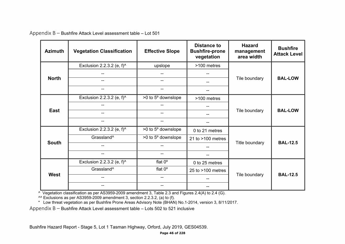
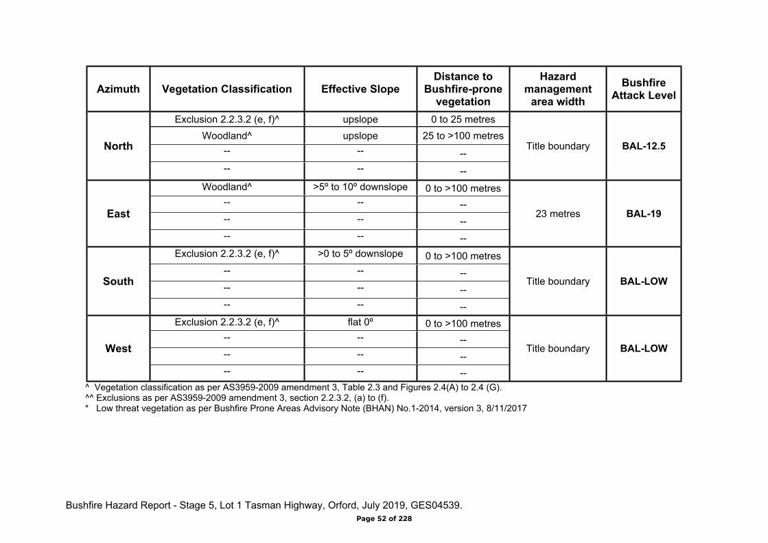
Appendix B – Bushfire Attack Level assessment table – Lot 501
Azimuth Vegetation Classification Effective SlopeDistance to
Bushfire-prone vegetation
Hazard management
area widthBushfire
Attack Level
Exclusion 2.2.3.2 (e, f)^ upslope >100 metres
-- -- ---- -- --
North
-- -- --
Tile boundary BAL-LOW
Exclusion 2.2.3.2 (e, f)^ >0 to 5º downslope >100 metres-- -- ---- -- --
East
-- -- --
Tile boundary BAL-LOW
Exclusion 2.2.3.2 (e, f)^ >0 to 5º downslope 0 to 21 metresGrassland^ >0 to 5º downslope 21 to >100 metres
-- -- --South
-- -- --
Title boundary BAL-12.5
Exclusion 2.2.3.2 (e, f)^ flat 0º 0 to 25 metresGrassland^ flat 0º 25 to >100 metres
-- -- --West
-- -- --
Tile boundary BAL-12.5
^ Vegetation classification as per AS3959-2009 amendment 3, Table 2.3 and Figures 2.4(A) to 2.4 (G).^^ Exclusions as per AS3959-2009 amendment 3, section 2.2.3.2, (a) to (f).* Low threat vegetation as per Bushfire Prone Areas Advisory Note (BHAN) No.1-2014, version 3, 8/11/2017.
Appendix B – Bushfire Attack Level assessment table – Lots 502 to 521 inclusive
Page 46 of 228

Bushfire Hazard Report - Stage 5, Lot 1 Tasman Highway, Orford, July 2019, GES04539.
Azimuth Vegetation Classification Effective SlopeDistance to
Bushfire-prone vegetation
Hazard management
area widthBushfire
Attack Level
Exclusion 2.2.3.2 (e, f)^ upslope >100 metres
-- -- ---- -- --
North
-- -- --
Tile boundary BAL-LOW
Exclusion 2.2.3.2 (e, f)^ >0 to 5º downslope >100 metres-- -- ---- -- --
East
-- -- --
Tile boundary BAL-LOW
Woodland^ >0 to 5º downslope 0 to 18 metresExclusion 2.2.3.2 (e, f)^ >0 to 5º downslope 18 to 35 metres
Grassland^ >0 to 5º downslope 35 to >100 metresSouth
-- -- --
18 metres BAL-19
Exclusion 2.2.3.2 (e, f)^ flat 0º 0 to 25 metresGrassland^ flat 0º 25 to >100 metres
-- -- --West
-- -- --
Tile boundary BAL-12.5
^ Vegetation classification as per AS3959-2009 amendment 3, Table 2.3 and Figures 2.4(A) to 2.4 (G).^^ Exclusions as per AS3959-2009 amendment 3, section 2.2.3.2, (a) to (f).* Low threat vegetation as per Bushfire Prone Areas Advisory Note (BHAN) No.1-2014, version 3, 8/11/2017.
Appendix B – Bushfire Attack Level assessment table – Lots 522 to 528 inclusive
Page 47 of 228
Bushfire Hazard Report - Stage 5, Lot 1 Tasman Highway, Orford, July 2019, GES04539.
Azimuth Vegetation Classification Effective SlopeDistance to
Bushfire-prone vegetation
Hazard management
area widthBushfire
Attack Level
Exclusion 2.2.3.2 (e, f)^ upslope 0 to 70 metresWoodland^ upslope 70 to >100 metres
-- -- --North
-- -- --
Title boundary BAL-12.5
Exclusion 2.2.3.2 (e, f)^ >0 to 5º downslope 0 to 20 metres Grassland^ >0 to 5º downslope 20 to >100 metres
-- -- --East
-- -- --
Title boundary BAL-12.5
Exclusion 2.2.3.2 (e, f)^ >0 to 5º downslope 0 to 21 metresGrassland^ >0 to 5º downslope 21 to >100 metres
-- -- --South
-- -- --
Title boundary BAL-12.5
Exclusion 2.2.3.2 (e, f)^ flat 0º 0 to 25 metresGrassland^ flat 0º 25 to >100 metres
-- -- --West
-- -- --
Title boundary BAL-12.5
^ Vegetation classification as per AS3959-2009 amendment 3, Table 2.3 and Figures 2.4(A) to 2.4 (G).^^ Exclusions as per AS3959-2009 amendment 3, section 2.2.3.2, (a) to (f).* Low threat vegetation as per Bushfire Prone Areas Advisory Note (BHAN) No.1-2014, version 3, 8/11/2017.
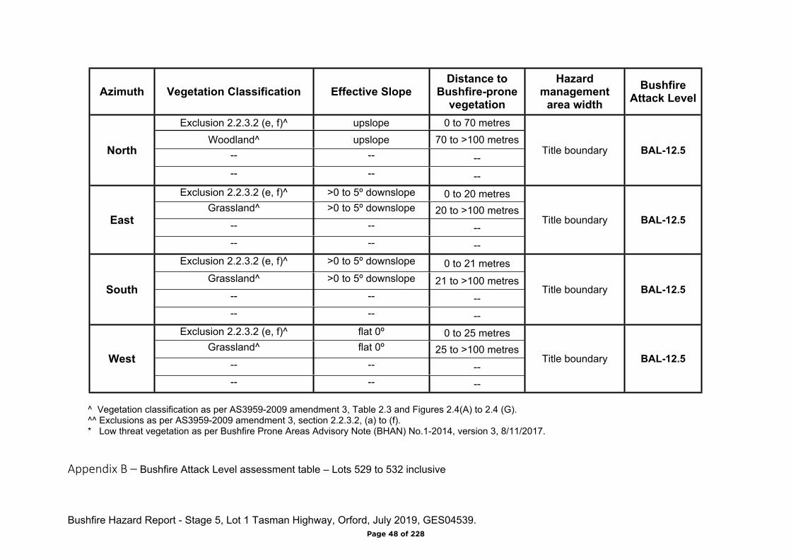
Appendix B – Bushfire Attack Level assessment table – Lots 529 to 532 inclusive
Page 48 of 228

Bushfire Hazard Report - Stage 5, Lot 1 Tasman Highway, Orford, July 2019, GES04539.
Azimuth Vegetation Classification Effective SlopeDistance to
Bushfire-prone vegetation
Hazard management
area widthBushfire
Attack Level
Woodland^ upslope 0 to >100 metres-- -- ---- -- --
North
-- -- --
22 metres BAL-12.5
Exclusion 2.2.3.2 (e, f)^ >0 to 5º downslope 0 to 20 metresGrassland^ >0 to 5º downslope 20 to >100 metres
-- -- --East
-- -- --
Title boundary BAL-12.5
Exclusion 2.2.3.2 (e, f)^ >0 to 5º downslope 0 to >100 metres-- -- ---- -- --
South
-- -- --
Title boundary BAL-LOW
Exclusion 2.2.3.2 (e, f)^ flat 0º 0 to >100 metres-- -- ---- -- --
West
-- -- --
Title boundary BAL-LOW
^ Vegetation classification as per AS3959-2009 amendment 3, Table 2.3 and Figures 2.4(A) to 2.4 (G).^^ Exclusions as per AS3959-2009 amendment 3, section 2.2.3.2, (a) to (f).* Low threat vegetation as per Bushfire Prone Areas Advisory Note (BHAN) No.1-2014, version 3, 8/11/2017.
Appendix B – Bushfire Attack Level assessment table – Lots 542 and 543 inclusive
Page 49 of 228
Bushfire Hazard Report - Stage 5, Lot 1 Tasman Highway, Orford, July 2019, GES04539.
Azimuth Vegetation Classification Effective SlopeDistance to
Bushfire-prone vegetation
Hazard management
area widthBushfire
Attack Level
Woodland^ upslope 0 to >100 metres-- -- ---- -- --
North
-- -- --
22 metres BAL-12.5
Exclusion 2.2.3.2 (e, f)^ >0 to 5º downslope 0 to 40 metresWoodland^ >0 to 5º downslope 40 to >100 metres
-- -- --East
-- -- --
Title boundary BAL-12.5
Exclusion 2.2.3.2 (e, f)^ >0 to 5º downslope 0 to >100 metres-- -- ---- -- --
South
-- -- --
Title boundary BAL-LOW
Woodland^ flat 0º 0 to >100 metres-- -- ---- -- --
West
-- -- --
22 metres BAL-LOW
^ Vegetation classification as per AS3959-2009 amendment 3, Table 2.3 and Figures 2.4(A) to 2.4 (G).^^ Exclusions as per AS3959-2009 amendment 3, section 2.2.3.2, (a) to (f).* Low threat vegetation as per Bushfire Prone Areas Advisory Note (BHAN) No.1-2014, version 3, 8/11/2017.
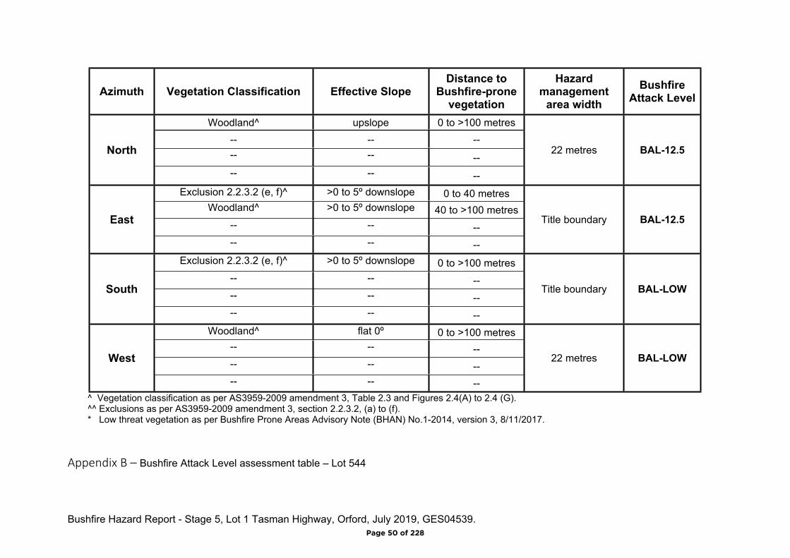
Appendix B – Bushfire Attack Level assessment table – Lot 544
Page 50 of 228
Bushfire Hazard Report - Stage 5, Lot 1 Tasman Highway, Orford, July 2019, GES04539.
Azimuth Vegetation Classification Effective SlopeDistance to
Bushfire-prone vegetation
Hazard management
area widthBushfire
Attack Level
Woodland^ upslope 0 to >100 metres-- -- ---- -- --
North
-- -- --
22 metres BAL-12.5
Woodland^ >5º to 10º downslope 0 to >100 metres-- -- ---- -- --
East
-- -- --
23 metres BAL-19
Exclusion 2.2.3.2 (e, f)^ >0 to 5º downslope 0 to >100 metres-- -- ---- -- --
South
-- -- --
Title boundary BAL-LOW
Exclusion 2.2.3.2 (e, f)^ flat 0º 0 to >100 metres-- -- ---- -- --
West
-- -- --
Title boundary BAL-LOW
^ Vegetation classification as per AS3959-2009 amendment 3, Table 2.3 and Figures 2.4(A) to 2.4 (G).^^ Exclusions as per AS3959-2009 amendment 3, section 2.2.3.2, (a) to (f).* Low threat vegetation as per Bushfire Prone Areas Advisory Note (BHAN) No.1-2014, version 3, 8/11/2017.
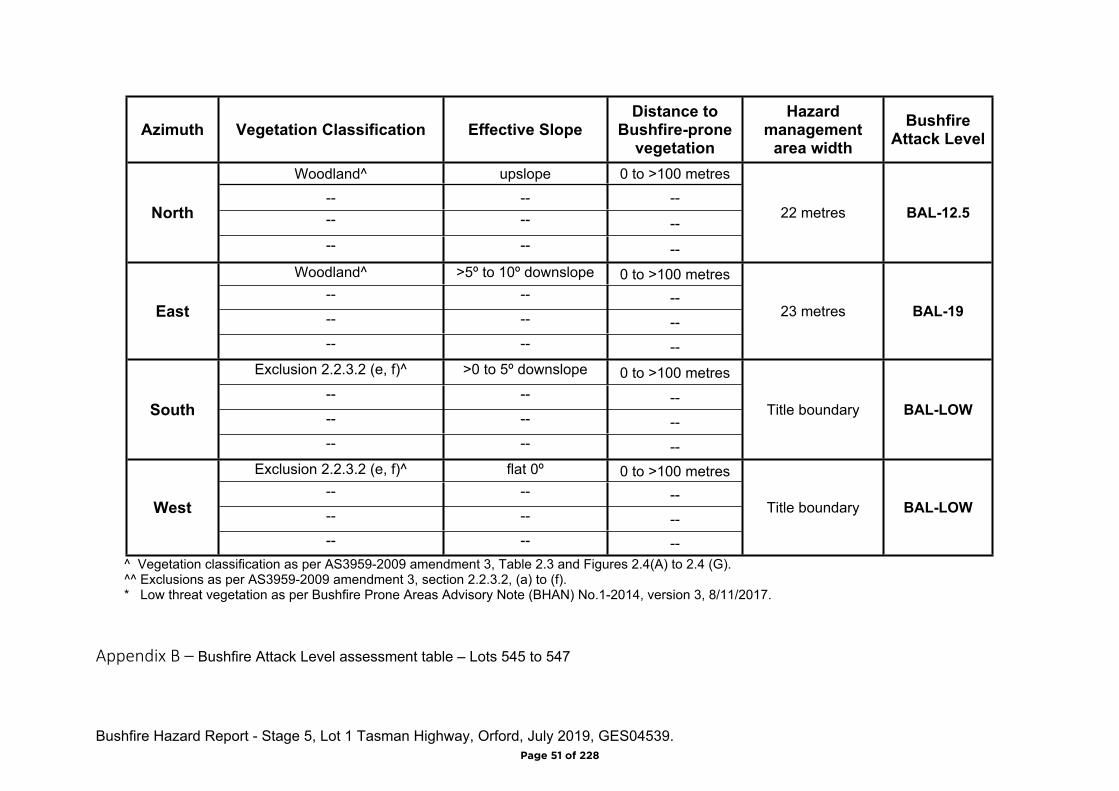
Appendix B – Bushfire Attack Level assessment table – Lots 545 to 547
Page 51 of 228
Bushfire Hazard Report - Stage 5, Lot 1 Tasman Highway, Orford, July 2019, GES04539.
Azimuth Vegetation Classification Effective SlopeDistance to
Bushfire-prone vegetation
Hazard management
area widthBushfire
Attack Level
Exclusion 2.2.3.2 (e, f)^ upslope 0 to 25 metresWoodland^ upslope 25 to >100 metres
-- -- --North
-- -- --
Title boundary BAL-12.5
Woodland^ >5º to 10º downslope 0 to >100 metres-- -- ---- -- --
East
-- -- --
23 metres BAL-19
Exclusion 2.2.3.2 (e, f)^ >0 to 5º downslope 0 to >100 metres-- -- ---- -- --
South
-- -- --
Title boundary BAL-LOW
Exclusion 2.2.3.2 (e, f)^ flat 0º 0 to >100 metres-- -- ---- -- --
West
-- -- --
Title boundary BAL-LOW
^ Vegetation classification as per AS3959-2009 amendment 3, Table 2.3 and Figures 2.4(A) to 2.4 (G).^^ Exclusions as per AS3959-2009 amendment 3, section 2.2.3.2, (a) to (f).* Low threat vegetation as per Bushfire Prone Areas Advisory Note (BHAN) No.1-2014, version 3, 8/11/2017
Page 52 of 228

Bushfire Hazard Report - Stage 5, Lot 1 Tasman Highway, Orford, July 2019, GES04539.
Appendix C
Bushfire Hazard Management Plan
Page 53 of 228
STAGE 5 QUANTITIESSTAGE 5C
-
TOTAL121866
99802
23064
1173
STAGE 5BSTAGE 5A
483
LOT AREAROAD RESERVE AREALINEAL METRES OF ROAD
--
---
32464 36880 29943
GROSS AREA m²
371 319
5301962m²
5292426m²
5141761m² 513
1793m²
5282043m²
5271885m²526
1862m²5251840m²524
1818m²5231810m²522
1828m²5211837m²520
1876m²5191885m²518
2037m²508
2287m²
5072063m²
5062063m²
5052055m²
5042067m²
5031954m²
5021841m²
5011974m²
5121874m² 511
1753m² 5101883m²
5091814m²
5351937m²
5343654m²
5332262m²
5321959m²
5311959m²
5471926m²
5461770m²
5451834m²
5446536m²543
2607m²542
2315m²
5401777m²
5411759m²539
2376m²
5382301m²
5372354m²
5362163m²
5171740m²
5161669m²
5151613m²
35.809
54.78
6
35.809
54.78
6
28.02
3
38.696
54.78
6
44.519
7.537
22.02
3
56.35122.57
48.5
78
51.321 34.13
0
23.767
29.26
9
34.13
0
17.42614.498
63.77
4
9.33719.315
65.24
9
26.471 11.142
59.04
3
29.066
64.47
6
29.094
65.24
9
29.066
63.70
4
29.094
64.47
6
29.066
62.93
2
29.094
63.70
4
29.066
62.16
0
29.094
62.93
2
29.066
62.58
4
24.395 4.669
62.16
0
29.066
63.23
7
29.059
62.58
4
28.912
63.88
7
28.905
63.23
7
29.221
64.54
4
29.21463
.887
29.06665
.197
29.059
64.54
4
19.0065.894
64.23
6
18.742 19.108
65.19
75.894
22.691
65.74
0
21.00420.585
64.23
6
31.375
65.74
0
31.375
65.74
0
31.375
65.74
0
31.375
65.74
0
31.253
65.74
0
31.253
65.74
0
28.691
65.96
8
34.181
65.74
0
26.168
66.26
1
33.315
65.96
8
28.003
66.26
1
28.003
66.26
1
22.167
8.381
46.76
6
18.07
4
22.608
66.26
1
13.95712.796
63.77
4
32.844
62.58
1
5.02421.729
62.58
1
29.598
61.88
830.610
61.88
8
30.602
61.17
0
22.608
61.17
0
37.025
62.33
1
26.042
62.33
1
11.789 23.296
63.45
4
28.93728.937
63.45
4
51.873
8.485
57.45
4
41.611
48.78
6
8.485 35.611
54.78
6
10.16125.592
54.78
6
35.752
54.78
6
35.752
54.78
6
35.752
54.78
6
63.975
29.36
2
41.61125.592
29.53
9
60.780
27.36
2
63.975
29.53
9
58.243
25.36
2
60.780
7.975
28.81
0
7.943
15.559
15.559
12.900
16.77814.831
18.676
2.7339.220
77.32
7
23.225 8.485
58.243
28.60
9
20.013
19.995
62.66
7
37.225
77.32
7
7.040
25.475
15.889
5.682
19.51
4
55.914
11.643
62.66
7
8.48522.93728.937
61.41
7
28.93728.937
55.41
7
61.41
7
5.454
19.1162.271
65.73
9
22.608 26.042
61.41
7
2.271
30.799
70.82
75.024
30.610
65.73
9
9.94021.475
69.37
8
13.95721.729
70.82
7
29.473
32.00
5
32.02
7
23.76712.796
69.37
8
53.080
9.38114
.552
8.023
56.030
32.00
556.030
9.450
19.12
4
55.452 32.02
7
55.452
28.57
4
56.351 29.26
9
0 8040
SCALE IN METRES - 1:2000
6020 20
L O U I S V I L L E R O A D
N E W
R O
A D
B E R N A C C H I D R I V E
GD1917-P7 2-
-BAYPORT PTY LTDSPRING BAY
LAND DEVELOPMENTSUBDIVISION STAGE 5
LOT PLAN
R. GIBSON R. GIBSON R. GIBSON 11/5/2019
21-6-19 AHD 1 VEGETATION ADDED2 LOTS ADDED
REFERENCE FILES ATTACHED: GD1917-X3; GD1917-X1; GD1917-X2; GD1917-X4
DATE SIGNEDJun. 21, 19 - 19:45:26 Name: GD1917-P7.dwg Updated By: Ross gibson
DRAWING REVISION HISTORY
DATUMS:
REVISION DESCRIPTION
STATUS
REVIEWED DATEDRAWN DESIGNED
SIGNEDDRAWING No.
TITLE
CLIENT
PROJECT
CLIENT No.
REVISION
VERSIONSHEET No.ANDY HAMILTON & ASSOCIATES PTY LTDCONSULTING LAND SURVEYORS
PO Box 223 Bicheno 7215P: 0418 593 300 E: [email protected]
STAGE 5B
STAGE 5C
STAGE 5A LEGENDBIODIVERSITY PROTECTIONAREA OVERLAY PERPLANNING SCHEME
501BAL-12.5
502BAL-19
505BAL-19
508BAL-19
507BAL-19
506BAL-19
504BAL-19
503BAL-19
509BAL-12.5
510BAL-12.5
511BAL-12.5
512BAL-12.5
513BAL-12.5 514
BAL-12.5
515BAL-12.5
516BAL-12.5
517BAL-12.5
518BAL-19
520BAL-19 519
BAL-19
521BAL-19
522BAL-12.5
523BAL-12.5
524BAL-12.5
525BAL-12.5
528BAL-12.5
527BAL-12.5 526
BAL-12.5
529BAL-12.5 530
BAL-12.5 531BAL-12.5 532
BAL-12.5 533BAL-12.5 534
BAL-12.5 535BAL-12.5
536BAL-12.5 537
BAL-12.5 538BAL-12.5
539BAL-12.5
540BAL-12.5
541BAL-12.5
542BAL-12.5
543BAL-12.5
544BAL-19
545BAL-19
546BAL-19
547BAL-19
BUSHFIRE HAZARD MANAGEMENT PLANBushfire Hazard Management Plan, Stage 5, Lot 1 Tasman
Highway, Orford. June 2019 GES04539Glamorgan-Spring Bay Interim Planning Scheme 2015
Hazard Management Area
BAL-19 building area
BAL-12.5 building area
Notes:
A. This plan must be read in conjunction with theBushfire Hazard Report Lot 1 Tasman Highway, Orford,Stage 5. June 2019. GES045939 prepared byGeo-Environmental Solutions.
B. Plan prepared for compliance with theGlamorgan-Spring Bay Interim Planning Scheme 2015.Code E1. Bushfire-prone Areas Code.
Hazard Management AreaIs to be managed in a minimum fuel condition. This means thereis insufficient fuel available to significantly increase the severity ofthe bushfire attack.Guidance•Hazard management area to be maintained in a minimum fuelcondition. Locate fire hazards such as wood piles, rubbish heapsand stored fuels away from habitable buildings.•The area directly adjacent to the building has a significantamount of flammable material removed such that there is little tono material available to burn around the building;•Includes non flammable areas such as paths, driveways, shortcropped lawns;•Establishing orchards, vegetable gardens, dams or waste watereffluent disposal areas on the fire prone side of the buildingwhere practical;•Create wind breaks and radiation shields such as noncombustible fences and low flammability hedges;•Create and maintain vertical as well as horizontal separationbetween ground fuels and tree canopies by pruning;•It is not necessary to remove all vegetation from the defendablespace, trees can provide protection from wind borne embers andradiant heat under some circumstances.
Building Specifications toBAL-19 & BAL-12.5
of AS3959-2018 as shown.
Certification No. GES04539
Mark Van den BergAcc. No. BFP-108
Scope 1, 2, 3A, 3B, 3C.
Page 1 of 2
18m
18m
18m
22m22m
23m
23m
23m
22m
22m
4m
4m
18m
m
22m
CT: 139972/1PID: 2549195
Page 54 of 228
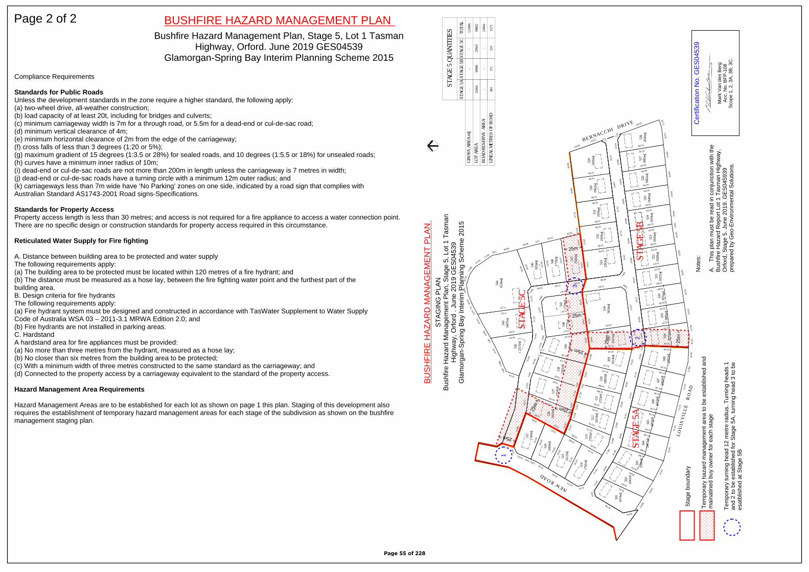
Compliance Requirements
Standards for Public RoadsUnless the development standards in the zone require a higher standard, the following apply: (a) two-wheel drive, all-weather construction; (b) load capacity of at least 20t, including for bridges and culverts; (c) minimum carriageway width is 7m for a through road, or 5.5m for a dead-end or cul-de-sac road; (d) minimum vertical clearance of 4m; (e) minimum horizontal clearance of 2m from the edge of the carriageway; (f) cross falls of less than 3 degrees (1:20 or 5%); (g) maximum gradient of 15 degrees (1:3.5 or 28%) for sealed roads, and 10 degrees (1:5.5 or 18%) for unsealed roads; (h) curves have a minimum inner radius of 10m; (i) dead-end or cul-de-sac roads are not more than 200m in length unless the carriageway is 7 metres in width; (j) dead-end or cul-de-sac roads have a turning circle with a minimum 12m outer radius; and (k) carriageways less than 7m wide have ‘No Parking’ zones on one side, indicated by a road sign that complies with Australian Standard AS1743-2001 Road signs-Specifications.
Standards for Property AccessProperty access length is less than 30 metres; and access is not required for a fire appliance to access a water connection point.There are no specific design or construction standards for property access required in this circumstance.
Reticulated Water Supply for Fire fighting
A. Distance between building area to be protected and water supply The following requirements apply: (a) The building area to be protected must be located within 120 metres of a fire hydrant; and (b) The distance must be measured as a hose lay, between the fire fighting water point and the furthest part of the building area. B. Design criteria for fire hydrants The following requirements apply: (a) Fire hydrant system must be designed and constructed in accordance with TasWater Supplement to Water Supply Code of Australia WSA 03 – 2011-3.1 MRWA Edition 2.0; and (b) Fire hydrants are not installed in parking areas. C. HardstandA hardstand area for fire appliances must be provided: (a) No more than three metres from the hydrant, measured as a hose lay; (b) No closer than six metres from the building area to be protected; (c) With a minimum width of three metres constructed to the same standard as the carriageway; and (d) Connected to the property access by a carriageway equivalent to the standard of the property access.
Hazard Management Area Requirements
Hazard Management Areas are to be established for each lot as shown on page 1 this plan. Staging of this development alsorequires the establishment of temporary hazard management areas for each stage of the subdivision as shown on the bushfiremanagement staging plan.
Page 2 of 2 BUSHFIRE HAZARD MANAGEMENT PLANBushfire Hazard Management Plan, Stage 5, Lot 1 Tasman
Highway, Orford. June 2019 GES04539Glamorgan-Spring Bay Interim Planning Scheme 2015
STAG
E 5 Q
UANT
ITIE
SST
AGE
5C
-
TOTA
L12
1866
9980
2
2306
4
1173
STAG
E 5B
STAG
E 5A
483
LOT
AREA
ROAD
RES
ERVE
ARE
ALIN
EAL M
ETRE
S OF
ROA
D-
-
--
-
3246
436
880
2994
3
GROS
S AR
EA m
²
371
319
530
1962
m²
529
2426
m²
514
1761
m²51
317
93m²
528
2043
m²52
718
85m²
526
1862
m²52
518
40m²
524
1818
m²52
318
10m²
522
1828
m²52
118
37m²
520
1876
m²51
918
85m²
518
2037
m²50
822
87m²
507
2063
m²
506
2063
m²
505
2055
m²
504
2067
m²
503
1954
m²
502
1841
m²
501
1974
m²
512
1874
m²51
117
53m²
510
1883
m²50
918
14m²
535
1937
m²
534
3654
m²
533
2262
m²
532
1959
m²
531
1959
m²
547
1926
m²
546
1770
m²
545
1834
m²
544
6536
m²54
326
07m²
542
2315
m²
540
1777
m²
541
1759
m²53
923
76m²
538
2301
m²
537
2354
m²
536
2163
m²
517
1740
m²
516
1669
m²
515
1613
m²35
.809
54.786
35.80
9
54.786
28.023
38.69
6
54.786
44.51
9
7.53722.023
56.35
1
22.5748.578
51.32
1
34.130
23.76
7
29.269
34.130
17.42
614
.498
63.774
9.337
19.31
5
65.249
26.47
111
.142
59.043
29.06
6
64.476
29.09
4
65.249
29.06
6
63.704
29.09
4
64.476
29.06
6
62.932
29.09
4
63.704
29.06
6
62.160
29.09
4
62.932
29.06
6
62.584
24.39
54.6
69
62.160
29.06
6
63.237
29.05
9
62.584
28.91
2
63.887
28.90
5
63.237
29.22
1
64.544
29.21
4
63.887
29.06
6
65.197
29.05
9
64.544
19.00
65.8
94
64.236
18.74
219
.108
65.197
5.894
22.69
1
65.740 21.00
420
.585
64.236
31.37
5
65.740
31.37
5
65.740
31.37
5
65.740
31.37
5
65.740
31.25
3
65.740
31.25
3
65.740
28.69
1
65.968
34.18
1
65.740
26.16
8
66.261
33.31
5
65.968
28.00
3
66.261
28.00
3
66.261
22.16
7
8.381
46.766
18.074
22.60
8
66.261
13.95
712
.796
63.774 32.84
4
62.581
5.024
21.72
9
62.581 29.59
8
61.888
30.61
0
61.888
30.60
2
61.170
22.60
8
61.170
37.02
5
62.331
26.04
2
62.331
11.78
923
.296
63.454
28.93
728
.937
63.454
51.87
3
8.48557.454
41.61
1
48.786
8.485
35.61
1
54.786
10.16
125
.592
54.786
35.75
2
54.786
35.75
2
54.786
35.75
2
54.786
63.97
5
29.362
41.61
125
.592
29.539
60.78
0
27.362
63.97
5
29.539
58.24
3
25.362
60.78
0
7.97528.810
7.943
15.559
15.559
12.90
0
16.77
814
.831
18.67
6
2.733
9.220 77.327
23.22
58.4
85
58.24
3
28.609
20.01
3
19.99
5
62.667
37.22
5
77.327
7.040
25.47
5
15.88
9
5.682
19.514
55.91
4
11.64
3
62.667
8.485
22.93
728
.937
61.417
28.93
728
.937
55.417
61.417
5.454
19.11
6
2.271
65.739 22.60
826
.042
61.417
2.271
30.79
9
70.827
5.024
30.61
0
65.739
9.940
21.47
5
69.378
13.95
721
.729
70.827
29.47
3
32.005
32.027 23.76
712
.796
69.378
53.08
0
9.381
14.552
8.023
56.03
0
32.005
56.03
0
9.450
19.124
55.45
2
32.027
55.45
2
28.574
56.35
1
29.269 L O U
I S V
I L L
E
R O
A D
N E W R O A D
B E R N A C C H I D R I V E
STAG
E 5B
STAG
E 5C
STAG
E 5A
LEGE
NDBI
ODIV
ERSI
TY P
ROTE
CTIO
NAR
EA O
VERL
AY P
ERPL
ANNI
NG S
CHEM
E
25m
25m
25m
25m
25m
25m
1
2
3
Sta
ge b
ound
ary
25m
25m
Tem
pora
ry h
azar
d m
anag
emen
t are
a to
be
esta
blis
hed
and
mai
natin
ed b
uy o
wne
r fo
r ea
ch s
tage
Tem
pora
ry tu
rnin
g he
ad 1
2 m
etre
rad
ius.
Tur
ning
hea
ds 1
and
2 to
be
esta
blis
hed
for
Sta
ge 5
A, t
urni
ng h
ead
3 to
be
esat
blis
hed
at S
tage
5B
Cer
tific
atio
n N
o. G
ES
0453
9
Mar
k V
an d
en B
erg
Acc
. No.
BFP
-108
Sco
pe 1
, 2, 3
A, 3
B, 3
C.
BU
SH
FIR
E H
AZ
AR
D M
AN
AG
EM
EN
T P
LAN
STA
GIN
G P
LAN
Bus
hfire
Haz
ard
Man
agem
ent P
lan,
Sta
ge 5
, Lot
1 T
asm
anH
ighw
ay, O
rford
. Ju
ne 2
019
GE
S04
539
Gla
mor
gan-
Spr
ing
Bay
Inte
rim P
lann
ing
Sch
eme
2015
Not
es:
A.
Thi
s pl
an m
ust b
e re
ad in
con
junc
tion
with
the
Bus
hfire
Haz
ard
Rep
ort L
ot 1
Tas
man
Hig
hway
,O
rfor
d, S
tage
5. J
une
2019
. GE
S04
5939
pr
epar
ed b
y G
eo-E
nviro
nmen
tal S
olut
ions
.
542
2315
m²
Page 55 of 228

Bushfire Hazard Report - Stage 5, Lot 1 Tasman Highway, Orford, July 2019, GES04539.
Appendix D
Planning Certificate
Page 56 of 228
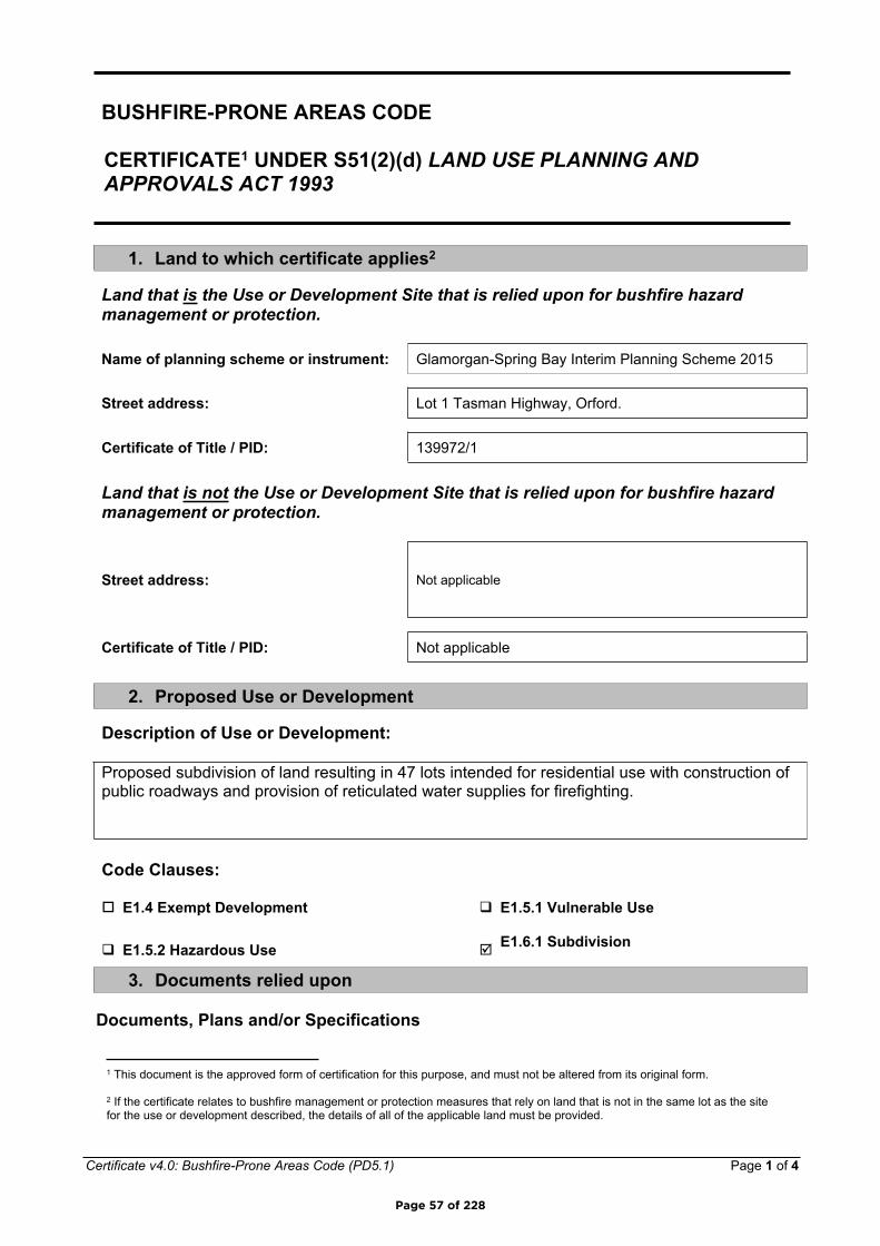
Certificate v4.0: Bushfire-Prone Areas Code (PD5.1) Page 1 of 4
BUSHFIRE-PRONE AREAS CODE
CERTIFICATE1 UNDER S51(2)(d) LAND USE PLANNING AND APPROVALS ACT 1993
1. Land to which certificate applies2
Land that is the Use or Development Site that is relied upon for bushfire hazard management or protection.
Name of planning scheme or instrument: Glamorgan-Spring Bay Interim Planning Scheme 2015
Street address: Lot 1 Tasman Highway, Orford.
Certificate of Title / PID: 139972/1
Land that is not the Use or Development Site that is relied upon for bushfire hazard management or protection.
Street address: Not applicable
Certificate of Title / PID: Not applicable
2. Proposed Use or Development
Description of Use or Development:
Proposed subdivision of land resulting in 47 lots intended for residential use with construction of public roadways and provision of reticulated water supplies for firefighting.
Code Clauses:
E1.4 Exempt Development E1.5.1 Vulnerable Use
E1.5.2 Hazardous Use E1.6.1 Subdivision
3. Documents relied upon
Documents, Plans and/or Specifications
1 This document is the approved form of certification for this purpose, and must not be altered from its original form.
2 If the certificate relates to bushfire management or protection measures that rely on land that is not in the same lot as the site for the use or development described, the details of all of the applicable land must be provided.
Page 57 of 228

Certificate v4.0: Bushfire-Prone Areas Code (PD5.1) Page 2 of 4
Title: Plan of Sub-division. Spring Bay Development
Author: Ross Gibson
Date: 21/06/2019 Version: GD1917-P7
Bushfire Hazard Report
Title: Bushfire Hazard Report Stage 5, Lot 1 Tasman Highway, Orford. June 2019. GES045939
Author: Mark Van den Berg (Geo Environmental Solutions)
Date: June 2019 Version: 1
Bushfire Hazard Management Plan
Title: Bushfire hazard Management Plan , Lot 1 Tasman Highway, Orford. June 2019. GES045939
Author: Mark Van den Berg (Geo Environmental Solutions)
Date: June 2019 Version: 1
Other Documents
Title:
Author:
Date: Version:
Page 58 of 228
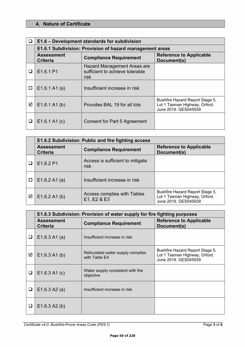
Certificate v4.0: Bushfire-Prone Areas Code (PD5.1) Page 3 of 4
4. Nature of Certificate
E1.6 – Development standards for subdivisionE1.6.1 Subdivision: Provision of hazard management areasAssessment Criteria Compliance Requirement Reference to Applicable
Document(s)
E1.6.1 P1Hazard Management Areas are sufficient to achieve tolerable risk
E1.6.1 A1 (a) Insufficient increase in risk
E1.6.1 A1 (b) Provides BAL 19 for all lotsBushfire Hazard Report Stage 5, Lot 1 Tasman Highway, Orford. June 2019. GES045939
E1.6.1 A1 (c) Consent for Part 5 Agreement
E1.6.2 Subdivision: Public and fire fighting accessAssessment Criteria Compliance Requirement Reference to Applicable
Document(s)
E1.6.2 P1 Access is sufficient to mitigate risk
E1.6.2 A1 (a) Insufficient increase in risk
E1.6.2 A1 (b) Access complies with Tables E1, E2 & E3
Bushfire Hazard Report Stage 5, Lot 1 Tasman Highway, Orford. June 2019. GES045939
E1.6.3 Subdivision: Provision of water supply for fire fighting purposesAssessment Criteria Compliance Requirement Reference to Applicable
Document(s)
E1.6.3 A1 (a) Insufficient increase in risk
E1.6.3 A1 (b) Reticulated water supply complies with Table E4
Bushfire Hazard Report Stage 5, Lot 1 Tasman Highway, Orford. June 2019. GES045939
E1.6.3 A1 (c) Water supply consistent with the objective
E1.6.3 A2 (a) Insufficient increase in risk
E1.6.3 A2 (b)
Page 59 of 228

Certificate v4.0: Bushfire-Prone Areas Code (PD5.1) Page 4 of 4
E1.6.3 A2 (c)
5. Bushfire Hazard Practitioner3
Name: Mark Van den Berg Phone No: 03 62231839
Address: 29 Kirksway Place Fax No: N/A
Battery Point Email Address:
Tasmania 7004
Accreditation No: BFP – 108 Scope: 1, 2, 3a, 3b, 3c.
6. Certification
I, certify that in accordance with the authority given under Part 4A of the Fire Service Act 1979 –
The use or development described in this certificate is exempt from application of Code E1 – Bushfire-Prone Areas in accordance with Clause E1.4 (a) because there is an insufficient increase in risk to the use or development from bushfire to warrant any specific bushfire protection measure in order to be consistent with the objectives for all the applicable standards identified in Section 4 of this Certificate.
or
There is an insufficient increase in risk from bushfire to warrant the provision of specific measures for bushfire hazard management and/or bushfire protection in order for the use or development described to be consistent with the objective for each of the applicable standards identified in Section 4 of this Certificate.
and/or
The Bushfire Hazard Management Plan/s identified in Section 3 of this certificate is/are in accordance with the Chief Officer’s requirements and can deliver an outcome for the use or development described that is consistent with the objective and the relevant compliance test for each of the applicable standards identified in Section 4 of this Certificate.
Signed:certifier
Date: 28/06/2019 Certificate No: GES04539
3 A Bushfire Hazard Practitioner is a person accredited by the Chief Officer of the Tasmania Fire Service under Part IVA of Fire Service Act 1979. The list of practitioners and scope of work is found at www.fire.tas.gov.au.
Page 60 of 228

Bushfire Hazard Report - Stage 5, Lot 1 Tasman Highway, Orford, July 2019, GES04539.
Appendix E
Certificate of Others (form 55)
Page 61 of 228

Director of Building Control – Date Approved 1 July 2017 Building Act 2016 - Approved Form No. 55
CERTIFICATE OF QUALIFIED PERSON – ASSESSABLE ITEM Section 321
To: Bay Port Pty. Ltd. Owner /Agent
55 Colemans Road Address
Carrum Downs Vic. 3201 Suburb/postcode
Qualified person details:
Qualified person: Mark Van den BergAddress: 29 Kirksway Place Phone No: 03 6223 1839
Battery Point 7004 Fax No:
Licence No: Email address: [email protected]
Accredited to report on bushfire hazards under Part IVA of the Fire Service Act. BFP-108 scope 1, 2, 3a, 3b, 3c.Besso PI policy No. 10780170
Qualifications and Insurance details:
(description from Column 3 of the Director's Determination - Certificates by Qualified Persons for Assessable Items
Speciality area of expertise:
Analysis of bushfire hazards in bushfire prone areas
(description from Column 4 of the Director's Determination - Certificates by Qualified Persons for Assessable Items)
Details of work:
Address: Lot 1 Tasman Highway Lot No: 1Orford, Tas. 7190 Certificate of title No: 139972/1
The assessable item related to this certificate:
New building work in a bushfire prone area.
(description of the assessable item being certified) Assessable item includes – - a material;- a design- a form of construction- a document- testing of a component, building
system or plumbing system- an inspection, or assessment,
performed
Certificate details:
Certificate type: Bushfire Hazard (description from Column 1 of Schedule 1 of the Director's Determination - Certificates by Qualified Persons for Assessable Items n)
This certificate is in relation to the above assessable item, at any stage, as part of - (tick one)
building work, plumbing work or plumbing installation or demolition work: Xor
a building, temporary structure or plumbing installation:
Form 55
Page 62 of 228
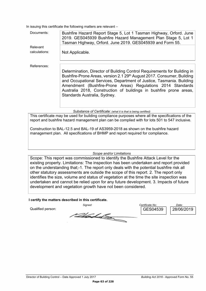
Director of Building Control – Date Approved 1 July 2017 Building Act 2016 - Approved Form No. 55
In issuing this certificate the following matters are relevant –
Documents: Bushfire Hazard Report Stage 5, Lot 1 Tasman Highway, Orford. June 2019. GES045939 Bushfire Hazard Management Plan Stage 5, Lot 1 Tasman Highway, Orford. June 2019. GES045939 and Form 55.
Relevantcalculations: Not Applicable.
References:Determination, Director of Building Control Requirements for Building in Bushfire-Prone Areas, version 2.1 29th August 2017. Consumer, Building and Occupational Services, Department of Justice, Tasmania. Building Amendment (Bushfire-Prone Areas) Regulations 2014 Standards Australia 2018, Construction of buildings in bushfire prone areas, Standards Australia, Sydney.
Substance of Certificate: (what it is that is being certified)This certificate may be used for building compliance purposes where all the specifications of the report and bushfire hazard management plan can be complied with for lots 501 to 547 inclusive.
Construction to BAL-12.5 and BAL-19 of AS3959-2018 as shown on the bushfire hazard management plan. All specifications of BHMP and report required for compliance.
Scope and/or LimitationsScope: This report was commissioned to identify the Bushfire Attack Level for the existing property. Limitations: The inspection has been undertaken and report provided on the understanding that;-1. The report only deals with the potential bushfire risk all other statutory assessments are outside the scope of this report. 2. The report only identifies the size, volume and status of vegetation at the time the site inspection was undertaken and cannot be relied upon for any future development. 3. Impacts of future development and vegetation growth have not been considered.
I certify the matters described in this certificate.Signed: Certificate No: Date:
Qualified person: GES04539 28/06/2019
Page 63 of 228
SUBDIVISION SITE ASSESSMENT
Lot 1 Tasman Highway, Orford
Geo-Environmental Solutions P/L 29 Kirksway Place, Battery Point.
T | 6223 1839 E | [email protected]
June 2019
Page 64 of 228
GES – Geotechnical Assessment – Lot 1 Tasman Highway Orford
© GES P/L 2019 1
Contents 1. Introduction .................................................................................................................. 2
2. Planning Context ........................................................................................................ 4
3. Site Information ........................................................................................................... 6
3.1 Geology .................................................................................................................... 6 3.1 Soil Distribution ....................................................................................................... 6
4. Site Suitability for Onsite Wastewater Disposal .................................................... 8
5. Conclusions ............................................................................................................... 15 Appendix 1 –Trench summary reports ......................................................................... 16
Appendix 2 – Bore Logs ................................................................................................. 19 Appendix 3 – Test Hole Locations ................................................................................ 25
Appendix 4 – Building Act 2016 Compliance .............................................................. 26
Page 65 of 228

GES – Geotechnical Assessment – Lot 1 Tasman Highway Orford
© GES P/L 2019 2
1. Introduction The proposed subdivision site is located at Lot 1 Tasman Highway in the locality of Orford, Tasmania (C.T. 139972/1). The total current land area of the subdivision is approximately 12.24ha, of which it is proposed to create forty seven (47) new residential lots with a minimum area of approximately 1600m2 (please refer to appendix 2 – development plans). The site is not serviced with mains sewer, therefore onsite wastewater disposal would be required on the lots (see Figure 1 for study area).
Figure 1.0 – Whole Site Location (blue) with proposed subdivision area outlined (red)
Page 66 of 228
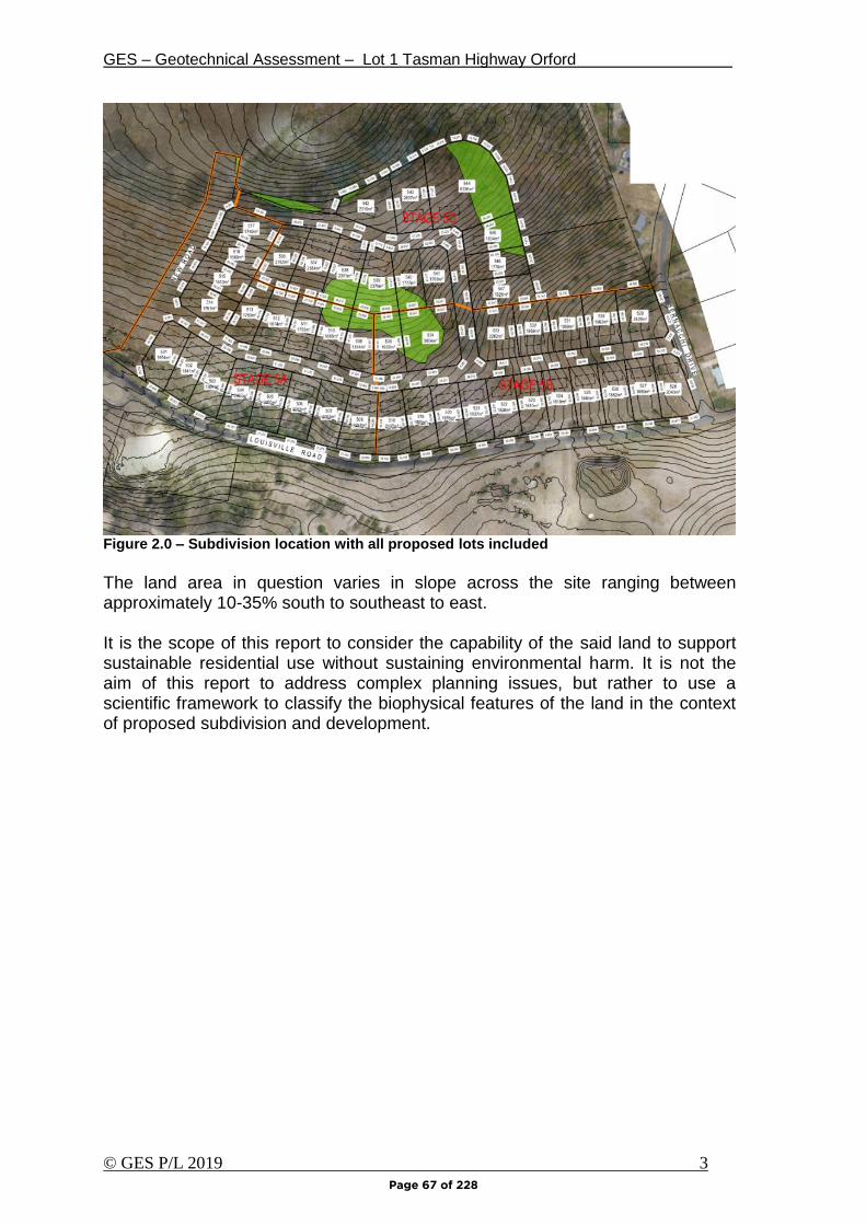
GES – Geotechnical Assessment – Lot 1 Tasman Highway Orford
© GES P/L 2019 3
Figure 2.0 – Subdivision location with all proposed lots included
The land area in question varies in slope across the site ranging between approximately 10-35% south to southeast to east. It is the scope of this report to consider the capability of the said land to support sustainable residential use without sustaining environmental harm. It is not the aim of this report to address complex planning issues, but rather to use a scientific framework to classify the biophysical features of the land in the context of proposed subdivision and development.
Page 67 of 228
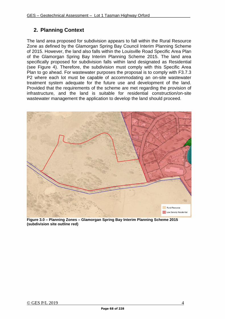
GES – Geotechnical Assessment – Lot 1 Tasman Highway Orford
© GES P/L 2019 4
2. Planning Context
The land area proposed for subdivision appears to fall within the Rural Resource Zone as defined by the Glamorgan Spring Bay Council Interim Planning Scheme of 2015. However, the land also falls within the Louisville Road Specific Area Plan of the Glamorgan Spring Bay Interim Planning Scheme 2015. The land area specifically proposed for subdivision falls within land designated as Residential (see Figure 4). Therefore, the subdivision must comply with this Specific Area Plan to go ahead. For wastewater purposes the proposal is to comply with F3.7.3 P2 where each lot must be capable of accommodating an on-site wastewater treatment system adequate for the future use and development of the land. Provided that the requirements of the scheme are met regarding the provision of infrastructure, and the land is suitable for residential construction/on-site wastewater management the application to develop the land should proceed.
Figure 3.0 – Planning Zones – Glamorgan Spring Bay Interim Planning Scheme 2015 (subdivision site outline red)
Page 68 of 228
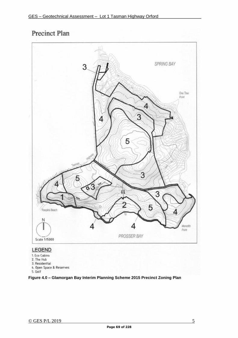
GES – Geotechnical Assessment – Lot 1 Tasman Highway Orford
© GES P/L 2019 5
Figure 4.0 – Glamorgan Bay Interim Planning Scheme 2015 Precinct Zoning Plan
Page 69 of 228
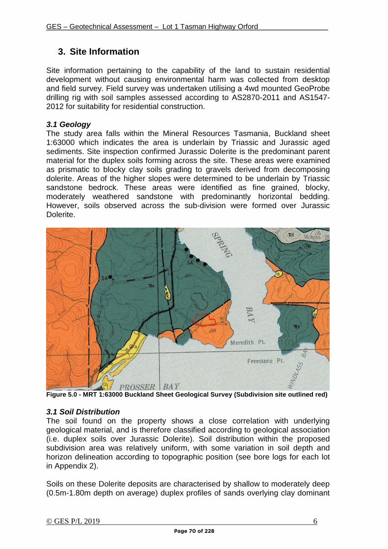
GES – Geotechnical Assessment – Lot 1 Tasman Highway Orford
© GES P/L 2019 6
3. Site Information Site information pertaining to the capability of the land to sustain residential development without causing environmental harm was collected from desktop and field survey. Field survey was undertaken utilising a 4wd mounted GeoProbe drilling rig with soil samples assessed according to AS2870-2011 and AS1547-2012 for suitability for residential construction. 3.1 Geology The study area falls within the Mineral Resources Tasmania, Buckland sheet 1:63000 which indicates the area is underlain by Triassic and Jurassic aged sediments. Site inspection confirmed Jurassic Dolerite is the predominant parent material for the duplex soils forming across the site. These areas were examined as prismatic to blocky clay soils grading to gravels derived from decomposing dolerite. Areas of the higher slopes were determined to be underlain by Triassic sandstone bedrock. These areas were identified as fine grained, blocky, moderately weathered sandstone with predominantly horizontal bedding. However, soils observed across the sub-division were formed over Jurassic Dolerite.
Figure 5.0 - MRT 1:63000 Buckland Sheet Geological Survey (Subdivision site outlined red)
3.1 Soil Distribution The soil found on the property shows a close correlation with underlying geological material, and is therefore classified according to geological association (i.e. duplex soils over Jurassic Dolerite). Soil distribution within the proposed subdivision area was relatively uniform, with some variation in soil depth and horizon delineation according to topographic position (see bore logs for each lot in Appendix 2). Soils on these Dolerite deposits are characterised by shallow to moderately deep (0.5m-1.80m depth on average) duplex profiles of sands overlying clay dominant
Page 70 of 228
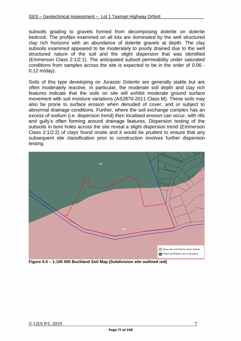
GES – Geotechnical Assessment – Lot 1 Tasman Highway Orford
© GES P/L 2019 7
subsoils grading to gravels formed from decomposing dolerite on dolerite bedrock. The profiles examined on all lots are dominated by the well structured clay rich horizons with an abundance of dolerite gravels at depth. The clay subsoils examined appeared to be moderately to poorly drained due to the well structured nature of the soil and the slight dispersion that was identified (Emmerson Class 2:1/2:1). The anticipated subsoil permeability under saturated conditions from samples across the site is expected to be in the order of 0.06 -0.12 m/day).
Soils of this type developing on Jurassic Dolerite are generally stable but are often moderately reactive. In particular, the moderate soil depth and clay rich features indicate that the soils on site will exhibit moderate ground surface movement with soil moisture variations (AS2870-2011 Class M). These soils may also be prone to surface erosion when denuded of cover, and or subject to abnormal drainage conditions. Further, where the soil exchange complex has an excess of sodium (i.e. dispersion trend) then localised erosion can occur, with rills and gully’s often forming around drainage features. Dispersion testing of the subsoils in bore holes across the site reveal a slight dispersion trend (Emmerson Class 2:1/2:2) of clays found onsite and it would be prudent to ensure that any subsequent site classification prior to construction involves further dispersion testing.
Figure 6.0 – 1:100 000 Buckland Soil Map (Subdivision site outlined red)
Page 71 of 228

GES – Geotechnical Assessment – Lot 1 Tasman Highway Orford
© GES P/L 2019 8
4. Site Suitability for Onsite Wastewater Disposal The soils across the subdivision site were compared and classified according to AS/NZS1547-2012 (on-site wastewater management). Bore logs for each profile based upon onsite geotechnical drilling is presented in Appendix 2 whilst site and soil factors pertinent to wastewater disposal under AS1547-2012 are presented in Table 1 overleaf. The soils across the site area classified according to AS1547-2012 as Category 5 Light Clay with lower Long Term Acceptance Rates (LTAR’s). Due to the variable duplex soils on site it is recommend that appropriate application rates be assigned (refer to Table 1). Modelling utilising the planning scheme typical three bedroom house on mains water with standard plumbing fixtures indicates that a disposal area of up to 500m2 (250m2 installed and 250m2 reserve) should be set aside wastewater disposal on each lot (see trench summary report attached). Based upon allowances for adequate down slope boundary setbacks and sufficient construction, access, and recreational space, then I recommend that a minimum area available for wastewater disposal of flow from any future dwelling to be 1500m2 would be adequate for subdivision design. It should be noted that this area is based upon the installation of an AWTS or similar packaged system on each lot, with irrigation (using a Design Irrigation Rate DIR of 3mm/day). However, some of the areas examined would also be suitable for traditional septic tank and absorption trench systems, with a typical total disposal area of up to 200m2 (100m2 installed and 100m2 reserve) required on each lot for a typical three bedroom home (based upon a Design Loading Rate DLR of 7L/m2/day). Soil depth does vary across the lots ranging from approximately 0.8m to over 2m, and as such wastewater designs on each lot will need to consider soil depth and separation distances to the underlying limiting layer. On the lots where soil depth is less than 1m, if a traditional septic tank system is to be used the design will require incorporation of secondary treatment via a geotextile sand filter similar to achieve the required vertical setback to rock (i.e. 0.5m minimum). The addition of soil and/or terracing may also be required to achieve and appropriate absorption area with compliant setbacks. Nutrient balance and sustainable wastewater application The soils across the entire site are developed from Jurassic Dolerite with moderate to high cation exchange complex in the clay subsoils. The subsoil clays returned slight dispersive results to all Emerson dispersion tests (Trench assigned value of “2”). The soils examined are also moderately to well structured and clay minerals and a moderate to high estimated Cation Exchange Capacity (CEC) at depth. Therefore, the soils have a moderate ability to retain applied nutrients in wastewater and the risk of nutrient attenuation associated with wastewater application is low. Furthermore, it is recommended that adequate dispersion testing and soil classification is undertaken in proposed disposal areas on each lot to ensure the predicted soil behaviour and effluent disposal standards are met.
Page 72 of 228
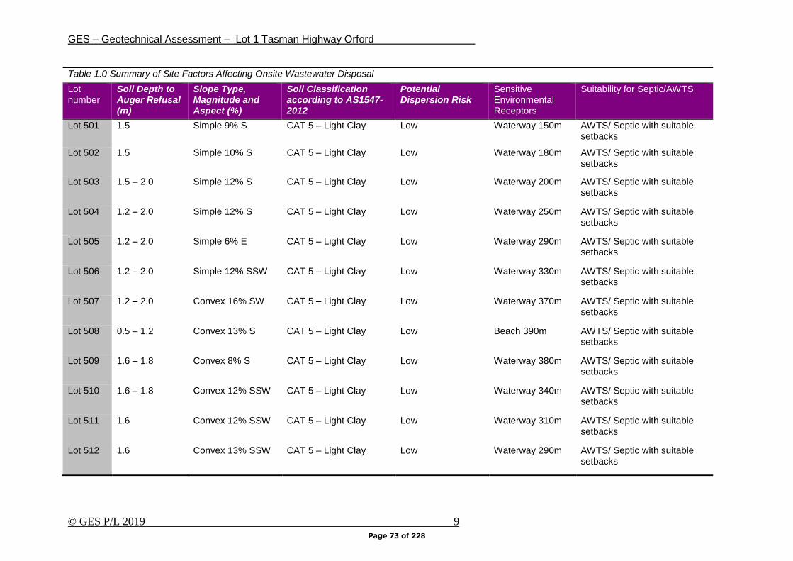
GES – Geotechnical Assessment – Lot 1 Tasman Highway Orford
© GES P/L 2019 9
Table 1.0 Summary of Site Factors Affecting Onsite Wastewater Disposal
Lot number
Soil Depth to Auger Refusal (m)
Slope Type, Magnitude and Aspect (%)
Soil Classification according to AS1547-2012
Potential Dispersion Risk
Sensitive Environmental Receptors
Suitability for Septic/AWTS
Lot 501 1.5 Simple 9% S CAT 5 – Light Clay Low Waterway 150m AWTS/ Septic with suitable setbacks
Lot 502 1.5 Simple 10% S CAT 5 – Light Clay Low Waterway 180m AWTS/ Septic with suitable setbacks
Lot 503 1.5 – 2.0 Simple 12% S CAT 5 – Light Clay Low Waterway 200m AWTS/ Septic with suitable setbacks
Lot 504 1.2 – 2.0 Simple 12% S CAT 5 – Light Clay Low Waterway 250m AWTS/ Septic with suitable setbacks
Lot 505 1.2 – 2.0 Simple 6% E CAT 5 – Light Clay Low Waterway 290m AWTS/ Septic with suitable setbacks
Lot 506 1.2 – 2.0 Simple 12% SSW CAT 5 – Light Clay Low Waterway 330m AWTS/ Septic with suitable setbacks
Lot 507 1.2 – 2.0 Convex 16% SW CAT 5 – Light Clay Low Waterway 370m AWTS/ Septic with suitable setbacks
Lot 508 0.5 – 1.2 Convex 13% S CAT 5 – Light Clay Low Beach 390m AWTS/ Septic with suitable setbacks
Lot 509 1.6 – 1.8 Convex 8% S CAT 5 – Light Clay Low Waterway 380m AWTS/ Septic with suitable setbacks
Lot 510 1.6 – 1.8 Convex 12% SSW CAT 5 – Light Clay Low Waterway 340m AWTS/ Septic with suitable setbacks
Lot 511 1.6 Convex 12% SSW CAT 5 – Light Clay Low Waterway 310m AWTS/ Septic with suitable setbacks
Lot 512 1.6 Convex 13% SSW CAT 5 – Light Clay Low Waterway 290m AWTS/ Septic with suitable setbacks
Page 73 of 228
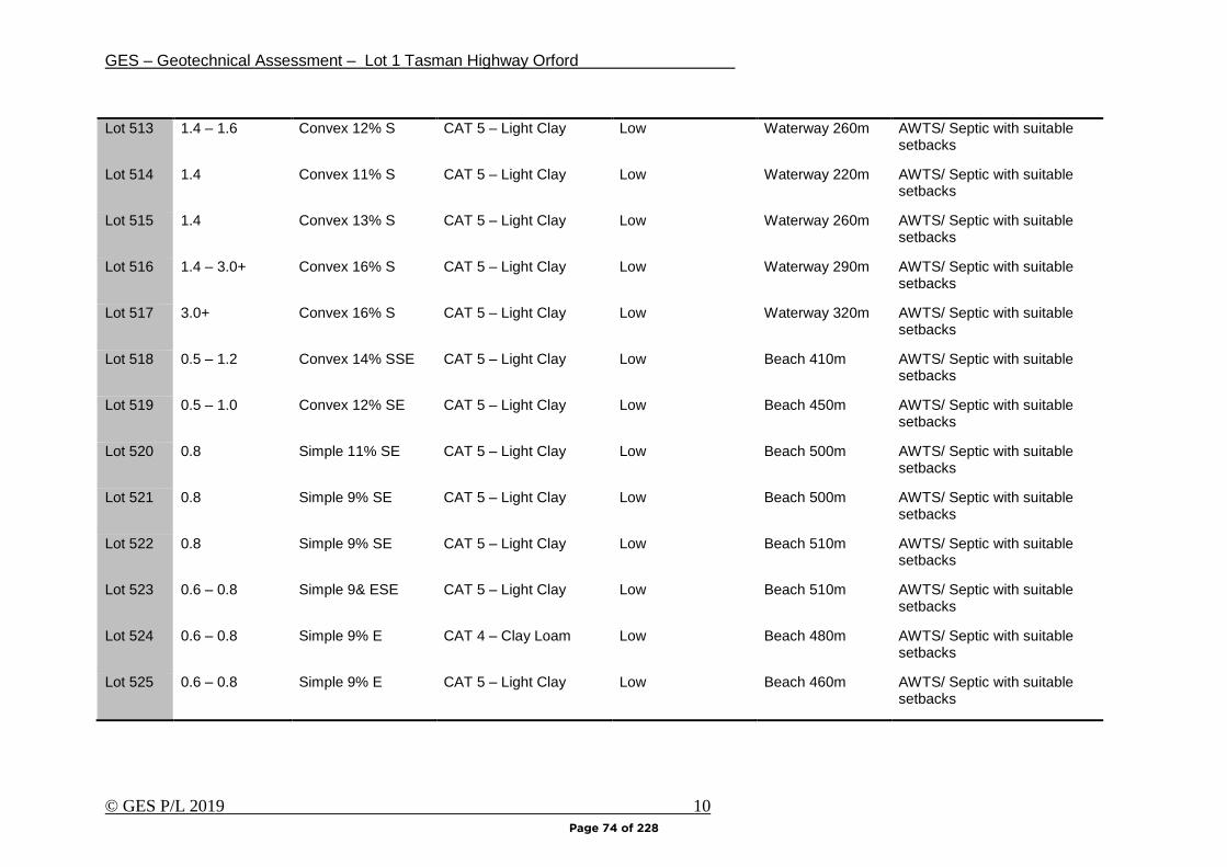
GES – Geotechnical Assessment – Lot 1 Tasman Highway Orford
© GES P/L 2019 10
Lot 513 1.4 – 1.6 Convex 12% S CAT 5 – Light Clay Low Waterway 260m AWTS/ Septic with suitable setbacks
Lot 514 1.4 Convex 11% S CAT 5 – Light Clay Low Waterway 220m AWTS/ Septic with suitable setbacks
Lot 515 1.4 Convex 13% S CAT 5 – Light Clay Low Waterway 260m AWTS/ Septic with suitable setbacks
Lot 516 1.4 – 3.0+ Convex 16% S CAT 5 – Light Clay Low Waterway 290m AWTS/ Septic with suitable setbacks
Lot 517 3.0+ Convex 16% S CAT 5 – Light Clay Low Waterway 320m AWTS/ Septic with suitable setbacks
Lot 518 0.5 – 1.2 Convex 14% SSE CAT 5 – Light Clay Low Beach 410m AWTS/ Septic with suitable setbacks
Lot 519 0.5 – 1.0 Convex 12% SE CAT 5 – Light Clay Low Beach 450m AWTS/ Septic with suitable setbacks
Lot 520 0.8 Simple 11% SE CAT 5 – Light Clay Low Beach 500m AWTS/ Septic with suitable setbacks
Lot 521 0.8 Simple 9% SE CAT 5 – Light Clay Low Beach 500m AWTS/ Septic with suitable setbacks
Lot 522 0.8 Simple 9% SE CAT 5 – Light Clay Low Beach 510m AWTS/ Septic with suitable setbacks
Lot 523 0.6 – 0.8 Simple 9& ESE CAT 5 – Light Clay Low Beach 510m AWTS/ Septic with suitable setbacks
Lot 524 0.6 – 0.8 Simple 9% E CAT 4 – Clay Loam Low Beach 480m AWTS/ Septic with suitable setbacks
Lot 525 0.6 – 0.8 Simple 9% E CAT 5 – Light Clay Low Beach 460m AWTS/ Septic with suitable setbacks
Page 74 of 228
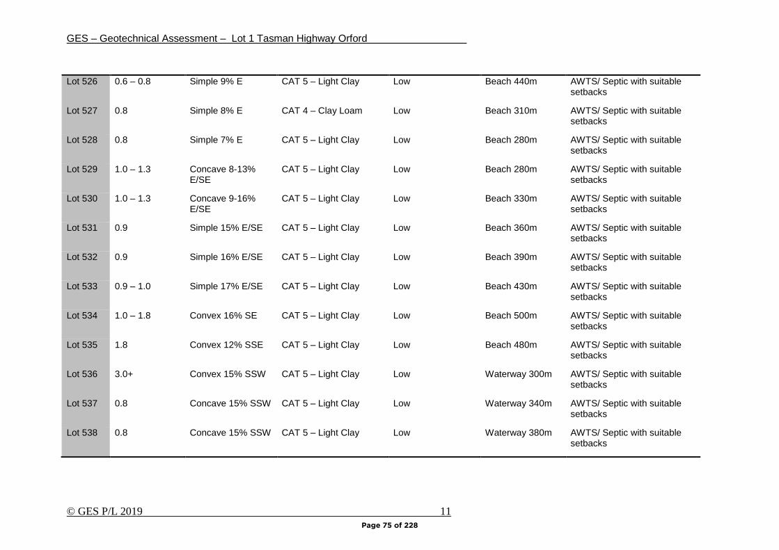
GES – Geotechnical Assessment – Lot 1 Tasman Highway Orford
© GES P/L 2019 11
Lot 526 0.6 – 0.8 Simple 9% E CAT 5 – Light Clay Low Beach 440m AWTS/ Septic with suitable setbacks
Lot 527 0.8 Simple 8% E CAT 4 – Clay Loam Low Beach 310m AWTS/ Septic with suitable setbacks
Lot 528 0.8 Simple 7% E CAT 5 – Light Clay Low Beach 280m AWTS/ Septic with suitable setbacks
Lot 529 1.0 – 1.3 Concave 8-13% E/SE
CAT 5 – Light Clay Low Beach 280m AWTS/ Septic with suitable setbacks
Lot 530 1.0 – 1.3 Concave 9-16% E/SE
CAT 5 – Light Clay Low Beach 330m AWTS/ Septic with suitable setbacks
Lot 531 0.9 Simple 15% E/SE CAT 5 – Light Clay Low Beach 360m AWTS/ Septic with suitable setbacks
Lot 532 0.9 Simple 16% E/SE CAT 5 – Light Clay Low Beach 390m AWTS/ Septic with suitable setbacks
Lot 533 0.9 – 1.0 Simple 17% E/SE CAT 5 – Light Clay Low Beach 430m AWTS/ Septic with suitable setbacks
Lot 534 1.0 – 1.8 Convex 16% SE CAT 5 – Light Clay Low Beach 500m AWTS/ Septic with suitable setbacks
Lot 535 1.8 Convex 12% SSE CAT 5 – Light Clay Low Beach 480m AWTS/ Septic with suitable setbacks
Lot 536 3.0+ Convex 15% SSW CAT 5 – Light Clay Low Waterway 300m AWTS/ Septic with suitable setbacks
Lot 537 0.8 Concave 15% SSW CAT 5 – Light Clay Low Waterway 340m AWTS/ Septic with suitable setbacks
Lot 538 0.8 Concave 15% SSW CAT 5 – Light Clay Low Waterway 380m AWTS/ Septic with suitable setbacks
Page 75 of 228
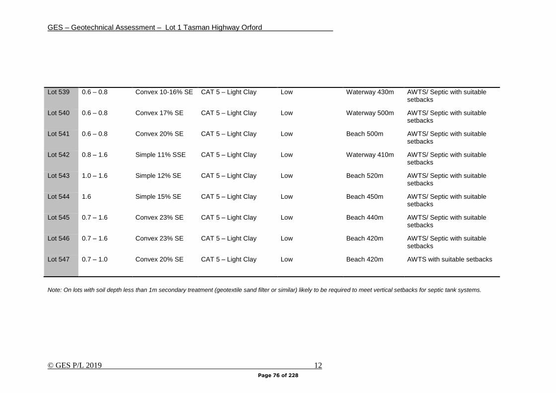
GES – Geotechnical Assessment – Lot 1 Tasman Highway Orford
© GES P/L 2019 12
Lot 539 0.6 – 0.8 Convex 10-16% SE CAT 5 – Light Clay Low Waterway 430m AWTS/ Septic with suitable setbacks
Lot 540 0.6 – 0.8 Convex 17% SE CAT 5 – Light Clay Low Waterway 500m AWTS/ Septic with suitable setbacks
Lot 541 0.6 – 0.8 Convex 20% SE CAT 5 – Light Clay Low Beach 500m AWTS/ Septic with suitable setbacks
Lot 542 0.8 – 1.6 Simple 11% SSE CAT 5 – Light Clay Low Waterway 410m AWTS/ Septic with suitable setbacks
Lot 543 1.0 – 1.6 Simple 12% SE CAT 5 – Light Clay Low Beach 520m AWTS/ Septic with suitable setbacks
Lot 544 1.6 Simple 15% SE CAT 5 – Light Clay Low Beach 450m AWTS/ Septic with suitable setbacks
Lot 545 0.7 – 1.6 Convex 23% SE CAT 5 – Light Clay Low Beach 440m AWTS/ Septic with suitable setbacks
Lot 546 0.7 – 1.6 Convex 23% SE CAT 5 – Light Clay Low Beach 420m AWTS/ Septic with suitable setbacks
Lot 547 0.7 – 1.0 Convex 20% SE CAT 5 – Light Clay Low Beach 420m AWTS with suitable setbacks
Note: On lots with soil depth less than 1m secondary treatment (geotextile sand filter or similar) likely to be required to meet vertical setbacks for septic tank systems.
Page 76 of 228
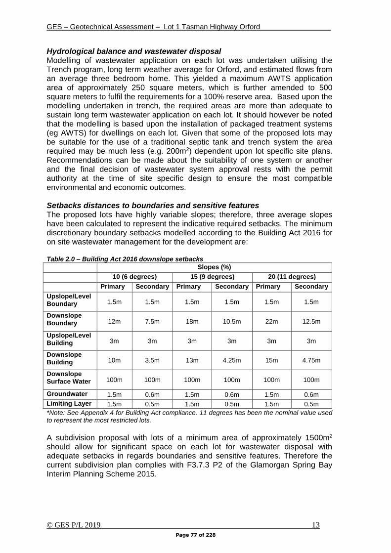
GES – Geotechnical Assessment – Lot 1 Tasman Highway Orford
© GES P/L 2019 13
Hydrological balance and wastewater disposal Modelling of wastewater application on each lot was undertaken utilising the Trench program, long term weather average for Orford, and estimated flows from an average three bedroom home. This yielded a maximum AWTS application area of approximately 250 square meters, which is further amended to 500 square meters to fulfil the requirements for a 100% reserve area. Based upon the modelling undertaken in trench, the required areas are more than adequate to sustain long term wastewater application on each lot. It should however be noted that the modelling is based upon the installation of packaged treatment systems (eg AWTS) for dwellings on each lot. Given that some of the proposed lots may be suitable for the use of a traditional septic tank and trench system the area required may be much less (e.g. 200m2) dependent upon lot specific site plans. Recommendations can be made about the suitability of one system or another and the final decision of wastewater system approval rests with the permit authority at the time of site specific design to ensure the most compatible environmental and economic outcomes. Setbacks distances to boundaries and sensitive features The proposed lots have highly variable slopes; therefore, three average slopes have been calculated to represent the indicative required setbacks. The minimum discretionary boundary setbacks modelled according to the Building Act 2016 for on site wastewater management for the development are: Table 2.0 – Building Act 2016 downslope setbacks
Slopes (%)
10 (6 degrees) 15 (9 degrees) 20 (11 degrees)
Primary Secondary Primary Secondary Primary Secondary
Upslope/Level Boundary 1.5m 1.5m 1.5m 1.5m 1.5m 1.5m
Downslope Boundary 12m 7.5m 18m 10.5m 22m 12.5m
Upslope/Level Building 3m 3m 3m 3m 3m 3m
Downslope Building 10m 3.5m 13m 4.25m 15m 4.75m
Downslope Surface Water 100m 100m 100m 100m 100m 100m
Groundwater 1.5m 0.6m 1.5m 0.6m 1.5m 0.6m
Limiting Layer 1.5m 0.5m 1.5m 0.5m 1.5m 0.5m
*Note: See Appendix 4 for Building Act compliance. 11 degrees has been the nominal value used to represent the most restricted lots.
A subdivision proposal with lots of a minimum area of approximately 1500m2 should allow for significant space on each lot for wastewater disposal with adequate setbacks in regards boundaries and sensitive features. Therefore the current subdivision plan complies with F3.7.3 P2 of the Glamorgan Spring Bay Interim Planning Scheme 2015.
Page 77 of 228

GES – Geotechnical Assessment – Lot 1 Tasman Highway Orford
© GES P/L 2019 14
The actual down slope boundary setbacks applied will require fine tuning at the special plumbing permit stage as access, parking, and building footprints are finalised in conjunction with wastewater disposal areas. Modelling at this planning stage does however suggest that sufficient room would be available on each lot to accommodate the required setbacks. The subdivision area has no dams/drainage lines or permanent creeks; however a natural drainage line is noted to the southwest of the site approximately 150m from proposed lot 501. Therefore, there is little risk involved with onsite wastewater and downslope surface water.
Page 78 of 228
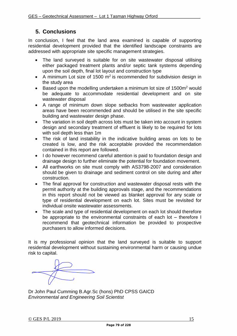
GES – Geotechnical Assessment – Lot 1 Tasman Highway Orford
© GES P/L 2019 15
5. Conclusions
In conclusion, I feel that the land area examined is capable of supporting residential development provided that the identified landscape constraints are addressed with appropriate site specific management strategies.
• The land surveyed is suitable for on site wastewater disposal utilising either packaged treatment plants and/or septic tank systems depending upon the soil depth, final lot layout and construction type
• A minimum Lot size of 1500 m2 is recommended for subdivision design in the study area
• Based upon the modelling undertaken a minimum lot size of 1500m2 would be adequate to accommodate residential development and on site wastewater disposal
• A range of minimum down slope setbacks from wastewater application areas have been recommended and should be utilised in the site specific building and wastewater design phase.
• The variation in soil depth across lots must be taken into account in system design and secondary treatment of effluent is likely to be required for lots with soil depth less than 1m
• The risk of land instability in the indicative building areas on lots to be created is low, and the risk acceptable provided the recommendation contained in this report are followed.
• I do however recommend careful attention is paid to foundation design and drainage design to further eliminate the potential for foundation movement.
• All earthworks on site must comply with AS3798-2007 and consideration should be given to drainage and sediment control on site during and after construction.
• The final approval for construction and wastewater disposal rests with the permit authority at the building approvals stage, and the recommendations in this report should not be viewed as blanket approval for any scale or type of residential development on each lot. Sites must be revisited for individual onsite wastewater assessments.
• The scale and type of residential development on each lot should therefore be appropriate to the environmental constraints of each lot – therefore I recommend that geotechnical information be provided to prospective purchasers to allow informed decisions.
It is my professional opinion that the land surveyed is suitable to support residential development without sustaining environmental harm or causing undue risk to capital. Dr John Paul Cumming B.Agr.Sc (hons) PhD CPSS GAICD Environmental and Engineering Soil Scientist
Page 79 of 228

GES – Geotechnical Assessment – Lot 1 Tasman Highway Orford
© GES P/L 2019 16
Appendix 1 –Trench summary reports
Page 80 of 228
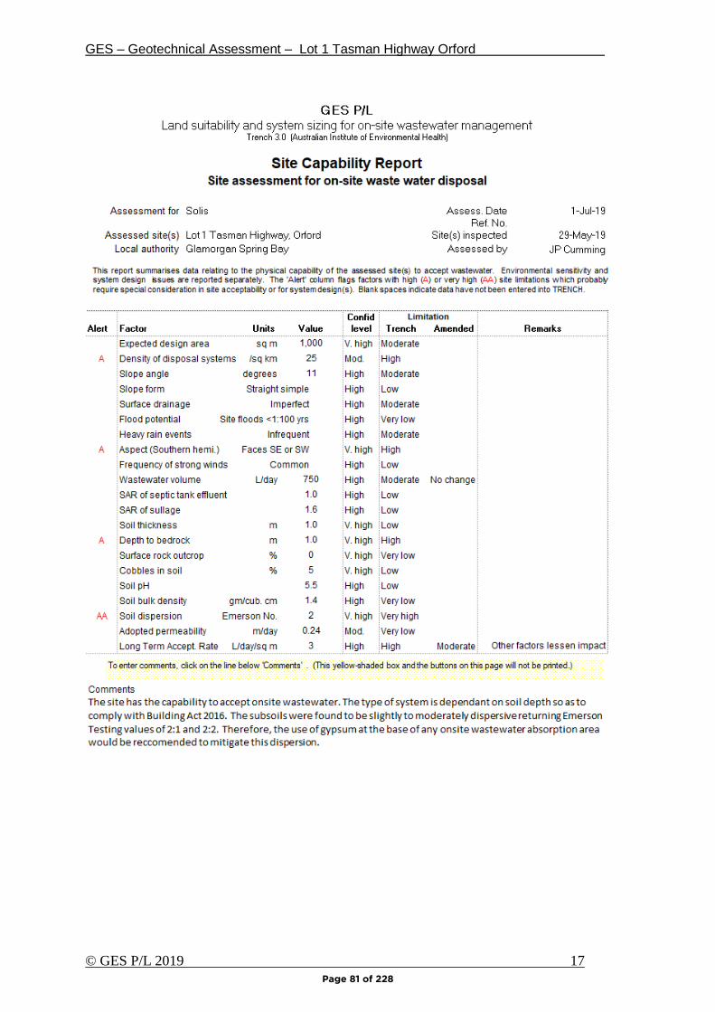
GES – Geotechnical Assessment – Lot 1 Tasman Highway Orford
© GES P/L 2019 17
Page 81 of 228
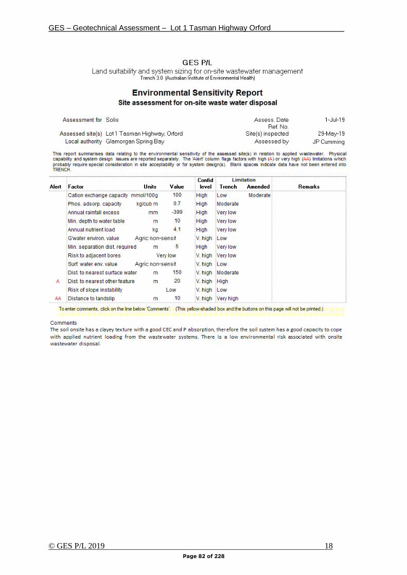
GES – Geotechnical Assessment – Lot 1 Tasman Highway Orford
© GES P/L 2019 18
Page 82 of 228
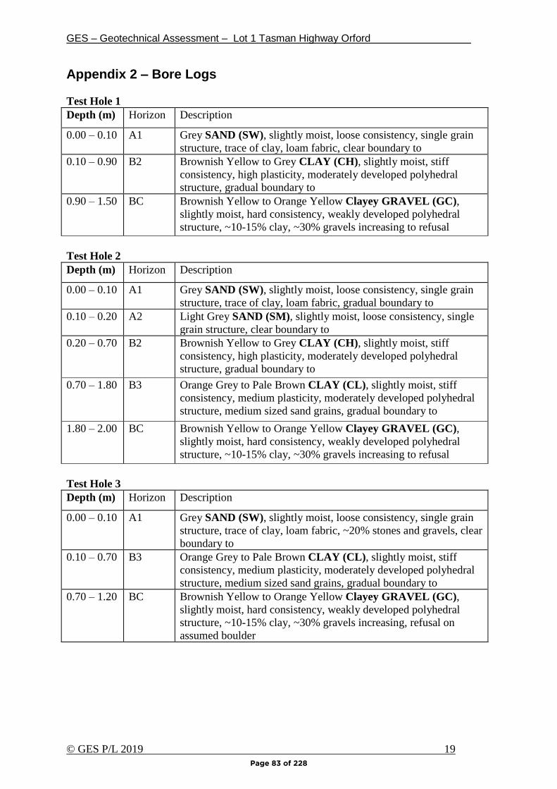
GES – Geotechnical Assessment – Lot 1 Tasman Highway Orford
© GES P/L 2019 19
Appendix 2 – Bore Logs
Test Hole 1
Depth (m) Horizon Description
0.00 – 0.10 A1 Grey SAND (SW), slightly moist, loose consistency, single grain
structure, trace of clay, loam fabric, clear boundary to
0.10 – 0.90 B2 Brownish Yellow to Grey CLAY (CH), slightly moist, stiff
consistency, high plasticity, moderately developed polyhedral
structure, gradual boundary to
0.90 – 1.50 BC Brownish Yellow to Orange Yellow Clayey GRAVEL (GC),
slightly moist, hard consistency, weakly developed polyhedral
structure, ~10-15% clay, ~30% gravels increasing to refusal
Test Hole 2
Depth (m) Horizon Description
0.00 – 0.10 A1 Grey SAND (SW), slightly moist, loose consistency, single grain
structure, trace of clay, loam fabric, gradual boundary to
0.10 – 0.20 A2 Light Grey SAND (SM), slightly moist, loose consistency, single
grain structure, clear boundary to
0.20 – 0.70 B2 Brownish Yellow to Grey CLAY (CH), slightly moist, stiff
consistency, high plasticity, moderately developed polyhedral
structure, gradual boundary to
0.70 – 1.80 B3 Orange Grey to Pale Brown CLAY (CL), slightly moist, stiff
consistency, medium plasticity, moderately developed polyhedral
structure, medium sized sand grains, gradual boundary to
1.80 – 2.00 BC Brownish Yellow to Orange Yellow Clayey GRAVEL (GC),
slightly moist, hard consistency, weakly developed polyhedral
structure, ~10-15% clay, ~30% gravels increasing to refusal
Test Hole 3
Depth (m) Horizon Description
0.00 – 0.10 A1 Grey SAND (SW), slightly moist, loose consistency, single grain
structure, trace of clay, loam fabric, ~20% stones and gravels, clear
boundary to
0.10 – 0.70 B3 Orange Grey to Pale Brown CLAY (CL), slightly moist, stiff
consistency, medium plasticity, moderately developed polyhedral
structure, medium sized sand grains, gradual boundary to
0.70 – 1.20 BC Brownish Yellow to Orange Yellow Clayey GRAVEL (GC),
slightly moist, hard consistency, weakly developed polyhedral
structure, ~10-15% clay, ~30% gravels increasing, refusal on
assumed boulder
Page 83 of 228

GES – Geotechnical Assessment – Lot 1 Tasman Highway Orford
© GES P/L 2019 20
Test Hole 4
Depth (m) Horizon Description
0.00 – 0.10 A1 Grey SAND (SM), slightly moist, loose consistency, single grain
structure, trace of clay, loam fabric, gradual boundary to
0.10 – 0.50 B3 Orange Grey to Pale Brown CLAY (CL), slightly moist, stiff
consistency, medium plasticity, moderately developed polyhedral
structure, medium sized sand grains, ~20% stones and gravels,
refusal on assumed boulder
Test Hole 5
Depth (m) Horizon Description
0.00 – 0.10 B1 Dark Brown CLAY (CL), slightly moist, stiff consistency,
moderately developed polyhedral structure, medium plasticity,
gradual boundary to
0.10 – 0.70 B2 Dark Orange Brown CLAY (CH), slightly moist, stiff consistency,
moderately developed polyhedral structure, high plasticity, ~20%
fine gravels, gradual boundary to
0.70 – 0.80 BC Light Grey Clayey GRAVELS (GC), slightly moist, hard
consistency, weakly developed polyhedral structure, ~70% stones
and gravels, refusal on rock
Test Hole 6
Depth (m) Horizon Description
0.00 – 0.05 B1 Dark Brown CLAY (CL), slightly moist, stiff consistency,
moderately developed polyhedral structure, medium plasticity,
gradual boundary to
0.05 – 0.60 BC Light Grey Clayey GRAVELS (GC), slightly moist, hard
consistency, weakly developed polyhedral structure, ~80% stones
and gravels, refusal on rock
Page 84 of 228

GES – Geotechnical Assessment – Lot 1 Tasman Highway Orford
© GES P/L 2019 21
Test Hole 7
Depth (m) Horizon Description
0.00 – 0.10 B1 Dark Brown CLAY (CL), slightly moist, stiff consistency,
moderately developed polyhedral structure, medium plasticity,
gradual boundary to
0.10 – 0.70 B2 Dark Orange Brown CLAY (CH), slightly moist, stiff consistency,
moderately developed polyhedral structure, high plasticity, ~20%
fine gravels, gradual boundary to
0.70 – 0.80 BC Light Grey Clayey GRAVELS (GC), slightly moist, hard
consistency, weakly developed polyhedral structure, ~70% stones
and gravels, refusal on rock
Test Hole 8
Depth (m) Horizon Description
0.00 – 0.20 B1 Dark Brown CLAY (CL), slightly moist, stiff consistency,
moderately developed polyhedral structure, medium plasticity,
gradual boundary to
0.20 – 0.30 B2 Dark Orange Brown CLAY (CH), slightly moist, stiff consistency,
moderately developed polyhedral structure, high plasticity, ~20%
fine gravels, gradual boundary to
0.30 – 0.80 BC Light Grey Clayey GRAVELS (GC), slightly moist, hard
consistency, weakly developed polyhedral structure, ~70% stones
and gravels, refusal on rock
Test Hole 9
Depth (m) Horizon Description
0.00 – 0.10 A1 Greyish Brown SAND (SM), slightly moist, loose consistency,
single grain structure, clear boundary to
0.10 – 1.10 B2 Light Orange Brown CLAY (CH), slightly moist, stiff
consistency, moderately developed polyhedral structure, high
plasticity, ~10% gravels, ~20% fine sand, gradual boundary to
1.10 – 1.30 BC Brownish Yellow Clayey GRAVELS (GC), slightly moist, hard
consistency, moderately developed polyhedral structure, ~20%
clay, ~20% fine gravels increasing to refusal on rock
Test Hole 10
Depth (m) Horizon Description
0.00 – 0.10 A1 Greyish Brown SAND (SM), slightly moist, loose consistency,
single grain structure, clear boundary to
0.10 – 0.90 B2 Light Orange Brown CLAY (CH), slightly moist, stiff
consistency, moderately developed polyhedral structure, high
plasticity, refusal on rock
Page 85 of 228
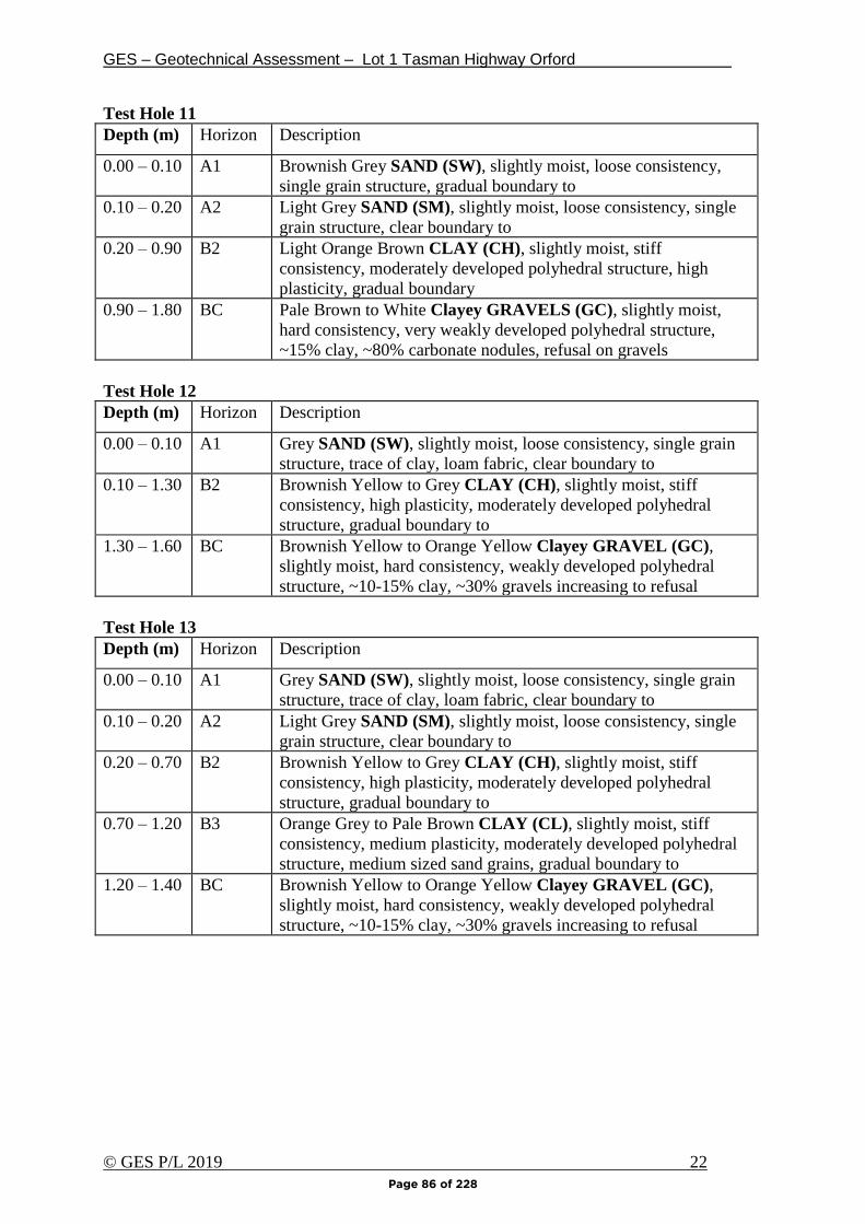
GES – Geotechnical Assessment – Lot 1 Tasman Highway Orford
© GES P/L 2019 22
Test Hole 11
Depth (m) Horizon Description
0.00 – 0.10 A1 Brownish Grey SAND (SW), slightly moist, loose consistency,
single grain structure, gradual boundary to
0.10 – 0.20 A2 Light Grey SAND (SM), slightly moist, loose consistency, single
grain structure, clear boundary to
0.20 – 0.90 B2 Light Orange Brown CLAY (CH), slightly moist, stiff
consistency, moderately developed polyhedral structure, high
plasticity, gradual boundary
0.90 – 1.80 BC Pale Brown to White Clayey GRAVELS (GC), slightly moist,
hard consistency, very weakly developed polyhedral structure,
~15% clay, ~80% carbonate nodules, refusal on gravels
Test Hole 12
Depth (m) Horizon Description
0.00 – 0.10 A1 Grey SAND (SW), slightly moist, loose consistency, single grain
structure, trace of clay, loam fabric, clear boundary to
0.10 – 1.30 B2 Brownish Yellow to Grey CLAY (CH), slightly moist, stiff
consistency, high plasticity, moderately developed polyhedral
structure, gradual boundary to
1.30 – 1.60 BC Brownish Yellow to Orange Yellow Clayey GRAVEL (GC),
slightly moist, hard consistency, weakly developed polyhedral
structure, ~10-15% clay, ~30% gravels increasing to refusal
Test Hole 13
Depth (m) Horizon Description
0.00 – 0.10 A1 Grey SAND (SW), slightly moist, loose consistency, single grain
structure, trace of clay, loam fabric, clear boundary to
0.10 – 0.20 A2 Light Grey SAND (SM), slightly moist, loose consistency, single
grain structure, clear boundary to
0.20 – 0.70 B2 Brownish Yellow to Grey CLAY (CH), slightly moist, stiff
consistency, high plasticity, moderately developed polyhedral
structure, gradual boundary to
0.70 – 1.20 B3 Orange Grey to Pale Brown CLAY (CL), slightly moist, stiff
consistency, medium plasticity, moderately developed polyhedral
structure, medium sized sand grains, gradual boundary to
1.20 – 1.40 BC Brownish Yellow to Orange Yellow Clayey GRAVEL (GC),
slightly moist, hard consistency, weakly developed polyhedral
structure, ~10-15% clay, ~30% gravels increasing to refusal
Page 86 of 228
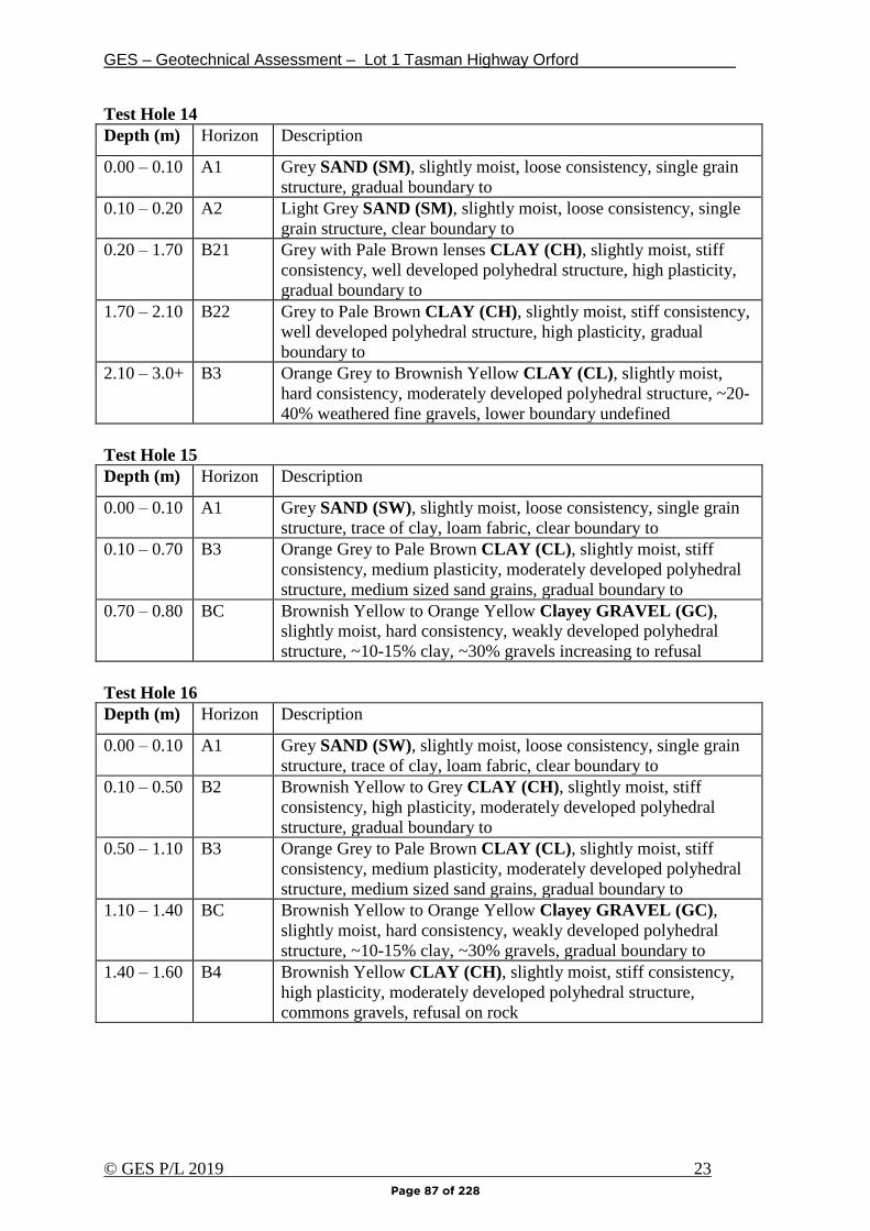
GES – Geotechnical Assessment – Lot 1 Tasman Highway Orford
© GES P/L 2019 23
Test Hole 14
Depth (m) Horizon Description
0.00 – 0.10 A1 Grey SAND (SM), slightly moist, loose consistency, single grain
structure, gradual boundary to
0.10 – 0.20 A2 Light Grey SAND (SM), slightly moist, loose consistency, single
grain structure, clear boundary to
0.20 – 1.70 B21 Grey with Pale Brown lenses CLAY (CH), slightly moist, stiff
consistency, well developed polyhedral structure, high plasticity,
gradual boundary to
1.70 – 2.10 B22 Grey to Pale Brown CLAY (CH), slightly moist, stiff consistency,
well developed polyhedral structure, high plasticity, gradual
boundary to
2.10 – 3.0+ B3 Orange Grey to Brownish Yellow CLAY (CL), slightly moist,
hard consistency, moderately developed polyhedral structure, ~20-
40% weathered fine gravels, lower boundary undefined
Test Hole 15
Depth (m) Horizon Description
0.00 – 0.10 A1 Grey SAND (SW), slightly moist, loose consistency, single grain
structure, trace of clay, loam fabric, clear boundary to
0.10 – 0.70 B3 Orange Grey to Pale Brown CLAY (CL), slightly moist, stiff
consistency, medium plasticity, moderately developed polyhedral
structure, medium sized sand grains, gradual boundary to
0.70 – 0.80 BC Brownish Yellow to Orange Yellow Clayey GRAVEL (GC),
slightly moist, hard consistency, weakly developed polyhedral
structure, ~10-15% clay, ~30% gravels increasing to refusal
Test Hole 16
Depth (m) Horizon Description
0.00 – 0.10 A1 Grey SAND (SW), slightly moist, loose consistency, single grain
structure, trace of clay, loam fabric, clear boundary to
0.10 – 0.50 B2 Brownish Yellow to Grey CLAY (CH), slightly moist, stiff
consistency, high plasticity, moderately developed polyhedral
structure, gradual boundary to
0.50 – 1.10 B3 Orange Grey to Pale Brown CLAY (CL), slightly moist, stiff
consistency, medium plasticity, moderately developed polyhedral
structure, medium sized sand grains, gradual boundary to
1.10 – 1.40 BC Brownish Yellow to Orange Yellow Clayey GRAVEL (GC),
slightly moist, hard consistency, weakly developed polyhedral
structure, ~10-15% clay, ~30% gravels, gradual boundary to
1.40 – 1.60 B4 Brownish Yellow CLAY (CH), slightly moist, stiff consistency,
high plasticity, moderately developed polyhedral structure,
commons gravels, refusal on rock
Page 87 of 228

GES – Geotechnical Assessment – Lot 1 Tasman Highway Orford
© GES P/L 2019 24
Test Hole 17
Depth (m) Horizon Description
0.00 – 0.10 A1 Grey SAND (SW), slightly moist, loose consistency, single grain
structure, trace of clay, loam fabric, clear boundary to
0.10 – 0.50 B2 Brownish Yellow to Grey CLAY (CH), slightly moist, stiff
consistency, high plasticity, moderately developed polyhedral
structure, gradual boundary to
0.50 – 0.70 BC Brownish Yellow to Orange Yellow Clayey GRAVEL (GC),
slightly moist, hard consistency, weakly developed polyhedral
structure, ~10-15% clay, ~30% gravels, refusal on assumedboulder
Test Hole 18
Depth (m) Horizon Description
0.00 – 0.10 A1 Grey SAND (SW), slightly moist, loose consistency, single grain
structure, trace of clay, loam fabric, clear boundary to
0.10 – 0.20 A2 Light Grey SAND (SM), slightly moist, loose consistency, single
grain structure, clear boundary to
0.20 – 0.60 B2 Brownish Yellow to Grey CLAY (CH), slightly moist, stiff
consistency, high plasticity, moderately developed polyhedral
structure, refusal on rock
Page 88 of 228
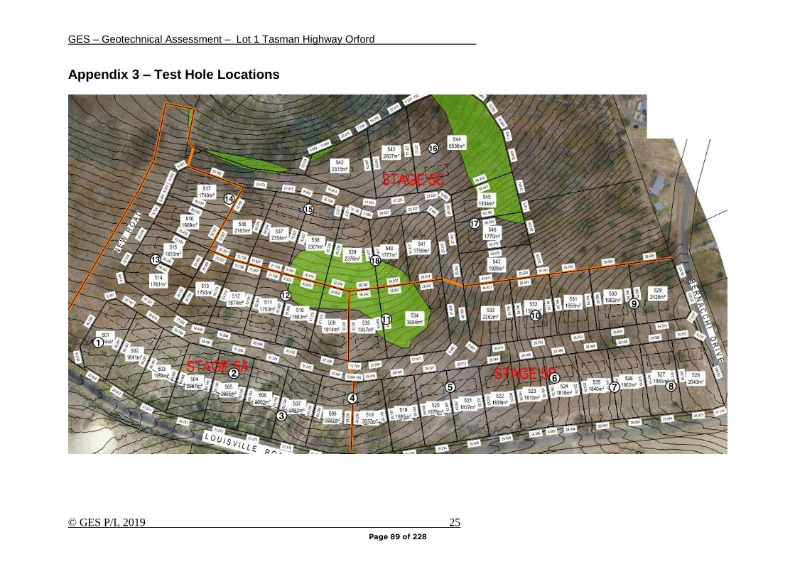
GES – Geotechnical Assessment – Lot 1 Tasman Highway Orford
© GES P/L 2019 25
Appendix 3 – Test Hole Locations
Page 89 of 228
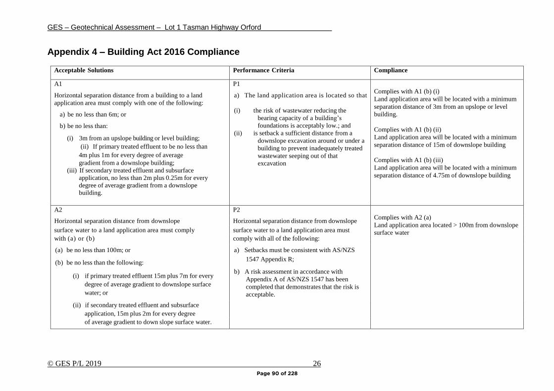
GES – Geotechnical Assessment – Lot 1 Tasman Highway Orford
© GES P/L 2019 26
Appendix 4 – Building Act 2016 Compliance
Acceptable Solutions Performance Criteria Compliance
A1
Horizontal separation distance from a building to a land
application area must comply with one of the following:
a) be no less than 6m; or
b) be no less than:
(i) 3m from an upslope building or level building;
(ii) If primary treated effluent to be no less than
4m plus 1m for every degree of average
gradient from a downslope building;
(iii) If secondary treated effluent and subsurface
application, no less than 2m plus 0.25m for every
degree of average gradient from a downslope building.
P1
a) The land application area is located so that
(i) the risk of wastewater reducing the
bearing capacity of a building’s
foundations is acceptably low.; and
(ii) is setback a sufficient distance from a
downslope excavation around or under a
building to prevent inadequately treated
wastewater seeping out of that
excavation
Complies with A1 (b) (i)
Land application area will be located with a minimum
separation distance of 3m from an upslope or level
building.
Complies with A1 (b) (ii)
Land application area will be located with a minimum
separation distance of 15m of downslope building
Complies with A1 (b) (iii)
Land application area will be located with a minimum
separation distance of 4.75m of downslope building
A2 P2
Complies with A2 (a)
Land application area located > 100m from downslope
surface water
Horizontal separation distance from downslope Horizontal separation distance from downslope
surface water to a land application area must comply surface water to a land application area must
with (a) or (b) comply with all of the following:
(a) be no less than 100m; or a) Setbacks must be consistent with AS/NZS
(b) be no less than the following: 1547 Appendix R;
(i) if primary treated effluent 15m plus 7m for every
degree of average gradient to downslope surface
water; or
b) A risk assessment in accordance with
Appendix A of AS/NZS 1547 has been
completed that demonstrates that the risk is
acceptable.
(ii) if secondary treated effluent and subsurface
application, 15m plus 2m for every degree
of average gradient to down slope surface water.
water.
Page 90 of 228
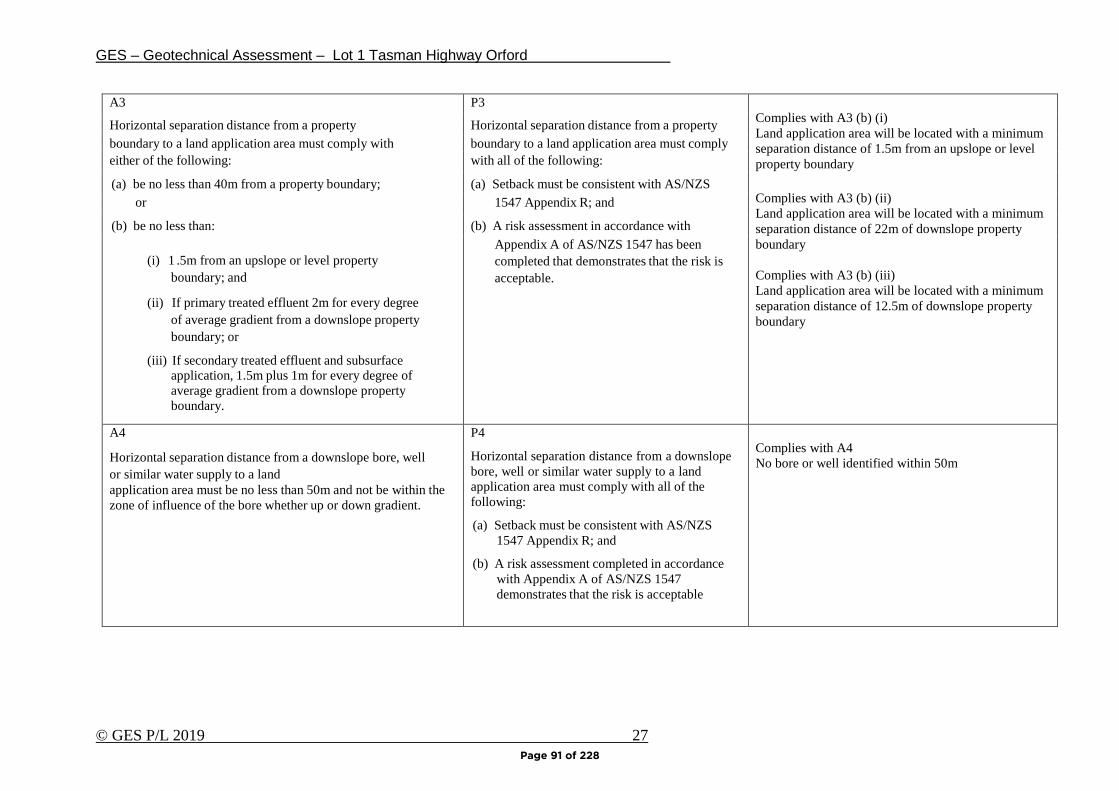
GES – Geotechnical Assessment – Lot 1 Tasman Highway Orford
© GES P/L 2019 27
A3 P3
Complies with A3 (b) (i)
Land application area will be located with a minimum
separation distance of 1.5m from an upslope or level
property boundary
Complies with A3 (b) (ii)
Land application area will be located with a minimum
separation distance of 22m of downslope property
boundary
Complies with A3 (b) (iii)
Land application area will be located with a minimum
separation distance of 12.5m of downslope property
boundary
Horizontal separation distance from a property Horizontal separation distance from a property
boundary to a land application area must comply with boundary to a land application area must comply
either of the following: with all of the following:
(a) be no less than 40m from a property boundary; (a) Setback must be consistent with AS/NZS
or 1547 Appendix R; and
(b) be no less than: (b) A risk assessment in accordance with
(i) 1 .5m from an upslope or level property
boundary; and
(ii) If primary treated effluent 2m for every degree
of average gradient from a downslope property
boundary; or
(iii) If secondary treated effluent and subsurface application, 1.5m plus 1m for every degree of
average gradient from a downslope property
boundary.
Appendix A of AS/NZS 1547 has been
completed that demonstrates that the risk is
acceptable.
A4
Horizontal separation distance from a downslope bore, well
or similar water supply to a land
application area must be no less than 50m and not be within the
zone of influence of the bore whether up or down gradient.
P4
Horizontal separation distance from a downslope
bore, well or similar water supply to a land
application area must comply with all of the
following:
(a) Setback must be consistent with AS/NZS
1547 Appendix R; and
(b) A risk assessment completed in accordance
with Appendix A of AS/NZS 1547
demonstrates that the risk is acceptable
Complies with A4
No bore or well identified within 50m
Page 91 of 228

GES – Geotechnical Assessment – Lot 1 Tasman Highway Orford
© GES P/L 2019 28
A5
Vertical separation distance between groundwater and a land
application area must be no less than:
(a) 1.5m if primary treated effluent; or
(b) 0.6m if secondary treated effluent
P5
Vertical separation distance between
groundwater and a land application area must
comply with the following:
(a) Setback must be consistent with AS/NZS
1547 Appendix R; and
(b) A risk assessment completed in accordance
with Appendix A of AS/NZS 1547 that
demonstrates that the risk is acceptable
1.5m separation is required to comply with A5 (a)
0.6m separation is required to comply with A5 (b)
A6
Vertical separation distance between a limiting layer and a
land application area must be no less than:
(a) 1.5m if primary treated effluent; or
(b) 0.5m if secondary treated effluent
P6
Vertical setback must be consistent with
AS/NZS1547 Appendix R.
1.5m separation is required to comply with A5 (a)
0.5m separation is required to comply with A5 (a)
A7 P7
nil A wastewater treatment unit must be located a
sufficient distance from buildings or neighbouring
properties so that emissions (odour, noise or
aerosols) from the unit do not create an
environmental nuisance to the residents of those
properties
Complies
Page 92 of 228
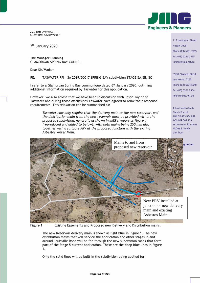
JMG Ref: J92191CL Client Ref: SA2019/0017
7th January 2020 The Manager Planning GLAMORGAN SPRING BAY COUNCIL Dear Sir/Madam RE: TASWATER RFI – SA 2019/00017 SPRING BAY subdivision STAGE 5A,5B, 5C I refer to a Glamorgan Spring Bay communique dated 6th January 2020, outlining additional information required by Taswater for this application. However, we also advise that we have been in discussion with Jason Taylor of Taswater and during those discussions Taswater have agreed to relax their response requirements. This relaxation can be summarised as:
Taswater now only require that the delivery main to the new reservoir, and the distribution main from the new reservoir must be provided within the proposed subdivision, generally as shown in JMG’s report as figure 1 (reproduced and added to below), with both mains being 250 mm dia, together with a suitable PRV at the proposed junction with the exiting Asbestos Water Main.
Figure 1 Existing Easements and Proposed new Delivery and Distribution mains.
The new Reservoir delivery main is shown as light blue in Figure 1. The new distribution mains that will service the application and other stages in and around Louisville Road will be fed through the new subdivision roads that form part of the Stage 5 current application. These are the deep blue lines in Figure 1. Only the solid lines will be built in the subdivision being applied for.
Mains to and from
proposed new reservoir
New PRV installed at
junction of new delivery
main and existing
Asbestos Main.
Page 93 of 228
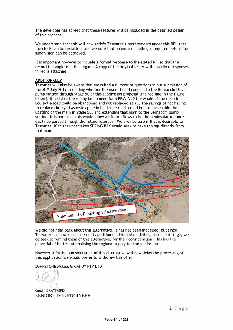
2 | P a g e
The developer has agreed that these features will be included in the detailed design of this proposal. We understand that this will now satisfy Taswater’s requirements under this RFI, that the clock can be restarted, and we note that no more modelling is required before the subdivision can be approved. It is important however to include a formal response to the stated RFI so that the record is complete in this regard. A copy of the original letter with inscribed responses in red is attached. ADDITIONALLY Taswater will also be aware that we raised a number of questions in our submission of the 30th July 2019, including whether the main should connect to the Bernacchi Drive pump station through Stage 5C of this subdivision proposal (the red line in the figure below). If it did so there may be no need for a PRV, AND the whole of the main in Louisville road could be abandoned and not replaced at all. The savings of not having to replace the aged Asbestos pipe in Louisville road could be used to enable the upsizing of the main in Stage 5C, and extending that main to the Bernacchi pump station. It is note that this would allow all future flows to be the peninsular to more easily be passed through the future reservoir. We are not sure if that is desirable to Taswater. If this is undertaken SPRING BAY would seek to have tapings directly from that main.
We did not hear back about this alternative. It has not been modelled, but since Taswater has now reconsidered its position on detailed modelling at concept stage, we do seek to remind them of this alternative, for their consideration. This has the potential of better rationalising the regional supply for the peninsular. However if further consideration of this alternative will now delay the processing of this application we would prefer to withdraw this offer. JOHNSTONE McGEE & GANDY PTY LTD
Geoff BRAYFORD
SENIOR CIVIL ENGINEER
Page 94 of 228
Enquiries: Planning Department Planning ref: SA 2019 / 017 Property file: 4-3800-406 06 January 2020 Andy Hamilton & Associates P O Box 223 BICHENO TAS 7215 Dear Sir/Madam
DEVELOPMENT APPLICATION - Tasman Highway, Orford Subdivision of 47 new lots
I refer to the above application received on 17/07/2019 and the information supplied so far.
Please be advised that the information provided so far is still not satisfactory.
Accordingly and pursuant to Section 54 of the Land Use Planning and Approvals Act 1993 the following information is required:
• What is the proposed size of the new reservoir?
The reservoir is not required for this subdivision application. Refer Taswater communique 15/8/2019
• Some of the pipes appear to have internal diameters that are not in accordance with the model notes provided, can a plan showing the proposed pipe sizes be provided?
A plan can be provided at Detailed design.
• What is the maximum height that the tank could be built?
The maximum height is dependent upon the supply pressure that is available from Taswater. JMG have not modelled the system that delivers water to the Peninsula, and are relying on the boundary conditions provided by Taswater. If the Boundary conditions at the Tasman Highway is RL 81 then that is the maximum height of the reservoir TWL, unless boosted.
• What is the ideal height? (i.e. that all lots in Stage 1 would see pressure in accordance with TasWater Standards - it is not in anyone’s interest to have a local boosted area for approx. 10-15 lots)
The ideal height appears to be RL81 - ?.
Unless there is no development above say RL 55 there will likely be a need for a local boosted area scheme – whether to mains pressure or to .an elevated “golf ball reservoir”. It would not be in anyone’s interest to abandon the potential of higher developments, especially given that there appear to be existing connections above RL
Page 95 of 228
60 that must be reconnected in the future, making a local boosted area scheme essential.
• Can the models be provided?
Yes
• TasWater requires that the tank will have capacity to cater for the existing customers in the Bernacchi Drive zone (transferred directly), plus the customers in Barton Avenue, The Eastcoaster Resort and across the other side of Spring Bay (all supplied at the pressure they currently have).
Ok. Taswater to advise what regional demands are. Negotiations can be undertaken with Developer concerning cost sharing for an extended reservoir. We again note that the reservoir is not required for this subdivision.
• The model should show what is required for the Spring Bay Development to fit into the existing network (i.e. flow-through to Barton Avenue and Bernacchi Drive) both now and in the fully developed situation, this includes those areas listed above.
A regional model is required. The Spring Bay model can be added to the regional model. It is not reasonable to require SPRING BAY to build the regional model to cater for sites remote form this proposal. This has been a consistent position for over 9 months.
• Of particular note is that a Pressure Release Valve (PRV) will be required to ensure that excess pressure does not cause mains breaks in the lower areas. The size of the pipe to the PRV is at this stage shown as 114mm. This is not likely to be sufficient to meet the demands of the existing serviced area and should be based on supplying the ultimate connected properties. A PRV will be required initially to reduce the pressure from the main. In the long term the PRV will see inlet pressure from the new tank and the setting. The report notes that the PRV does not benefit Spring Bay, however, TasWater note that without it we won’t allow them to connect as they will cause our network to fail, and by virtue of this the PRV does benefit Spring Bay.
Unsure where the perception that the PRV is only 114mm stems from.
In discussion with the developer a PRV will be installed where the new main on Louisville road connects to the existing Asbestos Main.
• A plan showing what is proposed to be built for both scenarios should be provided rather than a model that does not include key points such as the interface with existing customers.
This is detailed design and is unnecessary, especially the interface with existing customers. This interface will occur downstream of the proposed PRV, on Louisville road, in accordance with the infrastructure plan provided by Taswater on the 15/8/2019.
It should be noted that the statutory period in which Council has to deal with the application does not run between the time that further information is requested and it is received to the satisfaction of Council.
Noted. The developer expects that the clock will restart upon receipt of this update.
Please provide your response in writing to the General Manager, Glamorgan Spring Bay Council at either:
Page 96 of 228

• PO Box 6, Triabunna, 7190
Should you have any queries in this matter please do not hesitate to contact the planning department on 6256 4767.
Yours sincerely
Chris Schroeder GENERAL MANAGER
Page 97 of 228
Spring Bay Stage 5 – Proposed Subdivision
Report for: Bayport Pty Ltd
Property Location: Part Lot 1 Tasman Hwy, Orford
Prepared by: Scott Livingston
Livingston Natural Resource Services 12 Powers Road Underwood, 7268
Date: 5th November 2019
Natural Values Report
Page 98 of 228

Natural Values Report Livingston Natural Resource Services
i
Client:
Bayport Pty Ltd
Property identification
Lot 1 Tasman Hwy, Orford. CT 139972/1, PID 2549195 Current zoning is Rural Resource, Louisville Road Specific Area Plan Glamorgan-Spring Bay Interim Planning Scheme 2015
Proposal:
Stage 5 of Subdivision, lots 501-547 in 3 sub stages
Assessment comments:
Under the Glamorgan-Spring Bay Interim Planning Scheme 2015, consideration of the impact on natural values is required. A field inspection was conducted on the 6th October 2019. This field assessments were used to confirm or otherwise the desktop study findings. This report summarises the findings of the desktop and field assessment.
Assessment by: Scott Livingston, Master Environmental Management, Forest Practices Officer (Planning) Natural Resource Management Consultant.
Page 99 of 228
Natural Values Report Livingston Natural Resource Services
i
Contents SUMMARY ...................................................................................................................... 2
INTRODUCTION............................................................................................................... 3
METHODS ...................................................................................................................... 3
DESCRIPTION ................................................................................................................. 4
NATURAL VALUES ......................................................................................................... 5
PROPOSED DEVELOPMENT- CLEARING OF VEGETATION................................................... 7
CONCLUSIONS ................................................................................................................ 8
REFERENCES .................................................................................................................. 8
APPENDIX 1 – MAPS ..................................................................................................... 10
APPENDIX 2 – PHOTOS .................................................................................................. 17
APPENDIX 3 –FLORA SPECIES LIST ................................................................................ 20
APPENDIX 4 –HABITAT CONTEXT ASSESSMENT............................................................. 21
APPENDIX 5 – THREATENED FLORA WITHIN 5KM ........................................................... 23
APPENDIX 6 – THREATENED FAUNA WITHIN 5KM .......................................................... 28
Figure 1: Location Map ......................................................................................................... 4
Figure 2: vegetation removal and retention ............................................................................ 7 Figure 1: Location Map ....................................................................................................... 10
Figure 2: Aerial Image, Stage 5, Planning Scheme Overlay (Biodiversity Protection) .......... 11 Figure 3: Aerial image, Masterplan area .............................................................................. 12
Figure 4: Master Plan .......................................................................................................... 13 Figure 5: FPP Map AKO00110 (draft) ................................................................................ 14
Figure 8: TasVeg Communities ........................................................................................... 15 Figure 9: Vegetation communities (Tasmanian Herbarium report) ....................................... 16
Figure 10: north along western road .................................................................................... 17 Figure 11: central eucalypt patch ......................................................................................... 17
Figure 12: southern eucalypt patch ...................................................................................... 18 Figure 13: north across eastern section ................................................................................ 18
Figure 14: gorse western section adjacent to Louisville Road .............................................. 19 Figure 15: spanish heath western section ............................................................................. 19
Figure 16: Habitat Context 5 km ......................................................................................... 22 Figure 17: Habitat Context 1 km ......................................................................................... 22
Page 100 of 228
Natural Values Report Livingston Natural Resource Services
2
SUMMARY
The development area contains two small (1.4 & 0.6ha) stands and a portion (0.3ha) of a larger stand of Eucalyptus globulus, a threatened vegetation community that also provides foraging habitat for, swift parrot, a federally and state listed threatened species that will be affected by clearing for development. Portions of the southern and central patches will be retained, giving a clearing requirement of 0.8ha. A 4.3ha patch of the same vegetation community (DGL) immediately north of the development is shown to be retained in the site master plan and an adjoining 0.3ha within the proposed subdivision is also to be retained.
The development area has suitable habitat for threatened flora known within 5km, although no threatened flora was identified on the site visit or previous studies, noting no survey of areas outside proposed development site was not conducted.
The development area has suitable foraging but no nesting/denning habitat for several wide-ranging threatened fauna species. Clearing of the site would have a very minor impact on foraging habitat for wide ranging species such as devils, quolls, eagles and masked owls, retained vegetation on surrounding land will provide alternate habitat and therefore the impact is expected to be minimal. Ghania radula occurs within the site and adjacent areas and is the host plant for threatened species Antipodia chaostola, chaostola skipper butterfly. The species has not been detected on the site and undeveloped areas of the property also contain Ghania radula and no impact on this species is likely. The proposal retains stands of Eucalyptus globulus within and adjacent to the subdivision which will continue to provide foraging habitat for swift parrot. The clearing of 0.8ha will affect around 10% of the foraging habitat in the immediate area and 5% within the property. Impact on this species is likely to be minor provided alternate foraging is available in the vicinity. No potential breeding habitat for the species is affected.
The proposed clearing is within the harvest boundaries of expired FPP (AKO00110) for the area, and the prescriptions for retention and revegetation of native vegetation for the FPP were considered to be sufficient to mitigate any loss of habitat at that time. The extent of retained vegetation on the property is considerable and further offsetting for previously approved clearing does not appear to be necessary.
Page 101 of 228
Natural Values Report Livingston Natural Resource Services
3
INTRODUCTION
The developers propose to develop Stage 5 of the Spring Bay Land Development. This 47 lot in 3 stages covers lots 501-547 and includes public roads and associated infrastructure. The Louisville Road Specific Area Plan makes provision for this subdivision. Portions of the development are mapped as Biodiversity Protection Overlay. Tasmanian Herbarium conducted a botanical survey of the estate and Dr R Rose undertook a fauna survey in 2003. The Tasmanian Herbarium report notes no species listed on State or Federal Schedules. The Fauna report considered that the only likely threatened flora on the site to be swift parrot. The Tasmanian Herbarium (2003) Botanical Report supplied includes Evaluation Sheets for the proposed FPP’s (AKO0110, AKO0111)) for the overall site in 2006. Recommendations from the Biodiversity Section of Forest Practices Authority and FPP process established requirements for habitat protection including reservations and revegetation. The FPP Map (AKO0110) shows harvesting boundaries that include the native forest patches within stage 5 noting portions approved for clearing are now to be retained under the developer’s current proposal. The estate has a mosaic of grassland and native forest and woodland, with substantial areas to remain as native vegetation. Vegetation will be retained within lots along the southern boundary (Louisville Road), and a 5ha forested area north of stage 5 separates the development from stage 6.
METHODS
A Natural Values report was accessed from the DPIWE website on 7/10/2019, This report covers know sightings within 5km and fauna species whose predicted range boundaries overlay the site. Additional desktop information was sourced from Forest Practices Authority Biodiversity Values Database and EPBC Act Protected Matters Report (both accessed 23/10/2019). A site visit on 6/8/2019 was undertaken by Scott Livingston. The area of proposed development was surveyed. No survey of other areas of the property were undertaken in detail. The survey was conducted in October, which is outside the flowering period of some flora species. No survey can guarantee that all flora will be recorded in a single site visit due to limitations on seasonal and annual variation in abundance and the presence of material for identification. While all significant species known to occur in the area were considered, species such as late spring or autumn flowering flora may have been overlooked. A sample of all vegetation communities, aspects and variations in topographic location was achieved. All mapping and Grid References in this report use GDA 94, Zone 55, with eastings and northings expressed as 6 & 7 digits respectively. Flora taxonomy nomenclature used is consistent with Census of Vascular Plants of Tasmania, Tasmanian Herbarium 2015, From Forest to Fjaeldmark, Descriptions of Tasmania's Vegetation
Page 102 of 228
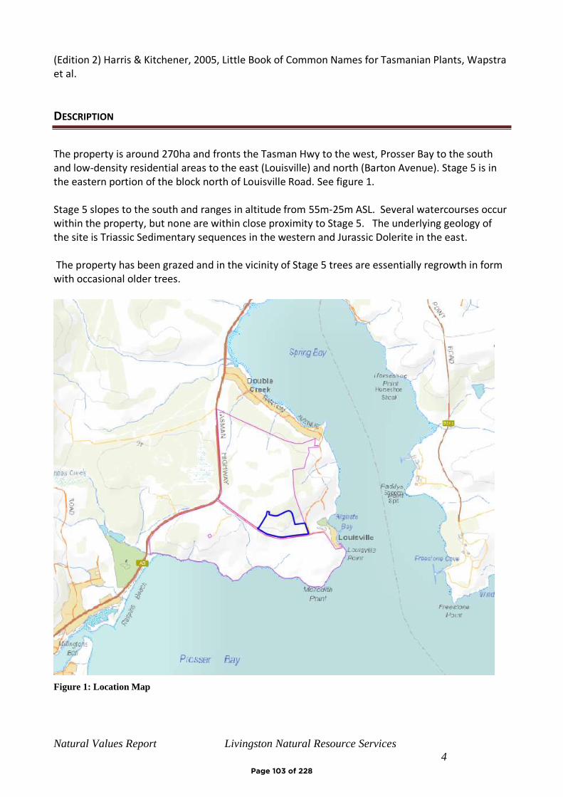
Natural Values Report Livingston Natural Resource Services
4
(Edition 2) Harris & Kitchener, 2005, Little Book of Common Names for Tasmanian Plants, Wapstra et al.
DESCRIPTION
The property is around 270ha and fronts the Tasman Hwy to the west, Prosser Bay to the south and low-density residential areas to the east (Louisville) and north (Barton Avenue). Stage 5 is in the eastern portion of the block north of Louisville Road. See figure 1. Stage 5 slopes to the south and ranges in altitude from 55m-25m ASL. Several watercourses occur within the property, but none are within close proximity to Stage 5. The underlying geology of the site is Triassic Sedimentary sequences in the western and Jurassic Dolerite in the east. The property has been grazed and in the vicinity of Stage 5 trees are essentially regrowth in form with occasional older trees.
Figure 1: Location Map
Page 103 of 228
Natural Values Report Livingston Natural Resource Services
5
NATURAL VALUES
VEGETATION
TASVEG 3.0 mapping shows the native vegetation community on the development area as Eucalyptus globulus dry forest and woodland (DGL) for the central eucalypt patch and Eucalyptus
pulchella forest and woodland (DPU) retained native vegetation to the north (5ha) and FAG
(Agricultural Land) for the balance. Tasmanian Herbarium (2003) in its botanical survey report
classified both the central and northern patch as Eucalyptus globulus dry forest and woodland (DGL)
The site visit confirmed the central and northern patches as DGL with an area of FAG along
Louisville road also considered to be DGL. The central and southern patches have been impacted by
grazing and are more understorey species depauperate than the northern patch. The FAG area
contains occasional trees (E. globulus) but their density does not warrant a woodland classification.
The central DGL patch is approximately 0.8ha and the southern patch 1.4 ha. The northern patch is
around 5 ha. FLORA
The Natural Vales Atlas (Department of Primary Industries, (accessed 7/10/2019) two records of threatened flora within 500m of the site, Acacia ulicifolia, juniper wattle, and Caladenia filamentosa (daddy longlegs). Note, the database records (1993) the location around 600m east of the described location which is near the fence line adjacent to the Tasman Hwy. While the site is potentially suitable for Acacia ulicifolia it was not located I surveys and unlikely to be missed. Caladenia filamentosa may have marginally suitable habitat on the western sandy soils, this is predominately grassland and has extensive grazing history, the species flowers in late November so may have been missed. Twenty-two additional threatened flora species have been recorded within 5 km, of those most have at best marginally suitable habitat on the site and if they occur in the locality are most likely to be found within the retained native vegetation to the north. see Appendix 5 for species list and habitat. An assessment of the proposed clearing and accessed areas was undertaken, and no threatened flora species were identified. An assessment conducted during flowering (late spring/ autumn) may identify further threatened flora species. It is possible that threatened flora species occur in unassessed areas of the property. FAUNA
The Natural Values Atlas has two records of sightings for threatened fauna within 500m of the development site and a further 23 within 5km, a number of these are shore/ marine as the list is influenced by the proximity of Prossers and Spring Bays. The site is within the range of an additional 6 threatened fauna species. Appendix 6 provides habitat descriptions and habitat suitability for threatened fauna species within 5km of the development area (based on range boundaries and observations).
Page 104 of 228
Natural Values Report Livingston Natural Resource Services
6
Potential foraging habitat is present for wide ranging species such as devils and quolls, however the development area contains no suitable denning sites for these species, the site has no suitable nesting sites for species such as eagles or masked owls although they o may forage in the area. Ghania radula occurs within the site and adjacent areas and is the host plant for Antipodia chaostola. The site is within the potential range of this species however the closet known populations occur 22 km to the north and 50km to the south west. This species was not detected during the site visit or in previous fauna monitoring (Rose 2003). There are significant populations of Ghania radula on the east coast of Tasmania that do not support populations of chaostola skipper. The Eucalyptus globulus that occurs within site and adjacent retained native forest is foraging habitat for Swift Parrot a federally and state listed threatened species. Previous planning for the site indicates that 16.7 ha of grassy Eucalyptus globulus forest was to be retained, E. globulus and E. ovata also occur in other communities and as paddock trees across the site. Rose (2003) in his fauna report indicated that he considered only of the potential for threatened species to occur on the property on swift parrot to be present.
RAPTOR NESTS
Nests of wedge-tailed eagle and white-bellied sea-eagle have been recorded within 5km. The closest known nest, a white bellied sea eagle, is located on the coastline 700m to the south west of the development site. Masked owls have been recorded within 5km of the property, but no nest sites are known. The development area and indeed the majority of property is outside the parameters for probability for Eagle Nests (FPA Model), the adjacent retained native forest has a small area rated 5/10 in the model however the potential for a nest in that area of the property without detection is considered low. The development site on north side of Louisville road has a nil mature habitat rating in the Forest Practices Biodiversity Database, the site inspection found no trees with significant hollows were present. No evidence of raptor nests was found in close proximity to the sites. The retained native vegetation to the north has a rating of medium and likely to contain hollows. WATER COURSES
The property contains a number of water courses however none are located near the development
site and are unlikely to be impacted. The site drains to the south and east and land direction is
developed cleared land and low density residential and accommodation facilities.
EPBC PROTECTED MATTERS
An EPBC Protected Matters report for the site (accessed 23/10/2019) includes a number of species not referred to in the Natural Values or Biodiversity Values searches, however the majority of these additional species are marine / aquatic and no suitable habitat is for any additional listed species. No additional matter within the report applies to the development area.
Page 105 of 228
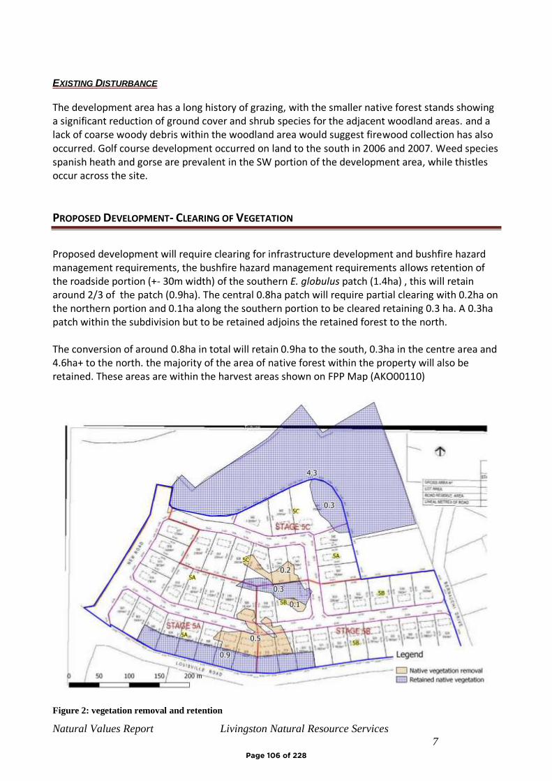
Natural Values Report Livingston Natural Resource Services
7
EXISTING DISTURBANCE
The development area has a long history of grazing, with the smaller native forest stands showing a significant reduction of ground cover and shrub species for the adjacent woodland areas. and a lack of coarse woody debris within the woodland area would suggest firewood collection has also occurred. Golf course development occurred on land to the south in 2006 and 2007. Weed species spanish heath and gorse are prevalent in the SW portion of the development area, while thistles occur across the site.
PROPOSED DEVELOPMENT- CLEARING OF VEGETATION
Proposed development will require clearing for infrastructure development and bushfire hazard management requirements, the bushfire hazard management requirements allows retention of the roadside portion (+- 30m width) of the southern E. globulus patch (1.4ha) , this will retain around 2/3 of the patch (0.9ha). The central 0.8ha patch will require partial clearing with 0.2ha on the northern portion and 0.1ha along the southern portion to be cleared retaining 0.3 ha. A 0.3ha patch within the subdivision but to be retained adjoins the retained forest to the north. The conversion of around 0.8ha in total will retain 0.9ha to the south, 0.3ha in the centre area and 4.6ha+ to the north. the majority of the area of native forest within the property will also be retained. These areas are within the harvest areas shown on FPP Map (AKO00110)
Figure 2: vegetation removal and retention
Page 106 of 228
Natural Values Report Livingston Natural Resource Services
8
CONCLUSIONS
The development area contains two small (1.4 & 0.6ha) stands and a portion (0.3ha) of a larger stand of Eucalyptus globulus, a threatened vegetation community that also provides foraging habitat for, swift parrot, a federally and state listed threatened species that will be affected by clearing for development. Portions of the southern and central patches will be retained, giving a clearing requirement of 0.8ha. A 4.3ha patch of the same vegetation community (DGL) immediately north of the development is shown to be retained in the site master plan and an adjoining 0.3ha within the proposed subdivision is also to be retained.
The development area has suitable habitat for threatened flora known within 5km, although no threatened flora was identified on the site visit or previous studies, noting no survey of areas outside proposed development site was not conducted.
The development area has suitable foraging but no nesting/denning habitat for several wide-ranging threatened fauna species. Clearing of the site would have a very minor impact on foraging habitat for wide ranging species such as devils, quolls, eagles and masked owls, retained vegetation on surrounding land will provide alternate habitat and therefore the impact is expected to be minimal. Ghania radula occurs within the site and adjacent areas and is the host plant for threatened species Antipodia chaostola, chaostola skipper butterfly. The species has not been detected on the site and undeveloped areas of the property also contain Ghania radula and no impact on this species is likely. The proposal retains stands of Eucalyptus globulus within and adjacent to the subdivision which will continue to provide foraging habitat for swift parrot. The clearing of 0.8ha will affect around 10% of the foraging habitat in the immediate area and 5% within the property. Impact on this species is likely to be minor provided alternate foraging is available in the vicinity. No potential breeding habitat for the species is affected.
The proposed clearing is within the harvest boundaries of expired FPP (AKO00110) for the area, and the prescriptions for retention and revegetation of native vegetation for the FPP were considered to be sufficient to mitigate any loss of habitat at that time. The extent of retained vegetation on the property is considerable and further offsetting for previously approved clearing does not appear to be necessary.
REFERENCES
Andy Hamilton & Associates (2019), Subdivision Stage 5 Lot Plan GD1914-P7
Department of the Environment and Energy, Proteced Matters Report. (accessed 23/102019).
Department of Primary Industry Parks Water and Environment (DPIPWE). (accessed 7/10/2019).
Natural Values Report, Derived from the Natural Values Atlas, online database.
Department of Primary Industries, Parks, Water and Environment.DPIPWE. Thelist.tas.gov.au ,
spatial datasets
Page 107 of 228
Natural Values Report Livingston Natural Resource Services
9
Department of Primary Industries, Parks, Water and Environment. DPIPWE. Tasmanian
Vegetation Monitoring and Mapping Program TASVEG 3.0.
Forest Practices Authority (accessed 23/10/2019). Biodiversity Values Database
Forest Practices Authority, (2005)Forest Botany Module 4_Freycinet
Geo-Environmental Solutions (2019), Bushfire Hazard ReportStage 5, Lot 1 Tasman Hwy, Orford,
GES045939
Glamorgan-Spring BayBayCity Council. (2015). Glamorgan-Spring BayBayCouncil Interim
Planning Scheme
Harris & Kitchener, (2005) From Forest to Fjaeldmark, Descriptions of Tasmania's Vegetation
(Edition 2)
JMG ((2018) Solis Louisville Point Concept Master Plan
Tasmanian Herbarium (2003), Botanical Survey of the Property of Mr John Salmon, near
Louisville, Tasmania
Wapstra et al. Little Book of Common Names for Tasmanian Plants,
Page 108 of 228
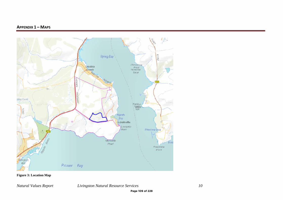
Natural Values Report Livingston Natural Resource Services 10
APPENDIX 1 – MAPS
Figure 3: Location Map
Page 109 of 228
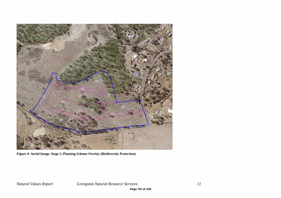
Natural Values Report Livingston Natural Resource Services 11
Figure 4: Aerial Image, Stage 5, Planning Scheme Overlay (Biodiversity Protection)
Page 110 of 228
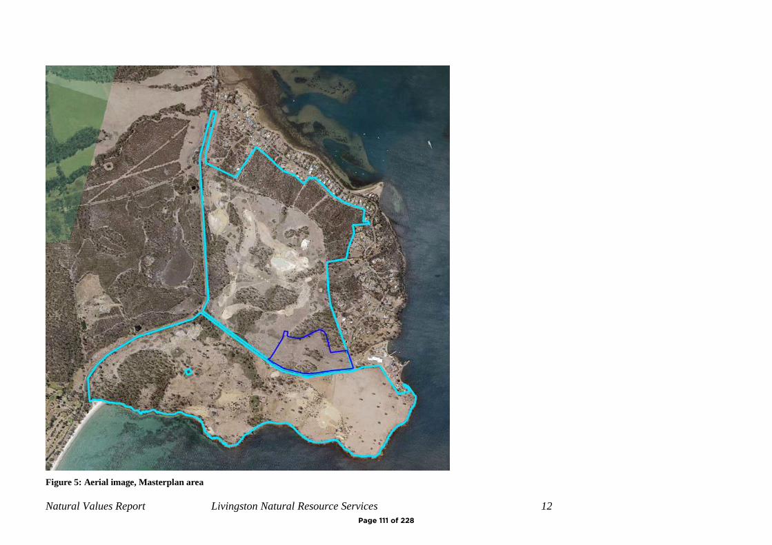
Natural Values Report Livingston Natural Resource Services 12
Figure 5: Aerial image, Masterplan area
Page 111 of 228
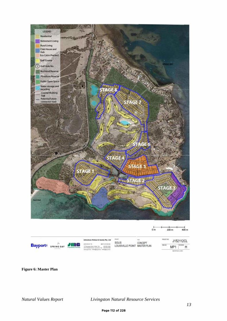
Natural Values Report Livingston Natural Resource Services
13
Figure 6: Master Plan
Page 112 of 228
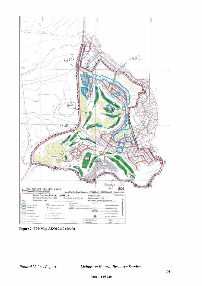
Natural Values Report Livingston Natural Resource Services
14
Figure 7: FPP Map AKO00110 (draft)
Page 113 of 228
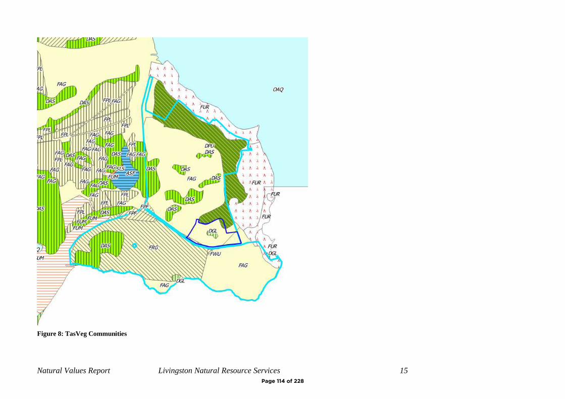
Natural Values Report Livingston Natural Resource Services 15
Figure 8: TasVeg Communities
Page 114 of 228

Natural Values Report Livingston Natural Resource Services 16
Figure 9: Vegetation communities (Tasmanian Herbarium report)
Page 115 of 228
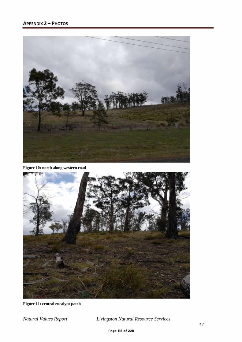
Natural Values Report Livingston Natural Resource Services
17
APPENDIX 2 – PHOTOS
Figure 10: north along western road
Figure 11: central eucalypt patch
Page 116 of 228
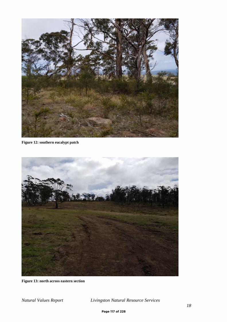
Natural Values Report Livingston Natural Resource Services
18
Figure 12: southern eucalypt patch
Figure 13: north across eastern section
Page 117 of 228
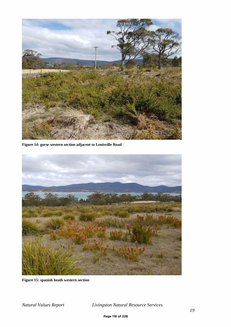
Natural Values Report Livingston Natural Resource Services
19
Figure 14: gorse western section adjacent to Louisville Road
Figure 15: spanish heath western section
Page 118 of 228
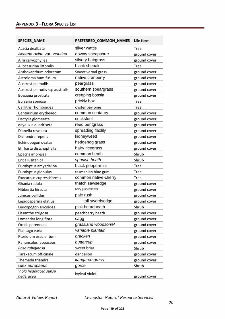
Natural Values Report Livingston Natural Resource Services
20
APPENDIX 3 –FLORA SPECIES LIST
SPECIES_NAME PREFERRED_COMMON_NAMES Life form
Acacia dealbata silver wattle Tree
Acaena ovina var. velutina downy sheepsburr ground cover
Aira caryophyllea silvery hairgrass ground cover
Allocasurina littoralis black sheoak Tree
Anthoxanthum odoratum Sweet vernal grass ground cover
Astroloma humifusum native cranberry ground cover
Austrostipa mollis peargrass ground cover
Austrostipa rudis ssp australis southern speargrass ground cover
Bossiaea prostrata creeping bossia ground cover
Bursaria spinosa prickly box Tree
Calllitris rhomboidea oyster bay pine Tree
Centaurium erytheaec common centaury ground cover
Dactylis glomerata cocksfoot ground cover
deyeuxia quadriseta reed bentgrass ground cover
Dianella revoluta spreading flaxlily ground cover
Dichondra repens kidneyweed ground cover
Echinopogon ovatus hedgehog grass ground cover
Ehrharta distchophylla hairy ricegrass ground cover
Epacris impressa common heath Shrub
Erica lusitanica spanish heath Shrub
Eucalyptus amygdalina black peppermint Tree
Eucalyptus globulus tasmanian blue gum Tree
Exocarpus cupressiformis common native-cherry Tree
Ghania radula thatch sawsedge ground cover
Hibbertia hirsuta hairy guineaflower ground cover
Jumcus pallidus pale rush ground cover
Lepidosperma elatius tall swordsedge ground cover
Leucopogon ericoides pink beardheath Shrub
Lissanthe strigosa peachberry heath ground cover
Lomandra longiflora sagg ground cover
Oxalis perennans grassland woodsorrel ground cover
Plantago varia variable plantain ground cover
Pteridium esculentum bracken ground cover
Ranunculus lappaceus buttercup ground cover
Rosa rubiginosa sweet briar Shrub
Taraxacum officinale dandelion ground cover
Themeda triandra kangaroo grass ground cover
Ulex europaeus gorse Shrub
Viola hederacea subsp hederacea
ivyleaf violet ground cover
Page 119 of 228
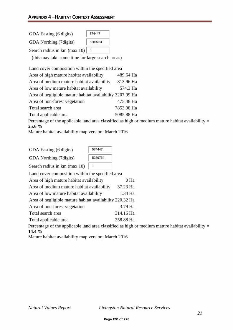
Natural Values Report Livingston Natural Resource Services
21
APPENDIX 4 –HABITAT CONTEXT ASSESSMENT
GDA Easting (6 digits) 574447
GDA Northing (7digits) 5289754
Search radius in km (max 10) 5
(this may take some time for large search areas)
Land cover composition within the specified area
Area of high mature habitat availability 489.64 Ha
Area of medium mature habitat availability 813.96 Ha
Area of low mature habitat availability 574.3 Ha
Area of negligible mature habitat availability 3207.99 Ha
Area of non-forest vegetation 475.48 Ha
Total search area 7853.98 Ha
Total applicable area 5085.88 Ha
Percentage of the applicable land area classified as high or medium mature habitat availability =
25.6 %
Mature habitat availability map version: March 2016
GDA Easting (6 digits) 574447
GDA Northing (7digits) 5289754
Search radius in km (max 10) 1
Land cover composition within the specified area
Area of high mature habitat availability 0 Ha
Area of medium mature habitat availability 37.23 Ha
Area of low mature habitat availability 1.34 Ha
Area of negligible mature habitat availability 220.32 Ha
Area of non-forest vegetation 3.79 Ha
Total search area 314.16 Ha
Total applicable area 258.88 Ha
Percentage of the applicable land area classified as high or medium mature habitat availability =
14.4 %
Mature habitat availability map version: March 2016
Page 120 of 228
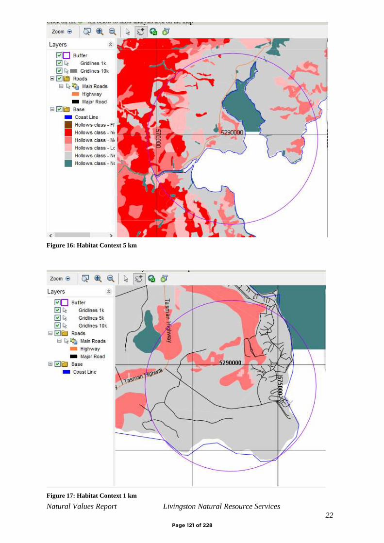
Natural Values Report Livingston Natural Resource Services
22
Figure 16: Habitat Context 5 km
Figure 17: Habitat Context 1 km
Page 121 of 228
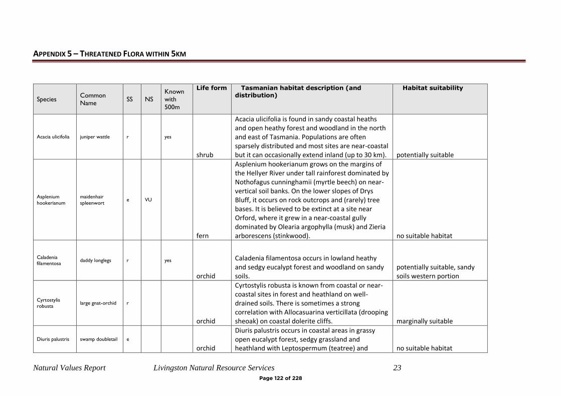
Natural Values Report Livingston Natural Resource Services 23
APPENDIX 5 – THREATENED FLORA WITHIN 5KM
Species Common Name
SS NS Known with
500m
Life form Tasmanian habitat description (and distribution)
Habitat suitability
Acacia ulicifolia juniper wattle r yes
shrub
Acacia ulicifolia is found in sandy coastal heaths and open heathy forest and woodland in the north and east of Tasmania. Populations are often sparsely distributed and most sites are near-coastal but it can occasionally extend inland (up to 30 km). potentially suitable
Asplenium
hookerianum
maidenhair
spleenwort e VU
fern
Asplenium hookerianum grows on the margins of the Hellyer River under tall rainforest dominated by Nothofagus cunninghamii (myrtle beech) on near-vertical soil banks. On the lower slopes of Drys Bluff, it occurs on rock outcrops and (rarely) tree bases. It is believed to be extinct at a site near Orford, where it grew in a near-coastal gully dominated by Olearia argophylla (musk) and Zieria arborescens (stinkwood). no suitable habitat
Caladenia
filamentosa daddy longlegs r yes
orchid
Caladenia filamentosa occurs in lowland heathy and sedgy eucalypt forest and woodland on sandy soils.
potentially suitable, sandy soils western portion
Cyrtostylis
robusta large gnat-orchid r
orchid
Cyrtostylis robusta is known from coastal or near-coastal sites in forest and heathland on well-drained soils. There is sometimes a strong correlation with Allocasuarina verticillata (drooping sheoak) on coastal dolerite cliffs. marginally suitable
Diuris palustris swamp doubletail e orchid
Diuris palustris occurs in coastal areas in grassy open eucalypt forest, sedgy grassland and heathland with Leptospermum (teatree) and no suitable habitat
Page 122 of 228
Natural Values Report Livingston Natural Resource Services 24
Melaleuca (paperbark) on poorly- to moderately-drained sandy peat and loams, usually in sites that are wet in winter.
Eucalyptus
barberi barbers gum r
tree
Eucalyptus barberi occurs on dolerite-derived soils on the central east coast of Tasmania, with disjunct populations occurring in the Wielangta area. The species tends to occur on broad ridgelines, saddles and flats, often with high surface rock cover (including at the edge of dolerite rock plates). Eucalyptus barberi generally occurs in localised stands in heathy/grassy eucalypt forest and woodland, typically dominated by E. pulchella, with E. viminalis and E. ovata also present on some sites. marginally suitable
Eucalyptus
barberi x
cordata ph
#N/A #N/A
Glossostigma
elatinoides small mudmat r
herb
Glossostigma elatinoides is an aquatic plant that occurs submerged in shallow water and on the banks of streams. no suitable habitat
Gyrostemon
thesioides broom wheelfruit r
shrub
Gyrostemon thesioides occurs predominately on dolerite or granite in Allocasuarina (sheoak) forest in the State’s east and north-east, including the Furneaux Group. no suitable habitat
Juncus amabilis gentle rush r?
rush
Juncus amabilis occurs in a variety of habitats, usually poorly-drained sites such as damp grasslands and grassy woodlands, wet pastures, roadside ditches and edges of still and slow-flowing waterbodies. As presently understood, the species is mainly confined to lowland areas in the eastern half of the State but there are potential higher elevation and more western records that require confirmation. no suitable habitat
Page 123 of 228
Natural Values Report Livingston Natural Resource Services 25
Lepidium
hyssopifolium soft peppercress e EN
herb
The native habitat of Lepidium hyssopifolium is the growth suppression zone beneath large trees in grassy woodlands and grasslands (e.g. over- mature black wattles and isolated eucalypts in rough pasture). Lepidium hyssopifolium is now found primarily under large exotic trees on roadsides and home yards on farms. It occurs in the eastern part of Tasmania between sea-level to 500 metres above sea level in dry, warm and fertile areas on flat ground on weakly acid to alkaline soils derived from a range of rock types. It can also occur on frequently slashed grassy/weedy roadside verges where shade trees are absent. marginally suitable
Limonium
australe var.
baudinii
tasmanian sea-
lavender v VU
herb
Limonium australe var. baudinii is known only from the Triabunna and Saltwater River areas where it occurs in succulent or graminoid saltmarsh close to the high water mark, typically near small brackish streams. no suitable habitat
Melaleuca
pustulata warty paperbark r
shrub
Melaleuca pustulata occurs in a range of habitats including dry open woodland (often on dolerite in forests dominated by Eucalyptus pulchella), grassland and scrub, riparian zones and stable dunes in sparse coastal shrubbery. It is restricted to the State’s Central East coast. marginally suitable
Ozothamnus
lycopodioides
clubmoss
everlastingbush r
shrub
Ozothamnus lycopodioides is restricted to dry sclerophyll forest near the East Coast from Orford to Bicheno where it is restricted to dolerite. marginally suitable
Pimelea flava
subsp. flava yellow riceflower r
shrub
Pimelea flava subsp. flava occurs in wet and dry sclerophyll forest and woodland, and extends into hardwood and softwood plantations. It often occurs abundantly on disturbed sites such as in logged forest, firebreaks, powerline easements and road batters. marginally suitable
Page 124 of 228
Natural Values Report Livingston Natural Resource Services 26
Pomaderris
intermedia lemon dogwood r
shrub
Pomaderris intermedia occurs in heathland and heathy woodland on eastern Bass Strait islands but extends to mainly dry sclerophyll forest on mainland Tasmania, most often associated with rock outcrops (dolerite), riparian areas and open forest. marginally suitable
Pterostylis
squamata ruddy greenhood v
orchid
Pterostylis squamata occurs in heathy and grassy open eucalypt forest, woodland and heathland on well-drained sandy and clay loams.
potentially suitable, sandy soils western portion
Ruppia tuberosa tuberous
seatassel r
aquatic herb
Ruppia tuberosa has been recorded from the State’s south-east at Ralphs Bay and Blackman Bay, where it grows in holes and channels in saltmarshes. no suitable habitat
Scaevola aemula fairy fanflower e
herb
Scaevola aemula is restricted to the East Coast between the Prosser and the Apsley rivers, where its habitat includes dry woodland/forest dominated by Allocasuarina verticillata (drooping sheoak) or ‘half-barked’ Eucalyptus amygdalina, with Callitris rhomboidea (oyster bay pine) also usually present. The species often occurs on rocky dolerite slopes. marginally suitable
Scleranthus
fasciculatus spreading knawel v
herb
Scleranthus fasciculatus is only recorded from a few locations in the Midlands and south-east. The vegetation at most of the sites is Poa grassland/grassy woodland. Scleranthus fasciculatus appears to need gaps between the tussock spaces for its survival and both fire and stock grazing maintain the openness it requires. Often found in areas protected from grazing such as fallen trees and branches. no suitable habitat
Senecio
squarrosus leafy fireweed r
herb
Senecio squarrosus occurs in a wide variety of habitats. One form occurs predominantly in lowland damp tussock grasslands. The more widespread and common form occurs mainly in dry marginally suitable
Page 125 of 228

Natural Values Report Livingston Natural Resource Services 27
forests (often grassy) but extends to wet forests and other vegetation types.
Stenanthemum
pimeleoides propeller plant v VU
shrub
Stenanthemum pimeleoides is restricted to Tasmania’s central East Coast and the Northern Midlands, where it occurs in dry sclerophyll forest or woodland with an open heathy or shrubby understorey. The topography tends to be flat to gently sloping. The species occurs in the drier parts of the State with rainfall between 500-800 mm per year, and usually at elevations below 100 m. marginally suitable
Teucrium
corymbosum forest germander r
shrub
Teucrium corymbosum occurs in a wide range of habitats from rocky steep slopes in dry sclerophyll forest and Allocasuarina (sheoak) woodland, riparian flats and forest. marginally suitable
Vittadinia
gracilis
woolly new-
holland-daisy r
herb Vittadinia gracilis occurs in native grassland and grassy woodland. marginally suitable
Page 126 of 228
Natural Values Report Livingston Natural Resource Services 28
APPENDIX 6 – THREATENED FAUNA WITHIN 5KM
Species Common Name SS NS Range
Known
within 500m
Known
within 5km
Habitat Description Habitat suitability
Antipodia chaostola chaostola skipper e EN Potential
Potential habitat for the Chaostola Skipper is dry forest and woodland supporting Gahnia radula (usually on sandstone and other sedimentary rock types) or Gahnia microstachya (usually on granite baseds ubstrates).
Suitable Gahnia radula located on site
Accipiter novaehollandiae grey goshawk
e
Potential
Requires wet sclerophyll forest for breeding and foraging. Potential habitat for the grey goshawk is native forest with mature elements below 600m altitude, particularly along watercourses. Significant habitat for the grey goshawk may be summarised as areas of wet forest, rainforest and damp forest patches in dry forest, with a relatively closed mature canopy, low stem density, and open understorey in close proximity to foraging habitat and a freshwater body (i.e. stream, river, lake, swamp, etc.). FPA's Fauna Technical Note 12 can be used as a guide in the identification of grey goshawk habitat. no suitable habitat
Page 127 of 228
Natural Values Report Livingston Natural Resource Services 29
Aquila audax subsp. fleayi tasmanian wedge-tailed eagle e EN Potential
yes
Potential habitat for the wedge tailed eagle comprises potential nesting habitat and potential foraging habitat. Potential foraging habitat is a wide variety of forest (including areas subject to native forest silviculture) and non-forest habitats. Potential nesting habitat is tall eucalypt trees in large tracts (usually more than 10ha) of eucalypt or mixed forest. Nest trees are usually amongst the largest in a locality. They are generally in sheltered positions on leeward slopes, between the lower and mid sections of a slope and with the top of the tree usually lower than the ground level of the top of the ridge, although in some parts of the State topographic shelter is not always a significant factor (e.g. parts of the northwest and Central Highlands). Nests are usually not constructed close to sources of disturbance and nests close to disturbance are less productive. More than one nest may occur within a territory but only one is used for breeding in any one year. Breeding failure often promotes a change of nest in the next year. [see FPA?s Fauna Technical Note 1 and FPA?s Fauna Technical Note 6 for more information] Significant habitat for the wedge tailed eagle is all native forest and native non-forest vegetation within 500 m or 1 km line of sight of known nest sites (where the nest tree is still present).
foraging habitat, no nesting habitat in development area
Page 128 of 228

Natural Values Report Livingston Natural Resource Services 30
Botaurus poiciloptilus australasian bittern EN Potential
yes
Australasian Bitterns are widespread but uncommon over south-eastern Australia.Favours permanent freshwater wetlands with tall, dense vegetation, particularly bullrushes (Typha spp.) and spikerushes (Eleocharis spp.) no suitable habitat
Calidris ferruginea curlew sandpiper CR yes #N/A
Dasyurus maculatus spotted-tail quoll r VU
yes
Potential habitat for the spotted tailed quoll is coastal scrub, riparian areas, rainforest, wet forest, damp forest, dry forest and blackwood swamp forest (mature and regrowth), particularly where structurally complex areas are present, and includes remnant patches in cleared agricultural land or plantation areas. Significant habitat for the spotted tailed quoll is all potential denning habitat within the core range of the species. Potential denning habitat for the spotted tailed quoll includes 1) any forest remnant (>0.5ha) in a cleared or plantation landscape that is structurally complex (high canopy, with dense understorey and ground vegetation cover), free from the risk of inundation, or 2) a rock outcrop, rock crevice, rock pile, burrow with a small entrance, hollow logs, large piles of coarse woody debris and caves. FPA’s Fauna Technical Note 10 can be used as a guide in the identification of potential denning habitat.
foraging habitat, no denning
habitat in development area
Page 129 of 228
Natural Values Report Livingston Natural Resource Services 31
Dasyurus viverrinus eastern quoll EN Potential
yes
Potential habitat for the Eastern quoll includes rainforest, heathland, alpine areas and scrub. However, it seems to prefer dry forest and native grassland mosaics which are bounded by agricultural land. Potential range for the Eastern Quoll is the whole of mainland Tasmania and Bruny Island. Core range for the Eastern Quoll is a specialist defined area based primarily on modelling work published in Fancourt et al 2015 and additional expert advice
foraging habitat, no denning
habitat in development area
Diomedea cauta subsp.
cauta shy albatross pv PVU Core
yes
Birds have been noted in shelf-waters around breeding islands and over adjacent rises. During the non-breeding season, the Shy Albatross occurs over continental shelves around continents. The species occurs both inshore and offshore
nil - shore bird
Eubalaena australis southern right whale e EN yes Marine. nil- marine species
Gazameda gunnii Gunn's screw shell v yes Marine species nil- marine species
Page 130 of 228

Natural Values Report Livingston Natural Resource Services 32
Haliaeetus leucogaster white-bellied sea-eagle v Potential
yes
Potential habitat for the White Bellied Sea eagle species comprises potential nesting habitat and potential foraging habitat. Potential foraging habitat is any large waterbody (including sea coasts, estuaries, wide rivers, lakes, impoundments and even large farm dams) supporting prey items (fish). Potential nesting habitat is tall eucalypt trees in large tracts (usually more than 10 ha) of eucalypt or mixed forest within 5 km of the coast (nearest coast including shores, bays, inlets and peninsulas), large rivers (Class 1), lakes or complexes of large farm dams. Scattered trees along river banks or pasture land may also be used. Significant habitat for the white bellied sea eagle is all native forest and native non-forest vegetation within 500 m or 1 km line of sight of known nest sites (where nest tree still present). 0
Hirundapus caudacutus white-throated needletail VU yes migratory/marine - breeds in Asia nil - breeding (migratory)
Lathamus discolor swift parrot e CR Core yes yes
Potential breeding habitat for the swift parrot comprises potential foraging habitat and potential nesting habitat, and is based on definitions of foraging and nesting trees. Potential foraging habitat comprises E. globulus or E. ovata trees that are old enough to flower. Potential nesting habitat is considered to comprise eucalypt forests that contain hollow-bearing trees.
suitable foraging habitat - E.
globulus, no breding habitat
Page 131 of 228
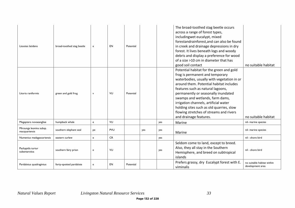
Natural Values Report Livingston Natural Resource Services 33
Lissotes latidens broad-toothed stag beetle e EN Potential
The broad-toothed stag beetle occurs across a range of forest types, includingwet eucalypt, mixed forestandrainforest,and can also be found in creek and drainage depressions in dry forest. It lives beneath logs and woody debris and display a preference for wood of a size >10 cm in diameter that has good soil contact no suitable habitat
Litoria raniformis green and gold frog v VU Potential
Potential habitat for the green and gold frog is permanent and temporary waterbodies, usually with vegetation in or around them. Potential habitat includes features such as natural lagoons, permanently or seasonally inundated swamps and wetlands, farm dams, irrigation channels, artificial water holding sites such as old quarries, slow flowing stretches of streams and rivers and drainage features. no suitable habitat
Megaptera novaeangliae humpback whale e VU yes Marine nil- marine species
Mirounga leonina subsp.
macquariensis southern elephant seal pe PVU yes yes
Marine nil- marine species
Numenius madagascariensis eastern curlew e CR yes nil - shore bird
Pachyptila turtur
subantarctica southern fairy prion e VU
yes
Seldom come to land, except to breed. Also, they all stay in the Southern Hemisphere, and breed on subtropical islands
nil - shore bird
Pardalotus quadragintus forty-spotted pardalote e EN Potential
Prefers grassy, dry Eucalypt forest with E. viminalis
no suitable habitat within
development area
Page 132 of 228

Natural Values Report Livingston Natural Resource Services 34
Perameles gunnii eastern barred bandicoot VU Core
yes
Potential habitat for the eastern barred bandicoot is open vegetation types including woodlands and open forests with a grassy understorey, native and exotic grasslands, particularly in landscapes with a mosaic of agricultural land and remnant bushland. Significant habitat for the Eastern Barred Bandicoot is dense tussock grass sagg sedge swards, piles of coarse woody debris and denser patches of low shrubs (especially those that are densely branched close to the ground providing shelter) within the core range of the species. suitable habitat
Prototroctes maraena australian grayling v VU Potential
yes
All streams and rivers in their lower to middle reaches. Areas above permanent barriers that prevent fish migration are not potential habitat no suitable habitat
Page 133 of 228
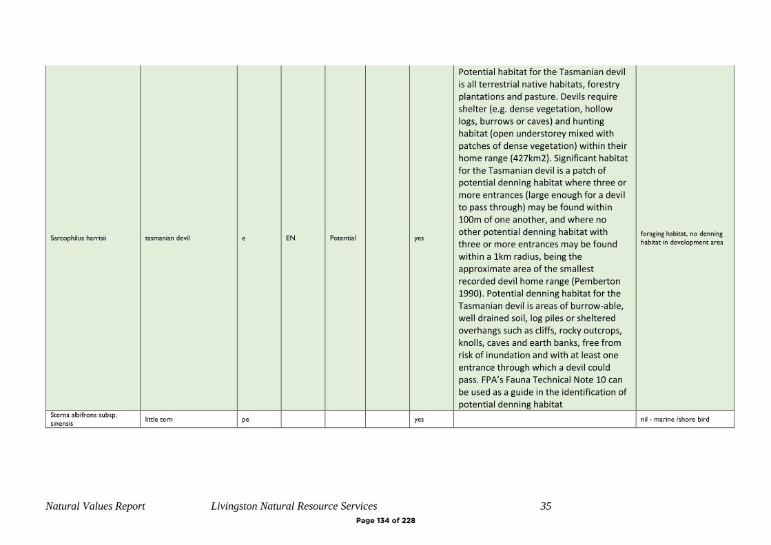
Natural Values Report Livingston Natural Resource Services 35
Sarcophilus harrisii tasmanian devil e EN Potential
yes
Potential habitat for the Tasmanian devil is all terrestrial native habitats, forestry plantations and pasture. Devils require shelter (e.g. dense vegetation, hollow logs, burrows or caves) and hunting habitat (open understorey mixed with patches of dense vegetation) within their home range (427km2). Significant habitat for the Tasmanian devil is a patch of potential denning habitat where three or more entrances (large enough for a devil to pass through) may be found within 100m of one another, and where no other potential denning habitat with three or more entrances may be found within a 1km radius, being the approximate area of the smallest recorded devil home range (Pemberton 1990). Potential denning habitat for the Tasmanian devil is areas of burrow-able, well drained soil, log piles or sheltered overhangs such as cliffs, rocky outcrops, knolls, caves and earth banks, free from risk of inundation and with at least one entrance through which a devil could pass. FPA’s Fauna Technical Note 10 can be used as a guide in the identification of potential denning habitat
foraging habitat, no denning
habitat in development area
Sterna albifrons subsp.
sinensis little tern pe yes nil - marine /shore bird
Page 134 of 228

Natural Values Report Livingston Natural Resource Services 36
Sterna nereis subsp. nereis fairy tern pv PVU
yes
It seldom goes far out to sea but is often to be seen where predatory fish are feeding on shoals of small fish. Breeding takes place in the spring in colonies on sheltered beaches on the mainland or on offshore islands. The nest is just above high-water mark and is a scrape in the sand
nil - marine /shore bird
Sternula nereis subsp.
nereis fairy tern v VU yes nil - shore bird
Theclinesthes serpentata
subsp. lavara Chequered Blue r
yes
nil - shore bird
Thinornis rubricollis hooded plover VU yes nil - shore bird
Thylacinus cynocephalus thylacine x EX yes presumed extinct
Page 135 of 228
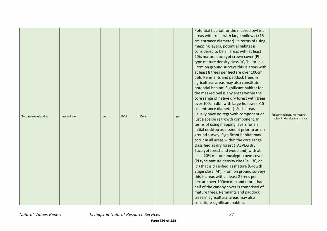
Natural Values Report Livingston Natural Resource Services 37
Tyto novaehollandiae masked owl pe PVU Core
yes
Potential habitat for the masked owl is all areas with trees with large hollows (>15 cm entrance diameter). In terms of using mapping layers, potential habitat is considered to be all areas with at least 20% mature eucalypt crown cover (PI type mature density class `a’, `b’, or `c’). From on ground surveys this is areas with at least 8 trees per hectare over 100cm dbh. Remnants and paddock trees in agricultural areas may also constitute potential habitat. Significant habitat for the masked owl is any areas within the core range of native dry forest with trees over 100cm dbh with large hollows (>15 cm entrance diameter). Such areas usually have no regrowth component or just a sparse regrowth component. In terms of using mapping layers for an initial desktop assessment prior to an on ground survey. Significant habitat may occur in all areas within the core range classified as dry forest (TASVEG dry Eucalypt forest and woodland) with at least 20% mature eucalypt crown cover (PI type mature density class `a’, `b’, or `c’) that is classified as mature (Growth Stage class `M’). From on ground surveys this is areas with at least 8 trees per hectare over 100cm dbh and more than half of the canopy cover is comprised of mature trees. Remnants and paddock trees in agricultural areas may also constitute significant habitat.
foraging habitat, no nesting
habitat in development area
Page 136 of 228

Natural Values Report Livingston Natural Resource Services 38
Page 137 of 228
Spring Bay Stage 5 – Proposed Subdivision
Report for: Bayport Pty Ltd
Property Location: Part Lot 1 Tasman Hwy, Orford
Prepared by: Scott Livingston
Livingston Natural Resource Services 12 Powers Road Underwood, 7268
Date: 30th January 2020
Natural Values Offsetting Report
Page 138 of 228

Natural Values Offset Report Livingston Natural Resource Services
i
Client:
Bayport Pty Ltd
Property identification
Lot 1 Tasman Hwy, Orford. CT 139972/1, PID 2549195 Current zoning is Rural Resource, Louisville Road Specific Area Plan Glamorgan-Spring Bay Interim Planning Scheme 2015
Proposal:
Development as part of Stage 5 of Subdivision, lots 501-547 will include removal of 0.8ha of Eucalyptus globulus dry forest and woodland (DGL). This is a threatened vegetation community that also provides foraging habitat for swift parrot, a federally and state listed threatened species.
Under the Glamorgan-Spring Bay Interim Planning Scheme 2015, the proposal requires assessment against E10.8.P1.
Assessment comments:
A field inspection was conducted on the 22nd January 2020. This field assessments to undertake Vegetation Condition Assessments on the proposed clearing and offset areas. This report summarises the findings of that assessment.
Assessment by: Scott Livingston, Master Environmental Management, Forest Practices Officer (Planning) Natural Resource Management Consultant.
Page 139 of 228
Natural Values Offset Report Livingston Natural Resource Services
i
Contents INTRODUCTION ................................................................................................................... 2
BIODIVERSITY OFFSETS ...................................................................................................... 2
PROPOSED OFFSET .............................................................................................................. 2
VEGETATION AREAS ........................................................................................................... 3
VEGETATION CONDITION ASSESSMENT .............................................................................. 3
BIODIVERSITY CODE ........................................................................................................... 6
CONCLUSIONS ..................................................................................................................... 7
REFERENCES ....................................................................................................................... 7
APPENDIX 1 – MAPS............................................................................................................ 8
APPENDIX 2 – PHOTOS ...................................................................................................... 11
Figure 1: Location Map Stage 5................................................................................................. 8
Figure 2: Aerial Image, Stage 5, Planning Scheme Overlay (Biodiversity Protection) ............ 9 Figure 3: Proposed clearing, retained vegetation and offset area ............................................ 10
Figure 4: north along western road .......................................................................................... 11 Figure 5: central eucalypt patch, portions to be cleared .......................................................... 11 Figure 6: southern eucalypt patch, to be retained .................................................................... 12
Figure 7: proposed offset area, northern section ...................................................................... 12 Figure 8: proposed offset area, fire felled large tree ................................................................ 13
Figure 9: offset area southern section ...................................................................................... 13 Figure 11: Spanish Heath on proposed POS ............................................................................ 14
Page 140 of 228
Natural Values Offset Report Livingston Natural Resource Services
2
INTRODUCTION
The developers propose to develop Stage 5 of the Spring Bay Land Development. This 47 lot in 3 stages covers lots 501-547 and includes public roads and associated infrastructure. Portions of the development are mapped as Biodiversity Protection Overlay. The subdivision is within the Louisville Road Specific Area Plan Glamorgan-Spring Bay Interim Planning Scheme 2015, and residential development on the site has been in the planning process for a considerable period. Clearing of the vegetation within the subdivision was approved under now expired Forest Practices Plan AKO00110, which accounted for loss of vegetation and reserved area across the site. A Natural Values Report, Livingston Natural Resource Services, 5/11/2019, identified of 0.8ha of Eucalyptus globulus dry forest and woodland (DGL) that would require clearing and conversion as part of the proposed development. Eucalyptus globulus dry forest and woodland is a threatened vegetation community that also provides foraging habitat for swift parrot, a federally and state listed threatened species. The retention (avoidance of clearing) of these patches within the proposed subdivision stage would impact on lot yield and Bushfire ratings of future residences.
BIODIVERSITY OFFSETS
Biodiversity Offsets are actions that a proponent undertakes in order to compensate for the residual impact of a use or development on a biodiversity value(s). Under the Guidelines for the Use of Biodiversity Offsets in the Local Planning Approval Process, Southern Tasmanian Councils Authority 2013, offsetting of clearing can be a combination of some or all of the following: protection in situ, protection off site, restoration, rehabilitation, research, monitoring and financial contributions. For threatened vegetation communities, to deliver a net benefit by offsetting requires 3:1-5:1 ration of similar vegetation community.
PROPOSED OFFSET
The proponents for the development propose offsite protection via a Part 5 Agreement of a 4ha of a 6ha patch immediately to the north of the proposed subdivision stage. The northern boundary of the proposed offset is within the existing patch and is offset from the planned Stage 6 subdivision by 23m, this area has been excluded as it may be required for future bushfire hazard management noting this will also be subject to future offset requirements. There is a minor discrepancy (<8m) between the western portion of the southern Offset area and existing vegetation boundary. The offset has been extended to the proposed cadastral boundaries for ease of interpretation and management. An area of 0.3 ha currently grassland that is south of the proposed offset and identified as Public Open Space on the Master Plan, is not included the 4ha offset but with weed control (Spanish Heath) and exclusion of grazing is likely to naturally
Page 141 of 228

Natural Values Offset Report Livingston Natural Resource Services
3
regenerate to E. globulus forest over time and therefore may be considered for inclusion in a Part 5 Agreement. Management of the offset area should include cessation of firewood harvesting. The existing low level of grazing does not appear to be significantly impacting the site, however stock removal may be considered. Weed removal including a small infestation of Spanish Heath on the grassland portion and isolated gorse plants in the western portion.
VEGETATION AREAS
Proposed stage 5 and offset area have 6.4ha of existing E. globulus forest, this does not include the 2ha north of the offset area that may be subject to future development. The table below summarises the areas to be cleared and retained.
Ha % Total
retained within subdivision 1.6 25%
Offset Area 4 63%
cleared vegetation 0.8 13%
TOTAL 6.4 100%
VEGETATION CONDITION ASSESSMENT
The proposed clearing and offset area were assessed using the methodology in Michaels. K (2006), A Manual for Assessing Vegetation Condition in Tasmania, DPIWE and the TasVeg Benchmarks for DGL Eucalyptus globulus dry forest and woodland coastal facies – forest V2. A single plot was
established to represent each of the impacted area and proposed offset.
The proposed clearing area has a generally grassy understorey while the proposed offset area has a shrubbier understorey. All assessed areas have some impact for past grazing, fire and firewood harvesting. Both sites have small infestation of weeds. The offset area contains a lower number of large (>80cm DBH) trees due to recent fires and death/collapse of a number of lager trees within the patch. Both sites have good species diversity and recruitment with multiple age classes of tree species. The patches of vegetation to be removed (0.3, 0.1 % 0.2 ha) is limited in extent in proportion to the total area remaining of that vegetation community on the overall site and the neighbourhood in the > 100m ranges are high at 70% for 1km and 85% for 5km zones.
Page 142 of 228
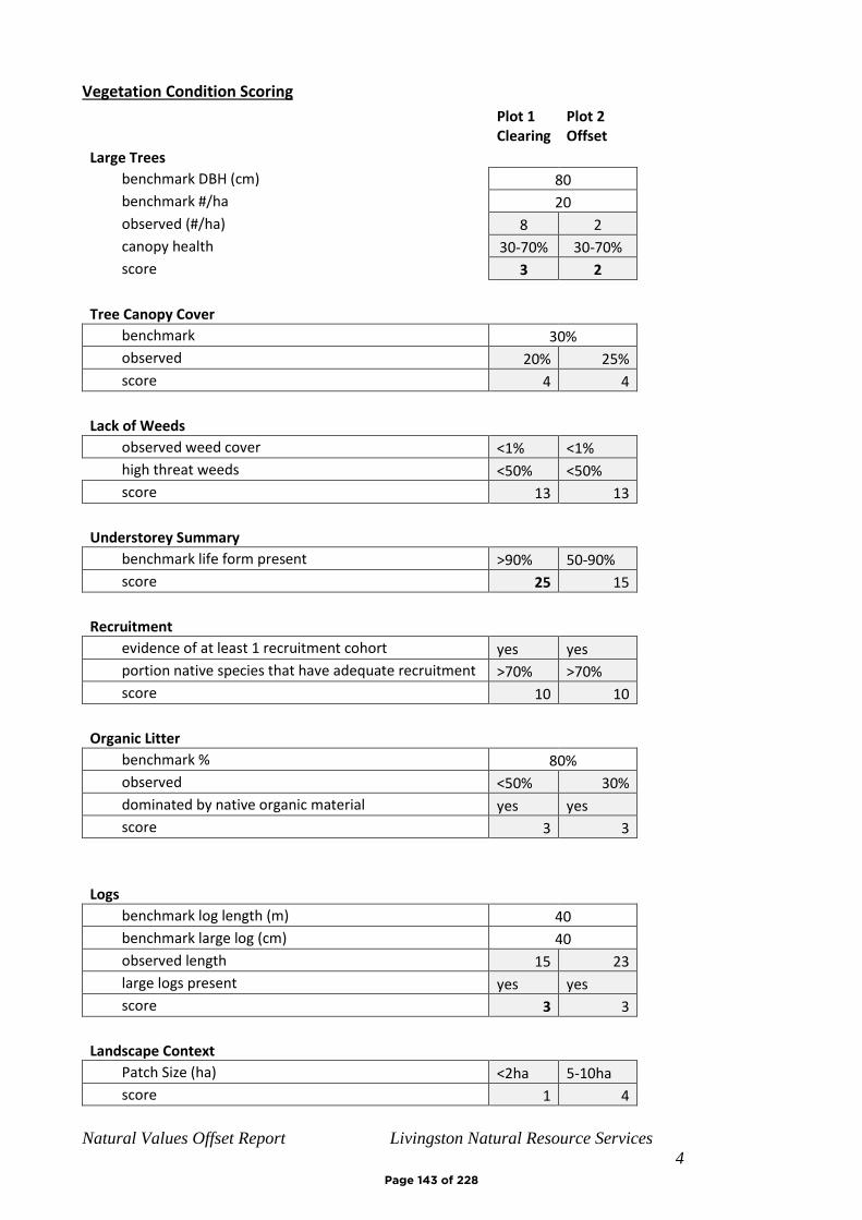
Natural Values Offset Report Livingston Natural Resource Services
4
Vegetation Condition Scoring
Plot 1 Clearing
Plot 2 Offset
Large Trees
benchmark DBH (cm) 80
benchmark #/ha 20
observed (#/ha) 8 2
canopy health 30-70% 30-70%
score 3 2
Tree Canopy Cover
benchmark 30%
observed 20% 25%
score 4 4
Lack of Weeds
observed weed cover <1% <1%
high threat weeds <50% <50%
score 13 13
Understorey Summary
benchmark life form present >90% 50-90%
score 25 15
Recruitment
evidence of at least 1 recruitment cohort yes yes
portion native species that have adequate recruitment >70% >70%
score 10 10
Organic Litter
benchmark % 80%
observed <50% 30%
dominated by native organic material yes yes
score 3 3
Logs
benchmark log length (m) 40
benchmark large log (cm) 40
observed length 15 23
large logs present yes yes
score 3 3
Landscape Context
Patch Size (ha) <2ha 5-10ha
score 1 4
Page 143 of 228
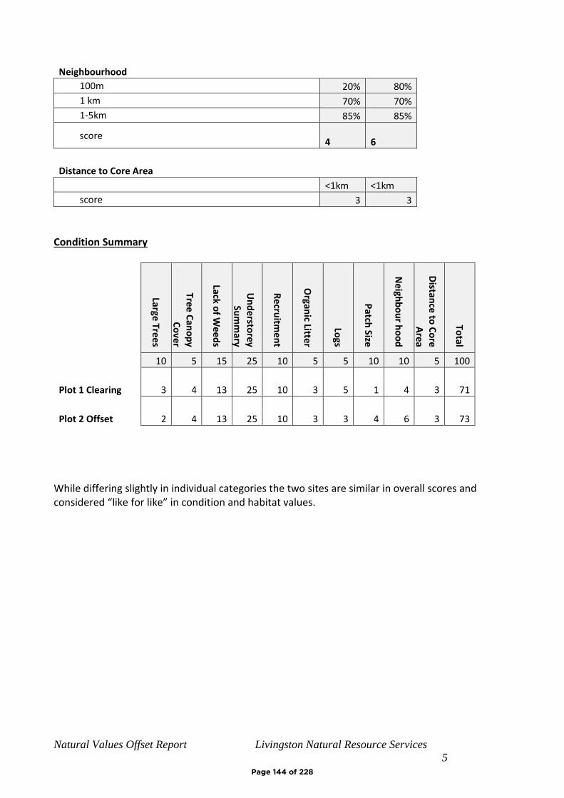
Natural Values Offset Report Livingston Natural Resource Services
5
Neighbourhood
100m 20% 80%
1 km 70% 70%
1-5km 85% 85%
score 4
6
Distance to Core Area
<1km <1km
score 3 3
Condition Summary
Large Tre
es
Tree C
ano
py
Co
ver
Lack of W
eed
s
Un
de
rstore
y Su
mm
ary
Re
cruitm
en
t
Organ
ic Litter
Logs
Patch
Size
Neigh
bo
ur h
oo
d
Distan
ce to
Co
re A
rea
Total
10 5 15 25 10 5 5 10 10 5 100
Plot 1 Clearing 3 4 13 25 10 3 5 1 4 3 71
Plot 2 Offset 2 4 13 25 10 3 3 4 6 3 73
While differing slightly in individual categories the two sites are similar in overall scores and considered “like for like” in condition and habitat values.
Page 144 of 228
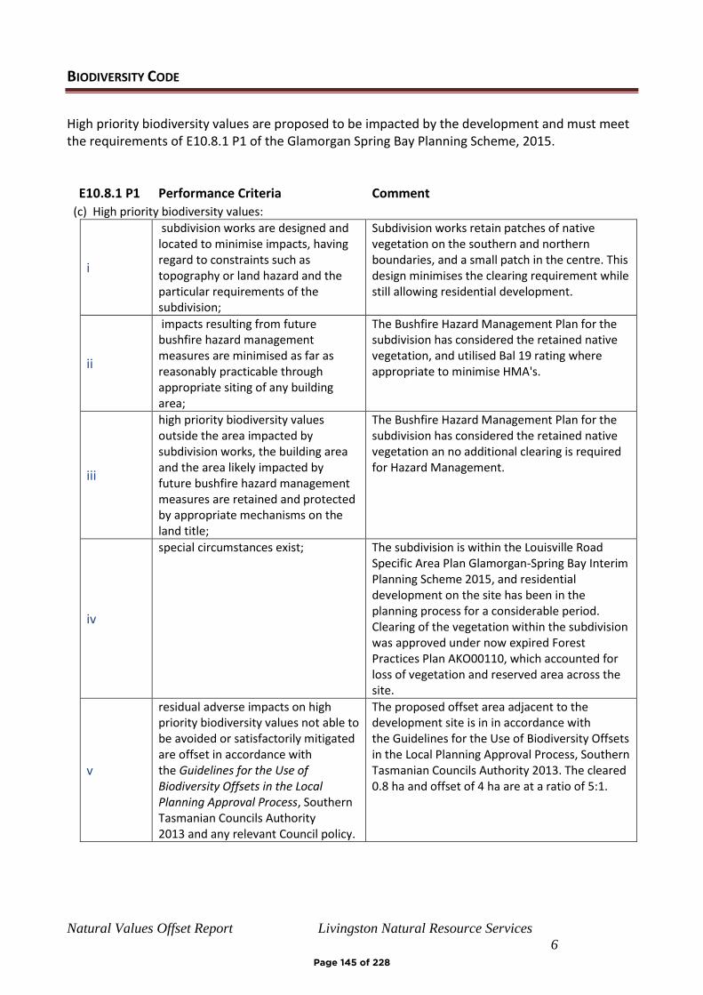
Natural Values Offset Report Livingston Natural Resource Services
6
BIODIVERSITY CODE
High priority biodiversity values are proposed to be impacted by the development and must meet the requirements of E10.8.1 P1 of the Glamorgan Spring Bay Planning Scheme, 2015.
E10.8.1 P1 Performance Criteria Comment
(c) High priority biodiversity values:
i
subdivision works are designed and located to minimise impacts, having regard to constraints such as topography or land hazard and the particular requirements of the subdivision;
Subdivision works retain patches of native vegetation on the southern and northern boundaries, and a small patch in the centre. This design minimises the clearing requirement while still allowing residential development.
ii
impacts resulting from future bushfire hazard management measures are minimised as far as reasonably practicable through appropriate siting of any building area;
The Bushfire Hazard Management Plan for the subdivision has considered the retained native vegetation, and utilised Bal 19 rating where appropriate to minimise HMA's.
iii
high priority biodiversity values outside the area impacted by subdivision works, the building area and the area likely impacted by future bushfire hazard management measures are retained and protected by appropriate mechanisms on the land title;
The Bushfire Hazard Management Plan for the subdivision has considered the retained native vegetation an no additional clearing is required for Hazard Management.
iv
special circumstances exist; The subdivision is within the Louisville Road Specific Area Plan Glamorgan-Spring Bay Interim Planning Scheme 2015, and residential development on the site has been in the planning process for a considerable period. Clearing of the vegetation within the subdivision was approved under now expired Forest Practices Plan AKO00110, which accounted for loss of vegetation and reserved area across the site.
v
residual adverse impacts on high priority biodiversity values not able to be avoided or satisfactorily mitigated are offset in accordance with the Guidelines for the Use of Biodiversity Offsets in the Local Planning Approval Process, Southern Tasmanian Councils Authority 2013 and any relevant Council policy.
The proposed offset area adjacent to the development site is in in accordance with the Guidelines for the Use of Biodiversity Offsets in the Local Planning Approval Process, Southern Tasmanian Councils Authority 2013. The cleared 0.8 ha and offset of 4 ha are at a ratio of 5:1.
Page 145 of 228
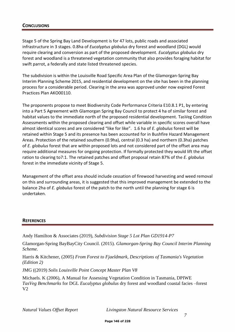
Natural Values Offset Report Livingston Natural Resource Services
7
CONCLUSIONS
Stage 5 of the Spring Bay Land Development is for 47 lots, public roads and associated infrastructure in 3 stages. 0.8ha of Eucalyptus globulus dry forest and woodland (DGL) would require clearing and conversion as part of the proposed development. Eucalyptus globulus dry forest and woodland is a threatened vegetation community that also provides foraging habitat for swift parrot, a federally and state listed threatened species. The subdivision is within the Louisville Road Specific Area Plan of the Glamorgan-Spring Bay Interim Planning Scheme 2015, and residential development on the site has been in the planning process for a considerable period. Clearing in the area was approved under now expired Forest Practices Plan AKO00110.
The proponents propose to meet Biodiversity Code Performance Criteria E10.8.1 P1, by entering into a Part 5 Agreement with Glamorgan Spring Bay Council to protect 4 ha of similar forest and habitat values to the immediate north of the proposed residential development. TasVeg Condition Assessments within the proposed clearing and offset while variable in specific scores overall have almost identical scores and are considered “like for like”. 1.6 ha of E. globulus forest will be retained within Stage 5 and its presence has been accounted for in Bushfire Hazard Management Areas. Protection of the retained southern (0.9ha), central (0.3 ha) and northern (0.3ha) patches of E. globulus forest that are within proposed lots and not considered part of the offset area may require additional measures for ongoing protection. If formally protected they would lift the offset ration to clearing to7:1. The retained patches and offset proposal retain 87% of the E. globulus forest in the immediate vicinity of Stage 5.
Management of the offset area should include cessation of firewood harvesting and weed removal on this and surrounding areas, it is suggested that this improved management be extended to the balance 2ha of E. globulus forest of the patch to the north until the planning for stage 6 is undertaken.
REFERENCES
Andy Hamilton & Associates (2019), Subdivision Stage 5 Lot Plan GD1914-P7
Glamorgan-Spring BayBayCity Council. (2015). Glamorgan-Spring Bay Council Interim Planning
Scheme.
Harris & Kitchener, (2005) From Forest to Fjaeldmark, Descriptions of Tasmania's Vegetation
(Edition 2)
JMG ((2019) Solis Louisville Point Concept Master Plan V8
Michaels. K (2006), A Manual for Assessing Vegetation Condition in Tasmania, DPIWE
TasVeg Benchmarks for DGL Eucalyptus globulus dry forest and woodland coastal facies –forest
V2
Page 146 of 228
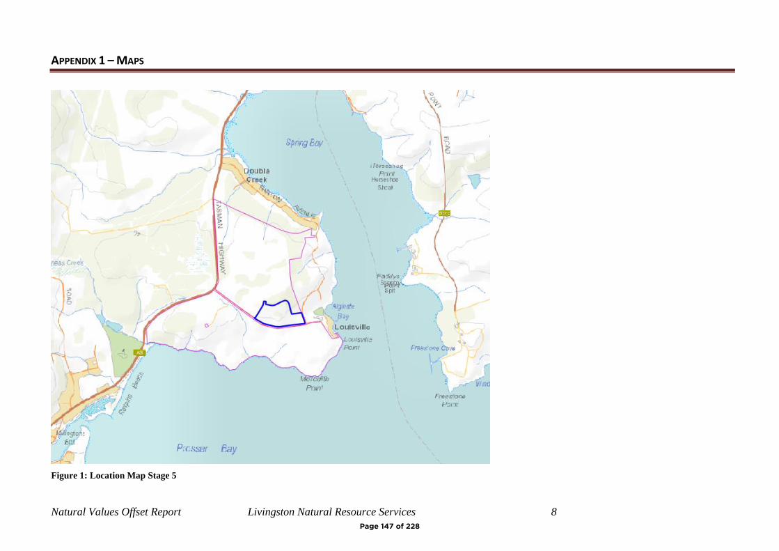
Natural Values Offset Report Livingston Natural Resource Services 8
APPENDIX 1 – MAPS
Figure 1: Location Map Stage 5
Page 147 of 228

Natural Values Offset Report Livingston Natural Resource Services 9
Figure 2: Aerial Image, Stage 5, Planning Scheme Overlay (Biodiversity Protection)
Page 148 of 228
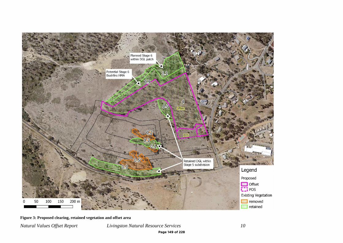
Natural Values Offset Report Livingston Natural Resource Services 10
Figure 3: Proposed clearing, retained vegetation and offset area
Page 149 of 228

Natural Values Offset Report Livingston Natural Resource Services
11
APPENDIX 2 – PHOTOS
Figure 4: north along western road
Figure 5: central eucalypt patch, portions to be cleared
Page 150 of 228
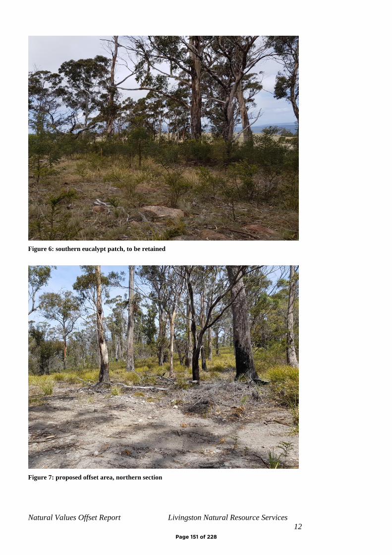
Natural Values Offset Report Livingston Natural Resource Services
12
Figure 6: southern eucalypt patch, to be retained
Figure 7: proposed offset area, northern section
Page 151 of 228
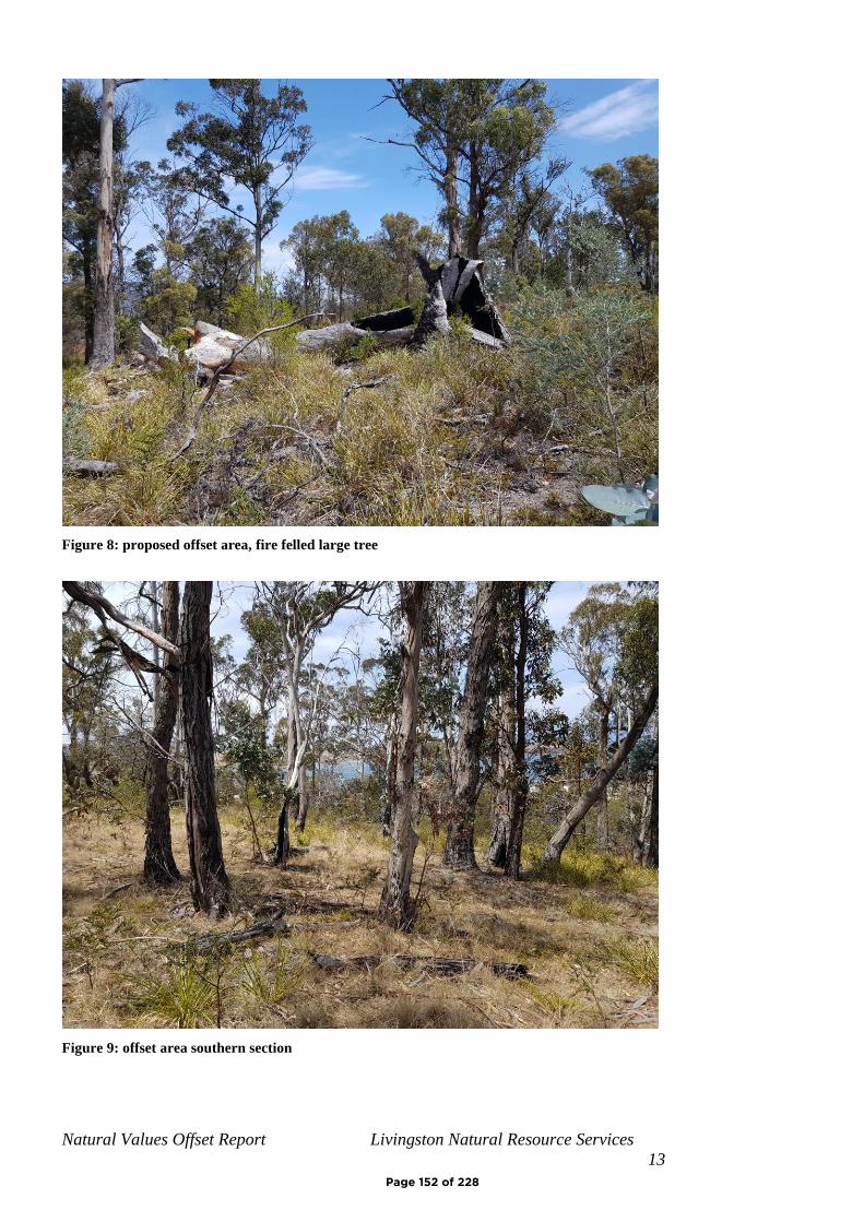
Natural Values Offset Report Livingston Natural Resource Services
13
Figure 8: proposed offset area, fire felled large tree
Figure 9: offset area southern section
Page 152 of 228
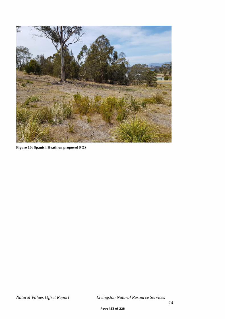
Natural Values Offset Report Livingston Natural Resource Services
14
Figure 10: Spanish Heath on proposed POS
Page 153 of 228
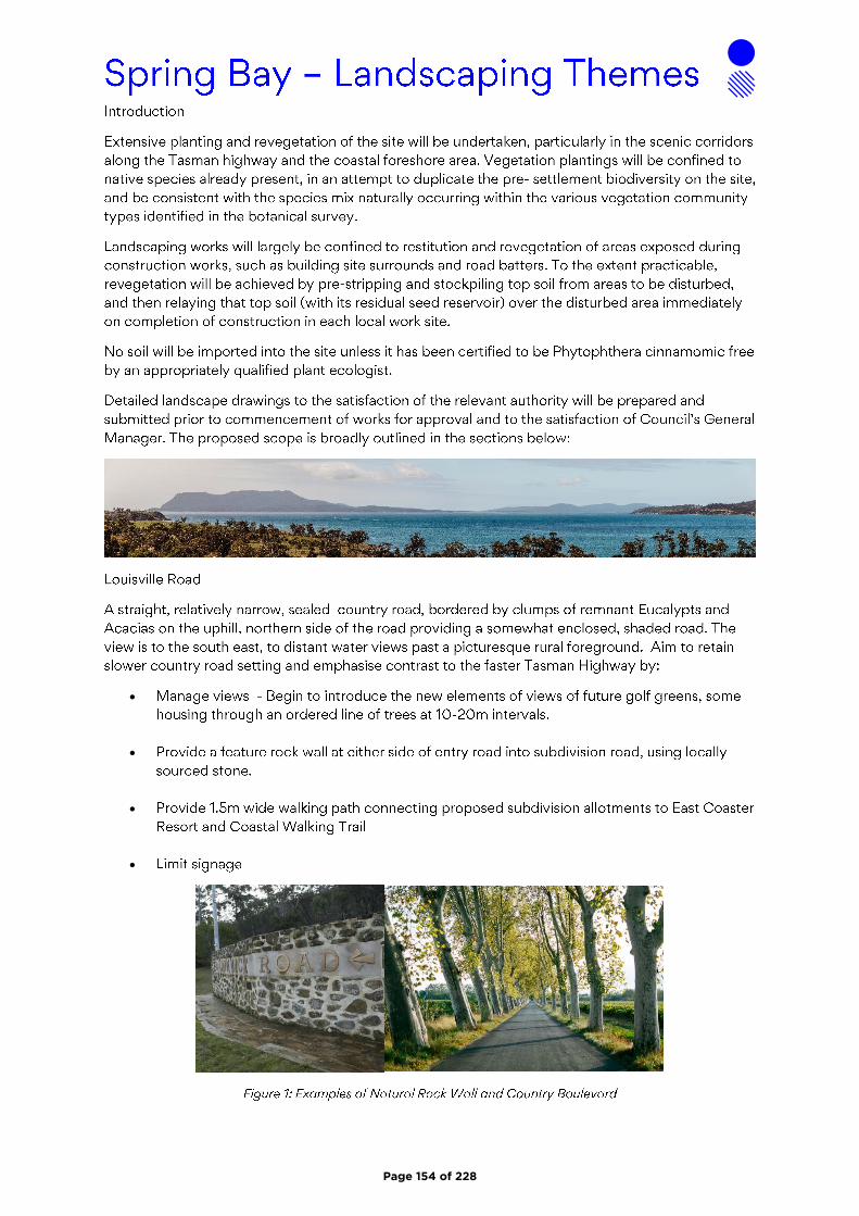
•
•
•
•
Page 154 of 228

•
•
Page 155 of 228

•
•
Page 156 of 228

1
Maree Tyrrell
From:Sent: Friday, 18 September 2020 10:23 PMTo: PlanningSubject: Representation RE: SA 2019/17
The General Manager Glamorgan Spring Bay Council By email: [email protected] Dear Sir, I refer to the Subdivision Application SA 2019/17 and the documentation in support thereof. My attention was drawn to this Application thanks to an article in the Mercury Newspaper which gushed: “ An application has now been submitted to the Glamorgan Spring Bay Council for the fifth stage of multimillion-dollar golf course and residential project”. True of course in its own way but nothing to do with the long promised and equally long awaited but still mythical multi-million dollar golf course. And hardly the fifth stage, more like a first tentative step. I note the following: The Solis Development Specific Area Plan is meant to promote a high quality tourism, recreational and residential Estate that will create a major visitor attraction that will encourage visitors to stay longer in the area. SA 2019/17 is an application only for a residential subdivision ( the first one for 47 Lots in three stages with many more SAs undoubtedly to follow to get to the 609 Lots envisaged) and promises to add nothing to the tourism or recreation experience. Council’s own “Major Projects” pages on its website explains where the Solis Development is today (18/09/2020). Solis covers 272 hectares of premium waterfront land, only a 45-minute drive from Hobart airport. It offers the perfect base to explore the National Parks and World Heritage Areas found on the east coast of Tasmania. Solis can be broken down into three specific components, which will be constructed and developed simultaneously. These include: Development of an 18-hole golf course on land donated to council at Louisville Point Road, Orford. The Glamorgan Spring Bay Council will lease the “Golf Course Land” to a private lessee on commercial terms, and the lessee will construct and operate the golf course. The development of around 609 residential lots through the sub-division of land surrounding the golf course development, over three stages. This includes the development of a 60 unit eco-cabin holiday (sic) The re-development of the Eastcoaster Resort. This would involve completing an approved 10 lot subdivision and a new street at the end of Louisville Rd to replace the existing 20 strata titles. Other work involves an upgrade to the existing resort, construction of a new waterfront café/marina complex including an upgrade to the existing outdoor pool and jetty, and redesign of the existing caravan and cabin park for the construction of 24 holiday units purposefully designed with a golfing theme. In order to link these facilities between Orford and Triabunna, a coastal walking track will also be established. It is clear that SA 2019/17 is the first part of the development of said 609 Lots. There appears to be no progress on the simultaneously to be developed long promised world class 18 hole golf course, the land on which this would occur has NOT been donated to Council, and Council is so much trying to get its inherited disastrous financial affairs in order it should not be simultaneously be shouldered with the task of taking responsibility for a golf course development that has already cost it considerable time and money. This fabled Solis golf course also already
Page 157 of 228
Agenda Item 4.1 - Attachment B

2
played its shameful part in the Council owned pipeline financial disaster as the decision to own the pipeline was taken in part to assist in providing water for the golf course. There is no clarity as to which water customer would get priority in years of drought and the low price per megaliter apparently negotiated with Solis for an annual 300 megaliters might well put them behind Tassal and Taswater. This might mean such uncertainty that the golf course will never be built. When all uncertainty about the Solis Golf Course has been resolved then Council will have no reason to not support the subdivision aspects of the proposed Development. If it allows residential subdivision now it will set a clear precedent that the much vaunted “tourism and recreational” parts of the Development SAP are indeed subordinate to the residential part. That I believe was never the intention. In order that the whole of the proposed development will take its place as a sustainable and visually more pleasing jewel in the crown of the promised East Coast tourism icon rather than just become another massive subdivision I object to, and strongly argue against, the clearly premature approval of SA 2019/17 in the continued absence of clear commitment to, and approvals for, the more pleasing aspects of the Solis SAP. Yours sincerely,
Page 158 of 228
G L A M O R G A N / S P R I N G B A Y C O U N C I L
N O T I C E O F P R O P O S E D D E V E L O P M E N T
Notice is hereby given that an application has been made for planning approval for the following development;
SITE: 42 Gordon Street Bicheno
PROPOSAL: Dwelling
Any person may make representation on the application(s) by letter (PO Box 6, Triabunna) or
electronic mail ([email protected]) addressed to the General Manager.
Representations must be received before midnight on Friday 04 June 2021.
APPLICANT: Laura Wycherley
DATE: 03 December 2020
APPLICATION NO: DA 2020 / 288
Page 159 of 228
Agenda Item 4.2 - Attachment A

Office: 9 Melbourne Street, Postal: PO Box 6 Triabunna 7190 Phone: 6256 4777 Fax: 6256 4774 Email: [email protected] Web: www.gsbc.tas.gov.au ABN: 95 641 533 778
Application for Planning Approval
Glamorgan Spring Bay Council - Application for Planning Approval – August 2017 Page 1 of 8
OFFICE USE ONLY
DATE RECEIVED: PID:
FEE RECEIPT No:
DA: PROPERTY FILE:
Advice:
Use this form for all no permit required, permitted and discretionary planning applications including subdivision, planning scheme amendment & minor amendments to permits.
For visitor accommodation in the General Residential, Low Density Residential, Rural Living, Environmental Living or Village Zone use the sharing economy form available on the Council website.
Completing this form in full will help ensure that all necessary information is provided and avoid any delay. The planning scheme provides details of what other information may be required at clause 8.1 and in each applicable Code.
Please provide the relevant details in each applicable section by providing the information or circling Yes or No as appropriate. If relevant details are provided on plans or documents please refer to the drawing number or other documents in this form.
Often, it is beneficial to provide a separate written submission explaining in general terms what is proposed and why and to justify the proposal against any applicable performance criteria.
If you have any queries with the application form or what information is required please contact the office.
Details of Applicant & Owner
Applicant:
Contact person: (if different from applicant)
Address: Phone
Fax:
Email: Mobile:
Do you wish for all correspondence to be sent solely by email? Yes No
Owner: (if different from applicant)
Address: Phone:
Fax:
Email: Mobile:
Laura Wycherley
6 Integrity Drive, Westbury 7303 03 6776 0096
Jacqueline Hardman
GPO BOX 78, 7001
Page 160 of 228
Application for Planning Approval
Glamorgan Spring Bay Council - Application for Planning Approval – August 2017 Page 2 of 8
Details of Site and Application
Please note, if your application is discretionary the following will be placed on public exhibition.
Site Details
Address / Location of Proposal:
Suburb ……………… Post Code ……
Size of site ……………..……… m2 or …………………. Ha
Certificate of Title(s):
Current use of site:
General Application Details
Complete for All Applications
New Dwelling Change of use
Additions / Alterations to Dwelling Intensification or modification of use
New Outbuilding or Addition Subdivision or boundary adjustment
New Agricultural Building Minor amendment to existing permit DA …… / …..
Commercial / Industrial Building Planning Scheme Amendment
Estimated value of works (design & construction) $
Describe the order and timing of any staged works: …………………………………………………………………….. or N/A
General Background Information
Please state the name of any Council officers that you have discussed this proposal with: Officer’s name : or N/A
Is the site listed on the Tasmanian Heritage Register? Yes No
Have any potentially contaminating activities ever occurred on the site? If yes, please provide a separate written description of those activities.
Yes No
Is the proposal consistent with any restrictive covenants or Part 5 agreements that apply to the site? Yes No
42 Gordon Street , Bicheno 7215
396.88
11887/13
Newly subdivided Lot will be vacant
Page 161 of 228

Application for Planning Approval
Glamorgan Spring Bay Council - Application for Planning Approval – August 2017 Page 3 of 8
Does the proposal involve any of the following?
Type of development Brief written description if not clearly shown on the plans:
Partial or full demolition Y Yes
No
Fencing Y Yes No
New or upgraded vehicle / pedestrian access
Y Yes No
New or modified water, sewer, electrical or telecommunications connection
Y Yes No
Retaining walls Y Yes No
Cut or fill Y Yes No
Signage Y Yes No
New car parking Y Yes No
Vegetation removal Y Yes No
Existing floor area …………….. m2 Proposed floor area ……………………….m2
Number of existing car parking on site ………… Number of proposed car parking on site ………
Describe the width & surfacing of vehicular access (existing or proposed) and how drainage/runoff is collected and discharged: ……………………………………………………….….
If vehicular access is from a road sign-posted at more than 60 km/hr, please state the sight distance in both directions: ………………………………………………….. or N/A
Please note, if a gravel driveway is proposed from a sealed public road please address the following clause (E6.7.6 P1):
Parking spaces and vehicle circulation roadways must not unreasonably detract from the amenity of users, adjoining occupiers or the quality of the environment through dust or mud generation or sediment transport, having regard to all of the following:
(i) the suitability of the surface treatment;(ii) the characteristics of the use or development;(iii) measures to mitigate mud or dust generation or sediment transport.
Will stormwater from buildings and hardstand areas be managed by:
(details should be clearly shown / noted on plans)
Discharge to a main: …………….... Yes / Not applicable
Discharge to kerb & gutter: ……..… Yes / Not applicable
Discharge to roadside table drain:... Yes / Not applicable
Discharge to natural watercourse: .. Yes / Not applicable
Retained on site: ……………….….. Yes / Not applicable
Y
e
s
N
o
Y
e
s
Y
e
s
N
o
Y
e
s
N
o
Y
e
s
Y
e
s
N
o
Y
e
s
N
o
Y
e
s
Y
e
s
N
o
Y
e
s
N
o
Y
e
s
Y
e
s
N
o
Y
e
s
N
o
Y
e
s
Y
e
s
N
o
Y
e
s
N
o
Y
e
s
Y
e
s
N
o
Y
e
s
N
o
Y
e
s
Y
e
s
N
o
Y
e
s
N
o
Y
e
s
Y
e
s
N
o
Y
e
s
N
o
Y
e
s
Y
e
s
N
o
2
206.43 m²
Proposed 3.6m sealed with exposed aggregate concrete. Stormwater runoff to go to grated drain connected to
council approved connection point,
Page 162 of 228
Application for Planning Approval
Glamorgan Spring Bay Council - Application for Planning Approval – August 2017 Page 4 of 8
Materials:
External building material
Walls: ……………………………..
Roof: ……………………………….
External building colours
Walls: ……………………………..
Roof: ………………………………
Fencing materials ………………………………
Retailing wall materials ……………………………….
For all outbuildings
Describe for what purpose the building is to be used:
………………………………………………………………………………
Describe any intended toilet, shower, cooking or heating to be installed: ………………………………………………………………………………
…
If the building is to be used wholly or partly as a domestic workshop, what type of tools and machines will be used? ………………………………………………………………………………
For all non-residential applications
Hours of Operation
Current hours of operation
Monday to Friday:
Saturday: Sunday & Public holidays:
Proposed hours of operation
Monday to Friday:
Saturday: Sunday & Public holidays:
Number of Employees
Current Employees Total: Maximum at any one time:
Proposed Employees Total: Maximum at any one time:
Describe any delivery of goods to and from the site, including the types of vehicles used and the estimated average weekly frequency: ………………………………………………….. or N/A
Describe current traffic movements into the site, including the type & timing of heavy vehicle movements & any proposed change: ………………………………………………….. or N/A
Describe any hazardous materials to be used or stored on site:
………………………………………………….. or N/A
Describe the type & location of any large plant or machinery used (refrigeration, generators) ………………………………………………….. or N/A
Describe any retail and/or storage of goods or equipment in outdoor areas: ………………………………………………….. or N/A
Describe any external lighting proposed:
………………………………………………….. or N/A
Colourbond & Weatherboard Colourbond
NA
NIght Sky Night Sky
NA
Page 163 of 228
Application for Planning Approval
Glamorgan Spring Bay Council - Application for Planning Approval – August 2017 Page 5 of 8
Personal Information Protection Statement:
The personal information that Council is collecting form you is deemed personal information for the purposes of the Personal Information Protection Act 2004. The intended recipients of personal information collected by Council may include its officers, agents or contractors or data service providers. The supply of the information by you is voluntary. If you cannot provide or do not wish to provide the information sought, Council may be unable to process your application. Council is collecting this personal information from you for the purposes of managing, addressing, advising upon and determining the application and other related Council matters.
Declaration:
I/we hereby apply for planning approval to carry out the use or development described in this application and the accompanying documents and declare that: -
The information in this application is true and correct.
In relation to this application, I/we agree to allow Council employees or consultants to enterthe site in order to assess the application.
I/we confirm that I/we are the copyright holder or have the authority to sign on behalf of anyperson with copyright for documents to this application and authorities Council to provide acopy of this application to any person for assessment or statutory consultation.
I/we authorise Council to provide a copy of any documents relating to this application to anyperson for the purpose of assessment or public consultation and agree to arrange for thepermission of the copyright owner of any part of this application to be obtained.
I acknowledge that if the application is discretionary that the application will be exhibited inthe Council offices and on the Council website.
I/We declare that the Owner has been notified of the intention to make this application inaccordance with section 52(1) of the Land Use Planning and Approvals Act 1993.
Signature: Date:
If application is not the owner
If the applicant is not the owner, please list all persons who were notified of this application pursuant to section 52 of the Land Use Planning and Approvals Act 1993.
Name: Method of notification: Date of notification:
If application is on or affect Council or Crown owned or administered land
If land affected by this application is owned or administered by the Crown or Council then the written permission of the relevant Minister (or their delegate) and/or the General Manager must provided and that person must also sign this application form below:
I ………………………………………………………... being responsible for the administration of land at …………………………………………………………………..declare that I have given permission for the making of this application by …………………………………….… for use and/or development involving …………………………………………………………………………………………………………………………………………………………………………………………..…………………..……………….……………..
Signature: ……………………………………………………………………………… Date: ………………….
It is the applicant’s responsibility to obtain any such consent prior to lodgement. Written requests for consent of the Council must be sent to General Manager. Request for Ministerial consent should be directed to the relevant department.
2.12.20
Laura Wycherley 27.11.20Contract
Page 164 of 228

W
-1000
-500
0
500 1000
DRAINAGEALL DRAINAGE WORK SHOWN IS PROVISIONALONLY AND IS SUBJECT TO AMENDMENT TOCOMPLY WITH THE REQUIREMENTS OF THELOCAL AUTHORITIES. ALL WORK IS TO COMPLYWITH THE REQUIREMENTS OF NATIONALPLUMBING AND DRAINAGE CODE AS3500 ANDMUST BE CARRIED OUT BY A LICENCEDTRADESMAN ONLY.
3000
1100
6015
9600
11385
7795
1060
4015
5247
3020
7420
9085
3625
2215
APPROX. BOUNDARY: 35.60m
APPR
OX. BO
UNDA
RY: 1
3.50m
APPROX. BOUNDARY: 30.00m
APPR
OX. B
OUND
ARY:
12.10
m
PROPOSED DWELLING
PROPOSED SEALED, EXPOSEDAGGREGATE CONCRETE DRIVEWAY
PROPOSED 3.6m CROSSOVERTO COUNCIL STANDARDS
EXISTING CROSSOVER TO BEUPGRADED TO COUNCIL STANDARDS
EXISTING DRIVEWAY TO BERELOCATED AND UPGRADED
EXISTING SHED TOBE DEMOLISHED
GORD
ON S
TREE
T
PROPOSED WATER CONNECTIONAND METER AS APPROVED
WATER TO PROPOSED DWELLING TOCONNECT TO PROPOSED COUNCIL APPROVEDWATER CONNECTION POINTLOCATION TO BE DETERMINED ONSITE
SEWER FROM PROPOSED DWELLING TO CONNECT TOEXISTING COUNCIL APPROVED CONNECTION POINTLOCATION TO BE DETERMINED ONSITE
STORMWATER FROM PROPOSED DWELLING TO CONNECTTO EXISTING ADAPTERLOCATION TO BE DETERMINED ONSITE
LOT 1AREA: 396.88m²
NEIGHBOURING DWELLING
NEIGHBOURING DWELLING
NEIGHBOURING DWELLING
PID: 3236713
PID: 5283601
PID: 5283628
PID: 5283636
SUBDIVISION BOUNDARIES TO BEAPPROVED IN SEPERATE APPLICATIONDA: SA2020/31PROVIDE GRATED DRAIN TO DRIVEWAY TO
CONNECT TO PROPOSED STORMWATER SYSTEMPRIOR TO COUNCIL CONNECTION POINT
SEWER
WATER
STORMWATER
LEGEND
PRIVATE OPEN SPACES 26.64m² (6.7%)
IMPERVIOUS SURFACES 174.21m² 43.90%
Rev: Amendment: Date: Int:
Client: T. SMITHProject: PROPOSED DWELLINGAddress:
Drawn: O. Jones
Scale: As Shown @ A3
J.PfeifferCC2211T
RevDrawing No:Designer Name:Accredited Building Designer
Accreditation No:
Checked: C. ParryApproved: J. Pfeiffer
cCopyright
ISSUED FOR APPROVAL
Mob 0417 362 783 or 0417 545 [email protected]@engineeringplus.com.au
Date Drawn: 12.11.20
1022020A ISSUED FOR APPROVAL 12.11.20 O.J. D
Tasbuilt Manufactured Homes & CabinsP.O Box 274, Deloraine Tasmania 7304Ph: 03 6393 [email protected]
42A GORDON STREET,BICHENO
B FRONT STAIR AMENDMENT 23.11.20 O.J.01.12.20 O.J.C SUBDIVISION CLARIFICATION03.12.20 O.J.D DRIVEWAY AMENDMENTS
A02
SCALE 1 : 200SITE PLAN
Page 165 of 228
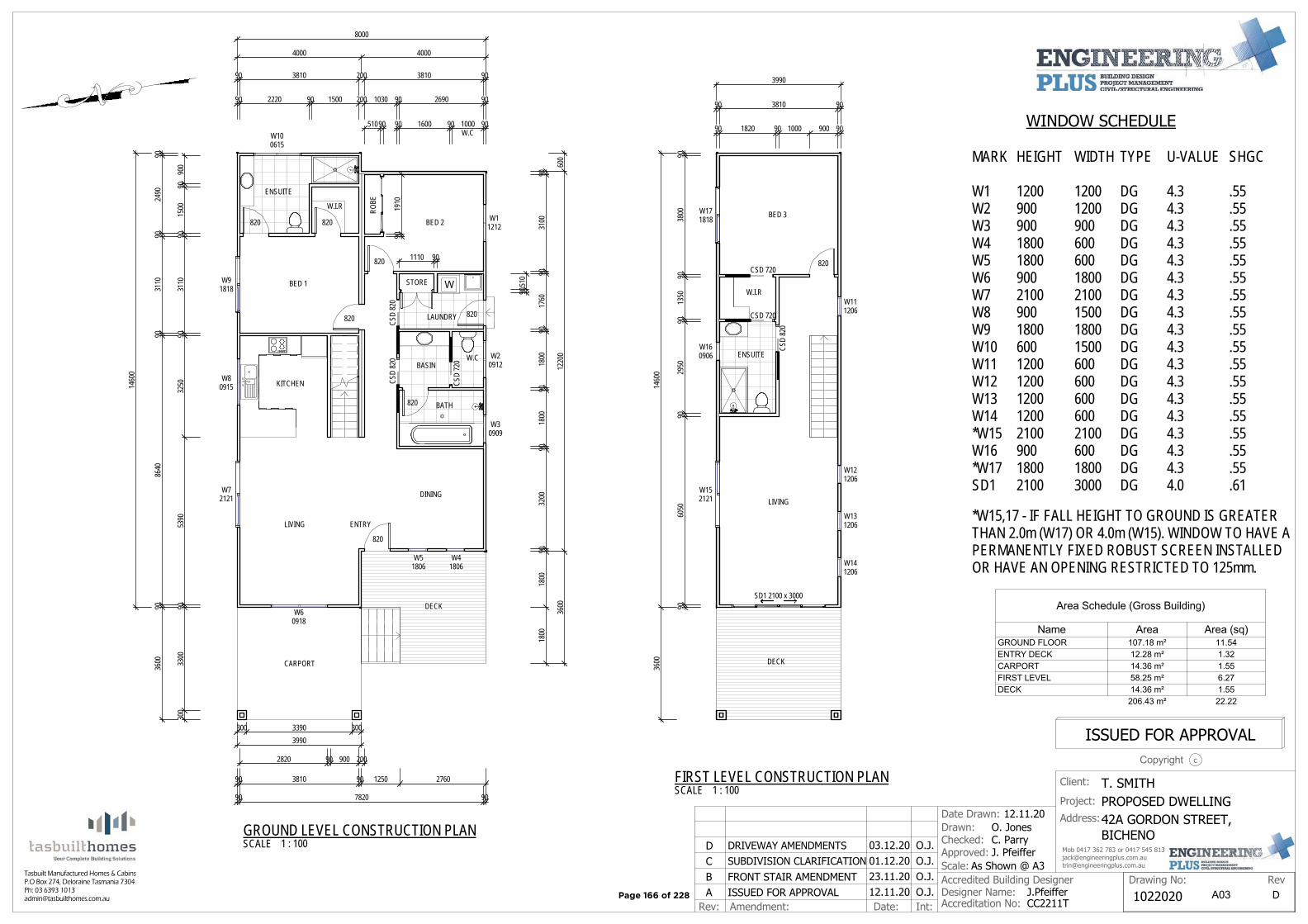
W
8000
4000 4000
600
1220
036
00
9031
0090
1760
9018
0090
1800
9032
0090
1800
1800
STORE
820
820
CSD
720
820820
820
820
ROBE
BED 1
W.I.R
ENSUITE
BED 2
LAUNDRY
BASINW.C
BATH
DINING
ENTRYLIVING
KITCHEN
W11212
W20912
W30909
W41806
W60918
W80915
W91818
W100615
90 2220 90 1500 200 1030 90 2690 90
90 3810 200 3810 90
90 1600 90W.C1000 90
9024
9090
3110
9086
4090
3600
1460
0
CSD
820
300
3300
9053
9032
5090
3110
9015
0090
900
90 7820 90
90 3810 90 1250 2760
2820 90 900 200
DECK
820
W51806
CARPORT
W72121
CSD
820
3990300 3390 300
51090
9019
10
9051
0
1110 90CSD 720
CSD 720
BED 3
W.I.R
ENSUITE
LIVING
W111206
W121206
W131206
W141206
W160906
W171818
SD1 2100 x 3000
90 3810 90
90 1820 90 1000 900 90
3990
9038
0090
1350
9029
5090
6050
90
1460
036
00 DECK
CSD
820
820
W152121
Rev: Amendment: Date: Int:
Client: T. SMITHProject: PROPOSED DWELLINGAddress:
Drawn: O. Jones
Scale: As Shown @ A3
J.PfeifferCC2211T
RevDrawing No:Designer Name:Accredited Building Designer
Accreditation No:
Checked: C. ParryApproved: J. Pfeiffer
cCopyright
ISSUED FOR APPROVAL
Mob 0417 362 783 or 0417 545 [email protected]@engineeringplus.com.au
Date Drawn: 12.11.20
1022020A ISSUED FOR APPROVAL 12.11.20 O.J. D
Tasbuilt Manufactured Homes & CabinsP.O Box 274, Deloraine Tasmania 7304Ph: 03 6393 [email protected]
42A GORDON STREET,BICHENO
B FRONT STAIR AMENDMENT 23.11.20 O.J.01.12.20 O.J.C SUBDIVISION CLARIFICATION03.12.20 O.J.D DRIVEWAY AMENDMENTS
A03
Area Schedule (Gross Building)
Name Area Area (sq)GROUND FLOOR 107.18 m² 11.54ENTRY DECK 12.28 m² 1.32CARPORT 14.36 m² 1.55FIRST LEVEL 58.25 m² 6.27DECK 14.36 m² 1.55
206.43 m² 22.22
MARK
W1W2W3W4W5W6W7W8W9W10W11W12W13W14*W15W16*W17SD1
HEIGHT
120090090018001800900210090018006001200120012001200210090018002100
WIDTH
1200120090060060018002100150018001500600600600600210060018003000
WINDOW SCHEDULE
U-VALUE
4.34.34.34.34.34.34.34.34.34.34.34.34.34.34.34.34.34.0
SHGC
.55
.55
.55
.55
.55
.55
.55
.55
.55
.55
.55
.55
.55
.55
.55
.55
.55
.61
TYPE
DGDGDGDGDGDGDGDGDGDGDGDGDGDGDGDGDGDG
SCALE 1 : 100GROUND LEVEL CONSTRUCTION PLAN
SCALE 1 : 100FIRST LEVEL CONSTRUCTION PLAN
*W15,17 - IF FALL HEIGHT TO GROUND IS GREATERTHAN 2.0m (W17) OR 4.0m (W15). WINDOW TO HAVE APERMANENTLY FIXED ROBUST SCREEN INSTALLEDOR HAVE AN OPENING RESTRICTED TO 125mm.
Page 166 of 228
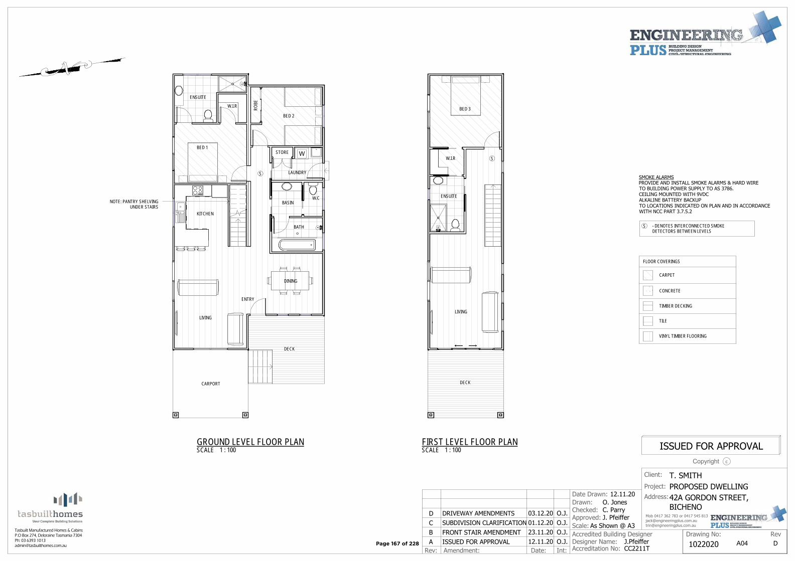
W
SMOKE ALARMSPROVIDE AND INSTALL SMOKE ALARMS & HARD WIRETO BUILDING POWER SUPPLY TO AS 3786.CEILING MOUNTED WITH 9VDCALKALINE BATTERY BACKUPTO LOCATIONS INDICATED ON PLAN AND IN ACCORDANCEWITH NCC PART 3.7.5.2
S - DENOTES INTERCONNECTED SMOKEDETECTORS BETWEEN LEVELS
STORE
ROBE
BED 1
W.I.R
ENSUITE
BED 2
LAUNDRY
BASINW.C
BATH
DINING
ENTRY
LIVING
KITCHEN
DECK
CARPORT
NOTE: PANTRY SHELVINGUNDER STAIRS
S
BED 3
W.I.R
ENSUITE
LIVING
DECK
S
CARPET
CONCRETE
TIMBER DECKING
TILE
FLOOR COVERINGS
VINYL TIMBER FLOORING
Rev: Amendment: Date: Int:
Client: T. SMITHProject: PROPOSED DWELLINGAddress:
Drawn: O. Jones
Scale: As Shown @ A3
J.PfeifferCC2211T
RevDrawing No:Designer Name:Accredited Building Designer
Accreditation No:
Checked: C. ParryApproved: J. Pfeiffer
cCopyright
ISSUED FOR APPROVAL
Mob 0417 362 783 or 0417 545 [email protected]@engineeringplus.com.au
Date Drawn: 12.11.20
1022020A ISSUED FOR APPROVAL 12.11.20 O.J. D
Tasbuilt Manufactured Homes & CabinsP.O Box 274, Deloraine Tasmania 7304Ph: 03 6393 [email protected]
42A GORDON STREET,BICHENO
B FRONT STAIR AMENDMENT 23.11.20 O.J.01.12.20 O.J.C SUBDIVISION CLARIFICATION03.12.20 O.J.D DRIVEWAY AMENDMENTS
A04
SCALE 1 : 100GROUND LEVEL FLOOR PLAN
SCALE 1 : 100FIRST LEVEL FLOOR PLAN
Page 167 of 228

CEILING LEVEL
FLOOR LEVEL
CEILING LEVEL
FLOOR LEVEL
HEIGHT
COLORBOND 'CUSTOM ORB' ROOFINGCOLOUR: TO OWNERS SPECIFICATIONS
COLORBOND FASCIA & GUTTERSCOLOUR: TO OWNERS SPECIFICATIONS
COLOURED ALUMINIUM WINDOW FRAMESCOLOUR: TO OWNERS SPECIFICATIONS
COLORBOND 'CUSTOM ORB' CLADDINGCOLOUR: TO OWNERS SPECIFICATIONS
NATURAL GROUND LEVEL
CUT OF APPROX. 150mm, BATTERBACK TO NATURAL GROUND AT 1:3
BALUSTRADE CONSTRUCTED TONCC STANDARDS
PAINTED TIMBERSUBFLOOR SLATS
STAIRS CONSTRUCTED TONCC STANDARDS
PROVIDE ROOF VENTILLATION INACCORDANCE WITH TASMANIAN DESIGNERSGUIDELINES - CONDENSATION IN BUILDINGS
2400
300
2400
450
6170
ENSURE FALL HIEGHT TO GROUND IS<1.0m OR PROVIDE BALUSTRADECONSTRUCTED TO NCC STANDARDS
CEILING LEVEL
FLOOR LEVEL
CEILING LEVEL
FLOOR LEVEL
HEIGHT
COLORBOND 'CUSTOM ORB' ROOFINGCOLOUR: TO OWNERS SPECIFICATIONS
COLORBOND FASCIA & GUTTERSCOLOUR: TO OWNERS SPECIFICATIONS
COLOURED ALUMINIUM WINDOW FRAMESCOLOUR: TO OWNERS SPECIFICATIONS
COLORBOND 'CUSTOM ORB' CLADDINGCOLOUR: TO OWNERS SPECIFICATIONS
NATURAL GROUND LEVEL
CUT OF APPROX. 400mm, BATTERBACK TO NATURAL GROUND AT 1:3
BALUSTRADE CONSTRUCTEDTO NCC STANDARDS
PAINTED TIMBERSUBFLOOR SLATS
STAIRS CONSTRUCTED TONCC STANDARDS
PROVIDE ROOF VENTILLATION INACCORDANCE WITH TASMANIAN DESIGNERSGUIDELINES - CONDENSATION IN BUILDINGS
970
2400
300
2400
6690
EAVE & SOFFIT CONSTRUCTION BCA Volume 2 Part 3.5.3.5
eave width − 300mm design wind speed N3
soffit / eave lined with ’hardiflex’ cement sheeting
trimmers located within 1200 mm of external corners to be spaced @ 500 mm centers, remainder of sheet − 700 mm centers
fastener / fixings within 1200 mm of external corners @ 200 mm centers, remainder of sheet − 300 mm centers
STAIR CONSTRUCTION. BCA Volume 2 Part 3.9
treads: 240 mm
risers: 180 mm
Treated pine timber stair material to AS1684
treatment levels H4 for inground use & H3 for above ground use.
ALL fixings fitting brackets and connectors to be galvanised.
stringer: 300x50 F5 treated pine
treads: 240x45 F5 treated pine maximum tread span 1000
Rev: Amendment: Date: Int:
Client: T. SMITHProject: PROPOSED DWELLINGAddress:
Drawn: O. Jones
Scale: As Shown @ A3
J.PfeifferCC2211T
RevDrawing No:Designer Name:Accredited Building Designer
Accreditation No:
Checked: C. ParryApproved: J. Pfeiffer
cCopyright
ISSUED FOR APPROVAL
Mob 0417 362 783 or 0417 545 [email protected]@engineeringplus.com.au
Date Drawn: 12.11.20
1022020A ISSUED FOR APPROVAL 12.11.20 O.J. D
Tasbuilt Manufactured Homes & CabinsP.O Box 274, Deloraine Tasmania 7304Ph: 03 6393 [email protected]
42A GORDON STREET,BICHENO
B FRONT STAIR AMENDMENT 23.11.20 O.J.01.12.20 O.J.C SUBDIVISION CLARIFICATION03.12.20 O.J.D DRIVEWAY AMENDMENTS
A06
SCALE 1 : 100NORTH ELEVATION
SCALE 1 : 100SOUTH ELEVATION
Page 168 of 228
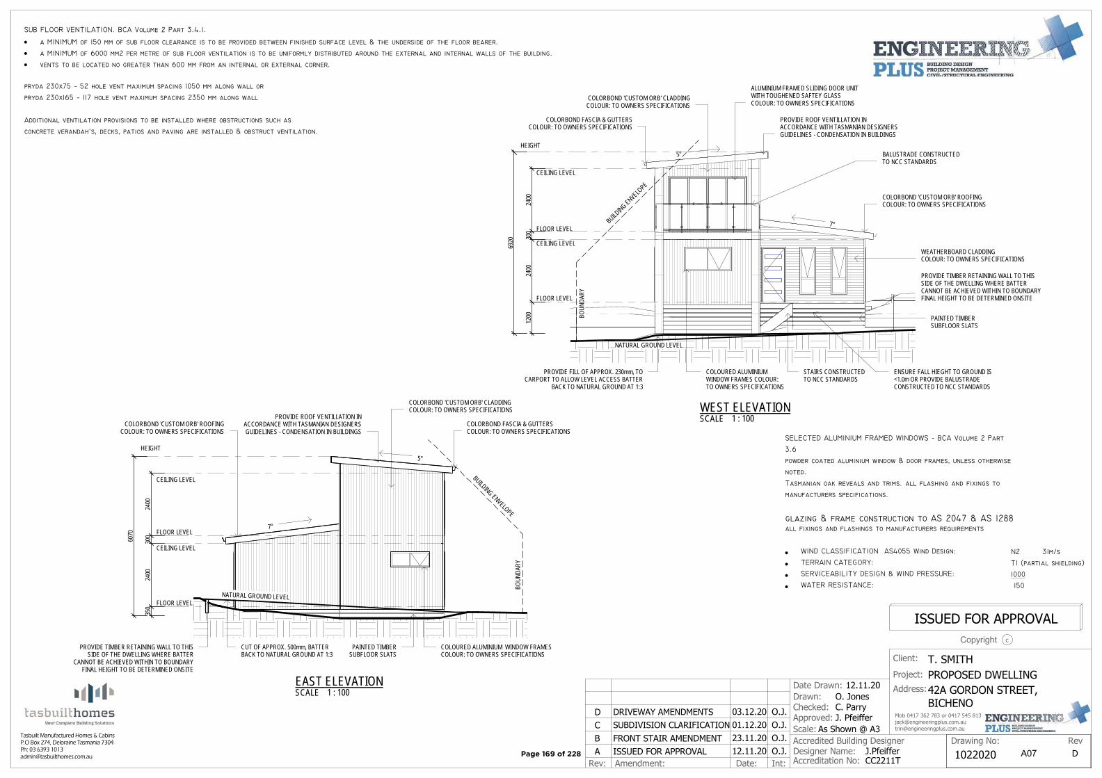
CEILING LEVEL
FLOOR LEVEL
CEILING LEVEL
FLOOR LEVEL7°
350
2400
300
2400
6070
HEIGHT5°
BUILDING ENVELOPEBO
UNDA
RY
COLORBOND 'CUSTOM ORB' ROOFINGCOLOUR: TO OWNERS SPECIFICATIONS
COLORBOND FASCIA & GUTTERSCOLOUR: TO OWNERS SPECIFICATIONS
COLOURED ALUMINIUM WINDOW FRAMESCOLOUR: TO OWNERS SPECIFICATIONS
COLORBOND 'CUSTOM ORB' CLADDINGCOLOUR: TO OWNERS SPECIFICATIONS
NATURAL GROUND LEVEL
CUT OF APPROX. 500mm, BATTERBACK TO NATURAL GROUND AT 1:3
PROVIDE TIMBER RETAINING WALL TO THISSIDE OF THE DWELLING WHERE BATTER
CANNOT BE ACHIEVED WITHIN TO BOUNDARYFINAL HEIGHT TO BE DETERMINED ONSITE
PAINTED TIMBERSUBFLOOR SLATS
PROVIDE ROOF VENTILLATION INACCORDANCE WITH TASMANIAN DESIGNERSGUIDELINES - CONDENSATION IN BUILDINGS
CEILING LEVEL
FLOOR LEVEL
CEILING LEVEL
FLOOR LEVEL7°
5°
BUILDING ENVELO
PE
BOUN
DARY
COLORBOND 'CUSTOM ORB' ROOFINGCOLOUR: TO OWNERS SPECIFICATIONS
COLORBOND FASCIA & GUTTERSCOLOUR: TO OWNERS SPECIFICATIONS
COLOURED ALUMINIUMWINDOW FRAMES COLOUR:TO OWNERS SPECIFICATIONS
COLORBOND 'CUSTOM ORB' CLADDINGCOLOUR: TO OWNERS SPECIFICATIONS
PROVIDE TIMBER RETAINING WALL TO THISSIDE OF THE DWELLING WHERE BATTERCANNOT BE ACHIEVED WITHIN TO BOUNDARYFINAL HEIGHT TO BE DETERMINED ONSITE
BALUSTRADE CONSTRUCTEDTO NCC STANDARDS
PAINTED TIMBERSUBFLOOR SLATS
STAIRS CONSTRUCTEDTO NCC STANDARDS
PROVIDE ROOF VENTILLATION INACCORDANCE WITH TASMANIAN DESIGNERSGUIDELINES - CONDENSATION IN BUILDINGS
2400
300
2400
1200
HEIGHT
6920
WEATHERBOARD CLADDINGCOLOUR: TO OWNERS SPECIFICATIONS
NATURAL GROUND LEVEL
PROVIDE FILL OF APPROX. 230mm, TOCARPORT TO ALLOW LEVEL ACCESS BATTER
BACK TO NATURAL GROUND AT 1:3
ALUMINIUM FRAMED SLIDING DOOR UNITWITH TOUGHENED SAFTEY GLASSCOLOUR: TO OWNERS SPECIFICATIONS
ENSURE FALL HIEGHT TO GROUND IS<1.0m OR PROVIDE BALUSTRADECONSTRUCTED TO NCC STANDARDS
SELECTED ALUMINIUM FRAMED WINDOWS − BCA Volume 2 Part
3.6
powder coated aluminium window & door frames, unless otherwise
noted.
Tasmanian oak reveals and trims. all flashing and fixings to
manufacturers specifications.
glazing & frame construction to AS 2047 & AS 1288all fixings and flashings to manufacturers requirements
WIND CLASSIFICATION AS4055 Wind Design: N2 31m/s
TERRAIN CATEGORY: T1 (partial shielding)
SERVICEABILITY DESIGN & WIND PRESSURE: 1000
WATER RESISTANCE: 150
SUB FLOOR VENTILATION. BCA Volume 2 Part 3.4.1.
a MINIMUM of 150 mm of sub floor clearance is to be provided between finished surface level & the underside of the floor bearer.
a MINIMUM of 6000 mm2 per metre of sub floor ventilation is to be uniformly distributed around the external and internal walls of the building.
vents to be located no greater than 600 mm from an internal or external corner.
pryda 230x75 − 52 hole vent maximum spacing 1050 mm along wall or
pryda 230x165 − 117 hole vent maximum spacing 2350 mm along wall
Additional ventilation provisions to be installed where obstructions such as
concrete verandah’s, decks, patios and paving are installed & obstruct ventilation.
Rev: Amendment: Date: Int:
Client: T. SMITHProject: PROPOSED DWELLINGAddress:
Drawn: O. Jones
Scale: As Shown @ A3
J.PfeifferCC2211T
RevDrawing No:Designer Name:Accredited Building Designer
Accreditation No:
Checked: C. ParryApproved: J. Pfeiffer
cCopyright
ISSUED FOR APPROVAL
Mob 0417 362 783 or 0417 545 [email protected]@engineeringplus.com.au
Date Drawn: 12.11.20
1022020A ISSUED FOR APPROVAL 12.11.20 O.J. D
Tasbuilt Manufactured Homes & CabinsP.O Box 274, Deloraine Tasmania 7304Ph: 03 6393 [email protected]
42A GORDON STREET,BICHENO
B FRONT STAIR AMENDMENT 23.11.20 O.J.01.12.20 O.J.C SUBDIVISION CLARIFICATION03.12.20 O.J.D DRIVEWAY AMENDMENTS
A07
SCALE 1 : 100EAST ELEVATION
SCALE 1 : 100WEST ELEVATION
Page 169 of 228
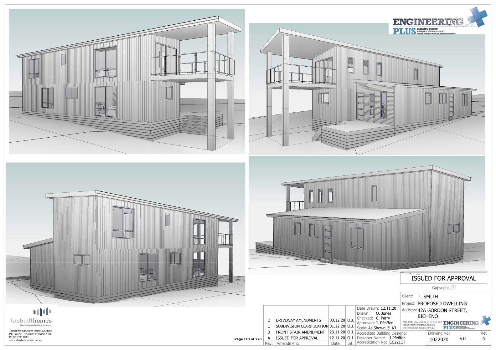
Rev: Amendment: Date: Int:
Client: T. SMITHProject: PROPOSED DWELLINGAddress:
Drawn: O. Jones
Scale: As Shown @ A3
J.PfeifferCC2211T
RevDrawing No:Designer Name:Accredited Building Designer
Accreditation No:
Checked: C. ParryApproved: J. Pfeiffer
cCopyright
ISSUED FOR APPROVAL
Mob 0417 362 783 or 0417 545 [email protected]@engineeringplus.com.au
Date Drawn: 12.11.20
1022020A ISSUED FOR APPROVAL 12.11.20 O.J. D
Tasbuilt Manufactured Homes & CabinsP.O Box 274, Deloraine Tasmania 7304Ph: 03 6393 [email protected]
42A GORDON STREET,BICHENO
B FRONT STAIR AMENDMENT 23.11.20 O.J.01.12.20 O.J.C SUBDIVISION CLARIFICATION03.12.20 O.J.D DRIVEWAY AMENDMENTS
A11Page 170 of 228
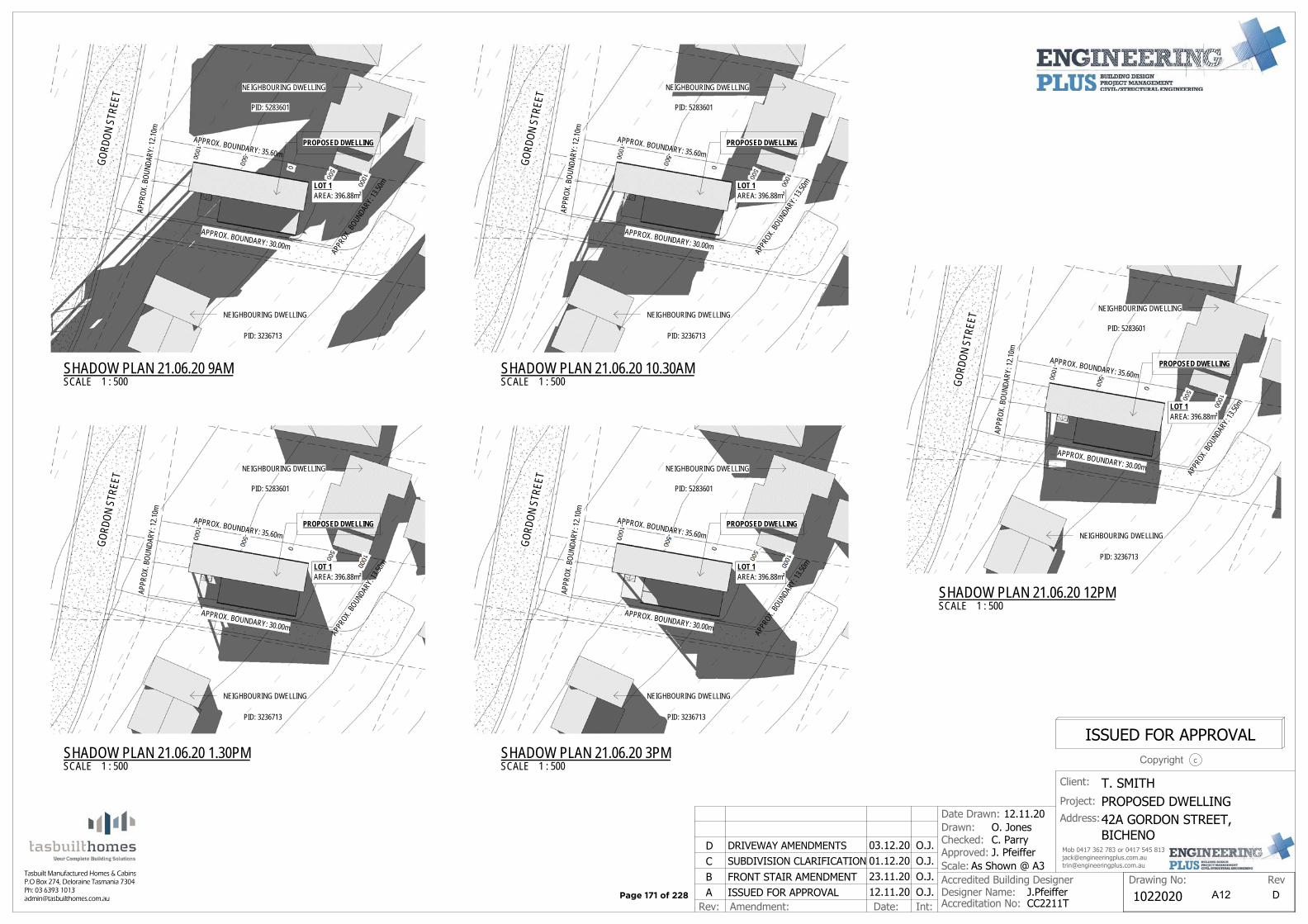
APPROX. BOUNDARY: 35.60m
APPR
OX. BO
UNDA
RY: 1
3.50m
APPROX. BOUNDARY: 30.00m
APPR
OX. B
OUND
ARY:
12.10
mPROPOSED DWELLING
GORD
ON S
TREE
T
LOT 1AREA: 396.88m²
NEIGHBOURING DWELLING
NEIGHBOURING DWELLING
PID: 3236713
PID: 5283601
APPROX. BOUNDARY: 35.60m
APPR
OX. BO
UNDA
RY: 1
3.50m
APPROX. BOUNDARY: 30.00m
APPR
OX. B
OUND
ARY:
12.10
m
PROPOSED DWELLING
GORD
ON S
TREE
T
LOT 1AREA: 396.88m²
NEIGHBOURING DWELLING
NEIGHBOURING DWELLING
PID: 3236713
PID: 5283601
APPROX. BOUNDARY: 35.60m
APPR
OX. BO
UNDA
RY: 1
3.50m
APPROX. BOUNDARY: 30.00m
APPR
OX. B
OUND
ARY:
12.10
m
PROPOSED DWELLING
GORD
ON S
TREE
T
LOT 1AREA: 396.88m²
NEIGHBOURING DWELLING
NEIGHBOURING DWELLING
PID: 3236713
PID: 5283601
APPROX. BOUNDARY: 35.60m
APPR
OX. BO
UNDA
RY: 1
3.50m
APPROX. BOUNDARY: 30.00m
APPR
OX. B
OUND
ARY:
12.10
m
PROPOSED DWELLING
GORD
ON S
TREE
T
LOT 1AREA: 396.88m²
NEIGHBOURING DWELLING
NEIGHBOURING DWELLING
PID: 3236713
PID: 5283601
APPROX. BOUNDARY: 35.60m
APPR
OX. BO
UNDA
RY: 1
3.50m
APPROX. BOUNDARY: 30.00m
APPR
OX. B
OUND
ARY:
12.10
m
PROPOSED DWELLINGGO
RDON
STR
EET
LOT 1AREA: 396.88m²
NEIGHBOURING DWELLING
NEIGHBOURING DWELLING
PID: 3236713
PID: 5283601
Rev: Amendment: Date: Int:
Client: T. SMITHProject: PROPOSED DWELLINGAddress:
Drawn: O. Jones
Scale: As Shown @ A3
J.PfeifferCC2211T
RevDrawing No:Designer Name:Accredited Building Designer
Accreditation No:
Checked: C. ParryApproved: J. Pfeiffer
cCopyright
ISSUED FOR APPROVAL
Mob 0417 362 783 or 0417 545 [email protected]@engineeringplus.com.au
Date Drawn: 12.11.20
1022020A ISSUED FOR APPROVAL 12.11.20 O.J. D
Tasbuilt Manufactured Homes & CabinsP.O Box 274, Deloraine Tasmania 7304Ph: 03 6393 [email protected]
42A GORDON STREET,BICHENO
B FRONT STAIR AMENDMENT 23.11.20 O.J.01.12.20 O.J.C SUBDIVISION CLARIFICATION03.12.20 O.J.D DRIVEWAY AMENDMENTS
A12
SCALE 1 : 500SHADOW PLAN 21.06.20 9AM
SCALE 1 : 500SHADOW PLAN 21.06.20 10.30AM
SCALE 1 : 500SHADOW PLAN 21.06.20 12PM
SCALE 1 : 500SHADOW PLAN 21.06.20 1.30PM
SCALE 1 : 500SHADOW PLAN 21.06.20 3PM
Page 171 of 228

The General Manager, Glamorgan Spring Bay Council
3 June 2021
Dear Sir,
REPRESENTATION RE PROPOSED DWELLING 42 GORDON STREET, BICHENO DA 2020.288
We strongly object to this proposed development. As ratepayers and residents of Bicheno,we have valued our way of life here since purchasing our property at backin 2001. Soon after, a new house was built at the rear of 42 Gordon Street next door. Thisresulted in us losing all of the privacy that we had in our back yard. To add to this, it is nowrented out as short-term holiday accommodation, with different people staying there on aregular basis who can be noisy and disruptive.
This block at 42 Gordon Street has now been subdivided into two blocks, with the new(front) tiny block being less than the minimum lot size allowed for subdivision in the general
residential zone, which is totally out of character for Gordon Street. We are now faced withthe prospect of having a very large two storey house on that tiny block which willcompletely destroy the chance of us being able to enjoy any part of our back or front yards.
There are numerous large windows and an upstairs deck that will look straight over our yardand into our house. This will completely take away the quality or our lives that we haveenjoyed here for many years and cause us great stress.
The winds around here can be extremely strong and a development this size so close to ourhouse will be likely to create a wind tunnel that will put our house and carport at risk in highwinds. We have had to rebuild a carport that was blown away previously.
All of the houses that are the size of the proposed development in our street are on largeblocks and are set back from the street and therefore do not impact on others around themWe did not choose to live in a small country town to be crowded out by high densitydevelopment that takes away from the character of town and severely impacts on ourquality of life, particularly our privacy.
We have also been totd by the owner that this will also be rented out as short-term holidayaccommodation, further negatively impacting our lives, privacy and peace and quiet.Regardless of this, a house of this size should not be allowed on block that is so small. Weare concerned that this will open the door for future inappropriate development like thisthat will destroy the nature of our beautiful town.
Yours sincerely,
1
Page 172 of 228
REP 1
Agenda Item 4.2 - Attachment B
The General Manager
Glamorgan Spring Bay Council
PO Box 6
Triabunna Tas 7190
3 June 2021
Dear Sir,
We are writing to make a representation regarding the proposed development at 42A Gordon
Street in Bicheno, DA 2020-288. We wish to make it clear that we are strongly opposed to this
development.
Firstly, we are appalled that the Council saw it fit to allow the subdivision to go ahead in the first
instance, allowing such a small lot to be approved. In accordance with the Glamorgan Spring Bay
Planning Scheme, minimum lot size for subdivision in the General Residential zone is 450m2. This lot
is less than 400m2.
The proposed development on that lot itself fails to meet the requirements of the Planning Scheme
on many fronts – namely:
1. Building envelope
2. Front setback
3. Length of building in relation to side setback and boundary length
4. Overshadowing of adjacent properties
5. Visual impacts caused by the scale and proportion of the dwelling when viewed from
adjoining properties.
We as individual property owners and ratepayers are up in arms, as are the majority of neighbours
within proximity of the proposed development.
We built our own home at accordance with all planning requirements, so as to
minimize the impact on others around us, whereas this proposal does the complete opposite, with
total disregard to all surrounding residents/property owners. Some residents have been told by the
current owner that the house will be built and that it is none of their business. As the proposed
development does not meet the Planning Scheme requirement, it is ours and every other rate payers
business, as this development will impact significantly on us all.
The proposed dwelling should be no more than a small single-storey building compatible with the
very small and narrow lot size.
The front setback should be equivalent to dwellings on the adjoining sites (of which there is only
one) which has a setback of 24 metres from the front boundary. Current proposed setback is only
6 metres which contravenes the Planning Scheme requirements.
The length of the proposed dwelling should be no more than nine metres or one third of the length
of the side boundary due to the side setback being less than three metres. The current length of the
proposed building far exceeds either of these criteria.
Page 173 of 228
REP 2
Due to the height of the building, there are overshadowing issues impacting on the fruit and
vegetable garden on the lot at , further contravening the planning scheme.
A combination of the five stated issues that fail to meet the Planning Scheme requirements, will
impact significantly on both ourselves and all surrounding property owners. Privacy is of significant
concern for all residents, but particularly those at who will have no private
outdoor open space available to them. All properties across the road at 45, 47, 49 and 51 Gordon
Street will have their privacy significantly impacted in a negative manner due to the height and size of
the dwelling, front setback and elevated front deck facing the street. As the proposed building does
not meet the planning requirements outlined above, we feel we have a valid reason to object to this
development. This will obliterate our water view (which we built our house for) and devalue our
property and quality of life. We live with our disabled youngest son, who is calmed by being able to
see the water. Our home was built for him.
The lot at 42A Gordon Street should never have been allowed, as it is not possible to build any
dwelling that will satisfactorily meet Planning Scheme requirements, let alone a dwelling of the
proportions proposed with this development. A small single storey dwelling would be far more
appropriate.
We did not choose to purchase and build a property in a small country town to be faced with the
prospect of living in a high density housing environment typical of a large city.
Please be advised that should a satisfactory outcome not be achieved by this representation; we will
have no hesitation in taking this to the media and the Resource Management and Planning Appeals
Tribunal.
Bicheno Tas 7215
Page 174 of 228
1
Maree Tyrrell
From:Sent: Friday, 4 June 2021 3:17 PMTo: PlanningSubject: Objection to Proposed development at 42A Gordon Street Bicheno
The General Manager Glamorgan Spring Bay Council
4 June 2021
Dear Sir
I am writing to make a representation in respect of the proposed development at 42A Gordon Street in Bicheno (DA 2020-288). I am seriously concerned about the impact that this will have if it is allowed to go ahead.
It is proposed that this tiny block (which is less than the minimum size allowed by the Planning Scheme) is to have a house built on it that also does not fit the requirements of the Planning Scheme (on several fronts) and will impact on all neighbouring residents.
From my perspective at Gordon Street, this will considerably invade my privacy. I don’t spend time at my property in a small town by the sea, to be overshadowed by a large house on a tiny block that is so close to the front boundary and totally out of keeping with the remainder of the houses in this street.
High density development is not appropriate for this street or town, and not welcomed by the rate payers and residents who will be affected by such a decision.
Please carefully consider the appropriateness of the proposed development and do not approve it. The size and shape of this block would suit a very small single storey house, not the house that is proposed.
Bicheno
CONFIDENTIALITY NOTICE AND DISCLAIMER The information in this transmission may be confidential and/or protected by legal professional privilege, and is intended only for the person or persons to whom it is addressed. If you are not such a person, you are warned that any disclosure, copying or dissemination of the information is unauthorised. If you have received the transmission in error, please immediately contact this office by telephone, fax or email, to inform us of the error and to enable arrangements to be made for the destruction of the transmission, or its return at our cost. No liability is accepted for any unauthorised use of the information contained in this transmission.
Please consider the environment. Do you really need to print this email?
Page 175 of 228
REP 4
The General ManagerGlamorgan Spring Bay CouncilPO Box 6Triabunna Tas 7190
Dear Sir,
We wish to make a formal representation re the development DA 2020-288, proposed at 42 Gordon Street in Bicheno. We are strongly opposed to this development being approved as it will impact on us significantly at our home
Gordon Street.
As a community we are up in arms about this – firstly a subdivision that created a tiny, narrow block that is smaller than should have been allowed under the Planning Scheme, and now a proposed two storey house that also does not fit the requirements of the Planning Scheme.
The sheer size of the house, its closeness to the front boundary, length and proximity to the side boundaries and the visual impact it creates from ours and other surrounding properties are all of concern.
In particular the natural slope of the land uphill from our house, combined with a nearly 7 metre total house elevation looms directly over our front yard and verandah.
Our concerns are not only shadow and light levels, but also potential intrusive noise issues from the deck and living areas, fronting the road, especially if this dwelling is used as an Airbnb, as was previously the case with the existing house.
At over 200sqm a dark two storey colour bond house on such a small block ( how was this approved) seems to be a poor addition to the built environment in this part of Gordon St.
Our privacy and quality of life (as well as that of many others in proximity to this proposed house) will be severely impacted if this is allowed to proceed.
We as residents and ratepayers object strongly to this unwelcome development and suggest serious consideration of allowing only a small single storey house on this block, that will not negatively impact on the comfort, privacy and wellbeing of others nearby.
Bicheno
June 4th 2021
Page 176 of 228
REP 5
Danielle Gray, Principal Consultant
Gray Planning
224 Warwick Street
West Hobart TAS 7000
4 June 2021
General Manager
Glamorgan Spring Bay Council
PO Box 9
Triabunna TAS 7190
Dear Mr Ingham,
REPRESENTATION AGAINST PROPOSED NEW DWELLING AT (lot 1) 42 GORDON STREET, BICHENO (DA-2020-288)
Gray Planning has been engaged by a number of local residents to prepare and submit a letter of representation that objects to the proposed dwelling advertised as being located at 42 Gordon Street, Bicheno (DA-2020-288).
I have attached Appendix A to this representation that provides the names and addresses of those who have engaged Gray Planning and all of whom oppose the proposed development.
It is noted that the proposed development seeks approval for a relatively large dwelling, to be located at lot 1, 42 Gordon Street which only measures 396sqm in total site area.
Essentially, the proposed development seeks approval for a large suburban style dwelling on a small allotment more commonly seen in higher density residential zones and areas.
It is understood that the developer is the same person who subdivided the property to create the 396sqm development site. If this is indeed the case, it is unclear why they chose to create such a small lot, well below the minimum lot size for ordinary lots and clearly out of character with the pattern of development in the surrounding area, and then proposes to place a large dwelling on the site that seeks further discretion from development standards.
My clients oppose the relaxation of development standards, regardless of how marginal, on the basis that it is unreasonable to develop such a small lot by way of recent subdivision which then results in future development requiring further relaxations in development standards.
Page 177 of 228
REP 6

Gray Planning – representation DA-2020-288 Dwelling at 42 Gordon Street Bicheno
4 June 2021
2
I have provided the following comments against the applicable development standards that the proposal seeks discretion on:
Clause 10.4.6.A1 Privacy setbacks for all decks:
*This applies only to decks with a floor level 1m or above natural ground level at any point*
Building front, side and rear setbacks apply to decks in terms of siting.
If a deck is roofed, it is included in the site coverage calculations for any development proposal.
Acceptable (Permitted): Any deck within 3m of a side boundary or 4m of a rear boundary or multiple dwelling decks less than 6m from eachother must also additionally be screened with screening that has no more than 25% transparency and is no less than 1.7m above finished floor level. Planning Comment: The ground floor level deck does not comply as it has a floor level higher than 1m (its FFL is 1.2m above NGL as shown on the west elevation drawing) and is less than 3m to the southern side boundary of the subject site that adjoins the driveway access for the rear internal lot and one of my client’s properties at While the deck in question is directly adjacent to a driveway, one of my clients resides in the dwelling closest to the proposed development at n line with recent Tribunal decisions as to what constitutes ‘adjacent’, my client’s property is adjacent to and in close proximity to the proposed ground floor level deck that is located marginally over 1m to a side boundary, a significant reduction on the minimum 3m setback for decks that have a FFL at any point 1m or more above natural ground level. An inspection of reveals this dwelling faces north directly toward the development site and toward where the proposed dwelling will be located. The proposed deck will enable a direct view into my client’s dwelling at a similar level to the habitable room windows at my client’s residence. On this basis, as the proposed ground level deck is only located 1.060m to the southern side boundary of the subject site, the side of the deck facing my client’s residence should be wholly screened with screening that has no more than 25% transparency and is no less than 1.7m above finished floor level. Alternatively, the deck should be deleted from the proposal plans (and replaced with steps only to the front door) as unscreened it will result in unacceptable overlooking of my client’s adjoining residence.
Page 178 of 228
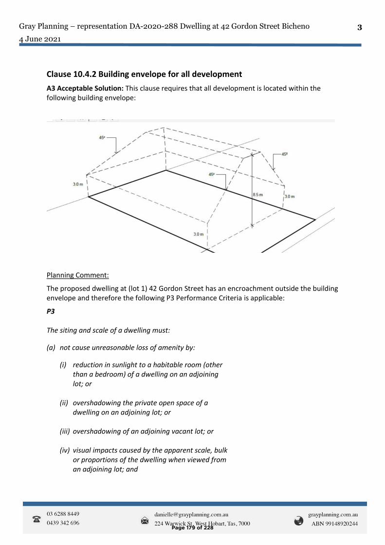
Gray Planning – representation DA-2020-288 Dwelling at 42 Gordon Street Bicheno
4 June 2021
3
Clause 10.4.2 Building envelope for all development
A3 Acceptable Solution: This clause requires that all development is located within the following building envelope:
Planning Comment:
The proposed dwelling at (lot 1) 42 Gordon Street has an encroachment outside the building envelope and therefore the following P3 Performance Criteria is applicable:
P3 The siting and scale of a dwelling must:
(a) not cause unreasonable loss of amenity by:
(i) reduction in sunlight to a habitable room (other than a bedroom) of a dwelling on an adjoining lot; or
(ii) overshadowing the private open space of a
dwelling on an adjoining lot; or (iii) overshadowing of an adjoining vacant lot; or (iv) visual impacts caused by the apparent scale, bulk
or proportions of the dwelling when viewed from an adjoining lot; and
Page 179 of 228

Gray Planning – representation DA-2020-288 Dwelling at 42 Gordon Street Bicheno
4 June 2021
4
(b) provide separation between dwellings on adjoining lots that is compatible with that prevailing in the surrounding area.
Planning Comment:
The above P3 Performance Criteria must be considered by Council as the dwelling fails to comply with the prescribed building envelope.
It is unclear why the proposed development cannot be further excavated into the site to ensure it is located wholly within the building envelope. The subject site has no site constraints that justify the proposed development seeking relaxation of the requirement to be located wholly within the prescribed building envelope.
My clients own and reside in properties in very close proximity to the proposed development site.
will have its outlook obliterated by the proposed dwelling and will appear to experience significant overshadowing onto her property until at least 11am as a result of the proposed development.
The shadow diagrams do not provide sufficient detail on the total extent of overshadowing (including when residence will become free of overshadowing and how far shadows will be cast onto her habitable room windows facing the development site) that will be cast onto property and therefore it is unclear how Council can make a decision as to the actual overshadowing impact in the absence of such information.
My clients property Gordon Street faces due north toward the outlook and also toward the development site. Their current outlook is likely to be substantially diminished by the proposed development. However, in the absence of any assessment of visual impact resulting from the proposed development lodged by the developer, it is further unclear how a decision can be made by Council that definitively rules out unreasonable loss of amenity from visual impact of the proposed development.
Page 180 of 228
Gray Planning – representation DA-2020-288 Dwelling at 42 Gordon Street Bicheno
4 June 2021
5
Incorrect advertising of the proposed development with respect to the development address provided I note that the address of the property given on Council advertising documentation states that the address of the development site is ’42 Gordon Street, Bicheno’. This has caused some confusion with my clients as to what lot is affected. The advertised address of the development site is not the correct address as the property has been recently subdivided and there is more than one title with 42 Gordon Street listed as a street address. The correct address that should have been notified is lot 1, 42 Gordon Street (CT-181017/1) which includes the appropriate title reference being provided so that the development site is able to be correctly identified. Where a property address is not immediately clear, there is no street address (including individual property street number) or where there are properties with the same street address (as is the case with 42 Gordon Street), title reference details of the development site should be included as part of the public notification. On this basis, the proposed development has not been correctly identified as part of the public notification process and should be readvertised. Failure to readvertise the proposed development will result in any decision that is being made by Council being an invalid decision.
Use of the proposed dwelling for the purposes of self contained visitor accommodation
While the proposal plans state that the proposed development is to be used for the purposes of a single private dwelling, there is concern that the proposed development may be intended for use as commercial Air BNB accommodation.
Any approval should include advice to the developer that such use requires further and prior planning approval from Council.
Page 181 of 228
Gray Planning – representation DA-2020-288 Dwelling at 42 Gordon Street Bicheno
4 June 2021
6
In summary, it is considered that the proposal plans and documentation as submitted by the developer do not provide sufficient documentation to enable Council to make an adequate assessment on the impacts of the proposed development with respect to either visual impact or overshadowing impact on adjoining properties.
It is also noted that the development site address has not been clearly or correctly identified by Council as part of the public notification process and as a result, at the very least should be readvertised to avoid an invalid decision being made by Council.
Should you wish to discuss this representation, I may be contacted on 0439 342 696.
Yours faithfully
Danielle Gray B.Env.Des. MTP. MPIA
Principal Consultant, Gray Planning
On behalf of Mr and Mrs Westcott and Others (see Appendix A overleaf)
Page 182 of 228

Gray Planning – representation DA-2020-288 Dwelling at 42 Gordon Street Bicheno
4 June 2021
7
APPENDIX A
1.
2.
3.
4.
5.
6.
7.
Page 183 of 228

1
Maree Tyrrell
From:Sent: Friday, 4 June 2021 4:48 PMTo: PlanningSubject: Development Application 42 Gordon St Bicheno
The General Manager Glamorgan Spring Bay Council PO Box 6 Triabunna Tas 7190 4 June 2021 Dear Sir, We are writing to express our opposition and make a formal representation relating to the proposed development at 42A Gordon Street in Bicheno, DA 2020-288. We strongly object to the proposed development for many reasons, relating to issues arising due to the development not meeting the Glamorgan Spring Bay Planning Scheme requirements. As you are no doubt aware, the development is not appropriate in terms of the building envelope, front setback, length of the building, overshadowing of adjacent and adjoining properties and visual impact caused by the size of the proposed building. The proximity of the house to the front boundary, and its size in relation to the lot size and the fact that it will loom over our properties directly across the road, will impact significantly on our privacy, enjoyment of our outdoor spaces and noise. This is not in character with all the other properties in this street and will set the precedent for further unwanted future development of this nature both in our street and this town. The lot size on which this proposed development is smaller than the minimum size permitted by the Planning Scheme, and as such is not suitable for anything other than a small single storey dwelling at most. We chose to live in Bicheno for the quality of life, peace and tranquility and object to any high-density development typical of large cities, of which Bicheno is not.
Bicheno
To help protect your privacy, Micro so ft Office prevented auto matic downlo ad o f this picture from the Internet.
Virus-free. www.avast.com
Page 184 of 228
REP 7
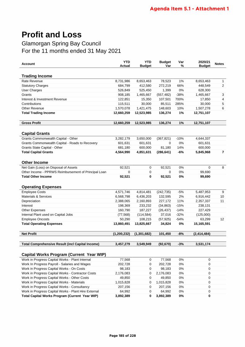
Profit and Loss Glamorgan Spring Bay Council
For the 11 months ended 31 May 2021
Account YTD
Actual YTD
Budget Budget
Var Var
% 2020/21 Budget
Notes
Trading Income Rate Revenue 8,731,986 8,653,463 78,523 1% 8,653,463 1
Statutory Charges 684,799 412,580 272,219 66% 448,549 2
User Charges 526,849 525,450 1,399 0% 628,300
Grants 908,185 1,465,667 (557,482) -38% 1,465,667 3
Interest & Investment Revenue 122,851 15,350 107,501 700% 17,850 4
Contributions 115,511 30,000 85,511 285% 30,000 5
Other Revenue 1,570,078 1,421,475 148,603 10% 1,507,278 6
Total Trading Income 12,660,259 12,523,985 136,274 1% 12,751,107
Gross Profit 12,660,259 12,523,985 136,274 1% 12,751,107
Capital Grants Grants Commonwealth Capital - Other 3,282,179 3,650,000 (367,821) -10% 4,644,337
Grants Commonwealth Capital - Roads to Recovery 601,631 601,631 0 0% 601,631
Grants State Capital - Other 681,180 600,000 81,180 14% 600,000
Total Capital Grants 4,564,990 4,851,631 (286,641) -6% 5,845,968 7
Other Income Net Gain (Loss) on Disposal of Assets 92,521 0 92,521 0% 0 8
Other Income - PPRWS Reimbursement of Principal Loan 0 0 0 0% 99,690
Total Other Income 92,521 0 92,521 0% 99,690
Operating Expenses Employee Costs 4,571,746 4,814,481 (242,735) -5% 5,487,953 9
Materials & Services 6,568,798 6,436,203 132,595 2% 6,916,442 10
Depreciation 2,388,065 2,160,893 227,172 11% 2,357,337 11
Interest 198,369 233,232 (34,863) -15% 238,131
Other Expenses 160,790 187,227 (26,437) -14% 227,429
Internal Plant used on Capital Jobs (77,568) (114,584) 37,016 -32% (125,000)
Employee Oncosts 50,290 108,215 (57,925) -54% 63,299 12
Total Operating Expenses 13,860,491 13,825,667 34,824 0% 15,165,591
Net Profit (1,200,232) (1,301,682) 101,450 -8% (2,414,484)
Total Comprehensive Result (incl Capital Income) 3,457,279 3,549,949 (92,670) -3% 3,531,174
Capital Works Program (Current Year WIP) Work in Progress Capital Works - Plant Internal 77,568 0 77,568 0% 0
Work In Progress Payroll - Salaries and Wages 202,728 0 202,728 0% 0
Work in Progress Capital Works - On Costs 98,183 0 98,183 0% 0
Work in Progress Capital Works - Contractor Costs 2,176,083 0 2,176,083 0% 0
Work in Progress Capital Works - Other Costs 49,850 0 49,850 0% 0
Work in Progress Capital Works - Materials 1,015,828 0 1,015,828 0% 0
Work in Progress Capital Works - Consultancy 207,156 0 207,156 0% 0
Work in Progress Capital Works - Plant Hire External 64,992 0 64,992 0% 0
Total Capital Works Program (Current Year WIP) 3,892,389 0 3,892,389 0% 0
Page 185 of 228
Agenda Item 5.1 - Attachment 1

Notes:
1: Rate Revenue is up 1% ($79k) on budget YTD due to a higher than forecast level of supplementary valuations.
2: Statutory Charges are up 66% ($272k) on budget YTD due to a higher than forecast level of development applications.
3: Operational Grants Revenue is down $557k on budget YTD due to the timing of FAGs in advance payment which will be received in June.
4: Interest & Investment Revenue is up $108k on budget YTD due to the receipt of a partial interim TasWater Dividend, which was not budgeted to be received this financial year.
5: Contribution Revenue is up $86k on budget YTD which is due to the higher level of development applications than originally forecast.
6: Other Revenue is up $149k on budget YTD due to a higher level of medical income received than originally forecast.
7: Total Capital Grant Revenue is down 6% due to the timing of grant milestone payments which are likely to carry forward to the next financial year.
8: Net Gain (Loss) on Disposal of Assets is up $93k on budget YTD due to the trade-in of a number of older vehicles and plant.
9: Employee Costs are down $243k (5%) on budget YTD primarily due to vacancies during the year.
10: Materials and Services are up by $133k (2%) budget YTD primarily due to increased contractor cost to cover staff vacancies earlier in the year.
11: Depreciation is up 11% on budget YTD. Forecasting is based on actual depreciation for the prior financial year.
12: Employee Oncosts are down $58k (54%) due to primarily due to the annual adjustment to workers compensation insurance for vacancies in the prior year.
Page 186 of 228

Balance Sheet - Council Report (Abridged Version) Glamorgan Spring Bay Council
Statement of Financial PositionGlamorgan Spring Bay CouncilAs at 31 May 2021
31 MAY 2021 30 JUN 2020
AssetsCurrent Assets
Cash & Cash Equivalents 3,867,290 1,683,196
Trade & Other Receivables 590,368 658,232
Inventories 22,402 23,755
Other Assets 91,155 81,600Total Current Assets 4,571,215 2,446,782
Non-current AssetsTrade & Other Receivables 9,435 9,435
Investment in Water Corporation 28,139,885 28,139,885
Property, Infrastructure, Plant & Equipment 125,634,438 126,700,280Total Non-current Assets 153,783,759 154,849,601
Total Assets 158,354,974 157,296,383
LiabilitiesCurrent Liabilities
Trade & Other Payables 882,339 1,207,652
Trust Funds & Deposits 343,662 534,472
Provisions 636,254 614,714
Contract Liabilities - 421,919
Interest bearing Loans & Borrowings 200,183 512,113Total Current Liabilities 2,062,438 3,290,870
Non-current LiabilitiesProvisions 117,389 117,389
Interest Bearing Loans & Borrowings 8,125,938 6,723,587Total Non-current Liabilities 8,243,327 6,840,975
Total Liabilities 10,305,765 10,131,845
Net Assets 148,049,209 147,164,538
EquityCurrent Year Earnings 884,671 1,214,901
Retained Earnings 78,352,191 77,152,601
Equity - Asset Revaluation Reserve 68,381,239 68,381,239
Equity - Restricted Reserves 431,109 415,797
Total Equity 148,049,209 147,164,538
Page 187 of 228
Agenda Item 5.1 - Attachment 2
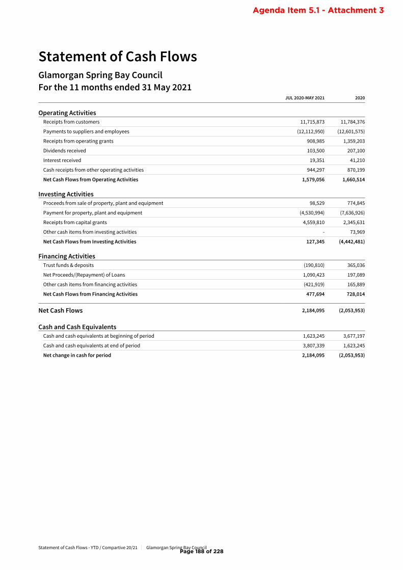
Statement of Cash Flows - YTD / Compartive 20/21 Glamorgan Spring Bay Council
Statement of Cash FlowsGlamorgan Spring Bay CouncilFor the 11 months ended 31 May 2021
JUL 2020-MAY 2021 2020
Operating ActivitiesReceipts from customers 11,715,873 11,784,376
Payments to suppliers and employees (12,112,950) (12,601,575)
Receipts from operating grants 908,985 1,359,203
Dividends received 103,500 207,100
Interest received 19,351 41,210
Cash receipts from other operating activities 944,297 870,199
Net Cash Flows from Operating Activities 1,579,056 1,660,514
Investing ActivitiesProceeds from sale of property, plant and equipment 98,529 774,845
Payment for property, plant and equipment (4,530,994) (7,636,926)
Receipts from capital grants 4,559,810 2,345,631
Other cash items from investing activities - 73,969
Net Cash Flows from Investing Activities 127,345 (4,442,481)
Financing ActivitiesTrust funds & deposits (190,810) 365,036
Net Proceeds/(Repayment) of Loans 1,090,423 197,089
Other cash items from financing activities (421,919) 165,889
Net Cash Flows from Financing Activities 477,694 728,014
Net Cash Flows 2,184,095 (2,053,953)
Cash and Cash EquivalentsCash and cash equivalents at beginning of period 1,623,245 3,677,197
Cash and cash equivalents at end of period 3,807,339 1,623,245
Net change in cash for period 2,184,095 (2,053,953)
Page 188 of 228
Agenda Item 5.1 - Attachment 3
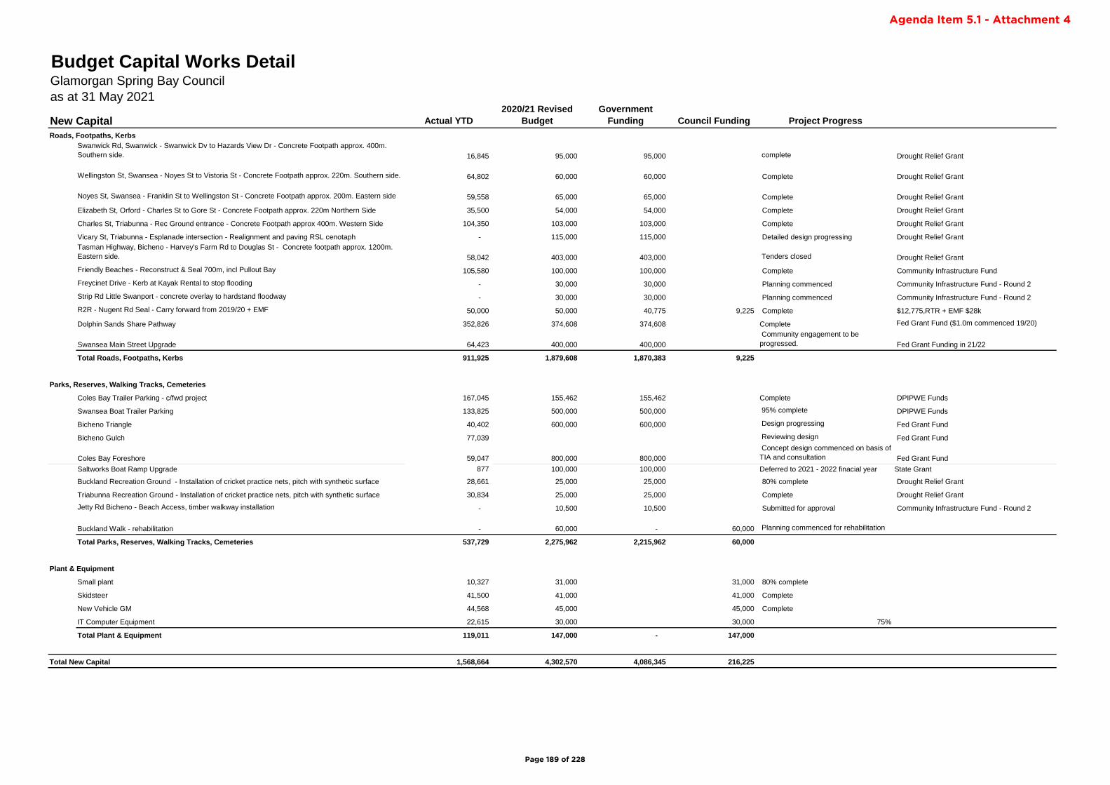
Actual YTD
2020/21 Revised
Budget
Government
Funding Council Funding Project Progress
Roads, Footpaths, Kerbs
Swanwick Rd, Swanwick - Swanwick Dv to Hazards View Dr - Concrete Footpath approx. 400m.
Southern side. 16,845 95,000 95,000 complete Drought Relief Grant
Wellingston St, Swansea - Noyes St to Vistoria St - Concrete Footpath approx. 220m. Southern side. 64,802 60,000 60,000 Complete Drought Relief Grant
Noyes St, Swansea - Franklin St to Wellingston St - Concrete Footpath approx. 200m. Eastern side 59,558 65,000 65,000 Complete Drought Relief Grant
Elizabeth St, Orford - Charles St to Gore St - Concrete Footpath approx. 220m Northern Side 35,500 54,000 54,000 Complete Drought Relief Grant
Charles St, Triabunna - Rec Ground entrance - Concrete Footpath approx 400m. Western Side 104,350 103,000 103,000 Complete Drought Relief Grant
Vicary St, Triabunna - Esplanade intersection - Realignment and paving RSL cenotaph - 115,000 115,000 Detailed design progressing Drought Relief Grant
Tasman Highway, Bicheno - Harvey's Farm Rd to Douglas St - Concrete footpath approx. 1200m.
Eastern side. 58,042 403,000 403,000 Tenders closed Drought Relief Grant
Friendly Beaches - Reconstruct & Seal 700m, incl Pullout Bay 105,580 100,000 100,000 Complete Community Infrastructure Fund
Freycinet Drive - Kerb at Kayak Rental to stop flooding - 30,000 30,000 Planning commenced Community Infrastructure Fund - Round 2
Strip Rd Little Swanport - concrete overlay to hardstand floodway - 30,000 30,000 Planning commenced Community Infrastructure Fund - Round 2
R2R - Nugent Rd Seal - Carry forward from 2019/20 + EMF 50,000 50,000 40,775 9,225 Complete $12,775,RTR + EMF $28k
Dolphin Sands Share Pathway 352,826 374,608 374,608 Complete Fed Grant Fund ($1.0m commenced 19/20)
Swansea Main Street Upgrade 64,423 400,000 400,000
Community engagement to be
progressed. Fed Grant Funding in 21/22
Total Roads, Footpaths, Kerbs 911,925 1,879,608 1,870,383 9,225
Parks, Reserves, Walking Tracks, Cemeteries
Coles Bay Trailer Parking - c/fwd project 167,045 155,462 155,462 Complete DPIPWE Funds
Swansea Boat Trailer Parking 133,825 500,000 500,000 95% complete DPIPWE Funds
Bicheno Triangle 40,402 600,000 600,000 Design progressing Fed Grant Fund
Bicheno Gulch 77,039 Reviewing design Fed Grant Fund
Coles Bay Foreshore 59,047 800,000 800,000
Concept design commenced on basis of
TIA and consultation Fed Grant Fund
Saltworks Boat Ramp Upgrade 877 100,000 100,000 Deferred to 2021 - 2022 finacial year State Grant
Buckland Recreation Ground - Installation of cricket practice nets, pitch with synthetic surface 28,661 25,000 25,000 80% complete Drought Relief Grant
Triabunna Recreation Ground - Installation of cricket practice nets, pitch with synthetic surface 30,834 25,000 25,000 Complete Drought Relief Grant
Jetty Rd Bicheno - Beach Access, timber walkway installation - 10,500 10,500 Submitted for approval Community Infrastructure Fund - Round 2
Buckland Walk - rehabilitation - 60,000 - 60,000 Planning commenced for rehabilitation
Total Parks, Reserves, Walking Tracks, Cemeteries 537,729 2,275,962 2,215,962 60,000
Plant & Equipment
Small plant 10,327 31,000 31,000 80% complete
Skidsteer 41,500 41,000 41,000 Complete
New Vehicle GM 44,568 45,000 45,000 Complete
IT Computer Equipment 22,615 30,000 30,000 75%
Total Plant & Equipment 119,011 147,000 - 147,000
Total New Capital 1,568,664 4,302,570 4,086,345 216,225
Budget Capital Works DetailGlamorgan Spring Bay Council
as at 31 May 2021
New Capital
Page 189 of 228
Agenda Item 5.1 - Attachment 4
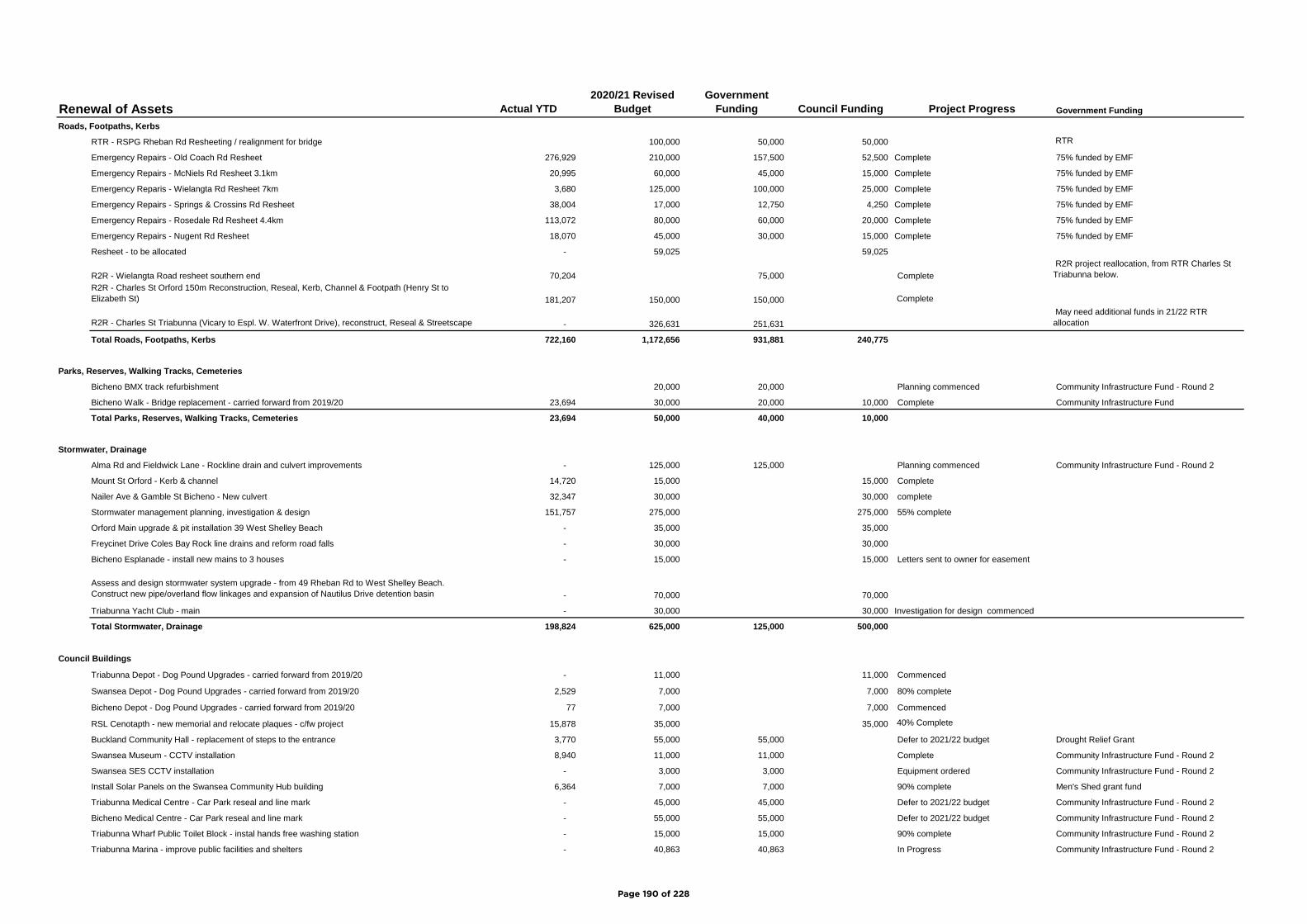
Renewal of Assets Actual YTD
2020/21 Revised
Budget
Government
Funding Council Funding Project Progress Government Funding
Roads, Footpaths, Kerbs
RTR - RSPG Rheban Rd Resheeting / realignment for bridge 100,000 50,000 50,000 RTR
Emergency Repairs - Old Coach Rd Resheet 276,929 210,000 157,500 52,500 Complete 75% funded by EMF
Emergency Repairs - McNiels Rd Resheet 3.1km 20,995 60,000 45,000 15,000 Complete 75% funded by EMF
Emergency Reparis - Wielangta Rd Resheet 7km 3,680 125,000 100,000 25,000 Complete 75% funded by EMF
Emergency Repairs - Springs & Crossins Rd Resheet 38,004 17,000 12,750 4,250 Complete 75% funded by EMF
Emergency Repairs - Rosedale Rd Resheet 4.4km 113,072 80,000 60,000 20,000 Complete 75% funded by EMF
Emergency Repairs - Nugent Rd Resheet 18,070 45,000 30,000 15,000 Complete 75% funded by EMF
Resheet - to be allocated - 59,025 59,025
R2R - Wielangta Road resheet southern end 70,204 75,000 Complete
R2R project reallocation, from RTR Charles St
Triabunna below.
R2R - Charles St Orford 150m Reconstruction, Reseal, Kerb, Channel & Footpath (Henry St to
Elizabeth St) 181,207 150,000 150,000 Complete
R2R - Charles St Triabunna (Vicary to Espl. W. Waterfront Drive), reconstruct, Reseal & Streetscape - 326,631 251,631
May need additional funds in 21/22 RTR
allocation
Total Roads, Footpaths, Kerbs 722,160 1,172,656 931,881 240,775
Parks, Reserves, Walking Tracks, Cemeteries
Bicheno BMX track refurbishment 20,000 20,000 Planning commenced Community Infrastructure Fund - Round 2
Bicheno Walk - Bridge replacement - carried forward from 2019/20 23,694 30,000 20,000 10,000 Complete Community Infrastructure Fund
Total Parks, Reserves, Walking Tracks, Cemeteries 23,694 50,000 40,000 10,000
Stormwater, Drainage
Alma Rd and Fieldwick Lane - Rockline drain and culvert improvements - 125,000 125,000 Planning commenced Community Infrastructure Fund - Round 2
Mount St Orford - Kerb & channel 14,720 15,000 15,000 Complete
Nailer Ave & Gamble St Bicheno - New culvert 32,347 30,000 30,000 complete
Stormwater management planning, investigation & design 151,757 275,000 275,000 55% complete
Orford Main upgrade & pit installation 39 West Shelley Beach - 35,000 35,000
Freycinet Drive Coles Bay Rock line drains and reform road falls - 30,000 30,000
Bicheno Esplanade - install new mains to 3 houses - 15,000 15,000 Letters sent to owner for easement
Assess and design stormwater system upgrade - from 49 Rheban Rd to West Shelley Beach.
Construct new pipe/overland flow linkages and expansion of Nautilus Drive detention basin - 70,000 70,000
Triabunna Yacht Club - main - 30,000 30,000 Investigation for design commenced
Total Stormwater, Drainage 198,824 625,000 125,000 500,000
Council Buildings
Triabunna Depot - Dog Pound Upgrades - carried forward from 2019/20 - 11,000 11,000 Commenced
Swansea Depot - Dog Pound Upgrades - carried forward from 2019/20 2,529 7,000 7,000 80% complete
Bicheno Depot - Dog Pound Upgrades - carried forward from 2019/20 77 7,000 7,000 Commenced
RSL Cenotapth - new memorial and relocate plaques - c/fw project 15,878 35,000 35,000 40% Complete
Buckland Community Hall - replacement of steps to the entrance 3,770 55,000 55,000 Defer to 2021/22 budget Drought Relief Grant
Swansea Museum - CCTV installation 8,940 11,000 11,000 Complete Community Infrastructure Fund - Round 2
Swansea SES CCTV installation - 3,000 3,000 Equipment ordered Community Infrastructure Fund - Round 2
Install Solar Panels on the Swansea Community Hub building 6,364 7,000 7,000 90% complete Men's Shed grant fund
Triabunna Medical Centre - Car Park reseal and line mark - 45,000 45,000 Defer to 2021/22 budget Community Infrastructure Fund - Round 2
Bicheno Medical Centre - Car Park reseal and line mark - 55,000 55,000 Defer to 2021/22 budget Community Infrastructure Fund - Round 2
Triabunna Wharf Public Toilet Block - instal hands free washing station - 15,000 15,000 90% complete Community Infrastructure Fund - Round 2
Triabunna Marina - improve public facilities and shelters - 40,863 40,863 In Progress Community Infrastructure Fund - Round 2
Page 190 of 228
Coles Bay Tennis Courts - Basketball hoop installation - 3,000 3,000 Getting quotes Community Infrastructure Fund - Round 2
Buckland Community Hall - ramp access 2,155 45,000 45,000 Defer to 2021/22 budget Community Infrastructure Fund
Coles Bay Tennis Courts - Resurface/Recontruct 65,827 65,000 65,000 Complete Community Infrastructure Fund
Replace Fencing, paving & awning Swansea Child Care Centre 3,812 25,000 25,000 80% complete Community Infrastructure Fund
Bicheno Medical Centre - Refurb Treatment Room - 25,000 25,000 Defer to 2021/22 budget Community Infrastructure Fund
Swansea Courthouse Drainage Works 5,585 25,000 25,000 80% Complete Community Infrastructure Fund
Swansea Community Hall - Toilet Refurbishment - 40,000 40,000 In Progress Community Infrastructure Fund
Total Council Buildings 114,937 519,863 459,863 60,000
Bridges, Culverts
Orford Bridge Replacement 958,930 990,840 990,840
Contract Complete. Rehabilitation to
finalise project
$1.02m project started May 2019. Fully Federal
Grant funded
Holkham Crt Culvert 6,500 56,087 56,087 Design continued - design delays Community Infrastructure Fund
RTR - BRP Rheban Rd Griffith River Bridge 21,266 300,000 300,000
Survey for design revision complete.
developing scope for tender RTR 25% EMF75%
Total Bridges, Culverts 986,696 1,346,927 1,346,927 -
Plant & Equipment Actual YTD
2020/21 Revised
Budget
Government
Funding Council Funding Project Progress Government Funding
Wheeloader (replace backhoe) 121,996 122,000 122,000 Complete
Replace Animal Control Vehicle 31,634 35,000 35,000 Complete
Plant replacement - replace 3 utes/works vehicles 117,069 159,230 109,230 Ordered Nov, 3 of 4 Delivered
Total Plant & Equipment 270,700 316,230 - 266,230
Total Renewal Capital 2,317,012 4,030,676 2,903,671 1,077,005
Total Capital Works 3,885,676 8,333,246 6,990,016 1,293,230
Page 191 of 228
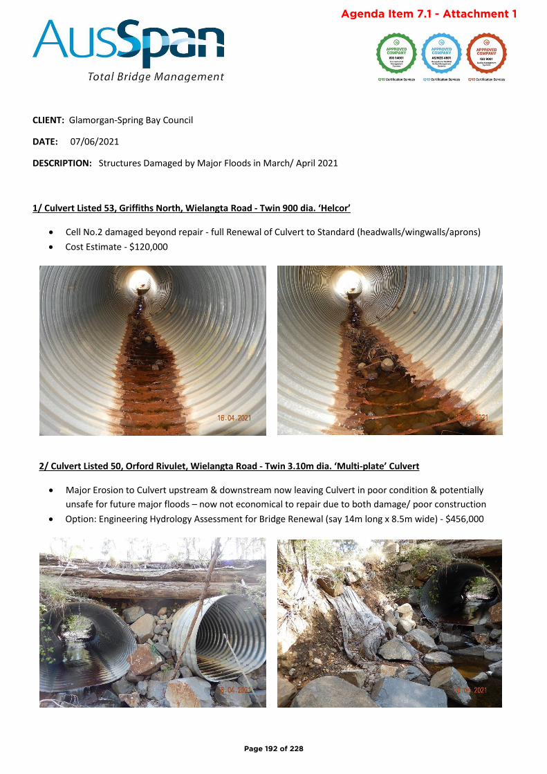
CLIENT: Glamorgan-Spring Bay Council
DATE: 07/06/2021
DESCRIPTION: Structures Damaged by Major Floods in March/ April 2021
1/ Culvert Listed 53, Griffiths North, Wielangta Road - Twin 900 dia. ‘Helcor’
• Cell No.2 damaged beyond repair - full Renewal of Culvert to Standard (headwalls/wingwalls/aprons)
• Cost Estimate - $120,000
2/ Culvert Listed 50, Orford Rivulet, Wielangta Road - Twin 3.10m dia. ‘Multi-plate’ Culvert
• Major Erosion to Culvert upstream & downstream now leaving Culvert in poor condition & potentially
unsafe for future major floods – now not economical to repair due to both damage/ poor construction
• Option: Engineering Hydrology Assessment for Bridge Renewal (say 14m long x 8.5m wide) - $456,000
Page 192 of 228
Agenda Item 7.1 - Attachment 1
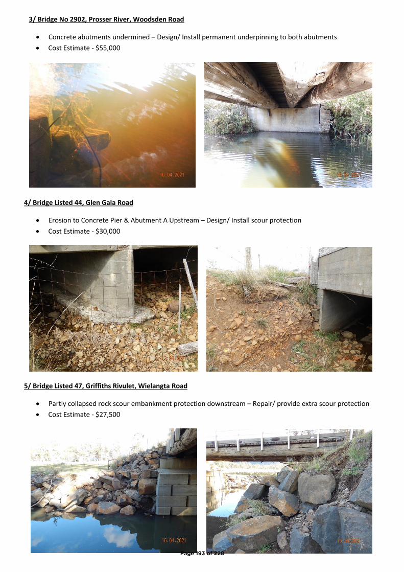
3/ Bridge No 2902, Prosser River, Woodsden Road
• Concrete abutments undermined – Design/ Install permanent underpinning to both abutments
• Cost Estimate - $55,000
4/ Bridge Listed 44, Glen Gala Road
• Erosion to Concrete Pier & Abutment A Upstream – Design/ Install scour protection
• Cost Estimate - $30,000
5/ Bridge Listed 47, Griffiths Rivulet, Wielangta Road
• Partly collapsed rock scour embankment protection downstream – Repair/ provide extra scour protection
• Cost Estimate - $27,500
Page 193 of 228
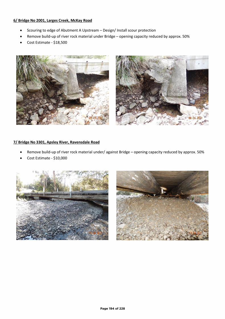
6/ Bridge No 2001, Larges Creek, McKay Road
• Scouring to edge of Abutment A Upstream – Design/ Install scour protection
• Remove build-up of river rock material under Bridge – opening capacity reduced by approx. 50%
• Cost Estimate - $18,500
7/ Bridge No 3301, Apsley River, Ravensdale Road
• Remove build-up of river rock material under/ against Bridge – opening capacity reduced by approx. 50%
• Cost Estimate - $10,000
Page 194 of 228
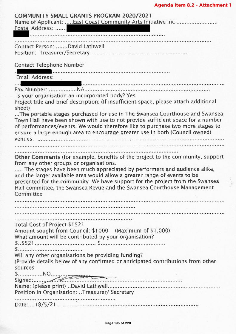
Page 195 of 228
Agenda Item 8.2 - Attachment 1
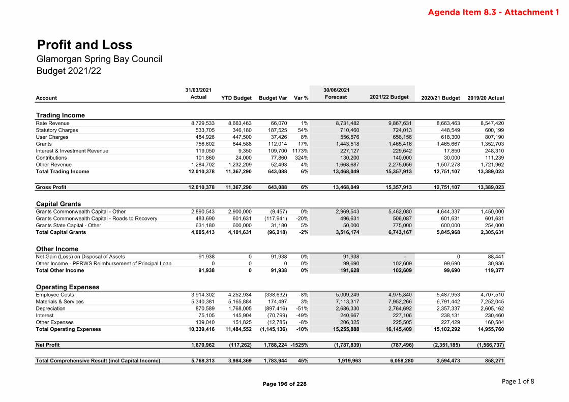
Account
31/03/2021 Actual YTD Budget Budget Var Var %
30/06/2021 Forecast 2021/22 Budget 2020/21 Budget 2019/20 Actual
Rate Revenue 8,729,533 8,663,463 66,070 1% 8,731,482 9,867,631 8,663,463 8,547,420Statutory Charges 533,705 346,180 187,525 54% 710,460 724,013 448,549 600,199User Charges 484,926 447,500 37,426 8% 556,576 656,156 618,300 807,190Grants 756,602 644,588 112,014 17% 1,443,518 1,465,416 1,465,667 1,352,703Interest & Investment Revenue 119,050 9,350 109,700 1173% 227,127 229,642 17,850 248,310Contributions 101,860 24,000 77,860 324% 130,200 140,000 30,000 111,239Other Revenue 1,284,702 1,232,209 52,493 4% 1,668,687 2,275,056 1,507,278 1,721,962Total Trading Income 12,010,378 11,367,290 643,088 6% 13,468,049 15,357,913 12,751,107 13,389,023
Gross Profit 12,010,378 11,367,290 643,088 6% 13,468,049 15,357,913 12,751,107 13,389,023
Capital GrantsGrants Commonwealth Capital - Other 2,890,543 2,900,000 (9,457) 0% 2,969,543 5,462,080 4,644,337 1,450,000Grants Commonwealth Capital - Roads to Recovery 483,690 601,631 (117,941) -20% 496,631 506,087 601,631 601,631Grants State Capital - Other 631,180 600,000 31,180 5% 50,000 775,000 600,000 254,000Total Capital Grants 4,005,413 4,101,631 (96,218) -2% 3,516,174 6,743,167 5,845,968 2,305,631
Other IncomeNet Gain (Loss) on Disposal of Assets 91,938 0 91,938 0% 91,938 - 0 88,441Other Income - PPRWS Reimbursement of Principal Loan 0 0 0 0% 99,690 102,609 99,690 30,936Total Other Income 91,938 0 91,938 0% 191,628 102,609 99,690 119,377
Operating ExpensesEmployee Costs 3,914,302 4,252,934 (338,632) -8% 5,009,249 4,975,840 5,487,953 4,707,510Materials & Services 5,340,381 5,165,884 174,497 3% 7,113,317 7,952,266 6,791,442 7,252,045Depreciation 870,589 1,768,005 (897,416) -51% 2,686,330 2,764,692 2,357,337 2,605,162Interest 75,105 145,904 (70,799) -49% 240,667 227,106 238,131 230,460Other Expenses 139,040 151,825 (12,785) -8% 206,325 225,505 227,429 160,584Total Operating Expenses 10,339,416 11,484,552 (1,145,136) -10% 15,255,888 16,145,409 15,102,292 14,955,760
Net Profit 1,670,962 (117,262) 1,788,224 -1525% (1,787,839) (787,496) (2,351,185) (1,566,737)
Total Comprehensive Result (incl Capital Income) 5,768,313 3,984,369 1,783,944 45% 1,919,963 6,058,280 3,594,473 858,271
Profit and LossGlamorgan Spring Bay CouncilBudget 2021/22
Trading Income
Page 1 of 8Page 196 of 228
Agenda Item 8.3 - Attachment 1
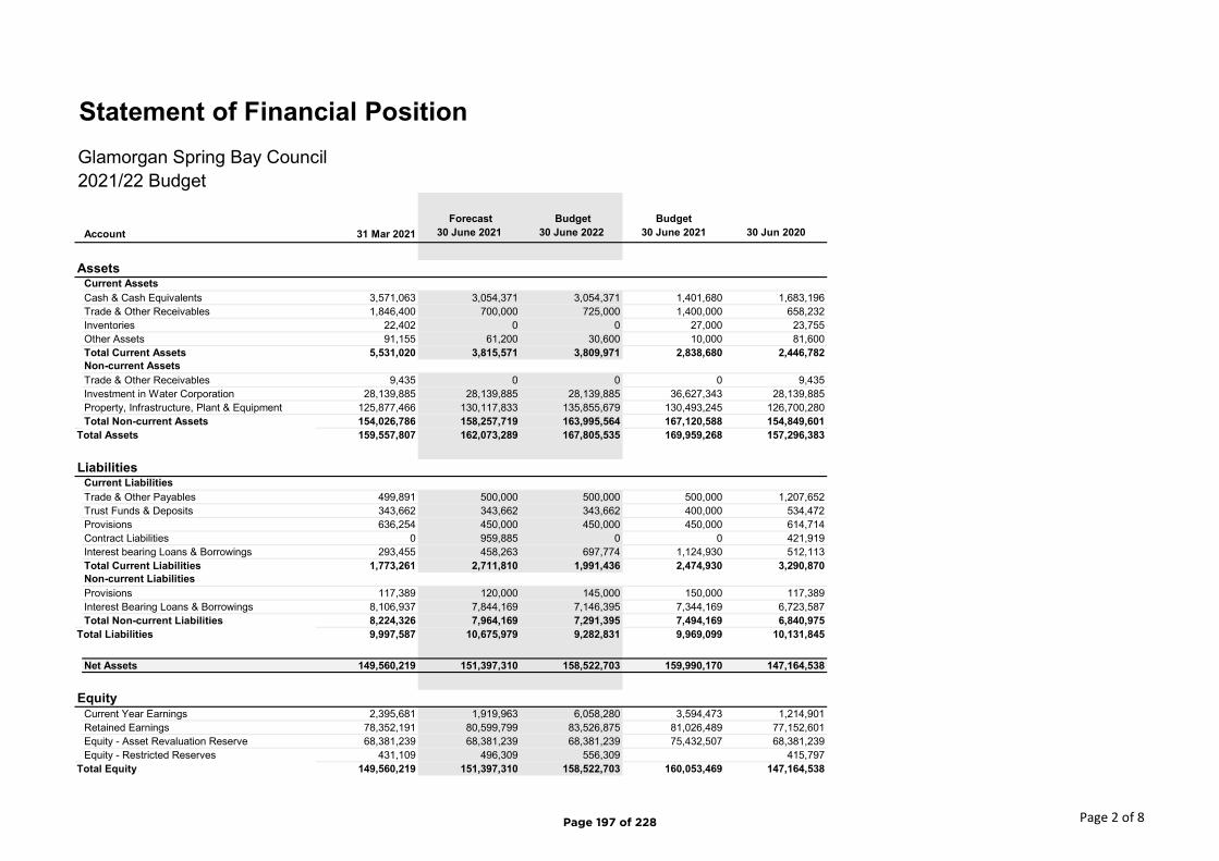
Account 31 Mar 2021
Forecast 30 June 2021
Budget 30 June 2022
Budget 30 June 2021 30 Jun 2020
Cash & Cash Equivalents 3,571,063 3,054,371 3,054,371 1,401,680 1,683,196Trade & Other Receivables 1,846,400 700,000 725,000 1,400,000 658,232Inventories 22,402 0 0 27,000 23,755Other Assets 91,155 61,200 30,600 10,000 81,600Total Current Assets 5,531,020 3,815,571 3,809,971 2,838,680 2,446,782
Trade & Other Receivables 9,435 0 0 0 9,435Investment in Water Corporation 28,139,885 28,139,885 28,139,885 36,627,343 28,139,885Property, Infrastructure, Plant & Equipment 125,877,466 130,117,833 135,855,679 130,493,245 126,700,280Total Non-current Assets 154,026,786 158,257,719 163,995,564 167,120,588 154,849,601
Total Assets 159,557,807 162,073,289 167,805,535 169,959,268 157,296,383
Trade & Other Payables 499,891 500,000 500,000 500,000 1,207,652Trust Funds & Deposits 343,662 343,662 343,662 400,000 534,472Provisions 636,254 450,000 450,000 450,000 614,714Contract Liabilities 0 959,885 0 0 421,919Interest bearing Loans & Borrowings 293,455 458,263 697,774 1,124,930 512,113Total Current Liabilities 1,773,261 2,711,810 1,991,436 2,474,930 3,290,870
Provisions 117,389 120,000 145,000 150,000 117,389Interest Bearing Loans & Borrowings 8,106,937 7,844,169 7,146,395 7,344,169 6,723,587Total Non-current Liabilities 8,224,326 7,964,169 7,291,395 7,494,169 6,840,975
Total Liabilities 9,997,587 10,675,979 9,282,831 9,969,099 10,131,845
Net Assets 149,560,219 151,397,310 158,522,703 159,990,170 147,164,538
Current Year Earnings 2,395,681 1,919,963 6,058,280 3,594,473 1,214,901Retained Earnings 78,352,191 80,599,799 83,526,875 81,026,489 77,152,601Equity - Asset Revaluation Reserve 68,381,239 68,381,239 68,381,239 75,432,507 68,381,239Equity - Restricted Reserves 431,109 496,309 556,309 415,797
Total Equity 149,560,219 151,397,310 158,522,703 160,053,469 147,164,538
LiabilitiesCurrent Liabilities
Non-current Liabilities
Equity
2021/22 Budget
Statement of Financial Position
Glamorgan Spring Bay Council
AssetsCurrent Assets
Non-current Assets
Page 2 of 8Page 197 of 228
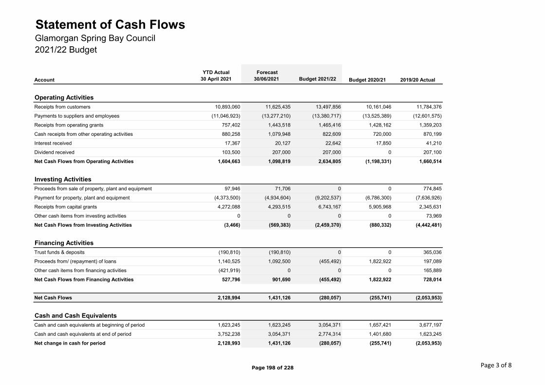
2021/22 Budget
Account
YTD Actual 30 April 2021
Forecast 30/06/2021 Budget 2021/22 Budget 2020/21 2019/20 Actual
Receipts from customers 10,893,060 11,625,435 13,497,856 10,161,046 11,784,376
Payments to suppliers and employees (11,046,923) (13,277,210) (13,380,717) (13,525,389) (12,601,575)
Receipts from operating grants 757,402 1,443,518 1,465,416 1,428,162 1,359,203
Cash receipts from other operating activities 880,258 1,079,948 822,609 720,000 870,199
Interest received 17,367 20,127 22,642 17,850 41,210
Dividend received 103,500 207,000 207,000 0 207,100
Net Cash Flows from Operating Activities 1,604,663 1,098,819 2,634,805 (1,198,331) 1,660,514
Proceeds from sale of property, plant and equipment 97,946 71,706 0 0 774,845
Payment for property, plant and equipment (4,373,500) (4,934,604) (9,202,537) (6,786,300) (7,636,926)
Receipts from capital grants 4,272,088 4,293,515 6,743,167 5,905,968 2,345,631
Other cash items from investing activities 0 0 0 0 73,969
Net Cash Flows from Investing Activities (3,466) (569,383) (2,459,370) (880,332) (4,442,481)
Trust funds & deposits (190,810) (190,810) 0 0 365,036
Proceeds from/ (repayment) of loans 1,140,525 1,092,500 (455,492) 1,822,922 197,089
Other cash items from financing activities (421,919) 0 0 0 165,889
Net Cash Flows from Financing Activities 527,796 901,690 (455,492) 1,822,922 728,014
Net Cash Flows 2,128,994 1,431,126 (280,057) (255,741) (2,053,953)
Cash and cash equivalents at beginning of period 1,623,245 1,623,245 3,054,371 1,657,421 3,677,197
Cash and cash equivalents at end of period 3,752,238 3,054,371 2,774,314 1,401,680 1,623,245
Net change in cash for period 2,128,993 1,431,126 (280,057) (255,741) (2,053,953)
Financing Activities
Cash and Cash Equivalents
Operating Activities
Investing Activities
Statement of Cash FlowsGlamorgan Spring Bay Council
Page 3 of 8Page 198 of 228

2021/22 Budget
New Capital $Roads, Footpaths, Kerbs 1,578,000 Stormwater & Drainage 265,000 Parks, Reserves, Walking Tracks, Cemeteries 3,540,500 Buildings & Facilities - Plant & Equipment 20,000 Total New Capital 5,403,500
Renewal of AssetsRoads, Footpaths, Kerbs 1,058,174 Parks, Reserves, Walking Tracks, Cemeteries 20,000 Stormwater, Drainage 302,000 Marine Infrastructure 445,000 Buildings & Facilities 593,863 Bridges, Culverts 330,000 Plant & Equipment 300,000 Medical Equipment 20,000 IT Equipment 30,000 Total Renewal Capital 3,099,037
Total Capital Works 8,502,537
Budget Capital Works SummaryGlamorgan Spring Bay CouncilFor the year ended 30 June 2022
Page 4 of 8Page 199 of 228
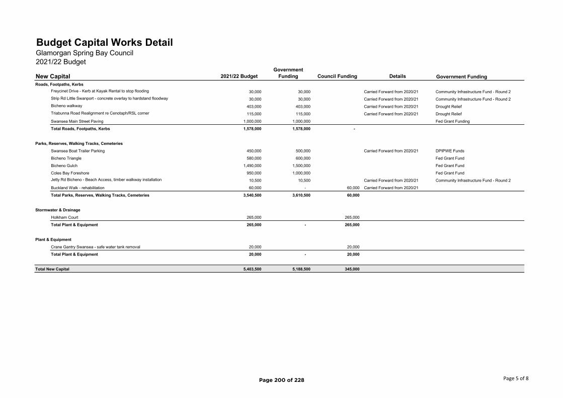
2021/22 BudgetGovernment
Funding Council Funding Details Government Funding
Roads, Footpaths, Kerbs
Freycinet Drive - Kerb at Kayak Rental to stop flooding 30,000 30,000 Carried Forward from 2020/21 Community Infrastructure Fund - Round 2
Strip Rd Little Swanport - concrete overlay to hardstand floodway 30,000 30,000 Carried Forward from 2020/21 Community Infrastructure Fund - Round 2
Bicheno walkway 403,000 403,000 Carried Forward from 2020/21 Drought Relief
Triabunna Road Realignment re Cenotaph/RSL corner 115,000 115,000 Carried Forward from 2020/21 Drought Relief
Swansea Main Street Paving 1,000,000 1,000,000 Fed Grant Funding
Total Roads, Footpaths, Kerbs 1,578,000 1,578,000 -
Parks, Reserves, Walking Tracks, Cemeteries
Swansea Boat Trailer Parking 450,000 500,000 Carried Forward from 2020/21 DPIPWE Funds
Bicheno Triangle 580,000 600,000 Fed Grant Fund
Bicheno Gulch 1,490,000 1,500,000 Fed Grant Fund
Coles Bay Foreshore 950,000 1,000,000 Fed Grant Fund
Jetty Rd Bicheno - Beach Access, timber walkway installation 10,500 10,500 Carried Forward from 2020/21 Community Infrastructure Fund - Round 2
Buckland Walk - rehabilitation 60,000 - 60,000 Carried Forward from 2020/21
Total Parks, Reserves, Walking Tracks, Cemeteries 3,540,500 3,610,500 60,000
Stormwater & Drainage
Holkham Court 265,000 265,000
Total Plant & Equipment 265,000 - 265,000
Plant & Equipment
Crane Gantry Swansea - safe water tank removal 20,000 20,000
Total Plant & Equipment 20,000 - 20,000
Total New Capital 5,403,500 5,188,500 345,000
Budget Capital Works DetailGlamorgan Spring Bay Council2021/22 Budget
New Capital
Page 5 of 8Page 200 of 228
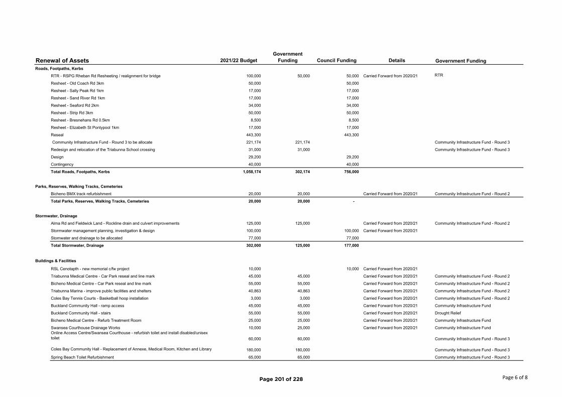
Renewal of Assets 2021/22 BudgetGovernment
Funding Council Funding Details Government Funding
Roads, Footpaths, Kerbs
RTR - RSPG Rheban Rd Resheeting / realignment for bridge 100,000 50,000 50,000 Carried Forward from 2020/21 RTR
Resheet - Old Coach Rd 3km 50,000 50,000
Resheet - Sally Peak Rd 1km 17,000 17,000
Resheet - Sand River Rd 1km 17,000 17,000
Resheet - Seaford Rd 2km 34,000 34,000
Resheet - Strip Rd 3km 50,000 50,000
Resheet - Bresnehans Rd 0.5km 8,500 8,500
Resheet - Elizabeth St Pontypool 1km 17,000 17,000
Reseal 443,300 443,300
Community Infrastructure Fund - Round 3 to be allocate 221,174 221,174 Community Infrastructure Fund - Round 3
Redesign and relocation of the Triabunna School crossing 31,000 31,000 Community Infrastructure Fund - Round 3
Design 29,200 29,200
Contingency 40,000 40,000
Total Roads, Footpaths, Kerbs 1,058,174 302,174 756,000
Parks, Reserves, Walking Tracks, Cemeteries
Bicheno BMX track refurbishment 20,000 20,000 Carried Forward from 2020/21 Community Infrastructure Fund - Round 2
Total Parks, Reserves, Walking Tracks, Cemeteries 20,000 20,000 -
Stormwater, Drainage
Alma Rd and Fieldwick Land - Rockline drain and culvert improvements 125,000 125,000 Carried Forward from 2020/21 Community Infrastructure Fund - Round 2
Stormwater management planning, investigation & design 100,000 100,000 Carried Forward from 2020/21
Stomwater and drainage to be allocated 77,000 77,000
Total Stormwater, Drainage 302,000 125,000 177,000
Buildings & Facilities
RSL Cenotapth - new memorial c/fw project 10,000 10,000 Carried Forward from 2020/21
Triabunna Medical Centre - Car Park reseal and line mark 45,000 45,000 Carried Forward from 2020/21 Community Infrastructure Fund - Round 2
Bicheno Medical Centre - Car Park reseal and line mark 55,000 55,000 Carried Forward from 2020/21 Community Infrastructure Fund - Round 2
Triabunna Marina - improve public facilities and shelters 40,863 40,863 Carried Forward from 2020/21 Community Infrastructure Fund - Round 2
Coles Bay Tennis Courts - Basketball hoop installation 3,000 3,000 Carried Forward from 2020/21 Community Infrastructure Fund - Round 2
Buckland Community Hall - ramp access 45,000 45,000 Carried Forward from 2020/21 Community Infrastructure Fund
Buckland Community Hall - stairs 55,000 55,000 Carried Forward from 2020/21 Drought Relief
Bicheno Medical Centre - Refurb Treatment Room 25,000 25,000 Carried Forward from 2020/21 Community Infrastructure Fund
Swansea Courthouse Drainage Works 10,000 25,000 Carried Forward from 2020/21 Community Infrastructure FundOnline Access Centre/Swansea Courthouse - refurbish toilet and install disabled/unisex toilet 60,000 60,000 Community Infrastructure Fund - Round 3
Coles Bay Community Hall - Replacement of Annexe, Medical Room, Kitchen and Library 180,000 180,000 Community Infrastructure Fund - Round 3
Spring Beach Toilet Refurbishment 65,000 65,000 Community Infrastructure Fund - Round 3
Page 6 of 8Page 201 of 228
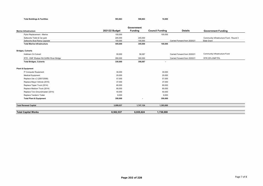
Total Buildings & Facilities 593,863 598,863 10,000
Marine Infrastructure 2021/22 BudgetGovernment
Funding Council Funding Details Government Funding
Pylon Replacement - Marina 100,000 100,000
Saltworks Toilet & Car park 245,000 245,000 Community Infrastructure Fund - Round 3
Saltworks Boat Ramp Upgrade 100,000 100,000 Carried Forward from 2020/21 State Grant
Total Marine Infrastructure 445,000 345,000 100,000
Bridges, Culverts
Holkham Crt Culvert 50,000 56,087 Carried Forward from 2020/21 Community Infrastructure Fund
RTR - EMF Rheban Rd Griffith River Bridge 280,000 300,000 Carried Forward from 2020/21 RTR 25% EMF75%
Total Bridges, Culverts 330,000 356,087 -
Plant & Equipment
IT Computer Equipment 30,000 30,000
Medical Equipment 20,000 20,000
Replace Ute x 2 (2007/2008) 57,000 57,000
Replace Mayor Vehicle (2016) 37,000 37,000
Replace Tipper Truck (2014) 80,000 80,000
Replace Medium Truck (2014) 80,000 80,000
Replace Toro Groundmaster (2014) 40,000 40,000
Replace Tanderm Trailer 6,000 6,000
Total Plant & Equipment 350,000 - 350,000
Total Renewal Capital 3,099,037 1,747,124 1,393,000
Total Capital Works 8,502,537 6,935,624 1,738,000
Page 7 of 8Page 202 of 228
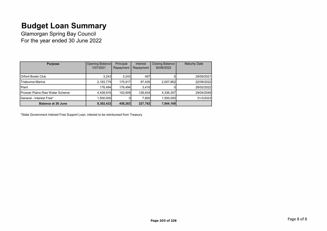
Purpose Opening Balance 1/07/2021
Principal Repayment
Interest Repayment
Closing Balance 30/06/2022
Maturity Date
Orford Bowls Club 3,243 3,243 497 0 29/09/2021
Triabunna Marina 2,183,779 175,917 87,435 2,007,862 22/08/2022
Plant 176,494 176,494 3,416 0 28/02/2022
Prosser Plains Raw Water Scheme 4,438,916 102,609 128,634 4,336,307 29/04/2049
General - Interest Free* 1,500,000 0 7,800 1,500,000 31/3/2023
Balance at 30 June 8,302,432 458,263 227,782 7,844,169
*State Government Interest Free Support Loan, interest to be reimbursed from Treasury
Budget Loan SummaryGlamorgan Spring Bay CouncilFor the year ended 30 June 2022
Page 8 of 8Page 203 of 228
Page 1 of 9
Glamorgan Spring Bay Council
Rates and Charges Policy
Version 3
Adopted:
Minute No.:
Page 204 of 228
Agenda Item 8.4 - Attachment 1

Page 2 of 9
Document Control
Policy Name
First issued/approved 17/12/2019
Source of approval/authority Council
Last reviewed December 2019
Next review date June 2025
Version number 03
Responsible Officer Director Corporate & Community
Department responsible for policy development Corporate Services
Related policies • Rates Resolutions
• Financial Hardship Assistance Policy
• Rate Relief for Community Groups
• Rate Relief for Religious Organisations.
• Long Term Financial Management Plan
• Annual Budget
Publication of policy Website
Page 205 of 228
Page 3 of 9
Contents
1 Introduction ................................................................................................................................... 4
1.1 Purpose ........................................................................................................................................ 4
1.2 Scope ........................................................................................................................................... 4
1.3 Definitions ................................................................................................................................... 4
1.4 Related Policies and Legislation .................................................................................................. 4
1.5 Policy Review and Update Cycle.................................................................................................. 4
2 Policy ............................................................................................................................................. 5
2.1 Rating Objective .......................................................................................................................... 5
2.2 Key Principles ............................................................................................................................... 5
2.3 Strategic Emphasis ...................................................................................................................... 6
2.4 The Rates Model .......................................................................................................................... 7
3 Implementation .............................................................................................................................. 9
Page 206 of 228

Page 4 of 9
1 Introduction
This policy is prepared in accordance with 86B (1) of the Local Government Act 1993 (the Act) and provides an overview of the rating framework that Council has adopted. The Policy reflects the fundamental principles that are set out in the S.86A of the Act, that:
a) Rates are a tax and not a fee for service. b) The value of the land is an indicator of capacity to pay.
The Council through the application of this Policy primarily levy rates based on property values with a contribution through fixed and service charges. The Policy also outlines the Council’s approach to the provision of remissions and management of rate debt.
1.1 Purpose
Increase community awareness of Council’s decision making in setting and collecting rates.
1.2 Scope
This policy sets out Council’s rates and charges (taxation) objectives in regards to: a) Statutory compliance; and b) Discretionary matters.
This document is a statement of policy and intent, it does not supersede or overrule the specific rating resolutions and policies that are determined by resolution of Council.
1.3 Definitions
AAV Assessed Annual Value
1.4 Related Policies and Legislation
This policy relates to and depends on other Council policies, as well as legislation, including:
• The Glamorgan Spring Bay Council Rates Resolution (adopted annually)
• Local Government Act 1993
• Local Government Regulations 2015
• Financial Hardship Assistance Policy
• Rate Relief for Community Groups
• Rate Relief for Religious Organisations
• Annual Budget
• Long Term Financial Management Plan
1.5 Policy Review and Update Cycle
This policy is to be reviewed every 4 years.
Page 207 of 228

Page 5 of 9
2 Policy
2.1 Rating Objective
To maintain an appropriate distribution of rates and charges consistent with the principle stated in this Policy with the objectives of:
a) Consistent and equitable treatment of all residents and ratepayers; b) Achieving an appropriate mix and distribution of taxation from
i. Rates based on property values, fixed and service charges and revenue from other sources; and
ii. Different sectors (including use of the land) withing the municipal area. c) Using rate settings to support the achievement of strategic objectives.
2.2 Key Principles
1. According to the Act s.86A General Principles in relation to making or varying rates:
(1) A council, in adopting policies and making decisions concerning the making or varying of rates, must take into account the principles that: (a) Rates constitute taxation for the purposes of local government, rather than a fee for service; and (b) the value of rateable land is an indicator of the capacity of ratepayers to pay rates.
These principles have been taken into account in Glamorgan Spring Bay Council’s Rating Model (see 2.3).
2. Annual assessed value (AAV), potential rental valued, as determined by the Valuer-General,
is used currently as the basis for determining rates within the Council area.
3. Glamorgan Spring Bay Council is committed to fairness and equity in the raising of rates revenue across all properties.
4. Glamorgan Spring Bay Council has a goal for financial sustainability. Within the Long-Term Financial Management Plan Council has predicated the likely impact on rates over the coming 10 year period. This will be reviewed annually. This refers to the overall rate revenue and not the individual properties which may be affected from time to time by movements in valuation.
5. Council has no role in the assessment of objections to valuations. The lodgement of an objection does not alter the due date for the payment of rates. Rates must be paid in accordance with the rates notice until otherwise notified by Council.
6. A general rate will comprise a fixed component, which will apply equally to all rateable land, and variable component (cents in the dollar) which will be based on the AAV of a rateable property.
7. The variable component of the general rate will have a differential rate applying to
commercial, industrial, and non-use commercial land.
Page 208 of 228
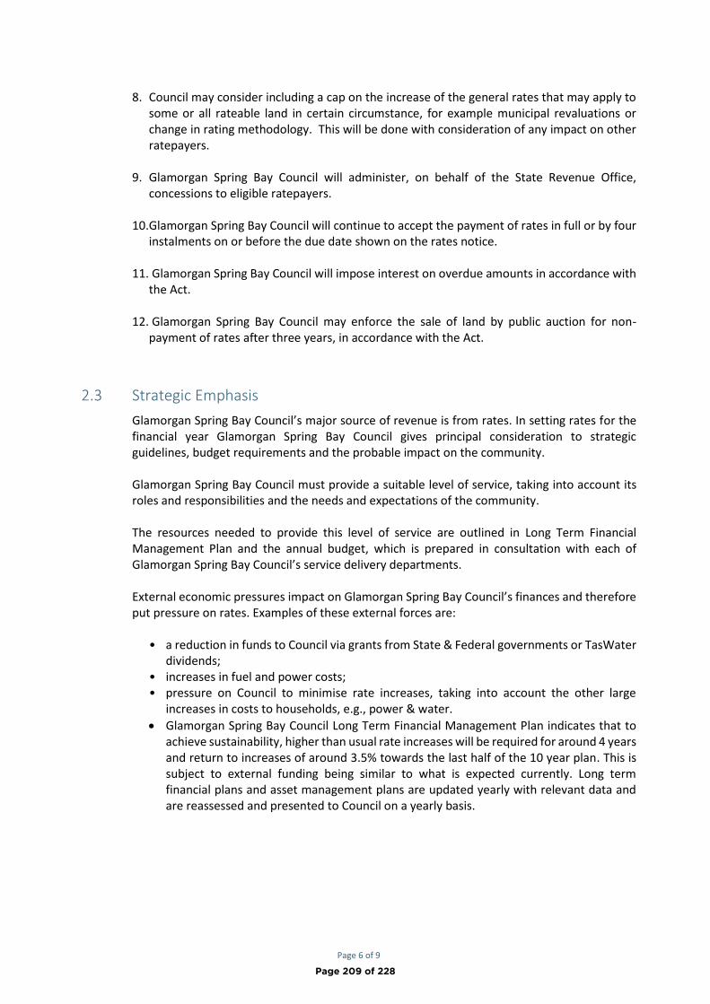
Page 6 of 9
8. Council may consider including a cap on the increase of the general rates that may apply to
some or all rateable land in certain circumstance, for example municipal revaluations or change in rating methodology. This will be done with consideration of any impact on other ratepayers.
9. Glamorgan Spring Bay Council will administer, on behalf of the State Revenue Office, concessions to eligible ratepayers.
10. Glamorgan Spring Bay Council will continue to accept the payment of rates in full or by four instalments on or before the due date shown on the rates notice.
11. Glamorgan Spring Bay Council will impose interest on overdue amounts in accordance with the Act.
12. Glamorgan Spring Bay Council may enforce the sale of land by public auction for non-payment of rates after three years, in accordance with the Act.
2.3 Strategic Emphasis
Glamorgan Spring Bay Council’s major source of revenue is from rates. In setting rates for the financial year Glamorgan Spring Bay Council gives principal consideration to strategic guidelines, budget requirements and the probable impact on the community. Glamorgan Spring Bay Council must provide a suitable level of service, taking into account its roles and responsibilities and the needs and expectations of the community. The resources needed to provide this level of service are outlined in Long Term Financial Management Plan and the annual budget, which is prepared in consultation with each of Glamorgan Spring Bay Council’s service delivery departments. External economic pressures impact on Glamorgan Spring Bay Council’s finances and therefore put pressure on rates. Examples of these external forces are:
• a reduction in funds to Council via grants from State & Federal governments or TasWater
dividends; • increases in fuel and power costs; • pressure on Council to minimise rate increases, taking into account the other large
increases in costs to households, e.g., power & water.
• Glamorgan Spring Bay Council Long Term Financial Management Plan indicates that to achieve sustainability, higher than usual rate increases will be required for around 4 years and return to increases of around 3.5% towards the last half of the 10 year plan. This is subject to external funding being similar to what is expected currently. Long term financial plans and asset management plans are updated yearly with relevant data and are reassessed and presented to Council on a yearly basis.
Page 209 of 228
Page 7 of 9
2.4 The Rates Model
DIFFERENTIAL GENERAL RATES The Act allows Councils to set different rates based on the use, or non-use of the land and/or the locality or zoning of the land. Glamorgan Spring Bay Council applies differential rates on the predominant use and non-use of the land. In setting the differential rates Glamorgan Spring Bay Council takes into account: • growth in properties of the same use and • the varying impact of a particular use, such as commercial, on core council services such as
road maintenance and stormwater. A ratepayer may object to a variation in a rate based on a particular use of land, if they believe the use of the land is not the use of land on which the variation is based, by following the processes outlined in Section 109 of the Act. However, rates must continue to be paid in accordance with the rates notice until otherwise notified by the Council. FIXED GENERAL RATE According to the Act Council may have a fixed component to the general rate that applies equally to all rateable properties within the municipal area and that the revenue from the fixed component can not exceed 50% of the Council’s general rate revenue. Consistent with the Act, a minimum rate is also not levied. The application of a fixed charge recognises that all rateable properties should make a fixed contribution to the cost of Council’s operations and services. The application of a fixed charge reduces the rates that are raised based on property values. Council recognises the regressive taxation effect of fixed charges and so limits the amount of rates raised through a fixed charge. ASSESSED ANNUAL VALUE (AAV) After significant modelling and consideration of the key rating principles identified in 2.1, Council have determined that the most equitable model of rating for the Glamorgan Spring Bay municipal area is AAV plus a fixed component. Thereby all rateable land will be charged a fixed general charge and the other component of the general rate will be calculated based on a rate in the dollar of the AAV of each rateable land. The rate in dollar charged will be the same for all rateable land, except where it has been varied by use as outlined in Differential General Rates above (Commercial and Industrial use and non-use of land). WASTE COLLECTION SERVICE CHARGE Glamorgan Spring Bay Council sets an annual service charge for waste management for each financial year for each non-vacant premises, tenement, flat, unit, apartment, single stratum section or portion of land set aside for separate occupation to which a regular garbage and recycling removal service is supplied by the Council. This provides a property with 1 x garbage & 1 x recycling bin or 1 x Waste Transfer Station voucher. A property owner may make an application for additional services to their property and the rates will be adjusted accordingly, as per the rate charge as specified in the rates resolution. If an application is received from a tenant, the application must be approved by the land owner, unless the tenant is the ratepayer. WASTE MANAGEMENT (TRANSFER STATION) SERVICE CHARGE Glamorgan Spring Bay Council sets an annual service charge for managing four waste transfer stations throughout the municipal area and for carting recycling and collected waste to Hobart.
Page 210 of 228

Page 8 of 9
This charge applies for each financial year for each premises, tenement, flat, unit, apartment, single stratum section or portion of land and every type of property that is rated within the municipal area. MEDICAL SERVICE CHARGE Glamorgan Spring Bay Council sets a service charge to recover incentives paid to health professionals, for providing infrastructure to health professionals and cover costs of running the medical practices not covered by Medicare rebates or other grants and user fees. This enables the Council to be able to attract and retain health professionals and provide a satisfactory working environment for our health professionals. This charge applies for each financial year for each premises, tenement, flat, unit, apartment, single stratum section or portion of land and every type of property that is rated within the municipal area. CHARITABLE ORGANISATIONS Confirmed charitable organisations who apply and who have provided the necessary documentation, may be eligible for a remission. Council’s policies on remissions 3.7 and 3.8 apply. RATEPAYER CONCESSION An eligible ratepayer must hold a Pension Concession Card, Health Concession Card or a Department of Veteran’s Affairs Card marked TPI Gold, in order to be entitled to a concession on Council rates, as provided by the Tasmanian State Government. REMISSIONS At some stage Council may identify a need to apply a remission to a class of ratepayers. No such remissions are currently proposed. FINANCIAL HARDSHIP Council have introduced a policy for Financial Hardship. Details of the policy and how to apply can be found on Council’s website. PAYMENT OF RATES Glamorgan Spring Bay Council rates are payable in full by the first instalment date or by four instalments on or before the due date shown on the rates notice. Payment options are displayed on the rates notice. Any ratepayer who is experiencing difficulty paying rates by the due dates should ring our Rates Officer on 03 6256 4777 to discuss alternative payment arrangements. These enquiries are treated confidentially. LATE PAYMENT OF RATES Rates will be overdue if they have not been paid by the due date shown on the notice. After this date interest will be applied, according to Section 128 of the Act. RECOVERY OF RATES In accordance with thorough financial management and Section 133 of the Act, the Council's Rates Officer will apply timely debt recovery practice. This includes that where rates are two instalments overdue, the ratepayer will be subject to recovery action.
Page 211 of 228

Page 9 of 9
SALE OF LAND FOR NON-PAYMENT OF RATES Section 137 of the Act provides that a Council may sell any property where rates have been in arrears for three years or more. The General Manager will recommend to Council the sale of land by public auction. SUPPLEMENTARY ADJUSTMENTS Should an individual property receive an adjustment to its valuation through the supplementary process, and the financials to be adopted is greater than $10, a supplementary rates notice will be issued. Any financial impact throughout the supplementary process against a single PID that is less than $10 will not be adopted & levied to the ratepayer. OTHER CHARGES From time to time it may be necessary for Council to develop new infrastructure or pay for a new or existing service not previously rated. Before applying this charge a level of community consultation will be applied by detailing why it is necessary to make this change. FAILURE TO COMPLY The Act states that a rate cannot be challenged even if it is found not to comply with this policy and must be paid on the due date/s. Where a ratepayer believes that Glamorgan Spring Bay Council has failed to correctly apply this policy, it should raise the matter by contacting the Rates Officer on 03 6256 4782 to discuss the matter. If the ratepayer is still dissatisfied, they should write to the General Manager at PO Box 6, Triabunna 7190. INFORMATION The contact officer for further information at the Glamorgan Spring Bay Council is Council’s Rates Officer 03 6256 4782. This policy will be made available as soon as practicable after its adoption, over the counter, electronically and on Glamorgan Spring Bay Council’s website.
3 Implementation
Implementation of this Policy rests with the General Manager and Director Corporate and Community.
Page 212 of 228

GLAMORGAN SPRING BAY COUNCIL
RATES RESOLUTIONS
GENERAL RATE
1.1 Pursuant to Section 90 and 91 of the Local Government Act 1993 (here referred to as the
“Act”), Council makes the following general rate for all rateable land (excluding land which is
exempt pursuant to the provisions of Section 87) within the municipal area of Glamorgan Spring
Bay for the period commencing 1 July 2021 and ending 30 June 2022; which consists of:
(a) a General Rate of 5.45 cents in the dollar of the assessed annual value (here referred
to as “AAV”); and
(b) a fixed charge of $300.
1.2 Pursuant to Section 107(1)(a) and (b) of the Act, by reason of use or predominant use of
the land or non use of the land, namely:
(a) For land within the municipality which is used or predominantly used for
commercial purposes.
(b) For land within the municipality which is used or predominantly used for industrial
purposes.
(c) For land within the municipality which is zoned for commercial purposes but which
is not used for commercial purposes (i.e. vacant commercial).
Council declares by absolute majority that component (a) of the general rate in clause
1.1 is varied by increasing it by 4.25 cents in the dollar to 9.7 cents in the dollar of the
AAV of the land.
1.3 Pursuant to section 88A and section 107 of the Act, Council, by absolute majority sets the
following maximum percentage increase in respect of the general rate under paragraph 1.1
of 99% for land used or predominately used for residential purposes with the following
conditions:
(a) The cap does not apply to supplementary rates raised due to changes in use or
changes in valuation that are effective or after 1 July 2021.
SERVICE RATES AND CHARGES
2. WASTE MANAGEMENT SERVICE CHARGE
Pursuant to Section 94 of the Act, the Council makes the following service charges for waste
management for rateable land within the municipal area of Glamorgan Spring Bay for the
Page 213 of 228
Agenda Item 8.5 - Attachment 1
period commencing 1 July 2021 and ending 30 June 2022, namely:
(a) A general waste management charge of $100.00 for all rateable land; and
(b) A charge of $105.00 for all land that receives a residential waste collection service
provided by Council; and
(c) A charge of $237.00 for all land that receives a commercial waste collection
service provided by Council.
3. FIRE SERVICE RATE
(a) Pursuant to sections 93 and Section 93A of the Act, Council makes the following
fire protection service rates in respect of the fire service contributions it must
collect under the Fire Service Act 1979 for the period commencing 1 July 2021 and
ending on 30 June 2022, as follows:
Urban Rate 0.3239260 cents in the dollar of AAV
Rural Rate 0.4618290 cents in the dollar of AAV
(b) Pursuant to Section 93(3) of the Act, Council sets a minimum fire service
contribution payable in respect of this service rate of $42.00.
4. COMMUNITY MEDICAL SERVICE CHARGE
Pursuant to section 94 of the Act, and regulation 32(b) of the Local Government (General)
Regulations 2005, the Council makes the following service charge for the provision of
community medical services for the period commencing 1 July 2021 and ending 30 June
2022 of $90.00 for each rateable parcel of land.
SEPARATE LAND 5. For the purposes of these resolutions the rates and charges shall apply to each parcel of
land which is shown as being separately valued in the valuation list prepared under the
Valuation of Land Act 2001.
ADJUSTED VALUES 6. For the purposes of each of these resolutions any reference to assessed annual value or
AAV includes a reference to that value as adjusted pursuant to Section 89 and 89A of the
Act.
PAYMENT OF RATES AND CHARGES 7. Pursuant to Section 124 of the Act, for the period commencing 1 July 2021 and ending 30
June 2022, Council:
(a) Decides that all rates and charges payable to Council shall be payable by four (4)
instalments which must be of approximately equal amounts.
Page 214 of 228

(b) Determines that the dates by which instalments are to be paid shall be as
follows:
(i) The first instalment must be made on or before the 31st of August 2021;
(ii) The second instalment must be made on or before the 30th of November
2021;
(iii) The third instalment must be made on or before the 28th of February
2022; and
(iv) The fourth instalment must be made on or before the 30th of April
2022. (c) If a ratepayer fails to pay any instalment within 21 days from the date on which it is
due, the ratepayer must pay the full amount owing.
PENALTY AND INTEREST Pursuant to Section 128 of the Act, if any rate or instalment is not paid on or before the date it falls
due:
a) There is payable a daily interest charge of 0.0164384% (6% per annum) in respect of
the unpaid rate or instalment for the period during which it is unpaid.
WORDS AND EXPRESSIONS Words and expression used both in these resolutions and in the Local Government Act 1993 or the
Fire Services Act 1979 have in these resolutions the same respective meanings as the have in those
Acts.
Page 215 of 228
Glamorgan Spring Bay Council – 2021/2022 Fees & Charges Page 1 of 6
FEES AND CHARGES 2021-2022
ADMINISTRATIVE FEES
Type Budget 2021-2022 Budget 2020-2021
Right to Information Act $40.50 $40.50
Photocopying - Black and White A4 10 cents per page 10 cents per page
Photocopying - Black and White A3 30 cents per page 30 cents per page
Photocopying – Colour A4 50 cents per page 50 cents per page
Photocopying – Colour A3 $1 per page $1 per page
132 Certificate $48.60 $48.60
337 Certificate $214.65 $214.65
Search and copy of permit and plans $50 $50
HALL HIRE (Guide for Hall Committees)
Type Budget 2021-2022 Budget 2020-2021
Hall Hire – hourly rate (not for profit) $10 - $30 $10 - $30
Hall Hire – half day rate (not for profit) $10 - $30 $10 - $30
Hall Hire – full day rate (not for profit) $35 - $50 $35 - $50
Hall Hire – evening rate (not for profit) $10 - $30 $10 - $30
Hall Hire – half day rate (Commercial) $50 - $70 $50 - $70
Hall Hire – full day rate (Commercial) $100 - $200 $100 - $200
Hall Hire – evening rate (Commercial) $50 - $70 $50 - $70
Large events – weddings, birthdays etc $100 - $200 $100 - $200
Pre-paid bond related to any large events at Halls $200 $200
Hall – External Hire Items (Guidance Only)
Chairs up to 10 – Public $10 $10
Chairs 11 to 30 – Public $15 $15
Chairs 31 to 50 – Public $20 $20
Chairs 51 and over – Public $30 $30
Chairs up to 10 – Community Group $5 or small donation $5 or small donation
Chairs 11 to 30 – Community Group $5 or small donation $5 or small donation
Chairs 31 to 50 – Community Group $10 or small donation $10 or small donation
Chairs 51 and over – Community Group $10 or small donation $10 or small donation
Hire of Tables (1 to 3) – Public $5 $5
Hire of Tables (4 to 6) – Public $10 $10
Hire of Tables (7 to 10) – Public $15 $15
Hire of Tables (11 to 15) – Public $20 $20
Hire of Tables (1 to 3) – Community Group Small donation Small donation
Hire of Tables (4 to 6) – Community Group Small donation Small donation
Hire of Tables (7 to 10) – Community Group $5 $5
Hire of Tables (11 to 15) – Community Group $10 $10
Use of Urn – Public Discretionary Discretionary
Use of Urn – Community Group Discretionary Discretionary
Use of Crockery – Public Discretionary Discretionary
Use of Crockery – Community Group Discretionary Discretionary
Use of Kitchen – Major Events $50 - $150 $50 - $150
Page 216 of 228
Agenda Item 8.5 - Attachment 2
Glamorgan Spring Bay Council – 2021/2022 Fees & Charges Page 2 of 6
MARINE INFRASTRUCTURE FEES (ALL FIGURES INCLUDE GST) #
WASTE MANAGEMENT TRANSFER STATIONS
Type Budget 2021-2022 Budget 2020-2021
General waste – per cubic metre $25 (min $5) $25 (min $5)
Compactor Vehicle – per cubic metre $35 $35
Recyclable materials Free Free
Metals / Oils / Batteries Free Free
Greenwaste: Free (conditions apply)
• Car boot load $2 n/a
• Utility / flat tray load $5 n/a
• Trailer single axle (no cage) $5 n/a
• Trailer single axle (with cage) $10 n/a
• Trailer double axle (no cage) $10 n/a
• Trailer double axle (with cage) $20 n/a
• Loads larger than above, per m3 $5 n/a
Tyre disposal:
• Car $10 $8
• Small truck $15 $10
• Large truck $25 $20
BICHENO / TRIABUNNA CEMETERY FEES
Type Budget 2021-2022 Budget 2020-2021
Reservation Certificates - General $280 $160
Niche Wall Allocation $220 $125
Old / Lawn Section burials $965 $550
Children – max coffin size 1350mm x 450mm $350 $200
Re-open Fee (Old / Lawn section) $790 $450
Burials - outside working hours (additional charge) $440 $250
Type Budget 2021-2022 Budget 2020-2021
Marina Berth (Fixed Jetty Access) $3,750 $3,260
Marina Berth (Floating Pontoon Access) $4,700 $4,100
Floating Commercial Berth $4,950 $4,300
Marina Berth – Casual Rate (Daily) $40 $35
Marina Berth – Casual Rate (Weekly) $150 $125
Marina Berth – Casual Rate (Monthly) $480 $420
Fisherman’s Wharf – Annual Fee (Up to 18 metres in length)
$1,380 $1,200
Fisherman’s Wharf – Annual Fee (>18 metres in length) $2,070 $1,800
Fisherman’s Wharf – Casual Rate (Daily) $40 $35
Fisherman’s Wharf – Casual Rate (Weekly) $150 $125
Fisherman’s Wharf – Casual Rate (Monthly) $500 $420
Fisherman’s Wharf – Unloading Fee $60 $50
Fisherman’s Wharf – Cleaning Fee (When required) $80 N/A
Use of Single phase power at wharf (Per connection 24Hr Period)
N/A N/A
Use of Three Phase Power (Per connection 24Hr Period)
$30. $25
Maintenance work on vessels at wharf fee (Daily) $80 $60
Maintenance work on vessels at wharf fee (Weekly) $500 $200
Page 217 of 228
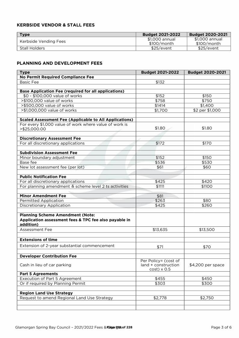
Glamorgan Spring Bay Council – 2021/2022 Fees & Charges Page 3 of 6
KERBSIDE VENDOR & STALL FEES
Type Budget 2021-2022 Budget 2020-2021
Kerbside Vending Fees $1,000 annual $100/month
$1,000 annual
$100/month
Stall Holders $25/event $25/event
PLANNING AND DEVELOPMENT FEES
Type Budget 2021-2022 Budget 2020-2021
No Permit Required Compliance Fee
Basic Fee $132
Base Application Fee (required for all applications) $0 - $100,000 value of works $152 $150
>$100,000 value of works $758 $750
>$500,000 value of works $1414 $1,400
>$1,000,000 value of works $2 per $1,000
Scaled Assessment Fee (Applicable to All Applications)
For every $1,000 value of work where value of work is
>$25,000.00 $1.80 $1.80
Discretionary Assessment Fee
For all discretionary applications $172 $170
Subdivision Assessment Fee
Minor boundary adjustment $152 $150
Base fee $536 $530
New lot assessment fee (per lot) $61 $60
Public Notification Fee
For all discretionary applications $425 $420
For planning amendment & scheme level 2 ts activities $1111 $1100
Minor Amendment Fee $81
Permitted Application $263 $80
Discretionary Application $425 $260
Planning Scheme Amendment (Note:
Application assessment fees & TPC fee also payable in
addition)
Assessment Fee $13,635 $13,500
Extensions of time
Extension of 2-year substantial commencement $71 $70
Developer Contribution Fee
Cash in lieu of car parking Per Policy= (cost of land + construction
cost) x 0.5 $4,200 per space
Part 5 Agreements
Execution of Part 5 Agreement $455 $450
Or if required by Planning Permit $303 $300
Region Land Use Strategy
Request to amend Regional Land Use Strategy $2,778 $2,750
Page 218 of 228
$1,700
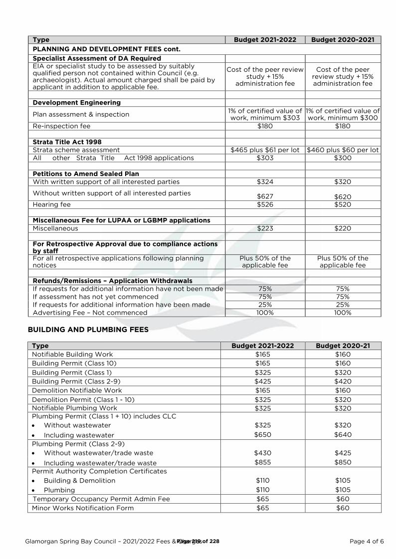
Glamorgan Spring Bay Council – 2021/2022 Fees & Charges Page 4 of 6
Type Budget 2021-2022 Budget 2020-2021
PLANNING AND DEVELOPMENT FEES cont.
Specialist Assessment of DA Required
EIA or specialist study to be assessed by suitably qualified person not contained within Council (e.g. archaeologist). Actual amount charged shall be paid by applicant in addition to applicable fee.
Cost of the peer review study + 15%
administration fee
Cost of the peer review study + 15% administration fee
Development Engineering
Plan assessment & inspection 1% of certified value of work, minimum $303
1% of certified value of work, minimum $300
Re-inspection fee $180 $180
Strata Title Act 1998
Strata scheme assessment $465 plus $61 per lot $460 plus $60 per lot
All other Strata Title Act 1998 applications $303 $300
Petitions to Amend Sealed Plan
With written support of all interested parties $324 $320
Without written support of all interested parties
$627
$620
Hearing fee $526 $520
Miscellaneous Fee for LUPAA or LGBMP applications
Miscellaneous $223 $220
For Retrospective Approval due to compliance actions by staff
For all retrospective applications following planning notices
Plus 50% of the applicable fee
Plus 50% of the applicable fee
Refunds/Remissions – Application Withdrawals
If requests for additional information have not been made 75% 75%
If assessment has not yet commenced 75% 75%
If requests for additional information have been made 25% 25%
Advertising Fee – Not commenced 100% 100%
BUILDING AND PLUMBING FEES
Type Budget 2021-2022 Budget 2020-21
Notifiable Building Work $165 $160
Building Permit (Class 10) $165 $160
Building Permit (Class 1) $325 $320
Building Permit (Class 2-9) $425 $420
Demolition Notifiable Work $165 $160
Demolition Permit (Class 1 - 10) $325 $320
Notifiable Plumbing Work $325 $320
Plumbing Permit (Class 1 + 10) includes CLC
• Without wastewater $325 $320
• Including wastewater $650 $640
Plumbing Permit (Class 2-9)
• Without wastewater/trade waste $430 $425
• Including wastewater/trade waste $855 $850
Permit Authority Completion Certificates
• Building & Demolition $110 $105
• Plumbing $110 $105
Temporary Occupancy Permit Admin Fee $65 $60
Minor Works Notification Form $65 $60
Page 219 of 228
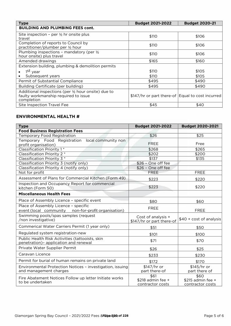
Glamorgan Spring Bay Council – 2021/2022 Fees & Charges Page 5 of 6
Type Budget 2021-2022 Budget 2020-21
BUILDING AND PLUMBING FEES cont.
Site inspection – per ½ hr onsite plus travel
$110 $106
Completion of reports to Council by
practitioner/plumber per ½ hour $110 $106
Plumbing inspections – mandatory (per ½ hour onsite) plus travel
$110 $106
Amended drawings $165 $160
Extension building, plumbing & demolition permits
• 1st year $110 $105
• Subsequent years $110 $105
Permit of Substantial Compliance $495 $490
Building Certificate (per building) $495 $490
Additional inspections (per ½ hour onsite) due to faulty workmanship required to issue completion
$147/hr or part there-of Equal to cost incurred
Site Inspection Travel Fee $45 $40
ENVIRONMENTAL HEALTH #
Type Budget 2021-2022 Budget 2020-2021
Food Business Registration Fees
Temporary Food Registration $26 $25
Temporary Food Registration local community non
profit organisation) FREE Free
Classification Priority 1 * $268 $265
Classification Priority 2 * $202 $200
Classification Priority 3 * $137 $135
Classification Priority 3 (notify only) $26 – One off fee
Classification Priority 4 (notify only) $26 – One off fee
Not for profit FREE FREE
Assessment of Plans for Commercial Kitchen (Form 49) $223 $220
Inspection and Occupancy Report for commercial
kitchen (Form 50) $223 $220
Miscellaneous Health Fees
Place of Assembly Licence – specific event $80 $60 Place of Assembly Licence – specific
event (local community non-for-profit organisation) FREE
FREE
Swimming pools/spas samples (request /non investigative)
Cost of analysis + $147/hr or part there-of
$40 + cost of analysis
Commerical Water Carriers Permit (1 year only) $51 $50
Regulated system registration-new $101 $100 Public Health Risk Activities (tattooists, skin penetration)– application and renewal
$71 $70
Private Water Supplier Permit $26 $25
Caravan Licence $233 $230
Permit for burial of human remains on private land $172 $170
Environmental Protection Notices – investigation, issuing and management charges
$147/hr or part there-of
$145/hr or part there of
Fire Abatement Notices Follow up letter Initiate works to be undertaken
$61 $218 admin fee + contractor costs
$60 $215 admin fee + contractor costs
Page 220 of 228
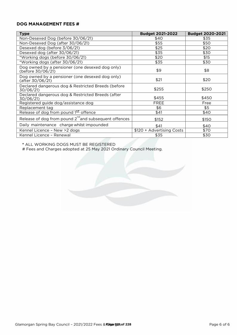
Glamorgan Spring Bay Council – 2021/2022 Fees & Charges Page 6 of 6
DOG MANAGEMENT FEES #
Type Budget 2021-2022 Budget 2020-2021
Non-Desexed Dog (before 30/06/21) $40 $35
Non-Desexed Dog (after 30/06/21) $55 $50
Desexed dog (before 3/06/21) $25 $20
Desexed dog (after 30/06/21) $35 $30
*Working dogs (before 30/06/21) $20 $15
*Working dogs (after 30/06/21) $35 $30
Dog owned by a pensioner (one desexed dog only) (before 30/06/21) $9 $8
Dog owned by a pensioner (one desexed dog only) (after 30/06/21) $21 $20
Declared dangerous dog & Restricted Breeds (before 30/06/21) $255 $250
Declared dangerous dog & Restricted Breeds (after 30/06/21) $455 $450
Registered guide dog/assistance dog FREE Free
Replacement tag $6 $5
Release of dog from pound 1st offence $41 $40
Release of dog from pound 2nd
and subsequent offences $152 $150
Daily maintenance charge whilst impounded $41 $40 Kennel Licence – New >2 dogs $120 + Advertising Costs $70
Kennel Licence – Renewal $35 $30
* ALL WORKING DOGS MUST BE REGISTERED
# Fees and Charges adopted at 25 May 2021 Ordinary Council Meeting.
Page 221 of 228

Banding of Change for Industrial Properties for 21/22
Change for Industrial PropertiesNumber of Properties % of Properties
Decrease 8 57%$0 to $200 Increase 5 36%$200 to $500 Increase 1 7%Total 14 100%
Banding of Change for Commercial Properties for 21/22
Change for Commercial (Non Vacant) PropertiesNumber of Properties % of Properties
Decrease 26 12%$0 to $200 Increase 25 11%$200 to $500 Increase 130 58%Greater than $500 Increase but less than 15% Increase 42 19%Total 223 100%
**NB Properties with Supp Vals in 20/21 removed**Assumes properties are paying the full rates in the current year and are not hitting the cap
Banding of Change for Primary Production Properties for 21/22
Change for Primary Production PropertiesNumber of Properties % of Properties
Decrease 49 46%$0 to $201 Increase 58 54%Total 107 100%
**NB Properties with Supp Vals in 20/21 removed
Those Industrial and Commercial properties that are hitting the existing cap will see a higher increase than tabled above.
Page 222 of 228
Agenda Item 8.5 - Attachment 3
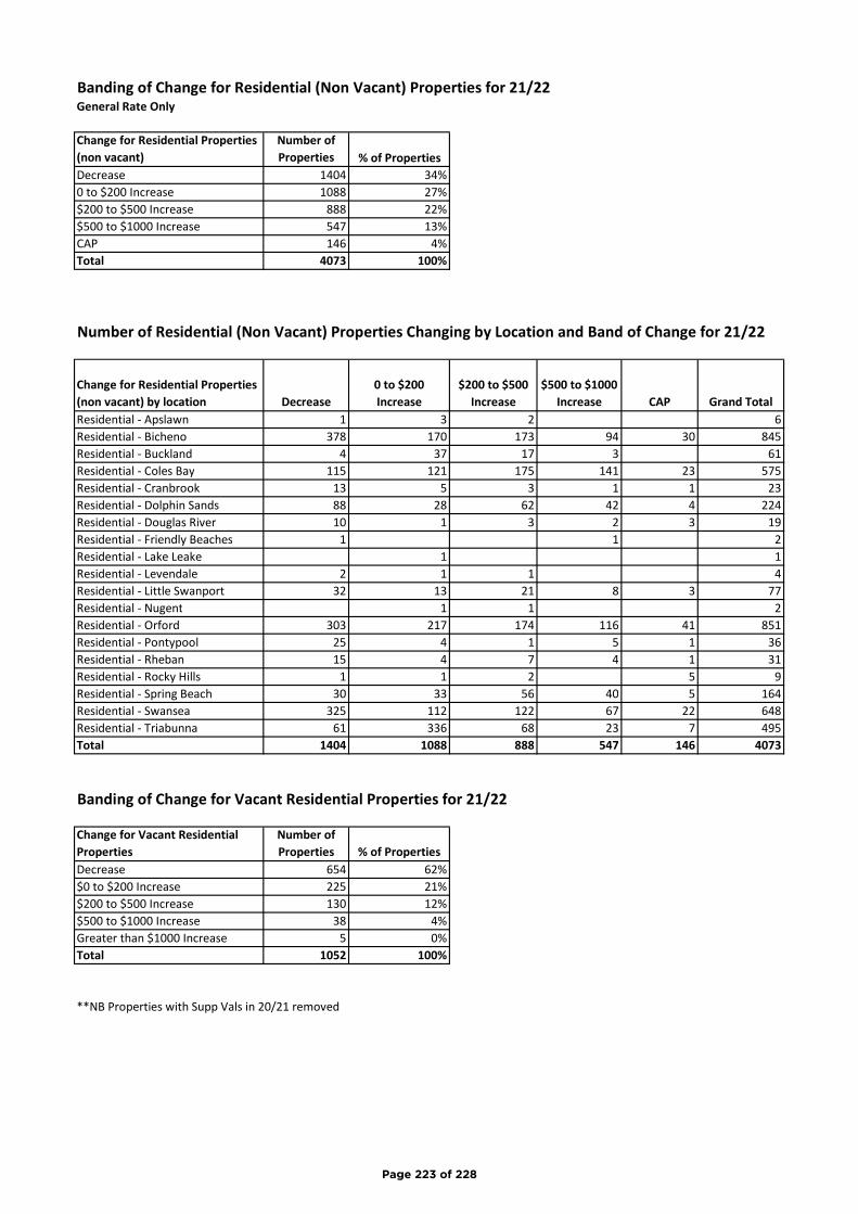
Banding of Change for Residential (Non Vacant) Properties for 21/22General Rate Only
Change for Residential Properties (non vacant)
Number of Properties % of Properties
Decrease 1404 34%0 to $200 Increase 1088 27%$200 to $500 Increase 888 22%$500 to $1000 Increase 547 13%CAP 146 4%Total 4073 100%
Number of Residential (Non Vacant) Properties Changing by Location and Band of Change for 21/22
Change for Residential Properties (non vacant) by location Decrease
0 to $200 Increase
$200 to $500 Increase
$500 to $1000 Increase CAP Grand Total
Residential - Apslawn 1 3 2 6Residential - Bicheno 378 170 173 94 30 845Residential - Buckland 4 37 17 3 61Residential - Coles Bay 115 121 175 141 23 575Residential - Cranbrook 13 5 3 1 1 23Residential - Dolphin Sands 88 28 62 42 4 224Residential - Douglas River 10 1 3 2 3 19Residential - Friendly Beaches 1 1 2Residential - Lake Leake 1 1Residential - Levendale 2 1 1 4Residential - Little Swanport 32 13 21 8 3 77Residential - Nugent 1 1 2Residential - Orford 303 217 174 116 41 851Residential - Pontypool 25 4 1 5 1 36Residential - Rheban 15 4 7 4 1 31Residential - Rocky Hills 1 1 2 5 9Residential - Spring Beach 30 33 56 40 5 164Residential - Swansea 325 112 122 67 22 648Residential - Triabunna 61 336 68 23 7 495Total 1404 1088 888 547 146 4073
Banding of Change for Vacant Residential Properties for 21/22
Change for Vacant Residential Properties
Number of Properties % of Properties
Decrease 654 62%$0 to $200 Increase 225 21%$200 to $500 Increase 130 12%$500 to $1000 Increase 38 4%Greater than $1000 Increase 5 0%Total 1052 100%
**NB Properties with Supp Vals in 20/21 removed
Page 223 of 228
Page 1 of 5
Glamorgan Spring Bay Council
Rate Relief for Community Groups
Version 3
Adopted:
Minute No.:
Page 224 of 228
Agenda Item 8.6 - Attachment 1
Page 2 of 5
Document Control
Policy Name
First issued/approved 28/04/2020
Source of approval/authority Council
Last reviewed April 2020
Next review date June 2025
Version number 04
Responsible Officer Director Corporate and Community
Department responsible for policy development Corporate Services
Related policies • Rates Resolution
• Rates Policy
Publication of policy Website
Page 225 of 228
Page 3 of 5
Contents
1 Introduction ................................................................................................................................... 4
1.1 Purpose ........................................................................................................................................ 4
1.2 Scope ........................................................................................................................................... 4
1.3 Definitions ................................................................................................................................... 4
1.4 Related Policies and Legislation .................................................................................................. 4
1.5 Policy Review and Update Cycle.................................................................................................. 4
2 Policy ............................................................................................................................................. 4
2.1 Types of Organisations ................................................................................................................ 4
2.2 Criteria ......................................................................................................................................... 5
3 Implementation .............................................................................................................................. 5
4 Attachments (if applicable) .................................................................. Error! Bookmark not defined.
Page 226 of 228

Page 4 of 5
1 Introduction
1.1 Purpose
To recognise the contributions community groups and organisations make to the community and to assist them by providing rate relief.
1.2 Scope
This policy covers all forms of community groups and organisations.
1.3 Definitions
Nil
1.4 Related Policies and Legislation
This policy relates to and depends on other Council policies, as well as legislation, including:
• Section 129 of the Local Government Act 1993 (the Act).
1.5 Policy Review and Update Cycle
This policy is to be reviewed every 4 years.
2 Policy
This policy refers only to the general rates that are payable on the proportion of land that is owned or used by the organisation. Commonwealth, Crown, State and Council owned land is exempt from this policy. All organisations listed below are required to pay all service rates and charges in full. A remission on general rates can only be considered initially upon receipt of a written request from the organisation to the General Manager.
2.1 Types of Organisations
CLUBS - 100% remission in general rates
• Examples of such organisations are Scouts, Girl Guides, Retired Servicemen’s League and similar.
SPORTING BODIES – No remission on general rates
• Examples of such organisations are Cricket, Football, Tennis, Badminton, Soccer Clubs, Sporting Shooters Clubs, Boating Clubs, Golf, Bowls and the like.
• In previous years a 50% remission was available for Sporting Bodies.
• With the change in rating models, land use for Sport and Recreation will see a significant reduction in rates.
• Therefore, the remission for this group has been reviewed and Council do not believe that it continues to be justified. Council will continue to monitor and review this policy.
COMMUNITY ORGANISATIONS - 50% remission on general rates
• Examples of such organisations are Men’s/Community Sheds, Museum, Art Gallery and the like.
Page 227 of 228

Page 5 of 5
CHARITABLE ORGANISATIONS - Exempt from General Rates
• Examples of such organisations are St Vincent De Paul, Salvation Army and the like.
• Charitable organisation are exempt from General Rates per S.87 of the Act, where the land is owned and occupied exclusively for charitable purposes.
HEALTH FACILITIES - No remission from general rates
• Examples of such organisations are Nursing Homes, Retirement Homes, Child Care Centres, Doctors Surgeries, Specialist Consultancy Practices, and the like.
2.2 Criteria
• To qualify for a remission the property must be solely used for public or community purposes. If the property is used for any other purposes, then no remission on general rates is available.
• The organisation must apply in writing each year.
3 Implementation
Implementation of this Policy rests with the General Manager and the Director of Corporate and Community.
Page 228 of 228
Related Documents