Orbital observations of contemporary dune activity in Endeavor crater, Meridiani Planum, Mars Matthew Chojnacki, 1 Devon M. Burr, 1 Jeffrey E. Moersch, 1 and Timothy I. Michaels 2 Received 16 June 2010; revised 23 December 2010; accepted 19 January 2011; published 7 April 2011. [1] Although aeolian landforms are pervasive on Mars, evidence for contemporary activity has been limited. The next major campaign for the Mars Exploration Rover “Opportunity” is the investigation of the ∼20 km diameter Endeavor crater, ∼6 km to southeast of the rover’s position as of December 2010. We present evidence from orbital imagery that eight aeolian bed forms (∼14,000 m 2 ) in Endeavor crater have been active within the past decade (2001–2009), at a spatial scale that should be directly observable by Opportunity from the crater rim. Two dunes appear to show translational migration (∼10–20 m), but all dunes indicate erosion to be the dominant process with up to 100% sediment removal. Thermophysical properties of these dunes are consistent with very fine to fine sand sizes, the particle sizes most easily moved by the Martian atmosphere. The dunes that show the most surface change have a rippled appearance without well‐defined slip faces. Based on their morphology (elliptical shape), we classify them as dome dunes. Mesoscale atmospheric modeling is employed to provide insight into the atmospheric forcing of this aeolian system. The major wind regimes from modeling are consistent with observations of wind streaks, sand streamers, ripples, and slip faces of regional dune fields although modeled wind speeds are insufficient to move sand. The translation and erosion of these dunes constitutes the largest contemporary movement of sand‐sized sediment reported on Mars to date and demonstrates that Endeavor crater has been subject to wind profiles exceeding the threshold velocity at the surface (daily/seasonally and/or episodically) in the recent past. Citation: Chojnacki, M., D. M. Burr, J. E. Moersch, and T. I. Michaels (2011), Orbital observations of contemporary dune activity in Endeavor crater, Meridiani Planum, Mars, J. Geophys. Res., 116, E00F19, doi:10.1029/2010JE003675. 1. Introduction and Study Area [2] Despite a dynamic atmosphere and plentiful sediment supply, orbital detection of dune movement on Mars has been elusive. For more than a century, telescopic observa- tions of Mars showed temporal albedo variations associated with regions such as (what is now known as) Meridiani Planum [Flammarion, 1892]. Spacecraft data from Mariner 9 and Viking suggested aeolian deposits are common and dynamic on Mars, with wind‐related albedo changes occurring during these missions [e.g., Sagan et al., 1973; Greeley et al., 1992]. Geissler [2005] used three decades of orbital data to document changes in albedo, and suggested that more than a third of the Martian surface had brightened or darkened by roughly 10% in that time by wind‐related processes. Albedo changes have been attributed to the aeolian deposition and raising of the light‐toned dust par- ticles [e.g., Sagan et al. , 1973; Geissler, 2005; Cantor, 2007]. The calculated saltation threshold friction speeds (verified in wind tunnel experiments under Martian atmo- spheric conditions) are much greater for dust than for sand‐ size particles because of the cohesive effects of interparticle forces [Greeley et al., 1980]. Winds that are strong enough to directly mobilize single dust particles should also be of sufficient magnitude to initiate saltation of most sand sizes. Yet somewhat paradoxically, although lofting of dust from the Martian surface is amply documented, the orbital detection of sand dune modification has been lacking [Edgett and Malin, 2000; Malin and Edgett, 2001; Bridges et al., 2007]. The Mars Global Surveyor’s (MGS) Mars Orbiter Camera (MOC) experiment was used to look for dune migration that may have occurred between the time of the Viking and MGS missions [Edgett and Malin, 2000; Malin and Edgett, 2001]. No dune migration was observed over that 14 Mars year time span [Edgett and Malin, 2000; Malin and Edgett, 2001]. [3] However, Bourke et al. [2008, 2009a] observed the gradual disappearance of two small (∼1000 m 2 ) dome dunes and ∼85% deflation of a third over a 5 year time span (1999–2004) in MOC images. That study reported no bed form migration. More recently, orbital images from the Mars Reconnaissance Orbiter (MRO) High Resolution Imaging 1 Planetary Geosciences Institute, Department of Earth and Planetary Sciences, University of Tennessee, Knoxville, Tennessee, USA. 2 Southwest Research Institute, Boulder, Colorado, USA. Copyright 2011 by the American Geophysical Union. 0148‐0227/11/2010JE003675 JOURNAL OF GEOPHYSICAL RESEARCH, VOL. 116, E00F19, doi:10.1029/2010JE003675, 2011 E00F19 1 of 20

Welcome message from author
This document is posted to help you gain knowledge. Please leave a comment to let me know what you think about it! Share it to your friends and learn new things together.
Transcript

Orbital observations of contemporary dune activityin Endeavor crater, Meridiani Planum, Mars
Matthew Chojnacki,1 Devon M. Burr,1 Jeffrey E. Moersch,1 and Timothy I. Michaels2
Received 16 June 2010; revised 23 December 2010; accepted 19 January 2011; published 7 April 2011.
[1] Although aeolian landforms are pervasive on Mars, evidence for contemporaryactivity has been limited. The next major campaign for the Mars Exploration Rover“Opportunity” is the investigation of the ∼20 km diameter Endeavor crater, ∼6 km tosoutheast of the rover’s position as of December 2010. We present evidence fromorbital imagery that eight aeolian bed forms (∼14,000 m2) in Endeavor crater havebeen active within the past decade (2001–2009), at a spatial scale that should be directlyobservable by Opportunity from the crater rim. Two dunes appear to show translationalmigration (∼10–20 m), but all dunes indicate erosion to be the dominant process with up to100% sediment removal. Thermophysical properties of these dunes are consistent withvery fine to fine sand sizes, the particle sizes most easily moved by the Martianatmosphere. The dunes that show the most surface change have a rippled appearancewithout well‐defined slip faces. Based on their morphology (elliptical shape), weclassify them as dome dunes. Mesoscale atmospheric modeling is employed to provideinsight into the atmospheric forcing of this aeolian system. The major wind regimesfrom modeling are consistent with observations of wind streaks, sand streamers,ripples, and slip faces of regional dune fields although modeled wind speeds areinsufficient to move sand. The translation and erosion of these dunes constitutes thelargest contemporary movement of sand‐sized sediment reported on Mars to date anddemonstrates that Endeavor crater has been subject to wind profiles exceeding thethreshold velocity at the surface (daily/seasonally and/or episodically) in the recent past.
Citation: Chojnacki, M., D. M. Burr, J. E. Moersch, and T. I. Michaels (2011), Orbital observations of contemporary duneactivity in Endeavor crater, Meridiani Planum, Mars, J. Geophys. Res., 116, E00F19, doi:10.1029/2010JE003675.
1. Introduction and Study Area
[2] Despite a dynamic atmosphere and plentiful sedimentsupply, orbital detection of dune movement on Mars hasbeen elusive. For more than a century, telescopic observa-tions of Mars showed temporal albedo variations associatedwith regions such as (what is now known as) MeridianiPlanum [Flammarion, 1892]. Spacecraft data from Mariner9 and Viking suggested aeolian deposits are commonand dynamic on Mars, with wind‐related albedo changesoccurring during these missions [e.g., Sagan et al., 1973;Greeley et al., 1992]. Geissler [2005] used three decades oforbital data to document changes in albedo, and suggestedthat more than a third of the Martian surface had brightenedor darkened by roughly 10% in that time by wind‐relatedprocesses. Albedo changes have been attributed to theaeolian deposition and raising of the light‐toned dust par-ticles [e.g., Sagan et al., 1973; Geissler, 2005; Cantor,
2007]. The calculated saltation threshold friction speeds(verified in wind tunnel experiments under Martian atmo-spheric conditions) are much greater for dust than for sand‐size particles because of the cohesive effects of interparticleforces [Greeley et al., 1980]. Winds that are strong enoughto directly mobilize single dust particles should also be ofsufficient magnitude to initiate saltation of most sand sizes.Yet somewhat paradoxically, although lofting of dust fromthe Martian surface is amply documented, the orbitaldetection of sand dune modification has been lacking[Edgett and Malin, 2000; Malin and Edgett, 2001; Bridgeset al., 2007]. The Mars Global Surveyor’s (MGS) MarsOrbiter Camera (MOC) experiment was used to look fordune migration that may have occurred between the time ofthe Viking and MGS missions [Edgett and Malin, 2000;Malin and Edgett, 2001]. No dune migration was observedover that 14 Mars year time span [Edgett and Malin, 2000;Malin and Edgett, 2001].[3] However, Bourke et al. [2008, 2009a] observed the
gradual disappearance of two small (∼1000 m2) dome dunesand ∼85% deflation of a third over a 5 year time span(1999–2004) in MOC images. That study reported no bedform migration. More recently, orbital images from the MarsReconnaissance Orbiter (MRO) High Resolution Imaging
1Planetary Geosciences Institute, Department of Earth and PlanetarySciences, University of Tennessee, Knoxville, Tennessee, USA.
2Southwest Research Institute, Boulder, Colorado, USA.
Copyright 2011 by the American Geophysical Union.0148‐0227/11/2010JE003675
JOURNAL OF GEOPHYSICAL RESEARCH, VOL. 116, E00F19, doi:10.1029/2010JE003675, 2011
E00F19 1 of 20
mattchojnacki
Text Box
Endeavour crater,

Science Experiment (HiRISE) [McEwen et al., 2007] haveidentified meter‐scale modification of ripples and duneedges in less than a Martian season [Silvestro et al., 2010a,2010b]. These events demonstrate that the threshold windspeed for sand entrainment was exceeded under currentconditions in these locations.[4] Evidence for aeolian activity, both ancient and con-
temporary, has been detected many times in surface‐basedobservations. The combination of abundant sand‐sizedparticles and erosional surfaces (e.g., ventifact flutes, windstreaks, etc.) at the Viking and Pathfinder landing sitessuggested that abrasion due to repeated saltation has beencommonplace [Bridges et al., 1999; Greeley et al., 2002], atleast relative to geologic timescales. The Mars ExplorationRover (MER) Spirit has encountered a number of aeolianfeatures and phenomena at Gusev crater, including: venti-facts, ripples, wind streaks, the El Dorado ripple field, andactive dust devils [Greeley et al., 2006, 2008; Sullivanet al., 2008]. Evidence for geomorphically effective windevents occurred during the 2007 global dust storm, withSpirit observing rover track modification and ripple migra-tion [Sullivan et al., 2008]. In addition to observed ripplemodifications with associated sand movement, sand‐sizedgrains were found on the 66 cm tall rover deck [Greeley et al.,2006], supporting the notion of contemporary sand saltation.[5] In the last decade, Meridiani Planum has become one
of the most intensely studied regions on Mars. The orbitaldetection of crystalline hematite associated with regional‐scale layered deposits [Christensen et al., 2001] contributedto Meridiani being selected as the landing site for theOpportunity rover [Golombek et al., 2003; Squyres et al.,2004]. At the Opportunity landing site, ripples (of mixedparticle sizes) and occasional wind streaks (dark and light)are pervasive [Sullivan et al., 2005; Fergason et al., 2006a].The last major ripple migration episode along the Oppor-tunity traverse is estimated from crater statistics to haveoccurred between ∼50 ka and ∼200 ka [Golombek et al.,2010], and is thought to be related to the atmospheric con-ditions during periods of higher axial obliquity [Arvidsonet al., 2011]. Evidence for modern aeolian activity at therover landing site was found in the form of the deposition anderosion of basaltic sand observed by Opportunity in a darkstreak at Victoria Crater [Geissler et al., 2008]. However,modeled near‐surface mean winds for the landing site atLs ∼ 320° [Rafkin and Michaels, 2003] were below theminimum threshold for saltating sand on Mars [cf. Greeleyet al., 1980], and no wind‐related bed form change has beendetected in orbital observations.[6] The apparent disagreement between surface and
orbital observations at Meridiani Planum, and the limitedorbital detection of motion in general on Mars raise somepertinent questions concerning aeolian processes on Mars.(1) Why is bed form change not more commonly observedfrom orbit? (2) Why do some bed forms show changes fromorbit but not others? (3) What factors are controlling bedform movement?[7] The next major campaign planned for Opportunity
will be an investigation of Endeavor crater (2.3°S, 5.3°W;Figure 1 and Figure S1), which reaches deeper into thestratigraphy and geologic history of this region than any of
the other craters previously visited by the rover.1 Endeavorcrater is a degraded primary crater with a diameter of ∼20 km.This crater predates the deposition of the sulfate‐bearinglayered deposits and is Noachian in age [Wray et al., 2009;Arvidson et al., 2011]. Crater rim segments are in variouspreservation states: rim segments to the north, west, and easthave been rounded and degraded, whereas rims to thenorthwest and south have been completely removed or bur-ied. Endeavor’s floor shows heightened spectral contrast forbasalt, hematite, and possibly hydrated sulfates as comparedwith the surrounding plains [Chojnacki et al., 2010a]. Thisenhancement was attributed to the intracrater dust coveragebeing lower than outside the crater (i.e., more frequent dustcleaning events), rather than to a greater mineral abundance.As of December 2010, Opportunity is ∼6 km from the westernrim of Endeavor crater. The rim of Endeavor has been foundto include phyllosilicate minerals [Wray et al., 2009], amineralogy not yet examined in situ on Mars and a drivingmotivator for Opportunity’s exploration there.[8] In this paper, we present evidence for contemporary
dune deflation, modification, and translation in EndeavorCrater. First we provide a summary of the methods used tocharacterize Martian dunes and likely atmospheric condi-tions with associated spacecraft data and mesoscale atmo-spheric modeling. Next we present an overview of Endeavorcrater and the characterization of aeolian activity there usinga suite of remote sensing data sets and mesoscale atmo-spheric modeling. We then discuss the factors operating tocreate or reveal such an apparently high level of local aeo-lian activity and the implications of dune change on Mars.We conclude with a brief summary of our findings.
2. Method and Data
2.1. Visible Wavelength Images
[9] This study utilized visible‐wavelength images fromseveral spacecraft to search for surface changes. Narrow‐angle images acquired between 2001 and 2003 from theMGS MOC instrument [Malin et al., 1992] provide visiblewavelength data at ∼3 m/pixel. Additionally, we utilizedimages acquired by MRO during the period 2007 through2009 with both the Context Camera (CTX) [Malin et al.,2007] at 5–6 m/pixel and the HiRISE instrument at up to25 cm/pixel. Images of Endeavor crater from all three in-struments were examined for photogeologic evidence ofaeolian bed forms. We utilized MOC images acquired in2001 and 2003 to compare with MRO images taken in 2008,a time period of 3.3 Mars years (6.3 Earth years) and 2.3Mars years (4.3 Earth years), respectively (see Table 1 forimage identification and resolution). We examined otherMRO images in addition to those listed in Table 1 for evi-dence of subsequent or intermediate surface change. Imageswere processed using U.S. Geological Survey (USGS) Inte-grated Software for Imagers and Spectrometers (ISIS) soft-ware [Gaddis et al., 1997] for radiometric calibration, andspatially registered to each other using ArcGIS and ENVIsoftware, allowing dune morphometry to be measured.
1Auxiliary materials are available in the HTML. doi:10.1029/2010JE003675.
CHOJNACKI ET AL.: RECENT DUNE ACTIVITY IN ENDEAVOUR CRATER E00F19E00F19
2 of 20

[10] Complications in comparing data from the threeimagers arise from differences in atmospheric conditions, inviewing geometries, and, most significantly, in spatial res-olution. These differences have been mitigated through thesuperior resolution and high signal‐to‐noise ratio of HiRISEdata and the coregistration of small features (e.g., craters).Additionally, we have applied an empirically derived con-trast enhancement to the MRO images to match the dynamicrange of pixel brightness in the MOC images. This methodfor modifying the contrast takes the (MOC) image near‐minimum‐maximum pixel values and ties them to the(MRO) near‐minimum‐maximum pixels values linearly.One example of the result of this method is shown inFigures 2a and 2b where we have also downsampled theHiRISE image to match the original MOC resolution.[11] As a simple assessment of the accuracy of our area
measurements for the different image combinations, wemade area measurements of several (presumably unchang-
ing) impact craters of approximately the same scale as thedunes that were the subject of this study (1000–8000 m2).We estimate minimum threshold values for detectability of6%, 4%, and 4% change in area (i.e., the amount of dunearea that would have to change in order to be detected bycomparing image pairs) for the MOC‐HiRISE, MOC‐CTX,and CTX‐CTX combinations, respectively.
2.2. Thermal Inertia
[12] Thermal inertia is a key surface property controllingdiurnal temperature variations of the near surface and providesinsight into the physical properties (e.g., grain size, degree ofinduration) of theMartian surface. Thermal inertia maps werederived from Mars Odyssey’s Thermal Emission ImagingSystem (THEMIS) nighttime infrared data [Christensen et al.,2004; Fergason et al., 2006b] using the thermal model ofPutzig and Mellon [2007], as implemented in the “jENVI”software suite (http://arsia.gg.utk.edu/∼utmars/jenvi/). This
Figure 1. (a) A CTX visible‐wavelength image mosaic showing Endeavor crater and the location of theOpportunity rover as of December 2010. (b) CTX image P17_007849_1793_XN_00S005W showing thecrater basin and the aeolian sand dunes forming two distinct groups to the east and west (black arrows).For the well‐formed barchans in the west, white arrows are oriented perpendicular to dune slip faces(downwind). For the degraded dunes and bed forms in the east, white lines are oriented perpendicularto transverse dune orientation. (c) A closer view of the eastern dunes showing the bed forms that wereobserved to change from 2001–2003 to 2008–2009. Black arrows indicate inferred primary wind direc-tion, and white arrows show areas of dune morphological modification of larger dunes. North is towardthe top in all images unless otherwise indicated. For a version with fewer annotations see Figure S1.
CHOJNACKI ET AL.: RECENT DUNE ACTIVITY IN ENDEAVOUR CRATER E00F19E00F19
3 of 20

Tab
le1.
Morph
ometricValuesBeforeandAfter
Dun
e/Bed
Form
Rem
oval
and/or
Transpo
rta
ImageID
,DOA,andLsb
Length
(m)
Width
(m)
Area
(m2)
Area
Loss(%
)Distance
Mov
ed(m
)Tim
eChang
eEarth
(years)
Tim
eChang
eMars(years)
AreaRem
oval
RateEarth
(m2/yr)
AreaRem
oval
RateMars(m
2/yr)
Transpo
rtRate
Earth
(m/yr)
Transpo
rtRate
Mars(m
/yr)
Dun
ei
M1,
12/8/200
1,Ls28
7°58
241,07
1H1,
3/30
/200
8,Ls52
°na
na0
100
na6.3
3.3
170
325
nana
Dun
eii
M1,
12/8/200
1,Ls28
7°63
291,63
0H1,
3/30
/200
8,Ls52
°na
na0
100
na6.3
3.3
259
494
nana
Dun
eiii
M1,
12/8/200
1,Ls28
7°71
432,09
4H1,
3/30
/200
8,Ls52
°47
301,15
945
na6.3
3.3
148
283
nana
C1,
3/30
/200
8,Ls52
°45
311,09
0C2,
7/18
/200
9,Ls30
6°41
2982
724
na1.3
0.7
202
376
nana
Dun
eiv
M2,
12/30/20
03,Ls32
5°62
391,92
9C1,
3/30
/200
8,Ls52
°48
341,25
935
na4.3
2.3
156
291
nana
Dun
ev
M2,
12/30/20
03,Ls32
5°10
945
4,32
2C1,
3/30
/200
8,Ls52
°69
502,72
837
204.3
2.3
371
693
4.7
8.7
Dun
evi
M2,
12/30/20
03,Ls32
5°13
184
8,66
6C1,
3/30
/200
8,Ls52
°88
745,78
633
104.3
2.3
670
1,25
22.3
4.3
Dun
evii
M1,
12/8/200
1,Ls28
7°97
764,71
8H1,
3/30
/200
8,Ls52
°75
603,10
334
na6.3
3.3
256
489
nana
C1,
3/30
/200
8,Ls52
°71
623,18
5C2,
7/18
/200
9,Ls30
6°57
511,42
255
na1.3
0.7
1,35
62,51
9na
naDun
eviii
M1,
12/8/200
1,Ls28
7°12
996
7,31
3H1,
3/30
/200
8,Ls52
°11
782
6,66
69
na6.3
3.3
103
196
nana
C1,
3/30
/200
8,Ls52
°12
283
7,01
0C2,
7/18
/200
9,Ls30
6°11
081
6,01
914
na1.3
0.7
762
1,41
6na
naTotal
14,059
a The
datesof
imageof
acqu
isition
s(D
OA)aregiven.
Imageidentificationandresolutio
nareas
follo
ws:
C1,
P17
_007
849_
1793
_XN_0
0S00
5Wat
5.37
m/pixel;C2,
B11
_013
954_
1780
_XN_0
2S00
5Wat
5.37
m/pixel;H1,
PSP_0
0784
9_17
75at
0.25
m/pixel;M1,
E11
0132
8at
3.61
m/pixel;andM2,
R12
0394
9at
3.59
m/pixel,where
C,CTX;H,HiRISE;andM,MOC.Valuesfordu
nesiii,vii,andviiiare
basedon
twopairsof
observations,M1‐H1andC1‐C2.
Herena,no
tapplicable.
bDateform
atismon
th/day/year.
CHOJNACKI ET AL.: RECENT DUNE ACTIVITY IN ENDEAVOUR CRATER E00F19E00F19
4 of 20

Figure 2. Visible‐wavelength images showing the deflation of dunes i–iii and vii. Blue polygons rep-resent the extent of dunes in 2001, and yellow polygons represent the extent in 2008. See Table 1 forall image numbers and resolutions. (a) MOC image and (b) a HiRISE image downsampled to MOCresolution with approximately the same contrast enhancement of the scene. A closer view in the colorHiRISE image illustrating that the texture of the eastern dune is no longer visible where dune i waspreviously located (inset with a ∼80 m field of view). (c) MOC shows dune ii in 2001. (d) HiRISE showsthe deflation for dune ii and the ∼50% reduction in size of dune iii in 2008. Closer examination showsdifferences in surface texture from dune ii to dune iii and hints at a southward erosional direction (insetwith a ∼80 m field of view). (e) MOC image and (f) HiRISE shows a ∼35% reduction in area for dune vii.Closer examination shows differences in surface texture from the previous extent (inset with a ∼80 m fieldof view).
CHOJNACKI ET AL.: RECENT DUNE ACTIVITY IN ENDEAVOUR CRATER E00F19E00F19
5 of 20

method uses THEMIS Band 9 (12.57 mm) nighttimebrightness temperature to derive best fit thermal inertia valuesby interpolation within a seven‐dimensional lookup tableusing: season, time of sol (Mars day), latitude, thermalinertia, albedo, elevation, and visible dust opacity [Putzigand Mellon, 2007]. THEMIS thermal inertia values wereconverted to effective particle sizes via the relationships deter-mined experimentally by Piqueux and Christensen [2009].The effective particle size describes the upper centimetersof an unconsolidated surface and is a function of mixing,cementation, porosity, and subsurface layering [Presley andChristensen, 1997]. Although thermal inertia is largely con-trolled by particle size, several factors can complicate therelationship. Ambiguities in the interpretation can arise fromparticle size mixing, grain cementation, subsurface layering,and atmospheric effects [Fergason et al., 2006b; Putzig andMellon, 2007; Piqueux and Christensen, 2009]. However,some of these issues are mitigated when dealing with well‐sorted sedimentary deposits (i.e., dunes and aeolian bed forms)[Fergason et al., 2006a, 2006b; Putzig and Mellon, 2007].The latter point is related to the fine component properties,rather than those of the rock components, in controllingthe bulk nighttime thermal inertia within the field of view[Christensen, 1986]. Additionally, bed forms that are thickerthan several diurnal skin depths reduce the chance of sub-surface vertical heterogeneities or layering effects (e.g.,sand over bedrock) [Putzig and Mellon, 2007; Piqueux andChristensen, 2009].
2.3. Topography
[13] To quantitatively investigate surface morphology andestimate the underlying slopes digital elevation models(DEMs) were used. DEMs created from Mars Express HighResolution Stereo Camera (HRSC) data [Neukum et al.,2004] were acquired from the HRSC data explorer at http://hrscview.fu‐berlin.de and then reprojected and reformattedusing ISIS software.
2.4. Mesoscale Atmospheric Modeling
[14] Mesoscale climate modeling can provide insight intowind direction, speed, and its ability to move sediment on aplanetary surface. The mesoscale Mars atmospheric modelused in this work was the Mars Regional AtmosphericModeling System (MRAMS) [Rafkin et al., 2001]. Thismodel is a regional (versus global) three‐dimensional, non-hydrostatic atmospheric model, enabling relatively highspatial resolution (grid spacing tens of kilometers or less)over timescales of sols at a targeted location. The output froma NASA Ames Mars General Circulation Model (MGCM)[Haberle et al., 1993] simulation is used for initial states andtime‐dependent boundary conditions for MRAMS runs. Inthis work, a series of five nested computational grids (eachwith a successively smaller total area and horizontal gridspacing) is used to achieve a grid spacing of ∼2.5 km overEndeavor crater and its surroundings. In these simulations,approximately 10 × 10 horizontal model grid points arewithin Endeavor crater.[15] Seasonal MRAMS simulations were conducted for
Ls ∼ 30°, 120°, 210°, and 300°, each ∼4 sols in duration(first sol is spin‐up), to characterize basic seasonal differ-ences in the aeolian environment at Endeavor crater.MRAMS and the MGCM both used latitudinally and
seasonally varying atmospheric dust loadings based onMGS Thermal Emission Spectrometer (TES) dust opacityobservations [e.g., Smith, 2004]. MRAMS bases its terrainand surface characteristics on 1/64 deg/pixel (degree perpixel) gridded MGS Mars Orbiter Laser Altimeter (MOLA)topography [Smith et al., 2001], 1/8 deg/pixel griddedMGS TES albedo, and 1/20 deg/pixel gridded MGS TES‐based nighttime thermal inertia [Putzig and Mellon, 2007].The model‐resolved topography of the crater is generallymuted compared to what is known from higher‐resolutiondata (see section 3.6.). This issue is unavoidable, given thefinite resolution of the computational grid and a numericalstability requirement that the model topography not containstructure at scales less than two times the horizontal gridspacing. Instantaneous snapshots of the model state wereoutput every 1/3 Mars hour (simulated).[16] Previous attempts to identify correlations between
mesoscale atmospheric modeling and Mars aeolian systems[e.g., Fenton et al., 2005; Hayward et al., 2009] have metwith mixed degrees of success. This study is different,however, in that it targets a dune system that is known to havechanged over a relatively short period of time. The atmo-spheric modeling aspect of this work aims not only todetermine whether sediment‐mobilizing winds are occurring,but also to gain insight into when these winds occur, and intowhat causes these winds. This approach often involvesidentifying and characterizing the wind regimes for the areaof interest, Endeavor crater. Wind regimes we define as dis-tinct periods (>30Mars minutes in duration) when strong anddirectionally coherent near‐surface mean winds occur atnearly the same time of sol for one or more seasons. The mixof wind regimes present may vary seasonally. Additionally,the modeling work aims to achieve a measure of model“validation” (i.e., gain confidence that MRAMS can satis-factorily predict winds relevant to aeolian surface processes),and provide information to help interpret future observationsof Endeavor crater aeolian features and processes.
3. Results
3.1. Recent Aeolian Activity in Endeavor Crater
[17] Endeavor crater (Figure 1a and Figure S1a) has threetypes of aeolian morphologies: two main populations of dunebed forms (Figure 1b and see Figure S1b for a less‐annotatedversion) and transverse aeolian ridges (TARs). Dune fieldsare superposed on the following units (in stratigraphic order,lowest to highest): a light‐toned etched unit (described byHynek et al. [2002]), an immobile midtoned mantling unit(related to the hematite‐bearing plains intercrater unit[Christensen et al., 2001;Hynek et al., 2002]), and TARs in arelatively sediment‐starved landscape [Chojnacki et al.,2010a]. Barchans and barchanoid dunes are found in thewestern portions of the crater (Figure 1b and Figure S1b). Incontrast the eastern half of the crater is populated by a greaterdiversity of dune morphologies, including bed forms thatmay be classified as transverse dunes, sand sheets, and smalldome dunes (Figures 1c, 2, and 3, respectively). The con-sistently darker tone (lower DN values) on the down‐Sunside of these modest bed forms suggests muted topography(shallower slopes) compared to the western barchan dunes.High‐resolution images reveal a rippled, “crosshatched”morphology with 2–5 m wavelengths (e.g., Figures 2b, 2d,
CHOJNACKI ET AL.: RECENT DUNE ACTIVITY IN ENDEAVOUR CRATER E00F19E00F19
6 of 20
and 2f). Although these eastern dunes lack prominent slipfaces, we suggest that they qualify as “dunes” as defined byBagnold [1941]: mounds of windblown sand‐sized sedi-ment with a central higher‐standing rise. We classify thebed forms in Figures 2, 3c, and 3d as dome dunes; that is,relatively small dunes, circular to elliptical in plan view,and without prominent slip faces [cf. McKee, 1979]. We usethe more general term bed forms when describing the col-lective group of eastern aeolian morphologies (Figure 1cand Figure S1c).[18] Modeling and spectroscopy give some indication of a
primary wind direction and propensity for moving sediment.Previously published results from the MRAMS described agenerally easterly (toward the west) wind flow at ∼10 m/s inthe vicinity of Endeavor crater during afternoon at Ls ∼ 320°[Rafkin and Michaels, 2003]. These modeled wind vectorsare consistent with the north‐south orientations of ripples onthe smaller dome dunes (insets in Figure 2) and dark streaksassociated with some of the western barchans (Figure 4a),although not with the western group dunes slip face orienta-tions (toward the south‐to‐southeast). MGS TES‐derived
dust cover index (DCI) [Ruff and Christensen, 2002] valuesof 0.96 to 0.98 in the southern interior of Endeavor craterindicate minimal to no surface dust at the time of dataacquisition, consistent with a surface that has been scouredby aeolian processes or has not undergone dust deposition.[19] Our analysis of Endeavor crater orbital images from
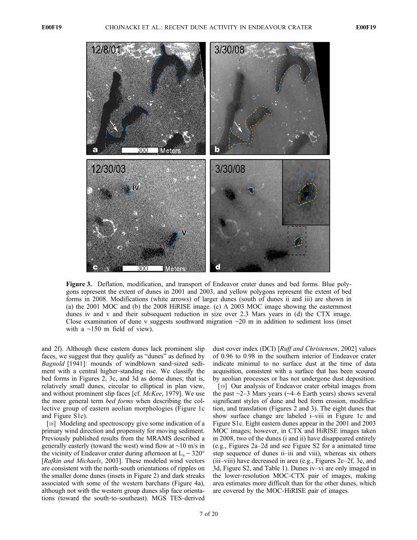
the past ∼2–3 Mars years (∼4–6 Earth years) shows severalsignificant styles of dune and bed form erosion, modifica-tion, and translation (Figures 2 and 3). The eight dunes thatshow surface change are labeled i–viii in Figure 1c andFigure S1c. Eight eastern dunes appear in the 2001 and 2003MOC images; however, in CTX and HiRISE images takenin 2008, two of the dunes (i and ii) have disappeared entirely(e.g., Figures 2a–2d and see Figure S2 for a animated timestep sequence of dunes ii–iii and viii), whereas six others(iii–viii) have decreased in area (e.g., Figures 2c–2f, 3c, and3d, Figure S2, and Table 1). Dunes iv–vi are only imaged inthe lower‐resolution MOC‐CTX pair of images, makingarea estimates more difficult than for the other dunes, whichare covered by the MOC‐HiRISE pair of images.
Figure 3. Deflation, modification, and transport of Endeavor crater dunes and bed forms. Blue poly-gons represent the extent of dunes in 2001 and 2003, and yellow polygons represent the extent of bedforms in 2008. Modifications (white arrows) of larger dunes (south of dunes ii and iii) are shown in(a) the 2001 MOC and (b) the 2008 HiRISE image. (c) A 2003 MOC image showing the easternmostdunes iv and v and their subsequent reduction in size over 2.3 Mars years in (d) the CTX image.Close examination of dune v suggests southward migration ∼20 m in addition to sediment loss (insetwith a ∼150 m field of view).
CHOJNACKI ET AL.: RECENT DUNE ACTIVITY IN ENDEAVOUR CRATER E00F19E00F19
7 of 20

3.2. Dune Deflation
[20] There are two potential explanations for the disap-pearance of these dunes (dunes i–viii): (1) aeolian removaland/or deflation of dune sediment or (2) dust deposition withconsequent obscuration via an increase in albedo, effectively“blending” the dunes into the lighter‐toned backgroundplains. The latter explanation is less credible because thelocations where the dark‐toned features were originallypresent now lack (as of 2008) the crosshatched, rippledappearance seen in the other dark‐toned dunes that are stillpresent (see insets in Figures 2b, 2d, and 2f). Although theMOC images from 2001 to 2003 and CTX images are ofinsufficient resolution to distinguish this texture in the now‐missing features, it is reasonable to assume that all the dark‐toned features in this vicinity originally had the same rippledsurface texture. If a mantle of bright dust were responsiblefor the disappearance of the dark‐toned features the rippledtexture would have been preserved, but it is not observed.Moreover, substantial dust mantlings are relatively uncom-mon on the surface of Meridiani Planum, as observed byOpportunity [Herkenhoff et al., 2006]. Thus, we infer thatthese eight dunes were partially or completely deflatedwithin the 2.3–3.3 Mars years (4.3–6.3 Earth years) or less,between the images.[21] The majority of dune or bed form change is found in
the eastern group, although there are sand streamers or darkstreaks emanating from one western dune that suggest per-iods of winds capable of saltating this material (Figure 4 andFigure S3, showing change in dominance of west‐southwestand southeast orientations). For dunes captured in the 2001–
2003 MOC and 2008 MRO combinations, dune areareduction ranged from ∼20% to 100% (Table 1). An addi-tional CTX observation in 2009 supports the trend ofdeflation with dunes iii and vii reduced in area ∼24% and∼55%, respectively, when compared with CTX in 2008(Table 1). For these eastern dunes we estimate that the totalsurface area from which sediment has been removed isgreater than ∼14,000 m2 (Table 1). In comparison to dunefields previously visited by MER, the total area of Endeavordunes removed is roughly one quarter the area of the totalVictoria crater dune field (55,000 m2), or about the samearea as Gusev crater’s El Dorado ripple field (13,000 m2).Dune coverage area lost per unit time varies widely fromdune to dune (Table 1), but the mean for all dunes is 750 m2
per Mars year (400 m2 per Earth year). These rates areaverages assuming removal at a steady rate throughout thetime between image acquisitions. The assumption of steadystate may be incorrect, as some dune(s) may have beenactive more intermittently (see section 4.2.).
3.3. Dune Morphology Modification
[22] The dunes presented in Figure 2 show no evidencefor downwind or southward migration. However, severallarger dunes or bed forms ∼500 m to the southeast (theinferred downwind direction) of dunes ii–iii do show surfacemodification (Figure 1c and Figure S1c, white arrows).Minor changes, presumably due to aeolian modification, areevident on the windward side of what appears to be adeflated barchan dune and a minor limb of a transverse dune(Figures 3a and 3b, white arrows) and other locations
Figure 4. HiRISE images (a) PSP_005779_1775 and (b) PSP_007849_1775 of a degrading barchandune on the eastern edge of the western dune group. These two images, taken on 20 October 2007(Ls ∼ 334°) and 30 March 2008 (Ls ∼ 51°), are separated by one Martian season (0.24 Mars year). Sandstreamers appear both to the southeast and west‐southwest in Figure 4a. However, the distributionappears to be more concentrated to the southeast, and the dark‐toned material, inferred to be sand, presentin Figure 4a appears to have been largely removed in the western portion of Figure 4b. Also, note thedegraded state of the slip face of this former barchan dune (gray arrow). Phase angle is ∼15° greaterfor Figure 4b.
CHOJNACKI ET AL.: RECENT DUNE ACTIVITY IN ENDEAVOUR CRATER E00F19E00F19
8 of 20

(Figure 1c and Figure S1c, white arrows). From this evi-dence, we suggest two likely outcomes for the sand involvedin the dune changes between 2001 and 2009. The sandremoved from the northernmost dome dunes may have beendispersed downwind too diffusely to be detected in HiRISEimagery, but some of this sand may have been absorbed andincorporated into the larger dunes to the south, includingthose that show shape modification (Figures 3a and 3b).Some combination of the two scenarios is also possible.
3.4. Dune Migration
[23] In addition to dune deflation and the modification ofdune morphology, several dunes noticeably translate from2003 to 2008. Dune v, in addition to losing ∼40% of its area,shows a ∼20 m southeastward change of its centroid,defined as the location equidistant along the long and shortaxis (Figures 3c and 3d; blue to yellow polygon). Thisevidence is interpreted as southeastward dune migration (seesection 4.1.). Likewise, dune vi also appears to havemigrated∼10 m from its position in earlier images (Table 1). To ourknowledge, this change is the first documentation of dunemigration on Mars, although smaller ripples have beenobserved to migrate at landing sites [Sullivan et al., 2008] andin HiRISE observations [Silvestro et al., 2010a]. These esti-mates of dune translation are based on the available MOC‐CTX pair of observations, and thus precision is limited. Ifmigration continues, the dune centroid positions could bebetter constrained using future high‐resolution observations.
3.5. Thermal Inertia and Topography
[24] A THEMIS thermal inertia map of Endeavour crater(Figure 5) exhibits values from 80 to 350 J m−2 K−1 s−1/2
(hereafter referred to as “tiu,” or thermal inertia unit). Thewestern barchan sand dunes exhibit a thermal inertia of 150–240 tiu, whereas the eastern dunes have a thermal inertiarange of 110–190 tiu. For unconsolidated sediments, thesethermal inertia values are consistent with particle sizes of100–600 mm (very fine to coarse sand sizes) and 50–200 mmsediment (very fine to fine sand sizes), respectively[Piqueux and Christensen, 2009]. The elevated thermalvalues could be the result of differences in dune thickness orsediment induration, instead of or in addition to differencesin grain size.[25] A CTX visible‐wavelength image colorized with
HRSC elevation is shown in Figure 6, illustrating the localtopography of the Endeavour crater basin. Topographicprofiles aligned parallel to the inferred primary winddirection indicate hummocky terrain dropping off southwardacross the eastern dunes and bed forms.
3.6. Mesoscale Atmospheric Modeling Results
[26] The MRAMS simulations performed for this work donot have the spatial resolution (due to computational limita-tions usual for such modeling) needed to properly resolveboundary layer turbulence, although wind gusts generated bysuch turbulence are suspected of being very important toaeolian processes onMars [e.g., Fenton andMichaels, 2010].
Figure 5. CTX image colorized with THEMIS thermal inertia (I22535006) of the Endeavor crater basinand dune fields. Dunes that show change in morphology are highlighted in white. The western dune fieldsare found to have thermal inertia values consistent with fine to medium sand sizes, while eastern dunesthat show change have thermal inertia values suggestive of very fine to fine sand sizes.
CHOJNACKI ET AL.: RECENT DUNE ACTIVITY IN ENDEAVOUR CRATER E00F19E00F19
9 of 20

The MRAMS output fields analyzed here are effectivelythe spatial mean (within each ∼2.5 km × 2.5 km grid cell)of the actual variability within those fields (a range thatexists due to turbulence). One of those fields is the aero-dynamic surface shear stress (t = ratm u*
2; with units ofmN m−2 or mPa). Shear stress is an important quantity forestimating aeolian saltation potential because it includesthe effects of both the local atmospheric density (ratm;varies significantly between night and day on Mars) andfriction speed (u*; also varies significantly, especially whenturbulence is present). The threshold aerodynamic surfaceshear stress (tt) needed to initiate saltation of sand‐sizedparticles was also calculated for every MRAMS grid pointat all output times using the semiempirical expressions ofNewman et al. [2002, equation (5)], the local atmosphericdensity at the surface, and a particle mass density of2800 kg m−3 (similar to weathered basalt).[27] Figure 7a shows the model topographic contours on a
portion of grid 5 (∼20% of the full area), an area whichincludes Endeavor crater as well as Opportunity’s traverse,
overlaid on a mosaic of CTX imagery colored with HRSCtopography. An area of 4 × 4 model grid points, where duneactivity is known from photogeologic evidence, is analyzedin detail. This target area was selected to receive moredetailed attention because of its relevance to the observeddune modifications discussed above (see Figure 7a, blackbox). Polar coordinate scatterplots were generated of t/ttversus wind direction (Figure 8) within that area, valid ateach of the four seasons that were simulated (Ls ∼ 30°,120°, 210°, and 300°). Two additional sets of similar plots(Figure S4), illustrating the dependence of t/tt and winddirection on local mean solar time (LMST), were also uti-lized for analysis. Values of t/tt greater than or equal to onewould indicate that the spatial mean winds at the associatedmodel grid point(s) are likely capable of initiating the sal-tation of basaltic sand.[28] The regional‐scale atmospheric model (MRAMS)
results are only broadly similar to the much coarser reso-lution GCM results (used as distant boundary conditions forthe MRAMS runs discussed here), with both models sug-
Figure 6. CTX image colorized with HRSC elevation (75 m/pixel H2064_0000_DT4) of Endeavor cra-ter dunes. The eastern dunes and bed forms are situated at the top of a ∼200 m tall hill that drops offsouthward and downwind across the dune field. Four topographic profiles (in units of meters) with thesame vertical spacing are given across dunes that show change (highlighted in white). Profiles are parallelto and lead downwind (inferred direction) of the dunes that show change (shown by black ellipse in theprofiles).
CHOJNACKI ET AL.: RECENT DUNE ACTIVITY IN ENDEAVOUR CRATER E00F19E00F19
10 of 20

gesting that regional‐scale winds should evolve seasonally,with a significant easterly wind component occurring often.The MRAMS results suggest that the study area withinEndeavor crater is subject to three flow regimes (two major,one minor) that vary seasonally. The wind regime with thehighest modeled winds (WR1) occurs for ∼2–3 Mars hoursduring the midmorning at all seasons, with the direction andstrength varying with season: from the east (with thestrongest overall magnitudes) during the warmer seasons
(e.g., Ls ∼ 210°, 300°; Figures 4a, 7b, and 8 and Figures S3and S4), and from the southeast to south at during thesouthern fall and winter (e.g., Ls ∼ 30°, 120°; Figure 8 andFigure S4). The strength and direction of this wind regime isgenerated by regional forces associated with both theatmospheric diurnal tides and the regional‐scale topography.The wind regime with the second highest modeled winds(WR2) occurs for ∼1 Mars hour in the early evening, and ischaracterized by winds primarily from the northwest. It is
Figure 7. (a) CTX visible‐wavelength image mosaic of Endeavor crater and its vicinity, overlain bycolor‐shaded HRSC elevation (100 m/pixel H1183_0000_DT4) and the MOLA‐based elevation contoursused by MRAMS. (b–d) CTX visible‐wavelength image mosaic of the Endeavor crater vicinity withexamples of flow regimes: wind regime 1 (Figure 7b), MRAMS wind vectors and magnitude 1.3 mabove ground level (AGL) (interval 0.5, purple < 6.5, red > 8.5 m/s) at Ls ∼ 300 and 0950 LMST; windregime 2 (Figure 7c), MRAMS wind vectors and magnitude 1.3 m AGL (interval 0.5, purple < 1, red >3.5 m/s) at Ls ∼ 120 and 1650 LMST; and wind regime 3 (Figure 7d), MRAMS wind vectors and mag-nitude at 1.3 m AGL (interval 0.3, light purple < 1.5, dark red > 4.5 m/s) at Ls ∼ 210 and 1750 LMST.The magenta circle in the northwest quadrant of the images represents the location of the Opportunityrover in December of 2010.
CHOJNACKI ET AL.: RECENT DUNE ACTIVITY IN ENDEAVOUR CRATER E00F19E00F19
11 of 20

strongest in southern spring (e.g., Ls ∼ 210°; Figures 3b, 4b,7c, and 8 and Figure S4) and nearly absent during southernwinter (e.g., Ls ∼ 120°). This northwest flow is initiallygenerated by regional forces, but its magnitude is signifi-cantly enhanced through interaction with Endeavor crater.Furthermore, this enhancement only appears to occur in thenorthern half of the crater, with weak winds elsewherewithin the crater. The third flow regime (WR3) is a minorone that is only significantly present during the southernwinter (e.g., Ls ∼ 120°; Figures 7d and 8 and Figure S4). It ischaracterized by flow from the southeast to south‐southeast
into the southern third of Endeavor crater, and is a result oflocal flow modification due to the presence of the crater.[29] At all seasons, the modeled t/tt has magnitudes
below 0.5, and more commonly less than 0.25. Although theMRAMS‐modeled t/tt values are less than one (indicatingwinds nominally incapable of mobilizing sediment),MRAMS does not take into account possible turbulent gustssuperposed on the mean wind speed. To achieve the neededincrease in t/tt of a factor of two to four, corresponding guststrength of
ffiffiffi
2p
toffiffiffi
4p
times the mean wind speed would berequired. Such enhancements are plausible according to
Figure 8. MRAMS polar coordinate scatterplot for four representative seasons (Ls ∼30°, 120°, 210°, and300°). Each of the 20 model grid points within the outlined area in Figure 7 are plotted at each of the 72model output times within in a single sol. Points with LMST between approximately 12 and 16 Marshours are plotted in gray to indicate that their magnitude and direction are contaminated (to varyingdegrees) by the occurrence within the model results of poorly resolved/realistic dry convective structuresat those times. Inspection of the other (lower‐resolution) model grids strongly suggests that t anddirection during this time interval should not have a significantly different character than that in the latemorning. Directions are given using the meteorological convention (i.e., the direction the flow is from).Fraction of threshold aerodynamic surface shear stress (t/tt) versus wind direction (degrees clockwisefrom north) is plotted, with a grid ring interval of 0.25, illustrating the flow directions with the greatest/least magnitudes.
CHOJNACKI ET AL.: RECENT DUNE ACTIVITY IN ENDEAVOUR CRATER E00F19E00F19
12 of 20
Fenton and Michaels [2010]. In discussing correlationsbetween MRAMS wind vector orientations and the orienta-tions of aeolian surface changes, we make the assumptionthat this level of gustiness is achieved. Therefore wesuggest, in a relative sense, the results indicate that thesouthern spring and summer seasons (e.g., Ls ∼ 210°, 300°;Figure 8 and Figure S4) are more likely to support aeolianactivity within Endeavor crater than the other two seasons.According to the model results, winds would move, if ofsufficient magnitude, aeolian features predominantly west-ward or southeastward across the basin with some minorreworking northwestward (Figure 7). The results also sug-gest that southern autumn (Ls ∼ 30°) is the least likely timeof year for significant aeolian activity within the crater. Themodeling also indicates that some sol‐to‐sol variabilityoccurs, but does not significantly change the general resultspresented above.
4. Discussion
4.1. Comparison With Other Martian and TerrestrialExamples
[30] Our results have documented a high degree of duneactivity in Endeavor crater during the relatively short timespan of ∼2–3 Mars years (∼4–6 Earth years). We suggestsaltation, rather than creep or suspension, as the primarymechanism to be responsible for the erosion, modification,and migration of these dunes. A surface of coarse sandparticles, which is less prone to saltation than to surfacecreep, is inconsistent with estimates from the thermal inertiadata. Likewise, removal by suspension would require sub-sand sizes that would correspond with lower thermal inertiasurfaces than estimated from THEMIS data (Figure 5).[31] This evidence for widespread dune deflation implies
local winds that are sufficient to initiate saltation, as observedelsewhere on Mars [Greeley et al., 2006; Bourke et al., 2008;Geissler et al., 2008; Sullivan et al., 2008; Silvestro et al.,2010a, 2010b]. Indeed, Endeavor crater dune area removalrates are an order of magnitude larger than polar dunes thatshow surface change (see below). This sediment movementin Endeavor crater represents the most significant contem-porary sand‐sized aeolian sediment transport on Marsdetected to date. This movement indicates that Endeavorcrater experienced significant near‐surface wind speeds,although the temporal nature of those winds (e.g., dailywinds? episodic wind events?) (see section 4.2) is poorlyconstrained. Regardless of the time frame for movement,documentation of relatively large scale (>1000 m2) bed formactivity may have been inevitable due to spacecraft imagingcampaigns with progressively greater spatial and temporalresolution, as well as areal coverage [Sullivan et al., 2008].[32] Thorough image analysis campaigns looking for dune
change have been ongoing, with comparisons being madebetween Viking‐acquired images to MOC, MOC to MOC(for a review see Bourke et al. [2008]), and most recentlyMRO to MRO [Bridges et al., 2007], yet have been limitedin success. Endeavor crater, Nili Patera (where ripplemigration has been observed for the first time from orbit[Silvestro et al., 2010b]), and the small dome dunes seen tobe modified in the north polar region [Bourke et al., 2008],are the only such identifications thus far. An intriguingcommon thread between these three known anomalous sites
is that the features with observed aeolian modification weremuch smaller in size (lesser sediment volume) than the moretypical “larger” dunes across Mars that have yielded nearlyno evidence of contemporary aeolian modification. Thiscorrelation supports the possibility that the contemporaryaeolian sediment transport processes on Mars may be of amagnitude and/or intermittency which allows low‐volumebed forms to change detectably over a few Mars years (orless), but may take Mars decades to produce detectablechanges on larger bed forms.[33] The average migration and removal rates we have
deduced for the dunes in Endeavor crater provide anopportunity for comparison with terrestrial rates. Themigration rates for the two Martian dunes were ∼4–9 m perMars year (∼2–5 m per Earth year; Table 1), which aregenerally lower rates than terrestrial studies of small dune(typically barchans) movement [Finkel, 1959; Pye andTsoar, 1990; Jimenez et al., 1999]. However, Antarctichyperarid polar dunes, thought to be analogous to at leastsome Martian dunes, travel at an average rate of 1.5 m perEarth year [Bourke et al., 2009b]. Similarly, terrestrialstudies of dome dune migration rates vary from 4 to 8 m perEarth year [Dong et al., 2000; Bristow and Lancaster,2004], which is similar to our estimates of 2–5 m perEarth year for the Endeavor crater dome dunes.[34] The estimated areal removal fluxes vary by an order
of magnitude from dune to dune, but the higher‐resolutionMOC‐HiRISE comparisons suggest ∼350 m2 per Mars year(∼190 m2 per Earth year). For comparison, we have alsocalculated areal removal rates for the deflating polar domedunes (dunes i–iii) identified by Bourke et al. [2008]. Wederive areal change rates for these dunes of ∼180 m2 perMars year (100 m2 per Earth year), which is smaller than butcomparable to the removal rates in Endeavor crater. Theunusual parameter of areal removal rate is necessitated forthe Mars dunes because no data are available on the thick-ness of the dunes (see section 4.3.). This parameter is notwhat is typically used in terrestrial studies, but Dong et al.[2000] do report several instances of small crescent anddome dunes deflating in the Taklimakan Desert, China.Dune morphometric data from these authors suggests ratesof ∼85 and 115 m2 per Earth year for the collective study(including small crescent dunes) and dome dunes, respec-tively. Reports of terrestrial dunes experiencing 100%deflation are uncommon. However, one small (∼45 mdiameter) dome dune in the Namib Sand Sea [Bristow andLancaster, 2004] was reported to have dissipated 100%within 3 years (1999–2002) of that study (C. S. Bristow, per-sonal communication, 2010). This report results in a poorlyconstrained, areal removal flux of ∼1000 m2 per Mars year(∼550 m2 per Earth year), clearly a much higher rate thanhas been observed on Mars to date.
4.2. Timing: Episodic and/or Gradual Aeolian Activity
[35] Both episodic and gradual aeolian events are sus-pected to have taken part in the aeolian activity at Endeavorcrater. Surface observations during operations at MarsExploration Rover landing sites led Sullivan et al. [2008] toconclude (1) strong wind events, usually associated withregional or global dust storms, occur with some random-ness; (2) the strongest events are also the rarest; and (3)these strong wind events contribute the most to surface
CHOJNACKI ET AL.: RECENT DUNE ACTIVITY IN ENDEAVOUR CRATER E00F19E00F19
13 of 20

change. A planet‐encircling dust storm occurred in July–August 2007 and disrupted MER surface operations at bothlanding sites. Several local changes associated with thisstorm were observed from the surface and from orbit.During that period, atmospheric opacity (tau) reached ∼5.0at Victoria crater, and eventually Opportunity’s solar arrayperformance dropped to record lows [Geissler et al., 2010;Vaughan et al., 2010]. Commonly associated with thesesometimes sudden increases in dust opacity were episodicstrong wind events, which stripped sediment from MERsolar panels [Geissler et al., 2010; Vaughan et al., 2010].The spatial extent of these exceptional wind events, and thustheir potential effect on Endeavor crater bed forms, isunknown, in part because all of these dust‐cleaning eventsoccurred during long hiatuses between overlappingEndeavor crater imaging. During the course of the mission,several local changes associated with this storm wereobserved from the surface and from orbit [Geissler et al.,2010]. Opportunity observed its rover tracks both gradu-ally fade (brighten) due to dust deposition and be erased dueto aeolian deflation, including some that were less than1 Mars year old [Geissler et al., 2010]. In contrast to theslow rate of dust deposition, episodic transport and depo-sition of basaltic sand by surface winds may produce rapiderasure, as suggested by the disappearance of the rovertracks and dark streaks around Victoria crater during the2007 dust storm [Geissler et al., 2008, 2010]. It is thusconceivable that much of the surface change observedherein is due to one major episode of high‐magnitude windsassociated with the 2007 planet‐encircling dust storm.Because it is known only that changes occurred sometimebetween the acquisition of the two images showing dunetransport and removal, these time spans for change and theremoval and migration rates shown in Table 1 are temporalaverages that assume continuous activity, as no intermediateimages of suitable quality are available.[36] Alternatively, some evidence exists that dune bed
form surface change is more gradual with changes occurringon an interseasonal or even intraseasonal basis. At theOpportunity landing site, landing rockets fired prior to therover dropping during the landing sequence made brightscour marks easily resolvable in subsequent MOC images.The bright marks are likely created by the removal of sandand hematite‐rich concretions by the rocket blast [Geissleret al., 2010]. The blast marks were observed to graduallyfade in several orbital images, presumably due to seasonalwind‐driven deflation, in less than a Martian year [Geissleret al., 2010]. Contemporary “reversing” bright wind streaks(each feature having two streak orientations, northwest andsoutheast) that are associated with small craters are also com-mon in this portion of Meridiani Planum [Sullivan et al., 2005;Jerolmack et al., 2006]. There is evidence from repeatedvisible‐wavelength data that these dust streaks appear atpredicable and repeatable times of the Martian year (seesection 4.4) [Jerolmack et al., 2006]. This evidence sug-gests some element of seasonal aeolian behavior controls theemplacement and erosion of dust, producing these features.Bourke et al. [2008, 2009a] documented polar domes thatshowed gradual deflation every 1–2 Earth years and somechanges occurring over a single Martian season. Other thanthe 2001–2007 time step, the frequent MRO imagery cov-erage of Endeavor crater supports a gradual erasure of dune
iii and possibly neighboring bed forms. Future observationswill reveal whether or not areal removal and/or migrationrates are relatively continuous in time.
4.3. Factors Contributing to Surface Change
[37] Coordinated orbital and rover observations at Mer-idiani and Gusev crater made significant progress in ad-dressing question 1, why bed form change is not morecommonly observed from orbit [Geissler et al., 2008;Sullivan et al., 2008]. These studies have provided someinsight for observations of other, less (remotely) character-ized aeolian features on Mars and their potential for con-temporary activity. For example, the temporal change of theVictoria crater dark streaks are easily resolved at MOC‐NAand HiRISE spatial resolutions, but required MER‐Bobservations to determine that they were due to the saltationof dark sediment (versus the removal of a bright mantlingmaterial overlying a dark substrate) [Geissler et al., 2008].In contrast to the Victoria crater dark streaks the El Doradoripple migration (∼2 cm) [Sullivan et al., 2008] would nothave been discovered solely from orbital observations evenwith repeated HiRISE imaging. The recent discovery ofdune mobilization in Endeavor crater and ripples migrating∼1.7m in Nili Patera over oneMartian season [Silvestro et al.,2010b] was accomplished with the 25 cm/pixel resolution ofHiRISE and the multiple of overlapping images.[38] The reasons some bed forms change and others do not
as observed from orbit (question 2) and the factors control-ling detectable movement (question 3) may be a combinationof effects associated with: particle sizes, degree of sedimentinduration, areal extent and/or volume, position relative toassociated topography, bed form morphology, and smaller‐scale atmospheric flow structure. The thermophysical prop-erties of the local sediment may give us some indication whysome dunes show a greater propensity for change than others(Figure 5). The THEMIS‐derived mean grain size value of∼120 mm (50–200 mm) for the eastern dunes and bed formsencompasses the particle size (∼115 mm) most easily mobi-lized by the Martian atmosphere [Greeley et al., 1980].Particles are expected to be composed of basaltic grains(low‐calcium pyroxene), rather than lower‐density dustaggregates based on MRO’s Compact Reconnaissance Imag-ing Spectrometer for Mars (CRISM) spectroscopic observa-tions [Chojnacki et al., 2010a]. This particle size range forbasaltic grains, at the estimated Meridiani Planum atmo-spheric pressure (∼6.7 mb), would require an frictionthreshold velocity (u*t) of ∼2 m/s [Greeley et al., 1980] orsurface wind velocity of ∼17.5 m/s (at ∼1 m height and anaerodynamic roughness value of 3 cm [Sullivan et al., 2005])for entrainment. The thermal inertia of these dunes and bedforms also supports the notion that on these dunes, like theEl Dorado ripples [Sullivan et al., 2008], saltation of hardsand‐sized particles is winning its competition against sur-face induration.[39] Dune area removal rates appear relatively similar
across the study area and between imaging epochs with theexception of dunes v–vii, where measurements were donewith lower‐resolution MOC‐CTX data. Volumetric sedimentfluxes are difficult to estimate in Endeavor crater because noappropriate imagery currently exists that can be used toconstruct a DEMwith sufficient resolution. However, we canmake crude estimates of dome dune volumes, mass, and
CHOJNACKI ET AL.: RECENT DUNE ACTIVITY IN ENDEAVOUR CRATER E00F19E00F19
14 of 20
associated flux by looking at different dune heights. Toobtain an upper limit for dune height, we note that thesedome dunes have no slip faces and thus possess slopes belowthe angle of repose (<33°). This lack of slip faces can be usedto put upper limits on dune heights. For example, dune iii at∼39 m wide could be ∼9 m tall (assuming slopes of 25°) butnot possess a slip face. This dune height is likely an over-estimate, as terrestrial dome dunes have relatively modestslope angles when compared with other dune morphologies[Dong et al., 2000; Bristow and Lancaster, 2004], so we willalso consider a height of 2 m. Volume estimates from the2008 dune iii measurement are estimated at ∼900 m3 and16,900 m3 (Monolithic Dome Institute, Spherical dome for-mulas, 2001; available at http://www.monolithic.com/stories/advanced-dome-calculator), when using heights of 2 m and9 m, respectively. These estimates illustrate dunes that areshorter are more susceptible to deflation and surface change,because they contain less sediment.[40] Bed forms move proportional to the wind velocity
and inversely to their size [Bagnold, 1941; Finkel, 1959;Sauermann et al., 2000; Hesse, 2009]. Endeavor craterdunes show no clear inverse correlation between areal sizeand removal rate, as a proxy for transport rate (i.e., thesmallest dunes do not appear to be removed faster thanlarger dunes in Table 1). However, this lack of an inversecorrelation is likely an artifact of poor temporal resolutionand we suspect the smallest dunes (<2000 m2) were deflatedin a shorter time span than larger ones.[41] Topography and degree of bed form exposure are
additional factors influencing dune sediment transport ratesand dune morphology [Taylor et al., 1987; Pye and Tsoar,1990]. All dunes (except vi) that show removal or reductionin size are located at the inferred upwind perimeter of thedune field (Figure 1c and Figure S1c), making them mostexposed to atmospheric flow and prone to deflation. Profilesacross the eastern dune field (Figure 6) parallel with whatwe have defined as the primary wind/transport directionindicate that many mobile dunes are superimposed on asurface that slopes downward to the southeast (with 200 mof relief). The majority of dunes that show erosion andtransport are located at the summits of small hills or ongently southeastward sloping (1°–7°) surfaces (Figure 6).Local topographic highs, as with the stoss slope leading upto the crest of an individual dune, are locations of increasedwind velocity due to streamline convergence [Taylor et al.,1987; Pye and Tsoar, 1990]. Saltation path lengths arelonger where wind vectors align with the downhill direction,enhancing the wind’s capacity for transporting sediment[Tsoar et al., 1996; Pye and Tsoar, 1990].[42] As described above (section 3.1) these bed forms are
classified as simple dome dunes [cf. McKee, 1979]. Domedunes are not as efficient at trapping sand as barchansand are known to be highly susceptible to wind erosion[Bagnold, 1941; McKee, 1979; Bourke et al., 2008, 2009a].Dome dunes may develop into barchan dunes given suffi-cient sand supply and wind velocity [McKee, 1979; Bourkeand Goudie, 2009] or develop from larger barchan limbs aspart of a calving event [Bourke, 2010]: thus an evolutionaryrelationship between dome and barchan morphologies canexist. We suggest the changing dome dunes in Endeavorcrater are an example of progressive degradation of barchandunes leading to present‐day dome dunes and the loss of slip
faces. A survey of dune field morphology supports the ideaof disequilibrium. Dune height monotonically decreasesfrom the westernmost barchan dunes toward the east, asinferred by using the technique of Bourke et al. [2006], inwhich the horizontal lengths of slip faces (where present)provide a proxy for dune heights.[43] All of the barchan dunes in western Endeavor crater
are classified as fat barchans, based on the ratio of length ofwindward slope to horn‐to‐horn width [Long and Sharp,1964]. Dunes in this subclass are common on Earth, butless so on Mars [Bourke and Goudie, 2009]. Models suggestfat barchans form in the presence of varying wind directions(up to ∼40°) [Reffet et al., 2009], in locations that aretopographically influenced and/or on the margins of largerdune fields [Bourke, 2010]. There is evidence for all of thesefactors in the western dune field of Endeavor crater. Manydunes of the western group have maintained a crescentshape, but have greatly degraded slip faces (e.g., Figure 4and Figure S3). In general, the presence of barchan dunemorphologies commonly has been suggested to imply arelatively unidirectional wind regime and limited sandsupply [Bagnold, 1941]. The sediment supply north of thesedunes, presumably upwind, certainly is sparse according toour photogeologic and thermophysical analyses (Figures 1b,1c, 4a, and 5). The dune field, primarily the eastern group,shows evidence for a trend in dune degradation (from north tosouth) due to wind energy stripping material away (erosion)from the northernmost dunes and depositing sand southwardas part of larger bed forms.[44] The remaining dunes exhibiting recent movement
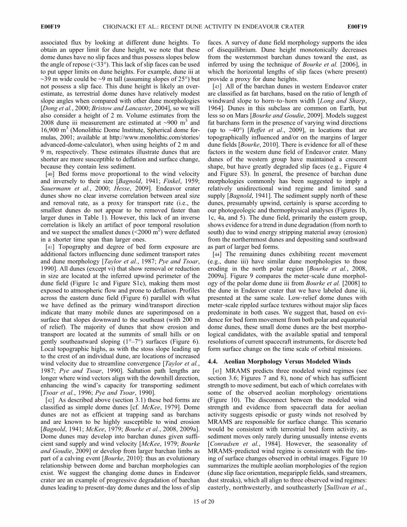
(e.g., dune iii) have similar dune morphologies to thoseeroding in the north polar region [Bourke et al., 2008,2009a]. Figure 9 compares the meter‐scale dune morphol-ogy of the polar dome dune iii from Bourke et al. [2008] tothe dune in Endeavor crater that we have labeled dune iii,presented at the same scale. Low‐relief dome dunes withmeter‐scale rippled surface textures without major slip facespredominate in both cases. We suggest that, based on evi-dence for bed form movement from both polar and equatorialdome dunes, these small dome dunes are the best morpho-logical candidates, with the available spatial and temporalresolutions of current spacecraft instruments, for discrete bedform surface change on the time scale of orbital missions.
4.4. Aeolian Morphology Versus Modeled Winds
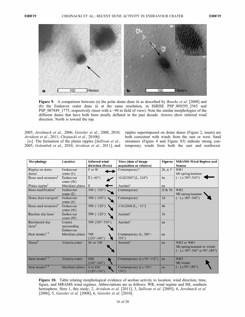
[45] MRAMS predicts three modeled wind regimes (seesection 3.6; Figures 7 and 8), none of which has sufficientstrength to move sediment, but each of which correlates withsome of the observed aeolian morphology orientations(Figure 10). The disconnect between the modeled windstrength and evidence from spacecraft data for aeolianactivity suggests episodic or gusty winds not resolved byMRAMS are responsible for surface change. This scenariowould be consistent with terrestrial bed form activity, assediment moves only rarely during unusually intense events[Conradsen et al., 1984]. However, the seasonality ofMRAMS‐predicted wind regime is consistent with the tim-ing of surface changes observed in orbital images. Figure 10summarizes the multiple aeolian morphologies of the region(dune slip face orientation, megaripple fields, sand streamers,dust streaks), which all align to three observed wind regimes:easterly, northwesterly, and southeasterly [Sullivan et al.,
CHOJNACKI ET AL.: RECENT DUNE ACTIVITY IN ENDEAVOUR CRATER E00F19E00F19
15 of 20
2005; Jerolmack et al., 2006; Geissler et al., 2008, 2010;Arvidson et al., 2011; Chojnacki et al., 2010b].[46] The formation of the plains ripples [Sullivan et al.,
2005; Golombek et al., 2010; Arvidson et al., 2011], and
ripples superimposed on dome dunes (Figure 2, insets) areboth consistent with winds from the east or west. Sandstreamers (Figure 4 and Figure S3) indicate strong con-temporary winds from both the east and northwest.
Figure 9. A comparison between (a) the polar dome dune iii as described by Bourke et al. [2008] and(b) the Endeavor crater dune iii at the same resolution, in HiRISE PSP_009295_2565 andPSP_007849_1775, respectively (inset with a ∼90 m field of view). Note the similar morphologies of thedifferent dunes that have both been areally deflated in the past decade. Arrows show inferred winddirection. North is toward the top.
Figure 10. Table relating morphological evidence of aeolian activity to location, wind direction, time,figure, and MRAMS wind regimes. Abbreviations are as follows: WR, wind regime and SH, southernhemisphere. Here 1, this study; 2, Arvidson et al. [2011]; 3, Sullivan et al. [2005]; 4, Jerolmack et al.[2006]; 5, Geissler et al. [2008]; 6, Geissler et al. [2010].
CHOJNACKI ET AL.: RECENT DUNE ACTIVITY IN ENDEAVOUR CRATER E00F19E00F19
16 of 20

Endeavor crater dune slip face orientations (Figure 1b andFigure S1b) suggest a wind direction from the northwest(Figure 4). Indeed, all five craters similar in size (5–20 kmdiameter) to and within ∼100 km of Endeavor crater possesssimilar intracrater concentrations of dark‐toned sedimentforming dune fields. All of these intracrater dune fields havedune slip faces consistent with a wind direction at the timeof formation from the northwest. Observed dune modifica-tions within Endeavor crater (Figures 2–4) indicate thepresence of a contemporary wind regime, also from thenorthwest, that is able to mobilize sediment. Contemporary“reversing” bright wind streaks (each feature having twostreak orientations, northwest and southeast) that are asso-ciated with small craters are also common in this portion ofMeridiani Planum [Sullivan et al., 2005; Jerolmack et al.,2006]. Additionally, ubiquitous crater‐associated darkwind streaks, formed from south‐southeasterly winds, arefound on the plains adjacent to Endeavor crater, includingthose associated with Victoria crater [Geissler et al., 2008].[47] Seasonal dust streaks were mapped out from 1999 to
2005 using 54 MOC images by Jerolmack et al. [2006] toinfer two major wind regimes associated with their forma-tion (dust streak azimuths of ∼130° and ∼320°). The duststreak azimuths were found to correspond with the seasons
immediately preceding the MRAMS modeled WR1(southeast, at Ls ∼ 120°) and WR2 (northwest, at Ls ∼ 210°),(Figures 8 and 10). The season when the Victoria crater darkstreak typically emerges has been found to be ∼Ls 90° (withsome variability) [Geissler et al., 2010] and is broadlycorrelated with GCM and MRAMS predicted patterns(Figure 10).[48] However, as previously discussed (section 3.6)
MRAMS does not explicitly predict flow magnitudes thatare greater than the threshold required for the initiation ofsand saltation. Prior modeling work has suggested thatMeridiani Planum is not a windy place by Martian standards[e.g., Rafkin and Michaels, 2003]. Wind magnitudes pre-dicted in other mesoscale atmospheric modeling workcommonly are too low to move sediment [Fenton et al.,2005; Hayward et al., 2009]. This result may be due toinsufficient model spatial and temporal resolution, such thatconvective turbulent gusts, likely important in aeolian pro-cesses on Mars [e.g., Michaels and Fenton, 2010; Fentonand Michaels, 2010], are not resolved. Alternatively (oradditionally), energy from decaying northern autumn andwinter baroclinic storms from southern Chryse Planitia (tothe northwest) may episodically enhance the northwesterlyflow so that it is more effective at mobilizing sediment than
Figure 11. Opportunity’s southward view (top, bottom, and middle Pancam mosaic insets) ofEndeavor crater rim segments visible on the horizon, in comparison to HRSC orbital data (south istoward the top). HRSC data has been reprojected into distance (vertical coordinate) and azimuth (hor-izontal coordinate) from the location where the Pancam mosaic was taken. The azimuth coordinate isrescaled to match that of the Pancam resolution such that the same features in both ground and orbitaldata align vertically across the image. Pancam mosaics have been vertically stretched to exaggerate thehorizon and were taken near Concepcion crater (Figure 1a) in early 2010. Image credit: NASA/JPL/Cornell University (Pancam), ESA/DLR/FU Berlin (HRSC), and processing courtesy of James Canvinand http://www.nivnac.co.uk/mer/.
CHOJNACKI ET AL.: RECENT DUNE ACTIVITY IN ENDEAVOUR CRATER E00F19E00F19
17 of 20

the easterly regime. Further atmospheric modeling work(particularly at higher resolutions) is needed to improve ourunderstanding of the contemporary aeolian sediment trans-port processes at work in and near Endeavor crater. Toconclude, modeled (mean) winds are insufficient to initiatesaltation, but less frequent turbulent winds superimposed onthese mean winds would provide sufficient shear stress toentrain sediment.
4.5. Possible Future Observations by Opportunity
[49] Endeavor crater has been the future destination forOpportunity since leaving Victoria crater in 2008. Its rimhas become increasingly apparent in panoramic images ofthe southern horizon (Figure 11). Upon Opportunity’santicipated arrival at the northwestern rim of Endeavor,possibly as early as 2011, the rover will be ∼6 km from theportion of the crater floor where we have identified erodingdunes and bed forms. The average lateral extent (perpen-dicular to the line of sight from the northwest rim) of dunesthat have experienced 100% deflation is ∼60 m. Opportu-nity’s Pancam instrument [Squyres et al., 2003; Bell et al.,2003] has a resolution of 0.28 mrad/pixel [Bell et al.,2006] meaning that dunes of this size would span ∼18Pancam pixels (assuming 100% deflation) as viewed fromthe northwest rim. If Opportunity spends as much time atEndeavor crater as it spent at Victoria crater (>1 Mars year),the rover could detect the removal of additional dunes ifmore occur at the scale and rates we have observed in recentorbital data. Additionally, the MRAMS modeling worksuggests that certain seasons (and even times of sol) wouldbe optimal for documenting dune change in and near thecrater (see section 3.6, Figure 8 and Figure S4). Docu-mentation of aeolian bed form movement from the surfacein coordination with orbital observations would help clarifythe apparent disconnect between the two observationalscales that has been prevalent until now. If Opportunity isstill healthy upon reaching the rim of Endeavor crater, anattractive long‐term intracrater drive target might be to thevicinity of these changing dunes, allowing this active ero-sional process to be viewed in situ (or nearly so) for the firsttime on Mars.
5. Summary and Conclusions
[50] Eight Endeavor crater dunes with a combined surfacearea of ∼14,000 m2 show activity over the past decade.These changes constitute the most extensive contemporaryactivity of sand‐sized sediment observed to date. Thesedunes primarily show evidence for deflation, up to 100% insome cases, but two dunes have translated as part of bedform migration. The active dunes in Endeavor crater aredome dunes, the same morphologic class as the only othergroup of dunes known to be active on Mars, identified in thenorth polar region by Bourke et al. [2008]. The fact thatthese two groups share the same morphologic type despitethe vastly different surface environmental conditions (e.g.,temperature, carbon dioxide frost cycle and water ice)implies that small dome dunes may be the best candidatesfor seeking out decadal‐timescale surface dune change fromremote sensing. The dune activity in Endeavor crater showsthat it has experienced relatively strong atmospheric flow,which could have been relatively continuous or episodic.
Mesoscale atmospheric modeling suggests that wind energyand possible sand transport within the crater may peakduring the southern spring and summer seasons. The sandfrom these dunes has either been thinly dissipated and/orincorporated into larger dunes approximately hundreds ofmeters downwind that also show evidence for modification.Future orbital observations of this dune field with greatertemporal resolution may be used to document surface evo-lution and sand transport rates. Anticipated MER operationsat the rim of Endeavor crater may provide a chance todocument large‐scale aeolian modification of the surface asit occurs.
[51] Acknowledgments. We would like to thank Jennifer Piatek foruse of her jENVI routines, Nathaniel Putzig for use of his thermal inertialookup table, Sylvain Piqueux for his particle size spreadsheet, James Canvinfor Figure 11, faculty at the University of Tennessee for their constructivesuggestions, and Paul Geissler and an anonymous reviewer for their helpfulcomments and suggestions that greatly improved the manuscript. Also, wethank the many people responsible for the success of the MER, MGS, MO,MEX, and MRO missions and the relevant instrument teams for their won-derful data. Partial support (M.C. and J.E.M.) for this research was providedby the MER Participating Scientist Program provided by NASA contractsthrough Cornell and the Jet Propulsion Laboratory and by the THEMISParticipating Scientist Program provided by Arizona State University.
ReferencesArvidson, R. E., et al. (2011), Opportunity Mars Rover mission: Overviewand selected results from Purgatory ripple to traverses to Endeavourcrater, J. Geophys. Res., 116, E00F15, doi:10.1029/2010JE003746.
Bagnold, R. A. (1941), The Physics of Blown Sand and Desert Dunes,265 pp., Methuen, London.
Bell, J. F., III, et al. (2003), Mars Exploration Rover Athena PanoramicCamera (Pancam) investigation, J. Geophys. Res., 108(E12), 8063,doi:10.1029/2003JE002070.
Bell, J. F., III, J. Joseph, J. N. Sohl‐Dickstein, H. M. Arneson, M. J. Johnson,M. T. Lemmon, and D. Savransky (2006), In‐flight calibration and perfor-mance of theMars Exploration Rover Panoramic Camera (Pancam) instru-ments, J. Geophys. Res., 111, E02S03, doi:10.1029/2005JE002444.
Bourke, M. C. (2010), Barchan dune asymmetry: Observations from Marsand Earth, Icarus, 205, 183–197.
Bourke, M. C., and A. S. Goudie (2009), Varieties of barchan form inthe Namib Desert and on Mars, Aeolian Res., 1, 45–54, doi:10.1016/j.aeolia.2009.05.002.
Bourke, M. C., M. Balme, R. Bayer, K. K. Williams, and J. R. Zimbelman(2006), A comparison of methods used to estimate the height of sand duneson Mars, Geomorphology, 81, 440–452, doi:10.1016/j.geomorph.2006.04.023.
Bourke, M. C., K. S. Edgett, and B. A. Cantor (2008), Recent aeolian dunechange on Mars, Geomorphology, 94, 247–255, doi:10.1016/j.geomorph.2007.05.012.
Bourke, M. C., A. Philippoff, and N. Bridges (2009a), Studies of dunechange on Mars combining MOC and HiRISE images, Lunar Planet.Sci., XXXX, abstract 1748.
Bourke, M. C., R. C. Ewing, D. Finnegan, and H. A. McGowan (2009b),Sand dune movement in the Victoria Valley, Antarctica, Geomorphol-ogy, 109, 148–160, doi:10.1016/j.geomorph.2009.02.028.
Bridges, N. T., R. Greeley, A. F. C. Haldemann, K. E. Herkenhoff,M. Kraft, T. J. Parker, and A.W.Ward (1999), Ventifacts at the Pathfinderlanding site, J. Geophys. Res., 104, 8595–8615, doi:10.1029/98JE02550.
Bridges, N. T., P. E. Geissler, A. S. McEwen, B. J. Thomson, F. C.Chuang, K. E. Herkenhoff, L. P. Keszthelyi, and S. Martínez‐Alonso(2007), Windy Mars: A dynamic planet as seen by the HiRISE camera,Geophys. Res. Lett., 34, L23205, doi:10.1029/2007GL031445.
Bristow, C. S., and N. Lancaster (2004), Movement of a small slipface-less dome dune in the Namib Sand Sea, Namibia, Geomorphology,59, 189–196, doi:10.1016/j.geomorph.2003.09.015.
Cantor, B. A. (2007), MOC observations of the 2001 Mars planet‐encirclingdust storm, Icarus, 186, 60–96, doi:10.1016/j.icarus.2006.08.019.
Chojnacki, M., J. E. Moersch, J. J. Wray, and D. M. Burr (2010a), The stra-tigraphy, composition and thermophysical properties of Endeavour cra-ter, Meridiani Planum, Mars, from orbital remote sensing, LunarPlanet. Sci., XXXXI, abstract 2175.
CHOJNACKI ET AL.: RECENT DUNE ACTIVITY IN ENDEAVOUR CRATER E00F19E00F19
18 of 20

Chojnacki, M., D. M. Burr, and J. E. Moersch (2010b), Recent dunechanges at Endeavour crater, Meridiani Planum, Mars, from orbitalobservations, Lunar Planet. Sci., XXXXI, abstract 2326.
Christensen, P. R. (1986), The spatial distribution of rocks on Mars, Icarus,68, 217–238, doi:10.1016/0019-1035(86)90020-5.
Christensen, P. R., R. V. Morris, M. D. Lane, J. L. Bandfield, and M. C.Malin (2001), Global mapping of Martian hematite mineral deposits:Remnants of water‐driven processes on early Mars, J. Geophys. Res.,106, 23,873–23,885, doi:10.1029/2000JE001415.
Christensen, P. R., et al. (2004), The Thermal Emission Imaging System(THEMIS) for the Mars 2001 Odyssey mission, Space Sci. Rev., 110,85–130, doi:10.1023/B:SPAC.0000021008.16305.94.
Conradsen, K., L. B. Nielsen, and L. P. Prahm (1984), Review of Weibullstatistics for estimation of wind speed distributions, J. Clim. Appl.Meteorol., 23(8), 1173–1183, doi:10.1175/1520-0450(1984)023<1173:ROWSFE>2.0.CO;2.
Dong, Z., X. Wang, and G. Chen (2000), Monitoring sand dune advance inthe Taklimakan Desert, Geomorphology, 35, 219–231, doi:10.1016/S0169-555X(00)00039-8.
Edgett, K. S., and M. C. Malin (2000), New views of Mars eolian activity,materials, and surface properties: Three vignettes from the Mars GlobalSurveyor Mars Orbiter Camera, J. Geophys. Res., 105, 1623–1650,doi:10.1029/1999JE001152.
Fenton, L. K., and T. I. Michaels (2010), Modeling aeolian erosionpotential on Mars with the MRAMS LES, paper 2026 presented atSecond International Planetary Dunes Workshop, Lunar and Planet.Inst., Alamosa, Colo.
Fenton, L. K., A. D. Toigo, and M. I. Richardson (2005), Aeolian processesin Proctor crater on Mars: Mesoscale modeling of dune‐forming winds,J. Geophys. Res., 110, E06005, doi:10.1029/2004JE002309.
Fergason, R. L., P. R. Christensen, J. F. Bell III, M. P. Golombek, K. E.Herkenhoff, and H. H. Kieffer (2006a), Physical properties of the MarsExploration Rover landing sites as inferred from Mini‐TES–derived ther-mal inertia, J. Geophys. Res., 111, E02S21, doi:10.1029/2005JE002583.
Fergason, R. L., P. R. Christensen, and H. H. Kieffer (2006b), High‐resolution thermal inertia derived from the Thermal Emission ImagingSystem (THEMIS): Thermal model and applications, J. Geophys.Res., 111, E12004, doi:10.1029/2006JE002735.
Finkel, H. J. (1959), The barchans of southern Peru, J. Geol., 67, 614–647,doi:10.1086/626622.
Flammarion, C. (1892), La Planète Mars et Ses Conditions d’Habitabilité,vol. 1 and 2, Gauthier Villars et Fils, Paris.
Gaddis, L. R., et al. (1997), An overview of the Integrated Software forImaging Spectrometers (ISIS), Lunar Planet. Sci., XXVIII, abstract 1226.
Geissler, P. E. (2005), Three decades of Martian surface changes, J. Geo-phys. Res., 110, E02001, doi:10.1029/2004JE002345.
Geissler, P. E., et al. (2008), First in situ investigation of a dark wind streakon Mars, J. Geophys. Res., 113, E12S31, doi:10.1029/2008JE003102.
Geissler, P. E., R. Sullivan, M. Golombek, J. R. Johnson, K. Herkenhoff,N. Bridges, A. Vaughan, J. Maki, T. Parker, and J. Bell (2010), Gonewith the wind: Eolian erasure of the Mars Rover tracks, J. Geophys.Res., 115, E00F11, doi:10.1029/2010JE003674.
Golombek, M. P., et al. (2003), Selection of the Mars Exploration Roverlanding sites, J. Geophys. Res., 108(E12), 8072, doi:10.1029/2003JE002074.
Golombek, M., K. Robinson, A. McEwen, N. Bridges, B. Ivanov,L. Tornabene, and R. Sullivan (2010), Constraints on ripple migrationat Meridiani Planum from Opportunity and HiRISE observations of freshcraters, J. Geophys. Res., 115, E00F08, doi:10.1029/2010JE003628.
Greeley, R., R. Leach, B. White, J. Iversen, and J. Pollack (1980),Threshold windspeeds for sand on Mars: Wind tunnel simulations,Geophys. Res. Lett., 7, 121–124, doi:10.1029/GL007i002p00121.
Greeley, R., N. Lancaster, S. Lee, and P. Thomas (1992), Martian aeolianprocesses, sediments, and features, inMars, edited by H. H. Kieffer et al.,pp. 730–766, Univ. of Ariz. Press, Tucson.
Greeley, R., N. T. Bridges, R. O. Kuzmin, and J. E. Laity (2002), Terrestrialanalogs to wind‐related features at the Viking and Pathfinder landing siteson Mars, J. Geophys. Res., 107(E1), 5005, doi:10.1029/2000JE001481.
Greeley, R., et al. (2006), Gusev crater: Wind‐related features and pro-cesses observed by the Mars Exploration Rover Spirit, J. Geophys.Res., 111, E02S09, doi:10.1029/2005JE002491.
Greeley, R., et al. (2008), Columbia Hills, Mars: Aeolian features seen fromthe ground and orbit, J. Geophys. Res., 113, E06S06, doi:10.1029/2007JE002971.
Haberle, R. M., J. B. Pollack, J. R. Barnes, R. W. Zurek, C. B. Leovy, J. R.Murphy, J. Schaeffer, H. Lee, and J. Schaeffer (1993), Mars atmosphericdynamics as simulated by the NASA Ames general circulation model: 1.The zonal‐mean circulation, J. Geophys. Res., 98, 3093–3123,doi:10.1029/92JE02946.
Hayward, R. K., T. N. Titus, T. I. Michaels, L. K. Fenton, A. Colaprete,and P. R. Christensen (2009), Aeolian dunes as ground truth for atmo-spheric modeling on Mars, J. Geophys. Res., 114, E11012, doi:10.1029/2009JE003428.
Herkenhoff, K., et al. (2006), Overview of Athena Microscopic Imagerresults, Lunar Planet. Sci., XXXVII, abstract 1816.
Hesse, R. (2009), Do swarms of migrating barchan dunes record paleoen-vironmental changes?—A case study spanning the middle to late Holo-cene in the Pampa de Jaguay, southern Peru, Geomorphology, 104,185–190, doi:10.1016/j.geomorph.2008.08.006.
Hynek, B. M., R. E. Arvidson, and R. J. Phillips (2002), Geologic settingand origin of Terra Meridiani hematite deposit on Mars, J. Geophys. Res.,107(E10), 5088, doi:10.1029/2002JE001891.
Jerolmack, D. J., D. Mohrig, J. P. Grotzinger, D. A. Fike, and W. A. Watters(2006), Spatial grain size sorting in eolian ripples and estimation of windconditions on planetary surfaces: Application to Meridiani Planum, Mars,J. Geophys. Res., 111, E12S02, doi:10.1029/2005JE002544.
Jimenez, J. A., L. P. Maia, J. Serraà, and J. Morais (1999), Aeolian dunemigration along the Ceara coast, north‐eastern Brazil, Sedimentology,46, 689–701, doi:10.1046/j.1365-3091.1999.00240.x.
Long, J. T., and R. P. Sharp (1964), Barchan‐dune movement in ImperialValley, California, Geol. Soc. Am. Bull., 75, 149–156, doi:10.1130/0016-7606(1964)75[149:BMIIVC]2.0.CO;2.
Malin, M. C., and K. S. Edgett (2001), Mars Global Surveyor Mars OrbiterCamera: Interplanetary cruise through primary mission, J. Geophys. Res.,106, 23,429–23,570, doi:10.1029/2000JE001455.
Malin, M. C., G. E. Danielson, A. P. Ingersoll, H. Masursky, J. Veverka,M. A. Ravine, and T. A. Soulanille (1992), Mars Observer Camera,J. Geophys. Res., 97, 7699–7718, doi:10.1029/92JE00340.
Malin, M. C., et al. (2007), Context Camera investigation on board the MarsReconnaissance Orbiter, J. Geophys. Res., 112, E05S04, doi:10.1029/2006JE002808.
McEwen, A. S., et al. (2007), Mars Reconnaissance Orbiter’s High Reso-lution Imaging Science Experiment (HiRISE), J. Geophys. Res., 112,E05S02, doi:10.1029/2005JE002605.
McKee, E. D. (1979), Introduction to a study of global sand seas, in AStudy of Global Sand Seas, edited by E. D. McKee, U.S. Geol. Surv.Prof. Pap., 1052, 3–17.
Michaels, T. I., and L. K. Fenton (2010), Characterizing the sensitivity ofdaytime turbulent activity and aeolian erosion potential on Mars with theMRAMS LES, paper 1955 presented at Second International PlanetaryDunes Workshop, Lunar and Planet. Inst., Alamosa, Colo.
Neukum, G. R., et al. (2004), HRSC: The High Resolution Stereo Cameraof Mars Express, Eur. Space Agency Spec. Publ., 1240, 17–35.
Newman, C. E., S. R. Lewis, P. L. Read, and F. Forget (2002), Modelingthe Martian dust cycle: 1. Representations of dust transport processes,J. Geophys. Res., 107(E12), 5123, doi:10.1029/2002JE001910.
Piqueux, S., and P. R. Christensen (2009), A model of thermal conductivityfor planetary soils: 1. Theory for unconsolidated soils, J. Geophys. Res.,114, E09005, doi:10.1029/2008JE003308.
Presley, M. A., and P. R. Christensen (1997), Thermal conductivity mea-surements of particulate materials: 1. A review, J. Geophys. Res., 102,6535–6549, doi:10.1029/96JE03302.
Putzig, N. E., and M. T. Mellon (2007), Apparent thermal inertia andthe surface heterogeneity of Mars, Icarus, 191, 68–94, doi:10.1016/j.icarus.2007.05.013.
Pye, K., and H. Tsoar (1990), Aeolian Sand and Sand Dunes, 396 pp.,Unwin Hyman, London.
Rafkin, S. C. R., and T. I. Michaels (2003), Meteorological predictions for2003 Mars Exploration Rover high‐priority landing sites, J. Geophys.Res., 108(E12), 8091, doi:10.1029/2002JE002027.
Rafkin, S. C. R., R. M. Haberle, and T. I. Michaels (2001), The Marsregional atmospheric modeling system: Model description and selectedsimulations, Icarus, 151, 228–256, doi:10.1006/icar.2001.6605.
Reffet, E., S. Courrech du Pont, P. Hersen, M. Fulchignoni, and S. Douady(2009), Solitary Dunes Under Bimodal Winds: American AstronomicalSociety, DPS Meeting #40, #15.09, Bull. Am. Astron. Soc., 41, 557 pp.
Ruff, S. W., and P. R. Christensen (2002), Bright and dark regions onMars: Particle size and mineralogical characteristics based on ThermalEmission Spectrometer data, J. Geophys. Res., 107(E12), 5127,doi:10.1029/2001JE001580.
Sagan, C., et al. (1973), Variable features on Mars: Preliminary Mariner 9television results, Icarus, 22, 346–372.
Sauermann, G., et al. (2000), The shape of the barchan dunes of southernMorocco, Geomorphology, 36, 47–62, doi:10.1016/S0169-555X(00)00047-7.
Silvestro, S., L. K. Fenton, and D. A. Vaz (2010a), Ripple migration andsmall modifications of active dark dunes in Nili Patera (Mars), LunarPlanet. Sci., XXXXI, abstract 1838.
CHOJNACKI ET AL.: RECENT DUNE ACTIVITY IN ENDEAVOUR CRATER E00F19E00F19
19 of 20

Silvestro, S., L. K. Fenton, D. A. Vaz, N. T. Bridges, and G. G. Ori (2010b),Ripple migration and dune activity on Mars: Evidence for dynamic windprocesses, Geophys. Res. Lett., 37, L20203, doi:10.1029/2010GL044743.
Smith, D. E., et al. (2001), Mars Orbiter Laser Altimeter: Experiment sum-mary after the first year of global mapping of Mars, J. Geophys. Res.,106, 23,689–23,722, doi:10.1029/2000JE001364.
Smith, M. D. (2004), Interannual variability in TES atmospheric observa-tions of Mars during 1999–2003, Icarus, 167, 148–165, doi:10.1016/j.icarus.2003.09.010.
Squyres, S. W., et al. (2003), Athena Mars rover science investigation,J. Geophys. Res., 108(E12), 8062, doi:10.1029/2003JE002121.
Squyres, S. W., et al. (2004), In situ evidence for an ancient aqueous envi-ronment at Meridiani Planum, Mars, Science, 306, 1709–1714,doi:10.1126/science.1104559.
Sullivan, R., et al. (2005), Aeolian processes at the Mars Exploration RoverMeridiani Planum landing site, Nature, 436, 58–61, doi:10.1038/nature03641.
Sullivan, R., et al. (2008), Wind‐driven particle mobility on Mars: Insightsfrom Mars Exploration Rover observations at “El Dorado” and surround-ings at Gusev Crater, J. Geophys. Res., 113, E06S07, doi:10.1029/2008JE003101.
Taylor, P. A., P. J. Mason, and E. F. Bradley (1987), Boundary‐layer flowover low hills, Boundary Layer Meteorol., 39, 107–132, doi:10.1007/BF00121870.
Tsoar, H., B. White, and E. Berman (1996), The effect of slopes on sandtransport—Numerical modelling, Landscape Urban Plann., 34, 171–181.
Vaughan, A., J. R. Johnson, K. E. Herkenhoff, R. Sullivan, G. A. Landis,W. Goetz, and M. B. Madsen (2010), Pancam and Microscopic Imagerobservations of dust on the Spirit Rover: Cleaning events, spectral prop-erties, and agglomerates, Mars, 5, 129–145, doi:10.1555/mars.2010.0005.
Wray, J. J., E. Z. Noe Dobrea, R. E. Arvidson, S. M. Wiseman, S. W.Squyres, A. S. McEwen, J. F. Mustard, and S. L. Murchie (2009), Phyl-losilicates and sulfates at Endeavour crater, Meridiani Planum, Mars,Geophys. Res. Lett., 36, L21201, doi:10.1029/2009GL040734.
D. M. Burr, M. Chojnacki, and J. E. Moersch, Planetary GeosciencesInstitute, Department of Earth and Planetary Sciences, University ofTennessee, 306 EPS Bldg., Knoxville, TN 37996, USA. ([email protected])T. I. Michaels, Southwest Research Institute, Boulder, CO 80302, USA.
CHOJNACKI ET AL.: RECENT DUNE ACTIVITY IN ENDEAVOUR CRATER E00F19E00F19
20 of 20
Related Documents
![Vita in Meridiani Planum,Marte [Life in Meridiani Planum, Mars]eprints.bice.rm.cnr.it/15621/1/Vita in Meridiani Planum... · Giorgio Bianciardi Università degli Studi di Siena 132](https://static.cupdf.com/doc/110x72/5c6cf48109d3f214088b6422/vita-in-meridiani-planummarte-life-in-meridiani-planum-mars-in-meridiani-planum.jpg)