1 BIOGEOGRAPHY SOIL GENESIS Soil is the upper weathered layer of the earth’s crust. It is a dynamic entity which is always undergoing physical, chemical and biological changes. The vertical section through the upper crust of the earth is called soil profile. Pedology is the study of soils and pedogenesis refers to the processes involved in the formation of soils. Soil is made up of substances existing in three states : solid, liquid and gaseous. For healthy plant growth, a proper balance of all three states of matter is necessary. The solid portion of soil is both inorganic and organic. Weathering of rock produces the inorganic particles that give a soil the main part of its weight and volume. These fragments range from gravel and sand down to tiny colloidal particles too small to be seen by an ordinary microscope. The organic solids consist of both living and decayed plant and animal materials, such as plant roots, fungi, bacteria, worms, insects and rodents. The colloidal particles an important function in soil chemistry. The liquid portion of soil, the soil solution, is a complex chemical solution necessary for many important activities that go on in the soil. Soil without water cannot have these chemical reactions, nor can it support life. Gases in the open pore spaces of the soil form the third essential component. They are principally the gases of the atmosphere, together with the gases liberated by biological and chemical activity in the soil. SOIL FORMING PROCESSES OR PEDOGENIC REGIMES Based on the specific physical conditions prevailing and the physical, chemical or biological activities involved, the following processes involved in the processes of soil genesis, may be identified. 1. TRANSLOCATION

Welcome message from author
This document is posted to help you gain knowledge. Please leave a comment to let me know what you think about it! Share it to your friends and learn new things together.
Transcript
1
BIOGEOGRAPHY
SOIL GENESIS
Soil is the upper weathered layer of the earth’s crust. It is a dynamic entity
which is always undergoing physical, chemical and biological changes. The
vertical section through the upper crust of the earth is called soil profile. Pedology
is the study of soils and pedogenesis refers to the processes involved in the
formation of soils.
Soil is made up of substances existing in three states : solid, liquid and
gaseous. For healthy plant growth, a proper balance of all three states of matter is
necessary. The solid portion of soil is both inorganic and organic. Weathering of
rock produces the inorganic particles that give a soil the main part of its weight and
volume. These fragments range from gravel and sand down to tiny colloidal
particles too small to be seen by an ordinary microscope. The organic solids
consist of both living and decayed plant and animal materials, such as plant roots,
fungi, bacteria, worms, insects and rodents. The colloidal particles an important
function in soil chemistry.
The liquid portion of soil, the soil solution, is a complex chemical solution
necessary for many important activities that go on in the soil. Soil without water
cannot have these chemical reactions, nor can it support life.
Gases in the open pore spaces of the soil form the third essential component.
They are principally the gases of the atmosphere, together with the gases liberated
by biological and chemical activity in the soil.
SOIL FORMING PROCESSES OR PEDOGENIC REGIMES
Based on the specific physical conditions prevailing and the physical,
chemical or biological activities involved, the following processes involved in the
processes of soil genesis, may be identified.
1. TRANSLOCATION
2
It involves several kinds of physical movements which are predominantly in
the downward direction. The processes which can be categorised under
translocation include the following.
a. Leaching It is the downward movement of material-clay, bases or organic
stuff, in solution or colloidal form. Leaching is more pronounced in humid areas
than in dry areas.
b. Eluviation It refers to the downwash of clay and other soluble material,
leaving behind a deprived horizon.
c. Illuviation It is the reverse of eluviation; illuviation is said to have
occurred when accumulation or deposition of materials from the upper layers
leaves behind an enriched horizon.
d. Calcification It occurs when the evaporation exceeds precipitation. Under
such conditions, the material has an upward movement within the profile due to
capillary action. This brings the calcium compounds to the upper layers. In
grasslands, there is enhanced calcifications, as grasses use a lot of calcium, leaving
a dark, organic upper surface (Fig.3.1).
e. Salinisation / Alkalisation This happens when a temporary excess of water
and extreme evaporation bring the underground salts to the surface and a whitish
fluorescent crust is left behind. This is a common phenomenon in areas with good
canal irrigation facilities but poor drainage, as in some areas of Punjab in India.
2. ORGANIC CHANGES
These changes occur mainly on the surface and follow a specific sequence.
Degrading or break down of the organic material by algae, fungi, insects and
worms causes humification which leaves behind a dark, amorphous humus.
Extreme wetness may leave behind a peaty layer. On further decay, the humus
releases nitrogenous compounds into the soil. This stage is called mineralization.
The organic changes, thus, refer to the accumulated effect produced by these
processes.

3
Degrading Humification Mineralisation
3. PODZOLISATION / CHELUVIATION
This occurs in cool, humid climates where the bacterial activity is low. In
these regions, a thick, dark organic surface (having organic compounds or
“chelating agents”) is left behind which is translocated downwards by heavy
rainfall. The chelating agents are the organic compounds thriving in acidic soils of
conifers and health plat regions whose leaves release acids on decomposition.
During podzolisation or cheluviation, because of differential solubility of
materials, the upper horizons become rich in silica (tending to pure quartz) and the
lower horizons rich in sesquioxides – mainly of iron. At times, even an iron pan is
formed. Horizon-A, just below the humus-rich upper layer, has an ashy-grey
appearance.
4. GLEYING
The process of gleying takes place under water-logged and anaerobic
conditions. Under such conditions, some specialised bacterial flourish which use
up the organic matter. Reduction of iron compounds laves behind a thick, bluish-
grey gley horizon. Sometimes, intermittent oxidation of iron compounds gives red
spots and the surface gets a characteristic ‘blotched’ lock. Leaching is absent due
to ground water saturation.
5. DESILICATION / LATERISATION
Such processes are common in hot-wet tropical and equatorial climates.
High temperature leaves little or no hummus on the surface. Desilication or
laterisation contrasts with podzolisation when iron and aluminium compounds are
more mobile. In desilication, silica is more mobile and gets washed out with other
bases. Thus, we get horizon-A with red oxides (which are insoluble) of iron and
aluminium –also called ‘ferralsols’. Such soils, being poor in organic compounds,
are normally infertile. Where there is an abundance of iron and aluminium, these
soils are suitable for mining.
4
FACTORS INFLUENCING SOIL FORMATION
There are five elements which control the pace and direction of soil-
formation.
1. Parent Rock
It is in the texture and fertility, which the parent rock contributes, that the
soil formation is controlled by the parent rock. For instance, sandstone and
gritstone give coarse and well drained soils, while shale gives finer and poorly
drained soils. And, in terms of fertility, limestone rocks produce base-rich soils
through the process of calcification. Non-calcareous rocks, on the other hand, are
liable to podzolosation and acidity.
2. Climate
The climate exercises its influence through temperature and rainfall. High
temperature facilities more bacterial activity, more physical and chemical
weathering, but little or no humus. Low temperature, on the other hand, helps form
thicker, organic layers.
In situations, where evapotranspiration is less than precipitation, pedalfers
(rich in aluminum, iron) are formed, while in situations where evapotranspiration
exceeds precipitation, pedocals (ricj in calcium) are formed.
3. Biotic Activity
Plants and animals are the instruments of biotic activity. Plants form a part
of the soil profile in the form of humus, which is basically decayed plant material.
Plants check soil erosion through interception of rainwater and by binding the soil
with their roots. The plants absorb bases from the lower horizons into their stems,
roots and branches and by shedding their mass, the plants again release these bases
to the upper horizons Roots of plants create crevasses and thus enhance leaching.
Through transpiration, the plants inhibit percolation and make the rainfall less
effective. Plants are also critical for the process of podzolisation.
5
Some micro-organisms like algae, fungi and bacteria break down humus.
Some others like rhizobium cause fixation of nitrogen in root nodules in
leguminous plants. Some burrowing animals like rodents and ants overturn the
profile by mixing. Earthworms not only mix the soil, but also change the chemical
composition and structure of the soil by passing the soil through their digestive
system.
4. Topography Various :
Aspects of topography have their own influence on the process of soil
formation. On steep slopes, thinner soils are formed because of the inability of soil
constituents to lodge themselves. Location also has its influence-a flat surface on
the hilltop may be a material-exporting site, whereas a flat surface in valley may be
a material-receiving site. From the point of view of drainage, the hilslope soils are
better drained while the valley soils are poorly drained and may experience
gleying. Exposure to the sun may determine the extent of bacterial activity and
evapotranspiration and nature of vegetation. These factors further influence soil
genesis.
5. Time :
A more porous rock like sand stone a less massive rock like glacial till, may
take less time in soil formation than an impervious rock or a more massive rock
like dark basalt.
Classification and Distribution Zonal (Older) system of Classification
This system links the distribution of various soil type to the distribution of
climate and vegetation. It is through the works of Dukuchaiey Masbut (USA) that
the zonal system of classification evolved. According to this system, there are three
major classes of soil types (i) Zonal soils are characterized by the dominant
influence of climate (ii) Intra-Zonal soils, on the other hand, have some local
factor like moisture or parent rock having the dominant influence. The intra-zonal
soils occur within broad zonal types on poorly draining sites. (iii) Azonal soils are
6
poorly developed and occur along the recent alluvium, steep slopes or sand
deposits.
Criticisum of zonal system of classification Contrary to the general rule,
the zonal soils may be found in different climatic situations. For instance, Podzols
which are generally associated with cool, temperate conifers and health plants are
also found in marine and tropical climate similarly, the azonal soils may results
from an arrested pedogensis. Morever, the climatic characteristics reflected by a
soil may be inherited for the past.
WORD ZOAL PATTERN OF SOILS ZONAL SOILS
There are seven main types of zonal soils.
1. TUNDRA SOILS
As the name suggests, these soils extend over the tundra region, covering
northern parts of North America, Southern fringes of Greenland and northern
Eurasia. The exact character of these soils depends on the ground ice position,
slope and vegetation. If the slope is stable, peaty soils are fromed due to slow
organic and chemical action. In case of steep slopes, thin soils result.
2. PODZOLS
These soils occur south of the tundra region in North America, northern
Europe and Siberia and are associated with conifers and heath plants. In these soils,
the horizon-A is colloidal and humus rich, horizon-E is bleached and ash-grey,
horizon-B is brown clayey. Depending on the composition of horizon-B, the soils
could be humus-podozol, iron-podzol or gley podzol. These soils are generally
infertitle and require lime and fertilizers if put to agricultural use.
3. BROWN FOREST SOILS
These soils occur south of the podzol region in milder climates of eastern
USA, northern Europe and England. These soils are associated with deciduous
forest and derive their brown appearance from the equitable distribution of hums
and sesquioxides. There is less leaching, because there is no downward movement
of sesquioxides. The brown forest soils are generally less acidic.

7
4. LATERTIC SOILS/ LATOSOLS/ FERRALSOLS
These soils cover large areas of Asia, Africa, South and Central America and
Australia. These soils are generally associated with tropical and sub-tropical
climates with a short wet and long dry season and thick vegetation.
During the dry season, in these areas, there is intense physical and chemical
weathering and organic activity. During the wet season, an intense leaching causes
washing down of humus, organic and mineral colloids, clay and other soluble
material. The upper horizons are, as result, acidic with minimum organic content.
The insoluble oxides of iron and aluminum give the upper layers a characteristic
red colour. The lower horizons are clayey. The lateritic soils are generally poorly
differentiated but have deep horizons and are suitable for mining. These soils are
generally infertile due to low base status.
5. CHERNOZEM / PRAIRIE / STEPPE
These soils are associated with grasslands receiving moderate rainfall in
northern USA, the commonwealth of Independent States (former USSR),
Argentina, Manchuria, Australia.
The chernozems are characterised by high mineral content and low organic
content. Calcium carbonate is quite high in the profile. The upper horizons are
dark, mineral-matrix-base rich. The humus content is around 10%. The parent
material of chernozems may be “loess” (wind eroded sediments). The soft, crumb
structure imparts fertility to these soils.
The chestnut soils occur on the arid side of chernozems, and are associated
with lowgrass steppe. The lime content is still higher in these soils compared to the
chernozems.
The prairies represent the transitional soils between cherzems and the brown
forest soils and reflect the element of increasing wetness. These soils are
charaterised by less leaching, no calcium content and taller, coarser grasses. In the
corn regions of the USA, prairie soils are quite fertile.
6. GRUMUSOLS / REDDISH /BROWN SOILS
8
These are dark clays soils of savanna grass lands which occur on the drier
margins of the laterites. These regions experience warm climate with wet-dry
seasons. There are no eluviated and illuvial horizons but the wholesolum is base-
rich which gives these soils a dark appearance. These soils support scattered trees,
low scrubs and grasses. During the dry season, these soils show cracks.
7. DESERT (SEIROZEMS AND RED DESERT)
Seirozems or grey desert solid occur in mid-latitude deserts oc Colorado and
Utah states of USA, in Turkmenistan, Mongoila and Sinkiang. These soils occur on
the extreme sides of chestnut soils and have a low organic content. Lime and
gypsum are closer to the surface. Being rich in bases, the seirozems are good on
irrigation.
The red desert soils occur in the tropical deserts of the Sahara, West Asia,
Pakistan, South Africa and Australia. These soils are characterised by lack of
vegetation and lack of leaching. The insoluble of iron and aluminum give these
soils a red colour. The red desert soils are generally base rich, sandy and gravelly.
INTRAZONAL SOILS
Depending on the role played by water, presence of calcium in the parent
material and the location, intra-zonal soils may be hydromorphic, calcimorphic and
halomorphic.
HYDROMORPHIC
Surface water gley soils and ground water gely soils are formed under
anaerobic conditions. Bog soils formed under cool, temperate, continental climates.
In these soil the upper layer is peaty while the lower layer is gleyey. Meadows are
formed in mountains and in river basins and have a humus-rich upper layer and
gleyey lower layer.
CALCIMORPHIC
Wherever the limestone is exposed, rendzinas are formed. Which are dark,
organic rich and good for cultivation in humid regions. The terrarosa soils are
9
formed in the Mediterranean region and are characterised by insoluble traces of
iron and aluminum, low humus besides being clayey.
HALOMORPHIC
These soils occur mostly in deserts. Solonchak are white alkali soils which
are formed in depressions and develop a whitish crust in the dry season. The
solonetz are black alkali soils. Intense alkalinisation is marked by the presence of
sodium carbonate Better drainage results in lighter soils. In solodics intense
leaching in the presence of sodium results in washing down of clay, colloids etc.,
and forms a podzol-like ashy-grey horizon.
AZONAL SOILS
These soils are common where the parent material is being continuously
eroded and deposited. These soils have poorly developed horizons due to three
reasons.
1. LACK OF TIME
For instance, in new flood plains alluvium is being continually eroded and
deposited.
2. PARENT MATERIAL
Azonal soils like ‘regosols’ result from loose sand and loess.
NEW CLASSIFICATION OF WORLD SOILS
This scheme is in practice since 1960, and is based on factors which can be
inferred and observed from the field, such as morphology and composition. In this
scheme the zonal, intrazonal distinction is not made. Modifications on account of
cultivation, irrigation and fertilisers are also recognised. These are 10 orders, 47
sub-orders 180 great groups, 960 sub-groups, 4,700 families and 10,000 sere in the
new scheme. Thus, it is a very comprehensive system of soil classification. The ten
orders of soils in the new scheme are discussed briefly here.
1.ENTISOLS
The zonal scheme equivalent of these soils are the azonal soils. Entisols are found
in different climates, such as shifting sands of Sahara, mountain soils of Canada,
10
Alaska, Siberia and Tibet. Even fresh alluvium comes under this category. Entisols
are basically shallow soils of the parent bedrock and are sometimes referred to as
‘embryonic mineral soils’.
2. INVERTSOILS
The zonal equivalents of invertisols include grumusols, rendzina and the
regur soils of Deccan region in India. These soils are spread over eastern USA,
South America, Sudan, India and Australia. These are disturbed, inverted clay soils
having a high content of shrinking type clay. Because of shrinking, shearing and
cracking, these soils are unstable.
3. ARIDISOLS
The zonal equivalent of aridisols are the seirozems. These soils are spread
over south-western USA, central Mexico, western parts of South America,
Shahara, West Asia, Australia, Taklamkan and Gobi. Aridisols are basically desert
soils with minimum organic content, high base status and lack of leaching.
4. MOLLISOLS
The zonal equivalent of mollisols are the chernozems. Mollisols are spread
over the plains of USA, CIS, China, Mongolia, northern Argentina, Paraguay,
Uruguay and Australia. These soils are associated with prairie vegetation and have
a soft, crumb structure. The lower one is clayey. Mollisols are generally fertile
soils.
5. INCEPTISOLS
Some brown soils can be said to be the zonal equivalents of inceptisols.
These soils are spread over parts of the USA, Ecuador, Chile, Colombia, Spain,
France, Siberia, eastern China and south-western Gangetic valley in India. These
are young soils characterised by underdeveloped horizons and lack of intense
weathering and leaching. Also absent are the accumulations of iron and aluminium.
6. SPODOSOLS
Podzols are the zonal equivalents of spodosols. These soils are spread over
the cold temperate forests of northern USA, northern Europe, parts of South
11
America and Australia. These soils are characterised by intense leaching (except
silicates) and not much organic activity. Spodosols are generally acidic with an
ashy E-horizon and a colloidal rich B-horizon.
7. ALFISOLS
Degraded chernozems can be said to be the zonal equivalents of alfisols,
which are spread over the deciduous forests of the USA, eastern Brazil, lower half
of South Africa, India and south –eastern Asia. Alfisols are moist, mineral soils
which have a productive, medium medium to high base status, grey to brown
surface. The illuviated horizon has silicate clay.
8. ULTISOLS
The zonal equivalents of ultisols are red yellow podzols and laterites. The
ultisols extend over warm tropics of south-eastern USA, north-eastern Australia,
south eastern Asia, southern Brazil and Paraguay which are generally south-eastern
margins of the conditions. The sltisols are weathered, acidic soils and have a red,
yellow illuviated horizon because of oxides of iron (expect in wet soils). The
ultisols are sometimes associated with savanna or swamp vegetation.
9. OXISOLS
The zonal equivalents of oxisols are latosols and ferralsols. These soils
extend over the tropics of northern Brazil, southeren half of Africa and south-
eastern Asia. The oxisols are deeply weathered, highly leached as the silicates get
washed down and a large proportion of iron and aluminium oxides reman. The
sub-surface of these soils is deep and clayey. The oxisols are productive on proper
management.
10. HISTOSOLS
The zonal equivalents of histosols are bog soils. If the clay content is less,
the histosols have a minimum of 20% organic matter; they have 30% organic
matter if the clay content is above 50%
SOIL PROFILE AND HORIZONS
12
A soil profile displays a vertical section of soil from the ground surface
down to the bed rock or parent material. A soil profile suggests vertical distribution
of soil components, i.e. the flora and fauna, the inorganic, etc. the profile of a soil
can be determined from a specially dug soil pit. It usually Shows different layers
(or horizons) from which the soil is classified. A soil horizon is a well-defined
layer within the soil profile, parallel to the ground surface. The main soil horizons
are visually distinctive, reflecting their different physical and chemical properties,
which result from various soil-forming processes, e.g., weathering, introduction of
humus, movement of minerals, etc.
Although there are several views regarding the classification of major
horizons, most of the scientists agree that there are three major horizons, viz., the
A horizon or topsoil which Fig.3.3a Soil profile showing soil horizons. The
composition, thickness and actual number of horizons vary in different soil types.
(According to more recent views, the O horizon is same as L and F horizons. The
A and E horizons coincide with A and H horizons. The E horizon is taken as a thin
transitional zone.) contains humus the soil minerals are washe downwards from A
horizons by gravitational put and deposited in the B horizon or subsoil. The parent
rock at the bottom has been designate as the C horizon.
The Oxford Dictionary of Geography has classified the major soil horizons
as A, B, C and D, where A and B horizons are the same mentioned earlier. The C
horizon has, however been defined as unconsolidated rock below the soil, and D
horizon as the consolidated parent rock. (Some scientists have used the latter ‘R’ in
place of D.)
Apart from these major soil horizons, other layers have been recognized.
The soil surface composed of plant material has been classified as the L horizon
(fresh litter), F horizon (decomposing litter), H horizon (well-decomposed litter),
and O horizon (peaty soil). The E horizon (eluviated horizon) signifies a leached A
horizon.
13
Additional surffies have been used to signify further types. The A horizon
has been subdivided into Ah horizon found on uncultivated land, Ahp found under
cultivated land, and Apg on gleyed land. The B horizon has been subdivided into B
horizon characterised by a thin iron pan B with gleyed soil, Bh characterised by
humic accumulations, Box having a residual deposition of sesquioxides, Bs with
sesquioxide accumulation, Bt having clay minerals in soil, and Bx or fragipans with
thin and brittle layers caused by compaction. The subdivisions of the C horizon are
Cu which shows little gleying, accumulation of salt, or fragipan, Cr while is so
dense that plants are not able to penetrate it with their roots, and Cg which has
gleyed soil.
Prof.Savindra Singh has given a modified version of the above
classification.
The first two horizons, i.e., L and F, are the uppermost layers which belong
to the organic horizon. The L horizon consists of original vegetative matter, partly
decomposed organic matter, etc. The F horizon is characterised by greatly altered
remains of plants and animals. The organic matter of F horizon is beyond
recognition. It is called humus. (The process of humus formation is known as
humification.)
HORIZONS OF A GENERALISED SOIL PROFILE
Ground Surface General Usage More Recent Usage
O1 (Aoo) L Organic horizon, Litter
layer
O2 (Ao) F Organic horizon
(decomposed
organic matter)
zone of eluviation A1 H Dark colour : rich in
humus.
A2 A Ligh colour : zone of
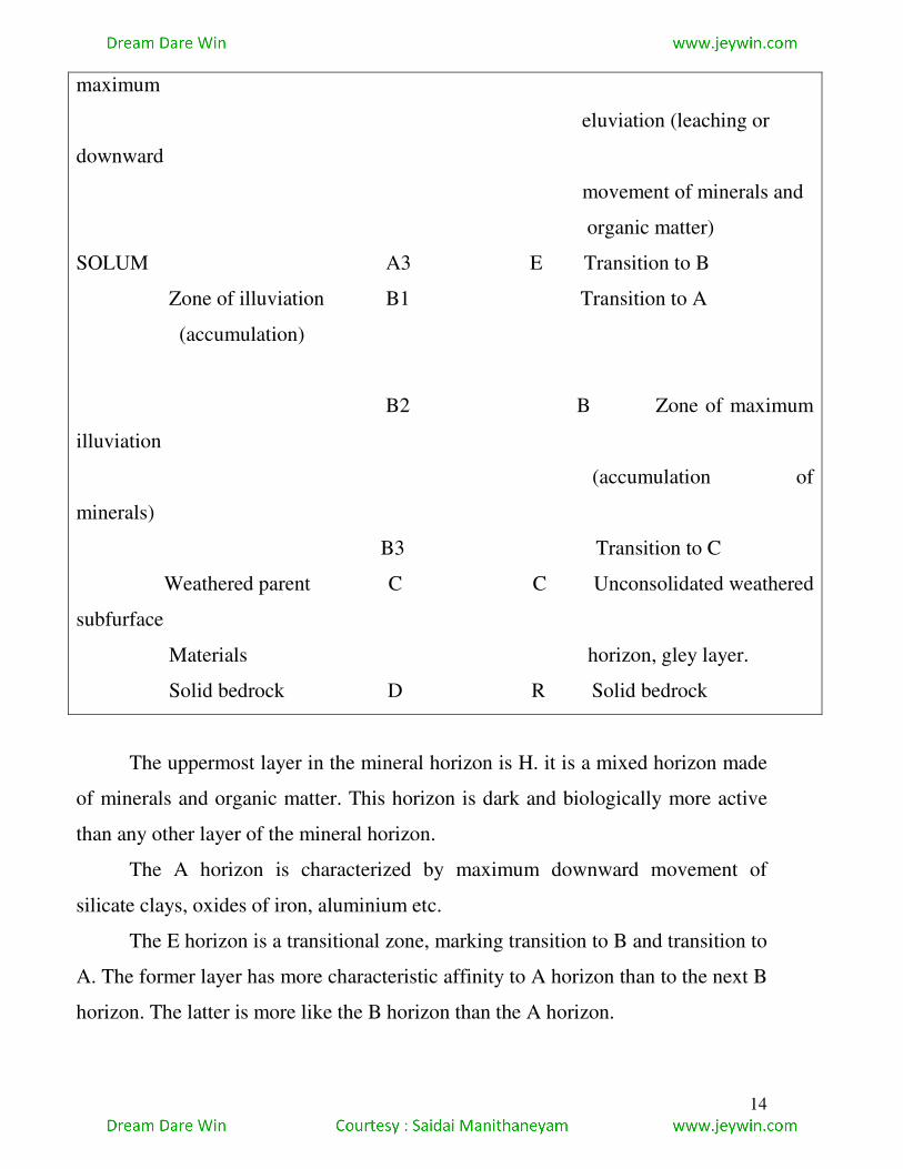
14
maximum
eluviation (leaching or
downward
movement of minerals and
organic matter)
SOLUM A3 E Transition to B
Zone of illuviation B1 Transition to A
(accumulation)
B2 B Zone of maximum
illuviation
(accumulation of
minerals)
B3 Transition to C
Weathered parent C C Unconsolidated weathered
subfurface
Materials horizon, gley layer.
Solid bedrock D R Solid bedrock
The uppermost layer in the mineral horizon is H. it is a mixed horizon made
of minerals and organic matter. This horizon is dark and biologically more active
than any other layer of the mineral horizon.
The A horizon is characterized by maximum downward movement of
silicate clays, oxides of iron, aluminium etc.
The E horizon is a transitional zone, marking transition to B and transition to
A. The former layer has more characteristic affinity to A horizon than to the next B
horizon. The latter is more like the B horizon than the A horizon.
15
The B horizon is a zone of maximum accumulation of silicate clay minerals
or sesquidoxides and organic matter.
The C horizon has unconsolidated weathered parent rock materials, also
known as regoliths. This layer is also called subsurface horizon and gley horizon. It
resembles the structure and composition of basal parent rock.
The R horizon is made of unconsolidated hard parent rock.
CHARACTERISTIC FEATURES
The characteristic features of a soil profile may be described as follows
With increasing depth, the organic matter decreases along with a sharp
decrease in the number of living organisms.
With increasing depth, the level of soil aeration decreases.
The number and variety of parent materials increase with descent.
No definite trend has been observed with regard to soil water and depth of
soil because of the fluctuation of soil water. Such fluctuations occur
due to the position and movement of groundwater, the frequency and
volume of rainfall, and the capacity of different horizons of the soil
profile to absorb water.
The soil surface has a thin veneer of leaf litter, crop residues and fresh or
partly decomposed organic matter (O horizon). The A horizon or topsoil lies just
beneath the O horizon and is composed of several minerals and organic material.
The thickness of the A horizon varies from several meters in the prairie-region to
zero in deserts. Most of the plants spread roots and derive their food from this
layer. The surface or the A horizon often blends into the E horizon which is subject
to leaching. The subsurface horizon or subsoil (the B horizon) has little organic
matter but greater concentration of minerals. Soluble compounds and clay particles
are washed downward from the upper layers and deposited in the B horizon.
(Sometimes subsoil particles are cemented together to form an impervious layer
called hardpan. Hardpans prevent the growth of plant roots and water from
16
escaping downward.) The subsoil is followed by the C horizon or the parent
material. The layer is made of comparatively undecomposed minerals and
unweathered rock particles with little organic material. In the USA about 70 per
cent of the existing horizon material was transported to its present site by natural
agents like glaciers, wind and water and has no direct relation to the bedrock
placed below it.
FACTORS INFLUMENCING SOIL PROFILE
Water movement in the soil affects the soil profile. When evaporation
cannot equal the rainfalls, excess water moves downwards in the soil, mineral
matter being removed from the top layer in the process. This matter settles in the B
horizon, at times creating a hardpan and, thus, leading to poor drainage. The soil in
such a case is said to be leached. Podozls in cold wet regions and laterites in hot
wet regions are produced by leaching.
There is little organic matter in the soil water of humid tropical regions, and
such water is not able to dissolve iron and aluminium hydroxides. Most of the
other minerals dissolve and are carried in solution to be deposited in the B horizon.
In course of time, a soil composed mainly of iron and aluminium compounds may
be formed; this is laterite soil. (Laterites may form from any kind of rock.)
An upwards movement of water takes place in the soils of hot desert or
semi-arid regions. As a result, mineral matter is deposited in the A horizon.
Significant saltpeter deposits have been formed n this way.
SOIL DEGRADATION AND ITS CONSERVATION
Soil constitutes a complex mixture of weathered minerals derived from
rocks, partly decomposed organic matter and a host of flora and fauna. Soil may be
considered as an ecosystem by itself. The degradation of soil is categorized into
four types.
i. Light Topsoil is removed. Some rills and gullies appear and about 70 per
cent of vegetation survives.
17
ii. Moderate Topsoil is completely ren Soil loses its capacity to absorb
and retain Nutrient depletion takes place along with creased toxification. The
percentage of vegetation hovers between 30 to 70 per cent.
iii. Severe Gullies become deeper and frequent. Nutrients deplete
severely, crops fer. Natural vegetation is reduced to less the 30 per cent.
iv. Extreme Land becomes devoid of vegetation. Land restoration is not
possible.
Thus, land degradation may be defined the basis of biological productivity
and the humus expectations about the land. Generally, land considered to be
degraded when the soil impoverished or eroded, water dries up or ge
contaminated, natural vegetation decreases, bio mass production
deteriorates, resulting in loss biodiversity.
Types of soil erosion
Soil erosion may be divided into four major types : (i) wind erosion, (ii)
sheet erosion, (iii) rill erosion, and (iv) gully erosion.
WIND EROSION
Involves the actual removal of dry and unconsolidated material by the
transporting agents of wind. The effect of wind erosion is mostly felt in the desert
regions of the world. Small particles of up to 0.05 mm are transported in
suspension; medium –sized particles of 0.05/20 mm are transported by slatation;
and larger materials move by creeping. Wind deflation in arid regions leads to
excavation of wide shallow basis known as deflation hollows or blow outs.
Sometimes, the desert floor is lowered to the level of groundwater. Often, the
water-table is found to be lower than the sea level. Such depressions are called
oases. Examples are the pans of South Africa and the Kalahari and the Tsaidam
Swamp in the Mongolian desert. Desert blown away by wind, and pebbles and
boulders are left behind as lag deposits.
TYPES AND CAUSES
18
Soil breaks down into finer particles when raindrops strike against the bare
ground surface. Erosion is accelerated as the kinetic energy is greater in the
absence of any kind of interception barrier like vegetation cover. The process is
known as splash erosion. Splash erosion causes resettling of up thrown soil
particles in the uppermost horizon of the soil profile which causes plugging and
sealing of larger pore spaces. Thus, an impervious thin layer is formed that
prevents water infiltration. During heavy rains, the surface runoff carries away soil
particles: this is known as entrainment sheet erosion or rain wash occurs as the soil
is eroded in thin layers. Heavy precipitation along with rainstorms transformers
sheet flow into linear flow called rills and the resultant erosion produced by rills is
known as rill erosion or rilling. During rill erosion several interconnected rills
merge to form shoestring rills. If rills are not destroyed by farming practices, they
enlarge and deepen to form gullies. Erosion caused by both rills and gullies is
known as rill and ravine erosion which is the most destructive form of soil erosion.
It often leads to the formation of badland topography. Soil erosion caused by
splash erosion and sheet erosion in areas located between two rills is known as
inter-rill erosion. Soil erosion between two gullies is known as inter-gully erosion.
Soil erosion also takes place by the movement of debris when loose
materials as produce of weathering of bedrock slide down the slop. The process is
called mass movement. In the absence of running water, mass wasting occurs,
resulting in ‘slop collapse’ or ‘slop failure’. Mass wasting occurs in various forms,
some of which are slow and continuous over a long duration of time, and others are
sudden and catastrophic. The movement mainly occurs due to gravitation. Repid
downward movements may occur by some natural or artificial factors such as
sudden concentrated snow-melt, an earth quake, unsustainable mining, collapse of
a dam deforestation on hill-slopes, wrong methods cultivation on hill slopes, the
burrowing of animals the vibrations produced by passing trains, helicopters etc.,
the passage of grazing stock or humans and so on. Creep is an indiscernible
19
movement of soil which is reflected by tilted fences, posts or trees. It produces a
stepped slope called teracettes.
FACTORS RESPONSIBLE FOR SOIL EROSION
The major factors responsible for soil erosion are discussed in brief.
(1) CLIMATE
Rainfall, temperature and wind influence precipitation significantly. Rainfall
of high intensity and long duration causes heavy erosion of soil. According to the
Food and Agricultural Organisation (FAO), climate factors like volume, intensity,
energy and distribution of rainfall and changes in temperature are important
determining factors. The momentum of falling raindrops, also called kinetic energy
of rain of rainfall energy, has a very close relation with the nature of soil erosion.
Temperature has an indirect influence on the nature and rate of soil erosion.
Alternate wet and dry conditions of soils result in hydration and dehydration of the
thin veneer of soil. This leads to expansion of soil particles resulting in cracks
which, if filled with water during the nest rains, cause removal of soil. This process
is operative in tropical and subtropical climatic regions. In arid and semi-arid
areas, wind is an important erosive agent, especially during summer in the regions
of monsoon climate and in the dry season of temperate climate regions. Wind can
deflect raindrops and minimise thekinetic energy of raindrops.
2. TOPOGRAPHIC FACTORS
These include relative relief, gradient, slop aspects, etc. The flow velocity
and kinetic energy of surface runoff increases in steep gradients. This accelerates
soil erosion. Studies reveal that a longer length of slop causes greater erosion than
slopes of shorter length.
3. LITHOLOGICAL FACTOR
20
Rock types and their physical and chemical properties also influence
erosion. However, this factor is more closely related to geological erosion of
geomaterials rather than to soil erosion.
4. NATURAL VEGETATION
Vegetation is a dominant controlling factor because (i) vegetation intercepts
rainfall and thus protects the ground surface from the direct impact of raindrops,
(ii) vegetation retards the speed with which rainwater infiltrates and reaches the
ground surface, (iii) the plant stems act as obstructions and decrease the velocity of
surface runoff, (iv) the roots of plants decrease the rate of detachment and
transportation of soil particles, (v) soil strength, porosity and granulation increase
due to the impact of roots, (vi) soil is insulated from high and low temperatures, so
cracks are not developed, and (vii) vegetation slows down wind speed, and this
reduces soil erosion.
5. SOIL
The erodibility of soil is related to its physical and chemical characteristics
like particle size, distribution, humus content, structure, porosity, root content,
strength, aggregate ability, etc., and management practices viz., land and crop
management. The FAO has listed major factors like detachability, transportability
and molecular attraction of soil particles, depth and moisture retaining capacity of
the soil as important factors influencing soil erosion.
6. ANTHROPOGENIC FACTOR
The human factor is the most important one, as the muli-faceted activities of
human beings change and modify the natural factors controlling soil loss and soil
erosion. The human activities controlling soil erosion are categorised into three
groups, viz., (i) land use changes involving destruction of forest and grassland for
expansion of agricultural land, industrialisation and urbanization, mining and
constructional purposes such as rail, road, dams etc., (ii) farm practice changes
involving more intense application of wheeled traffic, i.e., tractors, harvesters etc.,
21
frequent changes in the nature of farming, for example a shift from crop cultivation
to orchard farming; and (iii) management measures encompassing both crop
management and land management.
The modification of natural factors affecting soil erosion takes place in the
following ways; (i) Climate is modified by the removal of forests and grasslands,
thus accelerating soil erosion.
Topograpy is modified by terrace construction on mountain slopes or by
quarrying and mining, construction, of roads, canals, etc. Such
construction activities rivers.
Deforestation, cultivation, increased use of artificial fertilizers, etc. are
responsible for charges in the physical and chemical properties of soils.
Devegetation causes changes in content of humus in the soils accompanied
by changes in the physical and chemical properties of soil. Heavy use of
machineries causes cohesion and compaction of soil surface. It reduces
rainwater infiltration and enhances surface runoff.
(iv) Soil erosion is also caused by over-grazing by cattle, sheep and goats. Even
the properties of soils are greatly modified through the soil being trampled by
animals.
It is, thus, obvious that human activities cause a far greater damage to soil
than do natural factors.
GEOGRAPHICAL DISTRIBUTION OF SOIL
DEGRADATION
Some activities aruge that human activities cause more than 50 per cent of
the total erosion. However, man-induced erosion is most dominat in monsoon and
tropical arid and semi-arid regions. Even in the Mediterranean regions and
temperate grasslands, rampant cutting of trees has accelerated the rate of erosion.
The dimensions of soil erosion can be clearly understood from the fact that the
22
rivers all over the world transport about 40,000 cubic km of water as surface
runoff. In the USA, the average rate of soil erosion is about 30 tonnes per hectares
per annum. The UNESCO report, Nature and Resources, 1983 reveals that soil
erosion during the constructional phases in the urban areas is 20,000 to 40,000
times more than those in virgin natural areas. In central china, the rate of soil
erosion in about 34,000 tonnes per square km per annum. The UNESCO studies in
selected Africa countries suggest that the rate of erosion is only 0.9 tonne/hectare
p.a. in dense forest regions, whereas erosion is 320 times greater under crop cover
and it increases to 768 times under bare reported from grassland biomass of
temperature climate regions, viz., the steppe of Central Asia, the prairies of Canada
and the USA, the pampas of South America, veld of Australia and the downs of
Australia. The monsoon climate regions of Asia and, particularly, India experience
serve deforestation and overgrazing which leads to heavy loss of soil cover.
Approximately 37,00,000 hectares of farm lands have been affected by rill and
gully erosion. This type of erosion has assumed alarming dimensions in Uttar
Pradesh (12,30,000 hectares, Madhya Pradesh (6,83,000 hectares), Rajasthan
(4,52,000 hectares), Gujarat (4,00,000 hectares), Bihar (6,00,000 hectares), Wes
Bengal (1,04,000 hectares), Punjab (1,20,00 hectares).
SOIL CONSERVATION MEASURES
The conservation and restoration of land is necessary to protect land for
agriculture with a view to augmenting food production for the future. Conservation
measures must therefore fulfil the following objectives:
protection of the surface from the impact of raindrops,
increase in rainwater infiltration,
decrease in the volume and velocity of surface runoff,
enhancement in soil resistance to erosion by judicious modification of the
physical and chemical properties of soil resource.
The soil conservation measures are mainly of two types:

23
(a) crop management, and
(b) providing mechanical protection and soil conservation devices and practices.
Before initiating soil conservation measures, some steps should be followed:
(i) extensive survey of effected areas,
ii) classification of agricultural and forest lands on the basis of land capabilities,
(iii) identification of areas affected by low, moderate and serve soil erosion, and
(iv) enlisting the prime priorities of soil conservation and land reclamation.
The two main measures of soil conservation are discussed
below.
1. CROP MANAGEMENT
Proper crop management decreases both the amount of exposed surface area
and the duration of exposure of surface area to the negative impact of raindrops.
There are several measures of crop management.
Proper selection of crops reduces surface exposure to precipitation, resulting
in reduced loss of soil. For example, the previous practice of maintaining fallow
lands after the harvesting of rabi crops during the rainy season caused an immense
loss of valuable top soils. But after the initiation of Green Revolution in India, such
practices have been, generally, abandoned. The fallow lands have been converted
into lands growing paddy and leguminous crops. Such crop management
techniques have effectively reduced soil erosion.
Such crops should be selected that can cover maximum area and restore the
soil particles. however, a complete changeover to a new crop system may not
demand, commercial value, individual bias, calorific value, irrigation requirements
etc.,
Crops should so sowed as to ensure that the surface areas do not remain bare
for long durations. In Rhodesia, for example, methods like early plantation of
tobacco have reduced soil degradation by almost 50 per cent.
24
Agriculture practices like intercropping and mixed cropping are effective in
soil conversation. Such techniques are followed in India during the Kharif season,
when maize, leguminous crops, arhar and millet are raised together.
Techniques like stubble mulching, in which the roots, stems and leaves are
left over in the agricultural fields after harvesting, help to conserve soil. Trash
farming is a similar technique where chopped crop residue are spread and
ploughed in order to produce a better tilth in the soil.
Application of chemical fertilizers can enhance soil fertility. But this
technique is not free from negative effects like decrease in the content of organic
matters in the soils. As an alternative, practices like organic farming, i.e.,
maintaining fertility of the soil by raising leguminous crops, are gradually
becoming popular.
Lands affected by rill and gully erosion should be brought under mechanical
conservation techniques. During the process, no cultivation and grazing should be
allowed.
Extensive reforestation and reforestation and afforestation have the potential
of preventing erosion, particularly in mountainous areas.
2. MECHANICAL SOIL PROTECTION TECHNIQUES
Ploughing, hoeing, cultivation etc., are mechanical soil protection techniques
and are of use especially over slopes. They minimize overland flow, enhance
rainwater infiltration and reduce the velocity of surface flow. The major techniques
are discussed below :
(i) Contour Farming refers to cultivation practices transverse to the slope
gradient. Surface flow is reduced as each furrow acts as a temporary dam, the
system allows infiltration of rainwater, reduces formation of channels, rills and
gullies, and cultivators can hold water.
(ii) Tied –ridging is mainly practiced in East Africa. The cultivable land is
ploughed transverse to the slop while ridges are made parallel to the slop. So, the
25
agricultural field is segregated by many smaller basins which check overland flow
and allow rainwater to infiltrate. In the USA, a similar technique is called Basin
listing.
(iii) Criss-cross ploughed is practiced in the valleys of rivers. In India, for
example, slops in valleys are cultivated parallel i.e., transverse to the main channel
during the rabi season. The slopes are never irrigated, rather dried up soils receive
the first summer shower and are slumped into the main river by overland flow.
(iv) Contour bunding or terracing involves the construction of level-floored
benches on general slopes bordered by earthen embankments in order to obstruct
water flow down the slope. This technique is popular in South Asia and South
Africa, where steep slopes are subjected to heavy erosion, particularly, during
heavy rainstorms. In India, terrace cultivation is practiced in the Himalayas, the
Western Ghats and the North-eastern hilly regions.
(v) Prevention of gully erosion may be achieved by building a series of
check dams, and trapping silts behind such dams. These steps would be to reduce
the gradient will be reduced by an increased sedimentation. Other steps would be
to reduce the gradient of walls and heads of gullies, planting grasses, vines, bushes
to stabilise the walls and heads, plugging the gully-heads with stone-filled iron nets
so that head-cut advancement can be checked.
BIOTIC SUCCESSIONS
Biotic communities are not static, they change through time. This change
can be understood on several levels. The simplest is the growth, interaction and
death of individual organisms as they pass through their life-cycles, affected by the
cycles of seasons and other natural phenomena. But there are other levels of
community change that act over longer time spans and that account for much larger
community composition and structure. These include biotic succession and
community evolution.
26
As a lake fills with silt, it changes gradually from a deep to a shallow lake or
pond, then to a marsh, and beyond this in some cases, to a dryland forest (Fig.3.4).
When a cropfield is deserted or a forest is severely burnt over, it is just like a plot
of bare ground and a series of plant communities grow there and replace one
another-first annual weeds, then perennial weeds and grasses, then shrubs, and
trees until a forest ends the development (Fig.3.4)
Such an orderly and progressive replacement of one community called the
‘climax community’, occupies the area, is called ecosystem development or biotic
succession.
PARAMETERS OF A BIOTIC SUCCESSION
It is an orderly process of community development that involves changes in
species structure and community process with time. It is reasonably
directional and, therefore, predicable.
It results from modification of the physical environment by the community; that
is, succession is community-controlled even though the physical
environment determines the patern and the rate of change and often sets
limits as to how far development can go,
It culminates in stabilised eco-system in which maximum biomass and
symbiotic function between organisms are maintained per unit of available
energy flow.
With succession, the following changes occur
diversity of species increases
production per biomass decreases
energy flow decreases
new habitat niches are created
climax or stable community controls or becomes a buffer against the physical
forces, such as, temperature, moisture, light, wind, etc.

27
The first organisms to become established in an eco-system, undergoing
succession, are known as pioneers. The stable community that ends the succession
is termed the climax community. The whole series of communities which are
involved in the ecological succession in a given area, for instance, from grass to
shrub to forest, and which terminates in a final stable climax community, is called
a sere and seral stage. Each seral state is a community, although temporary, with its
own characteristics and it may remain for a very short time or for many years.
PRIMARY AND SECONDARY SUCCESSIONS
The successions may be of two types, in any of the basic environments such
as terrestrical, fresh –water or marine.
1. PRIMARY SUCCESSION
It is the process of species colonization and replacement on sites not
occupied previously by any other community, such as sand beach, sand dune, fresh
lava flows, volcanic ash plans, etc. The sere involved in primary succession is
called presere. Initially, only those species which are resistant to extreme
conditions flourish and add to the humus. Thus ground is prepared for higher order
species with broad foliage. Initial species are called the pioneer communities
(lichens on bare rocks, for instance). Colonisation of beaches can be cited as an
example of a primary succession.
S and Beach
Beach Grass
Woody Shrubs
Pine Trees

28
Dry Oak
Moist Forest
Beach Maple Forest ComplEX
The bog successions of Canada are an example of a primary succession.
2. SECONDARY SUCCESSION
It is a process of change that occurs on sites previously occupied by well-
developed communities, for instance, an old field succession where an abandoned
field acts as the site:
Bare Field
Grassland
Pine Shrubs
Pine Forest
Oak Forest Climax
Secondary succession is more repid than primary. The sere involved in secondary
succession is called subsere.
STAGES INVOLVED IN BIOTIC SUCCESSION
The complete process of primary ecological succession involves the
following sequential steps.
29
1. NUDATION
The process of succession beings with the formation of a bare area or
nudation which could be due to volcanic eruption, landslide, flooding, erosion,
deposition, fire, distance or some other catastrophic agency. New lifeless bare
areas are also created by human activity, for instance, walls, quarries, burning,
digging, flooding large land areas under reservoirs.
2. INVASION
The next stage is invasion or the arrival of the reproductive bodies of various
organisms and their settlement in the new or bare area. The plants are the first
invaders (pioneers) in any area because the animals depend on them for food.
3. COMPETITION AND INTERACTION
As the number of individuals of species increases by multiplication, the
competition for space and nutrition beings-within different individuals of the same
species (intra-specific competition) and between two or more species (inter-
specific competition). These species, in turn, interact with the environment, and the
exchange is a two-way process-the environment gets modified and different
species also modify their behaviour. Increased availability of food allows various
kinds of animals to join the community and the resulting interactions further
modify the environment, thus paving the way for fresh invasions by other species
of plants and animals and continuing the process of succession.
4. STABILISATION OR CLIMAX
Eventually a stage is reached when the final terminal community becomes
more or less stabilized for a comparatively long period of time and it can maintain
itself in the equilibrium or steady state with the climate of that area. This terminal
community is characterized by an equilibrium between gross primary production
and total respiration, between the energy captured from sunlight and energy
released by decomposition, between the intake of nutrients and the return of
nutrients by litter fall. It has a wide diversity of species, a well developed spatial
30
structure, and complex food chains; and its living biomass is in a steady state. This
final stable community of the state. This final stable community of the sere is the
climax community, and the vegetation supporting it is the climax vegetation.
CONTINUUM CONCEPT
According to this concept, the vegetation undergoes gradual and continuous
changes, and cannot be differentiated into distinct communities.
MAJOR BIOTIC REGIONS OF THE WORLD (with special reference to
ecological aspects of savanna and monsoon forest biomes)
To analyse the worldwide distribution of vegetation and to explain its
variations with latitude, continental position and altitude, the land areas of earth
can be divided into four major biotic regions of biomes. This regionalisation is
done on the basis of the following parameters.
Description of vegetation in terms of its structure, and the organisation of
vegetation into plant assemblages of various orders of magnitudes
(biome/biochore-formation class association-community).
Climate types.
Pedogenic regimes.
Soil moisture regimes
Major biotic regions
In describing the four great biomes, emphasis is placed on the vast range of
climates spanned by each. Essentially, the biomes are determined by the degree to
which moisture is available to plants in a scale ranging from abundant (forest
biome) to almost none (desert biome). But, within each biome, conditions of
temperature are vastly different from low to high latitudes and from low to high
altitudes. Consequently, there is a need to subdivide each biome into a number of
formation classes. The biome classification system, normally used, follows, the
works of Pierre Dansereau and is based on principles developed by Schimper and
Rubel.
31
1. FOREST BIOME
A forest is defined as a plant formation consisting of trees growing close
together and forming a layer of foliage that largely shades the ground. Forests
often show stratification with more than one layer. Shading of the ground gives
distinctly different microclimate than would be found over open ground. Forests
require a relatively large annual precipitation can be stated because the
effectiveness of the precipitation, and this in turn depends on air temperature and
humidity. Consequently, the forest biome spans a great climate range, from wet
equatorial to cold subarctic. The important formation classes so formed include
(i) Equatorial Rainforest,
(ii) Tropical Rainforest,
(iii) Temperate Rainforest,
(iv) Monsoon Forest.
The equatorial rainforest extends over the Amazon lowland of South
America, Congo lowland of Africa, a coastal zone extending westward from
Nigeria to Guinea and in southeast Asia from Sumatra on the west to the islands of
the western Pacific on the east. These forests are characterised by two or three
layered crowns of trees, numerous epiphytes, a wide diversity of species, little
vegetation growth on the ground due to lack of sunshine there. Repid consumption
of dead plant matter by bacterial action results in the absence of humus upon the
soil surface and within the soil profile. These conditions are typical of the
pedogenic process of laterisation with which the rainforest is identified. The
coastal vegetation in areas of equatorial rainforest is highly specialized-in the from
of mangrove swamp forest.
The tropical rainforest areas include southern and south-eastern Asia : in
Western Ghats of India, coastal Myanmar, coastal Vietnam and the Philippines,
eastern Brazilian coast, the Madgascar coast and north-eastern Australia. In many
respects, these forests are structurally similar to the equatorial rainforest but have
32
distinct differences imposed upon them by their location-which is on windward
coasts. The cooler temperatures, coinciding approximately with the period of
reduced rainfall, impose some stress upon the plants. As a result, there are fewer
species, but the epiphytes are abundant.
The temperate rainforest covers south-eastern USA, southern Japan,
southern Brazil, Uruguay and northern Argentina, south-eastern South Africa,
European highland from France in the west to Slovakia in the east, eastern Chinese
coast, south-eastern coast of Australia and New Zealand. These forests are
characterised by a well-developed lower stratum of vegetation and abundant
epiphytes. The diversity of species is further reduced.
The monsoon forest presents a more open tree growth than the equatorial
and tropical rainforests. The most important feature of the monsoon forest is the
deciduous nature of most plant regime are discussed in detail, later in this chapter.)
2. SAVANNA BIOME
This biotic region consists of a combination of tress and grassland in various
proportions. The appearance of the vegetation can be described as park-like, with
tress spaced singly or in small groups and surrounded by, or interspersed with,
surfaces covered by grasses, or by some other plant life form, such as shrubs or
annuals in a low layer. The savanna biome indicates a climate of limited total
annual precipitation with an uneven distribution throughout the year.
GRASSLAND BIOME
This biotic region consists of an upland vegetation largely or entirely of
herbs, which may include grasses, grasslike plants and forbs (broadleaf herbs). The
degree of coverage may range from continuous to discontinuous and there may be
stratification. The grassland biome may include tress in the more moist habitats of
valley floors and along stream courses where ground water is available. The
grassland biome is typical of a climate which has small total annual precipitation,
but otherwise, ranging from extreme heat to extreme cold. The important formation
33
classes of grasslands, are-1 prairies, 2.steppe, 3.pampas, 4.veld, 5.downland
Prairies are characteristic tall, deep rooted grasses of the interior North
American plains. The steppes cover a belt extending from Hungary in the west to
Mongolian and eastern Chinese plains in the east. Other important grassland areas
include pampas of South America, veld plateau of South Africa, northern and
central Africa and the downland in Australia. In this climate regime, the dominant
pedogenic process in calcification with salinisation in poorly drained areas. Soils
have excess of calcium carbonate and are rich in bases.
4. DESERT BIOME
The desert biome, associated with the climates of extreme aridity, has thinly
dispersed plants and hence a high percentage of bare ground exposed to direct
insolation and the forces of wind and water erosion or freeze-thaw action.
Although essentially treeless, the desert biome may have scattered woody plants.
Typically, however, the plants are small, e.g herbs, bryoids, lichens Because the
desert biome includes climates ranging from extremely hot tropical desert to
extremely cold arctic desert, a great range in plant communities and habitats is
spanned by the biome
ECOLOGICAL ASPECTS OF MONSOON FOREST
CLIMATE
The monsoon forest is a response to warm-humid tropical climate where a
soil –moisture surplus rainy season alternates with a long dry season. Such
conditions prevail over India, Myanmar, Thailand, Cambodia, Laos north
Australia, parts of Africa and southern central America. In these areas, rainfall
ranges between 100 cm and 200 cm for at least four months .
PEDOGENIC REGIME
The prevailing pedogenic regime of the monsoon forest areas is that of
laterisation. Despite the dry season, a substantial water surplus is developed during
the warm rainy season. Humus does not accumulate; leaching of bases and silica is
34
the dominant soil-forming process. Common soil-types are ultisols, oxisols and
alfisols.
VEGETATION
The monsoon forest regime is characterised by an open tree growth with
medium height (10 to 30 meters). Trees have massive trunks and thick bark.
Perhaps, the most important feature of the monsoon forest is the deciduous nature
of most trees. The shedding of leaves results from the stress of a long dry season
which occur at the time of low sun and cooler temperatures. Thus, the forest in the
dry season has deciduous forests of the middle latitudes. A representative example
of monsoon forest tree is the teak. Lianas and epiphytes are present, but they are
fewer and smaller as compared to tropical rainforest, e.g.bamboo in teakwood
forest. The monsoon forest regime is characterised by a wide variety of trees-there
may be 30 to 40 species in a small track.
ECOLOGICAL ASPECTS OF SAVANNA
CLIMATE
The savanna is a response to a wet-dry tropical climate regime in which the
sever drought period is one of relatively cooler temperature but which experiences
great heat just preceding the onset of the rains. These areas include the Pacific
coast of central America and highlands of northern South America, Brazilian
highlands, central and southern Africa, peninsular India, parts of Thailand and
northern Australia. Rainfall in these areas ranges between 100 and 150 cm.
PEDOGENIC REGIME
The pedogenic process most closely associated with tropical savanna is
laterisation, promoted by the high temperatures, associated with the rainy season.
However, laterisation gives way to calsification as the savanna is traced towards
higher latitudes where thornbush, and ultimately, steppe grasslands are
encountered.
VEGETATION
35
The savanna vegetation has a park-like appearance. The savanna vegetation
lies adjacent to that of the tropical rainforest biome. The tress are of medium
height, flat topped and umbrella shaped. There is not much variety of species, as
drought and fire-resistant varieties alone can survive. Species may be xerophytic or
the broad-leaf deciduous types. Occurrence of fire is common. Rainfall results in
greening of plants, hence savanna is also called raingreen. Towards the desert
biome, the plant type changes to widely scattered thorny species. The plant
varieties include elephant grass, flat topped acacia and baobab among others.
DEFORESTATION AND MEASURES OF
CONSERVATION
DEFORESTATION
Deforestation, as the term implies, is the removal of forests – their complete
clearance by cutting or burning.
For long now, human beings have cut down trees and cleared forests, for
fuel, and tp make space for agriculture, settlement and industry. But the effect was
not as disastrous as what deforestation now signifies; the process was slow and
allowed time for regeneration, so it did not have an adverse impact on the
environment. With the increase in population, the clearing of forests has been
speeded up, with disastrous effect.
In Europe much of the forests was cleared up to make way for agriculture in
early times. With the development of industry, more forests were destroyed to get
fuel (especially charcoal), and for constructional purposes. Uptil the end of the
nineteenth century, wood was the main material for ship-building; large tracts of
temperate hardwood forests were destroyed for this purpose. The railways claimed
more wood for their sleepers. Then came the destruction of trees to get wood –
cellulose – required for the paper and pulp industries. North America was witness
to rampant emploitation of forestresources, though it began later than in Enrope
and some parts of Asia. Forests in Chins have been steadily reduced over a long
36
period, by an ancient civilisation based on agriculture. Forests were, till very
recently, the chief source of fuel. Many developing countries today face the
problem of rapidly depleting forests due to the requirements of fuelwood and
agricultural space by a huge population.
Forests are not an inexhaustible resource if exploited in an unplanned
rapacious manner: they have no time to regenerate natrially. If too many trees are
felled, or if areas are clear – cut, the forest is unable to re-establish itself.
Moreover, if select species are cut down, leaving the rest of the forest intact, the
forest gets degraded: regeneration of the particular valuable species is prevented.
Some forests in north – western USA have been degraded because of the removal
of a large proportion of valuable Douglas firs.
Besides degradation, overcutting also leads to soil erosion, by gullying or
sheetwash, on the mountain slopes (and all the ills of such erosion). Landslides,
too, have been the consequence of deforestation on hill slopes.
Economically, too, deforestation has had a devastating effect-to the extent
that countries largely dependent on timber in their economy suddenly found there
were no more (or very few) trees to fell. This was specialy true for Britain during
the First World War. Later Thailand and Myanmar found their teak forests sadly
depleted and were forced to cut down the output of teak.
In the developing countries, forests are often depleted by shifting cultivators,
who burn mature forests to make way for growing crops. In earlier times, the
practice was not quite so damaging; indeed, the method was a carefully balanced
one, and did not damage the ecology, as the cleared plot was left alpne after a year
or two of cultivation, allowing forest regrowth over 10 to 15 years at least. But
with increasing
Most parts of the world have been affected by deforestation, though
some of the developed countries have witnessed an increased forest cover
during 1990-95. The rate of deforestation has been most rapid (during
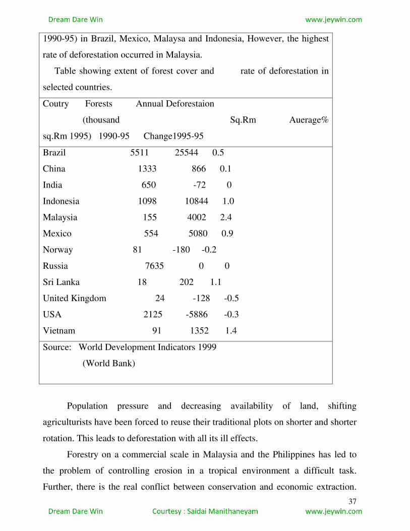
37
1990-95) in Brazil, Mexico, Malaysa and Indonesia, However, the highest
rate of deforestation occurred in Malaysia.
Table showing extent of forest cover and rate of deforestation in
selected countries.
Coutry Forests Annual Deforestaion
(thousand Sq.Rm Auerage%
sq.Rm 1995) 1990-95 Change1995-95
Brazil 5511 25544 0.5
China 1333 866 0.1
India 650 -72 0
Indonesia 1098 10844 1.0
Malaysia 155 4002 2.4
Mexico 554 5080 0.9
Norway 81 -180 -0.2
Russia 7635 0 0
Sri Lanka 18 202 1.1
United Kingdom 24 -128 -0.5
USA 2125 -5886 -0.3
Vietnam 91 1352 1.4
Source: World Development Indicators 1999
(World Bank)
Population pressure and decreasing availability of land, shifting
agriculturists have been forced to reuse their traditional plots on shorter and shorter
rotation. This leads to deforestation with all its ill effects.
Forestry on a commercial scale in Malaysia and the Philippines has led to
the problem of controlling erosion in a tropical environment a difficult task.
Further, there is the real conflict between conservation and economic extraction.
38
As Goh Cheng Leong and Gillian C. Morgan point our, “Economically, the best
place to build roads for the removal of timber in tropical areas is along the ridge
tops because the valleys are often steep, straight glaciated valleys of many
temperate areas. Unfortunately this positioning of the roads leads to greater
erosing than any other position, as it allows gullies to start forming right at the top
of the slopes. Such gullies may then extend right down the valley sides. Much
more rigorous conservation measures are needed in tropical than in temberate
forests, but if these were imposed, exploitation might be inhibited, with a
consequent reduction in valuable exports and local industrial development. To
make matters worse, little research has yet been done on erosional problems in
tropical regions and thus it is more difficult to know that conditions to impose on
timber operators.
Forest fires are another cause for the destruction of forests. These may be
naturally induced – by lightning strike or spontaneously created in hot dry weather;
or started by human agencies – fires, lit by shifting cultivators or by picknickers,
getting out of control, or trees catching fire form sparks from locomotives. Huge
tracts of forest are destroyed by such fires.
It was government intervention that finally brought a halt to mindless
exploitation of forests in the developed countries. In developing countries, though
legislation has been put in place to conserve forests, some intractable problems
remain: lack of communication, difficult terrain, remoteness of forest areas, low
awareness, and inadequate supervision. Poverty, too, plays its part: most people in
the developing countries still depend on timber for fuel, and as population
increases, the number of trees cut down also increases. Industrial users are often
unserupu
ARE FOREST FIRES ALL THAT BAD
Recent studies of the ecological role of fire in forests suggest that much of our
horror of fire and our attempts to suppress it may be misguided. Many biological
39
communities are fire – adapted and require periodic fires for regeneration. In the
western United States, for instance, dry montane forests originally were dominated
by big trees such as whose thick, fire-resistant bark and lack of branches close to
the ground protected them form frequent creeping ground fires. Historic accounts
describe these forests as open and parklike, with little underbrush, luxuriant grass
and abundant wildlife.
Eliminating fire from these forests has allowed shrubs and small trees to fill the
forest floor, crowding out grasses and forbs (herbs that are not grasses) . As woody
debris accumulates , the chances of a really big fire increase. Small trees act as
“fire ladders” to carry flames up into the crowns of forest giants. By preventing
low-intensity fires that once kept the forest open and free of fuel, we actually
threaten the trees we intend to protect.
Our attempts to put fires out often cause more ecological damage than the fires
themselves. Firefighters bulldoze fire-breaks through sensitive land-scapes such as
tindra or wetlands, leaving scars that last far longer than the effects of the fire.
Often the only thing that extinguishes a major fire is a change in the weather.
Source: Environmental Science by William P. Cunningham and Barbara
Woodworth Saigo.
Lous and laws are often broken with impunity in connivance with corrupt officials.
In brief, the major causes of deforestation in India as elsewhere may be
listed as:
Population increase The massive population increase has put tremendous
pressure on land all over the world, especially in the countries of South Asia.
Extension of agriculture As a direct result of increase in population, the
agricultural lands have been extending day by day leading to the cutting down of
forests.
Growth of industries Furniture, and paper and pulp industries require huge
amounts of timber every year. This has led to deforestation on an alarming level.
40
Industries require large land areas and, in the past, forest land was cleared for
setting up industries.
Incidence of poverty The widespread occurrence of poverty in most Asian
countries comples people to depend on fuelwood as the main source of energy.
Corrupt practices The problem of a corrupt nexus between forest officials
and poachers/mafia has degraded the general environment of forests and led to
deforestation.
Spread of tourism The mountains habe been favourite tourist destinations,
especially in the recent past. The growing pressure of tourism has caused an
effective loss of forests to allow for construction.
Forest fire Forest fires, whether due to anthropogenic or natural factors, have
caused loss of forest resources in different parts of the world including India for
thousands of years.
CONSERVATION AND MANAGEMENT OF FORESTS
In the developed countries, legislation and its strict implementation
combined with a growing awareness among the people of the importance of forests
have managed to retarse, deforestation. Many developing countries too have
understood the need to conserve forests-as, indeed, early civilizations did. There
are awys in which forestry problems can be solved.
(1) Afforestation and reforestation Trees could be planted on land, which
was formerly not under plant cover, to make a forest for commercial or other
purposes. This is affprestation. Land which had once been under forest but from
which trees have been removed could be replanted and turned back into forest
land. This is reforestation.
Germany has law that requires the replacement of every tree cut down by a
new tree. In other countries marginal areas under crops or for pasture have been
planted with trees. In some countries such as Finland incentives are given by the
government to framers for turning arable land into forest. The Tennessee valley in
the USA has a well-known programme by which formerly eroded or impoverished
41
land has been brought under forestation. In lands like Australia and New Zealand,
not traditionally endowed with natural forests, afforestation with quickgrowing
conifers has of the prairies have been planted with trees to check soil erosion. In
the Landes of south-western France, a sandy region, forestry has stabilized the
sand besides improving the economy of the region.
China, cut down most of its forest one thousand years ago and has suffered
centuries of erosion and terrible floods as a consequence. Recently, however a
massive reforestation campaign has been started. An average of 4.5 million ha per
year were replanted during the last decade. South korea also has had very
successfully forest restoration programmes. After losing nearly all its trees during
the civil war thirty years ago, the country is now about 70 per cent forested again.
In spite of being the word’s largest net importer of wood, Japan has
increased forest to approximately 68 per cent of its land area. Strict environmental
laws and constraints on the harvesting of local forests encourage imports so the
Japan’s forest are being preserved while it uses those of its trading partners.
Many reforestation projects involve large plantations of single-special,
single-use, intensive cropping called monoculture forestry. Although this produces
high profits, a dense, single- species stand encourages pest and disease infestations.
This type of management lends itself to mechanized clear-cut harvesting, which
saves money and labour but tends to leave soil exposed to erosion. Monocultures
eliminate habitat for may woodland species and often disrupt ecological processes
that keep forests healthy and productive. When profits from these forest plantation
go to absentee landlords or government agencies, local people have little incentive
to prevent fires or keep grazing animals out of newly planted areas. In some
countries, such the Philippines, Israel and EI Salvador, government reforestation
projects have been targets for destruction by anti-government forces, with
devastating environment impacts.
Promising alternative agroforestry plants are being promoted by
conservation and public organization such as the new forest fund and Oxfam.

42
These groups encourage people to pant community woodlots of fast-growing,
multipurpose trees such as Leucaena, Millions of seedlings have been planted in
hundreds of self-help projects n Asia, Africa and Latin America. Leucaena is a
legume, is a legume, so it fixes nitrogen and improves the soil, Its nutritious leaves
are good livestock fodder.
Community woodlots can be planted on wasteland or along roads or slopes
too steep to plough so they do not interfere with agriculture. They protect
watersheds, create windbreak and, if composed of mixed species, also provide
useful food and forest products such as fruits, nuts, mushrooms or materials for
handicrafts on a sustained-yield basis.
Afforestation and reforestation programmes need to be undertaken seriously
in developing countries as well. Many tropical countries are taking steps to protect
forests. Indonesia has announced plans to preserve 100.000 square kilometers,
one-tenth of its original forest. Zaire and Brazil each plan to protect 350.000 square
kilometers (about the size of Norway) in parks and forest preserves. Costa Rica has
one of the best plans for forest protection in the world. Attempts are being made
there to but only rehabilitate the land (make an area useful to humans), but also
restore the ecosystems to naturally occurring associations. One of the best known
of these projects is Den Janzen’s work restoring the dry tropical forest of
Guanacaste National Park.
People on the grassroots level also are working to protect and restore forests.
Refores-tation projects build community pride while also protecting the land.
India, for instance, has a long history of non-violent, passive resistance to protest
unfair government policies. During the 1970s, commercial loggers began large-
scale treefelling in the Garhwal region in the state of Uttar Pradesh in northern
India. Landslides and floods resulted from stripping the forest cover from the hills.
The firewood on which local people depended was destroyed, and the way of life
on the traditional forest culture was threatened. In a remarkable display of courage
and determination, the village women wrapped their arms around the trees to
43
protect them, sparking the Chepko Andolan (literally, movement to hugtrees).
They prevented logging on 12.000 square kilometers of sensitive watersheds in the
Alakanada basin.
II. Better harvesting practices Another forest management method is that
of improving cutting practices. One way is selective cutting I,e. only the mature or
weak trees are felled, and tere is a bether chance for forests to regenerate and
survive. In this ‘selection’, it is not one species which is selected to be cut down in
its entirety, thus leading to degradation. However, this method may be
uneconomical for large-scale industrial use. The alternative method is clear-
cutting: clearing all the trees from a marked area, but taking care to replant the area
with seedlings. In regions where forests are scientifically managed, trees are
farmed on a long-term system of rotation which ensure sustainable yield of timber.
This is being practiced by large pulp-milling companies, owning their own forests,
in Sweden, Finland and southern USA. In the absence of proper organization,
however, clear-cutting is bound to lead to deforestation and soil erosion, as pointed
out earlier.
Other harvest practices offer variations on, or substitutes to, clear-cutting,
Coppicing is used to encourage stump sprouts from species such as aspen, red oak,
beech or short-leaf pine and is usually accomplished by clear-cutting. In seed tree
harvesting, some mature trees (generally two to five trees per hectare) are left
standing to serve as a seed source in an otherwise clear-cut patch. Shelterwood
haruesting involves removing mature trees in a series of two or more cuts. This
encourages regeberation of wind- and sun-sen-sitive species such as spruce and fir.
Strip cutting entails harvesting all the trees in a narrow corridor.
III Reducing wastage Shortage of wood and conservation of forests can
both be met by reducing the wastage at industrial plants. Instead of wasting the
pulp unsuitable for paper manufacture, other end products may be devised from it
such as fibre-board for building purposes. Waste paper could be recycled. Trees
44
may also be used more intensively, i.e. for timber as well as other purposes such as
extraction of tannin, etc.
iv. Protection of forests Protecting forests from natural hazards such as
large-scale fires and pests needs to be undertaken with vigilance and diligence.
Scientific research into the causes and methods of overcoming such natural
destructive agents needs to be intensified if forests are to be saved, Overgrazing
should be strictly prevented in forest areas; cattle, sheep and goats destroy the
undergrowth and seed-lings, thus preventing the regeneration of forests.
Specifically speaking, forests can be Protected by demarcating regions and
types of forest growth and harvesting these in a planned manner.
Reserve forests may be protected areas such as sanctuaries, sacred groves,
biosphere reserves and national parks in different parts of a country. These
protected areas should have strict provisions for checking deforestation.
Limited production forests would be those regions at a height above 100
metres, where, fewer trees grow because of the reduced soil fertility. In such cases,
forest resources can be harvested in a rational and controlled manner in order to
save soil and trees.
Production forests should be cultivated on flat land and managed for high
production. A forest having its three storeys (viz., tall trees, smaller trees or shrubs,
ground cover of small shrubs or herbs) together with soil and microflora
constitutes a living and dynamic system, and it should be maintained as such be
good management system.
As a long-term measure, the rapid growth of population in the developing
countries should be checked. The increased pressure of population exerted on the
limited forest resource is causing soil erosion and rampant felling of trees for the
expansion of settlements.
Shifting cultivation should be checked. At the same time, tribals’s rights,
should be protected to enable them to actively participate in forest conservation.

45
The role of non-governmental organizations is important in this context. Social
forestry should be en-couraged.
The unholy nexus between corrupt officials and timber mafias should be
stopped at any cost for checking the rapid loss of forest cover. The recent surge of
environmental movements all over the world-a la Chipko Movement of India-is of
paramount importance in this context.
Nowadays, scientists in the US are adopting techniques such as data from
Global Position Satellites (GPS), Geographical Indormation System (GIS), remote
sensing etc. to access information on forest fires, loss of forests due to
anthropogenic activities, etc. These should help in taking timely action for forest
protection.
Strict implementation of laws cannot only check but reduce the rate of
deforestation.
Social Forestry
Social forestry or community-based forestry has the basic objective of
involving the local community in forestry, activities to promote growth of and
preserve trees. It refers to a collective management of under-utilised or unutilized
land to produce forest products to meet the needs of the local people, especially the
underprivileged or poor. Two main strands combine in the objectives of social
forestry: presser-vation of green cover as well economic benefits for the
participating community and the region.
The objectives of social forestry are
to fulfil the basic requirements such as fuel, fodder, small timber, supplementary
food and income from surplus forest products;
to provide employment opportunities and to increase family income
considerably for alleviating poverty;
to tap the dormant energies and skills of the villagers for therir own
development by enabling them to manage their own natural resources;
46
to popularise economic tree farming alongwith crop farming;
to integrate economic gains in the distribution of other benefits to the
socially and economically poor in a village;
to organise them in their struggle for socio-economic development;
to conserve soil and water and to maintain ecological balance by enhancing
biomass genceration;
to provide congenial environment to the trubals and to help them to preserve
their cultural identity as their life and culture is intimately related to forest;
to reduce encroachment on the existing forests;
to inculcate the value of village-level self-sufficiency and self-management
in the production as well as distribution of forest products with social justice;
to foster the spirit of cooperation and to encourage cooperative
enterprises;and
to form the villagers into a well-knit community and an effective functional
unit of society which can shape its own destiny.
Most social forestry programmes involve
1. farm forestry in which farmers are given incentives by the government
and encouraged to plant trees on their on their own farms;
2. Maintenance of public woodlots planted on roadsides and alsong rivers by
forest depart-ments to meet the needs of the community ;and
3. Maintenance of community woodlots which the local people themselves
plant and look after, the products to be sared by the community.
Social forestry, in order to succeed, must involve the beneficiary from the
planning to the consumption stage. It should use community land, and there should
a mixed production system, i.e., a variety of forest produce required by the
community should be available. The main-tenance, management and the end-use
should be in the hands of the community with minimal government intervention.
However, necessary inputs, training and incentives should be provided by the
government.

47
Trees and plant species selected for social forestry should conform to the
following criteria; trees should be fast growing, early maturing and yielding; they
should have multiple usages (for food, fodder, fuel, manures); the tree trunk should
be strong and stouct; the species should be suited to climate and soil of the place;
they should have dense foliage; they should possess the capacity to tolerate adverse
climate and soil conditions; they should be in early spring and not in summer; they
should not have prominent thorns; and their planting and care should be easy and
economical.
Trees can be grouped according to people’s requirements. For the selection
of trees, people should identify locally available species first and only then go for
exotic species. This principle should always be kept in mind before a species is
selected for social forestry.
Agroforestry
Agrogorestry is a modified, expanded version of social forestry.
“Agroforestry is a system of land use where woody perennials are deliaberately
used on the same land management units as annual agricultural crops and/or
animals, rather sequentially or simultaneously, with the aim of obtaining greater
outputs on a sustained basis,” Agroforestry, as the definition suggests, refers to an
old land practice where land is used for agriculture, forestry and animal husbandry
purposes at the same time.
The planting of trees may aid farmers since tree roots can bind soil and limit
soil erosion, deep-rooted trees can tap new nutrient sources, leguminous trees can
fix atmospheric nitrogen and improve soil fertility, leaf litter can addorganic
matter, and tree civer can moderate temperatures. In addition, trees may provide
food, fodder, firewood and timber.
The Food and Agricultural Organisation (FAO) has listed agri-silvicultural,
agri-pastoral and agri-silvi-pastoral systems as components of the agroforestry
system. The social/farm/agroforestry programmes cover massive afforestation
48
programmes. Every village/town/city is supposed to meet firewood, fodder and
small timber requirements by growing trees/shrubs in the land available in a
cooperative system.
Agroforestry can be of benefit to farmers by providing them with firewood,
timber and bamboo for building purposes, fodder, green manure and mulching
material, and additional income it they choose to sell any of the surplus products.
By making fule and fodder available, it also saves women from having to go long
distances to collect them otherwise. It is environmentally beneficial as the trees act
as wind-breaks, help in controlling soil erosion, increasing moisture conservation
and organic matter content of the soil.
Trees may be planted in uncultivable portions of the land, on the boundaries
(where their branches should be chopped so they grow straight upward), on bunds,
on the lower side of a catchment area, in water logging areas, in saline and alkali
soils, along with shade-loving plants such as cardamom, turmeric, coffee, tea,
black-pepper etc., and, of course, along roads, surroundings of farm houses, and at
appropriate gaps, on fodder fields.
Care must be taken to prune the trees so that excessive shade is
avoided. Hence,in agroforestry, fruit trees are best avoided. Timber trees, firewood
and fodder trees, bamboo and fibre trees are most suitable. Fruit trees, too, may be
grown if shade does not matter. Coconut and other palms are useful trees in
agroforestry as they provide several useful products all at once even as their
structure is suitable for the purpose.
Related Documents