OPERATIONS & MAINTENANCE MANUAL SAN FRANCISQUITO CREEK FLOOD REDUCTION, ECOSYSTEM RESTORATION, AND RECREATION PROJECT San Francisco Bay to Highway 101 April 4, 2016

Welcome message from author
This document is posted to help you gain knowledge. Please leave a comment to let me know what you think about it! Share it to your friends and learn new things together.
Transcript
OPERATIONS & MAINTENANCE MANUAL
SAN FRANCISQUITO CREEK FLOOD REDUCTION, ECOSYSTEM RESTORATION, AND
RECREATION PROJECT San Francisco Bay to Highway 101
April 4, 2016
ii April 4, 2016
ACKNOWLEDGEMENTS
This manual was prepared through a collaboration of the San Francisquito Creek Joint Powers Authority (JPA). The members of the JPA are the Cities of East Palo Alto, Menlo Park and Palo Alto; the County of San Mateo; and the Santa Clara Valley Water District.
iii April 4, 2016
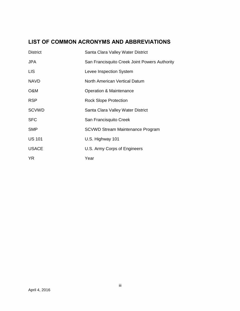
LIST OF COMMON ACRONYMS AND ABBREVIATIONS
District Santa Clara Valley Water District
JPA San Francisquito Creek Joint Powers Authority
LIS Levee Inspection System
NAVD North American Vertical Datum
O&M Operation & Maintenance
RSP Rock Slope Protection
SCVWD Santa Clara Valley Water District
SFC San Francisquito Creek
SMP SCVWD Stream Maintenance Program
US 101 U.S. Highway 101
USACE U.S. Army Corps of Engineers
YR Year
iv April 4, 2016
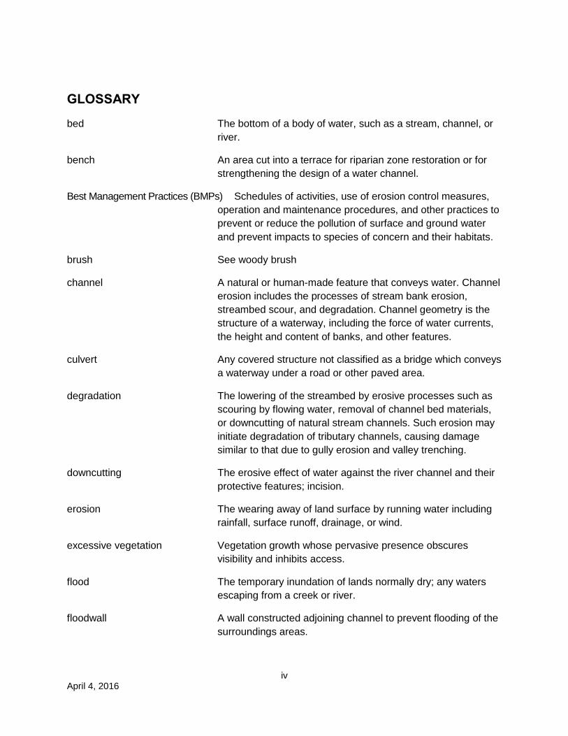
GLOSSARY
bed The bottom of a body of water, such as a stream, channel, or river.
bench An area cut into a terrace for riparian zone restoration or for strengthening the design of a water channel.
Best Management Practices (BMPs) Schedules of activities, use of erosion control measures, operation and maintenance procedures, and other practices to prevent or reduce the pollution of surface and ground water and prevent impacts to species of concern and their habitats.
brush See woody brush
channel A natural or human-made feature that conveys water. Channel erosion includes the processes of stream bank erosion, streambed scour, and degradation. Channel geometry is the structure of a waterway, including the force of water currents, the height and content of banks, and other features.
culvert Any covered structure not classified as a bridge which conveys a waterway under a road or other paved area.
degradation The lowering of the streambed by erosive processes such as scouring by flowing water, removal of channel bed materials, or downcutting of natural stream channels. Such erosion may initiate degradation of tributary channels, causing damage similar to that due to gully erosion and valley trenching.
downcutting The erosive effect of water against the river channel and their protective features; incision.
erosion The wearing away of land surface by running water including rainfall, surface runoff, drainage, or wind.
excessive vegetation Vegetation growth whose pervasive presence obscures visibility and inhibits access.
flood The temporary inundation of lands normally dry; any waters escaping from a creek or river.
floodwall A wall constructed adjoining channel to prevent flooding of the surroundings areas.
v April 4, 2016
freeboard Vertical distance between the top of an embankment adjoining a channel and the water level in the channel.
levee An embankment constructed to prevent a river or stream from flooding adjacent lands.
low-flow channel The natural stream that carries the more frequent, periodic stream flows.
mitigation An action taken to moderate, reduce, alleviate the impacts of a proposed activity by (a) avoiding the impact by not taking a certain action or parts of an action; (b) minimizing impacts by limiting the degree or magnitude of the action and its implementation; (c) rectifying the impact by repairing, rehabilitating, or restoring the affected environment; (d) reducing or eliminating the impact over time by preservation and maintenance operations during the life of the action; (e) compensating for the impact by replacing or providing substitute resources or environments.
reach The smallest subdivision of a drainage system consisting of a uniform length of channel or a discrete portion of a channel.
revetment A facing of stones, sandbags, etc., to protect a wall, embankment, or earthworks
riparian Pertaining to the banks of a river, stream, waterway, or other, typically, flowing body of water, as well as to plant and animal communities along such bodies of water.
rock slope protection Loose rock or concrete of varying size, typically brought to a site. Used to protect channel banks and drainage outlets from scouring forces.
scour The clearing and digging action of flowing water, especially the downward erosion caused by stream water in removing material (e.g., soil, rocks) from a channel bed or bank or around in-channel structures.
sediment Solid material, both mineral and organic, that is carried by the water and settles to the bottom of channels, bypass culverts, drain pipes, or behind dams.
sedimentation The process by which rock and organic materials settle out of water.
spalling To break into pieces, esp. concrete.
vi April 4, 2016
station A station is a standard channel location system used by the SCVWD that gives the distance from the downstream limit of jurisdiction (usually San Francisco Bay), or, for a tributary creek, from where it branches off of the main channel. Distance is measured in feet, with each "station" representing 100 feet for the Lower San Francisquito Creek Project levees. For example, station 26+00 would be a point 2,600 feet upstream from the mouth of the channel from San Francisco Bay along the left or right levee.
streambed The part of a stream over which a column of water moves.
toe The line of a natural or fill slope where it intersects the natural ground.
vegetation management Removal or pruning of vegetation for any of a number of purposes including maintenance of infrastructure, fuel management, ecosystem modification or improvement, aesthetic, or purposes that provide desirable benefits in and adjacent to water channels to maintain their ability to function as flood protection facilities. In addition, vegetation is removed to meet local fire code requirements and to reduce combustible weeds and grasses on property adjacent to the streams within the Project. The control of invasive non-native vegetation is another purpose for which vegetation control is undertaken. Vegetation management is also required for maintaining visibility for inspection; ensuring access for maintenance work and flood fighting; and minimizing detrimental effects to levees, embankment, and bank protection. Vegetation management can be accomplished through mechanical or hand mowing, disking, hand clearing, or herbicide applications.
watershed The area of a landscape from which surface runoff flows to a given point; a drainage basin. A ridge or drainage divide separates a watershed from adjacent watersheds.
woody brush Thick, scrubby vegetation typically 6 feet in height or less. Brush is composed of shrubs and woody perennials usually growing in dense, impenetrable masses that can affect hydraulic conveyance in a channel.
vii April 4, 2016
CONTENTS ACKNOWLEDGEMENTS ......................................................................................................................... ii
LIST OF COMMON ACRONYMS AND ABBREVIATIONS ................................................................ iii
GLOSSARY................................................................................................................................................ iv
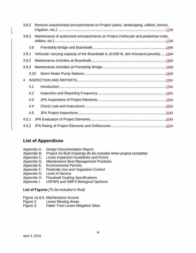
1 OVERVIEW AND ACCESS ........................................................................................................... 117
1.1 Purpose of Manual ............................................................................................................. 117
1.2 Changes to the Project or the Manual ............................................................................. 117
1.3 Project Vehicular Access ................................................................................................... 217
2 OPERATION .................................................................................................................................... 318
2.1 Introduction .......................................................................................................................... 318
2.2 Removal of Excess Sediment and Vegetation ............................................................... 419
2.2.1 Sediment Removal Triggers for Channel .............................................................................. 419
2.2.2 Vegetation Removal Triggers for Channel ............................................................................ 519
3. MAINTENANCE .................................................................................................................. 520
3.1 Vegetation Maintenance .................................................................................................... 520
3.1.1 Mitigation Plantings during Establishment Period ......................................................... 720
3.1.1.1 Instream benches adjacent to levees and floodwalls to remove undesired and non-native vegetation .................................................................................................................................... 720
3.1.1.2 Faber Tract levees .............................................................................................................. 720
3.1.2 Erosion Control Plantings .................................................................................................. 720
3.1.3 Protection for Endangered Species ................................................................................. 721
3.1.4 Other Vegetation Removal .............................................................................................. 1123
3.1.4.1 Removal of woody and non-woody invasive vegetation within project right-of-way for inspections at base of levee toes using herbicide application, mechanical mowing, hand mowing and trimming, or hand weeding. ......................................................................................................... 1123
3.1.4.2 Removal or pruning of all vegetation encroaching within project right-of-way using herbicide application, mechanical mowing, hand mowing and trimming, or hand weeding. .... 1123
3.1.4.3 Removal of woody vegetation in channel ..................................................................... 1123
3.2 Flood Protection Structures .......................................................................................................... 1123
3.2.1 Levee Maintenance .......................................................................................................... 1123
3.2.1.1 Levee repairs ..................................................................................................................... 1123
viii April 4, 2016
3.2.1.2 Repair of levee damage caused by flood events (erosion, scour, slumps, and sags) 1224
3.2.1.3 Animal Control Program (baiting, trapping, and barriers) ........................................... 1224
3.2.1.4 Repair animal damage on levee slopes and at levee toe .......................................... 1225
3.3 Floodwall Maintenance ................................................................................................................. 1325
3.3.1 Repair of floodwall coating .............................................................................................. 1325
3.3.2 Repair of floodwall damage caused by flood events ................................................... 1325
3.4 Creek Channel Maintenance ....................................................................................................... 1325
3.4.1 Removal of downed trees in creek channel.................................................................. 1325
3.4.2 Sediment removal in low flow channel .......................................................................... 1325
3.4.3 Fill and repair scour holes in channel ............................................................................ 1325
3.4.4 Control of unwanted vegetation on benches to maintain conveyance ..................... 1426
3.4.5 Repair of rock slope protection ....................................................................................... 1426
3.4.6 Trash and debris removal in channels and at bridge piers/columns ........................ 1426
3.5 Maintenance Access Ramps and Maintenance Roads ........................................................... 1426
3.5.1 Repair and maintenance of levee maintenance roads and access ramps .................... 1426
3.5.2 Repair and maintenance of floodwall maintenance roads and access ramps .............. 1527
3.6 Outfalls, Flap Gates, and Valves ................................................................................................. 1527
3.6.1 Culvert flap gate service and repairs (during annual inspections) ............................ 1527
3.6.2 Pipe culvert inspection, repairs, and sediment removal (during annual inspections) 1527
3.6.3 Periodic video inspection of culvert joints and lining for buckling, spalling, corrosion, damage Interior Drainage System ..................................................................................................... 1527
3.6.4 Removal of sediment and woody vegetation at culverts and outfalls (during annual inspections) ........................................................................................................................................... 1628
3.6.5 Repair and maintenance of outfall slope protection (during annual inspections) ... 1628
3.6.7 Positive closure valve (during annual inspections) ...................................................... 1628
3.7 San Francisquito Creek Channel ................................................................................... 1628
3.7.1 Maintenance and repair of flood gate .................................................................................. 1628
3.7.2 Homeless encampment clean-up ........................................................................................ 1729
3.8 Miscellaneous Maintenance Activities ........................................................................... 1729
3.8.1 Miscellaneous Repairs and Maintenance ............................................................................ 1729
ix April 4, 2016
3.8.2 Remove unauthorized encroachments on Project (stairs, landscaping, utilities, fences, irrigation, etc.) .......................................................................................................................... 1729
3.8.3 Maintenance of authorized encroachments on Project (Vehicular and pedestrian trails, utilities, etc.) ............................................................................................................................. 1729
3.9 Friendship Bridge and Boardwalk .................................................................................. 1830
3.9.1 Vehicular carrying capacity of the Boardwalk is 10,000 lb. (ten thousand pounds). .... 1830
3.9.2 Maintenance Activities at Boardwalk .................................................................................... 1830
3.9.3 Maintenance Activities at Friendship Bridge ....................................................................... 1830
3.10 Storm Water Pump Stations ........................................................................................... 1830
4 INSPECTION AND REPORTS .................................................................................................... 1931
4.1 Introduction ........................................................................................................................ 1931
4.2 Inspection and Reporting Frequency ............................................................................. 1931
4.3 JPA Inspections of Project Elements ............................................................................. 1931
4.4 Check Lists and Instructions ........................................................................................... 2032
4.5 JPA Project Inspections ................................................................................................... 2032
4.5.1 JPA Evaluation of Project Elements ..................................................................................... 2032
4.5.2 JPA Rating of Project Elements and Deficiencies ............................................................. 2032
List of Appendices
Appendix A. Design Documentation Report Appendix B. Project As-Built Drawings [to be included when project complete] Appendix C. Levee Inspection Guidelines and Forms Appendix D. Maintenance Best Management Practices Appendix E. Environmental Permits Appendix F. Pesticide Use and Vegetation Control Appendix G. Level of Service Appendix H. Floodwall Coating Specifications Appendix I. USFWS and NMFS Biological Opinions List of Figures [To be included in final]
Figure 1a & b. Maintenance Access Figure 2. Levee Mowing Areas Figure 3. Faber Tract Levee Mitigation Sites
April 4, 2016 1
1 OVERVIEW AND ACCESS
1.1 Purpose of Manual
The manual provides a consolidation of data and requirements needed by the sponsor to perform operation and maintenance (O&M) activities at San Francisquito Creek. The San Francisquito Creek Joint Powers Authority (JPA) is responsible for project O&M. In its Resolution Number 14.11.20 (November 14, 2014), the JPA delegated responsibility for operation and maintenance of the Project to the City of East Palo Alto and the Santa Clara Valley Water District. This manual will govern the actions of both East Palo Alto and the Water District. The City of East Palo Alto (City) and the Santa Clara Valley Water District (District) will enter into an Agreement assigning roles and responsibilities to each agency. The Agreement will be attached to this Manual.
The manual has been developed as a “Living Document”. It is expected that the sponsors will update it when changes to the project and O&M occur. Significant changes to the project or procedures that could potentially impact the operation of the project should be addressed by the JPA for review and approval (see Section 1.2).
Design criteria for flood risk reduction are the one-percent fluvial flow (9,400 cfs) and the one-percent tidal elevation plus sea level rise (11.30 ft). The one percent flow is that which has a one-percent statistical chance of occurring in any year; also known as the 100-year flow.
Sensitive species anticipated to be found within the Project area include the salt marsh harvest mouse, Ridgway’s rail (formerly California clapper rail), steelhead, green sturgeon, and longfin
smelt. Unobserved but potentially present may be the California red-legged frog, western pond turtle, and San Francisco garter snake. Avian species potentially present include the western burrowing owl, western snowy plover, California black rail, and California least tern.
Steelhead migration will be protected by installation of in-stream refugia of root wads and a rock resting structure. The low-flow channel will be retained and relocated where the channel has been widened.
1.2 Changes to the Project or the Manual
Proposed changes to the project/system and/or its O&M Manual should addressed by the JPA.
The current name and address is: San Francisquito Creek Joint Powers Authority 615 B Menlo Avenue Menlo Park, CA 94025 This manual will be reviewed and updated as necessary at a minimum of every five years to meet the strategies and actions necessary for potential impacts from global climate change and to incorporate lessons learned from previous operations and maintenance activities.
April 4, 2016 2
1.3 Project Vehicular Access
See Figures 1a and b for vehicular access locations to the San Francisquito Creek levees and floodwalls.
For normal O&M, vehicular access points to the gravel and paved roads are located at East Bayshore Road, Verbena Drive, Daphne Way, Geng Road, and O’Connor Street. Access restrictors from public roadways, such as gates and bollards, are secured by locks.
The Cities of Palo Alto and East Palo Alto and SCVWD shall have access to the Project areas as permitted under Table 2-1, below.
Ramps providing direct channel access are located downstream from the Palo Alto Pump Station (L-Line STA 70+75) and near the overhead utility tower in the channel (L-Line STA 48+00). L-line is stationing in Santa Clara County.
All access gates and bollards will remain locked when not in use.
Access is available to pedestrians, bicyclists, and authorized cars and trucks.
Access across Friendship Bridge and the Boardwalk is limited to pedestrians, and cars and light trucks. Vehicular carrying capacity of the boardwalk is 10,000 lb. Heavier equipment is not allowed.
City of East Palo Alto has access to facilities within the City. Santa Clara Valley Water District has access to facilities within Santa Clara County. City of Palo Alto has access to facilities within the City.
April 4, 2016 3
2 OPERATION
2.1 Introduction
In accordance with U.S. Army Corps of Engineers (USACE) technical guidance (Levee Owner’s Manual for Non-Federal Flood Control Works, the Rehabilitation and Inspection Program, Public Law 84-99, March 2006), this section covers routine operations and maintenance details required for the proper care and efficient operation of the various project elements, including levee embankments, floodwalls, channels, interior drainage system, and pump stations. Maintenance records will be maintained and available for inspection in SCVWD Watershed Operations and Maintenance Division and East Palo Alto Public Works/Maintenance. For project design information, see Appendix A, Design Documentation Report and Appendix B, Project As-Built Drawings. Maintenance documents to be followed are in Appendix C, SCVWD Inspection Guidelines, Rating Guides and Checklists.
Some maintenance activities require regulatory permits and/or authorization to perform the work. The work activities for specific locations will need to be analyzed for determination of possible significant impacts through the appropriate environmental review and adoption process. O&M activities will be performed in accordance with SCVWD Maintenance Best Management Practices; however, separate permits will be obtained when maintenance, except for vegetation control, is required.
Owners and/or occupants of properties on which maintenance easements exist or which are adjacent to public agency-owned property on which work will be performed should be notified and/or approval obtained before work is commenced.
Table 2-1
Contact Information for Access
Location Easement/Adjacent
to Fee
Location Name Contact Address APN Contact(s)
Santa Clara County
Easement City of Palo Alto
Ranger Station 2500 Embarcadero Rd Palo Alto 94303
008-01-032 and 008-06-001
Richard Bicknell (650) 617-3156
Santa Clara County
Easement United States Postal Service
2085 E. Bayshore Palo Alto, 94303
008-01-049 Dean Maeda, Postmaster (650) 321-1423
Santa Clara Easement International School of the
151 Laura Lane 008-01-050 François Guedenet (650)
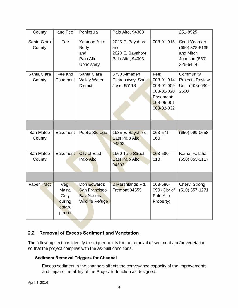
April 4, 2016 4
County and Fee Peninsula Palo Alto, 94303 251-8525
Santa Clara County
Fee Yeaman Auto Body and Palo Alto Upholstery
2025 E. Bayshore and 2023 E. Bayshore Palo Alto, 94303
008-01-015 Scott Yeaman (650) 328-8169 and Mitch Johnson (650) 326-6414
Santa Clara County
Fee and Easement
Santa Clara Valley Water District
5750 Almaden Expressway, San Jose, 95118
Fee: 008-01-014 008-01-009 008-01-020 Easement: 008-06-001 008-02-032
Community Projects Review Unit (408) 630-2650
San Mateo County
Easement Public Storage 1985 E. Bayshore East Palo Alto, 94303
063-571-060
(650) 999-0658
San Mateo County
Easement City of East Palo Alto
1960 Tate Street East Palo Alto 94303
063-580-010
Kamal Fallaha (650) 853-3117
Faber Tract Veg. Maint. Only
during estab. period
Don Edwards San Francisco Bay National Wildlife Refuge
2 Marshlands Rd. Fremont 94555
063-580-090 (City of Palo Alto Property)
Cheryl Strong (510) 557-1271
2.2 Removal of Excess Sediment and Vegetation
The following sections identify the trigger points for the removal of sediment and/or vegetation so that the project complies with the as-built conditions.
Sediment Removal Triggers for Channel
Excess sediment in the channels affects the conveyance capacity of the improvements and impairs the ability of the Project to function as designed.
April 4, 2016 5
From Highway 101 to the San Francisco Bay, sediment deposition accumulated to a continuous elevation 8.0’ (NAVD88) will reduce the levee/floodwall freeboard by 50% (1.5 feet) which will require sediment removal.
Sediment removal is also triggered when sediment deposition impedes fish migration, including within the footprint of in-stream refugia.
No sediment deposition is anticipated during normal conditions. Upstream bank failure could provide an amount of sediment that the channel could not accommodate, requiring a maintenance need as a result of an unpredictable event. In the event that tidal deposition reaches an equilibrium at a different elevation than designed, a berm or other means of recapturing freeboard will be installed.
In accordance with the District’s 2013-2023 Stream Maintenance Program, sediment removal will not exceed 300 linear feet for an individual work project.
Vegetation Removal Triggers for Channel
Vegetation management refers to the removal of vegetation for the purposes of maintaining specific flood control objectives such as passage of flood flows and to maintain flood control access (project inspections, flood fighting, maintenance and repairs).
From Highway 101 to the San Francisco Bay, a maximum roughness coefficient of n=0.055 (similar to continuous thickets or rigid woody understory and brush) would result in a reduction of levee/floodwall freeboard of 33% (1.0 foot). This condition is based on brush or excessive vegetation (n-value = 0.055) being present on the terraced benches and levee side slope.
The system has been designed to a maximum roughness coefficient of n=0.038 (similar to grasses). Maintenance activities shall occur when woody understory or brush is encountered.
3. MAINTENANCE
3.1 Vegetation Maintenance
The Project site is habitat for the endangered species Salt Marsh Harvest Mouse (SMHM) and Ridgway’s Rail (RR), formerly California Clapper Rail. All activities for the Project shall be in accordance with protection measures listed in Section 3.1.3 SMHM monitor shall be on site for duration of all work except irrigation and hand weeding. Herbicides are required to remove invasive species within mitigation plantings. Herbicide application shall be done with immediate oversight by a State-certified Qualified Applicator with the appropriate certification categories. Herbicide application shall be in accordance with QEMS Procedures Q751D02, Control and Oversight of Pesticide Use, and W751D01, Pesticide Products Approved for District Use and QEMS
April 4, 2016 6
Work Instruction WW75100, Vegetation Control Work Instructions (Appendix F, Pesticide Use and Vegetation Control).
April 4, 2016 7
3.1.1 Mitigation Plantings during Establishment Period
3.1.1.1 Instream benches adjacent to levees and floodwalls to remove undesired and non-native vegetation
a. Hand weeding or hand mowing (weed whacker) every 2 weeks, summer and fall (two-day duration).
b. Herbicide application typically will be performed five days per year but this may be modified based on field conditions (see section 3.1.3.g below for details).
c. See the restrictions in Section 3.1 for all activities.
3.1.1.2 Faber Tract levees (See Figure 3)
a. Remove unwanted vegetation and control non-natives (hand methods) as needed.
b. Remove of diseased vegetation as needed.
c. Implement additional maintenance measures, as needed, to ensure that long term success criteria are met.
d. Note that Faber Tract levees are within the Don Edwards San Francisco Bay National Wildlife Refuge, and any maintenance requires specific conditions.
3.1.2 Erosion Control Plantings
a. Annual mowing of grasses (two-day duration) to 3 to 4 inches high on levee slopes from top of levee to levee toes in summer or fall for inspection of levee integrity, maintaining channel roughness, and fire risk reduction.
b. Hydroseed with erosion control seed mix on bare spots on levee faces due to fire or slope repairs in fall or early winter months to facilitate germination.
c. Monitor hydroseeded areas for success.
d. Repeat hydroseed application, as needed if first attempt was not successful.
e. See the restrictions in Section 3.1 for all activities.
3.1.3 Protection for Endangered Species
a. Note, all work will be in accordance with the United Sates Fish and Wildlife Service and National Marine Fisheries Service Biological Opinions (Appendix I). Any variance between those
April 4, 2016 8
conditions and others in this manual or appendices will be superseded by the conditions of the Biological Opinions
b. Within 7 days prior to work within the range of SMHM or RR, as depicted on the SCVWD’s GIS layers, the proposed project area will be surveyed by a qualified biologist to identify specific habitat areas. Surveyed areas will include work locations and access routes. If the SCVWD’s GIS information is revised, it will be provided to the USFWS for review.
c. To minimize or avoid the loss of individuals, activities within or adjacent to RR and SMHM habitat will not occur within 2 hours before or after extreme high tides (6.5 feet or above) when the marsh plain is inundated, because protective cover for those species is limited and activities could prevent them from reaching available cover.
d. Mowing will not occur at night.
e. Vegetation will be removed by hand from areas of cordgass (Spartina spp.), marsh gumplant (Grindelia spp.), pickleweed (Sarcocornia pacifica), alkali heath, (Frankenia sp.), and other high marsh vegetation, brackish marsh reaches of creek with heavy accumulations of bulrush thatch (old stands), and high water refugia habitat that may include annual grasses, and shrubs immediately adjacent to channels.
f. Prior to the initiation of work each day for all vegetation management work, ground or vegetation disturbance, operation of large equipment, grading, sediment removal, and bank stabilization work, and prior to expanding the work area, a qualified biologist will conduct a preconstruction survey of all habitat that may be directly or indirectly impacted by the day’s activities (work area, access routes, staging areas).
i. If during the initial daily survey or during work activities a RR is observed within or immediately adjacent to the work area (50 feet), initiation of work will be delayed until the RR leaves the work area.
ii. If during the initial daily survey or during work activities a SMHM or similar rodent is observed within or immediately adjacent to the work area (50 feet), initiation of work will be delayed until a Site Specific Species Protection Form can be developed and implemented by a qualified biologist to protect the SMHM or similar rodent is developed and implemented by the qualified biologist. Acceptable plan activities may include one or more of the following activities: 1) establishment of a buffer zone at least 50 feet in radius from the rodent; 2) ongoing active monitoring, 3) delay of work activity until the qualified biologist can
April 4, 2016 9
provide CDFW and the USFWS a suggested course of action and seek concurrence.
g. If mowing with hand equipment will be performed within 50 feet of habitat areas, an on-site monitor will observe the area in front of the mower from a safe vantage point while it is in operation. If SMHM are detected within the area to be mowed, no mowing will occur in that area at this time. If RR is detected within the area to be mown, the mowing will stop until the individual(s) have left the work area.
h. If visual observation cannot confirm RR left the work area then it is assumed that the individual(s) remains in the work area and the work will not resume until the area has been thoroughly surveyed (and absence confirmed) or the USFWS has been contacted for guidance.
i. Use of Herbicides
i. Herbicides will be applied topically and not be broadcast (area spraying).
ii. All herbicide applications will be performed under the planning and direction of a California-licensed Pest Control Advisor.
iii. Herbicide applications within the banks of channels within 20
feet of any water present will take place only between July 1 and October 15, or until the first occurrence of any of the following conditions; whichever happens first:
local rainfall greater than 0.5 inches is forecast within a 24-hour period from planned application events; or
when steelhead begin upmigrating and spawning in San Francisquito Creek, as determined by a qualified biologist (typically in November/December), o A qualified biologist will determine
presence/absence of sensitive resources in designated herbicide use areas and develop site-specific control methods (including the use of approved herbicide and surfactants). Proposed herbicide use would be limited to the aquatic formulation of glyphosate (Rodeo or equal). No surfactants will be used. Any modifications to these materials would require review and approval by NMFS and CDFW; and
o A qualified fisheries biologist will review proposed herbicide application methods and stream reaches. The fisheries biologist would conduct a pre-construction survey (and any other appropriate data research) to determine whether the proposed herbicide application is consistent with SMP approvals concerning biological resources and
April 4, 2016 10
determine which BMPs would be instituted for work to proceed.
In addition, herbicide application requirements are as follows:
o no direct application into water; o herbicide application shall not occur when wind
conditions may result in drift; and o herbicide solution shall be applied only until
there is a “wet” appearance on the target plants in order to avoid runoff
iv. Approved herbicides and adjuvants may be applied in habitat areas for sensitive wildlife species (including those identified in the project area such as steelhead, California red-legged frog, and salt marsh harvest mouse); all applications will occur in accordance with federal and state regulations.
v. For sprayable or dust formulations: when the air is calm or
moving away from sensitive wildlife habitat, applications will commence on the side nearest the habitat and proceed away from the habitat. When air currents are moving toward habitat, applications will not be made within 200 yards by air or 40 yards by ground upwind from occupied habitat. However, these distances may be modified for the control of invasive species on salmonid streams if the measures in Section iii, above, are implemented.
j. See Section 3.2.1.3 for additional restrictions.
k. Effects on native aquatic vertebrates will be avoided or minimized. If native aquatic vertebrates are present when in-stream work is proposed, an evaluation of the project site and species within will be conducted by a qualified biologist, who will consider:
i. Species at the site,
ii. Ability of the species to naturally recolonize the stream reach,
iii. The life stages of the species present,
iv. The flow, depth, topography, substrate, chemistry, and temperature of the stream reach,
v. The feasibility of relocating the species present, and
vi. The likelihood the stream reach will naturally dry up during the work season. Based on consideration of these factors, the qualified biologist will document in writing the reasons to relocate or not the species prior to in-channel work. Relocation will be based on the District’s Fish Relocation Guidelines.
April 4, 2016 11
3.1.4 Other Vegetation Removal
3.1.4.1 Removal of woody and non-woody invasive vegetation within project right-of-way for inspections at base of levee toes using herbicide application, mechanical mowing, hand mowing and trimming, or hand weeding.
a. Cut and remove woody growth (trees and saplings) within 15 feet of outboard levee toe.
3.1.4.2 Removal or pruning of all vegetation encroaching within project right-of-way using herbicide application, mechanical mowing, hand mowing and trimming, or hand weeding.
a. Remove ground cover that obscures visual inspections of levee and floodwall structures for damage and for flood fighting activities.
b. Cut, prune, or remove landscape ground covers, brush, and ornamentals from adjacent private property which encroach onto the right-of-way.
3.1.4.3 Removal of woody vegetation in channel
a. Cut and remove woody saplings, trees, invasives, and understory.
b. Follow up with appropriate herbicide treatment as necessary to prevent regrowth.
3.2 Flood Protection Structures
Maintenance measures are necessary to ensure serviceability of the levees and floodwalls to withstand flow events up to the design flood event. Limited vegetation is required to allow for visual inspection of the levee embankments. Vegetation other than shallow rooted grasses shall not be permitted on levee crowns, slopes, or within 15 feet of the outboard levee toe. This is necessary to prevent the development of deep roots within the body of the levee which can create seepage paths. A rodent abatement program shall be employed as soon as evidence of burrowing activity is found on the levee embankment or toe. Shallow scattered holes allow for runoff to infiltrate the levee and can result in seepage flow paths through the levee during flood events. See Figures 1 and 2 for maintenance activity locations.
3.2.1 Levee Maintenance
3.2.1.1 Levee repairs
a. Excavate, repair, and reconstruct levee embankments due to seepage, slumps, cracks (longitudinal or transverse), loss of grade, sloughs, slides, rodent burrows, scour, or erosion in order to maintain full levee section.
April 4, 2016 12
b. Reconstruct/raise levee crown due to sags, depressions, or groundwater subsidence.
c. The levee is to be repaired to original design specifications (See Appendix B, Project As-Built Drawings).
3.2.1.2 Repair of levee damage caused by flood events (erosion, scour, slumps, and sags)
a. Inspect and document cause of levee damage.
b. Plans for repairs will be prepared by the JPA.
c. Schedule and complete construction.
d. Levee fill material shall be placed in maximum uncompacted lifts of 8-inches and moisture conditioned to between 0 and +3% of the optimum moisture content. The fill shall be compacted to a minimum dry density of 92% of the maximum laboratory dry density determined by ASTM Method D1557. The upper 12 inches of levee embankment shall be compacted to a minimum dry density of 95% of the maximum laboratory dry density determined by ASTM Method D1557. Monitor repair site for performance.
3.2.1.3 Animal Control Program (baiting, trapping, and barriers)
a. Control of burrowing animals (gophers, ground squirrels, and similar rodents) with bait stations, fumigants, smoke bombs, rodenticides, and live trapping to prevent damage or colonization of levee embankments.
b. Control methods shall be evaluated to avoid harm to the SMHM and RR. No rodenticides will be used within 100 m (328 ft) of suitable marsh/brackish marsh habitat for these species.
c. Methods of rodent control within SMHM or RR habitat will be limited to live trapping. All live traps shall have openings measuring no smaller than 2 inches by 1 inch to allow any SMHM that inadvertently enter the trap to easily escape. All traps will be placed outside of pickleweed areas and above the high tide line.
d. Captured mammals that are predators shall be disposed of.
e. Displace or exclude animals constructing and using dens (burrows) in the levee embankments by mechanical means.
3.2.1.4 Repair animal damage on levee slopes and at levee toe
April 4, 2016 13
a. Excavate burrow locations and reconstruct levee embankment, or
b. Pressure-fill burrows with bentonite clay, cement grout slurry. Slurry to consist of two parts bentonite clay, one part cement grout and water, as specified by the Project designer, HDR, Inc., or
c. Mud packing method may be used to backfill burrows.
d. Additional information on the repair of animal burrows may be found in FEMA Publication 473, “Technical Manual for Dam Owners, Impacts of Animals on Earthen Dams,” September 2005.
3.3 Floodwall Maintenance
3.3.1 Repair of floodwall coating
a. The sheet pile floodwall has been protected from rust by a 15-millimeter thick phenalkamine coating on the floodwall surface.
b. This coating should be visually inspected during annual inspections to insure a complete coverage.
c. Any nicks or scrapes in the coating surface should be repaired immediately in accordance with the specifications in Appendix E.
3.3.2 Repair of floodwall damage caused by flood events
a. Inspect and document cause of floodwall damage.
b. Plans for repairs will be prepared by the JPA.
c. Schedule and complete repair.
d. Monitor repair site for performance.
3.4 Creek Channel Maintenance
3.4.1 Removal of downed trees in creek channel
a. Cut and remove downed trees within creek channel.
3.4.2 Sediment removal in low flow channel
a. Sediment removal in channels is necessary if sediment bar and vegetation blocks flow and reduces conveyance.
3.4.3 Fill and repair scour holes in channel
April 4, 2016 14
a. Scour hole repairs are required if conveyance, slope stability, or a utility is affected.
b. Drain ponded water and reconstruct channel embankment and/or invert.
c. Fill placed in 8-inch lifts, minimum 90% compaction. Sand Cone method to test relative compaction may be used.
3.4.4 Control of unwanted vegetation on benches to maintain conveyance
a. Mowing/trimming of herbaceous growth when it is 4 feet or higher.
b. Cut, remove, and treat trees in channels to control woody growth and maintain conveyance per Section 3.1.3.3.
3.4.5 Repair of rock slope protection
a. Inspect condition of rock slope protection after flood events.
b. Replace, repair, and restore rock slope protection to as-constructed conditions.
c. Remove woody vegetation (brush or trees) growing in rock slope protection. Cut trees or woody vegetation and treat stumps with appropriate herbicide.
3.4.6 Trash and debris removal in channels and at bridge piers/columns
a. Remove debris that creates blockages or reduces conveyance, as determined by engineering staff.
3.5 Maintenance Access Ramps and Maintenance Roads
3.5.1 Repair and maintenance of levee maintenance roads and access ramps
a. Levee maintenance roads accessed from O’Connor Street, Daphne Way, and Verbena Drive in East Palo Alto, and the channel maintenance access ramp at the PG & E electric tower in Palo Alto are surfaced with Caltrans Section 26 Class II aggregate base. Fill potholes or ruts with compacted Class 2 aggregate base per Caltrans Specifications.
b. The levee access road from Geng Road in Palo Alto is surfaced with Caltrans Section 39 asphalt concrete paving (AC). Repair damaged areas with AC per Caltrans specifications.
c. The channel maintenance access road adjacent to the Palo Alto Pump Station is paved with Portland cement concrete (PCC). Repair damaged areas with suitable PCC.
April 4, 2016 15
d. Apply herbicide on permeable levee crown surfaces to prevent unwanted vegetation.
e. Remove woody vegetation and overhanging growth which impairs or obstructs maintenance access along the base of levee roads and along the top of levees.
3.5.2 Repair and maintenance of floodwall maintenance roads and access ramps
a. Floodwall maintenance roads in East Palo and above L-line Sta 54+00 are surfaced with Caltrans Section 26 Class II aggregate base. Fill potholes or ruts with compacted Class 2 aggregate base per Caltrans Specifications.
b. The floodwall maintenance road in Palo Alto below L-line Sta 54+00 is surfaced with Caltrans Section 39 asphalt concrete paving (AC). Repair damaged areas with AC per Caltrans specifications.
c. Apply herbicide on permeable roadway surfaces to exclude unwanted vegetation.
d. Remove woody vegetation and overhanging growth which impairs or obstructs maintenance access.
3.6 Outfalls, Flap Gates, and Valves
Outfalls which penetrate the floodwall must be maintained and repaired as necessary to ensure that they continue to operate as intended and at full design capacity. Outfalls which have failed, including flap gates that are not operating properly, culverts that are operating below full capacity or positive closure valves that are inoperable, may create flooding.
3.6.1 Culvert flap gate service and repairs (during annual inspections)
a. Check for damage.
b. Check for rust.
c. Confirm proper seating and sealing of flap gate on culvert.
d. Service frame and lubricate pivots.
3.6.2 Pipe culvert inspection, repairs, and sediment removal (during annual inspections)
a. Evaluate culvert for sediment and/or blockages.
b. Check pipe interior.
3.6.3 Periodic video inspection of culvert joints and lining for buckling, spalling, corrosion, damage Interior Drainage System
April 4, 2016 16
a. Outfalls which penetrate the floodwall must be maintained and repaired as necessary to ensure that they continue to operate as intended and at full design capacity, or separation.
b. Remove sediment in culvert.
c. Replace damaged or degraded pipes and culvert sections.
3.6.4 Removal of sediment and woody vegetation at culverts and outfalls (during annual inspections)
a. Cut and remove vegetation that could affect flap gate or discharge.
b. Remove sediment that could affect flap gate or discharge.
3.6.5 Repair and maintenance of outfall slope protection (during annual inspections)
a. Remove any woody vegetation (brush or trees) in rock slope protection.
b. Repair or replace rock slope protection.
c. Repair foundation or apron of outfalls to prevent undermining, scour, and/or slope failures.
3.6.7 Positive closure valve (during annual inspections)
a. Positive closure valves located at the outboard side of the flood walls shall be tested to insure proper sealing.
b. Positive closure valves that do not seal properly shall be repaired or replaced to ensure protection from flooding backflow.
3.7 San Francisquito Creek Channel
Maintenance measures shall be performed to ensure serviceability of the creek to safely pass all flows up to the design flood event. Maintenance of the low flow creek channel and terraced benches shall consist of the removal of sediment deposition, debris accumulation and vegetative growth. The JPA will periodically re-assess facilities to evaluate conveyance to verify maintenance practices (see Section 3).
The channel shall be thoroughly inspected annually and immediately following each major high water period after water levels are reduced to the low flow.
3.7.1 Maintenance and repair of flood gate
a. Inspect and verify operation, identify and document any damage annually.
b. Grease, lubricate, and exercise mechanical appurtenances as needed based on inspection. Gates are removed and reinstalled or twice per year.
c. Determine if the condition is undesirable, or affects operations.
April 4, 2016 17
d. Prepare plans and complete repairs if necessary.
e. Monitor for performance.
3.7.2 Homeless encampment clean-up
a. Remove homeless encampments with assistance from local authorities.
b. Monitor, evaluate, and repair impacts from homeless encampments (brush clearance, tree trimming, creation of trails and paths, debris and wastes) as needed.
3.8 Miscellaneous Maintenance Activities
Maintenance on the following project elements is required to provide security in areas where access is not intended, and to ensure access at the proper locations for maintenance staff as needed, and to the general public for recreational use. Encroachments into the project ROW must be maintained when authorized, and removed when not authorized.
3.8.1 Miscellaneous Repairs and Maintenance
a. Repair fence sections and replace damaged fence gates and bollards.
b. Replace and install public signage for Project as necessary.
c. Paint defaced structures located in the channel (floodwalls, drop structures, etc.) as part of the neighborhood clean-up work.
3.8.2 Remove unauthorized encroachments on Project (stairs, landscaping, utilities, fences, irrigation, etc.)
a. Coordinate removal of unauthorized private encroachments with local jurisdictions (parks, police, public works, building departments).
b. Notify adjacent property owners to remove unauthorized encroachments if they are the responsible party.
c. Provide neighborhood notice if work is necessary to remove encroachments.
d. Coordinate removal of unauthorized encroachments or utility encroachments with owners.
3.8.3 Maintenance of authorized encroachments on Project (Vehicular and pedestrian trails, utilities, etc.)
a. Encroachment owner identifies needed repairs or modifications.
b. Repairs are identified and project is defined.
c. Owner applies for a permit from the appropriate governing entity to perform work.
d. Coordinate with local jurisdictions (city, parks, or private party).
e. Owner sends neighborhood notices to the surrounding property owners/community.
April 4, 2016 18
f. Complete repairs.
g. Monitor for performance.
3.9 Friendship Bridge and Boardwalk
3.9.1 Vehicular carrying capacity of the Boardwalk is 10,000 lb. (ten thousand pounds).
3.9.2 Maintenance Activities at Boardwalk
a. Cut and remove vegetation or debris that may accumulate at boardwalk piers.
b. Inspect for scour and erosion at boardwalk piers and abutments.
c. Reconstruct channel sags, depressions, or ground subsidence to original design specifications (See Appendix B – Project As-Constructed Drawings).
3.9.3 Maintenance Activities at Friendship Bridge
a. Inspect for scour and erosion at bridge abutments.
b. Remove debris at bridge abutments and Friendship Island.
3.10 Storm Water Pump Stations
There are two municipal storm water pump stations located within the project limits: the O’Connor Street Pump Station located near R-Line Station 30+00 and the Palo Alto Pump Station located near L-Line Station 71+00. Neither pump station was constructed as part of the flood control works. The pump stations were operational prior to the construction of the levees and floodwalls. The Cities of East Palo Alto and Palo Alto are responsible for their operation and maintenance, including the Palo Alto Pump Station channel and the O’Connor Street Pump Station outfalls.
April 4, 2016 19
4 INSPECTION AND REPORTS
4.1 Introduction
This section details the inspection required for proper care and efficient operation of the various project elements. Completed projects must be adequately maintained if they are to function as intended. The JPA is responsible for preserving maintenance and inspection records for its area of responsibility and making them available for government inspection. Government inspections will be performed in consultation with JPA. The inspection requirements included herein apply to all items constructed by and necessary for the operation of the Federal Project.
4.2 Inspection and Reporting Frequency
Semiannual inspections performed by JPA shall occur by May 1 and November 1.
In addition to the semiannual inspection cycle, the following events require immediate inspection.
a. Immediately following each major flood,
b. Immediately following each earthquake based upon the following criteria:
i. Earthquakes measuring less than 5.0 on the Richter scale, inspection shall be performed when the epicenter is within 3 miles of the project,
ii. Earthquakes measuring 5.0 to 6.0 on the Richter scale, inspections shall be performed when the epicenter is less than 30 miles from the project,
iii. For earthquakes measuring 6.0 or higher on the Richter scale, inspections shall be performed when the epicenter is less than 50 miles from the project,
iv. Inspections shall also be performed after any earthquakes in which specific reports of damage to the project are received.
4.3 JPA Inspections of Project Elements
These reports are to inform Field Operations staff of creek conditions that may impact system performance. Reports in paragraphs f and g also serve to comply with permit conditions.
a. Channels checked for sediment, scour, fallen trees, debris and other blockages.
b. In-stream refugia structures checked for stability and scour.
c. Levee embankments.
d. Interior drainage (culverts, flap gates, isolation gates, valves).
e. Levee penetrations are visually inspected annually, and by video or walkthrough every 5 years. Frequency will be increased if deficiencies are noted.
f. Annual reports documenting project conditions.
April 4, 2016 20
g. Levee elevations on both sides will be inspected by survey two years after completion of construction and four years after completion of construction to verify forecast elevations following settlement. Beginning after the fourth-year inspection, levee subsidence surveys will be conducted at 5-year intervals. If settlement exceeds predictions, repair options will be evaluated and implemented.
4.4 Check Lists and Instructions
The SCVWD check lists and instructions shown in Appendix C are to be explicitly followed in each inspection to ensure that no features of the protective system are overlooked. A copy of the inspector’s original field notes as recorded on the check list shall be transmitted to the District Engineer as an enclosure to the annual report. Completed inspection check lists are located at the direction of the JPA. The following documents are included in “Appendix C - Levee Inspection Guidelines and Forms”:
SCVWD WW 75161 Field Operations Levee Inspection Guidelines
SCVWD WF 75161 Levee Field Inspection Rating Guide
SCVWD WW 75165 Field Operations Inspection Guidelines
SCVWD WF 75165 Field Inspection Checklist
SCVWD WF 75166 Facilities Inspection Rating Guide
4.5 JPA Project Inspections
The JPA completes annual inspections of the Project by November of each year. During these inspections the Project elements (levees, channels, maintenance roads, culverts, revetment, etc.) are evaluated and rated following the SCVWD guidelines for inspections. Evaluations will identify and document any deficiency (e.g., erosion, scour, sediment, rodent control problems, animal damage, in-stream vegetation, levee maintenance, trash build up, homeless encampments, large woody debris blockages, etc.) on the Project.
4.5.1 JPA Evaluation of Project Elements
The SCVWD has developed specific Inspection Guidelines for watershed facilities and levees throughout the county. These Guidelines identify the inspection category (routine or event driven) and frequency of inspection (annual, event, or semiannual) for each project and system. The Guidelines contain information on the inspection and work flow so that deficiencies identified during the inspections are corrected.
4.5.2 JPA Rating of Project Elements and Deficiencies
During inspections, project elements are assigned a rating (A=New, B=Good, C=Monitor, D=Corrective Action, E=Immediate Action). Deficiencies or items of concern found during the inspections are documented by the JPA.
Based on the severity of the deficiency, available budget, right-of-way, and existing permits, the JPA then schedules corrective maintenance to remedy the problem. If it is determined that
April 4, 2016 21
maintenance is required, a project plan is prepared, the repairs are scheduled, and funds are budgeted as necessary.
San Francisquito Creek Flood Reduction, Ecosystem Restoration, and Recreation Project
San Francisco Bay to Highway 101
Design Documentation Report Draft 100% Design Submittal
SAN FRANCISQUITO CREEK JOINT POWERS AUTHORITY
July 2014
Prepared by:
HDR Engineering, Inc.
2365 Iron Point Road, Suite 300 Folsom, CA 95630

This page intentionally left blank.
Draft 100% Design Documentat ion Report
San Francisquito Creek Joint Powers Authority i San Francisco Creek Flood Protection Project – Project No. 130806 July 2014
Contents
1.0 Background ........................................................................................................................... 1
2.0 Alternatives Analysis ............................................................................................................ 1
3.0 Flood Protection Design Elements ..................................................................................... 2 3.1 Floodwalls ........................................................................................................................................... 2
3.1.1 Floodwall Depth ........................................................................................................................... 2 3.1.2 Floodwall – Levee Transition ....................................................................................................... 3
3.2 Levees ................................................................................................................................................ 3 3.3 Access Road ....................................................................................................................................... 4 3.4 Appurtenant Structures and Tie-Ins .................................................................................................... 4 3.5 Friendship Bridge ................................................................................................................................ 4
4.0 Alignment and Layout Considerations ............................................................................... 5 4.1 Project Extent ..................................................................................................................................... 5 4.2 Hydraulics ........................................................................................................................................... 5 4.3 Geotechnical Design........................................................................................................................... 5 4.4 Utilities ................................................................................................................................................ 5
4.4.1 USACE ........................................................................................................................................ 7 4.4.2 EPASD ........................................................................................................................................ 8 4.4.3 PG&E ........................................................................................................................................... 8
4.5 Caltrans Design Coordination ............................................................................................................. 8 4.6 Right-of-Way ....................................................................................................................................... 9
Appendices Appendix A - Flood Wall Calculations Appendix B - PG&E Coordination (Email and Figure)
Figures Figure 1. Project Design Features .............................................................................................................. 11 Figure 2. PWA Alternative 2 Conceptual Layout......................................................................................... 13 Figure 3. Typical Levee Cross Section ....................................................................................................... 15 Figure 4. Typical Raised Access Way ........................................................................................................ 17 Figure 5. Raised Access way Behind ISTP ................................................................................................ 17 Figure 6. New Boardwalk Structure ............................................................................................................ 19 Figure 7. Existing Utilities ............................................................................................................................ 21
Tables Table 1. GEI Floodwall Depths ..................................................................................................................... 2 Table 2. Final Floodwall Depths and Types .................................................................................................. 3 Table 3. Utility Encroachments ..................................................................................................................... 6
Draft 100% Design Documentat ion Report
San Francisquito Creek Joint Powers Authority ii San Francisco Creek Flood Protection Project – Project No. 130806 July 2014
This page intentionally left blank.
Draft 100% Design Documentat ion Report
San Francisquito Creek Joint Powers Authority 1 San Francisco Creek Flood Protection Project – Project No. 130806 July 2014
1.0 Background
The HDR Project team is under contract with the San Francisquito Creek Joint Powers Authority (JPA) to provide consulting services in support of plans, specifications and estimates (PS&E) preparation for flood protection improvements along San Francisquito Creek between the San Francisco Bay (SF Bay) and Highway 101. Scoped tasks include: project management; public outreach assistance; design concept, model, and base map/survey review; utility mapping; design criteria development; geotechnical investigations and associated reporting and recommendations; PS&E at the 30%, 90%, 95% Draft 100%, and 100% levels. Optional services include bid and construction support.
This Technical Memorandum (TM) details the design analysis to this Draft 100% stage. This TM is a living document and will be continuously updated with new design calculations and criteria as the design progresses.
The following sections describe the Draft 100% submittal design elements, the status of the current design, significant changes, and specific considerations that have shaped the progress of the design. Figure 1 depicts the project design features as they are currently planned.
2.0 Alternatives Analysis
In July 2009, Philip Williams & Associates (PWA) completed the San Francisquito Creek Flood Reduction Alternatives Analysis. PWA divided the project into three reaches; the upper reach extends from East Bayshore Road / Highway 101 Bridge to the Palo Alto Municipal Golf Course, the middle reach extends from the golf course to Friendship Bridge and the lower reach extends from Friendship Bridge to the San Francisco Bay. The JPA selected PWA’s Alternative 2 model for the design of the downstream portion of San Francisquito Creek. Alternative 2 consisted of setback floodwalls in the upper reach, levee setbacks in the middle reach, an overflow terrace near Friendship Bridge, and the removal of the levee between the Baylands Preserve (also known as the Faber Tract) and the north side of the creek. PWA’s Alternative 2 diagram is shown in Figure 2.
HDR has worked within the design constraints laid out by the JPA to minimize impacts to existing features and structures, minimize increases to the design water surface elevation at Highway 101 / East Bayshore Road, and preserve opportunities for habitat within the creek as much as possible. The levee and floodwall layout proposed in the PWA Model has been reconfigured to fit within existing structures, utilities, and recreational facilities in coordination with the JPA right of way acquisition efforts.
Draft 100% Design Documentat ion Report
San Francisquito Creek Joint Powers Authority 2 San Francisco Creek Flood Protection Project – Project No. 130806 July 2014
3.0 Flood Protection Design Elements
3.1 Floodwalls
A geotechnical evaluation was performed by GEI Consultants and are summarized in a memorandum tilted, “San Francisquito Creek Flood Protection Project, Geotechnical Evaluation Report” dated May 2012.
Both interlocking steel sheet pile cantilever walls and T-type concrete walls were considered for flood wall design. During the subsurface exploration program, shallow, pervious soil units and soft Bay deposits were encountered below relatively thin blankets of low permeability soils along the proposed floodwall alignments. The results of seepage analyses indicate that flood walls should include a cut off to intercept the pervious foundation soils in order to meet the minimum acceptance criteria for underseepage gradients. In addition, flood wall cut offs should fully penetrate into the soft bay deposits and terminate in competent material.
Shallow supported concrete T-type walls would likely have a wide foundation embedded 3 to 5 feet below the ground surface, and include a cutoff at the heel. Construction of this type of floodwall would require significant excavation, and a large construction footprint.
Sheet pile walls are constructed in a more limited construction zone with fewer disturbances to adjacent areas and can intercept the pervious foundation soils present within the project footprint. Based on these considerations, a floodwall consisting of interlocking sheet piles that fully penetrate soft bay deposits and terminate in competent material is recommend for flood control within the upper reach of this project.
3.1.1 Floodwall Depth
GEI’s evaluation of sheet pile depth required that the floodwall be embedded to the maximum tip elevations shown in Table 1 (i.e. no shallower than the elevations shown).
Table 1. GEI Floodwall Depths
FLOODWALL DEPTHS
LEVEE – STATION ELEVATION
R-LINE 54+00 TO 67+50 -15
L-LINE – 67+00 TO 76+00 -10
L-LINE – 49+00 TO 67+00 -15
These maximum tip evaluations are based on providing cutoff for seepage and a minimum embedment of 8 feet below the estimated bottom of young Bay Mud.
Draft 100% Design Documentat ion Report
San Francisquito Creek Joint Powers Authority 3 San Francisco Creek Flood Protection Project – Project No. 130806 July 2014
The floodwall materials were identified and embedment depths were refined during the structural design of these walls. This design is in conformance with USACE EM 1110-2-2504. A summary of the structural calculations for this project are located in Appendix A. The final sheet pile floodwall depths are summarized in Table 2 and can be found within the construction documents on Sheet S-1.
Table 2. Final Floodwall Depths and Types
FLOODWALL DEPTHS AND TYPES
LEVEE – STATION SHEET PILE TYPE ELEVATION
R-LINE 29+53.75 TO 31+57.64 AZ 24-700 -15.0
R-LINE 54+00 TO 61+00 AZ 19-700 -15.0
R-LINE 61+00 TO 70+00 AZ 24-700 -15.0
R-LINE 70+00 TO 75+00 AZ 36-700 -17.0
R-LINE 75+00 TO 75+54.13 AZ 50 -22.0
L-LINE 49+00 TO 62+00 AZ 19-700 -15.0
L-LINE 62+00 TO 71+05 AZ 24-700 -15.0
L-LINE 71+80 TO 75+00 AZ 24-700 -15.0
L-LINE 75+00 TO 76+29.42 AZ 36-700 -17.0
3.1.2 Floodwall – Levee Transition
To mitigate for the potential for differential settlement at the transition between the floodwall and the new levee fill, the floodwall section should be extended into the new levee fill section with an overlap of at least 150 feet. This overlap will provide additional protection against levee through seepage if differential settlement and cracking of the levee fill should occur. There are four transitions that occur between floodwall and levee. The transitions occur at R-Line 28+03.00 to 29+53.73, R-Line 31+57.64 to 33+07.00, R-Line 52+50.00 to 54+00.00, and L-Line 47+50.00 to 49+00.00.
3.2 Levees
Levees are the preferred flood protection element downstream of the project floodwalls. For conformance with USACE EM 1110-2-1913, the levee geometry includes:
A 16 foot crown width.
A 3 horizontal to 1 vertical (3H:1V) water side levee slope.
A 2H:1V landside levee slope.
Draft 100% Design Documentat ion Report
San Francisquito Creek Joint Powers Authority 4 San Francisco Creek Flood Protection Project – Project No. 130806 July 2014
Top of Levee elevation includes three feet of freeboard above the 100 year design water surface elevation.
Top of Levee elevation includes four feet of freeboard above the 100 year design water surface elevation 100 feet upstream and downstream of bridge structures (Highway 101 and Friendship Bridge).
See Figure 3 for the typical levee section layout.
Geotechnical stability analyses indicate that this geometry will provide factors of safety as required by USACE guidelines. Seepage analyses indicate that no seepage berms or cutoff walls are required for the levee portion of this project.
3.3 Access Road
To provide the appropriate level of flood protection, the proposed flood wall will be significantly higher than the existing ground, on the order of 10 feet in some sections. In order to maintain visibility of the creek for pedestrians and bicyclists, the access roadway located behind the flood wall will be raised when necessary (see Figure 4). The access roadway will typically be 16 ft. wide and will slope away from the flood wall at a 2% slope.
In the area of the International School of the Peninsula (ISTP), the creek is particularly narrow, and maximizing the width of the floodway is hydraulically beneficial. However, it is also beneficial to mitigate for any encroachment that this floodway widening will impose on the school playground. In order to minimize encroachment within the playground area behind the ISTP, the access roadway will be reduced to a width of 12 ft. and a retaining wall will be constructed on the outboard side of the access road in order to eliminate the 2H:1V landside slope that typically occurs at the raised access way (see Figure 5).
3.4 Appurtenant Structures and Tie-Ins
Several details were produced with the Draft 100% plan set; these include but are not limited to: the sheet pile wall connection to concrete structures, sheet pile wall utility penetrations, concrete cap, and flood wall details.
3.5 Friendship Bridge
Per direction of the JPA, its member agencies and stakeholders, the existing friendship bridge will not be removed from its current location. Because of significant floodway widening that will occur at this bridge, the existing left bank levee will be transformed to an in-creek island at the Friendship Bridge north abutment. A new boardwalk will also be constructed from the new in-creek island to the new setback levee (see Figure 6).
Draft 100% Design Documentat ion Report
San Francisquito Creek Joint Powers Authority 5 San Francisco Creek Flood Protection Project – Project No. 130806 July 2014
4.0 Alignment and Layout Considerations
4.1 Project Extent
For the left levee, the downstream project extent will occur at the tie-in point between the new and existing levees downstream of Friendship Bridge. The extent of the project along the right levee alignment will occur at the eastern end of the bay levee degrade near the San Francisco Bay. These extents are shown on the attached Figure 1. HDR understands that subsequent local or Shoreline Study project(s) will address levee inadequacies in the creek upstream of Highway 101. It is expected that such future projects will tie in to the flood protection elements of this project, to create a comprehensive flood protection system that protects from riverine and tidal flooding.
4.2 Hydraulics
Due to the complexity of the hydraulic design required for this project, a separate TM was prepared by HDR to address the hydraulic design features. This TM is titled Hydraulic Review Technical Memorandum, San Francisquito Creek Flood Protection Capital Project, Floodwater Conveyance Improvements from East Bayshore Road to San Francisco Bay, dated July 2014.
4.3 Geotechnical Design
A geotechnical report was completed by GEI Consultants and is titled, “San Francisquito Creek Flood Protection Project, Geotechnical Evaluations Report” and dated May 2012. Topics within this report include:
Field exploration and laboratory testing.
Subsurface conditions.
Engineering analyses for proposed levees and floodwalls including seepage, stability, and settlement evaluations.
Geotechnical recommendations and design criteria.
Results of this report were used to develop the floodwall and levee design criteria listed previously in this report.
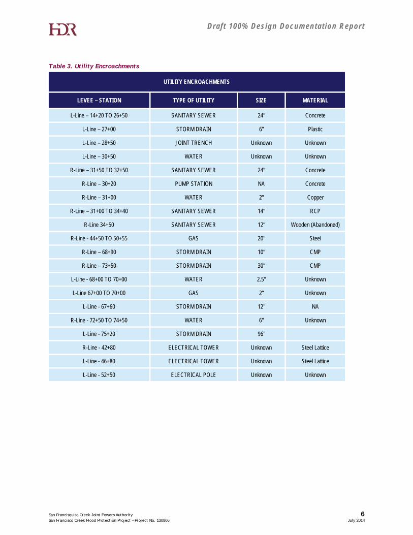
4.4 Utilities
There are several utility structures that cross the proposed levee/flood wall alignment. A summary of these encroachments is listed within Table 3 and are shown in Figure 7:
Draft 100% Design Documentat ion Report
San Francisquito Creek Joint Powers Authority 6 San Francisco Creek Flood Protection Project – Project No. 130806 July 2014
Table 3. Utility Encroachments
UTILITY ENCROACHMENTS
LEVEE – STATION TYPE OF UTILITY SIZE MATERIAL
L-Line – 14+20 TO 26+50 SANITARY SEWER 24” Concrete
L-Line – 27+00 STORM DRAIN 6” Plastic
L-Line – 28+50 JOINT TRENCH Unknown Unknown
L-Line – 30+50 WATER Unknown Unknown
R-Line – 31+50 TO 32+50 SANITARY SEWER 24” Concrete
R-Line – 30+20 PUMP STATION NA Concrete
R-Line – 31+00 WATER 2” Copper
R-Line – 31+00 TO 34+40 SANITARY SEWER 14” RCP
R-Line 34+50 SANITARY SEWER 12” Wooden (Abandoned)
R-Line - 44+50 TO 50+55 GAS 20" Steel
R-Line – 68+90 STORM DRAIN 10” CMP
R-Line – 73+50 STORM DRAIN 30” CMP
L-Line - 68+00 TO 70+00 WATER 2.5" Unknown
L-Line 67+00 TO 70+00 GAS 2” Unknown
L-Line - 67+60 STORM DRAIN 12" NA
R-Line - 72+50 TO 74+50 WATER 6" Unknown
L-Line - 75+20 STORM DRAIN 96"
R-Line - 42+80 ELECTRICAL TOWER Unknown Steel Lattice
L-Line - 46+80 ELECTRICAL TOWER Unknown Steel Lattice
L-Line - 52+50 ELECTRICAL POLE Unknown Unknown
Draft 100% Design Documentat ion Report
San Francisquito Creek Joint Powers Authority 7 San Francisco Creek Flood Protection Project – Project No. 130806 July 2014
4.4.1 USACE
HDR conducted a meeting on January 20, 2012 with Paul Schimelfenyg and Brian Hubel of the USACE to discuss the existing utility encroachments and proposed utility relocations. The following is a list of proposed actions agreed upon for each utility:
A. Sanitary Sewer – There is an existing Sanitary Sewer line that crosses under San Francisquito Creek. HDR recommended protecting the existing line in place during construction. Paul expressed interest in determining the condition of the existing pipe. HDR indicated that the interior of the existing pipe will be lined by the East Palo Alto Sanitary District to improve function.
B. Brian expressed concern with settlement that would occur if a new levee were built over the existing sewer line. The existing soil consists of Bay Mud which can experience significant consolidation.
C. After discussion it was agreed that HDR should consider re-routing the existing sewer line to cross the levee at a point where the existing levee is not being relocated. This will eliminate settling because the soil underneath the existing levee is already consolidated. The manhole at the Friendship Bridge abutment will be raised and fitted with a watertight cover. The design will address erosion protection around the manhole.
D. Gas - There is an existing 20” gas line that crosses the levee twice. HDR should work with PG&E to insure that the gas line is relocated over the levee per EM 1110-2-1913. Settlement should be considered. If possible, the gas line should be installed after settlement of the levee is complete due to the bay mud which is prevalent within the project footprint.
E. Storm Drain – There is an existing storm drain inlet behind the International School of the Peninsula (ISTP) that drains the water from the blacktop area behind the school. Another drain inlet that currently discharges to the creek is located behind the adjacent storage facility and drains runoff from the roofs and blacktop area. These storm drain inlets release to 12-inch diameter pipes that discharge to the creek. Paul did not see a concern with protecting these lines in place. However, the 12-inch diameter pipes will be replace with 30-inch diameter pipes a fitted with flap gate outlets and landside positive closure valves to prevent the backflow of water into the pipe.
F. Private Water Line – There is an existing 6” private water line near US 101. The line does not cross the proposed flood wall but does lie beneath the proposed access way. Paul suggested relocating the line if possible; however the line occurs in a densely populated area. Paul was okay with leaving the line if relocation is not feasible.
G. Abandoned Utilities – Abandoned utilities will be removed and backfilled where possible. Abandoned pipes left in place under the creek will be grouted.
H. Electrical Towers – The design needs to include 15 feet of easement around the towers to provide for inspection. PG&E will need to consider seepage and stability issues at
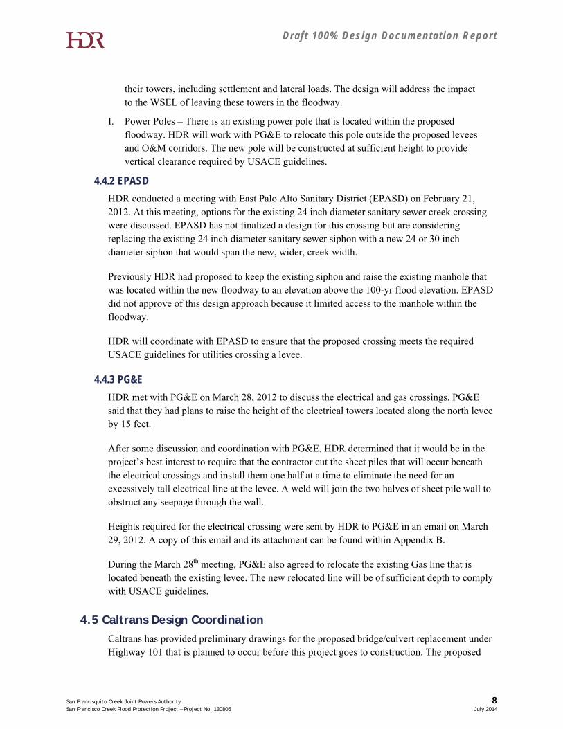
Draft 100% Design Documentat ion Report
San Francisquito Creek Joint Powers Authority 8 San Francisco Creek Flood Protection Project – Project No. 130806 July 2014
their towers, including settlement and lateral loads. The design will address the impact to the WSEL of leaving these towers in the floodway.
I. Power Poles – There is an existing power pole that is located within the proposed floodway. HDR will work with PG&E to relocate this pole outside the proposed levees and O&M corridors. The new pole will be constructed at sufficient height to provide vertical clearance required by USACE guidelines.
4.4.2 EPASD
HDR conducted a meeting with East Palo Alto Sanitary District (EPASD) on February 21, 2012. At this meeting, options for the existing 24 inch diameter sanitary sewer creek crossing were discussed. EPASD has not finalized a design for this crossing but are considering replacing the existing 24 inch diameter sanitary sewer siphon with a new 24 or 30 inch diameter siphon that would span the new, wider, creek width.
Previously HDR had proposed to keep the existing siphon and raise the existing manhole that was located within the new floodway to an elevation above the 100-yr flood elevation. EPASD did not approve of this design approach because it limited access to the manhole within the floodway.
HDR will coordinate with EPASD to ensure that the proposed crossing meets the required USACE guidelines for utilities crossing a levee.
4.4.3 PG&E
HDR met with PG&E on March 28, 2012 to discuss the electrical and gas crossings. PG&E said that they had plans to raise the height of the electrical towers located along the north levee by 15 feet.
After some discussion and coordination with PG&E, HDR determined that it would be in the project’s best interest to require that the contractor cut the sheet piles that will occur beneath the electrical crossings and install them one half at a time to eliminate the need for an excessively tall electrical line at the levee. A weld will join the two halves of sheet pile wall to obstruct any seepage through the wall.
Heights required for the electrical crossing were sent by HDR to PG&E in an email on March 29, 2012. A copy of this email and its attachment can be found within Appendix B.
During the March 28th meeting, PG&E also agreed to relocate the existing Gas line that is located beneath the existing levee. The new relocated line will be of sufficient depth to comply with USACE guidelines.
4.5 Caltrans Design Coordination
Caltrans has provided preliminary drawings for the proposed bridge/culvert replacement under Highway 101 that is planned to occur before this project goes to construction. The proposed
Draft 100% Design Documentat ion Report
San Francisquito Creek Joint Powers Authority 9 San Francisco Creek Flood Protection Project – Project No. 130806 July 2014
bridge will consist of a box culvert consisting of 3 cells that are 30.9 ft. wide and one cell that is 27.3 ft. wide for a total width of 120 ft. The current project floodwall alignment is aligned to match the outer cell wall of the proposed Caltrans bridge structure.
At the July 21, 2010 Caltrans coordination meeting, Caltrans disclosed that they will design no permanent wing walls, only temporary sheet pile wing walls aligned to conform to existing contours. The wing walls on the south side of the creek will close off the 4th bridge cell until the upstream and downstream projects are complete in this area.
There is currently a 96-inch diameter storm drain outfall that is located approximately 50 feet downstream of the Highway 101 Bridge. Caltrans will coordinate the relocation of the existing 96-inch diameter storm drain outfall so that the future outfall will be located beneath Highway 101. This will be of benefit because the exiting 96-inch diameter outfall conflicts with the location of the new floodwall.
During review of the Caltrans drawings, HDR determined that the concrete barrier located at the downstream face of the bridge is lower than the proposed adjacent flood wall. As such, the Caltrans Barrier does not provide the 4 ft of freeboard required by FEMA guidelines. On May 28, 2014 SCVWD met with Caltrans to discuss the Highway Bridge Replacement. HDR joined the conference via teleconference. The barrier was discussed and HDR requested that Caltrans consider raising the barrier to provide the typical 4 ft freeboard required by FEMA. Caltrans replied that the barrier was standard for the approach speed and that a substitution was not feasible.
4.6 Right-of-Way
The layout has been purposely set such that a minimal property take is required, specifically in the residential area of East Palo Alto. It is advisable to avoid property takes for public relations and cost impact purposes; in addition, the minimal backyard takes that are possible in East Palo Alto would provide little hydraulic benefit to offset the resulting impacts. The majority of the ROW infringements and changes in use will be considered on the Santa Clara County side of the creek.
The current right-of-way limit provides a 15’ Operations and Maintenance (O&M) easement at the waterside and landside toe of each levee for inspection and flood fighting purposed. This easement is narrowed to 10 ft easements within areas that have limited access due to existing structures.
The levee right-of-way line adjacent to the Right Bank Floodwall from station 57+00 to 69+00 is located along the existing fence line of the subdivision within that area.

Draft 100% Design Documentat ion Report
San Francisquito Creek Joint Powers Authority 10 San Francisco Creek Flood Protection Project – Project No. 130806 July 2014
This page intentionally left blank.
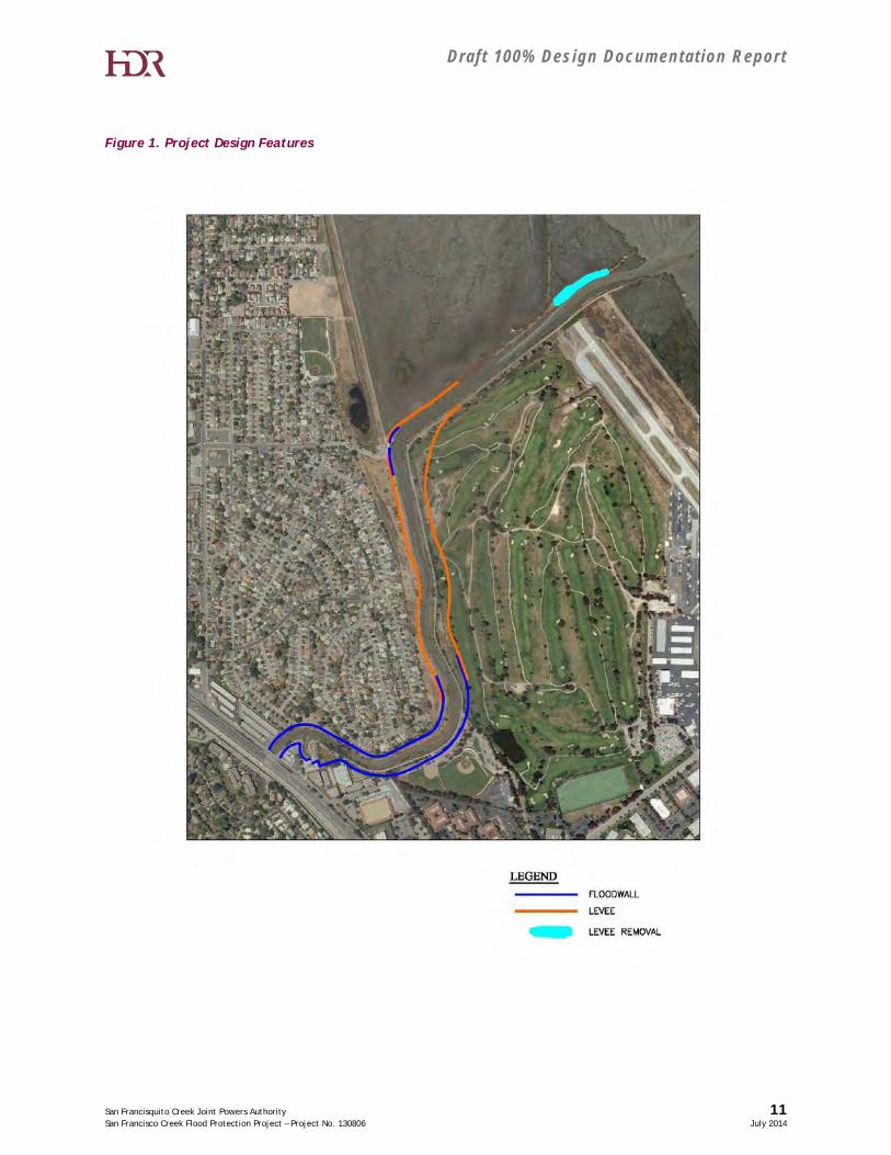
Draft 100% Design Documentat ion Report
San Francisquito Creek Joint Powers Authority 11 San Francisco Creek Flood Protection Project – Project No. 130806 July 2014
Figure 1. Project Design Features
Draft 100% Design Documentat ion Report
San Francisquito Creek Joint Powers Authority 12 San Francisco Creek Flood Protection Project – Project No. 130806 July 2014
This page intentionally left blank.
Draft 100% Design Documentat ion Report
San Francisquito Creek Joint Powers Authority 13 San Francisco Creek Flood Protection Project – Project No. 130806 July 2014
Figure 2. PWA Alternative 2 Conceptual Layout
Figure reproduced from PWA’s July 2009 San Francisquito Creek Flood Reduction Alternatives Analysis.
Draft 100% Design Documentat ion Report
San Francisquito Creek Joint Powers Authority 14 San Francisco Creek Flood Protection Project – Project No. 130806 July 2014
This page intentionally left blank.
Draft 100% Design Documentat ion Report
San Francisquito Creek Joint Powers Authority 15 San Francisco Creek Flood Protection Project – Project No. 130806 July 2014
Figure 3. Typical Levee Cross Section
Draft 100% Design Documentat ion Report
San Francisquito Creek Joint Powers Authority 16 San Francisco Creek Flood Protection Project – Project No. 130806 July 2014
This page intentionally left blank.
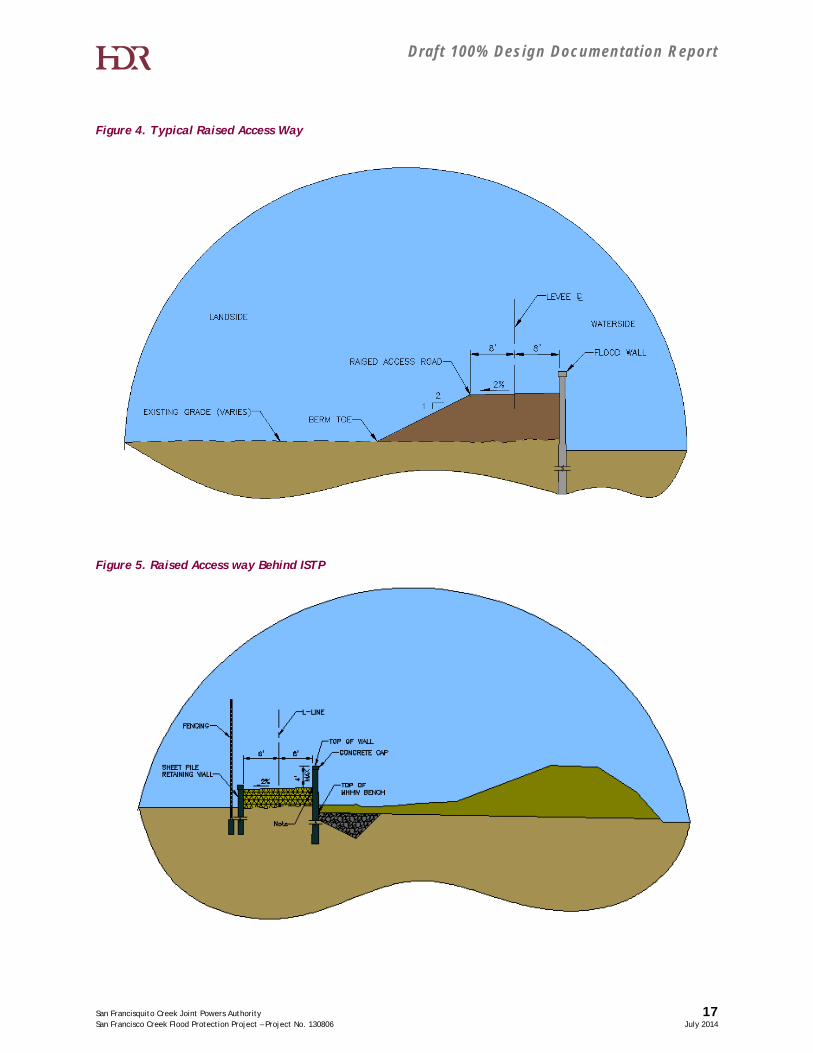
Draft 100% Design Documentat ion Report
San Francisquito Creek Joint Powers Authority 17 San Francisco Creek Flood Protection Project – Project No. 130806 July 2014
Figure 4. Typical Raised Access Way
Figure 5. Raised Access way Behind ISTP

Draft 100% Design Documentat ion Report
San Francisquito Creek Joint Powers Authority 18 San Francisco Creek Flood Protection Project – Project No. 130806 July 2014
This page intentionally left blank.
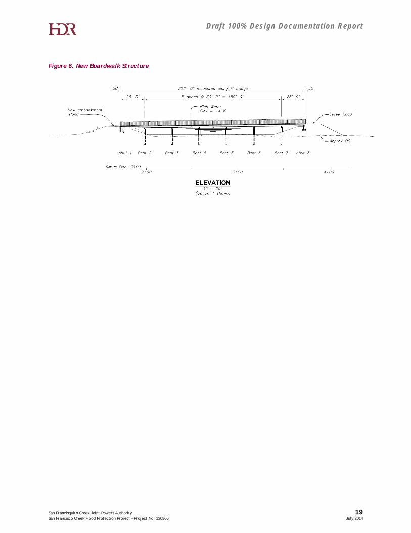
Draft 100% Design Documentat ion Report
San Francisquito Creek Joint Powers Authority 19 San Francisco Creek Flood Protection Project – Project No. 130806 July 2014
Figure 6. New Boardwalk Structure
Draft 100% Design Documentat ion Report
San Francisquito Creek Joint Powers Authority 20 San Francisco Creek Flood Protection Project – Project No. 130806 July 2014
This page intentionally left blank.
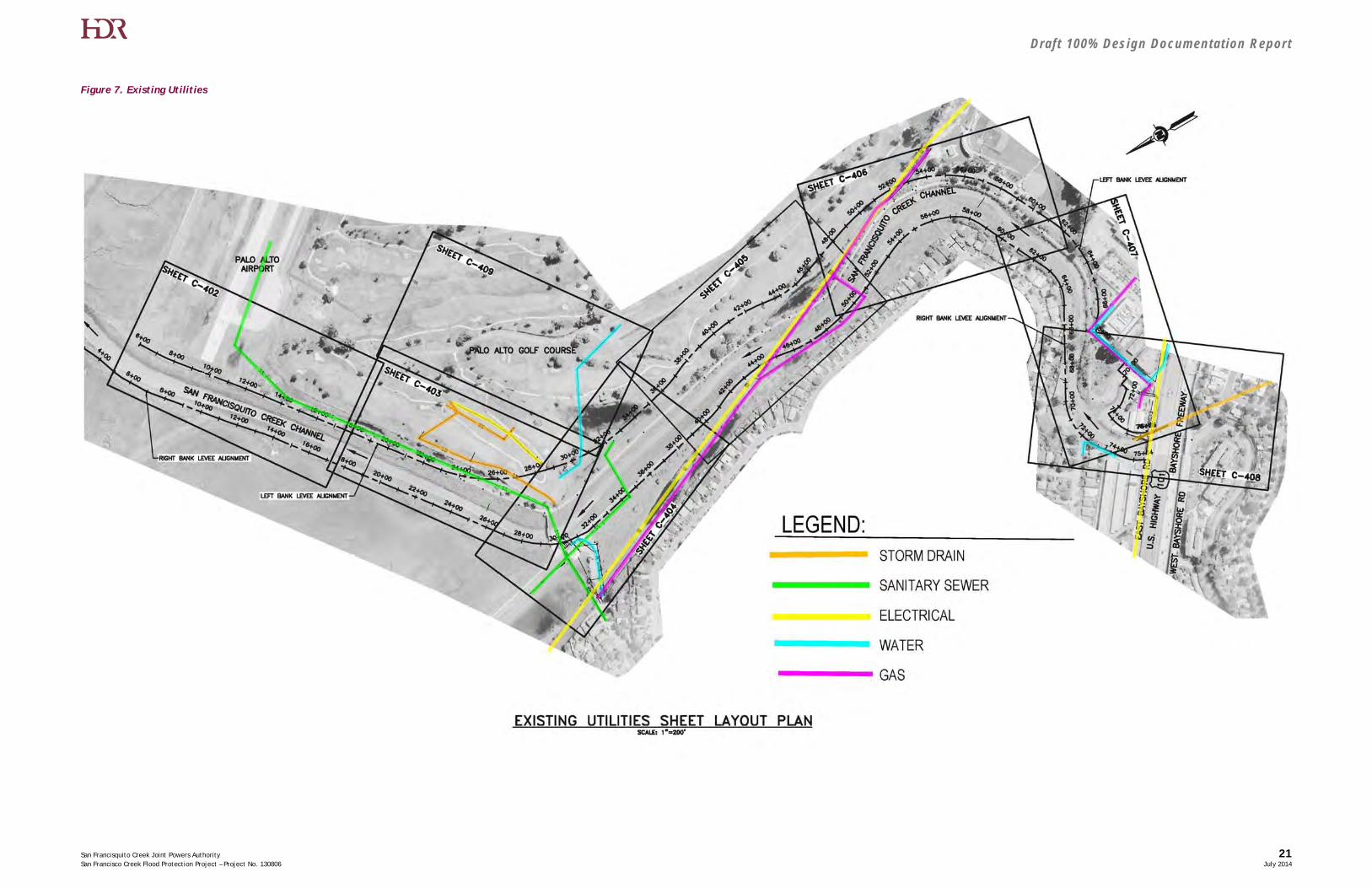
Draft 100% Design Documentat ion Report
San Francisquito Creek Joint Powers Authority 21 San Francisco Creek Flood Protection Project – Project No. 130806 July 2014
Figure 7. Existing Utilities
Draft 100% Design Documentat ion Report
San Francisquito Creek Joint Powers Authority 22 San Francisco Creek Flood Protection Project – Project No. 130806 July 2014
This page intentionally left blank.
Draft 100% Design Documentat ion Report
San Francisquito Creek Joint Powers Authority San Francisco Creek Flood Protection Project – Project No. 130806 July 2014
APPENDIX A – Flood Wall Calculations
Draft 100% Design Documentat ion Report
San Francisquito Creek Joint Powers Authority San Francisco Creek Flood Protection Project – Project No. 130806 July 2014
This page intentionally left blank.
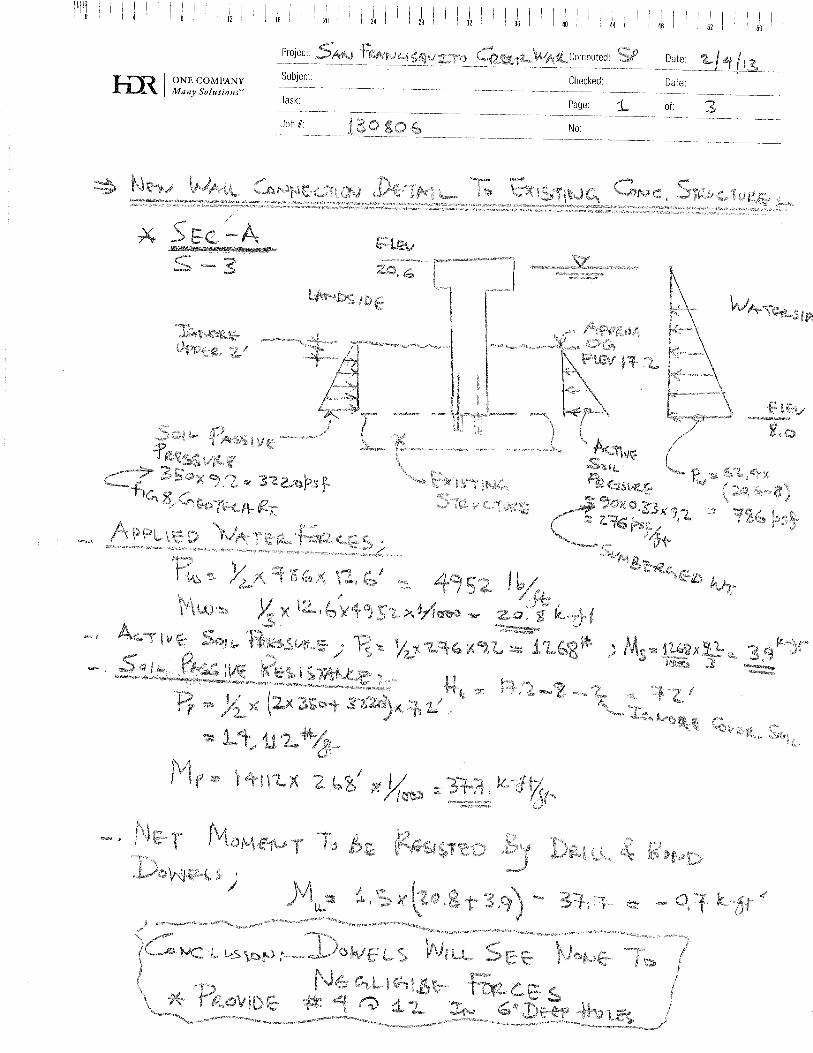
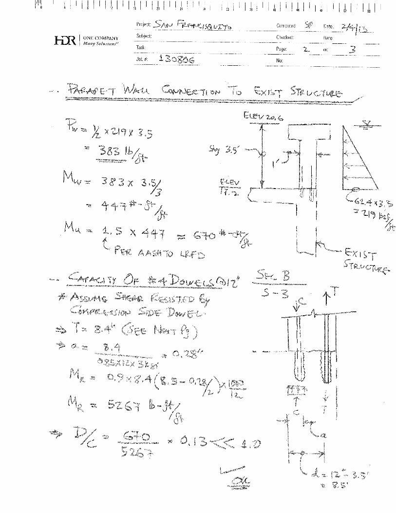
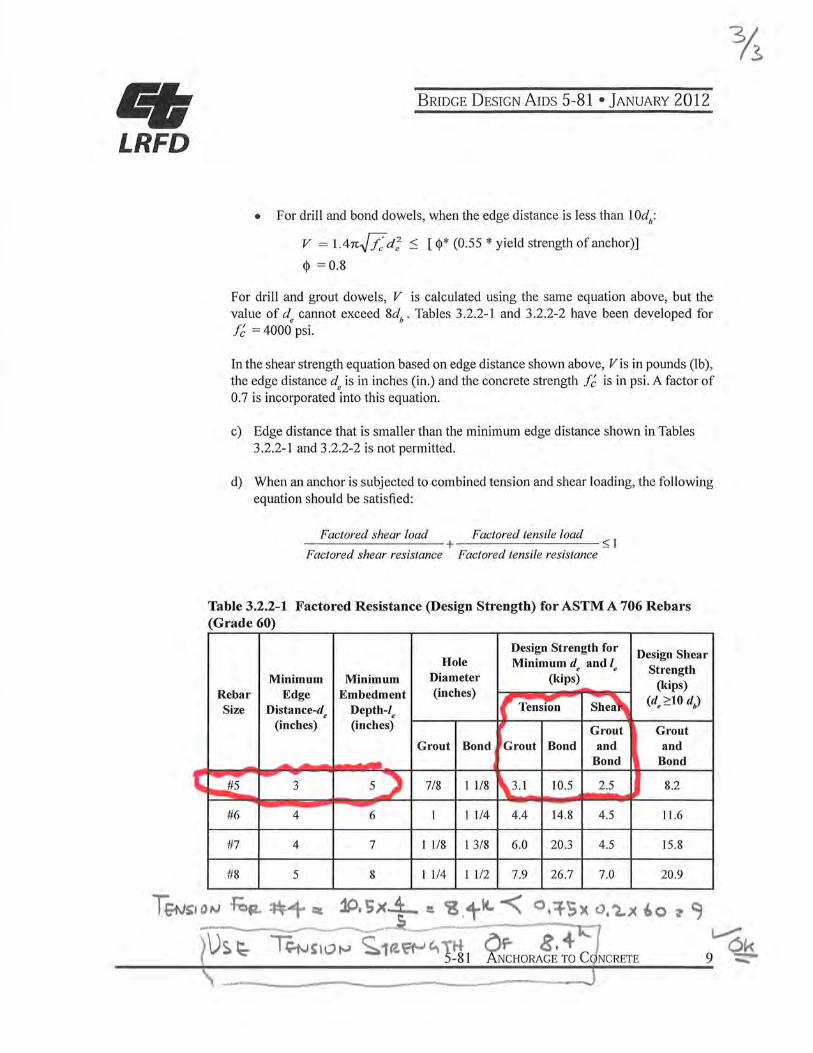
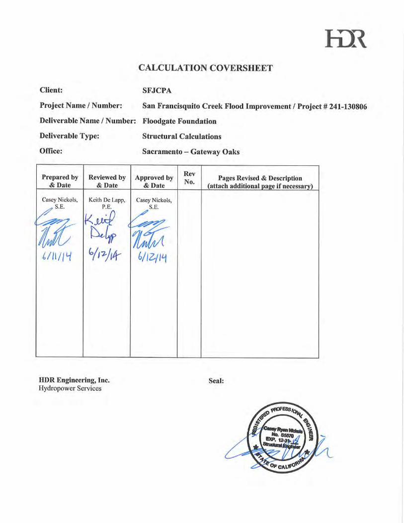
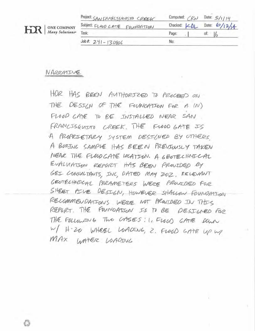
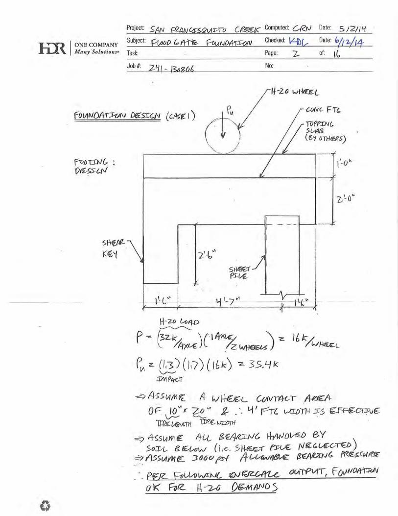
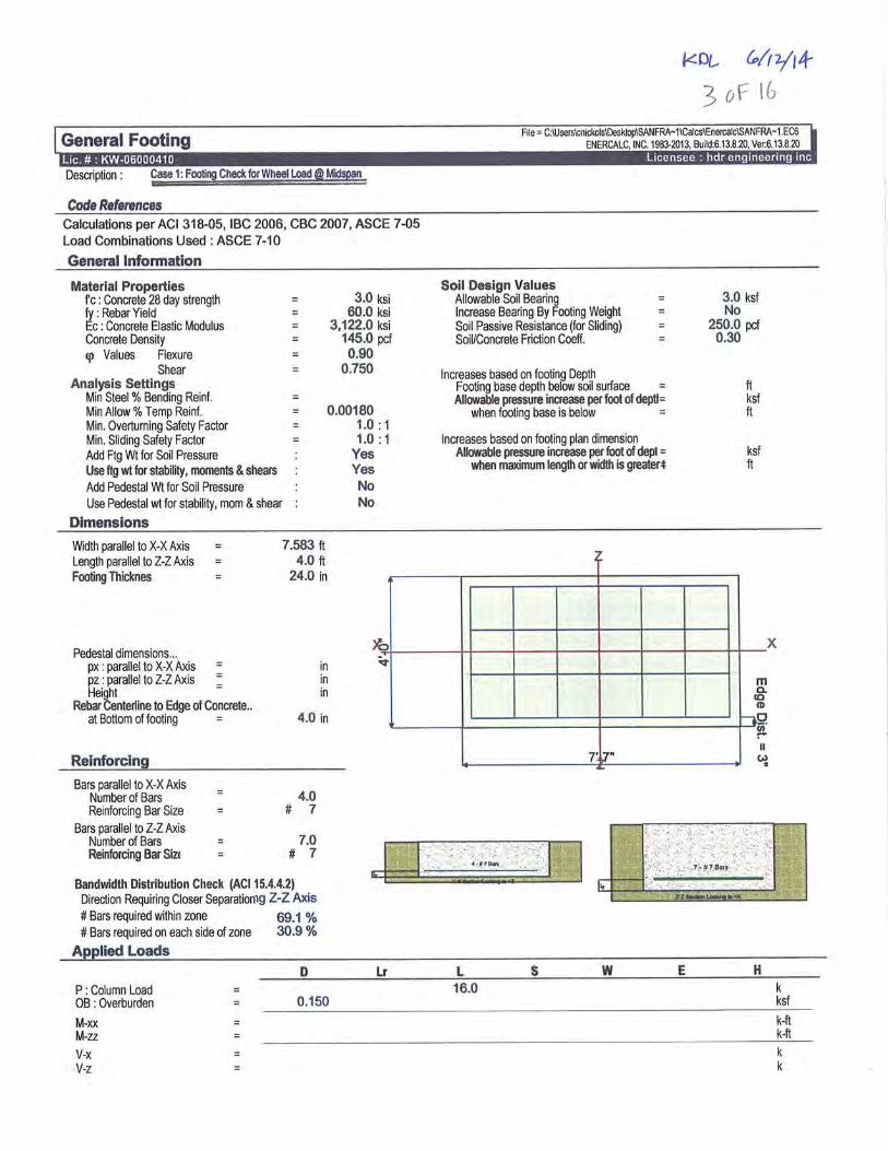
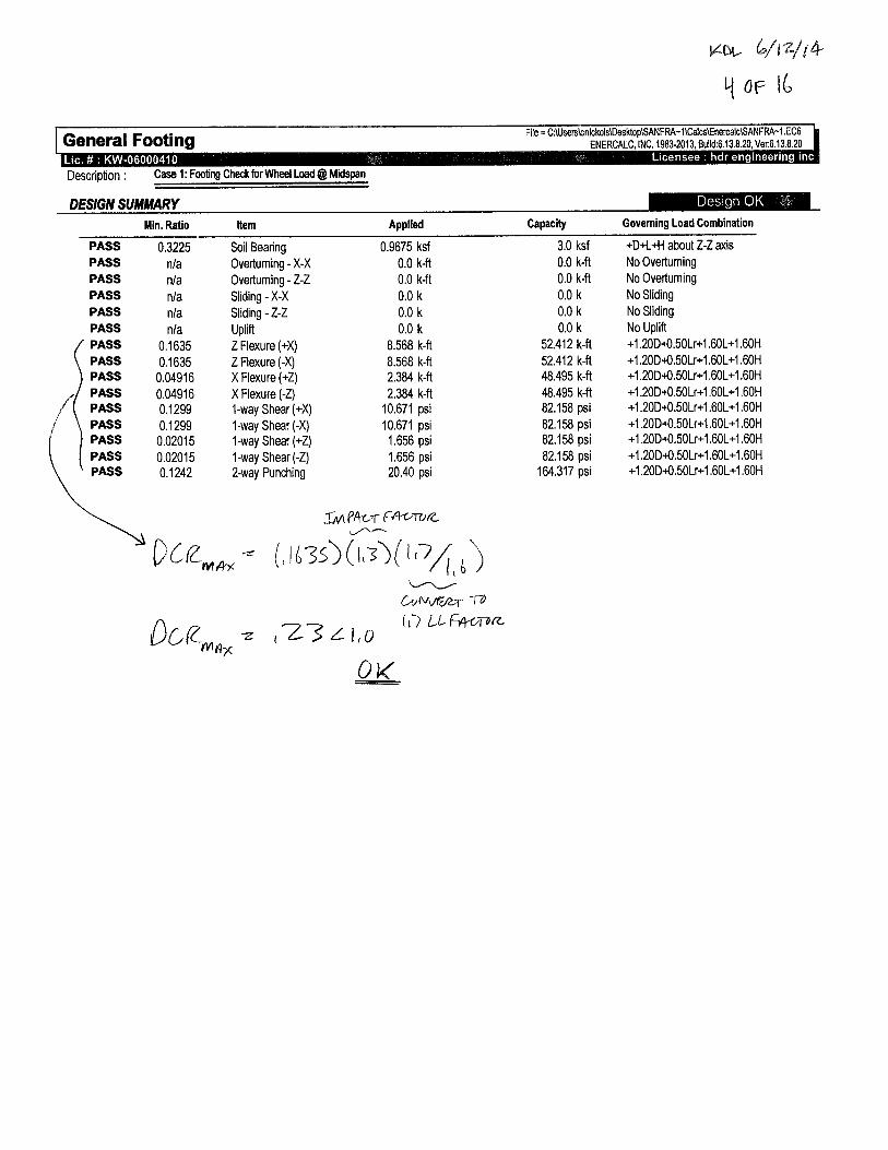
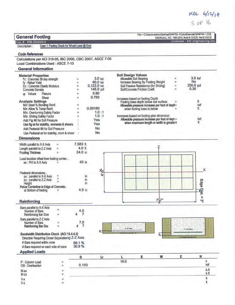
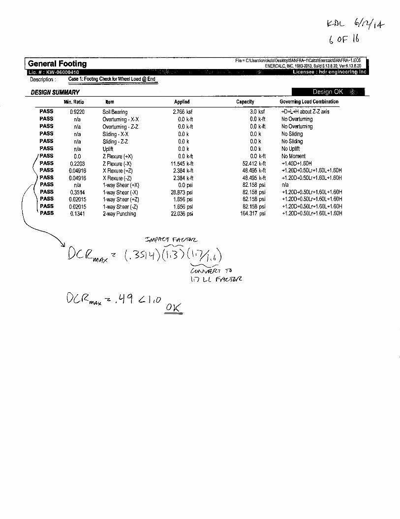
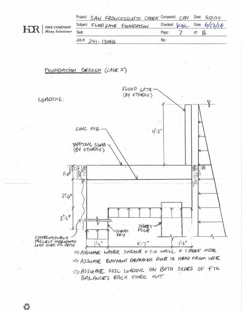
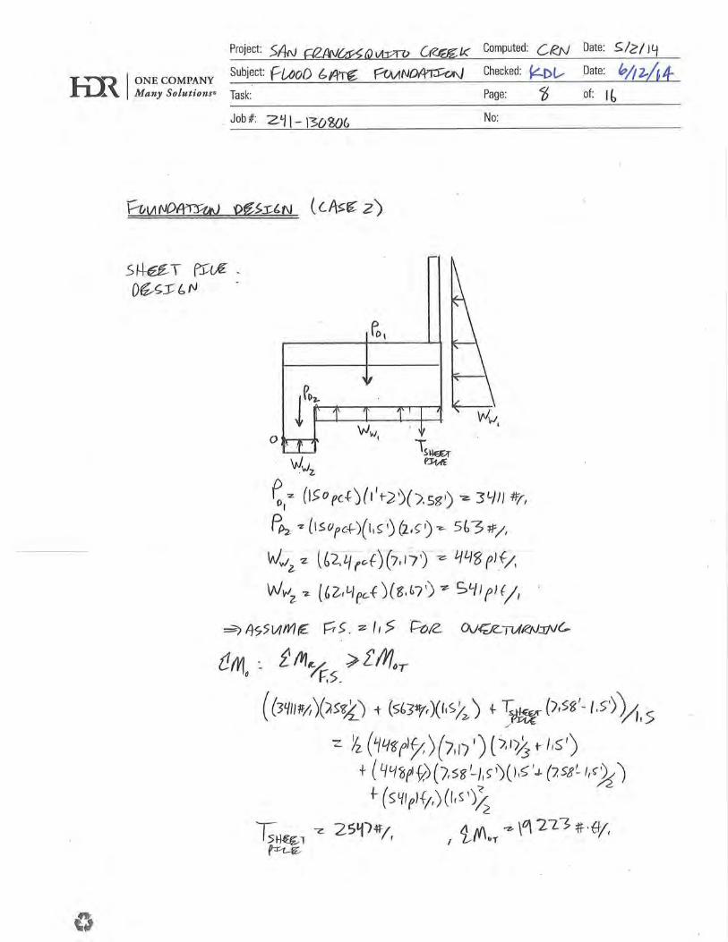
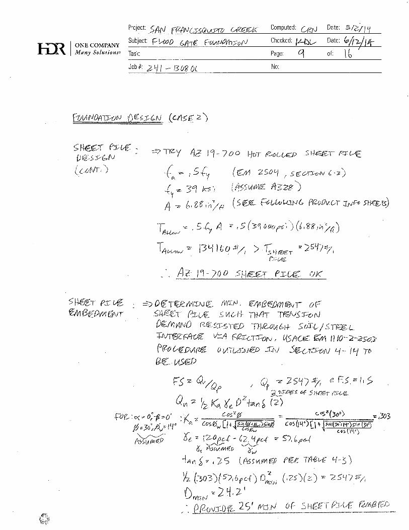
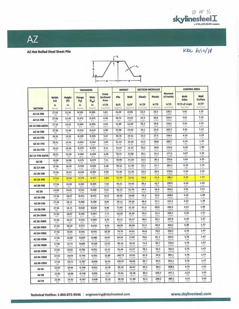
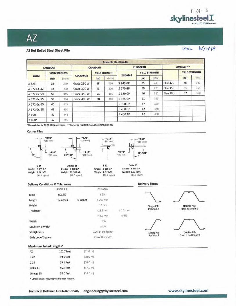
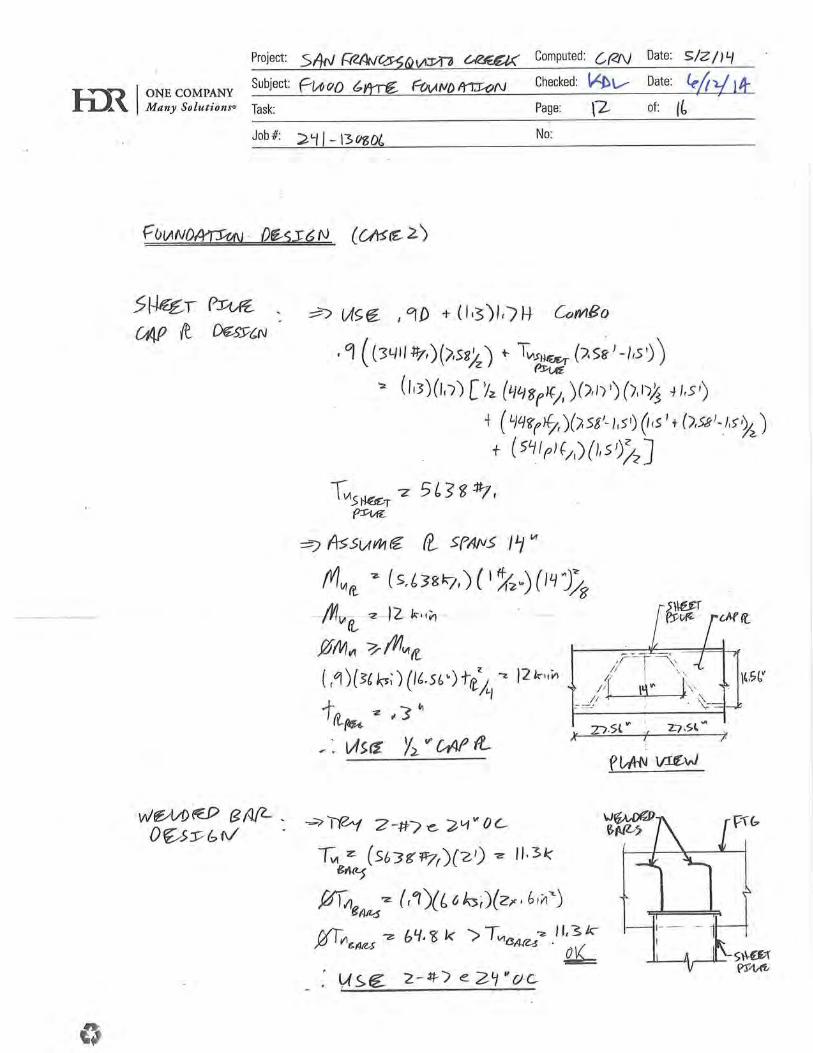
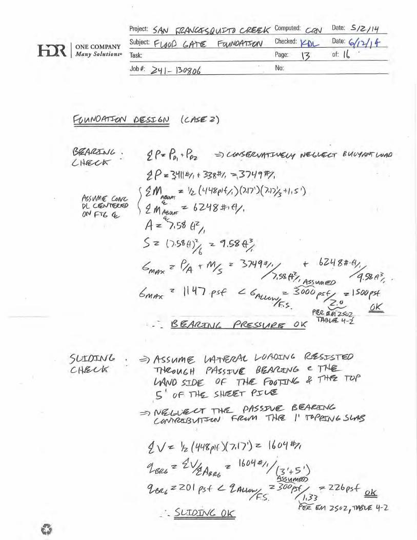
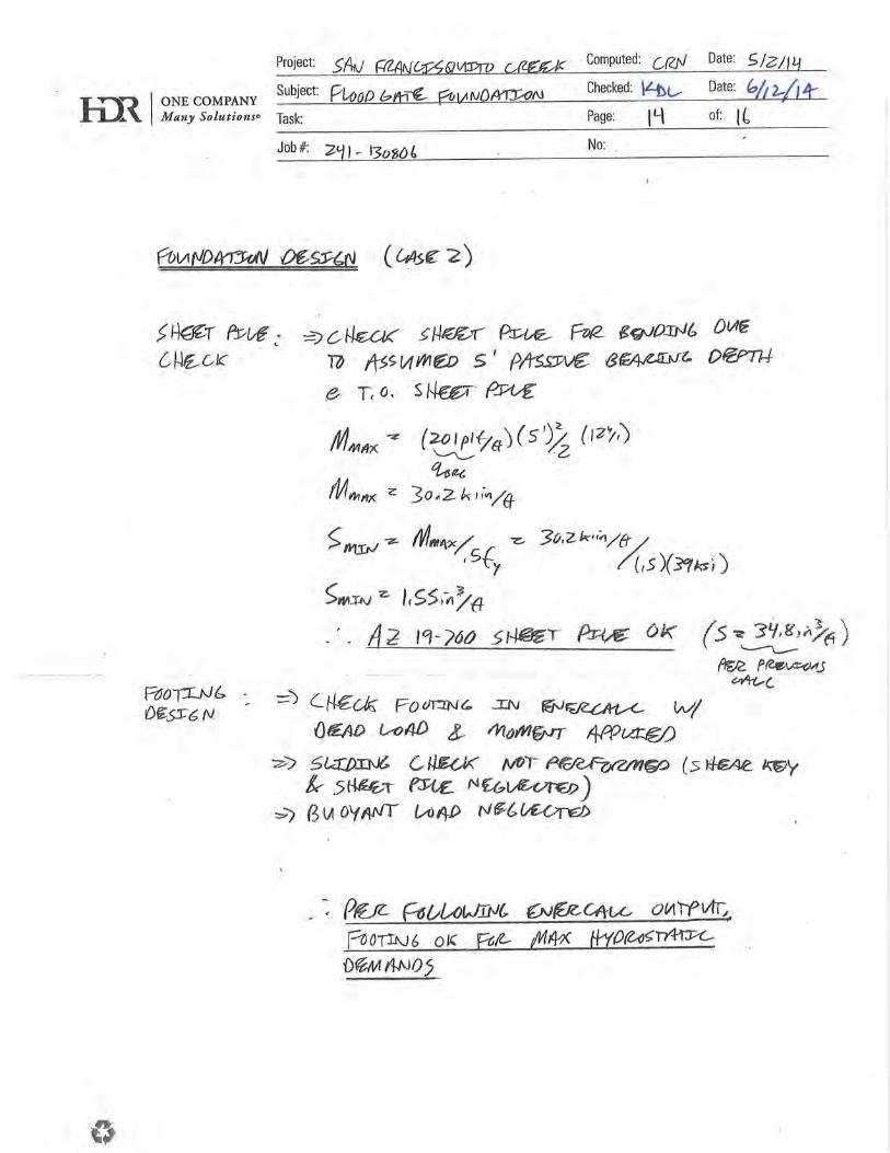
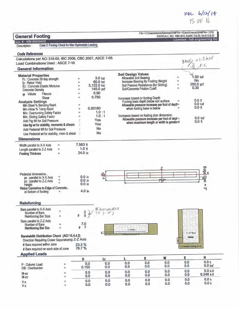
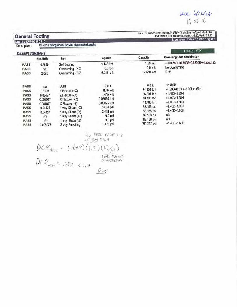

Draft 100% Design Documentat ion Report
San Francisquito Creek Joint Powers Authority San Francisco Creek Flood Protection Project – Project No. 130806 July 2014
This page intentionally left blank.
Draft 100% Design Documentat ion Report
San Francisquito Creek Joint Powers Authority San Francisco Creek Flood Protection Project – Project No. 130806 July 2014
APPENDIX B – PG&E Coordination (Email and Figure)
Draft 100% Design Documentat ion Report
San Francisquito Creek Joint Powers Authority San Francisco Creek Flood Protection Project – Project No. 130806 July 2014
This page intentionally left blank.
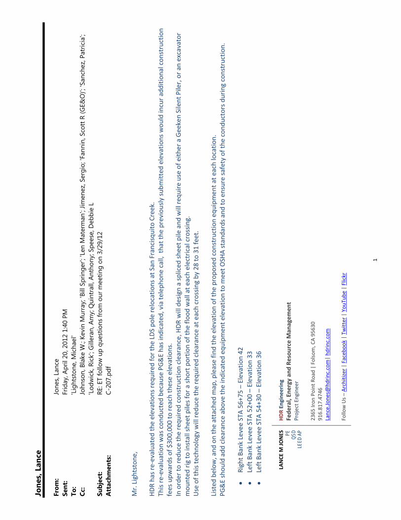
1
Jone
s, L
ance
From
:Jo
nes,
Lanc
eSe
nt:
Frid
ay, A
pril
20, 2
012
1:40
PM
To:
'Lig
htst
one,
Mic
hael
'Cc
:Jo
hnso
n, B
lake
W.;
Kevi
n M
urra
y; 'B
ill S
prin
ger';
'Len
Mat
erm
an';
Jimen
ez, S
ergi
o; 'F
anni
n, S
cott
R (G
E&O
)'; 'S
anch
ez, P
atric
ia';
'Lod
wic
k, R
ick'
; Gill
eran
, Am
y; Q
uint
rall,
Ant
hony
; Spe
ese,
Deb
bie
LSu
bjec
t:RE
: ET
follo
w u
p qu
estio
ns fr
om o
ur m
eetin
g on
3/2
9/12
Att
achm
ents
:C-
207.
Mr. Lightstone
, HD
R has re‐evaluated the elevations re
quire
d for the
LDS
pole relocatio
ns at S
an Francisq
uito Creek.
This re‐evaluation was con
ducted
because PG&E has ind
icated
, via te
leph
one call, that the
previou
sly su
bmitted
elevatio
ns wou
ld incur a
ddition
al con
struction
fees upw
ards of $
300,00
0 to re
ach these elevations.
In order to
redu
ce th
e requ
ired constructio
n clearance, HDR
will design a spliced
sheet p
ile and
will re
quire
use of e
ither a Geeken Silent Piler, or an excavator
mou
nted
rig to install she
et piles for a sh
ort p
ortio
n of th
e flo
od wall at e
ach electrical crossing.
Use of this techn
ology will re
duce th
e requ
ired clearance at each crossin
g by
28 to 31 feet.
Listed
below
, and
on the attached
map, please fin
d the elevation of th
e prop
osed
con
struction eq
uipm
ent a
t each locatio
n.
PG&E shou
ld add
clearance abo
ve th
e indicated eq
uipm
ent e
levatio
n to m
eet O
SHA standards a
nd to
ensure safety of the
con
ductors d
uring constructio
n.
Right B
ank Levee STA 56
+75 – Elevation 42
Left Bank Levee STA 52
+00 – Elevation 33
Left Bank Levee STA 54
+30 – Elevation 36
LANCE
M JO
NES
PE
QSD
LE
ED A
P
HDR En
gine
ering
Fede
ral, En
ergy and
Resou
rce Man
agem
ent
Project E
ngineer
2365
Iron
Point Road | Folso
m, CA 95630
916.81
7.47
46
Lance.Jone
s@hd
rinc.com| hd
rinc.com
Follow Us –
Architizer | Faceb
ook | Tw
itter | You
Tube
| Flickr
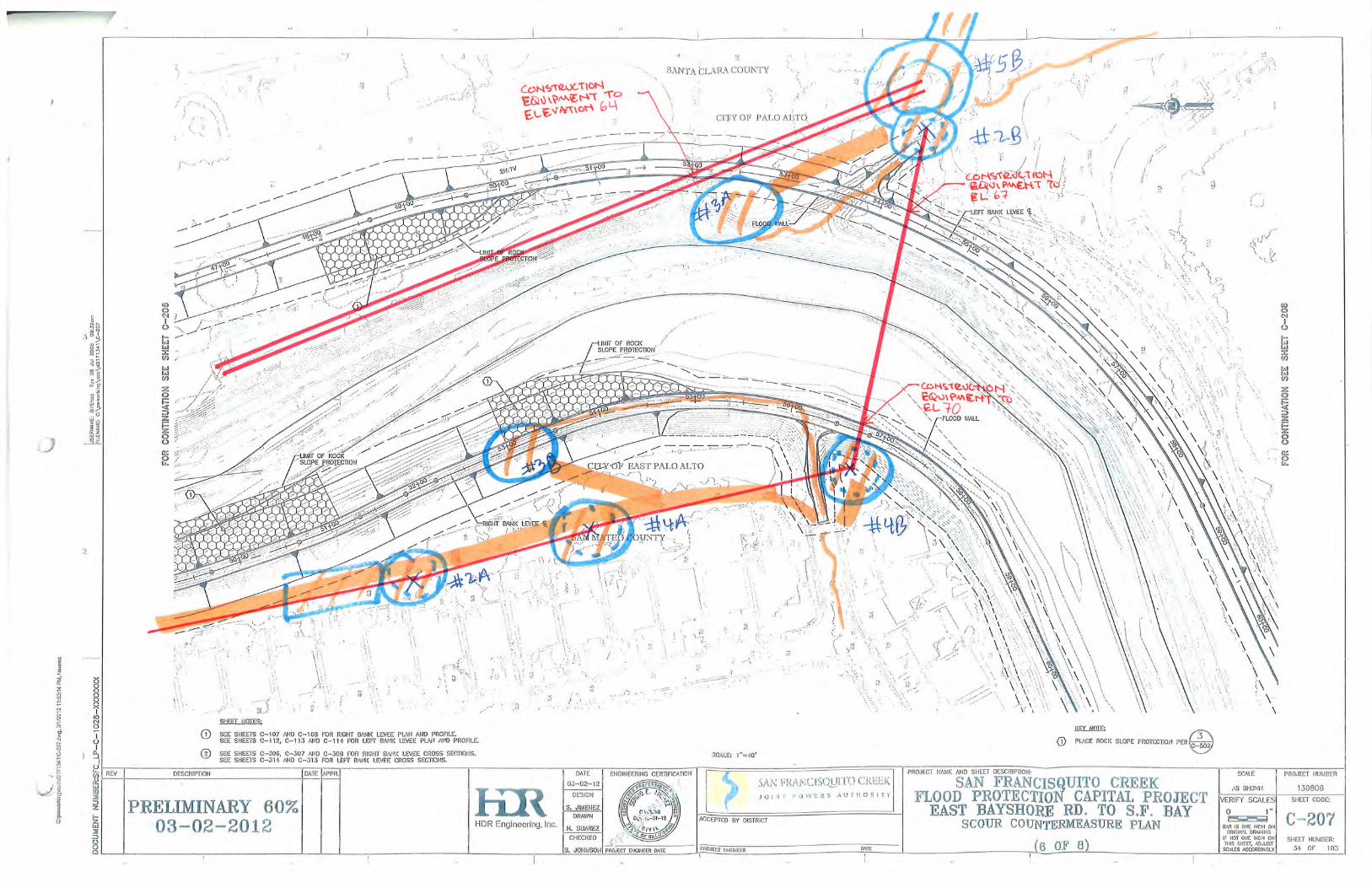
ljones
Text Box
CONSTRUCTION EQUIPMENT TO EL 42.0
ljones
Text Box
CONSTRUCTION EQUIPMENT TO EL 36.0
ljones
Text Box
CONSTRUCTION EQUIPMENT TO EL 33.0
Field Operations Levee Inspection Guidelines
DOCUMENT NO.: WW75161 REVISION: R4
EFFECTIVE DATE: 02/15/11 PROCESS OWNER: Roger Narsim
Page 1 of 10 Downloaded or printed copies are for reference only. Verify this is the current version prior to use. See the District website for released version
1. PURPOSE AND SCOPE: Adequate levee inspection and maintenance is essential for providing a reliable flood protection system, reducing the risk of flooding and loss of life and property, and maintaining compliance with state and federal regulations for funding and flood insurance requirements. Adequate levee maintenance also ensures accessibility and serviceability during flood events and emergency work.
This document describes general procedures and guidelines for field operations levee inspection and record-keeping.
2. REFERENCE DOCUMENTS: External References:
U.S. Army Corps of Engineers levee technical guidance documents U.S. Army Corps of Engineers O&M manuals for certain SCVWD flood protection projects
Internal References: Q751D02 Control and Oversight of Pesticide Use WQ75101 Field Operations Work Order Process WQ75115 Engineering Field Instructions WF75118 Ordinance Violation Form WF75161 Levee Field Inspection Rating Guide WF75165 Field Inspection Checklist
Levee Inventory List (watershed specific) Levee Safety Technical Guidance Manual (W:\Watershed Mgmt\Levee Safety Manuals\TechManualComplete) Annual Levee Inspection Report Event Levee Inspection Report Facility Maintenance Guidelines/Agreements As-Built Plans SMP Binder (BMP Manual/Permits and Supporting Material) FC 441 (03-21-89) Land Surveying and Mapping Request for Services (FC 136)
3. DEFINITIONS:
Levee – A raised embankment to prevent a watercourse from flooding beyond its expected course. The “levee” as defined here refers to all elements of the flood protection system. This includes the embankment itself and any stability or seepage berms, toe drains, flood walls, relief wells, and any waterside erosion protection system. It also includes other ancillary structures, facilities and appurtenances encroaching on the levee.
Net grade – The as-built elevation of a levee. Event-driven inspection – An inspection that should take place during or immediately after a natural hazard
such as flood, earthquake, storm and other events having the potential of damaging the flood protection system.
Field Operations Levee Inspection Guidelines
DOCUMENT NO.: WW75161 REVISION: R4
EFFECTIVE DATE: 02/15/11 PROCESS OWNER: Roger Narsim
Page 2 of 10 Downloaded or printed copies are for reference only. Verify this is the current version prior to use. See the District website for released version
4. ROLES AND RESPONSIBILITIES: None
5. REQUIREMENTS: 5.1. ISO 9001 - 7.5.1 Control of Production and Service Provision
5.2. ISO 14001 - 4.4.6 Operational Control
5.3. Other Requirements
Q751D02 Control and Oversight of Pesticide Use SMP Permits & CEQA documents
6. MONITORING AND MEASUREMENT: None
7. PROCEDURE:
7.1. Field Operations Levee/Work Inspection Flow Chart
The following flowchart represents typical critical paths from initial levee inspection to final work initiation. Although this flowchart cannot be used for every levee inspection/work scenario, it is shown here to represent a basis for most typical situations.
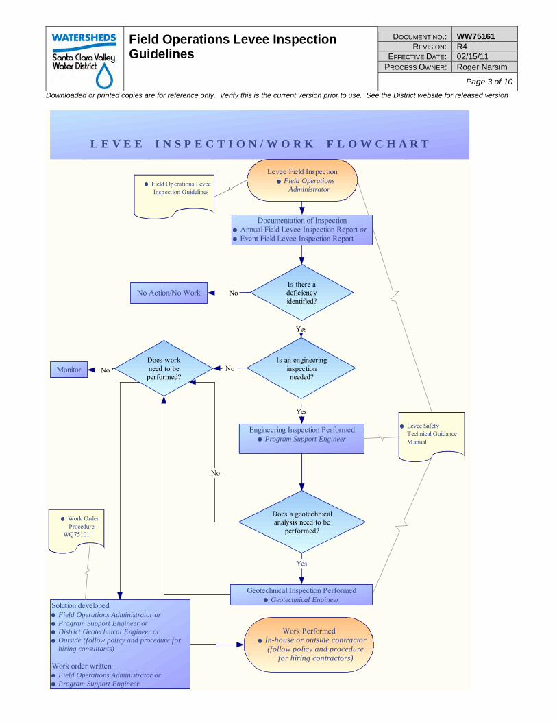
Field Operations Levee Inspection Guidelines
DOCUMENT NO.: WW75161 REVISION: R4
EFFECTIVE DATE: 02/15/11 PROCESS OWNER: Roger Narsim
Page 3 of 10 Downloaded or printed copies are for reference only. Verify this is the current version prior to use. See the District website for released version
L E V E E I N S P E C T I O N / W O R K F L O W C H A R T
Levee Field InspectionField Operations
Administrator
Solution developedField Operations Administrator orProgram Support Engineer orDistrict Geotechnical Engineer orOutside (follow policy and procedure forhiring consultants)
Work order writtenField Operations Administrator orProgram Support Engineer
Documentation of InspectionAnnual Field Levee Inspection Report orEvent Field Levee Inspection Report
Is there adeficiencyidentified?
Work PerformedIn-house or outside contractor(follow policy and procedure
for hiring contractors)
Engineering Inspection PerformedProgram Support Engineer
No Action/No Work No
Monitor
Yes
Work OrderProcedure -
WQ75101
Levee SafetyTechnical GuidanceManual
Field Operations LeveeInspection Guidelines
Yes
NoDoes workneed to beperformed?
Yes
No
Does a geotechnicalanalysis need to be
performed?
Geotechnical Inspection PerformedGeotechnical Engineer
NoIs an engineering
inspectionneeded?
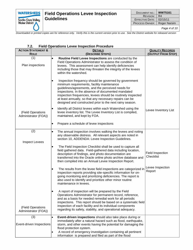
Field Operations Levee Inspection Guidelines
DOCUMENT NO.: WW75161 REVISION: R4
EFFECTIVE DATE: 02/15/11 PROCESS OWNER: Roger Narsim
Page 4 of 10 Downloaded or printed copies are for reference only. Verify this is the current version prior to use. See the District website for released version
7.2. Field Operations Levee Inspection Procedure ACTION STATEMENT &
ROLE DETAILS
(DESCRIBE STEPS) QUALITY RECORDS
(OUTPUT FROM STEP) (1)
Plan inspections
(Field Operations Administrator (FOA))
• Routine Field Levee Inspections are conducted by the Field Operations Administrator to assess the condition of levees. This assessment can help identify deficiencies including those that may threaten the integrity of the levees within the watershed.
• Inspection frequency should be governed by government
minimum requirements, facility maintenance guidelines/agreements, and the perceived needs for inspections. In the absence of documented mandated inspection frequencies, levees should be routinely inspected at least annually, so that any necessary repairs can be designed and constructed prior to the next rainy season.
• Identify all District levees within each Watershed using the levee inventory list. The Levee Inventory List is compiled, maintained, and kept by FOA.
• Prepare a schedule of levee inspections
Levee Inventory List
(2)
Inspect Levees
(Field Operations Administrator (FOA))
• The annual inspection involves walking the levees and noting any observable distress. All relevant aspects are noted in section 10, ADDENDA: Levee Inspection Guidelines.
• The Field Inspection Checklist shall be used to capture all
field gathered data. Field-gathered data including location, description of findings, and photo documentation are transferred into the Oracle online photo archive database and then compiled into an Annual Levee Inspection Report.
• The results from the levee field inspections are categorized in
inspection reports providing site-specific information for on-going monitoring and prioritizing deficiencies. The report is also used to identify and prioritize other minor routine maintenance in levees.
• A report of inspection will be prepared by the Field
Operations Administrator for permanent record, reference, and as a basis for needed remedial work for all periodic inspections. This report should be based on a systematic field inspection of each facility and its individual components regarding its safety, stability, and operational adequacy.
Field Inspection Checklist Levee Inspection Report
(3)
Event-driven Inspections
• Event-driven inspections should also take place during or immediately after a natural hazard such as flood, earthquake, storm, and other events having the potential for damaging the flood protection system.
• A record of emergency investigation containing all pertinent information is prepared and filed as part of the flood
Field Operations Levee Inspection Guidelines
DOCUMENT NO.: WW75161 REVISION: R4
EFFECTIVE DATE: 02/15/11 PROCESS OWNER: Roger Narsim
Page 5 of 10 Downloaded or printed copies are for reference only. Verify this is the current version prior to use. See the District website for released version
ACTION STATEMENT &
ROLE DETAILS
(DESCRIBE STEPS) QUALITY RECORDS
(OUTPUT FROM STEP)
(Field Operations Administrator (FOA))
protection system record. • Make additional inspections after significant events such as
floods and earthquakes. The emphasis of these inspections will depend on the event triggering the inspection.
o Specific items to be checked should include: waterside erosion protection and encroachments, evidences of seepage, levee settlement, slumps, lateral spreading, cracking, evidence of liquefaction (boils and cracking), and slope failures.
o Other items to be observed and reported should include any mechanical equipment and facilities such as pipes, gates and valves, inlet and outlet structures, and bridge abutments.
• An earthquake inspection is particularly urgent if the earthquake occurs just before or during the rainy season.
• During flood periods, frequent patrols of the levee are made to locate flood-related deficiencies in levees, floodwalls, and other flood protection structures and facilities. The specific frequency of these patrols will depend on the flood level, and may vary from daily to essentially continuously.
• A report of an event-driven inspection is prepared by the FOA for permanent record, reference, and as a basis for needed remedial work for all periodic inspections. Field-gathered data including location, description of findings and photo documentation are transferred into the Oracle online photo archive database and then compiled into an Event Levee Inspection Report.
Event Levee Inspection Report
(4) Deficiency Correction
(Field Operations Administrator (FOA))
• If a deficiency revealed during the course of the field levee inspection requires correction, a solution is developed by the FOA and implemented.
• FOA will document any work required in accordance with
WQ75101 Field Operations Work Order Process. • If the FOA determines that a deficiency revealed during the
course of the field levee inspection requires engineering analysis, a Watershed Program Support Engineer shall be consulted and if necessary, a solution developed. The Watershed Program Support engineer will develop a solution in accordance with WQ75115 Engineering Field Instructions.
• If the Watershed Program Support Engineer determines that a
geotechnical inspection is necessary, a geotechnical engineer or outside consultant will be consulted, and if necessary, a solution developed.
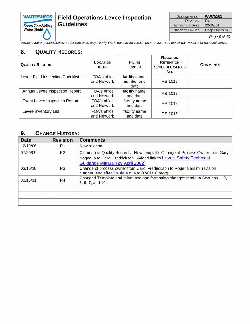
Field Operations Levee Inspection Guidelines
DOCUMENT NO.: WW75161 REVISION: R4
EFFECTIVE DATE: 02/15/11 PROCESS OWNER: Roger Narsim
Page 6 of 10 Downloaded or printed copies are for reference only. Verify this is the current version prior to use. See the District website for released version
8. QUALITY RECORDS:
QUALITY RECORD LOCATION
KEPT FILING ORDER
RECORDS
RETENTION
SCHEDULE SERIES
NO.
COMMENTS
Levee Field Inspection Checklist
FOA’s office and Network
facility name, number and
date RS-1015
Annual Levee Inspection Report FOA’s office and Network
facility name, and date
RS-1015
Event Levee Inspection Report FOA’s office and Network
facility name and date RS-1015
Levee Inventory List FOA’s office and Network
facility name and date
RS-1015
9. CHANGE HISTORY: Date Revision Comments 12/19/06 R1 New release
07/29/09 R2 Clean up of Quality Records. New template. Change of Process Owner from Gary Nagaoka to Carol Fredrickson. Added link to Levee Safety Technical Guidance Manual (29 April 2002)
03/15/10 R3 Change of process owner from Carol Fredrickson to Roger Narsim, revision number, and effective date due to 02/01/10 reorg.
02/15/11 R4 Changed Template and minor text and formatting changes made to Sections 1, 2, 3, 5, 7, and 10.
Field Operations Levee Inspection Guidelines
DOCUMENT NO.: WW75161 REVISION: R4
EFFECTIVE DATE: 02/15/11 PROCESS OWNER: Roger Narsim
Page 7 of 10 Downloaded or printed copies are for reference only. Verify this is the current version prior to use. See the District website for released version
10. ADDENDA:
Levee Inspection Guidelines More detailed information can be in the Levee Safety Technical Guidance Manual The guidelines listed below were derived from the Levee Safety Technical Guidance Manual (29 April 2002) and are intended to provide a general basis for conducting field operations levee inspections. All aspects of the guidelines will not apply to every levee and must be applied on a case-by-case basis as appropriate. Flood Protection Levees Levee Geometry Inspection should identify any apparent deviations from the as-built geometry of the levee. Levee embankments should be maintained to not less than the net grade and section by replacing any loss of material from the crest, slopes, or any bench/berm. Ruts, washes, slides and areas of subsidence should be noted and promptly repaired and the entire embankment maintained sufficiently smooth for power mowing. Levee crests should be graded as necessary to drain freely and prevent impoundment of rain water. When the crest of the levee is used as maintenance road, and unless the crest road is paved in accordance with standard roadway pavement and traffic criteria, the levee crest should be covered by at least 6 inches of a gravel/aggregate base overlying a filter fabric.
Cracking During the levee inspection, any observed cracks along the crest or the side slopes should be recorded for further assessment of impact to levee integrity. Longitudinal cracks with down scarps toward the levee slope may be an indication of incipient slope instability. Generally these surface cracks will exacerbate potential sloughing or sliding during wet and prolonged rainy seasons. As the water infiltrates the cracks, it adds lateral hydrostatic pressures on the walls of the cracks and hence promotes potential slips. Random cracks that do not show any sign of down slope movements are generally caused by high shrink-swell levee material, such as high-plasticity clay or organic rich material. The long term cycles of shrink-swell may cause the levee material to deteriorate and weaken. It is recommended that these cracks be repaired as soon as reported.
Erosion and Condition of Slope Protection Erosion or scour of levees and banks commonly occurs along non-protected levee and bank slopes. The amount and extent of erosion depend typically on the flow velocity, material-type irregularities and contacts between hard and soft material. Silty and sandy unconsolidated alluvium are highly susceptible to erosion and scour. Even levees and banks equipped with erosion protection can experience scour during high river stages. Usually these occurrences take place in areas where the erosion protection system has not been well maintained and has deteriorated with time, or in areas where the erosion protection system was under-designed for the damaging flood. Erosion protection comes in various forms; from concrete surfacing and rock protection to more environmentally friendly solutions such as bio-engineered slope protection, to non-protection by design to allow the river to meander and run its natural course. The latter usually is associated with a system of set-back levees.
When slope erosion protection is provided, observations during the levee inspection should ascertain that the erosion protection is maintained in accordance with the intent of the design; that the levee maintains its uniformity and its integrity; that no irregularities are developing that may become points of weakness. If
Field Operations Levee Inspection Guidelines
DOCUMENT NO.: WW75161 REVISION: R4
EFFECTIVE DATE: 02/15/11 PROCESS OWNER: Roger Narsim
Page 8 of 10 Downloaded or printed copies are for reference only. Verify this is the current version prior to use. See the District website for released version
such events are observed, repairs should be undertaken immediately to bring the protection system to its original design.
Erosion and scour are probably the leading cause of levee failures during flood events. Levee material, rock, plastic sheeting (Visqueen), and filter fabric should be stockpiled near the flood protection system in locations where they are quickly and efficiently accessible for emergency repairs.
Levee Settlement and Subsidence The levee crest may be lowered over time due to settlement or subsidence.
Settlement is a lowering due to consolidation of soils under loads. Typically settlements under the self-weight of the levee are estimated prior to construction, and the levee is overbuilt by an appropriate amount. However, there may be other factors causing later levee settlements. There may be compressible layers or lenses that were not adequately recognized in design. There may have been later nearby construction that applied additional loads on the soils under the levee. There may have been loss of ground from under the levee due to internal erosion or due to adjacent excavations. There may have been slumping of the entire levee due to overstressing of foundation soils.
Levee settlements and differential settlements, and their observation, are particularly important for levees constructed on compressible soils, as is typically the case for levees built near the Bay.
Subsidence is a lowering of the levee crest over some length of the levee, due to deep-seated compression of soil layers caused by extraction of water, gas or oil, The lowering of the levee crest might compromise the flood protection of the subject levee. Levee inspections should include looking for signs of crest lowering over short stretches of the levee crest. Any such evidence should be noted and followed promptly by a topographic survey of the levee crest. Levee crest lowering over some length (say, hundreds of feet) can probably only be identified by an elevation survey. Such surveys are advisable at regular intervals (e.g., 5-year intervals).
Landside Seeps and Boils Seepage is prevalent along flood protection levees. Because of the condition of the levees and foundation, seepage is often observed during flood events. Both seepage through the levee and underseepage are common. Pervious layers within the levees or in the foundation have caused seeps to occur on the side slopes of the levees and seeps and boils near the levees’ landside toe. Emergency response during a flood event typically involves the construction of sandbag rings around boils to slow the migration of fines out of the foundation soils by allowing a hydrostatic head to build up inside the sandbag rings.
When observed, seeps and boils should be recorded in the field noting location, size, and amount of soil ejected with the flow of water. A note should also be made as to whether the boils are stable or growing in size. If the seeps and boils are evolving and give indication of potential deteriorating conditions, an evaluation should be made to assess the criticality of the situation and develop prompt remedial measures.
Prevention of Encroachment Inspection should verify that the levees are not encroached upon. Buildings, structures, and storage of miscellaneous materials or equipment should not be permitted on the levee. Refuse dumps are an item of
Field Operations Levee Inspection Guidelines
DOCUMENT NO.: WW75161 REVISION: R4
EFFECTIVE DATE: 02/15/11 PROCESS OWNER: Roger Narsim
Page 9 of 10 Downloaded or printed copies are for reference only. Verify this is the current version prior to use. See the District website for released version
frequent concern and should not be permitted. Following each high water season, any drift which has been deposited on the channel and levee slopes should be removed promptly.
River Channel The river channels and overflow banks are natural areas of planned and unplanned riparian vegetation. Unplanned growth, if abundant, can restrict channel hydraulic capacity, particularly at constricted locations such as at bridge overpasses, culverts and other river crossings. It is recognized that most of the vegetation and trees within the river channel and banks foster and restore riparian corridors and shaded riverine canopy that are critical for terrestrial and aquatic life. Habitat is highly regulated by State and Federal agencies. If serious obstructions due to vegetation growth threaten the flood protection system, these observations should be noted, reported, and acted upon accordingly.
Sediments tend to deposit in areas of reduced channel slope, drop structures, and diversion facilities. The inspection should note and report the degree of silting that is occurring along these facilities, and make recommendations for cleaning and de-silting the obstructed facilities. Floodwalls and Retaining Walls As part of the periodic inspections, floodwalls and retaining walls in levees should be inspected for any distress including: cracking, undermining (scour, erosion at the wall footing), settlement, misalignment, and any other signs that could potentially affect the structural integrity of the walls. The levee inspector should look for and record with photographs and drawings, indicating exact locations with respect to levee miles and offset distances from the levee centerline, any signs of:
• Wall cracks, fissures, chipping, and breaks or spalls • Settlement and offsets • Out of plumb and misaligned sections of walls • Seepage, boils, and saturated areas • Scour holes and erosion • Roots that may undermine the wall footing • Accumulation of trash, debris or any undesirable rubbish • Unauthorized encroachment such as: boats against or tied up to the floodwall. Structures, Facilities and Appurtenances Various facilities and appurtenances encroach on the levees. During inspections, care should be taken to verify that these facilities are operating in satisfactory conditions. Because these facilities generally create a hard contact with the levee/bank material, inspection for scour and undermining at these localities is important. Inspections should verify that: • Pipes, gates, and valves are in good working conditions and that no erosion is occurring around pipes
and drainage structures. • Grade control and energy dissipating structures are not undermined and exposed or silted up. • Drainage ditches and channels are open and clear from overgrowth and any undesirable rubbish that
may impact the normal flow and proper discharge. Note abnormal occurrence of silt and sand mounds within the drainage ditches.
• Drainage inlet structures are inspected and kept free from debris and accumulation that may cause clogging.
• Flap gates on storm drainage discharge pipe outlets are kept clean from accumulated debris between the gates and the pipes which could impede the normal function of the gates.
Field Operations Levee Inspection Guidelines
DOCUMENT NO.: WW75161 REVISION: R4
EFFECTIVE DATE: 02/15/11 PROCESS OWNER: Roger Narsim
Page 10 of 10 Downloaded or printed copies are for reference only. Verify this is the current version prior to use. See the District website for released version
• Bridge and culvert abutments should be checked for structural distress and erosion effects. • Pumps are well maintained and in good working condition.
Miscellaneous Levee Facilities and Appurtenances Miscellaneous levee facilities (e.g., relief wells, check valves, slide gates) that are constructed on, over or through the levee should be maintained in a good state of repair and/or in good operating condition. The condition of these facilities should be inspected at least annually, and those items that are operative only during high river stages should be checked carefully and repaired as necessary immediately prior to the high water season. Relief wells should be checked during periods of high water. Wells that do not flow for an extended period of time may have to be tested by pumping to determine the extent of deterioration. Where wells are found to be critically deteriorated, they should be rehabilitated by cleaning, surging, and pumping. Check valves should be inspected to ensure that they open freely and that the gaskets are in good condition. Periodic Elevation Surveys Periodic surveys of the elevation of the levee crest are advisable to monitor any potential deviation from the design levee profile. Specific facility maintenance guidelines and/or agreements may dictate survey requirements.
Levee Field Inspection Rating Guide Page 1 of 4
WF75161 Levee Field Inspection Rating Guide Process Owner: Roger Narsim Date: 03/15/10; Revision: R3
Rating Guide
A - As-built/New B - Good C - Requires FOA Evaluation or Monitoring
D - Requires Corrective Action (ie Work Order, Violation, Engineer Review, Notification, etc.)
E - Requires Immediate Action
Item Rating Guide
Guidance
1. Depressions
B Minimal depressions or potholes; proper drainage.
C-D Some depressions that will not pond water.
E Depressions 6" vertical or greater which endangers the integrity of the levee.
2. Erosion
B No erosions observed.
C-D Levees: Erosion of levee crown or slopes that will not interrupt inspection or maintenance access. OTHER: Erosion gullies less than 6 inches deep or deviation of 1 foot from designed grade or section.
E Levee: Erosion of levee crown or slopes that has interrupted inspection or maintenance access. OTHER: Erosion gullies greater than 6 inches or deviation of 1 foot or more from designed grade or section.
3. Slope stability
B No slides present, or erosion of slopes more than 4 inches deep.
C-D Minor superficial sliding that with deferred repair does not pose an immediate threat to levee integrity. No displacement or bulges.
E Evidence of deep seated sliding (2 foot vertical or greater) requiring repairs to re-establish levee integrity.
4. Cracking
B No cracks in transverse or longitudinal direction observed in the levee.
C-D Longitudinal cracks are no longer than the levee height. No displacement and bulging. No transverse cracks observed.
E Longitudinal cracks are greater than levee height with some bulging observed. Transverse cracks are evident.
5. Animal burrows
B Continuous animal burrow control program that eliminates any active burrowing in a short period of time.
C-D Animal burrows present that will not result in seepage or slope stability problems.
E Animal burrows present that would result in possible seepage or slope stability problems.
Levee Field Inspection Rating Guide Page 2 of 4
WF75161 Levee Field Inspection Rating Guide Process Owner: Roger Narsim Date: 03/15/10; Revision: R3
Rating Guide
A - As-built/New B - Good C - Requires FOA Evaluation or Monitoring
D - Requires Corrective Action (ie Work Order, Violation, Engineer Review, Notification, etc.)
E - Requires Immediate Action
Item Rating Guide
Guidance
6. Unwanted levee growth
B No large brush or trees exist in the levee. Grass cover well maintained. CHANNELS: Channel capacity for design flows is not affected.
C-D
Minimal tree (2" diameter or smaller) and brush cover present that will not threaten levee integrity. (NOTE: Trees that have been cut and removed from levees should have their roots excavated and the cavity filled and compacted with impervious material.)
E
Tree, weed, and brush cover exists in the levee requiring removal to re-establish or ascertain levee integrity. (NOTE: If significant growth on levees exists, prohibit rating of other levee inspection items, then the inspection should be ended until this item is corrected.) CHANNEL: Channel obstructions have impaired the floodway capacity and hydraulic effectiveness.
7. Encroachments
B No trash, debris, excavations, structures, or other obstructions present.
C-D Trash, debris, excavations, structures, or other obstructions present or inappropriate activities occurring that will not inhibit operations and maintenance performance.
E Trash, debris, excavations, structures, or other obstructions present or inappropriate activities that would inhibit operations and maintenance performance.
8. Riprap/Revetment
B Existing protection works which is properly maintained and undamaged.
C-D No scouring activity that could undercut banks, erode embankments, or restrict desired channel flow.
E Meandering and/or scour activity that is undercutting banks, eroding, embankments (such as levees), or impairs channel flows by causing turbulence, meandering, or shoaling.
9. Stability of Concrete Structures
B Tilting, sliding, or settling of structures that has been secured which preserves the integrity or performance.
C-D Uncorrected sliding or settlement of structures of a magnitude that doesn't affect performance.
E Tilting or settlement of structures that has resulted with a threat to the structure's integrity and performance.
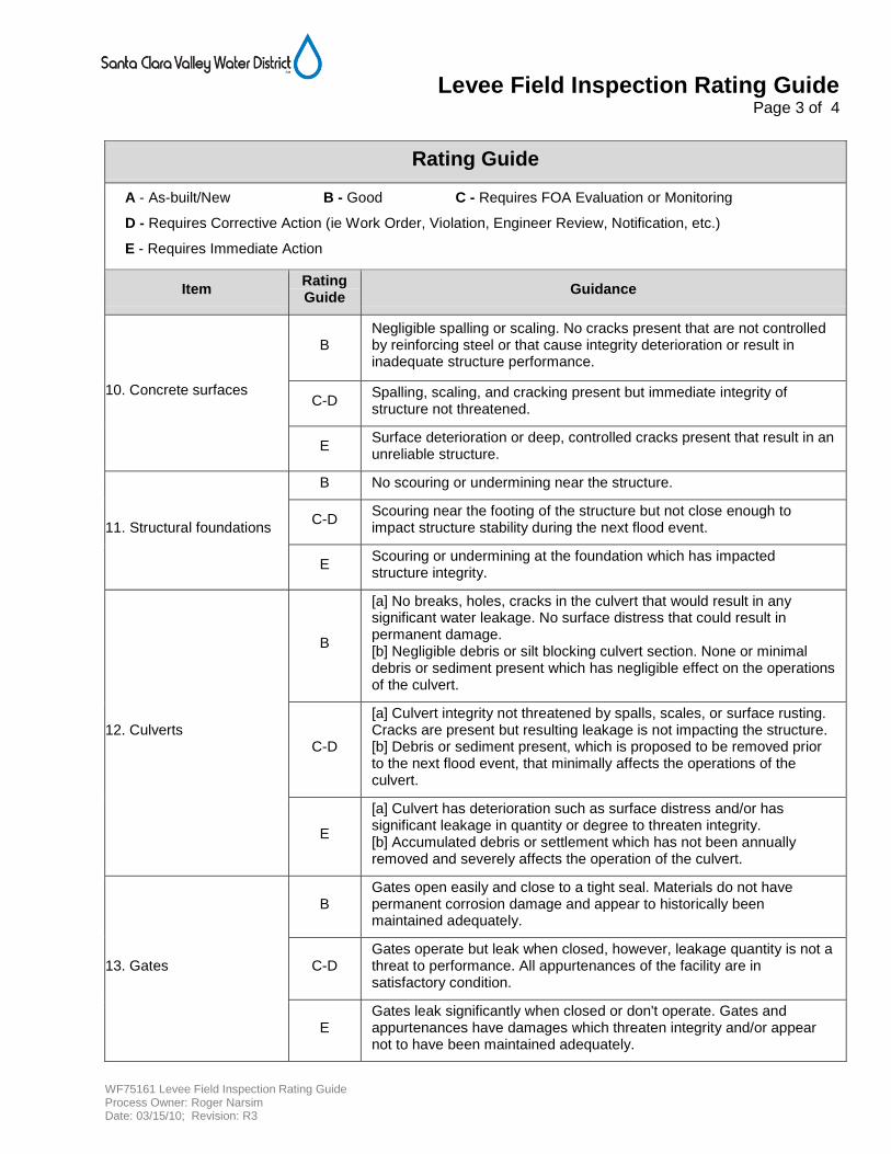
Levee Field Inspection Rating Guide Page 3 of 4
WF75161 Levee Field Inspection Rating Guide Process Owner: Roger Narsim Date: 03/15/10; Revision: R3
Rating Guide
A - As-built/New B - Good C - Requires FOA Evaluation or Monitoring
D - Requires Corrective Action (ie Work Order, Violation, Engineer Review, Notification, etc.)
E - Requires Immediate Action
Item Rating Guide
Guidance
10. Concrete surfaces
B Negligible spalling or scaling. No cracks present that are not controlled by reinforcing steel or that cause integrity deterioration or result in inadequate structure performance.
C-D Spalling, scaling, and cracking present but immediate integrity of structure not threatened.
E Surface deterioration or deep, controlled cracks present that result in an unreliable structure.
11. Structural foundations
B No scouring or undermining near the structure.
C-D Scouring near the footing of the structure but not close enough to impact structure stability during the next flood event.
E Scouring or undermining at the foundation which has impacted structure integrity.
12. Culverts
B
[a] No breaks, holes, cracks in the culvert that would result in any significant water leakage. No surface distress that could result in permanent damage. [b] Negligible debris or silt blocking culvert section. None or minimal debris or sediment present which has negligible effect on the operations of the culvert.
C-D
[a] Culvert integrity not threatened by spalls, scales, or surface rusting. Cracks are present but resulting leakage is not impacting the structure. [b] Debris or sediment present, which is proposed to be removed prior to the next flood event, that minimally affects the operations of the culvert.
E
[a] Culvert has deterioration such as surface distress and/or has significant leakage in quantity or degree to threaten integrity. [b] Accumulated debris or settlement which has not been annually removed and severely affects the operation of the culvert.
13. Gates
B Gates open easily and close to a tight seal. Materials do not have permanent corrosion damage and appear to historically been maintained adequately.
C-D Gates operate but leak when closed, however, leakage quantity is not a threat to performance. All appurtenances of the facility are in satisfactory condition.
E Gates leak significantly when closed or don't operate. Gates and appurtenances have damages which threaten integrity and/or appear not to have been maintained adequately.
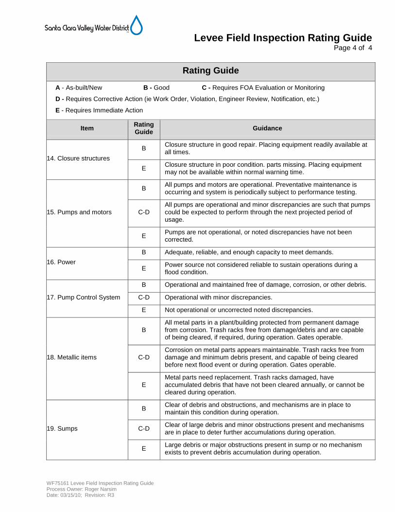
Levee Field Inspection Rating Guide Page 4 of 4
WF75161 Levee Field Inspection Rating Guide Process Owner: Roger Narsim Date: 03/15/10; Revision: R3
Rating Guide
A - As-built/New B - Good C - Requires FOA Evaluation or Monitoring
D - Requires Corrective Action (ie Work Order, Violation, Engineer Review, Notification, etc.)
E - Requires Immediate Action
Item Rating Guide
Guidance
14. Closure structures
B Closure structure in good repair. Placing equipment readily available at all times.
E Closure structure in poor condition. parts missing. Placing equipment may not be available within normal warning time.
15. Pumps and motors
B All pumps and motors are operational. Preventative maintenance is occurring and system is periodically subject to performance testing.
C-D All pumps are operational and minor discrepancies are such that pumps could be expected to perform through the next projected period of usage.
E Pumps are not operational, or noted discrepancies have not been corrected.
16. Power
B Adequate, reliable, and enough capacity to meet demands.
E Power source not considered reliable to sustain operations during a flood condition.
17. Pump Control System
B Operational and maintained free of damage, corrosion, or other debris.
C-D Operational with minor discrepancies.
E Not operational or uncorrected noted discrepancies.
18. Metallic items
B All metal parts in a plant/building protected from permanent damage from corrosion. Trash racks free from damage/debris and are capable of being cleared, if required, during operation. Gates operable.
C-D Corrosion on metal parts appears maintainable. Trash racks free from damage and minimum debris present, and capable of being cleared before next flood event or during operation. Gates operable.
E Metal parts need replacement. Trash racks damaged, have accumulated debris that have not been cleared annually, or cannot be cleared during operation.
19. Sumps
B Clear of debris and obstructions, and mechanisms are in place to maintain this condition during operation.
C-D Clear of large debris and minor obstructions present and mechanisms are in place to deter further accumulations during operation.
E Large debris or major obstructions present in sump or no mechanism exists to prevent debris accumulation during operation.
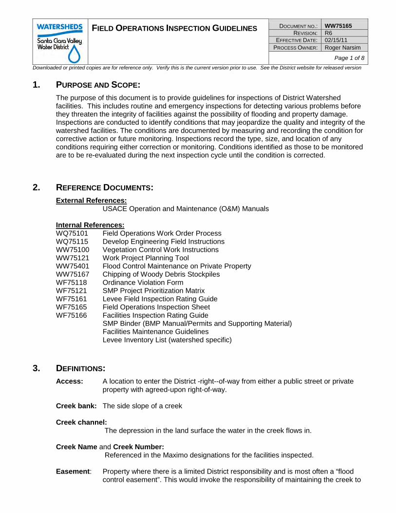
FIELD OPERATIONS INSPECTION GUIDELINES DOCUMENT NO.: WW75165 REVISION: R6
EFFECTIVE DATE: 02/15/11 PROCESS OWNER: Roger Narsim
Page 1 of 8 Downloaded or printed copies are for reference only. Verify this is the current version prior to use. See the District website for released version
1. PURPOSE AND SCOPE: The purpose of this document is to provide guidelines for inspections of District Watershed facilities. This includes routine and emergency inspections for detecting various problems before they threaten the integrity of facilities against the possibility of flooding and property damage. Inspections are conducted to identify conditions that may jeopardize the quality and integrity of the watershed facilities. The conditions are documented by measuring and recording the condition for corrective action or future monitoring. Inspections record the type, size, and location of any conditions requiring either correction or monitoring. Conditions identified as those to be monitored are to be re-evaluated during the next inspection cycle until the condition is corrected.
2. REFERENCE DOCUMENTS: External References: USACE Operation and Maintenance (O&M) Manuals Internal References: WQ75101 Field Operations Work Order Process WQ75115 Develop Engineering Field Instructions WW75100 Vegetation Control Work Instructions WW75121 Work Project Planning Tool WW75401 Flood Control Maintenance on Private Property WW75167 Chipping of Woody Debris Stockpiles WF75118 Ordinance Violation Form WF75121 SMP Project Prioritization Matrix WF75161 Levee Field Inspection Rating Guide WF75165 Field Operations Inspection Sheet WF75166 Facilities Inspection Rating Guide
SMP Binder (BMP Manual/Permits and Supporting Material) Facilities Maintenance Guidelines
Levee Inventory List (watershed specific)
3. DEFINITIONS: Access: A location to enter the District -right--of-way from either a public street or private
property with agreed-upon right-of-way. Creek bank: The side slope of a creek Creek channel: The depression in the land surface the water in the creek flows in. Creek Name and Creek Number: Referenced in the Maximo designations for the facilities inspected. Easement: Property where there is a limited District responsibility and is most often a “flood
control easement”. This would invoke the responsibility of maintaining the creek to
FIELD OPERATIONS INSPECTION GUIDELINES DOCUMENT NO.: WW75165 REVISION: R6
EFFECTIVE DATE: 02/15/11 PROCESS OWNER: Roger Narsim
Page 2 of 8 Downloaded or printed copies are for reference only. Verify this is the current version prior to use. See the District website for released version
meet District Flood Control guidelines. Ingress/egress, flowage, or other forms of easement require much less maintenance responsibilities. Easements are indicated in yellow on District maps.
Fee Title: Property where the deed lists the Santa Clara Valley Water District as the property
owner. Fee titles are indicated in green on District maps. GIS: Geographic Information System. A geographic database of layers of information.
Primarily used by Watershed Field staff for right-of-way and location information. Inspection: The evaluation of the watershed facilities to identify and record corrective action or
monitoring of any condition that could jeopardize the quality of the facility (creeks, levees, property and habitat) in the watersheds.
Major facilities: Major tributaries with the greatest potential for catastrophic flooding and property
damage. Generally have high water flows and are historically problematic. Minor facilities: Feed into major tributaries and have a potential for localized flooding and limited
property damage. Generally have low flows and historically have low occurrence of problems.
NRCS facilities:
Facilities where flood protection projects were constructed cooperatively with the Natural Resources Conservation Service (NRCS).
Orientation: The right and left bank orientation is determined by facing upstream. Right-of-Way: Property the District has some form of responsibility recorded by legal deed. This
includes Easement and/or Fee Title. Stationing: A geometric/geographic measurement that starts at the furthest most downstream
point of the creek. It is referenced by the starting point of 0+00 (hundreds of feet) = 0 feet measuring upstream from the mouth of the creek.
USACE facilities:
Facilities where flood protection projects were constructed cooperatively with the U.S. Army Corps of Engineers (USACE). This cooperative relationship requires semi-annual inspections and annual reports to USACE.
4. ROLES AND RESPONSIBILITIES: None
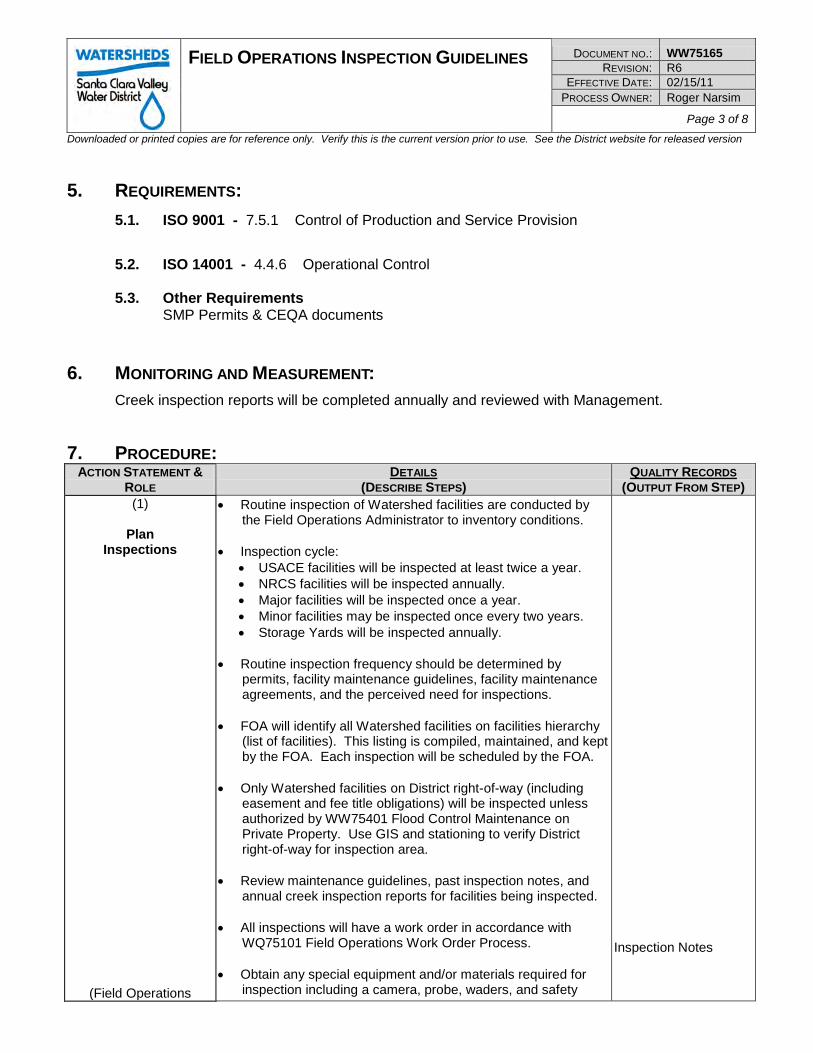
FIELD OPERATIONS INSPECTION GUIDELINES DOCUMENT NO.: WW75165 REVISION: R6
EFFECTIVE DATE: 02/15/11 PROCESS OWNER: Roger Narsim
Page 3 of 8 Downloaded or printed copies are for reference only. Verify this is the current version prior to use. See the District website for released version
5. REQUIREMENTS:
5.1. ISO 9001 - 7.5.1 Control of Production and Service Provision
5.2. ISO 14001 - 4.4.6 Operational Control
5.3. Other Requirements SMP Permits & CEQA documents
6. MONITORING AND MEASUREMENT: Creek inspection reports will be completed annually and reviewed with Management.
7. PROCEDURE: ACTION STATEMENT &
ROLE DETAILS
(DESCRIBE STEPS) QUALITY RECORDS
(OUTPUT FROM STEP) (1)
Plan
Inspections
(Field Operations
• Routine inspection of Watershed facilities are conducted by the Field Operations Administrator to inventory conditions.
• Inspection cycle:
• USACE facilities will be inspected at least twice a year. • NRCS facilities will be inspected annually. • Major facilities will be inspected once a year. • Minor facilities may be inspected once every two years. • Storage Yards will be inspected annually.
• Routine inspection frequency should be determined by
permits, facility maintenance guidelines, facility maintenance agreements, and the perceived need for inspections.
• FOA will identify all Watershed facilities on facilities hierarchy
(list of facilities). This listing is compiled, maintained, and kept by the FOA. Each inspection will be scheduled by the FOA.
• Only Watershed facilities on District right-of-way (including
easement and fee title obligations) will be inspected unless authorized by WW75401 Flood Control Maintenance on Private Property. Use GIS and stationing to verify District right-of-way for inspection area.
• Review maintenance guidelines, past inspection notes, and
annual creek inspection reports for facilities being inspected. • All inspections will have a work order in accordance with
WQ75101 Field Operations Work Order Process. • Obtain any special equipment and/or materials required for
inspection including a camera, probe, waders, and safety
Inspection Notes
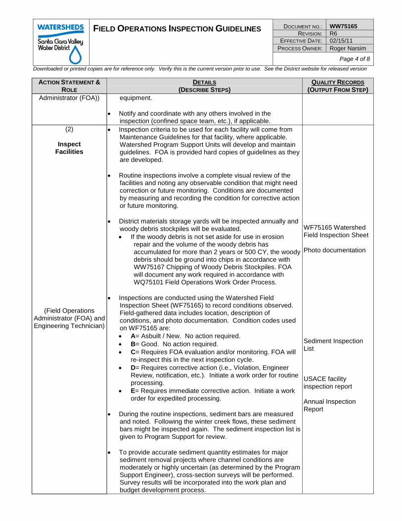
FIELD OPERATIONS INSPECTION GUIDELINES DOCUMENT NO.: WW75165 REVISION: R6
EFFECTIVE DATE: 02/15/11 PROCESS OWNER: Roger Narsim
Page 4 of 8 Downloaded or printed copies are for reference only. Verify this is the current version prior to use. See the District website for released version
ACTION STATEMENT &
ROLE DETAILS
(DESCRIBE STEPS) QUALITY RECORDS
(OUTPUT FROM STEP) Administrator (FOA)) equipment.
• Notify and coordinate with any others involved in the
inspection (confined space team, etc.), if applicable. (2)
Inspect
Facilities
(Field Operations Administrator (FOA) and Engineering Technician)
• Inspection criteria to be used for each facility will come from Maintenance Guidelines for that facility, where applicable. Watershed Program Support Units will develop and maintain guidelines. FOA is provided hard copies of guidelines as they are developed.
• Routine inspections involve a complete visual review of the
facilities and noting any observable condition that might need correction or future monitoring. Conditions are documented by measuring and recording the condition for corrective action or future monitoring.
• District materials storage yards will be inspected annually and
woody debris stockpiles will be evaluated. • If the woody debris is not set aside for use in erosion
repair and the volume of the woody debris has accumulated for more than 2 years or 500 CY, the woody debris should be ground into chips in accordance with WW75167 Chipping of Woody Debris Stockpiles. FOA will document any work required in accordance with WQ75101 Field Operations Work Order Process.
• Inspections are conducted using the Watershed Field
Inspection Sheet (WF75165) to record conditions observed. Field-gathered data includes location, description of conditions, and photo documentation. Condition codes used on WF75165 are: • A= Asbuilt / New. No action required. • B= Good. No action required. • C= Requires FOA evaluation and/or monitoring. FOA will
re-inspect this in the next inspection cycle. • D= Requires corrective action (i.e., Violation, Engineer
Review, notification, etc.). Initiate a work order for routine processing.
• E= Requires immediate corrective action. Initiate a work order for expedited processing.
• During the routine inspections, sediment bars are measured
and noted. Following the winter creek flows, these sediment bars might be inspected again. The sediment inspection list is given to Program Support for review.
• To provide accurate sediment quantity estimates for major
sediment removal projects where channel conditions are moderately or highly uncertain (as determined by the Program Support Engineer), cross-section surveys will be performed. Survey results will be incorporated into the work plan and budget development process.
WF75165 Watershed Field Inspection Sheet Photo documentation Sediment Inspection List USACE facility inspection report Annual Inspection Report
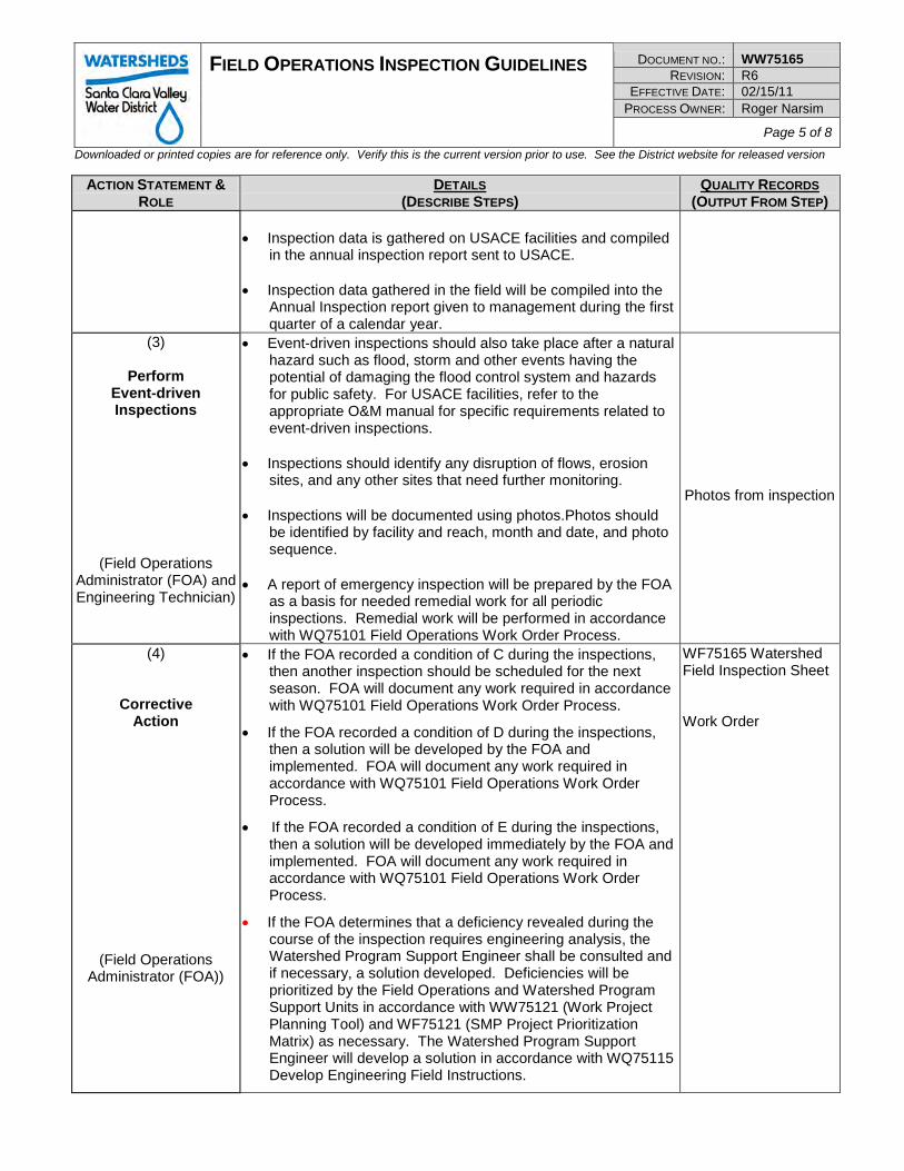
FIELD OPERATIONS INSPECTION GUIDELINES DOCUMENT NO.: WW75165 REVISION: R6
EFFECTIVE DATE: 02/15/11 PROCESS OWNER: Roger Narsim
Page 5 of 8 Downloaded or printed copies are for reference only. Verify this is the current version prior to use. See the District website for released version
ACTION STATEMENT &
ROLE DETAILS
(DESCRIBE STEPS) QUALITY RECORDS
(OUTPUT FROM STEP) • Inspection data is gathered on USACE facilities and compiled
in the annual inspection report sent to USACE. • Inspection data gathered in the field will be compiled into the
Annual Inspection report given to management during the first quarter of a calendar year.
(3)
Perform Event-driven Inspections
(Field Operations Administrator (FOA) and Engineering Technician)
• Event-driven inspections should also take place after a natural hazard such as flood, storm and other events having the potential of damaging the flood control system and hazards for public safety. For USACE facilities, refer to the appropriate O&M manual for specific requirements related to event-driven inspections.
• Inspections should identify any disruption of flows, erosion
sites, and any other sites that need further monitoring. • Inspections will be documented using photos.Photos should
be identified by facility and reach, month and date, and photo sequence.
• A report of emergency inspection will be prepared by the FOA
as a basis for needed remedial work for all periodic inspections. Remedial work will be performed in accordance with WQ75101 Field Operations Work Order Process.
Photos from inspection
(4)
Corrective Action
(Field Operations Administrator (FOA))
• If the FOA recorded a condition of C during the inspections, then another inspection should be scheduled for the next season. FOA will document any work required in accordance with WQ75101 Field Operations Work Order Process.
• If the FOA recorded a condition of D during the inspections, then a solution will be developed by the FOA and implemented. FOA will document any work required in accordance with WQ75101 Field Operations Work Order Process.
• If the FOA recorded a condition of E during the inspections, then a solution will be developed immediately by the FOA and implemented. FOA will document any work required in accordance with WQ75101 Field Operations Work Order Process.
• If the FOA determines that a deficiency revealed during the course of the inspection requires engineering analysis, the Watershed Program Support Engineer shall be consulted and if necessary, a solution developed. Deficiencies will be prioritized by the Field Operations and Watershed Program Support Units in accordance with WW75121 (Work Project Planning Tool) and WF75121 (SMP Project Prioritization Matrix) as necessary. The Watershed Program Support Engineer will develop a solution in accordance with WQ75115 Develop Engineering Field Instructions.
WF75165 Watershed Field Inspection Sheet Work Order
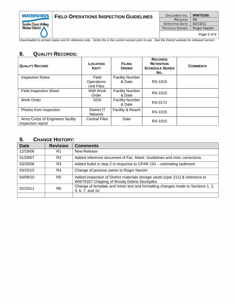
FIELD OPERATIONS INSPECTION GUIDELINES DOCUMENT NO.: WW75165 REVISION: R6
EFFECTIVE DATE: 02/15/11 PROCESS OWNER: Roger Narsim
Page 6 of 8 Downloaded or printed copies are for reference only. Verify this is the current version prior to use. See the District website for released version
8. QUALITY RECORDS:
QUALITY RECORD LOCATION
KEPT FILING ORDER
RECORDS
RETENTION
SCHEDULE SERIES
NO.
COMMENTS
Inspection Notes Field Operations Unit Files
Facility Number & Date RS-1015
Field Inspection Sheet With Work Order
Facility Number & Date
RS-1015
Work Order SOS Facility Number & Date RS-0172
Photos from inspection District IT Network
Facility & Reach RS-1015
Army Corps of Engineers facility inspection report
Central Files Date RS-1015
9. CHANGE HISTORY: Date Revision Comments 12/19/06 R1 New Release
01/29/07 R2 Added reference document of Fac. Maint. Guidelines and misc corrections.
03/26/08 R3 Added bullet in step 2 in response to CPAR 191 – estimating sediment.
03/15/10 R4 Change of process owner to Roger Narsim
04/09/10 R5 Added inspection of District materials storage yards (cpar 211) & reference to WW75167 Chipping of Woody Debris Stockpiles
02/15/11 R6 Change of template and minor text and formatting changes made to Sections 1, 2, 3, 6, 7, and 10.
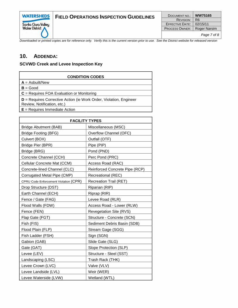
FIELD OPERATIONS INSPECTION GUIDELINES DOCUMENT NO.: WW75165 REVISION: R6
EFFECTIVE DATE: 02/15/11 PROCESS OWNER: Roger Narsim
Page 7 of 8 Downloaded or printed copies are for reference only. Verify this is the current version prior to use. See the District website for released version
10. ADDENDA: SCVWD Creek and Levee Inspection Key
CONDITION CODES
A = Asbuilt/New
B = Good
C = Requires FOA Evaluation or Monitoring
D = Requires Corrective Action (ie Work Order, Violation, Engineer Review, Notification, etc.)
E = Requires Immediate Action
FACILITY TYPES
Bridge Abutment (BAB) Miscellaneous (MSC)
Bridge Footing (BFG) Overflow Channel (OFC)
Culvert (BOX) Outfall (OTF)
Bridge Pier (BPR) Pipe (PIP)
Bridge (BRG) Pond (PND)
Concrete Channel (CCH) Perc Pond (PRC)
Cellular Concrete Mat (CCM) Access Road (RAC)
Concrete-lined Channel (CLC) Reinforced Concrete Pipe (RCP)
Corrugated Metal Pipe (CMP) Recreational (REC)
CPRU Code Enforcement Violation (CPR) Recreation Trail (RET)
Drop Structure (DST) Riparian (RIP)
Earth Channel (ECH) Riprap (RIR)
Fence / Gate (FAG) Levee Road (RLR)
Flood Walls (FDW) Access Road - Lower (RLW)
Fence (FEN) Revegetation Site (RVS)
Flap Gate (FGT) Structure - Concrete (SCN)
Fish (FIS) Sediment Debris Basin (SDB)
Flood Plain (FLP) Stream Gage (SGG)
Fish Ladder (FSH) Sign (SGN)
Gabion (GAB) Slide Gate (SLG)
Gate (GAT) Slope Protection (SLP)
Levee (LEV) Structure - Steel (SST)
Landscaping (LSC) Trash Rack (THK)
Levee Crown (LVC) Valve (VLV)
Levee Landside (LVL) Weir (WER)
Levee Waterside (LVW) Wetland (WTL)
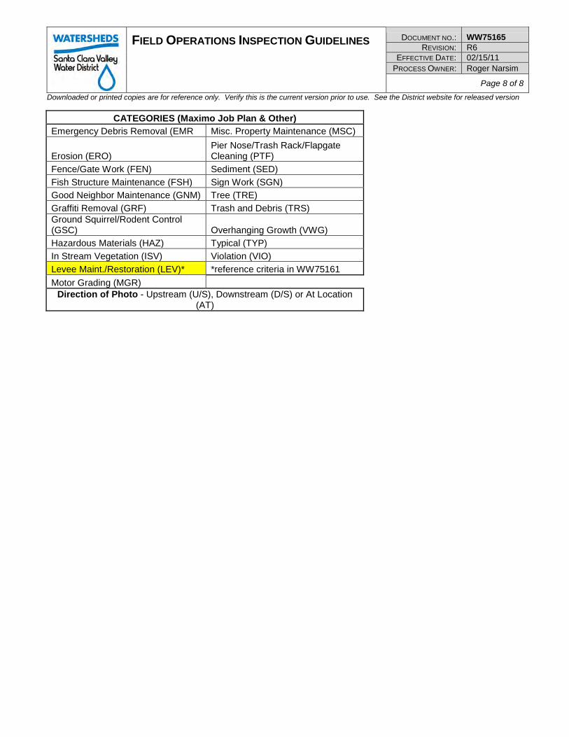
FIELD OPERATIONS INSPECTION GUIDELINES DOCUMENT NO.: WW75165 REVISION: R6
EFFECTIVE DATE: 02/15/11 PROCESS OWNER: Roger Narsim
Page 8 of 8 Downloaded or printed copies are for reference only. Verify this is the current version prior to use. See the District website for released version
CATEGORIES (Maximo Job Plan & Other) Emergency Debris Removal (EMR Misc. Property Maintenance (MSC)
Erosion (ERO) Pier Nose/Trash Rack/Flapgate Cleaning (PTF)
Fence/Gate Work (FEN) Sediment (SED)
Fish Structure Maintenance (FSH) Sign Work (SGN)
Good Neighbor Maintenance (GNM) Tree (TRE)
Graffiti Removal (GRF) Trash and Debris (TRS) Ground Squirrel/Rodent Control (GSC) Overhanging Growth (VWG)
Hazardous Materials (HAZ) Typical (TYP)
In Stream Vegetation (ISV) Violation (VIO)
Levee Maint./Restoration (LEV)* *reference criteria in WW75161
Motor Grading (MGR) Direction of Photo - Upstream (U/S), Downstream (D/S) or At Location
(AT)
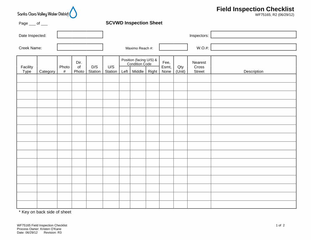
Field Inspection Checklist WF75165; R2 (06/29/12)
WF75165 Field Inspection Checklist 1 of 2 Process Owner: Kristen O’Kane Date: 06/29/12 Revision: R3
Page ___ of ___ SCVWD Inspection Sheet
Date Inspected: Inspectors:
Creek Name: Maximo Reach #: W.O.#:
Facility Type Category
Photo #
Dir. of
Photo D/S
Station U/S
Station
Position (facing U/S) & Condition Code Fee,
Esmt, None
Qty (Unit)
Nearest Cross Street Description Left Middle Right
* Key on back side of sheet
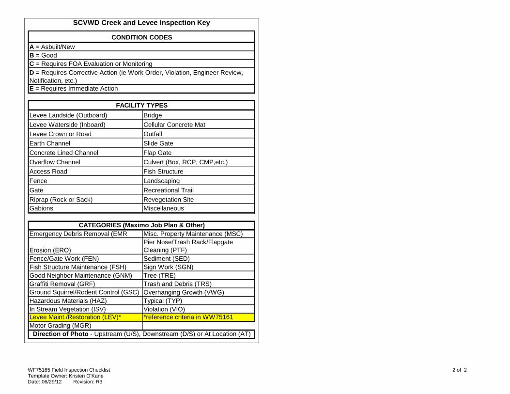
WF75165 Field Inspection Checklist 2 of 2 Template Owner: Kristen O’Kane Date: 06/29/12 Revision: R3
SCVWD Creek and Levee Inspection Key
Levee Landside (Outboard) Bridge
Levee Waterside (Inboard) Cellular Concrete Mat
Levee Crown or Road Outfall
Earth Channel Slide Gate
Concrete Lined Channel Flap Gate
Overflow Channel Culvert (Box, RCP, CMP,etc.)
Access Road Fish Structure
Fence Landscaping
Gate Recreational Trail
Riprap (Rock or Sack) Revegetation SiteGabions Miscellaneous
Emergency Debris Removal (EMR Misc. Property Maintenance (MSC)
Erosion (ERO)Pier Nose/Trash Rack/Flapgate Cleaning (PTF)
Fence/Gate Work (FEN) Sediment (SED)Fish Structure Maintenance (FSH) Sign Work (SGN)Good Neighbor Maintenance (GNM) Tree (TRE)Graffiti Removal (GRF) Trash and Debris (TRS)Ground Squirrel/Rodent Control (GSC) Overhanging Growth (VWG)Hazardous Materials (HAZ) Typical (TYP)In Stream Vegetation (ISV) Violation (VIO)Levee Maint./Restoration (LEV)* *reference criteria in WW75161Motor Grading (MGR)
B = Good
CATEGORIES (Maximo Job Plan & Other)
Direction of Photo - Upstream (U/S), Downstream (D/S) or At Location (AT)
E = Requires Immediate Action
D = Requires Corrective Action (ie Work Order, Violation, Engineer Review, Notification, etc.)
C = Requires FOA Evaluation or Monitoring
FACILITY TYPES
CONDITION CODES
A = Asbuilt/New
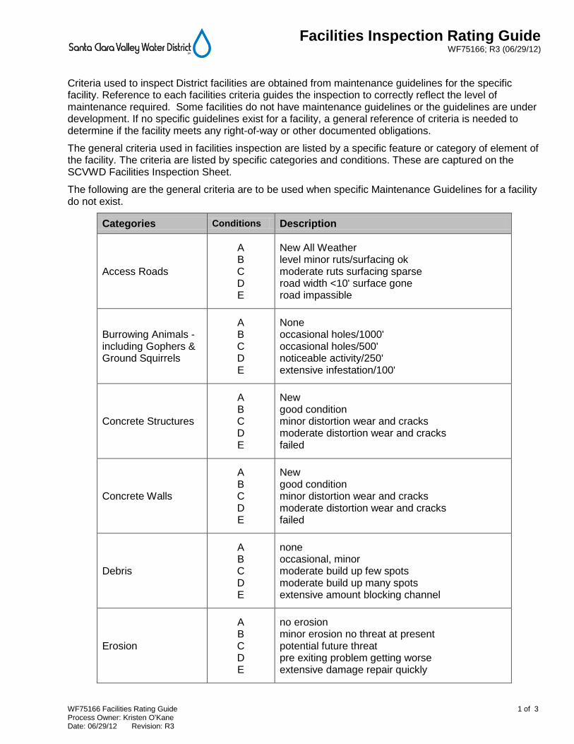
Facilities Inspection Rating Guide WF75166; R3 (06/29/12)
WF75166 Facilities Rating Guide 1 of 3 Process Owner: Kristen O’Kane Date: 06/29/12 Revision: R3
Criteria used to inspect District facilities are obtained from maintenance guidelines for the specific facility. Reference to each facilities criteria guides the inspection to correctly reflect the level of maintenance required. Some facilities do not have maintenance guidelines or the guidelines are under development. If no specific guidelines exist for a facility, a general reference of criteria is needed to determine if the facility meets any right-of-way or other documented obligations.
The general criteria used in facilities inspection are listed by a specific feature or category of element of the facility. The criteria are listed by specific categories and conditions. These are captured on the SCVWD Facilities Inspection Sheet.
The following are the general criteria are to be used when specific Maintenance Guidelines for a facility do not exist.
Categories Conditions Description
Access Roads
A B C D E
New All Weather level minor ruts/surfacing ok moderate ruts surfacing sparse road width <10' surface gone road impassible
Burrowing Animals - including Gophers & Ground Squirrels
A B C D E
None occasional holes/1000' occasional holes/500' noticeable activity/250' extensive infestation/100'
Concrete Structures
A B C D E
New good condition minor distortion wear and cracks moderate distortion wear and cracks failed
Concrete Walls
A B C D E
New good condition minor distortion wear and cracks moderate distortion wear and cracks failed
Debris
A B C D E
none occasional, minor moderate build up few spots moderate build up many spots extensive amount blocking channel
Erosion
A B C D E
no erosion minor erosion no threat at present potential future threat pre exiting problem getting worse extensive damage repair quickly
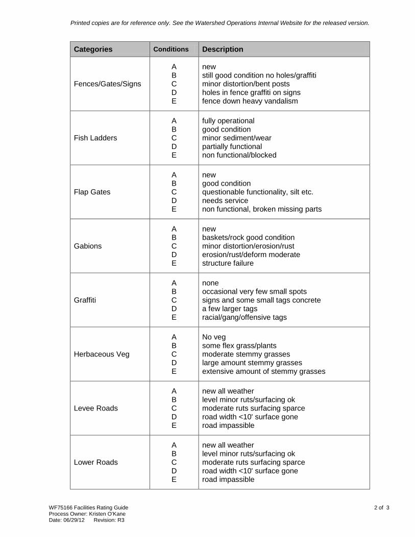
Printed copies are for reference only. See the Watershed Operations Internal Website for the released version.
WF75166 Facilities Rating Guide 2 of 3 Process Owner: Kristen O’Kane Date: 06/29/12 Revision: R3
Categories Conditions Description
Fences/Gates/Signs
A B C D E
new still good condition no holes/graffiti minor distortion/bent posts holes in fence graffiti on signs fence down heavy vandalism
Fish Ladders
A B C D E
fully operational good condition minor sediment/wear partially functional non functional/blocked
Flap Gates
A B C D E
new good condition questionable functionality, silt etc. needs service non functional, broken missing parts
Gabions
A B C D E
new baskets/rock good condition minor distortion/erosion/rust erosion/rust/deform moderate structure failure
Graffiti
A B C D E
none occasional very few small spots signs and some small tags concrete a few larger tags racial/gang/offensive tags
Herbaceous Veg
A B C D E
No veg some flex grass/plants moderate stemmy grasses large amount stemmy grasses extensive amount of stemmy grasses
Levee Roads
A B C D E
new all weather level minor ruts/surfacing ok moderate ruts surfacing sparce road width <10' surface gone road impassible
Lower Roads
A B C D E
new all weather level minor ruts/surfacing ok moderate ruts surfacing sparce road width <10' surface gone road impassible
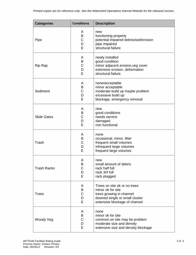
Printed copies are for reference only. See the Watershed Operations Internal Website for the released version.
WF75166 Facilities Rating Guide 3 of 3 Process Owner: Kristen O’Kane Date: 06/29/12 Revision: R3
Categories Conditions Description
Pipe
A B C D E
new functioning properly potential impaired debris/sed/erosion pipe impaired structural failure
Rip Rap
A B C D E
newly installed good condition minor adjacent erosion,veg cover extensive erosion, deformation structural failure
Sediment
A B C D E
none/acceptable minor acceptable moderate build up maybe problem excessive build up blockage, emergency removal
Slide Gates
A B C D E
new good conditions needs service damaged non functional
Trash
A B C D E
none occasional, minor, litter frequent small volumes infrequent large volumes frequent large volumes
Trash Racks
A B C D E
new small amount of debris rack half full rack 3/4 full rack plugged
Trees
A B C D E
Trees on site ok or no trees minor ok for site trees growing in channel downed single or small cluster extensive blockage of channel
Woody Veg
A B C D E
none minor ok for site common on site may be problem moderate size and density extensive size and density blockage
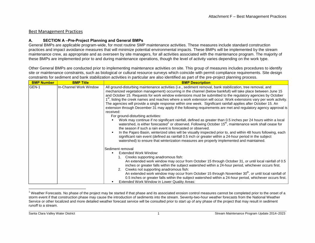
Attachment F – Best Management Practices
Santa Clara Valley Water District
1 Stream Maintenance Program Update 2014–2023
A. SECTION A –Pre-Project Planning and General BMPs
Best Management Practices
General BMPs are applicable program-wide, for most routine SMP maintenance activities. These measures include standard construction practices and impact avoidance measures that will minimize potential environmental impacts. These BMPs will be implemented by the stream maintenance crew, as appropriate and as overseen by site managers, for all activities associated with the maintenance program. The majority of these BMPs are implemented prior to and during maintenance operations, though the level of activity varies depending on the work type.
Other General BMPs are conducted prior to implementing maintenance activities on site. This group of measures includes procedures to identify site or maintenance constraints, such as biological or cultural resource surveys which coincide with permit compliance requirements. Site design constraints for sediment and bank stabilization activities in particular are also identified as part of the pre-project planning process.
BMP Number BMP Title BMP Description GEN-1 In-Channel Work Window All ground-disturbing maintenance activities (i.e., sediment removal, bank stabilization, tree removal, and
mechanized vegetation management) occurring in the channel (below bankfull) will take place between June 15 and October 15. Requests for work window extensions must be submitted to the regulatory agencies by October 1st
For ground-disturbing activities:
, listing the creek names and reaches where a work extension will occur. Work extensions vary per work activity. The agencies will provide a single response within one week. Significant rainfall applies after October 15. An extension through December 31 may apply if the following requirements are met and regulatory agency approval is received:
Work may continue if no significant rainfall, defined as greater than 0.5 inches per 24 hours within a local watershed, is either forecasted1 or observed. Following October 15th
In the Pajaro Basin, winterized sites will be visually inspected prior to, and within 48 hours following, each significant rain event (defined as rainfall 0.5 inch or greater within a 24-hour period in the subject watershed) to ensure that winterization measures are properly implemented and maintained.
, maintenance work shall cease for the season if such a rain event is forecasted or observed.
Sediment removal
Extended Work Window: 1. Creeks supporting anadromous fish:
An extended work window may occur from October 15 through October 31, or until local rainfall of 0.5 inches or greater falls within the subject watershed within a 24-hour period, whichever occurs first.
2. Creeks not supporting anadromous fish: An extended work window may occur from October 15 through November 30th
Extended Work Window in Lower Quality Areas:
, or until local rainfall of 0.5 inches or greater falls within the subject watershed within a 24-hour period, whichever occurs first.
1 Weather Forecasts. No phase of the project may be started if that phase and its associated erosion control measures cannot be completed prior to the onset of a storm event if that construction phase may cause the introduction of sediments into the stream. Seventy-two-hour weather forecasts from the National Weather Service or other localized and more detailed weather forecast service will be consulted prior to start up of any phase of the project that may result in sediment runoff to a stream.
billspri
Text Box
Appendix D - Maintenance Best Management Practices
billspri
Text Box
Attachment F – Best Management Practices
Santa Clara Valley Water District
2 Stream Maintenance Program Update 2014–2023
BMP Number BMP Title BMP Description 1. Sediment removal work may occur until December 31. 2. Work will only occur on Berryessa Creek (0-88+80; 232+70-236+00; 284+30-288+00), Lower Silver
Creek (Reach 3 between Stations 37+40 and 381+19), Thompson Creek (0+00-10+00), Canoas Creek (0+00-390+00), Ross Creek (0+00-86+30), Calabazas Creek (35+00-105+00), and San Tomas Aquino Creek (80+00-100+00) with the following conditions: o site conditions are dry and access for all construction equipment and vehicles will not impact
waterways; and o all work will stop if any rainfall is forecast for the next 72 hour period.
3. Work may occur after a significant rainfall event but no later than December 31. 4. Sites must be maintained in a rapidly winterizable2
Bank stabilization projects may continue until the approved date stated below. Prior to a forecasted significant rainfall event (0.5 in/24 hrs), all incomplete bank stabilization projects must be winterized.
state (implement control measures BMP GEN-20).
1. In Creeks Supporting Anadromous Fish o An extended work window may occur until October 31st for bank stabilization projects that will be
50% complete by October 15th
2. In Creeks Not Supporting Anadromous Fish .
o An extended work window may occur until November 30th for projects that will be 50% complete by October 15th
o An extended work window may occur until November 30th for new bank stabilization projects that will be completed in five (5) days or less, or until significant rainfall.
or until significant rainfall.
Instream hand pruning and hand removal of vegetation will occur year round, except when: o Wheeled or tracked equipment needs to access the site by crossing a creek, ponded area, or
secondary channel; or o Work occurs in streams that support steelhead. In these streams instream vegetation
maintenance will cease on December 31 or when local rainfall greater than 0.5 inches is predicted within a 24-hour period of planned activities, whichever happens first.
Modification and removal of instream large woody debris will occur at any time of the year, and as further described in the NMFS Biological Opinion.
GEN-2 Instream Herbicide Application Work Window
Instream herbicide applications will take place between June 15 and October 15, or until the first occurrence of any of the following conditions; whichever happens first: local rainfall greater than 0.5 inches is forecasted within a 24-hour period from planned application events;
or when steelhead begin upmigrating and spawning in the 14 anadromous steelhead creeks, as determined
by a qualified biologist (typically in November/December), o A qualified biologist will determine presence/absence of sensitive resources in designated
herbicide use areas and develop site-specific control methods (including the use of approved herbicide and surfactants). Proposed herbicide use would be limited to the aquatic formulation of glyphosate (Rodeo or equal). Surfactant use would be limited to non-ionic products, such as Agri-
2 Winterization is the process to maintain work sites with the appropriate BMP’s to prevent erosion, sediment transport, and protect water quality. Winterization occurs upon completion of bank repairs or on incomplete projects after October 15 and prior to the forecast of significant rainfall, 0.5 inches or greater of local watershed rainfall within 24 hours. Winterization shall be completed prior to the occurrence of such actual significant rainfall.
billspri
Text Box
Appendix D - Maintenance Best Management Practices
Attachment F – Best Management Practices
Santa Clara Valley Water District
3 Stream Maintenance Program Update 2014–2023
BMP Number BMP Title BMP Description dex, Competitor, or another brand name using the same ingredients. Any modifications to these materials would require review and approval by NMFS and CDFW.
o A qualified fisheries biologist will review proposed herbicide application methods and stream reaches. The fisheries biologist would conduct a pre-construction survey (and any other appropriate data research) to determine whether the proposed herbicide application is consistent with SMP approvals concerning biological resources and determine which BMPs would be instituted for work to proceed.
In addition, herbicide application requirements are as follows: no direct application into water; herbicide application shall not occur when wind conditions may result in drift; herbicide solution shall be applied only until there is a “wet” appearance on the target plants in order to
avoid run off; and where permitted, surfactants shall be added to the spray solution prior to application.
GEN-3 Avoid Exposing Soils with High Mercury Levels
Sediment removal and bank stabilization projects in portions of the Guadalupe River watershed affected by historic mercury mining may expose soils containing mercury. 1. In Basin Plan identified creeks in the Guadalupe River Basin, soils that are likely to be disturbed or excavated shall be tested for mercury (Hg). Soils shall be remediated if disturbed or excavated soils exposed to streamflow have a residual sample test exceeding 0.2 mg mercury per kg erodible sediment (dry wt., median). 2. Remediation may be accomplished either by:
a. treating the site so that contaminated soils excavated for the purpose of bank stabilization shall not be susceptible to erosion; or
b. further excavating contaminated soils and replacing them with clean fill or other bank stabilization materials that are free from contaminants.
c. Soils with residual sample mercury concentrations exceeding 0.2 mg mercury per kg erodible sediment (dry wt., median) shall be removed and disposed of in a Class I landfill following established work practices and hazard control measures. Soils with residual sample mercury concentrations less than 0.2 mg mercury per kg erodible sediment (dry wt., median) will remain at the project site.
3. To ensure worker safety during sediment removal and bank stabilization projects with elevated mercury concentrations in the exposed surfaces, personal protective equipment will be required during project construction to maintain exposure below levels established by the Occupational Safety and Health Agency (OSHA).
Biological Resources GEN-4 Minimize the Area of
Disturbance To minimize impacts to natural resources, soil disturbance will be kept to the minimum footprint necessary to complete the maintenance operation.
GEN-5
Mitten Crab Control Measure
Sediment from the San Francisco Bay Watershed, including that for reuse, cannot be moved to areas any farther south than Coyote Creek Golf Drive in south San Jose, and the intersection of McKean and Casa Loma Roads.
GEN-6
Minimize Impacts to Nesting Birds via Site
1. For activities occurring between January 15 and August 31, project areas will be checked by a qualified biologist or Designated Individuals (DI – for limited ground nesting species surveys) for nesting birds within 2
billspri
Text Box
Appendix D - Maintenance Best Management Practices
billspri
Text Box
Gen-3 deleted
Attachment F – Best Management Practices
Santa Clara Valley Water District
4 Stream Maintenance Program Update 2014–2023
BMP Number BMP Title BMP Description
Assessments and Avoidance Measures
weeks prior to starting work. If a lapse in project-related work of 2 weeks or longer occurs, another focused survey will be conducted before project work can be reinitiated.
2. If nesting birds are found, a buffer will be established around the nest and maintained until the young have fledged. Appropriate buffer widths are 0.5 mile for bald and golden eagles; 250 feet for other raptors and the least Bell’s vireo, herons, and egrets; 25 feet for ground-nesting non-raptors; 700 feet for the California clapper rail; 600 feet for the California least tern and western snowy plover; and 50 feet for non-raptors nesting on trees, shrubs and structures. Mowing and weed whacking will have a 25 feet buffer. A qualified biologist may identify an alternative buffer based on a site specific-evaluation. No work within the buffer will occur without written approval from a qualified biologist, for as long as the nest is active.
3. All vegetation management, sediment reuse, road grading, or other SMP activities in or immediately adjacent to suitable California clapper rail or Alameda song sparrow nesting habitat, as determined by a qualified biologist, shall not be conducted prior to September 1 (the non-nesting season).
4. If a pre-activity survey in high-quality San Francisco common yellowthroat breeding habitat (as determined by a qualified biologist) identifies more singing male San Francisco common yellowthroats than active nests, then the inconspicuous nests of this species might have been missed. In that case, maintenance activities in that area shall be delayed until the San Francisco common yellowthroat non-breeding season (i.e., August 16–March 14).
5. The boundary of each buffer zone will be marked with fencing, flagging, or other easily identifiable marking if work will occur immediately outside the buffer zone.
6. All protective buffer zones will be maintained until the nest becomes inactive, as determined by a qualified biologist.
7. If monitoring shows that disturbance to actively nesting birds is occurring, buffer widths will be increased until monitoring shows that disturbance is no longer occurring. If this is not possible, work will cease in the area until young have fledged and the nest is no longer active.
GEN-6.5 Protection of Nesting Least Bell’s Vireos 1. To the extent feasible, SMP activities within those areas mapped as vireo habitat in the Santa Clara Valley
Habitat Plan shall be scheduled to occur outside of the least Bell’s vireo nesting season (March 15 – July 31). If it is not feasible for maintenance activities along these reaches to be scheduled during the non-nesting season, the following measures will be implemented.
2. For activities within woody riparian habitat mapped as vireo habitat in the Santa Clara Valley Habitat Plan that will occur between March 15 and July 31, any work will be preceded by a focused survey for least Bell’s vireos. Pre-activity surveys will consist of two site visits, conducted on separate days within 14 days before the initiation of maintenance activities in the given area, with at least one of these surveys occurring within 5 calendar days before the initiation of such activities. Surveys will be conducted between dawn and 11:00 a.m., during mild weather conditions (i.e., not during excessive cold, heat, wind, or rain), within all riparian habitat in and within 250 feet of any proposed maintenance location along these reaches. The surveys will be conducted by a qualified biologist who is familiar with the visual and auditory identification of this species.
3. To minimize impacts to nesting least Bell’s vireos and other birds, the biologist will not initially be looking for Bell’s vireo nests during these surveys. Rather the biologist will look and listen for individual vireos. If a least Bell’s vireo is detected, it will be observed to determine whether it is actively nesting. The biologist will note the nest location, or if finding the actual nest could result in excessive disturbance or risk damaging the nest, the biologist will determine the approximate location, based on observation of birds carrying nesting material,
billspri
Text Box
Appendix D - Maintenance Best Management Practices
Attachment F – Best Management Practices
Santa Clara Valley Water District
5 Stream Maintenance Program Update 2014–2023
BMP Number BMP Title BMP Description carrying food, or repeatedly visiting a certain area.
4. If an active nest is found, a minimum 250-foot no-activity buffer will be established around the nest. If a territorial male is found but no nest can be detected, then the approximate centroid of the bird’s area of activity will be the point from which the buffer will be applied. The required buffer may be reduced in areas where dense riparian forest occurs between the construction activities and the active nest or where sufficient barriers or topographic relief exists to protect the nest from excessive noise or other disturbance. The biologist will coordinate with the USFWS and CDFW to evaluate exceptions to the minimum no-activity buffer distance on a case-by-case basis.
5. No work will occur within the buffer without verification by a biologist that the nest is inactive and until any fledged young are no longer dependent on adults for food.
6. If a least Bell’s vireo and/or its nest is detected during pre-activity surveys, the District will contact the USFWS and CDFG within two working days regarding the presence and location of the bird/nest.
GEN-7
Protection of Burrowing Owls
1. If occupied burrows are identified, a 250 foot radius no work buffer zone will be established around the burrow. The buffer may be modified, with CDFW approval, to take into consideration of paved roads, intervening riparian corridors and levees. 2. No construction work will occur within the 250 foot buffer zone until after the nesting season. 3. After the nesting season work may occur within the 250 foot buffer zone provided:
a. A qualified biologist monitors the owls for at least 3 days prior to construction to determine baseline foraging behavior (i.e., behavior without construction) b. The same qualified biologist monitors the owls during construction and finds no change in owl foraging behavior in response to construction activities. c. If there is any change in owl foraging behavior as a result of construction activities, these activities will cease within the 250-foot buffer. d. If the owls are gone for at least one week, the project proponent may request approval from the
Santa Clara County Habitat Agency that a qualified biologist excavate the usable burrows to prevent owls from re-occupying the site. After the usable burrows are excavated, the buffer zone will be removed and construction may continue.
e. Monitoring must continue as described above for the non-breeding season as long as the burrow remains active.
5. Routine use of existing District maintenance roads within the 250 foot buffer will be allowed. However, no construction traffic will be allowed to use the maintenance road during the active nesting period. 6. Exceptions.
a. Mowing on levees may occur during the nesting season and within 250 feet of active burrows provided the burrows are marked by a qualified biologist. b. No vehicle mounted mowers will be used within 10 ft of occupied burrows. c. A qualified biologist will monitor the mowing within the buffer zone and stop the mowing if burrowing owls are observed on the surface at the nest or another burrow. d. Areas within 10 feet of the burrows may be mowed using hand equipment when no owls are visible on the surface. e. All mowing activities within the buffer zone will be completed within 30 minutes.
GEN-8 Protection of Sensitive Approved herbicides and adjuvants may be applied in habitat areas for sensitive wildlife species (including
billspri
Text Box
Appendix D - Maintenance Best Management Practices
Attachment F – Best Management Practices
Santa Clara Valley Water District
6 Stream Maintenance Program Update 2014–2023
BMP Number BMP Title BMP Description
Fauna Species from Herbicide Use
steelhead, California red-legged frog, California tiger salamander, salt marsh harvest mouse, and Bay checkerspot butterfly); all applications will occur in accordance with federal and state regulations. For sprayable or dust formulations: when the air is calm or moving away from sensitive wildlife habitat, applications will commence on the side nearest the habitat and proceed away from the habitat. When air currents are moving toward habitat, applications will not be made within 200 yards by air or 40 yards by ground upwind from occupied habitat. However, these distances may be modified for the control of invasive species on salmonid streams if the following measures are implemented: A qualified biologist will determine presence/absence of sensitive resources in designated herbicide use
areas and develop site-specific control methods (including the use of approved herbicide and surfactants). Proposed herbicide use would be limited to the aquatic formulation of glyphosate (Rodeo or equal). Surfactant use would be limited to non-ionic products, such as Agri-dex, Competitor, or another brand name using the same ingredients. Any modifications to these materials would require review and approval by NMFS and CDFW.
A qualified fisheries biologist will review proposed herbicide application methods and stream reaches. The fisheries biologist would conduct a pre-construction survey (and any other appropriate data research) to determine whether the proposed herbicide application is consistent with SMP approvals concerning biological resources and determine which BMPs would be instituted for work to proceed.
GEN-9
Avoid Impacts to Special-Status Plant Species and Sensitive Natural Vegetation Communities
A qualified botanist will identify special status plant species and sensitive natural vegetation communities and clearly map or delineate them as needed in order to avoid and/or minimize disturbance, using the CDFW protocols and the CNPS Botanical Survey Guidelines to formulate the following protocols: 1. A qualified botanist will use the GIS database, CNDDB, and/or other suitable tools to identify special status
plants and sensitive natural vegetation communities located within or near work areas. 2. Surveys of areas identified as sensitive natural communities or suitable habitat for special status plant species
will be conducted by a qualified botanist prior to commencement of work. 3. Surveys will be conducted during the appropriate time of the year to adequately identify special-status plants
that could occur on the site of proposed maintenance activities. 4. The qualified botanist will ensure avoidance and/or minimize impacts by implementing one or more of the
following, as appropriate, per the botanist’s recommendation: a) Flag or otherwise delineate in the field the special status plant populations and/or sensitive natural
community to be protected; b) Allow adequate buffers around plants or habitat; the location of the buffer zone will be shown on the
maintenance design drawings and marked in the field with stakes and/or flagging in such a way that exclusion zones are visible to maintenance personnel without excessive disturbance of the sensitive habitat or population itself (e.g., from installation of fencing).
c) Time construction or other activities during dormant and/or non-critical life cycle period; d) Store removed sediment off site; and e) Limit the operation of maintenance equipment to established roads whenever possible.
5. No herbicides, terrestrial or aquatic, will be used in areas identified as potential habitat for special status plants
6. If special status plant species or sensitive communities are present, then a qualified botanist will determine if a given type of vegetation management method is ecologically appropriate for a given area. Alternative
species or containing sensitive natural communities, until a qualified botanist has surveyed the area and determined the locations of special status plant species present.
billspri
Text Box
Appendix D - Maintenance Best Management Practices
billspri
Text Box
Revised, see Section 3.1.3.h.
Attachment F – Best Management Practices
Santa Clara Valley Water District
7 Stream Maintenance Program Update 2014–2023
BMP Number BMP Title BMP Description strategies based on the botanist’s recommendations will be coordinated with appropriate staff.
7. All impacts to sensitive natural communities and special status plants identified by the qualified botanist will be avoided and/or minimized
GEN-10
Avoid Impacts to Bay Checkerspot Butterfly and Associated Critical Habitat
1. Areas supporting Bay checkerspot larval host plants will be identified by a qualified botanist and protected from disturbance to the extent feasible, by establishing buffer zones around individual plants or populations. The size of the buffer will be determined by a qualified botanist; the actual distance will depend on the plant species potentially affected and the type of disturbance. No herbicide will be applied to the buffer area, and to the extent feasible, maintenance personnel and equipment will not operate within such areas.
2. Herbicides may be used in serpentine areas that do not contain Bay checkerspot butterfly larval host plants or sensitive plant species and habitat when approved by a qualified botanist and for the following maintenance purposes:
a) To protect sensitive species and habitat; b) To manage for control of invasive and non-native plants; and/or c) To maintain access to a facility.
GEN-11
Protection of Salt Marsh Harvest Mouse and California Clapper Rail
1. A District qualified biologist will conduct a desk audit to determine whether suitable Salt Marsh Harvest Mouse (SMHM) or California Clapper Rail (CCR) habitat is present in or adjacent to a maintenance activity.
2. Within 7 days prior to work within the range of the Salt Marsh Harvest Mouse (SMHM) or California Clapper Rail (CCR), as depicted on the District’s GIS layers, the proposed project area will be surveyed by a qualified biologist to identify specific habitat areas. Surveyed areas will include work locations and access routes. The range of the salt marsh harvest mouse and California clapper rail is based on the SCVWD’s GIS mapping reflecting occurrence information and potential habitat. If this mapping is revised, it will be provided to the Service for review.
3. To minimize or avoid the loss of individuals, activities within or adjacent to California clapper rail and salt marsh harvest mouse habitat will not occur within two hours before or after extreme high tides (6.5 feet or above) when the marsh plain is inundated, because protective cover for those species is limited and activities could prevent them from reaching available cover.
4. Specific habitat areas are vegetated areas of cordgass (Spartina spp), marsh gumplant (Grindelia spp.), pickleweed (Sarcocornia pacifica), alkali heath, (Frankenia sp.), and other high marsh vegetation, brackish marsh reaches of creek with heavy accumulations of bulrush thatch (old stands), and high water refugia habitat that may include annual grasses, and shrubs immediately adjacent to channels.
5. Within the identified specific habitat areas, vegetation will be removed by hand from areas to be directly impacted by the work activities if possible (hand removal of vegetation is some channels may not be possible). If within the mapped range of the mouse but outside of areas identified as specific habitat areas, then other methods may be possible.
6. Prior to the initiation of work each day for all vegetation management work, ground or vegetation disturbance, operation of large equipment, grading, sediment removal, and bank stabilization work and prior to expanding the work area, if suitable habitat occurs within the immediate work area, a qualified biologist will conduct a pre-construction survey of all suitable habitat that may be directly or indirectly impacted by the day’s activities (work area, access routes, staging areas). a. If during the initial daily survey or during work activities a CCR is observed within or immediately
billspri
Text Box
Appendix D - Maintenance Best Management Practices
Attachment F – Best Management Practices
Santa Clara Valley Water District
8 Stream Maintenance Program Update 2014–2023
BMP Number BMP Title BMP Description adjacent to the work area (50 feet), initiation of work will be delayed until the CCR leaves the work area.
b. If during the initial daily survey or during work activities a SMHM or similar rodent is observed within or immediately adjacent to the work area (50 feet), initiation of work will be delayed until a Site Specific Species Protection Form can be developed and implemented by a qualified biologist to protect the SMHM or similar rodent is developed and implemented by the qualified biologist. Acceptable plan activities may include one or more of the following activities: 1) establishment of a buffer zone at least 50 feet in radius from the rodent; 2) ongoing active monitoring, 3) construction of silt fence barrier between maintenance work and location of the rodent, 4) delay of work activity until the qualified biologist can provide CDFW and the Service a suggested course of action and seek concurrence.
7. Mowing using heavy equipment (tractors, boom mowers, rider mowers) will not be conducted in habitat areas or within 50 feet of habitat areas. If mowing with hand equipment is necessary within 50 feet of habitat areas, an on-site monitor will observe the area in front of the mower from a safe vantage point while it is in operation. If SMHM are detected within the area to be mown, no mowing will occur in that area. If CCR are detected within the area to be mown, the mowing will stop until the individual(s) have left the work area.
8. See ANI-2 for additional restrictions. 9. If visual observation cannot confirm California clapper rail left the work area then it is assumed that the
individual(s) remains in the work area and the work will not resume until the area has been thoroughly surveyed (and absence confirmed) or the Service has been contacted for guidance.
GEN-12
Protection of Special-Status Amphibian and Reptile Species
1. A District qualified biologist will conduct a desk audit to determine whether suitable special-status amphibian or reptile habitat is present in or adjacent to a maintenance activity based on all available information including the habitats modeled in the Valley Habitat Plan.
2. If the District Wildlife or Fisheries Biologist determines that a special-status amphibian or reptile could occur in the activity area, a qualified biologist will conduct one daytime and one nighttime survey within a 7 day period preceding the onset of maintenance activities.
a. If a special-status amphibian or reptile, or the eggs or larvae of a special status amphibian or reptile, are found within the activity area during a pre-activity survey or during project activities, the qualified biologist shall notify the project proponent about the special-status species and conduct the following work specific activities: i. For minor maintenance activities and for vegetation removal activities that will take less than 1 day, a
qualified biologist shall conduct a special status species survey on the morning of and prior to the scheduled work.
A. If no special status species is found, the work may proceed. B. If eggs or larvae of a special status species are found, a buffer will be established around the
location of the eggs/larvae and work may proceed outside of the buffer zone. No work will occur within the buffer zone. Work within the buffer zone will be rescheduled until the time that eggs have hatched and/or larvae have metamorphosed.
C. If an active western pond turtle nest is detected within the activity area, a 50-foot buffer zone around the nest will be established and maintained during the breeding and nesting season (April 1 – August 31). The buffer zone will remain in place until the young have left the nest, as determined by a qualified biologist.
D. If adults or non-larval juveniles of a special status species are found, one of the following two
billspri
Text Box
Appendix D - Maintenance Best Management Practices
Attachment F – Best Management Practices
Santa Clara Valley Water District
9 Stream Maintenance Program Update 2014–2023
BMP Number BMP Title BMP Description procedures will be implemented:
i. If, in the opinion of the qualified biologist, capture and removal of the individual to a safe place outside of the work area is less likely to result in adverse effects than leaving the individual in place and rescheduling the work (e.g., if the species could potentially hide and be missed during a follow-up survey), the individual will be captured and relocated by a qualified biologist (with USFWS and/or CDFW approval, depending on the listing status of the species in question), and work may proceed.
ii. If, in the opinion of the qualified biologist, the individual is likely to leave the work area on its own, and work can be feasibly rescheduled, a buffer will be established around the location of the individual(s) and work may proceed outside of the buffer zone. No work will occur within the buffer zone. Work within the buffer zone will be rescheduled.
ii. For minor maintenance and vegetation removal activities that will take more than 1 day, the qualified biologist shall conduct a special-status species survey on each morning of and prior to the scheduled work commencing.
E. If eggs or larvae of a special status species are found, a buffer will be established around the location of the eggs/larvae and work may proceed outside of the buffer zone. No work will occur within the buffer zone. Work within the buffer zone will be rescheduled until the time that eggs have hatched and/or larvae have metamorphosed.
F. If an active western pond turtle nest is detected within the activity area, a 50 ft-buffer zone around the nest will be established and maintained during the breeding and nesting season (April 1 – August 31). The buffer zone will remain in place until the young have left the nest, as determined by a qualified biologist.
G. If adults or non-larval juveniles of a special status species are found, the individual will be captured and relocated by a qualified biologist (with USFWS and/or CDFW approval, depending on the listing status of the species in question), and work may proceed.
iii. For Sediment Removal and Bank Stabilization Projects the wildlife or fisheries biologist in cooperation with the project proponent shall complete a Site Specific Species Protection Form for the project. Elements of the form include: work rescheduling, training work crews, daily surveys, establishment of buffers and buffer fencing, on-site monitoring, habitat modification in advance of work activities, capture and relocation of individual special-status species, methods of documentation, and reporting of results.
b. If no special status amphibian or reptile is found within the activity area during a pre-activity survey, the work may proceed.
c. During animal conflict management activities, if special status species are found within a burrow proposed for destruction, a qualified biologist will determine an appropriate buffer distance around that burrow to ensure adequate protection of the habitat. The buffer area may include not destroying adjacent burrows as that may damage subterranean networks of the occupied burrow or produce substrate vibrations which could interfere with prey detection mechanisms. If two consecutive follow up surveys are conducted (spaced 30 days apart) in which the burrow is found to be unoccupied, work can proceed as planned. A naturally found back filled burrow known to have been inhabited by a special-status species will be presumed to still be occupied by that species and a clearly delineated buffer demarcation of the burrow area will be in place for the duration of nearby work activities. In rare instances in which destruction of the burrow is not avoidable during animal conflict management, the animal will be relocated to a safe burrow outside the
billspri
Text Box
Appendix D - Maintenance Best Management Practices
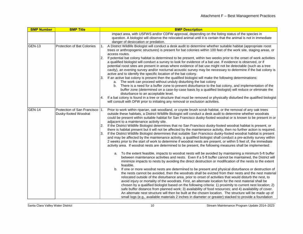
Attachment F – Best Management Practices
Santa Clara Valley Water District
10 Stream Maintenance Program Update 2014–2023
BMP Number BMP Title BMP Description impact area, with USFWS and/or CDFW approval, depending on the listing status of the species in question. A biologist will observe the relocated animal until it is certain that the animal is not in immediate danger of desiccation or predation.
GEN-13 Protection of Bat Colonies 1. A District Wildlife Biologist will conduct a desk audit to determine whether suitable habitat (appropriate roost trees or anthropogenic structures) is present for bat colonies within 100 feet of the work site, staging areas, or access routes.
2. If potential bat colony habitat is determined to be present, within two weeks prior to the onset of work activities a qualified biologist will conduct a survey to look for evidence of a bat use. If evidence is observed, or if potential roost sites are present in areas where evidence of bat use might not be detectable (such as a tree cavity), an evening survey and/or nocturnal acoustic survey may be necessary to determine if the bat colony is active and to identify the specific location of the bat colony.
3. If an active bat colony is present then the qualified biologist will make the following determinations: a. The work can proceed without unduly disturbing the bat colony b. There is a need for a buffer zone to prevent disturbance to the bat colony, and implementation of the
buffer zone (determined on a case-by-case basis by a qualified biologist) will reduce or eliminate the disturbance to an acceptable level.
4. If a bat colony is found in a tree or structure that must be removed or physically disturbed the qualified biologist will consult with DFW prior to initiating any removal or exclusion activities.
GEN-14
Protection of San Francisco Dusky-footed Woodrat
1. Prior to work within riparian, oak woodland, or coyote brush scrub habitat, or the removal of any oak trees outside these habitats, a District Wildlife Biologist will conduct a desk audit to determine whether woodrats could be present within suitable habitat for San Francisco dusky-footed woodrat or is known to be present in or adjacent to a maintenance activity site.
2. If the District Wildlife Biologist determines that no San Francisco dusky-footed woodrat habitat is present, or there is habitat present but it will not be affected by the maintenance activity, then no further action is required.
3. If the District Wildlife Biologist determines that suitable San Francisco dusky-footed woodrat habitat is present and may be affected by the maintenance activity, a qualified biologist shall conduct a pre-activity survey within 2 weeks prior to the start of work to determine if woodrat nests are present, or within 5 feet of, the immediate activity area. If woodrat nests are determined to be present, the following measures shall be implemented:
a. To the extent feasible, impacts to woodrat nests will be avoided by maintaining a minimum 5-ft buffer
between maintenance activities and nests. Even if a 5-ft buffer cannot be maintained, the District will minimize impacts to nests by avoiding the direct destruction or modification of the nests to the extent feasible.
b. If one or more woodrat nests are determined to be present and physical disturbance or destruction of the nests cannot be avoided, then the woodrats shall be evicted from their nests and the nest material relocated outside of the disturbance area, prior to onset of activities that would disturb the nest, to avoid injury or mortality of the woodrats. First, an alternate location for the nest material shall be chosen by a qualified biologist based on the following criteria: 1) proximity to current nest location; 2) safe buffer distance from planned work; 3) availability of food resources; and 4) availability of cover. An alternate nest structure will then be built at the chosen location. The structure will be made up of small logs (e.g., available materials 2 inches in diameter or greater) stacked to provide a foundation
billspri
Text Box
Appendix D - Maintenance Best Management Practices
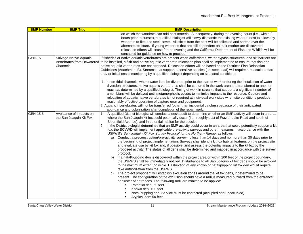
Attachment F – Best Management Practices
Santa Clara Valley Water District
11 Stream Maintenance Program Update 2014–2023
BMP Number BMP Title BMP Description on which the woodrats can add nest material. Subsequently, during the evening hours (i.e., within 2 hours prior to sunset), a qualified biologist will slowly dismantle the existing woodrat nest to allow any woodrats to flee and seek cover. All sticks from the nest will be collected and spread over the alternate structure. If young woodrats that are still dependent on their mother are discovered, relocation efforts will cease for the evening and the California Department of Fish and Wildlife will be contacted for guidance on how to proceed.
GEN-15 Salvage Native Aquatic Vertebrates from Dewatered Channels
If fisheries or native aquatic vertebrates are present when cofferdams, water bypass structures, and silt barriers are to be installed, a fish and native aquatic vertebrate relocation plan shall be implemented to ensure that fish and native aquatic vertebrates are not stranded. Relocation efforts will be based on the District’s Fish Relocation Guidelines (Attachment B). Streams that support a sensitive species (i.e. steelhead) will require a relocation effort and/ or initial onsite monitoring by a qualified biologist depending on seasonal conditions: 1. In non-tidal channels, where water is to be diverted, prior to the start of work or during the installation of water
diversion structures, native aquatic vertebrates shall be captured in the work area and transferred to another reach as determined by a qualified biologist. Timing of work in streams that supports a significant number of amphibians will be delayed until metamorphosis occurs to minimize impacts to the resource. Capture and relocation of aquatic native vertebrates is not required at individual work sites when site conditions preclude reasonably effective operation of capture gear and equipment.
2. Aquatic invertebrates will not be transferred (other than incidental catches) because of their anticipated abundance and colonization after completion of the repair work.
GEN-15.5 Avoidance of Impacts on the San Joaquin Kit Fox
1. A qualified District biologist will conduct a desk audit to determine whether an SMP activity will occur in an area where the San Joaquin kit fox could potentially occur (i.e., roughly east of Frazier Lake Road and south of Bloomfield Avenue), and in potential habitat for the species.
2. If the District biologist determines that an SMP activity could occur in an area that could potentially support a kit fox, the SCVWD will implement applicable pre-activity surveys and other measures in accordance with the USFWS’s San Joaquin Kit Fox Survey Protocol for the Northern Range, as follows:
a) Conduct a preconstruction/pre-activity survey no less than 14 days and no more than 30 days prior to the beginning of project implementation. Surveys shall identify kit fox habitat features on the project site and evaluate use by kit fox and, if possible, and assess the potential impacts to the kit fox by the proposed activity. The status of all dens shall be determined and mapped in accordance with the survey protocol.
b) If a natal/pupping den is discovered within the project area or within 200 feet of the project boundary, the USFWS shall be immediately notified. Disturbance to all San Joaquin kit fox dens should be avoided to the maximum extent possible. Destruction of any known or natal/pupping kit fox den would require take authorization from the USFWS.
c) The project proponent will establish exclusion zones around the kit fox dens, if determined to be present. The configuration of the exclusion should have a radius measured outward from the entrance or cluster of entrances. The following radii are minima to be applied:
Potential den: 50 feet Known den: 100 feet Natal/pupping den: Service must be contacted (occupied and unoccupied) Atypical den: 50 feet.
billspri
Text Box
Appendix D - Maintenance Best Management Practices
billspri
Text Box
Deleted Gen -15 See Section 3.1.3.j.
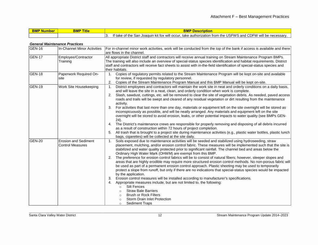
Attachment F – Best Management Practices
Santa Clara Valley Water District
12 Stream Maintenance Program Update 2014–2023
BMP Number BMP Title BMP Description 3. If take of the San Joaquin kit fox will occur, take authorization from the USFWS and CDFW will be necessary.
General Maintenance Practices GEN-16 In-Channel Minor Activities For in-channel minor work activities, work will be conducted from the top of the bank if access is available and there
are flows in the channel. GEN-17 Employee/Contractor
Training All appropriate District staff and contractors will receive annual training on Stream Maintenance Program BMPs. The training will also include an overview of special-status species identification and habitat requirements. District staff and contractors will receive fact sheets to assist with in-the-field identification of special-status species and their habitats.
GEN-18 Paperwork Required On-site
1. Copies of regulatory permits related to the Stream Maintenance Program will be kept on-site and available for review, if requested by regulatory personnel.
2. Copies of the Stream Maintenance Program Manual and this BMP Manual will be kept on-site. GEN-19 Work Site Housekeeping 1. District employees and contractors will maintain the work site in neat and orderly conditions on a daily basis,
and will leave the site in a neat, clean, and orderly condition when work is complete. 2. Slash, sawdust, cuttings, etc. will be removed to clear the site of vegetation debris. As needed, paved access
roads and trails will be swept and cleared of any residual vegetation or dirt resulting from the maintenance activity.
3. For activities that last more than one day, materials or equipment left on the site overnight will be stored as inconspicuously as possible, and will be neatly arranged. Any materials and equipment left on the site overnight will be stored to avoid erosion, leaks, or other potential impacts to water quality (see BMPs GEN-24).
4. The District’s maintenance crews are responsible for properly removing and disposing of all debris incurred as a result of construction within 72 hours of project completion.
5. All trash that is brought to a project site during maintenance activities (e.g., plastic water bottles, plastic lunch bags, cigarettes) will be collected at the site daily.
GEN-20 Erosion and Sediment Control Measures
1. Soils exposed due to maintenance activities will be seeded and stabilized using hydroseeding, straw placement, mulching, and/or erosion control fabric. These measures will be implemented such that the site is stabilized and water quality protected prior to significant rainfall. The channel bed and areas below the Ordinary High Water Mark (OHWM) are exempt from this BMP.
2. The preference for erosion control fabrics will be to consist of natural fibers; however, steeper slopes and areas that are highly erodible may require more structured erosion control methods. No non-porous fabric will be used as part of a permanent erosion control approach. Plastic sheeting may be used to temporarily protect a slope from runoff, but only if there are no indications that special-status species would be impacted by the application.
3. Erosion control measures will be installed according to manufacturer’s specifications. 4. Appropriate measures include, but are not limited to, the following:
o Silt Fences o Straw Bale Barriers o Brush or Rock Filters o Storm Drain Inlet Protection o Sediment Traps
billspri
Text Box
Appendix D - Maintenance Best Management Practices
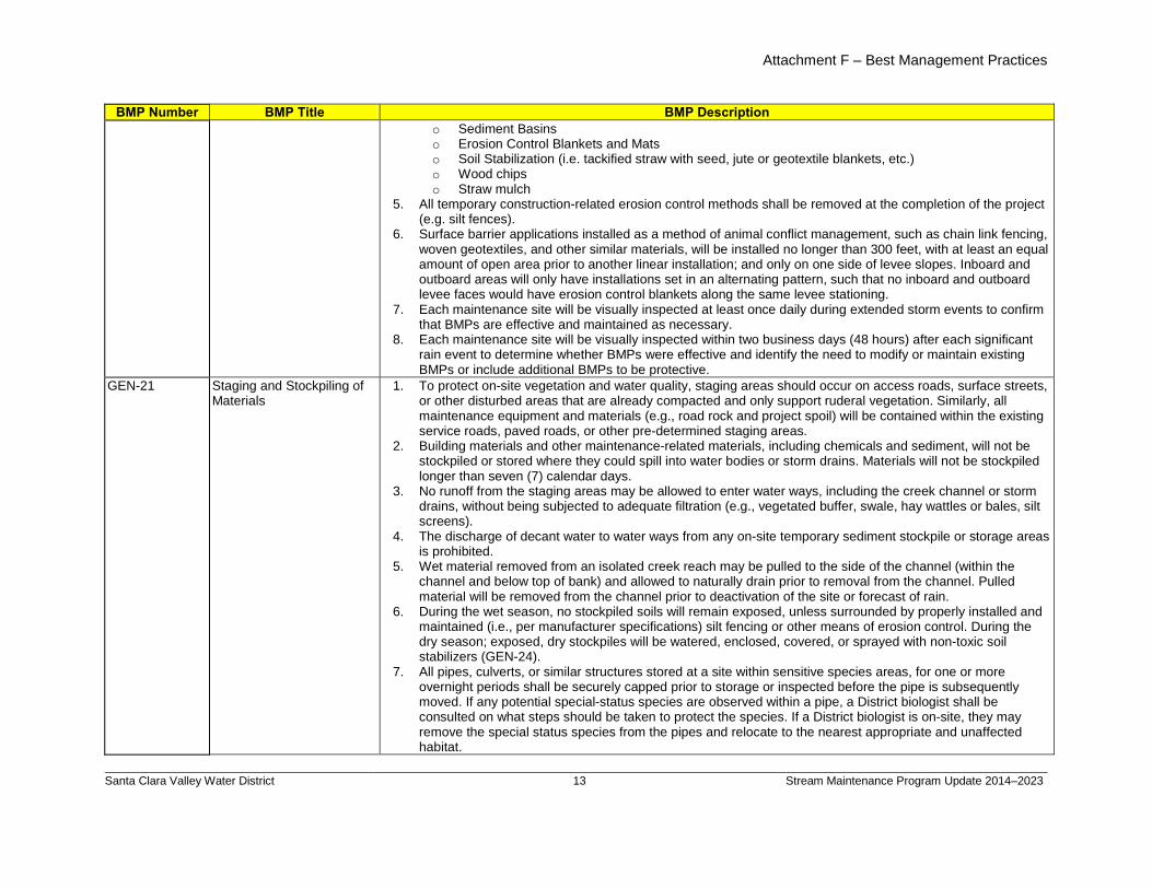
Attachment F – Best Management Practices
Santa Clara Valley Water District
13 Stream Maintenance Program Update 2014–2023
BMP Number BMP Title BMP Description o Sediment Basins o Erosion Control Blankets and Mats o Soil Stabilization (i.e. tackified straw with seed, jute or geotextile blankets, etc.) o Wood chips o Straw mulch
5. All temporary construction-related erosion control methods shall be removed at the completion of the project (e.g. silt fences).
6. Surface barrier applications installed as a method of animal conflict management, such as chain link fencing, woven geotextiles, and other similar materials, will be installed no longer than 300 feet, with at least an equal amount of open area prior to another linear installation; and only on one side of levee slopes. Inboard and outboard areas will only have installations set in an alternating pattern, such that no inboard and outboard levee faces would have erosion control blankets along the same levee stationing.
7. Each maintenance site will be visually inspected at least once daily during extended storm events to confirm that BMPs are effective and maintained as necessary.
8. Each maintenance site will be visually inspected within two business days (48 hours) after each significant rain event to determine whether BMPs were effective and identify the need to modify or maintain existing BMPs or include additional BMPs to be protective.
GEN-21 Staging and Stockpiling of Materials
1. To protect on-site vegetation and water quality, staging areas should occur on access roads, surface streets, or other disturbed areas that are already compacted and only support ruderal vegetation. Similarly, all maintenance equipment and materials (e.g., road rock and project spoil) will be contained within the existing service roads, paved roads, or other pre-determined staging areas.
2. Building materials and other maintenance-related materials, including chemicals and sediment, will not be stockpiled or stored where they could spill into water bodies or storm drains. Materials will not be stockpiled longer than seven (7) calendar days.
3. No runoff from the staging areas may be allowed to enter water ways, including the creek channel or storm drains, without being subjected to adequate filtration (e.g., vegetated buffer, swale, hay wattles or bales, silt screens).
4. The discharge of decant water to water ways from any on-site temporary sediment stockpile or storage areas is prohibited.
5. Wet material removed from an isolated creek reach may be pulled to the side of the channel (within the channel and below top of bank) and allowed to naturally drain prior to removal from the channel. Pulled material will be removed from the channel prior to deactivation of the site or forecast of rain.
6. During the wet season, no stockpiled soils will remain exposed, unless surrounded by properly installed and maintained (i.e., per manufacturer specifications) silt fencing or other means of erosion control. During the dry season; exposed, dry stockpiles will be watered, enclosed, covered, or sprayed with non-toxic soil stabilizers (GEN-24).
7. All pipes, culverts, or similar structures stored at a site within sensitive species areas, for one or more overnight periods shall be securely capped prior to storage or inspected before the pipe is subsequently moved. If any potential special-status species are observed within a pipe, a District biologist shall be consulted on what steps should be taken to protect the species. If a District biologist is on-site, they may remove the special status species from the pipes and relocate to the nearest appropriate and unaffected habitat.
billspri
Text Box
Appendix D - Maintenance Best Management Practices
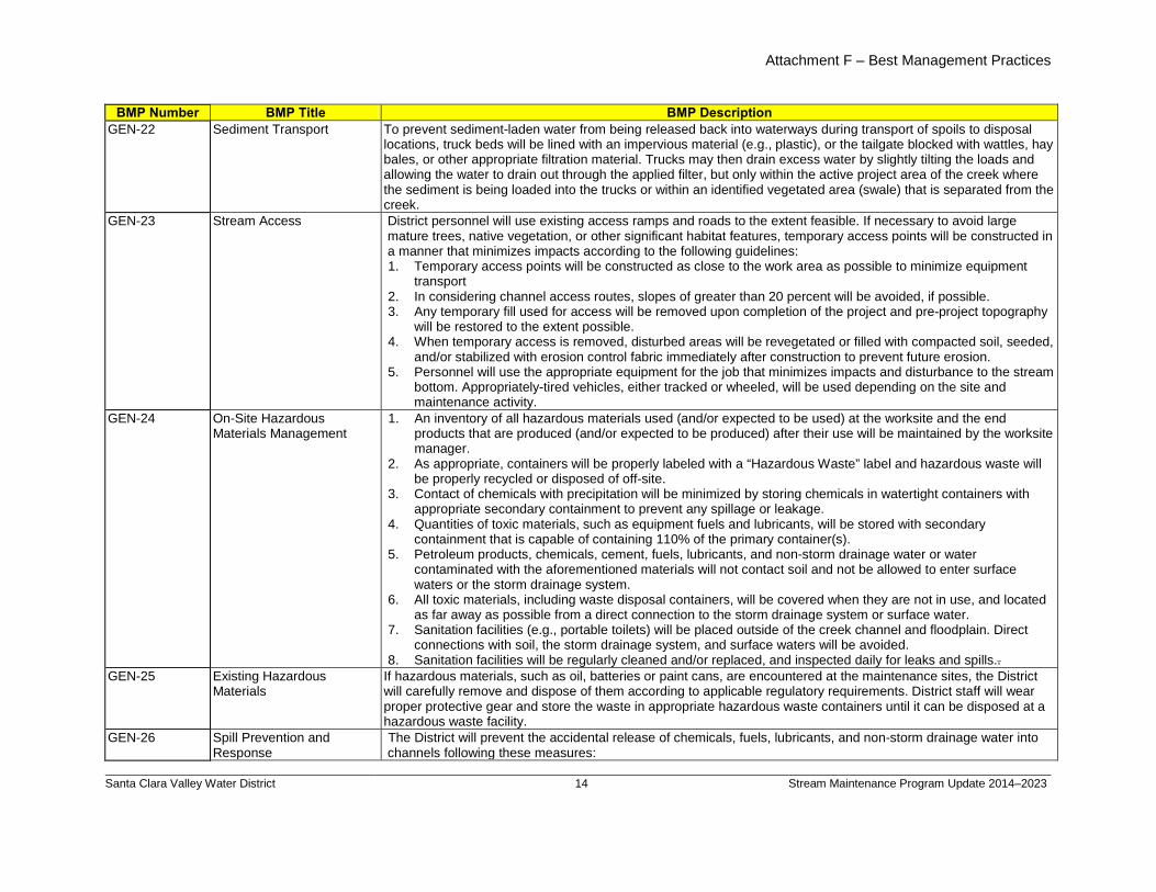
Attachment F – Best Management Practices
Santa Clara Valley Water District
14 Stream Maintenance Program Update 2014–2023
BMP Number BMP Title BMP Description GEN-22 Sediment Transport To prevent sediment-laden water from being released back into waterways during transport of spoils to disposal
locations, truck beds will be lined with an impervious material (e.g., plastic), or the tailgate blocked with wattles, hay bales, or other appropriate filtration material. Trucks may then drain excess water by slightly tilting the loads and allowing the water to drain out through the applied filter, but only within the active project area of the creek where the sediment is being loaded into the trucks or within an identified vegetated area (swale) that is separated from the creek.
GEN-23 Stream Access District personnel will use existing access ramps and roads to the extent feasible. If necessary to avoid large mature trees, native vegetation, or other significant habitat features, temporary access points will be constructed in a manner that minimizes impacts according to the following guidelines: 1. Temporary access points will be constructed as close to the work area as possible to minimize equipment
transport 2. In considering channel access routes, slopes of greater than 20 percent will be avoided, if possible. 3. Any temporary fill used for access will be removed upon completion of the project and pre-project topography
will be restored to the extent possible. 4. When temporary access is removed, disturbed areas will be revegetated or filled with compacted soil, seeded,
and/or stabilized with erosion control fabric immediately after construction to prevent future erosion. 5. Personnel will use the appropriate equipment for the job that minimizes impacts and disturbance to the stream
bottom. Appropriately-tired vehicles, either tracked or wheeled, will be used depending on the site and maintenance activity.
GEN-24 On-Site Hazardous Materials Management
1. An inventory of all hazardous materials used (and/or expected to be used) at the worksite and the end products that are produced (and/or expected to be produced) after their use will be maintained by the worksite manager.
2. As appropriate, containers will be properly labeled with a “Hazardous Waste” label and hazardous waste will be properly recycled or disposed of off-site.
3. Contact of chemicals with precipitation will be minimized by storing chemicals in watertight containers with appropriate secondary containment to prevent any spillage or leakage.
4. Quantities of toxic materials, such as equipment fuels and lubricants, will be stored with secondary containment that is capable of containing 110% of the primary container(s).
5. Petroleum products, chemicals, cement, fuels, lubricants, and non-storm drainage water or water contaminated with the aforementioned materials will not contact soil and not be allowed to enter surface waters or the storm drainage system.
6. All toxic materials, including waste disposal containers, will be covered when they are not in use, and located as far away as possible from a direct connection to the storm drainage system or surface water.
7. Sanitation facilities (e.g., portable toilets) will be placed outside of the creek channel and floodplain. Direct connections with soil, the storm drainage system, and surface waters will be avoided.
8. Sanitation facilities will be regularly cleaned and/or replaced, and inspected daily for leaks and spills.GEN-25
.
Existing Hazardous Materials
If hazardous materials, such as oil, batteries or paint cans, are encountered at the maintenance sites, the District will carefully remove and dispose of them according to applicable regulatory requirements. District staff will wear proper protective gear and store the waste in appropriate hazardous waste containers until it can be disposed at a hazardous waste facility.
GEN-26 Spill Prevention and Response
The District will prevent the accidental release of chemicals, fuels, lubricants, and non-storm drainage water into channels following these measures:
billspri
Text Box
Appendix D - Maintenance Best Management Practices
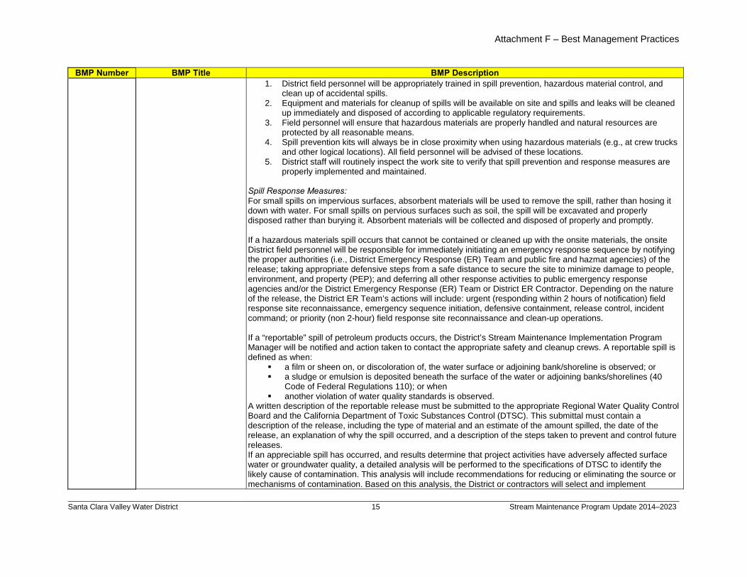
Attachment F – Best Management Practices
Santa Clara Valley Water District
15 Stream Maintenance Program Update 2014–2023
BMP Number BMP Title BMP Description 1. District field personnel will be appropriately trained in spill prevention, hazardous material control, and
clean up of accidental spills. 2. Equipment and materials for cleanup of spills will be available on site and spills and leaks will be cleaned
up immediately and disposed of according to applicable regulatory requirements. 3. Field personnel will ensure that hazardous materials are properly handled and natural resources are
protected by all reasonable means. 4. Spill prevention kits will always be in close proximity when using hazardous materials (e.g., at crew trucks
and other logical locations). All field personnel will be advised of these locations. 5. District staff will routinely inspect the work site to verify that spill prevention and response measures are
properly implemented and maintained.
Spill Response Measures: For small spills on impervious surfaces, absorbent materials will be used to remove the spill, rather than hosing it down with water. For small spills on pervious surfaces such as soil, the spill will be excavated and properly disposed rather than burying it. Absorbent materials will be collected and disposed of properly and promptly. If a hazardous materials spill occurs that cannot be contained or cleaned up with the onsite materials, the onsite District field personnel will be responsible for immediately initiating an emergency response sequence by notifying the proper authorities (i.e., District Emergency Response (ER) Team and public fire and hazmat agencies) of the release; taking appropriate defensive steps from a safe distance to secure the site to minimize damage to people, environment, and property (PEP); and deferring all other response activities to public emergency response agencies and/or the District Emergency Response (ER) Team or District ER Contractor. Depending on the nature of the release, the District ER Team’s actions will include: urgent (responding within 2 hours of notification) field response site reconnaissance, emergency sequence initiation, defensive containment, release control, incident command; or priority (non 2-hour) field response site reconnaissance and clean-up operations. If a “reportable” spill of petroleum products occurs, the District’s Stream Maintenance Implementation Program Manager will be notified and action taken to contact the appropriate safety and cleanup crews. A reportable spill is defined as when:
a film or sheen on, or discoloration of, the water surface or adjoining bank/shoreline is observed; or a sludge or emulsion is deposited beneath the surface of the water or adjoining banks/shorelines (40
Code of Federal Regulations 110); or when another violation of water quality standards is observed.
A written description of the reportable release must be submitted to the appropriate Regional Water Quality Control Board and the California Department of Toxic Substances Control (DTSC). This submittal must contain a description of the release, including the type of material and an estimate of the amount spilled, the date of the release, an explanation of why the spill occurred, and a description of the steps taken to prevent and control future releases. If an appreciable spill has occurred, and results determine that project activities have adversely affected surface water or groundwater quality, a detailed analysis will be performed to the specifications of DTSC to identify the likely cause of contamination. This analysis will include recommendations for reducing or eliminating the source or mechanisms of contamination. Based on this analysis, the District or contractors will select and implement
billspri
Text Box
Appendix D - Maintenance Best Management Practices
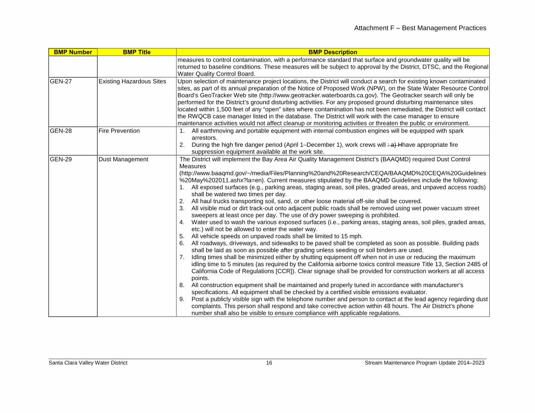
Attachment F – Best Management Practices
Santa Clara Valley Water District
16 Stream Maintenance Program Update 2014–2023
BMP Number BMP Title BMP Description measures to control contamination, with a performance standard that surface and groundwater quality will be returned to baseline conditions. These measures will be subject to approval by the District, DTSC, and the Regional Water Quality Control Board.
GEN-27 Existing Hazardous Sites Upon selection of maintenance project locations, the District will conduct a search for existing known contaminated sites, as part of its annual preparation of the Notice of Proposed Work (NPW), on the State Water Resource Control Board’s GeoTracker Web site (http://www.geotracker.waterboards.ca.gov). The Geotracker search will only be performed for the District’s ground disturbing activities. For any proposed ground disturbing maintenance sites located within 1,500 feet of any “open” sites where contamination has not been remediated, the District will contact the RWQCB case manager listed in the database. The District will work with the case manager to ensure maintenance activities would not affect cleanup or monitoring activities or threaten the public or environment.
GEN-28
Fire Prevention 1. All earthmoving and portable equipment with internal combustion engines will be equipped with spark arrestors.
2. During the high fire danger period (April 1–December 1), work crews will : a) H
GEN-29
have appropriate fire suppression equipment available at the work site.
Dust Management The District will implement the Bay Area Air Quality Management District’s (BAAQMD) required Dust Control Measures (http://www.baaqmd.gov/~/media/Files/Planning%20and%20Research/CEQA/BAAQMD%20CEQA%20Guidelines%20May%202011.ashx?la=en). Current measures stipulated by the BAAQMD Guidelines include the following: 1. All exposed surfaces (e.g., parking areas, staging areas, soil piles, graded areas, and unpaved access roads)
shall be watered two times per day. 2. All haul trucks transporting soil, sand, or other loose material off-site shall be covered. 3. All visible mud or dirt track-out onto adjacent public roads shall be removed using wet power vacuum street
sweepers at least once per day. The use of dry power sweeping is prohibited. 4. Water used to wash the various exposed surfaces (i.e., parking areas, staging areas, soil piles, graded areas,
etc.) will not be allowed to enter the water way. 5. All vehicle speeds on unpaved roads shall be limited to 15 mph. 6. All roadways, driveways, and sidewalks to be paved shall be completed as soon as possible. Building pads
shall be laid as soon as possible after grading unless seeding or soil binders are used. 7. Idling times shall be minimized either by shutting equipment off when not in use or reducing the maximum
idling time to 5 minutes (as required by the California airborne toxics control measure Title 13, Section 2485 of California Code of Regulations [CCR]). Clear signage shall be provided for construction workers at all access points.
8. All construction equipment shall be maintained and properly tuned in accordance with manufacturer‘s specifications. All equipment shall be checked by a certified visible emissions evaluator.
9. Post a publicly visible sign with the telephone number and person to contact at the lead agency regarding dust complaints. This person shall respond and take corrective action within 48 hours. The Air District‘s phone number shall also be visible to ensure compliance with applicable regulations.
billspri
Text Box
Appendix D - Maintenance Best Management Practices
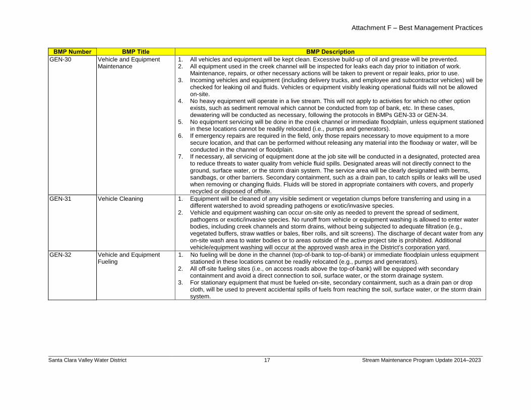
Attachment F – Best Management Practices
Santa Clara Valley Water District
17 Stream Maintenance Program Update 2014–2023
BMP Number BMP Title BMP Description GEN-30 Vehicle and Equipment
Maintenance 1. All vehicles and equipment will be kept clean. Excessive build-up of oil and grease will be prevented. 2. All equipment used in the creek channel will be inspected for leaks each day prior to initiation of work.
Maintenance, repairs, or other necessary actions will be taken to prevent or repair leaks, prior to use. 3. Incoming vehicles and equipment (including delivery trucks, and employee and subcontractor vehicles) will be
checked for leaking oil and fluids. Vehicles or equipment visibly leaking operational fluids will not be allowed on-site.
4. No heavy equipment will operate in a live stream. This will not apply to activities for which no other option exists, such as sediment removal which cannot be conducted from top of bank, etc. In these cases, dewatering will be conducted as necessary, following the protocols in BMPs GEN-33 or GEN-34.
5. No equipment servicing will be done in the creek channel or immediate floodplain, unless equipment stationed in these locations cannot be readily relocated (i.e., pumps and generators).
6. If emergency repairs are required in the field, only those repairs necessary to move equipment to a more secure location, and that can be performed without releasing any material into the floodway or water, will be conducted in the channel or floodplain.
7. If necessary, all servicing of equipment done at the job site will be conducted in a designated, protected area to reduce threats to water quality from vehicle fluid spills. Designated areas will not directly connect to the ground, surface water, or the storm drain system. The service area will be clearly designated with berms, sandbags, or other barriers. Secondary containment, such as a drain pan, to catch spills or leaks will be used when removing or changing fluids. Fluids will be stored in appropriate containers with covers, and properly recycled or disposed of offsite.
GEN-31 Vehicle Cleaning 1. Equipment will be cleaned of any visible sediment or vegetation clumps before transferring and using in a different watershed to avoid spreading pathogens or exotic/invasive species.
2. Vehicle and equipment washing can occur on-site only as needed to prevent the spread of sediment, pathogens or exotic/invasive species. No runoff from vehicle or equipment washing is allowed to enter water bodies, including creek channels and storm drains, without being subjected to adequate filtration (e.g., vegetated buffers, straw wattles or bales, fiber rolls, and silt screens). The discharge of decant water from any on-site wash area to water bodies or to areas outside of the active project site is prohibited. Additional vehicle/equipment washing will occur at the approved wash area in the District’s corporation yard.
GEN-32
Vehicle and Equipment Fueling
1. No fueling will be done in the channel (top-of-bank to top-of-bank) or immediate floodplain unless equipment stationed in these locations cannot be readily relocated (e.g., pumps and generators).
2. All off-site fueling sites (i.e., on access roads above the top-of-bank) will be equipped with secondary containment and avoid a direct connection to soil, surface water, or the storm drainage system.
3. For stationary equipment that must be fueled on-site, secondary containment, such as a drain pan or drop cloth, will be used to prevent accidental spills of fuels from reaching the soil, surface water, or the storm drain system.
billspri
Text Box
Appendix D - Maintenance Best Management Practices
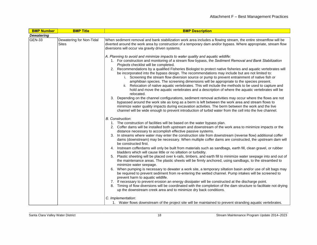
Attachment F – Best Management Practices
Santa Clara Valley Water District
18 Stream Maintenance Program Update 2014–2023
BMP Number BMP Title BMP Description Dewatering GEN-33
Dewatering for Non-Tidal Sites
When sediment removal and bank stabilization work area includes a flowing stream, the entire streamflow will be diverted around the work area by construction of a temporary dam and/or bypass. Where appropriate, stream flow diversions will occur via gravity driven systems. A. Planning to avoid and minimize impacts to water quality and aquatic wildlife:
1. For construction and monitoring of a stream flow bypass, the Sediment Removal and Bank Stabilization Projects checklist will be completed.
2. Recommendations by a qualified Fisheries Biologist to protect native fisheries and aquatic vertebrates will be incorporated into the bypass design. The recommendations may include but are not limited to:
i. Screening the stream flow diversion source or pump to prevent entrainment of native fish or amphibian species. The screening dimensions will be appropriate to the species present.
ii. Relocation of native aquatic vertebrates. This will include the methods to be used to capture and hold and move the aquatic vertebrates and a description of where the aquatic vertebrates will be relocated.
3. Depending on the channel configurations, sediment removal activities may occur where the flows are not bypassed around the work site as long as a berm is left between the work area and stream flows to minimize water quality impacts during excavation activities. The berm between the work and the live channel will be wide enough to prevent introduction of turbid water from the cell into the live channel.
B. Construction:
1. The construction of facilities will be based on the water bypass plan. 2. Coffer dams will be installed both upstream and downstream of the work area to minimize impacts or the
distance necessary to accomplish effective passive systems. 3. In streams where water may enter the construction site from downstream (reverse flow) additional coffer
dams (downstream) may be necessary. When multiple coffer dams are constructed, the upstream dam will be constructed first.
4. Instream cofferdams will only be built from materials such as sandbags, earth fill, clean gravel, or rubber bladders which will cause little or no siltation or turbidity.
5. Plastic sheeting will be placed over k-rails, timbers, and earth fill to minimize water seepage into and out of the maintenance areas. The plastic sheets will be firmly anchored, using sandbags, to the streambed to minimize water seepage.
6. When pumping is necessary to dewater a work site, a temporary siltation basin and/or use of silt bags may be required to prevent sediment from re-entering the wetted channel. Pump intakes will be screened to prevent harm to aquatic wildlife.
7. If necessary to prevent erosion an energy dissipater will be constructed at the discharge point. 8. Timing of flow diversions will be coordinated with the completion of the dam structure to facilitate not drying
up the downstream creek area and to minimize dry back conditions.
C. Implementation: 1. Water flows downstream of the project site will be maintained to prevent stranding aquatic vertebrates.
billspri
Text Box
Appendix D - Maintenance Best Management Practices
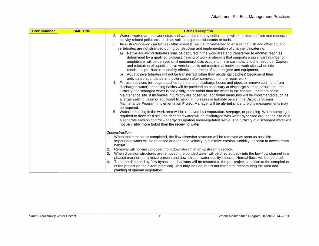
Attachment F – Best Management Practices
Santa Clara Valley Water District
19 Stream Maintenance Program Update 2014–2023
BMP Number BMP Title BMP Description 2. Water diverted around work sites and water detained by coffer dams will be protected from maintenance
activity-related pollutants, such as soils, equipment lubricants or fuels. 3. The Fish Relocation Guidelines (Attachment B) will be implemented to ensure that fish and other aquatic
vertebrates are not stranded during construction and implementation of channel dewatering. a) Native aquatic vertebrates shall be captured in the work area and transferred to another reach as
determined by a qualified biologist. Timing of work in streams that supports a significant number of amphibians will be delayed until metamorphosis occurs to minimize impacts to the resource. Capture and relocation of aquatic native vertebrates is not required at individual work sites when site conditions preclude reasonably effective operation of capture gear and equipment.
b) Aquatic invertebrates will not be transferred (other than incidental catches) because of their anticipated abundance and colonization after completion of the repair work.
4. Filtration devices (silt bags attached to the end of discharge hoses and pipes to remove sediment from discharged water) or settling basins will be provided as necessary at discharge sites to ensure that the turbidity of discharged water is not visibly more turbid than the water in the channel upstream of the maintenance site. If increases in turbidity are observed, additional measures will be implemented such as a larger settling basin or additional filtration. If increases in turbidity persist, the District’s Stream Maintenance Program Implementation Project Manager will be alerted since turbidity measurements may be required.
5. Water remaining in the work area will be removed by evaporation, seepage, or pumping. When pumping is required to dewater a site, the decanted water will be discharged with water bypassed around the site or in a separate erosion control – energy dissipation area/vegetated swale. The turbidity of discharged water will not be visibly more turbid than the receiving water.
Deconstruction: 1. When maintenance is completed, the flow diversion structure will be removed as soon as possible.
Impounded water will be released at a reduced velocity to minimize erosion, turbidity, or harm to downstream habitat.
2. Removal will normally proceed from downstream in an upstream direction. 3. When diversion structures are removed, the ponded water will be directed back into the low-flow channel in a
phased manner to minimize erosion and downstream water quality impacts. Normal flows will be restored. 4. The area disturbed by flow bypass mechanisms will be restored to the pre-project condition at the completion
of the project (to the extent practical). This may include, but is not limited to, recontouring the area and planting of riparian vegetation.
billspri
Text Box
Appendix D - Maintenance Best Management Practices
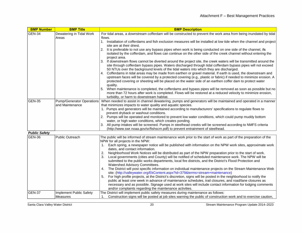
Attachment F – Best Management Practices
Santa Clara Valley Water District
20 Stream Maintenance Program Update 2014–2023
BMP Number BMP Title BMP Description GEN-34
Dewatering in Tidal Work Areas
For tidal areas, a downstream cofferdam will be constructed to prevent the work area from being inundated by tidal flows. 1. Installation of cofferdams and fish exclusion measures will be installed at low tide when the channel and project
site are at their driest. 2. It is preferable to not use any bypass pipes when work is being conducted on one side of the channel, ifs
3. If downstream flows cannot be diverted around the project site, the creek waters will be transmitted around the site through cofferdam bypass pipes. Waters discharged through tidal cofferdam bypass pipes will not exceed 50 NTUs over the background levels of the tidal waters into which they are discharged.
isolated by the cofferdam, and flows can continue on the other side of the creek channel without entering the project area.
4. Cofferdams in tidal areas may be made from earthen or gravel material. If earth is used, the downstream and upstream faces will be covered by a protected covering (e.g., plastic or fabric) if needed to minimize erosion. A protected covering or sheeting will be placed on the water side of an earthen coffer dam to protect water quality.
5. When maintenance is completed, the cofferdams and bypass pipes will be removed as soon as possible but no more than 72 hours after work is completed. Flows will be restored at a reduced velocity to minimize erosion, turbidity, or harm to downstream habitat.
GEN-35 Pump/Generator Operations and Maintenance
When needed to assist in channel dewatering, pumps and generators will be maintained and operated in a manner that minimizes impacts to water quality and aquatic species. 1. Pumps and generators will be maintained according to manufacturers’ specifications to regulate flows to
prevent dryback or washout conditions. 2. Pumps will be operated and monitored to prevent low water conditions, which could pump muddy bottom
water, or high water conditions, which creates ponding. 3. All pump intakes will be screened. Pumps in steelhead creeks will be screened according to NMFS criteria
(http://www.swr.noaa.gov/sr/fishscrn.pdf) to prevent entrainment of steelhead. Public Safety GEN-36 Public Outreach The public will be informed of stream maintenance work prior to the start of work as part of the preparation of the
NPW for all projects in the NPW: 1. Each spring, a newspaper notice will be published with information on the NPW work sites, approximate work
dates, and contact information. 2. Neighborhood Work Notices will be distributed as part of the NPW preparation prior to the start of work. 3. Local governments (cities and County) will be notified of scheduled maintenance work. The NPW will be
submitted to the public works departments, local fire districts, and the District’s Flood Protection and Watershed Advisory Committees.
4. The District will post specific information on individual maintenance projects on the Stream Maintenance Web site: (http://valleywater.org/EkContent.aspx?id=379&terms=stream+maintenance)
5. For high profile projects, at the District’s discretion, signs will be posted in the neighborhood to notify the public at least one week in advance of maintenance schedules, trail closures, and road/lane closures as necessary and as possible. Signage used at work sites will include contact information for lodging comments and/or complaints regarding the maintenance activities.
GEN-37 Implement Public Safety Measures
The District will implement public safety measures during maintenance as follows: 1. Construction signs will be posted at job sites warning the public of construction work and to exercise caution,
billspri
Text Box
Appendix D - Maintenance Best Management Practices
billspri
Text Box
billspri
Text Box
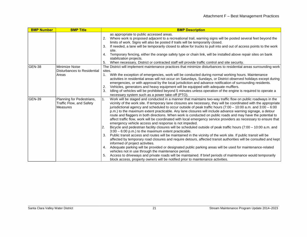
Attachment F – Best Management Practices
Santa Clara Valley Water District
21 Stream Maintenance Program Update 2014–2023
BMP Number BMP Title BMP Description as appropriate to public accessed areas.
2. Where work is proposed adjacent to a recreational trail, warning signs will be posted several feet beyond the limits of work. Signs will also be posted if trails will be temporarily closed.
3. If needed, a lane will be temporarily closed to allow for trucks to pull into and out of access points to the work site.
4. Temporary fencing, either the orange safety type or chain link, will be installed above repair sites on bank stabilization projects.
5. When necessary, District or contracted staff will provide traffic control and site security. GEN-38 Minimize Noise
Disturbances to Residential Areas
The District will implement maintenance practices that minimize disturbances to residential areas surrounding work sites. 1. With the exception of emergencies, work will be conducted during normal working hours. Maintenance
activities in residential areas will not occur on Saturdays, Sundays, or District observed holidays except during emergencies, or with approval by the local jurisdiction and advance notification of surrounding residents.
2. Vehicles, generators and heavy equipment will be equipped with adequate mufflers. 3. Idling of vehicles will be prohibited beyond 5 minutes unless operation of the engine is required to operate a
necessary system such as a power take-off (PTO). GEN-39
Planning for Pedestrians, Traffic Flow, and Safety Measures
1. Work will be staged and conducted in a manner that maintains two-way traffic flow on public roadways in the vicinity of the work site. If temporary lane closures are necessary, they will be coordinated with the appropriate jurisdictional agency and scheduled to occur outside of peak traffic hours (7:00 – 10:00 a.m. and 3:00 – 6:00 p.m.) to the maximum extent practicable. Any lane closures will include advance warning signage, a detour route and flaggers in both directions. When work is conducted on public roads and may have the potential to affect traffic flow, work will be coordinated with local emergency service providers as necessary to ensure that emergency vehicle access and response is not impeded.
2. Bicycle and pedestrian facility closures will be scheduled outside of peak traffic hours (7:00 – 10:00 a.m. and 3:00 – 6:00 p.m.) to the maximum extent practicable.
3. Public transit access and routes will be maintained in the vicinity of the work site. If public transit will be affected by temporary road closures and require detours, affected transit authorities will be consulted and kept informed of project activities.
4. Adequate parking will be provided or designated public parking areas will be used for maintenance-related vehicles not in use through the maintenance period.
5. Access to driveways and private roads will be maintained. If brief periods of maintenance would temporarily block access, property owners will be notified prior to maintenance activities.
billspri
Text Box
Appendix D - Maintenance Best Management Practices
Attachment F – Best Management Practices
Santa Clara Valley Water District
22 Stream Maintenance Program Update 2014–2023
BMP Number BMP Title BMP Description Cultural Resources GEN-40
Discovery of Cultural Remains or Historic or Paleontological Artifacts
Work in areas where remains or artifacts are found will be restricted or stopped until proper protocols are met. 1. Work at the location of the find will halt immediately within 50 feet of the find. A “no work” zone shall be
established utilizing appropriate flagging to delineate the boundary of this zone, which shall measure at least 50 feet in all directions from the find.
2. The District shall retain the services of a Consulting Archaeologist or Paleontologist, who shall visit the discovery site as soon as practicable, and perform minor hand-excavation to describe the archaeological or paleontological resources present and assess the amount of disturbance.
3. The Consulting Archaeologist shall provide to the District and the Corps, at a minimum, written and digital-photographic documentation of all observed materials, utilizing the guidelines for evaluating archaeological resources for the California Register of Historic Places (CRHP) and National Register of Historic Places (NRHP). Based on the assessment, the District and Corps shall identify the CEQA and Section 106 cultural-resources compliance procedure to be implemented.
4. If the find appears to not meet the CRHP or NRHP criteria of significance, and the Corps archaeologist concurs with the Consulting Archaeologist’s conclusions, construction shall continue while monitored by the Consulting Archaeologist. The authorized maintenance work shall resume at the discovery site only after the District has retained a Consulting Archaeologist to monitor and the Watershed Manager has received notification from the Corps to continue work.
5. If the find appears significant, avoidance of additional impacts is the preferred alternative. The Consulting Archaeologist shall determine if adverse impacts to the resources can be avoided.
6. When avoidance is not practical (e.g., maintenance activities cannot be deferred or they must be completed to satisfy the SMP objective), the District shall develop an Action Plan and submit it to the Corps within 48 hours of Consulting Archaeologist’s evaluation of the discovery. The action Plan may be submitted via e-mail to ([email protected])
7. The recovery effort will be detailed in a report prepared by the archaeologist in accordance with current archaeological standards. Any non-grave artifacts will be placed with an appropriate repository.
. The Action Plan is synonymous with a data-recovery plan. It shall be prepared in accordance with the current professional standards and State guidelines for reporting the results of the work, and shall describe the services of a Native American Consultant and a proposal for curation of cultural materials recovered from a non-grave context.
8. The Consulting Paleontologist will meet the Society for Vertebrate Paleontology’s criteria for a “qualified professional paleontologist” (Society of Vertebrate Paleontology Conformable Impact Mitigation Guidelines Committee 1995).
9. The paleontologist will follow the Society for Vertebrate Paleontology’s guidelines for treatment of the artifact. Treatment may include preparation and recovery of fossil materials for an appropriate museum or university collection, and may include preparation of a report describing the finds. The District will be responsible for ensuring that paleontologist’s recommendations are implemented.
10. In the event of discovery of human remains (or the find consists of bones suspected to be human), the field crew supervisor shall take immediate steps to secure and protect such remains from vandalism during periods when work crews are absent.)
11. Immediately notify the Santa Clara County Coroner and provide any information that identify the remains as Native American. If the remains are determined to be from a prehistoric Native American, or determined to be a Native American from the ethnographic period, the Coroner shall contact the Native American Heritage
billspri
Text Box
Appendix D - Maintenance Best Management Practices
Attachment F – Best Management Practices
Santa Clara Valley Water District
23 Stream Maintenance Program Update 2014–2023
BMP Number BMP Title BMP Description Commission (NAHC) within 24 hours of being notified of the remains. The NAHC then designates and notifies within 24 hours a Most Likely Descendant (MLD). The MLD has 24 hours to consult and provide recommendations for the treatment or disposition, with proper dignity, of the human remains and grave goods.
12. Preservation in situ is the preferred option. Human remains shall be preserved in situ if continuation of the maintenance work, as determined by the Consulting Archaeologist and MLD, will not cause further damage to the remains. The remains and artifacts shall be documented and the find location carefully backfilled (with protective geo-fabric if desirable) and recorded in District project files.
13. Human remains or cultural items exposed during maintenance that cannot be protected from further damage shall be exhumed by the Consulting Archaeologist at the discretion of the MLD and reburied with the concurrence of the MLD in a place mutually agreed upon by all parties.
GEN-41 Review of Projects with Native Soil
A cultural resources specialist will conduct a review and evaluation of those sites that would involve disturbance / excavation of native soil previously undisturbed by contemporary human activities to determine their potential for affecting significant cultural resources. The evaluation of the potential to disturb cultural resources will be based on an initial review of archival information provided by the California Historical Resources System/Northwest Information Center (CHRIS/NWIC) in regard to the project area based on a 0.25 mile search radius. It is recommended that this initial archival review be completed by a professional archaeologist who will be able to view confidential site location data and literature to arrive at a preliminary sensitivity determination. If necessary, a further archival record search and literature review (including a review of the Sacred Lands Inventory of the Native American Heritage Commission); and a field inventory of the project area will be conducted to determine the presence/absence of surface cultural materials associated with either prehistoric or historic occupation. The results along with any mitigation and/or management recommendations would be presented in an appropriate report format and include any necessary maps, figures, and correspondence with interested parties. A summary table indicating appropriate management actions (e.g., monitoring during construction, presence/absence testing for subsurface resources; data recovery, etc.) will be developed for each project site reviewed. The management actions will be implemented on site to avoid significant effects to cultural resources.
Utilities GEN-42
Investigation of Utility Line Locations
An evaluation of the locations of utility lines that could be affected by maintenance activities will be conducted annually as part of the preparation of the Notice of Proposed Work (NPW). Utilities will be avoided as much as possible. For maintenance areas with the potential for adverse effects on utility services, the following measures shall be implemented: 1. Utility excavation or encroachment permits shall be required from the appropriate agencies. These permits
include measures to minimize utility disruption. The District and its contractors shall comply with permit conditions. Such conditions shall be included in construction contract specifications.
2. Utility locations shall be verified through a field survey (potholing) and use of the Underground Service Alert services.
3. Detailed specifications shall be prepared as part of the design plans to include procedures for the excavation, support, and/or fill of areas around utility cables and pipelines. All affected utility services shall be notified of the District’s maintenance plans and schedule. Arrangements shall be made with these entities regarding protection, relocation, or temporary disconnection of services.
4. Residents and businesses in the project area shall be notified of planned utility service disruption 2 to 4 days in advance, in conformance with state standards.
5. Disconnected cables and lines shall be reconnected promptly.
billspri
Text Box
Appendix D - Maintenance Best Management Practices
Attachment F – Best Management Practices
Santa Clara Valley Water District
24 Stream Maintenance Program Update 2014–2023
B. SECTION B – Sediment Removal BMPs This group of BMPs is intended to be implemented specifically during sediment removal activities to avoid potential impacts on biological resources. BMP Number BMP Title BMP Description
SED-1 Groundwater Management If high levels of groundwater (i.e., visible water) are encountered during excavations in a work area, the water will be pumped out of the work site or left within the work area if the work activity is not causing water quality degradation in a live stream. Water Quality monitoring would need to occur. If necessary to protect water quality, the extracted water will be discharged into specifically constructed infiltration basins, holding ponds, or areas with vegetation to remove sediment prior to the water re-entering a creek. Water discharged into vegetated areas or swales will be pumped in a manner that will not create erosion around vegetation.
SED-2 Prevent Scour Downstream of Sediment Removal
Sediment removal sites in the transport zone on alluvial fans may cause increased scour downstream if they experience scouring flows or rapid sediment accumulation after maintenance. After sediment removal, the channel will be graded so that the transition between the existing channel both upstream and downstream of the maintenance area is smooth and continuous between the maintained and non-maintained areas and does not present a sudden vertical transition (wall of sediment) or other blockage that could erode once flows are restored to the channel.
SED-3 Restore Channel Features Low-flow channels within non-tidal streams will be contoured to facilitate fish passage and will emulate the pre-construction conditions as closely as possible, within the finished channel topography.
SED-4 Berm Bypass Where sediment removal is accomplished without a bypass by removing alternating cells, the berm between the work and the live channel will be wide enough to prevent introduction of turbid water from the cell into the live channel.
SED-5 Sediment Characterization Projects involving sediment removal at stream gauges, outfalls, culverts, flap gates, tide gates, grade control structures, bridges, fish ladders, and fish screens in excess of 25 cubic yards shall be characterized in accordance with the SCVWD’s Sediment Characterization Plans for SMP-2. These projects shall be reported in the annual summary report. Sediment removed will not be reused without pre-approval from appropriate regulatory agencies. See section 5.4 for information on the waiver process.
C. SECTION C – Vegetation Management BMPs These BMPs provide specific and detailed guidance on the variety of vegetation management procedures implemented by the District. BMPs for the following maintenance techniques are included: tree pruning, tree removal, plant removal, woody debris management, herbicide application, mowing, discing, flaming, and grazing. Practices will be implemented by fully trained and qualified field crews.
billspri
Text Box
Appendix D - Maintenance Best Management Practices
Attachment F – Best Management Practices
Santa Clara Valley Water District
25 Stream Maintenance Program Update 2014–2023
BMP Number BMP Title BMP Description
VEG-1 Minimize Local Erosion Increase from In-channel Vegetation Removal
To minimize the potential effect of localized erosion, the toe of the bank will be protected by leaving vegetation to the maximum extent possible and consistent with the maintenance guidelines or original design requirements.
VEG-2 Non-native Invasive Plant Removal
Invasive species (e.g. cape ivy [Delairea odorata/Senecio mikanoides], arundo [Arundo donax]) will be disposed of in a manner that will not contribute to the further spread of the species. Cape ivy removed during a project shall be bagged and disposed of in a landfill. Arundo canes will be prevented from floating downstream or otherwise entering the creek or waterway.
VEG-3 Use Appropriate Equipment for Instream Removal
When using heavy equipment to cut or remove instream vegetation, low ground pressure equipment, such as tracked wheels will be utilized to reduce impacts to the streambed.
VEG-4
Use Flamers with Caution 1. A fire extinguisher, water supply and other appropriate fire suppression equipment will always be kept close to the work site in case of an emergency. 2. Propane tanks will be checked for leaks and proper functioning prior to and proceeding use of flaming equipment. The propane tank will be treated as a hazardous material.
VEG-5 Conduct Flaming During Appropriate Weather and Seasonal Conditions
Flamers will not be used during periods of high fire danger or in areas where fuel or climate conditions could accidentally ignite a fire.
VEG-6 Standard Grazing Procedures
1. Vegetation and areas to be preserved will be fenced off to exclude grazing animals. 2. Grazing animals will be excluded from stream channels, using fencing or other barriers.
D. SECTION D – Bank Stabilization BMPs These BMPs provide additional guidance during implementation of bank stabilization projects to avoid impacts on biological and cultural resources. Review of the Post-Project Restoration BMPs in Section F is recommended because those measures will be implemented after bank stabilization projects are complete. The BMPs included in this section are implemented by the field crew and site manager. BMP Number BMP Title BMP Description
BANK-1 Bank Stabilization Design to Prevent Erosion Downstream
To further prevent potential downstream erosion impacts due to bank stabilization, the site design will be adjusted to provide proactive protection of vulnerable areas within the reach of the worksite. Such measures include, but are not limited to, appropriately keyed-in coir logs, riparian planting, strategic placement of rock, and flow deflectors. Bank stabilization will include appropriate transition designs upstream and downstream of the work site to prevent potential erosion impacts.
BANK-2 Concrete Use Near Waterways
Concrete that has not been cured is alkaline and can increase the pH of the water. Fresh concrete will be isolated until it no longer poses a threat to water quality using the following appropriate measures: 1. Wet sacked concrete will be excluded from the wetted channel for a period of 30 days after installation. During that time, the wet sacked concrete will be kept moist (such as covering with wet carpet) and runoff from the wet
billspri
Text Box
Appendix D - Maintenance Best Management Practices
billspri
Text Box
C. SECTION C - Vegetation Management BMPs Cont'd
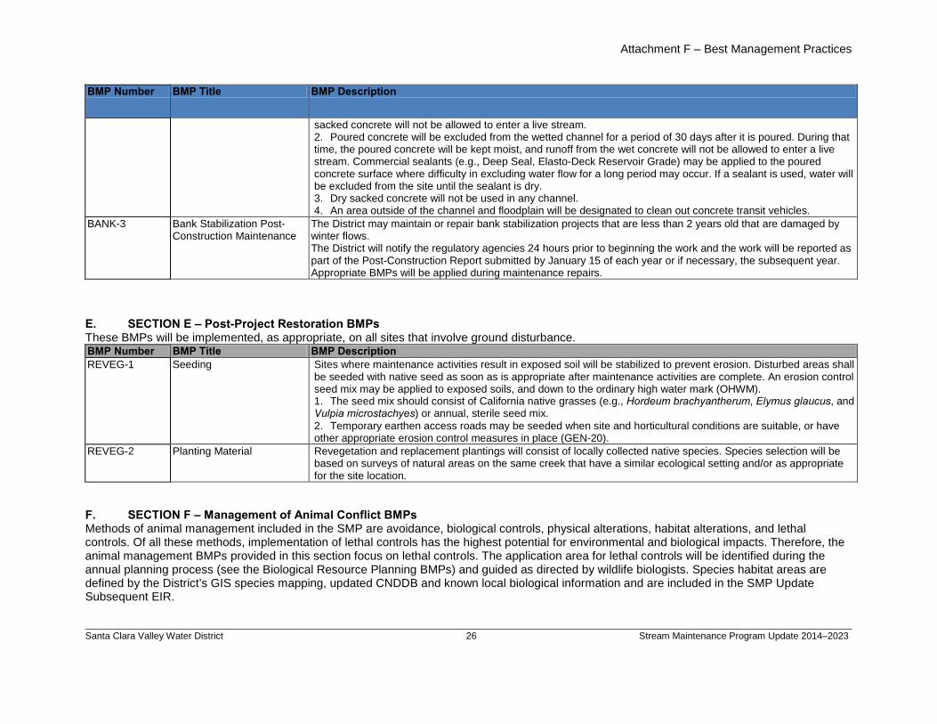
Attachment F – Best Management Practices
Santa Clara Valley Water District
26 Stream Maintenance Program Update 2014–2023
BMP Number BMP Title BMP Description
sacked concrete will not be allowed to enter a live stream. 2. Poured concrete will be excluded from the wetted channel for a period of 30 days after it is poured. During that time, the poured concrete will be kept moist, and runoff from the wet concrete will not be allowed to enter a live stream. Commercial sealants (e.g., Deep Seal, Elasto-Deck Reservoir Grade) may be applied to the poured concrete surface where difficulty in excluding water flow for a long period may occur. If a sealant is used, water will be excluded from the site until the sealant is dry. 3. Dry sacked concrete will not be used in any channel. 4. An area outside of the channel and floodplain will be designated to clean out concrete transit vehicles.
BANK-3
Bank Stabilization Post-Construction Maintenance
The District may maintain or repair bank stabilization projects that are less than 2 years old that are damaged by winter flows. The District will notify the regulatory agencies 24 hours prior to beginning the work and the work will be reported as part of the Post-Construction Report submitted by January 15 of each year or if necessary, the subsequent year. Appropriate BMPs will be applied during maintenance repairs.
E. SECTION E – Post-Project Restoration BMPs These BMPs will be implemented, as appropriate, on all sites that involve ground disturbance. BMP Number BMP Title BMP Description REVEG-1
Seeding Sites where maintenance activities result in exposed soil will be stabilized to prevent erosion. Disturbed areas shall be seeded with native seed as soon as is appropriate after maintenance activities are complete. An erosion control seed mix may be applied to exposed soils, and down to the ordinary high water mark (OHWM). 1. The seed mix should consist of California native grasses (e.g., Hordeum brachyantherum, Elymus glaucus, and Vulpia microstachyes) or annual, sterile seed mix. 2. Temporary earthen access roads may be seeded when site and horticultural conditions are suitable, or have other appropriate erosion control measures in place (GEN-20).
REVEG-2
Planting Material Revegetation and replacement plantings will consist of locally collected native species. Species selection will be based on surveys of natural areas on the same creek that have a similar ecological setting and/or as appropriate for the site location.
F. SECTION F – Management of Animal Conflict BMPs Methods of animal management included in the SMP are avoidance, biological controls, physical alterations, habitat alterations, and lethal controls. Of all these methods, implementation of lethal controls has the highest potential for environmental and biological impacts. Therefore, the animal management BMPs provided in this section focus on lethal controls. The application area for lethal controls will be identified during the annual planning process (see the Biological Resource Planning BMPs) and guided as directed by wildlife biologists. Species habitat areas are defined by the District’s GIS species mapping, updated CNDDB and known local biological information and are included in the SMP Update Subsequent EIR.
billspri
Text Box
Appendix D - Maintenance Best Management Practices
billspri
Text Box
D. SECTION D - Bank Stabilization BMPs Cont'd
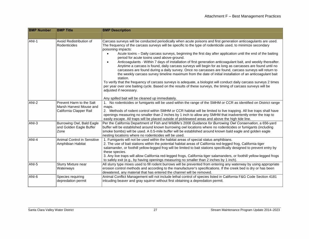
Attachment F – Best Management Practices
Santa Clara Valley Water District
27 Stream Maintenance Program Update 2014–2023
BMP Number BMP Title BMP Description
ANI-1 Avoid Redistribution of Rodenticides
Carcass surveys will be conducted periodically when acute poisons and first generation anticoagulants are used. The frequency of the carcass surveys will be specific to the type of rodenticide used, to minimize secondary poisoning impacts:
• Acute toxins – Daily carcass surveys, beginning the first day after application until the end of the baiting period for acute toxins used above-ground.
• Anticoagulants - Within 7 days of installation of first generation anticoagulant bait, and weekly thereafter. Anytime a carcass is found, daily carcass surveys will begin for as long as carcasses are found until no carcasses are found during a daily survey. Once no carcasses are found, carcass surveys will return to the weekly carcass survey timeline maximum from the date of initial installation of an anticoagulant bait station.
To verify that the frequency of carcass surveys is adequate, a biologist will conduct daily carcass surveys 2 times per year over one baiting cycle. Based on the results of these surveys, the timing of carcass surveys will be adjusted if necessary. Any spilled bait will be cleaned up immediately.
ANI-2 Prevent Harm to the Salt Marsh Harvest Mouse and California Clapper Rail
1. No rodenticides or fumigants will be used within the range of the SMHM or CCR as identified on District range maps. 2. Methods of rodent control within SMHM or CCR habitat will be limited to live trapping. All live traps shall have openings measuring no smaller than 2 inches by 1 inch to allow any SMHM that inadvertently enter the trap to easily escape. All traps will be placed outside of pickleweed areas and above the high tide line.
ANI-3 Burrowing Owl, Bald Eagle and Golden Eagle Buffer Zone
Per the California Department of Fish and Wildlife’s 2008 Guidance for Burrowing Owl Conservation, a 656-yard buffer will be established around known burrowing owl locations where no rodenticides or fumigants (including smoke bombs) will be used. A 0.5-mile buffer will be established around known bald eagle and golden eagle nesting locations where no rodenticides will be used.
ANI-4 Animal Control in Sensitive Amphibian Habitat
1. Fumigants will not be used within the habitat areas of special status amphibians. 2. The use of bait stations within the potential habitat areas of California red-legged frog, California tiger salamander, or foothill yellow-legged frog will be limited to bait stations specifically designed to prevent entry by these species. 3. Any live traps will allow California red-legged frogs, California tiger salamanders, or foothill yellow-legged frogs to safely exit (e.g., by having openings measuring no smaller than 2 inches by 1 inch).
ANI-5 Slurry Mixture near Waterways
All slurry type mixes used to fill rodent burrows will be prevented from entering any waterway by using appropriate erosion control methods and according to the manufacturer’s specifications. If the creek bed is dry or has been dewatered, any material that has entered the channel will be removed.
ANI-6
Species requiring depredation permit
Animal Conflict Management will not include lethal control of species listed in California F&G Code Section 4181 inlcuding beaver and gray squirrel without first obtaining a depredation permit.
billspri
Text Box
Appendix D - Maintenance Best Management Practices
billspri
Text Box
F. SECTION F - Management of Animal Conflict BMPs Cont'd
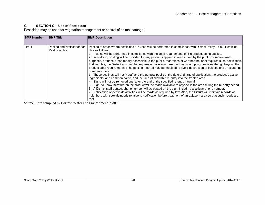
Attachment F – Best Management Practices
Santa Clara Valley Water District
28 Stream Maintenance Program Update 2014–2023
G. SECTION G – Use of Pesticides Pesticides may be used for vegetation management or control of animal damage. BMP Number BMP Title BMP Description
HM-4 Posting and Notification for Pesticide Use
Posting of areas where pesticides are used will be performed in compliance with District Policy Ad-8.2 Pesticide Use as follows: 1. Posting will be performed in compliance with the label requirements of the product being applied. 2. In addition, posting will be provided for any products applied in areas used by the public for recreational purposes, or those areas readily accessible to the public, regardless of whether the label requires such notification. In doing this, the District ensures that exposure risk is minimized further by adopting practices that go beyond the product label requirements. (The posting method may be modified to avoid destruction of bait stations or scattering of rodenticide.) 3. These postings will notify staff and the general public of the date and time of application, the product’s active ingredients, and common name, and the time of allowable re-entry into the treated area. 4. Signs will not be removed until after the end of the specified re-entry interval. 5. Right-to-know literature on the product will be made available to anyone in the area during the re-entry period. 6. A District staff contact phone number will be posted on the sign, including a cellular phone number. 7. Notification of pesticide activities will be made as required by law. Also, the District will maintain records of neighbors with specific needs relative to notification before treatment of an adjacent area so that such needs are met.
Source: Data compiled by Horizon Water and Environment in 2011
billspri
Text Box
Appendix D - Maintenance Best Management Practices
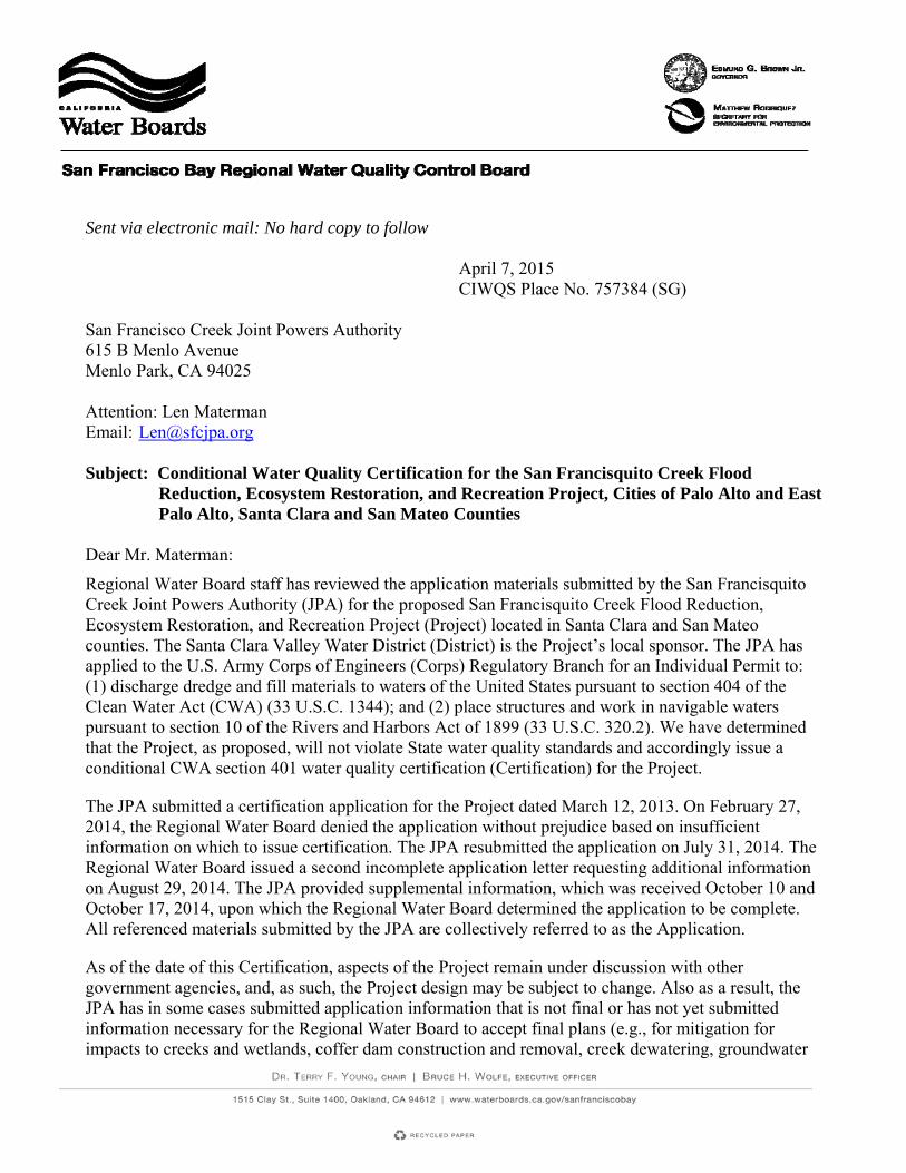
Sent via electronic mail: No hard copy to follow April 7, 2015 CIWQS Place No. 757384 (SG) San Francisco Creek Joint Powers Authority 615 B Menlo Avenue Menlo Park, CA 94025 Attention: Len Materman Email: [email protected] Subject: Conditional Water Quality Certification for the San Francisquito Creek Flood
Reduction, Ecosystem Restoration, and Recreation Project, Cities of Palo Alto and East Palo Alto, Santa Clara and San Mateo Counties
Dear Mr. Materman:
Regional Water Board staff has reviewed the application materials submitted by the San Francisquito Creek Joint Powers Authority (JPA) for the proposed San Francisquito Creek Flood Reduction, Ecosystem Restoration, and Recreation Project (Project) located in Santa Clara and San Mateo counties. The Santa Clara Valley Water District (District) is the Project’s local sponsor. The JPA has applied to the U.S. Army Corps of Engineers (Corps) Regulatory Branch for an Individual Permit to: (1) discharge dredge and fill materials to waters of the United States pursuant to section 404 of the Clean Water Act (CWA) (33 U.S.C. 1344); and (2) place structures and work in navigable waters pursuant to section 10 of the Rivers and Harbors Act of 1899 (33 U.S.C. 320.2). We have determined that the Project, as proposed, will not violate State water quality standards and accordingly issue a conditional CWA section 401 water quality certification (Certification) for the Project.
The JPA submitted a certification application for the Project dated March 12, 2013. On February 27, 2014, the Regional Water Board denied the application without prejudice based on insufficient information on which to issue certification. The JPA resubmitted the application on July 31, 2014. The Regional Water Board issued a second incomplete application letter requesting additional information on August 29, 2014. The JPA provided supplemental information, which was received October 10 and October 17, 2014, upon which the Regional Water Board determined the application to be complete. All referenced materials submitted by the JPA are collectively referred to as the Application.
As of the date of this Certification, aspects of the Project remain under discussion with other government agencies, and, as such, the Project design may be subject to change. Also as a result, the JPA has in some cases submitted application information that is not final or has not yet submitted information necessary for the Regional Water Board to accept final plans (e.g., for mitigation for impacts to creeks and wetlands, coffer dam construction and removal, creek dewatering, groundwater
San Francisquito Creek Project - 2 - CWA § 401 Certification
management, utility line construction and abandonment, placement and stabilization of fill in levees and on wetlands, beneficial reuse of excavated sediment, and disposal of excess sediment/cut). Where that is the case, this Certification requires submittal of final plans, acceptable to the Regional Water Board Executive Officer (Executive Officer), prior to commencement of Project construction or commencement of construction for the relevant Project component. A. Project Location and Site Description
The Project is located on San Francisquito Creek (Creek) along a 1.5‐mile stretch of the Creek from San Francisco Bay to East Bayshore Road, a frontage road to U.S. Highway 101. This stretch of the Creek is a managed earthen flood control channel. The Project is designed to increase the flow conveyance capacity of the creek channel for a combination of the 100-year flow event, the 100-year high tide event, and 26 inches of sea level rise.
This stretch of the Creek is on the boundary between Santa Clara and San Mateo counties. The Project area is divided into three reaches. A reach is a continuous part of the Creek between two specified points. The lower reach is from San Francisco Bay to Friendship Bridge, the middle reach from Friendship Bridge to Daphne Way, and the upper reach from Daphne Way to East Bayshore Road. This Certification refers to the Project area south of the creek channel centerline as the “south bank” and the area north of the creek channel centerline as the “north bank.” The JPA refers to these areas as left and right banks, respectively, in its design plans and other documents. From the JPA naming scheme, the station numbers along the Creek and levees are labeled “L-line” for station locations south of the creek channel, “R-line” for station locations north of the creek channel, and “C-line” for the creek channel centerline stations.
The City of Palo Alto, within Santa Clara County, borders the south bank in all three reaches. The Palo Alto Municipal Golf Course borders the majority of the south bank, with the Palo Alto airport bordering a 600-foot stretch of the eastern-most section of the south bank. The north bank of the Project area is bordered by San Mateo County, with the Faber Tract Marsh in the lower reach and the City of East Palo Alto in the middle and upper reach borders.
The Creek provides important migration, spawning, and juvenile rearing habitat for winter-run steelhead. In addition, green sturgeon and longfin smelt are known to inhabit the South Bay and its tidally-influenced tributaries. The Faber Tract and the Laumeister Tract (north of the Faber Tract) provide ideal habitat for special status species including Ridgway’s (formerly California clapper) rail, black rail, salt marsh harvest mouse, and salt marsh wandering shrew. Additionally, suitable habitat occurs along the creek channel, and these species have the potential to occur in the Project area.
B. Project Purpose
The purpose of the Project is to improve the Creek’s channel capacity to accommodate the 100-year flood flow event for Creek flows coupled with the influence of San Francisco Bay tides, including projected sea level rise, from the downstream face of East Bayshore Road down to the Bay. It would reduce local fluvial flood risks in the Project area during storm events, provide the capacity needed for future upstream improvements, and increase and improve ecological habitat and recreational opportunities.
C. Project Description
The JPA proposes to increase the Creek’s flood flow capacity to contain the one percent flood flow event through the following activities:
San Francisquito Creek Project - 3 - CWA § 401 Certification
1. Excavate in-channel sediments: About 175,890 cubic yards of sediment will be removed from along 5,775 linear feet of the creek channel and associated channel expansion area to increase creek capacity and to maximize conveyance. In-channel sediment will not be reused because it is unlikely to provide suitable material for levee embankment use.
2. Rebuild and relocate levees: The JPA will widen the creek channel by rebuilding the East Palo Alto Levee (Northern Levee) and relocating the Palo Alto Levee/Palo Alto Municipal Golf Course Levee (Southern Levee), which will reduce tidal influences in the Creek and increase channel capacity.
a. Northern Levee: About 3,296 linear feet (station (STA) 30+00 to STA 55+00) of the levee will be raised to increase channel capacity. As shown in the draft 100 percent design plans, sheets X-7 through X-14, the elevation increase varies by up to 4 feet based on existing conditions and the necessary modifications along the levee. Approximately 55,000 cubic yards of fill will be used to increase the height of the levee.
b. Southern Levee: About 2,728 linear feet (STA 23+00 to STA 54+00) will be relocated up to approximately 200 feet into the Palo Alto Municipal Golf Course and raised to increase channel capacity. The elevation increase varies by up to 4 feet based on existing conditions and the necessary modifications at each station as shown in sheets X-6 through X-14 in the draft 100 percent design plans. Approximately 84,700 cubic yards of fill will be used for the levee relocation.
3. Construct levee maintenance roads: The JPA will build about 10,176 linear feet of maintenance roads on the newly raised and relocated levees. The maintenance roads will also serve as pedestrian/bicycle trails. The roads will be up to 16 feet wide and paved with crushed granite, except for a section on the south bank from stations L-line 28+00 through 54+00 that will be paved with asphalt as part of the Bay Trail. The Bay Trail section will have up to 41,600 square feet of asphalt (2,600 linear feet, up to 16 feet wide), as shown in sheet G-3 in the Application’s supplemental figures. This Certification requires the JPA to submit a Post-Construction Stormwater Management Plan to describe how stormwater runoff from the paved Bay Trail surface will be diverted away from the Creek and other waters of the State, consistent with the Regional Water Board’s Municipal Regional Stormwater Permit (NPDES Permit No. CAS612008; Order No. R2-2009-0074, as amended by Order No. R2-2011-0083, and as may be subsequently amended or reissued) requirements for post-construction stormwater management for new or replacement impervious surfaces.
4. Raise and grade the Faber Tract Levee: The JPA will raise and grade a portion of the currently unmaintained levee between the Creek and the Faber Tract (Faber Tract Levee) closer to its original design elevation to stabilize the levee. The new levee design will allow the Creek to periodically flood the marsh to mimic the current discharge pattern. Fill will be added to the Faber Tract Levee along 350 linear feet (0.77 acres) (STA 21+00 to STA 24+00) to reduce concerns regarding levee erosion and the potential for mass wasting leading to levee failure. In addition, the JPA will raise the lowest levee crest elevation downstream of the Friendship Bridge from a minimum elevation of 11 feet to 13 feet and incorporate a 6H:1V levee side slope on the side sloping into the Faber Tract. The 6H:1V levee side slope will help protect the levee toe from potential erosion due to flow overtopping along a 400 foot distance as the levee transitions upstream to a higher elevation closer to the Friendship Bridge. The new area of impact from the existing levee toe to the proposed levee toe is approximately 0.42 acres (18,383 square
San Francisquito Creek Project - 4 - CWA § 401 Certification
feet). Approximately 12,000 cubic yards of clean imported fill will be used to increase the height of the levee.
5. Degrade Bay Levee: The JPA will degrade a section of the levee north of the Creek and east of the Faber Tract (Bay Levee) to restore the Creek-Bay interface in the marsh area east of the Faber Tract and to reduce water surface elevations in the Creek between Friendship Bridge and the Bay. About 2,820 cubic yards of sediment/soil will be removed along 600 linear feet (0.73 acres) of the Bay Levee (STA 3+50 to 9+50) downstream of the Faber Tract in a marsh area that is already subject to daily tides from the Bay. This will further connect the marsh to the Creek, allow the channel to expand out over the marsh area at a point further upstream than under existing conditions, and decrease the water surface elevation during large flood events.
6. Construct floodwalls: The JPA will construct floodwalls in the upper reach to increase capacity and maintain consistency with the California Department of Transportation’s (Caltrans) enlargement of the U.S. 101/East Bayshore Road Bridge over the Creek (Caltrans facility) as follows:
a. East Palo Alto Floodwall: Concrete floodwalls up to 4 feet above top of bank (up to 13 feet from channel bottom) will be constructed along approximately 2,350 linear feet (STA 52+00 to STA 77+50) of the Northern Levee; and
b. Palo Alto Floodwall: Concrete floodwalls up to 4 feet above top of bank (up to 13 feet from channel bottom) will be constructed along approximately 2,879 linear feet (STA 51+00 to STA 77+50) of the Southern Levee.
7. Install rock slope protection: The JPA will install approximately 4,735 linear feet (5.86 acres) of rock-slope levee protection (RSP) at various locations along the length of the Project to protect the levee against erosion and to stabilize the floodwalls. The RSP on the levees will be installed from the toe of the levee up the bank approximately 10 to 15 feet.
8. Construct Friendship Bridge boardwalk extension: The JPA will construct a boardwalk extension to the Friendship Bridge. The existing Friendship Bridge will be retained and a 202-linear foot boardwalk will be constructed from the retained eastern footing of the bridge and across the newly-expanded Creek to connect with the realigned Southern Levee. The boardwalk will be the same width as the Friendship Bridge (140 feet long and 10 feet wide), constructed of timber deck and concrete piles, and require twenty 18-inch diameter concrete piles. The elevation of the low mark of the boardwalk will be set above the highest anticipated flood elevation, with the lowest point of the bridge a minimum of 5 feet above the marsh plain terrace beneath it. This Certification contains a condition prohibiting the use of chemically-treated wood on top of and inboard of the levees (i.e., in a location where it could discharge to State waters or otherwise impact beneficial uses, which are discussed in Finding D below), which applies to the boardwalk extension.
9. Relocate portion of channel: About 1,100 linear feet of the channel (C-line stations 43+00 to 54+00, as shown in the draft 100 percent design plans, will be relocated up to 80 feet to the east due to its existing close proximity to the proposed inboard levee toe. The final low flow channel alignment will be roughly equidistant between the Northern Levee and the new Southern Levee location and will have the same elevation as the existing channel elevation.
San Francisquito Creek Project - 5 - CWA § 401 Certification
10. Relocate or remove utilities: The JPA will remove, abandon, or replace several utility components for electricity, gas, water, sanitary sewer, and stormwater runoff present within the Project right-of-way. This Certification requires, prior to the beginning of work, the JPA to prepare and submit an acceptable utility relocation plan that identifies, for example, appropriate measures to prevent impacts during horizontal directional drilling, proposed disposal locations or methods for excess sediment, elevations of live and abandoned utilities, and related information. In addition, the plan shall document the locations of any utilities abandoned in place.
a. Electricity and gas systems. The JPA will coordinate with Pacific Gas and Electric (PG&E) to perform the following electricity and gas transmission system work before creek channel and levee construction work begins:
i. Electricity transmission system. PG&E will realign the existing electricity transmission system that currently crosses over the Creek from L-line STA 52+00 (south bank) to R-line STA 48+00 (north bank). The new line will be shifted 250 feet south and cross over the Creek at L-line STA 51+00 (south bank) to R-line STA 52+00 on the north bank. The Project will include removing a pole from both banks; replacing two existing poles, one on each bank; and adding two new poles on the north bank for the new line. In addition, PG&E will remove wires from six poles that run north to south along the far north bank right-of-way between R-line STA 30+00 to STA 56+00. Of these six poles, one will be raised by 15 feet. The realigned section will connect to the southern-most pole in this series. Any replacement poles will be made of light-duty steel. PG&E will replace the foundation of an existing electric transmission tower located in the floodplain of the future channel alignment footprint at STA R-48+00, approximately 2,000 feet upstream of the Friendship Bridge. PG&E will demolish the existing foundation, build a temporary shoo-fly support, and build a permanent concrete foundation at the existing foundation site. The electricity tower on the old foundation will be lifted and placed onto the permanent concrete foundation with an area of 625 square feet. An access ramp will be built on the inboard side of the levee for this tower. This Certification includes a condition for the JPA to submit a utility plan that shall include elevations for all the new utilities.
ii. Gas transmission system. PG&E will abandon in place 3,000 linear feet of the gas transmission line located in the Project right-of-way, of which about 1,350 linear feet is in the new channel realignment footprint. PG&E estimates that the old line is 4.7 feet below grade beneath the creek channel and will confirm the elevation during excavation activities. This Certification includes a condition requiring the JPA to remove the section of the existing gas transmission pipeline extending beneath the creek channel, floodplain, and levees, which is approximately 1,350 linear feet from the inboard top-of-bank of the Southern Levee to the inboard top-of-bank of the Northern Levee. The new gas line will be aligned south to north in the golf course, then will cross east to west through the Project right-of-way upstream of the Friendship Bridge from L-line STA 32+00 (south bank) to R-line STA 34+00 (north bank), and will extend west to a connection in East Palo Alto. The pipeline tunnel under the Creek will be bored by horizontal direction drilling at 25 feet below ground. The other portions of the pipeline will be installed by cut and fill at a minimum of 4 feet below ground surface. PG&E will place three trench spoils piles equidistant from south to north along the south bank. Each pile is planned to be 100 feet by 100 feet. On the north bank, PG&E will place
San Francisquito Creek Project - 6 - CWA § 401 Certification
another 100 foot by 100 foot spoils pile next to the borehole site. The suitability of the spoils for reuse to cover the new pipeline will be determined after they are appropriately assessed during the utility activities, and any unused spoils will be hauled from the site and appropriately disposed of at an approved upland facility.
b. Sanitary sewer. The JPA will realign a sanitary sewer line that currently crosses the Creek at the Friendship Bridge. As proposed, this task will involve open trenching with a minimum depth below ground surface of 3.5 feet for the new line. The sanitary sewer line would be encased in armored steel where it crosses the Creek. The new alignment will cross the creek at L-line STA 27+50 (south bank) through the channel at C-line STA 29+90 to R-line STA 27+60 (north bank). This work would be concurrent with the levee construction work so will not have separate impacts to waters of the State. The JPA will remove about 960 linear feet of existing sanitary sewer line. This Certification includes a condition requiring the JPA to submit information demonstrating that the line cannot be constructed at a deeper depth below the creek channel bottom or otherwise that there is not a reasonably foreseeable chance that the line could constrain the creek channel in the future.
c. Storm drains and stormwater outfall. The JPA will remove various storm drain pipelines existing within the golf course that will be under the future Southern Levee and widened creek channel post project. This work will be concurrent with the levee and channel work so will not have separate impacts to waters of the State. Caltrans plans to remove an abandoned 96-inch stormwater outlet within the Project area adjacent to the east border of the Project area (east of STA L-76; sheet C-47), as shown in the 100 percent design plans, sheet C-47, before the JPA begins Southern Levee construction activities.
11. Dewatering: The full length of the Project from Highway 101 to the mouth of the creek will be dewatered as discussed in the JPA’s Temporary Dewatering Plan (October 14, 2014 draft). The Regional Water Board requires a Dewatering Plan to address diversion of surface water and management of groundwater seepage in construction areas. The Dewatering Plan states that at the end of each construction season, the JPA will remove all cofferdams, re-water the dewatered creek areas, and restore the creek habitat. The JPA will implement best management practices (BMPs) to avoid and minimize impacts to water quality and will analyze and monitor the water being returned to the creek channel to ensure the effectiveness of the BMPs. This Certification includes a condition requiring the JPA to revise the Dewatering Plan to address both surface water and groundwater management to ensure the proposed discharges meet applicable water quality objectives. The revised Dewatering Plan shall include a Surface Water Diversion Plan that describes, for example, the JPA’s procedures for placing and removing coffer dams with minimal impacts to the Creek. The revised Dewatering Plan shall also include a Groundwater Management Plan that describes the BMPs that will be implemented to ensure groundwater flows are appropriately pumped, contained, and analyzed such that they meet applicable water quality objectives before discharging the flow back into the Creek downstream of the lower coffer dam.
12. Sediment disposal and fill import: The JPA plans to excavate about 175,890 cubic yards of fill or sediment during the levee modification and channel widening activities. About 20 percent of this sediment will be hauled offsite. The JPA anticipates placing the other 80 percent of sediment in the adjacent golf course for use in a future golf course reconfiguration project being managed by the
San Francisquito Creek Project - 7 - CWA § 401 Certification
City of Palo Alto. About 190,800 cubic yards of fill will be imported for use in raising levee elevations. This Certification contains a condition for the JPA to characterize any sediment being hauled out of the Project area to determine the appropriately-permitted upland location for disposal or to determine if the sediment may be beneficially-reused for the Project or at another location. In addition, this Certification includes a condition for the JPA to characterize all imported fill material being used in the Project in accordance with the Dredged Material Management Office guidance document Guidelines for Implementing the Inland Testing Manual in the San Francisco Bay Region (Corps Public Notice 01-01, or most current version) and the Regional Water Board May 2000 staff report, Beneficial Reuse of Dredged Materials: Sediment Screening and Testing Guidelines, or the most current revised version.
13. Disposal of materials other than sediment or soil: This Certification includes a condition for the JPA to dispose of any other waste materials in an appropriately-permitted upland location. This applies to materials such as, but not limited to, wooden utility poles, electric wires, and other utility components removed from the Project area.
14. Staging, access, and haul routes: The Project’s staging, access, and haul routes are designated based on work on the north or south banks as follows:
a. North Bank
i. Site access and a construction staging area will be located at the end of O’Connor Street near the intersection with Daisy Lane in East Palo Alto. The haul route will be along O’Connor Street to Pulgas Avenue, East Bayshore Road, and Embarcadero Road to U.S. 101. This is the designated route for large vehicles, including dump trucks and flatbed trucks, in the City of East Palo Alto.
ii. Site access and a construction staging area will be located at the end of Daphne Way at Jasmine Way in East Palo Alto. The haul route will be along Jasmine Way to Camelia Drive, Pulgas Avenue, East Bayshore Road, and Embarcadero Road to U.S. 101. Large vehicles, including but not limited to dump trucks and flatbed trucks, will be prohibited on Daphne Way and Jasmine Way. Further vehicle restrictions on Daphne Way and Jasmine Way may be required by the City of East Palo Alto and will be determined during development of the Project Traffic Plan.
iii. Site access and a construction staging area will be located at the end of Verbena Drive at Abelia Way. The haul route will be along Verbena Drive to Camelia Drive, Pulgas Avenue, East Bayshore Road, and Embarcadero Road to U.S. 101. Large vehicles, including but not limited to dump trucks and flatbed trucks, will be prohibited on Verbena Drive and Camelia Drive. Further vehicle restrictions on Verbena Drive and Camelia Drive may be required by the City of East Palo Alto and will be determined during development of the Project Traffic Plan.
b. South Bank
i. Site access will be at the Palo Alto Pump Station, accessed from East Bayshore Road. The haul route will be along East Bayshore Road to Embarcadero Road and U.S. 101.
ii. Site access will be at Geng Road between the Baylands Athletic Center and the Golf Course. The haul route will be along Geng Road to Embarcadero Road and U.S. 101.
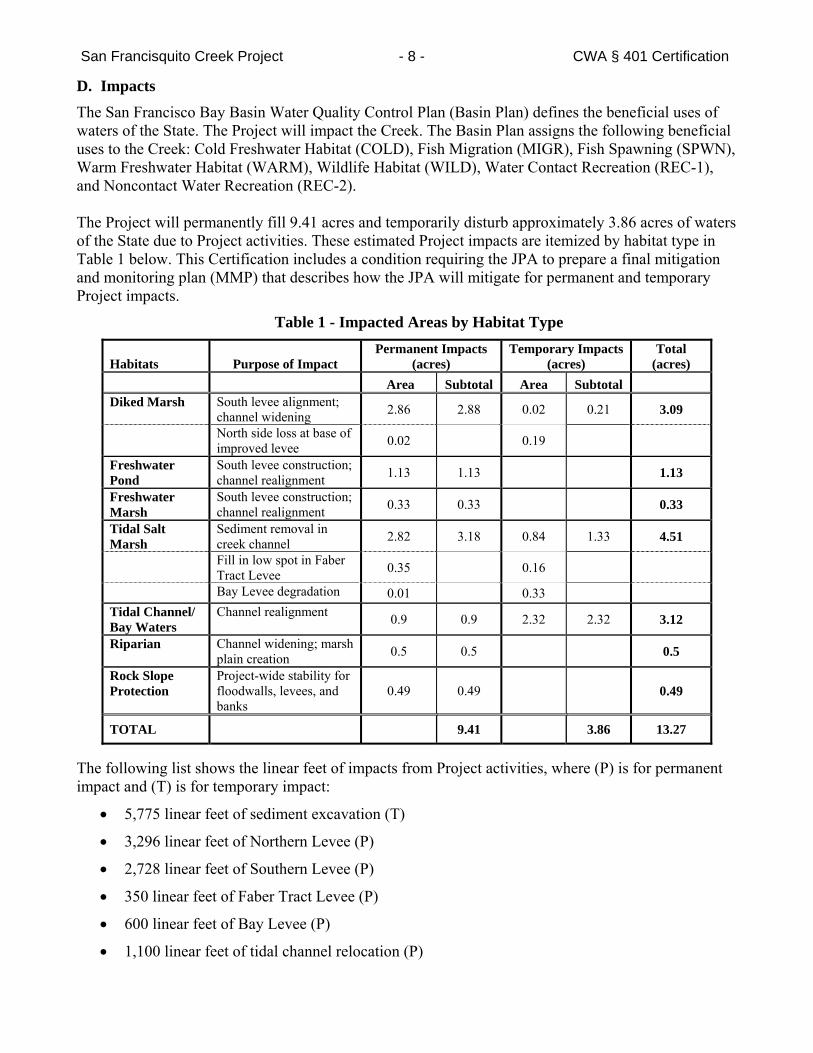
San Francisquito Creek Project - 8 - CWA § 401 Certification
D. Impacts
The San Francisco Bay Basin Water Quality Control Plan (Basin Plan) defines the beneficial uses of waters of the State. The Project will impact the Creek. The Basin Plan assigns the following beneficial uses to the Creek: Cold Freshwater Habitat (COLD), Fish Migration (MIGR), Fish Spawning (SPWN), Warm Freshwater Habitat (WARM), Wildlife Habitat (WILD), Water Contact Recreation (REC-1), and Noncontact Water Recreation (REC-2). The Project will permanently fill 9.41 acres and temporarily disturb approximately 3.86 acres of waters of the State due to Project activities. These estimated Project impacts are itemized by habitat type in Table 1 below. This Certification includes a condition requiring the JPA to prepare a final mitigation and monitoring plan (MMP) that describes how the JPA will mitigate for permanent and temporary Project impacts.
Table 1 - Impacted Areas by Habitat Type
Habitats Purpose of Impact Permanent Impacts
(acres) Temporary Impacts
(acres) Total
(acres)
Area Subtotal Area Subtotal Diked Marsh South levee alignment;
channel widening 2.86 2.88 0.02 0.21 3.09
North side loss at base of improved levee 0.02 0.19
Freshwater Pond
South levee construction; channel realignment 1.13 1.13 1.13
Freshwater Marsh
South levee construction; channel realignment 0.33 0.33 0.33
Tidal Salt Marsh
Sediment removal in creek channel 2.82 3.18 0.84 1.33 4.51
Fill in low spot in Faber Tract Levee 0.35 0.16
Bay Levee degradation 0.01 0.33
Tidal Channel/ Bay Waters
Channel realignment 0.9 0.9 2.32 2.32 3.12
Riparian Channel widening; marsh plain creation 0.5 0.5 0.5
Rock Slope Protection
Project-wide stability for floodwalls, levees, and banks
0.49 0.49 0.49
TOTAL 9.41 3.86 13.27
The following list shows the linear feet of impacts from Project activities, where (P) is for permanent impact and (T) is for temporary impact:
5,775 linear feet of sediment excavation (T)
3,296 linear feet of Northern Levee (P)
2,728 linear feet of Southern Levee (P)
350 linear feet of Faber Tract Levee (P)
600 linear feet of Bay Levee (P)
1,100 linear feet of tidal channel relocation (P)
San Francisquito Creek Project - 9 - CWA § 401 Certification
543 linear feet of rock slope protection (P)
E. Mitigation
This Certification requires the JPA to restore permanently-affected riparian and wetland/marsh habitat and other waters of the State onsite at a minimum mitigation‐to‐effect ratio of 2:1 and to restore temporarily-affected habitat at a minimum mitigation-to-effect ratio of 1:1 to ensure the Project results in no net loss and a long-term net gain in wetland area, function, and value. The ratio of 2:1 for permanent impacts and 1:1 for temporary impacts will apply as long as onsite construction of a mitigation activity is completed within 12 months of the date when the associated impact first occurs. This Certification requires the JPA to complete an additional 10 percent mitigation per year, on an areal basis, for the portion of mitigation not completed within the required 12-month period. This Certification includes a condition for the JPA to maintain a schedule to track actual Project activity start dates, and the start dates of impacts to waters of the State and the associated mitigations.
The JPA will mitigate for permanent and temporary Project impacts in accordance with the final MMP. The JPA submitted a draft MMP to the Regional Water Board, the Corps, the California Department of Fish and Wildlife (CDFW), the U.S. Fish and Wildlife Service (USFWS), and the National Marine Fisheries Service (NMFS) in October 2014.
F. Maintenance
The JPA delegated operations and maintenance within the Project area to the District and the City of East Palo Alto on November 20, 2014 (JPA Resolution 14.11.20). The JPA, in consultation with the District and the cities of East Palo Alto and Palo Alto, is considering also adding the City of Palo Alto to the delegation agreement, although the City of Palo Alto is already within the District’s jurisdiction. Maintenance will be conducted in accordance with the San Francisquito Creek Flood Reduction, Ecosystems Restoration, and Recreation Project, San Francisco Bay to Highway 101, Operation & Maintenance Manual (October 2014; final document in progress) (O&M Manual) and be consistent with the District’s Stream Maintenance Program. The revised O&M Manual shall cover site-specific work requirements within the Project area such as vegetation management; and repair of animal damage to levees, erosion sites, flood damage, and access and maintenance roads. This Certification includes a condition for the JPA to submit, or cause the operations and maintenance-delegated entities to submit, a revised O&M Manual. G. California Environmental Quality Act Compliance
On October 25, 2012, the JPA, as lead agency, certified an Environmental Impact Report (EIR) for the Project in accordance with the California Environmental Quality Act (CEQA) (JPA Resolution Number 12-10-25A). The JPA submitted an endorsed Notice of Determination, dated July 25, 2013, indicating that the JPA would carry out or approve the Project (JPA Resolution Number 13-07-25) in compliance with CEQA (Project State Clearinghouse Number 2010092048). The Regional Water Board, as a responsible agency under CEQA, has considered the EIR and finds that it appropriately addressed the Project’s reasonably foreseeable potential environmental impacts.
H. EcoAtlas
It has been determined through regional, State, and national studies that tracking of mitigation/ restoration projects must be improved to better assess the performance of these projects, following monitoring periods that last several years. In addition, to effectively carry out the State’s Wetlands Conservation Policy of no net loss to wetlands, the State needs to closely track both wetland losses and
San Francisquito Creek Project - 10 - CWA § 401 Certification
mitigation/restoration project success. Therefore, this Certification requires that the JPA use the California Wetlands Form to provide Project information related to impacts and mitigation/restoration measures. An electronic copy of the form and instructions can be downloaded at: http://www.waterboards.ca.gov/sanfranciscobay/certs.shtml. Project information concerning impacts and mitigation/restoration will be made available at the web link: http://www.ecoatlas.org/regions/ecoregion/bay-delta/projects. Certification and General Waste Discharge Requirements: I hereby issue an order certifying that any discharge from the Project will comply with the applicable provisions of CWA sections 301 (Effluent Limitations), 302 (Water Quality Related Effluent Limitations), 303 (Water Quality Standards and Implementation Plans), 306 (National Standards of Performance), and 307 (Toxic and Pretreatment Effluent Standards) and with other applicable requirements of State law. This discharge is also regulated under State Water Resources Control Board Order No. 2003 - 0017 - DWQ, "General Waste Discharge Requirements for Dredge and Fill Discharges That Have Received State Water Quality Certification," which requires compliance with all conditions of this Certification. The following conditions are associated with this Certification:
1. The JPA shall construct the Project in conformance with the Project description provided in the Application. Any changes to Project design must receive Executive Officer approval before the changes are implemented.
2. All technical reports, plans, and related information required by this Certification shall be submitted acceptable to the Executive Officer. Any changes to plans accepted by the Executive Officer must be accepted in writing prior to implementation of the change(s).
3. Construction shall not commence on any phase of the Project until all required documents, reports, plans, and studies required in this Certification associated with that phase of the Project have been submitted to the Executive Officer or the Regional Water Board and found acceptable by the Executive Officer or the Regional Water Board.
4. During construction activities, the JPA shall minimize disturbance or removal of vegetation in accordance with the Application’s Box 16: Avoidance of Impacts. The JPA shall stabilize the Project area by incorporating appropriate BMPs, including the successful reestablishment of native vegetation, to enhance wildlife habitat values and to prevent and control erosion and sedimentation.
5. No debris, soil, chemically-treated wood, cement, concrete, or washings thereof, oil or other petroleum products, or any other unauthorized construction related materials or wastes shall be allowed to enter into or be placed where it may be washed by rainfall or runoff into waters of the State. When operations are completed, the JPA shall remove any excess material from the work area and any areas adjacent to the work area where such material may be washed into waters of the State.
6. The use of chemically-treated wood on or anywhere between the Project’s levees, such as for boardwalks, utility line supports, and signposts, is prohibited, unless the JPA submits a report acceptable to the Executive Officer prior to such use demonstrating that no feasible alternative exists. Additionally, to avoid the leaching of copper and other chemicals toxic to aquatic species into the water column and sediment, only piles consisting of inert materials shall be installed. These materials may include steel, concrete, untreated wood, composite, or reinforced plastic. The use of marine paints containing copper and/or tributyltin is prohibited, without exception.
San Francisquito Creek Project - 11 - CWA § 401 Certification
7. The JPA shall not operate any equipment in stream channels or other waters where there is flowing or standing water. No fueling, cleaning, or maintenance of vehicles or equipment shall take place within any areas where an accidental discharge to waters of the State may occur.
8. All work performed within waters of the State shall be completed in a manner that minimizes impacts to water quality, beneficial uses, and wetland and riparian habitat along the Creek and the Bay.
9. This Certification does not allow for the take, or incidental take, of any special status species. The JPA shall use the protocols specified by CDFW, USFWS, NMFS, and the Corps to ensure that Project activities do not impact the beneficial uses of COLD, MIGR, WARM, WILD, and the Preservation of Rare and Endangered Species.
10. The JPA shall adhere to the Terms and Conditions and the Reasonable and Prudent Measures in the most current Endangered Species Consultation issued for the Project by NMFS and the Conservation Recommendations in the Essential Fish Habitat Consultation also issued for the Project by NMFS.
11. The JPA shall adhere to the Terms and Conditions and the Reasonable and Prudent Measures in the most current Biological Opinion issued for the Project by USFWS.
12. Project construction activities shall be restricted to the time periods during the year and conditions allowed by the Corps, BCDC, USFWS, NMFS, and CDFW as specified in their permits, biological opinions, and agreements. Temporary extensions of the specified work periods may be granted upon receipt of written authorization from the applicable agencies and the Executive Officer.
13. Concrete used in the Project shall be allowed to completely cure (a minimum of 28 days) or be treated with a CDFW-approved sealant before it comes into contact with flowing water.
14. Dewatering Plan. Not later than 30 days prior to the commencement of dewatering activities, as discussed in Finding C.11, the JPA shall submit and implement a Dewatering Plan acceptable to the Executive Officer. The Dewatering Plan shall describe how the JPA will implement dewatering and rewatering activities for each creek reach in a manner that will be protective of the Creek’s water quality and beneficial uses and will avoid exceedances of the applicable receiving water quality objectives including, but not limited to, turbidity, pH, temperature, dissolved sulfide, and dissolved oxygen. The Dewatering Plan shall include plans (i.e., diagrams or drawings; maps showing locations of activities and structure; and other design details as appropriate) for and appropriate discussion of all dewatering system components, such as diversion pipes, water storage, water quality monitoring, and discharge methods. In addition, the Dewatering Plan shall identify an appropriate discharge point for the proposed dewatering flows downstream of the lower coffer dam. The Dewatering Plan shall include, at a minimum, the following specific plans:
a. Surface Water Management Plan. The JPA shall prepare and implement a Surface Water Diversion Plan as part of the Dewatering Plan. In addition to the general dewatering requirements discussed above, the Surface Water Diversion Plan shall include:
i. procedures and methods for maintaining natural flow upstream and downstream of the Project area; for avoiding and preventing sedimentation and erosion upstream or downstream of the Project area; and for achieving discharge and receiving water quality objectives;
San Francisquito Creek Project - 12 - CWA § 401 Certification
ii. methods for installing, maintaining, inspecting, and removing coffer dams with minimal or no impacts to the Creek. In addition, the plan shall describe how the Creek will be restored when coffer dams are removed after each construction season; and
iii. procedures for diverting the flow from two municipal storm drain pump stations that normally discharge into the Project area.
b. Groundwater Management Plan. The JPA shall prepare and implement a Groundwater Management Plan as part of the Dewatering Plan. At a minimum, the Groundwater Management Plan shall include detailed descriptions of the procedures for pumping, diverting, containing, and analyzing groundwater that upwells from trenching and other grading and excavation activities. In addition, the plan shall include:
i. a sketch of the approximate excavation and grading locations anticipated to generate groundwater needing to be managed during the construction activity;
ii. the purpose of each excavation activity where groundwater will be managed;
iii. anticipated depth and length of each excavation area;
iv. plans for containing and monitoring groundwater flow before discharging it to the Creek downstream of the lower coffer dam; and
v. identification of an appropriate discharge point for the proposed dewatering flows downstream of the lower coffer dam.
15. Creek dewatering discharges, accumulated groundwater or stormwater removed during dewatering of excavations, and diverted creek and stormwater flows shall not be discharged to waters of the State without meeting the following discharge and receiving water limitations:
a. Discharge pH - the instantaneous discharge pH shall be in the range of 6.5 to 8.5 and shall not vary from ambient pH by more than 0.5 pH units.
b. Discharge Dissolved Oxygen - the discharge dissolved oxygen concentration shall be no less than 5.0 milligrams per liter (mg/L) as an hourly average for discharging into tidal water and 7.0 mg/L (hourly average) for discharging into non-tidal receiving waters.
c. Discharge Dissolved Sulfide shall not be greater than 0.1 mg/L.
d. Receiving Water Turbidity - the receiving water turbidity measured as nephelometric turbidity units (NTU) shall not be greater than 10 percent of natural conditions in areas where natural turbidity is greater than 50 NTU (daily average). All Project discharge plans shall identify an acceptable location or locations at which to measure background turbidity. The JPA shall monitor receiving water and discharge turbidity at least one time every 8 hours on days when discharges from excavations or any other dewatering processes may occur.
e. Nutrients - the receiving waters shall not contain biostimulatory substances in concentrations that promote aquatic growths to the extent that such growths cause nuisance or adversely affect beneficial uses.
f. There shall be no violation of any water quality standard for receiving waters adopted by the Regional Water Board or the State Water Resources Control Board.
San Francisquito Creek Project - 13 - CWA § 401 Certification
16. No later than 60 days before the beginning of work, the JPA shall prepare and submit a utility relocation plan, acceptable to the Executive Officer, that identifies, at a minimum, appropriate measures to prevent impacts during horizontal directional drilling, elevations of live and abandoned utilities, proposed disposal locations or methods for excess sediment, proposed sediment reuse, and related information. In addition, the plan shall document the locations of any utilities abandoned in place.
17. No later than 60 days prior to commencing any drilling activity, the JPA shall submit boring plans acceptable to the Executive Officer. At a minimum, the boring plans shall include: a sketch of the approximate locations of drill entry and exit points; the proposed depth of bore(s) and a description of streambed conditions that supports the proposed depth of the bore; the approximate length of the proposed bores; type and size of boring equipment to be used; the estimated time to complete the bore; a list of lubricants and muds to be used; the name of the contractor and cell phone numbers of its construction supervisor and monitor; name of the environmental and biological monitor; site-specific monitoring conditions; monitoring protocols; and a containment and cleanup plan in the event of a discharge of drilling muds or other materials to a receiving water or to a location where they could be discharged to a receiving water.
a. The JPA shall monitor drill mud pressure and volume at all times during drilling to ensure that hydrofracture or other loss of drill muds has not occurred. In the event of a sudden loss in pressure or volume, the JPA shall take appropriate steps, including immediately halting the drilling operation, to ensure that drilling muds are not discharged to waters of the State.
b. Drilling within 50 feet of the creek channel shall only be performed when it is possible to visually monitor the creek bed for any indications of hydrofracture within the creek channel. In the event of any visual indication of hydrofracture, the JPA shall take appropriate steps, including immediately halting the drilling operation, to ensure that drilling muds are not discharged to waters of the State.
c. All drilling muds, slurries, oils, oil-contaminated water, and other waste materials removed from the bore hole or otherwise used during the Project shall be disposed of at a permitted landfill, another appropriately-permitted site, or at an upland site approved in advance by the Executive Officer.
18. No later than 60 days prior to commencing the proposed relocation of the sanitary sewer line, the JPA shall submit a technical report, acceptable to the Executive Officer, that identifies the depth below the channel at which the sanitary sewer line is to be relocated and demonstrates that the line cannot be constructed at a deeper depth below the creek channel bottom, or otherwise that there is not a reasonably foreseeable chance that the line could constrain the creek channel in the future.
19. No later than 60 days prior to commencing the proposed abandonment of the PG&E gas transmission line the JPA shall submit a technical report, acceptable to the Executive Officer, that includes plans to remove the section of the PG&E gas pipeline to be abandoned that runs beneath the Project’s creek channel from the inboard top-of-bank of the Southern Levee to the inboard top-of-bank of the Northern Levee. The JPA shall complete the utility line relocations and removals, or cause them to be completed, consistent with the accepted report.
20. Prior to placing any imported fill material at the Project area, including all placement of fill in areas below the top of bank, on levees, and at any other location where the fill is a discharge to or has the potential to discharge to the Creek or other waters of the State, the JPA shall submit a technical
San Francisquito Creek Project - 14 - CWA § 401 Certification
report, acceptable to the Executive Officer, that the chemical concentrations in the imported fill soil are in compliance with the protocols specified in the following documents:
a. The Dredged Material Management Office (DMMO) guidance document, Guidelines for Implementing the Inland Testing Manual in the San Francisco Bay Region (Corps Public Notice 01-01, or most current version) (Inland Testing Manual) with the exception that the water column bioassay simulating in-bay unconfined aquatic disposal shall be replaced with the modified effluent elutriate test, as described in Appendix B of the Inland Testing Manual, for both water column toxicity and chemistry (DMMO suite of metals only); and,
b. The Regional Water Board May 2000 staff report, Beneficial Reuse of Dredged Materials: Sediment Screening and Testing Guidelines, or the most current revised version. Regional Water Board staff shall review and approve data characterizing the quality of all material proposed for use as fill prior to placement of fill at any of the levee, marsh, or channel areas at the Project site. Modifications to these procedures may be approved on a case-by-case basis, pending the JPA’s ability to demonstrate that the imported fill material is unlikely to adversely impact beneficial uses.
21. Prior to reusing any sediment spoils, the JPA shall characterize the material to ensure the chemical concentrations are in compliance with the guidance documents from the DMMO and Regional Water Board discussed in Condition 20. The JPA shall characterize any unused spoils to determine the appropriate disposal of the material at an approved upland facility. The JPA shall maintain hauling receipts for all sediment hauled from the Project area and make them available upon request by the Executive Officer.
22. The JPA shall obtain coverage under and comply with the statewide NPDES General Permit for Discharges of Stormwater Associated with Construction Activity (Order No. DWQ-2009-0009, as amended by Order Nos. 2010-0014-DWQ and 2012-006-DWQ) (Construction Stormwater Permit). As part of its compliance, the JPA shall:
a. Submit, no later than 30 days before starting Project construction activities, a Storm Water Pollution Prevention Plan (SWPPP), prepared consistent with the requirements of the Construction Stormwater Permit and acceptable to the Executive Officer;
b. Stabilize all exposed/disturbed areas within the Project area, including using effective erosion and sediment control BMPs throughout all phases of construction to prevent the discharge of sediment-laden runoff to waters of the State. At no time shall sediment-laden runoff be allowed to enter wetlands or other waters of the State. Erosion and sediment control BMPs shall be monitored before, during, and after each storm event. Repairs and improvements to erosion and sediment control BMPs shall be implemented as necessary to prevent erosion and the discharge of sediment to waters of the State;
c. Ensure that, prior to the start of the rainy season, disturbed areas of waters of the State and disturbed areas that drain to waters of the State are protected with correctly installed erosion control BMPs (e.g., jute, straw, coconut fiber erosion control fabric, coir logs, straw) and are revegetated with propagules (seeds, cuttings, divisions) of locally-collected native plants; and
d. Where areas of bare soil are exposed during the rainy season, use silt control measures where silt and/or earthen fill threaten to enter waters of the State. Silt control structures shall be monitored for effectiveness and shall be repaired or replaced as needed. Buildup of soil behind
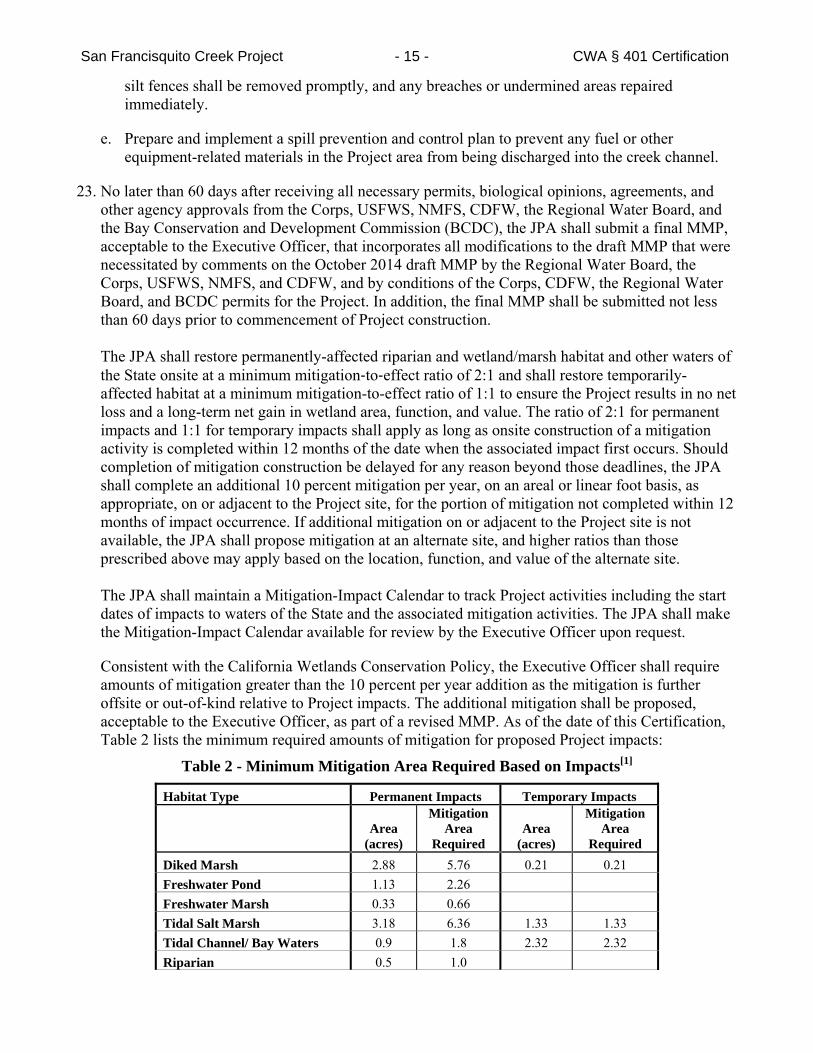
San Francisquito Creek Project - 15 - CWA § 401 Certification
silt fences shall be removed promptly, and any breaches or undermined areas repaired immediately.
e. Prepare and implement a spill prevention and control plan to prevent any fuel or other equipment-related materials in the Project area from being discharged into the creek channel.
23. No later than 60 days after receiving all necessary permits, biological opinions, agreements, and other agency approvals from the Corps, USFWS, NMFS, CDFW, the Regional Water Board, and the Bay Conservation and Development Commission (BCDC), the JPA shall submit a final MMP, acceptable to the Executive Officer, that incorporates all modifications to the draft MMP that were necessitated by comments on the October 2014 draft MMP by the Regional Water Board, the Corps, USFWS, NMFS, and CDFW, and by conditions of the Corps, CDFW, the Regional Water Board, and BCDC permits for the Project. In addition, the final MMP shall be submitted not less than 60 days prior to commencement of Project construction. The JPA shall restore permanently-affected riparian and wetland/marsh habitat and other waters of the State onsite at a minimum mitigation‐to‐effect ratio of 2:1 and shall restore temporarily-affected habitat at a minimum mitigation-to-effect ratio of 1:1 to ensure the Project results in no net loss and a long-term net gain in wetland area, function, and value. The ratio of 2:1 for permanent impacts and 1:1 for temporary impacts shall apply as long as onsite construction of a mitigation activity is completed within 12 months of the date when the associated impact first occurs. Should completion of mitigation construction be delayed for any reason beyond those deadlines, the JPA shall complete an additional 10 percent mitigation per year, on an areal or linear foot basis, as appropriate, on or adjacent to the Project site, for the portion of mitigation not completed within 12 months of impact occurrence. If additional mitigation on or adjacent to the Project site is not available, the JPA shall propose mitigation at an alternate site, and higher ratios than those prescribed above may apply based on the location, function, and value of the alternate site. The JPA shall maintain a Mitigation-Impact Calendar to track Project activities including the start dates of impacts to waters of the State and the associated mitigation activities. The JPA shall make the Mitigation-Impact Calendar available for review by the Executive Officer upon request.
Consistent with the California Wetlands Conservation Policy, the Executive Officer shall require amounts of mitigation greater than the 10 percent per year addition as the mitigation is further offsite or out-of-kind relative to Project impacts. The additional mitigation shall be proposed, acceptable to the Executive Officer, as part of a revised MMP. As of the date of this Certification, Table 2 lists the minimum required amounts of mitigation for proposed Project impacts:
Table 2 - Minimum Mitigation Area Required Based on Impacts[1]
Habitat Type Permanent Impacts Temporary Impacts
Area
(acres)
Mitigation Area
Required Area
(acres)
Mitigation Area
Required Diked Marsh 2.88 5.76 0.21 0.21 Freshwater Pond 1.13 2.26 Freshwater Marsh 0.33 0.66 Tidal Salt Marsh 3.18 6.36 1.33 1.33 Tidal Channel/ Bay Waters 0.9 1.8 2.32 2.32 Riparian 0.5 1.0
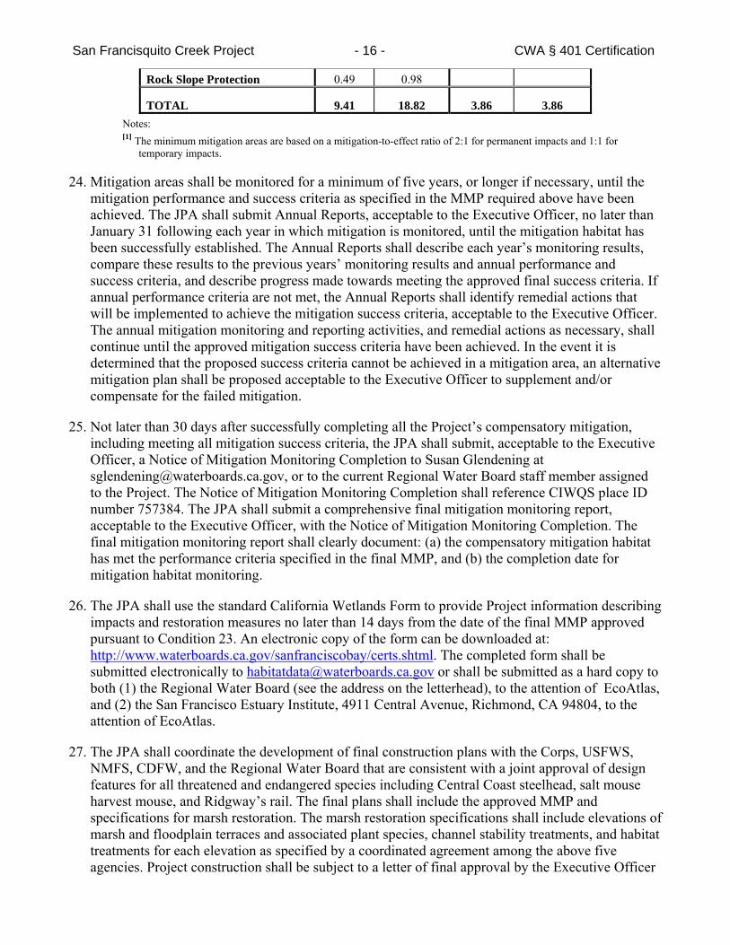
San Francisquito Creek Project - 16 - CWA § 401 Certification
Rock Slope Protection 0.49 0.98
TOTAL 9.41 18.82 3.86 3.86 Notes: [1] The minimum mitigation areas are based on a mitigation-to-effect ratio of 2:1 for permanent impacts and 1:1 for
temporary impacts.
24. Mitigation areas shall be monitored for a minimum of five years, or longer if necessary, until the mitigation performance and success criteria as specified in the MMP required above have been achieved. The JPA shall submit Annual Reports, acceptable to the Executive Officer, no later than January 31 following each year in which mitigation is monitored, until the mitigation habitat has been successfully established. The Annual Reports shall describe each year’s monitoring results, compare these results to the previous years’ monitoring results and annual performance and success criteria, and describe progress made towards meeting the approved final success criteria. If annual performance criteria are not met, the Annual Reports shall identify remedial actions that will be implemented to achieve the mitigation success criteria, acceptable to the Executive Officer. The annual mitigation monitoring and reporting activities, and remedial actions as necessary, shall continue until the approved mitigation success criteria have been achieved. In the event it is determined that the proposed success criteria cannot be achieved in a mitigation area, an alternative mitigation plan shall be proposed acceptable to the Executive Officer to supplement and/or compensate for the failed mitigation.
25. Not later than 30 days after successfully completing all the Project’s compensatory mitigation, including meeting all mitigation success criteria, the JPA shall submit, acceptable to the Executive Officer, a Notice of Mitigation Monitoring Completion to Susan Glendening at [email protected], or to the current Regional Water Board staff member assigned to the Project. The Notice of Mitigation Monitoring Completion shall reference CIWQS place ID number 757384. The JPA shall submit a comprehensive final mitigation monitoring report, acceptable to the Executive Officer, with the Notice of Mitigation Monitoring Completion. The final mitigation monitoring report shall clearly document: (a) the compensatory mitigation habitat has met the performance criteria specified in the final MMP, and (b) the completion date for mitigation habitat monitoring.
26. The JPA shall use the standard California Wetlands Form to provide Project information describing impacts and restoration measures no later than 14 days from the date of the final MMP approved pursuant to Condition 23. An electronic copy of the form can be downloaded at: http://www.waterboards.ca.gov/sanfranciscobay/certs.shtml. The completed form shall be submitted electronically to [email protected] or shall be submitted as a hard copy to both (1) the Regional Water Board (see the address on the letterhead), to the attention of EcoAtlas, and (2) the San Francisco Estuary Institute, 4911 Central Avenue, Richmond, CA 94804, to the attention of EcoAtlas.
27. The JPA shall coordinate the development of final construction plans with the Corps, USFWS, NMFS, CDFW, and the Regional Water Board that are consistent with a joint approval of design features for all threatened and endangered species including Central Coast steelhead, salt mouse harvest mouse, and Ridgway’s rail. The final plans shall include the approved MMP and specifications for marsh restoration. The marsh restoration specifications shall include elevations of marsh and floodplain terraces and associated plant species, channel stability treatments, and habitat treatments for each elevation as specified by a coordinated agreement among the above five agencies. Project construction shall be subject to a letter of final approval by the Executive Officer
San Francisquito Creek Project - 17 - CWA § 401 Certification
contingent upon his/her receipt of letters from the above named agencies that the Project’s final construction plans meet their joint requirements.
28. No later than 60 days prior to construction, JPA shall submit, acceptable to the Executive Officer, a Post-Construction Stormwater Management Plan to show how stormwater runoff from newly-created impervious surfaces will be diverted away from any water of the State in the Project area and not result in water quality impacts downgradient of the impervious surfaces. The Post-Construction Stormwater Management Plan shall be consistent with the Regional Water Board’s Municipal Regional Stormwater Permit (Order No. R2-2009-0074, as amended by Order No. R2-2011-0083, and as may be subsequently amended or reissued) requirements for post-construction stormwater management for new or replacement impervious surfaces.
29. Should any levee or floodwall settle more than the design projections, the JPA shall expeditiously repair the structure(s) and provide repair reports describing elevation differences from the design and re-evaluate with the resource agencies how to address short term protection needs and long term structural improvements required to maintain public safety.
30. No later than 60 days after completing construction of the Project, the JPA shall submit an as-built
report of the Project to the Regional Water Board, acceptable to the Executive Officer. The as-built report shall include revised Project plans showing the actual areas of temporary disturbance and permanent fill. The as-built report shall also describe fill removal activities undertaken to restore temporarily-impacted sites to their original condition. The as-built report shall be submitted either by email to staff or by uploading it to the Regional Water Board’s FTP internet site. Instructions for uploading documents to the FTP internet site are available at http://www.waterboards.ca.gov/sanfranciscobay/publications_forms/documents/FTP_Dis charger_Guide-12-2010.pdf. If the as-built report is submitted by uploading it to the FTP internet site, JPA shall notify the Regional Water Board case manager via email.
31. No later than 60 days after receiving all necessary permits, biological opinions, agreements, or other agency approvals, i.e., from the Corps, USFWS, NMFS, CDFW, the Regional Water Board, and BCDC, the JPA shall submit a revised Operations and Maintenance Manual, acceptable to the Executive Officer, that incorporates all modifications to the MMP that were necessitated by conditions of those permits, agreements, or other approvals. The revised Operations and Maintenance Manual shall conform to the following requirements:
a. Be consistent with the District’s Stream Maintenance Program.
b. Clearly specify the responsibilities of the JPA and its delegates for operations and maintenance in accordance with Resolution 14.11.20 and any future resolutions the JPA may adopt to delegate or otherwise define operations and maintenance responsibilities.
c. Clearly specify any mitigation actions that may be necessary for operations and maintenance activities, which may include, but not be limited to, addressing potential sedimentation and erosion and other impacts to ensure: (1) long-term habitat protection and enhancement; (2) flood protection performance; and (3) long-term sustainability of the creek channel and the creek-marsh interface along the Faber Tract Levee in face of sea level rise.
d. The revised manual may cover regular creek channel operations and maintenance activities in the Project area.
San Francisquito Creek Project - 18 - CWA § 401 Certification
e. The Operations and Maintenance Manual shall be updated at a minimum every five years to meet the strategies and actions necessary for potential impacts from global climate change, as discussed in the next condition, and to incorporate lessons learned from previous operations and maintenance activities.
32. The JPA shall submit, at least once every five years, a technical report proposing revisions to the Operations and Maintenance Manual, acceptable to the Executive Officer, and describe adaptive management strategies to be implemented, and a corresponding implementation schedule, designed for the continued healthy functioning of the creek channel within the Project area and the creek-marsh interface along the Faber Tract Levee. This technical report shall address the best balance for sediment and hydrology and landscape conditions for the creek channel and marsh in the context of sea level rise and other potential climate change impacts, such as changes in storm surges and the tidal prism, for the primary purpose of implementing long-term protection strategies for the endangered species dependent on the creek channel and marsh. The technical reports shall make recommendations to adjust the Project as necessary to manage potential future impacts based on the most current climate change science within each five-year cycle.
33. This Certification action is not intended and shall not be construed to apply to any discharge from any activity involving a hydroelectric facility requiring a Federal Energy Regulatory Commission (FERC) license or an amendment to a FERC license unless the pertinent certification application was filed pursuant to Title 23 of the California Code of Regulations (23 CCR) subsection 3855(b) and that application specifically identified that a FERC license or amendment to a FERC license for a hydroelectric facility was being sought.
34. This Certification action is subject to modification or revocation upon administrative or judicial review, including review and amendment pursuant to section 13330 and section 3867 of the California Water Code (CWC) and 23 CCR.
35. Certification is conditioned upon total payment of the full fee required in State regulations (23 CCR §3833). Payment of the full fee amount of $59,000 was received on March 12, 2013.
Please be aware that any violation of this Certification’s conditions is a violation of State law and subject to administrative civil liability pursuant to CWC section 13350. Failure to meet any condition of a certification may subject the JPA to civil liability imposed by the Regional Water Board to a maximum of $5,000 per day of violation or $10 for each gallon of waste discharged in violation of this action. Any requirement for a report made as a condition to this action (i.e., condition numbers 14, 16, 17, 18, 19, 20, 22, 23, 24, 25, 26, 28, 30, 31, and 32) is a formal requirement pursuant to CWC section 13267 (see Fact Sheet attached), and failure to submit, late submittals, and inadequate submittals, or falsification of technical reports is also subject to civil liability as described in CWC section 13268. We anticipate, should new information come to our attention that indicates a water quality problem with this Project, the Regional Water Board may issue waste discharge requirements pursuant to 23 CCR, section 3857.
Finally, the Regional Water Board recognizes that the JPA plans additional phases of flood management project work on the Creek. The Regional Water Board will not certify any subsequent phases unless the JPA develops and implements, in a timely manner acceptable to the Executive Officer, plans for using a stakeholder coordination team approach to project permitting. Such a team should be jointly formed by the JPA and State and federal regulatory and resource agencies and include interested public stakeholders. The goal of using such a stakeholder coordination approach
San Francisquito Creek Project - 19 - CWA § 401 Certification
would be to help ensure the timely development and implementation of a multi-objective project supported by local, State, and federal stakeholders. The JPA should consider facilitating meetings of such a team by a mutually-agreed upon neutral facilitator. Regional Water Board staff is available to assist the JPA in developing and implementing this permitting approach.
If you have any questions, please contact Susan Glendening at (510) 622-2462 or via email to [email protected]. Sincerely, Bruce H. Wolfe Executive Officer Attachment 1:
Fact Sheet - California Water Code, Section 13267
Cc: Kevin Murray, JPA, [email protected] Greg Stepanicich, Esq., JPA, [email protected] Melanie Richardson, SCVWD, [email protected] Bill Springer, SCVWD, [email protected] Luisa Valiela, U.S. EPA, [email protected] Melissa Scianni, U.S. EPA, [email protected] Jason Brush, U.S. EPA, [email protected] Lisa Mangione, Corps, [email protected]
Gary Stern, NMFS, [email protected] Amanda Morrison, NMFS, [email protected]
Anne Morkill, USFWS, [email protected] Joseph Terry, USFWS, [email protected] Cay Goude, USFWS, [email protected] Joy Albertson, USFWS, [email protected] Melisa Amato, USFWS, [email protected]
Brenda Blinn, CDFW, [email protected] Tami Schane, CDFW, [email protected] SWRCB-DWQ, Bill Orme [email protected] Bob Batha, BCDC, bobb@bcdc,ca.gov Brad McCrea, BCDC, [email protected]
ATTACHMENT 1 - CWC § 13267 Fact Sheet CWA § 401 Certification
Attachment 1 - San Francisquito Creek Flood Control Project
Fact Sheet – Requirements for Submitting Technical Reports Under Section 13267 of the California Water Code
What does it mean when the Regional Water Board requires a technical report? Section 13267 of the California Water Code provides that “…the regional board may require that any person who has discharged, discharges, or who is suspected of having discharged or discharging, or who proposes to discharge waste...that could affect the quality of waters...shall furnish, under penalty of perjury, technical or monitoring program reports which the regional board requires.” This requirement for a technical report seems to mean that I am guilty of something, or at least responsible for cleaning something up. What if that is not so? The requirement for a technical report is a tool the Regional Water Board uses to investigate water quality issues or problems. The information provided can be used by the Regional Water Board to clarify whether a given party has responsibility. Are there limits to what the Regional Water Board can ask for? Yes. The information required must relate to an actual or suspected or proposed discharge of waste (including discharges of waste where the initial discharge occurred many years ago), and the burden of compliance must bear a reasonable relationship to the need for the report and the benefits obtained. The Regional Water Board is required to explain the reasons for its request. What if I can provide the information, but not by the date specified? A time extension may be given for good cause. Your request should be promptly submitted in writing, giving reasons. Are there penalties if I don’t comply? Depending on the situation, the Regional Water Board can impose a fine of up to $5,000 per day, and a court can impose fines of up to $25,000 per day as well as criminal penalties. A person who submits false information or fails to comply with a requirement to submit a technical report may be found guilty of a misdemeanor. For some reports, submission of false information may be a felony. Do I have to use a consultant or attorney to comply? There is no legal requirement for this, but as a practical matter, in most cases the specialized nature of the information required makes use of a consultant and/or attorney advisable. What if I disagree with the 13267 requirements and the Regional Water Board staff will not change the requirement and/or date to comply? You may ask that the Regional Water Board reconsider the requirement, and/or submit a petition to the State Water Resources Control Board. See California Water Code sections 13320 and 13321 for details. A request for reconsideration to the Regional Water Board does not affect the 30-day deadline within which to file a petition to the State Water Resources Control Board. If I have more questions, whom do I ask? Requirements for technical reports include the name, telephone number, and email address of the Regional Water Board staff contact. 1 All code sections referenced herein can be found by going to www.leginfo.ca.gov.

Ver. 02/16/2010
CALIFORNIA DEPARTMENT OF FISH AND WILDLIFE BAY DELTA REGION 7329 SILVERADO TRAIL NAPA, CALIFORNIA 94558 (707) 944-5500 STREAMBED ALTERATION AGREEMENT NOTIFICATION NO. 1600-2013-0092-R3 SAN FRANCISQUITO CREEK MR. KEVIN MURRAY San Francisquito Creek Flood Reduction, Ecosystem Restoration and Recreation Project
This Streambed Alteration Agreement (Agreement) is entered into between the California Department of Fish and Wildlife (CDFW) and the San Francisquito Creek Joint Powers Authority (Permittee), as represented by Kevin Murray.
RECITALS WHEREAS, pursuant to Fish and Game Code (FGC) section 1602, Permittee notified CDFW on March 15, 2013 that Permittee intends to complete the project described herein. WHEREAS, pursuant to FGC section 1603, CDFW has determined that the project could substantially adversely affect existing fish or wildlife resources and has included measures in the Agreement necessary to protect those resources.
WHEREAS, Permittee has reviewed the Agreement and accepts its terms and conditions, including the measures to protect fish and wildlife resources.
NOW THEREFORE, Permittee agrees to complete the project in accordance with the Agreement.
PROJECT LOCATION The project is located along San Francisquito Creek, on the eastern edge of East Palo Alto, in southeastern San Mateo County and northwestern Santa Clara County, in the State of California. The Palo Alto Municipal Golf Course (Golf Course) and Palo Alto Airport are adjacent to the eastern and southern boundaries of the project site. The project area can be accessed from East Bayshore Road (on the northeastern side of Highway 101). The project is located at Latitude 37.453057 N, Longitude -122.127577 W on the Palo Alto U.S.G.S Quadrangle Map, and at Latitude 37.453057 N, Longitude -122.115942 W on the Mountain View U.S.G.S Quadrangle Map.
Notification #1600-2013-0092-R3 Streambed Alteration Agreement Page 2 of 24
The project area is shown in Exhibit A. Within this Agreement, the right bank will refer to the San Mateo County (East Palo Alto) side of the creek, and the left bank will refer to the Santa Clara County (Palo Alto) side of the creek (from downstream to upstream).
PROJECT DESCRIPTION The purpose of the project is to improve channel capacity for San Francisquito Creek flows, coupled with the influence of the San Francisco Bay tides, and including projected sea-level rise, from the downstream face of East Bayshore Road to San Francisco Bay. The goals of the project are to improve flood protection, habitat, and recreational opportunities with the following objectives: protect properties and infrastructure between East Bayshore Road and the San Francisco Bay from creek flows resulting from 100-year fluvial flood flows occurring at the same time as a 100-year tide that includes projected sea-level rise through 2067; accommodate future flood protection measures (e.g., possible bridge removals or modifications) that are expected to be constructed upstream of the project; enhance habitat along the project reach, particularly for threatened and endangered species; enhance recreational uses; and minimize operational and maintenance requirements. Major project elements include installation of floodwalls in the upper reach downstream of East Bayshore Road, and levee setbacks and improvements to widen the channel and increase levee height and stability between East Palo Alto and the Golf Course. Project activities include excavating sediment deposits within the channel to maximize conveyance; constructing sheetpile floodwalls in the upper reach to increase capacity and maintain consistency with Caltrans’ newly constructed enlargement of the U.S. 101/East Bayshore Road bridge over San Francisquito Creek; and rebuilding levees, degrading levees, and relocating a portion of the southern levee (left bank) to widen the channel to reduce the influence of tides and increase channel capacity. Other major project elements include the extension of Friendship Bridge via a boardwalk across new marshland within the widened channel, and marshplain creation and restoration. Project activities are anticipated to take place over two construction seasons. Sediment Removal A total of approximately 11,000 cubic yards (CY) of sediment will be excavated from the channel (not including the excavation that will occur as a result of construction of structural elements). Sediment will be excavated along approximately 2,200 linear feet of the left bank (Station L-Lines 31+50 to 53+50) and along approximately 2,600 linear feet of the right bank (Station R-Line 32+50 to 42+50, 50+50 to 62+50, and 66+50 to 70+50). Flood Walls Sheetpile floodwalls with tops measuring approximately 20 feet North American Vertical Datum (NAVD 88) in elevation will be constructed along portions of the right and left banks of the channel. The floodwalls will be constructed along the right bank at the following locations: 1) Station R-Line 54+00 to 75+54 (approximately 2,154 feet in length and between 10.5 feet and 13.4 feet in height above the channel bench); 2)
Notification #1600-2013-0092-R3 Streambed Alteration Agreement Page 3 of 24
Station R-Line 30+40 to 31+60 (approximately 120 feet in length and 13 feet in height above the channel bench); and 3) Station R-Line 29+60 to 29+96 (approximately 36 feet in length and 15 feet in height above the channel bench). The floodwalls will be constructed along the left bank at the following locations: 1) Station L-Line 71+57 to 76+19 (approximately 462 feet in length and between 13.2 feet and 15 feet in height above the channel bench); and 2) Station L-Line 49+23 to71+05 (approximately 2,182 feet in length and between 11.5 feet and 12.4 feet in height above the channel bench). Earthen Levees Existing earthen levees measuring between 13.5 feet and 17.5 feet NAVD 88 in elevation will be enlarged to approximately between 17.8 feet and 19.5 feet NAVD 88 along portions of the right and left banks of the channel. The existing earthen levee on the right bank at Station R-Line 29+60 to 75+50 (measuring 4,590 feet in length, 65 feet in width at the toe, and 8 feet above the channel bench) will be modified from Station R-Line 29+60 to Station 54+00 (approximately 2,440 feet in length, 75 feet in width at the toe, and 12 feet above the channel bench). The existing earthen levee on the left bank at Station L-Line 23+10 to 72+50 (measuring 4,940 feet in length, 44-60 feet in width at the toe, and 8 feet above the channel bench) will be modified from Station L-Line 22+73 to 49+23 (approximately 2,650 feet in length, 82-94 feet in width at the toe, and 12 feet above the channel bench). A portion of the earthen levee on the left bank (mentioned above) will be relocated inland to an area currently occupied by the Golf Course. This relocated levee will be moved up to approximately 103 feet further inland (away from the San Francisquito Creek channel) relative to the existing levee to increase channel capacity at the existing constriction point. Except for a section around the eastern footings of Friendship Bridge, the old levee will be removed and the area restored to marsh plain. The portion of the levee containing the Friendship Bridge footings will remain as an island (referred to in the design plans [labeled Draft 100% and dated July 2015] as Friendship Island). Access Roads Access roads, which will also serve as trails, will be constructed at the tops of the levee crowns on both the left and right banks. These access roads/trails will measure approximately16 feet in width, but may be narrowed down to 12 feet in width near structures and residences in order to maximize the stream width in these locations. Access roads/trails will be overlain with aggregate base and in some areas will also be paved with asphalt concrete. Rock Slope Protection Approximately 3.71 acres (6,276 linear feet) of rock slope protection (RSP) will be placed along portions of some of the levee tops and inboard levee slopes, as well as on the top and side slopes of Friendship Island. Faber Tract Levee Stability Improvement
Notification #1600-2013-0092-R3 Streambed Alteration Agreement Page 4 of 24
The project is separated from the Faber Tract of the U.S. Fish and Wildlife Service’s (USFWS) Don Edwards Wildlife Refuge (Refuge) by an existing levee (Faber Tract Levee). The Faber Tract is known to contain a high density of Ridgway’s rail (Rallus obsoletus obsoletus), and a likely population of salt-marsh harvest mouse (Reithrodontomys raviventris). To minimize impacts to the high quality habitat of the Faber Tract for these species, fill will be added to portions of the Faber Tract Levee to reduce concerns regarding levee erosion and the potential for mass levee failure. A 400-foot section of levee crest downstream of Friendship Bridge will be raised from a minimum elevation of 11 feet to 13 feet, and the marsh side of the Faber Tract Levee will be sloped 6H:1V into the Faber Tract marsh. The 6H:1V Faber Tract Levee side slope will help protect the levee toe from erosion due to flow overtopping a 400-foot distance as the Faber Tract Levee transitions to a higher elevation upstream near Friendship Bridge. Friendship Bridge The existing Friendship Bridge [measuring approximately 140 feet long, 11.5 feet wide, 15 feet high, with a freeboard water surface elevation (WSE) to soffit of 4.9 feet] will be retained and extended as a boardwalk from the retained eastern footing across the new marsh plain terrace to the relocated left bank levee. The abutments supporting Friendship Bridge will remain unchanged. Adjacent to the existing bridge on the left side of the creek, the project will include a marsh plain terrace that will be graded to an elevation equal to the mean higher high water (MHHW) tide elevation. This terrace will create a continuous tidal marsh beginning in the lower reach of the project, surrounding Friendship Bridge’s southeast approach, and extending upstream along the creek’s left bank. The terrace will be inundated during spring tides and more moderate stream flow events. The left end of Friendship Bridge will stand in the marsh plain terrace after the project is implemented. A boardwalk will traverse the marsh plain from the left bank and will tie into the abutment on the left end of Friendship Bridge. The boardwalk will be the same width (approximately 11.5 feet wide) as Friendship Bridge and measure approximately 202 feet long and 10 feet high. The boardwalk will have a freeboard WSE of 3.7 feet at the new levee, and 2.4 feet at Friendship Island (flows will be allowed over the boardwalk). The boardwalk will be constructed of a timber deck and 12 concrete piles (each measuring 18 inches in diameter). The elevation of the low mark of the boardwalk will be set above the highest anticipated flood elevation, with the lowest point of the bridge a minimum of 5 feet above the marsh plain terrace beneath it. Bay Levee Degrade Downstream of the Faber Tract, in a separate, lower-quality marsh area that is subject to daily tides from San Francisco Bay, approximately 600 feet an existing levee (referred to as the Bay Levee) separating the creek from this marsh area will be degraded from Station 3+50 to Station 9+50. This levee degrade will allow further connection of the marsh to the creek and decrease the WSE in the creek during large flood events, allowing the channel to expand out over the marsh area at a point further upstream than under existing conditions.
Notification #1600-2013-0092-R3 Streambed Alteration Agreement Page 5 of 24
Dewatering Water diversion will be implemented to maintain the work site as water-free as possible for the duration of in-channel work. The full width of the channel from the tops of bank will be dewatered. Water incursion is expected from San Francisco Bay tides, natural and urban runoff flows from upstream, outfalls downstream from the U.S. 101/East Bayshore Road bridge, and discharges from the O’Connor Pump Station in East Palo Alto and the Palo Alto Pump Station. Water diversion will include cofferdams upstream (to intercept stream flows) and downstream (to block tidal Bay waters) of the work site. Stream flows upstream of the site will be pumped and passed through piping that bypasses the work site. Discharges from the two municipal pump stations will be pumped from the clear wells into the diversion piping. Dewatering sumps may be necessary for excavation, as depth to groundwater has been determined to be 1-3 feet below existing channel invert. Utility Relocation Project activities will require the relocation, removal, or raising of some of Pacific Gas and Electric’s (PG&E) electric transmission towers (T) and poles, abandonment of existing and construction of new gas transmission lines, and realignment or relocation of sewer lines and storm drains. T1 and T4 will be raised 15 feet. T2, which is currently located outside of the wetted portion of the stream channel, will be permanently removed. T3 will be relocated approximately 25 feet north of where T2 is currently located. Due to the fact that T3 will be within the creek channel once project construction is complete, there will be a fortified concrete pier (measuring approximately 625 square feet in area and 3 feet high) supporting each of the four legs of the tower placed into the newly widened channel. T3 will be 25 feet taller than T2. A temporary shoo-fly structure will be built to enable construction of T3. The shoo-fly structure will be supported by one wooden pole placed 25 feet south of the existing T2 and a second pole placed 75 feet north of the existing T2. The poles of the shoo-fly structure will be placed in the toe of the existing levee and will be removed once the new tower (T3) is fully operational. Several utilities will be removed as a result of the relocation of the left levee into the Golf Course in the area of the Friendship Bridge extension. These utilities include a portion of an abandoned 24-inch sanitary sewer line, a portion of a 6-inch solid storm drain flex pipe, a portion of a joint trench (containing electrical and irrigation water), and a portion of a potable water line. Just upstream of Friendship Bridge, a 14-inch sanitary sewer line, which will be capped and plugged outside of the right of way on the right bank, crosses the channel to the left bank. This sanitary sewer line and associated vault will be removed. A City of Palo Alto 96-inch diameter storm drain and outfall at Station L-line Station 76+00 will be relocated within the abutment for the Caltrans U.S. 101/Eat Bayshore Road Bridge and resized to 30 inches. A 30-inch diameter storm drain and outfall at
Notification #1600-2013-0092-R3 Streambed Alteration Agreement Page 6 of 24
Station L-line 75+10 will be removed. A storm drain at the existing Santa Clara Valley Water District mitigation site Station C-Line 69+75 to 72+15 will be daylighted at the newly constructed bank (Station L-line Station 67+75). The storm drain and outfall at Station R-line 69+00 will be removed. Portions of the existing PG&E gas transmission line (from Station R-line 50+50 to Station L-line 53+00) between the International School of the Peninsula and Friendship Bridge on both right and left banks are located within the realigned channel and will be removed. An approximately 1,350-foot length of abandoned PG&E gas transmission line that runs beneath channel from the right bank to the left bank will be removed (Station R-line 44+75 to Station L-line 53+00). A new 24‐inch gas pipeline will be installed on the Palo Alto side of the creek (Station L-line 29+00). The pipeline will cross to the East Palo Alto side near Friendship Bridge (Station R-line 32+00), where it will tie in to the existing pipeline. The new pipeline will tie into the old pipeline at the electrical transmission tower east of the recreation area parking lot, at the end of Geng Road in Palo Alto. The new pipeline will extend northward on the left bank to the approximate location of Friendship Bridge just south of O’Connor Street. Between Geng Road and Friendship Bridge, the pipeline will lie within the Golf Course at a minimum of 15 feet east of the proposed new levee. At Friendship Bridge, the new pipeline will cross under the creek channel to the right bank, where it will tie into the existing pipeline. The tunnel for the new pipeline under the creek channel will be bored via horizontal directional drilling. The trench for the pipe on the left bank will be constructed by cut and fill. The pipeline will be located a minimum of 4 feet below grade. Operation and Maintenance Post-operation and maintenance activities beyond the term of this Agreement will be performed under the Santa Clara Valley Water District’s Stream Maintenance Program (1600-2011-0336-R3). Post-construction operation and maintenance activities at the project site that may be performed during the term of this Agreement include mowing of approximately 6.49 acres of grassland habitat along the inboard face of the levees (except on the Faber Tract levee) up to three times per year, removal of invasive species from the restored tidal marsh, trash and debris removal, and burrowing rodent control. Marshplain Creation and Restoration Herbicides will be used to conduct the initial removal of invasive plant species prior to marshplain creation and restoration activities. Approximately 9.76 acres of tidal marsh will be created, and approximately 5.38 acres of tidal marsh will be passively restored as a result of this project. Steelhead Passage Features Six velocity refuge features (approximate locations shown in Exhibit A) will be installed within the project footprint in the San Francisquito Creek channel to improve steelhead (Oncorhynchus mykiss) passage. Features will include five rock and rootwad structures
Notification #1600-2013-0092-R3 Streambed Alteration Agreement Page 7 of 24
(constructed features including wood logs with and without rootwads and large rocks for anchoring) in the middle reach (upstream of Friendship Bridge) and one rock spur (partial weir) in the lower reach (immediately downstream of Friendship Bridge). PROJECT IMPACTS Existing fish or wildlife resources the project could substantially adversely affect include: the federally threatened Central California Coast steelhead; the federal candidate and state threatened longfin smelt (Spirinchus thaleichthys); the federally threatened and state species of special concern California red-legged frog (CRLF) (Rana draytonii), green sturgeon (Acipenser medirostris), and western snowy plover (Charadrius alexandrinus nivosus); the federally threatened and state fully protected black rail (Laterallus jamaicensis coturniculus); the federally endangered and state fully protected salt marsh harvest mouse (SMHM), California Ridgway’s rail, San Francisco garter snake (SFGS) (Thamnophis sirtalis tetrataenia), and California least tern (Sternula antillarum browni); the fully protected white-tailed kite (Elanus leucurus); the state species of special concern western pond turtle (WPT) (Actinemys marmorata), western burrowing owl (BUOW) (Athene cunicularia hypogea), northern harrier (Circus cyaneus), San Francisco common yellowthroat (Geothlypis trichas sinuosa), and Alameda song sparrow (Melospiza melodia pusillula); other native and non-native fish species, and nesting birds. Existing plant resources the project could substantially adversely affect include: the California Native Plant Society (CNPS) 1B.2 alkali milk-vetch (Astragalus tener var. tener), San Joaquin spearscale (Atrixplex joaquiniana), Congdon’s tarplant (Centromadia parryi ssp. condonii), Point Reyes bird’s beak (Cordylanthus maritimus ssp. palustris), and saline clover (Trifolium depauperatum ssp. hydrophilum); the CNPS 1A hairless popcorn flower (Plagiobothrys glaber); the CNPS 2B.2 slender-leaved pondweed (Stuckenia filiformis); and the Federally Endangered and CNPS 1B.1 California seablite (Suaeda californica). The adverse effects the project could have on the fish or wildlife resources identified above, without implementation of the Measures to Protect Fish and Wildlife Resources specified below, include: permanent loss of natural bed or bank; channel profile widening; loss of bank stability during construction; increased bank erosion; accelerated channel scour; increased turbidity; changes in pH; short-term release of contaminants; short-term changes in dissolved oxygen, water temperature, and stream flow; dryback of stream channels; permanent loss of wetland vegetation; permanent decline in vegetative diversity; colonization by exotic plant species; change in stream flow; temporary impacts to stream due to dewatering activities; direct take of aquatic species from pumps; construction of trenches that can capture terrestrial and semi-aquatic organisms; temporary loss of wildlife connectivity to water source; temporary loss of terrestrial animal species’ travel routes due to construction; disturbance or mortality of terrestrial, aquatic, and semi-aquatic fish and wildlife species; and disturbance to nesting birds. Exhibit B shows a summary of permanent and temporary impacts to channel, wetland, and riparian habitat types. Exhibit C is a map showing the permanent and temporary impacts to the channel and various wetland types referenced in Exhibit B. The project
Notification #1600-2013-0092-R3 Streambed Alteration Agreement Page 8 of 24
will result in a total (both permanent and temporary) of approximately 3.13 acres of impacts to diked marsh which is found on the landward side of the levees and was likely tidal salt marsh historically (prior to the original construction of the levees) and supports vegetation typically dominated by saltgrass (Distichlis spicata), pickleweed (Salicornia pacifica and S. virginica), alkali heath (Frankenia salina), and Mediterranean barley (Hordeum marinum ssp. gussoneanum). The project will also result in a total of approximately 4.51 acres of impacts to tidal salt marsh which supports vegetation typically dominated by Pacific cordgrass (Spartina foliosa), pickleweed, perennial peppergrass (Lepidium latifolium), gumplant (Grindelia stricta), and alkali heath; and a total of approximately 2.43 acres of impacts to tidal channel and bay water habitat. Approximately 0.57 acres of riparian habitat will be impacted by this project. Of approximately 114 trees to be removed, 48 trees are native, 59 trees are considered non-native and invasive, and 7 trees are considered non-native and ornamental. Exhibit D contains a tree removal map. Approximately fourteen of the native trees will be removed from an off-site riparian mitigation site that was required for project impacts associated with the Santa Clara Valley Water District’s Matadero/Barron Creeks Long-Term Remediation Project (1600-2003-0119-R3). Approximately three of the native trees will be removed from a riparian mitigation site associated with the City of Palo Alto’s Pump Station Project (1600-2007-0046-R3). These two existing mitigation sites are not protected under a Conservation Easement. MEASURES TO PROTECT FISH AND WILDLIFE RESOURCES 1. Administrative Measures
Permittee shall meet each administrative requirement described below.
1.1 Documentation at Project Site. Permittee shall make the Agreement, any extensions and amendments to the Agreement, and all related notification materials and California Environmental Quality Act (CEQA) documents, readily available at the project site at all times and shall be presented to CDFW personnel, or personnel from another state, federal, or local agency upon request.
1.2 Providing Agreement to Persons at Project Site. Permittee shall provide copies of the Agreement and any extensions and amendments to the Agreement to all persons who will be working on the project at the project site on behalf of Permittee, including but not limited to contractors, subcontractors, inspectors, and monitors.
1.3 Notification of Conflicting Provisions. Permittee shall notify CDFW if Permittee determines or learns that a provision in the Agreement might conflict with a provision imposed on the project by another local, state, or federal agency. In that event, CDFW shall contact Permittee to resolve any conflict.
Notification #1600-2013-0092-R3 Streambed Alteration Agreement Page 9 of 24
1.4 Project Site Entry. Permittee agrees that CDFW personnel may enter the project
site at any time to verify compliance with the Agreement.
1.5 Notification of Commencement and Completion of Work. Permittee shall notify CDFW within 5 working days of beginning work and within 5 working days of completion of work within the stream channel for each construction season covered in this Agreement. Notification shall be made to Tami Schane, Environmental Scientist, by email ([email protected]) or by phone (415) 831-4640.
1.6 Final Plans and Specifications. Permittee shall provide final construction plans and specifications to CDFW prior to construction. Permittee shall notify CDFW of any modifications to the project description as stated above. At the discretion of CDFW, project modifications may require an amendment or a new Streambed Alteration Agreement.
1.7 Unauthorized Take. This Agreement does not authorize the take, including incidental take, of any State or federally listed threatened or endangered species, or of species that are otherwise protected under FGC. Permittee may be required, as prescribed in the California and U.S. Endangered Species Acts, to obtain take coverage for State and federally listed species prior to commencement of the project. Any unauthorized take of listed species may result in prosecution and nullification of this Agreement.
2. Avoidance and Minimization Measures
To avoid or minimize adverse impacts to fish and wildlife resources identified above, Permittee shall implement each measure listed below.
2.1 Work Period. To avoid impacts to longfin smelt, green sturgeon and steelhead,
dewatering shall begin no earlier than June 15 and extend no later than October 15 for each work season during the term of this Agreement. Construction activities outside of the stream channel shall be confined to the period between May 1 and October 15. Revegetation work in a given reach is not confined to this work period but shall be completed within the wet season following completion of the project in that reach. Requests for extensions to conduct work within the stream or adjacent marsh shall be coordinated with Tami Schane, Environmental Scientist, by email ([email protected]) or by phone (415) 831-4640.
2.2 Work Period Modification. If Permittee needs more time to complete Project activities, work may be authorized outside of the work period and extended on a day-to-day basis by contacting Tami Schane, Environmental Scientist, by email ([email protected]) or by phone (415) 831-4640, or the CDFW Bay Delta Regional Office by mail, or by phone (707) 944-5500.
Notification #1600-2013-0092-R3 Streambed Alteration Agreement Page 10 of 24
If Permittee requests a work period extension, Permittee shall submit such a request in writing to the CDFW Bay Delta Regional Office. The request shall: i) describe the extent of work already completed; ii) detail the activities that remain to be completed; iii) detail the time required to complete each of the remaining activities; and iv) provide photographs of both the current work completed and the proposed site for continued work. The work period variance shall be issued at the discretion of CDFW. CDFW reserves the right to require additional measures to protect biological resources as a condition for granting the variance. CDFW shall have 10 calendar days to review the proposed work period variance.
2.3 Precipitation Forecasts. Precipitation forecasts shall be considered when planning construction activities. Construction activities shall cease and all necessary erosion control measures shall be implemented prior to the onset of substantial precipitation defined as 0.5 inch or more within a 24-hour period. Construction activities that are halted due to precipitation may resume when precipitation ceases and the National Weather Service 72-hour weather forecast indicates a 20% or less chance of precipitation. Weather forecasts shall be documented upon request by CDFW.
2.4 Dewatering. Work shall be performed in isolation from the flowing stream. The entire stream flow shall be diverted around the project work area using water-tight coffer dams and piping consistent with the Temporary Water Diversion Plan dated September 3, 2015, and received by CDFW in the submittal of additional information dated September 14, 2015, unless otherwise conditioned herein. Upon removal of the water diversion system, flows shall be gradually restored to the channel in a manner that avoids an erosive surge of water. Gravel-filled bags and plastic sheeting may be used to prevent leaking at the cofferdams. Sand-filled bags shall not be used at any time within the limits of the stream channel. The project site shall be dewatered using Baker tanks with a total capacity of 21,000 gallons for testing and appropriate discharge or disposal. Screened pumps shall be used in accordance with CDFW’s fish screening criteria (http://www.dfg.ca.gov/fish/Resources/Projects/Engin/Engin_ScreenCriteria.asp).
2.5 Silt Curtain. A Type 3 Department of Transportation (DOT) floating silt curtain or CDFW-approved equivalent shall be installed on the outboard side of the Bay Levee during Bay Levee excavation, to prevent sediment from entering the adjacent marshland and San Francisco Bay. If it is possible to perform the Bay Levee excavation without entering the channel, the same type of floating silt curtain shall be installed on the channel side of the Bay Levee to prevent sediment from entering the channel.
2.6 No Equipment in Wetted Areas. Equipment shall not be operated in wetted areas,
including but not limited to ponded, flowing, or wetland areas, or within the live stream channel below the level of top-of-bank.
Notification #1600-2013-0092-R3 Streambed Alteration Agreement Page 11 of 24
2.7 Erosion Control. Erosion control measures shall be utilized throughout all phases of the project where sediment runoff from exposed slopes threatens to enter any stream channels. At no time shall silt laden runoff be allowed to enter any stream channels. To protect exposed soils from erosion during discharges, erosion control blankets, mats, or geotextiles shall be placed over the erodible surfaces. Any erosion control materials used within the stream channels during discharges shall be removed immediately upon completion of water discharges. No erosion control materials shall contain any plastic or monofilament netting.
2.8 CDFW-Approved Qualified Biologist(s) and Monitor(s). Permittee shall submit to CDFW for written approval, the names and resumes of all qualified biologists and biological monitors involved in conducting surveys and/or monitoring work.
A qualified biologist is an individual who shall have a minimum of five years of academic training and professional experience in biological sciences and related resource management activities with a minimum of two years conducting surveys for each species that may be present within the project area. A biological monitor is an individual who shall have academic and professional experience in biological sciences and related resource management activities as it pertains to this project, experience with construction-level biological monitoring, be able to recognize species that may be present within the project area, and be familiar with the habits and behavior of those species.
2.9 Nesting Bird Surveys. If construction, grading, or other project-related improvements are scheduled during the nesting season of protected raptors and migratory birds January 15 to September 1, a focused survey for active nests of such birds shall be conducted by a qualified biologist within fourteen (14) days prior to the beginning of project-related activities. The results of the survey shall be sent to Tami Schane, Environmental Scientist, by email ([email protected]) prior to the start of project activities. Refer to Notification Number 1600-2013-0092-R3 when submitting the survey results to CDFW. If an active nest is found, Permittee shall consult with the USFWS and CDFW regarding appropriate action to comply with the Migratory Bird Treaty Act (MBTA) of 1918 and the FGC of California. If a lapse in project-related work of 15 days or longer occurs, another focused survey and if required, consultation with CDFW and USFWS, shall be required before project work can be reinitiated.
2.10 Buffers. Active nests shall be designated as “Ecologically Sensitive Areas” and protected (while occupied) during project activities with the establishment of a fence barrier or flagging surrounding the nest site. If an active nest is found, the qualified biologist shall establish an appropriate buffer to be in compliance with the MBTA and Fish and Game Code 3503. The qualified biologist shall monitor the nesting birds and shall increase the buffer if the qualified biologist determines the birds are showing signs of unusual or stressed behavior by project activities.
Notification #1600-2013-0092-R3 Streambed Alteration Agreement Page 12 of 24
Abnormal nesting behaviors which may cause reproductive harm include, but are not limited to, defensive flights/vocalizations directed towards project personnel, standing up from a brooding position, and flying away from the nest. The qualified biologist shall have authority to order the cessation of all nearby project activities if the nesting exhibit abnormal behavior which may cause reproductive failure (nest abandonment and loss of eggs and/or young) until an appropriate buffer is established. Typical minimum distances of the protective buffers surrounding each identified nest site is a 50-foot radius except for raptors, herons, and egrets; and a 300-foot radius around active nests for hawks, owls, herons, and egrets. All protective buffer zones shall be maintained, and no entrance shall be allowed into protective buffer zones, until the nest becomes inactive. If monitoring shows that disturbance of actively nesting birds is occurring, buffer widths shall be increased until monitoring shows that disturbance is no longer occurring. If this is not possible, work shall cease in the area until young have fledged and the nest is no longer active.
2.11 CRLF Survey. Prior to and within 48 hours of the planned start of project activities, a focused survey for CRLF shall be conducted by a qualified biologist to determine if they are present in the area. If CRLF individuals are found, CDFW and USFWS shall be notified immediately to determine the correct course of action and project activities shall not begin until approved by CDFW. CDFW may submit additional written avoidance, minimization and mitigation measures if CRLF are found within the project area. Those additional measures shall be considered part of this Agreement. CRLF shall not be relocated without authorization from USFWS.
2.12 SFGS Survey. Prior to and within 48 hours of the planned start of project activities, a focused survey for SFGS shall be conducted by a qualified biologist to determine if they are present in the area. If SFGS individuals are found, then work shall be stopped immediately by the qualified biologist, and the GGS shall be allowed to leave the work area on its own volition. CDFW shall be notified of any such occurrences. If the SFGS does not leave the area, then no work shall commence until CDFW has made a determination on how to proceed with work activities. The qualified biologist shall be present on site to monitor for this species during the operation of large equipment within 300 feet of freshwater pond areas. The qualified biologist shall have the authority to stop work if deemed necessary for any reason to protect SFGS.
2.13 WPT Survey. Prior to and within 48 hours of the planned start of project activities, a focused survey for WPT shall be conducted by a qualified biologist to determine if they are present in the area. If WPT individuals are found, CDFW shall be notified immediately to determine the correct course of action and project activities shall not begin until approved by CDFW. CDFW may submit additional written avoidance, minimization and mitigation measures if WPT are found within the project area. Those additional measures shall be considered part of this Agreement. In addition, Permittee shall notify CDFW in any instance where WPTs
Notification #1600-2013-0092-R3 Streambed Alteration Agreement Page 13 of 24
are relocated. Notification shall be made to Tami Schane, Environmental Scientist, by email ([email protected]) or by phone (415) 831-4640.
2.14 WPT Exclusion. If WPT individuals are found, they shall be excluded from entering the project site. CDFW-approved exclusion fencing shall be installed around those areas or where equipment may be stockpiled. The lower edge of the fence shall be buried at least four (4) inches to prevent burrowing animals from tunneling under the fence.
2.15 Daily Species Inspection. If WPT individuals are found, after installation of the fence barrier, the biological monitor (or qualified biologist) shall conduct daily inspections of the project work area, and staging area prior to the commencement of construction activities. If the biological monitor or qualified biologist determines that sensitive species are not within the work area, equipment or materials may be moved onto the work site and project activities may commence under the direct observation of the biological monitor or qualified biologist.
2.16 BUOW. Permittee shall implement all conservation measures applicable to BUOW under the Santa Clara Valley Habitat Plan, including the BUOW Conservation Strategy. For any project activities located in grassland or bare ground habitat, Permittee shall survey the surrounding work area and associated grassland habitat to identify any nests sites and/or any BUOW foraging habitat. If there are BUOW nests on the project site, or if there are nests dependent on the grasslands on the project site, Permittee shall conduct an impact analysis to determine whether there will be any permanent impacts (permanent impacts under the BUOW Conservation Strategy are defined as those impacts where the site cannot be restored to pre-project conditions within one year) to BUOW nests or associated foraging habitat. If there are BUOW nests within 250 feet of project activities, Permittee shall establish a 250-foot radius, no work buffer zone around occupied BUOW nests. Buffers may be modified, with CDFW approval, by a qualified biologist based on location of paved roads, intervening riparian corridors, and levees.
2.17 California Ridgway’s Rail, California Black Rail, and SMHM Survey. Prior to and within 48 hours of the planned start of project activities, a qualified biologist shall thoroughly inspect the work area and adjacent tidal or brackish marsh areas to determine if California Ridgway’s rail, California black rail, or SMHM are present in these areas. If a mouse of any species, California Ridgway’s rail, or California black rail is observed within the work area, then work shall be stopped immediately by the qualified biologist, and the mouse or rail shall be allowed to leave the work area on its own volition. CDFW shall be notified of any such occurrences. If the mouse or rail does not leave the area, then no work shall commence until CDFW has made a determination on how to proceed with work activities. The qualified biologist shall be present on site to monitor for these species during the operation of large equipment within 300 feet of brackish marsh areas. The qualified biologist
Notification #1600-2013-0092-R3 Streambed Alteration Agreement Page 14 of 24
shall have the authority to stop work if deemed necessary for any reason to protect California Ridgway’s rail, California black rail, or SMHM.
2.18 Work within California Ridgway’s Rail, California Black Rail, and SMHM Habitat. Project activities within or adjacent to habitat suitable for California Ridgway’s rail, California black rail, or SMHM shall not occur within 2 hours before or after extreme high tides (6.5 feet or above) when the marsh plain is inundated.
2.19 Vegetation Removal Within SMHM Habitat. Vegetation removal within suitable habitat for SMHM shall be conducted by hand. Hand removal of vegetation shall start at the edge farthest from the largest contiguous salt marsh area and work its way towards the salt marsh, providing cover for SMHM and allowing them to move towards the salt marsh as vegetation is being removed.
2.20 SMHM Exclusion Fencing. In consultation with CDFW and USFWS, SMHM-proof exclusion fencing shall be placed around a defined work area immediately following vegetation removal and before proposed project activities begin. All supports for the exclusion fencing shall be placed on the inside of the work area to prevent SMHM from climbing the stakes into the work area. The SMHM-proof exclusion fencing shall be at least two feet high but no higher than 4 feet. The fencing shall be made of a heavy plastic sheeting material that is too smooth for SMHM to climb. The toe of the fence shall be buried approximately four inches in the ground to prevent SMHM from crawling or burrowing underneath it. A 4-foot buffer shall be maintained free of vegetation around the exclusion fencing and work areas. The final design and proposed location of the fencing shall be reviewed and approved by CDFW and USFWS prior to placement.
2.21 Daily Site Inspection for SMHM. Prior to initiation of work each day within 300 feet of tidal or pickleweed habitats, a qualified biologist shall thoroughly inspect the work area and adjacent habitat areas to determine if salt marsh harvest mice are present. The biologist shall ensure the exclusion fencing has no holes or rips, and the base remains buried. The fenced area shall be inspected daily to ensure that no SMHM are trapped.
2.22 Mowing. To minimize the possibility of injuring or killing SMHM during mowing activities associated with maintenance, mowing activities shall be preceded by cutting of vegetation with hand tools only. Once vegetation has been cut to a level such that the ground is clearly visible, mowing activities shall proceed with a biological monitor walking in front of the mower, scanning the area for any SMHM. Mowing shall be conducted in upland vegetation only and shall be prohibited in any marsh or marsh/transition zone vegetation.
2.23 Burrowing Rodent Control. Burrowing rodent (such as ground squirrel and gopher) control activities within 330 feet of marsh/brackish marsh habitat suitable for California Ridgway’s rail or SMHM shall be limited to live trapping efforts only. All
Notification #1600-2013-0092-R3 Streambed Alteration Agreement Page 15 of 24
live traps shall have openings measuring no smaller than 2 inches (horizontal) by 1 inch (vertical) to allow any SMHM that inadvertently enter the trap to easily escape. All traps shall be placed outside of pickleweed areas and above the high tide line. Burrowing rodent control using rodenticides shall be limited to areas outside of known and potential habitat for California Ridgway’s rail, California black rail, or SMHM. Any rodenticide use shall be limited to first-generation rodenticides only.
2.24 Stranded Aquatic Life. Permittee shall check daily for stranded aquatic life as the water level in the dewatering area drops. All reasonable efforts shall be made to capture and move all native fish observed in the dewatered areas. Capture methods may include fish landing nets, dip nets, buckets, electrofishing, and by hand. Captured native fish shall be released immediately in the closest body of water adjacent to the work site. For any species listed under the California Endangered Species Act or Federal Endangered Species Act, only a qualified biologist with the necessary permits issued by CDFW and/or National Marine Fisheries Service can supervise the relocation of listed species. Handling of said listed species shall be restricted solely to a qualified biologist with the necessary permits issued by CDFW and/or National Marine Fisheries Service. The Permittee shall contact CDFW no less than 24 hours and no greater than 72 hours of relocation activities. In the event that the Permittee intends to dispatch non-native fish species, Permittee shall coordinate with CDFW fisheries staff to apply for any applicable permits such as a permit to destroy nuisance fish (FG 793).
2.25 Steep-Walled Holes, Pits, and Trenches. All steep-walled holes, pits, or trenches exceeding 6 inches deep shall be secured against animal entry at the close of each day or any time the opening will be left unattended for more than one hour. Plywood or similar materials with no gaps shall be used to cover the trench (if possible), holes, and pit. In the absence of covers, escape ramps shall be provided, constructed of earth or untreated wood, sloped no steeper than 2:1, and located no further than 15 feet apart.
2.26 Pipes, Hoses, and Similar Structures. All pipes, hoses, or similar structures less than 12 inches in diameter shall be closed or covered to prevent animal entry. All construction pipes or similar structures greater than 2 inches in diameter stored at the project site overnight shall be inspected thoroughly for wildlife by a qualified biologist before the pipe or similar structure is buried, capped, used, or moved.
2.27 Herbicide Use. Only herbicides registered with the California Department of Pesticide Regulation shall be used. All herbicides shall be applied in accordance with regulations set by the California Department of Pesticide Regulation and used according to labeled instructions. Only herbicides and surfactants registered for aquatic use may be applied within the banks of the stream channel. Precautions shall be used to avoid contact of herbicide with native and non-target plant species. Use of herbicides within the banks of the stream channel shall be limited to the period between June 15 and October 15. There shall be no application of
Notification #1600-2013-0092-R3 Streambed Alteration Agreement Page 16 of 24
herbicide directly into water. Herbicide application shall not occur when wind conditions may result in drift. Herbicide solution shall be applied only until there is a wet appearance on the target plants to avoid runoff.
2.28 Staging of Materials. Staging and storage areas for vehicles, equipment, and any
other materials shall be located outside of the stream channels and banks. Stationary equipment such as motors, pumps, generators, compressors, and welders, located within or adjacent to the stream channels shall be positioned over drip-pans. Any equipment or vehicles driven and/or operated within or adjacent to the stream channels shall be checked and maintained daily, to prevent leaks of materials that if introduced to water could be deleterious to aquatic life. Vehicles shall be moved a minimum of 65 feet away from any stream channels prior to refueling and lubrication.
2.29 Hazardous Materials. Debris, soil, silt, bark, rubbish, slash, sawdust, creosote-treated wood, raw cement/concrete or washings thereof, asphalt, paint, or other coating material, oil or other petroleum products, or any other substances which could be hazardous to aquatic life, resulting from project-related activities, shall be prevented from contaminating the soil and/or entering the waters of the State. Any of these materials, placed within or where they may enter a stream or lake, by Permittee or any party working under contract, or with the permission of the Permittee, shall be removed immediately. All chemicals stored in staging areas shall be stored in secondary containment with no less than 110% capacity. Proper storage and security shall be implemented to ensure that chemicals are not spilled or vandalized.
2.30 Frac-Out Contingency Plan. Permittee shall design, pre-plan and direct the horizontal directional drilling operations in such a way as to minimize the risk of spills of all types. At least 30 days prior to horizontal directional drilling operations, Permittee shall provide to CDFW for review and approval, a frac-out contingency plan to address the possibility of the release of drilling lubricants through fractures in the streambed or bank ("frac-outs"). The plan shall be on site at all times and all contractors shall have pre-arranged duties in case of a frac-out. Cleanup equipment shall be on site prior to the start of operations. In case of a frac-out, all drilling shall cease, and all personal shall implement the cleanup contingency plan. Operations shall not resume until the frac-out is located, contained, and cleaned up. CDFW shall be notified on every frac-out immediately. Notification shall be made to Tami Schane, Environmental Scientist, by email ([email protected]) or by phone (415) 831-4640. Directional drilling shall not resume until approved by CDFW.
2.31 Drilling Mud. At no time shall drill cuttings, drilling mud, and/or materials or water contaminated with bentonite or any other substance deemed deleterious to fish or wildlife be allowed to enter the stream or be placed where they may be washed into the stream. Any contaminated water/materials from the drilling and/or project
Notification #1600-2013-0092-R3 Streambed Alteration Agreement Page 17 of 24
activities shall be pumped or placed into a holding facility and removed for proper disposal. Discharge or release of any contaminant, including drilling fluid, into a waterway is prohibited by Fish and Game Code 5650, except as authorized by Fish and Game Code 5650(b).
2.32 Spill Kits. Prior to entering the work site, all field personnel shall know the location of spill kits and trained in their appropriate use.
2.33 No Dumping of Litter or Debris. There shall be no dumping of litter or construction debris within the channel, riparian zone, or adjacent marsh. All litter, debris, and waste shall be picked up daily and properly disposed at an appropriate site.
2.34 Concrete Use Near Waterways. Poured concrete, including grout associated with rock riprap, and any runoff exposed to poured concrete shall be excluded from stream flows and the wetted channel for a minimum period of 30 days after it is installed. During that time the concrete shall be kept moist, and runoff from the concrete shall not be allowed to enter a waterway. Sealant or curing accelerant may be applied to the poured concrete surface or slurry where difficulty in excluding water flow from the uncured concrete surface for a long period may occur; however, pH testing of water exposed to uncured concrete shall be performed to ensure that the pH range shall remain between 6.5 and 8.3. Any sealant or accelerant to be used shall first have the material safety data sheets (MSDS) for all active chemical ingredients submitted and accepted by CDFW before application in construction. All MSDS shall include environmental toxicity information. If sealant is used, water shall be excluded from the site until the sealant is dry.
3. Compensatory Measures To compensate for adverse impacts to fish and wildlife resources identified above that cannot be avoided or minimized, Permittee shall implement each measure listed below. 3.1 Mitigation and Monitoring Plan. At least 30 days prior to the start of project
activities, Permittee shall submit to CDFW for review and written approval, an updated Mitigation and Monitoring Plan (MMP) to replace the Draft MMP (San Francisquito Creek Flood Reduction, Ecosystem, Restoration, and Recreation Mitigation and Monitoring Plan, dated December 2015) that was submitted to CDFW via email on December 17, 2015. The updated MMP shall reflect the current project description, including an updated assessment of temporary, semi-permanent, and permanent impacts as described in this Agreement and associated Exhibits, and associated compensatory mitigation for each habitat type, such as habitat creation, restoration and levee enhancements. The updated MMP shall include revegetation details, including but not limited to, species composition, planting locations, plant palettes, hydroseeding methods, irrigation requirements, contingency measures, plant establishment periods, revegetation monitoring, performance standards, and success criteria for percent cover, survivorship,
Notification #1600-2013-0092-R3 Streambed Alteration Agreement Page 18 of 24
health and vigor ratings, and non-native vegetation cover. The planting plan for levee enhancements around the Faber Tract shall include linear feet and acreage of vegetation removal and planting; planting species palette; planting densities; and success criteria. The updated MMP shall also include a detailed description of mitigation associated with impacts to special-status species habitat such as invasive plant species removal, installation of passage features for steelhead, and upland refugia mounds in the Faber Tract for California Ridgway’s rail.
3.2 Temporary, Semi-Permanent, and Permanent Impacts. CDFW defines temporary impacts as those impacts where habitat at the impact site can be fully restored to pre-project conditions, values, and functions within one year of impact. CDFW defines semi-permanent impacts as those impacts where habitat at the impact site can be fully restored to pre-project conditions, values, and functions within two years of impact. CDFW defines permanent impacts as those impacts where habitat at the impact site either cannot be restored, due to permanent removal of habitat, or where habitat at the impact site will require greater than two years to be restored to pre-project conditions, values, and functions relative to time of impact.
3.3 Temporary Wetland and Channel Impact Mitigation. Temporary impacts to 4.47 acres of wetland and channel habitat (0.80 acres of diked marsh, 1.33 acres of tidal salt marsh, and 2.34 acres of tidal channel), shall be compensated at a minimum ratio of 1:1. Passive restoration methods may be used if they will result in the site meeting the definition of a temporary impact per Measure 3.2. The updated MMP (refer to Measure 3.1) shall include measures to actively restore the site if passive restoration is not successful.
3.4 Permanent Wetland and Channel Impact Mitigation. Permanent impacts to 5.60 acres of wetland and channel habitat (2.33 acres of diked marsh, 3.18 acres of tidal salt marsh, and 0.09 acres of tidal channel), shall be compensated at a minimum ratio of ratio of 2:1 through the installation of 11.2 acres of tidal marsh plantings. Plantings shall include approximately 7.63 acres of native high marsh plantings, 6.64 acres of high marsh/transition zone plantings, and 0.87 acre of high marsh/transition zone seed mix. Permittee shall include a planting plan (including species palette, planting densities, and success criteria) in the updated MMP (see Measure 3.1).
3.5 Riparian Tree Mitigation. In consideration of the dominance of non-native and
invasive species within the project impact area, the fact that riparian trees did not historically occur within the project area, and to minimize perching opportunities for avian predators in the salt marsh habitat, loss of native and non-native riparian trees shall be compensated by a combination of out-of-kind/on-site mitigation and in-kind/off-site mitigation. Loss of 0.57 acres of riparian habitat shall be mitigated out-of-kind and on-site at a 2:1 ratio with restoration of 1.14 acres of tidal wetland which historically occurred within the project area. To fully meet the mitigation required to compensate for the loss of riparian trees, trees shall also be replaced
Notification #1600-2013-0092-R3 Streambed Alteration Agreement Page 19 of 24
off-site at an appropriate location(s) as described in the updated MMP. The following tree replacement ratios shall apply:
3.5.1 Native tree species (except for oak) measuring 2-6 inches dbh shall be replaced with native tree species at a minimum ratio of 1:1 (trees replaced: trees impacted).
3.5.2 Native tree species (except for oak) measuring 7-30 inches dbh shall be replaced with native tree species at a minimum ratio of 3:1 (trees replaced: trees impacted).
3.5.3 Native tree species (except for oak) measuring greater than 30 inches dbh shall be replaced with native tree species at a minimum ratio of 5:1 (trees replaced: trees impacted).
3.5.4 Native oak trees measuring less than 13 inches dbh shall be replaced with similar native oak trees at a minimum ratio of 5:1 (trees replaced: trees impacted).
3.5.5 Native oak trees measuring 13-18 inches dbh shall be replaced with similar native oak trees at a minimum ratio of 8:1 (trees replaced: trees impacted).
3.5.6 Native oak trees measuring greater than 18 inches dbh shall be replaced with similar native oak trees at a minimum ratio of 10:1 (trees replaced: trees impacted).
3.5.7 Native trees removed from the mitigation sites associated with the Santa Clara Valley Water District’s Matadero/Barron Creeks Long-Term Remediation Project and the City of Palo Alto’s Pump Station Project shall be replaced at a minimum ratio of 6:1.
CDFW will consider installation of replacement tree plantings at an off-site location, to be described in the updated MMP and subject to CDFW approval. The updated MMP shall also include an updated assessment identifying the impacted riparian trees by species, dbh range, project element, and an updated planting plan (including species palette, planting densities, and success criteria).
3.6 Irrigation. Supplemental watering shall be used as necessary to establish and maintain plant growth in order to meet success criteria. Irrigation shall be done in the most water efficient manner possible, such as using hand watering, drip/micro-irrigation, or through the use of a time release system.
3.7 Phytophthora. Permittee shall implement measures to avoid using plant stock that may be infected with the plant pathogen Phytophthora sp. Measures to avoid contamination with Phytophthora sp. may include, but are not limited to, avoiding collection of propagules from 1) known or likely infected areas; 2) during wet conditions; 3) when soil is muddy; or 4) from within 0.5 meters of the soil surface. Measures may also include implementing heat or chemical treatments to collected seeds prior to installation. Such measures shall be included in the planting plan in the updated MMP that shall be submitted to CDFW for review and approval (see Measure 3.1).
Notification #1600-2013-0092-R3 Streambed Alteration Agreement Page 20 of 24
4. Reporting Measures Permittee shall meet each reporting requirement described below.
4.1 Annual Monitoring Report. Permittee shall provide to CDFW an annual monitoring report by February 1st of each year of monitoring until CDFW provides approval in writing that the Permittee’s final mitigation success criteria have been achieved. The first annual monitoring report shall be due the first year after project completion.
CONTACT INFORMATION Any communication that Permittee or CDFW submits to the other shall be in writing and any communication or documentation shall be delivered to the address below by U.S. mail, fax, or email, or to such other address as Permittee or CDFW specifies by written notice to the other.
To Permittee: Kevin Murray San Francisquito Creek Joint Powers Authority 615 B Menlo Avenue Menlo Park, CA 94025 Phone (650) 324-1972 [email protected] To CDFW: Department of Fish and Wildlife Bay Delta Region 7329 Silverado Trail Napa, CA 94558 Attn: Lake and Streambed Alteration Program – Tami Schane Notification #1600-2013-0092-R3 Fax (415) 831-4640 (call same number ahead of time to arrange fax time) [email protected]
LIABILITY Permittee shall be solely liable for any violations of the Agreement, whether committed by Permittee or any person acting on behalf of Permittee, including its officers, employees, representatives, agents or contractors and subcontractors, to complete the project or any activity related to it that the Agreement authorizes.
Notification #1600-2013-0092-R3 Streambed Alteration Agreement Page 21 of 24
This Agreement does not constitute CDFW’s endorsement of, or require Permittee to proceed with the project. The decision to proceed with the project is Permittee’s alone.
SUSPENSION AND REVOCATION CDFW may suspend or revoke in its entirety the Agreement if it determines that Permittee or any person acting on behalf of Permittee, including its officers, employees, representatives, agents, or contractors and subcontractors, is not in compliance with the Agreement. Before CDFW suspends or revokes the Agreement, it shall provide Permittee written notice by certified or registered mail that it intends to suspend or revoke. The notice shall state the reason(s) for the proposed suspension or revocation, provide Permittee an opportunity to correct any deficiency before CDFW suspends or revokes the Agreement, and include instructions to Permittee, if necessary, including but not limited to a directive to immediately cease the specific activity or activities that caused CDFW to issue the notice. ENFORCEMENT Nothing in the Agreement precludes CDFW from pursuing an enforcement action against Permittee instead of, or in addition to, suspending or revoking the Agreement. Nothing in the Agreement limits or otherwise affects CDFW's enforcement authority or that of its enforcement personnel. OTHER LEGAL OBLIGATIONS This Agreement does not relieve Permittee or any person acting on behalf of Permittee, including its officers, employees, representatives, agents, or contractors and subcontractors, from obtaining any other permits or authorizations that might be required under other federal, state, or local laws or regulations before beginning the project or an activity related to it.
This Agreement does not relieve Permittee or any person acting on behalf of Permittee, including its officers, employees, representatives, agents, or contractors and subcontractors, from complying with other applicable statutes in the FGC including, but not limited to, FGC sections 2050 et seq. (threatened and endangered species), 3503 (bird nests and eggs), 3503.5 (birds of prey), 5650 (water pollution), 5652 (refuse disposal into water), 5901 (fish passage), 5937 (sufficient water for fish), and 5948 (obstruction of stream). Nothing in the Agreement authorizes Permittee or any person acting on behalf of Permittee, including its officers, employees, representatives, agents, or contractors and subcontractors, to trespass.
Notification #1600-2013-0092-R3 Streambed Alteration Agreement Page 22 of 24
AMENDMENT CDFW may amend the Agreement at any time during its term if CDFW determines the amendment is necessary to protect an existing fish or wildlife resource. Permittee may amend the Agreement at any time during its term, provided the amendment is mutually agreed to in writing by CDFW and Permittee. To request an amendment, Permittee shall submit to CDFW a completed CDFW “Request to Amend Lake or Streambed Alteration” form and include with the completed form payment of the corresponding amendment fee identified in CDFW’s current fee schedule (see Cal. Code Regs., tit. 14, § 699.5). TRANSFER AND ASSIGNMENT This Agreement may not be transferred or assigned to another entity, and any purported transfer or assignment of the Agreement to another entity shall not be valid or effective, unless the transfer or assignment is requested by Permittee in writing, as specified below, and thereafter CDFW approves the transfer or assignment in writing.
The transfer or assignment of the Agreement to another entity shall constitute a minor amendment, and therefore to request a transfer or assignment, Permittee shall submit to CDFW a completed CDFW “Request to Amend Lake or Streambed Alteration” form and include with the completed form payment of the minor amendment fee identified in CDFW’s current fee schedule (see Cal. Code Regs., tit. 14, § 699.5). EXTENSIONS In accordance with FGC section 1605(b), Permittee may request one extension of the Agreement, provided the request is made prior to the expiration of the Agreement’s term. To request an extension, Permittee shall submit to CDFW a completed CDFW “Request to Extend Lake or Streambed Alteration” form and include with the completed form payment of the extension fee identified in CDFW’s current fee schedule (see Cal. Code Regs., tit. 14, § 699.5). CDFW shall process the extension request in accordance with FGC 1605(b) through (e). If Permittee fails to submit a request to extend the Agreement prior to its expiration, Permittee must submit a new notification and notification fee before beginning or continuing the project the Agreement covers (FGC section 1605(f)). EFFECTIVE DATE The Agreement becomes effective on the date of CDFW’s signature, which shall be: 1) after Permittee’s signature; 2) after CDFW complies with all applicable requirements under the California Environmental Quality Act (CEQA); and 3) after payment of the
Notification #1600-2013-0092-R3 Streambed Alteration Agreement Page 23 of 24
applicable FGC section 711.4 filing fee listed at http://www.wildlife.ca.gov/habcon/ceqa/ceqa_changes.html.
TERM This Agreement shall expire on December 31, 2020 unless it is terminated or extended before then. All provisions in the Agreement shall remain in force throughout its term. Permittee shall remain responsible for implementing any provisions specified herein to protect fish and wildlife resources after the Agreement expires or is terminated, as FGC section 1605(a)(2) requires. EXHIBITS The documents listed below are included as exhibits to the Agreement and incorporated herein by reference. Exhibit A. (Figure 1 – Proposed Project Elements) Exhibit B. (Summary Table) Exhibit C. (Figures 1a-1d - Impacts to Wetlands and Other Waters) Exhibit D. (Tree Removal Map) AUTHORITY If the person signing the Agreement (signatory) is doing so as a representative of Permittee, the signatory hereby acknowledges that he or she is doing so on Permittee’s behalf and represents and warrants that he or she has the authority to legally bind Permittee to the provisions herein. AUTHORIZATION This Agreement authorizes only the project described herein. If Permittee begins or completes a project different from the project the Agreement authorizes, Permittee may be subject to civil or criminal prosecution for failing to notify CDFW in accordance with FGC section 1602. CONCURRENCE
The undersigned accepts and agrees to comply with all provisions contained herein. FOR SAN FRANCISQUITO CREEK JOINT POWERS AUTHORITY
Notification #1600-2013-0092-R3 Streambed Alteration Agreement Page 24 of 24
Kevin Murray Date Project Manager
FOR DEPARTMENT OF FISH AND WILDLIFE
Craig Weightman Date Environmental Program Manager Prepared by: Tami Schane Environmental Scientist Date Submitted: December 28, 2015 Date Revised: February 3, 2016
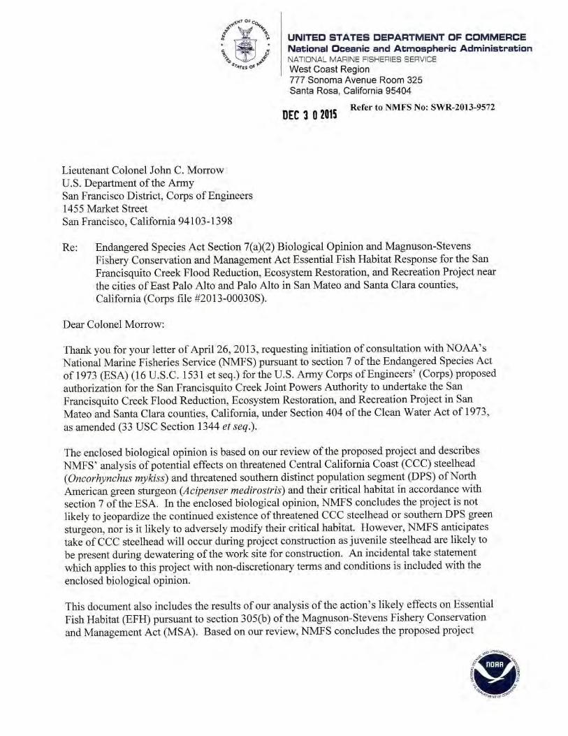


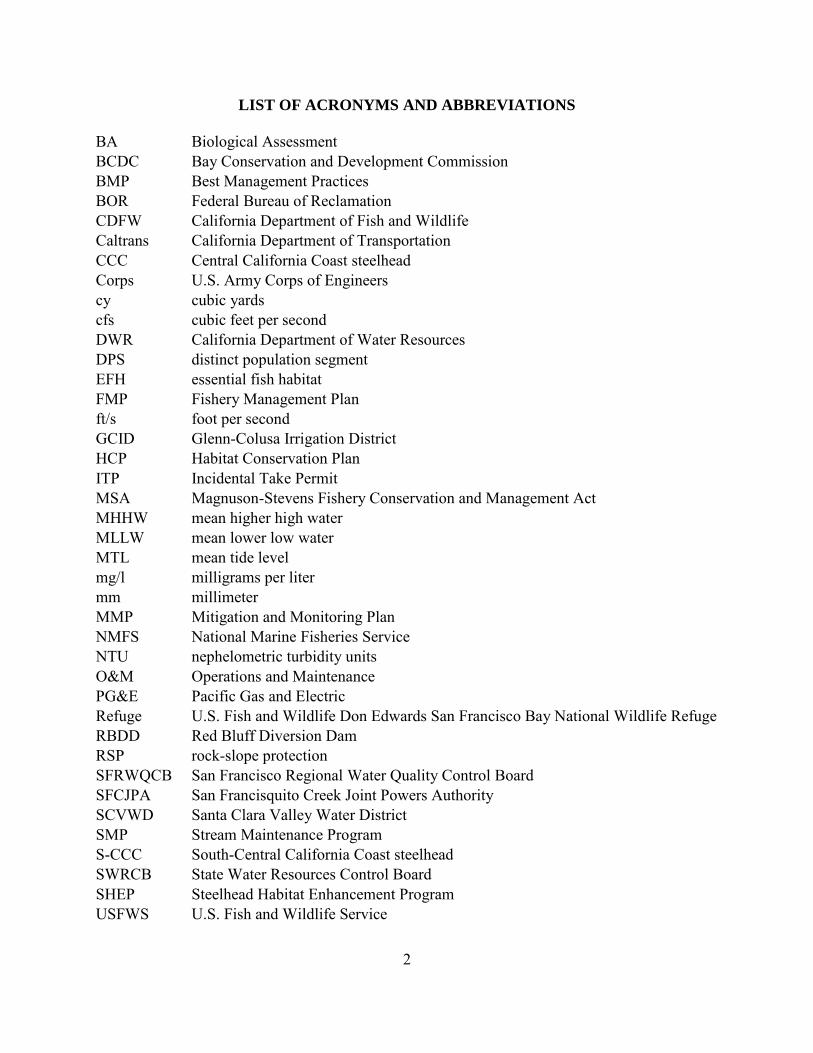
2
LIST OF ACRONYMS AND ABBREVIATIONS BA Biological Assessment BCDC Bay Conservation and Development Commission BMP Best Management Practices BOR Federal Bureau of Reclamation CDFW California Department of Fish and Wildlife Caltrans California Department of Transportation CCC Central California Coast steelhead Corps U.S. Army Corps of Engineers cy cubic yards cfs cubic feet per second DWR California Department of Water Resources DPS distinct population segment EFH essential fish habitat FMP Fishery Management Plan ft/s foot per second GCID Glenn-Colusa Irrigation District HCP Habitat Conservation Plan ITP Incidental Take Permit MSA Magnuson-Stevens Fishery Conservation and Management Act MHHW mean higher high water MLLW mean lower low water MTL mean tide level mg/l milligrams per liter mm millimeter MMP Mitigation and Monitoring Plan NMFS National Marine Fisheries Service NTU nephelometric turbidity units O&M Operations and Maintenance PG&E Pacific Gas and Electric Refuge U.S. Fish and Wildlife Don Edwards San Francisco Bay National Wildlife Refuge RBDD Red Bluff Diversion Dam RSP rock-slope protection SFRWQCB San Francisco Regional Water Quality Control Board SFCJPA San Francisquito Creek Joint Powers Authority SCVWD Santa Clara Valley Water District SMP Stream Maintenance Program S-CCC South-Central California Coast steelhead SWRCB State Water Resources Control Board SHEP Steelhead Habitat Enhancement Program USFWS U.S. Fish and Wildlife Service
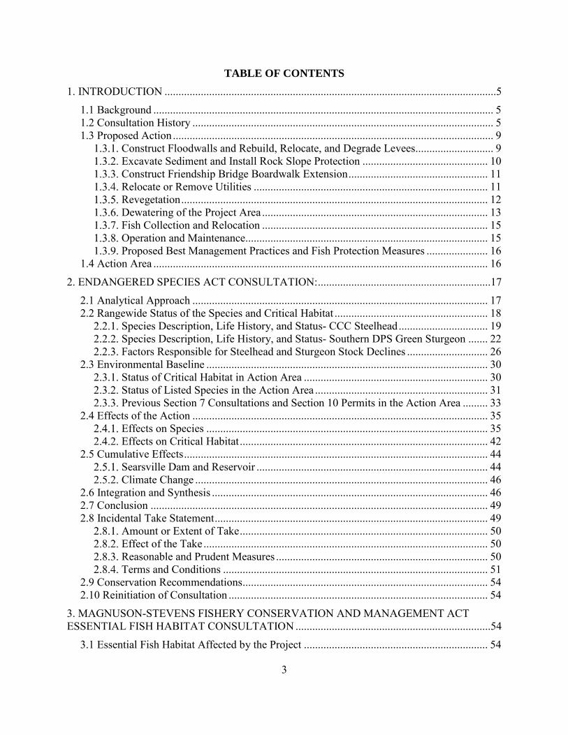
3
TABLE OF CONTENTS
1. INTRODUCTION .......................................................................................................................5
1.1 Background .......................................................................................................................... 5 1.2 Consultation History ............................................................................................................ 5 1.3 Proposed Action ................................................................................................................... 9
Construct Floodwalls and Rebuild, Relocate, and Degrade Levees............................ 9 Excavate Sediment and Install Rock Slope Protection ............................................. 10 Construct Friendship Bridge Boardwalk Extension .................................................. 11 Relocate or Remove Utilities .................................................................................... 11 Revegetation .............................................................................................................. 12 Dewatering of the Project Area ................................................................................. 13 Fish Collection and Relocation ................................................................................. 15 Operation and Maintenance....................................................................................... 15 Proposed Best Management Practices and Fish Protection Measures ...................... 16
1.4 Action Area ........................................................................................................................ 16
2. ENDANGERED SPECIES ACT CONSULTATION: ..............................................................17
2.1 Analytical Approach .......................................................................................................... 17 2.2 Rangewide Status of the Species and Critical Habitat ....................................................... 18
Species Description, Life History, and Status- CCC Steelhead ................................ 19 Species Description, Life History, and Status- Southern DPS Green Sturgeon ....... 22 Factors Responsible for Steelhead and Sturgeon Stock Declines ............................. 26
2.3 Environmental Baseline ..................................................................................................... 30 Status of Critical Habitat in Action Area .................................................................. 30 Status of Listed Species in the Action Area .............................................................. 31 Previous Section 7 Consultations and Section 10 Permits in the Action Area ......... 33
2.4 Effects of the Action .......................................................................................................... 35 Effects on Species ..................................................................................................... 35 Effects on Critical Habitat ......................................................................................... 42
2.5 Cumulative Effects ............................................................................................................. 44 Searsville Dam and Reservoir ................................................................................... 44 Climate Change ......................................................................................................... 46
2.6 Integration and Synthesis ................................................................................................... 46 2.7 Conclusion ......................................................................................................................... 49 2.8 Incidental Take Statement .................................................................................................. 49
Amount or Extent of Take ......................................................................................... 50 Effect of the Take ...................................................................................................... 50 Reasonable and Prudent Measures ............................................................................ 50 Terms and Conditions ............................................................................................... 51
2.9 Conservation Recommendations ........................................................................................ 54 2.10 Reinitiation of Consultation ............................................................................................. 54
3. MAGNUSON-STEVENS FISHERY CONSERVATION AND MANAGEMENT ACT ESSENTIAL FISH HABITAT CONSULTATION ......................................................................54
3.1 Essential Fish Habitat Affected by the Project .................................................................. 54

4
3.2 Adverse Effects on Essential Fish Habitat ......................................................................... 55 Water Quality ............................................................................................................ 55 Benthic disturbance ................................................................................................... 55
3.3 Essential Fish Habitat Conservation Recommendation ..................................................... 56 3.4 Statutory Response Requirement ....................................................................................... 57 3.5 Supplemental Consultation ................................................................................................ 57
4. DATA QUALITY ACT DOCUMENTATION AND PRE-DISSEMINATION REVIEW .....57
4.1 Utility ................................................................................................................................. 57 4.2 Integrity .............................................................................................................................. 58 4.3 Objectivity .......................................................................................................................... 58
5. FIGURES ...................................................................................................................................59
6. REFERENCES ..........................................................................................................................63

5
1. INTRODUCTION This Introduction section provides information relevant to the other sections of this document and is incorporated by reference into sections 2 and 3 below. 1.1 Background The National Marine Fisheries Service (NMFS) prepared the biological opinion (opinion) and incidental take statement portions of this document in accordance with section 7(b) of the Endangered Species Act (ESA) of 1973 (16 USC 1531 et seq.), and implementing regulations at 50 CFR 402. We also completed an essential fish habitat (EFH) consultation on the proposed action, in accordance with section 305(b)(2) of the Magnuson-Stevens Fishery Conservation and Management Act (MSA) (16 U.S.C. 1801 et seq.) and implementing regulations at 50 CFR 600. We completed pre-dissemination review of this document using standards for utility, integrity, and objectivity in compliance with applicable guidelines issued under the Data Quality Act (section 515 of the Treasury and General Government Appropriations Act for Fiscal Year 2001, Public Law 106-554). The document will be available through NMFS’ Public Consultation Tracking System (https://pcts.nmfs.noaa.gov/pcts-web/homepage.pcts). A complete record of this consultation is on file at the NMFS North-Central Coast Office in Santa Rosa, California. 1.2 Consultation History November 8, 2011: NMFS attended a site visit along with staff from San Francisquito
Creek Joint Powers Authority (SFCJPA), Santa Clara Valley Water District (SCVWD), and the U.S. Army Corps of Engineers (Corps).
April 26, 2013: NMFS received from the Corps the project’s Biological Assessment (BA) (ICF International 2012) and the request for consultation on the San Francisquito Creek Flood Reduction, Ecosystem Restoration, and Recreation Project (Project). In the initiation letter, the Corps determined the project may affect, but is not likely to adversely affect, threatened Central California Coast (CCC) steelhead (Oncorhynchus mykiss) and threatened southern distinct population segment (DPS) of North American green sturgeon (Acipenser medirostris) and their critical habitat. Additionally, the Corps determined that the project would not have substantial adverse effects on EFH for various federally managed fish species within the Pacific Coast Groundfish, Pacific Coast Salmon, and Coastal Pelagic Species Fishery Management Plans (FMP).
May 13, 2013: NMFS sent an electronic message to the Corps commenting on the BA
and requesting additional information on the proposed project. The message mentioned that the description of the project contained in the

6
BA did not contain sufficient detail for NMFS to assess the potential impacts of the project, and requested additional clarification on the project description (i.e., dewatering activities and using heavy equipment in the channel).
February – July 2014: NMFS attended multiple interagency meetings regarding the project
with staff from the U.S. Fish and Wildlife Service’s (USFWS) Don Edwards San Francisco Bay National Wildlife Refuge (Refuge), the Corps, SCVWD, SFCJPA, California Department of Fish and Wildlife (CDFW), San Francisco Regional Water Quality Control Board (SFRWQCB), NMFS, and the Bay Conservation and Development Commission (BCDC) to discuss the various alternative configurations for the proposed project including filling in low spots in the Main Faber Marsh levee, degrading the Bay levee adjacent to Outer Faber Marsh near the mouth of San Francisquito Creek, and further setting back the levee into the Palo Alto Municipal Golf Course.
August 28, 2014: NMFS received from the Corps and SFCJPA the amended BA for the
Project. October 15, 2014: NMFS attended a site visit along with staff from SFCJPA, SCVWD,
CDFW, and Corps. During the site visit NMFS was informed several additional documents regarding the project were available. These documents consisted of the Draft Mitigation and Monitoring Plan (MMP) (SFCJPA 2015c), Draft Operations and Maintenance (O&M) Plan (SFCJPA 2015a), and Temporary Water Diversion Plan (SFCJPA 2015b). NMFS received these documents from the SFCJPA on October 17, 2014.
November 3, 2014: NMFS sent a letter to the Corps and SFCJPA commenting on the
August 2014 amended BA, the Draft MMP, and the Draft O&M Plan and requested additional information on channel capacity, sedimentation, and flooding, and fish passage and habitat. In this letter, NMFS also informed the Corps and SFCJPA that this information was necessary to complete the NMFS assessment of potential project impacts and conclude consultation.
April 24, 2015: NMFS attended a meeting with the Corps, SFRWQCB, SCVWD, and
SFCJPA to discuss NMFS’s comments and questions raised in the November 3, 2014, letter. The SFCJPA agreed to investigate the feasibility of, and provide to NMFS a conceptual proposal for incorporation of several project features (i.e., velocity refuges and passive tidal marsh revegetation) to improve conditions for fish. The SFCJPA further agreed to provide: 1) updated planting plans and landscape sheets; 2) a table of wetlands impacts and mitigation calculations; 3) an updated MMP; 4) written responses to the points
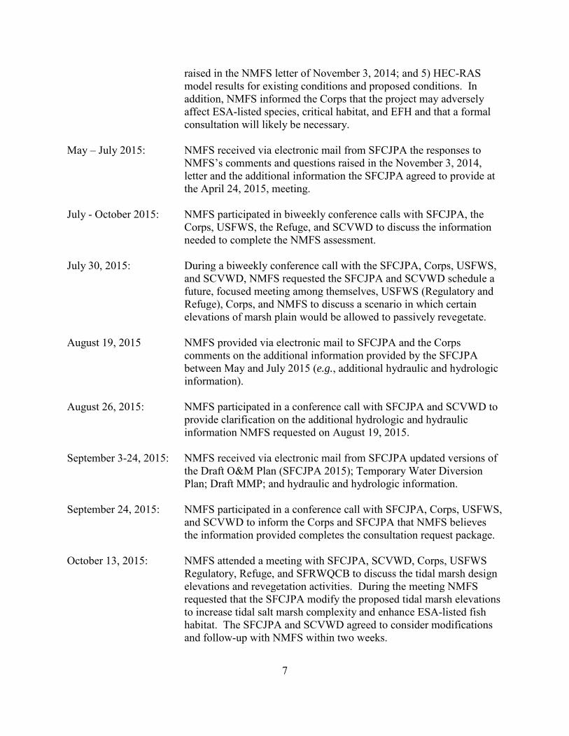
7
raised in the NMFS letter of November 3, 2014; and 5) HEC-RAS model results for existing conditions and proposed conditions. In addition, NMFS informed the Corps that the project may adversely affect ESA-listed species, critical habitat, and EFH and that a formal consultation will likely be necessary.
May – July 2015: NMFS received via electronic mail from SFCJPA the responses to
NMFS’s comments and questions raised in the November 3, 2014, letter and the additional information the SFCJPA agreed to provide at the April 24, 2015, meeting.
July - October 2015: NMFS participated in biweekly conference calls with SFCJPA, the
Corps, USFWS, the Refuge, and SCVWD to discuss the information needed to complete the NMFS assessment.
July 30, 2015: During a biweekly conference call with the SFCJPA, Corps, USFWS,
and SCVWD, NMFS requested the SFCJPA and SCVWD schedule a future, focused meeting among themselves, USFWS (Regulatory and Refuge), Corps, and NMFS to discuss a scenario in which certain elevations of marsh plain would be allowed to passively revegetate.
August 19, 2015 NMFS provided via electronic mail to SFCJPA and the Corps
comments on the additional information provided by the SFCJPA between May and July 2015 (e.g., additional hydraulic and hydrologic information).
August 26, 2015: NMFS participated in a conference call with SFCJPA and SCVWD to
provide clarification on the additional hydrologic and hydraulic information NMFS requested on August 19, 2015.
September 3-24, 2015: NMFS received via electronic mail from SFCJPA updated versions of
the Draft O&M Plan (SFCJPA 2015); Temporary Water Diversion Plan; Draft MMP; and hydraulic and hydrologic information.
September 24, 2015: NMFS participated in a conference call with SFCJPA, Corps, USFWS,
and SCVWD to inform the Corps and SFCJPA that NMFS believes the information provided completes the consultation request package.
October 13, 2015: NMFS attended a meeting with SFCJPA, SCVWD, Corps, USFWS
Regulatory, Refuge, and SFRWQCB to discuss the tidal marsh design elevations and revegetation activities. During the meeting NMFS requested that the SFCJPA modify the proposed tidal marsh elevations to increase tidal salt marsh complexity and enhance ESA-listed fish habitat. The SFCJPA and SCVWD agreed to consider modifications and follow-up with NMFS within two weeks.

8
October 20, 2015: Via electronic mail to the SFCJPA, SCVWD, and Corps, NMFS requested additional hydrologic information (e.g., HEC-RAS model results for the 1 percent, 5 percent, and 50 percent [March-June] exceedance flows).
November 5, 2015: During the biweekly project update call, NMFS informed the SFCJPA
and Corps that SFRWQCB Estuarine Geomorphologist, Christina Toms, spoke with NMFS on October 26, 2015, regarding modifications to the Project’s marshplain designs. NMFS explained the SFRWQCB believed that a passive approach to creating channel complexity in the tidal salt marsh would not be successful in the action area due to intense fluvial influences and that alternative methods would need to be taken to enhance ESA-listed fish habitat, specifically adult fish passage conditions. NMFS informed the SFCJPA that they will provide a memo summarizing their analysis of the Project’s impacts on fish habitat and recommendations on the types of habitat enhancements that would be needed to enhance fish habitat within two weeks. NMFS also confirmed that they could rush completion of the Opinion, with a goal of completing it by December 15, 2015.
November 23, 2015: NMFS provided the Corps, SFCJPA, and other resource agency
representatives a technical memo prepared by fish passage engineer, Dave White, which summarized the fish passage issues associated with high channel velocities under some streamflow conditions in the project reach, and suggested design elements to provide velocity refuge in the project reach.
November 30, 2015: In response to recommendations provided in the NMFS November 23,
2015, fish passage review memorandum, the SFCJPA submitted to NMFS and the Corps a preliminary proposal for the location, number and type of steelhead migration features to be incorporated in to project.
December 1, 2015: A telephone conference call with representatives of NMFS, SFCJPA,
USFWS and SCVWD was held to discuss SFCJPA’s proposed steelhead fish passage features. NMFS informed the group that the proposal will likely address the most significant high velocity areas by creating resting sites behind boulders and rootwads. The SFCJPA agreed to incorporate these features into the project and continue to work with NMFS to develop the specific designs for each feature.
December 2, 2015: The SFCJPA provided a revised proposal for steelhead fish passage
features based on the December 1, 2015, conference call with NMFS.

9
1.3 Proposed Action “Action” means all activities or programs of any kind authorized, funded, or carried out, in whole or in part, by Federal agencies (50 CFR 402.02). The Corps proposes to issue a permit under Section 404 of the Clean Water Act of 1973 (33 U.S.C. Section 1344) to the SFCJPA to construct a 1.5 mile flood protection and habitat restoration project along San Francisquito Creek from San Francisco Bay to East Bayshore Road, near the cities of East Palo Alto and Palo Alto in San Mateo and Santa Clara counties, California (Figures 1-5). The SFCJPA is a regional government agency whose members include the Cities of Palo Alto, Menlo Park, and East Palo Alto, the San Mateo County Flood Control District, and the SCVWD. The purpose of the proposed activity is to improve flood protection (up to a 100-year flood flow event coupled with the influence of tides and projected sea level rise), restore and enhance habitat functions, and improve recreational opportunities within the project area. Major project elements include: levee setback and improvements, construction of floodwalls, extension of a pedestrian bridge, excavation of sediment deposits within the channel to maximize flood conveyance, relocation and removal of utilities, and revegetation of tidal marsh habitats. Construction of the project elements would likely take two years to complete. The project is scheduled to begin in 2016 and to be completed by 2018. “Interrelated actions” are those that are part of a larger action and depend on the larger action for their justification. “Interdependent actions” are those that have no independent utility apart from the action under consideration (50 CFR 402.02). There are no interdependent or interrelated actions associated with the proposed action.
Construct Floodwalls and Rebuild, Relocate, and Degrade Levees Approximately 5,650 linear feet of floodwalls will be constructed along the channel at the top of levees to increase flow capacity and maintain consistency with the California Department of Transportation’s (Caltrans) enlargement of the U.S. 101/East Bayshore Road Bridge over the San Francisquito Creek. On the East Palo Alto side (north bank), concrete floodwalls up to 4 feet above top of bank (up to 13 feet from channel bottom) will be constructed along approximately 500 linear feet near Friendship Bridge (pedestrian bridge crossing the creek) (STA 28+00 to STA 33+00) (Figure 4) and along 2,300 linear feet of channel between Daphne Way (STA 52+50) and U.S. Highway 101/East Bayshore Road (STA 75+50) (Figure 5). On the Palo Alto side (south bank), sheetpile floodwalls up to 4 feet above top of bank (up to 13 feet from channel bottom) will be constructed along approximately 2,850 linear feet from Geng Road (STA 47+50) to Highway 101/East Bayshore Road Bridge (STA 76+00) (Figures 4 and 5). Downstream of the floodwalls, the SFCJPA will rebuild the East Palo Alto Levee (northern levee) in its current location and relocate the Palo Alto Levee/Palo Alto Municipal Golf Course Levee (southern levee). Approximately 3,400 linear feet of the existing levee on the north side of the channel would be rebuilt to a greater strength and/or height from just downstream of Friendship Bridge (STA 21+00) (Figure 3) to Daphne Way (STA 55+00) to increase channel capacity (100-year water surface elevation). Approximately 55,000 cubic yards (cy) of fill will be used to reinforce and increase the height of the northern levee. Approximately 2,727 linear feet of the southern levee will be relocated and/or reinforced between the area just downstream
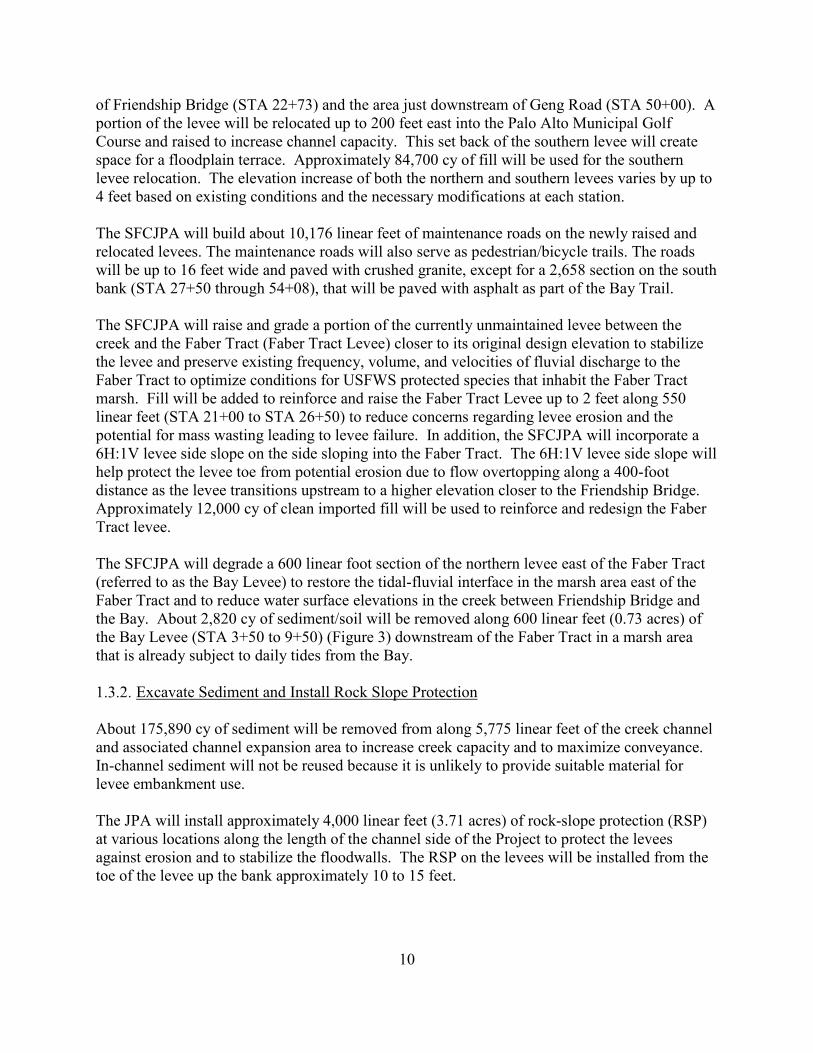
10
of Friendship Bridge (STA 22+73) and the area just downstream of Geng Road (STA 50+00). A portion of the levee will be relocated up to 200 feet east into the Palo Alto Municipal Golf Course and raised to increase channel capacity. This set back of the southern levee will create space for a floodplain terrace. Approximately 84,700 cy of fill will be used for the southern levee relocation. The elevation increase of both the northern and southern levees varies by up to 4 feet based on existing conditions and the necessary modifications at each station. The SFCJPA will build about 10,176 linear feet of maintenance roads on the newly raised and relocated levees. The maintenance roads will also serve as pedestrian/bicycle trails. The roads will be up to 16 feet wide and paved with crushed granite, except for a 2,658 section on the south bank (STA 27+50 through 54+08), that will be paved with asphalt as part of the Bay Trail. The SFCJPA will raise and grade a portion of the currently unmaintained levee between the creek and the Faber Tract (Faber Tract Levee) closer to its original design elevation to stabilize the levee and preserve existing frequency, volume, and velocities of fluvial discharge to the Faber Tract to optimize conditions for USFWS protected species that inhabit the Faber Tract marsh. Fill will be added to reinforce and raise the Faber Tract Levee up to 2 feet along 550 linear feet (STA 21+00 to STA 26+50) to reduce concerns regarding levee erosion and the potential for mass wasting leading to levee failure. In addition, the SFCJPA will incorporate a 6H:1V levee side slope on the side sloping into the Faber Tract. The 6H:1V levee side slope will help protect the levee toe from potential erosion due to flow overtopping along a 400-foot distance as the levee transitions upstream to a higher elevation closer to the Friendship Bridge. Approximately 12,000 cy of clean imported fill will be used to reinforce and redesign the Faber Tract levee. The SFCJPA will degrade a 600 linear foot section of the northern levee east of the Faber Tract (referred to as the Bay Levee) to restore the tidal-fluvial interface in the marsh area east of the Faber Tract and to reduce water surface elevations in the creek between Friendship Bridge and the Bay. About 2,820 cy of sediment/soil will be removed along 600 linear feet (0.73 acres) of the Bay Levee (STA 3+50 to 9+50) (Figure 3) downstream of the Faber Tract in a marsh area that is already subject to daily tides from the Bay.
Excavate Sediment and Install Rock Slope Protection About 175,890 cy of sediment will be removed from along 5,775 linear feet of the creek channel and associated channel expansion area to increase creek capacity and to maximize conveyance. In-channel sediment will not be reused because it is unlikely to provide suitable material for levee embankment use. The JPA will install approximately 4,000 linear feet (3.71 acres) of rock-slope protection (RSP) at various locations along the length of the channel side of the Project to protect the levees against erosion and to stabilize the floodwalls. The RSP on the levees will be installed from the toe of the levee up the bank approximately 10 to 15 feet.

11
Construct Friendship Bridge Boardwalk Extension The existing Friendship Bridge will be retained and a 202 linear foot boardwalk will be constructed from the retained eastern footing of the bridge and across the newly-expanded marshplain to connect with the realigned southern levee. The boardwalk will be the same width as the Friendship Bridge (140 feet long and 10 feet wide), constructed of timber deck and concrete piles, and require twenty 18-inch diameter concrete piles. The elevation of the low mark of the boardwalk will be set above the highest anticipated flood elevation, with the lowest point of the bridge a minimum of 5 feet above the marshplain terrace beneath it.
Relocate or Remove Utilities The SFCJPA will remove, abandon, or replace several utility components for electricity, gas, and sanitary sewer, and stormwater runoff present within the Project right-of-way. SFCJPA will remove various storm drain pipelines existing within the golf course and at the top of the current levees that will be under the future southern levee and widened creek channel post project. This work will be concurrent with the levee and channel work. The SFCJPA will realign a sanitary sewer line that currently crosses the creek near the Friendship Bridge (STA 32+00 at the south bank to 34+50 at the north bank). As proposed, this task will involve open trenching with a minimum depth below ground surface of 3.5 feet for the new line. The sanitary sewer line would be encased in armored steel where it crosses the creek. This work would be concurrent with the levee construction work so will not have separate impacts to waters of the San Francisquito Creek. The SFCJPA will remove about 390 linear feet of existing sanitary sewer line. The SFCJPA will coordinate with Pacific Gas and Electric (PG&E) to perform electricity and gas transmission system work before creek channel and levee construction work begins. PG&E’s work is considered part of the Project and will be covered under the Corps’ 404 permit for the Project. PG&E will realign the existing electricity transmission system that currently crosses over the creek from STA 52+00 (south bank) to R-line STA 48+00 (north bank). The new line will be shifted 250 feet south and cross over the creek at STA 51+00 (south bank) to STA 52+00 on the north bank. A transmission pole will be removed from both banks; replacing two existing poles, one on each bank; and adding two new poles on the north bank for the new line. In addition, PG&E will remove wires from six towers that run north to south along the far north bank right-of-way between STA 30+00 to STA 56+00. Of these six towers, one will be raised by 15 feet. The realigned section will connect to the southern-most pole in this series. Any replacement poles will be made of light-duty steel. PG&E will replace the foundation of an existing electric transmission tower located in the floodplain of the future channel alignment footprint at STA 48+00, approximately 2,000 feet upstream of the Friendship Bridge. PG&E will demolish the existing foundation, build a temporary shoo-fly support, and build a permanent concrete foundation at the existing foundation site. The electricity tower on the old foundation will be lifted and placed onto the permanent concrete foundation with an area of 625 square feet. An access ramp will be built on the inboard side of the levee for this tower.

12
PG&E will abandon in place 3,000 linear feet of the gas transmission line located in the Project right-of-way, of which about 1,350 linear feet is in the new channel realignment footprint. THE SFCJPA will remove the abandoned gas transmission lines. PG&E estimates that the old line is 4.7 feet below grade beneath the creek channel. The SFCJPA will confirm the elevation during excavation activities. The new gas line will be aligned south to north in the golf course, then will cross east to west through the Project right-of-way upstream of the Friendship Bridge from STA 32+00 (south bank) to STA 34+00 (north bank), and will extend west to a connection in East Palo Alto. The pipeline tunnel under the Creek will be bored by horizontal direction drilling at 25 feet below ground. The other portions of the pipeline will be installed by cut and fill at a minimum of 4 feet below ground surface. PG&E will place three trench spoils piles equidistant from south to north along the south bank. Each pile is planned to be 100 feet by 100 feet. On the north bank, PG&E will place another 100 foot by 100 foot spoils pile next to the borehole site. The suitability of the spoils for reuse to cover the new pipeline will be determined after they are appropriately assessed during the utility activities, and any unused spoils will be hauled from the site and appropriately disposed of at an approved upland facility.
Revegetation The action area encompasses 4.34 acres of diked marsh wetlands, 0.33 acres of freshwater marsh wetlands, 112.26 acres of tidal salt marsh wetlands, 1.13 acres of freshwater pond, 22.39 acres of tidal channel and bay waters, and 0.37 acres of tidal pans. The project construction is anticipated to impact a total of 3.13 acres of diked marsh, 4.51 acres of tidal salt marsh habitat, and 2.43 acres of tidal channel and bay waters. The diked marsh community is found on the landward side of the levees along San Francisquito Creek and within the Golf Course; and the tidal salt marsh vegetation is found throughout the Faber Tract and along both sides of San Francisquito Creek. The Project will result in the removal of between 162 and 256 trees. Of the potential of 256 trees to be removed, 220 of these are on the south side of the creek and the remaining 36 are on the north side. After levee construction is complete, the tidal marsh area would be terraced and revegetated with high-marsh plants appropriate to the elevation relative to tidal levels in accordance with the MMP for the Project (SCVWD 2014). The high-marsh (above mean higher high water) will be planted with include alkali weed (Cressa truxillensis), saltgrass (Distichlis spicata), alkali heath (Frankenia salina), marsh jaumea (Jaumea carnosa), and perennial pickleweed (Salicornia pacifica [S. virginica]). The high-marsh transition planting area will be planted with fat hen (Atriplex patula), alkali weed, saltgrass, alkali heath, gumweed (Grindelia spp.), marsh jaumea, and western marsh rosemary (Limonium californicum). Native marsh plants will be used to revegetate the terraced land. Plants appropriate to the high marsh will be planted near the stream channel. Plants native to marsh transition areas would be planted in areas more distant from the creek channel and in the upper half of the Project area as elevation gains. Approximately 19,600 high marsh and high marsh transition wetland plants and cuttings are planned for installation. Plants will be sourced from the San Francisquito Creek watershed and Baylands areas.

13
A temporary irrigation system will be installed for use during the planting and three-year establishment phase, in order to provide a back-up water supply to the newly-installed vegetation in the event of a period of drought during the winter or spring rainy season, and for irrigation as needed during the summer. Irrigation frequency is expected to be reduced as the site develops during the establishment phase. The supplemental irrigation ensures an adequate supply of moisture to the young plants until they are fully established in the site’s soils. Annual monitoring will be conducted over a 5-year period. Performance goals related to revegetation efforts will aid in determining if the site is progressing incrementally toward meeting the year-5 success criteria (SFCJPA 2015c). Year 5 monitoring will determine if the success criteria have been achieved. Monitoring will be overseen or conducted by a qualified biologist with experience in vegetation monitoring. Final success will not be considered to have been achieved until temporary irrigation has been off for at least two years. The specific performance goals and criteria that will be used to determine if all revegetation was successful will be described in a Final MMP.
Dewatering of the Project Area The project area is located in a reach of San Francisquito Creek that is influenced by tides and freshwater flow from the San Francisquito Creek watershed. Therefore, both a stream flow and tidal diversion will be necessary to dewater the project area for construction purposes. Water diversion will be implemented to maintain the work site as water-free as possible for the duration of in-channel work. The full width of the channel from tops of bank will be dewatered. Water incursion is expected from Bay tides, natural and urban runoff flows from upstream, outfalls downstream from the U.S. 101/East Bayshore Road Bridge, and discharges from the O’Connor Pump Station in East Palo Alto and the Palo Alto Pump Station. Water diversion will include cofferdams upstream (to intercept stream flows) and downstream (to block tidal Bay waters) of the work site. Stream flows upstream of the site will be pumped through pipes that bypass the work site. Discharges from the two municipal pump stations located adjacent to the creek will be pumped from the clear wells into the diversion pipes as well. In addition, water that is diverted from the channel during dewatering will be retained, tested, and treated, as necessary, in order to meet all water quality effluent limitations as specified in the SFRWQCB, San Francisco Bay Region, Basin Plan (Basin Plan). Diversion pipe flow velocity dissipaters will be installed downstream of the cofferdam on existing banks. Pumps will be used to dewater the work site. Pumps will be required to: 1) reroute water from the stream, which accumulates above the upstream cofferdam; 2) dewater the construction area above the downstream cofferdam or where ponded; and 3) to reroute outflow at each of the two municipal pump stations (see below). The cofferdams will be installed for the in-channel construction period between June 15th and October 15th at various locations, depending on the construction element, during the two construction seasons (see Table 1). Utilities and levee construction and dewatering will be completed in one season, and floodwall construction the following season.
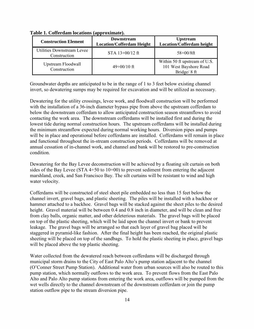
14
Table 1. Cofferdam locations (approximate).
Construction Element Downstream
Location/Cofferdam Height Upstream
Location/Cofferdam height Utilities Downstream Levee
Construction STA 13+00/12 ft 58+00/8ft
Upstream Floodwall Construction 49+00/10 ft
Within 50 ft upstream of U.S. 101 West Bayshore Road
Bridge/ 8 ft Groundwater depths are anticipated to be in the range of 1 to 3 feet below existing channel invert, so dewatering sumps may be required for excavation and will be utilized as necessary. Dewatering for the utility crossings, levee work, and floodwall construction will be performed with the installation of a 36-inch diameter bypass pipe from above the upstream cofferdam to below the downstream cofferdam to allow anticipated construction season streamflows to avoid contacting the work area. The downstream cofferdams will be installed first and during the lowest tide during normal construction hours. The upstream cofferdams will be installed during the minimum streamflow expected during normal working hours. Diversion pipes and pumps will be in place and operational before cofferdams are installed. Cofferdams will remain in place and functional throughout the in-stream construction periods. Cofferdams will be removed at annual cessation of in-channel work, and channel and bank will be restored to pre-construction condition. Dewatering for the Bay Levee deconstruction will be achieved by a floating silt curtain on both sides of the Bay Levee (STA 4+50 to 10+00) to prevent sediment from entering the adjacent marshland, creek, and San Francisco Bay. The silt curtains will be resistant to wind and high water velocity. Cofferdams will be constructed of steel sheet pile embedded no less than 15 feet below the channel invert, gravel bags, and plastic sheeting. The piles will be installed with a backhoe or hammer attached to a backhoe. Gravel bags will be stacked against the sheet piles to the desired height. Gravel material will be between 0.4 and 0.8 inch in diameter, and will be clean and free from clay balls, organic matter, and other deleterious materials. The gravel bags will be placed on top of the plastic sheeting, which will be laid upon the channel invert or bank to prevent leakage. The gravel bags will be arranged so that each layer of gravel bag placed will be staggered in pyramid-like fashion. After the final height has been reached, the original plastic sheeting will be placed on top of the sandbags. To hold the plastic sheeting in place, gravel bags will be placed above the top plastic sheeting. Water collected from the dewatered reach between cofferdams will be discharged through municipal storm drains to the City of East Palo Alto’s pump station adjacent to the channel (O’Conner Street Pump Station). Additional water from urban sources will also be routed to this pump station, which normally outflows to the work area. To prevent flows from the East Palo Alto and Palo Alto pump stations from entering the work area, outflows will be pumped from the wet wells directly to the channel downstream of the downstream cofferdam or join the pump station outflow pipe to the stream diversion pipe.

15
The SFCJPA will ensure SFRWQCB and State Water Resources Control Board (SWRCB) water quality standards for receiving waters will be met during creek dewatering discharges, dewatering of excavations, and diverting creek and stormwater flows. Specifically, the instantaneous discharge pH will be in the range of 6.5 to 8.5 and shall not vary from ambient pH by more than 0.5 pH units; the discharge dissolved oxygen concentration will be no less than 5.0 milligrams per liter (mg/L) as an hourly average for discharging into tidal water and 7.0 mg/L (hourly average) for discharging into non-tidal receiving waters; dissolved sulfide will not be greater than 0.1 mg/L; the receiving water turbidity measured as nephelometric turbidity units (NTU) will not be greater than 10 percent of natural conditions in areas where natural turbidity is greater than 50 NTU (daily average); and the receiving waters will not contain biostimulatory substances in concentrations that promote aquatic growths to the extent that such growths cause nuisance or adversely affect beneficial uses. The SFCJPA will identify an acceptable location or locations at which to measure background turbidity. Receiving water and discharge turbidity will be monitored at least one time every 8 hours on days when discharges from excavations or any other dewatering processes may occur.
Fish Collection and Relocation Because the project will require water diversion and dewatering of work sites, fish within the project area will be collected and relocated in order to minimize their risk of being harmed or killed. The fish collection and relocation activities will be conducted by a NMFS/CDFW-approved biologist. Methods used to capture and relocate fish in the project area may include dip net and seine. Due to the high conductivity of brackish waters, electrofishing will not be used. The SFCJPA will submit a fish relocation plan to NMFS and CDFW for review no less than 90 days prior to beginning these activities for each phase of construction.
Operation and Maintenance The SFCJPA has entered into a Construction Management Agreement with the SCVWD to designate the SCVWD as the lead agency responsible for project construction and post-project revegetation monitoring and management. The SFCJPA has also delegated responsibility for routine operation and maintenance of the Project, outside the scope of construction-related maintenance and monitoring activities, to the City of East Palo Alto and the SCVWD. Routine operations and maintenance include providing the proper care to levee embankments, floodwalls, channels, interior drainage system, and pump stations required for the efficient operation of the Project. The only operation and maintenance activity proposed by the SFCJPA as part of the Project is levee maintenance, vegetation management, and removal of trash and debris. The primary routine maintenance activities will consist of mowing levees to facilitate inspections, removal of trash and debris from the channel and channel benches, and control of burrowing rodents. Mowing will occur on the sides of the levee, which, on the inboard side of the levee, extend to the tidal marsh. Maintenance activities will be performed in accordance with the Best Management Practices Handbook (Attachment F to the SCVWD 2014-2023 SMP).
16
Additional future maintenance within the completed flood channel could include sediment removal, vegetation removal, levee repair, floodwall maintenance, removal of woody debris from the channel, repair of rock slope protection, maintenance of access roads, and repair and maintenance of outfalls and culverts. These activities, within specified limits and mitigation measures, are conducted as part of the SCVWD’s Stream Maintenance Program (SMP). NMFS and the Corps completed formal section 7 consultation in 2014 on a 10-year (2014-2023) SMP conducted by SCVWD within stream channels of Santa Clara County, including San Francisquito Creek. A biological opinion was issued to the Corps on April 29, 2014 (See Section 2.3.3.2 for more detail). At this time, no maintenance activities outside the actions described above and outside the purview of SCVWD’s SMP are anticipated.
Proposed Best Management Practices and Fish Protection Measures Based on a fish passage analysis performed by NMFS, the SFCJPA proposes to install six structures in the flood control channel that are designed to provide velocity refuge for upstream migrating adult steelhead. Five of the structures will be constructed with rock and rootwads as a “constructed log jam”. The sixth structure will be a rock spur structure extending from the lower tip of the Friendship Bridge Island into the low flow channel. All six structures will be placed in or adjacent to the low flow channel at approximately 300 feet intervals in the middle reach of the project. These structures will be designed to create velocity breaks and fish resting areas during high flow events and low tide conditions. During project construction, operation and maintenance activities, the project will implement BMPs to avoid and/or minimize potential impacts to special-status species and their designated critical habitat. All activities will be performed in accordance with Best Management Practices Handbook (Attachment F to the SCVWD 2014-2023 SMP). The BMP handbook is a comprehensive document that includes minimization measures related to hazards and hazardous materials, hydrology and water quality, bank protection, stormwater management, discharge activities, grading and excavation, sediment removal and storage, vegetation management and removal, and other topics. 1.4 Action Area “Action area” means all areas to be affected directly or indirectly by the Federal action and not merely the immediate area involved in the action (50 CFR 402.02). San Francisquito Creek Watershed drains approximately 47.5-square miles on the eastern side of the Santa Cruz Mountains. Major tributaries include Bear Creek, Corte Madera Creek, and Los Trancos Creek, which converge to form San Francisquito Creek. The project area has a Mediterranean climate, typical of the California’s central coast, with cool, wet winters and a long, mild dry season. Rainfall in the winter averages approximately 35 inches per year, falling mainly between the months of October and March. Portions of the upper San Francisquito Creek watershed are perennial and support spawning and rearing habitat for CCC steelhead. Sections of the mainstem of San Francisquito Creek dry by late spring or early summer in most years (Launer and Spain 1998; Metzger 2002; Stokes 2006).

17
The action area consists of the lower 1.5 miles of San Francisquito Creek in an existing flood control channel and adjacent marsh areas. The action area encompasses 4.34 acres of diked marsh wetlands, 0.33 acres of freshwater marsh wetlands, 112.26 acres of tidal salt marsh wetlands, 1.13 acres of freshwater pond, 22.39 acres of tidal channel and bay waters, and 0.37 acres of tidal pans. The diked marsh community is found on the landward side of the levees along San Francisquito Creek and within the Golf Course; and the tidal salt marsh vegetation is found throughout the Faber Tract and along both sides of San Francisquito Creek. From upstream to downstream, the constructed channel flows southwest to northeast through the cities of East Palo Alto and Palo Alto. The proposed project is located between where U.S. Highway 101 crosses San Francisquito Creek at the border of southern San Mateo and northern Santa Clara counties and the confluence of San Francisquito Creek with San Francisco Bay. This 7700 linear foot reach of San Francisquito Creek is located in a moderately urbanized, low gradient area, historically occupied by extensive tidal marshes at the edge of San Francisco Bay. The project location experiences daily tidal fluctuations.
2. ENDANGERED SPECIES ACT CONSULTATION: BIOLOGICAL OPINION AND INCIDENTAL TAKE STATEMENT
The ESA establishes a national program for conserving threatened and endangered species of fish, wildlife, plants, and the habitat upon which they depend. As required by section 7(a)(2) of the ESA, Federal agencies must ensure that their actions are not likely to jeopardize the continued existence of endangered or threatened species, or adversely modify or destroy their designated critical habitat. Per the requirements of the ESA, Federal action agencies consult with NMFS and section 7(b)(3) requires that, at the conclusion of consultation, NMFS provides an opinion stating how the agency’s actions would affect listed species and their critical habitat. If incidental take is expected, section 7(b)(4) requires NMFS to provide an incidental take statement (ITS) that specifies the impact of any incidental taking and includes non-discretionary reasonable and prudent measures and terms and conditions to minimize such impacts. 2.1 Analytical Approach This biological opinion includes both a jeopardy analysis and an adverse modification analysis. The jeopardy analysis relies upon the regulatory definition of “to jeopardize the continued existence of a listed species,” which is “to engage in an action that would be expected, directly or indirectly, to reduce appreciably the likelihood of both the survival and recovery of a listed species in the wild by reducing the reproduction, numbers, or distribution of that species” (50 CFR 402.02). Therefore, the jeopardy analysis considers both survival and recovery of the species. The adverse modification analysis considers the impacts of the Federal action on the conservation value of designated critical habitat. This biological opinion does not rely on the regulatory definition of "destruction or adverse modification" of critical habitat at 50 CFR 402.02. Instead, we have relied upon the statutory provisions of the ESA to complete the following analysis with respect to critical habitat.1
1 Memorandum from William T. Hogarth to Regional Administrators, Office of Protected Resources, NMFS
18
We use the following approach to determine whether a proposed action is likely to jeopardize listed species or destroy or adversely modify critical habitat:
• Identify the rangewide status of the species and critical habitat likely to be adversely affected by the proposed action.
• Describe the environmental baseline in the action area. • Analyze the effects of the proposed action on both species and their habitat using an
“exposure-response-risk” approach. • Describe any cumulative effects in the action area. • Integrate and synthesize the above factors to assess the risk that the proposed action poses
to species and critical habitat. • Reach jeopardy and adverse modification conclusions. • If necessary, define a reasonable and prudent alternative to the proposed action.
For critical habitat, NMFS determines the range-wide status of critical habitat by examining the condition of its physical or biological features (also called “primary constituent elements” or PCEs) - which were identified when critical habitat was designated. Species and critical habitat status are discussed in section 2.2 of this biological opinion. To conduct the assessment, NMFS examined an extensive amount of information from a variety of sources. Detailed background information on the biology and status of and critical habitat has been published in a number of documents including peer reviewed scientific journals, primary reference materials, and governmental and non-governmental reports. Additional information regarding the effects of the project’s actions on the listed species in question, their anticipated response to these actions, and the environmental consequences of the actions as a whole was formulated from the aforementioned resources referenced in the Consultation History section. Information was also provided in electronic mail messages and telephone conversations between April 2013 and November 2015. For information that has been taken directly from published, citable documents, those citations have been referenced in the text and listed at the end of this document. 2.2 Rangewide Status of the Species and Critical Habitat This opinion examines the status be adversely affected by the proposed action. The status is determined by the level of extinction risk that the listed species face, based on parameters considered in documents such as recovery plans, status reviews, and listing decisions. This informs the description of the species’ likelihood of both survival and recovery. The species status section also helps to inform the description of the species’ current “reproduction, numbers, or distribution” as described in 50 CFR 402.02. The opinion also examines the condition of critical habitat throughout the designated area, evaluates the conservation value of the various watersheds and coastal and marine environments that make up the designated area, and discusses
(Application of the “Destruction or Adverse Modification” Standard Under Section 7(a)(2) of the Endangered Species Act) (November 7, 2005).

19
the current function of the essential physical and biological features that help to form that conservation value.
Species Description, Life History, and Status- CCC Steelhead In this opinion, NMFS assesses four population viability parameters to help analyze the status of CCC steelhead and the population’s ability to survive and recover. These population viability parameters are: abundance, population growth rate, spatial structure, and diversity (McElhany et al. 2000). NMFS has used the best available scientific and commercial information to determine the general condition of the population and factors responsible for the current status of the DPS. The population viability parameters are used as surrogates for numbers, reproduction, and distribution; the criteria to be analyzed pursuant to the regulatory definition of jeopardy (50 CFR §402.02). For example, the first three parameters are used as surrogates for numbers, reproduction, and distribution. We relate the fourth parameter, diversity, to all three regulatory criteria. Numbers, reproduction, and distribution are all affected when genetic or life history variability is lost or constrained. This results in reduced population resilience to environmental variation at local or landscape-level scales. 2.2.1.1. CCC Steelhead General Life History Steelhead are anadromous forms of O. mykiss, spending some time in both fresh- and saltwater. The older juvenile and adult life stages reside in the ocean, until the adults ascend freshwater streams to spawn. Unlike Pacific salmon, steelhead are iteroparous, or capable of spawning more than once before death (Busby et al. 1996). Although one-time spawners are the great majority, Shapovalov and Taft (1954) reported that repeat spawners are relatively numerous (17.2 percent) in California streams. Eggs (laid in gravel nests called redds), alevins (gravel dwelling hatchlings), fry (juveniles newly emerged from stream gravels), and young juveniles all rear in freshwater until they become large enough to migrate to the ocean to finish rearing and maturing to adults. General reviews for steelhead in California document much variation in life history (Barnhart 1986; Busby et al. 1996; Shapovalov and Taft 1954). Although variation occurs, in coastal California steelhead usually live in freshwater for 1 to 2 years before emigrating to the ocean. Juvenile steelhead emigration from San Francisco Bay natal streams occurs episodically during winter and spring months, and generally occurs during high flow events. Barnhart (1986) reports that peak smolt migration occurs in March and April, and steelhead smolts in California typically range in size from 140 to 210 millimeter (mm) (fork length). Steelhead of this size can withstand higher salinities than smaller fish, and are more likely to occur for longer periods in tidally influenced estuaries, such as San Francisco Bay. Steelhead smolts in most river systems must pass through estuaries prior to seawater entry. Once they leave their natal streams, steelhead will spend 1 to 3 years in the ocean before returning to spawn. Based on the timing of adult migration from the ocean to freshwater, CCC steelhead are classified as winter-run steelhead. Adult CCC steelhead typically enter freshwater between December and April, peaking in January and February (Fukushima and Lesh 1998). Steelhead
20
females build redds to bury eggs for a several month-long incubation period. Redds are generally located in areas where the hydraulic conditions are such that fine sediments, for the most part, are sorted out and streamflow is constant. This is because, during the incubation period, the intragravel environment must permit a constant flow of water to deliver dissolved oxygen and to remove metabolic wastes. Other intragravel parameters such as the gravel permeability, water temperature, substrate composition, and organic material in the substrate effect the survival of eggs to fry emergence (Chapman 1988; Everest et al. 1987; Shapovalov and Taft 1954). Adult steelhead may spawn 1 to 4 times over their life span. Steelhead fry rear in freshwater edgewater habitats and move gradually into pools and riffles as they grow larger. Cover, water temperature, sediment, and food items are important habitat components for juvenile steelhead. Cover in the form of woody debris, rocks, overhanging banks, and other in-water structures provide velocity refuge and a means of avoiding predation (Bjornn et al. 1991; Shirvell 1990). Steelhead, however, tend to use riffles and other habitats not strongly associated with cover during summer rearing more than other salmonids. In winter, juvenile steelhead become less active and hide in available cover, including gravel or woody debris. Young steelhead feed on a wide variety of aquatic and terrestrial insects, and emerging fry are sometimes preyed upon by older juveniles. Water temperature can influence the metabolic rate, distribution, abundance, and swimming ability of rearing juvenile steelhead (Barnhart 1986; Bjornn and Reiser 1991b; Myrick and Cech 2005). Optimal temperatures for steelhead growth range between 10 and 20 degrees (°) Celsius (C) (Hokanson et al. 1977; Myrick and Cech 2005; Wurtsbaugh and Davis 1977). Fluctuating diurnal water temperatures are also important for the survival and growth of salmonids (Busby et al. 1996). Turbidity (i.e., water clarity) also can influence the behavior, distribution, and growth of steelhead (Cordone and Kelley 1961; Newcombe and Jensen 1996; Newcombe and MacDonald 1991; Redding et al. 1987; Sigler et al. 1984). The impacts of turbidity on juvenile salmonids are largely linked to factors such as background turbidity levels and the duration of turbid conditions. Bisson and Bilby (1982) found that juvenile coho salmon that were acclimated to clear water did not exhibit significant sediment avoidance until the turbidity reached 70 NTUs. Sigler et al. (1984) observed avoidance of turbid water by juvenile steelhead and coho when exposed to turbidities as low as 38 NTUs and 22 NTUs, respectively, for a period of 15-17 days. Sigler et al. (1984) also observed that fish kept in these turbid conditions had lower growth rates than fish kept in clear water for the same amount of time. 2.2.1.2. Status of CCC Steelhead DPS and Critical Habitat Historically, approximately 70 populations2 of steelhead existed in the CCC steelhead DPS (Spence et al. 2008; Spence et al. 2012). Many of these populations (about 37) were independent, or potentially independent, meaning they had a high likelihood of surviving for 100 years absent anthropogenic impacts (Bjorkstedt et al. 2005). The remaining populations were
2 Population as defined by Bjorkstedt et al. 2005 and McElhaney et al. 2000 as, in brief summary, a group of fish of the same species that spawns in a particular locality at a particular season and does not interbreed substantially with fish from any other group. Such fish groups may include more than one stream. These authors use this definition as a starting point from which they define four types of populations (not all of which are mentioned here).

21
dependent upon immigration from nearby CCC steelhead DPS populations to ensure their viability (Bjorkstedt et al. 2005; McElhany et al. 2000). While historical and present data on abundance are limited, CCC steelhead numbers are substantially reduced from historical levels. A total of 94,000 adult steelhead were estimated to spawn in the rivers of this DPS in the mid-1960s, including 50,000 fish in the Russian River - the largest population within the DPS (Busby et al. 1996). Near the end of the 20th century the population of wild CCC steelhead in the Russian River was estimated to be between 1,700- 7,000 fish (Busby et al. 1996; Good et al. 2005) . Recent estimates for the Russian River population are unavailable since monitoring data is limited. Abundance estimates for smaller coastal streams in the DPS indicate low population levels that are slowly declining, with recent estimates (2011/2012) for several streams (Redwood [Marin County], Waddell, San Vicente, Soquel, and Aptos creeks) of individual run sizes of 50 fish or less (Nature Conservancy 2013). Some loss of genetic diversity has been documented and attributed to previous among-basin transfers of stock and local hatchery production in interior populations in the Russian River (Bjorkstedt et al. 2005). Similar losses in genetic diversity in the Napa River may have resulted from out-of-basin and out-of-DPS releases of steelhead in the Napa River basin in the 1970s and 80s. These transfers included fish from the South Fork Eel River, San Lorenzo River, Mad River, Russian River, and the Sacramento River. In San Francisco Bay streams, reduced population sizes and fragmentation of habitat has likely also led to loss of genetic diversity in these populations. For more detailed information on trends in CCC steelhead abundance, see: (Busby et al. 1996; Good et al. 2005; Spence et al. 2008; Williams et al. 2011). CCC steelhead have experienced serious declines in abundance and long-term population trends suggest a negative growth rate. This indicates the DPS may not be viable in the long term. DPS populations that historically provided enough steelhead immigrants to support dependent populations may no longer be able to do so, placing dependent populations at increased risk of extirpation. However, because CCC steelhead remain present in most streams throughout the DPS, roughly approximating the known historical range, CCC steelhead likely possess a resilience that is likely to slow their decline relative to other salmonid DPSs or ESUs in worse condition. In 2005, a status review concluded that steelhead in the CCC steelhead DPS remain “likely to become endangered in the foreseeable future” (Good et al. 2005). On January 5, 2006, NMFS issued a final determination that the CCC steelhead DPS is a threatened species, as previously listed (71 FR 834). A more recent viability assessment of CCC steelhead concluded that populations in watersheds that drain to San Francisco Bay are highly unlikely to be viable, and that the limited information available did not indicate that any other CCC steelhead populations could be demonstrated to be viable3 (Spence et al. 2008). Monitoring data from the last ten years of adult CCC steelhead returns in Lagunitas and Scott creeks show steep declines in adults in 2008/2009. In 2011/2012 population levels began to increase, but still remained lower than levels observed over the past ten years (Nature Conservancy 2013). The most recent status update found that the status of the CCC steelhead DPS remains “likely to become endangered in the foreseeable future” (Williams et al. 2011), as new and additional information available since Good et al. (2005), does not
3 Viable populations have a high probability of long-term persistence (> 100 years).

22
appear to suggest a change in extinction risk. On December 7, 2011, NMFS chose to maintain the threatened status of the CCC steelhead (76 FR 76386). Critical habitat was designated for CCC steelhead on September 2, 2005 (70 FR 52488) and includes PCEs essential for the conservation of CCC steelhead. These PCEs include estuarine areas free of obstruction and excessive predation with the following essential features: (1) water quality, water quantity and salinity conditions supporting juvenile and adult physiological transitions between fresh- and saltwater; (2) natural cover such as submerged and overhanging large wood, aquatic vegetation, large rocks and boulders, and side channels; and (3) juvenile and adult forage, including aquatic invertebrates and fishes, supporting growth and maturation (70 FR 52488). The condition of CCC steelhead critical habitat, specifically its ability to provide for their conservation, has been degraded from conditions known to support viable salmonid populations. NMFS has determined that present depressed population conditions are, in part, the result of the following human-induced factors affecting critical habitat4: logging, agricultural and mining activities, urbanization, stream channelization, dams, wetland loss, and water withdrawals, including unscreened diversions for irrigation. Impacts of concern include alteration of streambank and channel morphology, alteration of water temperatures, loss of spawning and rearing habitat, fragmentation of habitat, loss of downstream recruitment of spawning gravels and large woody debris, degradation of water quality, removal of riparian vegetation resulting in increased streambank erosion, loss of shade (higher water temperatures) and loss of nutrient inputs (70 FR 52488 ; Busby et al. 1996). Water development has drastically altered natural hydrologic cycles in many of the streams in the DPS. Alteration of flows results in migration delays, loss of suitable habitat due to dewatering and blockage; stranding of fish from rapid flow fluctuations; entrainment of juveniles into poorly screened or unscreened diversions, and increased water temperatures harmful to salmonids. Overall, current condition of CCC steelhead critical habitat is degraded, and does not provide the full extent of conservation value necessary for the recovery of the species.
Species Description, Life History, and Status- Southern DPS Green Sturgeon 2.2.2.1. Green Sturgeon General Life History Green sturgeon is an anadromous, long-lived, and bottom-oriented fish species in the family Acipenseridae. Sturgeon have skeletons composed mostly of cartilage and lack scales, instead possessing five rows of characteristic bony plates on their body called "scutes." On the underside of their flattened snouts are sensory barbels and a siphon-shaped, protrusible, toothless mouth. Large adults may exceed 2 meters in length and 100 kilograms in weight (Moyle 1976). Based on genetic analyses and spawning site fidelity, NMFS determined that North American green sturgeon are comprised of at least two DPSs: a northern DPS consisting of populations originating from coastal watersheds northward of and including the Eel River (“northern DPS
4 Other factors, such as over fishing and artificial propagation have also contributed to the current population status of steelhead. All these human induced factors have exacerbated the adverse effects of natural factors such as drought and poor ocean conditions.

23
green sturgeon”), with spawning confirmed in the Klamath and Rogue river systems; and a southern DPS consisting of populations originating from coastal watersheds south of the Eel River (“southern DPS green sturgeon”), with spawning confirmed in the Sacramento River system (Adams et al. 2002). Green sturgeon is the most marine-oriented species of sturgeon (Moyle 2002). Along the West Coast of North America, they range in nearshore waters from Mexico to the Bering Sea (Adams et al. 2002), with a general tendency to head north after their out-migration from freshwater ( (Lindley et al. 2011). While in the ocean, archival tagging indicates that green sturgeon occur in waters between 0 and 200 meters depth, but spend most of their time in waters between 20–80 meters and temperatures of 9.5–16.0°C (Huff et al. 2011; Nelson et al. 2010). Subadult and adult green sturgeon move between coastal waters and estuaries (Lindley et al. 2011; Lindley et al. 2008), but relatively little is known about how green sturgeon use these habitats. Lindley et al. (2011) reported multiple rivers and estuaries are visited by aggregations of green sturgeon in summer months, and larger estuaries (e.g., San Francisco Bay) appear to be particularly important habitat. During the winter months, green sturgeon generally reside in the coastal ocean. Areas north of Vancouver Island are favored overwintering areas, with Queen Charlotte Sound and Hecate Strait likely destinations based on detections of acoustically-tagged green sturgeon (Lindley et al. 2008; Nelson et al. 2010). Based on genetic analysis, (Israel et al. 2009) reported that almost all green sturgeon collected in the San Francisco Bay system were southern DPS. This is corroborated by tagging and tracking studies which found that no green sturgeon tagged in the Klamath or Rogue rivers (i.e., Northern DPS) have yet been detected in San Francisco Bay (Lindley et al. 2011). However, green sturgeon inhabiting coastal waters adjacent to San Francisco Bay include northern DPS green sturgeon. Adult southern DPS green sturgeon spawn in the Sacramento River watershed during the spring and early summer months (Moyle et al. 1995). Eggs are laid in turbulent areas on the river bottom and settle into the interstitial spaces between cobble and gravel (Adams et al. 2007). Like salmonids, green sturgeon require cool water temperatures for egg and larval development, with an upper thermal limit for developing embryos of 17˚C (Van Eenennaam et al. 2005). Eggs hatch after 6–8 days, and larval feeding begins 10–15 days post-hatch. Larvae grow into juveniles typically after a minimum of 45 days (post-hatch) when fish have reached 60–80 mm total length (TL) and have migrated downstream. Juveniles spend their first few years in the Delta and San Francisco estuary before entering the marine environment as subadults. Juvenile green sturgeon salvaged at the State and Federal water export facilities in the southern Delta are generally between 200 mm and 400 mm TL (Adams et al. 2002), which suggests southern DPS green sturgeon spend several months to a year rearing in freshwater before entering the Delta and San Francisco estuary. Laboratory studies conducted by Allen and Cech (2007) indicated juveniles approximately 6 month old were tolerant of saltwater, but approximately 1.5-year old green sturgeon appeared more capable of successful osmoregulation in salt water. Subadult green sturgeon spend several years at sea before reaching reproductive maturity and returning to freshwater to spawn for the first time (Nakamoto et al. 1995). Little data are available regarding the size and age-at-maturity for the southern DPS green sturgeon, but it is
24
likely similar to that of the northern DPS. Male and female green sturgeon differ in age-at-maturity. Males can mature as young as 14 years and female green sturgeon mature as early as age 16 (Van Eenennaam et al. 2006). Adult green sturgeon are believed to spawn every two to five years. Recent telemetry studies by Heublein et al. (2009) indicate adults typically enter San Francisco Bay from the ocean and begin their upstream spawning migration between late February and early May. These adults on their way to spawning areas in the upper Sacramento River typically migrate rapidly through the estuary toward their upstream spawning sites. Preliminary results from tagged adult sturgeon suggest travel time from the Golden Gate to Rio Vista in the Delta is generally 1-2 weeks. Post-spawning, tagged southern DPS green sturgeon displayed two outmigration strategies (Heublein et al. 2009); outmigration from Sacramento River prior to September 1 and outmigration during the onset of fall/winter stream flow increases. The transit time for post-spawning adults through the San Francisco estuary appears to be very similar to their upstream migration (i.e., 1-2 weeks). During the summer and fall, an unknown proportion of the population of non-spawning adults and subadults enter the San Francisco estuary from the ocean for periods ranging from a few days to 6 months (Lindley et al. 2011). Some fish are detected only near the Golden Gate, while others move as far inland as Rio Vista in the Delta. The remainder of the population appear to enter bays and estuaries farther north from Humboldt Bay, California to Grays Harbor, Washington (Lindley et al. 2011). Green sturgeon feed on benthic invertebrates and fish (Adams et al. 2002). Radtke (1966) analyzed stomach contents of juvenile green sturgeon captured in the Sacramento-San Joaquin Delta and found the majority of their diet was benthic invertebrates, such as mysid shrimp and amphipods (Corophium spp). Dumbauld et al. (2008) report that immature green sturgeon found in Willapa Bay, Grays Harbor, and the Columbia River Estuary, fed on a diet consisting primarily of benthic prey and fish common to these estuaries (ghost shrimp, crab, and crangonid shrimp), with burrowing thalassinid shrimp representing a significant proportion of the sturgeon diet. Dumbauld et al. (2008) observed feeding pits (depressions in the substrate believed to be formed when green sturgeon feed) in soft-bottom intertidal areas where green sturgeon are believed to spend a substantial amount foraging. 2.2.2.2. Status of Southern DPS Green Sturgeon and Critical Habitat To date, little population-level data have been collected for green sturgeon. In particular, there are no published abundance estimates for either northern DPS or southern DPS green sturgeon in any of the natal rivers based on survey data. As a result, efforts to estimate green sturgeon population size have had to rely on sub-optimal data with known potential biases. Available abundance information comes mainly from four sources: 1) incidental captures in the CDFW white sturgeon (Acipenser transmontanus) monitoring program; 2) fish monitoring efforts associated with two diversion facilities on the upper Sacramento River; 3) fish salvage operations at the water export facilities on the Sacramento-San Joaquin Delta; and 4) dual frequency sonar identification in spawning areas of the upper Sacramento River. These data are insufficient in a variety of ways (short time series, non-target species, etc.) and do not support more than a qualitative evaluation of changes in green sturgeon abundance.

25
CDFW’s white sturgeon monitoring program incidentally captures southern DPS green sturgeon. Trammel nets are used to capture white sturgeon and CDFW utilizes a multiple-census or Peterson mark-recapture method to estimate the size of subadult and adult sturgeon population (https://www.dfg.ca.gov/fish/Resources/Sturgeon/). By comparing ratios of white sturgeon to green sturgeon captures, estimates of southern DPS green sturgeon abundance can be calculated. Estimated abundance of green sturgeon between 1954 and 2001 ranged from 175 fish to more than 8,000 per year and averaged 1,509 fish per year. Unfortunately, there are many biases and errors associated with these data, and CDFW does not consider these estimates reliable. For larval and juvenile green sturgeon in the upper Sacramento River, information is available from salmon monitoring efforts at the Red Bluff Diversion Dam (RBDD) and the Glenn-Colusa Irrigation District (GCID). Incidental capture of larval and juvenile green sturgeon at the RBDD and GCID have ranged between 0 and 2,068 green sturgeon per year (Adams et al. 2002). Genetic data collected from these larval green sturgeon suggest that the number of adult green sturgeon spawning in the upper Sacramento River remained roughly constant between 2002 and 2006 in river reaches above Red Bluff (Israel and May 2010). In 2011, rotary screw traps operating in the Upper Sacramento River at RBDD captured 3,700 larval green sturgeon which represents the highest catch on record in 16 years of sampling (Poytress et al. 2011). Juvenile green sturgeon are collected at water export facilities operated by the California Department of Water Resources (DWR) and the Federal Bureau of Reclamation (BOR) in the Sacramento-San Joaquin Delta. Fish collection records have been maintained by DWR from 1968 to present and by BOR from 1980 to present. The average number of southern DPS green sturgeon taken per year at the DWR facility prior to 1986 was 732; from 1986 to 2001, the average per year was 47 (70 FR 17386). For the BOR facility, the average number prior to 1986 was 889; from 1986 to 2001 the average was 32 (70 FR 17386). Direct capture in the salvage operations at these facilities is a small component of the overall effect of water export facilities on southern DPS green sturgeon; entrained juvenile green sturgeon are exposed to potential high levels of predation by non-native predators, disruption in migratory behavior, and poor habitat quality. Delta water exports have increased substantially since the 1970s and it is likely that this has contributed to negative trends in the abundance of migratory fish that utilize the Delta, including the southern DPS green sturgeon. During the spring and summer spawning period, researchers with University of California Davis have utilized dual-frequency identification sonar (i.e., DIDSON) to enumerate adult green sturgeon in the upper Sacramento River. These surveys estimated 175 to 250 sturgeon (±50) in the mainstem Sacramento River during the 2010 and 2011 spawning seasons. However, it is important to note that this estimate may include some white sturgeon, and movements of individuals in and out of the survey area confound these estimates. Given these uncertainties, caution must be taken in using these estimates to infer the spawning run size for the Sacramento River, until further analyses are completed. The southern DPS green sturgeon was listed as threatened on April 7, 2006 (71 FR 17757). NMFS determined that the southern DPS green sturgeon was likely to become endangered in the foreseeable future due to the substantial loss of spawning habitat, the concentration of a single spawning population in one section of the Sacramento River, and multiple other risks to the species such as stream flow management, degraded water quality, and introduced species (NMFS
26
2005). A recent status review update concluded that there has been no significant change in the status of Southern DPS green sturgeon since they were listed as Threatened in 2006 (NMFS 2015). This was based on an evaluation of new information generated since the 2006 which indicated that some threats, such as those posed by fisheries and impassable barriers, have been reduced. It also identified an emerging threat posed by nearshore and offshore energy development that requires continued attention into the future. Overall, the new information did not provide conclusive data indicating that habitat conditions and factors have changed in severity or degree of threat since 2006, and that additional research is needed. Since many of the threats cited in the original listing still exist, on August 11, 2015, NMFS chose to maintain the threatened status of the southern DPS green sturgeon (NMFS 2015). Critical habitat was designated for the southern DPS of green sturgeon on October 9, 2009 (74 FR 52300). Critical habitat includes coastal marine waters within 60 fathoms depth from Monterey Bay, California to Cape Flattery, Washington, and includes the Strait of Juan de Fuca to its United States boundary. Designated critical habitat also includes the Sacramento River, lower Feather River, lower Yuba River, Sacramento-San Joaquin Delta, Suisun Bay, San Pablo Bay, and San Francisco Bay in California. PCEs of designated critical habitat in estuarine areas are food resources, water flow, water quality, mitigation corridor, depth, and sediment quality. In freshwater riverine systems, PCEs of green sturgeon critical habitat are food resources, substrate type or size, water flow, water quality, migratory corridor, depth, and sediment quality. In nearshore coastal marine areas, PCEs are migratory corridor, water quality, and food resources. The current condition of critical habitat for the southern DPS of green sturgeon is degraded over its historical conditions. It does not provide the full extent of conservation values necessary for the recovery of the species, particularly in the upstream riverine habitat of the Sacramento River. In the Sacramento River, migration corridor and water flow PCEs have been impacted by human actions, substantially altering the historical river characteristics in which the southern DPS of green sturgeon evolved. In addition, the Delta may have a particularly strong impact on the survival and recruitment of juvenile green sturgeon due to their protracted rearing time in brackish and estuarine waters.
Factors Responsible for Steelhead and Sturgeon Stock Declines NMFS cites many reasons (primarily anthropogenic) for the decline of steelhead (Busby et al. 1996) and southern DPS of green sturgeon (Adams et al. 2002; National Marine Fisheries Service (NMFS) 2005). The foremost reason for the decline in these anadromous populations is the degradation and/or destruction of freshwater and estuarine habitat. Additional factors contributing to the decline of these populations include: commercial and recreational harvest, artificial propagation, natural stochastic events, marine mammal predation, and reduced marine-derived nutrient transport. The following section details the general factors affecting the CCC steelhead and southern green sturgeon in California. The extent to which there are species specific differences in these factors is not clear; however, the freshwater and estuarine ecosystem characteristics necessary for the

27
maintenance of self-sustaining populations of steelhead and green sturgeon are similar. Therefore, most of these factors below affect both steelhead and green sturgeon. 2.2.3.1. Habitat Degradation and Destruction The best scientific information presently available demonstrates a multitude of factors, past and present, have contributed to the decline of west coast salmonids by reducing and degrading habitat by adversely affecting essential habitat features. Most of this habitat loss and degradation has resulted from anthropogenic watershed disturbances caused by urban development, agriculture, poor water quality, water resource development, dams, gravel mining, forestry (Adams et al. 2002; Busby et al. 1996; Good et al. 2005), and lagoon management (Bond 2006; Smith 1990). The final rule listing Southern DPS green sturgeon indicates that the principle factor for the decline in the DPS is the reduction of spawning to a limited area in the Sacramento River (71 FR 17757). The constriction of spawning areas is caused by passage impediments associated with several dams, weirs, and diversions on the Sacramento River and its tributaries. While some of these passage impediments have been improved (e.g., RBDD), significant numbers of these structures continue to impede passage of green sturgeon to spawning areas. 2.2.3.2. Commercial and Recreational Harvest Ocean salmon fisheries off California are managed to meet the conservation objectives for certain stocks of salmon listed in the Pacific Coast Salmon FMP, including any stock that is listed as threatened or endangered under the ESA. Early records did not contain quantitative data by species until the early 1950’s. In addition, the confounding effects of habitat deterioration, drought, and poor ocean conditions on salmonids make it difficult to assess the degree to which recreational and commercial harvest have contributed to the overall decline of salmonids and green sturgeon in West Coast rivers. Since being listed in 2006, landing and sales of green sturgeon is prohibited. A recent analysis of green sturgeon bycatch (Lee et al. 2015) estimated the number of Southern DPS green sturgeon bycatch in federally managed fisheries (e.g., LE groundfish bottom trawl, IFQ groundfish bottom trawl, and at-sea hake fisheries) was 20.9 in 2011, 12.1 in 2012, and 5.5 in 2013, below NMFS’s authorized take level of 28 per year (NMFS 2012). 2.2.3.3. Artificial Propagation Releasing large numbers of hatchery fish can pose a threat to wild steelhead stocks through genetic impacts, competition for food and other resources, predation of hatchery fish on wild fish, and increased fishing pressure on wild stocks as a result of hatchery production (Waples 1991).
28
2.2.3.4. Natural Stochastic Events Natural events such as droughts, landslides, floods, and other catastrophes have adversely affected steelhead and green sturgeon populations throughout their evolutionary histories. The effects of these events are exacerbated by anthropogenic changes to watersheds such as logging, roads, and water diversions. These anthropogenic changes have limited the ability of steelhead and green sturgeon to rebound from natural stochastic events and further depressed populations to critically low levels. 2.2.3.5. Marine Mammal Predation The population of some marine mammal species, such as the Harbor seal (Phoca vitulina) and California sea lion (Zalophus californianus), have increased along the Pacific Coast (NMFS 1999). Although predation by these mammals is not believed to be a major factor in overall population decline, there may be substantial localized impacts on steelhead particularly during the migration season (Hanson 1993). CDFW notes predation on Southern DPS green sturgeon by California sea lions in the Sacramento River, bays, and Delta5. Steller and California sea lion abundance has increased in recent decades (NMFS 2013). 2.2.3.6. Invasive Species San Francisco Bay is considered one of the most invaded estuaries in the world (Cohen and Carlton 1998). Invasive species contribute up to 99 percent of the biomass of some of the communities in the Bay (Cloern and Jassby 2012). Invasive species can disrupt ecosystems that support native populations. While there have been numerous invasions in the Bay, the best documented and studied invasive is the nonnative overbite clam (Corbula amurensis). It is a small clam native to rivers and estuaries of East Asia that is believed to be introduced in the ballast waters of ships entering the Bay in the late 1980s. The overbite clam can utilize a broad suite of food resources and withstand a wide range of salinities, including a tolerance of salinities less than 1 part per thousand (Nichols et al. 1990). Its introduction has corresponded with a decline in phytoplankton and zooplankton abundance due to grazing by the overbite clam (Kimmerer et al. 1994). Prior to its introduction, phytoplankton biomass in the Bay was approximately three times what it is today (Cloern 1996; Cloern and Jassby 2012), and the zooplankton community has changed from one having large abundances of mysid shrimp, rotifers, and calanoid copepods to one dominated by copepods indigenous to East Asia (Winder and Jassby 2011). Kogut (2008) noted that overbite clams passed through the gut of white sturgeon alive. NMFS assumes that this may occur with green sturgeon too. Clams passing alive through a sturgeon’s gut may lead to adverse effects on calorie and nutrient intake of sturgeon and may be a mechanism to assist in distribution of overbite clams to novel areas.
5 California Department of Fish and Wildlife submitted comments in response to NMFS’ invitation to review the green sturgeon Southern DPS draft status review in 2013.
29
2.2.3.7. Reduced Marine-Derived Nutrient Transport Marine-derived nutrients from adult salmon carcasses have been shown to be vital for the growth of juvenile salmonids and the surrounding terrestrial and riverine ecosystems (Bilby et al. 1996; Bilby et al. 1998; Gresh et al. 2000). Declining salmon and steelhead populations have resulted in decreased marine-derived nutrient transport to many watersheds. This has contributed to the further decline of ESA-listed salmonid populations (Gresh et al. 2000). 2.2.3.8. Ocean Conditions Recent evidence suggests poor ocean conditions played a significant role in the low number of returning adult fall run Chinook salmon to the Sacramento River in 2007 and 2008 (Lindley et al. 2009). The decline in ocean conditions likely affected ocean survival of all west coast salmonid populations (Good et al. 2005; Spence et al. 2008). Changing ocean conditions could also impact Southern DPS green sturgeon since subadults and adults use ocean habitats for migration and potentially for feeding. Based on their use of coastal bay and estuarine habitats, subadults and adults can occupy habitats with a wide range of temperature, salinity, and dissolved oxygen levels, so predicting the impact of climate change in these environments is difficult (Kelly et al. 2007; Lindley et al. 2008). 2.2.3.9. Global Climate Change One factor affecting the rangewide status of CCC steelhead and Southern DPS green sturgeon, and aquatic habitat at large is climate change. The acceptance of global climate change as a scientifically valid and human caused phenomenon has been well established by the United Nations Framework Convention on Climate Change (UNFCCC), the Intergovernmental Panel on Climate Change, and others (Davies et al. 2001; Oreskes 2004; UNFCCC 2014). The most relevant trend in climate change is the warming of the atmosphere from increased greenhouse gas emissions. This warming is inseparably linked to the oceans, the biosphere, and the world's water cycle. Changes in the distribution and abundance of a wide array of biota confirm a warming trend is in progress, and that it has great potential to affect species’ survival (Davies et al. 2001). In general, as the magnitude of climate fluctuations increases, the population extinction rate also increases (Good et al. 2005). Global warming is likely to manifest itself differently in different regions. Modeling of climate change impacts in California suggests average summer air temperatures are expected to increase (Lindley et al. 2007). Heat waves are expected to occur more often, and heat wave temperatures are likely to be higher (Hayhoe et al. 2004). Total precipitation in California may decline; critically dry years may increase (Lindley et al. 2007; Schneider 2007). The Sierra Nevada snow pack is likely to decrease by as much as 70 to 90 percent by the end of this century under the highest emission scenarios modeled (Luers et al. 2006). Wildfires are expected to increase in frequency and magnitude, by as much as 55 percent under the medium emissions scenarios modeled (Luers et al. 2006). Vegetative cover may also change, with decreases in evergreen conifer forest and increases in grasslands and mixed evergreen forests. The likely change in amount of rainfall in Northern and Central Coastal streams under various warming scenarios is less certain, although as noted above, total rainfall across the state is

30
expected to decline. For the California North Coast, some models show large increases (75 to 200 percent) while other models show decreases of 15 to 30 percent (Hayhoe et al. 2004). Many of these changes are likely to further degrade salmonid habitat by, for example, reducing stream flows during the summer and raising summer water temperatures. Estuaries may also experience changes detrimental to green sturgeon. Estuarine productivity is likely to change based on changes in freshwater flows, nutrient cycling, and sediment amounts (Scavia et al. 2002). The projections described above are for the mid to late 21st Century. In shorter time frames natural climate conditions are more likely to predominate (Cox and Stephenson 2007; Smith and Murphy 2007). 2.3 Environmental Baseline The “environmental baseline” includes the past and present impacts of all Federal, state, or private actions and other human activities in the action area, the anticipated impacts of all proposed Federal projects in the action area that have already undergone formal or early section 7 consultation, and the impact of state or private actions which are contemporaneous with the consultation in process (50 CFR §402.02).
Status of Critical Habitat in Action Area Designated critical habitat for CCC steelhead includes all aquatic habitat within the action area. Within the action area, essential features of critical habitat include estuarine areas. The critical habitat designation for CCC steelhead specifies that:
…estuarine areas should be free of obstruction with water quality, water quantity, and salinity conditions supporting juvenile and adult physiological transitions between fresh- and saltwater; natural cover such as submerged and overhanging large wood, aquatic vegetation, large rocks and boulders, and side channels; and juvenile and adult forage, including aquatic invertebrates and fishes, supporting growth and maturation. These features are essential to conservation because without them juveniles cannot reach the ocean in a timely manner and use the variety of habitats that allow them to avoid predators, compete successfully, and complete the behavioral and physiological changes needed for life in the ocean. Similarly, these features are essential to the conservation of adults because they provide a final source of abundant forage that will provide the energy stores needed to make the physiological transition to fresh water, migrate upstream, avoid predators, and develop to maturity upon reaching spawning areas (70 FR 52488).
These essential features of designated critical habitat for adult and juvenile steelhead within the action area are partially degraded and limited due to channelization, high water velocities, limited water depth and natural cover, lack of emergent marsh, and reduced channel complexity (i.e., floodplains and side channels). The project’s action area is located within designated critical habitat for the southern DPS of green sturgeon. PCEs essential for green sturgeon critical habitat in estuarine areas include food
31
resources, water flow, water quality, migratory corridor, water depth, and sediment quality. These PCEs for green sturgeon critical habitat in the action area are partially degraded. NMFS believes the overall PCE for rearing of green sturgeon is degraded due to the poor overall condition of the habitat, including a lack of emergent marsh, limited depth and cover, and reduced channel complexity. Adult southern DPS green sturgeon are only known to spawn in deep, turbulent pools in the upper Sacramento River below Keswick Dam and therefore spawning would not occur in the San Francisquito Creek watershed.
Status of Listed Species in the Action Area 2.3.2.1. CCC Steelhead The San Francisquito Creek watershed CCC steelhead population represents one of only a few known remaining runs in tributary streams to South San Francisco Bay. The mainstem of San Francisquito Creek provides access between the headwaters of the watershed and San Francisco Bay and, thus, is essential for the immigration of steelhead adults and the emigration of smolts. Juvenile and adult abundance data for this watershed are very limited. Based on the limited surveys that have been conducted, adult steelhead currently occur in San Francisquito Creek and its tributaries (Launer and Spain 1998; Leidy et al. 2005). Most steelhead presence data are based on observations from local residents/biologists and pertain primarily to the upper watershed. Launer and Spain (1998) conducted observations of fish and amphibian communities in San Francisquito Creek through the Stanford University (approximately 6 miles upstream of the action area) property during the summer of 1997. Based on their observations, they estimated a few thousand juvenile steelhead inhabited that segment of the creek, which represents a small fraction of the total available rearing habitat available to steelhead in the watershed. In the summer of 2004, juvenile steelhead were captured and relocated at two sites on the upper mainstem of San Francisquito Creek. Juvenile steelhead densities at the two sites were approximately 17 and 12 fish per 100 feet respectively (D.W. Alley and Associates 2004). During the course of their downstream migration, juvenile steelhead may utilize the estuarine reaches of San Francisquito Creek and San Francisco Bay for seasonal rearing, but available information suggests that fish are actively migrating and currently they do not reside in estuarine reaches or the San Francisco Bay estuary (Chapman et al. 2015). Historically, the tidal marshes of San Francisco Bay provided a highly productive estuarine environment for juvenile anadromous salmonids. However, loss of habitat, changes in prey communities, and water-flow alterations and reductions have degraded habitat and likely limit the ability of the Bay and the action area to support juvenile rearing. MacFarlane and Norton (2002) found that fall-run Chinook experienced little growth, depleted condition, and no accumulation of lipid energy reserves during the relatively limited time the fish spent transiting the 40-mile length of the estuary. Sandstrom et al. (2013) found that CCC steelhead smolts emigrated more rapidly through the Bay than the Napa River and the ocean. Steelhead use of the action area would be primarily as migratory habitat for adults and smolts migrating in and out of the watershed during the winter and spring months. As noted earlier,
32
reaches upstream of the U.S. Highway 101 Bridges go dry in most years and therefore summer rearing habitat is not available at this location (Launer and Spain 1998; Leidy et al. 2005; Metzger 2002). In the action area, NMFS expects juvenile and smolt steelhead presence during construction activities is unlikely due to the lack of connection with upstream freshwater rearing areas in the summer months, the timing of project construction (i.e., at the end of the smolt out-migration season), and the poor quality of rearing habitat described above. 2.3.2.2. Southern DPS Green Sturgeon: Sub-adult and non-spawning adult green sturgeon are found in San Francisco Bay during the summer months; however, acoustic tagging studies suggest the duration of residence by an individual is typically 6 weeks . There are no known records of green sturgeon utilizing San Francisquito Creek. Green sturgeon have occasionally been captured by CDFW during trawl surveys in southern San Francisco Bay, and acoustic tagging studies have reported tagged green sturgeon in the vicinity of the Dumbarton Bridge, approximately 2.5 miles north of the Project (ECORP Consulting, Inc. unpublished data 2011). While no surveys for green sturgeon have been conducted in the action area, tidal sloughs are used as foraging habitat by green sturgeon. Green sturgeon prey on demersal fish (e.g., sand lance) and benthic invertebrates similar to those that green sturgeon are known to prey upon in estuaries of Washington and Oregon . Green sturgeon are known to be generalist feeders and may feed opportunistically on a variety of benthic species encountered. For example, the invasive overbite clam has become the most common food of white sturgeon, and for the green sturgeon that have been examined to date (CDFG 2002). Based on distribution data and foraging habits of green sturgeon, NMFS assumes they are present in the action area when tidal conditions permit. Based on the poor condition of habitat in the action area for green sturgeon (i.e., shallow waters, poor cover, and limited foraging habitat) NMFS expects very few green sturgeon will be present in the action area during project construction. 2.3.2.3. Factors Affecting Species Environment within San Francisquito Creek and the Action
Area Factors affecting watershed reaches upstream of the action area have impacted steelhead, and to a significantly lesser degree affected green sturgeon. Jones and Stokes (2006) conducted a limiting factors analysis for steelhead in the San Francisquito Creek. Based on their conclusion, multiple factors are impacting the survival and abundance of steelhead in San Francisquito Creek. They identified poor overwintering habitat (i.e., a lack of deep, complex pools) as the primary limiting factor for juvenile survival. Although the availability of summer rearing habitat was not found to be a limiting factor, they noted that summer rearing habitat was degraded due to a lack of deep pools, low abundance of large woody debris, limited coarse substrate accumulations caused by channelization, urban development, and stream flow regulation. Steelhead outmigration success is limited by seasonal drying which may be further impacted by fish passage impediments in San Francisquito Creek. In dry to average years, low spring outmigration flows severely limits passage for out-migrating smolts. Multiple dams in the upper watershed have blocked approximately 33 percent of the historic steelhead spawning habitat in the San Francisquito Creek watershed (Spence et al. 2008).
33
The lower reaches of San Francisquito Creek are heavily channelized and bordered by levees and dikes. Some areas of stream bank are armored with concrete to prevent erosion. In the action area, San Francisquito Creek is tidally influenced. The action area consists of a flood control channel with two tight curves, two long straight sections, and one soft bend. The current channel is confined by earthen levees for most of its length except in a small 300 foot long reach in the middle of the channel where the levees have partially degraded. Channel widths from the top of the northern to southern levees ranges between 110 to 200 feet. The flood control channel has an irregular v-shaped low flow channel bordered by a gentle sloping marshplain. The Palo Alto Municipal Golf Course is located on the south side of the creek within a portion of the action area. Historically, this reach consisted of a sinuous main channel that transitioned into a distributary tidal marshland approximately 0.5 miles from the mouth of the creek (Hermstad 2009). Historical conditions supported a highly complex habitat structure with multiple entry/exit points, depth variability, more abundant woody debris in the channel, and a more expansive floodplain. All of which contributed to higher water levels at low tide, increased depth variability, and reduced stream velocities through the multichannel marsh. Major re-routing of the lower reaches took place in the late 1920s, with levees constructed on both sides of the creek for flood control and development purposes (Hermstad 2009). Constriction of the marsh within a narrow corridor has led to the current condition of a simplified channel and homogenous marshplain, with no side channels, deep pools, or large woody debris to provide natural cover for fish. Freshwater flow through the action area during the dry season is either non-existent or consists largely of urban runoff.
Previous Section 7 Consultations and Section 10 Permits in the Action Area Within the past ten years, pursuant to section 7 of the ESA, NMFS conducted section 7 consultations in the action area: 2.3.3.1. Hwy 101Bridge Replacement Project NMFS and the Caltrans completed formal section 7 consultation on Caltrans’ proposal to replace the U.S. Highway 101 Bridge over San Francisquito Creek, and a biological opinion was issued on May 29, 2011. The biological opinion analyzed the effects of construction and operation of the bridge on CCC steelhead and southern DPS green sturgeon and their critical habitat. The biological opinion concluded that the project was not likely to jeopardize steelhead or green sturgeon, or adversely modify their critical habitat. 2.3.3.2. SCVWD Stream Maintenance Permit NMFS and the Corps completed formal section 7 consultation on SCVWD’s activities to be conducted between 2014 and 2023 in Santa Clara County as part of the SCVWD’s SMP. A biological opinion was issued on April 29, 2014. The biological opinion analyzed the effects of maintenance activities on CCC steelhead, South-Central California Coast (S-CCC) steelhead, southern DPS green sturgeon, and their critical habitat. The biological opinion concluded that

34
the project was not likely to jeopardize CCC steelhead, S-CCC steelhead, or southern DPS green sturgeon, or adversely modify their critical habitat. 2.3.3.3. Stanford University’s proposed Steelhead Habitat Enhancement Program (SHEP) (NMFS
PCTS #SWR-2006-00892 and WCR 2014- 875; and Corps File No. 28630S) NMFS and the Corps completed formal section 7 consultation regarding Stanford University’s proposed SHEP, and a biological opinion was issued on April 21, 2008. The formal consultation evaluated modifications to Stanford’s San Francisquito Pump Station and the Los Trancos Diversion. The consultation and resulting biological opinion also evaluated the future operation of the San Francisquito Pump Station and Los Trancos Diversion under the SHEP’s minimum bypass flow requirements. The biological opinion concluded the project was not likely to jeopardize the continued existence of threatened CCC steelhead or adversely modify CCC steelhead designated critical habitat. The Corps requested reinitiation of formal consultation with NMFS in June 2014, to address a bank stabilization structure that failed at the Los Trancos Diversion facility and unsuccessful riparian mitigation plantings that needed to be replanted. The formal consultation analyzed the effects of these actions on CCC steelhead and their critical habitat, and a biological opinion was issued on August 27, 2014. The biological opinion concluded the project was not likely to jeopardize the continued existence of threatened CCC steelhead or adversely modify CCC steelhead designated critical habitat. 2.3.3.4. Stanford University’s Habitat Conservation Plan (HCP) In addition to the above interagency consultation, NMFS conducted an internal section 7 consultation on the proposed issuance of an ESA section 10(a)(1)(B) Incidental Take Permit (ITP) for Stanford’s 2011 HCP. NMFS completed a biological opinion on October 19, 2012, which concluded the issuance of a 50-year ITP was not likely to jeopardize the continued existence of threatened CCC steelhead or adversely modify CCC steelhead designated critical habitat. However, NMFS did not proceed with the issuance of the ITP because Stanford requested by letter dated December 6, 2012, that NMFS suspend the processing of their application until such time as the Searsville Alternative Study is complete or advanced to a point where Stanford better understands the best future for Searsville Dam and Reservoir. 2.3.3.5. Research and Enhancement Permits Research and enhancement projects resulting from NMFS’ Section 10(a)(1)(A) research and enhancement permits and section 4(d) limits or exceptions could potentially occur in the action area. Salmonid and sturgeon monitoring approved under these programs includes juvenile and adult net surveys and tagging studies. In general, these activities are closely monitored and require measures to minimize take during the research activities. As of November 2015, no research or enhancement activities requiring Section 10(a)(1)(A) research and enhancement permits or section 4(d) limits have occurred in the action area.
35
2.4 Effects of the Action Under the ESA, “effects of the action” means the direct and indirect effects of an action on the species or critical habitat, together with the effects of other activities that are interrelated or interdependent with that action, that will be added to the environmental baseline (50 CFR 402.02). Indirect effects are those that are caused by the proposed action and are later in time, but still are reasonably certain to occur. In this biological opinion, our approach to determine the effects of the action was based on institutional knowledge and a review of the ecological literature and other relevant materials. We used this information to gauge the likely effects of the proposed project via an exposure and response framework that focuses on the stressors (physical, chemical, or biotic), directly or indirectly caused by the proposed action, to which CCC steelhead and southern DPS green sturgeon are likely to be exposed. Next, we evaluate the likely response of the above listed fish to these stressors in terms of changes to survival, growth, and reproduction, and changes to the ability of PCEs or physical and biological features to support the value of critical habitat in the action area. PCEs, and physical and biological features, include sites essential to support one or more life stages of the species. These sites for migration, spawning, and rearing in turn contain physical and biological features that are essential to the conservation of the species. Where data to quantitatively determine the effects of the proposed action on listed fish and their critical habitat were limited or not available, our assessment of effects focused mostly on qualitative identification of likely stressors and responses.
Effects on Species 2.4.1.1. Steelhead and Green Sturgeon Passage and Rearing Conditions NMFS fish passage facility design criteria (NMFS 2011) re intended to assist with improving conditions for salmonids that must migrate past man-made structures to complete their life cycle. The criteria were developed by integrating knowledge about fish behavior, physiology, and bio-mechanics with hydraulic, hydrology, and engineering specifications of typical fish passage designs. For a structure to meet NMFS’s fish passage requirements it ultimately must provide for the safe, timely, and efficient upstream and downstream passage of anadromous salmonids at impediments created by artificial structures, natural barriers, or altered instream hydraulic conditions. There are no specific criteria for flood control channels, per se, but design criteria for similar structures (i.e., fishways) can be adapted to flood control channels. NMFS assessed fish passage within the flood control channel using the hydraulic design criteria for culverts and other road crossings. The hydraulic design method is a design process that matches the hydraulic performance of a culvert with the swimming abilities of a target species and age class of fish. It is only suitable in streams with sufficiently low gradient. This method targets distinct species of fish and therefore does not account for ecosystem requirements of non-target species. There are significant errors associated with estimation of hydrology and fish swimming speeds that are resolved by making conservative assumptions in the design process. Determination of the high and low fish passage design flows, water velocity, and water depth is required for this option.

36
The hydraulic design method requires hydrologic data analysis, open channel flow hydraulic calculations, and information on the swimming ability and behavior of the target group of fish. This design method is intended for the design of new, replacement culverts, and retrofitted culverts. NMFS chose to use this criterion as opposed to another method that heavily relies on geomorphic attributes (i.e., the active channel method or stream simulation method) since the flood control channel exhibits a very simplified geometry and more closely resembles a very long natural bottom culvert than a natural, more complex channel. The range of fish passage flows is frequently defined by exceedance flows obtained from a flow duration curve for the site. The San Francisquito Creek stream gage, operated by the USGS from 1950 to 2015 (65 years of record), is located near the Junipero Serra Boulevard Road crossing, roughly 6 to 7 miles upstream of the flood control channel. The historic daily average streamflow data from this gaging station was used to construct a flow duration curve for the project site representing flow conditions during the period of assumed adult steelhead migration (December through March). Design high flow for fishways is the mean daily average streamflow that is exceeded 1 percent of the time on an annual basis, or the 5 percent exceedance flow if the flow duration is based on the period of fish migration. The fish passage design high flow is the highest streamflow for which migrants are expected to be present, migrating, and dependent on the channel or fishway for safe passage. Design low flow for fishways is the mean daily average streamflow that is exceeded 50 percent of the time on an annual basis. If the 50 percent exceedance flow is less than 3 cubic feet per second (cfs), then the low flow design should be for 3 cfs. The fish passage design low flow is the lowest streamflow for which migrants are expected to be present, migrating, and dependent on the channel or fishway for safe passage. For San Francisquito Creek, the 5 percent exceedance during November through April is approximately 160 cfs which was selected as the high fish passage design flow for upstream steelhead passage. Since this is based on a more expansive timeframe than the peak steelhead migration window (December through March) in which the majority of high flows occur, 160 cfs is likely an underestimate of the 5 percent exceedance flow during the period of migration. For San Francisquito Creek the 95 percent exceedance flow during the period of migration is less than 1 cfs, so the alternative minimum flow of 3 cfs was selected as the low fish passage design flow for upstream steelhead passage. A different set of criteria is commonly used by NMFS to assess juvenile salmonid passage. NMFS guidance recommends assessing high flow juvenile fish passage by calculating the average water velocity within a facility at the 10 percent annual exceedance flow (NMFS 2001) or the 50 percent exceedance flow for the time period corresponding to juvenile upstream passage (March through June) (NMFS 2011). The 50 percent exceedance flow in San Francisquito Creek during the period of juvenile passage is approximately 2.6 cfs which was selected as the high fish passage design flow for juvenile passage. NMFS guidance recommends the 95 percent annual exceedance flow or 1 cfs, whichever is greater, should be used for juveniles. The 95 percent exceedance flow during the migration period in San Francisquito Creek is less than 1 cfs, so the 95percent annual exceedance is less than that, and therefore the 1 cfs alternative was selected as the low design flow for juvenile passage.
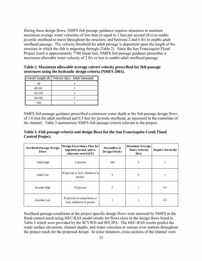
37
During these design flows, NMFS fish passage guidance requires structures to maintain maximum average water velocities of less than or equal to 1 foot per second (ft/s) to enable juvenile steelhead to move throughout the structure; and between 2 and 6 ft/s to enable adult steelhead passage. The velocity threshold for adult passage is dependent upon the length of the structure in which the fish is migrating through (Table 2). Since the San Francisquito Flood Project reach is approximately 7700 linear feet, NMFS fish passage guidance prescribes a maximum allowable water velocity of 2 ft/s or less to enable adult steelhead passage. Table 2. Maximum allowable average culvert velocity prescribed for fish passage structures using the hydraulic design criteria (NMFS 2001).
NMFS fish passage guidance prescribed a minimum water depth at the fish passage design flows of 1.0 foot for adult steelhead and 0.5 feet for juvenile steelhead, as measured in the centerline of the channel. Table 3 summarizes NMFS fish passage criteria relevant to the project. Table 3. Fish passage criteria and design flows for the San Francisquito Creek Flood Control Project.
Steelhead passage conditions at the project specific design flows were assessed by NMFS in the flood control reach using HEC-RAS model results for flows close to the design flows listed in Table 3 which were provided by the SCVWD and SFCJPA. The HEC-RAS results predict the water surface elevations, channel depths, and water velocities at various river stations throughout the project reach for the proposed design. In some instances, cross sections of the channel were
Steelhead Passage Design Flows
Design Exceedance Flow for migration period, unless
otherwise noted (EF)
Streamflow at Design EF(cfs)
Maximum Average Water Velocity
(ft/s)Depth Criteria (ft)
Adult High 5 percent 160 2 1
Adult Low95 percent or 3cfs, whichever is
greater.3 2 1
Juvenile High 50 percent 5 1 0.5
Juvenile Low95 percent on annual basis or
1cfs, whichever is greater1 1 0.5
38
provided to illustrate water surface elevation profiles in the reach at certain flows. NMFS requested HEC-RAS results for both the Mean Lower Low Water (MLLW) and Mean Higher High Water (MHHW) tidal stages. During the MHHW tide stage, tidal backwater extends upstream of the project reach creating suitable passage conditions for juveniles and adults. Tidal backwater also extends upstream of the project reach at the Mean Tide Level (MTL) and all the tidal stages between the MTL and MHHW. NMFS assumes the tidal backwater effect creates suitable fish passage conditions at all tidal stages between MTL and MHHW. This constitutes about 12 hours of the daily tidal cycle. During the lower end of the tidal cycle (between MLLW and MTL) tidal backwater extent varies between STA 2+27 and the upstream end of the project. This constitutes about 12 hours of the daily tidal cycle. Based on the HEC-RAS results, high design flow stream velocities will exceed the 2 ft/s velocity threshold at some locations during the lower tidal range (MLLW to MTL). To provide hydraulic breaks and resting areas for upstream migrating adult steelhead, the project has proposed the installation of five complex rootwad and boulder structures in the low flow channel between STA 28+97 and 46+07. An additional rock spur structure will also be installed at the downstream tip of Friendship Bridge Island. The rock spur structure will extend into the low flow channel and function as a partial weir. These features have been incorporated into the channel design to function as an analog for native historic velocity refuges and would also provide cover and other habitat benefits for adult and juvenile steelhead. These structures will be strategically placed to avoid excessively long reach(es) with relatively swift water velocities and no resting opportunities. As a result, adult steelhead are expected to ascend the flood control channel at the high design fish passage flow (5 percent exceedance flow) under all tidal conditions. For the upstream passage of juvenile steelhead, the high design flow stream velocities are anticipated to consistently exceed the 1 ft/s velocity threshold during the low tidal range. This may result in an excessively long reach(es) with relatively swift water velocities at high stream flows and no velocity refuge. Under low flow conditions during periods of low tide, water depths in the channel are not expected to meet the 0.5 ft criterion, and very shallow water depths could impede the movement of steelhead juveniles. However, at this downstream location in San Francisquito Creek, steelhead juveniles are anticipated to be primarily smolts and actively moving downstream. Upstream movement in this reach of stream is not essential since they have reached the tidally-influenced portion of San Francisquito Creek and they are generally committed at this stage to passing into San Francisco Bay, and subsequently the Pacific Ocean. The majority of smolts will likely be moving through the action area during periods of moderate and high flows in the spring when passage conditions are anticipated to be adequate for downstream passage to San Francisco Bay. Under low flow conditions, the alluvial reaches of San Francisquito Creek upstream of the action area experience very shallow depths and smolts will unlikely be descending into the project reach under these conditions. Therefore, the hydraulic and geomorphic conditions in the action area as a result of the Project are not expected to adversely affect smolt steelhead emigrating through the action area. For green sturgeon, NMFS did not conduct a fish passage assessment because sturgeon are not expected to ascend San Francisquito Creek. Adult and juvenile green sturgeon may enter and

39
depart the project reach during periods of high tide when adequate water depths allow sturgeon access into the project area. No impediments to the passage of green sturgeon in the action area are anticipated by project construction. 2.4.1.2. Dewatering and Fish Relocation To protect water quality, and avoid direct and indirect mortality of fishes from construction activities, SFCJPA will bypass stream flow around the work area and dewater the work site in areas where in-stream work occurs. The project will require channel dewatered during up to two consecutive dry seasons. A vast majority, if not all, of the water present during the summer months would be tidal waters. The SFCJPA will submit a final dewatering and fish relocation plan to NMFS and the Corps prior to construction. This plan will provide a detailed description of the methods that will be employed, individuals conducting the work, dewatering sites, and relocation sites. All construction will occur during the summer low-flow between June 15 and October 15. Stream flow diversions and dewatering is expected to cause temporary loss, alteration, and reduction of aquatic habitat, including critical habitat, in the action area. Dewatering activities could harm individual juvenile steelhead and green sturgeon by concentrating or stranding them in residual wetted areas (Cushman 1985) before they are relocated. Juvenile steelhead and green sturgeon could be killed or injured during dewatering activities, though direct mortality is expected to be minimal due to relocation efforts prior to installation of the bypass system. The proposed bypass system, which isolates the work areas to be dewatered; will allow stream flow in the San Francisquito Creek to continue flowing downstream. Before the project site is dewatered, a qualified biologist will capture fish and relocate them away from the project work site to avoid direct mortality and minimize possible impacts during project dewatering and construction of the work site. Fish in the immediate project area will be captured by seine and/or dip net, and then transported and released at an appropriate location. Electrofishing will not be used to capture fish due to potentially high salinity/conductivity levels in the tidal channel. Data to precisely quantify the amount of steelhead that will be relocated prior to construction are not available. However, based on the proposed timing of project construction, NMFS can narrow the life-history-stage to juvenile steelhead because in-channel work activities will occur during the summer low-flow period after emigrating steelhead smolts have left and before adult migration has been initiated. In addition, the project reach is tidally-influenced and the presence of juvenile steelhead during the summer months in this area is expected to be low. However, the areas to be de-watered for project construction are large and the project reach includes 1.5 miles of lower San Francisquito Creek. Therefore, the steelhead that are likely to be captured during relocation activities should not exceed 20 pre-smolting juveniles, each year of construction. Based on distribution data and foraging habits of green sturgeon, their occurrence in the action area is assumed to be rare. Therefore, no individual green sturgeon are anticipated to be captured during relocation activities, each year of construction. Fish capture and relocation activities pose a risk of injury or mortality to fish species. Fish collecting gear, whether passive (Hubert 1996) or active (Hayes et al. 1996) has some associated
40
risk to fish, including stress, disease transmission, injury, or death. The amount of unintentional injury and mortality attributable to fish capture varies widely depending on the method used, the ambient conditions, and the expertise and experience of the field crew. Since fish relocation activities will be conducted by qualified fisheries biologists, direct effects to and mortality of steelhead during capture are expected to be minimized. Data from years of similar salmonid relocation activities indicate that average mortality rate is below one percent (Jeffrey Jahn, NMFS, personal communication, November 2015). Based on this information, NMFS will use 2 percent as the maximum amount of mortality likely from fish relocation for the project, or no more than one fish, each year of construction. Fish collection is unlikely to be 100-percent effective at removing all individuals, but experienced biologists are expected to remove approximately greater than 95 percent of the fish present. Juvenile steelhead that evade capture and remain in the project area will likely be lost to desiccation or thermal stress during dewatering activities. This will result in the mortality of one steelhead, each year of construction. Fish encountered during dewatering will be relocated to a downstream or upstream location in similarly brackish conditions. Because the project is located adjacent to the San Francisco Bay, fish relocated downstream will have direct access to ample Bay habitats and adjacent fringe marshes. Fish relocated upstream may endure short-term stress from crowding at the relocation sites. Relocated fish may also have to compete with resident fish for available resources such as food and habitat. Some of the fish released at the relocation sites may choose not to remain in these areas and may move either upstream or downstream to areas that have more habitat and a lower density of fish. As each fish moves, competition remains either localized to a small area or quickly diminishes as fish disperse. NMFS cannot accurately estimate the number of fish affected by competition, but does not believe this impact will affect the survival chances of individual fish or cascade through the watershed population of these species based on the small area that will likely be affected and the small number of steelhead likely to be relocated. As a result, fish are not expected to experience crowding or any reductions in fitness from relocation. Another manner by which juvenile steelhead and green sturgeon may be harmed or killed during dewatering activities is to be entrained into pumps or discharge lines if these methods are used. To eliminate this risk, the SFCJPA will screen all pumps according to NMFS criteria, to ensure juvenile steelhead and green sturgeon will not be harmed by the pumps during dewatering events. Juvenile steelhead and green sturgeon foraging within the action area may be inadvertently affected by the loss of benthic aquatic macroinvertebrate production associated with construction disturbance. However, effects to aquatic macroinvertebrates resulting from dewatering will be temporary because construction activities will be limited to the summer period during two consecutive years, drift from upstream will continue through the bypass pipes, and rapid recolonization (about two to three months) of disturbed areas by macroinvertebrates is expected following construction (Cushman 1985; Harvey 1986; Thomas 1985). Furthermore, the project area is located in the tidally-influenced reach of San Francisquito Creek, so benthic aquatic organisms from San Francisco Bay are likely to rapidly recolonize the action area from sources downstream of the project area. Based on the foregoing, the temporary loss of aquatic

41
macroinvertebrates as a result of dewatering activities and channel disturbances is not expected to adversely affect juvenile steelhead or green sturgeon. 2.4.1.3. Construction Related Impacts on Water Quality Water Quality. In-stream and near-stream construction activities may cause temporary increases in turbidity (reviewed in Furniss et al. 1991, Everest et al. 1991, and Spence et al. 1996), reductions in dissolved oxygen, changes to pH, and other alterations in water quality. NMFS anticipates only short-term changes to ambient water quality conditions will occur during proposed activities (e.g., construction and removal of cofferdams and the initial re-wetting of the channel following the removal of the diversion). High concentrations of suspended sediment can disrupt normal feeding behavior and efficiency (Berg and Northcote 1985; Bjornn et al. 1977; Cordone and Kelley 1961), reduce growth rates (Crouse et al. 1981), and increase plasma cortisol levels (Servizi and Martens 1992). High turbidity concentrations can reduce dissolved oxygen in the water column, result in reduced respiratory functions, reduce tolerance to diseases, and can also cause fish mortality (Berg and Northcote 1985; Gregory and Northcote 1993; Sigler et al. 1984; Waters 1995). Even small pulses of turbid water will cause salmonids to disperse from established territories (Waters 1995), which can displace fish into less suitable habitat and/or increase competition and predation, decreasing chances of survival. The SFCJPA will ensure water quality during construction will meet RWQCB and SWRCB water quality standards by monitoring water quality at reference sites and works sites at regular time intervals and implementing BMPs (see Sections 1.3.6 and 1.3.9). Water quality will remain close to ambient conditions. These slight alterations to water quality may cause minor behavioral changes (Henley et al. 2000), but are not expected to result in injury or mortality (immediate or latent) of fish. Behavioral changes will likely materialize as fish temporarily vacating preferred habitat or temporarily reduced feeding efficiency. These temporary changes in behavior, may reduce growth rates, but are not likely to reduce the survival chances of individual juveniles. Water quality alteration is expected to be limited to the immediate area of construction activities plus varying distances up and downstream (depending on the tidal stage). Fish will be able to move from the areas where degraded water quality may occur to the ample Bay habitats and fringing tidal marshes nearby. Therefore, any short-term impacts associated with changes in water quality during implementation of this project are expected to be insignificant. Toxic Chemicals. Equipment refueling, fluid leakage, equipment maintenance, and road surfacing activities near the stream channel pose some risk of contamination of aquatic habitat and subsequent injury or death to listed salmonids. The SFCJPA and its contractors propose to maintain any and all fuel storage and refueling site in an upland location well away from the stream channel; that vehicles and construction equipment be in good working condition, showing no signs of fuel or oil leaks, and that any and all servicing of equipment be conducted in an upland location. For instream construction activities, NMFS does not anticipate any localized or appreciable water quality degradation from toxic chemicals or adverse effects to steelhead or green sturgeon associated with the proposed project, as the stream will be dewatered, giving the SFCJPA and its contractors ample opportunity to attend to any spill prior to toxic chemicals reaching the waters of San Francisquito Creek. NMFS anticipates proposed BMPs and responses
42
by the SFCJPA and its contractors to any accidental spill of toxic materials should be sufficient to restrict the effects to the immediate area and not enter the waterway. Therefore, any short-term impacts associated toxic chemicals during implementation of this project are expected to be insignificant.
Effects on Critical Habitat Designated critical habitat for Southern DPS green sturgeon and CCC steelhead occurs in the action area. The Project may impact designated critical habitat for these species by maintaining the existing condition of minimal natural cover, altering water quality, and temporarily reducing foraging habitat. 2.4.2.1. Natural Cover Tidal salt marsh vegetation is found throughout the action area. Tidal salt marsh habitat is primarily supported by tidal exchange. Dominant plant species in the tidal salt marsh community include Pacific cordgrass (Spartina foliosa), pickleweed, perennial peppergrass (Lepidium latifolium), gumplant (Grindelia stricta), and alkali heath (Frankenia salina). Narrow bands of brackish tidal marsh are present along a few-hundred-foot section of San Francisquito Creek downstream of East Bayshore Road. In the brackish marsh, bulrush (Schoenoplectus sp.) is the dominant species rather than cordgrass and pickleweed. Ruderal vegetation intergrades with salt marsh species along the levee banks. A total of 4.51 acres of tidal salt marsh vegetation will be impacted by construction of the Project. Impacts to tidal salt marsh are primarily from excavation of accumulated sediments on both sides of the channel and the relocation of approximately 1,100 feet of tidal channel. Excavation of sediments will result in the removal of 2.82 acres of tidal salt marsh vegetation. Additional tidal salt marsh vegetation will be removed for: creating roads for construction access (1.33 acres); filling in the low spot of the Faber Tract levee and improving the slope of the levee (0.35 acres); and degrading the Bay Levee (0.01 acres). After project construction is complete, the tidal marsh area would be terraced and revegetated with high-marsh plants appropriate to the elevation relative to tidal levels in accordance with the MMP for the Project (SFCJPA 2015c). Approximately 19,600 native wetland plants and cuttings are planned for installation. Plants will be sourced from the San Francisquito Creek watershed and Baylands areas. The SFCJPA also proposes to install 5 large debris jam structures within the channel to improve adult steelhead passage. These structures are anticipated to provide cover in the form of large woody debris and depth. Removal of tidal salt marsh vegetation during construction could temporarily reduce the amount of cover utilized by steelhead for protection from predators. The reduction of in-channel vegetation may also temporarily reduce invertebrates in the channel by limiting their food source or substrate in which they live. Similarly, by disturbing the bed and banks of the channel, sediment removal may bury aquatic insects that steelhead and green sturgeon feed on. Overhanging and submerged vegetation provides hiding cover (protection from predators) and disturbance for adult salmonids during their migrations (Bisson et al. 1987; Bjornn and Reiser 1991a). Removal of this vegetation exposes them to predation and disturbance. Furthermore,
43
removing vegetation has the potential to reduce the amount of velocity refuges available for adults and juveniles during high stream flow events.
NMFS expects the impacts on natural cover from construction of the Project will significantly reduce the already limited amount of natural cover for steelhead or green sturgeon until re-establishment of vegetation occurs. Installation of the debris jams will improve natural cover for fish within an approximate 2000 linear foot section of the channel. NMFS expects the impacts on natural cover will adversely affect PCEs of steelhead and green sturgeon for the short-term due to the large size of the construction area. Following vegetation reestablishment, PCEs and physical and biological features of critical habitat will be restored to near their current degraded state, and is expected to improve because of the increase in natural cover that will be provided by the debris jams. The Project proposes to construct the levees, channel, and marshplains to resemble its current condition which is degraded from its historical condition described in Section 2.3.1. Major re-routing of the lower reaches took place in the late 1920s, with levees constructed on both sides of the creek for flood control and development purposes (Hermstad 2009). Constriction of the marsh within a narrow corridor has led to the current condition of a simplified channel and homogenous marshplain, with no side channels, deep pools, or large woody debris to provide natural cover for fish. Installation of five debris jams will improve habitat complexity in the channel. Overall, NMFS believes the proposed Project will improve the current degraded condition of natural cover for steelhead and green sturgeon in the action area. Future maintenance activities will be limited to levee maintenance, vegetation management, and removal of trash and debris. Maintenance of the levee will employ best management practices to avoid impacts to the surrounding areas and channel. Ongoing maintenance that will be covered by the Project is expected to have minimal impacts on natural cover for steelhead and green sturgeon since the Project only proposes to remove vegetation along the levees. These activities will be located away from the channel, where steelhead and green sturgeon are expected to occur the majority of the time. Therefore, ongoing maintenance in the form of mowing vegetation along the levees is not expected to affect natural cover for steelhead or green sturgeon in the action area. 2.4.2.2. Water Quality The effects of the Project on water quality were discussed above in section 2.4.1.3 of this opinion and also apply to the critical habitat within the action area. As described above, the effects of the proposed project may result in increased levels of turbidity, reductions in dissolved oxygen, changes to pH, and other water quality alterations. NMFS does not expect the impacts on water quality will adversely affect PCEs and physical and biological features of steelhead or green sturgeon because alterations to water quality will be associated with construction activities which will be temporary. Water quality is expected to remain near ambient levels as a result of the SFCJPA implementing BMPs and monitoring water quality during construction.
44
2.4.2.3. Foraging The Project proposes to remove a significant amount of sediment and vegetation during excavation of the channel. Disturbance to benthic habitat from excavation will result in the direct removal of prey resources (e.g., entrained with sediment and vegetation) or the displacement of preferred forage species due to habitat disturbances. These impacts are expected to persist throughout the two-year construction timeframe and extend up to five years beyond the completion of the Project while vegetation is re-establishing. As described in Section 2.3.2.1 of this opinion, habitat in the action area is degraded and does not contain attributes that would likely support extended foraging by steelhead or green sturgeon. NMFS does not consider the action area a primary foraging site for green sturgeon or steelhead and the impacts incurred from the Project will not likely have a substantial impact on the current value of this habitat to steelhead or green sturgeon. Sturgeon and steelhead likely already use other areas in South San Francisco Bay as preferred foraging sites, and will continue to do so when project construction is completed. Nonetheless, the Project will result in significant alterations to marsh vegetation and the channel benthos for up to two years during construction and five years during marsh vegetation re-establishment. This is expected to reduce the amount of already degraded forage opportunities for green sturgeon during this time. After construction is complete and vegetation re-establishes, forage will likely return to current levels, and may slightly improve as a result of the Project’s channel widening in some locations and vegetation management and monitoring activities. Based on this information, NMFS concludes that Project is likely to reduce the quality of the PCEs and physical and biological features for green sturgeon and steelhead critical habitat within the action area over the short-term (seven years), with the potential for minor improvements to the quality of PCEs in the long-term. 2.5 Cumulative Effects “Cumulative effects” are those effects of future state or private activities, not involving Federal activities, that are reasonably certain to occur within the action area of the Federal action subject to consultation (50 CFR §402.02). Future Federal actions that are unrelated to the proposed action are not considered in this section because they require separate consultation pursuant to section 7 of the ESA.
Searsville Dam and Reservoir Searsville Dam and Reservoir are owned and operated by Stanford University on lower Corte Madera Creek approximately 12 mile upstream of the action area. Construction of Searsville Dam on lower Corte Madera Creek was completed in 1892 by Spring Valley Water Company, and in 1919 the reservoir and some surrounding property became part of the Stanford University. Searsville is a year-round water storage and diversion facility. Although Searsville Dam is upstream of the action area, sediment transported over the dam is predicted to affect the channel within the action area of this Project. Searsville Reservoir is rapidly filling with sediment due to historical and current episodes of erosion. Stanford is currently reviewing their potential future management options for Searsville Dam and Reservoir,

45
but Stanford has not identified a future course of action. In the absence of future actions by Stanford, the natural filling of Searsville Reservoir will continue until equilibrium between sediment inflow and sediment outflow is reached (Northwest Hydraulic Consultants et al. 2002). 2002). Once Searsville Reservoir fills with sediment, Northwest Hydraulic Consultants, Inc. (Northwest Hydraulic Consultants et al. 2002) predict bedload consisting primarily of sand will be transported over the dam for the first time in more than 100 years. The San Francisco District Corps of Engineers Water Resources Section evaluated what specific changes are expected to occur within the action area as a result of Searsville Dam filling with sediment (Corps 2011). The study used the predicted channel bed elevation changes from the (Northwest Hydraulic Consultants et al. 2002) study to model a “with-sediment” flow scenario in the action area. Northwest Hydraulic Consultants et al. (2002) predicted an average channel bed change of 1.24 feet from sediment deposition over a 70-year period. The Corps’ study results predict sediment deposition in the action area may increase flood flow depths by up to 1.5 feet in some locations of the action area during the 100-year flood event (Corps 2011). Deposition of sediment at this volume will not require sediment removal since the project has been designed to accommodate flow elevation increases associated with the predicted 1.24 foot average bed elevation increase. Periodic sediment removal at current baseline volumes is anticipated as a future maintenance need and will be conducted under the auspices of the SCVWD SMP. Information from SCVWD maintenance records shows removal of approximately 1,200 to 5,300 cubic yards of sediment from the project reach at variable intervals (1- 4 years) between 2000 and 2013. The cumulative effect of sediment originating from Searsville Reservoir could increase, from the current baseline, the frequency and volume of material periodically removed. However, per SCVWD’s SMP, sediment removal in San Francisquito Creek will not exceed 300 linear feet along the channel bed and will not exceed the maintenance baseline established by the relevant Maintenance Guidelines. If additional sediment is deposited with the flood channel reach during high flow events, additional sediment removal may be required to maintain the Project’s design flow conveyance capacity, yet it would not be covered under the Corps permit for this Project. Sediment removed by excavation of the channel per the SCVWD SMP is expected to disturb benthic habitat and result in the direct removal of prey resources (e.g., entrained with sediment and vegetation) or the displacement of preferred forage species due to habitat disturbances. However, excavation would occur in relatively small sections of the channel (300 linear feet or less) and be restricted to volumes similar to baseline excavation volumes. Since the project area is located in the tidally-influenced reach of San Francisquito Creek, benthic aquatic organisms from San Francisco Bay are expected to rapidly recolonize the action area from sources downstream following sediment excavation events. Juvenile steelhead and green sturgeon foraging within the action area may be inadvertently affected by the temporary loss of benthic aquatic macroinvertebrate production associated with disturbance by sediment removal activities; however the effect is not expected to be significant due to the localized and short-term nature of the impact, and that adequate foraging areas adjacent to the action area remain available and undisturbed.

46
Climate Change The long-term effects of climate change have been presented in the Section 2.3.2.3 - Factors Affecting Species Environment within San Francisquito Creek and the Action Area of this biological opinion. These include changes in streamflow regimes, water temperatures, and rainfall patterns. Climate change poses a threat to CCC steelhead and Southern DPS green sturgeon within the action area. The current climate in the action area is generally warm, and modeled regional average air temperatures show an increase in summer (Lindley et al. 2007) and greater heat waves (Hayhoe et al. 2004). The likely change in amount of rainfall in Northern and Central Coastal streams under various warming scenarios is less certain, total rainfall across the state is expected to decline. For the California North Coast, some models show large increases (75 to 200 percent) in precipitation while other models show decreases of 15 to 30 percent (Hayhoe et al. 2004). Sea level rise of 16 inches in San Francisco Bay could extend the area of tidal-influence in lower San Francisquito Creek upstream by approximately one mile and (BCDC 2007) convert portions of high marsh habitat (elevations of 0.2 to 0.3 meters) in the lower 0.5 mile of stream to mid marsh habitat (elevations of -0.2 to 0.1 meters) (Point Reyes Bird Observatory Conservation Science 2012). Steelhead rearing and migratory habitat are most at risk to climate change. Increasing water temperatures and changes in the amount and timing of precipitation will impact water quality, streamflow levels, and steelhead migration. Low and warm summer flow conditions will negatively affect juvenile steelhead growth and survival. The upstream migration of adult steelhead will be impeded by low stream conditions during winter months, as well as, excessively high streamflows during large winter precipitation events. Smolt outmigration may be constrained by fewer or lower spring high flow events. Climate change is also anticipated to result in further ocean acidification and changes in ocean prey availability (Feely et al. 2008; Portner and Knust 2007) which would also negatively impact adult steelhead in the marine environment. Overall, the range and degree of variability in ambient temperature and precipitation are likely to increase due to climate change, and these predictions further highlight the importance of providing suitable instream habitat diversity/complexity in the streams and estuaries where CCC steelhead DPS and southern DPS green sturgeon occur. 2.6 Integration and Synthesis The Integration and Synthesis section is the final step in our assessment of the risk posed to species and critical habitat as a result of implementing the proposed action. In this section, we add the effects of the action (section 2.4) to the environmental baseline (section 2.3) and the cumulative effects (section 2.5), taking into account the status of the species and critical habitat (section 2.2), to formulate the agency’s biological opinion as to whether the proposed action is likely to: (1) reduce appreciably the likelihood of both the survival and recovery of a listed species in the wild by reducing its numbers, reproduction, or distribution; or (2) reduce the value of designated or proposed critical habitat for the conservation of the species. CCC steelhead and southern DPS green sturgeon have experienced serious declines in abundance, and long-term population trends suggest a negative growth rate. Human-induced factors have reduced populations and degraded habitat, which in turn has reduced the

47
population’s resilience to natural events, such as droughts, floods, and variable ocean conditions. Global climate change presents another real threat to the long-term persistence of these populations, especially when combined with the current depressed population status and human caused impacts. Within the project’s action area in the effects of channelization and urban development are evident. These activities have contributed the lack of emergent marsh and reduced channel complexity (i.e., floodplain extent and side channels) in the action area. As a result, forage species that listed salmonids and green sturgeon depend on have been reduced, stream hydrology and hydraulics have been altered, and natural cover characteristic of intact complex tidal salt marshes (e.g., deep pools, side channels, and woody debris) have been eliminated. Construction of the Project will occur during two consecutive construction seasons between June 15 and October 15, when CCC steelhead juveniles may be present within the action area. Based on distribution data and foraging habits of green sturgeon, their occurrence in the action area is assumed to be rare. Therefore, no individual green sturgeon are anticipated to be encountered during dewatering and fish relocation activities. The Project has the potential to affect juvenile steelhead during construction through injury or mortality during fish capture and relocation, desiccation during dewatering, and degradation of water quality. The project has the potential to adversely impact natural cover, water quality, and forage features of CCC steelhead and southern DPS green sturgeon critical habitat. The Project proposes to build one simplified channel, with relatively narrow floodplains. Although most of the project reach will contain minimal structural complexity, the Project has proposed to construct six structures in the channel for the purpose of creating hydraulic velocity breaks which will serve as both resting areas for upstream migrating steelhead and provide instream cover. The general lack of channel complexity will resemble the current channel configuration, which is a product of historical flood control and development activities in the action area. The Project will slightly widen the flood control channel and recreate marshplains throughout the action area. These actions are expected to provide minor improvements to the current degraded habitat condition within the action area. The Project proposes to dewater and relocate juveniles steelhead from the action area prior to construction each season. Experienced fish biologists are expected to work effectively to collect and relocate juvenile steelhead. Based on the low mortality rates for similar dewatering and fish relocation efforts, NMFS anticipates few juvenile steelhead will be harmed or killed during implementation of this project. The maximum number of individuals likely to be encountered by the project over the two year construction window is 40 pre-smolting juvenile steelhead. Anticipated mortality from relocation activities are expected to not exceed two (2) percent of the total likely to be encountered each construction season (i.e., one individual juvenile steelhead each year). Fish that elude capture and remain in the project area during construction activities will likely be lost to thermal stress or crushed by heavy equipment, but this number is not expected to exceed five (5) percent of the fish within the area dewatered each construction season (i.e., one individual juvenile steelhead each year). In total, NMFS expects no more than four (4) juvenile steelhead will be harmed or killed by this project’s fish relocation and dewatering. Due to the relatively large number of juveniles produced by each spawning pair, steelhead spawning in the San Francisquito Creek watershed in future years are expected to

48
produce enough juveniles to replace the few that may be lost at the project site due to relocation and dewatering. It is unlikely that the small potential loss of juveniles by this project will impact future adult returns. During construction, water quality in the action area may be degraded through temporary increases in turbidity, reductions in dissolved oxygen, changes to pH, introduction of toxic chemicals, and other alterations to ambient water conditions. However, due to the implementation of BMPs these water quality alterations are not expected to occur at levels known to cause reductions in fitness to listed fish. Alterations to water quality during construction will be temporary and similar to the natural conditions typically encountered by listed fish (close to ambient conditions). Furthermore, steelhead will have been relocated from work sites and green sturgeon are not expected to be present during construction so their exposure to altered water quality conditions is unlikely. If fish do encounter water quality alterations, they will likely result in minor and temporary changes to fish behavior (i.e., avoidance), and are not expected to adversely affect green sturgeon or steelhead. The action area experienced major re-routing in the late 1920s, with levees constructed on both sides of the creek for flood control and development purposes (Hermstad 2009). Constriction of the marsh within a narrow corridor has led to the current condition of a simplified channel and homogenous marshplain, with no side channels, deep pools, or large woody debris to provide natural cover for fish. This has led to an overall degraded condition of PCEs and physical and biological features of green sturgeon and steelhead critical habitat. Construction of the Project will have short-term (two years) adverse impacts on critical habitat through the direct disturbance of benthic prey items, natural cover, water quality, and passage conditions. After project construction is complete, the tidal marsh area would be terraced and revegetated so construction impacts will dissipate within the five year vegetation reestablishment period. The SFCJPA also proposes to install five large debris jam structures within the channel to improve adult steelhead passage. These structures are anticipated to provide cover in the form of large woody debris and depth. Installation of the debris jams will improve natural cover for fish within an approximate 2000 linear foot section of the channel. Following vegetation reestablishment, PCEs and physical and biological features of critical habitat will be restored to near their current degraded state, and is expected to improve because of the increase in natural cover that will be provided by the debris jams. For steelhead, the action area serves as an essential migration corridor to and from one of the few remaining steelhead populations in tributaries to South San Francisco Bay. Migration for steelhead through the completed Project will be adequate, and may improve over current conditions by the addition of the instream wood structures. Also, the project will not reduce the ability of green sturgeon to move into and out of lower San Francisquito Creek. The Project’s impacts on forage, and cover features in the action area will result in temporary reduction in steelhead critical habitat value in the action area, yet because of its limited scope and duration, the impacts to critical habitat in the action area will not appreciably reduce the critical habitat value for CCC steelhead. The current ecological distribution of green sturgeon in the Bay suggests that the action area is not of prime importance for this species. NMFS anticipates no direct impact to green sturgeon

49
during construction of this project. The Project’s impacts to aquatic habitat will not result in an appreciable reduction in critical habitat value in the action area or at entire critical habitat designation scale for southern DPS green sturgeon. The cumulative effects of the operation of Searsville Dam and Reservoir are anticipated to affect CCC steelhead and designated critical habitat in the future in a manner similar to the present day impacts on steelhead and critical habitat in the action area. Sedimentation rates in the action area are only expected to increase slightly once Searsville Reservoir fills with sediment and the annual sediment loads from the upper watershed move past the reservoir to downstream reaches. The predicted changes in bed elevations (plus 1.24 feet) and flood elevations (plus 1.5 feet) within the action area as a result of the filling of Searsville Reservoir (Corps 2011) are not expected to appreciably reduce steelhead or green sturgeon critical habitat value within the action area. Regarding future climate change effects in the action area, California could be subject to higher average summer air temperatures and lower total precipitation levels. The Sierra Nevada snow pack may decrease by as much as 70 to 90 percent by the end of this century under the highest emission scenarios modeled. Reductions in the amount of precipitation would reduce streamflow levels in Northern and Central Coastal rivers. Estuaries may also experience changes in productivity due to changes in freshwater flows, nutrient cycling, and sediment amounts. For this project, construction would be completed no later than 2020 and the above effects of climate change are unlikely to be detected within that time frame. The short-term effects of project construction will have completely elapsed prior to these climate change effects. 2.7 Conclusion After reviewing and analyzing the current status of the listed species and critical habitat, the environmental baseline within the action area, the effects of the proposed action, any effects of interrelated and interdependent activities, and cumulative effects, it is NMFS’ biological opinion that the proposed action is not likely to jeopardize the continued existence of threatened CCC steelhead and threatened southern DPS green sturgeon or destroy or adversely modify their designated critical habitat. 2.8 Incidental Take Statement Section 9 of the ESA and Federal regulations pursuant to section 4(d) of the ESA prohibit the take of endangered and threatened species, respectively, without a special exemption. “Take” is defined as to harass, harm, pursue, hunt, shoot, wound, kill, trap, capture or collect, or to attempt to engage in any such conduct. “Harm” is further defined by regulation to include significant habitat modification or degradation that actually kills or injures fish or wildlife by significantly impairing essential behavioral patterns, including breeding, spawning, rearing, migrating, feeding, or sheltering (50 CFR §222.102). “Incidental take” is defined by regulation as takings that result from, but are not the purpose of, carrying out an otherwise lawful activity conducted by the Federal agency or applicant (50 CFR 402.02). Section 7(b)(4) and section 7(o)(2) provide that taking that is incidental to an otherwise lawful agency action is not considered to be

50
prohibited taking under the ESA if that action is performed in compliance with the terms and conditions of this incidental take statement.
Amount or Extent of Take
The number of threatened CCC steelhead that may be incidentally taken during project activities is expected to be small, and limited to the juvenile (pre-smolt) life stage. Take is anticipated to occur during fish relocation and dewatering of construction reaches within the action area between June 15 and October 15 over two years of construction. The number of juvenile steelhead relocated during project construction is anticipated to be no more than 20 per year (40 for the entire two years of construction), and no more than two juvenile steelhead are expected to be injured or killed each year (4 for the entire two years of construction) during fish relocation and dewatering activities.
If more than 40 juvenile steelhead are captured, or more than 4 juvenile steelhead are injured or killed, incidental take will have been exceeded.
Based on distribution data and foraging habits of green sturgeon, their occurrence in the action area is assumed to be rare and no take of southern DPS green sturgeon is anticipated from the Project.
Effect of the Take In the biological opinion, NMFS determined that the amount or extent of anticipated take, coupled with other effects of the proposed action, is not likely to result in jeopardy to the species or destruction or adverse modification of critical habitat.
Reasonable and Prudent Measures “Reasonable and prudent measures” are nondiscretionary measures that are necessary or appropriate to minimize the impact of the amount or extent of incidental take (50 CFR 402.02). 1. Ensure construction methods, minimization measures, operations and maintenance, and
monitoring are properly implemented within the action area. 2. Ensure the steelhead habitat complexity features are designed in a manner that provide
adequate resting and holding areas for steelhead migrants. 3. Undertake measures to ensure that harm and mortality to steelhead resulting from fish
relocation and dewatering activities is low. 4. Prepare and submit a report to document effects of construction and relocation activities
and performance. 5. Monitor and evaluate the performance of the habitat elements (RPM #2), revegetation,
and channel morphology components of the project.

51
6. Prepare and submit reports to document the performance of habitat elements (RPM #2),
revegetation, and channel morphology components of the project.
Terms and Conditions The terms and conditions described below are non-discretionary, and the Corps or any applicant must comply with them in order to implement the reasonable and prudent measures (50 CFR §402.14). The Corps or any applicant has a continuing duty to monitor the impacts of incidental take and must report the progress of the action and its impact on the species as specified in this incidental take statement (50 CFR §402.14). If the entity to whom a term and condition is directed does not comply with the following terms and conditions, protective coverage for the proposed action would likely lapse. All plans and reports mentioned below must be submitted to: NMFS North-Central Coast Office Attention: San Francisco Bay Branch Chief, 777 Sonoma Avenue, Room 325, Santa Rosa, California 95404-6528. 1. The following terms and conditions implement reasonable and prudent measure 1:
a. The permittees must submit the Project’s Final Operations and Maintenance
Manual and Mitigation and Monitoring Plan for review and approval at least 90 days prior to construction of the Project.
b. The SFCJPA will allow any NMFS employee(s) or any other person(s) designated by NMFS, to accompany field personnel to visit the project sites during construction activities described in this biological opinion.
c. If any ESA-listed fish are found dead or injured, the biologist shall contact NMFS
biologist Amanda Morrison to review the activities resulting in take and to determine if additional protective measures are required. All ESA-listed fish mortalities shall be retained, placed in an appropriately-sized sealable plastic bag, labeled with the date and location of collection, fork length measured, and be frozen as soon as possible. Frozen samples shall be retained by the biologist until specific instructions are provided by NMFS. The biologist may not transfer biological samples to anyone other than the NMFS North-Central Coast Office without obtaining prior written approval from the North-Central Coast Office, San Francisco Bay Branch Chief. Any such transfer will be subject to such conditions as NMFS deems appropriate.
2. The following terms and conditions implement reasonable and prudent measure 2:
a. The permittees must submit the Project’s 60 percent and 90 percent design plans for steelhead habitat features (i.e., debris jams and rock weir) to NMFS for review and approval at least 90 days prior to the initiation of construction of the Project.

52
3. The following terms and conditions implement reasonable and prudent measure 3: a. The permittees must submit the Project’s Final Dewatering and Fish Relocation
Plan(s) for review and approval at least 90 days prior to construction of each phase. The Plan(s) must clearly identify the proposed cofferdam locations and fish relocation methods.
b. All screens used on equipment meant to divert flows must be screened in
accordance with the NMFS Fish Screening Criteria for Anadromous Salmonids [available at: http://swr.nmfs.noaa.gov/hcd/fishscrn.pdf] and the Addendum for Juvenile Fish Screen Criteria for Pump Intakes [available at: http://swr.nmfs.noaa.gov/hcd/pumpcrit.pdf].
c. The SFCJPA shall retain a qualified biologist with expertise in the areas of
anadromous fish biology, including handling, collecting, and relocating salmonids and green sturgeon; salmonid and green sturgeon habitat relationships; and biological monitoring of salmonids and green sturgeon. The Corps shall ensure that all biologists working on this project be qualified to conduct fish collections in a manner which minimizes all potential risks to ESA-listed fish.
d. A qualified biologist shall monitor the construction site during placement and
removal of flow diversions and cofferdams to ensure that any adverse effects to steelhead and green sturgeon are minimized. The biologist shall be on site during all dewatering events to ensure that all ESA-listed fish are captured, handled, and relocated safely. The biologist shall notify NMFS biologist Amanda Morrison at (707) 575-6083 or [email protected] one week prior to capture activities in order to provide an opportunity for NMFS staff to observe the activities.
e. ESA-listed fish shall be handled with extreme care and kept in water to the
maximum extent possible during relocation activities. All captured fish shall be kept in cool, shaded, aerated water protected from excessive noise, jostling, or overcrowding any time they are not in the stream and fish shall not be removed from this water except when released. To avoid predation, the biologist shall have at least two containers and segregate young-of-year fish from larger age-classes and other potential aquatic predators. Captured steelhead and green sturgeon must be relocated, as soon as possible, to a suitable in-stream or estuary location in which suitable habitat conditions are present and similar to capture sites to allow for adequate survival of transported fish and fish already present.
f. If any ESA-listed fish are found dead or injured, the SFCJPA must implement
Term and Condition 1.c. listed above.

53
4. The following terms and conditions implement reasonable and prudent measure 4: a. The Corps and SFCJPA must provide a written report to NMFS by January 15 of
each year following completion of the previous year’s construction and fish relocation activities. The report must contain, at a minimum, the following information:
(1) Construction related activities. The report must include the dates construction
began and was completed; photographs taken before, during, and after the activity from photo reference points; a discussion of any unanticipated effects or unanticipated levels of effects on ESA-listed fish and their habitat, a description of any and all measures taken to minimize those unanticipated effects and a statement as to whether or not the unanticipated effects had any effect on ESA-listed fish or designated critical habitat; and, the number of ESA-listed fish killed or injured during the project action.
(2) Fish Relocation. The report must include a description of the location from which
fish were removed and the release site including photographs; the date and time of the relocation effort; a description of water quality at release sites at the time of release, including, at a minimum, water temperature and dissolved oxygen levels; a description of the equipment and methods used to collect, hold, and transport ESA-listed fish; the number of fish relocated by species; the number of fish injured or killed by species and a brief narrative of the circumstances surrounding ESA-listed fish injuries or mortalities; and a description of any problems which may have arisen during the relocation activities and a statement as to whether or not the activities had any unforeseen effects.
5. The following terms and conditions implement reasonable and prudent measure 5:
a. The SFCJPA must conduct annual inspections of the Project by November of
each year that evaluate the performance of fish habitat elements, vegetation re-establishment, and channel design performance as it relates to fish passage conditions, in addition to other elements inspected per the Project’s Mitigation and Monitoring and Operations and Maintenance Plans.
6. The following terms and conditions implement reasonable and prudent measure 6: a. The Corps and SFCJPA must provide a written report to NMFS by February 1 of
each year on the results of annual inspections. The report must include a discussion on the performance of fish habitat elements and channel design performance as it relates to fish passage conditions; a discussion of any unanticipated effects to fish passage or critical habitat; and a description of potential measures that will be taken to mitigate those effects.

54
2.9 Conservation Recommendations Section 7(a)(1) of the ESA directs Federal agencies to use their authorities to further the purposes of the ESA by carrying out conservation programs for the benefit of the threatened and endangered species. Specifically, conservation recommendations are suggestions regarding discretionary measures to minimize or avoid adverse effects of a proposed action on listed species or critical habitat or regarding the development of information (50 CFR 402.02). NMFS has no Conservation Recommendations. 2.10 Reinitiation of Consultation This concludes formal consultation for San Francisquito Creek Flood Reduction, Ecosystem Restoration, and Recreation Project. As 50 CFR 402.16 states, reinitiation of formal consultation is required where discretionary Federal agency involvement or control over the action has been retained or is authorized by law and if: (1) the amount or extent of incidental taking specified in the incidental take statement is exceeded, (2) new information reveals effects of the agency action that may affect listed species or critical habitat in a manner or to an extent not considered in this opinion, (3) the agency action is subsequently modified in a manner that causes an effect to the listed species or critical habitat that was not considered in this opinion, or (4) a new species is listed or critical habitat designated that may be affected by the action.
3. MAGNUSON-STEVENS FISHERY CONSERVATION AND MANAGEMENT ACT ESSENTIAL FISH HABITAT CONSULTATION
Section 305(b) of the MSA directs Federal agencies to consult with NMFS on all actions or proposed actions that may adversely affect EFH. The MSA (section 3) defines EFH as “those waters and substrate necessary to fish for spawning, breeding, feeding, or growth to maturity.” Adverse effect means any impact that reduces quality or quantity of EFH, and may include direct or indirect physical, chemical, or biological alteration of the waters or substrate and loss of (or injury to) benthic organisms, prey species and their habitat, and other ecosystem components, if such modifications reduce the quality or quantity of EFH. Adverse effects on EFH may result from actions occurring within EFH or outside of it and may include site-specific or EFH-wide effects, including individual, cumulative, or synergistic consequences of actions (50 CFR 600.810). Section 305(b) also requires NMFS to recommend measures that can be taken by the action agency to conserve EFH. This analysis is based, in part, on the EFH assessment provided by the Corps and descriptions of EFH for Pacific coast groundfish (PFMC 2005), coastal pelagic species (PFMC 1998), and Pacific coast salmon (PFMC 1999) contained in the fishery management plans (FMP) developed by the Pacific Fishery Management Council and approved by the Secretary of Commerce. 3.1 Essential Fish Habitat Affected by the Project Effects of the proposed project will effect EFH for various federally managed fish species within the Pacific Coast Groundfish (PFMC 2005), Pacific Coast Salmon (PFMC 1999), and Coastal
55
Pelagic Species (PFMC 1998) FMPs. Furthermore, the project area is located in a Habitat Area of Particular Concern for various federally managed fish species within the Pacific Coast Groundfish FMP. 3.2 Adverse Effects on Essential Fish Habitat Adverse effects to EFH for coastal pelagic species and Pacific groundfish will occur through (1) altered water quality, and (2) disturbance of benthic biological community, including removal of prey, and physical habitat. No adverse effects to EFH for Pacific salmon are anticipated.
Water Quality As described in sections 2.4.1.3 and 2.4.2.2 of the biological opinion, in-stream and near-stream construction activities may cause temporary increases in turbidity (reviewed in Everest et al. 1991; Furniss et al. 1991; Spence et al. 1996), reductions in dissolved oxygen, changes to pH, and other alterations in water quality. NMFS anticipates only short-term changes to ambient water quality conditions will occur during proposed activities (e.g., construction and removal of cofferdams and the initial re-wetting of the channel following the removal of the diversion). The SFCJPA will ensure water quality during construction will meet SFRWQCB and SWRCB water quality standards through monitoring and implementing BMPs (see Sections 1.3.6 and 1.3.9). Water quality will remain close to ambient conditions. Water quality alteration is expected to be limited to the immediate area of construction activities plus varying distances up and downstream (depending on the tidal stage). It is expected that fish species encountering the altered water quality conditions will react behaviorally and either move away from or avoid them. These effects are expected to be temporary and there is ample area for fish to move to near the action area.
Benthic disturbance As described in Section 2.4.2.3 of the opinion, the Project proposes to remove a significant amount of sediment and vegetation during project construction. Disturbance to benthic habitat from excavation will result in the direct removal of prey resources (e.g., entrained with sediment and vegetation) or the displacement of preferred forage species due to habitat disturbances. These impacts are expected to persist throughout the two-year construction timeframe and extend up to five years beyond the completion of the Project while vegetation is re-establishing. The Project would result in benthic disturbance and potential removal of invertebrate prey within 4.5 acres of tidal salt marsh habitat from sediment removal and 2.4 acres of bay waters from channel realignment, for a total of 6.9 acres of soft substrate habitat. EFH species managed under the Coastal Pelagics and Pacific Groundfish FMPs forage on infaunal and bottom-dwelling organisms, such as polychaete worms and crustaceans. Excavation and dredging activities can adversely affect the benthic invertebrate community by directly removing or burying these organisms (Newell 2002; Van der Veer et al. 1985). The Project is likely to result in the temporary loss of EFH prey organisms due to construction activities.

56
Recolonization studies suggest that recovery (generally meaning the later phase of benthic community development after disturbance when species that inhabited the area prior to disturbance begin to re-establish) may not be quite as straightforward, and can be regulated by physical factors including particle size distribution, currents, and compaction/stabilization processes following disturbance. Rates of recovery listed in the literature range from several months to several years for estuarine muds (Currie and Parry 1996; McCauley et al. 1977; Tuck et al. 1998; Watling et al. 2001) to up to 2 to 3 years for sands and gravels (Gilkinson et al. 2005; Oliver et al. 1977; Reish 1961; Thrush 2002; Thrush et al. 1995; Watling et al. 2001). Thus, forage resources for fish that feed on the benthos may be substantially reduced before recovery is achieved. Based on available literature, NMFS will assume full recovery of prey resources will exceed one year following construction. Additionally, the act of removing sediments and the associated biotic assemblages during construction of the Project creates an area of disturbance that is extremely susceptible to recolonization by invasive species, often resulting in the displacement of native species. As a result, the Project may result in the increased distribution and abundance of invasive species in the action area, which in turn would reduce the amount of native prey resources available to coastal pelagic species and groundfish in the action area. 3.3 Essential Fish Habitat Conservation Recommendation To compensate for the temporal effects of benthic disturbance on 6.9 acres of soft bottom substrate during two years of construction and for an additional period of year or longer following construction, NMFS recommends the SFCJPA: (1) provide funding to an ongoing restoration project; (2) purchase credits from a conservation/mitigation bank; and/or (3) implement a new restoration project.
For any compensatory mitigation, the habitat replacement should be “in-kind”, such that the replacement habitat value is equal to, or greater than, pre-project habitat value. Determination of habitat replacement value should be based on the contribution of that habitat to the support of species and vegetation affected by the proposed project and be determined in coordination with NMFS.
Compensatory mitigation should occur on-site at an one-to-one mitigation ratio (e.g., 15 acres restored:15 acres impacted) or off-site at a three-to-one mitigation ratio (e.g., 45 acres restored:15 acres impacted) and should be habitat replacement in-kind. Ratios greater than one-to-one to account for temporal losses, uncertainty of performance, and differences in functions or values in replacement habitats outside of the action area.
The amount of credits purchased from a conservation/mitigation bank should be equal to a three-to-one ratio, or greater, and should result in habitat replacement in-kind. If the credit system for a bank is not expressed and measured in the same manner as the impacts of proposed project, the SFCJPA should confer with NMFS to determine an acceptable amount of credits to be purchased. The amount of monies provided to a restoration project should be sufficient to fund one-to-one habitat restoration for projects in South San Francisco Bay, or three-to-one at off-site restoration sites.
57
Fully implementing this EFH conservation recommendation would avoid, minimize, or offset the adverse effects described in section 3.2, above, to approximately 6.9 acres of designated EFH for Pacific coast groundfish, and coastal pelagic species. 3.4 Statutory Response Requirement As required by section 305(b)(4)(B) of the MSA, the Corps must provide a detailed response in writing to NMFS within 30 days after receiving an EFH Conservation Recommendation. Such a response must be provided at least 10 days prior to final approval of the action if the response is inconsistent with any of NMFS’ EFH Conservation Recommendations unless NMFS and the Federal agency have agreed to use alternative time frames for the Federal agency response. The response must include a description of measures proposed by the agency for avoiding, mitigating, or offsetting the impact of the activity on EFH. In the case of a response that is inconsistent with the Conservation Recommendations, the Federal agency must explain its reasons for not following the recommendations, including the scientific justification for any disagreements with NMFS over the anticipated effects of the action and the measures needed to avoid, minimize, mitigate, or offset such effects (50 CFR §600.920 (k)(l)). In response to increased oversight of overall EFH program effectiveness by the Office of Management and Budget, NMFS established a quarterly reporting requirement to determine how many conservation recommendations are provided as part of each EFH consultation and how many are adopted by the action agency. Therefore, we ask that in your statutory reply to the EFH portion of this consultation, you clearly identify the number of conservation recommendations accepted. 3.5 Supplemental Consultation The Corps must reinitiate EFH consultation with NMFS if the proposed action is substantially revised in a way that may adversely affect EFH, or if new information becomes available that affects the basis for NMFS’ EFH Conservation Recommendations (50 CFR §600.920 (l)). 4. DATA QUALITY ACT DOCUMENTATION AND PRE-DISSEMINATION REVIEW
The Data Quality Act (DQA) specifies three components contributing to the quality of a document. They are utility, integrity, and objectivity. This section of the opinion addresses these DQA components, documents compliance with the DQA, and certifies that this opinion has undergone pre-dissemination review. 4.1 Utility Utility principally refers to ensuring that the information contained in this consultation is helpful, serviceable, and beneficial to the intended users. The intended users of this opinion are the Corps. Other interested users could include the SFCJPA, SCVWD, USFWS, BCDC, and the SWQCB. Individual copies of this opinion were provided to the Corps. This opinion will be
58
posted on the Public Consultation Tracking System web site (https://pcts.nmfs.noaa.gov/pcts-web/homepage.pcts). The format and naming adheres to conventional standards for style. 4.2 Integrity This consultation was completed on a computer system managed by NMFS in accordance with relevant information technology security policies and standards set out in Appendix III, ‘Security of Automated Information Resources,’ Office of Management and Budget Circular A-130; the Computer Security Act; and the Government Information Security Reform Act. 4.3 Objectivity Information Product Category: Natural Resource Plan Standards: This consultation and supporting documents are clear, concise, complete, and unbiased; and were developed using commonly accepted scientific research methods. They adhere to published standards including the NMFS ESA Consultation Handbook, ESA regulations, 50 CFR 402.01 et seq., and the MSA implementing regulations regarding EFH, 50 CFR 600. Best Available Information: This consultation and supporting documents use the best available information, as referenced in the References section. The analyses in this opinion and EFH consultation contain more background on information sources and quality. Referencing: All supporting materials, information, data and analyses are properly referenced, consistent with standard scientific referencing style. Review Process: This consultation was drafted by NMFS staff with training in ESA and MSA implementation and reviewed in accordance with West Coast Region ESA quality control and assurance processes.

59
5. FIGURES
Figure 1. Map showing general location of the Project.
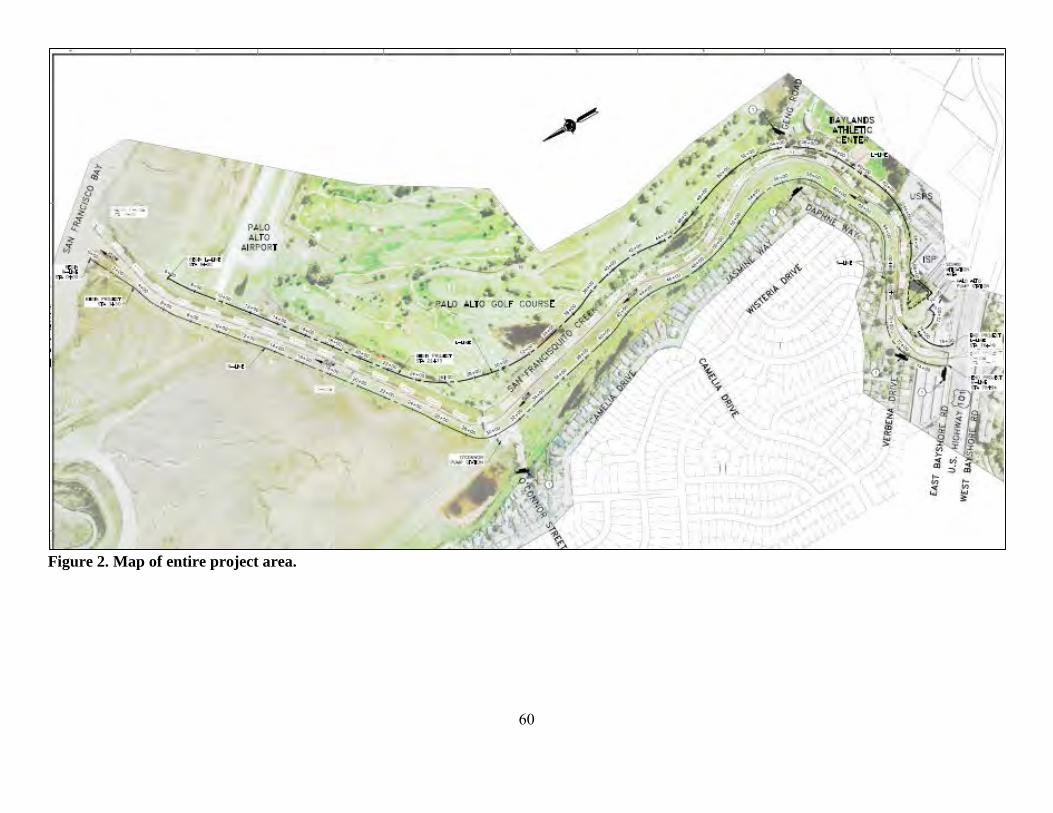
60
Figure 2. Map of entire project area.
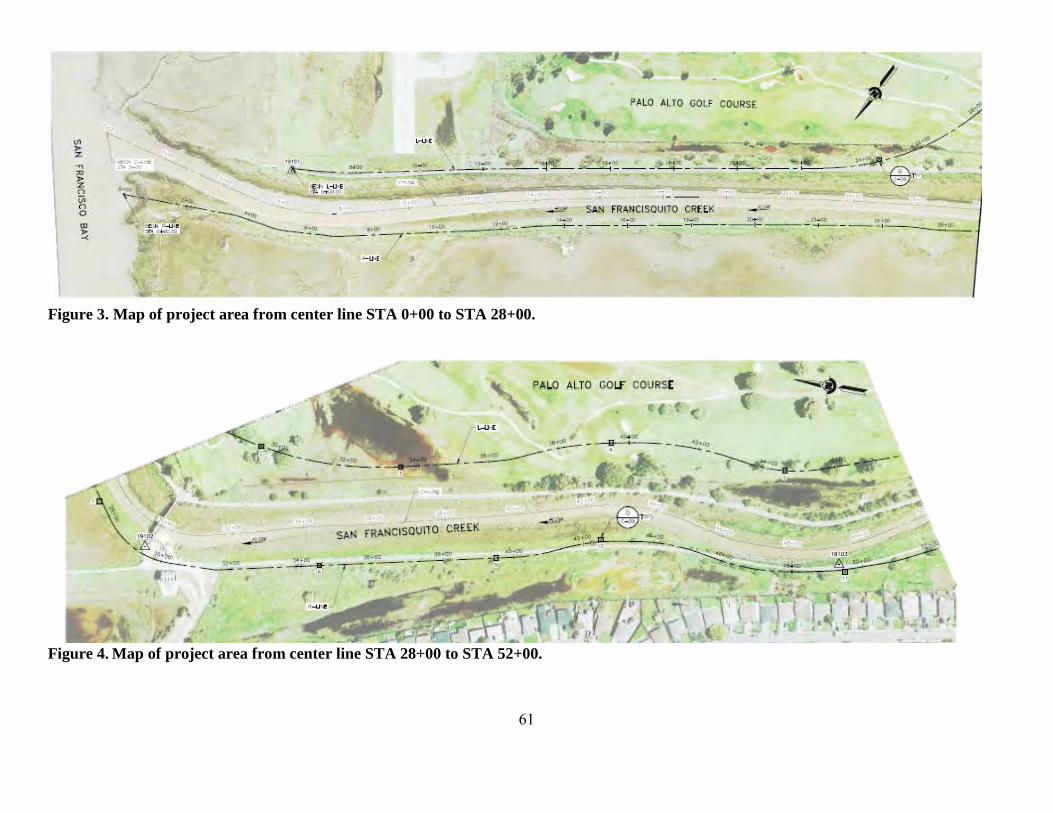
61
Figure 3. Map of project area from center line STA 0+00 to STA 28+00.
Figure 4. Map of project area from center line STA 28+00 to STA 52+00.
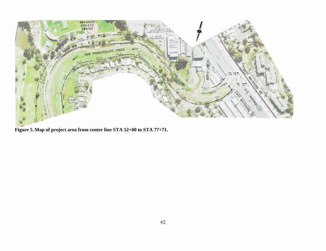
62
Figure 5. Map of project area from center line STA 52+00 to STA 77+71.

63
6. REFERENCES Adams, P. B., C. B. Grimes, J. E. Hightower, S. T. Lindley, and M. L. Moser. 2002. Status
Review for North American Green Sturgeon, Acipenser medirostris. NMFS, SWFSC, USGS, North Carolina State University, NWFSC, Santa Cruz, Raleigh, Seattle.
Adams, P. B., and coauthors. 2007. Population status of North American green sturgeon
Acipenser medirostris. Environmental Biology of Fishes 79:339-356. Allen, P. J., and J. J. Cech. 2007. Age/size effects on juvenile green sturgeon, Acipenser
medirostris, oxygen consumption, growth, and osmoregulation in saline environments. Environmental Biology of Fishes 79:211-229.
Barnhart, R. A. 1986. Species Profiles: Life Histories and Environmental Requirements of
Coastal Fishes and Invertebrates (Pacific Southwest), 82(11.60). Berg, L., and T. G. Northcote. 1985. Changes in territorial, gill-flaring, and feeding behavior in
juvenile coho salmon (Oncorhynchus kisutch) following short-term pulses of suspended sediment. Canadian Journal of Fisheries and Aquatic Sciences 42:1410-1417.
Bilby, R. E., B. R. Fransen, and P. A. Bisson. 1996. Incorporation of nitrogen and carbon from
spawning coho salmon into the trophic system of small streams: evidence from stable isotopes. Canadian Journal of Fisheries and Aquatic Sciences 53:164-173.
Bilby, R. E., B. R. Fransen, P. A. Bisson, and J. K. Walter. 1998. Response of juvenile coho
salmon (Oncorhynchus kisutch) and steelhead (Oncorhynchus mykiss) to the addition of salmon carcasses to two streams in southwestern Washington, U. S. A. Canadian Journal of Fisheries and Aquatic Sciences 55:1909-1918.
Bisson, P. A., and R. E. Bilby. 1982. Avoidance of suspended sediment by juvenile coho salmon.
North American Journal of Fisheries Management 2(4):371-374. Bisson, P. A., and coauthors. 1987. Large woody debris in forested steams in the Pacific
northwest: past, present, and future. E. O. Salo, and T. W. Cundy, editors. Streamside management: forestry and fishery interactions, volume Chapter five. University of Washington, Seattle, WA.
Bjorkstedt, E. P., and coauthors. 2005. An analysis of historical population structure for
evolutionarily significant units of Chinook salmon, coho salmon, and steelhead in the north-central California coast recovery domain. U.S. Department of Commerce, National Marine Fisheries Service, Southwest Fisheries Science Center, NOAA Technical Memorandum, NMFS-SWFSC-382, Santa Cruz, CA.
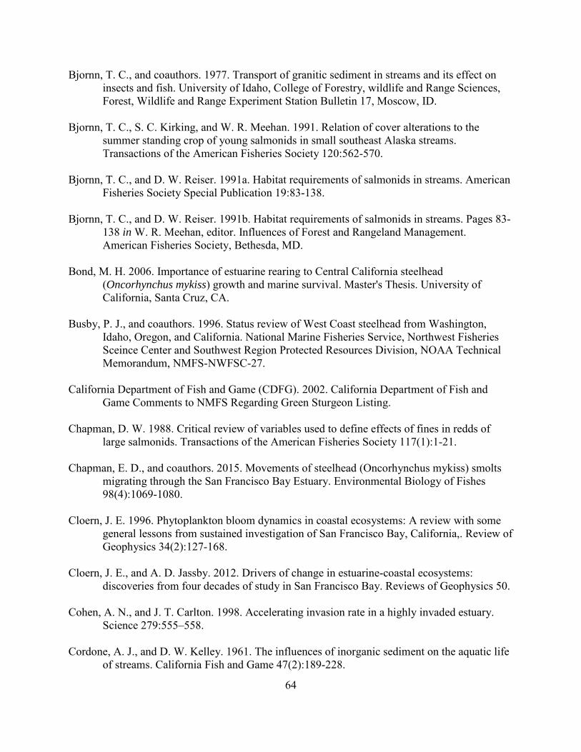
64
Bjornn, T. C., and coauthors. 1977. Transport of granitic sediment in streams and its effect on insects and fish. University of Idaho, College of Forestry, wildlife and Range Sciences, Forest, Wildlife and Range Experiment Station Bulletin 17, Moscow, ID.
Bjornn, T. C., S. C. Kirking, and W. R. Meehan. 1991. Relation of cover alterations to the
summer standing crop of young salmonids in small southeast Alaska streams. Transactions of the American Fisheries Society 120:562-570.
Bjornn, T. C., and D. W. Reiser. 1991a. Habitat requirements of salmonids in streams. American
Fisheries Society Special Publication 19:83-138. Bjornn, T. C., and D. W. Reiser. 1991b. Habitat requirements of salmonids in streams. Pages 83-
138 in W. R. Meehan, editor. Influences of Forest and Rangeland Management. American Fisheries Society, Bethesda, MD.
Bond, M. H. 2006. Importance of estuarine rearing to Central California steelhead
(Oncorhynchus mykiss) growth and marine survival. Master's Thesis. University of California, Santa Cruz, CA.
Busby, P. J., and coauthors. 1996. Status review of West Coast steelhead from Washington,
Idaho, Oregon, and California. National Marine Fisheries Service, Northwest Fisheries Sceince Center and Southwest Region Protected Resources Division, NOAA Technical Memorandum, NMFS-NWFSC-27.
California Department of Fish and Game (CDFG). 2002. California Department of Fish and
Game Comments to NMFS Regarding Green Sturgeon Listing. Chapman, D. W. 1988. Critical review of variables used to define effects of fines in redds of
large salmonids. Transactions of the American Fisheries Society 117(1):1-21. Chapman, E. D., and coauthors. 2015. Movements of steelhead (Oncorhynchus mykiss) smolts
migrating through the San Francisco Bay Estuary. Environmental Biology of Fishes 98(4):1069-1080.
Cloern, J. E. 1996. Phytoplankton bloom dynamics in coastal ecosystems: A review with some
general lessons from sustained investigation of San Francisco Bay, California,. Review of Geophysics 34(2):127-168.
Cloern, J. E., and A. D. Jassby. 2012. Drivers of change in estuarine-coastal ecosystems:
discoveries from four decades of study in San Francisco Bay. Reviews of Geophysics 50. Cohen, A. N., and J. T. Carlton. 1998. Accelerating invasion rate in a highly invaded estuary.
Science 279:555–558. Cordone, A. J., and D. W. Kelley. 1961. The influences of inorganic sediment on the aquatic life
of streams. California Fish and Game 47(2):189-228.
65
Cox, P., and D. Stephenson. 2007. A changing climate for prediction. Science 113:207-208. Crouse, M. R., C. A. Callahan, K. W. Malueg, and S. E. Dominguez. 1981. Effects of fine
sediments on growth of juvenile coho salmon in laboratory streams. Transactions of the American Fisheries Society 110:281-286.
Currie, D. R., and G. D. Parry. 1996. Effects of scallop dredging on a soft sediment community:
A large-scale experimental study. Marine Ecology Progress Series 134(1-3):131-150. Cushman, R. M. 1985. Review of ecological effects of rapidly varying flows downstream from
hydroelectric facilities. North American Journal of Fisheries Management 5(330-339). D.W. Alley and Associates. 2004. Report of construction monitoring leading to isolation of
construction sites and fish capture/relocation of San Francisquito Creek at the Sand Hill Road Bridge and the golf cart crossing in the Stanford Golf Course, June 4-September 2, 2004.
Davies, K. F., C. Gascon, and C. R. Margules. 2001. Habitat fragmentation: consequences,
management, and future research priorities. Island Press, Washington, D.C. Dumbauld, B. R., D. L. Holden, and O. P. Langness. 2008. Do sturgeon limit burrowing shrimp
populations in Pacific Northwest estuaries. Environmental Biology of Fishes 83:283-296. Everest, F. H., and coauthors. 1987. Fine sediment and salmonid production: A paradox. Forestry
and Fishery Interactions:98-142. Everest, F. H., J. R. Dedell, G. H. Reeves, and M. D. Bryant. 1991. Planning and Evaluating
Habitat Projects for Anadromous Salmonids. American Fisheries Society Symposium 10:68-77.
Feely, R. A., C. L. Sabine, J. M. Hernandez-Ayon, D. Ianson, and B. Hales. 2008. Evidence for
Upwelling of Corrosive "Acidified" Water onto the Continental Shelf. Science 320(5882):1490-1492.
Fukushima, L., and E. W. Lesh. 1998. Adult and juvenile anadromous salmonid migration timing
in California streams. California Fish and Game 84(3):133-145. Furniss, M. J., T. D. Roelofs, and C. S. Yee. 1991. Road construction and maintenance. Pages
297-324 in W. R. Meehan, editor. Influences of forest and rangeland management on salmonid fishes and their habitats. American Fisheries Society Special Publication 19, Bethesda, MD.
Gilkinson, K. D., and coauthors. 2005. Immediate impacts and recovery trajectories of
macrofaunal communities following hydraulic clam dredging on Banquereau, eastern Canada. ICES J. Mar. Sci. 62:925-947.

66
Good, T. P., R. S. Waples, and P. B. Adams. 2005. Updated status of federally listed ESUs of West Coast salmon and steelhead. U.S. Department of Commerce, NOAA Technical Memorandum NMFS-NWFSC-66.
Gregory, R. S., and T. G. Northcote. 1993. Surface, planktonic, and benthic foraging by juvenile
Chinook salmon (Oncorhynchus tshawytscha) in turbid laboratory conditions. Canadian Journal of Fisheries and Aquatic Sciences 50:233–240.
Gresh, T., J. Lichatowich, and P. Schoonmaker. 2000. An estimation of historic and current
levels of salmon production in the northeast Pacific ecosystem: evidence of a nutrient deficit in the freshwater systems of the Pacific Northwest. Fisheries 25(1):15-21.
Hanson, L. C. 1993. The Foraging Ecology of the Harbor Seal, Phoca vitulina, and the California
Sea Lion, Zalophus Californianus, at the Mouth of the Russian River, California. Master's Thesis. Sonoma State University, Cotati, California.
Harvey, B. C. 1986. Effects of Suction Gold Dredging on Fish and Invertebrates in Two
California Streams. North American Journal of Fisheries Management 6(3):401-409. Hayes, J. P., and coauthors. 1996. Intergrating research and forest management in riparian areas
of the Oregon coast range. Western Journal of Applied Forestry 11(3):85-89. Hayhoe, K., and coauthors. 2004. Emissions pathways, climate change, and impacts on
California. Proceedings of the National Academy of Sciences of the United States of America 101(34):12422-12427.
Henley, W. F., M. A. Patterson, N. R.J., and A. D. Lemly. 2000. Effects of Sedimentation and
Turbidity on Lotic Food Webs: A Concise Review for Natural Resource Managers. Reviews in Fisheries Science 8(2):125-139.
Hermstad, D., Cayce, K. and Grossinger, R. 2009. Historical Ecology of Lower San
Francisquisto Creek, Phase 1. Technical memorandum accompanying project GIS Data, Contribution No. 579. . Historical Ecology Program, San Francisco Estuary Institute (SFEI), Oakland, California.
Heublein, J. C., J. T. Kelly, C. E. Crocker, A. P. Klimley, and S. T. Lindley. 2009. Migration of
green sturgeon, Acipenser medirostris, in the Sacramento River. Environmental Biology of Fishes 84:245–258.
Hokanson, K. E. F., C. F. Kleiner, and T. W. Thorslund. 1977. Effects of constant temperatures
and diel temperature fluctuations on specific growth and mortality rates and yield of juvenile rainbow trout, Salmo gairdneri. Journal of the Fisheries Research Board of Canada 34:639-648.
67
Hubert, W. A. 1996. Passive capture techniques. Pages Pages 157-192 in B. R. Murphy, and D. W. Willis, editors. Fisheries Techniques-Second Edition. American Fisheries Society, Bethesda, Maryland.
Huff, D. D., S. T. Lindley, P. S. Rankin, and E. A. Mora. 2011. Green sturgeon physical habitat
use in the coastal Pacific Ocean. PLOS One 6(9):e25156. Israel, J. A., K. Jun Bando, E. C. Anderson, and B. May. 2009. Polyploid microsatellite data
reveal stock complexity among estuarine North American green sturgeon (Acipenser medirostris). Canadian Journal of Fisheries and Aquatic Sciences 66:1491–1504.
Israel, J. A., and B. May. 2010. Indirect genetic estimates of breeding population size in the
polyploid green sturgeon (Acipenser medirostris). Molecular Ecology 19:1058–1070. Jones and Stokes Associates. 2006. Lower San Francisquito Creek Watershed Aquatic Habitat
Assessment & Limiting Factors Analysis (Work Product N.1). Jones and Stokes Associates, San Jose, CA.
Kelly, J. T., A. P. Klimley, and C. E. Crocker. 2007. Movements of green sturgeon, Acipenser
medirostris, in the San Francisco Bay estuary, California. Environmental Biology of Fishes 79:281-295.
Kimmerer, W., E. Gartside, and J. J. Orsi. 1994. Predation by an introduced clam as the likely
cause of substantial declines in zooplankton of San Francisco Bay. Marine Ecology Progress Series 113:81–93.
Kogut, N. J. 2008. overbite clams, Corbula amurensis, defecated alive by white sturgeon,
Acipenser transmontanus. . California Fish and Game 94(3):143-149. Launer, A. E., and D. Spain. 1998. Biotic resources of the San Francisquito Creek Watershed:
Report on 1997 Field Activities Associated with SAA #934-96. Stanford, CA, Stanford, CA.
Lee, Y.-W., and coauthors. 2015. Observed and Estimated Bycatch of Green Sturgeon in 2002–
2013 US West Coast Groundfish Fisheries. . West Coast Groundfish Observer Program, National Marine Fisheries Service, NWFSC, Seattle, WA.
Leidy, R. A., G. S. Becker, and B. N. Harvey. 2005. Historical distribution and current status of
steelhead/rainbow trout (Oncorhynchus mykiss) in streams of the San Francisco Estuary, California- San Mateo and San Francisco Counties. Center for Ecosystem Management and Restoration, Oakland, CA.
Lindley, S. T., and coauthors. 2009. What caused the Sacramento River fall Chinook stock
collapse? Pre-publication report to the Pacific Fishery Management Council.
68
Lindley, S. T., and coauthors. 2011. Electronic Tagging of Green Sturgeon Reveals Population Structure and Movement among Estuaries. Transactions of the American Fisheries Society 140:108–122.
Lindley, S. T., and coauthors. 2008. Marine migration of North American green sturgeon.
Transactions of the American Fisheries Society 137:182–194. Lindley, S. T., and coauthors. 2007. Framework for assessing viability of threatened and
endangered Chinook salmon and steelhead in the Sacramento-San Joaquin Basin. San Francisco Estuary and Watershed Science 5(1):26.
Luers, A. L., D. R. Cayan, G. Franco, M. Hanemann, and B. Croes. 2006. Our changing climate,
assessing the risks to California; a summary report from the California Climate Change Center. California Climate Change Center.
MacFarlane, B. R., and E. C. Norton. 2002. Physiological ecology of juvenile Chinook salmon
(Oncorhynchus tshawytscha) at the southern end of their distribution, the San Francisco Estuary and Gulf of the Farallones, California. Fisheries Bulletin 100:244-257.
McCauley, J. E., R. A. Parr, and D. R. Hancock. 1977. Benthic Infauna and Maintenance
Dredging- Case Study. Water Research 11(2):233-242. McElhany, P., M. H. Ruckelshaus, M. J. Ford, T. C. Wainwright, and E. P. Bjorkstedt. 2000.
Viable Salmonid Populations and the Recovery of Evolutionarily Significant Units. Appendix A4: Population Size. National Marine Fisheries Services, Northwest Fisheries Science Center & Southwest Fisheries Science Center.
Metzger, L. 2002. Streamflow Gains and Losses along San Francisquito Creek and
Characterization of Surface-Water and Ground-Water Quality, Southern San Mateo and Northern Santa Clara Counties, California, 1996–97. Prepared in cooperation with the City of Menlo Park.
Moyle, P. B. 2002. Inland fishes of California. University of California Press, Berekely and Los
Angeles, CA. Moyle, P. B., R. M. Yoshiyama, J. E. Williams, and E. D. Wikramanayake. 1995. Fish species of
special concern in California. California Department of Fish and Game, Davis. Myrick, C., and J. J. Cech, Jr. 2005. Effects of Temperature on the Growth, Food Consumption,
and Thermal Tolerance of Age-0 Nimbus-Strain Steelhead. North American Journal of Aquaculture 67:324-330.
Nakamoto, R. J., T. T. Kisanuki, and G. H. Goldsmith. 1995. Age and Growth of Klamath River
Green Sturgeon (Acipenser medirostris). United States Fish and Wildlife Service Project 93-FP-13, Yreka, CA.

69
National Marine Fisheries Service (NMFS). 2001. Guidleines for Salmonid Passage at Stream Crossings.
National Marine Fisheries Service (NMFS). 2005. Green Sturgeon (Acipenser medirostris)
Status Review Update. NMFS, SWFSC, Santa Cruz. National Marine Fisheries Service (NMFS). 2011. Anadromous Salmonid Passage Facility
Design. NMFS, Northwest Region, Portland, Oregon. National Marine Fisheries Service (NMFS). 2012. Continuing Operation of the Pacific Coast
Groundfish Fishery - Endangered Species Act (ESA) Section 7(a)(2) Biological Opinion and Section 7(a)(2) "Not Likely to Adversely Affect" Determination. . Pages 194 in.
National Marine Fisheries Service (NMFS). 2013. Status Review of The Eastern Distinct
Population Segment of Steller Sea Lion (Eumetopias jubatus). Protected Resources Division, Alaska Region, National Marine Fisheries Service, Juneau, Alaska.
National Marine Fisheries Service (NMFS). 2015. Southern Distinct Population Segment of the
North American Green Sturgeon (Acipenser medirostris) 5-Year Review: Summary and Evaluation. West Coast Region, Long Beach, CA
Nature Conservancy. 2013. California Salmon Snapshots. Date Accessed: May 30, 2014.
http://www.casalmon.org/. Nelson, T. C., and coauthors. 2010. Modern technologies for an ancient fish: tools to inform
management of migratory sturgeon stocks. A report for the Pacific Ocean Shelf Tracking (POST) Project.
Newcombe, C. P., and J. O. Jensen. 1996. Channel suspended sediment and fisheries: a synthesis for quantitative assessment of risk and impact. North American Journal of Fisheries Management 16(4):693-726.
Newcombe, C. P., and D. D. MacDonald. 1991. Effects of suspended sediments on aquatic
ecosystems. North American Journal of Fisheries Management 11(1):72-82. Newell, R. C., L.J. Seiderer, N.M. Simpson, J.E. Robinson. 2002. Impact of Marine Aggregate
Dredging and Overboard Screening on Benthic Biological Resources in the Central North Sea: Production Licence Area 408, Coal Pit. Marine Ecological Surveys Limited, Cornwall, England.
Nichols, F. H., J. K. Thompson, and L. E. Schemel. 1990. Remarkable invasion of San Francisco
Bay (California, USA) by the Asian clam Potamocorbula amurensis. II. Displacement of a former community. Marine Ecology Progress Series 66:95–101.
Northwest Hydraulic Consultants, I., and coauthors. 2002. Searsville Lake Sediment Impacts
Study. Submitted to Stanford University.
70
Oliver, J. S., P. N. Slattery, L. W. Hulberg, and J. W. Nybakken. 1977. Patterns of succession in benthic infaunal communities following dredging and dredged material disposal in Monterey Bay. U.S. Army Corps of Engineers, editor.
Oreskes, N. 2004. The scientific consensus on climate change. Science 306:1686. Pacific Fishery Management Council (PFMC). 1998. The Coastal Pelagic Species Fishery
Management Plan: Amendment 8. Pacific Fishery Management Council. Pacific Fishery Management Council (PFMC). 1999. Identification and description of essential
fish habitat, adverse impacts, and recommended conservation measures for salmon. Appendix A to Amendment 14, Pacific Coast salmon fishery management plan. Available at: http://www.pcouncil.org/salmon/fishery-management-plan/adoptedapprovedamendments/amendment-14-to-the-pacific-coast-salmon-plan-1997/.
Pacific Fishery Management Council (PFMC). 2005. Amendment 19 (essential fish habitat) to
the Pacific Coast groundfish fishery management plan for the California, Oregon, and Washington groundfish fishery. Available at: http://www.pcouncil.org/wp-content/uploads/A18-19Final.pdf.
Point Reyes Bird Observatory Conservation Science (PRBO). 2012. San Francisco Bay Sea-
Level Rise Website. Date Accessed: August 12, 2012. http://data.prbo.org/apps/sfbslr/. Portner, H. O., and R. Knust. 2007. Climate Change Affects Marine Fishes Through the Oxygen
Limitation of Thermal Tolerance. Science 315:95-97. Poytress, W. R., J. J. Gruber, and J. Van Eenennaam. 2011. 2010 Upper Sacramento River Green
Sturgeon Spawning Habitat and Larval Migration Surveys. Annual Report of U.S. Fish and Wildlife Service to U.S. Bureau of Reclamation, Red Bluff, CA.
Radtke, L. D. 1966. Distribution of smelt, juvenile sturgeon, and starry flounder in the
Sacramento-San Joaquin Delta with observations on food of sturgeon: Acipenser Transmontanus, Acipenser medirostris, Hypomesus transpaciiicus, Spirinchus thaleicnthys, Platichthys stellatus. Calif Dep Fish Game Fish Bull 136:115-129.
Redding, J. M., C. B. Schreck, and F. H. Everest. 1987. Physiological effects on coho salmon
and steelhead of exposure to suspended solids. Transactions of the American Fisheries Society 116:737-744.
Reish, D. J. 1961. A Study of Benthic Fauna in a Recently Constructed Boat Harbor in Southern
California. Ecology 42:84–91. San Francisco Bay Conservation and Development Commission (BCDC). 2007. San Francisco
Bay Scenarios for Sea Level Rise Index Map. Date Accessed: May 30, 2014. http://www.bcdc.ca.gov/planning/climate_change/index_map.shtml.

71
San Francisco District Corps of Engineers Water Resources Section (Corps). 2011. Memo: San Francisquito Creek Floodplains Update - The impacts of sediment on the channel capacity and the resulting floodplains.
San Francisquito Creek Joint Powers Authority (SFCJPA). 2015a. San Francisquito Creek Flood
Control Reduction, Ecosystem Restoration, and Recreation Project Operation and Maintenance Manual.
San Francisquito Creek Joint Powers Authority (SFCJPA). 2015b. San Francisquito Creek Flood
Control Reduction, Ecosystem Restoration, and Recreation Project Temporary Water Diversion Plan.
San Francisquito Creek Joint Powers Authority (SFCJPA). 2015c. San Francisquito Creek Flood
Reduction, Ecosystem Restoration, and Recreation Mitigation and Monitoring Plan. Sandstrom, P. T., T. Keegan, and G. Singer. 2013. Survival and movement patterns of central
California coast native steelhead trout (Oncorhynchus mykiss) in the Napa River. Environmental Biology of Fishes 96(2-3):287-302.
Scavia, D., and coauthors. 2002. Climate change impacts on U.S. coastal and marine ecosystems.
Estuaries 25(2):149-164. Schneider, S. H. 2007. The unique risks to California from human-induced climate change. Servizi, J. A., and D. W. Martens. 1992. Sublethal responses of coho salmon (Oncorhynchus
kisutch) to suspended sediments. Canadian Journal of Fisheries and Aquatic Sciences 49:1389-1395.
Shapovalov, L., and A. C. Taft. 1954. The life histories of the steelhead rainbow trout (Salmo
gairdneri gairdneri) and silver salmon (Oncorhynchus kisutch) with special reference to Waddell Creek, California, and recommendations regarding their management. California Department of Fish and Game, Fish Bulletin No. 98.
Shirvell, C. S. 1990. Role of instream rootwads as juvenile coho salmon and steelhead trout
cover habitat under varying streamflows. Canadian Journal of Fisheries and Aquatic Sciences 47:852-860.
Sigler, J. W., T. C. Bjornn, and F. H. Everest. 1984. Effects of chronic turbidity on density and
growth of steelheads and coho salmon. Transactions of the American Fisheries Society 113:142-150.
Smith, D. M., Cusack, S., Colman, A.W., Folland, C.K., Harris, G.R., and J. M. Murphy. 2007.
Improved surface temperature prediction for the coming decade from a global climate model. Science 317:796-799.

72
Smith, J. J. 1990. The effects of sandbar formation and inflows on aquatic habitat and fish utilization in Pescadero, San Gregorio, Waddell, and Pomponio crek estuary/lagoon systems, 1985-1989. Prepared for California Department of Parks and Recreation. Report Interagency Agreement 84-04-324, San Jose State University.
Spence, B. C., and coauthors. 2008. A Framework for Assessing the Viability of Threatened and
Endangered Salmon and Steelhead in the North-Central California Coast Recovery Domain U.S. Department of Commerce, National Marine Fisheries Service, Southwest Fisheries Service Center, NOAA-TM-NMFS-SWFSC-423, Santa Cruz, CA.
Spence, B. C., E. P. Bjorkstedt, S. Paddock, and L. Nanus. 2012. Updates to biological viability
criteria for threatened steelhead populations in the North-Central California Coast Recovery Domain. National Marine Fisheries Service, Southwest Fisheries Science Center, Fisheries Ecology Division, Santa Cruz, CA.
Spence, B. C., G. A. Lomnnicky, R. M. Hughes, and R. P. Novitzki. 1996. An ecosystem
approach to salmonid conservation. Management Technology, TR-4501-96-6057. Stokes, J. a. 2006. Lower San Francisquito Creek Watershed Aquatic Habitat Assessment and
Limiting Factors Analysis (Work Product No. 1), San Jose, CA. Thomas, V. G. 1985. Experimentally determined impacts of a small, suction gold dredge on a
Montana stream. North American Journal of Fisheries Management 5:480-488. Thrush, S. F., and Paul K. Dayton. 2002. Disturbance to Marine Benthic Habitats by Trawling
and Dredging: Implications for Marine Biodiversity. Annual Review of Ecology and Systematics 33 Annual Reviews: 449–73. http://www.jstor.org/stable/3069270.
Thrush, S. F., J. E. Hewitt, V. J. Cummings, and P. K. Dayton. 1995. The impact of habitat
disturbance by scallop dredging on marine benthic communities: What can be predicted from the results of experiments? Marine Ecology Progress Series 129(1-3):141-150.
Tuck, I. D., S. J. Hall, M. R. Robertson, E. Armstrong, and D. J. Basford. 1998. Effects of
physical trawling disturbance in a previously unfished sheltered Scottish sea loch. Marine Ecology Progress Series 162:227-242.
United Nations Framework Convention on Climate Change (UNFCC). 2014. United Nations
Framework Convention on Climate Change Homepage. Date Accessed: May 30, 2014. http://unfccc.int/2860.php.
Van der Veer, H., M. J. N. Bergman, and J. J. Beukema. 1985. Dredging activities in the Dutch
Wadden Sea effects on macrobenthic infauna. Netherlands Journal for Sea Research 19:183-190.
73
Van Eenennaam, J. P., J. Linares-Casenave, X. Deng, and S. I. Doroshov. 2005. Effect of incubation temperature on green sturgeon embryos, Acipenser medirostris. Environmental Biology of Fishes 72(2):145-154.
Van Eenennaam, J. P., and coauthors. 2006. Reproductive Conditions of the Klamath River
Green Sturgeon. Transactions of the American Fisheries Society 135(1):151-163. Waples, R. S. 1991. Genetic interactions between hatchery and wild salmonids: lessons from the
Pacific Northwest. Canadian Journal of Fisheries and Aquatic Sciences 48:124-133. Waters, T. F. 1995. Sediment in streams: sources, biological effects, and control. American
Fisheries Society Monograph 7. Watling, L., R. H. Findlay, L. M. Mayer, and D. F. Schick. 2001. Impact of a scallop drag on the
sediment chemistry, microbiota, and faunal assemblages of a shallow subtidal marine benthic community. Journal of Sea Research 46(3-4):309-324.
Williams, T. H., S. T. Lindley, B. C. Spence, and D. A. Boughton. 2011. Status Review Update
For Pacific Salmon and Steelhead Listed Under the Endangered Species Act: Southwest. NOAA's National Marine Fisheries Service, Southwest Fisheries Science Center, Santa Cruz, CA.
Winder, M., and A. D. Jassby. 2011. Shifts in Zooplankton Community Structure: Implications
for Food Web Processes in the Upper San Francisco Estuary. Estuaries and Coasts 34(4):675-690.
Wurtsbaugh, W. A., and G. E. Davis. 1977. Effects of temperature and ration level on the growth
and food conversion efficiency of Salmo gairdneri, Richardson. Journal of Fish Biology 11:87-98.


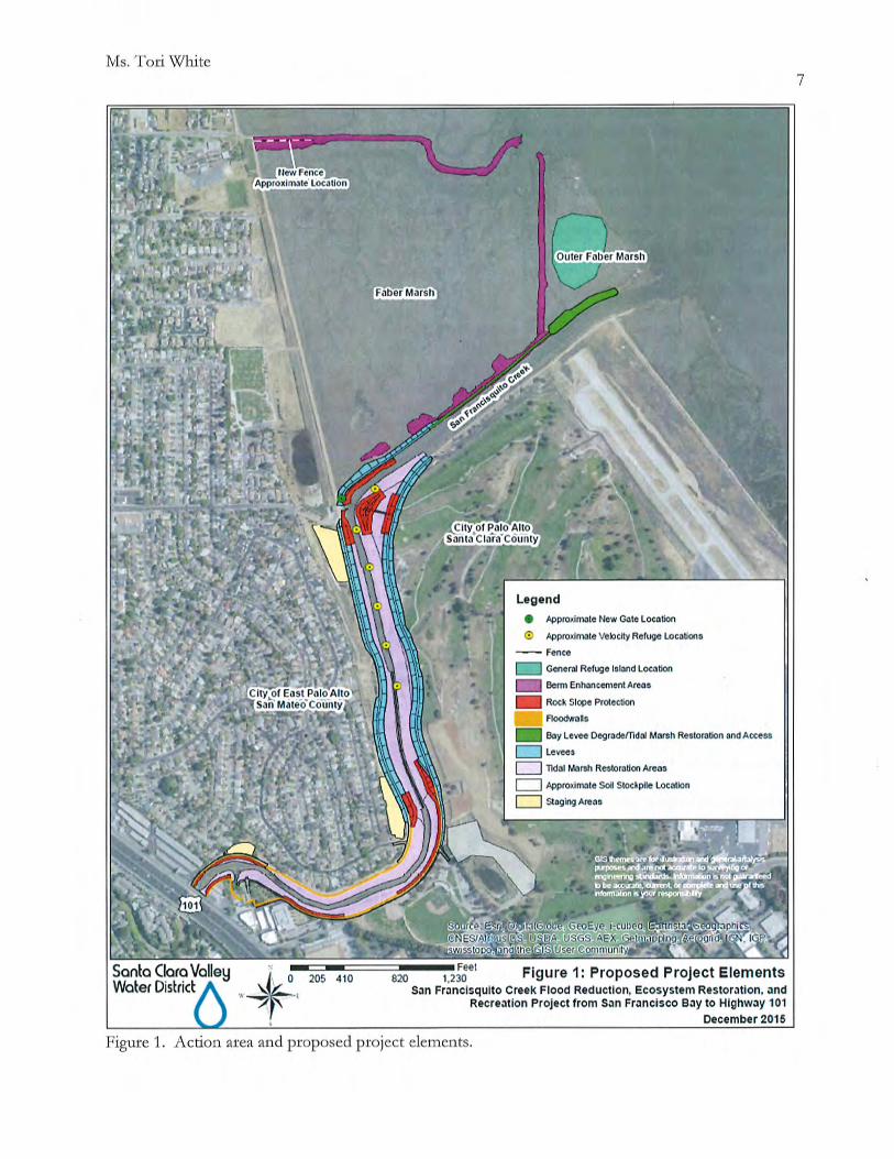


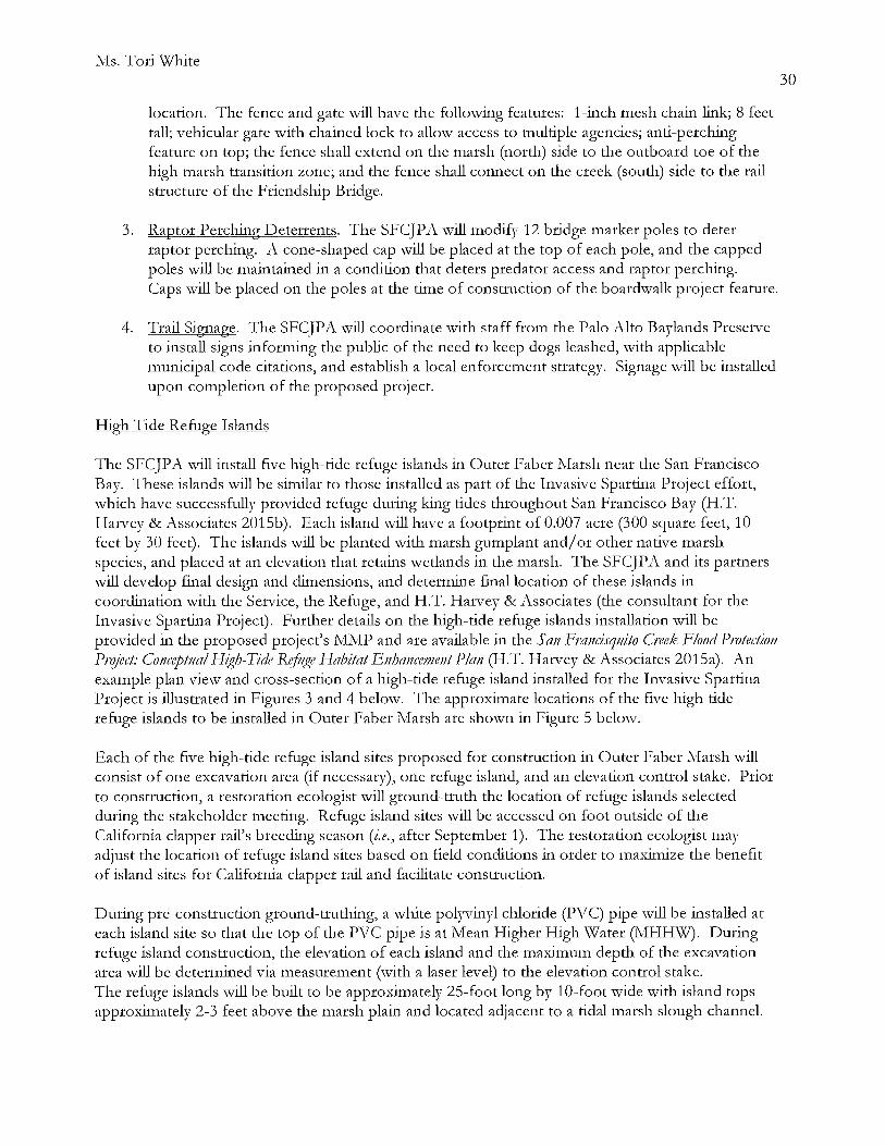


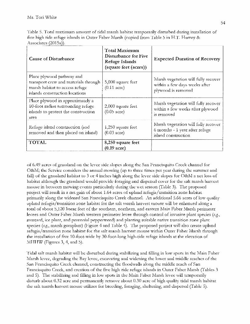


Ms. Tori White
Sawyer, Kim. 2013. Memorandum from Biologist Intern, Don Edwards San Francisco Bay National Wildlife Refuge, Fremont, California. Subject: Avian predator nest removal with PG&E, 2013.
Santa Clara Valley \v'ater District (SCVWD). 2015. Memorandum from Matt Parsons and Doug Padley, Santa Clara Valley Water District, Sanjose, California, to Bill Springer and :MichaelMartin, Santa Clara Valley Water District, Sanjose, California, dated March 5, 2015. Subject: San Francisquito Creek Flood Reduction, Ecosystem Restoration, and Recreation Project from San Francisco Bay to Highway 101, Ridgway's Rail and Salt Marsh Harvest Mouse Habitat Impacts Technical Memorandum.
Personal Communications
Albertson, Joy. Supe1visory \v'ildlife Biologist, San Francisco Bay National Wildlife Refuge Complex, Fremont, California.
Allan, Kate. Wildlife Biologist, WR.A Environmental Consulting, San Rafael, California.
McBroom, Jen. Clapper Rail I\fonitoring Manager, Olofson Environmental, Inc., Oakland, California.
I\Iruz, Eric. Refuge Manager, Don Edwards San Francisco Bay National \v'ildlife Refuge, Fremont, California.
Overton, Cory. Wildlife Biologist, U.S. Geological Smvey, DL-::on, California.
Perrera, Robert. Biological Monitor, Huffman-Broadway Group, Inc., San Rafael, California.
Popper, Brian J. Wildlife Biologist, U.S. Department of Agriculture Wildlife Services, San Luis District, Fremont, California.
Riley, Ann L. Watershed and Stream Protection Advisor, San Francisco Bay Regional \v'ater Quality Control Board, Oakland, California.
Strong, Cheryl. Wildlife Biologist, Don Edwards San Francisco Bay National Wildlife Refuge, Fremont, California.
Tertes, Rachel. Wildlife Biologist, Don Edwards San Francisco Bay National \-xi'ildlife Refuge, Fremont, California.
76
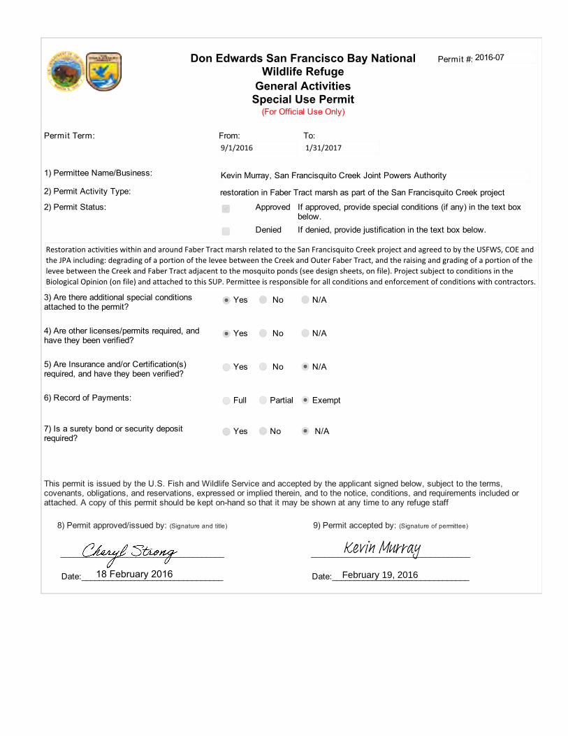
Don Edwards San Francisco Bay NationalWildlife Refuge
General ActivitiesSpecial Use Permit
(For Official Use Only)
Permit #:
Permit Term: From: To:
1) Permittee Name/Business:
2) Permit Activity Type: restoration in Faber Tract marsh as part of the San Francisquito Creek project
2) Permit Status: Approved If approved, provide special conditions (if any) in the text boxbelow.
Denied If denied, provide justification in the text box below.
Restoration activities within and around Faber Tract marsh related to the San Francisquito Creek project and agreed to by the USFWS, COE andthe JPA including: degrading of a portion of the levee between the Creek and Outer Faber Tract, and the raising and grading of a portion of thelevee between the Creek and Faber Tract adjacent to the mosquito ponds (see design sheets, on file). Project subject to conditions in theBiological Opinion (on file) and attached to this SUP. Permittee is responsible for all conditions and enforcement of conditions with contractors.
3) Are there additional special conditionsattached to the permit?
Yes
No
N/A
4) Are other licenses/permits required, andhave they been verified?
Yes
No N/A
5) Are Insurance and/or Certification(s)required, and have they been verified?
Yes No N/A
6) Record of Payments: Full Partial Exempt
7) Is a surety bond or security depositrequired?
Yes
No N/A
This permit is issued by the U.S. Fish and Wildlife Service and accepted by the applicant signed below, subject to the terms,covenants, obligations, and reservations, expressed or implied therein, and to the notice, conditions, and requirements included orattached. A copy of this permit should be kept on-hand so that it may be shown at any time to any refuge staff
8) Permit approved/issued by: (Signature and title) 9) Permit accepted by: (Signature of permittee)
_____________________________________ ____________________________________
Date:________________________________ Date:_______________________________
2016-07
9/1/2016 1/31/2017
Kevin Murray, San Francisquito Creek Joint Powers Authority
18 February 2016
Kevin MurrayFebruary 19, 2016
General Conditions and Requirements 1) Responsibility of Permittee: The permittee, by operating on the premises, shall be considered to have accepted these premises withall facilities, fixtures, or improvements in their existing condition as of the date of this permit. At the end of the period specified or uponearlier termination, the permittee shall give up the premises in as good order and condition as when received except for reasonablewear, tear, or damage occurring without fault or negligence. The permittee will fully repay the Service for any and all damage directly orindirectly resulting from negligence or failure on his/her part, and/or the part of anyone of his/her associates, to use reasonable care. 2) Operating Rules and Laws: The permittee shall keep the premises in a neat and orderly condition at all times, and shall comply withall municipal county, and State laws applicable to the operations under the permit as well as all Federal laws, rules, and regulationsgoverning national wildlife refuges and the area described in this permit. The permittee shall comply with all instructions applicable tothis permit issued by the refuge official in charge. The permittee shall take all reasonable precautions to prevent the escape of fires andto suppress fires and shall render all reasonable assistance in the suppression of refuge fires. 3) Use Limitations: The permittee’s use of the described premises is limited to the purposes herein specified and does not, unlessprovided for in this permit, allow him/her to restrict other authorized entry onto his/her area; and allows the U.S. Fish and WildlifeService to carry on whatever activities are necessary for: (1) protection and maintenance of the premises and adjacent landsadministered by the U.S. Fish and Wildlife Service; and (2) the management of wildlife and fish using the premises and other U.S. Fishand Wildlife Service lands. 4) Transfer of Privileges: This permit is not transferable, and no privileges herein mentioned may be sublet or made available to anyperson or interest not mentioned in this permit. No interest hereunder may accrue through lien or be transferred to a third party withoutthe approval of the Regional Director of the U.S. Fish and Wildlife Service and the permit shall not be used for speculative purposes. 5) Compliance: The U.S. Fish and Wildlife Service’s failure to require strict compliance with any of this permit’s terms, conditions, andrequirements shall not constitute a waiver or be considered as a giving up of the U.S. Fish and Wildlife Service’s right to thereafterenforce any of the permit’s terms or conditions. 6) Conditions of Permit not Fulfilled: If the permittee fails to fulfill any of the conditions and requirements set forth herein, the U.S. Fishand Wildlife Service shall retain all money paid under this permit to be used to satisfy as much of the permittee’s obligation as possible. 7) Payments: All payment shall be made on or before the due date to the local representative of the U.S. Fish and Wildlife Service by apostal money order or check made payable to the U.S. Fish and Wildlife Service. 8) Termination Policy: At the termination of this permit the permittee shall immediately give up possession to the U.S. Fish and WildlifeService representative, reserving, however, the rights specified in paragraph 11 below. If he/she fails to do so, he/she will pay the U.S.Fish and Wildlife Service, as liquidated damages, an amount double the rate specified in this permit for the entire time possession iswithheld. Upon yielding possession, the permittee will still be allowed to reenter as needed to remove his/her property as stated inparagraph 11 below. The acceptance of any fee for the liquidated damages or any other act of administration relating to the continuedtenancy is not to be considered as an affirmation of the permittee’s action nor shall it operate as a waiver of the U.S. Fish and WildlifeService’s right to terminate or cancel the permit for the breach of any specified condition or requirement. 9) Revocation Policy: The Regional Director of the U.S. Fish and Wildlife Service may revoke this permit without notice fornoncompliance with the terms hereof, or for violation of general and/or specific laws or regulations governing national wildlife refuges, orfor nonuse. It is at all times subject to discretionary revocation by the Director of the Service. Upon such revocation the U.S. Fish andWildlife Service, by and through any authorized representative, may take possession of said premises for its own and sole use, and/ormay enter and possess the premises as the agent of the permittee and for his/her account. 10) Damages: The U.S. Fish and Wildlife Service shall not be responsible for: any loss or damage to property including but not limitedto crops, animals, and machinery; injury to the permittee or his/her relatives or to the officers, agents, employees, or any other(s) whoare on the premises from instructions; the sufferance from wildlife or employees or representatives of the U.S. Fish and Wildlife Servicecarrying out their official responsibilities. The permittee agrees to hold the U.S. Fish and Wildlife Service harmless from any and allclaims for damages or losses that may arise to be incident to the flooding of the premises resulting from any associated governmentriver and harbor, flood control, reclamation, or Tennessee Valley Authority activity. 11) Removal of Permittee’s Property: Upon the expiration or termination of this permit, if all rental charges and/or damage claims due tothe U.S. Fish and Wildlife Service have been paid, the permittee may, within a reasonable period as stated in the permit or asdetermined by the U.S. Fish and Wildlife Service official in charge, but not to exceed 60 days, remove all structures, machinery, and/orequipment, etc., from the premises for which he/she is responsible. Within this period the permittee also must remove any other ofhis/her property including his/her acknowledged share of products or crops grown, cut, harvested, stored, or stacked on the premises.Upon failure to remove any of the above items within the aforesaid period, they shall become the property of the U.S. Fish and WildlifeService.
FOR ANY LAW ENFORCEMENT ISSUES PLEASE CALL DISPATCH AT 415-561-5510. BE PREPARED TO EXPLAIN WHO AND WHERE YOU ARE.
1. Permittee or designee must carry a copy of permit and the research / study proposal when on Refuge lands. Permittees and designees will place the appropriate placard on the dashboard of all vehicles while on the Refuge and behind locked gates.
2. Permittee is responsible for meeting all conservation measures (pages 15-27) of the biological opinion,
dated 15 January 2015, and for enforcing said conditions with any contractor(s). A biological monitor will be on site during all activiites.
3. Work includes the degrading of a portion of the levee between the Creek and Outer Faber Tract, and the raising and grading of a portion of the levee between the Creek and Faber Tract adjacent to the mosquito ponds as specified in the design plans dated Feb 2016.
4. Permittee will not interfere with ongoing Dept. of Agriculture-Wildlife Service’s predator management activities. Permittee will not interfere with work by Cargill Salt Division or Refuge visitors using public trails.
5. All work will be conducted in a manner which minimizes disturbance to wildlife and damage to wetland
habitat. Noise must be minimized to prevent wildlife disturbance.
6. Permittee may not drive on levees for 3-5 days after a moderate rain or under conditions that may damage the levee. Any damage caused by construction and access will be repaired by pemirttee. When permittee encounters visitors on Refuge trails, speed will be reduced to prevent dust and unnecessary disturbance of visitors.
7. Permittee will immediately report any active burrowing owl burrows to Refuge Biologists.
8. Permittee will immediately report all sightings or feral cats, dogs, red fox, or active raven and hawk nests (on
PG&E towers) observed on the Refuge. Fox dens will not be approached or searched.
9. Access into salt marsh habitat is prohibited except on boardwalks, railroad grades, and similar structures. No access to the marsh will be allowed during the California clapper rail breeding season, 1 February to August 31. Marsh access is not permitted during extreme high tide events (>6.5 at GG) to reduce impacts to tidal marsh species looking for refugia. Exceptions to this must be cleared by Refuge biologists prior to access.
10. All locked gates opened must immediately be shut and locked behind you. TAKE CARE NOT TO LOOK OUT ANY OTHER LOCKS IN THE CHAIN LOOP.
11. Refuge contacts: Cheryl Strong, biologist, 510-557-1271, [email protected]; and Chris Barr, acting Refuge manager, 510-792-0222 ext. 127.
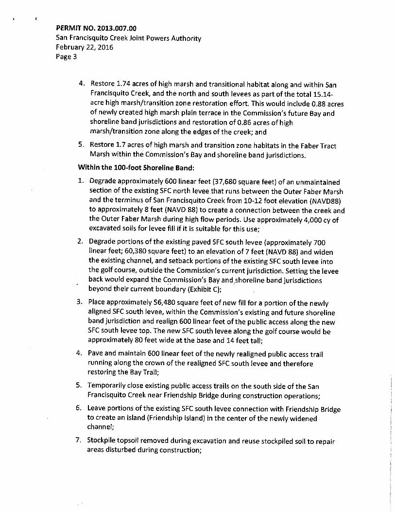
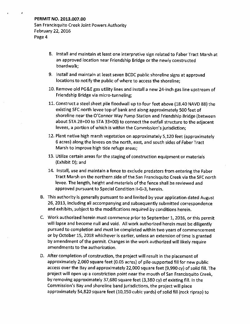
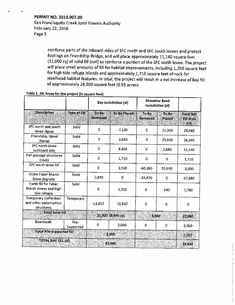
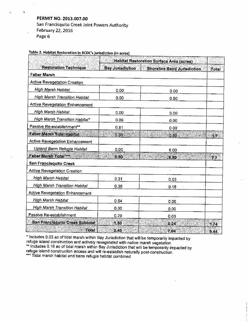
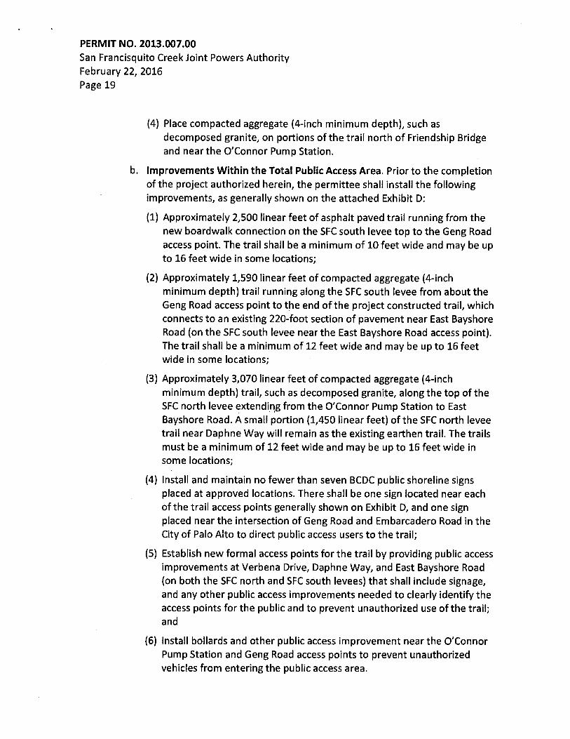

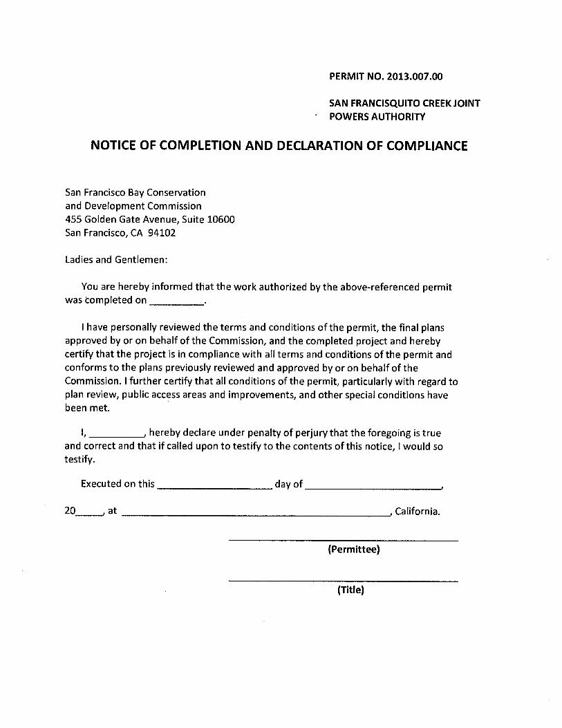
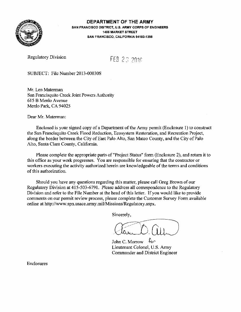
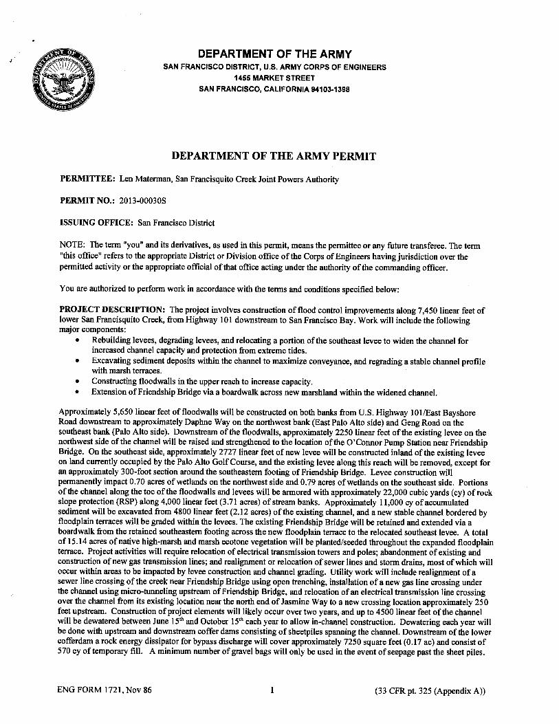
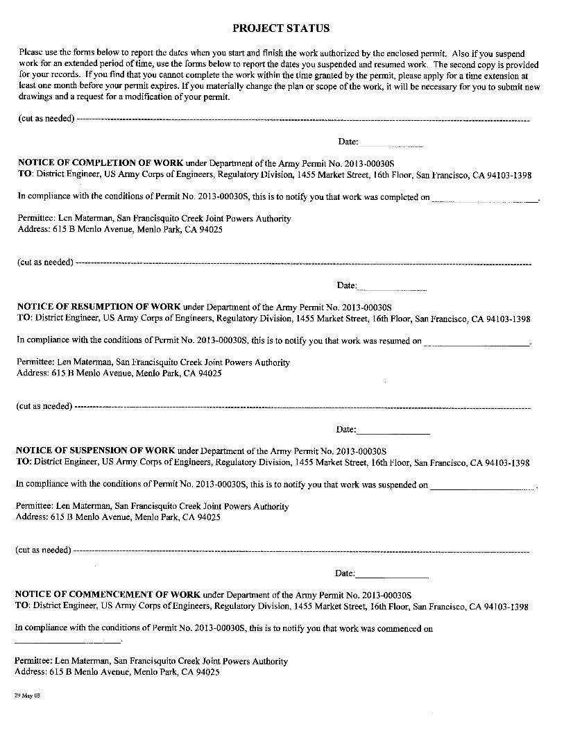
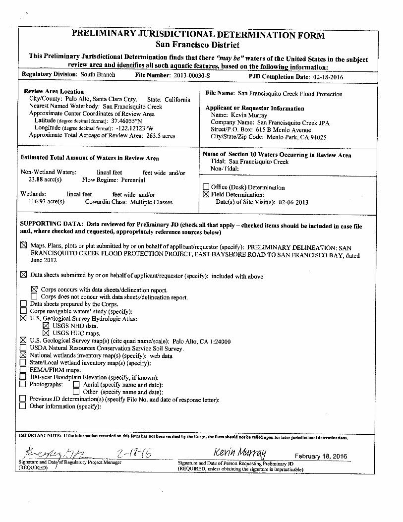
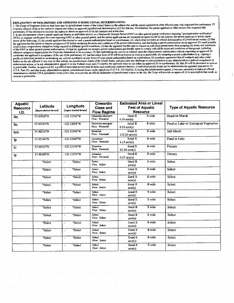
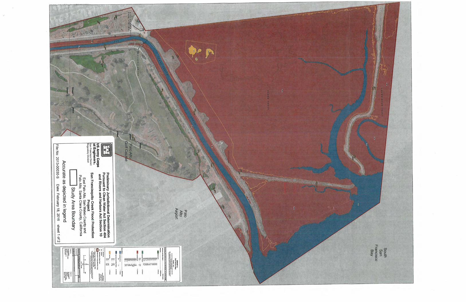
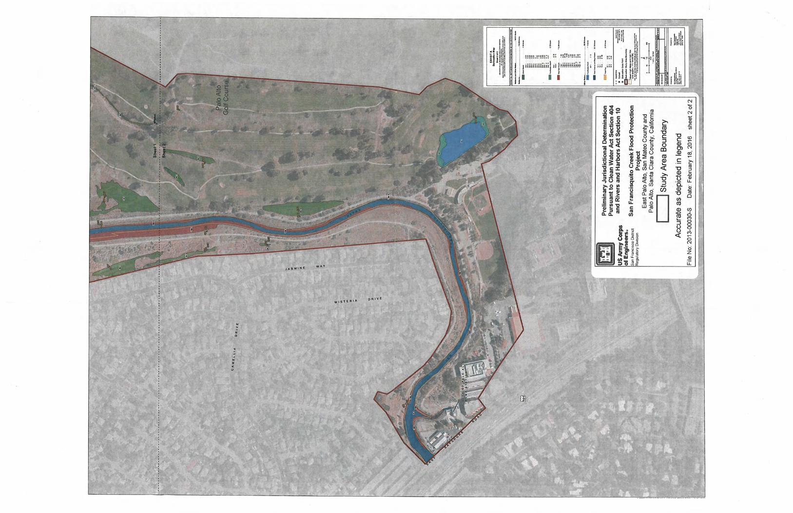
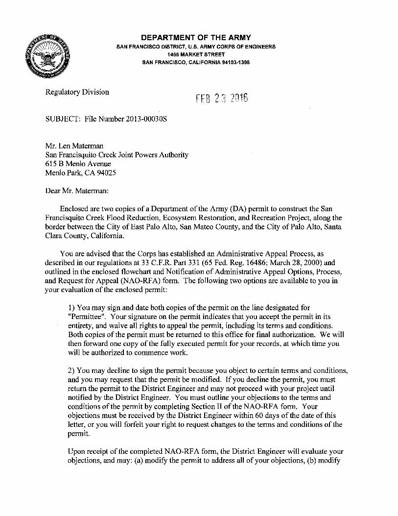
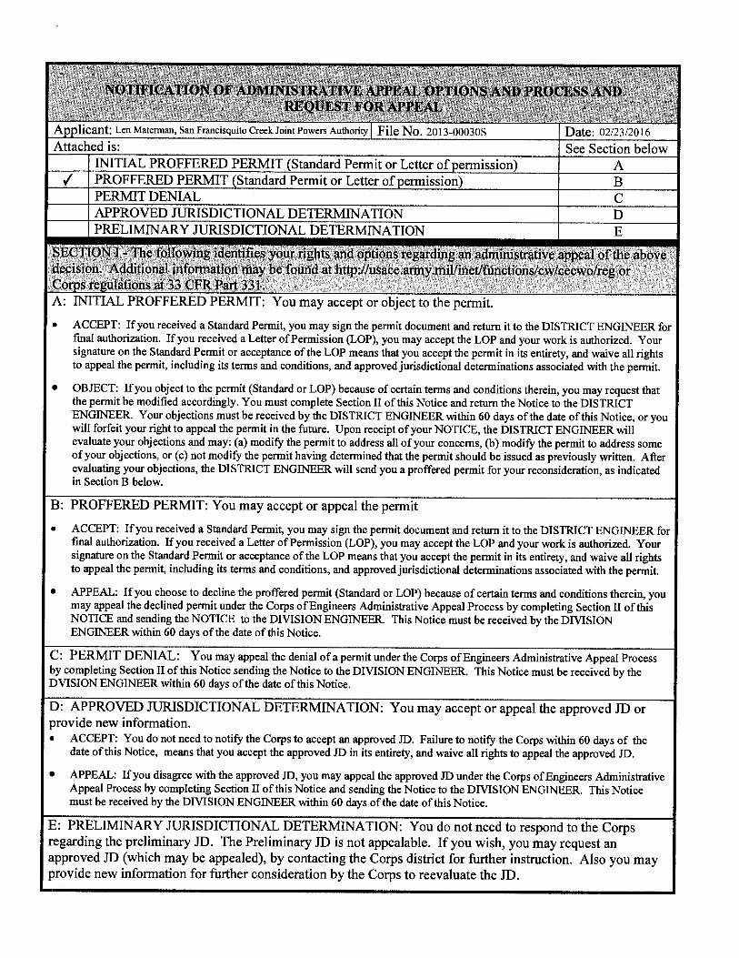
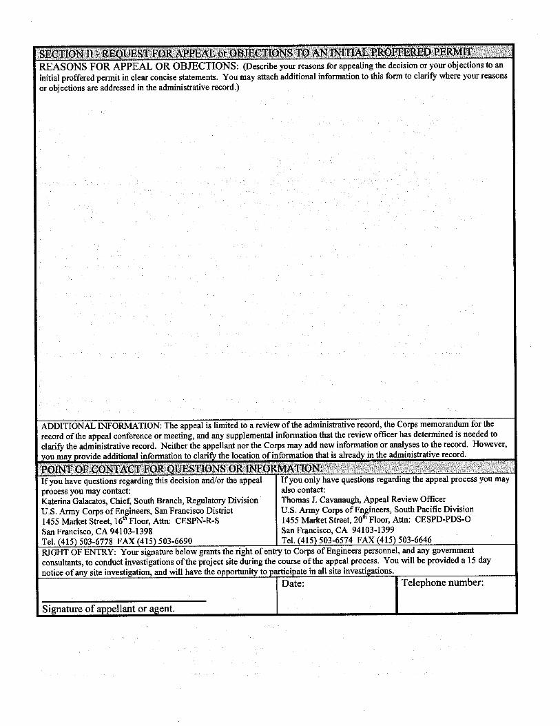
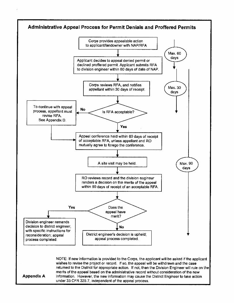
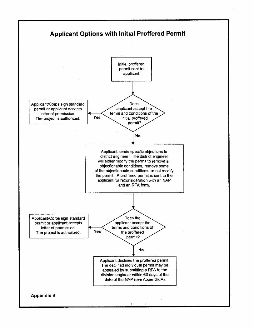
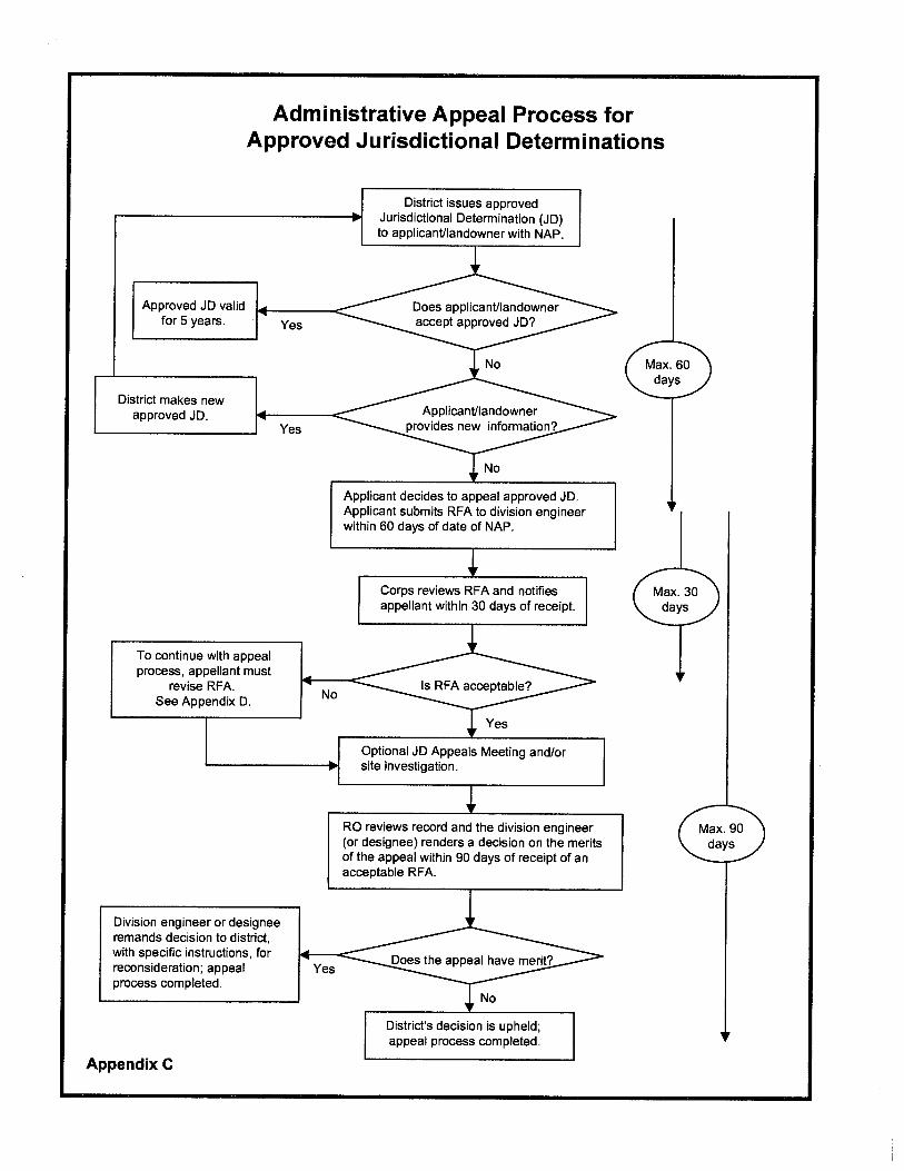
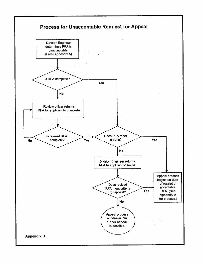
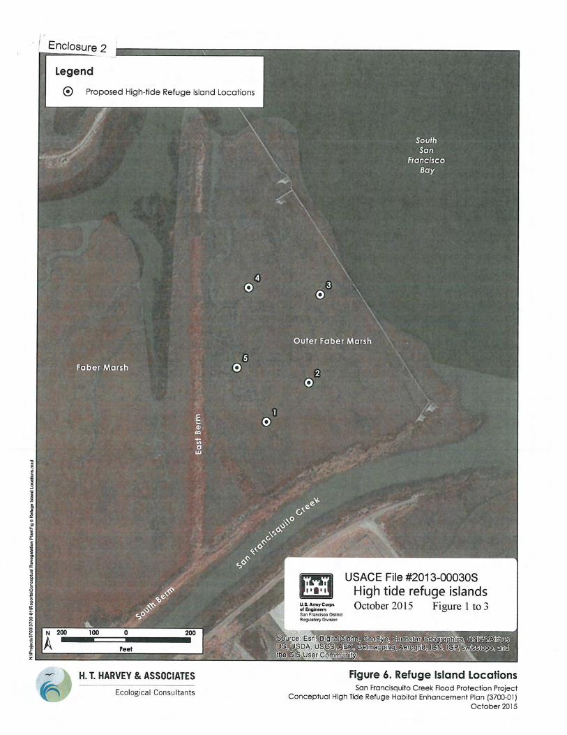
CONTROL AND OVERSIGHT OF PESTICIDE USE DOCUMENT NO.: Q751D02
REVISION: D
EFFECTIVE DATE: 09/13/12
PROCESS OWNER: Mark Wander Page 1 of 13
Downloaded or printed copies are for reference only. Verify this is the current version prior to use. See the District website for released version 1. PURPOSE AND SCOPE
This defines District policies and procedures for pesticide approval, purchasing, acquisition, handling, use, storage, transportation, disposal, and reporting in a manner consistent with all Districts’ permits, the California Environmental Quality Act (CEQA), and the California Department of Pesticide Regulation. These policies and procedures do not replace the need for regulatory permits and only apply to District work activities once these permits are in place. These policies and procedures apply to all District-owned or operated facilities and staff, contractors, permittees, and suppliers. The District goal is to minimize the environmental risk and exposure resulting from its pesticide use by employing Best Management Practices (BMPs) and alternatives to their use to the maximum extent practicable and to facilitate the safe use of pesticide by qualified staff and contractors.
2. POLICY
1. Only pesticides included on W751D01 Pesticides Products Approved for District Use (Product List) are allowed to be used, in the appropriate categories for product application on District facilities.
1.1. District staff is prohibited from purchasing over the counter pesticides 1.2. The product lists will be updated, as needed, by the Pesticide Review Team to ensure
compliance with these practices. 1.3. All pesticide products not on the approved list that are desired to be used on District facilities
(by employees, contractors, or permittees) will need first to be reviewed and approved by the Pesticide Review Team (PRT) prior to their use in accordance with Section 8 of this document and be verified as being in accordance with any relevant regulatory agency review.
2. State-certified Qualified Applicator (see definition in Section 4) with the appropriate current
certification categories must be onsite for entire application of all pesticides. 3. Products listed on the State Department of Pesticide Regulation (DPR) “A” list of known
groundwater contaminants will not be used. Detailed information on DPR regulations can be found on their web site at http://www.cdpr.ca.gov/docs/legbills/calcode/040101.htm#a6800
4. Category I and II pesticides will not be used for routine projects without prior review and approval by the Pesticide Review Team and per regulatory authorizations.
5. To minimize the use of pesticides in the work place, pesticides derived from non-toxic natural ingredients should be used as repellants when appropriate.
6. Insecticides are used after other methods, such as prevention or natural nontoxic control methods, have been shown to be ineffective in similar situations. Where use is needed, the product with the lowest toxicity is used in accordance with the manufacturer’s label.
7. Herbicides are used only when alternatives use such as mowing, hand removal, disking, or grazing, has been shown to be ineffective or inefficient to meet the needs and requirements of this program. 7.1. No herbicide shall be used by District staff without a written recommendation from a Pest
Control Advisor in accordance with State Department of Pesticide Regulation (DPR) www.cdpr.ca.gov
CONTROL AND OVERSIGHT OF PESTICIDE USE DOCUMENT NO.: Q751D02
REVISION: D
EFFECTIVE DATE: 09/13/12
PROCESS OWNER: Mark Wander Page 2 of 13
Downloaded or printed copies are for reference only. Verify this is the current version prior to use. See the District website for released version
8. Rodenticides are used only after trapping to control burrowing rodents has been shown to be ineffective in similar situations or deemed impractical, unless regulatory permits are required.
9. Pesticides containing the following are prohibited without exception:
9.1. Copper based products on or around any body of water. 9.2. Organophosphate or Carbamate products.
3. REFERENCE DOCUMENTS
External Reference Documents
REFERENCE DOCUMENT DOCUMENT LOCATION(S)
State Department of Pesticide Regulation (DPR)
www.cdpr.ca.gov
http://www.cdpr.ca.gov/docs/dept/quicklinks/compliance/lawsregs.htm
State Department of Pesticide Regulation (DPR) - pesticides that are known to cause groundwater contamination
http://www.cdpr.ca.gov/docs/legbills/calcode/040101.htm#a6800
State Department of Pesticide Regulation (DPR) - Keeping Pesticides Out Of Floodwaters – Container Labeling
http://www.cdpr.ca.gov/docs/pressrls/archive/1998/980213.htm
California Environmental Quality Act (CEQA) http://ceres.ca.gov/ceqa/
California Food and Agricultural Code for Non-Production Agricultural Use
http://www.cdfa.ca.gov/phpps/LBAMeir/CH%207_Public%20Svcs%20&%20Haz%20Resp.pdf http://www.cdpr.ca.gov/docs/enforce/bulletins/ag_nonag.pdf
State Department of Fish and Game Code relative to stream alterations http://www.dfg.ca.gov/habcon/1600/
Environmental Protection Agency regulations
http://www.epa.gov/pesticides/regulating/laws.htm
http://www.epa.gov/pesticides/regulating/containers.htm
Spill Cleanup on The Pesticide Environmental Stewardship (PES) website supported by Center for Integrated Pest Management
http://pesticidestewardship.org/spill/Pages/SpillCleanup.aspx
Internal Reference Documents
REFERENCE DOCUMENT DOCUMENT LOCATION(S)
Q520D01 Environmental Management System Environmental Planning District QEMS
Q741D03 Procurement of General Services District QEMS
Q830D01 HAZMAT Emergency Response Procedures District QEMS
W751M01 Best Management Practices (BMP) Handbook District QEMS
W640D07 Contractor Safety Program District QEMS
W640D36 Chemical Purchasing District QEMS
W640D23 Personal Protective Equipment District QEMS
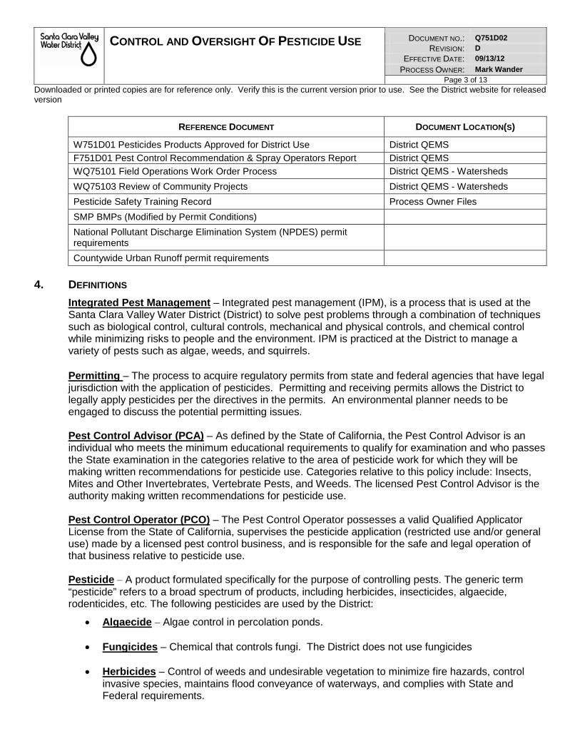
CONTROL AND OVERSIGHT OF PESTICIDE USE DOCUMENT NO.: Q751D02
REVISION: D
EFFECTIVE DATE: 09/13/12
PROCESS OWNER: Mark Wander Page 3 of 13
Downloaded or printed copies are for reference only. Verify this is the current version prior to use. See the District website for released version
REFERENCE DOCUMENT DOCUMENT LOCATION(S)
W751D01 Pesticides Products Approved for District Use District QEMS
F751D01 Pest Control Recommendation & Spray Operators Report District QEMS
WQ75101 Field Operations Work Order Process District QEMS - Watersheds
WQ75103 Review of Community Projects District QEMS - Watersheds
Pesticide Safety Training Record Process Owner Files
SMP BMPs (Modified by Permit Conditions)
National Pollutant Discharge Elimination System (NPDES) permit requirements
Countywide Urban Runoff permit requirements
4. DEFINITIONS
Integrated Pest Management – Integrated pest management (IPM), is a process that is used at the Santa Clara Valley Water District (District) to solve pest problems through a combination of techniques such as biological control, cultural controls, mechanical and physical controls, and chemical control while minimizing risks to people and the environment. IPM is practiced at the District to manage a variety of pests such as algae, weeds, and squirrels.
Permitting – The process to acquire regulatory permits from state and federal agencies that have legal jurisdiction with the application of pesticides. Permitting and receiving permits allows the District to legally apply pesticides per the directives in the permits. An environmental planner needs to be engaged to discuss the potential permitting issues. Pest Control Advisor (PCA) – As defined by the State of California, the Pest Control Advisor is an individual who meets the minimum educational requirements to qualify for examination and who passes the State examination in the categories relative to the area of pesticide work for which they will be making written recommendations for pesticide use. Categories relative to this policy include: Insects, Mites and Other Invertebrates, Vertebrate Pests, and Weeds. The licensed Pest Control Advisor is the authority making written recommendations for pesticide use. Pest Control Operator (PCO) – The Pest Control Operator possesses a valid Qualified Applicator License from the State of California, supervises the pesticide application (restricted use and/or general use) made by a licensed pest control business, and is responsible for the safe and legal operation of that business relative to pesticide use. Pesticide – A product formulated specifically for the purpose of controlling pests. The generic term “pesticide” refers to a broad spectrum of products, including herbicides, insecticides, algaecide, rodenticides, etc. The following pesticides are used by the District:
• Algaecide – Algae control in percolation ponds.
• Fungicides – Chemical that controls fungi. The District does not use fungicides
• Herbicides – Control of weeds and undesirable vegetation to minimize fire hazards, control invasive species, maintains flood conveyance of waterways, and complies with State and Federal requirements.
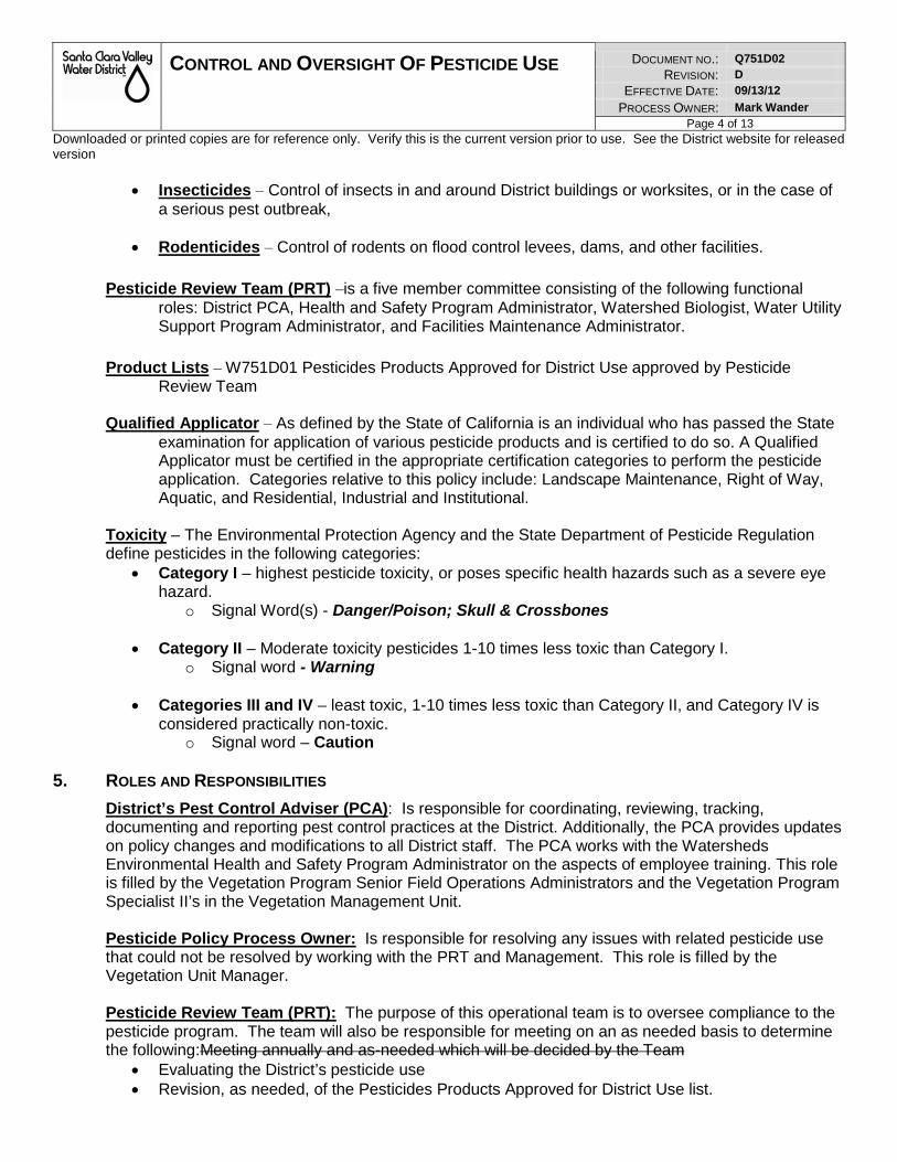
CONTROL AND OVERSIGHT OF PESTICIDE USE DOCUMENT NO.: Q751D02
REVISION: D
EFFECTIVE DATE: 09/13/12
PROCESS OWNER: Mark Wander Page 4 of 13
Downloaded or printed copies are for reference only. Verify this is the current version prior to use. See the District website for released version
• Insecticides – Control of insects in and around District buildings or worksites, or in the case of a serious pest outbreak,
• Rodenticides – Control of rodents on flood control levees, dams, and other facilities.
Pesticide Review Team (PRT) –is a five member committee consisting of the following functional roles: District PCA, Health and Safety Program Administrator, Watershed Biologist, Water Utility Support Program Administrator, and Facilities Maintenance Administrator.
Product Lists – W751D01 Pesticides Products Approved for District Use approved by Pesticide
Review Team
Qualified Applicator – As defined by the State of California is an individual who has passed the State examination for application of various pesticide products and is certified to do so. A Qualified Applicator must be certified in the appropriate certification categories to perform the pesticide application. Categories relative to this policy include: Landscape Maintenance, Right of Way, Aquatic, and Residential, Industrial and Institutional.
Toxicity – The Environmental Protection Agency and the State Department of Pesticide Regulation define pesticides in the following categories:
• Category I – highest pesticide toxicity, or poses specific health hazards such as a severe eye hazard.
o Signal Word(s) - Danger/Poison; Skull & Crossbones
• Category II – Moderate toxicity pesticides 1-10 times less toxic than Category I. o Signal word - Warning
• Categories III and IV – least toxic, 1-10 times less toxic than Category II, and Category IV is
considered practically non-toxic. o Signal word – Caution
5. ROLES AND RESPONSIBILITIES
District’s Pest Control Adviser (PCA): Is responsible for coordinating, reviewing, tracking, documenting and reporting pest control practices at the District. Additionally, the PCA provides updates on policy changes and modifications to all District staff. The PCA works with the Watersheds Environmental Health and Safety Program Administrator on the aspects of employee training. This role is filled by the Vegetation Program Senior Field Operations Administrators and the Vegetation Program Specialist II’s in the Vegetation Management Unit. Pesticide Policy Process Owner: Is responsible for resolving any issues with related pesticide use that could not be resolved by working with the PRT and Management. This role is filled by the Vegetation Unit Manager. Pesticide Review Team (PRT): The purpose of this operational team is to oversee compliance to the pesticide program. The team will also be responsible for meeting on an as needed basis to determine the following:Meeting annually and as-needed which will be decided by the Team
• Evaluating the District’s pesticide use • Revision, as needed, of the Pesticides Products Approved for District Use list.
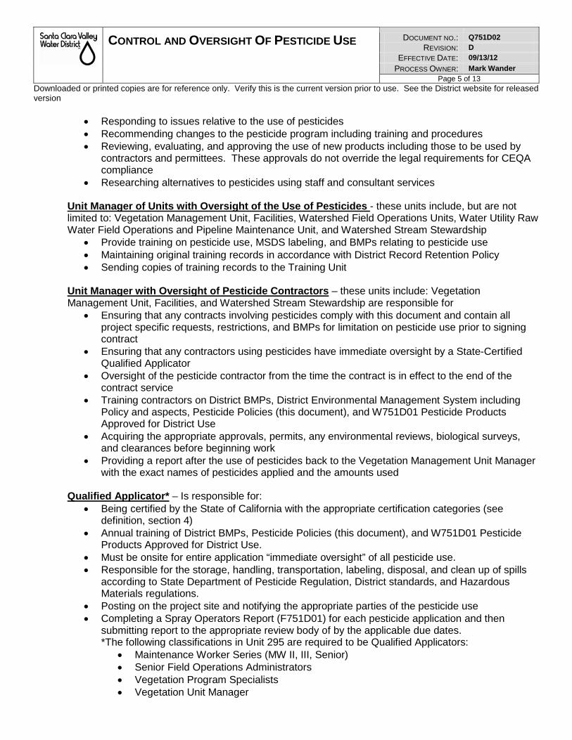
CONTROL AND OVERSIGHT OF PESTICIDE USE DOCUMENT NO.: Q751D02
REVISION: D
EFFECTIVE DATE: 09/13/12
PROCESS OWNER: Mark Wander Page 5 of 13
Downloaded or printed copies are for reference only. Verify this is the current version prior to use. See the District website for released version
• Responding to issues relative to the use of pesticides • Recommending changes to the pesticide program including training and procedures • Reviewing, evaluating, and approving the use of new products including those to be used by
contractors and permittees. These approvals do not override the legal requirements for CEQA compliance
• Researching alternatives to pesticides using staff and consultant services Unit Manager of Units with Oversight of the Use of Pesticides - these units include, but are not limited to: Vegetation Management Unit, Facilities, Watershed Field Operations Units, Water Utility Raw Water Field Operations and Pipeline Maintenance Unit, and Watershed Stream Stewardship
• Provide training on pesticide use, MSDS labeling, and BMPs relating to pesticide use • Maintaining original training records in accordance with District Record Retention Policy • Sending copies of training records to the Training Unit
Unit Manager with Oversight of Pesticide Contractors – these units include: Vegetation Management Unit, Facilities, and Watershed Stream Stewardship are responsible for
• Ensuring that any contracts involving pesticides comply with this document and contain all project specific requests, restrictions, and BMPs for limitation on pesticide use prior to signing contract
• Ensuring that any contractors using pesticides have immediate oversight by a State-Certified Qualified Applicator
• Oversight of the pesticide contractor from the time the contract is in effect to the end of the contract service
• Training contractors on District BMPs, District Environmental Management System including Policy and aspects, Pesticide Policies (this document), and W751D01 Pesticide Products Approved for District Use
• Acquiring the appropriate approvals, permits, any environmental reviews, biological surveys, and clearances before beginning work
• Providing a report after the use of pesticides back to the Vegetation Management Unit Manager with the exact names of pesticides applied and the amounts used
Qualified Applicator* – Is responsible for:
• Being certified by the State of California with the appropriate certification categories (see definition, section 4)
• Annual training of District BMPs, Pesticide Policies (this document), and W751D01 Pesticide Products Approved for District Use.
• Must be onsite for entire application “immediate oversight” of all pesticide use. • Responsible for the storage, handling, transportation, labeling, disposal, and clean up of spills
according to State Department of Pesticide Regulation, District standards, and Hazardous Materials regulations.
• Posting on the project site and notifying the appropriate parties of the pesticide use • Completing a Spray Operators Report (F751D01) for each pesticide application and then
submitting report to the appropriate review body of by the applicable due dates. *The following classifications in Unit 295 are required to be Qualified Applicators:
• Maintenance Worker Series (MW II, III, Senior) • Senior Field Operations Administrators • Vegetation Program Specialists • Vegetation Unit Manager
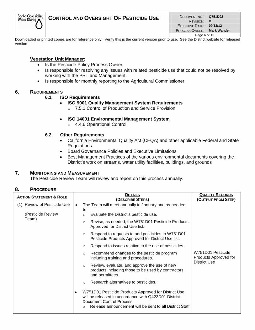
CONTROL AND OVERSIGHT OF PESTICIDE USE DOCUMENT NO.: Q751D02
REVISION: D
EFFECTIVE DATE: 09/13/12
PROCESS OWNER: Mark Wander Page 6 of 13
Downloaded or printed copies are for reference only. Verify this is the current version prior to use. See the District website for released version
Vegetation Unit Manager:
• Is the Pesticide Policy Process Owner • Is responsible for resolving any issues with related pesticide use that could not be resolved by
working with the PRT and Management. • Is responsible for monthly reporting to the Agricultural Commissioner
6. REQUIREMENTS
6.1 ISO Requirements • ISO 9001 Quality Management System Requirements
o 7.5.1 Control of Production and Service Provision
• ISO 14001 Environmental Management System o 4.4.6 Operational Control
6.2 Other Requirements
• California Environmental Quality Act (CEQA) and other applicable Federal and State Regulations
• Board Governance Policies and Executive Limitations • Best Management Practices of the various environmental documents covering the
District’s work on streams, water utility facilities, buildings, and grounds
7. MONITORING AND MEASUREMENT The Pesticide Review Team will review and report on this process annually.
8. PROCEDURE
ACTION STATEMENT & ROLE DETAILS
(DESCRIBE STEPS) QUALITY RECORDS
(OUTPUT FROM STEP) (1) Review of Pesticide Use
(Pesticide Review Team)
• The Team will meet annually in January and as-needed to: o Evaluate the District’s pesticide use.
o Revise, as needed, the W751D01 Pesticide Products Approved for District Use list.
o Respond to requests to add pesticides to W751D01 Pesticide Products Approved for District Use list.
o Respond to issues relative to the use of pesticides.
o Recommend changes to the pesticide program including training and procedures.
o Review, evaluate, and approve the use of new products including those to be used by contractors and permittees.
o Research alternatives to pesticides.
• W751D01 Pesticide Products Approved for District Use will be released in accordance with Q423D01 District Document Control Process o Release announcement will be sent to all District Staff
W751D01 Pesticide Products Approved for District Use
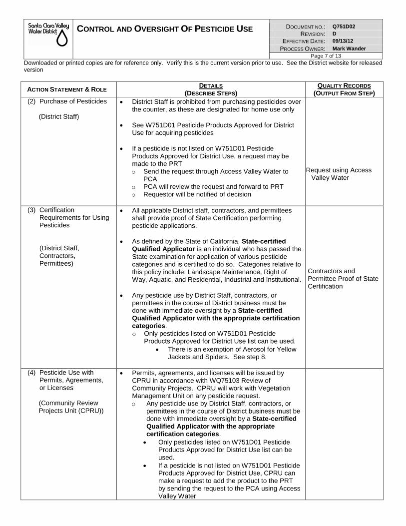
CONTROL AND OVERSIGHT OF PESTICIDE USE DOCUMENT NO.: Q751D02
REVISION: D
EFFECTIVE DATE: 09/13/12
PROCESS OWNER: Mark Wander Page 7 of 13
Downloaded or printed copies are for reference only. Verify this is the current version prior to use. See the District website for released version
ACTION STATEMENT & ROLE DETAILS
(DESCRIBE STEPS) QUALITY RECORDS
(OUTPUT FROM STEP) (2) Purchase of Pesticides
(District Staff)
• District Staff is prohibited from purchasing pesticides over the counter, as these are designated for home use only
• See W751D01 Pesticide Products Approved for District Use for acquiring pesticides
• If a pesticide is not listed on W751D01 Pesticide
Products Approved for District Use, a request may be made to the PRT o Send the request through Access Valley Water to
PCA o PCA will review the request and forward to PRT o Requestor will be notified of decision
Request using Access
Valley Water
(3) Certification Requirements for Using Pesticides (District Staff, Contractors, Permittees)
• All applicable District staff, contractors, and permittees shall provide proof of State Certification performing pesticide applications.
• As defined by the State of California, State-certified Qualified Applicator is an individual who has passed the State examination for application of various pesticide categories and is certified to do so. Categories relative to this policy include: Landscape Maintenance, Right of Way, Aquatic, and Residential, Industrial and Institutional.
• Any pesticide use by District Staff, contractors, or
permittees in the course of District business must be done with immediate oversight by a State-certified Qualified Applicator with the appropriate certification categories. o Only pesticides listed on W751D01 Pesticide
Products Approved for District Use list can be used. • There is an exemption of Aerosol for Yellow
Jackets and Spiders. See step 8.
Contractors and Permittee Proof of State Certification
(4) Pesticide Use with Permits, Agreements, or Licenses
(Community Review Projects Unit (CPRU))
• Permits, agreements, and licenses will be issued by CPRU in accordance with WQ75103 Review of Community Projects. CPRU will work with Vegetation Management Unit on any pesticide request. o Any pesticide use by District Staff, contractors, or
permittees in the course of District business must be done with immediate oversight by a State-certified Qualified Applicator with the appropriate certification categories. • Only pesticides listed on W751D01 Pesticide
Products Approved for District Use list can be used.
• If a pesticide is not listed on W751D01 Pesticide Products Approved for District Use, CPRU can make a request to add the product to the PRT by sending the request to the PCA using Access Valley Water
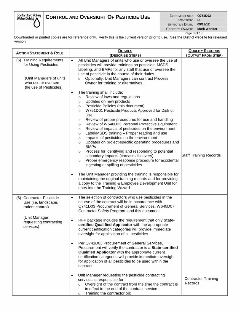
CONTROL AND OVERSIGHT OF PESTICIDE USE DOCUMENT NO.: Q751D02
REVISION: D
EFFECTIVE DATE: 09/13/12
PROCESS OWNER: Mark Wander Page 8 of 13
Downloaded or printed copies are for reference only. Verify this is the current version prior to use. See the District website for released version
ACTION STATEMENT & ROLE DETAILS
(DESCRIBE STEPS) QUALITY RECORDS
(OUTPUT FROM STEP) (5) Training Requirements
for Using Pesticides (Unit Managers of units who use or oversee the use of Pesticides)
• All Unit Managers of units who use or oversee the use of pesticides will provide trainings on pesticide, MSDS labeling, and BMPs for any staff that use or oversee the use of pesticide in the course of their duties. o Optionally, Unit Managers can contract Process
Owner for training or alternatives.
• The training shall include: o Review of laws and regulations o Updates on new products o Pesticide Policies (this document) o W751D01 Pesticide Products Approved for District
Use o Review of proper procedures for use and handling o Review of W640D23 Personal Protective Equipment o Review of impacts of pesticides on the environment o Label/MSDS training – Proper reading and use o Impacts of pesticides on the environment o Updates on project-specific operating procedures and
BMPs o Process for identifying and responding to potential
secondary impacts (carcass discovery) o Proper emergency response procedure for accidental
ingesting or spilling of pesticides
• The Unit Manager providing the training is responsible for maintaining the original training records and for providing a copy to the Training & Employee Development Unit for entry into the Training Wizard
Staff Training Records
(6) Contractor Pesticide Use (i.e. landscape, rodent control)
(Unit Manager requesting contracting services)
• The selection of contractors who use pesticides in the course of the contract will be in accordance with Q741D03 Procurement of General Services, W640D07 Contractor Safety Program, and this document.
• RFP package includes the requirement that only State-certified Qualified Applicator with the appropriate current certification categories will provide immediate oversight for application of all pesticides.
• Per Q741D03 Procurement of General Services,
Procurement will verify the contractor is a State-certified Qualified Applicator with the appropriate current certification categories will provide immediate oversight for application of all pesticides to be used within the contract
• Unit Manager requesting the pesticide contracting
services is responsible for: o Oversight of the contract from the time the contract is
in effect to the end of the contract service o Training the contractor on:
Contractor Training Records
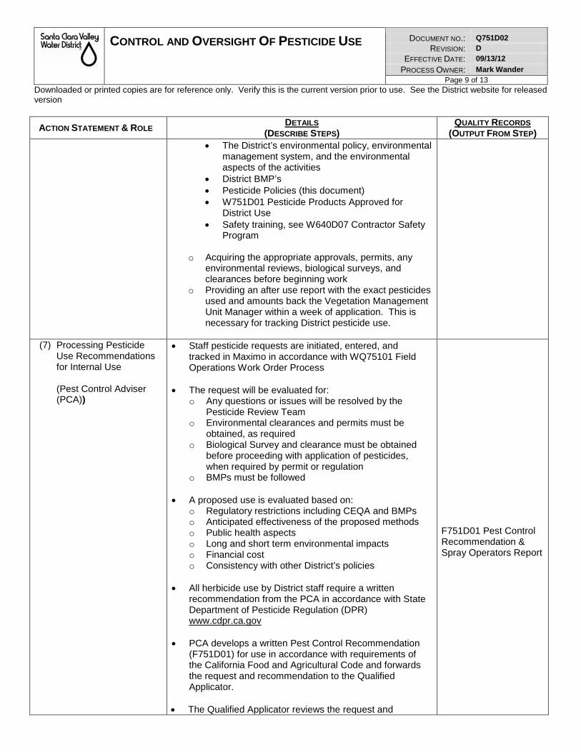
CONTROL AND OVERSIGHT OF PESTICIDE USE DOCUMENT NO.: Q751D02
REVISION: D
EFFECTIVE DATE: 09/13/12
PROCESS OWNER: Mark Wander Page 9 of 13
Downloaded or printed copies are for reference only. Verify this is the current version prior to use. See the District website for released version
ACTION STATEMENT & ROLE DETAILS
(DESCRIBE STEPS) QUALITY RECORDS
(OUTPUT FROM STEP) • The District’s environmental policy, environmental
management system, and the environmental aspects of the activities
• District BMP’s • Pesticide Policies (this document) • W751D01 Pesticide Products Approved for
District Use • Safety training, see W640D07 Contractor Safety
Program
o Acquiring the appropriate approvals, permits, any environmental reviews, biological surveys, and clearances before beginning work
o Providing an after use report with the exact pesticides used and amounts back the Vegetation Management Unit Manager within a week of application. This is necessary for tracking District pesticide use.
(7) Processing Pesticide Use Recommendations for Internal Use (Pest Control Adviser (PCA))
• Staff pesticide requests are initiated, entered, and tracked in Maximo in accordance with WQ75101 Field Operations Work Order Process
• The request will be evaluated for:
o Any questions or issues will be resolved by the Pesticide Review Team
o Environmental clearances and permits must be obtained, as required
o Biological Survey and clearance must be obtained before proceeding with application of pesticides, when required by permit or regulation
o BMPs must be followed
• A proposed use is evaluated based on: o Regulatory restrictions including CEQA and BMPs o Anticipated effectiveness of the proposed methods o Public health aspects o Long and short term environmental impacts o Financial cost o Consistency with other District’s policies
• All herbicide use by District staff require a written
recommendation from the PCA in accordance with State Department of Pesticide Regulation (DPR) www.cdpr.ca.gov
• PCA develops a written Pest Control Recommendation
(F751D01) for use in accordance with requirements of the California Food and Agricultural Code and forwards the request and recommendation to the Qualified Applicator.
• The Qualified Applicator reviews the request and
F751D01 Pest Control Recommendation & Spray Operators Report
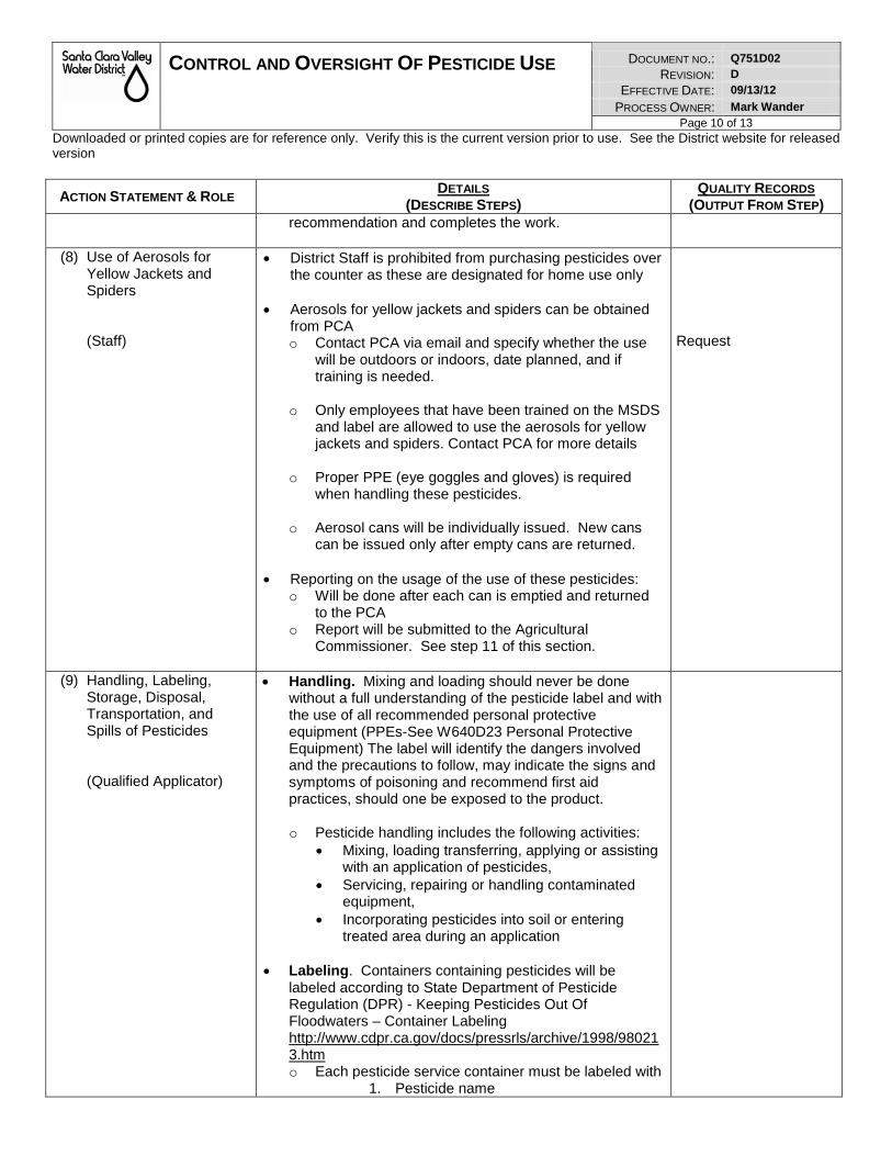
CONTROL AND OVERSIGHT OF PESTICIDE USE DOCUMENT NO.: Q751D02
REVISION: D
EFFECTIVE DATE: 09/13/12
PROCESS OWNER: Mark Wander Page 10 of 13
Downloaded or printed copies are for reference only. Verify this is the current version prior to use. See the District website for released version
ACTION STATEMENT & ROLE DETAILS
(DESCRIBE STEPS) QUALITY RECORDS
(OUTPUT FROM STEP) recommendation and completes the work.
(8) Use of Aerosols for
Yellow Jackets and Spiders
(Staff)
• District Staff is prohibited from purchasing pesticides over the counter as these are designated for home use only
• Aerosols for yellow jackets and spiders can be obtained from PCA o Contact PCA via email and specify whether the use
will be outdoors or indoors, date planned, and if training is needed.
o Only employees that have been trained on the MSDS
and label are allowed to use the aerosols for yellow jackets and spiders. Contact PCA for more details
o Proper PPE (eye goggles and gloves) is required
when handling these pesticides.
o Aerosol cans will be individually issued. New cans can be issued only after empty cans are returned.
• Reporting on the usage of the use of these pesticides:
o Will be done after each can is emptied and returned to the PCA
o Report will be submitted to the Agricultural Commissioner. See step 11 of this section.
Request
(9) Handling, Labeling, Storage, Disposal, Transportation, and Spills of Pesticides (Qualified Applicator)
• Handling. Mixing and loading should never be done without a full understanding of the pesticide label and with the use of all recommended personal protective equipment (PPEs-See W640D23 Personal Protective Equipment) The label will identify the dangers involved and the precautions to follow, may indicate the signs and symptoms of poisoning and recommend first aid practices, should one be exposed to the product. o Pesticide handling includes the following activities:
• Mixing, loading transferring, applying or assisting with an application of pesticides,
• Servicing, repairing or handling contaminated equipment,
• Incorporating pesticides into soil or entering treated area during an application
• Labeling. Containers containing pesticides will be
labeled according to State Department of Pesticide Regulation (DPR) - Keeping Pesticides Out Of Floodwaters – Container Labeling http://www.cdpr.ca.gov/docs/pressrls/archive/1998/980213.htm o Each pesticide service container must be labeled with
1. Pesticide name
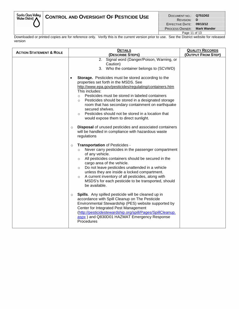
CONTROL AND OVERSIGHT OF PESTICIDE USE DOCUMENT NO.: Q751D02
REVISION: D
EFFECTIVE DATE: 09/13/12
PROCESS OWNER: Mark Wander Page 11 of 13
Downloaded or printed copies are for reference only. Verify this is the current version prior to use. See the District website for released version
ACTION STATEMENT & ROLE DETAILS
(DESCRIBE STEPS) QUALITY RECORDS
(OUTPUT FROM STEP) 2. Signal word (Danger/Poison, Warning, or
Caution) 3. Who the container belongs to (SCVWD)
• Storage. Pesticides must be stored according to the
properties set forth in the MSDS. See http://www.epa.gov/pesticides/regulating/containers.htm This includes: o Pesticides must be stored in labeled containers o Pesticides should be stored in a designated storage
room that has secondary containment on earthquake secured shelves.
o Pesticides should not be stored in a location that would expose them to direct sunlight.
o Disposal of unused pesticides and associated containers will be handled in compliance with hazardous waste regulations
o Transportation of Pesticides - o Never carry pesticides in the passenger compartment
of any vehicle. o All pesticides containers should be secured in the
cargo area of the vehicle. o Do not leave pesticides unattended in a vehicle
unless they are inside a locked compartment. o A current inventory of all pesticides, along with
MSDS's for each pesticide to be transported, should be available.
o Spills. Any spilled pesticide will be cleaned up in
accordance with Spill Cleanup on The Pesticide Environmental Stewardship (PES) website supported by Center for Integrated Pest Management (http://pesticidestewardship.org/spill/Pages/SpillCleanup.aspx ) and Q830D01 HAZMAT Emergency Response Procedures
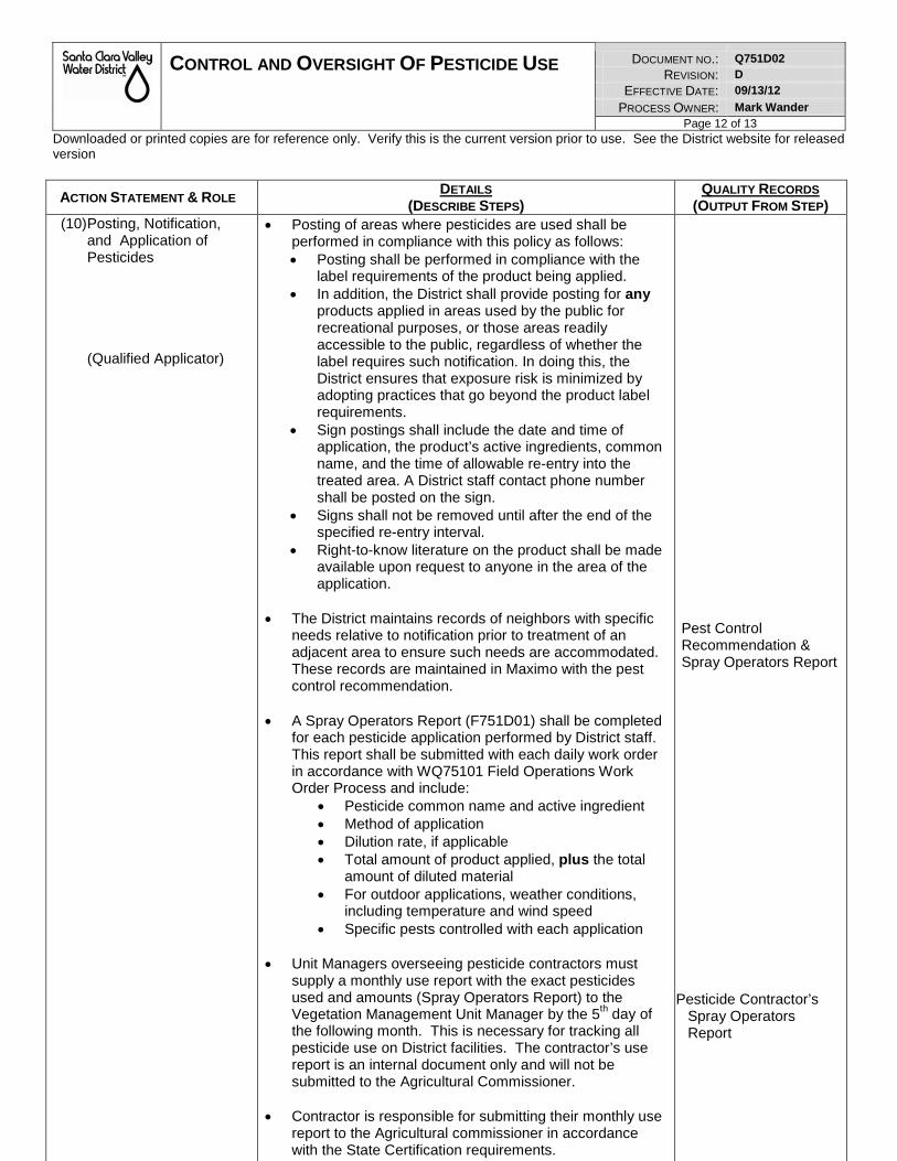
CONTROL AND OVERSIGHT OF PESTICIDE USE DOCUMENT NO.: Q751D02
REVISION: D
EFFECTIVE DATE: 09/13/12
PROCESS OWNER: Mark Wander Page 12 of 13
Downloaded or printed copies are for reference only. Verify this is the current version prior to use. See the District website for released version
ACTION STATEMENT & ROLE DETAILS
(DESCRIBE STEPS) QUALITY RECORDS
(OUTPUT FROM STEP) (10) Posting, Notification,
and Application of Pesticides (Qualified Applicator)
• Posting of areas where pesticides are used shall be performed in compliance with this policy as follows: • Posting shall be performed in compliance with the
label requirements of the product being applied. • In addition, the District shall provide posting for any
products applied in areas used by the public for recreational purposes, or those areas readily accessible to the public, regardless of whether the label requires such notification. In doing this, the District ensures that exposure risk is minimized by adopting practices that go beyond the product label requirements.
• Sign postings shall include the date and time of application, the product’s active ingredients, common name, and the time of allowable re-entry into the treated area. A District staff contact phone number shall be posted on the sign.
• Signs shall not be removed until after the end of the specified re-entry interval.
• Right-to-know literature on the product shall be made available upon request to anyone in the area of the application.
• The District maintains records of neighbors with specific needs relative to notification prior to treatment of an adjacent area to ensure such needs are accommodated. These records are maintained in Maximo with the pest control recommendation.
• A Spray Operators Report (F751D01) shall be completed for each pesticide application performed by District staff. This report shall be submitted with each daily work order in accordance with WQ75101 Field Operations Work Order Process and include:
• Pesticide common name and active ingredient • Method of application • Dilution rate, if applicable • Total amount of product applied, plus the total
amount of diluted material • For outdoor applications, weather conditions,
including temperature and wind speed • Specific pests controlled with each application
• Unit Managers overseeing pesticide contractors must
supply a monthly use report with the exact pesticides used and amounts (Spray Operators Report) to the Vegetation Management Unit Manager by the 5th day of the following month. This is necessary for tracking all pesticide use on District facilities. The contractor’s use report is an internal document only and will not be submitted to the Agricultural Commissioner.
• Contractor is responsible for submitting their monthly use report to the Agricultural commissioner in accordance with the State Certification requirements.
Pest Control Recommendation & Spray Operators Report
Pesticide Contractor’s
Spray Operators Report
CONTROL AND OVERSIGHT OF PESTICIDE USE DOCUMENT NO.: Q751D02
REVISION: D
EFFECTIVE DATE: 09/13/12
PROCESS OWNER: Mark Wander Page 13 of 13
Downloaded or printed copies are for reference only. Verify this is the current version prior to use. See the District website for released version
ACTION STATEMENT & ROLE DETAILS
(DESCRIBE STEPS) QUALITY RECORDS
(OUTPUT FROM STEP) (11) Reporting
(Vegetation Unit Manager)
• A re port will be run monthly from Ma ximo lis ting the total amount of products used for pest control including the common name.
• This lis ting will be submitted to the Agricultural
commissioner no later than the 10th day of each month.
Maximo Report Report send to Agricultural Commissioner
9. QUALITY RECORDS
QUALITY RECORD LOCATION
KEPT FILING ORDER
RECORDS
RETENTION
SCHEDULE SERIES
NO.
COMMENTS
Pesticide Products Approved for District Use List
District Document
Control
Document ID RS-0226
Maximo Database Record (including reports)
Network Server Work Order Number
RS-0052
Pest Control Recommendation & Report
Work Order Facility Number & Date
RS-0221
Report send to Agricultural Commissioner
Process Owner Files
Date RS-0026
Original Training Records Process Owner Files
Date RS-0076
10. CHANGE HISTORY Date Revision Comments 02/10/10 A Initial release into QEMS, effective 1/27/10. Supersedes Administrative Policy and
Procedure Ad-8.2 Pesticide Use. This document was sent to be reviewed by: Bill Smith; Geoffrey Weigand; David Matthews; Marc Klemencic; Liang Lee; Mike Martin; Debra Caldon; Mike Cresap; Melanie Richardson (Maryann O’Brien); Ann Draper; Chris Elias; Jim Fiedler; Michael Hamer; Frank Maitski; and Neddal Ali-Adeeb.
04/29/11 B Major rewrite of document. Document was sent for the first stakeholder review in September 2010 and a second stakeholder review in December 2010. Comments were provided by Michael Sanchez; Jennifer Castillo; David Dunlap; Joe Chavez; Jim Crowley; Jamie McLeod; David Matthews; Bill Smith; Kenneth McKenzie; John Chapman, Sunny Williams, Lisa Porcella, and Nina Merrill. A meeting with held with Larry Lopez, Geoffrey Weigand, Mike Cresap; and Tom Spada to collect comments. Stakeholder comments have been responded to and incorporated into the document where appropriate.
09/21/11 C Minor editorial changes: incorporated W640D23 Personal Protective Equipment in Procedure Steps 5 and 9 and added a link to Spill Cleanup.
09/13/12 D Minor editorial changes: added definition of IPM, corrections of spelling and language.
12/23/15 D Minor editorial change: clarified roles and responsibilities of classifications in Unit 295 and requirements for Licensing and Certifications in the Unit
11. ADDENDA
None
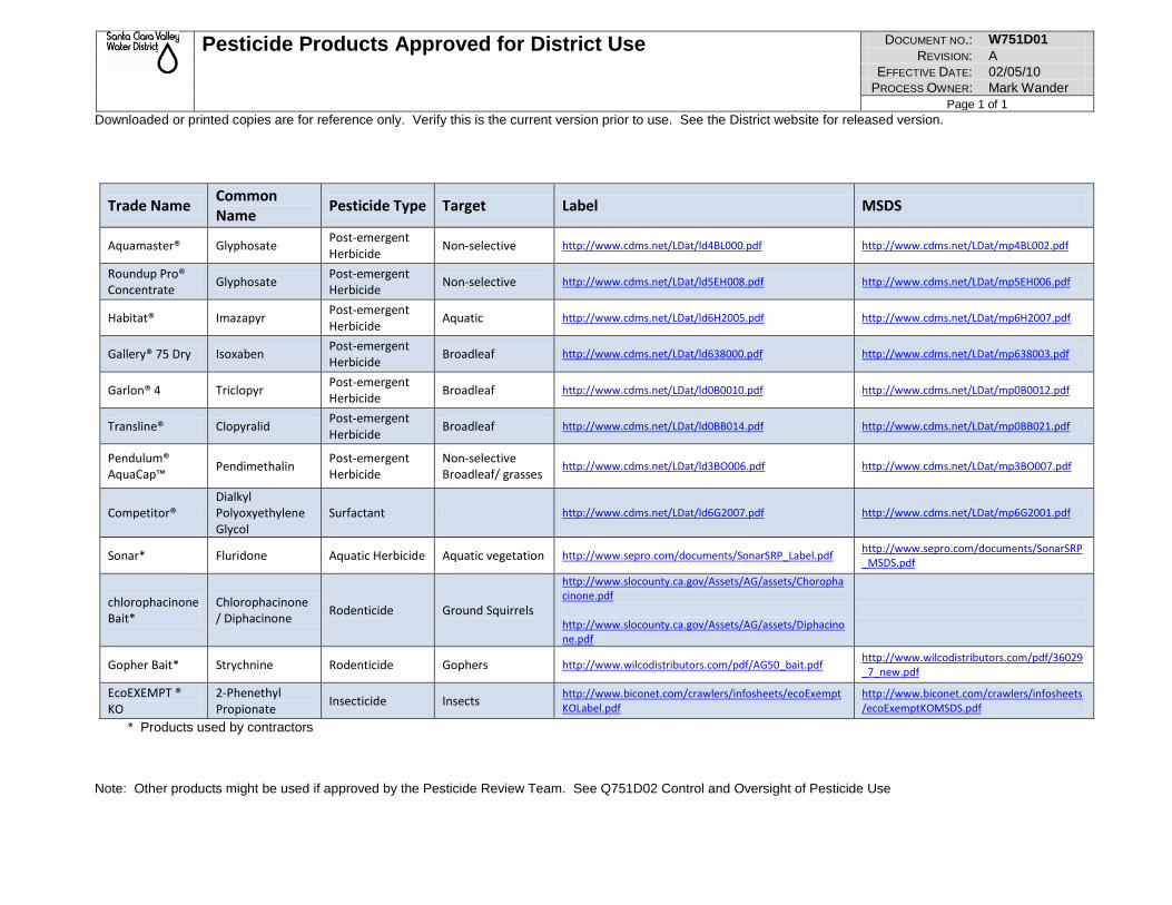
Pesticide Products Approved for District Use DOCUMENT NO.: W751D01 REVISION: A
EFFECTIVE DATE: 02/05/10 PROCESS OWNER: Mark Wander
Page 1 of 1 Downloaded or printed copies are for reference only. Verify this is the current version prior to use. See the District website for released version.
Trade Name Common Name Pesticide Type Target Label MSDS
Aquamaster® Glyphosate Post-emergent Herbicide Non-selective http://www.cdms.net/LDat/ld4BL000.pdf http://www.cdms.net/LDat/mp4BL002.pdf
Roundup Pro® Concentrate Glyphosate Post-emergent
Herbicide Non-selective http://www.cdms.net/LDat/ld5EH008.pdf http://www.cdms.net/LDat/mp5EH006.pdf
Habitat® Imazapyr Post-emergent Herbicide Aquatic http://www.cdms.net/LDat/ld6H2005.pdf http://www.cdms.net/LDat/mp6H2007.pdf
Gallery® 75 Dry Isoxaben Post-emergent Herbicide Broadleaf http://www.cdms.net/LDat/ld638000.pdf http://www.cdms.net/LDat/mp638003.pdf
Garlon® 4 Triclopyr Post-emergent Herbicide Broadleaf http://www.cdms.net/LDat/ld0B0010.pdf http://www.cdms.net/LDat/mp0B0012.pdf
Transline® Clopyralid Post-emergent Herbicide Broadleaf http://www.cdms.net/LDat/ld0BB014.pdf http://www.cdms.net/LDat/mp0BB021.pdf
Pendulum® AquaCap™ Pendimethalin Post-emergent
Herbicide Non-selective Broadleaf/ grasses
http://www.cdms.net/LDat/ld3BO006.pdf http://www.cdms.net/LDat/mp3BO007.pdf
Competitor® Dialkyl Polyoxyethylene Glycol
Surfactant http://www.cdms.net/LDat/ld6G2007.pdf http://www.cdms.net/LDat/mp6G2001.pdf
Sonar* Fluridone Aquatic Herbicide Aquatic vegetation http://www.sepro.com/documents/SonarSRP_Label.pdf http://www.sepro.com/documents/SonarSRP_MSDS.pdf
chlorophacinone Bait*
Chlorophacinone / Diphacinone Rodenticide Ground Squirrels
http://www.slocounty.ca.gov/Assets/AG/assets/Chorophacinone.pdf http://www.slocounty.ca.gov/Assets/AG/assets/Diphacinone.pdf
Gopher Bait* Strychnine Rodenticide Gophers http://www.wilcodistributors.com/pdf/AG50_bait.pdf http://www.wilcodistributors.com/pdf/36029_7_new.pdf
EcoEXEMPT ® KO
2-Phenethyl Propionate Insecticide Insects http://www.biconet.com/crawlers/infosheets/ecoExempt
KOLabel.pdf http://www.biconet.com/crawlers/infosheets/ecoExemptKOMSDS.pdf
* Products used by contractors Note: Other products might be used if approved by the Pesticide Review Team. See Q751D02 Control and Oversight of Pesticide Use
VEGETATION CONTROL WORK INSTRUCTIONS DOCUMENT NO.: WW75100 REVISION: R2
EFFECTIVE DATE: 01/25/11 PROCESS OWNER: Mark Wander
Page 1 of 8 Downloaded or printed copies are for reference only. Verify this is the current version prior to use. See the District website for released version
1. PURPOSE AND SCOPE: The purpose of this document is to define and substantiate vegetation control activities on creeks and rivers of the Santa Clara Valley Water District (District). This document will be used for the following purposes:
1. Training of field staff on vegetation control activities and the goals of the program. 2. Annual review of program goals by field staff, supervisors, and technical staff. 3. Education of District employees outside of the Vegetation Management Unit on the goals of
the program. 4. As a source of information for the general public and other public agencies.
The District has a wide variety of modified channel types, as well as unmodified, or natural channels under its jurisdiction. The vegetation control program is designed to fit the flood control designs of the improved facilities and to assist in the minimization of potential problems in the unimproved facilities. The basic premise behind the program is to control unwanted vegetation while minimizing damage to desirable vegetation. By succeeding, engineering standards, flood control designs, environmental concerns and habitat requirements for riparian and wetland species can all be ensured in both a timely, environmentally sensitive and economic manner.
2. REFERENCE DOCUMENTS: External References: None Internal References: Q751D02 Control and Oversight of Pesticide Use WQ75101 Field Operations Work Order Process WF75123 BMP Daily Checklist – SR/BP WF75124 BMP Project Checklist – SR/BP WF75125 BMP Checklist – Concrete WF75126 BMP Checklist – Herbicide (Chemical) WF75127 BMP Checklist – Mech Veg Removal (Non-Chemical) Stream Maintenance Program EIR Stream Maintenance Program BMP’s Maintenance Guidelines Habitat Conservation Plan O&M Manuals
3. DEFINITIONS: DEFINITION OF VEGETATION CONTROL ACTIVITIES The general definition of vegetation control as it will be used in this document includes:
1. The selective control of undesirable vegetation from top of bank to top of bank in a stream to meet maintenance guidelines or engineering standards.
VEGETATION CONTROL WORK INSTRUCTIONS DOCUMENT NO.: WW75100 REVISION: R2
EFFECTIVE DATE: 01/25/11 PROCESS OWNER: Mark Wander
Page 2 of 8 Downloaded or printed copies are for reference only. Verify this is the current version prior to use. See the District website for released version
2. The control of non-native species from top of bank to top of bank. Non-native species targeted, unless otherwise specified in the work order and pesticide recommendation are Tree Tobacco, Castor Bean, Pampas Grass, Arundo donax, Eucalyptus, Ailanthus, Tamarisk, Spartina, Lepidium Ditrichia and Broom species.
3. The control of upland vegetation for fire prevention or maintenance access. Control of
vegetation for these purposes is performed by a combination of mechanical, chemical or hand removal activities.
4. ROLES AND RESPONSIBILITIES: N/A
5. REQUIREMENTS: 5.1. ISO 9001
7.5.1 Control of Production and Service Provision
5.2. ISO 14001 4.4.6 Operational Control
5.3. Other Requirements Q751D02 Control and Oversight of Pesticide Use SMP Permits & CEQA documents
6. MONITORING AND MEASUREMENT: None
7. PROCEDURE: PLANNING OF VEGETATION CONTROL WORK The Vegetation Program Specialist, bases the recommendations for vegetation control activities on the following criteria: 1) Channel type and size of channel 2) Engineering and/or flood control/hydrology standards for the facility
3) Right of way access needs 4) Combustible fuel loads (fire protection)
5) Environmental considerations (including regulatory compliance with other agencies) 6) Avoidance/minimization of damage to existing desirable vegetation (including
revegetation areas, native vegetation, sensitive or listed plants, sensitive habitat, in the targeted application area)
VEGETATION CONTROL WORK INSTRUCTIONS DOCUMENT NO.: WW75100 REVISION: R2
EFFECTIVE DATE: 01/25/11 PROCESS OWNER: Mark Wander
Page 3 of 8 Downloaded or printed copies are for reference only. Verify this is the current version prior to use. See the District website for released version
Each work order (Quality Record) for a vegetation control activity will be in accordance with WQ75101 Field Operations Work Order Process and contains the following information:
1. A computer generated description of the facility, specific location(s) of work areas, and specific work to be performed (vegetation types, etc)
2. A channel cross section showing the locations of the vegetation to be controlled 3. A BMP checklist 4. If herbicides are used for the work, a pest control recommendation containing all of the
application information required by the State Department of Pesticide Regulation. This recommendation also provides further specifics regarding the type of treatment for the facility.
5. Maps and photos of the area which include further description of work to be performed, areas to leave undisturbed, etc.
6. Written clearances by Environmental Services staff relative to bird nesting, fisheries, amphibians, etc.
METHOD The following pages describe the methods of work performed on District facilities. The methods vary in relation to the type of channel. A list of each facility or portion of facility that falls into each category follows the category description. DESCRIPTION OF CHANNEL TYPES The following description begins with the largest modified facilities and ends with the smallest unmodified facilities.
IN STREAM WORK DESCRIPTIONS In stream work descriptions are specific to the facility type(s) as defined in this section.
1) LARGE IMPROVED EARTHEN CHANNELS (WITH OR WITHOUT LEVEES) In general, all of the larger channels under the District's jurisdiction can tolerate flexible aquatic vegetation and some large trees . For this reason, unless otherwise specified by formal standards or guidelines, the work performed on these facilities is limited to the following:
1. Control of woody volunteers or riparian species that exceed the hydraulic standard
criteria for the facility. Treatment with aquatic herbicides is limited to trees less the 2 inches DBH, or less than 10 feet in height. Removal by hand or mechanical methods is limited to trees less than 6 inches DBH. Unless specified in the engineering standards, mitigation documents, or O&M Guidelines for the facility, woody riparian species will be allowed to remain within ten feet of both sides of the existing low flow channel to maintain appropriate water temperatures for fisheries. Application is made in the channel bottom by foliar application (spray to wet coverage of all of the plant’s foliage). In areas where herbicide drift may affect desirable species, the trees will be cut by chainsaw or other hand methods and the fresh stumps will be treated with aquatic herbicide (Aquamaster) immediately after the cut is made.
2. Selected pruning of in stream vegetation to an identified height to allow flows to pass below
the canopy. This design feature will be noted on the specific work order. Types of

VEGETATION CONTROL WORK INSTRUCTIONS DOCUMENT NO.: WW75100 REVISION: R2
EFFECTIVE DATE: 01/25/11 PROCESS OWNER: Mark Wander
Page 4 of 8 Downloaded or printed copies are for reference only. Verify this is the current version prior to use. See the District website for released version
vegetation, height of pruning and estimated frequency will be noted in Maintenance Guidelines for specific facilities and will serve as a reference for the work order.
3. Clearance of woody vegetation from toe to toe within 100 feet upstream and downstream of
bridges or as defined in Maintenance Guidelines or Engineering Standards.
4. Control of non native species described earlier in this document within the entire right of way. Any additional species of concern specific to the facility will be outlined in the work order or pest control recommendation. If the applicator discovers undesirable species not listed in this document or in the work order package, approval of treatment must be made in writing by the Pest Control Adviser.
5. Larger trees are left in the channel bottom and on the slopes of these facilities to establish
and maintain a riparian canopy. Large non native species may be removed and the stumps chemically treated. Any large tree removal must be cleared by the appropriate Watershed Environmental Planner and permitted by local municipalities where applicable.
The channels included in this category are:
STEVENS CREEK SAN FRANCISQUITO CREEK CALABAZAS CREEK (HWY 101 D/S TO HWY 237) SAN TOMAS CREEK (SARATOGA CREEK TO HWY 237) SARATOGA CREEK (PRUNERIDGE D/S TO SAN TOMAS CREEK) GUADALUPE RIVER (ALAMITOS CREEK TO D/S UPRR) LOS GATOS CREEK ALAMITOS CREEK GUADALUPE CREEK (NON NATIVES ONLY) COYOTE CREEK BERRYESSA CREEK (CALAVERAS BLVD TO LOWER PEN)
THOMPSON CREEK (QUIMBY RD. U/S TO CADWALLADER) 2) SMALL IMPROVED EARTHEN CHANNELS Generally, smaller improved earthen channels cannot tolerate woody vegetation. There are limitations on the amounts of upright aquatic vegetation allowed in the channel bottom to meet engineering standards and maintenance guidelines. Work performed on these facilities includes the following: 1) Control of woody volunteers from toe to toe. 2) Control of excessive upright aquatic vegetation (cattails, bulrush etc.) from toe to toe. 3) Control of non natives from top of bank to top of bank. Native trees and shrubs are left untreated on the slopes of these facilities unless identified in writing to be removed as part of each individual project.
The channels included in this category are: PERMANENTE CREEK ( HWY 101 D/S TO CHARLESTON) SUNNYVALE EAST SUNNYVALE WEST CALABAZAS (LAWRENCE EXPRESSWAY U/S TO MILLER)
CONTACT THE REVEG SECTION (ext 3867)FOR AREAS TO AVOID RODEO CREEK REGNART CREEK
VEGETATION CONTROL WORK INSTRUCTIONS DOCUMENT NO.: WW75100 REVISION: R2
EFFECTIVE DATE: 01/25/11 PROCESS OWNER: Mark Wander
Page 5 of 8 Downloaded or printed copies are for reference only. Verify this is the current version prior to use. See the District website for released version
PROSPECT CREEK EL CAMINO STORM DRAIN JUNIPERO SERRA CHANNEL (D/S WOLFE RD. TO CALABAZAS) SAN TOMAS CREEK (POLLARD ROAD TO McCOY) SARATOGA CREEK (PRUNERIDGE U/S TO PROSPECT RD.) SMITH CREEK (U/S GRANADA WAY TO END OF ACCESS) CANOAS CREEK GOLF CREEK GREYSTONE CREEK (ALAMITOS CREEK U/S TO ALMADEN EXPRESSWAY) ROSS CREEK RANDOL CREEK BERRYESSA CREEK (OLD PIEDMONT RD. TO CALAVERAS BLVD.) CALERA CREEK RUBY CREEK LOS COCHES CREEK (BERRYESSA CREEK U/S TO DEMPSEY) SILVER CREEK MIGUELITA CREEK PIEDMONT CREEK (BERRYESSA CREEK U/S TO HWY 680) UPPER PENITENCIA CREEK LOWER PENITENCIA CREEK SIERRA CREEK TULARCITOS CREEK NORWOOD CREEK QUIMBY CREEK THOMPSON CREEK (SILVER CREEK U/S TO QUIMBY RD.) FLINT CREEK EAST PENITENCIA CREEK
3) CONCRETE LINED CHANNELS Concrete lined U-frame or trapezoidal channels require vegetation control for both flood control and to maintain the structural integrity of the concrete lining. Work on these facilities includes the following: 1) Control of woody volunteers from toe to toe. 2) Control of upright aquatic vegetation from toe to toe. 3) Control of all vegetation in weep holes, expansion joints and any areas which may
damage the structural integrity of the concrete. 4) Control of non natives within the right of way.
The channels included in this category are: ADOBE CREEK (EL CAMINO D/S TO HWY 1O1) BARRON CREEK (EL CAMINO D/S TO HWY 101) MATADERO CREEK (EL CAMINO D/S TO HWY 101) STANFORD CHANNEL HALE CREEK (PERMANENTE CREEK U/S TO ROSITA) PERMANENTE CREEK (HWY 101 U/S TO HALE CREEK) CALABAZAS CREEK (HWY 1O1 U/S TO LAWRENCE) JUNIPERO SERRA CHANNEL (WOLFE RD. U/S TO HWY 85) SAN TOMAS CREEK (WILLIAMS RD. U/S TO McCOY) SMITH CREEK (SAN TOMAS CREEK U/S TO VASONA CANAL) DAVES CREEK (WILD WAY U/S TO FIRST DROP STRUCTURE) GREYSTONE CREEK (ALMADEN EXPWY TO OLIVE BRANCH)
VEGETATION CONTROL WORK INSTRUCTIONS DOCUMENT NO.: WW75100 REVISION: R2
EFFECTIVE DATE: 01/25/11 PROCESS OWNER: Mark Wander
Page 6 of 8 Downloaded or printed copies are for reference only. Verify this is the current version prior to use. See the District website for released version
LONE HILL CREEK (ROSS CREEK U/S TO LOS GATOS ALMADEN) ROSS CREEK (BLOSSOM HILL RD. TO DEL CARLO CT.) NORTH BABB CREEK SOUTH BABB CREEK LOS COCHES CREEK (S. PARK VICTORIA U/S TO EVANS) PIEDMONT CREEK (HWY 680 U/S TO PARK VICTORIA) SILVER CREEK DIVERSION
4) UNIMPROVED (NATURAL) CHANNELS Aquatic work in unimproved channels is limited to the following: 1) Areas where the District has legal right of way. 2) Non-native vegetation (this is limited to cut stump treatments only)
3) Poison oak control as requested by the public or which impedes maintenance work. Due to the high habitat value of poison oak, requests from the public will be handled on a case by case basis.
4) Control of woody and aquatic vegetation from toe to toe as needed. All work in unmodified channels must meet the requirements of the unmodified channel appendix of the District’s Stream Maintenance EIR.
The channels included in this category are: ADOBE CREEK (EL CAMINO U/S TO THE U/S END OF THE DIVERSION) BARRON CREEK (DEBRIS BASIN U/S TO ARASTRADERO RD.) HENEY CREEK PERMANENTE CREEK (HALE CREEK U/S TO FOOTHILL EXPWY) SUMMERHILL CREEK CALABAZAS CREEK (MILLER AVE. U/S TO CHIQUITA ) SARATOGA CREEK (PROSPECT RD. U/S TO CRESTBROOK) WILDCAT CREEK CALERO CREEK SANTA TERESA CREEK
UPLAND WORK DESCRIPTIONS Upland work activities include weed abatement, and removal of vegetation to provide maintenance access and fire prevention. The level of fire prevention work is determined through a collaborative process between Unit staff and staff from the County Fire Marshall’s office. These activities are more general in nature and do not vary significantly based on the specific channel type. Upland work activities include:
1. Herbicide applications on Maintenance Roads and top of bank areas 2. Pruning of overhanging growth to provide maintenance access 3. Mowing of creek banks and levee slopes 4. Mechanical Disking, mowing or hand removal of weeds on floodplains and larger upland parcels.
Each of these activities are performed under specific work orders for each facility after being reviewed by the Vegetation Program Specialist and cleared by Environmental Services staff. Standard operating procedures for both in stream and upland vegetation control activities are included in the following section.
VEGETATION CONTROL WORK INSTRUCTIONS DOCUMENT NO.: WW75100 REVISION: R2
EFFECTIVE DATE: 01/25/11 PROCESS OWNER: Mark Wander
Page 7 of 8 Downloaded or printed copies are for reference only. Verify this is the current version prior to use. See the District website for released version
STANDARD OPERATING PROCEDURES (SOP’S) In addition to the formal Best Management Practices of the Stream Maintenance Program EIR, the District’s vegetation management program incorporates the following standard operating procedures into its day to day operation:
1. Application of herbicides from the downstream end of a project to the upstream end. This minimizes the potential of the herbicide concentration increasing, which may happen if the application is being made in the direction of the current.
2. Minimizing drift by using anti-drift agents and applying the herbicide from the upwind side of the
target. Jobs are shut down when winds exceed 10 mph. All applicators carry anemometers to measure wind speed prior to and during an application. Target species are treated from as close a distance as possible to minimize drift to off site species. Whenever possible, applicators wash off any off target drift from desirable foliage.
3. Training of all Unit staff and contractors in the identification of native and non native species,
special status species, desirable and undesirable vegetation prior to the start of each work season.
4. Requiring that all employees, contractors etc. who apply herbicides do so only under the immediate oversight (must be on site during application) of a Qualified Applicator as defined by the State Department of Pesticide Regulation and only with a written recommendation by a licensed Pest Control Adviser (PCA) in accordance with Q751D02 Control and Oversight of Pesticide Use.
5. Evaluation of each site by a Vegetation Program Specialist of which activity (chemical, mechanical
or hand removal) best suits the job based on environmental criteria, etc. In cases where herbicides will be used, such evaluation must be performed by a Pest Control Adviser.
6. Routine monitoring of channels for changes in vegetation types and invasive species so that
control can be obtained with minimum impact to desirable species.
7. Application of aquatic herbicides or mechanical control of in stream vegetation is performed only during the time of year between the end of bird nesting season (usually when cleared by District Biological staff) and the commencement of anadromous fish migration. (Usually around October 15th, or as described in the Stream Maintenance Program). In addition, further avoidance is taken regarding any listed species in specific areas as defined by biological staff. In specific areas of concern, no activities during these periods will occur without an accompanying biological survey by District biologists.
8. Mechanical and hand removal of upland weeds and removal or pruning of overhanging growth for
maintenance access shall not be performed during nesting season (as defined by biological staff) without accompanying nesting or botanical surveys by qualified staff. If nests are found in the work area, work may only proceed after the nests have been marked and an appropriate buffer zone has been clearly identified as described in the BMP document. Work shall not be performed within the buffer zone until approved by a District biologist. In areas with special plant species, work shall not proceed until a qualified botanist has cleared work (upon completion of seed set and dispersal)
9. Discontinuing applications when out of season activities are noticed (e.g. early migration of fish,
early or late nesting of upland species, late nesting waterfowl, or the presence of endangered or threatened species.)

VEGETATION CONTROL WORK INSTRUCTIONS DOCUMENT NO.: WW75100 REVISION: R2
EFFECTIVE DATE: 01/25/11 PROCESS OWNER: Mark Wander
Page 8 of 8 Downloaded or printed copies are for reference only. Verify this is the current version prior to use. See the District website for released version
10. Any removal or control of native vegetation within the channel banks or in upland areas is
prohibited without written direction from the Vegetation Specialist or the Senior Field Operations Administrator. In cases where selective vegetative thinning is to occur, each plant or plant type to be removed will be required to be clearly identified prior to the start of work through pre construction meetings, or site surveys.
11. Continual research of new methods, equipment, products and ongoing development of staff.
This document will be reviewed by staff at the start of each work season as part of their training. Failure to follow the guidelines in this or any other documents defining the restrictions and requirements for vegetation management will result in progressive disciplinary measures up to and including dismissal of the employee. 8. QUALITY RECORDS:
QUALITY RECORD LOCATION KEPT
FILING ORDER
RECORDS RETENTION
SCHEDULE SERIES NO.
COMMENTS
BMP Checklists BMP Binder (SR. FAO)
Activity, Facility Number & Date RS-0219
Work Order Package SOS Facility Number & Date RS-0172
Maximo – Work Order Maximo Facility Number & Date RS-0052
9. CHANGE HISTORY: Date Revision Comments 09/07/05 R1 New Release
01/25/11 R2 Update of template
10. ADDENDA:
None
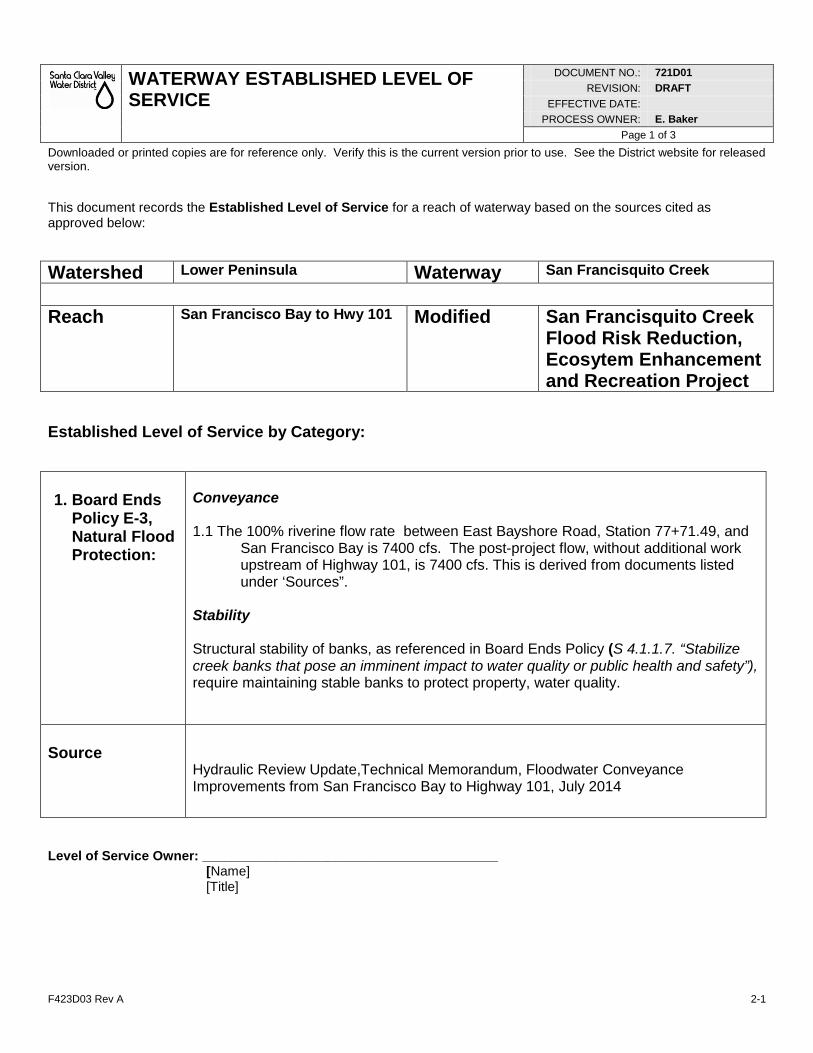
F423D03 Rev A 2-1
WATERWAY ESTABLISHED LEVEL OF SERVICE
DOCUMENT NO.: 721D01
REVISION: DRAFT
EFFECTIVE DATE:
PROCESS OWNER: E. Baker
Page 1 of 3
Downloaded or printed copies are for reference only. Verify this is the current version prior to use. See the District website for released version.
This document records the Established Level of Service for a reach of waterway based on the sources cited as approved below:
Watershed Lower Peninsula Waterway San Francisquito Creek
Reach San Francisco Bay to Hwy 101 Modified San Francisquito Creek
Flood Risk Reduction, Ecosytem Enhancement and Recreation Project
Established Level of Service by Category:
1. Board Ends
Policy E-3, Natural Flood Protection:
Conveyance 1.1 The 100% riverine flow rate between East Bayshore Road, Station 77+71.49, and
San Francisco Bay is 7400 cfs. The post-project flow, without additional work upstream of Highway 101, is 7400 cfs. This is derived from documents listed under ‘Sources”.
Stability Structural stability of banks, as referenced in Board Ends Policy (S 4.1.1.7. “Stabilize creek banks that pose an imminent impact to water quality or public health and safety”), require maintaining stable banks to protect property, water quality.
Source
Hydraulic Review Update,Technical Memorandum, Floodwater Conveyance Improvements from San Francisco Bay to Highway 101, July 2014
Level of Service Owner: ________________________________________ [Name] [Title]
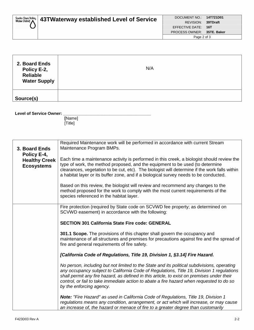
43TWaterway established Level of Service DOCUMENT NO.: 14T721D01
REVISION: 39TDraft
EFFECTIVE DATE: 16T
PROCESS OWNER: 35TE. Baker
Page 2 of 3
F423D03 Rev A 2-2
2. Board Ends
Policy E-2, Reliable Water Supply
N/A
Source(s)
Level of Service Owner: ______________________________________ [Name] [Title] 3. Board Ends
Policy E-4, Healthy Creek Ecosystems
Required Maintenance work will be performed in accordance with current Stream Maintenance Program BMPs.
Each time a maintenance activity is performed in this creek, a biologist should review the type of work, the method proposed, and the equipment to be used (to determine clearances, vegetation to be cut, etc). The biologist will determine if the work falls within a habitat layer or its buffer zone, and if a biological survey needs to be conducted. Based on this review, the biologist will review and recommend any changes to the method proposed for the work to comply with the most current requirements of the species referenced in the habitat layer.
Fire protection (required by State code on SCVWD fee property; as determined on SCVWD easement) in accordance with the following:
SECTION 301 California State Fire code: GENERAL 301.1 Scope. The provisions of this chapter shall govern the occupancy and maintenance of all structures and premises for precautions against fire and the spread of fire and general requirements of fire safety. [California Code of Regulations, Title 19, Division 1, §3.14] Fire Hazard. No person, including but not limited to the State and its political subdivisions, operating any occupancy subject to California Code of Regulations, Title 19, Division 1 regulations shall permit any fire hazard, as defined in this article, to exist on premises under their control, or fail to take immediate action to abate a fire hazard when requested to do so by the enforcing agency. Note: "Fire Hazard" as used in California Code of Regulations, Title 19, Division 1 regulations means any condition, arrangement, or act which will increase, or may cause an increase of, the hazard or menace of fire to a greater degree than customarily
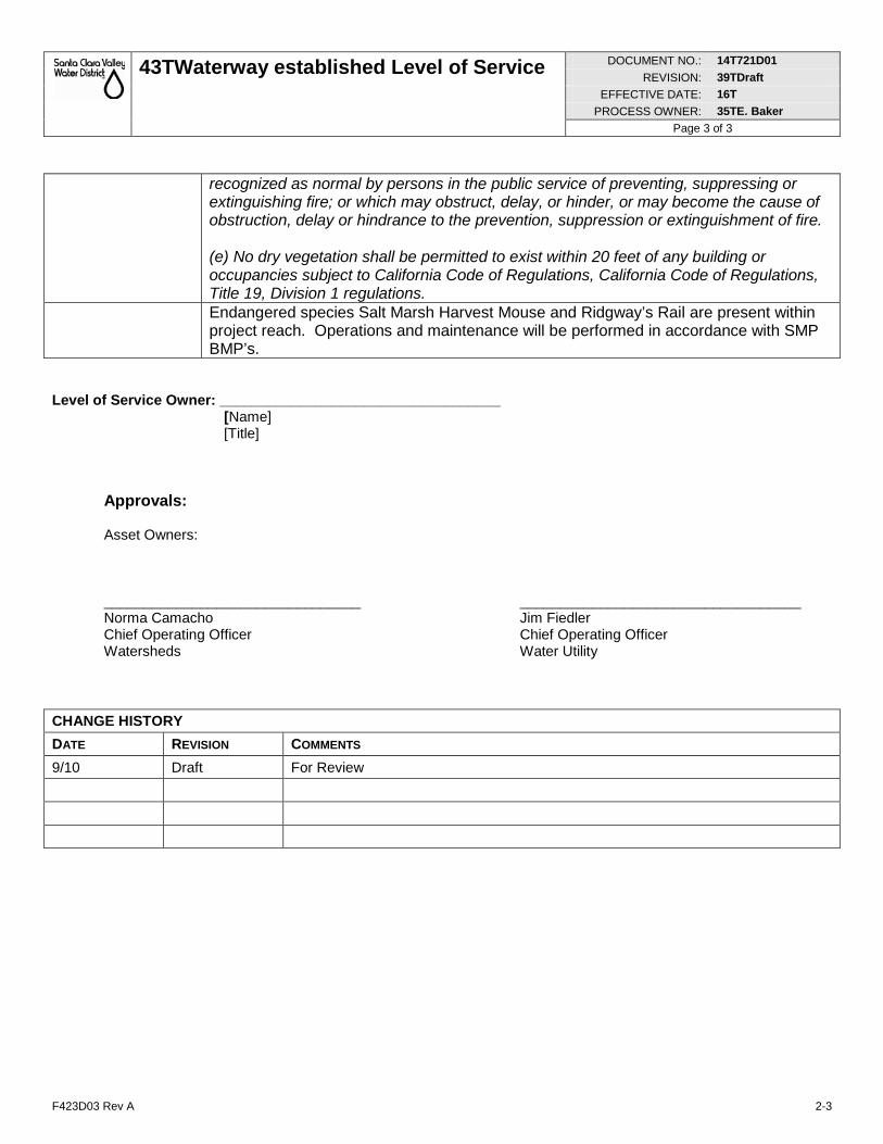
43TWaterway established Level of Service DOCUMENT NO.: 14T721D01
REVISION: 39TDraft
EFFECTIVE DATE: 16T
PROCESS OWNER: 35TE. Baker
Page 3 of 3
F423D03 Rev A 2-3
recognized as normal by persons in the public service of preventing, suppressing or extinguishing fire; or which may obstruct, delay, or hinder, or may become the cause of obstruction, delay or hindrance to the prevention, suppression or extinguishment of fire. (e) No dry vegetation shall be permitted to exist within 20 feet of any building or occupancies subject to California Code of Regulations, California Code of Regulations, Title 19, Division 1 regulations.
Endangered species Salt Marsh Harvest Mouse and Ridgway’s Rail are present within project reach. Operations and maintenance will be performed in accordance with SMP BMP’s.
Level of Service Owner: ___________________________________ [Name] [Title]
Approvals: Asset Owners: ________________________________ ___________________________________ Norma Camacho Jim Fiedler Chief Operating Officer Chief Operating Officer Watersheds Water Utility
CHANGE HISTORY
DATE REVISION COMMENTS
9/10 Draft For Review
Special Structures Section 26
San Francisquito Creek 26-14 Revised May 2015 Flood Reduction, Ecosystem Restoration, and Recreation Project
26.03 Protective Coating — Bid Item No. 22
A. Scope of Work
1. Provide all labor, materials, equipment and incidentals required to coat the buried and above ground portions of the steel sheet pile wall components, using a combination of coating systems as specified herein. Perform all surface preparation and coating application at a controlled shop facility. Field coating operations shall only consist of touchup coating repairs during and after erection as specified herein. Field operations shall be in accordance with coating environment and surface temperature during surface preparation and coating application per coating manufacturer product specification. The dimensions of the piles are shown on the Drawings.
2. Qualifications
a. The Contractor shall be regularly engaged in the application of similar coatings and structures for at least five years immediately prior to this work: The Contractor shall provide evidence of this experience by providing the name of previous projects with owner’s name, owner’s phone numbers, and years that coating application as performed.
b. All contractors and subcontractors that perform surface preparation or coating application shall be certified by the Society for Protective Coatings (formerly Steel Structures Painting Council) (SSPC) to the requirements of SSPC QP 1 and QP 3 prior to contract award, and shall remain certified while accomplishing any surface preparation or coating application. The painting contractors and painting subcontractors must remain so certified for the duration of the project. If a contractor's or subcontractor's certification expires, the company will not be allowed to perform any work until the certification is reissued. Requests for extension of time for any delay to the completion of the project due to an inactive certification will not be considered and liquidated damages will apply. Notify the Owner of any change in contractor certification status. Contractor shall provide documentation certifying that the company is QP 1 and QP 3 Certified.
c. Foreman and workers in the shop and on the project site shall be experienced and knowledgeable in preparation for and application of high performance industrial coatings. All work shall be accomplished by Applicators qualified to accomplish the required work in a manner comparable with the best standards of practice.
billspri
Text Box
Appendix F. Floodwall Coating Specifications
Special Structures Section 26
San Francisquito Creek 26-15 Revised May 2015 Flood Reduction, Ecosystem Restoration, and Recreation Project
Continuity of personnel shall be maintained and transfers of key personnel shall be coordinated with the Engineer.
d. Workmanship shall conform to standards and recommendations of Society of Protective Coatings SSPC Vol. 1.
B. Materials and Placement
1. The coating system for buried and concrete-encased sections shall be one of the following systems:
a. System 1: Carboline 1209 – Polyamido-Amine Epoxy applied at 20 – 40 mils total dry film thickness.
b. System 2: Devoe International Interzone 1000 applied at 20 – 40 mils total dry film thickness.
2. The coating system for atmospherically exposed sections shall be one of the following systems:
a. System 1:
1) Base Coat: Carboline 1209 – Polyamido-Amine Epoxy applied at 20 – 40 mils total DFT.
2) Top Coat: Carboline Carbothane 133VOC (UV Resistant) Polyurethane applied at a minimum dry film thickness of 5 mils total DFT.
b. System 2:
1) Base Coat: Devoe International Interzone 1000 Epoxy applied at 20 – 40 mils total DFT.
2) Top Coat: Devoe International Interthane 990 SG Polyurethane applied at a minimum dry film thickness of 5 mils total DFT.
3. Coating materials for touchup shall be the same products used for application.
4. All coating color(s) to be selected and approved in writing by the Owner prior to procurement.
5. All coating products that will be used for the piles shall be provided from a single coating manufacturer. Any deviation will require prior approval from the Engineer; appropriate warranties will be required. Deviation from
billspri
Text Box
Appendix F. Floodwall Coating Specifications
Special Structures Section 26
San Francisquito Creek 26-16 Revised May 2015 Flood Reduction, Ecosystem Restoration, and Recreation Project
specified mil thickness or product type is not allowed without written authorization of Engineer.
6. Blasting media shall be sized (graded) to achieve the profile and level of cleanliness as recommended by the coating manufacturer. Blasting media shall be new, clean and free of contaminants, and containing no hazardous materials.
7. Deliver coating system materials in original, unopened containers with seals unbroken and labels intact. Labels shall identify the following:
a) Name or type number of material.
b) Manufacturer's name and item stock number.
c) Manufacturer's name, batch number, specification number.
d) Contents, by volume, of major constituents.
e) Warning labels.
f) Application instructions
g) Color name and number
h) Date of manufacture and expiration date
8. Coating materials shall be labeled and used in accordance with SSPC-PA 1, paragraph 5.1.1 through 5.1.5, except all coating system materials without a stated shelf life shall be delivered and used within 6 months of the date of manufacture; and certification, from any source, that the coating system materials are still suitable for use beyond the stated shelf life or beyond the 6 month period specified above will not be accepted.
9. Store materials in a single, approved location. All containers shall be handled and stored in such a manner as to prevent damage or loss of labels or containers. All coating materials shall be stored in an enclosed, dry, well-ventilated place, protected from sparks, flame, direct rays of the sun, or from excessive heat. The Contractor shall be solely responsible for the protection of the materials stored at the shop coating facility and project job site. Maintain temperature inside the structure within the temperature range recommended by the manufacturer.
10. Safety Requirements
a. Contractor shall comply with all Federal, State, and Local applicable safety regulations and requirements.
billspri
Text Box
Appendix F. Floodwall Coating Specifications
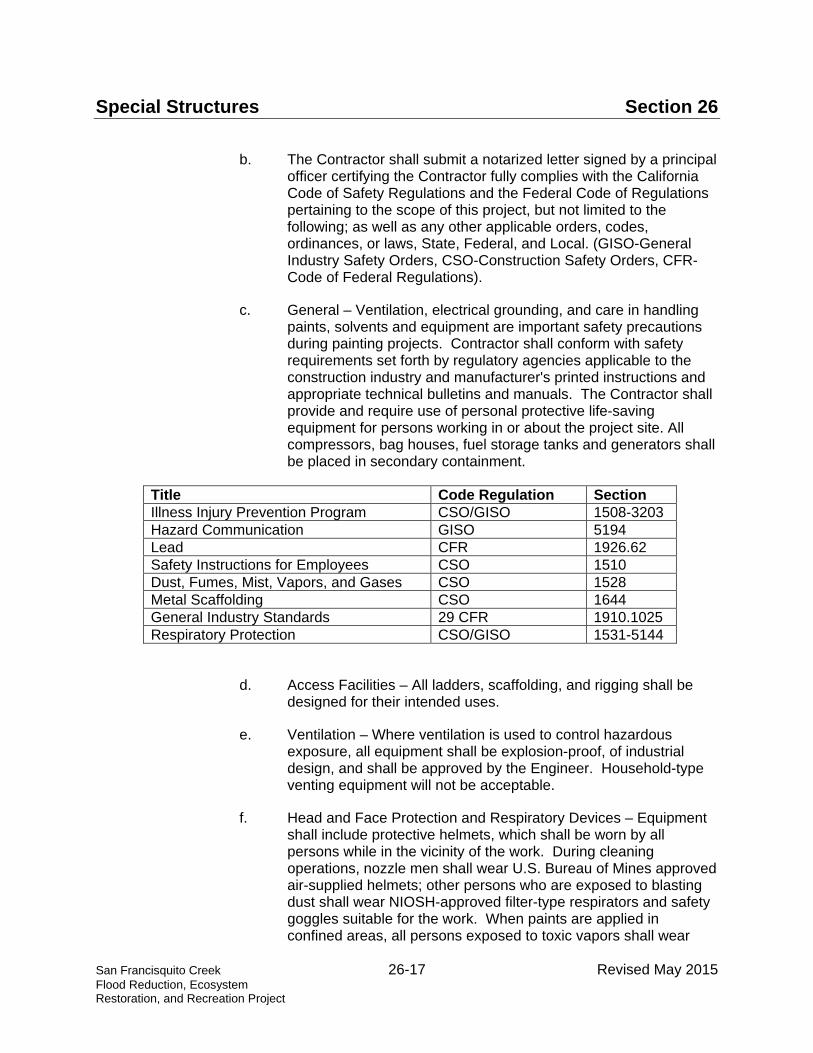
Special Structures Section 26
San Francisquito Creek 26-17 Revised May 2015 Flood Reduction, Ecosystem Restoration, and Recreation Project
b. The Contractor shall submit a notarized letter signed by a principal officer certifying the Contractor fully complies with the California Code of Safety Regulations and the Federal Code of Regulations pertaining to the scope of this project, but not limited to the following; as well as any other applicable orders, codes, ordinances, or laws, State, Federal, and Local. (GISO-General Industry Safety Orders, CSO-Construction Safety Orders, CFR-Code of Federal Regulations).
c. General – Ventilation, electrical grounding, and care in handling paints, solvents and equipment are important safety precautions during painting projects. Contractor shall conform with safety requirements set forth by regulatory agencies applicable to the construction industry and manufacturer's printed instructions and appropriate technical bulletins and manuals. The Contractor shall provide and require use of personal protective life-saving equipment for persons working in or about the project site. All compressors, bag houses, fuel storage tanks and generators shall be placed in secondary containment.
Title Code Regulation Section Illness Injury Prevention Program CSO/GISO 1508-3203 Hazard Communication GISO 5194 Lead CFR 1926.62 Safety Instructions for Employees CSO 1510 Dust, Fumes, Mist, Vapors, and Gases CSO 1528 Metal Scaffolding CSO 1644 General Industry Standards 29 CFR 1910.1025 Respiratory Protection CSO/GISO 1531-5144
d. Access Facilities – All ladders, scaffolding, and rigging shall be designed for their intended uses.
e. Ventilation – Where ventilation is used to control hazardous exposure, all equipment shall be explosion-proof, of industrial design, and shall be approved by the Engineer. Household-type venting equipment will not be acceptable.
f. Head and Face Protection and Respiratory Devices – Equipment shall include protective helmets, which shall be worn by all persons while in the vicinity of the work. During cleaning operations, nozzle men shall wear U.S. Bureau of Mines approved air-supplied helmets; other persons who are exposed to blasting dust shall wear NIOSH-approved filter-type respirators and safety goggles suitable for the work. When paints are applied in confined areas, all persons exposed to toxic vapors shall wear
billspri
Text Box
Appendix F. Floodwall Coating Specifications
Special Structures Section 26
San Francisquito Creek 26-18 Revised May 2015 Flood Reduction, Ecosystem Restoration, and Recreation Project
approved air-supplied masks. Barrier creams shall be used on any exposed areas of skin.
g. Grounding – Spray and air hoses shall be grounded to prevent accumulation of charges of static electricity.
h. Illumination – Spark-proof artificial lighting shall be provided for all work in contained spaces. Light bulbs shall be guarded to prevent breakage. Lighting fixtures and flexible cords shall comply with the requirements of NFPA 70 "National Electric Code" for the atmosphere in which they will be used. Whenever required by Engineer, the Contractor shall provide additional illumination and necessary supports to cover all areas to be inspected. The level of illumination for inspection purposes shall be determined by the Engineer.
i. Toxicity and Explosiveness – The solvents used with specified protective coatings are explosive at low concentrations and are highly toxic. Because of toxicity, the maximum allowable concentration of vapor shall be kept below the maximum safe concentration for an eight-hour exposure, plus Lower Explosive Limit (LEL) must be strictly adhered to. If coatings or paints contain lead or other hazardous materials, all regulations related to safety of personnel and handling of such materials shall be strictly adhered to.
j. Protective Clothing – Paint materials may be irritating to the skin and eyes. When handling and mixing paints, workmen shall wear gloves and eye shields.
k. Fire – During mixing and application of all materials, all flames, welding, and smoking shall be prohibited in the vicinity. Appropriate type fire abatement devices shall be provided by CONTRACTOR, and be readily available at the job site during all operations.
l. Sound Levels – Whenever the occupational noise exposure exceeds the maximum allowable sound levels, the CONTRACTOR shall provide and require the use of approved ear protective devices.
m. General sound levels for the project shall be those which will not affect routine facility or neighborhood activities. Whenever levels are objectionable, they shall be adjusted as directed by the Engineer.
billspri
Text Box
Appendix F. Floodwall Coating Specifications
Special Structures Section 26
San Francisquito Creek 26-19 Revised May 2015 Flood Reduction, Ecosystem Restoration, and Recreation Project
n. Warranty inspections of remedial work shall be at the expense of the Contractor.
11. Environmental Requirements
a. Provide continuous ventilation and heating facilities to maintain surface and ambient temperatures above 50 DegF for 24 hours before, during, and 48 hours after application of coatings, unless otherwise required by manufacturer's instructions.
b. Do not apply coatings when relative humidity is above 85 percent, unless otherwise required by manufacturer's instructions.
c. Minimum application temperatures for paints shall be 50°F unless otherwise required by manufacturer's instructions.
d. Inspector will examine surfaces after blast cleaning to verify that deposits of contaminants have been removed.
e. No paint shall be applied if the substrate/steel is wet or damp, or if the temperature is less than 5°F above the dew point.
12. Items To Be Painted
a. Steel sheet pile wall
1) Landside: Top of the pile wall to 15 feet below finished grade or 10 feet below the groundwater table (elevation -2 NAVD 88), whichever is greater.
2) Creekside: Top of the pile wall to 15 feet below finished grade or 10 feet below the groundwater table (elevation -2 NAVD 88), whichever is greater.
13. General Preparation
a. Verify that air supply is free of oil and moisture contamination. Effective oil and water separators shall be used in all main compressed air lines and shall be placed as close as practical to the equipment. Prior to using compressed air, quality of air downstream of the separator shall be tested at suitable outlets by blowing the air on clean white blotter (minimum size, 8-1/2 by 11 inch, or as approved) for 2 minutes to check for any contamination, oil, or moisture.
b. Measure air temperature, humidity, relative humidity, and metal surface temperature, and determine dew point prior to blasting or
billspri
Text Box
Appendix F. Floodwall Coating Specifications
Special Structures Section 26
San Francisquito Creek 26-20 Revised May 2015 Flood Reduction, Ecosystem Restoration, and Recreation Project
painting each day. Repeat measurements and determination of dew point as often as the Inspector deems necessary, but not less often than every 4 hours.
c. Maintain a written record of measurements and dew points, and time that measurements were taken. Make record available to Inspector immediately on request.
d. Inspector will also measure air temperature, humidity, relative humidity, and metal surface temperature, and determine dew point at least once each day that blasting or painting is performed.
e. All abrasive-blasted ferrous metal surfaces shall be inspected and approved in writing by Inspector immediately prior to application of paint coatings.
f. Inspection shall be performed to determine cleanliness and profile depth of blasted surfaces and to certify that surface has been prepared in accordance with these Specifications.
g. Schedule the abrasive blasting operation so blasted surfaces will not be wet after blasting and before painting.
h. Perform additional blasting and cleaning as required to achieve surface preparation required. Prior to painting, reblast surfaces allowed to set overnight and surfaces that show rust bloom.
i. Surfaces allowed to set overnight or surfaces which show rust bloom prior to painting shall be reinspected and approved by Inspector prior to paint application.
j. Profile depth of blasted surface: Not less than 3.0 mil or greater than 4.0 mils unless required otherwise by coating manufacturer.
k. Provide compressed air for blasting that is free of water and oil. Provide accessible separators and traps.
l. Confine blast abrasives to area being blasted. Provide shields of polyethylene sheeting or other such barriers to confine blast material.
m. Re-blast surfaces not meeting requirements of these Specifications.
n. Prepare surfaces to be painted in accordance with coating manufacturer's instructions and this Section unless noted otherwise in the Specification. Inspector will evaluate surface
billspri
Text Box
Appendix F. Floodwall Coating Specifications
Special Structures Section 26
San Francisquito Creek 26-21 Revised May 2015 Flood Reduction, Ecosystem Restoration, and Recreation Project
preparation using accepted abrasive blasting standard, and replica tapes. Evaluation will include inspection of blasted surfaces for dust and abrasive residue, using adhesive coated tape. Evaluation will be made immediately prior to coating application.
o. Remove all dust, grease, oil, compounds, dirt and other foreign matter which would prevent bonding of coating to surface.
p. Verify cleanliness of all spray application equipment prior to, or no later than, time of mixing coating material.
q. Measure wet film coating thickness during application of coating to ensure adequate coating thickness. Take at least four measurements on every steel pile.
r. Measure dry film coating thickness after each coat using non-destructive magnetic dry film gauges. Inspector will also measure coating thickness, at random locations, after each coat.
s. Contractor shall test all coated surfaces in accordance with NACE SP0188 for pinholes and holidays after application of the epoxy system, prior to application of the UV resistant polyurethane final coat where applicable and the following:
1) Perform test after coating has cured as recommended by the manufacturer.
2) Perform test in presence of Inspector.
3) Use an appropriate model holiday detector, as approved by the Inspector.
t. Retest after coating repairs.
u. Disposal of Spent Abrasive Blast Media
1) Disposal of spent abrasive blast media and removed coating materials shall be in accordance with the disposal plan approved by the Construction Administrator.
2) Coordinate and pay all costs for all sampling and testing of spent abrasive blast media and removed coating materials in order to document waste class. Minimum sampling and testing requirements are listed previously in this Section.
billspri
Text Box
Appendix F. Floodwall Coating Specifications
Special Structures Section 26
San Francisquito Creek 26-22 Revised May 2015 Flood Reduction, Ecosystem Restoration, and Recreation Project
3) Before any wastes are removed from the job site, Contractor shall allow the Construction Administrator time for review of laboratory test results, as well as the time required to obtain a Hazardous Waste Generator’s U.S. EPA ID Number if required.
4) Construction Administrator will give Contractor written notice to dispose of all or a portion of the spent abrasive blast media and/or removed coating materials as hazardous waste if the Construction Administrator determines that such disposal is required.
5) Contractor shall be responsible for all costs associated with accumulating, transporting, and disposing of spent abrasive blast media and removed coating materials.
14. Surface Preparation for Steel Pile
a. All grease, sludge and debris shall be removed from the pile surfaces prior to abrasive blast cleaning. Any chemical contamination shall be eliminated by means of neutralization and/or flushing, prior to surface preparation. Solvent and rags shall be changed frequently.
b. The anchor pattern of the blasted surface shall be sharp and angular, not peened. The anchor profile shall be 3.0 – 4.0 mils. Verify compliance with anchor profile requirements by testing in accordance with ASTM D4417.
c. Testing of Surface Profile after Abrasive Blasting: shall be tested with the use of Press-o-Film as manufactured by Testex, or other RP0287 approved equal, at locations to be determined by the Inspector. The replica tape thickness shall be measured using a dial micrometer manufactured by Testex, or other ASTM D4417 Type C approved equal. For each test area, three replica tape tests shall be performed within a single test area 12 inches in diameter. For each test area, the three replica tape thickness values shall be recorded and shall be of the coating manufacturer’s recommended profile.
d. The proper abrasive to obtain the specified profile (anchor pattern) designated in the coating manufacturers most recent printed Product Data Sheet shall be used.
1) Care must be taken so as not to use an abrasive that is contaminated with oil or chlorides.
billspri
Text Box
Appendix F. Floodwall Coating Specifications
Special Structures Section 26
San Francisquito Creek 26-23 Revised May 2015 Flood Reduction, Ecosystem Restoration, and Recreation Project
2) Recycled steel abrasives will be allowed for shop operations provided the blast media is clean and of a size and shape to create a sharp and angular surface profile. Abrasives shall be replaced or mixture adjusted using only fresh unused media, when they no longer create the specified surface profile as determined by the Inspector.
3) Do not reuse any contaminated abrasive.
4) After abrasive blasting, dust and spent abrasive shall be removed from the surfaces by brushing or vacuum cleaning.
5) Abrasive blasting shall not be performed concurrent with coating operations and shall be sequenced so that freshly coated surfaces will not be contaminated by abrasive particles or airborne dust.
e. The compressed air used for blasting shall be free of water and oil as per ASTM D4285. Adequate moisture traps, oil waste separators, and air dryers shall be used to ensure elimination of all contaminants.
15. Coating Application
a. Mix and apply all coatings in accordance with the manufacturer's recommendations and instructions, the applicable requirements of SSPC good painting practices, and as specified herein.
b. Obtain Inspector's evaluation and approval of steel surface preparation immediately prior to application
c. Contractor will coat a test section on the first day of coating as per the coating manufacturer’s specifications, and the manufacturer’s representative will evaluate. Obtain Inspector’s approval before commencing coating operations.
d. Obtain Inspector's evaluation and approval of cleanliness of previous coat immediately prior to application of a subsequent coat.
e. Care shall be exercised to prevent coating or paint from being spattered onto surfaces, which are not to be coated or painted. Surfaces from which such material cannot be removed satisfactorily shall be refinished as required to produce a finish satisfactory to the Construction Administrator.
billspri
Text Box
Appendix F. Floodwall Coating Specifications
Special Structures Section 26
San Francisquito Creek 26-24 Revised May 2015 Flood Reduction, Ecosystem Restoration, and Recreation Project
f. Apply coatings at a temperature recommended by manufacturer.
g. Discard all catalyzed coatings at the end of each working day or atthe end of manufacturer's recommended pot life, whichever is first.
h. After each coat and immediately prior to application of asubsequent coat, clean surface as required to remove dirt, dust,over-spray, and other contaminants that may affect adhesion ofthe subsequent coat.
i. Finish coat shall be uniform in color and gloss over the entiresurface. Finish coat shall be smooth to touch with no sags, runs,over-spray, cracks, pinholes, drips or any other surface defects.
j. Coating Repairs
1) Touch-up or refinish all chipped, abraded, or otherwiseunsatisfactory portions of the work in accordance with themanufacturer's recommendations.
2) Re-coating or touch-up or areas that have cured beyondthe maximum time recommended by the manufacturerrequire special preparation, including amine testing.
3) Coating shall be applied free of runs, dry spray, drips, andfish eyes.
16. Surface Preparation, Specific Field Touchup
a. All damaged surfaces shall be prepared to a level acceptable tothe coating manufacturer and in accordance with (SSPC-SP11)Power Tool Cleaning to Bare Metal with a minimum Surfaceprofile of 1.5 mils, or (SSPC-SP10) Near White Metal Blast.
b. A smooth transition shall be achieved between sound existingcoating and spot prepared substrate in accordance with SSPCgood painting practices in preparation for spot touchup.
17. Spot Repair Application, Specific Field
a. Areas of damaged coating: (Spot Touch Up)
b. All coating components shall be mixed in exact proportionsspecified by the Manufacturer. Care shall be exercised to ensureall material is removed from containers during mixing andmetering operations. Manufacturers published induction times andpot life requirements shall be strictly adhered to.
billspri
Text Box
Appendix F. Floodwall Coating Specifications
Special Structures Section 26
San Francisquito Creek 26-25 Revised May 2015 Flood Reduction, Ecosystem Restoration, and Recreation Project
c. All properly prepared bare steel surfaces shall receive the propernumber of coats as required of the epoxy applied by brush inmultiple passes to achieve a minimum dry film thickness of 20mils. Care shall be exercised to ensure that the coating is not overworked with the brush during application.
d. All spot touch up locations in the atmospherically exposed sectionshall be over-coated with the polyurethane at a minimum dry filmthickness of 5 mils.
18. Cleanup and Protection
a. During the course of the work, remove from site discarded paintmaterials, rubbish, cans and rags at the end of each work day.
b. Clean paint spattered surfaces. Use proper cleaning agents andmethods, and use care not to damage finished surfaces.
c. Remove surplus materials, scaffolding, and debris.
d. Protect the work of other trades, whether to be painted or not,against damage by painting and finishing work. Protectsurrounding off-site property from damage and over spray.
billspri
Text Box
Appendix F. Floodwall Coating Specifications


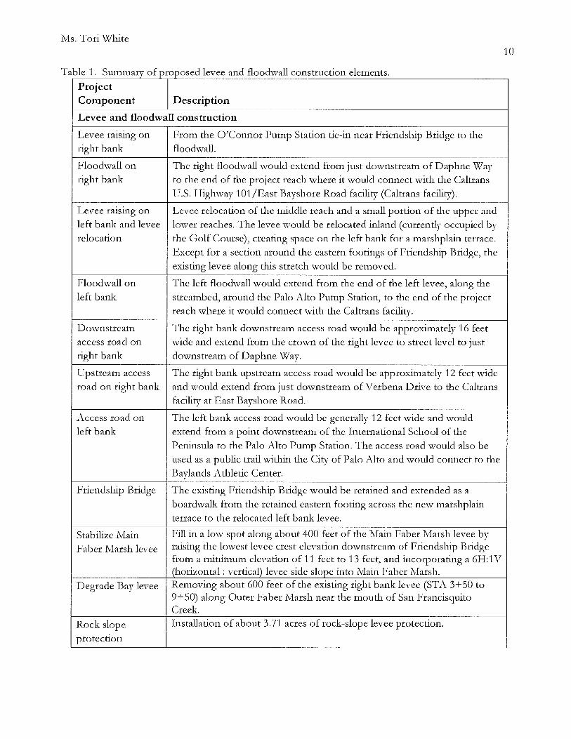
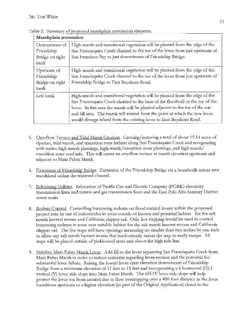

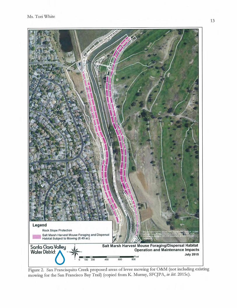

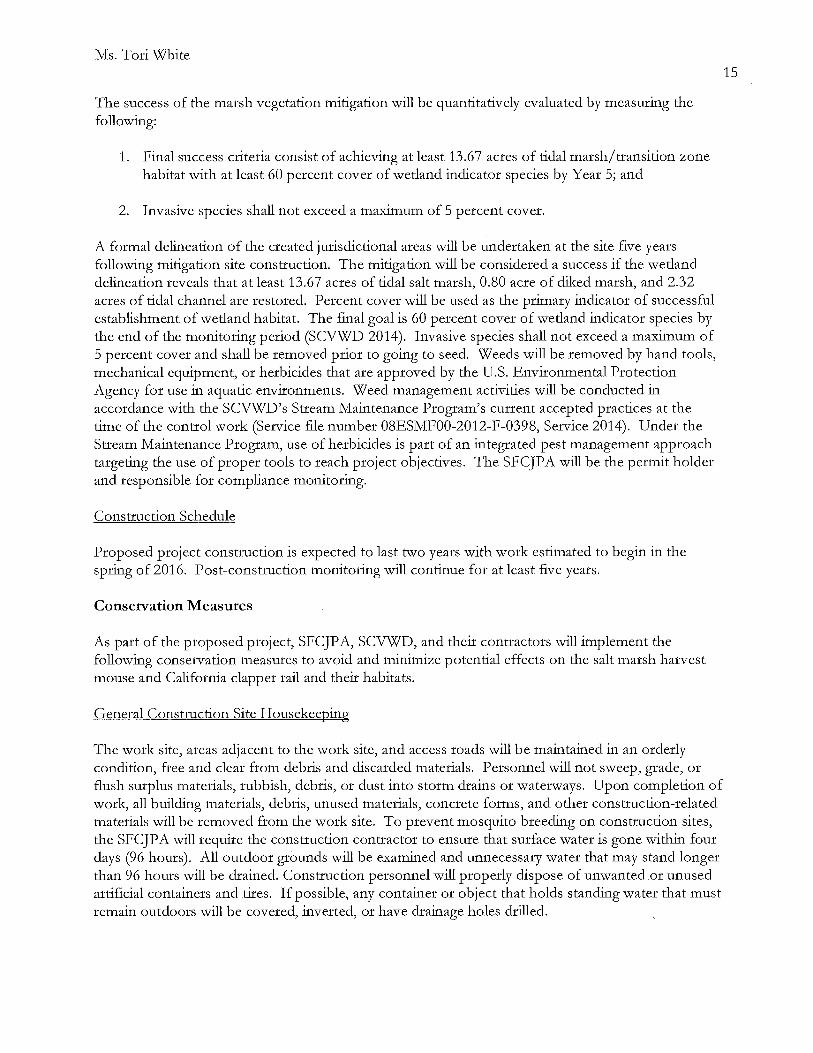


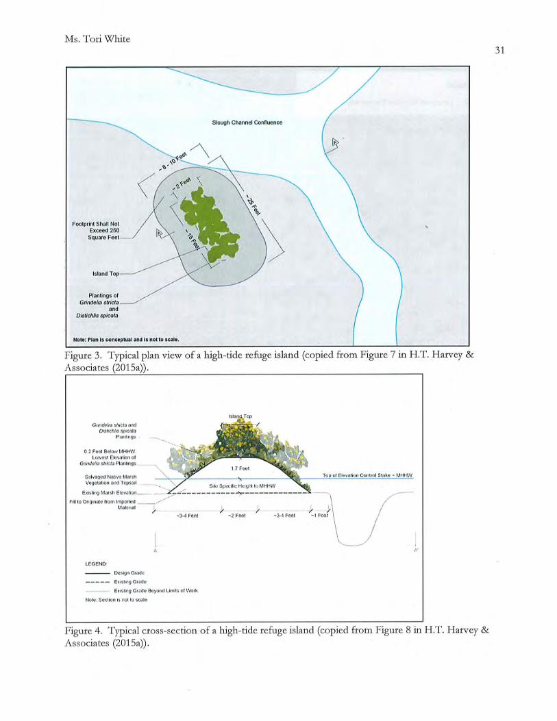
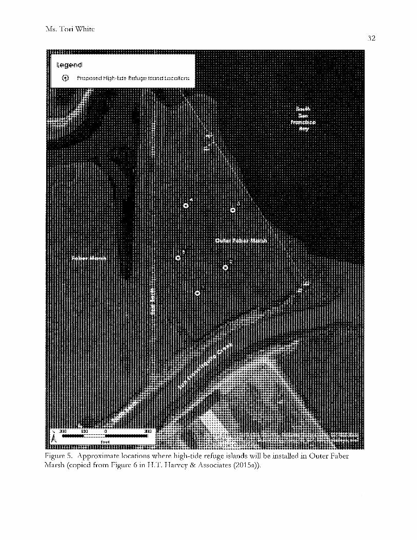
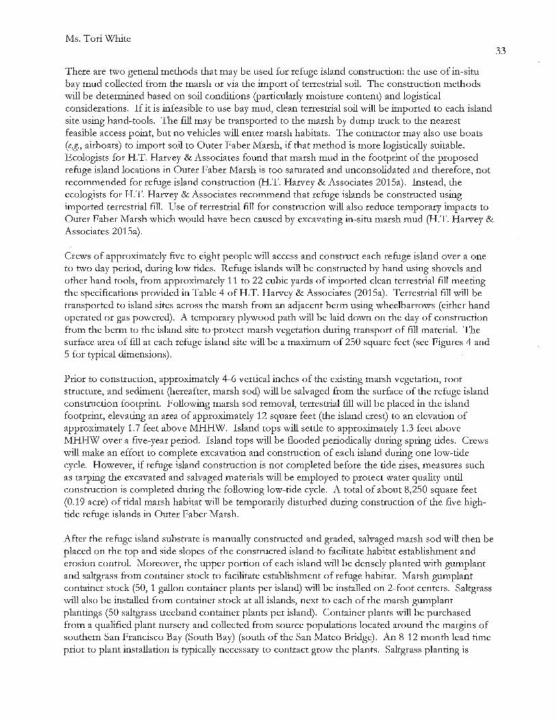

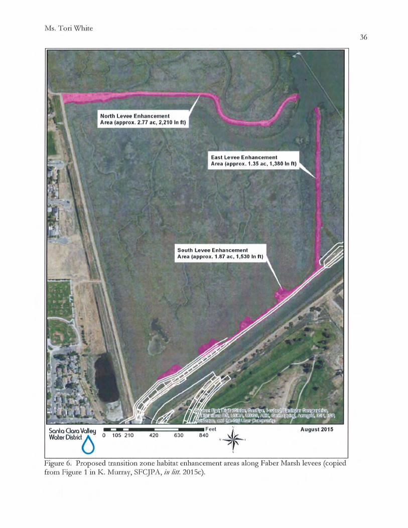


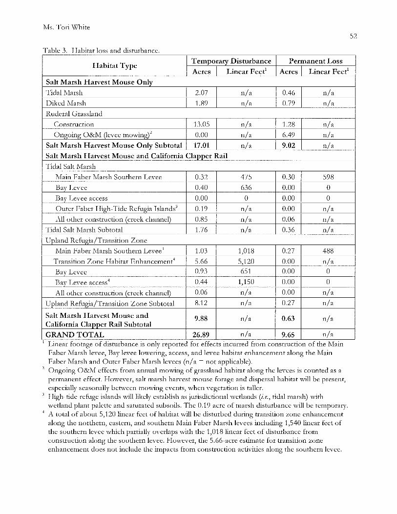
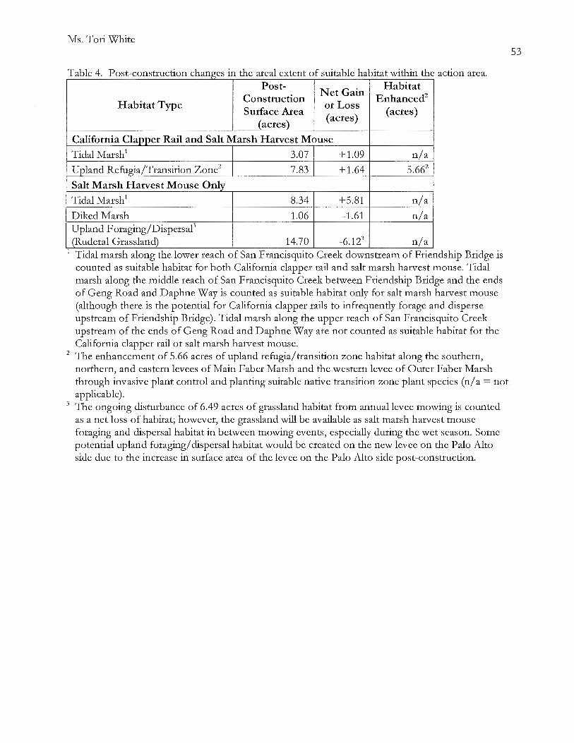


Ms. Tori White
Sawyer, Kim. 2013. Memorandum from Biologist Intern, Don Edwards San Francisco Bay National Wildlife Refuge, Fremont, California. Subject: Avian predator nest removal with PG&E, 2013.
Santa Clara Valley \v'ater District (SCVWD). 2015. Memorandum from Matt Parsons and Doug Padley, Santa Clara Valley Water District, Sanjose, California, to Bill Springer and :MichaelMartin, Santa Clara Valley Water District, Sanjose, California, dated March 5, 2015. Subject: San Francisquito Creek Flood Reduction, Ecosystem Restoration, and Recreation Project from San Francisco Bay to Highway 101, Ridgway's Rail and Salt Marsh Harvest Mouse Habitat Impacts Technical Memorandum.
Personal Communications
Albertson, Joy. Supe1visory \v'ildlife Biologist, San Francisco Bay National Wildlife Refuge Complex, Fremont, California.
Allan, Kate. Wildlife Biologist, WR.A Environmental Consulting, San Rafael, California.
McBroom, Jen. Clapper Rail I\fonitoring Manager, Olofson Environmental, Inc., Oakland, California.
I\Iruz, Eric. Refuge Manager, Don Edwards San Francisco Bay National \v'ildlife Refuge, Fremont, California.
Overton, Cory. Wildlife Biologist, U.S. Geological Smvey, DL-::on, California.
Perrera, Robert. Biological Monitor, Huffman-Broadway Group, Inc., San Rafael, California.
Popper, Brian J. Wildlife Biologist, U.S. Department of Agriculture Wildlife Services, San Luis District, Fremont, California.
Riley, Ann L. Watershed and Stream Protection Advisor, San Francisco Bay Regional \v'ater Quality Control Board, Oakland, California.
Strong, Cheryl. Wildlife Biologist, Don Edwards San Francisco Bay National Wildlife Refuge, Fremont, California.
Tertes, Rachel. Wildlife Biologist, Don Edwards San Francisco Bay National \-xi'ildlife Refuge, Fremont, California.
76
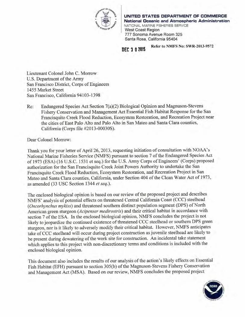
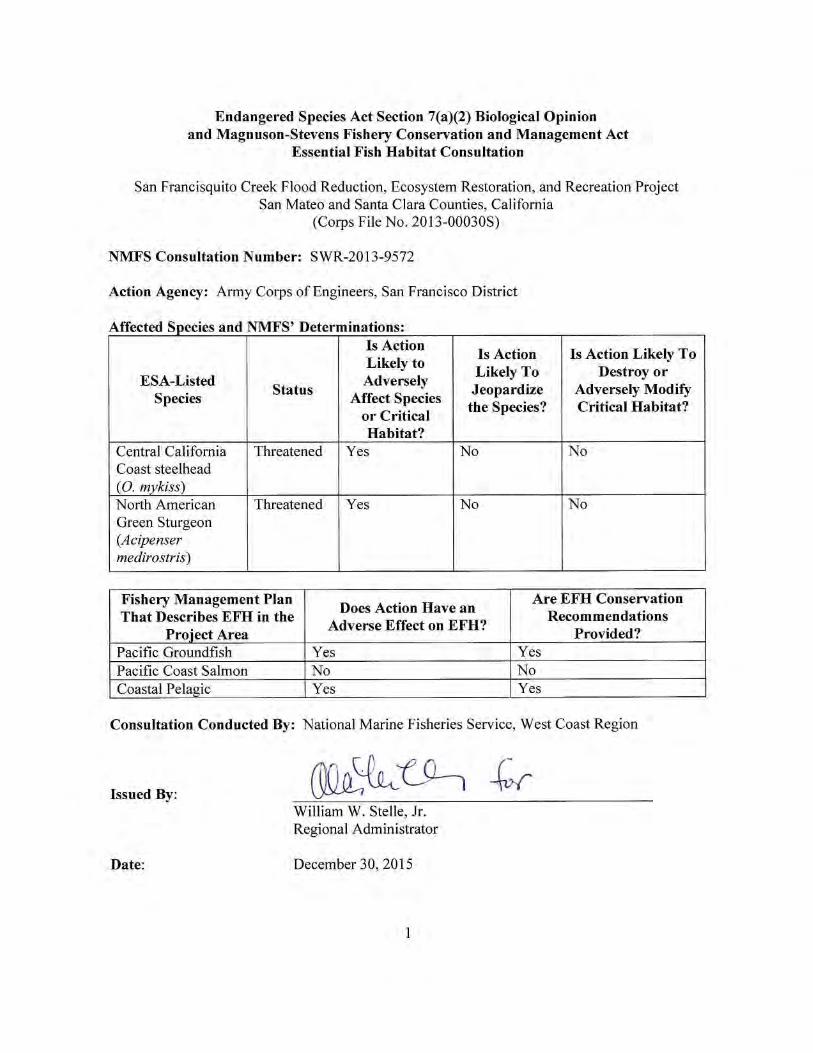

2
LIST OF ACRONYMS AND ABBREVIATIONS BA Biological Assessment BCDC Bay Conservation and Development Commission BMP Best Management Practices BOR Federal Bureau of Reclamation CDFW California Department of Fish and Wildlife Caltrans California Department of Transportation CCC Central California Coast steelhead Corps U.S. Army Corps of Engineers cy cubic yards cfs cubic feet per second DWR California Department of Water Resources DPS distinct population segment EFH essential fish habitat FMP Fishery Management Plan ft/s foot per second GCID Glenn-Colusa Irrigation District HCP Habitat Conservation Plan ITP Incidental Take Permit MSA Magnuson-Stevens Fishery Conservation and Management Act MHHW mean higher high water MLLW mean lower low water MTL mean tide level mg/l milligrams per liter mm millimeter MMP Mitigation and Monitoring Plan NMFS National Marine Fisheries Service NTU nephelometric turbidity units O&M Operations and Maintenance PG&E Pacific Gas and Electric Refuge U.S. Fish and Wildlife Don Edwards San Francisco Bay National Wildlife Refuge RBDD Red Bluff Diversion Dam RSP rock-slope protection SFRWQCB San Francisco Regional Water Quality Control Board SFCJPA San Francisquito Creek Joint Powers Authority SCVWD Santa Clara Valley Water District SMP Stream Maintenance Program S-CCC South-Central California Coast steelhead SWRCB State Water Resources Control Board SHEP Steelhead Habitat Enhancement Program USFWS U.S. Fish and Wildlife Service

3
TABLE OF CONTENTS
1. INTRODUCTION .......................................................................................................................5
1.1 Background .......................................................................................................................... 5 1.2 Consultation History ............................................................................................................ 5 1.3 Proposed Action ................................................................................................................... 9
Construct Floodwalls and Rebuild, Relocate, and Degrade Levees............................ 9 Excavate Sediment and Install Rock Slope Protection ............................................. 10 Construct Friendship Bridge Boardwalk Extension .................................................. 11 Relocate or Remove Utilities .................................................................................... 11 Revegetation .............................................................................................................. 12 Dewatering of the Project Area ................................................................................. 13 Fish Collection and Relocation ................................................................................. 15 Operation and Maintenance....................................................................................... 15 Proposed Best Management Practices and Fish Protection Measures ...................... 16
1.4 Action Area ........................................................................................................................ 16
2. ENDANGERED SPECIES ACT CONSULTATION: ..............................................................17
2.1 Analytical Approach .......................................................................................................... 17 2.2 Rangewide Status of the Species and Critical Habitat ....................................................... 18
Species Description, Life History, and Status- CCC Steelhead ................................ 19 Species Description, Life History, and Status- Southern DPS Green Sturgeon ....... 22 Factors Responsible for Steelhead and Sturgeon Stock Declines ............................. 26
2.3 Environmental Baseline ..................................................................................................... 30 Status of Critical Habitat in Action Area .................................................................. 30 Status of Listed Species in the Action Area .............................................................. 31 Previous Section 7 Consultations and Section 10 Permits in the Action Area ......... 33
2.4 Effects of the Action .......................................................................................................... 35 Effects on Species ..................................................................................................... 35 Effects on Critical Habitat ......................................................................................... 42
2.5 Cumulative Effects ............................................................................................................. 44 Searsville Dam and Reservoir ................................................................................... 44 Climate Change ......................................................................................................... 46
2.6 Integration and Synthesis ................................................................................................... 46 2.7 Conclusion ......................................................................................................................... 49 2.8 Incidental Take Statement .................................................................................................. 49
Amount or Extent of Take ......................................................................................... 50 Effect of the Take ...................................................................................................... 50 Reasonable and Prudent Measures ............................................................................ 50 Terms and Conditions ............................................................................................... 51
2.9 Conservation Recommendations ........................................................................................ 54 2.10 Reinitiation of Consultation ............................................................................................. 54
3. MAGNUSON-STEVENS FISHERY CONSERVATION AND MANAGEMENT ACT ESSENTIAL FISH HABITAT CONSULTATION ......................................................................54
3.1 Essential Fish Habitat Affected by the Project .................................................................. 54
4
3.2 Adverse Effects on Essential Fish Habitat ......................................................................... 55 Water Quality ............................................................................................................ 55 Benthic disturbance ................................................................................................... 55
3.3 Essential Fish Habitat Conservation Recommendation ..................................................... 56 3.4 Statutory Response Requirement ....................................................................................... 57 3.5 Supplemental Consultation ................................................................................................ 57
4. DATA QUALITY ACT DOCUMENTATION AND PRE-DISSEMINATION REVIEW .....57
4.1 Utility ................................................................................................................................. 57 4.2 Integrity .............................................................................................................................. 58 4.3 Objectivity .......................................................................................................................... 58
5. FIGURES ...................................................................................................................................59
6. REFERENCES ..........................................................................................................................63
5
1. INTRODUCTION This Introduction section provides information relevant to the other sections of this document and is incorporated by reference into sections 2 and 3 below. 1.1 Background The National Marine Fisheries Service (NMFS) prepared the biological opinion (opinion) and incidental take statement portions of this document in accordance with section 7(b) of the Endangered Species Act (ESA) of 1973 (16 USC 1531 et seq.), and implementing regulations at 50 CFR 402. We also completed an essential fish habitat (EFH) consultation on the proposed action, in accordance with section 305(b)(2) of the Magnuson-Stevens Fishery Conservation and Management Act (MSA) (16 U.S.C. 1801 et seq.) and implementing regulations at 50 CFR 600. We completed pre-dissemination review of this document using standards for utility, integrity, and objectivity in compliance with applicable guidelines issued under the Data Quality Act (section 515 of the Treasury and General Government Appropriations Act for Fiscal Year 2001, Public Law 106-554). The document will be available through NMFS’ Public Consultation Tracking System (https://pcts.nmfs.noaa.gov/pcts-web/homepage.pcts). A complete record of this consultation is on file at the NMFS North-Central Coast Office in Santa Rosa, California. 1.2 Consultation History November 8, 2011: NMFS attended a site visit along with staff from San Francisquito
Creek Joint Powers Authority (SFCJPA), Santa Clara Valley Water District (SCVWD), and the U.S. Army Corps of Engineers (Corps).
April 26, 2013: NMFS received from the Corps the project’s Biological Assessment (BA) (ICF International 2012) and the request for consultation on the San Francisquito Creek Flood Reduction, Ecosystem Restoration, and Recreation Project (Project). In the initiation letter, the Corps determined the project may affect, but is not likely to adversely affect, threatened Central California Coast (CCC) steelhead (Oncorhynchus mykiss) and threatened southern distinct population segment (DPS) of North American green sturgeon (Acipenser medirostris) and their critical habitat. Additionally, the Corps determined that the project would not have substantial adverse effects on EFH for various federally managed fish species within the Pacific Coast Groundfish, Pacific Coast Salmon, and Coastal Pelagic Species Fishery Management Plans (FMP).
May 13, 2013: NMFS sent an electronic message to the Corps commenting on the BA
and requesting additional information on the proposed project. The message mentioned that the description of the project contained in the
6
BA did not contain sufficient detail for NMFS to assess the potential impacts of the project, and requested additional clarification on the project description (i.e., dewatering activities and using heavy equipment in the channel).
February – July 2014: NMFS attended multiple interagency meetings regarding the project
with staff from the U.S. Fish and Wildlife Service’s (USFWS) Don Edwards San Francisco Bay National Wildlife Refuge (Refuge), the Corps, SCVWD, SFCJPA, California Department of Fish and Wildlife (CDFW), San Francisco Regional Water Quality Control Board (SFRWQCB), NMFS, and the Bay Conservation and Development Commission (BCDC) to discuss the various alternative configurations for the proposed project including filling in low spots in the Main Faber Marsh levee, degrading the Bay levee adjacent to Outer Faber Marsh near the mouth of San Francisquito Creek, and further setting back the levee into the Palo Alto Municipal Golf Course.
August 28, 2014: NMFS received from the Corps and SFCJPA the amended BA for the
Project. October 15, 2014: NMFS attended a site visit along with staff from SFCJPA, SCVWD,
CDFW, and Corps. During the site visit NMFS was informed several additional documents regarding the project were available. These documents consisted of the Draft Mitigation and Monitoring Plan (MMP) (SFCJPA 2015c), Draft Operations and Maintenance (O&M) Plan (SFCJPA 2015a), and Temporary Water Diversion Plan (SFCJPA 2015b). NMFS received these documents from the SFCJPA on October 17, 2014.
November 3, 2014: NMFS sent a letter to the Corps and SFCJPA commenting on the
August 2014 amended BA, the Draft MMP, and the Draft O&M Plan and requested additional information on channel capacity, sedimentation, and flooding, and fish passage and habitat. In this letter, NMFS also informed the Corps and SFCJPA that this information was necessary to complete the NMFS assessment of potential project impacts and conclude consultation.
April 24, 2015: NMFS attended a meeting with the Corps, SFRWQCB, SCVWD, and
SFCJPA to discuss NMFS’s comments and questions raised in the November 3, 2014, letter. The SFCJPA agreed to investigate the feasibility of, and provide to NMFS a conceptual proposal for incorporation of several project features (i.e., velocity refuges and passive tidal marsh revegetation) to improve conditions for fish. The SFCJPA further agreed to provide: 1) updated planting plans and landscape sheets; 2) a table of wetlands impacts and mitigation calculations; 3) an updated MMP; 4) written responses to the points

7
raised in the NMFS letter of November 3, 2014; and 5) HEC-RAS model results for existing conditions and proposed conditions. In addition, NMFS informed the Corps that the project may adversely affect ESA-listed species, critical habitat, and EFH and that a formal consultation will likely be necessary.
May – July 2015: NMFS received via electronic mail from SFCJPA the responses to
NMFS’s comments and questions raised in the November 3, 2014, letter and the additional information the SFCJPA agreed to provide at the April 24, 2015, meeting.
July - October 2015: NMFS participated in biweekly conference calls with SFCJPA, the
Corps, USFWS, the Refuge, and SCVWD to discuss the information needed to complete the NMFS assessment.
July 30, 2015: During a biweekly conference call with the SFCJPA, Corps, USFWS,
and SCVWD, NMFS requested the SFCJPA and SCVWD schedule a future, focused meeting among themselves, USFWS (Regulatory and Refuge), Corps, and NMFS to discuss a scenario in which certain elevations of marsh plain would be allowed to passively revegetate.
August 19, 2015 NMFS provided via electronic mail to SFCJPA and the Corps
comments on the additional information provided by the SFCJPA between May and July 2015 (e.g., additional hydraulic and hydrologic information).
August 26, 2015: NMFS participated in a conference call with SFCJPA and SCVWD to
provide clarification on the additional hydrologic and hydraulic information NMFS requested on August 19, 2015.
September 3-24, 2015: NMFS received via electronic mail from SFCJPA updated versions of
the Draft O&M Plan (SFCJPA 2015); Temporary Water Diversion Plan; Draft MMP; and hydraulic and hydrologic information.
September 24, 2015: NMFS participated in a conference call with SFCJPA, Corps, USFWS,
and SCVWD to inform the Corps and SFCJPA that NMFS believes the information provided completes the consultation request package.
October 13, 2015: NMFS attended a meeting with SFCJPA, SCVWD, Corps, USFWS
Regulatory, Refuge, and SFRWQCB to discuss the tidal marsh design elevations and revegetation activities. During the meeting NMFS requested that the SFCJPA modify the proposed tidal marsh elevations to increase tidal salt marsh complexity and enhance ESA-listed fish habitat. The SFCJPA and SCVWD agreed to consider modifications and follow-up with NMFS within two weeks.
8
October 20, 2015: Via electronic mail to the SFCJPA, SCVWD, and Corps, NMFS requested additional hydrologic information (e.g., HEC-RAS model results for the 1 percent, 5 percent, and 50 percent [March-June] exceedance flows).
November 5, 2015: During the biweekly project update call, NMFS informed the SFCJPA
and Corps that SFRWQCB Estuarine Geomorphologist, Christina Toms, spoke with NMFS on October 26, 2015, regarding modifications to the Project’s marshplain designs. NMFS explained the SFRWQCB believed that a passive approach to creating channel complexity in the tidal salt marsh would not be successful in the action area due to intense fluvial influences and that alternative methods would need to be taken to enhance ESA-listed fish habitat, specifically adult fish passage conditions. NMFS informed the SFCJPA that they will provide a memo summarizing their analysis of the Project’s impacts on fish habitat and recommendations on the types of habitat enhancements that would be needed to enhance fish habitat within two weeks. NMFS also confirmed that they could rush completion of the Opinion, with a goal of completing it by December 15, 2015.
November 23, 2015: NMFS provided the Corps, SFCJPA, and other resource agency
representatives a technical memo prepared by fish passage engineer, Dave White, which summarized the fish passage issues associated with high channel velocities under some streamflow conditions in the project reach, and suggested design elements to provide velocity refuge in the project reach.
November 30, 2015: In response to recommendations provided in the NMFS November 23,
2015, fish passage review memorandum, the SFCJPA submitted to NMFS and the Corps a preliminary proposal for the location, number and type of steelhead migration features to be incorporated in to project.
December 1, 2015: A telephone conference call with representatives of NMFS, SFCJPA,
USFWS and SCVWD was held to discuss SFCJPA’s proposed steelhead fish passage features. NMFS informed the group that the proposal will likely address the most significant high velocity areas by creating resting sites behind boulders and rootwads. The SFCJPA agreed to incorporate these features into the project and continue to work with NMFS to develop the specific designs for each feature.
December 2, 2015: The SFCJPA provided a revised proposal for steelhead fish passage
features based on the December 1, 2015, conference call with NMFS.
9
1.3 Proposed Action “Action” means all activities or programs of any kind authorized, funded, or carried out, in whole or in part, by Federal agencies (50 CFR 402.02). The Corps proposes to issue a permit under Section 404 of the Clean Water Act of 1973 (33 U.S.C. Section 1344) to the SFCJPA to construct a 1.5 mile flood protection and habitat restoration project along San Francisquito Creek from San Francisco Bay to East Bayshore Road, near the cities of East Palo Alto and Palo Alto in San Mateo and Santa Clara counties, California (Figures 1-5). The SFCJPA is a regional government agency whose members include the Cities of Palo Alto, Menlo Park, and East Palo Alto, the San Mateo County Flood Control District, and the SCVWD. The purpose of the proposed activity is to improve flood protection (up to a 100-year flood flow event coupled with the influence of tides and projected sea level rise), restore and enhance habitat functions, and improve recreational opportunities within the project area. Major project elements include: levee setback and improvements, construction of floodwalls, extension of a pedestrian bridge, excavation of sediment deposits within the channel to maximize flood conveyance, relocation and removal of utilities, and revegetation of tidal marsh habitats. Construction of the project elements would likely take two years to complete. The project is scheduled to begin in 2016 and to be completed by 2018. “Interrelated actions” are those that are part of a larger action and depend on the larger action for their justification. “Interdependent actions” are those that have no independent utility apart from the action under consideration (50 CFR 402.02). There are no interdependent or interrelated actions associated with the proposed action.
Construct Floodwalls and Rebuild, Relocate, and Degrade Levees Approximately 5,650 linear feet of floodwalls will be constructed along the channel at the top of levees to increase flow capacity and maintain consistency with the California Department of Transportation’s (Caltrans) enlargement of the U.S. 101/East Bayshore Road Bridge over the San Francisquito Creek. On the East Palo Alto side (north bank), concrete floodwalls up to 4 feet above top of bank (up to 13 feet from channel bottom) will be constructed along approximately 500 linear feet near Friendship Bridge (pedestrian bridge crossing the creek) (STA 28+00 to STA 33+00) (Figure 4) and along 2,300 linear feet of channel between Daphne Way (STA 52+50) and U.S. Highway 101/East Bayshore Road (STA 75+50) (Figure 5). On the Palo Alto side (south bank), sheetpile floodwalls up to 4 feet above top of bank (up to 13 feet from channel bottom) will be constructed along approximately 2,850 linear feet from Geng Road (STA 47+50) to Highway 101/East Bayshore Road Bridge (STA 76+00) (Figures 4 and 5). Downstream of the floodwalls, the SFCJPA will rebuild the East Palo Alto Levee (northern levee) in its current location and relocate the Palo Alto Levee/Palo Alto Municipal Golf Course Levee (southern levee). Approximately 3,400 linear feet of the existing levee on the north side of the channel would be rebuilt to a greater strength and/or height from just downstream of Friendship Bridge (STA 21+00) (Figure 3) to Daphne Way (STA 55+00) to increase channel capacity (100-year water surface elevation). Approximately 55,000 cubic yards (cy) of fill will be used to reinforce and increase the height of the northern levee. Approximately 2,727 linear feet of the southern levee will be relocated and/or reinforced between the area just downstream

10
of Friendship Bridge (STA 22+73) and the area just downstream of Geng Road (STA 50+00). A portion of the levee will be relocated up to 200 feet east into the Palo Alto Municipal Golf Course and raised to increase channel capacity. This set back of the southern levee will create space for a floodplain terrace. Approximately 84,700 cy of fill will be used for the southern levee relocation. The elevation increase of both the northern and southern levees varies by up to 4 feet based on existing conditions and the necessary modifications at each station. The SFCJPA will build about 10,176 linear feet of maintenance roads on the newly raised and relocated levees. The maintenance roads will also serve as pedestrian/bicycle trails. The roads will be up to 16 feet wide and paved with crushed granite, except for a 2,658 section on the south bank (STA 27+50 through 54+08), that will be paved with asphalt as part of the Bay Trail. The SFCJPA will raise and grade a portion of the currently unmaintained levee between the creek and the Faber Tract (Faber Tract Levee) closer to its original design elevation to stabilize the levee and preserve existing frequency, volume, and velocities of fluvial discharge to the Faber Tract to optimize conditions for USFWS protected species that inhabit the Faber Tract marsh. Fill will be added to reinforce and raise the Faber Tract Levee up to 2 feet along 550 linear feet (STA 21+00 to STA 26+50) to reduce concerns regarding levee erosion and the potential for mass wasting leading to levee failure. In addition, the SFCJPA will incorporate a 6H:1V levee side slope on the side sloping into the Faber Tract. The 6H:1V levee side slope will help protect the levee toe from potential erosion due to flow overtopping along a 400-foot distance as the levee transitions upstream to a higher elevation closer to the Friendship Bridge. Approximately 12,000 cy of clean imported fill will be used to reinforce and redesign the Faber Tract levee. The SFCJPA will degrade a 600 linear foot section of the northern levee east of the Faber Tract (referred to as the Bay Levee) to restore the tidal-fluvial interface in the marsh area east of the Faber Tract and to reduce water surface elevations in the creek between Friendship Bridge and the Bay. About 2,820 cy of sediment/soil will be removed along 600 linear feet (0.73 acres) of the Bay Levee (STA 3+50 to 9+50) (Figure 3) downstream of the Faber Tract in a marsh area that is already subject to daily tides from the Bay.
Excavate Sediment and Install Rock Slope Protection About 175,890 cy of sediment will be removed from along 5,775 linear feet of the creek channel and associated channel expansion area to increase creek capacity and to maximize conveyance. In-channel sediment will not be reused because it is unlikely to provide suitable material for levee embankment use. The JPA will install approximately 4,000 linear feet (3.71 acres) of rock-slope protection (RSP) at various locations along the length of the channel side of the Project to protect the levees against erosion and to stabilize the floodwalls. The RSP on the levees will be installed from the toe of the levee up the bank approximately 10 to 15 feet.
11
Construct Friendship Bridge Boardwalk Extension The existing Friendship Bridge will be retained and a 202 linear foot boardwalk will be constructed from the retained eastern footing of the bridge and across the newly-expanded marshplain to connect with the realigned southern levee. The boardwalk will be the same width as the Friendship Bridge (140 feet long and 10 feet wide), constructed of timber deck and concrete piles, and require twenty 18-inch diameter concrete piles. The elevation of the low mark of the boardwalk will be set above the highest anticipated flood elevation, with the lowest point of the bridge a minimum of 5 feet above the marshplain terrace beneath it.
Relocate or Remove Utilities The SFCJPA will remove, abandon, or replace several utility components for electricity, gas, and sanitary sewer, and stormwater runoff present within the Project right-of-way. SFCJPA will remove various storm drain pipelines existing within the golf course and at the top of the current levees that will be under the future southern levee and widened creek channel post project. This work will be concurrent with the levee and channel work. The SFCJPA will realign a sanitary sewer line that currently crosses the creek near the Friendship Bridge (STA 32+00 at the south bank to 34+50 at the north bank). As proposed, this task will involve open trenching with a minimum depth below ground surface of 3.5 feet for the new line. The sanitary sewer line would be encased in armored steel where it crosses the creek. This work would be concurrent with the levee construction work so will not have separate impacts to waters of the San Francisquito Creek. The SFCJPA will remove about 390 linear feet of existing sanitary sewer line. The SFCJPA will coordinate with Pacific Gas and Electric (PG&E) to perform electricity and gas transmission system work before creek channel and levee construction work begins. PG&E’s work is considered part of the Project and will be covered under the Corps’ 404 permit for the Project. PG&E will realign the existing electricity transmission system that currently crosses over the creek from STA 52+00 (south bank) to R-line STA 48+00 (north bank). The new line will be shifted 250 feet south and cross over the creek at STA 51+00 (south bank) to STA 52+00 on the north bank. A transmission pole will be removed from both banks; replacing two existing poles, one on each bank; and adding two new poles on the north bank for the new line. In addition, PG&E will remove wires from six towers that run north to south along the far north bank right-of-way between STA 30+00 to STA 56+00. Of these six towers, one will be raised by 15 feet. The realigned section will connect to the southern-most pole in this series. Any replacement poles will be made of light-duty steel. PG&E will replace the foundation of an existing electric transmission tower located in the floodplain of the future channel alignment footprint at STA 48+00, approximately 2,000 feet upstream of the Friendship Bridge. PG&E will demolish the existing foundation, build a temporary shoo-fly support, and build a permanent concrete foundation at the existing foundation site. The electricity tower on the old foundation will be lifted and placed onto the permanent concrete foundation with an area of 625 square feet. An access ramp will be built on the inboard side of the levee for this tower.
12
PG&E will abandon in place 3,000 linear feet of the gas transmission line located in the Project right-of-way, of which about 1,350 linear feet is in the new channel realignment footprint. THE SFCJPA will remove the abandoned gas transmission lines. PG&E estimates that the old line is 4.7 feet below grade beneath the creek channel. The SFCJPA will confirm the elevation during excavation activities. The new gas line will be aligned south to north in the golf course, then will cross east to west through the Project right-of-way upstream of the Friendship Bridge from STA 32+00 (south bank) to STA 34+00 (north bank), and will extend west to a connection in East Palo Alto. The pipeline tunnel under the Creek will be bored by horizontal direction drilling at 25 feet below ground. The other portions of the pipeline will be installed by cut and fill at a minimum of 4 feet below ground surface. PG&E will place three trench spoils piles equidistant from south to north along the south bank. Each pile is planned to be 100 feet by 100 feet. On the north bank, PG&E will place another 100 foot by 100 foot spoils pile next to the borehole site. The suitability of the spoils for reuse to cover the new pipeline will be determined after they are appropriately assessed during the utility activities, and any unused spoils will be hauled from the site and appropriately disposed of at an approved upland facility.
Revegetation The action area encompasses 4.34 acres of diked marsh wetlands, 0.33 acres of freshwater marsh wetlands, 112.26 acres of tidal salt marsh wetlands, 1.13 acres of freshwater pond, 22.39 acres of tidal channel and bay waters, and 0.37 acres of tidal pans. The project construction is anticipated to impact a total of 3.13 acres of diked marsh, 4.51 acres of tidal salt marsh habitat, and 2.43 acres of tidal channel and bay waters. The diked marsh community is found on the landward side of the levees along San Francisquito Creek and within the Golf Course; and the tidal salt marsh vegetation is found throughout the Faber Tract and along both sides of San Francisquito Creek. The Project will result in the removal of between 162 and 256 trees. Of the potential of 256 trees to be removed, 220 of these are on the south side of the creek and the remaining 36 are on the north side. After levee construction is complete, the tidal marsh area would be terraced and revegetated with high-marsh plants appropriate to the elevation relative to tidal levels in accordance with the MMP for the Project (SCVWD 2014). The high-marsh (above mean higher high water) will be planted with include alkali weed (Cressa truxillensis), saltgrass (Distichlis spicata), alkali heath (Frankenia salina), marsh jaumea (Jaumea carnosa), and perennial pickleweed (Salicornia pacifica [S. virginica]). The high-marsh transition planting area will be planted with fat hen (Atriplex patula), alkali weed, saltgrass, alkali heath, gumweed (Grindelia spp.), marsh jaumea, and western marsh rosemary (Limonium californicum). Native marsh plants will be used to revegetate the terraced land. Plants appropriate to the high marsh will be planted near the stream channel. Plants native to marsh transition areas would be planted in areas more distant from the creek channel and in the upper half of the Project area as elevation gains. Approximately 19,600 high marsh and high marsh transition wetland plants and cuttings are planned for installation. Plants will be sourced from the San Francisquito Creek watershed and Baylands areas.
13
A temporary irrigation system will be installed for use during the planting and three-year establishment phase, in order to provide a back-up water supply to the newly-installed vegetation in the event of a period of drought during the winter or spring rainy season, and for irrigation as needed during the summer. Irrigation frequency is expected to be reduced as the site develops during the establishment phase. The supplemental irrigation ensures an adequate supply of moisture to the young plants until they are fully established in the site’s soils. Annual monitoring will be conducted over a 5-year period. Performance goals related to revegetation efforts will aid in determining if the site is progressing incrementally toward meeting the year-5 success criteria (SFCJPA 2015c). Year 5 monitoring will determine if the success criteria have been achieved. Monitoring will be overseen or conducted by a qualified biologist with experience in vegetation monitoring. Final success will not be considered to have been achieved until temporary irrigation has been off for at least two years. The specific performance goals and criteria that will be used to determine if all revegetation was successful will be described in a Final MMP.
Dewatering of the Project Area The project area is located in a reach of San Francisquito Creek that is influenced by tides and freshwater flow from the San Francisquito Creek watershed. Therefore, both a stream flow and tidal diversion will be necessary to dewater the project area for construction purposes. Water diversion will be implemented to maintain the work site as water-free as possible for the duration of in-channel work. The full width of the channel from tops of bank will be dewatered. Water incursion is expected from Bay tides, natural and urban runoff flows from upstream, outfalls downstream from the U.S. 101/East Bayshore Road Bridge, and discharges from the O’Connor Pump Station in East Palo Alto and the Palo Alto Pump Station. Water diversion will include cofferdams upstream (to intercept stream flows) and downstream (to block tidal Bay waters) of the work site. Stream flows upstream of the site will be pumped through pipes that bypass the work site. Discharges from the two municipal pump stations located adjacent to the creek will be pumped from the clear wells into the diversion pipes as well. In addition, water that is diverted from the channel during dewatering will be retained, tested, and treated, as necessary, in order to meet all water quality effluent limitations as specified in the SFRWQCB, San Francisco Bay Region, Basin Plan (Basin Plan). Diversion pipe flow velocity dissipaters will be installed downstream of the cofferdam on existing banks. Pumps will be used to dewater the work site. Pumps will be required to: 1) reroute water from the stream, which accumulates above the upstream cofferdam; 2) dewater the construction area above the downstream cofferdam or where ponded; and 3) to reroute outflow at each of the two municipal pump stations (see below). The cofferdams will be installed for the in-channel construction period between June 15th and October 15th at various locations, depending on the construction element, during the two construction seasons (see Table 1). Utilities and levee construction and dewatering will be completed in one season, and floodwall construction the following season.

14
Table 1. Cofferdam locations (approximate).
Construction Element Downstream
Location/Cofferdam Height Upstream
Location/Cofferdam height Utilities Downstream Levee
Construction STA 13+00/12 ft 58+00/8ft
Upstream Floodwall Construction 49+00/10 ft
Within 50 ft upstream of U.S. 101 West Bayshore Road
Bridge/ 8 ft Groundwater depths are anticipated to be in the range of 1 to 3 feet below existing channel invert, so dewatering sumps may be required for excavation and will be utilized as necessary. Dewatering for the utility crossings, levee work, and floodwall construction will be performed with the installation of a 36-inch diameter bypass pipe from above the upstream cofferdam to below the downstream cofferdam to allow anticipated construction season streamflows to avoid contacting the work area. The downstream cofferdams will be installed first and during the lowest tide during normal construction hours. The upstream cofferdams will be installed during the minimum streamflow expected during normal working hours. Diversion pipes and pumps will be in place and operational before cofferdams are installed. Cofferdams will remain in place and functional throughout the in-stream construction periods. Cofferdams will be removed at annual cessation of in-channel work, and channel and bank will be restored to pre-construction condition. Dewatering for the Bay Levee deconstruction will be achieved by a floating silt curtain on both sides of the Bay Levee (STA 4+50 to 10+00) to prevent sediment from entering the adjacent marshland, creek, and San Francisco Bay. The silt curtains will be resistant to wind and high water velocity. Cofferdams will be constructed of steel sheet pile embedded no less than 15 feet below the channel invert, gravel bags, and plastic sheeting. The piles will be installed with a backhoe or hammer attached to a backhoe. Gravel bags will be stacked against the sheet piles to the desired height. Gravel material will be between 0.4 and 0.8 inch in diameter, and will be clean and free from clay balls, organic matter, and other deleterious materials. The gravel bags will be placed on top of the plastic sheeting, which will be laid upon the channel invert or bank to prevent leakage. The gravel bags will be arranged so that each layer of gravel bag placed will be staggered in pyramid-like fashion. After the final height has been reached, the original plastic sheeting will be placed on top of the sandbags. To hold the plastic sheeting in place, gravel bags will be placed above the top plastic sheeting. Water collected from the dewatered reach between cofferdams will be discharged through municipal storm drains to the City of East Palo Alto’s pump station adjacent to the channel (O’Conner Street Pump Station). Additional water from urban sources will also be routed to this pump station, which normally outflows to the work area. To prevent flows from the East Palo Alto and Palo Alto pump stations from entering the work area, outflows will be pumped from the wet wells directly to the channel downstream of the downstream cofferdam or join the pump station outflow pipe to the stream diversion pipe.
15
The SFCJPA will ensure SFRWQCB and State Water Resources Control Board (SWRCB) water quality standards for receiving waters will be met during creek dewatering discharges, dewatering of excavations, and diverting creek and stormwater flows. Specifically, the instantaneous discharge pH will be in the range of 6.5 to 8.5 and shall not vary from ambient pH by more than 0.5 pH units; the discharge dissolved oxygen concentration will be no less than 5.0 milligrams per liter (mg/L) as an hourly average for discharging into tidal water and 7.0 mg/L (hourly average) for discharging into non-tidal receiving waters; dissolved sulfide will not be greater than 0.1 mg/L; the receiving water turbidity measured as nephelometric turbidity units (NTU) will not be greater than 10 percent of natural conditions in areas where natural turbidity is greater than 50 NTU (daily average); and the receiving waters will not contain biostimulatory substances in concentrations that promote aquatic growths to the extent that such growths cause nuisance or adversely affect beneficial uses. The SFCJPA will identify an acceptable location or locations at which to measure background turbidity. Receiving water and discharge turbidity will be monitored at least one time every 8 hours on days when discharges from excavations or any other dewatering processes may occur.
Fish Collection and Relocation Because the project will require water diversion and dewatering of work sites, fish within the project area will be collected and relocated in order to minimize their risk of being harmed or killed. The fish collection and relocation activities will be conducted by a NMFS/CDFW-approved biologist. Methods used to capture and relocate fish in the project area may include dip net and seine. Due to the high conductivity of brackish waters, electrofishing will not be used. The SFCJPA will submit a fish relocation plan to NMFS and CDFW for review no less than 90 days prior to beginning these activities for each phase of construction.
Operation and Maintenance The SFCJPA has entered into a Construction Management Agreement with the SCVWD to designate the SCVWD as the lead agency responsible for project construction and post-project revegetation monitoring and management. The SFCJPA has also delegated responsibility for routine operation and maintenance of the Project, outside the scope of construction-related maintenance and monitoring activities, to the City of East Palo Alto and the SCVWD. Routine operations and maintenance include providing the proper care to levee embankments, floodwalls, channels, interior drainage system, and pump stations required for the efficient operation of the Project. The only operation and maintenance activity proposed by the SFCJPA as part of the Project is levee maintenance, vegetation management, and removal of trash and debris. The primary routine maintenance activities will consist of mowing levees to facilitate inspections, removal of trash and debris from the channel and channel benches, and control of burrowing rodents. Mowing will occur on the sides of the levee, which, on the inboard side of the levee, extend to the tidal marsh. Maintenance activities will be performed in accordance with the Best Management Practices Handbook (Attachment F to the SCVWD 2014-2023 SMP).

16
Additional future maintenance within the completed flood channel could include sediment removal, vegetation removal, levee repair, floodwall maintenance, removal of woody debris from the channel, repair of rock slope protection, maintenance of access roads, and repair and maintenance of outfalls and culverts. These activities, within specified limits and mitigation measures, are conducted as part of the SCVWD’s Stream Maintenance Program (SMP). NMFS and the Corps completed formal section 7 consultation in 2014 on a 10-year (2014-2023) SMP conducted by SCVWD within stream channels of Santa Clara County, including San Francisquito Creek. A biological opinion was issued to the Corps on April 29, 2014 (See Section 2.3.3.2 for more detail). At this time, no maintenance activities outside the actions described above and outside the purview of SCVWD’s SMP are anticipated.
Proposed Best Management Practices and Fish Protection Measures Based on a fish passage analysis performed by NMFS, the SFCJPA proposes to install six structures in the flood control channel that are designed to provide velocity refuge for upstream migrating adult steelhead. Five of the structures will be constructed with rock and rootwads as a “constructed log jam”. The sixth structure will be a rock spur structure extending from the lower tip of the Friendship Bridge Island into the low flow channel. All six structures will be placed in or adjacent to the low flow channel at approximately 300 feet intervals in the middle reach of the project. These structures will be designed to create velocity breaks and fish resting areas during high flow events and low tide conditions. During project construction, operation and maintenance activities, the project will implement BMPs to avoid and/or minimize potential impacts to special-status species and their designated critical habitat. All activities will be performed in accordance with Best Management Practices Handbook (Attachment F to the SCVWD 2014-2023 SMP). The BMP handbook is a comprehensive document that includes minimization measures related to hazards and hazardous materials, hydrology and water quality, bank protection, stormwater management, discharge activities, grading and excavation, sediment removal and storage, vegetation management and removal, and other topics. 1.4 Action Area “Action area” means all areas to be affected directly or indirectly by the Federal action and not merely the immediate area involved in the action (50 CFR 402.02). San Francisquito Creek Watershed drains approximately 47.5-square miles on the eastern side of the Santa Cruz Mountains. Major tributaries include Bear Creek, Corte Madera Creek, and Los Trancos Creek, which converge to form San Francisquito Creek. The project area has a Mediterranean climate, typical of the California’s central coast, with cool, wet winters and a long, mild dry season. Rainfall in the winter averages approximately 35 inches per year, falling mainly between the months of October and March. Portions of the upper San Francisquito Creek watershed are perennial and support spawning and rearing habitat for CCC steelhead. Sections of the mainstem of San Francisquito Creek dry by late spring or early summer in most years (Launer and Spain 1998; Metzger 2002; Stokes 2006).
17
The action area consists of the lower 1.5 miles of San Francisquito Creek in an existing flood control channel and adjacent marsh areas. The action area encompasses 4.34 acres of diked marsh wetlands, 0.33 acres of freshwater marsh wetlands, 112.26 acres of tidal salt marsh wetlands, 1.13 acres of freshwater pond, 22.39 acres of tidal channel and bay waters, and 0.37 acres of tidal pans. The diked marsh community is found on the landward side of the levees along San Francisquito Creek and within the Golf Course; and the tidal salt marsh vegetation is found throughout the Faber Tract and along both sides of San Francisquito Creek. From upstream to downstream, the constructed channel flows southwest to northeast through the cities of East Palo Alto and Palo Alto. The proposed project is located between where U.S. Highway 101 crosses San Francisquito Creek at the border of southern San Mateo and northern Santa Clara counties and the confluence of San Francisquito Creek with San Francisco Bay. This 7700 linear foot reach of San Francisquito Creek is located in a moderately urbanized, low gradient area, historically occupied by extensive tidal marshes at the edge of San Francisco Bay. The project location experiences daily tidal fluctuations.
2. ENDANGERED SPECIES ACT CONSULTATION: BIOLOGICAL OPINION AND INCIDENTAL TAKE STATEMENT
The ESA establishes a national program for conserving threatened and endangered species of fish, wildlife, plants, and the habitat upon which they depend. As required by section 7(a)(2) of the ESA, Federal agencies must ensure that their actions are not likely to jeopardize the continued existence of endangered or threatened species, or adversely modify or destroy their designated critical habitat. Per the requirements of the ESA, Federal action agencies consult with NMFS and section 7(b)(3) requires that, at the conclusion of consultation, NMFS provides an opinion stating how the agency’s actions would affect listed species and their critical habitat. If incidental take is expected, section 7(b)(4) requires NMFS to provide an incidental take statement (ITS) that specifies the impact of any incidental taking and includes non-discretionary reasonable and prudent measures and terms and conditions to minimize such impacts. 2.1 Analytical Approach This biological opinion includes both a jeopardy analysis and an adverse modification analysis. The jeopardy analysis relies upon the regulatory definition of “to jeopardize the continued existence of a listed species,” which is “to engage in an action that would be expected, directly or indirectly, to reduce appreciably the likelihood of both the survival and recovery of a listed species in the wild by reducing the reproduction, numbers, or distribution of that species” (50 CFR 402.02). Therefore, the jeopardy analysis considers both survival and recovery of the species. The adverse modification analysis considers the impacts of the Federal action on the conservation value of designated critical habitat. This biological opinion does not rely on the regulatory definition of "destruction or adverse modification" of critical habitat at 50 CFR 402.02. Instead, we have relied upon the statutory provisions of the ESA to complete the following analysis with respect to critical habitat.1
1 Memorandum from William T. Hogarth to Regional Administrators, Office of Protected Resources, NMFS

18
We use the following approach to determine whether a proposed action is likely to jeopardize listed species or destroy or adversely modify critical habitat:
• Identify the rangewide status of the species and critical habitat likely to be adversely affected by the proposed action.
• Describe the environmental baseline in the action area. • Analyze the effects of the proposed action on bot h species and their habitat using an
“exposure-response-risk” approach. • Describe any cumulative effects in the action area. • Integrate and synthesize the above factors to assess the risk that the proposed action poses
to species and critical habitat. • Reach jeopardy and adverse modification conclusions. • If necessary, define a reasonable and prudent alternative to the proposed action.
For critical habitat, NMFS determines the range-wide status of critical habitat by examining the condition of its physical or biological features (also called “primary constituent elements” or PCEs) - which were identified when critical habitat was designated. Species and critical habitat status are discussed in section 2.2 of this biological opinion. To conduct the assessment, NMFS examined an extensive amount of information from a variety of sources. Detailed background information on the biology and status of and critical habitat has been published in a number of documents including peer reviewed scientific journals, primary reference materials, and governmental and non-governmental reports. Additional information regarding the effects of the project’s actions on the listed species in question, their anticipated response to these actions, and the environmental consequences of the actions as a whole was formulated from the aforementioned resources referenced in the Consultation History section. Information was also provided in electronic mail messages and telephone conversations between April 2013 and November 2015. For information that has been taken directly from published, citable documents, those citations have been referenced in the text and listed at the end of this document. 2.2 Rangewide Status of the Species and Critical Habitat This opinion examines the status be adversely affected by the proposed action. The status is determined by the level of extinction risk that the listed species face, based on parameters considered in documents such as recovery plans, status reviews, and listing decisions. This informs the description of the species’ likelihood of both survival and recovery. The species status section also helps to inform the description of the species’ current “reproduction, numbers, or distribution” as described in 50 CFR 402.02. The opinion also examines the condition of critical habitat throughout the designated area, evaluates the conservation value of the various watersheds and coastal and marine environments that make up the designated area, and discusses
(Application of the “Destruction or Adverse Modification” Standard Under Section 7(a)(2) of the Endangered Species Act) (November 7, 2005).
19
the current function of the essential physical and biological features that help to form that conservation value.
Species Description, Life History, and Status- CCC Steelhead In this opinion, NMFS assesses four population viability parameters to help analyze the status of CCC steelhead and the population’s ability to survive and recover. These population viability parameters are: abundance, population growth rate, spatial structure, and diversity (McElhany et al. 2000). NMFS has used the best available scientific and commercial information to determine the general condition of the population and factors responsible for the current status of the DPS. The population viability parameters are used as surrogates for numbers, reproduction, and distribution; the criteria to be analyzed pursuant to the regulatory definition of jeopardy (50 CFR §402.02). For example, the first three parameters are used as surrogates for numbers, reproduction, and distribution. We relate the fourth parameter, diversity, to all three regulatory criteria. Numbers, reproduction, and distribution are all affected when genetic or life history variability is lost or constrained. This results in reduced population resilience to environmental variation at local or landscape-level scales. 2.2.1.1. CCC Steelhead General Life History Steelhead are anadromous forms of O. mykiss, spending some time in both fresh- and saltwater. The older juvenile and adult life stages reside in the ocean, until the adults ascend freshwater streams to spawn. Unlike Pacific salmon, steelhead are iteroparous, or capable of spawning more than once before death (Busby et al. 1996). Although one-time spawners are the great majority, Shapovalov and Taft (1954) reported that repeat spawners are relatively numerous (17.2 percent) in California streams. Eggs (laid in gravel nests called redds), alevins (gravel dwelling hatchlings), fry (juveniles newly emerged from stream gravels), and young juveniles all rear in freshwater until they become large enough to migrate to the ocean to finish rearing and maturing to adults. General reviews for steelhead in California document much variation in life history (Barnhart 1986; Busby et al. 1996; Shapovalov and Taft 1954). Although variation occurs, in coastal California steelhead usually live in freshwater for 1 to 2 years before emigrating to the ocean. Juvenile steelhead emigration from San Francisco Bay natal streams occurs episodically during winter and spring months, and generally occurs during high flow events. Barnhart (1986) reports that peak smolt migration occurs in March and April, and steelhead smolts in California typically range in size from 140 to 210 millimeter (mm) (fork length). Steelhead of this size can withstand higher salinities than smaller fish, and are more likely to occur for longer periods in tidally influenced estuaries, such as San Francisco Bay. Steelhead smolts in most river systems must pass through estuaries prior to seawater entry. Once they leave their natal streams, steelhead will spend 1 to 3 years in the ocean before returning to spawn. Based on the timing of adult migration from the ocean to freshwater, CCC steelhead are classified as winter-run steelhead. Adult CCC steelhead typically enter freshwater between December and April, peaking in January and February (Fukushima and Lesh 1998). Steelhead

20
females build redds to bury eggs for a several month-long incubation period. Redds are generally located in areas where the hydraulic conditions are such that fine sediments, for the most part, are sorted out and streamflow is constant. This is because, during the incubation period, the intragravel environment must permit a constant flow of water to deliver dissolved oxygen and to remove metabolic wastes. Other intragravel parameters such as the gravel permeability, water temperature, substrate composition, and organic material in the substrate effect the survival of eggs to fry emergence (Chapman 1988; Everest et al. 1987; Shapovalov and Taft 1954). Adult steelhead may spawn 1 to 4 times over their life span. Steelhead fry rear in freshwater edgewater habitats and move gradually into pools and riffles as they grow larger. Cover, water temperature, sediment, and food items are important habitat components for juvenile steelhead. Cover in the form of woody debris, rocks, overhanging banks, and other in-water structures provide velocity refuge and a means of avoiding predation (Bjornn et al. 1991; Shirvell 1990). Steelhead, however, tend to use riffles and other habitats not strongly associated with cover during summer rearing more than other salmonids. In winter, juvenile steelhead become less active and hide in available cover, including gravel or woody debris. Young steelhead feed on a wide variety of aquatic and terrestrial insects, and emerging fry are sometimes preyed upon by older juveniles. Water temperature can influence the metabolic rate, distribution, abundance, and swimming ability of rearing juvenile steelhead (Barnhart 1986; Bjornn and Reiser 1991b; Myrick and Cech 2005). Optimal temperatures for steelhead growth range between 10 and 20 degrees (°) Celsius (C) (Hokanson et al. 1977; Myrick and Cech 2005; Wurtsbaugh and Davis 1977). Fluctuating diurnal water temperatures are also important for the survival and growth of salmonids (Busby et al. 1996). Turbidity (i.e., water clarity) also can influence the behavior, distribution, and growth of steelhead (Cordone and Kelley 1961; Newcombe and Jensen 1996; Newcombe and MacDonald 1991; Redding et al. 1987; Sigler et al. 1984). The impacts of turbidity on juvenile salmonids are largely linked to factors such as background turbidity levels and the duration of turbid conditions. Bisson and Bilby (1982) found that juvenile coho salmon that were acclimated to clear water did not exhibit significant sediment avoidance until the turbidity reached 70 NTUs. Sigler et al. (1984) observed avoidance of turbid water by juvenile steelhead and coho when exposed to turbidities as low as 38 NTUs and 22 NTUs, respectively, for a period of 15-17 days. Sigler et al. (1984) also observed that fish kept in these turbid conditions had lower growth rates than fish kept in clear water for the same amount of time. 2.2.1.2. Status of CCC Steelhead DPS and Critical Habitat Historically, approximately 70 populations2 of steelhead existed in the CCC steelhead DPS (Spence et al. 2008; Spence et al. 2012). Many of these populations (about 37) were independent, or potentially independent, meaning they had a high likelihood of surviving for 100 years absent anthropogenic impacts (Bjorkstedt et al. 2005). The remaining populations were
2 Population as defined by Bjorkstedt et al. 2005 and McElhaney et al. 2000 as, in brief summary, a group of fish of the same species that spawns in a particular locality at a particular season and does not interbreed substantially with fish from any other group. Such fish groups may include more than one stream. These authors use this definition as a starting point from which they define four types of populations (not all of which are mentioned here).
21
dependent upon immigration from nearby CCC steelhead DPS populations to ensure their viability (Bjorkstedt et al. 2005; McElhany et al. 2000). While historical and present data on abundance are limited, CCC steelhead numbers are substantially reduced from historical levels. A total of 94,000 adult steelhead were estimated to spawn in the rivers of this DPS in the mid-1960s, including 50,000 fish in the Russian River - the largest population within the DPS (Busby et al. 1996). Near the end of the 20th century the population of wild CCC steelhead in the Russian River was estimated to be between 1,700- 7,000 fish (Busby et al. 1996; Good et al. 2005) . Recent estimates for the Russian River population are unavailable since monitoring data is limited. Abundance estimates for smaller coastal streams in the DPS indicate low population levels that are slowly declining, with recent estimates (2011/2012) for several streams (Redwood [Marin County], Waddell, San Vicente, Soquel, and Aptos creeks) of individual run sizes of 50 fish or less (Nature Conservancy 2013). Some loss of genetic diversity has been documented and attributed to previous among-basin transfers of stock and local hatchery production in interior populations in the Russian River (Bjorkstedt et al. 2005). Similar losses in genetic diversity in the Napa River may have resulted from out-of-basin and out-of-DPS releases of steelhead in the Napa River basin in the 1970s and 80s. These transfers included fish from the South Fork Eel River, San Lorenzo River, Mad River, Russian River, and the Sacramento River. In San Francisco Bay streams, reduced population sizes and fragmentation of habitat has likely also led to loss of genetic diversity in these populations. For more detailed information on trends in CCC steelhead abundance, see: (Busby et al. 1996; Good et al. 2005; Spence et al. 2008; Williams et al. 2011). CCC steelhead have experienced serious declines in abundance and long-term population trends suggest a negative growth rate. This indicates the DPS may not be viable in the long term. DPS populations that historically provided enough steelhead immigrants to support dependent populations may no longer be able to do so, placing dependent populations at increased risk of extirpation. However, because CCC steelhead remain present in most streams throughout the DPS, roughly approximating the known historical range, CCC steelhead likely possess a resilience that is likely to slow their decline relative to other salmonid DPSs or ESUs in worse condition. In 2005, a status review concluded that steelhead in the CCC steelhead DPS remain “likely to become endangered in the foreseeable future” (Good et al. 2005). On January 5, 2006, NMFS issued a final determination that the CCC steelhead DPS is a threatened species, as previously listed (71 FR 834). A more recent viability assessment of CCC steelhead concluded that populations in watersheds that drain to San Francisco Bay are highly unlikely to be viable, and that the limited information available did not indicate that any other CCC steelhead populations could be demonstrated to be viable3 (Spence et al. 2008). Monitoring data from the last ten years of adult CCC steelhead returns in Lagunitas and Scott creeks show steep declines in adults in 2008/2009. In 2011/2012 population levels began to increase, but still remained lower than levels observed over the past ten years (Nature Conservancy 2013). The most recent status update found that the status of the CCC steelhead DPS remains “likely to become endangered in the foreseeable future” (Williams et al. 2011), as new and additional information available since Good et al. (2005), does not
3 Viable populations have a high probability of long-term persistence (> 100 years).
22
appear to suggest a change in extinction risk. On December 7, 2011, NMFS chose to maintain the threatened status of the CCC steelhead (76 FR 76386). Critical habitat was designated for CCC steelhead on September 2, 2005 (70 FR 52488) and includes PCEs essential for the conservation of CCC steelhead. These PCEs include estuarine areas free of obstruction and excessive predation with the following essential features: (1) water quality, water quantity and salinity conditions supporting juvenile and adult physiological transitions between fresh- and saltwater; (2) natural cover such as submerged and overhanging large wood, aquatic vegetation, large rocks and boulders, and side channels; and (3) juvenile and adult forage, including aquatic invertebrates and fishes, supporting growth and maturation (70 FR 52488). The condition of CCC steelhead critical habitat, specifically its ability to provide for their conservation, has been degraded from conditions known to support viable salmonid populations. NMFS has determined that present depressed population conditions are, in part, the result of the following human-induced factors affecting critical habitat4: logging, agricultural and mining activities, urbanization, stream channelization, dams, wetland loss, and water withdrawals, including unscreened diversions for irrigation. Impacts of concern include alteration of streambank and channel morphology, alteration of water temperatures, loss of spawning and rearing habitat, fragmentation of habitat, loss of downstream recruitment of spawning gravels and large woody debris, degradation of water quality, removal of riparian vegetation resulting in increased streambank erosion, loss of shade (higher water temperatures) and loss of nutrient inputs (70 FR 52488 ; Busby et al. 1996). Water development has drastically altered natural hydrologic cycles in many of the streams in the DPS. Alteration of flows results in migration delays, loss of suitable habitat due to dewatering and blockage; stranding of fish from rapid flow fluctuations; entrainment of juveniles into poorly screened or unscreened diversions, and increased water temperatures harmful to salmonids. Overall, current condition of CCC steelhead critical habitat is degraded, and does not provide the full extent of conservation value necessary for the recovery of the species.
Species Description, Life History, and Status- Southern DPS Green Sturgeon 2.2.2.1. Green Sturgeon General Life History Green sturgeon is an anadromous, long-lived, and bottom-oriented fish species in the family Acipenseridae. Sturgeon have skeletons composed mostly of cartilage and lack scales, instead possessing five rows of characteristic bony plates on their body called "scutes." On the underside of their flattened snouts are sensory barbels and a siphon-shaped, protrusible, toothless mouth. Large adults may exceed 2 meters in length and 100 kilograms in weight (Moyle 1976). Based on genetic analyses and spawning site fidelity, NMFS determined that North American green sturgeon are comprised of at least two DPSs: a northern DPS consisting of populations originating from coastal watersheds northward of and including the Eel River (“northern DPS
4 Other factors, such as over fishing and artificial propagation have also contributed to the current population status of steelhead. All these human induced factors have exacerbated the adverse effects of natural factors such as drought and poor ocean conditions.
23
green sturgeon”), with spawning confirmed in the Klamath and Rogue river systems; and a southern DPS consisting of populations originating from coastal watersheds south of the Eel River (“southern DPS green sturgeon”), with spawning confirmed in the Sacramento River system (Adams et al. 2002). Green sturgeon is the most marine-oriented species of sturgeon (Moyle 2002). Along the West Coast of North America, they range in nearshore waters from Mexico to the Bering Sea (Adams et al. 2002), with a general tendency to head north after their out-migration from freshwater ( (Lindley et al. 2011). While in the ocean, archival tagging indicates that green sturgeon occur in waters between 0 and 200 meters depth, but spend most of their time in waters between 20–80 meters and temperatures of 9.5–16.0°C (Huff et al. 2011; Nelson et al. 2010). Subadult and adult green sturgeon move between coastal waters and estuaries (Lindley et al. 2011; Lindley et al. 2008), but relatively little is known about how green sturgeon use these habitats. Lindley et al. (2011) reported multiple rivers and estuaries are visited by aggregations of green sturgeon in summer months, and larger estuaries (e.g., San Francisco Bay) appear to be particularly important habitat. During the winter months, green sturgeon generally reside in the coastal ocean. Areas north of Vancouver Island are favored overwintering areas, with Queen Charlotte Sound and Hecate Strait likely destinations based on detections of acoustically-tagged green sturgeon (Lindley et al. 2008; Nelson et al. 2010). Based on genetic analysis, (Israel et al. 2009) reported that almost all green sturgeon collected in the San Francisco Bay system were southern DPS. This is corroborated by tagging and tracking studies which found that no green sturgeon tagged in the Klamath or Rogue rivers (i.e., Northern DPS) have yet been detected in San Francisco Bay (Lindley et al. 2011). However, green sturgeon inhabiting coastal waters adjacent to San Francisco Bay include northern DPS green sturgeon. Adult southern DPS green sturgeon spawn in the Sacramento River watershed during the spring and early summer months (Moyle et al. 1995). Eggs are laid in turbulent areas on the river bottom and settle into the interstitial spaces between cobble and gravel (Adams et al. 2007). Like salmonids, green sturgeon require cool water temperatures for egg and larval development, with an upper thermal limit for developing embryos of 17˚C (Van Eenennaam et al. 2005). Eggs hatch after 6–8 days, and larval feeding begins 10–15 days post-hatch. Larvae grow into juveniles typically after a minimum of 45 days (post-hatch) when fish have reached 60–80 mm total length (TL) and have migrated downstream. Juveniles spend their first few years in the Delta and San Francisco estuary before entering the marine environment as subadults. Juvenile green sturgeon salvaged at the State and Federal water export facilities in the southern Delta are generally between 200 mm and 400 mm TL (Adams et al. 2002), which suggests southern DPS green sturgeon spend several months to a year rearing in freshwater before entering the Delta and San Francisco estuary. Laboratory studies conducted by Allen and Cech (2007) indicated juveniles approximately 6 month old were tolerant of saltwater, but approximately 1.5-year old green sturgeon appeared more capable of successful osmoregulation in salt water. Subadult green sturgeon spend several years at sea before reaching reproductive maturity and returning to freshwater to spawn for the first time (Nakamoto et al. 1995). Little data are available regarding the size and age-at-maturity for the southern DPS green sturgeon, but it is

24
likely similar to that of the northern DPS. Male and female green sturgeon differ in age-at-maturity. Males can mature as young as 14 years and female green sturgeon mature as early as age 16 (Van Eenennaam et al. 2006). Adult green sturgeon are believed to spawn every two to five years. Recent telemetry studies by Heublein et al. (2009) indicate adults typically enter San Francisco Bay from the ocean and begin their upstream spawning migration between late February and early May. These adults on their way to spawning areas in the upper Sacramento River typically migrate rapidly through the estuary toward their upstream spawning sites. Preliminary results from tagged adult sturgeon suggest travel time from the Golden Gate to Rio Vista in the Delta is generally 1-2 weeks. Post-spawning, tagged southern DPS green sturgeon displayed two outmigration strategies (Heublein et al. 2009); outmigration from Sacramento River prior to September 1 and outmigration during the onset of fall/winter stream flow increases. The transit time for post-spawning adults through the San Francisco estuary appears to be very similar to their upstream migration (i.e., 1-2 weeks). During the summer and fall, an unknown proportion of the population of non-spawning adults and subadults enter the San Francisco estuary from the ocean for periods ranging from a few days to 6 months (Lindley et al. 2011). Some fish are detected only near the Golden Gate, while others move as far inland as Rio Vista in the Delta. The remainder of the population appear to enter bays and estuaries farther north from Humboldt Bay, California to Grays Harbor, Washington (Lindley et al. 2011). Green sturgeon feed on benthic invertebrates and fish (Adams et al. 2002). Radtke (1966) analyzed stomach contents of juvenile green sturgeon captured in the Sacramento-San Joaquin Delta and found the majority of their diet was benthic invertebrates, such as mysid shrimp and amphipods (Corophium spp). Dumbauld et al. (2008) report that immature green sturgeon found in Willapa Bay, Grays Harbor, and the Columbia River Estuary, fed on a diet consisting primarily of benthic prey and fish common to these estuaries (ghost shrimp, crab, and crangonid shrimp), with burrowing thalassinid shrimp representing a significant proportion of the sturgeon diet. Dumbauld et al. (2008) observed feeding pits (depressions in the substrate believed to be formed when green sturgeon feed) in soft-bottom intertidal areas where green sturgeon are believed to spend a substantial amount foraging. 2.2.2.2. Status of Southern DPS Green Sturgeon and Critical Habitat To date, little population-level data have been collected for green sturgeon. In particular, there are no published abundance estimates for either northern DPS or southern DPS green sturgeon in any of the natal rivers based on survey data. As a result, efforts to estimate green sturgeon population size have had to rely on sub-optimal data with known potential biases. Available abundance information comes mainly from four sources: 1) incidental captures in the CDFW white sturgeon (Acipenser transmontanus) monitoring program; 2) fish monitoring efforts associated with two diversion facilities on the upper Sacramento River; 3) fish salvage operations at the water export facilities on the Sacramento-San Joaquin Delta; and 4) dual frequency sonar identification in spawning areas of the upper Sacramento River. These data are insufficient in a variety of ways (short time series, non-target species, etc.) and do not support more than a qualitative evaluation of changes in green sturgeon abundance.
25
CDFW’s white sturgeon monitoring program incidentally captures southern DPS green sturgeon. Trammel nets are used to capture white sturgeon and CDFW utilizes a multiple-census or Peterson mark-recapture method to estimate the size of subadult and adult sturgeon population (https://www.dfg.ca.gov/fish/Resources/Sturgeon/). By comparing ratios of white sturgeon to green sturgeon captures, estimates of southern DPS green sturgeon abundance can be calculated. Estimated abundance of green sturgeon between 1954 and 2001 ranged from 175 fish to more than 8,000 per year and averaged 1,509 fish per year. Unfortunately, there are many biases and errors associated with these data, and CDFW does not consider these estimates reliable. For larval and juvenile green sturgeon in the upper Sacramento River, information is available from salmon monitoring efforts at the Red Bluff Diversion Dam (RBDD) and the Glenn-Colusa Irrigation District (GCID). Incidental capture of larval and juvenile green sturgeon at the RBDD and GCID have ranged between 0 and 2,068 green sturgeon per year (Adams et al. 2002). Genetic data collected from these larval green sturgeon suggest that the number of adult green sturgeon spawning in the upper Sacramento River remained roughly constant between 2002 and 2006 in river reaches above Red Bluff (Israel and May 2010). In 2011, rotary screw traps operating in the Upper Sacramento River at RBDD captured 3,700 larval green sturgeon which represents the highest catch on record in 16 years of sampling (Poytress et al. 2011). Juvenile green sturgeon are collected at water export facilities operated by the California Department of Water Resources (DWR) and the Federal Bureau of Reclamation (BOR) in the Sacramento-San Joaquin Delta. Fish collection records have been maintained by DWR from 1968 to present and by BOR from 1980 to present. The average number of southern DPS green sturgeon taken per year at the DWR facility prior to 1986 was 732; from 1986 to 2001, the average per year was 47 (70 FR 17386). For the BOR facility, the average number prior to 1986 was 889; from 1986 to 2001 the average was 32 (70 FR 17386). Direct capture in the salvage operations at these facilities is a small component of the overall effect of water export facilities on southern DPS green sturgeon; entrained juvenile green sturgeon are exposed to potential high levels of predation by non-native predators, disruption in migratory behavior, and poor habitat quality. Delta water exports have increased substantially since the 1970s and it is likely that this has contributed to negative trends in the abundance of migratory fish that utilize the Delta, including the southern DPS green sturgeon. During the spring and summer spawning period, researchers with University of California Davis have utilized dual-frequency identification sonar (i.e., DIDSON) to enumerate adult green sturgeon in the upper Sacramento River. These surveys estimated 175 to 250 sturgeon (±50) in the mainstem Sacramento River during the 2010 and 2011 spawning seasons. However, it is important to note that this estimate may include some white sturgeon, and movements of individuals in and out of the survey area confound these estimates. Given these uncertainties, caution must be taken in using these estimates to infer the spawning run size for the Sacramento River, until further analyses are completed. The southern DPS green sturgeon was listed as threatened on April 7, 2006 (71 FR 17757). NMFS determined that the southern DPS green sturgeon was likely to become endangered in the foreseeable future due to the substantial loss of spawning habitat, the concentration of a single spawning population in one section of the Sacramento River, and multiple other risks to the species such as stream flow management, degraded water quality, and introduced species (NMFS

26
2005). A recent status review update concluded that there has been no significant change in the status of Southern DPS green sturgeon since they were listed as Threatened in 2006 (NMFS 2015). This was based on an evaluation of new information generated since the 2006 which indicated that some threats, such as those posed by fisheries and impassable barriers, have been reduced. It also identified an emerging threat posed by nearshore and offshore energy development that requires continued attention into the future. Overall, the new information did not provide conclusive data indicating that habitat conditions and factors have changed in severity or degree of threat since 2006, and that additional research is needed. Since many of the threats cited in the original listing still exist, on August 11, 2015, NMFS chose to maintain the threatened status of the southern DPS green sturgeon (NMFS 2015). Critical habitat was designated for the southern DPS of green sturgeon on October 9, 2009 (74 FR 52300). Critical habitat includes coastal marine waters within 60 fathoms depth from Monterey Bay, California to Cape Flattery, Washington, and includes the Strait of Juan de Fuca to its United States boundary. Designated critical habitat also includes the Sacramento River, lower Feather River, lower Yuba River, Sacramento-San Joaquin Delta, Suisun Bay, San Pablo Bay, and San Francisco Bay in California. PCEs of designated critical habitat in estuarine areas are food resources, water flow, water quality, mitigation corridor, depth, and sediment quality. In freshwater riverine systems, PCEs of green sturgeon critical habitat are food resources, substrate type or size, water flow, water quality, migratory corridor, depth, and sediment quality. In nearshore coastal marine areas, PCEs are migratory corridor, water quality, and food resources. The current condition of critical habitat for the southern DPS of green sturgeon is degraded over its historical conditions. It does not provide the full extent of conservation values necessary for the recovery of the species, particularly in the upstream riverine habitat of the Sacramento River. In the Sacramento River, migration corridor and water flow PCEs have been impacted by human actions, substantially altering the historical river characteristics in which the southern DPS of green sturgeon evolved. In addition, the Delta may have a particularly strong impact on the survival and recruitment of juvenile green sturgeon due to their protracted rearing time in brackish and estuarine waters.
Factors Responsible for Steelhead and Sturgeon Stock Declines NMFS cites many reasons (primarily anthropogenic) for the decline of steelhead (Busby et al. 1996) and southern DPS of green sturgeon (Adams et al. 2002; National Marine Fisheries Service (NMFS) 2005). The foremost reason for the decline in these anadromous populations is the degradation and/or destruction of freshwater and estuarine habitat. Additional factors contributing to the decline of these populations include: commercial and recreational harvest, artificial propagation, natural stochastic events, marine mammal predation, and reduced marine-derived nutrient transport. The following section details the general factors affecting the CCC steelhead and southern green sturgeon in California. The extent to which there are species specific differences in these factors is not clear; however, the freshwater and estuarine ecosystem characteristics necessary for the
27
maintenance of self-sustaining populations of steelhead and green sturgeon are similar. Therefore, most of these factors below affect both steelhead and green sturgeon. 2.2.3.1. Habitat Degradation and Destruction The best scientific information presently available demonstrates a multitude of factors, past and present, have contributed to the decline of west coast salmonids by reducing and degrading habitat by adversely affecting essential habitat features. Most of this habitat loss and degradation has resulted from anthropogenic watershed disturbances caused by urban development, agriculture, poor water quality, water resource development, dams, gravel mining, forestry (Adams et al. 2002; Busby et al. 1996; Good et al. 2005), and lagoon management (Bond 2006; Smith 1990). The final rule listing Southern DPS green sturgeon indicates that the principle factor for the decline in the DPS is the reduction of spawning to a limited area in the Sacramento River (71 FR 17757). The constriction of spawning areas is caused by passage impediments associated with several dams, weirs, and diversions on the Sacramento River and its tributaries. While some of these passage impediments have been improved (e.g., RBDD), significant numbers of these structures continue to impede passage of green sturgeon to spawning areas. 2.2.3.2. Commercial and Recreational Harvest Ocean salmon fisheries off California are managed to meet the conservation objectives for certain stocks of salmon listed in the Pacific Coast Salmon FMP, including any stock that is listed as threatened or endangered under the ESA. Early records did not contain quantitative data by species until the early 1950’s. In addition, the confounding effects of habitat deterioration, drought, and poor ocean conditions on salmonids make it difficult to assess the degree to which recreational and commercial harvest have contributed to the overall decline of salmonids and green sturgeon in West Coast rivers. Since being listed in 2006, landing and sales of green sturgeon is prohibited. A recent analysis of green sturgeon bycatch (Lee et al. 2015) estimated the number of Southern DPS green sturgeon bycatch in federally managed fisheries (e.g., LE groundfish bottom trawl, IFQ groundfish bottom trawl, and at-sea hake fisheries) was 20.9 in 2011, 12.1 in 2012, and 5.5 in 2013, below NMFS’s authorized take level of 28 per year (NMFS 2012). 2.2.3.3. Artificial Propagation Releasing large numbers of hatchery fish can pose a threat to wild steelhead stocks through genetic impacts, competition for food and other resources, predation of hatchery fish on wild fish, and increased fishing pressure on wild stocks as a result of hatchery production (Waples 1991).

28
2.2.3.4. Natural Stochastic Events Natural events such as droughts, landslides, floods, and other catastrophes have adversely affected steelhead and green sturgeon populations throughout their evolutionary histories. The effects of these events are exacerbated by anthropogenic changes to watersheds such as logging, roads, and water diversions. These anthropogenic changes have limited the ability of steelhead and green sturgeon to rebound from natural stochastic events and further depressed populations to critically low levels. 2.2.3.5. Marine Mammal Predation The population of some marine mammal species, such as the Harbor seal (Phoca vitulina) and California sea lion (Zalophus californianus), have increased along the Pacific Coast (NMFS 1999). Although predation by these mammals is not believed to be a major factor in overall population decline, there may be substantial localized impacts on steelhead particularly during the migration season (Hanson 1993). CDFW notes predation on Southern DPS green sturgeon by California sea lions in the Sacramento River, bays, and Delta5. Steller and California sea lion abundance has increased in recent decades (NMFS 2013). 2.2.3.6. Invasive Species San Francisco Bay is considered one of the most invaded estuaries in the world (Cohen and Carlton 1998). Invasive species contribute up to 99 percent of the biomass of some of the communities in the Bay (Cloern and Jassby 2012). Invasive species can disrupt ecosystems that support native populations. While there have been numerous invasions in the Bay, the best documented and studied invasive is the nonnative overbite clam (Corbula amurensis). It is a small clam native to rivers and estuaries of East Asia that is believed to be introduced in the ballast waters of ships entering the Bay in the late 1980s. The overbite clam can utilize a broad suite of food resources and withstand a wide range of salinities, including a tolerance of salinities less than 1 part per thousand (Nichols et al. 1990). Its introduction has corresponded with a decline in phytoplankton and zooplankton abundance due to grazing by the overbite clam (Kimmerer et al. 1994). Prior to its introduction, phytoplankton biomass in the Bay was approximately three times what it is today (Cloern 1996; Cloern and Jassby 2012), and the zooplankton community has changed from one having large abundances of mysid shrimp, rotifers, and calanoid copepods to one dominated by copepods indigenous to East Asia (Winder and Jassby 2011). Kogut (2008) noted that overbite clams passed through the gut of white sturgeon alive. NMFS assumes that this may occur with green sturgeon too. Clams passing alive through a sturgeon’s gut may lead to adverse effects on calorie and nutrient intake of sturgeon and may be a mechanism to assist in distribution of overbite clams to novel areas.
5 California Department of Fish and Wildlife submitted comments in response to NMFS’ invitation to review the green sturgeon Southern DPS draft status review in 2013.

29
2.2.3.7. Reduced Marine-Derived Nutrient Transport Marine-derived nutrients from adult salmon carcasses have been shown to be vital for the growth of juvenile salmonids and the surrounding terrestrial and riverine ecosystems (Bilby et al. 1996; Bilby et al. 1998; Gresh et al. 2000). Declining salmon and steelhead populations have resulted in decreased marine-derived nutrient transport to many watersheds. This has contributed to the further decline of ESA-listed salmonid populations (Gresh et al. 2000). 2.2.3.8. Ocean Conditions Recent evidence suggests poor ocean conditions played a significant role in the low number of returning adult fall run Chinook salmon to the Sacramento River in 2007 and 2008 (Lindley et al. 2009). The decline in ocean conditions likely affected ocean survival of all west coast salmonid populations (Good et al. 2005; Spence et al. 2008). Changing ocean conditions could also impact Southern DPS green sturgeon since subadults and adults use ocean habitats for migration and potentially for feeding. Based on their use of coastal bay and estuarine habitats, subadults and adults can occupy habitats with a wide range of temperature, salinity, and dissolved oxygen levels, so predicting the impact of climate change in these environments is difficult (Kelly et al. 2007; Lindley et al. 2008). 2.2.3.9. Global Climate Change One factor affecting the rangewide status of CCC steelhead and Southern DPS green sturgeon, and aquatic habitat at large is climate change. The acceptance of global climate change as a scientifically valid and human caused phenomenon has been well established by the United Nations Framework Convention on Climate Change (UNFCCC), the Intergovernmental Panel on Climate Change, and others (Davies et al. 2001; Oreskes 2004; UNFCCC 2014). The most relevant trend in climate change is the warming of the atmosphere from increased greenhouse gas emissions. This warming is inseparably linked to the oceans, the biosphere, and the world's water cycle. Changes in the distribution and abundance of a wide array of biota confirm a warming trend is in progress, and that it has great potential to affect species’ survival (Davies et al. 2001). In general, as the magnitude of climate fluctuations increases, the population extinction rate also increases (Good et al. 2005). Global warming is likely to manifest itself differently in different regions. Modeling of climate change impacts in California suggests average summer air temperatures are expected to increase (Lindley et al. 2007). Heat waves are expected to occur more often, and heat wave temperatures are likely to be higher (Hayhoe et al. 2004). Total precipitation in California may decline; critically dry years may increase (Lindley et al. 2007; Schneider 2007). The Sierra Nevada snow pack is likely to decrease by as much as 70 to 90 percent by the end of this century under the highest emission scenarios modeled (Luers et al. 2006). Wildfires are expected to increase in frequency and magnitude, by as much as 55 percent under the medium emissions scenarios modeled (Luers et al. 2006). Vegetative cover may also change, with decreases in evergreen conifer forest and increases in grasslands and mixed evergreen forests. The likely change in amount of rainfall in Northern and Central Coastal streams under various warming scenarios is less certain, although as noted above, total rainfall across the state is
30
expected to decline. For the California North Coast, some models show large increases (75 to 200 percent) while other models show decreases of 15 to 30 percent (Hayhoe et al. 2004). Many of these changes are likely to further degrade salmonid habitat by, for example, reducing stream flows during the summer and raising summer water temperatures. Estuaries may also experience changes detrimental to green sturgeon. Estuarine productivity is likely to change based on changes in freshwater flows, nutrient cycling, and sediment amounts (Scavia et al. 2002). The projections described above are for the mid to late 21st Century. In shorter time frames natural climate conditions are more likely to predominate (Cox and Stephenson 2007; Smith and Murphy 2007). 2.3 Environmental Baseline The “environmental baseline” includes the past and present impacts of all Federal, state, or private actions and other human activities in the action area, the anticipated impacts of all proposed Federal projects in the action area that have already undergone formal or early section 7 consultation, and the impact of state or private actions which are contemporaneous with the consultation in process (50 CFR §402.02).
Status of Critical Habitat in Action Area Designated critical habitat for CCC steelhead includes all aquatic habitat within the action area. Within the action area, essential features of critical habitat include estuarine areas. The critical habitat designation for CCC steelhead specifies that:
…estuarine areas should be free of obstruction with water quality, water quantity, and salinity conditions supporting juvenile and adult physiological transitions between fresh- and saltwater; natural cover such as submerged and overhanging large wood, aquatic vegetation, large rocks and boulders, and side channels; and juvenile and adult forage, including aquatic invertebrates and fishes, supporting growth and maturation. These features are essential to conservation because without them juveniles cannot reach the ocean in a timely manner and use the variety of habitats that allow them to avoid predators, compete successfully, and complete the behavioral and physiological changes needed for life in the ocean. Similarly, these features are essential to the conservation of adults because they provide a final source of abundant forage that will provide the energy stores needed to make the physiological transition to fresh water, migrate upstream, avoid predators, and develop to maturity upon reaching spawning areas (70 FR 52488).
These essential features of designated critical habitat for adult and juvenile steelhead within the action area are partially degraded and limited due to channelization, high water velocities, limited water depth and natural cover, lack of emergent marsh, and reduced channel complexity (i.e., floodplains and side channels). The project’s action area is located within designated critical habitat for the southern DPS of green sturgeon. PCEs essential for green sturgeon critical habitat in estuarine areas include food

31
resources, water flow, water quality, migratory corridor, water depth, and sediment quality. These PCEs for green sturgeon critical habitat in the action area are partially degraded. NMFS believes the overall PCE for rearing of green sturgeon is degraded due to the poor overall condition of the habitat, including a lack of emergent marsh, limited depth and cover, and reduced channel complexity. Adult southern DPS green sturgeon are only known to spawn in deep, turbulent pools in the upper Sacramento River below Keswick Dam and therefore spawning would not occur in the San Francisquito Creek watershed.
Status of Listed Species in the Action Area 2.3.2.1. CCC Steelhead The San Francisquito Creek watershed CCC steelhead population represents one of only a few known remaining runs in tributary streams to South San Francisco Bay. The mainstem of San Francisquito Creek provides access between the headwaters of the watershed and San Francisco Bay and, thus, is essential for the immigration of steelhead adults and the emigration of smolts. Juvenile and adult abundance data for this watershed are very limited. Based on the limited surveys that have been conducted, adult steelhead currently occur in San Francisquito Creek and its tributaries (Launer and Spain 1998; Leidy et al. 2005). Most steelhead presence data are based on observations from local residents/biologists and pertain primarily to the upper watershed. Launer and Spain (1998) conducted observations of fish and amphibian communities in San Francisquito Creek through the Stanford University (approximately 6 miles upstream of the action area) property during the summer of 1997. Based on their observations, they estimated a few thousand juvenile steelhead inhabited that segment of the creek, which represents a small fraction of the total available rearing habitat available to steelhead in the watershed. In the summer of 2004, juvenile steelhead were captured and relocated at two sites on the upper mainstem of San Francisquito Creek. Juvenile steelhead densities at the two sites were approximately 17 and 12 fish per 100 feet respectively (D.W. Alley and Associates 2004). During the course of their downstream migration, juvenile steelhead may utilize the estuarine reaches of San Francisquito Creek and San Francisco Bay for seasonal rearing, but available information suggests that fish are actively migrating and currently they do not reside in estuarine reaches or the San Francisco Bay estuary (Chapman et al. 2015). Historically, the tidal marshes of San Francisco Bay provided a highly productive estuarine environment for juvenile anadromous salmonids. However, loss of habitat, changes in prey communities, and water-flow alterations and reductions have degraded habitat and likely limit the ability of the Bay and the action area to support juvenile rearing. MacFarlane and Norton (2002) found that fall-run Chinook experienced little growth, depleted condition, and no accumulation of lipid energy reserves during the relatively limited time the fish spent transiting the 40-mile length of the estuary. Sandstrom et al. (2013) found that CCC steelhead smolts emigrated more rapidly through the Bay than the Napa River and the ocean. Steelhead use of the action area would be primarily as migratory habitat for adults and smolts migrating in and out of the watershed during the winter and spring months. As noted earlier,

32
reaches upstream of the U.S. Highway 101 Bridges go dry in most years and therefore summer rearing habitat is not available at this location (Launer and Spain 1998; Leidy et al. 2005; Metzger 2002). In the action area, NMFS expects juvenile and smolt steelhead presence during construction activities is unlikely due to the lack of connection with upstream freshwater rearing areas in the summer months, the timing of project construction (i.e., at the end of the smolt out-migration season), and the poor quality of rearing habitat described above. 2.3.2.2. Southern DPS Green Sturgeon: Sub-adult and non-spawning adult green sturgeon are found in San Francisco Bay during the summer months; however, acoustic tagging studies suggest the duration of residence by an individual is typically 6 weeks . There are no known records of green sturgeon utilizing San Francisquito Creek. Green sturgeon have occasionally been captured by CDFW during trawl surveys in southern San Francisco Bay, and acoustic tagging studies have reported tagged green sturgeon in the vicinity of the Dumbarton Bridge, approximately 2.5 miles north of the Project (ECORP Consulting, Inc. unpublished data 2011). While no surveys for green sturgeon have been conducted in the action area, tidal sloughs are used as foraging habitat by green sturgeon. Green sturgeon prey on demersal fish (e.g., sand lance) and benthic invertebrates similar to those that green sturgeon are known to prey upon in estuaries of Washington and Oregon . Green sturgeon are known to be generalist feeders and may feed opportunistically on a variety of benthic species encountered. For example, the invasive overbite clam has become the most common food of white sturgeon, and for the green sturgeon that have been examined to date (CDFG 2002). Based on distribution data and foraging habits of green sturgeon, NMFS assumes they are present in the action area when tidal conditions permit. Based on the poor condition of habitat in the action area for green sturgeon (i.e., shallow waters, poor cover, and limited foraging habitat) NMFS expects very few green sturgeon will be present in the action area during project construction. 2.3.2.3. Factors Affecting Species Environment within San Francisquito Creek and the Action
Area Factors affecting watershed reaches upstream of the action area have impacted steelhead, and to a significantly lesser degree affected green sturgeon. Jones and Stokes (2006) conducted a limiting factors analysis for steelhead in the San Francisquito Creek. Based on their conclusion, multiple factors are impacting the survival and abundance of steelhead in San Francisquito Creek. They identified poor overwintering habitat (i.e., a lack of deep, complex pools) as the primary limiting factor for juvenile survival. Although the availability of summer rearing habitat was not found to be a limiting factor, they noted that summer rearing habitat was degraded due to a lack of deep pools, low abundance of large woody debris, limited coarse substrate accumulations caused by channelization, urban development, and stream flow regulation. Steelhead outmigration success is limited by seasonal drying which may be further impacted by fish passage impediments in San Francisquito Creek. In dry to average years, low spring outmigration flows severely limits passage for out-migrating smolts. Multiple dams in the upper watershed have blocked approximately 33 percent of the historic steelhead spawning habitat in the San Francisquito Creek watershed (Spence et al. 2008).

33
The lower reaches of San Francisquito Creek are heavily channelized and bordered by levees and dikes. Some areas of stream bank are armored with concrete to prevent erosion. In the action area, San Francisquito Creek is tidally influenced. The action area consists of a flood control channel with two tight curves, two long straight sections, and one soft bend. The current channel is confined by earthen levees for most of its length except in a small 300 foot long reach in the middle of the channel where the levees have partially degraded. Channel widths from the top of the northern to southern levees ranges between 110 to 200 feet. The flood control channel has an irregular v-shaped low flow channel bordered by a gentle sloping marshplain. The Palo Alto Municipal Golf Course is located on the south side of the creek within a portion of the action area. Historically, this reach consisted of a sinuous main channel that transitioned into a distributary tidal marshland approximately 0.5 miles from the mouth of the creek (Hermstad 2009). Historical conditions supported a highly complex habitat structure with multiple entry/exit points, depth variability, more abundant woody debris in the channel, and a more expansive floodplain. All of which contributed to higher water levels at low tide, increased depth variability, and reduced stream velocities through the multichannel marsh. Major re-routing of the lower reaches took place in the late 1920s, with levees constructed on both sides of the creek for flood control and development purposes (Hermstad 2009). Constriction of the marsh within a narrow corridor has led to the current condition of a simplified channel and homogenous marshplain, with no side channels, deep pools, or large woody debris to provide natural cover for fish. Freshwater flow through the action area during the dry season is either non-existent or consists largely of urban runoff.
Previous Section 7 Consultations and Section 10 Permits in the Action Area Within the past ten years, pursuant to section 7 of the ESA, NMFS conducted section 7 consultations in the action area: 2.3.3.1. Hwy 101Bridge Replacement Project NMFS and the Caltrans completed formal section 7 consultation on Caltrans’ proposal to replace the U.S. Highway 101 Bridge over San Francisquito Creek, and a biological opinion was issued on May 29, 2011. The biological opinion analyzed the effects of construction and operation of the bridge on CCC steelhead and southern DPS green sturgeon and their critical habitat. The biological opinion concluded that the project was not likely to jeopardize steelhead or green sturgeon, or adversely modify their critical habitat. 2.3.3.2. SCVWD Stream Maintenance Permit NMFS and the Corps completed formal section 7 consultation on SCVWD’s activities to be conducted between 2014 and 2023 in Santa Clara County as part of the SCVWD’s SMP. A biological opinion was issued on April 29, 2014. The biological opinion analyzed the effects of maintenance activities on CCC steelhead, South-Central California Coast (S-CCC) steelhead, southern DPS green sturgeon, and their critical habitat. The biological opinion concluded that
34
the project was not likely to jeopardize CCC steelhead, S-CCC steelhead, or southern DPS green sturgeon, or adversely modify their critical habitat. 2.3.3.3. Stanford University’s proposed Steelhead Habitat Enhancement Program (SHEP) (NMFS
PCTS #SWR-2006-00892 and WCR 2014- 875; and Corps File No. 28630S) NMFS and the Corps completed formal section 7 consultation regarding Stanford University’s proposed SHEP, and a biological opinion was issued on April 21, 2008. The formal consultation evaluated modifications to Stanford’s San Francisquito Pump Station and the Los Trancos Diversion. The consultation and resulting biological opinion also evaluated the future operation of the San Francisquito Pump Station and Los Trancos Diversion under the SHEP’s minimum bypass flow requirements. The biological opinion concluded the project was not likely to jeopardize the continued existence of threatened CCC steelhead or adversely modify CCC steelhead designated critical habitat. The Corps requested reinitiation of formal consultation with NMFS in June 2014, to address a bank stabilization structure that failed at the Los Trancos Diversion facility and unsuccessful riparian mitigation plantings that needed to be replanted. The formal consultation analyzed the effects of these actions on CCC steelhead and their critical habitat, and a biological opinion was issued on August 27, 2014. The biological opinion concluded the project was not likely to jeopardize the continued existence of threatened CCC steelhead or adversely modify CCC steelhead designated critical habitat. 2.3.3.4. Stanford University’s Habitat Conservation Plan (HCP) In addition to the above interagency consultation, NMFS conducted an internal section 7 consultation on the proposed issuance of an ESA section 10(a)(1)(B) Incidental Take Permit (ITP) for Stanford’s 2011 HCP. NMFS completed a biological opinion on October 19, 2012, which concluded the issuance of a 50-year ITP was not likely to jeopardize the continued existence of threatened CCC steelhead or adversely modify CCC steelhead designated critical habitat. However, NMFS did not proceed with the issuance of the ITP because Stanford requested by letter dated December 6, 2012, that NMFS suspend the processing of their application until such time as the Searsville Alternative Study is complete or advanced to a point where Stanford better understands the best future for Searsville Dam and Reservoir. 2.3.3.5. Research and Enhancement Permits Research and enhancement projects resulting from NMFS’ Section 10(a)(1)(A) research and enhancement permits and section 4(d) limits or exceptions could potentially occur in the action area. Salmonid and sturgeon monitoring approved under these programs includes juvenile and adult net surveys and tagging studies. In general, these activities are closely monitored and require measures to minimize take during the research activities. As of November 2015, no research or enhancement activities requiring Section 10(a)(1)(A) research and enhancement permits or section 4(d) limits have occurred in the action area.

35
2.4 Effects of the Action Under the ESA, “effects of the action” means the direct and indirect effects of an action on the species or critical habitat, together with the effects of other activities that are interrelated or interdependent with that action, that will be added to the environmental baseline (50 CFR 402.02). Indirect effects are those that are caused by the proposed action and are later in time, but still are reasonably certain to occur. In this biological opinion, our approach to determine the effects of the action was based on institutional knowledge and a review of the ecological literature and other relevant materials. We used this information to gauge the likely effects of the proposed project via an exposure and response framework that focuses on the stressors (physical, chemical, or biotic), directly or indirectly caused by the proposed action, to which CCC steelhead and southern DPS green sturgeon are likely to be exposed. Next, we evaluate the likely response of the above listed fish to these stressors in terms of changes to survival, growth, and reproduction, and changes to the ability of PCEs or physical and biological features to support the value of critical habitat in the action area. PCEs, and physical and biological features, include sites essential to support one or more life stages of the species. These sites for migration, spawning, and rearing in turn contain physical and biological features that are essential to the conservation of the species. Where data to quantitatively determine the effects of the proposed action on listed fish and their critical habitat were limited or not available, our assessment of effects focused mostly on qualitative identification of likely stressors and responses.
Effects on Species 2.4.1.1. Steelhead and Green Sturgeon Passage and Rearing Conditions NMFS fish passage facility design criteria (NMFS 2011) re intended to assist with improving conditions for salmonids that must migrate past man-made structures to complete their life cycle. The criteria were developed by integrating knowledge about fish behavior, physiology, and bio-mechanics with hydraulic, hydrology, and engineering specifications of typical fish passage designs. For a structure to meet NMFS’s fish passage requirements it ultimately must provide for the safe, timely, and efficient upstream and downstream passage of anadromous salmonids at impediments created by artificial structures, natural barriers, or altered instream hydraulic conditions. There are no specific criteria for flood control channels, per se, but design criteria for similar structures (i.e., fishways) can be adapted to flood control channels. NMFS assessed fish passage within the flood control channel using the hydraulic design criteria for culverts and other road crossings. The hydraulic design method is a design process that matches the hydraulic performance of a culvert with the swimming abilities of a target species and age class of fish. It is only suitable in streams with sufficiently low gradient. This method targets distinct species of fish and therefore does not account for ecosystem requirements of non-target species. There are significant errors associated with estimation of hydrology and fish swimming speeds that are resolved by making conservative assumptions in the design process. Determination of the high and low fish passage design flows, water velocity, and water depth is required for this option.
36
The hydraulic design method requires hydrologic data analysis, open channel flow hydraulic calculations, and information on the swimming ability and behavior of the target group of fish. This design method is intended for the design of new, replacement culverts, and retrofitted culverts. NMFS chose to use this criterion as opposed to another method that heavily relies on geomorphic attributes (i.e., the active channel method or stream simulation method) since the flood control channel exhibits a very simplified geometry and more closely resembles a very long natural bottom culvert than a natural, more complex channel. The range of fish passage flows is frequently defined by exceedance flows obtained from a flow duration curve for the site. The San Francisquito Creek stream gage, operated by the USGS from 1950 to 2015 (65 years of record), is located near the Junipero Serra Boulevard Road crossing, roughly 6 to 7 miles upstream of the flood control channel. The historic daily average streamflow data from this gaging station was used to construct a flow duration curve for the project site representing flow conditions during the period of assumed adult steelhead migration (December through March). Design high flow for fishways is the mean daily average streamflow that is exceeded 1 percent of the time on an annual basis, or the 5 percent exceedance flow if the flow duration is based on the period of fish migration. The fish passage design high flow is the highest streamflow for which migrants are expected to be present, migrating, and dependent on the channel or fishway for safe passage. Design low flow for fishways is the mean daily average streamflow that is exceeded 50 percent of the time on an annual basis. If the 50 percent exceedance flow is less than 3 cubic feet per second (cfs), then the low flow design should be for 3 cfs. The fish passage design low flow is the lowest streamflow for which migrants are expected to be present, migrating, and dependent on the channel or fishway for safe passage. For San Francisquito Creek, the 5 percent exceedance during November through April is approximately 160 cfs which was selected as the high fish passage design flow for upstream steelhead passage. Since this is based on a more expansive timeframe than the peak steelhead migration window (December through March) in which the majority of high flows occur, 160 cfs is likely an underestimate of the 5 percent exceedance flow during the period of migration. For San Francisquito Creek the 95 percent exceedance flow during the period of migration is less than 1 cfs, so the alternative minimum flow of 3 cfs was selected as the low fish passage design flow for upstream steelhead passage. A different set of criteria is commonly used by NMFS to assess juvenile salmonid passage. NMFS guidance recommends assessing high flow juvenile fish passage by calculating the average water velocity within a facility at the 10 percent annual exceedance flow (NMFS 2001) or the 50 percent exceedance flow for the time period corresponding to juvenile upstream passage (March through June) (NMFS 2011). The 50 percent exceedance flow in San Francisquito Creek during the period of juvenile passage is approximately 2.6 cfs which was selected as the high fish passage design flow for juvenile passage. NMFS guidance recommends the 95 percent annual exceedance flow or 1 cfs, whichever is greater, should be used for juveniles. The 95 percent exceedance flow during the migration period in San Francisquito Creek is less than 1 cfs, so the 95percent annual exceedance is less than that, and therefore the 1 cfs alternative was selected as the low design flow for juvenile passage.

37
During these design flows, NMFS fish passage guidance requires structures to maintain maximum average water velocities of less than or equal to 1 foot per second (ft/s) to enable juvenile steelhead to move throughout the structure; and between 2 and 6 ft/s to enable adult steelhead passage. The velocity threshold for adult passage is dependent upon the length of the structure in which the fish is migrating through (Table 2). Since the San Francisquito Flood Project reach is approximately 7700 linear feet, NMFS fish passage guidance prescribes a maximum allowable water velocity of 2 ft/s or less to enable adult steelhead passage. Table 2. Maximum allowable average culvert velocity prescribed for fish passage structures using the hydraulic design criteria (NMFS 2001).
NMFS fish passage guidance prescribed a minimum water depth at the fish passage design flows of 1.0 foot for adult steelhead and 0.5 feet for juvenile steelhead, as measured in the centerline of the channel. Table 3 summarizes NMFS fish passage criteria relevant to the project. Table 3. Fish passage criteria and design flows for the San Francisquito Creek Flood Control Project.
Steelhead passage conditions at the project specific design flows were assessed by NMFS in the flood control reach using HEC-RAS model results for flows close to the design flows listed in Table 3 which were provided by the SCVWD and SFCJPA. The HEC-RAS results predict the water surface elevations, channel depths, and water velocities at various river stations throughout the project reach for the proposed design. In some instances, cross sections of the channel were
Steelhead Passage Design Flows
Design Exceedance Flow for migration period, unless
otherwise noted (EF)
Streamflow at Design EF(cfs)
Maximum Average Water Velocity
(ft/s)Depth Criteria (ft)
Adult High 5 percent 160 2 1
Adult Low95 percent or 3cfs, whichever is
greater.3 2 1
Juvenile High 50 percent 5 1 0.5
Juvenile Low95 percent on annual basis or
1cfs, whichever is greater1 1 0.5

38
provided to illustrate water surface elevation profiles in the reach at certain flows. NMFS requested HEC-RAS results for both the Mean Lower Low Water (MLLW) and Mean Higher High Water (MHHW) tidal stages. During the MHHW tide stage, tidal backwater extends upstream of the project reach creating suitable passage conditions for juveniles and adults. Tidal backwater also extends upstream of the project reach at the Mean Tide Level (MTL) and all the tidal stages between the MTL and MHHW. NMFS assumes the tidal backwater effect creates suitable fish passage conditions at all tidal stages between MTL and MHHW. This constitutes about 12 hours of the daily tidal cycle. During the lower end of the tidal cycle (between MLLW and MTL) tidal backwater extent varies between STA 2+27 and the upstream end of the project. This constitutes about 12 hours of the daily tidal cycle. Based on the HEC-RAS results, high design flow stream velocities will exceed the 2 ft/s velocity threshold at some locations during the lower tidal range (MLLW to MTL). To provide hydraulic breaks and resting areas for upstream migrating adult steelhead, the project has proposed the installation of five complex rootwad and boulder structures in the low flow channel between STA 28+97 and 46+07. An additional rock spur structure will also be installed at the downstream tip of Friendship Bridge Island. The rock spur structure will extend into the low flow channel and function as a partial weir. These features have been incorporated into the channel design to function as an analog for native historic velocity refuges and would also provide cover and other habitat benefits for adult and juvenile steelhead. These structures will be strategically placed to avoid excessively long reach(es) with relatively swift water velocities and no resting opportunities. As a result, adult steelhead are expected to ascend the flood control channel at the high design fish passage flow (5 percent exceedance flow) under all tidal conditions. For the upstream passage of juvenile steelhead, the high design flow stream velocities are anticipated to consistently exceed the 1 ft/s velocity threshold during the low tidal range. This may result in an excessively long reach(es) with relatively swift water velocities at high stream flows and no velocity refuge. Under low flow conditions during periods of low tide, water depths in the channel are not expected to meet the 0.5 ft criterion, and very shallow water depths could impede the movement of steelhead juveniles. However, at this downstream location in San Francisquito Creek, steelhead juveniles are anticipated to be primarily smolts and actively moving downstream. Upstream movement in this reach of stream is not essential since they have reached the tidally-influenced portion of San Francisquito Creek and they are generally committed at this stage to passing into San Francisco Bay, and subsequently the Pacific Ocean. The majority of smolts will likely be moving through the action area during periods of moderate and high flows in the spring when passage conditions are anticipated to be adequate for downstream passage to San Francisco Bay. Under low flow conditions, the alluvial reaches of San Francisquito Creek upstream of the action area experience very shallow depths and smolts will unlikely be descending into the project reach under these conditions. Therefore, the hydraulic and geomorphic conditions in the action area as a result of the Project are not expected to adversely affect smolt steelhead emigrating through the action area. For green sturgeon, NMFS did not conduct a fish passage assessment because sturgeon are not expected to ascend San Francisquito Creek. Adult and juvenile green sturgeon may enter and
39
depart the project reach during periods of high tide when adequate water depths allow sturgeon access into the project area. No impediments to the passage of green sturgeon in the action area are anticipated by project construction. 2.4.1.2. Dewatering and Fish Relocation To protect water quality, and avoid direct and indirect mortality of fishes from construction activities, SFCJPA will bypass stream flow around the work area and dewater the work site in areas where in-stream work occurs. The project will require channel dewatered during up to two consecutive dry seasons. A vast majority, if not all, of the water present during the summer months would be tidal waters. The SFCJPA will submit a final dewatering and fish relocation plan to NMFS and the Corps prior to construction. This plan will provide a detailed description of the methods that will be employed, individuals conducting the work, dewatering sites, and relocation sites. All construction will occur during the summer low-flow between June 15 and October 15. Stream flow diversions and dewatering is expected to cause temporary loss, alteration, and reduction of aquatic habitat, including critical habitat, in the action area. Dewatering activities could harm individual juvenile steelhead and green sturgeon by concentrating or stranding them in residual wetted areas (Cushman 1985) before they are relocated. Juvenile steelhead and green sturgeon could be killed or injured during dewatering activities, though direct mortality is expected to be minimal due to relocation efforts prior to installation of the bypass system. The proposed bypass system, which isolates the work areas to be dewatered; will allow stream flow in the San Francisquito Creek to continue flowing downstream. Before the project site is dewatered, a qualified biologist will capture fish and relocate them away from the project work site to avoid direct mortality and minimize possible impacts during project dewatering and construction of the work site. Fish in the immediate project area will be captured by seine and/or dip net, and then transported and released at an appropriate location. Electrofishing will not be used to capture fish due to potentially high salinity/conductivity levels in the tidal channel. Data to precisely quantify the amount of steelhead that will be relocated prior to construction are not available. However, based on the proposed timing of project construction, NMFS can narrow the life-history-stage to juvenile steelhead because in-channel work activities will occur during the summer low-flow period after emigrating steelhead smolts have left and before adult migration has been initiated. In addition, the project reach is tidally-influenced and the presence of juvenile steelhead during the summer months in this area is expected to be low. However, the areas to be de-watered for project construction are large and the project reach includes 1.5 miles of lower San Francisquito Creek. Therefore, the steelhead that are likely to be captured during relocation activities should not exceed 20 pre-smolting juveniles, each year of construction. Based on distribution data and foraging habits of green sturgeon, their occurrence in the action area is assumed to be rare. Therefore, no individual green sturgeon are anticipated to be captured during relocation activities, each year of construction. Fish capture and relocation activities pose a risk of injury or mortality to fish species. Fish collecting gear, whether passive (Hubert 1996) or active (Hayes et al. 1996) has some associated
40
risk to fish, including stress, disease transmission, injury, or death. The amount of unintentional injury and mortality attributable to fish capture varies widely depending on the method used, the ambient conditions, and the expertise and experience of the field crew. Since fish relocation activities will be conducted by qualified fisheries biologists, direct effects to and mortality of steelhead during capture are expected to be minimized. Data from years of similar salmonid relocation activities indicate that average mortality rate is below one percent (Jeffrey Jahn, NMFS, personal communication, November 2015). Based on this information, NMFS will use 2 percent as the maximum amount of mortality likely from fish relocation for the project, or no more than one fish, each year of construction. Fish collection is unlikely to be 100-percent effective at removing all individuals, but experienced biologists are expected to remove approximately greater than 95 percent of the fish present. Juvenile steelhead that evade capture and remain in the project area will likely be lost to desiccation or thermal stress during dewatering activities. This will result in the mortality of one steelhead, each year of construction. Fish encountered during dewatering will be relocated to a downstream or upstream location in similarly brackish conditions. Because the project is located adjacent to the San Francisco Bay, fish relocated downstream will have direct access to ample Bay habitats and adjacent fringe marshes. Fish relocated upstream may endure short-term stress from crowding at the relocation sites. Relocated fish may also have to compete with resident fish for available resources such as food and habitat. Some of the fish released at the relocation sites may choose not to remain in these areas and may move either upstream or downstream to areas that have more habitat and a lower density of fish. As each fish moves, competition remains either localized to a small area or quickly diminishes as fish disperse. NMFS cannot accurately estimate the number of fish affected by competition, but does not believe this impact will affect the survival chances of individual fish or cascade through the watershed population of these species based on the small area that will likely be affected and the small number of steelhead likely to be relocated. As a result, fish are not expected to experience crowding or any reductions in fitness from relocation. Another manner by which juvenile steelhead and green sturgeon may be harmed or killed during dewatering activities is to be entrained into pumps or discharge lines if these methods are used. To eliminate this risk, the SFCJPA will screen all pumps according to NMFS criteria, to ensure juvenile steelhead and green sturgeon will not be harmed by the pumps during dewatering events. Juvenile steelhead and green sturgeon foraging within the action area may be inadvertently affected by the loss of benthic aquatic macroinvertebrate production associated with construction disturbance. However, effects to aquatic macroinvertebrates resulting from dewatering will be temporary because construction activities will be limited to the summer period during two consecutive years, drift from upstream will continue through the bypass pipes, and rapid recolonization (about two to three months) of disturbed areas by macroinvertebrates is expected following construction (Cushman 1985; Harvey 1986; Thomas 1985). Furthermore, the project area is located in the tidally-influenced reach of San Francisquito Creek, so benthic aquatic organisms from San Francisco Bay are likely to rapidly recolonize the action area from sources downstream of the project area. Based on the foregoing, the temporary loss of aquatic
41
macroinvertebrates as a result of dewatering activities and channel disturbances is not expected to adversely affect juvenile steelhead or green sturgeon. 2.4.1.3. Construction Related Impacts on Water Quality Water Quality. In-stream and near-stream construction activities may cause temporary increases in turbidity (reviewed in Furniss et al. 1991, Everest et al. 1991, and Spence et al. 1996), reductions in dissolved oxygen, changes to pH, and other alterations in water quality. NMFS anticipates only short-term changes to ambient water quality conditions will occur during proposed activities (e.g., construction and removal of cofferdams and the initial re-wetting of the channel following the removal of the diversion). High concentrations of suspended sediment can disrupt normal feeding behavior and efficiency (Berg and Northcote 1985; Bjornn et al. 1977; Cordone and Kelley 1961), reduce growth rates (Crouse et al. 1981), and increase plasma cortisol levels (Servizi and Martens 1992). High turbidity concentrations can reduce dissolved oxygen in the water column, result in reduced respiratory functions, reduce tolerance to diseases, and can also cause fish mortality (Berg and Northcote 1985; Gregory and Northcote 1993; Sigler et al. 1984; Waters 1995). Even small pulses of turbid water will cause salmonids to disperse from established territories (Waters 1995), which can displace fish into less suitable habitat and/or increase competition and predation, decreasing chances of survival. The SFCJPA will ensure water quality during construction will meet RWQCB and SWRCB water quality standards by monitoring water quality at reference sites and works sites at regular time intervals and implementing BMPs (see Sections 1.3.6 and 1.3.9). Water quality will remain close to ambient conditions. These slight alterations to water quality may cause minor behavioral changes (Henley et al. 2000), but are not expected to result in injury or mortality (immediate or latent) of fish. Behavioral changes will likely materialize as fish temporarily vacating preferred habitat or temporarily reduced feeding efficiency. These temporary changes in behavior, may reduce growth rates, but are not likely to reduce the survival chances of individual juveniles. Water quality alteration is expected to be limited to the immediate area of construction activities plus varying distances up and downstream (depending on the tidal stage). Fish will be able to move from the areas where degraded water quality may occur to the ample Bay habitats and fringing tidal marshes nearby. Therefore, any short-term impacts associated with changes in water quality during implementation of this project are expected to be insignificant. Toxic Chemicals. Equipment refueling, fluid leakage, equipment maintenance, and road surfacing activities near the stream channel pose some risk of contamination of aquatic habitat and subsequent injury or death to listed salmonids. The SFCJPA and its contractors propose to maintain any and all fuel storage and refueling site in an upland location well away from the stream channel; that vehicles and construction equipment be in good working condition, showing no signs of fuel or oil leaks, and that any and all servicing of equipment be conducted in an upland location. For instream construction activities, NMFS does not anticipate any localized or appreciable water quality degradation from toxic chemicals or adverse effects to steelhead or green sturgeon associated with the proposed project, as the stream will be dewatered, giving the SFCJPA and its contractors ample opportunity to attend to any spill prior to toxic chemicals reaching the waters of San Francisquito Creek. NMFS anticipates proposed BMPs and responses

42
by the SFCJPA and its contractors to any accidental spill of toxic materials should be sufficient to restrict the effects to the immediate area and not enter the waterway. Therefore, any short-term impacts associated toxic chemicals during implementation of this project are expected to be insignificant.
Effects on Critical Habitat Designated critical habitat for Southern DPS green sturgeon and CCC steelhead occurs in the action area. The Project may impact designated critical habitat for these species by maintaining the existing condition of minimal natural cover, altering water quality, and temporarily reducing foraging habitat. 2.4.2.1. Natural Cover Tidal salt marsh vegetation is found throughout the action area. Tidal salt marsh habitat is primarily supported by tidal exchange. Dominant plant species in the tidal salt marsh community include Pacific cordgrass (Spartina foliosa), pickleweed, perennial peppergrass (Lepidium latifolium), gumplant (Grindelia stricta), and alkali heath (Frankenia salina). Narrow bands of brackish tidal marsh are present along a few-hundred-foot section of San Francisquito Creek downstream of East Bayshore Road. In the brackish marsh, bulrush (Schoenoplectus sp.) is the dominant species rather than cordgrass and pickleweed. Ruderal vegetation intergrades with salt marsh species along the levee banks. A total of 4.51 acres of tidal salt marsh vegetation will be impacted by construction of the Project. Impacts to tidal salt marsh are primarily from excavation of accumulated sediments on both sides of the channel and the relocation of approximately 1,100 feet of tidal channel. Excavation of sediments will result in the removal of 2.82 acres of tidal salt marsh vegetation. Additional tidal salt marsh vegetation will be removed for: creating roads for construction access (1.33 acres); filling in the low spot of the Faber Tract levee and improving the slope of the levee (0.35 acres); and degrading the Bay Levee (0.01 acres). After project construction is complete, the tidal marsh area would be terraced and revegetated with high-marsh plants appropriate to the elevation relative to tidal levels in accordance with the MMP for the Project (SFCJPA 2015c). Approximately 19,600 native wetland plants and cuttings are planned for installation. Plants will be sourced from the San Francisquito Creek watershed and Baylands areas. The SFCJPA also proposes to install 5 large debris jam structures within the channel to improve adult steelhead passage. These structures are anticipated to provide cover in the form of large woody debris and depth. Removal of tidal salt marsh vegetation during construction could temporarily reduce the amount of cover utilized by steelhead for protection from predators. The reduction of in-channel vegetation may also temporarily reduce invertebrates in the channel by limiting their food source or substrate in which they live. Similarly, by disturbing the bed and banks of the channel, sediment removal may bury aquatic insects that steelhead and green sturgeon feed on. Overhanging and submerged vegetation provides hiding cover (protection from predators) and disturbance for adult salmonids during their migrations (Bisson et al. 1987; Bjornn and Reiser 1991a). Removal of this vegetation exposes them to predation and disturbance. Furthermore,

43
removing vegetation has the potential to reduce the amount of velocity refuges available for adults and juveniles during high stream flow events.
NMFS expects the impacts on natural cover from construction of the Project will significantly reduce the already limited amount of natural cover for steelhead or green sturgeon until re-establishment of vegetation occurs. Installation of the debris jams will improve natural cover for fish within an approximate 2000 linear foot section of the channel. NMFS expects the impacts on natural cover will adversely affect PCEs of steelhead and green sturgeon for the short-term due to the large size of the construction area. Following vegetation reestablishment, PCEs and physical and biological features of critical habitat will be restored to near their current degraded state, and is expected to improve because of the increase in natural cover that will be provided by the debris jams. The Project proposes to construct the levees, channel, and marshplains to resemble its current condition which is degraded from its historical condition described in Section 2.3.1. Major re-routing of the lower reaches took place in the late 1920s, with levees constructed on both sides of the creek for flood control and development purposes (Hermstad 2009). Constriction of the marsh within a narrow corridor has led to the current condition of a simplified channel and homogenous marshplain, with no side channels, deep pools, or large woody debris to provide natural cover for fish. Installation of five debris jams will improve habitat complexity in the channel. Overall, NMFS believes the proposed Project will improve the current degraded condition of natural cover for steelhead and green sturgeon in the action area. Future maintenance activities will be limited to levee maintenance, vegetation management, and removal of trash and debris. Maintenance of the levee will employ best management practices to avoid impacts to the surrounding areas and channel. Ongoing maintenance that will be covered by the Project is expected to have minimal impacts on natural cover for steelhead and green sturgeon since the Project only proposes to remove vegetation along the levees. These activities will be located away from the channel, where steelhead and green sturgeon are expected to occur the majority of the time. Therefore, ongoing maintenance in the form of mowing vegetation along the levees is not expected to affect natural cover for steelhead or green sturgeon in the action area. 2.4.2.2. Water Quality The effects of the Project on water quality were discussed above in section 2.4.1.3 of this opinion and also apply to the critical habitat within the action area. As described above, the effects of the proposed project may result in increased levels of turbidity, reductions in dissolved oxygen, changes to pH, and other water quality alterations. NMFS does not expect the impacts on water quality will adversely affect PCEs and physical and biological features of steelhead or green sturgeon because alterations to water quality will be associated with construction activities which will be temporary. Water quality is expected to remain near ambient levels as a result of the SFCJPA implementing BMPs and monitoring water quality during construction.

44
2.4.2.3. Foraging The Project proposes to remove a significant amount of sediment and vegetation during excavation of the channel. Disturbance to benthic habitat from excavation will result in the direct removal of prey resources (e.g., entrained with sediment and vegetation) or the displacement of preferred forage species due to habitat disturbances. These impacts are expected to persist throughout the two-year construction timeframe and extend up to five years beyond the completion of the Project while vegetation is re-establishing. As described in Section 2.3.2.1 of this opinion, habitat in the action area is degraded and does not contain attributes that would likely support extended foraging by steelhead or green sturgeon. NMFS does not consider the action area a primary foraging site for green sturgeon or steelhead and the impacts incurred from the Project will not likely have a substantial impact on the current value of this habitat to steelhead or green sturgeon. Sturgeon and steelhead likely already use other areas in South San Francisco Bay as preferred foraging sites, and will continue to do so when project construction is completed. Nonetheless, the Project will result in significant alterations to marsh vegetation and the channel benthos for up to two years during construction and five years during marsh vegetation re-establishment. This is expected to reduce the amount of already degraded forage opportunities for green sturgeon during this time. After construction is complete and vegetation re-establishes, forage will likely return to current levels, and may slightly improve as a result of the Project’s channel widening in some locations and vegetation management and monitoring activities. Based on this information, NMFS concludes that Project is likely to reduce the quality of the PCEs and physical and biological features for green sturgeon and steelhead critical habitat within the action area over the short-term (seven years), with the potential for minor improvements to the quality of PCEs in the long-term. 2.5 Cumulative Effects “Cumulative effects” are those effects of future state or private activities, not involving Federal activities, that are reasonably certain to occur within the action area of the Federal action subject to consultation (50 CFR §402.02). Future Federal actions that are unrelated to the proposed action are not considered in this section because they require separate consultation pursuant to section 7 of the ESA.
Searsville Dam and Reservoir Searsville Dam and Reservoir are owned and operated by Stanford University on lower Corte Madera Creek approximately 12 mile upstream of the action area. Construction of Searsville Dam on lower Corte Madera Creek was completed in 1892 by Spring Valley Water Company, and in 1919 the reservoir and some surrounding property became part of the Stanford University. Searsville is a year-round water storage and diversion facility. Although Searsville Dam is upstream of the action area, sediment transported over the dam is predicted to affect the channel within the action area of this Project. Searsville Reservoir is rapidly filling with sediment due to historical and current episodes of erosion. Stanford is currently reviewing their potential future management options for Searsville Dam and Reservoir,
45
but Stanford has not identified a future course of action. In the absence of future actions by Stanford, the natural filling of Searsville Reservoir will continue until equilibrium between sediment inflow and sediment outflow is reached (Northwest Hydraulic Consultants et al. 2002). 2002). Once Searsville Reservoir fills with sediment, Northwest Hydraulic Consultants, Inc. (Northwest Hydraulic Consultants et al. 2002) predict bedload consisting primarily of sand will be transported over the dam for the first time in more than 100 years. The San Francisco District Corps of Engineers Water Resources Section evaluated what specific changes are expected to occur within the action area as a result of Searsville Dam filling with sediment (Corps 2011). The study used the predicted channel bed elevation changes from the (Northwest Hydraulic Consultants et al. 2002) study to model a “with-sediment” flow scenario in the action area. Northwest Hydraulic Consultants et al. (2002) predicted an average channel bed change of 1.24 feet from sediment deposition over a 70-year period. The Corps’ study results predict sediment deposition in the action area may increase flood flow depths by up to 1.5 feet in some locations of the action area during the 100-year flood event (Corps 2011). Deposition of sediment at this volume will not require sediment removal since the project has been designed to accommodate flow elevation increases associated with the predicted 1.24 foot average bed elevation increase. Periodic sediment removal at current baseline volumes is anticipated as a future maintenance need and will be conducted under the auspices of the SCVWD SMP. Information from SCVWD maintenance records shows removal of approximately 1,200 to 5,300 cubic yards of sediment from the project reach at variable intervals (1- 4 years) between 2000 and 2013. The cumulative effect of sediment originating from Searsville Reservoir could increase, from the current baseline, the frequency and volume of material periodically removed. However, per SCVWD’s SMP, sediment removal in San Francisquito Creek will not exceed 300 linear feet along the channel bed and will not exceed the maintenance baseline established by the relevant Maintenance Guidelines. If additional sediment is deposited with the flood channel reach during high flow events, additional sediment removal may be required to maintain the Project’s design flow conveyance capacity, yet it would not be covered under the Corps permit for this Project. Sediment removed by excavation of the channel per the SCVWD SMP is expected to disturb benthic habitat and result in the direct removal of prey resources (e.g., entrained with sediment and vegetation) or the displacement of preferred forage species due to habitat disturbances. However, excavation would occur in relatively small sections of the channel (300 linear feet or less) and be restricted to volumes similar to baseline excavation volumes. Since the project area is located in the tidally-influenced reach of San Francisquito Creek, benthic aquatic organisms from San Francisco Bay are expected to rapidly recolonize the action area from sources downstream following sediment excavation events. Juvenile steelhead and green sturgeon foraging within the action area may be inadvertently affected by the temporary loss of benthic aquatic macroinvertebrate production associated with disturbance by sediment removal activities; however the effect is not expected to be significant due to the localized and short-term nature of the impact, and that adequate foraging areas adjacent to the action area remain available and undisturbed.
46
Climate Change The long-term effects of climate change have been presented in the Section 2.3.2.3 - Factors Affecting Species Environment within San Francisquito Creek and the Action Area of this biological opinion. These include changes in streamflow regimes, water temperatures, and rainfall patterns. Climate change poses a threat to CCC steelhead and Southern DPS green sturgeon within the action area. The current climate in the action area is generally warm, and modeled regional average air temperatures show an increase in summer (Lindley et al. 2007) and greater heat waves (Hayhoe et al. 2004). The likely change in amount of rainfall in Northern and Central Coastal streams under various warming scenarios is less certain, total rainfall across the state is expected to decline. For the California North Coast, some models show large increases (75 to 200 percent) in precipitation while other models show decreases of 15 to 30 percent (Hayhoe et al. 2004). Sea level rise of 16 inches in San Francisco Bay could extend the area of tidal-influence in lower San Francisquito Creek upstream by approximately one mile and (BCDC 2007) convert portions of high marsh habitat (elevations of 0.2 to 0.3 meters) in the lower 0.5 mile of stream to mid marsh habitat (elevations of -0.2 to 0.1 meters) (Point Reyes Bird Observatory Conservation Science 2012). Steelhead rearing and migratory habitat are most at risk to climate change. Increasing water temperatures and changes in the amount and timing of precipitation will impact water quality, streamflow levels, and steelhead migration. Low and warm summer flow conditions will negatively affect juvenile steelhead growth and survival. The upstream migration of adult steelhead will be impeded by low stream conditions during winter months, as well as, excessively high streamflows during large winter precipitation events. Smolt outmigration may be constrained by fewer or lower spring high flow events. Climate change is also anticipated to result in further ocean acidification and changes in ocean prey availability (Feely et al. 2008; Portner and Knust 2007) which would also negatively impact adult steelhead in the marine environment. Overall, the range and degree of variability in ambient temperature and precipitation are likely to increase due to climate change, and these predictions further highlight the importance of providing suitable instream habitat diversity/complexity in the streams and estuaries where CCC steelhead DPS and southern DPS green sturgeon occur. 2.6 Integration and Synthesis The Integration and Synthesis section is the final step in our assessment of the risk posed to species and critical habitat as a result of implementing the proposed action. In this section, we add the effects of the action (section 2.4) to the environmental baseline (section 2.3) and the cumulative effects (section 2.5), taking into account the status of the species and critical habitat (section 2.2), to formulate the agency’s biological opinion as to whether the proposed action is likely to: (1) reduce appreciably the likelihood of both the survival and recovery of a listed species in the wild by reducing its numbers, reproduction, or distribution; or (2) reduce the value of designated or proposed critical habitat for the conservation of the species. CCC steelhead and southern DPS green sturgeon have experienced serious declines in abundance, and long-term population trends suggest a negative growth rate. Human-induced factors have reduced populations and degraded habitat, which in turn has reduced the
47
population’s resilience to natural events, such as droughts, floods, and variable ocean conditions. Global climate change presents another real threat to the long-term persistence of these populations, especially when combined with the current depressed population status and human caused impacts. Within the project’s action area in the effects of channelization and urban development are evident. These activities have contributed the lack of emergent marsh and reduced channel complexity (i.e., floodplain extent and side channels) in the action area. As a result, forage species that listed salmonids and green sturgeon depend on have been reduced, stream hydrology and hydraulics have been altered, and natural cover characteristic of intact complex tidal salt marshes (e.g., deep pools, side channels, and woody debris) have been eliminated. Construction of the Project will occur during two consecutive construction seasons between June 15 and October 15, when CCC steelhead juveniles may be present within the action area. Based on distribution data and foraging habits of green sturgeon, their occurrence in the action area is assumed to be rare. Therefore, no individual green sturgeon are anticipated to be encountered during dewatering and fish relocation activities. The Project has the potential to affect juvenile steelhead during construction through injury or mortality during fish capture and relocation, desiccation during dewatering, and degradation of water quality. The project has the potential to adversely impact natural cover, water quality, and forage features of CCC steelhead and southern DPS green sturgeon critical habitat. The Project proposes to build one simplified channel, with relatively narrow floodplains. Although most of the project reach will contain minimal structural complexity, the Project has proposed to construct six structures in the channel for the purpose of creating hydraulic velocity breaks which will serve as both resting areas for upstream migrating steelhead and provide instream cover. The general lack of channel complexity will resemble the current channel configuration, which is a product of historical flood control and development activities in the action area. The Project will slightly widen the flood control channel and recreate marshplains throughout the action area. These actions are expected to provide minor improvements to the current degraded habitat condition within the action area. The Project proposes to dewater and relocate juveniles steelhead from the action area prior to construction each season. Experienced fish biologists are expected to work effectively to collect and relocate juvenile steelhead. Based on the low mortality rates for similar dewatering and fish relocation efforts, NMFS anticipates few juvenile steelhead will be harmed or killed during implementation of this project. The maximum number of individuals likely to be encountered by the project over the two year construction window is 40 pre-smolting juvenile steelhead. Anticipated mortality from relocation activities are expected to not exceed two (2) percent of the total likely to be encountered each construction season (i.e., one individual juvenile steelhead each year). Fish that elude capture and remain in the project area during construction activities will likely be lost to thermal stress or crushed by heavy equipment, but this number is not expected to exceed five (5) percent of the fish within the area dewatered each construction season (i.e., one individual juvenile steelhead each year). In total, NMFS expects no more than four (4) juvenile steelhead will be harmed or killed by this project’s fish relocation and dewatering. Due to the relatively large number of juveniles produced by each spawning pair, steelhead spawning in the San Francisquito Creek watershed in future years are expected to
48
produce enough juveniles to replace the few that may be lost at the project site due to relocation and dewatering. It is unlikely that the small potential loss of juveniles by this project will impact future adult returns. During construction, water quality in the action area may be degraded through temporary increases in turbidity, reductions in dissolved oxygen, changes to pH, introduction of toxic chemicals, and other alterations to ambient water conditions. However, due to the implementation of BMPs these water quality alterations are not expected to occur at levels known to cause reductions in fitness to listed fish. Alterations to water quality during construction will be temporary and similar to the natural conditions typically encountered by listed fish (close to ambient conditions). Furthermore, steelhead will have been relocated from work sites and green sturgeon are not expected to be present during construction so their exposure to altered water quality conditions is unlikely. If fish do encounter water quality alterations, they will likely result in minor and temporary changes to fish behavior (i.e., avoidance), and are not expected to adversely affect green sturgeon or steelhead. The action area experienced major re-routing in the late 1920s, with levees constructed on both sides of the creek for flood control and development purposes (Hermstad 2009). Constriction of the marsh within a narrow corridor has led to the current condition of a simplified channel and homogenous marshplain, with no side channels, deep pools, or large woody debris to provide natural cover for fish. This has led to an overall degraded condition of PCEs and physical and biological features of green sturgeon and steelhead critical habitat. Construction of the Project will have short-term (two years) adverse impacts on critical habitat through the direct disturbance of benthic prey items, natural cover, water quality, and passage conditions. After project construction is complete, the tidal marsh area would be terraced and revegetated so construction impacts will dissipate within the five year vegetation reestablishment period. The SFCJPA also proposes to install five large debris jam structures within the channel to improve adult steelhead passage. These structures are anticipated to provide cover in the form of large woody debris and depth. Installation of the debris jams will improve natural cover for fish within an approximate 2000 linear foot section of the channel. Following vegetation reestablishment, PCEs and physical and biological features of critical habitat will be restored to near their current degraded state, and is expected to improve because of the increase in natural cover that will be provided by the debris jams. For steelhead, the action area serves as an essential migration corridor to and from one of the few remaining steelhead populations in tributaries to South San Francisco Bay. Migration for steelhead through the completed Project will be adequate, and may improve over current conditions by the addition of the instream wood structures. Also, the project will not reduce the ability of green sturgeon to move into and out of lower San Francisquito Creek. The Project’s impacts on forage, and cover features in the action area will result in temporary reduction in steelhead critical habitat value in the action area, yet because of its limited scope and duration, the impacts to critical habitat in the action area will not appreciably reduce the critical habitat value for CCC steelhead. The current ecological distribution of green sturgeon in the Bay suggests that the action area is not of prime importance for this species. NMFS anticipates no direct impact to green sturgeon
49
during construction of this project. The Project’s impacts to aquatic habitat will not result in an appreciable reduction in critical habitat value in the action area or at entire critical habitat designation scale for southern DPS green sturgeon. The cumulative effects of the operation of Searsville Dam and Reservoir are anticipated to affect CCC steelhead and designated critical habitat in the future in a manner similar to the present day impacts on steelhead and critical habitat in the action area. Sedimentation rates in the action area are only expected to increase slightly once Searsville Reservoir fills with sediment and the annual sediment loads from the upper watershed move past the reservoir to downstream reaches. The predicted changes in bed elevations (plus 1.24 feet) and flood elevations (plus 1.5 feet) within the action area as a result of the filling of Searsville Reservoir (Corps 2011) are not expected to appreciably reduce steelhead or green sturgeon critical habitat value within the action area. Regarding future climate change effects in the action area, California could be subject to higher average summer air temperatures and lower total precipitation levels. The Sierra Nevada snow pack may decrease by as much as 70 to 90 percent by the end of this century under the highest emission scenarios modeled. Reductions in the amount of precipitation would reduce streamflow levels in Northern and Central Coastal rivers. Estuaries may also experience changes in productivity due to changes in freshwater flows, nutrient cycling, and sediment amounts. For this project, construction would be completed no later than 2020 and the above effects of climate change are unlikely to be detected within that time frame. The short-term effects of project construction will have completely elapsed prior to these climate change effects. 2.7 Conclusion After reviewing and analyzing the current status of the listed species and critical habitat, the environmental baseline within the action area, the effects of the proposed action, any effects of interrelated and interdependent activities, and cumulative effects, it is NMFS’ biological opinion that the proposed action is not likely to jeopardize the continued existence of threatened CCC steelhead and threatened southern DPS green sturgeon or destroy or adversely modify their designated critical habitat. 2.8 Incidental Take Statement Section 9 of the ESA and Federal regulations pursuant to section 4(d) of the ESA prohibit the take of endangered and threatened species, respectively, without a special exemption. “Take” is defined as to harass, harm, pursue, hunt, shoot, wound, kill, trap, capture or collect, or to attempt to engage in any such conduct. “Harm” is further defined by regulation to include significant habitat modification or degradation that actually kills or injures fish or wildlife by significantly impairing essential behavioral patterns, including breeding, spawning, rearing, migrating, feeding, or sheltering (50 CFR §222.102). “Incidental take” is defined by regulation as takings that result from, but are not the purpose of, carrying out an otherwise lawful activity conducted by the Federal agency or applicant (50 CFR 402.02). Section 7(b)(4) and section 7(o)(2) provide that taking that is incidental to an otherwise lawful agency action is not considered to be
50
prohibited taking under the ESA if that action is performed in compliance with the terms and conditions of this incidental take statement.
Amount or Extent of Take
The number of threatened CCC steelhead that may be incidentally taken during project activities is expected to be small, and limited to the juvenile (pre-smolt) life stage. Take is anticipated to occur during fish relocation and dewatering of construction reaches within the action area between June 15 and October 15 over two years of construction. The number of juvenile steelhead relocated during project construction is anticipated to be no more than 20 per year (40 for the entire two years of construction), and no more than two juvenile steelhead are expected to be injured or killed each year (4 for the entire two years of construction) during fish relocation and dewatering activities.
If more than 40 juvenile steelhead are captured, or more than 4 juvenile steelhead are injured or killed, incidental take will have been exceeded.
Based on distribution data and foraging habits of green sturgeon, their occurrence in the action area is assumed to be rare and no take of southern DPS green sturgeon is anticipated from the Project.
Effect of the Take In the biological opinion, NMFS determined that the amount or extent of anticipated take, coupled with other effects of the proposed action, is not likely to result in jeopardy to the species or destruction or adverse modification of critical habitat.
Reasonable and Prudent Measures “Reasonable and prudent measures” are nondiscretionary measures that are necessary or appropriate to minimize the impact of the amount or extent of incidental take (50 CFR 402.02). 1. Ensure construction methods, minimization measures, operations and maintenance, and
monitoring are properly implemented within the action area. 2. Ensure the steelhead habitat complexity features are designed in a manner that provide
adequate resting and holding areas for steelhead migrants. 3. Undertake measures to ensure that harm and mortality to steelhead resulting from fish
relocation and dewatering activities is low. 4. Prepare and submit a report to document effects of construction and relocation activities
and performance. 5. Monitor and evaluate the performance of the habitat elements (RPM #2), revegetation,
and channel morphology components of the project.
51
6. Prepare and submit reports to document the performance of habitat elements (RPM #2),
revegetation, and channel morphology components of the project.
Terms and Conditions The terms and conditions described below are non-discretionary, and the Corps or any applicant must comply with them in order to implement the reasonable and prudent measures (50 CFR §402.14). The Corps or any applicant has a continuing duty to monitor the impacts of incidental take and must report the progress of the action and its impact on the species as specified in this incidental take statement (50 CFR §402.14). If the entity to whom a term and condition is directed does not comply with the following terms and conditions, protective coverage for the proposed action would likely lapse. All plans and reports mentioned below must be submitted to: NMFS North-Central Coast Office Attention: San Francisco Bay Branch Chief, 777 Sonoma Avenue, Room 325, Santa Rosa, California 95404-6528. 1. The following terms and conditions implement reasonable and prudent measure 1:
a. The permittees must submit the Project’s Final Operations and Maintenance
Manual and Mitigation and Monitoring Plan for review and approval at least 90 days prior to construction of the Project.
b. The SFCJPA will allow any NMFS employee(s) or any other person(s) designated by NMFS, to accompany field personnel to visit the project sites during construction activities described in this biological opinion.
c. If any ESA-listed fish are found dead or injured, the biologist shall contact NMFS
biologist Amanda Morrison to review the activities resulting in take and to determine if additional protective measures are required. All ESA-listed fish mortalities shall be retained, placed in an appropriately-sized sealable plastic bag, labeled with the date and location of collection, fork length measured, and be frozen as soon as possible. Frozen samples shall be retained by the biologist until specific instructions are provided by NMFS. The biologist may not transfer biological samples to anyone other than the NMFS North-Central Coast Office without obtaining prior written approval from the North-Central Coast Office, San Francisco Bay Branch Chief. Any such transfer will be subject to such conditions as NMFS deems appropriate.
2. The following terms and conditions implement reasonable and prudent measure 2:
a. The permittees must submit the Project’s 60 percent and 90 percent design plans for steelhead habitat features (i.e., debris jams and rock weir) to NMFS for review and approval at least 90 days prior to the initiation of construction of the Project.
52
3. The following terms and conditions implement reasonable and prudent measure 3: a. The permittees must submit the Project’s Final Dewatering and Fish Relocation
Plan(s) for review and approval at least 90 days prior to construction of each phase. The Plan(s) must clearly identify the proposed cofferdam locations and fish relocation methods.
b. All screens used on equipment meant to divert flows must be screened in
accordance with the NMFS Fish Screening Criteria for Anadromous Salmonids [available at: http://swr.nmfs.noaa.gov/hcd/fishscrn.pdf] and the Addendum for Juvenile Fish Screen Criteria for Pump Intakes [available at: http://swr.nmfs.noaa.gov/hcd/pumpcrit.pdf].
c. The SFCJPA shall retain a qualified biologist with expertise in the areas of
anadromous fish biology, including handling, collecting, and relocating salmonids and green sturgeon; salmonid and green sturgeon habitat relationships; and biological monitoring of salmonids and green sturgeon. The Corps shall ensure that all biologists working on this project be qualified to conduct fish collections in a manner which minimizes all potential risks to ESA-listed fish.
d. A qualified biologist shall monitor the construction site during placement and
removal of flow diversions and cofferdams to ensure that any adverse effects to steelhead and green sturgeon are minimized. The biologist shall be on site during all dewatering events to ensure that all ESA-listed fish are captured, handled, and relocated safely. The biologist shall notify NMFS biologist Amanda Morrison at (707) 575-6083 or [email protected] one week prior to capture activities in order to provide an opportunity for NMFS staff to observe the activities.
e. ESA-listed fish shall be handled with extreme care and kept in water to the
maximum extent possible during relocation activities. All captured fish shall be kept in cool, shaded, aerated water protected from excessive noise, jostling, or overcrowding any time they are not in the stream and fish shall not be removed from this water except when released. To avoid predation, the biologist shall have at least two containers and segregate young-of-year fish from larger age-classes and other potential aquatic predators. Captured steelhead and green sturgeon must be relocated, as soon as possible, to a suitable in-stream or estuary location in which suitable habitat conditions are present and similar to capture sites to allow for adequate survival of transported fish and fish already present.
f. If any ESA-listed fish are found dead or injured, the SFCJPA must implement
Term and Condition 1.c. listed above.
53
4. The following terms and conditions implement reasonable and prudent measure 4: a. The Corps and SFCJPA must provide a written report to NMFS by January 15 of
each year following completion of the previous year’s construction and fish relocation activities. The report must contain, at a minimum, the following information:
(1) Construction related activities. The report must include the dates construction
began and was completed; photographs taken before, during, and after the activity from photo reference points; a discussion of any unanticipated effects or unanticipated levels of effects on ESA-listed fish and their habitat, a description of any and all measures taken to minimize those unanticipated effects and a statement as to whether or not the unanticipated effects had any effect on ESA-listed fish or designated critical habitat; and, the number of ESA-listed fish killed or injured during the project action.
(2) Fish Relocation. The report must include a description of the location from which
fish were removed and the release site including photographs; the date and time of the relocation effort; a description of water quality at release sites at the time of release, including, at a minimum, water temperature and dissolved oxygen levels; a description of the equipment and methods used to collect, hold, and transport ESA-listed fish; the number of fish relocated by species; the number of fish injured or killed by species and a brief narrative of the circumstances surrounding ESA-listed fish injuries or mortalities; and a description of any problems which may have arisen during the relocation activities and a statement as to whether or not the activities had any unforeseen effects.
5. The following terms and conditions implement reasonable and prudent measure 5:
a. The SFCJPA must conduct annual inspections of the Project by November of
each year that evaluate the performance of fish habitat elements, vegetation re-establishment, and channel design performance as it relates to fish passage conditions, in addition to other elements inspected per the Project’s Mitigation and Monitoring and Operations and Maintenance Plans.
6. The following terms and conditions implement reasonable and prudent measure 6: a. The Corps and SFCJPA must provide a written report to NMFS by February 1 of
each year on the results of annual inspections. The report must include a discussion on the performance of fish habitat elements and channel design performance as it relates to fish passage conditions; a discussion of any unanticipated effects to fish passage or critical habitat; and a description of potential measures that will be taken to mitigate those effects.
54
2.9 Conservation Recommendations Section 7(a)(1) of the ESA directs Federal agencies to use their authorities to further the purposes of the ESA by carrying out conservation programs for the benefit of the threatened and endangered species. Specifically, conservation recommendations are suggestions regarding discretionary measures to minimize or avoid adverse effects of a proposed action on listed species or critical habitat or regarding the development of information (50 CFR 402.02). NMFS has no Conservation Recommendations. 2.10 Reinitiation of Consultation This concludes formal consultation for San Francisquito Creek Flood Reduction, Ecosystem Restoration, and Recreation Project. As 50 CFR 402.16 states, reinitiation of formal consultation is required where discretionary Federal agency involvement or control over the action has been retained or is authorized by law and if: (1) the amount or extent of incidental taking specified in the incidental take statement is exceeded, (2) new information reveals effects of the agency action that may affect listed species or critical habitat in a manner or to an extent not considered in this opinion, (3) the agency action is subsequently modified in a manner that causes an effect to the listed species or critical habitat that was not considered in this opinion, or (4) a new species is listed or critical habitat designated that may be affected by the action.
3. MAGNUSON-STEVENS FISHERY CONSERVATION AND MANAGEMENT ACT ESSENTIAL FISH HABITAT CONSULTATION
Section 305(b) of the MSA directs Federal agencies to consult with NMFS on all actions or proposed actions that may adversely affect EFH. The MSA (section 3) defines EFH as “those waters and substrate necessary to fish for spawning, breeding, feeding, or growth to maturity.” Adverse effect means any impact that reduces quality or quantity of EFH, and may include direct or indirect physical, chemical, or biological alteration of the waters or substrate and loss of (or injury to) benthic organisms, prey species and their habitat, and other ecosystem components, if such modifications reduce the quality or quantity of EFH. Adverse effects on EFH may result from actions occurring within EFH or outside of it and may include site-specific or EFH-wide effects, including individual, cumulative, or synergistic consequences of actions (50 CFR 600.810). Section 305(b) also requires NMFS to recommend measures that can be taken by the action agency to conserve EFH. This analysis is based, in part, on the EFH assessment provided by the Corps and descriptions of EFH for Pacific coast groundfish (PFMC 2005), coastal pelagic species (PFMC 1998), and Pacific coast salmon (PFMC 1999) contained in the fishery management plans (FMP) developed by the Pacific Fishery Management Council and approved by the Secretary of Commerce. 3.1 Essential Fish Habitat Affected by the Project Effects of the proposed project will effect EFH for various federally managed fish species within the Pacific Coast Groundfish (PFMC 2005), Pacific Coast Salmon (PFMC 1999), and Coastal

55
Pelagic Species (PFMC 1998) FMPs. Furthermore, the project area is located in a Habitat Area of Particular Concern for various federally managed fish species within the Pacific Coast Groundfish FMP. 3.2 Adverse Effects on Essential Fish Habitat Adverse effects to EFH for coastal pelagic species and Pacific groundfish will occur through (1) altered water quality, and (2) disturbance of benthic biological community, including removal of prey, and physical habitat. No adverse effects to EFH for Pacific salmon are anticipated.
Water Quality As described in sections 2.4.1.3 and 2.4.2.2 of the biological opinion, in-stream and near-stream construction activities may cause temporary increases in turbidity (reviewed in Everest et al. 1991; Furniss et al. 1991; Spence et al. 1996), reductions in dissolved oxygen, changes to pH, and other alterations in water quality. NMFS anticipates only short-term changes to ambient water quality conditions will occur during proposed activities (e.g., construction and removal of cofferdams and the initial re-wetting of the channel following the removal of the diversion). The SFCJPA will ensure water quality during construction will meet SFRWQCB and SWRCB water quality standards through monitoring and implementing BMPs (see Sections 1.3.6 and 1.3.9). Water quality will remain close to ambient conditions. Water quality alteration is expected to be limited to the immediate area of construction activities plus varying distances up and downstream (depending on the tidal stage). It is expected that fish species encountering the altered water quality conditions will react behaviorally and either move away from or avoid them. These effects are expected to be temporary and there is ample area for fish to move to near the action area.
Benthic disturbance As described in Section 2.4.2.3 of the opinion, the Project proposes to remove a significant amount of sediment and vegetation during project construction. Disturbance to benthic habitat from excavation will result in the direct removal of prey resources (e.g., entrained with sediment and vegetation) or the displacement of preferred forage species due to habitat disturbances. These impacts are expected to persist throughout the two-year construction timeframe and extend up to five years beyond the completion of the Project while vegetation is re-establishing. The Project would result in benthic disturbance and potential removal of invertebrate prey within 4.5 acres of tidal salt marsh habitat from sediment removal and 2.4 acres of bay waters from channel realignment, for a total of 6.9 acres of soft substrate habitat. EFH species managed under the Coastal Pelagics and Pacific Groundfish FMPs forage on infaunal and bottom-dwelling organisms, such as polychaete worms and crustaceans. Excavation and dredging activities can adversely affect the benthic invertebrate community by directly removing or burying these organisms (Newell 2002; Van der Veer et al. 1985). The Project is likely to result in the temporary loss of EFH prey organisms due to construction activities.
56
Recolonization studies suggest that recovery (generally meaning the later phase of benthic community development after disturbance when species that inhabited the area prior to disturbance begin to re-establish) may not be quite as straightforward, and can be regulated by physical factors including particle size distribution, currents, and compaction/stabilization processes following disturbance. Rates of recovery listed in the literature range from several months to several years for estuarine muds (Currie and Parry 1996; McCauley et al. 1977; Tuck et al. 1998; Watling et al. 2001) to up to 2 to 3 years for sands and gravels (Gilkinson et al. 2005; Oliver et al. 1977; Reish 1961; Thrush 2002; Thrush et al. 1995; Watling et al. 2001). Thus, forage resources for fish that feed on the benthos may be substantially reduced before recovery is achieved. Based on available literature, NMFS will assume full recovery of prey resources will exceed one year following construction. Additionally, the act of removing sediments and the associated biotic assemblages during construction of the Project creates an area of disturbance that is extremely susceptible to recolonization by invasive species, often resulting in the displacement of native species. As a result, the Project may result in the increased distribution and abundance of invasive species in the action area, which in turn would reduce the amount of native prey resources available to coastal pelagic species and groundfish in the action area. 3.3 Essential Fish Habitat Conservation Recommendation To compensate for the temporal effects of benthic disturbance on 6.9 acres of soft bottom substrate during two years of construction and for an additional period of year or longer following construction, NMFS recommends the SFCJPA: (1) provide funding to an ongoing restoration project; (2) purchase credits from a conservation/mitigation bank; and/or (3) implement a new restoration project.
For any compensatory mitigation, the habitat replacement should be “in-kind”, such that the replacement habitat value is equal to, or greater than, pre-project habitat value. Determination of habitat replacement value should be based on the contribution of that habitat to the support of species and vegetation affected by the proposed project and be determined in coordination with NMFS.
Compensatory mitigation should occur on-site at an one-to-one mitigation ratio (e.g., 15 acres restored:15 acres impacted) or off-site at a three-to-one mitigation ratio (e.g., 45 acres restored:15 acres impacted) and should be habitat replacement in-kind. Ratios greater than one-to-one to account for temporal losses, uncertainty of performance, and differences in functions or values in replacement habitats outside of the action area.
The amount of credits purchased from a conservation/mitigation bank should be equal to a three-to-one ratio, or greater, and should result in habitat replacement in-kind. If the credit system for a bank is not expressed and measured in the same manner as the impacts of proposed project, the SFCJPA should confer with NMFS to determine an acceptable amount of credits to be purchased. The amount of monies provided to a restoration project should be sufficient to fund one-to-one habitat restoration for projects in South San Francisco Bay, or three-to-one at off-site restoration sites.

57
Fully implementing this EFH conservation recommendation would avoid, minimize, or offset the adverse effects described in section 3.2, above, to approximately 6.9 acres of designated EFH for Pacific coast groundfish, and coastal pelagic species. 3.4 Statutory Response Requirement As required by section 305(b)(4)(B) of the MSA, the Corps must provide a detailed response in writing to NMFS within 30 days after receiving an EFH Conservation Recommendation. Such a response must be provided at least 10 days prior to final approval of the action if the response is inconsistent with any of NMFS’ EFH Conservation Recommendations unless NMFS and the Federal agency have agreed to use alternative time frames for the Federal agency response. The response must include a description of measures proposed by the agency for avoiding, mitigating, or offsetting the impact of the activity on EFH. In the case of a response that is inconsistent with the Conservation Recommendations, the Federal agency must explain its reasons for not following the recommendations, including the scientific justification for any disagreements with NMFS over the anticipated effects of the action and the measures needed to avoid, minimize, mitigate, or offset such effects (50 CFR §600.920 (k)(l)). In response to increased oversight of overall EFH program effectiveness by the Office of Management and Budget, NMFS established a quarterly reporting requirement to determine how many conservation recommendations are provided as part of each EFH consultation and how many are adopted by the action agency. Therefore, we ask that in your statutory reply to the EFH portion of this consultation, you clearly identify the number of conservation recommendations accepted. 3.5 Supplemental Consultation The Corps must reinitiate EFH consultation with NMFS if the proposed action is substantially revised in a way that may adversely affect EFH, or if new information becomes available that affects the basis for NMFS’ EFH Conservation Recommendations (50 CFR §600.920 (l)). 4. DATA QUALITY ACT DOCUMENTATION AND PRE-DISSEMINATION REVIEW
The Data Quality Act (DQA) specifies three components contributing to the quality of a document. They are utility, integrity, and objectivity. This section of the opinion addresses these DQA components, documents compliance with the DQA, and certifies that this opinion has undergone pre-dissemination review. 4.1 Utility Utility principally refers to ensuring that the information contained in this consultation is helpful, serviceable, and beneficial to the intended users. The intended users of this opinion are the Corps. Other interested users could include the SFCJPA, SCVWD, USFWS, BCDC, and the SWQCB. Individual copies of this opinion were provided to the Corps. This opinion will be

58
posted on the Public Consultation Tracking System web site (https://pcts.nmfs.noaa.gov/pcts-web/homepage.pcts). The format and naming adheres to conventional standards for style. 4.2 Integrity This consultation was completed on a computer system managed by NMFS in accordance with relevant information technology security policies and standards set out in Appendix III, ‘Security of Automated Information Resources,’ Office of Management and Budget Circular A-130; the Computer Security Act; and the Government Information Security Reform Act. 4.3 Objectivity Information Product Category: Natural Resource Plan Standards: This consultation and supporting documents are clear, concise, complete, and unbiased; and were developed using commonly accepted scientific research methods. They adhere to published standards including the NMFS ESA Consultation Handbook, ESA regulations, 50 CFR 402.01 et seq., and the MSA implementing regulations regarding EFH, 50 CFR 600. Best Available Information: This consultation and supporting documents use the best available information, as referenced in the References section. The analyses in this opinion and EFH consultation contain more background on information sources and quality. Referencing: All supporting materials, information, data and analyses are properly referenced, consistent with standard scientific referencing style. Review Process: This consultation was drafted by NMFS staff with training in ESA and MSA implementation and reviewed in accordance with West Coast Region ESA quality control and assurance processes.
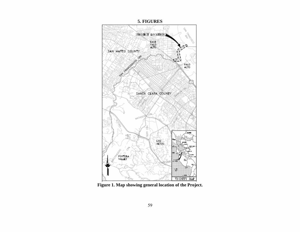
59
5. FIGURES
Figure 1. Map showing general location of the Project.
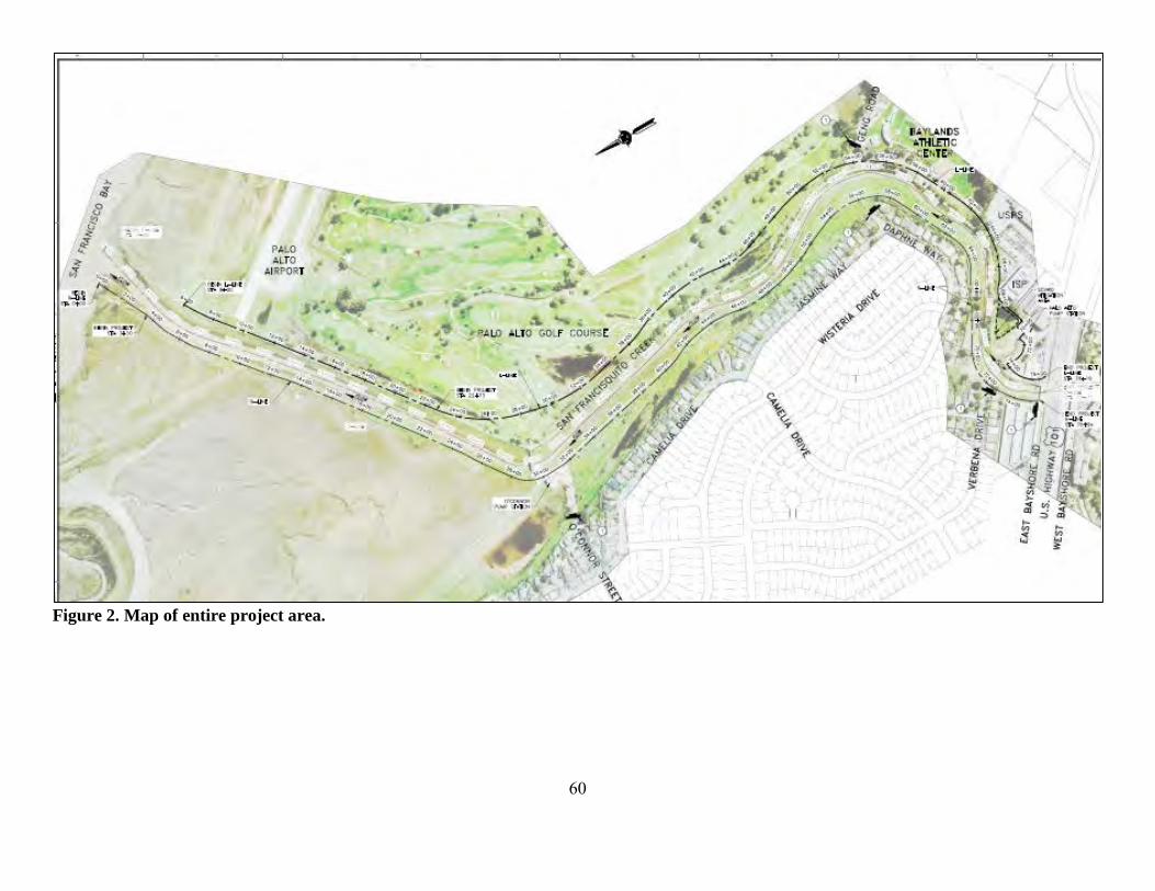
60
Figure 2. Map of entire project area.

61
Figure 3. Map of project area from center line STA 0+00 to STA 28+00.
Figure 4. Map of project area from center line STA 28+00 to STA 52+00.
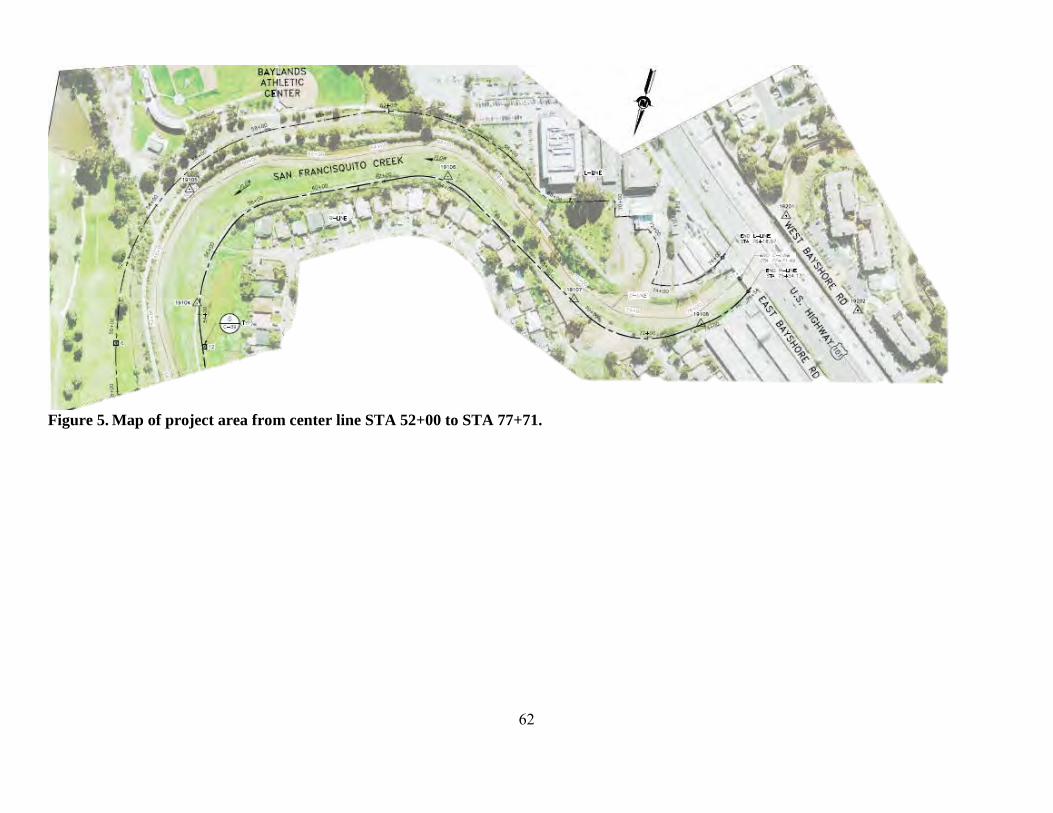
62
Figure 5. Map of project area from center line STA 52+00 to STA 77+71.
63
6. REFERENCES Adams, P. B., C. B. Grimes, J. E. Hightower, S. T. Lindley, and M. L. Moser. 2002. Status
Review for North American Green Sturgeon, Acipenser medirostris. NMFS, SWFSC, USGS, North Carolina State University, NWFSC, Santa Cruz, Raleigh, Seattle.
Adams, P. B., and coauthors. 2007. Population status of North American green sturgeon
Acipenser medirostris. Environmental Biology of Fishes 79:339-356. Allen, P. J., and J. J. Cech. 2007. Age/size effects on juvenile green sturgeon, Acipenser
medirostris, oxygen consumption, growth, and osmoregulation in saline environments. Environmental Biology of Fishes 79:211-229.
Barnhart, R. A. 1986. Species Profiles: Life Histories and Environmental Requirements of
Coastal Fishes and Invertebrates (Pacific Southwest), 82(11.60). Berg, L., and T. G. Northcote. 1985. Changes in territorial, gill-flaring, and feeding behavior in
juvenile coho salmon (Oncorhynchus kisutch) following short-term pulses of suspended sediment. Canadian Journal of Fisheries and Aquatic Sciences 42:1410-1417.
Bilby, R. E., B. R. Fransen, and P. A. Bisson. 1996. Incorporation of nitrogen and carbon from
spawning coho salmon into the trophic system of small streams: evidence from stable isotopes. Canadian Journal of Fisheries and Aquatic Sciences 53:164-173.
Bilby, R. E., B. R. Fransen, P. A. Bisson, and J. K. Walter. 1998. Response of juvenile coho
salmon (Oncorhynchus kisutch) and steelhead (Oncorhynchus mykiss) to the addition of salmon carcasses to two streams in southwestern Washington, U. S. A. Canadian Journal of Fisheries and Aquatic Sciences 55:1909-1918.
Bisson, P. A., and R. E. Bilby. 1982. Avoidance of suspended sediment by juvenile coho salmon.
North American Journal of Fisheries Management 2(4):371-374. Bisson, P. A., and coauthors. 1987. Large woody debris in forested steams in the Pacific
northwest: past, present, and future. E. O. Salo, and T. W. Cundy, editors. Streamside management: forestry and fishery interactions, volume Chapter five. University of Washington, Seattle, WA.
Bjorkstedt, E. P., and coauthors. 2005. An analysis of historical population structure for
evolutionarily significant units of Chinook salmon, coho salmon, and steelhead in the north-central California coast recovery domain. U.S. Department of Commerce, National Marine Fisheries Service, Southwest Fisheries Science Center, NOAA Technical Memorandum, NMFS-SWFSC-382, Santa Cruz, CA.

64
Bjornn, T. C., and coauthors. 1977. Transport of granitic sediment in streams and its effect on insects and fish. University of Idaho, College of Forestry, wildlife and Range Sciences, Forest, Wildlife and Range Experiment Station Bulletin 17, Moscow, ID.
Bjornn, T. C., S. C. Kirking, and W. R. Meehan. 1991. Relation of cover alterations to the
summer standing crop of young salmonids in small southeast Alaska streams. Transactions of the American Fisheries Society 120:562-570.
Bjornn, T. C., and D. W. Reiser. 1991a. Habitat requirements of salmonids in streams. American
Fisheries Society Special Publication 19:83-138. Bjornn, T. C., and D. W. Reiser. 1991b. Habitat requirements of salmonids in streams. Pages 83-
138 in W. R. Meehan, editor. Influences of Forest and Rangeland Management. American Fisheries Society, Bethesda, MD.
Bond, M. H. 2006. Importance of estuarine rearing to Central California steelhead
(Oncorhynchus mykiss) growth and marine survival. Master's Thesis. University of California, Santa Cruz, CA.
Busby, P. J., and coauthors. 1996. Status review of West Coast steelhead from Washington,
Idaho, Oregon, and California. National Marine Fisheries Service, Northwest Fisheries Sceince Center and Southwest Region Protected Resources Division, NOAA Technical Memorandum, NMFS-NWFSC-27.
California Department of Fish and Game (CDFG). 2002. California Department of Fish and
Game Comments to NMFS Regarding Green Sturgeon Listing. Chapman, D. W. 1988. Critical review of variables used to define effects of fines in redds of
large salmonids. Transactions of the American Fisheries Society 117(1):1-21. Chapman, E. D., and coauthors. 2015. Movements of steelhead (Oncorhynchus mykiss) smolts
migrating through the San Francisco Bay Estuary. Environmental Biology of Fishes 98(4):1069-1080.
Cloern, J. E. 1996. Phytoplankton bloom dynamics in coastal ecosystems: A review with some
general lessons from sustained investigation of San Francisco Bay, California,. Review of Geophysics 34(2):127-168.
Cloern, J. E., and A. D. Jassby. 2012. Drivers of change in estuarine-coastal ecosystems:
discoveries from four decades of study in San Francisco Bay. Reviews of Geophysics 50. Cohen, A. N., and J. T. Carlton. 1998. Accelerating invasion rate in a highly invaded estuary.
Science 279:555–558. Cordone, A. J., and D. W. Kelley. 1961. The influences of inorganic sediment on the aquatic life
of streams. California Fish and Game 47(2):189-228.

65
Cox, P., and D. Stephenson. 2007. A changing climate for prediction. Science 113:207-208. Crouse, M. R., C. A. Callahan, K. W. Malueg, and S. E. Dominguez. 1981. Effects of fine
sediments on growth of juvenile coho salmon in laboratory streams. Transactions of the American Fisheries Society 110:281-286.
Currie, D. R., and G. D. Parry. 1996. Effects of scallop dredging on a soft sediment community:
A large-scale experimental study. Marine Ecology Progress Series 134(1-3):131-150. Cushman, R. M. 1985. Review of ecological effects of rapidly varying flows downstream from
hydroelectric facilities. North American Journal of Fisheries Management 5(330-339). D.W. Alley and Associates. 2004. Report of construction monitoring leading to isolation of
construction sites and fish capture/relocation of San Francisquito Creek at the Sand Hill Road Bridge and the golf cart crossing in the Stanford Golf Course, June 4-September 2, 2004.
Davies, K. F., C. Gascon, and C. R. Margules. 2001. Habitat fragmentation: consequences,
management, and future research priorities. Island Press, Washington, D.C. Dumbauld, B. R., D. L. Holden, and O. P. Langness. 2008. Do sturgeon limit burrowing shrimp
populations in Pacific Northwest estuaries. Environmental Biology of Fishes 83:283-296. Everest, F. H., and coauthors. 1987. Fine sediment and salmonid production: A paradox. Forestry
and Fishery Interactions:98-142. Everest, F. H., J. R. Dedell, G. H. Reeves, and M. D. Bryant. 1991. Planning and Evaluating
Habitat Projects for Anadromous Salmonids. American Fisheries Society Symposium 10:68-77.
Feely, R. A., C. L. Sabine, J. M. Hernandez-Ayon, D. Ianson, and B. Hales. 2008. Evidence for
Upwelling of Corrosive "Acidified" Water onto the Continental Shelf. Science 320(5882):1490-1492.
Fukushima, L., and E. W. Lesh. 1998. Adult and juvenile anadromous salmonid migration timing
in California streams. California Fish and Game 84(3):133-145. Furniss, M. J., T. D. Roelofs, and C. S. Yee. 1991. Road construction and maintenance. Pages
297-324 in W. R. Meehan, editor. Influences of forest and rangeland management on salmonid fishes and their habitats. American Fisheries Society Special Publication 19, Bethesda, MD.
Gilkinson, K. D., and coauthors. 2005. Immediate impacts and recovery trajectories of
macrofaunal communities following hydraulic clam dredging on Banquereau, eastern Canada. ICES J. Mar. Sci. 62:925-947.
66
Good, T. P., R. S. Waples, and P. B. Adams. 2005. Updated status of federally listed ESUs of West Coast salmon and steelhead. U.S. Department of Commerce, NOAA Technical Memorandum NMFS-NWFSC-66.
Gregory, R. S., and T. G. Northcote. 1993. Surface, planktonic, and benthic foraging by juvenile
Chinook salmon (Oncorhynchus tshawytscha) in turbid laboratory conditions. Canadian Journal of Fisheries and Aquatic Sciences 50:233–240.
Gresh, T., J. Lichatowich, and P. Schoonmaker. 2000. An estimation of historic and current
levels of salmon production in the northeast Pacific ecosystem: evidence of a nutrient deficit in the freshwater systems of the Pacific Northwest. Fisheries 25(1):15-21.
Hanson, L. C. 1993. The Foraging Ecology of the Harbor Seal, Phoca vitulina, and the California
Sea Lion, Zalophus Californianus, at the Mouth of the Russian River, California. Master's Thesis. Sonoma State University, Cotati, California.
Harvey, B. C. 1986. Effects of Suction Gold Dredging on Fish and Invertebrates in Two
California Streams. North American Journal of Fisheries Management 6(3):401-409. Hayes, J. P., and coauthors. 1996. Intergrating research and forest management in riparian areas
of the Oregon coast range. Western Journal of Applied Forestry 11(3):85-89. Hayhoe, K., and coauthors. 2004. Emissions pathways, climate change, and impacts on
California. Proceedings of the National Academy of Sciences of the United States of America 101(34):12422-12427.
Henley, W. F., M. A. Patterson, N. R.J., and A. D. Lemly. 2000. Effects of Sedimentation and
Turbidity on Lotic Food Webs: A Concise Review for Natural Resource Managers. Reviews in Fisheries Science 8(2):125-139.
Hermstad, D., Cayce, K. and Grossinger, R. 2009. Historical Ecology of Lower San
Francisquisto Creek, Phase 1. Technical memorandum accompanying project GIS Data, Contribution No. 579. . Historical Ecology Program, San Francisco Estuary Institute (SFEI), Oakland, California.
Heublein, J. C., J. T. Kelly, C. E. Crocker, A. P. Klimley, and S. T. Lindley. 2009. Migration of
green sturgeon, Acipenser medirostris, in the Sacramento River. Environmental Biology of Fishes 84:245–258.
Hokanson, K. E. F., C. F. Kleiner, and T. W. Thorslund. 1977. Effects of constant temperatures
and diel temperature fluctuations on specific growth and mortality rates and yield of juvenile rainbow trout, Salmo gairdneri. Journal of the Fisheries Research Board of Canada 34:639-648.

67
Hubert, W. A. 1996. Passive capture techniques. Pages Pages 157-192 in B. R. Murphy, and D. W. Willis, editors. Fisheries Techniques-Second Edition. American Fisheries Society, Bethesda, Maryland.
Huff, D. D., S. T. Lindley, P. S. Rankin, and E. A. Mora. 2011. Green sturgeon physical habitat
use in the coastal Pacific Ocean. PLOS One 6(9):e25156. Israel, J. A., K. Jun Bando, E. C. Anderson, and B. May. 2009. Polyploid microsatellite data
reveal stock complexity among estuarine North American green sturgeon (Acipenser medirostris). Canadian Journal of Fisheries and Aquatic Sciences 66:1491–1504.
Israel, J. A., and B. May. 2010. Indirect genetic estimates of breeding population size in the
polyploid green sturgeon (Acipenser medirostris). Molecular Ecology 19:1058–1070. Jones and Stokes Associates. 2006. Lower San Francisquito Creek Watershed Aquatic Habitat
Assessment & Limiting Factors Analysis (Work Product N.1). Jones and Stokes Associates, San Jose, CA.
Kelly, J. T., A. P. Klimley, and C. E. Crocker. 2007. Movements of green sturgeon, Acipenser
medirostris, in the San Francisco Bay estuary, California. Environmental Biology of Fishes 79:281-295.
Kimmerer, W., E. Gartside, and J. J. Orsi. 1994. Predation by an introduced clam as the likely
cause of substantial declines in zooplankton of San Francisco Bay. Marine Ecology Progress Series 113:81–93.
Kogut, N. J. 2008. overbite clams, Corbula amurensis, defecated alive by white sturgeon,
Acipenser transmontanus. . California Fish and Game 94(3):143-149. Launer, A. E., and D. Spain. 1998. Biotic resources of the San Francisquito Creek Watershed:
Report on 1997 Field Activities Associated with SAA #934-96. Stanford, CA, Stanford, CA.
Lee, Y.-W., and coauthors. 2015. Observed and Estimated Bycatch of Green Sturgeon in 2002–
2013 US West Coast Groundfish Fisheries. . West Coast Groundfish Observer Program, National Marine Fisheries Service, NWFSC, Seattle, WA.
Leidy, R. A., G. S. Becker, and B. N. Harvey. 2005. Historical distribution and current status of
steelhead/rainbow trout (Oncorhynchus mykiss) in streams of the San Francisco Estuary, California- San Mateo and San Francisco Counties. Center for Ecosystem Management and Restoration, Oakland, CA.
Lindley, S. T., and coauthors. 2009. What caused the Sacramento River fall Chinook stock
collapse? Pre-publication report to the Pacific Fishery Management Council.

68
Lindley, S. T., and coauthors. 2011. Electronic Tagging of Green Sturgeon Reveals Population Structure and Movement among Estuaries. Transactions of the American Fisheries Society 140:108–122.
Lindley, S. T., and coauthors. 2008. Marine migration of North American green sturgeon.
Transactions of the American Fisheries Society 137:182–194. Lindley, S. T., and coauthors. 2007. Framework for assessing viability of threatened and
endangered Chinook salmon and steelhead in the Sacramento-San Joaquin Basin. San Francisco Estuary and Watershed Science 5(1):26.
Luers, A. L., D. R. Cayan, G. Franco, M. Hanemann, and B. Croes. 2006. Our changing climate,
assessing the risks to California; a summary report from the California Climate Change Center. California Climate Change Center.
MacFarlane, B. R., and E. C. Norton. 2002. Physiological ecology of juvenile Chinook salmon
(Oncorhynchus tshawytscha) at the southern end of their distribution, the San Francisco Estuary and Gulf of the Farallones, California. Fisheries Bulletin 100:244-257.
McCauley, J. E., R. A. Parr, and D. R. Hancock. 1977. Benthic Infauna and Maintenance
Dredging- Case Study. Water Research 11(2):233-242. McElhany, P., M. H. Ruckelshaus, M. J. Ford, T. C. Wainwright, and E. P. Bjorkstedt. 2000.
Viable Salmonid Populations and the Recovery of Evolutionarily Significant Units. Appendix A4: Population Size. National Marine Fisheries Services, Northwest Fisheries Science Center & Southwest Fisheries Science Center.
Metzger, L. 2002. Streamflow Gains and Losses along San Francisquito Creek and
Characterization of Surface-Water and Ground-Water Quality, Southern San Mateo and Northern Santa Clara Counties, California, 1996–97. Prepared in cooperation with the City of Menlo Park.
Moyle, P. B. 2002. Inland fishes of California. University of California Press, Berekely and Los
Angeles, CA. Moyle, P. B., R. M. Yoshiyama, J. E. Williams, and E. D. Wikramanayake. 1995. Fish species of
special concern in California. California Department of Fish and Game, Davis. Myrick, C., and J. J. Cech, Jr. 2005. Effects of Temperature on the Growth, Food Consumption,
and Thermal Tolerance of Age-0 Nimbus-Strain Steelhead. North American Journal of Aquaculture 67:324-330.
Nakamoto, R. J., T. T. Kisanuki, and G. H. Goldsmith. 1995. Age and Growth of Klamath River
Green Sturgeon (Acipenser medirostris). United States Fish and Wildlife Service Project 93-FP-13, Yreka, CA.
69
National Marine Fisheries Service (NMFS). 2001. Guidleines for Salmonid Passage at Stream Crossings.
National Marine Fisheries Service (NMFS). 2005. Green Sturgeon (Acipenser medirostris)
Status Review Update. NMFS, SWFSC, Santa Cruz. National Marine Fisheries Service (NMFS). 2011. Anadromous Salmonid Passage Facility
Design. NMFS, Northwest Region, Portland, Oregon. National Marine Fisheries Service (NMFS). 2012. Continuing Operation of the Pacific Coast
Groundfish Fishery - Endangered Species Act (ESA) Section 7(a)(2) Biological Opinion and Section 7(a)(2) "Not Likely to Adversely Affect" Determination. . Pages 194 in.
National Marine Fisheries Service (NMFS). 2013. Status Review of The Eastern Distinct
Population Segment of Steller Sea Lion (Eumetopias jubatus). Protected Resources Division, Alaska Region, National Marine Fisheries Service, Juneau, Alaska.
National Marine Fisheries Service (NMFS). 2015. Southern Distinct Population Segment of the
North American Green Sturgeon (Acipenser medirostris) 5-Year Review: Summary and Evaluation. West Coast Region, Long Beach, CA
Nature Conservancy. 2013. California Salmon Snapshots. Date Accessed: May 30, 2014.
http://www.casalmon.org/. Nelson, T. C., and coauthors. 2010. Modern technologies for an ancient fish: tools to inform
management of migratory sturgeon stocks. A report for the Pacific Ocean Shelf Tracking (POST) Project.
Newcombe, C. P., and J. O. Jensen. 1996. Channel suspended sediment and fisheries: a synthesis for quantitative assessment of risk and impact. North American Journal of Fisheries Management 16(4):693-726.
Newcombe, C. P., and D. D. MacDonald. 1991. Effects of suspended sediments on aquatic
ecosystems. North American Journal of Fisheries Management 11(1):72-82. Newell, R. C., L.J. Seiderer, N.M. Simpson, J.E. Robinson. 2002. Impact of Marine Aggregate
Dredging and Overboard Screening on Benthic Biological Resources in the Central North Sea: Production Licence Area 408, Coal Pit. Marine Ecological Surveys Limited, Cornwall, England.
Nichols, F. H., J. K. Thompson, and L. E. Schemel. 1990. Remarkable invasion of San Francisco
Bay (California, USA) by the Asian clam Potamocorbula amurensis. II. Displacement of a former community. Marine Ecology Progress Series 66:95–101.
Northwest Hydraulic Consultants, I., and coauthors. 2002. Searsville Lake Sediment Impacts
Study. Submitted to Stanford University.

70
Oliver, J. S., P. N. Slattery, L. W. Hulberg, and J. W. Nybakken. 1977. Patterns of succession in benthic infaunal communities following dredging and dredged material disposal in Monterey Bay. U.S. Army Corps of Engineers, editor.
Oreskes, N. 2004. The scientific consensus on climate change. Science 306:1686. Pacific Fishery Management Council (PFMC). 1998. The Coastal Pelagic Species Fishery
Management Plan: Amendment 8. Pacific Fishery Management Council. Pacific Fishery Management Council (PFMC). 1999. Identification and description of essential
fish habitat, adverse impacts, and recommended conservation measures for salmon. Appendix A to Amendment 14, Pacific Coast salmon fishery management plan. Available at: http://www.pcouncil.org/salmon/fishery-management-plan/adoptedapprovedamendments/amendment-14-to-the-pacific-coast-salmon-plan-1997/.
Pacific Fishery Management Council (PFMC). 2005. Amendment 19 (essential fish habitat) to
the Pacific Coast groundfish fishery management plan for the California, Oregon, and Washington groundfish fishery. Available at: http://www.pcouncil.org/wp-content/uploads/A18-19Final.pdf.
Point Reyes Bird Observatory Conservation Science (PRBO). 2012. San Francisco Bay Sea-
Level Rise Website. Date Accessed: August 12, 2012. http://data.prbo.org/apps/sfbslr/. Portner, H. O., and R. Knust. 2007. Climate Change Affects Marine Fishes Through the Oxygen
Limitation of Thermal Tolerance. Science 315:95-97. Poytress, W. R., J. J. Gruber, and J. Van Eenennaam. 2011. 2010 Upper Sacramento River Green
Sturgeon Spawning Habitat and Larval Migration Surveys. Annual Report of U.S. Fish and Wildlife Service to U.S. Bureau of Reclamation, Red Bluff, CA.
Radtke, L. D. 1966. Distribution of smelt, juvenile sturgeon, and starry flounder in the
Sacramento-San Joaquin Delta with observations on food of sturgeon: Acipenser Transmontanus, Acipenser medirostris, Hypomesus transpaciiicus, Spirinchus thaleicnthys, Platichthys stellatus. Calif Dep Fish Game Fish Bull 136:115-129.
Redding, J. M., C. B. Schreck, and F. H. Everest. 1987. Physiological effects on coho salmon
and steelhead of exposure to suspended solids. Transactions of the American Fisheries Society 116:737-744.
Reish, D. J. 1961. A Study of Benthic Fauna in a Recently Constructed Boat Harbor in Southern
California. Ecology 42:84–91. San Francisco Bay Conservation and Development Commission (BCDC). 2007. San Francisco
Bay Scenarios for Sea Level Rise Index Map. Date Accessed: May 30, 2014. http://www.bcdc.ca.gov/planning/climate_change/index_map.shtml.
71
San Francisco District Corps of Engineers Water Resources Section (Corps). 2011. Memo: San Francisquito Creek Floodplains Update - The impacts of sediment on the channel capacity and the resulting floodplains.
San Francisquito Creek Joint Powers Authority (SFCJPA). 2015a. San Francisquito Creek Flood
Control Reduction, Ecosystem Restoration, and Recreation Project Operation and Maintenance Manual.
San Francisquito Creek Joint Powers Authority (SFCJPA). 2015b. San Francisquito Creek Flood
Control Reduction, Ecosystem Restoration, and Recreation Project Temporary Water Diversion Plan.
San Francisquito Creek Joint Powers Authority (SFCJPA). 2015c. San Francisquito Creek Flood
Reduction, Ecosystem Restoration, and Recreation Mitigation and Monitoring Plan. Sandstrom, P. T., T. Keegan, and G. Singer. 2013. Survival and movement patterns of central
California coast native steelhead trout (Oncorhynchus mykiss) in the Napa River. Environmental Biology of Fishes 96(2-3):287-302.
Scavia, D., and coauthors. 2002. Climate change impacts on U.S. coastal and marine ecosystems.
Estuaries 25(2):149-164. Schneider, S. H. 2007. The unique risks to California from human-induced climate change. Servizi, J. A., and D. W. Martens. 1992. Sublethal responses of coho salmon (Oncorhynchus
kisutch) to suspended sediments. Canadian Journal of Fisheries and Aquatic Sciences 49:1389-1395.
Shapovalov, L., and A. C. Taft. 1954. The life histories of the steelhead rainbow trout (Salmo
gairdneri gairdneri) and silver salmon (Oncorhynchus kisutch) with special reference to Waddell Creek, California, and recommendations regarding their management. California Department of Fish and Game, Fish Bulletin No. 98.
Shirvell, C. S. 1990. Role of instream rootwads as juvenile coho salmon and steelhead trout
cover habitat under varying streamflows. Canadian Journal of Fisheries and Aquatic Sciences 47:852-860.
Sigler, J. W., T. C. Bjornn, and F. H. Everest. 1984. Effects of chronic turbidity on density and
growth of steelheads and coho salmon. Transactions of the American Fisheries Society 113:142-150.
Smith, D. M., Cusack, S., Colman, A.W., Folland, C.K., Harris, G.R., and J. M. Murphy. 2007.
Improved surface temperature prediction for the coming decade from a global climate model. Science 317:796-799.
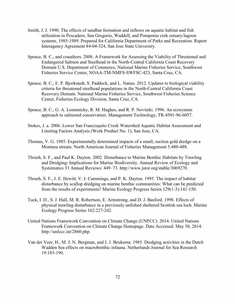
72
Smith, J. J. 1990. The effects of sandbar formation and inflows on aquatic habitat and fish utilization in Pescadero, San Gregorio, Waddell, and Pomponio crek estuary/lagoon systems, 1985-1989. Prepared for California Department of Parks and Recreation. Report Interagency Agreement 84-04-324, San Jose State University.
Spence, B. C., and coauthors. 2008. A Framework for Assessing the Viability of Threatened and
Endangered Salmon and Steelhead in the North-Central California Coast Recovery Domain U.S. Department of Commerce, National Marine Fisheries Service, Southwest Fisheries Service Center, NOAA-TM-NMFS-SWFSC-423, Santa Cruz, CA.
Spence, B. C., E. P. Bjorkstedt, S. Paddock, and L. Nanus. 2012. Updates to biological viability
criteria for threatened steelhead populations in the North-Central California Coast Recovery Domain. National Marine Fisheries Service, Southwest Fisheries Science Center, Fisheries Ecology Division, Santa Cruz, CA.
Spence, B. C., G. A. Lomnnicky, R. M. Hughes, and R. P. Novitzki. 1996. An ecosystem
approach to salmonid conservation. Management Technology, TR-4501-96-6057. Stokes, J. a. 2006. Lower San Francisquito Creek Watershed Aquatic Habitat Assessment and
Limiting Factors Analysis (Work Product No. 1), San Jose, CA. Thomas, V. G. 1985. Experimentally determined impacts of a small, suction gold dredge on a
Montana stream. North American Journal of Fisheries Management 5:480-488. Thrush, S. F., and Paul K. Dayton. 2002. Disturbance to Marine Benthic Habitats by Trawling
and Dredging: Implications for Marine Biodiversity. Annual Review of Ecology and Systematics 33 Annual Reviews: 449–73. http://www.jstor.org/stable/3069270.
Thrush, S. F., J. E. Hewitt, V. J. Cummings, and P. K. Dayton. 1995. The impact of habitat
disturbance by scallop dredging on marine benthic communities: What can be predicted from the results of experiments? Marine Ecology Progress Series 129(1-3):141-150.
Tuck, I. D., S. J. Hall, M. R. Robertson, E. Armstrong, and D. J. Basford. 1998. Effects of
physical trawling disturbance in a previously unfished sheltered Scottish sea loch. Marine Ecology Progress Series 162:227-242.
United Nations Framework Convention on Climate Change (UNFCC). 2014. United Nations
Framework Convention on Climate Change Homepage. Date Accessed: May 30, 2014. http://unfccc.int/2860.php.
Van der Veer, H., M. J. N. Bergman, and J. J. Beukema. 1985. Dredging activities in the Dutch
Wadden Sea effects on macrobenthic infauna. Netherlands Journal for Sea Research 19:183-190.

73
Van Eenennaam, J. P., J. Linares-Casenave, X. Deng, and S. I. Doroshov. 2005. Effect of incubation temperature on green sturgeon embryos, Acipenser medirostris. Environmental Biology of Fishes 72(2):145-154.
Van Eenennaam, J. P., and coauthors. 2006. Reproductive Conditions of the Klamath River
Green Sturgeon. Transactions of the American Fisheries Society 135(1):151-163. Waples, R. S. 1991. Genetic interactions between hatchery and wild salmonids: lessons from the
Pacific Northwest. Canadian Journal of Fisheries and Aquatic Sciences 48:124-133. Waters, T. F. 1995. Sediment in streams: sources, biological effects, and control. American
Fisheries Society Monograph 7. Watling, L., R. H. Findlay, L. M. Mayer, and D. F. Schick. 2001. Impact of a scallop drag on the
sediment chemistry, microbiota, and faunal assemblages of a shallow subtidal marine benthic community. Journal of Sea Research 46(3-4):309-324.
Williams, T. H., S. T. Lindley, B. C. Spence, and D. A. Boughton. 2011. Status Review Update
For Pacific Salmon and Steelhead Listed Under the Endangered Species Act: Southwest. NOAA's National Marine Fisheries Service, Southwest Fisheries Science Center, Santa Cruz, CA.
Winder, M., and A. D. Jassby. 2011. Shifts in Zooplankton Community Structure: Implications
for Food Web Processes in the Upper San Francisco Estuary. Estuaries and Coasts 34(4):675-690.
Wurtsbaugh, W. A., and G. E. Davis. 1977. Effects of temperature and ration level on the growth
and food conversion efficiency of Salmo gairdneri, Richardson. Journal of Fish Biology 11:87-98.
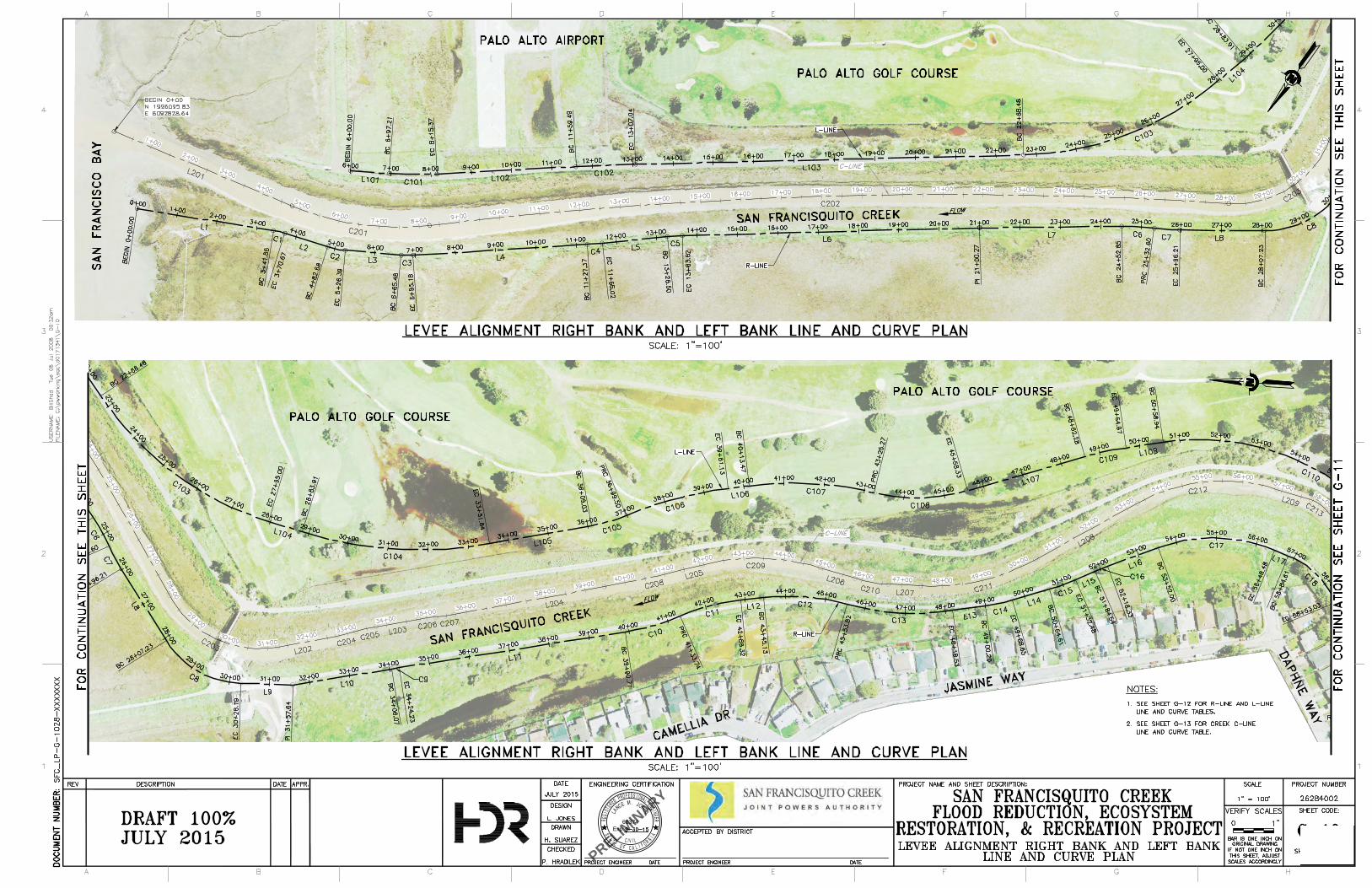
P
R
E
L
I
M
I
N
A
R
Y
68374
Exp.
billspri
Text Box
Figure 1a Maintenance Access Downstream
billspri
Text Box
billspri
Line
billspri
Line
billspri
Text Box
O'Connor St. Past Pump Station
billspri
Text Box
Daphne Way
billspri
Line
billspri
Text Box
Geng Rd.
billspri
Line
billspri
Text Box
Access Ramp into Channel
billspri
Text Box
To South and East Levee Enhancement Area for Maintenance during Establishment Period Only
billspri
Text Box
To North Levee Enhancement Area for Maintenance during Establishment Period Only
billspri
Line
billspri
Line
P
R
E
L
I
M
I
N
A
R
Y
68374
Exp.
billspri
Text Box
Figure 1b Maintenance Access Upstream
billspri
Text Box
billspri
Line
billspri
Text Box
Removable Flood Gate into Channel At Palo Alto Pump Station
billspri
Line
billspri
Text Box
Verbena Dr.
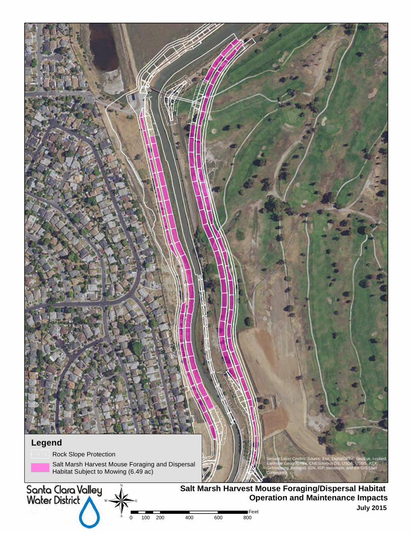
Salt Marsh Harvest Mouse Foraging/Dispersal Habitat Operation and Maintenance Impacts
July 2015®0 200 400 600 800100Feet
LegendRock Slope Protection
Salt Marsh Harvest Mouse Foraging and DispersalHabitat Subject to Mowing (6.49 ac)
Service Layer Credits: Source: Esri, DigitalGlobe, GeoEye, i-cubed,Earthstar Geographics, CNES/Airbus DS, USDA, USGS, AEX,Getmapping, Aerogrid, IGN, IGP, swisstopo, and the GIS UserCommunity
Related Documents