Workshop on the ‘Role of Crisis Informatics in Disaster Management: The Case of Nepal Earthquake’ Kahtmandu, August 9 2015 Pierre Béland, Humanitarian OpenStreetMap Volunteer Coordinator, HOT/OSM Activations OpenstreetMap Response - 2015 Nepal Earthquake

Welcome message from author
This document is posted to help you gain knowledge. Please leave a comment to let me know what you think about it! Share it to your friends and learn new things together.
Transcript

Workshop on the ‘Role of Crisis Informatics in Disaster Management: The Case of Nepal Earthquake’Kahtmandu, August 9 2015
Pierre Béland, Humanitarian OpenStreetMap VolunteerCoordinator, HOT/OSM Activations
OpenstreetMap Response - 2015 Nepal Earthquake
OpenstreetMap Response - 2015 Nepal Earthquake
The role of HOT in Disaster Management● Interface between the OSM community and the humanitarian organizations● Flexible coordination with the UN Agencies, international organizations and
GIS teams - We adapt rapidly to the particularity of each region and disaster
Quick response to support the first responders – The BaseMap (road network and villages outline) is the first priority
● Imagery Acquisition, Process Hosting : Support from Imagery providers and HOT volunteers
● Imports,Tutorials. Validations● Define Tasks with partners, monitor progress
Humanitarian OpenStreetMap Team

OpenstreetMap Response - 2015 Nepal Earthquake
● Coordination Room via Skype was effective a few hours after the earthquake – a few hundred participants
● Kathmandu Living Labs was operational in the second day of the Response
The Nepal Earthquake Response
OpenstreetMap Response - 2015 Nepal Earthquake
● Humanitarian OpenStreetMap Team● Kathmandu Living Labs● UN agencies● International organizations (MSF, Red Cross, etc)● Digital Humanitarian Network● Imagery providers● Organizations involved in Post-Disaster Assessments
- UNOSAT, DigitalGlobe● Various specialists
Coordination of the mapping response
OpenstreetMap Response - 2015 Nepal Earthquake
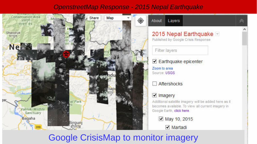
● Pre Disaster : Bing Imagery available for most of the area. HIU provided an image to complete the coverage
● Post-Disaster : Activation by the International Charter – Satellites re-oriented to quickly provide new images
● With the bad meteo of the first week, only a images of Kathmandu valley were acquired. OSM did quickly locate the informal camps from these images.
● Support from DigitalGlobe, AirBus Defence & Space, HIU (US State Department), MapBox, Google
Imagery acquisition, process, hosting
OpenstreetMap Response - 2015 Nepal Earthquake
Google CrisisMap to monitor imagery
OpenstreetMap Response - 2015 Nepal Earthquake
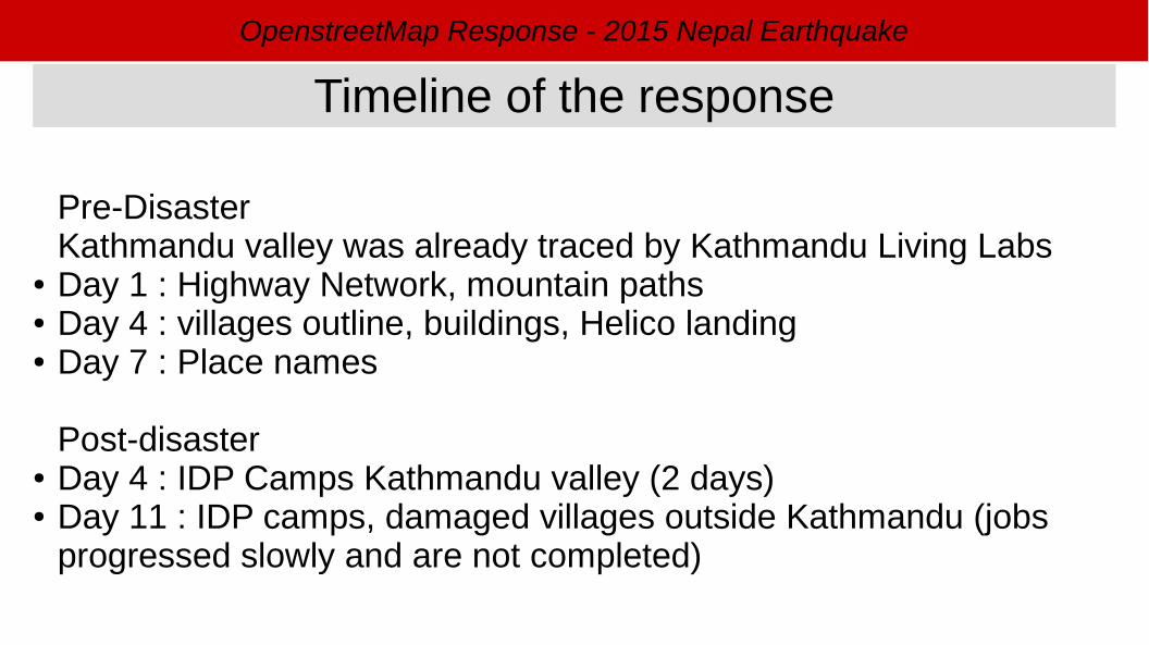
Pre-DisasterKathmandu valley was already traced by Kathmandu Living Labs
● Day 1 : Highway Network, mountain paths● Day 4 : villages outline, buildings, Helico landing● Day 7 : Place names
Post-disaster● Day 4 : IDP Camps Kathmandu valley (2 days)● Day 11 : IDP camps, damaged villages outside Kathmandu (jobs
progressed slowly and are not completed)
Timeline of the response
OpenstreetMap Response - 2015 Nepal Earthquake
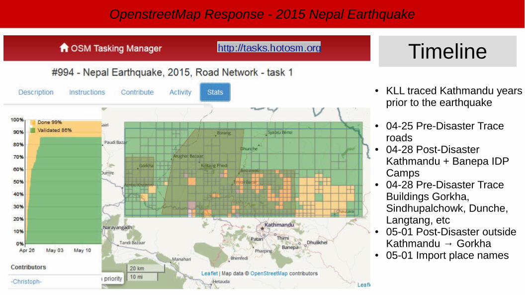
● KLL traced Kathmandu years prior to the earthquake
● 04-25 Pre-Disaster Trace roads
● 04-28 Post-Disaster Kathmandu + Banepa IDP Camps
● 04-28 Pre-Disaster Trace Buildings Gorkha, Sindhupalchowk, Dunche, Langtang, etc
● 05-01 Post-Disaster outside Kathmandu → Gorkha
● 05-01 Import place names
Timeline
OpenstreetMap Response - 2015 Nepal Earthquake
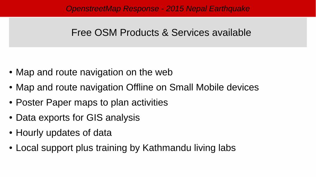
● Map and route navigation on the web● Map and route navigation Offline on Small Mobile devices● Poster Paper maps to plan activities● Data exports for GIS analysis● Hourly updates of data● Local support plus training by Kathmandu living labs
Free OSM Products & Services available
OpenstreetMap Response - 2015 Nepal Earthquake
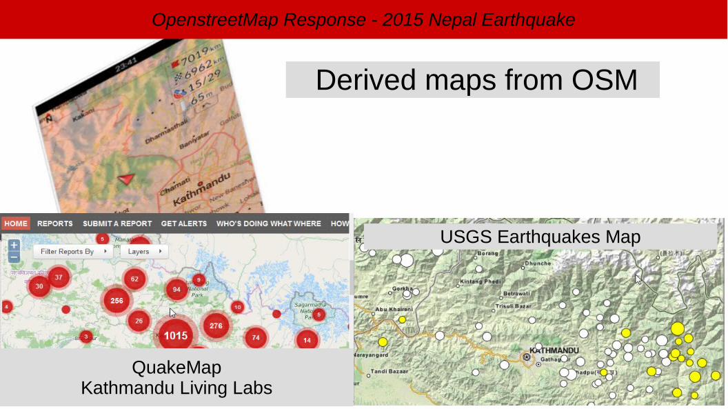
Derived maps from OSM
QuakeMapKathmandu Living Labs
USGS Earthquakes Map

OpenstreetMap Response - 2015 Nepal Earthquake
HOT Email list
● Partners and OSM community from around the world follow and discuss, join-in to contribute
Communications

OpenstreetMap Response - 2015 Nepal Earthquake
http://wiki.openstreetmap.org/wiki/2015_Nepal_earthquake
Wiki – Inform the partners and coordinate actions
General Info, contacts, coordination, etc
Maps & Services available- Exports : Hourly update
How to contribute
Medias updates
OpenstreetMap Response - 2015 Nepal Earthquake
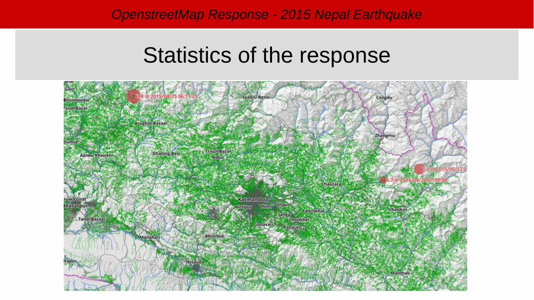
Statistics of the response

OpenstreetMap Response - 2015 Nepal Earthquake
4211942121
4212342125
4212742129
4213142133
4213542137
4213942141
4214342145
4214742149
4215142153
4215542157
4215942161
42163
0
200000
400000
600000
800000
1000000
1200000
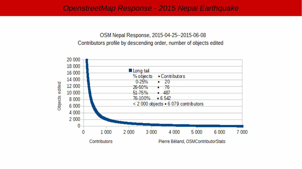
OSM Nepal Response, 2015-04-25 to 06-08
Objects per day
OSMContributorStats
OpenstreetMap Response - 2015 Nepal Earthquake
OpenstreetMap Response - 2015 Nepal Earthquake
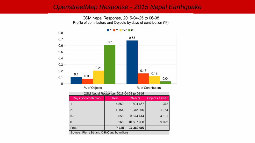
% of Objects % of Contributors0
0.1
0.2
0.3
0.4
0.5
0.6
0.7
0.8
0.1
0.68
0.08
0.160.21
0.12
0.61
0.04
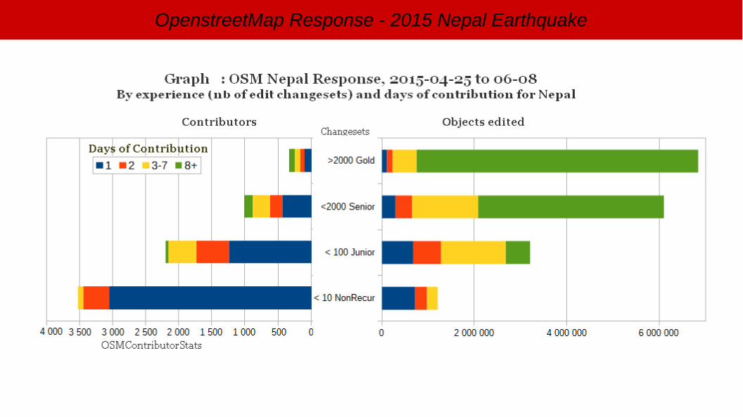
OSM Nepal Response, 2015-04-25 to 06-08Profile of contributors and Objects by days of contribution (%)
1 2 3-7 8+
OSMContributorStats OSM Nepal Response, 2015-04-25 to 06-08
Days of contribution Users Objects Objects / User
1 372
2
3-7 855
8+ 266
Total
4 850 1 804 667
1 154 1 342 976 1 164
3 574 414 4 181
10 637 950 39 992
7 125 17 360 007
Source : Pierre Béland OSMContributorStats
OpenstreetMap Response - 2015 Nepal Earthquake

OpenstreetMap Response - 2015 Nepal Earthquake
● Imagery providers reacted quickly and delivered post-disaster imagery daily. But Weather conditions limited access to images of quality
● OSM Maps & Services – A complete solution is available instantly to respond to emergencies
● The HOT Tasking Manager let's coordinate simultaenous contribution of hundred of people
● 17 millions objects edited in 6 weeks – more then for one year of Ebola response
Observations / Lessons learned
OpenstreetMap Response - 2015 Nepal Earthquake
● Media coverage and organization of various mapathon brought an unprecedented number of new contributors
● Validation problems where often mentionned. More monitoring tools, follow-up of Mapathons and Adapted Learning material should be developped
● OSM priority is to provide the BaseMap and the Map & Services necessary for the various field teams and GIS specialists.
● A workflow should be developped with the Post-assessment agencies for more complementarity, OSM supporting them primarily with the basemap needed for assessments comparizons.
Observations / Lessons learned
OpenstreetMap Response - 2015 Nepal Earthquake
Thanks for all the contributions to this OpenStreetMap Response
Free Imagery, processing, hosting, monitoring● Bing, International Charter, Space and Major Disasters, DigitalGlobe,
AirBus Defence & Space, Humanitarian Information Unit, US State Department , MapBox, Google
● HOT coordination team volunteers● The OSM developpers and Export Service providers● The thousand of OSM contributors
Related Documents