Open Source Solutions for a Open Source Solutions for a Growing Atlas of Canada Growing Atlas of Canada Douglas O’Brien June 10, 2004

Open Source Solutions for a Growing Atlas of Canada Douglas O’Brien June 10, 2004.
Jan 01, 2016
Welcome message from author
This document is posted to help you gain knowledge. Please leave a comment to let me know what you think about it! Share it to your friends and learn new things together.
Transcript

Open Source Solutions for a Open Source Solutions for a
Growing Atlas of CanadaGrowing Atlas of Canada
Douglas O’BrienJune 10, 2004

2
Presentation outline
• What is the Atlas of Canada• Evolution of the Atlas Online• Current software solutions• Philosophies leading to decisions

3
The Atlas – addresses the Government’s priorities of the time
Issues
1st edition (1906) Transportation Networks*, Populating the Country, Natural Resources
2nd edition (1915) Update of 1st edition, plus Climate
3rd edition (1957) Natural Resource Development,
Industrial Development
4th edition (1974) Communications, Canada in the World – Exports
5th edition (1993) Native Issues, Health and Welfare, Ethnic Diversity
6th edition (current) Aboriginal, Resource-dependent Communities, Climate Change, Water, Healthcare Delivery, Biodiversity …
* transportation was a unifying theme in the 1st, 2nd and 3rd editions

4
1300+ MAPS
Environment
People and Society
Economy
Historical
Reference
Climate Change
Health
Freshwater
Partnerships
Natural Resources Canada•Resource Reliant Communities•Forestry•Mining•Energy•Geology
Other departments•Statistics Canada•Agriculture•Health•Environment•Indian and Northern Affairs•Fisheries & Oceans
Users
General Public•Find-a-place•Subject information
Education•Subject information•Tools
Science/Policy Experts•Communication•Tools for visualization and analysis•Information for analysis
Communities of Practice•Tools and services for visualization•Access to distributed information
WebFrameworksReference mapsCGDI/services
FrameworksCommunicationsMapping tools
GeoConnections

5
The Atlas – what does it do
• addresses current national issues:• deals with information and relationships to other information*.
• engages partners from many federal agencies, NGOs etc.
• reaches a broad Canadian audience. • general public, especially students and teachers.
• is a key component of the Canadian Geospatial Data Infrastructure (GeoConnections Program):
• a point of entry for the public.
• a consistent implementation demonstrating best practices.
• re-usable (representations, services and data).
* the Atlas contains maps, explanatory text, analysis, commentary, graphs, charts, pictures etc.

6
Some numbers
• Over 300 interactive maps, most with multiple layers, as part of a hierarchy of issues/themes/topics with associated text and related information
• Over 1,000 static maps (primarily scanned previous editions).
• Each month, 180,000 users make 380,000 visits to the Atlas and view over 450,000 maps (initial views only).

7
1997
1994/95
19992002
2004

8
Atlas Online 1994/1995
• Internally developed web mapping application as technology prototype.
• Limited set of data layers at 1:30M scale dealt with as secondary in importance.
• A few partners, most internal to Natural Resources Canada.
• Little thought to user interaction.

9
Atlas Online 1999
• Custom application built on “off the shelf” ESRI Map Objects.
• Improved information content presented at 1:7.5M scale.
• Increase in partnerships across government.
• User interaction based on “we know best”.

10
Atlas Online 2004
• Custom built application based on open source software.
• Information content presented at scales up to 1:1M.
• Waiting list of partnerships across government.
• User interaction strongly based on user-centric design.

11

12

13
Open/free software solutions for the Atlas
• Red Hat Linux• Zope• PostgreSQL/PostGIS• Python• OpenLDAP• Tripwire• Apache• PHP• University of Minnesota
MapServer
• University of Minnesota MapServer
• GDAL/OGR• PROJ• MapLab• Analog• Darwin Quicktime
Streaming Server• M3Cat
14
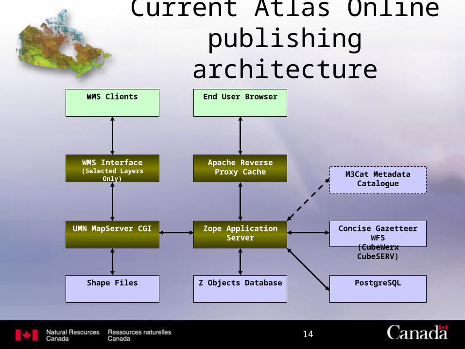
Apache Reverse Proxy Cache
End User Browser
Zope Application Server
UMN MapServer CGI
Z Objects Database PostgreSQL
Concise Gazetteer WFS(CubeWerx CubeSERV)
WMS Interface(Selected Layers Only) M3Cat Metadata
Catalogue
WMS Clients
Shape Files
Current Atlas Online publishing architecture

15
Main interactions
• The Atlas has Zope at its core, utilizing additional packages such as Localizer, mxmRelations, WFSAdapter, TranslationService, CMF.
• Zope & MapServer: The key Mapping Component object is designed to interact with the UMN MapServer. Its proxies requests between the end-user and the MapServer CGI, generating a web page from the output of MapServer, repeating the process to obtain the legend.
• Other Zope interactions including PostgreSQL and M3Cat.

16
Using service interfaces
• The Atlas publishes base information through OGC WMS specifications.
• The Atlas reads information layers through OGC WMS specifications.
• The Atlas accesses Gazetteer information through a WFS interface.
• The Atlas publishes high level services, such as find-a-place, through open, custom web based interfaces.

17
Some technology philosophies
• Importance of separating data, services and presentation.
• Information management and publication are two different things.
• Value of open standards to interconnect services.• Iterative approach – anything is possible, but
nothing is perfect.• Own what you must, and influence all that you can.

18
Embracing an open approach
• The Atlas collaborates with GeoConnections, a national partnership initiative, to provide Canadians with Internet access to geospatial information - information about the geography, environment and natural resources base of a country.
• The Atlas consumes and publishes information through the Canadian Geospatial Data Infrastructure through open interfaces.
• The Atlas works with partners to develop national scale framework data sets which are made freely available for common use.

19
Why use open source solutions
• The Atlas is not looking for an out-of-the-box solution – the need to be something extra.
• Open source provides a balance between custom-built and out-of-the-box solutions.
• Open source solutions are purpose built which means that they are efficient at what they do.
• Support is good for popular solutions.• But, experience/expertise may be a limiting factor.

20
Future growth for the Atlas
• Expanded Reuse– High level service to embed the Atlas, as the official mapping
source, into non-mapping web sites.
• Advanced Interaction– Customizable user interface to target specific client groups.
– Advanced analytic capabilities and visualization (dynamic, 3d, …)
• Increased access to information– Incorporate discovery and access of a wide range of geographic
data from a wide variety of sources.
– Incorporate larger scale information down to local reference layers, and local, distributed thematic information.

21
http://atlas.gc.cahttp://atlas.gc.ca
Related Documents