Ontario Power Generation Landfill Terrestrial Biological Inventory and Assessment December, 2013

Welcome message from author
This document is posted to help you gain knowledge. Please leave a comment to let me know what you think about it! Share it to your friends and learn new things together.
Transcript

Ontario Power Generation Landfill
Terrestrial Biological Inventory and Assessment
December, 2013

Report prepared by: Paul Prior, Fauna Biologist
Gavin Miller, Flora Biologist
Alberta D’Souza, GIS Technologist
Reviewed by: Sue Hayes, Project Manager, Terrestrial Field
Inventories
Scott Jarvie, Manager, Watershed Monitoring and
Reporting Section
This report may be referenced as:
Toronto and Region Conservation Authority (TRCA). 2013. Ontario
Power Generation Landfill Terrestrial Biological Inventory and
Assessment.

O n t a r i o P o w e r G e n e r a t i o n L a n d f i l l
December 2013
Table of Contents
p a g e
1.0 Introduction ............................................................................................ 1
2.0 Study Area Description .......................................................................... 1
3.0 Inventory Methodology ......................................................................... 2
3.1 Landscape Analysis ........................................................................................................ 3
3.2 Vegetation Community and Flora and Fauna Species .................................................... 4
4.0 Results and Discussion ......................................................................... 5
4.1 Regional Context ............................................................................................................. 5
4.2 Habitat Patch Findings for OPG Landfill ......................................................................... 5
4.2.1 Quantity of Natural Cover ................................................................................................. 6
4.2.2 Quality Distribution of Natural Cover ................................................................................ 6
4.2 Vegetation Community Findings for OPG Landfill .......................................................... 7
4.2.1 Vegetation Community Representation ........................................................................... 7
4.2.2 Vegetation Communities of Concern ............................................................................... 9
4.3 Flora Species Findings for OPG Landfill ......................................................................... 9
4.3.1 Flora Species Representation .......................................................................................... 9
4.3.2 Flora Species of Concern ................................................................................................ 9
4.4 Fauna Species Findings for OPG Landfill .................................................................... 11
4.4.1 Fauna Species Representation ...................................................................................... 11
4.4.2 Fauna Species of Concern ............................................................................................ 12
5.0 Recommendations ............................................................................... 15
5.1 Site Highlights ............................................................................................................... 16
5.2 Site Recommendations ................................................................................................. 16
6.0 References ............................................................................................ 19

O n t a r i o P o w e r G e n e r a t i o n L a n d f i l l
December 2013
p a g e
L is t o f Tab les Table 1: Habitat patch quality, rank and species response ............................................................. 3 Table 2: Schedule of the TRCA biological surveys at the OPG Landfill .......................................... 5
L is t o f F igures Figure 1: Lake Ontario Shoreline at OPG Landfill with successional and coastal communities ...... 8 Figure 2: Hairy St. John’s-wort (Hypericum hirsutum), new to North America .............................. 11
L is t o f Maps
Map 1: OPG Landfill Study Area in the Context of Regional Natural Cover ................................ 21
Map 2: OPG Landfill Study Area (aerial view) .............................................................................. 22
Map 3: TRCA Regional Natural System Habitat Patch Quality .................................................... 23
Map 4: TRCA Distribution of Fauna Regional Species of Concern ............................................. 24
Map 5: OPG Landfill Habitat Patch Quality ................................................................................... 25
Map 6: Vegetation Communities with their Associated Local Ranks ........................................... 26
Map 7: Location of Flora Species of Concern .............................................................................. 27
Map 8: Location of Fauna Species of Concern ........................................................................... 28
List of Appendices Appendix 1: List of Vegetation Communities ................................................................................. 29
Appendix 2: List of Flora Species .................................................................................................. 30
Appendix 3: List of Fauna Species ................................................................................................ 37

O n t a r i o P o w e r G e n e r a t i o n L a n d f i l l
December 2013
1
1.0 Introduction
In 2013 the Toronto Region Conservation Authority (TRCA) conducted a flora and fauna inventory
of the landfill located within the Pickering Ontario Power Generation (OPG) property in preparation
for an upcoming management plan. The site had already been inventoried for both fauna and flora
in 2008 as part of the larger inventory of the OPG property, but access to the landfill itself had
been restricted such that all observations were made from the boundary fence. In 2013 TRCA
biologists were allowed complete access in the company of OPG staff.
The purpose of the work conducted by the TRCA during the 2013 field season was to provide
current terrestrial natural heritage data to be used to inform management decisions regarding the
old landfill site. In order to provide this advice, detailed field work was undertaken to characterize
the terrestrial natural heritage features of the study area. Through the completion of this
characterization, the site features can then be understood together with the rest of the OPG
property within the larger regional context of the Terrestrial Natural Heritage Program of the TRCA.
The question that the inventory addresses is “How does the area surveyed at Pickering OPG
Landfill fit within the regional and the watershed natural systems, and how should its contribution to
these systems be protected and maximized?” The important underlying message presented by
this question is that the health of the natural system is measured at the regional scale and specific
sites must be considered together for their benefits at all scales, from the site to the larger system.
2.0 Study Area Description
The OPG Landfill study area sits in the south east corner of the Frenchman’s Bay on the Toronto
waterfront and covers a total of 20.8 ha. The vast majority of the site is fenced off from public
access and has no traffic. However, the natural cover patch includes a long narrow strip of public
land on the north and east side just outside the fence adjacent to Montgomery Park Road. This
strip of public land is bisected by the Waterfront Trail. The Duffins Creek lies immediately to the
east, with the extensive Duffins Marsh complex just over 1 km to the east along the Lake Ontario
shore (Map 1). The OPG Landfill lies within the Great Lakes – St. Lawrence floristic region, an area
composed of mixed coniferous-deciduous forest. At the coarse physiographic level, the site is
located on the Clay Plain physiographic zone, a zone that is restricted to the extreme south-east
corner of the TRCA region. However, the site is highly altered, being entirely graded and filled
(Map 2). The substrate is thus largely relatively recent (post-1970) fill with highly compacted soils
that are variable but with a large component of fine clayey and silty material.
The OPG Landfill has created an artificial elevation, the highest contour for a considerable
distance on this part of the lake shore. Since being discontinued as a working landfill, the hill has
been extensively planted with largely non-native tree species, with areas of non-native forb
meadow, particularly on the eastern flank. The 2013 study area also includes the extension of
natural cover leading from the south-east corner of the larger landfill to the lakeshore, forming a

O n t a r i o P o w e r G e n e r a t i o n L a n d f i l l
December 2013
2
narrow corridor of natural cover which is also completely fenced against any human intrusion.
This smaller section of the study area contains the most extensive natural vegetation cover to be
found across the entire site though it too is largely fill. The surrounding landscape is almost
predominantly industrial, with the OPG station to the southwest and a water treatment facility
immediately to the east.
The Frenchman’s Bay watershed is largely built-up, either with industrial and commercial
developments at the southern extent, close to the lakeshore, or urban and suburban development
heading further inland. This smallest of watersheds contains limited natural cover connections; the
only effective corridor is located along the hydro corridor at Finch Avenue, at the extreme northern
end of the watershed. Even in the vicinity of Frenchman’s Bay and its smaller wetland neighbour,
Hydro Marsh, development has been pushed right to the very edge of the wetlands. Any patches
of natural cover are islands in an otherwise extensively paved landscape.
3.0 Inventory Methodology
A biological inventory of the OPG Landfill was conducted at the levels of vegetation community
and species (flora and fauna) according to the TRCA methodologies for field data collection
(TRCA 2007a).
A key component of the field data collection is the scoring and ranking of vegetation communities
and flora and fauna species to generate local “L” ranks (L1 to L5 with L+ for exotic species); this
process was undertaken in 1996-2000 and ranks are reviewed regularly (TRCA 2010). Vegetation
community scores and ranks are based on two criteria: local occurrence and the number of
geophysical requirements or factors on which they depend. Flora species are scored using four
criteria: local occurrence, population trend, habitat dependence, and sensitivity to impacts
associated with development. Fauna species are scored based on seven criteria: local
occurrence, local population trend, continent-wide population trend, habitat dependence,
sensitivity to development, area-sensitivity, and patch isolation sensitivity. With the use of this
ranking system, communities or species of regional concern, ranked L1 to L3, now replace the
idea of rare communities or species. Rarity (local occurrence) is still considered but is now one of
many criteria that make up the L-ranks, making it possible to recognize communities or species of
regional concern before they have become rare.
In addition to the L1 to L3 ranked species, a large number of currently common or secure species
at the regional level are considered of concern in the urban context. These are the species
identified with an L-rank of L4. Although L4 species are widespread and frequently occur in
relatively intact urban sites, they are vulnerable to long-term declines.

O n t a r i o P o w e r G e n e r a t i o n L a n d f i l l
December 2013
3
3.1 Landscape Analysis
The quality, distribution and quantity of natural cover in a region are important determinants of the
species distribution, vegetation community health and the provision of “ecosystem services” (e.g.
air and water quality, recreation, aesthetics) in that region.
Base Mapping
The first step in evaluating a natural system or an individual habitat patch is to interpret and map
land cover using aerial photographs. The basic unit for the evaluation at all scales is the habitat
patch in the region, which are then combined and evaluated as a system at any scale. A habitat
patch is a continuous piece of habitat, as determined from aerial photo interpretation. The TRCA
maps habitat according to four broad categories: forest, wetland, meadow, and coastal (beach,
dune, or bluff). At the regional level, the TRCA jurisdiction is made up of thousands of habitat
patches. This mapping of habitat patches in broad categories is conducted through remote–
sensing and is used in the evaluation of quality, distribution and quantity of natural cover. It should
not be confused with the more detailed mapping of vegetation communities obtained through field
surveys and that is used to ground-truth the evaluation (see Section 3.2).
Quality Distribution of Natural Cover
The quality of each habitat patch is evaluated according to three criteria: size (the number of ha
occupied by the patch), shape (edge-to-area ratio), and matrix influence (measure of the positive
and negative impacts from surrounding land use) (TRCA 2007b). A total score for each patch is
obtained through a weighted average of the scores for the three criteria. This total score is used
as a measure of the ‘quality’ of a habitat patch and is translated into a local rank (L-rank) ranging
from L1 to L5 based on the range of possible total scores from 3 to 15 points. Of these L-ranks, L1
represents the highest quality habitat and L5 the poorest.
Species presence or absence correlates to habitat patch quality (size, shape and matrix influence)
(Kilgour 2003). The quality target is based on attaining a quality of habitat patch throughout the
natural system that would support in the very long term a broad range of biodiversity, specifically
a quality that would support the region’s fauna Species of Conservation Concern (Table 1).
Table 1: Habitat patch quality, rank and species response
Size, Shape and Matrix Influence Patch Rank Fauna Species of Conservation Concern
Excellent L1 Generally found
Good L2 Generally found
Fair L3 Generally found
Poor L4 Generally not found
Very Poor L5 Generally not found

O n t a r i o P o w e r G e n e r a t i o n L a n d f i l l
December 2013
4
In addition to the three criteria that make up the total habitat patch score, another important
measure to consider in assessing habitat patch quality is forest interior, i.e. the amount of forest
habitat that is greater than 100 m from the edge of the forest patch, using 100 m increments. A
recognized distance for deep interior conditions occurs at 400 m from the patch edge. Such
conditions are a habitat requirement for several sensitive fauna species.
Quantity
The amount of natural cover needed in the landscape is based on the quantity required to
accommodate and achieve the quality distribution targets described above. The two targets are
therefore linked to each other: it will be impossible to achieve the required distribution of natural
heritage quality without the appropriate quantity of natural cover. The proportion of the region that
needs to be maintained as natural cover in order to achieve the desired quality has been identified
as 30%.
3.2 Vegetation Community and Flora and Fauna Species
Vegetation community and flora and fauna species data were collected through field surveys.
These surveys were done during the appropriate times of year to capture breeding status in the
case of birds, and during the optimal growing period of the various plant species and
communities.
Vegetation communities and flora species were surveyed concurrently. Botanical field-work for the
site was conducted in three visits in late summer 2013 (Table 2). The whole OPG property had
been surveyed in 2008 as well, though this survey excluded access to the landfill site itself (TRCA
2009). Vegetation community designations were based on the Ecological Land Classification
(ELC) and determined to the level of vegetation type (Lee et al. 1998). Community boundaries
were outlined onto printouts of 2007 digital ortho-rectified photographs (ortho-photos) to a scale
of 1:2000 and then digitized in ArcView. Flora species of regional and urban concern (ranked L1
to L4) were mapped as point data with approximate number of individuals seen. A list of all
species observed was documented for the site.
Fauna data were collected by the TRCA in late May and June. These surveys were concerned
primarily with the mapping of breeding bird species of regional and urban concern (L1 to L4). As
per the TRCA data collection protocol, breeding bird surveys are carried out by visiting all parts of
a site at least twice during the breeding season (last week of May to mid-July) to determine the
breeding status of each mapped point. The methodology for identifying confirmed and possible
breeding birds follows Cadman et al. (2007). All initial visits are to be completed by the end of the
third week of June. The field-season is to be organized so that by late June only repeat visits are
being conducted. It is imperative that any visit made in the first half of June is subsequently
validated by a second visit later in the season. For this urban location it was decided that records
of both regional species of concern (ranked L1 to L3) and urban species of concern (L4) would be

O n t a r i o P o w e r G e n e r a t i o n L a n d f i l l
December 2013
5
mapped. Records were mapped as point data with each point representing a possible breeding
bird.
Table 1. Schedule of TRCA biological surveys at OPG Landfill
Survey Item Survey Dates Survey Effort (hours)
Patch / Landscape 2007/08: ortho-photos 21 hours (whole region)
Vegetation Communities and
Flora Species 27th Aug., 4th and 9th Sept. 2013 14 hours
Breeding Songbirds 28th May and 21st June, 2013 4.25 hours
4.0 Results and Discussion
Information pertaining to the OPG Landfill study area was collected through both remote-sensing
and ground-truthing surveys. This information contains three levels of detail: habitat patch,
vegetation community, and species (flora and fauna). This Section provides the information
collected and its analysis in the context of the TNHS Strategy.
4.1 Regional Context
Based on 2007/08 ortho-photography, 25% of the land area in the TRCA jurisdiction consists of
natural cover but this figure includes meadow and old field. Although historically, the region would
have consisted of up to 95% forest cover, currently (i.e. 2007/08) only about 17% is covered by
forest and wetland. Of the non-natural cover (i.e. the remaining 75%), 48% is urban and 27% is
rural / agricultural.
The regional level analysis of habitat patches shows that the present average patch quality across
the TRCA jurisdiction is “fair” (L3); forest and wetland cover is contained largely in the northern
half of the TRCA jurisdiction, especially on the Oak Ridges Moraine; and the quantity is 16.7% of
the surface area of the jurisdiction (Map 3). In addition, meadow cover stands at 8.1% of the
region. Thus the existing natural system stands below the quantity target that has been set for the
region (30%) and also has an unbalanced distribution. The distribution of fauna species of
concern is also largely restricted to the northern part of the jurisdiction; fauna species of regional
concern are generally absent from the urban matrix (Map 4). The regional picture, being the result
of a long history of land use changes, confirms that all site-based decisions contribute to the
condition of a region.
4.2 Habitat Patch Findings for OPG Landfill
The following details the site according to the two natural system indicators used in designing the
Terrestrial Natural Heritage System Strategy: the quality distribution and quantity of natural cover.
Analysis was based on 2007/08 ortho-photos.

O n t a r i o P o w e r G e n e r a t i o n L a n d f i l l
December 2013
6
4.2.1 Quantity of Natural Cover
Within the regional natural system, the OPG Landfill occupies a small but significant place along
the lakeshore corridor, with coastal habitat providing a pathway particularly for migratory birds
and insects. It also lies in the southern, urbanized zone of the TRCA jurisdiction.
The OPG Landfill is in the small Frenchman’s Bay watershed, which covers about 2705 ha
containing 22.4% natural cover (2007/08), including 275.4 ha as forest and successional (10.2%),
290.2 ha as meadow (10.7 %), 8.9 ha as coastal habitat (beach/bluff) (0.3%) and 30.5 ha as
wetland (1.1%). The OPG Landfill contains 2.8% of the total natural cover in the Frenchman’s Bay
watershed. It has a strategic importance in the corridor of natural cover associated with the Lake
Ontario shoreline.
The OPG Landfill has 20.0 ha of natural cover; 0.8 ha are manicured (Table 3; Appendix 1). The
natural cover includes 2.9 ha of forest (mostly young plantation), 2.0 ha of successional, 10.1 ha
of meadow and 1.9 ha of wetland. The site also includes 0.2 ha of “dynamic” communities: open
or semi-open habitat maintained by unique conditions along the Lake Ontario shoreline.
Combined with the natural cover of the entire OPG lands, these total 77.4 ha: 10.2 ha of forest, 5.6
ha of successional, 32.1 ha of meadow, 13.1 ha of wetland, 14.5 ha of vegetated aquatic, and 0.7
ha of dynamic communities (TRCA 2009).
4.2.2 Quality Distribution of Natural Cover
The total score for quality distribution is derived from habitat patch size and shape, and matrix
influence.
The study area and therefore patch size is small but the configuration of habitat patches (shape)
is relatively rounded, which reduces the edge / area ratio. Thus, considering the very small size of
the OPG Landfill, the interior of the habitat is relatively sheltered.
The site’s isolation in a primarily industrial and commercial landscape dictates the opportunities
available for natural recruitment into this entirely artificial patch of cover. The intensively developed
surrounding landscape would tend to yield a negative matrix influence. However, the complete
restriction on public access to the site presents opportunities that might be otherwise lacking in a
more residentially developed landscape. On the one hand, it is almost entirely disconnected from
any remnant natural system within the Frenchman’s Bay watershed. On the other hand, however,
the site is insulated from most direct disturbances caused by human activity. The presence of
Lake Ontario itself also provides some limit on the exposure of the landscape to urban influences.
Habitat patch total score on site ranks as “fair” (L3) for these reasons (Map 5).

O n t a r i o P o w e r G e n e r a t i o n L a n d f i l l
December 2013
7
4.2 Vegetation Community Findings for OPG Landfill
4.2.1 Vegetation Community Representation
The OPG Landfill is a small site with a total of 23 different ELC vegetation community types
(Appendix 1; Map 6). There were six forest communities (all being young and all but one being
plantation), six successional communities, seven wetlands, two coastal dynamic communities and
two meadows.
Meadow predominates, occupying 10.1 ha, about half the total of the site, especially the landfill
slopes. Most of this is dominated by European cool-season grasses (CUM1-b) with a smaller
component of Native Forb Meadow (CUM1-A).
The site has 2.9 ha of forest community; however, this is overwhelmingly made up of numerous
small fragments of plantation scattered as landscape plantings across the site. Most of the
plantings date from the late 1980s, and so are fairly young. Horticultural Deciduous Plantation
(CUP1-d), dominated in this case by the invasive Norway maple (Acer platanoides); Austrian Pine
Coniferous Plantation (CUP3-b) and Colorado Spruce Coniferous Plantation (CUP3-j) are the main
types. The sole non-plantation forest type is Fresh-Moist Poplar Deciduous Forest (FOD8-1),
occurring mostly along the western side of the southern part of the landfill.
Successional communities cover 2.0 ha, i.e. about 10% of the site. They include areas of more
natural regeneration on the landfill as well as a patch of post-agricultural Native Successional
Deciduous Woodland (CUW1-A3), with less than 60% tree canopy closure. This is located at the
south end of the site just above the Lake Ontario shoreline and has had the least amount of
landfill, maintaining some of the natural topography. This is a dense growth of a variety of
successional native woody species including poplar (Populus spp.), red ash (Fraxinus
pennsylvanica), red-osier dogwood (Cornus stolonifera), and a few planted conifers and silver
maple (Acer saccharinum).
Wetlands cover just 1.9 ha. Over half of this area is covered by a virtual monoculture of the
invasive common reed (Phragmites australis ssp. australis): Common Reed Mineral Shallow Marsh
(MAM2-a) covering 0.9 ha and Common Reed Mineral Shallow Marsh (MAS2-a) covering 0.3 ha.
The more diverse wetlands are swamp types in the southern part of the site: Willow Mineral
Deciduous Swamp (SWD4-1), Willow Mineral Thicket Swamp (SWT2-2), and Red-osier Dogwood
Mineral Thicket Swamp (SWT2-5). Many of the wetland patches show evidence of vernal pooling
and hence some degree of habitat diversity potential for amphibians.
Finally, the site includes a short stretch of Lake Ontario shoreline at the extreme south end (Figure
1). The coastal communities: Open Sand Beach (BBO1-1) and Mineral Open Bluff (BLO1) cover
0.2 ha. These are undisturbed because they are restricted from public access.

O n t a r i o P o w e r G e n e r a t i o n L a n d f i l l
December 2013
8
Exotic species are prominent, even dominant, across the entire site due to the land disturbance of
recent decades with some of them having been deliberately planted. Common reed and Norway
maple have already been mentioned as community dominants.
Figure 1. Lake Ontario Shoreline with successional and coastal communities

O n t a r i o P o w e r G e n e r a t i o n L a n d f i l l
December 2013
9
4.2.2 Vegetation Communities of Concern
The vegetation communities that occur in the TRCA jurisdiction are scored and given a local rank
from L1 to L5 based on the two criteria mentioned in Section 3.1. Vegetation communities with a
rank of L1 to L3 are considered of regional concern in the jurisdiction while L4 communities are
considered of concern in the urban portion of the jurisdiction. On the other hand, community
ranks do not take into account the intactness or quality of individual examples of communities;
thus, a common type of vegetation community may be of conservation concern at a particular site
because of its age, intact native ground layer, or other considerations aside from rank.
The Open Sand Beach community (BBO1-1) found at the very south edge of the OPG Landfill
study area is very small but has a rank of L2. This example is valuable because it has little public
access or disturbance and natural dynamics predominate. In addition, two successional
communities: Raspberry Deciduous Thicket and Red-osier Dogwood Deciduous Thicket (CUT1-5
and CUT1-E) have a rank of L4 largely because they don’t cover a lot of territory in the TRCA
jurisdiction rather than due to high sensitivity. On the other hand, the L4 wetland communities that
aren’t dominated by common reed do have some sensitivity, especially to invasive species and
hydrological changes. These are Willow Mineral Deciduous Swamp (SWD4-1), Willow Mineral
Thicket Swamp (SWD2-2), Red-osier Dogwood Mineral Thicket Swamp (SWT2-5), and Broad-
leaved Cattail Mineral Shallow Marsh (MAS2-1A). They also add habitat diversity.
4.3 Flora Species Findings for OPG Landfill
4.3.1 Flora Species Representation
The OPG Landfill had a total of 204 species of vascular plants recorded in 2013 (see Appendix 2).
If the whole OPG property is taken into consideration, including the 2008 records, there are 288
species. Of the 204 species, 9 are present only as planted specimens. There are 78 native species
(just 40% of the naturally-occurring total). The modest number of species recorded and very high
proportion of exotic species reflects the fact that this is a very disturbed site: mostly landfill. Many
of the non-native species, such as common European grasses as well as crown vetch (Securigera
varia) are clearly originally from seed mixes placed onto the land fill for erosion control and
vegetation cover. Others are simply successful super-invaders such as common reed.
4.3.2 Flora Species of Concern
There are 2 vascular plant species of regional conservation concern: shining willow (Salix lucida)
and slender gerardia (Agalinis tenuifolia) (with a rank of L3) and an additional 17 L4 species (ranks
described in Section 3.0). Appendix 2 lists plant species by ranks and locations are shown on
Map 7. The ranks are based on sensitivity to human disturbance associated with development;
and habitat dependence, as well as on rarity (TRCA 2010). Rarity is defined as being found in six
or fewer of the forty-four 10x10 km UTM grid squares that cover the TRCA jurisdiction. In most
cases, the species are not currently rare but are at risk of long-term decline due to the other

O n t a r i o P o w e r G e n e r a t i o n L a n d f i l l
December 2013
10
criteria. The two species recorded at OPG Landfill as “rare” are in fact not rare but have a low
number of records because they have only recently been tracked: heal-all - Prunella vulgaris ssp.
lanceolata and amethyst aster – Symphyotrichum x amethystinum, which is a hybrid between the
two common species New England aster (S. novae-angliae) and heath aster (S. ericoides).
Seventeen of the nineteen species of regional or urban concern are habitat specialists to some
extent. Most of them, such as shining willow (Salix lucida), woolly sedge (Carex pellita), tall manna
grass (Glyceria grandis), and soft-stemmed bulrush (Schoenoplectus tabernaemontani) are
wetland species occurring in depressions around the base of the landfill. The slender gerardia
actually tends to be even more restricted, to coastal meadow-marshes and so reflects the site’s
proximity to Lake Ontario. The other specialists are typical of successional habitats: two species of
hawthorn (Crataegus macracantha and C. coccinea var. coccinea), smooth wild rose (Rosa
blanda) and early goldenrod (Solidago juncea).
Vulnerability to impacts caused by nearby development or human land use generally is another
factor affecting species of concern. In the case of the OPG Landfill, there are 14 L1 to L4 flora
species that have a somewhat elevated score. The main risk is from being overrun by invasive
exotics, since the flora are fairly disturbance-tolerant in other ways. This is particularly true of the
wetland species that may get outcompeted by common reed and hybrid cattail (Typha x glauca).
Hawthorns and smooth wild rose grow well in disturbed post-agricultural landscapes but do not
compete well in the long term with the invasive buckthorn (Rhamnus cathartica) or dog-strangling
vine (Cynanchum rossicum). To some extent, the wetland species are also vulnerable to
hydrological interference, drainage ditches, or climate change may render conditions no longer
suitable for them. Given the site’s relative isolation, trampling and runoff are currently insignificant
factors, although there may be some salt drift from nearby roads and parking lots.
Invasive Species
While exotic plants dominate the site as a whole, many of these largely reflect the disturbance
history of the landfill. They are so prevalent that management needs to take a priority view. There
are just a few exotic species that are extremely aggressive. Common reed dominates the wetlands
and even is moving into some of the uplands. The ground covered by common reed has
noticeably increased since the 2008 survey, at least along the east side of the site near the
Waterfront Trail. Crown vetch, originating from erosion control seed mixes, dominates much of the
meadow on the main landfill hillside. Dog-strangling vine and buckthorn are present on the site
but don’t yet dominate most of it, although dog-strangling vine is abundant in the successional
and poplar forest areas. Dog-strangling vine is able to invade and dominate areas due to its
prolific seed production, high seed viability, and competitive growth (TRCA 2008). At present,
there are no effective control measures for large populations; however, a moth has recently been
released in Ottawa for biological control trials for dog-strangling vine (Spears 2013). Garlic
mustard (Alliaria petiolata) dominates the ground layer of many of the tree plantings.
One unusual find at the OPG Landfill is a new record for North America: hairy St. John’s-wort
(Hypericum hirsutum) (Figure 2). This plant was observed in the 2008 survey and later identified in

O n t a r i o P o w e r G e n e r a t i o n L a n d f i l l
December 2013
11
2011 (Heydon et al. 2011). It is still present in 2013 on the east side of the site close to the
Waterfront Trail. It is difficult to assess the potential invasiveness of this species at this time.
Figure 2. Hairy St. John’s-wort (Hypericum hirsutum), new to North America
4.4 Fauna Species Findings for OPG Landfill
4.4.1 Fauna Species Representation
The TRCA fauna surveys at OPG Landfill in 2013 documented a total of 28 bird species and 6
mammal species, bringing the total number of possible breeding vertebrate fauna species
identified by the TRCA to 34. The survey previously conducted across the entire OPG property in
2008 did not record any additional species within this current study area.
This total is perhaps a little low given the location of the site to the east of the main city of Toronto,
but it is fairly certain that several non-avian species have been missed in the survey, e.g. eastern
gartersnake (Thamnophis sirtalis) and striped skunk (Mephitis mephitis). It should be understood

O n t a r i o P o w e r G e n e r a t i o n L a n d f i l l
December 2013
12
that the survey protocol is directed primarily at fauna that can be detected by audio clues (birds
and frogs). Refer to Appendix 3 for a list of the fauna species and their corresponding L-ranks.
4.4.2 Fauna Species of Concern
Fauna species, like vegetation communities and flora species, are considered of regional concern
if they rank L1 to L3 based on their scores for the seven criteria mentioned in Section 3.0. Since
the subject site is situated within the urban zone this report also considers those species ranked
as L4, i.e. those species that are of concern in urban landscapes.
Fauna surveys at the study area reported six bird species of regional and urban concern (all L4).
In addition there were three mammal species of urban concern, bringing the total to nine fauna
species of regional and urban concern. Locations of these breeding fauna are depicted on Map 8.
Local occurrence is one of seven scoring criteria for fauna species and is based on TRCA data
and information from the Natural Heritage Information Centre (NHIC) of the Ontario Ministry of
Natural Resources (OMNR) (NHIC 2008). Using local occurrence as a measure of regional rarity,
any species that is reported as a probable or confirmed breeder in fewer than ten of the forty-four
10x10 km UTM grid squares in the TRCA jurisdiction is considered regionally rare (i.e. scores
three to five points for this criterion) (TRCA, 2010). Just one of the species reported from the OPG
Landfill study area satisfies this criterion: gadwall (Anas strepera) was observed on the beach at
the southern extent of the site in both 2009 and 2013, suggesting that this duck species is at least
attempting to nest along the lakeshore, and since the least disturbed patch of natural cover is
situated within the restricted area of the site, it is highly likely that gadwall have nested in the
vicinity. As is the case with flora, most regionally rare fauna species have other associated factors
that explain their vulnerability and need to be taken into account in conservation strategies.
Sensitivity to development is another criterion used to determine the L-rank of fauna species. A
large number of impacts that result from local land use, both urban and agricultural, can affect the
local fauna. These impacts – considered separately from the issue of actual habitat loss – can be
divided into two distinct categories. The first category involves changes that arise from local
urbanization that directly affect the breeding habitat of the species in question. These changes
alter the composition and structure of the vegetation communities; for example, the clearing and
manicuring of the habitat (e.g. by removal of dead wood and clearance of shrub understorey). The
second category of impacts involves changes that directly affect individuals of the species in
question. Examples include increased predation from an increase in the local population of
predator species that thrive alongside human developments (e.g. blue jays, Cyanocitta cristata;
American crows, Corvus brachyrhynchos; squirrels, raccoons and house cats); parasitism (from
facilitating the access of brown-headed cowbirds, Molothrus ater, a species which prefers more
open, edge-type habitat); competition (for nest-cavities with bird species such as house sparrows,
Passer domesticus; and European starlings, Sturnus vulgaris); flushing (causing disturbance and
abandonment of nest) and, sensitivity to pesticides.

O n t a r i o P o w e r G e n e r a t i o n L a n d f i l l
December 2013
13
Fauna species are considered to have a high sensitivity to development if they score three or
more points (out of a possible five) for this criterion. At the OPG Landfill study area, five of the nine
L4 species receive this score and are therefore considered sensitive to one or more of the impacts
associated with development. The five species include gadwall, which is especially sensitive to
ground-borne disturbance since it is a ground-nesting species. Ground-nesting species are highly
susceptible both to increased predation from ground-foraging predators that are subsidized by
local residences (house cats, raccoons) and to repeated flushing from the nest (by pedestrians,
off-trail bikers and dogs) resulting in abandonment and failed breeding attempts.
Of the remaining four sensitive species, two are meadow obligates: eastern kingbird (Tyrannus
tyrannus) and willow flycatcher (Empidonax traillii), both of which nest at mid-height and are
somewhat susceptible to persistent disturbance from hikers. The presence of multiple territories
for these two species indicates that disturbance within the site (including the adjacent fenced
extension of natural cover) is very low, affording a fairly extensive area free from human
disturbance.
Such numbers of relatively sensitive species are persisting at this site because although the
habitat quality is poor, the matrix influence is fair, and the access restriction to the site prevents
excessive human disturbance. It is important to understand that negative matrix influences are not
solely associated with the proximity of urban and suburban developments; many of the negative
influences can be transferred deep within an otherwise intact natural matrix by extensive trail
networks. Extensive public use of a natural habitat can have substantial negative impact through
the cumulative effects of hiking, dog-walking and biking on the site. Currently, these impacts do
not have any bearing on the subject lands.
Various studies have shown that many bird species react negatively to human intrusion (i.e. the
mere presence of people) to the extent that nest-abandonment and decreased nest-attentiveness
lead to reduced reproduction and survival. One example of such a study showed that abundance
was 48% lower for hermit thrushes (a ground-nesting/foraging species) in intruded sites than in
the control sites (Gutzwiller and Anderson 1999). Elsewhere, a recent study reported that dog-
walking in natural habitats caused a 35% reduction in bird diversity and a 41% reduction in
abundance, with even higher impacts on ground-nesting species (Banks and Bryant 2007).
The tendency for local urbanization to be accompanied by the clearing and maintenance of
woodlands and thickets in the vicinity dramatically disrupts any species that is dependent on such
scrub cover for nesting or foraging, and certainly one sensitive bird species at the Landfill site -
grey catbird (Dumetella carolinensis), - has such specific requirements. Grey catbird requires a
relatively intact shrub layer, or at least the shelter and nest-protection afforded by dense shrub
foliage. However, the observation of just one grey catbird territory suggests that some other
aspect of their preferred shrub habitat is not in place. It is possible excessive deer-browse has
reduced the desirability of the remaining tree cover. The fifth L4 species scoring high for sensitivity
to development is the northern flicker (Colaptes auratus), which has a particular need for standing
dead wood in which to excavate nest-holes.

O n t a r i o P o w e r G e n e r a t i o n L a n d f i l l
December 2013
14
Area sensitivity is a scoring criterion that can be closely related to the issue of a species’ need for
isolation. Fauna species are scored for area sensitivity based on their requirement for a certain
minimum size of preferred habitat. Species that require large tracts of habitat (>100 ha in total)
score the maximum five points, while species that either show no minimum habitat requirement, or
require <1 ha in total, score one point. Species scoring three points or more (require ≥5 ha in
total) are deemed area sensitive species. Researchers have shown that for some species of birds,
area sensitivity is a rather fluid factor, dependent and varying inversely with the overall percentage
forest cover within the landscape surrounding the site where those species are found (Rosenburg
et al. 1999). Of the nine fauna species of regional and urban concern that were identified only one
species - white-tailed deer (Odocoileus virginianus) - is considered area sensitive.
Species’ patch-size constraints are due to a variety of factors including foraging requirements and
the need for isolation within a habitat block during nesting. In the latter case, regardless of the
provision of a habitat patch of sufficient size, if that block is seriously and frequently disturbed by
human intrusion, such species will be liable to abandon the site. Given the lack of disturbance at
the Landfill site it is highly likely that white-tailed deer are in fact giving birth within the site.
At 20 ha the Landfill site is extensive enough to accommodate other area sensitive species and it
is perhaps a little surprising to note such species’ absence. It seems highly likely that another
factor is dictating the absence of such species. The final two scoring criteria may in fact have more
influence at this site than either sensitivity to development or area sensitivity.
Patch isolation sensitivity in fauna measures the overall response of fauna species to
fragmentation and isolation of habitat patches. One of the two main aspects of this scoring
criterion is the physical ability or the predisposition of a species to move about within the
landscape and is related to the connectivity of habitat within a landscape. The second main
aspect is the potential impact that roads have on fauna species that are known to be mobile. Thus
most bird species score fairly low for this criterion (although they prefer to forage and move along
connecting corridors) whereas many herpetofauna score very high (since their life cycle requires
them to move between different habitat types which may increase likelihood of roadkill). One
example of how this criterion affects species populations is the need for adult birds to forage for
food during the nestling and fledgling stage of the breeding season. By maintaining and
improving the connectivity of natural cover within the landscape (e.g. by reforestation of
intervening lands) we are able to positively influence the populations of such species, improving
their foraging and dispersal potential.
Only one of the L4 species – woodchuck (Marmota monax) - scores significantly in this criterion.
Woodchucks are regularly the victim of roadkill but they are such prolific breeders that their
populations can probably withstand a certain level of mortality on the roads, in much the same
way as can raccoon and striped skunk. Two species that were not observed at the Landfill site but
are suspected as being present are eastern gartersnake and brownsnake (Storeria dekayi). Both
species are managing to persist within the urban landscape in the City of Toronto and it is thought
that they are likely to be present at the OPG Landfill. Both species, however, are sensitive to patch
fragmentation and are especially susceptible to roadkill in areas of heavy traffic. It is possible that

O n t a r i o P o w e r G e n e r a t i o n L a n d f i l l
December 2013
15
numbers of these two common species are reduced at the study area due to its isolation but it is
considered much more likely that the species were simply missed by a field protocol which is not
designed to effectively inventory such species.
Fauna species that score greater than three points under the habitat dependence criterion are
considered habitat specialists. These species exhibit a combination of very specific habitat
requirements that range from their microhabitat (e.g. decaying logs, aquatic vegetation) and
requirements for particular moisture conditions, vegetation structure or spatial landscape
structures, to preferences for certain community series and macro-habitat types. The only fauna
species that occurs at the OPG Landfill site that is considered a habitat specialist is northern
rough-winged swallow (Stelgidopteryx serripennis), a species that is dependent on very specific
nest requirements, being a cavity-nester in banks and artificial man-made cavities (such as are to
be found among the infrastructure associated with the adjacent power generating station).
Representation is essentially the presence or absence of a species at a site. However, beyond
mere representation of single species is the idea that a natural system can be considered a
healthy functioning system if there is an association of several species thriving within that system.
Each habitat type supports particular species associations. As the quality of the habitat patch
improves so will the representation of flora and fauna species within that habitat. In this way
representation biodiversity is an excellent measure of the health of a natural system. The presence
of almost no habitat dependent species, in particular, species that are dependent on meadow
habitat – the dominant habitat type at the site - initially suggests that the open habitat at the study
area is not functioning at a particularly high level. However, the presence of multiple territories for
two sensitive meadow species (willow flycatcher and eastern kingbird) indicates otherwise. What
is lacking from the meadow community is any representation of ground- or low-nesting species,
such as savannah sparrow (Passerculus sandwichensis), eastern meadowlark (Sturnella magna)
and bobolink (Dolichonyx oryzivorus).
The TRCA runs a meadow monitoring station in the nearby hydro corridor and although there
have been no savannah sparrows recorded within the station count area, there have been multiple
records of pairs of savannah sparrows nesting successfully in the grass banks around the soccer
pitch complex. That a ground-nesting meadow species such as this would utilize opportunities in
a presumably somewhat disturbed location but meanwhile avoid the several hectares of
undisturbed meadow habitat at the nearby Landfill suggests that the habitat quality at the Landfill
is severely lacking. Certainly, the vegetation surveys would bear this out. The sward is an
impenetrable jungle of non-native crown vetch.
5.0 Recommendations
The recommendations for the OPG Landfill study area are given in relation to the regional targets
for natural heritage in the TRCA jurisdiction. To reach the regional targets for quality distribution
and quantity of natural cover, every site will require its own individualized plan of action. Following
is a short summary of the site within the regional context, followed by specific recommendations.

O n t a r i o P o w e r G e n e r a t i o n L a n d f i l l
December 2013
16
5.1 Site Highlights
Site is a block of predominantly open habitat, isolated but located strategically on important coastal corridor
Total of 23 vegetation types observed, including a large block of meadow, but also young plantation and poplar forest, wetland, and successional habitats and a small coastal strip with beach and bluff
A total of 204 flora species observed; 19 L1 to L4 plants; flora include successional and wetland species (total OPG property including area surveyed in 2008) has 288 flora species
Flora of concern include the Great Lakes coastal meadow-marsh species slender gerardia
First known North American record of hairy St. John’s-wort Site has been planted with almost exclusively exotic species – both trees and forbs,
which at present provides a constraint on natural quality and function Total of 34 vertebrate fauna species observed which is perhaps a little lower than might
be expected given the study area size and the matrix influence The patch supports multiple territories of two sensitive open-habitat species – willow
flycatcher and eastern kingbird The site provides a total of 17 ha of undisturbed habitat, fenced from any direct human
disturbance. (Vegetation polygons extending outside the fence increase total to 20 ha) The site’s location right on the lakeshore presents opportunities for migrating birds
(and butterflies) to utilize the site for shelter and foraging.
5.2 Site Recommendations
Protect and Maximize Benefits between the OPG Landfill and Wider Natural System
Recommendations based on this objective address the landscape ecology indicators of patch
size/shape and matrix influence, as well as connections to the larger system.
Optimize Patch Size and Shape
The more that natural cover is restored and maintained at the study area and vicinity, the better it
can support a healthy level of biodiversity. Furthermore, improving the representation of native
plants and vegetation communities will provide excellent food and shelter opportunities for
migrating songbirds. This latter is especially true if such restoration efforts can be extended to
enhance any corridor that exists between the OPG Landfill site and the lower Duffins watershed.
Increasing natural cover through strategic plantings and restoration will improve the patch size
and shape and facilitate the reduction of negative matrix influences. The larger a habitat block, the
more resilient the associated fauna and flora communities are to developments within the
landscape or to increased user pressure.

O n t a r i o P o w e r G e n e r a t i o n L a n d f i l l
December 2013
17
Any opportunity to restore natural habitat on land adjacent to the study area, increasing
the current 20 ha, will help to ensure the persistence of the existing population of willow
flycatchers and eastern kingbirds, and possibly encourage the recruitment of other
sensitive early successional species.
Planting extensive native shrub cover at the site will enhance the foraging opportunities for
the large number of fall migrants which undoubtedly pass along this stretch of the Lake
Ontario shoreline, especially if such native cover is integrated into an extended network of
natural cover connecting to the major migration route along the Duffins and Rouge
watersheds. Likewise, managing a native meadow community within the site will provide
excellent nectaring opportunities for a host of both migrant and resident invertebrates (e.g.
monarch butterflies, Danaus plexippus).
Minimize Negative Matrix Influence
Landscape metrics indicate that the matrix influence at the site is largely neutral (emanating from a
primarily industrial and commercial matrix). However, the relatively small size of the site means
that even a low level of negative matrix influence is likely to have a profound effect. The site’s
current status, prohibiting and restricting all public access, provides respite from any direct
disturbance from hikers and dog-walkers.
Plans for the site should focus on biological conservation and habitat instead of recreation,
because it is currently free of recreational impacts and because it is inaccessible to users.
All invasive plants that are now present should be controlled. Invasive species control
should be set up pro-actively, as part of an extensive restoration of the entire site to native
communities. The first species to receive attention should be those whose populations are
currently localized, such as buckthorn and garlic mustard.
Because the site is fairly small and isolated, it may be possible to control the dog-
strangling vine and buckthorn as well as the less-established invasive species.
The common reed is particularly problematic. Options for controlling this plant are limited,
although mowing followed by covering the ground with a light-blocking fabric for about two
years can have some success. Wetlands dominated by a monoculture of common reed
could be considered as candidates for major regrading and replanting.
Improve Connectivity to Nearby Habitat
A feature of this site that has great influence on the condition of the fauna diversity is its almost
complete isolation from the surrounding larger landscape. On three sides, west, north and east,
the site is bound by roads and industrial uses; to the south is Lake Ontario. The only unobstructed
ingress (or egress) to this site is along the lake shore. This relative isolation does not necessarily
cause any problems for the avian fauna of the site but may have considerable impact on reptile

O n t a r i o P o w e r G e n e r a t i o n L a n d f i l l
December 2013
18
populations (e.g. eastern gartersnake). It would be difficult for local recruitment to be able to
compensate for any on-site extirpations since movement across the local landscape is so
compromised.
One way to address the existing habitat connectivity issues would be to widen the existing
shoreline corridor, connecting this site to the Duffins watershed.
Other fauna and plants may be less compromised in their dispersal across a landscape
that is fragmented by roads, but there should be an investigation into other possible ways
to improve connectivity of habitat patches in the area.
Improve Habitat Quality
It is in the criterion of habitat quality that the most improvement is required at this site; fortunately
this is also the area in which improvement is most feasible. Efforts should be made to improve the
quality of existing habitat, and to ensure that restoration work matches site conditions.
Vegetation and species selection for planting in restoration areas should be targeted
according to topography and drainage. For example, Norway maple plantings should be
removed and replaced with the limited number of native tree species suitable for
compacted soils, such as bur oak (Quercus macrocarpa), hawthorn (Crataegus spp.) and
red cedar (Juniperus virginiana). Existing non-native conifers such as Austrian pine (Pinus
nigra) and Colorado spruce (Picea pungens) should be retained because they provide
coniferous cover and habitat diversity while not being very invasive.
Restoration should be designed around the most feasible natural community and function
for this much altered site (i.e. the landfill). Given the site’s isolation and disturbed soils it
may be more appropriate to concentrate efforts on the behalf of migrating songbirds as
opposed to breeding bird communities or sensitive native plant communities.
Creating foraging and shelter opportunities for migrating songbirds will incidentally
provide nesting opportunities for several songbird species associated with early
succesional and more open habitats, e.g. grey catbird, clay-coloured sparrow (Spizella
pallida), field sparrow (Spizella pusilla), and brown thrasher (Toxostoma rufum).

O n t a r i o P o w e r G e n e r a t i o n L a n d f i l l
December 2013
19
6.0 References Banks P.B. and Bryant J.V. 2007. Four-legged friend or foe? Dog walking displaces native
birds from natural areas. Biology Letters (2007) 3. 611-613. Available on-line at:
http://rsbl.royalsocietypublishing.org/content/3/6/611.full.pdf [Accessed 8 January 2010].
Cadman M.D., Sutherland D.A., Beck G.G., Lepage D., and Couturier A.R. (eds). 2007. Atlas of
the Breeding Birds of Ontario, 2001 – 2005. Bird Studies Canada, Environment Canada, Ontario Field Ornithologists, Ontario Ministry of Natural Resources, and Ontario Nature, Toronto, xxii + 706pp.
Gutzwiller K.J. and Anderson S.H. 1999. Spatial extent of human-intrusion effects on subalpine
bird distributions. Condor 101:378-389.
Heydon, Paul A., Gavin C. Miller, and Michael J. Oldham. 2011. Hairy St. John’s-wort
(Hypericum hirsutum L.) in the Toronto area, new to North America. Canadian Field-
Naturalist 125(3): 248–251.
Lee H., Bakowsky W.D., Riley J., Bowles J., Puddister M., Uhlig P. and McMurray S. 1998.
Ecological land classification for southern Ontario: first approximation and its
application. Peterborough, Ontario: Ontario Ministry of Natural Resources, Southcentral
Science Section, Science Development and Transfer Branch.
NHIC [Ontario Natural Heritage Information Centre] 2008. Natural Heritage Information website.
Available on-line at: http://nhic.mnr.gov.on.ca/nhic_.cfm [Accessed 8 January 2010].
Rosenburg K.V., Rohrbaugh R.W. Jr., Barker S.E., Hames R.S. and Dhondt A.A. 1999. A land
manager’s guide to improving habitat for scarlet tanagers and other forest-interior
birds. Ithaca, NY: The Cornfell Lab of Ornithology.
Spears T. 2013. Agriculture Canada releases moth to eat invasive ‘dog-strangling vine’.
Ottawa Citizen, 1 October 2013.
TRCA 2007a. Terrestrial Natural Heritage Program Data Collection Methodology. Toronto
Region Conservation Authority.
TRCA 2007b. Evaluating and Designing Terrestrial Natural Heritage Systems. Toronto Region
Conservation Authority.
TRCA 2009. Ontario Power Generation: biological inventory and assessment. Toronto Region
Conservation Authority.

O n t a r i o P o w e r G e n e r a t i o n L a n d f i l l
December 2013
20
TRCA 2008. Dog-strangling vine – Cynanchum rossicum (Kleopow) Borhidi: a review of
distribution, ecology and control of this invasive plant. Toronto and Region
Conservation Authority and Rouge Park.
TRCA 2010. Vegetation Community and Species Ranking and Scoring method. Toronto
Region Conservation Authority.


Appendix 1: OPG Landfill Vegetation Communities (2013)
Tot. Localarea Local Geophy. Total Rank# ha Occur. Requir. Score (2012-08)
ForestFOD8-1 Fresh-Moist Poplar Deciduous Forest 0.3 1.0 0.0 1.0 L5CUP1-4 Hybrid Poplar Deciduous Plantation 0.3 3.0 0.0 3.0 L5CUP1-5 Silver Maple Deciduous Plantation 0.1 3.0 0.0 3.0 L5CUP1-d Horticultural Deciduous Plantation 1.0 3.5 0.0 3.5 L+CUP3-b Austrian Pine Coniferous Plantation 0.7 3.5 0.0 3.5 L+CUP3-j Colorado Spruce Coniferous Plantation 0.5 5.0 0.0 5.0 L+
SuccessionalCUT1-1 Sumac Deciduous Thicket 0.2 2.0 0.0 2.0 L5CUT1-5 Raspberry Deciduous Thicket 0.1 3.0 0.0 3.0 L4CUT1-E Red Osier Dogwood Deciduous Thicket 0.1 3.0 0.0 3.0 L4CUH1-A Treed Hedgerow 0.1 1.5 0.0 1.5 L5CUS1-A1 Native Deciduous Successional Savannah 1.1 1.5 0.0 1.5 L5CUW1-A3 Native Deciduous Successional Woodland 0.5 1.0 0.0 1.0 L5
WetlandSWD4-1 Willow Mineral Deciduous Swamp 0.1 2.0 1.0 3.0 L4SWT2-2 Willow Mineral Thicket Swamp 0.3 2.0 2.0 4.0 L4SWT2-5 Red-osier Mineral Thicket Swamp 0.1 2.0 2.0 4.0 L4MAM2-a Common Reed Mineral Meadow Marsh 0.9 3.0 0.0 3.0 L+MAS2-1A Broad-leaved Cattail Mineral Shallow Marsh 0.02 2.0 1.0 3.0 L4MAS2-1b Narrow-Leaved Cattail Mineral Shallow Marsh 0.1 2.0 0.0 2.0 L+MAS2-a Common Reed Mineral Shallow Marsh 0.3 3.0 0.0 3.0 L+
Dynamic (Beach, Bluff, Barren, Prairie, Savannah)BBO1-1 Sea Rocket Open Sand Beach 0.1 3.5 3.0 6.5 L2BLO1 Mineral Open Bluff 0.1 2.5 2.0 4.5 L4
MeadowCUM1-A Native Forb Meadow 0.8 1.5 0.0 1.5 L5CUM1-b Exotic Cool-season Grass Graminoid Meadow 9.3 1.0 0.0 1.0 L+
ELC Code
ScoresVegetation Type
(* indicates present as inclusion and/or complex only)
Page 29

Local Popn. Hab. Sens. Total Rank
Occur. Trend Dep. Dev. Score TRCANew Scientific Name Common Name 1-5 1-5 0-5 0-5 2-20 (08/2012)
Agalinis tenuifolia slender gerardia 3 4 5 4 16 L3Salix lucida shining willow 2 4 5 3 14 L3Acer saccharinum silver maple 1 2 5 3 11 L4Carex pellita woolly sedge 2 3 4 3 12 L4Carex pseudocyperus pseudocyperus sedge 2 3 3 4 12 L4Crataegus coccinea var. coccinea scarlet hawthorn 3 2 3 3 11 L4Crataegus macracantha long-spined hawthorn 2 2 4 3 11 L4Glyceria grandis tall manna grass 2 3 4 2 11 L4Juncus articulatus jointed rush 3 2 4 2 11 L4Prunella vulgaris ssp. lanceolata heal-all (native) 4 2 3 2 11 L4Rosa blanda smooth wild rose 2 3 3 4 12 L4Salix amygdaloides peach-leaved willow 1 2 5 3 11 L4Salix bebbiana Bebb's willow 2 3 3 4 12 L4Salix discolor pussy willow 2 3 4 3 12 L4Schoenoplectus tabernaemontani soft-stemmed bulrush 1 2 5 3 11 L4Solidago juncea early goldenrod 3 3 4 2 12 L4Symphyotrichum x amethystinum amethyst aster 5 2 2 2 11 L4Thuja occidentalis white cedar 1 4 1 5 11 L4Typha latifolia broad-leaved cattail 1 4 4 4 13 L4Acer saccharum sugar maple 2 3 0 2 7 L5Achillea millefolium ssp. lanulosa woolly yarrow 3 2 0 1 6 L5Agrimonia gryposepala agrimony 2 2 0 2 6 L5Ambrosia artemisiifolia common ragweed 2 1 3 0 6 L5Anemone canadensis Canada anemone 2 2 2 2 8 L5Apocynum cannabinum var. cannabinum hemp dogbane 3 2 2 2 9 L5Asclepias syriaca common milkweed 2 2 0 2 6 L5Bidens frondosa common beggar's-ticks 2 1 4 0 7 L5Carex granularis meadow sedge 3 2 1 3 9 L5Carex stipata awl-fruited sedge 2 3 2 3 10 L5Cornus stolonifera red osier dogwood 2 2 0 3 7 L5Echinocystis lobata wild cucumber 2 2 3 1 8 L5Epilobium ciliatum ssp. ciliatum sticky willow-herb 3 2 2 2 9 L5
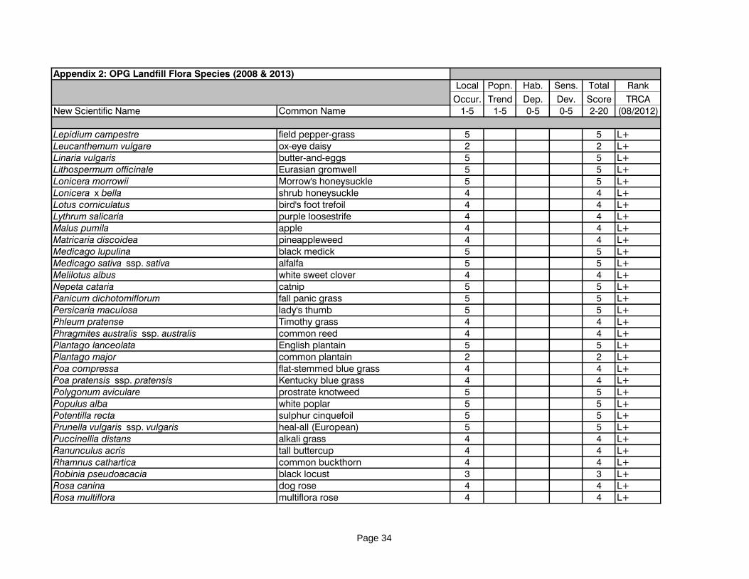
Appendix 2: OPG Landfill Flora Species (2008 & 2013)
Page 30

Local Popn. Hab. Sens. Total Rank
Occur. Trend Dep. Dev. Score TRCANew Scientific Name Common Name 1-5 1-5 0-5 0-5 2-20 (08/2012)
Appendix 2: OPG Landfill Flora Species (2008 & 2013)
Equisetum arvense field horsetail 2 2 1 1 6 L5Erigeron canadensis horse-weed 3 1 2 0 6 L5Erigeron philadelphicus var. philadelphicus Philadelphia fleabane 3 2 0 1 6 L5Erigeron strigosus rough fleabane 4 2 1 1 8 L5Euthamia graminifolia grass-leaved goldenrod 2 1 4 1 8 L5Fraxinus americana white ash 2 2 0 3 7 L5Fraxinus pennsylvanica red ash 1 2 0 3 6 L5Galium aparine cleavers 3 1 3 2 9 L5Galium palustre marsh bedstraw 2 2 3 3 10 L5Juglans nigra black walnut 2 1 2 1 6 L5Juncus bufonius toad rush 4 1 4 1 10 L5Juncus dudleyi Dudley's rush 2 2 3 1 8 L5Leersia oryzoides rice cut grass 2 2 3 2 9 L5Lemna turionifera common duckweed 2 2 4 2 10 L5Oenothera biennis common evening-primrose 2 1 1 1 5 L5Oxalis stricta common yellow wood-sorrel 5 1 1 1 8 L5Panicum capillare panic grass 3 1 4 1 9 L5Parthenocissus inserta thicket creeper 2 2 0 1 5 L5Persicaria lapathifolia pale smartweed 3 1 4 0 8 L5Plantago rugelii red-stemmed plantain 3 2 0 1 6 L5Poa palustris fowl meadow-grass 2 2 3 2 9 L5Populus balsamifera balsam poplar 2 2 3 2 9 L5Populus deltoides cottonwood 2 1 4 1 8 L5Populus tremuloides trembling aspen 2 3 1 3 9 L5Potentilla anserina ssp. anserina silverweed 3 2 3 2 10 L5Prunus virginiana var. virginiana choke cherry 2 2 0 1 5 L5Rhus typhina staghorn sumach 2 1 2 2 7 L5Rubus idaeus ssp. strigosus wild red raspberry 1 1 0 1 3 L5Salix eriocephala narrow heart-leaved willow 2 1 3 1 7 L5Salix interior sandbar willow 2 1 5 2 10 L5Sambucus canadensis common elderberry 2 3 2 2 9 L5Scirpus atrovirens black-fruited bulrush 2 2 4 2 10 L5
Page 31

Local Popn. Hab. Sens. Total Rank
Occur. Trend Dep. Dev. Score TRCANew Scientific Name Common Name 1-5 1-5 0-5 0-5 2-20 (08/2012)
Appendix 2: OPG Landfill Flora Species (2008 & 2013)
Scirpus microcarpus barber-pole bulrush 1 2 4 3 10 L5Solanum ptychanthum American black nightshade 4 1 4 0 9 L5Solidago altissima tall goldenrod 2 2 0 0 4 L5Solidago gigantea late goldenrod 3 1 1 1 6 L5Solidago nemoralis ssp. nemoralis grey goldenrod 3 2 2 2 9 L5Symphyotrichum cordifolium heart-leaved aster 2 1 0 2 5 L5Symphyotrichum ericoides var. ericoides heath aster 2 1 2 1 6 L5Symphyotrichum lanceolatum var. lanceolatum panicled aster 2 2 3 1 8 L5Symphyotrichum novae-angliae New England aster 2 2 2 1 7 L5Tilia americana basswood 2 3 2 3 10 L5Viburnum lentago nannyberry 2 3 1 2 8 L5Vitis riparia riverbank grape 2 1 0 0 3 L5Xanthium strumarium clotbur 3 1 4 0 8 L5Fragaria virginiana ssp. glauca blue-leaved wild strawberry 5 5 0 10 L5?Abutilon theophrasti velvet-leaf 5 0 0 2 7 L+Acer platanoides Norway maple 4 4 L+Agrostis gigantea redtop 4 4 L+Ailanthus altissima tree-of-heaven 5 5 L+Alliaria petiolata garlic mustard 4 4 L+Anagallis arvensis scarlet pimpernel 4 4 L+Arctium lappa great burdock 4 4 L+Arctium minus common burdock 5 5 L+Artemisia biennis biennial wormwood 5 5 L+Betula pendula European white birch 5 5 L+Bromus commutatus upright chess 5 5 L+Bromus inermis smooth brome grass 4 4 L+Centaurea stoebe ssp. micranthos spotted knapweed 5 5 L+Centaurium pulchellum branching centaury 5 5 L+Chaenorhinum minus ssp. minus dwarf snapdragon 5 5 L+Chenopodium album lamb's quarters 5 5 L+Chenopodium glaucum oak-leaved goosefoot 4 4 L+Cichorium intybus chicory 5 5 L+
Page 32

Local Popn. Hab. Sens. Total Rank
Occur. Trend Dep. Dev. Score TRCANew Scientific Name Common Name 1-5 1-5 0-5 0-5 2-20 (08/2012)
Appendix 2: OPG Landfill Flora Species (2008 & 2013)
Cirsium arvense creeping thistle 4 4 L+Cirsium vulgare bull thistle 4 4 L+Convolvulus arvensis field bindweed 3 3 L+Crepis tectorum narrow-leaved hawk's beard 5 5 L+Cynanchum rossicum dog-strangling vine 4 4 L+Dactylis glomerata orchard grass 4 4 L+Daucus carota Queen Anne's lace 4 4 L+Digitaria ischaemum smooth crab grass 5 5 L+Digitaria sanguinalis hairy crab grass 5 5 L+Diplotaxis muralis wall rocket 5 5 L+Echinochloa crus-galli barnyard grass 5 5 L+Echium vulgare viper's bugloss 3 3 L+Elaeagnus angustifolia Russian olive 4 4 L+Elaeagnus umbellata autumn olive 5 5 L+Elymus repens quack grass 5 5 L+Epilobium hirsutum European willow-herb 5 5 L+Epilobium parviflorum small-flowered willow-herb 5 5 L+Eragrostis minor little love grass 4 4 L+Erucastrum gallicum dog mustard 4 4 L+Fallopia convolvulus black bindweed 5 5 L+Festuca filiformis hair fescue 5 5 L+Festuca rubra ssp. rubra red fescue 5 5 L+Galium mollugo white bedstraw 5 5 L+Geum urbanum urban avens 4 4 L+Hordeum jubatum ssp. jubatum squirrel-tail barley 4 4 L+Hypericum hirsutum hairy St. John's-wort 5 5 L+Hypericum perforatum common St. John's-wort 4 4 L+Inula helenium elecampane 4 4 L+Juncus compressus round-fruited rush 4 4 L+Kochia scoparia summer-cypress 5 5 L+Lactuca serriola prickly lettuce 3 3 L+Leonurus cardiaca ssp. cardiaca motherwort 4 4 L+
Page 33
Local Popn. Hab. Sens. Total Rank
Occur. Trend Dep. Dev. Score TRCANew Scientific Name Common Name 1-5 1-5 0-5 0-5 2-20 (08/2012)
Appendix 2: OPG Landfill Flora Species (2008 & 2013)
Lepidium campestre field pepper-grass 5 5 L+Leucanthemum vulgare ox-eye daisy 2 2 L+Linaria vulgaris butter-and-eggs 5 5 L+Lithospermum officinale Eurasian gromwell 5 5 L+Lonicera morrowii Morrow's honeysuckle 5 5 L+Lonicera x bella shrub honeysuckle 4 4 L+Lotus corniculatus bird's foot trefoil 4 4 L+Lythrum salicaria purple loosestrife 4 4 L+Malus pumila apple 4 4 L+Matricaria discoidea pineappleweed 4 4 L+Medicago lupulina black medick 5 5 L+Medicago sativa ssp. sativa alfalfa 5 5 L+Melilotus albus white sweet clover 4 4 L+Nepeta cataria catnip 5 5 L+Panicum dichotomiflorum fall panic grass 5 5 L+Persicaria maculosa lady's thumb 5 5 L+Phleum pratense Timothy grass 4 4 L+Phragmites australis ssp. australis common reed 4 4 L+Plantago lanceolata English plantain 5 5 L+Plantago major common plantain 2 2 L+Poa compressa flat-stemmed blue grass 4 4 L+Poa pratensis ssp. pratensis Kentucky blue grass 4 4 L+Polygonum aviculare prostrate knotweed 5 5 L+Populus alba white poplar 5 5 L+Potentilla recta sulphur cinquefoil 5 5 L+Prunella vulgaris ssp. vulgaris heal-all (European) 5 5 L+Puccinellia distans alkali grass 4 4 L+Ranunculus acris tall buttercup 4 4 L+Rhamnus cathartica common buckthorn 4 4 L+Robinia pseudoacacia black locust 3 3 L+Rosa canina dog rose 4 4 L+Rosa multiflora multiflora rose 4 4 L+
Page 34

Local Popn. Hab. Sens. Total Rank
Occur. Trend Dep. Dev. Score TRCANew Scientific Name Common Name 1-5 1-5 0-5 0-5 2-20 (08/2012)
Appendix 2: OPG Landfill Flora Species (2008 & 2013)
Rumex crispus curly dock 5 5 L+Salix alba white willow 5 5 L+Salix purpurea purple-osier willow 4 4 L+Schedonorus arundinaceus tall fescue 4 4 L+Schedonorus pratensis meadow fescue 4 4 L+Securigera varia crown vetch 5 5 L+Setaria pumila ssp. pumila yellow foxtail 4 4 L+Setaria viridis green foxtail 3 3 L+Silene vulgaris bladder campion 3 3 L+Solanum dulcamara bittersweet nightshade 4 4 L+Solanum lycopersicum tomato (incl. cherry tomato) 5 5 L+Sonchus arvensis ssp. arvensis glandular perennial sow-thistle 5 5 L+Sonchus asper spiny sow-thistle 4 4 L+Sonchus oleraceus annual sow-thistle 5 5 L+Symphyotrichum ciliatum rayless aster 5 5 L+Taraxacum officinale dandelion 4 4 L+Tragopogon pratensis meadow goat's beard 3 3 L+Trifolium arvense rabbit-foot clover 5 5 L+Trifolium aureum hop-clover 5 5 L+Trifolium pratense red clover 5 5 L+Tussilago farfara coltsfoot 4 4 L+Typha angustifolia narrow-leaved cattail 3 3 L+Typha x glauca hybrid cattail 3 3 L+Verbascum thapsus common mullein 4 4 L+Veronica serpyllifolia ssp. serpyllifolia thyme-leaved speedwell 5 5 L+Viburnum opulus ssp. opulus European highbush cranberry 4 4 L+Vicia cracca cow vetch 4 4 L+Vicia tetrasperma slender vetch 4 4 L+Acer negundo Manitoba maple 4 0 0 2 6 L+?Agrostis stolonifera creeping bent grass 5 5 L+?Atriplex prostrata spreading orache 5 5 L+?Cyperus esculentus yellow nut-sedge 5 0 4 1 10 L+?
Page 35

Local Popn. Hab. Sens. Total Rank
Occur. Trend Dep. Dev. Score TRCANew Scientific Name Common Name 1-5 1-5 0-5 0-5 2-20 (08/2012)
Appendix 2: OPG Landfill Flora Species (2008 & 2013)
Euphorbia vermiculata hairy spurge 5 5 L+?Phalaris arundinacea reed canary grass 3 3 L+?Sporobolus vaginiflorus ensheathed dropseed 5 5 L+?Picea glauca white spruce 1 5 4 4 14 pL3Pinus strobus white pine 1 4 3 4 12 pL4Celtis occidentalis hackberry 5 5 pL+Fraxinus mandshuriaca Manchurian ash pL+Gleditsia triacanthos honey locust 5 5 pL+Picea pungens Colorado spruce 5 5 pL+Pinus nigra Austrian pine 5 5 pL+Pinus sylvestris Scots pine 4 4 prL+Populus x canadensis Carolina poplar 4 4 prL+
Page 36

Appendix 3: Fauna List for OPG Landfill Site, 2004 - 2013.
Common Name Code Scientific Name '04 - '13 LO PTn PTt AS PIS HD StD + TS L-Rank
Survey Species: species for which the TRCA protocol effectively surveys.
Birdseastern kingbird EAKI Tyrannus tyrannus 3 0 4 2 2 1 1 3 0 13 L4
gadwall GADW Anas strepera 1 4 1 2 1 2 1 3 0 14 L4
grey catbird GRCA Dumetella carolinensis 1 0 2 2 1 1 1 3 0 10 L4
northern flicker NOFL Colaptes auratus 1 0 3 2 1 1 2 3 0 12 L4
northern rough-winged swallow NRWS Stelgidoptery x serripennis 1 0 1 2 1 1 3 2 0 10 L4
willow flycatcher WIFL Empidonax traillii 4 0 4 2 1 1 1 3 0 12 L4
American goldfinch AMGO Carduelis tristis x 0 2 2 1 1 0 1 0 7 L5
American robin AMRO Turdus migratorius x 0 1 2 1 1 0 1 0 6 L5
Baltimore oriole BAOR Icterus galbula x 0 2 2 1 1 0 1 0 7 L5
black-capped chickadee BCCH Parus atricapillus x 0 1 2 1 1 0 1 0 6 L5
blue jay BLJA Cyanocitta cristata x 0 4 2 1 1 0 1 0 9 L5
brown-headed cowbird BHCO Molothrus ater x 0 2 2 1 1 0 1 0 7 L5
Canada goose CANG Branta canadensis x 0 1 1 1 2 1 0 0 6 L5
cedar waxwing CEDW Bombycilla cedrorum x 0 1 2 1 1 0 1 0 6 L5
chipping sparrow CHSP Spizella passerina x 0 2 2 1 1 0 2 0 8 L5
common grackle COGR Quiscalus quiscula x 0 3 2 1 1 0 1 0 8 L5
downy woodpecker DOWO Picoides pubescens x 0 3 2 1 1 1 1 0 9 L5
killdeer KILL Charadrius vociferus x 0 2 2 1 2 0 2 0 9 L5
mourning dove MODO Zenaida macroura x 0 2 2 1 1 0 0 0 6 L5
northern cardinal NOCA Cardinalis cardinalis x 0 2 2 1 1 1 2 0 9 L5
northern mockingbird NOMO Mimus polyglottos x 0 2 0 1 1 1 1 0 6 L5
orchard oriole OROR Icterus spurius 2 1 2 1 1 1 0 1 0 7 L5
red-winged blackbird RWBL Agelaius phoeniceus x 0 2 2 1 1 0 2 0 8 L5
song sparrow SOSP Melospiza melodia x 0 2 2 1 2 0 2 0 9 L5
warbling vireo WAVI Vireo gilvus x 0 1 2 1 1 1 2 0 8 L5
yellow warbler YWAR Setophaga petechia x 0 1 2 1 1 1 3 0 9 L5
European starling EUST Sturnus vulgaris x L+
house finch HOFI Carpodacus mexicanus x L+
Incidental Species: species that are reported on as incidental to the TRCA protocol.
Mammalsmeadow vole MEVO Microtus pennsylvanicus 1 2 2 2 1 2 1 2 0 12 L4
Page 37

Appendix 3: Fauna List for OPG Landfill Site, 2004 - 2013.
Common Name Code Scientific Name '04 - '13 LO PTn PTt AS PIS HD StD + TS L-Rank
white-tailed deer WTDE Odocoileus virginianus 1 0 2 1 3 2 2 1 0 11 L4
woodchuck WOOD Marmota monax 1 1 2 2 1 3 0 1 0 10 L4
coyote COYO Canis latrans x 0 2 2 1 3 0 1 0 9 L5
grey squirrel GRSQ Sciurus carolinensis x 0 2 2 1 3 0 0 0 8 L5
raccoon RACC Procyon lotor x 0 2 2 1 3 1 0 0 9 L5
LEGENDLO = local occurrence PIS = Patch Isolation Sensitivity LX = extirpatedPTn = population trend, continent-wide STD = sensitivity to development L+= non-native/introducedPTt = population trend, TRCA + = additional pointsHD = habitat dependence TS = total scoreAS = area sensitivity L-rank = TRCA Rank, October, 2008
Page 38
Related Documents