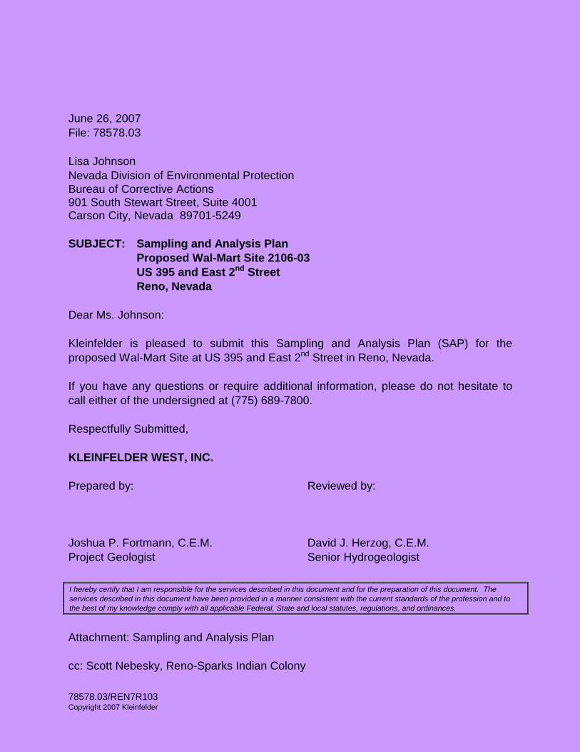
78578.03/REN7R103 Copyright 2007 Kleinfelder June 26, 2007 File: 78578.03 Lisa Johnson Nevada Division of Environmental Protection Bureau of Corrective Actions 901 South Stewart Street, Suite 4001 Carson City, Nevada 89701-5249 SUBJECT: Sampling and Analysis Plan Proposed Wal-Mart Site 2106-03 US 395 and East 2 nd Street Reno, Nevada Dear Ms. Johnson: Kleinfelder is pleased to submit this Sampling and Analysis Plan (SAP) for the proposed Wal-Mart Site at US 395 and East 2 nd Street in Reno, Nevada. If you have any questions or require additional information, please do not hesitate to call either of the undersigned at (775) 689-7800. Respectfully Submitted, KLEINFELDER WEST, INC. Prepared by: Reviewed by: Joshua P. Fortmann, C.E.M. David J. Herzog, C.E.M. Project Geologist Senior Hydrogeologist Attachment: Sampling and Analysis Plan cc: Scott Nebesky, Reno-Sparks Indian Colony I hereby certify that I am responsible for the services described in this document and for the preparation of this document. The services described in this document have been provided in a manner consistent with the current standards of the profession and to the best of my knowledge comply with all applicable Federal, State and local statutes, regulations, and ordinances.

Welcome message from author
This document is posted to help you gain knowledge. Please leave a comment to let me know what you think about it! Share it to your friends and learn new things together.
Transcript
78578.03/REN7R103 Copyright 2007 Kleinfelder
June 26, 2007 File: 78578.03 Lisa Johnson Nevada Division of Environmental Protection Bureau of Corrective Actions 901 South Stewart Street, Suite 4001 Carson City, Nevada 89701-5249 SUBJECT: Sampling and Analysis Plan Proposed Wal-Mart Site 2106-03 US 395 and East 2nd Street Reno, Nevada Dear Ms. Johnson: Kleinfelder is pleased to submit this Sampling and Analysis Plan (SAP) for the proposed Wal-Mart Site at US 395 and East 2nd Street in Reno, Nevada. If you have any questions or require additional information, please do not hesitate to call either of the undersigned at (775) 689-7800. Respectfully Submitted, KLEINFELDER WEST, INC. Prepared by: Reviewed by: Joshua P. Fortmann, C.E.M. David J. Herzog, C.E.M. Project Geologist Senior Hydrogeologist
Attachment: Sampling and Analysis Plan cc: Scott Nebesky, Reno-Sparks Indian Colony
I hereby certify that I am responsible for the services described in this document and for the preparation of this document. The services described in this document have been provided in a manner consistent with the current standards of the profession and to the best of my knowledge comply with all applicable Federal, State and local statutes, regulations, and ordinances.

SAMPLING AND ANALYSIS PLAN PROPOSED WAL-MART SITE 2106-03
US 395 AT EAST 2nd STREET
RENO, NEVADA
June 26, 2007 File: 78578.03
Prepared for:
Nevada Division of Environmental Protection 901 South Stewart Street, Suite 4001
Carson City, Nevada 89701-5249
Prepared by:
Kleinfelder, Inc. 4835 Longley Lane
Reno, Nevada 89502
78578.03/REN7R103 i August 9, 2018 Copyright 2007 Kleinfelder
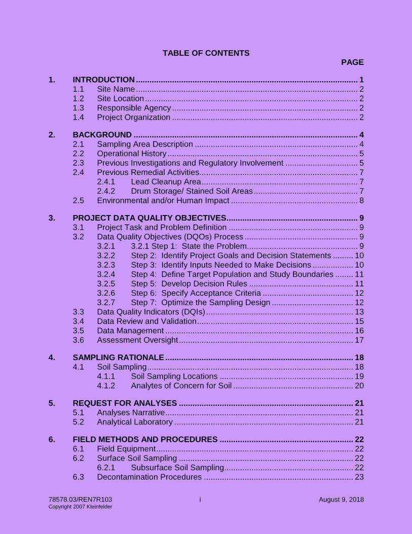
TABLE OF CONTENTS PAGE
1. INTRODUCTION .................................................................................................. 1 1.1 Site Name .................................................................................................. 2 1.2 Site Location .............................................................................................. 2 1.3 Responsible Agency .................................................................................. 2 1.4 Project Organization .................................................................................. 2
2. BACKGROUND ................................................................................................... 4 2.1 Sampling Area Description ........................................................................ 4 2.2 Operational History .................................................................................... 5 2.3 Previous Investigations and Regulatory Involvement ................................ 5 2.4 Previous Remedial Activities ...................................................................... 7
2.4.1 Lead Cleanup Area ..................................................................... 7 2.4.2 Drum Storage/ Stained Soil Areas .............................................. 7
2.5 Environmental and/or Human Impact ........................................................ 8
3. PROJECT DATA QUALITY OBJECTIVES .......................................................... 9 3.1 Project Task and Problem Definition ......................................................... 9 3.2 Data Quality Objectives (DQOs) Process .................................................. 9
3.2.1 3.2.1 Step 1: State the Problem................................................. 9 3.2.2 Step 2: Identify Project Goals and Decision Statements ......... 10 3.2.3 Step 3: Identify Inputs Needed to Make Decisions .................. 10 3.2.4 Step 4: Define Target Population and Study Boundaries ........ 11 3.2.5 Step 5: Develop Decision Rules .............................................. 11 3.2.6 Step 6: Specify Acceptance Criteria ........................................ 12 3.2.7 Step 7: Optimize the Sampling Design .................................... 12
3.3 Data Quality Indicators (DQIs) ................................................................. 13 3.4 Data Review and Validation ..................................................................... 15 3.5 Data Management ................................................................................... 16 3.6 Assessment Oversight ............................................................................. 17
4. SAMPLING RATIONALE ................................................................................... 18 4.1 Soil Sampling ........................................................................................... 18
4.1.1 Soil Sampling Locations ........................................................... 19 4.1.2 Analytes of Concern for Soil ..................................................... 20
5. REQUEST FOR ANALYSES ............................................................................. 21 5.1 Analyses Narrative ................................................................................... 21 5.2 Analytical Laboratory ............................................................................... 21
6. FIELD METHODS AND PROCEDURES ........................................................... 22 6.1 Field Equipment ....................................................................................... 22 6.2 Surface Soil Sampling ............................................................................. 22
6.2.1 Subsurface Soil Sampling ......................................................... 22 6.3 Decontamination Procedures .................................................................. 23

78578.03/REN7R103 ii August 9, 2018 Copyright 2007 Kleinfelder
7. DISPOSAL OF RESIDUAL MATERIALS .......................................................... 24
8. FIELD AND SAMPLE DOCUMENTATION ........................................................ 25 8.1 Field Notes ............................................................................................... 25
8.1.1 Field Documentation ................................................................. 25 8.1.2 Photographs ............................................................................. 26
8.2 Labeling ................................................................................................... 26 8.3 Chain-of-Custody Forms .......................................................................... 26
9. LABORATORY QUALITY CONTROL ............................................................... 27 9.1 Field Quality Control Samples ................................................................. 27
9.1.1 Assessment of Field Contamination ......................................... 27 9.1.1.2 Temperature Blanks ................................................................. 27 9.1.1.3 Field Blanks .............................................................................. 28 9.1.2 Assessment of Field Variability ................................................. 28
9.2 Laboratory Quality Control Samples ........................................................ 28
10. FIELD VARIANCES ........................................................................................... 29
11. FIELD HEALTH AND SAFETY PROCEDURES ................................................ 30 REFERENCES TABLES
Table 1 Summary of Analytical Results for Soil Samples, Former Radiator Shop (Lead Cleanup Area)
Table 2 Summary of Analytical Results for Soil Samples, Drum Storage Area and Stained Soils in the DS-4 Area
Table 3 Systematic Planning: DQO Summary Table for Proposed Wal-Mart Site
Table 4 Summary of Soil Sampling Table 5 Required Detection Limits and Action Levels for Total and TCLP Lead Table 6 Required Detection Limits and Action Levels for Total Petroleum
Hydrocarbons Table 7 Required Detection Limits for Volatile Organic Compounds Table 8 Required Detection Limits for RCRA Metals
PLATES Plate 1 Site Plan Plate 2 Soil Sampling Grid for the Lead Cleanup Area Plate 3 Soil Sampling Locations in the DS-4 Area
APPENDICES A Laboratory Standard Operating Procedures B Field Forms C Health and Safety Plan

78578.02/REN7R103 Page 1 August 9, 2018 Copyright 2007 Kleinfelder
ACRONYMS AND ABBREVIATIONS
APN Assessors Parcel Number ARARs Applicable or relevant and appropriate requirements BIA Bureau of Indian Affairs CEM Certified environmental manager CERCLA Comprehensive Environmental Response, Cleanup, and Liability Act DQA Data quality assessment DQI Data quality indicator DQO Data quality objective DRO Diesel range organics EPA U.S. Environmental Protection Agency ESA Environmental site assessment GC/MS Gas chromatography and mass spectrometry GRO Gasoline range organics HASP Health and Safety Plan HRGC/HRMS
High resolution gas chromatography/high resolution mass spectrometry
ICAL Initial calibration ICP/MS Inductively coupled plasma (atomic emission spectrometry) and mass
spectrometry IDW Investigation-derived waste LCS Laboratory control sample MDL Method detection limit Mg/Kg Milligrams per kilogram mg/L Milligrams per liter mL milliliters µg/L Micrograms per liter MQO Measurement quality objective MS/MSD Matrix spike and matrix spike duplicate NAC Nevada Administrative Code NBP Nevada Brownfields Program NCP National Contingency Plan NDEP Nevada Division of Environmental Protection NPL National Priorities List NRS Nevada Revised Statues OERR Office of Emergency and Remedial Response ORO Oil range organics PARCCS Precision, accuracy, representativeness, completeness, comparability, and
sensitivity PPE Personal protective equipment PRG Preliminary remediation goal PRQL Project-required quantitation limit QA Quality assurance QA/QC Quality assurance/quality control QARrP Quality Assurance Program Plan

78578.02/REN7R103 Page 2 August 9, 2018 Copyright 2007 Kleinfelder
QC Quality control QCSR Quality control summary report QL Quantitation limit %R Percent recovery RBCA Risk-based corrective action RCRA Resource Conservation and Recovery Act RDL Required detection limit RECs Recognized environmental conditions RPD Relative percent difference SAP Sampling and analysis plan (an integrated field sampling plan and QA
project plan) SD Standard deviation SOP Standard operating procedure SOW Statement of work SQL Sample quantitation limit TCLP Toxicity characteristic leaching procedure TDS Total dissolved solids TPH Total petroleum hydrocarbons TSA Technical system audit USTs Underground storage tanks VOC Volatile organic compound VSP Visual sample plan WCDHD Washoe County District Health Department YSA Yearly systems audit

78578.02/REN7R103 Page 1 of 31 August 9, 2018 Copyright 2007 Kleinfelder
SAMPLING AND ANALYSIS PLAN
PROPOSED WAL-MART SITE RENO, NEVADA
1. INTRODUCTION
Kleinfelder, Inc. (Kleinfelder) prepared this Sampling and Analysis Plan (SAP) for the proposed Wal-Mart site 2106-03 in Reno, Nevada (Site). The Site is located at the northeast corner of the intersection of US 395 and East 2nd Street, as shown in Plate 1. This SAP was prepared in accordance with the Nevada Division of Environmental Protection (NDEP) Quality Assurance Program Plan (QAPrP) (NDEP 2007). Historical information and analytical data indicate that Site soil has been contaminated from recent and historical on-site activities. Although the Site is currently vacant, several commercial and industrial businesses previously operated on the property. The most recent occupants included a nightclub, a plant nursery, an automobile scrap yard, and an automobile body shop. Historical operations included various automotive shops and other businesses that may have used chemicals and/or generated waste. The purpose of this project is to complete additional soil remediation activities at the Site and allow for Site closure. Based on available soil sample results, contaminants remaining in Site soil at concentrations exceeding cleanup goals are total petroleum hydrocarbons (TPH) – diesel range organics (DRO), TPH-oil range organics (ORO), and lead. Soil samples will be collected from two on-site areas, as discussed below. Lead Cleanup Area Soil samples will be collected from the lead cleanup area and used to assess lead concentrations in soil. Based on the sample results, soil containing lead at concentrations exceeding EPA residential cleanup goals and/or soil containing leachable lead at hazardous concentrations will be remediated.

78578.02/REN7R103 Page 2 of 31 August 9, 2018 Copyright 2007 Kleinfelder
Drum Storage/Soil Stained Area (DS-4) After trench excavation at proposed underground utility locations, soil samples will be collected from the DS-4 area to assess remaining TPH concentrations in soil. 1.1 Site Name
Proposed Wal-Mart Supercenter #2106-03. 1.2 Site Location
The Site is approximately 22.52 acres in size, and is composed of Washoe County Assessors Parcel Numbers (APNs) 012-301-04, -07, -08, -10, -12, -13, -15, -19, and 20. The Site is located in an area of predominantly commercial and industrial site use. The Truckee River is located adjacent to the north of the Site, East 2nd Street is located adjacent to the south, US-395 is located adjacent to the west, and a State of Nevada restitution facility is located adjacent to the east. 1.3 Responsible Agency
The majority of the Site is held in trust by the federal government for the Reno-Sparks Indian Colony. One parcel at the Site (APN 012-301-20, 0.62 acres) is owned by the Reno-Sparks Indian Colony, and is not yet accepted into trust by the Bureau of Indian Affairs (BIA). This portion of the subject Site remains under the jurisdiction of the NDEP and Washoe County District Health Department (WCDHD). The trust property is under oversight of the EPA, with guidance provided by NDEP. Proposed remediation activities will be performed on trust and non-trust property. 1.4 Project Organization
The Quality Assurance (QA) Manager will oversee quality control (QC) of all activities and review all documents. The QA Manager will provide project oversight to ensure that the data quality objectives (DQOs) are achieved, but will not direct the field or data acquisition activities. Prior to the start of field activities, the Project Manager will hold preparatory meetings with the field crew to discuss project objectives, field methods, the Health and Safety Plan (HASP), and to ensure the use of appropriate documentation during field activities. If field conditions require modifications to protocols outlined in the plan, or if questions arise, then the field crew will stop work and the field team leader

78578.02/REN7R103 Page 3 of 31 August 9, 2018 Copyright 2007 Kleinfelder
will contact the Project Manager for direction. The field team leader is responsible for overseeing the sampling activities in the field and ensuring that the SAP is followed.
TITLE/RESPONSIBILITY NAME/PHONE NUMBER Kleinfelder Project Manager Josh Fortmann/ 775-689-7800 Kleinfelder Quality Assurance Manager Dave Herzog/ 775-689-7800 Kleinfelder Field Team Leader Phil Tousignant/ 775-689-7800 Kleinfelder Data Manager Phil Tousignant/ 775-689-7800 Kleinfelder Health and Safety Officer Jim Grippa/ 801-261-3306

78578.02/REN7R103 Page 4 of 31 August 9, 2018 Copyright 2007 Kleinfelder
2. BACKGROUND
The Site consists of predominantly vacant commercial and industrial property. One structure and multiple building foundations remain on the Site. All underground utilities, including nine septic systems, remain onsite. Plate 1 shows the layout of the Site, and the locations of remediation activities. The Site was previously occupied by multiple indistrial and commercial businesses that most recently included a nightclub, a plant nursery, an automobile scrap yard, and an automobile body shop. Historic Site occupants included a radiator shop, an auto repair facility, a machine shop, a sheet metal fabricating company, a glass company, an electronics lab and a construction company. Chemical use by previous occupants included petroleum products and metals. Septic systems used by previous occupants remain onsite. Assessment activities performed in 2005 and 2006 identified concentrations of lead and TPH in soil in excess of regulatory limits. The majority of soil containing concentrations of TPH above the action level was remediated in 2007. However, limited additional remediation is warranted for soil containing concentrations of TPH above the action level and concentrations of lead above the EPA residential cleanup goals and/or leachable lead at hazardous concentrations. 2.1 Sampling Area Description
The two proposed remediation areas are shown in Plate 1. Lead Cleanup Area The existing excavation and proposed additional excavation areas are located on the south side of the Site (Plate 1). Soil samples will be collected to assess the lead concentration in soil, and to assess the soil volume to be remediated. Drum Storage/Soil Stained Area (DS-4) The existing excavation and proposed additional excavation areas are located near the northeast corner of the Site (Plate 1). Soil samples will be collected after trench excavation to confirm removal of TPH-contaminated soil from the utility trenches.
78578.02/REN7R103 Page 5 of 31 August 9, 2018 Copyright 2007 Kleinfelder
2.2 Operational History
The Reno-Sparks Indian Colony currently owns the Site. Based on available information, at least one residential structure, located at 2395 East 2nd Street, was present on the Site as early as 1925. The Site use during, and prior to, this time is unknown. Based on the available information, sources of soil contamination included commercial and industrial businesses located onsite that used petroleum and metal products, including auto repair shops and a radiator shop. 2.3 Previous Investigations and Regulatory Involvement
Several site assessments have been performed for the Site, or portions of the Site. These include:
• A&R Environmental Services, Preliminary Phase ESA Report #APN 012-301-12, dated May 10 1995
• A&R Environmental Services, Preliminary Phase ESA Report #APN 012-301-13, dated May 31, 1995
• SEA, Incorporated, Phase I ESA Report #2025-04-01, dated February 8, 1996 • Broadbent and Associates, Inc., Phase II ESA Report #97548.2, dated October,
1997 • Pezonella Associates, Inc. Consulting Engineers and Geologists, Phase I ESA
Report #3844.04K, dated October 21, 1999 • Pezonella Associates, Inc. Consulting Engineers and Geologists, Phase I ESA
Report #3844.06K, dated May 17, 2000 • Pezonella Associates, Inc. Consulting Engineers and Geologists, Phase I ESA
Report #3844.07K, dated March 19, 2001 • CEI Engineering Associates, Inc., Phase I ESA, Future Wal-Mart Supercenter
#2106-03, Project # 18637.0.20180, dated November, 2004 • CEI Engineering Associates, Inc., Phase I ESA, Future Wal-Mart Supercenter
#2106-03, Project # 18637.0.20180, dated November, 2006 The Phase I ESA reports prepared by CEI Engineering Associate, Inc. (CEI), November 2004 and November 2006, were provided to Kleinfelder for review. The 2006 report included a summary of the Recognized Environmental Conditions (RECs) that were identified in CEI’s 2004 Phase I ESA for the Site. The 2004 report identified several RECs, including:
• Numerous 55 gallon drums of waste oil, oil products, and unknown substances • Surface staining from unknown substances
78578.02/REN7R103 Page 6 of 31 August 9, 2018 Copyright 2007 Kleinfelder
• An above-ground storage tank • Construction equipment, waste tires, and buckets of waste oil and other
unknown substances • A painting operation at a work yard • Septic tank systems • Light ballasts and fixtures
The 2004 Phase I ESA also provided documentation regarding five heating oil underground storage tanks (USTs) on the Site. One UST was formerly located at 2395 E. 2nd Street. The UST had been previously filled in-place with slurry, and one soil sample collected at the time of removal did not contain a reportable concentration of TPH. Additional documentation included four USTs located at 2445 E. 2nd Street. One UST (#1) was filled in-place with slurry in 1990, and reportedly remains on the Site. Two of the remaining USTs (#2 and #4) were filled with slurry prior to 1999 and removed in 1999. Soil samples were collected beneath the three removed USTs. Only one of the soil samples, from UST #4, contained a reportable concentration of TPH at 19 milligrams per kilogram (mg/Kg). A copy of a WCDHD “closure letter” was included, apparently in reference to UST #4. CEI did not identify any of the USTs as an REC. The Phase I ESA prepared by CEI, dated November 2006, only revealed one REC, the former existence of numerous industrial/commercial operations historically located on the Site. The numerous drums and unknown waste containers had been removed, and only one structure remained on the Site. However, several concrete pads were still present and septic tanks/systems were left in place. According to the Phase I ESA, the other earlier assessments did not reveal additional RECs other than those identified by CEI. Some of the historical occupants of the Site have included a radiator shop, an auto repair facility, a machine shop, a sheet metal fabricating company, a glass company, an electronics lab, and a construction company. A Maaco Auto Painting and Bodyshop, previously located on the Site at 2445 E. 2nd Street, was destroyed by an explosion in April 1999. The explosion resulted in a confirmed release of diesel, propane, paints, and thinner due to the runoff from fire suppression efforts. The WCDHD was the responding agency, and indicated that the runoff was minimal. In September 2005, soil assessment for lead and TPH assessment, and soil remediation was performed. This included the collection of soil samples adjacent to the former radiator shop (2453 East 2nd Street) and the Buggy Barn (2455 East 2nd Street), and soil excavation. These activities were performed for the Reno Sparks Indian
78578.02/REN7R103 Page 7 of 31 August 9, 2018 Copyright 2007 Kleinfelder
Colony, and were not overseen by any regulatory agency. The stockpiled soil remains onsite. In January 2006, Kleinfelder performed assessment activities at the Site including the collection of surface and subsurface soil samples at locations of TPH and hazardous materials use. The analytical results indicated concentrations of TPH and lead in Site soil in excess of regulatory limits. The applicable regulatory limits are the EPA Region 9 Preliminary Remediation Goal (PRG) for lead in soil at residential sites (400 mg/Kg) and the State of Nevada action level for TPH in soil (100 mg/kg). 2.4 Previous Remedial Activities
2.4.1 Lead Cleanup Area
Plate 1 shows the limits of the existing excavation at the lead cleanup area in the southern portion of the Site (in green). Soil remediation within the lead cleanup area included the excavation of approximately 485 tons of soil. Because concentrations of the lead in soil samples analyzed using the toxicity characteristic leaching procedure (TCLP) exceeded hazardous levels (5 mg/L), the excavated soil was disposed of as hazardous waste. Soil containing lead in excess of the residential PRG remains onsite to the north and east of the existing excavation. Based on analytical results for soil samples collected for a supplemental assessment (Plate 2), the lateral extent of soil containing lead in excess of the residential PRG has been defined. Soil samples that contained lead concentrations in excess of the residential PRG are shown in bold-face font (Table 1). Analytical results also indicate that soil containing TPH concentrations in excess of the action level is present in the sidewalls of the existing excavation at the lead cleanup area. Soil samples that contained TPH concentrations in excess of the action level are shown in bold-face font (Table 1).
2.4.2 Drum Storage/ Stained Soil Areas
Soil remediation was performed at a total of six areas of former drum storage and observed soil staining (DS-1, DS-3, DS-4, DS-6, DS-7 and DS-10). Soil excavation and disposal followed by confirmation sample collection was performed at all six areas. Remediation was completed at five areas, with area DS-4 (Plate 1) requiring additional remediation.
78578.02/REN7R103 Page 8 of 31 August 9, 2018 Copyright 2007 Kleinfelder
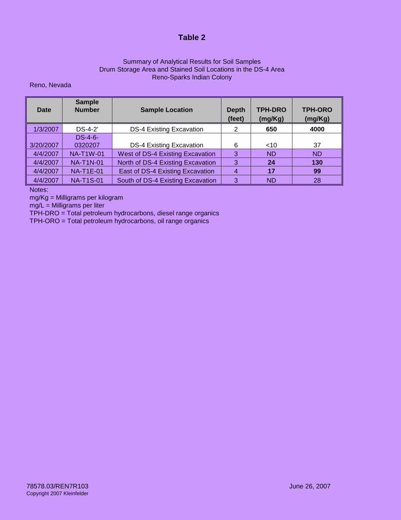
Completed soil remediation included the excavation of approximately 1,174 tons of soil. Based on the analytical results, soil containing TPH concentrations in excess of the action level was completely excavated at all locations except DS-4, where some TPH-contaminated soil remains. Following the stockpiling of approximately 225 tons of soil at DS-4, excavation activities were terminated. Soil containing TPH was observed on the north, west, and south sidewalls of the existing DS-4 excavation. Plate 3 presents a detail of the existing DS-4 excavation near the northeast corner of the Site and locations of supplemental assessment soil samples. Table 2 presents the analytical results for soil samples from DS-4. 2.5 Environmental and/or Human Impact
Based on the available data, TPH and lead-contaminated soils are present at the Site. However, adverse human health effects have not been documented at the Site.
78578.02/REN7R103 Page 9 of 31 August 9, 2018 Copyright 2007 Kleinfelder
3. PROJECT DATA QUALITY OBJECTIVES
3.1 Project Task and Problem Definition
The laboratory data that will be collected for this project will be definitive data. Definitive data are the result of quantitating organic and inorganic compounds using EPA procedures. The resulting data, if they meet QC criteria, will be used to delineate concentrations of lead and TPH in Site soils and to make decisions regarding the volume of soil to be remediated. Based on previous investigations and our current knowledge of the Site, our investigation will focus on the lead cleanup area and drum storage/soil stained area DS-4. 3.2 Data Quality Objectives (DQOs) Process
The DQO process (EPA 2006) is a systematic planning tool that is used to establish performance or acceptance criteria. These criteria, in turn, serve as the basis for designing a plan for collecting data of sufficient quality and quantity to support the goals of a study. The DQO process consists of seven iterative steps, as described in the following sections and summarized in Table 3.
3.2.1 Step 1: State the Problem
Based on the available data, lead and TPH remain in Site soil at concentrations exceeding the cleanup goals. Additional data are needed for delineating areas of soil that require remediation, remediating those soils, and verifying that contaminant concentrations are sufficiently low to allow a risk-based closure of the Site.

78578.02/REN7R103 Page 10 of 31 August 9, 2018 Copyright 2007 Kleinfelder
3.2.2 Step 2: Identify Project Goals and Decision Statements
Lead Cleanup Area The initial goal of the project is to delineate the volume of soil containing lead concentrations in excess of the residential PRG (400 mgKg); if so, remediation will be required. The project will also evaluate whether concentrations of lead, as determined by the toxicity characteristic leaching procedure (TCLP), exceed the action level of 5 mg/L lead in the leachate. Again, soils exceeding this action level will require remediation. DS-4 Area Data from this study will be used to guide excavation of soil containing TPH concentrations in excess of the action level (100 mg/Kg) in proposed utility trench locations. Soil exhibiting visual and/or olfactory evidence of TPH will be excavated from the trenches locations. Soil samples will be collected to assess removal of soil in excess of the action level. Based on the sample results, additional excavation may be necessary to complete remediation in the trench locations. Soil samples will also provide data to evaluate whether TPH concentrations in soil remaining after excavation require additional corrective action (using the factors contained in Nevada Administrative Code 445A.227). 3.2.3 Step 3: Identify Inputs Needed to Make Decisions
The project scope includes collecting additional analytical data for lead and TPH in Site soil located adjacent to areas of completed remediation (existing excavations) and proposed additional remediation. Tables 5, 6, 7, and 8 present action levels and reporting limits for the chemicals of concern. Lead Cleanup Area The soil in the lead cleanup area will be screened using the EPA residential PRG (400 mg/kg). The Site will be developed with a commercial structure, but the future Site user requires soils to meet the residential PRG for lead (400 mg/Kg). Due to the presence of undocumented fill in the building footprint, soil located in the building footprint will require excavation and reprocessing or removal. Based on the required excavation of soil during construction, the soil in the lead cleanup area will also be screened using the TCLP method.
78578.02/REN7R103 Page 11 of 31 August 9, 2018 Copyright 2007 Kleinfelder
DS-4 Area The soil in the DS-4 area will be screened using the action level for TPH in soil. Soil will only be screened in the future utility trench locations (shown in red on Plate 1).
3.2.4 Step 4: Define Target Population and Study Boundaries
Soil sampling and remediation activities are anticipated to require three weeks. Section 4 provides soil sampling rationale, and Section 6.2 describes sampling procedures. Lead Cleanup Area The target population includes surface (0 to 0.5 ft below ground surface [bgs]) and subsurface (0.5 to 5 ft bgs) soil located adjacent to existing excavations. The anticipated area of excavation extends 10 feet north, 10 feet east, and 10 feet west of the existing excavation. The anticipated excavation area also includes the parking slab on the south side of the excavation. The anticipated maximum excavation depth is 5 feet bgs. DS-4 Area The target population is all soil located in future utility trench locations. It is anticipated that 100 linear feet of total trench will be installed to depths of 2 to 5 feet bgs. Based on the current survey, 4 sections of utility trench will be excavated north and south of the existing excavation, as shown in Plate 1. 3.2.5 Step 5: Develop Decision Rules
Lead Cleanup Area If the total lead concentration in a soil sample exceeds the EPA Region 9 residential PRG for lead, then the entire soil grid will be excavated to a depth of 5 feet bgs and disposed of in an appropriate manner. If the lead concentration in a TCLP leachate for a soil sample exceeds 5 mg/L, then the soil grid will be excavated to a depth of 5 feet bgs and disposed as hazardous waste.

78578.02/REN7R103 Page 12 of 31 August 9, 2018 Copyright 2007 Kleinfelder
DS-4 Area If the TPH (TPH-DRO and TPH-ORO) concentration in a soil sample exceeds the action level for TPH in soil (100 mg/Kg), then the soil grid will be excavated to a depth of 2 or 5 feet bgs and disposed of in an appropriate manner. 3.2.6 Step 6: Specify Acceptance Criteria
Lead Cleanup Area Systematic random samples will be collected from grid blocks, and the concentration data (total lead and TCLP lead) for each sample will be compared to the action levels for total (400 mg/Kg) and leachable lead (5 mg/L). DS-4 Area Concentration data for TPH in each soil sample will be compared to the action level of 100 mg/kg. If the concentration in the soil sample exceeds the action level, then additional soil in that trench section will be excavated. 3.2.7 Step 7: Optimize the Sampling Design
Lead Cleanup Area A random systematic sampling design will define grid blocks of specific dimensions. Soil samples will then be collected from random locations within each grid block. Each grid block will be represented by two soil samples (one sidewall sample and one ground surface sample). If the concentration of lead in either of the samples exceeds the limits for total lead (400 mg/kg) or TCLP lead (5 mg/L), then soil in that grid block will be excavated. Following initial excavation of grid blocks, subsequent grid blocks will be represented by one sample (sidewall soil sample), and assessed as described above. DS-4 Area Systematic random samples will be collected from trench sections. Concentration data for TPH in soils will be compared to the Nevada action level of 100 mg/kg. If the concentration in the sample exceeds the action level, then additional soil in that trench section will be excavated for offsite disposal.
78578.02/REN7R103 Page 13 of 31 August 9, 2018 Copyright 2007 Kleinfelder
3.3 Data Quality Indicators (DQIs)
The effectiveness of a QA program is measured by the quality of data generated by the laboratory. Data quality is judged in terms of precision, accuracy, representativeness, completeness, comparability, and analytical sensitivity; referred to as the PARCCS parameters. Overall measurement quality objectives (MQOs) established for the Nevada Brownfields Program (NBP) are provided in Appendix D of the QAPrP (NDEP 2007). Specific MQOs applicable to this project are discussed in the following paragraphs. Precision Precision is the degree of mutual agreement between or among independent measurements of a similar property (usually reported as a standard deviation [SD] or relative percent difference [RPD]). This indicator relates to the analysis of duplicate laboratory or field samples. An RPD of <20% for water and <35% for soil, depending upon the chemical being analyzed, is generally acceptable. Typically field precision is assessed by co-located samples, field duplicates, or field splits; and laboratory precision is assessed using laboratory duplicates, matrix spike duplicates, or laboratory control sample duplicates. The following QC data will be collected to assess field and analytical precision:
• Laboratory precision will be assessed by the analysis of QC samples in accordance with the referenced laboratory Standard Operating Procedures (SOPs), see Appendix A.
Additional QC information is provided in Section 10. Accuracy Accuracy is a determination of how close the measurement is to the true value. Accuracy can be assessed using laboratory control samples (LCSs), standard reference materials, or spiked environmental samples. The accuracy of the data submitted for this project will be assessed in the following manner: The percent recovery of a matrix spike (MS), matrix spike duplicate (MSD), LCS, or spiked surrogates (organic analysis only) will be calculated. The level of target
78578.02/REN7R103 Page 14 of 31 August 9, 2018 Copyright 2007 Kleinfelder
compounds that are found (if any) in laboratory method blanks will be checked. If a target compound is found above the practical quantitation limit in the method or field blank corresponding to a batch of samples and the same target compound is found in a sample, the data will not be “background subtracted,” but will be qualified to indicate that the compound was detected in the blank. Representativeness Representativeness is a qualitative parameter that reflects the extent to which a given sample is characteristic of a given population at a specific location or under a given environmental condition. Representativeness is best satisfied by making certain that sampling locations are selected properly, a sufficient number of samples are collected, and an appropriate sampling technique is employed. Sampling locations, number of samples, and analytical methods are presented in Table 4. The sampling locations are based on the DQOs as described in Section 3.2. A systematic random sampling design will be employed. Section 4 provides soil sampling rationale and Section 6.2 describes sampling procedures. Completeness Completeness is a measure of the amount of valid data obtained from a measurement system compared with the amount that was expected to be obtained under normal conditions. To be considered complete, the data set must contain all analytical results and data specified for the project. In addition, all data are compared to project requirements to ensure that specifications are met. Completeness is evaluated by comparing the project objectives to the quality and quantity of the data collected to determine if any deficiencies exist. Missing data can result from any number of circumstances ranging from sample acquisition and accessibility problems to sample breakage and rejection of analytical data because of QC deficiencies. Completeness will be quantitatively assessed as the percent of controlled QC parameters that are within limits. The minimum requirement for completeness for all QC parameters, except holding times, will be 80%. The requirement for holding times will be 100%. Any deviations will be reported in the report narrative. Valid data are defined as those data points that are not qualified as rejected.

78578.02/REN7R103 Page 15 of 31 August 9, 2018 Copyright 2007 Kleinfelder
Comparability Comparability expresses the confidence with which one data set can be compared to another data set measuring the same property. To ensure comparability, field procedures will be standardized and field operations will adhere to outlined procedures. Laboratory data comparability will be assured by use of established and approved analytical methods, consistency in the basis of analysis (wet weight, volume, etc.), and consistency in reporting units (mg/L, mg/Kg, etc.). Analysis of standard reference materials will follow EPA or other standard analytical methods, which use standard units of measurement, methods of analysis, and reporting format. Sensitivity (Detection Limits) The laboratory shall report results below the required detection limit (RDL) and above the method detection limit (MDL) as “estimated” because, by definition, the accuracy and precision of the data at that level have greater uncertainty. Matrix effects (e.g., highly contaminated samples requiring dilution for analysis, dilution to bring detected levels within the range of calibration, and matrix interference requiring elevation of detection limits) will be considered in assessing compliance with the requirements for sensitivity. The RDL and action levels for the analytes of concern are listed in Tables 5 through 8. 3.4 Data Review and Validation
The intent of the data review and validation process is to establish the levels of PARCCS parameters of the final results with respect to the project MQOs. As part of the data review process, Alpha Analytical, Inc. of Sparks, Nevada (Alpha) will generate and review all laboratory data. Regularly scheduled analysis of duplicates, standards, and spiked samples are routine aspects of data reduction, validation, and reporting procedures. Alpha will perform QA/QC procedures in accordance with the SOPs included as AppendixA. The QA Manager will supervise and/or perform data quality assessment tasks. Kleinfelder will consistently evaluate and document measurement data to monitor consistency with MQOs, to quantitatively assess data quality, and to identify potential limitations to data use.

78578.02/REN7R103 Page 16 of 31 August 9, 2018 Copyright 2007 Kleinfelder
Kleinfelder will review field and analytical laboratory data generated for this project, including the following:
• Chain of custody documentation; • Laboratory batch QC frequency; • Results of batch and field QC analyses; and • Sample results influenced by outlier QC sample results.
Each data point will be assessed as non-qualified or qualified based upon the acceptance criteria. Data may be qualified as “estimated” (J-qualified); these data are used as is. Some data may be qualified as “rejected” (R-qualified) if critical QC parameters are not met; these data are unusable for any purpose. Sample re-analysis, for data not meeting MQOs, will be considered as a possible corrective action. Third-party data validation will not be performed. 3.5 Data Management
A unique identification number will be assigned to each sample. This number will be an alphanumeric sequence that serves as an acronym to identify the sample. The sample area designation, sample number, and depth of the sample will be incorporated into the sample identification designation (ID). The following format will be used: Sample ID: LAS01-5-01 LAS01- represents the Sample Area designation (Lead Area Sidewall Grid 1) 5- represents the depth at which the sample was collected (5 feet bgs) 01- represents the sample number (sample #1) Information pertaining to a particular sample will be referenced by its identification number. This number will be entered on the sample data sheet, sample container, field logbook, and sample chain-of-custody form. Before sample collection, the sample label will be completed in waterproof ink and secured to the sample container. A chain-of-custody form will be completed for each sample container. The chain-of-custody will include the laboratory identification number, sample location, sample fraction (abbreviation for sample container type and preservative), parameter list (abbreviation for the list of analytes to be performed), sample type, and Site ID. In addition, there are spaces for entry of the sample collection date and time, sample
78578.02/REN7R103 Page 17 of 31 August 9, 2018 Copyright 2007 Kleinfelder
depth, sample collection technique, signature of the persons relinquishing and receiving samples, and the status of samples upon receipt by the laboratory. 3.6 Assessment Oversight
Before performing work in the field, environmental staff will review the scope of work, and the HASP (Appendix C), coordinate the work to be done with the Project Manager, assemble the necessary sample equipment containers, and check and clean equipment to be used in the field. The QA Manager will oversee QC of all activities and review all documents. Prior to the start of field activities, the Project Manager will hold preparatory meetings with the field crew and ensure the use of appropriate forms during field activities. If field conditions require modifications to protocols outlined in the SAP or if questions arise, then the field crew will contact the Project Manager for direction. As conditions in the field may vary, it may become necessary to implement minor modifications to sampling as presented in this plan. When appropriate, the QA Manager will be notified and a verbal approval will be obtained before implementing the changes. Modifications to the approved plan will be documented in the sampling project report as “deviations from the sampling plan”.

78578.02/REN7R103 Page 18 of 31 August 9, 2018 Copyright 2007 Kleinfelder
4. SAMPLING RATIONALE
Table 4 lists the locations and number of samples that will be collected, and specifies the analytical methods. The sampling rationale is discussed in Section 4.1.1. The rationale for choosing the analytical methods is presented in Section 4.1.2. Soil sample collection procedures are described in Sections 6.2 and 6.2.1. 4.1 Soil Sampling
Lead Cleanup Area Kleinfelder will collect soil samples from the sidewalls of the existing excavation, and from the ground surface surrounding the excavation. The purpose of the soil samples is to provide additional lead concentration data for assessment of the soil volume to be excavated. Soil containing lead in excess of the residential PRG will be excavated for disposal. In addition, if the total lead concentration within the soil grid is below the residential PRG, but the TCLP indicates hazardous concentrations, the soil will be excavated. This is intended to prevent soil containing lead at a hazardous concentration from remaining onsite and becoming disturbed during demolition and/or construction activities. Following excavation of soil in excess of the residential PRG, or at a hazardous concentration, confirmation samples of the soil in the sidewalls of the excavated grids will be collected. Based on the sample results, additional soil will be excavated until soil containing lead in excess of applicable regulations is removed. DS-4 Area Soil samples will be collected as follows, from three general areas within the DS-4 area:
a) After excavation of soil within the proposed utility trenches, four soil samples will be collected from the utility trenches to confirm that soil containing TPH concentrations in excess of the action level has been excavated.
b) Two soil samples will be collected to the north and east of the existing sample locations at DS-4 to further assess the lateral extent of TPH in soil remaining in place.

78578.02/REN7R103 Page 19 of 31 August 9, 2018 Copyright 2007 Kleinfelder
c) Two soil samples will be collected from soil visually identified as “stained” to assess contaminant concentrations remaining at DS-4.
4.1.1 Soil Sampling Locations
Lead Cleanup Area Soil samples will be collected using a gridded sampling design (see Plate 2). In plan view, the grid blocks are 10 feet by 10 feet in size. The existing excavation is five feet deep, so the sidewall area of each grid block will be 10 feet wide by 5 feet high. On the ground surface adjacent to the existing excavation, the width of each grid block will be 5 feet; so that the each ground surface grid block will be 10 feet long by five feet wide. The software ELIPGRID-PC (ORNL, 1995) was used to calculate the probability of detecting an assumed elliptical target (“hot spot”) given the selected grid size. The program output indicated that the selected grid size will result in a 95% probability of detecting an elliptical target with a semi-major axis length of 5 feet. Soil samples will be collected from the excavation sidewall and the ground surface adjacent to the excavation at grid blocks 1, 2, 3, 4, 6, 7, 9, 10, 12, 13, 15, 16, 18, 19, 20, 21, 22, 24, 25, 27, 28, and 30. The soil samples will be collected from randomly selected locations in each grid block. The sidewall soil samples will be collected approximately two feet down the sidewall (depth of two feet bgs), and the ground surface soil samples will be collected from a depth of 0.5 feet bgs. DS-4 Area
a) One soil sample will be collected from approximately every 25 linear feet of trench. Four sections of trench, approximately 25 feet long each, will be excavated at the locations shown in red in Plate 1. The soil samples will be collected at depths of two feet (water line) and five feet (sewer line) bgs. The soil samples will be analyzed for TPH-DRO and TPH-ORO by EPA Method 8015.
b) One soil sample will be collected approximately 40 feet north of the existing
excavation and a second soil sample will be collected approximately 20 feet east of the existing excavation. These samples will provide additional data, regarding the lateral extent of TPH-contaminated soil, for use during possible risk based site closure evaluation. The soil samples will be collected from an anticipated depth of two feet bgs, and analyzed for TPH-DRO and TPH-ORO by EPA Method 8015.

78578.02/REN7R103 Page 20 of 31 August 9, 2018 Copyright 2007 Kleinfelder
c) Samples of visibly stained soil (assumed to be TPH-containing soil) will be collected from an anticipated depth of two feet bgs, and analyzed for TPH-GRO, TPH-DRO, and TPH-ORO by EPA Method 8015, volatile organic compounds (VOCs) by EPA Method 8260B and seven RCRA metals by EPA Method SW6020.
4.1.2 Analytes of Concern for Soil
Lead Cleanup Area Based on existing analytical results, lead and TPH are present in soil within the lead cleanup area. All soil samples from the lead cleanup area will be analyzed for total lead by EPA Method 6010B and leachable lead by EPA Method SW6020/SW6020A using the TCLP. Eight sidewall samples will also be analyzed for TPH-DRO and TPH-ORO. The TPH analyses will provide data for TPH concentrations remaining in Site soils; these data will be used to evaluate possible risk-based site closure. DS-4 Area Based on existing analytical data, TPH is present in soil in the DS-4 area. All soil samples from the DS-4 area will be analyzed for TPH-DRO and TPH-ORO. Two of the samples collected from areas of stained soil will also be analyzed for VOCs and metals. The VOC and metals data will be used to evaluate risk-based site closure.

78578.02/REN7R103 Page 21 of 31 August 9, 2018 Copyright 2007 Kleinfelder
5. REQUEST FOR ANALYSES
One commercial laboratory (Alpha) will provide analytical services for this project. 5.1 Analyses Narrative
As discussed in Section 4.1.1 and Section 4.1.2 and as enumerated in Table 4, soil samples will be collected at the described locations. 5.2 Analytical Laboratory
Option 2 of the Sampling and Analysis Plan Guidance and Template (EPA, 2004) will be followed. This option acknowledges that sampling organization (Kleinfelder) agrees to the DQIs defined by the laboratory. Accordingly, the SOPs for Alpha are included as Appendix A. Based on a review of the SOPs, Alpha’s DQIs will meet the project needs

78578.02/REN7R103 Page 22 of 31 August 9, 2018 Copyright 2007 Kleinfelder
6. FIELD METHODS AND PROCEDURES
This section outlines the field equipment required, and the procedures for collection of soil samples. 6.1 Field Equipment
Equipment to be used during field activities:
• Track-mounted excavator;
• Personal protective equipment (PPE): steel-toed boots, nitrile gloves, work gloves, and hard hats;
• Sampling equipment: stainless steel trowel, sample containers;
• Decontamination equipment: deionized water, liquinox, buckets, brushes, and sprayers.
6.2 Surface Soil Sampling
Surface soil is defined as 0 to 0.5 feet bgs, and subsurface soil is defined as 0.5 to 5 feet bgs. Surface soil samples will be collected by hand, using a stainless steel trowel to collect soil from approximately 0.5 feet bgs. The trowel will be used to transfer the soil sample directly to the 8-ounce sample jar. The sampling equipment will be decontaminated between every sample, in accordance with the method described in this section. Sample containers will be filled to the top, taking care to prevent soil from remaining in the lid threads prior to being sealed to prevent potential contaminant migration to or from the sample. Sample containers will be labeled and sealed as soon as they are filled and placed in a cooler chilled to 4 degrees Celsius (°C). 6.2.1 Subsurface Soil Sampling
A track-mounted excavator will be used to excavate to the desired sample depth, from which the subsurface soil samples will be collected using a stainless steel trowel. Soil samples will be placed in 8-ounce soil jars. The trowel will be used to collect the sample

78578.02/REN7R103 Page 23 of 31 August 9, 2018 Copyright 2007 Kleinfelder
from the bottom of the excavation, and transfer the sample to the sample jar. The sampling equipment will be decontaminated between every sample, in accordance with the method described in this section. Sample containers will be filled to the top, taking care to prevent soil from remaining in the lid threads prior to being sealed to prevent potential contaminant migration to or from the sample. Sample containers will be labeled and sealed as soon as they are filled and placed in a cooler chilled to 4 degrees Celsius (°C). 6.3 Decontamination Procedures
The decontamination procedures that will be followed are in accordance with industry standards. Decontamination of sampling equipment will be conducted consistently to assure the quality of the samples. All equipment that comes into contact with potentially contaminated soil will be decontaminated prior to and after each sample is collected. All sampling devices used, including trowels, will be decontaminated according to the following procedures:
1. Wash with liquinox and potable water.
2. Rinse with potable water.
3. Rinse with deionized/distilled water.
6.4 Sample Containers, Preservation, and Storage
The laboratory will supply pre-cleaned 8-ounce glass containers for sample storage. Immediately upon collection, the samples will be placed in an iced cooler chilled to 4° Celsius.

78578.02/REN7R103 Page 24 of 31 August 9, 2018 Copyright 2007 Kleinfelder
7. DISPOSAL OF RESIDUAL MATERIALS
In the process of collecting environmental samples at the Site, generated types of potentially contaminated investigation-derived wastes (IDW) will include the following:
• Used PPE; • Disposable sampling equipment; • Decontamination fluids.
The EPA’s National Contingency Plan (NCP) requires that management of IDW generated during sampling comply with all applicable or relevant and appropriate requirements (ARARs) to the extent practicable. The sampling plan will follow the Office of Emergency and Remedial Response (OERR) Directive 9345.3-02 (May 1991), which provides the guidance for the management of IDW. In addition, other legal and practical considerations that may affect the handling of IDW will be considered.
• Used PPE and disposable equipment will be double bagged and placed in a municipal refuse dumpster. These wastes are not considered hazardous and can be sent to a municipal landfill. Any PPE and disposable equipment that is to be disposed of which can still be reused will be rendered inoperable before disposal in the refuse dumpster.
• Decontamination fluids that will be generated in the sampling event will consist of deionized water, residual contaminants, and water with non-phosphate detergent. The volume and concentration of the decontamination fluid will be sufficiently low to allow disposal at the Site or sampling area. The water (and water with detergent) will be poured onto the ground or into a storm drain.

78578.02/REN7R103 Page 25 of 31 August 9, 2018 Copyright 2007 Kleinfelder
8. FIELD AND SAMPLE DOCUMENTATION
8.1 Field Notes
8.1.1 Field Documentation
All field activities will be documented on standardized Daily Field Forms and in a logbook used for the project. The following information will be recorded:
• Team members and their responsibilities;
• Time of arrival/entry onsite and time of site departure;
• Other personnel onsite;
• Summary of meetings or discussions with federal, state, or other regulatory agencies;
• Deviations from sampling plans, site safety plans, and SAP procedures;
• Changes in personnel and responsibilities with reasons for the changes;
• Sample name, locations and descriptions, and; • Weather conditions during field activities.
In addition, a separate Sample Control Log will be used to record information on the samples collected. The following information will be recorded:
• Date and time of sample collection;
• Sample, name, location, and description;
• Sample matrix, number of containers, and container type; • Observations and details related to analysis or integrity of samples (conditions,
noticeable odors, colors, etc.);
• Sampler’s name(s);
• Sample preservation;
• Chain-of-custody form numbers, and;
• Name(s) of recipient laboratory.

78578.02/REN7R103 Page 26 of 31 August 9, 2018 Copyright 2007 Kleinfelder
8.1.2 Photographs
Photographs will be taken at the sampling locations and at other areas of interest on Site or sampling area. They will serve to verify information entered in the field logbook. For each photograph taken, the following information will be written in the logbook or recorded in a separate field photography log:
• Time, date, location, and weather conditions; • Description of the subject photographed; and • Name of person taking the photograph.
8.2 Labeling
All samples collected will be labeled in a clear and precise manner for proper identification in the field and for tracking in the laboratory. The samples will have pre-assigned, identifiable, and unique nomenclature. The sample labels will contain the following information: date and time of collection, and method of preservation. Every sample will be assigned a unique sample number. Example sample numbers are shown in Section 3.5. 8.3 Chain-of-Custody Forms
Chain-of-custody forms are used to document sample collection and shipment to laboratories for analysis. All samples collected will be accompanied by a chain-of-custody record. Form(s) will be completed and sent with the samples for each delivery to the laboratory. If multiple containers are sent to a single laboratory on a single day, form(s) will be completed and sent with each cooler. The chain-of-custody forms will be affixed to the inside of the lid of the custody sealed shipping container, in a waterproof zip lock-type bag. The chain-of-custody form will identify the contents of each shipment and maintain the custodial integrity of the samples. Generally, a sample is considered to be in someone’s custody if it is either in someone's physical possession, in someone’s view, locked up, or kept in a secured area that is restricted to authorized personnel. Until the samples are delivered to the laboratory, the custody of the samples will be the responsibility of Kleinfelder. The field team leader or designee will sign the chain-of-custody form in the “relinquished by” box and note date, time, and air bill number. Copies of all field forms are included as Appendix B.
78578.02/REN7R103 Page 27 of 31 August 9, 2018 Copyright 2007 Kleinfelder
9. LABORATORY QUALITY CONTROL
9.1 Field Quality Control Samples
Field quality control samples are intended to help evaluate conditions resulting from field activities and are intended to accomplish two primary goals, assessment of field contamination and assessment of sampling variability. The former looks for substances introduced in the field due to environmental or sampling equipment and is assessed using blanks of different types. The latter typically includes variability due to sampling technique and instrument performance as well as variability possibly caused by the heterogeneity of the matrix being sampled. 9.1.1 Assessment of Field Contamination
Equipment rinsate blanks will be collected to evaluate field sampling and decontamination procedures by pouring deionized water over the decontaminated sampling equipment. One equipment rinsate blank will be collected per matrix each day that sampling equipment is decontaminated in the field. If multiple sampling teams are collecting samples, equipment rinsate blanks will be collected each day by each team for each set of sampling equipment. Equipment rinsate blanks will be obtained by passing water over the decontaminated sampling devices used that day. The rinsate blanks that are collected will be analyzed for TPH-GRO/DRO and lead. The equipment rinsate blanks will be preserved, packaged, and sealed in the manner described for the environmental samples. A separate sample number and station number will be assigned to each sample, and it will be submitted blind to the laboratory. 9.1.1.2 Temperature Blanks
For each cooler that is shipped or transported to an analytical laboratory, a 40 mL VOA vial will be included that is marked “temperature blank.” This blank will be used by the sample custodian to check the temperature of samples upon receipt.
78578.02/REN7R103 Page 28 of 31 August 9, 2018 Copyright 2007 Kleinfelder
9.1.1.3 Field Blanks
Field blanks will be collected to evaluate whether contaminants have been introduced into the samples during the sampling due to ambient conditions or from sample containers. Field blank samples will be obtained by pouring deionized water into a sampling container at a randomly selected sampling location. One field blank per day per sampling team will be collected. The field blanks will be analyzed for TPH-GRO/ORO/DRO and lead. 9.1.2 Assessment of Field Variability
The artificial fill from undocumented sources contributes to highly heterogeneous soils at the Site. For such heterogeneous media, field duplicates tend to be as variable as independent samples. As a result, no field duplicate samples will be collected for this project; rather, variability will be assessed using data from independent samples. 9.2 Laboratory Quality Control Samples
Laboratory QC samples are analyzed as part of the standard laboratory practice. Laboratory QC samples consist of matrix spike/matrix spike duplicate (MS/MSD) samples. A routinely collected soil sample (a full 8-oz sample jar) contains sufficient volume for both routine sample analysis and additional laboratory QC analyses. Therefore, a separate soil sample for laboratory QC purposes will not be collected.
78578.02/REN7R103 Page 29 of 31 August 9, 2018 Copyright 2007 Kleinfelder
10. FIELD VARIANCES
Because conditions in the field may deviate from expected conditions, it may become necessary to implement minor modifications to sampling as presented in this plan. When appropriate, the QA Manager will be notified and a verbal approval will be obtained before implementing the changes. Modifications to the approved plan will be documented in the sampling project report as “Deviations from the Sampling Plan.”
78578.02/REN7R103 Page 30 of 31 August 9, 2018 Copyright 2007 Kleinfelder
11. FIELD HEALTH AND SAFETY PROCEDURES
All work will be performed by following the safety procedures as outlined in the HASP. A copy of the HASP is included in Appendix C.

78578.02/REN7R103 Page 31 of 31 August 9, 2018 Copyright 2007 Kleinfelder
REFERENCES
ORNL Environmental Technology Section, 1995, ORNL ELIPGRID-PC Version 10/20/95: PC Based Hot Spot Probability Calculations EPA, 2006, “Guidance on Systematic Planning Using the Data Quality Objectives Process, EPA QA/G-4” Kleinfelder, Inc., February 26, 2007, “Report of Findings, Phase II Environmental Site Assessment, Proposed Wal-Mart Site 2106-03, Glendale Avenue at US 395, Reno, Nevada” Kleinfelder, Inc., March 8, 2007, “Soil Remediation Workplan, Proposed Wal-Mart Site 2106-03, US 395 at East 2nd Street, Reno, Nevada” Kleinfelder, Inc., March 12, 2007, “Soil Remediation Workplan, Former Radiator Shop, 2453 East 2nd Street, Reno, Nevada” Kleinfelder, Inc., April 19, 2007, “Recommended Soil Remediation Option, Proposed Wal-Mart Site 2106-03, East 2nd Street and US 395”: Memorandum Kleinfelder, Inc., May 9, 2007, “Recommended Soil Remediation Option, Proposed Wal-Mart Site 2106-03, Reno, Nevada”: Memorandum Kleinfelder, Inc., May 29, 2007, “Asbestos Abatement Specifications, Proposed Wal-Mart Site 2106-03, US 395 at East 2nd Street, Reno, Nevada”
78578.02/REN7R103 August 9, 2018 Copyright 2007 Kleinfelder
Table 1
Summary of Analytical Results for Soil Samples Former Radiator Shop (Lead Cleanup Area)
Reno-Sparks Indian Colony Reno, Nevada
Date Sample Number Sample Location Depth Total Lead TPH-E TCLP Lead
(feet) (mg/Kg) (mg/Kg) (mg/L) 3/14/2007 LC-031407-01 Grid 01 2 34 45 NA 3/14/2007 LC-031407-02L North lateral- Grid 02 1.5 100 670 NA 3/14/2007 LC-031407-04L West lateral- Grid 04 1.5 120 252 NA 3/14/2007 LC-031407-05 Grid 05 2 140 2,170 NA 3/14/2007 LC-031407-06 Grid 06 2 10 66 NA 3/14/2007 LC-031407-07 Grid 07 2.5 230 1,130 NA 3/14/2007 LC-031407-08 Grid 08 2.5 260 550 NA 3/14/2007 LC-031407-09 Grid 09 3 180 580 NA 3/14/2007 LC-031407-10 Grid 10 3.5 290 271 NA 3/14/2007 LC-031407-11 Grid 11 3.5 89 164 NA 3/14/2007 LC-031407-12 Grid 12 3.5 77 250 NA 3/14/2007 LC-031407-13 Grid 13 4 80 141 NA 3/14/2007 LC-031407-14 Grid 14 5 15 26 NA 3/14/2007 LC-031407-15L East lateral- Grid 15 1.5 270 2,620 1.8 (320*) 3/14/2007 LC-031407-16 Grid 16 5 11 <10 NA 3/14/2007 LC-031407-18 Grid 18 5 5.3 <10 NA 3/14/2007 LC-031407-19 Grid 19 5 240 760 NA 3/14/2007 LC-031407-20L South lateral- Grid 20 1.5 260 3,030 NA 3/14/2007 LC-031407-21 Grid 21 2 1,100 1,090 NA 3/14/2007 LC-031407-22 Grid 22 3 86 516 NA 3/14/2007 LC-031407-24 Grid 24 2 310 890 NA 3/14/2007 LC-031407-28 Grid 28 2 320 610 1.4 (290*) 3/19/2007 LC-031907-21 Grid 21- resample 5 5.8(1) ND NA 3/21/2007 LC-032107-08 Grid 8-resample 6 6.7 ND NA
78578.02/REN7R103 August 9, 2018 Copyright 2007 Kleinfelder
Table 1 (Continued) 4/4/2007 LA-T1W-01 West of Existing Excavation 3 38 110 NA 4/4/2007 LA-T2W-01 West of Existing Excavation 3 270 NA NA 4/4/2007 LA-T2W-02 West of Existing Excavation 2 25 236 NA 4/4/2007 LA-T2W-03 West of Existing Excavation 0.5 34 NA NA 4/4/2007 LA-T1N-01 North of Existing Excavation 2 580 NA NA 4/4/2007 LA-T1N-02 North of Existing Excavation 3.5 61 103 NA 4/4/2007 LA-T1E-01 East of Existing Excavation 3.5 730 NA NA 4/4/2007 LA-T1E-02 East of Existing Excavation 3 52 273 NA
Notes: * Total lead reanalysis (1) Resample collected following additional excavation mg/Kg = Milligrams per kilogram mg/L = Milligrams per liter TPH-E = Total petroleum hydrocarbons, extractable TCLP = Toxicity characteristic leaching procedure
78578.03/REN7R103 June 26, 2007 Copyright 2007 Kleinfelder
Table 2
Summary of Analytical Results for Soil Samples Drum Storage Area and Stained Soil Locations in the DS-4 Area
Reno-Sparks Indian Colony Reno, Nevada
Date Sample Number Sample Location Depth TPH-DRO TPH-ORO
(feet) (mg/Kg) (mg/Kg) 1/3/2007 DS-4-2' DS-4 Existing Excavation 2 650 4000
3/20/2007 DS-4-6-0320207 DS-4 Existing Excavation 6 <10 37
4/4/2007 NA-T1W-01 West of DS-4 Existing Excavation 3 ND ND 4/4/2007 NA-T1N-01 North of DS-4 Existing Excavation 3 24 130 4/4/2007 NA-T1E-01 East of DS-4 Existing Excavation 4 17 99 4/4/2007 NA-T1S-01 South of DS-4 Existing Excavation 3 ND 28
Notes: mg/Kg = Milligrams per kilogram mg/L = Milligrams per liter TPH-DRO = Total petroleum hydrocarbons, diesel range organics TPH-ORO = Total petroleum hydrocarbons, oil range organics

78578.03/REN7R103 June 26, 2007 Copyright 2007 Kleinfelder
TABLE 3: SYSTEMATIC PLANNING: DQO SUMMARY TABLE FOR PROPOSED WAL-MART SITE STEP 1 STEP 2 STEP 3 STEP 4 STEP 5 STEP 6 STEP 7
State the Problem Identify Goals and Decision Statements
Identify Inputs Needed
Define Study Boundaries
Develop Analytical Approach (Decision Rules)
Specify Acceptance Criteria (Tolerable Limits on Errors)
Optimize Plan for Obtaining Data (Sampling Design)
The site was used historically by several commercial and industrial businesses, including auto shops that may have used/generated hazardous chemicals/waste. Soil at the site contains petroleum and lead at concentrations exceeding risk-based levels. The site developer requires regulatory site closure prior to the start of construction. Additional data are needed for making a risk-based decision to remediate the soils and/or verify that contaminant concentrations are sufficiently low for demolition to start. Lead Samples will be collected as step-out samples from specified grid blocks extending outward from the existing excavation. A minimum of one sample per grid block will be collected and used to characterize the soil within that block. TPH Samples will be collected as confirmation samples following utility trench excavation.
Lead (1) Do concentrations of total lead in site soils exceed the action level for lead in soil of 400 mg/kg? (2) Do concentrations of lead, as determined by the toxicity characteristic leaching procedure (TCLP), exceed the action of 5 mg/L lead in the leachate? TPH (3) Do concentrations of petroleum (measured as TPH-E) in TPH-contaminated soil exceed the Nevada action level of 100 mg/kg?
New and existing analytical data for site soils New data will be collected for total and TCLP lead and TPH in site soil adjacent to areas of completed remediation (existing excavations). Risk-based cleanup goals Lead Residential PRG (400 mg/kg) based on future site user requirement TCLP limit of 5 mg/L lead in the leachate. TPH Nevada action level of 100 mg/kg for TPH-E in soils (NAC 445A.227)in future utility trench locations only
The vertical boundary includes surface and subsurface soil. Surface soil (0’ to 0.5’ bgs), subsurface soil (0.5’ to 5’ bgs) Lead Lateral boundaries include all possible soil samples located adjacent to existing excavation (10’ north, east, west parking slab to south) to a depth of 5’ bgs. Soil sample grid blocks (10’ wide x 5’ wide x 5’ height). Excavation anticipated to extend two grid blocks laterally north, east, west. TPH Lateral boundaries include all possible soil samples located in future utility trench locations. 100 linear feet of total trench, trench depth 2-5’ bgs Temporal boundary is anticipated to be three weeks based on the required excavation activities.
Lead (1a) If the concentration of total lead in a soil sample exceeds the action level of 400 mg/kg, then the soil grid will be excavated and disposed. (1b) If the concentration of total lead in a soil sample does not exceed the action level of 400 mg/kg, then no excavation of soil is needed. (2a) If the concentration of TCLP lead in a soil sample exceeds the action level, then the soil grid will be excavated and disposed as hazardous waste. (2b) If the concentration of lead does not exceed the action level of 5 mg/L in the TCLP leachate for a soil sample, then no excavation is needed. TPH (3a) If the maximum concentration of TPH-E in a soil sample exceeds the action level of 100 mg/kg, then additional soil in the trench section will be excavated and disposed. (3b) If the maximum concentration of TPH-E in a soil sample does not exceed the action level of 100 mg/kg, then no excavation is needed.
Lead Systematic random samples will be collected from grid blocks, then the concentration data (total lead and TCLP lead) for each sample will be compared to the action levels for total and leachable lead. Initially each grid block will be represented by two samples; if the concentration of lead in the samples exceeds the limits for total lead (400 mg/kg) or TCLP lead (5 mg/L), then soil in that grid block will be excavated. Following initial excavation of grid blocks, subsequent grid blocks will be represented by one sample, and assessed as described above. TPH Systematic random samples will be collected from trench sections. Concentration data for TPH in soils will be compared to the Nevada action level of 100 mg/kg. If the concentration in the sample exceeds the action level, then additional soil in that trench section will be excavated. MQOs established for analytical data are described in the QA Program Plan for the Nevada Brownfields Program.
Lead The sampling area will be step-out samples from the existing excavation, these will be sidewall grid blocks within existing excavation, step-out grid blocks on the surface surrounding the existing excavation. TPH The sampling area will be utility trench excavations to be located adjacent to the existing excavation DS-4.
Notes: bgs = Below ground surface DQO = Data quality objective MQO = Measurement quality objective

78578.03/REN7103 June 26, 2007
TABLE 4
SUMMARY OF SOIL SAMPLING RENO-SPARKS INDIAN COLONY
RENO, NEVADA
Sample Location
Sample Numbers
Sample Depth (feet)
Sample Matrix
Analytical Methods Number of Equipment Blanks,
Analysis Method Lead Cleanup Area Grid 1
(sidewall) LAS1-2-1 2 Soil EPA 6010B, EPA SW6020/6020A
EPA SW8015B
Lead Cleanup Area Grid 2 (sidewall) LAS2-2-2 2 Soil EPA 6010B
EPA SW6020/6020A
Lead Cleanup Area Grid 3 (sidewall) LAS3-2-3 2 Soil EPA 6010B, EPA SW6020/6020A
EPA SW8015B
Lead Cleanup Area Grid 4 (sidewall) LAS4-2-4 2 Soil EPA 6010B
EPA SW6020/6020A
Lead Cleanup Area Grid 6 (sidewall) LAS6-2-5 2 Soil EPA 6010B
EPA SW6020/6020A
Lead Cleanup Area Grid 7 (sidewall) LAS7-2-6 2 Soil EPA 6010B, EPA SW6020/6020A
EPA SW8015B
Lead Cleanup Area Grid 9 (sidewall) LAS9-2-8 2 Soil EPA 6010B
EPA SW6020/6020A
Lead Cleanup Area Grid 10 (sidewall) LAS10-2-9 2 Soil EPA 6010B
EPA SW6020/6020A
Lead Cleanup Area Grid 12 (sidewall) LAS12-2-10 2 Soil EPA 6010B
EPA SW6020/6020A
Lead Cleanup Area Grid 13 (sidewall) LAS13-2-11 2 soil EPA 6010B
EPA SW6020/6020A
Lead Cleanup Area Grid 15 (sidewall) LAS15-2-12
2 soil EPA 6010B EPA SW6020/6020A
EPA SW8015B
Lead Cleanup Area Grid 16 (sidewall) LAS16-2-14 2 soil EPA 6010B, EPA SW6020/6020A
EPA SW8015B

78578.03/REN7103 June 26, 2007
Sample Location
Sample Numbers
Sample Depth (feet)
Sample Matrix
Analytical Methods Number of Equipment Blanks,
Analysis Method Lead Cleanup Area Grid 18
(sidewall) LAS18-2-15 2 soil EPA 6010B EPA SW6020/6020A
Lead Cleanup Area Grid 19 (sidewall) LAS19-2-16 2 soil EPA 6010B
EPA SW6020/6020A
Lead Cleanup Area Grid 20 (sidewall) LAS20-2-17 2 soil EPA 6010B
EPA SW6020/6020A
Lead Cleanup Area Grid 21 (sidewall) LAS21-2-18
2 soil EPA 6010B EPA SW6020/6020A
EPA SW8015B
Lead Cleanup Area Grid 22 (sidewall) LAS22-2-19 2 soil EPA 6010B
EPA SW6020/6020A
Lead Cleanup Area Grid 24 (sidewall) LAS24-2-20 2 soil EPA 6010B
EPA SW6020/6020A
Lead Cleanup Area Grid 25 (sidewall) LAS25-2-21 2 soil EPA 6010B
EPA SW6020/6020A LAS25-RB1-23, EPA 6010B
EPA SW6020/6020A Lead Cleanup Area Grid 27
(sidewall) LAS27-2-24 2 soil EPA 6010B EPA SW6020/6020A
Lead Cleanup Area Grid 28 (sidewall) LAS28-2-25
2 soil EPA 6010B EPA SW6020/6020A
EPA SW8015B
Lead Cleanup Area Grid 29 (sidewall) LAS29-2-26 2 soil EPA 6010B, EPA SW6020/6020A
EPA SW8015B
Lead Cleanup Area Grid 30 (sidewall) LAS30-2-27 2 soil EPA 6010B
EPA SW6020/6020A
Lead Cleanup Area Grid 1 (ground surface) LAG1-0.5-28 0.5 soil EPA 6010B
EPA SW6020/6020A
Lead Cleanup Area Grid 2 (ground surface) LAG2-0.5-29 0.5 soil EPA 6010B
EPA SW6020/6020A
Lead Cleanup Area Grid 3 (ground surface) LAG3-0.5-30 0.5 soil EPA 6010B
EPA SW6020/6020A
Lead Cleanup Area Grid 4 (ground surface) LAG4-0.5-31 0.5 soil EPA 6010B
EPA SW6020/6020A
Table 4 (Continued)
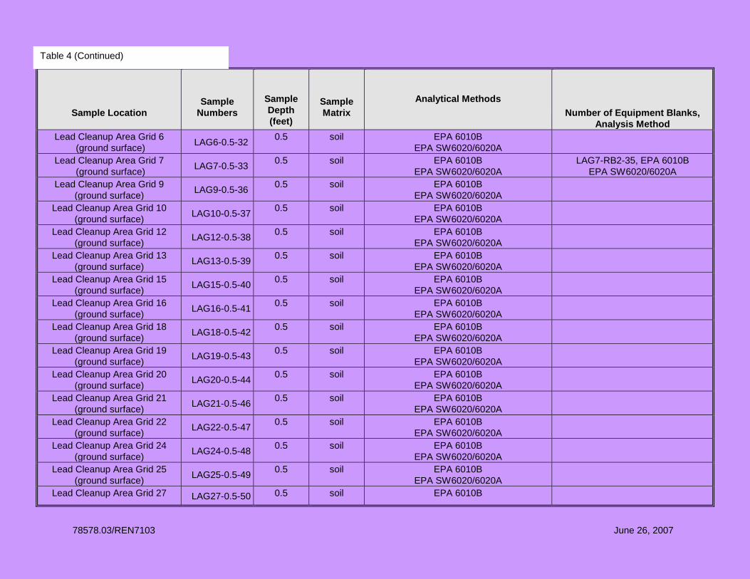
78578.03/REN7103 June 26, 2007
Sample Location
Sample Numbers
Sample Depth (feet)
Sample Matrix
Analytical Methods Number of Equipment Blanks,
Analysis Method Lead Cleanup Area Grid 6
(ground surface) LAG6-0.5-32 0.5 soil EPA 6010B EPA SW6020/6020A
Lead Cleanup Area Grid 7 (ground surface) LAG7-0.5-33 0.5 soil EPA 6010B
EPA SW6020/6020A LAG7-RB2-35, EPA 6010B
EPA SW6020/6020A Lead Cleanup Area Grid 9
(ground surface) LAG9-0.5-36 0.5 soil EPA 6010B EPA SW6020/6020A
Lead Cleanup Area Grid 10 (ground surface) LAG10-0.5-37 0.5 soil EPA 6010B
EPA SW6020/6020A
Lead Cleanup Area Grid 12 (ground surface) LAG12-0.5-38 0.5 soil EPA 6010B
EPA SW6020/6020A
Lead Cleanup Area Grid 13 (ground surface) LAG13-0.5-39 0.5 soil EPA 6010B
EPA SW6020/6020A
Lead Cleanup Area Grid 15 (ground surface) LAG15-0.5-40 0.5 soil EPA 6010B
EPA SW6020/6020A
Lead Cleanup Area Grid 16 (ground surface) LAG16-0.5-41 0.5 soil EPA 6010B
EPA SW6020/6020A
Lead Cleanup Area Grid 18 (ground surface) LAG18-0.5-42 0.5 soil EPA 6010B
EPA SW6020/6020A
Lead Cleanup Area Grid 19 (ground surface) LAG19-0.5-43 0.5 soil EPA 6010B
EPA SW6020/6020A
Lead Cleanup Area Grid 20 (ground surface) LAG20-0.5-44 0.5 soil EPA 6010B
EPA SW6020/6020A
Lead Cleanup Area Grid 21 (ground surface) LAG21-0.5-46 0.5 soil EPA 6010B
EPA SW6020/6020A
Lead Cleanup Area Grid 22 (ground surface) LAG22-0.5-47 0.5 soil EPA 6010B
EPA SW6020/6020A
Lead Cleanup Area Grid 24 (ground surface) LAG24-0.5-48 0.5 soil EPA 6010B
EPA SW6020/6020A
Lead Cleanup Area Grid 25 (ground surface) LAG25-0.5-49 0.5 soil EPA 6010B
EPA SW6020/6020A
Lead Cleanup Area Grid 27 LAG27-0.5-50 0.5 soil EPA 6010B
Table 4 (Continued)

78578.03/REN7103 June 26, 2007
Sample Location
Sample Numbers
Sample Depth (feet)
Sample Matrix
Analytical Methods Number of Equipment Blanks,
Analysis Method (ground surface) EPA SW6020/6020A
Lead Cleanup Area Grid 28 (ground surface) LAG28-0.5-51 0.5 soil EPA 6010B
EPA SW6020/6020A
Lead Cleanup Area Grid 29 (ground surface) LAG29-0.5-52 0.5 soil EPA 6010B
EPA SW6020/6020A
Lead Cleanup Area Grid 30 (ground surface) LAG30-0.5-53 0.5 soil EPA 6010B
EPA SW6020/6020A
DS-4 Trench 1 DS4T1-2-55 2 soil EPA SW8015B
DS-4 Trench 2 DS4T2-2-56 2 soil EPA SW8015B
DS-4 Trench 3 DS4T3-5-57 5 soil EPA SW8015B
DS-4 Trench 4 DS4T4-5-58 5 soil EPA SW8015B DS4T4-RB3-60, EPA SW8015B
DS-4 Existing Excavation DS4EE-2-61, DS4EE-2-62
2 soil EPA SW8015B EPA SW 8260B EPA SW6020
DS-4 North of Existing Excavation DS4NEE-2-63 2 soil EPA SW8015B
DS-4 East of Existing Excavation DS4EEE-2-64 2 soil EPA SW8015B
Table 4 (Continued

78578.03/REN7R103 June 26, 2007 Copyright 2007 Kleinfelder
TABLE 5
REQUIRED DETECTION LIMITS AND ACTION LEVELS FOR TOTAL AND TCLP LEAD
(ICPMS EPA SW6020/SW6020A and SW1311) RENO-SPARKS INDIAN COLONY
RENO, NEVADA
Contaminant of Concern
RDL – Soil
Extract (mg/L)
Action Level – Soil Extract
(mg/L)
RDL – Soil
(mg/Kg) Action Level – Soil (mg/kg)
Total Lead --- --- 1.0 400 TCLP Lead 0.1 5.0 --- ---
TABLE 6
REQUIRED DETECTION LIMITS AND ACTION LEVEL FOR TOTAL PETROLEUM HYDROCARBONS (BY EPA SW8015B)
RENO-SPARKS INDIAN COLONY RENO, NEVADA
Contaminant of Concern RDL – Soil (mg/Kg)
Action Level – Soil (mg/kg)
TPH 10.0 100

78578.03/REN7R103 June 26, 2007 Copyright 2007 Kleinfelder
TABLE 7
REQUIRED DETECTION LIMITS FOR VOLATILE ORGANIC COMPOUNDS BY GC/MS (SW-846 8260B)
RENO-SPARKS INDIAN COLONY RENO, NEVADA
Compound RDL – Soil (µg/kg)
Chloromethane 80 Bromomethane 80 Vinyl Chloride 20 Chloroethane 20 Dichloroethane 80 Trichlorofluoromethane 20 1,1-Dichloroethene 20 Dichloromethene 20 1,1-Dichloroethane 20 Cis-1,2-dichloroethene 20 Trans-1,2-dichloroethene 20 Chloroform 20 1,2-Dichloroethane 20 1,1,1-Trichloroethane 20 Carbon Tetrachloride 20 Bromodichloromethane 20 1,2-Dichloropropane 20 cis-1,3-Dichloropropene 20 Trichloroethene 20 Dibromochloromethane 20 1,1,2-Trichloroethane 20 Benzene 20 Trans-1,3-dichloropropene 20 Tetrachloroethene 20 1,1,2,2-Tetrachloroethane 20 Bromoform 20 Toluene 20 Chlorobenzene 20 Ethylbenzene 20 Total Xylenes 20 1,3-Dichlorobenzene 20 1,4-Dichlorobenzene 20 1,2-Dichlorobenzene 20
Notes: RDL – Required Detection Limits

78578.03/REN7R103 June 26, 2007 Copyright 2007 Kleinfelder
TABLE 8
REQUIRED DETECTION LIMITS FOR
METALS ANALYSES BY ICPMS (SW6020/SW6020A) RENO-SPARKS INDIAN COLONY
RENO, NEVADA
Metal RDL – Soil (mg/kg)
Arsenic 1 Beryllium 1 Cadmium 1 Chromium 1 Nickel 2 Lead 1 Antimony 1

APPENDIX A
Laboratory Standard Operating Procedures

APPENDIX B
Field Forms

APPENDIX C
Health and Safety Plan

PLATES

TABLES
Related Documents