r I TASMAN IA DEPA RTMENT OF MI NES GEOLOGICAL EXPLANATORY SURVEY REPORT ONE MILE GEOLOGICAL MAP SE RI ES K '5 5-7- 39 LAUNCESTON by M. J. LONGMAN APPENDIX: PETROLOGY by G. EVERARD Iss ued under the authority of The Ho noura ble ERIC ELLIOTT REECE, M.H.A .. Minister for Mine s for Tasmania. 1966 II _ D. B. \VILKINSON, Government Printer, Tas mania. 5041 50 cents

Welcome message from author
This document is posted to help you gain knowledge. Please leave a comment to let me know what you think about it! Share it to your friends and learn new things together.
Transcript
r I TASMAN IA
DEPA RTMENT OF MINES
GEOLOGICAL EXPLANATORY
SURVEY REPORT
ONE MILE GEOLOGICAL MAP SERI ES
K'55-7-39
LAUNCESTON by
M. J. LONGMAN
APPENDIX: PETROLOGY by
G. EVERARD
I ssued under the authority of The H onourable ERIC ELLIOTT REECE, M.H.A ..
Minister for Mines for Tasmania.
1966
II _ D. B . \VILKIN SON, Government Printer, Tas mania.
5041 50 cents

I
Preface The Launceston Quadrangle, as can be seen from the Geological
Map Sheet. is noted for the expanse of Tertiary deposits occupying the Tamar Trough, formed in dolerite. The drainage pattern of the south-western and central parts of the sheet contrasts strongly with that of the north-eastern part where older rocks occur.
Economically, the Tamar Trough is important as it was the controlling factor in the formation of the valley of the navigable Tamar River and the site of the little settlement t hat has grown into the City of Launceston. It is also important in that the Tertiary deposits have provided the materials for making the bricks of which Launceston Is mainly built, and this industry continues to be of great importance.
As the Launceston Quadrangle, unlike some others that have been mapped recently, is comparatively thickly populated, t here arises the problem of the stability of Tertiary deposits for foundations of houses, factories, &c. A considerable amount of work has been and wllI be carried out on this problem.
Though the Launceston Quadrangle is poor in metallic minerals, it is worthwhile noticing that considerable reserves of bauxite occur and m ay be of great value to the community in the future .
J. G. SYMONS. Director of Mines.

" ,.
Mt Uarruw rrom Cataract Gorge.

S cm
MT. BARROW
---- ------ --------- - -oii;- Si:OPES OF TILT ED DOLERITE FAULT
- - - ----------------- - - --- - - -- - -------------- - --- ------- - - ~.!,.g~!<.$~-----------;--- _______ _ DIP SURFACE ON DOLERITE TERTIARYSED~~N-~~---- ) --~-~=====-I'j,~~K_ !ily~R __ -_-_=_=~ L)lJJNCESTON
_/-==~ =:: = =-=--=- _ ~ORTH ESK RIVER - --------------
~--- -, ------ ......
DOLERITE
, \ , , , , , ,
( \ \ \ \ \ \ \ \ \
\
----
TAMAR
CATARACT GORGE
----
RIVER
DOLERITE
Mt Barrow f!'Urn Cataract Gorge ShOWlnK dip slop es of fauited dolerite b locks In middle dis tance with ftood plains of the NOl'th E~k 0.1111 Tamar Rive]"lI in fOI"l~iI'round.

L
INTRODUCTION PHYSIOGRAPHY STRATIGRAPHY
Silurian· Devonian Mathinna Beds
Permian Lower Permian LifIey Group Upper Permian
Triassic Tertiary
Launceston Group Quaternary
IGNEOUS ROCKS Devonian Jurassic Tertiary
STRUCTURE Folding Faulting Tamar Trough
ECONONUC GEOLOGY Bauxite Clay Coal Dolerite Gold Gravel Limestone Ochre Oil Shale Sand
Contents
ENGINEERING GEOLOGY Foundation Conditions
REFERENCES APPENDIX : Petrological Examinations of Rock Speci
mens
Page II II 12 12 12 13 17 18 18 19 19 19 21 22 22 24 24 24 24 26 31 31 31 31 32 32 32 33 33 34 34 35 35 35 35
37

1-
Figures
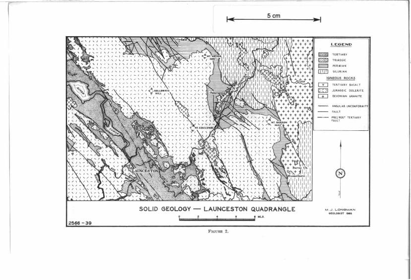
1. Locality Map 2. Simplified geological map of the Launceston Quad
rangle 3. Stratigraphic columns and correlations of Permian
rocks 4. Variation in thickness of Permian rocks 5. Glaciated pavement: profile 6. Rose diagram of striations on glaciated pavement 7. Dolerite Isostrats-Launceston Quadrangle .... 8. Stereographic projection of fold axes: Mathinna
Beds 9. 1
10. ~ Development of Tamar Trough : Tertiary to Recent 11. J 12.
Plates Mt Barrow from Cataract Gorge
1. Anticline in Mathinna Beds, Sideling 2. Glaciated pavement, Patersonia 3. Sheet jointing in dolerite, Mt Barrow 4. Jointing in dolerite, Corra Lynn 5. Tertiary quartz conglomerate, 8t Leonards 6. Detail. plate 5 7. Tertiary dolerite conglomerate, East Tamar High-
way 8. Mt Arthur from Mt Barrow 9. Periglacial rock streams. Mt Barrow
10. Recent flood plains. North Esk River 11 . Scree slopes. Mt Barrow
Page 9
10
14 15 16 16 23
25
27-30
Frontispiece
Between Pages 24 and
25

KING IS.
.' =====.;"' ... ====~IOO toiL.!>
TASMANIA
~.~rUNDERS
IS.
o (l
• . '~ () ..
o ONE MILE CEOLOGICAL MAP SERIES
N° 39 LAUNCESTON
r
. ,. ., .
....
... ...
AREA COffCRED BY EXPLANATORY REPORT
FIGU RE 1.
Scm ~I
Scm
SOLID GEOLOGY LAUNCESTON QUADRANGLE ........ ..l ................ ..:I.. __ .I1 111.11.
FICURE 2.
LE:GEND
CD TUlTI""V mm IlI.lASSle
~ I'I"O\'AN
[!J] "lVII'"'' IGNEOUS ROCKS
crJ HIITl.t.II.V " ... SAU
~ JU~AS51( OOLtll.lTt
[±:J OlVOMIA .. " .. N Il(
ANGUlAII. ""''''''''"11 rAUlT
~'U/I'MT T{II.TOAII.V • ... ULI
N

EXPLANATORY REPORT OF THE QUADRANGLE LAUNCESTON
Introduction
11
The Launceston Quadrangle (figure 1) which covers portion of the central north of Tasmania between Latitude 41 0 15' and 41 °30'S and Longitude 147°00' and 147°30'E, includes the city of Launceston, the township of Lilydale, and Mts Arthur and Barrow. Previous geological studies were made by Gould (1864) I reconnaissance of the eastern portion; Twelvetrees (1909) , reconnaissance between Launceston and Lllydale; Nye (1924). the LHydale area; and Carey (1947), the Launceston district. E. D. Gill (of the National Museum of Victoria) and O. D. Aitchison (of the Commonwealth Scientific and Industrial Research Organization) are preparing to publish detailed results of their studies of the Tertiary sedimentary deposits.
Between September. 1961 and June. 1963. the present survey was made as part of the regional mapping programme. using topographical maps (scale 1 inch : 20 chains and contour interval 25 feet) and air photographs (scale 1 inch : 45 and 20 chains). S. M . Rowe. Geologist. mapped the area west of the Tamar and South Esk Rivers. W. L. Matthews. Geologist. mapped the East Tamar area north of Launceston and M. J. Longman, Geologist, mapped the remaining three quarters of the Quadrangle. G. Everard, Mineralogist and Petrologist, undertook the petrological examinations. Access is good throughout the area, but outcrop is restricted to rivers, large creeks and roads.
The map sheet, scale 1 inch : 1 mile, has been published and a simplified map is shown in this report (figure 2).
Numbers in the following descriptions refer to rocks described in the appendix by G. Everard.
Physiography The area varies in elevation from sea level in the Tamar
Valley, rising in a series of steps to 1.500 feet on Grassy Hut Tier in the west, to over 3,900 feet on Mt Arthur and over 4,600 feet on Mt Barrow in the east, dropping abruptly to a dissected peneplain 2,000 to 2,400 feet a.s.1., further east. This peneplain corresponds to the pre-Permian surface. The scarps and steps are a result of, faulting trending NNW -SSE with the down throw to the east.
Periglacial features are rock streams on the western slopes of Mt Barrow and Mt Arthur and outwash plains of dolerite boulders in yellow clay situated on the 3,300 to 3,500 feet level below Mt Barrow. Disintegration of the dolerite blocks by ice wedging forms extensive scree deposits on the steeper eastern slopes.

I~
12
Below North Mt Barrow thls scree has filled a probable pre-existing glacial valley, and forms the present periglacial rock stream.
West of Mt Arthur and Mt Barrow, drainage is controlled by the NNW -SSE faulting and the SW tilt of the fault blocks. Superimposed on this major pattern is the control of minor faults in Permian and Triassic rocks, and joints in t he dolerite which are mainly NNW-SSE, ENE-WSW and ESE-WNW. However. in Tertiary sedimentary rocks the pattern is not so definite, being controlled by the structure of the underlying dolerite or varying lithology.
In the east. drainage control is by granite jointing or bedding aDd jointing in Mathinna rocks, mainly NNW-SSE aod ENE-WSW.
Tertiary drainage has been considerably modified by basalt flows, which have caused twinning and damming of the original St Patricks River. which appears to have flowed through Tayene. Myrtle Bank, Patersonia. Nunamara and St Leonards. possibl)joined at Nunamara by the North Esk from Watery Plains and Bullocks Hunting Ground Damming by basalt at Nunamara caused the St Patricks River to be diverted SSE to Watery Plains to join the North Esk River which had been diverted by basalt at Watery Plains. Twinning of the original St Patricks R iver occurred at Patersonia forming Patersonia Rivulet and the present St Patricks River . Twinning also occurred at Georges Plains forming Seven Time Creek and the present St Patricks River .
Stratigraphy SILURIAN-DEVONIAN
MATHINNA BEDS
These rocks have been subdivided into a mudstone-slate sequence, conformably underlying and grading into a sandstonemudstone sequence, the junction being best exposed on the Lisle Road at 512640E 914730N.
Mudstone-Slate Sequence (63-233, 63-238, 63-239)
These rocks extend in a NNW-trending anticlinorium with the western margin exposed H miles east of Lllydale and the eastern boundary passing west of Lisle through Myrtle Bank and Myrtle Park to the northern slopes of Mt Barrow. The total thickness of succession is unknown as the base is not exposed but the maximum thickness measured is 500 feet in an unfaulted section along the Lisle Road.
The rock is fine grained with cleavage dominant over bedding. The latter is usually represented by laminations 2 mm thick or less and rarely by siltstone or fine sandstone horizons up to 1 foot in thickness. The colour is variable with green, purple, redbrown and grey horizons present, but the weathered rock is fawn or pink. Locally the rock is intensely plicated with the development of mica and may reach phyllite in metamorphic grade, but generally only a sheen is developed along cleavage planes. No fOSSil horizons have been found.

13
Sandstone-Mudstone Sequence (63··232, 63-247. 63-253)
This Is a typical turbidite sequence composed of sandstone, grey to cream in colour and mudstone similar in composition to that of the mudstone-slate sequence.
The sandstone shows cross lamination, grading, convolute bedding and bottom structures, mainly current rippling and load casts. The sandstone composition ranges from greywacke and feldspathic sandstone to Quartzite. The bedding units are up to 1 foot thick ; composite beds over 10 feet thick occur in the upper part of the sequence but cleavage is poorly developed.
Rare plant fragments occur in some horizons usually associated with carbonaceous shale.
The rocks flank the older mudslione and slate out-cropping in the west at Lilydale and in the east at Lisle, and extend south to Burns Creek and east to the Sideling and Diddleum Plains. The greatest thickness of rocks measured in an unfaulted sect.ion is 670 feet. (Williams pers. comm.) on the Sideling which does not include the base or top of the unit .
A Quartzite breccia (63-234) · composed of angular fragments up to 1 foot in size tn a siliceous matrix outcrops at Myrtle Bank. Flute casts at the base of the unit, which varies from 10 to 30 feet tn thickness, indicate a source to the SW. This Quartzite breccia is overlain by or adjacent to basalt and may be a baked Tertiary deposit.
PERMIAN
The P ermian sedimentary rocks are exposed tn the LilydaleKaroola area extending south along the eastern slopes of Mt Arthur and Mt Barrow to Musselboro. occurring as isolated outcrops near Bridgenorth and Launceston and in the St Patrlcks River and Weaver Creek. Small remnants overlying the dolerite occur at St Leonards and Corra Lynn. These rocks which have a regional dip of 100 to 150 towards the SW. are 1,500 feet thick near Lilydale but thin to the east and south.
The lower beds were laid down upon a glaciated basement with moderate relief of folded Mathinna rocks. The boundary of the Permian and Triassic is taken at the base of the first thick well-sorted sandstone above the LUfey Group. The boundary. exposed on the Pipers River Road at 503330E 917000N, is just below a 2 inch Quartz conglomerate band deposited on an undulating surface with a slight unconformity.
In the Launceston Quadrangle the Permian (figure 3) has been subdIvided as follows:-
Upper Permian . Liffey Group Lower Permian
Total
Thickness (feet) .. Up to 650
150-100 725-130
1525

f--
WE,TUN TII:JU .uc:T1OM
( ..... T~. "'Kn.~"'" .. n )
... _ ....... .. _.-
FIGURI'.: 3.
Scm
-'
. UfIIKJ CfIIUM MUSK~N\U.
1_ o.rtt_l
~ I

, ...
i I i
Scm
F !
."::: ::::S,~ ·TAl't1C
~~~ ... ::::<>!:.
VARIATION OF THICKNESS IN PERMIAN ROCKS LAUNCESTON QUADRANGLE
FIOUU 4.

,JoO I-I
l ito
S ,w.
1-- ' -----":
ICA ~E ... rUT
CD GL A CIA TCD "AII'CMCl'T~ c:::I 501L" WCA THERED ROC/( (I3 UI'WCATNCREO /.IArHI""A 8C05
PROFILE OF GLACIATED PATf:RSONIA
MAGNETIC
N
TE.RRACES
_.1.-------'-_---1 E PAVEMENT - PATERSONIA
ROSE DIAGRAM OF 70 STRIATIONS OVER 3 " IN I..ENGTH
1··IGlIRES 6 and 6.
5cm
N _II!:.

17
LoWER PERMIAN
The base of the Permian is represented by a tillite, up to 150 fee t thick, between Mt Arthur, Paters'onia and the Mt Barrow turnoff on the Tasman Highway ; an interbedded siltstone overlying tillite on the Mt Arthur Road near Lilydale ; and a conglomerate, fiuvlo-glacial in origin, up to 100 feet thick elsewhere.
Tillite, maximum thickness 75 feet. near Patersonia (521000E 910800N) rests upon a series of glaciated terraces up to 100 feet in length and 15 feet wide, the polished surfaces dipping towards the NE at 10"·20" and the plucked surface to the SWat 40". Striations and grooves indicate ice movement from the NNE (figures 5, 6l.
The tillite consists of faceted and rarely striated pebbles varying in size from 6 inches to less than 3 mm and rare rounded pebbles set in a matrix of rock ft.our with very little clay. The matrix is composed of angular fragments similar in composition to pebbles and varies in colour from pale blue-grey when fresh to fawn when weathered. Mottled colours are very common.
The dominant pebble type is Quar tzite. pale grey in colour with minor red, white, brown and green varieties. with granite (usually weathered) , Quartz conglomerate, quartz and feldspar porphyries. slate and schist also represented.
Generally the pre-Permian surface Is gently undulating with total relief less than 100 feet, but north of Mt Arthur a large valley. 300 feet deep. with walls sloping 1 :8. extends towards Lilydale. East of Mt Barrow and at Musselboro there are basement highs, 350 feet and 300 feet respectively above the general level, with slopes averaging 1: 100 to the west.
Overlying the basal tillite or conglomerate Is a dark grey to black mudstone, varying in thickness from 380 feet east of Lilydale and 300 feet north of Mt Barrow to less than 50 feet north of Burns Creek. It contains scattered erratics, commonly faceted , minor sandstone beds which increase towards the top of the sequence and conglomerate bands (63-257, 63-258). Fossils include Stenopora tasmaniensis, Fenestella spp., Strophalosia, Keeneia pTatyschismoides, Gangamopteris and aviculopectinids. Carbonaceous fragments are uncommon but occur in bands throughout the sequence, a rich zone being exposed in a quarry on the Burns Creek Road at 532000E 891250N.
The mudstone weathers readily, usually forming elliptical shapes up to 5 feet long by 2 feet high which eventually break down to small angular fragments 3 nun or less in size covering the exposed face. the colour changing from dark grey to pale bluegrey to fawn. Limonite stained jointing and obvious bedding are rare.
The sequence above the tillite is exposed in the railway cuttings between Lllydale and Downie.
Limestone containing Calcitornella stephensii, Stenopora tasmaniensis and Eurydesma cordatum varies in thickness between 30 feet at Downie, 20 feet at Mt Arthur, 10 feet at Mt Barrow. 3 feet at Karoola and 1 foot at t he Weaver Valley and north of Burns Creek. It conformably overlies the grey-black mudstone and is in turn overlain by alternating beds of mudstone, siltstone and conglomerate. The total thickness varies between 200 feet and 240 feet in the north thinning to 100 feet north of Mt Barrow and to less than 50 feet east of Mt Barrow and at Musselboro.

18
LIFFEY GROUP (63·260)
Uplift above sea level followed the deposition of the Lower Permian, and the Liffey Group rocks, mainly quartz sandstone and micaceous and carbonaceous shale, were deposited under estu~rine or lacustrine condlt1ons. The base ot the group. exposed near Mt Barrow at 526900E 901900N, is composed of quartz conglomerate lenses, 6 inches thick, unconformablY overlying mudstone of the Lower Permian. Total thIckness of the unIt is difficult to determine due to dolerite scree cover but t he exposed thickness varies. between 100 and 150 feet, thinning towards the east. The sandstone forms prominent cliffs, weathers white to orange in colour and contains secondary Quartz.
Overlying ,the conglomerate or resting directly on the Lower Permian is clean, well-sorted. quartz sandstone. with minor shale and quartz conglomerate bands. 30 feet thick at Karoola. Mt Arthur and Mt Barrow. At Karoola the sandstone is current bedded. indicating currents from the NE, and one shale band contains a 9 inch seam of oU shale (Nye. 1924L
Above the basal sandstone at Mt Arthur. Trout Creek and Turners Marsh, in clitIs up to 70 feet high. there is fine-grained quartz sandstone in beds varying between 2 and 5 feet thick with minor micaceous and carbonaceous shale bands, usually less than half an inch thick.
Overlying this sandstone are interbedded feldspathic sandstone and dark 'brown to black carbonaceous shale containing .abundant plant fragments. The beds. which vary in thickness from 3 feet to 6 inches. are exposed at Turners Marsh and in a road quarry near the Karoola church. where the unit is 20 + feet thick .
The highest unit, 5+ feet thick, outcropping above Trout Creek and at Turners Marsh. is a grey feldspathic sandstone containing numerous worm casts and abundant pebbles. some faceted , up to 2 inches in diameter, of quartzite, slate and schist.
UPPER PERMIAN
This sequence, overlying the sandstone of the Liffey Group is composed of interbedded mudstone, sUtstone and pebbly sandstone 600-650 teet thick in the Lilydale-Turners Marsh area. Elsewhere the dolerite intrudes this sequence so the total thickness is unknown, but at least 500 feet of sedimentary rocks occur at Mt Barrow and Musselboro. The lowest beds which rarely outcrop in the Launceston Quadrangle are represented 'by discontinuous outcrops in the road and railway cuttings between Downie and Lallah and isolated outcrops elsewhere. The sandstone units in the upper beds, being more resistant to erosion, form benches and have ·been used as mapping horizons while the finer sediments only outcrop in rivers and large creeks or man-made exposures.
The lowest beds exposed at 509500E 918800N in a water channel consist of 15 feet of reddish brown to fawn. poorly-bedded mudstone containing small erratics, approximately 25 feet above the LUfey Group sandstone. Elsewhere these beds, possibly 50 feet thick at Downie are extensively weathered forming a brown clay. Above these beds 1:; micaceous siltstone, 10 teet thick. containing scattered fenestell1ds, brachiopods and Conularia. which is overlain by 5 feet of poorly sorted sandstone containing numerous erratics (Horizon c, figures 3, 4).

19
Overlying this sandstone, there is approximately 150 fee t of brown and grey mudstone, usually well weathered, containing scattered fenestell1ds and brachiopods. Small erratics become more numerous towards the top of thIB unit (63-261, 63-262, 63-263 ).
Overlying the mudstone is a poorly sorted feldspathtc sand· stone, 30 feet thick, containing abundant erratics, which is the principal marker horizon in the sequence (Horizon b. figures 3, 4). The ,best exposure occurs in a small cillf 25 feet high halt a mile SW of Karoola railway station, but isolated outcrops and abundant float on well marked benches are characteristic of this sandstone.
Another similar sandstone (Horizon R, figures 3, 4) occurs 225 feet above Horizon band 150 feet below the Permian-Triassic boundary. This sandstone, containing abundant erratics and mica flakes, is approximately 5 feet thick on the Mt Arthur logging road south of Lilydale and 25 feet thick on the Dismal Range. It forms a well defined bench covered with abundant float , and 1s difficult to distinguish from the lower unit.
Above the lower sandstone unit are approximately 200 feet of interbedded fissile and non-fissile mudstone bands with few erratics and rare thin sandstone bands.
The mudstone shows characteristic grey and cream mottling when weathered. It outcrops along the ra ilway between Karoola and Turners Marsh and also occurs as isolated outcrops on Mt Arth ur and Mt Barrow.
Approximately 150 feet of fissile and non-fissile mudstone with few erratics and numerous worm markings in the coarser beds overlies the upper sandstone unit. This mudstone weathers with the characteristic colour mottling and is best exposed in the road and railway cuttings east of Lallah, and in the Pipers River south of Karoola.
TRIASSIC The Triassic rocks are feldspathic sandstone. quartz sand
s tone and shale (63-250) ; they are intruded by dolerite and restricted to the Dismal Range-Brown Mount area.. The sequence is 600 feet thick on Brown Mount and 300 feet thick on the Dismal Range, and it has a regional dip of 5°_10° towards the SW.
The lowest bed, resting unconformably upon an undulating surface of Permian mUdstone, is a 2 inch thick quartz pebble conglomerate, which Is overlain by 20 feet of alternating feldspathic sandstone and micaceous shale. Resting upon these is a thick massive sandstone containing numerous iron concretions up to 1.5 inch in diameter at the base, which has been used as a marker horizon in this area. Current bedding is common throughout the sequence showing current directions from the NW .
It Is possible that the lower 20 feet of feldspathlc sandstone and micaceous shale may be of Permian age but no fossils or <:arbonaceous material could be found.
TERTIARY LAUNCESTON GROUP
Tertiary deposits, occurring in a NNW-trending belt up to 8 miles wide along the Tamar and North Esk Valleys, consist of Interbedded clay. sandstone, conglomerate. lignite and basalt fiows <:aUed the Launceston Group. These rocks. 1.000 feet

20
thick in the deepest part of the trough, thin to the east on 7EX Hill and to the west at Prospect to less than 100 feet thick. The Group was deposited in a series of narrow elongated basins fonned by the step faul ting of SW tilted blocks with the upthrown side to the west. The main movement occurred at the beginning of the Tertiary with m Inor movements continuing thrQughout the period. (See figures 9-12).
The major basins extend from Relbia to Bradys Lookout. and from Carra Lynn to Windermere ; the minor basins extend through First Basin, P rospect. Ravenswood and R ocherlea. Later in the Tertiary the sediments in these troughs coalesced, flooring the present Tamar Valley. Elsewhere in the Quadrangle the Tertiary is represented by sand and gravel underlying basalt at Prosser Forest and Diddleum Plains and laterite at Turners Marsh and Prosser Forest.
As the stratigraphy of the Launceston Group is complex, no detailed study has ,been m ade, only distinctive rock type boundaries have been mapped and approximate positions in the sequence determined.
The sediments were deposited under deltaic conditions with scour and fill structures, randomly directed current-bedding, rare graded bedding, and rapid variation of grain size. Lignite and laterite horizons, some representing land surfaces , occur throughout the sequence.
The most abundant rock, comprising 75% of outcrop, is a green to brown sandstone composed of well-sorted to subangular feldspar, now altered to clay minerals, minor well-rounded quartz up to 2 mm in size and clay cement, all commonly iron impregnated. When weathered or compressed the original structure is destroyed and green and brown clay results.
Sandstone, pale yellow to brown in colour, composed of wellrounded quartz grains, which are occasionally coated with limonite or clay, forms 5% of the outcrop and is more common towards the top of the sequence. Current bedding Is frequent and liesegang rings and bands occur in the more massive varie ties. When it is limonite impregnated, it forms resistant layers which preserve impressions of leaf and plant fragments. A flne clear sand results when this rock Is weathered.
Clay, massive and coloured red, brown, green, yellow and black, is interbedded with other rock types and occupies 5 % of outcrop. The black variety is rich in plant fragments.
Lignite occurs throughout the sequ.ence. usually as thin lenses, but at St Leonards 10 feet of black compressed plant remains is exposed on the North Esk River bank.
Quartzite pebble conglomerate occurs throughout the sequence forming 10% of outcrop and becomes more abundant in the upper part of the sequence. The conglomerate varies from small lenses half an inch thick to bands 50 feet thick.
Three conglomerate types have been noted:-1. Composed o'f ftattened ellipsoidal quartzi te pebbles up
to 2 inches in size with minor dolerite pebbles now weathered to clay. The m atrix is clean, composed of sand with very little clay. The conglomerate Is well bedded, pebbles show imbricate structure and it usually grades into sandstone with m inor pebbles. Location: 7EX Hill.

21
2. Composed of rounded ~uartzite and quartz pebbles varying in size from t to 2 inches. commonly current bedded and well sorted. Location: Prospect Quarries.
3. Composed of rounded quartzite and dolerite pebbles in equal proportions up to 4 inches diameter in a sandy matrix containing little clay. This conglomerate is rarer, but outcrops in railway cuttingS at Vermont.
Dolerite pebble conglomerate, composed of rounded to subangular dolerite pebbles, average size 6 inches but varying between 3 inches and 3 feet in a bedded clay matrix, forms 5% of outcrop. These conglomerate lenses contain rare chert ('baked Permian) pebbles and wood fragments and occasional lenses of well sorted sandstone. and occur on the eastern margin of the trough extending from 600 feet above to 100 feet ,below sea level. Exposed at Waverley, Mowbray and at the Lefroy turnoff on the main highway, these rocks most probably represent mudflows from the margin of the trough. They occurred throughout the Tertiary as they are interbedded with sedimentary rocks towards the centre of the trough. The conglomerate never contains basalt pebbles despite adjacent outcrop of basalt so its formation did not extend into post-basalt time in the Launceston area.
Laterite, widespread in the western half of the Quadrangle, occurs at all heights between sea level and 800 feet but is dominant on the 500-600 feet and 350-450 feet levels representing the peaks of higher blocks.
Four laterite types occur, the commonest being on dolerite throughout the area, with good exposures at St Leonards where the profile can be seen in trenches. Laterite on basalt is uncommon and restricted to the Bradys Lookout area and Scott's fann, east of St Leonards.
Throughout the Tertiary sequence, well defined iron-rich layers occur, some representing land surfaces with the formation of laterite in situ with well defined horizons. Elsewhere, horizons of limonitic oolites occur representing material transported from adjacent hillsides.
Drill holes and outcrops in the centre of the Tamar Trough show relatively unweathered dolerite underlying Tertiary rocks indicating that laterite formation in this area is probably later than the main period of Tertiary faulting and extended throughout the Tertiary Period.
QUATERNARY
Glacial and Periglacial Deposits : On the western slopes of Mt Barrow between the 4,200 feet and 3,400 feet contours, well defined block streams with an average gradient of 80 are composed of unsorted dolerite boulders with the longer axis aUgned parallel to the slope. They are periglacial in origin and resemble moraine occurring in valleys up to 1 mile long and a Quarter mile wide but no evidence of glacial features, e.g. cirques, has been found associated with them.
West of Mt Barrow and Mt Arthur extensive marshy plains, elongated in a NNW-SSE direction and ranging in height from 3,200 feet to 3,400 feet a.s.1., appear to follow fault zones. These plains are composed of unsorted dolerite boulders in a clayey matrix overlain by peaty clay and represent accumulations of periglacial m aterial from the mountains.

1-
22
Dolerite scree, composed of angular unoriented dolerite blocks forming slopes with an angle of rest of up to 35 0
• is restricted to the north, east and south of Mt Arthur and Mt Barrow. These deposits were formed by the detachment and disintegration of large blocks or the wedging of smaller blocks from the exposed mountain tops by ice and frost action. Detachment of such large blocks Is evident along Mt Barrow road where many blocks up to 100 feet in size have horizontal jointing in contrast to nearby vertical Jointing elsewhere.
Dolerite talus, forming a thick cover composed of dolerite boulders and soil and concealing the underlying rock, Is widespread on the steeper slopes below dolerite on the h111s and lower mountains and below scree on the higher mountains. To the west of Mt Arthur and Mt Barrow extensive talus occurs on gentle slopes extending downslope as far as two miles from solid dolerite.
Basalt talus, restricted to steep slopes beneath basalt outcropping near Bradys Lookout and Windermere, h as been formed by the disintegration of basalt along jOint planes and the undermining by erosion of the weaker unconsolidated Tertiary sedimentary rocks.
Alluvium consists of (1) peaty clay containing small weathered dolerite blocks and granules and magnetite concretions up to t inch diameter along creeks and fault zones in doleri te areas; (2) sand and clay containing quartzite and basalt pebbles along the St Patricks River and its tributaries ; (3) clay and black loam in the Pipers River; (4) black clay and sand containing 3 inch diameter Quartzite and dolerite pebbles up to 40 feet below present river level along the North Esk and Tamar Rivers. Elsewhere the alluVium is composed of sand and clay containing abundant Quartzite pebbles.
Igneous Rocks DEVONIAN
Intruded into the Mathinna Beds is an equigranular h ornblende-biotite granodiorite with granodiorite porphyry developed at some contacts. Diorite inclusions are common near the boundary with sedimentary rocks and are oriented parallel to it. The main granite body forms a belt up to 5 miles wide which extends from Musselboro in the south to Springfield in the north. An isolated intrusion occurs at Lisle surrounded by a contact zone two miles wide along Bessels Road.
Contacts with the sedimentary rocks showing intrusion by dilation of joints and bedding planes are exposed in St Patricks River at 532500E 911500N and in a quarry east of Mt Barrow Road at 530500E 905000N. The porphyry margin is exposed at 535500E 902500N on the disused logging tram south of Camden.
Numerous roof pendants and remnants of chilled margins occur throughout the area indicating that the roof of the granite is just exposed.
Quartz feldspar porphyry outcrops on Diddleum Plains near the St Patricks River but its relation to the main granite :is unknown.
For descriptions of rocks see Appendix (61-78, 62-361, 62-432, 63-236, 63-241, 63-244, 63-248 and 63-245, 63-246, 63-252 ).

DOLERITE ISOSTRATS LAUNCESTON QUADRANGLE . "~ FlGt!!l!!: 7.
Scm
LCGEND
c::::J TtIITIJ,',
~ TI\I"SSI(
~ P( ...... l~~
lID ~ ... l"' .....
IGN[~ ROCK3
[Y] 'l",a~~ lJ,V @ all ..IIJ'_HI( N'l iII'H
CIJ (\(YOHI>" 6~~~;Tt
A'/G<.IV1, ~~rm~'O~"IH
raVlT
'~ l/1I,I~T IlUI ..... 1 f.lJ(T
h •
• ,
Ulo:.,. ", ... n"{l'''''' Of 00l { ~"{ ."'~
•• S( Of n, .~s" '.~I>lT_{
u· ........... .. "".,01_ .. ....... "' ........ _.l"" .. !:~\..:: .. V"l'
LOW'IO ........... (L'",fS,OO!<)-<1
...'" or lOWtO ..... , ...
..... , "0" .... I\O{"~ ( ......... N ....... "" GA..M,,. I
... oJ LO NG ......... 1;(00000'JT ,_
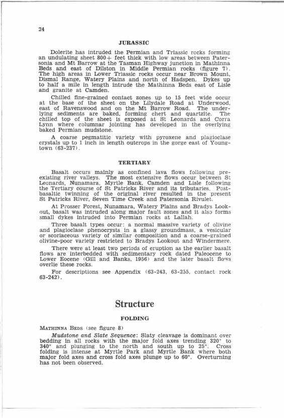
24
JURASSIC
Dolerite has intruded the Permian and Triassic rocks forming an undulating sheet 800 + feet thick with low areas between Patersonia and Mt Barrow at the Tasman Highway junction in Mathinna Beds and east of Dilston in Middle Permian rocks (figure 7). The high areas in Lower Triassic rocks occur neaf Brown Mount, Dismal Range, Watery Plains and north of Hadspen. Dykes up to half a mile in length intrude the Mathinna Beds east of Lisle and granite at Camden.
Ch11led fine-grained contact zones up to 15 feet wide occur at the base of the sheet on the Lllydale Road at Underwood, east of Ravenswood and on the Mt Barrow Road. The underlying sediments are baked, forming chert and Quartzite. The chilled top of the sheet is exposed at St Leonards and Carra Lynn where columnar jointing has developed in the overlying baked Permian mudstone.
A coarse pegmatitic variety with pyroxene and plagioclase crystals up to 1 inch in length outcrops in the gorge east of Youngtown (63-237).
TERTIARY
Basalt occurs mainly as conflned lava flows following preexisting river valleys. The most extensive flows occur between S t Leonards, Nunamara, Myrtle Bank, Camden and Lisle following the Tertiary course of St Patricks River and its tributaries. Postbasaltic twinning of the original river resulted in the present St Patricks River. Seven Time Creek and Patersonia Rivule t.
At P rosser Forest, Nunamara, Watery Plains and Bradys Lookout. basalt was intruded along major fault zones and it also forms small dykes intruded into Permian rocks at Lallah.
Three basalt types occur: a normal massive variety of olivine and plagioclase phenocrysts in a glassy groundmass, a vesicular or scoriaceous variety of similar composition and a coarse-grained olivine-poor variety restricted to Bradys Lookout and Windermere.
There were at least two periods of eruption as the earlier basalt flows are interbedded with sedimentary rock dated Paleocene to Lower Eocene (Gill and Banks, 1956) and the later basalt flows overlie these rocks.
For descriptions see Appendix (63-243, 63-255, contact rock 63-242>'
Structure FOLDING
MATHINNA BEDS (see flgure 8) Mudstone and Slate Sequence: Slaty cleavage is dominant over
bedding in all rocks with the major fold axes trending 320 0 to 340 0 and plunging to the north and south up to 25 0
• Cross folding is intense at Myrtle Park and Myrtle Bank wh~re both major fold axes and cross fold axes plunge up to 600
• Overturning has not been observed.
.. • =
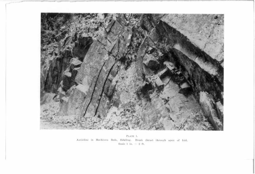
P('ATK 1-
Anticline in Mathinna Bcd~. S idf!!inR'. Ureltk thrust throu;.:-h apex of fold.
SClIlc ! in. 2 rt.

PI.ATE 2.
r:lnci!1ted p:lI('ment nn lIhnl(' in Mnlhinnn Beds, Pater!l:lni.!. Srnle I in. 3 rt.

PLATE 3.
Sheet jointinsc in dolerite, Mt Hllrrow. Scale I in. I fl.

PLAn; 4.
JointinlC in duleri te, Cornl Linn .

PLATE 5.
Interbedded Tertiary lluartl: conglomerate and sandstone, St Leonards.

PLAn: 6.
Detail plate [i shuwing imbricate stl'ucture of Ilcbbkg anll gl'atling in riner bed::;,
Scale 1 in. = 1 ft,

Pl..l.n: i.
Tertiary dolerite conglomerate. Junction of E!Ut Tarnal" Highway and Lefroy Road. Pebbles of dolerite in a clay matrix cont9.ining plant f'·agments. Scale I in. =:: 6 in.

PLAT!; 8.
Mt Arthur from Mt Barrow showing pre-Permian surface and backgrOU!1d with b:9.Salt co>'ered hills 11\ middle distance. Basa! Permian rocks in fOI·ellround.

MTARTHUR
________ !>pLERITE TOP LIFFEY GP. , ___ --RQ!::~~I!-E-_-SCREE&-- _- / SUB PERMIAN
______ _ ..!'ERMIAN -'T.~L"YS ,-- SURFACE B_A_li. ...... I..J_-=-::.-:=.::---_-...:------ ____ ------------MATHIN I DO i-E-R- -~- - -=--'"" PERMIA-- -----=--_--= =:== == = ::.-"..- -----~!'-- BEDS
ITE _------~----- --,----
----MATHINNA BEDS
APPROX. BASE OF PERMIAN __ -R_OCKS ----- ------- ----- --------_ ..... --- --------- -----... -
LOWER PERMIAN
5cm

I
PLATE fl.
Pcrigiacilli ruck stream>! in foregruund with cUR"e.; uf tilted fault block,,; ::;howiu\: in middle dititRnc\.!. Tamar Valley in back g round,

, , 800-1200 LEVELS IN DOLERITE
- - ---- - - -------- _ _ ___ _ _ ______ _________ -'T"A .. A "'-- -\JALLE"- -- ---______ ___ __-:...--::.=--- - --- ___________ ______ __ lO ..... I!'1.I:\.. __ .!"D 1 ______ _
-- - - .:::.::.=::.::...-:..--- - - ---- ----- - -".- ------------.... .... ------ __ __ ~ .. :::::._=_::~::: .. -_=_ _____ 7 t1PFAUL TED EDGE --...,,---------~-_ __ - ------- ,/ OF TILTED --, / ->-- --- ---
_c:=~:=:.:::.=~-_ // DOLERITE BLOCKS --.> ,,' ."........... -_ ... :: .... - .....
=:7---~~-:I~~~:.~~~-R~~~--S~-:::?~;=::~~~~--,--/'----L--__ J ---/ I "
- - ------_ ............ \ ------ - - ----- \ ", - --- ------\ / \ , \ , \ '
-/ /
/
-... ... ~ ~ ',_1
, I DOLERITE OUTCROP WITH ICE
Scm
WEDGED JOINTS

PL"n: 10. Re~enl flood plains, N. Esk River in foreground with U)l faulted dolerite block
in ha('k~I'ound showing- well developoo 600 (1. and 1,200 (1. levels.

>
CATARACT GORGE SOUTH ESK RIVER
I I ' ~::'I~~~;LU_EE_RR_nl~n~~_-~--_-_-_-_---_-_-_-__ -_------~~~_~~;=-~~-~--, --~--_-_--------------------------~OO, .. _ ..... , ",,"'" ...... ----- 600
----- ' / ----- ...... LAUNCESTON TERTIARY BEDS ---------_ ------ - -- -- -- - --- - --------------------------------------------------
DOLERITE
FLOOD PLAIN NORTH ESK RIVER
-----------~----====~===::::::::::=== TOP OF DOLERIT E SHELF WITH REMNANTS OF
PERMI A N ROCKS
Scm

1
P LAT!': 11.
SC l'ee 8101100, Mt BalTow, Scree composed of angular dolerite blocks up to 20 ft. in size with random orientation.

0·· . .
MAGNETIC NORTH
0-V
STEREOGRAPHIC PROJECTION Of 58 fOLD AXES IN M ATHINNA BED S
CONTOUR INTERVAL 1-3-5-7-9-117. PE R 17. A REA
FIGURE 8 .
25
Mudstone and Sandstone Sequence: The major fold axes trend 320" to 340" and plunge to the north and south up to 10° commonly and rarely up to 25°. Folding is usually asymmetrical and overturned beds occur in small sections.
In both sequences the major fold axes appeal' to be over 6 miles in wavelength while the minor fold wavelengths vary from 1 mile to 50 feet. The wavelength of the cross folding varies from 1 mile to 100 feet .
PERMIAN AND TRIASSIC
Generally the Permian and Triassic rocks strike between 320" and 340" and dip towards the SWat 5° to 20". The calculated dip within fault blocks is 5° and the observed discrepancy is due to numerous small non-mappable faul ts or movement along joints.
I n the Karoola-LaUah area folding occurs with a fold axis plunging at 8° towards 2100
•
JURASSIC
Dolerite has intruded the Permian and Triassic sedimentary rocks In the form of an undulating sheet (dips less than 5°) with low areas near Patersonia and Dilston. Except for small dykes no vertical or high angle contacts occur.
Scm

I
~
26
TERTIARY
Where good exposures occur. the Tertiary beds are flat lying or dipping at low angles with no preferred orientation except in small areas where high dips probably due to current bedding. slumping and drag adjacent to faults occur.
These flat lying sedimentary rocks indicate that the tilting of the Permian and Triassic beds and the dolerite occurred prior to Tertiary deposition.
FAULTING
The sedimentary rocks and dolerite have been disturbed by normal faults. generally trending NNW-SSE and down throwing to the east.
Subsidiary faulting trending ENE-WSW generally downthrows to the south with minor faulting trending E-W, NNE-SSW and NW -SE but with no consistent displacement.
Major NNW -SSE faults with probable displacements over 500 feet extend through Bridgenorth. Trevallyn. Prosser Forest. K aroola . Weaver Valley, Lllydale and Patersonia. The fault pat tern is best displayed in the Lilydale-Turners Marsh area.
The linears mapped in the dolerite represent major joints. which could be movement zones. but displacement cannot be proved. Some lineal'S show movement by slickensides but frequently direct evidence of movement is lacking.
Three ages of faulting have been identified. The earliest movement was pre-dolerite intrusion so there was no displacement of dolerite boundaries, but over 100 feet displacement of the underlying sedimentary rocks has been observed 'between Permian sedimentary rocks and Mathinna Beds south of the Mt Barrow turn off from the Tasman Highway.
The major movement has been dated as post dolerite intrusion and pre-Tertiary sedimentation with minor movements carrying into the Tertiary. Displacements along these faults are the same for Permian and dolerite horizons but basalt was unaffected as it post dated the faulting. Faulting in the Mt Barrow. Mt Arthur, Karoola and Launceston area is of this age.
Two faults of post basalt age occur at Patersonla and Myrtle Bank. At Patersonia both basalt ·base and underlying dolerite base have been displaced by the same amount. but at Myrtle Bank no displacement of the underlying rock can be determined. Displacement is between 75 and 100 feet. with the southern block downfaulted.
Multiple movement is shown in the Weaver Valley where dolerite intrudes upper Permian sedimentary rocks on the eastern wall and lower Permian sedimentary rocks on the western wall. The displacement in this area of dolerite is approximately 200 feet and in the sedimentary rocks 600 feet. showing two movements along this fault zone.

· . . . . . , ..... . . . . . . . .... ...... .
....... · ..... . . . . . . . · . . ... . . . . . .
=------<=1--~---.OIF"''' - 9$'"
=---~ ... --
Scm
LAU"K~tON
\
/ ,"" ....
FiGURE 9.
Development or Tamar Trough.

..,. -=---!i;iI ,--S!m:l -- ... - . ..
""'" ----" = -_._-"
Scm
,,-
/
FIGURE 10.
:.1 DcveloJlmcnt of Tamar Trough.

'.' .
,,0119''' ' OS'"
0= =
Scm ~I
/ ®
<x . ..... ", .. "',.",""'''''''.
/~ ~-t
FIGURE 11.
Development of Tama r Trough.

"""" ""'" = c:::!i:!I -= --_._'". = mTI
=
Scm
@
/
LAUNCESTON
.' ,,'
........ T ... "''''.·~" ""'"
~-t
F[GUR~: 12.
Development of Tarnal· Troui'h.

31
TA.'\IAR TROUGH
The term " Tamar Graben" is well established and Gill (1962 ) reviewed the Tertiary deposits of the Launceston district under this heading. Although Carey (947) used the term Tamar Trough, examination of his figures 2, 3 and 4 has inevitably resulted in the interpretation of a graben for the structure.
Detailed mapping of rock distribution and bore cores shows that structural control is ·by slip faulting and tilting and the name should revert to Tamar Trough.
Detail of the development of the t rough can be seen In figures 9-12.
Economic Geology BAUXITE
St Leonards Owen (1950) stated that the bauxite deposit occurs on the
northern side of Kings lane between Scottsdale and Corra Lynn roads, outcropping on a nsrrow bench for 2,900 feet on the valley side. Smaller discontinuous bodies occur on the southern side of t he road at a similar elevation. The bauxit e rests on dolerite and is overlain by Tertiary deposits and basalt.
Extensive sampling by the Australian Aluminium Commission in 1946 indicated 86,500 cubic yards of bauxite assaying 40.7% Al~, and 26.3% Fe:rO, overlain by 160,800 cubic yards of overburden, mainly clay. sand, pebbles and sandy clay, sometimes containing magnetite nodules. The economic bauxite ranges in thickness from 5.0 to 8.5 feet averaging 5.25 feet and the overburden ranges from a few inches to 19.5 feet averaging 9.0 feet.
The total reserves in the St Leonards district have been estimated at 160,500 tons dry ore assaying 41.5 % AlzO, overlain by 198,000 cubic yards of overburden , mainly clay.
Launceston In the vicinity of the Gorge Picnic Ground, Basin Road a nd
Connaught Crescent bauxite overlies dolerite . These deposits are of no economic importance as they are too small or occupy buil t up areas. It Is estimated that 100,000 tons of bauxite occur in the largest deposit at Connaught Crescent.
CLAY
In the Launceston city area the Tertiary deposits are extensively Quarried for brick, tile and pipe manufacture. The sandy and clayey beds are mixed to make suitable material. Production of clay prior to 1958 has not been recorded. Production and producers from 1958 to 1964 inclusive are:-
Machen Bricks Ltd., Kings Meadows 95,811 cubic yards
Huttons Bricks Pty. Ltd., P rospect 77,052 cubic yards
McHugh's B rick Pty. Ltd. (now Humes Ltd. ) Pros-pect Vale 19,249 cubic yards

L
32
John Campbell Pty. Ltd., Launceston . 4,104 cubic yards
G. R. Wise, Young Town 1,248 cubic yards Wunderlich Ltd. used 23,976 cubic yards of clay for tile manll
facture but the material used at Kings Meadows was transported from Loira on the West Tamar.
COAL
Dilston
In this area two shafts were sunk for coal and one, 50 yards west of the Post Office, reached coal at 50 feet but was abandoned. The coal was of POOl' quality with high ash and did not burn readily.
Another shaft, 400 yards east of the Post Office, passed through chert and then clay. No coal was reached, but the clay was used for fire bricks.
The coal probably belongs to the LUfey Group as the rocks in which it occurs appear to be overlain by at least 200 feet of Permian mudstone.
DOLERITE
Dolerite is quarried in the Launceston area mainly at Mowbray and St Leonards, as an aggregate for concrete or as road material. Production in 1958 to 1964 inclusIve from the varIous Quarries is:-
Lilydale
Launceston Quarries, Mow-bray
G. Rouse, St Leonards E. C. MCHugh, Launceston Launceston Corporation
Quarry, St Leonards
R. K . Sulzberger, Launceston
GOLD
241,701 cubic yards 82,609 cubic yards 18.609 cubic yards
14,199 cubic yards (1.1.58-31.12.59 )
2,660 cubic yards
Kelp and Boultbee's Prospect: Nye (1924) stated that a shallow shaft and a dip tunnel a chain in length were excavated near the SE corner of F . Kelp 's property 3 miles NE of Lilydale.
The tunnel was commenced in basal Permian sandstone and pebbly mudstone passing into grit, blue mud and Mathinna slate. A few feet from the entrance a large boulder of quartz was encountered which assayed 4 oz gold/ ton. No other gold was found.
Boaks Creek: Nye (1924) reported a vertical shaft sunk 96 feet in basal Permian rock on the flats bordering Boaks Creek half a mile NE of Lllydale. No gold was recorded.

,I
33
Myrtle Bank Eastburn and Barwick Prospect: Blake (1934) reported that
several shallow trenches and a narrow open cut 6 feet deep had been made over an outcrop of white quartzite and light brown sandstone. 3 chains long, from which prospects of gold and matrix tin were said to have been obtained. No trace of gold, silver or tin was found in seven samples taken from the outcrop and workings.
Burns Creek Golden Hill Mine: The information on this mine is taken from
an undated plan in the Department of Mines, prepared by W . H. W11l1ams, Inspector of Mines. It shows an adit approximately 500 feet long connected with a shaft 98 feet deep. In the shaft the main drive at the 36 feet level was 100 feet long, ,and at the 40 feet level another 70 feet of drive and 240 feet of cross cut were excavated.
Values were very variable. the richest vein varying between 6 inches and 11 inches wide and assaying from 6 dwt. 13 gns. to a trace gold per ton and from 2 dwt. 15 gns. to a trace silver per ton.
In the adit the lode varied between 3.5 inches and 15 inches and showed a trace of silver in one area only. Arsenic varied between 9.67 % and 'a trace. Minor stoping in the adit to a heigh t of 17 feet over a. length of 20 feet following a lode 6-15 inches wide assayed a trace of silver only.
W111iams (1930) stated that this mine was being prospected and developed In 1929, and a battery was erected towards the end of the year.
GRAVEL Gravel is Quarried from the Tertiary conglomerate beds at
St Leonards, Alanvale. Legana and Prospect and from river terraces and flats near St Leonards and Relbla. Laterite overlying dolerite is used as road gravel from Dilston, Prospect and Trevallyn.
Production of gravel from 1954 to 1965 inclusive is:-Clays Pty. Ltd., Launceston 10,000 cubic yards E. B. Watchorn Estate,
Prospect .. E. C. McHugh, Launceston J. Wise, Young Town A. V. Watts, Launceston
LIMESTONE
4,810 2,034
930 460
cubic yards cubic yards cubic yards cubic yards
Nye (1924) and Hughes (1957) reported limestone three feet thick on the hillside east of the Pipers River road bridge on the Bangor Road. An analysis of the limestone showed:-
Acid insoluble AIIOl Fe~Ol CaO . M gO
% 14.7
0.9 1.0
45.0 1.2
Similar limestone 30 feet thick outcrops in the raU cuttingS at Downie and on Mt Barrow and Mt Arthur where the thickness Is less than 5 feet. The limestone 15 of no economic importance.

I--
34
OCHRE Twelvetrees (1917) reported on a deposit of ochre at Paint
Mine Hill near Mowbray. which had been investigated previously about 20 years earlier. Trenches were dug to a depth of 5-6 feet and red and yellow ochre exposed. Twelvetrees considered the ochre to be due to the decomposition of dolerite and gave '~he following assays:-
Iron sesQuioxide Alumina Silica Magnesia Lime water
Red Ochre.
% 45.28 13.72 32.40
1.84 0.91 5.60
Y ellow Ochre.
% 42.62
8.78 39.52
1.50 1.28 5.80
Analyst: W. D. Reid .
Red Ochre,
Iron Oxide Silica Alumina Magnesium and Calcium Salts Combined Water
% 55.555 37.5
4.166 1.388 1.389
Yellow Ochre.
% 43.678 40.613
9.195 2.683 3.831
Analyst: A. Flounders. The deposit was worked for some years in conjunction with
a deposit near Beaconsfield and the product was used for paint manufacture by the Serpentine Paint Company of Launceston. Total production is unknown.
OIL SHALE Twelvetrees (1918) and Nye (1924) reported an occurrence of oil
shale in a bed 18 inches to possibly 3 feet thick at the bottom of a shaft above the sandstone cliffs on the east bank of the Pipers River above the bridge on the Karoola-Bangor Road. The shaft is now partially filled but pieces of shale occur on the associated dump. Analysis of the shale (Twelvetrees. 1918) showed:-
Volatile Combustible Matter F ixed Carbon Ash Moisture @ lOO GC
% 27.80 21.30 50.10
0.80
100.00
The shale was tested at the Railton-Latrobe Shale Oil Works yielding:-
Crude OU (S.G. 0.920 @ 60 ' F) 19.7 gal/ton
Ammoniacal Water (un-known concentration) 14.0 gal/ton
Permanent Gas 2.000 cubic feet / ton This shale may possibly cover an area of one acre and is of
no economic importance.

I
Ii
I
35
SAND
Sand used mainly as a fine aggregate in concrete and a dilutant for clay in brick manufacture Is produced by the weathering of the sandstone and the sheddIng of fine quartz sand on h1ll slopes.
The larger deposits are near DUston, Swan Bay, Alanvale, Legana and Prospect. At Prospect sand Is produced as the fines from the washing of gravel.
Production of sand, 1958-1964 inclusive 15:E. B. Watchorn Estate,
Prospect Clays Pty. Ltd. , Launceston E. C. McHugh, Launceston A. V. Watts, Launceston
8,381 cubic 5.200 cubic
614 cubic 168 cubic
ENGINEERING GEOLOGY
Foundation Conditions
yards yards yards yards
As Launceston is situated predominantly on the Tertiary deposits of the Tamar Trough, some work has been done recently on the suitability of this material for carrying foundations.
Following a series of landslips in the Lawrence Vale area and consequent damage to roads. sewerage and private property. a geophysical survey was carried out by the Bureau of Mineral Resources, Geology and Geophysics (Polak, 1964: Wiebenga. 1964). Other references to foundation conditions in the Launceston area are contained in Polak (1962), Jennings 0963, 1964 a, b ) and Longman (1963).
References BANKS, M. R .. 19&8-Reeent adtlitiolUl to the knowledge of the Permian SYlltem
in Tasmania: in Symposium on Gondwanaland. 20th Int. Geol. Conn., Mexico. pp. 151-177.
----- -- 1962-Permian ; in The Geoloa-y of Tasmania. J. Geol. Soc. AUllt . 9 (2), 189-215.
BLAKE, F .. 1934 - Report on Eastburn and Warwick Prospect at Myrtle Bank. Rep. Dep. Min. Ta •. (U-npubli.hed).
CARl:Y, S. W., 1947--Geology ot the Launceston Dis trict. Ree. Q. Vic . M"" .. LaulWle,ton. 2 (1).
DIRECrOR OP MINES. TASMAN IA- 1958-1964 Annual Report.. GILL, E. D. 1962-Tamar Graben; in The Geology of Taamania. J. Geol. S oc.
Aut., 9 (2) 236-237. Gru.., E. D. and BANKS. M. R. 1956--Cainowie his tory ot tbe Mowbray Swamp
and other areas of North-Western Tumanla. Ree. Q. Vic. Mil'., La",,ee,t01t, No.6 (N.S,).
GOUI-D. C., 1864- Report on part of the County ot Dorset. Rep. Ta •. H ouse of AIJ8embly, 46 (for 1864).
HUGHES, T. D. 1957- Limeetones in Tasmania, Miner. Re,ouT. Geol. SUTV. Tall., ~O.
JENNINGS. I. B .. 1963-Geological factors affeetin!" proposed building at COIIll'rove Park, Launceston. Tech. Rep. Dep. Mtn. Tall., 7, 87.90.
------ 1964 {a)-Interim report on site eondltlonIJ at Cosgrove Park. Launceston. Tech. Rep. Dep. Min. TIl3., 8, 88-90.
------1964{b) - FoundatioTm for Ainslie House, COIIgrove Park, Launceeton. T ech. Rep. Dep. Min. TIl3., 8, 90-92.
LONGMAN M. J., 1963--Geolosrleal investigations in the LBunceston area- Laun. Cl'ston Grammar School site. T ech. Rep. Dep. Min. TIU., 7, 46-47.
McKELLAR. J., 1957--Geology of Portion of the Weatern Tiers. Ree. Q. Vic. MUll .. Launeeston. No. 7 (N.S.).
NYI!:, P. B., 1924- GeclOln' of the Lilydale-Lebrina District. Rep. Dep. Min. Tall.
(Unpublillhed). Bull. Bu-. 'f,·.,-. OWBN, K. 8., 19M- The Bauxite Reaourres of Tasmania. ' " , R ellouT. Au-d., 24.

36
POLAK, E. J., 19G2---Queen Victoria HOIJpitai site seismic lurvey, Launceston. Tumania, 1961. H~c. Bur. Miner. Re.our. AtUt., 1962-180 (Unpublished.)
1964-Lawn'nce Vale &,eopbysieal survey, Launeeston, Tasmania, 1960. Ree. Bur. Miner. ~e.ouT. Au.t., 1964/121 (Unpubli.hed).
TWELVBTRDS, W. H .• 1909-The Lisle Goldfield. BvU. Geol. 8tlrv. TIIB., 4. -----;:--- 1917- A deposit of ochre near Mowbray. Miner, RellouT. Geol.
S"",, TGII., 5. - - ---,::-- 1918--Gold and oil shale at Bangor. Rep. Dep. Min. T(U.
(Unpublyhed) . WELLS, A. T., 1957---Geology of the Deloraine-Golden Valley Area, TlUlmania.
Ree. Q. Vic. Mus., Launce.t<m. No.8 (N.S.), WIEBENCA, W. A., 1964-Lawrence Vale and H oepital areas: borehole logging,
Launceston. Tasmania. 1959-60. Ree. Bur. Miner. ReBouT. Au.t., 1964/ 120. (UnpublUhed) .
WILLIAMS, W. B., 1930-Report of Inspector of Mines (Launceston) for 1929. Ann. Rep. Dir. Min. Ttu. for 1929, pp. 87-40.

37
Appendix
PETROLOGICAL EXAMINATIONS OF ROCK SPECIMENS FRO~£ THE LAUNCESTON QUADRANGLE
by G . Everard
61-78 Mt Barrow (S30S00E 90S000N) The specimen 1s a granitic rock of medium to coarse grain.
Visible in hand specimen are colourless transparent crystals of feldspar with pearly lustre on the cleavages, irregular grains of milky Quartz, black prisms of hornblende, and lustrous black books of biotite with slightly crumpled laminae. There are some dark oval patches of much finer granularity, about an inch in length.
In thin section the texture is hypidiomorphic. Plagioclase. quartz. orthoclase, hornblende and biotite occur in that order of abundance, with magnetite, apatite and zircon as accessories, and the secondary minerals chlorite, sericite and calcite. A little augite is present with the hornblende.
Plagioclase occurs in subhedral crystals averaging 2-3 mm in length. Carlsbad. Mannebach and very fine lamellar twinning occur, and extinction angles and refractive indices place this feldspar within the andesine range. Zoning is very common but extinction angles show that the composition varies within the andesine range. Andesine may be partly enclosed by orthoclase. 'but the relative amounts of the species prevents this relationship trom being common. Hornblende. too, tends to wrap around the ends of andesine crystals ; quartz is interstitial, so that the order of crystallization is normal. Although the feldspars appear very fresh in handspeclmen, some alteration to sericite can be seen in thin section of both orthoclase and plagioclase and there is also some alteration to calcite.
Hornblende occurs in ragged prisms with pleochroic scheme X = yellow. Y = olive green, Z = green and absorption Z > Y > X. The extinction angle zc = 20 °. It has a little colourless augite developed in parallel position, usually well inside the crystal boundaries. The augite has a larger extinction angle Bnd high er refractive indices than the hornblende.
Biotite is common and occurs with the hornblende. It is brown and highly pleochroic and shows alteration to a green biotite and to chlorite. It has inclusions of magnetite, and zircon with pleochroic haloes.
Apatite is a common accessory, occurring in numerous small needles with hexagonal section that penetrate other minerals.
There are also a few ragged patches of calcite. The rock is a normal granodiorite.
62-361 Camden (S3SS00E 902S00N) Mesocratic, porphyritic rock conSisting of oblong, slightly
rounded crystals of feldspar up to 6-7 mm long. in a fine grained grey matrix. Books of black biotite 1-2 mm across are also plentiful.
In thin section the texture is markedly porphyritic with phenocrysts of feldspar and biotite in a very flne grained matrix of quartz, feldspar and biotite.

L
38
The feldspar phenocrysts appear to be of two generations: the earlier, showing simple or no twinning, are deeply embayed and may assume bizarre outlines ; the later show peripheral corrosion and have lamellar tWinning. Both come within the oligociaseandesine range. Pericline twinning also appears and some crystals sh ow peripheral zoning. Biotite may show alteration to chlorite and carbonate. Opaque mineral consists of a little euhedral magnetite.
The rock is a porphyrite.
62-363 Camden, near sawmill (534500E 904000N) The specimen Is a medium grained rock consisting of dark
green crystals of hornblende and opaque white feldspar, some of which is discoloured to a brownish pink.
In thin section the texture is panidimorphic and the minerals present are feldspar and hornblende, with accessory magnetite and apatite and a little secondary carbonate.
The hornblende Is fairly fresh with but slight alteration to chlorite. It is pleochroic with X = pale brown, Y = greenish brown, X = olive green and absorption Z > y > X.
Most of the feldspar is brownish and cloudy and · much sericitlzed. There Is some fairly fresh labradorite with compound twinning.
Magnetite and apatite occur as smaller euhedral crystals and there is a. little carbonate.
The rock is a lamprophyre.
62-432 N of Burns Creek (S33S00E 900000N) The specimen Is a dark grey rock consisting of a network
of prismatic hornblende crystals averaging 2 mm in length, the interstices being filled with feldspar.
In thin section the texture is panidiomorphic with prismatic crystals of hornblende and plagioclase. The hornblende is extensively altered to green chlorite, and the feldspar Is cloudy and sericitized. Unaltered plagioclase may show twinning and zoning. Extinction angles on albite twins average 20° and indicate andesine. The extinction angles vary outwards through the zoned crystals to 0° on the peripheries indicating an andesine-oligoclase range. Some of the fresher feldspar is free from twinning but the refractive index is everywhere greater than that of balsam.
There is a little interstitial Quartz and apatite needles are common. Pyrite crystals are common.
The rock is a hornblende lamprophyre.
63-232 Tasman Highway. Sideling (S30S00E 917200N ) The handspecimen is a fine grained, finely banded, bedded
rock, brownish grey in colour. Current bedding with truncation of the upper parts is well shown. Coarser grained beds, with particles up to 1 mm across, occur.
In thin section the rock consists of an aggregate of grains of quartz, sericite and opaque clay minerals somewhat stained by limonite. The coarser particles mentioned above, prove to be compOSite masses of Quartz grains. under magnification averaging 0.03 mm across, whereas the finer particles are of verj' fine silt and mud grade.
The rock is a mudstone.

39
63-233 Mt Arthur Road (516800E 918000N) The specimen is a fine grained, schistose. crenulated silver grey
rock. In thin section it consists of sericite and quartz in grains up
to 0.03 mm long. Shearing is intense 'but in some places has been a little disturbed by enclaves of recrystallized Quartz. In places sericite appears as minute knots with cleavage at an angle to the general rock cleavage, indicating rotation, and possibly replacement of albite.
The specimen is a phyllitic rock.
63-234 Near Myrtle Bank (523500E 914000N) The specimen is a pale grey. fine grained rock of very uniform
texture. In thin section the rock consists of a mosaic of subangular
Quartz grains averaging about 0.075 mm across. The grains are tightly packed but there are frequent irregularly shaped voids in the rock.
Almost every quartz grain exhibits cracks thus causing the rock to seem even finer grained. There is a little very fine grained interstitial quartz and a little interstitial organic materiaL There are also occasional grains of zircon, topaz, tourmaline, &c.
The rock is a sandstone.
63-235 Musselboro turnoH (531000E 889500N) The handspecimen is a very fine grained, uniformly grey rock
with sparse colourless ,glassy crystals about 0.5 mm across. The thin section is darkened by a fine dust of evenly scattered
minute particles possibly mainly of carbonaceous material, although magnetite and pyrite are also present. Otherwise the rock is an aggregate of extremely fine particles of quartz, feldspar and sericite, the two former minerals giving very faint greys under crossed nicols. Some of the larger fragments are capable of being individually identified and consist of Quartz, feldspar, sericite and rock fragments.
The rock is an indurated mudstone.
63-236 Logging track N of Burns Creek (535000E 899000N) The handspecimen is a medium grained mesocratic rock with
crystals of feldspar, biotite and hornblende 2 or 3 mm long in a finer grained quartzo-feldspathic matrix .
In thin section the texture is poikilitic. Plagioclase feldspar occurs in large subhedral crystals together with irregular crystals of hornblende and somewhat ragged plates of biotite with interstitial Quartz. The plagioclase may contain a few inclusions of hornblende and oligoclase but the hornblende and especially the Quartz are full of inclusions of the other minerals. The inclusions are euhedral to subhedral and are of the order of 0.25 mm long.
The feldspar generally belongs to the oligoclase-andesine range. Some of the larger crystals are zoned but the range in composition does not seem to be very great. Tiny grains of opaque iron are minerals are widely disseminated through the section.
The rock is a tonalite.

40
63-237 Youngtown (507500E 890500N) The handspecimen is a dense, medium to coarse grained rock
showing faces of prismatic and acicular crystals. The rock is heavily stained by iron oxides.
In thin section the rock has a coarse grained, confused structure typical of reaction under thermal metamorphism. Iron staining and cloudiness obscure the section. Plagioclase feldspar is common in broad laths showing simple twinning. It is extensively cracked and the cracks are filled with brown oxides of iron. A neutral to brownish grey augite occurs in euhedral crystals that have been very extensively corroded. Quartz and cordierite are present in clear irregularly shaped grains, and ilmeno-rnagnetite in large skeletal crystals showing alteration to leucoxene. Brushes. and radiating sheaves of sillimanite needles are common.
The specimen is a sillimanite contact rock.
63-238 Lisle Road (522200E 912000N) In handspecimen the rock is fine grained and greenish with'
dark grey bands, Indicating the original sedimentary bedding which has been disturbed by shearing.
In thin section the grain size varies, possibly due to the dis ruption of graded bedding. The coarsest grained patches show Quartz grains grading up to fine silt. Quartz is the principal mineral with much muscovite and chlorite. Iron staining occurs. and the colour of the dark bands is due to hematite.
The specimen is a phyl1itic rock.
63-239 Myrtle Bank (524100 E913200N) In handspecimen the rock is weathered and sheared, fine grained
and argillaceous. In thin section it is a felted mass of fine sericite, with clay
minerals and iron oxide. Coarser grained material with Quartz grains up to 0.02 mm occur in small irregular lenses. Shearing is well shown by wavy lineations of limonitic material.
The specimen is a phyllitic rock.
63-240 Highway 2 mile S of Lilydale (512000E 918500N) The handspecimen is a pale coloured rock composed of rounded
to angular fragments of Quartz, kaolinized feldspar and rock fragments in a fine grained matrix. The rock fragments are of Quartzite, mudstone and schist and are up to 3cm long.
In thin section can be seen rounded to angular fragments of Quartz, fresh feldspar, Quartzite, schist, mUdstone, &c .. in a. very flne grained isotropic matrix.
The rock is a subgreywacke.
63-241 Diddleum Plains, St Patricks River (536000E 911000N) The handspecimen is a somewhat weathered, fine grained
rock with phenocrysts of Quartz and pink feldspar about 1 mm across.
In thin section the matrix consists of pinkish laths of feldspar with interstitial Quartz, brown pleochroic prisms of hornblende and shapeless masses of biotite weathered to a yellow colour. There is a very minor amount of iron are minerals in minute crystals.

41
The phenocrysts consist of rounded quartz grains and euhedral feldspar. The feldspar in oligoclase-andesine.
The rock is a granodiorite porphyry.
63-242 7EX Broadcasting Station (515000E 895000N)
The handspecimen is a fine grained brown and white mottled siliceous rock.
In thin section the rock consists of angular to subrounded grains of quartz averaging 0.25 mm in a matrix of fine s1liceous particles and opaque limonitic material. There are also occasional remains of feldspar crystals.
The rock is a fine grained sandstone.
63-243 Near Bradys Lookout (492000E 908000N)
The handspecimen is of a fine grained, dense black rock with minute vesicles some filled with zeolite.
In thin section the texture Is intersertal with colourless glass and granular tltanaugite in the interstices of twinned laths and needles of feldspar. Olivine is very plentiful In cracked and rounded crystals and aggregates. Euhedral iron are minerals are common.
The rock is an olivine basalt.
63-244 Chalet, Mt Barrow Road (530750E 904750N)
The rock in handspecimen is medium grained, consisting of quartz, kaolinized feldspar and ,biotite. and contains a cognate xenolith of similar but fine grained material.
In thin section the texture is hypidiomorphic consisting of interlocking grains of clear quartz, oligoclase showing polysynthetic twinning in one direction, red-brown biotite and accessory iron ore minerals associated with it. The biotite shows many pleochroIc haloes and inclusions of zircon. The feldspar is altered in part to kaolin with very low birefringence and strongly birefringent sericite.
The xenolith consists of quartz in equidimensional grains, biotite and magnetite with a little very flne grained interstitial material.
The rock is a granodiorite.
63-245 Lisle Road near Forestry Corner (522950E 915800N)
In thin section this rock is a mosaic of Quartz grains 0.02 mm across with in terspersed books of biotite. ragged masses of sericite and areas of cryptocrystall1ne s1l1ca. Minute crystals and aggregates of magnetite are common.
The rock is a hornfels.
63-246 Lisle Road, near granite contact (521450E 918200N)
The handspecimen is a flne grained. pink, porous rock with much seriCite; large flakes of mica and dark stainings appear on one face.
In thin section the rock consists of Quartz grains averaging 0.02 mm across in a matrix of very fine grained sericite. It is heavily stained by iron oxides.
The rock is a hornfels.

42
63-247 Arthur Road 1 mUe E of LUydale (5 l3500E 9l9000N) The handspecimen is a grey and white. finely banded, fine
grained rock. There is a strong cleavage alon g the ·bedding planes which are polished and show cleavage lines of a more imperfect cleavage at an angle of about 300 to the bedding.
In thin section both bedding and cleavage are well shown. The rock consists of quartz and sericite with much black opaque carbonaceous material, possibly graphite. and white opaque shreds and patches of very fine grained clay minerals. somewhat stained with limonite. Quartz particles range up to 0.02 mm but the average grain size is much less.
The rock is a banded carbonaceous shale.
63-248 Loggin g track N of Musselboro (533000E 895000N) The handspecimen is a coarse grained, dark coloured holo
crysta1l1ne rock. White rectangular crystals of feldspar up to 5 mm across and books of biotite up to 2 mm across are prominent.
In thin section the texture is hypidlomorphic consisting of oligoclase. biotite and hornblence with a little interstitial quartz. Inclusions of small twinned laths of feldspar are common in the other minerals. Small crystals of magnetite are widely disseminated and there is a little pyrite.
The rock is a diorite.
63-250 Railway cutting, Lallah (508000E 9l8850N ) The handspecimen is a fine grained, siliceous, friable rock ~
showing current bedding, and with much sericite in the bedding planes.
In thin section the rock consists of angular quartz grains averaging 0.075 mm across and much dark material of clay grade.
The rock is a siltstone.
63-252 Parsons Spur, Lisle (522000E 9l8000N) The handspecimen is a fine grained, dark grey rock with
minute, gUttering crystal faces. It can be scratched with a knife. Under magnification it is seen to consist of both black and white minerals and the glittering faces are of books of 'bjack and white mica.
In thin section the rock consists of a mosaic of angular Quartz grains about 0.075 mm across, with plentiful books of 'biotite of similar size, a UtUe muscovite and occasional small opaque grains of magnetite. Very minute particles of dust size are scattered evenly through the section. Under crossed nico}s an incipient granular structure appears -with grains of about 1 mm across composed of areas of the mosaic with similar extinction positions for the quartz grains so that the area extinguishes as a unit separated from adjacent areas.
The rock is a hornfels. 63-253 Lisle Road (523000E 9l6000N)
This is a pale grey. fine grained, sheared rock. In thin section the rock consists of angular quartz grains
about 0.075 mm across with interstitial sericite and other very fine grained material. Shearing is shown by semiparallel wisps and veinlets of sericite and very fine grained dark material.
The rock Is a sheared siltstone.

43
63-255 Railway cutting, Lallah (508200E 918000N)
The handspecimen is a massive. pale grey. fine grained rock. In thin section the texture if intersertal with a pale brownish
or greyish glass in the interstices between a net work of feldspar needles. Granules of pale coloured augite occur in the interstitial glass, and phenocrysts of olivine up to 1 mm long are common.
The rock is an olivine basalt.
63-256 Railway cutting, Lallah (508200E 918000NJ
The handspecimen is a fine grained, dark grey bedded rock, with a few very small white fragments visible.
In thin section the grain size is generally very fine but there are a few angular grains of Quartz and feldspar ranging up to 0.1 mm. Below this size the grains are unsorted and consist of quartz, feldspar and sericiUzed grains and minute particles of sericite and opaque argillaceous material.
The specimen is a greywacke.
63-257 Railway cutting, Downie (511300E 917800N)
The handspecimen Is a fine grained grey rock, slightly iron stained. A few particles up to 3 or 4 mm long occur ; but most particles are below 1 mm. Particles of quartz and sericite are visible in a very fine, slightly friable matrix.
In thin section the rock consists of poorly sorted rounded to angular grains of quartz, quartzite, feldspar, epidote and white mica in a very fine grained, opaque argillaceous matrix.
The rock is a coarse grained greywacke.
63-258 Railway cutting, Downie (511300E 917800N)
In thin section the specimen is a fine grained sheared rock containing angular grains of quartz averaging 0.03 mm across, a little feldspar and sericite in a semi-opaque matrix of sericite and agiIlaceous material. A few rock fragments, mainly quartzite, are also present.
The rock is a subgreywacke.
63-260 Upper Turners Marsh (504000E 918300N)
The handspecimen is a fine grained, cream coloured, slightly friable, siliceous rock.
In thin section it consists of angular and subangular cracked grains of quartz, averaging 0.05 mm across, with semi-opaque, argillaceous, interstitial material containing minute grains of Quartz and sericite, cementing the larger grains together.
The rock is a fine grained sandstone.
63-261 Road cutting S of Patersonia Creek (519000E 904000N)
In handspecimen the rock is pale coloured, fine grained and siliceous, except for iron stained areas.
In thin section it consists of angular quartz grains up to 1 mm across and occasional rock fragments in a very fine grained, opaque, iron stained matrix.
The rock is a fine grained sandstone.

44
63-262 Road cutting S of Patersonia Creek (S 190DOE 904600N)
The rock in handspecimen is fine grained. with some visible grains of quartz and small flakes of sericite. It is cream coloured with dark mottlings which disappear on roasting.
In thin section the rock consists of occasional shattered grains of quartz up to 0.25 mm across in a matrix of argillaceous and carbonaceous material containing minute angular grains of Quartz and white mica. The material is relatively unsorted and the finer material largely predominates.
The rock is a mudstone.
63-263 Road cutting S of Patersonia Creek (519000E 904600N )
The handspecimen is a flne grained, buff coloured rock, showing bedding and a rough cleavage at an angle to the bedding.
In thin section the rock consists of minute angular fragments of quartz with some feldspar in a matrix of fine sericite and opaque, white, argillaceous material. Although the grain size is very fine in general the grains are relatively unsorted and fragments occur up to 0.1 mm and more in length.
The rock is an indurated mudstone.
63-265 Ridge NE of Lallah (509000E 919300N) This rock is a sandstone similar to 63-261 but of coarser
grain with particles averaging 2-3 mm across.
63-266 Ridge N of Walker's Orchard (507000E 919500N) In handspecimen this is a fine grained, pale grey and white,
mottled, siliceous rock. In thin section the rock consists of angular quartz grains,
averaging 0.1 mm in diameter, wisps of sericite and rock fragments in a very fine grained opaque matrix of clay grade.
The rock is a mudstone.
Related Documents