Bulletin No. 282 A> Economic B) Descriptive Geplogy) 85 DEPARTMENT OF THE INTERIOR UNITED STATES GEOLOGICAL SURVEY CHARLES D. WALCOTT, DIRECTOR OIL FIELDS OF THE TEXAS-LOUISIANA GULF COASTAL PLAIN BY M. WASHINGTON GOVERNMENT PRINTING OFFICE 1906

Welcome message from author
This document is posted to help you gain knowledge. Please leave a comment to let me know what you think about it! Share it to your friends and learn new things together.
Transcript
Bulletin No. 282 A> EconomicB) Descriptive Geplogy) 85
DEPARTMENT OF THE INTERIOR
UNITED STATES GEOLOGICAL SURVEYCHARLES D. WALCOTT, DIRECTOR
OIL FIELDS OF THE TEXAS-LOUISIANA GULF COASTAL PLAIN
BY
M.
WASHINGTONGOVERNMENT PRINTING OFFICE
1906

CONTENTS.
Pvige.
Introduction...;........................................................... 9Acknowledgments..................................................... 9Previous knowledge of the region......................................... ] 0
Topography of the Gulf Coastal Plain..............:. .I......................... 11Rel i ef ................................. .^............................. 12Drainage............................................................. 12Timber............................................................... 12
Geology of the Gulf Coastal Plain........................................... 13Description of sediments............................................... 13Stratigraphy ........._... ............................................. 13
Difficulty of correlation............................................ 13Fossils.......:......................-....-...-....-....-......... 13Kennedy's general section........................................... 15
The mounds................................................'........... 16. Formations .............................................. .^. .\.... 16
Relative positions of formations..................................... 17Spindletop field............... ........................................... 18
Topography.......................................................... 18Area................................................................. 18Surface indications and first drilling......................:.............. ISWell sections. .'...........I...............................'............. 19Sedimentary formations above the oil.................................... 24
Sands............................................................ 24Gravel........................................................... 24Limestone........................................................ 25Shell beds...........................'............................. 25Clays....'....................................................... 25Lack of continuity............. '................................... 26Age of beds........................................................ 26
Rocks closely associated with the oil............................... ..... 26Porous limestone .................................................... 26Formation between oil horizons..................................... 28Formation beneath the oil rock........ '. ............................ 28Sulphur.......................................................... 29Gypsum.......................................................... 30Rock salt.......................................................... 31Pyrite........................................................... 31Position of the oil................................................. 31Generalized column............................................'.... 32
Geologic structure .................................................... 33Two or more oil horizons ........................................... 33Depths and dips of the oil rock...................................... 34Dimensions of the dome.............................................' 35Structure beyond the limits of the dome..............-....'............ 36
3
4 . CONTENTS.
Spindletop field Continued. Page.Gas......................................'..._..........._..._'........ 36
From above the oil.._.............../.........._.................. 36From the horizon of the oil......................................... ' 36
Salt water ............................................................ 37Production........................................................... 37
Quantity of oil............................................. '....... 38Character of the oil................................................ 38
Sour'Lake field............................................................ 38Surface indications and history.......................................... 38_
First observed evidence of oil....................................... 38Early exploitation................................................. 38Beginning of production.....................'....................... 39
Topography.......................................................... . 39Geologic formations.................................................... 40
Well sections..................................................... 40Coastal Plain sediments ........'..................... .^.............. 42Porous limestone.................................................. 42Formation below the limestone...................................... 43Gypsum.......................................................... 43Rock salt..:...................................................... 43Pyrite..........:...............'................................ 43
Structure............................................................. 43The sedimentary formations.............................:........... 43Structure indicated by the porous limestone..._._....'_.__..____.___._ 44Inferences......................................................... 44Nature of the limestone............................................ 45
Occurrence of the oil .................................................... 45Classification of wells.............................................. 45
. Wells in the limestone............................ .'L................ 45Wells in the sand.................................................. 46
Salt water............................................................ 46Regular advance.................................................. 46Irregular advance..............................J.................. 46Hot water ........................................................ 47
Gas.................................. ............................... 47Production........................................................... 47
Number of wells........................... J......................:. 47Quaiatity of oil.................................................... 47Character of the oil................................................. 48
Batsbn field............................................................... 48History...........................;...................-.............. 48Location and topography............................................... 48Limits of the field..................................................... 49Geologic formations ................................................... 49
Well sections ...................................................... 49Sediments...................... J. 1 ............................... 52Porous limestone................................................... 52Sulphur, pyrite, gypsum, and salt ..................................... 53Formation below the porous limestone............................... 53
Structure...........................-......-..--.---.--.--...-.--.....- 53Depths and dips of the limestone.........................:.......... 53A higher porous limestone............:.................-........... 54Summary........................................................ 54
CONTENTS. 5
Batson field Continued. Page.Occurrence of the oil............................^...................... 55
In the limestone ................................................... 55.In the sands...................................................... 55
Salt water and gas..................................................... 55Horizon of salt water.............................................. 55Advance of salt water.............................................. . 55Relations of gas, oil, and water...................................... 55Hot water........................................................ 56
Production........................................................... 56Number of wells. ..............^.. .\............................... 56.Quantity of oil ..................................................... 56Character of the oil................................................. 56
Saratoga field............................................................. 57History and surface indications ......................................... 57
Similarity to other fields.................................. 1........ 57Recent development................................... 1........... 57Location and topography........................................... 57
Geologic formations..............."...................................., 58Source of information...................................:.......... 58Sand and gravel................................................... 58Limestone........................................................ 58Zones............................................................ 58
Occurrence of the oil.................................................... 60Depths........................................................... 60Gas and blow-outs................................................. 60'Water............................................................ 62
Development and production........................................... 62Dimensions of the field .......................... ....:.............. 62Amount produced ................................................... 62Character of the oil................................................ 62
Matagorcla field........................................................... 63Location J........................:................................... 63Geologic formations.... I............................................... 64
Well.sections..................................................... 64Sediments above the oil............................................ 64Porous limestone.................................................. 64Formation below the porous limestone............................... 65Sulphur....................................................I.:... ' 65
Structure of the mound........................................ '. ....... 65Occurrence of oil, gas, and salt water............................ J.. 1.... 66.Production........................................................... 67
Humble field.............................................................. 67Historical account.............................. t>............... .*"...... 67Geologic formations. .................... i............... .............. 68Gas.................................................................. 69
Minor Texas districts...................................................... 69Nacogdoches County.................................................... ' 69Jasper and San Augustine counties...................................... 71Sabine Pass oil ponds .................................................. 74.
Theories of origin ................................................. 74Examination of mud from Gulf of Mexico............................ 75Sea wax.......................................................... 77
Scattered wells in Orange and Jefferson counties........................... 77Pligh Island.............................'.............................. 79
6 CONTENTS.
Minor Texas districts Continued. ' Page.Barbers Hill......,............................................'....... 83Vicinity of Dayton...................................:................ 85Scattered wells near Houston................................ '. .......... 86Hoskins Mound....................................................... 86Amsterdam........................................................... 86Bryan Heights........................................................ 86Kiser Hill............................................................. 88Damon Mound........................................................ 89Vicinity of Ottine..................................... i..'............. 91Vicinity of San Antonio............'.................................... 92Sutherland Springs ......................... i........................ .^ . 92
Jennings field............................................................. 94Location.................. '. .......................................... 94Topography..........................;............................... 94History and production................................................ 94
Growth of the field................................................ 94Individual wells.................................................... 95Reservoirs and pipe lines ............ .............................. 95Uses and character of the oil........................................ 95
Geologic formations.................................................... 95Well sections...................................................... 95Clay. ........................................................... 98Sand and gravel.................................................... 98Limestone........................................................ 98Pyrite. .......................................................... 98
Occurrence of the oil..............................'.......'. ............ 99Principal zone.................................................... 99Shallow wells...I................................................. 100
Salt water....................................i .... .........'...........'. 100Gas.................................................................. 101Limits of the field..................................................... 101
Welsh field........................................................'...... 102General description.................................................... 102
'Well sections......................................................... 103Gas.................................................................. 105Salt water..........................:................................. 105
Ansela Butte field........................................................ 105Description........................................................... 105Surface indications._..........................................:....... 106Well sections......................................................... 106Sediments............................................................ 107Occurrence of the oil................................................... 108Geologic structure....... *............................................. 109Salt................................................................. 109
Minor Louisiana districts................................................... 110Vinton.....:......................................................... 110Hackberry Island..................................................... IllBayou Bouillon....................................................... 112
Origin and accumulation of oil bodies........................................ 114Origin of petroleum...................................'................. 114
' Classification of theories............................................ 114Theories of inorganic origin.:....................................... 114Theories of organic origin........................................... 114
CONTENTS. 7
Origin and accumulation of oil bodies Continued. Page.Origin of petroleum Continued.
Theories of combined organic and inorganic origin..................... 1.15Conclusion.......:................................................ 115
Accumulation of the oil................................................ 11.5Conditions for accumulation........'................................. 115The oil supply.................................................... 115The reservoir rock........................................... .^..... 115The impervious cover.............................................. 116Anticlinal structure................................................ 116Saturation of the rocks and circulation of the saturating fluid..........: 1.1.6
General relations of gas, oil. and water................................... 116Natural flow. 1 ..'..................................................... 1.1.7
Geologic relations of the Gulf Coastal Plain oils ............................... 117Source of the hydrocarbons..........'................................... 118Movements..............................................'............. 118
Effects of irregular beds............................................. .118Accumulation at Spindlctop........................................ 1.1.9
Reservoirs............................................................ 119In the sand....................................................... ' 119In the limestone................................................... 120
Movement of ground water in the mounds................................ .120Salinity............1............................................. 120Temperature................:..................................... 120The work of rising ground waters.................................... .1.21
Relation of the oil to gas and salt water.................................. 12.1.Gas.............................................................. 121Salt water........................................................ 12.1Independence among wells.................................'......... -122
Well phenomena........ t.............................................. 122Loss of water..................................................... 122Sudden dropping of tools........................................... 122Well pressure..................................................... 123
Surface indications.................................................... 1.23Indications common to oil fields in general ........................... 124Indications based" on local conditions.................................. 1.24
Physical and chemical properties of the Texas-Louisiana oil..................... 125Physical properties...................................................^ 125
Color and odor.................................................... 125Specific gravity................................................... .125Flash and burning point............................................ 125Viscosity......................................................... 126
Chemical properties.................................................... 126Composition....................................................... 1.27Volatility...........................................I............. 128Constitution...................................................... 130Results of refinement.....................'......................... 130
Associated hydrocarbons............................................... 130Natural gas........................................................ 130
Utilization of the Gulf Coastal Plain petroleum................................ 131Illuminating oil....................................................... 1.31Fuel................................................................. 131
Theoretical value.................................................. .131Safety........................................................... 131
8 - . CONTENTS.
Utilization of the Gulf Coastal Plain petroleum Continued. Page.' Fuel Continued. . ^
Practical tests in steam raising....................................'.. 132Comparative fuel value of coal and Beaumont petroleum. .............. 133Locomotive tests........ J...............-.................:......- 133
Methods of burning the oil. .............................................. 134Storage and transportation............................................. 136
Methods and cost of well drilling............................................' 136Rotary method..................................................... .. 136Machinery and operation... 1 ............................................ 137Cost of drilling. ....................................................... 138Finishing the well..................................................... 138
Index.................................................................... 139
ILLUSTRATIONS.
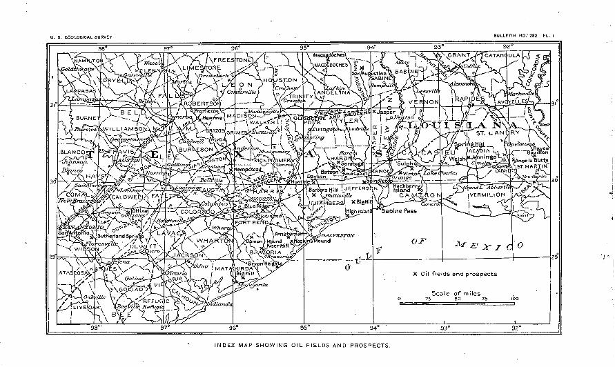
PLATE I. Index map showing oil fields and prospects......................... 9II. Map of Spindletop .oil field........................................ 18
III. View of a portion of Spindletop, 1902............................... 24IV. Fire in Spindletop oil field, September, 1902......................... 28V. Map of Sour Lake oil field........................................ 38
VI. Map of Batson oil field........................................... .48VII. Map of Jennings oil field......................................... 94
VIII. Sand gusher at Welsh, La........................................ 104I.. .Williams burner: A, Section through center .of burner; B, Horizontal
section through center of burner................................. 134X. A, Chapman rotary drill; B, Hoisting and operating machinery.. : . .. 136
XI. A, Fishtail bit;'j5, Core-barrel bit; C, Adamantine or shot drill...... 138FIG. 1. Section of Spindletop oil pool......................................... 32
2. Map of Saratoga oil field.........................................'.. 593. Sands in Saratoga wells, showing irregular distribution................. 61
' 4. Map of Matagorda oil field........................................... 635. Part of Nacogdoches County, showing location of oil wells.............. 706. Map of Sabine Pass, showing location of so-called oil ponds............. 747. Sketch contour map of High Island..........:.......:........... '.... 818. Sketch contour map of Damon Mound............................... 909. Map of Welsh oil field. ............................................ 104
10. Map of Anse la Butte, La........................................... 10811. Theoretical relations of gas, oil, and water in the reservoir rock.......'... 11712. Ideal section of irregularly interbedded sands and clays.......... 1...... 11913. Boiler furnace with oil-burning equipment............................ 13514. Boiler furnace arranged for burning oil............................... 13515. Derrick and machinery in place..................................... 137
U. S. GEOLOGICAL SURVEY BULLETIN NO.° 282 PL.
INDEX MAP SHOWING OIL FIELDS AND PROSPECTS.
OIL FIELDS OF THE TEXAS-LOUISIANA GULF COASTAL PLAIN.
By N. M. FENNEMAN.
INTRODUCTION.
The discovery of oil in the Gulf Coastal Plain created a demand for general geologic knowledge of that region and for specific knowledge of the geologic relations of the oil. This demand was for the time met by the.publication, in 1903', of a report a by Messrs. C. W. Hayes and William Kennedy. The rapid development of the industry an'd the discovery of new pools, as well as the exhaustion of the edition of the former report, indicated the need of a new examination of the fields. The work whose results are reported in this bul letin was done between June 15 and September 15, 1904, and was directed chiefly to those phases of the subject on which new data were-available. Accordingly, no stratigraphic work was attempted. Of the methods of drilling, the use of the oil as fuel, and (for the earlier-known pools) the physical and chemical properties of the oil there is little to be said now which was not well said by Hayes and Kennedy. It was not possible to visit all the localities where prospect wells have been sunk. Of many of these there is nothing to say except that nothing noteworthy was found. The number of such abandoned wells is so large that to ascertain merely the location and depth of each of them would have required much time and travel. In some cases it has been deemed advisable to publish the logs of such wells for comparison. In a few cases where the locality was/examined and the results of drilling were learned by Mr. Kennedy and nothing has since been done, the statements made in the former report have been repeated in this. A large part of the work consisted in the collection of logs, A few are here published, having been selected on account of their representative character or because of special interest. Some were received in confidence. The remainder arc preserved in the archives of the Survey and may be published later. In publishing logs the wording of the driller has been changed as little as possible.
ACKoSTOWJVEDC MJSSTTS.
To Messrs. Hayes. and Kennedy, authors of the former report, the writer is under the greatest obligations. Where parts of that report have been used in this, the fact has been indicated by quotations or footnotes when practicable. Information and assistance in the field were received from a very large number of companies, managers, and drillers. Special acknowledgment and thanks are due to the following: President J. S. Cullinan and the officers of the Texas Company, for well reports of Spindletop, Sour Lake, Batson, and Saratoga, and for accurate maps from which Pis. V and VI and fig. 2 were made; to the officers of the Higgins Oil and Fuel Company; to President J. M. Guffey and General Supt. J. F. Fisher, of the J. M. Guffey Petroleum Company; to J. S. McNamara, of the United Oil and Refining Company; to E. Peperkorn, for maps; to W. E. Brice, Prof. F. C. Thiele, Underwood Nezro, Geo.-ge A. Hill, A. W. Hamill, Pattillo Higgins, W. H. Cunning- ham, and C. K. McFadden of: Beaumont; to B. J. Harper, of Sour Lake; to Lee laager,
a Bull. U. S. Geol. Survey No. 212.
10 OIL FIELDS OF TEXAS-LOUISIANA COASTAL PLAIN.
of the Rio Bravo (Southern Pacific Railroad) Oil Company; to H. B. Goodrich, of the Santa Fe Company, for special kindness in furnishing logs; to Dr. P. S. Griffith, for infor mation concerning the Matagorda field; to J. A. Otto, of Ottine; to the Hey wood Brothers, of Jennings; and to Robert Martin, of St. Martinsville, through whose kindness the visit to Bayou Bouillon was made possible. Important information was received from Mr. Holland S. Reavis, editor of .the Oil Investors' Journal. For recent statistics and infor mation of developments after the completion of the field work, the writer has relied chiefly upon the reports given by Mr. Reavis in his journal.
PREVIOUS KNOWLEDGE OF THE REGION."
From Mississippi River westward through Louisiana and Texas, along the border of the Gulf of Mexico, is a low, flat country, partly swampy or marshy, as in the southern parishes of Louisiana, and partly a broad stretch of clayey and sandy land but slightly elevated above the level of these marshes. The marshy areas extend westward to the eastern shore of Galveston Bay, while the clayey areas may be said to extend as far west as Guadalupe River, in Victoria County, Tex. West of that stream, as far as the Rio Grande, the country is covered with sand and has a semiarid aspect. It may be added that this condition exists for many miles along the coast of the Mexican State of Tamaulipas. This region is known as the Gulf Coastal Plain.6 . It extends inland for a distance of from 50 to 100 miles. Forests of pine, oak, and magnolia fringe its northern border on the higher grounds, various species of gum occur on the lower'benches, and heavy forests of black and red cypress occupy the low river flood plains, but the greater portion of the Coastal Plain is a treeless prairie.
These prairies have usually been designated the "coast prairies,"and the beds which occupy the sur face within the area are grouped under the general title of "coast clays." Comparatively little geologic work has been done in this prairie region, partly because the country was not considered of any eco nomic value, and partly on account of the difficulties'caused by the absence of anything like a natural section. The country is very flat, there are few streams flowing across it, and these few are flowing through broad, shallow channels filled with recent alluvium.
The only references made to these coast deposits in the published reports of the Texas State Geo logical Survey have been cursory and of a very general character. The most important is as follows:
"Immediately bordering the Gulf shore and forming the underlying slope we find a series of beds of clays, sandy clays, blue, yellow, red, and often mottled, which frequently appear black upon the surface from the combination of vegetable matter with the lime of the calcareous nodules which are found scat tered through them. These clays are heavy, massive, containing small crystals of gypsum in places, and so compact that bluffs from 15 to 20 feet in height are often found along the streams and bay shores even in such a moist climate as that of Texas.
" The various strata which form these beds dip so slightly to the southeast as to appear.nearly hori zontal, and form the basis of the level coast prairies which stretch inland from the Gulf for distances varying from 50 to 100 miles. '
" While the underlying beds of clay are seemingly identical for-the entire Gulf coast, the overlying soil is somewhat different, being more sandy on the eastern and western borders and more clayey between Brazos and Nueces rivers."c
McGee regarded these deposits as belonging in -part to his Lafayette formation and in part to his Columbia. He considers the region to have been built up for the most part from long wave-built keys separated from the mainland by sounds, although he says that" east of Galveston the keys and sounds appear to fail; yet the wave-built barriers are continuous as in southern Texas and eastern Mexico, though submerged beneath the Gulf waters to form Sabine Bank, Trinity Shoals, and Ship Shoal, and their connecting series of bars parallel with the coast."d
R. T. Hill describes these plains as a belt of prairie land not over 100 miles wide bordering the Gulf of Mexico in Louisiana and Texas. He regards it as a grass-covered constructional plain newly reclaimed from the Gulf of Mexico. The interior margin of this plain rises scarcely 100 feet above the sea, and it is characterized by an exceedingly level surface hardly broken except by a few low drainage grooves, which become fewer and more faintly developed toward the Rio Grando. Upon this plain.a youthful drainage system is being established, while the seaward extensions of the through-flowing streams cross it. These rivers have wide and deeply indented valleys with gently terraced slopes filled with old alluvium.
" The floor of the sea border of Texas is a submerged gently sloping sandy plain, or shelf, extending 50 miles seaward. By action of tide, wave, current, and wind this sand is piled into long island strips which fringe the coast and stand almost at sea level. These are separated from the land by shallow lagoons, in which most of the sediments of the river are deposited. The building up of the sand bars by
a Reprinted with slight revision from Bull. U. S. Geol. Survey No. 212.6 This is the popular use of the term "Coastal Plain!" Among geologists the term is applied to a
broader belt, including the whole of the Louisiana and East Texas Timber Belt. As thus defined the Coastal Plain includes much hilly ground. See Hill, R. T., Physical geography of the Texas region: Topographic Atlas U. S. Geol. Survey, folio 3..
c First Ann. Rept. Geol. Survey Texas, 1889, p. xxxii.d Twelfth, Ann. Rept. U. S. Geol. Survey, 1892, p. 316.
TOPOGEAPHY. 11
wind and wave and the filling up of the lagoons between them by river sediments, in connection with gradual uplift, may possibly explain the origin of much of the adjacent coast prairie. "a,
Sufficient work has not been done in southwestern Louisiana to give us any clue to the structure of that portion of the Coastal Plain.
According to Hilgard, this portion of the coast country is built up partly of littoral and cstuarine deposits and partly of swampy lagoon and fluviatile deposits, whose thickness and location are mani festly dependent upon the topographic features of the continent at the time they were laid down. The land at that time was being slowly depressed, as is shown by the nature of the deposits and by the numerous superimposed generations of large cypress stumps embedded in laminated clays, which ex hibit the yearly fall of leaves. This view was also held by Hopkins in his survey of southwestern Louisiana in 1870-71.
The above theories regarding the upbuilding of the Coastal Plain may possibly apply to the .newest extension in the east, along the Gulf of Mexico, which at present is altogether marshy, or to the com paratively arid region west of Nueces River, where at present we find a chain of such keys with their accompanying Iag9ons. The largest of these lagoons Laguna de la Madre is being rapidly filled up by the drifting sands from the higher dunes of Padre Island.
A study of the submerged portion of the Coastal Plain, as shown by the Coast Survey charts, shows that the general slope of the sea floor, as far out at least as the 5-fathom, or 30-foot, line, is not more than 5 to 7 feet per mile, and that there does not appear to be any uniformity in the deposition of the mate rials forming this floor. Lens-shaped deposits of hard blue clay and soft mud occur, irregularly inter spersed with banks of fine and coarse gray sand and broken shells. The Sabine Bank is reported as being made up of a gray sand, with black specks and broken shells, which closely resemble much of the gray sand obtained from the different wells in the southeastern portion of the oil fields, especially in the neighborhood of Beaumont. It is probable that the upbuilding of the Coastal Plain, at least through out about 500 feet of its upper portion, was carried on in the same manner as at present. Under the present Gulf the sands appear to be the heaviest deposits, and the well records at many places show the same conditions to exist down to a depth of 500 feet.
The existence of petroleum in this portion of the country has been known for many years. In 1860 Wall, quoting from Taylor's Statistics of Coal, mentioned the existence within 100 miles of Houston of a small lake filled with bitumen or asphaltuni, and having, in its center a spring from which during the summer months an o'ily liquid (probably petroleum) continually boiled up from the bottom. b
In 1880 S. F. Peckham quotes N. A. Taylor as to the existence of maltha in Texas, and gives Sour Lake as one of the localities. On the map accompanying his report oil-producing localities are marked as follows: At the mouth of the Brazos (near Bryan Heights, where considerable drilling has since been done); close to Port Arthur, in Jefferson County; in Newton and Orange counties, Tex.; and at several points in Calcasicu Parish, La.c
When the present oil development began, it was considered advisable to undertake the study of the Coastal Plain in order to bring together such geologic information as was available concerning the geologic relations of the various deposits and to assist in the economic exploitation of the oil fields.
[With this object in view the Gulf Coastal Plain was thoroughly studied by Mr. William Kennedy in the years 1901 and 1902, The various deposits of. sands, clays, and sandstones were examined and compared, their continuity across the country was traced, and their geologic conditions and position in the general section of the region werejstudied. Mri Kennedy's inferences were, so far as possible, drawn from observations on the small bluffs and cuttings seen along the courses of the rivers and creeks-, as well as on such cuttings as could be found along the various railroads traversing the country. In addition the logs of the various deep wells throughout the whole Coastal Plain, so far as obtainable, were gath ered, and the results of the borings collated and compared. The results of his study are published in Bulletin No. 212.<* In the work which forms the basis of the present bulletin much attention was given to well sections and but little to natural exposures.]
By these means the general underground conditions of the region to a depth of about 2,000 feet have been determined and have been described so as to be readily understood by those immediately interested in the development of the field. There are, however, many questions regarding the underground struc ture that can not be answered until much more drilling has been done.
TOPOGRAPHY OF THE GULF COASTAL PLAIN. e
That portion of the Gulf Coastal Plain under discussion may briefly be described as a belt of country having a width of from 50 to 100 miles, extending around the shores of the Gulf of Mexico and embracing in Louisiana, in whole or in part, the parishes of Vermilion, Lafayette, Acadia, Cameron, Calcasieu, and Vernon; and in Texas the counties of Orange, Newton, Jefferson, Hardin, Jasper, Chambers, Liberty, Harris, Galveston, Brazoria, Matagorda, Fort Bend, Wharton, and portions of Waller, Montgomery, San Jacinto, Polk, and Tyler.
a Physical Geography of Texas: Topographic Atlas U. S. Geol. Survey, folio 3. b Geology of Trinidad, App. G, p. 136; Taylor's Statistics of Coal, p. 223. c Tenth Census, Vol. X, p. 20, and map, Washington, 1884.d Hayes, C. W., and Kennedy, William, Oil fields of the Texas-Louisiana Gulf Coastal Plain: Bull.
U. S. Geol. Survey No. 212,1903. « Revised and reprinted from Bull. U. S. Geol. Survey No. 212.
12 OIL FIELDS OF TEXAS-LOUISIANA COASTAL PLAIN.
BELIEF.
The surface features of the Gulf Coastal Plain are extremely simple. In the immediate vicinity of the coast and for 15 or 20 miles inland, in the parishes of Vermilion and Cameronand in the counties of Orange, Jefferson, Chambers, and Galveston, the general level is scarcely more than 3 or 4 feet above the average tides of the Gulf. At a few points, such as Grand Chenier and Hackberry Island, in Cam- eron Parish, La., and Dig Hill and High Island, in Jefferson and Galveston counties, Tex., there are pronounced elevations,- of a few hundred acres in extent, rising to heights of from 40 to 50 feet above the level of the coast marshes. [These are called "islands/ 11 mounds, or hills. In the following pages all elevations of this class, whether in the coastal marshes or on the flat prairie farther inland, arc termed mounds.]
Bordering the marsh along its northern edge is a second belt, largely prairie land, whose surface rises gradually toward the northwest, at an average rate of from JO inches to a foot per mile.
A few small prominences appear within this belt, as at Spindletop and Fairchild Hill, in Jefferson County; at Sour Lake, Dayton, Barber Hill, Kiser Mound near Columbia, and Dainon Mound in Brazoria County; and the Sun Mounds, in Waller County. These, however, do not present any great elevations, Dainon Mound, probably the highest, having a maximum of 83 feet above the plain, or probably not more than ]40 feet above the Gulf.
[Aside from the elevations commonly called mounds, there is on the uneroded parts of the Coastal Plain another typical topographic feature, usually spoken of as "gas mounds." The name is objection able because their origin is in doubt. Their presence makes the. so-called "pimpled plains." They are circular lumps, generally 1 or 2 rods in diameter and ranging in height up to 5 or 6 feet. They are scat tered over thousands of square miles and, considering their vast number, their approximate uniformity in shape and size is noteworthy.]
The third or inner belt of country belonging to the Coastal Plain rises comparatively rapidly from the second and has a more broken and generally timbered surface, with numerous small rounded hills. The general elevation of this belt does not appear to exceed 175 to 200 feet above sea level.
jmAESTAGE.
In the eastern part of the region throughout Louisiana the rivers are deep and sluggish. The few streams of any magnitude are the Bayou Vermilion, Bayou Mermentau, and Calcasieu River. Each of these streams is narrow, deep, and clear, has scarcely any appreciable current, tends to expand into a broad, shallow lake, and enters the Gulf through a shallow bay. Bayou Vermilion flows into Vermilion Bay. The Mermentau shortly after the junction of Bayous Nezpique and DCS Cannes expands into the broad, shallow Grand Lake, with a depth of little over 3 feet, and again contracts only to enter the Gulf through a wide mouth. The Calcasieu forms a series of shallow lakes such as Calcasieu, Black, and West lakes, extending all the way from Lake Charles to the coast. These Louisiana rivers all have the peculiar characteristics of drowned or submerged streams.
Throughout the Coastal Plain in southeast Texas the streams are similar in character to those in Louisiana. The Sabine and Neches'unite to form Sabine Lake; the Trinity debouches into the eastern end of Galveston Bay; the Colorado reaches the Gulf through Matagorda Bay, and the Nueces flows into Corpus Christi Bay. Of all the rivers in this area the Brazos alone enters the Gulf directly and without the intervention of any lagoon or bay.
West of the Nueces the coast drainage fails almost absolutely, as the whole stretch of coast line to the Rio Grande contains only two small creeks, the San Fernando and the Olmos, and thes/! unite to form Copano Bay, near the head of Laguna de la Madre.
These streams of the Gulf Coastal Plain may be divided into two groups an older, pre-Pleistocene or prc-Golumbia, and a younger, post-Columbia. The pre-Columbia (and probably even pre-Lafayette) group includes the Sabine, Neches, Trinity, Brazos, Colorado, Guadalupe, and Nueces, all of which appear to have been in existence during Lafayette time. The younger, or post-Columbia, rivers are the Vermilion, Mermentau, Calcasieu, San Jacinto, Buffalo, Clear, Oyster, San Bernard, Caney, Lavaca, Aransas, San Fernando, and Olmos.
A glance at the map of the region a will show the reasons for this division. It will be noticed that all the rivers included in the older group pass completely across the Coastal Plain, heading upon the older formations of the interior, while the streams of the second or younger class arc confined wholly to the plain itself, heading within it, or in the strong springs which rise from the Fayette sands at its northern border.
Notwithstanding the large number of rivers which occur in the Coastal Plain, much of its surface is' poorly drained. Water stands in many small lakes or ponds throughout the year, and over consider able areas the surface is largely under water during the wet season.
TIMBEJR.
Regarding the timber of the Coastal Plain it may be broadly stated that the cypress is confined to the eastern end, or to the swamps occurring within the immediate drainage area of the Mississippi River, very few of these trees occurring west of the Sabine River. The magnolia ( M. grandiflora) is found in a
a Bull. XJ. S. Geol. Survey No. 212, PI. I.
GEOLOGY. 13
belt stretching in a general southwestern direction through the parishes of Sabino and Vernon, La'., and the counties oi Newton, Jasper, Hardin, Liberty, and San Jacinto, Tcx., terminating in a few straggling trees in the neighborhood of Houston. The western end of the great southern belt of pine is reached near the Brazos River. West of the Brazos the tree growth is mostly represented by oaks and mesquite, the latter gradually becoming the only timber to be found.
GEOLOGY OF THE GULF COASTAL PLAIN.
DESCRIPTION OF SEDIMENTS.
As indicated above under the heading "Previous knowledge of the region," the sediments of the Coastal Plain consist of generally unconsolidated clays, sands, and marls. The beds lie in essentially the same position in which they were deposited. Their seaward dip is a little greater than the seaward slope of the surface, causing younger beds to come to the surface nearer the coast.
The first of the sediments to become consolidated are the marls. Beds of limestone from a few inches to a few feet in thickness are of common occurrence. It is repeatedly noted that the consolidation .of the calcareous beds bears a distinct relation to their thickness* the consolidated beds being generally thin (see pp.25,98). Sands cemented by carbonate of lime are found, sometimes as sandstone beds and sometimes as concretions or "bowlders." No consolidated beds of clay are known, but some of the clays contain concretions. In addition to the consolidated sedimentary beds, there are certain solid materials of secondary origin, described on page 16. The most important of these is the crystalline and cavernous limestone from which a large part of the oil has been derived.
STRATIGRAPHY.
DIFFICULTY OF CORRELATION.
These deposits have not yet been sufficiently studied to make possible an entirely satis factory or final classification. Correlations between widely separated exposures are often only tentative. There are three reasons for this imperfection of the present knowledge: (1) The almost complete lack of natural exposures;, (2) the want of sufficient evidence from fossils, due largely to the scarcity of exposures; (3) the lack of lateral continuity in the physical character of the beds and the corresponding variation in vertical section in beds of the same age.
By a comparison of a large number of well sections from one locality, it is generally pos sible to subdivide the formations into broad but indefinite/ones, each characterized by the dominance of a certain kind of sediment (see pp. 58, 99). Such zones may be a few hundred feet in thickness. Within these zones each well section shows numerous well-defined beds, the characters of adjacent beds Often being sharply contrasted; but when sections of neighboring wells are compared it is found that beds of like character and thickness do not occur at similar depths in the several well sections. Generally it is quite impossible to identify the individual beds passed through in one well with those passed through in another (see fig. 3, p. 61). Attempts to do this have led to grotesque assumptions of folds and faults. .
FOSSILS.
A few fossils have been obtained from borings, but these fix the age of the sediments only within very broad limits. The best-known section whose fossils have-been studied is that of the Galveston well. According to Harris,« the deposits appear to be as follows:
Section of Galveston well.Feet.
Pleistocene.......................................................... -46- 458Doubtful........................................ t ................. 458-1, 510Upper Tertiary..................................................... 1, 510-2,158Miocene (upper)..................................................... 2,158-2, 720
a Fourth Ann. Kept. Geol. Survey Texas, 1893, pp. 89 et seq.
14 OIL FIELDS OF TEXAS-LOUISIANA COASTAL PLAIN.
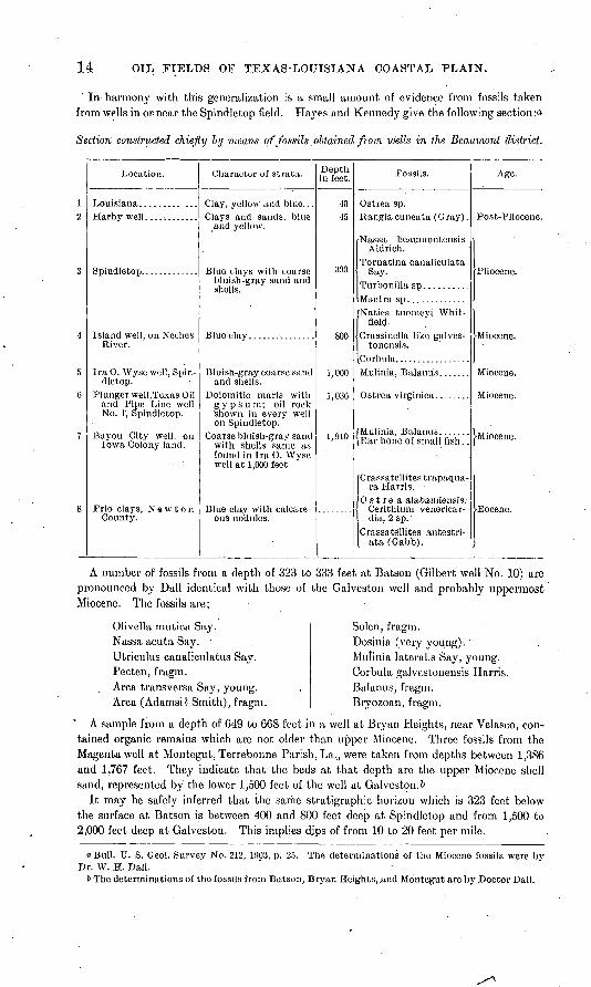
In- harmony with this generalization is a small amount of evidence from fossils taken from wells in or near the Spindletop field'. Hayes and Kennedy give the following section :a
Section constructed chiefly Inj means of fossils obtained from wells in the Beaumont district.
Location.
Spindletop. ............
River.
Ira 0. Wyse well, Spindletop.
Plunger well, Texas Oiland Pipe Line well No. 1, Spindletop.
Bayou City well, on Iowa Colony land.
Frio clays, NewtonCounty.
Character of strata.
and yellow.
bluish-gray sand and
and shells.
gypsurn; oil rock 'shown in every well on Spindletop.
Coarse bluish-gray sand with shells same as found in Ira 0. Wyse well at 1,000 feet
ous nodules.
Depth in feet.
4045
390
800
1,000
1,030
. 1,910
Fossils.
Nassa beaumontensis Aldrich.
Tornatina canaliculata Say.
Natica tuomeyi Whit- field.
tonensis.
[Mulinia, Balanus ....... \Ear bone of small fish. .
Crassatellites trapaqua- ra Harris.
0 s t re a alabaniiensis; Cerithiura venericar-dia, 2 sp.
Crassatellites antestri- ata (Gabb).
Age.
>Miocene.
A number of fossils from a depth of 323 to 333 feet at Batson (Gilbert well No. 10) are pronounced by Dall identical with those of the Galveston well and probably uppermost Miocene. The fossils are:
Olivella mutica Say. Nassa acuta Say. - Utriculus canaliculatus Say. Pecten, fragm. Area transversa Say, young. Area (Adamsi? Smith), fragm.
Solen, fragm.Dosinia (very young).'Mulinia laterals Say, young.Corbula galvestonensis Harris.Balanus, fragm.Bryozoan, fragm.
A sample from a depth of 649 to 668 feet in a well at Bryan Heights, near Velasco, con tained organic remains which are not older than upper Miocene. Three fossils from the Magenta well at Montegut, Terrebonne Parish, La,, were taken from depths between 1,386 and 1,767 feet. They indicate that the beds at that depth are the upper Miocene shell sand, represented by the lower 1,500 feet of the well at Galveston.&
It may be safely inferred that the same stratigraphic horizon which is 323 feet below the surface at Batson is between 400 and 800 feet deep at Spindletop and from 1,500 to 2,000 feet deep at Galveston. This implies djps of from 10 to 20 feet per mile.
"Bull. U. S. Geol. Survey No. 212, 190?, p. 25. The determinations of the Miocene fossils were by Dr. W. H. Dall.
6 The determinations of the fossils from Batson, Bryan Heights, and Montegut are by Doctor Dall.
STEATIGEAPHY. 15
KENNEDY'S GENERAL SECTION.
While no system of classification and correlation of the systems of the Texas Coastal Plain is universally agreed on and any such system may be altered by fuller data in the future, Mr. Kennedy's section, given below, is valuable as a description of the formations. His geologic mapo is based upon the stratigraphic classification here given. The geologic boundaries given on PI. I are taken from a map published by Mr. Lee Hager, by whom they were compiled from various sources. For reasons given under the heading "Geologic rela tions of the oil" (p. 117), a knowledge of the general,physical character of the entire mass of sediments is belived to be more important in the study of the oil than are the details of stratigraphy. ,-
General section of eastern division of Texas-Louisiana Gulf Coastal Plain.Thickness
.' in feet.1. Recent: Coastal marshes, consisting chiefly of sea flats subject to overflow at
extremely high tides, swamps, and partly submerged lands, and the bottom lands along the rivers. The life is represented by recent shells, such asRangia cuneata and Ostrea. Beds of these shells occur along the rivers,and at many of the smaller lakes in this region......................... 5 to 25
2. Pleistocene, with probably some Pliocene: fa. Beaumont clays! Brown, blue, and yellow clays, carrying nodules of
limestone in places irregularly distributed through the clays, making the soil black where found; brown and blue sands with great quanti ties of cypress wood and recent shells .............. ; ............ 25 to 400
b. Columbia sands: White, yellow, gray, and mottled sands with beds ofblue and yellow clay, some decayed wood, and a heavy deposit ofgravel at base. In the clays belonging to.these beds at Sour Lakesuch vertebrates as.Mammut,- Megalonyx, Equus, Smilodonfatalis,
' etc., have been found b.............................I............. 50 to 2003. Neocene (Miocene, with probably some Pliocene): .....
. a. Lafayette sands:- Blue and red thinly laminated clays; massive red and : brown clays; and red and brown cross-bedded sands and gravels car
rying pinkish inclusions of clay. ............................'...,. 30 to 375b. Blue, brown, and gray clays; sands-with: thin beds of limestone and con
taining small1 quantities of oil....................-....-............. 300 to 480c. Blue clays and thin-bedded irregularly .deposited sandstones. .......... 200d. Blue, red, and gray clays and sands and thin-bedded limestones; lime
stones dolomitized and associated with sulphur, gypsum, gas, and petroleum. Sands carry fossils of Miocene -age................... 300
4. Eocene:' . .... i-a. Frio clays: Blue, brown, red, yellow, and green clays, thinly laminated,
partially stratified and massive. The laminated clays carry small crystals of gypsum, and the. ,massive clays numerous concretions of lime from 2.to 4 inches in diameter and calcareous-ferruginous con cretions from 6 inches to 2 or mpre feet in length. Fossiliferous-.in
x places and changing to sandy, calcareous clays to the west......... 260b, Fayette sands: Oray sarids and gray and white sandstones interstratified
1 with gray, white, and pink clays and sandy clays. The" lower,.sand- stones are often hard and glassy, and bluish or pinkish in-color. The upper sandstones are soft and chalky white, and contain numerous casts of grass, reeds, palmetto, and 'other marsh .plants. At some . localities a thin bed of limestone in these upper ^sandstones carries .
oBull. U. & Geol. Survey No. 212, PI. I. .-- . - - -' -*>Leidy, Joseph, Contributions to the extinct vertebrate fauna of the, western Territories: Mon.
U. S. Geol. and Geog. Surv._Terr., vol. 1, 1873.
Bull. 282 06 2
16 OIL FIELDS OF TEXAS-LOUISIANA COASTAL PLAIN.
Thicknessin feet.
lo,wer Claiborne fossils, and a yellowish-brown sand contains a con siderable number of plant impressions .......................... 400
c. Yegua clays: Dark-blue gypseous clays and dark bluish-gray sandswith considerable deposits of lignite............................. 1, 000
d. Upper marine beds or Cooks Mountain beds: A series of greensands, fos- x siliferous greensands, fossiliferous clays, stratified black and gray sandy clays, black and yellow clays with limy concretions. A very prolific Claiborne fauna....................................... 390
e. Mount Selman beds: Brown sands; blue clays, greensands, glauconitic sandstone, and heavy deposits of limonite. More or less fossiliferous, but fauna mostly represented by casts..............'............ 260
f. Lignitic: White, yellow, gray-brown, red, blue, and black sands with interstratified and interlaminated blue, gray, and brown clays with heavy beds of lignite. Apparently unfossiliferous except for a few plant remains, including the palmetto........................... 1,060
g. Wills Point clays: Yellowish-brown sands containing bowlders of sand stone and limestone with some calcite concretions; dark-blue and brown laminated and massive clays and fossiliferous white limestone 260
5. Cretaceous. oTHE MOUJSTDS.
FORMATIONS.
Beneath the mounds (p. 12) are various materials which, in general, are not found else where on the Coastal Plain. These materials crystalline limestone, sulphur, gypsum, and rock salt are generally covered by the unconsolidated sediments described above. In some cases this covering is very thin, as at Damon Mound, where the limestone outcrops, and at Avery Island, Louisiana, where the rock salt was found at one place within 15 feet of the surface. At Spindletop the limestone is 800 to 800 feet deep, and at Hackberry Island, Louisiana, a similar rock was found more than 1,600 fe^t deep.
The limestone is frequently dolomitic and at places entirely crystalline. When stained by oil it resembles maple sugar. At some places it is dense. Both the dense and the crystalline varieties may be cavernous. Some limestone bodies are more than 100 feet thick. It can
not be doubted that the pure calcite which forms large parts of the porous oil-bearing lime stone is deposited from solution in water. Some large masses may thus have been formed by material brought long distances. In most cases observed, however, there is an abundant source of carbonate of lime in the highly calcareous sediments immediately adjacent to or below the secondary limestone. Some of these calcareous beds are in the original condition of marl, others consolidated without the formation of crystalline calcite. Still others are partly composed.of redeposited material, so that between the original marl bed and the entirely secondary limestone there are all possible gradations. The nature of this porous limestone is further discussed in the descriptions of the several fields (see pp. 26,45, 52).
At about the horizon of the limestone and sometimes contained within its caverns (see table below, p. 17) sulphur is frequently found. In many cases it is almost chemically pure. Well-formed crystals more than an inch long have been obtained. Probably these are gen erally from cavities in the limestone. Some of such cavities which have been filled with oil are lined with minute sulphur crystals. Sands at higher horizons occasionally contain a
. large admixture of sulphur.Gypsum occurs both as a massive rock and as an admixture in sands and clays. It gener
ally lies deeper than the limestone and the sulphur (see table below).Salt is abundant. In the salt islands of Louisiana it is very pure. That which has been
found below the limestone of the oil fields is likewise believed to be pure rock salt. Salt no doubt also impregnates some sands, especially on the borders of the large masses of rock salt.
THE MOUNDS. .17
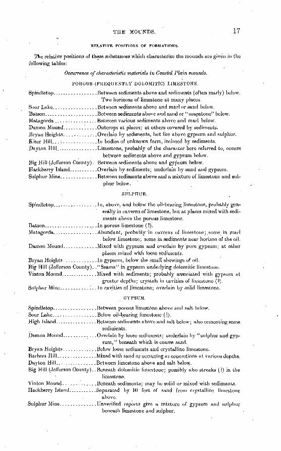
RELATIVE POSITIONS OF FORMATIONS.
The relative positions of these substances which characterize the mounds are given in the i'ollowing tables:
Occurrence of characteristic materials in Coastal Plain mounds.
POROUS-(FREQUENTLY DOLOMITIC) LIMESTONE.
Spindletop.................Between sediments above and sediments (often marly) below.Two horizons of limestone at many places.
Sour Lake.................Between sediments above and marl or sand below.Batson....................Between sediments above and sand or "soapstone" below.Matagorda ................Between various sediments above and marl below.Damon Mound.............Outcrops at places; at others covered by sediments.Bryan Heights.............Overlain by sediments, but lies above gypsum and sulphur.Kiser Hill.................In bodies of unknown form, inclosed by sediments.Dayton Hill................Limestone, probably of the character here referred to, occurs
between sediments above and gypsum below.Big Hill (Jefferson County). .Between sediments above and gypsum below.Hackberry Island.......... .Overlain by sediments; underlain by sand and gypsum.Sulphur Mine..............Between sediments above and a mixture of limestone and sul
phur below.
SULPHUR.
Spindletop.................In, above, and below the oil-bearing limestone, probably gen erally in caverns of limestone, but at places mixed with sedi ments above the porous limestone.
Batson....................In porous limestone (?).Matagorda.................Abundant, probably in caverns of limestone;.some in marl
below limestone; some in sediments near horizon of the oil.Damon Mound.............Mixed with gypsum and overlain by pure gypsum; at other
places mixed with loose sediments.Bryan Heights.............In gypsum, below the small showings of oil.Big Hill (Jefferson County). ."Seams" in gypsum underlying dolomitic limestone.Vinton Mound............. .Mixed with sediments; probably associated with gypsum at
greater depths; crystals in cavities of limestone (?).Sulphur Mine............". .In cavities of limestone; overlain by solid limestone.
GYPSUM.
Spindletop.................Between porous limestone above and salt below.Sour Lake.................Below oil-bearing limestone (?).High Island................Between sediments above and salt below; also cementing some
sediments.Damon Mound.............Overlain by loose sediments; underlain by "sulphur and gyp
sum," beneath which is coarse sand.Bryan Heights.............Below loose sediments and crystalline limestone.Barbers Hill.............. .Mixed with sand or occurring as concretions at various depths.Dayton Hill................Between limestone above and salt below.Big Hill (Jefferson County). .Beneath dolomitic limestone; possibly also streaks (?) in the
limestone.Vinton Mound.............Beneath sediments; may be solid or mixed with sediments.Hackberry Island.......... .Separated by 10 feet of sand from crystalline limestone
above.Sulphur Mine..............Unverified reports give a mixture of gypsum and sulphur
beneath limestone and sulphur.
18 OIL FIELDS OF TEXAS :LOUISIANA COASTAL PLAIN.
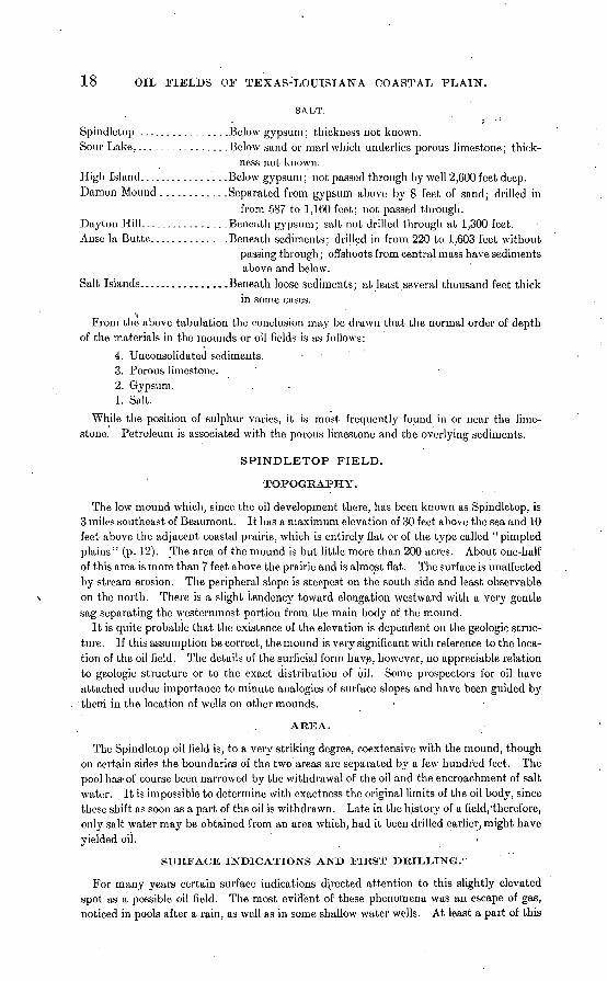
SALT.
Spindletop.................Below gypsum; thickness not known.Sour Lake.................Below sand or marl which underlies porous limestone; thick
ness not known.High Island................Below gypsum; not passed through by well 2,600 feet deep.Damon Mound............Separated from gypsum above by 8 feet of sand; drilled in
from 587 to 1,160 feet; not passed through.Dayton Hill................Beneath gypsum; salt not drilled through at 1,300 feet.Anse la Butte..............Beneath sediments; drilled in from 220 to 1.603 feet without
passing through; ofl'shoots from central mass have sediments above and below.
Salt Islands................Beneath loose sediments; at least .several thousand feet thickin some cases.
^ From the above tabulation the conclusion may be drawn that the normal order of depth
of the materials in the mounds or oil fields is as follows:
4. Unconsolidated sediments. 3. Porous limestone. 2. Gypsum. 1. Salt.
While the position of sulphur varies, it is most frequently found in or near the lime stone. Petroleum is associated with the porous limestone and the overlying sediments.
SPINDLETOP FIELD.
TOPOGRAPHY.
The low mound which, since the oil development there, has been known as Spindletop, is 3 miles southeast of Beaumont. It has a maximum elevation of 30 feet above the sea and 10 feet above the adjacent coastal prairie, which is entirely flat or of the type called "pimpled plains" (p. 12). The area of the mound is but little more than 200 acres. About one-half of this area is more than 7 feet above the prairie and is almost flat. The surface is unaffected by stream erosion. The peripheral slope is steepest on the south side and least observable on the north. There is a slight tendency toward elongation westward with a very gentle sag separating the westernmost portion from the main body of the mound.
It is quite probable that the existence of the elevation is dependent on the geologic struc ture. If this assumption be correct, the mound is very significant with reference to the loca tion of the oil field. The details of the surficial form have, however, no appreciable relation to geologic structure or to the exact distribution of oil. Some prospectors for oil have attached undue importance to minute analogies of surface slopes and have been guided by them in the location of wells on other mounds.
AREA.
The Spindletop oil field is, to a very striking degree, coextensive with the mound, though on certain sides the boundaries of the two areas are separated by a few hundred feet. The pool has-of course been narrowed by the withdrawal of the oil and the encroachment of salt water. It is impossible to determine with exactness the original limits of the oil body, since these shift as soon as a part of the oil is withdrawn. Late in the history of a field/therefore, only salt water may be obtained from an area which, had it been drilled earlier, might have yielded oil.
SURFACE INDICATIONS AND FIRST DRILLING. 1
For many years certain surface indications directed attention to this slightly elevated spot as a possible oil field. The most evident of these phenomena was an escape of gas, noticed in pools after a rain, as well as in some shallow water wells. At least a part of this
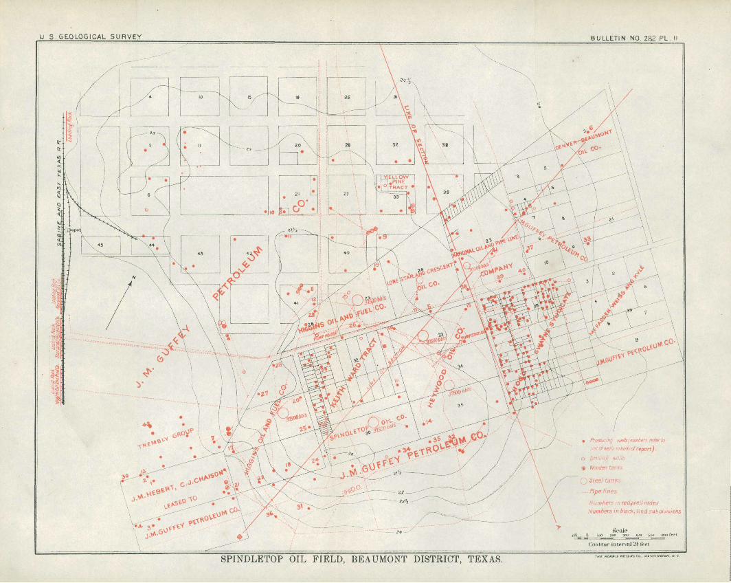
U S. GEOLOGICAL SURVEY BULLETIN NO. 282 PL. II
Producing wells!number re listcfmllsmbotkofrrport).
o Drill!nf> ive/
Wooden Tan
Numbers in red,we// index Numbers in black, land subdivisions
S'caleidij t) _inB loo _3outoo 500 apo fart
Contour inlervtd 2{ frci
SPINDLETOP OIL FIELD, BEAUMONT DISTRICT, TEXAS.
SPINDLETOP FIELD. 19
gas appears to have been sulphureted hydrogen. Incrustations of sulphur were observed in the soil and considerable importance is said to have been attached to these by Captain Lucas, under whose management the first successful oil well .was completed on January 19, 1901 .a The slightly sulphurous waters found in certain shallow wells were regarded as significant for the same reason. " Sour waters " (see p. 124) are also said to have been noted at Spindle- top, but they are not now much in evidence. The composition of the escaping gases, aside from sulphureted hydrogen, has riot been definitely determined. Hill also mentions Spindle- top among the localities where seepages of oil were observed at the surface. One of the most potent reasons for drilling here seems to have been the suggest!veness of the topo graphic form. Captain Lucas had become convinced, from his work in Louisiana, that salt, sulphur, gypsum, dolomite, sulphureted hydrogen, and oil were in some way associated with such mounds or "islands. "b
It is not so well known just what phenomena were influential in leading to earlier drillings than that of Captain Lucas. It is but fair, however, to record that Mr. Pattillo Higgins, for some years previous to the actual discovery, insisted constantly and confidently on the pres ence of petroleum under Spindletop, and it was he who, several years before the finding of oil, laid out Gladys City in anticipation of the corning importance of that locality. In 18Q4 a well was drilled to a depth of 400 feet. It was too shallow to reach the oil, but it afforded certain slight indications which gave encouragement fco the later successful attempt.
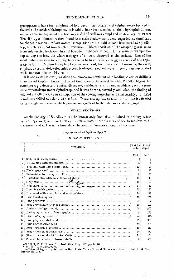
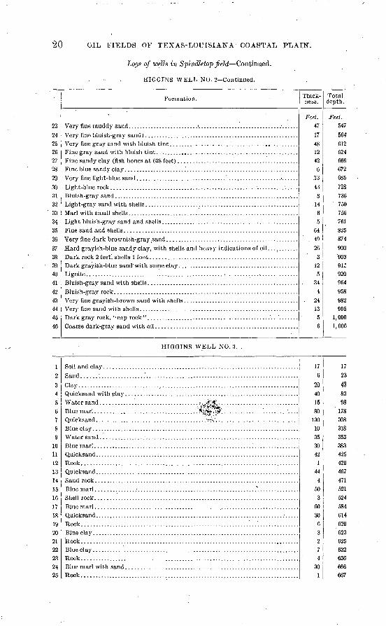
W:EL,:L SECTIONS.
As the geology of Spindletop can be known only from data obtained in drilling, a few typical logs are given here.c They illustrate most of the features of the formations to bo discussed, and at the same time show the great differences among well sections.
Logs of wells in Spindletop field.
HIGGINS WELL NO. 2.
17,3
4
5
fi
780
10
11
1213
14
15
1C.
17IS
10
?0
21
22
Formation.
Blue sand ..'..................... ...=,. .'. K :. .'. :'. . . ..:.: ..............................
Blue sand with some clay and small pebbles. ............................. ... . .
Fine gray sand ........................ ...................................;..... .
Fine grayish-green sand. . .......................................................
Fine brown sand with shells. . ....................................... ... . .
Fine brown sand with broken shells. .............................................
Coarse blue sand with broken shells ..............................................
Thick ness.
Feet.2
3J
12
G
810
10
13
51
20
10
31
10
Co
9
44
35
5040
30
21
9
Total depth.
Feet.2
4
1622
3040
50
69120
146
150187
197
202
271
315
350
400440
470
491
500
a See Hill, R. T., Trans. Am. Inst. Min. Eng. 1002, pp. 31, 35. *Hill, R. T., loc. cit., p. 34.c Additional logs are published in Bull. Univ. Texas Mineral Survey No. 1 and in Bull. U. S. Geol.
Survey No. 212.
20 OIL FIELDS OF TEXAS-LOUISIANA COASTAL PLAIN.
Lofjs of wells in Spindletop Jield Continued.
HIGGINS WELL NO. 2 Continued.
Formation.
Very fine muddy sand. . .......................'.............................. ......
Very fine gray sand with bluish tint. ... ................................. .......Fine gray sand with bluish tint. .-. .. .............................................
Fine blue sandy clay. ............... ... .........................................
Bluish-gray sand ................... . . . ............. . ............... .......
Dark rock 2 feet, shells 1 foot. ...... .............................................
Thick ness.
Feet. 4717481242
613
438
1465
644926
3125
344
. 2413
56
Total depth.
Feet. 547564612624666672685
728736
' 750756761825874
90090391:920954958982995
1,0001,006
24
27
HIGGINS WELL NO. 3.
1
3456789
10ii
131415161718'
19
?1??n9425
Sand .......................'.......................................................Clay ...............................................................................
Water sand ................................... ; . -.'* &:. ............................
Rock..............................................................................
Shell rock. ........................................................................
Rock ..............................................................................Blue clay. ......... ............... ....................................... .......Rock ............................................................;.................Blue clay. ......... ............... . . ........... ..................... .....Rock ..............................................................................
Rock. .............................................................................
176
20401580
13010353042
144
450
O
6030
63274
301
1723
438398'178
308318353383425426467471521524584614620623625632636666667
SPINDLETOP FIELD. 21
Locjs of wells in Spindletop field Continued.
HIGGINS WELL NO. 3 Continued.
?fl37
?829'
3031
3?
33
3435'
3fi
37
38
30
40
41
4?43
44
45
4fl
47
Formation.
Shell rock. ........................................................................
Jl ock ..............................................................................
Rock ..............................................................................
Hock. .............................................................................
Quit in rock salt.
Thick ness.
. Feet.. 8012
14
GO
510
0
12
20
. 103
19
73225
1
173
1
40
40
53
522
309
Total depth.
feel.747
759
773
833
838848854
800
886
989
1,008
1,081
1,306
1,307
1, 480
1,481
1, 527
1,567
1,620
1,625
1,647
1,956
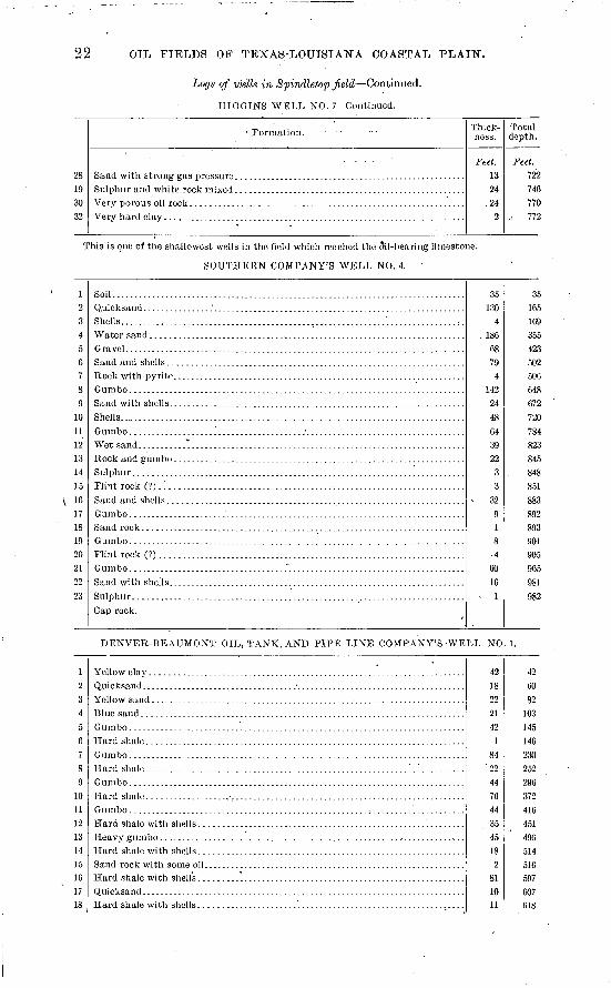
T-TIGGINS WELL NO. 7.
1?,3
4
fi
78
910
11
1?
13
14'15
10
17
1819
20?1
W,?3?4
2526
27
White clay ........................................................................
Very hard white limestone. .......................................................
21
8
56
9
20210
10
79
63
4
25
1
2
42
2
1
72
82
521
37
2
35
5
21
29
8594
114
324
334
4.13
476
480
505
506
508
550552
558565
567575
577629
067
669
704
709
22 OIL FIELDS OF TEXAS-LOUISIANA COASTAL PLAIN.
Logs of wells in Spindletop field Continued.
J-IIGGINS WELL NO. 7 Continued.
28 19 30 32
' Formation. .- - -
Sulphur and white rock mixed . .....................Very porous oil rock. ................. . ..... . ...............................
Thick ness.
Feet. 13 24
.24 2
Total depth.
Feet. 722 746 770
.. 772
This is one of the shallowest wells in the field which reached the §il-bearing limestone.
SOUTHERN COMPANY'S WELL NO. 4.
1 2 3 4 5 6 7 8 9
10 11 12 13 14 15 16 17 18 19 20 21 22 23
Soil...................... . ..........
Shells.................... . . .'............:.Water sand ................... .....................
Sand and shells .......... .....
Sand with shells.... ....... . . .......
Shells.................................. . . . . . . . . ...........................
Sulphur. ..........................................................................Flint rock (?) .i ........... . . . ....................
Sand rock ........................... . . . ....... . . ...........................Gumbo. ................. . .......Flint rock (?)....................... . . .......... .............................G umbo ....................................*.........................................Sand with shells...... ... .... .... . ..................
Cap rock.
35 130
4 . 186
68 79
4 142 24 48 64 39 22
3 3
32 9 1 8 4
60 16
; 1
35 165 169 355 423 502 506 648 672 720 784 823 845 848 851 883 892 893 901 905 965 981 982
DENVER-BEAUMONT OIL, TANK, AND PIPE LINE COMPANY'S -WELL NO. 1.
1 2 3 4 5 6 7 8 9
10 11 12 13 14 15 16 17 18
Gumbo. ............. ......... . . . . . . . . . . . . ...... . ...............
Sand rock with some oil.. ....... . . . . . . . . . . . . .........................
Hard shale with shells ............................................................
42 18 22 21 42
1 84
"22
44 76 44 35 45 18
2 81 10 11
42 CO 82
103 145 146 230 252 296 372 416 451 496 514 516 597 607 618
8PINDLETOP FIELD. 23
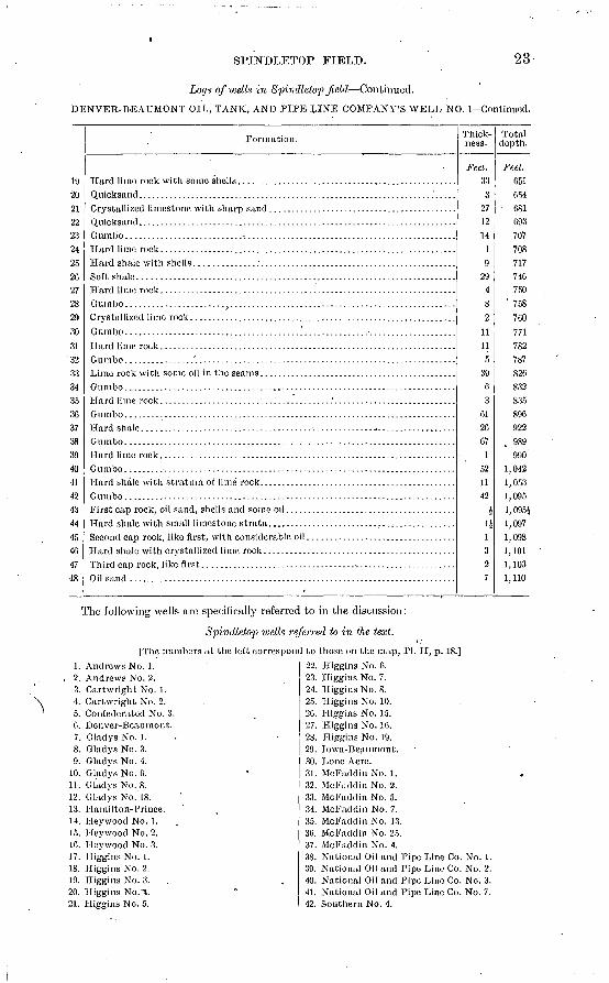
Logs of wells in Spindletop field Continued.
DENVER-BEAUMONT OIL, TANK, AND PIPE LINE COMPANY'S WELL NO. 1 Continued.
192021oo
2324259P>
282030
31'32
33343530373830dn41424344di404748
Formation.
Hard limo rock with some shells. ..... ....... . ............... .............
Hard shale with stratum of lime rock. . ........................... .............
Thick ness.
Feel. 33
3271214
19
2!).482
1111
539
C3
012007
1521142
i. 1J
1327
Total depth.
Feet. 051054
0810937077087177407.50
' 758
760771782787820832835890922989990
1,0421, 0531,0951, 095J1,0971,0981,1011, 1031,110
The following wells are specifically referred to in the discussion:
Spindletop wells referred to in tlie text.
[The numbers at the
1. Andrews No. 1. , 2. Andrews No. 2.
3. Cartwright No. 1.4. Cartwright No. 2.5. Confederated No. 3. 0. Denver-Beaumont.7. Gladys No. 1.8. Gladys No. 3.9. Gladys No. 4.
10. Gladys No. 0.11. Gladys No. S.12. Gladys No/18.13. Hamilton-Prince.14. Hey wood No. 1.15. Heywood No. 2. 1C. Heywood No. 3. 17. Biggins No. 1. IS. Biggins No. 2.19. Biggins No. 3.20. Biggins No.^.21. Biggins No. 5.
left correspond to those on the map, PI. II, p. 18.]
22. Higgins No. 0.23. Higgins No. 7.24. Higgins No. 8.25. Biggins No. 10. 20. Higgins No. 15.27. Biggins No. 10.28. Higgins No. 19.29. Iowa-Beaumont.30. Lone Acre.31. McFaddin No. 1.32. McFaddin No. 2.33. McFaddin No. 5.34. McFaddin No. 7.35. McFaddin No. 13. 30. McFaddin No. 25.37. McFaddin No. 4.38. National Oil and Pipe Line Co. No. 1.39. National Oil and Pipe Line Co. No. 2.40. National Oil and Pipe Line Co. No. 3.41. National Oil and Pipe Line Co. No. 7.42. Southern No. 4.
24 OIL FIELDS OF TEXAS-LOUISIANA COASTAL PLAIN.
SEDIMENTARY FORMATIONS ABOVE THE OIL,.
Above the horizon of the oil are 700 to 1,000 feet of generally unconsolidated sediments. They are not distinguishable from the beds under the adjacent prairie. Named in the order of their abundance, these beds consist of clays, sands (with gravels), and limestones (with shell beds). In general, individual beds can not be traced from well to well, except for very short distances. A stratum of from 15 to 25 feet of clay at the top is general.
The first 500 feet generally have a predominance of sand. From that depth down to the oil rock, sands are generally very subordinate in amount when not entirely absent. The logs of a considerable number of wells which are well distributed over the field show the following proportions of sands in their upper portions:
. Proportions of sand in Spindletop well sections.
Well.
Thick ness of sand or gravel.
F(et.
180290404305340
284
Out of first
Feet. 4713505445CO413510520503
Well.
Thick- ness-of sand or gravel.
Feet. 395438356373419198'
233
Out of first
Feet. 590512598502595350465
By consulting the logs it 'will be seen that the last four wells in the above list, together with the Higgins Nos. 4, 15, and 16, while showing a decided dominance of sand or gravel within the depths named, are almost devoid of sand within 100 or 200 feet of the surface. The largest proportions of sand and gravel are found in the Higgins Nos. 1 and 2. The sec tion of the Higgins No. 1 shows 815 feet of sand out of 1,020 feet above the oil rock. Well No. 2 has 781 feet of sand and gravel out of a total depth of 1,006 feet, no considerable por tion of the section having a dominance of clay. In the somewhat uncertain logs of wells Nos. 1 and 2 of the National Oil and Pipe Line Company, sand is given as the most abun dant material to a depth of over 800 feet. At the other extreme may be placed the Denver- Beaumont well, with but 40 feet of sand beneath the 42 feet of surface clays, the balance of the section showing only an insignificant proportion of sand. "Sand rock" is occasionally mentioned, generally in beds of a very few feet. All the specimens seen of such sandstone have a calcareous cement. Such "rocks" are very local or concretionary.
While gravels occur in the sandy upper halves of a minority of the well sections obtained, they have no constant position, thickness, or character, and the correlation of such beds is not here attempted. Those gravels which have been thought to suggest some possibility of correlation are enumerated in the list given belo\y. It is, of course^ to be borne in mind that as reliable logs were obtained from only about one-twentieth of all the wells, this list of occurrences of gravel is correspondingly imperfect. It.might be added that "very coarse sand" is mentioned in some other logs at horizons similar to those here named for the gravels, but the general omission of such mention in most logs is extremely adverse to any scheme of correlation.
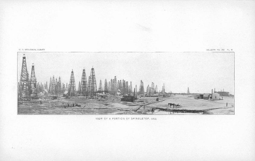
U. S. GEOLOGICAL SURVEY 1ULLETIN NO, 282 PL.
VIEW OF A PORTION OF SPINDLETOP, 1902.
SPINDLETOP FIELD. 25
Gravels mentioned in Spindletop logs.
Well.Thick ness.
Feet. 157
082020
Depth.
.Feet. 245-260270-277255-428245-265295-315
Remarks.
" Coarse sand with black pebbles;" occurs also deeper.
Do." Variously colored; from bean to goose-egg size."
LIMESTONE.
In most of the logs there is frequent mention of "rock." As a rule, where not other wise specified, this is understood to be limestone. When questioned, drillers frequently describe it as such. Most of the samples seen were limestone, a few being sandstone with calcareous cement. It is usually reported as occurring in beds 1 or 2 feet thick, but occa sionally in 20 or 30 foot strata. Sometimes the degree of consolidation of these thick beds of rock may be exaggerated in the reports, but from the length of time required to drill through some of them it is believed that well-indurated beds of such thickness are occa sionally encountered. In a note appended to the log of the Denver-Beaumont well, the contractor describes a very hard rock which was entered at a depth of 654 feet. This bed is 27 feet thick, and seventy-five days were required to drill through it. From the descrip tion given, the rock must be a very siliceous limestone. "Forty-three feet.of steel were worn away in getting .through this 27 feet." This statement, of course, refers to the wear ing away of the bits. The reports of "soft rock," "soft white rock," "white clay," and "blue marl" probably refer to various shades of color and degrees of consolidation of the limy material.
SHELL BEDS.
"Shells," "shell beds," or "shell rock" are reported from most-wells. Large fragments of shell rock were occasionally brought to the surface by blowouts or other accidental means. They indicate the existence of large accumulations of shells, such as occur at 'or near the surface at many places on the Coastal Plain. Shells are also reported as occurring mixed in all proportions with sand, rock,'or clay. Shell beds,-when thin, may form thor oughly indurated rocks. The thicker masses, reaching 40, 50, or 60 feet, are' poorly cemented if at all, and generally do not consist of .shells, alone, but of shells mixed with sand or clay.
The relations of all the consolidated beds are such as to show that cementation has occurred most readily in the most calcareous material and where this material was com minuted and therefore easily dissolved. Where neighboring beds have been consolidated by the calcareous cement, or where calcareous concretions have been formed in these beds, the occurrence is in the permeable sands more frequently than in the more impervious clays.
"Gumbo" is the common term by which most clays are reported.** There are occasional mentions of "shale," and from the descriptions given by drillers and contractors it would appear that occasional beds ofHhe clays are sufficiently consolidated to justify the word shale. Probably in most cases, if not all, such occurrences are concretionary.
a An intelligent driller, when asked to distinguish between clay and gumbo, defined the latter as a clay so sticky that instead of mixing with water as common clay doe's to form mud, it rolls up into balls.
26 OIL FIELDS OF TEXAS-LOUISIANA COASTAL PLAIN.
LACK OF CONTINUITY.
On account of the lack of lateral continuity, individual beds noted in one well section can not be identified in another. An attempt to correlate the beds named in the accom panying logs will make this fact obvious. The first impression on finding that a bed noted in one well is not found at the same depth in another is that it has "dipped" of "pinched out," implying a lens-like form. These impressions are prevalent in oil fields and appear in the common phraseology of the operators, but are for the most part ina'ccurate. It should rather be assumed that any one bed shows a gradual change from place to place in the nature of its material.
AGE OF BEDS.
The exact age of these beds overlying the oil is a matter of much uncertainty. Of the few fossils found, none would indicate that the horizon of the oil is older than late Miocene, and the topmost beds are very recent. However, if the conception of the oil-bearing rock as given below (p. 119) is correct, the exact age of the strata in which it is included is not a matter of the first importance in determining the laws of its distribution on the Coastal Plain. i
ROCKS CLOSELY ASSOCIATED WITH THE OIL.
Beneath the rocks above described are others whose presence is peculiarly characteristic of the mounds or dome structures which either yield oil or show close structural similarities to the oil fields. These rocks or minerals are porous limestone (or dolomite), sulphur, gypsum, salt, and pyrite with associated salts.
POROUS LIMESTONE.
The porous limestone is not the same as that described above as occurring in thin beds above the horizon of the oil rock, though gradations may occur between the two types (see p. 45). These thin beds are characteristically dense and seem to be in horizontal position. They are not crystalline, but show the ordinary dense texture resulting from induration of calcareous deposits. The limestone here referred to as characteristically associated with the oil bodies is sometimes dolomitic, and much of it is completely crystalline and porous or cavernous. Its upper surface is also extremely uneven, and its lower is perhaps equally so, though 'naturally the latter is but imperfectly explored.
Cavernous and oil-soaked fragments blown out from gushing wells, and differing from the beds passed through in drilling, may be supposed to fairly represent the rock which carries the oil. The crystalline character of this is evident. Among the workers in the field it is frequently compared to a light-colored maple sugar. Cavities may contain large crystals, or their walls may be drusy with calcite, though sometimes they contain sulphur (see p. 17). For a few inches, or even, it may be, a few feet, next to the upper surface, the limestone lacks the completely crystalline character, and resembles the dense, thin limestone beds found among the overlying clays. This narrow zone or crust of indefinite thickness (for the change is gradual) is spoken of as the "cap rock."
The dolomitic character of this porous rock varies. Doubtless the magnesium carbonate is always very subordinate to the calcium carbonate. No specimen was tested which did not effervesce freely with cold dilute hydrochloric acid without pulverizing the rock. Prof. F. C. Thiele, of Beaumont, has found no proportions of magnesia to lime greater than 1 to 40. The analysis here given is of the so-called "cap rock," which may be either the dense crust of the oil-bearing rock or the reservoir rock itself.
SPINDLETOP FIELD. 27
Analysis of the limestone, forming the cap rock of the Beaumont oil.aPercent.
Silica.................................................................... 0.40Oxide of iron.............................. 1...........................Oxide of alumina. " ' Lime..............................: .....I......:......:.:............... 54. 89Magnesia.................................^................................ Trace.Sulphur, as free.sulphur and in organic combination............................ 1. 58Sulphur, as sulphuric acid in combination .................................... .21Carbonic acid.................................................... . ... .... 42. 45
Total.,............................................................ 100.03
The'openiugs seen iu hand specimens are of all sizes, from the minutest pores to cavities more than an inch in diameter. The sudden dropping of tools through supposed cavities of several feet, which is discussed elsewhere, does not necessarily.indicate .the presence of
such large openings. On the other hand, there is no reason to deny the existence of cavities much larger than those seen in hand specimens. Doubtless very large masses of this oil rock may have a porosity of over one-third the total volume.
Computations based on the amount of oil produced indicate that the reservoir rock must be extremely porous or cavernous. The 37,000,000 barrels of oil already taken from this pool 1> would cover the area of the productive field to a depth of 22 feet. To afford room for this amount of fluid would require a rock 66 feet thick,'one-third of its volume being pore space. -Therefore, unless the average thickness of the oil-bearing limestone is greater than it has been believed to be, its average porosity mu^t exceed 33 per cent, or oil must have come in from a totally unknown source. If the average porosity exceeds 33 per cent, there must be large spots in which more than One-half the total volume is pore space, for the rock is locally dense. Large cores of similar rock taken from other mounds sometimes show more than 33 per cent of pore space, the pores or caverns being either empty or filled with sulphur.
So1 far as observed, a specimen taken from the immediate upper crust has essentially the same density, hardness, and constitution as the local limestones in the overlying beds. The thickness of this crust may be inferred from the depth to which wells are drilled into the rock before setting casings. It may safely be assumed that in all cases there are at least a few inches of such a crust. Its thickness may reach many feet, and at places the entire mass of the rock may be of the dense character of the. crust.
Sometimes well-rounded or multiplex concretions of .pure crystalline limestone of the maple-sugar appearance are carried to the surface by blow-outs. It is not possible to say positively from what matrix these come, but they belong near the horizon of the .oil rock and probably come from a marly stratum.
An understanding of the exact nature and origin of the porous limestone would be much facilitated by a clear picture of the exact forms of the bodies in which it occurs. It might have been hoped that where wells were drilled so close that the timbers of neighboring derricks touched or interlocked, a comparison of depths at which the rock was reached would give a fairly exact picture of the .form of its upper surface. Unfortunately, in the violent rush of well drilling in the most closely perforated portion of the field, the methods of work and of making reports were not such as to insure accuracy within 10,.20, or even 30 feet. If reports could be accepted as given (generally orally), the depth to cap rock in neighboring wells niight differ as much as 20 or 30 feet within a horizontal distance of the same amount. This would require that the oil rock should have an extremely lumpy or hummocky upper surface or should interlock in some way with the overlying formation. While making large allowance for the unreliable character of most of these hurried reports,
"Analysis by Mr. S. H. Worrell; sec PhillLps, Wm. B., Texas petroleum: Bull. Univ. Texas Min- .eral Survey No. 1,1900, p. 27.
& Before January 1, 1905.
28 OIL FIELDS OF TEXAS-LOUISIANA COASTAL PLAIN.
it still seems necessary to conclude, from the observations of some careful contractors and good observers, that the upper surface of the oil rock has such a lumpy or (in a very large way) botryoidal form. In addition, this irregularity of surface seems to be attended by overlying or outlying concretions and possibly by branching veins. The oil rock does not seem to have on its lower side any such dense crust as that which is encountered above.
FORMATION BETWEEN OIL HORIZONS.
There are in many wells two oil-bearing horizons, the oil in both cases coming from the same kind of porous limestone, the two horizons being separated by a barren zone, which in some places attains a thickness of almost 200 feet, though in most cases it is less than 100 feet thick. Concerning the nature of the material between two oil-bearing horizons, there
is fairly general agreement. Mr. A. W. Hamill, a driller and contractor, who has observed the formations with some care, speaks of this material in the Keith-Ward tract as a "white, limy stuff" resembling gypsum. -It is generally, though not always, unconsolidated. It contains many concretions, commonly spoken of among drillers as "bowlders". These are liable to loosen and turn under the bit and give much trouble in drilling. The specimens seen of these "bowlders" are all limestone. In the Higgins No. 6 the formation from 1,009 feet to 1,024 feet, occupying the space between two " oil sands," was a "hard, bluish, porous rock." In the Gladys No. 3 were "60 or 70 feet of white limestone" intervening between two oil horizons. In block 33, Gladys City (the Yellow Pine- tract), the corresponding material is referred to as "generally whitish or gray, limy stuff, not always soft." An occasional streak of "blue shale" is also mentioned in this locality. In the McFaddin No. 2 about 15 feet of "gumbo" separates two oil-bearing levels. In some cases, as in the National Oil and Pipe Line Company's well No. 7, such a gumbo parting is but 1 or 2 feet thick. The mention of gypsum may be assumed to be only by way of superficial com parison, though gypsum is probably found at greater depths in some of the same wells. On the whole, the language employed in description, together with the evidence of the calcareous concretions, points strongly to a marly substance more or less clayey and having, in different wells, different degrees of consolidation.
FORMATION BENEATH THE OIL ROCK.
Testimony concerning the material beneath the lower oil horizon is divided, some of it being in perfect agreement with that concerning the material just described, while other
reports point to the presence of a white sand beneath the lowest oil. "Very hard clay" is mentioned at one place (Higgins No. 7); "gumbo underlain by laminated sandstone" at another (McFaddin J^o. 25); "soft sulphur mud alternating with hard limestone" at another (Higgins No.. 5); "white soft sands" at another (Higgins No. 10); "white lime rock" at another (Higgins No. 3), were the same material intervenes between two masses of the oil rock. "White, limy porous rock" was entered by one of the Cartwright wells after passing through a 2-foot oil-bearing stratum, which may be the representative at that place of the regular oil rock. "White, limy or gypsum-like material, not hard as limestone proper should be," "having loose bowlders" (concretions), was found in Gladys No. 1, where it was drilled into for 50 feet below a 40-foot oil rock. "Soapstone" is said by a reliable observer to underlie the lowest oil rock in the Iowa-Beaumont well (Keith-Ward tract), but the same observer uses the word soapstone to describe the "white^limy stuff" with concretions, found between the oil horizons in the same tract, and it is therefore believed that the word should be similarly interpreted in the other case. In two wells the Confederated No. 3 and the Gladys No. 6 the drill stopped in white sand at some dis tance below the oil rock, but the bed immediately below the latter is not described.
The descriptions cited above make it quite probable that in the main the subjacent neighbor of the oil rock is of the same calcareous nature as that which intervenes between two oil lu izons, where two are found. It is subject to various degrees of consolidation, and may locally pass into a stiff clay or contain clay streaks. The mention of white sand
U. S. GEOLOGICAL SURVEY IULLETIN NO. 282 PL. IV
FIRE IN SPINDLETOP OIL FIELD, SEPTEMBER, 1902.
SPINDLETOP FIELD. 29
may refer to the same substance, but inasmuch as trustworthy observers have described occurrences, in different wells differently, it is more probable that the material is locally sandy, or it may even be that the sand, exists in separate bodies of lens-like form. The superficial resemblance of light-colored marl to gypsum is manifest, and the latter is no doubt found both pure and intermixed (seep. 17), but these masses of " soft limy stuff " are not so interpreted.
SULPHUR.
A characteristic constituent of many of the mounds is sulphur. Though not found in all wells at Spindletop, it is very common, either pure or as an admixture. Deposits of sulphur occur both above and below the horizon of the oil, though of necessity it is less known in the latter position.» Most wells went but a few feet into the oil rock, and therefore the knowledge of what lies deeper is very limited. From the nature of the cuttings brought up by the rotary method of drilling, the reports of "solid" or "pure" sulphur must be received with some allowance. The following are some characteristic illustrations of its occurrence at Spindletop:
Well No. 1 of the National Oil and Pipe Line Company reported 40 feet of "pure sul phur" immediately above the cap rock. The same 40 feet of solid sulphur appears in the logs of wells Nos. 2 and 3 of this company, though the wells are separated by some him-- dreds' of feet. The observations on which the logs of these three wells are founded were made under certain disadvantages which impair the value of the records. In_\vell No. 2. the report is varied by the appearance of 26 feet of "sand and sulphur" between the 40 feet of solid sulphur and the oil rock. In the Higgins No. 5, 8 feet (1,020 to 1,028) of supposedly pure sulphur occurs between beds of hard rock, being separated by 17 feet of the latter from the main oil-bearing rock .below. There are also 10 feet of "soft sulphur mud" above the sulphur and separated from it by 5 feet of hard rock, presumably a bed of limestone. The chief oil-bearing horizon (1,045 to 1,061 feet) is also described as "soft and sulphury." In the Higgins No. 1 are 10 feet of "sulphur rock" at the bottom of the well (1,030 to 1,040 feet) underlying the main oil-bearing bed, which is here but 10 feet thick. The Southern No. '4 encountered 1 foot of sulphur just above the cap rock, which is here 982 feet below the surface. Higher up in the same well 3 feet (845 to 848) of sulphur are reported. On the west side of the Yellow Pine tract (block 33 of Gladys City) 15 feet of " pure sulphur " (970 to 985) are said to underlie the main oil horizon. Similar deposits on the east side of the block have the same relations. The log of the Hey wood No. 2 gives 33 feet of "sulphur rock" immediately above the oil rock, which was struck at 950 feet. This record adds credibility to that of the National No. 1, which is less than 200 feet dis tant. The Heywood No. 1 is said to have the same formation in the same relations, but the thickness is not recorded. The No. 3 well of the same company reports " sulphur rock " at four horizons, with thicknesses of 10, 15, 8, and 20 feet respectively, the lowest sulphur formation resting directly upon the oil rock. Seventy feet of sulphur are claimed for the Gladys No. 3, the location being above the oil. A few inches of pure sulphur were found in block 44, of Gladys City. "Solid sulphur 100 feet thick" is reported near the center of the field in an isolated dry well, which is quite surrounded by producers. The depth of this alleged deposit is greater than that of the surrounding oil zone.
In most of the wells cited above sulphur was supposed to be found unmixed with earthy matter. Where found remote from the oil rock (generally above) it is commonly reported as mixed with sand and clay, and this may also be the case in beds in contact with the oil rock. In the Higgins No. 7 there are 24 feet of "sulphur and white rock mixed" immedi ately above the oil rock, which was found here at 746 feet. In the Higgins No. 10 occur ' 8 feet (930 to 938) of "soft sulphur and white and gray ro.ck," separated by 34 feet from the top of the oil-bearing rock. Some wells on the adjacent prairie beyond the limits of the field have encountered small proportions of sulphur in beds of sand and clay, but " pure " sulphur has not been discovered outside the territory underlain by the cavernous limestone.
The above enumeration of occurrences of supposedly pure sulphur shows the basis for
30 OIL FIELDS OF TEXAS-LOUISIANA COASTAL PLAIN.
the statements made by well-informed operators to the effect that when sulphur is encoun tered in the unmixed form it is generally on or in the oil rock. The fact is significant that out of the comparatively small number of wells which were drilled to depths beyond the oil horizon three of those whose logs were obtained encountered sulphur beneath the oil. At all events, in the present state of our knowledge it is unsafe to assign a place to sulphur deposits above rather than below the oil. The great sulphur deposit in a mound similar to Spindletop at Sulphur, La., is found beneath small quantities of oil, and no oil is known to underlie the sulphur. It is not improbable that if the few hundred feet next beneath the main oil horizon at Spindletop were as thoroughly explored as those above, the prevailing position of the sulphur would be found to be below the oil.
Despite the popular impression there is small ground for assuming that the sulphur occurs in definite beds or continuous masses of large size. Samples conveyed to the surface by blow-outs or taken out as cores show pure sulphur and limestone as parts of the same chunk. Where there is any evident structural relation, as in the McFaddin well No. 13, the sulphur fills cavities in the limestone which are in every way similar to the cavities found in the best oil-bearing rock. The latter, in fact, are not infrequently lined with small sulphur crystals, just as in other cases they are lined with small calcite crystals. Gushers have ejected well-formed crystals of sulphur, more than an inch in length, indi cating the existence of only partially filled cavities of still larger dimensions. Locally the limestone may be extraordinarily rich invsulphur-filled cavities, or the drill may strike some such masses of extraordinary size; there may even be some veins or "chimneys" filled with the same substance, but direct proof of such is wanting.
An inspection of the overlying beds shows that in nearly all cases the sulphur, when not found in the oil rock itself, is covered by a dense rock, either clay or limestone, and there fore occupies a position in which a body of oil might have been retained. There are a few cases, as in the Heywood well No. 3, where beds containing much sulphur are overlain by sand, but it must also be borne in mind that oil is sometimes reported as occurring beneath a barren sand. The explanation which at once suggests itself is that an impervious parting has been overlooked. The'significant fact is that in the case of sulphur, as in that of oil, the reports of such relations are exceptional.
. GYPSUM.
Gypsum is mentioned in a considerable number of reports from Spindletop, but it is impossible to verify its existence at this time because of the inaccurate use of the term and the want of samples. It is poorly discriminated by drillers from "soapstone" and marl. This is evident from the reports of gypsum abounding in shell remains. While other mate rials may thus be'wrongly reported as "gyp," gypsum is liable to be classed'as "rock" where found. Of the two deep wells on the hill, the Iowa-Beaumont reports "soapstone" beneath.the oil rock to 1,200 feet, and the Higgins No. 3 reports "mostly "white lime," with comparatively small amounts' of sand and rock, to 1,647'feet. 'Either of these reports might cover a large amount of gypsum, but there is no direct evidence to that effect.
While direct proof by samples is impossible at the present time, careful observers who examined many samples during the early life of the field do not hesitate to speak confidently of the association of gypsum with oil-bearing rock. Hayes and Kennedy o, make the statement: "From some of the wells, along with the dolomite, large pieces of crystalline gypsum or selenite have been thrown out by the escaping oil. Their surfaces are always deeply corroded, giving evidence that they have been subjected to the action of some sol vent." Lee Plager speaks confidently of the presence of gypsum, or, rather more frequently, of anhydrite, beneath the oil horizon. It is his impression that the very thick strata, 50 to 100 feet, reported as gypsum are more frequently composed of thin beds of gypsum inter- bedded with clays or sands. The reports of gypsum, either in this condition or as selenite crystals, do not furnish an exact parallel to its occurrence at some .other mounds, where it
a Oil fields of the Texas-Louisiana Gulf Coastal Plain: Bull. U. S. Geol. Survey No. 212, 1903, p. 71.
SPINDLETOP FIELD. 31
is found as a massive rock, sometimes hundreds of feet thick (see p. 80), but such occur rences at Spindletop might easily be referred to by the rather vague reports of "soapstone" or "limy stuff." The normal position of gypsum when occurring in great masses seems to be some distance below the limestone. The existence of. well-developed selenite crystals suggests that the gypsum sometimes occurs in cavities, presumably those of the limestone, though the crystals may have developed in loose sediments.
ROCK SALT.
Both the deep wells went into rock salt. The Iowa-Beaumont entered "pure salt" at 1,200 feet and continued to 1,790 feet, stopping in the same material. The Higgins No. 3, entering salt at 1,647 feet, continued to 1,990 feet without encountering any other sub-: stance. The analogy of certain other mounds would create a presumption in favor of gyp sum above the salt if the former is to be found at all (see p. 17). An exceptional case of salt above the oil appears in the Higgins well No. 19, where a 10-foot bed of "rock salt" is reported at a depth of about 600 feet. Its purity is uncertain.
PYRITE.
In small quantities iron pyrite is found at almost all depths, sometimes scattered through the sand, sometimes concentrated in nodules or so strongly impregnating certain thin beds as to make a serious barrier to the., rotary drill. It took eleven days to drill through a 6-foot layer of this character in the Higgins well No. 14. This bed was encountered at 600 feet.
: In the Higgins well No. 9 the same kind of rock, met with at various levels below 800 feet, is described as occurring in " bowlders." Pyrite is most frequently mentioned as occurring just above the oil, the oil rock itself frequently containing admixtures of it. A zone overlying the oil rock in the McFaddin well No. 7 is composed of interstratified rock (presumably limestone) and pyrite. In the McFaddin No. 5, a dry hole on the north side, there were several hundred feet in which the same materials were interstratified. The depth of the abundant pyrite in this well is about that at which the oil should have been expected. The limestone mentioned as interstratified with pyrite is not, however, the porous or cavernous rock which carries the oil, but a dense rock like the thin limestone beds found above the oil.
POSITION OF THE OIL.
So far as the petroleum can be assigned to a constant position among the substances discussed above, it may be said to belong to the caverns and pores of the principal limestone. Far the larger part of the oil has been found in this position, and over most of the area of Spindletop no oil from any other horizon has been developed. Only "showings" are reported from the sandy beds above. In the haste to reach the well-known rock below, little attention was paid to these showings, and it can not be known how much oil, if any, they might have yielded. On the other hand, a very,considerable productive area on the west side of the field has yielded little or no oil from the porous limestone, if, indeed, the latter is present. With the exception of one or two wells which seem to have entered the regular oil rock, all the wells in this vicinity obtain their oil from sands inclosed between clays. These sands have diverse depths in different wells, and it is quite probable that they are of very limited lateral extent and that near-by wells derive their oil from different bodies of sand.
It should be plainly recognized that the Spindletop pool contains oil in two distinct relations in the porous limestone and in loose sands. This is an essential consideration if this field is to be compared with other fields of the Gulf Coastal Plain. In this connection it is also to be noted that the destructive blow-outs of gas by which some wells have be'en ruined have come from beds some distance above the porous oil-bearing limestone.
Bull. 282 06 3
32 OIL FIELDS OF TEXAS-LOUISIANA COASTAL PLAIN.
GENERALIZED COLUMN.
So far as the facts detailed above warrant a statement concerning the general relations of the materials disclosed by the Spindletop wells, these materials may be said to occupy more or less distinct levels and to be arranged in the following order:
1. Sands, clays, and thin limestones; occasional admixtures of sulphur and pyrite.2. Iron.pyrite, most abundant just above the cavernous limestone.3. Cavernous limestone containing oil and sulphur.4. Gypsum, which may be massive, interlaminated or mixed with sand or clay.5. Rock salt to an unknown depth, probably pure.
HORIZONTAL AND VERTICAL SCALE <)500_____o______500_____1000 feet ?
A iS "A NW. ^ ta
B?
i ! II
1$ ^U
1X1 s11
,/^
^y afds
^
lrret
and
"on**
^r.^rnatin,
with thin beds i
Cap rock
' 6
f
tinC°£*_., /=0^
sds of C/a
?*ndSt0f
us dolomi
V, 5'
e
tnrt-r.
ind, a,
^~~~~~.
sncf
Xi
id g'rgyel
^
- ---,
Gypsum ?
Salt
FIG. 1. Section of Spindletop oil pool. (See map, PI. II, p. 18.)
The zone here referred to as No. 3 is complex and must be understood as embracing much unconsolidated limy sediment. No definite statement can be made concerning the relative positions of the sulphur and the oil, except that the two occur in similar relations to the sediments and crystalline limestone.
SPINDLETOP FIELD. 33\
GEOLOGIC STKUCTUBE.
There still remains some obscurity about the geologic structure of Spindletop aud similar mounds. There is no reason to doubt that there is some upward bulging in the form of a dome (see fig. 1). The areal extent of this structural dome is substantially that of the surficial elevation. The height of the uplift affecting any given horizon can be stated only when that horizon has been clearly discriminated over the entire field and its depth ascer tained both on the top of the dome and beyond its limits, where the beds are horizontal. Because of the lack of lateral continuity in the character of the beds, such data are difficult to obtain. The. principal dependence must be placed on data pertaining to the oil-bearing rock because this formation is best known and probably the most continuous.
TWO OR MORE OIL HORIZONS. '
The difficulty in an accurate delineation of the dome structure arises from the presence (locally) of more than one horizon of the genuine oil rock. Eacli has considerable con tinuity throughout certain parts of the field and there is some uncertainty as to which should be correlated with the single oil-bearing rock near the edges of the mound. One such area of two oil horizons embraces much of the Keith-Ward tract and is apparently continuous to the north far enough to include blocks 21 and 33, Gladys City. The porous oil rock is reached anywhere in the northern .part of the Keith-Ward area at less than 900 feet, and in some wells at less than 800 feet. The first oil-bearing rock encountered may have a thickness of from 20 to 40 feet. Below it is the marly material described above as having various degrees of consolidation and containing calcareous concretions usually spoken of as loose bowlders. At about 1,000 feet, or frequently less, the porous crystalline oil rock is found again. A majority of the reports say that at this lower level the oil rock is incrusted by a hard "cap rock" similar to that of the higher stratum, and that the two horizons are not distinguishable by any physical characteristics.
In block 21, Gladys City, the true oil rock, yielding large quantities of oil, is said to be found at a minimum depth of 740 feet and to have a thickness of 40 feet. Most of the wells from the upper horizon in this block are deeper than this, the oil being found at varying depths, averaging about 800 feet. Here again a lower stratum is reached at between 900 and 1,000 feet. The same statements, with little change of figures, apply to block 33 (the Yellow Pine tract).
The Gladys well No. 3, situated between the Keith-Ward tract and block 21, found oil at 760 feet, being one of the shallowest wells in the field. A lower oil stratum was reached by this same well between 900 and 1,000 feet. Gladys Nos. 8 and 18 also show two oil strata similar to those in No. 3.
Some wells near the edge of the dome show a similar duplication of oil-bearing horizons. In the Higgins No. 5 an upper showing of oil at 983 to 1,005 feet is separated from the principal oil, which is found at 1,045 feet. A similar separation has been pointed out in the Higgins No. 6, while partings of less magnitude have been noted in the McFaddin No. 2 and the National Oil and Pipe Line Company's well No. 7. . .
Situated somewhat centrally in the area where the two oil horizons are noted are other wells, e. g., the Gladys No. 4, in which the lower oil was reached without passing any indi cation of a higher oil-bearing stratum. It would seem from this and other similar occur rences that the lower stratum is the more continuous, while the upper ones are local, and that therefore, in determining the elevation of the structural dome, it would be best to correlate the lower horizon at the center of the area with the single formation which is found at the edge. It is more probable, however, that neither formation is entirely con tinuous, but that there is a zone from 100 to 200 feet in thickness which contains numerous masses of porous rock at different depths. It is not therefore certain that either oil horizon at the center of the field can be exactly correlated with that around the edges.
34 OIL FIELDS OF TEXAS-LOUISIANA COASTAL PLAIN.
DEPTHS AND DIPS OF THE OIL KOOK.
In the following statements concerning the structural relations of the oil rock it is assumed, for convenience, that the lower porous limestone near the middle of the field is continuous with the single stratum found near the edges of the dome. It must be understood, how ever, that in speaking of dips it is not intended to imply that the inclined formation is one and the same bed at the same stratigraphic horizon throughout. A difference of depth which may be spoken of here as indicating an inclination of the rock may mean that entirely distinct rock bodies were encountered in different wells.
A little north of the center of the field the lowest oil rock seems to be found nearer the surface than at any other place. It is entered here by the wells on the west boundary of the National Oil and Pipe Line Company's tract at a depth of less than 900 feet. Within 500 feet to the northeast the rock was found to be from 25 to 50 feet deeper. One thousand feet to the north the Denver-Beaumont well reached what may fairly be correlated with the porous oil limestone at 1,104 feet. The fall toward the northwest from, the assumed center (if the same horizon is represented by the deeper oil in the Yellow Pine tract) is perhaps 100 feet in a distance of 500 to 600 feet. The rock is little if any deeper in block 21 than in block 33, though the former is 1,000 feet west from the assumed crest of the dome. Concerning the west side of the field, reference has already been made to the wells which pumped oil from sand beds in blocks 5, 6, and 11, Gladys City. These wells did not find the oil limestone, though some of them are 1,100 feet deep. Southeast from the supposed highest point of the dome the level soon falls below 900 feet in the west corner of the Hogg-Swayne tract. The average depth of the oil rock here is probably 50 feet greater than on the supposed top of the dome 500 feet to the northwest. Southwest from the National and Hogg-Swayne tracts is the central portion of the field, including and extending beyond the two tracts of the Higgins Oil and Fuel Company. Ignoring for the present the extreme edges of this area we may say that the entire fall in nearly one-half mile to the southwest from the highest part of the dome does not exceed 50 or 60 feet. It is steepest near the center of the field and becomes very small or disappears entirely for a considerable distance. In certain localities the depth of oil would indicate a greater inclination of the oil-bearing rock, but such instances are exceptional. There may, indeed, be a secondary dome at the southwest end of the field, but to delineate such would require a refinement not possible from the data. On.the west side of the field, in the vicinity of the Sabine and East Texas Railroad station, the true-oil rock is recognized in only one well (block 44). It was found here at 978 feet, which is substantially the same depth at which it was found in the southwest end of the field. There can be no certainty about the correlation of the limestone in this well with that found farther east. Other wells in this vicinity have gone deeper, but neither at this horizon nor at any other have they, reached any recognized equivalent of the porous oil-bearing limestone.
It is noteworthy that a large number of wells near the edges of the dome found the oil rock at distinctly greater depths than those named above. The depths given above for J;he Hogg-Swayne tract are applicable to the western third of that tract.« East of a line running north by west and passing somewhat west of the center of the tract the oil rock has a decided dip in an easterly direction. At places the increased depth of the oil horizon is as much as 70 feet in a distance of 200 feet, though such sharp dips may have borrowed steepness from the local irregularities of the upper surface of the limestone. Probably it would not be safe to assign to this edge of the dome a general dip greater than 1 foot in 4, and that for only a short distance. Exploration extends but little to the east of this so-called "monocline," and it is not known that the total drop exceeds 60 or 70 feet. It is said that the character of the oil rock remains the same wherever found on this side of the field.
a In referring to the map it should be noted that the boundaries of this and other rectangular tracts do not run with the points of the compass and that the cardinal directions are not parallel with the margins of the map.
SPINDLETOP FIELD. 35
On the south side of the field the MoFaddin wells and Higgins Nos. 5 and 6 all found oil considerably deeper than it was found nearer the center of the field, generally at about 1,000 feet and frequently lower. Here, however, the true oil limestone was generally found at at least two different depths in the same.well and some oil was obtained from each horizon. The higher levels, if correlated with the most productive levels in the body of the field, would indicate a slight dip away from the mound. If the lower and more productive levels be assumed to be continuous with the lower horizons in the body of the field, a marked southeastward dip is indicated, though the fall would not be so abrupt as that in the Hogg-Swayne tract.
Two wells in the Hebert tract, located on the flat south of the mound, found the oil rock at 996 feet, which is substantially the depth of the lower horizon in the Keith-Ward tract. West of these the group of Trembly wells and those of the Southern Drill Company reveal a very slight dip to the south or southwest, the greatest depth at which oil was found being 1,010 feet. A few hundred feet farther southwest the oil rock is probably represented in the Hamilton-Prince well by about 4 feet of limestone struck at 1,020 feet, which yielded no oil. The Lone Acre well, 150 feet farther west, went 1,240 feet and found no rock. One hundred feet east of the.Hamilton-Prince Mr. Benjamin Andrews found the undoubted oil rock at 1,010 feet and obtained some oil. A well drilled by Mr. Andrews about halfway between these two last named found a limestone at a depth which indicated a slight westerly dip, but the rock lacked the porosity of the oil rock and contained no oil. Three hundred feet farther south the eastern one of two Cartwright wells found, at 1,111 feet, a 2-foot oil-bearing stratum which may represent the oil limestone. The other of these wells, 140 feet farther west, showed nothing which could be identified with the stratum in question.
DIMENSIONS OF THE DOME.
From these depths it appears that the Spindletop structural dome is of very gentle slope and small height. A generalized section from the Cartwright wells on the south-southwest to the Denver-Beaumont well on the north-northeast would show an arching of a little more than 200 feet in a distance of 4,000 feet, the dip to the north being considerably steeper than that to the south. An east-west cross section would be of similar dimensions and would show the steepest dip on the dome, namely, that of the abrupt monocline running through the Hogg-Swayne tract, where, for a horizontal distance of 200 or 300 feet, the dip may be as great as 1 foot in 4. It is to be understood that these statements about cross sections ignore not only all the limestone formations above the lowest, but all the local roughness of the surface. The dimensions of the dome are taken from the upper surface of the lowest representative of the oil rock, this member being assumed to be continuous, or at least far more likely to be continuous than any other member.
The height of the dome as regards any bed below the oil limestone is even less than that given above, for the reason that the limestone formation is thickest at the center. From well records on the south side it appeal's that the limestone is very thin at the edges of the mound, while beneath the mound the thickness of the lowest oil rock alone is'considerable. There are 40 feet of it in the Gladys No. 1 and 20 feet in the Higgins No. 3. It is quite safe, therefore, to affirm that within the explored area the amount of differential uplift of beds below the oil-bearing limestone is well within 200 feet. It is significant that in two wells, the Cart wright on the south and the Denver-Beaumont on the north, in which the supposed oil rock was encountered some hundreds of feet beyond the limits of the mound, the depth of the rock is substantially the same, being in each case a little more than 1,100 feet.
If the entire zone in which oil occurs be considered as a unit, its greatest thickness and the highest part of the dome are in the Keith-Ward tract and adjacent territory to the north and northwest. Looked at in this way, the maximum thickness of the reservoir rock is over 200 feet, and its upper surface forms a dome fully 300 feet high. Beds above the limestone, if conformable with it, would of necessity be domed to the same extent. The lack of lateral continuity in the beds makes evidence on this point very difficult. There is no collateral evidence of so great an uplift of the overlying beds.
86 OIL FIELDS OF TEXAS-LOUISIANA COASTAL PLAIN.
STRUCTURE BEYOND THE LIMITS OF THE DOME.
Beyond the immediate limits of the oil field the far deeper wells of the surrounding prairie have not found any formation to correspond to the porous oil-bearing limestone. The western one of the two Cartwright wells, 1,424 feet deep, did not pass the oil rock, though only 140 feet farther east it seems to be feebly represented at 1,111 feet. The Lone Acre well, northwest" of the Cartwright, went 1,240 feet without finding the rock in question, though'it is quite certain that the Hamilton-Price well, which is just 150 feet away in the direction of the mound, found the rock at 1,020 feet. If the McFaddin No. 5 (near Spindletop avenue northeast) found the rock at all, it was dense and hard and not to be distinguished from the thin limestone beds which occur'in the overlying sands and clays. Four hundred feet to the southwest of this well and also 600 feet to the northwest (in the Denver-Beaumont well) the oil rock is recognizable. In the northwest side of the hill no deep well nearer than 1,500 feet from the developed field affords information. At that distance the .Chicago Crude was sunk 2,100 feet without finding the oil rock. On the north east side the big Jumbo is 1,100 feet from the nearest productive well (the Denver-Beau mont). It is 2,000 feet deep, but did not find the formation in question. Nearly all the wells in the barren area surrounding Spindletop passed through limestone, sometimes in thick strata and at great depths, but its character is always that of the thin limestones above the oil.
The structure beyond the immediate limits of the known dome may be considered with reference to three possibilities: (1) The dip of the oil formation may be so great as to "carry it beyond the reach of the deepest wells. (2) The rock may be horizontal outside the' limits within which it is shown, but have its character changed within a narrow space to that of the ordinary Coastal Plain deposits. (3) The rock may thin out and disappear, the entire formation having the form of a lens, concave below and convex above. It is suffi cient here to express the belief that a combination of the second and third hypotheses con tains the essential truth. The first hypothesis, besides being inherently improbable on account of the magnitude and steepness of the dips required, is unsupported by any col lateral, evidence within this field. Its only claims to consideration are based on (I) the failure to find the oil rock beyond certain limits and (2) a supposed analogy with certain salines of Louisiana and eastern Texas, where the quaquaversal dip is marked, but where crustal deformation is manifestly far more intense than at this point.
GAS.
FROM ABOVE THE OIL.
At almost all depths small showings of gas were encountered. Its appearance, even at the surface, has been noted under "Surface indications" (p. 18). Except near the depth of the oil, however, gas pressures are very slight. A stratum above the oil, though entirely separate from it, frequently produced gas under remarkable pressures, in some cases dry, in others carrying small quantities of oil.
It was from this horizon that the destructive " blow-outs" occurred. In some such cases the machinery was wrecked and the casing driven from the well. The derrick floor and surrounding ground were covered to a depth of several feet with sand and mud and the hole was ruined. These violent eruptions might continue for a few hours and then cease entirely, partly, perhaps, by reason of the clogging of the well, partly on account of the exhaustion of the gas pocket. The gas above the oil is sometimes described as coming from a "mucky sand" having sufficient plasticity to be molded in the hand. The beds separating it from the porous oil-bearing rock below appear, where described at all, to be of. an impervious nature.
GAS FROM THE HORIZON OF THE OIL.
Great quantities of gas come out with the oil itself, doubtless from the same cavities of the porous limestone, or the gas may have been absorbed in the oil under enormous pres-
SPINDLETOP FIELD. 87
sures. Men at work in the oil fields generally speak of this gas which comes out with the oil as differing from the dry gas found higher. The former is spoken of as poisonous, while the latter is thought to be harmless. The distinguishing characteristic, of the lower and deadly gas is probably sufficiently accounted for by the following quotation from Hayes and Kennedy: * "This gas contains a large proportion of hydrogen sulphide and its poison ous qualities are intensified by its being saturated with petroleum vapor. Petroleum vapor has the effect of rendering persons inhaling it unconscious, and if one remains under its influence-for any length of time death ensues. The combination of hydrogen sulphide and petroleum vapor issuing from the wells is such as to render death almost instantaneous." Some deaths occurred at Spindletop from this cause and in a large number of cases death was averted only by a timely resuscitation. The effect of the saturated gas on the eyes is very painful and injurious, lasting a number of days. The expression "gassed eyes" is thoroughly understood in the Texas oil fields and regrettably familiar.
It is the expansive force of this gas which causes the phenomenon of gushing. The oil and gas come out together in a*spray, which may rise to several times the height of thederrick.
SALT WATER.
The first appearance of salt water in the Spindletop field was in the great blow-out of the McFaddin No. 4. The gas was struck at 918 feet, which is considerably higher than the local level of the oil. Elsewhere on Spindletop salt water was not found above the oil. It is uncertain whether the vicinity of this well is exceptional in this respect or whether the explosive expansion of the gas rent the rock in such a way as to connect the well with a deeper source of salt water. Salt water first began to follow the exhaustion of the oil in the wells of the Export Oil and Pipe Line Company, at the north corner of the Hogg-Swayne tract. Later this became the common experience in the deeper wells around the edges pf the field. In a general way the area invaded by salt water spread toward the center of the field, but the advance was extremely irregular and the rate of advance on different sides was not uniform. Before the general occupation of the Hogg-Swayne tract by salt water an occasional well encountered it by being drilled too deep. Some wells in the earlier life of the field were exhausted and abandoned before the advent of salt water. This was notably the case in the Yellow Pine tract. At the present time, however, salt water has invaded all parts of the field, and the amount of it pumped greatly exceeds that of the oil.
There has been occasional freakish behavior of wells, as in the case of the Higgins No. 10, which, after producing oil at the rate of 600 barrels a day, suddenly began to produce salt water, which continued for ninety-four days, after which time the well produced oil steadily with no admixture of water.
PRODUCTION.
QUANTITY OF OIL.
In the first four years of its life the Spindletop field produced 34,000,000 barrels of oil. Including the production of the fifth year and the amount wasted for lack of storage facilities in the early days of the field, the total amount brought to the surface was at least 37,000,000 barrels.. If this amount were contained in a tank having a base equal to the area of the field the depth of the oil. would approximate 22 feet. Estimates of the yield of gushing wells are generally greatly exaggerated. In one instance, however, that of the Hey wood No. 2, the actual flow into the tank is given by a careful authority*' as 8,000 barrels within two hours, or at the rate of 96,000 barrels a day. In ten months it produced 1,395,000 barrels. The original Lucas gusher (McFaddin No. 1) is said to have flowed at an initial rate of 75,000 barrels per day, but this statement is not based upon measurements.
The average life of flowing wells in the Spindletop field was short, frequently but a few weeks and rarely more than a few months, with constantly diminishing output. When
a Bull. U. S. Geol. Survey No. 212, p. 170.6 Mr. Holland S. Reavis, editor of the Oil Investors' Journal.
38 OIL FIELDS OF TEXAS-LOUISIANA COASTAL PLAIN.
flowing ceased, many of the wells were put to pumping, but many others were abandoned. Late in 1904 there was a revival of drilling operations on the southwest side of the field near the railroad. These wells derived their oil from sands, and do not reach any porous limestone. By these operations the daily production of the field, which had fallen to 4,500 barrels, was considerably raised. In the autumn of 1905 the production fell to less than 4,000 barrels daily.
CHARACTER OF THE OIL.a.
The gravity of average Spindletop oil is 21.9° B. On refining it yields:
Refined product of'average Spindletop oil. . Per cent.
Gasoline................................................................... 1.8Kerosene................................................................... 17.1Solar......................;.............................................. 15. 4Lubricating....................................... .^ ....................... 52. 2Asphalt.................................................................... 7.5
.SOUR LAKE FIELD.
The Sour Lake oil field is in Hardin County, about 20 miles west by north from Beaumont. It is reached by the newly constructed Beaumont, Sour Lake and Western Railroad; also by an 8-mile branch of the Southern Pacific, which leaves the main line at Nome. The place takes its name from a pond fed by springs and wells of highly mineralized water which is believed to possess medicinal properties. A hotel was constructed some years ago, and the place is well known as a resort.
SURFACE INDICATIONS AND HISTOBT.
FIRST OBSERVED EVIDENCE OF OIL.
The surface indications which led to drilling for oil at this place are various. In the vicinity of the lake occasional seepages of bil and bubbles of gas have been noted since the .earliest settlement. At places near the.lake a.black asphaltic substance has also been observed, strongly impregnating the soil, forming a kind of crust or even coating the surf ace. b This substance is believed to be a residuum left by the evaporation of petroleum. Sulphur is also said to be found in the soil, but it is not known that this was considered significant before the actual discovery of the oil. Like the sour waters of the springs and lake, sulphur has subsequently received some attention as an associate of oil in the Coastal Plain, on account of its very frequent occurrence in the oil fields.
EARLY EXPLOITATION.
Drilling at Sour Lake began in 1893. In 1895 Savage Brothers found oil in several shallow wells. Various projects held attention on the matter until, in 1898, the Gulf Coast Refining Company built a refinery with a capacity of 100 barrels of oil daily. By this time no less than five wells had been drilled, none of them exceeding 280 feet in depth. Three of them, drilled by Savage.Brothers, found oil at about 230 feet. This was a dark oil, with a gravity of about 16° B. and suitable for lubricants, which it was the intention of the Gulf- Coast Refining Company to manufacture. Savage Brothers entered into a contract to supply 100 barrels of crude oil daily, but this was soon found to be impossible and the refinery was .closed. . .
Up to 1901 the prospective field at Sour Lake was similar to that at Nacogdoches in the character and depth of its oil, as also in industrial conditions, c It differed only in the age of the formation in which the oil occurred. The area prospected was in the southern half of the present developed field and.extended eastward from the lake.
o Information received from Mr. J. S. McNamara, of the United Oil and Refining Company, Beaumont, Tex. 6 The first published account of these features is in Wall's work on the asphalt deposits of Trinidad, c Compare also the Saratoga field, p. 57, and the Jennings field, p. 100.
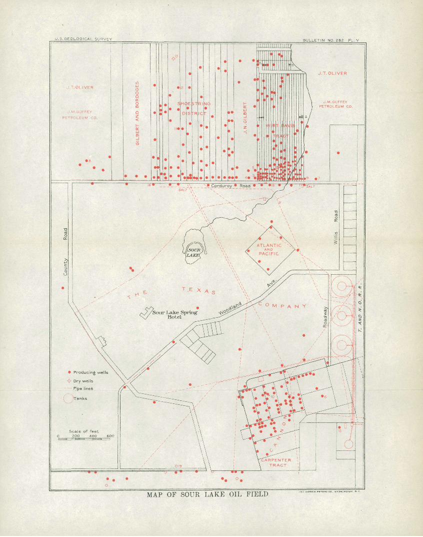
U.S.GEOLOGICAL SURVEY BULLETIN NO. 282 PL.V
f .Corduroy Road *»is /"
MAP OF SOUR LAKE OIL FIELD
SOUR LAKE FIELD. 89
Deep drilling began in 1901. In the summer of that year the Guffey well No. 1, on the extreme west side of the field, was sunk to a depth of 1,200 feet. A sputtering of gas, mud, and sand, with some oil, was noted at 900 feet. Similar indications were obtained in the Great Western well, in the Rodgers tract near the railroad. It was drilled to 1,500 feet in November of the same year. This well is also noteworthy for the large amount of hot water encountered (see p. 120). In March, 1902, the Great Western Company obtained a natural flow or gushing of oil in .a well 683 feet deep, located some 500 feet south of the Wirt Davis tract. The experience of this well showed the necessity of a strainer (an invention not yet perfected) to prevent loose sand from entering and choking the well.
BEGINNING OF PRODUCTION.
The first genuine success was the W. B. Sharp well, drilled in January, 1903, in the Wirt Davis tract. The facts concerning this well were for a time kept secret. The Texas Com pany also obtained flows from two wells on the large tract belonging to the Sour Lake Springs Company, but the facts were not then made public. In May came the Gilbert No. 1, a famous gusher, yielding 15,000 to 20,000 barrels per day. This became the signal for immediate drilling by a host of operators. "By August 1, 1903, 220 wells had been completed, or were in the process of drilling, and the output of the field exceeded 100,000 barrels a day." « Many of these early wells were in the best parfcof the field, in and near the south end of the Wirt Davis tract, and had an initial yield of more than 10,000 barrels daily. Only a small minority yielded less than 1,000 barrels. Before- the close of the year the field had produced more than 8,000,000 barrels.
TOPOGRAPHY.
Some effort has been expended in instrumental surveys to show the existence of a mound at Sour Lake similar to that of the Beaumont field. The necessity of measurements indicates at once the fact that any elevation in this field is of a very different form from that of Spindletop. Levclings show a difference of 20 feet between the highest part of the field and the lowest part of the salt marsh on the southeast. The relief within the field itself amounts to at least 10 feet. The inequalities are, however, highly irregular, and there is no well-defined mound.
The differences of elevation are due to three causes: (1) Unequal settling of the sedi mentary formations, (2) erosion, and (3) the activity of the same uplifting agencies which made the mounds of the Coastal Plain. There is a possibility of a fourth factor, namely, settling due to the dissolving of salt deposits, but this can not be demonstrated. The phenomenon of unequal settling of unconsolidated sediments is sufficiently common on the Coastal Plain to need no further mention.
The beginnings of erosion at Sour Lake are. evident. .Pine Island Bayou, several miles to the south, follows near the edge of the Beaumont clays as mapped by Kennedy. On its southern side this stream is practically without tributaries. On its northern side tributaries have begun to incise the sandier terrane which has been regarded as of Columbia age. The progress of stream dissection is more marked farther north, but its beginnings are noted at Sour Lake.
« Reavis, Holland S., The Texas Almanac, 1904, p. 159.
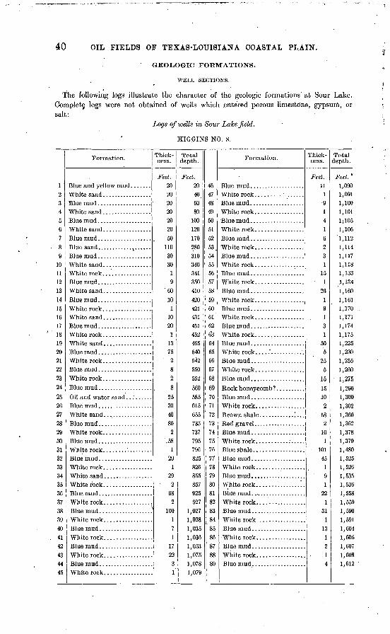
40 OIL FIELDS OF TEXAS-LOUISIANA COASTAL PLAIN.
GEOLOGIC FORMATIONS.
WELL SECTIONS.
The following logs illustrate the character of the geologic formations at Sour Lake. Complete, logs were not obtained of wells which entered porous limestone, gypsum, or salt:
Logs of wells in Sour Lake field.
HIGGINS NO. 8.
1 '9,345ft789
1011121314ISIf.17IS192021222324
252627282930313?33343536373839404142434445
Formation.
\Vhite rock
White rock. ................Blue mud...................
White sand .................
White rock.................
White rock.. ...............
White rock...... ...........
White rock................
Thick ness.
Feet. 20202020202050
1103030
19
'60
101
1020
11375
282
825304080
2',58
129
129
268
2100
171
172231
Total depth.
Feet. 20406080
100120170280310340341350410420421431451452465540542550552
560585615C55735737795790825826855857925927
1,0271,0281,0351,0361,0531,0751,0781,079
4R474849505152,5354555657.585960f.1626-3
64fiS666768
W707172737475767778798081828384'85
86878889
Formation.
White rock.................
White rock.................
White rock...... ...........
Thick ness.
Feet. 11
19141623
15 1
2619131
505
255
T;
1510
258
216
1101
45191
221
311
131214
Total depth.
Feet. '
1,0901,0911,1001,1011;105
1,106'1,1121,1141,1171,1181,1331,134
1,1601,1611,1701,1711,1741,1751,2251,2301,2551,2601 97 1;1,2901,300
1,3021,3601,3621,3781,3791,4801,5251,526
1,5351,5361,5581,5591,5901,5911,6041,6051,6071,6081,612
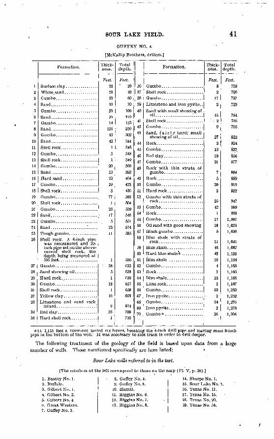
SOUR LAKE FIELD. 41
GUFFEY NO. 4.
[McKallip Brothers, drillers.]
12 3 4
5'o
7 8 9
10 11 .12 13 14 15 10 17 18 19 20 21 22 23 24 25 20
27 28 29 30 31 32 33
3435
Formation.
Sand........................
Gumbo .....................Sand........................Shell rock...................Gumbo.....................Shell rock. ..................
Shell rock...................
Shell rock. A 6-inch pipe was remeasured and 10- inch pipe set 011 the above- named shell rock, the depth being measured at 595 feet....................
Limestone and sand rock mixed .................... '.
Red clay ....................
Thick ness.
Feet. 20 20 20 10 39 10 14
126 43 42
1 3 1
20 13 22 19 3
77 1
25 17
5 23 11
1 38
5 1
18 1
10
6 35
1
Total depth.
Feet. ' 20
40 00 70
109 119 133 259 302 344 345 348 349 369 382 404 423 426 503 504 529 540 551 574 585
580 633 638 639 657 658 608
674 709 710
36 37 38 39 40
41 42 43
44 45 46 47 48
49 50 51 52
53 54 55 50 57 58
59 00 01 62 63 64 65 60 07 08 09 70
Formation.
Limestone and iron pyrite..Sand with small showing of
oil..................:.....Shell rock...................Gumbo. ....................Sand, fairly hard; small
Rock with thin strata of
Rock........................
Hard rock. .................Gumbo with thin strata of
rock ...................... Gumbo.. ...................Rock. .......................Gumbo..... ................Oil sand with good showing Black gumbo ...............Blue shale with strata of
Thick ness.
Feet. 8 2
17 2
45 2 9
27 2
13 19 21
7 5
30 3
25-
42 1
17 18
5
1140 48 19
4 2
25 2
63 2
24 2
20
Total depth.
Feet. 718 720 737 739
784 780 795
822 824 837 856 877
884 889 919 922
947 989 990
1,007 1,025 1,030
1,041 1,087 1,135 1,154 1,158 1,160 1,185 1,187 1,250 1,252 1,270 1,278 1,304
"At 1,135 feet a blow-out lasted six hours, breaking the 4-inch drill pipe and leaving some 8-inch pipe in the bottom of the well.- It was necessary to side track in order to drill deeper.
The following treatment of the geology of the field is based upon data from a large number of wells. Those mentioned specifically are here listed:
Sour Lake wells referred to in the text.
[The numbers at the left correspond to those on tho map (PI. V, p. 38).]
1. Beatty No. 1. 2. Buffalo. 3. Gilbert No. 1. 4. Gilbert No. 2. 5. Gilbert No. 4 0. Great Western. 7. GuffeyNo.3.
8. Guffey No. 4. 9. Guffey No. 5.
10. Hamill. 11. HigginsNo.O. 12. Higgins No. 7. 13. Higgins No. 8.
14. SharpeNo. 1. 15. Sour Lake No. 1 16. Texas No. 11. 17. Texas No. 15. 18. Texas No. 20. 19. Texas No. 34.
42 OIL FIELDS OF TEXAS-LOUISIANA COASTAL PLAIN.
COASTAL PLAIN SEDIMENTS.
As noted above, Kennedy's geologic map places the Sour Lake field on the outcrop of the Columbia (Pleistocene) sands. The delimitation of these from the Beaumont clays is primarily by fossils rather than by the nature of the sediments. Nevertheless, it may be noted that from Sour Lake northward the soil becomes progressively more sandy.
The beds, for the first 700 feet or more of depth, are clays, sands, gravels, and lime stones, no one of which has a constant position in the column. Anv one horizon may be represented at one place by a sand, and a hundred feet away by a limestone or clay. In some places the deposits may be of lens-like form; in others the nature of the bed may change without change of thickness. In any case the log of one well affords no suggestion of what may be found in another a few hundred feet away.
Of a large number of well records from this field, only a few show the character of the beds in the upper third or half of the section. Where these are given, the records do not indicate such a distinct dominance of sand in the first 400 or 500 feet as was found at Spindletop. It is true in a general way that sands are more abundant to that depth than lower, but it is also true that below 400 feet the Sour Lake logs do not generally show the long unbroken stretches of gumbo which are characteristic of the Beaumont wells. From 400 to 1,000 feet sands are frequently interspersed in the clays.
In the well sections whose upper parts are recorded, the proportions of sand are given in the following table. In the entire section of the Hill well, 1,780 feet deep,.very little is reported besides sand .a
Proportion of sands in surface beds at Sour Lake.
Well.
Gufley No. 4. .............. .". ................:.........................................Texas No. 34 ...........................................................................
Thick ness of sand.
Feet. 233255
3 2GO140
71
In the first
Feet. 358380410404
339
Beds of limestone from a few inches to a very few feet thick are of frequent occurrence, some wells showing as many as twenty such within 1,000 feet.
POROUS LIMESTONE.
Beneath the generally unconsolidated formations of the Coastal Plain there 's, in at least a small part of the Sour Lake field, a crystalline or cavernous limestone of the true Spindletop type (see p. 26). The area in which such rock is definitely known is a strip about 700 feet east and west by about"250 feet north and south. This strip covers the southern part of the Wirt Davis tract, extending west into the Gilbert tract, and east into the J. M. Guffey Petroleum Company's lease. On its southern side this strip includes some of the wells of the Texas Company in the Sour Lake Springs tract. About half a mile directly south" of this area, somewhat centrally located in the Cannon tract, a well drilled by James Hamill penetrated a similar porous limestone to a depth of 12 or 15 feet, finishing at 1,091 feet and deriving its oil from this rock. A few other wells in the Cannon tract seem to have finished in this rock and to have derived their oil from it, but most of the reports of such occurrences in this part of the field are believed to refer to wells which derive their oil from beneath rather than from within the limestone. Most of the wells in this part of the field are shallower than the Hamill well, and while passing through some
olt is to be remembered thatdrillers differ in the naming of materials as well as in the care with which the records are kept.
SOUR LAKE FIELD. . 43
limestone, it seems to be generally true that it is of the dense kind referred to above as occurring in the sediments above the porous limestone. A considerable number of these wells are familiarly spoken of as " rock wells." The fact that many of the wells in and near the Cannon and Rodgers tracts have been greatly troubled with sand and are obliged to use strainers indicates that they should be classed with the sand wells and not with those which derive their oil from the porous limestone.
FORMATION BELOW THE LIMESTONE.
The immediate lower neighbor of the limestone is not well known. On the northern edge of the area outlined above as being underlain by porous limestone, oil is reported as bsing obtained from sand beneath the limestone, the latter in this case being dense. White sand having a thickness of 60 feet is said to underlie the limestone in the Gilbert tract. Samples were not seen, but as this so-called sand was said to be entirely lacking in grit and to come out in small chunks which could be crushed between the fingers, it may be a material not unlike that which was found beneath the limestone at Spindletop and which seems to be a marl rather than a sand. In the Gilbert No. 2, gumbo intervenes between the limestone and the so-called white sand. A short distance to the oast, in the Wirt Davis tract, the same relations exist.
In the Texas well No. 11, 16 feet of gypsuui are reported as encountered at a depth of 1,180 feet. This was immediately below 14 feet of limestone which were reported as "oil rock." Inasmuch, however, as this well is classed as a "dead gas well" and has not pro duced oil, the nature of the rock is uncertain. If, whatever be its character, it represents the horizon of the porous oil rock, the gypsum reported is in the same general position with reference to the porous limestone as that in which it is found in the Beaumont field, the one difference being that between the oil limestone and the gypsum at Beaumont a bed of marl, clay, or sand commonly intervenes.
BOCK SALT.
Not less than ten wells within the area underlain by the porous, oil-bearing limestone are reported as having penetrated rock salt. The farthest west of these is the Gilbert No. 4. In it the salt was found separated from the oil-bearing limestone by a bed of hard clay or shale. In strip No. 5, 150 feet farther east, where the top of the limestone is at a depth of 800 feet, salt was encountered at a depth of 885 feet. The drill penetrated the salt 10 feet and stopped there, leaving the thickness of the formation unknown. The Buffalo well, in strip No. 11, 300 feet east of the Gilbert No. 4, stopped in salt at a depth of 1,090 feet.
PYKITE.
Iron pyrite is found at almost all depths, both above and below the oil. So far as noted, this substance is most abundant at or below the horizon of the oil. It was conspicuous below this depth in well No. 1 of the Sour Lake Oil Company and at a depth of 1,400 to 1,500 feet in the Great Western well. In the latter case clay from 5 to 10 feet thick, strongly impregnated with pyrite, alternated with other clay beds from which pryite was absent. A careful foreman (Mr. Black, of the Higgins Oil and Fuel Company), whose work has been with those wells in which the oil is derived from the sand, states that pyrite is always found in the rock just above the oil and to some extent in every consolidated rock below 340 feet.
STRUCTURE.
SEDIMENTARY FORMATIONS.
The determination of geologic structure from well borings alone necessarily implies that a given bed is recognizable and traceable from well to well. On account of the marked
44 OIL FIELDS OF TEXAS-LOUISIAISTA COASTAL PLAIN.
lack of lateral continuity in these Coastal Plain deposits, this is for the most part impossible. No significance can be attached to the varying depths at which oil is found in a group of sand wells, except as an illustration of the limited area of any one sand and of the irregular depths at which sands occur. (See fig. 12, p. 119.) The determination of dips by such evidence is of no value whatever. >,
STRUCTURE INDICATED BY THE POROUS LIMESTONE.
Within that small part of the field where the oil-bearing limestone has been exploited the case is somewhat different. The limestone is recognizable with a fair degree of cer tainty, and wells are so near together as to reduce the chances of error to a minimum.
The oil limestone, so far as recognized in and near the Wirt Davis tract, has a northeasterly, though by no means uniform, dip. It is nearest the surface in the Gilbert wells, where it is encountered at a depth of 660 feet, and is from 20 to 25 feet thick. The inclination of its upper surface in strip No. 1 (the strips of the Wirt Davis tract being numbered from west to east) is nearly 45° N. One hundred and fifty feet farther east the rock is found at a depth of 780 feet. It is reported here to be 100 feet thick. A few rods north of this latter. point its depth is 800 feet. In the Texas well No. 20, south of the road, a formation is reported at 754 feet, which may represent the same rock, indicating a continued rise to the south, but no wells farther south in this locality encounter the rock. Near the small stream a few hundred feet farther east the depth of the rock is from 830 to 840 feet, and its southern edge appears to be near the southern border of the Wirt Davis tract. Still farther east the Guffey well No. 5 reached the rock at a depth of 881 feet ami penetrated to a depth of 22 feet without passing through to ascertain its thickness. At this point it appears that the rock is present south of the road in the Texas No. 15 and is found at a shallower depth. The Guffey well No. 3,150 feet still farther east, was drilled to a depth of 1,117 feet, but no rock was encountered.
The oil-bearing limestone of this part of the Sour Lake field has its highest point near the southeast corner of the Gilbert tract. From this point it dips to the north and east but is not found to the south or west. Northward from this highest point the rock extends about 200 feet, and eastward it extends 600 feet. The highest point is 660 feet below the surface. The margin on the north side is 800 feet deep, and on the east side 88r feet. The extreme height of the structure, so far as it is known, is therefore 221 feet. These figures are similar to the corresponding figures-taken from Spindletop. It may be neces sary to state once more-that these figures may or may not represent actual local dips of beds. They, indicate the depth of the upper surface of a body which is not sedimentary and which may have any position with reference to bedding planes (see p. 45).
The known occurrences of the porous limestone in the Cannon tract are too few to be used in the determination of structure. If inferences may be drawn from the depths of the many wells which have derived their oil from beneath a limestone, it may fairly be con cluded that there is in this part of the field a gentle dip to the south and the east. Some much deeper wells on the west and northwest side, of the field reach no porous limestone.
INFERENCES.
In accordance with the facts summarized below it is believed that the strata underlying the area are approximately horizontal. This does not apply to the crystalline, porous, oil-bearing limestone, whose form is not believed to be that of a sedimentary bed. The indications which seem to exclude steep dips from the sediments may be summarized as follows:
(1) The horizon of the oil differs but a few hundred feet in long distances, and when it is remembered that four or five petroliferous sands are often passed in the same well even this difference of depth loses all significance as to dips, because of the impossibility of correlating the sands of different wells, ^hat is true of the petroliferous zone as a whole is true of the more restricted oil-bearing horizons, some of which seem to have a certain continuity throughout limited portions of the field.
SOUK LAKE FIELD. ' 45
(2) There is no evidence whatever of dips from the surface outcrops. The character of the beds at the surface in the oil field is essentially that of the surface beds in the sur rounding region.
NATURE OP THE LIMESTONE.
The characteristic features of the porous limestone are those of a precipitate of calcite (sometimes dolomitic) from ground waters. At places the entire mass of limestone is of this origin. At other places there has been only enough solution and precipitation to cement a calcareous bed into a dense, hard limestone. Between these extremes there are all gradations, representing all possible proportions of original calcareous sediment and of crystalline calcite. There are also gradations between pure sand and both of the extremes named above.
So far as the limestones found at Sour Lake are due to the consolidation or cementation of calcareous beds they are generally thin plates, dense and hard. These are of the most common occurrence and are believed to be nearly horizontal, occurring at any and all depths and being of very limited lateral extent. Thicker layers of this kind have, in various parts of the field, formed impervious covers over oil-bearing sands, and therefore constitute true cap rocks. Such a rock may, however, be locally crystalline and cavernous, due $o the local activity of ground waters. In such a case the-rock itself may bear the oil instead of acting as a cap to confine it in the lower sands. This is without doubt the case in the Cannon tract, where a limited number of wells derived oil from the limestone. These local masses of porous limestone may belong to the horizon of the dense limestone which, in other wells, serves as cap rock, or they may be separate bodies.
So far as the limestone is a precipitate from water, its surface may show almost any form. Though influenced to some extent by the bedding, it may be expected to exemplify all the freakishness of concretions. Horizontality, or the lack of it, must not, therefore,, be taken too seriously or ascribed to causes too profound. In entire harmony with this, it may be stated as a general principle based on observation, that steep dips in the oil-bearing mounds are limited to the limestones (or dolomites) which have been precipitated from water. The dense, hard plates due to cementation are, so far as known, nearly or quite horizontal. This statement does not apply to the higher mounds which have not as yet produced oil.
OCCURRENCE OF THE OIL-.
CLASSIFICATION OF WELLS.
By the different relations of the oil to the rock, the Sour Lake wells fall naturally into three classes: (1) Those which derive their oil from the pores and caverns of the lime stone, (2) those in which the oil is found beneath a limestone cap rock, (3) those which find oil in beds of sand, confined by clays, and in which limestone, if occurring at all, bears no relation to the oil reservoir. There is no essential distinction between wells of the last two types. The three classes are differentiated here because wells of the second class are frequently spoken of as "rock wells" and confused with wells of the first" class.
WELLS IN THE LIMESTONE.
Probably wherever the porous limestone has been encountered in this field, it has yielded oil. While a relatively small portion of the field affords this source of oil, the wells of this small area have yielded the larger part of the product. In both the rate and duration of their production they have been superior to the wells which have tapped the sands only. In the Gilbert and W.irt Davis tracts alone about 150'wells have been drilled, most of them in the limestone, many of these yielding at the start more than 10,000 barrels daily. "The Sharp well produced 325,000 barrels in twenty days, valued at $80,000; Gilbert No. 1 produced enough petroleum in thirty days to bring $125,000" (Oliphant). It is note worthy, however, that several of the sand wells drilled later on the northwest side yielded, under compressed air, 3,000 to 5,000 barrels daily, but this rate was continued for only a short time.
46' OIL FIELDS OF TEXAS-LOUISIANA COASTAL PLAIN.
WELLS IN THE SAND.
The so-called "rock wells" of the second class are frequent in the central and southern parts of the field. In the larger part of the field, including the whole of the "Shoestring district," the oil is found in reservoirs of sand, overlain by impervious clays. Wells of the second and third classes find oil at almost all depths from the heavy oil at 230 feet to the large quantities of a better grade found between 1,300 and 1,400 feet on the northwest side of the field. All mention of "first sand," "second sand," "third sand," etc., is mis leading. The most that can be said is that certain broad and poorly defined horizons are richer than others in oil-bearing lenses or patches. The deeper, wells afford some suggestion of a definite oil-bearing stratum, but the area thus characterized is small, and the oil should be spoken of as belonging to a horizon which may be defined within certain limits, rather than to a definite bed.
It is not now possible to say to what extent the areas affording sand wells are underlain by an oil-bearing limestone and the oil in the sands supplied by upward leakage from the limestone: It is not definitely known that such relations exist, but the showings of oil in the sands directly over the oil-bearing porous limestone in this and other fields offer a strong suggestion of such a relation. .It can not be affirmed, however, that this relation is general, because prolific oil sands have been found, both at Spindletop and Sour ^ake, at lower levels than that of any known limestone. Thus far, also, no oil-bearing or porous limestone has been found at Saratoga or Jennings.
SALT WATER.
All except the surface waters within the field contain some salt. Water from depths greater than 100 feet is rarely fresh enough for drinking or for. use in boilers. At the depths where wells are finished the water may be intensely briny.
REGULAR ADVANCE.
In its relations to the oil, the salt water at places behaves very much as it does in the Appalachian fields. Considerable areas have shown a progressive invasion of salt water, advancing from well to .well, beginning with those which found the oil at greater depths and proceeding up the dip of the oil-bearing rock to the shallower wells. This mode of invasion is typically illustrated in the limestone wells of the Wirt Dayis tract. In August, 1893, salt water appeared in the eastern member of this group and began its advance westward. More than a year later there was still left a gradually diminishing group of limestone wells which were free from salt water and were yielding the greater part of the product of the fields. By the close of 1904 only three wells in this group were producing oil without salt water. *
IRREGULAR ADVANCE.
Other parts of the field do not afford examples of this well-recognized relation between oil and salt water. It must be accepted as a general principle that where oil and salt water are contained in the same reservoir the latter will buoy the former up, and on the exhaustion of the oil the water will follow it into the well. However, where porous sands, impervious clays, and porous limestones with impervious crusts have such an apparently lawless distribution as in these Coastal Plain sediments, either oil or water may be con tained in a practically sealed reservoir or the communication between the two may be of any degree of freedom. Some wells therefore "go dry," or, to speak more accurately, the oil when exhausted is followed by insignificant quantities of water, which enters the formation from which the oil has been removed, but with exceeding slowness, because to do so it must traverse the clays. At other places the advance of the salt water across the field is by the most devious and apparently haphazard course, some wells producing oil without water for weeks or even months after their neighbors on all sides have gone to water. Again, the salt water may appear suddenly in the most unexpected place.
SOUR LAKE FIELD. 47
These irregularities are well illustrated on the west side of the group of limestone wells in the Gilbert and Wirt Davis tracts. It is commonly said that the wells on the east side of the group go to salt water and those on the west side to gas. The only significance of this latter expression is that' the gas so abundantly associated with the oil of the rock wells continues to exhale slowly from the porous rock after the quantity of oil capable of being pumped has become very small.
In November, 1904, the Landry wells were conspicuous for their freedom from salt water, while the surrounding wells were yielding gradually increasing quantities. Such has been the case with an occasional well in the Cannon tract. In September, 1904, the original "Beatty gusher" was still yielding oil without water, while some of its neighbors had gone dry and others were yielding mainly water. In a general way, however, the salt water has invaded the Cannon tract as it did the Wirt Davis tract, from the east.
HOT WATER.
There are various reports of "hot water," but the data concerning the taking of the temperatures are not obtainable. The Higgins well No. 4 is said to have encountered water at 101° F. at a depth of 985 feet. This water was intensely salt. The Great Western reported water at 100° F. from a depth of 850 to 880 feet. These reports were made while drilling, and the .water was obliged to rise to the surface on the outside of the pipe.
It is therefore to be supposed that some heat was lost in the ascent.
GAS.
The amount of gas released in this field has been very great. Strong gushers were obtained in various parts of the field and flowing wells were common. The gas is similar to that at Spindletop. That which comes from the porous limestone is equally poisonous and, as noted above, continues to exhale from wells where salt water has failed to appear when the oil has been- practically exhausted.
PRODUCTION.
NUMBER OF WELLS.
Up to August 15, 1904, 467 wells had been finished and 15 were drilling; 181 had been abandoned, 32 were reported dry, and 254 were producing intermittently, though the average number in daily operation was about 105.« These figures apply to all wells within a radius of 5 miles, but the number of wells more than^one-half mile from the center of the field is very small. The activity in the second half of 1904 was somewhat greater than in the first half. .
QUANTITY OF OIL.
During its first year (1903) the field produced 8,700,000 barrels. The maximum rate was in August and September, when the average daily production ranged from 50,000 to 60,000 barrels. For short periods the yield exceeded 100,000 barrels daily. From that time the production steadily declined until, in July, 1904, it was but 11,000 barrels. About that time, however, the decline at Batson redirected attention to the staying qualities of the Sour Lake field and there was a revival of successful development, the result being an intermittent rise of the daily output to 19,000 barrels in December, 1904. The chief gain in the latter half of 1904 was from deep sand walls (1,300 to 1,400 feet) on the west and northwest sides of the field. Early in 1905 the entire group of these deep sand wells went to salt water. The statistics compiled by Mr. Oliphant b give 6,442,357 barrels for the yield of 1904, or more than 2,000,000 barrels less than that of the former year. In October, 1905, the daily production slightly exceeded 7,000 barrels.
o Oil Investors' Journal, September 15,1904. 6 Mineral Resources U. S., 1904.
Bull. 282 06 1
48 OIL FIELDS OF TEXAS-LOUISIANA COASTAL PLAIN.
CHARACTER OP THE OIL.
Taken as a whole the Sour Lake crude oil is practically identical with the Beaumont. Its gravity averages about 22 B°. On refining, it yields less than 2 per cent gasoline, 17 per cent kerosene, 15 to 16 per cent solar, and fully 52 per cent lubricating oil.o The shal low oils discovered before 1902 have a gravity of 16° to 18° B. The deepest oil (1,300 to 1,400 feet) is said to have a gravity of 24.7° B.
BATSON FIELD.
HISTORY.
Next to Spindletop, Batson has the most sensational history of any oil field on the Coastal Plain. This is due largely to its discovery at a time when the rapid decline of the Beau mont field and the waning production of Sour Lake set free a large number of men and drills. It is also due in part to the rare chance by which the first well pierced almost the center of the field. The wells were, therefore, from the start, phenomenally successful. The drilling in this field is also easy and is comparatively free from certain disadvantages, such as caving, which attended the drilling at Spindletop. The discovery of the Batson field came at a time when the Santa Fe Railroad had but recently built a branch to Sara toga, thus giving a railroad station within less than 6 miles from the new field.
Surface indications inviting drilling in this vicinity were never abundant. Bubbles of gas may be seen rising from pools of water, but whatever seepage of oil there may have been is now obscured by the abundant waste from the wells.
In 1901 the Libby Oil Company drilled a well 3 miles to the south, but, with the excep tion of a slight showing of oil at about 1,000 feet, this trial offered but little encouragement. The second attempt was by the newly organized Paraffine Oil Company, of Beaumont, which, on October 31,1903, found .oil at a depth of 790 feet not far from the center of the Batson field. This well became a good producer. On December 19 the same company brought in its second well, which, after a little preliminary difficulty with sand, yielded by natural flow 4,500 barrels of oil per day.
The effect of these successes was such that by the close of the year 1903 there were 28 derricks in the new field, many of them representing partially completed wells. The two Paraffine wells were followed early in January by the Brooks No. 1, of the J. M. Guffey Petroleum Company, a vigorous gusher with an initial daily production of 18,000 barrels. Development work was so rapid that, on March 4, the daily production of the field had reached 151,000 barrels. At this time salt water, which had been noticeable from the start, began to make rapid advance, and by April the .production of the field had fallen to 35,000 barrels a day. The larger part of the total production of the field to the close of 1905 was in the first half of the year 1904.
LOCATION A1STD TOPOGRAPHY.
The site of this field is Batson Prairie, a mile or more distant from the village and post- office of Batson, Hardin County. The field is 7 miles southwest of the village.of Saratoga and less than 6 miles from Saratoga station. It is 13£ miles west by north from Sour Lake. The distance from the Gulf coast is 45 miles. The coastal prairie at this distance from the Gulf alternates with woodland, which for the most part follows the streams.
Batson Prairie is a comparatively flat stretch of ground lying between the southeastward- flowing tributaries of Pine Island Bayou. The relief due to the faint stream cutting is perhaps 10 feet. While apparently flat, it is probable that the elevation of the oil field is slightly greater than that of the surrounding forest. There is no superficial suggestion of a mound of the Spindletop type.
o Information received from Mr. J. S. McNamara, of the United Oil and Refining Company, Beau mont, Tex.
BULLETIN NO. 282 PL. VI
CHAMPION CHOATE:
M«ARY KfN&STONCOLORADO SYNDICATE / 6UFFEY PETROLEU
8 A / 8 A.
I I 7! ' * / /i
________ SWBDI.VISIPN
Producing wells
I o Dry wells
! - -Ripe lines
0 Derricks or proposed wells 0 20O 400 60O BOO feet
MAP OF THE BATSON OIL FIELD.
BATSON FIELD. 49
LIMITS OF THE PIEIJD
Before the spring of 1905 the oil-producing area had been outlined with a considerable degree of exactness and was surrounded by dry holes. New work in the winter of 1904-5 was confined to the west side of the field, chiefly to the Wing and Milhome tracts. In the month of January, 1905, but four new wells were being drilled and four old ones being deepened. At about that time the successful development of the Milhome tract, on the extreme west side of the field, caused a revival of operations and a consequent increase of production The productive area of the field, as outlined in the spring of 1905, did not exceed 400 acres. Its shape gives no suggestion of axial directions.
GEOLOGIC FORMATION'S.
WELL SECTIONS.
The following logs are typical of the Batson field:
Logs ofiuetts in Batson field.
HIGGINS OIL AND FUEL COMPANY, NO. 4.
[Finished May, 1904.]
1
9
4567
101119
11
14
1516
Formation.
ter,80°F.... .............Blue shale. .................
Thick ness.
Feet. 325
58515
19015
1954030
15410
5
15. 70
1
Total depth.
Feet. 32533n415430620635830870900901955965970
9851,0551,056
17*18
192021W,23
24
25
26
27
28
29
30
Formation.
White rock. ................
Thick ness.
Feet. 91
151925
322
102213171
Total depth.
Feet. ' 1,005
1,0061,0811,1001,1251,1281,1301,1321,1421,1441,1461,1471,1501,151
J. M. GUFFEY PETROLEUM COMPANY (STATE LAND) NO. 14.
12q
4
5'
6
7K
910
1?
Clay........................
.....do.......................
Blue shale ...:... ..........
&<*
55901565
3520
4521
50220
45
100190205270
305325
370391441443463
131415
1017181920
21222324
.....do......................
Rock........................
Blue shale ..................
1631818' 30
131
1020-20
2327
479482500518548561
562572598618641668
"Pumped 500 barrels at the start. One month later about 400 barrels of oil with 600 of salt water. Salt water from the start at 101° F. A strainer placed wherever oil appears in the log. This is true for all wells at Batson below 475 feet.
50 OIL FIELDS OF TEXAS-LOUISIANA COASTAL PLAIN.
Logs of wells in Batson field Continued.
J. M. GUFFEY PETROLEUM COMPANY (STATE LAND) NO. 14-Continued.
252697
28?930vv>00
34OC
3A
^7
38on
4n
414?
Formation.
"Rn'Mr
Rock.......................
Rock. .......................
Thick ness.
Feet. 20
16182
1 310 '
209C
6141035
310
2112410
Total depth.
. Feet. 68869671273073274";
755775800806820830865868878880891915091;
44
40474849wi
51CO
.53
54
55Cfl
^7
CO
CQ
fiOfil
Formation.
Rock. .......:...............
Rock........................
Rock. .......................
showing of oil o.. ..........
Thick ness.
Feet. 2510301218
4
113
102112106
217
176
2
Total depth.
Feet. Q^O960990
1,0021,0201,024
1,0351,0381,0481,0691,0811,091
1,0971,1181,1251,1421,148
1,150
J. M. GUFFEY PETROLEUM COMPANY (WING) NO. 21.
[Completed June 23, 1904.]
1 2 3 4 5
6 7 8 9
10 11 12 13 14 15 16 17 18 19 20 21 22 23 24 25
Shale.......................
Rock. .......................
40 20
'20
10 50
20 10 10 20 20 90 58 22 25
5 1
30 51 25 10 30 24 23
1 15
40 60 80 90
140
1(50 170
. 180 200 220 310 368 390 415 420 421 451 502 527 537
. 567 591 614, 615 630
26 27 28 29 30
31 32 33 34 35 36 37 38 39 40 41 42 43 44
45 46 4748
Shale.......................
Sand, soft rock, and gas. . . . Oil, sand, oil rock, and gas . . .
Shale with gas blowout .....
Shale.......................
Oil rock and shale alternat ing and containing gas. . . .
Same with gumbo; no gas. . Rock. .......................Shale.......................Rock. Water lost and well
20 64 25 21 34
19 17 44 22 22 30 13 16 2
16 . 3
6 20
39 19
1 2*
14
650 714 739 760 794
813 830 874 896 918 948 961 977 979 995 998
1,004 1,024
1,063 1,082 1,083 1,085J
1,087
oStrainers set at 550-575, 680-780, 830-870,1,090-1,150.& Nine joints of strainer, 180 feet, set at 1,087, above which is one joint of blank pipe, then 60 feet more
of strainer. Well still flowing (August, 1904) 225 barrels daily.
BATSON FIELD. 51
Logs of wells in Bat son field Continyed.
J. M. GUFFEY PETROLEUM COMPANY (CHOATE) NO.
1?:
o
45f>7
9101119
14'
151C17ia
192021?,?,
Formation.
Glay.. ......................
Rock. .......................Gumbo.....................HockShalo.......................Sand........................
Shale....................:..Rock........................
Shale.......................
Thick ness.
Feet. wi<mOA
60
410
o
o
10
10 5
20
37Ort
1 C
33
Total depth.
Feet. 5090
120180206210220997
AV\
dfi^
500
?324M?,6?7?,8W
303132
33343536373839-
404142
Formation.
Rock. .......................
of oil throughout. ........Slate........................G umbo .........I..........;.Slate........................Rock. .......................Slate........................Gumbo. ....................Shalo....................... J.....do......................Gumbo .....................Shale.......................Rock.........................Slate and shale .............Rock. .......................
Thick ness.
Feet. 4050
3372525
554520
GO
337
110353342.282
181
Total depth. ,
Feet. 540590593630655680
735780800800863900
1,0101,0451,0781,1201,1481,1501,108
. 1,169
a This well has not yet produced; will be deepened..
The date from which the geology of the field is inferred are taken from a large number of wells. Those which are mentioned by name in the text are found in the following list and may be located on the map (PI. VI):
Batson wells referred to in the text.
[The numbers at the left correspond to those on the map (PI. VI, p. 48).]
1. Alert.2. Bates No. 1.3. Batson Oil Company.4. Brooks Nb..l.5. Choate No. 1.6. Choate No. 8.7. Colorado Syndicate.8. Douglas No. 5.9. Guffey (2 acres) No. 1
10. HigginsNo. 1.11. Higgins No. 4.12. Higgins No. 5.13. Marshall No. 1.14. Marshall No. 2.15. Mary Ellen No. 1.
1.6. Milhome.17. Parafflnc No. 1.18. Paraffine No. 2.19. Paraffine No. 12.20. Prather & Hughes.21. Santa Fe.No. 1.22. Santa Fe No. 2.23. State Land No. 2.24. State Land No. 14.25. Wing No. 1.26. Wing No. 2.27. Wing No. 4.28. Wing No. 12.29. Wing No. 13.30. Wing No. 19.
52 OIL FIELDS OF TEXAS-LOUISIANA COASTAL PLAIN.
SEDIMENTS.
The location of the field on Kennedy's geologic map a is on the outcrop of the Columbia (Pleistocene) sands. Not much sand, however, is apparent in the surface soil of the prairie. The proportion of sand increases rapidly toward the north in the vicinity of Saratoga station. '
As at Spindletop and Sour Lake, the sedimentary beds traversed in drilling consist of unconsolidated clays and sands with occasional thin beds of limestone. Three or even more of such limestones may be encountered within a thickness of 100 feet. In general they are more abundant in the second 500 feet than in the first.._If all the logs received are correct, it appears that such limestones are so irregularly distributed that while some wells encounter 15 or 20 beds, other wells miss them entirely.
The proportion of sands passed is rather smaller than at Spindletop, though perhaps not so strictly limited to the upper beds. In a general way the upper beds, including 100 to 300 feet, are predominantly sand. The proportions found are shown in the following table;
Proportion of sands near the surface at Batson.
Name of well.
Santa Fe No. 1. ...................Santa 'Fe No. 2..............'......Santa Fe No. 3. ....................Texas Co. (Lovett & Davis) No. 12.
Higgins No. 5. ....................Guffey (2 Acres) No. 1. .:.........
Thick ness of sand.
Feet. 213229132174150180
61
In the first
Feet. 348292105234195260121
Name of well.
Douglas No. 5 (Guffey) ..........State Land No. 14 (Guffey) .:....Wing No. 12 (Guffey) ...........Wing No. 19 (Guffey) ...........Choate No. 13 (Guffey) ..........Choate No. 16 (Guffey) ..........
Thick ness of sand.
Feet. 270
5550
310180100
In the first
Feet. 290100100330220180
In a well 5 miles northwest of Batson, 1,506 feet deep, only two small water sands were found above a depth of 140 feet, while all .below is reported as solid clay.
There is an occasional mention of gravels in the upper sandy layers, but they do not occupy constant positions in the column and must be regarded as isolated patches contained within the sands and clays. The Choate No. 16 reports gravel at from 50 to 90 feet; the Wing
. No. 19 at from'310 to 330; the Santa Fe No. 3 reports sand and gravel passed through from 145 to 165 feet. In two wells, the Wing No. 1 and Wing No. 4, this gravel, found at a depth of about 200 feet, is said to be highly colored, having pebbles of yellow, red, and black.
POROUS. LIMESTONE.
Beneath the sediments here described, and lying at depths varying from a little less than 1,100 to a little more than 1,200 feet, is a rock which is believed to be essentially the same as the porous oil-bearing limestone at Spindletop. This limestone is reported from all parts of the field, and it probably underlies nearly the whole area. Its thickness is deter mined ui two wells near the center of the field as 22 feet in the one case and 30 feet in the other. It is highly probable, however, that both the thickness and the character of the rock are subject to veiy great variation. The limits of this variation, as described at Sour Lake (see p. 45), will doubtless also hold true for Batson. In brief, it may be said that at places the limestone is a consolidated sediment of close texture, while at others it is crystal line and porous or cavernous and evidently a precipitate from ground waters. Further more, it can not be asserted with any degree of certainty that the limestone beds found at approximately the same depth in various parts of the field are connected in one continuous stratum.
Bull. U. S. Geol. Survey No. 212,1903, PI. I.
BATSON FIELD. 53
SULPHUR, PYRITE, GYPSUM, AND SALT.
The abundant reports of sulphur in other fields of the Coastal Plain find no parallel at Bat- son. It is mentioned in one well only, in the Kiser & Middlebrook tract, where it is said to have been found in a rock locally called " cap rock." What is true of sulphur is to a lai-ge degree true of the iron pyrite so abundant in other fields. Pyrite was found with the sul phur in the well mentioned above, and it to some extent impregnates a sandy .horizon between 800 and 900 feet -deep in the Higgins tract. Outside of these two places it has received very little mention. It is noteworthy, also, that the surface indications noted in other-fields as so closely connected with the presence of sulphur are largely absent at Bat- son. Gypsum is also almost without mention. There is but one mention of salt encoun tered in drilling at Batson. ' If the observations of the drillers were correct, 12.feet of salt were found in the Paraffine No. 12, northeast of the center of the field, at a depth of 1,007 feet, or 130 feet above the oil rock. The absence of any other mention of salt leaves this observation'open to doubt. It is more probable that the bed in question consists of sand impregnated with salt than of the latter alone.
FORMATION BELOW THE POROUS LIMESTONE.
Because of danger from salt water, very few wells at Batson were drilled through the oil- bearing porous limestone. The Higgins No. 1 passed out of a limestone at 1,222 feet into "a coarse gray salt sand, very porous," 22 feet in thickness. This sand was drilled through with cable tools because of the loss of water in drilling by the rotary process. In one of the Brice & Bradley wells, at 1,190 feet the drill passed through the limestone into "soapstone." It is apparent that very little is known of the formation in the Batson field occupying the same relative position as that of the gypsum, marls, and salt in most of the mounds of the Texas and Louisiana coastal plains (see p. 17). There was at one time a project for the cooperation of several companies in drilling one deep well in the hope of finding a deeper oil than has yet been discovered. Such an attempt, though not promising from an economic standpoint, would be highly interesting in view of the opportunities it might give for com parison of the structures and succession of formations at Batson and elsewhere; for it is highly probable that although there is no superficial mound in this field, the agencies which have been at work are the same as those which have made the Coastal Plain mounds. It is quite possible that the succession of materials at Batson would be found very similar to that at Spindletop, though the proportionate abundance of each might differ greatly.
STRUCTURE.
As in the other fields, the position of the beds is difficult to determine on account of their lateral discontinuity and the resulting impossibility of correlation. The only formation capable of being traced from well to well with any certainty as to its identity is the oil- bearing limestone. It furnishes, therefore, the chief criterion in the determination of structure. . '
DEPTHS AND DIPS OF THE LIMESTONE.
This formation comes nearest to the surface at the east end of the Marshall lot (Guffey lease). It was encountered'here in two wells at depths of 1,081 and 1,088^ feet, respec tively. From this place it dips somewhat strongly to the north and east, but a faint ridge or crest of this formation extends in a northeasterly direction through the 12-acre tract of the Paraffine Oil Company to its northeast corner.' Along this low crest the depth of the limestone is, for the most part, about 1,136 feet. It dips gently to the south from this crest, reaching a depth of 1,144 feet in the Brooks No. 1, 1,159 feet in the Bates No. 1, and 1,178 feet in the State Land No. 2. The dip to the east and northeast from the end of the crest described is more rapid than that to the south and southeast. In the.Choate No. 1, about 500 feet east of where the crest begins'to pitch, the depth attained is 1,180 feet. In the Higgins No. 1, 300 feet farther east, it is 1,198 feet. Northward from the assumed crest
54 OIL FIELDS OF TEXAS-LOUISIANA COASTAL PLAIN.
the depth of the limestone increases but slowly. In the Choate No. 8, on the extreme north side of the field, some 1,700 feet from the crest, the depth is 1,205 feet.
Little is known of the depth or continuity of the limestone west of the highest point in the Marshall tract. There seems, however, to be a separate elevation having its highest point at or near the Wing No. 4, in the southeast corner of the W. D. Wing 100-acre tract. This well found limestone at 1,104 feet, while to the east the Mary Ellen No. 1 and the Wing No. 13 found the same formation at depths of 1,145 and 1,152 feet, respectively. Between this elevation in the Wing tract and the one which culminates in the Marshall tract there is apparently a broad structural depression. It appears that the Wing No. 2, on the west side of the field, encountered a similar rock at a reported depth of 1,136 feet. Whether the elevation thus indicated is connected with either of the other two is open to question.
1 If the elevation of the limestone indicated at the Wing No. 2 be hypothetical^ connected with tha.t which appears at the Wing No. 4, there might be some slight presumption that the form of the limestone shows structural lines trending northeast and southwest. This would be somewhat further strengthened by assuming the correctness of the report which ascribes to the same rock a depth of only 1,136 feet in the Paraffine No. 12, east of the Choate tract. This well is almost on a line with the northeasterly extension of the crest described above. It must be admitted, however, that in our present state of knowledge the delineation of the surface of the porous limestone by contour lines is a difficult matter, not free from inconsistencies, and the assigning of any direction to structural lines is no less precarious.
It will be seen from the depths given above that the dips of the oil-bearing limestone are very gentle. Locally, as in the vicinity of the Marshall No. 1, the inclination appears to be as great as 20 feet in 100, but this is altogether exceptional. When one remembers the extreme unevenness of the upper surface of the corresponding formation at Spindletop, such local variations of depth can not be assigned any great structural significance. The next steepest place in the field is probably at the north end of the Guffey State land lease. It would seem that here, between the Brice & Bradley wells on the south and the Choate wells on the north, there is an inclination of the limestone amounting to perhaps 10 feet in 100.
As at Spindletop, the porous limestone is not found outside the limits of the productive field. If the formation extends beyond these limits its distinctive character is lost. There is no evidence whatever of a steep marginal dip, carrying the limestone to greater depths than the outlying wells have reached.
A HIGHER POROUS LIMESTONE.
In the southeast corner of the Paraffine 30 acres there is said to be a minor limestone of the typical porous character at a depth of about 600 feet and having a thickness of 5 or 6 feet. In the latter part of 1904 a few wells were drilled into and finished in this limestone, deriving their oil from it as others did from the deeper porous formation. These wells yielded at the start about 150 barrels per day each. No strainers were used.. It may safely be assumed that this rock is of the same kind and had the same origin as the deeper porous limestone (see p. 45).
SUMMARY.
The form of the limestone may be summarized as follows: (1) The general dip is very small. (2) There are at least two, and perhaps three or four, roughly dome-like or ridge-like elevations. (3) The extreme difference in elevation between the highest and the lowest points of the same formation is less than 125 feet. i('4) The attitude of the limestone prob ably agrees with the bedding in the main but not in detail. (5) The peculiar limestone in which the oil is found probably does not exist beyond the limits of the oil field. (6) Lime stones of the same character and the same (secondary) origin may occur at higher levels.
BATSON FIELD. 55
OCCURRENCE OF THE OIL.
IN THE LIMESTONE.
So far as known the porous limestone, wherever encountered, was filled with oil, and no oil has been found below it. Until the advent of salt water most of the wells were drilled into and finished in this limestone. When these deeper wells began to go to water it became the custom to finish wells at higher levels, where the occasional sands (and apparently in some cases the clays) were found to be saturated with oil.
IN THE SANDS.
As stated above, sands form a very small proportion of the sedimentary beds below 200 feet. There is no stretch of 100 feet, however, in which sands have not been found in some part of the field, and there is no stretch of 100 feet between the depths of 200 and 1,300 feet at which wells have not been finished. The occurrences'of oil in the sand might be grouped into certain broad and indefinite horizons, but it is probably very rare that half a dozen wells have derived oil from the same bed. What has been said of the patchy dis tribution and lateral discontinuity of these sandy beds at Spindletop and Sour Lake applies with equal fitness to Batson. Probably the smallest number of wells stopped between 920 and 1,100 feet. A large number found oil between 800 and 900 feet. Throughout the Higgins tract an oil-bearing horizon is said to exist between 400 and 600 feet. Even at 265 feet one well (Alert No. 3) had a typical blow-out and developed into a small gasher yielding 125 barrels of oil per day during the short time that it lasted.
SALT WATER AND GAS.
HORIZON OF SALT WATER.
All the waters encountered below 200 feet are noticeably saline, and even above that depth it has been difficult to obtain water suitable, to use in boilers. At greater depths the water becomes progressively more briny.. The large number of wells which stopped between 800 and 900 feet found abundant salt water below their deepest oil stratum. Indeed, the interstratification of oil and salt water is one of the noticeable characteristics _ of the field. This, of course, is made possible by the highly impervious clays which form the bulk of the sedimentary formations.
ADVANCE OP SALT WATER.
The lowest oil-bearing horizons went to salt water first. Wells drilled as early as Jan uary noted its presence, though no.t finding it in inconvenient quantities. The first two weeks of March marked tlie rapid invasion of the limestone by the salt water, and it was not long before the drilling of wells to this horizon had ceased entirely.
In a general way the advance of salt water within the limestone has been from the deeper to the shallower wells, though such a rule would not apply in detail. An illustration taken from the east side of the field is typical of the behavior of the salt water in the better-known fields of the eastern United States. The Higgins No. 1 (limestone 1,198 feet deep) began to produce salt water February 25, and by March 8 the water had advanced 500 feet to the west and had invaded the Hughes well (limestone 1,170 feet deep)'and the Prather No. 1 (limestone 1,162 feet deep). The advance continued westward to slightly shallower wells, reaching the wells of the Batson Oil Company in the middle of the Brice & Bradley tract on March 11 and the Moonshine Company's lease about a week later.
RELATIONS OF GAS, OIL, AND WATER.
The mutual relations of gas, oil, and water, which are regarded as typical in the Appa lachian fields (see p. 116), are better exemplified at Batson than in any other field in the Coastal Plain, though even here good examples of such relations are exceptional. Not less than hah* a dozen wells have come in as "gasers," have later become good oil producers,
56 OIL FIELDS OF TEXAS-LOUISIANA COASTAL PLAIN.
and later still have gone to salt water. The parallel with the Appalachian fields is the more strict because of the fact that the wells originally producing gas are found at higher points of the faintly dome-like structure. The Wing No. 4 and Marshall Nos. 1 and 2 are good examples.
HOT WATER. ' _
A considerable proportion of the salt water from the deeper wells was found to have a temperature above the normal for the depth from which it came. In the Higgins No. 4 the salt water from the sands 1,080 to 1,130 feet deep had a temperature of 101° F. In the Higgins No. 1 the temperature of the very briny water from a depth below 1,200 feet is said to have been 125° F. It is generally said by gagers at Batson that the temperature of the salt water is higher than that of the oil, and that there is, accordingly, a notable increase in the temperature when a mixture of oil and salt water begins to take the place of the pure oil. (Compare Jennings, p. 100.)
PRODUCTION.
NUMBER OF WELLS.
Up to August 15, 1904, 440 wells had been drilled. There were 42 new wells drilling at that time and 25 derricks were erected at which drilling had not yet begun. Fifty-eight of the completed wells were reported as dry or abandoned. Of the remaining 382, some of which produced only intermittently, it was estimated that an average of 160 were in daily operation.
QUANTITY OF OIL.
In the year 1903 the recorded production of the field was but 4,500 barrels. Its growth and decline in 1904 are best illustrated by the following columns of reliable estimates, given by Mr. Holland S. Reavis in the Oil Investors.' Journal, January 1, 1905:
Production of the Batson field in 1904-
Barrels. January......'......'......... 440,000February......... 1.......... 1, 849, 000March...................... 2,608, 200April ....................... 1,050,000May........................ 883,500June.............. r ......... 720, 000July.........:.............. 682, 000
August September. October... November. December.
Barrels. 585,900 435, 000 325, 500 309, 000 316,200
10, 204, 300
It .will be seen from this decrease that the -production per day at the close of 1904 was approximately 10,000 barrels. At that time steel tanks were rapidly being removed to newer fields and the amount of new drilling in progress did not indicate much hope on the part of the operators that the production of the field would be revived. In the early part of 1905 the daily production rose again, reaching at- various times about 15,000 barrels. In October of the same year the field continued to produce more than 9,000 barrels daily and considerable drilling was still in progress.
CHARACTER OF THE OIL.
The lightest oil yet found in any quantity on the Coastal Plain is obtained at Batson. That from the Brooks well No. 1 (J. M. Guffey Petroleum Co.) at 1,150 feet had a gravity of 29.9° B. The oil from the sands above is a little heavier, that which was taken from near the center of the field at a depth of 1,100 feet having a gravity of 26° B. The oil obtained at 265 feet in the southern end of the Paraffin 30 acres had a gravity of 20° B. In this vicinity some oil taken from so shallow a depth as 814 feet had a gravity of 29.8° B., which is about that of.the deepest oil in the field. This circumstance suggests a rapid or easy rise
SARATOGA FIELD. 57
from the lower horizon, a suggestion which is supported by the finding of a porous lime stone (supposedly concretionary) at 600 feet. This is also in harmony with certain reports from drillers to the effect that in certain deep wells in that vicinity the limestone was found "fractured." The evidence on which such a report was made was not obtained.
The average gravity of Batson crude, as it is received by the United Oil and Refining Company, of Beaumont, is 27.7° B. 'By others the average gravity is given as low as 23° or 24°. On refining, it yields 6.5 per cent gasoline, 20.4 per cent kerosene, 14.4 per cent solar, 46.7 p'er cent lubricating oil, and 6 per cent asphaltum.
SARATOGA FIELD.
HISTORY AND SURFACE INDICATIONS.
SIMILARITY TO OTHER FIELDS.
The surface indications of oil at .Saratoga, were very similar to those at Sour Lake and Nacogdoches. The escape of small quantities of gas had long been noted, as had likewise small seepages of oil. There are also here, as at Sour Lake, certain spots in which the soil is found to be impregnated with an asphaltic substance. These phenomena have from the earliest settlement been regarded as indications of the presence of oil. A further analogy with the Sour Lake field is found in the sulphureted and sour waters which come to the surface.in.small quantities. In that part of .the field which is thus characterized a pond was dug some years ago which resembles the partly artificial pool at Sour Lake.
The first attempt to find oil by drilling was made with a spring-pole device worked by hand. This was not far from the present site of the hotel! The drilling stopped at a small depth after obtaining a showing of heavy oil, which was bailed out in very small quantities. This oil was used for medicinal purposes only. In 1896 Savage Brothers drilled a hole in the same locality to a depth of 250 feet. Oil and water issued from this well with a natural flow, which continued at a very slow rate almost to the present time.
RECENT DEVELOPMENT.
After the opening up of the Beaumont field in 1901 drilling, was begun in earnest at Saratoga. The year 1903 was the first in which oil was shipped. In that year the field is credited with a production of 150,000 barrels. Up to August, 1904, some $200,000 had been spent in development work, chiefly by a few large companies, the Southern Pacific and Santa Fe railroads, the J. M. GufFey Petroleum Company, and the Producers Oil Company being the principal operators in the field. The daily production had never exceeded 1,500 barrels for any considerable length of time. At that time a well drilled by the Guffey Company to a depth of some 1,500 feet in the southwestern part of the field gave new encouragement for drilling, and activity in the field was greatly stimulated. It was not until the following January, however, that the results of this deep drilling began, to have a great effect upon the output of the field.
LOCATION AND TOPOGRAPHY. '
The Saratoga field lies some 12 miles north by west from Sour Lake and is reached by a 10-mile branch of the Santa Fe Railroad which leaves the main line at Bragg. The field is on the outcrop of the Columbia sands as mapped by Kennedy. The soil is very sandy and the surface forested. Lying, as it does, close to one of the larger branches of Pine Island Bayou the sandy surface is considerably dissected, the total relief within a radius of a mile being perhaps 15 or 20 feet. There is at present no indication of any elevation of the surface due to such constructional agencies as made the Spindle Top mound.
58 OIL FIELDS OF TEXAS-LOUISIANA COASTAL PLAIN.
GEOLOGIC FORMATIONS.
SOURCE OP INFORMATION.
Knowledge of the geology of the field is based almost entirely on well data. The most valuable information was obtained from sections of the following wells:
Partial list of wells in the Saratoga field.
[The numbers on the left correspond to those on the map (fig. 2).]
1. Greer.2. Light and Power.3.' Producers No. 1.4. Producers No. 2.5. Producers No. 3.6. Producers No. 4.7. Rio Bravo No. 200.8. Rio Bravo No. 201.9. Rio Bravo No. 202.
10. Rio Bravo No. 203.11. Rio Bravo No. 204.12. Rio Bravo No. 212.13. Santa Fe No. 1.14. Santa Fe No. 2.15. Santa Fe No. 3.16. Santa Fe No. 4.17. Santa Fe No. 5.18. Santa Fe No. 6.
SAND AND GRAVEL.
All the formations encountered in drilling are sediments of the ordinary Gulf Coastal
Plain type, generally unconsolidated. A list of the varieties of sediment found in any one oil field of the Texas Coastal Plain would be very much the same as the corresponding list taken from any other of these fields. The several varieties, however, would differ in their relative abundance in the different fields. In most cases clay would be found to lead in amount. In the Saratoga field, however, the proportion of sandy sediment is almost as great as that of clay. In the Santa Fe.well No. 3 out of the first 658 feet of sediment 500 were found to be sand or gravel. This is an exceptionally high proportion, but a proportion of sand approximating one-half in the first 500 or 600 feet is not uncommon. In exceptional cases the sands have become sandstones, but such occurrences do not represent any widespread consolidation. The instances of cemented sands are generally near the surface and should probably be regarded as concretionary. Gravel has more frequent mention in the Saratoga field than elsewhere, except at Jennings, La. It appears also to be in thicker beds and of greater lateral extent than in any other Texas field.
LIMESTONE.(
Thin plates of limestone are found here as in the other fields described. There is also some mention of "soapstone," which term may be used by the drillers to designate a clay, but as it appears from the reports to be in relatively thin beds it is highly probable that the term as here used has been applied to the sticky marls which, under other condi tions, have been consolidated into thin beds of limestone. The frequent mention in some well records of "hard white gypsum" is believed also to refer to the same class of beds. All the sediments show the same lack of lateral continuity which has been noted in the other fields. .
ZONES.
While any one bed, whatever be its composition, may pass laterally into a bed of any other composition, and the drill is therefore liable to encounter almost any material at almost any depth, there are certain-horizons which are characterized by a large predomi nance of one kind of material. As an illustration of this, there is in almost all of the wells in the southwestern part of the field sand or gravel, or both, at a depth approximating 500 feet. That this occurrence represents merely a horizon abounding in local sands and gravels and not one continuous stratum is plain from the diversity in thickness, number of beds, and depth reported (see fig. 3). Thicknesses vary from a few feet to more than a hundred. In one well there may be but a single bed of great thickness; in another near by the sands or gravels at approximately the same horizon may appear in half a dozen beds separated
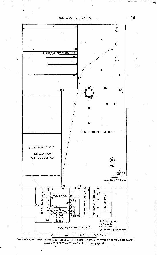
SARATOGA FIELD. 59
LIGHT AND POWER CO. Z<>
B.B.B. AND C. R.R.
J.M.GUFFEY
PETROLEUM CO.
o
9 .7
to
SOUTHERN PACIFIC R.R.
8
DODDDMAIN
POWER STATION
W.E.BRICE
o, oBlk. |
» Blk.3 Blk.4|Blk.S
3*k«
o> °r-
SOUTHERN PACIFIC R.R.
Producing wells
$ Dry wells ---Pipelines .
O Derricks or proposed well
400 800 1200 feetFIG. 2. Map of the Saratoga, Tex., oil field. The names of wells the symbols of which are accom
panied by numbers are given in the list on page 58.
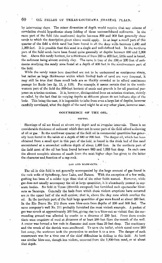
60 ' OIL FIELDS OF TEXAS-LOUISIANA ,COASTAL PLAIN.
by intervening clays. The minor diversities of depth would require that any scheme of correlation should hypothesize sharp folding of these unconsolidated sediments. In the same part of the field (the southwest) depths between 800 and 900 feet generally show sands to which the description given above would apply. In at least a small part of this quarter of the field a thick sand has been found in all the deep wells-between 1,400 and 1,500 feet. It is possible that this sand is a single and well-defined bed. In the northern part of the field sands have been found quite generally at depths between 900 and 1,000 feet. Above this sandy horizon, for a thickness of from 200 to 400 feet, little sand is found, the sediment being almost entirely clay. The same is true of the 100 or 200 feet of sedi ments overlying the sandy zone found at a depth of 800 feet in the southwestern part of the field.
While, the sandy zones here described are not to be understood as continuous strata, but rather as large thicknesses within which limited beds of sand are very frequent, it may still be true that these small beds are so thickly crowded as to afford continuous passage for fluids (see fig. 12, p. 119). For example, it seems certain that in the south western part of the field the 500-foot horizon of sands and gravels is for all practical pur poses an artesian stratum. It is, however, distinguished from an artesian stratum, strictly. so called, by the fact that its varying depths at different places do not indicate dips of the beds. This being the case, it is impossible to infer from even a large list of depths, however carefully correlated, what the depth of the sand might be at any other place, however near.
OCCURRENCE OF THE OIL,.
Showings of oil are found at almost any depth and at irregular intervals. There is no considerable thickness of sediment which does not in some part of the field afford a showing of oil or gas. In the southwest quarter of the field oil in commercial quantities has gener ally been found in the sands at a depth of 800 or 900 feet. The deeper oil, which has been obtained from a small spot in this part of the field, is found in the thick bed of fine sand encountered at a somewhat uniform depth of about 1,400 feet. In the northern part of the field most of the oil has been found between 900 and 1,000 feet deep: In each case the almost complete absence of sands from the next higher clays has given to the latter the character and function of a cap rock.
GAS AND BLOW-OUTS.
The oil in this field is not generally accompanied by the large amount of gas found in the rock wells of Spindletop, Sour Lake, and Batson. With the exception of a few wells, gushing has been of a milder type than that of the other fields named. However, while gas does not usually accompany the oil in large quantities, it is abundantly present in sep arate bodies. No field in Texas (Humble excepted) has furnished such spectacular blow outs as Saratoga. Generally the beds from which these violent eruptions have occurred are in the upper half of the well section; that is (| above the clay zone which overlies the oil. In the northern part of the field large quantities of gas were found at about 500 feet. In the Kio Bravo No. 215 there were blow-outs from depths of 200 and 600 feet. The same company's well No. 211 probably furnished the most violent example. A pocket of gas was struck at approximately 500 fe"et, giving rise to a blow-out so violent that the sur rounding ground was affected by cracks to a distance of 250 f.eet; From these cracks there were eruptions of mud at distances of at least 200 feet frpm the-mouth of the well. A crater was formed a few rods in diameter and more than 20 feet deep. The machinery and the wreck of the derrick were swallowed. To save the boiler, which stood some 200 feet away, the workmen took the precaution to anchor it to a tree. The danger of such occurrences was for a time one of the chief difficulties in drilling in this field. At least one similar blow-out, though less violent, occurred from the 1,400-foot sand, or at about that depth.
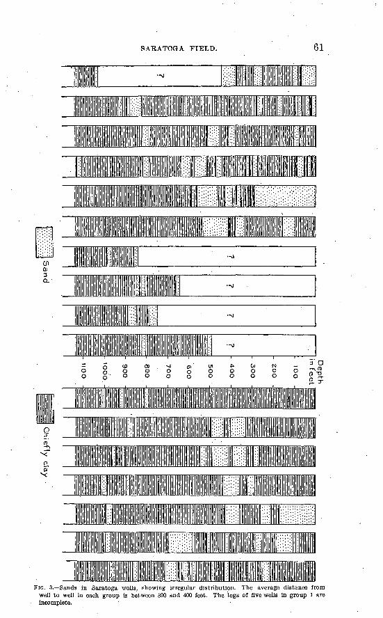
SAEATOGA FIELD. 61
1 1
III
1 ' 'II ' I'll'' : ||| 1 1 .'
i :: |[li l||[:: -0
FIG. 3. Sands in Saratoga wells, showing irregular distribution. The average distance from well to well in each group is between 300 and 400 feet. The logs of five wells in group 1 are Incomplete.
62 OIL FIELDS OF TEXAS-LOUISIANA COASTAL PLAIN.
WATER.
The ground waters of this field are fresh to a much greater depth than those of the other Hardin County fields. The strong flow usually met at a depth of about 500 feet in the southwestern part of the field is always reported as fresh. It appears that, by ill fortune or carelessness, this water was not properly cased off in certain wells. When the wells were drilled through the underlying clay, this water was given access to the sandy zone containing the oil and soon appeared in other wells, which had been pumping oil alone. The admixture of this water was the more unfortunate on account of the fact that fresh water is separated from the oil with greater difficulty than salt water.
Below the level of the clay zone which overlies the first important oil the water encoun tered is salt. The amount of salt water pumped previous to the drilling of the deep wells was small. The 1,400-foot sand, after yielding oil abundantly for a few weeks, began to produce large quantities of salt water.
One thousand feet north of the limited area in which the above-named wells are situated" a number of deep wells were drilled in the B. B. B. and C. tract. This locality, while producing moderate quantities of oil, yielded salt water in great abundance, some wells producing as much as 5,000 barrels daily. One well having a depth of 1,700 feet is said to have produced hot sulphur water.
DEVELOPMENT AND PRODUCTION.
DIMENSIONS OF THE FIELD.
The developed area of the Saratoga field has a total length of about 4,500 feet north and south and a width of 1,800 feet east and west. The longest dimension has a trend a little east of north. The area of the proved field is less than 200 acres. There is some reason to think that the area of the field as here stated represents approximately the total size of the pool, and that therefore but little development may be expected outside of the present limits. It must be remarked, however, that the formations, the surface indications, and the occurrence of the oil in this field bear a striking resemblance to the corresponding features of those parts of Sour Lake and Spindletop which are not known to be underlain by the porous limestone. In view of the small area occupied by such limestone at Sour
Lake, it is too early to abandon the hope that there may be found on the borders of the present Saratoga field a spot which will produce oil from the limestone, perhaps in as great
abundance as at Sour Lake.Up to August 15, 1904, there had been drilled in and around the Saratoga field 70 wells.
Forty-five of these were drilled within the productive area of the field, and 35 have at some time been pumped more or less regularly. The number of wells drilled since the summer of 1904 is large.
AMOUNT PRODUCED.
As indicated above, the production of the Saratoga field up to the close of 1904 was relatively small. For the year 1903 it was 150,000 barrels. A very reliable estimate makes the output of 1904 a little more than 700,000 barrels.. The production during the latter year was quite uniform, amounting in December to 65,000 barrels, or a little more than 2,000 barrels daily. Early in January, 1905, the 1,400-foot sand in the southwestern quarter of the field began to yield large quantities of oil. For a short time daily records approximating 20,000 barrels were common, but in February the advent of salt water had reduced the daily production to less than 10,000 barrels. The principal wells concerned in the temporary large output were two Greer wells (of the J. M. Guffey Petroleum Com pany) and the Producers No. 4. The last-named is said to have made a record of 10,000 barrels daily.
CHARACTER OF THE OIL.
The gravity of the Saratoga oil is a little greater than the average of that from adjacent fields. The larger part of that produced in 1903 and 1904 from depths not greater than
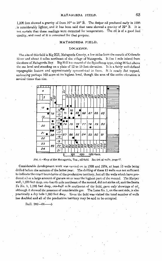
MATAGOBDA FIELD. 63
1,100 feet showed a gravity of from 16° to 18° B. The deeper oil produced early in 1905 . is considerably lighter, and it has been said that tests showed a gravity of 22° B. It is not certain that these readings were corrected for temperature. The oil is of a good fuel quality, and most of it is consumed for that purpose.
MATAGORDA FIELD.
LOCATION.
The site of this field is Big Hill, Matagorda County, a few miles from the mouth of Colorado River and about 5 miles northeast of the village of Matagorda. It lies 1 mile inland from the shore of Matagorda Bay. Big Hill is a mound of the Spindletop type, rising 36 feet above the sea level and standing on a plain of 12 to 15 feet elevation. It is a fairly well-defined topographic feature and approximately symmetrical in form. It is nearly flat topped, embracing perhaps 100 acres at its highest level, though the area of the entire elevation is several times that size.
12
SO
£2
33
73
86
89
A3
17
19
20
71
74
87
7O
75
86
'o'o
69
76
85
$o>o>
68
77
84-
67
78
83
§3
<o^
66
79
82
65
60
Bl
p 590 10.00 '500 feet
FIG. 4. Map of the Matagorda, Tex., oil field. See list of wells, page 67.
Considerable development work was carried on in 1903 and 1904, at least 15 wells being drilled before the autumn of the latter year. The drilling of these 15 wells was not sufficient to indicate the exact boundaries of the productive territory, but all the wells which have pro duced o'.l or a large amount of gas are on or near the highest part of the mound. The Harper well, 1,370 feet deep, one-fourth mile northeast of the mound, did not strike oil, and the Santa Fe No. 1, 1,198 feet deep, one-half mile southwest of the field, gave only showings of oil } although it showed the presence of considerable gas. The Lane No. 1, on the east side, is also practically a dry hole 1,360 feet deep. Since the field was visited the total number of wells has doubled and all of the productive territory may be said to be occupied.
Bull. 282 06^ 5
64 OIL FIELDS OF TEXAS-LOUISIANA COASTAL PLAIN.
GEOLOGIC FORMATIONS.
WELL SECTIONS.
The following well sections are typical of this field:
Logs of wells in Matagorda field.
LANE WELL NO. 2.
[Received from W. G. Lane, driller.]
1
3
4
56
7
8
9
10
Formation.
Sand ........................
Blue . limestone (specimen
Gumbo ...............
Thick ness.
Feet.
7015805040
4141
19
Total depth.
Feet. 108095
175
225
265
485
489
630
11
^?,
IK1415Ifi17
Formation.
Sudden drop ................
rocks 2 to 8 feet each; a
Shells .......................
Gumbo ...................Cap rock, not passed through
Thick ness.
Feet. 6
5775
42
694
Total depth.
Feet. 648
705780784786855859
Casing set'] foot in cap rock at 856. This well showed considerable gas but little oil.
GRIFFITH NO. 1.
[Received from Dr P. S. Griffith!]
12 3 4 5 6 7 8 9
10 11 12
Red clav
Gumbo and shells. .....
20 30 25 90
283 4
211 20
50 3
10 2
20 50 75
165 448 452 663 683 733 736 746 748
13 14 15 16 17 18 19 20 21 22
Sand ........................
Blue rock and iron (pyrite) . .
Blue clay with show of gas . . .
Rock showing gas; casing set at 874 .................
1 16
4 6
40 6
18 11 2
23
749 765 769 775 815 821 839 850 852
875
SEDIMENTS ABOVE THE OIL.
The formations passed through are very similar to those found in the oil fields of eastern Texas. Clay is the leading material in amount. There are also sands, shells, and thin beds of" rock," which is known in some cases to be limestone, while in others it may be sand stone with calcareous cement. Most of the rock beds carry pyrite, but this is far more abundant near the horizon of the oil, frequently just above it.
POROUS LIMESTONE.
At depths varying from 844 to 1,035 feet a limestone is found which possesses the char acteristic feature of the oil-bearing limestone at Spindletop and other large oil fields of the Coastal Plain. Some specimens obtained are entirely crystalline and highly porous or cav ernous, suggesting the probability that the rock body contains openings of stiH larger size. Certain fragments of this white or bluish limestone came to the surface perfectly clean and
MATAGKXRDA FIELD. . 65
evidently free from oil. Such fragments are plainly from that portion of the rock which con-. tained the gas accountable for the blow-outs. The thickness of this porous limestone forma tion is uncertain and no doubt variable. Whether the formation is single or subdivided by beds of sand is also uncertain. The cause of this uncertainty lies in the porous nature of the rock itself. This porosity causes the loss of the water used in drilling, and therefore no sam ples could be obtained. Under certain favorable conditions, described elsewhere, drilling advanced for many feet without a return of the water, and therefore with no definite knowl edge of the nature of the rock. From the behavior of the tools it is believed that the thick ness of the limestone in the Lane No. 1 is more than 100 feet, a part of which was traversed without a return of the water.
FORMATION BELOW THE POROUS LIMESTONE.
But few wells entered the formation beneath the limestone, and the knowledge of its nature is based largely on the observations made in drilling the Lane No. 1. In this well the porous limestone or "gas rock" was found at 1.035 feet, and a large proportion of its body was found to be of sulphur, which filled the caverns. Beneath this mixture of limestone and sulphur the drill entered a nearly white sticky substance which was said to be similar to putty or sometimes to white lead. The material, when brought to the surface and dried, formed light porous chunks, which were said to resemble chalk. The description of this material, which agrees closely with that of certain materials examined in other fields, leads to the inference that the formation underlying the porous limestone is a.marl, in places doubt less sandy, and perhaps passing into a pure sand at other places.
Sulphur is reported from various wells, but always at or near the horizon of the oil. As in the better-known oil fields, it exists either in a disseminated form in the sand or clay or as a pure crystalline mass, filling the caverns of the limestone. In the latter form it has already been mentioned as occurring in the Lane .veil No. 1. It is here reported as "60 feet of solid sulphur with a probable addition of 30 feet more." Other good observers, however, speak of this sulphur as "mixed with rock," and inasmuch as a part of the drilling was effected without a return current of.water, and in view of the fact that the material when returned is in an unsatisfactory form for the determination of the relations of several materials coming up together, it is highly probable that the assumption of sulphur in caverns is correct for this place, as it is known to be for certain other places. In the same well (Lane No. 1) it is observed that there were small "veins" of sulphur in the light-colored sticky mass below the limestone. The Dean well, the Johnson, and.the Griffith No. 2 each report a little sul phur at about the horizon of the oil.
STRUCTURE OE THE MOUOT).
There is no other mound in which the depths of the porous limestone in different places may be so conveniently correlated to show dips as at Matagorda. Of the wells drilled pre vious.to September, 1904, the Dean reached the limestone at the least depth (844 feet). This well is on the west side of the field. East of the Dean well the Griffith No. 2 found the same limestone at 850 feet, and the Griffith No. 1, still farther east, at 852 feet. The Lane No. 2, which is north of the Dean, went 856 feet to the porous limestone. Northeast of the Lane the Higgins and Johnson wells went 865 feet and 870 feet, respectively, to the same rock. The Harper well, one-fourth mile to the northeast, found nothing but sand and clay to a depth of 1,370 feet. South from the Dean and Griffith wells the Santa Fe No. 2 found rock at 855 feet, and the wells at the south end of the field at 872 feet. On the east side of the field the Lane No. 1 struck what is presumably the same rock at 1,035 feet. The Santa Fe No. 1, southwest of the field, though nearly 1,200 feet deep,found nothing which could be identified with the limestone in question.
66 OIL FIELDS OF TEXAS-LOUISIANA COASTAL PLAIN.
The depths given above indicate that that part of the porous limestone which is known has the form of a half dome, its highest part being at the middle of the west side of the field. Its dip toward the northeast is at least 26 feet in the 500 feet between the Lane well and the Johnson well. The corresponding dip to the southeast is 28 feet to the southern border of the field, 2,000 feet away. If, as seems probable, the ] ,035-foot level in the Lane well is to be correlated with the other depths named, the dip at the eastern edge of the mound is greatly steepened. In accordance with the interpretation of the observations on the oil- bearing rock at Spindletop (see p. 36), it is highly probable that in this field also the lime stone occupies an area but little greater than that of the surficial mound. The extreme height of the dome, so far as revealed by borings, is less than 200 feet, and it is not probable that more complete data would greatly increase this height.
OCCTJKKENCE OF OII>, GAS, AXD SAI/r WATER.
The porous limestone constitutes the reservoir for oil, gas, and salt water. Gas and oil have not been found in any considerable quantity at any other horizon.a The distribution of the. three fluids is not such as to lead to the conclusion that the limestone is porous throughout, and therefore forms but a single reservoir. If this were the case, the gas should be expected to accumulate at the top of the dome, the oil beneath the gas, and the salt water at the base of the dome, the materials thus being arranged according to their several specific gravities, as in the Appalachian fields. On the contrary, the strongest pressure and the longest con tinued flow of gas is found in the southernmost well of the field, in which the limestone is deeper than in any other, with one exception. The flow from this well was estimated at 5,000,000 cubic feet daily. The gas is said to be chiefly H^S mixed with S0 2 . After produc ing under control for more than a year the well was connected by a pipe line over 7 miles long with an irrigation pumping plant on Colorado River. A well 30 feet to the north found a similar body of gas and no oil. It was evident that these two wells tapped the same reser voir from the fact that the flow of gas from the first was interrupted until the closing of the second. A third well, probably 200 feet farther north, found sulphur salt water at a tem perature of 99.6° F. A strong flow of this hot water was maintained for months. It came from a level fully 150 feet higher than that of the gas in the other two wells. It may there fore be assumed that the porous rock from which the water was derived is separated by impervious material from that yielding the gas (sec. p. 122).
The Griffith No. 1 found oil and gas near the base of the limestone body. From this horizon a violent blow-out occurred, projecting the pipe from the well in such a manner as to allow 300 feet to rise vertically into the airand fall as one piece. This blow-out was accompanied or fol
lowed by oil. The well began to gush some 400 barrels per day, gradually diminishing to per haps half that amount, but producing some 10,000 barrels before the flow ceased. The circum stances attending this cessation of flow furnish an additional illustration of the communica tion and interdependence.of certain wells in the Matagorda field. During the continuance of the flow from, the Griffith No. 1, No. 2 was drilled several hundred feet farther west. This well encountered gas at about the same horizon, but with very little oil. In order to drill the well deeper it became necessary to stop the flow of gas by pumping in slush or mud to fill the pores of the rock. After this process had been continued for a long tinie and under great pressure (approximately 400 pounds) well No. 1 ceased to flow. It is believed that the mud pumped into well No. 2 entered and clogged the pores of the same rock from which the gas and oil of well No. 1 were obtained.
In several instances the gas from one well has been successfully used to "blow" another, after the manner of blowing with compressed air (p. 123). The gas of the Dean well was thus introduced into the Johnson well and for a time expelled about 3,000 barrels of fluid daily, fully 90 per cent of which was salt water. The gas of the Griffith No. 2 was similarly used in the Griffith No. 1, -blowing out in one night 1,000 barrels of oil in addition to salt water. With the continuance of the process the water increased in proportion until, out of 10,000 barrels of fluid per day, only an insignificant amount was oil.
« Data on this point were not obtained for the wells drilled since 1904.
HUMBLE FIELD. 67
PRODUCTION".
The Matagorda field continued to grow in importance until December, 1904. In the early part of that month, out of about 30 wells drilled, 14 were producing. The combined daily output was more than 4,000 barrels. Salt water appeared in every well, probably from the first, but late in December it came in such quantities that the production of the field fell quickly to 1,200 barrels a day, and by February 1, 1905, the daily amount was not above 400 barrels. At that time 32 wells had been drilled and 2 others were nearly complete. Of these, 11 wells were producing, a number of others having been abandoned after .pumping for a time.
The following is a list of wells drilled up to May, 1905. The locations of most of these are shown on the map (fig. 4, p. 63).
Wells on Big Hill, Matayorda, County.
Owners.
P. S. Griffith;...................
Griffith & Sutherland ............Bay City Oil Co.................BigHill Oil and Fuel Co. (.Dean) .Big Hill Oil and Fuel Co........
Do..........................SantaFeK. R. Co. .............
P. S. Griffith....................McKallip'Bros. & Miller. .......
No. of block.
705309G9127475707814
15
Number of wells.
311115
110
Owners.
P. S. Griffith..................
J.'C. Walker...................SantaFeR. R. Co.............P. S. Griffith.......................do.........................
No. of block.
10738821
94
13
52 71
71. 7r
Number of wells.
221' 2
1
1 3
1
HUMBLE FIELD.
HISTORICAL .ACCOUNT.
The field at Humble was opened up after the completion of the field work which forms the basis of this report. Most of the data from which this brief account is compiled were published in the Oil Investors' Journal between November, 1904, and May, 1905.
The Humble field is in Harris County, 18 miles north of Houston and H miles east of Humble station, on the Houston, East and West Texas Railway. It covers a part of Echols Ridge, and is 100 feet above sea level,'or .50 feet higher than Houston.
The escape of gas in this vicinity has been noticed for many years. In the autumn of 1902 Mr. George Hart attempted to drill a well west of the present developed field, but the drilling was stopped by a blow-out. In the summer of 1904 Mr. C. E. Barrett, of Houston, .drilled several wells in that part of the field known as "the hill." Most of the wells in this part of the field were ruined by blow-outs. In October the Higgins Oil and Fuel.Company brought in a large gas well about one-half mile southeast of the Barrett wells.
The first successful oil well was the Beatty .No. 2, completed January 7, 1905. For some days this well yielded 8,500 barrels per day. Other producers followed in rapid succession. Some of these yielded more than 10,000 barrels daily. Before March! the daily production of the field was nearly 90,000 barrels and within three months after the completion of the Beatty No. 2 the field had produced 3,000,000 barrels of oil. Previous to March 3 little salt water was observed. On that day, the first anniversary of the "inundation" by salt water at Batson, the water began to appear in the great gushers at Humble. In ten days the production fell from nearly 90,000 barrels to less than 25,000 barrels daily. Partly by the bringing in of new wells on the east side and partly by the renewal of flow from the wells which had been "drowned out" the field recovered its former production, so that the yield
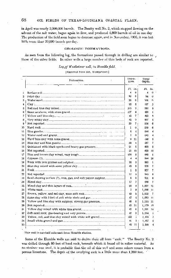
68 OIL FIELDS OF TEXAS-LOUISIANA COASTAL PLAIN.
in April was nearly 2,000,000 barrels. The Beatty well No. 2, which stopped flowing on the advent of the salt water, began again to flow, and produced 4,800 barrels of oil in one day. The production of the field soon began to decrease, again, and in November, 1905, it was but little more than 20,000 barrels per day.
GEOLOGIC 3?OTCMATlOiSrS.
As seen from the following log, the formations passed through in drilling are similar to those of the other fields. In other wells a large number of thin beds of rock are reported.
Lo(/j)f Westlieimer well, in Humble field.
[Received from Sid. Westheirner.]
1?,3
4
5
0
7
8
9
in11
12
13
14
15
Ifi
1718
19
20
21
2223
24
252fi
27
28
29
30
31
32
33
34
35
Formation.
Joint clay ...................... ............................................
Clay.........................................................................
Rock....................
Sf ixed clay .................................. .... ...................
White sand. .................................................................
Not reported ................................................................
Thick ness.
Ft. in. 4 0
80 020 0
23 3
165 2127 8
43 743 9
30 7
1 0
5 41 02 11
39 4
21 5
21 10
209 8
4 438 3
43 6
1 0
17 56 0
17 7
39 4
2 0
43 8
42 4
40 0
43 11
42 0
42 3152 1
41 3
42 11
Total depth.
Ft. in. 4 0
84 0104 0
127 3
292 5420 1
463 8507 5
538 0
539 0
544 4545 4548' 3
587 7
609 0
630 10
840 6
844 10883 1
926 7007 7
945 0951 0
968 7
1,007 11
1,009 11
1,053 7
1,095 11
1,135 11
1,179 10
1,221 10
1,264 11,416 2
1,457 5
1,500 4
This well is one-half mile east from Humble station.
Some of the Humble wells are said to derive their oil from "rock." The Beatty No. 2 was drilled through 80 feet of hard rock, beneath which it found oil in softer material. As no strainer was used, it is probable that the oil of this well and some others comes from a porous limestone. The depth of the overlying rock is a little more than 1,200 feet. '
NACOGDOCHES COUNTY. 69
GAS.
This field is remarkable for its large supplies of gas and terrific blow-outs. Gas was first found in large quantities between 500 and 600 feet deep. The strongest pressures were encountered at about 800 feet. From this depth there occurred, December 13, 1904, in the Higgins No. 2, the most violent eruption recorded in the Texas fields. After emitting gas, water, sand, and chunks of clay for some hours, the casing became choked, but apparently the gas rose outside the casing to the higher sands between 500 and 600 feet from the sur face, "and by the morning of the 14th this abnormal pressure sought relief through the various wells that had reached that depth on the neighboring properties." Every well within a considerable radius became involved in a general eruption of gas, water, and sand.
As in the other large fields, the great blow-outs were from horizons above the main oil body. The gas found at these levels is not of the poisonous type. That which has been confined with the oil and comes out with it from the great gushers is of the same deadly character as the corresponding gas at Spindletop.
Before the bringing in of the great producers at Humble a " blow-out preventer" had been devised. It was used with success at the finishing of the Beatty No. 2, the first great gusher.
The Humble oil closely resembles that of the other fields. The large production caused a great fall of prices. Up to June, 1904, little or no oil from the Humble field brought more than 16 cents, per barrel, and the larger part was sold much cheaper. ,
MINOR TEXAS DISTRICTS. '
NACOGDOCHES COUNTY.
A considerable area some 15 miles southeast of Nacogdoches has been known for nearly forty years to contain deposits of a heavy brown oil suitable for lubricating purposes. In the ten years following 1887 there was a considerable development of the industry, and probably at least 100 wells were drilled. Perhaps half of these yielded some oil, but the amounts in all cases were small, varying from a fraction of a barrel, to a possible 5 or 6 bar rels per day. An occasional pump was installed, but most of the oil was bailed out. The Lubricating Oil Company, having 20 wells in operation in 1890, shipped its products by wagon to Nacogdoches. The Petroleum Prospecting Company built a pipe line to Nacog doches, where its oil was tanked. This pipe line (the first in the State of Texas) has since been taken up. The field is now idle, though it is understood that this does not indicate a failure of the wells. A keeper is employed by the present owners to reside at the holdings, a
The Nacogdoches field is in the East Texas Timber Belt. At this place the relief of the Coastal Plain, due to erosion by Angelina River and its tributaries, is from 100 to 200 feet. The underlying rock is Eocene, chiefly greensands, which in weathering have produced a brick-red soil. There are occasional outcrops of shales and sandstones, but the bedding is so irregular that dips and strikes taken from these limited exposures' are of little value in determining structure. The occurrence of oil, therefore, is not known to have any other relation to geologic structure than that of its presence in local beds of sand overlain by clay and greensand.
Most of the superficial phenomena associated with the oil fields of Texas have been noted in the Nacogdoches field. The bubbling up of gas is common. At places each bubble rising through water leaves a film of oil on the surface. At Oil Spring, a well-known "boil ing spring," brown globules of oil are seen rising through the waterand forming iridescent films as they spread out upon its surface. Seepages of oil are common along the banks of streams. There.are also sulphureted waters containing in small proportion certain sour salts. Iron pyrite, from the decomposition of which these salts may have been derived, is encountered in drilling. A scum of iron oxide derived from the soil is a very common occur-
o For a more detailed history of the development of this field, see Phillips, Dr. William Battle, Texas petroleum: Bull. University of Texas Mineral Survey No. 1,1900, p. 1.
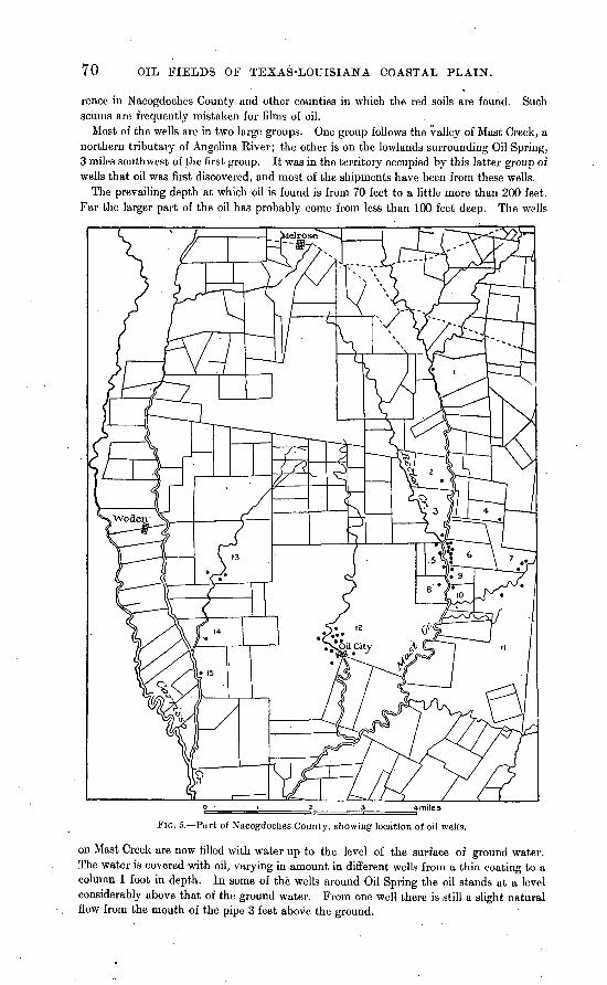
70 OIL FIELDS OF TEXAS-LOUISIANA COASTAL PLAIN.
rence in Nacogdoches County and other counties in which the red soils are found. Such scums are frequently mistaken for films of oil.
Most of the wells are in two largo groups. One group follows the valley of Mast Creek, a northern tributary of Angelina River; the other is on the lowlands surrounding Oil Spring, 3 miles southwest of the first group. It was in the territory occupied by this latter group of wells that oil was first discovered, and most of the shipments have been from these wells.
The prevailing depth at which oil is found is from 70 feet to a little more than 200 feet. Far the larger part of the oil has probably come from less than 100 feet deep. The wells
FIG. 5. Part of Nacogdoches County, showing location of oil wells.
on Mast Creek are now filled with water up to the level of the surface of ground water. The water is covered with oil, varying in amount in different wells from a thin coating to a column 1 foot in depth. In some of the wells around Oil Spring the oil stands at a level considerably above that of the ground water. From one well there is still a slight natural flow from the mouth of the pipe 3 feet above the ground.
JASPEK AND SAN AUGUSTINE COUNTIES. 71
A well 684 feet deep on the Skillern homestead, between Mast and Rector creeks, gavo the following section: ~
Log of Skillern homestead well, Nacogdoclies County.
12 3 4
5 6 7 8
9 10 11
12
13
14 15 16 17
18
Formation.
Clay^. .......................
Sand, with slight show of oil.........................
Blue clay..... ...............Hard rock ..................
Rock, with streaks of sand from 8 to 10 feet. ..........
Coarse sand, good showing of oil......................
. Blue clay (set 10-inch pipe
Stiff blue clay...............White sand; artesian water.. Hard blue clay and some
Thick ness.
Feet. 47
7 20
8 56
7 37
6
44 38
18
5
41 9
38 . 18
53 . 31
Total depth.
Feet. 47 54 80
'88
144
151 188 194
238 276
294
299
340 349 387 405
458 489
19 20 21 22 23 24
25 26
27 28 29 30 31
32 33
34 35 36
Formation.
Hard rock ..................Bed of shells; some gas ..... Stiff blue clay (gumbo) .....
Black formation of asphalt, dry........................
Gumbo or blue clay.........
Thin rocks, with sands be-
Hard, flinty rock. ..........Dark, coarse sand, or. oil
sand; good show of oil. ...
Sand, dark with asphalt. . . .4
Thick ness.
Feet. 8
17 4 7
34 4.
9
9 31
48
27
13 3
C 5 3 3
Total depth.
Feet.. 497 514 518 525 559 563 572
581 612
616 624 651
604 667
673 678 681 684
It will be observed that in this well much stiff clay was passed through, and there were at least seven horizons of coarse sands in which were found showings of oil or gas, or both. Attention is directed to the porous rock containing sulphur, passed between 486 and 497 feet; specimens were not seen. At greater depths are two beds called "asphalt," or "sand with asphalt." A well 2 miles south of Melrose and 6 miles north of Oil Spring was sunk 255 feet in clay, sand, and greensand, finding a showing of oil at about 160 feet beneath nearly 40 feet of clay.
Near Carrisso Creek, 3 miles west of Oil Spring, a deep well was being drilled by Mr. J. M. Thrasher at the time the field was visited, in the summer of 1904. The well had then attained a depth of 400 feet. Most of the beds passed through were greensand, of various shades and various degrees of induration. Oil was found in small quantities at 365 feet.
JASPER AND SAX AUGUSTINE COUNTIES.
At many places in the East Texas Timber Belt there are surface indications similar to those near Nacogdoches. The., best known of these localities are in San Augustine and Jasper counties.
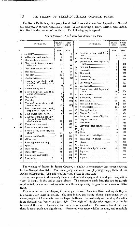
72 OIL FIELDS OF TEXAS-LOUISIANA COASTAL PLAIN.
The .Santa Fe Railway Company has drilled three wells near San Augustine. Most of the beds passed through were clay or sand. A few showings of heavy dark oil were noted. Well No. 1 is the deepest of the three. The following log is typical:
Lay of Santa Fe No. i well, San Augustine, Tex.
12 3 4
5 6 7 8 9
10
11
12 13 14
15
16 17
18 19
20
21 22
23 24 25 26 27 28
Formation.
Blue marl, black as coal
Blue marl, streaks of harder.
Brown, soapy shale, with bowlder of hematite at 75 and 78....................
Brown soapstone and thin layers of limestone. . ......
'Blue clay. ...................Blue and brown shale, with
Blue limestone and marl, < withpyrite; very hard....
Gray water sand, a little py- rite, and very small trace
Brown clay, with sand......
Brown sand, with streaks
Brown gumbo and clay . . . . .
Black rock and pyrlte.. .....
Thick ness.
Feet. 15
5 14
10 8 5
12 34
947
7 84 1
17
6i 2
26 6
14
11 10
1 29
2 10 10
1 6
Total depth.
Feet. 15 20 34
44 52 57 69 72i
82 89
96
1144 115J
1324
139 141
167. 173187
198 208
209 238 240 250 260 261 267
29
30 31
32 33 34 35 36 37 38 39
40 41 42 43 44 45 46 47 48 49 50
51 52 53
54 55 56 57 58 59 60
Formation.
Bowlder of lime, with little oil.........................
Brown clay, with layers of
Brown clay, with layers of
Clay or fine sand ............Shale, with layers of lignite. .
Clay.........................Shale. .......................Shale, with'little lignite... . : .
Shale and few shells. ........
Lignite. .....................Shale; thin lignite layers.... Lignite. .....................Shale. .......................Lignite. .....................
Thick ness.
Feet.
1 2
4 1 2 1 5 2 5 4
10 24 14 18 8
36 19 11 24 23
2
3 5 5 6 4
12
J 57J 2 1 4
Total depth.
Feet.
268 270
274 275 277 278 283 285 290
- 294
304 328 342 360 368 404 423 434 460 483 485 488
503 508 514
518 530 5304 588 590 591 595
The vicinity of Jasper, in Jasper County, is similar in topography and forest covering to the Nacogdoches field. The underlying sediments are of younger age, those at the surface being sands. The soil itself in many places is pure sand.
At various places in this county there are abundant seepages of oil and gas. Asphalt or "tar" is found in the soil at some places. The waters of such localities are frequently sulphurated, or contain various salts in sufficient quantity to give them a sour or bitter taste.
Twelve miles north of Jasper, in the angle between Angelina River and Ayish Bayou, is a saline a few acres in extent. The spot is bare and sandy, though surrounded by the dense jungle which characterizes the bayou bottoms. Immediately surrounding the saline is an elevated rim from 5 to 7 feet high. The origin of this elevation seems to' be similar to that of the mud volcanoes within the area of the saline. The waters found here and there in small pools are slightly salt. Scattered over spots within the area, and especially
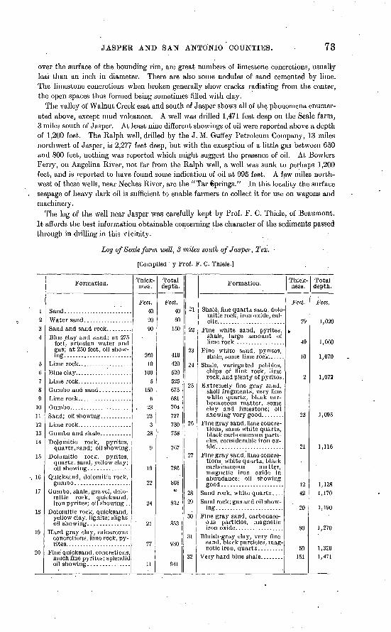
JASPEB AND SAN ANTONIO COUNTIES. 73
over the surface of the bounding rim, are great numbers of limestone concretions, usually less than an inch in diameter. There are also some nodules of sand cemented by lime. The limestone concretions when broken generally show cracks radiating from the center, the open spaces thus formed being sometimes filled with clay.
The valley of Walnut Creek east and south of Jasper shows all of the phenomena enumer ated above, except mud volcanoes. A well was drilled 1,471 feet deep on the Seale farm, 3 miles south of Jasper. At least nine different showings of oil were reported above a depth of 1,200 feet. The Ralph well, drilled by the J. M. Gufi'ey Petroleum Company, 13 miles northwest of Jasper, is 2,277 feet deep, but with the exception of a little gas between 650 and 800 feet, nothing was reported which might suggest the presence of oil. At Bowlers Ferry, on Angelina River, not far from the Ralph well, a well was sunk to perhaps 1,200 feet, and is reported to have found some indication of oil at 995 feet. A few miles north west of these wells, near Neches River, are the "Tar Springs." In this locality the surface seepage of heavy dark oil is sufficient to enable farmers to collect it for use on wagons and machinery.
The log of the well near Jasper was carefully kept by Prof. F. C. Thiele, of Beaumont. It affords the best information obtainable concerning the character of the sediments passed through in drilling in this vicinity.
Log of Seale farm well, 3 miles south of Jasper, T ex. ,
[Compiled y Prof. F. C. Thiele.]
12 3 4
5 G 7 8 9
10 11 12 13 14
15
16
17
18
19
20
Formation.
Water sand. ................
Blue clay and sand; at 275 feet', artesian water and gas; at 250 feet, oil show-
Dolomitic rock, pyrites, quartz, sand; oil showing.
Doloniitic rock, pyrites, quartz, sand, yellow clay;
Quicksand, dolornitic rock, gumbo ....................
Gumbo, shale, gravel, dolo- mitic rock, quicksand, iroiipyrites; oil showing . .
Doloniitic rock, quicksand, yellow clay, lignite; slight
Hard gray clay, calcareous concretions, lime rock, py-
Fine quicksand, concretions, much fine pyrites; splendid
Thick ness.
Feet. 40 20 90
200 10
100 5
150 6
. 23 23 3
28
9
19
22
24
21
77
11
Total depth.
Feet. 40 60
150
410 420 520 525 675 681 704 727 730 758
767
786
808<D
832
§53
930
941
21
22
23
24
25
26
27
28 29
30
31
32
Formation.
Shale, fine quartz sand, dolo- mitic rock, iron oxide, cal-
Fine white sand, pyrites, shale, large amount of
Fine white sand, pyrites, shale, some lime rock.. ....
Shale, variegated pebbles, chips of flint rock, lime rock, and plenty of pyrites .
Extremely fine gray sand, shell fragments, very fine white quartz, black car bonaceous matter, some clay and limestone; oil showing very good. .......
Fine gray sand, lime concre tions, some white quartz, black carbonaceous parti cles, considerable iron ox-
Fine gray sand, lime concre tions., white quartz, black carbonaceous matter, magnetic iron oxide in abundance; oil showing
Sand rock, white quartz ....Sand rock; gas and oil show
ing. .....:.................Fine gray sand, carbonace
ous particles, magnetic
Bluish-gray clay, very fine sand, black particles, mag-
Thick ness.
Feet.
79
¥
40
10
2
23
21
12 42
20
80
50 151
Total depth.
Feet.
1,020
1,060
1,070
1,072
1,095
1,116
1,128 1,170
1,190
3,270
1,320 1,471
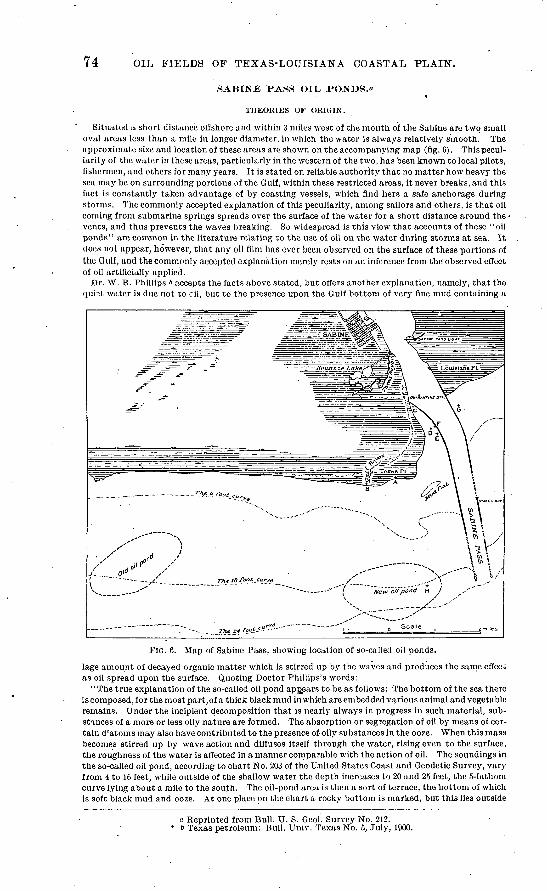
74 OIL FIELDS OF TEXAS-LOUISIANA COASTAL PLAIN.
SABLTSTE PASS OIL, PONDS."
THEORIES OF ORIGIN.
Situated a short distance offshore and within 3 miles west of the mouth of the Sabiiie are two small oval areas less than a mile in longer diameter, in which the water is always relatively smooth. The approximate size and location of these areas are shown on the accompanying map (fig. 6). This pecul iarity of the water in these areas, particularly in the western of the two, has been known to local pilots, fishermen, and others for many years. It is stated on reliable authority that no matter how heavy the sea may be on surrounding portions of the Gulf, within these restricted areas, it never breaks, and this fact is constantly taken advantage of by coasting vessels, which find here a safe anchorage during storms. The commonly accepted explanation of this peculiarity, among sailors and others, is that oil coining from submarine springs spreads over the surface of the water for a short distance around the vents, and thus prevents the waves breaking. So widespread is this view that accounts of these "oil ponds" are common in.the literature relating to the use of oil on the water during storms at sea. It does not appear, however, that any oil film has ever been observed on the surface of these portions of the Gulf, and the commonly accepted explanation merely rests on an inference from the observed effect of oil artificially applied.
Dr. W. B. Phillips & accepts the facts above stated, but offers another explanation, namely, that the quiat water is due not to cil, but to the presence upon the Gulf bottom of very fine mud containing a
FIG. 6. Map of Sabine Pass, showing location of so-callecl oil ponds.
lage amount of decayed organic matter which is stirred up by. the waves and produces the same effect as oil spread upon the surface. Quoting Doctor Phillips's words:
'' The true explanation of the so-called oil pond appears to be as follows: The bottom of the sea there is composed, for the most part,of a thick black mud in which are embedded various animal and vegetable remains. Under the incipient decomposition that is nearly always in progress in such material, sub stances of a more or less oily nature are formed. The absorption or segregation of oil by means of cer tain d ;atoms may also have contributed to the presence of oily substances in the ooze. When this mass becomes stirred up by wave action and diffuses itself through the water, rising even to the surface, the roughness of the water is affected in a manner comparable with the action of oil. The soundings in the so-called oil pond, according to chart No. 203 of the United States Coast and Geodetic Survey, vary from 4 to 16 feet, while outside of the shallow water the depth increases to 20 and 25 feet, the 5-fathom curve lying about a mile to the south. The oil-pond area is then a sort of terrace, the bottom of which is soft black mud and ooze. At one place on the chart a rocky bottom is marked, but this lies outside
a Reprinted from Bull. U. S. Geol. Survey No. 212. 6 Texas petroleum: Bull. Unh'. Texas No. 5, July, 1900.
SA.BINE . PASS OIL PONDS. 75
the area known as 'the pond' and is between the present pond and the site of the old pond. Waves beating upon a terrace laid in material which from its very nature is more or less oily, or contains sub stances which would act in a manner comparable with that of oil, would seem to present the true explanation of the calmness of the area under discussion."
It may be said in objection to this explanation that these areas of calm water do not appear to be intimately connected with any peculiarity in the topography of the Gulf bottom, or with the character of the material of which it is formed, or with the special abundance or peculiarity in the forms of animal or vegetable organisms living there. On the contrary, precisely the same conditions in all these respects characterize the Gulf coast for many miles, and if they are sufficient to produce calm water at one or two points they should produce the same effect along the entire coast An essential feature which must be accounted for by any satisfactory explanation is the extremely local character of the quiet spots and their persistence for many years, practically unchanged, although it appears that the location of the western area was permanently shifted some distance to the east during the great storm of 1878. *-. Whether or not these areas of calm water are due to the presence of oil must for the present, there fore, remain an open question; but, at any rate, some other explanation than that offered by Doctor Phillips must be found. Although the presence of oil in these so-called oil ponds has not been proved, there is no question of its occurrence in the immediate vicinity. At various points along the west jetty at the mouth of Sabinc lliver oil globules may be obtained by stirring the mud to a depth of 6 to 10 feet. This locality was examined by Doctor Phillips, and again by his assistants, and he expresses the con clusion in the report above quoted that the oil there found was derived from the Beaumont field; that it had been carried down Neches River or Hildebrands ,Bayou, and had accumulated in the anglebetween the west jetty and the shore, becoming finally entangled with the mud. The possibility of this origin for the oil at the mouth of the Sabine was thoroughly examined by the writers, and it is not believed possible that it could have been derived from such a source.
Anyone familiar with the behavior of oil.upon the surface of water will appreciate the difficulties of the explanation given by Doctor Phillips. Oil tends to spread out in a thin fllm, in which condition it is subject to rapid evaporation, and is thus quickly dissipated. Moreover, being lighter than water and having the tendency, owing to its surface tension, of spreading in a thin film, it could scarcely sink to the bottom and become entangled in mud to the depth at which it is now found. Again, the oil is found only along the west jetty, whereas, if it had floated down the river it should be found in equal or greater quantities along the east jetty, owing to the direction of the prevailing winds and currents. Finally, while the chief attention has been attracted to it since the discovery of the Beaumont field, it is reported on good authority that the oil was observed while the jetties were being constructed, many years before it could possibly have been derived from Beaumont.
The conclusion appears inevitable, therefore, that the oil is either indigenous in the mud forming the Gulf bottom, or, if derived from any extraneous source, that this source is the underlying beds. It is of course possible that it has been formed in place, through chemical or organic agencies, chiefly by living diatoms, as suggested by Doctor Phillips in the report above quoted. While he does not state his conclusion explicitly, he apparently inclines to the view that while the oil actually found is derived from the Beaumont field, oil of similar character may be secreted by the diatoms living in.the mud. In order to determine this point, numerous samples of mud were collected at various places in the vicin ity, from the surface, at different depths of water, and from a considerable depth below the surface. These were submitted for chemical and microscopical study to Dr. Harold J. Turner, of Johns Hopkins University. Doctor Turner's results are here given in full:
EXAMINATION OF MUD FROM GULF OF MEXICO.
'' In the plasma o of certain species of diatoms numerous minute globules of oil are contained. They are distributed irregularly through the body. In the genera Navicula and Pleurosigma the globules are relatively large, and in Navicula most numerous. Under the microscope the globules of oil in the body of the diatom strike the eye at once by their great refraction of the light. The fatty nature of the globule is shown by its immediately turning dark upon staining with osmic acid, as was first pointed out by Schultze. <> Diatoms are plants, and build up their organic structure under the influence of light from carbon dioxide and water. Starch and sugar are not formed, and it may well be that the oil is the first product of assimilation. Both Liiders c and Pfitzerd have observed that the fatty oil is accu mulated especially at the time when the cells are existing under unfavorable conditions, as when they are contained in a basin of water in a room. When the water in the basin is renewed, and consequently the oxygen also, the oil is largely reabsorbed in the plasma of the diatom.
" In a recent investigation Kraemer and Spilker« have suggested that in the oil of diatoms petroleum
a E. Pfitzer, Ban und Entwicklung der Bacillariaceen, in .1. Hanstein's Botanische Abhandlung, 1871, p. 33.
b Schultze, Bewegung der Diatoinen, p. 374. c Liiders, Beobachtung, u. s. w., p. 42. d Pfitzer, Hanstein's Botanische Abhandlung, p. 34. «Ber. Deutsch. chem. Gesell., vol. 32,1899, p. 2940.
76 OIL FIELDS OF TEXAS-LOUISIANA COASTAL PLAIN.
may have its origin. They worked upon some material to which the .name 'Seeschilck' (sea slime, ooze) has been applied. The material occurs in Uckermark, a subdivision of Prussia, north of Berlin. It underlies a peat bog and reaches the depth of more than 40 feet. To the hand it has a somewhat fatty feel. The mass contains 90 per cent water, which dries out slowly in the air. The material is rich in nitrogen, containing more than 3 per cent; and it is used both for fertilizing purposes and for the extrac tion of ammonia on a large scale. Under the microscope the ooze is seen to consist principally of diatoms, such, for example, as species of Navicula, Mdosira, &nd_Pleurosigma. Upon extracting the dried mass with hot benzine and crystallizing the material obtained from alcohol, a crystalline product melting at 75° C. is obtained. The residue, insoluble in alcohol, closely resembles paraffin oil obtained from certain petroleums.
'.'By treating the ooze with 5 per cent hydrochloric acid (by which operation about one-half of the weight is lost as hydrocarbons, organic acids, etc.) and drying the insoluble portion, there was obtained on the average 3.6 per cent of diatom wax which could hardly be distinguished from ozocerite. It had a black color, a fatty luster, an asphalt fracture, melted between 50° and 70° C., and contained 0.97 per cent sulphur. Upon combustion it yielded 73.5 per cent carbon, 11.2 per cent hydrogen, and some oxy gen. By investigating various specimens of ozocerite Kraemer and Spilker found that the diatom wax had closely similar properties, and they argue a common origin of the two. They suggest that the diatom is an agency in the formation of petroleum. The minute oil globules contained in the plasma of the diatom may be the origin of some petroleum.
'' The region where is found the mud yielding the oil is on the margin of the G ulf of Mexico near Sabiue Pass, immediately west of the west jetty and about 3,200 feet from its landward end, at the point marked 'F' on the accompanying map (fig. 6). The mud is thick and black. It appears to be com posed of thoroughly macerated organic matter mixed with grains of silica. The shells form only a very small part of the whole. By stirring the mud to a depth of 3 to 4 feet abundant globules of oil, 1 to 4 mm. in diameter, rise to the surface and there break. It appears that the number of globules increases as the depth of the mud which is stirred becomes greater. The strata of mud upon which rests the mat upon which the jetty is constructed yield the most oil. The oil is not equally distributed, but is more abundant at some points than at others, being most abundant at the edge of the mat. It is reported that the workmen observed oil in the mud at the time the jetty was constructed.
"A sample of 2 cc. of this oil was collected under great difficulties, as the globules break on reaching the surface of the water. ' From it the oil was extracted with ether. Upon evaporation of the ether a thick black oil was obtained, possessing a not disagreeable odor, and much thicker than crude Beau mont oil. An attempt was made to compare it with Beaumont oil by violently shaking a sample of the latter with mud and sea water at intervals for three days, distilling with steam for two hours, and extracting with ether. The residual oil still possessed its characteristic odor, though not so marked, and it was not as thick as the oil collected from the mud. It did not seem possible to identify the oil from the mud with the Beaumont oil.
"The various samples of mud were carefully examined for oil. Each sample was repeatedly extracted with redistilled ether. The extracts, after evaporation of the ether, yielded a very thin film of a greenish-yellow residue containing sulphur. A blank determination showed that the method was capable of extracting a globule of oil about 3 mm. in diameter after it had been thoroughly worked into the mud.- Two samples, Nos. 109 and 114, yielded traces of oil. The other samples were free of oil. The presence of sulphur is not unusual in dark-colored muds, arising as it does from the decomposition of organic material.
'' The salt-water diatoms multiply very rapidly, and their shells would in time fill up the tropical seas, were it not for their enemies, which devour them in enormous numbers. The region in the Gulf of Mex ico whence were obtained the samples of niuds is not especially favorable for the accumulation of diatoms, judging from the number of them actually found in the mud. Many species of diatoms belonging to the various genera, namely, Navicula, Pleurosigma, Rhoicosigma, Mellosira, and Coscino- discus, were found in the samples. The species of Navicula and Pleurosigma are the most numerous. Of the entire mass only a very small fraction consists of diatom shells. The mud consists largely of thoroughly macerated organic material mixed with grains of silica. A 10 per cent hydrochloric acid produced just a slight effervescence.
"The microscopical and chemical examination of the samples of mud gave the following results: No. 105. Collected 6 feet below the surface, which was covered by 4 feet of water at mean tide, on beach,
at point marked "A" on map. Few whole diatom shells; no living diatoms; no oil. No. 106. Collected 30 feet below surface at same place as No. 105. Few pieces of broken shells; no liv
ing diatoms; no oil.No. 107. Collected 18 feet below surface and 17J feet below tide level, on beach, at " B." Same as No. 106. No. 108. Collected 30 feet below surface, at same place as No. 107. Same as No. 107. No. 109. Collected from surface, uncovered at low tide, west of west jetty, Sabiin. Pass, about 600 feet
from landward end, at "C." This sample consists of two kinds of muci, one black, the other greenish-yellow in color. In the dark-colored mud the shells were numerous. The greenish- yellow mud was plentifully supplied with diatom shells and contained living diatoms of the species Navicula and Pleurosigma. The entire sample of 115 grams yielded a trace of oil. The sample was from mud showing oily film on surface.
ORANGE AND JEFFERSON COUNTIES. 77
No, 110. Collected 5 feet below surface, in same place as No. 109. Manyshells; no living diatoms; nooil. No. 111. Collected 6.8 feet below surface, exposed at extremely low tide, 200 feet west of west j°tty, 3,500
feet from its landward end, at "D." Few shells; no diatoms; no oil. No. 112. Collected 6 feet below surface, which is covered at mean low tide, 300 feet west of west jetty,
5,500 feet from its landward end, at " E." Same as No. 111. No. 114. Collected 4 feet below surface, covered by 2 feet of water, at mean low tide, west of west jetty,
3,200 feet from its landward end, at "F." Shells no more numerous than in No. 111. 100grams of mud yielded a trace of oil.
No. 115. Collected 10 feet below the surface, which is covered by a few inches of water at low tide, 250feet east of east jetty, 50 feet from edge of marsh, at "G." Few whole shells; no livingdiatoms; no oil.
No. 116. Collected at surface, same place as No. 115. Few shells; living diatoms present; no oil. No. 117. Collected 2 feet below surface covered by 9J feet of water, 6,000 feet west of west jetty, at "H."
No living diatoms; some shells; no oil."Diatom shells are found in all the samples, but they are not abundant in a single one. They are,
however, more abundant in samples Nos. 109 and 116 than in any of the others. Both of these samples were collected from the surface of the mud, while all the others were collected from below it. In each of the samples collected from 2 to 8 feet below the surface, i. e., Nos. Ill, 112,114,115, and 117, a few shells are found. The shells are least abundant in samples Nos. 106,107, and 108, which were collected from 18 to 30 feet below the surface along the shore.
'' Living diatoms were found in the two samples taken at the surface, Nos. 109 and 116, but they were absent from all the samples which had been collected below the surface of the mud. The compact nature of the mud, which prevents free circulation of water and consequent renewal of the oxygen, is inimical to the existence of the diatoms.
"The samples of mud were free of oil, except samples Nos. 109 and 114. The latter is the mud from which the oil globules rise when stirred, and the occurrence of the oil in No. 109 is doubtless to be attrib uted to the same cause as will account for that in No. 114. The samples of mud which were collected 2 and 9 feet below the surface were free of living diatoms. The quantity of shells contained in the mud was small in comparison with the total contents of the mud.
"With these facts before us it does not seem possible to explain the occurrence of the oil in the black mud as arising from the action of diatoms. It can-not be attributed to the segregation of oil by living diatoms, because of their entire absence from the mud; nor can it have its origin in diatoms buried in the mud in the past, because of the small number of shells present; and, lastly, as regards its contents of diatoms, the mud from which the oil rises is not different from the mud at various places near by, which show no traces of oil."
The results of this investigation by Doctor Turner, while not absolutely conclusive, indicate that some other source for this oil must be sought than the diatoms. Since, as shown above, it is entirely improbable that the oil was derived from Beaumont by floating upon the surface of the water; the only other source assignable is from the underlying strata. It does not necessarily follow, even if this is the case, that this region is underlain by a commercial deposit of petroleum, but the indications are suffi ciently favorable to warrant thorough exploration by means of the drill. The most favorable indica tions are afforded within the region lying between the quarantine station and the outer end of the west jetty and thence westward for a quarter of a mile.
SEA WAX.
In connection with the so-called oil ponds may be mentioned a peculiar substance called sea wax, which is frequently found along the Gulf beach from the Sabine to Corpus Christi. This sea wax is reported to have been found in cakes as large as G or 8 feet in length and an inch or two in thickness. The chemical composition of this material has been determined by Dr. A. L. Watz, of Tulane Uni versity, his results being given in full by Doctor Phillips in the report above cited. This sea wax is undoubtedly a petroleum residuum or an asphaltum. The cakes have traces of concentric structure, as though the material had spread out in all directions from the source of supply at the center, where it is slightly thicker than elsewhere. The source of this material is not known, and it may have nothing whatever to do with the oil ponds, but its presence is at least suggestive and points to the existence of springs of liquid bitumen somewhere in the gulf, and to that extent supports the theory that the oil ponds are actually due to the escape at these points of petroleum from the underlying beds.
SCATTERED WETJLS I]ST ORANGE AND JEFFERSON COUNTIES.
Several wells have been drilled near Orange, on Sabine River, but the materials passed cthrough are not known to have contained anything unusual.
The Stillwell Company drilled three holes in the southeast corner of Joseph Grigsby league, near where Neches River enters Sabine Lake. There is here a considerable ridge, whose trend is nearly parallel to the shore of Sabine Lake. The ridge rises perhaps 20 feet above the lake, or half that much above the surrounding country. The deepest of the three
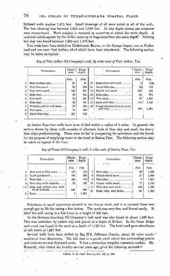
78 OIL FIELDS OF TEXAS-LOUISIANA COASTAL PLAIN.
Stillwell wells reaches 1,475 feet. Small showings of oil were noted in all of the wells. The best showing was between 1,013 and 1,040 feet. At this depth strong gas pressures were encountered. Much sulphur is reported as occurring at about the same depth. A material called asphalt by the driller came up in fragments from the same depth". Nothing but clay was found between 1,045 and 1,475 feet.
Two wells have been drilled on Hildebrands Bayou, on the Grange league, one at Ncder- land and one near Port Arthur, all of which have been abandoned. The following section may be taken as typical:
Log of Port Arthur Oil Company's well, %\ miles west of Port Arthur, Tex.
12 3 4 5 6 7 8 9
Formation.
Whitish-yellow wet sand . . .
Thick ness.
Feet. 87 22
182 40 70 40 25 30
227
Total depth.
Feet. 87
109 291 331 401 441 466 496 723
10 11 12 13 14 15 16
Formation.
Conglomerate of sand, mud, and clay ..................
Thick-ness.
Feet.
. 14 53£
248 45 30
119
140
Total depth.
Feet. 724^
' 778 926 971
1,001 1,120
1,260
At Sabine Pass four wells have been drilled within a radius of 5 miles. In general, the section shown by these wells consists of alternate beds of blue clay and sand, the heavy blue clays predominating. Three were drilled in prospecting for petroleum and the fourtli for the purpose of'supplying water to the hotel at Sabine Pass. The following section may be taken as typical of the four:
Log of Texas Oil Company's well, 3 miles west of Sabine Pass, Tex.
1?,34
6
. Formation.
oil at bottom .............Sand........................
Thick ness.
Feet. 170130430
33
2362
Total depth.
Feet. 170300730763
9991,001
7S<\
1011
Formation. Thick ness.
Feet. 3817
277
155
Total depth.
Feet. 1,0391,0561,0581,1351,3901,486
Petroleum in small quantities showed in the lowest sand, and it is claimed there was enough gas to lift the casing a few inches. The sand was very fine and flowed easily. Tt filled the well casing in a few hours to a height of 300 feet.
In the German-American Oil Company's well sand was also found at about 1,400 feet. This was underlain by yellow clay and gravel to a depth of _60 feet. In the Coast Ridge well wood was found in the sand at a depth of 1,120 feet. The hotel well gave abundance of salt water at 1,061 feet.
Several wells have been drilled at Big Hill, Jefferson County, about 25 miles south- 0 southwest from Beaumont. The hill rises in a gentle swell above the. surrounding prairie and contains several thousand acres. It has a somewhat irregular crescentic outline. Mr. Kennedy, who visited the locality several years ago, gives the following account:«
a Bull. U. S. Geol. Survey No. 212, p. 126.
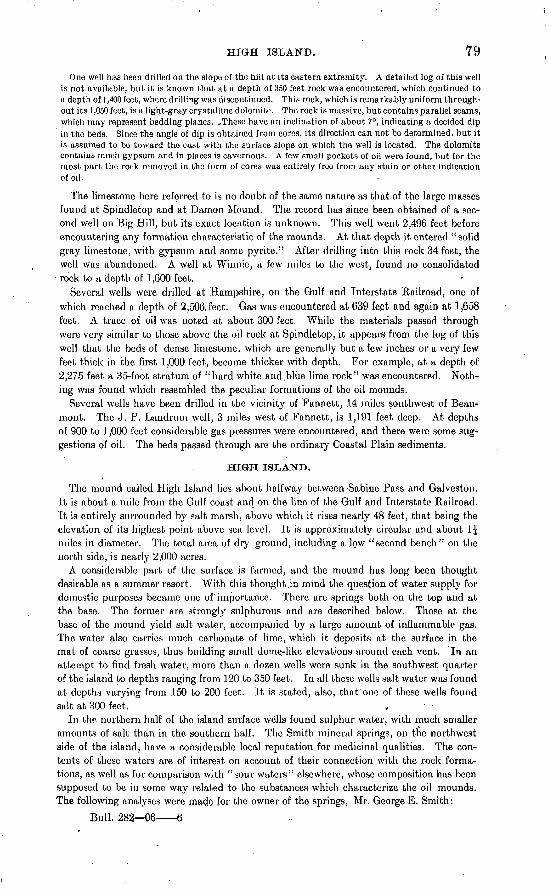
HIGH ISLAND. 79
One well has been drilled on the slope of the hill at its eastern extremity. A detailed log of this well is not available, but it is known that at a depth of 350 feet rock was encountered, which continued to a depth of 1,400 feet, where drilling was discontinued. This rock, which is remarkably uniform through out its 1,050 feet, is a light-gray crystalline dolomite. The rock is massive, but contains parallel seams, which may represent bedding planes. -These have an inclination of about 7°, indicating a decided dip in the beds. Since the angle of dip is obtained from cores, its direction can not be determined, but it is assumed to be toward the east with the surface slope on which the well is located. The dolomite contains much gypsum and in places is cavernous. A few small pockets of oil were found, but for the most part the rock removed in the form of cores was entirely free from any stain or other indication of oil.
The limestone here referred to is no doubt of the same nature as that of the large masses found at Spindletop and at Damon Mound. The record has since been obtained of a sec ond well on Big Hill, but its exact location is unknown. This well went 2,496 feet before encountering any formation characteristic of the mounds. At that depth it entered "solid gray limestone, with gypsum and some pyrite." After drilling into this rock 34 feet, the well was abandoned. A well at Winnie, a few miles to the west, found no consolidated
rock to a depth of 1,600 feet.Several wells were drilled at Hampshire, on the Gulf and Interstate Railroad, one of
which reached a depth of 2,506. feet. Gas was encountered at 639 feet and again at 1,658 feet. A trace of oil was noted at about 300 feet. While the materials passed through were very similar to those above the oil rock at Spindletop, it appears from the log of this well that the beds of dense limestone, which are generally but a few inches or a very few feet thick in the first 1,000 feet, become thicker with depth. For example, at a depth of 2,275 feet a 35-foot stratum of "hard white and.blue lime rock" was encountered. Noth ing was found which resembled the peculiar formations of the oil mounds.
Several wells have been drilled in the vicinity of Fannett, 14 miles southwest of Beau mont. The J. P. Laridrum well, 3 miles west of Fannett, is 1,191 feet deep. At depths of 900 to 1,000 feet considerable gas pressures were encountered, and there were some sug gestions of oil. The beds passed through are the ordinary Coastal Plain sediments.
HIGH ISLAND.
The mound called High Island lies about halfway between-Sabine Pass and Galvestou. It is about a mile from the Gulf coast and on the lino of the Gulf and Interstate Railroad. It is entirely surrounded by salt marsh, above which it rises nearly 48 feet, that being the elevation of its highest point above sea level. It is approximately circular and about 1£ miles in diameter. The total area of dry ground, including a low "second bench" on the north side, is nearly 2,000 acres.
A considerable part of the surface is farmed, and the mound has long been thought desirable as a summer resort. With this thought,in mind the question of water supply for domestic purposes became one of importance. There are springs both on the top and at the base. The former are strongly sulphurous and are described below. Those at the base of the mound yield salt water, accompanied by a large amount of inflammable gas. The water also carries much carbonate of lime, which it deposits at the surface in the mat of coarse grasses, thus building small dome-like elevations around each vent. In an attempt to find fresh water, more than a dozen wells were sunk in the southwest quarter of the island to depths ranging from 120 to 350 feet. In all these wells salt water was found at depths varying from 150 to 200 feet. It is stated, also', that one of these wells found salt at 300 feet. '
In the, northern half of the island surface wells found sulphur water, with much smaller amounts of salt than in the southern half. The Smith mineral springs, on the northwest side of the island, have a considerable local reputation for medicinal qualities. The con tents of these waters are of interest on account of their connection with the rock forma tions, as well as for comparison with "sour waters" elsewhere, whose composition has been supposed to be in some way related to the substances which characterize the oil mounds. The following analyses were mado for the owner of the springs, Mr. George E. Smith:
Bull. 282 06 6
80 OIL FIELDS OF TEXAS-LOUISIANA COASTAL PLAIN.
Analysis of sample from Smith spring No. 3, High Island, Texas.
[By Prof. H. H. Harrington. of the Texas Agricultural and Mechanical College.]
Grains to the English gallon.
Potassium chloride....................................................... 1.661Sodium chloride. .......................i.......... 1...................... 5. 81Sodium sulphate.................;. ........................................ 4.158Magnesium sulphate.;.................................................... 2.211Protosulphate of iron..................................................... 3. 534Calcium sulphate.......................................................... 10. 808Aluminum sulphate. .............. ..-^.................................... 3. 51Silica................................................................... 1.91Organic matter.......................................................... Trace.
Total............................................................. 33.602
Analysis of sample from Smith spring No. 2, High Island, Texas.
[By James Kennedy, Ph. G., M. D.]Grains to the U. S. gallon.
Sodium chloride.......................................................... 61. 720Potassium chloride....................................................... Trace.Magnesium bicarbonate. ................................................ 30. 479Ferrous bicarbonate...................................................... .970Calcium bicarbonate...................................................... 15. 599Calcium sulphate......................................................... 6. 320Alumina................................................................ . 950Silica................................................................... .720Loss ..................... 1...........................'................. .510
Total............................................................. 117.263
Cubic inches. Sulphureted hydrogen..................................................... 2. 73Organic matter.......................................................... None.
In digging at one place a formation was encountered which was apparently a mass of sulphates, chiefly of iron, resulting from the oxidation of pyrite. All these springs are charged with hydrogen sulphide. The mouth of one well of this character was stopped with straw, and a year later the straw was found so thickly coated with sulphur as to resem ble a solid mass of that substance.
The presence of oil was suggested by the abundance of inflammable and sulphurous gases,'as well as by a superficial resemblance of the mound to Spindletop. At least six wells have been sunk to considerable depths and one to 2,600 feet. The Big Four (a test well drilled under an agreement of four companies) went 995 feet, where the water was lost in a porous rock. In a previous attempt a depth of 610 feet had been reached. A showing of oil was noted at 505 feet in the first hole and one at 972 feet in the second hole. For several hundred feet from the surface the sediments at this place contain a consider able proportion of §and, but at greater depths clay is dominant. In the deep hole of the Big Four well no fewer than 14 beds called'" rock" were passed through. It can not be determined now much of this so-called rock is limestone and how much is sandstone. The former, however, is known from the data of other wells to be present in the island. The Carroll well, near the Smith mineral springs, passed through 316 feet of sands, clays, and thin rock beds, and found below these a 6-foot bed of gray limestone. At 331 feet the drill entered gypsum, in which it continued to a depth of 810 feet without passing through. This gypsum was of a white color, showing d.a.rk spots when the cores were taken out, but
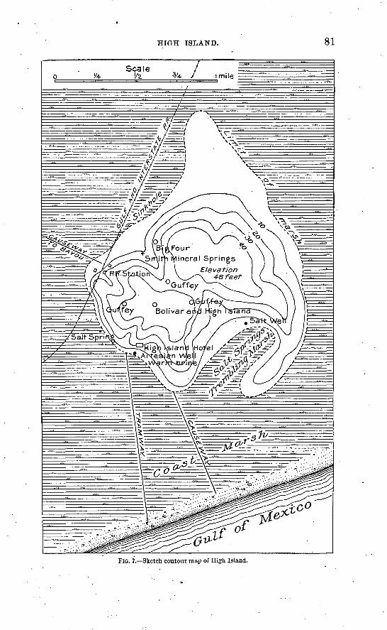
HIGH ISLAND. 81
FIG. 7. Sketch contour map of High Island.
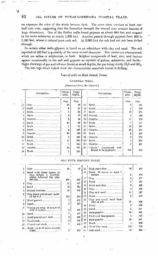
82 OIL FIELDS OF TEXAS-LOUISIANA COASTAL PLAIN".
on exposure the color of the whole became dark. The cores show crevices at least one- half inch wide, suggesting that the formation beneath the mound may contain fissures of large dimensions. One of the Guffey wells found gypsum at about 600 feet and stopped ;in the same substance at nearly 1,200 feet. Another passed through gypsum from 900 to 1,300 feet, where it entered pure rock salt. At 2,600 feet the salt had not yet been drilled through.
In certain other wells gypsum is found as an admixture with clay and sand. The salt reported at 300 feet is probably of the same mixed character. Hot waters are encountered, which are saline or sulphurous, or both. Sulphur compounds of lead, zinc, and barium appear -occasionally in the salt and gypsum as crystals of galena, sphalerite, and barite. .Slight showings of gas and oil were found at small depths, the gas being chiefly H 2S and SO2 .
The two logs which follow show the characteristic materials found in drilling:
Logs of wells on High Island, Texas.
CARROLL WELL.
[Received from Mr: Carroll.]
!
jl; ?.
3' 4
5:R.7'8
9
in
r>13'
14
Formation.
Clay........................
Rock. .......................
Gumbo. ............Sand ........................Rock........................
Gumbo .....................
Rock.........................
Rock. .......................
Thick ness.
Feet. 28
8. 2
88
2619
893
121
261
Total depth.
Feet. 28363846549091
100189192204205231232
15If.171819?n?im?3
?4
?5
?fi97
Formation.
Rock. .......................
found to be gypsum) ......
Thick ness.
Feet. 91
190
111
20
20
6
2
6
479
Total depth.
Feet. 241242
2649?<;
276290316322324325 «1
810
BIG FOUR (SECOND HOLE).
2
Q
4
ft
6
7
-.9
10
11
13
14
Clay........................
Sand with three layers of
which followed the pipe
Clay........................Sand........................
Clay below gravel and shells at 3^n foot
Very hard rock; 36 hours to
Rock; took 48 hours to drill 2 feet......................
20
114518
12426
q
7
2
20
237
282
300
424
426
432
A17
443
450
452
15
16
17
IS
19
?,0
?1
??,
23
24
25
26
?,7
28
W0^
31
Rock; 30 hours to drill 7
Clay........................Rock........................
Clay.........-..-....---.-..
Rock. .......................Clay and sand; hard blue
Sand .........................Blue gumbo. ...............Shell and blue gumbo .......Blue gumbo ................Rock. .....:.................
Soft mud . ..................
20
23694
412
6723
302
241
12416
472
474477483492496537539
606608611641643667668
. 792808
BARBERS HILL. 83
Logs of wells on High Island, Texas Continued.
BIG FOUR (SECOND HOLE)-Continited.
3?
33^doc
36
37
38
39
'Formation.
Rock........................Blue mud ....................
Blue gray rock, very porous.
Thick ness.
Feel. 22
3
60
2
11
162
Total depth.
Feet. 830833007
QQ7
899
910
926
928
40
4243
45
Formation.
cations. ...................Limestone and gravel.. .Blue stones with inica, gas
Thick ness.
Feet. 16
118
21
£i
Total depth.
Feet. 944
9'45
0(13
972
yyo
Set 12-inch pipe at 496 feet; 4-inch pipe at 834 feet.
BARBERS HILL,.
About ten wells « have been drilled in search of oil on Barbers Hill, in Chambers County, 20 miles south of Dayton. The hill is a roughly circular mound 20 feet or more in height and having an area of several thousand acres. Its highest part is almost flat, but its slopes, comprising the larger part of its area, are gently rolling. The surface indications which led to drilling for oil consist chiefly of the escape of gases. The appearance of the mound itself is suggestive of Spindletop, though the elevation is greater.
The principal operator in this district has been Mr. Pattillo Higgins. Before the close of the summer of 1904 Mr. Higgius had drilled five wells. It is said that several wells found indications of oil, but none have found it in paying quantities. A brown oily pgum found in the Higgins well No. 5 at a depth of 738 feet has the appearance of a residuum of oil left by evaporation.
The succession of beds passed in drilling does not differ materially from the familiar series of the developed and prospective oil fields of the Coastal Plain. There are clays in abundance, with sands, gravel, and thin beds of hard limestone. In well No. 2, near the center of the island, gypsum began to appear at 557 feet, apparently as a constituent of sandy beds. From this depth to nearly 1,200 feet, where the well stopped, gypsum appears at frequent intervals, sometimes as selenite flakes, sometimes as large concretions said to be embedded in sand. A single large body of gypsum was not found, though it is not improbable that such exists at a greater depth, covering a mass of rock salt.
Mr. Higgins has preserved samples of all beds with great care. These are described in the following log: '
Log of Biggins v>ell No. 2, Barbers Hill, Chambers County, Tex.
[Description of samples kept by Pattillo Higgins.]
Formation.
Soil............................................ . ... ..... ;.. . ...Yellow clay, blotched with red ........................................ . .......Very fine yellowish sand.. .................... . . .Yellow and blue variegated stiff clay..... .... ....... ..... ... ........Reddish-yellow, very fine sand, enough clay to make it lumpy, slightly calcareous Clear white silica sand ................................ ....... ... ......Variegated yellowish and blue clay. .............................................
a No data were obtained later than March, 1905.
Thick- 'ness.
Ft. in. 2 0
16 014 519 419 0 30 653 0
Total depth.
Ft. in. 2 0
18 032 551 970 9
101 3154 3
84 OIL FIELDS OF TEXAS-LOUISIANA COASTAL PLAIN.
Log ofHiggins well No. 2, Barbers Hill, Chambers County, Tex. Continued.
89
101112131415161718192021222324
252fi272829303132333435363738
39
40414?43444546474849505152
*n<\A
Formation.
White sand.......................... ........Light clay ........................................................................
Fine white sand ................................................. ................
White sand, medium to coarse, with black grains. ............. ................Light gumbo .....................................................................
Fragments of limestone, some sand ...... .",. ................. ................
Light clay. ...........................'............................................
Large concretions of gypsum (egg size) embedded in sand; some powdered gyp sum shown. .....................................................................
Fragments of gypsum insand; some very fine yellow sand within this range, also
Same material without the concretions/the red and yellow (as if limonite) par-
Thick ness.
Ft. in. 6 4
15 02 02 0
79 245 410 0
1 05 07 1
10 417 214 5
2 21 03 4
1 1015 1
3 72 37 24 9
11 535 699 511 9
G 029 5
5 7C 8
13 6
9 318 4
6 624 7
6 113 112 8
10 434 030 080 10
250 87 0
7 024 130 0
Total depth.
Ft. in. .160 7175 7177 7179 7
258 9304 1314 1315 1
320 1327 2337 6354 8369 1371 3372 3375 7
377 5392 6396 1398 4405 6410 3421 8457 2556 7
568 4574 10604 3609 10616 6
630 0
639 3657 7664 1688 8695 7699 6702 2712 6
746 6776 6857 4
1, 108 01,115 0
1, 122 61, 146 71, 176 7
OIL. FIELDS OF TEXAS-LOUISIANA COASTAL PLAIN. 85
VICINITY OF DAYTON.
A locality 8 miles west and a little north of Dayton attracted considerable attention for several reasons, even before oil was found in'commercial quantities in April, 1905. The first occasion of interest in this locality was the obtaining of considerable quantities of gas a few feet below the surface. The surface clay in this vicinity is exceptionally impervious, and gases have therefore been retained below it which, under ordinary circum stances, would have escaped. Shallow wells and post holes filled with water show a constant bubbling up of gas. Some years ago Mr. T. R. McGowan, on and near whose
. farm much gas is found, dug four shallow wells for gas, one of which was 28 feet deep. At 26 feet was a layer of pyrite, partially decomposed, and beneath this an exceptionally \ tough bed of gumbo. Although gas had been .noted at all depths, it came with much
. greater pressure from beneath this impervious bed. For some years Mr. McGowan burned this gas for domestic purposes. The supply was more than sufficient for bhe household and the larger part of it went to waste.
The second feature of interest in this locality is the rock salt discovered in deep wells drilled for oil. One of these, the Taylor-Dayton No. 1, is very near to the shallow gas wells. To a depth of 580 feet, this well showed sediments of the familiar Coastal Plain type. Moderate quantities of gas and faint showings of oil were found in certain sands. Below these were 10 feet of limestone, with .a showing of oil. It is possible that this bed corresponds in its origin and nature to the oil-bearing limestone of the oil fields. The material from 590 to 799 feet was reported as solid gypsum. Beyond that the drill went 500 feet farther in pure salt, but did not pass through it. In two other wells of the Taylor- Dayton Company the salt was mixed with sand, but was said to .be overlain by gypsum, as in well No. 1. Similar deposits of salt have since been found on the west side of the field. .
In the winter of 1904-5 a number of wells were drilled about 1 mile south of the McGowan wells. The first of these to obtain "oil was the Higgins-Paraffine No. 2, which was finished in April, 1905. Within a few months the same company sunk at least 4 successful wells, and as many more were put down by other companies. In October, 1905, the daily pro duction of the field was between 600 and 700 barrels. The gravity varies between 17° and 23° B. In the northeastern part of the field much gas is encountered and several severe blow-outs have occurred.
The oil is found between 600 and 700 feet deep. Most of it is obtained from loose sands, and the wells in such cases are provided with strainers. In at least one case, the Higgins- Paraffine No. 6, the oil is said to be derived from "rock." The depth in this case is 619 feet. There is no accurate description of the oil rock in this well, but fragments of rock were brought to the surface by the blow-outs of the Sun No. 5 and the Morning Star. These were said to show, a close resemblance to the oil rock at Spindle'top. That which came from the Sun No. 5 contained much pyrite. Th» wells from which these fragments came yielded no oil. .
This field is on the.margin of "Dayton Hill," a poorly defined elevation which extends westward from Trinity River about 10 miles, having an average width of perhaps 6 miles. Its highest part is 25 to 30 feet above the surrounding country and 90 to 100 feet above the sea.
Four miles southeast of Dayton, near Trinity River, there is a low spot which has attracted attention by the abundance of its escaping gases. There are also sulphur waters and reports of small seepages of oil. Six wells have been attempted here within-a very small area. Most of these have failed to get down more than a very few hundred feet. The deepest, at the time of the investigation, was the Bullard & Wilson No. 5, 670 feet.
The drilling revealed an abundance of gas, and showings of oil were found in several sandy beds. A porous limestone was found at a depth a little less than 400 feet, but it contained no oil. Strong salt water charged with hydrogen sulphide was found below 360 feet. A little sulphur came from an uncertain depth in the Bullard & Wilson well, probably from below 600 feet.
86 OIL .FIELDS OF TEXAS-LOUISIANA COASTAL PLAIN.
SCATTERED WEL.L.S NEAR HOUSTON.
Several wells were drilled at Pierce Junction, 8 miles southwest of Houston. Much gas appeared both at the surface and in the wells. At least one of the wells found a showing of oil. It is said that salt was found at 900 feet, underlain by limestone. The purity of the salt is not known. The Rio Bravo Oil Company has done considerable drilling at Missouri City, 15 miles west of Houston, but without results. Reports from Blue Ridge, in Fort Bend County, indicate a curious mixture of materials between the depths of 200 and 600 feet. This mixture includes gravel, pyrite, and crystals of sulphur, in a matrix of gypsum and dolomitic limestone. On the Camp rice" farm, near Alvin, the Santa Fe Railway drilled several wells, the deepest being 1,500 feet. Nothing of interest was found.
HOSKINS MOUND.a
In the southeastern part of Brazoria Co'unty, between Chocolate and Bastrop bayous, is Hoskins Mound. Its area is nearly 700 acres and its elevation 37 feet above sea level, or 30 feet above the plain. Three wells have been drilled here, none of which has failed to give showings of oil and gas. These occur in beds of alternating sands and clays at various depths to 800 feet. The largest showing of gas and oil was in well No. 3, in which a vigor ous blow-out occurred from a depth a little less than 600 feet. A large amount of sand was expelled, together with a few barrels of oil. Thin beds of rock are found, chiefly at consid erable depths. The samples of consolidated rock seen were all sandstone cemented by car bonate of lime, but thin plates of limestone are also reported.
At 610 feet in well No. 2 and at 780 feet in No. 1 thick beds of marl were found. Samples of this material were examined, and it is believed to correspond closely with the descriptions of the material which underlies the porous oil-bearing limestone in the oil-producing fields. It is sticky when wet and chalky when dry, is highly calcareous, and has little grit. It occurs here in beds 50 to 100 feet thick. As in other districts, the thick beds are poorly consolidated or perfectly soft. Where the same material lias passed into limestone, it occurs in thin beds only.
The water found in the sands is comparatively fresh to depths of 800 or 900 feet. At 980 feet in well No. 2 and at 1,125 feet in well No. 1 water was struck which was described by the contractor as black, salt, sulphur water, with a very bad smell and a biting or burn ing effect on the tongue. It is probable that this water contains sulphuric acid.
AMSTERDAM.
At Amsterdam, on the west side of Chocolate Bayou, 7 miles north of Hoskins Mound is an elevation which is without abrupt slopes and definite boundaries except on the north side. This Amsterdam mound rises 16 feet above sea level and 10 feet above the plain.
On the east side the channel of Chocolate Bayou exposes a bed of concretionary limestone beneath 2 or 3 feet-of soil. The material of the limestone horizon varies between two extreme phases. On the one hand it may appear as separate spherical concretions, often several inches in diameter. At the other extreme it is a bed of cavernous rock 2 or 3 feet thick. The concretions, when broken, frequently show wide open cracks radiating from the center. In some cases the space within is filled with clay. This limestone is of interest because of the light it may shed on the deeper porous limestones which bear oil.
Several wells have been drilled for oil one to a depth of 1,373 feet and another to 1,499 feet. The records of these wells show occasional traces of oil and gas. Salt water continues to flow from one of them at the rate of about 1 barrel per minute.
BRYAN HEIGHTS.
This mound is in Brazoria County, 3 miles south of Velasco, and but little more than a mile from the Gulf coast. It covers an area of 300 acres and rises 30 feet above tide. The surrounding plain is about 11 feet high. This locality has received frequent mention as containing asphalt in small quantities. Jet-like or asphaltic "sea wax" has been picked up on the shore, and the soil 'at places contains minute grains of what is supposedly the same substance.
o Sae note at bottom of page 138.
BKYAN HEIGHTS. 87
Seven wells were drilled for oil before the autumn of 1904. The drilling of one of these resulted in an. enormous flow of gas, the chief constituent of which was hydrogen sulphide. The initial flow was estimated at 6,000,000 cubic feet daily. Other wells encountered less gas. Several wells on the heights found flows of water at depths between 450 and 500 feet.. The fact that the Reed well, located on the flat on the northwest side, found a similar water- supply at 611 feet has been taken by some to indicate a dip of the beds toward the edges of the mound. There is no reason, however, for believing that the beds have more lateral continuity at this placo than elsewhere in the Coastal Plain. Correlations and inferences as to structure from the present well data are therefore not warranted.
Far the larger part of the formations passed in drilling are clay. Sand, gravel, and lime stone appear occasionally. A number of samples have been preserved, but there is no record of the depths from which they were taken. Among these was found a gypsiferous white marl of the same nature as that found at Hoskins Mound. Another sample called "oil sand" is a purely crystalline limestone of the yellow, sugary appearance shown by many of the Spindletop samples. The sample Avas soaked with oil and is believed to rep resent a formation corresponding to the oil-bearing rock at Spindletop. This does not imply that it contains oil in commercial quantities.
Sulphur is mentioned as occurring at or below the oil horizon, and gypsum is said to be found below that depth. Samples examined showed these two substances as parts of the same fragment. There is every reason to think that the characteristic materials noted in other mounds occur here in their usual order.
The Home well yields small quantities of a strong sulphur salt water from an uncertain depth. Most of the water from the wells on the hill is as fresh as from those of the sur rounding plain, on which a number of artesian wells have been sunk. Some of these wells near Brazos River, within 10 miles of its mouth, are more than 1,000 feet deep, and the water is sufficiently fresh for domestic use. A number of others from about half that depth yield smaller quantities of hotter water. The water of one of the deep wells at Surf- side is said to have a temperature of 104°. The artesian well at Velasco is .1,060 feet deep and the water flows slowly from a 4-inch pipe. It is accompanied by gas in sufficient quantities to burn at the mouth of the well.
The following log was carefully kept by the driller:
Log of Reed well, Bryan Heights, Brazoria County, Tex. [By J. F. Frederickson, driller.]
1
2 3 4 5 6
7
8 9
10
11 12 13 14
Formation.
Black surface (asphaltic
Black clav ..................Black clay with reddish
spots of "decomposed
Black clay with minute
First sign of gas in blue
Black clay with "decom posed lime .and iron".....
Black shale and sand .......
Black shale with some gravel. At 365 feet were 4 inches of rock, very hard .
Thick ness.
feet.
30
12
20 25
5
70
27 21
16
18
3 28
55
15
Total depth.
feet.
30 42 62 87 92
162
189 210
226
244 247 275 330
345
15
16
17 18
19 20
21
22 23 24
25
Formation.
Soft black clay with "de-
Soft blue clay with yellow clay m ixed ................
Yellow clay, sand, and shale. Oil sand, pebbles, and shale;
Yellow clay, sand, and shale. Hard rock, probably sand-
Oil sand, large pebbles, some oil........................
"Flint;" twisted off pipe
Pipe dropped suddenly 13 feet after drilling 2 days
Thick ness.
feet.
60
6282
8 30
2
2 4 2
1
13
Total depth.
feet.
405
467
549
557
587
'589
591
595
597
598
611
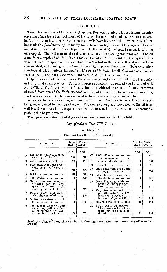
88 OIL FIELDS OF TEXAS-LOUISIANA COASTAL PLAIN.
KISEK HILL.
Two miles northwest of the town of Columbia, Brazoria County, is Kiser Hill, an irregular elevation which has a height of about 30 feet above the surrounding plain. On its southern half, at less than half that elevation, four oil wells have been drilled. One of these, No. 2, has made the place known by producing, for sixteen months, by natural flow, a good lubricat-. ing oil at the rate of about 5 barrels per day. In the midst of that period the market for the oil stopped. The well continued to flow until a part of the casing was removed. The oil came from a depth of 480 feet, from a material reported as "oil sand," but samples of this were not seen. A specimen of rock taken from 364 feet in the same well and said to have contained oil, with much gas, was found to be a highly porous limestone. There were other showings of oil, at various depths, from 89 feet to 835 feet. Small blow-outs occurred at various levels, and a little gas was found as deep as 1,050 feet in well No. 3.
Sulphur is reported from various depths, always in connection with " rock," and frequently in the form of small crystals. Pyrite is likewise abundant. A rock at the bottom of well No. 4 (760 to 812 feet) is called a "black limestone with soft streaks." A small core was obtained from one of the "soft streaks" and found to be a friable sandstone, containing small veins of salt. Similar cores are said to have contained crystalline sulphur.
Water was found under strong artesian pressure. Well No. 1 continues to flow, the water being accompanied by considerable gas. The slow and long-continued flow of the oil from well No. 2 was more like the quiet overflow due to artesian pressure than the spasmodic gushing due to gas pressure.
The logs of wells Nos. 1 and 2, given below, are representative of .the field:
Logs of wells at Kiser Hill, Texas.
WELL NO.l. 0
[Received from Mr. John Underwood.]
1
2 3
456
7
8
9
Formation.
showing of oil at 388... ... Alternating sand and clay.. Blue shale with sand below
containing good show of oil........................
Material not mentioned; it contains gas in large
sional globules of oil ...... Rocks, shells, and wood,
White rock saturated with oil............:...........
Gray rock impregnated with something yellow, either oil or sulphur, and con-
Thick ness.
Feet.
388 70
2020
. 2
5
5
2
25
Total depth.
Feet.
388 458
478498500
505
510
512
537
1011
1?13
14
15
10
1718
Formation.
Rock, sandstone, or lime stone, not determined....
Gray rock with pyrite and
Blue clay with strong gas
Gray limestone with sul phur and strong gas pres-
Very fine loose sand with oil alternating in thin
blow-out of gas at' 603 ....
Black rock called limestone. The water was lost at this place and the hole aban-
Thick- ness.
Feet.7
4 16
\.£i
8
4
28 48
16
Total depth .
Feet. 544
. 548 564
584
588
616 664
680
No oil was obtained from this well, but its showings were better than those of any other well at Kiser Hill.
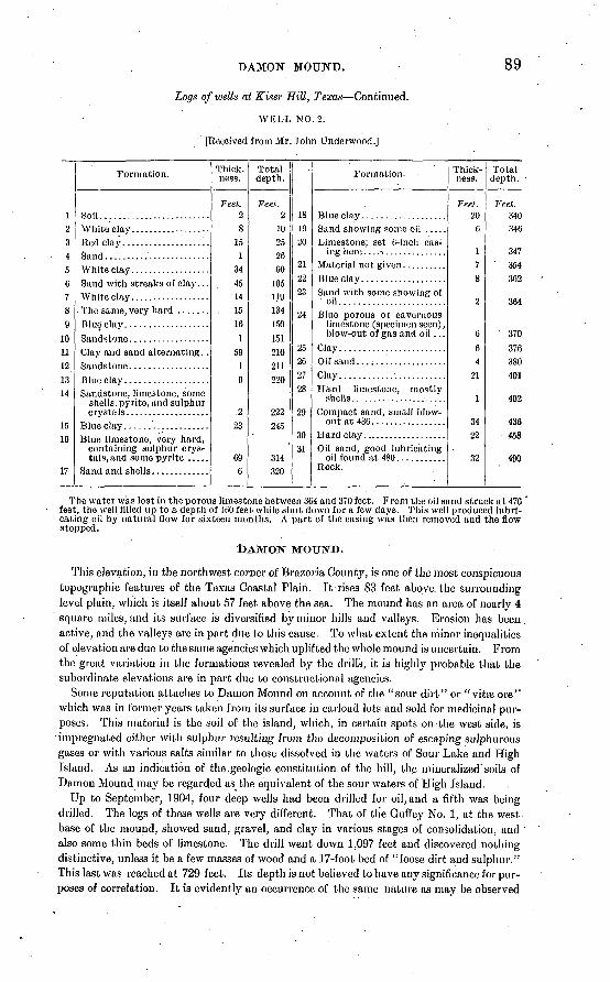
DAMON MOUND.
Logs of wells at Riser Hill, Texas Continued.
WELL NO. 2.
[Received from Mr. John Underwood.]
89
12 3 4 5 6 7 8 9
10 11 12 13 14
15 16
17
Formation.
Soil.........................White clay..................
Sand with streaks of clay. . . White clay ..................
Clay and sand alternating. .
Sandstone, limestone, some shells; pyrite, and sulphur
Blue limestone, very hard, containing sulphur crys tals, and some pyrite .....
Thick, ness.
Feet. 2 8
15 1
34 45 14
. 15 16
1 59
1
9
.2 23
69 6
Total depth.
Feet. 2
10 25 26 60
105 119 134 150
151 210 211 220
222 245
314 320
18 19 20
21 22 23
24
25 2627 28
29
30 31
Formation.
Sand showing some oil .....Limestone; set 6-inch cas
ing here. ...................Material not given..........
Sand with some showing of
Blue porous or cavernous limestone (specimen seen), blow-out of gas and oil ...
Clay........................Oil' sand .....................Clay........................Hard limestone, mostly
Compact sand, small blow out at 436.................
Oil sand, good lubricating oil found at 480...........
Rock.
Thick ness.
Feet. 20
6
17 8
2
6
6 4
21
1
34 22
32
Total depth.
Feet. 340 346
347 ' 354
362
364
370
376 380 401
402
436 458
490
The water was lost in the porous limestone between 364 and 370 feet. From the oil sand struck at 476 feet, the well filled up to a depth of 160 feet while shut down for a few days. This well produced lubri cating oil by natural flow for sixteen months. A part of the casing was then removed and the flow stopped.
±>AMO]Sr MOUTSTD.
This elevation, in the northwest corner of Brazoria County, is one of the most conspicuous topographic features of the Texas Coastal Plain. It rises 83 feet above, the surrounding level plain, which is itself about 57 feet above the sea. The mound has an area of nearly 4 square miles, and its surface is diversified by minor hills and valleys. Erosion has been active, and the valleys are in part due to this cause. To what extent the minor inequalities of elevation are due to the same agencies which uplifted the whole mound is uncertain. From the great variation in the formations revealed by the drills, it is highly probable that the subordinate elevations are in part due to constructional agencies.
Some reputation attaches to Darnon Mound on account of the "sour dirt" or "vitse ore" which was in former years taken from its surface in carload lots and sold for medicinal pur poses. This material is the soil of the island, which, in certain spots on the west side, is
impregnated either with sulphur resulting from the decomposition of escaping sulphurous gases or with various salts similar to those dissolved in the waters of Sour Lake and High Island. As an indication of the.geologic constitution of the hill, the mineralized'soils of Damon Mound may be regarded as the equivalent of the sour waters of High Island.
Up to September, 1904, four deep wells had been drilled for oil, and a fifth was being drilled. The logs of these wells are very different. That of trie Guffey No. 1, at theWest base of the mound, showed sand, gravel, and clay- in various stages of consolidation, and ' also some thin beds of limestone. The drill went down 1,097 feet and discovered nothing distinctive, unless it be a few masses of wood and a 17-foot bed of "loose dirt and sulphur." This last was reached at 729 feet. Its depth is not believed to have any significance for pur poses of correlation. It is evidently an occurrence of the same nature as may be observed
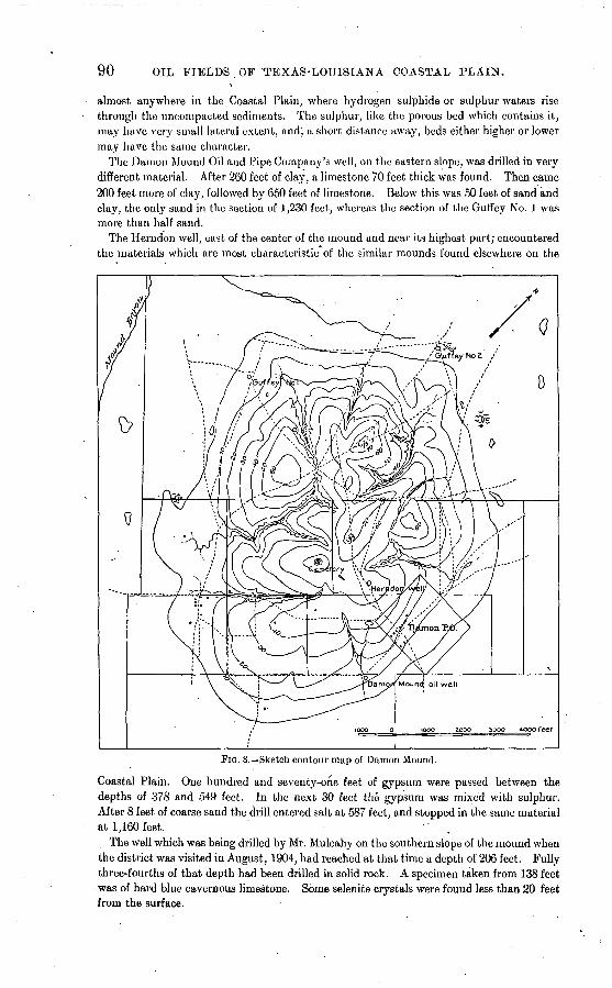
90 OIL FIELDS OF 'TEXAS-LOUISIANA COASTAL PLAIN.
almost anywhere in the Coastal Plain, where hydrogen sulphide or sulphur waters rise through the uncompacted sediments. The sulphur, like the porous bed which contains it, may have very small lateral extent, and; a short distance away, beds either higher or lower may have the same character.
The Damon Mound Oil and Pipe Company's well, on the eastern slope, was drilled in very different material. After 260 feet of clay, a limestone 70 feet thick was found. Then came 200 feet more of clay, followed by 650 feet of limestone. Below this was 50 feet of sand and clay, the only sand .in the section of 1,230 feet, whereas the section of the Guffey No. 1 was more than half sand.
The Herndon well, east of the center of the mound and near its highest part; encountered the materials which are most characteristic of the similar mounds found elsewhere on the
FIG. 8. Sketch, contour map of Damon Mound.
Coastal Plain. One hundred and seventy-one feet of gypsum were passed between the depths of 378 and .549 feet. In the next 30 feet the gypsum was mixed with sulphur. After 8 feet of coarse sand the drill entered salt at 587 feet, and stopped in the same material at 1,160 feet.
The well which was being drilled by Mr. Mulcahy on the southern slope of the mound when the district was visited in August, 1904, had reached at that time a depth of 206 feet. Fully three-fourths of that depth had been drilled in solid rock. A specimen taken from 138 feet was of hard blue cavernous limestone. Some selenite crystals were found less than 20 feet from the surface.
VICINITY OF OTTINE. 91
Limestone of a warty and cavernous appearance comes to the surface on the eastern slope. It was at one time quarried, and was shipped long distances. The horizon of this stone was no doubt calcareous from the time the sediments were laid down, but the body of limestone, as now known, is probably largely concretionary. As at Amsterdam, there are gradations between isolated concretions and large cavernous bodies.
Most of the shallow-well waters of the mound are sufficiently mineralized to have a dis tinctive taste, but the waters from various pa,rts of the area differ. That which comes from a depth of 206 feet in the Mulcahy well is strongly sulphureted and contains little or no salt.
Two logs which show the distinctive geologic features of the mound are here given:
Logs of wells at Damon Mound, Texas.
HERNDON WELL.
[Elevation 140 feet.]
1?3456
Formation.
Soil.........................
Thick ness.
Feet. 11
35
361446
4
Total depth.
Feet. 11
468296
142146
789
10111?,
Formation.
Gpysum ....... r ............
Salt.........................
Thick ness.
Feet. 196
378308
' 573
Total depth.
Feet. 165171549579587
1,160
DAMON MOUND OIL AND PIPE LINE COMPANY'S WELL.
[Elevation 100 feet.]
123
Clay........................
Clay................:.......
26070
200
260330530
45
65050
1,1801,230
VICINITY OF OTTINE.
Over a considerable area, which includes parts of Gonzales, Wilson, and Bexar coun ties, there are frequent indications of gas and oil. The vicinity of Ottine, Gonzales County, possesses considerable interest on account of its mud volcanoes and the drilling which has been done in search of oil.
Ottine is surrounded by a rolling country, through which runs the deep valley of San Marcos River. The channel at this place is 96 feet below the level of the town. A ter race about 50 feet above the river is at places about a mile wide between bluffs. About halfway down from this terrace to the river is a newer terrace, which, in the vicinity of Ottine, is several hundred feet wide. A.t a still lower level the river has at places a very narrow flood plain.
It is on the lower terrace that the mud volcanoes are found. Some are now active, while dry rounded knolls appear to represent extinct ones. There are other rounded lumps as much as 5 feet high and 30 or 40 feet in diameter, with abrupt slopes meeting the flat surface of the terrace in such a manner as to give to the elevations very definite outlines. Some of these are very wet; in fact, water may be seen oozing from their tops, accom panied by bubbles of gas. The surfaces'of such mounds are covered with vegetation, which forms a mat. Beneath this surface is a semiliquid quaking mass. A man standing on the top and supported by a plank may shake the entire mound. While the material of these mounds and of the more typical mud volcanoes with craters is generally mud, it is; frequently mixed with sand,
92 OIL FIELDS OF TEXAS-LOUISIANA COASTAL PLAIN.
The gas to which these phenomena are due also comes up copiously from the bed of the river and causes boiling pools in the sands along the river banks. It is abundant to a depth of 900 feet in the wells drilled for oil. These phenomena indicate that the gas does not result entirely from organic matter recently incorporated in the alluvial deposits. The connection of the mud volcanoes with such deposits is probably due to the fact that the gas escapes without notice through the sandy soil of the back country. Through the impervious covering of the old flood plains, however, gas must escape at isolated points where it can force a passage. In so doing it may enlarge the conduit by carrying material to the surface.
Nine wells have been drilled to various depths within 3 miles of Ottine. The Putnam well, beside San Marcos Kiver, is 1,176 feet deep. The records of the several wells show a great preponderance of sand over other materials. Some clay was found not far below the surface. Below that, one well showed no clay and the others showed different amounts, suggesting that the deposits are in lenses, or that the same bed varies in character from place to place. Beds of rock from a few inches to several feet in thickness were numer ous. Much pyrite was encountered, that at small depths being frequently decomposed, giving rise to "sour dirt."
While gas was found at frequent intervals, showings of oil were of rare occurrence. A small showing was supposed to be found at 200 feet in the well drilled by Mr. J. A. Otto west of the town, and probably also in his first well, located on the west side of the river. Small quantities of oil were found at shallow depths in wells on Mr. R. Wohlfahrt's land, 3 miles east of Ottine. A few gallons of oil coming from a depth of 82 feet were dipped out of a dug well. This led to drilling, but without success. One well reached a depth of 1,004 feet, but found no oil below 80 feet, except a faint showing at about 500 feet. A good artesian flow of water was found at about 550 feet. Half a mile to the west the Ottine Oil Company put down a well, getting a powerful artesian flow from about the same depth. The flow from this well-is estimated to be at least'10 barrels per minute. The water from both artesian wells is slightly sulphurous. Some gas accompanies the water. In the Wohlfahrt artesian .well the gas is said to have made its appearance several weeks after the completion of the well.
VICINITY O3? SAN ANTONIO.
Small quantities, of oil at shallow depths are common in the vicinity of San Antonio. Six and one-half miles southeast of the city are three wells belonging to Mr. George Dull- nig, which have for some years produced a good lubricating oil for the local market. The oil is pumped only occasionally. It is estimated that the three wells together might be made to yield one barrel per day. These wells have depths of 265, 300, and 900 feet, respectively, the first yielding its oil from a depth of 235 feet and the others from 300 feet. Little is known of the materials passed through in drilling, but the oil is contained in a marly sand covered by blue clay. A few similar wells in the same vicinity are owned by the San Antonio Oil Company. Artesian wells in the city of San Antonio find a stratum at about 500 feet which in nearly all cases shows oil. Eight miles northeast of San Antonio, and 10 miles southwest, on Leona River, heavy oil has been found at small depths in quan tities similar to those of the Dullnig wells.
SUTHERLAND SPRINGS.
This locality in Wilson County abounds in sulphur springs, and contains certain other features which have attracted the attention of oil investors. These include escapes of gas from the ground and an occasional oily film on t"he water of some of the springs. The most significant occurrence is that of small quantities of oil in wells drilled for water. The usual depth at which such showings have been noted is 80 to 100 feet. It is said that a number of wells drilled for water were abandoned on account of the taste of oil. Small quantities of the oil have been brought up from the wells and used among the farmers for lubricating purposes,
SUTHERLAND SPRINGS. 93
Cibolo River, afc this place, has a valley several miles in width. Its immediate channel is cut 30 feet or more below the flat bottom of the valley. It is along the steep banks of
the river that the largest sulphur springs occur. Their waters color the river a milky green for some distance. On the valley floor, at least half a mile from the river, are the "sour springs," which have a faint sulphur taste mingled with a slight sourness, due probably to the presence of sulphates.
On the old alluvial plain are certain so-called "bogs," which resemble some of the soft m'ounds found among the mud volcanoes near Ottine, except that these are not elevated. They are composed of a soft quaking mire, always wet, apparently by the rise of spring waters.
The narrow, dry channel of Alum Creek is cut about 20 feet below the main valley bot tom, or 40 feet below the dissected sandstone upland. The rock walls of this gorge and the sands in its bottom are abundantly incrusted with the materials left by the evapora tion of spring waters. There are layers of pure sulphur and of the sour salts, presumably sulphates. A brown loam taken from the bottom of the channel is intensely sour, resem bling the "sour dirt" formerly shipped from Dampn Mound.
Five wells have been drilled for oil within a strip about 3 miles long. The Pipkin well, whose log is given below, found showings of oil at depths of 415, 775, and 1,352 feet. In the Hobbs well, located in the vicinity where oil appeared in the water wells, oil was detect ed at 80 feet and again at 350. Gas appeared in the Pipkin well 'at various depths. In the Adams & Wolf well, a blow-out occurred at 140 feet. Strong sulphur water like that from the springs is flowing from the Pipkin well at a rate of at least 1 barrel per minute. As flows were encountered at three horizons below 970 feet, the depth from which this water comes was not ascertained.
The exposed sandstones of this vicinity show some considerable dips, but the details of structure have not been worked out.
Log of Pipkin well (American Mineral Company), Sutherland Springs, Tex. , [Kept by P.-E. Pannewitz.]
12
34 5 C7 8
9
10
11 12 13 14 15 16 17 18 19 20
21
Formation.
Soil........................Coarse white sand, with
flowing water and gas...
Black gumbo and gravel. . .
Hard gray rock containing pyrite....................
Coarse, white sand, with flowing sulphur, water,
Gray sand, with pebbles and lignite................ .
Soft gray rock.. . .Gray sand containing wood. Hard gray " bowlders "..... Gray sand mixed with shells
Soft gray rock. .........Gray sand mixed with shells Hard gray "bowlders" . .... Gray sand............... ..The same, mixed with lig
nite. ............... .The same, mixed, with wood.
Thick ness.
Feet. 14
3 13 2
16 4
13
6
19
16 5
29 7
01 0 8
.12 C
40
7 8
Total depth.
Feet. 14
17 30 32 48 52- OS-
71
90
100 111 140 147
1 208 j 214 I 222 « 234£ :M° J 280
7/ ~87
if i5
22
23 24 25 20 27 28 29 30 31
32
33
34 35
30
37
38 39 40 41
Formation.
The same, mixed with lig-
Hard blue gum bo, very_sour
Dark-gray clay and sand...
.Dark -gray clay and sand, with lignite and iron. .....
Da;rk-gray crystallized lime stone, with trace of oil. ...
Dark-gray clay, with lig nite, shells, iron, and flow-
Black clay, with lignite, shells, and iron. ..........
Hard light-blue rock, with
Black clay, mixed with
Gray sand, with shells. .....
Thick ness.
Feet.
7 58
8 2 1 2 2 3 2
35
4
02 3
144
12
52 8
34 6 2
Total depth.
Feet.
302 300 368 370 371 373 375 378 380
415
419
481 484
628
040
092 700 734 740 742
94 OIL FIELDS OF TEXAS-LOUISIANA COASTAL PLAIN".
Log of Pipkin well (American Mineral Company), Sutherland Springs, Tex. Continued.
42
43 44.
45 46 4748
49
50 51
52
53
54
55 56 57
58 59
Formation.
Gray clay, with, shells and
Hard black rock, porous in parts, with trace of oil. . . .
Black clay, mixed with shells
Dark-gray clay and sand . . . Hard black dolomite con
taining gas ...............Gray clay, with shells, iron,
and fine greensand .......Hard dark-gray limestone . . Black clay mixed with iron,
Soft dark-gray rock; flow ing water of bad odor ....
Black clay mixed with iron and shells .................
Hard black limestone. . .....Black clay, with shells, iron,
Black clay, with shells, iron,'
Thick ness.
Feet.
29 4
32 60 8
11
3
60 3
21
10
1 1
3 1
39 4
18
Total depth.
Feet.
771775
807 867 875 886
889
949 952
973
983
984 985 988 989
1,028 1/032
1,050
60
61
62
63
64
65
66 67
68
69
70
71
72
73
74
75
76-
77
Formation.
Hard black rock, with shells.Dark sand, containing iron,
flowing water, and gas. . . .
Hard black gumbo mixed with iron "bowlders". ...
Dark sand and clay mixed
Dark clay mixed with iron
Hard dark rock, with trace » of oil and flowing water. . .
Dark sand and clay mixed
Soft dark rock. .............
Thick ness.
Feet. 6
34
4
9
4
7 114
2
4
12
4
98
. 4
2
32
22
4
88
Total depth.
Feet. 1,065
1,090
1,094
1,103
1,107
1,114
1,228
1,230
1,234
1,246
1,250
1,348
1,352
1,354
1,386
1,408
1,412
1,500
JENNINGS FIELD.
LOCATION.
The Jennings field, which produces most of the petroleum of Louisiana, is situated in Acadia Parish, about-6 miles northeast of the city of Jennings and an equal distance from Mermentau station, on the Southern Pacific Railroad. The field lies about midway between Bayou Nezpique and Bayou des Cannes, these two streams being about 4 miles apart and uniting with each other, and with Bayou Plaquemine, some 3 miles south of the oil field, to form Mermentau River. Jennings is 90 miles east of Beaumont, Tex., and 188 miles west of New Orleans. The field lies nearly 50 miles inland from the Gulf coast, and is on the outcrop of the Port Hudson (Pleistocene) formation, as mapped by the LouisianaSurvey.
TOPOGRAPHY.
This part of the Coastal Plain is not so perfect a flat as that which surrounds the city of Beaumont, Tex. The two bayous have incised the surface of the plain to a depth of perhaps 20 feet. The beginnings of dissection by their tributaries impart to the neighbor ing strips of land> gently rolling surface. In addition to this relief due to stream action the Jennings field has a further elevation, probably not greater than 5 or 6 feet, which appears superficially to be of the same nature as that of Spindletop and other oil mounds of Texas. This elevation is not oval-in plan or symmetrical in form, but irregular and of indefinite boundaries. The dissection of its borders by the beginnings of stream erosion, makes it difficult to decide how much of its height should be ascribed to uplift and howmuch to erosion.
" HISTORY AND PRODUCTION.
GROWTH OF THE FIELD.
Attempts to find oil in this field w.ere induced by the escape of gas from the soil. The first drilling was by the Jennings Oil Company, but the well was ruined by an accident,
U.S. GEOLOGICAL SURVEY BULLETIN NO. 282 PL.VII
JENNINGS-HEYWOOD OIL SYNDICATE
SUBDIVISION
81 ,, . .,-,,-, ,- ,, r
MAP OF JENNINGS OIL FIELD.
JENJUNGS FIELD. '95
after six months of labor. In August, 1901, the Southern Oil Company .drilled a well 1,822 feet deep. By its violent gushing of oil and sand this well showed beyond doubt that the formation encountered was an oil-bearing sand of importance. The well produced 200,000 barrels before the gushing ceased. There is no record of any sale of oil from the field in 1901, but in the following year Louisiana produced 548,677 barrels, almost all of which came from the Jennings field. In 1903 the output was approximately doubled. The pro duction during the first half of 1904 continued at a rate not very different from that of the previous year, ranging between 2,000 and 2,500 barrels a day. On August 4, 1904, the Producers Company finished a well on the Latreille tract, on the east side of the field, which became the first great Jennings gusher. Following this success other large wells were put down in rapid succession. All but the first of the great gushers are in the Arnaudet tract, on the east side of the field. o- The yield of these wells rapidly increased the output of the field to over 50,000 barrels a day, and for several months the rate of production did not fall below that figure. Over 6,000,000 barrels were produced in the last five months of 1904. More than 95 per cent of this oil came to the surface by natural flow from the wells
finished after August 1 on the east side of the field. The small balance was pumped from
the older wells.INDIVIDUAL WELLS. '
Some of the newer wells will be noteworthy in the annals of the oil industry for their large yields in short times. The Bass & Beckenstein No. 1 yielded 1,500,000 barrels in the one hundred and forty-five days from September 8 to January 31, this probably making a short-time record for the United States, though the statistics of other fields are not at hand to support this statement. The Wilkins No. 2 yielded 995,800 barrels in the eighty-two days from November 20 to.February 10. It will be observed that these notable outputs
do not involve daily yields from single wells much greater than 12,000 barrels, and that no well yielded, in any single day, much more than 15,000 barrels. A comparison of these figures with those of Spindletop, where initial daily capacities as great as 95,000 barrels were ascribed to certain wells, does much to emphasize the oft-repeated statement that the unprecedented gushing of the Spindletop wells was of very brief duration.
.RESERVOIRS AND PIPE LINES.
To accommodate the great production of the Jennings field the tankage, steel and earthen, was rapidly increased to more than 7,500,000 barrels. Four pipe lines connect the field with the Southern Pacific Railroad at various points, and a line has been built to Atchafalaya lliver, a distance of 59£ miles to the east, passing through the Anse la Butte fields, 45 miles east of Jennings.
USES AND CHARACTER OF THE OIL.
Up td August, 1904, most of the Jennings oil was used for fuel by various industries within 100 miles of the field. During the summer season much of it went to the pumps employed to flood the rice lauds. Some had from the outset been bought by the Southern Pacific Railroad for fuel, and after the coming in of the great gushers most of the product was used in this way. A small refinery was built at Jennings, which is able to obtain from the crude oil about 7 per cent of illuminating oil, 25 per cent cylinder oil, and.4 per cent good asphalt, suitable for roofing and roofing paint. The remaining 64 per cent furnishes lighter lubricating and neutral oils. 0
GEOLOGIC FORMATIONS.
WELL SECTIONS.
The character of the formations is well illustrated by the following logs. That of the Chicago-Jennings well No. 1 illustrates the character of the formations outside the field as compared with those within the productive area. .
a No data have been obtained since May, 1905. Bull. 282 06 7
96 OIL FIELDS OF TEXAS-LOUISIANA COASTAL PLAIN.
Logs of wells in and near Jennings field.
GUARANTEE WELL NO. 1.
1?345fi789
1011Ifl13141516171819?021
Formation.
Clay........................
Coarse sand and gravel .....Clay........................
Clay.........................
Clay.........................
Clay.......;..:..............
Clay..............................do......................
Clay.........................
Thick ness.
Feet. 3520102510
60010102020
16080206040102050406015
Total depth.
Feet. 35556590
100700710720740760920
1,0001,0201,0801,1201,1301,1501,2001,2401 3001,315
n23?A25?6?72829in31323334
35363738394041
Formation.
Rock. .......................Clay.........................Rock........................
Clay../......................Rock. .......................
Clay.........................
Clay.........................
Clay.........................
Thick ness.
Feet. §
.200
i13J90
i1015
46102025
410'
202
104
43
Total depth.
Feet. 1,315?1,51311,516£
-1,5301,620l,620g1,6341,6391,6851,6951,7151,7401,7441,754 '
1,7741,7761,7861,7901,8331,887
CROWLEY OIL AND MINERAL COMPANY'S WELL NO. 3.
[Log kept by Mr. Lake Grow.]
12 3 4
5 6
7 8. 9
T
1 2 3 4 5 6 7
8 9
10
Clay.........................
Gravel......................Blue shale...................Gravel......................Blue shale. ..................
60. 840
43
'207 210
50 20 12 98
60 900 943
1,150 1,360
1,410 1,430 1,442 1,540
10
11
12
13
14 15
Shells, rock, gravel, and fine sand.. ....................
Shells and gumbo ...........
Oil sand, coarse mixed with gravel and dry asphalt . . .
20 32
95 73 40 10
1,560 1,592
1,687 1,760 1,800 1,810
his well has 43 feet of screen at the bottom and 100 feet from 1,597. to 1,697.
CROWLEY OIL AND MINERAL COMPANY'S WELL NO. 5.
[Log kept by Mr. Lake Grow.]
Blue shale; a few inches of
Blue, shale...................Rock, hard gumbo, and
shells.....................
65 745
90 160 120 20
75 25
100
100
65 810 900
1,060 1,180 1,200
1,275 1,300 1,400
1,500
11 12 13 14
.15 16
17 18 19
Good show of oil (presum-
Hard sand, salt water.
Thin shell rock, then almost
1 79 40 30 20
40 24
6
80
1,501 1,580 1,620 1,650 1,670
1,710 1,734 1,740
1,820
Well drilled in April, 1904; 82 feet of screen.
JENNINGS FIELD. 97
Logs of wells in and near Jennings Jield Continued.
CHICAGO-JENNINGS OIL COMPANY'S WELL NO. 1, 1J MILES NORTHWEST FROM JEN NINGS FIELD, ON GARROULD LAND.
[H. H. Jones, driller and contractor.]
.12
3 4 5 6 7 8
9 10H12 13 14 15 16 17 18 19 20 21 22 23 24 25 26 27 28 29 30 31 32 33 34
35 '36
37 38 39 40
41
Formation.
Clay.........................
Clay.........................
Clay.........................
Clay.........................
Gravel in clay. ..............
Gravel ......................Rock........................Clay.........................Rock. .......................Sandy clay. .................Clay.........................Gravel......................Clay.........................Soft limestone. .............Clay and sand ..............Tough blue clay. ............Sand and clay. ..............Fine blue sand ..............Packed sand ................Sandstone ..................Packed sand ................Rock........................Sand ........................Clay.........................Rock. .......................Clay.........................Rock. .......................Clay. . .......I...............Sandstone with light show
ing of oil. .................Clay.........................Hard sandstone. ............Clay and shale ..............Blue clay. ...................Sandy blue clay. ............Sand, shells, and clay, the
Thick ness.
Feet.
101 331
' 70 10 22 10 44 22
21 84 19
2 17
3 18 10 22 18 40 20
112 14 93 51
1 19
1 49 57
1 5 1
54
5 5 4
50 20 41
21 24
Total depth.
Feet.
101 432
508 518 540 550 594 610
637 721 7.40 742 759 762 780 790 812 830 870
890 1,002
.1,016 1,109 1,160 1,161 1,180 1,181 1,230 1,287 1,288 1,293 1,294 1,348
1,353 1,358 1,362 1,412 1,432 1,472
1,494 1,518
42 43
44 45 40 47 48
49
.50 51 52 53 54 55 56 57 58 59 60 61 62 63 64 65 66 67 68 69 70 71 72 73 74
75 76 77 78 79 80'
Formation.
Rock........................
Clay with shells at bottom. . Clay ........................Rock........................
Hard clay, . hardpan with sand at bottom ...........
Hardpan with sand streaks
Streaks of clay and sand. . . .
Clay ........................
Clay ........................
Clay ........................
Clay ........................
Shells .......................Clay ........................
Clay ........................
Limestone with pyrite. .....Clay......................... Limestone with pyrite. . .... Clay.........................
Coarse white sand with
Clay.........................
Clay.........................
Blue clay ...................
Thick ness.
Feet.
3 3
50 163
1 43
66
63 62 20
4 4
3 13
1 13
6 6 8 4
15 2 3
16 6 7
31 2 8 6
20 3
23 2 4
16 4 6 2
Total depth.
Feet.
1,521 1,524 1,574
1,737 1,738 1,781
1,847
1,910 1,972 1,992 1,996 2,000 2,003 2,016 2,017 2,030 2,036 2,042 2,050 2,054 2,069 2,071 2,074 2,090. 2,096 2,103 2,134 2,136 2,144 2,150 2,170 2,173
2,196 2,198 2,202 2,218 2,222 2,228 2,230
98 OIL FIELDS OF TEXAS-LOUISIANA COASTAL PLAIN.
As compared with the Texas fields, the most remarkable feature of the geology of the Jennings field is the very large proportion of coarse sediments.. Clay or gumbo, which is by far the most abundant material drilled through in the Texas fields, here occupies a sub ordinate position. In the Crowley well No. 3 there are about 421 feet of clay in a total depth of l^O feet. The corresponding figures in the Crowley No. 5 are 529 and 1,820; in the Crowley No. 12, 409 and 1,706. In the Superior No. 1 there were 620 feet of clay in a total depth of 1,510 feet. The Jennings Oil Company's well No. 7 had 643 feet of clay in a total depth of 1,870 feet. The data from many other wells are less definite, but there is general agreement that the material is, on the whole 3 of a coarse texture. The average pro portion of clay shown by the logs received is probably less than one-third. On the other hand, a few very reliable logs from points in Acadia Parish, outside the Jennings field, show the proportion of clay to be a little more than one-half. The well at Church Point, 26 miles northeast of Jennings, had 1,022 feet of clay out of 2,006. The record of the Chicago- Jennings No. 1, which is 2 miles northwest of the field, showed, in a total depth of 2,230 feet, clay beds aggregating 1,185 feet. ' .
SAND AND GRAVEL.
The place of importance commonly occupied by clays in the other fields is here held by sand and gravel. The latter is found in a remarkably large proportion. In the reports the. gravel is frequently not separated from the sand. Within the first 1,000 feet the men tion of a single body of "sand and gravel" or "quicksand and gravel" or "water sand and gravel" from 600 to 800 feet thick is the rule rather than the exception. Even disregard ing the proportion of this amount which should be set down as gravel, the aggregate thick ness of beds described as gravel alone is frequently several hundred feet. The logs obtained from the wells outside of the productive field show no such thick bodies of sand and gravel.
", LIMESTONE.
A further contrast between the formation of this field and of the Texas fields appears in the comparative absence of the-thin, hard beds of limestone. A number of wells report no such beds whatever. Over considerable areas they are limited to a few inches in chickness> and even then rarely encountered. In certain well logs there is mention of "soft lime stone." Where this description appears the thickness of the bed is usually considerably greater than that of the characteristically thin, hard sheets. This tends further to confirm the supposition that the prompt and early consolidation of the marly sediments, as com pared with that of clays and sands, is closely related to their prevailing thinness. The wells outside of the productive field show the familiar prevalence of these limestone beds, which is characteristic of the fields farther west. Thirteen of such thin, hard plates are mentioned in the log of the Chicago-Jennings No. 1. In addition to these the same log records a 40-foot stratum of "soft limestone." The well section at Church Point includes three thin beds of hard limestone and three thicker ones which have not yet become thor oughly consolidated.
Closely related to the beds of limestone are the deposits of shells, which, in the Jennings field, are notably abundant. They may constitute the entire body of a bed, but are more frequently reported in connection with another material, generally clay or gumbo, but in a considerable minority of cases with sand or gravel.
The Occurrence of iron pyrite is relatively frequent. While found at any depth, it is said by well-informed drillers to be far more abundant below a depth of 1,600 or 1,700 feet, or just above the oil. It does not occur in solid masses by itself, but impregnates sediments, sometimes to the extent of thoroughly indurating the beds. It is least often found impreg nating sands and gravels.. It is more frequently mentioned in connection with shells and
JENNINGS FIELD. 99
clay. Where limestone layers exist, pyrite is still more often named as a constituent of "rock," this word being commonly understood to signify the thin plates of limestone. Generally the rock so impregnated is found to be inclosed between beds of clay.
OCCURRENCE OF THE OIL.
PRINCIPAL ZONE.
The oil at Jennings, as at Saratoga, is found in a sandy zone rather than in a single stratum of sand. The style of formation is that which is customarily spoker of among oil men as "broken sands." This zone may have a thickness of 100 or, in exceptional cases, 200 feet, but is usually much thinner. It lies for the most part between the depths of- 1,700 and 1,900 feet. Above this main oil-producing zone are the principal beds of clay or gumbo, most of such beds being found in the lower half or even the lowest third of the well sections. This clay has the position and function of a cap rock. The great depth of the oil in the Jennings field, as compared with that in the other fields,- is due to the highly sandy or even gravelly character of the upper sediments. They contain no impervious bed of wide extent. Oil which might otherwise have accumulated in these beds has therefore been allowed to escape to the surface. In some parts of the field a showing of oil was common at a depth of about 1,000 feet. No pay oil was obtained from this zone.
Immediately above the sandy zone which forms the main reservoir for the oil there are generally beds composed largely of shells, and frequently impregnated with pyrite. Such beds, not being entirely impervious, are found to some extent saturated with the oil, and in some cases small producing wells might have been finished in these beds without entering the more porous sands below. This occurrence has given rise.to a rather general supposition in this field that the shells and pyrite are in some way connected with the oil. The connection, however, is purely incidental The overlying bed of shells may be absent at places, while at others it may be separated from the oil sands by a layer of gumbo, the shell bed in the latter case being void of oil.
The depth of the main zone is usually between 1,700 and 1,900 feet. This depth varies in different parts of the field, but all attempts to correlate depths in such a way as to show dips or folds are of no avail. The explanation applied to similar diversities of depth in the Saratoga field (see p': 58) applies with equal fitness to Jennings. The logs of wells of the Crowley Oil and Mineral Company in the northeastern part of the field (see map, PI. VII, and list of wells, p. 101) make repeated mention of the oil at 1,760 feet. It may bo that these'occurrences indicate a more or less continuous bed of sand at a nearly uniform depth; but .between the wells which found oil at this depth are other wells which found nothing but clay at 1,760 feet, though finding'oil considerably hjgher or lower. Therefore, even if the 1,760-foot level rep'resents one and the same stratigraphic horizon, it must be considered that the bed is not everywhere of sand. Wells on the same tract from 600 to 700 feet farther north find oil 100 or 200 feet higher. Should this, however, be regarded as indicating a southward dip of the sands, the same dip should be expected to appear with some consistency in neighboring tracts. Such consistency is entirely wanting.
Southwest from the Crowley tract toward the center of the field, the 1,760-foot level continues to yield oil in an occasional.well, while intervening wells find their supplies of oil at various depths ranging from 1,600 to 1,800 feet. In the extreme western part of the field is a group of wells which may, in general, be said to have found an oil body between 1,800 and 1,900 feet deep, but no consistent dip can be detected within this group. Going south from the center of the field, one finds a vague suggestion of a southward inclination of the oil-bearing zone. That such an inclination would be difficult to determine, even If present, is evident from the fact that the log of the Jennings Oil Company's well No. 7 mentions oil at six distinct horizons between 1,656 and 1,864 feet. Still farther- south the Charleston well found some oil at 1,735 feet, which is about the average deptfi in the central part of the field. Some-of the more recently drilled wells in the eastern part of the field, in the Arnaudet tract, have found the oil at depths of about 1,900 feet.
100 OIL FIELDS OF TEXAS-LOUISIANA COASTAL PLAIN.
The.significance of this utter irregularity in the depths of the various wells lies in the indication that (1) the oil horizon is not a single continuous porous stratum, but a zone having indefinite boundaries and containing many isolated oil-bearing sands; (2) there are no determinable dips, if indeed there are any dips at all, and (3) the varying depths of a group of wells can not be so correlated as to be used as a basis for inferring the probable depths of the oil-bearing sand at any other place.
... SHALLOW WELLS.
Some 15 or 20 shallow wells on the southern border of the field found a small body of heavy oil at a depth of about 110 feet. Such wells yielded from one-half barrel to 5 barrels or even more per day. The oil was for a time used for fuel in the drilling of the deeper wells, but later almost the entire product has been used as a lubricant. It will be seen that this occurrence in the Jennings field is very similar to that of the heavy surface oils at Saratoga, Sour Lake, and Nacogdoches.
SALT WATER.
It has been shown by.repeated occurrences in the Jennings field that there is an abun dant supply of salt water beneath the oil; that this body of salt water may be tapped by wells drilled too deep; and that eventually, with the gradual exhaustion of the oil, wells are invaded by salt water. Certain wells which were drilled too deep;early in 1904, encoun tered the salt water and may have been partly to blame for allowing this water access to other wells. As late as September, 1904, the large wells in the Arnaudet tract were free from salt water,ibut later its appearance became general. The Bass & Beckenstein well No.. 3 came in as a salt-water well in November, after the water had invaded this part of the field. In, such instances it is not improbable that had the well been drilled earlier it would have-yielded oil.
In its advance from well to well through the irregularly distributed sands.of this field the salt water has shown the same freakishness which was remarked at Sour Lake and other Texas fields. Certain wells, for example the Superior No. 2, have for a long time continued free from salt water after its appearance in large amount in surrounding wells. On the other,hand, while the sandy zone which contains the oil can- not be regarded as a folded, bed,.nevertheless, wherever the sands of this zone are sufficiently abundant and close together .to afford'communication over a considerable area, the effect of this structure in controlling the movements of fluids is the same as that of an inclined stratum of sand. (Compare fig. 12, p. 119.) It may therefore be expected that the behavior of salt water ,and oil will, be .controlled largely by their relative specific gravities, as is the case in those fields where the oil is contained in a single continuous bed of porous sand. This is found to^e the case, the salt water making a gradual advance from the deeper wells to the shal lower in accordance with the well-known laws of its behavior in the Appalachian fields. The spots in which salt water first appeared, and from, which it spread to other, wells, .were near\the north and south sides of the field respectively. The group of wells on the extreme west side reached salt water very early.; In addition to the large amount of salt water whidh presses upward beneath the oil, considerable, amounts are found in higher beds. These are, in all cases, separated from the lower oil by impervious clays, and their movements are quite independent of that of the fluids below. In the nor-thern part of the field it was quite-common to find a con siderable quantity of salt water at depths of from 1,400 to 1,600 feet. In one or more of the great gushers on the east side a strong flow of salt water was also encountered above the oil, and issued between the outer and inner casings, while the well itself produced oil only.
In at least one case (the Guarantee well) a flow of hot salt water was derived from beneath the oil sand. The exact temperature of this water was not taken, but a reliable man reports it as having been so hot that one could barely hold his hand in the water. It is stated
JENNINGS FIELD. 101
by several trustworthy drillers that all the water above the oil has the normal ground temperature and that high temperatures, wherever encountered, come in suddenly below the horizon of the oil. (Compare Batson, p. 56.)
GAS.
It is usually said that the Jennings field does not yield much "dry gas." The signifi cance of this expression is that most of the gas is contained in the beds with the oil instead of in higher strata or pockets, as at Saratoga. Jenniugs has not been without its blow-outs, a few of them destructive, but'these have come from about the same depth, as the oil. An examination of 'the recorded logs will readily show that the formations above the oil lack the extensive clay beds which are necessary as covers in order to retain large accu mulations of gas. The gas from the great gushers is of the same poisonous character as that at Spindletop.
LIMITS OF THE FIELD.
The outlines of the Jennings pool are fairly well indicated by the limits of the present development. The area is about 100 acres. A sufficient number of dry wells have been drilled around the edges to show that any great expansion of the field is very doubtful. Considerable drilling has also been done at a distance of 1 or 2 miles from the field. Such wells have generally been drilled somewhat deeper than the producing wells within the field, but thus far they offer no encouragement to further efforts. Ninety-two wells were drilled in this field before the middle of September, 1904. A large majority of these were producers. In the next three months great activity was displayed.
The following is a list of wells completed before October, 1904:
Wells in main portion of the Jennings oilfield.
[The numbers on the left correspond to those on the map (PI. VII).]
Map No.
12345
6
789
10111213141516171819202122OO
24252627
Owner.
.....do................................
.....do...............................
.....do...............................
.....do...............................
.....do. ..............................
.....do...................:...........
.....do...............................
.....do...............................
.....do...............................
.....do...............................
.....do...............................
Equitable Oil Co ....................
.....do.. ..........................I..
.....do...............................
.....do...............................
.....do...............................
.....do...............................
.....do...............................
.....do...............................
Well No.
1153
102871940
12211111123'4
24365
Map No.
28
293031323334353637383940414243444546474849vt
51525354
Owner.
.....do...............................
.....do...............................
.....do...............................
.....do...............................
.....do...............................Morse Oil Co. (Wilkins) .............
.....do...............................Bienville Oil Co ..........................do...............................
.....do:.......,......................
.....do...............................
.....do...............................
.....do..........:....................
.....do..........................:....
.....do...............................Morse Oil Co ........................
Well No.
7823123123541212111234
1236
o
102 OIL FIELDS OF TEXAS-LOUISIANA COASTAL PLAIN.
Wells in main portion of the Jennings oil field Continued.
Map No.
5550575859
fiOfi16?,63646566
676869'70
7117,73
Owner.
.....do...............................
.....do...............................
.....do...............................
Western Oil Co......................
H. &R. Oil Co.. ....................
McFarlain Oil Co .....................
Well No.
2341
11
- 1
2'1
' 1
1
1131111
Map No.
747576777879808182838485868788899091no
Owner.
.....do...............................Lake Oil Co ...........................Sch ultz Oil Co .............................do..............;................
.....do.........«......................
. ....do. ............................. .
.....do...............................
Wilkins.... .................:.......
Well No.
112
21231
132
141
271
WELSH FIELD.
GENERAL DESCRIPTION.'¥
This field is about 3 miles northwest of the village of Welsh, which is 10 miles west of Jennings. In an oblong tract some 1,500 feet northeast and southwest and perhaps half as wide, fifteen wells have been drilled since the summer of 1902, about half of which have pro duced oil in marketable quantities. None of these wells has been a large producer for any great length of time. The daily production from six or seven wells in August, 1904, was between 300 and 400 barrels. . .
The site of the Welsh field is a gentle elevation on the otherwise flat Coastal Plain. The elevation is distinctly visible from a distance, and amounts to between 5 and 10 feet, but the boundaries of the mound are not easily defined within narrow limits. The elevated area is approximately the same as that of the developed oil field. It is oblong in shape, having its greatest length in a northeast-southwest direction. Around the edges of the developed field a sufficient number of dry wells have been drilled to make fairly safe the prediction that the productive area will not be greatly extended. At a distance of one- fourth of a mile to the southwest the Texas Company drilled to a depth of 1,200 feet with out finding oil. The Decatur well, which is about the same distance south of the field, is 2,012 feet deep, and, though showings of oil were noted at depths of, 1,400 and 1,600 feet, the well may be called dry. A short distance northwest of the field the Colorado-Texas Company drilled 2,350 feet, finding only a faint showing of oil at about 1,000 feet. The Brown-Lively well, on the northwest side, is about 1,100 feet deep, and the Boss well, one- fourth of a mile northeast of the field, is about 2,000 feet deep. Both of these are dry, though the latter is said to have found showings of oil at 1,400 and 1,600 feet. Six miles north of the Welsh field the Decatur Company drilled two wells to depths of about 1,200 feet and found no oil. The Spindletop well, which is near the Decatur wells, and is 1,700 feet deep, found only a showing of gas at about 1,000 feet. At Roanoke, 5 miles east of the town of Welsh, are two dry wells said to be 1,100 or 1,200 feet deep. Some 6 or 7 miles southeast of Welsh, the Big Mound Oil and Gas Company drilled a dry hole 1,551 feet deep.
WELSH FIELD. 103
WELL, SECTIONS.
The character and vertical distribution of the sediments, both within the productive field and beyond its limits, are well shown in the following sections:
Logs of wells in and near Welsh field.
WELSH OIL AND "LAND DEVELOPMENT COMPANY'S, WELL NO. 3.
[Received from Mayor L. E. Robinson, Welsh.]
1?,3
5
fi
8
9
10
Formation.
Sand ........................
Sand with showing of oil. . .
cept that they contain fre quent bowlders and gravel
Gumbo with a fine rock at
Thick ness.
Feet. 1052042
103
19
G223
556
fiA
20
Total depth.
Feet. 105125167270289
351374
930
1,016
111?,1314
15
1fi17IS
19
2021
Formation.
Rock not hard, presumably sand cemented in streaks. .
Rock and sand ..............Rock........................
Thick ness.
Feet. 18101066
21
444487
15 6453
Total depth.
Feet. 1,0341,0441,054
'l,120
1,141
1,1851,2291,316
1,331 1,4181,471
The total depth of this well as corrected by tape measure should be 1,464 feet. Seven feet should be taken off from the measurements above 930.
BIG MOUND OIL AND GAS COMPANY'S WELL, 7 MILES SOUTHEAST OF WELSH.
[Received from W. N. West, driller.]
12 3 4
5 6 7 8 9
10
Very fine sand with water. .
Sand and gravel with much water. ....................
Blue clay ...................Sand........................Blue clay ...................Sand ........................
95 51 84
230 12 38 55 35 95 65
95 146 230
460 472
510 565 600 695 760
11 12 13 14 15 16 17 18 19 20
Sand........................
Sand........................
Sand; well dry and aban-
25 320
15 45
105 38
]02 65 55
21
785 1, 105 1,120 1,165 1,270 1,308 1,410 1,475 .1,530
1,551
The following is a list of wells in and near the field:
Wells at Welsh, La.
[The numbers at the left correspond to those on the map (fig. 9).]
1. Proven Field. <,2. Hilltop No. 1.3. Hilltop No. 2.4. Hilltop No. 3.5. Hilltop No. 4.6. Southern Pacific No. 1. 7; Southern Pacific No. 2.8. Southern Pacific No. 3.9. Metropolitan.
10. Welsh Oil and Land Development Company No. 1.
11. Welsh Oil and Land Development Company No. 2.
12. Welsh Oil and Land Development Company No. 3.
13. Welsh Oil and Land Development Company No. 4.
14. Southwestern Oil Company No. 1.15. McFadden.16. Texas Company.17. Decatur Oil and Mineral Company.18. Colorado-Texas.19. Brown-Lively.
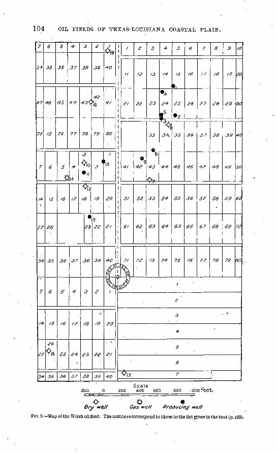
104 OIL FIELDS OF TEXAS-LOUISIANA COASTAL PLAIN.
7
34
4-7
74
7
14-
27
34
7
/J*
34-
6
35
4 '
75
6
/5
26
35
6
26
«*
36
5
36
^ 5.
76
5
$
/6
36
£
/6
25
36
4
37
44
77
14
17
37
4
/7
<
37
J
4-
<
\
<
/<
3
a
3<
'9
3
>ll
\2
9
23
38
3
> 3
?<9
^
JS»
C
79
4<?
/5
5 22
39
o
'39
4s-4-O
4/
80
\
2O
»
4-0
n
\20
40
-ri
^
/
,"
21
4-t
5/
6/
7/
Vl7
^
«
<?^
^®9
52
62
72
3
/3
23
33
6
4-3
A-,T /
53
63
73
4-
«
4
85
-
~
v5^
6^
7^
5
«
^5
J5
^5
^
65
75
i
2
3
4
5
6
7
6
/6
26
36
4-6
*,
66
76
7
t?
27
37
"
57
67
77
a
/e
ea
38
48
58
68
78
9
29
39
49
*,
69
"7O
/O
20
30
40
SO
60
7<y
30
Dry well Gas well Producing we//
FIG. 9. Map of the Welsh oil field. The numbers correspond to those In the list given in the text (p. 103).
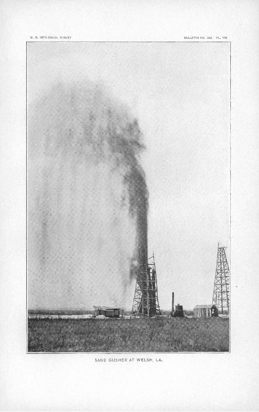
U- S. GEOLOGICAL SURVEY iULLETIN NO. 282 PL. VIII
SAND GUSHER AT WELSH, LA.
ANSE LA BUTTE FIELD. 105
All of the oil in the Welsh field is found at depths differing little from 1,000 feet, though faint showings at about 300 feet and again at 700 feet were noted in several instances. The oil is contained in uncompacted sands overlain by a single thick bed of gumbo, or, in other cases, by a succession of beds in which gumbo is prominent. For a depth approxi mating .100 feet from the surface of the ground the material is commonly reported as clay, but with this exception there is no important clay horizon above that which over lies the oil. The accumulation of oil at a higher level is therefore impossible. At a depth of several hundred feet is a body of sand and gravel, often more than 100 feet thick, from which water is pumped in abundance for the irrigation of rice. No rock is reported except such as is manifestly a partially cemented sand. A thin plate of this nature overlies the oil in a few of the wells, and probably extends over a considerable part of the field. It is frequently spoken of as the "cap rock," but it is probable that the function of holding down the oil and gas is performed mainly by the overlying clays.
GAS.
Gas is found in considerable quantities. Its escape at the surface was the principal indication which led to drilling, though the existence of the mound itself must have been regarded as significant. The greatest quantities of gas are found at the horizon of the oil. The No. 3 well of the Welsh Oil and Land Development Company was ruined by a severe blow-out which came from a depth of 1,100 feet. (See PI. VIII.) The same company's well No. 4 gushed for nearly one month before it was put to pumping, after which it yielded about 60 barrels daily for a period of at least eighteen months, or until the autumn of 1904. A blow-out in the Metropolitan lasted for about ten hours. On being closed down and cleaned out a year later, a similar blow-out occurred, lasting for about the same period. The McFadden well, after being pumped for one month, began to flow by its own pressure and continued to do this for at least six weeks. A similar occurrence took place in the Southern Pacific Nq. 1, which flowed from 50 to 75 barrels per day under its own pressure after having been pumped for a number of months.
SALT AVATER.
The amount of salt water pumped with the oil at Welsh is considerably greater than that of the oil itself. Some trouble has been experienced in the separation of the Welsh oil from the water which accompanies it. The .process.requires an inconveniently long time and high temperatures. After the separation the oil may be used for fuel, though in its constitution it differs sufficiently from the other Coastal Plain oils to cause a slight inconvenience in using it in the same burners.
ANSE LA BUTTE FIELD.
DESCRIPTION.
For several years a limited amount of oil has been obtained from the Anse la Butte district. This place is about -8 miles north of Lafayette, La., between Bayou Vermilion and Bayou Teche. The surface here has perhaps 10 or 15 feet of relief, due to stream erosion. In addition to that which is evidently of erosional origin, there is a somewhat symmetrical mound rising a few feet above the general level of the country. (See contour map, fig. 10.) It can not be definitely stated that the elevation at this place is due to the causes which made the salt islands rather than to erosion, but the presence of salt as shown by the well sections lends a strong probability to that supposition. Moreover, the form of the elevation has sufficient regularity to suggest an origin similar^to.that of the salt islands and the oil mounds of the Coastal Plain. Besides the more or less sym metrical mound, there are other limited elevations whose appearance is intermediate between that of the mound and that of purely erosional features. The center of the district in question is occupied by a swamp about 1,500 feet long and 1,000 feet wide.
Within an area about 1 mile east and west by a mile and a 'half north and south 15
LOG OIL FIELDS OF TEXAS-LOUISIANA COASTAL PLAIN.
wells were drilled before the close of the summer of 1904. Most of these found showings of oil, and at least four have produced small amounts of oil for the market. None had an initial capacity much in excess of 100 barrels per day. In February, 1905, but two wells, the Heywood Nos. 1 and 2, continued to .produce, showing little diminution of capacity after two years' production. They were pumped with air, and yielded enough oil to supply the fuel used in drilling another well and to satisfy a small local demand. Several more producers were driPed during 1905, one of which, the Lake No. 2, is 1,808 feet deep. The capacities of the newer wells are similar to those of the older.
SURFACE INDICATIONS.
In and around the swamp gas is seen to escape, sometimes in large quantities. Within the swamp itself this gas has given rise to a number of small mud volcanoes. On the northern edge is a so-called gas spring; it should rather be spoken of as a considerable area of soft ground from which much gas escapes. Through 2-inch pipes driven into this ground by hand gas may escape at such a rate as to support a flame several feet in height. On the east side of the marsh an asphaltic substance is found, at places, about 8 inches beneath the surface of the ground. This substance so strongly impregnates the subsoil as to give to it something of the consistency of rubber, making it difficult to cut with a spade. In addition to these phenomena, which have for a long time suggested the pos sible presence of oil, there are springs of sulphureted water, especially on the southeast side of the field. The presence of water thus mineralized has been regarded with some interest on account of its association (fortuitous or otherwise) with some of the larger oil fields, notably Sour Lake.
WELL, SECTIONS.
The following logs are selected as representative well records of this field. They show the types of sediments and the occurrence of the. salt bodies.
Logs of wells in Ansc, la Bulte field.
HEYWOOD NO. 1.
[B. H. Harper, driller.]
Formation.
Sand and gravel, mostly
Salt.. ............... ....---Clay..........................
Thick ness.
Feet.
208272460
Totaldepth.
Feet.
268540
1,000
4 5f>
Formation.
Sandy clay or cemented sand. Sand........................
Thick ness.
Feet. GO
9on200
Total depth.
Feet. 1,060 i Qsn
1,550
Some oil at 1,100 feet or thereabouts; now producing about 20 barrels of aromatic oil per produced about 40 barrels per day at first.
HEYWOOD NO. 2.
[W. Scott Heywood, driller.]
1?,3
Clay........................Clay and coarse oil sand
300100
85
300400
485
45
fi
Blue clay ....................
capable of producing 10
Clay.........................
85
2315
570
103
608
The log of this well was received from the driller, Mr. Heywood; and is guaranteed to be correct. The well contains two screens, in the 485-foot sand and 593-foot sand, respectively. Its daily produc tion is from 15 to 18 barrels.
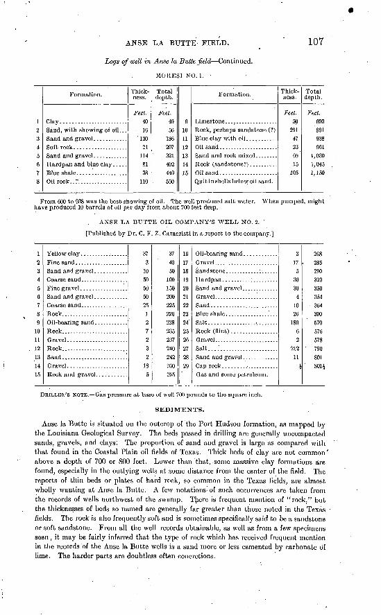
ANSE LA BUTTE FIELD.
Logs of well in Anse la Butte field Continued.
MORESI NO. 1.
107
12 345fi78
Formation.
Clay........................Sand, with showing of oil. . .
Thick ness.
Feet. 4016
13021
1148138
110
Total depth.
Feet. 4056
186207321402440550
g
10 11
1?
13
14i <;
Formation.
Rock, perhaps sandstone (?)
Quit in shells below oil sand.
Thick ness.
Feet. 50
291 47236915
105
Total depth.
Feel. 600891 938961
1,0301,0451,150
From 600 to 938 was the best showing of oil. The well produced salt water. When pumped, might have produced 10 barrels of oil per day from about 700 feet deep.
ANSE LA BUTTE OIL COMPANY'S WELL NO. 2.- '
[Published by Dr. C. F. 7,. Caracristi in a report to the company.]
1?,345678<>
10111?!131415
Rock. .......................Sand ........................
373
1050505025
127232
185
374050
10015020022522622S235237240242260205
16171819?021m?39425?f>27?8W
Salt..........................Rock (flint) .................
Salt....'............:........
317
53030
41026
18062
21211 i
268. 285
290320350354
364390>;7ft
576578790801801J
DRILLER'S NOTE. Gas pressure at base of well 700 pounds to the square inch.
SEDIMENTS.
Anse la Butte is situated on the outcrop of the Port Hudson formation, as mapped by the Louisiana Geological Survey. The beds passed in drilling are generally uncompacted sands, gravels, and clays'. The proportion of sand and gravel is large as compared with that found in the Coastal Plain oil fields of Texas. Thick beds of clay are not common" above a depth of 700 or 800 feet. Lower than that, some massive clay formations are found, especially in the outlying wells at some distance from the center of the field. The reports of thin beds or plates of hard rock, so common in the Texas fields, are almost wholly wanting at Anse la Butte. A few notations- of such occurrences are taken from the records of wells northwest of the swamp. There is frequent mention of "rock," but the thicknesses of beds so named are generally far greater than those noted in the Texas fields. The rock is also frequently soft and is sometimes specifically said to be a sandstone or soft sandstone. From all the well records obtainable, as well as from a few specimens seen, it may be fairly inferred that the type of rock which has received frequent mention in the records of the Anse la Butte wells is a sand more or less cemented by carbonate of lime. The harder parts are doubtless often concretions.
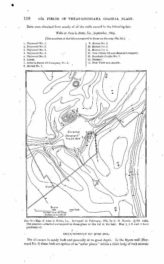
108 OIL FIELDS OF TEXAS-LOUISIANA COASTAL PLAIN.
Data were obtained from nearly all of the wells named in the following list:
Wells at Anse la Butte, La., September, 1904-
[The numbers at the left correspond to those on the map (fig. 10).]
1. Hey wood No. 1.2. Heywood No. 2.3. Heywood No. 3.4. Heywood No. 4.5. Heywood No. 5. C. Lucas.7. Anse la Butte Oil Company No. 2..8. Moresi No. 1.
9. Moresi No. 2.10. Moresi No. 3.11. Moresi No. 4.12. New Iberia Oil and Mineral Company.13. Southern Pacific No. 1.14. Pioneer.'15. New York and Acadia.
FIG. 10. Map of Anse la Butte, La. Surveyed in February, 1904, by G. D. Harris. Q0i\ wells. The numbers attached correspond to those given in the list in the text. Nos. 1, 2, 8, and 11 have produced oil.
r( . ' . ' OCCURRENCE OJT THE OIT..
The oil occurs in sandy beds and generally at no great depth. In the Myers well (Key- wood No. 5) these beds are spoken of as "softer places " within a thick body of rock encoun-
ANSE LA BUTTE FIELD. 109
tered at a depth of 308 feet. From an examination of the materials, it appears that these so-called "softer places" are uncemented sands included between well-cemented beds of similar material. The "rock" from which oil is derived in the Moresi No. 4 is probably of the same character, although in this instance the oil was obtained at or near the top of the rock. In all the other cases it seems clear that the oil comes from porous beds of sand, gravel, or sandy clay. The one occurrence which is peculiar to this small field, and of exceptional interest, is th8 finding of a so-called "aromatic oil" at a depth of 1,000 to 1,060 feet in the Heywood No. 1, this being beneath the 272 feet of rock salt which was passed in the upper half of the well section.
GEOLOGIC STRUCTTJKE.
Various attempts have been made to correlate the data of the different wells in such a way as to show dips of certain beds which have been assumed to be continuous from well to well. . From the available data of nearly all the wells drilled previous to September, 1904, it is quite safe to say that no correlation is possible; that the formations, so far as they are continuous from well to well, can not be recognized or identified; and, therefore, that it
is not possible from the present data to infer dips or folds in the structure. A 6-inch core of rock taken from one of the wells on the east side of the swamp shows markings which are inclined at a high angle, presumably toward the southeast. These lines have been supposed by some to represent bedding and therefore to indicate a pronounced uplift near the center of the field. From«an examination of the core referred to, this inference is believed to be not wholly established. The markings resemble joints or fractures which have been recemented quite as much as bedding planes. There is no inherent improba bility in the assumption of deformation which would tilt the bedding planes to the south east; that is, away from the salt body. Such deformations have been noted elsewhere iii similar relations,"but only to a very slight degree in the gently domed structures of the oil-bearing mounds. It is not yet demonstrated that there is an uplift at Anse la Butte of greater intensity than those noted in the larger and better-known oil fields of the Coastal Plain. (Compare pp. 35, 44, 54.)
SALT.
Salt was reached or passed through in three or four wells, but its deptli and thick nesses arc so diverse at different places that it is impossible at present to assign even an approximately exact form to the body or bodies of salt. The original Anse la Butte (Simpson) well passed through 189 feet of salt between the depths of 381 and 570 feet. Beneath this salt were 8 feet of "rock" and gravel; the drill then entered salt again, which it passed through at a depth of 790 feet, thus showing an entire thickness of 401 feet. Though showings of oil and gas were noticed, this well never produced. The record of the Heywood No. 1, on the northern margin of the swamp, shows 272 feet of salt between the depths of 268 and 540 feet. This well entered salt again at a depth of 1,350 feet and drilled 200 feet farther without passing through the salt body. Between 1,000 and 1,060 feet the well produced oil at the rate of about 20 barrels per day. The Heywood No. 4, west of the swamp, entered salt at a depth of 220 feet and stopped in the same formation at a depth of 1,803 feet. Reports differ as to the finding of salt in certain other wells and, to some extent, in the thickness of the salt formations already named.
If these salt bodies are connected in one continuous mass, it may be inferred that the Heywood No. 4 pierced the central body, and that the salt passed through in the Simpson well and the Heywood No. 1 represents.offshoots from this body. It may well be supposed that such offshoots would be controlled to some extent, in form and position, by bedding planes. The diversity of depths and thicknesses of salt bodies, however, throws grave doubt on the theory that there are sedimentary beds of salt, and suggests that the bodies here encountered are of secondary origin and that they follow lines determined by the movements of ground water, which, in turn, were influenced by the character and distri bution of the sediments. Inasmuch as the oil is chiefly on the east side of the swamp and
110 OIL FIELDS OF TEXAS-LOUISIANA COASTAL PLAIN.
the salt on the west side, it would seem probable that, so far as there is a central oil body, it branches out to the sides in porous sands in forms similar to those of the body of salt, and that the Heywood well No. 1 is located at a place where the branches of the salt body and the branches of the oil body are, in a manner, dovetailed. There is a similar occurence at Belle Isle, where a well was drilled near the edge of the salt body. After passing through five beds of salt, aggregating about 250 feet and alternating with sediments, a sand was reached at 1,475 feet which contained a very small quantity of light straw-colored oil.
Salt water is found in all parts of the Anse la Butte field. As in the other fields, it may be found either above or below the oil, but in the former case the two are always separated by an impervious bed. Gas is found in moderate quantities, generally above the oil.
MINOR LOUISIANA DISTRICTS.
VINTON.
About 4 or 5 miles southwest of the village of Vinton, La., is a mound covering 'about 800 acres. It rises 35 feet above the surrounding country and 50 feet above the level of the sea. It is approximately circular in form, but contains an irregular depression or trough which partly isolates a portion of the mound on the east side. This is the portion which has been of interest in the matter of oil. Gas bubbles have long been observed rising to the surface in the swampy depression or in other places when covered by the water of recent rains. Seepages of oil have likewise been observed, forming films 'on standing water. It is also said that the water of shallow wells has suggested petroleum by its taste. Certain springs of water, about a mile east of the mound, hav§ been noticed to possess a sour taste similar to that of the waters at Sour Lake.
There are at present four shallow wells which derive.a heavy oil from a depth of about 26 feet. These wells are pumped by hand and yield on an average about 15 gallons of oil per day. The oil is used for lubricating purposes by the large lumber concerns at or near Vinton. More of these wells will doubtless be drilled. It is estimated by the proprietor that one man could attend to 12 or 15 shallow wells, pumping by hand about 15 gallons daily from each well.
Since 1902 there have been at least six attempts to drill deep wells. Three of these have been successful in getting down to the desired depths. In the others is was found that the rotary drill was unable to penetrate a thick stratum of gravel which was found about 400 feet deep. The stones of this gravel are at some places so large that the return current of water is unable to bring them to the surface. The three wells which succeeded in passing this stratum of gravel attained depths of 1,100 to 1,200 feet* Oil was not found in sufficient quantities to pump, but the sections of these wells made known some interesting facts regarding the formations.
There were in all cases at least 20 feet of surface clay. Some wells report no clay or gumbo whatever below this. Others found clay in subordinate quantities to a depth of nearly 400 feet. Beyond this .depth is the bed of coarse gravel mentioned above, which is in some cases 100 feet thick. . This gravel is water bearing, but whether the powerful arte sian flow which now issues from the Vinton Oil and Sulphur Company's well No. 2 comes from this grayel or from a lower bed is not definitely determined. In any case the source of the flow seems to be above a depth of 600 feet. The occurrence of artesian water under great pressure at this depth doubtless indicates the presence of a rather widespread bed of clay immediately above the horizon of the water. The well sections (none of which were accurately recorded) indicate that the principal material from this depth to 950 feet is sand or poorly cemented sandstone. Below 950 feet a formation was encountered which is reported as gypsum, though in the absence of satisfactory samples it must remain a ques tion whether the next'150 feet is really gypsum or partially consolidated marl. It is said to have contained occasional showings of oil.
There is frequent mention of sulphur, and specimens of pure sulphur nearly one-half inch in diameter were seen. Its mode of occurrence is in doubt. It is quite probable that,
HACKBERRY ISLAND. 111
despite the records of "pure solid sulphur/' some of it occurs in a disseminated form in beds of sand. The existence, however, of small pieces of solid crystalline sulphur suggests the inference that certain beds of limestone were passed which contain sulphur in small caverns, and that the occurrence is therefore not very different from that at Spindletop or at Sulphur Mine, Louisiana, which is 15 miles northeast of the Vinton mound. The fact that certain specimens of limestone, coming from an unknown depth, are crystalline and resemble the oil rock of the Texas fields, gives probability to this supposition. The depth of one sulphur bed is said to have been 538 feet. It is reported again at about 1,000 feet, associated with the so-called gypsum.
From the samples examined it is quite certain that some gypsum was passed through. No cores were taken out and it is therefore impossible to determine whether the gypsum constitutes a solid body or whether it exists merely in a disseminated form.
The Vinton mound possesses a certain interest because it contains the materials which are characteristically associated with the oil-bearing mounds. In so far as well records were kept it appears also that the general order of succession of the materials here is the same as at Spindletop. Aside from the purely sedimentary beds sulphur is the first char acteristic material encountered by the drill. The gypsum appears at a greater depth, as
.it does at Spindletop. Although rock salt is not reported at Vinton, certain samples from the wells are very salty. Some of the sediments are impregnated with pyrite.. Considerable gas was liberated. That which now bubbles up with the artesian water from the Vinton Oil and Sulphur Company's well No. 2 is in large part hydrogen sulphide.
HACKJ1ERBY ISLAND.
This so-called island is a mound surrounded by coastal marsh. It reaches a maximum height of 35 feet, being steepest on the northwest side toward Black Lake and sloping gently .to Calcasieu Lake on the east. From the surface of this mound much gas escapes, and some of the spring and well waters are strongly sulpliureted. These are the features which have been suppose'd to indicate the presence of oil.
Three wells have been drilled here by the Louisiana-Texas Oil Company. Nos. 1 and 3, on the east side of the island attained a depth of 1,460 feet. The records of these wells show uucompacted clays, sands, and gravels to 908 feet. Beyond that depth thin plates of hard rock were noted at frequent intervals. These are variously described, sometimes as limestone and sometimes as sandstone with a calcareous cement. A 7-foot bed of lig nite was found at 1,421 feet in well No. 1. The sands near the bottom of the well contain a considerable amount of pyrite. There was a showing of oil at 1,460 feet.
Well No. 2 (see p..112) on the northwest side of the island, near Black Lake, shows a section which is similar to that of the other two wells to the depth at which those wells stopped. At 1,565 feet the drill entered a stratum of limestone 45 feet thick. From detailed descrip tions received from the driller, Mr. H. H. Jones, whose observations are trustworthy, it appears that samples obtained from this limestone are entirely crystalline and porous, and that therefore it is very similar to the characteristic oil-bearing limestone of the Texas fields. It did not, however, produce oil in this case. Below this limestone were 10 feet of black sand. The water used in drilling was lost in this sand and several hundred loads of clay were pumped into the well in the form of slush before the pores of the sand were, in a measure, stopped and the return current of water recovered. A showing of oil was noted near the bottom of the well arid may haye come from this sand, though this is not certain. Salt water was-likewise encountered and may have come from the same source. Below this sand, between the depths of 1,620 and 1,830 feet, is a gray-white material described as having little grit and not affected by acid. Samples of this material were not seen, but it is called gypsum by two or three observers who are believed to be competent judges. The position of this formation, with reference to the porous limestone, is the
.same as that of the gypsum at Spindletop. To judge from the analogy of other districts, it may be regarded as useless to drill this well deeper, though it can not be positively stated that the oil might not be found at some other spo.t on the island.
Bull. 282 06 8
112 OIL FIELDS OF TEXAS-LOUISIANA COASTAL PLAIN.
Louisiana and Texas Oil Company's well No. 2, Hackberry Island, Louisiana.
[H. H. Jones, driller.]
Formation. '
Alternating gumbo and sand, with streaks of something like brownish asphalt;
A gray-white material, with a little grit not affected by acid. This was called
Thick ness.
Feet. 832
3657
2
714510
210
Total depth.
Feet. 832835
1,4921,494
1,565-1, 6101,620
1,830
BAYOU BOUILLON.
Where Bayou Bouillon, or Larumpe River, enters the Atchafalaya, some 30 miles north east of New Iberia, La., there is a considerable area which is characterized by the abun dance of gas which issues from the ground. In fact, the bayou is said to take its name from the bubbling up of gas through its waters. There are occasional occurrences of oily or asphaltic matter in the soil. These phenomena, more especially the former, led to drill ing in the hope of finding an oil body. Up to the present time at least six wells have been started, .three of which attained considerable depths.
Samples of the gas were analyzed by Professor Metz, of Tulane University, who finds 93.72 per cent to.be hydrocarbons. It is not stated what proportion of the whole is marsh gas. Professor Metz finds no hydrogen sulphide, which is so common a constituent of the gas of the Texas oil fields. The gas is very similar to that which is found elsewhere in the delta and coastal region of Louisiana.
The oil, which has been found in small quantities at shallow depths, has also been ana lyzed by Doctors Metz and Eustis. It is of a dark-brownish or black color, very viscid and having a specific gravity of 0.859. The fractional distillation of this. oU resulted as follows:
Fractional distillation of oil from Bayou Bouillon, Louisiana.
Temperature.
Below 150° C. ........................Below 300° C. .........................
Above 300? C...... ....................
Product,
Loss ................................................
Percent age by
volume.
A ^
OQ A
42.015.59 8
100.0
The few logs obtained, though taken from wells not far apart, are very different. This diversity may be supposed to indicate that no one bed has any considerable lateral extent. If this be true, it may be inferred that no large oil body could be retained below the horizon protected by the surface clays and above the depth at which the wells stopped. From the meager data at hand it is not possible to state positively that the continuous clay beds which are necessary as cap rocks are wanting, but the amount of clay' reported in the Maxwell & Sherwood well is very small (see p. 113). There is frequent mention of clay mixed with sand, but the beds distinguished as pure clay are never more than 5 feet in
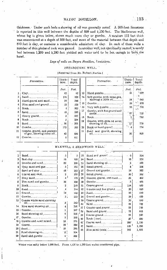
BAYOU BOUILLON. 113
thickness.- Under such beds a showing of oil was generally noted! A 300-foot .limestone is reported in this well between the depths of 850 and 1,150 feet. The Shelbourne well, whose log is given below, shows much more clay or gumbo. A stratum 173 feet thick was.encountered at a depth of 390 feet, and most of the material between that depth and 810 feet is clay, or contains a-considerable admixture of clay. In each of these wells a number of thin plates of rock were passed. In another well, not specifically, named; a sandy bed between 1,200 and 1,280 feet yielded salt water said to be hot enough to burn the hand.
Logs of wells on Bayou Bouillon, Louisiana.'
SHELBOURNE WELL.
[Received from Mr. Robert Martin.]
12 3 4 5 6 7 8 9
10 11
12
Formation.
Clay...............;........Sand........................
Sand. ................'.......Heavy gravel ........:......
Sand ........................
Gumbo, gravel, and pockets of gas, showing some oil. .
Thick ness.
Feet.
62 176
10 50
4 28
2 2
. 50 173
43 5
Total depth.
Feet. 02
238 248 298 302 330 332 334
390 503
000 Oil
13 14.
15 10 17
18 19
2021
Formation. '
Soft gumbo, with some gas, showing a little oil ........
Gumbo.....................Very soft gumbo ...........G umbo, with fine gravel and
Gumbo, with gasand some
Sand and gravel,, showing oil.......................:
Thick ness.
Feet. 21
24 24 55
" 27"'V
"1,7' ! 4
30
Total depth.
Feet.''022
1 : -l!
' "' 040 ' '''070
" '",' ''725
'' 752
753
770774
810
MAXWELL & SHERWOOD WELL.
12 3 4 5 6 7 8 9
10 11 12 13
14 15 1C 17 18 19 20 21 22
Coarse white sand showing oil. .......................
Fine sand showing oil.. .Gumbo.....................Sand showing oil..........:.Gumbo. .....................
. Gumbo and sand mixed .... Gravel......................Sand ........................
5 15 80
5 58
3 4
38 2 4
14 ' 3
8 4 1 9
. 2 18 20 10 '8
4
5 100 100 105 103 160 170 208 210 214 228 233
242 240 247 256 258 276 286 296 304 308
23 24 25 20 27 23 29 30 31 32 33 34 35 30 37 33 39 40 41 42 43
Gumbo, gravel, and sand . ..
Gumbo and fine gravel
6 10
0 8
14 30 81
3 134 20 30 30 10 '
30 20
. 70 20 20
300'
140 265
314 324 330 338 352 382 403 460 600 620 650 080 090 730 740 810 830 850
1,150 1, 290 1,555
Water was salty below 1,000 feet. From 1,150 to 1,200 feet water overflowed pipe.
114 OIL FIELDS OF TEXAS-LOUISIANA COASTAL PLAIN.
ORIGIN AND ACCUMULATION OF OIL BODIES, a
ORIGIN OP PETROLEUM.
CLASSIFICATION OF THEORIES.
The origin of petroleum is one of the most obsciire problems by which geologists are confronted. Numerous widely different theories have been advanced and advocated by geologists and chemists during the last fifty years, but as yet there is none which can be regarded as generally accepted and of universal applicability. In the present connection any full discussion of these theories is manifestly out of place, and only a bare outline of the more Important ones will be given. It should be stated, however, that numerous facts have come to light in the development of the Coastal Plain field which have a very direct bearing upon theories of the origin of the oil. These have in part been given in the preceding pages, but will be stated more explicitly in this and the following sections.
The theories may be divided into three main groups: (1) Those which attempt to explain the origin of oil by inorganic agencies; (2) those which ascribe it to an organic origin; and (3) those which involve both inorganic and organic agencies.
THEORIES OF INORGANIC ORIGIN.
In I860 Berthelot suggested that water containing carbonic acid or an.earthy carbonate coming in contact with metallic sodium or potassium at a high temperature might produce both liquid and gaseous hydrocarbons such as are found in various oil fields. In ]877 MendoljefT published his theory, which remains the most plausible of all the inorganic theories thus far proposed. Stated briefly, it is that water percolating downward through fissures in the earth's crust comes in contact, under condi tions of high temperature and great pressure, with metallic carbides; that a chemical reaction takes place, with the formation of metallic oxides and saturated hydrocarbons, and that the latter ascend and impregnate the porous beds of sedimentary rocks in which they arc now found.
Various modifications of the theories of Berthelot and Mendeljeff have been suggested by other chemists, but these contain the essentials of all the purely inorganic theories which merit consideration.
The fact is unquestioned that hydrocarbons similar to or identical with some of the constituents of natural petroleum may be produced in the laboratory by the action of inorganic substances, but no geologic or other evidence that these reactions actually take place in the earth's crust has been dis covered. The conclusion must therefore be that while the inorganic theory is attractive it is not proved.
THEORIES OF ORGANIC ORIGIN.
These theories may be again divided into two groups: (a) That petroleum is indigenous to the rocks in which it is found, and (6) that it is the product of natural distillation.
The first of these theories was advocated by Sterry Hunt, who asserted that all petroleum was formed in limestone by the decomposition of the animal remains which it originally contained. It was also advocated by Lesley and Whitney.
The theory was further amplified by Orton, who extended it to the petroleum found in the shale and sandstone in the Appalachian field as well as that found in limestone. According to Orton,& petroleum results from the primary decomposition of organic matter, and was formed when the rocks containing it were themselves formed.
A modification of this theory has recently been advanced namely,that the oil, instead of being the product of decomposition of organic matter, is secreted by living organisms of a low order, such as diatoms, and therefore exists as such as an original constituent of the rock in which it is found. The presence of oil associated with diatoms in the mud at Sabine Pass is regarded by Doctor Phillips as furnishing some degree of support to this theory. [See p. 74.]
The majority of geologists have held to the second theory namely, that petroleum is derived from the organic matter disseminated through great masses of carbonaceous shales by the process of slow natural 'distillation at relatively low temperatures, and that it has subsequently migrated through the strata to the reservoirs in which it is found. In proof it is pointed out that these carbonaceous shales yield by artificial distillation a large quantity of hydrocarbons, both gaseous and liquid, which are indistinguishable from those found in nature: but the possibility of natural distillation at a tempera ture sufficiently low to leave the inclosing rocks entirely unchanged has not been proved, nor have the residues of carbon which would result from such distillation been found in the rocks. Q
Again, there is much diversity of opinion among those who hold to the organic origin of petroleum- as to whether its source is in animal or vegetable remains. Peckham believes that petroleum may be derived from both animal and vegetable matter,'but that the source of the organic matter determines the character of the oil, that with a paraffin base (e. g., Pennsylvania) being derived from plant remains, and that with an asphalt base (e. g., California) being derived from animal remains.
o Reprinted with slight revision from Bull. U. S. Geol. Survey No. 212. t> Ann. Kept. Geol. Survey Ohio, 1890, p. 85.
AtfD ACCUMULATION. 115
THEORIES OF COMBINED ORGANIC AND INORGANIC ORIGIN.
Among the theories which fall in the third group may be mentioned that proposed by 0. C. D. Ross o in 1891. It is that petroleum is produced by the action of volcanic or solfataric gases containing sul phurous acid and hydrogen sulphide upon limestone, with the formation of gypsum and free sulphur. The reactions given undoubtedly take place in the laboratory, and they may also take place in certain localities in nature. On the other hand, Hopkins >> proposed a theory, which has been elaborated and modified somewhat by other chemists, according to-which the gypsum is the original material and the limestone is secondary. The essential features of this theory a re that gypsum, calcium sulphate, hi the presence of decomposing organic matter which gives off carbonic acid, is reduced, with the formation of limestone, calcium carbonate, free sulphur, and hydrocarbons. This reaction has not been exactly reproduced in the laboratory, but neither can the conditions which must prevail at great depths in the earth be exactly reproduced.
It will be observed that the theories of this group are intermediate between those of the first two classes. The original materials arc in part organic (limestone and vegetable or animal matter) and in part inorganic (volcanic gases and gypsum).
CONCLUSION.
This great diversity of views regarding the origin of petroleum is equaled by the diversity in character of the petroleum itself and in the geologic conditions under which it is found. In fact, it is probable that the final theory will include most of those outlined above, and will recognize the fact that this substance which is so widely distributed in .nature may be the product of widely different processes acting upon a great diversity of materials. Thus the hydrocarbons which have been observed in cer tain volcanic rocks and in gases given off from volcanic vents may be entirely inorganic, resulting from the reaction between water and heated metallic carbides. The oil of the Appalachian field may be derived from the slow distillation of plant remains disseminated through the underlying shales, and that of the Trenton limestone of the Lima field from animal remains originally contained in the rocks in which it is now found. [Finally, the oil of the Gulf Coastal Plain may be derived, in part at least, from the action of decomposing organic matter, both animal and vegetable, but chiefly the* latter, upon gypsum or limestone, either as sediments or borne in solution in the sea water which originally perme ated the sediments.]
ACCUMULATION OP THE OIL,.
CONDITIONS FOR ACCUMULATION.
Hydrocarbons of the petroleum type are among the most widely distributed .substances in nature. They are found associated with almost all classes of rocks, both crystalline and sedimentary, from the oldest to the youngest. While these hydrocarbons are very widely distributed they are, however, usually in small quantities, and accumulations sufficiently large to be of commercial importance are restricted by certain well-defined conditions to a relatively small portion of the earth's surface. In many regions it is comparatively easy for the geologist, by an examination of surface.conditions, to state definitely and with certainty that no oil in commercial quantities will be found. In other large regions he can state that oil may be found, and can point out in some cases the most favorable localities, but he can not predict the actual occurrence of an oil pool in advance of drilling.
The essential conditions for the accumulation of oil are (1) a sufficient supply of oil derived from any of the sources above described, (2) a porous reservoir rock in which it may be stored, and (3) an imper vious cap rock which will prevent its escape. Conditions which favor its accumulation but are not always essential arc (4) gentle undulations of the strata forming anticlinal arches or domes, (5) the complete saturation of the rocks with water and its slow circulation under hydrostatic head or convec tion due to differences of temperature.
THE OIL SUPPLY.
This is of course the first and most essential condition, for without it no accumulation could cake place however favorable other conditions might be. Of all the conditions enumerated above this is probably the one which prevails over the largest areas. Wherever there are heavy deposits of sed imentary rocks some of the beds generally contain organic material, either animal or vegetable, from which an abundant supply of hydrocarbons might be derived, and doubtless in a large proportion of cases at sometime in the history of such beds conditions have been favorable for its conversion into " petroleum. This is notably true of the many thousand feet of strata constituting the Cretaceous and Tertiary formations on the Gulf Coastal Plain.
THE RESERVOIR ROCK.
All granular rpcks which enter into the composition of the earth's crust are to some extent permeable to liquids. This porosity, the vacant space between the rock particles, varies from less than one-half of 1 per cent in rocks like granite to 8 or 10 per cent in ordinary compact, fine-grained sandstones, and 25 per cent or even more in coarse.gravel or cavernous limestone and dolomite. The porosity of a rock
a Chemical News, vol. 04,1891.6 Report on the Geology of Louisiana, 1869.
116 OIL FIELDS OF TEXAS-LOUISIANA COASTAL PLAIN.
depends upon the shape of the grains; their uniformity in size, and the amount of cementing material. It is wholly independent of the size of the grains. Hence a fine-grained sand may have as great capacity for holding oil.as a coarse gravel. The term ''oil pool." is in common use in most oil fields and is a convenient one, but is liable to lead to misapprehension. An oil pool is simply a restricted portion of any porous bed which is saturated with oil. It is limited both vertically and horizontally by some impervious barrier which prevents the escape of the oil. It does not generally contain any large fissures or caverns, the oil being.contained in the minute spaces between the constituent grains of the bed. In exceptional cases, such.as the Spindletop pool, where the reservoir rock is a limestone or dolomite, there are cavities of appreciable size, probably to be measured in inches and possibly in feet, in which the oil is,stored, as well,as in the minute spaces between the constituent grains of the rock.
[Ther.e,is,np difference between an ''oil sand " and a '' water sand " except that the pores of theformer contain oil) while those of the latter are filled with water. The popular belief, therefore, that an expert can tell by examining a sample of sand whether the formation "ought to contain oil," has no foundation.] r
The character of the reservoir rock does not determine the character of the oil, but does determine its behavior when the pool is tapped by the drill. When the rock is a firm, fine-grained sandstone, it yields its oil slowly, even when under great pressure, and the yield continues for a long time, steadily .decreasing, however,; as the supply is drawn from increasing distances. A cavernous dolomite, on the other hand, offers little resistance to .the passage of the oil toward the well, and the flow from such a rock is consequently,rapid and short-lived. When the oil is held in an unconsolidated sand the latter flows toward the exit along with the oil and quickly chokes the well unless held back by some straining device.
- ; - .THE IMPERVIOUS COVER.
Since petroleum ha^ a lower specific gravity than water, it always tends to rise when the two liquids are associated in the rocks, and if not stopped by some impervious barrier would continue until it reached the'surface and then be dissipated. An essential condition of any large accumulation is therefore an impervious stratum which shall check this upward course of the oil and restrain it in a porous reservoir rock below. Such impervious strata usually consist of fine clay, clay shale, or muddy limestone. If the bed is perfectly continuous, a few feet in thickness of clay or clay shale is sufficient to prevent any leakage from the underlying porous beds even under great pressure. In the Spindletop pool the cover is formed by a considerable thickness of alternating clay beds and limestones. * * * [The so-called "cap rock" is a dense crust of the porous, oil-bearing limestone. The term is often loosely used with reference to the entire body of the limestone.]
ANTICLINAL STRUCTURE.
When oil, whatever its origin, occurs in a porous bed along with water, it tends to-rise toward the surface and continues to rise until it reaches the surface or meets some obstruction. If the obstruction is a perfectly horizontal stratum of impervious material, the progress of the oil is checked, but it does not accumulate'in: large bodies. If, on the other hand, the impervious stratum is inclined, the oil.con- tinues to move upward along its under side until it meets a downward bend in.the bed which it can .not pass. Theioil is thus.trapped in the fold or anticline, and if the impervious bed is continuous over the crest it continues to accumulate and an oil pool is formed. The Appalachian field is characterized by low folds, which have.a general northeast-southwest trend, parallel with the large folds of the Appa lachian Mountains, and these folds have been of the highest importance in the accumulation of oil in that field. In the Gulf Coastal Plain no structures are found which at all resemble the anticlines of the Appalachian field. The latter are undoubtedly due to horizontal compression of the earth's crust, but'the Coastal Plain.does not appear ever to have been subjected to such compression, and conse quently the long, regular parallel folds are wanting. The circular or elliptical domes which have been described as occurring at Spindletop, Damon Mound, and elsewhere are structures of a wholly different class, and could scarcely have been produced by horizontal compression. Although these domes are not strictly comparable with the anticlines of the Appalachian field, they are equally efficient in furnishing the structural conditions favorable for the accumulation of oil.
i: .. . SATURATION . OF .THE ROCKS AND CIRCULATION OF THE SATURATING FLUID.
Sedimentary rocks'b'eldw'the immediate surface are generally saturated with water, either fresh or sah'ne. In some cases, particularly in the Appalachian field, the rocks are dry, and under these condi tions, even when sufficiently porous, they are not readily traversed by oil. This condition, however, is probably very rarely present in the thoroughly saturated beds underlying the Coastal Plain.
GENERAL, RELATIONS OF GAS, OIL, AND WATER.
'.Inmost oil fields -both gas and salt water are found. Many wells yield .all three, either at'the same lime Win succession. A knowledge of their mutual relations is important, not only in the proper management of a single well' but in the exploitation of a field as a whole. Where any two of these fluids are found in the .same reservoir, the heavier is found below
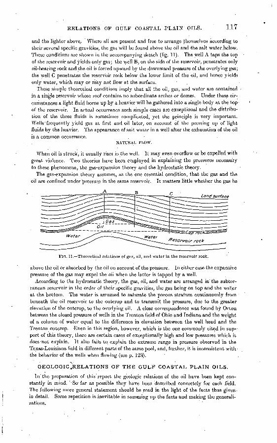
RELATIONS OF GULF COASTAL .PLAIN OILS. 117
and the lighter above.. Where all are present and free to arrange themselves according to their several specific gravities, the gas will be found above the oil and the salt water .below. These conditions are shown in the accompanying sketch (fig. 11). The well A taps the top of the reservoir and yields only gas; the well B, on the side of the reservoir, penetrates only oil-bearing rock and the oil is forced upward by the downward pressure of the overlying gas; the well C penetrates the reservoir rock below the lower limit of the oil, and hence yields only water, which may or may not flow at the surface.
These simple theoretical conditions imply that all the oil, gas, and water are contained in a single reservoir whose roof contains no subordinate arches or domes. Under these cir cumstances a light fluid borne up by a heavier will be gathered into a single body at the top of the reservoir. In actual occurrence such simple cases are exceptional and the distribu tion of the three fluids is sometimes complicated, yet the principle is very important. Wells'frequently yield gas at first and oil later, on account of the pressing up of light fluids by the heavier. The appearance of salt water in a well after the exhaustion of the oil is a common occurrence. . .
NATURAL PLOW.
When oil is struck, it usually rises in the well. It may even overflow or be expelled with great violence. Two theories have been employed in explaining the pressures necessary to these phenomena, the gas-expansion theory and the hydrostatic theory.
The gas-expansion theory assumes, as the one essential condition, that the gas and the oil are confined under'pressure in the same reservoir. It matters little whether the gas be
Land surface
FIG. 11. Theoretical relations of gas, oil, and water in the reservoir rock.
above the oil or absorbed by the oil on account of the pressure. In either case the expansive pressure of the gas may expel the oil when the latter is tapped by a well.
According to the hydrostatic theory, the gas, oil, and water are arranged in the subter ranean reservoir in the order of their specific gravities, the gas being on top and the water at the bottom. The water is assumed to saturate the porous stratum continuously from beneath the oil reservoir to the outcrop and to transmit the pressure, due to the greater elevation of the outcrop, to the overlying oil. A close correspondence was found by Orton between the closed pressure of wells in the Trenton field of Ohio and Indiana and the weight of a column of water equal to the difference in elevation between the well head and the Trenton outcrop. -Even in this region, however, which is the one commonly cited in sup-- port of this theory, there are certain cases of exceptionally high and low pressures which it does not explain. ' It also fails to explain the extreme range in pressure observed in the Texas-Louisiana field in different parts of the same pool, and, further, it is inconsistent with the behavior of the wells when flowing (see p. 123).
GEOLOGICJRELATIONS OF THE GULF COASTAL PLAIN OILS.
In'the preparation of this report the geologic relations of the oil have been kept con stantly in mind. ' So far as possible they have been described concretely for each field. The following more general statement should be read in the light of the facts thus given- in detail. Some repetition is-inevitable in summing up the facts and making the generali zations.
118 OIL FIELDS OF TEXAS-LOUISIANA COASTAL PLAIN.
The accumulation of oil in the Coastal Plain sediments is, in several respects, in strong contrast with the corresponding process in parts of the Appalachian field. In the latter case the reservoir rock, the cap rock, and the formation from wjiich the substance of the oils is believed to be derived are all continuous, without important change of character, over thousands of square miles. The'relation of each to the oil is so definite that if, at any place, the age and folds of the underlying rocks be ascertained, the conditions with respect to oil are to a considerable degree known. -On the Coastal Plain not only are dips and folds difficult to determine, but the age of a bed gives no clue to its physical character or its relation to oils, if present. Stratigraphy is therefore relatively less important in the study and exploitation of oil in the Coastal Plain fields than in fields of the Appalachian type.
SOURCE OF THE HYDROCARBONS.
Most of the sediments of the Coastal Plain contain small quantities of petroleum. The amount thus disseminated is extremely large, perhaps larger than that which has accumu lated into bodies of commercial importance. The distribution is so general that it would be impossible to name any one formation, or any series, as the probable source of the original hydrocarbons. The distribution of oil in very small quantities through hundreds or even thousands of feet of sediment, much of which is highly impervious clay, might be supposed to give plausibility to the assumption of its origin within the beds where it is now found. On the other hand, the enormous quantities found in certain small pools are inexplicable on any such hypothesis.
MOVEMENTS.
The collection of hydrocarbons into reservoirs of oil is related to the presence of water in at least two ways: (1) The oil is buoyed up by the ground water; (2) the oil must share to some extent in the movements of the water until the former comes to rest under an impervious arch or dome. These statements apply to oil as a liquid lighter than water, but the nature and condition of the hydrocarbons previous to their accumulation as oil are unknown.
EFFECTS OF IRREGULAR BEDS.
Being buoyed up by the ground water, the oil should rise through the sands of the Coastal Plain sediments until a bed <5f clay is reached. If porous and impervious beds were here regular in thickness and character, like those in the Appalachian fields, and were similarly folded, the oil would travel to the crests of the anticlines and accumulate in long, narrow pools. The beds of this region are, however, most irregular. No two well sections, even if closely adjoining, exactly correspond. In Ohio alone the Berea sandstone extends over 15,000 square miles with scarcely any variation in thickness and composition. In the Coastal Plain, on the other hand, no single bed can be traced without material modification over 100 square miles. Clay beds graduate laterally into sands, and vice versa. Under these conditions the small coastward dip of the sediments is practically negligible in comparison with the much steeper slopes formed by the irregular distribution of sands and clays. A large number of sand beds fortuitously distributed may touch, forming a single body, whose effect on. the movements of ground water is that of an inclined stratum. This con dition is illustrated in fig. 12, in which the bedding planes are assumed to be horizontal, though bodies of porous and impervious sediments are distributed in such a way that the movements of ground water are along steep slopes.
Not only are such slopes as are here described generally much steeper than the dips, but they conduct the oil now in one direction and now in another, so that the course pur sued by the rising fluids may be inconceivably devious and the vertical "component of the resulting movements very large. The lower surfaces of the clay bodies, taken as a whole, are irregular, and do not offer continuous slopes. The oil in its upward movement finds innumerable small pockets or traps in which it comes to rest. It may finally reach the surface and cause "surface indications" or it may accumulate in the sands in bodies of commercial importance as at Saratoga and Jennings.
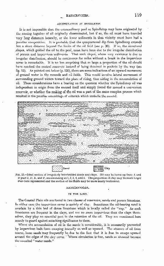
EESEEVOIES. 119
ACCUMULATION AT SPINDLETOP.
It is not impossible that the extraordinary pool at Spindletop may have originated by the coming together of oil originally disseminated, but if so, the oil must have traveled very long distances laterally, or the lower sediments in that vicinity must have had a peculiar composition. It is probable that the quaqu aver sal dip from Spindletop extends but a short distance beyond the limits of the oil field (see p. 36). If so, the structural
^slopes, which guided the oil to. the pool, must have been due to the irregular distribution of porous and impervious sediments. That such slopes, whose very existence is due to irregular distribution, should be continuous for miles without a break in the impervious cover is remarkable. It is no less surprising that so large a proportion of the oil should have reached the central reservoir instead of being detained in pockets by the way (see fig. 12). As pointed out below (p. 120), there are some indications of an upward movement of ground water in the mounds and oil fields. This would involve lateral movement of surrounding ground waters toward the place of rising, thus aiding in the accumulation of oil. These considerations have a bearing on the question whether the Spindletop oil was independent in origin from the mound itself and simply found the mound a convenient reservoir, or whether the making of the oil was a part of the same complex process which resulted in the peculiar assemblage of minerals which underlie the mound.
FIG. 12. Ideal section of irregularly interbedded sands and clays. Oil may be borne up from A and B past C, D, E, and F, accumulating at 1,2, 3, 4, and 5. The proportion of clay may be much larger than here represented and the motion of the fluids may be more nearly horizontal.
RESERVOIRS.
IN THE SAND.
The Coastal Plain oils are found in two classes of reservoirs, sands and porous limestone. In either case the impervious cover is mainly of clay. Sometimes the oil-bearing sand is overlain by a thin bed of dense limestone which is locally called the "cap." As such limestones are frequent in the clays, and are no more impervious than the clays them selves, they play no essential part in the retention of the oil. They are mentioned here merely to guard against attaching significance to them.
Where the accumulation of oil in the sands is considerable, it is necessarily prevented by impervious beds from escaping laterally as well as upward. The absence of oil from coarse, loose sands may frequently be due to the fact that it is free to escape upward around the edges of the clay cover, '^^here circulation is free, sands so situated become the so-called "water sands."
120 OIL FIELDS OF TEXAS-LOTJISIAKA_COASTAL PLAIN. '
IN THE LIMESTONE.
The oil-bearing limestone of the mounds may be either porous or cavernous, or both. Where completely crystalline, a part of the oil is contained in the pores between the indi vidual crystals. Not all the porous limestone contains oil. At Spindletop no limestone was found with empty caverns, while at Damon Mound, where the rock is very cavernous, no oil is found." In the .Matagorda field a part of the cavernous limestone bears oil, but some fragments came to the surface perfectly clear and unstained by oil. From this evi dence and from the high degree of independence among wells (compare pp. 60, 122) it may be inferred that the oil-bearing limestone varies greatly from place to place in the amount of pore space, that it comprises a group of small reservoirs or compartments rather than a single large one, and that neighboring compartments in the same "pool" may be entirely without communication.
Beneath the reservoirs in the sand are generally thick clays, and beneath the porous limestones are various impervious formations, among which clay, marl, and gypsum are common. In no case can it be shown that the beds beneath the oil are less impervious than those above. It is necessary to assume either that the oil entered the reservoir from the sides or that, previous to its accumulation as an oil body, the substance of the oil existed in some form in which it was able to traverse clay more rapidly than at present.
MOVEMENT OF GROUND WATER IX THE MOTJoSTDS.
A number of phenomena seem to indicate local upward movement of the ground waters of the Coastal Plain. These phenomena are more frequent in or near the mounds and oil fields than elsewhere.
SALINITY.
One evidence of vertical circulation lies in the distribution of fresh and salt ground waters. It may safely be assumed that, in general, the movement of coastal-plain ground waters is coastward and that this water is supplied by rain on the land. Therefore when a coastal plain has been long out of water, the salt water originally contained in the sedi ments will be replaced by fresh water. At great depths salt water may persist longer. Drilling has shown that the water may be fresh to a depth of more than 1,000 feet. That which came from the bottom of the Galveston well (3,070 feet deep) was only brackish. The water from a depth of 100 or 200 feet at Sour Lake or Batson is quite as salt as that which came from 3,000 feet at Galveston. With greater depths the salinity rapidly increases. Even a mass of salt such as underlies Spindletop could not produce this local effect without an upward circulation.
The frequent proximity of salines or salt marshes to oil fields has been remarked by Mr. Lee Hager.a The perennial dampness of many such spots is believed to be due to rising waters.
TEMPERATURE.
The temperature of waters in or near the oil fields is frequently much higher than the normal for the depth from which the water comes. Most observations of well temperatures in the oil fields have been made under conditions which did not insure accuracy, but there is general agreement in the testimony. The normal ground temperature at a depth of 30 feet at Batson is about 74° F. Adding 1 degree for each 50 feet of additional depth the temperature at 1,000 feet should be about 93 ° F. Temperatures of 116 °, 122 °, and 126 ° are reported at Batson. Wells several miles from the field report even hotter waters. A temperature of 180° is reported from a well near the Saratoga field. Matagorda had a strong artesian flow of sulphur water at a temperature of 99f ° from a depth of 700 feet. Various wells at Sour Lake and Jennings showed temperatures above 100°. In some fields, as at Jennings, it has been observed that abnormal temperatures were not encountered above the oil, but came in suddenly when wells were drilled deeper.
« The mounds of the southern oil fields: Eng. and Min. Jour., July 28, 1904, p. 137.
RELATIONS OF OIL, GAS, AND WATER. 121
THE WORK OF RISING GROUND WATERS.
Both the abnormal temperatures and the abnormal salinity suggest upward movements of ground waters. Future study may perhaps show that ground waters have been con cerned in making the salt and gypsum of the mounds, as well as the crystalline limestone, whose origin has already been explained (p; 16). It may even appear that the pressure exerted during the growth or alteration of these bodies was sufficient to raise the mounds. The agency of circulating.waters in the accumulation, not only of the oil in the Coastal Plain pools, but also'of the associated sulphur, dolomite, and salt, has been suggested by HilLo
The hypothesis is as follows: The oil and salt pockets of the Texas Coastal Plain are probably not indigenous to the strata in which they are found, but are the resultant products of columns of hot saline waters winch have ascended, under hydrostatic pressure, at points along lines of structural weakness through thousands of feet of shale, sand, and marine littoral sediments of the Coastal Plain section, through which oil and sand & are disseminated in more or less minute quantities. The oil, with sulphur, may have been floated, upward on these waters, and the salt and dolomite may have been crystallized from the saturated solution.
The channels of these ascending waters may have b'cen in places of structural weakness, such as fis sures, which probably at one time continued to the surface, but may have been sealed by the deposition. of the later overlapping strata now capping the oil pools.
Many facts may be adduced in support of this hypothesis, although it must be admitted that it presents some serious .difficulties. The mode of accumulation of the enormous masses of rock salt which occur in the Louisiana Salt Islands, in Damon Mound, in High Island, and also in Spindletop, has never been satisfactorily explained. For a variety of reasons it does not seem possible that they can be the result of evaporation of sea water in natural salt pans, which is supposed to be the origin of most deposits of rock salt. It may therefore be necessary to refer their origin to precipitation from rising ground waters, though no plausible reason has yet been suggested for the precipitation of the salt.
The spot at which the ground water rises may be determined by the absence of a con tinuous clay cover-or by a small fault. In either case any oil-brought up would escape so long as the vent remained open to the surface. If the vent were subsequently sealed by the deposition of impervious beds, the oil might collect in a pool. It has been suggested as a possible explanation of the difference between the oil-bearing mounds like Spindletop, on the one hand, and those barren of oil like Danion Mound and the Salt Islands, on the other, that the vents of the former were thus sealed after the salt had been deposited, while those of the latter had remained open..
RELATION OF THE OIL TO GAS AND SALT WATER.
GAS.
Gas may be encountered at any depth, either with or without the oil. That found above the oil, or in fields where no oil is found, is commonly called "dry gas." If this be allowed to escape it sometimes happens that a spray of oil begins to show in the gas after a few hours or a few days. This points to some communication between the reservoirs of gas and oil. Much gas is so closely associated with the oil that the two issue simultaneously. This is the "poisonous gas" of the gushers. In the reservoirs it is probably contained in the oil under pressure instead of accumulated above it. Gas is also frequently found beneath an oil body. This phenomenon of a lighter fluid beneath a heavier indicates that the two are separated by an impervious bed.
SALT WATER. -
Salt water occurs both above and below oil bodies. Two or three alternations may be found, each water horizon being separated from the next underlying oil by a bed of clay.
» Hill, R. T:; The'Beaumont oil field, with notes on the other oil fields of the Texas region: Jour. Franklin Inst.,-1902.
6 It is probable that this word "sand," which appears in Mr. Hill's original paper, should have been "salt."
122 OIL FIELDS OF TEXAS-LOUISIANA COASTAL PLAIN. '
In some cases the two fluids are contained in the same reservoir, the salt water gradually replacing the oil at the top of the reservoir as the oil is pumped out or expelled by gas pressure.
INDEPENDENCE AMONG WELLS.
Neighboring wells in the limestone show by their behavior a large degree of mutual inde pendence. To a less degree this is true of wells in the sands. The depths of wells in the limestone vary greatly within short distances. One well may produce oil, and a deeper well near by may yield only gas, or a shallower one may be yielding salt water. The behavior of the same well at different times may be still more strange. A few wells have gone entirely to salt water and, after days or weeks, have begun again to yield oil in large quantities. In some cases the later yield was pure oil with no water. These phenomena of independence among wells and of abnormal behaviors are due to the subdivision of the reservoir into many compartments. Communication among these compartments is of all degrees of. free dom. Some of them may be entirely sealed. A number of small rooms may be drained by the same well, either simultaneously or successively. One room may contain mainly oil, another mainly gas, or a single room may contain all three fluids. These conditions are sufficient to account for all apparently abnormal phenomena.
WELX, PHENOMENA.
LOSS OF WATER.
In drilling by the rotary process it may occur at any time that the water being pumped into the well suddenly fails to reappear. This is called "losing the water." It indicates that a porous stratum has been entered. The nature of the rock can not be determined except by the'behavior of the tools, for without a return flow no samples are obtainable. The failure to get a return of the water does not necessarily prevent further drilling, for, in its escape into the porous or cavernous rock, it may, for a time, at least, carry with it the cuttings and thus keep the bottom of the hole clear. If the uncased part of the hole does not cave the working of the tools is not interfered with. The continued pumping in of "slush" (often thickened under such circumstances) may sufficiently choke the pores by which the water has escaped to restore the return flow, or the porous bed may be drilled through and cased, allowing the drilling to go on as before.
This sudden loss of water may occur in the sands above the oil rock, but at Spindletop it was more frequent at the horizon of the latter. It is not to be understood that when water is lost the porous bed into which it is passing is either dry or lacking in gas pressure. It may bear water, oil, or gas. The sinking of the column of water in the drill pipe merely indicates that the fluid-pressure within the rock is less than that of the column in the well. Therefore, if the well be bailed, it may blow out or gush, the oil being brought up as a spray, or it may be a good pumping well. Under the conditions which allow the water to be lost it must not be expected that the well will flow either water or a solid stream of oil.
SUDDEN DROPPING OF TOOLS.
A phenomenon sometimes associated with the loss of water (though either may occur independently) is a sudden dropping of the drilling tools. Frequently such a drop is reported as 3 or 4 feet, or even twice that amount, though doubtless the reports are exag gerated. Such drops are generally believed by drillers to indicate great cavities. Small drops while drilling in the limestone may, indeed, be so explained, but in many instances a cavity in the limestone can not be assumed. Many drops are reported as occurring in a sand just below a hard plate of limestone. The drill may have worked hours and perhaps days on the thin limestone, a strong current of water all the time- washing the bottom of the hole. This current may have access by a fracture to the underlying sand and wash out a great cavity in the latter before the drill has passed through the limestone. The tools then drop. It will be observed that sand, in which the drop so frequently occurs, is a
SUEFACE INDICATIONS. ' 123
poor substance to support large cavities. Probably in most cases it is not necessary to assume a ca.vity, but a quicksand produced by continued injection of water. A sudden loss of water may follow the drop of 1 he tools.
WELL PRESSURES
[The phenomenon of gushing, so common in all the large fields of the Coastal Plain, implies great pressure.] In- some cases it has shown almost explosive violence, blowing out casing and breaking heavy cast-iron valves. The maximum pressure has never been even approximately measured. Some closed pressures of 500 pounds and over per square inch have been reported, but these are not well vouched for. The reliable measurements vary from 79 to 350 pounds.
The following are the most trustworthy measurements which have been made of closed pressure:
Measurements of closed pressure of oil wells in Gulf Coastal Plain field.Pounds.
American Oil and Refining Company................................................................ 79Texas Oil and Pipe Line. ............................................................................ 112Tran^-Mississippi................................................................................... 300Yellow Pine ........................................................................'............... 340San Jacinto No. 1................................................................................... 350
The Hooks well at Saratoga showed a steady closed pressure of 127 pounds.. *******
It appears highly probable that the pressure in the oil reservoir is due largely to the expansive force of the associated gas.' When the oil rock is penetrated by the drill it is usually, though not always, necessary to remove the water from the casing by bailing. When the pressure is thus relieved there is first a rush of gas, followed by a stream of oil, which is expelled with great violence. The oil, however, never flows in a steady stream like the water from an artesian well, but-by a series of jets or pulsations. These may be relatively slow, each flow of oil lasting for several rninutes, followed by an equal or longer period of quiescence, in which only gas escapes; or they may be rapid, several pulsations occurring within a single minute. The rapidity.of the pulsations appears to depend, among other things, upon the depth to which the well is drilled into the oil rock; and their rapidity, and consequently the yield of the well, is generally increased by deeper boring. It is also probably influenced by the character of the oil rock, the more porous rock yielding its contained oil more rapidly than that which is relatively compact. In addition to this longer period the stream of oil generally shows a very rapid pulsation similar to that observed in a jet of mingled water and steam when a boiler is blown off.
A common method of raising oil in wells which do not flow is to carry air under high pressure to the bottom of the well by means of a small pipe within the casing. When the air is turned on and accumu lates sufficient pressure to lift the column of oil in the casing, the oil is expelled in a pulsating stream exactly similar to a natural gusher. In the one case, however, the expansive force of artificially com pressed air is the expelling force, and in the other case it is the expansive force of the naturally com pressed gas which is associated with the oil in the rock reservoir.
In addition to the expansive force of the gas, there is also probably some hydrostatic pressure in this field, but its influence in producing the phenomena of a gusher must be relatively insignificant. Quite generally throughout the Coastal Plain region an artesian water flow is obtained at depths ranging from COO to 1,500 feet, but this has only a very moderate head. This is seen in the 1,400-foot artesian well at the Beaumont court-house, where the head is only a few inches above the surface. [The invasion of wells by salt water is, doubtless, in some cases, due to hydrostatic pressure; in other cases it is due to gas pressure.] * * *
If the pressure to which the gushing in the Spiudlctop and other Coastal Plain pools is due is chiefly the expansive force of gas, it follows that this force will expel only a part of the oil, and the remainder will necessarily be won by pumping or by supplying the place cf the natural gas by compressed air. [This has already been demonstrated in the case of Spindlctop, where gushing ceased in 1903.]
SURFACE .INDICATIONS.
The surface indications which have led to the exploiting of the several fields are various. They may be divided into two classes those which are common to oil fields in general, and those which owe their significance to the peculiar relations of the Coastal Plain oils. Almost all surface indications depend on a circulation of fluids. The lines of such circulation through the sediments of the Coastal Plain have been shown to be very devious (see fig. 12, p. 119). A seepage at the surface, therefore, does not indicate the exact location of an oil body. The two may be miles apart. Usually surface indications are scattered throughout an area which is many times that of the oil pool. Very abundant seepage.of oil or gas-may result from the want of an impervious cap or of domed structures which would make accu mulation possible. It is, therefore, by no means to be inferred that the escape of a large
p Revised and reprinted from Bull, U. S. Geol, Survey No. 212.
124 OIL FIELDS OF TEXAS-LOUISIANA COASTAL PLAIN.
amount of gas is a better indication than that of a small amount. Indeed, the best fields of the Coastal Plain have been marked by very modest indications.
INDICATIONS COMMON TO OIL FIELDS IN GENERAL.
Of the indications common to this and other fields, a seepage of oil is the best; This evi dence has been found in a'considerable number of the Coastal Plain fields. It may,'however, be confused, as it frequently has been, with another phenomenon which bears no relation to oil the appearance of an iridescent scum of iron oxide on stagnant water in regions where the soil is strongly colored with limonite. This phenomenon is very common in the red soil
'districts of eastern Texas. Closely related to a seepage of oil is the asphaltic substance sometimes found impregnating the soil at shallow depths. This evidence is not so wide spread as are the oil seepages in the Coastal Plain. It is well illustrated at Anse la Butte, Sour Lake, and the " Tar Springs " of Jasper County, Tex. The " sea wax " of the Gulf coast belongs to the same class of phenomena (see p.' 77). By far the most common of all evidences is the escape of gases. Indeed, this phenomenon is so widespread that it is entirely unsatis factory as an indication of the place where drilling should begin. In this, again, the phe nomena of importance are frequently confused with those which have no significance what ever. To the latter class belongs the escape of marsh gas from recently buried sediments. A very simple distinction, having some significance, is that based on the leaving of an oily film on .the water after the breaking of a bubble. The leaving of such a film may be regarded as evidence that the gas contains petroleum vapor and may therefore suggest the presence of oil at the place from which the gas came. It must,.however, be remembered that on the one hand there is much " dry gas " even in the oil fields, and on the other hand the quantity of oil whose presence is .thus indicated may be very small.
INDICATIONS BASED ON LOCAL CONDITIONS.
Some significance is attached to a number of phenomena on observational grounds alone, their relation to oil not being satisfactorily explained. Of this class of surface indications the escape of hydrogen sulphide probably deserves the most consideration. At places the bubbling .up of the gas itself through stagnant water is all that is to be seen. At other places the waters have become more or less strongly sulphureted. In some districts, around the mouths of shallow wells, an incrustation of pure sulphur is continuously forming. Closely related to the escape of this compound of sulphur are the so-called "sour waters." These are best known at Sour Lake, but are by no means uncommon. Their salts are largely sul phates, and their significance may be similar to that of sulphureted hydrogen, all being mem bers of a group of substances which are related in origin.
A phenomenon which has carried far more weight than justly belongs to it is found in the so-called "gas mounds." These are low, rounded mounds, averaging perhaps 2 feet in height and several rods in diameter. In view of their vast numbers on the flat Coastal Plain, they show remarkable uniformity in size and shape. They are popularly supposed to be connected with the escape of gases from the soil. Whatever be their origin, there is as yet no evidence that they are in any way related to oil bodies. Even were such a relation assumed, these mounds are so widely distributed over the flat Coastal Plain, that as guides to drilling they are of no value whatever.
On the uneroded parts of the Coastal Plain, by far the largest significance has very justly been attached to low. mounds of the Spindletop type. No oil has been found in the higher mounds. Since the surficial elevation must be regarded as merely incidental to the geologic structure, and since the most abundantly oil bearing of all (Spindletop) is but 10 feet high, it is highly probable that the characteristic structure and materials exist at many spots not marked by an elevation. The chance of finding these materials under elevated spots is however, vastly greater than elsewhere.
There is some reason for thinking that such structures are ranged along lines of slight crustal deformation or disturbance. If such lines exist, they probably trend northeast and southwest. This-probability may well be recognized in prospecting for new fields.
OIL FIELDS OF TEXAS-LOUISIANA COASTAL PLAIN. 125
PHYSICAL AND CHEMICAL PROPERTIES OF THE TEXAS- LOUISIANA OIL.a
PHYSICAL PROPEKTIES.o
COLOR AND ODOR.
When flowing from the well or first received into the tank, the Beaumont petroleum is a dark reddish- brown fluid, carrying a large quantity of hydrogen sulphide in solution. It has a very strong, disagree ably pungent, sulphurous odor, attacking the mucous membranes of the nose and causing the eyes to 'smart. The Saratoga and Jemiings oils are somewhat darker and heavier, and, owing to the smaller quantity of gas which they contain, have a less disagreeable odor. TJie small quantity of oil flowing from the Equitable Mining Company's well at Columbia is also of a very dark color [and is, in its natural state, a good lubricant].
Upon exposure to the air these oils gradually lose a large proportion of their contained gases and become somewhat thicker and darker. They do not, however, lose their peculiar odor. Kast and Lagai attribute the odor of petroleum to the presence of unsaturated.hydrocarbons, while Mabery and Smith appear to think it is due to a mixture of bad-smelling compounds, but do not say what may bo the cause, although they found unsaturated hydrocarbons in their experiments with the Ohio oils.6 Rich ardson c also found considerable quantities of unsaturated hydrocarbons in the Beaumont oils.
SPECIFIC GRAVITY.
The specific gravity of the Beaumont petroleum ranges from 0.904 to 0.925, or 25.4° B. to 21.5° B. [The early tests of the Sour Lake oil gave it specific gravities of 0.945, 0.958, and 0.963, or 18° B. to 15° B., but the oils found later are lighter, and the average gravity of oil from this field is about equal to that of the Spindlctop oils. The Saratoga oil has a specific gravity of 0.945, or 18° B. The deeper Batson oil has a gravity of 27° or even 28° B. That from shallow wells is heavy.]
A comparison of the specific gravities of the petroleum from various districts of the Coastal Plain with those of other well-known fields shows the former to be much heavier than any of the petroleums which contain a notable proportion of illuminants. They are, however, in this respect similar to the Calfornia oils.' Some of the Mexican oils are also heavier.
Specific gravity of petroleum from various fields.
Pennsylvania <*............................................................................. 0.801-0.817Ohio (Lima field)d.......................................................................... .810- .860Kansas ....................................................................^................ .835-1.000West Virginia^............................................................................. . 841- . 873Canada (Petrolia field)rf.......................................:..........'.................. .858Russia (Baku field)d........................................................................ . 859- . 871Mexico rf..................................................................................... . 874- . 970Beaumont /................................................................................. . 904- . 925Wyoming d. ................................................................................ . 912- . 945California 9....... ........................................................................ .920- .983.Saratoga (Hooks No. 1) ft................................................................... .937Sour Lake f................................................................................. .945- .963Brazoria County, Tex. ft.. .................................................................... .965Borneo<*.................................................................................... .965
FLASH AND BURNING POINT.
A roughly approximate ratio exists between the specific gravity of any petroleum and its flashing point, and as a general rule a low specific gravity accompanies a low flashing point, and while the burning point of an oil is usually from 10° to 15° higher than the flashing point, this is not always the case. An oil- having a high flashing point always has a high burning point, but, -on the other hand, a
.high burning point may be accompanied by a low flashing point.'The flashing test of an oil is made for the purpose of determining the lowest temperature at which it
gives oft an inflammable vapor, and is the most important test which can be applied to any petroleum, since it is to the inflammable vapor evolved at ordinary temperatures that most of the accidents are due.
a Reprinted with slight revision from Bull. U. S:.Geol. Survey No. 212. b Am. Chem. Jour., Vol. 16, p. 88.
0 c Jour. Soc. Chem. Industry, vol. 20, p. 693. d Redwood, Petroleum and its Products, 1886, vol. 1, p. 178. < Hay worth, Mineral Resources of Kansas, 1897, p. 51.
' /Jour. Soc.'Chem. Industry, vol. 20,.p. 691 et seq. . ff Watts, Oil and gas: Bull. Cal. State Mining Bureau No. 19, p. 204.
ft Worrell, analyst, Texas Mineral Survey. ' < Jour. Soc. Chem. Industry, vol. 19, p. 122.
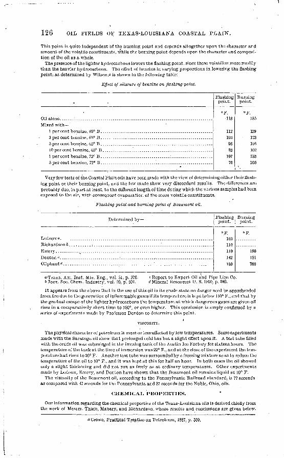
126 OIL FIELDS OF TEXAS-LOUISIANA COASTAL PLAIN.
This point is quite independent of the burning point and depends altogether upon the character and amount of the volatile constituents, while the burning point depends upon the character and composi tion of the oil as a whole.
The presence of the lighter hydrocarbons lowers the Gashing point, since these volatilize more readily tL'an the heavier hydrocarbons. The effect of benzine in varying proportions in lowering the flashing point, as determined by Wilson," is shown in the following table:
Effect of mixture of benzine on flashing point.
,
Mixed with
Flashing point.
°F. 118
1121039683
10770
Burning point.
°F. 135
129123116102133105
Very few tests of the Coastal Plain oils have been made with the view of determining either their flash ing point or their burning point, and the few made show very discordant results. The differences are probably due, in part at least, to the different length of time during which the various samples had been exposed to the air, with consequent evaporation of the more volatile constituents.
Flashing point and burning point of Beaumont oil.
Determined by
Oliphantd. ............ ............... .... . ..... ...
Flashing point.
°F. 165110110142180
Burning point.
F.
180181 200
"Trans. Am. Inst. Min. Eng., vol. 31, p. 370. t Jour. Soc..Chem. Industry, vol. 20, p. 691.
c Report to Export Oil and Pipe Line Co. d Mineral Resources U. S. 1890, p. 580.
It appears from the above that in the use of this oil in its crude state no danger need be apprehended from fire due to the generation of inflammable gases if its temperature is kept below 110° F., and that by the gradual escape of the lighter hydrocarbons the temperature at which dangerous gases are given off rises in a comparatively short time to 180°, or even higher. This conclusion is amply confirmed by a series of experiments made by Professor Denton to determine this point.
The physical character of petroleum is more or less affected by low temperatures. Some experiments made with the Saratoga oil show that prolonged cold has but a slight effect upon it. A test tube filled with the crude oil was submerged in the freezing tank of the Austin Ice Factory for sixteen hours. The temperature of the tank at the time of immersion was 22° F., and at the close of the experiment the tem perature had risen to 26° F. Another test tube was surrounded by a freezing mixture so as to reduce the temperature of the oil to 10° F., and it was kept at this for half an hour. In both cases the oil showed only a slight thickening and did not run as freely as at ordinary temperatures. Other experiments made by Ledoux, Emery, and Denton have shown that the Beaumont oil remains liquid at 10° F.
The viscosity of the Beaumont oil, according to the Pennsylvania Railroad standard, is 77 seconds as compared with 42 seconds for the Pennsylvania and 37 seconds for the Noble, Ohio, oils.
CHEMICAL, PROPERTIES.
Our information regarding the chemical properties of the Texas-Louisiana oils is derived chiefly from the work of Messrs. Thiele, Mabery, and Richardson, whose results and conclusions are given below.
oCrewe, PracticaJ Treatise on Petroleum, 1887, p, 359,
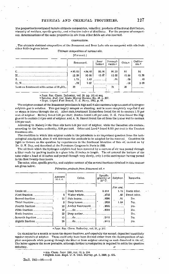
PHYSICAL AND CHEMICAL PKOPERTIES. 127
The properties investigated include ultimate composition, volatility, products of fractional distillation, viscosity of residues, specific gravity, and refractive index of distillates. For the purpose of compari son, determinations of the same properties in oils from other fields are also inserted.
COMPOSITION.
The ultimate chemical composition of the Beaumont and Sour Lake oils as compared with oils from other fields is given below.
Ultimate composition of various oils.[Percent.]
c... ......................................11.............:..........................S.. ......................................0, N. ....................................Loss on treatment with excess of HaSC>4 .
Beaumont.
a 85. 03 12.30 1.75 .92
39
C84.60 10.90 1.63 2.87
Sour Lake.o
85.96 13.97
Pennsyl vania."
86.10 13.90
.06
21
Ohio.a
85 13.80
.60
.60 30
Califor nia.''
84 12.70
.40 2.09
a Jour. Soc. Chem. Industry, vol. 20, pp. 161 et seq.6 Salathe. Bull. Cal. State Mining Bureau No. 19, p. 207.c Kept. Liquid Fuel Board, U. S. Navy, 1902, p. 69.
The sulphur content of the Beaumont petroleum is high and it also carries a large amount of hydrogen- sulphide gas in solution. This gas largely escapes on standing, and is more completely expelled if air or steam is blown through the oil. After such.treatment Richardson found the oil to contain 1.75 per cent of sulphur. Mabery found 2.16 per cent; Denton found 1.63 per cent; 0. H. Palm found the Hig- gins oil to contain 2.4 per cent of sulphur, and A. M. Smoot found the oil from the Lucas well to contain 2.04 per cent. '.
According to Mabery,a the Ohio oils have 0.50 per cent of sulphur, while the Canadian oils contain, according to the'same authority, 0.98 per cent. Orton and Lord* found 0.553 per cent in the Trenton limestone oils.
The condition in which this sulphur exists in the petroleum is an important question from the tech nological standpoint, since it will determine the methods to be adopted for its removal. Considerable light is thrown on the question by experiments in the fractional filtration of this oil, carried on by Dr. D. T. Day, and described at the Petroleum Congress in Paris in 1900.
The oil from which the hydrogen sulphide had been removed by a current of air was passed through a filter made by packing kaolin in a glass tube 19 inches in length. The oil entered the bottom of the tube under a head of 56 inches and passed through very slowly, only 5 cubic centimeters having passed in the first twenty-four hours.
The color, odor, specific gravity, and sulphur content of the several fractions obtained in this, manner are given below.
Filtration products from Beaumont oil. a
Amount in c. c.
5. 21
82210221320
Color.
.....do............'....
.....do................
.....do................
Specific gravity at
25° C.
0.914.8755.8986. 9038.9068.9104
.9115
.9115
Sulphur.
Per cent. 1.75.80.91
1.04
Remarks.
Do.Do.Do.Do.Do.Do.Do.
a Jour. Soc. Chem. Industry, vol. 21, p. 317.
On standing for a month of more the denser fractions, and especially the second, deposited beautifully regular crystals of sulphur. These could only have been derived either from the decomposition of sul phur compounds while passing through the filter or from sulphur existing as such dissolved in the oil. The latter appears the more probable, although further investigation is required to settle the question definitely. <*>
a Am. Chem. Jour. 1891, vol. 13, p. 234.6 Eighth Ann. Rept. U. S. Geol. Survey, pt. 2,1889, p. 625.
Bull. 282 06 9
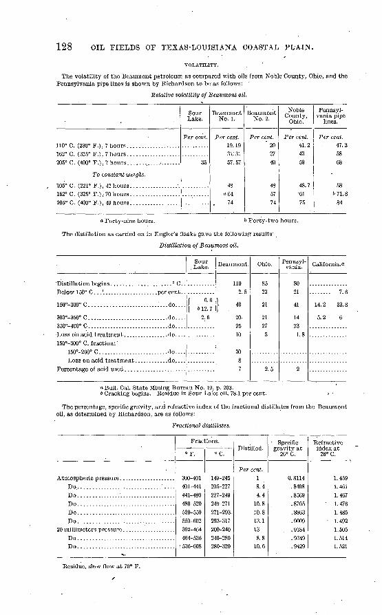
128 OIL FIELDS OF TEXAS-LOUISIANA COASTAL PLAIN.
VOLATILITY.
The volatility of the Beaumont petroleum as compared with oils from Noble County, Ohio, and the Pennsylvania pipe lines is shown by Richardson to be as follows:
Relative volatility of Beaumont oil.
110° C. (230° F.), 7 hours...................162° C. (325° F.), 7hours...................205° C. (400° F.), 7 hours.. ..................
To constant weight.
162° C. (325° F.) , 70 hours ..................205° C. (400° F.), 49 hours....... ...........
Sour Lake.
Per cent.
35
Beaumont No. 1.
Per cent. 19.1931:3157.57
48a 64
74
Beaumont No. 2.
Per cent.' 20
2749
485774
Noble County,
Ohio.
Per cent. 41.24359
48.7 61
75
Pennsyl vania pipe
lines.
Per cent. 47.35868
58671.8
84
« Forty-nine hours. b Forty-two hours.
The distillation as carried on in Engler's flasks gave the following results:
Distillation of Beaumont oil.
Below 150° C... '.................... per cent..
150°-300°C............ ............. '...do....
300°-350° C ............................. .do ....350°-400° C...... ...................... .do....
150°-300° C. fraction: ' 150°-260° C ........................ .do ....
Sour Lake.
f G.G | 6 12. 7
2.6
Beaumont.
110 2.5
| 40
20 25 10
3087
Ohio.
85 23
21
2127
5
2.5
Pennsyl vania.
80 21
41
14 23 1.8
2
California.**
........ 7. 6
14. 2 33. 8
5.2 6
a Bull. Cal. State Mining Bureau No. 19, p. 203.6 Cracking begins. Residue in Sour Lake oil, 78.1 per cent. o
The percentage, specific gravity, and refractive index of the fractional distillates from the Beaumont oil, as determined by Richardson, are as follows:
Fractional distillates.
Do..............................'.....Do...................................Do...................................Do.................'..................Do...................................
Do...................................Do...................................
Fractions.
°F.
300-401 401-441 441-480 480-520 520-559
'559-002 392-464 464-536
536-608
°C.
149-245 205-227 227-249 249-271 271-293. 293-317 200-240 240-280 280-320
Distilled.
Per cent. 1 8.4 4.4
10.8 10.8 13.1 13 8.8
10.6
Specific gravity at
26° C.
0.8114 . . 8408
. 8569
. 8705
.8863
.9009
. 9184
.9349
.9429
Refractive index at
26° C.
1.459 1.461 1.467 1. 476 1.485
1. 492 1.505 1.514 1.521
Residue, slc>w flow at 70° F.
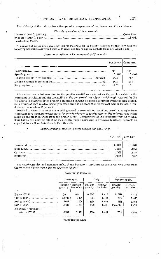
PHYSICAL AND CHEMICAL PKOPEKTIES. 129
The viscosity of the residues from the open-dish evaporation of the Beaumont oil is as follows:
Viscosity of residues of Beaumont oil. 7 hours at 205° C. (400° F.) --- --- --.- --- ------ ----- ------" ------ - -- ----- - - - Quick flow.49 hours at 205° C. (400° F.)........................................................................Solid.Penetration, 8°-10°.
A similar but softer pitch made by boiling the crude oil for twenty hours iii an open dish hud the following properties compared with a D grade residue or paving asphalt from Los Angeles oil:
Cliaractcr of residues of Beaumont and California oils.
..................... ...do..
.........................do..
Beaumont.
78°
0. 994378.3
84.38.7
California.
78°
0. 996474.4
81.615
Richardson has called attention to the peculiar conditions under which the sulphur exists in the Beaumont petroleums and the probability of the presence of free sulphur which might account for the variability in character of the product obtained on varying the conditions under which the oil is heated,
'the amount of hard residue reaching in some cases to no more than 10 per cent and under other con ditions to as much as 35 per cent.
Distilled in vacuo at a point where boiling ceased to go on without cracking, one of the samples from Beaumont gave distillates better suited for examinations as to the character of the hydrocarbons which make up the oil than those from the Engler flasks. Comparisons of the distillates from Corsicana, Sour Lake, and California oils show that the Beaumont petroleum is more closely related, as would be expected, to the Sour Lake than to the other oils.
Specific gravity of fractions boiling between 100° and 175° C.
100°-150°.
0. 8037.8093.7932. 9195
150°-] 75°.
0. 8803.9050.8187.9547
The specific gravity and refractive index of the Beaumont distillates as compared with those from the Ohio and Pennsylvania oils are shown as follows:
Character of distillates.
Below 150°C. .......................
350° to 400° C .......................After acid treatment:
150° to 300° C ...................
Beaumont.
Specific gravity.
(a)
0. 8749 .9089 .9182
.8704
Refract ive index.
(«) 1. 473 1. 501 1.508
1.473
Ohio.
Specific gravity.
0. 7297 .8014
1. 8404 .8043
.8006
Refract ive index.
1.412 1.442 1.408 1. 481
1.443
Pennsylvania.
Specific gravity.
0. 7188 .7984 .8338
Paraffin.
. 7791
Rjfract- ive index.
1.415 1.437 1.402 1.470
1.438
a Amount too small.
130 OIL FIELDS OF TEXAS-LOUISIANA COASTAL PLAIN.
The residue after distillation of the Beaumont oil amounting to 9.9 per cent of the original oil, was evaporated in an open dish to 6 per cent. It was then a brittle pitch which had the following properties:
Properties of residue after distillation of Beaumont oil. Specific gravity................................................................................. 1.0454Color............................................. ' . ............................................. Black.Luster. ................................................................. -....................... Shiny.Structure..............................I....................................................... Massive.
............................................................................ Conchoidal.Fracture.............................................................................Hardness penetration..........................................................................Soluble in CS2........................................................................per cent.Organic insoluble......................................................................... do...Mineral matter...........................................................................do...
15°
.1
.1
100.0
Soluble in 88° naphtha...................................................................do.... GOProportion of total bitumen...................................................'..:...do.... 60.1
Soluble in 62° naphtha...................................:...............................do.... 64.8Proportion of total bitumen...................................................... ..."do.... 64.9
Bitumen yields on ignition Fixed carbon.......................................................................... do.... 21.13Volatile hydrocarbon................................................................ do.... 78.
CONSTITUTION.
The chemical constitution of the Texas petroleum has not yet been thoroughly investigated, but Richardson and Wallace in the article quoted aboveo reach the conclusion that it contains a large proportion of unsaturated hydrocarbons, which are removed by treatment with an excess of strong sulphuric acid and washing soda. It also contains members of a hydrocarbon series CnHsn-2, which, although saturated, are readily attacked by cold nitric acid. Similar compounds are found in Russian and Californian oils and in Trinidad asphalt.
Mabery and Buck 6 have also investigated the constitution of the Beaumont oil and conclude that fractions distilling between 150° C. and 300° C. contain hydrocarbons of the series CnH2n-2andCnH'2.n-4.
RESULTS OF REFINEMENT.
The proportions of the several products and by-products obtained by different refineries differ. The proportions also differ from one time to another as the processes are gradually improved- and adapted to the treatment of the Coastal Plain oils. The following table shows the results obtained by the United Oil and Refining Company in 1904:
Products obtained by refinement of Coastal Plain oil.
Product.Spindletop and Sour.
Lake crude.
Per cent. 1.8
17.115.452.27.5
Batson crude.
Per cent.6 C
20.414.446.76.0
ASSOCIATED HYDROCARBONS.
NATURAL GAS.
Throughout the whole of the Gulf Coastal Plain, wherever any oil has been found, it is always accom panied by considerable quantities of natural gas; indeed, this form of hydrocarbon is more widely distributed than the oil, and at several localities it has been found unaccompanied by oil. Among the most remarkable of these gas wells was that at Bryan Heights, Brazoria County. At Big Hill, Mata- gorda County, gas was also found in enormous quantities and oil was found later a short distance away. The gas horizon was struck at 900 to 1,000 feet and the initial pressure was sufficient to blow out tools and casing and wreck the derrick. The flow from each of these wells was estimated at from 5,000,000 to 6,000,000 cubic feet per day. All efforts to control the flow of gas proved unsuccessful and they were
a Jour. Soc. Chem. Industry, vol. 20, 1901, p. 693. & Jour. Am. Chem. Soc., vol. 22, 1900, pp. 553-556.
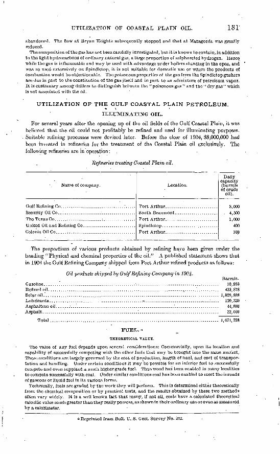
UTILIZATION OF COASTAL PLAIN OIL. 131
abandoned. The flow at Bryan Heights subsequently stopped and that at Matagorda was greatly reduced.
The composition of the gas has not been carefully investigated, but it is known to contain, in addition to the light hydrocarbons of ordinary natural gas, a large proportion of sulphureted hydrogen. Hence while the gas is inflammable and may be used with advantage under boilers standing in the open, and was so used extensively on Spindlctop, it is not suitable for domestic use or where the products of combustion would be objectionable. The poisonous properties of the gas from the Spindlctop gushers are due in part to the constitution of the gas itself and in part to an admixture of petroleum vapor. It is customary among drillers to distinguish between the "poisonous gas" and the "dry gas" which is not associated with the oil.
UTILIZATION OF THE GULF COASTAL PLAIN PETROLEUM. \
ILLUMINATING OIL.
For several years after the opening up of the oil fields of the Gulf Coastal Plain, it was believed that the oil could not profitably be refined and used for illuminating purposes. Suitable refining processes were devised later. Before the close of 1904, $8,000,000 had been invested in refineries for the treatment of the Coastal Plain oil exclusively. The following refineries are in operation:
Refineries treating Coastal Plain oil.
Name of company.
G ulf Reflning Co .....................................
The Texas Co. ......................:................United Oil and Refining Co. .........................
Location.
Daily capacity (barrels of crude
oil).
8,000. 4,500
i nnn400inn
The proportions of various products obtained by refining have been given under the heading "Physical and chemical properties of the oil." A published statement shows that ih 1904 the Gulf Refining Company shipped from Port Arthur refined products as follows:
Oil products shipped by Gulf Refining Company in 1904-
Gasoline.Barrels.
10,993Refined oil...................................................................,......'........... 433,878Solar oil.'..................................................................................... 1,029,898Lubricants............................................. r.................................:.... 129,339Asphaltum oil. Asphalt.......
44,990 22,C60
Total................................................................................... 1,671,758
FUEL. «
THEORETICAL VALUE.
The value of any fuel depends upon several considerations: Commercially, upon its location and capability of successfully competing with the other fuels that may be brought into the same market, These conditions are largely governed by the cost of production, length of haul, and cost.of transpor tation and handling. Under certain conditions it may be possible for an inferior fuel to successfully compete and even supplant a much higher grade fuel. Thus wood has been enabled in many localities to compete successfully with coal. Under similar conditions coal has been enabled to meet the inroads of gaseous or liquid fuel in its various forms.
Technically, fuels are graded by the work they will perform. This is determined either theoretically from 'the chemical composition or by practical tests, arid the results .obtained by these two methods often vary widely. It is a well-known fact that many, if not all, coals have a calculated theoretical calorific value much greater than they really possess, as shown in their ordinary use or even as measured by a calorimeter.
Reprinted from Bull. U. S. Geol. Survey No. 212.
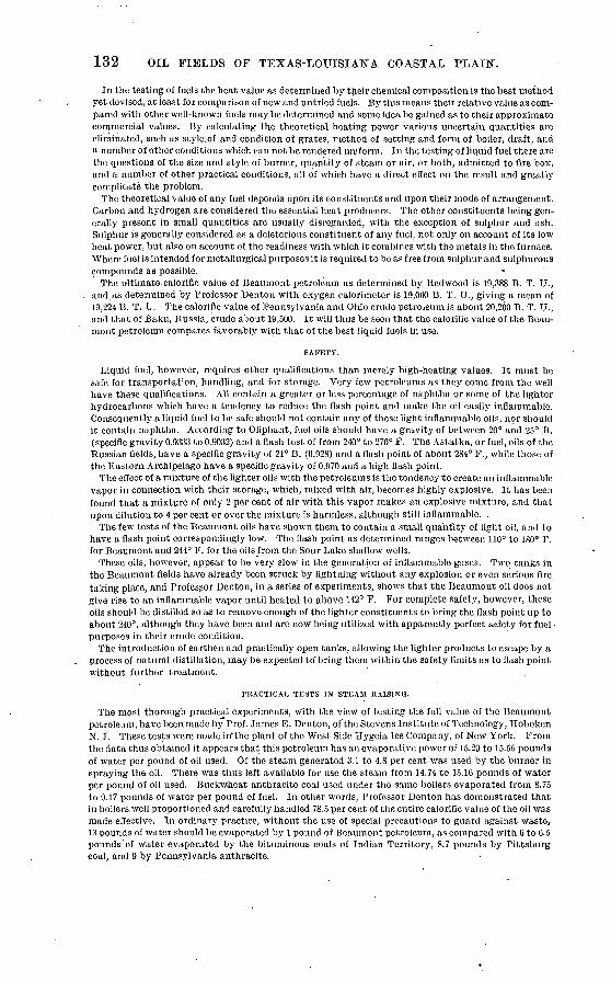
132 OIL FIELDS OF TEXAS-LOUISIANA COASTAL PLAIN.
In the testing of fuels the heat value as determined by their chemical composition is the best method yet devised, at least for comparison of new and untried fuels. By this means their relative value as com pared with other well-known fuels may be determined and some idea be gained as to their approximate commercial values. By calculating the theoretical heating power various uncertain quantities are eliminated, such as style.of and condition of grates, method of setting and form of boiler, draft, and a number of other conditions which can not be rendered uniform. In the testing of liquid fuel there are the questions of the size and style of burner, quantity of steam or air, or both, admitted to fire box, and a number of other practical conditions, all of which have a direct effect on the result and greatly complicate the problem.
The theoretical value of any fuel depends upon its constituents and upon their mode of arrangement. Carbon and hydrogen are considered the essential heat producers. The other constituents being gen erally present in small quantities are usually disregarded, with the exception of sulphur and ash. Sulphur is generally considered as a deleterious constituent of any fuel, not only on account of its low heat power, but also on account of the readiness with which it combines with the metals in the furnace. Where fuel is intended for metallurgical purposes it is required to be as free from sulphur and sulphurous compounds as possible. «
The ultimate calorific value of Beaumont petroleum as determined by Redwood is 19,388 B. T. U., and.as determined by Professor Denton with oxygen calorimeter is 19,000 B. T. U., giving a mean of 19,224 B. T. U. The calorific value of Pennsylvania and Ohio crude petroleum is about 20,200 B. T. U., and that of Baku, Russia, crude about 19,500. It will thus be seen that the calorific value of the Beau mont petroleum compares favorably with that of the best liquid fuels in use.
Liquid fuel, however, requires other qualifications than merely high-heating values. It must be safe for transportation, handling, and for storage. Very few petroleums as they come from the well have these qualifications. All contain a greater or less percentage of naphtha or some of the lighter hydrocarbons which have a tendency to reduce the flash point and make the oil easily inflammable. Consequently a liquid fuel to be safe should not contain any of these light inflammable oils, nor should it contain naphtha. According to Oliphant, fuel oils should have a gravity of between 20° and 25° B. (specific gravity 0.9333 to 0.9032) and a flash test of from 240° to 270° F. The Astatka, or fuel, oils of the Russian fields, have a specific gravity of 21° B. (0.928) and a flash point of about 284° F., while those of the Eastern Archipelago have a specific gravity of 0.970 and a high flash point.
The effect of a mixture of the lighter oils with the petroleums is the tendency to create an inflammable vapor in connection with their storage, which, mixed with air, becomes highly explosive. It has been found that a mixture of only 2 per cent of air with this vapor makes an explosive mixture, and that upon dilution to 4 per cent or over the mixture is harmless, although still inflammable. .
The few tests of the Beaumont oils have shown them to contain a small quantity of light oil, and to have a flash point correspondingly low. The flash point as determined ranges between 110° to 180° F. for Beaumont and 244° F. for the oils from the Sour Lake shallow wells.
These oils, however, appear to be very slow in the generation of inflammable gases. Two tanks in the Beaumont fields have already been struck by lightning without any explosion or even serious fire taking place, and Professor Denton, in a series of experiments, shows that the Beaumont oil does not give rise to an inflammable vapor until heated to above 142° F. For complete safety, however, these oils should be distilled so as to remove enough of the lighter constituents to bring the flash point up to about 240°, although they have been and are now being utilized with apparently perfect safety for fuel purposes in their crude condition.
The introduction of earthen and practically open tanks, allowing the lighter products to escape by a process of natural distillation, may be expected to'bring them within the safety limits as to flash point without further treatment.
PRACTICAL TESTS IN STEAM RAISING.
The most thorough practical experiments, with the view of testing the full value of the Beaumont petroleum, have been made by Prof. James E. Denton, of'the Stevens Institute of Technology, Hoboken N. J. These tests were made irf the plant of the West Side Hygeia Ice Company, of New York. From the data thus obtained it appears that this petroleum has an evaporative power of 15.29 to 15.55 pounds of water per pound of oil used. Of the steam generated 3.1 to 4.8 per cent was used by the burner in spraying the oil. There was thus left available for use the steam from 14.74 to 15.10 pounds of water per pound of oil used. Buckwheat anthracite coal used under the same boilers evaporated from 8.75 to 9.17 pounds of water per pound of fuel. In other words, Professor Denton has demonstrated that in boilers.well proportioned and carefully handled 78.5 per cent of the entire calorific value of the oil was made effective. In ordinary practice, without the use of special precautions to guard against waste, 13 pounds of water should be evaporated by 1 pound of Beaumont petroleum, as compared with G to 6.5 pounds of water evaporated by the bituminous coals of Indian Territory, 8.7 pounds by Pittsburg coal, and 9 by Pennsylvania anthracite.
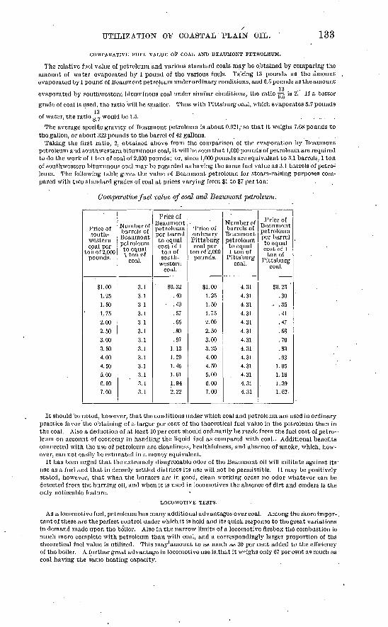
UTILIZATION OF COASTAL PLAIN OIL. 133
COMPAKATIVE FUEL VALUE OF COAL AND BEAUMONT PETROLEUM.
The relative fuel value of petroleum and various standard coals, may be obtained by comparing the amount of water evaporated by 1 pound of the various fuels. Taking 13 pounds as the amount evaporated by 1 pound of Beaumont petroleum under ordinary conditions, and 6.5 pounds as the amount
evaporated by southwestern bituminous coal under similar conditions, the ratio g-g is 2! If a better
grade of coal is used, the ratio will bo smaller. Thus with Pittsburg coal,.which evaporates 8.7 pounds
of water, the ratio 5-7 would be 1.5. . ....O- '
The average specific gravity of Beaumont petroleum is about 0.921; so that it weighs 7.C8 pounds to the gallon, or about 322 pounds to the barrel of 42 gallons.
Taking the first ratio, 2, obtained above from the comparison of the evaporation by Beaumont petroleum and southwestern bituminous coal, it will be seen that 1,000 pounds of petroleum are required to do the work of 1 ton of coal of 2,000 pounds; or, since 1,000 pounds are equivalent to 3.1 barrels, 1 ton of southwestern bituminous coal may be regarded as having the same fuel value as 3.1 barrels of petro leum. The following table gives the value of Beaumont petroleum for steam-raising purposes com pared with two standard grades of coal at prices varying from SI to S7 per ton:
Comparative fuel value of coal and Beaumont petroleum.
Price of south
western coal per
toil of 2,000 pounds.
SI. 001.251.501, 752.002.503.003.504.004.505.000.007.00
Number of barrels of Beaumont petroleum to equal 1 ton of
coal.
3.13.13.13.13.13.13.13.13.13.13.13.13.1
Price ol Beaumont petroleum per' barrel to equal cost of 1 ton of south
western coal.
$0. 32.40
.49.57.65.80.97
1.131.291.451.611.942.22
"Price of ordinary Pittsburg coal per
ton of 2,000 pounds.
$1.001.251.501.752.002.503.003.254.004.505.006.007.00
Number of barrels of Beaumont petroleum to equal l ton of
Pittsburg coal.
4.314.314.314.314.314.314.314.314.314.31.
, 4.314.314.31
Price of Beaumont petroleum per barrel to equal cost of 1 ton of
Pittsburg coal.
SO. 23 '.30
o .35.41.47..58.70.83.93
1.051.161.391.62
It should be noted, however, that the conditions under which coal and petroleum are used in ordinary practice favor the obtaining of a larger per cent of the theoretical fuel value in the petroleum than in the coal. Also a deduction of at least 10 per cent should ordinarily be made from the fuel cost of petro-- leum on account of economy in handling the liquid fuel as compared with coal.. Additional benefits connected with the use of petroleum are cleanliness, healthfulness, and absence of smoke, which, how ever, can .not easily be estimated in a money equivalent.
It has been urged that the extremely disagreeable odor of the Beaumont oil will militate against its' use as a fuel and that in densely settled districts its use will not be permissible. It may be positively stated, however, that when the burners are in good, clean working order no odor whatever can be detected from the burning oil, and when it is used in locomotives the absence of dirt and cinders is the only noticeable feature.
LOCOMOTIVE TESTS.
As a locomotive fuel, petroleum has many additional advantages over coal. Among the more impor-. tant of these are the perfect control under which it is held and its quick response to the great variations in demand made upon the boiler. Also in the narrow limits of a locomotive firebox the combustion ie much more complete with petroleum than with coal, and a correspondingly larger proportion of ths theoretical fuel value is utilized. This may amount to as much as 30 per cent added to the efficiency of the boiler. A further great advantage in locomotive use is.that it weighs only 67 per cent as much as coal having the same heating capacity.
134 OIL FIELDS OF TEXAS-LOUISIANA COASTAL PLAIN.
Practical tests of Beaumont petroleum have been made by the Southern Pacific Railroad and the Gulf, Colorado and Santa Fe Railroad. Both of these roads had already had experience with'Cali fornia petroleum, and were therefore in a position to carry out their experiments in a practical way. According to Mr. Stillman, of the Southern Pacific road, the specific gravity of the oil used was 0.9594 (16° B.). It had a flash point of 240° F. and fire test of 290° F. The results of the test on this road, as compared with coal, are shown in the following table:
Comparative test of petroleum and coal for locomotive fuel.
................. .do....
Petroleum.
224133
6/C09755
6,04074.14
o3.1
Coal.
224130
5,980
8,04355.72
61
a Barrels of 42 gallons. b Ton of 2,000 pounds.
From this test it appears that with petroleum at 30 cents per barrel, which is somewhat above the market price prevailing at the time the test was made, coal should be worth only 93 cents per ton; or stated in another form, with coal at $3 per ton, petroleum should be worth 97 cents per barrel.
METHODS OF BURNING THE OIL."
Of the numerous styles of. oil burners on the market, practically all consist of various modifications of the sprayer. Some of the earlier styles were of a different pattern, but these have been abandoned, The burners now in use all work on the principal of spraying or, as some claim, vaporizing the oil by the use of steam or air under considerable pressure, working somewhat on the style of a Bunsen burner When steam is used it should be taken from the highest part of the boiler and should be dry. It need not be superheated as was at one time considered necessary.
When working properly the flame is a clear white with an intense heat, and as the fuel is completely consumed no smoke issues from the chimney. When perfect combustion is interrupted by a too rapid feed of oil or an insufficient supply of air, an intensely black smoke pours from the stack in great vol umes, covering everything it touches with a black greasy soot. Under these conditions the flame becomes a dull red, the oil is not consumed, and, although more fuel is used, less work is performed. When steam is used in excess the smoke is white and watery owing to the condensation of the steam. Under these conditions the fire usually goes out.
In making his experiment Professor Denton used the Williams burner. His arrangements for burn ing the oil probably represent the best practice yet devised, and, with his modifications of the boiler furnace, are shown in figs. 13 and 14.
Four ducts of hollow tile (F, fig. 14) 30 by 6 inches were laid in the ash pit, extending nearly to the bridge wall, and the ash-pit door openings closed by brickwork around the outer ends of the tile.
The forward bearer of the grate bars (N, fig. 14) was dropped,.about half of the forward set of bars removed, and a course of fire brick (0, fig. 14) laid with fire clay over the whole upper surface of the grates, so that air entering through the tile could flow back along the outside of the latter, and then around and up between the front end of the grate bars through an area a little greater than that of the aggregate cross section of the tiles.
A checkerwork (P, fig. 14) of about 50 loose fire brick was built over the grates, the space back of the bridge was filled with ashes (R, fig. 14) flush with, the top of the bridge wall, and a single-course floor (Q, fig. 14) of fire brick laid over the ashes.
An iron bar (a, fig. 13) was bridged across the middle of the fire-door opening, and the remainder of the latter closed with fire brick (V, figs. 13 and 14) flared on the inside, a small opening (L, fig. 13) being left for applying the torch to the burners. Into the iron bar across each door was screwed the burner (K, fig. 14).
Oil enters the burner vertically through the opening (b, PI. IX) under control of the cock (c, PI. IX), regulated by the handle (d, PI. IX, A and B).
Steam enters the opening (e, PI. IX, A and B) and flows through the conical opening (f), regulated by the hand wheel (g), to meet the oil as the latter falls between the vertical flanges (h, B~).
A third opening (i, A and B) in the burner draws air from the back of the furnace through a fire brick duct built on top of the grate and connecting with the bottom side of the latter at its rear, while the front end communicates with the iron pipe (M, fig. 13) connected to both burners.
a Reprinted from Bull. U. S. Geol. Survey No. 212.
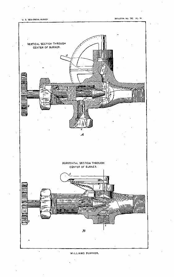
U. S. GEOLOGICAL SURVEYBULLETIN NO. 282 PL. IX
VERTICAL SECTION THROUGH
CENTER OF BURNER.
HORIZONTAL SECTION THROUGH
CENTER OF BURNER.
WILLIAMS BURNER.
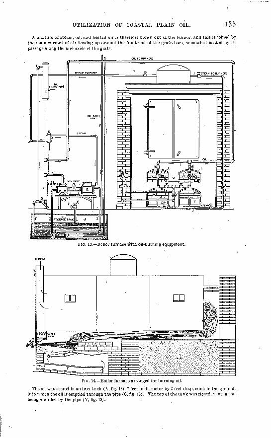
UTILIZATION OF COASTAL PLAIN OIL.
A mixture of steam, oil, and heated air is therefore blown out cf the burner, and this is joined by the main current of air flowing up around the front end of the grate bars, somewhat heated by its passage along the underside of the grate.
OIL TO BURNERS
FIG. 13. Boiler furnace with oil-burning equipment.
FIG. 14. Boiler furnace arranged for burning oil.
The oil was stored in an iron tank (A, fig. 13), 7 feet in diameter by 5 feet deep, sunk in the ground, into which the oil is emptied through the pipe (C, fig. 13). The top of the tank was closed, ventilation being afforded by the pipe (Y, fig. 13).
136 OIL FIELDS OF TEXAS-LOUISIANA COASTAL PLAIN.
A steam pump (B, fig. 13) drew oil from the tank through the strainer (U, fig. 13) to the burners under a head of about 10 feet.
The pump was run constantly and delivered a surplus, which flowed back to the tank through the pipe (T, fig. 13).
The oil was prepared with a device o (D, fig. 13) having a piston connecting by a chain with a cock (S, fig. 13), which automatically opened when the boiler was not under steam pressure, so that the standpipe would be emptied of oil by the latter flowing to the storage tank.
The steam exhaust of the pump passed through the tank by the pipe (Z', fig. 13) and thence to the atmosphere. Thereby high cold test oil is kept sufficiently fluid in cold weather to flow freely into the strainer, but is not sensibly heated to the touch when it arrives at the burner.
The air entered the ash-pit tile's under the natural draft of the chimney, 70 feet high by 42 inches square, connecting to the boiler tested by a 40-inch flue about 30 feet long.
STORAGE AND TRANSPORTATIOIST. >>
During the earlier'days of the Beaumont field the companies owning wells were seriously handicapped by the want of means of taking care of the oil or sending it to market. The immense quantity pro duced was unexpected and no one was prepared to handle it. The companies had no tankage, and consequently, although drilling was carried on, and'even stimulated beyond all reason, the wells, as soon as determined to be flowing wells, were closed until-such tunes as the owners could make arrange ments to dispose of the oil.
The railroad companies were not in a position to furnish cars, and for months looked upon the fields as a sort of freak that would soon die, and they considered themselves hardly justified in the purchase of new cars to supply the demand. These roads delayed action until several of the larger and wealthier companies commenced purchasing individual cars and shipping in that way. These companies own over 1,000 cars, and the railroads are now supplying enough additional cars to meet the demand.
[Pipe lines were laid to the coast at Port Arthur and Sabine Pass, and shipments by water were made from these ports. At the close of 1904 there were four pipe lines from Spindletop to Port Arthur, three to Sabine Pass, and not less than five to-Sour Lake. There were also four lines from Saratoga to Sour Lake, two from Batson to Sour Lake, and not less than four between Batson and Saratoga, besides several pipe lines connecting'the fields with the railroads at different points. After the opening of the Humble field various pipe lines were built connecting it with Houston on the south and Batson on the east. The Dayton field is reached by the lines between Humble and Batson. The oil from Jennings, La., is conveyed by-three pipe lines to as many different points on the Southern Pacific Railroad or by other lines to the bayous, where it is loaded on barges to be taken to the rice-farm irrigating plants to be used as fuel for pumping. A fourth pipe line connects the Jennings and Ause la Butte fields with a port on Atchafalaya River. The water shipments are mostly coastwise to New Orleans, Baltimore, New York, and other coast harbors. Considerable quantities are also shipped to European ports by the Shell Transport and Trading Company, which has two steam tank ships of 60,000 barrels capacity in the trade regularly.
The tankage in the field to the close of 1904 amounted to about 30,000,000 barrels. The larger part of this is in earthen reservoirs which have been found fairly satisfactory and much cheaper than steel tanks.] * * * Some of these earthen tanks have nothing done to them beyond excavating to the required depth; others are lined with timber, and while some of them are open, others are covered with a light board roof.
The capacity of the steel tanks ranges from 10,000 to 55,000 barrels, while the earthen tanks range from 25,000 to 350,000 barrels.
For fire protection the steel tanks are surrounded by a moat and embankment, giving a storage capacity equal to the full content of the tank. '..
METHODS AND COST OF WELL DRILLING.?)"
ROTARY METHOD.
The rotary method of drilling is the one used almost exclusively hi/the Gulf Coastal Plain oil fields. This appears to be a modification of the Fauvelle system, invented in 1845, and used for some tune in several of the European oil fields. It is unquestionably the most rapid and economical method where the formations to be penetrated are for the most part unconsolidated. The vast amount of drilling done in this field since the spring of 1901 and the keen competition among the drillers has brought the method and machinery to a high state of efficiency.
The rotary is so entirely different from the old-fashioned cable rig and churn drill that it has been thought desirable to insert a brief account of the machinery and method.
o There is a safety device required by western insurance rules.6 Reprinted with slight revision from Bull. U. S. Geol. Survey No. 212.
U. S. GEOLOGICAL SURVEY BULLETIN NO. 282 PL. X
A. CHAPMAN ROTARY DRILL.B. HOISTING AND OPERATING MACHINERY.
METHODS AND COST OF WELL DRILLING. 137
MACIIINEKY AND OPERATION.
There are three styles ol rotary drill in the field, differing slightly in details, but all working on the same principle. The fonn in most common use, the Chapman patent, has been taken for illustration. A general view of the derrick with ma chinery in place is shown in fig. 15, the rotary in PI. X, A, and the hoisting and operating machinery in PI. X, B.
The method consists essentially in ro tating a vertical drill rod, through which a continuous stream of water is forced downward. The drill rod is supported by a cable passing from a hoisting drum over a pulley at the top- of the derrick and thence by block and fall to a swivel attached to the top of the drill rod, the descent of the latter being controlled by the driller by means of a feeding device. The lower end of the drill rod is supplied with one of several forms of bit, adapted to the kind of material being drilled. The material loosened by the rotating bit is carried upward to the surface by the water ascending on the outside. This ascending current of water keeps the hole clean and allows the drill rod to turn freely. It is essential that the flow of water should be continuous, and a drilling outfit is always supplied with two force pumps in order to avoid any danger of stopping the flow. If the well has passed through a pervious stratum, such as a bed of loose sand, the ascend ing water is liable to pass into that stra tum instead of returning to the surface. This quickly results in theclogging of the hole, and in order to prevent it the water which is pumped in is mixed with a largo amount of fine clay. By this means the outlets through porous beds are sealed up, the unconsolidated material forming the walls of the hole is prevented from caving, and the water returns unimpeded to the surface. [The occasional failure to obtain a return current is discussed on page 122.]
The forms of bits most commonly used are shown in PI. XI, A, B, C. The fish tail bit (A~) is adapted to soft materials, such as sand and clay. The core-barrel bit (B) is better adapted for harder mate rials, such as very compact clay, indu rated sand, etc. Where rock is encoun tered the ordinary bits make very slow progress, and the drilling is greatly facil itated by the use of the adamantine, or shot, drill, the cutting being done by a quantity of steel shot which revolve under the rim of the tube ( C). Some drillers, in passing through hard rock, rig up a regular churn drill, the cable passing over a pulley at the top of the derrick and thence down to the engine fly wheel, where a turn around the crank pingives the required lifting-and-dropping riG _ ls._Derrick with machinery in place, motion to the drill.
When everything is ready to begin operations a length of rod with the bit attached is made fast to the water swivel and lifted into the derrick. The bit and lower end of the rod are passed through the
138 . OIL FIELDS OF TE^AS-LOUISIANA COASTAL PLAIN.
rotary far enough to allow the jaws to be brought together and clamped so as to hold the drill rod and rotate it. The driller starts the engine and sets the pump in motion. As soon as the water flows freely he slackens the friction and allows the drill to descend.
The force of water, which varies from 40 pounds to 75 or 80 pounds, passing through the rod finds its way as jets through two holes, one on either side of the fishtail bit, and washes the freshly loosened sa^d'up to the surface through the space between the drill rod and the wall of the well. As the work progresses the driller lowers the rod slowly, holding it stationary or letting it descend, according to the character of the material through which the bit is working. From this time on the whole respon sibility rests upon the judgment of the driller. The drilling crew generally consists of four men the driller, two derrick men, and the fireman with a corresponding night shift, as the work proceeds night and day.
The work progresses rapidly at first, but becomes slower as the drill goes downward. Great care is required to keep the drill in motion and a sufficient supply of water passing through, as a stoppage for a short time often '' sticks'' the work, and considerable tune is lost, as the rods and often the casing already in place have to be withdrawn from the well.
In starting a well arrangements are generally made for the insertion of a 12-inch casing to begin with, and in boring for this size the drill rods are generally made of 6-inch casing with a ISJ-inch bit. This sized bit is used to allow the collars at the joints of the 12-inch casing to slide past without damaging the wall of the well. The length of 12-inch casing used varies from 500 to 800 feet, depending largely upon the nature of the ground and the skill of the driller. The hole is generally left open until the whole depth calculated for one string of casing has been drilled. This generally extends until a hard stratum is met with, upon which the casing to this depth may stand. When the depth has been reached, the drill is withdrawn and the casing set.
Following the 12-inch casing the hole is next drilled for an 8-inch or 9-inch casing. In either case a 10i-inch bit is used. This 9-inch casing has in several of the Spindletop wells been placed in the oil sand. After setting the 9-inch casing the drilling proceeds downward with a 6-irich casing. Occa sionally a still further reduction to a 4-inch or even 2-inch becomes necessary.
COST OF DKLLMNG.
The drilling of the well is usually carried on by contract. Some few of the companies own their own outfits and drill on the company's account. During the earlier period of the history of the field several of the companies bought drilling outfits and erected the derricks. When new companies were rapidly springing up, it was usual to find the companies investing money .in drilling machinery, and the allur ing sentence that the work had actually been begun on the company's holdings "by the erection of a derrick" appears in many of the prospectuses issued at that time. This was chiefly for the purpose of inducing people to buy stock. At that time it was also the rule of the company to provide the casing, the contractor finding the tools and doing the work. Later the contractor was generally required to furnish everything and turn over the well to the company upon its completion. The contract in proved territory usually calls for a specified depth, or a good flowing well if found at a less depth.
Prices vary in accordance with the conditions of the contract, but from $4 to $4.50 per foot may be considered as a fair average of prices at Beaumont after the early excitement had-subsided, the con tractor furnishing all machinery, tools, labor, etc., necessary to drill the well. The company usually reserved the right to accept or reject the work upon completion.
The average tune required to drill a well in any of the oil fields when no accident occurs is about two months. Several wells on Spindletop have been drilled in less than one month, but the greater number of them have occupied between two and three months. The work is often kept up night and day, though most of the contractors are content to keep the pumps at -work all night without attempting to drill.
FINISHING THE WELL.
. When the well approaches completion, the drill rods are withdrawn and a gate valve fitted to the casing in such a way as to permit a rapid closing of the well if desired. When the valve is in position, the bit is again lowered and the work proceeds until the oil sands have been reached and penetrated to a sufficient depth to insure a flow in the well. The drilling tools are then withdrawn, the water bailed, and the well allowed to flow. When a sufficient time has elapsed to allow of the well cleaning itself of all loose pieces of rock or gravel, the valve is closed and the well shut in. None of these wells has been torpedoed. This method of inducing a flow was tried in one case on Spindletop and the only result was a ruined well.
NOTE. In November, 1905, the Mound Oil Company completed a successful well not far from the drillings described under " Hoskins Mound" on page 86. By unusual precautions this success was secreted for five months, the well being capped and allowed to flow only enough oil to supply fue' for drilling other wells. On the basis of these short-time flows it has been reported that the well would produce 2,500 barrels daily. The well is 582 feet deep and is said to be finished in " rock" which it penetrated a few feet but did not pass through. As no strainer was used it is not improbable that the oil comes from a porous limestone. The oil is said to be of a green color and exceptionally low in sulphur. Its gravity is 21.5. It is hoped that since the entire mound is in the hands of one company composed of experienced oil men the new field will not be " Spindletopped," or wastefully exploited.
U. S. GEOLOGICAL SURVEY BULLETIN NO. 282 PL. XI
A. FISH-TAIL BIT.
B. CORE-BARREL BIT.C. ADAMANTINE OR SHORT DRILL.
Bull. 282 06 10
INDEX.
A. Page.
Acadla Parish, wells in, rocks in........... 98Acknowledgments to those aiding.......... 9-10Alert-well, blow-out in..................... 55Alum Creek, sour dirt on................... 93Alvin, Tex., wells near..................... 86American Mineral Company's well, record of 93-94 American Oil and Refining Company, wells
of, pressure in.................. 123Amsterdam, Tex., mound at............... 80
wells at................................. 80Andrews, Benjamin, well of, rock in....... 35Anse la Buttc field, Louisiana, description
of./........................... 105-106development of....................... 105-100location of.............................. 105mound in............................... 105oil of, occurrence of................... 108-100rocks of .............................. IS, 107salt in................................ 109-110structure in............. f.............. 109surface indications in................. 105,124wells of. list of.......................... 108
records of........ J............... 106-107Anse la Butte Oil Company's well, record
of............................. 107,109Appalachian field, oil of.................... 118Area transversa, occurrence of............. 14
sp., occurrence of....................... 14Asphalt, occurrence of.............. 38,77,86,106Avery Island, Louisiana, structure of...... 16
B.
B. B. B. and C. tract, wells of...........Balanus, occurrence of...................Barbers Hill, location of................
mound at...........................
....... 62
....... 14
....... 83
.......' 83rocks at................................ 17,83wells at.............'..'.................. 83
record of........................... 83-84Barrett, C. E., development by ............ 07Bass & Beckerstein well, salt water in....... 100
yield of........-..-......-.:.......-.... 95Bates well, rocks in........................ ' 53Batson, Tex., rocks at..................... 17
well at, fossils from.................:.. 14Batson field, development of, history of... 48
gas in.................................. 55-56gypsum in...............:.............. 53hot water in............................ 120limestone in............................ 52limestone, porous, in................... 52-54limits of................................ 49location of.............................. 48
Page. Batson field, map of....................... 48
mound in, lack of....................... 48oil-bearing horizons at, rocks cf and
below........................... 52-53oil of, character of....................... 50-57
occurrence of....................... 55production of................... 48,56-57specific gravity of.................. 125
. pyrite in........'....................... 53rocks of.......I......................... 49-53
' salt water in.......................... 48,120sand in.:1.............................. 52structure of............................. 53-54surface indications in.................. 48topography of................."......... 48wells in, list of......................... 52
records of.......................... 49-52Batson Oil Company's wells,'salt water in.. 55 Batson Prairie, description of.......:...... 48Bayou Bouillon, mouth of, gas at...'....... 112
mouth of, wells at, records of......... 112-113Bayou Mermentau, location and character
of............................... 12Bayou Vermilion, location and character of 12 Beaumont clays, character of.............. 15Beaumont district. See Spindletop field. Benzine, effect of on flashing point......... 120Berthelot, investigations of................ 114Big Four, well of, record of............. 80,82-83Big Hill, Jefferson County, Tex., gas at..... 79
limestone at ........................... 79wells at................................. 78-79
Big Hill, Matagorda County, Tex., area of.. 63 elevation of............................ 12,63gas at.................................. 130location of.............................. 63rocks at................................ 17^18See also Matagorda field.
Big Mound Oil and Gas Company's well,record of....................... 103
Bits, drilling, views of..................... 138Black, , on occurrence of pyrite........ 43B razos River, inouth of, oil at............. 11Blow-outs, effects of..........:.....,.. 36-37,130
occurrence of.... 30-37,55,60,66,85,88,101,105source of............................... 31,36
Blue Ridge, Tex., rocks at................. 86Brice & Bradley well, rocks in............. 53-54
salt water in........................... 55Brooks well, oil of, character of............ 56
rocks in................................ 53yield of................................. 48
Bryan Heights, Tex., gas at............... 130location of.............................. 80
139.
140 INDEX.
ljage. Bryan Heights, oil near.................... 11
rocks at................................ 17,87sea wax near............................ 80well at, record of....................... 87
fossils from......................... 14Bryozoan, occurrence of.................... 14Buck, D. M., on Texas-Louisiana oil....... 130Buffalo well, rocks in....................... 43Bullard & Wilson well, rock in............. 85Burning point of Texas oil, data on....... 125-120
C.
Calcasieu Parish, La., oil in................ 11Calcasieu River, location and character of.. . 12 California oil, chemical properties of...... 127-129Cannon tract, wells on, rock in............. 42,45
wells on, salt water in.................. 47Cap jock, analysis of....................... 27
thickness and character of............. 20Carroll well, record of...................... 82Cartwright wells, rocks in............... 28,35-30Cavities, occurrence of.........: 27,04-65,122-123Chapman rotary bit,-view of............... 130Chemical properties of Texas-Louisiana
oils........................... 127-131Chicago Crude well, rock in................. 30Chicago-.Tennings well, record of........ 95,97-98Choate wells, rocks in...................... 52-54Church Point, well at,rocks in............. 98Cibolo River, sulphur spring on............ 93Clay beds, occurrence of.......:............ 25,
32,42,52,58,98,105,107,110,120,121 Coal, comparison of fuel value of Texas oil
and........................... 133-134Coast clays, occurrence and description of.. 10 Coast prairies, character of................ 10Columbia sands, character of.............. 15
occurrence of..................... 10,42,52,57Confederated well, rocks in................. 28Cooks Mountain beds, character of........ 16Corbula galvestonensis, occurrence of...... 14
sp., occurrence of....................... 14Correlation, difficulties of..................... 13,
26,43-44,52-53,65-60,99,109,118 Coscinodiscus, occurrence of............... 76Crassatelites alabamiensis, occurrence of... 14
antestriata, occurrence of.............. 14trapaquara, occurrence of.............. 14
Crassinella galvestonensis, occurrence of.'.. 14 Crowley Oil and Mineral Company's wells,
records of...................... 96-98Cypress, occurrence of...................... 12
D.
Damon Mound, Texas, description of......elevation of............................ 12,89limestone, porous, at ................... 120location of.............................. 89map of................................. 90materials of............................ 10rocks at................................ 17-18sour dirt at............................ 89structure of............................ 16wells at, records of..................... 89-91
Damon Mound Oil and Pipe Company's well,record of....................... 90-91
Page. Day, David T., distillation by............. 127Dayton Hill, Tex, description of........... 85
gas and oil at........................... 85location of.............................. 12production of.......................... 85rocks at................................ 17-18salt at................................... 85
Dean well, rocks in......................... 65Denton, J. D., on Texas-Louisiana oil. 126-127,132 Denver-Beaumont Oil, Tank, and Pipe Line
Company's well, rocks in. 22-25,34-36 Diatom wax, manufacture of..............' 70Diatoms, oil from...................... 75-77,114Dosiuia, occurrence of...................... 14Drainage, character and age of............. 12Drilling. Sec Wells, drilling of.Drills, view of.............................. 138Dullnig, George, wells of................... 92
E.
Echols Ridge, location of.................. 67Elevations in Gulf Coastal Plain........... 12
Sec also Topography. Emery, on Texas oil....................... 126Eocene deposits, character of....'.......... 14-10
fossils of................................ 14occurrence of........................... 69
Equitable Mining Company, oil of, char acter of......................... 125
Erosion, evidence of................. 39,57,94,105Eustis, Allan, analyses by................. 112Export Oil and Pirjo Line Company, wells
of, salt water in.......:.......-. 37
F.
Fannett, Tex., wells near.................. 79Fayettc sands, character of................ 15-10Filtration products of Texas oil........... 127Flashing point of Texas oil, data on...... 125-126Formations, grouping of, in zones.......... 13,18
See also individual fields. Fossils, occurrence of...................... 13-10Frio clays, character of.................... 15Fuel, theoretical values of................ 131-132
use of oil as................... 95,105,131-134
G.
Galveston well, fossils from ............... 13-14record of ............................... 13-14water of................................ 120
Gas, character of.................. 37,101,121,130escape of........ 18-19, 36, 47, 55, 57, 60, 00-07,
09, 85,82,93,101,100,110-111,123-124 effect of.......... 30-37,55,60,66,85,88,101,105'expansion of, flow of oil due to........ 117
pressure due to..................... 123occurrence of................ 36-37,47,55-56,00,
60-67,78-79,85-87,92,101,130-131relations of oil and salt water and. 110-117,121
figure showing^.................... 117sources of........................... 36-37,60utilization of........................... 66
Gas expansion theory of oil flows.......... 117Gas mounds. See Pimpled-plains.Gassed eyes, occurrence of................. 37
INDEX. 141
Page. Geology of region, study of.............. 11,13-18
See also individual fields.German-American Oil Company, well of... 78 Geyser-Kaltenbach well, materials in...... 24,25Gilbert well, opening of.................... 39
rocks in................................ 43-44salt water in........................... 47yieldof. ." _: ^ :. - ,_ - ......... _45
Gladys City, wells in, rocks in....... 28-29,33-34Gladys we'iis, rocks in..".............. 2S-29,33,35Grand Chejiier. La-, elevation of........... 12Gravels, _>ccurrence of.'. 24-25,42,52,58,98,107,110Great Western Company, well of, drilling of. 38
hot water in............................. 47rocks in................................ 43
Greer wells, yield of... .a.................... 62Griffith well, blow-out in. ^-................ 66
gas of....-..--.--..-.-....--.------...- 66rocks in.......... .. .................... 65yield of.......... .^.. ................... 66
Guarantee well, hotxwater in............... 100record of ....;........... ................ 96
Guffey (J. M. ) Petroleum Company's wells,drilling by...................... 39,57
records of..................... 41, 49-51,89-90rocks in............................. 44,53,82
Gulf Coast Refining Company, refinery builtby.............................. 38
Gulf Coastal Plain, artesian wells in....... 123counties and parishes in................ 11description of.......................... 10drainage of............................. 12elevations on........................... 12,67geology of.............................. 13-18
study of............................ 11location of.............................. 10,11map of, showing location of oil fields... 14 mounds of.............................. 12origin of................................ 10-11section of............................... 15-16sediments of............................. 13stratigraphy of......................... 13-16timber of............................. 9,12-13topography of............................ 11-13
Gulf of Mexico, mud of, oil from........... 74-77"oil" ponds in.......................... 74-75
location of, map showing........... 74Gulf Refining Company, oil shipments of.... 131Gumbo, definition of........'............... 25
See also Clay beds. Gypsum, occurrence of.................... 10-17,
30-32,43,53,82-83,85,87-91,110-111,120 origin of................................ 121
' H.
Hackberry Island (Louisiana), elevationof.............................. 12,111
gas at.................................. Illrocks of................................ 17,111structure of............................ 16well at, record of... ................... 112
Hager, Lee, map by........................ 15on oil fields............................ 30,120
Hamil, A. W., on oil-bearing limestone..... 28Hamil, James, well of, rock in.............. 42Hamilton-Prince well, rock in.............. 35-36
' Page. Hampshire, Tex., well at. .................. 79Harper well, -rock in......... . ......'... 65Harris, G. D., section by. ........-.----- 13Hart, George, drilling by ..........----- --- ~^7~Hayes, C. W., on Texas-Louisiana oil
fields.....-.....--.-.--.------ 9,30,37sections by. .......----------- ------- - 1*
Hebert tract, wells of, rocks in .............. 35Herndon we!!, record_pf . . __ ............... 90-91Heywood wells, records of. .........".: .-. ^^,^ 1^
rocks in.. ........................ 24,29%30,lll9yield of .......... 7. .................... 37, 106
Higgins, Pattillo, development by.. ........ S3location of oil by ....................... 19
Higgins Oil and Fuel Company, development by. .......... ........:.-^.. 67, S3
wells of, hot water in................. .. 47oil from, composition of. .... - .". - - - 127
_ records of. .............. 19-22, 40, 49,83-84" rocks in. . 19-22, 2<P25, 2S-4U , 33-33, 49, 53, 65
salt water in ............. i ......... 37, -55-Higgins-Parafine well, drilling of ------ i - - - 85High Island, Tex., elevations of. '-,_...---.. 12
location c*. ............................. 79map of. ............................ - - 81mineral water at ................
analyses of ..................mound at .......................rocks of. .........................sulphur at. ......................wells at ..........................
records of. ...................Hilgard, E. W., on Gulf Coastal Plain Hill, R. T., on occurrence of oil. .....
on origin of coast prairies......;Hogg-Swayne tract, wells of, rocks in. ..... 34-35
wells of, salt water in .................. 37Hooks well, pressure in ..................... 123Hopkins, F. V., on Gulf Coastal Plain.. .... 11
theories of ..............................Hoskins Mound, Texas, description of. ....
gas and oil at ..........................Houston, Tex., wells near. ..................Hughes well, salt water in. .................Humble field, blow-outs in. ................
development of, history of ............. 67-68elevation of ............................ 67gas in.................................. 67-68limestone, porous, in ................... 68location of .............................. 67oil-bearing horizon in, depth to ........ 68oil in, production of .................... 67-68rocks of. ................................ 68-69salt water in. ........................... 67surface indications of .................. 67.wells of, records of ..................... 68
Hunt, Sterry, theory of .................... 114Hydrocarbons, associated, character of. . 130-131 Hydrogen, sulphureted, escape of ...... 18-19, 124
occurrence of .......................... 37, 121Hydrostatic theory of oil flows. ............ 117
I.
Impervious cover, lack of continuity of. ... 118necessity for. ........................... lieSee also Strata.
1158686865567
142 INDEX.
Indications of oil, character of..........occui-ence of............... IS, 38,48,57,67,69,
72-73,78,92,94-95,105,110,118,123-124 Io«~..-Beaumoiit wells, rocks in......... 28-,30,31Iron oxide, misleading evidence from...... 124
j.
Jasper County, Tex., oil-indications in..... 72-73saline in.-. '.''.... .... .,--r-.-.:-..."..... 72-73
Jennjngs f.o'nl, Louisiana, access to......... 95clay .in.................................. 98development of, history of............. 94-95gas in................................. 94,101gravel, in............................... 98limestgne in............................. 98hot water in............................ 120limfts of.....-.......---..,.-.....-....,. 101location of.............................. 94map of................................... 94oil of, charapter ot.............. I.. 95,100,125
depth to........................... 99-1000(Vurrence of...................... 99-100.
production of.......................... 95pyrite in._...................... J........ 98rocks^if................................. 95-99
^saJf^ater in.......................... 100-101sand in................................. 98surface indications in.............'..... 94-95topography of.......................... 94wells of, depth of....................... 130
list of............................. 101-102records of........................... 96-97
Jennings Oil Company, development by.... 94-95wells of, rocks in....................... 98
Johnson well, rocks in...................... 65Jones, H. H., record by.................... IllJumbo well, rock in........................ 31
K.
Kast and Lagai, on Texas-Louisiana oils.... 125Kennedy,'William, map of .............. 42,52,57
on Texas-Louisiana oil fields...... 9,30,37,79sections by............................. 14-16work of.........................^....... 11
Kiser Hill, location of...................... 88oil at................................... 88.rocks at................................ 17wells at, records of..................... 88-89
Kraemer and Spilker, on origin of petro-. . leum............................. 75-76
L.
Lafayette sands, character of.............. 15occurrence of....................:...... 10
Lagai and Kast, on Texas-Louisiana oils. . 125Laguna de la Madre, filling up of........... 11Lake well, depth of......................... 106Landrum, J. P., well of.................... 79Landry wells, salt water in ................ 47Lane well, rocks in......................... 65Larumpe River. See Bayou Bouillon.Ledoux, on Texas oil....................... . 126Leona River, oil wells on................... 92Libby Oil Company, well of................ 48Lignite, occurrence of ...................... HILignitic formation, character of........... 16
Page. Limestone, character of.................... '16,25
occurrence of .. 13,16-17,25,32,42,52,58,64,107 Limestone, porous, analysis of............. 27
cavities in........................... 27,64-65character of............. 26-29,44-45,53-54,65depth to.................... 27,34-35,53-54,66occurrence of..............'....... 26,32-33,
__ ,. *>-** ^ fi4-t?s8 rc§.'6,L'ct91,98,119-120 oil from....._^26-28,31,"33,42-43. 45,55,66,68origin of..........:.:~............. \.... 121porosity of.......__............ (..... 27reservoirs in.........................--- 119
Locomotive tests of oil, results of........ 133-134Lone Acre well, rocks in.................... 35-36Lord, N". W., on oils......................... 127Louisiana, oil fields of, review of.......... 94-113
oil production of.,...................... 94-95streams in, character of................ 12
Louisiana-Texas Oil Company, wells of.... Illwells of, record of...." \................ 112
Lubricating Oil Company, de^ek>pment by. 69 Lucas, development by...... - x ......... 19
well of, materials in..................... 24-25oil of, composition of............... 127
M:
Mabery, C. F., on Texas-Louisiana oils... 125-130 McFadden well, -blow-out in/............... 37
rocks in.................... 28,30-31,33,35-36salt water in........................... 37yield of.............................. 37,105
Mactra sp., occurrence of................... 14McGee, W J, on coast clays ..... .......... 10McGowan, T. R., development by.......... 85Magnolia grandiflora, occurrence of........ 12-13Map of Anse la Butte field................. 108
of Batson field......................... 48of Coastal Plain........................ 14of Damon Mound....................... 90of High Island ......................... 81of Jennings field ......................... 94of Matagorda field...................... 63of Nacogdoches County................ 70of Sabine Pass......................... 74of Saratoga field....................... 59of Sour Lake field...................... 38of Spindletop field...................... 22of Welsh field.......................... 104
Marshall wells, salt water and gas in....... 56Mary Ellen well, rocks in................... 54Mast Creek, wells on....................... 70Matagorda field, blow-outs in.............. ' 66
development of, history of-............. 63dome in, height of.......;.............: 66gas in ...............- .---..-..--.-...-- 66hot water in'............................ 120limestone in..'.......................... 64limestone, porous, in............... 64-65,120location of............................. 63map of................................. 63mound in..............-....:...:....... 63,65oil-bearing horizons in, rocks at....... 64-65
rocks below........................ 65oil of, production of..................... 67pyrite in. ............................... 64rocks of............................. 17,64-65
INDEX. 143
Page. Matagorda field, salt water in.............. CO-67
sand in.................................. 64structure in............................ 65-66sulphur in.............................. 65wells of................................. 63
list of............................... 67records of.......................... 64
See also Big Hill (Matagorda County). Maxwell & Sherwood well, record of...... 112-113Melosira, oil from.......................... 76McndeljefE, D., investigations of............ 114Metropolitan well, blow-out in............. 105Metz, A. L., analyses by.................... 112Milhome tract, development of............. 49Miocene deposits, character of.............. 14-15
fossils of..........'...................... 14Montegut, La., well at, fossils from........ 14Moonshine Company's wells, salt water in. 55 Moresi well, record of.................... 107,109Morning Star well, blow-out in............. 85Mounds, absence of........................ 39,48
evidence of............................. 124materials of............................ 16-17'occurrence of. 12,18,63,65,79,83,86,89,102,105 origin of................................ 10-11relation of oil pools and............. 18-19,53rocks of............................. 16-17,53water in, movement of................ 120-121
Mount Selinan beds, character of.......... -16Mud volcanoes, occurrence of........... 72-73,91Mulcahy well, rocks in..................... 90Mulinia, occurrence of...................... 14
lateralis, occurrence of................. 14Myers well, rocks in...................... 108-109
N.
Nacogdoches County, Tex., map of ."....... 70oil in................................... 69-71
Nacogdoches field, development of......... 69location of................:..........». 69map of.................:............... 70rocks of................................ 69similarity of Saratoga field and........ 57similarity of Sour Lake field and....... 38surface indications in.................. 69well in, record of....................... 71
Nassa acuta, occurrence of..............'... 14beaumontensis, occurrence of.......... 14
Natica tuomeyi, occurrence of............. 14National Oil and Pipe Line Company well,
rocks in............... 24,28-29,33-34Navicula, oil from..................."....... 75-76Newton County, Tex., oil in............... 11
0.
Odor of Texas-Louisiana oil, cause of...... 125Ohio oil, chemical properties of........... 127-129Oil, Texas-Louisiana, accumulation of.. 115-116,
118-120 burning of, methods of............... 134-136character of............ 38,48,62-63,69,125-131comparison of fuel value of coal and..... 133cost of................... A ........... 133-134distillation of........................ 128-130filtration products of................... 127flash and burning point of ....... 125-126,132
Page Oil, Texas-Louisiana, flow of, cause of..... 117
fuel value of.......................... 132-133geologic relations of............... 31,117-124indications ,of................. 18,38,48,57,67,
69,72-73,78,92,94-95,110,118,123-124 movements of........................ 118-119occurrence of, conditions of, in Texas-
Louisiana field............... 117-124conditions of, in Appalachian field .. 118
odor of, cause of........................ 125origin of.............................. 114-115production of........... 37-38,47-48,56-57,67properties of......................... 125-131refinement of........................... 130relations of gas and salt water and.. 116-117,
121, 122 figure showing..................... 117
reservoirs of....................'...... 119-120safety of......'......................... 132seepage of, evidence of.................. 123shipments of....:...................... 131specific gravity of..'.................... 125specimen yields of... 37,45,48,62,67,88,95,105 storage and transportation of......... 136utilization of............:......... 95,131-136viscosity of........................... 126,129volatility of............................ 128See also Petroleum.
Oil, illuminating, manufacture of.......... 131Oil, lubricating, occurrence of...... 69,92,100,110Oil-bearing rock. See Limestone, porous.Oil fields, previous knowledge of........... 10-11
recent work in.......................... 9Oil furnace, figures showing................ 135" Oil" ponds, character of.................. 74-75
location of, map showing.............. 74origin of................................ 74-77
Oil Spring, oil in........................... C9wells near ............................. 70
Oliphant, F. H., oil statistics of........... 47.on oils as fuel.......................... 132
Olivella mutica, occurrence of.............. 14Orange, Tex., development near........... 77-78
sand near...........:.................. 78Orange County, Tex,, oil in................ 11Organic matter, decay of, oil from......... 74-75Orton, Edward, on petroleum............. 127
theory of............................... 114Ostrea virginica, occurrence of............. 14
sp., occurrence of....................... 14-15Ottine, Tex., gas and oil near. .............. 92
location and description of............. 91mud volcanoes near.................... 91wells near.............................. 92
Ottine Oil Company,drilling by............ '92Otto, J. A., wells of........................ 92Ozocerite, manufacture of.................. 76
P.
Palm, 0. H., on Texas oil...... ,........... 127Parafline Oil Company, wells of L ........... 48
wells of, oil of.......................... 56rocks in............................ 53-54
Peckham, S. F., on Texas oil.............. 11theories of............................... 114
Pecten, occurrence of............ '............ 14
144 INDEX.
Page.Pennsylvania oil, chemical properties of.. 127-129 Petroleum, existence of, knowledge of..... 11
origin of................................. 75-76See also Oil, Texas-Louisiana.
Petroleum Prospecting Company, develop ment by........................ 69
Phillips, W. B., on Sabine Pass oil ponds.. 74-75 Pierce Junction, wells near................. 85Pimpled plains, description of............ 12,124
evidence from............. .' :. .......... 124location of.............................. 18
Pine, occurrence of......................... 13Pipe lines, construction of................. 136Pipkin well, record of...................... 93-94Pleistocene deposits, character of.......... 15Pleurosigma, oil from...................... 75-76Pliocene deposits, character of............. 14-15
fossils of............................... 14Porosity of limestone, estimate of......... 27Port Arthur, Tex., oil near.......;........ 11
well near................................ 78Port Arthur Oil Company, well of......... 78Port Hudson formation, occurrence of.... 94,107Post-Pliocene deposits, character of....... 14
fossils of................................ 14Prather well, salt water in................. 55Pressures in oil wells....................... 123Producers Oil Company, development by.. 57
wells of................................. 95Production in various fields................ 27,
37-38,47-48,56-57,67 Putnam well, depth of..................... 92Pyrite, ir.on, occurrence of................. 31,
43,53,64,69,85,87,98-99 R.
Ralph well, data on........................ 73Rangia cuneata, occurrence of............. 14-15Recent deposits, character of.............. 15Redwood, Boverton, on Texas oil.......... 132Reed well, record of......................:. 87Refineries, location of............'.......... 131Relief of Gulf Coastal Plain................ 12
See also Elevations. Reservoirs, oil, occurrence of.............. 119
See also Limestone, porous; Sands. Rhoicosigma, occurrence of................ 76Richardson, Clifford, on Texas-Louisiana
oils........................... 125-130Rio Bravo Oil Company, development by.. 86
well of, blow-out in.................... 60Rodgers tract, wells on, sand in........... 42Ross, O. C. D.1 , theories of................. 115
S. Sabine, Tex., oil at, origin of............... 75Sabine Bank, materials of.................. 11
origin of............................... 10Sabine Pass, oil ponds near................ 74-77
oil ponds near, location of, map showing 74wells near.............................. 77-78
Saline, occurrence of....................... 72-73Salt rock, occurrence of ................... 16-18,
31-32, 43,53,85-86,109origin of................................ 121
Salt Islands, rocks at... .^................ 18Salt water. See Water, salt.
Page. San Antonio, Tex., wells near.............. 92San Augustine County, Tex., wells of, rec
ords of......................... 72San Jacinto well, pressure in............. . 123Sand gusher, view of....................... 104Sands, distribution of, figure showing..... 67-119
occurrence of.......................... 11,24,32,42-43,52,58-60,64,91,98,107
oil from.......................... 31,36,38-39,45-46,55,68,85,95,99,105,108-109,119
Santa Fe wells, records of.................. 72wells in.............................. 52,58,65
Saratoga field, area of...................... 62blow-outs in............................ 60development of, history of............. 57gas in.................................. 60hot water in............................ 120limestone in............................ 58location of.............................. 57map of................................. 59mound at, lack of...................... 57oil of, character of.................. 62-63,125
chemical properties of...........: 127-130depth to............................ 60occurrence of....................... 60-62production of................... 57,62-63specific gravity of.................. 125
pyrite in................................rocks of................................ 57-60salt water in........................... 62sand in................................. 58
distribution of, figure showing..... 61similarity of Nacogdoches field and..... 57surface indications in.................. 57
topography of.......................... 57water in................................ 62wells in, list of......................... 58
records of..........................Savage Brothers, oil found by............. 38,57Sea floor, slope and character of........... 11Sea slime, oil from .......................... 76Sea wax, evidence from.................... . 124
occurrence of........................... 77,86Searle well, record of........;.............. 73Seeschlick, oil from......................... 76Sharp, W. B., well of, opening of........... 39
yield of................................. 45Shelbourne well, record of.................. 113Shell beds, occurrence of................ 25,64,99Shoestring district, oil in................... 46Skillern well, record of ........'........>.... 71Smith, A. W., on Texas-Louisiana oils..... 125Smith, George E., springs of............... 79Smoot, A. M., on Texas oil................. 127Solen sp., occurrence of...................... 14Sour dirt, occurrence of.................... 89,93Sour Lake field, Texas, access to .......... 38
development of, history of............. 38-39gas in.................................. .47gypsum in.............................. 43hot water in........................... 47,120limestone in............................ 42limestone, porous, in .................... 42-43locatioirof.............................. 38map of................................. 38mound at. absence of................... 39
INDEX. 145
Page. Sour Lake field, oil-bearing horizons of,
depth to........................ 44oil-bearing horizons of, rocks at and
below........................... 42-43oil of, character of...................... 48
chemical properties of............ 127-130depth to............................ 44flash and burning point of......... 132geologic position of................. 45production of.................... 39,45,47sources of.......................... 45--4Cspecific gravity of.................. 125
pyrite in................................ 43rocks of.......................... 17-18,40-43salt water in....................... 40-47,120sand in................................. 42-43similarity of Nacogdoches field and..... 38structure of............................ 43-45surface indications in..................38,124topography of ........................... 39wells of.............................. 40-42,47
list of..........................'..... 41records of.......................... 40,42yield of............................. 45,47
Sour Lake Oil Company, well of, rocks in... 43 Sour waters, evidence from................ 124
' occurrence of......... 19,38,57,09,72,79-80,93Southern Oil and Drill Company, wells of,
records of................... 22,24,25wells of, rock in........................ 35
Southern Oil Company, development by... 95 Southern Pacific well, yield of.............. 105Specific gravity of Texas-Louisiana oils.... 125Spilker and Kraemer, on origin of petroleum 75-70 Spindletop field, area of.................... 18
clay beds in............................ 25development of, history of............. 18fire in, view of.............:............ 30gas in............................ 18-19,30-37dome of, dimensions of................. 35
structure of........................ 34-35gravel in............................... 24-25gypsum in.............................. 30-31limestone in............................ 25limestone, porous, in.................. 20,120map of................................. 22oil-bearing horizons at, depth to....... 33
occurrence of....................... 28,33rocks above........................ 24-20rocks at............................ 20-32rocks between ..................... 28rocksninder........................ 28-29
oil of, accumulation of.................. 1191 character of................... 38,125-130
depth to............................. 24flash and burning point of....... 120,132geologic position of................. 31production of................... 27,37-38specific gravity of.................. 125
pyrite in................................ 31rocks of............................. 14,24-32
age of.............................. 20salt water in........................... 37sand in................................\ 24section of............................... 32
figure showing..................... 32
Page. Spindletop field, shell beds at.............. 25
structure at........................ 33-30,119sulphur at.............................. 29-30surface indications in.................. 18topography of.......................... 18wells at, fossils from................... 14views of................................ 30,30wells of................................. 19
list of............................... 23records of.......................... 19-23rocks of............................ 24-32
Spindletop mound, area of................. 18elevation of............................' 18location of.............................. 18origin of............................... 18,119rocks at................................ 16-18structure of ........................ 16,33-30
State Land well, rocks in.................. 53Steam-raising tests of Texas oil.......... 132-133Still well Company, development by........ 77-78Strata, irregularity of, effect of......... 118-119
irregularity of, effect of, figure showing. 119 See also Impervious cover.
Stratigraphy of region, description of...... 13-16Streams of Gulf Coastal Plain, age of...... 1.2Structure, geologic, in difFerent fields, ac
counts of. 10,33-36,53-54,65-00,109,119 Sulphur, evidence from..................... 124
geologic position of..................... 17,30occurrence of.........................'. 10-17,
19,29-30,38,53,05,80,87-91,110-110 origin of................................ 121
Sulphur, La., mines at, rocks at............ 17sulphur at, mode of occurrence of...... 30
Sulphureted hydrogen. See Hydrogen, sul phurated.
Sun well, blow-out in...................... 85Superior well, salt water in................ 100Surface indications of oil. See Indications
of oil.Sutherland Springs, Tex., oil and gas near. 92-93
wells near, record of.................... 93-94
T.
Tankage, amount of....................... 130.Tar springs, location of.................... 73
oil indications at....................... 124Taylor, N. A., on Texas oil................. 11Taylor-Dayton well, rocks in.............. 85Texas, coast of. character of............... 10-11
oil fields of, review of......'............. 18-94streams in, character of................ 12
Texas Company, wells of............... 39,78,102wells of, pressure in.................... 123
rocks in............................ 43-44Thiele, F. C., log by ........................ 73
on porous limestone.................... ' 20on Texas-Louisiana oil................. 120
Timber, occurrence of...................... 12-13Topography of region................... 12,18,39Tornatina canaliculata, occurrence of...... 14Torpedoes, effect of........................ 138Trans-Mississippi well, pressure in......... 123Trembly wells, rock in..................... 35Turbonilla sp., occurrence of............... 14Turner, H. J., on Gulf of Mexico mud...... 75-77
146 INDEX.
U. Page.
Utriculus canaliculatus, occurrence of..... 14
V. Vinton Mound, description of.............. 110
, location of.............................. 110rocks of............................ 17,110-111surface indications at.................. 110wells of................................. 110
Vinton Oil and Sulphur Company's well,flow of.......................... 110
Viscosity of Texas oil...................... 126
Wallace, E. C., on Texas oil................ 130Water, fresh, occurrence of................. 62Water, ground, movements of ........... 120-121
salinity of.............................. 120Sec also Water, salt,
temperature of......................... 120Water, hot, occurrence of. 47,56,62,66,100,113,120 Water, mineral, occurrence of........... 38,79-80Water, salt, freaks of............ 37,46-47,68,100
invasion of.........................:... 37,40-48,55-56J 62,G6-68,100-101,105
occurrence of................. 109, 111, 113,120relations of oil and gas and .. 116-117,121,122
figure showing/.................... 117replacement of......................... 120
Water, sulphur, occurrence of........... 66,85,93Watz, A. L., on sea wax................... 77Wax, diatom, manufacture of.............. 76Wells, air lift in............................ 123
blow-outs in..... 36-37,55,60,66,85,88,101,105dropping of tools in.................. 122-123drilling of, cost of........... . .......... 138
machinery for.................... 137-138figures showing.......... 136,137,138
methods of....................... 136-138independence of.........;.............. 122lists of................ 23,52,58,67,101-102,108loss of water in......................... 122pressures in............................ 123records of....................... 13-1.4,19-32,
40-41, 49, 51, 64,67-68,71-73,78,80,82-84,87-89,91,93-94,96-97,101-103,107,112-113
records of, collection and study of..... 9,11
Page. Wells, rocks in.......................... 24-31,52
specimen yields of...................... 37,39,45,47-48,62,66-67,88,95,105
Welsh field, Louisiana, blow-outs in....... 105description of.................'........- 102gas of.................. .............. 105limits of................................. 102location of.............................. 102map of................................. 104mound in............................... 102oil of, depth of......................... 105salt water in.......................:... 105sand in................................. 105sand gusher at....'..................... 104surface indications in.................. 105wells in, depth of....................... 102
list of............................... 103records of........................... 103
Welsh Oil and Land Development Com pany, well of, blow-out of...... 105
well of, record of....................... 103yield of............................. '105
Westheimer well, record of................. 68Wilkins well, yield of....................... . 95Williams burner, description of.......... 134-136
figures showing........................ 134Wills Point clays, character of............. 16Wing wells, rocks in........................ 52,54
salt water and gas in................... 56Winnie, Tex., well at....................... 79Wirt Davis tract, wells on, rocks in........ 43-44
wells on, salt water in.................. 46-47yield of............................. 39
Wohlfahrt, R., wells on land of............ 92Worrell, S. H., analysis by................. 27
Y.
Yegua clays, character of.................. 16Yellow Pine wells, pressure in.............. 123
rocks in.......................... 28-29,33-34salt water in........................... 37
z.
Zones, division of formations into ... 13,18,58-60 relative succession of................... 18
CLASSIFICATION OF THE PUBLICATIONS OF THE UNITED STATES GEOLOGICALSURVEY.
[Bulletin No. 282.]
The serial publications of the United States Geological Survey consist of (1) Annual Reports, (2) Monographs, (3) Professional Papers, (4) Bulletins, (5) Mineral Resources, (6) Water-Supply and Irrigation Papers, (7) Topographic Atlas of United States folios and separate sheets thereof, (8) Geologic Atlas of the United States folios thereof. The classes numbered 2, 7, and 8 are sold at cost of publica tion; the others are distributed free. A circular giving complete lists may be had on application.
Most of the above publications may be obtained or consulted in the following ways:1. A. limited number are delivered to the Director of the Survey, from whom they
may be obtained, free of charge (except classes 2, 7, and 8), on application.2. A certain number are delivered to Senators and Representatives in Congress, for
distribution.3. Other copies are deposited with the Superintendent,of Documents, AVashington,
D. C., from whom they may be had at practically cost.4. Copies of all Government publications are furnished to the principal public
libraries in the large cities throughout the United States, where they may be con sulted by those interested.
The Professional Papers, Bulletins, and Water-Supply Papers treat of a variety of subjects, and the total number issued is large. They have therefore been classified into the following series: A, Economic geology; B, Descriptive geology; C, System atic geology and paleontology; D, Petrography and mineralogy; E, Chemistry and physics; F, Geography; G, Miscellaneous; H, Forestry; I, Irrigation; J, Water stor age; K, Pumping water; L, Quality of water; M, General hydrographic investiga tions; N, Water power; 0, Underground waters; P, Hydrographic progress reports. This paper is the sixty-ninth in Series A, and the eighty-fifth in Series B, the complete list of which follow (PP=Professional Paper; B=Bulletin; WS=Water- Supply Paper):
SERIES A, ECONOMIC GEOLOGY.
B 21. Lignites of Great Sioux Reservation: Report on region between Grand and Moreau rivers,Dakota, by Bailey Willis. 1885. 16 pp., 5 pis. (Out of stock.)
B 46. Nature and origin of deposits of phosphate of lime, by R. A. F. Penrose, jr., with introductionby N. S. Shaler. 1888. 143pp.' (Out of stock.)
B 65. Stratigraphy of the bituminous coal field of Pennsylvania; Ohio, and West Virginia, by I. C.White. 1891. 212 pp. >vll pis. (Out of stock.)
B 111. Geology of Big Stone Gap coal field of Virginia and Kentucky, by M. R. Campbell. 1893. 306pp., 6 pis. (Out of stock.)
B 132. The disseminated lead ores of southeastern Missouri, by Arthur Winslow. 1896. 31 pp. (Outof stock.)
B 138. Artesian-well prospects in Atlantic Coastal Plain region, by N. H. Darton. 1896. 228 pp.-, 19pis.
B 139. Geology of Castle Mountain mining district,'Montana, by W. H. Weed and L. V. Pirsson. 1896.164 pp., 17 pis.
B 143. Bibliography of clays and the ceramic arts, by J. C. Branner. 1896. 114 pp. B 164. Reconnaissance on the Rio Grandc coal fields of Texas, by T. W. Vaughan, including a report
on igneous rocks from the San Carlos coal field, by E. C. E. Lord. 1900. 100 pp., 11 pis. (Outof stock.)
B 178. El Paso tin deposits, by W. H. Weed. 1901. 15 pp., 1 pi.
IT SEEIES LIST.
B 180. Occurrence and distribution of corundumin United States, by J.H.Pratt. 1901. 98pp., 14pis.(Out of stock; see No. 269.)
B 182. A report on the economic geology of the Silverton quadrangle, Colorado, by F. L. Ransome. 1901. 266pp., 16 pis. (Out of stock.)
B 184. Oil and gas fields of the western interior and northern Texas Coal Measures and of the UpperCretaceous and Tertiary of the western Gulf coast, by G. I. Adams. 1901. 64 pp., 10 pis.(Out of stock.)
B 193. The geological relations and distribution of platinum and associated metals, by J. F. Kemp.1902. 95 pp., 6 pis.
B 198. The Berea grit oil sand in the Cadiz quadrangle, Ohio, by W. T. Griswold. 1902. 43 pp., 1 pi.(Out of stock.)
PP 1. Preliminary report on the Ketchikan mining district, Alaska, with an introductory sketch ofthe geology of southeastern Alaska, by A. H. Brooks. 1902. 120 pp., 2 pis.
B 200. Reconnaissance of the borax deposits of Death Valley and Mohave Desert, by M. R. Campbell.1902. 23 pp., 1 pi. (Out of stock.)
B 202. Tests for gold and silver in shales from western Kansas, by Waldemar Lindgren. 1902. 21 pp.(Out of stock.) '
PP 2. Reconnaissance of the northwestern portion of Seward Peninsula, Alaska, by A. J. Collier.1902. 70 pp., 11 pis.
PP 10. Reconnaissance from Fort Hamlin to Kotzebue Sound, Alaska, by way of Dall, Kanuti, Alien,and Kowak rivers, by W. C. Mendenhall. 1902. 68 pp., 10 pis.
PP 11. Clays of the United States east of the Mississippi River, by Heinrich Ries. «1903. 298 pp., 9 pis. PP 12. Geology of the Globe copper district, Arizona, by F. L. Ransome. 1903. 168 pp., 27 pis. B 212. Oil fields of the Texas-Louisiana Gulf Coastal Plain, by C. W. Hayes and William Kennedy.
1903. 174 pp., 11 pis. (Out of stock.)' B 213. Contributions to economic geology, 1902; S. F. Emmons and C. W. Hayes, geologists in charge.
1903. 449pp. (Out of stock.) PP 15. The mineral resources of the Mount Wrangell district, Alaska, by W. C. Mendenhall and F.
C. Schrader. 1903. 71 pV, 10 pis.B 218. Coal resources of the Yukon, Alaska, by A. J. Collier. 1903. 71 pp., 6 pis. B 219. The ore deposits of Tonopah, Nevada (preliminary report), by J. E. Spurr. 1903. 31 pp., 1 pi.
(Out of stock.)PP20. A reconnaissance in northern Alaska in 1901, by F. C. Schrader. 1904. 139 pp., 36 pis. PP 21. The geology and ore deposits of the Bisbee quadrangle, Arizona, by F. L. Ransome. 1904.
168 pp., 29 pis.B 223. Gypsum deposits in the United States, by G. I. Adams and others. 1904. 129 pp., 21 pis. PP24. Zinc and lead deposits of northern Arkansas, by G. I. Adams. 1904. ' 118 pp., 27 pis. PP 25. Copper deposits of the Encampment district, Wyoming, by A. C. Spencer. 1904. 107 pp., 2 pis. B 225. Contributions to economic geology, 1903, by S. F. Emmons and C. W. Hayes, geologists in charge.
1904. 527pp.,lpl. (Out of stock.)PP 26. Economic resources of the northern Black Hills, by J. D. I.rving, with contributions by S.
F. Emmons and T. A. Jaggar, jr. 1904. 222 pp., 20 pis.PP27. A geological reconnaissance across the Bitterroot Range and Clear water'Mountains in Mon
tana and Idaho, by Waldemar Lindgten. 1904. 123 pp., 15 pis.B 229. Tin deposits of the York region, Alaska, by A. J. Collier. 1904. 61 pp.', 7 pis.B 236. The Porcupine placer district, Alaska, by C. W. Wright. 1904. 35 pp., 10 pis.B 238. Economic geology of the lola quadrangle, Kansas, by G. I. Adams, Erasmus Haworth, and
W. R. Crane. 1904. 83 pp., 11 pis.B 243. Cement materials and industry of the United States, by E. C. Eckel. 1905. 395 pp., 15 pis.B 246. Zinc and lead deposits of northwestern Illinois, by H. Foster Bain. 1904. 56 pp., 5 pis.B 247. The Fairhaven gold placers Seward Peninsula, Alaska, by F. H. Mofflt. 1905. 85 pp., 14 pis.B 249. Limestones of southeastern Pennsylvania, by F. G. Clapp. 1905. 52 pp., 7 pis.B 250. The petroleum fields of the Pacific coast of Alaska, with an account of the .Bering River coal
deposits, by G. C. Martin. 1905. 65pp., 7 pis.B 251. The gold placers of the Fortymile, Birch Creek, and Fairbanks regions, Alaska, by L. M. Prindle.
1905. 89 pp., 16 pis.WS117. Thelignitepf North Dakota and its relation to irrigation, by F. A. Wilder. 1905. 59pp.,8pls. PP 36. The lead, zinc, and fluorspar deposits of western Kentucky, by E. O. Ulrich and W. S. T. Smith.
1905. 218 pp., 15 pis. PP 38. Economic geology of the Bingham mining district, Utah, by J. M. Boutwell, with a chapter
on areal geology, by Arthur .Keith, and an introduction on general geology, by S. F. Em mons. 1905. 413 pp., 49 pis. . v
PP41. Geology of the central Copper River region, Alaska, by W. C. Mendenhall. 1905. 133 pp.,20 pis.
B 254. Report of progress in the geological resurvey of the Cripple Creep district, Colorado, by Walde mar Lindgren and F. L. Ransome. 1904. 36 pp.
B 255. The fluorspar deposits of southern Illinois, by H. Foster Bain. 1905. 75 pp., 6 pis. B 256. Mineral resources of the Elders Ridge quadrangle, Pennsylvania, by R. W. Stone. 1905.
86pp., 12 pis.
SERIES LIST. Ill
B 259. Report on progress of investigations of mineral resources of Alaska in 1904, by A. H. Brooksand others. 1905. 196 pp., 3 pis.
B 260. Contributions to economic geology, 1904; S. F. Emmons and C. W. Hayes, geologists in charge.1905. 620 pp.,4 pis.
B 261. Preliminary report on the operations of the coal-testing plant of the United States GeologicalSurvey at the Louisiana Purchase Exposition, St. Louis, Mo., 1904; E. W. Parker, J. A.Holmes, and M. R. Campbell, committee in charge. 1905. 172 pp. (Out of stock.)
B 263. Methods and cost of gravel and placer mining in Alaska, by C. W. Purington. 1905. 273 pp.,42 pis.
PP 42. Geology, of the Tonopah mining district, Nevada, by J. E. Spurr. 1905. 295 pp., 24 pis. PP 43. The copper deposits of Clifton-Morenci, Arizona, by Waldemar Lindgren. 1905. 375 pp.,
25 pis. B 264/Record of deep-well drilling for 1904, by M. L. Fuller, E. F. Lines, and A. C. Veatch. 1905.
100 pis.B 265. Geology of the Boulder district,-Colorado, by N. M. Fcnneman. 1905. 101pp., 5 pis. B 267. The copper deposits of Missouri, by H. Foster Bain and E. 0. Ulrich. 1905. 52 pp., 1 pi. B 269. Corundum and its occurrence and distribution in the United States (a revised and enlarged
edition of Bulletin No. 180), by J. H. Pratt. 1906. 175pp., 18,pis. -PP"48. Report on the operations of the coal-testing plant of the United States Geological Survey at
the Louisiana Purchase Exposition, St. Louis, Mo., 1904; E. W. Parker, J. A. Holmes, M. .R. .._ Campbell, committee in charge. 1906. (In 3 parts.) 1492 pp., 13 pis. B 275. Slate deposits and slate industry of the United States, by T. N. Dale, with sections by E. C.
Eckel, W. F. Hillebrand, and A. T. Coons, 1906.' . PP 49. Geology and mineral resources of part of the Cumberland Gap coal field, Kentucky, by G. H.
Ashley and L. C. Glenn.in cooperation with the State Geological Department of Kentucky, _ C. J. Norwood, curator. 1906. 239pp., 40 pis.
B 277. Mineral resources of Kenai Peninsula, Alaska: Gold fields of the Turnagain Ann region, byF. H. Moflit; Coal fields of the Kachemak Bay region, by R. W. Stone. 1906.
B 278. Geology and coal resources of the Cape Lisburne region, Alaska, by A. J. Collier. 1906. JJ279. Mineral resources of the Kittanning and Rural Valley quadrangles, Pennsylvania, by Charles
Butts. 1906.B 280. The Rampart gold placer region, Alaska, by L. M. Prindle and F. L. Hess. 1906. 54 pp., 7 pis. B 282. Oil fields of the Texas-Louisiana Gulf Coastal Plain, by N. M. Fenneman. 1906. 146 pp., 11 pis.
SERIES B, DESCRIPTIVE GEOLOGY.
B 23. Observations on the junction between the Eastern sandstone and the Keweenaw series onKeweenaw Point, Lake Superior, by R. D. Irving and T. C. Chamberlin. 1885. 124 pp.,17 pis. (Out of stock.)
B 33. Notes on geology of northern California, by J. S. Diller. 1886. 23 pp. (Out of stock.) B 39. The upper beaches and deltas of Glacial Lake Agassiz, by Warren Upham. 3887. 84 pp., 1 pi.
(Out of stock.) B 40. Changes in river courses in Washington Territory due to glaciation, by Bailey Willis. 1887.
10 pp.,4 pis. (Out of stock.) B 45. The present condition of knowledge of the geology of Texas, by R. T. Hill. 1887. 94 pp. (Out
of stock.)B 53. The geology of Nantucket, by N. S. Shaler. 1889. 55pp.. 10 pis. (Out of stock.) B 57. A geological reconnaissance in southwestern Kansas, by Robert Hay. 1890. 49 pp., 2 pis. (Out
of stock.) B 58. The glacial boundary in western Pennsylvania, Ohio, Kentucky, Indiana, and Illinois, by G. F.
Wright, with introduction by T. C. Chamberlin. 1890. 112 pp., 8 pis. (Out of stock.) .B 67. The relations of the traps of the Newark system in the New Jersey region, by N. H. Darton.
1890. 82pp. (Out of stock.) B 104. Glaciation of the Yellowstone Valley north of the Park, by W. H. Weed. 1893. 41 pp., 4 pis.
(Out of stock.) B 108. A geological reconnaissance in central Washington, by I. C. Russell. 1893. 108 pp., 12 pis.
(Out of stock.) B 119! A geological reconnaissance in northwest Wyoming, by G. H. Eldridge. 1894. 72 pp., 4 pis.
(Out of stock.) B 137. The geology of the Tort Riley Military Reservation and vicinity, Kansas, by Robert Hay.
1896. 35 pp., 8 pis. B 144. The moraines of the Missouri Coteau and their attendant deposits, by J. E. Todd. 1896. 71
pp., 21 pis. B 158. The moraines of southeastern South Dakota and their attendant deposits, by J. E. Todd.
1899. 171 pp., 27 pis. B 159. The geology of eastern Berkshire County, Massachusetts, by B. K. Emerson. 1899. 139 pp.,
9 pis. B 165. Contributions to the geology of Maine, by H. S. Williams and H. E. Gregory. 1900. 212 pp.,
14 pis.
IV SEKIES LIST.
WS 70. Geology and water resources of the Patrick and Gosnen Hole quadrangles in eastern Wyoming and western Nebraska, by G. I. Adams. 1902. 50 pp., 11 pis.
B.199. Geology and water resources of the Snake River Plains of Idaho, by I. C. Russell. 1902. 192 pp., 25 pis. . i
PP 1. Preliminary report on the Ketchikan mining district, Alaska, with an introductory sketch of the geology of southeastern Alaska, by A. H. Brooks. 1902. 120 pp., 2 pis.
PP 2. Reconnaissance of the northwestern portion of Seward Peninsula, Alaska, by A. J. Collier. 1902. 70 pp., 11 pis.
PP 3. Geology and petrography of Crater Lake National Park, by J. S. Diller and H. B. Patton. 1902. 167 pp., 19 pis.
PP 10. Reconnaissance from Fort Hamlin to Kotzebue Sound, Alaska, by way of Dall, Kanuti, Alien, and Kowak rivers, by W. C. Mendenhall. 1902. 68 pp., 10 pis. ,
PP !!. Clays of the United States east of the Mississippi River, by Heinrich Ries. 1903. 298 pp., 9 pis. ,PP 12. Geology of the Globe copper district, Arizona, by F. L. Ransome. 1903. 168 pp., 27 pis.PIJ 13. Drainage modifications in southeastern Ohio and adjacent parts of West Virginia and Ken
tucky, by W. G. Tight. 1903. Ill pp., 17 pis.B 208. Descriptive geology of Nevada south of the fortieth parallel and adjacent portions of Cali
fornia, by J. E. Spurr.' 1903. 229pp., 8 pis. NB 209. Geology of Ascutney Mountain, Vermont, by R. A. Daly. 1903. 122 pp., 7 pis.WS 78. Preliminary report on artesian basins in southwestern Idaho and southeastern Oregon, by
I. C. Russell. 1903. 51 pp., 2 pis.PP--15. Mineral resources of the Mou-nt Wrangell district, Alaska, by W. C. Mendenhall and F. C.
Schrader. 1903. 71 pp., 10 pis.PP 17. Preliminary report on the geology and water resources of Nebraska west of the one hundred
and third meridian, by N. H. Darton. 1903. C9 pp., 43 pis.B 217. Notes on the geology of southwestern Idaho and southeastern Oregon, by I. C. Russell. 1903.
83pp.,18pls. (Out of stock.)B 219. The ore deposits of Tpnopah, Nevada (preliminary report), by J. E. Spurr. 1903. 31 pp., 1 pi.
(Out of stock.) . .PP 20. A reconnaissance in northern-Alaska in 1901, by F. C. Schrader. 1904. 139 pp., 16 pis.PP 21. The geology and ore deposits of the Bisbee quadrangle, Arizona, by F. L. Ransome. 1904.
168 pp., 29 pis.WS 90. Geology and water resources of part of the lower James River Valley, South Dakota, by J. E.'
Todd and C. M. Hall. 1904. 47 pp., 23 pis.PP25. The copper depositsof theEncarnpmentdistrict,'Wyoming, by A. C. Spencer. 1904. 107pp.,2pls.PP 26. Economic resources of northern Black Hills, by J. D. Irving, with chapters by S. F. Em'mons' and T. A. Jaggar, jr. 1904. 222 pp., 20 pis.PP 27. Geological reconnaissance across the Bitterroot Range and the. ClearwaterMountains in Mon
tana and Idaho, by Waldemar Lindgren. 1904. 122 pp., 15 pis.PP 31. Preliminary report on the geology of the Arbuckle and Wichita mountains in Indian Terri
tory and Oklahoma, by J. A. Taff, with an appendix on reported ore deposits" in the-Wichita Mountains, by H. F. Bain. 1904. 97 pp., 8 pis.
B 235. A geological reconnaissance across the Cascade Range near the forty-ninth parallel, by G. 0. Smith and F. C. Calkins. 1904. 103 pp., 4 pis.
B 236. The Porcupine placer district, Alaska, by C. W. Wright. 1904. 35 pp., 10 pis.B 237. Igneous rocks of the Highwood Mountains, Montana, by L. V. Pirsson. 1904. 208 pp., 7 pis.B 238. Economic geology of the lola quadrangle, Kansas, by G. I. Adams, Erasmus Haworth, and
W. R. Crane. 1904. S3 pp., 1 pi.PP 32. Geology and underground water resources of the central Great Plains, by N. H. Darton. 1905.
433 pp., 72 pis. (Out of stock.)WS 110. Contributions to hydrology of eastern United States, 1904; M. G. Fuller, geologist in charge.
1905. 211 pp., 5 pis.B 242. Geology of .the Hudson Valley between the Hoosic and the Kinderhook, by T. Nelson Dale.
1904. 63 pp., 3 pis.PP 34. The Delavan lobe of the Lake Michigan glacier of the Wisconsin stage of glaciation and
associated phenomena, by W. C. Alden. 1904. 106 pp., 15 pis.PP 35. Geology of the Perry Basin in southeastern Maine, by G. 0. Smith and David White. 1905.
107 pp., 6 pis. (Out of stock.)B 243. Cement materials and industry of the United States, by E. C. Eckel. 1905. 395 pp., 15 pis.B 246. Zinc and lead deposits of northwestern Illinois, by H. F. Bain. 1904. 56 pp.,5 pis.B 247. The Fairhaven gold, placers of Seward Peninsula, Alaska, by F. H. Moffit. 1905. 85 pp., 14 pis.B 249. Limestones of southwestern Pennsylvania, by F. G. Clapp. 1905. 52 pp.; 7 pis.B 250. The petroleum fields of the Pacific coast of Alaska, with an account of the Bering River coal
deposit, by G. C. Martin. 1905. 64 pp., 7 pis.B 251. The gold placers of the Fortymile, Birch Creek, and Fairbanks regions, Alaska, by L. M.
Prindle. 1905. 89 pp., 16 pis.WS 118. Geology and water resources of a portion of east-central Washington, by F. C. Calkins. 1905.
96 pp., 4 pis. .
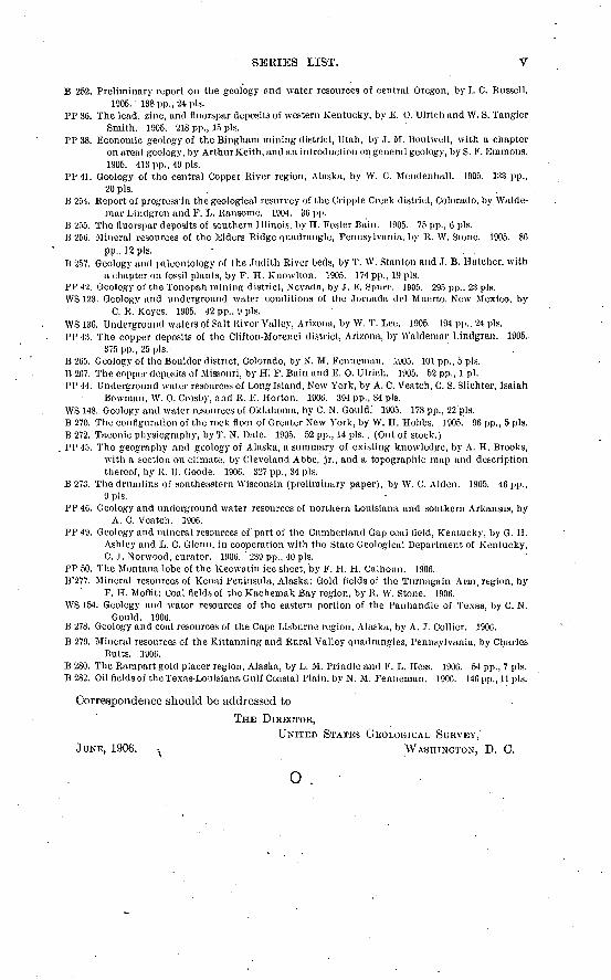
SBEIES LIST. V
B 252. Preliminary report on the geology and water resources of central Oregon, by I. C. Russell.1905. 138 pp., 24 pis.
PP 36. The lead, zinc, and fluorspar deposits of western Kentucky, by E. 0. Ulrich and W. S. TangierSmith. 1905. 218 pp., 15 pis.
PP 38. Economic geology of the Bingham mining district, Utah, by J. M. Boutwell, with a chapteron area! geology, by Arthur Keith, and an introduction on general geology, by S. F. Emmons.1905. 413 pp., 49 pis.
PP41. Geology of the central Copper River region, Alaska, by W. C. Mendenhall. 1905. 133 pp.,20 pis.
B 254. Report of-progress in the geological resurvey of the Cripple Creek district, Colorado, by Walde-mar Lindgren and F. L. Ransome. 1904. 36 pp.
B 255. The fluorspar deposits of southern Illinois, by H. Foster Bain. 1905. 75pp., 6 pis. B 256. Mineral resources of the Elders Ridge quadrangle, Pennsylvania, by R. W. Stone. 3905. 86
pp., 12 pis. ' . . B 257. Geology and paleontology of the Judith River beds, by T. W. Stanlon and J. B. Hatcher, with
a chapter on fossil plants, by F. H. Knowlton. 1905. 174 pp., 19 pis.PP 42. Geology of the Tonopah mining district, Nevada, by J. E. Spnrr. ]905. 295 pp., 23 pis. WS 123. Geology and underground water conditions of the Jornada del Muerto, New Mexico, by
C. R. Keyes. 1905. 42 pp., 9 pis.WS 130. Underground waters of Salt River Valley, Arizona, by W. T. Lee. 1905. 194 pp., 24 pis. PP43. The copper deposits of the Clifton-Morenci district, Arizona, by Waldemar Lindgren. 1905.
375 pp., 25 pis.B 265. Geology of the Boulder district, Colorado, by N. M. Fenneman. 1905. 101 pp., 5 pis. B 267. The copper deposits of Missouri, by H! F. Bain and E. 0. Ulrich. 1905. 52 pp., 1 pi. PP 44. Underground water resources of Long Island, New York, by A. C. Veatch, C. S. Slichter, Isaiah
Bowman, W. 0. Crosby, and R. E. Horton. 1906. 394 pp., 34 pis..WS 148. Geology and water resources of Oklahoma, by C. N. Gould.' 1905. 178 pp., 22 pis. B 270. The configuration of the rock floor of Greater New York, by W. H. Hobbs. 1905. 96 pp., 5 pis. B 272. Taconic physiography, by T. N. Dale. 1905. 52 pp., 14 pis. . (Out of stock.)
. PP 45. The geography and geology of Alaska, a summary of existing knowledge, by A. H. Brooks,with a section on climate, by Cleveland Abbe, jr., and a topographic map and descriptionthereof, by R. U. Goode. 1906. 327 pp., 34 pis.
B 273. The drumlins of southeastern Wisconsin (preliminary paper), by W. C. Alden. 1905. 46 pp.,9 pis.
PP 46. Geology and underground water resources of northern Louisiana and southern Arkansas, byA. C. Veatch. 1906.
PP 49. Geology and mineral resources of part of the Cumberland Gap coal field, Kentucky, by G. H.Ashley and L. C. Glenn, in cooperation with the State Geological Department of Kentucky,C. J. Norwood, curator. 1906. 239 pp., 40 pis.
PP 50. The Montana lobe of the Keewatin ice sheet, by F. H. H. Calhoun. 1906. B'277. Mineral resources of Keuai Peninsula, Alaska: Gold fields of the Tur.nagain Arm,region, by
F. H. Moflit; Coal fields of the Kachemak Bay region, by R. W. Stone. 1906. WS 154. Geology and water resources of the eastern portion of the Panhandle of Texas, by C. N.
Gould. 1906. B 278. Geology and coal resources of the Cape Lisburne region, Alaska, by A. ,T. Collier. 1906.B 279. Mineral resources of the Kittanning and Rural Valley quadrangles, Pennsylvania, by Charles .
Butts. :1906.B 280. The Rampart gold placer region, Alaska, by L. M. Prindle and F. L. Hess. 1906. 54 pp., 7 pis. B 282. Oil fields of the Texas-Louisiana Gulf Coastal Plain, by N. M. Fenneman. 1906. 146 pp., 11 pis.
Correspondence should be addressed to
THE DIRECTOR,UNITEJ> STATES GEOLOGICAL SURVEY,'
JUNE, 1906. ^ WASHINGTON, D. C.
o .
Related Documents