ISSN 1916-6117 [online] ISSN 0826-9580 [print] ISBN 978-1-4435-1414-9 [PDF] ISBN 978-1-4435-1413-2 [print] (for entire OFR 6240) (for entire OFR 6240) THESE TERMS GOVERN YOUR USE OF THIS DOCUMENT Your use of this Ontario Geological Survey document (the “Content”) is governed by the terms set out on this page (“Terms of Use”). By downloading this Content, you (the “User”) have accepted, and have agreed to be bound by, the Terms of Use. Content: This Content is offered by the Province of Ontario’s Ministry of Northern Development, Mines and Forestry (MNDMF) as a public service, on an “as-is” basis. Recommendations and statements of opinion expressed in the Content are those of the author or authors and are not to be construed as statement of government policy. You are solely responsible for your use of the Content. You should not rely on the Content for legal advice nor as authoritative in your particular circumstances. Users should verify the accuracy and applicability of any Content before acting on it. MNDMF does not guarantee, or make any warranty express or implied, that the Content is current, accurate, complete or reliable. MNDMF is not responsible for any damage however caused, which results, directly or indirectly, from your use of the Content. MNDMF assumes no legal liability or responsibility for the Content whatsoever. Links to Other Web Sites: This Content may contain links, to Web sites that are not operated by MNDMF. Linked Web sites may not be available in French. MNDMF neither endorses nor assumes any responsibility for the safety, accuracy or availability of linked Web sites or the information contained on them. The linked Web sites, their operation and content are the responsibility of the person or entity for which they were created or maintained (the “Owner”). Both your use of a linked Web site, and your right to use or reproduce information or materials from a linked Web site, are subject to the terms of use governing that particular Web site. Any comments or inquiries regarding a linked Web site must be directed to its Owner. Copyright: Canadian and international intellectual property laws protect the Content. Unless otherwise indicated, copyright is held by the Queen’s Printer for Ontario. It is recommended that reference to the Content be made in the following form: Brunton, F.R. 2009. Update of revisions to the Early Silurian stratigraphy of the Niagara Escarpment: integration of sequence stratigraphy, sedimentology and hydrogeology to delineate hydrogeologic units; in Summary of Field Work and Other Activities 2009, Ontario Geological Survey, Open File Report 6240, p.25-1 to 25-20. Use and Reproduction of Content: The Content may be used and reproduced only in accordance with applicable intellectual property laws. Non-commercial use of unsubstantial excerpts of the Content is permitted provided that appropriate credit is given and Crown copyright is acknowledged. Any substantial reproduction of the Content or any commercial use of all or part of the Content is prohibited without the prior written permission of MNDMF. Substantial reproduction includes the reproduction of any illustration or figure, such as, but not limited to graphs, charts and maps. Commercial use includes commercial distribution of the Content, the reproduction of multiple copies of the Content for any purpose whether or not commercial, use of the Content in commercial publications, and the creation of value-added products using the Content. Contact: FOR FURTHER INFORMATION ON PLEASE CONTACT: BY TELEPHONE: BY E-MAIL: The Reproduction of the EIP or Content MNDMF Publication Services Local: (705) 670-5691 Toll Free: 1-888-415-9845, ext. 5691 (inside Canada, United States) [email protected] The Purchase of MNDMF Publications MNDMF Publication Sales Local: (705) 670-5691 Toll Free: 1-888-415-9845, ext. 5691 (inside Canada, United States) [email protected] Crown Copyright Queen’s Printer Local: (416) 326-2678 Toll Free: 1-800-668-9938 (inside Canada, United States) [email protected]

Welcome message from author
This document is posted to help you gain knowledge. Please leave a comment to let me know what you think about it! Share it to your friends and learn new things together.
Transcript
ISSN 1916-6117 [online] ISSN 0826-9580 [print] ISBN 978-1-4435-1414-9 [PDF] ISBN 978-1-4435-1413-2 [print] (for entire OFR 6240) (for entire OFR 6240)
THESE TERMS GOVERN YOUR USE OF THIS DOCUMENT
Your use of this Ontario Geological Survey document (the “Content”) is governed by the terms set out on this page (“Terms of Use”). By downloading this Content, you (the “User”) have
accepted, and have agreed to be bound by, the Terms of Use.
Content: This Content is offered by the Province of Ontario’s Ministry of Northern Development, Mines and Forestry (MNDMF) as a public service, on an “as-is” basis. Recommendations and statements of opinion expressed in the Content are those of the author or authors and are not to be construed as statement of government policy. You are solely responsible for your use of the Content. You should not rely on the Content for legal advice nor as authoritative in your particular circumstances. Users should verify the accuracy and applicability of any Content before acting on it. MNDMF does not guarantee, or make any warranty express or implied, that the Content is current, accurate, complete or reliable. MNDMF is not responsible for any damage however caused, which results, directly or indirectly, from your use of the Content. MNDMF assumes no legal liability or responsibility for the Content whatsoever. Links to Other Web Sites: This Content may contain links, to Web sites that are not operated by MNDMF. Linked Web sites may not be available in French. MNDMF neither endorses nor assumes any responsibility for the safety, accuracy or availability of linked Web sites or the information contained on them. The linked Web sites, their operation and content are the responsibility of the person or entity for which they were created or maintained (the “Owner”). Both your use of a linked Web site, and your right to use or reproduce information or materials from a linked Web site, are subject to the terms of use governing that particular Web site. Any comments or inquiries regarding a linked Web site must be directed to its Owner. Copyright: Canadian and international intellectual property laws protect the Content. Unless otherwise indicated, copyright is held by the Queen’s Printer for Ontario. It is recommended that reference to the Content be made in the following form:
Brunton, F.R. 2009. Update of revisions to the Early Silurian stratigraphy of the Niagara Escarpment: integration of sequence stratigraphy, sedimentology and hydrogeology to delineate hydrogeologic units; in Summary of Field Work and Other Activities 2009, Ontario Geological Survey, Open File Report 6240, p.25-1 to 25-20.
Use and Reproduction of Content: The Content may be used and reproduced only in accordance with applicable intellectual property laws. Non-commercial use of unsubstantial excerpts of the Content is permitted provided that appropriate credit is given and Crown copyright is acknowledged. Any substantial reproduction of the Content or any commercial use of all or part of the Content is prohibited without the prior written permission of MNDMF. Substantial reproduction includes the reproduction of any illustration or figure, such as, but not limited to graphs, charts and maps. Commercial use includes commercial distribution of the Content, the reproduction of multiple copies of the Content for any purpose whether or not commercial, use of the Content in commercial publications, and the creation of value-added products using the Content. Contact:
FOR FURTHER INFORMATION ON PLEASE CONTACT: BY TELEPHONE: BY E-MAIL:
The Reproduction of the EIP or Content
MNDMF Publication Services
Local: (705) 670-5691 Toll Free: 1-888-415-9845, ext. 5691
(inside Canada, United States) [email protected]
The Purchase of MNDMF Publications
MNDMF Publication Sales
Local: (705) 670-5691 Toll Free: 1-888-415-9845, ext. 5691
(inside Canada, United States) [email protected]
Crown Copyright Queen’s Printer Local: (416) 326-2678 Toll Free: 1-800-668-9938
(inside Canada, United States) [email protected]
Summary of Field Work and Other Activities 2009, Ontario Geological Survey, Open File Report 6240, p.25-1 to 25-20. © Queen’s Printer for Ontario, 2009
25-1
25. Project Unit 08-004. Update of Revisions to the Early Silurian Stratigraphy of the Niagara Escarpment: Integration of Sequence Stratigraphy, Sedimentology and Hydrogeology to Delineate Hydrogeologic Units
F.R. Brunton1 1Sedimentary Geoscience Section, Ontario Geological Survey
INTRODUCTION
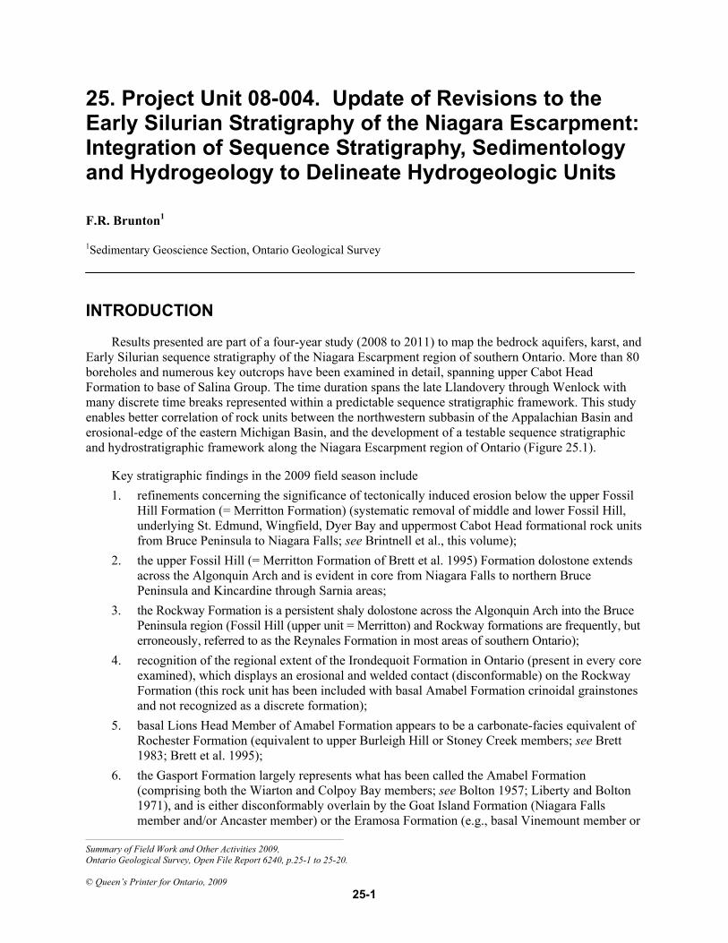
Results presented are part of a four-year study (2008 to 2011) to map the bedrock aquifers, karst, and Early Silurian sequence stratigraphy of the Niagara Escarpment region of southern Ontario. More than 80 boreholes and numerous key outcrops have been examined in detail, spanning upper Cabot Head Formation to base of Salina Group. The time duration spans the late Llandovery through Wenlock with many discrete time breaks represented within a predictable sequence stratigraphic framework. This study enables better correlation of rock units between the northwestern subbasin of the Appalachian Basin and erosional-edge of the eastern Michigan Basin, and the development of a testable sequence stratigraphic and hydrostratigraphic framework along the Niagara Escarpment region of Ontario (Figure 25.1).
Key stratigraphic findings in the 2009 field season include 1. refinements concerning the significance of tectonically induced erosion below the upper Fossil
Hill Formation (= Merritton Formation) (systematic removal of middle and lower Fossil Hill, underlying St. Edmund, Wingfield, Dyer Bay and uppermost Cabot Head formational rock units from Bruce Peninsula to Niagara Falls; see Brintnell et al., this volume);
2. the upper Fossil Hill (= Merritton Formation of Brett et al. 1995) Formation dolostone extends across the Algonquin Arch and is evident in core from Niagara Falls to northern Bruce Peninsula and Kincardine through Sarnia areas;
3. the Rockway Formation is a persistent shaly dolostone across the Algonquin Arch into the Bruce Peninsula region (Fossil Hill (upper unit = Merritton) and Rockway formations are frequently, but erroneously, referred to as the Reynales Formation in most areas of southern Ontario);
4. recognition of the regional extent of the Irondequoit Formation in Ontario (present in every core examined), which displays an erosional and welded contact (disconformable) on the Rockway Formation (this rock unit has been included with basal Amabel Formation crinoidal grainstones and not recognized as a discrete formation);
5. basal Lions Head Member of Amabel Formation appears to be a carbonate-facies equivalent of Rochester Formation (equivalent to upper Burleigh Hill or Stoney Creek members; see Brett 1983; Brett et al. 1995);
6. the Gasport Formation largely represents what has been called the Amabel Formation (comprising both the Wiarton and Colpoy Bay members; see Bolton 1957; Liberty and Bolton 1971), and is either disconformably overlain by the Goat Island Formation (Niagara Falls member and/or Ancaster member) or the Eramosa Formation (e.g., basal Vinemount member or
Sedimentary Geoscience Section (25) F.R. Brunton
25-2
Reformatory Quarry member) or the Guelph Formation, thereby highlighting the significance of the erosion above the surface of the Gasport Formation;
7. the Eramosa is a regionally persistent and faunally and/or lithologically distinctive rock unit (possessing a distinctive seismite bed). The regional scope of this study has demonstrated that, because of this region-wide identification, the status of the Eramosa lithofacies as a formation should be acknowledged more generally. As done previously (see Brunton 2008), this paper will refer to those lithofacies assigned to the Eramosa interval as the “Eramosa Formation”. The author will formally propose the redefinition of formation rank for Eramosa lithofacies in a future publication (refereed journal article).
8. revisions to the contact between the Eramosa and Guelph rock units and recognition of 3 previously unrecognized members of the Eramosa Formation (base to top: Vinemount member, Reformatory Quarry member and Stone Road member; see Brunton 2008);
9. recognition of 2 informal rock units in the Guelph Formation (basal reef mound-bearing Wellington member and overlying megalodontid bivalve-gastropod-dominated Hanlon member).
Figure 25.1. Silurian paleogeography relative to the present-day erosional boundaries of key foreland (Appalachian) versus intracratonic (Michigan) basins of eastern North America. The red lines depict present-day erosional boundaries of the Michigan, Appalachian and Ohio basins in relation to the arches (areas where forebulge migration and development were influencing sedimentation between the basins on broad shallow shelf areas) (modified from Haynes 2000). The stratigraphic succession of interest for this multi-year bedrock mapping project is upper Cabot Head through Guelph formations. These strata represent mostly dolostones with minor noncalcareous and calcareous shales. The mounds depicted in the stratigraphic column represent phases of composite reef mound development within the transgressive systems tracts (TSTs) of the succession. Proposed stratigraphic revisions shown include the Gasport Formation (comprising the Wiarton and Colpoy Bay members of the Amabel Formation). The blue and salmon colours for the Goat Island Formation represent the Niagara Falls member and the Ancaster member, respectively. The lines shown within the Eramosa and Guelph formations depict newly recognized members within type sections (see text). Michigan Basin subsurface terms for this stratigraphic interval are highlighted with arrows on left side of the stratigraphic section. Rock units that make up the Amabel Formation are also shown (white vertical line with arrows) and highlight the need to abandon this rock term in southern Ontario.
Sedimentary Geoscience Section (25) F.R. Brunton
25-3
A regional drilling program is currently underway to better constrain whether some of the members outlined for the Eramosa Formation may be of formational rank (e.g., Stone Road member). The recognition of very significant erosional phases above the Gasport and Guelph formations, 2 surfaces which strongly influence the hydrostratigraphic character of the Niagara Escarpment cuesta, is being followed up with the drilling program of more than 25 cored holes being collected this fall along the Niagara Escarpment subcrop–outcrop belt. This work is a collaborative effort between the Ontario Geological Survey, City of Guelph, Regional Municipality of Waterloo, Halton Region, City of Hamilton, University of Guelph, Parks Canada and Ministry of Natural Resources.
This project is the first attempt by the Ontario Geological Survey (OGS) to systematically map and delineate discrete bedrock aquifers and aquitards within Silurian carbonate strata along the Niagara Escarpment region of southern Ontario (Niagara Falls to Tobermory and Manitoulin Island). The foundation of such studies is the development of a robust and testable sequence stratigraphic and structural framework that integrates vertical and lateral changes in the physical character of the sedimentary rocks. Detailed lithogeochemical analyses of the stratigraphic succession (whole rock and trace element geochemistry on metre scale) can then be compared to the hydrochemical character of the water-bearing rock units in order to define discrete hydrogeologic units (HGUs). Such an approach requires acquisition of detailed head profiles and hydrochemistry relative to the sequence stratigraphic and lithogeochemical framework.
Detailed core logging, in combination with hydrogeological and lithogeochemical measurements, allows regional-scale aquitards and aquifers to be delineated. Such data can then be placed into a regional groundwater flow model that takes into account the major recharge and discharge areas. Compilation of these data provides the foundation to assess the sustainability of these vital resources as southern Ontario’s population continues to grow and global pressures for water sharing increase. It is a little known fact that the majority of families in southern Ontario on private water wells and municipal water supplies rely on karst-influenced carbonate bedrock aquifers (Brunton and Dodge 2008; Brunton 2008). Provincial estimates of current usage and bedrock aquifer capacities are poorly constrained because no systematic studies have been carried out to date.
The key goals of the 2009 field season have been to integrate core and outcrop stratigraphic and sedimentologic measurements to establish a testable sequence stratigraphic framework for Early Silurian sedimentary carbonate strata in the vicinity of Hamilton–Halton through Guelph–Cambridge and eastern Kitchener–Waterloo and northward along the spine of the Niagara Escarpment to Tobermory and westward into the Michigan Basin region to Kincardine and Sarnia. These strata occur between the upper Cabot Head Formation shales (regional aquitard of Niagara Escarpment) and overlying Salina Group algal laminites and gypsiferous sabkha cycles. This interval includes strata that span the upper Medina, Clinton and Lockport groups of western New York and extending into southwestern Ontario from Niagara Falls to Hamilton (Brett, Goodman and LoDuca 1990; Brett et al. 1995). This project incorporates and builds upon the major revisions to Early Silurian strata nomenclature and lithologic descriptions outlined in Brett et al. (1995).
The average depth of the holes drilled as part of this study is 120 m. In the majority of the cored holes, downhole geophysics in the form of gamma, conductivity and optical televiewer logs, camera logs and standard hydrogeologic investigations (pumping and packer testing) have been carried out to provide a more comprehensive picture of the groundwater character in these Silurian strata (see Brunton 2008). The current drilling program (September–October 2009) of at least 16, 100 to 140 m deep HQ-diameter drill holes builds upon the more than 100 holes that have been used to create the three-dimensional geologic framework for Tier III groundwater modelling being undertaken by the City of Guelph and Regional Municipality of Waterloo (funded by the Ministry of Environment and Ministry of Natural Resources). Key additional drill core and outcrop sections were measured from Niagara Falls to Tobermory (Figure 25.2) and Manitoulin Island to provide a regional context to the newly proposed sequence stratigraphic framework.
Sedimentary Geoscience Section (25) F.R. Brunton
25-4
BACKGROUND AND SCOPE OF STUDY
This regional-scale groundwater mapping initiative builds upon previous studies concerning the industrial mineral potential of the Guelph and Eramosa formations (see Brunton and Dekeyser 2004; Brunton, Dekeyser and Coniglio 2005), as well as karst and groundwater in southern Ontario (Brunton, Dodge and Shirota 2005, 2006; Brunton et al. 2007; Brunton and Dodge 2008; Brunton 2008). In order to map out regional hydrogeologic units (HGUs) within Paleozoic sedimentary rocks of southern Ontario,
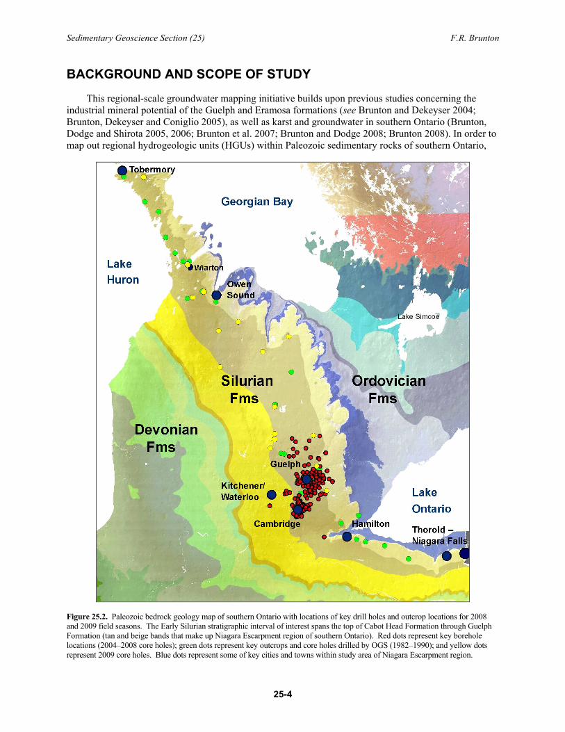
Figure 25.2. Paleozoic bedrock geology map of southern Ontario with locations of key drill holes and outcrop locations for 2008 and 2009 field seasons. The Early Silurian stratigraphic interval of interest spans the top of Cabot Head Formation through Guelph Formation (tan and beige bands that make up Niagara Escarpment region of southern Ontario). Red dots represent key borehole locations (2004–2008 core holes); green dots represent key outcrops and core holes drilled by OGS (1982–1990); and yellow dots represent 2009 core holes. Blue dots represent some of key cities and towns within study area of Niagara Escarpment region.
Sedimentary Geoscience Section (25) F.R. Brunton
25-5
a detailed understanding of the sequence stratigraphy and lithofacies changes from the northwestern Appalachian to southeastern Michigan basins is required. Other key factors include the delineation of recharge and discharge areas, roles of various strata (sequences and smaller scale rock units) as aquifers and aquitards, and integration of hydrochemistry and lithogeochemistry. The integration of hydrochemistry and lithogeochemistry requires collaboration and implementation of innovative water-well sampling techniques (see Brunton 2008).
PROPOSED REVISIONS TO THE SILURIAN STRATIGRAPHY OF THE NIAGARA ESCARPMENT
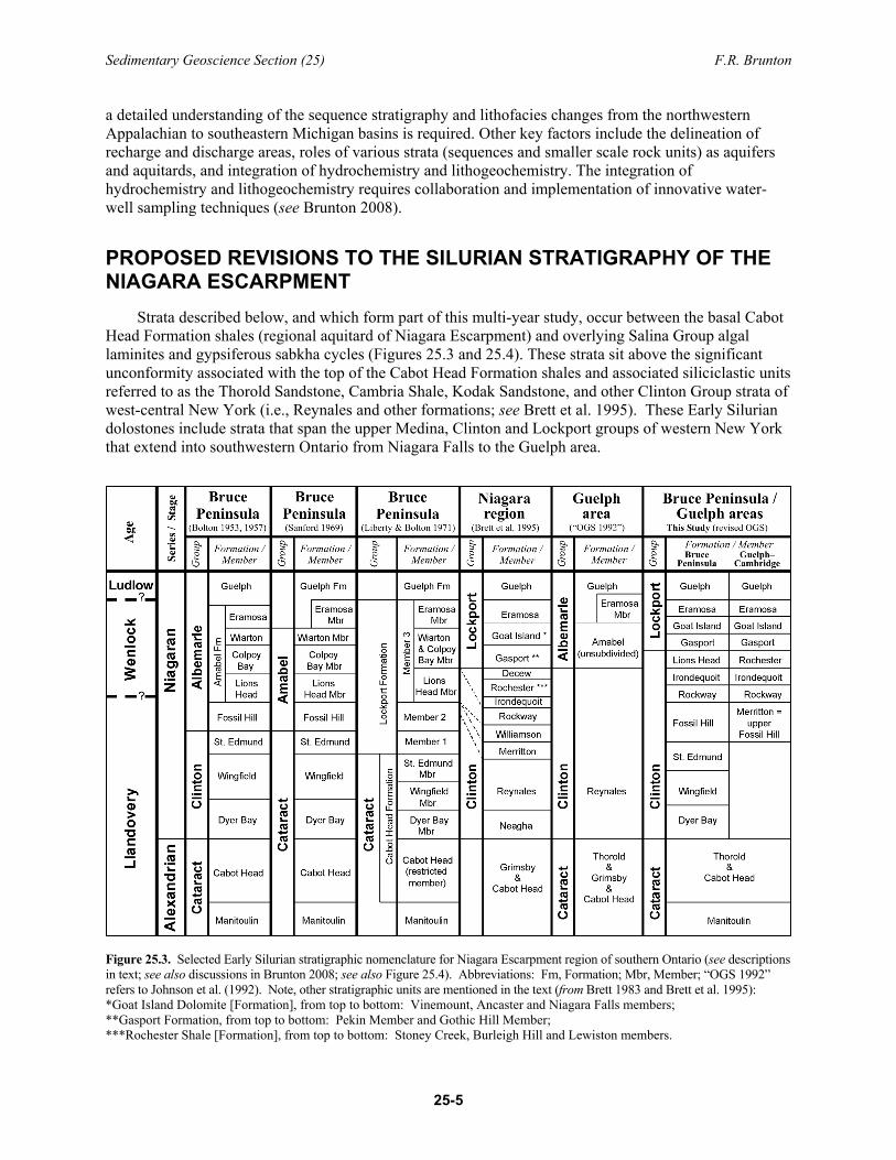
Strata described below, and which form part of this multi-year study, occur between the basal Cabot Head Formation shales (regional aquitard of Niagara Escarpment) and overlying Salina Group algal laminites and gypsiferous sabkha cycles (Figures 25.3 and 25.4). These strata sit above the significant unconformity associated with the top of the Cabot Head Formation shales and associated siliciclastic units referred to as the Thorold Sandstone, Cambria Shale, Kodak Sandstone, and other Clinton Group strata of west-central New York (i.e., Reynales and other formations; see Brett et al. 1995). These Early Silurian dolostones include strata that span the upper Medina, Clinton and Lockport groups of western New York that extend into southwestern Ontario from Niagara Falls to the Guelph area.
Figure 25.3. Selected Early Silurian stratigraphic nomenclature for Niagara Escarpment region of southern Ontario (see descriptions in text; see also discussions in Brunton 2008; see also Figure 25.4). Abbreviations: Fm, Formation; Mbr, Member; “OGS 1992” refers to Johnson et al. (1992). Note, other stratigraphic units are mentioned in the text (from Brett 1983 and Brett et al. 1995): *Goat Island Dolomite [Formation], from top to bottom: Vinemount, Ancaster and Niagara Falls members; **Gasport Formation, from top to bottom: Pekin Member and Gothic Hill Member; ***Rochester Shale [Formation], from top to bottom: Stoney Creek, Burleigh Hill and Lewiston members.
Sedimentary Geoscience Section (25) F.R. Brunton
25-6
This project incorporates and builds upon the major revisions to Early Silurian stratigraphic nomenclature and lithologic descriptions outlined in Brett et al. (1995). The nomenclature adopted below for the Early Silurian stratigraphy of southern Ontario differs from that outlined in the Geology of Ontario volume (Johnson et al. 1992) and recent updates of the Paleozoic stratigraphy of southern Ontario (Armstrong and Carter 2006, p.17; Armstrong and Dodge 2007). The significant differences between the overall stratigraphic nomenclature outlined by Brett et al. (1995) and that of this study include recognition
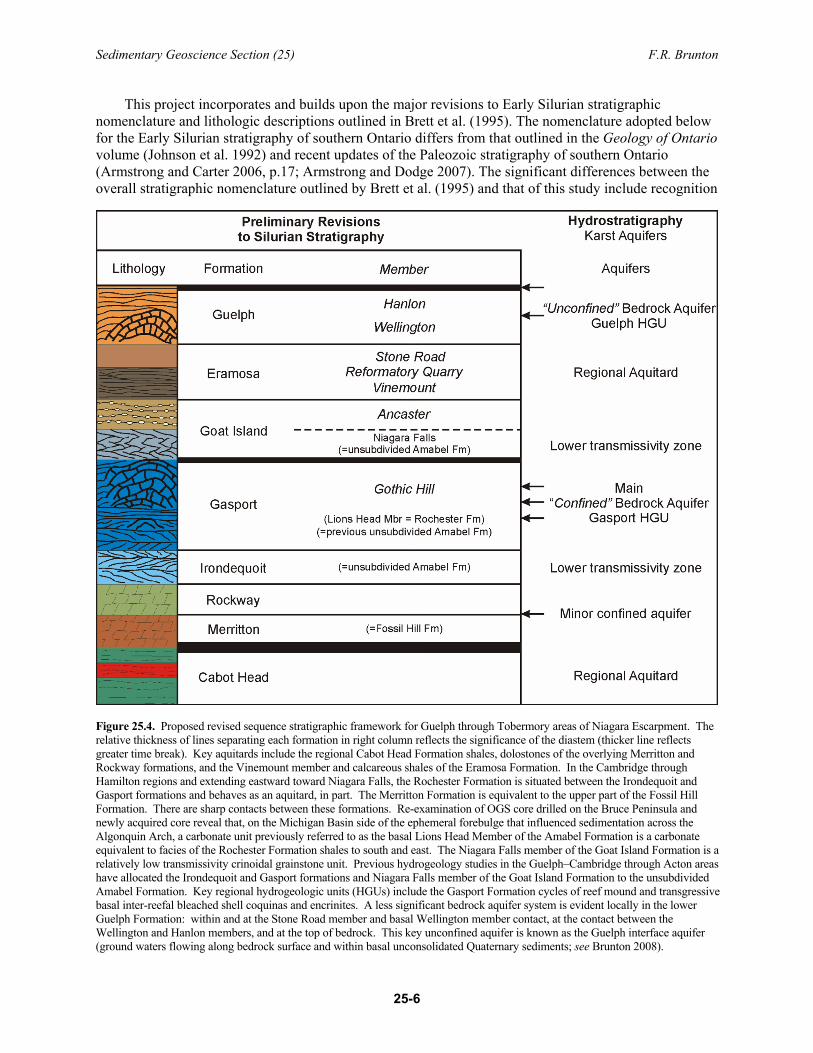
Figure 25.4. Proposed revised sequence stratigraphic framework for Guelph through Tobermory areas of Niagara Escarpment. The relative thickness of lines separating each formation in right column reflects the significance of the diastem (thicker line reflects greater time break). Key aquitards include the regional Cabot Head Formation shales, dolostones of the overlying Merritton and Rockway formations, and the Vinemount member and calcareous shales of the Eramosa Formation. In the Cambridge through Hamilton regions and extending eastward toward Niagara Falls, the Rochester Formation is situated between the Irondequoit and Gasport formations and behaves as an aquitard, in part. The Merritton Formation is equivalent to the upper part of the Fossil Hill Formation. There are sharp contacts between these formations. Re-examination of OGS core drilled on the Bruce Peninsula and newly acquired core reveal that, on the Michigan Basin side of the ephemeral forebulge that influenced sedimentation across the Algonquin Arch, a carbonate unit previously referred to as the basal Lions Head Member of the Amabel Formation is a carbonate equivalent to facies of the Rochester Formation shales to south and east. The Niagara Falls member of the Goat Island Formation is a relatively low transmissivity crinoidal grainstone unit. Previous hydrogeology studies in the Guelph–Cambridge through Acton areas have allocated the Irondequoit and Gasport formations and Niagara Falls member of the Goat Island Formation to the unsubdivided Amabel Formation. Key regional hydrogeologic units (HGUs) include the Gasport Formation cycles of reef mound and transgressive basal inter-reefal bleached shell coquinas and encrinites. A less significant bedrock aquifer system is evident locally in the lower Guelph Formation: within and at the Stone Road member and basal Wellington member contact, at the contact between the Wellington and Hanlon members, and at the top of bedrock. This key unconfined aquifer is known as the Guelph interface aquifer (ground waters flowing along bedrock surface and within basal unconsolidated Quaternary sediments; see Brunton 2008).
Sedimentary Geoscience Section (25) F.R. Brunton
25-7
that 1) the Irondequoit Formation, which belongs to the Clinton Group and extends across the Algonquin Arch and throughout southern Ontario, has been erroneously lumped into the basal Amabel Formation; 2) the Lions Head member of the basal Amabel Formation is actually a carbonate equivalent of part of the Rochester Formation (and not equivalent to the Rockway Formation as outlined in Brett et al. (1995) and as stated in Brunton (2008)); 3) the Vinemount Shale Beds (or Vinemount beds; referred to herein as Vinemount member), which were placed in the upper Goat Island Formation by Brett et al. (1995), better correlate with lithofacies assigned to the Eramosa Formation throughout southern Ontario; and 4) the Eramosa Formation has 3 previously unrecognized units that could be all assigned member status. The Guelph Formation also comprises 2 mappable units that have been assigned member names (see Figure 25.4). Some key details are outlined below.
Fossil Hill Formation (= Merritton Formation, in part) The type section for the Fossil Hill Formation is located on Manitoulin Island in a roadcut at the
intersection of Highway 6 and New England Road, approximately 10 km southwest of Manitowaning (Bolton 1953, 1957; Winder 1961). Williams (1919, 1937) referred to this rock unit as the Lockport. This unit can be separated into lower, middle and upper parts based on faunal components and lithofacies. There are, in fact, at least 4 significant erosional breaks or small-scale sequence boundary surfaces evident in the type section. The lower unit possesses a brachiopod-rich succession with large pentamerid brachiopods in condensed beds, suggesting low sedimentation rates. The lower one-third to middle part of the formation, as revealed in the type section on Highway 6, consists of poorly fossiliferous lime mudstone to wackestone and superficially resembles the underlying St. Edmund or Mindemoya Formation (termed the “false Mindemoya”). This “false Mindemoya” or St. Edmund Formation lithofacies is present in the northern cores on the Bruce Peninsula and thickens northward to the type section on Manitoulin Island. Hard grounds are present in this unit. The upper one-third of the Fossil Hill Formation shows a return to richly fossiliferous brachiopod beds of Pentameroides (not Pentamerus) and an abundant megafauna of tabulate corals and calcified sponges and related faunas. No bioherms have been described from this unit. The condensed nature and taphonomic character of the fauna in core indicates palimpsest conditions and a slow sedimentation rate. There are at least 4 significant disconformities in the Fossil Hill Formation at its type section on Manitoulin Island (see also Stott and von Bitter 1999).
The Fossil Hill Formation is very cherty and well indurated, which partly accounts for its regionally extensive nature. It is present from northern Michigan (where it is also known as the Manistique Formation) to Niagara Falls, where it is referred to as the Merritton Formation (Brett et al. 1995; Brunton 2008). Other good exposures of the Fossil Hill Formation are located on the Bruce Peninsula, on the shore of Isthmus Bay, just north of the village of Lion’s Head, and in a roadcut near Inglis Falls, just south of Owen Sound (Bolton 1957; Liberty and Bolton 1971; Armstrong, Goodman and Coniglio 2002; Armstrong and Carter 2006; Armstrong and Dodge 2007; see also Brintnell et al., this volume, Figure 26.1).
The Fossil Hill Formation in southern Ontario is everywhere disconformably overlain by the Rockway Formation (see discussion below) from the northern Bruce Peninsula to Niagara Falls. In general, the Pentameroides-dominated facies of the upper Fossil Hill Formation seems to be a regionally persistent rock unit. Of equal significance is the fact that the Irondequoit Formation is a persistent, thoroughly bioturbated crinoidal grainstone to packstone lithofacies that is present from Tobermory to Kincardine and in cores from the Chatham Sag area to Niagara Falls (Brunton et al. 2009; Brunton, Turner and Armstrong 2009).
The upper Fossil Hill (= Merritton) Formation rests disconformably above the Cabot Head Formation shale in cores from the Guelph area. This upper Fossil Hill Formation rock unit was originally identified as a member of the Reynales Formation (Kilgour 1963), which has produced some confusion in nomenclature. Strata referred to as the Merritton Formation (= upper Fossil Hill Formation) are generally less than a metre thick and appear to thin to the east, toward the present-day cuesta margin. This rock unit
Sedimentary Geoscience Section (25) F.R. Brunton
25-8
is thicker in some cores in Guelph than at the type section in Thorold. It possesses the same pentamerid brachiopods and tabulates as the Fossil Hill Formation and is, therefore, correlated with that formation. It has been previously incorrectly assigned to the lower Reynales Formation of New York State, which is much older (Brett et al. 1995, p.31-34).
From the Luther Lake–Mount Forest area to Niagara Falls, this distinctive formation comprises up to 3 well-indurated beds of unequal thickness that are separated by dark, shaly partings (upper Fossil Hill Formation = Merritton Formation). The basal bed has a distinctive, bioturbated, pinkish-brown finely crystalline matrix. It possesses a black, phosphate pebble-bearing hardground unit in the lower beds. The middle bed possesses Planolites-type burrows, which locally contain glauconite, and the lower beds are rich in pyrite. The lower beds are wackestones, whereas the upper bed exhibits pentamerids (Pentameroides subrectus) and halysitid and favositid corals typical of the upper Fossil Hill Formation. The uppermost, brachiopod-rich beds are rarely evident in core from the Guelph region.
This formation acts as a regional aquitard that enables waters to remain above the Cabot Head Formation shales and reside in the overlying karstic Gasport Formation aquifer (Gasport hydrogeologic unit). If the Merritton Formation were not present in the Guelph–Cambridge region, formational waters would most likely flow along the upper Cabot Head shale aquitard and the City of Guelph region would not have one of the best karst-influenced bedrock aquifers in southern Ontario. This formation thickens northwestwardly to its type section on Manitoulin Island.
Rockway Formation The Rockway Formation was originally assigned to the lower member of the Irondequoit Formation
(Kilgour 1963). It was subsequently elevated to formational status with the recognition that it had an unconformable contact with the overlying crinoidal dolostones in the Irondequoit Formation (see Brett et al. 1995). This formation possesses a distinctive, greenish-grey fine crystalline matrix separated by styloseam sets and thin shaly partings. It is an argillaceous dolomicrite to wackestone with no discernible macrofaunal elements. The Rockway Formation has a fairly consistent thickness of 1 to 2 m throughout the study area and, unlike the underlying Merritton Formation, is present in every core. It has a very distinctive and erosional contact with the overlying Irondequoit crinoidal grainstone unit, making it easy to delineate in the core. This contact is best described as “welded”, and its distinctive character in every core within the Guelph region proves the existence of a widespread disconformity, but not highly erosional contact, between the Rockway and Irondequoit formations. The Rockway Formation persists north of Hamilton, across the Algonquin Arch, and is present in every core examined from the Sarnia area through Kincardine to Tobermory and down the Niagara Escarpment cuesta region. The lack of significant change in the overall thicknesses of the upper Fossil Hill (= Merritton) and Rockway formations from the northern Appalachian to eastern Michigan Basin regions suggests that the Algonquin Arch did not influence regional sedimentation patterns during this time interval and that erosional phases were subdued prior to the transgressive phases that enabled deposition of the crinoidal shoal facies of the Irondequoit Formation.
Irondequoit Formation (= basal unit of unsubdivided Amabel Formation) The Irondequoit Formation is a crinoidal grainstone to packstone unit that possesses a fairly consistent
thickness of approximately 3 m throughout the study area. It is a thick- to medium-bedded, medium grey to pinkish-grey, buff-weathering, dolomitic, brachiopod-rich encrinite. It possesses distinctive stylolites and thin styloseams sets reflecting short-lived time breaks. These styloseam sets and stylolites possess secondary pyrite, gypsum and pyrolusite in virtually every core in the Guelph area. These secondary mineral phases are a common feature of the Irondequoit Formation (see Brett et al. 1995). Encrinitic units may be separated by thin, greenish-grey argillaceous and micritic intraclasts. Intraclasts from the underlying Rockway Formation can be seen in the basal beds of the Irondequoit Formation above the welded contact.
Sedimentary Geoscience Section (25) F.R. Brunton
25-9
This fine- to medium-crystalline encrinite-dominated package has been incorrectly assigned to the lower Amabel Formation (see Figure 25.4). It has been described as a low transmissivity zone of the lower Amabel Formation. The Irondequoit Formation rests disconformably below the overlying Gasport Formation with no Rochester Formation shales separating the 2 units (i.e., from just north of the Highway 401 through Guelph area). This upper contact is cryptic in nature and its exact position is difficult to assign from core to core. The most consistent features are a drastic increase in crinoid pluricolumnal size and associated increase in crystallinity and matrix colour and texture from Irondequoit Formation to Gasport Formation lithofacies due to the introduction of new and much larger crinoidal faunas.
Rochester Formation None of the cores in the Guelph region possess Rochester Formation shale lithofacies, demonstrating
that variable episodic erosion of this rock unit had occurred, from northwestern New York State into southern Ontario, because of episodic movements in the forebulge, which resulted in cannibalization of unlithified or poorly lithified sedimentary units through time. The Rochester Formation pinches out just north of Hamilton and Cambridge, where it is approximately 1 m thick. Therefore, it does not act as a regional aquitard as observed in the hydrogeology investigations of the Niagara Escarpment between Niagara Falls and Hamilton (see Yager 1997, 2000). Details of the members of the Rochester Formation are outlined in Brett (1983) and Brett et al. (1995). Pinch-out of the Rochester Formation is partly a function of westward thinning of the siliciclastic lithofacies. However, near Hamilton, contacts within and at the top of the Rochester Formation clearly become erosional. Episodic uplift of the forebulge apparently resulted in cannibalization of unlithified or poorly lithified mixed calcareous–terrigenous muds and silts of this unit.
One of the most significant stratigraphic relationships discerned in the 2009 field season is that the Lions Head Member of the Amabel Formation (see Sanford 1969; Liberty and Bolton 1971; and Johnson et al. 1992) is a carbonate equivalent to the largely calcareous shales and dolostones of the Rochester Formation as known from outcrops between Hamilton and Niagara Falls. This is significant because it demonstrates that accommodation space was created on the far side of the ephemeral forebulge that resulted in deposition of horizontally bioturbated, finely crystalline dolostones with characteristic styloseam sets and intermittent chert development and pseudonodular fabrics. The Lions Head Member facies rest disconformably on the Irondequoit Formation crinoidal grainstones in every core on the Bruce Peninsula. This rock unit is also disconformably overlain by crinoidal grainstones of the Gasport Formation, which represent the main facies of the Amabel Formation (see Brunton 2008).
Gasport Formation (= Wiarton and Colpoy Bay Members of the Amabel Formation)
The Gasport Formation consists of a basal cross-bedded crinoidal grainstone–packstone succession with incipient microbial–crinoidal reef mound lithofacies that change upward to rhynchonellid brachiopod–bryozoan–bivalve coquinas and large-scale microbial reef mounds dominated by crinoidal holdfasts and greater than 1 cm in diameter Periechocrinites sp. and possibly Eucalyptocrinites sp. pluricolumnals. The lower Gasport Formation, which represents a regional transgressive crinoidal succession, is generally a fine to coarse sand encrinite. In select areas where the crinoidal–microbial reef mounds form multiple stacked cycles, the thickness varies from 25 to more than 70 m. These stacked transgressive systems tracts (grainstone- and mound-dominated transgressive systems tract (TST) packages) make up the key hydrogeologic units in the Guelph–Cambridge region. Each cyclic package comprises a basal tan to white (bleached) encrinitic grainstone unit and upper dark blue-grey crinoid-dominated microbial reef mound. In the deeper subsurface of southwestern Ontario and Michigan (within Michigan Basin), this succession is known as the “White Niagaran” (see Figure 25.1).
Sedimentary Geoscience Section (25) F.R. Brunton
25-10
The Gasport Formation represents the bulk of Amabel Formation lithofacies in the Guelph–Cambridge through Luther Lake region (see Figure 25.4; Photo 25.1). Detailed logging of rock core and key outcrops has shown that the relative thickness of the Gasport Formation controls the nature of overlying stratigraphic relationships throughout the study area. The changes in relative thickness of the Gasport Formation appear to be controlled by the accommodation space required to develop significant microbial–crinoidal–bryozoan–coral reef mound complexes. The thicker the Gasport Formation lithofacies and nature of composite reef mound growth, the younger the stratigraphic unit that rests disconformably on the sequence boundary. In areas where the reefal Gasport Formation exceeds 60 to 70 m in thickness, the Guelph Formation may rest disconformably on the Gasport Formation. There is no lithologic or diagenetic evidence to suggest that the older Goat Island Formation or Eramosa formational lithofacies were deposited and eroded prior to deposition of Guelph Formation lithofacies on the Gasport disconformity. Some of the cores display paleo-karstification of uppermost Gasport Formation reef mounds where it is overlain by Guelph Formation lithofacies. The amount of time represented by this time break is poorly constrained at present.
The Gasport Formation north of Hamilton and extending from Guelph to the southern Bruce Peninsula differs from the typical Gasport lithofacies in the Niagara Falls area in that it does not possess the inter-reefal Pekin member lithofacies that envelope the Gothic Hill member reef mounds. Gothic Hill member faunas and reef mound characteristics are reflected in the Wiarton and Colpoy Bay members of the Amabel Formation as outlined by Bolton (1953, 1957) and modified by Liberty and Bolton (1971) (see faunal lists in Williams 1919; Bolton 1957; Zenger 1965; Liberty and Bolton 1971). The sources of the argillaceous Pekin member lithofacies presumably were cut off by the migrating forebulge. This tectonically induced phenomenon enabled increased accommodation space and resultant thicker reef mound development on the leading edge of the forebulge in what is now referred to as the eastern Michigan Basin (north Cambridge to Guelph regions). Much of the Gasport Formation along the erosional edge of the Niagara Escarpment in the vicinity of Mountsberg through Mount Nemo to Duntroon areas and westward within the escarpment displays stacked crinoidal, brachiopod, bivalve and bryozoan skeletal megashoals with minor to no reef mound development (see Pratt and Miall 1993). These stacked complexes possess
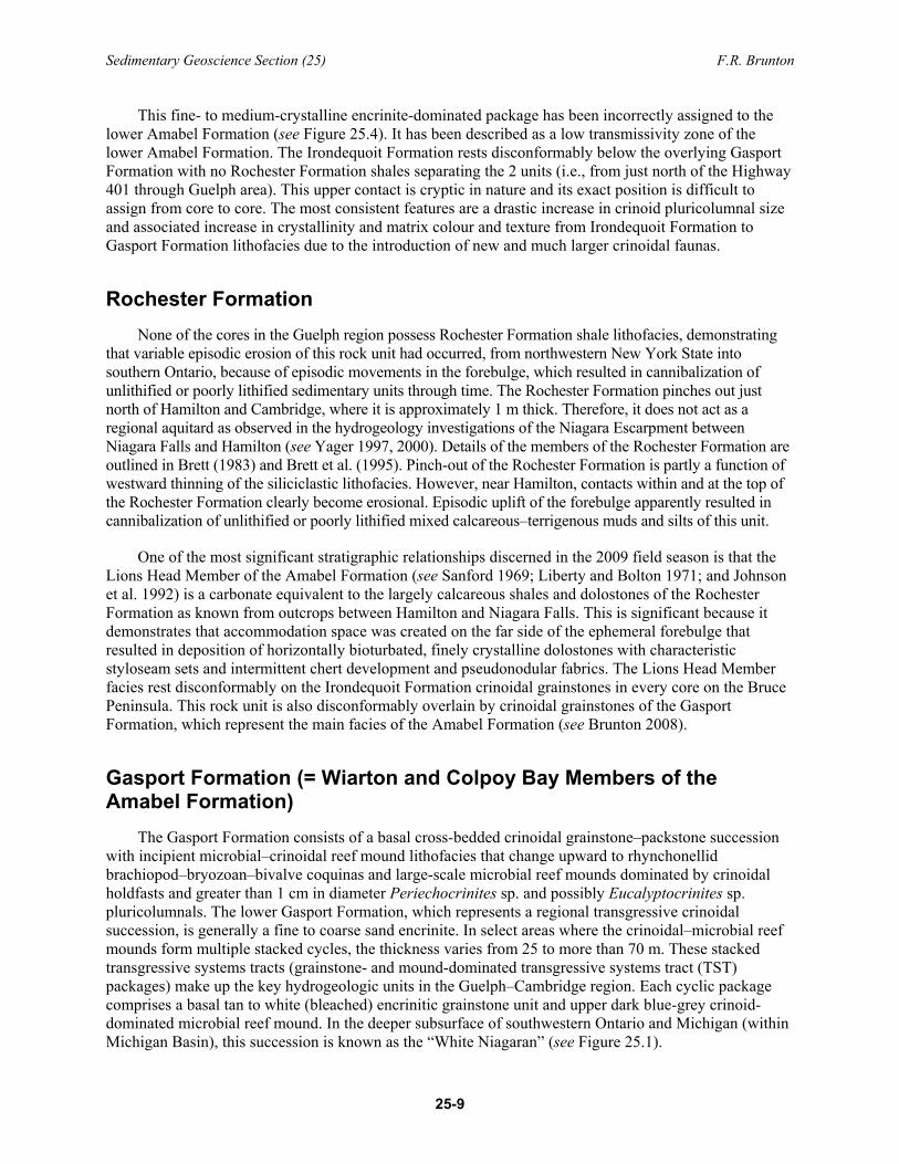
Photo 25.1. Key outcrops in Guelph Dolime Quarry area that display the hydrogeologic character of the Gasport, Eramosa and Guelph formations (see Brunton 2008). No Goat Island Formation is evident at this outcrop exposure; the lower Eramosa Formation Vinemount member disconformably overlies the reef mound lithofacies of the upper Gasport Formation.
Sedimentary Geoscience Section (25) F.R. Brunton
25-11
excellent to poor secondary porosity and permeability and karst-conduit development. Aquifer capacity or storativity within these inter-reef mound shoal complexes and composite reef mound facies appears to improve down dip or westward from the “disturbed zone” of the present-day escarpment margin zone (i.e., westward of the re-entrant terminations along the Niagara Escarpment).
The Lions Head Member of the Amabel Formation, which rests disconformably on the Irondequoit Formation in all cores drilled on the Bruce Peninsula, is a carbonate lithofacies equivalent of parts of the Rochester Formation. This recent discovery supports the contention to remove the Amabel Formation as a formal stratigraphic unit in Ontario (see Brunton 2008). The type section of the Amabel Formation in Wiarton may be used to characterize the key lithofacies packages of the Gasport Formation outlined in this report. In addition, the Wiarton roadcut also displays lithofacies best allocated to the Niagara Falls- and Ancaster-equivalent members of the overlying Goat Island Formation and a thin microbial-bearing phase of the basal Vinemount member of the Eramosa Formation.
Goat Island Formation The basal member of the Goat Island Formation is the crinoidal grainstone lithofacies of the Niagara
Falls member (see Figure 25.4). This unit commonly has a distinctive pin-striped appearance and is finely crystalline and cross laminated. These encrinites range in thickness from a few metres to up to 10 m thick in the Guelph area. It is important to distinguish the coarse crystalline encrinites and reef mound lithofacies of the underlying Gasport Formation from the finer crystalline encrinites of the overlying Goat Island Formation (Niagara Falls member). The Niagara Falls encrinite has a distinctive lithogeochemistry: the Goat Island Formation lithofacies generally have elevated sulphates and halite relative to Gasport Formation encrinites. The Niagara Falls member is a relatively tight (lower hydraulic conductivity), cross laminated and finely crystalline crinoidal and brachiopod-bearing grainstone with incipient small reef mounds; it does not comprise the cliff-forming encrinites of the upper quarry face of the Old Nelson quarry on Kerns Road as reported in 2008 (Brunton 2008, p.31-10, also referred to as “Kern’s Quarry”). This encrinite package has a distinctive low conductivity and transmissivity response relative to the underlying crinoidal grainstones and coquinas that occur between microbial–crinoidal reef mounds of the underlying Gasport Formation. Niagara Falls member lithofacies represent the next transgressive pulse of the Silurian seaways across the significant paleotopographic relief created by the differential development of thick crinoidal–microbial reef mounds that characterize the Gasport Formation.
The overlying Ancaster member is a chert-rich, finely crystalline dolostone that is medium to ash-grey in colour, thin to medium bedded and bioturbated. It forms the cap rock of much of the Niagara Escarpment between Hamilton and Niagara Falls. This unit lies above the Niagara Falls member in roadcut exposures along the Niagara Escarpment from northern New York State to Hamilton. In the Guelph region, some of the cores display an interfingering of lithofacies of the Niagara Falls member and the Ancaster member. This intercalation of units, forming a kind of hybrid rock unit, occurs when the Gasport Formation is less than 30 to 50 m thick. Generally, the Niagara Falls member forms the basal crinoidal grainstone phase of the transgressive systems tract. Where the Gasport Formation is less than 20 to 25 m thick, the Niagara Falls member may be up to 10 m thick and the overlying Ancaster member up to 6 m thick. It can generally be predicted that where both the Niagara Falls member and Ancaster member lithofacies are present in cores, then thickened Eramosa Formation members, especially the presence of the basal Vinemount member, are also present.
Eramosa Formation The Eramosa Formation is more laterally continuous along the Niagara Escarpment than is generally
depicted in the literature (see Sanford 1969; Brett et al. 1995; Brunton and Dekeyser 2004; Brunton, Dekeyser and Coniglio 2005; Brunton, Armstrong and Dekeyser 2006). The regional scope of this study
Sedimentary Geoscience Section (25) F.R. Brunton
25-12
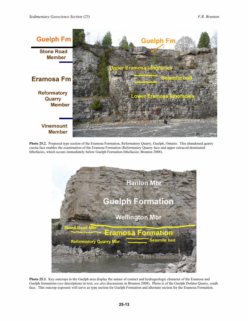
further supports general use of formational rank for Eramosa lithofacies. Detailed field measurements have been made from more than 100 field stations, including stratigraphic sections from key outcrops, operational and abandoned quarries, and more than 60 rock cores spanning all or most of these cap-rock formations along the Niagara Escarpment. This work verifies the regional continuity and lithologic variability, and temporal significance of this rock unit. Therefore, this paper will refer to those lithofacies assigned to the Eramosa interval by Williams (1915a, 1915b, 1919), Shaw (1937), Bolton (1953, 1957), Sanford (1969), Telford (1978), Armstrong and Meadows (1988), Armstrong and Dubord (1992), Smith (1990), Tetreault (2001) and von Bitter et al. (2007) as the Eramosa Formation. Although key lithologic characteristics for this rock unit are provided below, a detailed description and proper definition of the Eramosa Formation, including the provision of a type section for both the Eramosa and Guelph formations, will follow in a future publication. Rock units recognized as members of the Eramosa Formation in this study differ from previous definitions of the Eramosa Formation by Shaw (1937) and Brett et al. (1995). Generally, only lithofacies that make up part of the Reformatory Quarry member described in this paper were incorporated into the previous definitions. This paper recognizes 3 members for the Eramosa Formation: Stone Road, Reformatory Quarry and Vinemount.
Detailed logging of the Vinemount Quarry and comparisons with City of Guelph, Cambridge and Bruce Peninsula cores reveal that the Vinemount beds, previously assigned to the upper member of the Goat Island Formation by Brett et al. (1995), actually correlate faunally and lithologically with lithofacies assigned to the Eramosa Formation in the Guelph through Wiarton areas (see Figure 25.1). Recent field work reveals that the Eramosa dolostones display significant regional variability in fossil content and sedimentary structures depicting abrupt temporal and spatial changes in depositional environments between the Michigan and Appalachian basins. The lateral discontinuity of these lower lithofacies has been the most challenging part of establishing a type section for this formation (Photo 25.2).
Lower Eramosa Formation lithofacies, previously named Vinemount Shale Beds or Vinemount beds, are herein referred to as the Vinemount member (see Figure 25.4). This rock unit averages 10 m in thickness when present in the Guelph region. It comprises thinly bedded, fine-crystalline, cyclic horizontally bioturbated traction current deposits with interbedded horizons rich in partially silicified diminutive Whitfieldella brachiopods and distinctive digitate tabulate corals (cladoporids) beds. The Vinemount member is most shaly in the vicinity of the Vinemount Quarry, east of Hamilton, and becomes less shaly west and northward away from the influence of the Appalachian foreland basin. These beds are black to dark grey in freshly cut core and blasted outcrops (e.g., Guelph Dolime Quarry, City of Guelph), but are a light grey colour in weathered outcrops. The distinctive petroliferous odour on broken samples verifies that it is Eramosa Formation. This lower succession grades upward into incomplete sabkha-like cycles and low-diversity coral biostromes that vary greatly in faunal and sedimentological character, regionally representing a restricted offshore marine setting.
There is a sharp contact between these lower lithofacies and the overlying, lighter brown to cream coloured thicker bedded, pseudonodular, coarsely crystalline and coral-stromatoporoid biostromal lithofacies of the upper Eramosa Formation. Although this contact is best illustrated in numerous cores from the City of Guelph, it is evident in 2 outcrops that form part of the same cuesta: the classic Guelph Railway cut section on the west side of the Eramosa River illustrated in Williams (1919) and the Reformatory Quarry section situated less than 0.5 km away on the east side of the Eramosa River (see Photo 25.2). These sections are situated just north of Stone Road where it crosses the Eramosa River, City of Guelph. The Reformatory Quarry and recently re-opened Guelph Dolime Quarry possess excellent exposures of the cream-coloured pseudonodular lithofacies of the upper Eramosa Formation. These upper dolostone beds are herein designated the Reformatory Quarry member and the Stone Road member of the Eramosa Formation (see Photos 25.2 and 25.3). Therefore, the type section for the Eramosa Formation, which will be formally described and published in the future, is proposed to be at the Reformatory Quarry in the City of Guelph (see Photo 25.2). The Reformatory Quarry member possesses a strongly deformed pseudonodular interval, herein interpreted as a seismite (earthquake-deformed bed) that varies in
Sedimentary Geoscience Section (25) F.R. Brunton
25-13
Photo 25.2. Proposed type section of the Eramosa Formation, Reformatory Quarry, Guelph, Ontario. This abandoned quarry cuesta face enables the examination of the Eramosa Formation (Reformatory Quarry face and upper ostracod-dominated lithofacies, which occurs immediately below Guelph Formation lithofacies; Brunton 2008).
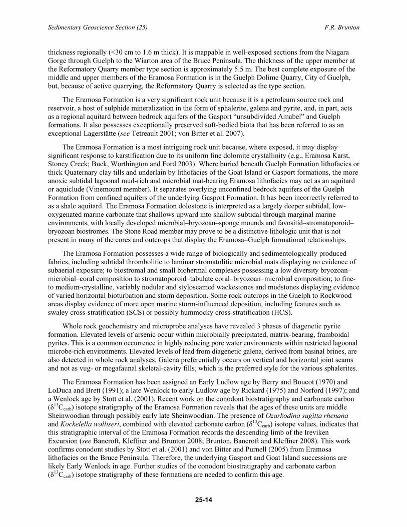
Photo 25.3. Key outcrops in the Guelph area display the nature of contact and hydrogeologic character of the Eramosa and Guelph formations (see descriptions in text; see also discussions in Brunton 2008). Photo is of the Guelph Dolime Quarry, south face. This outcrop exposure will serve as type section for Guelph Formation and alternate section for the Eramosa Formation.
Sedimentary Geoscience Section (25) F.R. Brunton
25-14
thickness regionally (<30 cm to 1.6 m thick). It is mappable in well-exposed sections from the Niagara Gorge through Guelph to the Wiarton area of the Bruce Peninsula. The thickness of the upper member at the Reformatory Quarry member type section is approximately 5.5 m. The best complete exposure of the middle and upper members of the Eramosa Formation is in the Guelph Dolime Quarry, City of Guelph, but, because of active quarrying, the Reformatory Quarry is selected as the type section.
The Eramosa Formation is a very significant rock unit because it is a petroleum source rock and reservoir, a host of sulphide mineralization in the form of sphalerite, galena and pyrite, and, in part, acts as a regional aquitard between bedrock aquifers of the Gasport “unsubdivided Amabel” and Guelph formations. It also possesses exceptionally preserved soft-bodied biota that has been referred to as an exceptional Lagerstätte (see Tetreault 2001; von Bitter et al. 2007).
The Eramosa Formation is a most intriguing rock unit because, where exposed, it may display significant response to karstification due to its uniform fine dolomite crystallinity (e.g., Eramosa Karst, Stoney Creek; Buck, Worthington and Ford 2003). Where buried beneath Guelph Formation lithofacies or thick Quaternary clay tills and underlain by lithofacies of the Goat Island or Gasport formations, the more anoxic subtidal lagoonal mud-rich and microbial mat-bearing Eramosa lithofacies may act as an aquitard or aquiclude (Vinemount member). It separates overlying unconfined bedrock aquifers of the Guelph Formation from confined aquifers of the underlying Gasport Formation. It has been incorrectly referred to as a shale aquitard. The Eramosa Formation dolostone is interpreted as a largely deeper subtidal, low-oxygenated marine carbonate that shallows upward into shallow subtidal through marginal marine environments, with locally developed microbial–bryozoan–sponge mounds and favositid–stromatoporoid–bryozoan biostromes. The Stone Road member may prove to be a distinctive lithologic unit that is not present in many of the cores and outcrops that display the Eramosa–Guelph formational relationships.
The Eramosa Formation possesses a wide range of biologically and sedimentologically produced fabrics, including subtidal thrombolitic to laminar stromatolitic microbial mats displaying no evidence of subaerial exposure; to biostromal and small biohermal complexes possessing a low diversity bryozoan–microbial–coral composition to stromatoporoid–tabulate coral–bryozoan–microbial composition; to fine- to medium-crystalline, variably nodular and styloseamed wackestones and mudstones displaying evidence of varied horizontal bioturbation and storm deposition. Some rock outcrops in the Guelph to Rockwood areas display evidence of more open marine storm-influenced deposition, including features such as swaley cross-stratification (SCS) or possibly hummocky cross-stratification (HCS).
Whole rock geochemistry and microprobe analyses have revealed 3 phases of diagenetic pyrite formation. Elevated levels of arsenic occur within microbially precipitated, matrix-bearing, framboidal pyrites. This is a common occurrence in highly reducing pore water environments within restricted lagoonal microbe-rich environments. Elevated levels of lead from diagenetic galena, derived from basinal brines, are also detected in whole rock analyses. Galena preferentially occurs on vertical and horizontal joint seams and not as vug- or megafaunal skeletal-cavity fills, which is the preferred style for the various sphalerites.
The Eramosa Formation has been assigned an Early Ludlow age by Berry and Boucot (1970) and LoDuca and Brett (1991); a late Wenlock to early Ludlow age by Rickard (1975) and Norford (1997); and a Wenlock age by Stott et al. (2001). Recent work on the conodont biostratigraphy and carbonate carbon (δ13Ccarb) isotope stratigraphy of the Eramosa Formation reveals that the ages of these units are middle Sheinwoodian through possibly early late Sheinwoodian. The presence of Ozarkodina sagitta rhenana and Kockelella walliseri, combined with elevated carbonate carbon (δ13Ccarb) isotope values, indicates that this stratigraphic interval of the Eramosa Formation records the descending limb of the Ireviken Excursion (see Bancroft, Kleffner and Brunton 2008; Brunton, Bancroft and Kleffner 2008). This work confirms conodont studies by Stott et al. (2001) and von Bitter and Purnell (2005) from Eramosa lithofacies on the Bruce Peninsula. Therefore, the underlying Gasport and Goat Island successions are likely Early Wenlock in age. Further studies of the conodont biostratigraphy and carbonate carbon (δ13Ccarb) isotope stratigraphy of these formations are needed to confirm this age.
Sedimentary Geoscience Section (25) F.R. Brunton
25-15
Guelph Formation The Guelph Formation comprises open marine medium to thickly bedded cross-stratified crinoidal
grainstones and wackestones and lagoonal thinly bedded megalodont–gastropod-dominated wackestones and packstones, and lesser biostromal and biohermal reefal complexes. The Guelph Formation displays a sharp erosional basal contact with the underlying Eramosa Formation. This contact is characterized in outcrop and subsurface by a greyish-tan matrix with a discontinuous stromatoporoid–favositid biostromal package. Reef mound phases are present in the lower half of the formation and megalodontid bivalve and high-spired gastropod lagoonal cycles dominate the middle and upper parts of the succession. The top of the Guelph Formation is interpreted to be a significant erosional surface prior to the onset of increasingly saline basinal conditions that resulted in deposition of the dark algal-laminites and gypsiferous chocolate brown carbonates of the basal Salina Group.
The Guelph Dolime Quarry in Guelph has been chosen as the type section for the Guelph Formation (see Photo 25.3). Approximately 16 m of strata are well exposed in the upper quarry bench and display all key lithofacies of the Guelph Formation, including an excellent, sharp contact with the underlying Eramosa Formation. Good alternate sections can be seen in the Irvine Gorge section in Elora and key outcrops along the north shore of the Bruce Peninsula (between Cave Point and Tobermory). This stratigraphic unit possesses a cream to light brown matrix colour and is known regionally in the subsurface as the “Brown Niagaran” (see Sanford 1969). It is generally 15 to 22 m thick in the Cambridge through Guelph region and thickens toward Luther Lake and northern Bruce Peninsula regions where thicknesses exceed 60m. Although these lithofacies appear to conformably overlie bituminous, argillaceous, less fossiliferous dolostones of the Eramosa Formation (Brunton and Dekeyser 2004; Brunton, Dekeyser and Coniglio 2005; Brunton, Armstrong and Dekeyser 2006), preliminary conodont analyses and regional correlations of key tabulate coral and megalodontid bivalve megafaunal elements from the Bruce Peninsula and northern Moose River Basin and Arctic platform of Nunavut, suggest a latest Wenlock (Early Silurian) to early Ludlow (Late Silurian) age. The Guelph Formation represents an unconfined aquifer in the Guelph–Cambridge region of southern Ontario.
SUMMARY AND FUTURE WORK This paper provides proposed revisions to the Early Silurian sequence stratigraphic and
sedimentologic framework and physical characterization of dolostone and calcareous shale rock units along the Niagara Escarpment of southern Ontario. The main focus of bedrock mapping and core logging during the 2008 field season was in the Guelph–Cambridge–Hamilton to Niagara Falls corridors. Additional drill core and key outcrop sections from the Bruce Peninsula, and Arthur and Luther Lake regions, located in the northern part of the study area, were also incorporated in 2009 to provide a more regional context to test the lateral facies changes within this revised sequence stratigraphic framework. The revised sequence stratigraphic framework will form the geologic foundation of a regional groundwater model that will address the vulnerability of groundwater resources required by Source Water Protection legislation and being completed under the Tier 3 studies of the City of Guelph and Kitchener–Waterloo Region.
Earlier studies delineated 2 bedrock aquifers known locally as the deeper Amabel “payzone” or “production zone” (representing coquinas and shoal complexes situated between reef mounds in Gasport Formation) and overlying Guelph aquifers and associated interface aquifers situated along the bedrock surface. However, the ability to predict the location and character of the water-bearing horizons and nature and distribution of the Eramosa aquitard unit, which separates the 2 main aquifers, has been difficult due to poor regional stratigraphic and sedimentologic understanding of the Silurian rock units (see also Brunton et al. 2007; Brunton 2008).
Sedimentary Geoscience Section (25) F.R. Brunton
25-16
The establishment of a revised and testable sequence stratigraphic framework for aquifer and aquitard characterization was achieved during the 2008–2009 field seasons. Key sequence stratigraphic findings include the following:
1. the recognition of significant differential erosion on the Cabot Head Formation surface regionally; 2. the Reynales Formation does not extend very far into southern Ontario from New York State
and those strata previously assigned to the Reynales belong to the younger Fossil Hill and Rockway formations;
3. the Merritton Formation dolostone (= upper Fossil Hill Formation), which disconformably overlies the Cabot Head Formation, Grimsby Formation and Thorold Formation surfaces, extends across the Algonquin Arch without significant change in thickness and character;
4. the Rockway Formation disconformably overlies the Merritton Formation and forms a persistent rock unit across the Algonquin Arch into the southern Bruce Peninsula region;
5. the Irondequoit Formation, previously unrecognized north of Hamilton in the subcrop–outcrop belt, rests disconformably on the Rockway Formation at a distinctive welded contact and has a consistent thickness across the Algonquin Arch and extends northward to Tobermory (previous stratigraphic and hydrogeologic investigations have placed this rock unit into the unsubdivided Amabel Formation);
6. the Rochester Formation shales, which pinch out just north of Hamilton and Cambridge areas, reappear as a finely crystalline dolostone (= Lions Head Member of Amabel Formation) on and just south of the Bruce Peninsula to Manitoulin Island region or to north of the forebulge region of the Algonquin Arch corridor;
7. the Gasport Formation, which consists of thick reef mound and inter-reef lithofacies in the subsurface of Cambridge–Kitchener–Waterloo and Guelph regions, is formally recognized as making up the majority of what has been traditionally called the unsubdivided Amabel Formation (comprising both the Wiarton and Colpoy Bay members of type section on Bruce Peninsula). A sharp, disconformable contact separates the Gasport Formation from the overlying basal crinoidal grainstone unit of the Goat Island Formation, known as the Niagara Falls member. This rock unit has been referred to locally in some hydrogeological reports as a low permeability unit of the unsubdivided Amabel Formation. The presence of significant paleotopography on the Gasport Formation is the main control on the character and presence and/or absence of overlying Goat Island and Eramosa strata along the Niagara Escarpment subcrop–outcrop belt;
8. the basal unit of the Goat Island Formation is known as the Niagara Falls member. It appears to exist in the type section of the Amabel Formation in Wiarton and along the northern coast of the Bruce Peninsula. This change is seen to be due to the rapid thickening of both Gasport and Goat Island formational encrinites over a distance of a few kilometres from Hamilton northward through the Guelph region to the Bruce Peninsula, coincident with the pinch-out of the Rochester Formation in the migrating forebulge region of the Algonquin Arch corridor;
9. the Ancaster member of the Goat Island Formation is generally found above the Niagara Falls member south of Hamilton, but interfingers with Niagara Falls member lithofacies in selected cores in the Guelph region and in more westerly cores of Michigan Basin in southern Ontario;
10. Eramosa lithofacies constitute a regionally persistent and faunally and lithologically distinctive rock unit that acts as a regional aquitard where the basal Vinemount member is present; therefore, it is recommended that the formational rank of the Eramosa be recognized more widely. Formal redefinition for the Eramosa Formation will be proposed and the formation will be subdivided into 3 members: a basal Vinemount member (main aquitard lithofacies), middle Reformatory Quarry member, and upper Stone Road member. The middle member possesses a distinctive seismite bed that is recognizable from Niagara Falls to the central Bruce Peninsula;
Sedimentary Geoscience Section (25) F.R. Brunton
25-17
11. study of the contact between the Eramosa and Guelph rock units shows that the true level is higher than previously suggested and is marked by an erosional disconformity. The Stone Road member of the Eramosa Formation may prove to be a distinctive rock unit of formational rank upon further analyses.
Two key bedrock aquifers or hydrogeologic units are recognized in the Guelph–Regional Municipality of Waterloo area. The lowermost of these is the confined to semi-confined Gasport hydrogeologic unit (Gasport HGU), the character of which is influenced by the development of reef mound complexes and interbedded shell coquinas. These 2 lithofacies create discrete sequence-controlled enhanced hydraulic subunits within an overall regionally significant hydrogeologic unit. The second key regional bedrock aquifer is the unconfined Guelph hydrogeologic unit (Guelph HGU).
Preliminary hydrogeologic studies of selected boreholes reveal the presence of multiple high-volume water-bearing horizons where composite reef mound complexes are separated by shell-rich, bleached coquinas in the Gasport Formation. The recognition of both significant erosion at the top of the Gasport Formation and substantial changes in formation thickness associated with reef mound and coquina development over short distances (1 to 5 km) reveals that the paleotopographic relief of this unit is the main control for predicting both the presence of the Gasport hydrogeologic unit (Gasport HGU) and which unit will overlie this regional disconformity. Where the Gasport Formation is less than 30 to 50 m in thickness, Goat Island lithofacies (e.g., Niagara Falls member and/or Ancaster member beds) are present. Where Goat Island Formation strata occur above the Gasport Formation, they are overlain by both the Vinemount and Reformatory Quarry members of the Eramosa Formation. Eramosa lithofacies generally rest disconformably on the Gasport Formation when it is 50 to 70 m thick. The Eramosa Formation represents a regional aquitard, especially where shaly lithofacies of the newly established lower Vinemount member are prominent. In places where the Gasport Formation exceeds 60 to 70 m in thickness, owing to the establishment of thick reef mounds in the Early Silurian seaway, the Goat Island Formation and Eramosa Formation lithofacies are generally not present and the overlying Guelph Formation rests disconformably on the Gasport Formation. Detailed subsurface mapping of these lithofacies patterns, in conjunction with detailed hydrogeologic and hydrogeochemical studies using the FLUTe™ multi-level monitoring system (see Brunton 2008, p.31-3), hold the key to the eventual delineation of the Gasport and Guelph hydrogeologic units.
The main goal of this multi-year multi-disciplinary bedrock aquifer mapping program is to define and map out regional-scale groundwater flow systems that will lead to the delineation of discrete hydrogeologic units (HGUs). Such an approach will eventually enable calculations of groundwater volumes for the key Paleozoic-age bedrock aquifers across southern Ontario. These data will form the foundation for addressing fundamental questions concerning bedrock groundwater resources in southern Ontario in the context of changing climatic conditions and implications for long-term sustainability of these vital resources.
Preliminary data from this study suggest a disconnection of bedrock aquifers from surface water flow patterns away from the cuesta margin zone within the Grand River watershed and adjacent areas on the Bruce Peninsula and Manitoulin Island. The implications of such observations, once they are proven, may result in changes to how water budgets are defined for different areas of southern Ontario. The multi-disciplinary approach adopted in this study to evaluate and model the bedrock groundwater resources of the Niagara Escarpment will create a template that will be employed by the OGS to map and evaluate the groundwater resources throughout southern Ontario. The field-based methodologies developed for this four-year project will be applied to other regions of southern Ontario in order to develop regional bedrock aquifer maps for Devonian- and Ordovician-age strata. These maps and the resultant regional-scale estimates of groundwater volumes will then be used to estimate total available groundwater resources throughout southern Ontario and Manitoulin Island.
Sedimentary Geoscience Section (25) F.R. Brunton
25-18
ACKNOWLEDGMENTS The compilation of stratigraphic units and regional correlations benefited greatly from conversations
and field work carried out with Dr. Carl Brett (University of Cincinnati), Dr. Pat McLaughlin (Wisconsin Geological Survey and Natural History Museum), Daryl Cowell, and Dr. Mark Kleffner, Dr. Brad Cramer and Alyssa Bancroft (The Ohio State University). Constructive discussions with colleagues at the OGS, especially Derek Armstrong, concerning the evolving Silurian stratigraphy of the Niagara Escarpment were beneficial to the sequence stratigraphic framework presented. Discussions with John Petrie and John Piersol of Golder Associates Ltd. helped clarify and focus some of the regional bedrock hydrogeologic characteristics. Parks Canada staff Scott Parker and Cavan Harpur are thanked for their logistical support (use of boats) for the sequence stratigraphic studies along the northern Bruce Peninsula and nearby islands and for collaboration with karst studies on the Bruce Peninsula. Funding for this multi-year project is from the Ontario Geological Survey, the Ministry of Natural Resources (MNR), the City of Guelph Water Works Department and the Regional Municipality of Waterloo Water Services Division. Lastly, Candace Brintnell (The University of Western Ontario) is thanked for her able assistance and helpful discussions during the 2009 field season (see Brintnell et al., this volume).
REFERENCES Armstrong, D.K. and Carter, T.R. 2006. An updated guide to the subsurface Paleozoic stratigraphy of southern
Ontario; Ontario Geological Survey, Open File Report 6191, 214p.
Armstrong, D.K. and Dodge, J.E.P. 2007. Paleozoic geology of southern Ontario; Ontario Geological Survey, Miscellaneous Release—Data 219.
Armstrong, D.K. and Dubord, M.P. 1992. Paleozoic geology, northern Bruce Peninsula, southern Ontario: Ontario Geological Survey, Open File Map 198, scale 1:50 000.
Armstrong, D.K., Goodman, W.R. and Coniglio, M. 2002. Stratigraphy and depositional environments of Niagaran carbonates, Bruce Peninsula, Ontario; Ontario Petroleum Institute, London, Ontario, Guidebook for 2002 Fall Field Trip, September 20-22, 2002, 56p.
Armstrong, D.K. and Meadows, J.R. 1988. Stratigraphy and resource potential of the Eramosa Member (Amabel Formation), Bruce Peninsula, Ontario; Ontario Geological Survey, Open File Report 5662, 89p.
Bancroft, A.M., Kleffner, M.A. and Brunton, F.R. 2008. Silurian conodont biostratigraphy and δ13C stratigraphy of the Eramosa Formation, southwestern Ontario, Canada; Geological Society of America, Abstracts with Programs, v.40, no.5, p.22.
Berry, W.B.N. and Boucot, A.J. 1970. Correlation of the North American Silurian rocks; Geological Society of America, Special Paper 102, 289p.
Bolton, T.E. 1953. Silurian formations of the Niagara Escarpment in Ontario; Geological Survey of Canada, Paper 53-23, 19p.
——— 1957. Silurian stratigraphy and paleontology of the Niagara Escarpment in Ontario; Geological Survey of Canada, Memoir 289, 145p.
Brett, C.E. 1983. Sedimentology, facies and depositional environments of the Rochester Shale (Silurian; Wenlockian) in western New York and Ontario; Journal of Sedimentary Petrology, v.53, p.947-971.
Brett, C.E., Goodman, W.M. and LoDuca, S.T. 1990. Sequences, cycles, and basin dynamics in the Silurian of the Appalachian Foreland Basin; in Processes and patterns in epeiric seas; Sedimentary Geology, v.69, p.191-244.
Brett, C.E., Tepper, D.H., Goodman, W.M., LoDuca, S.T. and Eckert, B.Y. 1995. Revised stratigraphy and correlations of the Niagaran provincial series (Medina, Clinton, and Lockport Groups) in the type area of western New York; United States Geological Survey, Bulletin 2086, 66p.
Sedimentary Geoscience Section (25) F.R. Brunton
25-19
Brunton, F.R. 2008. Preliminary revisions to the Early Silurian stratigraphy of Niagara Escarpment: integration of sequence stratigraphy, sedimentology and hydrogeology to delineate hydrogeologic units; in Summary of Field Work and Other Activities, 2008, Ontario Geological Survey, Open File Report 6226, p.31-1 to 31-18.
Brunton, F.R., Armstrong, D.K. and Dekeyser, L.-K. 2006. Revisiting the caprock carbonate stratigraphic nomenclature of the Niagara Escarpment – Guelph, Eramosa, and Amabel formations, southwestern Ontario; Geological Society of America, Abstracts with Programs, v.38, no.7, p.404.
Brunton, F.R., Bancroft, A. and Kleffner, M. 2008. Revised Early Silurian stratigraphy of eastern Michigan Basin, Niagara Escarpment, southern Ontario; in Canadian Paleontology Conference, September 19-21, 2008, Proceedings No.6, p.15-16.
Brunton, F.R., Belanger, D., DiBiase, S., Yungwirth, G. and Boonstra, G. 2007. Caprock carbonate stratigraphy and bedrock aquifer character of the Niagara Escarpment – City of Guelph Region, southern Ontario; in Proceedings of the 60th Canadian Geotechnical Conference and the 8th joint Canadian Geotechnical Society–International Association of Hydrogeologists conference, Canadian Geotechnical Society, Ottawa, p.371-377.
Brunton, F.R., Brintnell, C., Brett, C.E., Jin, J., Bancroft, A. and Kleffner, M. 2009. Update on Early Silurian stratigraphy of eastern Michigan Basin, Niagara Escarpment, southern Ontario; in Canadian Paleontology Conference Proceedings No.7, Sudbury, Ontario, p.13.
Brunton, F.R. and Dekeyser, L.-K. 2004. Industrial mineral potential of the Guelph Formation and the Eramosa member of the Amabel Formation, southwestern Ontario; in Summary of Field Work and Other Activities 2004, Ontario Geological Survey, Open File Report 6145, p.19-1 to 19-5.
Brunton, F.R., Dekeyser, L.-K. and Coniglio, M. 2005. Regional industrial minerals and diagenetic study of the Guelph, Eramosa, and Amabel formations, southwestern Ontario; in Summary of Field Work and Other Activities 2005, Ontario Geological Survey, Open File Report 6172, p.35-1 to 35-7.
Brunton, F.R. and Dodge, J.E.P. 2008. Karst of southern Ontario and Manitoulin Island; Ontario Geological Survey, Groundwater Resources Study 5.
Brunton, F.R., Dodge, J.E.P. and Shirota, J. 2005. Karst in southern Ontario; in Summary of Field Work and Other Activities 2005, Ontario Geological Survey, Open File Report 6172, p.27-1 to 27-7.
——— 2006. Karst compilation for southern Ontario: an update; in Summary of Field Work and Other Activities 2006, Ontario Geological Survey, Open File Report 6192, p.31-1 to 31-9.
Brunton, F.R., Turner, E. and Armstrong, D. 2009. A guide to the Paleozoic geology and fossils of Manitoulin Island and northern Bruce Peninsula, Ontario, Canada; Canadian Paleontology Conference, Field Trip Guidebook No.14, 77p.
Buck, M.J., Worthington, S.R.H. and Ford, D.C. 2003. Earth Science Inventory and evaluation of the Eramosa karst area of natural and scientific interest; Ministry of Natural Resources, Guelph District, South-Central Region, 51p.
Haynes, S.J. 2000. Geology and Wine 2 – a geological foundation for terroirs and potential sub-appellations of Niagara Peninsula wines, Ontario, Canada; Geoscience Canada, v.27, p.67-87.
Johnson, M.D., Armstrong, D.K., Sanford, B.V., Telford, P.G. and Rutka, M.A. 1992. Paleozoic and Mesozoic geology of Ontario; in Geology of Ontario, Ontario Geological Survey, Special Volume 4, Part 2, p.905-1008.
Kilgour, W.J. 1963. Lower Clinton (Silurian) relationships in western New York and Ontario; Geological Society of America Bulletin, v.74, p.1127-1142.
Liberty, B.A. and Bolton, T.E. 1971. Paleozoic geology of the Bruce Peninsula area, Ontario; Geological Survey of Canada, Memoir 360, 163p.
LoDuca, S.T. and Brett, C.E. 1991. Placement of the Wenlockian/Ludlovian boundary in western New York State; Lethaia, v.24, p.255-264.
Norford, B.S. 1997. Correlation chart and biostratigraphy of the Silurian rocks of Canada; International Union of Geological Sciences, Publication No. 35, 77p.
Sedimentary Geoscience Section (25) F.R. Brunton
25-20
Pratt, B.R. and Miall, A.D. 1993. Anatomy of a bioclastic grainstone megashoal (Middle Silurian, southern Ontario) revealed by ground-penetrating radar; Geology, v.21, p.223-226.
Rickard, L.V. 1975. Correlation of Silurian and Devonian rocks in New York State; New York State Museum and Science Service, Map and Chart Series No. 24, 4 plates, 16p., highway map and 4 charts.
Sanford, B.V. 1969. Silurian of southwestern Ontario; Ontario Petroleum Institute, 8th Annual Conference Proceedings, Technical Paper No.5, p.1-44.
Shaw, E.W. 1937. The Guelph and Eramosa formations of the Ontario peninsula; Transactions of the Royal Canadian Institute, v.21, pt.2, no.46, p.317-362.
Smith, L. 1990. Geologic controls on porosity and permeability variation in Silurian pinnacle reef bioherms, southwestern Ontario; Ontario Petroleum Institute Inc., Twenty-Ninth Annual Conference, Technical Session No.2, Paper No.4, London, Ontario, p.1-19.
Stott, C.A. and von Bitter, P.H. 1999. Lithofacies and age variation in the Fossil Hill Formation (Lower Silurian), southern Georgian Bay region, Ontario; Canadian Journal of Earth Sciences, v.36, p.1743-1762.
Stott, C.A., von Bitter, P.H., Kleffner, M.A., Tetreault, D.K. and Armstrong, D.K. 2001. Evidence for the Wenlockian age of the middle Silurian Eramosa Member, Guelph Formation, southern Bruce Peninsula, Ontario, Canada; in Canadian Paleontology Conference, Program and Abstracts, v.11, p.50.
Telford, P.G. 1978. Silurian stratigraphy of the Niagara Escarpment, Niagara Falls to the Bruce Peninsula; in Toronto ’78 Field Trips Guidebook, Joint Annual Meeting of the Geological Society of America–Geological Association of Canada–Mineralogical Society of Canada, p.28-42.
Tetreault, D.K. 2001. A new Silurian Konservat-Lagerstätte from the Eramosa dolostone of the southern Bruce Peninsula, Ontario, Canada; unpublished PhD thesis, University of Western Ontario, London, Ontario, 192p.
von Bitter, P.H. and Purnell, M.A. 2005. An experimental investigation of post-depositional taphonomic bias in conodonts; in Conodont biology and phylogeny—interpreting the fossil record; The Palaeontological Society, Special Papers in Palaeontology 73, p.39-56.
von Bitter, P.H., Purnell, M.A., Tetreault, D.K. and Stott, C.A. 2007. Eramosa Lagerstätte – exceptionally preserved soft-bodied biotas with shallow-marine shelly and bioturbating organisms (Silurian, Ontario, Canada); Geology, v.35, p.879-882.
Williams, M.Y. 1915a. The Middle and Upper Silurian of southwestern Ontario; Geological Survey of Canada, Summary Report 1914, p.82-86.
——— 1915b. An eurypterid horizon in the Niagara Formation of Ontario; Geological Survey of Canada, Museum Bulletin No.20, 21p.
——— 1919. The Silurian geology and faunas of Ontario Peninsula, and Manitoulin and adjacent islands; Geological Survey of Canada, Memoir 111, 195p.
Williams, M.Y. 1937. General geology and petroleum resources of Manitoulin and adjacent Islands, Ontario; Geological Survey of Canada, Paper 37-25, p.1-57.
Winder, G.C. 1961. Lexicon of Paleozoic names in southwestern Ontario; University of Toronto Press, Toronto, 121p.
Yager, R.M. 1997. Simulated three-dimensional ground-water flow in the Lockport Group, a fractured-dolomite aquifer near Niagara Falls, New York; United States Geological Survey, Water-Supply Paper 2487, 42p.
——— 2000. Simulated transport and biodegradation of chlorinated ethenes in a fractured dolomite aquifer near Niagara Falls, New York; United States Geological Survey, Water-Resources Investigations Report 00-4275.
Zenger, D.H. 1965. Stratigraphy of the Lockport Formation (Middle Silurian) in New York State; New York State Museum and Science Service, Bulletin No. 404, 210p.
Related Documents